DRAFT ENVIRONMENTAL IMPACT
ASSESSMENT REPORT
&
ENVIRONMENTAL MANAGEMENT PLAN
PROPOSED RBM (RIVER BED MINERAL) MINING PROJECT,
Hadbast No. – 478, Block No.: -1,
Khasra No. – 253//1, 253//2/1, 253//2/2, 253//3, 253//4,
253//7, 253//8, 253//9, 253//10, 253//11, 253//12, 253//14/2,
253//15, 253//16, 253//17, 253//18, 253//23, 253//24, 253//25,
260//3, 260//4, 260//5, 260//7, 260//8
Area: 8.86 ha.
Production Capacity: - 63991 MT
Project Cost: - Rs. 1.0 Crore
Study Period: -Winter Season (Dec. 2020 to Feb. 2021)
Work Order No.: - Nil
At River Sutlej, Village- Mahindpur, Tehsil: - Nangal,
District: - Ropar, State-Punjab
APPLICANT EIA CONSULTANT
Shri Rakesh Kumar Choudhary
R/o: - 51B/D Gandhi Nagar, Jammu J & K
Email Id: - [email protected]
Gaurang Environmental Solutions
Pvt. Ltd.
102, SNG, Shri Ratna Apartment, Near Tambi
Petrol Pump, Peetal Factory, Jhotwara Road,
Jaipur- 302016
E-mail id- [email protected]
NABET Accreditation No.:
NABET/EIA/1720/IA0026

Proposed RBM (River Bed Material) Gravel Minor Mineral Mining Project, Block No.–1, Area 8.86 ha. at Hadbast No. –478 River
Soan, Near village- Mahindpur, Tehsil-Nangal & District- Ropar (Rupnagar), Punjab.
Draft EIA/EMP Report
TABLE OF CONTENT
Chapter
No(s).
Title
1. Introduction
1. Purpose of the Report
Environment Clearance
Identification of Project & Project Proponent
Project
Project Proponent
Back ground of proponent
Brief Description of the Project
2. Project Description
2.0 Type Project
2.1 Need of the Project
2.2 Project Site
2.3 Project Highlight
2.4 Project-Activities
2.5 Mining Methodology
2.6 Conceptual Mining Plan
2.7 Proposed Infrastructure
2.8 Water Demand
2.9 Man Power
2.10 Conclusion
3. Description of Environment
3.0 Introduction
3.1 Sourse of Environmental Data
3.2 Collection and Analysis of Baseline Data
3.3 Topography
3.4 Dranage Pattern
3.5 Seismicity of Area

Proposed RBM (River Bed Material) Gravel Minor Mineral Mining Project, Block No.–1, Area 8.86 ha. at Hadbast No. –478 River
Soan, Near village- Mahindpur, Tehsil-Nangal & District- Ropar (Rupnagar), Punjab.
Draft EIA/EMP Report
3.6 Land Environment
3.7 Soil Environment
3.8 Water Environment
3.9 Air Environment
3.10 Noise Environment
3.11 Biological Environment
4. Anticipated Environmental Impacts and Mitigation Measures
4.0 Introduction
4.1 Land Environment
4.2 Water Environment
4.3 Air Environment
4.4 NoiseEnvironment
4.5 Biological Environment
4.6 Socio-Economic Environment
5. Analysis of Alternative (Technology and Site)
5.0 Introduction
5.1 Site
5.2 Technology
5.2.1 Mining Methodology
5.3 Conceptual Mining Plan
5.4 Conclusion
6. Environment Monitoring Programme
6.0 Introduction
6.1 Environmental Monitoring and Reporting Procedure
6.2 Environment Monitoring Cell
6.3 Environmental Monitoring Schedule
6.4 Monitoring Schedule
6.5 Monitoring Prameters
7. Additional Studies
7.0 Risk Analysis and Disaster Management Plan
7.1 Risk Analysis
7.2 Risk and Hazards in River Bed Material Mining

Proposed RBM (River Bed Material) Gravel Minor Mineral Mining Project, Block No.–1, Area 8.86 ha. at Hadbast No. –478 River
Soan, Near village- Mahindpur, Tehsil-Nangal & District- Ropar (Rupnagar), Punjab.
Draft EIA/EMP Report
7.3 Disaster Management Plan
7.4 Replenishment Study
7.5 Traffic Study
7.6 Socio-Economic Assessment
7.7 Public Hearing
8. Project Benefits
8.1 General
8.2 Improvement in Socio-Economice Environment
8.3 Health
8.4 Other Traingle Benefits
9. Environmental Cost Benefit Analysis
9.0 Introduction
9.1 Project Benefits
10. Environment Management Plan (Emp)
10.0 Introduction
10.1 Critical Activities for Emplementation
10.2 Environmental Action Program
10.3 Conclusion
11. Summary & Conclusion
11.0 Introduction
11.1 Silent Features of Project
11.2 Mining Methodology
11.3 Base Line & Impct to Proposed Project
11.4 Environment Management Plan & CSR

Proposed RBM (River Bed Material) Gravel Minor Mineral Mining Project, Block No.–1, Area 8.86 ha. at Hadbast No. –478 River
Soan, Near village- Mahindpur, Tehsil-Nangal & District- Ropar (Rupnagar), Punjab.
Draft EIA/EMP Report
LIST OF SYMBOLS, UNITS & ABBREVIATIONS
% Percent
°C Degree Celsius
µg/m3 Microgram per meter cube
AAGR Average Annual Growth Rate
AMSL Average Mean Sea Level
APHA American Public Health Association
BGL Below ground level
BIS Bureau of Indian Standards
BOD Biochemical Oxygen Demand
BOD5 BOD after 5 days of incubation period
BGL Below Ground Level
CO Carbon mono oxide
COD Chemical Oxygen Demand
CPCB Central Pollution Control Board
dB Decibel
DG Set Diesel Generator Set
DM District Magistrate
DO Dissolved Oxygen
EC Electrical Conductivity
EC Environmental Clearance
EIA Environmental Impact Assessment
EMP Environment Management Plan
ft feet
FDI Foreign Direct Investment
GoI Government of India

Proposed RBM (River Bed Material) Gravel Minor Mineral Mining Project, Block No.–1, Area 8.86 ha. at Hadbast No. –478 River
Soan, Near village- Mahindpur, Tehsil-Nangal & District- Ropar (Rupnagar), Punjab.
Draft EIA/EMP Report
ha Hectare
HFL Highest Flood Level
IRC Indian Road Congress
IS:3025 Indian Standard 3025
KLD Kilo Liters per Day
Km Kilometer
lpcd Liters per capita per day
LOS Level of Service
m Meter
m2 Square meter
mgbl meters below ground level
m3/annum Cubic meter per annum
mg/kg Milligram per kilogram
MoEF Ministry of Environment & Forests
ML Area Mining Lease Area
MPN Most Probable Number
MSW Municipal Solid Waste
NAAQ National Ambient Air Quality
NH National Highway
NO2 Nitrogen di-oxide
NOC No Objection Certificate
NTU Nephelometric Turbidity Unit
pH Negative (-) log of Hydrogen Ion Concentration
PM10 Particle size having aerodynamic diameter ≤ 10
PM2.5 Particle size having aerodynamic diameter ≤ 2.5
PCU Public Carrier Unit

Proposed RBM (River Bed Material) Gravel Minor Mineral Mining Project, Block No.–1, Area 8.86 ha. at Hadbast No. –478 River
Soan, Near village- Mahindpur, Tehsil-Nangal & District- Ropar (Rupnagar), Punjab.
Draft EIA/EMP Report
PPE Personnel Protective Equipment
PUC Pollution Under Control
RBM River Bed Mining
RL River Level
SEAC State Level Expert Appraisal Committee
SH State Highway
SiO2 Silicon di-Oxide
SO2 Sulpher di oxide
T Tonnes
TKN Total Kjeldahl nitrogen
TOR Terms of Reference
TSPM Total Suspended Particulate Matter


Proposed RBM (River Bed Material) Gravel Minor Mineral Mining Project, Block No.–1, Area 8.86 ha. at Hadbast No. –478 River Soan, Near village- Mahindpur, Tehsil-Nangal & District- Ropar (Rupnagar), Punjab.
TOR Compliance
Shri Rakesh Kumar Choudhary i
ToR Compliance
Point wise compliance of ToR issued by SEAC, Punjab for Proposed RBM (River Bed Material) Gravel Minor
Mineral Mining Project Block- 1; Area: - 8.86 ha.; Hadbast No.-478, with Production Capacity- 63,991 MT/Annum, At
River Soan Village- Mahinpur, Tehsil- Nangal & District- Ropar (Rupnagar), Punjab for by Shri Rakesh Kumar
Choudhary.
ToR Ref. ToR Point Compliance
Ref. in
Draft
EIA/EMP
Report
1. Submit dully filled checklist with the
application of environmental clearance.
NA, as this a proposed River Bed Mineral
(RBM) Minor Mineral Block Mining Project.
Not Applicable as this a fresh River Bed
Mineral (RBM) Minor Mineral Block.
-
2.
Deposit the requisite fee as per
Notification No. 10/167/2013-
STE(5)/1510178 dated 27.06.2019 issued
by the Govt. of Punjab, Department of
Science, Technology, and Environment.
Agreed, the requisite fee as per Notification
No. 10/167/2013-STE(5)/1510178 dated
27.06.2019 issued by the Govt. of Punjab,
Department of Science, Technology, and
Environment has been deposited. Copy of
bank statement is enclosed with this Draft
EIA/EMP report
Annexure-I

Proposed RBM (River Bed Material) Gravel Minor Mineral Mining Project, Block No.–1, Area 8.86 ha. at Hadbast No. –478 River Soan, Near village- Mahindpur, Tehsil-Nangal & District- Ropar (Rupnagar), Punjab.
TOR Compliance
Shri Rakesh Kumar Choudhary ii
3.
Project Proponent is required to conduct
public hearing in light of the OM dated
12.12.2018 issued by MOEF. The draft EIA-
EMP report shall be submitted to the
Punjab Pollution Control Board of the
concerned State for the conduct of
Public Hearing. The PPCB shall conduct
the Public Hearing district-wise, as per
the provisions of EIA notification, 2006.
The Public Hearing shall be chaired by an
Officer, not below the rank of Additional
District Magistrate.
Agreed, the draft EIA/EMP report along
with Executive Summary in English as well
as Hindi language is being submitted to the
Punjab Pollution Control Board of the
concerned State for the conduct of Public
Hearing.
4.
Ensure participation of the adjoining
land owners of the mining site during
the public consultation. Their grievances,
if any, be addressed and compliance
thereof be incorporated in the EIA
report.
Agreed, participation of the adjoining land
owners of the mining site during the public
consultation will be ensured and their
grievances, if any, shall be addressed and
compliance thereof will be incorporated in
the EIA report.
5.
Submission of Final District survey
report, containing apart from other
details as mentioned in the guidelines of
2016, specifically Including the following
points:
Final District survey report is being enclosed
with this Draft EIA/EMP report.
Annexure-
II

Proposed RBM (River Bed Material) Gravel Minor Mineral Mining Project, Block No.–1, Area 8.86 ha. at Hadbast No. –478 River Soan, Near village- Mahindpur, Tehsil-Nangal & District- Ropar (Rupnagar), Punjab.
TOR Compliance
Shri Rakesh Kumar Choudhary iii
a.
Recommendation regarding
environmentally safe depth of mining,
safe distance from banks and suitability of
site for mining or prohibition thereof, duly
signed by the members of the Sub
Divisional Committee comprising of Sub-
Divisional Magistrate, Officers from
Irrigation Department, State Pollution
Control Board or Committee, Forest
department, Geology or mining officer.
Agreed and complied with.
b. Submit the annual replenishment report
certified by an authorized agency in case
of river bed mining. In case the
replenishment is lower than the
approved rate of production then
mining activity/production level shall be
decreased/ stopped accordingly till the
replenishment study is completed.
Agreed and complied with.
6. Examine no use of semi-
mechanized/mechanized method shall
be allowed as Standard EC conditions
provided In the Guidelines, 2016
provided that manual method of mining
shall be preferred over any other
method otherwise submit proper
justification of use of semi-
mechanized/mechanized method, If any,
over the manual method of mining
considering the location, thickness of
sand deposition, agriculture land/river
Agreed and complied with.
Proposed RBM (River Bed Material) Gravel Minor Mineral Mining Project, Block No.–1, Area 8.86 ha. at Hadbast No. –478 River Soan, Near village- Mahindpur, Tehsil-Nangal & District- Ropar (Rupnagar), Punjab.
TOR Compliance
Shri Rakesh Kumar Choudhary iv
bed, with detailed calculations and
benefits to be achieved for the
Environment.
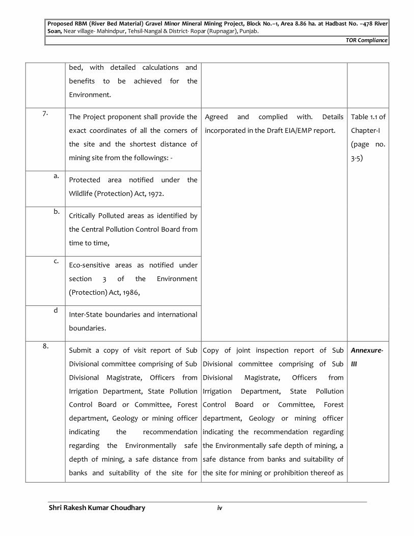
7. The Project proponent shall provide the
exact coordinates of all the corners of
the site and the shortest distance of
mining site from the followings: -
Agreed and complied with. Details
incorporated in the Draft EIA/EMP report.
Table 1.1 of
Chapter-I
(page no.
3-5)
a. Protected area notified under the
Wildlife (Protection) Act, 1972.
b. Critically Polluted areas as identified by
the Central Pollution Control Board from
time to time,
c. Eco-sensitive areas as notified under
section 3 of the Environment
(Protection) Act, 1986,
d Inter-State boundaries and international
boundaries.
8. Submit a copy of visit report of Sub
Divisional committee comprising of Sub
Divisional Magistrate, Officers from
Irrigation Department, State Pollution
Control Board or Committee, Forest
department, Geology or mining officer
indicating the recommendation
regarding the Environmentally safe
depth of mining, a safe distance from
banks and suitability of the site for
Copy of joint inspection report of Sub
Divisional committee comprising of Sub
Divisional Magistrate, Officers from
Irrigation Department, State Pollution
Control Board or Committee, Forest
department, Geology or mining officer
indicating the recommendation regarding
the Environmentally safe depth of mining, a
safe distance from banks and suitability of
the site for mining or prohibition thereof as
Annexure-
III
Proposed RBM (River Bed Material) Gravel Minor Mineral Mining Project, Block No.–1, Area 8.86 ha. at Hadbast No. –478 River Soan, Near village- Mahindpur, Tehsil-Nangal & District- Ropar (Rupnagar), Punjab.
TOR Compliance
Shri Rakesh Kumar Choudhary v
mining or prohibition thereof as per the
Sustainable Sand Mining Management
Guidelines, (SSMMG)-2016 issued by
MOEF&CC.
per the Sustainable Sand Mining
Management Guidelines, (SSMMG)-2016
issued by MOEF&CC is being submitted with
Final EIA/EMP report.
9. Demarcation of the mining site in the
presence of the Revenue officer, Mining
officer, Lambardar, project proponent/
contractor, owner of the land and
owners of the adjoining land and
submission of the demarcation report
duly signed by them.
Copy of demarcation report duly signed by
Revenue officer, Mining officer, Lambardar,
project proponent, owner of the land and
owners of the adjoining land is being
enclosed with this Draft EIA/EMP report.
Annexure-
IV
10. Submit complete transportation plan
giving detailed procedure (details of
route plan to be followed by trucks
transporting minor minerals with traffic
volume data etc.)
Complete transportation plan giving
detailed procedure (details of route plan to
be followed by trucks transporting minor
minerals with traffic volume data etc.) will
be incorporated at the time of submission
of Final EIA/EMP report.
-
11. Submit a copy of ownership of land such
as copy of latest jamabandi and consent
of all the owner of land.
Copy of ownership of land such as copy of
latest jamabandi and consent of all the
owner of land is being enclosed with this
Draft EIA/EMP report.
Annexure-
V
12. A copy of Mining Plan dully approved by
the State Geologist.
A copy of Mining Plan dully approved by the
State Geologist is being enclosed with this
Draft EIA/EMP report.
Annexure-
VI
13. Submit the contour plan showing river
bed level, water level and present
surface levels at various cross sections
Copy of contour plan showing river bed
level, water level and present surface levels
at various cross sections is being enclosed
Annexure-
VII

Proposed RBM (River Bed Material) Gravel Minor Mineral Mining Project, Block No.–1, Area 8.86 ha. at Hadbast No. –478 River Soan, Near village- Mahindpur, Tehsil-Nangal & District- Ropar (Rupnagar), Punjab.
TOR Compliance
Shri Rakesh Kumar Choudhary vi
etc. with this Draft EIA/EMP report.
14. Red line to be marked on the x-sections
in case riverbed mining.
Copy of Red line marked on the x-sections is
being enclosed with this Draft EIA/EMP
report.
Annexure-
VIII
15. Submit 10.0 Km radius map of the area
from periphery of project site clearly
indicating the physical features.
10.0 Km radius map of the area from
periphery of project site clearly indicating
the physical features marked on Survey of
India toposheets is being incorporated in
the Draft EIA/EMP report.
Fig. 1.2,
Chapter-II
(Page no.
7)
16. Submit an undertaking to the effect that
there is no other mine within 500 m.
radius from the periphery of this site.
Not applicable, as the project falls under B-1
Category
-
17. Submit photographs of the mining site
taken from all the four sides mentioning
the coordinates of the project.
Photographs of the mining site taken from
all the four sides mentioning the
coordinates of the project is being enclosed
with this Draft EIA/EMP report.
Annexure-
IX
18. Mining lay out plan showing key
distances of the mining site from the
various features such as river bank,
active channels, bundh and other
structures in the vicinity, if any, drawn
on portion of 'Aks Sajra' of the mining
site, so as to ensure that minimum
statutory distances are maintained. The
route map to be followed should also be
marked on the layout plan.
Mining lay out plan showing key distances
of the mining site from the various features
such as river bank, active channels, bundh
and other structures in the vicinity and
route map marked on the layout plan is
being enclosed with this Draft EIA/EMP
report.
Annexure-
X
Proposed RBM (River Bed Material) Gravel Minor Mineral Mining Project, Block No.–1, Area 8.86 ha. at Hadbast No. –478 River Soan, Near village- Mahindpur, Tehsil-Nangal & District- Ropar (Rupnagar), Punjab.
TOR Compliance
Shri Rakesh Kumar Choudhary vii
19. Submit Corporate Environment
Responsibility (CER) Plan as per the OM
dated 01.05.2018.
Corporate Environment Responsibility
(CER) Plan as per the OM dated 01.05.2018
is being incorporated in the Draft EIA/EMP
report.
Table 8.1,
Chapter
VIII (Page
no. 102)
20. The project proponent is required to get
the hydrogeological survey of the
existing water level done and to submit
the impact on the water level regime
due to the project. This report is
required to be submitted at the time of
submission of the EIA report.
Hydrogeological survey of the existing
water level to submit the impact on the
water level regime due to the project is
being carried out and the same will be
submitted at the time of submission of Final
EIA/EMP report.
-
21. The project proponent shall submit site
specific rain water harvesting details at
the submitted at the time of submission
of the EIA report.
Site specific rain water harvesting details
will be submitted at the time of submission
of Final EIA/EMP report.
-
22. The project proponent is required to
submit a report regarding the
preservation of topsoil excavated during
the mining process at the time of
submission of the EIA report.
Report regarding the preservation of
topsoil excavated during the mining
process is being incorporated in the Draft
EIA/EMP report
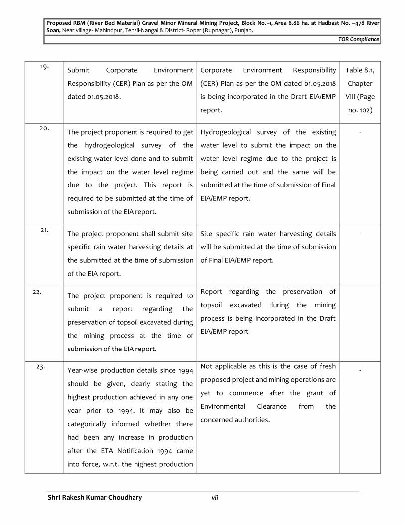
23. Year-wise production details since 1994
should be given, clearly stating the
highest production achieved in any one
year prior to 1994. It may also be
categorically informed whether there
had been any increase in production
after the ETA Notification 1994 came
into force, w.r.t. the highest production
Not applicable as this is the case of fresh
proposed project and mining operations are
yet to commence after the grant of
Environmental Clearance from the
concerned authorities.
-

Proposed RBM (River Bed Material) Gravel Minor Mineral Mining Project, Block No.–1, Area 8.86 ha. at Hadbast No. –478 River Soan, Near village- Mahindpur, Tehsil-Nangal & District- Ropar (Rupnagar), Punjab.
TOR Compliance
Shri Rakesh Kumar Choudhary viii
achieved prior to 1994.
24. Submit a copy of the document in
support of the fact that the Proponent is
the rightful lessee of the mine such as
letter of Intent (LOI) from the State
government/Allotment letter of mining
site etc
Copy of letter of Intent (LOI) indicating that
the Proponent is the rightful lessee of the
mine is being enclosed with this Draft
EIA/EMP report.
Annexure-
XI
25. All documents including approved mine
plan, EIA and Public Hearing should be
compatible with one another in terms of
the mine lease area, production levels,
waste generation and its management,
mining technology etc. and should be in
the name of the lessee.
All documents including approved mine plan, EIA and Public Hearing should be compatible with one another in term of following aspects: -
Particulars As per Mining Plan with PMCP
As per Draft EIA/EMP Report
Block No. 01 01
Mine Area 8.86 ha. 8.86 ha. Production Capacity (TPA)
63,991 TPA 63,991 TPA
Ultimate Working Depth
3.0 m bgl 3.0 m bgl
Waste Generation (MT) & Management
RBM to be exploited shall be saleable, therefore no question arises for waste management
RBM to be exploited shall be saleable, therefore no question arises for waste management
Mining Technology
Open cast manual cum semi-mechanized
Open cast manual cum semi-mechanized
Chapter-II
(Page No. -
14)
26. All corner coordinates of the mine lease
area, superimposed on a High
Resolution Imagery/toposheet,
topographic sheet, geomorphology and
geology of the area should be provided.
Such an Imagery of the proposed area
should clearly show the land use and
other ecological features of the study
All corner coordinates of the mine area superimposed on a High-Resolution toposheet showing ecological features are incorporated in this Draft EIA/EMP Report. Imagery of the proposed area clearly shows the land use and other ecological features of the study area (core and buffer zone) for Land use.
Chapter-I
(Page No.:
-7)
Proposed RBM (River Bed Material) Gravel Minor Mineral Mining Project, Block No.–1, Area 8.86 ha. at Hadbast No. –478 River Soan, Near village- Mahindpur, Tehsil-Nangal & District- Ropar (Rupnagar), Punjab.
TOR Compliance
Shri Rakesh Kumar Choudhary ix
area (core and buffer zone)
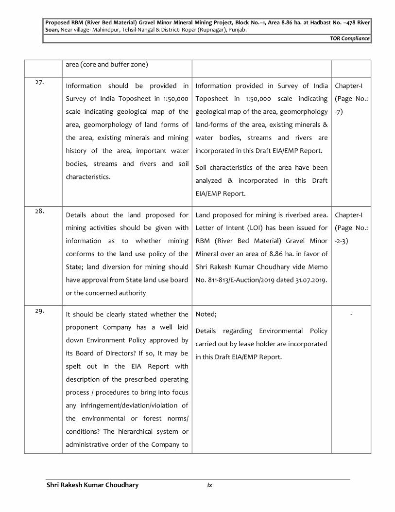
27. Information should be provided in
Survey of India Toposheet in 1:50,000
scale indicating geological map of the
area, geomorphology of land forms of
the area, existing minerals and mining
history of the area, important water
bodies, streams and rivers and soil
characteristics.
Information provided in Survey of India
Toposheet in 1:50,000 scale indicating
geological map of the area, geomorphology
land-forms of the area, existing minerals &
water bodies, streams and rivers are
incorporated in this Draft EIA/EMP Report.
Soil characteristics of the area have been
analyzed & incorporated in this Draft
EIA/EMP Report.
Chapter-I
(Page No.:
-7)
28. Details about the land proposed for
mining activities should be given with
information as to whether mining
conforms to the land use policy of the
State; land diversion for mining should
have approval from State land use board
or the concerned authority
Land proposed for mining is riverbed area.
Letter of Intent (LOI) has been issued for
RBM (River Bed Material) Gravel Minor
Mineral over an area of 8.86 ha. in favor of
Shri Rakesh Kumar Choudhary vide Memo
No. 811-813/E-Auction/2019 dated 31.07.2019.
Chapter-I
(Page No.:
-2-3)
29. It should be clearly stated whether the
proponent Company has a well laid
down Environment Policy approved by
its Board of Directors? If so, It may be
spelt out in the EIA Report with
description of the prescribed operating
process / procedures to bring into focus
any infringement/deviation/violation of
the environmental or forest norms/
conditions? The hierarchical system or
administrative order of the Company to
Noted;
Details regarding Environmental Policy
carried out by lease holder are incorporated
in this Draft EIA/EMP Report.
-

Proposed RBM (River Bed Material) Gravel Minor Mineral Mining Project, Block No.–1, Area 8.86 ha. at Hadbast No. –478 River Soan, Near village- Mahindpur, Tehsil-Nangal & District- Ropar (Rupnagar), Punjab.
TOR Compliance
Shri Rakesh Kumar Choudhary x
deal with the environmental issues and
for ensuring compliance with the EC
conditions may also be given. The
system of reporting of non-compliances
/ violations of environmental norms to
the Board of Directors of the Company
and/or shareholders or stakeholders at
large, may also be detailed in the
proposed safeguard measures in each
case should also be provided.
30. Issues relating to Mine Safety, Including
subsidence study in case of underground
mining and slope study in case of open
cast mining should be detalled. The
proposed safeguard measures in each
case should also be provided.
Issues relating to Mine Safety will be
followed as per prescribed Rules &
Regulation.
Subsidence Study is not applicable as this is
a River Bed Mining Project.
Slope Study is not applicable as this is a no
overburden exist there.
Blasting Study: -Mining operation will be
done by opencast manual cum semi-
mechanized method.
No blasting will be carried out during
mining operation; hence Blasting study is
not applicable.
-
31. The study area will comprise of 10 km
zone around the mine lease from lease
periphery and the data contained in the
EIA such as waste generation etc. should
be for the life of the mine / lease period.
Study area comprises of 10 km radius from
the proposed riverbed mining project area.
Details regarding core & buffer zone
incorporated in this Draft EIA/EMP Report.
Data like Reserve estimation, Waste
Proposed RBM (River Bed Material) Gravel Minor Mineral Mining Project, Block No.–1, Area 8.86 ha. at Hadbast No. –478 River Soan, Near village- Mahindpur, Tehsil-Nangal & District- Ropar (Rupnagar), Punjab.
TOR Compliance
Shri Rakesh Kumar Choudhary xi
generation etc. has been incorporated in
this Draft EIA/EMP Report.
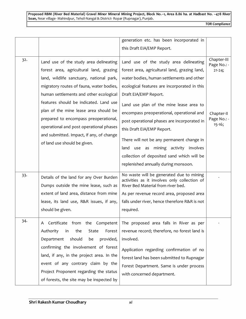
32. Land use of the study area delineating
forest area, agricultural land, grazing
land, wildlife sanctuary, national park,
migratory routes of fauna, water bodies,
human settlements and other ecological
features should be indicated. Land use
plan of the mine lease area should be
prepared to encompass preoperational,
operational and post operational phases
and submitted. Impact, if any, of change
of land use should be given.
Land use of the study area delineating
forest area, agricultural land, grazing land,
water bodies, human settlements and other
ecological features are incorporated in this
Draft EIA/EMP Report.
Land use plan of the mine lease area to
encompass preoperational, operational and
post operational phases are incorporated in
this Draft EIA/EMP Report.
There will not be any permanent change in
land use as mining activity involves
collection of deposited sand which will be
replenished annually during monsoon.
Chapter-III Page No.: -
21-24;
Chapter-II Page No.: -
15-16;
33. Details of the land for any Over Burden
Dumps outside the mine lease, such as
extent of land area, distance from mine
lease, its land use, R&R issues, if any,
should be given.
No waste will be generated due to mining activities as it involves only collection of River Bed Material from river bed.
As per revenue record area, proposed area
falls under river, hence therefore R&R is not
required.
-
34. A Certificate from the Competent
Authority in the State Forest
Department should be provided,
confirming the involvement of forest
land, if any, in the project area. In the
event of any contrary claim by the
Project Proponent regarding the status
of forests, the site may be inspected by
The proposed area falls in River as per
revenue record; therefore, no forest land is
involved.
Application regarding confirmation of no
forest land has been submitted to Rupnagar
Forest Department. Same is under process
with concerned department.
-

Proposed RBM (River Bed Material) Gravel Minor Mineral Mining Project, Block No.–1, Area 8.86 ha. at Hadbast No. –478 River Soan, Near village- Mahindpur, Tehsil-Nangal & District- Ropar (Rupnagar), Punjab.
TOR Compliance
Shri Rakesh Kumar Choudhary xii
the State Forest Department along with
the Regional Office of the Ministry to
ascertain the status of forests, based on
which, the Certificate in this regard as
mentioned above be issued. In all such
cases, it would be desirable for
representative of the State Forest
Department to assist the Expert
Appraisal Committees.
35. Status of forestry clearance for the
broken-up area and virgin forestland
involved in the Project including
deposition of net present value (NPV)
and compensatory afforestation (CA)
should be indicated. A copy of the
forestry clearance should also be
furnished.
The proposed area is a part of River No
forest land is involved.
-
36. Implementation status of recognition of
forest rights under the Scheduled Tribes
and other Traditional Forest Dwellers
(Recognition of Forest Rights) Act, 2006
should be indicated.
No forest land is involved in the proposed
mining area and this clause is not applicable
to this project.
-
37. The vegetation in the RF / PF areas in the
study area, with necessary details,
should be given.
Details regarding Protected Forest &
Reserved Forest in study area are
incorporated in this Draft EIA/EMP Report.
Chapter-I
(Page No.:
-4-5)
38. A study shall be got done to ascertain
the impact of the Mining Project on
wildlife of the study area and details
Biological Study with cost implications has
been conducted for the project &
incorporated in this Draft EIA/EMP Report.
Chapter-III (Page No.:
-49-56)

Proposed RBM (River Bed Material) Gravel Minor Mineral Mining Project, Block No.–1, Area 8.86 ha. at Hadbast No. –478 River Soan, Near village- Mahindpur, Tehsil-Nangal & District- Ropar (Rupnagar), Punjab.
TOR Compliance
Shri Rakesh Kumar Choudhary xiii
furnished. Impact of the project on the
wildlife in the surrounding and any other
protected area and accordingly, detailed
mitigative measures required, should be
worked out with cost implications and
submitted.
Impact of the Mining Project on wildlife &
its mitigative measures on the study area
are incorporated in this Draft EIA/EMP
Report.
Chapter-
IV
(Page No.:
-81-82)
39. Location of National Parks, Sanctuaries,
Biosphere Reserves, Wildlife Corridors,
Ramsar site Tiger/Elephant
Reserves/(existing as well as proposed),
if any, within 10 km of the mine lease
should be dearly indicated, supported by
a location map duly authenticated by
Chief Wildlife Warden. Necessary
clearance, as may be applicable to such
projects due to proximity of the
ecologically sensitive areas as
mentioned above, should be obtained
from the Standing Committee of
National Board of Wildlife and copy
furnished.
Location of Wildlife Sanctuary within 10 km
of the mine lease is being clearly indicated
on Survey of India toposheet and
Application regarding authentication of
Location map has been submitted to State
Forest Dept & same is under process with
concerned Department.
Chapter-I
(Page No.:
-7)
40. A detailed biological study of the study
area [core zone and buffer zone (10 km
radius of the periphery of the mine
lease)] shall be carried out. Details of
flora and fauna, endangered, endemic
and RET Species duly authenticated,
separately for core and buffer zone
should be furnished based on such
Detailed Biological Study for the study area (Core & Buffer Zone) has been conducted and the details are incorporated in this Draft EIA/EMP Report. Letter reg. authentication list of Flora & Fauna for core & buffer zone has been submitted to the State forest department.
Same is under process with concerned
Department.
Chapter-III (Page No.:
-49-56)

Proposed RBM (River Bed Material) Gravel Minor Mineral Mining Project, Block No.–1, Area 8.86 ha. at Hadbast No. –478 River Soan, Near village- Mahindpur, Tehsil-Nangal & District- Ropar (Rupnagar), Punjab.
TOR Compliance
Shri Rakesh Kumar Choudhary xiv
primary field survey, clearly indicating
the Schedule of the fauna present. In
case of any scheduled-I fauna found in
the study area, the necessary plan
alongwith budgetary provisions for their
conservation should be prepared in
consultation with State Forest and
Wildlife Department and details
furnished. Necessary allocation of funds
for implementing the same should be
made as part of the project cost.
41. Proximity to Areas declared as 'Critically
Polluted' or the Project areas attracting
court restrictions for mining operations,
should also be indicated and where so
required, clearance certifications from
the prescribed Authorities, such as the
SPCB or State Mining Dept. Should be
secured and furnished to the effect that
the proposed mining activities could be
considered.
No Critically Polluted areas as notified by
the Central Pollution Control Board are
located within 10 km from the boundary of
mining area.
Chapter-I
(Page No.:
-4-5)
42. R&R Plan/compensation details for the
Project Affected People (PAP) should be
furnished. While preparing the R&R Plan,
the relevant State/National
Rehabilitation & Resettlement Policy
should be kept in view. In respect of SCS
/STS and other weaker sections of the
society in the study area, a need based
The proposed ML Area is a part of River as
per the revenue record of Punjab State
Govt. Hence R&R is not applicable.
-
Proposed RBM (River Bed Material) Gravel Minor Mineral Mining Project, Block No.–1, Area 8.86 ha. at Hadbast No. –478 River Soan, Near village- Mahindpur, Tehsil-Nangal & District- Ropar (Rupnagar), Punjab.
TOR Compliance
Shri Rakesh Kumar Choudhary xv
sample survey, family-wise, should be
undertaken to assess their
requirements, and action programmes
prepared and submitted accordingly,
integrating the sectoral programmes of
line departments of the State
Government. It may be clearly brought
out whether the village(s) located in the
mine lease area will be shifted or not.
The issues relating to shifting of
village(s) including their R&R and socio-
economic aspects should be discussed in
the Report.
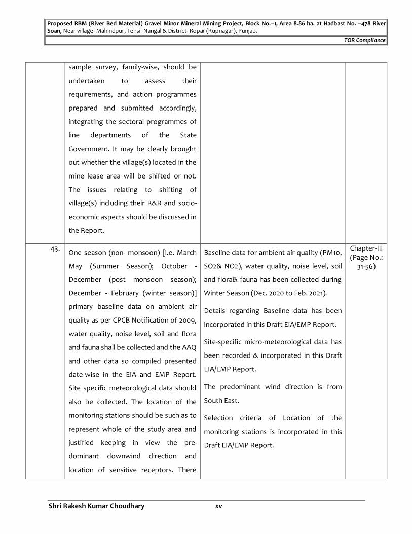
43. One season (non- monsoon) [l.e. March
May (Summer Season); October -
December (post monsoon season);
December - February (winter season)]
primary baseline data on ambient air
quality as per CPCB Notification of 2009,
water quality, noise level, soil and flora
and fauna shall be collected and the AAQ
and other data so compiled presented
date-wise in the EIA and EMP Report.
Site specific meteorological data should
also be collected. The location of the
monitoring stations should be such as to
represent whole of the study area and
justified keeping in view the pre-
dominant downwind direction and
location of sensitive receptors. There
Baseline data for ambient air quality (PM10,
SO2& NO2), water quality, noise level, soil
and flora& fauna has been collected during
Winter Season (Dec. 2020 to Feb. 2021).
Details regarding Baseline data has been
incorporated in this Draft EIA/EMP Report.
Site-specific micro-meteorological data has
been recorded & incorporated in this Draft
EIA/EMP Report.
The predominant wind direction is from
South East.
Selection criteria of Location of the
monitoring stations is incorporated in this
Draft EIA/EMP Report.
Chapter-III (Page No.:
31-56)
Proposed RBM (River Bed Material) Gravel Minor Mineral Mining Project, Block No.–1, Area 8.86 ha. at Hadbast No. –478 River Soan, Near village- Mahindpur, Tehsil-Nangal & District- Ropar (Rupnagar), Punjab.
TOR Compliance
Shri Rakesh Kumar Choudhary xvi
should be at least one monitoring
station within 500 m of the mine lease in
the pre-dominant downwind direction.
The mineralogical composition of PM10,
particularly for free silica, should be
given.
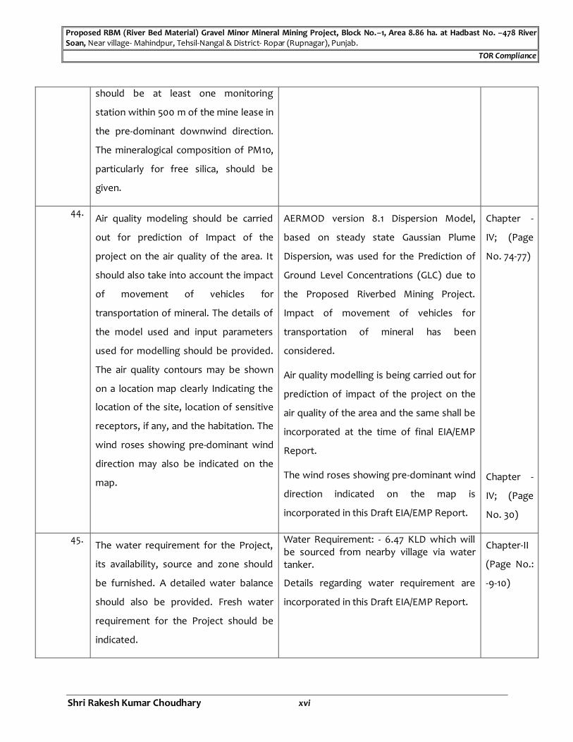
44. Air quality modeling should be carried
out for prediction of Impact of the
project on the air quality of the area. It
should also take into account the impact
of movement of vehicles for
transportation of mineral. The details of
the model used and input parameters
used for modelling should be provided.
The air quality contours may be shown
on a location map clearly Indicating the
location of the site, location of sensitive
receptors, if any, and the habitation. The
wind roses showing pre-dominant wind
direction may also be indicated on the
map.
AERMOD version 8.1 Dispersion Model,
based on steady state Gaussian Plume
Dispersion, was used for the Prediction of
Ground Level Concentrations (GLC) due to
the Proposed Riverbed Mining Project.
Impact of movement of vehicles for
transportation of mineral has been
considered.
Air quality modelling is being carried out for
prediction of impact of the project on the
air quality of the area and the same shall be
incorporated at the time of final EIA/EMP
Report.
The wind roses showing pre-dominant wind
direction indicated on the map is
incorporated in this Draft EIA/EMP Report.
Chapter -
IV; (Page
No. 74-77)
Chapter -
IV; (Page
No. 30)
45. The water requirement for the Project,
its availability, source and zone should
be furnished. A detailed water balance
should also be provided. Fresh water
requirement for the Project should be
indicated.
Water Requirement: - 6.47 KLD which will be sourced from nearby village via water tanker.
Details regarding water requirement are
incorporated in this Draft EIA/EMP Report.
Chapter-II
(Page No.:
-9-10)

Proposed RBM (River Bed Material) Gravel Minor Mineral Mining Project, Block No.–1, Area 8.86 ha. at Hadbast No. –478 River Soan, Near village- Mahindpur, Tehsil-Nangal & District- Ropar (Rupnagar), Punjab.
TOR Compliance
Shri Rakesh Kumar Choudhary xvii
46. Necessary clearance from the
Competent Authority for drawl of
requisite quantity of water for the
Project should be provided.
Water will be sourced from nearby villages. -
47. Description of water conservation
measures proposed to be adopted in the
Project should be given. Details of
rainwater harvesting proposed in the
Project, If any, should be provided
Details regarding Water Conservation
Measures are incorporated in this Draft
EIA/EMP Report.
Chapter-X
(Page No.:
-106-107)
48. Impact of the Project on the water
quality, both surface and groundwater,
should be assessed and necessary
safeguard measures, if any required,
should be provided.
Details of impact of the project on the
water quality both surface and
groundwater & Necessary safeguard
measures proposed to be adopted &
incorporated in this Draft EIA/EMP Report.
Chapter-IV
(Page No.:
-79-79)
49. Based on actual monitored data, it may
clearly be shown whether working will
intersect groundwater. Necessary data
and documentation in this regard may
be provided. In case the working will
Intersect groundwater table, a detailed
Hydro Geological Study should be
undertaken and Report furnished. The
Report Inter alia, shall include details of
the aquifers present and impact of
mining activities on these aquifers.
Necessary permission from Central
Ground Water Authority for working
below ground water and for pumping of
Mining will be done within the river-bed for
collection of RBM upto 3 mtr. from surface
which is well above the ground water table.
Thus, working will not intersect the ground
water table level.
Mining will be done as per Approved Mining Plan & Progressive Mine Closure Plan.
Details of the same have been incorporated
in this Draft EIA/EMP Report.
-

Proposed RBM (River Bed Material) Gravel Minor Mineral Mining Project, Block No.–1, Area 8.86 ha. at Hadbast No. –478 River Soan, Near village- Mahindpur, Tehsil-Nangal & District- Ropar (Rupnagar), Punjab.
TOR Compliance
Shri Rakesh Kumar Choudhary xviii
ground water should also be obtained
and copy furnished.
50.
Details of any stream, seasonal or
otherwise, passing through the lease
area and modification/ diversion
proposed, if any, and the impact of the
same on the hydrology should be.
This is a Proposal for Riverbed Mining Project for collection of RBM. Adequate protection measures will be followed for protection of river bank and its course viz: -
Mining will proceed along the river in the direction from downstream to upstream. No mining will be done across the river channel.
Adequate width as safety margin will be left on both sides of river banks during collection of RBM to permit unhindered flow of water.
Details of same incorporated in this Draft
EIA/EMP Report.
Chapter-II
(Page No.:
-13)
51. Information on site elevation, working
depth, groundwater table etc. Should be
provided both in AMSL and BGL A
schematic diagram may also be provided
for the same.
Mining will be done within the river-bed for
collection of RBM.
Elevation Range: -283.210 mRL to 285.896
mRL
Water Table: -3-11 mtr.
Ultimate working Depth: - 3 m bgl
Thus, working will not intersect the
groundwater table level.
Thus, working will not intersect the
groundwater table level.
Mining will be done as per Approved Mining
Plan & Progressive Mine Closure Plan has
been incorporated in this Draft EIA/EMP
Report.
Chapter-II
(Page No.:
-13)
52. A time bound Progressive Greenbelt
Development Plan shall be prepared in a
tabular form (Indicating the linear and
Time bound Progressive Greenbelt Development Plan prepared in a tabular form has been incorporated in this Draft EIA/EMP Report.
Selection criteria for plant species keeping
Chapter-X
(Page No.:
-109)

Proposed RBM (River Bed Material) Gravel Minor Mineral Mining Project, Block No.–1, Area 8.86 ha. at Hadbast No. –478 River Soan, Near village- Mahindpur, Tehsil-Nangal & District- Ropar (Rupnagar), Punjab.
TOR Compliance
Shri Rakesh Kumar Choudhary xix
quantitative coverage, plant species and
time frame) and submitted, keeping in
mind, the same will have to be executed
up front on commencement of the
Project. Phase-wise plan of plantation
and compensatory afforestation should
be charted clearly Indicating the area to
be covered under plantation and the
species to be planted. The details of
plantation already done should be given.
The plant species selected for green belt
should have greater ecological value and
should be of good utility value to the
local population with emphasis on local
and native species and the species which
are tolerant to pollution.
in view of ecological value has been
incorporated in this Draft EIA/EMP Report.
53. Impact on local transport infrastructure
due to the Project should be Indicated.
Projected Increase in truck traffic as a
result of the Project in the present road
network (Including those outside the
Project area) should be worked out,
Indicating whether it is capable of
handling the Incremental load.
Arrangement for Improving the
infrastructure, if contemplated
(Including action to be taken by other
agencies such as State Government)
should be covered. Project Proponent
shall conduct Impact of Transportation
Around 63,991 TPA of RBM will be
excavated.
Transportation of RBM from river bed face
to consumers will be through by
trucks/tractor trolleys.
Truck /tractor owners will purchase the
RBM from the face. Approach roads will be
provided up to the river bed face of RBM.
Maintenance of the approach road shall be
done whenever required.
Details of the Impact on local transport
infrastructure due to the Project are
incorporated in this Draft EIA/EMP Report.
Chapter-IV
(Page No.:
-81)

Proposed RBM (River Bed Material) Gravel Minor Mineral Mining Project, Block No.–1, Area 8.86 ha. at Hadbast No. –478 River Soan, Near village- Mahindpur, Tehsil-Nangal & District- Ropar (Rupnagar), Punjab.
TOR Compliance
Shri Rakesh Kumar Choudhary xx
study as per Indian Road Congress
Guidelines.
54. Details of the onsite shelter and facilities
to be provided to the mine workers
should be included in the EIA Report.
Onsite shelter and facilities to be provided
to the mine workers as per Approved
Mining Plan & as per mines rules.
The people living in the nearby villages will
be employed. Mine working will be done
only in one shift during day time only. Thus,
there is no requirement of major
infrastructural facilities at the site.
Following are the infrastructural facilities
which will be provided to the workers.
Rest Shelter;
Water Supply;
First Aid Facility
Details of the same have been incorporated
in this Draft EIA/EMP Report.
-
55. Conceptual post mining land use and
Reclamation and Restoration of mined
out areas (with plans and with adequate
number of sections) should be given in
the EIA report.
Details of Conceptual post mining land use
and Reclamation and Restoration of mined
out areas has been incorporated in this
Draft EIA/EMP Report.
Chapter-X
(Page No.:
-108)
56. Occupational Health Impacts of the
Project should be anticipated and the
proposed preventive measures spelt out
in detail. Details of pre-placement
medical examination and periodical
medical examination schedules should
be Incorporated in the EMP. The project
specific occupational health mitigation
measures with required facilities
Details reg. Occupational Health impacts of the Project with anticipated and the proposed preventive measures, which will be as per Mines & safety guidelines has been incorporated in this Draft EIA/EMP Report.
Details of pre-placement medical
examination and periodical medical
examination schedules are incorporated in
this Draft EIA/EMP Report.
Chapter-IV Page No.: -
82-84;
-

Proposed RBM (River Bed Material) Gravel Minor Mineral Mining Project, Block No.–1, Area 8.86 ha. at Hadbast No. –478 River Soan, Near village- Mahindpur, Tehsil-Nangal & District- Ropar (Rupnagar), Punjab.
TOR Compliance
Shri Rakesh Kumar Choudhary xxi
proposed in the mining area may be
detailed.
57. Public health implications of the Project
and related activities for the population
in the impact zone should be
systematically evaluated and the
proposed remedial measures should be
detailed along with budgetary
allocations.
Public health implications of the project and
related activities for the population in the
impact zone have been evaluated and
common diseases were identified
incorporated in this Draft EIA/EMP Report.
Chapter-IV Page No.: -
80;
58. Measures of socio economic significance
and influence to the local community
proposed to be provided by the Project
Proponent should be indicated. As far as
possible, quantitative dimensions may
be given with time frames for
implementation.
Measures of socio-economic significance &
influence to the local community proposed
with time frames for implementation are
incorporated in this Draft EIA/EMP Report.
Chapter-IV Page No.: -
80-81;
59. Detailed environmental management
plan (EMP) to mitigate the
environmental impacts which, should
inter-alia include the impacts of change
of land use, loss of agricultural and
grazing land, if any, occupational health
impacts besides other Impacts specific
to the proposed Project.
Detailed regarding environmental
management plan (EMP) to mitigate the
environmental impacts are incorporated in
this Draft EIA/EMP Report.
Chapter-X Page No.: -
105-111;
60. Public Hearing points raised and
commitment of the Project Proponent
on the same along with time bound
Action Plan with budgetary provisions to
Points raised during Public hearing will be
addressed in Final EIA/EMP report.
-
Proposed RBM (River Bed Material) Gravel Minor Mineral Mining Project, Block No.–1, Area 8.86 ha. at Hadbast No. –478 River Soan, Near village- Mahindpur, Tehsil-Nangal & District- Ropar (Rupnagar), Punjab.
TOR Compliance
Shri Rakesh Kumar Choudhary xxii
implement the same should be provided
I also incorporated in the final EIA/EMP
Report of the Project.
61. Submit an undertaking to the effect that
no litigation/court case is pending before
any court of law against the project
and/or on land in which mining is to be
carried out else submit the details of
litigation pending against the project, if
any, with direction /order passed by any
Court of Law against the Project should
be given.
No litigation is pending against the project. -
62. The cost of the Project (capital cost and
recurring cost) as well as the cost
towards implementation of EMP should
be clearly spelt out.
Project Cost: - Rs. 100 Lacs Cost for Corporate Environmental Responsibility: - Capital Cost: - Rs. 1.50 Lacs
Recurring Cost: - Rs. 2.0 Lacs
Chapter-I Page No.: -
5;
63 A Disaster Management Plan shall be
prepared and Included in the EIA/EMP
Report.
Disaster Management Plan has been
prepared & incorporated in this Draft
EIA/EMP Report.
Chapter-
VII Page
No.: -93;
64. Benefits of the Project if the Project is
implemented should be spelt out. The
benefits of the Project shall dearly
indicate environmental, social,
economic, employment potential, etc.
Benefits of the Project regarding
environmental, social, economic,
employment potential is incorporated in
this Draft EIA/EMP Report.
Chapter-VIII Page No.: -101-
102;
65. Besides the above, the below mentioned general points are also to be followed:

Proposed RBM (River Bed Material) Gravel Minor Mineral Mining Project, Block No.–1, Area 8.86 ha. at Hadbast No. –478 River Soan, Near village- Mahindpur, Tehsil-Nangal & District- Ropar (Rupnagar), Punjab.
TOR Compliance
Shri Rakesh Kumar Choudhary xxiii
a. The EIA document shall be printed on
both sides, as for as possible.
Agreed and complied with. -
b. All documents to be properly referenced
with index and continuous page
numbering.
Complied. All documents properly
referenced with index and continuous page
numbering.
-
c. The copy of the letter received from the
Ministry / SEIAA shall be also attached as
an annexure to the final EIA-EMP
Report.
Copy of the letter received from the
Ministry / SEIAA will be attached as an
annexure to the final EIA-EMP Report.
-
d. Where data are presented in the Report
especially in Tables, the period in which
the data were collected and the sources
should be indicated.
Tables mentioned in Draft EIA/EMP Report
contain the period in which the data were
collected and the sources.
-
e. Project Proponent shall enclose all the
analysis/testing reports of water, air,
soll, noise etc. using the MoEF&CC/NABL
accredited laboratories. All the original
analysis/testing reports should be
available during appraisal of the Project.
All the analysis reports of water, air, soil,
noise etc. using the MoEF& CC accredited
laboratories will be submitted to Final
EIA/EMP Report.
f. Where the documents provided are in a
language other than English, an English
translation should be provided.
All the documents are being submitted in
English.
-
g. The Questionnaire for environmental
appraisal of mining projects as devised
earlier by the Ministry shall also be filled
and submitted.
Noted. Questionnaire for environmental
appraisal of mining projects will be
submitted at the time of Final EIA/EMP
Report.
-
Proposed RBM (River Bed Material) Gravel Minor Mineral Mining Project, Block No.–1, Area 8.86 ha. at Hadbast No. –478 River Soan, Near village- Mahindpur, Tehsil-Nangal & District- Ropar (Rupnagar), Punjab.
TOR Compliance
Shri Rakesh Kumar Choudhary xxiv
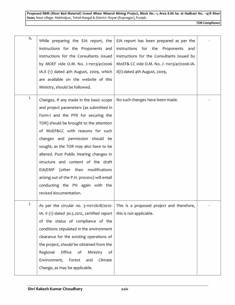
h. While preparing the EIA report, the
instructions for the Proponents and
instructions for the Consultants issued
by MOEF vide O.M. No. J-11013/41/2006
IA.II (1) dated 4th August, 2009, which
are available on the website of this
Ministry, should be followed.
EIA report has been prepared as per the
instructions for the Proponents and
instructions for the Consultants issued by
MoEF& CC vide O.M. No. J- 11013/41/2006-IA.
II(I) dated 4th August, 2009,
-
i. Changes, If any made in the basic scope
and project parameters (as submitted in
Form-I and the PFR for securing the
TOR) should be brought to the attention
of MoEF&CC with reasons for such
changes and permission should be
sought, as the TOR may also have to be
altered. Post Public Hearing changes in
structure and content of the draft
EIA/EMP (other than modifications
arising out of the P.H. process) will entail
conducting the PH again with the
revised documentation.
No such changes have been made. -
j. As per the circular no. 3-11011/618/2010-
IA. II (1) dated 30.5.2012, certified report
of the status of compliance of the
conditions stipulated in the environment
clearance for the existing operations of
the project, should be obtained from the
Regional Office of Ministry of
Environment, Forest and Climate
Change, as may be applicable.
This is a proposed project and therefore,
this is not applicable.
-

Proposed RBM (River Bed Material) Gravel Minor Mineral Mining Project, Block No.–1, Area 8.86 ha. at Hadbast No. –478 River Soan, Near village- Mahindpur, Tehsil-Nangal & District- Ropar (Rupnagar), Punjab.
TOR Compliance
Shri Rakesh Kumar Choudhary xxv
k. The EIA report should also include
(i) surface plan of the area indicating
contours of main topographic features,
drainage and mining area,
(ii) geological maps and sections and
(iii) Sections of the mine pit and external
dumps, if any, clearly showing the land
features of the adjoining area.
Surface geological plan, conceptual plan &
their sections have been annexed in this
Draft EIA/EMP Report.
Annexure-
XII
I. Submit a copy of presentation in PPT
format along with application.
Copy of presentation in PPT format has
been submitted along with application.
-
66. The Terms of Reference' (TORS)
prescribed will be valid for a period of
three years from its issuance. The final
EIA report shall be submitted to the
SEIAA, Punjab for obtaining
environmental clearance. Additional
Conditions:
Agreed and the same shall be complied
with.
-
Additional Conditions:
1. The project proponent shall submit the
approved DSR endorsed by the DC,
Rupnagar clearly mentioning the Khasra
Numbers of the site at the time of
submission of the EIA report.
Copy of approved DSR endorsed by the DC,
Rupnagar clearly mentioning the Khasra
Numbers of the site will be submitted at the
time of Final EIA/EMP report.
-
2. The project proponent is required to get
the hydrogeological survey of the
existing water level and to submit the
Hydrogeological survey of the existing
water level to submit the impact on the
water level regime due to the project is
-

Proposed RBM (River Bed Material) Gravel Minor Mineral Mining Project, Block No.–1, Area 8.86 ha. at Hadbast No. –478 River Soan, Near village- Mahindpur, Tehsil-Nangal & District- Ropar (Rupnagar), Punjab.
TOR Compliance
Shri Rakesh Kumar Choudhary xxvi
impact on the water level regime due to
the project. This report is required to be
submitted at the time of submission of
the EIA report.
being carried out and the same will be
submitted at the time of submission of Final
EIA/EMP report.
3. The project proponent is required to
submit a report regarding the
preservation of topsoil excavated during
the mining process at the time of
submission of the EIA report.
Report regarding the preservation of
topsoil excavated during the mining
process is being incorporated in the Draft
EIA/EMP report
-
4. Submit the transportation route map
away from the habitation area.
Complete transportation plan giving
detailed procedure (details of route plan to
be followed by trucks transporting minor
minerals with traffic volume data etc.) will
be incorporated at the time of submission
of Final EIA/EMP report.
-
5. Submit proper certificate regarding the
cluster formation issued by the
concerned Executive Engineer of the
Mining Department.
Copy of certificate regarding the cluster
formation issued by the concerned
Executive Engineer of the Mining
Department is being enclosed with the
Draft EIA/EMP report.
Annexure-
XIII
6. Examine the impact of the mining
activity on the near-by villages and
suggest the controlled measure to
mitigate the identified adverse impacts
on the villages.
The impact of the mining activity on the
near-by villages are being examined and the
controlled measure to mitigate the
identified adverse impacts on the villages is
being suggested in the Draft EIA/EMP
report.
Chapter-IV
(Page no.
74-84)

Proposed RBM (River Bed Material) Gravel Minor Mineral Mining Project, Block No.–1, Area 8.86 ha. at Hadbast No. –478 River Soan, Near village- Mahindpur, Tehsil-Nangal & District- Ropar (Rupnagar), Punjab.
TOR Compliance
Shri Rakesh Kumar Choudhary xxvii
7. Submit the distance of the mining site
from the protected areas notified under
the Wild Life (Protection), Act 1972.
The distance of the mining site from the
protected areas notified under the Wild Life
(Protection), Act 1972 is clearly indicated on
Survey of India toposheets is being
incorporated in the Draft EIA/EMP report.
Fig. 1.2,
Chapter-II
(Page no.
7)
8. Examine the mining area falling under
the instream of river Sutlej.
Mining area is not falling under the instream
of river Sutlej and it can be clearly verified
on google imagery.
-
9. Submit the ownership details of the
mining site.
Copy of letter of Intent (LOI) indicating that
the Proponent is the rightful lessee of the
mine is being enclosed with this Draft
EIA/EMP report.
Annexure-
XI
The Terms of Reference (TORS) prescribed will be valid for a period of three years from its issuance.
The final EIA report shall be submitted to the SEIAA, Punjab for obtaining environmental clearance.
The Terms of Reference (ToR) prescribed by the State Expert Appraisal Committee (SEAC), Punjab
should be considered for the preparation of EIA / EMP report for the project in addition to all the relevant
information as per the Generic: Structure of EIA given in Appendix III and IIIA in the EIA Notification, 2006. Where
the documents provided are in a language other than English, an English translation shall be provided. The draft
EIA-EMP report shall be submitted to the State Pollution Control Board of the concerned State for the conduct of
Public Hearing. The SPCB shall conduct the Public Hearing/public consultation, district-wise, as per the provisions
of EIA notification, 2006. The Public Hearing shall be chaired by an Officer, not below the rank of Additional
District Magistrate. The issues raised in the Public Hearing and during the consultation process and the
commitments made by the project proponent on the same shall be included separately in EIA-EMP Report in a
separate chapter and summarized in a tabular chart with financial budget (capital and revenue) along with time-
schedule of implementation for complying with the commitments made.
If any part of the data/information submitted by the project proponent is found to be false or misleading at any
stage, then SEIAA & SEAC will not be responsible for the expenditure incurred on the project due to issuance of
this ToR or subsequent work carried out by the project proponent for conducting EIA study or for any other
Proposed RBM (River Bed Material) Gravel Minor Mineral Mining Project, Block No.–1, Area 8.86 ha. at Hadbast No. –478 River Soan, Near village- Mahindpur, Tehsil-Nangal & District- Ropar (Rupnagar), Punjab.
TOR Compliance
Shri Rakesh Kumar Choudhary xxviii
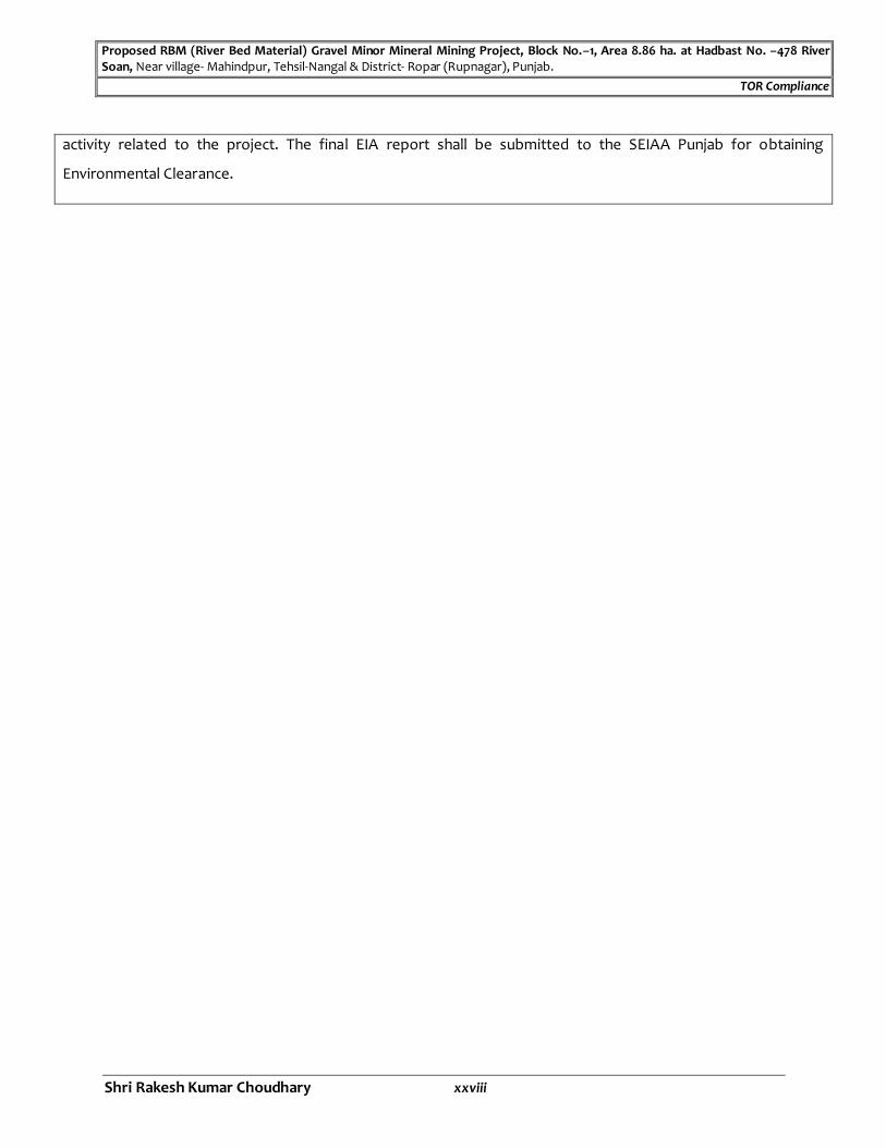
activity related to the project. The final EIA report shall be submitted to the SEIAA Punjab for obtaining
Environmental Clearance.
Proposed RBM (River Bed Material) Gravel Minor Mineral Mining Project, Block No.–1, Area 8.86 ha. at Hadbast No. –478 River Soan, Near village- Mahindpur, Tehsil-Nangal & District- Ropar (Rupnagar), Punjab.
Draft EIA/EMP Report
Shri Rakesh Kumar Choudhary 1
CHAPTER–I
INTRODUCTION
1.1 PURPOSE OF THE REPORT
Economic, social and environmental change is inherent to development. Whilst
development aims to bring about positive change it can lead to conflicts. In the past, the
promotion of economic growth as the motor for increased well-being was the main
development thrust with little sensitivity to adverse social or environmental impacts. The
need to avoid adverse impacts and to ensure long term benefits led to the concept of
sustainability. This has become accepted as an essential feature of development if the
aim of increased well-being and greater equity in fulfilling basic needs is to be met for this
and future generations.
Mankind, as it is developed today, cannot live without taking up developmental activities
for his food, security and other needs. Consequently, there is a need to harmonize
developmental activities with the environmental concerns. Environmental Impact
Assessment (EIA) is one of the tools available with the planners to achieve the above-
mentioned goals.
An Environmental Impact Assessment (EIA) may be defined as:
“A formal process to predict the environmental consequences of human development activities and to plan appropriate measures to eliminate or reduce adverse effects and to augment positive effects”.
EIA is an assessment of the possible impact—positive or negative—that a project may
have on the environment, together consisting of the natural, social and economic
aspects.
The purpose of the assessment is to ensure that decision makers consider the ensuing
environmental impacts when deciding whether to proceed with a project or not.
EIA, thus, has three main functions:
To predict problems/impacts
To find ways to avoid them, and
To enhance positive effects.
Law requires that every project proponent must take Environmental Clearance from
MoEFCC, New Delhi/State Environment Impact Assessment Authority (SEIAA) before
starting up any project. The environmental clearance is also mandatory for the expansion,
modernization projects. The conditions are applicable as per the SEAC/MoEFCC
guidelines and EIA notifications issued and amended from time to time.
To keep the environment congenial for better standard of living, the provisions have
been made in the constitution of India and many Enactments have taken place, so that,
industrialization may not have adverse impact on the environment. There are many Acts /
Rules / Notifications issued by MoEFCC, few of them are mentioned below:
Environment (Protection) Act, 1986;

Proposed RBM (River Bed Material) Gravel Minor Mineral Mining Project, Block No.–1, Area 8.86 ha. at Hadbast No. –478 River Soan, Near village- Mahindpur, Tehsil-Nangal & District- Ropar (Rupnagar), Punjab.
Draft EIA/EMP Report
Shri Rakesh Kumar Choudhary 2
Environment (Protection) Rules, 1986;
Water (Prevention & Control of Pollution) Act, 1974;
Air (Prevention & Control of Pollution) Act, 1981;
Sustainable Sand Mining Management Guidelines, 2016;
Environmental Impact Assessment (EIA) Notification, dated 14th September 2006 amended time to time.
As per the EIA Notification dated 14th September 2006, it is mandatory to have the
Environmental Clearance for any new industry or the expansion of the industry from
Ministry of Environment, Forests Climate Change, Government of India, New Delhi.
The process involves an analysis of the likely impacts on the environment, recording
those effects and appropriate control measures and management to ensure a secure,
hale and healthy environment in a report, undertaking a public consultation exercise on
the report, taking into account the comments and the report when making the final
decision and informing the public about that decision afterwards.
The sole purpose of the EIA report is to provide a coherent statement of the potential
impacts of a proposal and the measures that can be taken to reduce and remedy them. It
contains essential information for:
The proponent to implement the proposal in an environmentally and socially responsible way;
The responsible authority to make an informed decision on the proposal, including the terms and conditions that must be attached to an approval or authorization; and
The public to understand the proposal and its likely impacts on people and the
environment.
1.2 IDENTIFICATION OF PROJECT & PROJECT PROPONENT
1.2.1 Identification of the Project
A. Project Proposal
Shri Rakesh Kumar Choudhary has proposed RBM (River Bed Material) Gravel Minor
Mineral Mining Project, Block-1; Hadbast No.- 478, Area: - 8.86 ha., Production
Capacity- 63,991 MT/Annum, At River Soan Village- Mahinpur, Tehsil- Nangal &
District- Ropar (Rupnagar), Punjab.
B. Screening Category
As per EIA Notification dated 14th September, 2006, as amended time to time; the
project falls under S. No.‘1’ (Mining of Minerals),Project or Activity -1(a) (4),
Category “B1” .
C. Mining Area Status: -
Shri Rakesh Kumar Choudhary proposed RBM (River Bed Material) Gravel Minor Mineral Mining Project, Block-1; Hadbast No.- 478, Area:- 8.86 ha., Production

Proposed RBM (River Bed Material) Gravel Minor Mineral Mining Project, Block No.–1, Area 8.86 ha. at Hadbast No. –478 River Soan, Near village- Mahindpur, Tehsil-Nangal & District- Ropar (Rupnagar), Punjab.
Draft EIA/EMP Report
Shri Rakesh Kumar Choudhary 3
Capacity- 63,991 MT/Annum, At River Soan in Village- Mahinpur, Tehsil- Nangal & District- Ropar (Rupnagar), Punjab.
Letter of Intent (LOI) has been issued for RBM (River Bed Material) Gravel Minor
Mineral over an area of 8.86 ha. in favor of Shri Rakesh Kumar Choudhary vide
Memo No. 811-813/E-Auction/2019 dated 31.07.2019.
Mining Plan with Progressive Mine Closure Plan has been issued in favor of Shri
Rakesh Kumar Choudhary Vide Memo No. Glg/Pb/M.P./2020/Mahindpur/338 dated
20.03.2020.(Copy of the said document is annexed as Annexure II).
1.2.2 Introduction of Project Proponent
Applicant : Shri Rakesh Kumar Choudhary R/o: 51, B/D, Gandhi Nagar, Jammu, J & K- 188004
Shri Rakesh Kumar Choudhary has proposed RBM (River Bed Material) Gravel Minor Mineral Mining Project Block- 1; Area: - 8.86 ha.; Hadbast No.-478, with Production Capacity- 63,991 MT/Annum, At River Soan Village- Mahinpur, Tehsil- Nangal & District- Ropar (Rupnagar), Punjab
1.3 BRIEF DESCRIPTION OF NATURE, SIZE, LOCATION OF THE PROJECT AND ITS
IMPORTANCE TO THE COUNTRY, REGION
TABLE-1.1
S. No. Particulars Details
A. Nature of project
RBM (River Bed Material) Gravel Minor Mineral Mining
Project
B. Size of project
(i) Mining Lease area 8.86 ha.
(ii) Production capacity 63,991 MT/Annum
C. Project Location
(i) Khasra No.
253//1, 253//2/1, 253//2/2, 253//3, 253//4, 253//7, 253//8, 253//9,
253//10, 253//11, 253//12, 253//13, 253//14/2, 253//15, 253//16,
253//17, 253//18, 253//23, 253//24, 253//25, 260//3, 260//4,
260//5, 260//7, 260//8
(ii) Village Mahindpur
(iii) Tehsil Nangal
(iv) District Roper (Rupnagar)
(v) State Punjab
(vi) Latitude &Longitude
Geographical Extents:
Pillars Latitude (N) Longitude(E)
A 31°18' 54.1687" 76°19' 11.0611"
B 31°18' 55.6974" 76°19' 21.2294"
C 31°18' 51.7779" 76°19' 21.1746"
D 31°18' 51.7517" 76°19' 23.711"
E 31°18' 44.4026" 76°19' 23.6082"
F 31°18' 44.4287" 76°19' 21.0719"

Proposed RBM (River Bed Material) Gravel Minor Mineral Mining Project, Block No.–1, Area 8.86 ha. at Hadbast No. –478 River Soan, Near village- Mahindpur, Tehsil-Nangal & District- Ropar (Rupnagar), Punjab.
Draft EIA/EMP Report
Shri Rakesh Kumar Choudhary 4
Source: Site Visit & Approved Mining Plan with Progressive Mine Closure Plan
G 31°18' 42.85" 76°19' 21.0499"
H 31°18' 41.243" 76°19' 18.4908"
I 31°18' 42.0051" 76°19' 18.5014"
J 31°18' 42.0312" 76°19' 15.9651"
K 31°18' 49.8703" 76°19' 16.0746"
L 31°18' 49.9225" 76°19' 11.0019"
(vii) Toposheet No. 53 A/7
D. Environmental Settings of the Area (with distance & direction from mine site)
(i) Nearest City Nangal at a distance of ~9.0 km in NE direction.
(ii) Nearest Highway
SH-22 at a distance of ~7.65 km in NE direction.
SH-25 at a distance of ~7.7 km in NNE direction.
(iii) Railway Station Nangal Railway Station which is located at a distance
~7.80 km in NE from mine site.
(iv) Airport Adampur Airport, Jalandhar at a distance of about
~54.42 km in NW direction from mine site.
(V) State Boundary Interstate Boundary of Punjab-Himachal Pradesh lies ~
1.90 km in NW from mine site.
(vi) National Park, Wild Life
Sanctuaries, Biosphere Reserves,
Wildlife Corridors, Tiger/ Elephant
Reserves.
None, within 10 km radius area of the mine boundary.
(vii) Reserved / Protected Forest within
10.0 km radius
None, within 10 km radius area of the mine boundary.
(viii) Water bodies within 10 km radius Soan River within mine site.
Sutlej River at a distance of about ~4.80 km in East
direction from mine site.
(ix) Seismic Zone Zone – IV [as per IS 1893 (Part-I): 2002]
E. Cost Details
(i) Total Project Cost Rs. 1.0 Crore
(ii) Cost for Environmental Protection
Measures
Capital cost – 1.5 lac
Recurring cost – 2.0 lac per annum

Proposed RBM (River Bed Material) Gravel Minor Mineral Mining Project, Block No.–1, Area 8.86 ha. at Hadbast No. –478 River Soan, Near village- Mahindpur, Tehsil-Nangal & District- Ropar (Rupnagar), Punjab.
Draft EIA/EMP Report
Shri Rakesh Kumar Choudhary 5
Figure 1.1: Location Map

Proposed RBM (River Bed Material) Gravel Minor Mineral Mining Project, Block No.–1, Area 8.86 ha. at Hadbast No. –478 River Soan, Near village- Mahindpur, Tehsil-Nangal & District- Ropar (Rupnagar), Punjab.
Draft EIA/EMP Report
Shri Rakesh Kumar Choudhary 6
Figure 1.2: Map showing 10 km radius Study area of mine site
Proposed RBM (River Bed Material) Gravel Minor Mineral Mining Project, Block No.–1, Area 8.86 ha. at Hadbast No. –478 River Soan, Near village- Mahindpur, Tehsil-Nangal & District- Ropar (Rupnagar), Punjab.
Draft EIA/EMP Report
Shri Rakesh Kumar Choudhary 7
1.3.1 Site Selection
The selection of site is based on the following considerations:
No alternate site has been selected as mining is a site-specific project.
The site selection based on the past geological records of Mine & Geological
department, in which availability of RBM (River Bed Material) Gravel Minor Mineral
was indicated within the mine area.
Furthermore, survey work was conducted in second week, 2015 and mining plan was
based on mineral outcrops at site.
1.3.2 Location and Approach to the Mine
The site is well connected with communication facilities like telephone, fax and
wireless & as such, no constraints are envisaged in this respect as Tehsil Nangal is ~9.0
km in NE direction from the mine boundary. Major transportation will be done via SH-
22 & SH-25 at a distance of ~7.50 km in NE direction from mine boundary. Post and
Telegraph, Hospital, Bank, Education and all market facilities are available at these
places. Nearest airport is Adampur Airport, Jalandhar at a distance of about ~54.42 km
in NW direction from the mine boundary.
1.3.3 Importance to the Country and Region
This is proposed RBM (River Bed Material) Gravel Minor Mineral Mining Project. The
mined-out mineral from the applied area will be used in industries.
Besides this, the project will improve beneficial in terms of socio-economic
development as it will be provided employment to locals. Further, the average income
level, which is the indicator of socio – economic status of house hold is expected to
increase, which ultimately result in the better standard of living of the people.
1.4 SCOPE OF EIA STUDY
The disciplines covered under the study are prerequisite information of the proposed
mine site, mining operation details, waste generation and its proper disposal, impacts
and management plan. This report contains performance testing data of ambient air
monitoring as well as the ecological studies, noise environment, biological
environment study, socio-economic study carried out during Winter Season
(December 2020 to February 2021).
Application (Appendix-I / Form-I / ToR and Pre-Feasibility Report) for obtaining ToR
from SEIAA, Punjab for this mining project was submitted on 10.04.2020.
ToR letter has been issued by SEAC, Punjab vide letter no. DECC/SEIAA/2020/3543
dated 05.11.2020 & the same has been incorporated in this Draft EIA/EMP Report, page
no. I to XXVIII.
The EIA/EMP Report has been prepared as per ToR issued by SEAC, Punjab.
The reply / clarification of all the points suggested as per ToR letter have been
incorporated in this EIA/EMP Report at respective places.

Proposed RBM (River Bed Mineral) Gravel Minor Mineral Mining Project, Block No.–1, Area 8.86 ha. at Hadbast No. –478 River Soan, Near village- Mahindpur, Tehsil-Nangal & District- Ropar (Rupnagar), Punjab.
Draft EIA/EMP Report
Shri Rakesh Kumar Choudhary 8
CHAPTER–II
PROJECT DESCRIPTION
2.1 TYPE OF THE PROJECT Shri Rakesh Kumar Choudhary proposed RBM (River Bed Material) Gravel Minor Mineral Block Mining Project, Block-1; Hadbast No.- 478, Area:- 8.86 Ha., Production Capacity- 63991 MT/Annum, At River Soan in Village- Mahinpur, Tehsil- Nangal & District- Ropar (Rupnagar) Punjab.
2.2 NEED FOR THE PROJECT
Shri Rakesh Kumar Choudhary has proposed RBM (River Bed Material) Gravel Minor Mineral Mining Project. The mined-out mineral from the applied area is sorted manually at mine site & Gravel us separated from sand, Boulder & Gravel. Boulder & Gravel will be transported to the crusher site for crushing & and will be sold out in the market. Besides this, the project will be improved beneficial in terms of socio-economic development as it provides employment to locals. Further, the average income level, which will be the indicator of socio – economic status of house hold is expected to increase, which will be ultimately result in the better standard of living of the people.
2.3 LOCATION Location details are given in chapter-1:- Table-1.1 and location map is given in Figure-1.1.
2.4 REQUIREMENTS FOR THE PROJECT 2.4.1 Land Requirement
The Mining lease area is 8.86 ha. Comprising of Govt. Land. No forest land involved within the mine area. The occupancy of the land of the lease area is given below:
TABLE: 2.1 Land Ownership
S. No. Land Ownership Area (ha.)
1. Govt. land 8.86
Total 8.86
Source: Approved Mining Plan with Progressive Mine Closure Plan
2.4.2 Water Requirement
Total water requirement for the RBM (Gravel Material) mining project will be 6.47 KLD.
The break-up of water requirement and its source is given in the following table:
TABLE: 2.2 Break-up of Water Requirement
Water Requirement Quantity (KLD) Source
Dust suppression and Mining
Activity
2.25
Water will be sourced from
nearby village Drinking 2.40
Green Belt/ Plantation 1.82
Total 6.47
Source: Approved Mining Plan with Progressive Mine Closure Plan

Proposed RBM (River Bed Mineral) Gravel Minor Mineral Mining Project, Block No.–1, Area 8.86 ha. at Hadbast No. –478 River Soan, Near village- Mahindpur, Tehsil-Nangal & District- Ropar (Rupnagar), Punjab.
Draft EIA/EMP Report
Shri Rakesh Kumar Choudhary 9
2.4.3 Man Power Requirement
For safe and systematic mining, adequate technical & supervisory staffs will be
employed at the mine site. Local Peoples will be preferred for direct employment.
The man power required for the mining project will be above 90 persons. The break- up
of man power requirement is given in table below:
TABLE: 2.3
Man Power Requirement
S. No. Category No. of persons
1. Manager 1
2. Assistant Manager 1
3. Foreman 4
4. Supervisory Staff 4
5. JCB operator/ Skilled personal 10
6. Semi-skilled personnel 30
7. Un-skilled personnel 40
Total 90
Source: Approved Mining Plan with progressive mine closure plan
2.4.4 Power Requirement
Power will not be used in mining operations as mining will be carried out in day time
only with diesel operated mine machineries.
2.4.5 Extent of Mechanization
Following mines machinery arranging on hire basis.
TABLE: 2.4 Machinery & Equipment
S. NO. TYPE OF MACHINERIES No’s CAPACITY (H.P.) Remark
1. JCB/Excavator/Scrapper 10 0.9 m3 On hire basis
2. Tractor /Dumper 12 04/16 Tons On hire basis
3. Water Tanker 2 4000 Ltr. On hire basis
4. Light Vehicles 1 ---------------- On hire basis
5. Maintenance Van 1 As per requirement On hire basis
Source: Approved Mining Plan with Progressive Mine Closure Plan
2.5 GEOLOGY OF THE AREA
2.5.1 Regional Geology
The district mainly constitutes alluvial deposit which abuts against the Siwalik Hills on the north and north east direction. The main geological units occurring in the Rupnagar district are given below.
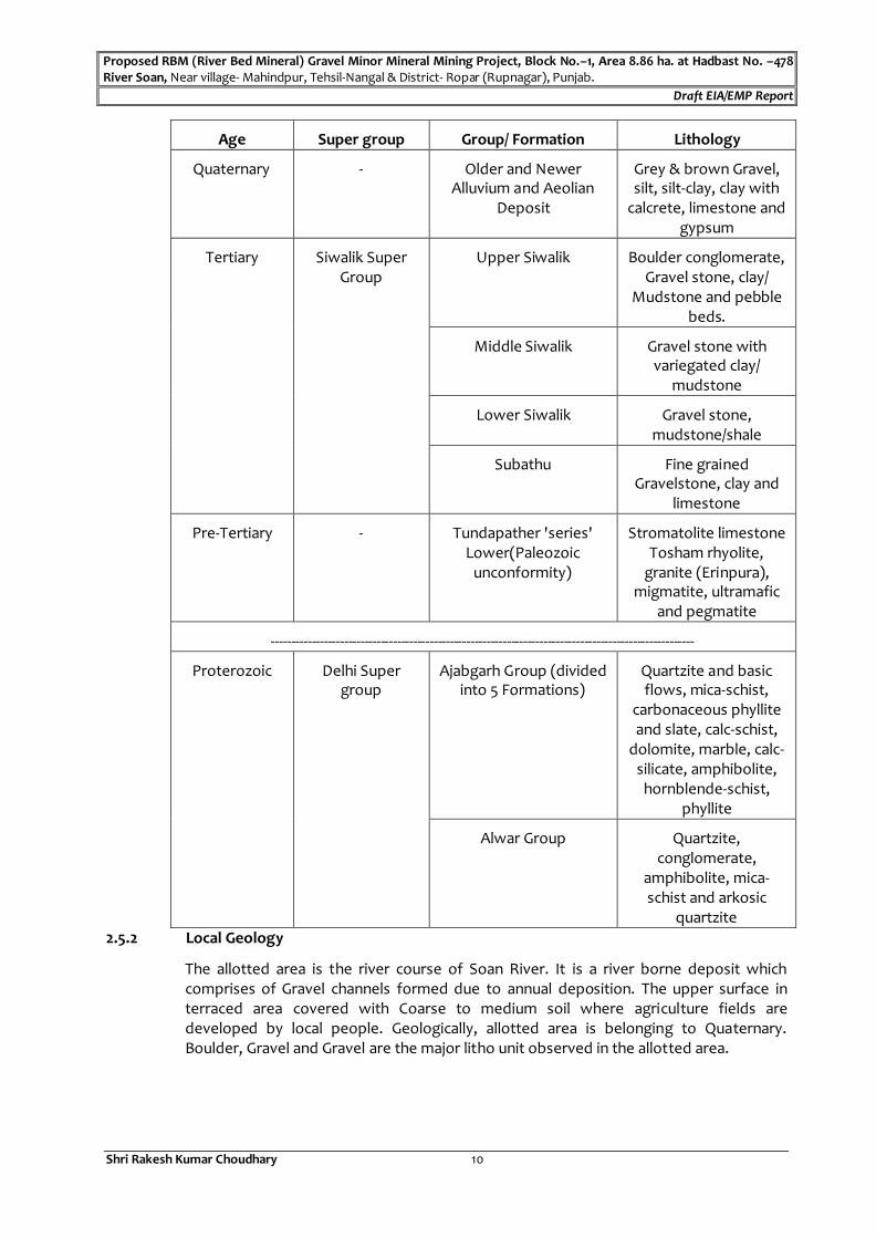
Proposed RBM (River Bed Mineral) Gravel Minor Mineral Mining Project, Block No.–1, Area 8.86 ha. at Hadbast No. –478 River Soan, Near village- Mahindpur, Tehsil-Nangal & District- Ropar (Rupnagar), Punjab.
Draft EIA/EMP Report
Shri Rakesh Kumar Choudhary 10
Age Super group Group/ Formation Lithology
Quaternary - Older and Newer Alluvium and Aeolian
Deposit
Grey & brown Gravel, silt, silt-clay, clay with
calcrete, limestone and gypsum
Tertiary Siwalik Super Group
Upper Siwalik Boulder conglomerate, Gravel stone, clay/
Mudstone and pebble beds.
Middle Siwalik Gravel stone with variegated clay/
mudstone
Lower Siwalik Gravel stone, mudstone/shale
Subathu Fine grained Gravelstone, clay and
limestone
Pre-Tertiary - Tundapather 'series' Lower(Paleozoic
unconformity)
Stromatolite limestone Tosham rhyolite,
granite (Erinpura), migmatite, ultramafic
and pegmatite
--------------------------------------------------------------------------------------------------------
Proterozoic Delhi Super group
Ajabgarh Group (divided into 5 Formations)
Quartzite and basic flows, mica-schist,
carbonaceous phyllite and slate, calc-schist,
dolomite, marble, calc-silicate, amphibolite,
hornblende-schist, phyllite
Alwar Group Quartzite, conglomerate,
amphibolite, mica-schist and arkosic
quartzite
2.5.2 Local Geology
The allotted area is the river course of Soan River. It is a river borne deposit which comprises of Gravel channels formed due to annual deposition. The upper surface in terraced area covered with Coarse to medium soil where agriculture fields are developed by local people. Geologically, allotted area is belonging to Quaternary. Boulder, Gravel and Gravel are the major litho unit observed in the allotted area.

Proposed RBM (River Bed Mineral) Gravel Minor Mineral Mining Project, Block No.–1, Area 8.86 ha. at Hadbast No. –478 River Soan, Near village- Mahindpur, Tehsil-Nangal & District- Ropar (Rupnagar), Punjab.
Draft EIA/EMP Report
Shri Rakesh Kumar Choudhary 11
2.6 TOPOGRAPHY & DRAINAGE PATTERN
Topography–`
Topographically the area is uneven river bed. The highest elevation is 285.896 mRL and
lowest elevation is 283.210 mRL.
Drainage Pattern:
There is Soan River water bodies exist within the mine area. General drainage of the area is towards SE-NW.
The study area is having water bodies like Sutlej River at a distance of about ~4.80 km in
East direction from mine site which controls the drainage of study area.
2.7 DETAILS OF MINING
2.7.1 Method of Estimation of Reserves& Resources as per UNFC: -
Method of Estimation of Reserves
The Mineable reserves are estimated by following formula:
Volume of mineral = Area of Section x Sectional influence length
Mineral in tones= Volume of mineral x Recovery percentage x Bulk density 1.8 tones per
cu. Meter).
The reserves are computed for proved, probable and possible categories.
Proved category (111+211):
The mineral is exposed in the applied area up to below 3 mtr. and is continuing in depth.
The working mines are also observed in nearby area.
Mineable Reserve:-
Mineable reserves have been considered up to the depth of 3.0 m which calculates as
63,991 MT/Annum.
Area (ha.) Total Proved Geological Reserves MT= Cross-Sectional area (in sqm) x
influence length (in mts) x Bulk Density (1.8 t/m3) (MT) (UNFC code 111)
Reserves in Blocked 7.5m. Safe ty Barrier
Area (UNFC Code 211 X 222)
Mineable Reserves
(MT)
8.86 76507.64 12516.64 63991
2.7.3 Anticipated Life of Mine
As river bed material deposition is a continuous process depending on the rainfall and
monsoon. The material reserves replenished every year, hence life of mine cannot be
computed. The quantification of mineable reserves may increase or decrease
accordingly.
2.7.4 Use of Mineral
The mined-out mineral from the applied area is sorted manually at mine site & Gravel us
separated from sand, Boulder & Gravel. Boulder & Gravel will be transported to the
crusher site for crushing & and will be sold out in the market.
2.8 METHOD OF MINING
a. The Mining will be done by deploying earthmovers like excavator, Backhoe loaders
for loading of mineral into trucks, tippers and tractor/trolleys.

Proposed RBM (River Bed Mineral) Gravel Minor Mineral Mining Project, Block No.–1, Area 8.86 ha. at Hadbast No. –478 River Soan, Near village- Mahindpur, Tehsil-Nangal & District- Ropar (Rupnagar), Punjab.
Draft EIA/EMP Report
Shri Rakesh Kumar Choudhary 12
b. Mining will be restricted within the central 3/4th width of the river. Manual
excavation will be carried out where ever the channel width is less than 478 mtrs.
c. The slope is maintained at 45° from the horizontal width & bench height has been
taken 3 meter. Mining operation will be restricted to 3 meter.
d. No working shall be made within a distance of 7.5 meter of the lease boundary as
required under MMR 1961 and no mining operation shall be carried out of any point
within 75 meter of railway line or 60 mtr. from National Highway or 50 meter from
H.T Line any public works, reservoirs, tank, canal, public roads and buildings or
inhabited or 10 meter of outer edge of any village road.
e. No mining shall be carried out 478 meter in side and 500 meter outside of the flood
protecting bandh of Major River and No mining shall be carried out within 500m on
the upper side and lower side of the high-level bridge on the rivers. Similarly, no
mining shall be carried out within 250 mtr. of upper side and lower side of other
bridges.
f. When the mining will be carried out in the river bed, the LOI holder will intimate it 7
days in advance to Chief Engineer, Drainage and carry out the operation such that it
doesn’t affect the flow of river or damage embankments and will ensure that
Gravel excavation is carried out strictly in accordance with advice of the Chief
Engineer, Drainage in this regard.
Flow chart showing the mining process is given as under:
Fig: 2.1 Mining Process
Table: 2.5 Mining Details
S. No. PARTICULARS DETAILS
1. Method of Mining Semi-Mechanized Opencast Mining Project (No drilling & Blasting)
2. Geological Reserves (Tonnes) 76507.64 tonnes
3. Mineable Reserves (Tonnes) 63,991 tonnes
COLLECTION OF GRAVEL
From River Bed
LOADING
By Light Weight Excavator Loaders
& Manually
TRANSPORTATION OF GRAVEL
From River bed face to consumers by
trucks etc.

Proposed RBM (River Bed Mineral) Gravel Minor Mineral Mining Project, Block No.–1, Area 8.86 ha. at Hadbast No. –478 River Soan, Near village- Mahindpur, Tehsil-Nangal & District- Ropar (Rupnagar), Punjab.
Draft EIA/EMP Report
Shri Rakesh Kumar Choudhary 13
4. Life of Mine As river bed material deposition is a continuous process depending on the onset of monsoon /rainfall & the mineral reserves will be replenished every year, hence life of mine cannot be
computed.
5. Proposed Production (MT/Annum) 63,991
6. Elevation Range 283.210 mRL to 285.896 mRL
7. General Ground level 283 mRL
8. Ground Water Table 273 mbgl - 281 mbgl
9. Ultimate Working Depth of Pit Up to 3.0 mtr.
10. Number of Working Days/year 300
11. Number of shifts per day 2 Shift of 16 hours
12. Generation of waste during the period of Mining Plan with
progressive Mine Closure Plan
100 % recovery, therefore no question arises for waste generation.
Source: Approved Mining Plan with Progressive Mine Closure Plan
2.8.1 Drilling& Blasting
River Bed is soft mineral & easily mineable so no drilling & blasting will be required.
2.8.2 LOADING & TRANSPORT
A)Haulage within the Mining Lease Hold
Overburden will be removed with help of excavator/JCB. Mineral will be excavated
by manually simple tools. Hired Trucks and tippers will be used to carry overburden
& mineral to stack yard from where it is loaded by buyers.
B) Haulage from Mine to Destination
The mineral will be loaded into hired tippers/Trucks Manually for further
transportation to the various destinations.
2.10 PROPOSED PRODUCTION
Table: 2.6 Year wise Production & Waste Generation
Year Production Rate MT/Annum Required Productivity (tonnes)
1st 63991 100
2nd 63991 100
3rd 63991 100
4th 63991 100
5th 63991 100
Total 3,19,955
Source: Approved Mining Plan with Progressive Mine Closure Plan

Proposed RBM (River Bed Mineral) Gravel Minor Mineral Mining Project, Block No.–1, Area 8.86 ha. at Hadbast No. –478 River Soan, Near village- Mahindpur, Tehsil-Nangal & District- Ropar (Rupnagar), Punjab.
Draft EIA/EMP Report
Shri Rakesh Kumar Choudhary 14
2.11 DISPOSAL OF WASTE
Total excavated material has sale value and therefore no question arises for generation
of waste & its management.
2.12 CONCEPTUAL PLAN
At the conceptual stage total excavated area will be 7.70 which will be Replenished during monsoon season & approx 1.16 Ha. area will be undisturbed area a safety zone (Buffer Zone). Green Belt /Plantation will be done outside the lease area on land identified by DFO Social Forestry concerned in consultation with village panchayat.
TABLE.2.7 Post-Mining Land Use of Core Zone with
Environment Management Area in hectares
S. No.
Description Land Use (In ha)
Plantation Water Body Public Use Undisturbed Total
1. Top Soil Dump -- -- -- -- --
2. Waste Dump -- -- -- -- --
3. Excavation (Voids) -- -- -- -- -
4. Road -- -- -- -- --
5. Built Up Area -- -- -- -- --
6. Township Area -- -- -- -- --
7. Afforestation -- -- -- -- --
8. Replenished area -- 7.70 -- -- 7.70
9. Mineral Storage -- -- -- -- --
10. Undisturbed Area (Buffer Zone)
-- -- -- 1.16 1.16
Total - 7.70 -- 1.16 8.86
Conceptual plan & section annexed as Annexure XII.
2.13 SITE SERVICES
Following miscellaneous site services will be provided for smooth operation of the mine.
(i) Mine Office: - Temporary Mine office will be constructed inside the mine area.
(ii) First Aid: - Primary first aid facility will be provided inside mine site.
(iii) Water Supply: Water will be sourced from a well near the mining lease area and a
tractor-mounted tanker is proposed for supply of water to mining work, spraying,
watering the plants and drinking purpose.
(iv) Rest Shelter: Temporary rest shelter will be provided inside mining area.
2.14 MITIGATION MEASURES
2.14.1 Air Pollution Control Measures
Following measures will be taken to control air/fugitive emission during mining
operation:
Regular water spraying on the haul roads will be done.
Workers will be provided with suitable PPEs as and when required.

Proposed RBM (River Bed Mineral) Gravel Minor Mineral Mining Project, Block No.–1, Area 8.86 ha. at Hadbast No. –478 River Soan, Near village- Mahindpur, Tehsil-Nangal & District- Ropar (Rupnagar), Punjab.
Draft EIA/EMP Report
Shri Rakesh Kumar Choudhary 15
Haul roads will be made compact.
Green Belt /Plantation will be developed outside the mine area /along approach
road.
Periodically monitoring will be done.
2.14.2 Water Quality Management
No waste water will be generated during the mining activities.
Domestic waste water generated from office toilet is disposed in soak pits via
septic tank.
Garland drains will be provided around the working pits.
The rain water collected in mining pit will be used for plantation, dust suppression
requirements.
2.14.3 Noise Pollution Control
Proper maintenance of all machineries will be carried out which will be help in
reducing generation of noise during operations.
Workers will be exposed to high noise levels provided with ear muffs/plugs & will
be persuaded to use the same.
Adequate silencers will be provided in all the diesel engines.
Green belt will be developed outside the mine boundary to minimize noise
propagation.
2.14.4 Riverbank & River Course Protection
The minerals will be mined out in a uniform way so that the river flow/course shall
not get disturbed.
No mining will be done within 3 mtr. from the either side of river banks to maintain
its protection.
Mining will proceed along the river in the direction from downstream to upstream in
each block. No. mining will be done across the river-Soan River.
Collection of minerals/working shall be started from the centre towards the bank
uniformly so that the river course does not get affected.
No mining will be done on curves of the rivers-Soan River to avoid the meandering
effect.
Every mining block will have clearly identified approach road/ entry points into the
rivers- Soan River & similarly the exit points.
Mining will not be done in proximity of any bridge, culvert, embankment or any
water works setup etc. Appropriate safety zone will be left and no mining will be
carried out in the safety zone.
Suitable mitigation measures will be adopted so that conditions of water logging
will not arise.

Proposed RBM (River Bed Mineral) Gravel Minor Mineral Mining Project, Block No.–1, Area 8.86 ha. at Hadbast No. –478 River Soan, Near village- Mahindpur, Tehsil-Nangal & District- Ropar (Rupnagar), Punjab.
Draft EIA/EMP Report
Shri Rakesh Kumar Choudhary 16
2.14.5 Green Belt Development / Plantation
At the conceptual stage total excavated area will be 7.70 which will be
Replenished during monsoon season & approx 1.16 Ha. area will be undisturbed
area a safety zone (Buffer Zone).
Green Belt/ Plantation will be done outside the lease area on land identified by
DFO Social Forestry concerned in consultation with village panchayat. The trees
will be planted @2000 saplings per hectare of land species will be like: Azadirachta
indica (Neem), Ficus religiosa (Peepal), Ficus benghalensis (Bargad), Tamarindus
indica (Imli),Terminalia arjuna (Arjun).
The same will be maintained & enhanced in future.
The plant species will be selected in consultation with forest department.

Proposed RBM (River Bed Material) Gravel Minor Mineral Mining Project, Block No.–1, Area 8.86 ha. at Hadbast No. –478 River Soan, Near village- Mahindpur, Tehsil-Nangal & District- Ropar (Rupnagar), Punjab.
Draft EIA/EMP Report
Shri Rakesh Kumar Choudhary 17
CHAPTER–III
DESCRIPTION OF THE ENVIRONMENT
3.1 INTRODUCTION
In order to assess impacts of project activities on existing physical biological and social environment, it is necessary to collect information on following parameters:
1. Land Environment
2. Meteorology
3. Air Environment
4. Noise Environment
5. Water Environment
6. Soil Environment
7. Biological Environment
8. Socio-economic Environment
To achieve these objectives, our team monitored the above said environmental parameters within core and buffer zone (10 km distance from the mine site) from the project site in accordance with the Guidelines for EIA issued by the Ministry of Environment & Forests, Govt. of India.
This chapter and the related discussions contain the results of field studies carried out during Winter Season (December 2020 to February, 2021).
3.2 STUDY AREA AT A GLANCE
1. Site location: Location details are given in Chapter I– Table 1.1, page no-3
2. Demography (10 km radius from the project site)
Total Population : 48,604 (as per 2011 Census)
Number of Households : 9,678
Scheduled Castes : 8818
Scheduled Tribes : 0
Literacy rate : 81.93%
Workers : 16,716
3. Meteorology
During study period Winter Season, (December 2020 to February, 2021)
i) Maximum Temperature : 26.80C
ii) Minimum Temperature : 2.10C
iii) Relative Humidity (%)
1. Minimum : 55
2. Maximum : 90
iv) Predominant Wind Direction : From South East

Proposed RBM (River Bed Material) Gravel Minor Mineral Mining Project, Block No.–1, Area 8.86 ha. at Hadbast No. –478 River Soan, Near village- Mahindpur, Tehsil-Nangal & District- Ropar (Rupnagar), Punjab.
Draft EIA/EMP Report
Shri Rakesh Kumar Choudhary 18
3.3 LAND USE/LAND COVER STUDY
3.3.1 Objective
To comply the ToR points issued vide letter No. DECC/SEIAA/2020/3543 dated 05.11.2020by SEAC/SEIAA, Punjab.
ToR Point no. 32: Land use of the study area delineating forest area, agricultural land, grazing land, wildlife sanctuary and national park, migratory routes of fauna, water bodies, human settlements and other ecological features should be indicated.
To develop land use & land cover map using land coordinates of the Study area.
To identify and mark important basic features according primary and secondary data.
To evaluate the project's impact on existing land use of the Study area.
To suggest measures for conservation and sustainable use of land.
3.3.2 Data Used
Current vintage data of Indian Remote Sensing Satellite RESOURCESAT-2 (L4FMX) digital FCC (False Color Composite) has been used for preparation of Land use & Land cover thematic map of study area. Satellite image has been procured from National Remote Sensing Centre, Hyderabad. Survey of India toposheet as a reference map on 1:50,000 scale has been used for preparation of base layer data like roads, railways, village name and for geo-referencing of satellite imagery.
Technical details of Data
Satellite Image - RESOURCESAT-2 (L4FMX)
Satellite Data Source - NRSC, Hyderabad
SOI Toposheet No. - 54A/07
Software Used - Earth Resources Data Analysis System (ERDAS) 9.2
Instrument Used - GPS (Garmin GPS MAP 78 S)
3.3.3 Methodology
Preliminary/ Primary Data Collection of the Study Area
Satellite data procurement from NRSC Hyderabad
Secondary Data Collection From Authorized Bodies
Survey of India Toposheet (SOI)
Mining Plan
Cadastral / Khasra Map
GPS Coordinates of Mining area
Processing of satellite data using ERDAS Imagine 9.2 and prepare the land use & land cover maps (e. g. Forest, agriculture, settlements, wasteland, water bodies etc.) by digital image processing (dip) techniques.
Geo-Referencing of the Survey of India Toposheet
Geo-Referencing of Satellite Imagery with the help of Geo-Referenced Toposheets
Proposed RBM (River Bed Material) Gravel Minor Mineral Mining Project, Block No.–1, Area 8.86 ha. at Hadbast No. –478 River Soan, Near village- Mahindpur, Tehsil-Nangal & District- Ropar (Rupnagar), Punjab.
Draft EIA/EMP Report
Shri Rakesh Kumar Choudhary 19
Enhancement of the Satellite Imagery
Base Map Layer Creation (Roads, Railway, Village Names and others Secondary data etc.)
Data Analysis and Classification using Digital Interpretation Techniques.
Ground Truth Studies or Field Verification.
Error Fixing / Reclassification
Final Map Generation
Identification / prediction of impacts on land use due to project activity
Recommendation
3.3.4 Details of LU/LC
3.3.4.1 Land Use & Land Cover Classes
These are the following LU/LC Classes: -
Water Bodies, Crop land, Fallow Land, Human Settlement, Industrial Area, Mine Quarry, Scrub Land, Plantation, Railway Line, Road Network, Forest Land, Stony Waste Land, Open Land etc. as per NRSC Guide Line.
3.3.4.2 Generation & Analysis of Data
Geo-referencing of the Survey of India Toposheet
Scanned surveys of India Toposheets were registered in geographic latitude / longitude projection system with the help of ERDAS imagine software and re-project in UTM WGS 84 with respective zone.
Geo-Referencing of the Satellite Imagery
Registered Toposheets is used as a reference map for Geo-Referencing of Raw satellite imagery by taking suitable Ground Control Points (GCP) like intersection point of railway, Road network, Canal intersection and some other permanent features.
Enhancement of Satellite Image
Satellite data is composed of substantial noise and haze errors due to various environmental factors, which affect the amount of reflectance (information) that can be deciphered. Since mapping of satellite images is based on spectral signatures, it is necessary to normalize the redundant values into near true values. This process of deriving true reflectance values is known as normalization. This enhances interpretability of the satellite image thereby facilitating better identification of land features viewed on satellite imagery. Histogram equalization and radiometric correction has been used for satellite image enhancement.
Base Map Layer Creation
Base map has been prepared using Survey of India Toposheet as a reference map on 1:50000 scale. In base layer linear and point feature like road, rail, canal, village location and other secondary information have been created in vector data format with the help of ArcGIS Software.

Proposed RBM (River Bed Material) Gravel Minor Mineral Mining Project, Block No.–1, Area 8.86 ha. at Hadbast No. –478 River Soan, Near village- Mahindpur, Tehsil-Nangal & District- Ropar (Rupnagar), Punjab.
Draft EIA/EMP Report
Shri Rakesh Kumar Choudhary 20
Data Analysis and Classification Using Digital Interpretation Technique
Image interpretation is the process of identifying objects or conditions in images and determining their meaning or significance. Satellite imagery are composed of array of grid, each grid has a numeric value that is known as digital number. Smallest unit of this grid is known as a pixel that captures reflectance of ground features represented in terms of Digital number, which represent a specific land feature. Using image classification technique, the satellite data is converted into thematic information map based on the user’s knowledge about the ground area.
Hybrid technique has been used i. e. visual interpretation and digital image processing for identification of different land use and vegetation cover classes based on spectral signature of geographic feature. Spectral signature represents various land use classes. Image interpretation keys are developed for better Interpretation/Classification scheme which is Shape, Size, Color, Tone, Texture Pattern, Association etc. Based on the Interpretation key and Spectral signature Entire satellite imagery is classified in different classes like Water Bodies, Crop land, Fallow Land, Human Settlement, Industrial Area, Mine Quarry, Scrub Land, Plantation, Railway Line, Road Network, Forest Land, Stony Waste Land, Open Land etc.
Ground Data Collection and Verification
Ground truth/ field verification is an important component in mapping and its validation exercise. Utmost care and planning is required for collecting ground data and verification. To facilitate a good ground truthing exercise the following steps were followed:
Identifying and listing all the doubtful areas for the ground verification and referring all such areas with respect to the toposheet to know their geographical location and accessibility on the ground.
Field traverse plan was prepared to cover maximum doubtful areas in the field in such a way that each traverse covers, as many land use and land cover classes as possible, apart from the doubtful areas
The sufficient number of points was covered for each Land Use Class as required for quality checking as well as accuracy assessment.
Error Fixing / Reclassification
Reclassification of Land Use classes was done on the basis of data collected / verified during ground truthing.
Final Map Generation
Final maps are generated for the core area as well as Buffer area. 3 Pixels is Filtered using Clump and Eliminate Process after ensuring to maintain crucial classes of importance. Base map layers is overlaid on the classified raster data and then thematic maps is generated on the layout consisting of Project name, legend, source of data, Index map, scale bar and North arrow.
A hybrid technique has been used i. e. visual interpretation and digital image processing to generate output Land use & Land cover map of the 10 km buffer area on 1:50000 scale.

Proposed RBM (River Bed Mineral) Gravel Minor Mineral Mining Project, Block No.–1, Area 8.86 ha., at Hadbast No. –478 River Soan, Near village- Mahindpur, Tehsil-Nangal & District- Ropar (Rupnagar), Punjab.
Draft EIA/EMP Report
Shri Rakesh Kumar Choudhary 21
3.3.5 Land Use/ Land Cover Map
FIGURE 3.1: LAND USE / LAND COVER MAP OF BUFFER ZONE

Proposed RBM (River Bed Material) Gravel Minor Mineral Mining Project, Block No.–1, Area 8.86 ha., at Hadbast No. –478 River Soan, Near village- Mahindpur, Tehsil-Nangal & District- Ropar (Rupnagar), Punjab.
Draft EIA/EMP Report
Shri Rakesh Kumar Choudhary 22
The land use/land cover details of the Buffer Zone are given in Table 3.1: Table – 3.1
Land Use / Land Cover Details of Study Area
LU/LC Class Area (in hectare) Area (in %)
Built Up Land 3177.73 9.67
Crop Land 13293.78 40.44
Fallow Land 2716.34 8.26
Forest Land 5193.82 15.80
Scrub Land 387.23 1.18
Sandy Waste Land 1296.57 3.94
Waste Land 634.45 1.93
Water Bodies/ Rivers 1973.38 6.00
Plantation 1708.62 5.20
Mining Area 765.21 2.33
Bricks Earth Industries 552.64 1.68
Industries Area 1171.28 3.56
Total 32871.05 100.00
Source: LU/LC Map for Buffer Zone
3.3.6 Observation of the LU/LC Data
The study area of the buffer zone mainly comprises of crop land with 40.44 % cover. The second largest area is covered by Forest Land i.e., 15.80 %. About 2.33 % area is under mining area.
There are water bodies in the study area forming 6.00 % of study area.
There is no National Park, Biosphere Reserve, Tiger Reserve, Wildlife Corridor, etc. within 10 km radius.
3.3.7 Identification of Impacts on Land Use Pattern due to Project Activity
Impact on Core Zone:
This is a proposed mine; there will be change in the land use of core zone due to the proposed project from mining activities.
At the conceptual stage total excavated area will be 7.70 ha. which will be
converted into Replenished area, 1.16 Ha. area will be undisturbed area (buffer
zone). Green Belt/ Plantation will be done outside the lease area on land
identified by DFO Social Forestry concerned in consultation with village
panchayat. The trees will be planted @2000 saplings per hectare of land species
will be like: Azadirachta indica (Neem), Ficus religiosa (Peepal), Ficus benghalensis
(Bargad), Tamarindus indica (Imli), Terminalia arjuna (Arjun).
Impact on Buffer Zone:
People, who migrate from the near-by villages for employment, may depend on the local resources available in that area.
Additional infrastructure may be developed in the surrounded area, which may also change the present land use of the area i. e. agricultural to hutments, shops etc.
Proposed RBM (River Bed Material) Gravel Minor Mineral Mining Project, Block No.–1, Area 8.86 ha., at Hadbast No. –478 River Soan, Near village- Mahindpur, Tehsil-Nangal & District- Ropar (Rupnagar), Punjab.
Draft EIA/EMP Report
Shri Rakesh Kumar Choudhary 23
In the M.L. area, mining activity will be confined to the mineralized zone & proper pollution control measures will be adopted to restrict the pollution load within the active zone in order to prevent any negative impact on nearby crop fields due to mining operation.
3.3.8 Recommendations
As per present land use, various patches of stony area are found near to the M.L. area. Thus, migrants may be relocated on the stony area.
Additional infrastructure may be developed on the stony area; so that there may not be any impact on the agricultural land.
The following practices shall be carried out to increase the productivity of the study area:
Awareness for new methodologies of the agricultural practices viz. mixed farming, crop rotation and agricultural cropping pattern suitable for the lease area.
Providing seeds, manure and fertilizers from different sources.
Rainwater harvesting practices shall be encouraged which will lead to ground water recharge and ultimately increased productivity in the study area.
Construction of the Garland drains along the temporarily Dump area can minimize the water contamination.
3.3.9 Conclusion
Remote Sensing data provides real time information pertaining to aspects of Land use & Land cover. Precise quantitative information could be extracted about existing land use & land cover in context to spatial dimension. Integration of various data layers gives proper understanding of the problem.
3.4 SEISMICITY OF THE AREA
Many parts of the Indian subcontinent have historically high Seismicity. Seven catastrophic earthquakes of magnitude greater than 8 (Richter scale) have occurred in the western, northern and eastern parts of India and adjacent countries in the past 100 years.
By contrast, peninsular India is relatively less seismic, having suffered only infrequent earthquakes of moderate strength. The main seism genic belts are associated with the collision plate boundary between the Indian and Eurasian plates.
The project site as well as study area lies in Zone-II of Seismic Zoning Map, and thus can be said to be located in an area of low seismic hazard by national standards. Hence the risk of earthquake at the site is minimal and so the site is safe.

Proposed RBM (River Bed Material) Gravel Minor Mineral Mining Project, Block No.–1, Area 8.86 ha., at Hadbast No. –478 River Soan, Near village- Mahindpur, Tehsil-Nangal & District- Ropar (Rupnagar), Punjab.
Draft EIA/EMP Report
Shri Rakesh Kumar Choudhary 24
Figure 3.2: Seismic Zone Map
Mine Site at, Nangal
(Punjab)
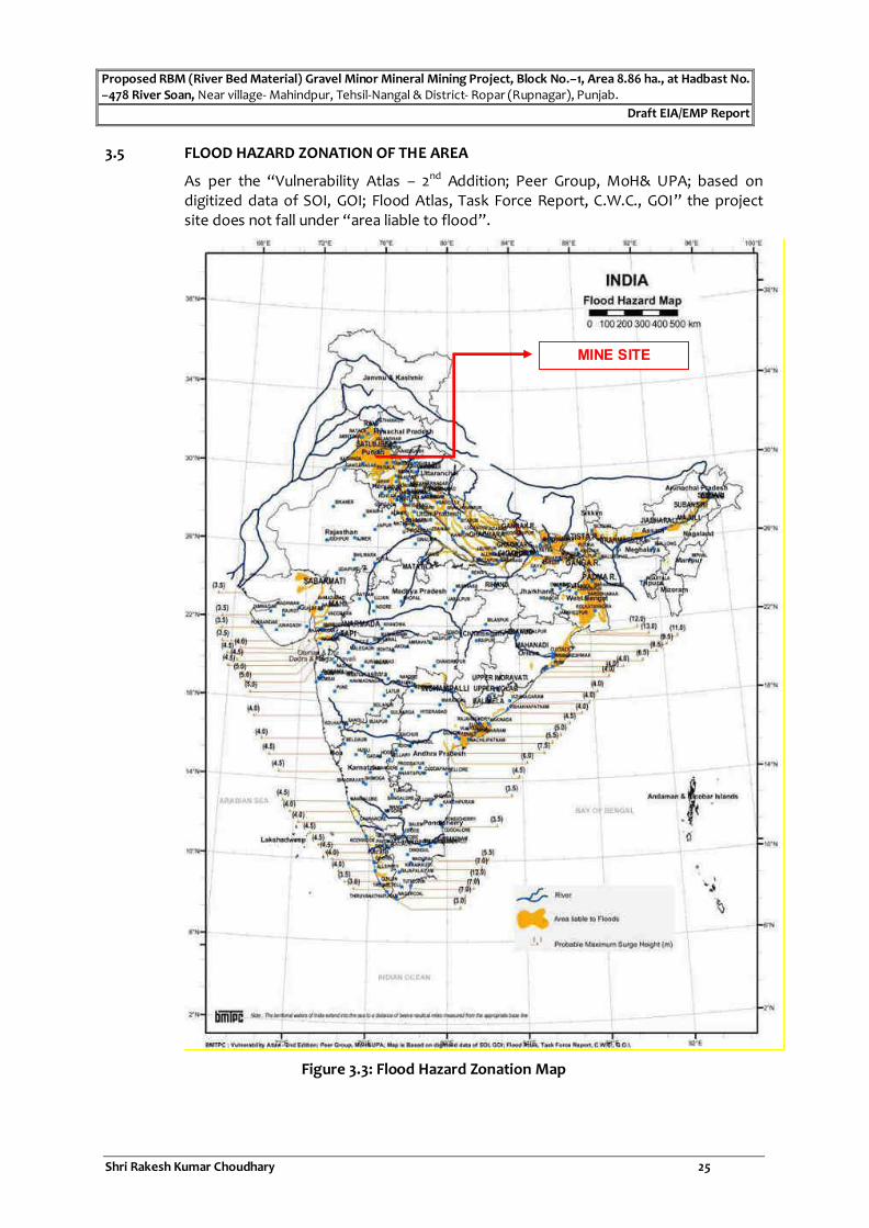
Proposed RBM (River Bed Material) Gravel Minor Mineral Mining Project, Block No.–1, Area 8.86 ha., at Hadbast No. –478 River Soan, Near village- Mahindpur, Tehsil-Nangal & District- Ropar (Rupnagar), Punjab.
Draft EIA/EMP Report
Shri Rakesh Kumar Choudhary 25
3.5 FLOOD HAZARD ZONATION OF THE AREA
As per the “Vulnerability Atlas – 2nd Addition; Peer Group, MoH& UPA; based on digitized data of SOI, GOI; Flood Atlas, Task Force Report, C.W.C., GOI” the project site does not fall under “area liable to flood”.
Figure 3.3: Flood Hazard Zonation Map
MINE SITE

Proposed RBM (River Bed Material) Gravel Minor Mineral Mining Project, Block No.–1, Area 8.86 ha., at Hadbast No. –478 River Soan, Near village- Mahindpur, Tehsil-Nangal & District- Ropar (Rupnagar), Punjab.
Draft EIA/EMP Report
Shri Rakesh Kumar Choudhary 26
3.6 INSTRUMENTS USED FOR ENVIRONMENTAL BASELINE DATA COLLECTION
The following instruments were used at the site for environmental baseline data collection work by M/s. Noida Testing Laboratories.
1. Respirable Dust Sampler with attachment for gaseous Pollutants, Lata Envirotech Services APM 860
2. Fine Particulate Sampler (FPS), APM 154
3. Hygrometer
4. Sound Level Meter Model SL – 4023SD
5. Micro Meteorological Station Model Enviro WM 251
6. Global Positioning System (GPS)
7. Water Level Indicator
Apart from collecting samples of air, water and soil from representative sampling points given in proceeding sections, the data on land use, vegetation and agricultural crops were also collected by the field team through interaction with a large number of local inhabitants of the study area and different Government departments / agencies. This provided an excellent opportunity to the members of the field team for obtaining clear scenario of the existing environment of the study area.
3.7 CLIMATE & RAINFALL
The climate of Rupnagar District is characterized by its general dryness (except in the south-west monsoon season), a hot summer and a bracing cold winter. The year may be divided into four seasons. The period from about middle of November to February is the cold season. This is followed by the summer season from March to about the end of June. The south-west monsoon season commences late in June and continues up to about middle of September. The period from mid-September to the middle of November constitute the post-monsoon or transition season. The temperature ranges from minimum of 4° C in winter to 45° C in summer. May and June are generally hottest months and December and January are the coldest months. Relative humidity is high, averaging about 70 percent during monsoon. The average annual rainfall in district is 775.6 mm. About 78 percent of the annual rainfall is received during the period from June to September. The soils of the District vary in texture generally from loam to silty clay loam except along the Sutlej River and chos where some sandy patches may be found. Chamkaur Sahib and Kharar blocks have sodic soils. The soils of Anandpur Sahib and Rupnagar blocks are undulating
Rainfall data of the area for last few years is mentioned in Table 3.2:
TABLE - 3.2
Rainfall Data of Nangal, Rupnagar (Punjab)
S. No. Year Rainfall (in mm)
1. 2014 625.9
2. 2015 830.2
3. 2016 818.6

Proposed RBM (River Bed Material) Gravel Minor Mineral Mining Project, Block No.–1, Area 8.86 ha., at Hadbast No. –478 River Soan, Near village- Mahindpur, Tehsil-Nangal & District- Ropar (Rupnagar), Punjab.
Draft EIA/EMP Report
Shri Rakesh Kumar Choudhary 27
4. 2017 1055.2
5. 2018 1378.9
6. 2019 1110.15
Source: Customized Rainfall Information System (CRIS) Hydromet Division India Meteorological Department
3.8 METEOROLOGY
Meteorology plays a vital role in determining the transport and diffusion pattern of air pollutants released into atmosphere. The principal variables include horizontal convective transport (average wind speed and direction), vertical convective transport (atmospheric stability) and topography of the area.
Meteorological characteristics of an area are very much important in assessing possible environmental impacts and in preparing environmental management plan.
Since meteorological factors show wide fluctuations with time, meaningful interpretation can be drawn only from long-term reliable data. Such source of data is India Meteorological Department (IMD), which maintains a network of meteorological stations at several important locations.
The nearest IMD station to the study area is located at Bilaspur (approx. 33 km, ENE). The Meteorological data i.e. wind speed, and wind direction, recorded maximum & minimum from this IMD station for Winter Season (Dec. 2020 to Feb. 2021) and was used to study the meteorology of the area.
3.8.1 Micro-Meteorology at Site
Meteorological station was set-up at site to record surface meteorological parameter
during Winter Season (Dec. 2020 to Feb. 2021).
Wind speed and wind direction data recorded during the study period has enabled identifying the influence of meteorology on the air quality of the area. Based on the collected meteorological data, relative percentage frequencies of different wind directions were calculated and plotted as wind roses for twenty-four-hour duration. Maximum and minimum temperatures including percentage relative humidity were also recorded simultaneously. It was observed that the predominant over all wind
patterns for the study period was from.
TABLE: 3.3
Micro-Meteorology at site
Study Period –Winter Season (Dec. 2020 to Feb. 2021)
Months Temperature °C Relative Humidity % Wind Speed (m/s)
Min. Max. Min. Max. Min. Max.
December 2020 3.5 24.8 60 90 0.0-5.28 0.0-5.28
January 2021 2.1 23.3 62 90 0.0-5.28 0.0-5.28
February 2021 3.5 26.6 55 87 0.0-5.28 0.0-5.28
Source: Meteorological Station at Site
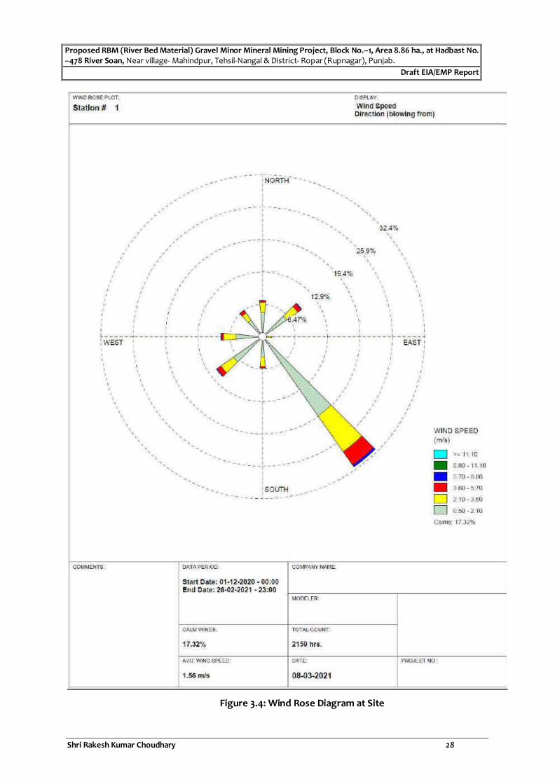
Proposed RBM (River Bed Material) Gravel Minor Mineral Mining Project, Block No.–1, Area 8.86 ha., at Hadbast No. –478 River Soan, Near village- Mahindpur, Tehsil-Nangal & District- Ropar (Rupnagar), Punjab.
Draft EIA/EMP Report
Shri Rakesh Kumar Choudhary 28
Figure 3.4: Wind Rose Diagram at Site
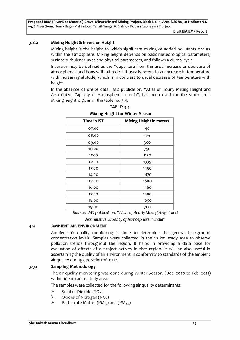
Proposed RBM (River Bed Material) Gravel Minor Mineral Mining Project, Block No.–1, Area 8.86 ha., at Hadbast No. –478 River Soan, Near village- Mahindpur, Tehsil-Nangal & District- Ropar (Rupnagar), Punjab.
Draft EIA/EMP Report
Shri Rakesh Kumar Choudhary 29
3.8.2 Mixing Height & Inversion Height
Mixing height is the height to which significant mixing of added pollutants occurs within the atmosphere. Mixing height depends on basic meteorological parameters,
surface turbulent fluxes and physical parameters, and follows a diurnal cycle.
Inversion may be defined as the “departure from the usual increase or decrease of atmospheric conditions with altitude.” It usually refers to an increase in temperature with increasing altitude, which is in contrast to usual decrease of temperature with
height.
In the absence of onsite data, IMD publication, “Atlas of Hourly Mixing Height and Assimilative Capacity of Atmosphere in India”, has been used for the study area.
Mixing height is given in the table no. 3.4:
TABLE: 3.4
Mixing Height for Winter Season
Source: IMD publication, “Atlas of Hourly Mixing Height and
Assimilative Capacity of Atmosphere in India”
3.9 AMBIENT AIR ENVIRONMENT
Ambient air quality monitoring is done to determine the general background concentration levels. Samples were collected in the 10 km study area to observe pollution trends throughout the region. It helps in providing a data base for evaluation of effects of a project activity in that region. It will be also useful in ascertaining the quality of air environment in conformity to standards of the ambient
air quality during operation of mine.
3.9.1 Sampling Methodology
The air quality monitoring was done during Winter Season, (Dec. 2020 to Feb. 2021) within 10 km radius study area.
The samples were collected for the following air quality determinants:
Sulphur Dioxide (SO2) Oxides of Nitrogen (NOx) Particulate Matter (PM10) and (PM2.5)
Time in IST Mixing Height in meters
07:00 40
08:00 120
09:00 300
10:00 750
11:00 1130
12:00 1335
13:00 1450
14:00 1870
15:00 1600
16:00 1460
17:00 1300
18:00 1050
19:00 700

Proposed RBM (River Bed Material) Gravel Minor Mineral Mining Project, Block No.–1, Area 8.86 ha., at Hadbast No. –478 River Soan, Near village- Mahindpur, Tehsil-Nangal & District- Ropar (Rupnagar), Punjab.
Draft EIA/EMP Report
Shri Rakesh Kumar Choudhary 30
The sources of air pollution in the region are dust rising from unpaved roads, domestic fuel burning, vehicular traffic, agricultural activities, emission from other
industries, etc.
3.9.2 Sampling Schedule
The sampling was done for every 8 hours continuously for 24 hours for SO2, NOx, PM2.5& PM10 with a frequency of twice a week for three months (24 observations for
one location).
3.9.3 Sampling Location
In order to know the baseline ambient air quality, in and around the mine sites,
ambient air qualities were measured at nearby sites and villages in the study area.
Tables showing the locations of the ambient air quality monitoring stations are given
in below Table:
Table: 3.5
Locations of Ambient Air Quality Monitoring Stations
Study Period –Winter Season (Dec. 2020 to Feb. 2021)
Station Location
Latitude - Longitude
Distance (km) & Direction from mine site
Selection Criterion
AAQS1 Mine Site
31°18'55.75"N 76°19'5.80"E
- Core zone location
AAQS2 Village- Bat Kalan
31°19'24.75"N 76°17'37.39"E
~2.7 km, NW Falls in downwind of dominant wind direction. Industrial area in Buffer zone.
AAQS3 Village- Bat Khurd
31°20'10.09"N 76°16'16.59"E
~5.2 km, NW Downwind of dominant wind direction. Habitation in Buffer Zone
AAQS4 Village Bhallri 31°18'20.56"N 76°20'31.80"E
~2.0 km, SE Falls in Upwind of Predominant wind direction. Nearest habitation
AAQS5 Village Sukhsal 31°19'20.78"N 76°20'18.35"E
~1.70 km, NE Falls in downwind of 2nd dominant wind direction. Near NH-8
AAQS6 Village- Brahmpur
31°20'27.50"N 76°23'42.34"E
~7.50 km, ENE Nearest SH-22
Source: SOI Toposheet
It can be observed from the wind rose diagram (Figure3.4) that the predominant wind direction during the study period was from South East. Villages/locations have been selected in the downwind direction as well as in the upwind direction for AAQ
monitoring from the activity site.

Proposed RBM (River Bed Material) Gravel Minor Mineral Mining Project, Block No.–1, Area 8.86 ha., at Hadbast No. –478 River Soan, Near village- Mahindpur, Tehsil-Nangal & District- Ropar (Rupnagar), Punjab.
Draft EIA/EMP Report
Shri Rakesh Kumar Choudhary 31
Figure 3.5: Key Plan showing Monitoring Locations for AAQ & Noise Level

Proposed RBM (River Bed Material) Gravel Minor Mineral Mining Project, Block No.–1, Area 8.86 ha., at Hadbast No. –478 River Soan, Near village- Mahindpur, Tehsil-Nangal & District- Ropar (Rupnagar), Punjab.
Draft EIA/EMP Report
Shri Rakesh Kumar Choudhary 32
3.9.4 Ambient Air Quality Monitoring
The following table shows the max. and min. concentrations of the air pollutants monitored at different locations (as mentioned Table:3.6) during the study period. All 24 observations of pollutants for each location are detailed in Ambient Air Quality Monitoring tables.
TABLE: 3.6
Ambient Air Quality Monitoring
Study Period –Winter Season (Dec. 2020 to Feb. 2021)
(Unit in g/m3)
Sampling Location PM10 PM2.5 SO2 NO2
Max. Min. Max. Min. Max. Min. Max. Min.
Mine Site 71.9 63.4 36.7 28.2 10.1 7.6 16.4 13.4
Village- Bat Kalan 74.1 66.5 35.4 28.6 9.3 6.4 19.2 17.3
Village- Bat Khurd 71.5 64.6 35.2 29.5 9.1 5.9 19.6 15.2
Village Bhallri 75.4 67.8 37.6 30.3 10.3 7.9 20.8 17.1
Village Sukhsal 77.5 68.5 42.5 35.6 11.6 8.0 23.2 20.8
Village- Brahmpur 79.6 70.2 43.3 31.9 14.6 8.3 25.4 22.8
NAAQS* 100 60 80 80
Source: Ambient Air Quality Monitoring Results
Figure No. 3.6: Graph showing concentrations of PM10
71,9 74,1 71,5 75,4 77,5 79,6
63,4 66,5 64,6 67,8 68,5 70,2
0
10
20
30
40
50
60
70
80
90
100
Mine Site Bat Kalan Bat Khurd Bhallri Sukhshal Brahmpur
PM
10
μ/m
3
Monitoring Location
PM 10 Max. PM 10 Min. NAAQS

Proposed RBM (River Bed Material) Gravel Minor Mineral Mining Project, Block No.–1, Area 8.86 ha., at Hadbast No. –478 River Soan, Near village- Mahindpur, Tehsil-Nangal & District- Ropar (Rupnagar), Punjab.
Draft EIA/EMP Report
Shri Rakesh Kumar Choudhary 33
Figure No. 3.7: Graph showing concentrations of PM2.5
Figure No. 3.8: Graph showing concentrations of SO2
36,7 35,4 35,2 37,6
42,5 43,3
28,2 28,6 29,5 30,5
35,6 31,9
0
10
20
30
40
50
60
70
80
90
100
Mine Site Bat Kalan Bat Khurd Bhallri Sukhshal Brahmpur
PM
2.5
mic
rog
ram
/m3
Monitoring Location
PM 2.5Max. PM 2.5 Min. NAAQS
10,1 9,3 9,1 10,3 11,6 14,6
7,6 6,4 5,9 7,9 8 8,3
0
10
20
30
40
50
60
70
80
90
100
Mine Site Bat Kalan Bat Khurd Bhallri Sukhshal Brahmpur
SO
2 m
icro
gra
m/m
3
Monitoring Location
SO2 Max. SO2 Min. NAAQS

Proposed RBM (River Bed Material) Gravel Minor Mineral Mining Project, Block No.–1, Area 8.86 ha., at Hadbast No. –478 River Soan, Near village- Mahindpur, Tehsil-Nangal & District- Ropar (Rupnagar), Punjab.
Draft EIA/EMP Report
Shri Rakesh Kumar Choudhary 34
Figure No. 3.9: Graph showing concentrations of NOx
The following table shows the NAAQS prescribed by CPCB.
TABLE: 3.7
National Ambient Air Quality Standards
S. No. Pollutant
Time Weighted
Average
Concentration in Ambient Air
Method of Measurement Industrial Area,
Residential Rural & Other
Areas
Ecologically Sensitive Area
(Notified by
Central Govt.)
(1) (2) (3) (4) (5) (6)
1
Sulphur
Dioxide
(SO2), g/m3
Annual
Average *
24 hours **
50
80
20
80
1. Improved West and Gaeke
Method.
2. Ultraviolet fluorescence.
2
Oxides of Nitrogen as
NOx,g/m3
Annual Average *
24 hours **
40
80
30
80
1. Modified Jacob & Hochheiser (Na-Arsenite) Method.
2. Chemiluminescence (Gas
phase).
3
Particulate Matter (size
less than
10m) or
PM10,g/m3
Annual
Average *
24 Hours **
60
100
60
100
1. Gravimetric,
2. TOEM,
3. Beta attenuation.
16,4 19,2 19,6 20,8
23,2 25,4
13,4 17,3
15,2 17,1 20,8 22,8
0
10
20
30
40
50
60
70
80
90
100
Mine Site Bat Kalan Bat Khurd Bhallri Sukhshal Brahmpur
NO
x m
icro
gra
m/m
3
Monitoring Location
NOx Max Nox Min. NAAQS

Proposed RBM (River Bed Material) Gravel Minor Mineral Mining Project, Block No.–1, Area 8.86 ha., at Hadbast No. –478 River Soan, Near village- Mahindpur, Tehsil-Nangal & District- Ropar (Rupnagar), Punjab.
Draft EIA/EMP Report
Shri Rakesh Kumar Choudhary 35
4
Particulate Matter (size
less than
2.5m) or
PM2.5,g/m3
Annual
Average*
24 Hours **
40
60
40
60
1. Gravimetric,
2. TOEM,
3. Beta attenuation.
5 Ozone (O3),
g/m3
8 Hours **
1 Hours *
100
180
100
180
1. UV Photometric,
2. Chemiluminescence,
3. Chemical Method.
6 Lead (Pb),
g/m3
Annual
Average *
24 Hours **
0.50
1.0
0.50
1.0
1. AAS/ICP Method after sampling on EPM 2000 or equivalent filter
paper.
2. ED-XRF using Teflon filter.
7
Carbon Monoxide
(CO), mg/m3
8 Hours**
1 Hours
02
04
02
04
Non-Depressive Infrared (NDIR)
Spectroscopy.
8 Ammonia
(NH3), g/m3
Annual Average*
24 hours **
100
400
100
400
1. Chemiluminescence (Gas phase).
2. Indophenol blue method.
9 Benzene
(C6H6), g/m3
Annual
Average* 05 05
1. Gas Chromatography based
continuous analyzer,
2. Adsorption and Desorption
followed by GC analysis.
10
Benzo(α) Pyrene (BaP) – Particulate Phase only,
ng/m3
Annual
Average* 01 01
Solvent extraction followed by
HPLC’GC analysis.
11 Arsenic (As),
ng/m3
Annual
Average* 06 06
AAS/ICP Method after sampling on EPM 2000 or equivalent filter
paper.
12 Nickel (Ni),
ng/m3
Annual
Average* 20 20
AAS/ICP Method after sampling on EPM 2000 or equivalent filter
paper.
* Annual arithmetic mean of minimum 104 measurements in a year at a particular site taken
twice a week 24 hourly at uniform intervals.
** 24 hourly or 08 hourly or 01 hourly monitored values, as applicable, shall be complied with 95% of the time in a year. 5% of the time, they may exceed the limits but not on two consecutive days of monitoring.
Note: Whenever and wherever monitoring results on two consecutive days of monitoring exceed the limits specified above for the respective category, it shall be considered adequate reason to institute regular or continuous monitoring and investigation.
3.9.5 Discussion of Results
Ambient Air Quality Monitoring reveals that the concentrations of PM 10 for all the 06
AAQM stations were found between 63.4 g/m3to 79.6 g/m3 and of PM2.5 were found to be between 28.2 g/m3 to 43.3 g/m3.

Proposed RBM (River Bed Material) Gravel Minor Mineral Mining Project, Block No.–1, Area 8.86 ha., at Hadbast No. –478 River Soan, Near village- Mahindpur, Tehsil-Nangal & District- Ropar (Rupnagar), Punjab.
Draft EIA/EMP Report
Shri Rakesh Kumar Choudhary 36
As far as the gaseous pollutants SO2 and NOx are concerned, the prescribed CPCB limit of
80 g/m3 has never surpassed at any station. The concentrations of SO2were found to be
in range of 14.6g/m3 to 5.9 g/m3. The concentrations of NOx were found to be in range of 13.4 g/m3 to 25.4 g/m3.
3.10 NOISE ENVIRONMENT
Noise often defined as unwanted sound, interferes with speech communication, causes annoyance, distracts from work, disturb sleep, thus deteriorating quality of human environment.
3.10.1 Source of Noise
At Mine - Many mine workers will be exposed not only to loud but sustained noise levels. At mines, most of the large excavation equipment utilized in open pits are not said to be responsible for the excessive noise levels as they are mostly equipped with noise-protected operator cabins. However, excavators with lower capacity and mobile diesel - powered machines have been accepted as the primary noise sources in surface mining activities.
Study Area - There will be several sources in the study area, which contribute to the local noise level of the area. Ambient noise sources in the vicinity of the project include the noise from traffic from rail and road, human activities in villages and agricultural fields. Noise level measurement is therefore essential to assess noise pollution.
3.10.2 Ambient Noise Level
In order to know the baseline noise levels, in and around the mine sites, noise levels were measured at nearby sites and villages in the study area. Tables showing the locations of the noise monitoring stations are given in below Table no.3.8 & 3.9.
TABLE: 3.8 Locations of Ambient Noise Level Monitoring Stations
Station Location Latitude - Longitude
Distance (km) & Direction from mine site
Selection Criterion
NQ1 Mine Site
31°18'55.75"N 76°19'5.80"E
- Core zone location
NQ2 Village- Bat Kalan
31°19'24.75"N 76°17'37.39"E
~2.7 km, NW Falls in downwind of dominant wind direction. Industrial area in Buffer zone.
NQ3 Village- Bat Khurd
31°20'10.09"N 76°16'16.59"E
~5.2 km, NW Downwind of dominant wind direction. Habitation in Buffer Zone
NQ4 Village Bhallri 31°18'20.56"N 76°20'31.80"E
~2.0 km, SE Falls in Upwind of Predominant wind direction. Nearest habitation
NQ5 Village Sukhsal 31°19'20.78"N 76°20'18.35"E
~1.70 km, NE Falls in downwind of 2nddominant wind direction. Near NH-8
NQ6 Village- Brahmpur
31°20'27.50"N 76°23'42.34"E
~7.50 km, ENE Nearest SH-22
Source: SOI Toposheet

Proposed RBM (River Bed Material) Gravel Minor Mineral Mining Project, Block No.–1, Area 8.86 ha., at Hadbast No. –478 River Soan, Near village- Mahindpur, Tehsil-Nangal & District- Ropar (Rupnagar), Punjab.
Draft EIA/EMP Report
Shri Rakesh Kumar Choudhary 37
50,1 49,2
50,6 51,2 51,8 53,2
0
10
20
30
40
50
60
70
80
90
100
Mine Site Bat Kalan Bat Khurd Bhallri Sukhshal Nearest Highway
38,1 38,8 39,4 40 41,2 42
0
10
20
30
40
50
60
70
80
90
100
Mine Site Bat Kalan Bat Khurd Bhallri Sukhshal Nearest Highway
3.10.3 Ambient Noise Level Monitoring Result
TABLE: 3.9
Ambient Noise Level Monitoring Study Period – Winter Season (Dec. 2020 to Feb. 2021)
Locations Noise Level Leq. dB (A)
Day Time Night Time
Mine Site 50.1 38.1
Village- Bat Kalan 49.2 38.8
Village- Bat Khurd 50.6 39.4
Village Bhallri 51.2 40.0
Village Sukhsal 51.8 41.2
Village- Brahmpur 53.2 42.0
Source : Ambient Noise level Monitoring Results
Figure No. 3.10: Graph showing Noise level at day time

Proposed RBM (River Bed Material) Gravel Minor Mineral Mining Project, Block No.–1, Area 8.86 ha., at Hadbast No. –478 River Soan, Near village- Mahindpur, Tehsil-Nangal & District- Ropar (Rupnagar), Punjab.
Draft EIA/EMP Report
Shri Rakesh Kumar Choudhary 38
Figure No. 3.11: Graph showing Noise level at Night time
TABLE: 3.10CPCB Noise Standards
AREA CODE CATEGORY OF AREA LIMITS IN Leq. dB (A)
DAY TIME 06.00 am–10.00 pm
NIGHT TIME 10.00 pm–6.00 am
(A) Industrial Area 75 70
(B) Commercial Area 65 55
(C) Residential Area 55 45
(D) Silence Zone 50 40
1. Day Time is from 6.00 AM to 10.00 PM.
2: Night Time is reckoned between 10.00 PM to 6.00 AM
3. Silence Zone is defined as an area up to 100m around premises of Hospitals, Educational Institutions and Courts. Use of vehicle horn, loudspeaker and bursting of crackers is banned
in these zones.
Note: Mixed categories of areas be declared as one of the four above mentioned categories
by the competent Authority and the corresponding standards shall apply
Source: Central Pollution Control Board Norm
3.10.4 Discussion of Results
Ambient noise levels were measured at 6 locations around the Mine site. Noise levels varies from 49.2 Leq dB (A) to 53.2 Leq dB (A) during day time and during night time noise levels range from 38.1Leq dB (A) to 42.0 Leq dB (A).
3.11 WATER ENVIRONMENT
3.11.1 Surface Water
The study area is having water body like Soan river. Sampling of surface water has been carried out in upstream as well as downstream of the river during study period.
TABLE: 3.11
Locations of Surface Water Sampling
Study Period-Winter-Season, Dec 2020 Feb 2021
Station Location Direction from
Mine site Latitude (N) Longitude (E) Distance from Mine
site (km) SW1 Soan River
(Upstream)
NNW 31°19'31.96"N 76°18'50.07"E 0.70
SW2 Soan River (Downstream)
SSE 31°18'26.96"N 76°19'41.24"E 1.40
Table: 3.12
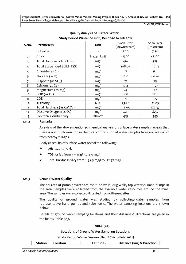
Proposed RBM (River Bed Material) Gravel Minor Mineral Mining Project, Block No.–1, Area 8.86 ha., at Hadbast No. –478 River Soan, Near village- Mahindpur, Tehsil-Nangal & District- Ropar (Rupnagar), Punjab.
Draft EIA/EMP Report
Shri Rakesh Kumar Choudhary 39
Quality Analysis of Surface Water
Study Period Winter Season, Dec 2020 to Feb 2021
S.No. Parameters Unit Soan River
(Downstream) Soan River (Upstream)
1 pH value - 7.20 7.56
2 Color Hazen Unit <5.00 <5.00
3 Total Dissolve Solid (TDS) mg/l 410 375
4 Total Suspended Solid (TSS) mg/l 108.05 119.15
5 Chloride (as Cl) mg/l 17 15.1
6 Fluoride (as F) mg/l <0.01 <0.01
7 Sulphate (as SO4) mg/l 17 25
8 Calcium (as Ca) mg/l 1.12 1.07
9 Magnesium (as Mg) mg/l 24 22
10 BOD (as O2) mg/l BDL BDL
11 COD mg/l 59 55
12 Turbidity NTU 23.20 21.05
13 Total Hardness (as CaCO3) mg/l 115.65 122.37
14 Dissolve Oxygen (as O2) mg/l 7.25 8.57
15 Electrical Conductivity Ohm/m 415 393
3.11.2 Remarks
A review of the above-mentioned chemical analysis of surface water samples reveals that
there is not much variation in chemical composition of water samples from surface water
from nearby villages.
Analysis results of surface water reveal the following: -
pH: -7.20 to 7.56.
TDS varies from 375 mg/l to 410 mg/l
Total Hardness vary from 115.65 mg/l to 122.37 mg/l
3.11.3 Ground Water Quality
The sources of potable water are the tube-wells, dug-wells, tap water & Hand pumps in the area. Samples were collected from the available water resources around the mine area. The samples were collected & tested from different sites.
The quality of ground water was studied by collecting5water samples from representative hand pumps and tube wells. The water sampling locations are shown below:
Details of ground water sampling locations and their distance & directions are given in
the below Table 3.13.
TABLE: 3.13
Locations of Ground Water Sampling Locations
Study Period-Winter Season (Dec. 2020 to Feb. 2021)
Station Location Latitude - Distance (km) & Direction

Proposed RBM (River Bed Material) Gravel Minor Mineral Mining Project, Block No.–1, Area 8.86 ha., at Hadbast No. –478 River Soan, Near village- Mahindpur, Tehsil-Nangal & District- Ropar (Rupnagar), Punjab.
Draft EIA/EMP Report
Shri Rakesh Kumar Choudhary 40
Longitude from mine site
S1 Village- Bat Kalan 31°19'25.41"N 76°17'37.01"E
~2.70 km, NW
S2 Village- Bat Khurd 31°20'10.49"N 76°16'17.23"E
~5.2 km, NW
S3 Village- Bhallri 31°18'21.04"N 76°20'31.70"E
~2.0 km, SE
S4 Village Sukhsal 31°19'21.03"N 76°20'18.74"E
~1.70 km, NE
S5 Village- Chhotewal 31°20'17.80"N 76°21'24.30"E
~4.20 km, NE
S6 Village- Brahmpur 31°20'27.50"N 76°23'42.34"E
~7.50 km, ENE
Source: SOI Toposheet

Proposed RBM (River Bed Mineral) Gravel Minor Mineral Mining Project, Block No.–1, Area 8.86 ha., at Hadbast No. –478 River Soan, Near village- Mahindpur, Tehsil-Nangal & District- Ropar (Rupnagar), Punjab.
Draft EIA/EMP Report
Shri Rakesh Kumar Choudhary 41
Figure 3.12: Key Plan showing Ground Water & Soil Sampling Locations

Proposed RBM (River Bed Mineral) Gravel Minor Mineral Mining Project, Block No.–1, Area 8.86 ha., at Hadbast No. –478 River Soan, Near village- Mahindpur, Tehsil-Nangal & District- Ropar (Rupnagar), Punjab.
Draft EIA/EMP Report
Shri Rakesh Kumar Choudhary 42
TABLE: 3.14 Ground Water Quality Analysis
Study Period –Winter Season (Dec. 2020 to Feb. 2021)
S.No. Parameters
Unit
Village- Bat Kalan
Village- Bat Khurd
Village Bhallri
Near Village Sukhshal
Village- Chhotewal
Near Village Brahmpur
Specification as per IS 10500- 2012
Desirable
limits
Permissible limit (Max.)
1. pH (at 25°C)
- 7.4 7.8 8.3 8.0 7.3 7.1 6.5 to 8.5
No Relaxation
2. Color Hazen Unit
BDL (DL5.0Hazen
)
BDL (DL5.0Hazen)
BDL (DL5.0Hazen)
BDL (DL5.0Hazen)
BDL (DL5.0Haze
n)
BDL (DL5.0Haze
n)
5 15
3. Turbidity NTU BDL (DL1.0NTU)
BDL (DL1.0NTU)
BDL (DL1.0NTU)
BDL (DL1.0NTU)
BDL (DL1.0NTU)
BDL (DL1.0NTU)
1 5
4. Odour - Agreeable Agreeable Agreeable Agreeable Agreeable Agreeable Agreeable
Agreeable
5. Taste - Agreeable Agreeable Agreeable Agreeable Agreeable Agreeable Agreeable
Agreeable
6. Total Hardness as CaCO3
mg/l 205.3 168.9 195.7 210.8 188.7 172.2 200 600
7. Calcium as Ca
mg/l 44.80 16.25 43.21 37.97 28.45 51.55 75 200
8. Alkalinity as CaCO3
mg/l 276.6 189.56 221.96 285.77 311.52 248.34 200 600
9. Chloride as Cl
mg/l 248.5 277.8 212.4 302.1 288.0 310.9 250 1000
10. Cyanide as CN
mg/l BDL (DL0.02mg/l
)
BDL (DL0.02mg/l)
BDL (DL0.02mg/l)
BDL (DL0.02mg/l)
BDL (DL0.02mg/l
)
BDL (DL0.02mg/l
)
0.05 No Relaxation
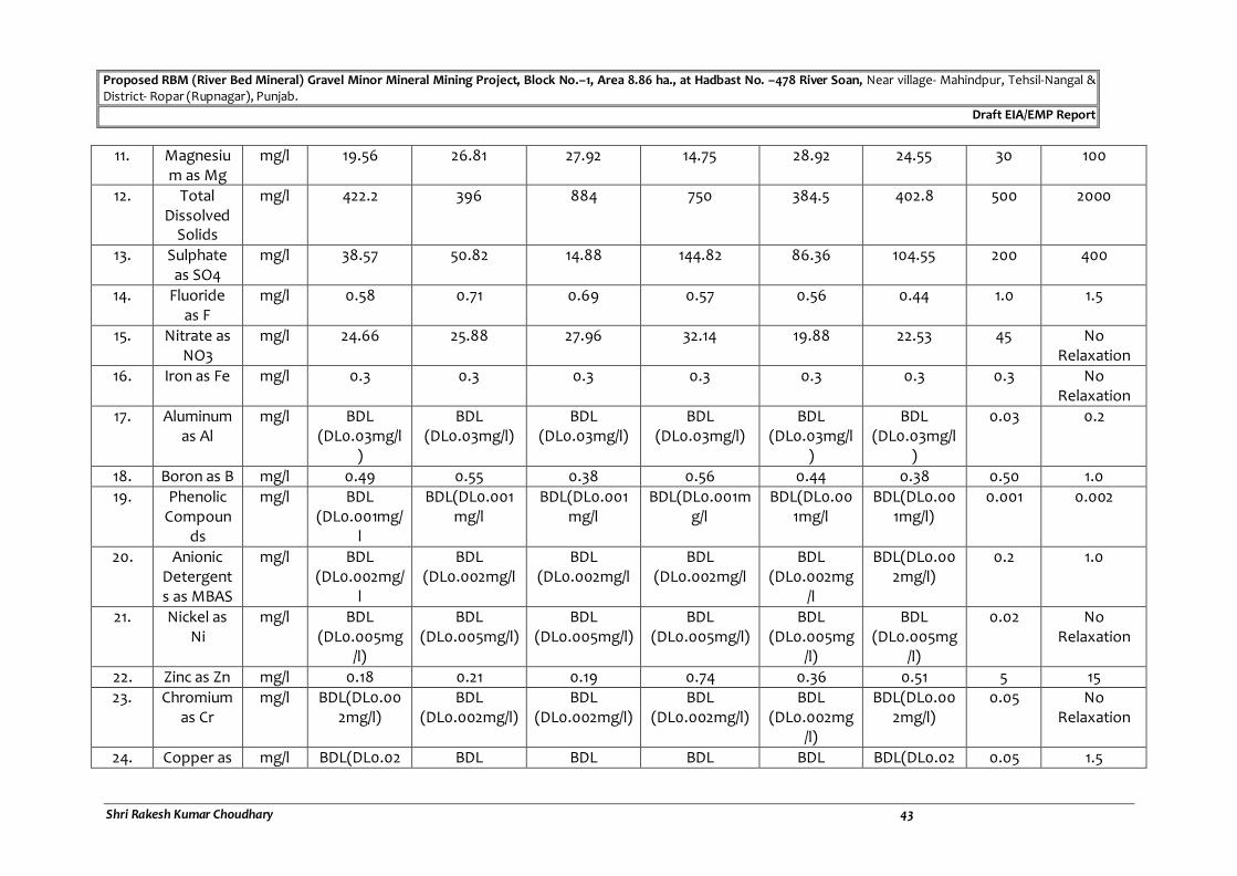
Proposed RBM (River Bed Mineral) Gravel Minor Mineral Mining Project, Block No.–1, Area 8.86 ha., at Hadbast No. –478 River Soan, Near village- Mahindpur, Tehsil-Nangal & District- Ropar (Rupnagar), Punjab.
Draft EIA/EMP Report
Shri Rakesh Kumar Choudhary 43
11. Magnesium as Mg
mg/l 19.56 26.81 27.92 14.75 28.92 24.55 30 100
12. Total Dissolved
Solids
mg/l 422.2 396 884 750 384.5 402.8 500 2000
13. Sulphate as SO4
mg/l 38.57 50.82 14.88 144.82 86.36 104.55 200 400
14. Fluoride as F
mg/l 0.58 0.71 0.69 0.57 0.56 0.44 1.0 1.5
15. Nitrate as NO3
mg/l 24.66 25.88 27.96 32.14 19.88 22.53 45 No Relaxation
16. Iron as Fe mg/l 0.3 0.3 0.3 0.3 0.3 0.3 0.3 No Relaxation
17. Aluminum as Al
mg/l BDL (DL0.03mg/l
)
BDL (DL0.03mg/l)
BDL (DL0.03mg/l)
BDL (DL0.03mg/l)
BDL (DL0.03mg/l
)
BDL (DL0.03mg/l
)
0.03 0.2
18. Boron as B mg/l 0.49 0.55 0.38 0.56 0.44 0.38 0.50 1.0
19. Phenolic Compoun
ds
mg/l BDL (DL0.001mg/
l
BDL(DL0.001mg/l
BDL(DL0.001mg/l
BDL(DL0.001mg/l
BDL(DL0.001mg/l
BDL(DL0.001mg/l)
0.001 0.002
20. Anionic Detergents as MBAS
mg/l BDL (DL0.002mg/
l
BDL (DL0.002mg/l
BDL (DL0.002mg/l
BDL (DL0.002mg/l
BDL (DL0.002mg
/l
BDL(DL0.002mg/l)
0.2 1.0
21. Nickel as Ni
mg/l BDL (DL0.005mg
/l)
BDL (DL0.005mg/l)
BDL (DL0.005mg/l)
BDL (DL0.005mg/l)
BDL (DL0.005mg
/l)
BDL (DL0.005mg
/l)
0.02 No Relaxation
22. Zinc as Zn mg/l 0.18 0.21 0.19 0.74 0.36 0.51 5 15
23. Chromium as Cr
mg/l BDL(DL0.002mg/l)
BDL (DL0.002mg/l)
BDL (DL0.002mg/l)
BDL (DL0.002mg/l)
BDL (DL0.002mg
/l)
BDL(DL0.002mg/l)
0.05 No Relaxation
24. Copper as mg/l BDL(DL0.02 BDL BDL BDL BDL BDL(DL0.02 0.05 1.5

Proposed RBM (River Bed Mineral) Gravel Minor Mineral Mining Project, Block No.–1, Area 8.86 ha., at Hadbast No. –478 River Soan, Near village- Mahindpur, Tehsil-Nangal & District- Ropar (Rupnagar), Punjab.
Draft EIA/EMP Report
Shri Rakesh Kumar Choudhary 44
Cu mg/l) (DL0.02mg/l) (DL0.02mg/l) (DL0.02mg/l) (DL0.02mg/l)
mg/l)
25. Hexavalent
Chromium asCr6+
mg/l BDL(0.03 mg/l)
BDL(0.03 mg/l)
BDL(0.03 mg/l)
BDL(0.03 mg/l) BDL(0.03 mg/l)
BDL(0.03 mg/l)
- -
26. Manganese as Mn
mg/l BDL(DL0.1mg/l)
BDL (DL0.1mg/l)
BDL (DL0.1mg/l)
BDL (DL0.1mg/l)
BDL (DL0.1mg/l)
BDL(DL0.1mg/l)
0.1 0.3
27. Cadmium as Cd
mg/l BDL(DL0.0005mg/l)
BDL (DL0.0005mg/
l)
BDL (DL0.0005mg/
l)
BDL (DL0.0005mg/l
)
BDL (DL0.0005m
g/l)
BDL(DL0.0005mg/l)
0.003 No Relaxation
28. Lead as Pb mg/l BDL(DL0.0008mg/l)
BDL (DL0.0008mg
/l)
BDL (DL0.0008mg
/l)
BDL (DL0.0008mg/
l)
BDL (DL0.0008m
g/l)
BDL(DL0.0008mg/l)
0.01 No Relaxation
29. Arsenic as As
mg/l BDL (DL0.0005m
g/l)
BDL (DL0.0005mg/
l)
BDL (DL0.0005mg/
l)
BDL (DL0.0005mg/l
)
BDL (DL0.0005m
g/l)
BDL (DL0.0005mg/l)
0.01 0.05
30. Mercury as Hg
mg/l BDL (DL0.0001m
g/l
BDL (DL0.0001mg/
l)
BDL (DL0.0001mg/
l)
BDL (DL0.0001mg/l
)
BDL (DL0.0001m
g/l)
BDL (DL0.0001m
g/l)
0.001 No Relaxation
31. Sodium as Na
mg/l 62.48 39.51 44.22 104.66 77.52 115.28 - -
32. Potassium as K
mg/l 22.63 16.88 27.56 25.94 10.16 32.55 - -
33. Phosphate as PO4
mg/l BDL (DL 0.02 mg/l)
BDL(DL0.02mg/l)
BDL(DL0.02mg/l)
BDL(DL0.02mg/l)
BDL(DL0.02mg/l)
BDL(DL0.02mg/l)
- -
34. Conductivity
µS/cm 612.58 708.96 488.02 1050.22 344.66 512.16 - -

Proposed RBM (River Bed Material) Gravel Minor Mineral Mining Project, Block No.–1, Area 8.86 ha., at Hadbast No. –478 River Soan, Near village- Mahindpur, Tehsil-Nangal & District- Ropar (Rupnagar), Punjab.
Draft EIA/EMP Report
Shri Rakesh Kumar Choudhary
45
3.11.3 Remarks
A review of the above-mentioned chemical analysis of ground water samples reveals that there is not much variation in chemical composition of water samples from
handpump & borewells from nearby villages.
Analysis results of ground water reveal the following: -
pH varies from 7.1 to 8.3.
Total hardness varies from 172.2 mg/l to 210.8 mg/l.
Total dissolved solids vary from 384.5 mg/l to 884.0 mg/l.
The ground water from all sources remains suitable for drinking purposes as per drinking water standards IS: 10500-2012.
3.12 SOIL ENVIRONMENT
3.12.1 Soil Quality and Characteristics
The information on soil quality has been arrived at by collecting data from various secondary sources and supplemented by collection and analysis of soil samples from
representative locations.
In order to assess the base line characteristics of soil profile of the project area representing project and nearby areas, the samples were analyzed for key and
chemical parameters.
The sampling locations were finalized with the following considerations:
To enable information on baseline characteristics.
To determine the impact of mining activities on soil characteristics.
Representative soil samples were collected from following different specified locations within the study area of the mine site. Standard operating procedures were followed for the sampling and analysis of physico – chemical parameters. Below table
3.15 shows the location of soil sampling stations.
TABLE: 3.15 Soil Sampling Locations
Study Period – Winter Season (Dec. 2020 to Feb. 2021)
Station Location Latitude - Longitude
Distance (km) & Direction from mine
site
S1 Mine Site 31°18'56.64"N 76°19'6.15"E
~0.15 km, NW
S2 Village- Bat Kalan
31°19'32.05"N 76°17'36.19"E
~2.7 km, NW
S3 Village- Bat Khurd
31°20'7.32"N 76°16'19.19"E
~5.1 km, NW
S4 Village- Bhallri 31°18'21.16"N 76°20'30.36"E
~1.9 km, SE
S5 Near Village -Sukhshal
31°19'21.67"N 76°20'19.23"E
~1.8 km, SW
S6 Near village- Brahmpur
31°20'28.35"N 76°23'39.69"E
~7.4 km, ENE
Source: SOI Toposheet

Proposed RBM (River Bed Material) Gravel Minor Mineral Mining Project, Block No.–1, Area 8.86 ha., at Hadbast No. –478 River Soan, Near village- Mahindpur, Tehsil-Nangal & District- Ropar (Rupnagar), Punjab.
Draft EIA/EMP Report
Shri Rakesh Kumar Choudhary 46
TABLE: 3.16 Soil Quality Analysis Report
Study Period – Winter Season, (December 2020-February 2021)
S. NO. PARAMETERS Unit Mine site Village- Bat
Kalan Village- Bat
Khurd Village- Bhallri Near Village
-Sukhshal Near village-
Brahmpur
1. pH - 7.22 7.69 8.01 7.55 7.92 7.46
2. Conductivity µmhos/cm 512 488 572 396 516 475
3. Bulk Density kg/cm3 0.51 0.48 0.55 0.68 0.57 0.62
4. Soil Moisture Content % 4.44 5.12 4.89 6.22 4.88 5.81
5. Sodium (as Na) (mg/kg) mg/kg 208 199 175 201 166 183
6. Water holding capacity (%) 29.2 30.5 27.7 31.4 34.6 29.8
7. Texture
Sand (% by mass) 56.9 63.4 62.1 55.6 57.5 56.4
Clay (% by mass) 16.2 19.1 18.8 23.8 17.9 15.8
Silt (% by mass) 26.9 17.5 19.1 20.6 24.6 27.8
8.
Available Calcium as Ca mg/kg 189 207 222 193 187 211
9. Magnesium as Mg mg/kg 83.1 79.4 91.2 87 81.8 79.5
10. Cadmium mg/kg BDL BDL BDL BDL BDL BDL
11. CEC meq/100gm 0.91 0.77 0.85 0.89 0.78 0.66
12. Available Nitrogen (Kg/Ha.) 1.38 1.24 1.52 1.38 1.57 1.44
13. Available Phosphorus (as P)
(Kg/Ha.) 5.88 4.59 3.88 6.01 5.16 4.87
14. Available Potassium (as K)
(Kg/Ha.) 93 69 77 82 76 87
15. Organic carbon (%) 0.88 0.91 0.69 0.81 0.90 0.85
16. Porosity % by mass 0.62 0.59 0.51 0.64 0.58 0.62
17. Permeability cm/hr 11.3 8.8 10.9 12.4 10.8 9.6
18. Cadmium mg/kg BDL BDL BDL BDL BDL BDL
Source: Soil Quality Analysis Report

Proposed RBM (River Bed Material) Gravel Minor Mineral Mining Project, Block No.–1, Area 8.86 ha., at Hadbast No. –478 River Soan, Near village- Mahindpur, Tehsil-Nangal & District- Ropar (Rupnagar), Punjab.
Draft EIA/EMP Report
Shri Rakesh Kumar Choudhary
47
TABLE: 3.17
Standard Soil Classification
S.No. Parameters Classification
1. pH <4.5 extremely acidic 4.51 – 5.0 very strong acidic 5.01 – 5.5 strongly acidic 5.51-6.0 moderately acidic 6.1 – 6.5 slightly acidic 6.51-7.3 Neutral 7.31-7.8 slightly alkaline 7.81-8.5 moderately alkaline 8.51 – 9.0 strongly alkaline >9.0 Very strongly alkaline
2. Salinity Electrical Conductivity (mS/cm)
Up to 1.0 average 1-2 harmful to germination 2-3 harmful to crops
3. Nitrogen (kg/ha) Up to 50 very less 51-100 less 110-150 good 151-300 better >300 sufficient
4. Phosphorus (kg/ha) Up to 15 very less 15 – 30 less 31-50 medium 51-65 on average sufficient 66-80 sufficient >80 more than sufficient
5. Potassium (kg/ha) 0-120 very less 120-180 less 180-240 medium 241-300 average 301-360 better >360 more than sufficient
Samples collected from identified locations indicate pH value ranging from 7.22 to 8.01, which shows that the soil is slightly alkaline in nature. Organic Carbon ranges from 0.69 % to 0.91 % in the soil samples. Nitrogen is found to be in range of 1.24 kg/ha to 1.57 kg/ha and Phosphorous is in lesser amount to less i.e. from 3.88 kg/ha to 6.01 kg/ha, respectively, whereas the Potassium is found to be lesser amount ranging from 69 kg/ha to 93 kg/ha.
3.13 BIOLOGICAL ENVIRONMENT
3.13.1 Introduction
An ecological study of the ecosystem is essential to understand the impact of industrialization and urbanization on existing flora and fauna of the study area. Studies on various aspects of ecosystem play an important role in identifying sensitive issues for undertaking appropriate action to mitigate the impact, if any.

Proposed RBM (River Bed Material) Gravel Minor Mineral Mining Project, Block No.–1, Area 8.86 ha., at Hadbast No. –478 River Soan, Near village- Mahindpur, Tehsil-Nangal & District- Ropar (Rupnagar), Punjab.
Draft EIA/EMP Report
Shri Rakesh Kumar Choudhary
48
The biological study was undertaken as a part of the EIA study report to understand the present status of ecosystem prevailing in the study area, to compare it with past condition with the help of available data, to predict changes in the biological environment as a result of present activities and to suggest measures for maintaining its health.
A survey was conducted to study the flora & fauna in 10 km radius. Some of the information was gathered from the local habitants. All the collected data were classified to interpret the impact of pollution on the flora and fauna of that region. Survey of the wild plants as well as cultivated crop plants was made and all the available information was recorded.
3.13.2 Flora
A general floral survey was carried out in the study area. The plant species found in the area are mentioned below.
TABLE - 3.18
INVENTORY OF FLORAL DIVERSITY IN THE CORE & BUFFER ZONE OF MINE SITE
Based on Actual Sighting, based on inputs from locals and Perused from Secondary data
Habit: Tree (T), Shrub (S), Herb (H) and Grass (G)
S. No. Scientific Name Local name Family Habit Core Buffer
1. Acacia nilotica Babool Fabaceae T + +
2. Acacia catechu Khair Fabaceae T + +
3. Albizia lebbeck Siris Mimosaceae T - +
4. Azadirachta indica Neem Meliaceae T - +
5. Aegle marmelos Bel Rutaceae T - +
6. Butea monosperma Dhak Fabaceae T - +
7. Casuarina equisetifolia Rhu Casuarinaceae T + +
8. Cassia fistula Amaltash Caesalpiniaceae T + +
9. Dalbergia sissoo Shesham Fabaceae T + +
10. Delonix regia Gulmohar Caesalpiniaceae T + +
11. Eucalyptus globolus Safeda Myrtaceae T + +
12. Embelica officinalis Amla Phyllanthaceae T - +
13. Ficus benghalensis Bargad Moraceae T - +
14. Ficus elastica Ruber Plant Moraceae T - +
15. Ficus religiosa Pipal Moraceae T - +
16. Holoptelea integrifolia Rajain Utreaceae T - +
17. Leucaena leucocephala Subabul Fabaceae T + +
18. Mangifera indica Aam Anacardiaceae T - +
19. Morus alba Shahtoot Moraceae T - +
20. Murraya koenigii Curry Patta Rutaceae T - +
21. Populus deltoides poplar Salicaceae T + +
22. Pinus roxburghi Chil Pinaceae T - +
23. Pongamia pinnata Karanj Fabaceae T - +
24. Phoenix sylvestris Khajoor Arecaceae T - +
25. Prosopis juliflora Vilayati babool Mimosaceae T + +
26. Toona sinensis Toon Meliaceae T + +

Proposed RBM (River Bed Material) Gravel Minor Mineral Mining Project, Block No.–1, Area 8.86 ha., at Hadbast No. –478 River Soan, Near village- Mahindpur, Tehsil-Nangal & District- Ropar (Rupnagar), Punjab.
Draft EIA/EMP Report
Shri Rakesh Kumar Choudhary
49
27. Tectona grandis Sagwan Lamiaceae T - +
28. Terminalia arjuna Arjun Combretaceae T - +
29. Terminalia belerica Bahera Combretaceae T + +
30. Terminalia chebula Harer Combretaceae T - +
31. Tamaridus indica Imli Fabaceae T - +
32. Syzygium cumini Jamun Myrtaceae T - +
33. Ziziphus mauritiana Ber Rhamnaceae T + +
34. Acacia tortilis Tortilis/Vilayati Kikar
Fabaceae T - +
35. Calotropis procera Aak Asclepiadaceae S - +
36. Nerium oleander Kaner Apocynaceae S + +
37. Jasminum polyanthum Chamali Oleaceae S + +
38. Hibiscus rosa-sinensis Chinese hibiscus malvaceae S + +
39. Morus alba Toot Apocynaceae T - +
40. Salix alba Willow Salicaceae T - +
41. Aerva tomentosa Bui Amaranthaceae S - +
42. Amaranthus spinosus Jangli chaulai Amaranthaceae H - +
43. Achyranthes aspera Latjira Amaranthaceae H - +
44. Flocourtia indica Kangu Euphorbiaceae H - +
45. Bacopa monieri Brahmi Plantaginaceae H - +
46. Cannabis sativa Bhung Cannabaceae S - +
47. Croton bonplandianum Ban Tulsi Euphorbiaceae H - +
48. Datura metel Dhatura Solanaceae H + +
49. Ageratum conyzoides Goat weed Scrophulariaceae H - +
50. Tecoma gaudichaudi Yellow Bell Bignoniaceae H - +
51. Lantana camera Raimuniya Verbenaceae S + +
52. Morus alba Bhringraj Asteraceae T - +
53. Sonchus oleraceus Dudhi Asteraceae H - +
54. Withania somnifera Ashwagandha Solanaceae H - +
55. Achyranthes aspera Apamarga Amaranthaceae S - +
56. Leucas aspera Kubi Lamiaceae S - +
57. Cynodon dactylon Doob ghas Poaceae H - +
58. Desmostachya bipinnata Dab Poaceae H - +
59. Dichanthium annulatum Sheda Grass Poaceae H - +
60. Saccharum spontaneum Knas Poaceae H - +
61. Ficus Bengalens Bohar Poaceae T + +
62. Parthenium hysterophorus
Gajar Ghas Asteraceae H - +
63. Cyperus rotundus Motha Cyperaceae H + +
64. Saccharum spontaneum Kans Poaceae H - +
65. Saccharum munja Munja Poaceae H + +
66. Adiantum Species Fern Pteridaceae F - +
“+” indicates presence of species.
“-” indicates absence of species.
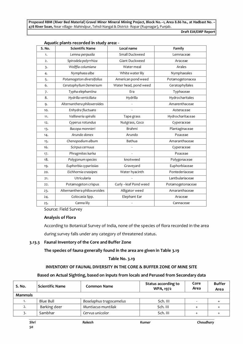
Proposed RBM (River Bed Material) Gravel Minor Mineral Mining Project, Block No.–1, Area 8.86 ha., at Hadbast No. –478 River Soan, Near village- Mahindpur, Tehsil-Nangal & District- Ropar (Rupnagar), Punjab.
Draft EIA/EMP Report
Shri Rakesh Kumar Choudhary
50
Aquatic plants recorded in study area: - S. No. Scientific Name Local name Family
1. Lemna perpusila Small Duckweed Lemnaceae
2. Spirodela polyrrhiza Giant Duckweed Araceae
3. Wolffia columiana Water meal Arales
4. Nymphaea alba White water lily Nymphaeales
5. Potamogeton diversifolius American pond weed Potamogetonacea
6. Ceratophyllum Demersum Water head, pond weed Ceratophyllales
7. Typha elephantina Era Typhaceae
8. Hydrilla verticillata Hydrilla Hydrocharitales
9. Alternanthera philoxeroides - Amarenthaceae
10. Enhydra fluctuans - Asteraceae
11. Vallisneria spiralis Tape grass Hydrocharitaceae
12. Cyperus rotundus Nutgrass, Coco Cyperaceae
13. Bacopa monnieri Brahmi Plantaginaceae
14. Arundo donex Arundo Poaceae
15. Chenopodium album Bathua Amaranthaceae
16. Scirpus cernuus - Cyperaceae
17. Phragmites karka - Poaceae
18. Polygonum species knotweed Polygonaceae
19. Euphorbia cyparissias Graveyard Euphorbiaceae
20. Eichhornia crassipes Water hyacinth Pontederiaceae
21. Utricularia - Lantbulariaceae
22. Potamogeton crispus Curly –leaf Pond weed Potamogetonaceae
23. Alternanthera philoxoroides Alligator weed Amaranthaceae
24. Colocasia Spp. Elephant Ear Araceae
25. Canna lily - Cannaceae
Source: Field Survey
Analysis of Flora
According to Botanical Survey of India, none of the species of flora recorded in the area
during survey falls under any category of threatened status.
3.13.3 Faunal Inventory of the Core and Buffer Zone
The species of fauna generally found in the area are given in Table 3.19
Table No. 3.19
INVENTORY OF FAUNAL DIVERSITY IN THE CORE & BUFFER ZONE OF MINE SITE
Based on Actual Sighting, based on inputs from locals and Perused from Secondary data
S. No. Scientific Name Common Name Status according to
WPA, 1972
Core Area
Buffer
Area
Mammals
1. Blue Bull Boselaphus tragocamelus Sch. III - +
2. Barking deer Muntiacus muntilak Sch. III + +
3. Sambhar Cervus unicolor Sch. III + +

Proposed RBM (River Bed Material) Gravel Minor Mineral Mining Project, Block No.–1, Area 8.86 ha., at Hadbast No. –478 River Soan, Near village- Mahindpur, Tehsil-Nangal & District- Ropar (Rupnagar), Punjab.
Draft EIA/EMP Report
Shri Rakesh Kumar Choudhary
51
4. Hog deer Axis porcinus Sch. III + +
5. Indian Pangolin Manis Crassicaudata Sch. I - +
6. Jackal Canis aureus Sch. III - +
7. Indian Hare Iepus nigricollis Sch. IV - +
8. Common Indian Mangoose
Herepestes edwardsi Sch. III + +
9. Small Indian civet Viverricula indica Sch. I - +
10. Rhesus Monkey Macaca Mulatta Sch. II - +
11. Grey Musk Shrew Suncus murinus - - +
12. Indian Fox Vulpes bengalensis Sch. II - +
13. Palm Squirrel Funambulus pennanti Sch. III - +
Reptiles
1. Northern house geeko Hemidactylus flaviviridis Sch. IV - +
2. Fat tailed gecko Eublepharis macularivl - + +
3. Common garden lizard Calotesversi color - - +
4. Indian chameleon Chamaeleonzey lanicaul Sch. IV - +
5. Common rat snake Ptyasmu cosus - + +
6. Common indian krait Bungarusc aeruleus - - +
7. Spiny tailed lizard Uromastixhard wikii Sch. II
8. Yellow monitor lizard Varanus flavescous Sch. I
Amphibians
1. Rana hexadactylus Indian Pond Frog Sch. IV - +
2. Rana limnocharis Indian Cricket Frog Sch. IV + +
Butterflies
1. Danaus chrysippus Plain Tiger - + +
2. Lxias Marianne White-orange Tip - - +
3. Precis orithya Blue Pancy - + +
4. Phalanta phalantha Plain leopard - - +
5. Eurema blanda Three-Spot Grass Yellow - + +
6. Papilio polytes Common Mormon - - +
Arthropods and Crustacean
1. Buthus sp. Scorpion - - +
2. Brachyura sp. Crab - - +
3. Stegodyphus sp. Social Spider - - +
4. Scolopendrid centipedes Kan Khajura - + +
5. Sympertrum fonscolombii
Red -veined darter (Dragonfly) - + +
Avian Diversity recorded in study area:-
S.
No. Scientific Name Common Name Family
Status according to
IWPA-1972
Core
Area
Buffer
Area
1. Larus cachinnans Yellow legged gull laridae Schedule IV - +
2. Tachybaptus ruficollis Little grabe Podicipedidae Schedule IV - +
3. Amaurornis phoenicurus White –breasted water hen Rallidae Schedule IV - +
4. Vanellus indicus Red-wattled lapwing Charadriidae - - +
5. Grus antigone Sarus Crane Grusformes Schedule IV - +

Proposed RBM (River Bed Material) Gravel Minor Mineral Mining Project, Block No.–1, Area 8.86 ha., at Hadbast No. –478 River Soan, Near village- Mahindpur, Tehsil-Nangal & District- Ropar (Rupnagar), Punjab.
Draft EIA/EMP Report
Shri Rakesh Kumar Choudhary
52
6. Ardeola grayii Indian Pond Heron Ardeidae Schedule IV - +
7. Charadrius dubius Little Ring Plover Charadridae Schedule IV - +
8. Nycticorax nycticorax Black crown night Heron Ardeidae Schedule IV - +
9. Ardea cinerea Grey Heron Ardeidae Schedule IV - +
10. Ocyceros birostris Indian grey hornbill Bucerotidae Schedule IV - +
11. Ploceus philippinus Baya weaver Ploceidae Schedule IV - +
12. Francolinus pondicerianus Grey francolin Phasianidae Schedule IV - +
13. Upupa epops Common hoopoe Upupidae - - +
14. Coracias benghalensis Indian Roller Coraciidae Schedule IV - +
15. Halcyon smyrnensis White -throated kingfisher Alcedinidae Schedule IV - +
16. Ceryle rudis Pied kingfisher Cerylidae Schedule IV - +
17. Merops orientalis Green bee-eater Meropidae - - +
18. Centropus bengalensis Lesser coucal Cuculidae Schedule IV - +
19. Psittacula krameri Rose-ringed parakeet Psittacidae Schedule IV - +
20. Apus affinis House swift Apodidae - + +
21. Columba livia Blue Rock pigeon Columbidae - + +
22. Streptopelia enegalensis Laughing dove Columbidae Schedule IV - +
23. Streptopelia decaocto Eurasian dove Columbidae Schedule IV + +
24. Streptopelia tranquebarica Red Collared dove Columbidae Schedule IV + +
25. Egretta garzetta Little egret Ardeidae Schedule IV - +
26. Mesophoyx intermedia Intermediate egret Ardeidae Schedule IV - +
27. Bubulcus ibis Cattle egret Ardeidae Schedule IV + +
28. Lanius meridionalis Southern grey shrike Laniidae - - +
29. Milvus migrans Black Kite Accipitridae Schedule IV + +
30. Corvus splendens House crow Corvidae Schedule V + +
31. Dicrurus macrocercus Black drongo Dicruridae Schedule IV - +
32. Saxicoloided fulicata Indian robin Turdinae - - +
33. Sturnus pagodarum Brahminy starling Sturnidae Schedule IV + +
34. Sturnus contra Asian Pied starling Sturnidae Schedule IV - +
35. Acridotheres tristis Common myna Sturnidae Schedule IV + +
36. Acridotheres ginginianus Bank myna Sturnidae Schedule IV - +
37. Hirundo smithii Wire-tailed swallow Hirundinidae - - +
38. Hirundo daurica Red-rumped swallow Hirundinidae - - +
39. Pycnonotus cafer Red-vented bulbul Pycnonotidae Schedule IV - +
40. Corvus corax Common Raven Corvidae Schedule V - +
41. Turdoides striatus Jungle babbler Timaliinae Schedule IV + +
42. Nectarinia asiatica Purple sunbird Nectariniidae Schedule IV - +
43. Passer domesticus House sparrow Passerinae Schedule IV + +
44. Motacilla deraspatensis White-browed wagtail Motacillidae - - +
45. Microcarbo niger Little cormorant Phalacrocoracidae Schedule IV - +
46. Acititis hypoleucos Common Sandpiper Scolopacidae Schedule IV - +
47. Tringa ochropus Green sandpiper Scolopacidae Schedule IV - +
48. Philomachus pugnex Ruff Scolopacidae Schedule IV - +
49. Colidris minuta Little stint Scolopacidae Schedule IV - +
50. Anas poecilorhyncha Spotted bill Duck Anatidae Schedule IV - +

Proposed RBM (River Bed Material) Gravel Minor Mineral Mining Project, Block No.–1, Area 8.86 ha., at Hadbast No. –478 River Soan, Near village- Mahindpur, Tehsil-Nangal & District- Ropar (Rupnagar), Punjab.
Draft EIA/EMP Report
Shri Rakesh Kumar Choudhary
53
51. Anas clypeata Northern Shoveler Anatidae Schedule IV - +
52. Himantopus himantopus Black wing Still Recrrvirostridae Schedule IV - +
53. Saxicola caprata Pied Bush chat Muscicapidae Schedule IV - +
54. Prinia socialis Ashy Warn- Warbler Cisticolidae Schedule IV - +
55. Chrysocolaptes festivus Wood piker Picidae Schedule IV - +
56. Apus apus Common swift Apodidae Schedule IV - +
57. Dromaius novaehollandiae Emu Dromaiidoe - - +
58. Anas platyrpynchas domesticus Domistic Duck Anatidae Schedule IV - +
59. Pseudibis papillosa Black ibis Threskiromithidae Schedule IV - +
60. Anas querquedula Garganey teal Anatidae Schedule IV - +
61. Anas penelope Wigeon Anatidae Schedule IV - +
62. Anas falcata Falcated Teal Anatidae Schedule IV - +
63. Anas crecca Teal Anatinae Schedule IV - +
64. Fulica atra Common Coot Rallidae Schedule IV - +
Fish Species recorded in study area:-
S. No. Scientific Name Common Name Family
1. Channa punctatus Snakehead fish Channidae
2. Catla catla Indian Carp Cyprinidae
3. Labio rohita Rohu Cyprinidae
4. Labio bata - Cyprinidae
5. Labio calbasu - Cyprinidae
6. Anguilla bangalensis Raj Bam Anguillidae
7. Tor ater Mahseer Cyprinidae
8. Cyprinus carpio Common carp Cyprinidae
9. Ctenopharyngodon idella Grass carp Cyprinidae
10. Gambusia affinis Mosqitofish Poeciliidae
11. Cirrhina reba Reba Carp Cyprinidae
12. Wallago attu Lanchi Siluridae
Analysis of Fauna: -
The biological study conducted for the core as well as buffer zone of the plant site
reveals that the fauna found in the study area majorly belongs to Schedule I, II, III, IV &
V.
Conservation Plan of schedule -I species are enclosed for your ready reference.
3.13.4 Cropping Pattern of the Study Area
There is Agricultural land available in the buffer zone. In general, the soil fertility is
medium. The soil is slightly alkaline. crops important one sare; Wheat, Rice or Maize.
The major and minor crops during Kharif season are; Paddy, Maize, Groundnut,

Proposed RBM (River Bed Material) Gravel Minor Mineral Mining Project, Block No.–1, Area 8.86 ha., at Hadbast No. –478 River Soan, Near village- Mahindpur, Tehsil-Nangal & District- Ropar (Rupnagar), Punjab.
Draft EIA/EMP Report
Shri Rakesh Kumar Choudhary
54
Sugarcane, Cotton, Pulses, Chillies, etc; whereas Wheat, Gram, Barley, Potatoes, Oil seed sare the major and minor crops of the Rabi season.
Plantation of fruit bearing trees, fibers, ornamental and medicinal plants have been done. Common trees for plantation are mango, Orange & Malta, guava, Pear, Peach etc. The staple food of the region mainly consists of Wheat, Rice or Maize. Most of the cultivation of the area is based on monsoon rains. However, ground water i.e. by
tube wells and dug wells is also used for cultivation.
3.14 SOCIO-ECONOMIC ENVIRONMENT
3.14.1 INTRODUCTION
An essential part of environmental study is socio-economic environment incorporating various facts related to socio-economic conditions in the area, which deals with the total environment.
Socio economic study includes demographic structure of the area, provision of basic amenities viz., housing, education, health and medical services, occupation, water supply, sanitation, communication, transportation, prevailing diseases pattern as well as feature of aesthetic significance such as temples, historical monuments etc. at the baseline level. This helps in visualizing and predicting the possible impact depending upon the nature and magnitude of the project.
Socio-economic study of an area provides a good opportunity to assess the socio-economic condition and possibly makes a change in living and social standards of the particular area benefitted due to the Project. In the nearby areas, gross economic production has increased substantially due to the existing mining projects in the area.
3.14.2 OBJECTIVES OF THE STUDY
The objectives of this socio-economic report consist of:
To conduct socio-economic assessment study in Study Area.
To know the current socio-economic situation in the region to cover the sub sectors of education, health, sanitation, and water and food security.
To recommend practical strategic interventions in the sector.
To help in providing better living standards.
To provide employment opportunities.
3.14.3 SCOPE OF WORK
To study the Socio-economic Environment of area from the secondary sources
Developing a questionnaire for SIA Survey
Data Collection and Analysis
Identification of impacts due to the mining projects
Mitigation Measures.
3.14.4 METHODOLOGY
Collection of Data
Data for this project were collected via a combination of secondary source (i. e. Government department, maps, literature research etc.) and relevant documents.

Proposed RBM (River Bed Material) Gravel Minor Mineral Mining Project, Block No.–1, Area 8.86 ha., at Hadbast No. –478 River Soan, Near village- Mahindpur, Tehsil-Nangal & District- Ropar (Rupnagar), Punjab.
Draft EIA/EMP Report
Shri Rakesh Kumar Choudhary
55
Presentation of Data & Analysis
The data collected were presented in a suitable, concise form for further analysis. The collected data were presented in the form of tabular or diagrammatic or graphic form. These tabulated data were interpreted and analyzed with the help of various qualitative techniques and ideographic approaches.
3.14.5 BACKGROUND INFORMATION OF THE AREA
Ropar district is located in the eastern part of the Punjab State and geographically lies between North latitudes of 76°19′00″ and 76°45′00″ and East longitudes of 30°44′00″ and 31°25′00″. The geographical extent of the area is 1440 sq. km. The area is bounded by Himachal Pradesh in the north and north east, Hoshiarpur, Nawanshahr and Ludhiana district in the west, Fatehgarh Sahib district in the South and Mohali district in the south east. Administratively the new Ropar district is divided into four tehsils – Rupnagar, Chamkaur Sahib, Anandpur Sahib and Nangal.
TABLE: 3.20
Social Profile of the Area
Punjab Rupnagar Study Area
Area sq. km. 50,362 1,356 328.7105
No. of households 54,86,851 1,35,054 9678
Population 2,77,43,338 6,84,627 48604
ST 0 0 0
SC 88,60,179 1,80,905 8818
Literacy Rate 75.84 82.19 81.83%
Sex Ratio 895 915 970
Source: Census of India, 2011
Detailed profile of the study area is given in table below:
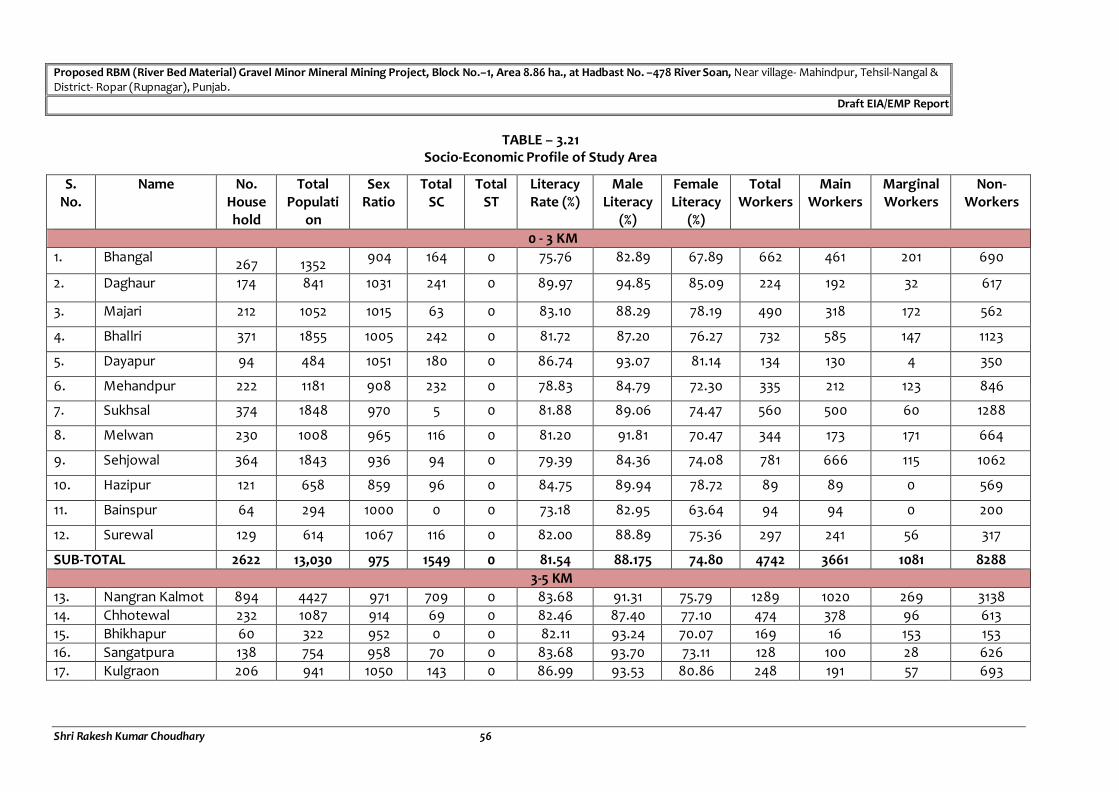
Proposed RBM (River Bed Material) Gravel Minor Mineral Mining Project, Block No.–1, Area 8.86 ha., at Hadbast No. –478 River Soan, Near village- Mahindpur, Tehsil-Nangal & District- Ropar (Rupnagar), Punjab.
Draft EIA/EMP Report
Shri Rakesh Kumar Choudhary 56
TABLE – 3.21 Socio-Economic Profile of Study Area
S. No.
Name No. Household
Total Populati
on
Sex Ratio
Total SC
Total ST
Literacy Rate (%)
Male Literacy
(%)
Female Literacy
(%)
Total Workers
Main Workers
Marginal Workers
Non-Workers
0 - 3 KM
1. Bhangal 267 1352
904 164 0 75.76 82.89 67.89 662 461 201 690
2. Daghaur 174 841 1031 241 0 89.97 94.85 85.09 224 192 32 617
3. Majari 212 1052 1015 63 0 83.10 88.29 78.19 490 318 172 562
4. Bhallri 371 1855 1005 242 0 81.72 87.20 76.27 732 585 147 1123
5. Dayapur 94 484 1051 180 0 86.74 93.07 81.14 134 130 4 350
6. Mehandpur 222 1181 908 232 0 78.83 84.79 72.30 335 212 123 846
7. Sukhsal 374 1848 970 5 0 81.88 89.06 74.47 560 500 60 1288
8. Melwan 230 1008 965 116 0 81.20 91.81 70.47 344 173 171 664
9. Sehjowal 364 1843 936 94 0 79.39 84.36 74.08 781 666 115 1062
10. Hazipur 121 658 859 96 0 84.75 89.94 78.72 89 89 0 569
11. Bainspur 64 294 1000 0 0 73.18 82.95 63.64 94 94 0 200
12. Surewal 129 614 1067 116 0 82.00 88.89 75.36 297 241 56 317
SUB-TOTAL 2622 13,030 975 1549 0 81.54 88.175 74.80 4742 3661 1081 8288
3-5 KM
13. Nangran Kalmot 894 4427 971 709 0 83.68 91.31 75.79 1289 1020 269 3138
14. Chhotewal 232 1087 914 69 0 82.46 87.40 77.10 474 378 96 613
15. Bhikhapur 60 322 952 0 0 82.11 93.24 70.07 169 16 153 153
16. Sangatpura 138 754 958 70 0 83.68 93.70 73.11 128 100 28 626
17. Kulgraon 206 941 1050 143 0 86.99 93.53 80.86 248 191 57 693

Proposed RBM (River Bed Material) Gravel Minor Mineral Mining Project, Block No.–1, Area 8.86 ha., at Hadbast No. –478 River Soan, Near village- Mahindpur, Tehsil-Nangal & District- Ropar (Rupnagar), Punjab.
Draft EIA/EMP Report
Shri Rakesh Kumar Choudhary 57
S. No.
Name No. Household
Total Populati
on
Sex Ratio
Total SC
Total ST
Literacy Rate (%)
Male Literacy
(%)
Female Literacy
(%)
Total Workers
Main Workers
Marginal Workers
Non-Workers
18. Palasi 301 1625 970 167 0 83.16 90.28 75.76 564 506 58 1061
19. Pasiwal 202 958 975 367 0 85.73 91.72 79.49 361 277 84 597
20. Bhanam 510 2667 886 286 0 80.23 89.23 70.13 1038 748 290 1629
SUB-TOTAL 2,543 12,781 959 1811 0 83.505 91.30125 75.29 4271 3236 1035 8510
5 - 7 KM
21. Maujowal 226 1129 1009 351 0 86.70 92.37 81.20 330 314 16 799
22. Jol 99 502 961 316 0 81.28 87.77 74.67 122 119 3 380
23. Palsari 67 395 1036 0 0 67.24 75.68 57.64 368 206 162 973
24. Bela Ramgarh 293 1656 962 305 0 82.44 88.93 75.68 768 636 132 888
25. Bhallan 731 3674 992 495 0 84.04 89.76 78.47 1154 981 173 2520
SUB-TOTAL 1416 7,356 992 1467 0 80.34 86.90 73.50 2,742 2,256 486 4,614
7-10 KM
26. Algaran 82 351 1006 4 0 79.18 90.54 69.23 150 89 61 201
27. Kalitran 337 1753 959 403 0 84.19 91.68 76.46 519 463 56 1234
28. Bhalowal 52 218 847 20 0 87.88 87.96 87.78 79 24 55 139
29. Jandla 203 1121 1020 455 0 86.63 92.02 81.33 287 272 15 834
30. Ajouli 490 2413 1001 104 0 76.05 86.13 66.11 941 725 216 1472
31. Brahmpur 652 3192 944 1290 0 83.42 89.19 77.50 927 673 254 2265
32. Bandleri 216 1067 929 291 0 82.03 88.58 75.32 361 353 8 706
33. Patti 336 1623 892 510 0 83.95 89.68 77.78 657 506 151 966
34. Manakpur 290 1505 975 303 0 72.77 80.09 65.30 468 351 117 1037
35. Meghpur 279 1,418 901 382 0 84.67 90.82 78.25 386 358 28 1032
36. Dohkli 160 776 1026 229 0 80.47 85.71 75.36 186 163 23 590
SUB-TOTAL 3097 15,437 955 3991 0 81.93 88.4 75.49 4,961 3977 984 10476
TOTAL 9,678 48,604 970 8818 0 81.83 88.69 74.78 16,716 13,130 3,586 31,888
Source: Census of India, 2011
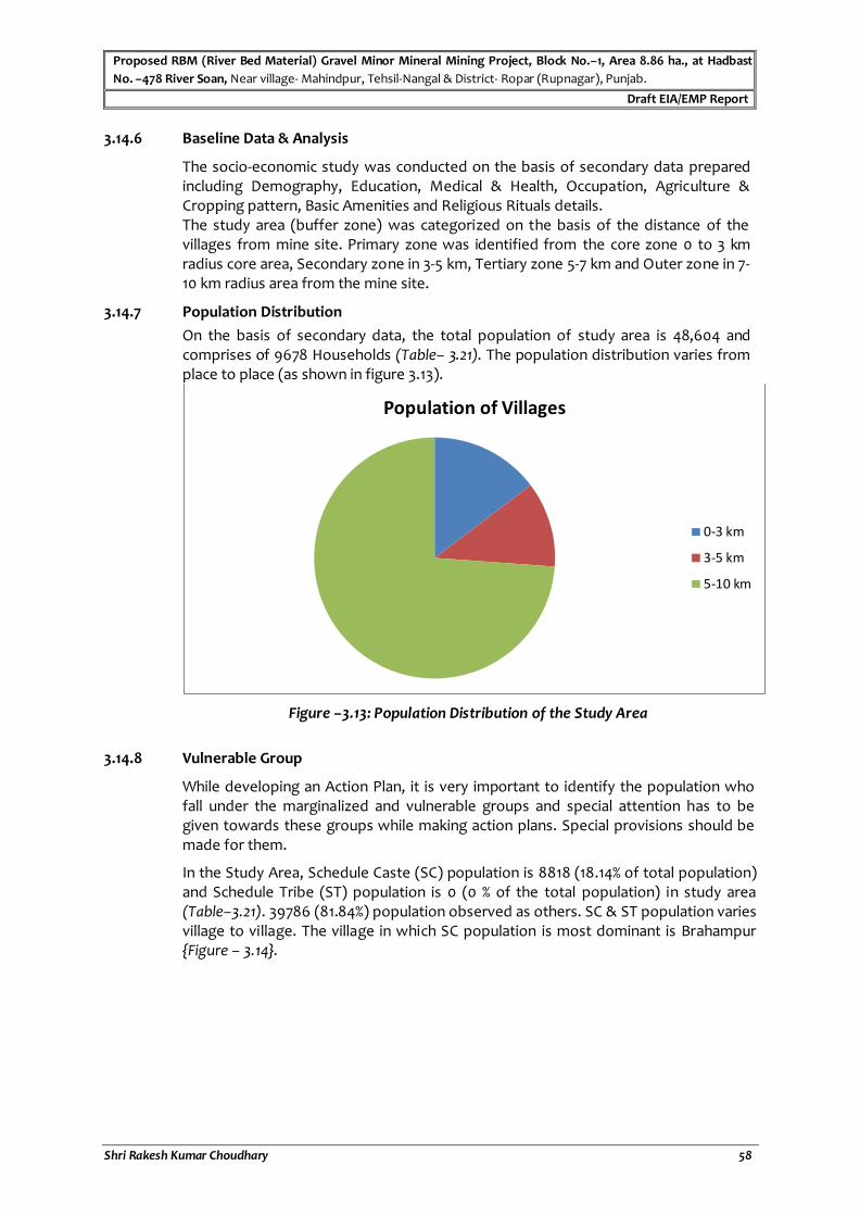
Proposed RBM (River Bed Material) Gravel Minor Mineral Mining Project, Block No.–1, Area 8.86 ha., at Hadbast
No. –478 River Soan, Near village- Mahindpur, Tehsil-Nangal & District- Ropar (Rupnagar), Punjab.
Draft EIA/EMP Report
Shri Rakesh Kumar Choudhary 58
3.14.6 Baseline Data & Analysis
The socio-economic study was conducted on the basis of secondary data prepared including Demography, Education, Medical & Health, Occupation, Agriculture & Cropping pattern, Basic Amenities and Religious Rituals details. The study area (buffer zone) was categorized on the basis of the distance of the villages from mine site. Primary zone was identified from the core zone 0 to 3 km radius core area, Secondary zone in 3-5 km, Tertiary zone 5-7 km and Outer zone in 7-10 km radius area from the mine site.
3.14.7 Population Distribution
On the basis of secondary data, the total population of study area is 48,604 and comprises of 9678 Households (Table– 3.21). The population distribution varies from place to place (as shown in figure 3.13).
Figure –3.13: Population Distribution of the Study Area
3.14.8 Vulnerable Group
While developing an Action Plan, it is very important to identify the population who fall under the marginalized and vulnerable groups and special attention has to be given towards these groups while making action plans. Special provisions should be made for them.
In the Study Area, Schedule Caste (SC) population is 8818 (18.14% of total population) and Schedule Tribe (ST) population is 0 (0 % of the total population) in study area (Table–3.21). 39786 (81.84%) population observed as others. SC & ST population varies village to village. The village in which SC population is most dominant is Brahampur {Figure – 3.14}.
Population of Villages
0-3 km
3-5 km
5-10 km

Proposed RBM (River Bed Material) Gravel Minor Mineral Mining Project, Block No.–1, Area 8.86 ha., at Hadbast
No. –478 River Soan, Near village- Mahindpur, Tehsil-Nangal & District- Ropar (Rupnagar), Punjab.
Draft EIA/EMP Report
Shri Rakesh Kumar Choudhary 59
Figure – 3.14: SC / ST Population in the Study Area
3.14.9 Religion
The religion of the majority of the population in the Study Area is Hindu.
3.14.10 Literacy Rate
Literacy Rate is the amount of people in a country with the ability to read and write. The analysis of the literacy levels is done in the study area. The 10 km radius study area demonstrates a literacy rate of 81.83% as per census 2011. The male literacy rate in the study area works out to be 88.69% whereas the female literacy rate, which is an important indicator for social change, is observed to be 74.78 % in the study area. This indicates that there is a need to focus in sociological aspect in the region and enhance further development. The distribution of literacy rates in the villages is given in Figure: 3.15.
In the present study, the literacy rate is quiet moderate in the study area. Male and Female literacy rate of villages are varying place to place. Although Female literacy an alarming situation.
3.14.11 Economic Activities
The economy of an area is defined by the occupational pattern and income level of the people in the area. The occupational structure of residents in the study area is studied with reference to work category. The population is divided occupation wise into three categories, viz., main workers, marginal workers, and non-workers. The workers include cultivators, agricultural laborers, those engaged in household activities and other services.
The marginal workers are those workers engaged in some work for a period of less than 180 days during the reference year. The non-workers include those engaged in unpaid household duties, students, retired persons, dependents, beggars, vagrants etc. besides institutional inmates or all other non-workers who do not fall under the above categories. Table- 3.22 shows the distribution of workers in the villages in the study area.
8818
0
39786
SC
ST
Others
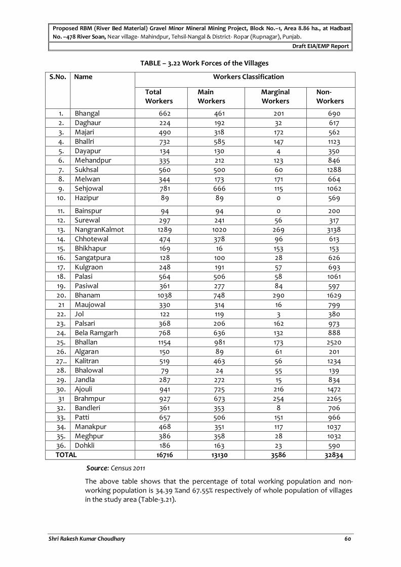
Proposed RBM (River Bed Material) Gravel Minor Mineral Mining Project, Block No.–1, Area 8.86 ha., at Hadbast
No. –478 River Soan, Near village- Mahindpur, Tehsil-Nangal & District- Ropar (Rupnagar), Punjab.
Draft EIA/EMP Report
Shri Rakesh Kumar Choudhary 60
TABLE – 3.22 Work Forces of the Villages
S.No. Name Workers Classification
Total Workers
Main Workers
Marginal Workers
Non-Workers
1. Bhangal 662 461 201 690
2. Daghaur 224 192 32 617
3. Majari 490 318 172 562
4. Bhallri 732 585 147 1123
5. Dayapur 134 130 4 350
6. Mehandpur 335 212 123 846
7. Sukhsal 560 500 60 1288
8. Melwan 344 173 171 664
9. Sehjowal 781 666 115 1062
10. Hazipur 89 89 0 569
11. Bainspur 94 94 0 200
12. Surewal 297 241 56 317
13. NangranKalmot 1289 1020 269 3138
14. Chhotewal 474 378 96 613
15. Bhikhapur 169 16 153 153
16. Sangatpura 128 100 28 626
17. Kulgraon 248 191 57 693
18. Palasi 564 506 58 1061
19. Pasiwal 361 277 84 597
20. Bhanam 1038 748 290 1629
21 Maujowal 330 314 16 799
22. Jol 122 119 3 380
23. Palsari 368 206 162 973
24. Bela Ramgarh 768 636 132 888
25. Bhallan 1154 981 173 2520
26. Algaran 150 89 61 201
27.. Kalitran 519 463 56 1234
28. Bhalowal 79 24 55 139
29. Jandla 287 272 15 834
30. Ajouli 941 725 216 1472
31 Brahmpur 927 673 254 2265
32. Bandleri 361 353 8 706
33. Patti 657 506 151 966
34. Manakpur 468 351 117 1037
35. Meghpur 386 358 28 1032
36. Dohkli 186 163 23 590
TOTAL 16716 13130 3586 32834
Source: Census 2011
The above table shows that the percentage of total working population and non-working population is 34.39 %and 67.55% respectively of whole population of villages in the study area (Table-3.21).

Proposed RBM (River Bed Material) Gravel Minor Mineral Mining Project, Block No.–1, Area 8.86 ha., at Hadbast
No. –478 River Soan, Near village- Mahindpur, Tehsil-Nangal & District- Ropar (Rupnagar), Punjab.
Draft EIA/EMP Report
Shri Rakesh Kumar Choudhary 61
3.14.12 Educational Facilities
According to census 2011, educational facilities are good in the villages. Approx. all the villages have schools up to middle school level but are lacking in higher educational facilities like Senior Secondary &colleges etc. (Table – 3.19) and shown in Figure – 3.17

Proposed RBM (River Bed Material) Gravel Minor Mineral Mining Project, Block No.–1, Area 8.86 ha., at Hadbast No. –478 River Soan, Near village- Mahindpur, Tehsil-Nangal & District- Ropar (Rupnagar), Punjab.
Draft EIA/EMP Report
Shri Rakesh Kumar Choudhary 62
TABLE – 3.23 Educational Facilities in the Study Area
S. No. Village Name Primary School Middle School Sec. School Sr. Sec.
school
College Training
School
Adult
literacy
centre
Anganbadi
0 - 3 km
1. Bhangal 1 1 1 0 0 0 0 0
2. Daghaur 1 0 0 0 0 0 0 1
3. Majari 1 1 0 0 0 0 0 1
4. Bhallri 2 2 1 1 0 0 0 1
5. Dayapur 1 0 0 0 0 0 0 1
6. Mehandpur 1 0 0 0 0 0 0 1
7. Sukhsal 1 1 1 0 0 0 0 1
8. Melwan 1 1 1 0 0 0 0 1
9. Sehjowal 1 1 1 0 0 0 0 1
10 Hazipur 1 0 0 0 0 0 0 1
11. Bainspur 1 0 0 0 0 0 0 0
12. Surewal 1 1 0 0 0 0 0 1
3 - 5 km
13. NangranKalmot 2 2 2 1 0 0 0 1
14. Chhotewal 1 1 0 0 0 0 0 1
15. Bhikhapur 2 0 0 0 0 0 0 0

Proposed RBM (River Bed Material) Gravel Minor Mineral Mining Project, Block No.–1, Area 8.86 ha., at Hadbast No. –478 River Soan, Near village- Mahindpur, Tehsil-Nangal & District- Ropar (Rupnagar), Punjab.
Draft EIA/EMP Report
Shri Rakesh Kumar Choudhary 63
S. No. Village Name Primary School Middle School Sec. School Sr. Sec.
school
College Training
School
Adult
literacy
centre
Anganbadi
16. Sangatpur 1 0 0 0 0 0 0 1
17. Kulgraon 1 1 1 0 0 0 0 1
18. Palasi 1 1 0 0 0 0 0 1
19. Pasiwal 1 1 1 0 0 0 0 1
20. Bhanam 1 1 0 0 0 0 0 1
5 - 7 km
21. Maujowal 1 0 0 0 0 0 0 1
22. Jol 1 0 0 0 0 0 0 1
23. Palsari 1 0 0 0 0 0 0 1
24. Bela Ramgarh 1 1 0 0 0 0 0 1
25. Bhallan 3 1 1 1 0 0 0 1
7 - 10 km
26. Algran 1 0 0 0 0 0 0 0
27. Kalitran 1 1 1 0 0 0 0 1
28. Bhalowal 0 0 0 0 0 0 0 0
29. Jandla 1 1 0 0 0 0 0 1
30. Ajouli 3 1 0 0 0 0 0 1
31. Barahmpur 4 4 3 2 0 0 0 1

Proposed RBM (River Bed Material) Gravel Minor Mineral Mining Project, Block No.–1, Area 8.86 ha., at Hadbast No. –478 River Soan, Near village- Mahindpur, Tehsil-Nangal & District- Ropar (Rupnagar), Punjab.
Draft EIA/EMP Report
Shri Rakesh Kumar Choudhary 64
S. No. Village Name Primary School Middle School Sec. School Sr. Sec.
school
College Training
School
Adult
literacy
centre
Anganbadi
32. Bandleri 1 1 0 0 0 0 0 1
33. Patti 1 0 0 0 0 0 0 1
34. Manakpur 1 0 0 0 0 0 0 1
35. Meghpur 1 0 0 0 0 0 0 1
36. Dohkli 1 1 0 0 0 0 0 1
Total 45 26 14 5 0 1 0 31
Source: Census, 2011

Proposed RBM (River Bed Material) Gravel Minor Mineral Mining Project, Block No.–1, Area 8.86 ha., at Hadbast No. –478 River Soan, Near village- Mahindpur, Tehsil-Nangal & District- Ropar (Rupnagar), Punjab.
Draft EIA/EMP Report
Shri Rakesh Kumar Choudhary
65
Figure – 3.15: Educational Facilities in the Study area
3.14.13 Health Facilities
In the study area, health facilities are not satisfactory. People have to go to about 7 to 10 km from their place to avail medical facility. There are 2 Maternity & Child Care Centre, 5 Primary Health Sub-Centre’s & 1Primary Health Centre’s in the study area. The available health facilities are given in following Table – 3.24 & shown in figure No. 3.16.
45
26
14
5
0 0
31
0
5
10
15
20
25
30
35
40
45
50
Primary
School
Middle
School
Sec. School Sen. Sec.
school
College Training
School
Anganbadi
Nu
mb
er
Educational Facilities in Study Area

Proposed RBM (River Bed Material) Gravel Minor Mineral Mining Project, Block No.–1, Area 8.86 ha., at Hadbast No. –478 River Soan, Near village- Mahindpur, Tehsil-Nangal & District- Ropar (Rupnagar), Punjab.
Draft EIA/EMP Report
Shri Rakesh Kumar Choudhary 66
TABLE – 3.24
Health Facilities in the Study area
S.
No.
Village Name Maternity &
Child Care
Centre
Veterinary
hospital
ASHA
(Accredited
social health
activists)
Community
Health
Centre
Primary
Health
Centre
Primary
Health
Sub-
Centre
Family
Welfare
Centre
TB Clinic Dispensary
0 - 3 km
1. Bhangal 0 0 1 0 0 0 1 0 0
2. Daghaur 0 0 1 0 0 0 1 0 0
3. Majari 0 0 1 0 0 0 0 0 0
4. Bhallri 1 1 1 0 0 0 0 0 1
5. Dayapur 0 0 1 0 0 0 0 0 0
6. Mehandpur 0 0 1 0 0 0 0 0 0
7. Sukhsal 0 0 1 0 0 0 0 0 0
8. Melwan 0 0 1 0 0 1 0 0 0
9. Sehjowal 0 0 1 0 0 0 0 0 0
10 Hazipur 0 0 1 0 0 0 0 0 0
11. Bainspur 0 0 1 0 0 0 0 0 0
12. Surewal 0 0 1 0 0 0 0 0 0

Proposed RBM (River Bed Material) Gravel Minor Mineral Mining Project, Block No.–1, Area 8.86 ha., at Hadbast No. –478 River Soan, Near village- Mahindpur, Tehsil-Nangal & District- Ropar (Rupnagar), Punjab.
Draft EIA/EMP Report
Shri Rakesh Kumar Choudhary 67
S.
No.
Village Name Maternity &
Child Care
Centre
Veterinary
hospital
ASHA
(Accredited
social health
activists)
Community
Health
Centre
Primary
Health
Centre
Primary
Health
Sub-
Centre
Family
Welfare
Centre
TB Clinic Dispensary
3 - 5 km
13. NangranKalmot 0 1 1 0 1 0 0 0 0
14. Chhotewal 0 0 1 0 0 0 0 0 0
15. Bhikhapur 0 0 1 0 0 0 0 0 0
16. Sangatpur 0 0 1 0 0 0 0 0 0
17. Kulgraon 0 0 1 0 0 0 1 0 1
18. Palasi 0 0 1 0 0 0 1 0 0
19. Pasiwal 0 0 1 0 0 0 0 0 0
20. Bhanam 0 0 1 0 0 1 0 0 0
5 - 7 km
21. Maujowal 0 0 1 0 0 0 0 0 1
22. Jol 0 0 1 0 0 0 0 0 0
23. Palsari 0 0 0 0 0 0 0 0 0
24. Bela Ramgarh 0 0 1 0 0 0 0 0 1
25. Bhallan 0 1 1 0 0 1 0 0 1
7 - 10 km

Proposed RBM (River Bed Material) Gravel Minor Mineral Mining Project, Block No.–1, Area 8.86 ha., at Hadbast No. –478 River Soan, Near village- Mahindpur, Tehsil-Nangal & District- Ropar (Rupnagar), Punjab.
Draft EIA/EMP Report
Shri Rakesh Kumar Choudhary 68
S.
No.
Village Name Maternity &
Child Care
Centre
Veterinary
hospital
ASHA
(Accredited
social health
activists)
Community
Health
Centre
Primary
Health
Centre
Primary
Health
Sub-
Centre
Family
Welfare
Centre
TB Clinic Dispensary
26. Algran 0 0 1 0 0 0 0 0 0
27. Kalitran 0 0 1 0 0 0 0 0 0
28. Bhalowal 0 0 1 0 0 0 0 0 0
29. Jandla 0 0 1 0 0 1 0 0 0
30. Ajouli 1 1 1 0 0 0 1 0 1
31. Barahmpur 0 0 1 0 0 1 0 0 1
32. Bandleri 0 0 1 0 0 0 0 0 0
33. Patti 0 0 1 0 0 0 0 0 0
34. Manakpur 0 0 1 0 0 0 0 0 0
35. Meghpur 0 0 1 0 0 0 0 0 0
36. Dohkli 0 0 1 0 0 0 0 0 0
Total 2 4 35 0 1 5 5 0 6
Source:Census2011

Proposed RBM (River Bed Material) Gravel Minor Mineral Mining Project, Block No.–1, Area 8.86 ha., at Hadbast No. –478 River Soan, Near village- Mahindpur, Tehsil-Nangal & District- Ropar (Rupnagar), Punjab.
Draft EIA/EMP Report
Shri Rakesh Kumar Choudhary 69
Figu
re:3
.16
Health facilities in the Study Area
3.14.14 Water resources and Facilities
Water resources and facilities i.e., Tap water, Well, Tube well, Hand Pump, River etc. of the in the Study area is given below Table – 3.25
TABLE – 3.25
Water resources and Facilities in the Study area
S.
No.
Village
Name Tap Well/ Tube Well Hand Pump River
0 - 3 km
1. Bhangal A A NA NA
2. Daghaur A A A NA
3. Majari A A A NA
4. Bhallri A A A NA
5. Dayapur A A A NA
6. Mehandpur A A A NA
7. Sukhsal A A A NA
8. Melwan A A A NA
9. Sehjowal A A A NA
10 Hazipur A A A NA
11. Bainspur A A A NA
12. Surewal A A A NA
3 - 5 km
2 4
35
0 1 5 5
0
6
0
5
10
15
20
25
30
35
40
45
50
Nu
mb
er
Health Facilities in Study Area
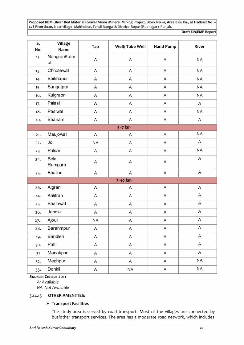
Proposed RBM (River Bed Material) Gravel Minor Mineral Mining Project, Block No.–1, Area 8.86 ha., at Hadbast No. –478 River Soan, Near village- Mahindpur, Tehsil-Nangal & District- Ropar (Rupnagar), Punjab.
Draft EIA/EMP Report
Shri Rakesh Kumar Choudhary 70
S.
No.
Village
Name Tap Well/ Tube Well Hand Pump River
12. NangranKalm
ot A A A NA
13. Chhotewal A A A NA
14. Bhikhapur A A A NA
15. Sangatpur A A A NA
16. Kulgraon A A A NA
17. Palasi A A A A
18. Pasiwal A A A NA
20. Bhanam A A A A
5 -7 km
21. Maujowal A A A NA
22. Jol NA A A A
23. Palsari A A A NA
24. Bela
Ramgarh A A A
A
25. Bhallan A A A A
7 -10 km
26. Algran A A A A
24. Kalitran A A A A
25. Bhalowal A A A A
26. Jandla A A A A
27.. Ajouli NA A A A
28. Barahmpur A A A A
29. Bandleri A A A A
30. Patti A A A A
31 Manakpur A A A A
32. Meghpur A A A NA
33. Dohkli A NA A NA
Source: Census 2011
A: Available NA: Not Available
3.14.15 OTHER AMENITIES:
Transport Facilities
The study area is served by road transport. Most of the villages are connected by bus/other transport services. The area has a moderate road network, which includes

Proposed RBM (River Bed Material) Gravel Minor Mineral Mining Project, Block No.–1, Area 8.86 ha., at Hadbast No. –478 River Soan, Near village- Mahindpur, Tehsil-Nangal & District- Ropar (Rupnagar), Punjab.
Draft EIA/EMP Report
Shri Rakesh Kumar Choudhary 71
National highway, major District Roads, and other roads. Within 10 km radius of the mining lease boundary. SH-22 at a distance of ~7.65 km in NE direction. SH-25 at a distance of ~7.7 km in NNE direction.
Post and Telegraphs
The study area has a Moderate level of post services. Altogether there are some Post Offices in the study area. The study area will be served by adequate telephone and mobile network.
o Electrification in the area
Villages in the study area are electrified. Electricity is available for domestic, non-domestic, industrial agricultural and public lighting purposes.
3.14.16 POTENTIAL IMPACTS OF THE PROJECT
Project potential impacts will be summarized below and categorized either as positive/beneficial or negative/adverse impacts.
Positive impacts
Employment: Employment will be created due to the mining in the area. Employment opportunity will be provided by Shri Rakesh Kumar Choudhary a sustainable and improved living standard to the locals.
Community welfare activities: The nearby local’s benefits from the CSR activities to be carried out by Shri
Rakesh Kumar Choudhary on fronts of Education, water Supply, Social welfare activities. Details of the same are given in Chapter VIII.
3.14.17 BASIC AMENITIES
Details of amenities available in individual villages are as follows: Educational facilities in the study area comprise Primary schools, middle,
Secondary and Senior Secondary school. Medical and health care facilities in the study area include primary health centers, primary health sub-center, registered private medical practitioners. For drinking water, tap water supply is available in 34 villages, well water in all villages. Field study data for power supply shows that approximately all villages have power supply for all purposes.
Census data shows that all villages have cellular service network. Most of the study area is served by road communication. Within the study
area, 60-70% villages have bus stops. As per the field study data, 40% villages can be approached by Kachha roads & 60% by tar roads. Problems:
Details were collected regarding health status of people in the study area, and it was found that though common diseases like Malaria, Viral Fever, Typhoid, Pneumonia, fungal infections, cholera are found to occur, but occurrence of any major disease/endemic diseases were not noticed within the study area also Medical facilities through primary health center, family planning center, maternity and child welfare center etc. are available in around 8.5% villages in 10 km radius buffer zone.
3.14.18 CONCLUSION:
The female literacy rate (74.78%) of the study area is comparatively lower than the male literacy rate (88.69%) which is quite lower. Therefore, there is

Proposed RBM (River Bed Material) Gravel Minor Mineral Mining Project, Block No.–1, Area 8.86 ha., at Hadbast No. –478 River Soan, Near village- Mahindpur, Tehsil-Nangal & District- Ropar (Rupnagar), Punjab.
Draft EIA/EMP Report
Shri Rakesh Kumar Choudhary 72
an urgent need for proper education facilities for girl child along with General Awareness Programs to eliminate gender discrimination which will be a general practice.
Education Awareness program will be conducted to make the population aware and better treatment for livelihood.
Vocational training session will be organized to provide self-employment to the women and unemployed youth.
Education and public awareness campaigns must be put in place to curb the pollution of water sources to promote the conservation of fresh water.
Some of the techniques will be include incentive for installation of rainwater collection.
Challenge of the lack of education must remain focused on create competencies and learning achievements.
Health care Centre and ambulance facility will be provided to make the population get easy medical facilities.
Natural Resource Management and Environmental Conservation.
On the basis of qualification and skills local youths will be employed.
Long term and short-term employments will be generated.
Basic amenities and facilities should be made available to the people and there should be proper maintenance of the facilities already provided in the study area through various ESR activities conducted in the study area by company of the mining projects.
Maternity facility will be made available to avoid going far off places and unnecessary risks to get treatment at Tehsil headquarters.
3.15 LIST OF INDUSTRIES WITHIN 10 KM RADIUS OF THE STUDY AREA:
Table No.3.26
List of Industries
Sr. No. Name of the Industries
1. Proposed RBM (River Bed Mineral) Gravel Minor Mineral Block Mining Project of M.L
Area 13.88 ha. At River Sutlej at Block No. –1, Hadbast No. –359, Near village: Khmeda,
Tehsil Nangal & District: Ropar (Rupnagar), Punjab.
2. Proposed RBM (River Bed Material) Gravel Minor Mineral Block Mining Project of M.L
Area 22.47 ha. At River Sutlej at Block No. –1, Hadbast No. –358, Near village: Mehain,
Tehsil Anandpur Sahib & District: Ropar (Rupnagar), Punjab.
3. Some other industries exist within the radius of 10.0 km from the project site.

Proposed RBM (River Bed Mineral) Gravel Minor Mineral Mining Project, Block No.–1, Area 8.86 ha., at Hadbast No. –478
River Soan, Near village- Mahindpur, Tehsil-Nangal & District- Ropar (Rupnagar), Punjab.
EIA/EMP Report
Shri Rakesh Kumar Choudhary 73
CHAPTER–IV
ANTICIPATED ENVIRONMENTAL IMPACTS AND MITIGATION MEASURES
4.1 ENVIRONMENTAL IMPACT ASSESSMENT
The environmental parameters likely to be affected by mining are related to many
factors, i.e. physical, social, economic, agriculture and aesthetic. Opencast mining
involves extraction of underneath minerals and dumping of waste along with other
operations and other vehicular movements. All the operations can disturb environment
of the area in various ways such as removal of mass, change of landscape,
displacement of human settlement, impact on flora and fauna of the area and on
surface drainage and change in air, water and soil quality. While for purpose of
development and economic upliftment of people, there is need for establishment of
industries and mining, but these have to be environmental friendly. Therefore, it is
essential to assess the impacts of mining on different environmental parameters,
before starting the mining operations, so that abatement measures could be planned
in advance for eco-friendly mining in the area.
4.2 ENVIRONMENTAL IMPACT ASSESSMENT & MITIGATION MEASURES
The mining activities cause environmental problems such as degradation of land,
deteriorating air, water and soil quality, affecting the biological and socio-economic
environment of the area. The impacts of mining on various environmental parameters
were assessed and are given below.
4.3 CUMULATIVE IMPACT THROUGH MATHEMATICAL MODELING FOR MINING PROJECT
Prediction of impacts on air environment has been carried out employing mathematical
model based on a steady state Gaussian plume dispersion model designed for multiple
point sources for short term. In the present case, AERMOD version 8.1 dispersion
model based on steady state Gaussian plume dispersion, designed for multiple point
sources and developed by United States Environmental Protection Agency [USEPA]
was used for simulations from different sources.
Existing industries within 10km radius of proposed mine site has been taken into
consideration while calculating cumulative impact.
4.3.1 Pollutants/ Model Options Considered for Computations
The model simulations deal with major pollutant Particulate Matter (PM) emitted from
the proposed mine project.
4.3.1.1 Model Options Used for Computations
The options used for short-term computations are:
The plume rise is estimated by Briggs formulae, but the final rise is always limited
to that of the mixing layer;
Stack tip down-wash is not considered;
Buoyancy Induced Dispersion is used to describe the increase in plume dispersion
during the ascension phase;
Calms processing routine is used by default;

Proposed RBM (River Bed Mineral) Gravel Minor Mineral Mining Project, Block No.–1, Area 8.86 ha., at Hadbast No. –478
River Soan, Near village- Mahindpur, Tehsil-Nangal & District- Ropar (Rupnagar), Punjab.
EIA/EMP Report
Shri Rakesh Kumar Choudhary 74
Wind profile exponents is used by default, 'Irwin';
Flat terrain is used for computations;
It is assumed that the pollutants do not undergo any physico-chemical
transformation and that there is no pollutant removal by dry deposition;
Washout by rain is not considered;
Cartesian co-ordinate system has been used for computations; and
The model computations have been done for 10 km distance with 500-m interval
4.3.1.2 Modelling Procedure
Prediction of ground level concentrations (glc’s) due to the proposed mining project has
been made by AERMOD version 8.1. It is USEPA approved model to predict the air quality.
The model uses rural dispersion and regulatory defaults options. For this study uniform
polar receptors on flat terrain have been assumed.
Meteorological inputs required are wind speed, direction, ambient temperature, stability
classes, and mixing height. The model details are as follows.
4.3.1.3 Gaussian Plume Model
The AERMOD version 8.1 model is based on a numerical integration over the area in the
upwind and cross wind directions of Gaussian plume formula. This can be applied to the
Point, Area, Line, Volume sources (& other forms of area sources) simultaneously and
their resultant incremental concentration of the pollutant can be predicted.
4.3.1.4 Stability Classification
Hourly stability is determined by wind direction fluctuation method as suggested by Slade
(1965) and recommended by CPCB (PROBES/70/1997-1998).
a = Wdr/6
a, is standard deviation of wind direction fluctuation, Wdr is the overall wind direction
fluctuation or width of the wind direction in degrees. The table for stability classes is given
as under:
Stability Class a (degree) Stability Class a (degree)
A > 22.5 D 12.4 – 7.5
B 22.4 – 17.5 E 7.4 – 3.5
C 17.4 – 12.5 F < 3.5
4.3.1.5 Dispersion Parameters
Dispersion parameters y and z for open country conditions (Briggs, 1974) are used as the
project is located on a flat terrain in a rural area. Atmospheric dispersion coefficients vary
with downwind distance (x) from emission sources for different atmospheric stability
conditions. (CPCB – PROBES/70/1997-98)
Rural Conditions
Stability
Class
y az Stability
Class
y az
A 0.22x(1+0.0001x)-.5 0.20x D 0.08x(1+0.0001x)-.5 0.06(1+0.0015x).5

Proposed RBM (River Bed Mineral) Gravel Minor Mineral Mining Project, Block No.–1, Area 8.86 ha., at Hadbast No. –478
River Soan, Near village- Mahindpur, Tehsil-Nangal & District- Ropar (Rupnagar), Punjab.
EIA/EMP Report
Shri Rakesh Kumar Choudhary 75
B 0.16x(1+0.0001x)-.5 0.12x E 0.06x(1+0.0001x)-.5 0.03x(1+0.0003x)-1
C 0.11x(1+0.0001x)-.5 0.08x(1+0.0002x).5 F 0.04x(1+0.0001x)-.5 0.16x(1+0.0003x)-1
4.3.1.6 Mixing Height
As site specific mixing heights were not available, mixing heights based on IMD publication, “Atlas of Hourly Mixing Height and Assimilative Capacity of Atmosphere in India”, has been considered for Industrial Source Complex model to establish the worst case scenario.
TABLE: 4.1 Mixing Height for Winter- Season
Source: IMD publication, “Atlas of Hourly Mixing Height and
Assimilative Capacity of Atmosphere in India”
4.3.1.7 Meteorological Data
Data recorded at the continuous weather monitoring station on wind speed, direction,
and temperature at one hour interval for the monitoring period was used as
meteorological input.
4.3.1.8 Presentation of Results
In the present case model simulations have been carried using the hourly Triple Joint
Frequency data. Short-term simulations were carried to estimate concentrations at the
receptors to obtain an optimum description of variations in concentrations over the site in
10 km radius covering 16 directions.
The concentration of PM10 is ranging from 63.4 g/m3 to 79.6 g/m3 well below the limits
of NAAQS (Industrial Area, Residential Rural & Other Areas) at all locations.
The increment in the fugitive emissions will be due to mineral handling and
transportation activity. These will be restricted to the lease area only by adopting
Time in IST (Hours) Mixing Height in meters
07:00 40
08:00 120
09:00 300
10:00 750
11:00 1130
12:00 1335
13:00 1450
14:00 1870
15:00 1600
16:00 1460
17:00 1300
18:00 1050
19:00 700
Proposed RBM (River Bed Mineral) Gravel Minor Mineral Mining Project, Block No.–1, Area 8.86 ha., at Hadbast No. –478
River Soan, Near village- Mahindpur, Tehsil-Nangal & District- Ropar (Rupnagar), Punjab.
EIA/EMP Report
Shri Rakesh Kumar Choudhary 76
proper mitigation measures, which will be practiced at the mine site to control air
pollution load below the prescribed limits.
4.3.2 Air Pollution Due To Mining
(i) Gaseous Pollution
The gaseous pollutants (SO2 & NOx) will be anticipated by mining machineries.
The ambient air quality was measured on 24 hourly basis for the gaseous
pollutants.
(ii) Particulate Matter
The generation of dust will be anticipated from various mining activities i.e.
loading, haulage and other transport activities related to mining. These will
increase PM10 in the area if no mitigative measures are taken.
4.3.3 Prevention and Control of Air Pollution
A. Dust Pollution
One of the main pollutants in air particulate matter (PM), which will be generated
during various activities of mining such as removal of overburden, extraction of
mineral, movement of mining machinery and vehicles. Following measures are
adopted to minimize air pollution:-
Sharp drill bits will be used for drilling to reduce generation of dust.
Operators will be provided with suitable air respirators.
Blasting will be done as and when required for breaking the hard strata & it
will be proposed in small scale with low charge.
Regular water spraying on the haul roads will be done.
Green belt development will be done around the lease boundary to control
dust pollution.
Periodical monitoring will be carried out.
B. Prevention and control of Gaseous pollutants
In mining activities, the only source of gaseous emissions is the diesel engines
of vehicles and equipments.
Proper maintenance of machine will be done, which will be minimizes the
pollutants.
4.4 IMPACT OF NOISE & MITIGATION MEASURES
4.4.1 Impact of Noise on Working Environment
Noise level will be increases due to excavation and transportation of mineral.
However, the expected noise levels will not be likely to have any adverse effect from
the occupational health point of view.
1. Noise Generated due to Excavation and Transportation

Proposed RBM (River Bed Mineral) Gravel Minor Mineral Mining Project, Block No.–1, Area 8.86 ha., at Hadbast No. –478
River Soan, Near village- Mahindpur, Tehsil-Nangal & District- Ropar (Rupnagar), Punjab.
EIA/EMP Report
Shri Rakesh Kumar Choudhary 77
Noise will be generated due to hydraulic excavator which will be deployed for
removal of waste and movement of truck on hire basis. Earplugs will be provided
to operator and mine workers.
2. Noise Generated Due to Blasting
Blasting will be done as and when required for breaking the hard strata & it will
be proposed in small scale with low charge.
4.4.2 Noise Abatement and Control
4.4.2.1 Mitigation Measures to Reduce Ambient Noise Levels
The following control measures will be adopted to keep the ambient noise levels well
below the limits:
Proper maintenance of all machines will be carried out which will be help in
reducing generation of noise during operations.
Workers exposed to high noise levels will be provided with ear muffs/plugs.
Adequate silencers will be provided in all the diesel engines.
Green belt will be done on around the lease boundary to minimize noise
propagation.
Periodical monitoring of noise level in and around mine site will be carried out &
records are maintained.
Periodic monitoring will be done.
4.5 Impact on Water Environment & Mitigation Measures
4.5.1 Impact on Surface Water
No surface water body present in the mining lease area.
Garland drains will be provided around the working pit.
The rain water will be channelized & used for dust suppression & green belt
development.
The natural gradients drain out water from mine area in rainy season.
At the conceptual stage, 7.70 ha. excavated area will be converted into water
reservoir.
There will not be any impact on surface water.
4.5.2 Impact on Ground Water
Elevation range of the lease area is from 285.896 mRL to 283.210 mRL. The mining in
the area is proposed above the water table. The water table is at 273 m RL - 281 mRL ,
while workings upto 283 mRL.
Besides, there will be no toxic elements in the mined out material, which may
contaminate ground/ surface water.
No any impacts on groundwater resources of buffer zone due to mining activity which
remains confined to a very small area and above water table.

Proposed RBM (River Bed Mineral) Gravel Minor Mineral Mining Project, Block No.–1, Area 8.86 ha., at Hadbast No. –478
River Soan, Near village- Mahindpur, Tehsil-Nangal & District- Ropar (Rupnagar), Punjab.
EIA/EMP Report
Shri Rakesh Kumar Choudhary 78
4.5.3 Waste Water Generation
No waste water will be generated during mining lease operation.
Waste water generated from rest shelter will be disposed in soak pits.
4.6 IMPACT ON SOIL AND LAND USE PATTERN & MITIGATION MEASURES
i) Impact on Soil
If top soil generated during mining operation it will be simultaneously used for
plantation purpose.
(ii) Landscape and Land Use pattern
At the conceptual stage total excavated area will be 7.70 which will be converted
into Replenished area, 1.16 Ha. area will be undisturbed area (Buffer Zone). Green
Belt /Plantation will be done outside the lease area, which will be equivalent to 33
% of the lease area.
Land use plan of the lease area in pre-operational, operational and post
operational phases are as per table 4.2.
TABLE: 4.2
Environmental Impact Land: Stage Wise Land Use and Reclamation Area (ha)
S. No. Land use Category Pre-operational Operational Post-
operational
1 Top Soil Dump - - -
2 Waste Dump - - -
3 Excavation (Voids Only) - - -
4 Road - - -
5 Built up Area - - -
6 Township Area - - -
7 Afforestation - - -
8 Replenished Area - 7.70 7.70
9 Mineral stack - - -
10 Processing (Crushing) - - -
11 Undisturbed Area 8.86 1.16 1.16
Total 8.86 8.86 8.86
Source: Approved Mining Plan with Progressive Mine Closure Plan
(iii) Impact due to change of land use
The proposed mining lease area is private land. Agriculture work is going in the
applied area only in the rainy season due to scarcity of water. Excavated area will
be 7.70 ha will be converted into Replenished area which will charge the water
table of the area.
There will be no adverse impact on land use of the study area due to mining
activities as adequate pollution control measures will be adopted. Proper
resources/ assistance will be provided to the farmers to develop their land.
Mining activity will be confined to the mineralized zone & adequate pollution

Proposed RBM (River Bed Mineral) Gravel Minor Mineral Mining Project, Block No.–1, Area 8.86 ha., at Hadbast No. –478
River Soan, Near village- Mahindpur, Tehsil-Nangal & District- Ropar (Rupnagar), Punjab.
EIA/EMP Report
Shri Rakesh Kumar Choudhary 79
control measures will be adopted to restrict the pollution load within the active
zone in order to prevent any negative impact on nearby crop fields. Therefore,
there will be no adverse impacts on agriculture field envisaged in the study area.
4.7 SOCIO - ECONOMIC ENVIRONMENT
4.7.1 Socio- Demographic Profile
The social demographic profile of the area is not likely to be affected. Mining in the
area will create rural employment. Thus mining in the area is open new sources of
employment.
Depending on vacancies and qualifications of the individuals, workers will be employed
from the surrounding villages in the mine. Thus the mining activities will be improving
the economic status of the area. The mining also benefit the local people due to
development of infrastructure facilities in the area. The applicant has a social
commitment which may result in an all-round welfare of the local population in terms
of medical, education etc. The lessee also assists in overall development of the area as
entrepreneur social commitment.
4.7.2 Health Care Facilities
Sufficient fund will be allocated to provide proper health care facilities for employees
of mine along with their families.
4.7.3 Impact on Human Health
The most common diseases in the region are common cold and cough, malaria, flue,
Oral disease, enteric fever like typhoid which will be prevalent amongst the mine
workers. None of these can be related to the project and allied activities of the project.
The quality of ground water is not potable per drinking water standards IS: 10500-2012.
Such water analysis will be carried out at periodical intervals.
The PM10, PM2.5 and SO2, NOx have been observed to be below the prescribed limit.
Noise levels will be also been found to be below the permissible limits. Further the
noise generated in the lease area will get attenuated due to plantation and green belt
all around the lease area.
All the employees when inducted will be medically examined. Further, they will also be
medically examined at periodical interval.
4.7.4 Impact on Human Settlement
Mostly local inhabitants are reported to be economically poor. The local people mainly
depend on agriculture. The mining operations will be creating employment for the local
inhabitants. Local persons will be preferred for direct employment. Besides, indirect
employments also get generated.
The overall impacts of mining industry on socio-economic condition of local villagers
are positive. Better medical facility, better education facility, communication etc. will
be improving the standard of life of the local people of the area.
4.7.5 Impact on employment Growth:

Proposed RBM (River Bed Mineral) Gravel Minor Mineral Mining Project, Block No.–1, Area 8.86 ha., at Hadbast No. –478
River Soan, Near village- Mahindpur, Tehsil-Nangal & District- Ropar (Rupnagar), Punjab.
EIA/EMP Report
Shri Rakesh Kumar Choudhary 80
About 90 persons will be employed from the nearby surrounding villages which will be
help in uplifting their living standard.
4.7.6 Impact on Civic Amenities
With improved basic amenities like transport, education health, welfare etc the impact
of the mining on the civic amenities will be positive.
4.7.7 Impact on Historical Monuments
There is no historical monument in the core zone / lease area. So, there will be no
impact on the historical monument due to mining activity in the area
4.8 IMPACT ON LOCAL TRANSPORT INFRASTRUCTURE
The lease area is about ~42.83 km away from the Rupnagar district. Railway station is
Nangal at distance of ~9.0 km from the mine lease boundary. SH-22 at a distance of
~7.65 km in NE direction.
Transportation of mineral from pit face to the destination will be done by trucks/tripper
on hire basis. Material handled per day will be 213 TPD, for which 10 trips/day will be
required.
Transportation will be done via SH- 22 and Present road network is enough to bear the
load for this project therefore no adverse impact on local transport infrastructure.
However the following measures are adopted:
All transportation vehicles have PUC certificate.
Mineral transportation through vehicles will not be overloaded.
Dust suppression will be done properly by regular sprinkling of water on haul roads.
Proper maintenance of transportation vehicles will be help reduce fugitive
emissions.
4.9 IMPACT ON BIOLOGICAL ENVIRONMENT
4.9.1 Impact on Wildlife
There is no National Park, Wildlife Sanctuary, Biosphere Reserve, Wildlife corridors,
Reserved/Reserved Forest and Tiger/Elephant Reserve found within 10 km radius of the
mine boundary.
4.9.2 Impact on Flora
The area is devoid of vegetation.
Plantation will be developed in the proposed mining lease area as per plantation
programme. These activities will help to improve the floral cover of the area. The
greenery and plantation development will eventually attract micro fauna, birds etc in
the area.
Assistance will be taken from local forest department in selection of species of plants
so that green coverage may improve fast. The varieties would include those plants,
which are suitable to the area.
4.9.3 Impact on Fauna

Proposed RBM (River Bed Mineral) Gravel Minor Mineral Mining Project, Block No.–1, Area 8.86 ha., at Hadbast No. –478
River Soan, Near village- Mahindpur, Tehsil-Nangal & District- Ropar (Rupnagar), Punjab.
EIA/EMP Report
Shri Rakesh Kumar Choudhary 81
The proposed mining lease area is in non-forest land where presence of fauna is very
rare. As such, there will be no adverse impact of the mining activity on fauna around
the proposed mining lease area.
4.9.4 Measures for Minimizing Impact on Biota
Following measures will be adopted to minimize the impact of mining on faunal
environment of the area.
Measures will be taken to curb pollution due to air, water, land & noise
environment.
Green belt development will be help in creating habitats for local faunal species
and to create better environment for various fauna.
4.9.5 Measures for Minimizing Impact on biodiversity
Green Belt Development
At the conceptual stage total excavated area will be 7.70 ha which will be
converted into Replenished area, 1.16 Ha. area will be undisturbed area (buffer
zone). Green Belt/ Plantation will be done outside the lease area on land identified
by DFO Social Forestry concerned in consultation with village panchayat. The trees
will be planted @2000 saplings per hectare of land species will be like: Azadirachta
indica (Neem), Ficus religiosa (Peepal), Ficus benghalensis (Bargad), Tamarindus
indica (Imli), Terminalia arjuna (Arjun).
The same will be maintained & enhanced in future.
The plant species will be selected in consultation with forest department.
4.10 Occupational Health and Safety
Occupational health and safety (OHS) is a cross-disciplinary area concerned with
protecting the safety, health and welfare of people engaged in work or employment.
The goal of all occupational health and safety programs is to foster a safe work
environment.
Occupational Health Hazards at mine site:
Excessive dust, noise and vibration are the chief health hazards for the miners. Some
examples of such hazards are:
Exposure to dust and
Noise exposure;
Vehicular movements and accidents
Physical Hazards.
A. Exposure to Dust
Proposed RBM (River Bed Mineral) Gravel Minor Mineral Mining Project, Block No.–1, Area 8.86 ha., at Hadbast No. –478
River Soan, Near village- Mahindpur, Tehsil-Nangal & District- Ropar (Rupnagar), Punjab.
EIA/EMP Report
Shri Rakesh Kumar Choudhary 82
Exposure to fine particulates is associated with work in most of the dust-
generating activities notably from excavation, mineral handling, and
transportation.
Workers with long term exposure to fine particulate dust are at risk of
pneumoconiosis, emphysema, bronchitis, and fibrosis.
Methods to prevent and control exposure to dust include the following:
Control of dust through water spraying,
Maintenance of machineries.
Use of PPE, as appropriate (e. g. masks and respirators) to address residual
exposures.
B. Noise and Vibration Exposure
Noise will be generated due to hydraulic excavator which deployed for
movement of tippers/truck on hire basis. Control of noise emissions will be
includes the use of silencers, noise barriers, and personal hearing protection (ear
plugs/muffs).
C. Physical hazards
Injuries during mine operation are typically related to slips and falls; contact with
falling / moving objects; and lifting / over-exertion. Other injuries may occur due
to contact with, or capture in, moving machinery (e. g. dump trucks, front
loaders).
Implementation of Occupational Health and Safety Measures
Occupational Health & Safety measures result improving the conditions under which
workers are employed and work. It improves not only their physical efficiency, but also
provides protection to their life and limb. The proposed mining in the area will be done
systematically as per provisions of Mines Act, 1952, Mines Rules, 1955, MMR, 1961 and
MCDR, 1988 which will take care of all health & safety aspects of employees and also
the neighboring community. Management will consider the following safety measures.
To depute dedicated qualified supervisors
Inspection and maintenance of equipments and accessories
Pre placement and periodic health check up
Removal of unsafe conditions and prevention of unsafe acts
Detailed analysis of each and every incident, if any
To provide standard PPEs and ensure their use
Medical facilities & first aid boxes will be provided in the mine premises.
Pits, Sumps etc. which may be a source of danger will be securely fenced in such a
way that it ceases to be a source of danger.
Besides, following points will also be taken care of during mine operation for assuring
safety of workers:

Proposed RBM (River Bed Mineral) Gravel Minor Mineral Mining Project, Block No.–1, Area 8.86 ha., at Hadbast No. –478
River Soan, Near village- Mahindpur, Tehsil-Nangal & District- Ropar (Rupnagar), Punjab.
EIA/EMP Report
Shri Rakesh Kumar Choudhary 83
Health Awareness Programmes and camps organized
The mine workers provided all necessary PPEs, especially dust masks for their
safe guard from dust, Ear Plugs/Ear Muffs for noise, helmets, safety belts, boots
etc. and measures for other hazards. The employees when inducted will be
thoroughly examined medically. After initial medical examination, the employees
will continue to be examined periodically. The examination includes apart from
the general observation, the Chest X-ray, Lung Function Test, Audiometriy and
the medical records of the employees will be maintained and submitted to the
concerned authorities.
The Occupational Health Surveillance Programme: A team of qualified doctors and
nurses visit periodically for health check up of all the workers, team and its records
will be maintained properly.
Proposed RBM (River Bed Mineral) Gravel Minor Mineral Mining Project, Block No.–1, Area 8.86 ha., at Hadbast No. –478 River Soan, Near village- Mahindpur, Tehsil-Nangal & District- Ropar (Rupnagar), Punjab.
EIA/EMP Report
Shri Rakesh Kumar Choudhary 84
CHAPTER – V
ANALYSIS OF ALTERNATIVES (Technology & Site)
5.1 GENERAL
A comparison of alternatives will help to determine the best method of achieves the
project objectives with minimum environmental impacts or indicates the most
environment friendly and cost-effective options.
Every mine needs to be planned in a way that the mineral is extracted to the
maximum extent without causing severe irreversible environmental damages.
5.2 ANALYSIS OF SITE
Letter of Intent (LOI) has been issued for RBM (Gravel mineral) over an area of 8.86
ha in favor of Shri Rakesh Kumar Choudhary vide Memo No. 811-813/DMG/E-
Auction/2019 dated 31.07.2019. Mining Plan with Progressive Mine Closure Plan has
been issued in favor of Shri Rakesh Kumar Choudhary Vide Memo No.
Glg/Pb/M.P./2020/Mahindpur/338 dated 20.03.2020.
As per the exploration carried out in the lease area, the nature & extent of the
deposit, the reserves & the quality have been proved with adequate degree of
reliability.
5.3 ANALYSIS OF TECHNOLOGY
a. The Mining will be done by deploying earthmovers like excavator, Backhoe loaders
for loading of mineral into trucks, tippers and tractor/trolleys.
b. Mining will be restricted within the central 3/4th width of the river.
Transportation of the Mineral will be done by tractor, trolley & trippers from face to
destination site.
5.4 CONCLUSION
The RBM (Gravel Mineral) Project is a proposed mine. Minor minerals are mainly
consumed by Infrastructure and housing industries. Main use of Gravel is in
construction. Gravel is used for making slabs for bridges. Gravel is used in foundry
industries. Conventional method of manual cum semi- mechanised mining with light
weight excavator, loading and transportation. Considering the demand of mineral
and sufficient availability of the mineral in the area, it is essential to have River Bed
Mining Project to sustain the supply of mineral for various purposes.

Proposed RBM (River Bed Mineral) Gravel Minor Mineral Block Mining Project of M.L Area 8.86 ha At River Soan at Block No. –1, Hadbast No. –478, Near village: Mahindpur, Tehsil Nangal & District: Ropar (Rupnagar), Punjab.
EIA/EMP Report
Shri Rakesh Kumar Choudhary 85
CHAPTER–VI
ENVIRONMENTAL MONITORING PROGRAMME
6.1 INTRODUCTION
Post Project Monitoring is considered as an essential part to check the impact of any
project activities. Hence monitoring of various environmental parameters will be
carried out on a regular basis to ascertain the following:
To know the status of Pollution within the mine site and in its vicinity.
To generate data for predictive or corrective purpose in respect of pollution.
Examine the efficiency of pollution control system adopted at the site.
To ascertain environmental impacts.
Monitoring will be carried out at the site as per the norms of CPCB/SPCB.
Environmental Monitoring Programme will be conducted for various environmental
components as per the conditions stipulated in EC issued by SEIAA, Punjab and
Consent to Operate issued by PPCB.
Six monthly compliance reports will be submitted on regular basis to concern
authorities on 1st of June & 1st of December. Quarterly compliance Report for
conditions stipulated in Consent to Operate will be submitted to SPCB on regular
basis. The various environmental components and pollution sources, which will be
monitored under environmental monitoring programme, are ambient air quality
domestic/industrial effluents and noise levels.
6.2 FORMATION OF EMC (ENVIRONMENTAL MANAGEMENT CELL)
In order to maintain the environmental quality within the standards, regular
monitoring of various environmental components is necessary. The company will be
employed person for compliance and monitoring purpose.
The lessee will conduct the following activities:-
The responsibilities of the Lease will be as follows:
i. Environmental monitoring of the surrounding area.
ii. Commissioning of pollution control equipment.
iii. Specification and regulation of maintenance schedules for pollution control
equipment.
iv. Ensuring that standards are maintained.
v. Developing the green belt.
vi. Ensuring water use is minimized.
vii. Carrying out the Environmental Management Plan.

Proposed RBM (River Bed Mineral) Gravel Minor Mineral Block Mining Project of M.L Area 8.86 ha At River Soan at Block No. –1, Hadbast No. –478, Near village: Mahindpur, Tehsil Nangal & District: Ropar (Rupnagar), Punjab.
EIA/EMP Report
Shri Rakesh Kumar Choudhary 86
6.3 MEASUREMENT METHODOLOGIES
6.3.1 Instruments to be used
The following instruments will be used for data collection work in the monitoring
schedule:
1. Respirable Dust Sampler with attachment for gaseous Pollutants, Envirotech
APM 460.
2. Hygrometer
3. Sound Level Meter
4. Global positioning system (GPS)
In addition to the above instruments, the data on land use to be collected by the field
team by meeting with a large number of local inhabitants in the study area and
different government departments / agencies.
6.3.2 Monitoring Programme
The post project Monitoring will include details of any major/ minor impact in the core
zone and area within buffer zone for the following parameters: -
Ambient Air Quality Monitoring
Noise Level Monitoring.
Land use pattern within core zone and buffer zone including the cropping
pattern.
Monitoring of agricultural crops of the area (on yearly basis)
Demography and socio-economic analysis based on last available census data
for entire study area.
Medical Check-up
6.3.2.1 Monitoring Schedule
Details of the Environmental Monitoring schedule, which will be undertaken for
various environmental components as per conditions stipulated by EC conditions &
Consents are detailed below:
TABLE: 6.1
Post Project Monitoring
S. No.
DESCRIPTION FREQUENCY OF MONITORING
1. Ambient Air Quality at mine site Quarterly/ Half Yearly
2. Water Quality Quarterly/ Half Yearly
3. Noise Level Monitoring Quarterly/ Half Yearly
4. Soil Quality Half Yearly/yearly

Proposed RBM (River Bed Mineral) Gravel Minor Mineral Block Mining Project of M.L Area 8.86 ha At River Soan at Block No. –1, Hadbast No. –478, Near village: Mahindpur, Tehsil Nangal & District: Ropar (Rupnagar), Punjab.
EIA/EMP Report
Shri Rakesh Kumar Choudhary 87
6.3.3 Methodology Adopted
Post project monitoring will be carried out as per conditions stipulated in
Environmental Clearance Letter issued by SEIAA, Punjab, Consent will be issued by
PPCB as well as according to CPCB guidelines. The Mine site is considered as core
zone and the area lying within 10 km radius from the mine site is considered as buffer
zone where some impacts may be observed on physical and biological environment.
The following table is showing details of Post Project Monitoring programme:
TABLE: 6.2
Attributes Sampling Measurement Method
Test Procedure
A. Air Environment
Network Frequency
Meteorological
Dry bulb temperature
Wet bulb temperature
Relative humidity
Rainfall
Minimum 1 site in the project impact area
Regularly in one season by Weather Monitoring Station
Mechanical/automatic weather station
-
Pollutants
PM10
4 to 6 locations in the project impact area (Minimum 2 locations in upwind side, more sites in downwind side / impact zone)
Revised National Ambient Air Quality Standards (NAAQS) vide MoEF Notification, dated 16.11.2009
Gravimetric method -
PM2.5 Gravimetric method -
SO2 EPA Modified West & Gaeke method
Absorption in Potassium Tetra Chloromercurate followed by Colorimetric estimation using P-Rosaniline hydrochloride and Formaldehyde (IS: 5182 Part - II).
NOx Arsenite modified Jacob & Hochheiser
Absorption in dill NaOH and then estimated colorimetrically with sulphanilamide and N (I-Nepthyle) Ethylene diamine Dihydrochloride and Hydrogen Peroxide (CPCB Method).
CO Non Dispersive Infra Red (NDIR) Spectroscopy
-
Proposed RBM (River Bed Mineral) Gravel Minor Mineral Block Mining Project of M.L Area 8.86 ha At River Soan at Block No. –1, Hadbast No. –478, Near village: Mahindpur, Tehsil Nangal & District: Ropar (Rupnagar), Punjab.
EIA/EMP Report
Shri Rakesh Kumar Choudhary 88
B. Water Environment
pH, Turbidity, Colour, Odour, Taste, TDS, Total Hardness, Calcium hardness, Magnesium hardness, Chloride, Fluoride, Sulphate, Nitrates, Alkalinity, Iron, Copper, Manganese, Mercury, Cadmium, Selenium, Arsenic, Cyanide, Lead, Zinc, Chromium, Aluminum, Boron, Phenolic compounds
Set of grab samples during pre and post-monsoon for ground and surface water for 10 km distance
Diurnal and Season wise
As per IS 10500- Samples for water quality should be collected and analyzed as per : IS : 2488 (Part 1-5) methods for sampling and testing of Industrial effluents Standard methods for examination of water and wastewater analysis published by American Public Health Association.
C. Noise
Noise levels at Day & night time -Leq dB (A)
Project boundary, High noise generating areas within the core zone
Quarterly / Half yearly
As per CPCB norms
As per CPCB norms
D. Soil
pH, Bulk Density, Soil texture, Nitrogen, Available Phosphorus, Potassium, Calcium, Magnesium, Sodium, Electrical Conductivity, Organic Matter, Chloride
4 to 6 locations in the project impact area
Yearly/half yearly
As per USDA Method As per USDA Method
E. Socioeconomic Status
Network Frequency Measurement Method Test Procedure

Proposed RBM (River Bed Mineral) Gravel Minor Mineral Block Mining Project of M.L Area 8.86 ha At River Soan at Block No. –1, Hadbast No. –478, Near village: Mahindpur, Tehsil Nangal & District: Ropar (Rupnagar), Punjab.
EIA/EMP Report
Shri Rakesh Kumar Choudhary 89
Demographic structure
Infrastructure resource base
Economic resource base
Health status: Morbidity pattern
Cultural and aesthetic attributes
Education
Socio-economic survey is based on proportionate, stratified and random sampling method
Minimum for two phases of the project
Primary data collection through questionnaire
Secondary data from census records, statistical hard books, topo sheets, health records and relevant official records available with Govt. agencies
6.4 LOCATION OF MONITORING STATIONS
The location of the monitoring stations will be selected on the basis of prevailing
micro – meteorological conditions of the area like wind direction & wind speed,
Relative Humidity, Temperature. 4 to 6 AAQM stations will be selected (including
minimum 2 locations in upwind side, more sites in downwind side / impact zone) to
assess ambient air quality of the area. Noise level monitoring will be carried out on
lease boundary & in high noise generating area within the lease. Water & soil
monitoring locations will be decided on the basis of general slope of the area &
drainage pattern. Location for the post project monitoring will be as under:
TABLE NO.: 6.3
LOCATION OF POST PROJECT MONITORING SAMPLING LOCATIONS
S. No. Description Location
1. Ambient Air Quality Mine site, Villages in downwind direction from the Mine site.
2. Noise Level Monitoring
Mine Boundary, High noise generating areas within the Mine boundary
3. Water Level & Quality
Nearby Surface & Ground water sources
6.5 DATA ANALYSIS
Monitoring data analysis will be done as per PPCB guidelines by EPA approved
laboratory & will be submitted to the concerned authority (specified in Environment
Clearance Letter issued by SEIAA, Punjab & Consent issued by (PPCB) on regular
basis.
6.6 DETAILED BUDGET
Shri Rakesh Kumar Choudhary has a proposed RBM (Gravel Mine), (Block No.-01,
Lease Area: 8.86 ha.), with Production Capacity of 63991 MT/Annum, Near Village –
Mahindpur, Tehsil: Nangal & District– Roper (Rupnagar), State- Punjab.
Cost details for the mining project are given as under:-
1. Total Cost of the Project : Rs. 1.0 Crore

Proposed RBM (River Bed Mineral) Gravel Minor Mineral Block Mining Project of M.L Area 8.86 ha At River Soan at Block No. –1, Hadbast No. –478, Near village: Mahindpur, Tehsil Nangal & District: Ropar (Rupnagar), Punjab.
EIA/EMP Report
Shri Rakesh Kumar Choudhary 90
2. Cost for EMP : Capital cost 1.5 lac
: Recurring cost – 2.0 per annum/-.

Proposed RBM (River Bed Mineral) Gravel Minor Mineral Mining Project, Block No.–1, Area 8.86 ha, at Hadbast No. –478 River Soan, Near village- Mahindpur, Tehsil-Nangal & District- Ropar (Rupnagar), Punjab.
DraftEIA/EMP Report
Shri Rakesh Kumar Choudhary 91
CHAPTER–VII
ADDITIONAL STUDIES
7.1 INTRODUCTION
As per EIA Notification dated 14th September, 2006, as amended from time to time,
the case was considered by the SEAC in its 195th meeting held on 24th Oct. 2020 and
decided to categorize the project into B-1 category (activity listed 1(a) of the
schedule) with public consultation as required for the projects. SEAC has finalized and
recommended “Terms of Reference” for the detailed EIA report.
The case was considered by the SEIAA in its 174th meeting held on 31st Oct.
2020 and decided to accept the recommendation of SEAC and the committee has
suggested various “Terms of Reference (ToRs)” for the preparation of the
Environmental Impact Assessment (EIA) Report and Environmental Management
Plan (EMP).
The following Additional Studies were carried out as per Terms of Reference:
1. Public Hearing
2. Risk Assessment & Disaster Management Plan
7.2 PUBLIC CONSULTATION
Public hearing has to be conducted for the project.
7.3 RISK ASSESSMENT AND DISASTER MANAGEMENT PLAN
7.3.1 Definition
A major emergency in a work is one, which has the intensity to cause serious injury or
loss of life. It may cause extensive damage to property and serious disruption both
inside and outside the work. It would normally require the assistance of emergency
services to handle it effectively.
7.3.2 Scope
An important element of mitigation is emergency planning i.e., recognizing that
accidents are possible, assessing the consequences of such accidents and deciding on
the emergency procedures, both on site and off site that would need to be
implemented in the event of an emergency.
Emergency planning is just one aspect of safety and cannot be considered in isolation.
7.3.3 Objective
The overall objectives of the emergency plan are:
(a) To localize the emergency and, if possible, eliminate it; and
(b) To minimize the effect of the accident on people and property.
Elimination requires well planned process/technology and its effective
implementation, so that such situation should either not arise or if it comes, a pre

Proposed RBM (River Bed Mineral) Gravel Minor Mineral Mining Project, Block No.–1, Area 8.86 ha, at Hadbast No. –478 River Soan, Near village- Mahindpur, Tehsil-Nangal & District- Ropar (Rupnagar), Punjab.
DraftEIA/EMP Report
Shri Rakesh Kumar Choudhary 92
warning is received for timely action in built or by preparedness for zeroing the
effects.
Minimizing the effects may include prompt action, rescue, first aid, and evacuation,
firefighting and also passing on information promptly to people living nearby.
7.3.4 Identification of Hazards
The possibility of the following may be there for such projects:
(a) Inundation of pit during excessive rains.
(b) Falling of the persons in the pit.
(c) Accidents due to machinery.
(d) Fire in the machinery explosives related explosions.
7.3.5 Disaster Management
This is a proposed mine and will be worked in day shift only.
No drilling & blasting will be carries out during mining operation.
The bench height is proposed 1 meters and width will be 1meters considering
semi mechanized workings.
The mines manager will make the arrangements to deal with disaster.
If the disaster is of higher magnitude, he will inform the same to Police, District
Collector, DGMS and IBM. The following arrangements will be made at the
mine.
(a) Availability of high-capacity pumps, firefighting equipment, ambulances etc.
(b) Formation of team to deal with the hazards.
(c) Arrangements for removal of employed persons from disaster site.
(d) Telephone Nos. of District Collector, Police and Hospital.
7.3.6 Post Disaster Analysis and Evaluation
When the emergency is over, the team will carry out a detailed analysis of cause of
accident/occurrence, evaluate the influence of various factors and find out the
procedures to minimize them in future. At the same time adequacy of disaster
management plan will be evaluated and shortcomings will be rectified to improve the
plan.
7.3.7 On Site Emergency Plan
To avoid the accident at working place and to minimize their effects following
precautions shall be taken and arrangement shall be made at the working place.
(i) Periodical maintenance of mine machineries.
(ii) The persons shall be trained properly to handle the situation.

Proposed RBM (River Bed Mineral) Gravel Minor Mineral Mining Project, Block No.–1, Area 8.86 ha, at Hadbast No. –478 River Soan, Near village- Mahindpur, Tehsil-Nangal & District- Ropar (Rupnagar), Punjab.
DraftEIA/EMP Report
Shri Rakesh Kumar Choudhary 93
(iii) Detailed warning system, implementation procedure, emergency control centre
shall be maintained at the mine with names of trained persons.
(iv) Details and availability of heavy machinery, fire-fighting equipment shall be
available at the site.
(v) Proper arrangements shall be made for treatment of injured person, if any.
(vi) All the safety equipment shall be available at the mine.
(vii) Telephone Nos. of District Collector, Police, Fire station and Hospital is given
below:
Sr. No.
Name of Office Phone No. Office
Fax No. Email Id
(i) Office of the Deputy Commissioner, District Administrative Complex, Mini Secretariat, Rupnagar-140001
01881-221150, 221157
01881-221165 [email protected]
(ii) Office of Senior Superintendent of Police, Govt. College Road, Rupnagar-140 001, Punjab-India.
01881-221273 01881-228874 [email protected]
(iii) Fire Brigade 101 -- --
(iv) Police Station, Rupnagar 01881-221177 -- 8558810964
(v) Civil Hospital, Sri Anandpur Sahib, Rupnagar
01887-232671 -- --
7.3.8 Off-Site Emergency Planning
7.3.8.1 Introduction
The off-site emergency plan is an integral part of any hazard control system. It would
be based on those accidents identified by the works management, which could affect
people and the environment outside the works. Thus, the off-site plan follows
logically from the analysis that took place to provide the basis for the on-site plan and
the two plans should, therefore, complement each other. The key feature of a good
off-site emergency plan is flexibility in its application to emergencies other than those
specifically included in the formation of the plan. The roles of the various parties that
may be involved in the implementation of an off-site plan are described below. The
responsibility for the off-site plan will be likely to rest either with the works
management or with the local authority.
Either way, the plan must identify an emergency coordinating officer who would take
overall command of the off-site activities. As with the on-site plan, an emergency
control center will be required within which the emergency coordinating officer can
operate. An early decision will be required in many cases on the advice to be given to
people living “within range” of the accident – in particular whether they should be
evacuated or told to go indoors. Consideration of evacuation may include the
following factors:
Proposed RBM (River Bed Mineral) Gravel Minor Mineral Mining Project, Block No.–1, Area 8.86 ha, at Hadbast No. –478 River Soan, Near village- Mahindpur, Tehsil-Nangal & District- Ropar (Rupnagar), Punjab.
DraftEIA/EMP Report
Shri Rakesh Kumar Choudhary 94
a. In the case of a major fire but without explosion risk (e.g. an oil storage tank),
only persons close to the fire are likely to need evacuation, although a severe
smoke hazard may require this to be reviewed periodically.
b. But if the fire escalates it might be necessary to evacuate people nearby, but
only if there is time; if insufficient time exists, people would be advised to stay
indoors and shield themselves from the fire while measures are taken by those
outside to douse fire.
7.3.8.2 Aspects to be Included in An Off-Site Emergency Plan
Some of the aspects to be included in off-site emergency plan are as follows:
a) Organization
Details of command structure, warning systems, implementation procedures,
emergency control centers, name and appointments of incident controller, site
main controller, their deputies and other key personnel.
b) Communications
Identification of personnel involved, communication center, call signs, network,
list of telephone numbers.
c) Special Emergency Equipment
Details of availability and location of heavy lifting gear, bulldozers, specified
fire-fighting equipment, fireboats.
d) Voluntary Organizations
Details of organizers, telephone numbers, resources, etc.
e) Meteorological information
Arrangements for obtaining details of weather conditions prevailing at the time
and weather forecasts will be made.
f) Humanitarian Arrangements
Transport, evacuation centers, emergency feeding, treatment of injured, first
aid, ambulances, temporary mortuaries.
g) Public Information
Arrangements for: -
(i) Dealing with the media-press office
(ii) Informing relatives, etc.
h) Assessment
Arrangements for: -
(i) Collecting information on the causes of the emergency
(ii) Reviewing the efficiency and effectiveness of all aspects of the emergency
plan.

Proposed RBM (River Bed Mineral) Gravel Minor Mineral Mining Project, Block No.–1, Area 8.86 ha, at Hadbast No. –478 River Soan, Near village- Mahindpur, Tehsil-Nangal & District- Ropar (Rupnagar), Punjab.
DraftEIA/EMP Report
Shri Rakesh Kumar Choudhary 95
7.3.8.3 Other Aspects due to River Bed Mining Project: -
Mining Operation will be done Manual cum Semi-Mechanized Method. There is no
land degradation due to mining activities as mining is done only on river bed surface.
There will be no Over Burden (OB) or waste generation as the river bed material is
exposed in the river bed.
Accident during river bed material loading, transportation and dumping
Accident due to vehicular movement
Inundation/ Flooding
Quick Sand Condition
Mitigation Measures: -
Measures to prevent accidents during loading: -
At the time of loading no person will be there within the swing radius of the
excavator.
The dumpers/ trucks will stand near the loading equipment and fully braked
when the muck is filled in it.
The truck would be brought to a lower level so that the loading operation suits
to the ergonomic condition of the workers.
The workers will be provided with gloves and safety shoes during loading.
Opening of the side covers (pattas) should be done carefully and with warning
to prevent injury to the loaders.
Mining activities in daylight only.
Measures to prevent accidents during vehicular movement &transportation: -
The truck will be covered with tarpaulin and maintained to prevent any spillage.
To avoid danger while reversing the trackless vehicles especially at the
embankment and tipping points, all areas for reversing of Lorries should be
made man free as far as possible.
The vehicles must be maintained in good conditions and checked thoroughly at
least once in a week.
All transportation within the main working will be carried out directly under the
supervision and control of the management.
Overloading should not be permitted and the maximum permissible speed limit
should be ensured.
The truck drivers should have proper driving license.
A statutory provision of the fences, constant education, training etc. will go a
long way in reducing the incidents of such accidents
Measures to prevent incidents during Inundation/ Flooding: -
During monsoon months and heavy rains, the mining operations are ceased.
There should be mechanism/ warning system of heavy rains and discharges from
the Up-stream of water.
Inundation of flooding is expected and beneficial for these mines as during this
time only the mineral reserve gets replenished

Proposed RBM (River Bed Mineral) Gravel Minor Mineral Mining Project, Block No.–1, Area 8.86 ha, at Hadbast No. –478 River Soan, Near village- Mahindpur, Tehsil-Nangal & District- Ropar (Rupnagar), Punjab.
DraftEIA/EMP Report
Shri Rakesh Kumar Choudhary 96
Precautionary Measure for Sudden Release of Water from Upstream: -
Mining activities should be avoided during monsoon season.
Exist zones should be clearly marked and made aware to the mine workers.
Deep water areas must be identified.
Measures to prevent sudden increase in water level
Following activities will be done to minimize the risk are: -
The mining activities will be restricted to 1.0 m depth from river bed surface.
Mining activities will be avoided during monsoon season.
Mining will be done as per the approved Mining Plan and it will be ensured to
avoid the pounding effect
7.3.8.4 Role of The Emergency Coordinating Officer
The various emergency services will be coordinated by an Emergency Coordinating
Officer (ECO) who is likely to be a senior police officer but, depending on the
circumstances, could be a senior fire officer. The ECO will liaise closely with the site
main controller. Again, depending on local arrangements, for very severe incidents
with major or prolonged off-site consequences, the external control may pass to a
senior local authority administrator or even an administrator appointed by the Central
or State Government.
7.3.8.5 Roles of Major Hazard Managements
Where the local authority has the organization to formulate the plan, the role of
management in off-site emergency planning will be to establish liaison with those
preparing the plans and to provide information appropriate to such plans. This will
include a description of possible on-site accidents with potential for off-site harm,
together with their consequences and an indication of the relative likelihood of the
accidents.
Advice should be provided by works managements to all the outside organizations
which may become involved in handling the emergency off-site and which will need
previously to have familiarized themselves with some of the technical aspects of the
works activities, e. g. emergency services, medical departments, etc.
7.3.8.5.1 Role of The Local Authority
In some places the duty to prepare the off-site plan lies with the local authorities.
They may have appointed an emergency planning officer (EPO) to carry out all this
duty as part of the EPO’s roles in preparing for a whole range of different
emergencies within the local authority area. The EPO will need to obtain the
information to provide the basis for the plan.
Rehearsals for off-site plans are important for the same reasons as on-site plans and
will need to be organized by the EPO.
7.3.8.5.2 Role of The Police
The police normally assume the overall control of an emergency, with a senior officer
designated as emergency coordinating officer.

Proposed RBM (River Bed Mineral) Gravel Minor Mineral Mining Project, Block No.–1, Area 8.86 ha, at Hadbast No. –478 River Soan, Near village- Mahindpur, Tehsil-Nangal & District- Ropar (Rupnagar), Punjab.
DraftEIA/EMP Report
Shri Rakesh Kumar Choudhary 97
Formal duties of the police during an emergency include protecting life and property
and controlling traffic movements.
The functions include controlling bystanders, evacuating the public, identifying the
dead and dealing with casualties and informing relatives of dead or injured.
7.3.8.5.3 Role of The Fire Authorities
The control of a fire is normally the responsibility of the senior fire brigade officer
who would take over the handling of the fire from the site incident controller on
arrival at the site. The senior fire brigade officer may also have a similar responsibility
for other events. Fire authorities having major hazard works in their area should have
familiarized themselves with the location on site of all stores of flammable materials,
water and foam supply points and fire-fighting equipment’s.
7.3.8.5.4 Role of The Health Authorities
Health authorities, including doctors, surgeons, hospitals, ambulances and so on,
have a vital part to play following a major accident and they should form an integral
part of any emergency plan.
For major fires, injuries will be the result of the effects of thermal radiation to a
varying degree and the knowledge and experience to handle this in all, but extreme,
cases may be generally available in most hospitals.
7.3.8.5.5 Roles of The Government Safety Authority
The Inspectors of Director General of Mines Safety may want to satisfy themselves
that the organization responsible for including the off-site plan has made adequate
arrangements for handling emergencies of all types including major emergencies.
In the event of an accident, local arrangements regarding the role of the factory
inspector will apply. In the aftermath, factory inspectors may wish to ensure that the
affected areas are rehabilitated safely.
7.4 DISASTER MANAGEMENT PLAN
This should deal with action plan for high-risk accidents like Landslides, Earthquakes,
subsidence, Avalanches & Snow Blizzards, Drought, Wind Strom, Cloudburst, flood,
inundation, fire, seismic activities, tailing dam failures etc. and emergency plan
proposed for quick evacuation, ameliorative measures to be taken etc. The capability
of lessee to meet such eventualities and the assistance to be required from the local
authorities should be described.
The shallow depth of activities in river bed mining will not involve any high-risk accident due to side falls/collapse.
The complete mining operation will be carried out under the Management and
control of experienced and qualified Mines Manager having Certificate of
Competencyto manage the mines granted by DGMS.
o All the provisions of Mines Act 1952, MMR 1961 and Mines Rules 1955 and other
laws applicable to mine will strictly be complied with.
o During heavy rainfall the mining activities will be closed.

Proposed RBM (River Bed Mineral) Gravel Minor Mineral Mining Project, Block No.–1, Area 8.86 ha, at Hadbast No. –478 River Soan, Near village- Mahindpur, Tehsil-Nangal & District- Ropar (Rupnagar), Punjab.
DraftEIA/EMP Report
Shri Rakesh Kumar Choudhary 98
o All persons in supervisory capacity will be provided with proper communication
facilities.
o Proper coordination with Irrigation Department will be maintained so that at the
time of releasing water, if any, from the dam suitable warning/information is given
in advance.
o Disaster Warning System” as developed will be strictly implemented
7.5 REPLENISHMENT STUDY: -
Sedimentation- In the geological sciences is a process of deposition of a solid material from a state of suspension or solution in a fluid (usually air or water). Broadly defined it also includes deposits from glacial ice and those materials collected under the impetus of gravity alone as in talus deposits, or accumulations of rock debris at the base of cliffs. The term is commonly used as a synonym for sedimentary petrology and sediment logy. Sedimentation is generally considered by geologists in terms of the textures, structures, and fossil content of the deposits lay down in different geographic and geomorphic environments. Rupnagar district holds a distinct place in the state with respect to strategic geographical position in the state and the availability of minor mineral resources from the bed of River Sutlej, Sirsa and Soan. The presences of minor mineral are suitable for mining. Mining of sand/gravel is being done since long time therefore no specific method of exploration is required as the sand/Gravel, deposited all along the bed is very well exposed on surface moreover, the excavated minerals are accumulated/replenished every year during rainy season by flow of water depending on intensity of rains on the upstream side. Adequate quantity of sand/gravel in reserved is available for meeting consumer demand. Mainly three types of Minor Minerals constituents such as Stone Bajri are required for any type of construction apart from other material like cement and steel. In the earlier time the mudhouses/buildings were constructed with the use of mud. However, with the passage of time, new techniques of development activities were started. As such the demand of Minor Mineral started on an increasing trend. In order to meet the requirement of raw material for construction, the extraction of sand carried out manually / semi- mechanized process from the river beds.The local residents used to lift sand etc. from the river beds to meet out their bonafide requirement. However, after coming into being the Punjab Minor Mineral rules 1964, and amended rules in 2013. The mining is regulated in accordance with the rules. Apart from the above mining operations, mining of brick earth and ordinary earth is also carried out at many areas of the district which requires digging earth only up to a certain depth of 1 m to 1.5 m by individual brick kiln owners. As Punjab is primarily an agricultural state and land is scarce thus many small/marginal farmers give their land on lease for mining of brick earth/ ordinary earth and same is restored as early as possible after mining to make it fit for agricultural purposes. Mining of sand/gravel is being done since long times therefore no specific method of exploration is required as the sand/gravel, deposited all along the bed is very well exposed on the surface. Moreover, the excavated minerals are accumulated /replenished every year during rainy season by flow of water depending on the intensity of rains on the upstream side. There is as such no specific life of the mine as the area under reference is open and barrel bed of the river and whatever quantity of minor minerals are extracted from

Proposed RBM (River Bed Mineral) Gravel Minor Mineral Mining Project, Block No.–1, Area 8.86 ha, at Hadbast No. –478 River Soan, Near village- Mahindpur, Tehsil-Nangal & District- Ropar (Rupnagar), Punjab.
DraftEIA/EMP Report
Shri Rakesh Kumar Choudhary 99
the lease area during one year almost equal to extracted quantity of the same are replenished every year in the lease area by the river itself on account of its flow and velocity so the voids created gets filled up on their own.

Proposed RBM (River Bed Mineral) Gravel Minor Mineral Mining Project, Block No.–1, Area 8.86 ha. at Hadbast No. –478 River Soan, Near village- Mahindpur, Tehsil-Nangal & District- Ropar (Rupnagar), Punjab.
EIA/EMP Report
Shri Rakesh Kumar Choudhary 100
CHAPTER–VIII
PROJECT BENEFITS
8.1 INTRODUCTION
Shri Rakesh Kumar Choudhary individual company conscious of his obligations to the
society at large. It will help in overall socio-economic development of the area. The
company management will help in overall socio economic development of the area.
This mine will be provided direct & indirect employment opportunities as an
additional employment to the local residents. Hence earning of the people has been
increased and helped a lot towards up-liftment of socio-economic status of the area,
which will be improve their living standard. This mine has also been provided help in
higher education, health care, drinking water, infrastructure etc.
8.2 CER Activities carried out in the area:
Shri Rakesh Kumar Choudhary will be contributed substantially to the overall
economy and social development of the area through its various activities. Shri
Rakesh Kumar Choudhary will be actively involved in the socio- economic up-liftment
of the nearby area. Main focus areas of the firm are:
a) Education
Assistance in construction and repairing of schools.
Promotion of education programmes and Vocational Training & Skills
Promotion of Adult Education programme
b) Water
Repairing of wells and hand pumps.
Support for water harvesting schemes.
Awareness programmes on safe drinking water.
c) Health
Periodic medical check-up of employees
Preventive medical care and health services for rural population shall be
promoted.
Awareness to improve health and hygiene standards.
d) Employment Avenues
The company will be generated direct and indirect employment.
Preferences will be given to the local population for employment based
on their educational qualifications and experience.
e) Others
Supplementing Govt. efforts in health monitoring camps, social welfare
and various awareness programmes among the rural population.
Assisting social forestry programme.

Proposed RBM (River Bed Mineral) Gravel Minor Mineral Mining Project, Block No.–1, Area 8.86 ha. at Hadbast No. –478 River Soan, Near village- Mahindpur, Tehsil-Nangal & District- Ropar (Rupnagar), Punjab.
EIA/EMP Report
Shri Rakesh Kumar Choudhary 101
Improvement in livelihoods by rain water harvesting and land leveling.
8.3 Corporate Environmental Responsibilities (CER) FOR PROJECT
Shri Rakesh Kumar Choudhary will continue to undertake activities for the upliftment
of the social community through community development in various fields like
education, community health care, water supply and water resource management,
social welfare and infrastructure development etc. The proposed budget for CER
activities is mentioned in below table:
Table 8.1
Sr. No. Particulars
Capital Cost (in Rs. Lac)
Recurring Cost
(in Rs. Lac)
1. Pollution monitoring – Air, Water, Noise and Soil
-- 0.50
2. Pollution control (Water Sprinkling) -- 0.50
3. Green Belt development (Tree guards, plantation and its maintenances etc.)
1.00 0.50
4. Construction & Maintain of approach road
0.50 0.50
Total 1.50 2.00

Proposed RBM (River Bed Mineral) Gravel Minor Mineral Mining Project, Block No.–1, Area 8.86 ha. at Hadbast No. –478 River Soan, Near village- Mahindpur, Tehsil-Nangal & District- Ropar (Rupnagar), Punjab.
EIA/EMP Report
Shri Rakesh Kumar Choudhary 121
8.4 CONCLUSION
Shri Rakesh Kumar Choudhary will be supported the local Panchayat and provided
other form of assistance for the development of public amenities in this region.
Shri Rakesh Kumar Choudhary will be recruit semi-skilled & unskilled workers from
the nearby villages. The overall effect will be improve the buying power of employees
and thus a higher standard of living viz. better education, improved health and
sanitation facilities, housing and acquisition of consumer durable. Housing, transport,
medical, educational and other civic amenities will be get a boost in future. This is
envisaged as a major positive benefit. Some activities will continue in future.

Proposed RBM (River Bed Mineral) Gravel Minor Mineral Mining Project, Block No.–1, Area 8.86 ha, at Hadbast No. –478 River Soan, Near village- Mahindpur, Tehsil-Nangal & District- Ropar (Rupnagar), Punjab.
Draft EIA/EMP Report
Shri Rakesh Kumar Choudhary 122
CHAPTER–IX
ENVIRONMENTAL COST BENEFIT ANALYSIS
9.0 ENVIRONMENTAL COST BENEFIT ANALYSIS
As per EIA Notification dated 14thSept., 2006, the Chapter on the ‘Environmental Cost
Benefit Analysis’ is applicable only if the same is recommended at the Scoping stage.
As per the ToR letter issued by SEAC File No. DECC/SEIAA/2020/3543 dated 05.11.2020 for
mining project activity, the ‘Environmental Cost Benefit Analysis’ is not required.

Proposed RBM (River Bed Mineral) Gravel Minor Mineral Mining Project, Block No.–1, Area 8.86 ha., at Hadbast No. –478 River Soan, Near village- Mahindpur, Tehsil-Nangal & District- Ropar (Rupnagar), Punjab.
Draft EIA/EMP Report
Shri Rakesh Kumar Choudhary 123
CHAPTER – X
ENVIRONMENTAL MANAGEMENT PLAN
10.1 INTRODUCTION
The environmental management plan consists of a set of mitigation, management,
monitoring and institutional measures to be taken during implementation and
operation of the project, to eliminate adverse environmental impacts or reduce them
to acceptable levels. The environmental management plan addresses, the
components of environment, which are likely to be affected by the different
operations in a mine.
The Objectives of EMP are:
Overall conservation of environment.
Minimization of waste generation and its proper use.
Judicious use of natural resources and water.
Safety, welfare and good health of the work force and others.
Ensure effective operation of all control measures.
Vigilance against probable hazards and risk assessment.
Monitoring of cumulative and long term impacts.
Ensure effective operation of all control measures.
Environmental Management Plan, which is to be implemented in the project, is
detailed under the following heads:
Air Pollution Control
Noise Mitigation
Water Management
Land Reclamation
Greenbelt Development
10.2 AIR ENVIRONMENT
In order to minimize impacts of mining on different environmental parameters and to
keep air and water quality within prescribed limits of PPCB, an Environmental
Management Plan (EMP) has been prepared. This will be help in resolving all
environmental and ecological issues due to mining in the area.
The environmental management plan will be include all preventive as well as
mitigation measures to minimize impact on environment along-with reclamation and
rehabilitation measures for mined out land.
The individual operations which will be generate particulate matter drilling, blasting,
excavation, loading, unloading and transportation etc. The general air pollution in

Proposed RBM (River Bed Mineral) Gravel Minor Mineral Mining Project, Block No.–1, Area 8.86 ha., at Hadbast No. –478 River Soan, Near village- Mahindpur, Tehsil-Nangal & District- Ropar (Rupnagar), Punjab.
Draft EIA/EMP Report
Shri Rakesh Kumar Choudhary 124
case of mining operation includes dust, smoke, Sulphur dioxide, nitrates etc. Gaseous
emission due to blasting and exhaust from diesel engines of the machinery deployed
also pollute the atmosphere marginally. These can have adverse effects on the
human health conditions, depending upon the concentration, particle size and
duration of exposure with the above pollutants.
However, proper precautions will be help in minimizing the adverse impact due to air
pollution.
10.2.1 Prevention and Control of Air Pollution
A. Dust Pollution
One of the main pollutants in air will be particulate matter (PM), which will be
generated during various activities of mining such as removal of overburden,
extraction of mineral, movement of mining machinery and vehicles. Following
measures will be adopted to minimize air pollution:-
Wet Drilling will be done with sharp drill bits.
Blasting will be done for breaking the hard strata & it will be proposed in
small scale with low charge.
Green belt development will be done periphery of the lease area to
control dust pollution.
Periodic air quality monitoring will be carried out to ensure that the
concentration of pollutants is within prescribed limits.
B. Prevention and Control of Gaseous Pollution
Proper maintenance of machine will be done, which minimizes the pollutants.
10.3 NOISE & GROUND VIBRATION MITIGATION
10.3.1 Noise Abatement and Control
Proper maintenance of all machineries carried out which will be help in reducing
generation of noise during operations.
Workers exposed to high noise levels provided with ear muffs/plugs & will be
persuaded to use the same.
Adequate silencers will be provided in all the diesel engines.
Green belt will be developed around the lease boundary to minimize noise
propagation.
Periodic noise level monitoring will be done.
10.4 WATER MANAGEMENT
10.4.1 Surface Water Management
There is no water body exists within the lease area.
Garland drains will be provided around the working pits.

Proposed RBM (River Bed Mineral) Gravel Minor Mineral Mining Project, Block No.–1, Area 8.86 ha., at Hadbast No. –478 River Soan, Near village- Mahindpur, Tehsil-Nangal & District- Ropar (Rupnagar), Punjab.
Draft EIA/EMP Report
Shri Rakesh Kumar Choudhary 125
At the end of life of mine 7.70 ha. ha which will be converted into Replenished
area.
There will be any impact on surface water.
10.4.2 Ground Water Management
Mining in the area will be above ground water table. The water table range from
285.896 m RL – 283.210 mRL, while ultimate working depth 1.0 mtr.
There will be no toxic element in the mined-out material, which may contaminate
ground/ surface water.
There will be no significant impact on groundwater resources of buffer zone
envisaged due to mining activity, as it is confined to a proposed mining area and
above water table.
10.4.3 Waste Water Management
No waste water will be generated during the mining activities.
Domestic sewage water generated from rest shelter disposed in soak pits.
10.4.3.1 Water Conservation Measures
Optimum utilization of ground water
Initially, Water for drinking purpose, mining work, spraying and for plantation
will be purchased from nearby villages. But later on, when the mine sump will
be developed, rain water accumulated in sump is being used for dust
suppression, plantation etc.
Water Recycling – In this mine, recycling of water will not be possible, as no
waste water treatment is proposed.
10.5 Solid Waste Management
No waste will be generated.
10.6 LAND ENVIRONMENT
10.6.1 Reclamation Plan for Land
At the conceptual stage total excavated area will be 7.70 ha which will be converted
into Replenished area, 1.16 Ha. area will be undisturbed area (buffer zone). 2.92 Ha.
plantation will be done outside the lease area, which will be equivalent to 33 % of the
lease area.
TABLE: 10.1
Post-mining land use of core zone with Environment management
S. No.
Description Land Use (In ha)
Plantation Water Body Public Use Undisturbed Total
1. Top Soil Dump -- -- -- -- --
2. Waste Dump -- -- -- -- --
3. Excavation (Voids) --
-- -- -
4. Road -- -- -- -- --
Proposed RBM (River Bed Mineral) Gravel Minor Mineral Mining Project, Block No.–1, Area 8.86 ha., at Hadbast No. –478 River Soan, Near village- Mahindpur, Tehsil-Nangal & District- Ropar (Rupnagar), Punjab.
Draft EIA/EMP Report
Shri Rakesh Kumar Choudhary 126
5. Built Up Area -- -- -- -- --
6. Township Area -- -- -- -- --
7. Afforestation -- -- -- -- --
8. Replenished area -- 7.70 -- -- 7.70
9. Mineral Storage -- -- -- -- --
10. Undisturbed Area (Buffer Zone)
-- -- -- 1.16 1.16
Total - 7.70 -- 1.16 8.86
Source: Approved Mining Plan with Progressive Mine Closure Plan
10.7 ENVIRONMENTAL MONITORING PROGRAMME
The details of the same are given in Chapter- VI: - (Page no.85-90)
10.8 GREENBELT DEVELOPMENT & PLANTATION PROGRAMME
Green belt development programme will be designed within the natural constraints
of the site and in particular species selection reflects flora known to be resistant to
the local conditions. A Greenbelt development is necessary for:
1. Landscaping and providing shelter.
2. Surface air purification by providing oxygen and letting SPM to settle on the
leaves.
3. To attenuate noise generation by movement of vehicles and other machinery.
4. To check soil erosion.
5. At the conceptual stage total excavated area will be 7.70 ha which will be
converted into Replenished area, 1.16 Ha. area will be undisturbed area (buffer
zone). 2.92 Ha. plantation will be done outside the lease area, which will be
equivalent to 33 % of the lease area., which will be equivalent to 33 % of the
lease area.
The plant species will be selected in consultation with forest department.
The following characteristics will be taken into consideration while selecting plant
species for green belt development and tree plantation.
I. They should be local indigenous and drought resistant species.
II. They should be fast growing and tall trees.
10.8.1 Plantation Programme
TABLE: 10.2
Ecology: stage wise cumulative plantation Requirements for plants for afforestation and reclamation
Year
Unworked Area (outside Lease
area) Waste Dump
Worked Out Area (backfilled)
Along &
Peripheral Road Total
Area (Ha.) No. of Area No. of Area (Ha.) No. of Area (Ha.) No. of Area (Ha.) No. of
Proposed RBM (River Bed Mineral) Gravel Minor Mineral Mining Project, Block No.–1, Area 8.86 ha., at Hadbast No. –478 River Soan, Near village- Mahindpur, Tehsil-Nangal & District- Ropar (Rupnagar), Punjab.
Draft EIA/EMP Report
Shri Rakesh Kumar Choudhary 127
trees (Ha.) trees trees trees trees
Existing - - - - - - - - - -
I 0.584 1168 - - - - - - 0.584 1168
II 0.584 1168 - - - - - - 0.584 1168
III 0.584 1168 - - - - - - 0.584 1168
IV 0.584 1168 - - - - - - 0.584 1168
V 0.584 1168 - - - - - - 0.584 1168
Total 2.92 5840 - - - - - - 2.92 5840
Source: Approved Mining Plan with Progressive Mine Closure Plan
10.8.2 General Guidelines for Green Belt Development
i. Trees growing up to 5 m. or more in height will be planted around the
installation.
ii. Plantation of trees will be done outside the lease periphery.
iii. Trees will be planted along roadsides, to arrest auto-exhaust and noise
pollution, and in such a way that there is no direct line of sight to the mine
when viewed from a point outside the foliage perimeter.
In order to facilitate the proper growth of vegetation, limited measures involving
preparation of seedbed with suitable amount of fertilizers and treatment with
mulches will be taken. The topsoil will be used for green belt development /
plantation.
Vegetation covers in and around the mine workings generally helps in:
Stabilizing erodible slopes to minimize pollution.
Control of dust.
Enhancement of aesthetic value.
Maximizing evapo-transpiration, which helps minimizing run off.
Reducing noise.
For revegetation, the plants and saplings suitable for the existing soils and site
conditions may be considered. It is recommended to plant fast growing local species,
which can adapt to the local climate.
This will be done in consultation with local government horticulturist.
10.9 CORPORATE ENVIRONMENTAL RESPONSIBILITY
Better education facilities, proper health care, road infrastructure and drinking water
facilities will be basic social amenities for standard of living for any human being
project proponent will provide basic facilities in the area. Details of Proposed CER
plan is given in Chapter- VIII, table no. 8.1, Page no. 118-121
10.10 INDUSTRIAL HYGIENE, OCCUPATIONAL HAZARDS AND SAFETY
The working conditions in the mines are governed by the enactments of the Director
General of Mines Safety (DGMS). As per the guidelines of the Mines Act, the
management will take all necessary precautions. Normal sanitary facilities are being

Proposed RBM (River Bed Mineral) Gravel Minor Mineral Mining Project, Block No.–1, Area 8.86 ha., at Hadbast No. –478 River Soan, Near village- Mahindpur, Tehsil-Nangal & District- Ropar (Rupnagar), Punjab.
Draft EIA/EMP Report
Shri Rakesh Kumar Choudhary 128
provided within the lease area. The management carry out periodic health check up
of workers.
All necessary first aid and medical facilities are being provided to the workers. The
mine will be well equipped with proper fire protection and firefighting equipment. All
operators and mechanics are trained to handle fire-fighting equipments. Further all
the necessary protective equipments such as helmets, shoes, safety belts, safety
goggles, earplugs, earmuffs, etc. are provided to persons working in mines as per
Mines Rules, 1955.
10.10.1 Occupational Health
A. Pre-Placement and Periodical Health Status
Pre /post-employment checkup are being carried out and following tests
conducted.
Periodical medical checkup of employed persons are got done ones in a year.
B. Personal Protective Devices and Measures
Face Mask for prevention of dust
Ear Muff
Safety Helmets
Welder equipment for eye and face protection
Leather Hand Gloves
Asbestos Hand Gloves
Safety Shoes
C. Anticipated Occupational & Safety Hazards
Heat Stress and Heat Stroke
Dehydration
Cardiac Disease
Dust Exposure
Deafness
10.11 CONCLUSION
As discussed, it is safe to say that the project not be likely to cause any significant
impact on the ecology of the area, as adequate preventive measures will be adopted
to contain the various pollutants within permissible limits. The project proponent
commits that he bound to comply with stipulation as will be imposed by according in
EC by SEIAA Punjab. The compliance report of the stipulation of EC will be submitted
to Regional office MoEF& CC and Quarterly report to the PPCB, Punjab as per the
guidelines of the respective authorities. Green belt development around the area will
also be developed as an effective pollution control technique, as well as to control
the pollutants released due to proposed mining.

Proposed RBM (River Bed Mineral) Gravel Minor Mineral Mining Project, Block No.–1, Area 8.86 ha., at Hadbast No. –478 River Soan, Near village- Mahindpur, Tehsil-Nangal & District- Ropar (Rupnagar), Punjab.
Draft EIA/EMP Report
Shri Rakesh Kumar Choudhary 129
CHAPTER–XI
SUMMARY & CONCLUSION
11.1 INTRODUCTION
Shri Rakesh Kumar Choudhary has a proposed RBM (Gravel Mine) with production
capacity 63991 MT/Annum over an area of 8.86 ha. located Village: Mahindpur, Tehsil:
Nangal & District: Roper (Rupnagar), State- Punjab. Letter of Intent (LOI) has been
issued for RBM (Gravel) mineral over an area of 8.86 ha. in favor of Shri Rakesh
Kumar Choudhary vide Memo No. 811-813/ DMG /E-Auction/2019 dated 31.07.2019.
Mining Plan with Progressive Mine Closure Plan has been issued in favor of Shri
Rakesh Kumar Choudhary Vide Memo No. Glg/Pb/M.P./2020/Mahindpur/338 dated
20.03.2020.
As per the EIA Notification dated 14th September, 2006, as amended from time to
time; the project falls under S. No.‘1’ (Mining of Minerals), Project or Activity -1(a) (4) ,
Category “B1”.
11.2 JUSTIFICATION FOR THE PROJECT
The following points show the justification for the implementation of the project:
No Wildlife Sanctuary / National Park, Biosphere Reserve, Wildlife Corridors and
Tiger/Elephant Reserve within the 10 km radius of the mine lease boundary.
Mining will be done in a scientific manner with adequate prevention /
abatement measures to ensure clean and green environment.
The project will be generate direct & indirect employment opportunities in this
proposed mining project. Preferences will be given to the local people based on
their skill and educational qualification.
No waste water will be generated during mining operation.
Green belt will be developed around the lease boundary as dust preventive
barrier.
No R & R plan will be involved.
No court case/ litigation are pending against this project.
11.3 PROJECT DETAILS
TABLE: 11.1
S. No. Particulars Details
A. Nature of project Proposed RBM (Gravel Mineral) Mining Lease
B. Size of project
(i) Mining Lease area 8.86 ha.
(ii) Proposed Production capacity 63991 MT/Annum
C. Project Location

Proposed RBM (River Bed Mineral) Gravel Minor Mineral Mining Project, Block No.–1, Area 8.86 ha., at Hadbast No. –478 River Soan, Near village- Mahindpur, Tehsil-Nangal & District- Ropar (Rupnagar), Punjab.
Draft EIA/EMP Report
Shri Rakesh Kumar Choudhary 130
(i) Village Mahinpur
(ii) Tehsil Nangal
(iii) District Roper
(iv) State Panjab
(v)
Latitude & Longitude
Geographical Extents:
Pillars Latitude (N) Longitude(E)
A 31°18' 54.1687"N 76°19' 11.0611"E
B 31°18' 55.6974"N 76°19' 21.2294"E
C 31°18' 51.7779"N 76°19' 21.1746"E
D 31°18' 51.7517"N 76°19' 23.711"E
E 31°18' 44.4026"N 76°19' 23.6082"E
F 31°18' 44.4287"N 76°19' 21.0719"E
G 31°18' 42.85"N 76°19' 21.0499"E
H 31°18' 41.243"N 76°19' 18.4908"E
I 31°18' 42.0051"N 76°19' 18.5014"E
J 31°18' 42.0312"N 76°19' 15.9651"E
K 31°18' 49.8703"N 76°19' 16.0746"E
L 31°18' 49.9225"N 76°19' 11.0019"E
(vi) Toposheet No. 53 A/7
D. Environmental Settings of the Area (with distance & direction from mine site)
(i) Nearest City Nangal at a distance of 9.0 km in NE direction.
(ii) Nearest Highway
SH-22 at a distance of ~7.65 km in NE direction. SH-25 at a distance of ~7.7 km in NNE direction.
(iii) Railway Station Nangal Railway Station which is located at a
distance 7.80 km in NE from mine site.
(iv) Airport Adampur Airport, Jalandhar at a distance of
about 54.42 km in NW direction from mine site.
(v) State Boundary Interstate Boundary of Punjab-Himachal pradesh
lies ~ 1.90 km in NW from mine site.
(vi) Ecological Sensitive Areas (National Park, Wild Life Sanctuaries, Biosphere Reserves, Wildlife Corridors, Tiger/
Elephant Reserves)
None, within 10 km radius area of the mine lease
boundary.
(vii) Reserved / Protected Forest
within 10km radius
None, within 10 km radius area of the mine lease
boundary.
(viii) Water bodies within 10 km radius Soan River
Sutlej River at a distance of about ~4.80 km in East
direction from mine site.

Proposed RBM (River Bed Mineral) Gravel Minor Mineral Mining Project, Block No.–1, Area 8.86 ha., at Hadbast No. –478 River Soan, Near village- Mahindpur, Tehsil-Nangal & District- Ropar (Rupnagar), Punjab.
Draft EIA/EMP Report
Shri Rakesh Kumar Choudhary 131
(ix) Seismic Zone Zone – IV [as per IS 1893 (Part-I): 2002]
E. Cost Details
(i) Total Project Cost Rs. 1.0 Crore
(ii) Cost for Environmental Protection Measures
Capital cost – 1.5 lac
Recurring cost – 2.0 lac per annum
Source: Site Visit & Approved Mining Plan with Progressive Mine Closure Plan
Proposed RBM (River Bed Mineral) Gravel Minor Mineral Mining Project, Block No.–1, Area 8.86 ha., at Hadbast No. –478 River Soan, Near village- Mahindpur, Tehsil-Nangal & District- Ropar (Rupnagar), Punjab.
Draft EIA/EMP Report
Shri Rakesh Kumar Choudhary 132
11.4 MINING DETAILS
TABLE: 11.2
Mining Details
S. No. PARTICULARS DETAILS
1. Method of Mining Semi-Mechanized Opencast Mining Project (No drilling & Blasting)
2. Geological Reserves (Tonnes) 76507.64 tonnes
3. Mineable Reserves (Tonnes) 63991 tonnes
4. Life of Mine 5 Years
5. Production 63991 MT/Annum
6. Elevation Range 283.210 mRL to 285.896 mRL
7. General Ground level 283 mRL
8. Ground Water Table 273 mbgl - 281 mbgl
9. Ultimate Working Depth of Pit Up to 3 mtr.
10. Number of Working Days/years 300
11. Number of shifts per day 2 Shift of 16 hours
12. Generation of waste during of Mining Plan with progressive
Mine Closure Plan
100 % recovery, therefore no question
arises for waste generation.
Source: Approved Mining Plan with Progressive Mine Closure Plan
11.5 MITIGATION MEASURES
11.5.1 Air Pollution Control Measures
Following measures are being taken to control air/fugitive emission during mining
operation:
Regular water spraying on the haul roads being done.
Workers are provided with suitable PPEs as and when required.
Green belt will be developed around the lease periphery or outside the lease area
to control dust pollution.
Periodical AAQ monitoring will be carried out.
.5.2 Water Quality Management
No waste water will be generated during the mining activities.
Domestic waste water generated from office toilet is disposed in soak pits via
septic tank.
Garland drains will be provided around the working pits.
The rain water collected in mining pit will be used for plantation, dust
suppression requirements.

Proposed RBM (River Bed Mineral) Gravel Minor Mineral Mining Project, Block No.–1, Area 8.86 ha., at Hadbast No. –478 River Soan, Near village- Mahindpur, Tehsil-Nangal & District- Ropar (Rupnagar), Punjab.
Draft EIA/EMP Report
Shri Rakesh Kumar Choudhary 133
11.5.3 Noise Pollution Control
Following measures will be taken to control air/fugitive emission during mining
operation:
No drilling & Blasting will be carried out during mining operation.
Regular water spraying on the haul roads will be done.
Workers will be provided with suitable PPEs as and when required.
Green Belt will be developed around the mine boundary.
Plantation will be carried out at the approach road, river bank and vicinity area.
Same practice will be continued in future.
.5.2 Green Belt Development / Plantation
At the conceptual stage total excavated area will be 7.70 ha which will be
converted into Replenished area, 1.16 Ha. area will be undisturbed area. Green
Belt/ Plantation will be done outside the lease area on land identified by DFO
Social Forestry concerned in consultation with village panchayat. The trees will
be planted @2000 saplings per hectare of land species will be like: Azadirachta
indica (Neem), Ficus religiosa (Peepal), Ficus benghalensis (Bargad), Tamarindus
indica (Imli), Terminalia arjuna (Arjun).
The same will be maintained & enhanced in future.
The plant species will be selected in consultation with forest department
11.6 CONCLUSION
The project will improve beneficial in terms of socio-economic development as it
provides employment to locals & increases in revenue generation to the government
by way of royalty, excise and other taxes. Further, the average income level, which
will be the indicator of socio – economic status of house hold is expected to increase,
which will be ultimately result in the better standard of living of the people.
DISCLOSUREOFTHECONSULTANTENGAGED
Declaration by Experts contributing to the Project Shri Rakesh Kumar Choudhary has Proposed
RBM (Gravel Mineral) Mining Projects, Block No.:- 01, Area: -8.86 ha., At River Soan at Block
No. –1, Hadbast No. –478, Near village: Mahindpur, Tehsil Nangal & District: Ropar (Rupnagar),
Punjab
Ihereby,certifythatIwasapartoftheEIAteaminthefollowingcapacitythatdevelopedtheabovereport
EIACoordinator 1(a)Mining
Name Mr.Vidya BhushanTrivedi
Signature&Date
Periodofinvolvement
ContactInformation
Address Gaurang Environmental Solutions Pvt Ltd.
#102,SNG,Shri Ratna Apartment NearTambi petrol pump, Peetal factory, Jhotwara Road,
Jaipur-302016
PhoneNo. 0141-4029115
E-mail [email protected]
FUNCTIONALAREAEXPERTS:
Functional
areas
Nameoftheexpert/s Involvement(periodandtask**) Signatureand
date

AP*
• Ms.GinniBarotia
-FAA
• Sitevisit
• Selectingparametersformonitoring.
• Suggestingmeasuresofreducingfugitive
emission.
• Identifyingandassessingquantumofemis
sions
• Identificationofprobableimpactsofthedi
fferentairemissionsfromtheproposedpro
ject
• Identificationofsuitablepollutioncontrol
device
WP* • Mr.
PradyumnaArvindDe
shpande
• Ms. PoojaBunker-
FAA
• Designingofwaterbalanceanddevelopin
gschemesforcascadinguse(recycle,reus
e)ofwater
• Evaluationofwaterpollutioncontrolman
agement
• Identificationofprobableimpactsofefflu
ent/wastewaterdischargesintothereceivi
ngenvironment/waterbodies
SHW* • Ms.Ginni Barotia • Computationandevaluationofsolidwast
easperapplicableRules:
• Construction&DemolitionwasteM
anagementRules,2016
• SolidWasteManagementRules,201
6
• Hazardous&OtherWasteManagem
entRules,2016(earlierHazardousW
asteManagementRules,2008)
• Bio-MedicalWaste
ManagementRules,2016
• Suggestingmeasuresfor
handling,treatmentanddisposalofwaste
SE* • Mr. Vinod
KumarVerma-FAA
• Conductingbaselinesocio-
economicsurvey
• Secondarydatacollection

• Evaluationofsocio-
economicstatusofstudyarea
• Assessmentofthepossiblechangestosoci
oeconomicissuesarisingoutofthepropos
edexpansionproject.Conductsocialneed
sassessmentstudies
• Preparingneed-basedCSRplan.
EB* • Ms.GinniBarotia • Tosurveyflora–fauna.
• To
identifyecologicallyimportantareasarou
ndprojectlocation.
• Toidentifythreatenedspeciesintheprojec
tarea.
• To identify impact of
proposedprojectonflora–fauna.
• To recommend mitigations
Geo • Mr.VidyaBhushanTri
vedi
• FieldSurveyforassessingtheregionaland
localgeologyofthearea.
HG* • Mr.VidyaBhushanTri
vedi
• Analysisofsurfacehydrologicaldata
• Computation of ground
waterrecharge,flowrateanddirection.
SC* • Mr.
PradyumnaArvindDe
N.A -
AQ* • Mr.
MallikarjunGuttula
• Analyzingmicrometeorologicaldataforu
seinmodeling
• Collectingandusingsecondarydataonme
teorologylikecloudcover,inversionrelat
eddata,mixingheightsetc.,formodeling
• Applicationofrelevantairqualitymodelsi
npredictionofdispersionofpollutants,
• PlottingofisoplethsofGLCsrepresenting
incrementalpollutionlevels,onsuitablem
apsshowing
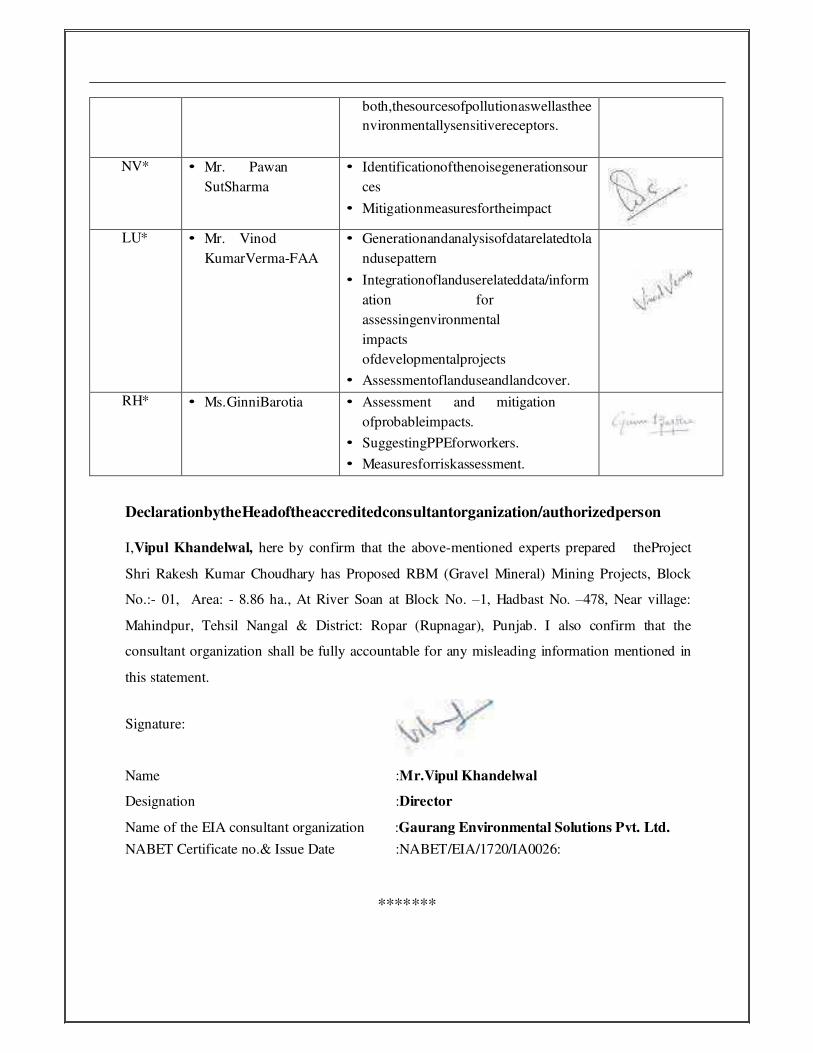
both,thesourcesofpollutionaswellasthee
nvironmentallysensitivereceptors.
NV* • Mr. Pawan
SutSharma
• Identificationofthenoisegenerationsour
ces
• Mitigationmeasuresfortheimpact
LU* • Mr. Vinod
KumarVerma-FAA
• Generationandanalysisofdatarelatedtola
ndusepattern
• Integrationoflanduserelateddata/inform
ation for
assessingenvironmental
impacts
ofdevelopmentalprojects
• Assessmentoflanduseandlandcover.
RH* • Ms.GinniBarotia • Assessment and mitigation
ofprobableimpacts.
• SuggestingPPEforworkers.
• Measuresforriskassessment.
DeclarationbytheHeadoftheaccreditedconsultantorganization/authorizedperson
I,Vipul Khandelwal, here by confirm that the above-mentioned experts prepared theProject
Shri Rakesh Kumar Choudhary has Proposed RBM (Gravel Mineral) Mining Projects, Block
No.:- 01, Area: - 8.86 ha., At River Soan at Block No. –1, Hadbast No. –478, Near village:
Mahindpur, Tehsil Nangal & District: Ropar (Rupnagar), Punjab. I also confirm that the
consultant organization shall be fully accountable for any misleading information mentioned in
this statement.
Signature:
Name :Mr.Vipul Khandelwal
Designation :Director
Name of the EIA consultant organization :Gaurang Environmental Solutions Pvt. Ltd.
NABET Certificate no.& Issue Date :NABET/EIA/1720/IA0026:
*******
\<_,
\<_
\<_.
v-.
\<_
--
\7*
V*
Y-
v-
Y.
Y-
v_
v-
v-
v--
v*
\r-
v-
AIilYEXURES
I


J
1
:'
ANNEXUfrffi
: ., .
*fi1 t. .''.'
r \'..,ts, 1,,...I
n
g
-
it1 !'i,'l I
t
I3.ie5 ,llfl
I
'\Brry
I
AT

v
v
v
\,
\,
\,
\,
I
] NEXURE----r
'ri
i: ,.
1,,
oRUPN
IJ
Ii[:
lrIi
.. I:..,., DEIHI. THE 15TH JANUARY' 2016 OF,M
T AND CLIM ATE CHANGE
LJIi,F>t}I ecs
N
r..bfi$g loo Llrm....
k
L-
il
P
T

t
,
,
)
,
)
)
)
)
)
e"g,
Trblr al Connnuil* al lllnlni rlrt, llrdbmt |lumbsr,Xhmn tJumb sr, Artt md Annuil Produdlon(tonno) of Dlstrlct
l, hfiiodrtmlfrr
*t#ff
4
)
1, Otony/.^,t ol Mtntn Adlvlty ln thr Olrtrlel, 8
lltt ol Mlnlnjtx,rfJofii Oprtilond lrom 2OL0 ta 2011,.,.,.,,, ,,........,..,...9
,, Thr Urt ol MlnlqLruetlnthr Dlrtrla wlth lofltlon, Anr rnd pcrlod ol Valtdlty {20f 6- 2OZtl ,..,74
lJ* d w,tt Mlnlfi,Locrllont..,,,. ..............,...t6
4, Dctelb d Aoytlty or Brvrnur RccrlvsdJn l"art fhrco yearu (tn Ril,,,.,,.....,..... ..,.......22
5, 0Arllr al Prod,uc/,on al Srnd or Bgul tn hrt Threo Yoar (tn tonner).......,. ,,,.......,..22
6. Prxttt ol Dtgotl/,on al *dlman|6 ln tha rlvcr of thc Dlrtrla ........,.22
7. Gtnenl prcfrb ol trc dlttrlct,.,,,..... ...,.....25
8. land |.:nd,lllrilan Pfilarn ln tho Dlrtrlct: Farest, Agrlculure, Hortlculture, Minlng €tc.,..,........,.....,..27
9. ?hVtlognptrl ol tto Olsrda ,.............,.,.....29
10. Rdnfdl Oatz:lctr Wlsc ,.,.,,......, ............ 31
Mrxlmum Rrlnfrll datalorthayeet 2070to20l5 ..............37
71. Grcilryy tdMlneral Werlth .....,...,.......32
Hydrrycolqy ,.,..,33
Ardnagc syttsm wlth dercrlpllon ol maln Rlvers
Srllcnt t ctfir q ol I mpora* Rlv cr s and St eams:,,,
Mtxlmum Olrdzrgc lor thc acrlod ol 2010 rD 2A15
lJfi ol Nllnlr8 ,ltct, H&b.sl llumber, l(hasra l{urnber, Area and Annual Productlon (tonne} of District
33
34
35
2
\
\
\
\
!
,\-
\t
!
V
v
v
v
v
\,
Executlvg
I

I
I!i3
{}
I:li
:I\T
Table of Tables
es,p3l
Llst of Mining Locations Operational from 2010 to 2011
Llst of Mining Leases in District Rupnagar
List of Quarry under process for getting the Environment Clearance
List of New Mining Locations
Details of Royalty or Revenue Received in Last Three years (ln Rs)
Detail of Production of Sand or Bajari ln last Three yean (tn tonnes)Geological Reserves / Mineral potential of Quarry in Rupnagar DistrictGeneral profile of the DistrictTotalArea and Classification of Area in Rupnagar District of PunJab State
Classification of Area in District Rupnagar
Maximum Rainfall data for the year 2010 to 2015
Drainage system with description of main Rivers
Salient Features of tmportant Rivers and Streams
Maximum Discharge for the period of 2010 to 2015
Calculation of Mineable mineral potential
List of Mining sites, Hadbast Number, Khasra Number, Area and Annual Production
(tonne) of District Rupnagar.
Mineral Potential
Annual Deposition
Geomorphological Map of District Rupnagar Punjab
Location Map of District Rupnagar Punjab
Mining Area Location Map of District Rupnagar Punjab
Land Use Land Cover Map of District Rupnagar Punjab
Drainage map of the district Rupnagar
Land utilizatlon pattern of dlstrict Rupnagar
Land utilization pattern of district Rupnagar
Block wise ground water detalls of district Rupnagar
u\D
\S:s{
Table 1
Table 2
Table 3
Table 4
Table 5
Table 5
Table 7
Table 8
Table 9
Table 10
Table 11
Table 12
Table 13
Table 14
Table 15
Table 16
Table 17
Table 18
Table of Maps
Figure 1
Figure 2
Figure 3
Figure 4
Annexure
Annexure I
Annexure ll
Annexure lll
Annexure lV
& 3
....rtir.figiDistrict MlnlngRupnagar.
Olflcer

t
Qpsrl
The present report ls prepared in the light of notiflcatlon no. S.O. 141(E) New Delhi, the
15s January, 2015 of Mlnlstry of Environment, Forest and Cllmate Change. The report has
been prepared to fulfill the requirement of above notification and filled as per the formats
provided ln the notification. lt is a compendlum of available mineral resources, geographical set
up, envlronmental and ecological set up of the Bupnagar dlstrict and replenishment of minerals,
!, IntroducdonHlstory of the DlstrlctRupnagar also spelled Ropar or Rupar, ls a city and a municipat councll in Rupnagar district in
the lndian state of Punjab in North-West Republlc of lndia. The town of Rupnagar (formerly
known as Rupar or Ropar) ls said to have been founded by a Raja called Rokeshar, who ruled
during the llth century and named it after hls son Rup Sen. lt is also the site of an ancient town
of the lndus Valley Civiliration. Rupnagar is a newly created fifth "Divisional Headquarters" of
Punjab comprising Rupnagar, Mohali, and its adjoining distrias. Rupnagar is a 21 meter high
ancient mound overlaying the Shiwalik {also spelt as Sivalik or Shivalik) deposition on the left
bank of the river SutleJ where it emerges into the lains. Sutlej river passes close (2 to 5 kmi to
the towns of Nangal, Rupnagar and Anandpur Sahib.
Locadon and Geographical area
Rupnagar district, included in the Rupnagar Division of Punjab falls between north latitude 30'-
32' and 31'-24'and east longitude 76'-18f and 76'-55'. lt has an average elevation of 260
metres (S53 ft). Town lies on bank of Sutlej River and Shivalik hill range spreads along the
opposfte bank of the river.
The geognphical extent of the area is 1440 sq.km. The district headquarters is 42 km from
Chandigafi, the state opital. The area is bounded by Himachal Pradesh in the north and
north east, Hoshiarpur, Nawanshahr and Ludhlana disttict ln the west, Fatehgarh Sahib district
in the South and Motrali district in the south east. Administratively the new Ropar
district is divided into four tehsils -Rupnagar, Chamkaur Sahlb, Anandpur Sahib and Nangal
comprise of five devehpment block. lnctudes, 617 villages and 5 towns: Rupnagar, Chamkaur
District Survey Report
!.'
III
rttIs:"g
-t>t
*
"o:,
ry:s*Iq3
t,4
E
0 istrlct Mlnlng Offlcer
Rupnagu.
I

}I}IlS
\3-b:-(l\I nr
}rs\s:$
r$
$bbr3
lI$l$
t
e$Irl
Sehib. Anandpur Snhlb, Morlnda, Klptpur Sahlb and Nangal. All the towns except Chamkaur
Sahib have nilwry conneclons. The SutleJ Rlver passes close to the towns of Nangal, Rupnagar
and Anandpur Srhlb.
PopuIaSon
Ths totll populrtlon of the dlstrlct ls 6Brt6II (as per cenrus 2011), the decennlal growth of the
populatlon ls 00,00tt. Majorlty of the totol popul1tlon resldes ln rurcl area. The percentase of
rural rnd urban populetion to total populatlon ls 72.71% and 27.29 96 respectively. As por
Ropar dlstrict data, there are 617 vlllagrs and 11 towns, The total number of uninhabited
villages is 19.
5
Oistrlct Mlnlng OtflcerRupnaglr
JL.\!r
ls:Il33$

e.Grl
Sonns 5O lopos[ect IVo. H*iE7,i11jE&H13811,H4iK5,H13K6,H43X9 (Scole 1:50,000)
Fig 1 Geomorphologlcal Mrp of Dlstrlct Rupnagar Punjab
Execullve0 rstrlct Mlnlng OfficarRupnagar.
5lq
-rs
=*r3tsrs:tl$\il\
Ib\$rl$
6
iuol{:i
I
u .; \, S.:,:ntr.T&*Ldl fiif"t-
)
Hr;l:rr-i
r&!
:ic"'.
it
rlt
i",

I,
I
)
l
)
)
)
)
,
)
)l)
)
)
)
)
)
t)o)
)
)
)
ttT
)
)
ectrl
Erccutlrt0 irtrlct lllnlng OflcrrRupnagrr.
I
DITITRT6T
-T
mrn
--
n5Itf
lllH
t
Fan,r
llrr:rIIT
flS f bc. on Mrp of Dlrtrkil lupnqrr Punlrb
#
t
'Sr
rs
7
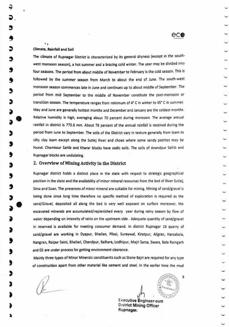
I3.
3
t,
tItttrratttttttloII)
tt,
I)
)
t
qc_trl
Ohneb, Relnhll rnd Soll
The clirnrte of Rupnagar Distrid ls chancterhed by its genenl dryness (except in the south-
west monsosr season), a hot summer and a bncing cold winter. The year may be divided into
four seasons. Thc period from about middle of Novernber to February is the cold season. This is
followed bry the summer season from March to about the end of June. The south'west
tnonsoon ieason oommenoes hte in June and continues up to about middle of September. The
period from mid September to the middle of November constitute the post-monsoon or
transition season. The tempenture Gnges from minimum of 4' C in winter to 45' C in summer.
May and Jun€ are genenlly honest months and December and January are the coldest months.
Rehtive humidity is high, avenging about 70 percent during monsoon. The average annual
rain'l"all in district b 775.6 mm. About 78 percent of the annual ninfull is received during the
period frorn June to S€ptember. The soils of the Oistrlct vary in texture generally from loam to
silty clay loam except along the Sutlej River and choes where some sandy patches may be
found. Chamkaur Sahib and (harar block have sodic soils. The soils of Anandpur Sahib and
Rupnagar blocls are undulating.
2. Overvlew of Mlnlng Acdvlty in the DlsEict
Rupnagar district hoHs a distinA place in the state with respect to strategic geographical
position in the state and the availability of minor mineral resources from the bed of River Sutlej,
Sirsa and Soan. The presences of minor mineral are suitable for mining. Mining of sand/gravel is
being done sinca long time therefore no specific method of exploration is required as the
sand/6ravel, deposited all along the bed is very well exposed on surface moreover, the
excavated minanh are accrmulated/replenished every year during rainy season by flow of
water dependlng on intensity of rains on the upstream side . Adequate quantity of sand/gravel
in reserved is available for meeting consumer demand. ln district Rupnagar 16 quarry of
sandlgravel are wo*ing in Oyapur, Bhallan, Pllasi, Sureywal, Kiratpur, Ailgran, Harsabela,
Nangnn, Raipr Saini, Bhallari, Chandpur, Baihara, Lodhipur, Majri Sarsa, Swara, Bela Ramgarh
and 02 are under process for getting environment clearance.
Mainly three types of Minor Minerals constituents such as Stone Bajri are required for any type
of construction apart from other material like cement and steel. ln the earlier time the mud
ExecutiveD'strict MlnRupnagar.
8
I
\,
v
v
v
ing Otficer
&

I
I
l
)
)
I
)
)
l
)a)
)
)
I
)
)
rl
qc.,
houses/buildings wrre constructed with the use of mud. However with the passage of time,
new techniques of development activities were started. As such the demand of Minor Mineral
started on an lncreasing trend. lh order to meet the requirement of raw material for
construction, the ertraction of sand carried out manually / semi- mechanized process from the
river beds .'Ihe local residents used to lift sand etc. from the river beds to meet out their
bonafide requiremenL However after coming into belng the Punjab Minor Mineral rules 1964,
and amended rules in 2013. The mining is regulated in accordance with the rules.
Apart from the aborre mining operations, mining of brick earth and ordinary earth is also carried
out at many areas of the district which requires digging earth only up to a certain depth of 1 m
to 1.5 m by individual brick kiln owne6. As Punjab is primarily an agricultural state and land is
scarce thus many smalfmarginal farmers give their land on lease for mining of brick earlhl
ordinary errth and same is restored as early as possible after mining to make it fit for
agricultural purpo*s.
Llst of Mhlng Locadons Operadonal from 2Ot0 to 20ll
)
)
)
I
)
)
o
)
I
)
)
)
9
0istrlct
1.
Raje Majra 192 1.14 7667 2.00
a,
Behrampur 219 36.53 9123 2.38
1.57 7667 2.00
3
Patharmajra ?20
55 LL,27 7667 2.00
4.
Bhaowal
223 37.88 8433
5.
Mugal Majri 2.20
225 43.89 7667Gosla 2.00
6.
201 L2.78 16905 4.41
7
Panjola
)Rupnagq
Otficer
ri u|1lr..'.1, jl, rl.l

4+d:Il,
$-*t
s:s
s
rt
l.Is
\t:t\'
$I'
$T\D
!t:'
ssbbt5
ExecutiveI'r r strict Mining Off icer
Rupnagar.
esf
v
\,
V
1.11
8.21,52 4255Manguwal 333
1.16
9.
w7Diwarhl 343 25.38
5.00
10.
19167Kotbala 10 7.39
11.
3.33MajriSana 11 29,23 L2765
L2.2.877 4.72 11002
13.7667 2.00Aaspur 9
t4.Barhl Haveli 45 u.77 38755 10.11
15.
Halerh 15.83 7667 2.00323
16.
2.00Bhaowal 325 11.96 7667
L7,
Kakrala 332 10.95 7667 2.00
18.
Surewal 386 3.t7 7667 2.00
19.
Ballamgarh 251 237.07 39790 10.38
20.
Sehjowal 232 119.81 49757 12.98
267 10.51
2L,Bela Dhyani 7667 2.00
0ayapur 256 130.13 39637
22.10.34
266 30.23
23.
Maiari 7667 2.00
267 97.03
24.Bhallrhi 53158 13.87
10
, IittJ.l i, lrlf .'
Awankot
77.72
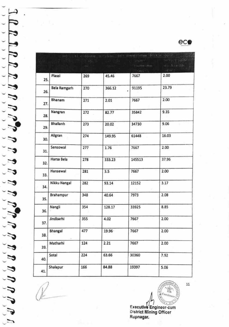
\
\
*$*srs\ril\
th
L-{
sc;
*:$
tt'.D
\ftpItry)*a*$r$
\\t
Ex r-cumD istrict tUllnlng OfficerRupnagar,
e5
2,ffi7667Flssrl 269 4$,{6
IS.2t.7$Brh Rrmgarh 270 366,12 91195
272.00thrnam 7667171 2.0I
18,
9.15Nrngnn 277 82,?? 358/2
29.thallanh 9.06273 20,02 t4730
30.
Allgran 6LM8 16.03274 149.95
31Sensowal 7667 2.00277 L,76
32.17.96Harca Bela 278 333.23 145513
33.
Hansewal 7667 2.00281 3.5
34.
Nlkku Nangal E,t7282 93,14 t2152
35.
Brahampur 348 7973 2.4840.64
Nangli 354 33925 8,85
36.
t28,77
37
Jlndbarhi 355 4.02 7667 2.00
Bhangal 477 19.96 7667
38.
2.m
tz4 2.27
39.
Matharhi 7667 2,00
40.Sotal 224 63.66 30360 7.92
41.Shalapur 156 84.88 19397 5.06
11,)i t/ir
\,t- "
ti, I
' .'rr rrill t) .\) 11 I'i' !'rtir! I
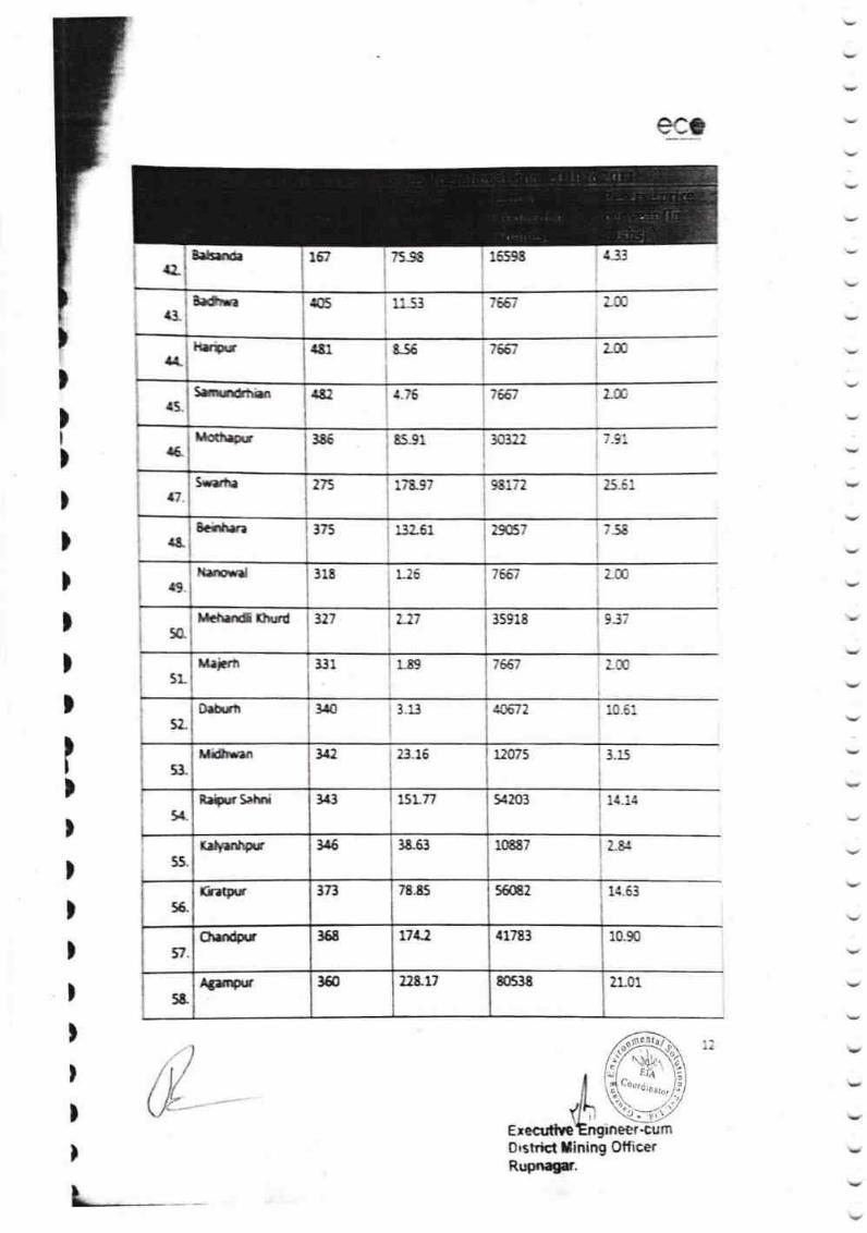
eac
E33
;-:[
75-S
us3
tm&56481
r 6qat
76fi
7ff,7
$5
482
331
2-m
9J7
r9. L{
2.8{
10.90
21.01
8s.91
)
)I
)
)
)
)
)
)
)
I)
)
)
)
)
)
)
)
)
)
7'e67 zm
30322
25-6:,
7-58
76ff
7ffi7
406-12
3.15
1{.53
Erecutive0 rstricl lining OfticerRupoagr.
4.?6
r-89
v
v
{TSrtsrrE 167
(3"8.6iln
,'H"lryir.r
43.Sxrn*tgn
{&.XoO*r 365
{7S,mrha 98172275 17&97
r&Schh*z 375 t a? F't 29857
s.lLra*.d 3lE 115
5&"
l{cnxd &ryd 327 L27 35918
5L[l.ivlt
5t.O.hrh 1r0 3.13
53"
Mdven 342 23.15 u075
343 $Lr/ }{203t*.
Rrli$rr Sahti
3{5 3E-63 10887
5s"
X.lptrrtrg
3r3 78.85 56082
56-
fr.Br
358 t7lJ. 41783OmAgr
',12&17 80538fffrgr 360
5&
k
&
F

i)l):I
=,:3
qc.*?
Nagar
:I$:I:T
rs
&.urce:
\rrg
:c:I:Ils*I:I!a:c:clc:I-I.IlS
n\
\\
tExecutiveDistric{ Mining OtlicerRuonagat
59.7.58lodhipur 352 28.62 29057
60.
Saidpur 7657 2,N376 12.39
61.
Behlu 2.00293 8.47 7667
62.Dasgnn 357 1.39 7667 2.N
63.
(hamerha 9c47 2.36359 10.63
Total 15214f.2 ?97.43
13
/(
, r. i i ,trr
,. il
. tltt
'l l tt | :
t, ,.t
.,lt
, ,l ,.,
.i

r/lc) oI s o o oI I
()
qo\s(}
(o(frio
a
E
!s
o\o()
b
Et
tA
$
I
tri'E{r
ci
IiitI ir t
sslir-3t"rlrtrrtrIto f
3lrrE
rO
oo
It()
ci
r"o
o
E
rO
(}
E
o
tqrte
I
Ii,ti'trlrr!iri
1'0
(o
t
a
!(,ao
li)a
lC0
EO
E)
,T(
?I!a
IaIlI
!xb:G
?l,in
T(
o0
ao
!:
!tl6
t&
!3(*
Bt{t
!*{\$
T*Zi
t,a,
rl!rc
Tal
cr!
t,
!3(ats
?dl
a
!IJ
cil
t6r
I*I
Fula
qr
n;F.
{6 or
$F
rrT;ahhGrFtih
sx
Lb-{l
xr
aah{t*f,h
*s
bh€r.l
b.br.l,
h'f,ffiiHi, io
att\ dtdlq6d!n yl
irlo
ll
ERs6rt rtm\o
\at,
lfnqb'a :'RFPP
|" r"*h-:C
BeLtlin rr
SP
rfhr-cTErl
ttclh
LL
rfhrpS
rFltfi
-2irtsrr?=b
ZZLdciqx6'^t?
i^h
za,t(hrnaqdql
ro|o
zz
^qOt\ryl
t?HR^t)hi
mfr
zzFO!tda rci
t{9
sIcaI
(il)
,*T
c,tl
col
1'co
rtt a} !!
3
c.Q!JOra(tvZ
eaT
tIA
aIb)
cts
CaB?
coG
E,
!l)Aa
iI
nro
sz
'e
G
Ior!d
ITa
l3IIacCI5J,
TIacA)3
|tttaca,a
ttitco')&,
cuiaca3E
.t!!llca:E
rlBIta.
E
(Eacal3c
,t i ,li ci o\
*it$Ft
,&$*
{rl
hrs
i;>r*a
il
6t.*$
trd6tiL((
ti*Jilt*
n.ir*
Is[J?tla{A
tla
I
fl;*$tq
*b
E
fb$3il
-I.*-rhF!t
)t)
)t)
)
)
fiistr1cl flnlng
*
I
)
I
)
)
)
)
I
Offic*rpnagnt.
I
)
I
I
I

(((((((((((((((((( (((((((((( (((((((((
v ru a v v t- tr t u !u t, - t, tr t r f r r - - r r e
e*;
Seltr < r Monogu Cutil Minittg Otticer, Oirtrrct Crnter. 5 A.S lVogor
,r(,€{ErTC
Eo*oo
6l(). i.ugnrlpr Grtr*ad ?,r,ra? Oad *.ot.7sL6 - 29.G.2fr11Bhrllrrl 9*ta ,1'tr,,.rcN,t'12'a.M*L
,o'ztt,tre76'2srt.vr'a
11.(A
ffitl. frugntln C.htndpur knlel ,t'tl'7.u*Htt'tt'tr.61't4
7d'r0t2,tt'c76'rt'ra.7*'l
61.44 Crlanlad Alvct bcd 27.M.7016 - 71.ffi.2m7
12. Aupntltt Grtntad Rlvct c.cd 72.ffi.20r6 " 21.M.2o21 t5a
Brlhrra 9atn ,t'12'57.W*N,t'71'21.5r"N
76'26',19,r,,e76'27',r.afe
t6.at
Grented Rlvcr tcd Cnvkorfile,rrt Clcsrrnqyct to ba U.'tr;lcrtcd ln
thr n,'rc ol th.t,tfirrclof ,
61t. f,upnr;rr [odhlpw Sutlcl 3l'12'13.1 1',N
,l'll'6.'l(f H
76'-79'.1.5\'e
76'29',12.9€E
70.97
76't ',6.r9'e76'r5'rt.2r"C
lL.7A 6rrntad Rlwr 6cd tnvlronmcnt Clcrrancayct to bc tnarfcrrad ln
thc n.m. o( thccontr!€ior.
14. Rupnr3rr Mrfrl l.rm SrrltNrdl
rl't'5.02'Hl1'3'18.67"1{
05
7G'22'.57.to',e76'1,1',t7.19*E
62.G9 Gr.nled15. f,upnrgrr Swrrr Swrn 3l'14'54.95"N31'lg'27.Or*t{
Rlver Bcd Envlronmenl Clornnccyot to bc trrnrferred lnthc n.mc d thccontnctot.
os
t6'24'37.8A"1 105.22 GrantcdRupnrjrr Behnm6rrh Sutlc, I l'16'29.33"N Rlwr Bed16. Invlronment Clcerrnccyat to ba lilnrfcrrod lnthe nama of th.conlractor.
o5
2,O1 Granled6rrhrmpur sallul Rlver BadRupnrglr 01.o7,2011 - 3l.lo.to16 o5
Xakrrll(had
3t'o4'58.8"N,l'o4'58.06"N
76'35'58.6"I76'36'58.2"t
7.59 6rnrrtcd Rlvor 8od
l7t8. Rupnrgrr Xalrala o1,o7.1011 - ll. to.20t6 o5
ltr
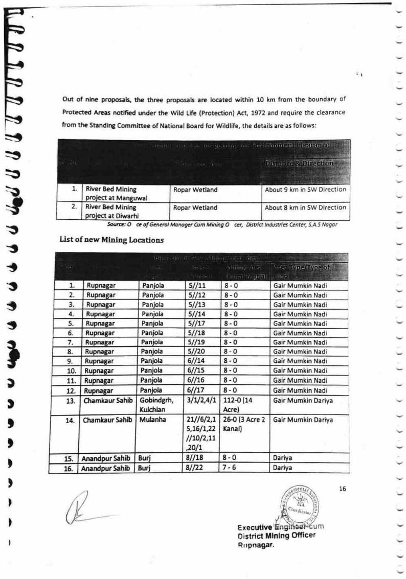
-
'l
D
tit)
i)
)
Out of nhe foposag Sre three proposals are located within 10 km from the boundary of
Protect€d Areas nortified wrder the Wild Lifu (Protecticn) Aa, t972 and require the clearance
frqm $€ Standir€ Cornmittee of National Eoard for Wldlife, the details are as follows;
Sourn'o * af Ganetal *{g/mger Atm Minbg O r,jr, Distrir,- tndus|f,a Carrrer, J"As ffogor.
List of new MfDIry Locadons
Gair Mumkin Nadi
Gair Mumkin Nadi
Gair Mumkin Nadi
Gair Mumkin Nadi
Gair Mumkin Nadi
Gair Mumhin Nadi
6air Mumkin Nadi
Gair Murnkin Nadi
6air Mumkin Nadi
Gair Mumkin Dariya
6air Mumkin Dariya
Executlvo Llm
D islric{ Mlnlng 0fficerRrrpnagar.
1. River Bed Miningproiect at Mar€uwal
Ropar Wethnd About 9 km in SW Direction
2. Riyer Bed Minirqploject at Diwertd
Ropar Wetland About 8 km in 5W Direstion
1, Rupnagar Fanbla sIILL 8-O3" Rupnagar Panlola sllt2 8-03. Rupnagar Panhla sllts 8-0 6air Mumkin Nadi
4. RupnaSar Panhla 5l/14 8-0RupnaSar Panlrb 5/h75. 8-0
Paniola sllLs6- Rupnagar 8-07. Rupnatar Panpla sllte Gair Mumkin Nadi
Rupnagar Panlrla sll2o 8-08.
Panbla 6l/149. Rupnagar 8-0Paniola 6l/L5 8-010. Rupnagar
Panhla 6lh6flupnaSar 8-0 Gair Murnkin Nadi11.
PanFla 6llr7 8-0Bupnagarn-31u2,411Gobindgrh,
XuHrian
1724(L4
Acre)
LI. Chamkaur Sahib
Mr.danha 2al6n,t5,76/L,22
lfiiln,7t
^alr
Zffi 13 t*re 2
Xanal)
ChamlaurSahib14.
8l/18 8-0Buri15. AnardpurSahb
Euri 8/n2 7-6AnardrurSahb16.
15
''''',,',, l l lu
I
. .,.,i1
E-0

r
Out of nine proposals, the three proposals are located within 10 km from tte hourld*ry r:f
protected Areas notifisd under the Wild Life {Protecticn} Act, 1972 and reguire ti'w stoarasMe
frgmtheStandingCommineeofNationalBoardforWildlife,thedetailsareasfox|ours:
Ahout I km in SVf
'i
]tdTHL
-l- \W
r. i) T
1
_:s
-:-$
:$-\}
-1{}
I,
T{}
l\illT
Irr$H}
h
$ourrr.,O co/6enemlidarogur
List of new t$iniug Locations
1l
firn idiaing O mr. ffif
Gair Munrkin Madl
G
s-0 6air
6ai r Mumkin fiadl
Gair &{urnkin
6air
Sair M
6air Mumkln Nadi' 'fi'
6sir ldurnkin ltndi ' ':l
S.air
10.
I
ffiIIfl
I
rhE x ecutive EnEineer'c urn
llistrict Mining Offieer
I
Ropar Wetland1 River Bed Miningproject at Manguwal
Ropar WetlandRiver Bed Miningpr0iect at Diwarhi
8-0IPa lrrI8-025
a r1.11
3Pan tara3 8-0sllL4*"
slll7Pan olaRABars. 8-0IlaPanRus. 8-09laPRU7 8-0olaPAfiuI lr.16air8"0arRI 6air8-0ar
6air8-CITRu llg
8-07PaRUP r12 1$-0 {14
,{cre}31r.12,411"
Channkaur 5ahib
zffi (3 Arre 2
Kanal)
Jell
ru/sl2,x5,16/1,2?
l/10l7,tt
MulanhaChamkaur Sahib1{.
8-0Anand Sahib
15 7-6gurihibSaAnandpur16.
Rrtpnagar'
ffi1
1
i$
Mum*in'Nad{
Faniola
Paniola8-0
6llt4Fanjola
6l/15Paniola
Panisla11.
6obindgrh,
Kulchian
s/n8Buri8l&2

t7Darlyr
Dariya
XS
q$
"td;ryts,a:'
ryt
-.s
ry!
It--of
r
Y
te
&
..t..i..
22
tl
'1,1
31
3?
Dariya!arly
Dari
Da
a
0ariyaAnandpur Sahib
Anandpur SrhiDar
0ariya
Dariya
Qariya
Anand ur Sahib L6l/elx
b f Buri
8urLs/la 3-2
1-38-08-CI
-
Da
Oariya
Oariya
Da
Dariya
Sankdeem
Bankdeem
Bankdeem
Bankdeenr
Eankdeem
Bankdeem
Bankdeem
Bankdeem
Bankdeem
Eankdeem
Bankdeem
Sankdeem
Khadh
Khadh
Khadh
Khadh
*%ll
-J
AnandpurSahlb
AnandpurSahibAqandpurSahib 8ur
Burfi,nand ur Sahib Bur
Bur 761/13
0ariya
Dariya
Dariya
Dari a
33
36
37
3e
E&r
IrI:
E
-
I-I I E
el/23
8/lza
qPA I,TniI ds b
pur $ahlbnA and
Anand ur $ahib sllts0
Surj III
Aaa ur Sahib
Anand u Sa bAnlrnd ur $ahib
Annndpur Sahlb
0
0
18ll1lr18111/28u
Bur
Bur
Bu
Bur
Bur
Bur
1 3
8
I5
0
0
0L6//2
t6lh
76//u
7-L6161/ts
77/lz 8-0An*rd ur $ahib Sur TUII 8-0Anand r $ahib B t7 4 8-0Amnd ur Sahib 8ur 17. '5 8-0Anand ur Sahib Balowal 6/, 8-0
3S
3d
Anand ur $ahib Balowal 6Anand ur $ahib Balowal 7/la 2-2Anand r $ahib Salowal 7 7-2Anand urSahlb Balowal 7/lfi 7-2
39 Anand r $ahib $alowal 7/, 11 6-24S
41.
Anand ur $ahib Ealowal 7 8-0r $ahih Ealowal Jllle 8-0
42 Ana r $ahib Ealowal 7/lts 71843.
r$6.
SahibAnand Balowal 7 1- 14Ana rSahib Sa{owal 7 3 x- 16
45. SahibAnandr Xhamera 12/lt7 9-10Anandpur$ahib lffiarn*ra _ullxs 6-2
47 Anandpur Sahib Xharnera-tzl&3 4-0
48" AnsndpurSrhib l(hamera tzlllt 8-049. <ardp,r$ahib Khrmera 121125/7 4- 10s0, Anandpur $ahib l(hamera ltt/3 2.25t Sahlb Kharnera sllls/t 6-1252. Sahrb l(lrgmera 33lNz t- 72s3. *nardpurSahib lftornera sutal{ 0-454. f;#,Atldprlrsf,,iF lfiarnera
- 3Afif\ 5-155$"
_wlr|3
ffi-q
*rl'1LJ
flssl
F
Khadh
Khadh
irdir Jil.
r9.
2e.
I*
19.
a-flm.
27
28.
39.
4-2
46.
1-17
l
m
tr
tt

8-48-06-48-0
31'lt
l3 r//s5
11/lL4
31llt631llt?
Khamera
Khamera
Xhamera
Khamera
Khamera
4-rtKadeemBan1- lt371174
'1-12
33'lllt
2-134-16
7-1131112
7-115-0
33llt2
I Khadh
5- 13
3- 13
Khamera 1lel,3s/14 8-0
8-03ell57-73sl16
8-0tsllT(hameraudnnA isellta(hamera
s-03el/11(hamera
3el/x?Kharnera8-04sll15Khameraha ibru snda,{n 8.0431 16bIhSarudnaAn 8-045llLtKhameraur $ahibAnand Banjar Kadeem
3
4sl 18Khamera
Khamera
AnandPu r Sahib6-16
2-180I
8-0Kharnera
Khamera
KhameraBanj ar Kadeem
Ban r.Kadeern
ibh5arundIflAbh5arndIAnbr SahinA and pu
4sll24 l
451125
46114 _Ga-Mu'fhow
Ga-Mu'Chow2t2-722-0
63
Mahain
Mahain
bIhur SandnaAh ibsarndpuAna 7-2t{ll,Mahalnr SahibAnand Ga-Mu-Chow? -L7r4ll4Mahainbi$ahu tndnaA s.85Mahainur SahibAnand
ec*
wt -lt bl.. Anandpur Satib
Khadh
Ban ar Kadeem
Bania r Kadeem
Bania r Kadeem
Ba ar Kadeem
Baniar Kadeem
Banj ar Kadeen
Ba ar Kadeern
Ban r Kadeem
0ariYa
Dari
Da a
Oar
rb. I Anandpur $ahib
I Anandpur$ahibT Anandpur Sahib
AnandpurSahh
Anan urSahib
Or" I nnandPurSahib Khamera
Khamera
Xhamera IAnandp ur Sahib 2
1
3
3
3
5l12
llslla
13lltla
AnandpurSahib
en. i nnanUPursahib
ur Sahib
Khamera
Khamera
I Khamera
1er3
Khamera
Khamera
I Khamera
Khamera
Khamera
t
t
3-4
33ll13
I Anand urSahib
ahib
AnandpurSahib
33/
39
11g
7
0
13$/lL?lLlellt
Dari
Khadh
Khadh
Khadh
Khadh
Khadh
Khadh
8a ar Kadeem
Ban r Kadeem
Baniar Kadeem
ar Kadeem
r Kadeem
Ban ar Kadeem
Ban KadEem
6a-Mu-Chow
Ga-Mu-Chow
a
AnandPurS
AnindPur Sahib
ur$ahib
ur Sahib
ur Sahib
r $ahib
ur$ahib
urSahib
't2It
74
Anand
nandp
AnanoP
Anand
A$and
AnandP
AnandP
Anand
ur Sahib
D. Iql
Khamera
Khamera
Khamera?
I :s.
79
$s
lsr
r Sahib
i-
8?
88.
s5
89
9U.
93
g{x8
II
ilttn
&
$
il
ri
., ., . ,,t, r i
5?
58.(6
7-12
63.
64.
66.KhameraSahibs7
Sahibs8,
?0"
71.
71.7?
?*9
7S.
SahibKhadh8-13
8-081.
8?.Khamera
s4"
85.
7.8
$s.
91.

)
)
I
I
l
t
)
)
)
l
l
I
I
t
0f,s!l
Ga-Mu{how
Ga-Mu-Chaw
Ga-Mu-Chow
6a-Mu-Chow
6a-Mu-Chow
Ga-Mu-Chow
Ga-Mu-Chow
Ga-Mu-Chow
Da
Ga-Mu{how
Da
a
Dariya
Da
95 Anandpur Sahib Mahain 14//13 3-18s6 AnandpurSahlb Mahain L4l/14 7-L2 Ga-Mu-Chow
97 ]nilndpurSahib 6a-Mu-ChowL4lltt 7 -L298. Anandpur Sahib Mahain 6a-Mu-Chowul{$ 2-1099. ,Anandpur Sahib Mahain lsllsh 2- 17
100. Ana!dpurSahih Mahain 2-1915lls/2101. Anandpur Sahib Mahain ts//te 2-2102. Anandpur Sahib lsl/22 7-L2103. Anandpur Sahib Mahain t6/16 3-12 6a-Mu-Chow
104. Anandpur Sahib Mahain t6//ts 9-710s, Anandpur Sahib Mahain t7/1212 4-0106. Anandpur Sahib Mahain 17/17 5-3LA7 Anandpur Sahib Mahaln t7//LL 8-0108. AnandpurSahib 17//13 8-0109 AnandpurSahib Mahain 77llt4 8-0x10 Anandpur Sahib Mahain L7/hs 8-0,,11. Anandpur Sahib Mahain t7l{t6 8-0112- Anandpur Sahib Mahain 17//17 8-0 Dariya
113. Anandpur Sahib Mahain L7lh& 5-8 Dariya
L14 Anandpur5ahib Mahain t7lhe 6-8Anandpur $ahib Mahain L7llZ0 4-0115.
116. Anandpur 5ahib Mahain L7//24 5-3Anandpur Sahib Mahain LTllzs 8-0 Darlya117.
Mahain L8//4 8-10118. AnandpurSahib
t8//5 8-0119. Anandpur Sahib Mahain
Mahain L\ll6 7-2 Dariya120. AnandpurSahib
Mahain lsl17 6-15 DariyaAnandpur Sahib1?1.
Mahain 18118 2-6 DariyaAnandpurSahib1tt.8.0Mahain L8/lL2 0ariyaAnandpur Sahib113
ts/hl 4-0Mahain $ariyaAnandpur SahibL1,4.
t8 14 8-0 DariyaMahainAnandpurSahib1?5,
Gair Mumkin Swazs3l/t 2-11MehandpurNangal
3-11 6airMumkin SwaMehandpur 2s3llzltNangal
1-1 Gair Mumkin SwaMehandpur 2s3ll2l2langalr,t ro 1Chari6 6air Mumkin
5aw
2531/3lehandpurNangal
Mehandpur 2531/4130.1 t
ansal IChariIehandpur 2531f7
qrq Gair Mumkin Swa25il18
l9 I
I.
r'1.;
Mahain
Mahain
Mahain
Dariva
Dariya
Dariva
126,
tz7
6-0
7-7 Chari
8-0131,
7-12MehandpurHsngal
l
,,LE xecutive Engineer-cum0 r*tricl Mining 0fficerRupnagar.
I

#f,*&l
i!.:- "-11
affil
MehandPur
6eir'llu.rrl.n 5ar,'
6 duhi 2 6air Mumkln
Saw
a5illr0
)
!,I
tx
$
}
s
tU
$
srt\,
s-q&
\/ht
\d
.\t
Y
i'l
t$
i 1s$.
. :l,r
i;.." l,i , " ', .
2 - tr6 6air M$mkin
5wa
i-:"'.1'-:l-l
I-i -u25311$l',"..,.. lii.r.-,.i". r
s -0
1$3ll12 7- tr,?-$. r-f ?53lfra
rr----r I rr-r 3
I8 -Sli;i,i.:l l.ier.;r,r;;:
x:ryx {'s : ot:, ';ii:l '
jl:
i"s3l/rs { :{_l$/lt, {:-U-
6153//15
6airMuru&i.m$mI s -o
8-0': .::
5 Baniar/ -ls'i '.-l
.,.:, , . : ? x2
11?9-75ITotal
15d Acre lt
F.anal12
lvlaria
-
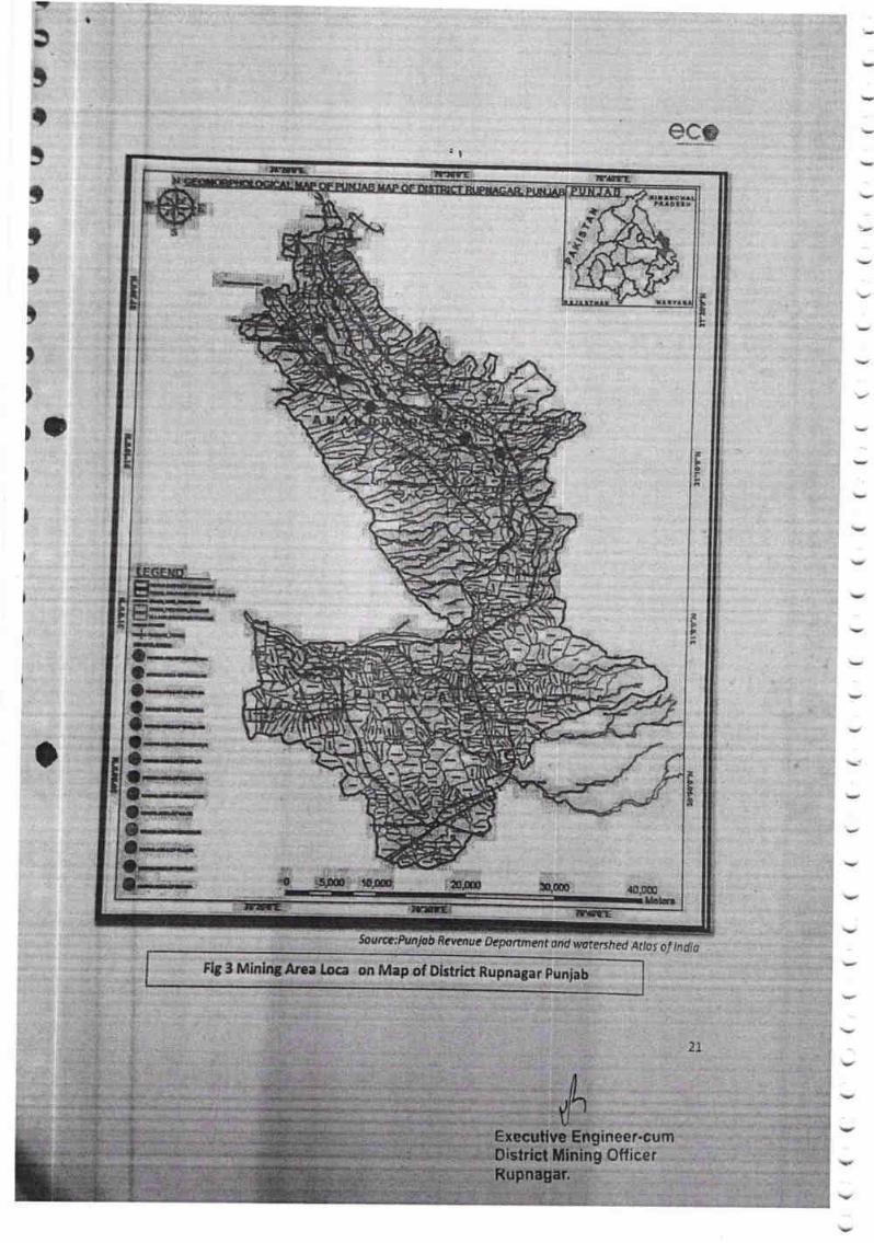
l
scs:l
Irunrc
TLIl*
IP
:Lb
iim,*f*,...--**-t--f..
tt-**r..itt**..-;*.{..ffit
f*i*tft?.|'fi*lf ' ,***-il}l'*{"rr.8f**..a*.f.**-Lrl.t,t-r*S..f*a.. ,{ ,to,ffir ,0m ol&rw
k*
! ;
t
tfi
(l')
Soutt*:PvnJab ficy*nue of,porrrnent ond w?mrshed At/os of lndjo
FIg 3 Mining Arsa lCIca on Map of District Rupnagar punjab
I Executive' Engineer-cumBistrict [,llning Offise r
ftupnagar.
1r
lv
I
V

8C*
*' Details of Royalty or Revenue Received in Last Three years (ln Rs)
2188580
.Sourre: O ceo/6e,neral Monoger Cum Mining O cer, Astrict tniiitrtes Ceiler, $ o,
I
l
5. Details of Produ*ion of sand or Balari in last Three years {Intonnes)
Sourwr O ce olGenerul Monoger Cum rl#n rnp 0 cer, O,,itrr?t rfidustricr Ceotfl: $.A.t iJrSEr
6. Process of Deposition of Sediments in the rivers of tlo Dictrict
l* Distrirt Rupnagar water action is perhaps the only agency respon$ble for erosion,
transportstion and deposition of sand/gravel and aggregates. The rive rr are the most important
source of sandlgravel in the district. Sutlej, Sirsa snd Soan stream are the source of sand/gravel
and tssociated aggregater in the District Rupnagar. The passage of these riven ln distrirt is
initially through sandy and clay stone gravel rich terrain, where erosion of country rocks and
transponation may be high but may result in the sand/gravel formatlon. lt is the lower
Himalaya and Shiwalik terrains which produce bulk quantity of sand/gnvel and associated
asgregates. Thus, geology plays a major role. They coupled with minei"al compasirior
sandstone; comprises essentially brownish-yellow and of grayish green medium to
grained hard compact sandstone with sub coordinated yellowish green and purple shale
scorerl bases and cobbles within the sandstone. lts basal part is dominated by fla8&y,
sandstones. fhe sandstone$ are generally coarser grained and more.rn icaceous " Thit lithnlagyI
E I
46A7775 698382?5
Sand/Gravel 29772.345 170759.681 7429A.933
Y
J
\,,
)i
Sand/Gravel
,l
I
al
Rc
trtKT
hIFh
qsGi1
h rclat*d to development to a large floodplain that shows a number of split channels.
Depositirn of muhistoried sandstones is associated to rapid change of slope {as evidenced by
scouring), deepening of base level and cutting into older formations (evidenced by presence of
cobblec and pebblcs of older fomration in sandstones. The boulder conglomerate formation of
upper Shiwalik mnAining boulders, pebbles and cobbles of granites, quartzites, slates and
limestone. The procxs of sand /gravelformatlon. Moreover, climatic conditions, waterload and
vebcity of river and ninfall have a vital role in the entire process of transportation and
d eposition of sa nd/g ravel a nd associated a ggregates.
" ln order to calculate the mineral deposits in the stream beds, the mineral constituents have
been categorized as clay, silt, sand, bajri and boulder. Howeyer during present calculation, the
wastB material i.e., silt which vary from 10 to 2S6 in different strearns has also been included in
the total production. Further, the Survey of lndia Topo-sheets is used as base map to know the
enent of river counte. The minenl reseryes have been calculated only up to 1.00 m depth
ahhough therp are some portions in the river beds such as channel bars, point bars and central
islards where the annual deposition is raising the level of river bed thus causing shifting of the
river: towards banks resulting in to cutting of banks and at such locations, removal of this
material up lo the bed level is essential to control the river flow in its central part to check the
bank cutting. While calculating the mineral potentials, the mineral deposits lying in the sub-
tributaries of that particular stream/river has not been taken into consideration. Since these
mineral deposits are adding annually to the main river, the mineral deposits will be much more^
Energy, environment and time are the three factors which determine the process of deposition
by sreams. Thus, when enerBy decreases to transport the load {by reduction in velocity or
volume of waterl, a part of material can no longer be transported and hence deposited.
Sirnilarly, the ftctor of environment influences the deposition through configuration or shape of
the channel. Uneven surface ofthe channel check the velocity and hence cause deposition. The
tim* factor actually op€rates through the above two factors. Thus, when a stream would
perform the act of deposition may be explained by a statement like, whenever and wherever its
vehcity b apprechbil checked. The deposits that are laid down by running water are called
allwial, ffwhl or ffwiatile deposits. They all vary greatly in size, shape and mode of origin.
0istricl
Y
Rupnagar
er
fll
23

TI
0oIs&
c,rft6rf{00,a,
rJ!drr
I1.f'
o()(}rlr{
(}C}C}ratrtr..d.
Z(a
z.ca&
li =
E z; g I *(Ii 2 -s x : ; -o .:\fa =
,! L$' E g s E g E =EEi;:Et:iLqJr.rLuL
da:16R.9rr
1r =;
n 2 g YEr$=-eJ*-L
=E ? = X t 5 Err;;s)5c)
zSta;?-J=cTy':?
;13 E E E;7=aEi?;,-=I:c9===a=kF374ia'iZZ;'rEi=dJ;4
4;8.4===-EaLr,=ur'4=d!an;U?aPE;E=Zi4?*'4Hn-'=s===i-;d! E E 2 i Y;
==L-=CO=J=!''i-44ts='?4r*t^r!=2=!r^*d4*i,;#F{n
:: Y: E 6 E ; AA 3; *'= H * E';i/=aEalHp*U+
'U _ i-- ct.*$a;iaaz€iHAEierrgt€EJ;E.'a*.b.".=)rJyti:ioE.a6t
't:; 7, a E E 2 ?.(.aA<):B--Ytu{?!';.9:;?.4 t- ,il i^ : : ..t'
Ol*qFd
.ZB
ort<,rn#,
r,Lt1
€,f.,.
wtt{
a,|.9r..
rtrrlil
rnF*lfi
ln
t,a(a
o
6t.att{
a,**
iElleirD,fi
C{?*tn
&Z414
'?*;a,ro 'a,**
{4,a .2,w1 *,
rsHBi(/r 5a
,:ir;(u6.:V, &,
Ere:! Gl*Etlt Y.
I,,
'a,6
gttta
:,:....
?$c.Y,
Fxls,r, 5a
10{!Y
c&*
*"1
Fx7Eur)d I
)T
fE
t{L
'J
a ,'-.
(}.$aOan(rlf\l
or{r\r\tn
()()r/it\iirfi
:
6(}rJ1\Ci*,-l
lil${i{
s{}*.J}c3*
*rr'1
,rt
qloqr\.
(Or\,vtil
r{'t:r'trl
rl)qc,.a
qtt,,nr{
f\,or\r-
F,rrl
na
(!11
rrlfrlrJ1
tll(3Fl
rl4dl
m()ejf{
|ncortifa
eldjr\?t
rnrnf\a
\lc)lrl
t\
ln(?ri|ui
ttJq,6r?,
,r,t{\ltn
4.gi
{tj{
{'t(o
";w
rt!qt\l{ft
CN1&
r{<r(C
{..lr'lL(}d
F,qrt,6t
+-ir,)
6fid?{
(}Ft
fqc}
{)r\aal
UlF'tlt
616{t,
rtr-{
1.t,rrl
a,ega
xe$* I
r*a,(cte
xe.*c,X.atrtE
I
I
-*l{r Arl
#i cdl***)i
l
6*rB
LUTl'rlk
lro'
*:
iu{)SrLYC, r-Hot,t?
,_r Lar.JI} q>.;::*
sc,tnw
))
I
raaoitn
(ora,
))))))))r)

9.09 111650
465000
9.5 49930
$oumr O e af Geneml Manager Am Minlng O cer, Ustict lndusvies Center, S.AS Nlgat
7. ffeneral pro ile of the district
30'-32'and 31'-24'N
76'-18'and 75'-55'E
1369
684627
775.6mm
AlluvialPlain &
lntermontane
Valt
Sutlej
26403
780
76555
141969
!l
llnrsabela
xS
qs
rs*$h$
-ls
r#1A
l:$
h
ry:LA"h,
5
4
6
x
rtJh
Executive Enginecr'uu r "
0istrict Mining 0l f i ccr
RitPnlgnr,
I
Nakkian
Khad
R8M 347 18.71 10.1
Satluj
River &
Swan
Khad
79.29RBM
Ai16ran Swan
Khad
RBM 274 14,57 10.62
t General lnfonnation
l. latitude
lt Logitude
lil Seographiel Area {sq. km.}
w Ad minlstrative Divis io ns
Number of Towns
lrlumber of Tehsils
Nurnber of Block
V Population {As per 2011Census}
vt, Normal Annual Rainfall (mm)
2
Major physiographic Units
Major Draina$t
3 LAND USE
a. Forest Area
b. Net trea ,orYn:
Het cultivated Area
& Total cultivet€d area:
25
617
Raipur $aini
278
Number of Villages
GEOMORPHOLOGY
r

4bIT
:a{
:t
rl
l:t$:S
iT
n\rt
qpr
$:3
$tg
13
:9
IIi,b$:tIIS
5\U
)
l
Source oround Woter lnlormo on Wklet RoNt Olstttct, Puniab, 2015
E xocuilvof}t516"1
4 MNOR SOITTYPES Rcddlrh Chertnut, Troplcr I
Arld Brown (Werkly
Solonlred)
5 AREA UNDER PRINCIPAL CROPS
--fThousand hectore)
Rhwlf -74 Sabl-72
5 lRRIGATION BY DIFFERENT SOURCES thousrnd hectare
Tqbewells/Borewolls 7to/21s73 { (66) " 18345/
Dugwells
Tankslponds
Canals 4
Other sources
Net lrrlgated area 70
Gross lnlgated area L74.8
7 NUMEER OF GROUND WATER MONITORING WETLS OF
CGWB
Noof Dug wells L4
No of Plezometers 2
I PREDOMINANT
FORMANONS
GEOLOGICAL Alluvium
kRupnagar.
Otflcer
26

rr
l'.r!
ro
at\t
o.e
IH
uEt$.
:T
Boo
V1
tu
I:
I
{u.ilfit
BOtriooq,
s'xila,
E$vt$CLtirt
r!t0t{cfL50r
tL
rA
()
out&.1
c0
mL:
+l31,,
sUorr'l
o
$:'s((a
Ig$
{u
Laracor*ftf,{,Ecs
'cll.}
trr[*s
Lrtt&d,ldr
,1ngrn
rog
"Q$L
o
,30c{!
c{,ratt,tut,gorsf,ho
uq,
tr!
$q*.E)t-
tJ
t{$
S)L
utih$q{r1
{,l*
r&
LJ
Lat
CI
{,lH
It${J{r*G
La
o
ie\oaQ
I00
6
$xx60ilci
3o<ze(}sr'
xOr()-i
(Ha
ao)mr\
al\Ir.t()r{
I
Fo
{ztroEtrkF2oJrcL
PoJF
93f=6S
o-noEEI
r8fn
+r/I
oF
s(t\00
otr"l
EhJfr,H'Q
}(O!u'!
2V1lrt tr,o-Eoo
Nrn(}
xlol.o
l.
EI
II
Ir
v
J{|-oF
rRLAN$t/t
x\octci
-
v
\,
BgEHdp
xolID

rT.
Is:$
:{r!!
:$sl**
3$
*$I$
ir-:,
Y$
xsi
tsSs
ptsm[:tlspir*h$l*"gl
PX
fwr\sm
sa{rce: uss ltl Dotd Mul speclral {l5'nM0rrh lo.tsi
lrqeuti
lit
.rAlrve Enginrer.6Lir'Il
TAI tll
*,f
&{(!r{
$
til
r6lr
I.ECEND
HtrrrqT wruqnil$pl*(S$. p
b&umilrnr,cxiii.ilt.d
fxmI"FsFfEq.IffiatmI.st${ImNrmtmrmmdIx$nt'r**'
ffiitilAk"-rtttptr rl}t
*
If,ffii$*Iuu*regru+Iqm
0't0.00
trnd Cove r Map of District Ru pnagar PuniabFig 4 Land Use
C*,--
ing 0fficer
28
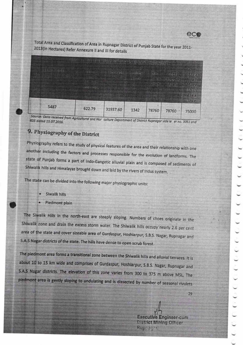
Total Arsa and claslification of Area in Rupnagar District of punjab state for the year 2011-3013{in Hectares} Refer Annexure il and fi for detairs
ecs
7876A Tsooo i0
Sorrc. Oata redrrd Agdcvkurol ondHar aiture Oepanmmt af AsHct Rupnogat ide645 df,rrd.t5, o7,20t6. le v na.30SJ ond
t
9. Rhysiography of the Disrrict
:::ty:oBraehy refers to the study of phvsicat features of the area and their relationship with oneafiothl including the fbctors and irocesses responsible for the evolution of lanrlforms. rhe
late of PunJab forms a part of lndo-Gangetic alluvial plain and is composed of sediments of
shir"rahk hills and Himarayas brought down and raid by the rivers of rndus system,
The *tate can be divided into the foilowing major physiographic units:
$iwalik hills
Piedmont plain
The siwalik Hills in the north-east are steeply slbping. Numbers of choes originate in theShiuralik lone and drain the excess storm water. The shiwalik hills occupy nearly 2.6 per centarea o{the state and coyersizeable area of Gurdaspur, Hoshiarpur, S.B.S, Nagar, Rupnagar and5'A$ Nagar districts of the state. The hiils have dense to open scrub forest.
Tlt* pi*dmont area forms a fi:anritional zone between the shiwalik hills and alluvial terraces. tt is
about 10 to 15 km wide and comprises of Gurdaspur, Hoshiarpur, 5.8.5. rrragar, Rupnagar anri
S.A-$ Nagar districts. The elaration of this lone varies from 300 to 37S m ahove MSL. The
dissected by number of seasonal rivulet:
E
TII I
IAcutit'e EngineBr-cum
ri i'r t;'ict Mlnin g 0f f i cc r
622.79 31937.60 1342 7876A
79
I
'.!trlri.
54S7
v
'I}
:{
-\
s.H)
rys::tIT
esttchocs) wtridr tnnsport storm water with sedlments from thelr catchment. The coarsest of
thtsc sedimen$ ane depusited in the form of alluvlalfans at the foot hills and finer fractions are
depositad rling the choes within the piedmont area.
Tht flood phins of Ravi, Beas, Sutlej and Ghaggar rivers and many seasonal rivulets cover nearly
10.0 per cent anea of the state. The flood plain soils are young and stntlfied without appreciable
attention of sediments. The continuous eroslon cum deposition keeps the soils young as time
bemrnes r limiting factor for the consolidation of sediments into pedogenic horizons. The
palaeochrnnets are believed to be the remanants of the old active channels. The origin of these
chrnnels may be due to the frequent changes in the courses of Ravi, Beas, Sutlej and Ghaggar
rivers ard thelr tributaries, which became defunct and silted up. These areas occupy a low'lying
topognphh position on the landscape.
The district ls situated in the east-central peripheral parts of Punjab; Rupnagar is one of the
smallast districts in the state. The district displays the Breatest physiographic diversity.
Consistent with tnnsitional location between the outer Himalayas and the Puniab plains, the
district has r whole rante of physiographic features which has made its impact on the
characteristics of the human landscape of this region. on the basis of relief, slope, drainage and
overlain material, the district may be divided into following five physiographic units;
r The AnandPur Dun
r The HillY tracts
r The Foothill Dissected Plain
r The UPland Plain
r 'ltre FloodPtain of the Sutlei
Based on the physiognphy, the area can be divided lnto 4 un.ru.siwalik Hills,
rntermontane va*ey of sutrei, Kandi/sirowar formatrons and a,uviar prains- which run pararler
toeachother.TheareaisdninedbySutlelriverbasin.TheSutleiRiverentersthedistrict
near NilrEal in north and flows in south easterly direction and then meanders south and
southwcst rcross the outermost Siwalik Hilrs to debouch into prains' Budki Nadiand siswa
-\
_\'
,x
_lt
-lt-:'::l-\tlt-*rtlr
-cum
l-lislrict f,lllninn
t &h, r'
n{{ir e I
30

t
I
Nadr emerg* from the hi,s drain rhr s*uthsa${er$ p$rr of th* dwith $utlej Rtvor.
10. Ratnfall Data; year LUi.se
The cllmate of punJab is mainly influenced by the Hrrnatay*r rn thp nnrrh indthe south $nd t0uth.wegt. Th€ perinrlic *ir*ul*tltrn of the rnr:rtt ;rr rnos*r.* |and north.western seclom decirjes the occu rrenf l of fwc .,,,l' $er;:.)..Ji F,til:perlod' rhe prereneo of Hirnaray* in thu nu{h srs*tly rnrxris+r rhq !p*,dlstance from th* Himalayas increares the mmp*:r*Nrim *i.r* ir,{rrn*_(*ur
decreasel. ln general, surnmfr$ ar* hol *nd wintrm $r* {qolThe dirtrict receives normarannu;r rainfalr *,r-r7ttnnm, whrrh rri$.i $sr.*d$ *t{,."
"il'I.::::tl rainfall is contributed
'v :outhwp',r r!",cn',r:)o,. Gpnsr r:!r , " *. is'uthwe$ to northeastsrn parf err tl're ciisrri$, rh*, (irrnato sf tlw df$rf$r {,}s\tropicatsteppe hot and semiarid type.
Maxlnrum Ratnfall data for rhe yearZ0I0 to 3SI ji
F{-'':{ta$*ls
rs{':t
\$r$3*r
q:t:"S
F3
P$
is
90.00 trff}.00
1TCI,20
?I,W 1$&.
l
I
,bitt-ra
ib EE
--
Ropar
Nrngnl
-t*t
57.00I
Xotla
1.
t,
3,
\
t
v
v
v
v
v

-r.ls:S
:,
:$
=T
xi:T:3
-v
srr$
T3
\,
$\is:9
qp3
11. Geologyand Mineral Wealth "
Based on geomorphology the entire district can be grouped lnto 4 units such as Siwalik Hills,
lntermontane valley, alluvial fan and alluvial plain. The Siwalik Hills separates the main
Himalayan ranges from the lndo-Gangetic alluvial plain. The area is highly dissected and has an
uneven topognphy. Adjacent to the hills is a long nanow intermontane valley, which extends
from Nangal to Ropar trending northwest to southeast. Anandpur Sahib tehsil of the district lies
in the intermontane valley and occupies a lenglh of 40 km. The average width of the valley in
the district ls 5 km. Sutlej River and its tributaries drain this valley. Adjacent to this is the alluvial
fan which forms the tnnsitional area between the alluvial plains and hilly area of Himalayan
foot hills. The coarse sediments brought down by hill tonents forms the alluvial fan deposits.
These alluvial fans coalesced to form Kandi and Sirowal formation. The southern part of the
district is mainly alluvial plain, which forms a part of vast lndo€angetic alluvail plain.
Two types of soils are found in the district-firstly Reddish chestnut soils which is seen in the
northeastern part of the district, particularly in the Ropar and Anandpur Sahib blocks. These
soils are loam to clay-loam in nature and decalcified and secondaly Tropical Arid Brown soits
(Weakly Solonized) are mainly found in rest of the area which is mainly calcareous sandy loam.
The soils of the district vary in texture generally from loam to silty clay loam except along the
Sutlej River and chos (seasonal canals) where some sandy patches may be found. Chamkaur
Sahib and Morinda blocks have sodic soils.
Explora on
Mining of sand/gnvel is being done since long times therefore no specific method of
exploration is required as the sand/gravel, deposited all along the bed is very well exposed on
the surface. Moreover the excavated minerals are accumulated /replenished every year during
rainy season by flow of water depending on the intensity of rains on the upstream side.
Geological Reserves have been taken as 90% of in-situ reserves considering voids, gangue,
accounting errors etc. which may occur within the deposit.
Oistrict Mlnlng OfficerRupnagar.
32
1-Drs:939
3

*i' '
HU[,] XHAO
Jr{A${CIAJt t(HAOl"AxHAtA XltASI-EXHAN t$tAs
3,rr4$ryJm:_MAN
-qtt{*m*xffiiM[SHWAt XHAS
/t! PHANPUH fi}RAtpuE r(l.tAD
)
lct.
t$.
t6.
lrHyn xHAn
$r$wAFlTm$UGH RAO
PAfiUH CII I{HAO
CIsl{Al,$ r(FlAs
0ult#Alr lffiAo
rAT[il*tsf XHAI]
0 xHeo
6HA#f;NA ffHAM
,-rAftlpt f;
27 TOTAL AREA
$allent Featurss of Import&nt ftiv*rx llnd $tr*arnx
EHATI.AUR XHAO
SUDKI t{rADl
CHARAHGAT''6A IIAIA
OAEATWAII ITHANN
OAIOU IffiANN
l
reirl
I
l
2
4
5
$.
T
I
TO,
HUM IOIAD
,fiAH0*,fl fiH*s
-
I
17.
1S.
1$.
10.
2t.
21"
1"5.
CHINIfi NHANO'---" t _-
---:"'-'
I
$"
13-
1,4.
r.$.
W16'

s:..\Y
il$
:tf{q
xt
€csrl
Y}
:$
:$
;!ril
L*
LAKHAN KHAD
rs19
?0
v2
23
24
25
26
Maximum Discharye for the period of 2010 to 2015
nl
4;
-I-s
_$
-!i-t
Source: waenhed Atlas of tndit
t 160
.Sosrce.'0ols lram Arrnrt 0minage-Oepartnent vide le er na.2835 doted 14,0
TheDruinageNiapofrheDistrict(Source:arainageDepartment}hasbeenattachedas
$\nnexure t, rne map depicts the special orientation and location of all the Rivers system and
Srreams in the RuPnagar Districi'
The bioek *ise gr*unj water detair of rast ten years for the dislict of Rupnagar is attached a* '
s,rrnexure-lV"{5ource,c,ounuWaterCell,Rupnagar,2N5to20t5}' .:
!T
!$
s
II
E
MA.JARI(IIAD
MESHWAL KHAD
PHARPUR KHAS
RAIPUR KHAD
SALHUR KHAB
SISWAN NADI
Rakas Lake Tibet20
SUGII RAO
SUTTUJ
631?l392065399?46134865275?214TaraaSutloj
849663214026952
s9910
18316 51250Swan 9?5597551s05548?502',1255I 8S6Sina irtso44904490r2180
Siswan 85?016?682698I 160I 1990:,?05Budhki s682797522A5460012180
Sago
I
-$-:,
$
-lt-$-$
_'il
of2
Shivalikof7
Shivalikof4
KHAD of5.5
of7
21. ShivatikofShivalikofFoothills
25
80
?{J[5
l.n
1
5
6.

rl
E
\oor\a
r(as!q.
i5i.ls!h(ns(\to
tt
trtr\:l
{r
tB
Lq-i{rla
IJsqB
o
ao
it,.ttl
lrlJ!,
tro(}
cq
Farqt
(Itrfi.+u
tnN
rrlul0r1
*ul
*
oo()(\m+0s(}\o
F.
c.Io\r.ltl$l{al
tl
trgrtrs|
vN
I
(3
olrft9
Ev.(rn{
Ii4
I
I
r+F8g
v
oe
ec{
rll('?lr,)lrqlrlu'! I
:lElxoIolnlr{l\lolslst
(3e o
ra
hg>*'&,
tfr
frs
BSIJl A
TII
611 8tl ,II 911
t'snt'rttt'tttt' nt{ tttt'ott
r'mit'mt t' tttt'lott'mtf mtt
{'mtf um' unf lmf smt' ltot'
i lmr' mf tqol'?mt'omt' 69ot' n
I mrf ilt' l,rol' ttol' 9f ot' !tol' tfffiog i
ot'ofot'6tr0r'$mt' [Ior'giol'm
'I r' rinf rinf not' ttot'otot*otot
l' groi' ttot'[mt'emf ttdotdsgt
I ds#ud$to'rdado*'oll'l{
I rdz#rll'ot*st's$dtsfEst'
i mf llr*rlff'1]o'orf6rf $rt
L, trf
?
(
{
I
(
(
{
{
I
It!t?
tJL)
-";,.^
6y19 &lx
slh!
{
tt'd lfit
1::: I trf ti rf f#m,fdrrofttrvlot't
nf tnfdrt'ut'ulvluttr
x LT, I}
lr
lemrruy puu BaJV';oqun;q c"r$sqx 'JaquInH Isrqpug'srl!$ EqqtrqSo 1s11
lr
L{l{tfuI
ffi
I
I
I
6rt[
I

qI
fr*
tr*q,ry$
ry*
*{
rywtrytsh$
r"tY.Y
.
I,rytrw,ts
ecs
I r&,1ru,tI r2Srr 12r,1
l2{}l Lf!,lttoJ l2?,1t1(),l l3r,l I !3,t r34,t
r 3r,l 136,ttt?rl l!8rI lr9,r 1.o,1I { I J l.tArl t4rrf lrt{rl I{r,t l.t6,lIt7 J latr,l t"a3.l 1$r,l I 64,1275,12? {,I,a?:t rt':t t la?9rlalorrzrl,t:82,la|.,1rss,t216lr2r7 J28E,l3Ar,lz90,ltel JZes,ttg?.129.(/1,1295,M,l3.d5 rl lSO,f S5 t,l3S2.
{3 ,?3
ia//r2.19,ro,2 r *zsrzi r ;,1q"r 1;2(};t t.6O//s,{,6,7,8,r 416,//,12,i9 20,2t,a2Ag//,t
'2r,lo,r l.l2,t 3,r.;l ? JE//,ro J r,6a I /,t?,ta 3a 3t,25.66/r',t,loil I JOJA.T/,:| J J|rir trl.,l 5,1s,6o,//,r 3.rs,l?333r,21 3S #r/ l r+.,rrti.?rErl!lt.l J,Srl6,7 L / / A O J I S,/ r',6,Lt,t6 3tl9,t\J /L' 37 t / tt 3t e*t /ts JS/l:t3{,,(
It56
*//.*<tt2 ll33//f 9 rl};rt Jrt I lq,S rL
N 767 ill.59
r?^3oo 3S?7es
den.*s i t6t$?$(l
I srl6*r*l
{{
I 3a,23,2.;}S 3s/t23,tg4 7 5 i,7 g,s
l,ro.r r4lr,rI/l/2,1 l/a,l1J !;a,r i./r,tr/! J$,/t J 6 /2,r6t r,t7 / t,l7 12 JV / 3,LA,tg ;;.c,/t,&12 ttlt /1,,,?.t2. *ttl J:3/33C:s,r L? t SJti*r5 ,$ ,2 ,tl ,1 12 ,&,/ l ,8/2 i9/ I ,9lr ,r o! II ,1e,13,l{,1s,/l ,l s,a2,r srt ?,I8J9JoSl/f ;I1r', .2,r /,p,zAt,44IrafiII l?,Nl a"n $.n";trr"g/I,g./lrloll rlO 12,ll / | J I tZ ; trA,t2'iU / t,ZAt2A5/ I L A,, lt / t A /?,1lr,, h,6,7 / t.7 t2,7 / t r7 l a, t L rgfz,,g/ 5,tt 4 rts,e,ta/ t,to/2,,t t / I l t n,L2 ), r,t1,rsJdlr J 61lJ 7 / t ;? n,La n,ra n,|I / r,,1,n AO,Zt,/t,2 l€:t|3!,2.t / I 2l A.,Z,g,q6./ h t | ;Lt,. JJ t,2Jz
,7tr
Irrooohs
X;
kkffi
f)lo;ltg i sgts? if,,!"irr^
II
I ru Executive figr-cumI I f H
-
uarrilt Itm 1o.45
[{r'./l I rl8,try'}.191tr,r2&/1;!(}r'x,I L,22 &, *1 3rl/l 2 J r,l { J9"A0.x &a t, 3j./ h.5,o.r,t !,t 4rt5rl 6rL7,r3 / lt r,,r,a siro.l t,12,13,1 g,
I ta{ 3$r 3r! s"t{ rl/,
att' ni I &t2 t2 it: ;5,16,1?,1 s/1,
E
Officer
1l
$snpml
i .)r ,ri.i ,
['I
i
\
!
49,Oos
IEI*OC I .!3ff$*n
&|s ,r.os
rlt

egttl
)
Er0rstrict Mlning
RupnaePr.
1' lar EI 52-7t
taa I eal.lJ.lolt JZ,*r,r/),.r r J6'rr*.arl? ll,.ua, n9,rlrrrrlryrrlr',rfu*;x,2??r#.y,tt"yfip"tlAzrg,arlj|..*rrAt r$frg,a L lz rt tr,or $ ta J L :r:L'/L7 a
xr*. {6'15
a! htt zatt atJt
r wrrgL?rIr .Lerng ail ll.J7eA2spA,g,at,*t)2J,t ,rsJaJ7r!rrrirE,J-Jtr,}ril3,.
, *, p zr a. p rr,zrltt 4.? A ;r :r,zlriorerr*t53.*,rar5J
^*4ruuflJ,q]l15rllroFort4.,Nrrr,,auttr:l.
,
l*gJA,
t,I,,, llft'll
I-rz ,asu
: r{,l', fzJ,s JEilt,yila ?r,r,
,, I *' # lt{r/n) i il.l?+17zrtt,zrl+,at',2..5ptr aJ|,r4,,li//tt,l2,Dnrz/,ra.6.17,
t rlt /.ti,z/lqr'rt4leroill,',ryilaehrnA)s,tc,gac,t t.tat irliu Atzz, ilrtl I tt )t,
lltanlot,zl'z:troa
tzgut
t6ru
a39
I
rr,uno
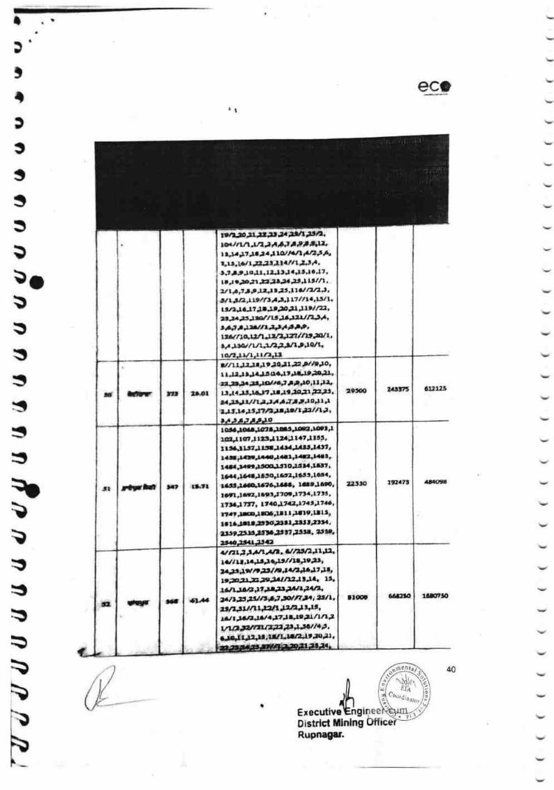
^
I r;
ect
3',
t3
t$
ssilb3
rl
B
$$s$$:s
clxm!
ITOBE
lilrrto
q;bt$I':t;lbbi'\I
sl--
JAExecutivetsngDistrlst t$lnlngRupnqnr.
rs&.rlla J,,l J ri aJ, JP, &r&r r,r.*trtr/r J tAlA.tf rr&rALrr, l./r *t#?t,;. tl/r t f J rt.tJrrJo,u.rrJrJaJI't 4,17'
r r,r r;o;t Ja:rl,l ':i,,l lrl /1,
2t te ;r, $ )Z.,r'a &r,ltat t1ul|,r,
rrr:rJljt lrJr, J,,..,.l) *z,',3r-,.iE JgrlrJa,tafi,'A,,rdrJrrt ,rrjrrrr,rr.t t}*r*url?'uE'. I lu, *l l,,t.t$t I v,-,arrsrlrrlrqrL
LTlrta rL5lt,
,.ttn,9toq
rr'lrr I J:Jr'tt 3ql,,n N l, Jar1 r *llJ lJ< cG^rrrll,Lrrn*r"''rrutula,{t'qrc'/*J lf rlorll rr&ll J {J.r,ralt Jl,tt 'lgjtr l3rr.l. )rarrlrrJrrrII ifrrro*r'rr*r,l.,rrr?n, t;',l t azlil l.I'5'J",LO
T" ,t0rIFrr
zttro trsr.7lt
r6arllrrlgrrJ.It'rm.rttIr,q"r rotJrrl,rt ura?'rttt,t rtarr rJlullttJtta.I/SltJaJtl,rar i.rrilrL{'rrar""raB'r{a?rar.r.rtllqr.tr Q)tu 'tGn,tl*lJ6a$rr5qrtlr2J6t t, ls.'tSttJacu0rJaar' LltJam,
t u1n. ltaol,.zJ?a,),ibrrr."JE;rE,rrtrrrr-ltt+l.r.rJtl0r,lrc5trr,rrtrrt.,l'rr:rE !r!atrl!'7l*ll. *ltlr
rart,.,fisld,r
ra.r,U J.rE f lUrSfrll.Xe P,V4*a/nitr,{,f.U(/lll,<rt',t ',rI8$,.Z,8)arlurltfa{ 1',raar.rrrr*?,E rttt$taq,,rtl',Xt fi ltttol *{ n*r ; g I L.
yl t.,,A;l,J,6r. *a l*,n rL I lf L,
rlqp e6a:Eoal,raa,
l
tr
t
40
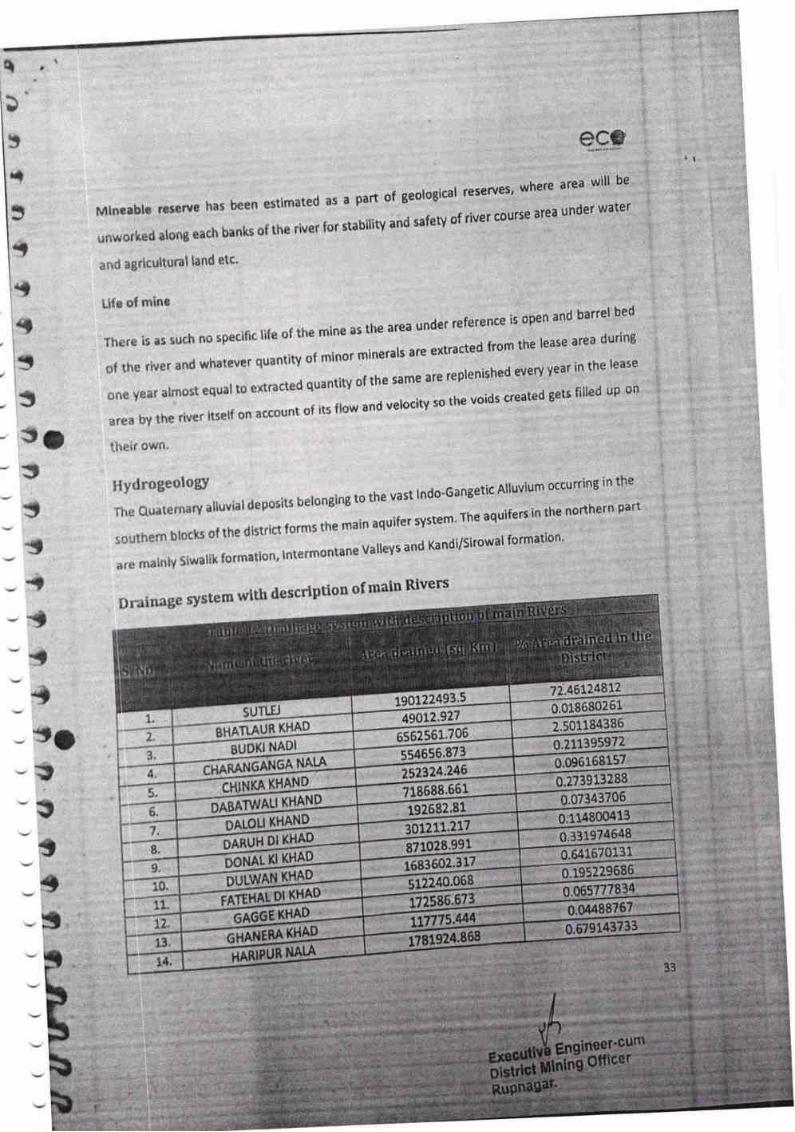
e
Y
,tll
ni
$
*|
i*l
sl
':l
${};
:!
$
-1S
-{
-yS
-Ys
_3S
_$;\$
-s-T
scs
ruiin*ablc r&$*rrs h*r treen estimated as a part of geological reserves' where area witl be
unvx*rhr*d ar*ng rach bankr of the river {or stability and safety of river cour$e area under water
*nd ogricultural l*nd etc'
tlrcir own
$tyrlrtgcology -_:,- kalnnoin, to the vast rndo-Gangetic Artuvium occurrin' in the
lht Quaternary aliuvialdeposits belonging to tne vdlL "'"- :--:: .arrifers in the northern part
r*ulhernblockscfthedistrirtformsthemainaquifersYstem.Theaquifersinthenorthernp
;rr*nlairlly$iwalikforrnation,lntermontaneValleysandKandi/Sirowalformation.
0rtinage system with descrlption of main Rivers
I
ItP*I
t-"*
t--L*I
t.2.
$UTTIJ
&HATIAU fl K}IAD
BUOKI NAOI
aa
f,.
6.
I
a
I
1s.
'!1
n?
ssp
Bk
81?742.'46175932241901
0.0x96802614$012,927
?.501 1943867061.566562 597?,391170.
554656' 873NAl.A
24652314.zINKACH ?18688. 561
50ATW
0KHANAl"OABDANKH,LOLIOA 7121.t3012 ?4649190,33,DHAl(sDAftUH .991102897
KHAOl(NALCIo L73602.1683
LWANDUKHAODI
F 71,62586.1?KHAD6
NAHAilT613NAIAput
HABI1{
I
b
rt
Lite pf mine
Th*r* il as such no sprci{ic life of the mine as the area under reference is open and barrel bed
,,f the rive r and whatever quantity of minor minerars are extracted from the rease area during
oile ye$f alrnust equal lo extracted quantity of the same are replenished every year in the lease
artabYtheriveritsetfonaecauntofitsflowandvelocitysothevoidscreatedgetslilleduRon
.
. il ,
RuPnagar'
33

tl
ee"o
tlr"r!
l*r7!&
9jlioxt ,67:UtO t9e9?SS
€
s
e ..ruti,[nsDistrlct Mlnlng Otfi
'l.rTtrGxto
rao,t,olrqml
Rupnagar.
n$
41
t)
ii
'll+,
ll
:iilr,
g{r"t5

I
TS
:s
t
,
Mlnlng Areer
7,6,1r,r2
10,1
L13.U,r5,$,lr,1&20,tL23.1{,13)31 R6,24I It 10,1l.U,1r,20,r 1.??.2
,t 10, 1:"uJ3,1.,$.t61218,r9,142r,2r.1 6rflr{i
7r&9rl0,lIYUJ3f la,fli, 16,17,18, tg,
1,22 ;71,14'23J1 I 1 a.5,6,7,11'15,16,17,2r,15,19 I I 1,2,Y
L1/1d5,6,7,8,r,10.11, 12,!1,14, 15 )S 3o )Ol I L.Z,
6rtvcl
iitgc er.cUnlD
Rupnagar.
lr t{o010*
Irlo"O$rict l{rrnrof Mlnr
l{rd
br3lNo.lrre {ln }lel IhrcB l{o.
5a,v!l
gt evrl
I I R0prrGoblrdtrfi{uldlhn
100 5.506ravel
6rovelI I nop.r Mrnlndpur a78 885,25? | I t8 25rl t 2r,75,, I I 7 1,25 t I I 25 J6A I / t
3 l Rop'r Moheln 358 2r,11
I
,L7llrf,tf /ftg,L' I n0,fl I I 2a,LU|IS,7ll I 1,L81 tS,t8 I I 6ltl 17,18 I I lfi ,LA I /
Grav{l
{ Ii
RoF$ ltrydr 359 u.E8
MnillF!L,3tllsnatl l5\3{l 5&3tl l73tt N\a lulu l\6,tu I t7,3t
I t2.elt n*zt Is\tl t63,I trlr,t l fin,itl fia,$l t L\3t
I I t2 3' I hz I r,tct l t 3e I l2l tpe I I 3 p9 I I 1 39 I ls,3e I I 6,3e t I7 irl ILO,rsI lt .3cthz4,I lt5,1v 1r8,45I l t7,q5 I 1 t8,65 I I,4 r\lhl..!,tDs.6lt,
GrAuel
5 i iprr Ur&ol It0, L30
2Ut6l\13,15ltall$l4lt,zon 6rlvoi
6 I fiCIpry, $i&r.l 2sl 51.r5
[12#A6.Z,3.ro.tr; u,rs,tr,ri,f OJ7,fnr6,UAJ&rrrla,r 5u1si0. ruzi3"14nhJ5,25,2 7.28J985mh36,3r,3&,39,{q aLa2,{r,r5,46,{8,53"5f , 55q6.6t)1 61.6? 61 6a 65.611.rO.77.77.73.74
6rpvel
I 1 Soprr &WIB,r 265 48.68
I I Roprr PkiC 269
14/41i8194,1 I n,7Ol L,ZA n,
19.{5 6r ovrl
3 I Sopr thdrn 2A q.{t 616vrl
rq I lop..r tslln rz 31,r9
\
-Ilr
Oflicor
t.t tcrrtt ttlrtt
T
5 h,; n,s n,il a.6.r, 16. 1r, ?4//1

!
:3&tIS
xs
rtxs}{r
$*s
h*'$;}
'q
,*'
-xI
*it,,;$
- II
I
;r
{}
t

I
rrl
nhl'lfrs
fd-+r.g6ak*rrr{a6EdafrHfihtt$r6aro
d$rrfir,
tgs-Hrffia qsrf,:Eirirdfir
"&,1
-
iFsrg:- -Jr"r
fi t srro ? fJs 6: P45:48rt.at urry.8. fir* tz.og"z020 ffi I
grtta-s fs} Fdfi 'H' ** i+st. t fu f?rlrdt nrnrr*r dts' {r. fr lr,*d
I{tdm qt8 q'Et fa'fda fu r{m i+* oo.ro.z0z0, 8.r0.2ozo ral3 14,10.2020 d )frf€ril
affi arerrHEt" rrrq-t6 E(H'E& gtirerh{t Tl.dr}rf. {r.}fd'?r{n{' f,r g6r t, ntrt{ Hr 6 Er,
+ri fiis ffrlrrua, E+e,E vriS rsw * fu+rc uffi fi ffi a' f* trafiidrtr. s rir fib?irrdri,t, rttiEJs, us.ft, qkJ. bi] Ht€ * fsfre i fd E *'e )rqau ErkA '€B' u:rsr6
ffi6 Ql{ifu frr}de fur.d qt-S iffi t, ,rnro e;ru rfi+o arei rarru fi E hrdrffig
fi'dr q. E'rs f& affi'ilelt *ia*6 * rrrms fuisa t
,- ttr
ri
gu )furs ilfiUrde,* *e" F.fuartiarsr
: IIGT
,f!:.
Q
*
rr
'a-' t rt
G 6)Gr6
sfiarsr
ffi l1)l"l'>oz'n
E
I
-
F
!
:
,; lllr
r
',1
t1:r.t_L'-lr-i
i,.:' .
Iir -
'/. .. .,: . ':"
ffi.
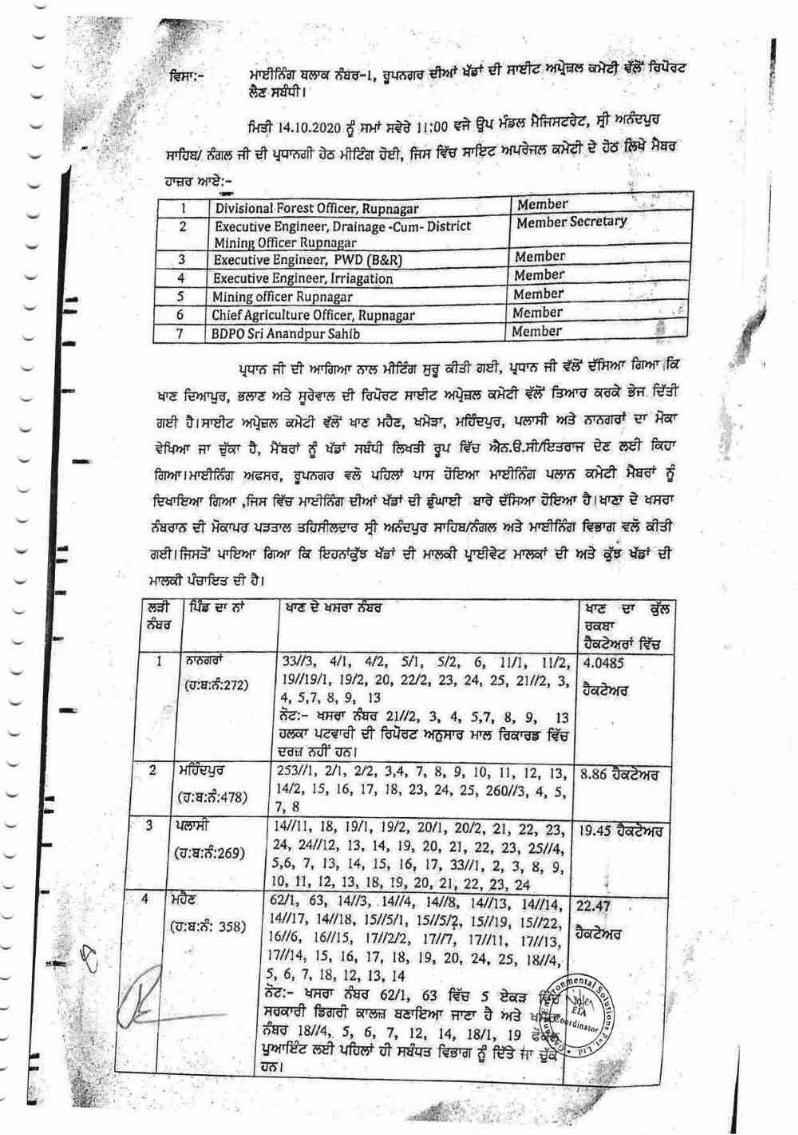
V
v
l
D
y,dqq tr$Er flrTr-I, Eqdc6 d,rd trt d nda ryEats Efrlfr {Ffrtt"&e mffit
fis 14.10.2020 d }ilf }I{$ 1Ii00 gfr g{ frg fif'rEde, fr hrfclr
Erftrq/ *dns # m {qr'6aft't6 H?f&r t*, firF 6 rrfuz }rfil}ir6 a&t i A6 frB'fuC
grgg ffi:-
I,d
tt
l'
,$
{-rt ,
r-i
qfEmt fr 6} )r{.ldr}?i' ?t'6 }frfJd1 5.g 6fs? ar$, r{qtd ;fr {ts' dtnw frrxi'tff
qre Fs)4{rgs, s6rd Dr3 Ea*s d' fdftz HrEte }r{tfiIt aka {E' f$rrnu 616* BE' fCfS'
a5ft trrrfia )r{tfs ac}dt f,S' H'E ,{fu, tflE, xfrgrE, u6t* }?fg ttt'aalUl gr fiar
?fi{hl' ilr ffir t, trgt, d fd' rni* fiarS Sr trs' }iE e.#lbrd,Tr gE 6A f{s'
faperrxdfrfur Dr6r{, grrard "8
uffi urr ifsrxr Hrctfrfiil ufi'?t ark* ffi d
fu{rfs}r{' ftp?'r. ,frr fdr H,E1ffiar et?{i dbt S frr.et gri dfE }rr i'furfr &rqtiut t trrsr
#rd'?r d? )}5pr;d uE:rrdr sffierE6' E lrrfeJq H'foa/trnr )rfi lfd'fcf'dr @r s8 dS
m$rfim5'ufsh{r fdl}rfr f{ ffidv tr * x'?5# Wet?z Hqsqt * hf3 # W *H'ffifr rJffi et ?l
MemberI Divisional Foresr 0flicer, Ru
2 Executive Engineer, Drainage -Cum- DistrictOfficer r
MemberJ neer, PWDExecutiye
Member4 Executive
Member5 Mining officer Rupnagar
Member6 Chief Agrlculture 0fficer, Rupnagar
Member7 BDP0 Sri Anandpur Sahlb
dE-d
I
@:a:*zlz)l9//tg/1, 1912,20, 2a2, 23,24, 25, 2tll2, 3,4, 5r7, g, 9) 13
8a- rrrrr *qa ztltz, 3, 4, 5,2, g, 9, 13
arrr u€rfr * flEff,d )rr6xq ){qr fu'ilr f6rws ir# imr
3yr3, 4/1, 4/2, , 5/2, 6, ll/1, I 4.0485
eArc
2
(u:a:#;474)
2531/1, 2/1, 2/2, 3,4, 7, g, gl4/2, 15, 16, 17, lg, 23, 24, 25, 260113, ,4, 5,7r8
, 10, ll, 12, 13, 8.85
3
(u:r:if:269) 24, 24lll2, 13, 14, lg, 20, 21, 22, 23, 25/t4,5,6,'7, 13, 14, 15, 16, 17,33/11,2, 3, g, g,
141/11, tg, lg/1, lgl2, 20/1,7012,21 , 22r 23,
22, 23,2420, 2l10, ll 12, 13, lg, tg
r9.45
4
(o;a:af: :sa;
4ll17, Ls/tst2,
7/luz 7/lt 7il1
?r?:-
66At 4//33, t4//8, 4//13 I 4,4//t B4//l sl/s/t 1 2s//2
J,7//1 5 74, 6, 8, 9, 24,20, 25, t8//4,
5 6 418, 3,2,
wrgr rfq-d 62lt 563 ffs *"tY}ril{,-# ffi' AT'H f,ry a tr+E-gfghlt
Idw 8114, 7 I5, 6, I4 18/L I 92,6Et9,1rfu" fluftrffi ffiqg f{grdr ffi #'d
d()
"0^!r!t V
Member Secretary
ttiB gr i't urde urmr tFg urd g s6ft(EraEA,rrEr f€B
7/n,
'7,
, tsl119,6//6, t61fi5, I I I t

v
v
v
rb.'
${edg urar affi Er fBrs, grraro ,rrfi' Wrs i* fEtE" trs fu"d ffiet e uprsr f,sv?r r$.l}6.r}.8. rSOo * qrtrr 4/5 ,?rd6 *r aiff 16, r
sfo#fltw,fiiTs €.B tr"e r.frdrdr g t*rrr fu zl/t2,3, 4, 5,7, it, g, 13
H&f fdftdz dS't fd' fu HFrdr &dr6 xro ftqrmr f$a wr a;ff irs,tsfimilfrffi, t,?rdsUr H.ffi ES fdrirc alf affi a fa fg HAE' g wro fra 6zlt, 63 fSu s t-r* rur
ITrdtfr ffi aqm r€rfulr{. rrar s uri unr da-o t8//+, S; o, 7, 12, 14, l8/1, ts
. aryghffi s* uforn.S dir ikg'iird ffi;r'Si a6,r
HFr{;1r r$.rmry.gfr. f 6. 6r6ilEi , xffiB.go, rf6'fr h,f} tfkfl F{ifi dCt
fEfiE' r-# trr+ftlar+t rfr.ry.*. {S' fr }rAE r$rn' ks.fl ffs t,frfur fs t@-6 ir.o rimq HoErne {B'}rrdr# ffi a'm fiiB HAE fr* s}arg Gr& ffi E-dt'fu}?r'
f,F't )rf} fuB fe fifu i, 6 Tc'*;r'S tra.rm,-fi ff#drrru a€irs-rn+ ffrs'Hrelftldr
'rf€rfiI Eurard hr} H'Sfrftr
hrentr, gr.n'dra, ,a6sq ?irddrqi, rrffiga, u{rrfi"uf3 Ht6 f,gt ff,ff *r ff,g t€ aFA
E1-qSfi'Bs6 ra r:ri fu # rl,$fddr alra'frar a-a'rfrfg tir]:r e t dra qs.{ #sd fg
frs t, t fu *- ,{Bat*s?r t ry} z rfrs uzrra rffiazrar Sts'fdr l"r A hr} fud {B
x'SfdfuI rra'dar tlEtrffis + fs6-s ftu6t Hr*h{t€+ ffrt H's?fif;dr Eg ilil6'+ ufu ti& }s
r.s-*x'd1?fur t S# effi & erB ;r's, $ fi vfer f#u ti'* ffi'# * ufufi" #itffS tsr # ffr tS Hdfrfrr r rtertr'ffif'blr a'n&rrnete }}rqfrE il|t$ {8' fEa
Infre ds'fltg A fd HSqs aAw d8 M #,'f*t H's1frSilr ET Erf,d + uftRit ndqs4
8fr6'H'ffit ,rfi ffiJ tffi qrF lrtnG ttqa #drrS *a H€tfr9a frs'ar d l?f'lrt
Uqa * tB'ar&dr. rlfS ffi'J Hrffirt fr Rfd,1-$ glt at"t'fi+rd ff)l€rT nEjT ffir
?
1,,
I
rt,t
i-1.
'-.-,.
:
i.
-I
frII
-:,n
i*f"
€',r lisp fl$*e.,fr rrrtE;o X'fffrtiaro
I
il**Etffi#1tuR - aH-ffrry H'Sff,il )?r6Frs, gn{firrd
JKTTERT {r.a r1xlr6 dz6s
/
16, 17,
1,. 12, I
45tlt5,
6,
7l
t s/,e 24,6/3, 7 3uls,t5, 2514, 24,33il1/ l2 4 50 3,11 I,39/l2l 3
6, I I 230 l7 246, 8,2,25
3 $srfus hr€mr
guffils (S.l}g.h{'c.)
t!
,-l
ai
I
*M#*,

--,
_\1"-_:$
-t:t
li3
_t_:t-:I-r$-\)
-t-ir'
in 5itrat
ruu.rl;
affi{.&frr?
M-
.i
{
proonrotlon of Dlrtrlct surycv.qfrort ln comolloncc lo ths n'o-tl[tJi[[98.,
drrod r31tlt6 & 2,0/t/li tlruod, bv Mlnlrtrv ol f,nvlronmenr' rorc" """Clirnoro Chauc rgrrrdlnr.
arru ifi d tfirl rfirS frfuh{' n}tl, e & fgiffi"{?nqfi7r{, t{'e'lfttt fi
frhr*fl fr,?rlr, fnf,. dflarz i0 t rj.ro dlrd rxor-ol/g'I-h{ra,nt zo$tq tix, frrfr oS'0'z'zOtg
(rS nrfih-O rrr6xo fur'u { fr'rf nr0 for6a s6,92 t nriir fif3 nnr r}rr rra'E ?
ul-'xqzr rfrfl fr$ zg.ot.zotg Ed Hq'ryewo dxr gu rc fia Aadl{ fr'rd ra el
rmrfr rilCl arCl 0 r hr rxqrnr tBbrd ,flmrrd gd ffi r,U,?rrg qqg a-or sd
mryfir, ftry' m.l fdrfue Brrga rar dl is ir fb, ndd fffi tr.dt -i *n Srate Envlronmenl
lmp.ct Atr€rm.nt A{,,rhortty (sfuO *s IEre ile }rr} E6rt tB ooJcaton wt,rfz"t'W fa
ry kry rct hrldrxr0rd *r a'?r
nr5 Fffr Rr.t 2016 *a,n ;rmnr hlrd ,rf3 awfi f@qt, ffi t? filf
yrrirra Yt liltfu ftry rst fuirc rg6iz rirrulm wrt' Brra ft1 ard rfr $dDrfIfi-rr0t ho, fl d f..rdifr fifs U ir
Nu*Jf**-*-rofua fry xelfia rrrrra,
A? rocfe$trfirsr
B'r,?86 f,flL*,-rd'fud fdf fdrft nrem.
ErffitEl
rdrfEd lrdfriot rrrarg,
il{SZritl
/,, "l/J. fL,* yb*er..rur&ngineer.cumDistrlct Mlnlng OfftcerRupnagar.
i
-i,Fr-hg
-i
{t-13;-rt\

v
Annex-6
i*, ONNEXUF<C +
tftm frffiP
lffii.n.,r.,*rr*,r.***irrrACI t0f*Hr*i!
fisr ftt
fldfF,.,r,.r.rr.r.rr.
ftnt# Slsirtr,
$r6fffil
&rl** mrr fnrsr ltfs H'Sftfur -w,q-r * {E ?{fdew U} iffifi rnnr rr*frt
ilrw:* . h{'v fr & Effir t dgffi dr2004-06 flr# re,09,20r9 wi +?s 8;2298-2300 fif*0?,1il2019 hrs *E *:zasz-d*tt fi,bFil.s,3 fi{s 14,11.rp rsfft
ft* n{t ** drfu frr erffi sr ftu Mrr * ttnnr+* fi lhhrs
sft,*eru'6, firs utt'rlgir rfr 4t3ts,q fl{S 29.1r.2019 Tr# }ff ar* ttry'r,t * { umu
g.r$ti6 rlgg 6:+r3rt.H fr{fr zg.it.lg, nrrg ffi Eflfi, ir.fiET *m, afaa ,}rg Tr}Jffiff,
ffi EnfiD{t fEq nW Htftrg urs& }rfn{ ffi'6 }?Erfi'fr fi"dr q-f{"* ffir *fu 6$ef 61
r{ftsf,r HUFfl
fftt hqfi ,.,.....,.*?r.......,20I gii?{qtr !
fuEere=rgsrffigg?Lt, fdg-tftr,rrt ntst tr ./
-q# *€u *rr'ngsugr*mt
t*,t/tlty", H'dfrr hfi frr€8# fu''dr, f,H.t,dfi, rae $
gulhrsr'?&?llrcl
65
. ":'.


I
I
II
I
srsd gftnqtsus fdrs, frn'$r6iInn
iq, l*si,
gu ltrs itltrnaia,r(ars r
aus ..h,1.3,,./ !E 0ril .,.,,,.P, frtllr,,l,1
l)nur$rcnllon Of It'Iinlrig lillcs in rllottrrl ll{ining lllocks of Strttc of
l'unJnb,
vrrnr iil t wss t {it6 nt*a dru ariz rilx.rft.r {ir$'?.1-r0*t0lo rniql'r
€'ufdm ftr) t Hfq f$s dir I iirst t k th] Hdfi f.r,[se dler a'$il
alla' lhrr' &ra i r4ur d1-* arS' 1?m ryl,fira s1bdhr #srs tis Hffialfd deuns ?faU,
,u.l tl fhr.r'utiil uu,l 9r{S,r luriire'u"$iit ull i+rrfrilry aru nn*r t'l rrlu iil d
(uua raarffi" riiaa'w$ f&'fl' n,iEl' b I
i
5
v'fr,B,
oj,*,,I
\[Ahrffiu,'t?m r
66
/
&

>s
v
t,
q'sqtul .fo
nsr-{)q M"4
KuldeP^ "-"'SarPand}
ilarnl'"' 'ot l-lchandPur
t iioir,, rlutPrr gedi (nuPnagr)
,)a.
t1
rI
1
[v-x*4t' &nl-ttt -.
1{8'l',rt.tue*'' fi-*, $lg P r,nl-e,i^, - P'-*1*
'b ) s /c edE Sfo,,*-
?,* od._,_ ,
t('
55 lrt,l .' L4
?*({,,,. *"{,uL'!!,,
#g3 }vaxffit',? LL..\ (rb ) n/o,Ee-ru;
Iry*d /o &ffiI,r,
(t
67
el- lt- Zcz\" t\e,*r \re-r siu'*, .' tqirm-
I
i
T(A 15mDr I
I

I
T
T
T
Y
T
Y
T
T
T-r
Y
'r
'r
I
Y
:
-naq \^ lBrlF 2.ar,
-X; BE yan?€lr-Aa;Qrr*rt ra, S) iq \Vl+arl)-*,u.,tq
-*t'vffi q,aG,,$*-al W 4*vro e: \)g ",€;I^.Ss,r( Vvpn.' & #J'-r,,?**;,o S*:i YV d)
B"qr-+
I
?"q ?rmt q aFA{a?,{ X d?t'tC ".rda- "q-$* uV >>+Yn
o"Qnn b. A;
"qedqil, 21fu".Re"t
.lur T.E
?. % a""? toi-r""
\ 1 2,# zffi:3,
w1\ i,*
I',,'ilndpur
(R.,;:€!ar)
M9
Granr poi,.
p.&'uYgry'jY, :rt
t
A",:r
trs, En -E -?n44 Zh A,r.. +^rG*q^q
\51,", -€t\ 6
qW
ry>) ?dAb_ts+"2r }1y2,,s- v<7' ;a.,& -b f" frlpe,n tr
$r'rtancfi
rI =*+)=$ v+at\^,r \ 6p-t$A-\r, \*St' s E,nt
rn/tt) ffi4
=_\q'{; r \h(l^^-
Ir\:?2
t-bQB-- .\
68
=ryi
it
I
ti
vrv>€tn,HI
'a

F*h,iS1 2t.1,-&g
"?,?z-LL qA *S.*& u)tr A@64*a F- W cl{?& v
n\Wr""\-c) *d?tw\q=q s) *,\ {) -fix)n fp@"A"g4-
Y{ ;,a,-n$d) 3o4 z1g e) P* Tffi aW;e&d :*" w -Se t Qae Q,,,rr-d *qr-1 vry'tr 2.su4 - 2lr , >}l-B- Y v
Y- t' 3 -ro -ll -tr-)3 - \\- \ S- iln , \) -1g- - Aa, :-vr- :-S {-WS -
1P', A ,go^ vre,$)--r.$'q.9's -ry':tr'(*o i '$ ?"'d :
-',llM F* "P "o:-str "a \,J..rr*r"h. 72 A-
-"r*\ ABh*{r"/ E t\jrr- tt€$n,* *; 9
W4r-
>?
Y
M*4erIuau^dr"t
69
-3$'*

-,
1
1
T
1
1
1
1
1
1
1
1
II
I
-1
:
*)(*..
-z;rt*D nW,& e \-\)g **'""'--+a
"
${1't"?f
ry> tc\\Itr 'tc, t\
?
b tll
,1 fr1'
v
L{o
? ,.,' { t'
Llia1
/r
.\!
{ esbd:F
13'*'ItI
I
,jb
')'
,i
q
,1i, *t'$
s{g
.]iao
tb
i.t t
.74
Ut
; t.1 5
,46 tl
'*1
(i
lto
tg*tt
-iir"B
'lL 1el. ,1
Sl,
€u
r,_, "1
n
4,\-1
li--us.--! r.t
"}o
t
-nk
$
- ,a'r /t.$
rl"
{,
'(,
tp
I
;l
(-tJ\'
1rllb {:."
1t1e
q
^(y.
#'' otl{L
frrr
ti)rtt
r(
t',
is tt,
iatl6.'
t
t
E
r7 IL'
t
15 'i,r i
!r
(1,.,[6
f,S arte\
)
I
,(
-,t Il':

s.-
!'
F@6
t$se?313a
o
I
ple|}t{doI$g
!
{
Iqcl{oI,
4E
gl:,:II
{*f*dI
E.s
edc!td4l,l+rl6[3{
s
{
i
'Badd4'd
(r(;''.". 'L
[:'l*.,,' , il:].,
crd
{ta
a
6I
NE(,
N
tr,Gqr
Noo o
{!t6 lN*::rIdo
tr6 t',F !:sPab.1 6
**fi{ +i
olffi I rslnE
@
ailt,El
fl
{ r- l=l=
,i
:::
'
)
Cour,li,atlor
71
iIIl
Jd:sqt,
t{I,
II
i
il}s{l,I

( (((((({ (((r((((( ( ((((((((({((((((((L-t, Annex-7
- Susffi'f,';- -- *- frsr-
i
:
1 2 3 4 5 6 7
*qrit:lX"6ryrH,
*grerr
Yi61
*xatrt{r"i
x'&rw ?rr?rr3&rg asgirffi y?trrrrg *crMs
,Trrr5-
g6sr,rr}{fia'
*sr
f{f :rf}y8fdfi{r{
ffis'ffis'
253 il1 2-11
(&12-89.9
tx. n'et
253 It 2t1 vl1(0-17-95_7
iU. F€t
t€2 s2 (Gsc85.73)
389 35,
(frt) visl(r?d",c )qo-Edug
0
417 nrddv.€fraddFrryfsa e€ li?rgiF lm?rd'
6 {6rg(0t€rf,?44)
6 i6rB(0t{}fi?na)
I Hi'E'r{ 30 EDfa 8l
Sloua.rrr'
I xdar{d 30 t rrd B,l
& v. we,
r)
')
,73
.73
et{E6dtzr #16: I gb*q: 25 a"]fnrdner 6a{i1}rJ '": t< dE an€ea rr's tdd.f, rs'ka a-ra gqrs tl
il );
R{traflr$:1846-202004:10:08:'l63Fr,{ u-e<d<tx'gka'o-sfl{S16/0612020:a drfuQ-zafrtuoa}lelr a-ars'd?ull-gryd
q
(
zzmxCfr]TI
frrsffi- flfa*
3
#*
. ri' G

;l}i**- frb- f,wrra *:* rfarrftr* ft?r"-
1 /- 3 4 5 \J Itr35?
*Bal
rd?r€
xrffir gr 7t" a{Er ?iFr ArffiFiter6t af.*tferffig'
Irl[rlrX*'s'r,fi urd'
tga
iltEITl,{ T
**frrr{
fE*g ryra
)
rI(((((((((((((((( (((((((( (((( ((( ( ( ( (
1:
a
1
I
I
j
I
( ( ( ( ( ( ( i ( ( ( a ( ( ( ( ( ( -( ( ( ( I ( ( ( ( -( ( ( (-. I ( ( l.J
I at- 3 4 5 6 I U
u-€e
Irrs^.l:il.
uid*E-{i
rdlr6'
n sq garx} ?r<' arygr6g.rtr€ a6:€'ffir
xrYS
Xtsrxri. {rrt*'sa
ragr rrr$.:lr -gg€t
fuur+
H'ssrr
frffis 248 lt 25 Gl6(044.69)
ffiu 249 il 21 2-4
(G11-1Ztg"S
8-0 (0-40-
46.86)252 lt 1
Etrt{t 74(s.35-41.(
sr$
1-O (0-S5
AU ft=etr
rlrawttr)crr6
252 ll 10 s0 (04s46.88)
+a(e,2G23.1
ftx. rdtcffis' +o
(o-2u23.4g'd
212 ilu &0(G4G46.88)
+0(G20-23.1
AH. F<t
fagsfu(s,2&8.rs.S
253 ll 212 1-1
(0-$31.1r
H. FCI
253 tt 3 6-0 (0-3&
35.14)
4-O
{o-2G23.rft x. rei
ftqseg 2-O
(0-10-1 r.ig.d
,tCU 37.
330,
334,
335,
3il6
(t4)wd(t's.d-erd)
E6<rd g.s
o
48 rfiI-r da €?r1 gafr"a h{ 1Fd rrdta'0fl{ 1/3 f,*'afug.a aio trrdrcfittyd Snr{{'rd
u-rd-*-6 ftur 1/3 ffB'mnfa*a r:d ofr'vorumlrrr5roiratFhrr 1/3 fud,
Ygar8:, er lfElrrr xrg6rr6
:,.#-.-^
Fg-{'st'g[z:ss t
2388 !9) 238s t
-2393 a
25,15 0
-b45 t
oqat'0) 39I ar.s afu6
;- flrgl 11t!fr11&l nA ao C-rfaau frrr !.g.d irdts ff{u srfr o.s-d. t }rr * UiilE-s&g! <d.,r'E-o 1752flr,| 10/3/201 1tsal$ific }rJk{,{a'ifl nr3
6'478 U-r'ka d urd' 2491 !22-2}l249t n+2}12fi1 121 -251 I I 1 - 1
" %21 12-34-*7 -2521lh*12-13-14-,s fu3 19 3-Ed 12G1 9 s'ft,r E{so 6},1 0 ? d atril, 262ilU262il&.7-& 1 } 1 4- 1 $ 1
-24-25-Mt3-1-266i/t&7-8-1 5 k? 20 3-er$ 1 58-12 er 4/9 foF
I E{sa7C10E t'urd'252i 1&17k32Tqr(Dt16-0g' 112
k3 1 1 3e.S e5'8 e' 2y3 foFr a.f,e? 42-12 e durrar 2611114-
262/ I 12-?f,,A n 1 -19-m -21 -22-2*-26611 7 k3 9 3€"€t 6$1 5 e'foH'aTsd42-10e1 €uF,r 261fi3-74 er 2/3 fuFrws{ +16 Er
\!tr41ib1114-92-7-265l/l-10 fu? 5 vs.d 36{ er 2I3 fuFl E{€r,
E' durrd' 2srlru- lotz-1 1 -12- 1 3-1&1
I zotrslr+rr26zn-2-*1o-11 ki20vE-e1 14G17er5O/1m
_Ed-sd 5&14 Bsarrsr 31$12 s&}l6tt3*dusdlfdka tfire,rrcrfs *a uJd uFd6qra' fr fl{ a q-d&d fl {u{ rrra e-dt [, h! I /'1 2
e rafafiirrya-a !!-d'Et.d ftnr 1/12 fuF sr&Jt'ue-fl13-14-1 5-1&17-1 8-z'},2+2*2ffi184-5.6-7-8-1 $ ffi 20 Tas" 1
- -1 2 fffu rrdrl3 da t rg6l q-dkd fnltr 1 /9 ftr, <. r6'd3 fa trJAl
uid:rarr'g hrr t tg fos' e' qstAs furr rrgd r6ts fu{ 1 /9 fur' xcd j
&fu q-ra erdEa fl{'rr 1/9 foF <' sr#.r ffie-d.6 E * t{E-g' d248lPl
- 24gt t21 -22-23-24-212*1 21 -251 I t 1 -101 1 -2521 123-4-5-&7+91
]
1 &1 +t$e dynfl 2321t1-1o-1 1 -16-17-k3 21-?r' ftA )r&& dall) {t ,rsn i-rdfra {hrrr 1 /6 foq' )r6rtrJ da vgd ohvarls flil{ t lo frr' e,r
- qrdE'sd ftruJ vrs rots ful 1/1 2 trr' rd*d trur u-:a o-eko Eftt
1/1 2 forI e dyFr' zSU m2-34-ffi-7-q 6 lH-dr 2611/'1 4-2E2Jl 12.
263, n 1 - $-20-21 -22-23-26d I 1 7 ? I 4{a, 2il il 3-7 4- a a'uq-s'
7 zot il*srz-z-265ilt -10-a 6 vril zst!tg-1or2-1 1 -12-1318-1s-20
21 -251 I 122-23-252J t2*X1 il51 1-+15-%2! I 1 -2-9.10-1 1 fr? lr6{t
Tdn*Ea frilrr <' lra'ris na usd afr'rsws flnrl sd'Ed fuE Ei
fqrx'rQ-a krrEsq.o rfffi r.sB tjEfu-,99,00,000/-
6frr6ag.dtt
;fr r$a."m f,rrx rrrfia m aar il
3)
h)
il
t-5
P,
3t
ad
3)
5 u'1 fl&funri : 1846-2020o4:16:49:940Erx rrre..d c& rfle frqsrir$ 16/06/202ovd cxA$raf< irea d irdtrfldl;rE.r-f,
(
-* -*".d€E rg"*=-* **- - 3farfr6ry -fmrr=-
4-O
&

\,
\,
.\y
.\=
:
;tfitil
It&I
a,dXlr
e
E,l',e
b
B
mt,tr
FI
€9q(Dr(o
(9
td
fiE.F€G
E,
()
6
ktr'Iutstfr,g
fi
f;xs
i56
rStai.eb
A
Se3*
:*l I I a-,
s Sils nels $i 3
|i.I
,$s+6c)d -4tteb
1t
Srati
.i' ?. r
t_9pe;t a,I
GL6ts
xEi
h
*RAB
f
T;d
EnNTfirgE
HB
IsEfEFrli
e aEo6r
EE9N
rStr'rT€X5 nF
E;i
'te ;F^E-o
e:igfrE36;-r*3,E:tr
:rIB'r cp3:
$$BIsI]F
[$fit
EEE
$rsEs*ffE
E i#tf;EG
r f FEp &E B
$ HT H
ggs*
gIrlBt]"'h8
€s&rSHEE
*q{$*E 8:EEB-E nTc{!g
FgE:88rb-
E6
EBbq,
*I.Edl
fEac
dE.E
bFblsb,
e
is
EI
Ea
&b19
$.
EEE6
#tBo'hhrEG!
F
E6-D&DpGID.h
Etrsxt
htshErtr&oAT
6
i
d
B&d
$&
a*6cl
I
3NJa{
s
5(oc!C{
&&+
E6
"t$&6.its+rr)
T
aa66.
.ld,i
+
nEh
dEI*.t6jeN:rrt
ta=
f$i1N6
#NiI.Nfiq.a**EFS*;*B
rf*!H g;ii!*sR9EE3E'rc Q
E sEE
ts
&p
Hlc
Kd
3a?
h
€B
esh
I.EXr
v
(r}r,N
l,)
F'(t$t hI
ll)6AI
0
{
rl'
{!ut
Is
u')
$rh,
Iv,ry
\l
hto,r
,tOrhtDphr0Eh
btrrllc
n,
sF:bl!
(a
HrfP
tlc
h,
I
U'(\
rtI0tE
rO
ss,
N e* E
*i.k' ;E H
HE#
r.
'tc
."
t.+14
fotrtr,H
.&d
I
srp
fe
ru

( I t ( ( ( I ( I ( { .l I I (
iIF{Ts--
xrFrrt*,6.i
Xr3rd'€r?rrr,1.} €6:gr angg6rry q,r 37r r,{-$ e3q,.umrr ffisasr
&o(0-{c46.86)
ll 14261
ll 11
I
t
1
)1- 4 5 6 4I *
ir$f*seraars
ffisEl:rS
arygru*
rgrfaxx
f.Sr+s 4-0
l**23.td.d
44
262 il 12 &o(G4G46.86)
fu-ffirs 44(G.2C23.,
s'dt
4-0
bffis &3(c.31-{1.(g.d
E& 283 il 1S 56(&,2641.{
"'d263 il 20 &0 (G4C
46.86)
6-0
ffi 24(G10-11.1
srS
263 il 21 &0(s4$,16.86)
ts@s 24(G10-11.:
"d6-0
(G3&35.'
ilx-sqtd
])
3)
l)
3)
JI
2)
4)
:rllr&x w *rxrx rm** m ar* lt
4,
r)
4i
1)
P3 flScnr$: 1&O6-202O04:16:49:9404'H raer&e&xrsfuarcJflr$ 16106r2020ra axfu$aaktuaatl -fil1.€rd€ n6tHa
P
ct,E
,13
sbpB
,t)labD
E
&
E,b[,G
ts
Eotod;t(o
tooGIoN,A
I6
hElohr[l.u
d
dgQEi(Ov
Nd
su8e&
!oN
sts $ll*sl- gst'
ti
Rr6q
o$!+gd $$l-[ll-i*|, [, nrt
*scr
*
5N)
**E*9c d IP
*ts
sd't
N
(o6GI
il=lE ls I
l.
t;;l*n
lott
s
Ekrar!r
IU
ll,4U
il
&'
ri$
f,FItxbIE
{ttt
Etx,
{,
€iE,
H
i
I
lr
Fi
it:h.E
.lJln
l
;
l
I
,lC
lnktr,B
I
lB..r.
I
6,w'b-
fr
0
f-
\0
Er
tI,s
r/.l
rf,
Fts
rht
F+rc
rr,lD
trl0wb
rO
FIb
r|l
rtD
FlchbEI
frl
-^d.i 'rn rD
'rc ,t l.HEH,ts I'lc
h
il&p
$n
{:}.5
',c
lcJr,ts
&

((( ."{(((((((((((((((((((((((( (
xrs.'/irs,Eq6
( ( (( {
fitrI ) 4 { 6 7
v***lrrraalrer
Xr6r6f gr 6f,n1:* ?3.€. E.rygaqara;rrf&€6:€" &r'rrlurg'*Td
aawar*
r??fdrlr
H.s 6rqs'
ffis 34(G1$17.r
ddil(o-2s-?8.)
it. x.r<'
281 ll 5 7-11
(G3&19.'
axre'A{s' fr? 2s 1S$S (9{
69.76)
107 a-$a 11
(5ffird4rfaral}fd-g
1q,6rS0)rd(0m'rdsBafd)*r-{ 1
q" Aort{.ird'106 il6rs'
(5 t€!{"3199.07 ta,rd
}lirurr 87 {irr?r,rd4.93 {4 t{?r t?qra
F 7 A-fir
'xrd 6.86 (0 tat9lstt d ffib{a
714.I xir6' (3 +nt
eb{! l?rrdildt 0 a'6
{o td:l?rd
r 18 lrtr{r
{d44 B'rd 6
ifiarq'*;,
11 xs$r
* 36 laro 1
dtx ;-c, *'11'
,rJ 60 t]l|d g
&x,ne'r0 rdgr
'{6 45 ArrA 5
*. x.lr:'
t)
L)
t
))
3-
r.84
l.?2
t00
>-71
4&.-*.'+*'ffi\r
%,i
5 g'5 flffiflrd:18-O6-202OO4:16:49:9408+| ua<6eBxrsffd-dr{sorS16/06J2020.E a!fugaakesa-frd *atrg'*talrg'rrc
(

v
I
h.E
&tf;
I
.litDtrtrD)b
.&(g
FE
m
ktr
'Utr,Ut
,U
f"e
'Ft n
E*e
\o
b$,B#
hilE?r
lrth,
EHdr
$
Dlg.P.tn:(
lc!
rp
F
HB&
sID
,lv.P
lch,l7
lrFt
N shFtoPF), .lc h
Fl
fiB$

( ( ( ( ( ( ( I ( ( ( ( ( ( I ( ( ( ( ( (..{ -( ( ( -( --( .( ( { -"( ( ( ( *.( ( (
?*{rEd* -ftrr- -
1 ) 3 4 5 6 I R
&'sa*:.,
rrqr,rH,
trd'€'d
vgi#
trdi5ATr5'
lmfq.3r,r ?ti r,fii +-d-€r
rorxarigEl
kFlIirk ara6f'g174.r{ ers.afi tag
frrrr*srq6'
gfrrrrSurrfud
253 ll I 7-12
(G.3844.5
ixrer-d256 ll 2s 1{(S.&7.
ga.d
zffi 258 fi 17t2 sr8(c29-84.3
a.d
ffi 258 li 21 &-2
(o..3().85.71
gr-d
272 ll 3 c0(c3c35.14)
24(0-1G11.7
sqfr
?ffi
${9(G19-98.1.
qdrd
0.1
(G&25.2e:
aa-xxfu6
@+s
56.97)
26-16
4901 451
(*{) ti"rfl
(dE-r€1E)
Eit-{tff $'is
0
526 a-ufsr"s fu{ trd grr l}tut ri3a flora+
1i3 ftif,r
a"x kmr -u?s
sry h{ {rd fur{rp 1 /3Rfu'
uo"il.sH elrr 1ia-d n-dfur{.s 0ru {:a u"a
friir l/12 ftih"
freagrotJro urbaroeur grr rtghirr 1/12 fbh'a'g atx tra fuane+r frg g'g frrLr
1118ffiig.X gtg !:rg krra'; $:a U'g t$t1/18 ftirygamr g'9. ris-d fu;rd v.H ilfd 6rs frr{1/18&r
H:g;rtIrJ<' HzEIiFXrEAr6
{.'!s3
16 fi^?dd)
fte,?rd)
5 45rs3ira?*ra 26
ils'-*=""*lgrrd (0 ffi';Ha!,l{r fiara)l
sr TT6Egtr6 (olaeh
sd t?'rra)
5' 0a6rtBDrd5.16 (0H', Fr{-d)t
h?5
{dq3
i)
t)
)
l)
r
)3)
-
is,'
I
leL,ruI
I
fdr{.sd) zgro
f$.^"^'
g*ara r'rza E66grfipr6Ulrter te a.t m :;lr$zr rrsfuara-a1e fba rcs:{n.E al
\_l\
\r
fir*: t dsfrc: 25
a nffdflrJl:1845-202004:23:35:0'17BD{ q?Erdl<&}rrsPtr{re5A.S16lO6X202OTa airflQzat<<ro-*d a-erg'd i arc"L.i
rs
i3 rfdgr
63!*a6(lilr{t--drro
l2lfdgrr 38 ?rra 4r
lxrcrS1 )rdEr
3 g ?brd 25.
r-Uxkaft€
&

l
l^o
l'r:.l:
sti#
:..hlD
wflD)ri
#
srS.l-
fi
v
Y
m
lctsIU
}Erhlus
r.'F*rE,re
\0
b
!,,EBa .k,
rlE
tr)
5n, ,^6Hhk&
t
r,to
,tv.tnF
lc
btoIUhhlE
trl
b?D
rfi1
r[)
f.FKL
h)
hts
:c
N frHHb.l{ h
;ErnrhKIuLtts.), )E "i(
I ( ( ( ( ( ( { I I ( ( I { I ( ( I I I ( ( ( I ( ( ( -'( ( { ( -'( ( ( ( '("(
----f,sffisffi- -t
/- 6 7 I1 3 4 5
faeef:r
iyrl*iE'Eivg'a
YEd
*svrdm
rfrfqgrA.arS Sfet arysarro e'atxri *rEffilsd?'
xtr5g*s'xfgurc
*'w
AAE'r€
f*kE{
ffiars'
kks 252 ll 18 7 -12
(0-384r.1
s-S
252 ll 19 8-0 (0-40
45.86)
7-19
(0-4&21.{
a.d
ffi
G1(o+25.2(
a-d-U,{kd
tu_et6
EeESs 252 ilx 8-0
(0-{0.{6.{
T-d
t€stg 252 $ 21 a-0
(G40-46.r
g.d
ft98?g 252 lt22 &o(0-1o-46.r
rd,t@ 252 ll 23 7-12
(0-38-44.!
s.S
&0(0-4G46.{
*u. r<t
253 $'.t6
37U UO
qa 6.40
xry4F{rd240
(rlf)vrd(d!-rsrd)vo-s.dg.g
401 r<fiiEe Frur frd {rdrad htr fzoflrrrn'iitr 1g4o fttrEtr*der{tIfd fi.Pr"r 0n rV?d 3E
fr1{ 1/40 {tfF
a-a-$u tilr ttJd Elr*d tfuJ q?d nrbrd''lr,l0 fiitra$s *s lrtd q.drflt mi{ gra fl P,qi{,rig/4offir l
Egfir:r?1 xRrrilt{cErr6 ffs.{'6d1) 23rfi sdilEr
- arra a'
ts6 ryqafra
- Dri 1t11t2O1O
rB?-s#Jfaq-r$erarerffurdun-a2671t1112-1il+mn-zofz-6) 2ffi1 t14tr15r2-16/1 -1 6/4-1 a7-1&8-l 7/1 -k3 1 1 dqsr lGl 2 ;rrr
_ <' dvn'a 2671111t6-1212-1312- ffi 3 TdF g'3 e' 2/3 fuE s{gd I
.' ii r{n{t 252il M*20-21 -2,-*253{/1 &2S fr1 I i,i&r 63-4 l
I a-cfi fa 1e/4ofoF'd<ffieEift, lg/4oE{ea6so E duroN,13t2-1411-172-H 3 n-fir 1+3 er 1r2 fuFtYdrsd 7-l q&
ur#s id 6'{ra' 2o4rlt 1-1$2Gmt/14-1$1s't7-1&19-2G.2'1.
- 23-2+25-2uzl2-3-4 m 18 d{s' 126-16 Ar EUE28 fo8's{sd 1.
14 <& n-e*s *d d\r*7,26711m13-?1 ka 2 E-{Err 12-13 e 114 tlE{sd }3 g& da*s fd dw-fl 281 #1 I n-1212-1u 1 n-Br2n-1*
- Bl2-290il 14J1 -.1 S/1 k3 8 aas' 4$ 1 3 et t r7 fu,rf aa#g rid d ux
268111618 d{Er 1€ ?a9/10 fuIl.€;reir 1-5 sBtrc-d-s *dduEd'i6) 2sut2+2wt4 Hz a-os' 1&o e,,v5 fug'E-{sd 12-16 sgdrsi_ ia duffi? 266/ 1 -2-1' 14-28U n-3-281 I t*81 1-X5l ll 1-l 2-1 $hj tr a'av,lulG.? drrd'261//10-11-H 2 a-{s.1&O
"'1l2 fdFr
le t g{sd e{ q& rsC}s id dqrd' 26s/16r5 Tda' 2-5 er 231i24 fuF
i see-s z-A <'t'uFd'267//1U&14-1$1*?*&-rutfl2ftr3 7 r:i-- 4$18 er 2/3 fux.rd-€d 3&2<ldurd' 251//S10/2-11-12-13-18.
2021 -?2-2?.25z n*X1 I lst 1-€-1$fr21 ! 1 -2-9-1|d"^1 1 ftr3 eO aa
14+17 s' 1115 trrlEir€ir9..8 1rdvg.dt 268r25nt1-25l2in-?al
- dfit s. 1 6 sr 56/90 fuqt E{sd 4-5 eB a-€itr3 +d 2 W I u 1 41 2- 1 2
-131/1-13/2i1-i(3on-iqr22{hrddfrr*d!-161?Effsdmi{t'6) urrs'2801/1-10ll- H2 dds'12-4 e'3/t fuars{sa9-3 r('fu i;
- 114 for fr}{T5fu ?id 1/4 ftEr €r dusa' Mt t 1y2- 1 41 1 - fi n- ?d
1
irErrr 14-3 €r 1/2 fuH'E{€? 7-1 <&a-efsiat'r{ril 253t12-%q
2 d{rr' 1$12 sr4/20 frmsrga }2 e,8{€ftrec ftug-src6araa !1 /20 foE, deif -s ia y20 foEr d urar 2 e U 2f,-2 1 -261 l l 1 -2-3+9- r i
-22-2v24 n-26W l5t2-2fot t4 n4 1 I 1 :7 I 1 t 1 -2fi1 lit 1 -281 | t I t 2-9t 2:
10t 1 -1ff2t 1 -1'.t t 1 t 1-',t2t 1 I 1-13t 1 tl I 1-13t21 1 t 1 t t h3 24 rdrs' 124-'1
s.sx<EgcfCsdfl fu rrgaqfdFd6tn{d:ufr .62entt1+2€tst81-fJ1
e,'l-711-28$rtfi-1&22-23 ftri 1O a-{s'5&1 l s 'll4 frEtans{4'i qBE-d*J *aa-s Tae' 38$8 $f{ ("rrd*6 d fr}rf.E }tarc"s;tlii q*u.roar1.60,00,m0/-gueirsr{Egftr6tr
8)
Itl
l@
I
'10 s' 1 f,lD*r fr* . { nJtA-rfi?nod.a{{.aA.ni7m{ rrzar$ ai w *rr!F Ar* I Aroa/?o2o€ airu rftzrfua m lt *n-Ji*-ffi
Ii*F*
{L-

!
tttI
f;
InTIa
fi
F
tE
-t6((
ftsk
Ed:II
'IIUf,EA
:Ets
(i!Y
:6cS(lqc
"c.It€
N
n,
3,ts
*
lcblu!arft
.lP
f* Fr rE*&
Gri-3E
s3;
o{.1 ^T160aOh
: H RS
EiE gE!!E$ f;
6lo-rrid!r
e1='aYa
l
?F@ai(!
38FF
-IE -t-te& tu p,b EFBT F8:osE orr:
Eb
.$
t3ar-Io:E'E€
ET
EtEH#afEmdifg N
e3hfi
^Irtl lil
r
d
,3
&br,
'tc
I.f)I
EEEtsft,6r
l!tuhF
EGo
rlr66-:P(,b(\a
Eg:rNBd$*[iRf,E?,
6'r;F::K+-lD
SE
$r(\O
N{
i
o.od):;Eia.r!&;sirE-di;i\i fr
EBIDE
h?ts:al,+BSE--&fs
d6da{?
d
eBodo+6;-iTNa
Bqiltbat
;d<57rAdrqT=6rN'
8g,.f 6-ftdJ.
EFEituF
E I *15
E E E $iE$'rcp
E,IIL
Bn*sE€g 3trd
h
(3
E6EryF*
hs
t.E.E:1
R\f,to6t
Egrlgr$gE
KEF
as
$
*^Et
?N
a
rt
8N
N
s
Ef9e $. [8s
ln8,.gH& tc
.88 E8E
EIg Ef;gL!tr *rr; b
i
It
tt
blo
.tv
.F
hh,lehm!rB
toF
EIib'
x
(7t
tulo
r[p
rltrk
hIpts
H
FrI&E$EEEiEEttSrfrFr#a&>i:I*ifiEf
(
(
c.l $BE
r-l.'". d *'lc ,F fHsFr! )r.[C
lttsI
ll
dctnEDo
,B
I
i
{t
leI
lxl
irF*t.h
I
;hG
l"o
I
lCIaLt(E

r ( { ( ( ( ( t ( ( ( ( ( i ( ( --{ { ( I -{ ( ( ( -'l ( ( -l "l ( ( ( 'r I
- ---- fiir -*agrrFl=r6:- -
1
1 2 ? 4 5 6 ?
itee 8-v
lrrrr,rrH,i*,a-d-Ea
tr&at
trolIt6I"r
lrrsir €|ra'r"rrg'elr€r qrma5 er 6irft€a-ErMg
gryl'.utrryiurra"
8{d
aEE rlr*
**f{x}.
fuixama
25? ll 11t2 7-1{ (G319.21
3751 U7nr6,
38 2-11
{(}12-8S.{dt n. r<t
0
406 E"-arP?"tlraIr-qtlttg3fd
qBa-d'#JdElrsdOarcisfi ft rdur+267111112-1114-291-29t12-
?t,$ll11t3-'15t2-1611-1€J4-,3n -$tv17lt-B I 1 aa!' 10-12 dr6iH
4 €vxdr x7fi11tu1212-13t2-fa? 3 irzEr $3 sr 2/3 t{rrsasd },9<r t'vnil 252lI8-19-2G21-2.-292531/1S2$. k3 8 dilEr 6i3-4 ?Sdd+J ia 19/40 foE .T<fi{trdtn{ 19/40 T{€.d 60-0 e a'vrar2f,$l13t2-1411-fif2ffi 3 a-,irsr 1+3 s' 112 foF|q6rea 7-l <B
rei#s +d d vEa Ml I 1 t - $'m-zf,r/ i 4' 1 5. l 6-1 7-1 & 1 s-2o-21 -2-2!24-25-282112-34 fu3 18 a6Gr 12S16 €r 83f828 fuHrs{gd 12-
14 eBdcifts+ddvEat2fl/,?]$/3-21 ffi 2d{s'12-13 er 1/4 ftE&r€ir&3?&TffrJ*df, urd'281r/1ln-12r2-1E',lt21y2n-1*8f2-m t 1 * 1 -1 5t 1 fu 3 8 ?aar 4 3.1 3 T I /7 fo H' a-s#s *a d ura26&/ 1 d6 T{s, 1 -B €' g/
1 o fu F y{sa 1 -5 <S ee*s *d d urd'253il2+26ffl4ta? 2 a-{sr 1S0 er4./5 fuqrrlarea 12-1e <B!-sf3*o d vra 26dl1 - 2-131 4-2Wt n4-281 I t*8t 1 -%51 I 11-12-1 $fr311 aiftp 4G1O<r d{rJ,261/1S11-B Z o-as, 16.0 er 1/2 t r
I rass eo rg d-€-fr'J +d dqrd' 26glt d5 a-as' 2-5 er 23124 fuF
i mrro z-a <' dw-a 2671113t3-1+1*1F-2**2wfir2 ffi Z rEsl4S1 I e' 2/3 fuE' E-{e6 3G.2 <' d uF{' 251 //$'1 0/2-l 1 -l 2-1 }1 &1 9r
I *u-n-2!2521r26-26111511+1*?€,?l/1-2.€-10-1 1 fu3 20 dds'
I r +or z €, 1 /1 5 fua, sd-sd 98 c' d qE-d' 268#2 5t2l 1 -25f212- tte 2
I a-aa e16 e 56EO fuE yf,sd 4-5 qtTr'd-sia 2&tlw1-u2-171-s
| - fit t t r t a z t fr ? 6 d{e' 22-o frrdr*r ia w?fr T<ht-d fl fi { d{c.d 28ty/1 -1 91 - ffi 2 i-{sr 1 2-4 e' 3|{ fuF E6rsd $3 d-5SJ da
i/4 foF frrffi*siid 1/4 {tFr'? durd' a8il13f2-14|1-17I2-kZ3a'{E 1 4- 3 sf 'l /2 fuE| Td-ed 7- 1 ce rs#s +d d {rd' 2531 t2-23 f A1
2 EaE? 1 5, 1 2 er 4/20 ftqt sdrfir $2 <B vsHsd 0ntr 1I5d arora-a frlu1 /20 frr{r a5{b +d 3/20 foqr d urdl 2 6'l I l2}-2'l -fr7 I I 1 -2-+&9'1 Or1
-22-2t24n-28t t{2-2W t4t 2-6t 1 I 1 -7 I 1 I 1 -2trJt l5l 1 -281 I t U z-gn-1U 1 -10t21 1-1 1 n! 1 -1211 11 -131'.| 11 l1-1 3t2l 1 11 t 1 ka 24 adrs' 1 2+14
srnr <& r<ftrga ifur g{d ardr&r h{ dvrrd 260r/ 1+288/3-4-ry1 -
6t1-7|1-26olt17-1&22-2,&,fu310 T{sr 5&I1 g' 1r4 tdFsflsd 4-'l
<B s-s*s *d gs n-as 389-8 s-de (npd *lt * fr ryEl) t* sa.e F&dTs& Isfiril r ,6o.00,0m/-qu? fus ,{rE otd?r t r
rge a€d 214
ck DrI3 afhrr flrd 22J31?017 a'$ ?&ca-s rr"s afod aua 6t-J 596 iri09l07ml0 dil rrE afoc t gd tr
a
n
x.: affra
q1112410td Jl
10 €r3 fiE4an-*. tR-n^,?a?onr.?t a^.ni7m rrzar;ftailqkra;fr*{fi/n^l?;lrr'r€ ;fuhr*rafary:*i a;.rri:liffi
(( "(
d*

{
In{it
t
v
a.
E
n
{fiE
F
tag
I$cF
IF2
tTl
:Eh
Ic:{cc
!c
tC
IG
i
l1
.{c
tr)Irwrr),r,
.
rtE
I
I
a3r
o*lis;
E
a,
EE.?.r€
Ess&E&o9cr,lg
EEts8Eq.E;-e&TE.,o dt
TB
blnbh
dt
*Blrborln
&.ic{NIYIo:
R
&
3aI
g
.i
Ba{D
b'!0
ilc
tbb'
E
fh
-lt,,rIF
.GLr
E
hnlpifl
&
ilaT
a
&
d&
o
frEs;;a
Hff
tqc{
r!ts
TBNci
f.icte{N
$ E$*E:B€$
r{EEfRfriB: E'"Fbr6lcB
HEEEE}! ngn, Iliorl 9+"E'b4jEB8IDN-
at* Dom i'x'lr a
ts{fit
$*tEiil€,EEE
EIEII
E$EIisstlti3$sE?fi$sSEFE:
R
I6
+ql
&s$$a
Iuttfr(tfra\a\l
ft
*
g
&
rofl6h!'rb
*ID
l;bE<c)&66
rl{
h
&
B
aC{*c{r.l
dtt
J,{a*ts
EhE
'lc
s(.'
PhF
st$sn{rns{SPiENm&:rQbE[ffiPnEl!eEE!E*ft8;PEqE
Eg**EiEIEI3rI;tEEildEts88;rpqb!raEESF*AAKFP.66 l! F E6r t{'lE F t9
ID.tintleDkDtr,(i)
6l
brE{1,fr&
nr
;?
iEC,l
aN
*E-lE{atsr.iI;B&g;o65(\l+I
fi[rn,.iI?$g$es. tn6
EEE
;h:d E*Jtm+'lc fiNbfu
E[;dlul.)'!DF!{f ts.ta bNrB
4*+h!'R
*d
3Nlolr!
'tc
.E
.E.lrItu|o
$Er;iqfirIUEE5$3s
t$Etf Nli.ts*IrEissEfrgiEE*H.xi*sf,fHS EE
'O d,
o{t
t{
d
niao;l
aq,i b
ts
&!
G
D
E"tc!.E
ts
aaY
bklo
EtD'
se
BE
'l'
tllo
f
a
af{ajl
*
sN
&'o
,A
d lp
rcOSRETto
r\rlq
F
El9
x&
6,t e
Nai
*d 13
b
d
true;Or
666
dYrrl
fi 6rlsrE
.r
d{(,I
str
q
aohY6s6
$s
3{{ErIE
3i:r.t Ear
&&.rtdE
o1:..b ga
6
C,-6as
t\a
?fu!1 ts
t9a
tR
s***gb
t
o-.rl.l
,\t
€B
*$b*q
ra)
={')rn
i
l
\() 6
ao
(o.
6
(D
ID
N
r.o
1
,l
ta, ,*rbh
rtr
tf
tto4r
Ekbp
HEE
(fl
Etff
*tb
Er
FrIEI$8.$,ErrBEIHrfrf*itFf,ce{.F
IE F.,g'Ff
,1
N $E $ I
;FxHPF,ts I'K
t;E, h,$e
sF k
I
lod
!ll-
h4r
I
kt.PF}
hrIU
ts,qr
,U
i
\$
.( ( ( ( ( ( ( ( ( ( .( ( -.(,-( .( ( '(J "( ( ( ""( ..{,.( (.{ -,(,.( t-(-J ( ( JJ { (
I 2 3 + 5 6 I I*€z *:tw*r/H,dm-dg'a
$isrrsrIrinr6.
Ms"Erq6'
fis*r arr+rllrffir er?il,hflaffi' rprgqr6r;{t }rr3 €qp'ESU'xS trn-r.
*Td
rcrry***f{lrtf
o-2(0-0-50.5s
lr,t
261 ll 13 8-0
(0.{0.{6.€
iI.Ftll 18 8-0 (G40.
48.86)
4-O
(0-tu73.4
il{. F€t
ad srrxrar* z; ucat 25zn*261 ll6l1+1$2a2ll1-2-91G1'l i
1 1 /3O for' er durar 2531412-1$, 17-?f,z n -261 I lg12-17 - 1*19-2W ru 1 -U24+7+S2-266/I$1 G1 1 -'l 2-1 &1$2G21 -22-2ti7 t tl
- -7-281tt',t-2-S/1- ffi 32 ferd 232-11 e 1/2 fuF Err€i' 1 1&5 ea
o) n-2r2szn$m1ilst1-6-1i-z6an-2-g-iF1'l fu3 20 14&17 sr
* 1 /3O fuF E?eE 4-14 ? durdr 25a n4 -28n,t I 4 fal 2 anftr 1 6{ €1/10 fuFf 5a-€a 1-124ss?t:, 124-5q5Uf{?rr 611111l+1z2-131
- e? 1 /3 fo E <& tra*s ;fd urd il-dn.a-d n4,u t31 g q'd lrt'd *F q-d
ilsf{d se8 75,00,O00/-qu0 kE ara ufo; t t
3)
feffis +o(0-2G23.1
T.d
il 't7 $0 (0-{o46,86)
,lffi 3-0
(Gr$17E.lf
s0(0-2+.8.2
i. t.r<'
zil lt 18 8-.0 ($40.46.86)
24(G1&11.'l
_ t u. r<r,
E{(0.3&45.r
YtS
281 ll 19 7-12 (0-3;
,t4.51)
2-12(s1$r5,iA U. Fsi
@6 rc(a-2$8.2gtd
26s ll 2 8{ (0-4O
46.86)
qt atra d 214
3) fi ,rr.s #uc $+E 2213t?f17 ?r.f.$te{,,rr.safoearre dE-d sso fl
_ 0910712010 A,rrgatrrtVat &
1)
n
e)
4)
i-
p)
P'
10 sr6 aft4{f,r*. tn-nA-2o2n{u'31.ac.O17Eff lrrerjl si ffiCrtrffiflfji inlaie,?n?n'ry ei:*ra-ztrea ltl
--*-"--tb-
Effis
&-a*ire
l.
a-
'lglr)IEFfi))h
(o
rD
{)
e
tI
$t6
entrhn
&fi
{c.E
f!tr
FFd
(l
fIFtr
kaII,!tu
G
N
EF
i1
ftt
E6
qc
-II€
*
lcbtrE
iiE
,u
l-l-l-l^l.l-lll-lllllirf!(''
-$tseblxrirl
n eil:E I
'ul-$nl ir
SElRa{iidEaic{ |r)
qa
(rl
{=Fs*gF$$l-iil-$-
6
lecI6{
I;b
u)6d
T+
tA!
or-t{ 9,ra o H
\o
ts,*f;.Etl |;|:l;|;
o
ra)o tO(o
I
I)oai. I
4D
ra!{9
L
h)
lc
hs
i
,l
i
lf
uirto'lvr[3
Fth,
tDF]D
E
CA
D,F
*&h,lB
E
(1t
f
N mrBr'lc
FEE !
r-,1*.F HHFB,h t-tt
1
tIl
r\
l,n
I
f\l''t8
p
it
';h.E
lls(tr
d:iio
I
tro
#,

( ( ( ( ( ( ( ( ( ( ( ( ( .( { ( ( ( --( ( ( (.J'.( ( {^d -d ( ( ".{ -{ ( ( r ''{ (
1 2 3 4 5 6 I Ite-r;t;,i
ltr$lt}$,
&rdg.d
tr5**ra/8tsIrd'
xr&r €ry nflrfg *?€r lflfgsfrd er ?tr rr,f} i3:Effie'
Fr{rl;
Uk'rr* usa'
tTd
iqsr)lf3
rEIf{fi
ffir;rqrs"
G2
{o-&50.5!ira 1*lta-a r
3'}.r$frffis 265 il 12 &0
(&40-48.t
d.fr
ftffir 285 lt 13 8-0
(040-46.{gd
268 ll'.l 7-12(G3&44.5
i. r1.rq'
ffis 268 lt 2 80(0-40"48.€
"-d246 ll e 7-{ {0-34
42-17)
fzffi1.1
2{((}l().1v.d
u(G2&3O.r
AU. r<*
266 il 10 7-11 (0-3
15.221
$11(o-17-95.i
au,*<t
4-0
(G2G23.rg&
266 ll 11 8-0
{HG46.rfiv. ret
8-0 (0-{0
46.86)266 ll 12
24(GlG11.;lr.u-rc'
fc_ffis 64(G3G35.
Ed
1)
Itl
6)
6)
i6)
)
i?d
10 sr7 ff H, fu*. tAie-"n"o n4.1r .an.nr7Eil r aar* a* rm *rsrrl fi ril I Arn ^r?n2fi
? ;ff rE r$zr fs m lt-c-r$iire
tftr=*
bffis
&*
n
f,t
T
t
i
IF
tiI
T
trc
Fo,b
05
sIY t
l" !bsbc
ao
(B
"6I-
ot
-
t-..
hF16
H,h.g
l
Ir
h.E
d
N
e6
$p
t\
roat
,bf)
\$
rl.(\q
6
E,
o
.B
rl
B!i
oYdgf. ?u x
Ho&
at€e?d€!t
tNLdF
o$J,{9c ?
!N
*d tu
o*
6toi6tg E
d'isr3r
llrrd.8
cI str*G
dt60a
\o
bE
*fih*pt
tt
\
E
!t
o(o
s
0(D
v1
IL,
EHrF
x-Ig
!f
lp16
,lurf6
F
hhFbt0l!E
(fr
pll),l[
ghh,IUEt
c..l fi& H
If; r"
It H

( ( ( ( I ( ( ( ( ( ( ( ( ( ("-( ( ( ( ( ( ( ( "..( ,*l ( ( .,,( .,1 ( ( ,l .,-.t ( ( ( (
1 2 4 6*-ss*:/X.frtt*,tsas.6
uisl*rcu
Eirrr!rr{56r gr5t }rni *r€" a.fEcFilari'rf3 tr€' My
rc5y*u'xlu-o'
8gr
i
@ 281 il $tl 1-16
(&91O.Agtrff
Per+6 281 ll Stl
d-S
44.62)
R fn*e flr{ . t e-nA-?o2nnd'? r.aA.ol 7 mu
fdB?*- twttg*':=----gffir=-3 5 7 I
rrqrarS
**fffir{
fs*gera
{s ffi42
1613 )a{Er
ns95Pro 1.
*actg,rf'
2 rrsra6 g gDf6 50
tu161xIg,
rd69errd5*r. r<,rg8 tf.ra,{dB etra25L r..re'f 2 )166!
rdo ?rrd S0
irdxxf{dtte
50 }{.{g'
tl{25B}rd2Errda-6E
187 {6rn 1t(9 AEr{d 5(
5O.54 fi?rym
187 E6'rS 1€
(9 t'drrrd 5(
50.54 fi'?r'rd
IirE r
?udt{igrrrr
r?I{rA{ag'&
117 q?
(5H€hr{0 at'.E
(o t-aa
Ebrd)
9t ai(4 a-€l},fd21q,
(1 i.q?
falr)0 d.'t
(o t-da
Fa{rd)
*6{t5 d?l
(o ti?ft,,ra:
59'3
)
4)
t.29
;45
t.0B
59
|.x
34
&I
1i?'I10 ?rg i rsr$ a* 1G ft rar*r' f lrJl,t 6ra'3 lh?oE $r0 €-a kl m 1tt
-.r:l:1
,r*,e

p
Iir
$t
n
fill
IhIrt'6
n
s
a
{J
s;TtT$s!J,is
$*trT
c
F
I(la
q
$(a
C(
tc.h
AG
o
n,
Tt.{]
*s
ruFtsk
,ta
.u
sI l I
f. lx*e11,Gi lc1brats
i9+
@$p
1
9g
t6:oS?b
9dr;g*
s)€6^In:* r $$ *$rsfix
\0
bs
*sk}l
o
(r'll)
^l
(l
o{o
il
d
cd
Ege $$FE$$
.x$. se
{fitr,*k6[{x
I
tf
fvts'lu
3fc
a,
PBl0
H
r.
lc:kh.tE
s
tfl
Flv
B
'fDrhIU
hts!
rdxtr
*'.8
$$,rPBrnF^p ls
s&!o
r *&s&,$
{
,i
't
,i
*l ee H
(}
1fi"*.lC ,3 h"
HEFt;Eb h,ro
G'E T
C)o€o(ro
IrE1
(r,
{:r,N
Jt$:
,&
6tlr,F[)
I
"$c
hlf
$T}
iI
Ct,,ry
?a\"tLt/J \

( ( ( ( ( ( ( ( ( ( ( ( ( ( -( ( ( .,.( *-( { ( ( J ( ( { J (((( ((( ( ((
1nL 4 5 6e 7 &
tqrE:/n'rrrH,*{dsqr
ui?*drs/ginrrr
HrArAg,r6{.r11ti3.Et mrg{rgf ,rrg,erg MsIlqr5
lErrf }lGr $fitr
*"rs
il{Ilr>}'*
*€tk'E{
kBr trsr
253 ll 10 7-11 (0-3,
19.22t
2-11
(G12-89.r
dtx. ref?-ffi 54
(&25-29:l
sr$
fr9s?6 253 il 1'l 8-O
(0.4c46.1grfr
?53 ll 1s 74 (G36
42.17\
04 (Gl-1
*.xxgqt
El{ts 74(G3$41.(q.d
290 ll 7 7{ (0-3e
42.17',,
u=Grr6r
$0(u25-29.2g"S
2+,19 (1-t
50.42)
19 )f{rtt,rd 25 grrd 3
'drrd-{,rr4 Hr€rr
rrd 11 &fd 1
t=,ilr6i
s11 HES!
{a 12 e}r6 Iil{. r<ts4uatrrra 1 ?rrd t,'ilI.xxrE
241-12.t(G1
't51/ 139
nr6,
213,
319
(il'*) ud(68-d-€'a )
Etr<dgr{t
0
169 fat$gtr.du-r$Ererds.orfradr){
25 d5r80(1 ai€,rrd
0
46.43
Efas.Jl
}rffqlt{t
,l) ruE Esa.s6' 2A25
-flr$ 3J6m14 e$ ry&srqHTdlrsd E6E-d e's fTd ffrde'
"'xtrrr cdasdrd*dug.dila-*3 h1{!3a a-sfuarrg0ru 1/2 fir'fr
9) rr*a*ourd q-d-#sht{lpa ildEfl"s61a 112ftfp qrod-mlnl74) eAFbF
6)q6g srrc6" 381
; uaEfua ffrS a/&/20i6 reE#$T){.du3-ds-fl.Szisd275tt23(8-cl24tt ('ot%sBtr fl{6(1-2) 311 fl{6(}2) gs
::;:4 rfdBe, 1/2 tox,tram 8-12rde<r vrrdr i2sytfi0-11)2$ltl'' " (+o) 2531 t 19 17 4\ Bs 22- 1 5 gE rrErea 31 -7 H.dB E dr uf,'s il-d.{
l- *q rd"s *E ao?z rm veB rgnsr 13,85,000/- guB ffi "E
utrd I
r sa'ttr rt0)- 1
!
,-
o\
e)
1
rL-,
e'3-a.E6"
2427
veaq:t "r
HEIETilHTFa
F
f6.4 s'1 flt"jrflrj}.{nrA-"n?nrd.61.dj.?1n@ rrar.deil.dfrpr:firJllArnAr?n?nF xirhr*zbrmlll :l*-r$|rlw
Elri&rt* *deqFr€ie*
ffi
{s rbB 4
4 a6rr(0 i-dina,F)
2 a-rrt
(0 t-{tft?lrd
2{6(0t.{ifi?,rrd
0a"tr(okifi}ro)

En
ti
xF
t'c.t
Itcoc6(€C
sJnkE
EE
:{I!
tfiI
,o
tI!ra
!
c(\tl
(
td
AI
#
Nlu
ii
r\
tc
BIE
rhC
.E
SEto.E
?bFlo
$*EEIbE T,ED7a
EFE.*tH6 gtirE:s5g.B5EE-P
5Iss,g9c- !,*
Ets-
€ r*f$$
Iidr
,:7'
stsEI
i,l,&
OGot-6rfrE
Ha
'rFoPHE;Ees
EE
c5j
;E{r
:t
-b
EhEno
s,ra-o
tr ^E',tsF
EFftE#6as;-8:ED-a$
Iug
Elt
E
$fI'ip
FbE.
q
3rNe
g.|.
.EF
loPLP&s
c
Bg|rl
&';c.oPrD
8&Fa
€rs.E
iBfis
rEefE:HEiiE-tr'b mB-e=
slE
llD
&&ph5'FE
shH
E)nEro l,
€EI
It'lc koI
e$tsEDd
n}t&,(o
kt
N
Y
LtrF(}{
l!'lt
Lk'&
f
ii5'&
{ti^r
il
g']'ll'
f)
B
.ts
ElFr,
&r.
E b5't!'lP
$
Fbu'
$b
F
4s
:sFD'sIE
F $FFbblla lv b{,
')C
bES*88ESeef,
d^t6*at+n)
{a
o.*iE q
6i;F "sS(rp
sF,BS*ll
(Y
ar){,
I)
IAT
€
(o
CDrr'
tr
oU}
EgF Ftrrg6
v\
L
hr
SFlpts&
Il
Bts,il.i,Ftc
Flu
EmFb
lq
F
hb.
{f}
DtD
'|},*
tL
tpbEI
.ll,
r'kohb,Iicrhft
&.l$IIE
lD
t'
sD
'8,pkKltr
.H[5'3[,
bg.p!c
pEt!
ss
EF?J lu,
*,4f,
h1r,ll,-tD
FllE.p
iE
cD{rp
fItrkg.It!tr
Earlo
:r.ts
Eh,
Rt
s B#
Ifll"
Itbg
I&t&q
(
r.T
$F
Fhh{itl.
f;
#b,B
:b
hlIsB
E{}
le&H:r'F
16tlCg,
s
mb**fs.B,s,rIt9 loIrbHh,$, E
EEEF
og
slph
pEs&
5&
ri,
E
>
sDg,
h!6
&
&
s $&
Dg
fItc
h6
&D
ID
t
t,b,tc
H5.bgk!D
)r.
Fg
s
I$
n
$$SpFhIl!,
Eitpjn
{;b
bg,
sn
rp
hCID
s,
Fi$
fiD
ar
dF
tbF
s,tt Edi
&
r"Es
&e
(D
N-&
$iL
&se
&g ,k
&u{@
f.l SBH),.tch|o
>S t.lC rb H,
UEH
rb.E
s
lcIE
tsE
l.|
N
q
It.
F
(*Itt
eI
.{c
BI
oo
<t
{'\ \
't\&{
D
l;
FE
ax'

( ( ( ( ( ( ( ( ( ( ( ( ( ( ( ( ( ( ( ( ( (.( ( ( 1..".,1 (
-tfts?--* -**--***-rfgEnr6':---
!lF4 ?3 f ilrr f,.f . { A-nA-2n?ond.ql.r1'rinru r zgri r* 1a *raar fl-* I 6rnA,?o?o- aiii 16=r kq p;r *t-c--3:;re
( (,,,( ( ( ( { ( (
1 2 3 .+ 5 6 I Ik*:lH-6rt*E-Tfgrr
tr3?fr
*EvrorS
)frpg.d"e?6thfj: +d"r Arfg-frf grErtfi*!-€" ffia',rriI6
ir.rgrlrf$
i*f*x'{
fie&r ryrsUfg,,{.iun
Et.d
feffis 259 ll $n $8(o-r7-1s.(
sdtcffi 259 ll 15 8-0
(0-{0-46.€
ad259 lt 16 &0 (0-,lO
46.88)
7-lo(()-37-93.t
g'S
@s
0-10
(G2-52.9:
trd-trt(k6,t{tEt$
ffi 269 lt 17 8{(s4046.{€rd
ffis 259 il 1e/1 *17(0{-2s.9r
sd259 ll 24 7-15 (G3
20.39)
l-13(G.38-69.I
s.d
E-€qts
G2(c&so.sseo-rrr{k6tuetg
@s 259 il 25t1 s,5(G2S.5s.:
d,-d
280 il2 &{(O4G46.l
t.rxre,
260 ll 3 7-12
(0-38-44.1
il.5xre,
auz r'684 ,rrrsEfu5
flri 8/8/2006
vrrd' dyd 25sr& 1 $. t &1 7 k3 4 r{E 32-@1 1 14 for E{sd 8-0
ryo-*s fli{ u.E{ Era d atE kaao an'rAk< !-a rars ai-<rg r*1,0O,00O/{'Jeffs br.s ak6- i t
g i{€ ckd
flrS Stgtam4
drd vFrd' 259/&71 1 -1412-1*16-17 -181 1 -24-251 1 -26914/1 ffiqqsr gf-19 ?' 1/10 fulr' ?B 0ftae1fuqe 3 r0rf,#tfffl{q-rdfrur Eda d Efa d W ka.a ta' roq nr.derra gtfue u'F
70,0O0/-UrrB fs '{B 4fu6 t I
64 x'E afoa
n{3t 12t1ora12
<S o-aflrreeu yra xg*hrvnrxd eus fi-ees a'rruAe.<+d
_ qE,2117 24 1 Htrd, ?;qd 27 1 m 4 1 -2591 l*7 I 1 - Un-1 $ 1 & 1 7-
1811-2+25t1-Xyt11l1-%9ll4l1 k3 13 a-{s?}3 e, '60/1463E{sd &0 t-SEd sd 1.0o.00olE g ks ry{3 afu6 t
U w"*afoa
flts 419/2013
<B asf#g hrr u-ro nse frfirr €fd'&d 763 flf3l 3tgl201 3 dEd
216r'240 urRrr*-d 259/6 (8-0) 7/1 (&8) t,f/2 (98) 15 {8-0) 16
17 (8{) 18U1 (G17) 24 l7-1sl2st1 ($.5) 200//11/1 (4.18)
(2-16) Es 57.7 )rdBs'2J15 ftl:It{df-sd7-13 }fdBs.Ja d tfilsa-e'fr re ka ro'g Q-s q6iz s€E tl{nrd 1, 38. 0oo/- BrE fr? h{.9
n _{altr
gg3 ars afua
fks v32009q$Dorafs frlrJytd rgofffuuro't'uo 259il141112lJ-.11 v 112
G5 g6i,6nrt $9 er6rd dqelacclaraq gf-i-E'Ess]
)
1 ke,{'gdfo6i r
f-12(0€s44.1
3i.xxr<,
260 il8
qra-eq-{ frfurqrd ar-+I.ft1'IrJ3E afl-d' 1/,
ffi,Arc-trs id{ fro q.flsq flrlt g?a u.+nfIru t/4 fftBr
fl f€ ffi ktr<' r-m flfu fss ryrglr lh{1120 ffErt'du da !-rd xgd fttrr fra msrr' ftirr
120 tfEry-a-Ss fttu {ra r-r* ffru fs-d t{Bx'fln{2/15ffirmt€eafu{ fsa x-s-dh{tirgg r,t s}rSflrI2/'15ffi'a-dfliea fttr rJrd rga flfu g?e +-+r'flruzjs HE
-ftr{Tr=--
II
I
&

tl
rI,I,f,
E
I
elt
E
tt(:6.:'h
Fc
EI(scItrIr
ttI
:,
I!{3tcqc
tCE€G
F$la
kpIU
F.k&
sf,!o$gE9
HEe5iEdtrlrdFd.,, DFE
5gi=lDrn"EEcdE
lc tso
HHE
EE=t^t
:$$ir*$
ilii*ilE. Et E;[ii3-$[r*$[ffi
iEngx*;ii* r E.i i:t R.trtdFaI c)F^^^G
t^ltt^ I n qr',
f.'Ft
rEoe
cTB6-
xtIA
*s ?{
!i.r
Hd
tE
v-R66h
-NDxss
\o
t[e ofl
!l6
t
d
EiT8*g
frEradt
PaI
q: x-8E
sE$.oxCro*tfur**t$
\o
h,?*b
l.Dfl
o
8
o
t t
I
IDo
Is
$gE g9rsgg EEr
s$r[ ul
EfP'g&
lr} Hts
lc.}
*I
IE
*r '.4,ttFk b^(lc
Eg; EfiilID
'tu.|1F
IchtrEiDFb
(t
hr}D
rfir
ttc
h,lE
H
a-+
,l\,4
d.D
,l
't
o,l $n H
$tEI1
I
{
I
hEJ3Iri
l
1l
.ti^
rDtrtrn):f, H
t.E
I
m
lf
((( ( ( .( ,...{ ( ( 1.,',.1 ( ( <,,"1, ( (" ( ,,1 ( ( { .\,,.,(
l. z 3
)fqPf{f fr?rf**ffi' 4rmrrrirgr?tf 11$ €?r Etsrrnriyxar*sd
EGT.'
38'l' 353 253 ll 13 7-12
{G3&44.ri{reai4..r 0.88
Hr60.55
FEdo.33 ffir 7-12
,{4.51)
7
7
(rl$){.d(#trs'd)Eit{rdBE
412 ufs-d eb 1trd foi't_:r-d <arlt 1/3 fUtrt
816'' gct kq<r €-6s ilr{ {sd ry
1t12f{ql
fiqftfu-d da !ftrd AEs arx tf*s ffi1fl2fdtr
El&s irs t?, trr a.x rj?d rla i rf ,tihruatfea Arrst+o 16 sq Sra fluf1112ffirorss's*?e frc'6gga <q"il 1/3ffIHr
XEN.;II}I'F{T6
fi ilrhr nr8 - tE-nA-rnrnna'61'14-dri?@
t
,.+ 5 $ I 8k*:/$rslfd,*Eagrs
trld?
*ry7Ir8lr6',
ffie'xrrr6
rflsru-$
**fuE{
ilE-
12)fagrrrd 38 errd4eaxa--dtrr
12r'gI,fir 38 g,,fd{
Itre.rd
r)
..51
r.51
&*4 €r1 rlu,rfl ai rr k;c1m iri {Arn6l2n}1s :irft #a fss :,rc iti
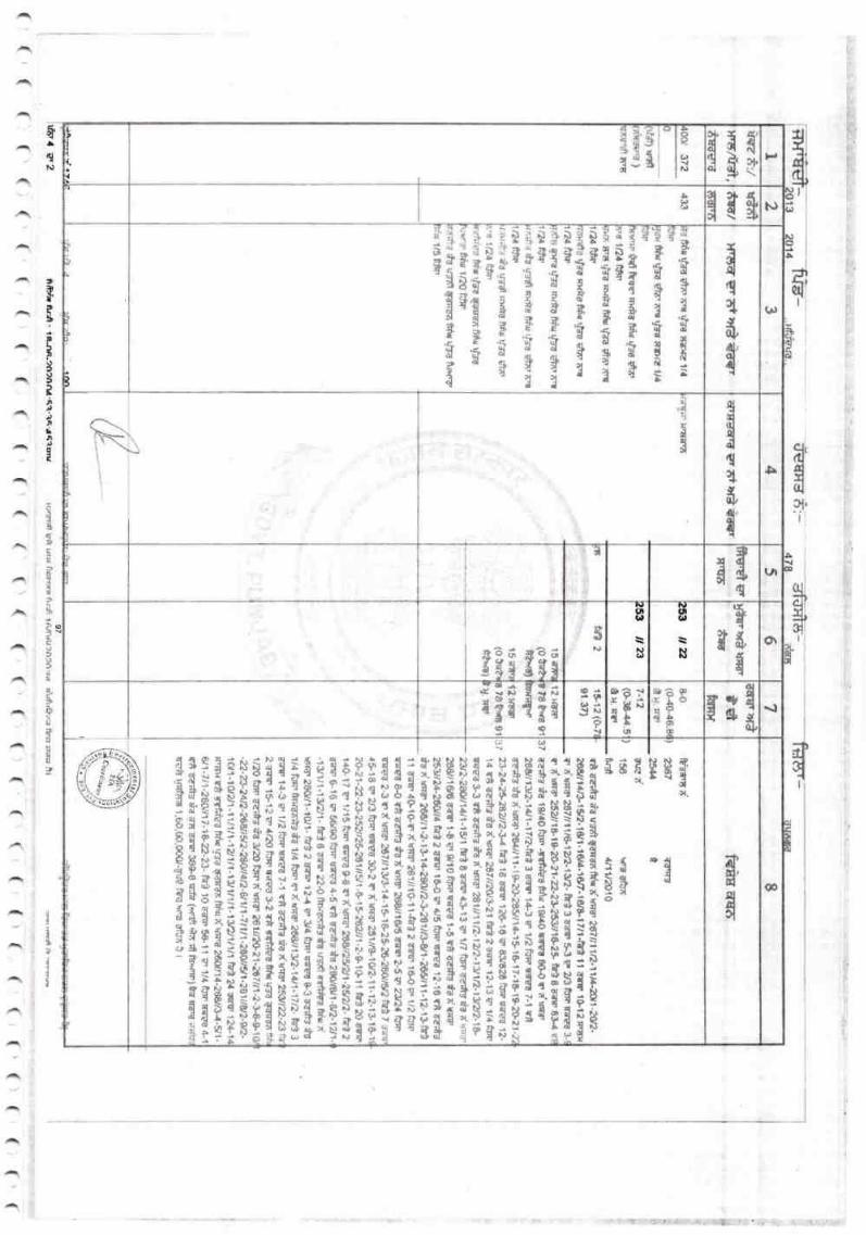
fitdnqclr
I
(lJ
cl.xJ
dI
t.
II{,
{
&H
a,){N
flea*{;3:s
0
$$gll
g t* h)
tv!
f
I,
t
TBlril-"i'?6'S$$i1#'fr
ix+ll
,i$$-$-$T,$],$ do,l
q
{fi,,{r(U
dl{
(r,
ci,dl1i
x$
{d
$dqcl
fi,fr'alat.{
i
II
a iD4s,q
rildcl
(,
$
(,t
\o
rloIq
ilu,{
ss$t s3$
(itt
\ts
t{ r t{a -!({I\) I{N
{fiI{s{93
lo-.f6r
?3
era II$srt
i,
el 6 Trtl()u?d5*fr
srr3 {
il8t'q^cldq
r!fl1t
eI!1,d
$,fld
fl
I?t,
sg
o{l!IBi
$
(D
EA?qi.e
aT:&:la?
il!}
qa{?
ttt"u,dl
No
$a
evilo6l
Tv\
{co{,rl4t4
s
1E$tulislg
*s fl,{;i$$d, Oi
'liargi{3i*lresg$ur5F:rxE6if,sifls;d5r3
Ei$f,
Srd.NNbdJNd-d(.i(}lrda(Jdor{PIPidr,L
Bi$lAB[fr$}EilEATlT$SIif,i6qi$*riiirlflifli H$*1 $Ei
IffiiiiilgEsrrl'a,E:a{s$$utii$
Tf,oolcitir
a :r.
{{6aa
a*8:&Q,lI)1. :dr
{suSi {rl
P8SH:lAdiJ
Pilng
I
NpI0N
N$sQ
i?N6Bn
??
cots
I
;$af,t!*:+-*aBadtaiBq<S€isa
s$t$$sfl3f,$a -lt'do-:uo?qj. l?or3cdils'
E5*$[
ii*$B*[*E$ail. .: Is! lt. a. E! rloc iN
NA
s${--*91 (.t
6'.!'r, il-
8{Tfl{C&{s -:,
SSs{*ile e(,
$a6sEF$N
NJN
f
N6
erIN
arcAN
e
DoQta
No
eNoB
a
e
&
ilg,D
s{
!
I,rl3|ad,dal
I''6a,4tal{$3E?lE{as
t)&aI
T
x:
Nu,
e
IN..!
I0odq
$
{n
{d!.1
$
'
fl1,! dl
s*sl q'
iga8flEil'cPqEry;
il${?rdi
**er !l-;r
"{{;{liola
I$dnl:lelArd|{B
{)l,
{q
fisHIHS,,t*trlt,
t{-i rl
u+
a.laI
I
cN
,3t,?$:,\!
i,I,,niJl
s(
x$l{,,
fun,{
,,s,,\lI:,u)rl
q.
,b\i
ilIIu
t3
.
:
{{
I$:,J
IJ
$
}J
&
E
N
:J|J-retl
I
$l;

(,((( ( ( '( ( u(( \ ,*.1 ( {( {(
ffias-a,
253
1
ts?q"sd
xrg0.5
(*A) u'lEl
376
rrEd
enrrtl-o fos's'rFs EtE? 1/2 t&'a-afi ffi Fce vd6 e.E uYd d=r' 1116
frfrr
t'efrdsfrireq{sdt's 1116
rrra e.b {ys ra:a e'F {rd *' 1/1 6
firhe.s' tr USd gA6 e'F {yd E?r,l fi 6fd{'k< gtr"d tsd qE'-< gt{.d tFJd krdSsu4ttF
Ir ') 3 Alt 5 6 I Itryaf:l)rrs^t*,8'ff9"d
tr&&t
F.Td/
a?ilrr
Hrrtargr?faf3+a(r rrsfqr g' ?r'i'l?l* tffl Sfsr)rf€i {Err
*r;16ptl'rrfj:
3Sfaxx
ffie'rErfi.
7-12(s38{4,1itirgt
ilt 7-12 (S3{
{4.51)
437 Hal?rHrsaf6
(0 t-d?
r€rtit-..
7 ?6rE
(o tde
na'fd
7 a6rr
12 )Gtgr
6 36$rro4+drd--dtF
l2 )firIr.39$o{elu. ra
' flr$ 29/g/2g19<&E3r.6'ri?a fu!.6rtlsd dra 112ftfr sd{a&rlsa sJd"Fd 6ilg' laffiqksdgxrlftd as-c,qrd
_ kd'n' 1/4 frFr <flraiftlrn FJ{'s&d t*
r.5t
r€ a,rad ZNI
nsafud 0rS 171312015 rBtr€Elfrdu-sd rrec${Eduatr.5l 26{/1 1 -1 $&-?s511 14-15.1&17-18.1*tu21 -n-Tl2+*W)
34et 115f19/78742j firEre' 253rl9 e' 1/4 fdfirEirrxfr-68 t{"1
_ ffitr'r' ro-e €rra lrfl 6,00,000/-!118 t{a t€ afuir n gcl t r
2553 ar)
€_-
iid'4 E 3 nffir Rrs . 4 e-nA-?n2noJ,.q1.'{q'rq.lw rrari aft )m kr*?|f3 rAln^r?n2na ,ir0.{}ak{ffi }l
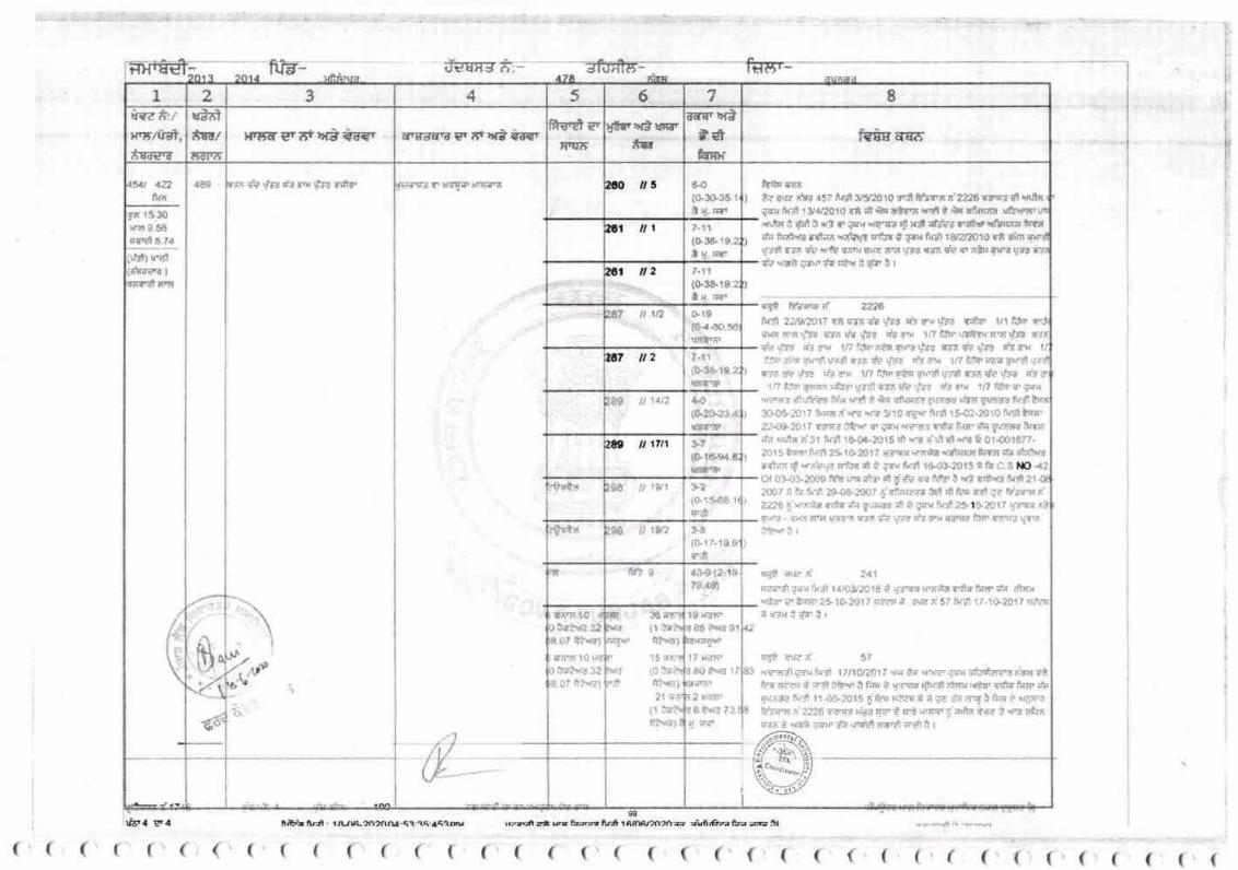
f,mg*-
0iF- Ari . { RJrt-m?n na. {?-a6.a4a@ rPzt t * tu brfr A.i,Armr"o2na afuh'?z Ea a 5trfor4 ?r4
( (((( (((1((((((((((((((('((
1 a 6 B3 4lrge f'rln"gr{d,*r€ry
uInl*Er/lRrrs
Mr,ilnt
XXcrry5lrr'tlilF
rewrySa*fuxr{
Hgas;ryr16,gt5rry${gg 7".EEr6rry gn 6t rrfi i?€r
2to lt 3 6-0(&s3$r*u,rt
&r ilt 7-11
{tr341C.2| {. trrt
ml il2 l-1r(s3&1e.2lx.rr1,
fi7 tt 1,2 s10(x{o.${lrgn}rr
,c? ilz 7.1,
{e3e18"ersrtip
$ ,1t2 4.0
t&:$-23.{;Y'TIiF
a& il 17t1 },,s,1ee{fiutrtt
tic Jilst 12{at$aa rr
s.&
t$st$ $a ilrw s0{I}.r 1.1fi.s
tr,
1t *ls s *a"t{:.{e.79..S)
30{rN{1 ffittr!,!)
15;rrrr
t0 *E"ik[?"t6]?1 ry{
1t te#tp,rtati
rin s{o *Jtl*t$S2i*.o7 Pv4,rAAr'' l0*rdiI fJ?',r{32'8-0f t*,r*]
rrrqh 'frsssrx!?at.slr
):r(6.v
a).
2
3W 4Q
;yr ll.lFrrrs 8-5E
,r{'gls.rd
,it B! r'g!(tuffi)*irat$gr:s
flcrlltr rr;t'{ vll" ffd 45? n jr gsrao t0 Et} Baqr f zz0 v$rg gt riltsE{}{ ar-Jl 1srt2$rs r* *t & dsrys 1!.dl t ,*r' it *?16
t'r.tts i &it t brt {, ryT *r'ra d r$ xffs? r1,}r'rfln6rlltlrBf{ nre'.Brtt{.nDahfs rrfrfi* S{ nr* r8rerfi0r* ?*E
fr'rl 116 ot lrfi ntt}r gxlr lrq VrE raa da v a,& trrr trta* *?S Vt{rrEst},( t ttr t r
q! ftrs* ZAfiif, 22rr2s1:' TSlrrnfrl,rr c"r?r'vg{ r*il r/1 ltlcl
anarsfss srfic.r{y! &rol tlf fdf'\ttf{r{nq{tafir.?l Cra.x ,frfirBrdlgxul].{i qad?SB t's{r ti!trl a*r {i./dtv-#l rgir ss {'/t fr",}. 1I| Hlrmrt?x'dltya qk {re iz su tn ftki feqi ?$rdl rlrsdt lr,"fi dp tly, RI
1n t ,rE!flrsxtti? !.&n r'lr *r $rd *, 0.$ 1,', lUtno px,r*E rrl *r&rsr l|fu ?rut t & rnrAfurll *rg gnae nr$30{6.4017 i{srsr}'t6,rtiil 310 8tr'f flf$ r -20roff,rrl}r5r
&.*fr 1 ? ygss lQtr n ;rx ',e'.rrd "{td l*' Ci }rrrr ff:a
* rrut, a'3r trt tA{a-2O16 {l If6 rrrl d ir! 6 01.00refr.2At5 trs, ftr$ 2fl0&1? U'i'Iq }rrsrnrifrnccnrrr # Bt !1,|?
i,lo
Ot 03.slS0O llt vu #r' il f $e ro f# t *t rd,'rt n{, ?1
200? t fe nrs 2e0S2007 tatr!"-{t *l t1 t!,s s*1 Vr kn sI
ryrit- qlr6 rrHg'ritrr r*t t'r yrq t'ra* 8ryd ffirttrtWt?t{'ilFiir i r
rqo uun z{ 2a1
rra-a'd rnx tl'"Jl t{632o18 i ys{{ }firae "d{
klr' ;r:r dtrr{!,fk' ? trsr ?t 1G?O17 r*r{ t rira s. 57 0{* 17-1}?01? s?rE, rrxi*nt r
tg! !r,r? t' 57
aiux-S qatr &r$ Llll{y?01l 4{n t* u'rsr {mr rfg{fspa rrag rAt?r P"fid ililtiir{fl i fi.n t y*'w {tel*xrr.E? rsta{*a'*hgrrsre trCl ti {$20t5 f &g fie"r * S f*
"? eq i *r,r t v-ax'a
It?{'s ri 2X 6 ?$rJl ,aa g? f s'g wrar g ;;lfir trA 3 d.s akJir{r' I *at irax r" \FdEt v|"91 erli t r
6
1*n{a86 &rd 81
l7 rds1
6q*u? I
eiryrs?-g rr l{ttmxrEim
,1
i
I
( (( ('( ( 1 ('( ( (
ftnr- -?ftffi til"rr- - ----l
5 ,
",1tl /
{/--
ANNEXURE
A]YI{EX(IRES
I'l_(
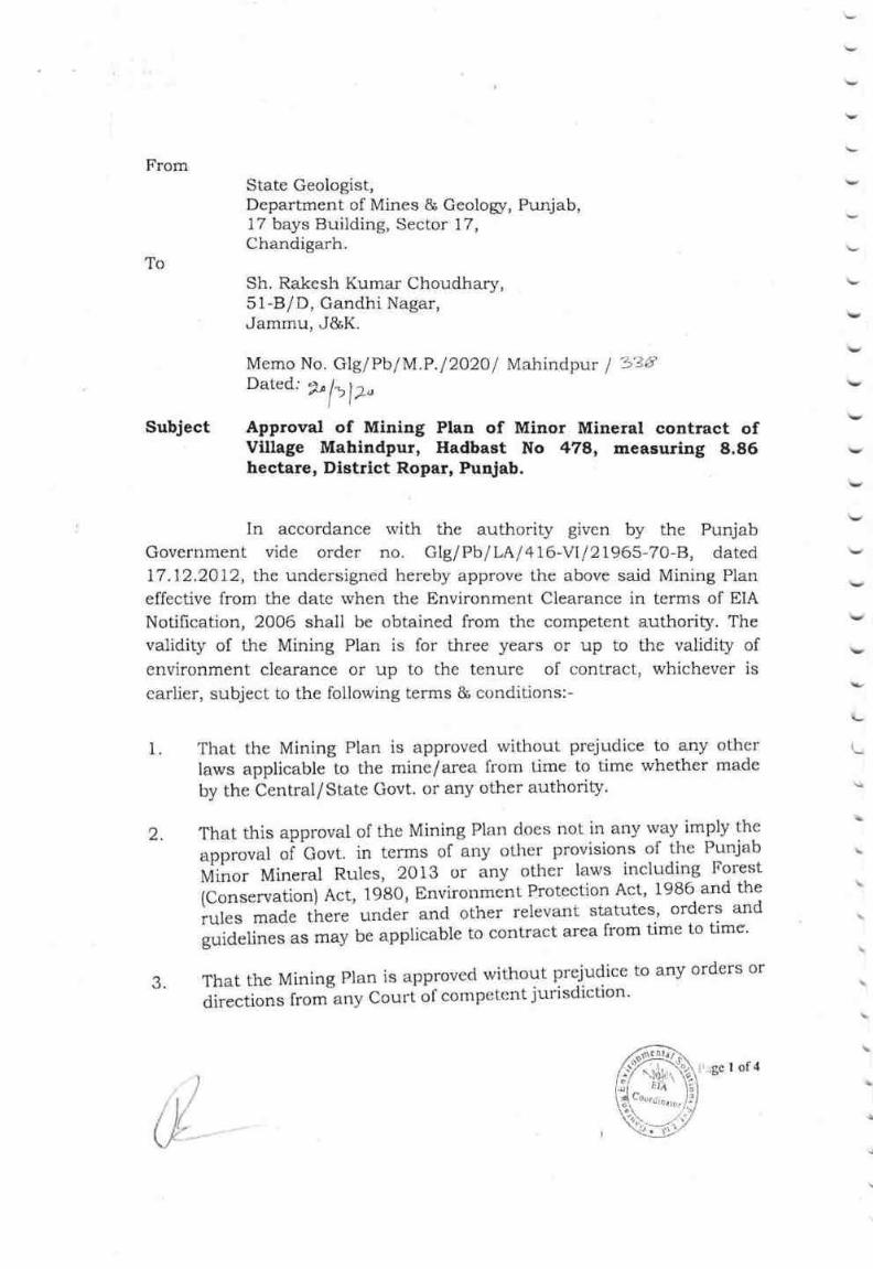
FromState Geologist,Department of Mines & Geologr, Punjab,17 bays Building, Sector 17,Chandigarh.
ToSh. Rakesh Kumar Choudhary,5l-B/D, Gandhi Nagar,Jammu, J&K.
Subject
Memo No. Glg/PblM.P.l2O2Ol Mahindpur I 3'B{tDated; ?n lyl z.
lt'
Approval of Mining Plan of Minor Mineral contract ofVillage Mahindpur, Hadbast No 478, measuring 8.86hectare, District Ropar, Punjab.
In accordance rvith the authority given by the Punjab
Government vide order no. GIg/Pb/LAl 416-VIl21965-7A-8, dated
L7.12.2A12, the undersigned hereby approve the above said Mining Plan
effective from the date when the Environment Clearance in terms of EIA
Notification, 2006 shall be obtained from the competent authority. The
validity of the Mining Plan is for three years or up to the validity of
environment clearance or up to the tenure of contract, whichever is
earlier, subject to the following terms & conditions:-
v
\,
v
v
v
\,
v
v
\-
\
\
1 That the Mining Plan is approved without prejudice to any other
laws applicable to the mine/area from t^ime to time whether made
by the Central/State Govt. or any other authority.
That this approval of the Mining Plan does not in any way imply the
upprouut oi ^Covt.
in terms of any other provisions of the Punjab
tf,ii"or Mineral Rules, 2013 or any other laws including Forest
(conservation) Act, 1980, Environment Protection Act, 1986 and the
rules mad.e there under and other relevant statutes, orders and
guidelines,. *uy be applicable to contract area from time to time.
ThattheMiningPlanisapprovedwithoutprejudicetoanyordersordirections from any Couri ol competent jurisdiction'
2
a
\
&; :ge I of 4
i
!

4 ?hat in case State Gcologist, Oeologist, any other authorizrdoflicer/official, after field inspection notices that proposals madeand workings shown in the mining plan by the RQP need certaincorrections/amendments due to change in conditions either naturalor manmade, the authorizecl officer can recommend necessaryamendments in thc Mining Plan at any point of time in the interestof environrnent and mineral conservation.
That the concession holder shali carry out production of mineralstrictly in accordance to the production shown in Mining Plan.
'lhat no person shall undertakc mining <-rperations in any miningcontract area, except in accordance rvith approved Mining Plan.
That the concession holder shall carry out working in the miningcontract area only after obtaini:ng permission to work from thecompetent authority.
That if the mining operations are not carried out in accordance withthe approved Mining Plan the State Geologist, Geologist, AssistantGcologist or the Mining Officer, may order suspension of all or anypart of the mining operations and permit continuation of only suchoperations as may be necessary to restore the conditions in themine as envisaged under the said Mining Plan.
That if anything is found to be concealed as required under variousRules and guidelines pertaining to mining in the contents of theMinir:g Plan and the proposal for rectilication has not been made,the approval shall be deer:red to have been withdrawn withimmediate effect.
10 This approval for mirring operations and associated activities isrestricted to the mining contract area only. The mining contractarea is shown on the statutory plans.
1 1. Where any pillar is left 'in situ' for the purpose of measurement, itsheight shall not exceed 2,5 metres; and where the height of suchpillar exceeds 1.25 metres, the base of the piilar shail not be lessthan 1.6 metres in diameter.
5
6
7
8.
9
&l'age 2 of 4

v
v
12. No working shail be made within a distance of 7.5 m of the leaseboundary as required under MMR 1961,
13. Sand will be collected in slices of maximum thickness up to a depthnot exceeding 3.0 m or above the ground water level or above therecl line, whichever encountered first.
14. Stream will not be diverted to form inactive channel.
15 No mining operation sha-ll be carried out of any point within 75 m ofrailway linc or 50 m lrom National Flighway or 50 m from I{.T Line,any public works, reservoirs, tank, canal, public roads anclbuildings or inhabited or 1O m of outer edge of any village road.
16. No mining shall be carried out 100 m in side and 500 m outside ofthe flood protecting bandh of the major river.
L7. No mining shall be carried out within 500 m on the upper side andlower side of the high level bridge on the rivers, Similarly no miningshall be carried out r,vithin 25O m of upper side and iower side ofother bridges.
18. All provisions in safety rule & regulation will be maintained byproviding required materials to the employees and there will be noviolation of safety provisions.
19. Plantation will also be done along with the contract boundary orplantation will be developed in an area identilied by the local grampanchayat.
At any stage, if it is observed that the information furnished in thedocument are incorrcct or misrepresent facts, the approval of thedocument shall be revoked with immediate effect.
2t The concession holder in accordance to provisions contained in thePunjab Minor Mineral Rules, 2013 shall deposit requisite sumtowards Environment Performance Guarantee and EnvironmentManagement Fund.
22 If any comments are received from the State Govt. then thenecessary action as per comments shall be taken immediately.
20
Ilge 3 of4

J
23 The permissible limit of exlraction shall be 63,991 TPA and mode ofmining shall also be as per its environmental clearance.
End :- one copy of approved mining plan.
GeologistPunj1{
Endst. No. Glg/PblM.P.l2O2Ol Mahindpur I Zz -k, nated:i"[]i a
Copy for information to:-
(1) Chief Engineer (Mines), Department of Mines and Geologr, Sector-
18, Chandigarh.
(2) Executive Engineer-cum-District Mining Officer, Ropar.
e.
1"
oC\
190r\"
$"o .c
N#
I'age 4 of'4
l
)
t'1,"itlt t;*

v
V
v
v
v
n,{lhx),{(; I}l .,\Nr$'-r,-t.t t)tNr;
trl{(x;l{r,ssl VH, sl I N I,. ('l,t}st rt{tr;l PL,tN(Submitted under Rule 48 (IV) of Punjab Minor Mineral Rules, 20l3and Sustainable Sand
Mining Management Guidelirre 2016 issuedby MoEF&CC)For
"\I't II{..x*iPt i},i. (;Id.{\' trI }I I \ Ii"Block No, - I
HadbastNo.-478
Near Village - Mahindptu
Name of River - Soan River
KhasraNo.-. 253 /1,25311211,25311212,253113,253114,253117,?53118,253/19,2531i10,
2531111,25311t2,2531113,25311t412,2531115,2531116.2531117 ,2531178,2531123.253/124,253 I 125, 260/ I 3, 26A/ I 4, 260 I I 5, 26A I 17, 2601 18,
Mineral -River Bed Material [Gravel(Minor Mineral)]
Lease Area -8.86I{a. (Non- Forest)
District- Ropar (Rupnagar)
State- Punjab
Mining Plan Period- 3 years fi'om the date of registration
I { ' :"\rrl }) i",
ARUN KUIUARYADAY
RQP/AJMt242/2003/A, Validiry-21'tMay,2023
{}V tilt$ I':Jt S Xl I N'f I::('l I fl ( }ISt i I "'f AN.l'!iIS0 9CI01-1008 .t NARn'f Accrctlitcd IilA Cunsultttlrts
SHRI
Addrcss-5
Vide
CH()
$rr fr,t'i) fL o*':r':gv
501 , Sth fluur, Al'ex'l'orrk
l{oael. J,
'l'rl. No. (ll,ll ,l
Motrilc
Wr-trsitu:,Eall"\ti.l
l)
K
ll-Mli l-anrrr"otntr:,ir

Mtrbile No.-+9 I -911 921 9028.
E-Mai l-ral< cshttrlres 1 2(@gntai I . conr
RAKESH KUMAR CHOUDHARY
Address-SlR/D Gandhi Naqur. .larrnru J & I(,
AUTHORISATION
I, Rakesh Kumar Chourlhary, hcreby authorise Shri Arun Kumar Yadav,
RQP/A.IN,I/?4212A$/,\,and Validitv2l't May, ?023 to prepare the Minrng Plan including
Progrcssive Mirre Closure Plan under Puniah Minor Mineral Concession 2A13, and
Sustainable Sand Mining Management Guideline 2016 issued by MoEF&CC, in respect of
River Bed Material fGravel(minor rnineral)] of "Mahindpur Gravel Mine" Block No, -1,
Hadbast No. -478, having total area o[ 8.86hectare (Non- Forest), in Village -Mahindpur,
Narne of River - Soarr River, Tehsil- Nangal, l)istrict- Ropar (Rupnagar), State- Punjab.
I request the Executive Engincer Cuni, District Mining Ot1icer, Ropar (Rupnagat)
(Rupnagar), Punjab to make further corre.spondence regarding submission /modification /
withdrawal / re-submission and to collect tlre approved copies of the aforesaid Mining Plan
Including Progressive Mine Closure Plan with the said recognized person on his following
address: -
.r
l:
Arun Kurnar Yadav
RQP/AIM/2421200314,
Validity 21*May,2023
501, Apex Tower,
Torik Road, P.O. Jaipur-302015(Raj.)
E-mai l- guuu&y ersc il$r!r-l q$ h.qp- r-r.
Website-S1yq,CIv,q1$Siyitlt UISAI,cOU
Telefax- 01 4 l -27 44 509, M-+9 I -9460221 084
Placc
ljttcir)r-l /(.,rarrci,qer.i^i
drv
6),;D
c'cn
o* t
Date
t{ Kumar Choudhary
.l
(

OYU,RSEAS MIN-TIICH CONSULTANTSAn ISO 9001:2008 Certified & IYABET Accredittd IIIA Consultants
50l,sth F'toor, Apex Tower,'l'onk Ronrl, Jaipur-302015' cl +91 -l 4l -27 44509. Fax No. 0l 4 l -2744509 (O), M ohile: +91 -9460221 084
E-mail: lrun.omtc(n)utrtsil.$orn, Wcbsite: lvtr'Xrol'u'sensrlirrlech.corf! I
!'\
caRJrrrrcAT0
I, Arun Kumar Yadav(RQP), hereby ccrtify that,
l. "The provisions of Punjab Minor Mineral Concession 2013 and Sustainable Sand Mining
Management Guideline 2016 issued by MoEF&CChave been observed in the Mining Plan
including Progressive Mine Closurc Plan, for River Bed Material fGravcl(minor mineral)] of
"Mahindpur Gravel Mine" Block No. -1, Hadbast No. 478, having total area of
8,86hectare(Non- Forest), in Villagc -Mahindpur, Nante of Rivsr - Soan River, Tehsil-
Nangal, Disrict- Ropar (Rupnagar), State- Punjab of Shri Rakesh Kumar Choudhary,
wherever specific pennission is required, the applicant will approach the Competent
authority {br granting the permission."
2. It is also certified that the prnvisions of Mines Act, Rules and Regulations rnade therc
under have been observed in the aforesaid Mining PIan including Progressive Mine Closure
Plan and wherever specific pennissions are required, the applicant will approach the Director
Ceneral oflMines Safety.
3. tt is further ccrtified that the afrrrcsaid Mining Plan including Progressive Mine Closure
Plan is prepared as per the copies of'the records and documenls provided by the licence lrolder
and infomration given as per discussions held with applicant's representativc.
4. It is also certified that the infonnation funtished in the aforesaid Mining Plan including
Progressive Mine Closure Plan are true aud correct to the best of rny knowledge & belief and
in case of default the approval would be withdrawn.
v
V
Place : .laipur
f)ate:
Arun Kumar
j RQP/A '4,
Vnlidfty v 2A23\l
i
i1l
'^.:\'ta

Ivlobil 0 fi tl.-+ t) I -94 I 921 q028.
h. -fu{ai I -l al< csh Lu [:es I 2 iliig rrrai I .crl nr
RAKSSH KUMAR CT{OUI}HARY
Acklress-.51 BiD Gantlhi Nirgar, .lamtnu J & K,
CERTIFICA'I'E
l. It is certified that thc provisions of the Mines Act, Rules and Regulations made there
under have been observed in the Mining Plan including Progressive Mine Closure Plan for
Itiver Bed Material fGravel(rninor rrrineral)] of "Mahindpur Gravel Mine" Block No. -1,
.Hadbast No. -478, having total area of S.tl6hectare(Non- Forest), in Village -Mahindpur,
Name r:f River - Soan River, Tehsil- Nangal, District- Ropar (Rupnagar), State- Punjab of
Strrj Rakeslr Kurnar Choudliary, aud wherever specific permissions are required, the applicant
will approach the I)irectol General of Mines Satbty. F'urther, the .standards as prescribed by
f)irector Ceneral of Mines Sal-ety in respect of mincr's health will bc strictly implcmented.
2. 'l'he Mining Plan including Progressive Mine Clo.sure Plan fbr River Bed
MaterialfGravel(nrinor minelal)] of "Mahindpur Gravel Mine" Block No. -1, Hachast No. -478, having total alea of 8.86hectare(l''lon- Forest), in Village -Ma}indpuq Name of River -Soan River, l'ehsil- Nangal, District- Ropar (Ruprragar), State- Punjab of Shri Rakesh Kumar
Clhoudhary, complics all thc statutory Rulss, Rcgr,rlations, Orders made by tlre Central
Govelnment or State Government, Statutory organizations, Court etc. and have bcen taken
into consideration. Whsrevor any spccific pcrmission is required, the applicarrt will approach
the concemed autliorities.
,I ).
.j'
:i)
Place
Dats
1.l
".: "Rakesh Kumar Choudhary
&
!.,I
h

N{obile No.-*91 -94 I 92 i 902ti,
tr- t\'tfl.i I -r"aksshtubcs 1 2(r)gmu i I .*onr
}TA KESTX K U i\{AK CX{&{J MffiA${V
Addrcss-51 B/n Grr.n<lhi Nagnr, Jatnnru J & K,
)
f'
1
DECLABATIOIY
1. The Mining Plan including Progressive Mine Closru'e Plan, fbr River Bed Material
[Gravel(minor mineral)] of "Ma]rindpur Gravel Mine"Block No. -1, Hadbast No. 478,
having total area of 8.86hectare (Non- Forest), in Village -Mahindpur, Name of River -Soan River, Tehsil- Nangal, District- Ropar (Rupnagar), State- Punjab of Shri Rakesh Kumar
Choudhary has been prcpared in full consultation with nre and I understand its contcnts and
agree to implement the same in accordance with law and in case of default the approval
wonld bc withtlrawn.
2. It is further declared that during the pendency pcriod of the approval of above said
document or thereaftcr if any change occurs in the name and addrcss of applicant, it will be
infonned promptly,
Place
Date :
t 1,
n;:
:
.l :,^1
Rakesh Kumar Choudhary",r
t
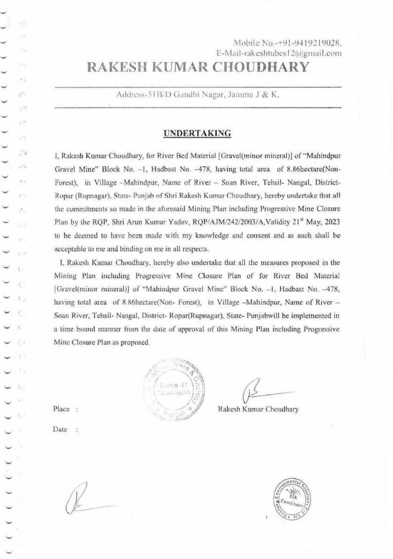
Mobile No.-+91-94 I 92 I 9028.
E- lr.'lriil -r ak eshtutrcs I 2(a)g nrai l.conr
RA.KESH KT.}MAR CHOUNHARY
Aildrcss-5lB,1D Garullri Nagar, .laurtru .l & K.
v
UNDERTAKING
I, Rakesh Kumar Choudhary, for fuver Bed Material fGravel(rninor rnineral)] of "Mahindpur
Gravel Mine" Btock No. -'1, Hadbast No. -478, having total area of 8.86hectare(Non-
F'orest), in Village -Mahindpur, Narne of River - Soan River, Tehsil- Nangal, District-
Ropar (Rupnagar), State- Puniab of Shri Rakesh Kumar Choutlhary, heleby unclertake that all
thc comhritments so made in thr: aforesaid Mining Plan irrcluding Progressive Mine Closure
Plan by the RQP, Shri Anrn Kurnar Yadav, RQP/AJMi}4zl}}l3l{.Validity Zl't May,2023
to be deerned to have been tnade with my knowledge and consent and as such shall he
acceptable to me and binding on me in all respects.
I, Rakesh Kuurar Choudhaly, hereby also undertake that all the rleasures proposed in the
Mining Plan including Progressive Mine Closure Plan of for River Bed Materiai
[Gravel(rninor: rnineral)] of "Mahindpur Gravel Mine" Blocl< No. -1. Hadbast No. -478,
having total area of 8.86hectare(Non- Forest), in Village -Mahindpur, Name of River -Soan River, Tehsil- Naugal, Dish'ict- Ropar(Rupnagar), State- Punjabwill be implemented in
a time bound manner fiorn the date of approval of this Mining PIan including Progressive
Mine Closure Plan as propnsed.
t
' )t I
,lt
.\
Rakesh Kumar ChoudharyPlace
Date
#-
iil
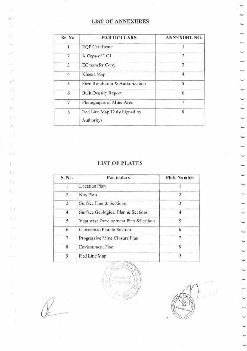
Sr. No PARTICULARS ANNEXURE NO.
1 RQP Cerlificate 1
2 A Copy of LOI 2
-) EC transfcr Cr:py J
4 Khasra Map 4
5 Firm Resolution & Authorization 5
6 Bulk Density Report 6
,7Photographs of Mine Area 7
tt Red Line Map(Duly Signed by
Aurhority)
8
t,IST OT..PT,ATN,,S
S. No. Particulars Plate Number
I Location Plan 1
I Key Plan 2
J Surface Plan & Scctions 3
4 4
5
Surtace Geological Plan & Sections
Year wise Development Plan &Sections 5
6 Conccptual Plan & Scction 6
Progressive Mine Closure Plan 7
I Environment Plan u
I Red Line Map 9
(){-)
t: i:'
LIST OF ANNITXURES
.{.'
. ' . i .r, .i .;'
i . ..., ,.r.r ,r 1r l.r\:iil

TNDEX
CHAPTF]R TTT[,8 PAGE NO,
I lntroduction I
2-42 General Infonrtation
J. Oeoiogy , Reservcs & Rcplcnishrnent study 5,t I
4 Mining t2-15
Blastiug r65.
166" Mine Drainage
Disposal of'Wastc I6
Use of Mineral t6B,
9 Mincral Bcneficiation t7
t0 Site Services 17
18il. Employnent Potential
Environment Management Plan l9-25,t2.
2613. Any Other Infomtation
Progressive Mine Closure Plan (PMCP)
Chapter- I to 13
2740
I r''
:,']
\
)/ l1'
tl/t!-
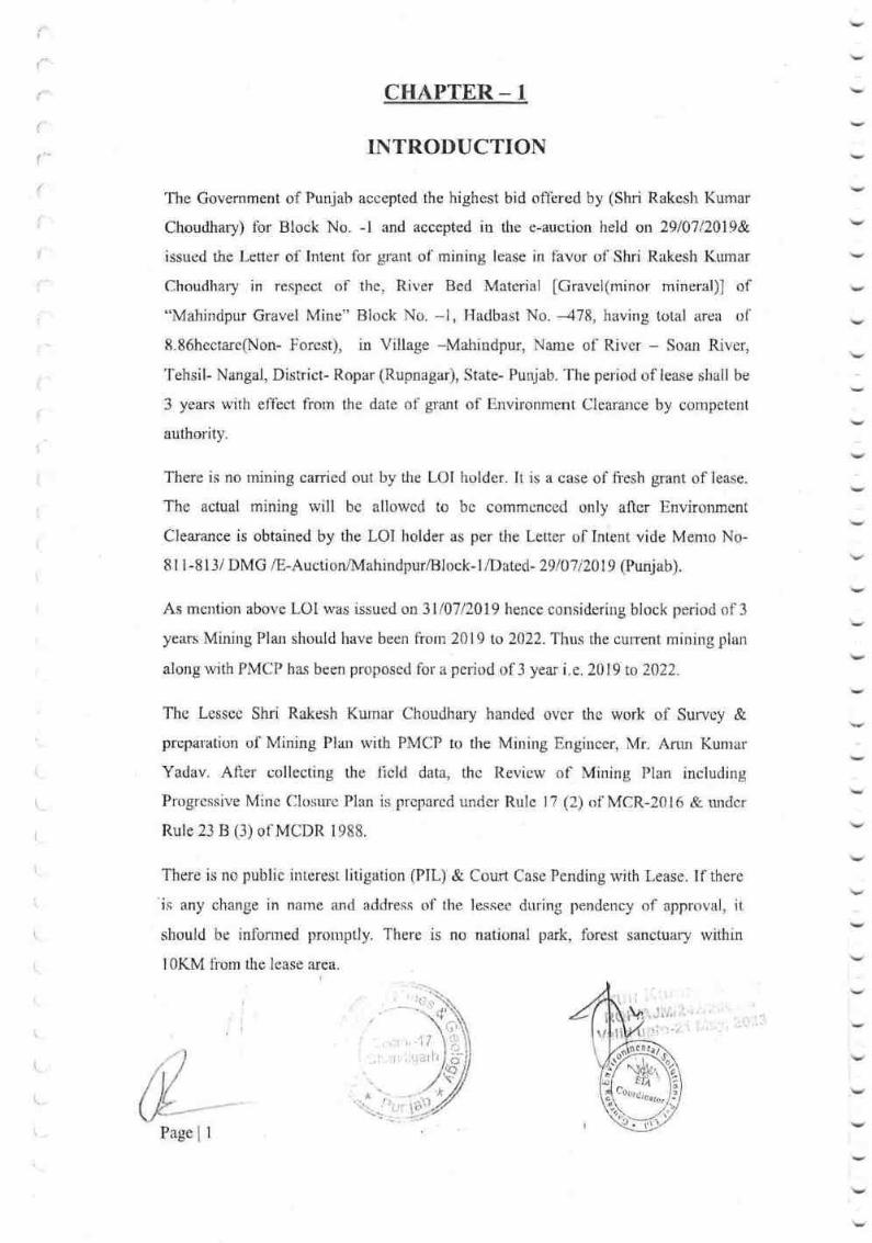
CHAPTER _ I
I]\TRODUCTION
llte Govemment of Punjah accepted the highest bid otlered by (Shri Rakesh Kumar
Choudhary) for Block No. -l and accepted in the e-auction held on 2q10712019&.,
issued lhe Letter of Intent for glant of'mining lease in favor of Shri Rakesh Kumar
Choudhary in respect of the, River Bed Material fGravel(minor mineral)l of
"Mahindpur Gravel Mine" Rlock No. -1, Hadbast No. --478, having total area of'
8.86hectare(Non- Forest), in Village -Mahindpur, Name of River - Soan River,
'Iehsil- Nangal, District- Ropar (Rupnagar), State- Punjab. The peiiod of lease shail be
3 years with effect from the date of grant of Environment Clearance by competent
authority.
There is no rnining carried out by tlie LOI holder. It is a case of ii'esh grant of lease.
The acfual mining will be allowcd to bc commcnced only aftcr Environmcnt
Clearance is obtained by the LOI holder as per the Letter of Intent vide Memo No-
8l 1-813/ DMG /E-Auction/lrdahindpur/Block-l/Date d,- 29lO7l\0l9 (Punjab).
As mention above LOI was issued on 31fi7/?019 hence considering block period of 3
years Minirrg Plan should have been llonr 2019 to 2022. Thus the cument mining plan
along with PMCP has been proposed for a period of 3 year i c. 2019 to 2022.
There is no public interest litigation (PIL) & Cou( Case Pending with Lease. If there
is any change in narne and address of the lessee during pendency of approval, it
should be inforrnsd prornptly. There is no national park. fbrest sanctuary within
1OKM fiorn the lease area.
(.r ).lt
r')-/. ; i.'::
t'1,l
I
r!.
l.'r)
CoordirD0t0r
Page I I
The Lesscc Shri Rakesh Kunar Choudhary handed ovcr the work of Survey &
preparation oliMining PIan with PMCP to the Mirring Engincer, Mr. Arun Kumar
Yadav. After collecting the flcld data, the Review of Mining Plan including
Progressive Mine Closure Plan is prepared under Rule I 'l (2) of MCR-2016 & turdcr
Rule 23 B (3) of MCDR 1988.
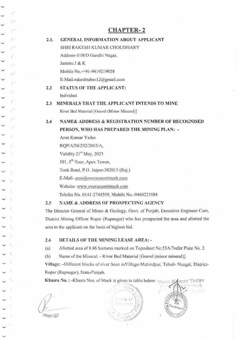
CTIAPTDR.2
2.1. GENERAL INFORMATION ABOI]T APPLICANT
SHRI RAKESH KUMAR CHOUDHARY
Address-5t hllf) Gandhi Nagar',
Jamrnu J & K
Mobile No.-+9 I -941 9219028
E-Mail-rakeshtubes I [email protected]
2.2 STATUS OF THE APPLICANT:
Individual
2.3 MINERALS THAT TIIE APPLICANT INTENDS TO MINE
River Bed Material [Gravcl {Minr:r Mineral)]
2.4 NAMB& ADDRESS & REGISTRATION NUMBER OF RECOGNISEI)
PERSON, WHO HAS PRIPARED THE NIIFIING PLAN; -
Arun Kumar Yadav
RQP/A.rMl242t2a$lh,
Validity 2l't May,2023
501, 5rh floor, Apex Tower,
Tonk Road, P.O. .Iaipur-302015 (Raj.)
E-Mail- arun(&ioverscg$Jninteclt.conr
Websi te- www,everspa^sfni nI-ech. corn
Telefax No. 0l4l -2744509, Mobile No.-9460221084
2,5 NAMB, & ADDRESS OF PROSPECTTNC ACENCY
f'he Director General of Mines & Geology, Govt. of Punjab, Exeoutive lJngineer Cum,
District Mining Officer Ropar (Rupnagar) who has prospected the area and allotted the
area to the applicant on the basis of highest bid.
2.6 DI,TAILS OF'THE MINING LEASE AREA: .
(a) Allotted area of 8.86 hectares marked on Toposheet No.53Al7refer Plate No, 2.
(b) Narne of tlie Mineral: - River: Red Material [Gravel (mirror mineral)].
Village: *Difl'erent blocks of river Soan inVillage-Mahindpu', Tehsil- Narrgal. District-
Ropar (Rupnagar), State-Punjab.
Khasra No. : -K.hasla Nos. of btock is givcn in table below -i:.rriir
i,)ii;
Itlgu,il22

2.8J:- Post Oflice: - The neeuest post office is located in Mangewalwhich is losated
at a distance of 1.0 krn from the allotted area.
2.8.42- Medical Facilities: -'fhe nearest hospital is situated at Mahindpur,
2.8.5:- Availability of water: - Water for drinking purpose is brought from nearby
villages. The water of hand pump and well located nearby the area is potable and
being used by the villagers, habitants and labors.
2.8.6:- Electricity: - The elecffic line is passing tl"rror-rgh the ailotted area. Electricity
required for mining will be supplied by Punjab Bijli Vitaran Nigam (PBVN).
2,8.7:- Educational Facilities: - The school and College facilities are available at
Mahindpur.
2.8.8:- Mode of transportation of Mineral: - The allotted area is approachable by
SH-25 approximately 20 Km. Minerat will be transported by hucks / f)umpers from
the site to thc oonsumers.
2.8.9:- River/ Canal: - Soan is a river, which is flowing from NW-SE direction.
2.8.10:-Port: - Thc nezuest port is Kandla port which is about 1250 Km fi'om the
allotted area.
2.8.11:- Other relevant information: - Banking and all other essential infrastrucflual
lacilities arc available at Nangal.
, ri" 1 ,1'
i it:.;.lt'h
)t
'*'fl)r,()
*
Page 1 4
,t
1
CHAPTER - 3
3.1 Physiography
The allotted mine lease area is a river bed with gentle slope from NW to SE.
There are surface area in found mixed with rjver Boulder, Gravel and sand. The
gencral topography of the area is gsntly sloping with drainage pattem of the river
Sutlej, it is floodplain area, There is highest 285.896mRL& lowest 283.210mRL. The
Sutlej River is carrying out sediment loads from the plains,
There is no protected or reseryed forest in and around the allotted area. There
is no habitation within allotted area.
3.2 Climate
The district receives normal annual rainfall af 776 mm, which was spread over 4l
days. 78% of the annual rainfall is conbibuted by southwest monsoon. Geuerally,
rainfall increases fl'om southwest to norJheastem part of the district. The climate of the
diskict can be classified as tropical steppe hot and semi-arid type.
3.3 Geology
3.3.1 Regional Geology
The district mainly constitutes alluvial deposit which abuts against the Siwalik hills on
the nodh and north east direction. The main geological units occuning in the
Rupnagar district are given below.
*
Page | 5
/,7(#-
I

I
l
Age Super
group
Groupl Formation Lithology
Quaternary Older and Newer
Alluviurn and Acolian
Deposit
Crey & brown sand, silt, silt-clay, clay
with calcrcte, limestone and gypsum.
'fertiary Siwalik
Super
Group
Upper Siwalik Boulder congl omerate, sandstone, clay/
Mudstone and pebble beds.
Middle Siwalik Sandstone with variegated clay/
mudstone
Lower Siwalik Sandstonc, mudstone/shalc,Fine grained
sandstone, clay and limestone
Proterozoic Delhi
Super
group
Ajabgarh Group Quarlzite and basic flows, mica-schist"
carbonaceous phyllite and slate, calc-
schist, dolomite, marble, catc-silicate,
amphibolite, hornblende-schist, phyllite
Alwar Group Quartzite, conglomerate, amphibolite.
mica-schist and arkosic quartzite
Table - 3.1
3.4 l",ocal Geology of the area
The allotted area is the rivEr course of Soan River. It is a river bornc dcposit which
comprises ol'sand channels formed duc to annual deposition. The upper surfbce in
teraced area covered with Coarse to rnediam soil where agriculrure {ields are
developed by local people, Geologically, allotted area is belonging to Quatemary.
Boulder, Gravel and Sand are the major litho unit observed in the allotted area. The
stratigraphic sequence of the litho units present in the area are as follows:-
Quaternary-All uvial mixed wI Boulder, Gravel & sand Older deposition
of river sand unit Basetl on the structurni of the allotted area, surfhcerl
l
i
t,
'ir
I
,t
Page | 6
!i
ir

Geological rnapping has besn done and a Surface Geological Plan with cross-sections
& longitudinal sections has been prepared on a scale I :1000.
3.5 Deposition of Minerals in River Bed: -
r Running water is the most imirodant agcnt of erosion on the continents and the
skeam valleys are the most common landforms.
r River gradually rnoulds the land by eroding away the material in some place
and depositing it in other placc.
r A nver system consists of a n:ain channel (trunk stream) and all of the tributar:ies
that flow into it or joining the trunk stream.
3.6 GEOMORPIIOLOGY AND DRAINAGE PATTERN: -
The entire district can bo grouped into 4 units such as Siwalik Hills, Intermontane
valley, alluvial fan and alluvial plain, The Siwalik Hills separates the main Himalayan
ranges frorn the Indo-Gangetic alluvial plain. lte area is highly dissected and has an
uneven topography. Adjaccnt to the hills is a long narrow intennontane valley, which
extends from Nangal to Ropar(Rupnagar)(Rupnagar) trending northwest to southeast.
Anandpur Sahib tehsil of the district lies in the internrontane valley and occupies a
length of 40 km. The averagc width of thc valley in the district is 5 km. Sutlej River
and its tributaries drain this valley. Adjacent to this is the alluvial fan which forms the
trausitional area between the alluvial plains and hitly area of Ilimalayan foot hills. "fhe
coarse sediments brought down by hill torrents forms the alluvial fan depo.sits. lhese
alluvial fh.ns coalcsccd to form Kandi and Sirorval formation. The southem part of the
district is mainly alluvial plain, which fonns a part of vast Indo-Gangeticalluvail plain.
3.7 DETAILS OF EXPLORAI]TON
(A) ALREADY CARRIED OUT IN THE AREA
The exploration of mineral fuver Bcd Material [Gravel(minor mineral)] has been
canied out by the Department of Mines and Geology, Punjab. The river borne
sediments are deposited all along the Soun riverbed and are very well exposed on the
surface. Moreover, thesc sedirnenls are accumulated every ycar during rainy season
dcpcnding on the intcnsity of Rain/G ctivity. Aocordingly. the statc govt. has
floated the bid {'or its auctiorr.r/
Arr17z r
l
\
Pagc | 7
)r
:.,-i, 'r" It'i, . i'ir,,.ii ]i i'
& \

(B) PROPOSED TO BE CARRIED OIIT
T'he rnineral sand is exposed all along the Soan river bed, so there is no need of
further exploration in this area. Also as per the condition of LOt there should be no
excavation below 3 meter from flre un- rnined bed tevel aL any point, so no ftlrther
exploration is proposed.
3.8RDSER!'E ESTIMATI ON:-
For estirnating the reserve of Itiver Bed Material [Gravel (Minor Mineral)] the
following paramcters are considercd as fallow:-
a) 'I'he reserves are calculated on the basis of the established width, thickness and
strike/influence of the mineralized formation in the area.
b) The entire reserve of River Bed Materjal [Gravel fMinor Mineral)] upto ttre
depth of 3 meter are calculated.
c) The Mineable area has been considered with an [Jltimate depth of 3 meter (for
river bed) for the calculation of the l'eserve. It is considered by Joint Inspection
Commiftce (JIC Report cnclose as Annexure-9).
The tonnage estimation, the reserve quanrity is multiplied with the bulk density of
l.Stonnes per cum For River Bed Material [Gravel(Minor Minsral)]) as pel Lab report
(Lab Report enclose as Annexure-6).
d) Reserve has becn estimated considcring the lsvel of Red linc after conducting
fresh topographical survey by DGPS. Original grountl level established is based on
DGPS survey which is correlated with the data (RL) provided in Red line map by
competent authority. (Red Line Map Enclose as Platc No. - 9).
e) Neither Mineable reservc estimated below the Red line level nor proposal for
excavation made below the Rcd line lcvel.(As per the Sustainable Saud Mining
Guideline 2016.)
0 Roseive has been calculated using cross-scctional area method of estimation.
s)
Thc mineral reservcs are comprrtcd as per LINFC are as lbllows:
Table:3.1
Prov*il fvlineral Resetvs i
['rob*ble rnineral Reserv0;.
Catcgary UNFC Codc
.r'i'
Quantity (in NIT)
A. toial Mineral Reservs,1
\II
Page | 8
.r 1 &122
.t^

a*'
f*.
ICategory I"INFC Code Quantity (in MT)
B, Total Remaining Resouroes
Feasibil ity mineral Reso urce 71t
Prefeasi bility mineral resouroe 221 k222
Measured mincral resource 33t
lndicated rnineral res0urce 332
Inf-erred mi neral resource 333
Reoonnaissance mineral resource 334
Reserves in MT= = Cross-Sectional area (in sqm) x influence length (in mts) x Bulk
Density (1.8 t/m3)
The reserves of River Bed Material [Gravel (Mirror Mineral)] calculated by volumetric
rurethod and are summarized here below:-
Table: 3.2
TOTAL RESERVES A5 PER UNFC CODE
(BLOCT(-r)
I. Geological Reserves: Cross-scction area (sqrn.) x Influence length (in rnts) x Bulk
Density ( 1.8 t/m3)
Section (A-A') = 134.2812x 206x 1.8
:49791.46MT
Section (B-B'): 72.05012x 206x 7.8
:26716.1tlN{T(l t'
II. Mineable rescrves = Cross-Section area (in sqm.) x
Dcnsity (l.tl Vm3)
Sectiorl (A-A'): I16.8473x 198.5x 1.8
:41749.55MT
in rnts) x Bulk
ion (B-B')
,.t'
I I r"r';I Irr
\,,Ir. ir i; i,,:l;'Jt il
(;)(1)
(-:)
* ',tt,
Sr.
Nu.
Name ofthc Quarry
Lcase
Area [nHectarcs
Total Proved
Geological Reservcs
MT= Cross-
Sectional &refl (in
sqm) *influence
length (in mts) *
B.D (UNFC code 111)
Reserves in
Blocked
7.5m. Safety
BarrierArea(MT)(UNFC
Code
21t*222\
MineableRcscrves(
MT)
I Mahindpur Gravcl
Mine
886 76507.64 12516.64 63991
Page | 9
62,24868x 198.5x 1.8
' !,.
')
I'iii;,/
,*
:22241.45MT
III. Reserves in Blocked (7.5m.) Safety Barrier Area = Geological Reserves(MT)-
Mineable Reserve(MT)
:7 6507 .64(MT)-63 99 1 (MT)
:l25L6.64lltT
PROPOSED PRODUCTION
The mineable reserve estimated within the mining lease area is 6399lMT (as per current
Topographical DGPS Survey).However, depending upon the annual replenishment of the
mineral the quantification of mineable reserve may be reduced or increased accordingly.
A) BALAI\CE RtrSEYERS
For balance reserves it is presumed that the mineral will be replenished every year during
the rainy season. River bed material [Gravel (Minor Mineral)] will be added every year in
the river bed. Thus quantification of mineable reserve may be reduced or increased
accordingly.
Life of mine: - As river bed material deposition is a continuous prosess depending on
the onset of monsoon / rainfall & the mineral reserye will be replenished every year
hence life of mine cannot be computed.
f) Surface Plan and Section-Plate No.-3
g) Geological Reserves - Plate No.-4
r:t I
t
Page | 10I
I
CHAPTER.4
MBTTIOD OF MINING
4.1 Present Method of Mining: -
It is a case of fresh grant of lease. The actual mining will be allowed to be commenced
only after Environment Clearance is obtained by the LOI holder as per the consent
letter, dated- 3110712019. Presently, no mining is carried out by the LOI holder in the
allotted area.
4,2 PROPOSED RATE OF PRODUCTION WHEN MINE IS FULLY
DEVELOPED:
The required rate of production is around 6399lMT of mineral. The required target is
planned & will be achieved during each year & maintained thereafter.
4.3 MINERAL RESERVE AND ANTICIPATED LII'E OF MINE: -
The area for the mining of River Bed Material [Gravel (Minor Mineral)] has been
concession for a period of 3 years from the date of registration. Accordingly, the
annual production targets have been planned, which will be 6399lMTlannum. For the
next three years.
. The cstimated mineable reserve is 63991MT and the proposed production is in line
with the annual concession quantity allowed to the mine from the block-l, araa-
8. 86(Ha) vill age-Mahindpur, Tahsil- Sri Chamkor Sahib, District-Ropar.
4,4 PROPOSED METIIOD OF MINING: .
a. Mining will be done by deplolng earthmovers like excavator, Backhoe loaders for
loading of mineral into trucks, tippers and tractor/holleys.
b. Mining will be restricted within the central 3/4th width of the river.
Manual excavation will be carried out where evpr the channel width is less than
478mtrs
.. , tli.;,r.f
, r.,i.ll il.J
rrr
I
t' I .rt
' 1.,
l/:"
Pagelll

c. The slope is maintained at 45o liom the horizontal width & bench height has been
taken 3 meter. Mining operation will be restricted to 3 meter.
d. No working shall be made within a distancs of 7.5 meter of the lease boundary as
required under MMR 1961 and no mining operation shall be carried out of any point
within 75 meter of railway line or 60 meter from National Highway or 50 meter foom
H.T Line any public works, reservoirs, tank, canal, public roads and buildings or
inhabited or l0 meter of outer edge of any village road.
e. No mining shall be carried out 478 meter in side and 500 meter outside of the flood
protecting bandh of Major River and No mining shall be carried out within 500rn on
the upper side and lower side of the high level bridge on the rivers. Similarly no
mining shall be carried out within 250 rneter of upper side and lower side of other
bridges.
f. When the mining will be canied out in the river bed, the LOI holder will intirnate it
7 days in advance to Chief Engineer, Drainage and cany out the operation such that it
doesn't affect the flow of river or damagc embanhnents and will ensure that sand
excavation is carried out strictly in accordance with advice of the Chief Engineer,
Drainage in this regard.
4.5 CONCEPTUAL MINING PLAN
Mine lease area will be worked in blocks for ease of operation. However, as
the digging depth will be restricted to 3.0 meter only, material will still be available
below. This will be further replenished during rainy season. Blocks will be worked
systanatically as the width is lirnited while length is much more. Sequence of working
has been shown on Plate no. - 6 of Development plan. As the lease period is only 3
years, some of the area will be left un-worked at the end of lease period.
4.6 ULTIMATE PIT LIMITS: .
It is proposed to work the deposit up to the depth of 3 meter from the surface.
Accordingly, the Ultimate Pit Limit has been drawn up to the 284.1rnRL (refer Plate No. 3),
which will be above the limit of the mineral reserve considered.
4.? EXTENT OF MECHANIZATION
At present no mining is carried out in the allotted area so there is no machinery
deployed for mining operations. To achieve the desired production, as proposed in the
3 years mining plan period, the machinery is proposed to be deployed. No
rninaral hcncficiation will be carried
ii
i-)
,J,
Page I 12
te

I
{
The Proposcd Mining Machinery is as follows: -
Table:4.2
Quantity of Diesel / Energy fuel Consumption per day: -
Table: 4.3
S. No Machine Nots Capacity Remark
I JCB/Excavator/Scrapper 10 0.9 mr On hire basis
.,Tractor/Dumper 12 04/16 Tons On hire basis
3 Water Tanker 2 4000 Liters On hire basis
4 Light Vehicles 1 On hire basis
5 Maintenance Van I As per requirement On hire basis
Type Details of Diesel requirements Consumptio
n of Diesel
(in ltr.)
Motive
Power
S. No.
560ltr Diesel
Engine
I Dumper Distance travelled by I durnper(Up & down)= 2 x 35 =
70km (Considering lead as 30 km)
Distance travelled by 1 dumper in 2 shift= 2x70= 140 km
Diesel consumption /dumper/ltr.= 14A I 3:46.661tr1 day
(Considering diesel consurnption by the dumper is 3 km /
Itr.)
Total Diesel consumption for l2 Dumper = 46.66 x 12=
560ltr.
466,6|tr Diesel
Engine
'1^\,._
2 Tractor
Mahindra
Distance travelled by I tractor(Up & down): 2 x 35 = 70km
(Considering lead as 30 km)
Distance travelled by I tractor in 2 shift= 2 x70= 140 km
Diesel consumption /tractor 140 / 6:23.331tr1 day
(Considering diesel consumption by the tractor is 6 krn / ltr.)
Total Diesel consumption for I 2 tractor : 23.33 x 20 =
280ltr.
-) Excavato
r
No of excavator = I0
Hourly Consumption = 20ltr / ShovEl/ excavator
2 shifts of 6 hour diesel consumption = 20x 6x 10 =l200ltr
, Dipdell
tnglne
l200ltr.
4 Maintena
nce Van
30ltr'''Diesel
Engine
{e
5
/
Water
I'ankcr
Itr Diesel
Engine
Pagc I 13
6tr

6 Light
Vehicles
l2ltr Diesel
Engine
Other equipment to be required: -
1. Potable Workshop containing all the equipment for repairing including portable
electric welding sets, Gas cutting arrangements, electrical equipment's, such as
insulators, conductors, transfonners, oil circuit breaker, protective fuses & relays,
control cables, flexible cables etc.
2. Safety appliances such as fire extinguisher, safety helmets, shoes, goggles,
florescentjackets etc.
3. Equipment's & medical appliances for first aid.
4. Office equipment's such as computers, Xerox machine, plotter, surveyor
equipment's & tools, various monitoring equipment's such as RDS (Respirable
Dust Sampler), Sound level meter, Lux meter, Vibrometer etc.
4.8 CONCLUSION
No much impact will be there on the local transport as onlyl2 dumper and 20 tractors
per days will be required for transport of mineral from mine. The LOS value from the
proposed mine may be "Good" for all two highways. So, the additional load on the
carrying capacity of the concern roads is not likely to have any significant adverse
effect.
Fencing: -
I. F'encing will be erected & maintain at the opening front of the mines.
2. Opencast workings, which is ternporarily or permanently out of use and any place
in or about for the excavation which is dangerous, shall be completely filled in or kept
securely fenced.
3. Where, any haulage road passes over a public road, suitable gates shall be
provided to prevent danger frorn hauling equipment's. Every such gate shall be fitted
with a danger signal & when a natural light wiil be sufficient, it will also have the
waming lamps,
(
Page I 14
{

/*
{-'
r-
,'
CHAPTER- 5
BLASTING
The mine Lease area is in the river section and the project is contemplated to win the
River Bsd Material [Gravel (Minor Mineral)] by semi rnechanized open cast method
of mining which doesn't required drilling & blasting.
MINE DRAINAGE,
River Bed Material [Gravel (Minor Mineral)] mining will be carried out in the river
bed and during the rainy season operations will be discontinued. AII the surface water
shall be flowing towards SE-NW direction" The proposed Mining will start from
above surface level, scl there will bc no effect on ground water table. The general
ground water level in the area varies from 3-11 meter below the surface level
(284.97mRL). (Source: CGWA Report Ropar)
Mining will be restricted to only 3Mtrs thetefore ground water table will not be
touched due to mining operations. There will be tro disturbance to drainage of water
clue to mine wor:kings
EITTAPTER - 7
DISPOSAL OF WASTE
MEASURES T0 BH TAKEN FOR DUMPING OVERBURDEN,
OF TOP SOII, AND TITILISATION O[ T'OP SOIL
t ittt I t
.. ,r!r
,t..4
7.1 Nature of weste: - There is no waste and top soil which is requircd to be durnped
& stacked for their utilization.There is no gcncration of waste in the proposed mining;
hcncc no measures will be taken
l.!. i ,,
7.2 DISPOSAL OF WASTE,
Nature'of Waste
is no gcncration of waste in the proposed mining, hence rr
0n.
Page I 15
bc
CHAPTER.6

{
{
{
q,fl,,trTER- IUSE OF MINERAL
The material is sorted manually at mining site and Gr:avel is separaled tiom Sand,
Boulder and Gravel. Boulder and Gravel shall be transported to the crusher for
cnuhing and sand will be sold in the market.
CHAPTER.9
MINERAL BENEFICIATION
The mineral extracted from the rivcr bed in the form of loose dry Gravcl, will be
supplied to consumers, No beneficiation of the mineral will be taken place within the
allotted area,
CHAPTER- 10
SITE SERVICES
For the proposcd mining opcrations, the fblk:wing site services arc proposed:
r A manager's office tbr supervision and up keeping of records.
r A first aid kit in mine office for giving first aid required in emergency.
r A rest shelter for labors for rest during lunch period.
r Waler hut otddnking waler.
r A store room for keeping necessary tools
" !.)
,t *
116
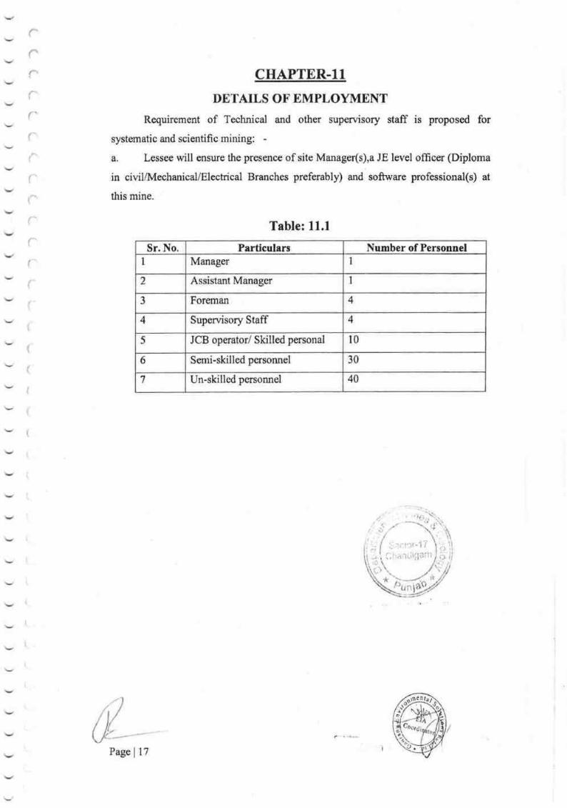
l,.:
,l
t
CHAPTER-I1
DETAILS OF EMPLOYMENT
Requirement of Technical and other supervisory staff is proposed for
systematic and scientific mining:
a. Lessee will ensure the presorce of site Manager(s),a JE level officer (Diploma
in civil/Mechanical/Electrical Branches preferably) and software professional(s) at
this mine.
Table: 1l.l
Sr. No. Particulars Number of Personnel
1 Manager 1
2 Assistant Manager 1
3 Forernan 4
4 Supervisory Staff 4
5 JCB operator/ Skilled personal l0
6 Ssmi-skilled persomel 30
7 Un-skilled personnel 40
(')lrairr-it11arh
i,CCl$l'-'17
tr*
Page | 17
ff-
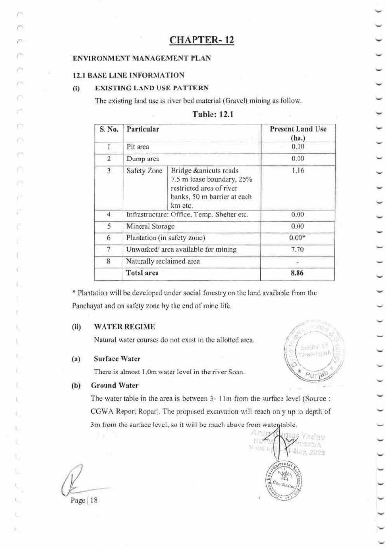
('
{'
CHAPTER. 12
ENVIRONMENT MANAGEMENT PLAN
12.I BASN, LINE INFORMATION
(i) mxrsTING LAND USE PATTB,RN
The existing land use is river bed material (Gravcl) mining as foliow.
Table: I2.1
S. No. Partirular Present Land Use
(ha.)
1 Pit area 0.00
2 Dump area 0.00
1 Salcry Zone Bridge &anicuts roads
7.5 nr lease boundary,25o/o
rcstrictcd arca ol river
banks, 50 m barricr at each
km etc.
r. r6
4 Infi'asfi'ucture: Office, Ternp. Shelter etc. 0.00
5 Mineral Storage 0.00
6 Plantation (in saf'cty zone) 0.00*
7 Unwor*edl area available for mining 7.70
I Naturally reclaimed area
Total area 8.86
* Plantation will be developed under social fbrestry on the land available fi'om the
Panchayat and on safety zonc hy thc end of mine lifc.
(iu WATER REGTME
Natural water courses do not exist in the allohed area.
v
:
:v
I
(a) Surface Water
There is almost 1.0m water level in the dver Soan
(b) Ground Water
# lr
The water table in the area is between 3- I I m from the surface level (Soulce :
CGWA Report Ropar). The proposed e.xcavation will reach only up to depth of
3m fipm the surface levol, so it will be rnuch above liorn wa tahle
I
I
Page I 18
N. . ...!. . 1.i"1i.,.. :.i.i,:1t I
(iii) rLoRA & FAUNA
Few local bushes can be seen in the area. Moreover there Ls no demarcated/protected
forest close to the allotted area. The protected wildlife animal in & around the allotbed
area is also not present.
(iv) HIIMAN SETTLEMENT
The proposed mining activities will be catried out in the river bed, so there will
be no impact on nearby the human settlement. The workers will be employed
from the villages surrounding within 2.5 km aroa so there will be no hurnan
settlernent proposed in the allotted area.
(v) PUBLIC BUILDING, PI,ACES AND MONUMENTS
No such buildings, places and monuments exist in and arourrd the allotted area.
(vD QUALITY Otr'AIR & WATH,R
QUALITY OF AIR
lhe quality of air at the allotted area is reported as fresh & Respirablc.
QUALTTY OF WATER
Natural watercourses exist out of the allotted area. These are serving tle purpose of
conveying rainwater into pond. The water table varies hetween 3-l lm from zurface
level in the area. (Source : CGWA Report Ropar)
(vii) WEATHER THE AREA FALLS UNDER NOTItr'IED AREA UNDER
WATER ACT 1974
The whole Punjabcomes undcr Water Act 1974.
{;,: .I,l.rt".'1:
i-.rq
,lLt,].\/
n
L!
Page | 19
I
il./
/ fi,\,r

I2.2 ENVIROI''{MENT IMPACT ASSESSMENT STATEMENT
Impact of mining and beneficiation on environment
The land in the allotted area wiil be degraded by proposed mining activities like open
pit etc.
Table: 12.2
Particulars Present land
use (ha.)
At the end of 3th
year (ha.)
Pit area 0.00 0.00
Dump area 0.00 0.00
Safety
7.one
Bridge &anicuts roads
7-5 m lcase boundary,25%
restricted area ofriver banks, 50 m
barrier at eaoh km ctc.
I I 6 r.r6
Inli'astructure: Oft-rce,'l'ernp. Shelter etc 0.00 0.CIO
Mineral Storage 0.00 0.00
Plantation (in saf-ety zonc) 0.00 0.00{'
UnworkerV area available for mining 7.70 7.70
Naturally reclaimed area
Total area 8.86 8.86
* Plantation will bc developed under social forestry on the land available frorn the
Panchayat and on safbty zone by the end of mine lii'e,
,.: "
,'a'.
(a) Air Quality .; * " r'.-lr'
,t
. ..{ .. \.Due to proposecl 3 years rnining activities the air pollution rvi$
1qk9 p.ki,gf bV,
running of transport machinery like dumpers & excavators. To reduic ail pollrrtiop'^,,/proposal l'or water spraying has already been ntarle.
"'i,r,"l , l,,i,.lil,r,lJ
(b) lVater Quality
In thc proposed 3 years tnine working, thcre u,ill bc no proposal to utilize any surface
or groirnd water. The water table in thc area is between 3- t{ the sur lircr:
level" (Sorircc: CCiWA Report Ropar). So, therc will bc no ,,-Ths W[tcr
quality of the allotted area will not be aft'ected by the mining
ity of warer rvill remain the same during the proposcd 3 years
I Pagc | 20
ns. lio. {.hc:
I (c) Noise Level
During the proposcd mining operations there will be noise pollution due to following
activities:-
(l) Excavation by usc of cxoavatur and JCB.
(2) Transportation of material is used by dumper and tractor.
To control thc noise due to above activities, regular weekly, fortnightly, quarterly
&annual nraintenance will be carried out for all these machineries. The operators &
helpcrs will bc provided with earplugs.
(d) Water Regime
Tlere is no source of surface water in and around the allotted area. Natural water
courses exist out of the allottcd area, which is thc source of watar for the pond. Thc
water table for: the local alea varies between 3-l lm liom the surface. (Source : CGWA
Report Ropar).
(e) Historical Monuments
No public building, places of monuments are existing in the around the allotted
area, so there will be no effect of rnining acrivities on any public building, places and
monuments.
I 2.3 EI\"VTRONMENTAL MANAGEMENT PLAN
(i) Storage & Preservation oftop soil
Thcre is no top soil in tho arca, so, there is no proposal for storage & preservation of
top soil. : "..
(ii) Year wise proposal for reclamation of land affected
during and at the end of mining
The proposed 3 ycars rmining is for RiverBed Matcrial [Cra
the River. So there will bs no reclamation and rehabilitation
t\4in
mining plan period (ref'er Plate No. 5&6) whereas at the end of mining, the worked'
out pit will be tleveloped as water resenoir due to absence of any fill material.
(iii) Program of affirrestation, year wise for the
number of plants with name of species to be
arcas in hectares.
PROGRAMME TOR PI,ANTATION
inltlal 3 indicating
TIrc arcir is tnostly Alluvial with good vegetation of bushes. Pl ll be carrisd
arouud thc rnine, to arrest the dust at source. l'he allotted alr", s0ras
IIA
by
1,;..;r
\ '.,1t,'r:r'.:l ).', i'
*
,tri: iir.i
'.1
,:i
Page | 2l
Notilicirtion 200;6,33% of the total area has to be antation
'diffqr:strt
8,,;r. ;.', r'i';

l
ri
1,
Thus, 0.97hectare of the area has to be covered under plantation every year.
Considering 50 trees per hectare as a tree density, the applicant will plant 49 trees per
year. The survival rate is 80%. The dead plants will be replaced by fresh plants in next
year and l2trees as replacement fiom second year. From first to third year Z,92hectare
area will be planted within the lease hold area & from third year onwards plantation
will be carried out in the nearby school, hospital, police station, community center&
other public utility places. Thus, 2.92hectarc of the area has to be covered under
plantation. lhis will be achieved in next three years.
'Ihe area receives average rainfall and hence following trees has been proposed which
is suitable in the region:-
v
v
,-:v
:v
v
1. Peepal 2. Mango 3,Shisham
Schedule of plantation for the 3 year:
Table: 12.3
4.Neem 5.Gulmohar
Place of proposed plantation: -The plantation shall be done at the following places: -
Plantation shall be done in the statutory barrier of 7.5m. as shown on the plan. (Plate No.- 6).
;i
wet drilli
(iv) MEASURES FOR DUST SUPPRESSION
Measures To Be Taken For Dust Suppression: -
The proposed drilling will be carried out by machines h
arangements. tt
2
3
Water spray will be regularly carried out over the material of
tippers to minimize the dust during transportation.
Water spray will be regularly done over the haul road during the working
hours.
Earplug will be provided to the work persons.
Sharp edges bits will be used for drilling, so minimum dust will be generated.
Dust respirators will be provided to the drillers.
Proper care & frequent maintenance of machines will be
4
5
Sr.
No.
Year ofPlantation
Proposed
Plantation
Assumed
survival
(80%)
Rqrlenishment of
Casualties
Total
1 IYr 49 39 Nil 39
2 II Yr. 59 47 1,2 47
--J III YT 59 47 t2 47
Total 167 133 24 133
Page 122

v
Y
v
r"
rr*
(v) MEASURES TO MINIMISE YIBERATIONS DUE TO BLASTTNG ANI)
CHECK NOISE POLLUTION
No sound pollution will be caused by above source, as the sound generated
will be kept within permissible limit.
(vi) STABILISATION AND VEGETA'I'ION OF DUMPS
There will be no waste generation from the proposed mining of River Bed
material [Gravel (Minor Mineral)], so stabilization of waste will not be required. Top
soil is also not there in the allotted area.
(vii) TREATMENT AND DISPOSAL OF WATER FROM MINE AI\IDBENEFICIATION PLANT
The proposed mine workings will be above the ground water table thus no
measures will be required.
(viir) MEASURES FOR MINIMISING ADVERSE EFFECTS ON WATERREGIME
No impact will take place due to proposed rnining activities on water quality
also neither the mineral nor any toxic substance will be discharged to the ground
water. The proposed excavation will reach only up to 3 m from the surface level, so it
will be much above from water table. Hence no measures will be required
(ix) AFFORESTATION OF TAILING PONDS
As there is no beneficiation so tailing ponds are not proposed,
tailing ponds will not be required.
(x) PREPARATION OF DUMPING GROUND FOR ST
MINERAL SUBSTANCE
,Y
JN
There will be no generation of toxic substances, due to the proposed mining.
So, neither the rnineral nor any waste will require durnping ground for stacking the
toxic mineral / substance.
Post Plantation Care:
(i) Protection from Grazing
Protection from grazing will be done by erecting suitable boundary in the
plantation area. As such in this area lessee will erect stonewall. This will protect
,pI*r
u-ts fror:r grazing.
0til
.t
Page 123

(ii) Watering during Dry Spcll
Watering will be done daily during the 1't year of plantation from March to
July and thrice a week from September to February by water tankerlOver head tank in
the plantation area. Thereafter each year watering will be done alternate day frorn
January to June and once in 3 day Septernber to February. After 3 years no watering
will be required.
(iii) Manuring
The manuring will be done while plantation work is taken up, for this
pu{pose cattle dung will be dumped in the area that has chosen for plantation. No
other manuring is required for the proposed plantation
(iv) Protection.from pest like white ant etc. will be done during the plantation and
inthe proposed pit l0gms of BSC powder will be given before plantation. After a
few months liquid pesticide mixed with 375 times water will be spread near the
planted sapling.
(v) Replenishment of Casualties saplings
The loss of each year will be counted and in subsequent plantation casualties
wiil be again planted at same place. This way in the end of 3 years 133 healthy trees
will rsmain in the area giving proper density.
12.4 DETAIL OF HEALTTI CHECKUP AND INSURANCE OF ALL THE
EMPLOYED PERSONS (FOR EXISTING LEASE)
lnitial and periodical Medical examination wili be conducted annually for
every person ernployed in the mines. As per Mines rules 20% of the total
get examined medically every y€ar, so that the entire person ernployed in thc get
examined within 3 years
v
v
i
,v
v
Occupational health Surveillance program of the
periodically to observe any contactions due to exposure to dust.and take iorrective
measures.
The entire person employed in the mines will be covered under Group insurance
Scheme.
Common Vocational training Center will be Set up at district level.
nperls r:1'habitant like School, Crdche, Hclspitai, V
Page 124
rvatcr etc. shall be considered positively.
tation,
)
j
i
CHAPTER.13
OTHER INFORMATION
0ccupational Health and Safety
To prevent the occupational disease the measure as proposed in previous
columns will be taken. This will prevent the inhalation of the dust by the workers. The
workers will be periodically medically examined under Rule 29(b) of Mines Rule. If
any worker found to have contracted with any occupational disease he will be
immediately removed from the affected area and will be provided with proper medical
care as per provision of Mines Rule,
Safety
To prevent the worker getting any injury during work following measure will be
taken:
(i) The workers will be trained in vocational training whenever available in
nearby area.
(ii) They will be provided proper safety wearing and equipment's such as hand
gloves, safety boots, helmets, and lifeline etc.
(iii) Proper benches will be formed. Apart from this all safety precaution will be
taken as per Act, Rules Regulation and Byelaws made there under.
ANY OTHER INFORMATION
Mr. Ajay Kumar Tripathi (Geologist) has assisted in preparation of this Mining Plan
including Progressive Mine Closure Plan, including Plans & Sections, Assessment of
Reserves, Year Wise Development Plan, Conceptual Plan & Environment Plan etc.
Arun
R IA
vatiaity 27't May,2023
Page | 25
. -l
,,t/
/ ll-t.tr

v
v
r'rrrf^
r{
r(\.
f:
rr'r'{
(
{
{
{
\
PROGRESSIVE
MINE
CLOSURE PLAN
f,'i)
i:r:ilr-J 7 ri)
{, i;'itti.iigarh0
A)
)4' *,ii)
Page | 26
ffi

i
('
r'
{'
CHAPTER - 1ry
INTRODUCTION
The Govemment of Punjab accepted the highest bid offercd by (Shri Rakesh Kumar
Choudhary) for Block No. -l and accepted in the e-auction held on 29/0712019 &"
issued the Letter of Intent for grant of mining lease in favor of ShriRakesh Kumar
Clhoudhary in respect of the, River Bed Material [Gravel (minor rnineral)] of
"Mahindpur Gravel Mine" Block No. *1, Hadbast No. -478, having total arca of
8.86hectare (Non- Forest). in Village *Mahindpu, Name of River - Soan River,
Tehsil- Nangal, District- Ropar (Rupnagar), State- Puniab. The period of lease shall be
3 years with effect from the date of glant of Errvironment Clearance by competent
authority.
There is no tnining carried out by the LOI holder. It is a case of fresh grant of lease.
The actual mining will be allowed to bc commenced only aftcr Ilnvironment
Clezu'ance is obtained by the LOI holder as per the Lelter of Tntent vide Menro No-
811-813iDMG/E-Auction/Iv{ahindpur/Block-1,/Dated-29107i2019 (Punjab).
As mention above LOI was issued on3ll07l2O19 hence considering block period of 3
years Mining Plan shr:uld have been fi'om 201 9 to 2022. Thus the current mining plan
along with PMCP has been proposed for a peliod of 3 year i.e. 2019 to 2022.
Thc Lessee ShriRakesh Kumar Choudharyhanded over the work of Survey &
pr"eparation of Mining PIan with PMCP to thc Mining Engineer, Mr, Arun Kumar
Yadav. After collecting the field data, the Rcview of Mining Plan inciuding
Prergrcssive Mine Closure Pian is prepared under Rule l7 (2) oI I\,ICR-2016 & rurdsr
Rule 23 B (3) of MCDR 1988.
There is no public interest litigation (PIL) & Court Case Pending with Lease. If there
is any change in name and address of the lessee duri cy of approval, it
should be infonrred prornptly. There is no national l OKM
frorn the lease area"
lt1l
l, *, ,)
, , ,. l',1
I'age 127
\"
I

{
1.1 Rcasons for Closure :
This is fresh area so reasons for closure of mine are not applicable at present.
1.2 Statutory obligations :
llhis area is Fresh Mining lease area, The PMCP Prepared in Compliance of Rules
378 (VD so statutory obligation lbr closure of mine is not applicable at present-
*Order of the Hon'ble Supreme Court of India in writ Petition(s)(Civil) No(s).
ll4l20l4 Common Cause Pctitioner(s) Vcrsus Union of India &Ors.Respondent(s).
The mining lease holders shall, after ceasing rnining operations, undefiake re-grassing
the mining area and any other area which rnay have been disfurbed due to their mining
activities and restote the land to a condition which is fit for gowth of fodder, flora,
fauna etc.
I{ame address and Resistration Numbgf gf the.Becosnized pe{[g]qArun Kurnar Yadav
RQP/AJM/242/2OA3tA,
Validity 2l*rMay,2023
501, sth lloor, Apex Tower,
Tonk Road, P.O. Jaipur-302015 (Raj.)
E-Mail- [email protected]
Websits- www. overseasm intech. corn
Telefax No. 0141 -2744509,Mobile No.-9460221084
v
Y
rf
i'
($$
*
{
:
i
1
Page | 28
I
N-

crkrPTER - 2
2.1 Physiography
The allotted mine lease area is a river bed with gentle slope from NW to SE.
There are surlace area in fbund mixed with river Boulder, Gravel and sand. The
general topography of the area is gently sloping with drainage pattern of the river
Sutlej, it is floodplain area. Thers is highest 285.896mRL& lowest 283.210mRL. The
Sutlej River is carrying out sediment loads from the plains.
Itrere is no protected or reserved forest in and around the allotted arsa. There
is no habitation within allotted area.
2.2 Climate
The district receives normal annual rainfall of 776 mm, which was spread over 41
days. 78% of the annuai rainfall is sontributed by southwest monsoon. Generally,
rainfall increa.ses from southwest to northeastenr part of the district. The climate of the
district can be classified as tropical steppe hot and semi-arid type.
2,3 Geology
2.7,1 Regionrl Geology
The district mainly constitutes alluvial deposit which abuts against the Siwalik hills on
the north and north east direction. 'Ilhe main geological units occuning iu the
Rupnagar district are given below.
*)r$
h ut
f'
(
l
Page | 29

Age Super
group
Group/ Formation Lithologv
Quatenury Older and Newer
Alluvium and Aeolian
Deposit
Grey & brown sand, silt, silt-clay, clay
with calcrete, limestone and gypsum.
'['ertiar:y Siwalik
Super
Gmup
Upper Siwalik Floulder conglomerate, sandstone, clay/
Mudstone and pebble beds.
Middle Siwalik Sandstonc with variegated clay/
mudstonc
Lower Siwalik Sandstone, mudstone/shale
Subathr.r Fine grairred sandstone, clay and
limestonc
Pre-Tertiary Tundapather 'seriss'
Lower(Palaeozoic
unconl'ormity)
Stromatolitic Iimestone'l'osharn rhyol itc,
granite (Erinpura), migrnatite, ultramafi c
and pegmatite
Proterozoic Delhi
Super
group
Ajabgarh Ciroup
(divided into 5
Iiomrations)
Quartzite and basic flows, mica-schist,
carbonaccous phyllite and slate, calc-
schist, dolomite, marble, calc-silicate,
arnphibolitc, hornbIendc-sch ist, phylli te
Alwar Group Quar:tzite, con gl om erate, amphibolitc,
mica-schist and arkosic quarlzite
Table - 2.1
2.4 Local Geology nf the aren
The allotted area is the river course of Soan river. lt is a river borne deposit which
comprises of sand channels formed due to urnnual deposition Tlie upper surfirce in
terraced area covered with Coarce to mediarn soil
developed by local people. Geologically, allotted area
Boulder, Gravel and Sand are the rnajor litho unit obserued the
stratigraphic scquence of the litlro units presenl. in the ilr'$fi ,rrc as t'ollorv,,i:-
I l,i
re ljelds are
to Quatenrnry.
T'he
i/ l:1.'
I
Pagc | 30
i-.1
i
i

2.5 Reserves
Table:2.2
More details are given in chapter 3 of Mining Plan.
2.5.1 Mining Method
Mining will be done by open cast method easily by manual/semi mechanized means.
Heavy earth moving machinery is not deployed. More details are given in chapter 4 of
Mining Plan.
2,5.2 Mineral Beneficiation
No mineral beneficiation processing of any kind will be undertaken at mine.
iE-
Sr.
No.
Name ofthe Quarry
Lease
Area InHectares
Total Proved
Geological Reserves
MT: Cross-
Sectional area (in
sqm) *lnfluence
Iength (in mts) *
B.D (UNFC code 111)
Reserves inBlocked7.5m. SafetyBarrierArea(UNFC
Code
211r.,222)
Mineablereserves
I MAHINDPUR CRAVIMINE
8.86 76507.64 10098.85 63991
Total 76507.64 10098.85 63991
Page | 3l
I
i'I

CHAPTER -3.
REVIEW OF IMPLEMENTATION OT MINING PLAN INCLUDING 3 YEAR
PROGRESSIVE CLOST'RE PLAN UP TO TIIE FINAL CLOSURE OT MINE.
This is fresh mining area and reserve is more than the scheme period. So this ctrapter
is not applicable at present.
**
- | - 11.)r.La...rl' I I
Charriiigarh
Pagel32
rl

r*
rr
r
f
f
fI
{t
qHAPTER -4CLOSURE PLAN
4;1 Mined out land
This area is fresh applied area so mining activities will take place subsequently that is
after the registration of Mining Lease then only this can be taken out. By proposed
mine planning, the limits of Pits average 3m depth at the end of three year as shown
on Year wise development plan of the area (Plate 5).
4.2 Water Quality Management
Mining operation is carried out when thc river bed is partially dry; hence impaot of
Mining on surface water will not take place. Cround water table is not going to be
touched; hence there will also be no impact on ground water. More details will be
given in chapter l2 of Mining plan.
4.3 Air Quality management
Mining operation is of small scale so air pollution due to dust will be negligible.
4.4 Waste management
No Waste generated during the rnining operation.
4.5 Top Soil Management
There is no soil cover over proposed area of rnining in next 3 years, so no arangement
for stacking is to be required. Any incidental soil encountered will be used for
plantation sim ultaneously.
4.6 Infrastructure
S.T.D. and Telephone facility are available at Mahindpur from Proposed mine site.
Educational facility is available up to Senior Secondary school level at
Ropar(Rupnagar).
4.7 Disposal of Mining Machinery
Machinery used for mining having more life than life of mine. Applicant will seek
more leases for rnining; hence, disposal of mining machinery will not arise.
4.8 Safety & Security
Details are given in chapter l3 of Mining Plan.
4.9 Disaster Management and Risk Assessment
All typcs of industries normal
chinery,il vities abruptly and
plosiou, to name a few
Page 33
can
or risk
hazards which
! ,;have

i1
which need be addressed for which a disaster uranagement plan has been fonnulated
with an aim of taking precautionary steps to avert disasters and also to take such
action after the disaster which limits the darnage to the mininlum.
Neveftheless, the following natural/industrial prohlems may be encountered during the
mining operation.
./ Inundation- filling of the mine pit due to excessive rains.
'/ Slope failures at the rnine faces or stacks.
,/ Accident due to fire.
/ Accidents due to use of machinery
{ Health hazmd
./ Environmental hazard
As per proposal made under the mining plan, during proposcd working fhe area will
be developed by means of Semi rnechanizcd opencast method. Exploitation and
transportation of minerals are to be canied out by mechanized means. Bench height &
width is maintained at 3m. The Ground Water table is irt 3 to I lm below the surfacc
depending upon the relief of areas. (Source : CGWA Report Ropar). Present RL of the
working pit is about 285.97mRL to 284.lmRL. Thercfbre no groundwater table is
going to be encountered due to mining activity. Therefore no groundwater table is
going to be touched due to mining activity. The impact of mining on ground water is
not anticipated; therefbre measures are not required. No high risk accidents like
landslides, subsidence etc. havc bcen apprehended.
Butpossibility of accidental disaster is also not ruled out. Thereftxe, all thc statulury
prccautions should be taken for quick evacuation as per the Mines Act 1952, the
Mines Rules 1955, MMR-I96i will lrc iniplemcnted,
POSSMT,E I}ISASTERS TOGETHER WITH CORRECTIVE AND
REMEI}IAI, MEASUR.ES IN UNDAT'ION
There is no perennial rivcr in the area except seasonal channsls within area flowing
NE to SW in the area and flow of watcr depends only on on ratns.
It is anticipated that ground waterlevel's not rnining as till
the end of rtife of thc minc, the maxirnum depth of the minc I bc 3 metcr only,
which is above the ground water table in the workable a'ea.In another case dudng
possihlc acclrmulation of water, prcvr:ntive & lrtanagc'tncnt
I
Page i 34
measures.shall hc planned,
I
':1"-
{
t,
{

POSSIBLE DANGERS DUE TO STORAGE OF EXPLOSIVES IN THE
MAGAZINE
No Blasting Proposed.
DISASTER DUE TO FIRE
No surface fire is anticipated in the mining operation. In case of forest, fire may result
due to dry leaves and wood in vegetated part and result in a disaster. In the area under
reference, there is no such situation and there is no danger of forests fire. No oil,
grease, canvas or other inflammable material will be stored in mine except in a fire-
proofreceptacle.
CARE AND MAINTENANCE DURING TEMPORARY DISCONTINANCE
During the temporary discontinuance of mine, notice (Reg,6 of MMR, 1961) will be
sent to Director of mines Safety. Notice will he accompanied with plan & Sections.
All precautionary steps will be takcn into account in respect of care and maintenance.
DISASTER PREVENTION MEASURES
In order to take care of above hazard / disasters the following control measures have
been envisaged
1. Entry of unauthorized persons will be prohibited.
2. Firefighting and first aid provision shall be kept in the mines office complex
and mining area,
3. Safety equipment such as safety boots, helmets, goggles etc. will be made
available to the employees and regular checked for their use.
4. Training and refresher courses for all the employees working in the mine.
5. Working of mine as per approved plan and regularly updating the mine plans.
6. Regular maintenance and testing of all mining equipment. as per manufacture's
guidelines.
7. Suppression ofdust on the haulage roads.
8. Increasing the awareness of safe practices through competitions, posters and
other similar drive,
As precautionary measures before onset of monsoon, the floors of different
benches are gently sloped so that working remains water free.
Telephone is proposed for communication facility, Distance of nearby hospital
Mahindpur is Km 2.3 Km. from site
4.10 Clare and Maintenance du
,'r*/ .
,r lfhis arcu is ticsh mining lease areaI lt.\ f drrring tcrnporary discontinuance wi!l
Page | 35
nng di
and precaution lai statute

EHAPTER-s
Economlc Repcrcussions of closure of Mine nnd Manpower retrenchments.
5.1 During llhree years Mining in this area will generate employment potcntial and
general financial status and socio economic conditions of Laborers will he improved.
5.2 During Three years compensation will be given as per rules.
5.3 Satellite occupations are not connected to the Mining operation.
5.4 Continued engagement of employees for certain mandatory activities.
EHArJER_[Time scheduling for abandonment:
This scheduling for abandonrnent operations are not proposed in para 4 of closure
plan. If the mine is closed due to unforeseen reason then tentatively it will I2 months
fbr closure.
Production target of Mineral Gravel are at the average rate tonnes per year.
rk
Page | 36
)ii

CHS.PTER -7Abandonment Cost
As at present mining is not going to be closed as abandonment cost could not be
assessed. However based on the progressive mine closure activities during the plan
period cost is assessed as given below:-
lr'l
,'.'.
tllL).
t.t
*.s
Activity Year Rate Amount
(inRs.)First Secoud Third
Plantation (in no.) 39 47 47 @ 20 Rs. Per
sapling
2660
Plantation Cost 780 940 940
Wire fencing (meter) 50 50 50 @120 Rs. Permeter 18000
Total 20660
$ector-17Chandigarh
Page | 37
N

Financial Assurance
Sqlwla{io$ for f,inqncial Assurance *
* Plantation will be developed under social forestry on the land available from the
Panchayat and on safety zone by the end of mine life.
i
ll'
o40
6)
Lql
a
cllq)an
treos
o. tr.
ga
o
()€)E+. 6!6! ).F
oluE.PiEUSgo.
-l
H
o6
o
gaolrGI
F
>r5
cr?o6)LL
*{ID
EEU.EP,6tatx(9=:qlLXt+r
k.o
1,o)htr, fitoulE '\J
e5E ECEI68-Au9\1o4llZUA
1. Area to be excavated 0.0 7.70 7.70 0.0 7.70
1 Storage for top soil 0.0 0.0 0.0 0.0 0.0
J Overburden/ Dumps 0.0 0.0 0.0 0.0 0.0
4. Mineral Storage 0.0 0.0 0.0 0.0 0.0
5 Infrastructure (Workshop,
Adm, Building & Road)
0.0 0,0 0.0 0.0
6 Safety zones (Bridge, road
swells)
0.0 1.16 1.16 0.0 1.16
Green belt 0.0 0.00* 0.0 0.0 0.00*
8 Tailing Pond 0.0 0.0 0.0 0.0 0.0
9. Effluent treatment plan 0.0 0,0 0.0 0.0 0.0
10. Mineral Separation Plant 0.0 0.0 0,0 0.0 0.0
11 Township area 0.0 0.0 0.0 0,0 0.0
t2, Others to specify 0.0 0.0 0,0 0,0 0.0
Total 0.0 8.86 8.86 0.0 8.86
OOtor
Page | 38
CHAPTER --q

rrrrrr(*
I
I
r.r,t
rr{
('
(
9.0 PLANS. SECTIONS
AII relevant plans & sections have been enclosed.
l. Location Plan
2. Key Plan
3. Surface Plan & Sections
4, Surface Geological Plan & Section
5. Year Wise Development Plan
6. Progressive Mine Closure PIan
7. Conceptual Plan
8. Environme,nt Plan
ANY OTHER INFORMATION
Mr. Ajay Kumar Tripathi (Geologist), have assisted in preparation of this Mining Plan
including Progressive Mine Closure Plan, including Plans & Sections, Assessment of
Reserves, Year Wise Development Plan, Conceptual Plan & Environment Plan etc.
Place: - Jaipur
Date:-
Arun
Validity 2l"t May,2023;
I ' \,1_ I j.
I -. " ....i
Page | 39
..,,:x. .-',9 \
\"t'\r"l ri-iz \it'1t.
i ; r,.,,,,.i Xt,ftr J il-jj
.; , /;,,/'.: _
, i;,,,_t.e-iit
ff,

'iJ
4I!
.,*,
*
t?j
| ,o,'
1*i
(7
,*
(+
rI
{*
1*
i,l
i'
.rr
'&
.t*
.,(^"
{,
.\
*,
:,
du-d
ftB'
€-cr"
*f,'le&,
dfrt furka d mrlr
/kard,a ffiEt'rm,)aeffi$ar mrors dua l,fr"a,d*arg r
/3n f r$*n
nrn-r # ? srs eT frskr
firS / lzo2o
#rs +gs-ge, firS tuazlzoza A mfq
Sustainable Sand Mining Management Guide Lines 2016 t Standard
Environmental Conditions for Sand Minlng .
iErdtr:-
Brtd-r f€B ur} d'".P, )?r*6 frd ? Hriq f*d nrry * d gfu, .fu'
H,s' t k x-f,rs-ar-yfg+tred,)r'dt6fr A" ft)r{r8fr fustr,ti$ar? H? dA drbs *S 8*e1
et fu'Ive *rnr * f'Ug.o' 4r* )?fir&-fi frdr a'il8816* a# nt$ t #r
'U"$ilrufroldl l$#&rm-ux*frq'ltrgf6'dl bf*rrs,
rr$fifar riro,glrdaRlrd&_
qEq:-aT{*na-fi rydD{d* rtr-fir{r lr'dfdar Dlr,H'o,{$@ sdru', *fx[L
a':d-m"drdtfr+*fr nra-au*
frq".t'dfqaT iI-sFIa,
lrt$fifdr f.ro, 3u,raut
Scanned bv CatnScanner
.': "tr
i,'/',',, . l.
il
\\.(' \,
\**.\\ t-j'\\,

LETTER OF TNTENT
I
:
I
l(umirr (llrowrlhlly,(lurnplcx, Soctor. ll lixttr,Nrr11irr, lamnru.
Motno No .f,lt':.8,1,3".'.70'Aurtlon /2019 Datc 3rlr/201e
Provlslonnl Acccptanct for Mltlng llloclt rto 1 Cunrpt'lsing' of Dtstrl(r
Itolrar ll-Auctlun dirtctl 2r'0?'2019
I litrl: Muutu Ntt.21tl1'tlil/li'Arrctlon /2019 (littc(l 31/07/2019 ol' 'l'lrc Sccrctnry
(Irtrt l)h'ocror, rlupu"nt""t ii pr r"t' ontr 0cology' Chantll gurh'
AsAppr.rrvr.:tlvi(lclctrcl,tttutttlttt.tutitttttlcrrcler.cncc,prtrvisional
ircuoPlirllco lbI lrililrcst't'iti o'uou"ti'r11 tu ltupc'r"s'i''tii'no'uuo/' (rorty Ninc (lrorc
l.]it{rtyl!uurlirlrlrs0nly);i;;,;;;;;.,.,,jnu.,'orr..r*,r,'rt.''.'.'Clrowtlliar.yIorltlrrckNtr.lnilrt ucccprcrr l|l rtrc il;,;;,;;'r,"i.r uu 29.0?;i;;;' is hc'cbv rtccttt'tlutl srrtricct to ;
tirlfilrnctrttrllollowlrrgt''n''u"tlcotttlltirrtls
l. 'l'lrc nnnttal uottce ssittt\ vulirc 01 tlrc cttttccssiott shull llc llupccs
4c).114,00,000/-(l;orly Nirrc ('ro|c litl$rly lrotrt lill<hs Only) l)cr i\llntlrl t'or llrc
l.trstycrrr.,tjt,".nn,'uutcollccssiolr,l,i.,cwittttr:itrcrcasctlbyTo/rr(orcacltsrrllscqucnt;r;.'j;;..,,ccssiunirlrc
shall also pay lls.60 pur tortrtc to lltu
I
)
U
ICoor<Jiootor
rrrrflIl
'lir,
$ubr
,1,
3,
4

r(
rnrrr-
C.
nnri
r'r("'
("
(
{
(
(
(
('
(
\,
(
(
\,
I
t(
{.
t
(
(.
I
'1tr':i[tr'r ilrrt.ttr.t.,l
'1rr1i'11111;11.r,\tl]1.11!!t
t lit, ti llit | 'r1lt rll';rr-'tttil'': I;:::.
.rrr.l lrr rrill lrr Ftr,llitll,{l t{r 11.rrrr(,l,.rt( rl ll'c,rttttrr" t "ttr' l't l: ,:;,..: ,,1 l , ,,, rlrc r.....r,'l
' l',ijl':lliill',llll3;'i::' ,i':;ll:.;ll; il,,,ill"'i,',,llll li :: ;: , " " '" ,,' r *'1 *,: r,.l
!,llilf,tntl(. ltt (nse lllc lll!{(\'lrrl lrr'1'lr'r l'rrl' ""'*'""'''''i"' '"'"" "
{,] lll'11: ,""'"
""'ltlttr:l
rlitrr, ttp lr. l.r)u prrt lilct il;rurrrii 1,1 pi,,rr,,rr,n;rl r,rl'.1,,,,,,...; lltc ' tt.tt' 'l l,"tti'i rlcIrt'tl rll'rll
lrt: lirlluttu6;,1(l llr'\\rll l',r',t,,ltil,rl.',1 h' ll;llllillr'lli'tt' ll'L """""'I
'trt''lt"l lr't tltl tl"r'l i
\{all\ ,,rr ,..,,t,,tr . i'r ll,l, I
i, Ilrr (il(r(ialtll hrtl,kl ,,1' lllll!llli' l'i'" I 'lr'rll "'r ' rllr"\ r1 1'r'(r' rlr\' \ltrl
.r'','r"r "\ 'l'
rlrlS
,t!,rr'('lrlcrl,,' 1llli\l i I ;r. 1"' lir"' i t' r'{ lllr' 2l l(' l' I I rr .I'
,\ttll'll(llrll'lil I ullllllr l" il l.-I "'i: l't1''u'iti''"t'l ;!!::jfir{;l,,tt:t: llr' illiilili'ltrt" 'ir'rl] ]'r'
Irr,rtr. l,r llir rrrer'r'..rl,ti l,rlri, r , ,lt ] j,\.1
i I lrc c(-)tr'"L\\r\\tlitil\' lll,tll dcirt':rl t ili,t, 'lrrti'ril I'u:l ttrt trtr c . .' . t., ,,,,, :rt ,,,,, '
,till$tllllllilr{l:l\'l'rltllililr'1ilri'l 1\":fi']i1'rl''"':""1r'I'r''i:ii; " *
( )ll-rir r tlr rlr,rli' rrl i'i l'i ." 'l ': "1' riiili\ ilrr":i rr\''
(r'll\t'\'rr',' l' Il',i
H ltt,,tt:ltll,r\r"'iill"!""l1'l;"'i. I'"'i'
r"'l'rl' "
Itt'l,'llrli "'i '1 lr'lri l''r'
ti lltr ..,t,r.,.. ,l.t'{ 1;,j!r,,.{ ritr.i,l
( r(r\ Ll liillilll .'1 c1l"i1 i I ' I
!)J)qr;lllilll,ll is tlrc nr':sl l)':'1:ii" ri ! li irirl I
l{},\rttcr'qrlrrl hidJtr srrrll "r;
' ' li': rr 1i'1 l'rrrI II r1'r' i1 i IrJ1{ir} 1"r li'l'ltlirtr'
I:llllf(lltllldlil;ll qlttora'lttt"':-" " " i ,':I " "'lil
ili il'
It,,trr ,l.tlr i I ftei''llr ': | ''
111q,;d 111111sr rr ilir
r,,li
N

rf\s-t
r,r
f*
rI
rrrt
J
{-
t
q
{
(
(
r
t
t
t
{
t
I
{.
(
t
t
i.
1,*r trrrth*r suviln wrrrkirrgttlys. rrp ru $.(ltl lrrl,tltct'-lti*trli'iil,:::,itffi:iitlll
"rrr{:l}trltl('01 tltttt tltrr lilrlt) tleposltt,tl lry ltlrrr ttJlll l)0 [llrJ{!llt!ll Irrr(t r"
prulrrtrttr.tl tn 1uu'tlcip.rtl lrr thr-,rurulrr11('.;ruclr(rrt)r tor riIxl '1.111,',,1,r, n,,,.,' r,,
li "l'ht'strt(tsslul birhlcr slrilll rbgrnsit sucrtrlty trrrr(rtrrrt tl'l.illl't,:,'l;',,,1,y ,,t,,,, t,"
thr rtlorrnr r'rlrielr rvlll hu itrri[tuttrl ttr lhr'ritr('c('$$ltll lrltlll{'ri ;]',i:;;r, lirrl'. lu
lyvrn iu rhr.hrurr rrt lurrrk uuirlittlltrr', llt uitsr't":.:::::;t;il':::;r;, ii,.;rr,rrrrr'
ilr'!uxlt llttl ,trttuttttt twithlll $uvt'lr tvttt'kitlll(l'ly)' t'l'".'".,.'.,, rr,, l.r'l.rr.rl ,trtll
il'-il'ill'i;:ffi:llli'lx'lill,i;:[]l',llll':::illiiill";l':;;;,,;""" r''r 'rr I
!'til[ri. . r..rr ^yn/rrtr! I/, ''(tlrli$lt'l tllt'
tr. ,l'lrr., suu.ussrtrl brrklrr rrr *riurrr11 lrlrrclt r.lt;rll lJfl0clltc .11,,'].11,r,,, zfrr:l
frilrc\ils(r(ln/f(illll,l(( ,rl:l'('elll0lll rrr l;0llt*1 1"1 ns pcr llulu 47(i ttt
It**'r; {,r:, ;tttt*tttlurl h1' tlt''l0trr nrncnrtrrrtlt;;;'J;;; 15 rlnyr oI lsgttrnle ol
Iri,]rr:rr*rr.rl ."t'*,u'"tt'' 'l'lrr stlltrrp ttt't' liiti""i*"i""'"* lty thc srrreuxslitl
lrlritllr' 'r"'rl 'l.irr(ll lirrv{rol'ttttcttt l}erlorlttitttec
(irtitr'tttltlt' (rt'
' lli:; ilil:';:::l'il-:l;,1l,Illfi:,illlil;;;"; ur u"."' t" u r,,'l ,,',r'l'nr r,'lr
.llll t..,ll}(.lll *'.,, ir,, *i,,iu6 0I'rur:i, i,. ..t,.,i. .,ii'u/(iirslr/l)t)/ltitttk (irtirt..trttt,t,
lr'trrrtl', v"rltrirlY'f C n"'ntt'* over tltu ctlnlcssltttt llurrttrl
:i lri r.l{r' ,,t'"t'"t"'ti" ""i'l*"'t''"t
I111111111 I rrr{l 1"'t t.,! t"' 'rlry trll\(''' l'l' s{lllrIrlrrl'
ilrt' ltrtltl('r tnifr i" i'-i"- t" 1r'ry lls 'l't)'i"'':'tt"''tt itr ittklitiorr trr ;tll rrllt.t
r'\lll'll:'l'Srl.^l'11(('{tlll('s:li}rl'llrusltitllnrrlnlicto.llututtvltrrrttttutttulclll'illlrcltyrr';ryt'l
ll''tltslt't "t""ttt"'"""'*utt""t"i'*""t0*t""i
nt"ttf ltt,kc(ltctttitturrtitlrrttili.tl
lr1'tltu{itrvt't'rt.'"]"''t't'*"t'nrr;rllttthqlllosttxpu(lltl(ruslllilllll0l'
l{l 5ril-rr,rrlrrl rrr,rlr'*r stri,lt ttcpoiit tltc rnttttcy pnltl lry llte (iovcrrrrttt]lrt l(lr
rrlrl'rttttttll "'t'ii""'"t"i''t*'lto"ntt
t't 'lrtrr*i
l.*ltttl lrr tltc rtlinlttli lrl.rk
rll(rtt,tl t" """
;;;'l;';t ;t' d;ryr fittm drrtc of cxcutrtlon ol'ir1!'cutrtctrt' rn thc
tirt'r"ttttttr'tt{i';';';';'lllrervlslre*toopcrillfltll0serilhl0srvitltprtttt't'll1,r lt t lllll lrlll'tl r'lc'tt'' tttt c'
ll,(i;rlttltts,tlu[lt'itc: . .r .r,,il ,\,rr trr. .,(llrl lrv tltt, rtliltt,(st(lll,illt',ll tll.'
.rlkrttl$;ltttl'ttttllir''rvt'lllr'llittrtlltt:';ttltlhl'tlrt'r(rlllt'{st(tll'rll
l}lllllIuilrtt',rtlrrrrrullr;rtrltr.t-lllt,t,trilttrIr.ulr..'lritltrttr.ltrrir's1{lIltlI
Itt'rtlrrtli ort tltl trllirlr'
It"t'l'trttttttttt'"u''ft"ftt-tftnrlirl'ttttt:llt'rlr"tttlrutlr'rtll"rlltt'll{rllillr'xilor" lrilllrlxlli'l([rtt ttI t"ttrtl ;r trtl 11r;tv{ll rvili lr* trrrltl rttl
r, l'l,tsittttrnr rl'r" t't l"'rrO 'rtxl (it'rvct r'ltlrr'lir"rlrlr llltlrl tllt't'tltl tttrttttttt'l
rvtll tlt tltr ('tu't,\t'trrtl tltr" rtrttt trl iilttlvr'r;ritl trr'tr t'tlt's'
.rl.iltrrtttll",.u,,,u'.tr,.tr,tllilii1r,ttrlts,llttl.lllll1ir.rl,t.}tltttrtrlltIllIll},lh{l\{..' (fJ":'1")ttt''o'*1"' illlt'{l{' t{t lt''|tlr:ilxtrt lt 'tt ltl lllllilltrl
rrl'h'ii\ rJlt'\
t' \rlllilllltt rrl 'tty rtl lltt: 'tlrtrvl'ltrl rtt* ttf llrlr (ltllrr*i' r *sttlt ttt r 'tlr rlll'tlittlt
,,t rl,* a,,,,r;t'ittln 'rtrrl lrrt'lllllttt trl lltr tl'r'trt'll\' 'lpftrlrlll'
)
(l

, | , t , I ) ) ) , ) ) ) ) ) ) ) ) ) ) ) ) ) , ) ) I ) )
]
t
i)
()
.J
.J
3
-J!
€
J
u
"1,O
La
:J
',
<)
!
a(;U
3
c.r
'u
:{.
E
a,
6
a
rl
a2ac
-l
z.,
4
:1
,u
u
:J
')
J
u
,:c{c
,.J
,a
al.
"J
-.
!)
E.J
,)
aa
z_uU
.4E.=)_
q)()
.=co
u
a)
,!
GI
e1'I(,E
-(:E€
cJ)
ca
.J
e
:{,
4
ua,Eca
irl
,)
L-{,{t'=-
-r-'rt ;'s;.----> -:v1 03. .=
-*a!q)'t ;!:
q..rJ
arat
4ta,a,
(E
L<>
€oo'(,E
1,
rrett*{_LL\- \- \, v\r,*
, 4l4, -yi/
N

rrfl*"
t
I
I
f-"
t^
I
/1
f
{
{,
t
Bv Soeed Post
No. J-1 70|sl 75912010-IA.II(M)Government of Indla
Ministry of Environment & Forests
Paryavaran Bhavan,C.G.O. Complex, Lodi Road,
New Delhi-110003.
Dated the 28th June, 2013To
The Director,Department of Industries and commerce,Government of Punjab,17 Bay building, Sector -17 Chandigarh.
Sub: Minor Mineral Mining ProJects of |fls Depaftment ofIndustries and Commerce Punjab - Grant of EC - Regarding,
This has reference to the 55 proposals for mining ofsand/gravel/stone (minor minerals) from four districts of Punjab namely
Pathankot/Gurdaspur, Rupnagar, Patiala & S.A,S. Nagar. The proposals
were received from Department of Industries and Commerce,
Government of Punjab. The proposals were prescribed TORs by MoEF and
SEIAA during the period from 27,02.2010 to 03.04.2011. These proposals
were considered in the 6th meeting of the reconstituted Committee of the
Expert Appraisal Committee held during April 16th-18th, 2Ot3 and
Committee recommended the proposals for grant of environmental
Clearance. While processing the proposals it was noted that 28 proposals
cannot be considered for grant of environmental clearance due to thelocation of mines within 1 km of protected areas, requirement ofcumulative impact assessment report for mines located in close proximity
to each other and public hearing not been conducted as per EIA
notification, 2006, The decision in respect of these 28 proposals is being
communicated separately.
2. The following 27 proposals for mining on Chakki, Ravi, Satluj, Soan
and Ghaggar Rivers
environmental cleara:,
formi six clusters are considered for grant ofnce: 4'
.)
&(\)'g"
33
\.. .!
"i
It.

I
Cluster 3- Dlstrict Ruonaqar on Satlul Rivers.No,
Project Name TOR Issuedby iloEF/SEIAA
Ar€a(ha)inTOR
Productioncapaclty(Lakh TPA)in TOR
Araa(ha)for EC
Production capacity(LakhTPA) forEC
1 River Bed MiningproJect atManquwal
MoEF on
03,04.20118.71 0.3 15.48 0.20
2 River Bed Miningproject at Diwarhi
MoEF on
03.04,2011t0.27 0.26 17.83 0.15
3 River Bed Miningproject at Kiratpur
MoEF on
28.02.201131.92 1.12 32.05 0.37
4 Rlver Bed Miningproject at Plassi
SEIAA on27.A2.2014
18.18 0.66 19.45 o.22
Cluster 4- District Rupnagar on Soan River
s.No.
Protect Name TORIssued byMoEF/SEIAA
Area(ha)In TOR
Productioncapaclty(LakhTPA) lnTOR
Area(ha)forEC
Productloncapacity(kkh TPA)for EC
1 Rlver Bed Mlnhgproject at Surewal
MoEF on28,O2.2011
93.55 3.0 73.72 0.78
2 Rlver Bed Mlnlngproject at Dyapur
MoEF on
0 3.04.201152.58 1.9 51,92 0.63
3 Rlver Bed Mlningproject at Algran
MoEF on
03.04.201160.7 2.08 t9,74 0.23
4 River Bed Miningproject at Bhallan
SEIAA on27.02.2070
8.0 0.51 5.77 0. 12
5 River Bed Miningproject atHarsabela
MoEF on
03.04.2011134.91 4.76 79.29 0.93
Cluster 5- District Patiala on Ghaggar River
s.No.
Project Nam€ TOR Issuedby MoEF/SEIAA
Arca(ha)inTOR
Productioncapaclty(LakhTPA) lnTOR
Area(ha)forEC
Productioncapacity(LakhTPA) forEC
1 River Bed Mlnlngproject at Tepla
MoEF on03.04.2011
L7.43 7.57 77.07 2.52
2 Rlver Bed Mlnlngproject at Kapoori
MOEF ON
03.04.20116.67 2.96 6.63 0.98
Coorrli,0&IOf
33
l,i
'"\.t1.r...r\. tt .o\\- (t \\'r'
" .\\
" lt'\
, \ .', ',\i lti, I ;.li
''r'li ' l''' 'i'r1
-.,, i:rr, .,...,,
\t .
t

10% of the width of the river whichever is more will be left intact as no
mining zone. The details of the twenty seven projects are Annexed.
5. The Ministry of Environment and Forests has examined theapplication in accordance with the EIA Notification, 2006 and hereby
accords environmental clearance under the provisions thereof to theabove mentioned Minor Mineral Mining Projects of M/s Department ofIndustries and Commerce Punjab of minor minerals (sand, stone and
bajri) from the bed of river Chakki, Ravi, Satluj, Soan and Ghaggar,
subject to implementation of the following conditions and environmental
safeg ua rds.
A. Specific conditions
i. The Environmental Clearance is valid for a period of 5 years i.e.upto the period of the approved mine plan.
The project proponent shall obtain Consent to Establish and Consent
to Operate from the Punjab Pollution Control Board and effectively
implement all the conditions stipulated therein.
lil Environmental clearance is subject to final order of the Hon'ble
Supreme Couft of India in the matter of Goa Foundation Vs. Union
of India in Writ Petition (Civil) No. 46A of 2004, as may be
applicable to this project.
iv. Environmental clearance to the proposals listed at Para 3 above is
subject to obtaining clearance under the Wildlife (Protection) Act,
7972from the Standing Committee of National Board for Wildlife.
Annual replenishment repoft ceftified by an authorized agency shall
be submitted. In case the replenishment is low the mining activity /production levels shall accordingly be decreased / stopped.
vi, A monitoring committee shall be established including Local
Panchayat, to check on traffic due to transportation and submit an
annual report for the same.
vii. All the provisions made and restrictions imposed as covered in the
&
Punjab ,{inor, ,' ..t'. .\'
.\
i
I r ,;
'_t,'lt lt'.a/t'
. tr', ,"+''i ;;
Mineral Rule, 2013 are to be complled with,
33

Board. If at any stage, it is observed that the groundwater table isgetting depleted due to the mining activity, necessary corrective
measures shall be carried out.
xv. The project proponent shall obtain necessary prior permission of the
competent authorities for drawl of requisite quantity of water(surface water and groundwater), if any, required for the project.
xvi. Appropriate mitigative measures shall be taken to prevent pollution
of the river in consultation with the State Pollution Control Board. Itshall be ensured that there is no leakage of oil and grease in the
river from the vehicles used for transpoftation.
xvii. Vehicular emissions shall be kept under control and regularly
monitored, The mineral transpoftation shall be carried out through
the covered trucks only and the vehicles carrying the mineral shall
not be overloaded.
xviii. No drilling and blasting operation shall be carried out
xix. Mineral handling area shall be provided with the adequate number
of high efficiency dust extraction system. Loading and unloading
areas including all the transfer points should also have efficient dust
control arrangements. These should be properly maintained and
operated.
XX Periodical medical examination of the workers engaged in theproject shall be carried out and records maintained. For thepurpose, schedule of health examination of the workers should be
drawn and followed accordingly.
xxi. Provision shall be made for the housing of construction labour
within the site with all necessary infrastructure and facilities such as
fuel for cooking, mobile toilets, mobile STP, safe drinking water,
medical health care, creche etc. The housing may be in the form oftemporary structures to be removed after the completion of theproject.
xx The proponent shall take all precautionary measures during
mtnt on for conservation and protection of endangered
elephant etc. found in the study area, Actio an for
i:i Iir'
.fauna',}
n
t3
1
I

rrf\r'r-
f*h
f1
rr-
{
f"'
{-
{""'
{-
(vi) Personnel working in dusty areas should wear protective respiratory
devlces and they should also be provided with adequate trainingand information on safety and health aspects.
(vii) Occupational health surveillance program of the workers should be
undertaken periodically to observe any contractions due to exposure
to dust and take corrective measures, if needed,
(viii) A separate environmental management cell with suitable qualified
personnel should be set-up under the control of a Senior Executive,
who will report directly to the Head of the Organization.
(ix) The funds earmarked for environmental protection measures should
be kept in separate account and should not be diverted for otherpurpose. Year wise expenditure should be repofted to the Ministry
of Environment and Forests and its Regional Office located at
Chandigarh
(x) The project authorities should inform to the Regional Office located
at Chandigarh regarding date of financial closures and final approval
of the project by the concerned authorities and the date of start of
land development work.
(xi) The Regional Office of this Ministry located at Chandigarh shall
monitor compliance of the stipulated conditions. The project
authorities should extend full cooperation to the officer (s) of the
Regional Office by furnishing the requisite data / information /monitoring reports,
(xii) The project proponent shall submit six monthly reports on the
status of compliance of the stipulated environmental clearance
conditions including results of monitored data (both in hard copies
as well as by e-mail) to the Ministry of Environment and Forests, its
simulta
Environ
Central
Board.
neously be sent to the Regional Office of the
ment and Forests, Chandigarh, the respective Zonal
Pollution Control Board and the State Pollution Co
of s
(&I
33
9
L974, the Air (Prevention & Control of Pollution) Act, 1981, the
Environment (Protection) Act, 1986 and the Public Liability
Insurance Act, 1991 along with their amendments and rules made
thereunder and also any other orders passed by the Hon'ble
Supreme Court of India/High Court of Punjab and any other Court
of Law relating to the subject matter.
Any appeal against this environmental clearance shall lie with the
National Green Tribunal, if preferred, within a period of 30 days as
prescribed under Section 16 of the National Green Tribunal Act,
2010.
(Dr. Saroj)Director
Copy to
,3
i. The Secretary, Ministry of Mines, Government of India, ShastriBhawan, New Delhi,
ii. The Secretary, Science, Technology and Environment Department,
Government of Punjab, Punjab Civil Secretariat, Chandigarh.
iii. The Conservator of Forests (C), Ministry of Environment & Forests,
Regional Office (NZ), Bays No, 24-25, Sector 31-A, Dakshin Marg,
Chandigarh-160 030.
iv, The Chief Wildlife Warden, Government of Punjab,SCO lA28-29,Sector 22-8, Chandigarh
v. The Chairman, Central Pollution Control Board, Parivesh Bhavan,
CBD-cum-Office complex, East Arjun Nagar, New Delhi-1100032.
vi, The Member Secretary, Central Ground Water Authority, A-2, W3,
Curzon Road Barracks, K.G. Marg, New Delhi-110001.
vii. The Chairman, Punjab Pollution Control Board, Vata Varan Bhawan,
Nabha Road, Patiala, Punjab-l47 001.
viii. The Controller General, Indian Bureau of Mines, Indira Bhavan, Civil
Lines, Nagpur-44O 001.
ix. The District Collector, Pathankot/Gurdaspur, Rupnagar, Patiala &
S.A.S. Nagar Districts, Punjab. ' ' r'
x. Guard File. "
'"''i,i. ,,r . ,,,,inli''saroj)'t.' :,:::'il;;;;
i

:,,..1',!!t
ID PROOF
\,'
Irurfl('-{I REflIP-r,39--S"r. }*}{D"}}".oa.r/ trr5 wfldr)?wni;r eoor qrrtr$Sq
-"*e*-'* "*"*J'!JP*-*- s 87itq{F / Sutn'm
C}IOUDHARYiiiFrrliGtrnrfrmsrtRrxEsH xuirR;ffi-ri&",.fir*
* **ftili* -Iqffiqttxollll
-]13.ffiilEE-cc- E,M
qIYfi,l p..rtlrrt Xo.
85A96
372
r :'l,M,z8ta5l?ol9)l--=----
,'i (R AKESH<KUftTf,(<<P<INDCHOUDHAR'l
s878 5Ee6< ? I ll D?.tg*$p,I ile 90 52 7 91<< T :'
' : { i(,{(L
Iil
L88l
6A sIll6H
IR XAUR
sr iei i-'i d"i;h''' 3'"laru'r
h\r: I 'q J1'i '' L(
H l0 5l B/D
ilASBHlj",fifi&n&rJAHlll, .,.
;-.*;'];k;t;;l;,ir*'-,M*-r,*,s'** * ;6*ss;6ddiil&
rlsr'l8St!0( rJf,llFlu ASID KAS
&

rrrfq
fe
rf*t
{q
f*
f*
t'
f\
t
(-
PHOTOGRAPH OF'I'HE MINE SIDE WITII DIREC'I'IONMahindpur Gravel Mine, Block-l, Hadbast No. 478, Village- Mahindpur, Name of River- Ravi River,Khasra no. 253111,253112/1,253/1212,2531/3,2531/4,253117,253/18,2531/9,253//10,253//11,2531/12,2531113,
2531t1412, 2531115, 2531/16,2531n7,2531118, 2531t23, 253//24,253il25,2601/3, 26Ail4, 260//5, 260il7, 260il8,Mineral- River Bed Material I Gravel (Minor Mineral), Lease Area- 8.86 Ha, District- Ropar(Rupnagar), State-
Punjab
NORTH EAST
SOUTH WEST
{
{
,{
{
d
L
,{"_
3r.;
,"!
I
.l
&*.ffi,ry
i
,
&

\
I
{*
I'
ir'
,-*l
!
'il-
,' \ \
I
ftA.
! \' .,t
{
.t.
\\
I(IIASITA IUAID OF MAIINITI}PUN
'1' l.; -l rrJ,j: .r:.t:,J
&-
lul
1,,, :\-rN\,,r\\
,r.\<r,ll,,1.;ll' ',ld'i./
,-.- \' r,r, ".?"'"",ry\t./
l

OVHRSHAS TEST HOU$f; S, BE$HARCH CENTRH PVT. LTr\
(An ISO 9OOI:2OO8,740OIt2OO4,OHSAS 18001:2007 Cerdfled & NASI Accredlted Laboratory)Regd. Address: 501, sth Floor, Apex Tower, Tonk Road, Iaipur-302015,Tel: +91-741-27 44509, (O), Mobiler +9L-9460ZZLAB4, E-mail:arun,[email protected]
certlflcareNo.:Tc-s15!
SAMPLF DETAIIS
TEST RESULTI;
$I-4Remarks:
NOTE : 1J Reports
hLl1
2) Re analysls
samples are not
3) All disputes su
'Thls test Parameter ls not cover ln our N6tl,
7 date of
rs to invoiced valu
if rhe
e0n
1. Name &Address of clienr:- sHitl RAKESH KUMAR CHOUDHARY,Address-S18/D Gandhl Nagar,
lammu I & K
2. Sample ID:-003OCT19SS05 3. Sampling Date:- 23 -25 / 09 / ?079
4. Sampling Locationl HAHIilruR GRAVET MINE, Block-l, Hadbact No.478, Vlllage- Mahinpur, Name of Rlven Ravl Rlver
5. Analysis commenced on:- 10.10.2019 6 Analysis Completed on:- 1.4,1.0.2019
a Reportlng Date:- 14, 10.2019 8. Sample Drawn By:- OTHRC Team
tffir(sm/cc)TRIA,L,
91,
S. No.
I
lbcation
*nil ffii:301
AVERAGE5
Method Used
1. **,*dlg& Iryfl
'h1.siffi
' -.i)*ls:2720 (part-3J
BY
S|f,ltt Lab Address: 19A, Shivpuri Colony
l4Lj rel: +e1-147-24667
rrri.
Extension, I een Mata Marg, f hotwara, Jalpur - 3,OZOLZ,
66, E-mail: [email protected],
!I
\
4tiirsr{" hutoniy in
* *
,.\
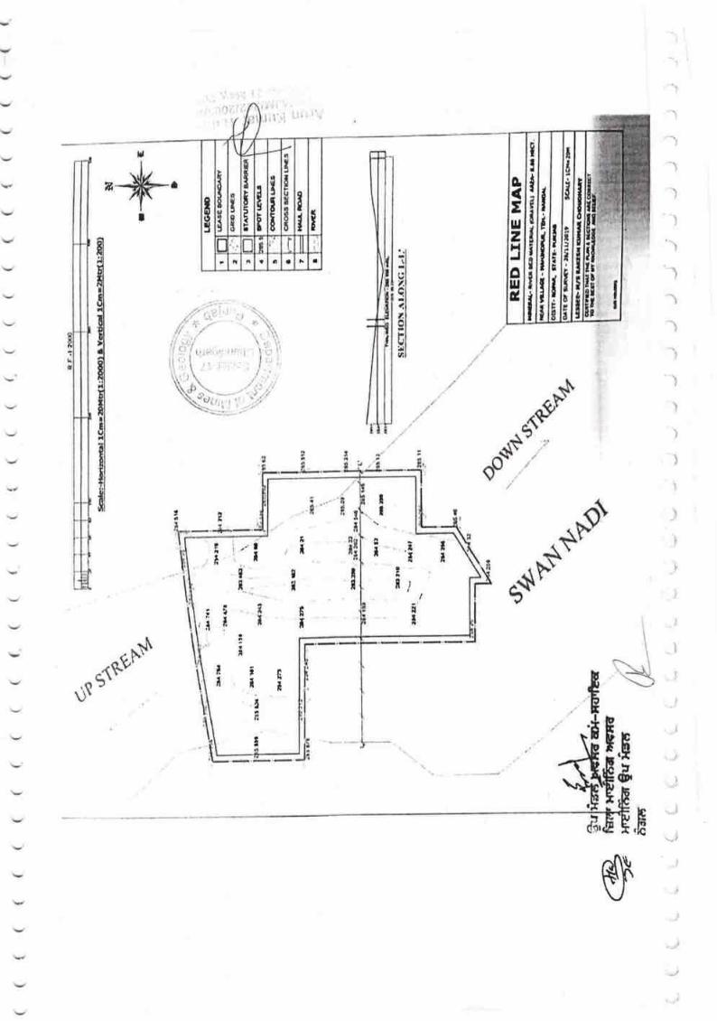
.&Ll
I
a
rl
t.l
!l1l,lolFIvlUIal
l
)
I
"tt
^f-{!,
.a''
do".
-$I$'
n,.
I
^{\?
$**u$l
h,$5
(&l
IUtr
$
$
hlrt.lc
IE
!
n
a
I
L
\ ,
llri(E
n
ItTn
a
ITd
l!ri
i
II
(I-a
f;o3
n t a a
III
Ii
I{I
o(Eltt25o
IIa
IIi
r ir'i rr . ii: '
.,:.
T
tIfl
tI
)
Et
tttE
TII
T
t
tI
,r
T
il
i!t
il
g
n
II
n
tiT
i
i ... IR' L
:l,i I
I i i'3'1
t*\ .\\t3
i,,
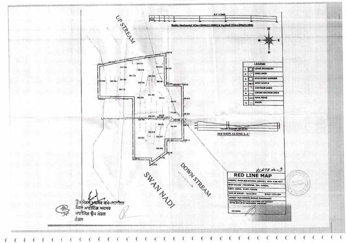
t
I GllO
I al^tutc!
1 lFOr tEl,l5,t
t rltcr
a
I
a nrrtt
RED LTNE }'tAPrl!} I'.' FCC',
tarf llUa0( r
'rai
LEGEI{D
SrcTLM6
CqTAR LIN':
SL
10 mwtilRY
wfR mssnY
MR AEO
li:
,MN
AREA- 8.85 h?cf.
( ( ( ( ( ( ( ( ( ( ( ( ( ( ( ( ( {i ( 1-1 1-{ -'("-( (-{ ( -( '{ ( -.(
lid\
tmN
R t:-t.5m
N
.#.c
((((
i0:F
5q)\
S'CAL€- rcil=5OH
I l, 1l aese ana
. lffirouB
,_ ll sr^rwmY 8^RRER
leuwarrre
lecnrcutruu urc
IRIVER
I plare xo.- a
ENVIRONMENT PLAN
DISTT. ROPA& STATE. FUil]AB
LESSEE.
&
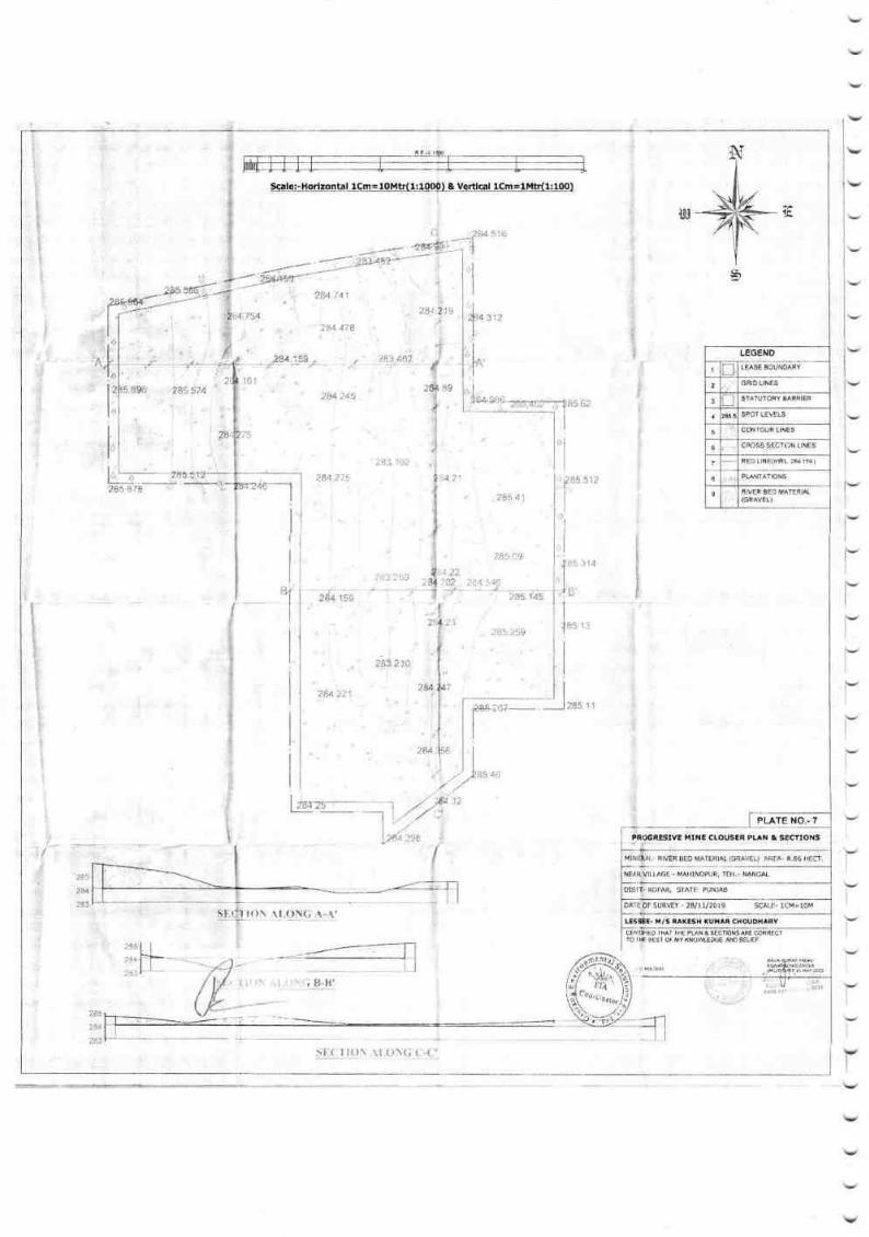
LINES
3 STATUTORY EARRIER
LEVELS
5
5 tINE$
7 RED LINE(mR| ?e lte I
I PLAN]ATIONS
9 8ED MATERIA
161$9
'l
2A5 41
?s$ 09
2U?45
264
.1r8.i 1 ii;i
PLATE NO^.7
& SECTIONS
II]AGE. MA}[NDPUR, TEN.- NANGAL
ROPAIIJ SINTT- PUNJAB
F SURVEY - 28/1rl2019 SCALE" 1CM=1oM
E. M/S RAKESH XUHAR CHOUOXARY
4E
F
13
516
r$as}-_-_
.\r,{.),YG :1:t!1
. , t,"rt'
244
I
rrI
rI
rri'lv
v
l-l
I
)--
l-rl--'
u,
ili $o,,,It
l'1,.
llyg*u*.1*,.,?8il {,i),1 "
I ,1285 s 1:
i'l
i'I'r
185
I
I
I
.'-''' 'rl
I
I
*[
I
I
i
I
I
I
' ,,' .!i:s a,i
I ,rrza-- - -'1 /,' .jo;'.)r-::--:-- _l
"
.l-,/ :,1 .',
1
I
-"1
!1,{. 1.!{}\ .\r oli(; { t-(r'
LEGEND,, ,"
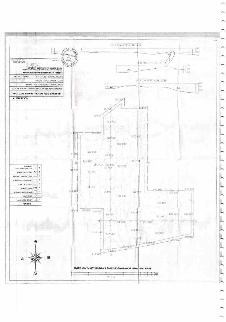
lwmnoHt rvflu xslxw s/x -3tss3l
B0r.Hll-3IVJS 610zlll/tZ-E UnSlOatVO
€vtNnd -l vs 'uvdou usto
]V9WN - Hlt'rndCilllVW - f,9VTtA WlN
'Lf,rH 98 8
sxolrrrs t Nyld 'llfrco.t()te ,rvJuns
, -'oN 3t\nd
rvEllvw o:8 uf^ru(llAYUC)
0
lA!:slu 03^ord
(sr F. rpEMl o;l
s3Nll {Orr3f,S SSOUC
s3Nrr urloff,oc
10ds
ulruEvS
r9i. y8e .
c)/z t8e
692582I
?, sL7
e9 t8z
ts/-i,
6[
,. )-. ) \ \{l
llIJ
L-L-
I
,3
9t
*--*r-*J
ZI
9r9' :)
t'lrt
!\ri,
i;ii::
:ri{. Ei:
r$e
|.sa
i
I
I
I
i
I
i.,
:)\() It Narr:tlif
-pd'
,d'
It.
,ii
I'ggii rsz
t,BA
l
i;iz:r'
I
I
I
' ,^,,1: Yrtt
I
:11
I
) tt .iE,t
!
I
I
I
I
I r9 gSZl
I
I
I
!,
0[z ese
Irt 982
gvi wz 'tozwzel. va?
,1.
iI'
t_ --!ret8z ri
L
l.
rte$ $Sir: $.jV rr
,Vf
6
Vt 8R
s3Nrl 0ru9
oN:lo:l'l

, {,,t_
'f*
C
5i,{_1 I ()
284
STA'
RIVE
(( ( ( ( (( ( ( (( ( ( ( (( ( ( ( ( ((( ( (( (
!L!'flIl ) $J,{.!Ili !. :{,1
&
RIVIP 35P Pq166141
. MAHINOPUR, TEH,- I
ROPAR, STATE- PUNJAB
suRvEY - 28ltll20t9
THE PLAN &
THE OF MY KNO\A'LEOGE AND B
(LOI rcWR)
((((
2$4.478
, 7M754
284 181
i(C
2A5.2s9
'.?3 162
284i?5 i
?43 25pr
. 284.27'
LESSEE- H/S RAKESH KUMAR
-1u.V,
/ls7,-4'It*.V,
'-J n{
':ir--*' :
tfl,
1 t--tiI
2..i..<ril
3
285 54
6 CI
7
( ( ( ( (
scrls-Hor.zo.rtal fgEEIAIg4(lJgS"o)q Y_9Eq']_LQE =!!q!49)
a,'t*-
LEAI
SPO
*..ffikh€
._ -,2.u.1..5-9.;.. -. *-_'t - . .?9.?-
14 )aa
2*4 ?'21
312
\l.r
LEG
GRII
**.-t-:,lET
?55 C9i
I
I
i
zB4.i.2
1
I
,JrtP..
ry

284
t
t,,
r**?85 1
46
sI,(:'t't()1\ .-\t,()5(; A.A'
t. it
AO&LIE'245
tB4. -.* itt,.o..',
i t.l M4"{tuv, " 4Di ,sr'r.noei/r.1/rdr/r
6rD D.r! r: iAv D3
t8 iiC
312.
2i
285 41
89
2q5.09
. 285,25S)
RECLAIMED
275
')trn;q,l
?8.4 221,
284.161
?83 210
;i
:. i84 741
LEGEND
.lFTTffi*-_1 ln I LE$E souNoARY
z lr lcn,ortxess lfJ I
sreruroav ae'aten
r lzr sl snor revers
s Iit'lconrouarrres
6
7 RED
a PUNTATIONS
I RIVER
HINERAL- RIVER BEO TATERIAL (GRAVEL) AREA. 8,86 HEfr.
ilEAR VILLAGE . MAHIilDruR, TEH,. NANGAI,
DISN- ROPAR, SIATE- PUN]AB
DAIE
LrssEE- x/s
sr.cTr()i\ {r.oN(i ('-(:'
PLATE NO..6
CONCEPTUAL PLA'{ & SECTIONS
, -,)i,;;':
9cale!-Horlzonta.!-lcmEplrlr{1JqQo) & Vertical lcm=1MtI(1:1q))
6
b
t'I',ll
I
lI
l, 'l283.1$2
i,.:I
284.247ti
z*luu
.32
/i-1.1 li 15 'bes srII
I
I
--r*rr"-l I
I
I
I
ii,r
TI
I
I
I
I
L
2$4.1 59
'13
}i4 I

T!ASE BOUNOARY
2GRIO LINES
3SIATUTORY AARRIEF
SPOT LEVELS
5CON'OUR LINES
I CROSS SECTION LINES
RED LINE(mRL a 1$)
PSNTATIONS
I RIVER BTO MATERIAL(cFAVEL)
PLATE NO..5
AR WISE OTV€LOPHEI{T PLAN E SECTIONS
Ftl\ RAL. RVERBEDMATERIAL(GRAVEL) AREA 4,86 HF(]
NU VILUSE . HAHINDPUR, TEH,. NANGAI,
ctli r. ROPAR, STATE- PUI]AB
OAI of suRVil - 28/11/2019
lEs iEE. H/S RATESH XUTAR CHOUOHARY
el
/
E
s,
tt
285 1t
85
1/r. I
516
r**4rl
'1
285 41.
285 09
284 54i
| 285.259
8!r
284.21
i
281 162
2aj.759
" ,21!'+:!45
28l..2i5
?u22i
.\ L()N(; ..\,.\'
; ,(i Li'['
I
I
I
I
()\
h
$E-(JI.0r\:!1.(l N {i (ri i=1i
LEGEND
U ..284
-:-1;,/-1,;
--:''2M !41
II
?3,1 4;P
A
384 101
.ll
tr
I
I314
EE rr5-iti
;, 13
283 2i,0
,,4
I
IP56
J
I
L& ar. ')?
i::f f,?84

r{I
oz
FUu,-roq ur>oo -t tY
2-i u<u_I t/1 T
-t 9oL=e 90^9 '-d* uJ (J
>2 ic'gil 3 gJLq<'-coolJ=c.<r'i-i*--iC)Y=z.N-E6r>A5zq rr uI
gEiB=
=gfi8f;t-) uDl))Y .' lrJ
tail,ttt
=fi'e E ffi>zooJ
E,uloJoJ-
oJ
s
UlJ.ld.&oULrJE
azoFuUJ.noU
z3o-E':EFk-FolJ.l
LL
FG,lJ.J
U
t!
g":t'
2
lJ-oL^IJ.J
6lrlIF-
oF
ttuJ
=UJco
ozTJ,J
EnRx\>FN<sf€NZix?r">kcr o66
:i
S&"
*F
6F
6
..ITYATYHi.:
c*5FIoti
Id
:.8Ia t -.
,\
-"3
.r...
'. !- -.E
't,'o,. .
ie
\ ,.a ,'.' .' !.t" .-' e4.' B ..
a(,c -'
.t- .', ,&-
;<o9vil
* $, .[$!ii,lilI:i!
l-rI;:!o
a
I
itrlli
+
a
fi
9t
t
tInt
,l
:t
-+
t
)
ea-t*
E!u*FB"Ba
otroi
flrt r3tat!t!
Iu'
.go
rdE
o!ci
I
1)
o-
z
=kUo
I
I
I
i
II
I
I
alI
-l
rr,
-7
v
i
Y
ti
Y
\7l
t
ijii:
l--- .\ ,
t5\
?.
$
t
5qza
2:Iot
ter7
a
a
ti,
IlE
lr
,
I
E
ItI
ir
l"laIU
l3
';,tf
I
E.TTlf
r llIri i
iliii3&t
I
na
II
iI

fi{ qdi.g'.'.S }}r6fi-d'
atr5dldl
,.';
exure-ll
,rrnr fr d frE frEd 66
du
\t''1 ' \ (
*etra d ltot, flf$ 23{61201 6.
E{r€ ffi t€ ir€te
€B
*S ad.a ?ffi a,.d -at
tS, E-f,6'
1:
trn ffi, *uH%,*,d.t.'m.roat
1d6H-d,
ffi-
T€rS:-
dso,3otl
ffie HEe ftry dfrt

*attcm in the District: Fo rest,A gricu I I u rc,H o rt icult u re,Mining etc.
o4 ofArea in Rupnagar District of Punjab slate for the year 201 l -2013 (in HectaresJ
-;A-v-,-'"-6, S-1.., i ) c i r
Assi sr.anr Directsr Hordcutue
Roopoagu 'f -
Not Available for cultivation T€{alcropryed
Areathatr
area
oncc
Araio*filmo(t
under
I
I Forests
Area underNonAgriculturaluses
Total
Other uncultivated land excluding fallcri* lard
[-and undermisc treecrops and
Groves nolincluded inNet Area .
T*a,
fal*qsI art
Cultivable
'irfa51e
I-and
IET
Art2$a\rTl
Barren
and Un-cultivationLand
i
I
r 1(( (((((((((((((((((((((((((((
(
r
Lrnd{Jtilizatio
itatisticsn
$nt* ili?d' linder if orti c u I tu re crcps : -548? Hect a res.
InmlngaCtivities Permanent
pastures
and otherGrazing
Lands
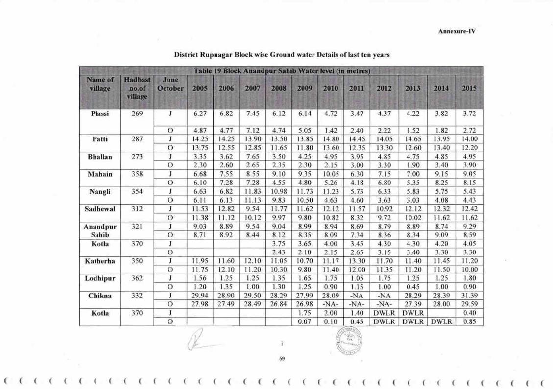
Annexure-IV
District Rupnagar Block wise Ground water Details of last ten years
59
( ( ( ( ( ( ( ( ( ( ( ( ( ( ( ( ( ( ( ( ( ( ( ( ( ( ( ( ( ( ( ( ( ( ( ( (
J 6.27 6.82 7.45 6.r2 6.14 3.82 3.724.72 3.47 4.37 4.22Plassi 269
o 4.87 4.77 7.12 4.74 5.05 t.42 2.40 2.22 1.52 r.82 2.72
J 14.25 14.25 r 3.90 13.50 r 3.85 14.80 14.45 14.05 14.65 13.95 14.00Patti 287
o 13.75 t2.55 12.85 I 1.65 I 1.80 13.60 12.35 13.30 12.60 13.40 12.20
J 3.35 3.62 7.65 3.50 4.25 4.95 3.95 4.85 4.75 4.85 4.95Bhallan 273
o 2.30 2.60 2.65 2.35 2.30 2.15 3.00 3.30 1.90 3.40 3.90
J 6.68 7.55 8.55 9. l0 9.3s 10.05 6.30 7.t5 7.00 9.15 9.05Mahain 358
o 6.10 7.28 7.28 4.55 4.80 5.26 4.r8 6.80 5.35 8.25 8.l s
J 6.63 6.82 I 1.83 10.98 11.73 tt.23 5.73 6.33 5.83 5.7s 5.43Nangli 354
o 6.1 I 6. l3 I l.13 9.83 10.50 4.63 4.60 3.63 3.03 4.08 4.43
J I 1.53 12.82 9.54 tt.77 11.62 12.12 11 .57 10.92 12.12 12.32 12.42Sadhewal 312
o I 1.38 lt.t2 t0.12 9.97 9.80 r 0.82 8.32 9.72 10.02 11.62 1.62J 9.03 8.89 9.54 9.04 8.99 8.94 8.69 8.79 8.89 8.74 9.29Anandpur
Sahib
321
o 8.71 8.92 8.44 8.12 8.35 9.09 8.598.09 7.34 8.36 8.34
J 3.7s 3.6s 4.00 4.30 4.20 4.053.45 4.30Kotla 370
o 2.43 2.10 2.15 2.65 3. l5 3.40 3.30 3.30
J I 1.95 I 1.60 12.10 I 1.05 10.70 I l.l7 13.30 lt.70 I 1.40 l1 .45 11.20Katherha 350
o 11.75 t2.to 11.20 10.30 9.80 I 1.40 12.00 I 1.35 11.20 I r.50 10.00
J 1.56 t.2s 1.25 l 35 1.65 1.25 1.801.75 1.05 1.7 5 1.25362
o 1.20 1.35 1.00 1.30 1.25 L00 0.90
Lodhipur0.90 l.l5 1.00 0.45
J 29.94 28.90 29.50 28.29 27.99 28.09 -NA -NA 28.29 28.39 31.39Chikna 332
o 27.98 27.49 28.49 26.84 26.98 -NA- -NA- -NA- 27.39 28.00 29.59
J 1.75 2.00 t.40 DWLR DWLR 0.40Kotla 370
o 0.07 DWLR DWLR DWLR 0.850.10 0.4s
Table 19 Bloclt Anandpur Sahib \Yater level (in metres)
Name ofvillage
Iladbastno.of
village
JuneOctober 2005 2s06 2007 2008 2*89 2010 20tl 2012 2&13 2014 20r5
/ t,/w

( (( ( (( ( ((( ( ((((((((( (((( ( (((( ((((((((
Annexure-[V
During the year 2005 the water level in Anandpur Sahib Block was observed to be highest in village Bhallan in the month of October
at 2.30 (in meters) and lowest in village Chikna 27.98 (in meters) while in the month of June the highest water level were again
observed in Bhallan at 3.35 (in meters) in 2005 and lowest in village Chikna at 31.39(in meters) consequently in the year 2015.
lt
J 18.96 18.50Manakpur 285
o 19.55 18.80
5.25 4.90JBhatto 262
o 5.95 5.00
J 5.10 4. l0Bhanam 271
o 5.90 4.20
J 3.23 0.85
3.0s
ShriAnandpur
Sahib
321
o DWLR
I 1.30 I 1.70 I l.l5 12.00J I1.40 l 1.85 I 1.45 I 1.80 l1.80 11.20
I l.l0Jattpur 392
o 10.80 10.80 9.90 I 1.30 11.20 I 1.50
J 3.72 4.00 4.60 4.40 4.70 5.10 3.90 4.60 4.70 4.80 4.70376
o 2.45 2.77 4.55 3.05 3.00 2.80 2.90 3.30 3.00 3.85 3.10
Saidpura
J 7.76 8.42 8.52 7.32 9.02 10.52 7.17 9.52 r0.72 1t.02 10.42397
o 6.67 7.52 7.80 6.32 7.00 6.25 7.32 7.82 7.42 8.92 7.72
Parchande
J 3.75 3.60 3.68 4.00 4.l s 4.60 3.60 4.60 4.80 4.90 5.20410
o 280 2.30 3.30 t.75 2.00 2.30 3.00 3.40 3.50 4.4s 2.20
Bassi
60
Table 19 Block Anandpur Sahib Water level (in metres)
Name ofvillage
Hadbastno.of
village
JuneOctober 2005 2006 2007 2008 2009 2010 201 I 2012 2013 2014 2015
Table 20 Block Nurpurbedi Water level (in metrcs)
Hadbastno.of
villase
June
0ctober2005 2046 2007 2008 2009 2010 20tt 2012 2013 2014 2015
Name of village

Annexure-IY
During the year 2009 the water level inNurpurbedi Block was observed to be highest in village Bassi in the month of October at2:00(in meters) and lowest in village Jhadian Khurd at 18.80 (in meters) in 2010 while in the month of June the highest water level were
again observed in Bassi at 3.60 (in meters) and lowest in village Jhadian Khurd at 18.60(in meters) consequently in the year 2006.
iii
61
(( ( ( ( ( ( ( ( ( ( ( ( ( ( ( ((( ( ( ( ( ( ( ( ( ( ( ( ( ( (( (( (
18.80 18.70 18.68 18.78 18.48 18.38J 18.60 18.30 18.35 18.20
17.00 18.20 18.60 18.28 18.28 18.08 18.28
Jhadian Khurd 515
o 18.00 18.00 17.20
J 5.41 5.51 5.37 5.21 s.29 5.75 5.00 5.76 5.81 5.66 6.06Madhopur 434
o 4.44 4.76 3.91 3.26 4.50 3.55 4.15 4.46 4.66 5.86 5.56
7.26J 6.98 7.15 6.55 6.45 6.1I 6.55 6.25 5.90 6.4s 6.30
6.60 7.40
Tibba Tapria s20
o 6.67 6.15 6.15 5.15 5.90 5.70 5.00 5.65 6.0s
8.55 10.00 9.l5 7.30 10.10 9.90 6.80J 11.75 t2.25 9.70 9.40
7.15 6.85 6.30 5.30 4.60 5.45 5.50
Kartarpur 502
o I l.l0 8.40 8.65 6.35
5.34 5.79 s.04 4.04 5.04 4.84 5.24J 5.20 4.99 5.04
3.74 4.04 3.24 2.74 3.89 4.24 6.39 5.54
Madhowalo 4.74 3.64
9.20 10.55 9.40 8.50 8.75 8.55 8.10J 8.45 8.90 8.50
6.60 8.90 9.10 6.35 7.90 8.80 9.80 8.35
Rampur 489
o 7.15 9.00 7.30
13.00 13.40 12.60 DWLR 12.60J
12.70 12.90 12.40 DWLR 13.05
Bains 417
o7.35 7.00J
8.r5 7.10
Mahindpur 478
oJ 9.05 7.70Kahvan 488
o 9.75 7.80
10.06 9.7J
10.95 DWLRNurpur Bedi 394
ot4.5 13.8J518
o 15.30 14.35
Rajgiri(NEELI)
'i
/Vtlr
Table 20 Btock Nurpurbedi Water level (in metres)
Name of village Iladbastno.of
villase
June t'
October2005 2006 2007 2008 2009 e0{s 20tt 2012 2013 20r4 2015

( ( ( ( ( ( ( ( ( ( ( ( ( ( ( ( ( ( ( ( ( ( ( ( ( ( ( ( ( ( ( ( ( ( ( ( (
Annexure-IV
3.02 4.37 4.82 4.42 5.92J 4.72 4.67 4.72 3.62 4.07 5.22Mallakpur
o 2.82 3.14 3.32 3.32 2.02 1.82 2.12 2.72 3.12 4.37 4.17
35
J 4.60 3.90 5.08 4.60 4.70 4.45Bhagomajra 210
o 1.80 1.55 2.90 1.85 2.00 1.55
2.77J 1.67 1.77 1.87 1.47 t.97 2.t7 2.07 2.42 2.67 2.87
1.35 1.87 2.17 1.87
Barha Pind 326
o l.l I t. 19 1.07 1.05 1.00 1.57 2.12
4.60 3.75 4.41 4.56 DRY 4.06J 4.07 4.39 4.10 4.80 4.50
3.95 1.04 1.00 1.03 3.00 1.45 2.33 1.76 2.00 1.46
Jhalia Mahla 59
o 2.45
J 5.85 5.85 6.60 6.70 6.65 6.30 4.95 6.30 4.85 5.43 s.55
4.90 6.25 5.70 5.05 5.60 5.60 4.15 5.05 3.75 4.70 4.65
Ropar 44
oJ 3.60 3.73 4.t4 3.94 4.64 4.66 4.44 4.49 4.r4 4.54Bhakho
maira160
o 2.88 3.14 2.94 2.55 2.74 3.84 3.99 4.34 4.54 5.74 5.14
J 5.40 5.50 s.80 5.50 5.30 5.05 5.10 4.40324
o 3.40 3.90 4.10 3.60 4.00 4.30 5.10 6.05 4.80
Gardaley
J 4.60 4.t5 3.15 2.65 3.10Bhago Majra 210
o 3.70 3.10 3.15 4.45 3.45
J 27.15 27.80 27.50 DWLR 27.90SinghBhagwantpur
215
o 27.25 27.20 27.35 29.00
8.10 8. l0J
8.40 9.10
Rael Majra 22
o4.8s s.20J
6.30 5.60
Attari 322
oJ 2.40 2.40
3.50 2.80
Nuho l5o
8.70 9.80J
10.00 10.35
Relo Khurd 178
o/aA; LN 48.65 49.30Haripur 371 J l
iv
62
Table 20 Block Roopnagar Water level (in metres)
Name ofvillage.
Hadbastno.of
villase
June
October 2005 2006 2007 2008 2049 010 20tl 2012 2013 zAM 2015

Annexure-IV
During the year 2008-2009 the water level in Roopnagar Block was observed to be highest in village Barha Pind and Jhalia Mahla in
the month of October at 1.00 (in meters) and lowest in village Bhagwantpur 27.35 (in meters) in the month of October in 201 I while
in the month of June the highest water level were again observed in Barha Pind at 1.47 (in meters) and lowest in village Haripur at
49.30 (in meters) consequently in the year 2015.
49.80 50.35o
J 5.97 6.s8 6.75 6.50 6.75 6.95 6.40 6.25 7.40 6.50 7.00
o 5.74 6.40 6.0s 5.90 6.10 4.90 5.50 6.70 6.55 6.50 5.s0
Silomasko 69
J 3.85 n.o. 3.20 3.64 3.40 3.70 2.20 2.75 3.50 3.20 3.90
3.00
Bela l4to 3.56 n.o. 2.40 2.40 2.95 1.30 2.10 2.85 3.20 3.00
L95 2.40 3.35 3.6s 4.30 3.65 3.80J
o l.00 2.30 4.18 3.80 3.20 3.00
Fatehpur r32
6.29 5.59 5.59 6.99 5.29 5.39 5.69 5.54 6.89 s.69 4.99JRaipur 149
o 5.09 5.37 4.90 4.89 4.89 4.79 4.89 5.39 5.34 5.84 4.69
J 6. l0 5.90 5.80
6.20 7.60 6.l0Khokhar l14
o4.25 4.10 4.00J
4.30 5.65 4.35
Behrampur 125
oJ 13.70 13.50 13.55
l3.85 14.90 13.90
Behlolpuro
63
( ( ( ( ( ( ( ( ( ( ( ( ( ( ( ( ( ( ( ( ( ( ( ( ( ( ( ( ( ( ( ( ( ( ( ( {
Table 20 Block Roopnagar Water level (in metres)
Name ofvillage
Hadbastno.of
villase
JuneOctober 2005 2006 2007 2008 2009 010 2011 2Al2 2013 2014 2015
Table 21 Block Chamkaur Sahib Water level (in metres)
2008 2009 2010 20ll 20t2 2013 2014
2015
Name ofvillage
Hadbastno.of
villase
June
0ctober 2005 2006 2047
)lt,y/r_(
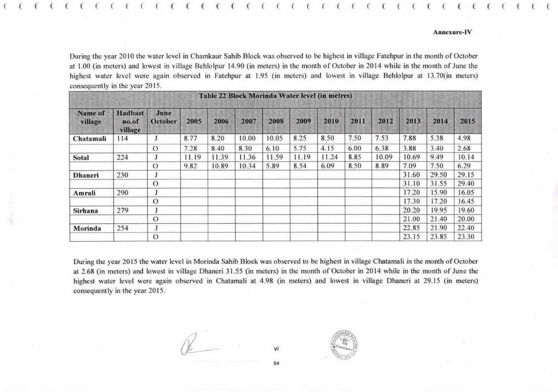
( ( ( ( ( ( ( ( ( ( ( ( ( ( ( ( ( ( ( ( ( ( ( ( ( ( ( ( ( ( ( ( ( ( ( ( (
Annexure-IV
During the year 2010 the water level in Chamkaur Sahib Block was observed to be highest in village Fatehpur in the month of October
at 1.00 (in meters) and lowest in village Behlolpur 14.90 (in meters) in the month of October in 2014 while in the month of June the
highest water level were again observed in Fatehpur at 1.95 (in meters) and lowest in village Behlolpur at 13.70(in meters)
consequently in the year 2015.
During the year 2015 the water level in Morinda Sahib Block was observed to be highest in village Chatamali in the month of October
at2.68 (in meters) and lowest in village Dhaneri 31.55 (in meters) in the month of October in 2014 while in the month of June the
highest water level were again observed in Chatamali at 4.98 (in meters) and lowest in village Dhaneri at 29.15 (in meters)
consequently in the year 2015.
vi
64
tl4 J 8.77 8.20 10.00 10.05 8.25 8.50 7.50 7.53 7.88 5.38 4.98Chatamali
6.00o 7.28 8.40 8.30 6.t0 5.75 4.15 6.38 3.88 3.40 2.68
11.24 8.85 10.09 10.69 10.14Sotal 224 J I l.19 I 1.39 I 1.36 I 1.59 I l.19 9.49
10.34 5.89 8.54 6.O9 8.50 8.89 7.09 7.s0 6.29o 9.82 10.89
31.60 29.50 29.15Dhaneri 230 J
o 31.10 3l.55 29.40
17.20 15.90 16.05Amrali 290 J
o 17.30 17.20 16.45
20.20 19.95 19.60Sirhana 279 J
o 21.00 2t.40 20.00
Morinda 2s4 J 22.8s 2t.90 22.40
23.15 23.85 23.30o
Table 22 Btock Morinda Water level (in metres)
Name ofvillage
Hadbastno.of
villaee
JuneOctober 2005 2$O6 2007 2008 2009 2010 2011 2012 20r3 2014 2015
&

Annex-6
€rnnr gu lh ffiseBs, Ifuru, ftnr S^emn
*tu:.,.,r.r......r...r.r...".2g196fu,*,t fdh.....,...r.r....
fu. ftrt
{brr# Eflttrttr,
Iuwnrl
lhfi* ffir pmar llfs Hr$fd$ur wr{-l d {F:t&r {t tlta'tttfr qrs$ ilf*t
(f€w:- , )rrr{ * t ery{ g ftrg d:2004-06 flrS te.09,2019 h{* r}?s f:zeEg*2300 S.{dl
07,10,2019 h,f* rIeE *:eooa*64/t,ff,bf'jil.8.3 flrS t4,ll,tg HSfft
$r&€ frt xf* ffi d fr frH' sofi {r lttr HtrEIr et firynd$ d^ ftftrs
sffitrc's, danr ufr'rlw rf: 4l3ls,q flr$ 29.n.2019 trfr t* sre trhr.u * $ urugrsriq'rf*rg #lal3^g.q f,+* 29.11.19, rynu ftnnrBf qnft, E,,f;r* fra", nrar br* fi'UHr it
s1{f anflx{t rIgU Er6 F fl{s re& ry'u * d tffirfi'fi fiTr r.dgr.S ffi tfr}1il fir$h{t 06t
tffi:-San uSBryt
frIp*:rfirg:..,,..,...* 7..,...,..20 t gih{,
fuHs'ffi'gircr ffiftiftrrn, t{dffu hr} ffT€*ff fs.dr, *H.e,*H. mm {Es# fdg tflmof' Plgr ! 1 .-
Sr*-
v
--# -tu *rs'|}ffi"fen r
r*,i,/*/tV-
gu fssftnrt
65
&

,',"4''
IT
-GSI lir6ftffic E fusnidrg
nlx.fi.s fi{-$ llll"l>o>o
fgn:*
".6d orflrrrrs,grffdrdt
G
Hdftfu ss'q ?tre-t, Ex{6irnr fu'tr'fr Eqfl" rfqiro 6rk8 d8'fuirdzgr 6$fir
..lf*r fi t srso t fJ-d i$:tz+s-q&t.fi.rrrq.t. fi+* rz.og.zozo nffito€rctr:-
I
i9: HHo
fr€'H)-
1
E
-*
E
I
S{+{s ffi }ili*'ffi ** ntel t fu f6}r6 r}t:rn{ii dB 6 * }rdz
hQirs EtA q.E fdrc fu rrfq1 flrS oo.ro.z020, 8.l0.2ozo rrr3 14.10.2020 d frPaI
ofr$ ar*rHdz h.rt*s q.k* d# oftreth{t rT.dx{t F'*{, ?fu}{r r fr }, rrinl fi 6 fiio
# fifd' fuUro, EA€.6 ni3 g6'E fr f{fca ufiigt fi ** ;r' f* t rgfridat, 5 rir' flis
irrfiIrdt, r+fdega, rrgrfr, urler 1fl3 HAE fr fdl}re fr' fa F*e hrtffi qlt& {# r{=136
rcc $rds fct-rc fJrlrril dd affi t, ,rrro fu&era-drs am xf,rs ag& zrnr fi d rrrdrBd
ril-dr EFBE f f& a#;rt'S t *titfi:- x'*a rrrkrs arfrfr d ums fuirea t
_tA
Sr fts ilfrbrda,E1 _rrd x'laarttargr
-
-
tG-
-
lln
I
Iri
tl.'i--
.*
lG'
-
'T
.Ir
&

Annex.l2Mobile : 94102-.l9028
E-mail : rakeshtubesl [email protected]
RAKESH KUMAR CHOUDHARY51BlD, Gandhi Nagar, Jammu, J&K
Ref. No. Oated:
tJnderlaking
I, Shri Rakesh Kuntar Choudhary Sio Shri Krrula Rarrr Resident of 5lBtD Candhi Nagar,
Janunu,.l & K. do here bv undertake that
i) No Cluster lonnation of mining site exists as no other mining site falls within a radius of
500 nr from the periphen of proposed site
ii) Mining site is not located in stream as per the actual layout plan enclosed hcre*'ith and nq
in sbezun minirrg is involved,
iii) Mining will be canied out by manual opencast method by hand tools withoul r$$ of
drilling, blastrng and JCB or any other nreclrmiz"ed nreans.
iv) All the stipulatiotrs provided in the sand mining guidelines, 2016 & Enforcement &
Monitr:ring Cuideline.s for Sand lvlining, 2020 issued by MoEF&CC will be complied
rvith in true lctter & spirit.
Il ;'Ii<l I'1" :r ;nr r Chouclhrry
5l lirD Ctt:: Nit gltr.
Jr
Shri Rakesh Kumar Choudhary
5lll/D Candhi Nagar, Jarnmu. J & K.
131

nexure-ll
*{ffiirsd?ils
, t,,.,]
I
Vl
I
v
-]
?.s
)
rl ;,
i,,

v
I
-c
a
a
a
't
It
(
a.o(tBt\}.o,*,(,o
" :l
; i i:':$t-,-
ar" fs
#.u
_.,. .4'-4,
'*13
o
;{y4
x*€
1fr
oefi.Ut
,: t_.
a
-.*'
-l
,;ffii:"l'
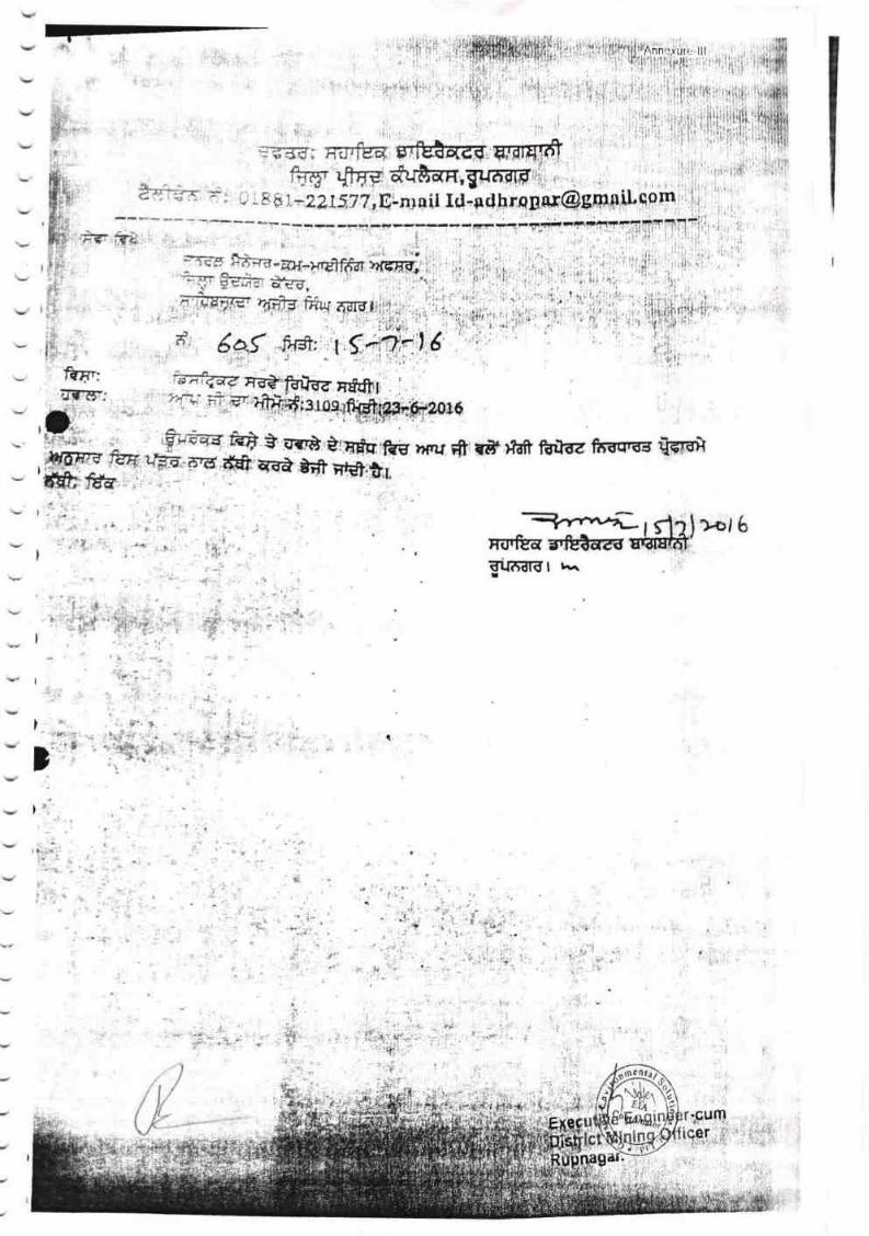
*-*vt--rflrtFs.rea s'iEareg EdffiEl{fill?l r.^
){,6f
t
)
)'*.
(
'' .t
' li:r
"r i',.1.
.,,,'lr
1
I
"*Pffi,
,i
I
ftp:IIII]F;
*f * sg* arfr:kglE .e ffi qvA &frilg1il-6nr f r#)tdfr fdtJrz f?tfircs @
.t''

Is3
C.
eG
IC,
55S
5
n.t
*
i{A
{'
t
'/-t
dt,
.l
.1
r
o
4d
3I
I
I
l,f ' " i i
lI-;.d.-.
;ia.1V
L
f.,
I.C,
3lL
$Jrt
J
rL
2
a
th2.dL
o*rl
r'lr)r)
C)a)
tt,
g?'
Ct
aln
iAt
l)
tr,{,J t
iI
teF.
4-
,y':!
rl
,l
i
;l
'lr
I '1. ;';' 'h' ,
a a..ilfr P.i'4'F'1
i;, I Jr:- l; ,rz l.' L-{.
'r gl,1
, ,,, ",&'ift3,
l,l Eil4 6'
rl
z!
14,V.,''4
a
t,
o
4ritiil
ufl
:ar
i,b
,
il,
I
a
1)
,t, ,l
i:l't,
I
i
i
t'I
i
i'
.1
, ,r,
i
I11,
iri
,!,
t,{lr,
?,
qt1
'I'

rl-'!J
3XI,UzZ
4
5t'
o
;
'184.?.75
RIVI,R BEO
PUNJAB
&
tl20L9
&
MY
))\)\ ))),1)))))))'))'
;
I
I
I
I
l'
k
?83 25!)
i-II
i'i
II
II
I
t.iI
I
l*I
I
!
284,764 'r*ip
j 284.161
RIVE
i
I
II
ISa zt,.{
:
z:Q tal
2U.?it
I t!_.
2U2?1
I
I
I
I
i
?9 i .r,
:;.te o.
.{s4'r!2342<:? 2U
1'J2:31 i,:.?
' i?,121C'
ICC LJ\'
NEAR VILTAGE . TEH.- I
DATE OF
LESSEE. IrI/S RAKESTI
TO THE BEST OF
(DrruER)
l&1:+l. _, :
I
iII
I
II
I
i'i
e56
,), ) , ) , ) . ) ' ) , ) ' ) ') ) )-, )'t ) , ) \ ) ) ) ) ) )t)


IANNEXURE
RSChsJ
i[
r@q!rrds
a\*.Fi-\'i'\i
fr:rtal
(-
\s."f{Itit\)
.,d*/
, ",:*oo,sf
'.{t
$'
I t lr TI a
iF
IIU37
tT
,!tII
EzmI
I
F
r
"r4.
T
E.
t
-- t- -. f"
1
T
T,
tr'"
,ts
.. -.ji!'
i-g
ts
'.t
9"".
r
-!
't/,
Y
r{fi
fl

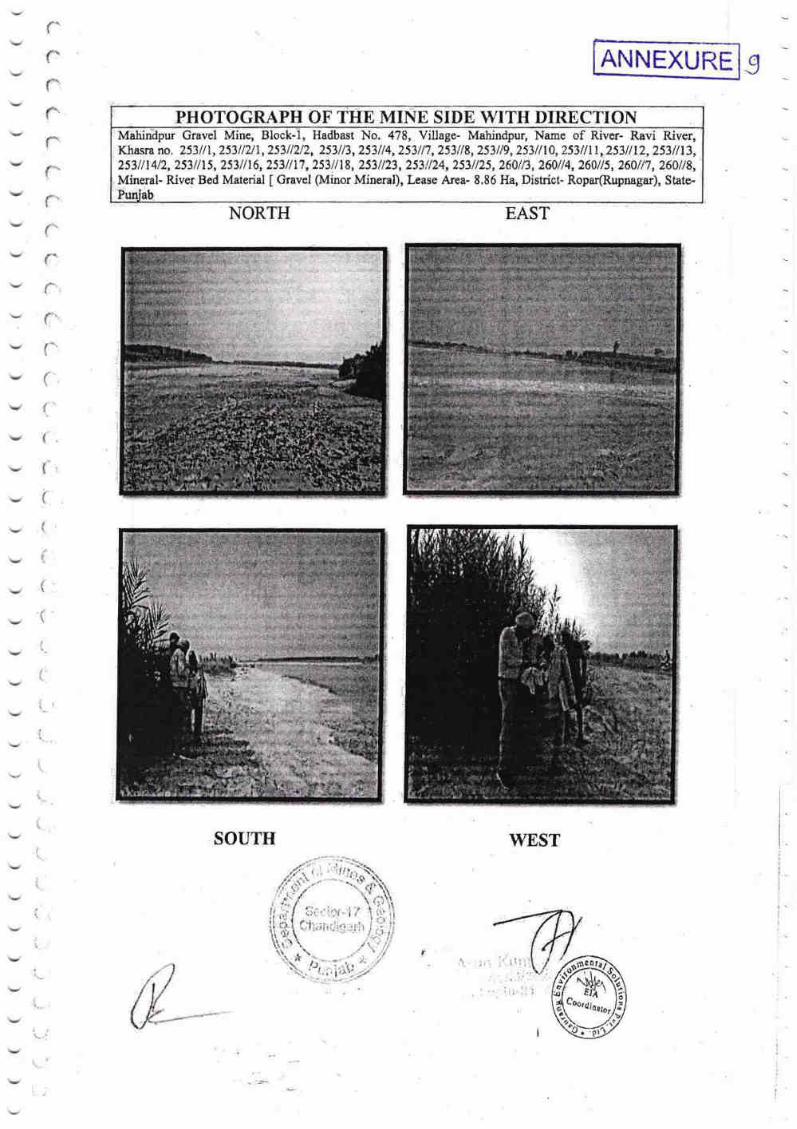
rr(":
rrr'f-r'{:'
f:'
{:,
f'(
fr ''
(-.
['.,
(
{
t
tI
t'
I'
i-i
t
l.
i"
i.
t,.
t,
i...
\,:
I
NORTH
SOUTH
EAST
WESTI
I
I
ANNEXURE
PH OF SIDE WITII DIRECTIONHadbast No. 478, Village- Mahindpur, Name of River- Ravi River,
Khasra no, 253lll,253ll2ll,253ll2/2,253113,253114,253117,253118,253119,253/nA,253/lll,253llL2,253ll13,253 I I 17, 253 I I 18, 253 I I 23, 253 ! / 24, 253 I /25, 2601 R, 26At / 4, 260 I I 5, 260 I I 7, 260 I I 8,
I Gravel (Minor Mineral), kase Area- 8.86 Ha, District- Ropar(Rupnagar), Stste-
2531 I I 412, 253 / I 15, 253 I I I 6,
Mineral- River Bed Material
Gravel
il
t
,riri
ir I
ll

v

LoANNEXURE
REO
PROVEO
I RVER EED UAERII(oRAVEL)
i 285259:
,!
.'F
i\..-
lx0
.478,i i'
r.ii
C
"-Pii'., ,'
284.215
,i
i
----fi'ilalN.\I.oNG (:-C'
):)
;iat
tf,8 lE
2s'4
l
j
754
1n1
I
I
['*'*-I
i
I
I
Bi'
I
I
'i
..Pd_ .
s l;r't'toN AI.oNG _{.::\'
- ={
I
LEOENO
1 lTl I tE^88 souiloARY
,I,rloRDINES
I ll- l I srlruronY ffirEn
SUNFACE
STAB PUME
.*_.t

'\,
I

litihr
Iti*':
I1I
lXs Alt1lr.uvi".ti virlu [ilucr rncntiortr:tl irttdct" rulcr'cncu, l:i'ttvisi0nal"
il('(:{lptitr'!{:e lur trililrcsr hirl rt:uour}l.u1li tr llupucs 4-9,u'1,00,001)i' Ilrorl"y i'1"*, firorc
liiltlrtl, 1;13111'lirirlls (lnlyJ trtic:'ctl tri'1,rirn'r'r;ulo l{irltr:sh l{ttttt;rrilhuwrlltilry ltr" lJloclt Nt>' i
;rrrri;rclr:pturl itr tlrr: f-;ltlr:tiur trr-rlr! rrr;l!.U7.3UltJ, il ltct'*hy accoftl*rl ltrtliut:t L(l'
Iirliitlrrr:rtl ul' lirlltrrvillli Lul'lils itnr"l curttlilit:tts: :
l. 'l'iru urtrruiri e{rrrrrssir.ut vllu* ni litt.r cttt'tccssitttr shall [ru llulluus
,'lr,$4,{}t}.{i(}(}l-(ljor'ty [',iirrr: {]r'rir'* liiliirty Irtttr litltlts (illly) p{.:r i.tnntttlr ltlr"Llrt:
tir.st y*ur.,'l'hc;lnlu;tl cunecsr,iiltt vulltu',r,'ill i:u itrcrcascd lty Ttlir lur r;relt
.srrl:scqirurli ycirr.'i'hc rort':ussiurtlrit'c shall iill;u pay lts.6t) per turrric to Ihc
ltttttlulvttui'.t -.-,-.-.-.:--.- -.,.....1ir,, rl,.,r r1.,.'t, 'l"hi: nnrrrrirl *rneussirrt tluttltLity llurt lhr: uunctssianlit'c stralI be irllu*,vctl l11
Itlltlu Jltrl'irlllltllrt lt'urrr tlrc lrloclt sltlll he 57,6() [altlt rrrctric Lt)nllc5.
3, 'l'lr* tcnn oI th* unneussittti slt;rll l;c lltree y0ilr$ wlriclr slrull bc cuunLrd {i.uru
nrrrrlllclit:n ot'all [nrrtullIics ineluiling taking crtvironmentai cl*urlrl]gl r;lr,4
.ll1(}rltllsll.rtlttitwl,tt,rlrrl'crllllt.ac[,wlticit0vCIiiieat,}icr.4. 'l'hc suct:es.slirl trirltlcr shall dcltosit (+ Z5(Xr oI unnual ctirrcr:ssion. virluu
irlonlpvith 'l'CS as l'rt'st institllttte ttt li'urrt his tleslgnirtcd lecourit withiri s{Jvcp
Ltrr)t'ltirtg tl;tys It'ol1] thc datu uI issuc n[ 1:rovlslurrirl ilcccl]tlncc, thrurilllttlr;si;lttatlrtl h;tttlt {w((}unl by ll'l'fililNtril;'f irr l.ltc ilr1rul'tluuntert'ut;rlull"l o!'
i lix*riltivc lin6ilrcnl-r:trrrr-l)isll'iut Minin6 0l'tiee r in-rlrarg* nl'ttr* nrinlrrg hl*ffi"
,, ,*, " i.* /rxis llnnlt Auufiurrt No. "9[itJ0zilU416t7lS7' l[Se C*tlc "tJ'l'1llQ.il,nt]5]]ill:
lit't:trtr 1"1-lJ (lhlnilil;lrh " 16()t)22.'l'he canrust rnoney (lil{l)) ul rhc $rri;russlrrl". ; ' r ;
" ' '' :,.
:: i . ritlrt:ussl'trl l:irtrlilt' tlous rruI tltrpusit tlrc rsquisiL$ ;ullugRt wliltln tlrc sr{prJln*tgtrr? "'* .--#n.'' '" :,:. .. ,,.-.t,..'*..i",i.,"r;1g..**s1f, 1l',: 127 .,* - .; .- - , 'rr11q.;;.*..,rfl:-l]if( .k&"-^

128

IgUi$e tiri*:; irsu*rl tr'', tli,l (iqi\ernn1*nr lr*nl lirrrr tr: tilne . -:,
I ry.r{1,.' ,.r n* au,;*l}t&ul;e *f trntlur rvill hc suhjr:rt t* llu: .::lut c(lnlc ,rf tlwl}{.PI1..'} ll(} $l' ?t}19 nnet ti'$rr'
,,,. l fifil$S *1 3{} }? reneiin,;. irr tlrr" l l*nc"'r;lhle ['*rrjri: ,r,,,1 i [q1i'rxlr;r l li*h []nur"t" ; '
l?, I Iic prtu'i"irurrr! t.r.fli:,t,.t c:irr 1',c;:utcri,ltcl,ig'ilh*lr.1rtt ill .;,trc of nttS patcllt qrrur'
Kindll unfiurc ..11iE! cqrtttpli.rrtcr ..,1 l[4rrc
Il:rucrttiut [,ngin*r::r (lum
[)i,tricr \1 lr: irrg ()fliccr,
('rrll'r'laipur.i )* .-. '-n'"' , *d
I
No. l***\'-, * -"' :' t*inrardcJ Iu
CI)PY tr1 lbtl\ru t:' I
I
flhielltlgineurl&1ittirt*'[)ultarltttrtlt.rl\lintslrtdt'ir:rrieia1,.I}ilrr'ialr[,hliritilg*rh"tirr
irtlirnttnliiln *n'l nc(s55;rl!1 llitltln ptr*alu'
iup*rinr*nding I.ingirr*er, \lirring f irrrlt: lir'.'l Lleptrlrtrctrt nf fu!in*s attrJ fi*i.rlug3,
I,rrrr'iabClrlndipnrh.firrinf*.rmalirrrtutldncrersary*ctiatt1}sl'1,ili LJ L* i :
F.xeotttivc linginuer L unrt !' .tlislri*t trr{in;E}.ft'11n, i, ; :
nurr{lspu\y}" .,",,1,!,,,.,:,

\,
tirrttl(rr.
{hu iwru:usiiirrririru sliirll dr:lrosit l.ltrrirolutlt}llt l'el'!ol',,,n1:',r:.
{tS.t[.0Utl/- trXlrn[r13lvitltln ll0 tl;rys ll"lrtt tlt* tl;tlt'oI s511s11[it]lr (]l lttll{rrr";r{'r}
,"rllrC*u*,rt ltlflt thu lr{ittltr[ illfictr, in slrltlle ol'l]l]/tllrllrll]l)/l]'lrrlr (irt'tl"tit{l'l'
:I,*"$tg tl;riiditi uf fr i*unths ot'cr lllu fitn(rxsitttt Itriotl',,1:;iit{tr.,* rlrrtr:r'tttrtf,nt ltttplUnrrtrtr l'Utrirtlr rlttttl lNtt'r,i {}r ir,Y ,llt'r' i'l' iiiittii{rll'
''lll,t'illttrfirlhf frill trf, liitttlt t0 lxry ltr L{} prrr tttttttc itt ;ttltl;ttrrrr trr 'til 'rliti'l
130

_l
I
I
I
I
II
-iI
I
I
Y
I
2:44.225
II
I
I
l
lEqII-oEALojlG A-^',
:l - ,i a..rl:"": B-llt
i
ANNEXURE
a
I
e
,1
I
,i'
:
I
II
i
2S5.@
28s,259
.EGENO
*8A EOUNDMY
Rt0 Lrr{Es
a PUNTAT|oXE
T+t,. NANil
DISTT- ROPA&
lElt!-
I
I
I
I
I
I
I
I
rI
I
rl=
t-1_ $f,r'TI{',}iti {Lot\(; ('..( "


rr; rJ [rJ EAu i-tE L3
a'
:l
$e4!fi-c*te
tt
2s3{12/1 (3-11}, 2s3/1212
Dlstrict
number 2531{L {a-lU,
(7 -41, 7s3/ 123 (7-L21, 253//24 (8-0), 2s3//2s (8-0), 2601/3 t7-\2),
{7-16} and
tf
,i
136
river bed.
Sub nal Officer*Cum-
Assistant District M in i ng Officer,
Engineer-Cum-


-
ANINtrX! !RF T*t
For the u Accredited EIA Consultant Organizations with approved Sectors please
acrQuality Council of India :
National Accreditation Board forEducation & Training
Gaurang Environmental Solutions Pvt. Ltd., Jalpur
SNG Shree Ratna Apartments near Tambl Petrol Pump, Banl Park; Jalpur, 302016
The organization is accredited as NABET Scheme for Accreditation of EIA
Consultant nization Vers e followi sectors -
Note: Names ol opprcved EIA Coordlnatorc and Functlonol Areo Expertr arc mentloned ln RAAC mlnutes dofud Dec 2q 2O2O
posted on QCI-NABEI webslte.
The Accredltotlon sholl remoln.ln force subject to contlnued cemplionce to the terms and condlttons mentioned in QCI-NABEfs bfter of occreditotlon beoring no. QC\/NABET/ENV/ACO/21/1672 dated Feb 07, 2027. The occredttotton needs
to be renewed before the explry dote Gourong Envlronmentol Solutlons Pvt. Ltd followlng due prccess of ossessment.
Sr. Director, NABET Certificate No. Valld tlllDated 202L NABET/ErA lZOZtlAeO19Z
refer to QC|-NABET
Sector (as per)
MoEFCCCat.
NABET
sl.
tto.L 1(a) (i) Aof mineralsMin1.
2 1 (b) .A2.Offshore and o
uction
1(d) BThermal power plants:. ,'i' ':,,ri3
7 2 (b) A4. M ineral beneflciation
8 3 (a) AMeta|lurgicaIindustries{ferrous&non-ferraus)5
i9 3 (b) B5, ,-Cement Plants
2L s(0 A7 nic ch
s (e) B8 22
9 lsolated sto & hand 28 B
10. Alrpbrts 29 7 (a) A
11. Zones(EPZs), Special Eco
Complexes *,,& ,I[ ilFt IH:-lndustrial estates/
31 7(c) B
L2 Co m m o n h a za rd o u s wa stb treatrne nqistrwa gddr+d di s p tib,l fa c i I it id* 32 7 (d) A
13 Bio-medicalwastetreatn6i1t*ilit*i!.*'-ffi, mW ffi ,ffi 324 7(da) B
74. Highways 34 7fi B
15. Common effluent treatment plants (CETPs) 35 7 (h) B
16. Common municipal solid waste management facility 37 7 (t) B
77 Buildlng and constructlon projects 38 8 (a) B
18. Townships and Area development projects 39 8 (b) B
Sestor Description ffiB+
Distlllerles
''{