FINAL REPORT LOS ANGELES RIVER IMPACT REPORT WBS ID: 160.10.25, 165.10.60 & 165.10.63 INTERSTATE 710 CORRIDOR PROJECT Prepared for: Los Angeles County Metropolitan Transportation Authority November 2011 Prepared by: 2020 East First Street, Suite 400 Santa Ana, California 92705

Welcome message from author
This document is posted to help you gain knowledge. Please leave a comment to let me know what you think about it! Share it to your friends and learn new things together.
Transcript
FINAL REPORT
LOS ANGELES RIVER IMPACT REPORT
WBS ID: 160.10.25, 165.10.60 & 165.10.63
INTERSTATE 710 CORRIDOR PROJECT Prepared for:
Los Angeles County Metropolitan Transportation Authority
November 2011
Prepared by:
2020 East First Street, Suite 400 Santa Ana, California 92705
I-710 EIR / EIS – Los Angeles River Impact Report
Page ii
TABLE OF CONTENTS
1.0 EXECUTIVE SUMMARY .......................................................................... 1
2.0 INTRODUCTION ..................................................................................... 2
2.1 Purpose Of This Report ............................................................................. 2
2.2 Report Background .................................................................................... 2
2.3 Project Introduction .................................................................................... 3
2.4 Project Alternatives .................................................................................... 6
2.4.1 Alternatives Description ........................................................................... 6
2.4.2 Alternative 1 – No Build Alternative ......................................................... 6
2.4.3 Alternative 5A – Freeway Widening up to 10 GP Lanes .......................... 6
2.4.4 Alternative 6A – 10 GP Lanes plus a Four-Lane Freight Corridor ............ 8
2.4.5 Alternative 6B – 10 GP Lanes plus a Zero-Emissions Four-Lane Freight Corridor ....................................................................................... 9
2.4.6 Alternative 6C – 10 GP Lanes plus a Four-Lane Freight Corridor with Tolls ................................................................................................. 9
2.4.7 Design Options .......................................................................................10
2.5 Project Segments .................................................................................... 10
3.0 FLOODPLAIN EVALUATION .................................................................. 12
3.1 Overview .................................................................................................. 12
3.2 Terminology ............................................................................................. 12
3.3 Flood Plain Mapping ................................................................................ 12
3.4 Basis for Hydraulic Analysis ..................................................................... 13
4.0 FLOODPLAIN ENCROACHMENTS ........................................................... 14
4.1 Overview .................................................................................................. 14
4.2 Location Hydraulic Studies ...................................................................... 14
4.3 Floodway Impacts Identified .................................................................... 14
4.3.1 Los Angeles River Structures .................................................................15
4.3.2 Compton Creek Structures .....................................................................18
4.3.3 Rio Hondo River Structures ....................................................................19
4.4 Analysis of Proposed Longitudinal Channel Encroachments ................... 21
4.4.1 Overview of DWP Relocations ................................................................21
4.4.2 Design Criteria/Assumptions ..................................................................21
4.4.3 HEC-RAS Model Analysis ......................................................................21
4.5 Other Impacts to Floodplain ..................................................................... 29
4.5.1 Permanent Encroachments to Flood Control Right-Of-Way ....................29
4.5.2 Impacts to the I-105 (Century Freeway) Retention Basins ......................30
4.5.3 Impacts to the Dominguez Basin Spreading Ground ..............................32
4.5.4 Natural Floodplain Values ......................................................................34
4.5.5 Los Angeles River Master Plan ..............................................................34
5.0 CONCLUSIONS ................................................................................... 35
I-710 EIR / EIS – Los Angeles River Impact Report
Page iii
5.1 Risk Associated with Project Impacts ...................................................... 35
5.2 Floodplain Impacts ................................................................................... 36
5.3 Temporary Project Impacts ...................................................................... 37
6.0 REFERENCES ..................................................................................... 37
Appendix
APPENDIX 1 - LOCATION HYDRAULIC STUDIES
APPENDIX 2 – FEMA NFIP MAPS AND FLOOD ZONE DESIGNATIONS
APPENDIX 3 – RIVER IMPACT EXHIBITS
APPENDIX 4 – HYDRAULIC ANALYSIS
Figures
FIGURE 1. I-710 EIR/EIS CORRIDOR STUDY AREA ............................................................................................. 5
FIGURE 2. PLAN VIEW OF DWP RELOCATION INTO LA RIVER CHANNEL.............................................................. 22
FIGURE 3. DWP TOWERS ON PLATFORMS IN LA RIVER CHANNEL ...................................................................... 23
FIGURE 4. PLAN VIEW OF WALL CONFIGURATION.............................................................................................. 24
FIGURE 5. MODIFIED LA RIVER CHANNEL ........................................................................................................ 24
FIGURE 6. DWP TOWERS ON BOX SECTION ..................................................................................................... 25
FIGURE 7. FINAL WATER SURFACE ELEVATION WITH CHANNEL IMPROVEMENTS .................................................. 27
FIGURE 8. AVAILABLE CHANNEL FREEBOARD WITH CHANNEL IMPROVEMENTS ..................................................... 28
FIGURE 9. I-105 RETENTION BASINS ............................................................................................................... 31
FIGURE 10. I-710 FREIGHT CORRIDOR IMPACTS TO THE DOMINGUEZ BASIN SPREADING GROUND FACILITIES ....... 33
FIGURE 11. CROSS SECTION OF FREIGHT CORRIDOR WITHIN BASIN ................................................................... 34
Tables
TABLE 2-1. I-710 INTERCHANGES BY SEGMENT ................................................................................................ 11
TABLE 3-1. HYDRAULIC PARAMETERS SUMMARY .............................................................................................. 13
TABLE 4-1. FLOODWAY IMPACT AREAS ............................................................................................................ 20
TABLE 5-1. FLOOD CONTROL ROW IMPACTS ................................................................................................... 30
TABLE 5-2. RIVER MASTER PLAN PROJECT SUMMARY ...................................................................................... 35
I-710 EIR / EIS – Los Angeles River Impact Report
Page 1
1.0 EXECUTIVE SUMMARY
The I-710 Corridor Project Funding Partners1 propose to improve the I-710 Corridor from Ocean Boulevard in the City
of Long Beach to SR-60 in East Los Angeles (Project). Alternatives under consideration include four Build
Alternatives and a No-Build Alternative. The principal improvements included in the alternatives consist of widening
and reconstructing the existing freeway to ten lanes and adding a new four-lane separate freight corridor adjacent to
the freeway.
The objective of this report is to evaluate impacts to the existing Los Angeles River channel and connecting flood
control facilities. The evaluation includes; evaluating existing flood mapping, quantifying project floodway impacts
including levee modifications, quantifying impacts to the flood control right-of-way, preparing Location Hydraulic
Studies, and reviewing reference information including USACE hydraulic analysis and the Los Angeles River Master
Plan.
For all alternatives a total of 54 floodway locations within the study area were assessed for potential impacts. For
Alternative 5A, a total of 24 channel structures (roadway bridges) are impacted, including 22 Los Angeles River
locations, one Compton Creek location, and one Rio Hondo location. At these locations, construction of new columns
or piers and extension of existing piers, all oriented transverse to the channel flow direction within the existing
channels, are featured. There are approximately 13,500 square feet of new structure within the floodway. These
transverse impacts require localized channel modifications to maintain the existing channel hydraulic capacity. There
are no longitudinal impacts to the Los Angeles River channel for this alternative. Acquisition of property and/or
easements totaling 26 acres of flood control area are needed to accommodate project features. LA River Master Plan
Projects that are affected include the Cesar E. Chavez Park, South Gate Riparian Restoration, and the LARIO Trail.
For Alternatives 6A/B/C, a total of 33 channel structures (roadway bridges) are impacted, including 28 Los Angeles
River locations, four Compton Creek locations, and one Rio Hondo location. At these locations, construction of new
columns or piers and extension of existing piers, all oriented transverse to the channel flow direction within the
existing channels, are featured. There are approximately 24,600 square feet of new structure within the floodway.
These transverse impacts require localized channel modifications to maintain the existing channel hydraulic capacity.
Acquisition of property and/or easements totaling 53 acres of flood control area are needed to accommodate project
features. LA River Master Plan Projects that are affected include the Cesar E. Chavez Park, South Gate Riparian
Restoration, and the LARIO Trail.
Alternatives 6A/B/C also require longitudinal encroachments into the Los Angeles River channel between Firestone
Boulevard and Slauson Avenue. This encroachment is associated with the relocation of Los Angeles Department of
Water and Power (DPW) transmission towers into the existing channel. Because an increase in the Base Flood
Elevation (BFE) is anticipated due to the longitudinal encroachments, a hydraulic computer model was run to
determine what channel modifications are necessary to mitigate for the Project impacts to the base flood plain.
Through a series of design iterations, a revised channel section was developed that properly mitigates the Project
impacts on the BFE. Section 4 of this report summarizes the results of these hydraulic calculations performed and
also describes the channel modifications.
1 The I-710 Corridor Funding Partners are the Los Angeles County Metropolitan Transportation Authority (MTA), the California
Department of Transportation (Caltrans), the Gateway Cities Council of Governments (GCCOG), the Port of Los Angeles (POLA), the Port of Long Beach (POLB), the Southern California Association of Governments (SCAG), and the I-5 Joint Powers Authority (I-5 JPA).
I-710 EIR / EIS – Los Angeles River Impact Report
Page 2
For Alternatives 6A/B/C, the two westerly basins of the Dominguez Basin Spreading Grounds are impacted by the
construction of the freight corridor. Mitigation options for the Dominguez basins include relocating the recharge
facilities to adjacent parcels.
At bridge crossing locations, with the implementation of special design mitigation measures for new, replaced, and
widened bridges, no significant impacts to the floodplain are anticipated for Alternatives 5A and 6A/B/C. The
proposed longitudinal encroachments associated with the DWP relocation in Alternative 6A/B/C are designed to
minimize impacts to the channel; therefore, no significant impact to the floodplain is anticipated.
2.0 INTRODUCTION
2.1 PURPOSE OF THIS REPORT
The purpose of this report is to identify any significant Project impacts to the base floodplain and assess the risks
associated with any Project encroachment into the base floodplain. This report describes the impacts associated with
constructing Project Alternatives 5A and 6A/B/C and discusses viable channel modifications to mitigate the
longitudinal encroachments into the Los Angeles River floodway. This report also describes the resulting impacts to
the existing flood control right-of-way. The footprint of this study includes three major flood control channels
(floodways) located within the Project limits including the Los Angeles River, Compton Creek Channel, and the Rio
Hondo Channel. The preparation of this report also addresses the need to prepare a Floodplain Evaluation Report as
identified in Section 804 of the Highway Design Manual. Project impacts to the natural and beneficial floodplain
values are also reviewed and discussed.
2.2 REPORT BACKGROUND
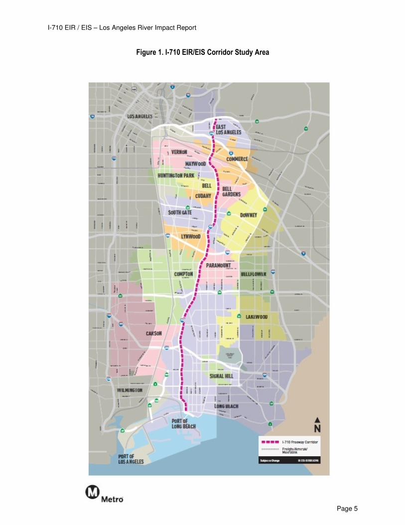
The majority of the I-710 corridor (Ocean Boulevard to Atlantic Avenue) as shown in Figure 1 resides adjacent to the
Los Angeles River. Other flood control channels including the Rio Hondo Channel and the Compton Creek Channel
join the Los Angeles River within the limits of the Project study area. The Los Angeles River is a significant flood
control channel with a watershed area of 834-square miles. With minor localized exceptions, the 100-year storm
event base flood plain is contained within the Los Angeles River channel.
In 1984, the Los Angeles County Flood Control District entered into an operational agreement with the Los Angeles
County Department of Public Works transferring planning and operational activities to the Department of Public
Works. Watershed Management Division is the planning and policy arm of the Flood Control District. Public Works
Flood Maintenance and Water Resources Divisions, respectively, oversee its maintenance and operational efforts.
Both the Los Angeles County Department of Public Works and the US Army Corp of Engineers (USACE) are
responsible for the operation and maintenance of the Los Angeles River. The Los Angeles County Department of
Public Works is the permitting authority and the first point of contact for acquiring any permits for improvements or
alterations to the channel (LA River Master Plan). Portions of the Los Angeles River provide in excess of 100-year
flood protection based on the results of the 2005 USACE river analysis. For the purpose of identifying mitigation
options for proposed longitudinal encroachments into the floodway, the USACE 2005 model was considered as the
base condition. Evaluations of potential impacts were conducted by modifying the HEC-RAS model with changes in
channel geometry until necessary reductions in water surface were obtained.
A Preliminary Los Angeles River Impact Analysis was prepared for the Los Angeles County Metropolitan
Transportation Authority (Metro), December 5, 2008, by URS. This study examined longitudinal encroachment
impacts at two LA River locations above and below the confluence with the Rio Hondo Channel. The impacts,
I-710 EIR / EIS – Los Angeles River Impact Report
Page 3
represented by vertical retaining walls, were associated with conceptual freight corridor alignments and utility
relocation strategies under consideration in 2008 that encroached into the existing trapezoidal channel. The
preliminary hydraulic analysis showed that significant modifications to the Los Angeles River channel were necessary
to eliminate any rise in the design Water Surface Elevation (WSE). Although this analysis was useful in guiding
preliminary design, it does not represent the alternatives or its impacts under consideration in this report.
2.3 PROJECT INTRODUCTION
The Interstate 710 (I-710) Corridor Project study area includes the portion of I-710 (6 or 8 lanes) from Ocean Blvd. in
Long Beach to State Route 60 (SR-60), a distance of approximately 18 miles (see Figure 1). At the freeway-to-
freeway interchanges, the study area extends one mile east and west of I-710 for the Interstate 405 (I-405), State
Route 91 (SR-91), Interstate 105 (I-105), and Interstate 5 (I-5) interchanges. The I-710 Corridor Project traverses
portions of the cities of Bell, Bell Gardens, Carson, Commerce, Compton, Cudahy, Downey, Huntington Park,
Lakewood, Long Beach, Los Angeles, Lynwood, Maywood, Paramount, Signal Hill, South Gate, and Vernon, and
portions of unincorporated Los Angeles County, all within Los Angeles County, California.
I-710 (also known as the Long Beach Freeway) is a major north/south interstate freeway connecting the City of Long
Beach to central Los Angeles. Within the I-710 Corridor Project study area, the freeway serves as the principal
transportation connection for goods movement between the Port of Los Angeles (POLA)/Port of Long Beach (POLB)
shipping terminals and the Burlington Northern Santa Fe (BNSF)/Union Pacific Railroad (UP) rail yards in the cities of
Commerce and Vernon and destinations along I-710 as well as destinations north and east of I-710.
The I-710 Major Corridor Study (MCS), undertaken to address the mobility and safety needs of the I-710 Corridor and
to explore possible solutions for transportation improvements, was completed in March 2005 and identified a
community-based Locally Preferred Strategy (LPS) consisting of 10 general purpose (GP) lanes next to four
separated freight movement lanes. The Los Angeles County Metropolitan Transportation Authority (Metro), the
California Department of Transportation (Caltrans), the Gateway Cities Council of Governments (GCCOG), the
Southern California Association of Governments (SCAG), POLA, POLB, and the Interstate 5 Joint Powers Authority
(I-5 JPA) are collectively known as the I-710 Funding Partners. Through a cooperative agreement, these agencies
are funding the preparation of preliminary engineering and environmental documentation for the I-710 Corridor
Project to evaluate improvements identified in the Major Corridor Study along the I-710 Corridor from Ocean Blvd. in
the City of Long Beach to SR-60. The I-710 Funding Partners have continued this engineering and environmental
study effort within the same broad, continuous community participation framework that was used for the MCS.
The environmental impacts of the I-710 Corridor Project will be assessed and disclosed in compliance with both the
California Environmental Quality Act (CEQA) and the National Environmental Policy Act (NEPA). Caltrans is the Lead
Agency for CEQA compliance and the lead agency for NEPA compliance pursuant to Section 6005 of the Safe,
Accountable, Flexible, and Efficient Transportation Equity Act: A Legacy for Users (SAFETEA-LU) (23 United States
Code [USC] 327).
The need for the I-710 Corridor Project is as follows:
• I-710 experiences high heavy-duty truck volumes, resulting in high concentrations of diesel particulate
emissions within the I-710 Corridor.
• I-710 experiences accident rates, especially truck-related, that are well above the statewide average for
freeways of this type.
I-710 EIR / EIS – Los Angeles River Impact Report
Page 4
• At many locations along I-710, the on- and off-ramps do not meet current design standards and weaving
sections within and between interchanges are of insufficient length.
• High volumes of both trucks and cars have led to severe traffic congestion throughout most of the day (6:00
a.m. to 7:00 p.m.) on I-710 as well as on the connecting freeways. This is projected to worsen over the next
25 years.
• Increases in population, employment, and goods movement between now and 2035 will lead to more traffic
demand on I-710 and on the streets and roadways within the I-710 Corridor as a whole.
The purpose of the I-710 Corridor Project is to achieve the following within the I-710 Corridor (2035 time frame):
• Improve air quality and public health
• Improve traffic safety
• Provide modern design for the I-710 mainline
• Address projected traffic volumes
• Address projected growth in population, employment, and activities related to goods movement (based on
SCAG population projections and projected container volume increases at the two ports)
I-710 EIR / EIS – Los Angeles River Impact Report
Page 5
Figure 1. I-710 EIR/EIS Corridor Study Area
I-710 EIR / EIS – Los Angeles River Impact Report
Page 6
2.4 PROJECT ALTERNATIVES
2.4.1 Alternatives Description
This section describes the alternatives based on the Major Corridor Study that were developed by a multidisciplinary
technical team to achieve the I-710 Corridor Project purpose and subsequently were reviewed and concurred upon
by the various committees involved in the I-710 Corridor Project community participation framework. Alternatives 2, 3,
and 4 were considered but withdrawn from further environmental study as stand-alone alternatives but elements of
these alternatives have been included in Build Alternatives 5A, 6A, 6B, and 6C. The alternatives are Alternative 1 (No
Build Alternative), Alternative 5A (I-710 Widening up to 10 General Purpose [GP] Lanes), Alternative 6A (10 GP
Lanes plus a Four-Lane Freight Corridor), Alternative 6B (10 GP Lanes plus a Zero-Emissions Four-Lane Freight
Corridor), and Alternative 6C (10 GP Lanes plus a Four-Lane Freight Corridor Tolled).
2.4.2 Alternative 1 – No Build Alternative
The No Build Alternative does not include any improvements within the I-710 Corridor other than those projects that
are already planned and committed to be constructed by or before the planning horizon year of 2035. The projects
included in this alternative are based on Southern California Association of Governments (SCAG’s) 2008 Regional
Transportation Improvement Program (RTIP) project list, including freeway, arterial, and transit improvements within
the SCAG region. This alternative also assumes that goods movement to and from the ports make maximum
utilization of existing and planned railroad capacity within the I-710 Corridor. Alternative 1 is the baseline against
which the Build Alternatives proposed for the I-710 Corridor Project will be assessed. The existing I-710 mainline
generally consists of eight GP lanes north of I-405 and six GP lanes south of I-405.
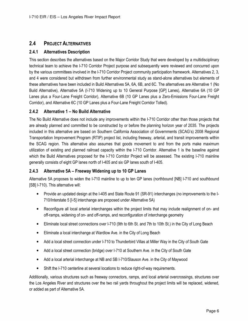
2.4.3 Alternative 5A – Freeway Widening up to 10 GP Lanes
Alternative 5A proposes to widen the I-710 mainline to up to ten GP lanes (northbound [NB] I-710 and southbound
[SB] I-710). This alternative will:
• Provide an updated design at the I-405 and State Route 91 (SR-91) interchanges (no improvements to the I-
710/Interstate 5 [I-5] interchange are proposed under Alternative 5A)
• Reconfigure all local arterial interchanges within the project limits that may include realignment of on- and
off-ramps, widening of on- and off-ramps, and reconfiguration of interchange geometry
• Eliminate local street connections over I-710 (9th to 6th St. and 7th to 10th St.) in the City of Long Beach
• Eliminate a local interchange at Wardlow Ave. in the City of Long Beach
• Add a local street connection under I-710 to Thunderbird Villas at Miller Way in the City of South Gate
• Add a local street connection (bridge) over I-710 at Southern Ave. in the City of South Gate
• Add a local arterial interchange at NB and SB I-710/Slauson Ave. in the City of Maywood
• Shift the I-710 centerline at several locations to reduce right-of-way requirements.
Additionally, various structures such as freeway connectors, ramps, and local arterial overcrossings, structures over
the Los Angeles River and structures over the two rail yards throughout the project limits will be replaced, widened,
or added as part of Alternative 5A.
I-710 EIR / EIS – Los Angeles River Impact Report
Page 7
In addition to improvements to the I-710 mainline and the interchanges, Alternative 5A also includes Transportation
Systems/Transportation Demand Management (TSM/TDM), Transit, and Intelligent Transportation Systems (ITS)
improvements. TSM improvements include provision of or future provision of ramp metering at all locations and the
addition of improved arterial signage for access to I-710. Parking restrictions during peak periods (7:00 a.m.–9:00
a.m.; 4:00 p.m.–7:00 p.m.) will be implemented on four arterial roadways: Atlantic Blvd. between Pacific Coast Hwy.
and SR-60; Cherry Ave./Garfield Ave. between Pacific Coast Hwy. and SR-60; Eastern Ave. between Cherry Ave.
and Atlantic Blvd.; and Long Beach Blvd. between San Antonio Dr. and Firestone Blvd. Transit improvements that will
be provided as part of the I-710 Corridor Project include increased service on all Metro Rapid routes and local bus
routes in the study area. ITS improvements include updated fiber-optic communications to interconnect traffic signals
along major arterial streets to provide for continuous, real-time adjustment of signal timing to improve traffic flow as
well as other technology improvements.
Alternative 5A also includes improvements to 42 local arterial intersections within the I-710 Corridor Project study
area. These improvements generally consist of lane restriping or minimal widening to provide additional intersection
turn lanes that will reduce traffic delay and improve intersection operations for those intersections with projected
Level of Service (LOS) F.
In addition to the transportation system improvements described above, Alternative 5A also includes:
• Aesthetic Enhancements: Landscaping and irrigation systems would be provided within the corridor where
feasible. Urban design and aesthetic treatment concepts for community enhancement will be integrated into
the design of the I-710 Corridor Project. These concepts will highlight unique community identities within a
unified overall corridor theme; strengthen physical connections and access/mobility within and between
communities; and implement new technologies and best practices to ensure maximum respect for the
environment and natural resources. They will continue to evolve and be refined through future phases of
project development.
• Drainage/Water Quality Features: Alternative 5A includes modifications to the Los Angeles River levee;
new, extended, replacement, and additional bents and pier walls in the Los Angeles River; additional and
extended bents and pier walls in the Compton Channel; modifications to existing pump stations or provision
of additional pump stations; and detention basins and bioswales that will provide for treatment of surface
water runoff prior to discharge into the storm drain system.
I-710 EIR / EIS – Los Angeles River Impact Report
Page 8
2.4.4 Alternative 6A – 10 GP Lanes plus a Four-Lane Freight Corridor
Alternative 6A includes all the components of Alternatives 1 and 5A described above. (The alignment of the GP lanes
in Alternative 6A will be slightly different than Alternative 5A in a few locations.) In addition, this alternative includes a
separated four-lane freight corridor (FC) from Ocean Blvd. northerly to its terminus near the UP and BNSF railyards
in the City of Commerce. The FC would be built to Caltrans highway design standards and would be restricted to the
exclusive use of heavy-duty trucks (5+ axles). In Alternative 6A these trucks are assumed to be conventional” trucks
(conventional trucks are defined to be newer [post-2007] diesel/fossil-fueled trucks [new or retrofitted engines
required per new regulations and standards].
The FC would be both at-grade and on elevated structure with two lanes in each direction. There are exclusive, truck
only ingress and egress ramps to and/or from the FC at the following locations:
• Harbor Scenic Dr. (NB ingress only)
• Ocean Blvd. (NB ingress only)
• Pico Ave. (NB ingress and SB egress only)
• Anaheim St. (NB ingress and SB egress only)
• SB I-710 GP lanes just south of Pacific Coast Hwy (SB egress only)
• NB I-710 GP lanes north of I-405 at 208th St. (NB ingress only)
• SB I-710 GP lanes north of I-405 at 208th St. (SB egress only)
• Eastbound (EB) SR-91 (NB egress only)
• Westbound (WB) SR-91 (SB ingress only)
• Patata St (NB egress and SB ingress only)
• SB I-710 GP lanes at Bandini Blvd. (SB ingress only)
• NB I-710 GP lanes at Bandini Blvd. (NB egress only)
• Washington Blvd. – (NB egress and SB ingress only) (Design Options 1 and 2)
• Washington Blvd. (NB egress and SB ingress via Indiana Ave) (Design Option 3)
• Sheila St – (NB egress only) (Design Option 3)
In addition to the FC feature, Alternative 6A includes:
• Partial modification to the I-5 interchange, notably the replacement of the NB I-710 to NB I-5 connector
(right-side ramp replacement of left-side ramp) and a realigned SB I-5 to SB I-710 connector and 5 SB GP
lanes from SR-60 to Washington Blvd.
• 3 NB GP lanes from I-5 to SR-60
• Retention of and modification to the I-710 SB on- and off-ramps at Eastern Ave. to slightly realign them.
• A local connection over I-710 at Patata St. in the cities of South Gate and Bell Gardens.
I-710 EIR / EIS – Los Angeles River Impact Report
Page 9
As with Alternative 5A, Alternative 6A will include additional aesthetic enhancements, and drainage/water quality
features as follows:
Aesthetic Enhancements: In addition to the aesthetic enhancements described above for Alternative 5A, specific
aesthetic treatments will be developed for the FC, including use of screen walls and masonry treatments on the FC
structures (including soundwalls).
Drainage/water quality features: Alternative 6A includes features to capture and treat the additional surface water
runoff from the FC, as well as some modifications to the Los Angeles River levees in order to accommodate electrical
transmission line relocations.
2.4.5 Alternative 6B – 10 GP Lanes plus a Zero-Emissions Four-Lane Freight Corridor
Alternative 6B includes all the components of Alternative 6A as described above, but would restrict the use of the FC
to zero-emission trucks rather than conventional trucks. This proposed zero emission truck technology is assumed to
consist of trucks powered by electric motors in lieu of internal combustion engines and producing zero tailpipe
emissions while traveling on the freight corridor. The specific type of electric motor is not defined, but feasible
options include linear induction motors, linear synchronous motors or battery technology. The power systems for
these electric propulsion trucks could include, but is not limited to, hybrid with dual-mode operation (ZEV Mode),
Range Extender EV (Fuel Cell or Turbine with ZEV mode), Full EV (with fast charging or infrastructure power), road-
connected power (e.g., overhead catenary electric power distribution system), alternative fuel hybrids, zero NOx
dedicated fuel engines (CNG, RNG, H2 ICE), and range extender EV (turbine). For purposes of the I-710
environmental studies, the zero-emission electric trucks are assumed to receive electric power while traveling along
the FC via an overhead catenary electric power distribution system (road-connected power).
Alternative 6B also includes the assumption that all trucks using the FC will have an automated control system that
will steer, brake, and accelerate the trucks under computer control while traveling on the FC. This will safely allow for
trucks to travel in “platoons” (e.g., groups of 6–8 trucks) and increase the capacity of the FC from a nominal 2,350
passenger car equivalents per lane per hour (pces/ln/hr) (as defined in Alternative 6A) to 3,000 pces/ln/hr in
Alternative 6B.
The design of the FC will also allow for possible future conversion, or be initially constructed, as feasible (which may
require additional environmental analysis and approval), of a fixed-track guideway family of alternative freight
transport technologies (e.g., Maglev). However, this fixed-track family of technologies has been screened out of this
analysis for now, as they have been determined to be inferior to electric trucks in terms of cost and ability to readily
serve the multitude of freight origins and destinations served by trucks using the I-710 corridor.
2.4.6 Alternative 6C – 10 GP Lanes plus a Four-Lane Freight Corridor with Tolls
Alternative 6C includes all the components of Alternative 6B as described above, but would toll trucks using the FC.
Although tolling trucks in the FC could be done under either Alternative 6A or 6B; for analytical purposes, tolling has
only been evaluated for Alternative 6B as this alternative provides for higher FC capacity than Alternative 6A due to
the automated guidance feature of Alternative 6B.
Tolls would be collected using electronic transponders which would require overhead sign bridges and transponder
readers like the SR-91 toll lanes currently operating in Orange County, where no cash toll lanes are provided. The toll
pricing structure would provide for collection of higher tolls during peak travel periods.
I-710 EIR / EIS – Los Angeles River Impact Report
Page 10
2.4.7 Design Options
For alternatives 6A, 6B, and 6C, three design options for the portion of I-710 between the I-710/Slauson Ave
interchange to just south of the I-710/I-5 interchange are under consideration. These configurations will be fully
analyzed so that they can be considered in the future selection of a Preferred Alternative for the project. These
options are as follows:
Design Option 1
Design Option 1 applies to Alternatives 6A, 6B and 6C and provides access to Washington Blvd using three ramp
intersections at Washington Blvd.
Design Option 2
Design Option 2 applies to Alternatives 6A, 6B, and 6C and provides access to Washington Blvd. using two ramp
intersections at Washington Blvd.
Design Option 3
Design Option 3 applies only to Alternative 6B2 and removes access to Washington Blvd. at its current location. The
ramps at the I-710/Washington Blvd. interchange would be removed to accommodate the proposed FC ramps in and
out of the railyards. The SB off-ramp and NB-on-ramp access would be accommodated by Alternative 6B in the
vicinity of the existing interchange by the proposed new SB off-ramp and NB on-ramp at Oak St. and Indiana St.
These two ramps are proposed as mixed-flow ramps (freight connector ramps that would also allow automobile
traffic). However, the SB on-ramp and NB off-ramp traffic that previously used the Washington Blvd. interchange
would be required to access the Atlantic Blvd./Bandini Blvd. interchange located south of the existing Washington
Blvd. interchange to ultimately reach I-710.
2.5 PROJECT SEGMENTS
To facilitate design, analysis, and organization, this report breaks down the project geographically into seven
segments. Table 2-1 provides the segment limits and interchange locations. The Segment/Package Key Map
included in Appendix 3 illustrates where flood control facilities are with respect to the freeway and project
improvements.
2 Design Option 3 only applies to Alternative 6B because it was not included in the travel demand modeling for either Alternative 6A
or 6C.
I-710 EIR / EIS – Los Angeles River Impact Report
Page 11
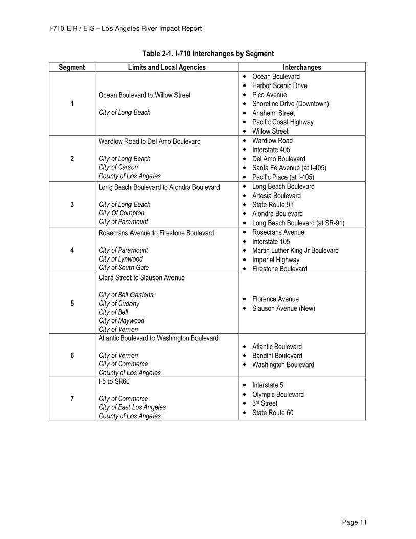
Table 2-1. I-710 Interchanges by Segment
Segment Limits and Local Agencies Interchanges
1 Ocean Boulevard to Willow Street City of Long Beach
• Ocean Boulevard
• Harbor Scenic Drive
• Pico Avenue
• Shoreline Drive (Downtown)
• Anaheim Street
• Pacific Coast Highway
• Willow Street
2
Wardlow Road to Del Amo Boulevard City of Long Beach City of Carson County of Los Angeles
• Wardlow Road
• Interstate 405
• Del Amo Boulevard
• Santa Fe Avenue (at I-405)
• Pacific Place (at I-405)
3
Long Beach Boulevard to Alondra Boulevard City of Long Beach City Of Compton City of Paramount
• Long Beach Boulevard
• Artesia Boulevard
• State Route 91
• Alondra Boulevard
• Long Beach Boulevard (at SR-91)
4
Rosecrans Avenue to Firestone Boulevard City of Paramount City of Lynwood City of South Gate
• Rosecrans Avenue
• Interstate 105
• Martin Luther King Jr Boulevard
• Imperial Highway
• Firestone Boulevard
5
Clara Street to Slauson Avenue City of Bell Gardens City of Cudahy City of Bell City of Maywood City of Vernon
• Florence Avenue
• Slauson Avenue (New)
6
Atlantic Boulevard to Washington Boulevard City of Vernon City of Commerce County of Los Angeles
• Atlantic Boulevard
• Bandini Boulevard
• Washington Boulevard
7
I-5 to SR60 City of Commerce City of East Los Angeles County of Los Angeles
• Interstate 5
• Olympic Boulevard
• 3rd Street
• State Route 60
I-710 EIR / EIS – Los Angeles River Impact Report
Page 12
3.0 FLOODPLAIN EVALUATION
3.1 OVERVIEW
This Los Angeles River Impact Report is a supporting document for the Environmental Impact Report / Environmental
Impact Statement. The mandate to prepare an analysis for highway encroachments into the floodplain is outlined in
23 CFR 650 Bridges, Structures & Hydraulics. The procedural guidance for this analysis is contained in the Caltrans’
Standard Environmental Reference (SER) chapter 17, Floodplains, and chapter 804 of the Highway Design Manual
(HDM). The SER and HDM identify the use of a Location Hydraulic Study to determine, (a) if a proposed route will
encroach on a base floodplain, and (b) where proposed construction on existing highway alignment encroaches on a
base floodplain. Where National Flood Insurance Program (NFIP) maps are available, their use is necessary in
determining the extent of the encroachment. For this report, Flood Insurance Rate Maps (FIRM) are included for
reference in Appendix 2. This Los Angeles River Impact Report also serves as the Floodplain Evaluation Report for
the proposed Project and includes copies of the Location Hydraulic Studies in the Appendix for reference. The
floodways contained in this analysis are the Los Angeles River (Reaches 1 & 2), Compton Creek Channel, and the
Rio Hondo Channel.
3.2 TERMINOLOGY
Chapter 17 of the Caltrans Standard Environmental Reference (SER) provides the following definitions of flood plain
terminology. These definitions are provided here for reference:
• Base Flood is the flood having a one percent (1%) chance of being equaled or exceeded in any given year
(100-year flood).
• Base Flood Elevation (BFE) is the water surface elevation of the base flood (This is the baseline condition).
• A floodplain is any land area subject to inundation by floodwaters.
• A floodway is defined as the channel of a river or other watercourse plus any adjacent floodplain area which
is designated a floodway by a public agency (No increase in the BFE is allowed in the floodway).
• The floodway fringe is defined as the portion of the 100-year floodplain that is not within the floodway.
• A significant encroachment is a highway encroachment that would involve one or more of the following
construction or flood related impacts:
o A significant potential for interruption or termination of a transportation facility which is needed for emergency vehicles.
o A significant risk (to life or property), or o A significant adverse impact on natural and beneficial floodplain values.
3.3 FLOOD PLAIN MAPPING
As indicated on the FIRM maps included in Appendix 2, the 100-year floodplain (base flood plain) is mostly contained
within the existing flood control channels in the study area. Two 100-year flood areas that reside outside of the Los
Angeles River channel are located near the Anaheim Street interchange in the City of Long Beach. Two other small
ponding areas (Zone AH) are located just north of the I-105 freeway and east of the existing I-710. Large “Zone X”
areas shown within the floodplain under study indicate either 500-year flood zone or areas of 100-year shallow
flooding (less than 1 foot depth). ‘Zone A’ floodways are designated from the UPRR Bridge north of Firestone
Boulevard in the City of South Gate south to the Ocean Boulevard Bridge in the City of Long Beach. FEMA Flood
I-710 EIR / EIS – Los Angeles River Impact Report
Page 13
Insurance Rate Maps (FIRM) 06037C1810, 06037C1815F, 06037C1820F, 06037C1955F, 06037C1962F and
06037C1964F, dated September 26, 2008, are included in Appendix 2.
The Flood Insurance Study (FIS) for Los Angeles County and unincorporated areas, Volumes 1 through 4,
September 26, 2008, Number 06037CV001A, 2A, 3A and 4A was also reviewed. The FIS report provides 100-year
discharges used for the analysis; however, it does not provide information on water surface elevations. The 100-year
discharges are 142,000 cubic feet per second (cfs) at Compton Creek and 140,000 cfs at Imperial Highway.
3.4 BASIS FOR HYDRAULIC ANALYSIS
The Army Corps of Engineers is the reviewing agency for any hydraulic analysis within the Los Angeles River
channel. The following reference information was obtained from the USACE and is used to define the existing
hydraulic conditions of the various rivers channels under review:
• USACE (Department of the Army, Los Angeles District, Corps of Engineers, Los Angeles, California), 2005.
Los Angeles County Drainage Area – Upper Los Angeles River and Tujunga Wash – HEC-RAS Hydraulic
Models. July.
• USACE (Department of the Army, Los Angeles District, Corps of Engineers, Los Angeles, California), 1991.
Los Angeles County Drainage Area Review - Final Feasibility Study – Hydrology Technical Report.
December.
• USACE (Department of the Army, Los Angeles District, Corps of Engineers, Los Angeles, California), 2004.
“Final Design for Union Pacific Railroad Bridge MP17.13 San Pedro Subdivision Reconstruction” DACW 09-
00-B-0009.
According to the information provided by the USACE, the existing Los Angeles River levees are designed for
discharges greater than the 100-year flood. Applicable design flows and water surface elevation data was extracted
from the various reports and used as a basis for design in this report. Table 3-1 below includes design discharges
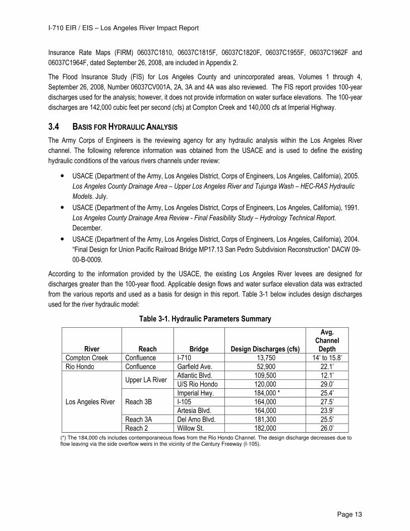
used for the river hydraulic model:
Table 3-1. Hydraulic Parameters Summary
River Reach Bridge Design Discharges (cfs)
Avg. Channel Depth
Compton Creek Confluence I-710 13,750 14’ to 15.8’
Rio Hondo Confluence Garfield Ave. 52,900 22.1’
Los Angeles River
Upper LA River Atlantic Blvd. 109,500 12.1’
U/S Rio Hondo 120,000 29.0’
Reach 3B
Imperial Hwy. 184,000 * 25.4’
I-105 164,000 27.5’
Artesia Blvd. 164,000 23.9’
Reach 3A Del Amo Blvd. 181,300 25.5’
Reach 2 Willow St. 182,000 26.0’
(*) The 184,000 cfs includes contemporaneous flows from the Rio Hondo Channel. The design discharge decreases due to flow leaving via the side overflow weirs in the vicinity of the Century Freeway (I-105).
I-710 EIR / EIS – Los Angeles River Impact Report
Page 14
4.0 FL OO D P LAI N EN CR O AC H ME N T S
4.1 OVERVIEW
For the purposes of evaluating Project impacts to the floodplain, this report differentiates impacts to the base
floodplain (typically the floodway) and the floodplain within the flood control right-of-way (ROW). Impacts to the Los
Angeles County Department of Public Works flood control ROW are included because many of these impacts affect
the dry side of the river channel levees and/or the ability of the Los Angeles County Flood Control District to increase
conveyance capacity in the existing channels. In most cases, the project base flood plain coincides with the existing
conveyance section of the facilities (floodway). During the Project design process, impacts within the floodway,
including longitudinal encroachments, were minimized wherever possible. Where access to the existing channels is
blocked or altered due to the proposed Project improvements, alternative access will be provided as a part of the
Project improvements. The proposed relocation of multiple 230kV Los Angeles Department of Water and Power
(DWP) towers between Firestone Boulevard and Slauson Avenue in Segments 4 and 5 will result in longitudinal
encroachment into the floodway.
4.2 LOCATION HYDRAULIC STUDIES
Location Hydraulic Studies (LHS) are the preliminary study metric for the determination of base floodplain
encroachments. The LHS is used to identify encroachments, present hydraulic data, and determine any potential
impacts to the floodplain including impacts to beneficial values. The LHS must also include a discussion of the
practicability of alternatives to any longitudinal encroachments. The relocation of the DWP towers into the existing
Los Angeles River channel is the only Project impact that constitutes a longitudinal encroachment into the floodway
and the potential to increase the Base Floodplain Elevation (BFE). In this case, when an increase in the BFE is
anticipated, a hydraulic computer model is produced to determine the extent of floodplain impacts. The LHS for each
floodway structure impacted by the project is included in Appendix 1.
4.3 FLOODWAY IMPACTS IDENTIFIED
Project Alternative 5A proposes to modify several existing river structures, replace certain existing river structures
with structures located on new alignments, and add four new river structures. The four new river structures include
two connectors to the I-405 freeway, northbound ramps at Long Beach Boulevard, and the Southern Avenue bridge.
All new structures will be supported by columns or piers depending on the structural design requirements. None of
the Alternative 5A impacts are characterized as longitudinal impacts to the floodway.
Project Alternatives 6A/B/C include all of the encroachments identified in Alternative 5A along with additional new
river structures. Alternative 6A/B/C also includes longitudinal encroachments between Firestone Boulevard and
Slauson Avenue to accommodate the relocation of ten DWP transmission towers into the existing channel. The
construction of the freight corridor includes three new structures over Compton Creek, two new connectors over the
Los Angeles River at SR-91, two new structures over the Los Angeles River north of the Rio Hondo confluence, and
extensive use of existing Flood Control right-of-way.
Detailed descriptions of the existing and proposed structures follow. The River Impact Exhibits provided in Appendix
3 indicate all of the proposed encroachment areas within the Flood Control right-of-way and the floodway areas. The
encroachments for the Alternative 5A and 6A/B/C improvements are indicated in green and red shading, respectively,
I-710 EIR / EIS – Los Angeles River Impact Report
Page 15
on the exhibits. All structures are assessed as part of all alternatives considered. Structures proposed for Alternative
6A/B/C only are noted. Otherwise, all proposed structures are included in Alternatives 5A and 6A/B/C.
4.3.1 Los Angeles River Structures
Segment 1
Ocean Boulevard Bridge – Los Angeles River (Unaffected) Ocean Boulevard Bridge will not be modified by the project. The existing bridge has three piers including columns
and pier walls. The bridge deck is 20 to 30 feet higher than the adjacent river top of levee.
Shoemaker Bridge – Los Angeles River (Replace) The Shoemaker Bridge (Shoreline Drive) will be replaced and will require new bents/columns in the river. The
existing bridge, which has five piers including columns and pier walls, will be removed. The proposed bridge will be
relocated approximately 400 ft downstream of the existing alignment.
Anaheim Street Bridge – Los Angeles River (Widen) The Anaheim Street Bridge will be widened and will require extension of the existing pier walls located in the river
and extension of the existing abutments at the river’s edge. The existing bridge has five piers in the river including
columns and pier walls. The piers will be extended approximately 30 feet on each side.
Pacific Coast Highway (PCH) Bridge – Los Angeles River (Widen) The PCH Bridge will be widened and will require extension of the existing pier walls located in the river and extension
of the existing abutments at the river’s edge. The existing bridge has five piers in the river. The piers will be
extended approximately 20 feet on the south side and 40 feet on the north side.
Willow Street Bridge – Los Angeles River (Widen) The widening requires extension of the existing pier walls located in the river and extension of the existing abutments
at the river’s edge. The existing bridge has seven piers in the river. The piers will be extended approximately 10 feet
on the south side and 40 feet on the north side. Seven of the piers have large pier noses which will require
reconstruction.
Segment 2
Wardlow Road Bridge – Los Angeles River (Replace) The replacement of the Wardlow Road Bridge allows for the reconfiguration of the lanes and removal of the NB I-710
on-ramp. The existing bridge has six piers in the river including debris walls.
NB 710 to SB 405 Connector (New), SB 710 to SB 405 Connector (Replace), NB 405 to SB 710 Connector (New), NB 405 to NB 710 Connector (Replace) Bridges – Los Angeles River Four new connector structures require the placement of column foundations in the river channel. Two existing
connectors that are supported by piers will be removed from the river channel.
I-405 Mainline Bridge – Los Angeles River (Widen) The existing 405 bridge will be widened in the westbound (upstream side) direction. Four existing piers will be
modified to accommodate a tapered widening of the existing bridge.
Metro Blue Line Bridge and U.P.R.R. Bridge – Los Angeles River (Unaffected) The two railroad bridges remain unaffected by the project.
Del Amo Boulevard Bridge – Los Angeles River (Widen) The existing Del Amo Bridge has five pier walls in the river channel and abutments on either side on top of the levee.
The Del Amo Bridge will be widened and will require the extension of the existing pier walls located in the river and
I-710 EIR / EIS – Los Angeles River Impact Report
Page 16
the extension of the existing abutments at the river’s edge. The piers will need to be extended approximately 30 feet
on either side of the bridge.
Segment 3
Long Beach Boulevard Ramps – Los Angeles River (New) A new river bridge will be constructed for the northbound I-710 ramps and be located downstream of the existing Long Beach Boulevard Bridge. A total of seven new piers will be placed within the river channel along with two new bridge abutments located at the top of the levee. Long Beach Boulevard Bridge – Los Angeles River (Widen) The existing Long Beach Boulevard Bridge over the LA River has seven pier walls within the river channel. The
bridge will be widened approximately 20 ft to the south. The widening will require the extension of the existing pier
walls located in the river.
Artesia Boulevard Bridge – Los Angeles River (Unaffected) The existing Artesia Boulevard Bridge, which has five pier walls in the river channel and abutments on either side on
top of the levee, will not be affected by the project.
NB FC to EB 91 Connector Bridge - Los Angeles River (New) A new Northbound Freight Corridor to Eastbound 91 Connector Bridge will require the placement of five to six new
columns in the river. The alignment of the columns will match the four pier wall locations of the existing SR-91
structures crossing the river. (Alternative 6A/B/C ONLY)
EB Atlantic off-ramp (from EB 91), SB 710 to EB 91 Connector, SR-91 Mainline, WB 91 to NB 710 Connector, WB Atlantic on-ramp (to WB 91), WB Atlantic on-ramp (to NB 710) Bridges – Los Angeles River (Unaffected) The existing mainline SR-91 Bridge and multiple connectors’ structures, which cross the river on four continuous pier
walls and abutments on either side on top of the levee, are unaffected by the project.
WB 91 to SB FC Connector- Los Angeles River (New) A new Westbound 91 to Southbound Freight Corridor Connector Bridge will require four new columns in the river
channel. The alignment of the columns will match the pier wall locations of the existing SR-91 structures crossing the
river. (Alternative 6A/B/C ONLY)
Atlantic Avenue Bridge – Los Angeles River (Unaffected) The existing Atlantic Avenue Bridge has seven pier walls in the river channel and is unaffected by the project.
Alondra Boulevard Bridge – Los Angeles River (Replace) The replacement of the Alondra Boulevard Bridge requires new abutments and columns in the LA River, shifted
directly south of the existing bridge. The existing bridge has five pier walls with debris noses. The same
configuration is proposed for the new bridge. The widening will require extension of the piers by approximately 100
feet.
Somerset Boulevard Bridge – Los Angeles River (Unaffected) No improvements are proposed for the existing Somerset Boulevard Bridge. The existing bridge has five pier walls
with debris noses in the river channel.
Segment 4
Rosecrans Avenue Bridge – Los Angeles River (Unaffected) The existing Rosecrans Avenue Bridge has six pier walls with debris noses. The existing bridge will not be affected
by the project.
I-710 EIR / EIS – Los Angeles River Impact Report
Page 17
NB 710 to EB 105 Connector, SB 710 to EB 105 Connector, I-105 Mainline, WB 105 to SB 710 Connector, WB 105 to NB 710 Connector – Los Angeles River (Unaffected) The I-105 Mainline and connectors will be unaffected by the project at the Los Angeles River crossing. The existing
structures are crossing the river on three pier walls and columns.
Imperial Highway Bridge - Los Angeles River (Widen) The existing Imperial Highway Bridge over the Los Angeles River has four pier walls with debris noses in the river
channel. Imperial will be widened to the north to allow for a wider median and two left turn lanes. The existing piers
will be extended approximately 50’and the debris noses reconstructed.
Freight Corridor Bridge – Los Angeles River (New) A new freight corridor bridge will be constructed within the Los Angeles River channel. Approximately 15 new
columns will be built within the channel. The column alignment will match the existing I-710 Mainline Bridge pier
walls. (Alternative 6A/B/C ONLY)
I-710 Mainline – Los Angeles River (Replace) The I-710 mainline bridge over the Los Angeles River will be replaced along a new alignment to the south of the
existing bridge. The new structure will be approximately 100’ wider than the existing structure. Three pier walls are
proposed to match the existing I-710 Mainline Bridge three pier walls.
UPRR Crossing Bridge – Los Angeles River (Unaffected) The Union Pacific Railroad Bridge over the river, between the I-710 River Bridge and Southern Avenue, will not be
affected by the project. The existing bridge crosses the river on four pier walls.
Southern Avenue Bridge – Los Angeles River (New) A new Southern Avenue bridge is proposed for the Los Angeles River channel. The new bridge will contain three new
column bents within the existing Los Angeles River channel.
Firestone Boulevard Bridge – Los Angeles River (Widen) The Firestone Boulevard Bridge over the Los Angeles River requires widening to allow for two new lanes to the
southbound on-ramp to the 710. The approximately 60-foot widening will require the extension of the existing pier
walls in the river. The existing bridge has three pier walls with debris noses.
UPRR Crossing (at Patata) – Los Angeles River (Replace) The new UPRR bridge will be located north of the existing UPRR alignment. The new bridge will require the
construction of three new column bents within the existing Los Angeles River channel.
Patata Street Interchange – Los Angeles River (New) The new Patata Street Bridge will be located south of the existing UPRR alignment. The existing Union Pacific
Railroad Bridge will be relocated north to accommodate the new street alignment. The two new bridges will require
the construction of three new column bents within the existing Los Angeles River channel. (Alternative 6A/B/C ONLY)
DWP Tower Relocation into the Los Angeles River (New) The construction of the freight corridor requires the relocation of several DWP towers into the existing Los Angeles
River channel between Firestone Boulevard and Slauson Avenue. Each affected tower location requires the
modification of approximately 1,000’ of channel to accommodate the new tower supports and transitions. When
consecutive DWP towers are relocated, the channel section is modified continuously between the relocated towers.
(Alternative 6A/B/C ONLY)
Segment 5
Clara Street Bridge – Los Angeles River (Replace)

I-710 EIR / EIS – Los Angeles River Impact Report
Page 18
The existing Clara Street Bridge will be replaced to improve channel hydraulics. The existing bridge has seven pier
walls in the river channel. (Alternative 6A/B/C ONLY)
Florence Avenue Bridge – Los Angeles River (Replace) The Florence Avenue Bridge will be replaced and will require new bents/pier walls in the river and abutments at the
river’s edge. The existing bridge has four piers in the river channel. The proposed widening of approximately 40 feet
on each side of the existing bridge will provide wider median to allow for a double left turn lanes and three lanes on
each side.
Gage Avenue Bridge – Los Angeles River (Unaffected) The existing Gage Avenue Bridge has four pier walls in the river channel and is unaffected by the project.
UPRR Crossing (at Randolph) – Los Angeles River (Replace) A Union Pacific Railroad shoo-fly, required for staging of the I-710 Mainline construction at Randolph Street, will
become the permanent Union Pacific Railroad Bridge at that location. The new rail bridge will be located
approximately 60 feet south of the existing one and will have four new columns within the river channel. The existing
bridge is a four span bridge with three piers in the river channel.
Slauson Avenue Bridge – Los Angeles River (Replace) The Slauson Avenue Bridge will be replaced with a much larger bridge and will require a replacement of the existing
bents/pier walls in the river and two abutments at the river’s edge. The existing bridge has four pier walls in the river
channel.
Segment 6
Atlantic Boulevard Bridge (Unaffected) The existing four-lane Atlantic Boulevard Bridge has four pier walls in the river channel and is unaffected by the
project.
Segment 7
There are no structures within floodways within this segment of the study area.
4.3.2 Compton Creek Structures
Segment 2
Freight Corridor Bridge - Compton Creek (New) A proposed new freight corridor bridge crossing the existing channel will require two column-bents or pier walls to be
placed within the existing channel and abutments located at the top of each side of the channel. (Alternative 6A/B/C
ONLY)
NB 710 to NB FC Connector Bridge - Compton Creek (New) The construction of a new northbound freight corridor connector requires one or more columns to be built within the
existing channel. (Alternative 6A/B/C ONLY)
I-710 Mainline Bridge – Compton Creek (Replace) The existing three span bridge has two pier walls in the channel. The replacement of the I-710 mainline bridge will
have column bents built within the channel, replacing the two existing pier walls, and one abutment on either side at
the top of the levee.
I-710 EIR / EIS – Los Angeles River Impact Report
Page 19
SB FC to SB 710 Connector Bridge – Compton Creek (New) The construction of a new southbound freight corridor connector requires one or two column to be built within the
existing channel and a new abutment located at the southerly side. (Alternative 6A/B/C ONLY)
4.3.3 Rio Hondo River Structures
Segment 4
UPRR Crossing Bridge – Rio Hondo (Unaffected) The Union Pacific Railroad Bridge over the Rio Hondo will not be affected by the project. The existing bridge crosses
the creek on two pier walls.
Garfield Avenue Bridge – Rio Hondo (Widen) The Garfield Avenue Bridge over the Rio Hondo will be widened to provide for an additional lane. The existing three
piers will be lengthened on the downstream side to accommodate the new widened structure.
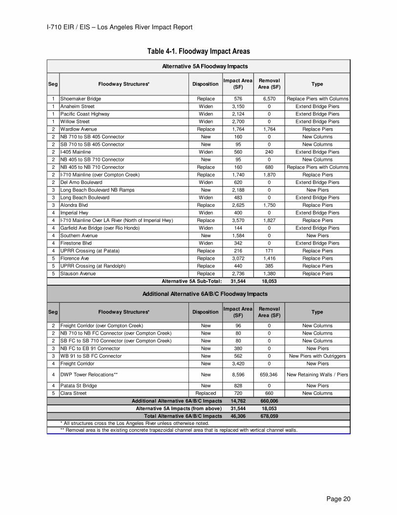
Table 4.1 provides a disposition of all of the impacted river structures along with the resulting areas of impacts. Total
impact areas are provided for Alternative 5A and Alternative 6A/B/C improvements.
I-710 EIR / EIS – Los Angeles River Impact Report
Page 20
Table 4-1. Floodway Impact Areas
Seg Floodway Structures* DispositionImpact Area
(SF)
Removal
Area (SF)Type
1 Shoemaker Bridge Replace 576 6,570 Replace Piers with Columns
1 Anaheim Street Widen 3,150 0 Extend Bridge Piers
1 Pacific Coast Highway Widen 2,124 0 Extend Bridge Piers
1 Willow Street Widen 2,700 0 Extend Bridge Piers
2 Wardlow Avenue Replace 1,764 1,764 Replace Piers
2 NB 710 to SB 405 Connector New 160 0 New Columns
2 SB 710 to SB 405 Connector New 95 0 New Columns
2 I-405 Mainline Widen 560 240 Extend Bridge Piers
2 NB 405 to SB 710 Connector New 95 0 New Columns
2 NB 405 to NB 710 Connector Replace 160 680 Replace Piers with Columns
2 I-710 Mainline (over Compton Creek) Replace 1,740 1,870 Replace Piers
2 Del Amo Boulevard Widen 620 0 Extend Bridge Piers
3 Long Beach Boulevard NB Ramps New 2,188 0 New Piers
3 Long Beach Boulevard Widen 483 0 Extend Bridge Piers
3 Alondra Blvd Replace 2,625 1,750 Replace Piers
4 Imperial Hwy Widen 400 0 Extend Bridge Piers
4 I-710 Mainline Over LA River (North of Imperial Hwy) Replace 3,570 1,827 Replace Piers
4 Garfield Ave Bridge (over Rio Hondo) Widen 144 0 Extend Bridge Piers
4 Southern Avenue New 1,584 0 New Piers
4 Firestone Blvd Widen 342 0 Extend Bridge Piers
4 UPRR Crossing (at Patata) Replace 216 171 Replace Piers
5 Florence Ave Replace 3,072 1,416 Replace Piers
5 UPRR Crossing (at Randolph) Replace 440 385 Replace Piers
5 Slauson Avenue Replace 2,736 1,380 Replace Piers
Alternative 5A Sub-Total: 31,544 18,053
Seg Floodway Structures* DispositionImpact Area
(SF)
Removal
Area (SF)Type
2 Freight Corridor (over Compton Creek) New 96 0 New Columns
2 NB 710 to NB FC Connector (over Compton Creek) New 80 0 New Columns
2 SB FC to SB 710 Connector (over Compton Creek) New 80 0 New Columns
3 NB FC to EB 91 Connector New 380 0 New Piers
3 WB 91 to SB FC Connector New 562 0 New Piers with Outriggers
4 Freight Corridor New 3,420 0 New Piers
4 DWP Tower Relocations** New 8,596 659,346 New Retaining Walls / Piers
4 Patata St Bridge New 828 0 New Piers
5 Clara Street Replaced 720 660 New Columns
Additional Alternative 6A/B/C Impacts 14,762 660,006
Alternative 5A Impacts (from above) 31,544 18,053
Total Alternative 6A/B/C Impacts 46,306 678,059
* All structures cross the Los Angeles River unless otherwise noted.
** Removal area is the existing concrete trapezoidal channel area that is replaced with vertical channel walls.
Alternative 5A Floodway Impacts
Additional Alternative 6A/B/C Floodway Impacts
I-710 EIR / EIS – Los Angeles River Impact Report
Page 21
4.4 ANALYSIS OF PROPOSED LONGITUDINAL CHANNEL ENCROACHMENTS
4.4.1 Overview of DWP Relocations
In an effort to avoid or minimize residential impacts, the proposed freight corridor alignment is situated above and
adjacent to the improved freeway alignment. The improvements encroach into the DWP transmission corridor
situated along the Los Angeles River channel. The transmission towers affected by the improvements are proposed
to be relocated within the Los Angeles River channel between Firestone Boulevard and Slauson Avenue. This
relocation strategy entails channel modifications to ensure adequate hydraulic performance and acquisition of
easements to ensure continuous transmission service by DWP.
As shown on the FIRM maps in Appendix 2, Clara Street is the northerly limit of the base flood plain within the Los
Angeles River channel. Because the relocation of the DWP towers into the Los Angeles River channel has the
potential to increase the Base Flood Elevation (BFE) within the channel and ultimately pose a risk to the buildings
and beneficial uses within the floodplain, a hydraulic computer model was prepared to analyze the proposed
improvements located within the channel. An outline of the procedure used and resulting analysis is included below.
4.4.2 Design Criteria/Assumptions
1. Design flow – The 100-year peak discharge was used for the analysis. The study reach has a capacity for a
120-year storm event according to a 1991 LACDA Hydrology Report (USACE, 1991). The hydraulic
computations were completed using a one-dimensional model and steady state flow analysis. HEC-RAS
version 4.1 was used for hydraulic modeling. A mixed flow regime was selected for model calculations due
to flow fluctuating from supercritical and subcritical along the study reach.
2. Transitions – At the terminus of the proposed longitudinal encroachment, a 500 foot long transition was
included upstream and a 600 foot long transition was provided downstream where proposed vertical walls
transitioned to the existing trapezoidal channel section.
3. Roughness values – A Manning’s “n” value of 0.016 is used for the entire reach within the channel for the
project limits based on criteria reported in Upper Los Angeles and Tujunga Wash HEC-RAS Hydraulic
Models (USACE, 2005).
4. Pier debris – two feet of floating debris was added to each side of all piers that measure 6 feet or less in
width, which was the modeling criteria reported in Upper Los Angeles and Tujunga Wash HEC-RAS
Hydraulic Models (USACE, 2005).
5. Each DWP Tower Box support structure is assumed to have sloping debris noses starting 45 feet upstream
of the towers, as described in “Final design for Union pacific railroad bridge MP17.13 San Pedro Subdivision
Reconstruction” DACW 09-00-B-0009, Drawing S-2 (USACE, 2004).
6. Freeboard – a 3.0 feet freeboard limit was assumed for all cross sections within the reach, based on design
criteria for river improved downstream of Rio Hondo Confluence (USACE, 1999).
7. Superelevation and wave effects were not included in this analysis.
4.4.3 HEC-RAS Model Analysis
The following HEC-RAS model simulations were developed to analyze the impact of modification to the bridges
within the longitudinal encroachment area and the relocation of the DWP towers into the river channel. All new
models were created by modifying the existing condition HEC-RAS model obtained from the US Army Corps of
Engineers (USACE), Los Angeles District. The analysis considers multiple configurations to assess the effectiveness
of mitigation. Four iterations of the model yielded a sufficient mitigation result. These four iterations represent channel
I-710 EIR / EIS – Los Angeles River Impact Report
Page 22
modifications that progress using a range of strategies and refinements to assess effectiveness and identify as
necessary to mitigate for the rise in water surface elevation for the design flow.
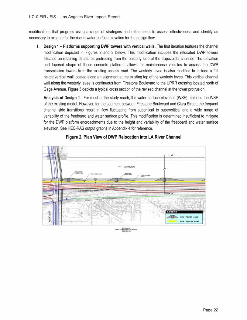
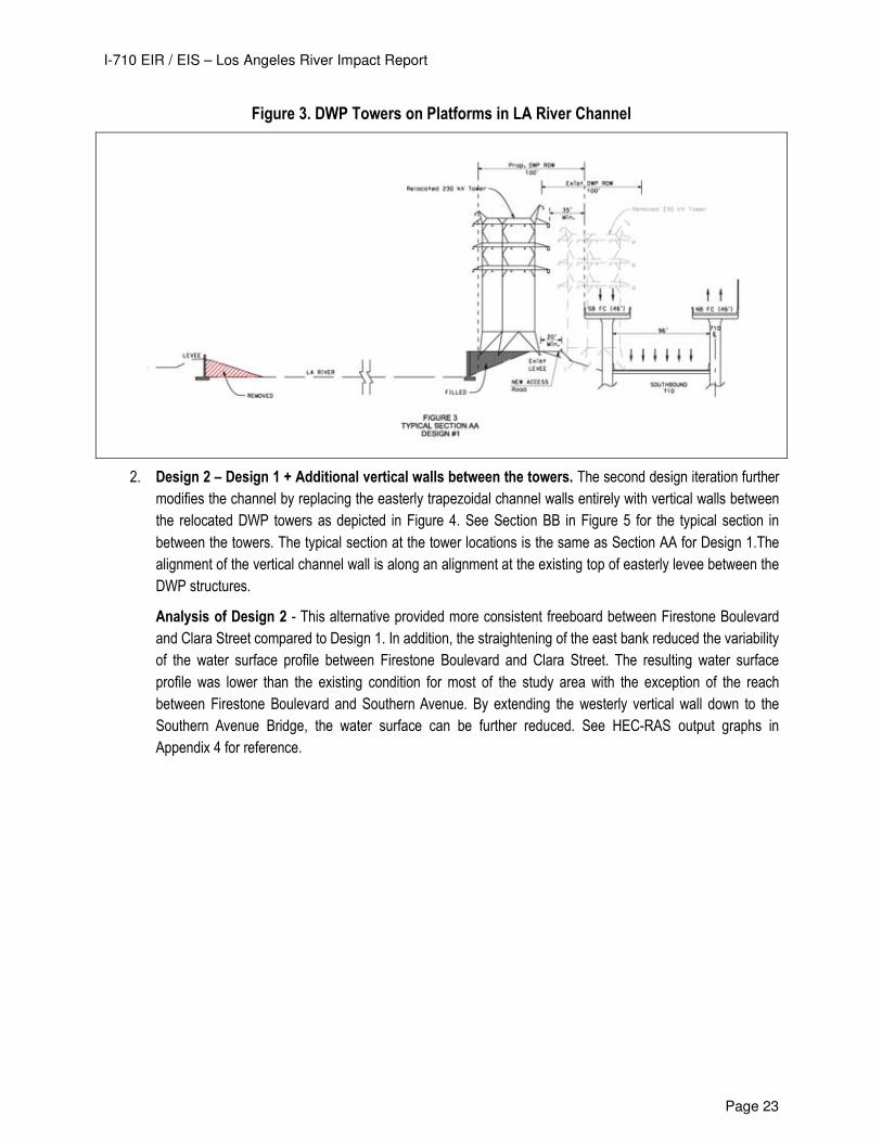
1. Design 1 – Platforms supporting DWP towers with vertical walls. The first iteration features the channel
modification depicted in Figures 2 and 3 below. This modification includes the relocated DWP towers
situated on retaining structures protruding from the easterly side of the trapezoidal channel. The elevation
and tapered shape of these concrete platforms allows for maintenance vehicles to access the DWP
transmission towers from the existing access road. The westerly levee is also modified to include a full
height vertical wall located along an alignment at the existing top of the westerly levee. This vertical channel
wall along the westerly levee is continuous from Firestone Boulevard to the UPRR crossing located north of
Gage Avenue. Figure 3 depicts a typical cross section of the revised channel at the tower protrusion.
Analysis of Design 1 - For most of the study reach, the water surface elevation (WSE) matches the WSE
of the existing model. However, for the segment between Firestone Boulevard and Clara Street, the frequent
channel side transitions result in flow fluctuating from subcritical to supercritical and a wide range of
variability of the freeboard and water surface profile. This modification is determined insufficient to mitigate
for the DWP platform encroachments due to the height and variability of the freeboard and water surface
elevation. See HEC-RAS output graphs in Appendix 4 for reference.
Figure 2. Plan View of DWP Relocation into LA River Channel
I-710 EIR / EIS – Los Angeles River Impact Report
Page 23
Figure 3. DWP Towers on Platforms in LA River Channel
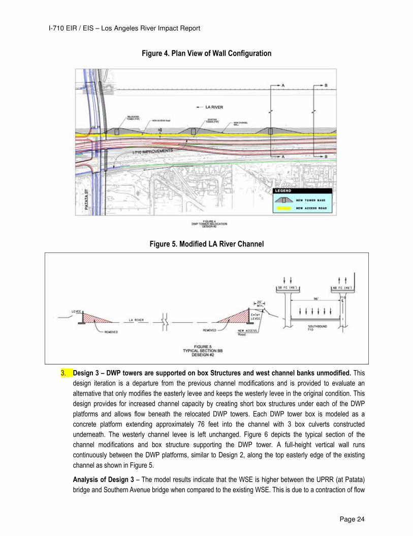
2. Design 2 – Design 1 + Additional vertical walls between the towers. The second design iteration further
modifies the channel by replacing the easterly trapezoidal channel walls entirely with vertical walls between
the relocated DWP towers as depicted in Figure 4. See Section BB in Figure 5 for the typical section in
between the towers. The typical section at the tower locations is the same as Section AA for Design 1.The
alignment of the vertical channel wall is along an alignment at the existing top of easterly levee between the
DWP structures.
Analysis of Design 2 - This alternative provided more consistent freeboard between Firestone Boulevard
and Clara Street compared to Design 1. In addition, the straightening of the east bank reduced the variability
of the water surface profile between Firestone Boulevard and Clara Street. The resulting water surface
profile was lower than the existing condition for most of the study area with the exception of the reach
between Firestone Boulevard and Southern Avenue. By extending the westerly vertical wall down to the
Southern Avenue Bridge, the water surface can be further reduced. See HEC-RAS output graphs in
Appendix 4 for reference.
I-710 EIR / EIS – Los Angeles River Impact Report
Page 24
Figure 4. Plan View of Wall Configuration
Figure 5. Modified LA River Channel
3. Design 3 – DWP towers are supported on box Structures and west channel banks unmodified. This
design iteration is a departure from the previous channel modifications and is provided to evaluate an
alternative that only modifies the easterly levee and keeps the westerly levee in the original condition. This
design provides for increased channel capacity by creating short box structures under each of the DWP
platforms and allows flow beneath the relocated DWP towers. Each DWP tower box is modeled as a
concrete platform extending approximately 76 feet into the channel with 3 box culverts constructed
underneath. The westerly channel levee is left unchanged. Figure 6 depicts the typical section of the
channel modifications and box structure supporting the DWP tower. A full-height vertical wall runs
continuously between the DWP platforms, similar to Design 2, along the top easterly edge of the existing
channel as shown in Figure 5.
Analysis of Design 3 – The model results indicate that the WSE is higher between the UPRR (at Patata)
bridge and Southern Avenue bridge when compared to the existing WSE. This is due to a contraction of flow
I-710 EIR / EIS – Los Angeles River Impact Report
Page 25
area at these locations. This design also resulted in more freeboard along the reach between UPRR (at
Patata) and Florence Avenue Bridge. The box structure design requires further modification to reduce the
WSE to a level at or below the existing conditions for the entire study reach.
Figure 6. DWP Towers on Box Section
4. Design 4: Design 3 + Additional Refinements In this design iteration additional modifications are made to
the east levee to reduce the WSE to an elevation below the existing condition. The west trapezoidal channel
bank remains unchanged. The following modifications were made in an attempt to improve hydraulics within
the vicinity of the Firestone Boulevard Bridge and Gage Avenue.
o The wall thickness at the three DWP platforms, located north of Gage Avenue, is reduced from 4' to 3'. o The number of piers supporting the Patata/UPRR bridge crossing is reduced from four to three, with
diameters unchanged. o The wall thickness at the four DWP Towers, located north of Firestone Boulevard, is reduced from 4' to
3'. o The easterly vertical wall is extended from Firestone Boulevard to Southern Avenue on the east side,
transitioning back to trapezoidal channel downstream of Southern.
Analysis of Design 4 - The resulting water surface elevation shown in Figure 7 indicates that there is minimal
increase in the BFE from the existing condition. The increase in WSE between Firestone Boulevard and Southern
Avenue amounts to a 1.5’ increase in WSE and is attributable to the new Southern Bridge crossing. The channel still
has adequate freeboard at this location. Additional detailed design and hydraulic modeling is required during final
design to further study the section of the channel to determine an achievable level of mitigation at all modified
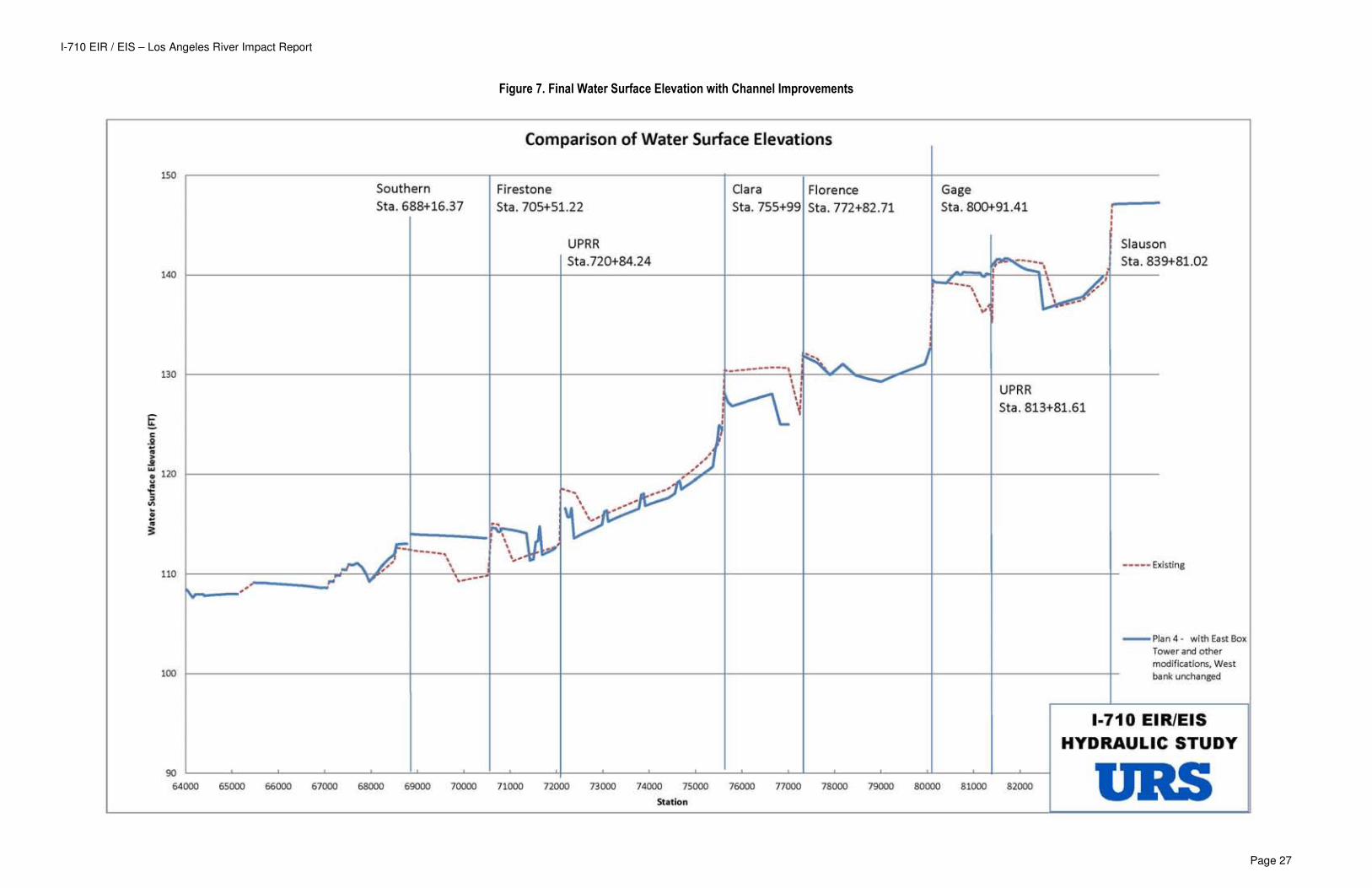
locations. Figure 8 shows a comparison of the freeboard with the proposed Design 4 channel modification. With the
exception of a few data points, Design 4 provides a minimum of 3 feet of freeboard or matches the existing freeboard
values for the entire reach impacted by the longitudinal encroachment into the Los Angeles River channel. Based on
the model output, Design 4 provides the necessary mitigation for the proposed longitudinal channel encroachments.
By replacing the existing piers with a more efficient design there is a general improvement (decrease in WSE)
upstream of the UPRR bridge between Firestone Blvd. and Clara St. bridges (denoted as SPRR in the model) for all
alternatives. Additional, more detailed, design and modeling analysis is required to determine if any additional
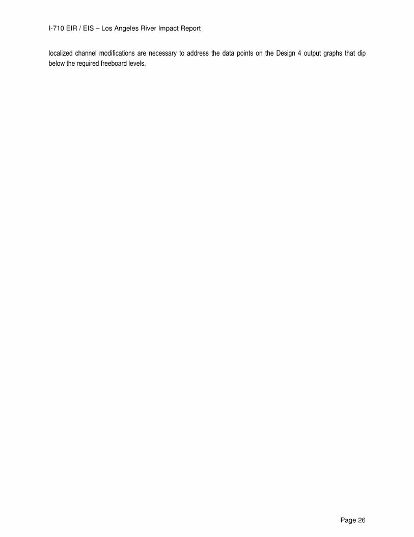
I-710 EIR / EIS – Los Angeles River Impact Report
Page 26
localized channel modifications are necessary to address the data points on the Design 4 output graphs that dip
below the required freeboard levels.
I-710 EIR / EIS – Los Angeles River Impact Report
Page 27
Figure 7. Final Water Surface Elevation with Channel Improvements
I-710 EIR / EIS – Los Angeles River Impact Report
Page 28
Figure 8. Available Channel Freeboard with Channel Improvements
I-710 EIR / EIS – Los Angeles River Impact Report
Page 29
4.5 OTHER IMPACTS TO FLOODPLAIN
4.5.1 Permanent Encroachments to Flood Control Right-Of-Way
The construction of the Project improvements requires significant encroachment into the existing Los Angeles Flood
Control right-of-way. These impacts are a result of the limited space available for the construction of the proposed
freight corridor between the existing I-710 freeway and the Los Angeles River. The nature of the encroachments can
be characterized as follows:
a. Overhead encroachment of the freight corridor structure into the Flood Control right-of-way, including
encroachments over the existing channel.
b. The placement of abutments, columns, and retaining walls within the Flood Control right-of-way.
c. Utility encroachment due to the relocation of Southern California Edison transmission power lines into the
existing Flood Control right-of-way.
The construction of the Project improvements will reduce the available width within the existing right-of-way. Table 5-
1 identifies the location of the proposed right-of-way encroachments and also identifies the nature of the Project
impact. To provide a sense of scale, Alternative 5A affects approximately 2.6 miles of the 16-mile length of the study
area. Specifically, 13,800 linear feet of improvements featured in Alternative 5A, which include roadways and
retaining walls, will require right of way acquisition and/or modification to the dry-side Los Angeles River levees.
Alternative 6A/B/C affects approximately 13.3 miles of the 16-mile length of the study area. Specifically, 70,000 linear
feet of improvements featured in Alternative 6A/B/C, which include roadways, columns, retaining walls, and electrical
transmission relocations, will require right of way acquisition and/or modification to the dry-side Los Angeles River
levees.
The River Impact Exhibits provided in Appendix 3 depict all of the right-of-way encroachments. While these
encroachments don’t impact the existing channel capacity, they do limit, to some extent, the County and USACE’s
ability to expand the capacity of Los Angeles River channel by expanding the channel footprint.
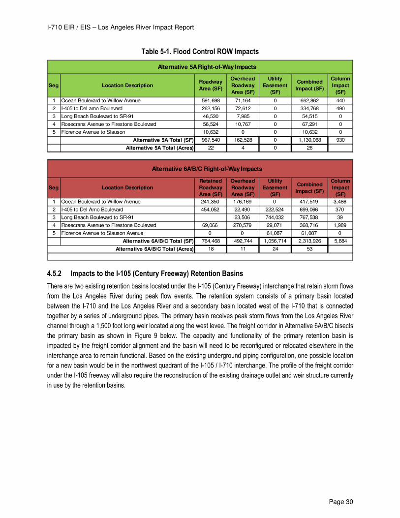
I-710 EIR / EIS – Los Angeles River Impact Report
Page 30
Table 5-1. Flood Control ROW Impacts
Seg Location DescriptionRoadway
Area (SF)
Overhead
Roadway
Area (SF)
Utility
Easement
(SF)
Combined
Impact (SF)
Column
Impact
(SF)
1 Ocean Boulevard to Willow Avenue 591,698 71,164 0 662,862 440
2 I-405 to Del amo Boulevard 262,156 72,612 0 334,768 490
3 Long Beach Boulevard to SR-91 46,530 7,985 0 54,515 0
4 Rosecrans Avenue to Firestone Boulevard 56,524 10,767 0 67,291 0
5 Florence Avenue to Slauson 10,632 0 0 10,632 0
Alternative 5A Total (SF) 967,540 162,528 0 1,130,068 930
Alternative 5A Total (Acres) 22 4 0 26
Seg Location Description
Retained
Roadway
Area (SF)
Overhead
Roadway
Area (SF)
Utility
Easement
(SF)
Combined
Impact (SF)
Column
Impact
(SF)
1 Ocean Boulevard to Willow Avenue 241,350 176,169 0 417,519 3,486
2 I-405 to Del Amo Boulevard 454,052 22,490 222,524 699,066 370
3 Long Beach Boulevard to SR-91 23,506 744,032 767,538 39
4 Rosecrans Avenue to Firestone Boulevard 69,066 270,579 29,071 368,716 1,989
5 Florence Avenue to Slauson Avenue 0 0 61,087 61,087 0
Alternative 6A/B/C Total (SF) 764,468 492,744 1,056,714 2,313,926 5,884
Alternative 6A/B/C Total (Acres) 18 11 24 53
Alternative 6A/B/C Right-of-Way Impacts
Alternative 5A Right-of-Way Impacts
4.5.2 Impacts to the I-105 (Century Freeway) Retention Basins
There are two existing retention basins located under the I-105 (Century Freeway) interchange that retain storm flows
from the Los Angeles River during peak flow events. The retention system consists of a primary basin located
between the I-710 and the Los Angeles River and a secondary basin located west of the I-710 that is connected
together by a series of underground pipes. The primary basin receives peak storm flows from the Los Angeles River
channel through a 1,500 foot long weir located along the west levee. The freight corridor in Alternative 6A/B/C bisects
the primary basin as shown in Figure 9 below. The capacity and functionality of the primary retention basin is
impacted by the freight corridor alignment and the basin will need to be reconfigured or relocated elsewhere in the
interchange area to remain functional. Based on the existing underground piping configuration, one possible location
for a new basin would be in the northwest quadrant of the I-105 / I-710 interchange. The profile of the freight corridor
under the I-105 freeway will also require the reconstruction of the existing drainage outlet and weir structure currently
in use by the retention basins.
I-710 EIR / EIS – Los Angeles River Impact Report
Page 31
Figure 9. I-105 Retention Basins
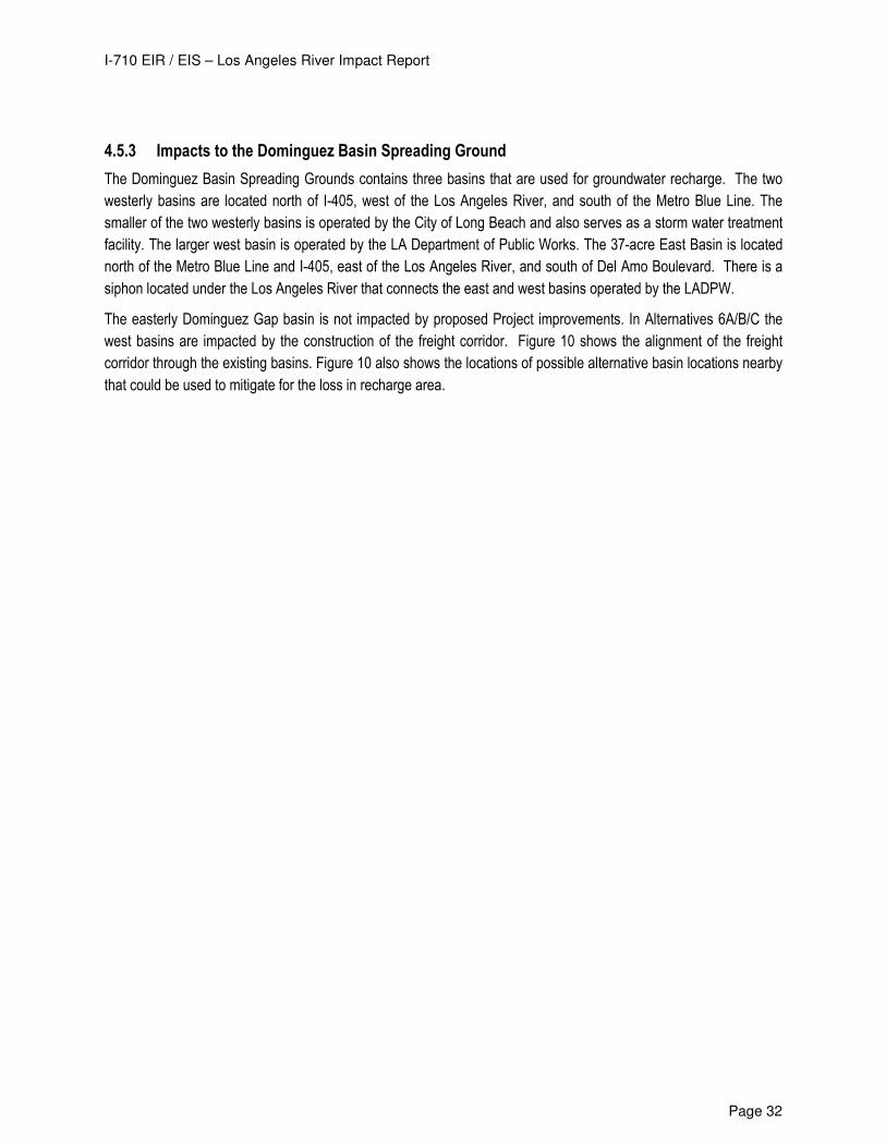
I-710 EIR / EIS – Los Angeles River Impact Report
Page 32
4.5.3 Impacts to the Dominguez Basin Spreading Ground
The Dominguez Basin Spreading Grounds contains three basins that are used for groundwater recharge. The two
westerly basins are located north of I-405, west of the Los Angeles River, and south of the Metro Blue Line. The
smaller of the two westerly basins is operated by the City of Long Beach and also serves as a storm water treatment
facility. The larger west basin is operated by the LA Department of Public Works. The 37-acre East Basin is located
north of the Metro Blue Line and I-405, east of the Los Angeles River, and south of Del Amo Boulevard. There is a
siphon located under the Los Angeles River that connects the east and west basins operated by the LADPW.
The easterly Dominguez Gap basin is not impacted by proposed Project improvements. In Alternatives 6A/B/C the
west basins are impacted by the construction of the freight corridor. Figure 10 shows the alignment of the freight
corridor through the existing basins. Figure 10 also shows the locations of possible alternative basin locations nearby
that could be used to mitigate for the loss in recharge area.
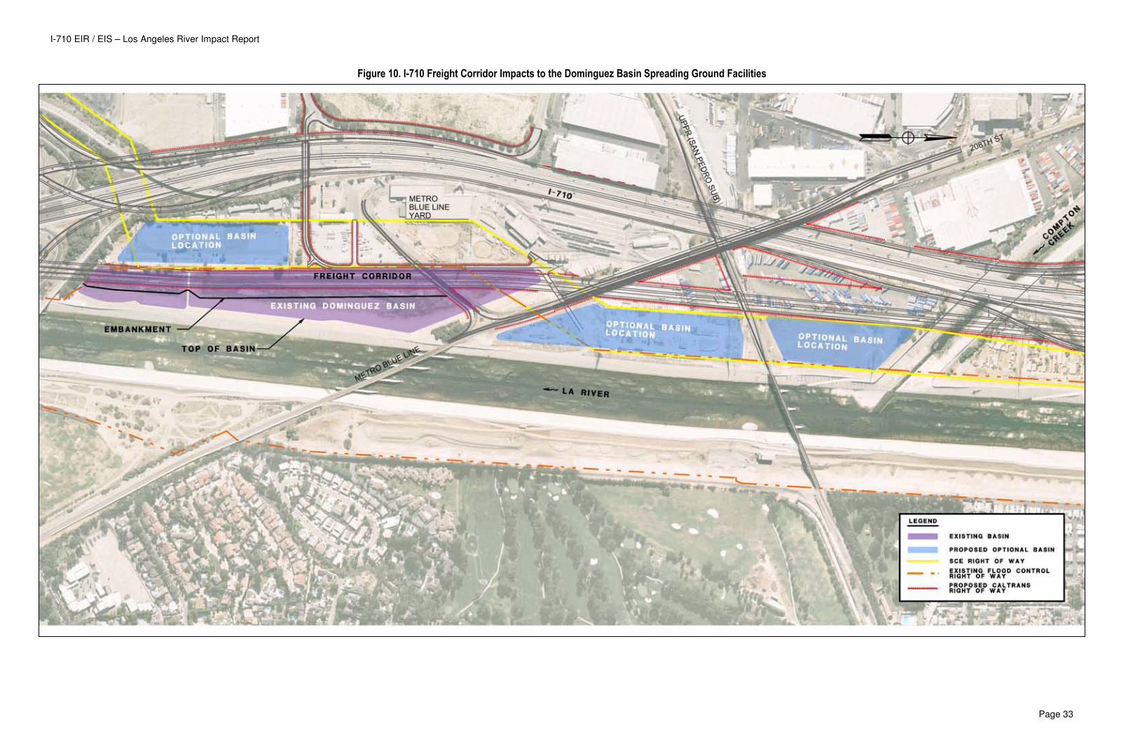
I-710 EIR / EIS – Los Angeles River Impact Report
Page 33
Figure 10. I-710 Freight Corridor Impacts to the Dominguez Basin Spreading Ground Facilities
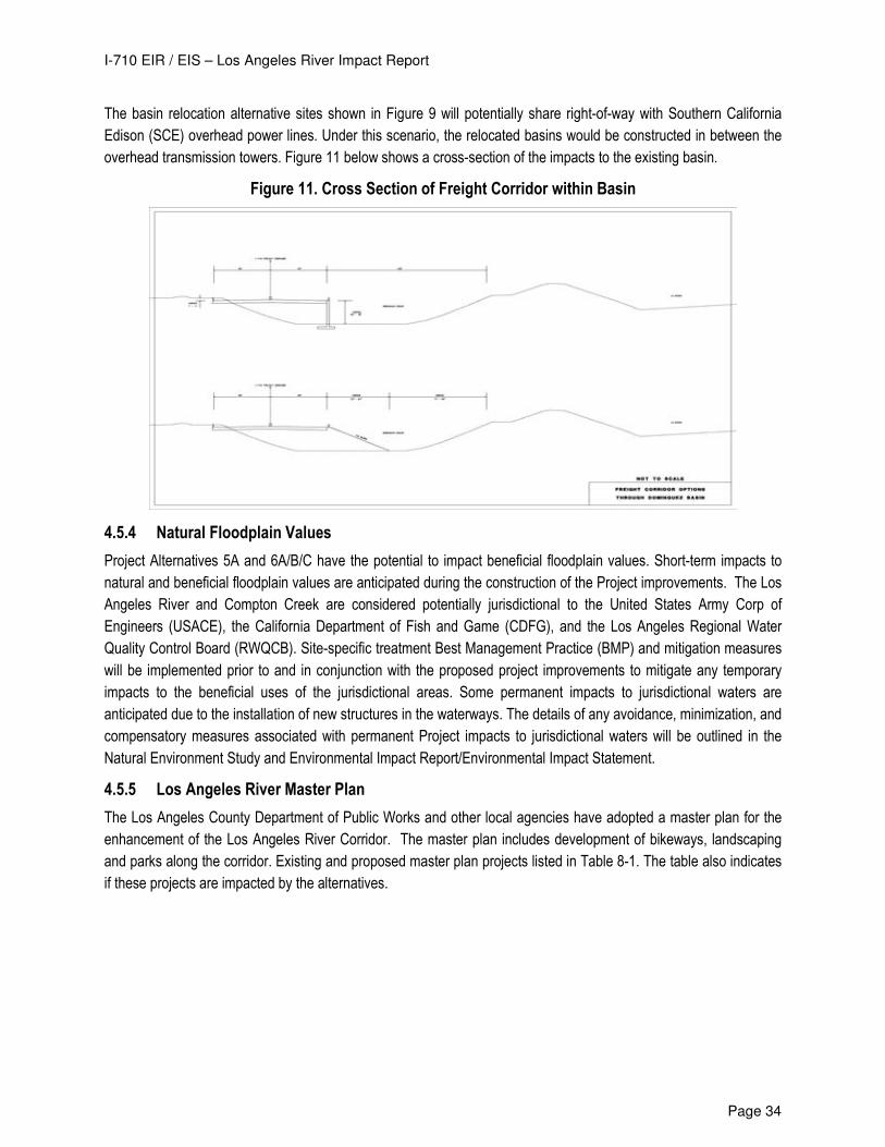
I-710 EIR / EIS – Los Angeles River Impact Report
Page 34
The basin relocation alternative sites shown in Figure 9 will potentially share right-of-way with Southern California
Edison (SCE) overhead power lines. Under this scenario, the relocated basins would be constructed in between the
overhead transmission towers. Figure 11 below shows a cross-section of the impacts to the existing basin.
Figure 11. Cross Section of Freight Corridor within Basin
4.5.4 Natural Floodplain Values
Project Alternatives 5A and 6A/B/C have the potential to impact beneficial floodplain values. Short-term impacts to
natural and beneficial floodplain values are anticipated during the construction of the Project improvements. The Los
Angeles River and Compton Creek are considered potentially jurisdictional to the United States Army Corp of
Engineers (USACE), the California Department of Fish and Game (CDFG), and the Los Angeles Regional Water
Quality Control Board (RWQCB). Site-specific treatment Best Management Practice (BMP) and mitigation measures
will be implemented prior to and in conjunction with the proposed project improvements to mitigate any temporary
impacts to the beneficial uses of the jurisdictional areas. Some permanent impacts to jurisdictional waters are
anticipated due to the installation of new structures in the waterways. The details of any avoidance, minimization, and
compensatory measures associated with permanent Project impacts to jurisdictional waters will be outlined in the
Natural Environment Study and Environmental Impact Report/Environmental Impact Statement.
4.5.5 Los Angeles River Master Plan
The Los Angeles County Department of Public Works and other local agencies have adopted a master plan for the
enhancement of the Los Angeles River Corridor. The master plan includes development of bikeways, landscaping
and parks along the corridor. Existing and proposed master plan projects listed in Table 8-1. The table also indicates
if these projects are impacted by the alternatives.
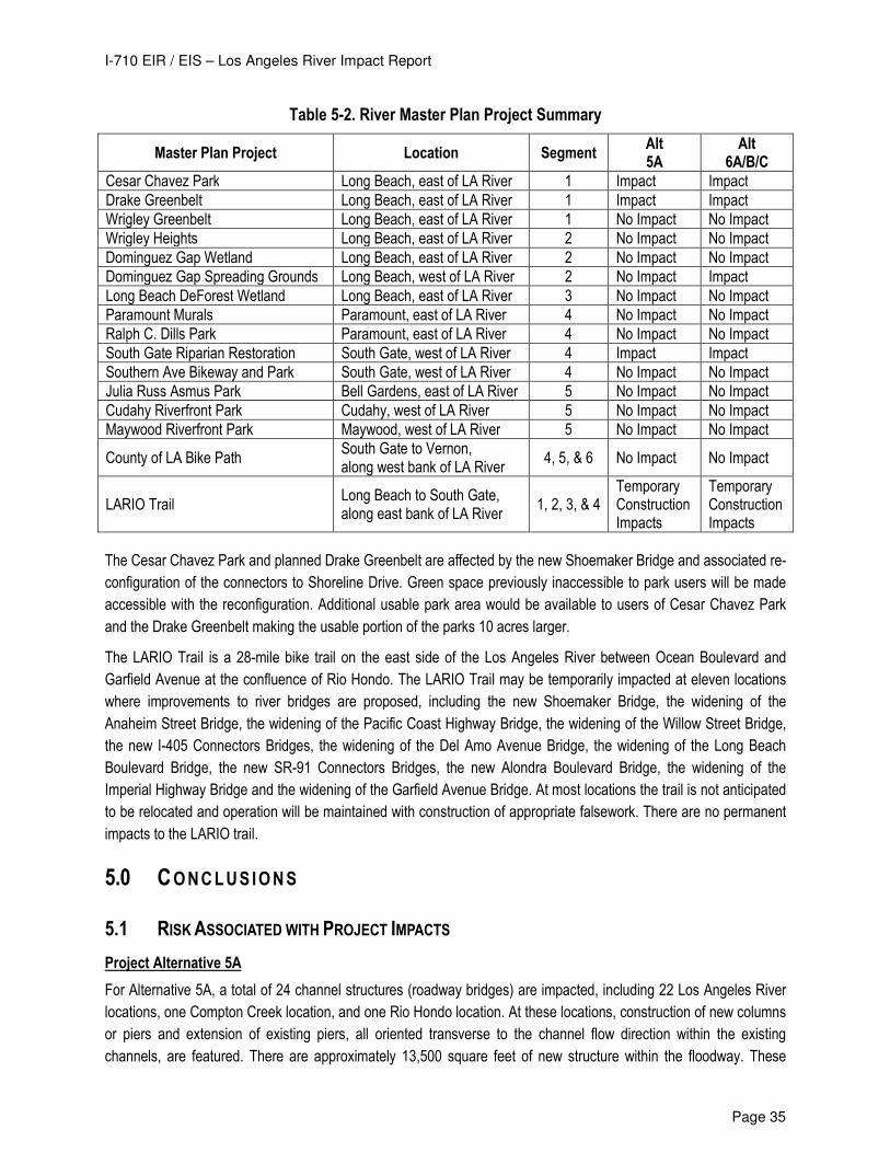
I-710 EIR / EIS – Los Angeles River Impact Report
Page 35
Table 5-2. River Master Plan Project Summary
Master Plan Project Location Segment Alt 5A
Alt 6A/B/C
Cesar Chavez Park Long Beach, east of LA River 1 Impact Impact
Drake Greenbelt Long Beach, east of LA River 1 Impact Impact
Wrigley Greenbelt Long Beach, east of LA River 1 No Impact No Impact
Wrigley Heights Long Beach, east of LA River 2 No Impact No Impact
Dominguez Gap Wetland Long Beach, east of LA River 2 No Impact No Impact
Dominguez Gap Spreading Grounds Long Beach, west of LA River 2 No Impact Impact
Long Beach DeForest Wetland Long Beach, east of LA River 3 No Impact No Impact
Paramount Murals Paramount, east of LA River 4 No Impact No Impact
Ralph C. Dills Park Paramount, east of LA River 4 No Impact No Impact
South Gate Riparian Restoration South Gate, west of LA River 4 Impact Impact
Southern Ave Bikeway and Park South Gate, west of LA River 4 No Impact No Impact
Julia Russ Asmus Park Bell Gardens, east of LA River 5 No Impact No Impact
Cudahy Riverfront Park Cudahy, west of LA River 5 No Impact No Impact
Maywood Riverfront Park Maywood, west of LA River 5 No Impact No Impact
County of LA Bike Path South Gate to Vernon, along west bank of LA River
4, 5, & 6 No Impact No Impact
LARIO Trail Long Beach to South Gate, along east bank of LA River
1, 2, 3, & 4 Temporary Construction Impacts
Temporary Construction Impacts
The Cesar Chavez Park and planned Drake Greenbelt are affected by the new Shoemaker Bridge and associated re-
configuration of the connectors to Shoreline Drive. Green space previously inaccessible to park users will be made
accessible with the reconfiguration. Additional usable park area would be available to users of Cesar Chavez Park
and the Drake Greenbelt making the usable portion of the parks 10 acres larger.
The LARIO Trail is a 28-mile bike trail on the east side of the Los Angeles River between Ocean Boulevard and
Garfield Avenue at the confluence of Rio Hondo. The LARIO Trail may be temporarily impacted at eleven locations
where improvements to river bridges are proposed, including the new Shoemaker Bridge, the widening of the
Anaheim Street Bridge, the widening of the Pacific Coast Highway Bridge, the widening of the Willow Street Bridge,
the new I-405 Connectors Bridges, the widening of the Del Amo Avenue Bridge, the widening of the Long Beach
Boulevard Bridge, the new SR-91 Connectors Bridges, the new Alondra Boulevard Bridge, the widening of the
Imperial Highway Bridge and the widening of the Garfield Avenue Bridge. At most locations the trail is not anticipated
to be relocated and operation will be maintained with construction of appropriate falsework. There are no permanent
impacts to the LARIO trail.
5.0 CONCLUS IONS
5.1 RISK ASSOCIATED WITH PROJECT IMPACTS
Project Alternative 5A
For Alternative 5A, a total of 24 channel structures (roadway bridges) are impacted, including 22 Los Angeles River
locations, one Compton Creek location, and one Rio Hondo location. At these locations, construction of new columns
or piers and extension of existing piers, all oriented transverse to the channel flow direction within the existing
channels, are featured. There are approximately 13,500 square feet of new structure within the floodway. These
I-710 EIR / EIS – Los Angeles River Impact Report
Page 36
transverse impacts require localized channel modifications to maintain the existing channel hydraulic capacity. There
are no longitudinal impacts to the Los Angeles River channel for this alternative. Acquisition of property and/or
easements totaling 26 acres of flood control area are needed to accommodate project features. LA River Master Plan
Projects that are affected include the Cesar E. Chavez Park, South Gate Riparian Restoration, and the LARIO Trail.
The proposed improvements require designs to minimize impacts to the subject water courses, facilities, and master
plan projects. Significant impacts to the floodplain are not anticipated. Structure design details are expected to
include localized channel modifications at abutments to offset any lost hydraulic capacity. Design details and
hydraulic calculations should be developed in subsequent project development phases to support designs and
permitting requirements.
Project Alternative 6A/B/C
For Alternatives 6A/B/C, a total of 33 channel structures (roadway bridges) are impacted, including 28 Los Angeles
River locations, four Compton Creek locations, and one Rio Hondo location. At these locations, construction of new
columns or piers and extension of existing piers, all oriented transverse to the channel flow direction within the
existing channels, are featured. There are approximately 24,600 square feet of new structure within the floodway.
These transverse impacts require localized channel modifications to maintain the existing channel hydraulic capacity.
Acquisition of property and/or easements totaling 53 acres of flood control area are needed to accommodate project
features. LA River Master Plan Projects that are affected include the Cesar E. Chavez Park, South Gate Riparian
Restoration, and the LARIO Trail.
The proposed bridge improvements require designs to minimize impacts to the subject water courses, facilities, and
master plan projects. Significant impacts to the floodplain are not anticipated. Structure design details are expected
to include localized channel modifications at abutments to offset any lost hydraulic capacity. Design details and
hydraulic calculations should be developed in subsequent project development phases to support designs and
permitting requirements.
Alternatives 6A/B/C also require longitudinal encroachments into the Los Angeles River channel between Firestone
Boulevard and Slauson Avenue to accommodate relocation of Los Angeles Department of Water and Power (DPW)
transmission towers into the existing Los Angeles River channel. This poses a more significant encroachment into
the floodway. The preliminary hydraulic model analysis yielded two viable channel modifications (Design 2 and 4
described in Section 4) capable of reducing the BFE to existing levels within the study reach. Based on the results of
the preliminary hydraulic modeling, the proposed longitudinal encroachments and any associated risk to the base
floodplain can be mitigated through the implementation of localized channel modifications.
For Alternatives 6A/B/C, the two westerly basins of the Dominguez Basin Spreading Grounds are impacted by the
construction of the freight corridor in these alternatives. Mitigation options for the Dominguez basins include
relocating the recharge facilities to adjacent parcels.
5.2 FLOODPLAIN IMPACTS
Although the construction of Alternatives 5A and 6A/B/C will encroach into the base flood plain, no increase to the
base flood elevation (BFE) is anticipated. The alternatives are not expected to have any significant long term impacts
to the base floodplain. Impacts to the existing FEMA floodplain and areas of inundation are not anticipated to be
significantly altered as a result of the proposed alternatives. In order to document the changes proposed for the
existing flood control system, it is anticipated that a Conditional Letter of Map Revision (CLOMR) will be required at
I-710 EIR / EIS – Los Angeles River Impact Report
Page 37
the conclusion of the Project for review and approval by FEMA. No revisions to the FEMA FIRM maps are
anticipated.
5.3 TEMPORARY PROJECT IMPACTS
Temporary disruption of emergency service should be anticipated during the construction of the Project alternatives
arterial improvements (bridges) over the existing channels. These temporary interruptions will be addressed prior to
initiating construction with the preparation of a traffic management plan specific to each construction project. The
Project alternatives do not remove or terminate any transportation facilities that are utilized for emergency services or
evacuation routes. Temporary impacts associated with the construction of the river crossings are addressed and
mitigated during detailed design development.
6.0 REFERENCES
Existing topography and proposed initial geometry information shown on the impact exhibits is provided by URS
(Microstation CAD files)
Flood Insurance Rate Maps 06037C1810, 06037C1815F, 06037C1820F, 06037C1955F, 06037C1962Fand
06037C1964F, dated September 26, 2008, Flood Emergency Management Agency.
Flood Insurance Study, Los Angeles County, California, and unincorporated areas, Volumes 1 through 4, September
26, 2008, FEMA, Flood Insurance Study Number 06037CV001A, 2A, 3A and 4A.
Los Angeles County Department of Public Works, Los Angeles County Flood Control District Opens Historic LA River
Wetlands Project http://dpw.lacounty.gov/wmd/documents/DominguezGap_article.cfm
Los Angeles River, Master Plan http://ladpw.org/wmd/Watershed/LA/Larmp/
The Los Angeles River Revitalization Master Plan http://www.lariverrmp.org/index.cfm
The Los Angeles River, California Natural Resource Agency, Environmental Resources Evaluation System, Wetlands
Information System http://ceres.ca.gov/wetlands/geo_info/so_cal/los_angeles_river.html
URS, 2008. “Final Report. Preliminary Los Angeles River Impact Analysis. WBS ID: 160.10.15-18.
US Army Corps of Engineers, “Hydraulic Design – Pertinent Data” for Compton Creek from Hooper Storm Drain to its
confluence with the Los Angeles River.
USACE (Department of the Army, Los Angeles District, Corps of Engineers, Los Angeles, California), 1991. Los
Angeles County Drainage Area Review - Final Feasibility Study – Hydrology Technical Report. December.
USACE (Department of the Army, Los Angeles District, Corps of Engineers, Los Angeles, California), 1997. Los
Angeles River Improvements, Design Memorandum No. 3, Century Freeway (Route 105) to Willow Street.
October.
USACE (Department of the Army, Los Angeles District, Corps of Engineers, Los Angeles, California), 1999. Los
Angeles River Improvements Project Including Rio Hondo and Compton Creek, Final Design Memorandum
No. 5, (Rio Hondo Confluence to Century Freeway), (Firestone Blvd. to Los Angeles River). June.
USACE (Department of the Army, Los Angeles District, Corps of Engineers, Los Angeles, California), 1995.
Stochastic Determination of Wave Heights for Flood Control Channels. September, revised October 1997.
I-710 EIR / EIS – Los Angeles River Impact Report
Page 38
USACE (Department of the Army, Los Angeles District, Corps of Engineers, Los Angeles, California), 2005. Los
Angeles County Drainage Area – Upper Los Angeles River and Tujunga Wash – HEC-RAS Hydraulic
Models. July.
USACE (Department of the Army, Los Angeles District, Corps of Engineers, Los Angeles, California), 2004. “Final
Design for Union Pacific Railroad Bridge MP17.13 San Pedro Subdivision Reconstruction” DACW 09-00-B-
0009.
USACE, 1994. EM 1110-2-1601 Hydraulic Design of Flood Control Channels. June.
USACE, Washington, D.C., 2006. ER 1105-2-101. Risk Analysis for Flood Damage Reduction Studies. January

Appendix 1 - Location Hydraulic Studies
Appendix 2 – FEMA NFIP Maps and Flood Zone Designations
Appendix 3 – River Impact Exhibits
Appendix 4 – Hydraulic Analysis
Related Documents