Welcome message from author
This document is posted to help you gain knowledge. Please leave a comment to let me know what you think about it! Share it to your friends and learn new things together.
Transcript
TANKS IN EASTERN INDIA :
A STUDY IN EXPLORATION
IWMI-Tata Policy Research ProgramHyderabad
and
Centre for Development StudiesLucknow
OCTOBER 2010
NIRANJAN PANT
R.K. VERMA
Design, Typeset & Printed by Dhruti Design, Secunderabad
Printed in Hyderabad, India
July 2010
© International Water Management Institute 2010
DisclaimerViews expressed in this book are those of the authors. They do not necessarily represent theviews of the financial sponsors of this book.
I S B N N o . 9 7 8 - 9 2 - 9 0 9 0 - 7 3 1 - 2
II
Citation
Pant, N.; Verma, R. K. 2010. Tanks in Eastern India: a study in exploration. Hyderabad, India:International Water Management Institute, IWMI-TATA Water Policy Research Program;Lucknow, Uttar Pradesh, India: Centre for Development Studies. 232p. doi:10.5337/2010.228
Keywords
Tanks / tank irrigation / fisheries / surveys / irrigated sites / ethnic groups / case studies / watermarket / colonialism / policy / Bihar / Jharkhand / West Bengal / Orissa / India
IWMI - Tata Water Policy Research Program
401/5, C/o ICRISAT, Patancheru 502 324
Andhra Pradesh
http://www.iwmi.cgiar.org/iwmi-tata/default.aspx
This Study was supported under the
IWMI Tata Water Policy Research Program (ITP) - 2004-2006
III
Niranjan Pant is Director, Centre for Development Studies, Lucknow since 1988.
He has been doing research in the field of irrigation management since 1975. Initially
he was associated with two research institutes, A. N.Sinha, Patna and Giri Institute,
Lucknow. In addition, he has worked as a consultant/advisor to National and International
organizations such as Ford Foundation, USAID, Planning Commission of India and
TAHAL Consultants and the World Bank, Danish, Dutch, SIDA, and NORAD missions.
In the course of research work he has availed visiting fellowships/research collaboration
with Harvard University, U.S.A., JSPS and IDE, Japan and WAU, the Netherlands. He
has had several associations with IWMI since 1980.
Ravindra Kumar Verma (b. 1956), Ph D. has been engaged in teaching and
research for over two and half decades. At present he is teaching at P G Department of
Political Science, R N College, Hajipur (Vaishali). He has participated in various national
and international refresher courses including one conducted in association with ISS,
The Hague, Netherlands. Verma has also been on the expert panel of government bodies.
He has contributed a great deal to the fields of Indian politics, rural development and
irrigation management in shape of five books and nearly 75 research papers in journals
like EPW, IJPS, IJPA, JJDMS, JSES, Mainstream etc. One of his books has been awarded
by the Government of India. He has long association with Niranjan Pant, including in
the research institutions at Patna and Lucknow.
About the authors
Despite the pivotal role played by tanks in the eastern region of India over centuries,
it is an under-researched area barring studies of ahar pyne systems of Bihar. The problem
arises mainly because of lack of appreciation of the role of tanks in east India on the part
of researchers, particularly the foreign scholars, who pioneered research on tank irrigation
in the late 1970s in India and held the view that tanks were concentrated in south and
central India and ignored the tanks in the eastern region. This dominance of south Indian
studies in tanks found an echo in the pattern of funding for further research and
rehabilitation of the tank based systems in that region. Part of the neglect of the tanks in
the eastern region is on account of absence of any documentation of the status of tanks
in that region. The authors feel that while lot of publications and publicity have been
going on for decades for in depth studies and investments in the tanks of south India,
lack of studies and therefore lack of publicity of tanks in eastern India has resulted in
them going unnoticed by donor agencies.
The present study therefore, attempts to explore this neglected terrain in terms of
status of tanks in the eastern region of India. Further, fishery aspect has also been studied
as it happens to be an inseparable part of tanks. Although fishery is an integral part of
tank activities, it escapes the attention of researchers dealing with irrigation and gets
neglected in research. Therefore, irrigation and fishery aspects of tanks have been studied
not only through historical records but a survey of the two aspects has also been carried
out in the states of Bihar, Jharkhand, West Bengal and Orissa.
About the Book
IV
1. Foreword VI
2. Preface VII
3. List of Tables X
2. Abbreviation XII
3. Glossary XIII
4. Chapter-I
Introduction 1
5. Chapter-II
The Scenario of Tanks in Eastern India 20
6. Chapter-III
Bihar 30
7. Chapter-IV
Jharkhand 47
8. Chapter-V
West Bengal 68
9. Chapter-VI
Orissa 87
10. Chapter-VII
Fishery - Non Irrigation uses of Tanks 103
11. Chapter-VIII
Inter State Variations and Summing Up 121
12. Annexures 145-215
CONTENTS
V
FOREWORD
Water is indispensable to agricultural production and livelihoods of many people.India is foremost among the countries in the world practicing various irrigation methodsmostly through canals, tanks and wells. In the post independence period, the countryhas invested huge amount of capital in the major and the medium irrigation projects.However, the gap between the potential created and utilized has been increasing overthe years. Given the high cost of developing the major irrigation projects, it is provedthat minor irrigation sources like tanks and wells can play a key role in stabilizing theirrigated area in the country.
Among the minor irrigation sources, wells and tube wells constitute the majorshare (58.7 per cent) followed by canals (25.7 per cent). Growth of well irrigation hasbeen at the expense of irrigation from tanks and other sources. Looking at the tanks,during the period from 1950-2005, the area under tanks had been decreased from 3.6million hectares to 2 million hectares. Tanks are mostly concentrated in areas whereother sources of irrigation are less or completely absent. Marginal and small farmers areworst affected due to the continuous decline of tank irrigation for whom an alternativesource of irrigation is either costly or not available.
Efforts are underway to identify and implement programs that help stabilize thetank irrigation potential in the country. Several studies have highlighted the importanceof tank rehabilitation programs. Most of the studies have focused on tanks in southIndia where in the intensity of tanks is primarily a function of rainfall pattern, terrain(slope) and soil types.
This book is the outcome of an interesting and very important study on tanks ineastern India done by Dr. Niranjan Pant and Dr. Ravindra Verma under ITP during2004-06. I am sure the findings of the study will re-emphasis the importance of tankirrigation in eastern India and will attract the government and other agencies to focustheir future irrigation investment on tanks in this region.
ITP has much benefited from this study and the resulting publication. I congratulatethe authors for this very important contribution.
K. Palanisami
Director, ITP
VI
I (Niranjan) had the privilege of participating in almost all of IWMI-Tata annualpartners meetings and its planning workshops till April 2008. During all such meets onecommon topic of discussion used to be tank irrigation in India. However the proposed/conducted studies used to be generally confined to south Indian tanks. On some occasionssome speakers would argue for taking research on tank irrigation in the eastern regionof India. Having done a study of tank irrigation in ahar-pyne systems of Bihar in 1997-98, I knew how important these systems were both in the historical and temporal contextand used to get provoked on such occasions. The culminating flash point came in theworkshop meeting in March 2004 at IRMA, where it was proposed to study south Indiantanks involving a sum of Rs. 2.2 million funds from IWMI-Tata programme. I stoutlyobjected this proposal and later proposed a study of tanks in the eastern region of thecountry and after initial problems, was ultimately awarded a research grant of 3.89 lakhrupees. Since the coverage of the study was quite vast and the completion of the studyhad time constraints, I decided to share the task with Ravindra and the two of us carriedout this study. Our working together was facilitated by the fact that we had workedtogether as a perfect research team in the early 1980s. After the study was completedsometime in January 2007, Tushar Shah wrote to me, “The historical picture you provideof irrigation in general and tank irrigation in particular is priceless. I enjoyed readingthose sections on Bihar, Jharkhand as well as West Bengal.” This encouraged us to gofor the publication of the study in to a book and it was thats how this book originated.
The book explores the history and status of tanks in the four east Indian states.The book contents have been built around eight chapters. The contents in these chaptersare often explained with the help of tables and whenever necessary material is providedin the annexure. Chapter one introduces tanks in general and those in eastern India inparticular and highlights the paucity of available tank data. An important component ofthe chapter is the highlight of the utter neglect of tanks in the east Indian states and highpreoccupation with south Indian tanks both in research and renovation/modernization.The chapter also covers research methodology and the process of selection of tanks forthe study. The scenario in the East Indian states vis-à-vis south Indian states is examinedin the second chapter with the help of available secondary data. The chapter also dealswith the procedure adopted for the survey of four East Indian states and the reasons forexclusion of Uttar Pradesh. Chapter three to six cover the states of Bihar, Jharkhand,West Bengal and Orissa. A common feature of these chapters is that the historical accountsof tank irrigation, including those of the selected districts from each state is followed by
PREFACE
VII
the survey findings in respect of each state. A number of case studies were conducted inBihar and Jharkhand and the findings of such studies have also been included in therespective chapters. The details of case studies however are included as annexure. Chapterseven covers the fishery aspect of tanks, including its historical perspective. Chaptereight sums up salient points emerging from the study and hopes for the revival ofindigenous tanks by their integration with the on going and new surface schemes.
Tables are arranged in two ways. One set of tables have been provided that goside by side of the description in each chapter. All such tables are based on secondarysources. Another set of tables have been generated from authors’ survey. Such tables arecommon to four states of Bihar, Jharkhand, West Bengal and Orissa. These tables haveuniform titles for all four states and have been arranged in the same order for all states.The only distinguishing feature of the state tables is the use of the first letter of the nameof the state to which the tables refer. All survey tables of Bihar for instance would havenumbering from B-1 to B-18. Similarly the consolidated tables of all four states havebeen numbered from E-1 to E-18, denoting eastern India. Although tables have beennumbered 1-18, table 9 is split in three tables as a, b, and c. This means there are 20tables for each state and a total of 100 tables based on the survey.
At times words with different spellings have been interchangeably used such asbundh, bundha, bandh, bund, and band. Similarly, santal, santhal, pyne, pain, ryot,royot, raiyat etc. In all such cases usage of the word is either location specific or authorspecific. While the location may refer to a district, region or state, authors generallyrefer to modern writers or old British gazetteer writers. It would be found that whileBritish gazetteer writers have been using the word santal, the modern writers use theword santhal.
Many individuals and institutions have assisted us in preparing the book. Thenames of the institutions have been mentioned while discussing data collection in themethodology section. First and foremost this study was made possible by a researchgrant under IWMI-Tata Programme and we are grateful to the then head of theprogramme, Tushar Shah for providing funds for the study. We are gratified to our friendsP.P.Ghosh and Indradeo Sharma who helped us intellectually and logistically in Bihar.We are also grateful to Deep Joshi for being instrumental for every possible assistancein PRADAN’s offices in West Bengal and Jharkhand. In Bhubaneswar, BismayaMahapatra of Harsha Trust was a pillar of strength for us in providing guidance andlogistic support for Orissa and we sincerely thank him for the same. Two others helpedus in Orissa and for that we wish to thank, R.K.Panda of MASS, Sambalpur and TapanPadhi of RCDS, Bhubaneshwar.
VIII
A number of research assistants helped us in the completion of research leadingto the book but the one deserving special mention is Sidheswar Singh, who was veryhelpful in tirelessly collecting both secondary and the primary data for Bihar, Jharkhandand West Bengal and for this he deserves our sincere thanks. Above all a number of un-named individuals who guided us to the tank sites and provided intimate informationabout tanks deserve our whole hearted thanks.
The publication of the book has been most torturous and agonizingly slow processand has been going on for over three years. The initial encouragement and support wasprovided by Dinesh Kumar, the then head of IWMI-Tata programme and we expressour big thanks to him for the same. The publication of the book however would not havebeen possible without the timely interventions of Madar Samad, head of the IWMIoffice in India and he deserves our thanks for the same. Finally, we wish to express ourthanks IWMI- Tata team, particularly to Padmaja Karanam and Vidya Ramesh for theediting of the manuscript.
Niranjan Pant
and
Ravindra Kumar Verma
IX
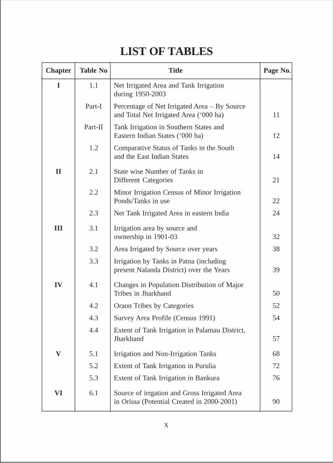
Chapter Table No Title Page No.
I 1.1 Net Irrigated Area and Tank Irrigationduring 1950-2003
Part-I Percentage of Net Irrigated Area – By Sourceand Total Net Irrigated Area (‘000 ha) 11
Part-II Tank Irrigation in Southern States andEastern Indian States (‘000 ha) 12
1.2 Comparative Status of Tanks in the Southand the East Indian States 14
II 2.1 State wise Number of Tanks inDifferent Categories 21
2.2 Minor Irrigation Census of Minor IrrigationPonds/Tanks in use 22
2.3 Net Tank Irrigated Area in eastern India 24
III 3.1 Irrigation area by source andownership in 1901-03 32
3.2 Area Irrigated by Source over years 38
3.3 Irrigation by Tanks in Patna (includingpresent Nalanda District) over the Years 39
IV 4.1 Changes in Population Distribution of MajorTribes in Jharkhand 50
4.2 Oraon Tribes by Categories 52
4.3 Survey Area Profile (Census 1991) 54
4.4 Extent of Tank Irrigation in Palamau District,Jharkhand 57
V 5.1 Irrigation and Non-Irrigation Tanks 68
5.2 Extent of Tank Irrigation in Purulia 72
5.3 Extent of Tank Irrigation in Bankura 76
VI 6.1 Source of irrgation and Gross Irrigated Areain Orissa (Potential Created in 2000-2001) 90
LIST OF TABLES
X
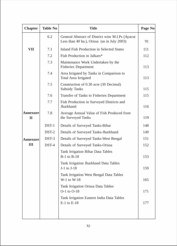
6.2 General Abstract of District wise M.I.Ps (AyacutLess than 40 ha.), Orissa (as in July 2003) 91
VII 7.1 Inland Fish Production in Selected States 111
7.2 Fish Production in Jalkars* 112
7.3 Maintenance Work Undertaken by theFisheries Department 113
7.4 Area Irrigated by Tanks in Comparison toTotal Area Irrigated 113
7.5 Construction of 0.30 acre (30 Decimal)Subsidy Tanks 115
7.6 Transfer of Tanks to Fisheries Department 115
7.7 Fish Production in Surveyed Districts andJharkhand 116
7.8 Average Annual Value of Fish Produced fromthe Surveyed Tanks 119
DST-1 Details of Surveyed Tanks-Bihar 148
DST-2 Details of Surveyed Tanks-Jharkhand 149
DST-3 Details of Surveyed Tanks-West Bengal 151
DST-4 Details of Surveyed Tanks-Orissa 152
Tank Irrigation Bihar Data TablesB-1 to B-18 153
Tank Irrigation Jharkhand Data TablesJ-1 to J-18 159
Tank Irrigation West Bengal Data TablesW-1 to W-18 165
Tank Irrigation Orissa Data TablesO-1 to O-18 171
Tank Irrigation Eastern India Data TablesE-1 to E-18 177
Chapter Table No Title Page No
AnnexureII
AnnexureIII
XI
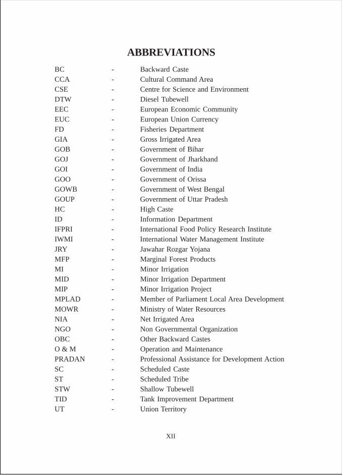
ABBREVIATIONS
BC - Backward CasteCCA - Cultural Command AreaCSE - Centre for Science and EnvironmentDTW - Diesel TubewellEEC - European Economic CommunityEUC - European Union CurrencyFD - Fisheries DepartmentGIA - Gross Irrigated AreaGOB - Government of BiharGOJ - Government of JharkhandGOI - Government of IndiaGOO - Government of OrissaGOWB - Government of West BengalGOUP - Government of Uttar PradeshHC - High CasteID - Information DepartmentIFPRI - International Food Policy Research InstituteIWMI - International Water Management InstituteJRY - Jawahar Rozgar YojanaMFP - Marginal Forest ProductsMI - Minor IrrigationMID - Minor Irrigation DepartmentMIP - Minor Irrigation ProjectMPLAD - Member of Parliament Local Area DevelopmentMOWR - Ministry of Water ResourcesNIA - Net Irrigated AreaNGO - Non Governmental OrganizationOBC - Other Backward CastesO & M - Operation and MaintenancePRADAN - Professional Assistance for Development ActionSC - Scheduled CasteST - Scheduled TribeSTW - Shallow TubewellTID - Tank Improvement DepartmentUT - Union Territory
XII
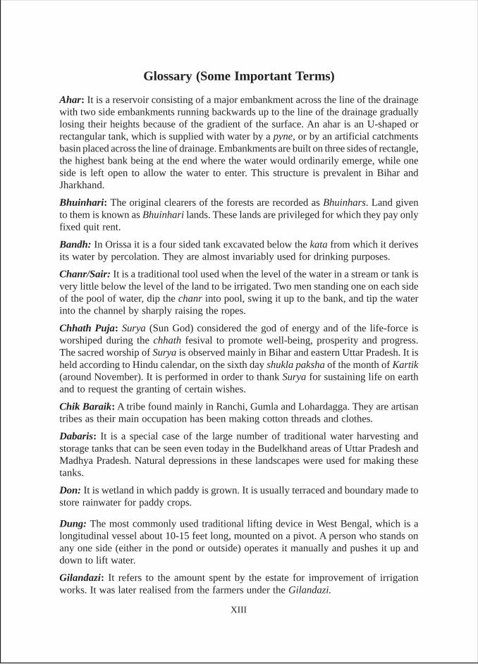
Glossary (Some Important Terms)
Ahar: It is a reservoir consisting of a major embankment across the line of the drainagewith two side embankments running backwards up to the line of the drainage graduallylosing their heights because of the gradient of the surface. An ahar is an U-shaped orrectangular tank, which is supplied with water by a pyne, or by an artificial catchmentsbasin placed across the line of drainage. Embankments are built on three sides of rectangle,the highest bank being at the end where the water would ordinarily emerge, while oneside is left open to allow the water to enter. This structure is prevalent in Bihar andJharkhand.
Bhuinhari: The original clearers of the forests are recorded as Bhuinhars. Land givento them is known as Bhuinhari lands. These lands are privileged for which they pay onlyfixed quit rent.
Bandh: In Orissa it is a four sided tank excavated below the kata from which it derivesits water by percolation. They are almost invariably used for drinking purposes.
Chanr/Sair: It is a traditional tool used when the level of the water in a stream or tank isvery little below the level of the land to be irrigated. Two men standing one on each sideof the pool of water, dip the chanr into pool, swing it up to the bank, and tip the waterinto the channel by sharply raising the ropes.
Chhath Puja: Surya (Sun God) considered the god of energy and of the life-force isworshiped during the chhath fesival to promote well-being, prosperity and progress.The sacred worship of Surya is observed mainly in Bihar and eastern Uttar Pradesh. It isheld according to Hindu calendar, on the sixth day shukla paksha of the month of Kartik(around November). It is performed in order to thank Surya for sustaining life on earthand to request the granting of certain wishes.
Chik Baraik: A tribe found mainly in Ranchi, Gumla and Lohardagga. They are artisantribes as their main occupation has been making cotton threads and clothes.
Dabaris: It is a special case of the large number of traditional water harvesting andstorage tanks that can be seen even today in the Budelkhand areas of Uttar Pradesh andMadhya Pradesh. Natural depressions in these landscapes were used for making thesetanks.
Don: It is wetland in which paddy is grown. It is usually terraced and boundary made tostore rainwater for paddy crops.
Dung: The most commonly used traditional lifting device in West Bengal, which is alongitudinal vessel about 10-15 feet long, mounted on a pivot. A person who stands onany one side (either in the pond or outside) operates it manually and pushes it up anddown to lift water.
Gilandazi: It refers to the amount spent by the estate for improvement of irrigationworks. It was later realised from the farmers under the Gilandazi.
XIII
Genrabandi: It refers the series of embankments, which prevented the water fromescaping from the fields. The gherwa or outer embankment used to be about four feethigh, within which were a series of smaller embankments (genera) and last of all werethe ordinary ails round individual fields.
Gotia: In olden days, the village land used to be collectively managed by the villagecommunity among the tribes of Ranchi district and the village officials used to distributeannually village lands to the different families within the village. In token of this annualarrangement each family used to receive a clod i.e. goti of earth from the gotia (villageheadman).
Gountias: They played a very important role in the construction and maintenance of thetanks in Orissa. Gountia or the village headman who held a hereditary position continuedtill the beginning of the Maratha rule.
Hathia nakshatra: It refers to the period between Septemeber 26 and October 7. It isbased on Hindu calendar, which is divided into 24 nakshatra, representing a certainportion of moon's path in the zodiac.
Jalkar: In Bihar, it includes tank, pokhar, ahar, river watercourse, channels, chaur, dhav,reservoir lake, ox-bow lake etc., in which makhana, singhara and fish is reared. In generalterms it refers to right of private ownership of the bodies of water or jalkar (from theSanskrit jal meaning ‘water’ and kara meaning ‘tax’) attached to the estates of zamindars.Such jalkar rights covered non-navigable rivers, beels, ponds, haors and tanks.
Karin: It is a water scoop shaped like “dug-out” canoe cut in half. It is usually made ofsingle piece of wood, but iron karins is not uncommon. The water is raised by a leveroverhead with a weight at the end of it. The karin is used for raising water from ahars orfrom a lower channel to a higher, where water is plentiful, and has not to be shifted to aconsiderable height.
Kata: Prevalent in Orissa, it is an ordinary irrigation tank that is constructed by throwinga strong earthen embankment, slightly curved at either end across a drainage line, so asto hold up an irregularly shaped sheet or water. The undulations of the country usuallydetermine its shape as that of a long isosceles triangle of which the dam is the base.
Khudi murrammat: This system of use of community labour for maintenance of irrigationwork was also very much in vogue in the erstwhile Madras state, where it was legitimisedthrough legislative action and is called khudi murrammat (self repair).
Khunt-katti: Among the tribes, the original clearers of the forests used to get recognitionof usufruct right over the areas they cleared and also the right to admit new members inthe same category. This system is still found in the areas of Ranchi district among theMundas (Singh Muda in Purulia, West Bengal).
Laterite Soil: This soil is mainly found in the highlands of western part of Ranchi plateauand pat region. This soil is dark red or brown in colour because of iron content.
Latha: This is a long beam working on an upright forked post, which serves as a fulcrum.The beam is weighted at one end with a log or stone, and a cone-shaped bucket (Kunru)
XIV
is attached by a rope to the other end. The cultivator pulls down the rope till the bucketis immersed, the weight attached to the lever then lifts it, and the bucket is emptied in tothe water channel.
Mahli: They are mainly found in the districts of Ranchi, Lohardagga, and Gumla etc.Their economy is based on basket weaving, collection of forest refuse, agriculture,carrying palanquin etc. Each mahli family owns some land for cultivation but generallythey have tanr land.
Munda: In Orissa it is an embankment of smaller size across a drainage channel. InBihar there is tribe by the same name.
Oraon: The second most populous tribe in Jharkhand. They originally hailed from westcoast of India. Their economy presents a mixture of agriculture, labour, collection ofmarginal forest products and services. Each family owns some agricultural land. Now adays some well to do oraon families have their own wells and diesel machines. Theagriculture provides engagement to the oraon for six to eight months in a year and forthe remaining period they collect forest refuse. They utilize the services of tribes likelohara, mahli, chik barik, and karmali in agriculture.
Pahan: Is the priest of oraon, munda and such other tribes. In some areas he is known asBaiga.
Paraha (Padaha): Comprises a number of villages, which ranges from about five tothirty. Each paraha has a particular territory.
Parha Raja: The head of each paraha is known as paraha raja.
Pats: The Pat is the highest portion, lying west of Ranchi plateau and south of Garhwaand Palamau district and having elevation ranging between 1000m and 1200m. Theseisolated pats are outliers of the Deccan lavas and have maintained flat tops.
Pyne: Is the local name for the diversion channels. These channels may be of varioussizes. The small ones are those found originating in ahars and carrying the water of theahars to cultivable plots. The large ones have their origins in rivers from which water isdiverted through these artificial channels by erecting embankment in the riverbeds.
Sagar: The tank structures, which are the largest ones called sagar were most visiblefeature of all feudatory states including Kalahandi in Orissa.
Simli: The simplest lifting device, a relatively inexpensive one, which is a triangularmetal tray tied with ropes on both the sides. The ropes are held by two persons, one oneither side, and pulled and released successively to throw water. A simli throws smallamounts of water each time.
Tanr: It is cultivated dry upland and is also known as gora or bari in the district ofSinghbhum.
Zamindar: The indigenous estate holder and the local ruler was known as zamindar(from the Arabic zamin or ‘earth/land’ and the Hindi dar meaning ‘one who holds’).
XV

Tanks in Eastern India: A Study in Exploration
Niranjan Pant and R. K. Verma
CHAPTER-I
Tanks are basically small reservoirs built of earthen walls across the rivers, streamsand drainage channels to impound and store water to irrigate fields through channels.Unlike the diversion channels, tanks retain the water for future use. Where not suppliedby perennial rivers, which is mostly the case, their storage depends on precipitation inthe catchment. Tanks are often linked with one another, and such tanks are known ascascade tanks. The outflows from one might flow into another one further down theslopes. Historically tanks have been important in the states of Tamil Nadu, AndhraPradesh, Karnataka and Kerala in the south India; Uttar Pradesh, Bihar (includesJharkhand), West Bengal and Orissa in the eastern India; Madhya Pradesh, Rajasthan,Maharashtra and Gujarat in central and western India.
The word tank is often used in common parlance to describe small irrigationreservoirs and a large number of small man-made lakes are also designated as tanks.There is no standard definition for tank. In the eastern states of Orissa and West Bengal,pond and tank are interchangeable expressions, while in Andhra Pradesh, Karnatakaand Tamil Nadu, tanks refer to a section of irrigation reservoirs, including small andmedium sized water bodies. In fact, some of the tanks in Tamil Nadu and Karnataka arequite large.1
Construction of small and big tanks have been taken up in India from timeimmemorial for domestic purposes, fisheries and irrigation. The irrigation tanks withelevated embankments have some similarity with tanks built for domestic purpose andfisheries. Also, it is not uncommon to find tanks that combine irrigation with fisheries.Since the tanks can store catchments runoff during rains for future use, the necessityand utility of tanks is great in areas ravaged by frequent occurrence of droughts moreparticularly in areas where rainfall is scanty and ground water is not easily available.But it is important for uses like “fisheries” in areas with shallow groundwater table andheavy rains. Tanks also play an important role in preserving the environment and theecology of the region. Tanks are vast in number and varied in size and are spread all
1 Fish Seed Committee of the Government of India (1966) termed all water bodies of more than 200 ha inarea as reservoirs
CHAPTER-I
INTRODUCTION
1
over the country. In different areas, they carry different nomenclature like tank/pondmalguzari, ery, kanmai, talab, tanka, kunta, baories, pokhur/pukar, sagar, kata, munda,bandha, khadim, haveli system, ahar etc.
Some evidence of advanced water harvesting systems can be traced back to thepre-historic times in Puranas, Mahabharat, Ramayan and various Vedic, Buddhist andJain texts. However, the most vivid and detailed description of such systems are foundin the Arthasastra – a politico administrative treatise of Chanakya (also known asKautilya) who was a mentor to and minister of Chandragupta Maurya (321-297 BC),the first emperor of India (Agarwal and Narain 1997, 11).
In Arthasastra, Kautilya clearly observed that kings dug tanks at locations wherewater for irrigation was plentiful. Semi-circular bunds were raised adjacent to smallhillocks and water reservoirs. He further observed, “The king should arrange forpermanent sources of irrigation for agriculture such as tanks and bandhas/dams. In caseother people are themselves eager for construction of such permanent sources, the kingshould provide them with necessary land, watering and wood. In such collectiveconstruction if some person is not able to participate himself, he should contribute themoney as compensation for his labour or provide a labour to represent him. It is furtherclarified that ownership of these sources would remain with the king” (Yogi 1973, 93-94). Kautilya not only provided detailed description of the mechanism for constructionof irrigation sources, but also mentions about their ownership and administration. Heasserts, “According to Shastras the king is the owner of all lands and water resources,therefore, he is eligible to collect water tax apart from land tax” (Yogi 1973, 215).
He also provided the details of the manner in which water tax should be levied.According to him, “those irrigating from the wells constructed by them are required topay one fifth of the crop. Those irrigating their lands through pitchers/earthen pots,carried over their shoulders, are required to pay one fourth of the crop and those irrigatingtheir lands from canals etc. should pay one third of the crop share to the king. Thoseirrigating their lands from the waters of rivers, lakes, tanks, ponds or wells, should payone fourth share of the crop” (Yogi 1973, 215-216).
Kautilya mentions two types of embankments – the sahodaka where there is anatural flow of water, and aharyodka, which is a sort of storage tank with water broughtin through channels specially dug for this purpose. Some important points emergingfrom the treaties of Kautalya, which have a relevance in the understanding of tankirrigation status today, are: (i) the land on which a tank was built was the property of thestate; (ii) settlers pooled their resources to build a tank for common use; (iii) punishmentwas prescribed for a person who failed to co-operate in the building of an irrigationwork; (iv) fines were imposed for damage to embankments or flooding of the lowertank by a tank constructed at a higher level. In addition, detailed instructions aboutexemptions from taxes, fines for failure to repair or maintain the tanks were given byKautilya (Agarwal and Narain 1997, 14).
2
The technology of tank irrigation was known for several centuries. References totanks occur from the time of the Sangam literature, i.e., 1st to 4th centuries AD (Meinzen-Dick 1984). Many of the existing/functioning tanks of today are several centuries old,as borne out by a large number of inscriptions dating from the 8th century. Historicalevidence suggests that tank construction was sponsored by kings, chiefs, dominant farmercastes and even merchants and priests for purposes of revenue enhancement, taxconcession and religious merit (Subbhalakshmi 1988).
Tank as a source of irrigation was most predominant in the southern and easternparts of India. In the south, right from Chola era (985-1205 AD) to the Vijayanagarkingdom (1336-1546 AD), cascade tanks were constructed in Andhra Pradesh andKarnataka. Anantarajsagar or Pourma milla tank in Cuddapah district in Andhra Pradeshis a magnificent monument of Vijayanagar kingdom2. Similarly, Pal kings, who ruledover the present day Bengal from 760 to 1100 AD, constructed many large tanks in theirkingdom (Bagchi 1995, xviii-xix). Further east, in the present day Orissa, gonds, theprincipal tribe of dravidian origin had established their rule by 9th century AD so muchso that the whole section of eastern and central provinces assumed the name “Gondwana”.It was the citadel of the most magnificent tanks. If there was one thing that chracterisedgond kings most, it was the construction of various types of tanks such as katas, mundas,bandhas and sagars during their reign.
The predominance of tanks in Deccan plateau and eastern India, includingChhota Nagpur plateau is on account of the unique topography of the regions. In caseof Deccan plateau, the tracts with undulating topography and rocky substrataare eminently suitable for tank irrigation. There are a number of reasons for theoverwhelming presence of tanks in Deccan plateau. The rivers of Deccan are solelydependent on monsoon rains. There are many streams that become torrential duringrainy season but dry up in the remaining part of the year. Besides, poor infiltrationcapacity of soils and substrata becomes ideal for storage of water for the lean season.Over and above, the undulating terrain and rocky substrata makes cost of constructionof wells prohibitive. Tanks could also be formed across the slope of a catchments areafor storage of rainwater. Consequently, two types of tanks, namely cascade tanks andreservoir tanks are found in this region. Cascade tanks are constructed in a series bybunding the running stretch of the same valley at several points. The surplus water,which spills over the waste-weir of one-tank, feeds the tank lower down and so on. Thereservoir tanks are bigger tanks constructed across a single point in a valley. The cascadetanks are mostly concentrated in the Telangana region of Andhra Pradesh and manyparts of erstwhile Madras district (Bhattacharjee 1961, 4-5).
The need for irrigation arises from the fact that the temporal and spatial distributionof rainfall and natural moisture regime is not in accordance with the water requirements
2 This tank was constructed with a 1,372 m long earthen embankment on the Maldevi river with awater-spread area of 41.4 sq. kilometers
3
of the crops cultivated. Though the whole of eastern India, except some parts, lie in ahumid zone with an annual rainfall of about 1200 mm, which is sufficient for kharifcrops like paddy and maize, the occurrence and distribution of rains is highly erratic anddistinctly seasonal in character. The monsoon often starts late and recedes early. Then,there are significant time gaps between wet spells. Such patterns of monsoon have severeconsequences for crop cultivation in eastern India, where paddy is the most importantcrop covering about 70 per cent of the net cropped area. This crop is highly sensitive todroughts. The entire crop may fail for want of one or two critical watering. The mostpertinent case in point is the severe drought of 1966-67 in which the production of foodgrains in the eastern region went down by over 50 per cent. Herein lies the significanceof irrigation. It bridges the gap between rains, protects the crops from failure for want ofmoisture and stabilises agricultural production and activity. Again, most of the annualrainfall (over 85 per cent) in the region takes place during the four months from June toSeptember, with very little precipitation during the remaining months of the year. In theabsence of irrigation, cultivation is largely confined to these monsoon months. Irrigationfacility extends the period of cultivation beyond the monsoon months. As a matter offact, consequent to the drought of 1966-67, paddy production of many districts of easternIndia decreased considerably. In Gaya district of Bihar, it decreased by 84.2 per cent(Prasad and Sharma 1991, 232).
Tank Irrigation in Eastern India
In the eastern region, over centuries, tanks and ponds constituted an importantsource of supplemental irrigation for crops during periods of water stress. Thus, tanksand ponds have been checkmating the hydrological characteristics of the monsoon byholding and conserving monsoon rains for utilization at critical stage of crop growth.Tank irrigation has a rich heritage on account of long historical antecedents in easternIndia, comprising eastern Uttar Pradesh, south Bihar plains, Jharkhand, West Bengaland Orissa.
In case of south Bihar plains and Chhota Nagpur plateau, the indigenous systemof the ahar-pyne has been evolved to overcome the obstacles, which the physiographyof the area poses to crop cultivation.
Ahar-pyne is historically the most important source of irrigation in south Biharplains and Chhota Nagpur plateau. Three factors contribute to the wide spread presenceof this system of irrigation in the region. These are (i) scanty rainfall, (ii) a steep slope infarm land, which causes extensive runoff and (iii) soil, which is either heavy clay orloose sand, in both cases equally non-retentive of moisture. The ingenuity of theinhabitants has helped devise a system by which the natural drainage is blocked and thewater is impounded (Pant 1998, 3133). Even today ahar-pyne provides a shining exampleof participatory irrigation management.
The eastern highlands (plateau) extends over Bihar, West Bengal, Madhya Pradeshand Orissa. The uplands of Chhota Nagpur plateau cover the districts of Palamau, Ranchi,
4
Dhanbad, Hazaribagh, Giridih, Santhal Pargana and Singhbhum. The same extend intothe Purulia, Bankura and Midnapore districts of West Bengal. The northern Orissahighlands comprise Dhenkanal, Kendujhar, Mayurbhanj, Sambhalpur and Sundergarh.Little is known about the water harvesting system of this region. However, there is lot ofevidence of rich tank irrigation system in Chhota Nagpur plateau. Although no majorirrigation project could be undertaken in the region due to its hilly terrain, the system ofdamming valleys by a series of bunds 8 to 10 feet high, exist everywhere. It forms smalltanks or ahars. These were not generally provided with masonry sluices, and the waterseeping through them could be used to irrigate rice fields down-stream. Once the waterwas drawn, wheat or gram was sown in the tank bed. This practice ensured a good rabicrop.
Similarly, the somewhat steeper gradients of West Bengal offer greater scope forflow irrigation from small-scale reservoirs/tanks (Boyce 1987, 12). Pukurs, talaos, bils,jhils and sayars are most widely found water structures dotting the rural Bengal. Theseare mostly used for irrigation purposes (Bagchi 1995, 122). Official statistics report thatprior to partition, the area irrigated by tanks grew substantially in Birbhum, Bankuraand Midnapore districts, from 260,000 acres in 1910 to 700,000 acres in 1947. At thesame time, tank irrigation shrunk in Burdwan, Malda and Murshidabad districts, from470,000 to 225,000 acres. The reasons for these opposite phenomena however, need tobe examined (Boyce 1987, 165-166).
The upland continues in Orissa, that at one time was called Gondawana, comprisingparts of present day Madhya Pradesh, Maharashtra, Andhra Pradesh and Orissa. In Orissait consisted of feudatory state of Kalahandi and the areas of pre-colonial states of Patnaand Sambhalpur.
In Orissa, tanks of different kinds irrigated large areas. Some are upland tanks,which irrigate the nearby fields by gravity and are locally named as kata. Some are dugout tanks (like pukhurs in West Bengal) and are locally called bandha. These againrequire different types of lifts, while mundas are single impounded streams, and do notrequire any lift (Bagchi 1995, 122).
Database on Tanks
Construction of tanks that form part of the minor irrigation works dates back toancient times as enunciated in the preceding part of this chapter. However integration ofsuch works with large irrigation works was a matter of deliberate policy on the part ofBritish colonial rulers. In 1854, they devised a definite irrigation policy laying a criterionfor investments on irrigation works, which also provided the policy framework for fixationof water rates. The Public Works Department was set up and separate funds for twocategories of irrigation works –major and minor, was instituted. However, some thinkthat the initiation of the term minor irrigation did a lot of disservice to the water resourcedevelopment programmes in this country. Though the British introduced the word 'minorirrigation' purely for financial management and accounting convenience, theclassification marked the beginning of shift of emphasis from minor to major (Barah
5
1996, 6). Later in 1903, Irrigation Commission recognized the importance of smallirrigation works and assessed that such works were responsible for more than half theirrigation area in the country. The drive for minor irrigation works actually started underthe “grow more food” campaign launched in 1943 when financial assistance began tobe extended by the government for these works (Anon 1991, 1-2)
Minor irrigation schemes fall in two categories, i.e., minor surface irrigation andground water. Surface minor scheme comprise of storage schemes, diversion schemesand surface water lift schemes. The storage system includes tanks and reservoirs, whichimpound water of streams and rivers. Tanks occupy a very important place under minorirrigation schemes. Small irrigation tanks are generally called bundhies owned byindividuals or groups of farmers. These have commands upto 20 ha. The state governmentconstructs only large tanks with command area ranging from 20 to 2000 ha. In fact oflate, tanks below 100 ha are being transferred by the state governments to the Panchayats.
The essential components of tanks are (i) bund or dam which is generally earthenbut at times it is partially or fully masonry, (ii) anicuts and feeder channels to divertwater from adjoining catchments, (iii) a waste weir to dispose off surplus flood water,(iv) sluice to let tank water flow out of the reservoir, and v) conveyance and distributionsystems. The size of the storage is determined by the dependable run-off from thecatchments, the rainfall pattern and the cropping system, that would decide on the inflowsand outflows possible. The best and the direct method to estimate the dependable run-off would be to gauge the annual stream flow at the tank site for a number of years. Asthis is not a feasible proposition for small streams that often provide inflows into tanks,the run-off is computed on the basis of empirical formulae, estimated for the basinwithin which the tank catchment fall and found valid for the region from past experience.
Tanks fail mainly due to two reasons - silting of bed and breaches due to inadequateor bad maintenance of the bund/embankment. The restoration work generally consistsof strengthening of the bund by raising its height, improvement of the spillway capacity,and occasional desilting of bed (Anon 1991, 3).
Since tanks come under various agencies, departments and tiers of governmentbodies within a state, there is no proper coordination to compile the data on the status oftanks. The non-availability of reliable data was felt in various forums including thePlanning Commission meetings, academic seminars and workshops. Ministry ofAgriculture sanctioned a centrally sponsored scheme named as Improvement of IrrigationStatistics during VI Plan (1980-85), which was fully funded by the central government.Since no fruitful result could be achieved, the scheme was abandoned in year 1986-87and in the same years two separate centrally funded schemes were initiated.
Under one of the schemes, a complete census of MI works was conducted in thecountry to provide database of MI schemes with 1986-87 as the reference year. Thesecond scheme provided for the rationalization of MI statistics in each state / UT. Underthis each state/UT identified the nodal department for compilation of MI statistics. Each
6
such department was required to establish a statistical cell for which funds were to beprovided by GOI. The statistical cell was required to compile a quarterly progress reportin a prescribed format. The statistical units were also to take up special studies forassessment of the schemes going out of use. Among the four south Indian states, inTamil Nadu and Andhra Pradesh, the nodal departments were State Statistical Bureaus,while in Karnataka and Kerala, MI departments were the nodal agencies. Among theeast Indian states, in Uttar Pradesh, Bihar and West Bengal, MI departments were thenodal agencies; in case of Orissa, Planning and Coordination department had theresponsibility of coordination.
Ministry of Water Resources at the centre collects data on minor irrigationdevelopment in each state in the form of quarterly progress reports. The statistical cellcreated in the nodal department of each state /UT are instrumental in collecting therequired information from all departments/agencies contributing towards the developmentof MI within the state/UT. The fact of the matter is that some states/UTs have not createdthe statistical cells. Hence, country level data is highly fuzzy. Further, even in stateswhere such cells exist, the present status and update worked out is based on the estimatesusing data obtained from 1986-87 MI Census. In fact, 1987 Census remained, for a longtime, the only country-level database that gave a detailed account of the number oftanks in the country. Even here the state of Rajasthan did not conduct the Census. Bihar,which conducted the Census, did not submit the report until March 1991. This exercisewas repeated once again in the third MI Census with the base at 2001 and the reportpublished in October 2005.
Rationale of the Study
In the early 1980s, Pant (1982) argued that during the Plan period untill 1980-81,76 per cent of the total financial outlays in irrigation had been spent in major and mediumirrigation works and only 24 per cent was spent on “minor irrigation” works. As againstthis, “major and medium” projects3 developed 49 per cent of the irrigation potential,while minor irrigation works developed 51 per cent. According to the author, during thePlan periods till 1980-81, it was only during the fifth Plan period (1974-78) when majorand medium irrigation projects created more irrigation potential (52 per cent) than theminor. Based on this analysis, Pant had argued in favour of minor works as against largeprojects and concluded, “small is beautiful” (Pant 1982). This view of Pant, had createda great deal of debate. While one group favoured the argument the other group opposedthe protagonists of the idea, which held that the very idea of large irrigation projects wasaltogether ill conceived and unwarranted. Those who did not agree with the ideaenumerated a number of shortcomings associated with minor irrigation (Dhawan 1996).While some others did not subscribe to the idea of 'small is beautiful', but chose to
3 All projects having a CCA of more than 10,000 ha are major projects. Those having CCA between 2000-10000 ha are medium projects. All projects having CCA up to 2000 ha come under MI projects. Projectsless than 100 ha are local sector projects, maintained by Panchayati Raj bodies.
7
criticize the large irrigation projects4. While a number of problems are associated withlarge irrigation projects, the one that deserves special mention is the ecological andenvironmental degradation on account of water logging (Vaidyanathan 1999). It wasfurther argued that while budgetary allocation for irrigation projects had increased,allocation towards maintenance of existing tanks and construction of new ones remaineda small fraction of the sector outlays (Vaidyanathan 2001).
Ignorance and Apathy of Tanks in Eastern India
Since tank irrigation constitutes the most important segment of minor surfaceirrigation schemes and had been the most important source of irrigation in the southernand eastern India, it is necessary to undertake a study of tank irrigation in eastern India.Such a study is urgently needed because, despite the pivotal role played by tanks in theeastern region over centuries, this remains a virgin territory as far as research is concerned.Another reason is that there is hardly any database on the status of tanks, for the countryas a whole and this region in particular. In the absence of a robust database, wildguestimates are being made5. As per Working Group on Minor Irrigation for theformulation of the Tenth Plan (2002-2007), the total number of surface flow schemes is4.19 lakh. The data based on updated MI census of 1993-94 however, provides noseparate figures for tanks. The first MI census (1986-87), which did a more detailedanalysis in respect of tanks, concluded that silting and poor maintenance reducedthe gross irrigated area by tanks to 3.07 million ha in 1985-86 from 4.78 million ha in1962-63. This was despite the fact that many new tanks were constructed during theseperiods and several others were renovated. Vaidyanathan calculates a colossal loss ofRs. 500 crore due to this (Vaidyanathan 2001). Given this fuzzy scenario in respect oftanks in India and near ignorance of tank in eastern India except those of south Bihar, itwas absolutely necessary to conduct a study.
There is scarcity of information available on tanks and the reference period forwhat is available is 5-7 years old. This is because there is delay of about 5 years inpublishing land use statistics and the delay in respect of MI Census is about 7 years. Inaddition there is lot of discrepancy between irrigation statistics compiled under land usestatistics and those compiled under MI Census. This is on account of different methodsof estimation and difference between these two sets of figures at the conceptual level(GOI 2001, 84-82). Further, several gaps exist in the information that is available ontanks and their management and usage. Most assumptions are not backed by data. Again,little is known about the scale of deterioration of tanks and the extent of impact on the
4 They held the view that the Indian Plans accorded high priority to irrigation sector and made massiveinvestments in this sector. It was mentioned that in comparative nominal terms, the public sector outlayhad risen from an average of Rs. 90 crores per annum during the first Plan to over Rs. 65,000 crores in theEighth Plan. Yet performance of irrigation sector had not matched the expectation; both in terms of paceof development, use of facilities and their impact on productivity of land.5 While one study mentions the number of tanks in India as 15.13 lakh (Vaidyanathan 2001), another studymentions existence of more than 10,000 tanks in one district of Tamil Nadu (Mosse 2003, 29). The ADBtank study reports that the number varies between 200,000 and 350,000 (ADB 2006).
8
communities (Vaidyanathan 2001). In this respect the latest report (3rd MI Census)estimates that there are 2,32,619 tanks in the country (GOI, October 2005, 50-51)
Over and above the reasons cited above, eastern region has the largest number oftanks in India. This factual position sounds unbelievable in the light of the myth that hasbeen perpetuated for a long time that makes tank irrigation synonymous with PeninsularIndia. Therefore, it is not uncommon to find such claims that in the subcontinent as awhole, systems of tank irrigation are concentrated in coastal districts of southern andcentral India and northern Srilanka (Mosse 2003, 05). However, the fact remains that asper the first and the only comprehensive MI Census done in a long time period, the foureast Indian states chosen for the study contained the largest number of tanks.6 As perthis MI Census, there were a total of 4,74,427 tanks and ponds in India. Further, the foursouth Indian states of Andhra Pradesh, Tamil Nadu, Karnataka and Kerala were having35.6 per cent ponds/tanks, while the four states of east namely, Uttar Pradesh, Bihar(Jharkhand included), West Bengal and Orissa were having 56 per cent of the totalponds/tanks. Thus, these two regions together accounted for about 92 per cent of thetanks of India. However, in terms of net irrigated area, the four states of south Indiaaccounted for 55.5 per cent of India’s net tank irrigated area, while the four states of eastaccounted for 25 per cent net tank irrigated area. But what is significant is that the 8states together contained 80.6 per cent of the net tank irrigated area (GOI, March 1991,43-44).
Preoccupation and Publicity of Tanks in South India
In the context of south India, despite the centrality of tanks in the region’s economy,the research on tanks started from sometime in the early 1980s (Mosse 2003, 31).However, what is significant is that the research that was carried out on south Indiantanks, more particularly with the funds of the Ford Foundation, was highly publicizedwhich attracted further funding for research and also for tank rehabilitation in the regionfrom the World Bank and other big funders. Until late 1990s, when “Dying wisdom”from the Center for Science and Environment was published, there was completeignorance about tanks of eastern India, except the “ahar- pyne” system of Bihar. Thepre-occupation of researchers with south Indian tanks can be observed if one goes tosome good academic libraries7. This is also observed in the study of tanks sponsoredunder IWMI-Tata Water Policy Programs during 2003-20048.
6 The MI Census, 1987 did not contain any tank data in respect of the states of Rajasthan and Bihar. In caseof Rajasthan no such Census was conducted, while in case of Bihar the data was not consolidated untilMarch 1991.7 Pant in April 2004 randomly checked these facts in some good academic libraries of New Delhi andfound that over 90% of the books on tanks irrigation dealt with south Indian tanks, while the rest of thebooks dealt with tanks in general, and very few books were found to deal exclusively with tank irrigationin eastern India.8 The study involved case studies of tanks and 73% of tanks were from south India (Tamil Nadu alone had45% of studied tanks). About 25% of tanks were from central and western Maharashtra. There was onlyone study (2%) from eastern India.
9
The problem arises because all those who pioneered tank research in India sincethe late 1970s held the view that tanks were concentrated in south and central India, i.e.,the coastal districts of Tamil Nadu and Andhra Pradesh, south-central Karnataka,Telengana in Andhra Pradesh and east Vidarbha in Maharashtra. In north India, tankirrigation, according to them, was found in north-east Uttar Pradesh, in the area of theformer kingdoms of Oudh and Rajasthan, east of the Aravalli mountain range (VonOppen and Subba Rao 1980) and no mention of tanks in the eastern India was made.
Unfortunately, for the past several decades, tank research has been equated tostudy of south India tanks by researchers both from outside as well as within India.They succeeded in publicizing the need for tank rehabilitation in south India andgenerating huge funds for the same. A recent example sighted on the negligence of eastIndia tanks research is the study of tanks by Saktivadivel undertaken for ADB. In the102 pages report, which covered a few selected states of India, only Orissa was coveredfrom east India, accounting for just 5 pages, mostly summary of an earlier ADB study.A section in the report “Tank Irrigation in Different Regions of India” confines to talksof tank functions and history in south India alone (ADB 2006). In this context, twomore studies dealing with tank research (Von Oppen & Subba Rao, 1980 and Mosse,2003) need to be mentioned.
Disproportionate research and resulting publications on tanks in south India hasalso led to greater availability of funds, particularly from the foreign donors for therehabilitation/rejuvenation of tanks in this region. During the Seventh Plan severalexternally aided tanks related projects were implemented in south India9. One was WorldBank Assisted Karnataka Irrigation Project. The project that continued for a long time,involved an aid of Rs. 6,706 million. In case of Karnataka, some NGOs were alsoproviding financial aid. For instance, during 1995-2003 DHAN foundation had providedan aid of Rs. 121 million. Similarly, another NGO by the name PALMYRA provided anaid of 1,476 million during the same period. Then there was EEC assisted MI project inAndhra Pradesh involving Rs.249 million (GOI 1991, 12) grant. During the Plan period(1985-90), there were other tank modernization / rehabilitation projects undertaken insouth India, and the most important one was Tamil Nadu’s Tank Rehabilitation andWater Management Project funded by the EEC. The project was implemented in twophases. The first phase was during 1987-89, while the second phase including extension(from 1989) continued up to 1999. It involved a total aid of Rs. 1794 million. Apartfrom it, Tamil Nadu also received an assistance of Rs. 1,028 million for tankmodernization during 2001-2002 from the World Bank. In Kerala Community Irrigation
9 Report of the Working Group on Minor Irrigation for formulation Eight Plan 1990-95 (GOI 1989)does provide the details of externally aided MI projects. But the report of the working group onMinor Irrigation for formulation of the Tenth Plan 2002-2007 (GOI 2001) has not included any informationon externally aided projects. All the financial figures given in terms of rupees are based on thoseprovided to us by Gomathynayagam, who along with Saktivadivel conducted the IWMI- Tata tank studyin 2003-2004.
10
project, apart from lift irrigation schemes, tank irrigation systems were also involved.This externally aided project received grants-in-aid from the Netherlands Governmentand the estimated cost of the project was Rs. 1,500 million. In addition, since 1999 thereis an ongoing EEC funded project in Pondicherry involving Rs. 36 million.
As against this, the only externally aided proposed project, which is mentioned inthe Working Group report, is the one on modernization of tank irrigation systems inOrissa. It was estimated to cost Rs. 170 million (GOI 1991, 14).
Comparison of Tanks in the Two Regions and the Desirability of the Study
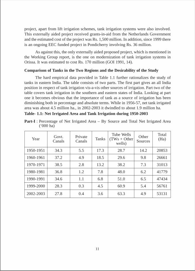
The hard empirical data provided in Table 1.1 further rationalizes the study oftanks in eastern India. The table consists of two parts. The first part gives an all Indiaposition in respect of tank irrigation vis-a-vis other sources of irrigation. Part two of thetable covers tank irrigation in the southern and eastern states of India. Looking at partone it becomes obvious that the importance of tank as a source of irrigation has beendiminishing both in percentage and absolute terms. While in 1956-57, net tank irrigatedarea was about 4.5 million ha., in 2002-2003 it dwindled to about 1.9 million ha.Table- 1.1: Net Irrigated Area and Tank Irrigation during 1950-2003
Part-I : Percentage of Net Irrigated Area – By Source and Total Net Irrigated Area(‘000 ha)
Year Govt. Private TanksTube Wells Other Total
Canals Canals (TWs + Other Sources (Ha)wells)
1950-1951 34.3 5.5 17.3 28.7 14.2 20853
1960-1961 37.2 4.9 18.5 29.6 9.8 26661
1970-1971 38.5 2.8 13.2 38.2 7.3 31013
1980-1981 36.8 1.2 7.8 48.0 6.2 41779
1990-1991 34.6 1.1 6.8 51.0 6.5 47434
1999-2000 28.3 0.3 4.5 60.9 5.4 56761
2002-2003 27.8 0.4 3.6 63.3 4.9 53131
11
Source: (i) 1956-57, “Study of the Problems of Minor Irrigation, PEO, Planning Commission, GOI, 1961,(ii) 1961-63, All India Review of MI Committee on Plan Projects, Planning Commission, GOI, June 1966,(iii) 1995-96, World Irrigation and Water Statistics 2002, IWMI, Colombo, (iv) 1999-2000 and 2002-03data is drawn from Land Use Statistics, MOA, GOI, March 2004 and February 2006 and, (v) the rest ofthe data is taken from Indian Agriculture in Brief: 9th, 14th, 18th and 25th editions.
Indian Agriculture in Brief: 9th, 14th, 18th and 25th editions, New Delhi.
Part-II : Tank Irrigation in Southern and Eastern Indian States (‘000 ha)
Total(India)
Year Southern &EasternStates
Eastern States
A .P.TamilNadu
Karn-ataka
KeralaSub
TotalU.P.West
BengalOrissaBiharSub
Total
Southern States
1956-57 1180 888 327 31 2426 241 495 390 423 1549 3975 4492
% 26.3 19.8 7.3 0.7 54 5.3 11 8.7 9.4 34.5 88.4 100
1961-63 1246.5 938.5 356.5 45.3 2586.8 278.8 418.5 368.3 417.6 1483.2 4070 4580.7
% 27.2 20.5 7.8 0.99 56.5 6.1 9.1 8 9.1 32.4 88.9 100
1965-66 1189 503 325 60 2077 175 495 328 391 1389 3466 4441
% 26.8 11.3 7.3 1.3 46.8 3.9 11.1 7.4 8.8 31.3 78.1 100
1971-72 813 924 374 74 2185 144 583 303 334 1364 3549 4123
% 19.7 22.4 9.7 1.8 53.0 3.5 14.1 7.3 8.1 33.1 86.1 100
1976-77 1089 800 256 51 1296 126 271 303 295 995 2291 3898
% 27.9 20.5 6.6 1.3 56.3 3.2 6.9 7.8 7.6 25.5 81.8 100
1984-85 775 715 327 38 1855 131 257 277 148 813 2668 3330
% 23.2 21.5 9.8 1.1 55.7 3.9 7.7 8.3 4.4 24.4 80.1 100
1990-91 968 769 240 49 2026 115 289 263 104 771 2797 3245
% 29.8 23.7 7.4 1.5 62.4 3.5 8.9 8.1 3.2 23.8 86.2 100
1992-93 729 629 257 48 1663 120 298 263 84 765 1428 3243
% 22.5 19.4 7.9 1.5 51.3 3.7 9.2 8.1 2.6 23.6 74.9 100
1995-96 747 512 230 49 1538 140 305 263 58 766 2304 3106
% 24.1 16.5 7.4 1.6 49.5 4.5 9.8 8.5 1.9 24.7 74.2 100
1999-00 651 633 245 53 1582 155 293 324 90 862 2444 2750
% 23.7 23 8.9 1.9 57.5 5.6 10.7 11.8 3.3 31.3 88.9 100
2002-03 426 422 239 49 1136 111 100 313 58 608 1718 1897
% 22.1 21.9 12.4 2.5 59.9 5.8 5.2 16.3 3 30.7 90.6 100
12
Examination of part two of the table clearly brings out two things. First, while thefour states of south India accounted for 47 per cent to 60 per cent of the net tank irrigatedarea, the four states of east accounted for 24 per cent to 36 per cent. The two regionstogether constitute 74 per cent to 94 per cent of net tank irrigated area. This is indicativeof the very high importance of the two regions in India’s tank irrigation landscape.
The other important point emerging from the data is that while in case of southIndia the decline in tank irrigated area has been inconsistent during the last four decades(showing increase in certain years), in case of eastern India, the decline remainedconsistent. The main reason for this trend is that while good amount of financial resources,more particularly from international donor agencies have been spent on rehabilitationof tanks in south India, tanks in the eastern India suffer from a complete neglect.
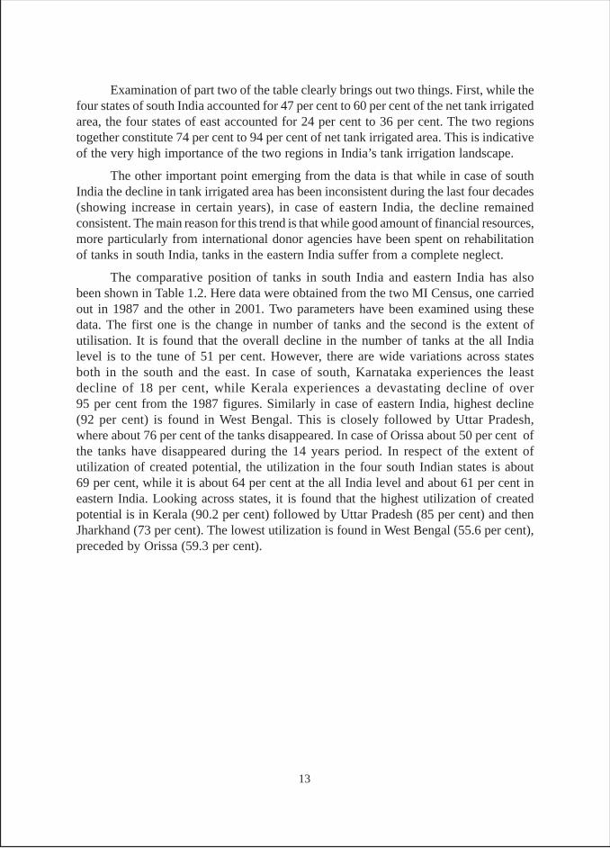
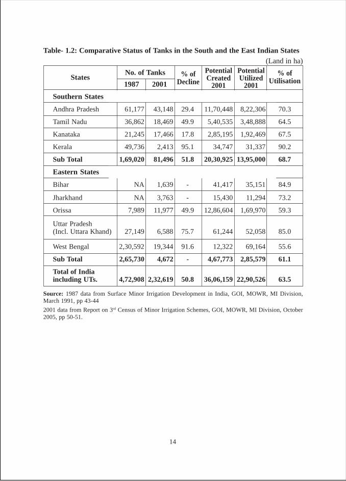
The comparative position of tanks in south India and eastern India has alsobeen shown in Table 1.2. Here data were obtained from the two MI Census, one carriedout in 1987 and the other in 2001. Two parameters have been examined using thesedata. The first one is the change in number of tanks and the second is the extent ofutilisation. It is found that the overall decline in the number of tanks at the all Indialevel is to the tune of 51 per cent. However, there are wide variations across statesboth in the south and the east. In case of south, Karnataka experiences the leastdecline of 18 per cent, while Kerala experiences a devastating decline of over95 per cent from the 1987 figures. Similarly in case of eastern India, highest decline(92 per cent) is found in West Bengal. This is closely followed by Uttar Pradesh,where about 76 per cent of the tanks disappeared. In case of Orissa about 50 per cent ofthe tanks have disappeared during the 14 years period. In respect of the extent ofutilization of created potential, the utilization in the four south Indian states is about69 per cent, while it is about 64 per cent at the all India level and about 61 per cent ineastern India. Looking across states, it is found that the highest utilization of createdpotential is in Kerala (90.2 per cent) followed by Uttar Pradesh (85 per cent) and thenJharkhand (73 per cent). The lowest utilization is found in West Bengal (55.6 per cent),preceded by Orissa (59.3 per cent).
13
Source: 1987 data from Surface Minor Irrigation Development in India, GOI, MOWR, MI Division,March 1991, pp 43-44
2001 data from Report on 3rd Census of Minor Irrigation Schemes, GOI, MOWR, MI Division, October2005, pp 50-51.
Southern States
Andhra Pradesh 61,177 43,148 29.4 11,70,448 8,22,306 70.3
Tamil Nadu 36,862 18,469 49.9 5,40,535 3,48,888 64.5
Kanataka 21,245 17,466 17.8 2,85,195 1,92,469 67.5
Kerala 49,736 2,413 95.1 34,747 31,337 90.2
Sub Total 1,69,020 81,496 51.8 20,30,925 13,95,000 68.7
Eastern States
Bihar NA 1,639 - 41,417 35,151 84.9
Jharkhand NA 3,763 - 15,430 11,294 73.2
Orissa 7,989 11,977 49.9 12,86,604 1,69,970 59.3
Uttar Pradesh(Incl. Uttara Khand) 27,149 6,588 75.7 61,244 52,058 85.0
West Bengal 2,30,592 19,344 91.6 12,322 69,164 55.6
Sub Total 2,65,730 4,672 - 4,67,773 2,85,579 61.1
Total of Indiaincluding UTs. 4,72,908 2,32,619 50.8 36,06,159 22,90,526 63.5
Table- 1.2: Comparative Status of Tanks in the South and the East Indian States(Land in ha)
% ofUtilisation
PotentialUtilized
2001
PotentialCreated
2001
% ofDecline
No. of Tanks
20011987States
14
The overall data in Table 1.2 points out that the extent of utilization of createdtank potential of south Indian states is better than that of east Indian states.
Lack of studies10 and therefore lack of publicity of tanks in eastern India resultedin lack of donor interests in funding tank rehabilitation projects. The present studyattempts to explore the status of tanks in eastern India comprising of eastern Uttar Pradesh,south Bihar, West Bengal and Orissa. This study was primarily taken with this point ofview so that enough interest is created among researchers about tank systems of thisregion.
Objectives of the Study
The main objective of the study was to prepare a status document on tank irrigationin eastern Uttar Pradesh, south Bihar, West Bengal and Orissa. Attempts were also madeto capture the regional diversity. Following were the complementary objectives:
- Examine the historical antecedents of tank irrigation in each of the selectedstates and in different regions within each state
- Examine the reasons of decline in tank irrigation in all states and in regionsthereof
- Examine the evolution of relationship between the society and the tank system,both in terms of the roles assigned and the sustainability of the system.
- Examine the multiple uses of tanks, particularly aquaculture
- Identify the present day major beneficiaries of tanks in different states and toshortlist the common denominators of such beneficiaries across the statesand the regions
- Identify the conditions of success for environment-friendly and sustainabledevelopment of tanks across states and regions
- Examine the prospects of rehabilitation of tanks and its potential linkage withother ongoing systems of irrigation. Tank utilization for developing aquaculture
Hypothesis
Since the study was of exploratory nature, no hypothesis was proposed. However,a large part of the high lands in the region are the abode of the tribal. Sometimes thesehigh lands have indigenous systems of tank irrigation; hence we might examine thisrelationship.
Methodology
Data were collected from secondary and primary sources. In respect of primarysources, reconnaissance surveys of different states were carried out and data collectedthrough group discussions; transit walks (in & around tank commands); and detailed10 While the authors have come across a large number of studies on south Indian tanks, there is not asingle study (except south Bihar), which covers eastern India.
15
semi structured interviews with knowledgeable individuals, (farmers, tank functionaries,politicians, bureaucrats, journalists, scholars). Secondary data sources included historicaland other official records collected at state capitals and regional headquarters.
There were three field visits planned initially to be carried out during the period2004-05, each for about a fortnight. The first visit was to be before the monsoon; thesecond during the monsoon, and the third during the critical hathia nakshatra period(second week of October) when artificial irrigation becomes a necessity for the paddycrop in the whole of the eastern region.
While the field visit was planned to start by mid May 2004, there was delay andthe field visit started in August 2004 during the kharif. The second visit was undertakenduring the rabi season in January 2005 and the third visit was carried out in summermonth of May 2005.
Also, after the initial field visits of Bihar, West Bengal and Orissa, it was decidedto incorporate tank fisheries into the survey. With respect of Bihar, tank survey wascarried out both in Bihar and Jharkhand. But for secondary data, Jharkhand was mergedwith Bihar.
Field Reconnaissance and the Survey
The first field visit was conducted during September 4 – 25, 2004, covering Patnaand Nalanda districts of Bihar; Birbhumi and Purulia in West Bengal and Sambhalpur,Bolangir and Kalahandi in Orissa.
In October 2004, tanks in Patna, Nalanda and Jamui districts of Bihar weresurveyed and during November 2004, Birbhum, Bankura nad Purulia districts of WestBengal were surveyed.
The second field visit carried out during rabi season between January 18 – February5, 2005 covered Ranchi and Gumla districts of Jharkhand as well as Bankura and Puruliain West Bengal. During this period, new and old official documents were also collectedfrom Calcutta, Bankura and Purulia.
The third field visit was carried out during May 6 – 21, 2005 and reconnaissanceand tank survey was carried out in Sambhalpur and Kalahandi districts in Orissa as wellas collecting official documents and data for the state; and visit to Bihar to consolidateprimary and secondary data for the state.
In July 2005, Palamau district of Jharkhand was surveyed. The data of Gumladistrict was found to have discrepancies and to correct that, a re-survey was carried outin August 2006.
Data Collection Techniques
Review of secondary data was useful to get a quick picture of the current situationof the tanks, their historical antecedents as well as its ecological and geographicalcoverage.
16
In September 2004, a semi structured interview schedule was prepared with aview to carry out discussions with tank stakeholders and other knowledgeable persons.
During the course of the field work, apart from visiting tank sites; data was collectedof data was done through transit walk, direct observations, group interviews etc,. Inaddition, state archives, libraries, government departments, reputed NGO offices werevisited for collecting both historical documents and secondary data. In this respect theA. N. Sinha Institute, Sinha Library and the Secretariat library in Patna, Asiatic Society,IIM, and Center for Studies in Social Sciences in Kolkata; Tribal Institute in Ranchi,State Archives and Nabakrushna Choudhary Centre for Development studies inBhubaneshwar were found to be very resourceful. PRADAN in Purulia and Ranchidistricts were helpful in field research as were Harsha Trust and Regional Centre forDevelopment Cooperation (RCDC) in Bhubuneshwar, Manav Adhikar Sewa Samiti(MASS) in Sambhalpur and Karrtabya at Chhoriagarh in Kalahandi.
Some major changes incorporated in the methodology include:� Study planned to begin in mid-May or early June 2004 (with the intention to
undertake first leg of field visits before onset of monsoon). Total time envisagedfor data collection and analysis was 6 months (spread over 9 months). Field workfor 45 days was spread over 140-150 days (each field visit, 15-day duration). Thestudy was to be complete by February 2005.
Against the envisaged plan, the first leg of field visit was undertaken in kharif(August 2004). Second during peak rabi (January 2005) and third in summer (May2005).Though actual schedule was reversed, it did not effect the study as it was possibleto visit the study states in all three seasons.
The main intention of starting the study in May 2004 was to undertake the firstleg of field visits in the 4 east Indian states before the onset of monsoon. However, dueto delay in approval of study proposal, it could be started only in August 2004.
� Initially, Pant planned to conduct the study by himself but later decided to collaboratewith R.K. Verma of Bihar University, a research collaborator, who shared theresponsibility of investigations in Bihar, Jharkhand and West Bengal.
� Initially field work was planned in Uttar Pradesh. But literature survey and initialdiscussions with competent authorities, brought to light that in the last 25 years,tank irrigation in the eastern Uttar Pradesh had waned and presently tank irrigationis confined to the Bundelkhand region. It was therefore decided to exclude UttarPradesh (in particular eastern Uttar Pradesh) from the tank survey and coverage ofUttar Pradesh was confined, to data from secondary sources for the comparativepurposes.
� After the first phase of field visit, in the state of Bihar, West Bengal and Orissa, itwas decided to incorporate tank fisheries into the survey.
17
� As Jharkhand was carved out of Bihar in November 2000, tank survey was carriedout both in Bihar and Jharkhand separately. However, in terms of secondary data,Jharkhand data is merged with that of Bihar.
Tank Site Reconnaissance
It consisted of the following: (i) walking / driving around the tanks and utilizingdirect observation technique; (ii) use of interview guide/semi-structured interview; (iii)focus interviews with groups of stakeholders; (iv) interviews with individuals /informants; and (v) pre-testing of interview schedules.
I. Walking and direct observation: To observe the tank dynamism in terms of activitiesof various tank water users, different types of activities performed by male and femaleusers of tanks, direct observations were recorded. This was very useful in understandingthe importance of tanks for bathing, cleaning of clothes, ceremonial purposes, fishingand irrigation “Seeing was believing,” when it come to the real dependence of certainsocial groups on these tanks. Gender based segregation of users was clearly visible intanks in case of bathing and washing of clothes. Observations noted in brief during thefield visits were elaborated and recorded in detail at the end of the day.
II. Use of interview guide: An interview guide was a list of topics to be discussed withtank stakeholders, and they were grouped in such a way that the sequence of discussionswas easy to manage for the respondent. Side by side, questions were prepared so thatthe respondent could think and respond in a meaningful way. In cases where the responseswere not satisfactory, probing questions such as "who gets what, why, when, how, howdo you mean, anything else, but why" etc., were asked. This process helped get furtherinformation on who gets what and why, particularly in respect of irrigation water andfisheries.
Generally questioning began by referring to scenes at the tanks site. Questionswere asked in an open-ended yet probing manner, asking respondents to provide concreteinformation/examples. New questions were generated from the answers given. At thesame time, respondents were also encouraged to raise questions keeping in mind thegroup dynamics at work.
III. Focus interviews with groups: All the above-mentioned techniques were used ingroup interviews. The process of group formation started along with walking and seeingaround the tanks. Once a walk around the tank/tanks in the village was over, peoplewere requested to gather at a central place. Efforts were made that the group constituteda mix of men and women, various social groups such as caste and various factionsrepresenting the tank village. The group size varied between 8 and 20.
IV. Interviews with key informants / individuals: During the course of the visits totank sites and more particularly during the course of group interviews, person's knowledgeand his/her willingness to divulge information were noted. All such knowledgeablepersons, who were thought to be , were later contacted individually and their detailedinterviews conducted.
18
Apart from selecting this, other knowledgeable persons specially selected fortheir better understanding of either the tank systems or other matters linked todevelopment of the tanks, be it social, ecological, historical, etc., were selected forindepth interviews.
V. Pre-testing of interview schedules: Two sets of interview schedules were formulatedafter the initial part of the first phase of field trip was over. The schedules ultimatelyused for the tank survey are incorporated as Annexue-1. During the rest of reconnaissance,including the first phase, the same were exercised during the group interviews. Both theinterview schedules were pre-tested, improved, refined and finalized in the subsequentphases. It should however be clearly understood that both - village and tank scheduleswere exercised on groups of farmers and not on individual farmer and the data so collectedwere used for analysis. At the same time, the PRA conventional technique was not usedwhich is highly time consuming and at the same time superfluous. This means thesurvey methodology was a mix of conventional survey and PRA methods.
Selection of Districts / Regions, Tanks and villages
The selection of states had already been done before we embarked on the fieldvisit. However as explained in the preceding pages, Uttar Pradesh was dropped from thesurvey when found that tank irrigation in eastern Uttar Pradesh was more a matter ofhistory and that in present times rarely used by anybody.
In respect of other states, the regions and/or districts were selected based on ourstudy of historical records and discussions with knowledgeable persons. Once the region/district was selected, the researchers looked around for large tanks, with historicalimportant and still contributing to irrigation and fishery. In some other cases, researcherscontacted local knowledgeable persons to know about villages or places where tankirrigation was popular. Once such villages were identified, the tanks were selected.
In the states of Bihar, Jharkhand and West Bengal, tanks survey was carried outunder the supervision of Verma. Survey of tanks in Bihar and West Bengal was duringOctober– December 2004 and in Jharkhand during February, July 2005 and August2006. In case of Orissa Pant survyed the tanks September 2004 and May 2005. The listof tanks surveyed along with other locational details is incorporated as Annexure-2.
19
CHAPTER-II
THE SCENARIO OF TANKS IN EASTERN INDIA
The overall scenario in India
At the commencement of the first five-year Plan, the number of tanks in thecountry was assessed to be nearly 5 lakh, spread across different states (GOI 1966, 9).However, this data do not include the figures for West Bengal, which contains the largestnumber of tanks as per the MI Census of 1986-87. Further, this data classified tanks intotwo categories, those irrigating below 100 acres and those irrigating 100 acres and above.According to this data, about 94 per cent of tanks belong to the first category, while only6 per cent belong to the second category. The data on tanks as per 1951 Census areprovided in Table-2.1. However, the reliability of this data is questionable11
The second important sources of data on tank irrigation are MI Census of 1987and 2001. The Census of Minor Irrigation works with reference to 1986-87 wasinitiated in the same year with a view to complete it by 1987-88. However therewas omission of two important states in this Census. Rajasthan did not conduct theCensus and in case of Bihar, the primary enumeration work had been completed, butthe consolidation of the data at state level was not done, hence no data was provided(GOI 1991, 8). As per this Census, there were 4.73 lakh ponds/tanks in India (including1519 tanks in UTs).
The state wise data emerging from the MI Census 1987 are provided in Table-2.2. A comparison of the data emanating from the two tables reveals that there is amarginal decrease in the number of tanks in 1987 in comparison to 1951. However,before we proceed, a few points need to be mentioned. First, Rajasthan data is missingin both the tables. Second, West Bengal data is missing in 1951 data (Table-2.1), whileBihar data is missing for 1987 (Table 2.2). So no comparison of these two states ispossible. Third, wide variations are found in some of the state-level figures of numberof tanks. In addition, in case of Table-2.1 it is found that the summation of state wisefigures of number of tanks does not add up to the total of 4995 provided in Table-2.1. Asregards the four south Indian states, a marginal increase in the number of tanks wasobserved from 1951 to 1987 in case of Andhra Pradesh and Tamil Nadu. In case ofKarnataka a substantial decrease in the number of tanks by 42 per cent is witnessed
11 For instance, Orissa was reported to have only 1700 tanks (1200 below 100 acre and 500 above 100acres). But, at the same time, the area irrigated from these tanks was reported to be 40% of the total areairrigated from all sources (GOI 1966, 9-11).
20
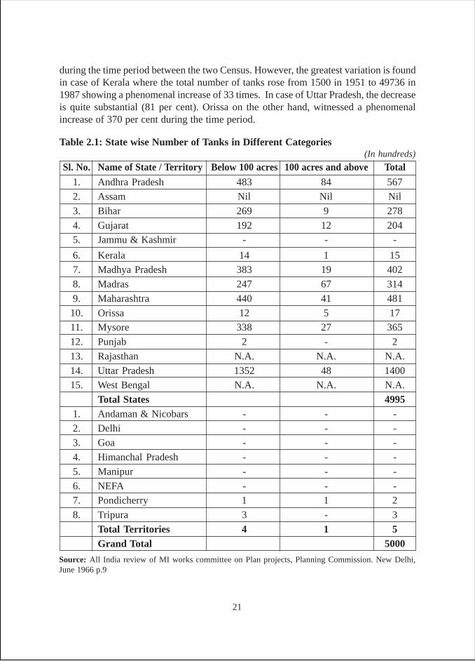
during the time period between the two Census. However, the greatest variation is foundin case of Kerala where the total number of tanks rose from 1500 in 1951 to 49736 in1987 showing a phenomenal increase of 33 times. In case of Uttar Pradesh, the decreaseis quite substantial (81 per cent). Orissa on the other hand, witnessed a phenomenalincrease of 370 per cent during the time period.
Sl. No. Name of State / Territory Below 100 acres 100 acres and above Total
1. Andhra Pradesh 483 84 567
2. Assam Nil Nil Nil
3. Bihar 269 9 278
4. Gujarat 192 12 204
5. Jammu & Kashmir - - -
6. Kerala 14 1 15
7. Madhya Pradesh 383 19 402
8. Madras 247 67 314
9. Maharashtra 440 41 481
10. Orissa 12 5 17
11. Mysore 338 27 365
12. Punjab 2 - 2
13. Rajasthan N.A. N.A. N.A.
14. Uttar Pradesh 1352 48 1400
15. West Bengal N.A. N.A. N.A.
Total States 49951. Andaman & Nicobars - - -
2. Delhi - - -
3. Goa - - -
4. Himanchal Pradesh - - -
5. Manipur - - -
6. NEFA - - -
7. Pondicherry 1 1 2
8. Tripura 3 - 3
Total Territories 4 1 5Grand Total 5000
Table 2.1: State wise Number of Tanks in Different Categories
Source: All India review of MI works committee on Plan projects, Planning Commission. New Delhi,June 1966 p.9
(In hundreds)
21
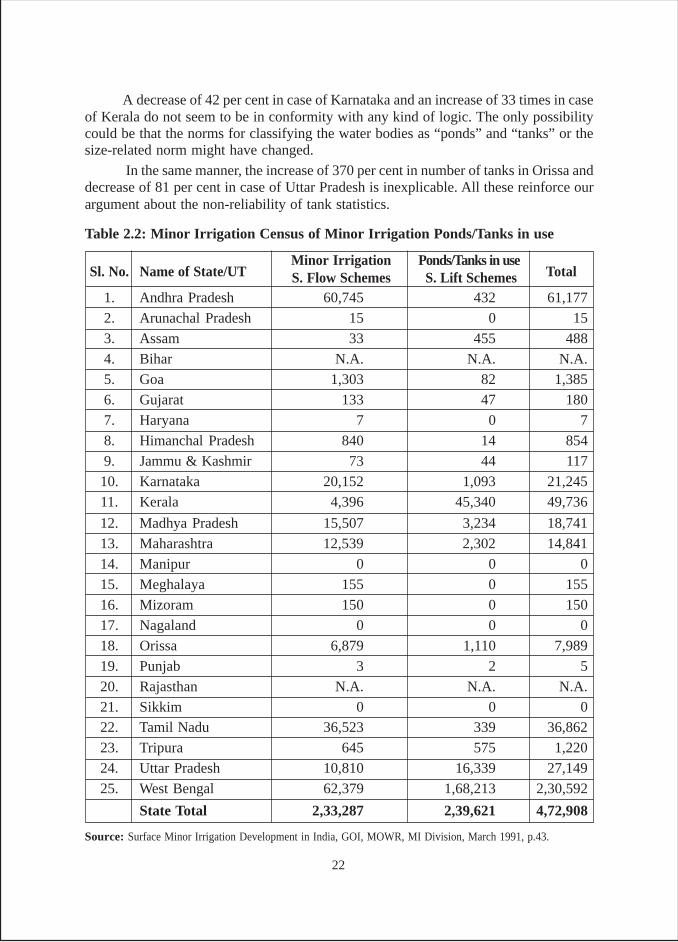
A decrease of 42 per cent in case of Karnataka and an increase of 33 times in caseof Kerala do not seem to be in conformity with any kind of logic. The only possibilitycould be that the norms for classifying the water bodies as “ponds” and “tanks” or thesize-related norm might have changed.
In the same manner, the increase of 370 per cent in number of tanks in Orissa anddecrease of 81 per cent in case of Uttar Pradesh is inexplicable. All these reinforce ourargument about the non-reliability of tank statistics.
Source: Surface Minor Irrigation Development in India, GOI, MOWR, MI Division, March 1991, p.43.
Table 2.2: Minor Irrigation Census of Minor Irrigation Ponds/Tanks in use
Sl. No. Name of State/UTMinor Irrigation Ponds/Tanks in use
TotalS. Flow Schemes S. Lift Schemes1. Andhra Pradesh 60,745 432 61,177
2. Arunachal Pradesh 15 0 15
3. Assam 33 455 488
4. Bihar N.A. N.A. N.A.
5. Goa 1,303 82 1,385
6. Gujarat 133 47 180
7. Haryana 7 0 7
8. Himanchal Pradesh 840 14 854
9. Jammu & Kashmir 73 44 117
10. Karnataka 20,152 1,093 21,245
11. Kerala 4,396 45,340 49,736
12. Madhya Pradesh 15,507 3,234 18,741
13. Maharashtra 12,539 2,302 14,841
14. Manipur 0 0 0
15. Meghalaya 155 0 155
16. Mizoram 150 0 150
17. Nagaland 0 0 0
18. Orissa 6,879 1,110 7,989
19. Punjab 3 2 5
20. Rajasthan N.A. N.A. N.A.
21. Sikkim 0 0 022. Tamil Nadu 36,523 339 36,862
23. Tripura 645 575 1,220
24. Uttar Pradesh 10,810 16,339 27,149
25. West Bengal 62,379 1,68,213 2,30,592
State Total 2,33,287 2,39,621 4,72,908
22
In such a scenario, the only available data in respect of tanks at the all Indialevel is from the MI census of 1987. Whatever updating done in latter years was basedon this basic Census (this includes 2001 MI Census). In all other subsequent documents,whether those brought out by the Planning Commission or by the MOWR, there is noseparate data on tanks either relating to irrigated area or financial investments. All suchdata has been bundled under a category referred to as “Minor Irrigation” to deal withirrigation development and financial investments. In fact, the Working Group Report(GOI 2001) does not even mention about the externally aided tank projects while theearlier one (GOI 1989) did provide the details. Given the constraints, we have reliedgreatly on land use statistics provided by Ministry of Agriculture for secondary data andthe old District Gazetteers for obtaining information about history of tanks. The onlyexception in this respect is the 3rd MI Census, and the data emanating from the same areprovided in Table 1.2.
In Table-2.3, figures of area irrigated by tanks in the four east Indian states areprovided. If we look at the overall column, it is found that there is a general declinein the net area irrigated by tanks, so much so that during the last 50 years the tankirrigated area declined by almost half. The only exception being the years 1999-2000when the tank irrigated area went up by about 1 lakh ha in comparison to 1995-96. Thisenhancement is noticeable in all the eastern India states except Orissa and this isinexplicable. It is also possible that this kind of picture has emerged in the absence offirm data.
23
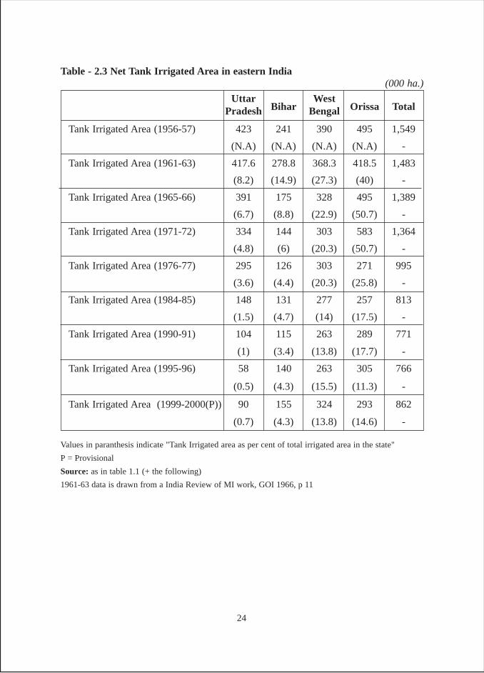
Table - 2.3 Net Tank Irrigated Area in eastern India
UttarBihar
WestOrissa TotalPradesh Bengal
Tank Irrigated Area (1956-57) 423 241 390 495 1,549
(N.A) (N.A) (N.A) (N.A) -
Tank Irrigated Area (1961-63) 417.6 278.8 368.3 418.5 1,483
(8.2) (14.9) (27.3) (40) -
Tank Irrigated Area (1965-66) 391 175 328 495 1,389
(6.7) (8.8) (22.9) (50.7) -
Tank Irrigated Area (1971-72) 334 144 303 583 1,364
(4.8) (6) (20.3) (50.7) -
Tank Irrigated Area (1976-77) 295 126 303 271 995
(3.6) (4.4) (20.3) (25.8) -
Tank Irrigated Area (1984-85) 148 131 277 257 813
(1.5) (4.7) (14) (17.5) -
Tank Irrigated Area (1990-91) 104 115 263 289 771
(1) (3.4) (13.8) (17.7) -
Tank Irrigated Area (1995-96) 58 140 263 305 766
(0.5) (4.3) (15.5) (11.3) -
Tank Irrigated Area (1999-2000(P)) 90 155 324 293 862
(0.7) (4.3) (13.8) (14.6) -
(000 ha.)
Values in paranthesis indicate "Tank Irrigated area as per cent of total irrigated area in the state"
P = Provisional
Source: as in table 1.1 (+ the following)
1961-63 data is drawn from a India Review of MI work, GOI 1966, p 11
24
Another interesting point to be noted is that between 1971 and 1977, there was adrastic reduction in the area irrigated by tanks across states. During this period, tankirrigated area decreased from 1.364 mha to 0.995 mha. However, West Bengal is anexception to this trend, where it remained the same at around 3 lakh ha. The main reasonfor this is the expansion of canal networks in the state during this period. There is nodenial of the fact that in many cases tanks are filled with imported canal water, moreparticularly when rains in the tank locality are scarce or untimely. The investigatorsobserved this during the fieldwork as well. Boyce has rightly observed that the mostimportant use of tank water in West Bengal was during the rainy season itself as aninsurance against monsoon failure, particularly in the critical month of September.However, some water is retained for winter crops (Boyce 1987, 165). For instance,tanks in some parts of Kangaswati canal project command in Bankura district receivedwater from canals, which provided free water to farmers on account of lack of theinstitutional mechanism for water distribution (Rawal 1999, 62).
In case of Orissa, the tank irrigated area has increased during 1991, 1996 and2000 while in case of Bihar an increase is noticeable during 1996 and 2000. UttarPradesh and West Bengal witnessed an increase in tank-irrigated area during 2000. Oneof the main reasons of the slump in case of Orissa during this period was the severedrought of 1997, which affected severely the districts such as Kalahandi, Sambhalpur,Bolangir and Baragarh. It is no coincidence that historically all these districts are mostfamous for tank irrigation.
Table 2.3 also includes data relating to percentage area irrigated by tanks in thestates. A mere glance over the data makes it obvious that importance of tank as a sourceof irrigation has been diminishing over the years. However, in spite of the diminishingimportance over time, tanks have higher relative importance in Orissa and West Bengalwhen compared to Uttar Pradesh and Bihar.
Uttar Pradesh
Even forty-five years ago, tank irrigation was not of great significance inUttar Pradesh. But by mid 1980s, tank as a source of irrigation became almostinsignificant in the state. The main reason for disappearance of tank irrigation fromUttar Pradesh was the flurry of free boring scheme12 and groundwater markets(Pant 2005), earlier preceded by the rapid progress in groundwater development. Evencanals, which were the most important source of irrigation for a long time, wereovertaken by wells as a source of irrigation (Pant 2004). Though assumed low significanceat the state level, tanks were one of the most important sources of irrigation in the
12 Rapid expansion of groundwater irrigation in Uttar Pradesh was largely due to the GOUP subsidyprogramme started in mid 1980s. In January 1986 GOI issued revised guidelines for assistance to smalland marginal farmers for increasing agriculture production. Importantly in Uttar Pradesh 70% of thescheme amount was to be spent as subsidy on MI works. GOUP enhanced rate of subsidy from 25% to33.3% for small farmers, from 33.3% to 50% for marginal farmers and 50% for SCs and STs. While thesubsidy was for purchase of the pump the boreing of wells was free for the target groups.
25
eastern region of Uttar Pradesh.13 A number of factors facilitated sustainability of tankirrigation in this region for a long time. The eastern tract is flood prone with periodicoccurrence of droughts. It is characterized by an impeded drainage, which wasaccentuated on account of laying of railway line during the British period. Unlike thewestern region where British started Ganga canal system in the late 19th century, therewas no major canal system in this region prior to Independence. The eastern regionrepresents highest concentration of poor people in the country where small and marginalfarmers with their very small and scattered holdings are abound.
Tank irrigation in the plains of eastern Uttar Pradesh is varied in size and historicity.In this region, tanks and ponds were an important source of irrigation for the poor farmersfor a long time, until free boring spurt provided them with access to purchased waterfrom well owners. The existence of an early Indian hydraulic engineering work wasrecently confirmed at Sringaverapura near Allahabad with the discovery of a tank, datingback to first century BC through archeological excavations. It was not only long (morethan 250 m long) but was fed perennially by Ganga water. Incidentally, Sringaverapurais the same place where, according to Hindu epic Ramayan, Rama crossed river Gangaduring his exile from Ayodhya, which dates back to 12th century BC (Agarwal and Narain,1997, 12). In Sultanpur district, tank irrigation was a cooperative effort – villagers workedin a collective way till all the lands were watered. In Azamgarh district, lat (a type oftank structure) was extensively used for irrigation. The area irrigated from a lat in seasonsof scanty rainfall was not large but in normal years, lats helped to equalize the water ofthe entire area within their ambit.
Writings from early 20th century show that tanks, as a source of irrigation,were common in Gorakhpur district and other parts of eastern districts in Uttar Pradesh.“They are the usual square or rectangular excavations dug down to water level, thespoil earth forming high banks on which trees are planted in many cases. Thesetanks are often of considerable size, and they serve a very large area, averaging some273,000 acres, though this figure must be acceptable with some qualification owning tothe confusion that often arises between artificial tanks and natural pools.” The mannerin which tank irrigation was practiced was further elaborated as “by taking water alongnarrow channels, and from these raised to the level of the fields by beris or swing-baskets of wicker-work in the style which was well known throughout the then UnitedProvinces. (Nevill 1909, 57).
Jaunpur is mentioned as one of the few districts where irrigation was practicedmost extensively and in as early as 1867, nearly 95 per cent of 5,61,407 acres of landwas irrigated. But tanks were not popular in the district because they were costlier thanwells, but less cost efficient. Nonetheless, they were said to be in large numbers, possiblybecause of the greater fame and merit attached to their construction. They were however
13 The eastern Uttar Pradesh forms part of Gangetic plains, which subsumes 64 of the total 71 districts inUttar Pradesh. The eastern region comprising of 27 districts is bounded by Nepal in the north and by Biharin the east.
26
seldom kept under good maintenance after the death of the original owner and thedistrict was said to be full of ruined tanks (Nevill 1908, 41-44). Opposite was the case ofthe district of Allahabad where in 1884-85, the average area irrigated was 2,19,096acres, which was a mere 19.75 per cent of the net cultivated area. Of this, 1,20,518 acres(55 per cent) were watered from wells and the rest from tanks, jhils and streams or othersources (Nevill 1911, 40).
The old Gazetteers, not only provide details of the sources of irrigation but alsothe extent of irrigation. Since irrigation from tanks in the olden days was mostly donemanually, it would be interesting to know the practice details. In Basti district of easternUttar Pradesh, the old Gazetteers mentioned that there were no canals in the district butan ample stock of water could be procured from the numerous streams, lagoons, reservoirs(tanks), and wells. From the tanks or its equivalents, water was lifted by the sling baskets14.In his reports on eastern India, Buchanan calculated that a group of ten men, workingwith two pairs of baskets could irrigate some 4,727 square yards, or just below one acredaily. Although this was the most expensive method, this was the most common andpopular method of irrigation because farmers believed that the water thus lifted containedsediments, which could be nutrients for plants (Atkinson 1881, 594). As explained inthe preceding section, in the Gangetic plain areas of Uttar Pradesh, well irrigation wasbeing practiced from time immemorial on account of favourable conditions. However,the eastern parts provided ideal conditions for tank irrigation till the recent past. Anotherregion of Uttar Pradesh, which found favour with tank irrigation, was Bundelkhand15,which had borders with Madhya Pradesh.
To the south and south west of Uttar Pradesh lie the districts of Lalitpur, Jhansi,Jalaun, Hamirpur, Mahoba and Banda, which form part of the central Indian plateau.These districts are situated on or below the slopes of the plateau. The tract is broken upespecially in the south, by low rocky hills – the spurs of the Vindhyan ranges. The soilcover is thin, underlain by hardrocks and is infertile. The whole of this area forms partof Bundelkhand region. The area suffers from the uncertainty of deficient or excessrainfall averaging around 900 mm.
Irrigation is not a new concept in Bundelkhand; as early as the fifteenth centuryAD, tanks and reservoirs were already in use for water harnessing and irrigation. Althoughmany of these structures have fallen into disrepair or have been destroyed, some are still
14 Such baskets, when shaped like a boat, were called godala or beri, and when shaped like round shield,were called don or donri. The ropes or strings by which the basket was swung were termed dori, and thesmall wooden instrument used in opening and shutting the apertures of the water channels was calledhatha.
15 Bundelkhand derives its name because Bundelas ruled this part of Uttar Pradesh and Madhya Pradesh.It stretches over six districts of southern Uttar Pradesh and twelve districts of northern Madhya Pradeshoccupying almost 70,000 square kilometers of the central plains in India. It is bounded in the north byYamuna river and in the south by the hills of the Vindhyan Plateau. The region presents a unique set ofgeologic and geographic characteristics, which have had profound effects on human development in theregion as well as on the country as a whole.
27
in use today. The reservoirs take many forms. In areas of very scanty rainfall, a numberof ingenious methods of storing water for irrigation have been evolved by local people.They include sub-surface tanks, roof water harvesting systems, step wells, tanks, pondsand lakes. Some of these lakes were large enough to store water for 18 months to 2years, an extremely important feature, given the rainfall regime of the region,characterized by frequent droughts.
The case of dabaris is a special case among the large number of traditional waterharvesting and storage tanks that can be seen even today in the Budelkhand region.These tanks fall in the category of minor irrigation tanks and have various names. Onecan see such tanks called chandel tanks in Bundelkhand; called malguzari tanks inBhandara, Chandrapur and Gadchiroli districts of Vidarbha; and called dabaris inChattisgarh. These came up as a consequence of traditional wisdom. Feudal land tenuresystems placed centralized powers in the hands of the local landlord over sizeablecontiguous pockets of lands extending over hundreds of hectares. Natural depressionsin these landscapes were used as dabaris or chandel tanks. Embankments were madeusually on the downstream side. Water would be released from the tanks by using atraditional system of a water chamber in which water is let through holes in theembankment kept plugged with wooden poles. To start with, the top most plug is removedto let the water out and as the level of water goes down, the plugs at lower levels arereleased. Usually such structures were used to grow long duration paddy varieties(Marothia, 2004).
Tank Survey in four East Indian States
The first chapter deals in considerable detail with the methodology adopted forthe study. The survey was conducted to document some basic information so that somekey trends could be gauged. To that extent the survey was found to be very useful. Also,as four states were covered, broad representative features were kept in mind and hesurvey conducted within this broad frame work and the survey has been very informative.
A point that needs to be explained is that in respect of analyzing the socio-economicbase of the tank beneficiaries, the social status in terms of caste and the economic statusin terms of land holdings were examined. Muslims were categorised under high, backwardand depressed castes depending on their social status rather than treating them as anexclusive religious category. For instance sheikh, sayyed, mughal and pathan weregrouped with high castes; ansaris with backward and quureshi and chikwa with scheduledcastes. In case of one village in Palamau district, most of the Muslims were migrantsand there was no clarity about their social status, therefore, the entire Muslim population,who were beneficiaries of the tanks, was taken out of the analysis. The selection of thisvillage also highlights the shortcoming of the sample selection. Another point that needsto be highlighted here concerns the strategy of research. Initially we had not planned fora systematic survey and wanted to do case studies. This strategy was in fact adopted in
28
case of Bihar, but later on it was decided to go for a quick survey. The same approachwas adopted in case of Gumla district in Jharkhand. As a result, for Bihar and partly forJharkhand, both the survey and detailed village cases were available, while for otherstates; it was based on survey, informal discussions, observations and historicaldocuments.16
Before the survey data is analyzed, it would be useful to clarify some more points,which are associated with the content and extent of data in various tables. As regardsownership of tanks, they are categorized into government, panchayat or privateownership. In case of government tanks, the ownership is either with the MI departmentor with fisheries department. However, they have been put under one category, i.e.,government tanks. Similarly tanks owned by panchayats include all tanks previouslyowned by individuals/zamindars and presently entrusted with the panchayats. Thiscategory also includes tanks, particularly in Orissa, where once private tanks wererehabilitated under a European Union donor project and then handed over to panchayatsfor maintenance. The private category includes all such tanks which were undergovernment / panchayat ownership but are captured by individuals and litigation ispending for title. This category also includes tanks in private land. This explanation isnecessary because of variations in data in the two state survey tables, i.e., Table 2 and11, which seem to deal with similar categories but actually present different data. WhileTable 2 presents a legalistic and formal position in respect of tanks, Table 11 provides amore realistic situation on the ground presented by the respondents during the groupinterview.
Although a total of 119 tanks were surveyed across the four states, not all theinformation required was always forthcoming for all the tanks. Therefore, in some ofthe tables, the information is on lesser number of tanks. A case to refer is Table 16 whichhas been prepared on the basis of data for 37 tanks (instead of 47) in Jharkhand, 16 tanks(instead of 20) in Bihar, 12 (instead of 31) in West Bengal and 8 (instead of 21) inOrissa. Thus, the requisite data were available only for 73 tanks. In the examination ofsurvey data, each one of the four states, starting with Bihar, followed by Jharkhand,West Bengal and Orissa were taken up and at the end inter-state comparisons have beenmade.
16All data collected from field survey are tabulated in a uniform manner in 20 tables for each of the fourstates plus one more set providing inter-state data. Although the tables are numbered 1 to 18, table 9consists of three tables as a, b and c, thus making the total number of tables 20 for each states and a totalof 100 tables (four states plus one inter state) for the study. In case of all such tables, the first alphabet ofthe state is added before the table number. So Bihar tables are mentioned as B-1, B-2, B-3 etc. SimilarlyJ- is added for Jharkhand, W- for West Bengal, O- for Orissa and E- for Eastern India (all four states).
29
CHAPTER III
BIHAR
On the basis of its physical features, the state of Bihar can be divided into threeregions, viz., north Bihar plains, south Bihar plains (the area north and south of Gangesrespectively) and Bihar plateau also known as Chhota Nagpur plateau. The total areacovered under south Bihar is about 40,000 sq.kms, which is slightly less than one fourthof the total area of 174,000 sq.kms of the state. Historically, ahar-pyne system ofindigenous irrigation has been the most important source of irrigation in south Bihar.Even today, it provides a shining example of participatory irrigation management. “Thisindigenous system is the outcome of the natural conditions and physical configurationof the country, and has been evolved to meet the obstacles which they place in the wayof cultivation.” (O’Malley 1919, 144)
Most of the places in the south Bihar region receive an average annual rainfall ofabout 1000 mm, which may be just sufficient for some of the low water-consumingcrops grown during kharif, but not paddy. In addition, the rainfall is conditioned by twoconstraints. First, there is a deficit in the rains almost every third year. Second, paddyexperiences moisture stress during the crucial period of hathia in case of rain failure.The southern part of this dry zone comprising erstwhile districts of Patna, Gaya, Shahabad,south of Munger and south of Bhagalpur is usually referred as south Bihar.
Bounded by Bihar plateau in the south and Gangetic valley in the north, southBihar has a marked slope from south to north towards the Gangetic valley and iscomparatively rapid, the average fall northwards being about 1.13 to 0.76 metre per km.A number of rivers debouch from the southern hills and intersect the region as they flowacross from south to north. Since these rivers are rainfed, as soon as rainfall occurs intheir catchments, they swell up into rushing torrents and discharge the runoff very quickly(within hours) through their sloping beds. As a result, the water is either rapidly drainedfrom the area where the soil is stiff clay or percolates down swiftly if the soil is sandy.
30
Ahar-Pyne System17
On casual examination, the area would seem utterly unsuited for rice cultivation,both from the physiographic and the rainfall regimes. But both difficulties have beenovercome by the ingenuity and industriousness of its inhabitants, who have devised asystem by which the natural drainage is blocked and the water impounded for use andhave also brought rivers into their services by diverting the water they bring down.
Therefore, in order to prevent the water being wasted, long narrow artificialchannels called pynes are led off from the rivers by means of which the water is conveyedto the fields. The water is impounded in extensive reservoirs called ahars, which areformed by constructing a series of retaining embankments across the lines of drainage.
Ahars consist of a major embankment across the drainage lines with two sideembankments running backwards upto along the drainage line, gradually losing theirheights due to the surface gradient. An ahar is either U-shaped or rectangular.Embankments are built on three sides of the rectangle, the highest bank being at the endwhere the water would ordinarily emerge, while one side is left open to allow the waterto emerge and enter (O’Malley 1926, 94). The drainage water enters from the catchmentfollowing the natural gradient of the country. Water supply for an ahar comes eitherfrom natural drainage after rainfall (rainfed ahars) or through pynes where necessarydiversion works are carried out. Opening outlets made at different heights in theembankment draw out water for irrigation. Ahars with sides that are more than a kilometrelong, irrigating more than 400 ha are not rare, though smaller ones are more common(Sengupta 1996). However, the average area irrigated per ahar during the early twentiethcentury was said to be 57.12 ha (Tanner 1919, 145).
Pyne18 is the local name for the diversion channels. These channels maybe ofvarious sizes. The small ones are those found originating in ahars and carrying thewater of the ahars to cultivable plots. The large ones have their origins in rivers fromwhich water is diverted through these artificial channels using the ahars. They are ledsome way upstream, above the level of the land intended to be irrigated. It is often 3 to5 km before the water of the pynes reaches the level of cultivation. Some of the biggestpynes are 16 to 32 km in length, and some of them known as dasian pynes (pynes with10 branches) irrigate many thousand acres of land of hundreds of villages (O’ Malley1919, 145).
Apart from irrigation, another useful purpose served by ahar-pyne system is floodmitigation. Writing about the then Gaya district, the collector (1947-49) observed thatas long as these minor irrigation works were kept in a reasonable state of repair, floodsin lower regions were well under control (Roychoudhry, 1957).
17 This section has drawn heavily from Pant's paper, “Indigenous Irrigation in South Bihar: A case ofCongruence of Boundaries”, Economic and Political Weekly,33,49, December 5, 1998.18 A pyne can be used for (I) transporting the river water to an ahar, (II) to irrigate the field (rarelydirectly ) through branches taking off from it and (III) taking out ahar water for irrigation
31
Extent of Irrigation
The ahar-pyne system of irrigation was overwhelmingly more important in southBihar, where it used to irrigate about 35 per cent of 2.5 mha of cropped land during thefirst two decades of the 20th century. Compared to this, the irrigation in north Bihar wasa mere 3 per cent of 3 mha cropped area. During this period, of the 0.98 mha areairrigated by ahar-pyne, 0.88 mha area was from south Bihar, while only 0.1 mha wasfrom north Bihar (Tanner 1919, 136). The area irrigated by this indigenous system hassince then witnessed a constant decline—from 0.94 mha in 1930s to 0.64 mha in 1971and to 0.55 mha by 1975-76. Today the area irrigated by ahar-pyne system in whole ofBihar has come down to about 0.53 mha constituting about 12 per cent of irrigationfrom all sources (GOB 1997), compared to about 18 per cent from south and northBihar alone during the first two decades of 20th century19.
As per records, the average area irrigated by tanks in British India was about 8million acres but the supply to many of the works was very precarious and was bound tofail in years of extreme drought. This figure does not include large areas over whichsome water is held up for sometime after every rainfall by means of field embankmentssuch as to be found under different names in Bengal, Bundelkhand, the Central Provinces,Gujarat and Bombay Deccan. The agricultural value of these temporary storage workswas considerable, but the areas protected by them were not usually recorded or regardedas tank-irrigated areas (Higham 1908, 325).
The Irrigation Commission of 1901-03 estimated the total area ordinarily irrigatedin British India from all sources, (Table 3.1) were the total cultivated area is being takenas 226,000,000 acres (Higham 1908, 345).
19 The extent of decline has been worked out on the basis of following data sources: (I) Census recordsfrom 1921 to 1961, (II) Season and Crop Report, Bihar 1971, and (III) District wise data available with theDirectorate of Statistics, Government of Bihar, 1975-76.
Table 3.1: Irrigation area by source and ownership in 1901-03
Source of Irrigation State works Pvt. Works Total
Wells - 12,895,000 12,895,000
Canals 15,644,000 1,235,000 16,879,000
Tanks 2,944,000 5,194,000 8,138,000
Other sources - 6,186,000 6,186,000
18,588,000 25,510,000* 44,098,000
Note: This does not include irrigation data in Native States (land of local kings/zamindars)
* The area shown under other sources includes a large area (5,000,000 acres) irrigated in Bengal fromprivate canals and from water held in natural depressions and in shallow artificial tanks.
In acres
32
Reasons of Decline
There are three important reasons for the decline of ahar-pyne system: First, untilthe abolition of zamindari system,20 the zamindars used to maintain these systems asthey had the capital resources and vested interest in doing so. Tenants were required topay gilandazi (for improvement of irrigation works) charges. “Gilandazi is an excellentform of investment as the capital spent on it attracts a dividend of 40 to 50 per cent in thefirst year itself, and in some cases 100 per cent. Even if the landlord received only halfof the produce from the land irrigated by these works, they would get a very good returnon their capital outlay” (O’Malley 1919, 158). After the zamindari abolition there areno regular budgetary outlays for the repair of these systems. The only possible avenuesof repair were hard manual labour during drought period, JRY, some relief schemes,food for work programme and also MI department which can spend some plan funds forthe renovation of these systems.
Second, a large number of alternatives have come before the farmers during thepost Independence period in the form of new canal schemes and tubewells. The growthof tubewells, particularly during the post green revolution period is phenomenal. Thishas been aided by high doses of government subsidies for private tubewells. Back in1970-71, the area irrigated by tubewells in Bihar was about 17 per cent of the net irrigatedarea, and this reached above 48 per cent in 1994-95 (GOB 1972 and 1997).
Further, wells in alluvial are a much more reliable source for irrigation than tanksand ahar-pynes. Even at the start of 20th century (Table 3.1), while wells wereirrigating 29 per cent of area, tank irrigation was limited to 18 per cent. With populationincrease, irrigation demands had also increased and to meet such demands alternativesources had to be tapped. So much so, that by 2001, while ahar-pynes were irrigating1.6 per cent area the area irrigated by tubewells had increased to 26.6 per cent.
The third reason for the declining performance of ahar-pyne system in southBihar’s irrigation is non-integration of these systems in the new diversion schemesundertaken by the state’s Irrigation department after Independence. The problem gotaccentuated on account of not taking over these systems formally and legally.
Need for Integration between New and Old Schemes
In 1950’s, particularly during the first and the second five-year Plans, anumber of diversion based irrigation schemes were undertaken in south Bihar. Inmost of the cases, the area brought under the command had very elaborate indigenousirrigation network through ahars and pynes, particularly in the upper reaches. Theplanners realising the valuable contribution of this indigenous system in subsidiary storageand water distribution, dovetailed it in their plan, thereby increasing the capability of
20 During the British period all the cultivated land belonged to zamindars (feudal landlords) who paid afixed share of the revenue to the British Government. After Independence in 1952 this system was abolishedand the land was distributed among the erstwhile tenants.
33

the run-of-the-river scheme on a rain-fed river, whose performance was subject tooccurrence of monsoon flows. They relied on the contribution of the existing ahars somuch that they planned for about two-thirds of the command to be irrigated during thecritical hathia period through the ahars, which were to be filled up from canal networksby drawing maximum possible water during favourable period of river flow.
The envisaged integration of ahar-pynes with the new irrigation schemes, however,could not be achieved in a large number of cases and this indigenous system was madeto languish over time. A study by a Bihar based consultancy firm shows that the numberof ahars in the command of Upper Mohar Irrigation Project covering the districts ofGaya and Aurangabad had dwindled from 109 in the pre-project period to 44 in postproject period (Metaplanner 1990) consequently affecting irrigation in an adverse manner.If due attention had been paid to proper maintenance of these indigenous systems andtheir integration with new canal networks, all these new diversion schemes would havebeen grand success stories.
Management of Ahar-Pyne System
Three functionaries looked after the operation and maintenance of ahar-pynes,particularly the ones relating to maintenance and overseeing of water distribution. Thesewere headman, barahill (supervisor) and gudait (watchman). A unique feature of ahar-pyne management system in some parts of south Bihar was that some functions wereassociated with particular castes. For instance only dusadhs (schedule caste) were hiredfor the job of watch and ward. Similarly, the drumbeaters used to be from the Muslimcaste of dafalis. Dusadhs were selected for the job of watchmen because they used to bephysically sturdy, and their muscle power used to come handy in matters of inter-villageand intra-village disputes. Similarly call for goam (collective physical action) used tobe made by beating of drums, and drum beatings was the traditional occupation ofdafalis.
Acquisition and Transport of Water
Since some of the pynes ran over 30 kms, covering hundreds of villages andirrigating thousands of acres of land and the construction of such irrigation works requiredhuge capital investment, only big landlords could build it. In fact, sometimes it requiredthe collaboration of two or more landlords. In such occasions, each participating landlordused to appoint his team of officers to look after his interest on the negotiating tableduring the construction phase. It should however be understood that usually the costinvolved in the construction of pynes was much higher than that of ahars. The constructionof pynes, particularly the large ones, involved excavation of channels running into severalkilometers. In case of ahars, even when they were large, the work involved constructionof embankment from three sides, the highest being on the northern side to check theflow of water from south to north. Writing even in the early part of the present century,O’Malley noted that no new pynes of considerable size were being constructed in his
34
times. According to him, large pynes were constructed several years back when largerareas were under the control of single zamindars (landlords) and their authority toenforce their orders and wishes was more absolute than during O’Malley’s times(O’Malley 1919, 155).
Repair and Maintenance
The repair and upkeep of ahar-pynes is generally of two types. The first oneinvolves major repairs and the other deals with the minor routine upkeep to make thesystem work. In case of major repairs, as farmers did not have the capital required,the responsibility of these matters was entrusted with the landlords. This pointhas been highlighted by both Buchanan (1939) and O’Malley (1919, 147). No doubt,the amount spent by the landlord was later realised from the farmers under thegilandazi (improvement of irrigation works) (mentioned earlier while discussing thereasons of decline in tank irrigation). Today also, farmers do not undertake major repairsand the same are done by the MI department. The only difference is, in the past, farmershad to pay for the repairs as well as irrigation, while today they do not pay for any ofthese. The routine upkeep work involves cleaning and desilting of ahar and pyne andmaintaining the water conveyance network, while the system is in operation. Ordinarymaintenance such as the clearance of silt, the repair of small branches of the ahars andfield channels is done by the cultivators themselves under goam system and it startsbefore the onset of monsoon. In the past, under this system, "at the order of the landlordor his local agent or servant, the cultivators have to supply one man per plough to turnout on these occasion and carry out the work; the peasants come out in a body and thisis called goam” (O’Malley 1919, 146). In case of wealthier peasants, they were allowedto send paid labourers but had to be present to supervise the ongoing work. This systemof use of community labour for maintenance of irrigation work was also very much invogue in the then Madras state, where it was legitimised through legislative action (Reddy1996) and is called khudi murrammat (self repair). Goam was and still is very effectivein meeting the emergencies. The call for goam is made by beating of drums. Thedrumbeater goes from place to place announcing the nature and location of the emergency.The most common emergencies relate to breaches in embankments and big pynes,breaking, cutting and blocking of pynes in upper reaches. Even blocking or diversion ofriver water in the upstream is not uncommon during the water scarcity times of droughtyears. Goam occurs even today in hundreds of villages of south Bihar.
Thus collective action finds place in operation as well as maintenance works.The maintenance work includes desilting of ahar and pyne beds, and regular repairof embankments. Apart from these routine activities, an important task is to keepconstant vigil, particularly during monsoon against sudden damage of protectiveworks which may occur due to natural or man-made reasons. The operational worksinclude cutting and closing embankments for diversion, erection of bunds or garandisacross the pynes, opening and closing of outlets and manual water lifts at times toirrigate uplands.
35
Allocation and Distribution of WaterAllocation of water, which was managed by the cultivators, was a major source
of conflict. Buchanan (1939) wrote that the landlords would “appoint proper persons todivide the water among the tenantry”. According to O’Malley (1919, 146-147), theparabandi system was used to distribute water among the villages from a commonsource (usually a pyne). Parabandi, derived from the term para (turn) and bandi (fixation)means fixation of turn. Each village had its fixed turns in terms of number of days andhours to avail the irrigation service. These turns were assigned through mutual agreementsor on the basis of ancient customs. In case of principal pynes under different estates, therulers of such estates used to maintain a detailed register called lal bahi (red register).The register specified the irrigation rights of each village. Usually parabandiarrangements began in the month of aswin (mid-September to mid-October), when thedemand was high and supply limited. At other times, all branches of pynes are left open(Agarwal and Narain 1997, 87).
Selected Districts for the SurveyThe three districts selected for the survey of tanks were Patna, Nalanda and
Jamuai.21 Although in the beginning it was planned to conduct the survey in the districtsof Patna, Gaya and Jamui, from a reconnaissance carried out around old Nalanda area,some of the largest and oldest of tanks in Bihar were seen here with fishing and irrigationtogether. Subsequently, Gaya was dropped from the study.
Leaving out district Gaya from the study was really distressing considering thefact that this district is historically most important for the ahar-pyne irrigation. In theold district Gazetteers of 1906, O’Malley wrote that the agricultural prosperity of Gayadepended on an extensive system of irrigation. While in the north east part of the district,Sone canal provided the boon, elsewhere people were dependent on methods of irrigationwhich had been practiced from time immemorial and was known as ahar-pyne system(Roychoudhry 1957, 204). However, consolation can be derived from the fact that agreat deal has been written on the ahar-pyne system of irrigation in Gaya district.
Another reason for doing the survey in Nalanda was to explore the possibility ofestablishing possible role for the large tanks that exist within a few kilometers radius ofthe old Nalanda ruins in the supply of food for the students, teaching community andtheir families in the ancient Nalanda university. Unfortunately the detailed history ofthese large tanks could not be found.
Patna and Nalanda
Nalanda, which consists of the then Biharsharif sub division, did not exist inthose days and was part of the Patna district. Thus, old records are not available separatelyfor Nalanda and Patna data is applicable to Nalanda as well.
Writing detailed account of big and small reservoirs/ahars that existed in Biharand Patna in the early 19th century, Buchanan observed that the cost of maintaining such
21 While Nalanda was a part of Patna district in the past, Jamui was carved out of Monghyr district.
36
reservoirs varied between rupees 25–500, depending on the size. He further informsthat the expense both of making and repairing the canals and reservoirs was entirelydefrayed by the zamindars, who appointed proper persons to allocate the water amongtenantry. Towards the end of the season, the water was lifted from both reservoirs andcanals using lifting devices. The basket suspended by rope, called here changr, wassometimes used, when the quantity of water remaining was small; but, when the quantityof water was considerable, an equipment like a canoe was used if the height to which itwas to be raised was small, while the pot raised by level was preferred, when the heightwas considerable (Buchanan 1934, 533-34).
In the early part of 20th century, O’Malley wrote that the agricultural prosperity ofPatna depended largely on extensive system of irrigation. To the west of the districtcultivators benefited from a portion of Sone canal. But elsewhere, they weredependent on indigenous methods of irrigation of which the most prominent was ahar/karhas. This indigenous system was so devised as to utilize not only the rainwater andthe water brought down by the rivers debouching from the Gaya district, but also asmuch of the floodwater as possible. This was done chiefly by masonry reservoirscalled ahar. The water impounded in these reservoirs was distributed among the fieldsthrough narrow channels called karhas. Whenever the level of the fields to be irrigatedwas lower than of the ahar, water was led into the karhas through pipes known asbhoklas. But, if the fields requiring irrigation was at higher elevation, water waslifted to the requisite heights by means of water lifting devices. The water, after beingtaken to the fields was retained in them by means of a network of low banks (ails)collectively called genrabandi22.
In Patna, ahars were the most important works of irrigation owing to their sheernumber and the large area they irrigated. Cultivators did minor repairs of ahars andpynes, while those requiring considerable expenditure were usually carried out bylandlords along with rest of the arrangements for irrigation (O’Malley 1907 a).
While writing about irrigation and agriculture in the early part of 20th century,O' Malley also makes descriptions about social groupings. In this respect, his observationson two most prominent backward castes are most interesting. According to him, “Thegoalas or ahirs are the most dominant caste in the district in terms of the size of itspopulation. They are thrifty race, selling grams and husks, themselves thriving on coarsefood; and cutting grass for their cattle, while their women go about selling milk, butterand ghi. They are generally cultivators and cattle breeders. While many of the poorerare labourers, a few rich zamindars also belong to the caste. They are notoriously themost quarrelsome caste in the district, consequently concerned in riots and very fond oflathi; cattle trespass forms a frequent subject of dispute among them. They have thereputation of being audacious cattle stealers, and many at the bottom of the social22 Genrabandi was the name for the series of embankments built to prevent water from running off thefields. The gherwa or outer embankment used to be about four feet high, within was a series of smallerembankments (genra) and last of all were the ordinary ails round individual fields (O' Malley and James1924, 100).
37
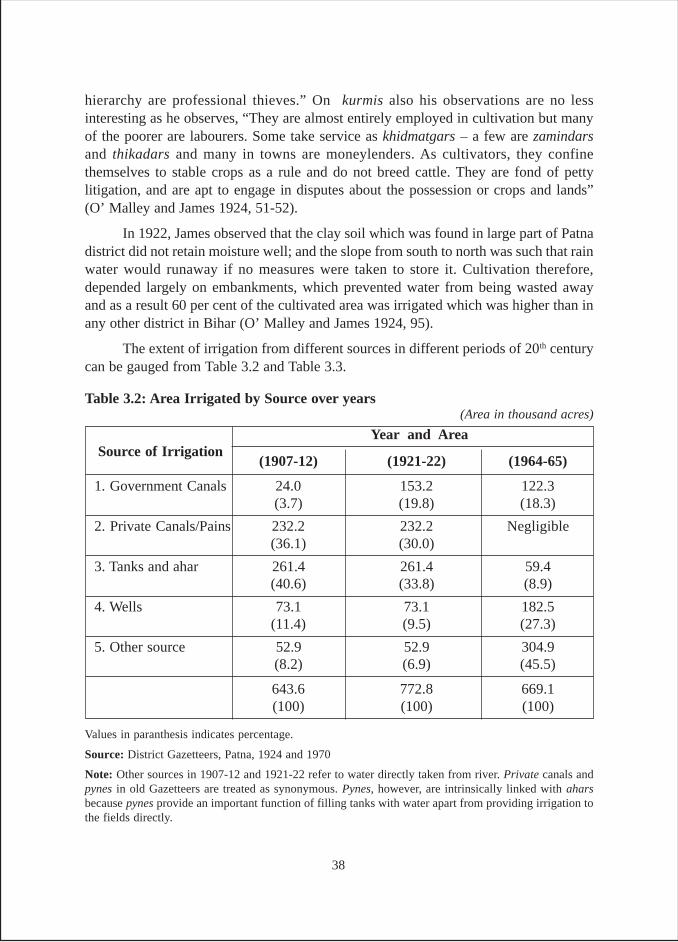
hierarchy are professional thieves.” On kurmis also his observations are no lessinteresting as he observes, “They are almost entirely employed in cultivation but manyof the poorer are labourers. Some take service as khidmatgars – a few are zamindarsand thikadars and many in towns are moneylenders. As cultivators, they confinethemselves to stable crops as a rule and do not breed cattle. They are fond of pettylitigation, and are apt to engage in disputes about the possession or crops and lands”(O’ Malley and James 1924, 51-52).
In 1922, James observed that the clay soil which was found in large part of Patnadistrict did not retain moisture well; and the slope from south to north was such that rainwater would runaway if no measures were taken to store it. Cultivation therefore,depended largely on embankments, which prevented water from being wasted awayand as a result 60 per cent of the cultivated area was irrigated which was higher than inany other district in Bihar (O’ Malley and James 1924, 95).
The extent of irrigation from different sources in different periods of 20th centurycan be gauged from Table 3.2 and Table 3.3.
Values in paranthesis indicates percentage.
Source: District Gazetteers, Patna, 1924 and 1970
Note: Other sources in 1907-12 and 1921-22 refer to water directly taken from river. Private canals andpynes in old Gazetteers are treated as synonymous. Pynes, however, are intrinsically linked with aharsbecause pynes provide an important function of filling tanks with water apart from providing irrigation tothe fields directly.
Table 3.2: Area Irrigated by Source over years
Source of Irrigation(1907-12) (1921-22) (1964-65)
1. Government Canals 24.0 153.2 122.3(3.7) (19.8) (18.3)
2. Private Canals/Pains 232.2 232.2 Negligible(36.1) (30.0)
3. Tanks and ahar 261.4 261.4 59.4(40.6) (33.8) (8.9)
4. Wells 73.1 73.1 182.5(11.4) (9.5) (27.3)
5. Other source 52.9 52.9 304.9(8.2) (6.9) (45.5)
643.6 772.8 669.1(100) (100) (100)
(Area in thousand acres)
Year and Area
38
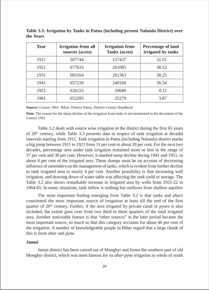
Table 3.2 deals with source wise irrigation in the district during the first 65 yearsof 20th century, while Table 3.3 presents data in respect of tank irrigation at decadalintervals starting from 1911. Tank irrigation in Patna (including Nalanda) district marksa big jump between 1911 to 1921 from 31 per cent to about 39 per cent. For the next twodecades, percentage area under tank irrigation remained more or less in the range of37 per cent and 38 per cent. However, it marked steep decline during 1941 and 1951, toabout 8 per cent of the irrigated area. These slumps must be on account of decreasinginfluence of zamindars on the management of tanks, which is evident from further declinein tank irrigated area to nearly 4 per cent. Another possibility is that increasing wellirrigation, and drawing down of water table was affecting the tank yield or storage. TheTable 3.2 also shows remarkable increase in irrigated area by wells from 1921-22 to1964-65. In many situations, tank inflow is nothing but outflows from shallow aquifers
The most important finding emerging from Table 3.2 is that tanks and aharsconstituted the most important source of irrigation at least till the end of the firstquarter of 20th century. Further, if the area irrigated by private canal or pynes is alsoincluded, the extent goes over from two third to three quarters of the total irrigatedarea. Another noticeable feature is that “other sources” in the later period became themost important source, so much so that this category accounts for about 46 per cent ofthe irrigation. A number of knowledgeable people in Bihar regard that a large chunk ofthis is from ahar and pyne.
Jamui
Jamui district has been carved out of Monghyr and forms the southern part of oldMonghyr district, which was most famous for its ahar-pyne irrigation in whole of south
Source: Census 1961: Bihar: District Patna, District Census Handbook
Note: The reason for the sharp decline of the irrigation from tanks is not mentioned in the document of theCensus 1961
Year Irrigation from all Irrigation from Percentage of landsources (acres) Tanks (acres) irrigated by tanks
1911 507744 157437 31.01
1921 677633 261085 38.52
1931 683164 261363 38.25
1941 657230 240160 36.54
1951 626155 50689 8.11
1961 652285 25279 3.87
Table 3.3: Irrigation by Tanks in Patna (including present Nalanda District) overthe Years
39
Bihar. In fact, the southern part of the present Jamui district forms border with Jharkhandand has the same kind of topography and social group as that of Palamau.
Towards the end of the first quarter of 20th century, while writing about the areaconstituting the present Jamui district, O’Malley (1926) had observed the area consistedof undulating country stretching from Kharagpur hills southwards to the border of thethen district. In the Jamui thana and the present district, in the north of this tract, thereare extensive areas under rice, and in the extreme south (referring to the area borderingJharkhand), the cultivators carve out paddy fields by leveling the beds of streamlets,and terracing the sides of the wider and shallower valleys. In the same way he goes onto say, in south Monghyr (refers to present Jamui district), irrigation is practiced farmore elaborately, affecting 42 per cent of the net cropped area. The irrigation is of threemain kinds, viz., from artificial water channels called pynes, from artificial reservoirscalled ahars, and from wells. According to him ahars formed the principal source ofirrigation in the then Jamui subdivision and that irrigation from this source in Jamuithana was 63 per cent and that in Chakai thana was 54 per cent. He further mentionsthat both small and large ahars operated in this area. If a small ahar was built acrossa drainage channel, a narrow cut was made at the deepest end to let out surpluswater. On the other hand, if the ahar was a large one, a weir was made for this purpose,so that water would escape and fill other ahars lower down the tract. The water flowedthrough a weir from ahar to the channels and to the fields. However, when supply leveldrops in the ahar, water is taken by means of latha-kunri, karin and chanr23 (O’Malley1926, 91-95).
Describing the tribal belt of the district, O’Malley observes that little irrigation ispossible in the hilly region of the Chakai thana. But rice is grown in reasonably largeareas in the beds of hill streamlets, which the santhals turn into fertile lands using their
23 The latha is a long beam working on an upright forked post, which serves as a fulcrum. The beam isweighted at one end with a stone, and a cone-shaped bucket (kunru) is attached by a rope to the other end.The cultivator pulls down the rope till the bucket is immersed, the weight attached to the lever then lifts it,and the bucket is emptied in to the water channel.
The karin is a water scoop shaped like “dug-out” canoe cut in half. It is usually made of single piece ofwood, but iron karins are not uncommon. The broad open end rests on the water channel which is toirrigate the fields, and the pointed end is dipped in to the reservoir. The water is raised by a lever overheadwith a weight at the end of it. The karin is used for raising water from ahars or from a lower channelwhere water is plentiful, to a higher channel and has not to be shifted to a considerable height.
The Chanr Sair is used where the level of the water in a stream or tank is slightly below the level of theland to be irrigated. Here water is often raised by means of chanr or sair. This consists of a piece of closelywoven bamboo matting, about 18 inches to 2 feet square with two of its corners brought together and sewnup. Two ropes are attached to the wedge-shaped end so formed, and one to each of the pieces of woodfastened across the mouth to keep it open. Two men standing one on each side of the pool of water, dip thechanr into pool, swing it up to the bank, and tip the water in to the channel by sharply raising the ropes.Water is sometimes lifted to a high level by means of a series of these chanrs, when fields to be irrigatedform a succession of terraces on a slope.
40
skills. An embankment is built across the stream near its source, and the stream-bedbeneath the embankment is leveled into fields, which continue one below the other, likethe steps of a stairway, down the whole length of the stream, till it reaches the mainstream or strikes soil, which can not be cultivated. Each field also acts as a small reservoirfor the field below it and all the fields are thus assured of a continuous supply of moistureand, except in extremely dry years, produce good crop.
According to O’Malley, some of the reservoirs thus formed were very large andsupplied an extensive area with water, but a good deal of cutting was required in orderto construct channels from the bed of the stream in which the water was originallycollected (O’Malley 1926, 95-96).
Survey Findings
In terms of origin of tanks (Table B-1), it is found that while an over-whelmingproportion of tanks (73 per cent) in Nalanda are of ancient origin, 88 per cent of tanks inPatna were built during the British period. Overall, just 5 per cent of the tanks were builtduring the post-Independent period. But there were 40 per cent of tanks from ancient /medieval period24 and 55 per cent were from British period.
As regards the ownership of these tanks (Table B-2), it is found that in Patna50 per cent of tanks were owned by government while the rest 50 per cent wereprivately owned. The privately owned tanks include those captured by individualswhere legal petition is pending with the court for title claim. In case of Nalanda, eachpanchayat and individual households own about 30 per cent tanks and the governmentowns 27 per cent.
In terms of people’s access to the tanks (Table B-3), it is found that in Bihar, in80 per cent of the cases, the tanks are open to all. Looking at the fact that 40 per centtanks are private, this implies that a number of tanks allow access to outsiders.
In terms of size of tanks (Table B-4), it is found that tanks of all sizes are found inBihar. However, the largest proportion of tanks are found in the size category of 2.5 to10 acres which covers 45 per cent of the tanks, followed by 20 per cent of tanks with asize category of 11 to 20 acres and then 15 per cent tanks falling the size category ofbelow 2.5 acres. The average size of the tanks is 16.2 acres. District wise analysis showedthat the average size of tanks in Patna is 20.1 acres, followed by 14.5 acres in Nalandaand three acres in Jamui.
The average irrigated area per tank (Table B-5) shows much greater evenness.Although area irrigated per tank was highest (60 acre) in Jamui, the average for the state
24 It refers to tanks constructed before the advent of British in India. This categorization was used for thesurvey of tanks (see interview schedule at p.146, question 2). Since our research was not an archeologystudy, the categorization ultimately depended on what our responded said (p.121, para 2) and/or what weobserved during the site visit. However as per historians, the ancient period is taken up to 6th century ADand medieval period from 7th century to 16th century
41
as a whole comes to about 48 acres per tank. The ratio of irrigated area and the tank areawas also found to be highest in Jamui where it stands at 20:1, followed by Nalandawhere one acre of tank area irrigates 3.1 acres of land and the lowest ratio is at 2.6:1 inPatna; the average for the state, however, comes to 2.9:1.
Table B-6 examines the data on tank-irrigated area from two angles. The first onelooks at area irrigated by tanks during the three cropping seasons and the second onelooks at the mode of irrigation, i.e., whether manual, energized, lift or flow irrigation.In case of manual irrigators, they use such traditional modes as karing, latha -kudi,while in case of mechanical all kinds of pumps such as diesel and kerosene are used. Incase where water level is high such as in case of village Salalpur in Patna district,Chinese diesel pump set (called by farmers as CD, which stands for - Chinese DieselEngine) were found to be very popular among the farmers.
Data on season wise irrigation shows that the largest proportion of the area isirrigated during kharif season, which accounts for 60.7 per cent of the total tank irrigatedarea, followed by 38 per cent during rabi and a meager 1 per cent of irrigation duringthe summer season.
As regards different modes of irrigation, flow irrigation is possible only duringthe kharif season, while in rabi and summer seasons, no flow irrigation is practiced inany of the districts. Even during kharif, lift irrigation seems to be more in vogue asabout 58 per cent tank irrigation is done through pumps, compared to 33 per cent byflow and about 9 per cent manually. The only exception in this respect is Patna districtwhere about 49 per cent of irrigation is done through flow method compared to about43 per cent through pumps. Another notable point is that although tank irrigation ismeager during the summer, about 27 per cent of it is done manually, compared to about73 per cent through energized lifting. This is in sharp contrast to the proportion of areairrigated through manual means in kharif (8.8 per cent) and rabi (1.6 per cent).
In Table B-7 the gross area irrigated through various modes in the three districtsis examined. It is found that overall about 73 per cent of gross irrigation is throughenergized lifting, followed by about 21 per cent from flow irrigation and 6 per cent donemanually. In case of Jamui mechanical mode is most popular accounting for 93 per centof the gross irrigated area. In the case of Patna, 54 per cent of the tank irrigation isthrough pumps and 39 per cent by flow method. In case of Nalanda, about 77 per cent ofthe area is irrigated by pumps and about 16 per cent of the area is irrigated by flowmethod.
As regard average number of irrigators per tank (Table B-8), it is 66 in Patna and62 in Nalanda. However, Nalanda seems to have larger number of farmers (4) per acreof tank irrigated area, as compared to 3 farmers per acre for Patna.
In Tables B-9a, 9b and 9c the depth of tanks during monsoon, winter and summerseasons respectively, was examined. One thing which comes out very vividly from the
42
three tables is that in all districts the depth of water goes on consistently dropping frommonsoon months to winter and then to summer. This is quite natural as these waterbodies do not receive inflows during the non-monsoon period. During rainy seasonthe largest proportion of tanks (45 per cent) have a storage depth of 5-7 feet and another35 per cent have a storage depth of above 10 feet. During winter, the largest proportionof tanks (40 per cent) have storage depth in the range of 3-5 feet, and only 10 per centhave storage depth above 10 feet. There is further reduction of depth during summermonths and it is found that 55 per cent tanks dry during summer months and storage inanother 40 per cent tank remain below 5 feet, and a mere 5 per cent tanks maintain astorage depth of 7-10 feet.
As regard the source of tank water (Table B-10), it is found that 45 per cent tanksderive their stock from rain (run off from the local catchment), while another 35 percent of tanks derive their stock from a combination of rain, rivulet, bigger tanks andfrom flood water. The rest of 20 per cent derive their stock from canals, artesian sourcesand from village drains.
In respect of maintenance (Table B-11), it is to be noted that responsibility ofmaintenance does not necessarily imply that maintenance was actually carried outby the organizations, who own the responsibility. This is particularly true in the caseof government and panchayat tanks. In this respect, it is revealing that as high as40 per cent of Bihar tanks are maintained by others who include tanks occupants, fishcontractors etc. For another 35 per cent of the tanks, maintenance responsibility lieswith the MI or FD of the state government. Individuals who have inherited them ownanother 20 per cent of the tanks. Only for the rest 5 per cent tanks in Bihar, panchayattakes the responsibility of maintenance.
Table B-12 consists of two parts. While the first part deals with the repair ofembankments, the second part deals with the frequency of desilting. The table showsthe pathetic state of affairs with regard to the two major maintenance requirements. It isfound that while in 35 per cent of cases the embankment was never repaired; in50 per cent cases, desilting was never done. In 25 per cent of cases, repair of embankmentwas done once in 2-10 years and in another 25 per cent cases, it was once in 11-30 years.Desilting, on the other hand, was resorted to less frequently. Only in 5 per cent cases itwas done once in 2-10 years and in 30 per cent cases, it was once in 11-30 years.However in 15 per cent cases, maintenance (embankment and desilting) was doneannually and these were the tanks which were either owned by individual or byunauthorized occupants or are run by some form of collectivity. In all these cases,pisciculture is the main function of the tank.
Table B-13 provides data on the agencies/individuals spending money for themaintenance and here a contrast is visible in relation to Table B-11 which covers agencies/individuals accountable for the maintenance of tanks. What is very striking is that thereare 35 per cent of tanks where no maintenance is done. Another important point is thatthere is considerable extent of community contributions; in about 25 per cent of cases
43
community action and panchayat contribution is forthcoming in comparison to 5 percent cases where panchayat has the responsibility (Table B-11).
Tables B-14 and Table B-15 need to be examined together. While Table B-14furnishes data for the tank studied in detail in each district, Table B-15 furnishes data onall the tanks in the villages/hamlets where survey/study was conducted. While Table B-14 contains data for about 20 tanks, the latter is based on data for about 78 tanks. Thefirst thing that strikes is that none of the tanks in the three districts are exclusively fordomestic purposes nor any of the tanks in the study villages were abandoned. The maindifference between the data furnished in the two tables is that the larger proportion ofthe surveyed tanks has pisciculture related activities. While 20 per cent of the surveyedtanks are concerned with pisciculture, only 6 per cent of the village tanks havepisciculture. This becomes obvious if the data in the two tables is examined in terms ofmultipurpose tanks. While 65 per cent of the studied tanks are multi-purpose tanks(Table B-14), the percentage is as high as 80 in respect of all village tanks (Table B-15).
Table B-16 deals with pisciculture aspect of tanks. It is found that there are 16tanks, which are either exclusively engaged in pisciculture or has pisciculture as one ofthe activities or which have data on fisheries activities. It was found that these 16 tanksgenerate a total of more than Rs. 18 lakhs rupees. The economic value of the outputgenerated per tank varies to a large extent between Patna and Nalanda. The returns fromfish production are not significant when it is assessed in per unit area terms. Whilefisheries in Nalanda tanks generate an economic value of Rs. 8,800 per acre of tankarea, Patna tank generates a lesser value of Rs. 5,800 per acre.
Table B-17 and B-18 contain data of the villages / hamlets where the tanks werelocated. Looking at the overall position in three districts, it found that higher castes owna much higher proportion of the land compared to lower castes. The difference is somuch so that while about 17 per cent households belonging to high castes own about35 per cent of the land, 29 per cent SCs own only about 7 per cent of the land in thevillages. Although OBCs (this category is expressed for both the categories of BC-I andBC-II) also own much less land, it is slightly higher than their share in the population.This is evident from the fact that while there are about 54 per cent of OBCs in thesample, the land owned by them is about 58 per cent of the total village land.
The same is reflected in Table 18 where average land holding of different castesis shown. The average size of land holding of high castes is 2.75 acre, followed by 1.44acre for the backward castes and 0.34 acre for the scheduled castes. There are a lot ofinter-district differences in this respect as can be seen from the table.
Findings of Bihar Village Cases
As mentioned in chapter-2 in case of Bihar, case studies were prepared from 7villages/hamlets. All the case studies are presented in the book as Annexure-4. Thecase studies present different pictures in terms of origin, nature and extent of benefits
44
and beneficiaries of tanks. Side by side, socio-economic power play, which determines,who gets what and why, has also been discussed.
In terms of variety, while in one village we find deep dug tanks known as khata,in other villages we see various types of tanks owned by individual farmers to severaltanks owned by fisheries department, panchayats and village committees. Even in thisearly 21st century, it is not uncommon to see traditional water lifting devices such askaring and latha kudi in villages which are not far from the state capital Patna.
An interesting feature of several of these tanks is the seasonal nature of wateravailability in the tanks. A case in point is Salarpur village of Patna district. DuringSeptember 2004, when we visited the village, the khatas (deep tanks) were full of water,and all kinds of traditional lift devices were visible. However, when the tank was visitedagain during December 2004, all khatas were dry and there was no sign of any traditionalmanual water-lifting devices. Followings are some of the other important features/findings emerging from these case studies.
- Although high castes like bhumihars still dominate the power structure, the conceptof dominant caste has taken a change for the better, particularly in the democraticframework. The scheduled caste members, holding panchayat offices, were foundto be counted as influential persons in the village. Similarly in some other villages,kurmis and other OBCs on account of larger share of land holding seem to dominatethe village politics.
- In several cases it was noticed that private parties had captured tanks located ingovernment and panchayat lands and made large profits by using them forpisciculture. It was also found that a lot of land in the water spread area of thetanks was illegally occupied and used by influential farmers.
- Although fisheries department and panchayats made huge profits from the fisherycontracts, they never ploughed back any portion of this income in desilting orother repairs or even routine maintenance works of these tanks. Another featuremore pronounced in case of FD was the rampant corruption in issuing contracts.This resulted in huge revenue losses to the department.
- In many situations, particularly when rains were scanty, there was visible conflictsbetween the fish contractors and irrigators. This was most visible where rainswere not occurring and irrigators desperately needed water to save the crops. Onhis/her part a fish contractor will not allow water to be taken out of tank when ithas reached a critical level below which the survival of fishes is threatened.
- The location of the tanks is ideal for the local topography and agricultural andother uses, particularly those tanks that exist since ancient and British times. Butthe tanks are not properly maintained, and therefore are not in good condition,even after public investments.
45
- The power dynamics at the society level, specially the caste and class dominanceand vested interests, have adverse impact on the profitability distribution ofirrigated crop production and fisheries activities from the tanks and the benefitsare confined to the dominant communities.
- Wherever the tank management has been the responsibility of individual owners,the maintenance of the structures has been good, and hence management of waterhas resulted in profitable uses.
- There has been a huge waste of public investments as private interests inconnivance with the socially dominant groups and government officials (in caseof fishing contracts) work against the public interests.
- Community actions have been encouraged in exigencies and social causes in recentpast but prior to 1980s for agricultural purposes.
- Progressive leadership and necessity have prompted community action formanagement of tanks for agricultural purposes.
46
CHAPTER-IV
JHARKHAND
The state of Jharkhand was carved out of Bihar and came into being on 15th
November 2000. The topographical features of the state are different from that ofBihar. The state is composed of Chhota Nagpur plateau of Vindhya mountain rangesimilar to the districts of Bankura, Purulia and Birbhum of West Bengal. The state canbe divided into three parts, viz., north eastern part containing districts of Godda,Dumka and Deoghar, (earlier known as Santhal Pargana); the north west part consistingof districts Palamau, Hazaribagh and Dhanbad; and the southern part consisting of Ranchi,Gumla Lohardagga, Shinghbhum and others. The state has nearly 27 per cent tribalpopulation, who are the original inhabitants, living in settlements in deep jungles. Themajor traditional source of their livelihood was the forest and they were introduced tosettled agriculture in the latter part of 19th and early 20th century. The immigrant,non-tribal population made them to shift to permanent cultivation. The concentration ofsanthal tribes is greater in northeast part of the state, and they perhaps started practicingagriculture earlier than the rest of the state.
The santals first settled in this region during 1790-1810. Later on in 1855 santalRebellion known as hul broke out. This triggered migration of santals to these areas thatbrought a change in their lifestyle and mode of sustenance. In O’Malley’s words, "‘Santalrebellion’ caused santals from different parts of Bengal to concentrate in these areas bymigration. But later they had to migrate out due to insufficient reclamation offorest land for agriculture, as it did not match with the needs of fast growing population"(O’Malley 1910, 54-65).
The surface of these areas is to a large extent composed of long undulating ridgesbetween which the drainage runs off to join the larger streams. The crests of ridges arevery poor for cultivation. However, the slopes of these ridges have been used forcultivation. The slope thus presents the appearance of a series of steps, which areconverted into terraces for rice cultivation. The rice terraces are flooded as soon as therain sets in, and water is retained until the crop matures in late autumn. Thus irrigationwas absolutely not necessary. The natural topography facilitated irrigation to a largeextent. O’Malley (1910, 190-91) writes, “Fortunately the undulating nature of the countryaffords great facilities for protective works. These facilities have been so fully utilizedso that one third of rice land is now protected and only two third remain unprotected”.
47
The irrigation works generally took the form of embankments constructed acrossravines, hollows or the natural depression or at the head of the numerous valleys thatimpounded the drainage water. These formed reservoirs from which the rice fieldsstretching away, were irrigated. The such small sized tanks are called ‘hires’ and thelarge sized ones are called bands. These embankments were in very large numbers,judged by the fact that each village had at least one or two. The smaller ones dried up ina month or two after the rains ceased, whereas the larger ones having large catchmentsensured continuous stream flows during the dry spells.
Their sites were usually well chosen and the beds of the bunds were oftenimpregnated with natural springs. The gouda area, which was another tract of 259 squarekms., was irrigated by channels called daubs leading from embankments thrown acrossthe bed of streams to fields at lower level (similar as pynes in Gaya district). Thesechannels frequently traversed through several villages, all of which assisted in theirconstruction and shared the benefits accruing from them. In the opinion of McPherson,the existing land system (with farmers holding fragmented land in the head, middle andtail end) benefited due to the peculiar advantage of cooperation it created amongst thecultivators. He further termed “the faculty of association and cooperation has beenfostered and developed to a degree that is impossible in the ordinary district.... works(irrigation works) that were beyond the means and enterprise of the individual cultivatorswere successfully carried through by united efforts of the community.... and cooperationhas told not only on the work of construction but also on the work of maintenance andrepair (of bandhs, tanks and other works of irrigation)” (O’Malley 1910, 192-93).
Even ryot (tenant) cultivators were free to construct embankments. The landlordswere self-restrained from interfering in the work of improvement of irrigation works,and left individual ryots free to think out and execute their own ideas in agriculture andirrigation.
North western part of the Jharkhand, where the tank survey was conducted hasbeen significant for irrigation since the 19th century. The hilly and undulating terrain inthe western part of this region (Palamau) witnessed settled agriculture very late. Thishistory of irrigated agriculture in this region is not very old; as the tribal people (originalinhabitants) practiced slash and burn cultivation25 in which irrigation had practically norole to play. Substantial influx of caste peasantry during 19th century from the plains ofBihar to this region brought the agricultural practices, including the art of irrigationwith them. The contact of caste peasantry, such as mahto and kurmi with tribals stimulatedthe growth of agriculture and extension of irrigation through ‘ahars’, pynes’ and tanks(Sharma, 1985, 118-120)
25 Slash and burn agriculture is the process of cutting down the vegetation in a particular plot of land,setting fire to the remaining foliage, and using the ashes to provide nutrients to the soil for use of plantingfood crops. Slash and burn is a method of agriculture primarily used by tribal communities for subsistencefarming (farming to survive). Humans have practiced this method for about 12,000 years, ever since thetransition known as the Neolithic Revolution, the time when humans stopped hunting and gathering andstarted to stay put and grow crops. Today, between 200 and 500 million people, or up to 7% of the world’spopulation, uses slash and burn agriculture.
48
In the beginning of the 20th century, the region throughout had a system of,damming up valleys by 8-10 feet high bunds constructed in series, forming small tanksor ahars, having no masonry sluices. These ahars gave agriculturists a good harvest ofpaddy whether rainfall was sufficient or not. In this undulating tract, with erratic rainfall,there must be enumerable small streams, the water of which could be dammed anddiverted into tanks and utilized in saving the crops at critical seasons. On the bed of thetank, as the water was drawn off, wheat or gram were sown on the moist soil and goodrabi crop was obtained (O’Malley 1910 a, 193).
As discussed above, the tribal population gave up slash and burns cultivation andstarted settled agriculture in 1930s. Famines had made them construct ahars during the19th century but the pace of construction of ahars and tanks was accelerated during thefirst quarter of the 20th century. The first survey and settlement operations in the districtof Palamau recorded existence of 148 ahars that went up to 1095 at the time of secondsurvey (1894-95 and 1896-97). The survey and settlement operations in mid 1930srecorded the existence of 11, 282 tanks (Sharma 1985, 120). With the passage of timethe significance of tank irrigation grew considerably. The ‘grow more food campaign’covered rehabilitation and construction of tanks, ahars, pynes, karhas under the minorirrigation scheme.
The southern part of Jharkhand consists of Ranchi, Gumla, Lohardagga andSinghbhum districts. The districts of Gumla and Lohardagga were hitherto part of Ranchidistrict. Ranchi, situated at plateau of Vindhya range of mountains, has a major part ofthese ranges stretch through north to south like natural wall with rocky spurs and deepvalleys. The central tract of mountain separated by Damodar Valley is undulating,intersected by numerous streams and rivers and studded with low rocky hills as well asisolated peaks. The region receives rain almost throughout the year, though concentrationis during the monsoon months from June to September.
The hill streams remain almost dry except in rainy season and do not offer asmuch scope for irrigation as the perennial rivers. The process of soil erosion is activethroughout the district due to the undulating land. The rainwater washes away the topsoil in the uplands and deposits it in the low land. As compared to other districts of theChhota Nagpur plateau, the tradition of water harvesting was relatively weak in Ranchidistrict. Hence, cultivation was traditionally rain-fed. Some of the landlords did constructbandhs for irrigating their lands but at the turn of the century, many of them were toopoor to keep these in a state of repair. They were also on such bad terms with the cultivatorsthat they were reluctant to work with them to carry out any larger works. The peasantstoo were extremely improvident, though they had shown themselves capable of unitedaction in their struggle against landlords. British officials noted that they had not joinedtogether to carry out any large irrigation works. In the more heavily forested parts of thedistrict, the local tribal people cleared forest lands to make new fields and embankedand terraced the land in streambeds. This was the normal way in which they extendedtheir cultivation (Kumar 1976, 1-6 & 196-200).
49
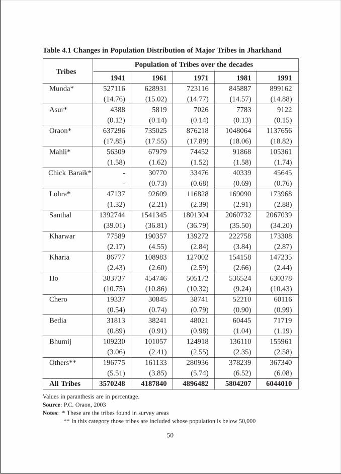
1941 1961 1971 1981 1991Munda* 527116 628931 723116 845887 899162
(14.76) (15.02) (14.77) (14.57) (14.88)
Asur* 4388 5819 7026 7783 9122
(0.12) (0.14) (0.14) (0.13) (0.15)
Oraon* 637296 735025 876218 1048064 1137656
(17.85) (17.55) (17.89) (18.06) (18.82)
Mahli* 56309 67979 74452 91868 105361
(1.58) (1.62) (1.52) (1.58) (1.74)
Chick Baraik* - 30770 33476 40339 45645
- (0.73) (0.68) (0.69) (0.76)
Lohra* 47137 92609 116828 169090 173968
(1.32) (2.21) (2.39) (2.91) (2.88)
Santhal 1392744 1541345 1801304 2060732 2067039
(39.01) (36.81) (36.79) (35.50) (34.20)
Kharwar 77589 190357 139272 222758 173308
(2.17) (4.55) (2.84) (3.84) (2.87)
Kharia 86777 108983 127002 154158 147235
(2.43) (2.60) (2.59) (2.66) (2.44)
Ho 383737 454746 505172 536524 630378
(10.75) (10.86) (10.32) (9.24) (10.43)
Chero 19337 30845 38741 52210 60116
(0.54) (0.74) (0.79) (0.90) (0.99)
Bedia 31813 38241 48021 60445 71719
(0.89) (0.91) (0.98) (1.04) (1.19)
Bhumij 109230 101057 124918 136110 155961
(3.06) (2.41) (2.55) (2.35) (2.58)
Others** 196775 161133 280936 378239 367340
(5.51) (3.85) (5.74) (6.52) (6.08)
All Tribes 3570248 4187840 4896482 5804207 6044010
Table 4.1 Changes in Population Distribution of Major Tribes in Jharkhand
Values in paranthesis are in percentage.Source: P.C. Oraon, 2003Notes: * These are the tribes found in survey areas ** In this category those tribes are included whose population is below 50,000
Population of Tribes over the decadesTribes
50
In Table 4.1 the changing pattern of tribal population in Jharkhand has beenpresented26. Among the tribes which inhabit Jharkhand, the most important ones in termsof population size are santhals, oraons, mundas and hos. Except for santhals and hos,all important tribes were covered in the tank survey. A striking point that emerges fromthe data is that while the population of all tribes had increased over the years, theproportion of certain tribes in relation to the total tribal population has decreased. Amongsuch tribes, santhals are the most prominent ones. In 1941 their population was 39 percent, which decreased to 34 per cent in 1991. As regard oraons, they were about 18 percent in 1941 and remained same in (19 per cent) 1991. In respect of mundas, theirproportion has more or less remained the same. In 1941 they constituted 14.8 per centand five decades later also they constituted 14.9 per cent. Another important inferencethat can be derived from the data is that those tribes that remain low in social hierarchysuch as, mahli, lohra, chick barik etc., constitute a very low proportion of the total tribalpopulation.
Relationship between Tribes, Agriculture and Tank Irrigation
The population of tribes in Jharkhand is 27 per cent and the profile of these tribesvary in terms of occupation, environment, natural resource and land. The concentrationof tribal population is highest in the districts of Ranchi, Gumla and Lohardagga. Asmentioned earlier, the tribes covered were munda, oraon, asurs and other tribes havinglower position in the social hierarchy such as, mahli, lohra and chick baraik.
Mundas and Asurs
The first settlers in the district of Ranchi (including Gumla) are the asurs and themundas who established themselves in the region under the system of village communesin the form of self-governing villages with a strong sense of community feeling,communal ownership of land and great cohesiveness and purposefulness in the villageagencies. Each village was under the leadership of a village chief called munda. Aconfederacy of about 20 villages was known as parha, whose head used to be the paraharaja or the manki (Verma 2002, 8). Those who cleared jungles for cultivation were inpossession of the reclaimed land and were known as bhuinhars and such land was knownas bhuinhari land. The Chhota Nagpur king appointed his relatives to rule over thesemankis and they used force over the markis for collecting revenue. This phase witnessedthe eviction of the tribal population by brute force. The newcomers took possession ofthe tribal’s bhuinhari land, which was originally reclaimed by them and converted theseinto majhias (landlord’s privilege) land. Chhota Nagpur tribes lived in relative isolationand lack security until the 16th century. In 1585, Akbar made the king of Chhota Nagpura malguzar or tributary, and as a result, tribal chief became tributary to the great empire.The headman from each village collected subscription and paid it to his parha chief andthe parha chief paid the money to the raja (Verma 2002, 8). The beginning of thetransformation of the tribal agrarian system however, could be traced to the rise of the
26 The tribes, which formed part of our tank survey, have been marked with an asterisk.
51
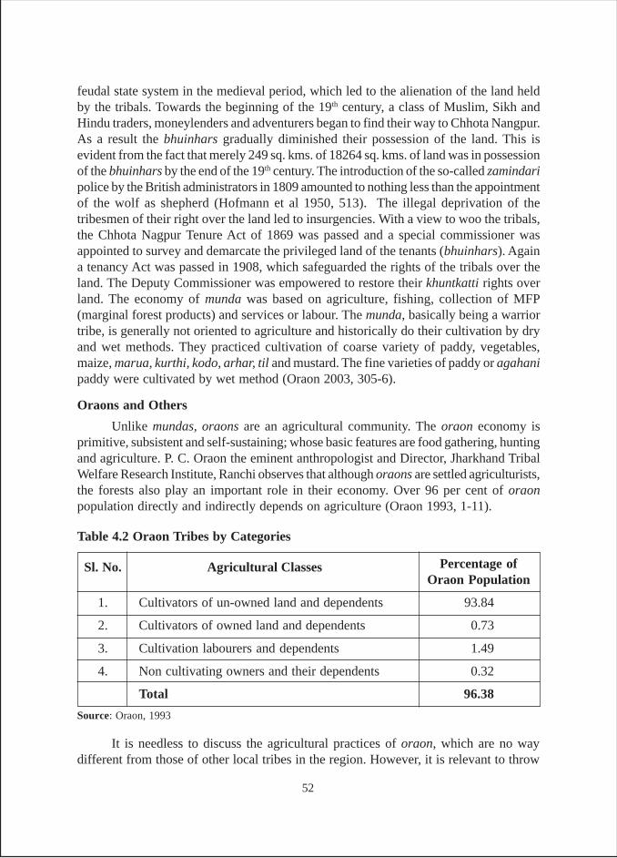
feudal state system in the medieval period, which led to the alienation of the land heldby the tribals. Towards the beginning of the 19th century, a class of Muslim, Sikh andHindu traders, moneylenders and adventurers began to find their way to Chhota Nangpur.As a result the bhuinhars gradually diminished their possession of the land. This isevident from the fact that merely 249 sq. kms. of 18264 sq. kms. of land was in possessionof the bhuinhars by the end of the 19th century. The introduction of the so-called zamindaripolice by the British administrators in 1809 amounted to nothing less than the appointmentof the wolf as shepherd (Hofmann et al 1950, 513). The illegal deprivation of thetribesmen of their right over the land led to insurgencies. With a view to woo the tribals,the Chhota Nagpur Tenure Act of 1869 was passed and a special commissioner wasappointed to survey and demarcate the privileged land of the tenants (bhuinhars). Againa tenancy Act was passed in 1908, which safeguarded the rights of the tribals over theland. The Deputy Commissioner was empowered to restore their khuntkatti rights overland. The economy of munda was based on agriculture, fishing, collection of MFP(marginal forest products) and services or labour. The munda, basically being a warriortribe, is generally not oriented to agriculture and historically do their cultivation by dryand wet methods. They practiced cultivation of coarse variety of paddy, vegetables,maize, marua, kurthi, kodo, arhar, til and mustard. The fine varieties of paddy or agahanipaddy were cultivated by wet method (Oraon 2003, 305-6).
Oraons and Others
Unlike mundas, oraons are an agricultural community. The oraon economy isprimitive, subsistent and self-sustaining; whose basic features are food gathering, huntingand agriculture. P. C. Oraon the eminent anthropologist and Director, Jharkhand TribalWelfare Research Institute, Ranchi observes that although oraons are settled agriculturists,the forests also play an important role in their economy. Over 96 per cent of oraonpopulation directly and indirectly depends on agriculture (Oraon 1993, 1-11).
Sl. No. Agricultural Classes Percentage ofOraon Population
1. Cultivators of un-owned land and dependents 93.84
2. Cultivators of owned land and dependents 0.73
3. Cultivation labourers and dependents 1.49
4. Non cultivating owners and their dependents 0.32
Total 96.38
Source: Oraon, 1993
It is needless to discuss the agricultural practices of oraon, which are no waydifferent from those of other local tribes in the region. However, it is relevant to throw
Table 4.2 Oraon Tribes by Categories
52
light on irrigation practices, including acquisition and regulation of water by the oraontribe. Well to do oraons who grow potatoes, onions etc., on their bari or chira lands digwells to irrigate them. In the past, water was drawn manually with the help of lathakundi but no such practice was found when we visited the area. The villagers informedus that the government had given them a number of pump sets, which were used toextract water from wells. Presently in a few villages, reservoirs in which rainwater isstored are also used by some well to do oraon cultivators by raising bunds at some costand labour. The regulation of water is an important issue. To quote Oraon again, “Betweenthe first ploughing and the sowing, the oraon cultivator has to repair breaches, if any, inthe ridges that separate one terrace from another. Adding earth to the sides and top alsostrengthens the ridges. The objective of this is to prevent rainwater from running overthe ridges or passing through the breaches in the ridges to the lower terraces. From thetime paddy is sown till the end of the rainy season, the amount of the water in the fieldshas to be regulated constantly. If too much rainwater is accumulated in the field thefarmers make a narrow opening on the lower side of the field and allow the surpluswater to run off. But if no rain occurs for a day or two, opening is sealed using earth, andthe field is allowed to get partially submerged with water. Towards the end of the season(the middle of September), the embankments are made watertight to keep sufficientwater in the fields” (Oraon 1993, 3). This reveals that oraons are conscious of usingwater wisely. It implies that they do also regulate the tank water according to the needand environment.
A success story of a person from oraon community tells the community’s aptitudetowards agriculture in tough conditions. In Jamtoli, Simon Oraon managed toconceptualize, plan and organize the finance for the construction of five check dams,which irrigated over hundreds of acres of land. He experimented with flow irrigationtechniques and built his first check dam when he was just fourteen years old, whichenabled part of his father’s land to be irrigated when the monsoon was poor or late: asystem that greatly improved his household’s food security. His success with these cropsencouraged him to expand Jamtoli’s irrigable potential. “Although, it cannot be deniedthat Simon Oraon’s irrigation schemes have been very important in terms of increasingfood security and profits from rabi season crops, his emphasis on modern farming is, tosome extent, resulting in replacement of more traditional farming methods.” (Jewitt1996, 118-20).27
Other tribes in the locality of Ranchi and Gumla districts are mahli, chik baraik,and lohra. The concentration of mahli tribe is in Ranchi, Gumla, Lohardagga andSinghbhum districts of Jharkhand. They have always maintained sustenance in associationwith mundas and oraons. The material culture of the mahli tribe reveals their existence-oriented economy, which is based on basketry, collection of MFP, agriculture, carryingpalanquins and labour. Previously basketry was the main occupation for this tribe. Each
27 This has been described as detailed village case and the same is provided in Annexure V. A summaryof the case is also provided at the end of Chapter IV.
53
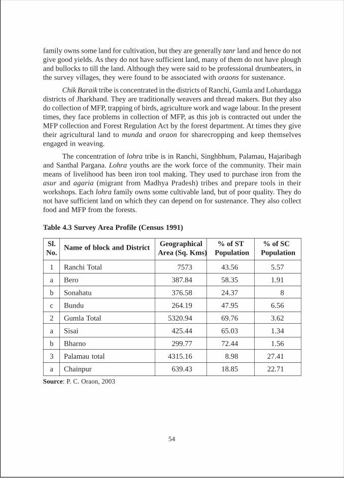
family owns some land for cultivation, but they are generally tanr land and hence do notgive good yields. As they do not have sufficient land, many of them do not have ploughand bullocks to till the land. Although they were said to be professional drumbeaters, inthe survey villages, they were found to be associated with oraons for sustenance.
Chik Baraik tribe is concentrated in the districts of Ranchi, Gumla and Lohardaggadistricts of Jharkhand. They are traditionally weavers and thread makers. But they alsodo collection of MFP, trapping of birds, agriculture work and wage labour. In the presenttimes, they face problems in collection of MFP, as this job is contracted out under theMFP collection and Forest Regulation Act by the forest department. At times they givetheir agricultural land to munda and oraon for sharecropping and keep themselvesengaged in weaving.
The concentration of lohra tribe is in Ranchi, Singhbhum, Palamau, Hajaribaghand Santhal Pargana. Lohra youths are the work force of the community. Their mainmeans of livelihood has been iron tool making. They used to purchase iron from theasur and agaria (migrant from Madhya Pradesh) tribes and prepare tools in theirworkshops. Each lohra family owns some cultivable land, but of poor quality. They donot have sufficient land on which they can depend on for sustenance. They also collectfood and MFP from the forests.
Sl. Name of block and District Geographical % of ST % of SCNo. Area (Sq. Kms) Population Population
1 Ranchi Total 7573 43.56 5.57
a Bero 387.84 58.35 1.91
b Sonahatu 376.58 24.37 8
c Bundu 264.19 47.95 6.56
2 Gumla Total 5320.94 69.76 3.62
a Sisai 425.44 65.03 1.34
b Bharno 299.77 72.44 1.56
3 Palamau total 4315.16 8.98 27.41
a Chainpur 639.43 18.85 22.71
Source: P. C. Oraon, 2003
Table 4.3 Survey Area Profile (Census 1991)
54
Palamau
The word Palamau is made up of two Hindi words “Pala” which means frost and“mu” which means dead. The whole word meaning “dead from the frost” is indicativeof parts of the district experiencing severe frost during winter months (Roychoudhury1961, 1). The district is bounded on the north by the river Sone that separates it fromerstwhile district of Shahabad and by the district of Gaya. In the west, the district isbounded by Garhwa.The districts of Chatra in the east and Latehar in the southrespectively, surround Palamau.
The district is characterized by a series of hill ranges running parallel, throughwhich the river Koel passes. The most valuable arable lands in the district are found inthe valleys and on the banks of Koel and Sone rivers. The rest of the district consists ofhilly, broken country covered with low growth jungle and dissected by deep gulliescaused by numerous streams and torrents which come in spate during the monsoon, butdry up in summer.
The rainfall in the district is either insufficient or unfavourably distributed forthe paddy crop, hence the fate of the crop depends a great deal on the good rainfall inthe months of September and October for the crop to reach maturity. Yet there is everylikelihood of failure of monsoon during this period. At the same time flow in the largestreams diminishes rapidly while that in the smaller stream the flow altogether disappearssoon after the rains stop. Further, much of the area under cultivation in the district ishighly fissured, undulating and unsuitable for irrigation, except in small patches. Butthe ingenuity of the inhabitants had helped overcome these difficulties posed by hydrologyand topography. Embankments were constructed across the natural slope of the land,and small streams were dammed and diverted. Rice fields were laboriously prepared byterracing the land or in some cases, the stream bed was made into one long, narrow ricefield.
As far back in the early part of 20th century, O’Malley wrote about the use ofsmall bunds called ahars, for rice cultivation in Palamau district. A large number ofahars were constructed in almost every depression all over the area. These bundswhich acted as reservoirs, varied in size. The area irrigated also varied significantly,from less than one ha to 40 ha. In some cases, damming of nullah and smallstreams formed reservoirs and water was diverted from streams through channels calledpynes (O’Malley 1907, 72-76).
The bandh ran along the contours. As it progressed on length, the catchment areawent on increasing and at places it required pucca flood escapes, to let out floodwater,locally known as chahakas. Here and there throughout the embankment and irrigationchannels, bhaos (wooden or earthen or cement pipes) were fitted to let out water in thedistrict (Roychoudhury 1961, 180).
Besides ahars, pynes (narrow water channels) have also been an important meansof irrigation in Palamau. Pynes are diversion channels taking off from the streams of
55
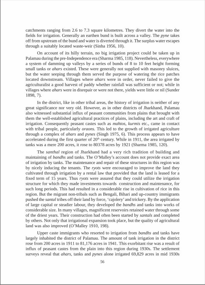
catchments ranging from 2.6 to 7.3 square kilometres. They divert the water into thefields for irrigation. Generally an earthen bund is built across a valley. The pyne takesoff from upstream of the bund and water is diverted through it. The surplus water escapesthrough a suitably located waste-weir (Sinha 1956, 10).
On account of its hilly terrain, no big irrigation project could be taken up inPalamau during the pre-Independence era (Sharma 1985, 118). Nevertheless, everywherea system of damming up valleys by a series of bunds of 8 to 10 feet height formingsmall tanks or ahars existed. These were generally not supplied with masonry sluices,but the water seeping through them served the purpose of watering the rice patcheslocated downstream. Villages where ahars were in order, never failed to give theagriculturalist a good harvest of paddy whether rainfall was sufficient or not; while invillages where ahars were in disrepair or were not there, yields were little or nil (Sunder1898, 7).
In the district, like in other tribal areas, the history of irrigation is neither of anygreat significance nor very old. However, as in other districts of Jharkhand, Palamaualso witnessed substantial influx of peasant communities from plains that brought withthem the well-established agricultural practices of plains, including the art and craft ofirrigation. Consequently peasant castes such as mahtos, kurmis etc., came in contactwith tribal people, particularly oraons. This led to the growth of irrigated agriculturethrough a complex of ahars and pynes (Singh 1975, 6). This process appears to haveaccelerated during the first quarter of 20th century. While in 1911, the area irrigated bytanks was a mere 200 acres, it rose to 80378 acres by 1921 (Sharma 1985, 120).
The santhal region of Jharkhand had a very rich tradition of building andmaintaining of bandhs and tanks. The O’Malley’s account does not provide exact areaof irrigation by tanks. The maintenance and repair of these structures in this region wasby nicely inducing the tenants. The ryots were encouraged to improve the land theycultivated through irrigation by a rental law that provided that the land is leased for afixed term of 15 years. Thus ryots were assured that they could utilize the irrigationstructure for which they made investments towards construction and maintenance, forsuch long periods. This had resulted in a considerable rise in cultivation of rice in thisregion. But the migrant non-tribals such as Bengali, Bihari and up-country immigrantspushed the santal tribes off their land by force, ‘cajolery’ and trickery. By the applicationof large capital or steadier labour, they developed the bandhs and tanks into works ofconsiderable size. In many villages, magnificent reservoirs retained water through someof the driest years. Their construction had often been started by santals and completedby others. Not only that irrigational expansion took place, but the quality of agriculturalland was also improved (O’Malley 1910, 198).
Upper caste immigrants who resorted to irrigation from bandhs and tanks havelargely inhabited the district of Palamau. The amount of tank irrigation in the districtrose from 200 acres in 1911 to 81,176 acres in 1941. This exorbitant rise was a result ofinflux of peasant castes from the plain into this region during 1930s. The settlementsurveys reveal that ahars, tanks and pynes alone irrigated 69,829 acres in mid 1930s
56
Ranchi
The present Gumla district was carved out of the erstwhile Ranchi district.Therefore what is mentioned here for Ranchi in terms of historical position is alsoapplicable to Gumla district. Although Ranchi had never been very important for tankirrigation, the selection of Ranchi was done with a view to study the contrast betweenhighly developed and least developed tank irrigation practices in close proximity. Thiswas possible by comparing situations in Gumla and Ranchi. As a matter of fact, Gumladistrict formed the western portion of erstwhile Ranchi district. In the erstwhile districtof Ranchi, tank irrigation was very much in vogue in certain pockets in the east and thewest. These were the pockets where the indigenous tribal caste of oraons and the migrantmahto caste were living together, particularly since the last quarter of the 19th century.The mahatos are the equivalent of kurmi castes in Uttar Pradesh, who are very goodcultivators. The mahtos migrated to Jharkhand from their original abode in Bihar andbrought with them the culture of irrigated agriculture and the art and craft of tank building.Among the tribals, while mundas (Warrior class) were not oriented to irrigated agriculture,the santhals and oraons did practice some kind of primitive agriculture. When theycame in contact with mahatos, they learnt the tricks of the trade quickly. Therefore byvisiting the villages of Ranchi and Gumla one can very well see this contrast injuxtaposition.
As O’Malley observes, the process was well described by McPherson, whoregarded the “Santhal as a born reclaimer”. According to McPherson, a santhal knows
(Sharma 1985, 120). The figures in Table 4.4 show the rise and fall of tank irrigationfrom pre-Independence period to post Independence period. Besides, the figures alsoshow a sharp decline in tank irrigation in the district from 1961 onwards.
Table 4.4: Extent of Tank Irrigation in Palamau District, Jharkhand
Source: 1, ID Sharma 1985. 2. Bihar Through Figures, Directorate of Statistics and Evaluation, PlanningDepartment, GOB.
Period of Irrigation Area IrrigatedTotal area irrigated
Pre-Independence Area (acres) Percentage
1921 80,378 89.2 90,041
1931 81,176 89.7 90,536
1941 81,176 89.7 90,536
Post-Independence
1951 40,426 65.5 61,757
1961 1,46,150 83.4 1,75,070
1971 48,820 27.1 1,78,690
1978 22,720 11.8 1,92,900
57
where to throw his cross bandhs and where to make his terraces. He loves to clearjungle, and level the rough slopy land, more than the civilized Bengali, Bihari, andup-country immigrant.
Ranchi district is bounded on the north by the districts of Palamau and Hazaribagh;on the south by districts of Singhbhum (Jharkhand) and Sundergarh (Orissa), on the eastby Singhbhum and Purulia (West Bengal) and on the west by districts of Raigarh andSurguja (Madhya Pradesh).
The plateau that covers the districts of Gumla and Ranchi consists of rocky spursof various heights with deep valleys radiating from the central mass. The highest portionof the central plateau is a ridge eight to ten miles south west of Ranchi from where themain rivers of the district, Subarnarekha and South Koel originate. The plateau wasformerly covered intensively with forests, which have gradually disappeared on accountof heavy increase of the inhabitants and also due to commercial exploitation. Reclamationof land for cultivating cereals has further reduced the area under forests.
The districts of Ranchi and Gumla have the highest concentration of scheduledtribes in Bihar (including Jharkhand) where about 31 per cent of tribal population of thewhole Bihar live in these two districts. Of the number of tribes that inhabit the twodistricts, oraons account for about 43 per cent and mundas 35 per cent and togetheraccounting for 78 per cent of the tribal population. The remaining 22 per cent of thetribal population is distributed among 27 other tribes (Kumar 1970 a, 99-100).
Gumla
Gumla is located in the south western part of the state and southwest fromRanchi. It falls south of the districts of Palamau and Garhawa. The total geographicalarea of the district is 5320.94 sq kms and the total population of the district according toCensus 2001 is 9,20,597. As per Census of 1991, the scheduled tribe (ST) population inthe district was 69.76 per cent of the total population. Within the ST population, theoraons population was 3,87,940, lohras constituted 11 per cent and mahlis were lessthan 3 per cent.
The topography of the district is undulating and hilly, technically known as ‘pats’.It falls in the altitude between 600 to 900 meters, that means at an altitude higher thanthat of Palamau and Ranchi. The land of the district can be divided in two categories –the don land and tanr land. Don land is wetland in which paddy is grown. It is usuallyterraced and field bunds are constructed to store rainwater for paddy. It is known asbahal and kanali in Dalbhum distirict. Tanr land is upland and dry land. It is known asgora and bari in the districts of Singhbhum. The surface has weathered into laterite soil.The soil texture is red loamy, red sandy and alluvial. This alluvial mixture is of recentalluvium. The entire Gumla region falls in the area of high density of cultivators say 20per cent and above in the state. The annual rainfall is recorded at 1600 mm. Terracedfields can be found in abundance and major crops are paddy, maize, jwar, bajara, potatoand vegetables in the district. The agriculture in this region seems to be introduced by
58
migrants. In areas with greater concentration of native population, there has beencomparatively lesser development in irrigation. The tribal ecology is not prone toagriculture. Therefore, large patches of fields can be found barren, as they do not intendreclamation of land for agriculture.
Survey FindingsThe survey in the state was carried out in the districts of Ranchi, Gumla and
Palamau. While Palamau has a long tradition of tank irrigation, Ranchi (including Gumla)had good tank irrigation in those parts of the districts where migrants from Bihar hadsettled down or oraon tribes inhabited. During reconnaissance, a village Khukhra nearChatti, Bero block, Ranchi district was visited. Here, over 90 per cent inhabitants weremigrants from Bihar who invariably worked as non-skilled labourers in a nearby factoryand depended exclusively on tank irrigation. The village was 15 km from Bero blockoffice in the same road.
In all, as is evident from annexure 2, tanks spread over 22 villages and 3 towns of3 districts were surveyed. While 16 tanks from Ranchi and one from Gumla districtwere surveyed in February 2005, 16 tanks from Palamau district were surveyed duringJuly 2005. Verma surveyed another 15 tanks in August 2006 in Gumla district to bringabout even distribution of surveyed tanks in three districts and also to remove some ofthe inconsistencies that were found in the earlier analysis.
Based on the inclusion of the 15 new tanks surveyed in Jharkhand and fromTable J-1, the overall position shows that 17 per cent of tanks, all from Ranchi, have anancient/medieval origin This means that while none of the sampled tanks in Palamauand Gumla had an ancient origin, 50 per cent of the tanks in Ranchi have ancient originand only 12 per cent each have come into being during the British period and postIndependence period. In case of Palamau, 67 per cent of tanks are said to be from theBritish period, followed by one third during the post Independence period. The overallposition also shows that more than half (53.2 per cent) of the tanks were constructedduring the British period. The proportion of such tanks is 67 per cent in Palamau, 63 percent in Gumla and 31 per cent in Ranchi. Similarly, while about one third of tanks inPalamau and Gumla were constructed after Independence, in Ranchi such tanksconstituted about 13 per cent. Another notable finding is that only 4 per cent of the tankswere constructed after 1990, clearly indicating meager progress in recent years.
In terms of ownership, it is found (Table J-2) that an overwhelming proportionof tanks (64 per cent) are owned by government, while about 30 per cent of tanks areprivate and only 6 per cent are owned by panchayats. The largest proportion of privatetanks (50 per cent) was found to be in Ranchi, whereas the largest proportion of panchayattanks (13 per cent) were in Palamau. In the state as a whole, although about 30 per centof tanks are private, in 94 per cent of the cases, tanks had open access (Table J-3). Herethe trend is very much similar to what was found in Bihar.
It is pertinent to note that unlike the neighbouring states of Bihar and West Bengal,there are restricted water rights in Jharkhand. The old government tanks have beenvirtually under the control of the local people. In case of private tanks, the water rights
59
are restricted to owners only. In some cases it was found that even the owners do not usewater for irrigation at the cost of pisciculture. In Tunja village of Bundu block, Goraitalab (tank) contains large amount of water, but has been leased out to one Ram PrashadDas by MI department of GOJ on contract of Rs. 1 lakh. He does not allow anyone totake water from the tank and sells it to nearby brick kiln owner at the rate of Rs. 5,000per lakh of bricks. Similarly in Sonahatu village, the tank owners do not allow water tonon-owners. As a result, Bundu bara talab (big tank) is virtually under the control oftwo localities of Bundu town. The fishermen of these two localities (who live close tothe tank) use the tank for fishing for their sustenance. They do not even invest on ponha(fish seeds) as enough fish grows in the tank naturally. Similarly in Sisai also, the tankowning family does not allow water to non-family members. This means that unauthorizedpersons who have captured these tanks for their personal use reserve the water/fishrights to themselves even in cases of government/panchayat tanks.
In Jharkhand, ownership over the tanks has been of two kinds: (i) previouslyunder the ownership of local kings but now turned over to the fisheries department, MIdepartment or Revenue department of Government of Bihar/Jharkhand; and (ii) privatelyowned/occupied tanks. In nutshell, the water rights are reserved with tank owners incase of private tanks, and in case of government tanks, the unauthorized occupantsrestrict the rights to themselves.
In terms of size of tanks (Table J-4), it is found that an overwhelming proportionof the tanks are of small size in Jharkhand. In fact, about 43 per cent of tanks are of sizebelow 2.5 acres and another 49 per cent are in the size range of 2.5 to 10 acres. This isquite understandable considering the fact that the whole state consists of a hilly terrain.On an average, the size of a tank in the state comes to 6.7 acres (Table J-5). However,there is a great deal of variation in the size across districts. While in Gumla the averagesize comes to 4.3 acres, it is 5.2 acres in Palamau and goes up to 10.5 acres in Ranchi.Naturally, same pattern is found in respect of per tank-irrigated area also. The averagetank irrigated area is 8.8 acres in Gumla, 9.4 acre in Palamau and 12.6 acre in Ranchi.As regards irrigation done per acre of tank area, Gumla has a ratio of 2.1:1, followed byPalamau with 1.8:1 and then followed by Ranchi with a ratio of 1.2:1.
As mentioned in the preceding section, 15 new tanks in Gumla district weresurveyed in August 2006. This was done mainly to make the distribution of sampletanks across districts even. Further, it appeared to us that the information in respect ofGumla collected by our research assistant during the survey February 2005 was notconsistent with the data earlier collected by Pant. Over and above, only one tank wassurveyed in Gumla and this was a private tank known as Kali Babu ka talab (tank ofKali Babu). This tank was visited by Pant during January 2005 reconnaissance and lotof information on the tanks both from the direct and indirect sources was collected.28
28 The tank is very close to Sisai market and is said to be about 300 – 400 years old. According to presentowners, Kalika Prashad’s forefathers were the priests of Ratu Raja who gave this tank to them as a gift.The present owners are the descendents of Kalika Prashad consisting of 9 owners. Presently two brotherslive close to the tank and one of them, Sushil Sharma (44 years) High School educated, is the activefarmer of the land.
60
Looking at the area irrigated during different cropping seasons, methods ofirrigation used and gross area irrigated by different methods (Table J-6 and J-7), followingare the findings. The largest proportion of area is irrigated during kharif season(51 per cent), followed by 43 per cent during rabi and 6 per cent during summer. Further,while in Palamau and Ranchi, about two third of gross irrigated area consists of flowirrigation, in case of Gumla over 98 per cent of gross irrigated area is derived by energizedpumps and less than 2 per cent of area is irrigated through flow method. Nevertheless, itshould be clearly understood that an overwhelming proportion of flow irrigation takesplace during kharif when tanks are full, about 86 per cent of area is irrigated by gravitymethod, and 14 per cent by pumps. The picture however takes a reverse turn during rabiwhen 91 per cent of area is irrigated by energized irrigation devices (pump sets),7 per cent by flow method and 2 per cent manually. One striking feature emerging fromTable J-6 is that although tanks irrigate very little area during summer, about 24 per centis irrigated by surface flow and about 4 per cent by manual modes. This is mainlybecause most of the tanks surveyed are located in undulating land, which enables suchirrigation modes to work. Looking at the overall picture (Table J-7) it is found that inJharkhand the largest proportion of GIA is obtained through pumps which cover about51 per cent of the GIA closely followed by gravity method that covers 48 per cent ofGIA. Manual irrigation covers just about 1 per cent of GIA. Taking each district separately(Table J-7), it is found that in case of Palamau, gravity method is the most importantmode of irrigation covering about 66 per cent of GIA followed by pumps that irrigateabout 34 per cent of GIA. Almost similar pattern was seen in Ranchi, where 64 per centof area is irrigated by gravity method, followed by 32 per cent by pumps and then about3 per cent by manual means. As mentioned in the preceding pages, this is in sharpcontrast to position in Gumla.
The average number of irrigators per tank is about 15 and the average size of thetank comes to 6.6 acre (Table J-8). Further analysis shows that on an average, there aretwo irrigators per acre of tank area. There are however wide variations across the threedistricts. The highest pressure is found in case of Palamau, where about 4 irrigatorsdepend on an acre of tank area. This goes down to 2 irrigators per acre in Gumla and theleast pressure was noticed in Ranchi where less than 2 irrigators depend on one acre oftank irrigated area.
Tables J-9a, J-9b and J-9c contain the data concerning the depth of storageof water during rainy season (kharif), winter season (rabi) and summer season(zaid). The data clearly shows that during rainy season, the largest proportion of tanks(47 per cent) have 7.5 to 10 feet deep water storage. During the winter season the largestproportions of tanks (40 per cent) have a storage depth of 3 to 5 feet. During summeralso, the largest proportion of tank (49 per cent) have the same depth of 3 to 5 feet, but30 per cent tanks go dry and 9 per cent record below 3 feet depth.
The sources of water (Table J-10) in the tanks in Jharkhand are predominantlyrains in the catchments, which fill 66 per cent of the tanks surveyed, followed by another17 per cent which apart from rains depend on rivulets, other tanks and floodwater. There
61
are another 17 per cent of tanks which depend on other sources such as springs anddrainage from villages. Although rains appear to be the main source of tank inflows, inthe case of Ranchi over 31 per cent of tanks are filled with artesian sources and drainagefrom villages.
Tables J-11 to J-13 provide data on maintenance, repairs and the agenciesconcerned with the same. As mentioned while dealing with Bihar data, there are somevariations in the data presented in Table J-2 and J-11, although both the tables seem todeal with same type of categories. The difference lies in the fact that while Table J-2deals with legalistic and formal kind of answers, Table J-11 provides more practicalanswers. The major difference between data in the two tables is that they helpmake the distinction between panchayat-owned and panchayats-maintained tanks. It isfound that while 6 per cent of tanks are owned by panchayats in Jharkhand, only2 per cent own responsibility of maintenance. In respect to frequency of repairs ofembankment and desilting, it is found that in largest proportion of cases, neither of thethings was ever done. In 62 per cent cases no repair of embankments was ever done,while in 57 per cent cases desilting was never done.
It was found that only in 26 per cent cases repair of embankments and in23 per cent of cases desilting was done once in 2-10 years in the state as a whole. Whatis however intriguing is that even in case of privately-owned tanks, no attention waspaid to repairs of tanks. Consequently, whatever repair is done (Table J-13) is met byfund provided by the government. The only exception in this regard is district Gumla,where the owners of tanks maintain about 13 per cent of tanks. Nonetheless, what appearsobvious is that in the state as a whole, in 51 per cent of cases funds come from thegovernment and in 4 per cent of the cases funds come from the owners of the tanks andin remaining 45 per cent cases no repair is done. As far as the maintenance and repair oftank structures is concerned, whatever repairs/desilting takes place; only the stategovernment provides the funds. Two trends were generally found. First, the maintenanceand repairs of tanks are not integrated with ongoing government irrigation schemes.Second, government money is invested without any custodian and communityinvolvement.
Table J-14 provides results of the analysis of data on various uses of the tankssurveyed. It is found that about 83 per cent of tanks are multipurpose, 9 per cent of tanksare exclusively meant for irrigation, 6 per cent of the tanks cater to mainly domesticpurpose, and only 2 per cent are exclusively for pisciculture. The picture is slightlydifferent if we look at all the tanks of the villages where surveyed tanks were located(Table J-15). Here, greater diversity is found and a slightly lesser proportion of the tanks(77 per cent) fall under multipurpose category. As per this data, there are about12 per cent of tanks, which are abandoned, about 5 per cent deal with only irrigation and4 per cent each exclusively deal with fishery and domestic purposes.
Table J-16 presents data on income accrued from tanks through pisciculture. Onthe basis of data on 37 tanks (out of 47 surveyed) for which information is available, the
62
annual income was estimated to be Rs.19.14 lakhs. The average value of economicoutput generated from tank use for the state as whole comes to about Rs. 517.2 lakhsthousand per tank. The highest value per tank is in Ranchi which it is Rs. 689.28 lakhsfollowed by Rs. 54.8 lakhs in case of Palamau and Rs. 158.12 lakhs per tank in case ofGumla. Since the tank sizes vary not only across districts but also within districts, thebest mechanism to measure the relative performance of the tanks would be to assess theeconomic value of the fish catch per acre of tank area as this provides a standard yardstickto compare the performance. Our analysis shows that tanks in Palamau have the highesteconomic value of Rs. 10,538 generated from fish production per acre of tank area,followed by Rs. 5,866 in case of Ranchi and Rs.2,600 in case of Gumla.
Tables J-17 and J-18 provide results of the analysis of data relating to caste-wisehouseholds and the land owned by these caste groups. The data presented in these tablesare about all the beneficiary households in the villages/hamlets where the surveyedtanks are located. In terms of land ownership, our analysis shows that 5 per cent of thehigh castes own 17 per cent of the land. The OBCs constitute 47 per cent of thehouseholds, but own only 25 per cent of the land. SCs constitute 5 per cent of thehouseholds and own about 5 per cent of the land. Finally, about 43 per cent tribalhouseholds own about 53 per cent of the land.
Among the districts, only in Ranchi, HCs condition is somewhat adverse as9 per cent of them own only 6 per cent of land. Compared to the SCs, OBCs landholding is less in all the three districts but is least in Ranchi where 69 per cent of theOBCs households own only 18 per cent of the land. The land ownership position of SCsin Palamau is least where they constitute 18 per cent of the households, but own onlyabout 11 per cent of the land. As compared to SCs, STs seem to be quite better off interms of owning land in Ranchi where they constitute 18 per cent of the households andown 60 per cent of the land. Almost similar trend emerges when we look at the averageland holding of various caste groups (Table J-18).
Across the districts, HCs have the highest average landholding per household of3.87 acres, followed by 1.33 acres for STs. The holding size of SCs (1.11 acre) is betterthan that of the OBCs whose average land holding per household is only 0.58 acres. Interms of relative advantage of each caste in each district, our analysis shows that inPalamau, HCs are better off as their average land holding is as large as 13.06 acre. InRanchi district, STs have highest land holding (3.64 acres) in the district. In Gumladistrict, HCs are better than other castes as their land holding size averages is 6 acres.
Findings of Jharkhand Village Cases
As mentioned in Chapter II in case of Jharkhand, eight case studies wereprepared from tank villages/hamlets in Gumla district, where 15 new tanks weresurveyed in August 2006. In addition, one case study was done from Ranchi district.Although this village was not from the surveyed tank villages, this was included inthe case studies mainly because it provided an excellent example of innovations in
63
collective efforts. Also, the village was part of the Bero block, where tank surveywas carried out in Ranchi district. All the case studies have been attached in the bookas Annexure-5. However, the key features emanating from the case studies havebeen subsumed under heads of location and topography, socio-economic structureand agriculture and irrigation.
Location and Topography
The case studies drawn from the surveyed villages were located on Ranchi–Gumlahighway. While some villages viz., Sisai and, Kudhra and Pilkhi were close to thehighway, some others viz., Turiamba, Gurgaon and Digdon were interior villages. Interms of villages as physical entities, while some of the villages were single villages andwith one village site of dwellings, the others were scattered into 2 to 5 hamlets. Againwhile villages such as Turiamba, Domba and Sisai were large, Gurgaon, Chhoti Sainda,Digdon and Pilkhi were small.
The villages had hilly and undulating topography and they form part of ChhotaNagpur plateau. However in some cases such as Gurgaon, the topography of the villagewas relatively less undulating and the soil texture was good. On the other hand, in caseof Chhoti Sainda, the entire region had a high altitude plateau. The dome shaped outcropsof rocky formations could be seen around the locality. The highly undulating land had agreater slope from east to west, in contrast to the south to north slope that was morecommon. In most of the cases the agricultural fields were terraced.
Socio-economic and Power Structure
Although all the studied villages in Gumla district were tribal, invariablymigrants were an important ingredient of the demographic composition of these villages.The villages were inhabited by a number of tribes namely, oraon, mahli, lohra andcheek baraik. Oraon are placed at the top in the social hierarchy. Traditionally theywere cultivators and own large holdings. As against them, the average holding of otherscheduled tribes in the villages was found to be considerably less. The tribes with meagerland holdings were mahlis, lohras and cheek baraiks. Mahlis are backward tribe interms of social hierarchy and have basketry and drum beating as their traditionaloccupation. The drum beating was earlier used to disseminate information also.Again, lohra is another socially backward tribe and has blacksmith craft astraditional occupation. Similarly cheek baraiks, another lower tribe is traditionally fromthe weaver clan.
Besides tribes, there are Hindus in the villages, who had migrated from the otherplaces and their castes are yadava, mahatogope koiri/mahato, vaishyas and brahmins.They had migrated from Bihar plains several generations back.
In the studied villages, power and influence seemed to go with oraons, vaishyasand brahmins, who held panchayati and other offices in the villages. One brahmin migrantwas found to be an influential person in the village because he worked in the Jharkhand
64
Electricity Board as a meter reader. He was helpful to the villagers in approaching thelocal bureaucracy. Similarly, Late Hira Sao (Vaishya) was a rich man who investedmoney in agriculture in the village and his son Dwarika Sao developed agriculturalpractice in the village. The Saos were influential persons till recently, but now have leftagriculture for running business in Gumla and Ranchi.
Among tribes, the institution of pahan was also found to be a source of power andinfluence. The pahan is a religious leader who enjoys influence over the villagers. Acase in point was Fagua Oraon, who was the pahan of the village Gurgaon, and wastreated with respect and regard. He possessed good knowledge of land and social relationsin the village.
In some villages like Domba, the tribal people dominated the village in terms ofpopulation size, but migrated Hindu castes, who were also in sizeable number, dominatedin village affairs. Most of them had migrated to this village four generations ago fromRohtas district of Bihar. Generally oraons own considerably large land holdings, buttheir land holding ratio in this village is much lower than that in other Oraon villages(average 0.75 acres). Here a vaishya, Jagdish Choudhary, ruled the roost. He commandedrespect among oraons also. He owned 20 acres of land. His forefathers had migrated tothis area from the then Shahabad district (presently Rohtas district) of Bihar, and he wasin the fourth generation of the migrant family. His forefathers introduced agriculture inthis area. With changes in socio-economic dynamics in the village, he expanded hisactivities by taking up business along with agriculture. He had been pramukh of Bharnoblock under the previous panchayati system. He prevailed upon the social-politicaldomain through his off springs. His sons dominated the fish committees in taking fishingcontract from the fisheries department.
The tribal population also dominates Sisai village in terms of their strength. Themigrant brahmin family, which is presently divided into three families, were mostpowerful and had economic resources, power and influence. In Digdon village, althoughoraon and a few other tribes numerically dominated the village, the rajput migrantswere socio-economically powerful and were the dominant group. Rajputs constitutingmerely 12 per cent of the households,owned approximately 22 per cent of the villageland. The average landholding of the rajputs was nearly 6 acres, whereas that of oraonswas nearly 3 acres. On the other hand in Chhoti Sainda village, all the influential personsbelonged to oraon tribe.
Agriculture and Irrigation
The studied villages generally have the same pattern of agriculture. Paddy, maize,peas and potato were the major crops grown in the village. In some villages such asTuriumba and Sisai, cultivation of ginger and vegetables was gaining popularity. Themain sources of irrigation in the villages were tanks, wells, ditches and rivulets. Theagriculture mainly depended on rains. For the rabi crops, especially vegetables includingpotatoes, depended on tanks. Cultivation of wheat was very rare. In these villages, there
65
was no renting in or renting out of pumps, unlike in other areas. Farmers borrowedpumps free of charge in an informal manner on the principle of give and take.
A common feature of tanks was their reducing use for irrigation and increasinguse for pisiculture. It was also found that most of the tanks were owned by fisheriesdepartment and such tanks were invariably not provided with any maintenance. It wasalso found that though fisheries produced very good dividends, the tanks were contractedon paltry sums and corruption was rampant. In the case of private tanks, owners didmaintain the tanks and reaped rich dividends. In case of Kali Babu ka tank, the value ofannual fish catch was Rs. 40,000. The three owner brothers shared the cost of fish seedsand fingerlings and they shared the income in proportion to their share of investment.
The Darhi Doin tank in Digdon village used for irrigation purpose is worth amention. It is an old tank constructed during British time. It was a private tank owned bytwo Rajput families. The water-spread area of the tank was only 0.5 acres. Although it isa small tank, it served agricultural purposes more than its capacity. The tank had apeculiar feature and its major source of water was a spring, where in water came outfrom the aquifer automatically through its discharge area. Another peculiarity of thistank concerns the system of conveyance of water. The owners had constructed anunderground water channel of nearly 2000 feet long along the divider (merdha,constructed between two fields) leading to a gallery. The water from the gallery waslater lifted mechanically to the fields of upper reach. The owners were very consciousof their agriculture and the tank, whereas none of the oraon tribal landholders werefound to have dug a tank. The small tank irrigated 10 acres during rabi and 4 acres ofvegetables during summer.
In some of the villages like Gurugaon and Domba, the tribal people were lessinterested in agriculture. The people of this area were reluctant in reclamation of landfor farming. They preferred to go for daily wage in the nearby town (Sisai) for theirlivelihood instead of developing their agriculture. As a consequence, tanks in the areawere getting abandoned as nobody cared for them. They had not renovated these tankssince they were constructed. In such villages, traditional crops such as maize and milletwere most prevalent. On the other hand, there were villages such as Sisai, which seemedto be agriculturally prosperous. Although the cropping pattern and agricultural practiceswere same as in the other villages and the major crops were paddy and potato, cultivationof wheat was practiced, which was unusual for the area.
Special Case Study
Village: Hariharpur; Panchayat: Jamtoli; Block: Bero; District: Ranchi
Hariharpur village was a unique example for the development of agriculture andreclamation of land powered by community efforts and use of local knowledge withquality leadership of a traditional institution of leadership named padaha raja (chairmanof the tribal social institution). In this whole experiment a septuagenarian tribal leadertook the initiative and using his native wisdom stepped up reclamation of forest land,
66
improved the ditches and chanwra (inundated land patch). Initially he is said to haveinvested his own money to construct Deshbali bandh. Later, having been impressed byhis efforts, others provided funds for improvement of tanks and bandhs in the village.For meeting the financial needs of the community work, including agriculturaldevelopment in the village and the needy, he created a jamin (land) bank in which certainamount of paddy was stored. There were four major water bodies in the village. Fundswere obtained from the jamin bank and external sources such as district commissioner,soil conservation department and rural development department as well as Christianmission for the construction of water bodies. The Christian mission had provided 30quintals of paddy for construction of channels. The tribal leader claimed that thesestructures and water bodies irrigated 1,000 acres of land during each kharif and rabiseasons but only 20 acres during summer season. Irrigation is done through gravity flowstructures and pumps. Hiring in and hiring out of pumps is practiced in the village andthe rental charge was between Rs. 100 and Rs. 150 per hour with fuel.
The villagers at some point in time do the maintenance of these structuresindividually and at other time in an organized and collective way. Pisciculture is alsopracticed in the village tanks. All those farmers, whose lands have been used forconstruction of these structures, get a share of the fish produce in proportion to the landthey had donated. Nearly 25 to 30 acres of land is pahan khet (tax free land, locallycalled pujar or girahi). The padaha raja is the supreme court of tribes. The tribal leaderclaimed to have settled not only their social disputes but also serious cases of murderand assaults through this institution.
67
CHAPTER V
WEST BENGAL
The somewhat steep gradients of West Bengal offer greater scope for flowirrigation including that from small scale reservoirs/tanks. In the first half of the 20th
century, in a large part of West Bengal, tanks were the primary source of irrigation.These small earthen reservoirs stored runoff from the catchments and water divertedfrom rivers during rainy season. The most important use of water was probablyduring the aman season (June-October) itself as insurance against monsoon failure,particularly in the critical month of September for use on secondary crops in the winter(Boyce 1987, 12-13, 165).
The tank-irrigated area in West Bengal was about 27 per cent during 1961-63. Itregistered a marginal decline by 1965-66 and then remained stagnant at about 20 percent upto 1976-77 (Table 2.3). However, during the past three decades it remainedstationery at around 14-15 per cent. This clearly demonstrates that while in the stateslike Uttar Pradesh and Bihar, tank irrigated area had diminished to a large extent, inWest Bengal it still retains its primacy as it still accounts for about 14 per cent of thetotal irrigated area.
The three districts selected for the tank survey are Birbhum, Bankura and Purulia.All the three districts form part of the undulating uplands in western part of the stateand have been historically the most important regions for tank irrigation. As shown inTable 5.1, even today the three districts have higher proportion of tanks used for irrigationas compared to the situation in West Bengal as a whole.
Sl. Districts No of TanksTotal
No. Irrigation purpose Non-irrigation purpose
1. Bankura 14057 21295 35352(39.8) (60.2) (100)
2. Birbhum 14681 28812 43493(33.8) (66.2) (100)
3. Purulia 18426 8065 26491(69.6) (30.4) (100)
4. West Bengal 161757 756422 918179overall (17.6) (82.4) (100)
Table 5.1: Irrigation and Non-Irrigation Tanks
Values in paranthesis are in percentage.Source: Third Minor Irrigation Census (2000-2001) in West Bengal, Water Investigation and DevelopmentDepartment, GOWB, December 2003, p.172.
68
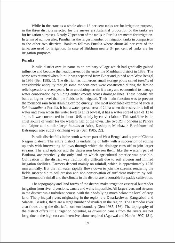
While in the state as a whole about 18 per cent tanks are for irrigation purpose,in the three districts selected for the survey a substantial proportion of the tanks arefor irrigation purposes. Nearly 70 per cent of the tanks in Purulia are meant for irrigation.In terms of number also, Purulia has the largest number of irrigation tanks in comparisonto the other two districts. Bankura follows Purulia where about 40 per cent of thetanks are used for irrigation. In case of Birbhum nearly 34 per cent of tanks are forirrigation purposes.
Purulia
Purulia district owe its name to an ordinary village which had gradually gainedinfluence and become the headquarters of the erstwhile Manbhum district in 1838. Thename was retained when Purulia was separated from Bihar and joined with West Bengalin 1956 (Sen 1985, 1). The district has numerous small storage pools called bandhs ofconsiderable antiquity though some modern ones were constructed during the faminerelief operations recent years. In an undulating terrain it is easy and economical to managewater conservation by building embankments across drainage lines. These bandhs arebuilt at higher level than the fields to be irrigated. Their main function was to preventthe monsoon rain from draining off too quickly. The most noticeable example of such isSahib bandha at Purulia. It has a water spread area of 24 ha when the reservoir is full ofwater and even when the water level is at its lowest, it has a water spread area of 12 to14 ha. It was constructed in about 1848 mainly by convict labour. This tank/lake is thechief source of water for the western half of the town. The two Rani bandha at Pandraand Jaipur and similar large bandhs at Adra, Kashipur, Manbazar, Barabhum andBalrampur also supply drinking water (Sen 1985, 22).
Purulia district falls in the south western part of West Bengal and is part of ChhotaNagpur plateau. The entire district is undulating or hilly with a succession of rollinguplands with intervening hollows through which the drainage runs off to join largerstreams. The arid uplands and the depression between them, like the western part ofBankura, are practically the only land on which agricultural practice was possible.Cultivation in the district was traditionally difficult due to soil erosion and limitedirrigation facilities. Farmers depend mainly on rainfall, which is approximately 1276mm annually. But the rainwater rapidly flows down to join the streams rendering thefields susceptible to soil erosion and non-conservation of sufficient moisture by soil.The amount of rainfall and the climate in the district are favourable for paddy cultivation.
The topography and land forms of the district make irrigation essential but renderirrigation from river diversions, canals and wells impossible. All large rivers and streamsin the district run a turbulent course, with their beds lying much below the level of cropland. The principal rivers originating in the region are Dwarkeshwar, Kangsabati andSilabati. Besides, there are a large number of rivulets in the region. The Damodar riveralso flows along the district’s northern boundary (Sen 1985, 156). The topography ofthe district offers little irrigation potential, as diversion canals from the rivers are notlong, due to the high cost and intensive labour required (Agarwal and Narain 1997, 181).
69
Besides, there is hardly any scope of deep or shallow tube well and river valley irrigationprojects. Hence, bandhs, tanks, reservoirs and jorbandhs were the only dependablesources of irrigation in the district for centuries. The topography and agriculturalconditions render the conservation of rainwater using embankments, built across thedrainage lines or streams at elevations higher than the fields to be irrigated, with apurpose to prevent the monsoon rain draining away rapidly and to supply water to thecrops in the land below by slow percolation (Sen, 1985).
The historical accounts show that the embankments, tanks and reservoirs wereconstructed both by the rulers and local zamindars. Almost every cultivated village inthe district has bandhs. In some cases, these embankments were constructed high acrossdeep valleys but usually raising low bandhs on one or more sides embanked any existingnatural depression; these bandhs were constructed wherever it was possible to catch acertain amount of surface drainage and at the same time to terrace a few rice fieldsbelow them. The early gazetteers noted that the local villagers regularly multiplied thenumber of embankments (bunds) and enlarged and deepened the existing ones. However,financial constraints marginalized the irrigable command area. In a few cases, as muchas 100 acres of land had been possibly irrigated from such a bandh (Sen 1985, 158).
A large number of tanks in the district were constructed during medieval andBritish periods. These tanks were in the form of reservoirs to provide irrigational facilitiesto the largest area of cultivable lands. Prior to the establishment of the TID in December1960, a large number of tanks in Purulia district were rendered derelict for want oftimely repairs or through neglect of their owners over long years (Sen 1985, 159). Therecan be four reasons behind this neglect: (i) increase in number of owners owing tofamily divisions, (ii) change in agricultural practices like use of the improved implementsbesides seeds, fertilizers and energized irrigation devices that require dependable supplyof water, (iii) growing disinterest of the owners in cultivation and (iv) the tenants had nosense of responsibility over the husbandry of the land. Traditionally zamindars, rajasand high caste landlords owned the tanks and bandhs. But with the passage of time theylost control over them or lost their ownership gradually, first due to abolition of zamindariand later on due to land reforms in West Bengal. The multiplicity of ownership due todivision in families has also adversely affected the tank irrigation in the districts. Thesharp decline in tank irrigation is owing to various reasons such as, disappearance of thelabour intensive traditional modes of fetching water from the tank, growing disinterestof traditional tank owners in agriculture owing to land reforms, increasing control of thetanks by non-owners, new power relations in society and increasing use of tanks forpisciculture at the cost of irrigation.
Spread over an area of 6259 sq. kms with a population of 25.35 lakh persons(Census 2001), Purulia district is at a low in almost all parameters of development inWest Bengal. One third of its population belongs to SC/ST category. The main source ofsustenance of people of Purulia is agriculture that faces all topographical odds adding topoor level of assured irrigation. On top of this, the average operational holding is very
70
low. As per the agricultural Census of 1995-96, the district’s average land holding ismerely 0.85 acres and nearly 92 per cent of land holdings are either small or marginal,covering 72.67 per cent of the area. The medium and large holdings are negligible innumber (GOWB 2002, 94-95). A number of rivers and rivulets in the district have beenill-fed by streams and naturally they remain dry through a greater part of the year. Assuch for improvement in irrigation facilities, reservoir and jorebund schemes were foundsuitable for the district during post Independence era because of its topography.
Rice is the principal crop of the district and three varieties aman, aus and boro29
are grown. Other cereals include wheat and maize. Rabi and kharif pulses are grown ina limited area. Nearly 93 per cent of total agricultural area was covered by paddycultivation (91 per cent aman, 2.29 per cent aus and 0.08 per cent boro) in the district in1968-69 (Sen 1985) and the recent data also shows that paddy was the only cerealcultivated in the district during 1997-98 and 2001-02 (GOWB 2002, 960). The cultivationof paddy depends on adequate water availability and conducive climatic conditions.The temperature of Purulia district (46ºC) is suitable for the paddy cultivation but due toundulating terrain, rain water runs off the fields very fast leaving them eroded and dry.Besides, shallow and deep tubewell irrigation is not feasible in the district due tonon-availability of adequate groundwater resources. The other minor irrigation projectsare also not feasible as the rivers and rivulets remain dry for most parts of the year. Thusthe embankments are the most suitable devices to contain water for irrigation duringerratic rains.
Declining Trend in Tank Irrigation
Tanks have been most crucial for irrigation in Purulia as compared to other districtsof West Bengal. The data reveals that tanks and bandhs account for majority of theirrigation in the district. Such bandhs are constructed practically in whichever placepossible to capture surface drainage and at the same time to terrace a few rice fieldsbelow them. The irrigation is normally affected by percolation. Only in exceptionalcases, a cut is made in the bandh or the water drawn off by a pipe or through someoutlets as is done when it is required to protect the seedlings or water paddy towards theend of the season. When land is first brought under cultivation, the cultivator naturallytackles first the land in lowest part of a slope. The bandh constructed is usually somewheredown the slope and consequently gets a large amount of surface runoff.
As cultivation extends, the lower bandhs are themselves converted into rice fields,except where they have been excavated deep, and the new bandhs constructed upstreamget proportionally less water and at the same time have to serve a large area. In the yearsof scanty rainfall or when the storage is poor in the tank, debuka or deuka is used to liftthe water for irrigation. Even the debuka is used to lift water to the surface structure and
29 In West Bengal, the three cropping seasons approximately coincide with the three meteorological seasons.The cropping seasons are kharif 1 (pre-monsoon), kharif II (monsoon) and rabi (dry and winter). Threerice varieties are grown in these different seasons—aus, aman, and boro respectively. Aman is the leadingrice crop, accounting for > 50% of the cropped area, followed by boro (25%) and aus (15%).
71
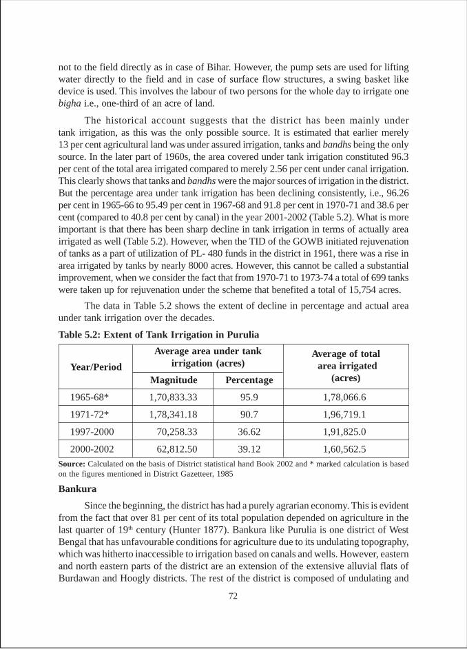
not to the field directly as in case of Bihar. However, the pump sets are used for liftingwater directly to the field and in case of surface flow structures, a swing basket likedevice is used. This involves the labour of two persons for the whole day to irrigate onebigha i.e., one-third of an acre of land.
The historical account suggests that the district has been mainly undertank irrigation, as this was the only possible source. It is estimated that earlier merely13 per cent agricultural land was under assured irrigation, tanks and bandhs being the onlysource. In the later part of 1960s, the area covered under tank irrigation constituted 96.3per cent of the total area irrigated compared to merely 2.56 per cent under canal irrigation.This clearly shows that tanks and bandhs were the major sources of irrigation in the district.But the percentage area under tank irrigation has been declining consistently, i.e., 96.26per cent in 1965-66 to 95.49 per cent in 1967-68 and 91.8 per cent in 1970-71 and 38.6 percent (compared to 40.8 per cent by canal) in the year 2001-2002 (Table 5.2). What is moreimportant is that there has been sharp decline in tank irrigation in terms of actually areairrigated as well (Table 5.2). However, when the TID of the GOWB initiated rejuvenationof tanks as a part of utilization of PL- 480 funds in the district in 1961, there was a rise inarea irrigated by tanks by nearly 8000 acres. However, this cannot be called a substantialimprovement, when we consider the fact that from 1970-71 to 1973-74 a total of 699 tankswere taken up for rejuvenation under the scheme that benefited a total of 15,754 acres.
The data in Table 5.2 shows the extent of decline in percentage and actual areaunder tank irrigation over the decades.
Bankura
Since the beginning, the district has had a purely agrarian economy. This is evidentfrom the fact that over 81 per cent of its total population depended on agriculture in thelast quarter of 19th century (Hunter 1877). Bankura like Purulia is one district of WestBengal that has unfavourable conditions for agriculture due to its undulating topography,which was hitherto inaccessible to irrigation based on canals and wells. However, easternand north eastern parts of the district are an extension of the extensive alluvial flats ofBurdawan and Hoogly districts. The rest of the district is composed of undulating and
Table 5.2: Extent of Tank Irrigation in Purulia
Year/PeriodMagnitude Percentage
1965-68* 1,70,833.33 95.9 1,78,066.6
1971-72* 1,78,341.18 90.7 1,96,719.1
1997-2000 70,258.33 36.62 1,91,825.0
2000-2002 62,812.50 39.12 1,60,562.5
Source: Calculated on the basis of District statistical hand Book 2002 and * marked calculation is basedon the figures mentioned in District Gazetteer, 1985
Average area under tankirrigation (acres)
Average of total area irrigated
(acres)
72
hilly terrain through which several natural streams originate and carry the drainage tolarger streams. Arid uplands and the depression between them were the only lands onwhich wet rice crop could be grown, if sufficient rains are available. The distribution ofrainfall in the district is favourable for agriculture when pre monsoon showers occur inMay or early June and heavy monsoon showers in June–July and again in September –October. If the rain failed in any of the above periods, people’s lives would be adverselyhit. The region had witnessed great famines as a fall-out of monsoon failure. O’ Malley(1908, 107) writes, “The district is liable to famine owing to… absence of completeirrigation works to counteract the effect of a failure of rains”. The most terrible famineoccurred in 1866 followed by that of 1874, 1885 and 1897, all due to failure of rains inrespective years in the district. Actually what compounded the problem in those timeswas absence of mechanisms for large-scale transport of food grains.
Western and southern parts of the district suffered severely from monsoonfailure, whereas, the extent to which its effects were felt in its north eastern portion wasnot serious (O’Malley 1908). The severity of the famines is reflected in following lines.“Thirty five poor wretches were dying daily of hunger and multitudes of desertedorphans were roaming the streets and subsisting on worms and snails” (Ibid :). Thetracts most liable to suffer from the famines were the western and north western parts(Gangajalighati, Sonamukhi, Chhatna, Raipur, Simalpal thanas and outpost) in the district.
It can be infered from the above illustration that the preservation of rainwater foragricultural use had been very crucial for survival of the people of Bankura for ages.Thus Bankura required irrigation everywhere except the east. On the other hand,Bankura’s natural configuration of undulating surface intersected by numerous riversand streams, makes holding of water easy enough by simply constructing embankmentacross the drainage lines or across small nallas. These embankments were made atlevels higher than the fields to be irrigated and their main use was to prevent the monsoonrain draining away rapidly and to supply water to the crops in the land below by slowpercolation. Digging tanks was regarded as sacred work for the kings (Hunter 1877,236) and canals were unknown to this part (O’Malley 1908).
So far as bandhs or tanks or any such structures for building reservoirs areconcerned, it has been stated that no village could be found without tanks in the district.It was common practice in Bankura to build embankments at suitable places to confinethe surface runoff and impound it in reservoirs known as bandhs. The then rulers (17th to19th century) resorted to excavation and renovation of tanks and khals for irrigation anddomestic uses in almost all parts of the district, even in eastern part 'O’ Malley describes“Bishnupur raj (comprising of present Bankura district) made a simple but effectivesystem of irrigation channels called shubhankari daura or khal, in the northern portionof Sonamukhi thana to counteract the vulnerability of that area to drought…. In thefamine of 1897 the daura was partially re-excavated.… several important tanks andbandhs were also constructed in Gangajalighati thana…the Kusthal bandh, Charuri tankand Vaishnava bandh were excavated at Saltora and much was done to improve the
73
sacred Shiva Ganga Tank at the foot of Biharinath hill, and also the Krishnapur andUdhampur bandhs. Other minor sources of irrigation are the Jamuna and Krishna bandhs,two artificial lakes of Bishnupur, which supply water to a fairly large area in the vicinityof the town” (O’Malley 1908, 98). The present condition of these bandhs will be discussedin latter section of the chapter. Bishnupur has an interesting history of Malla rajas. Thefounder of the dynasty rose from orphanage to the crown and took care of agricultureand defense of the kingdom by constructing big tanks (Mallik 1921, 3).
The district is endowed with three major rivers, namely, Damodar, Kangsabatiand Dwarkeshwar. These rivers discharge ample amount of water. It was estimated thatDamodar river discharged over 25 thousand cusecs in 1930s and 40s whereasDwarkeshwar discharged over 2 lakh acre-feet (Banerjee 1968, 32). These rivers carrygreater quantum of water during monsoon period than during the non-monsoon period.There are no natural lakes in the district. However, a few natural pools (asura panj-depression made by feet of demon) provide scope for irrigation. The district has a historyof bandhs/tanks of two kinds- embankments thrown across undulating valley from twoside bunds (excavation not required); and tanks and bandhs with excavation andembankments on all four sides, for multipurpose use including irrigation. The latercategory of bandh is of ‘considerable antiquity’.
By the end of 19th century, the British administration paid attention to re-excavation,erection and repair of khals and bandhs. British undertook construction of several tankslike the Mathgoda bandh and Shyamsundarpur bandh, and erected a dam across Harinmarikhal in Bishnupur sub-division for improvement of irrigation. It is important to note thatthe administration preferred to encourage investment by cultivators and zamindars forrepair and improvement of irrigation. This is evident from two following quotes. “Onthe present information it would appear that a channel made by the land ownersthemselves that are similar to pains, which existed in very large numbers in Gaya district,would be more suitable than a Government Canal’’ (reply of a question in BengalLegislative Council in March 1908 as quoted by 'O’Malley 1908). Mukhiya or mandalin Bankura villages were supposed to be authoritative informer about people, cattle andcrops; and he was not an employee of the zamindars. Fast silting of tanks requireddesilting and repair. The complete accounts of the exact area irrigated by the tanks arenot available for the periods of last two centuries. However, O’ Malley makes a mentionof ‘a considerable area’ under tank irrigation. It has been mentioned that almost all partsof the districts had tanks of one kind or other and were utilized for irrigation purposes.In the early part of 20th century the Tank Improvement Act 1931 was passed in WestBengal. Thus it is logical to infer that large areas fell under tank irrigation.
The British administration established a TID in 1940 for the purpose of desiltingthe old tanks (also bandhs) with a view to improve their irrigation potential. Between1940 and 1952 as many as 1,354 tanks were taken up for the purpose. In suchprojects, the cost of re-excavation was met partly by the beneficiaries and partly by thegovernment.
74
The government decided to bear 50 per cent of the cost and remaining 50 per centwas to be realized through water tax from the landowners for the lands benefited byirrigation, and also from the charges collected from leasing of the tank for pisciculture.Benefits were envisioned in: (i) increase in paddy production (ii) reclamation of wasteland(iii) increase in yield of winter crop (iv) pisciculture and (v) production ofvegetables. According to the officials, the TID, though exists now, has not taken upany new tasks during the past fifteen years. However, GOWB resorted to various minorand major irrigation schemes in the district. It is interesting to note that the areaunder tank irrigation was 67.6 per cent of total irrigated area in 1958-59 that reduced to59.44 per cent in 1962-63. Not only in percentage terms but also the aggregate areaunder tank irrigation also went down from 2 lac acres in 1956-59 to 1.79 lakh acresin 1962-63. The area under canal irrigation however increased from 28.7 per cent in1958-59 to 37 per cent during 1961-63 (Banerjee, 1968, 241). Things have changedconsiderably since then as in 2001-2002 tank irrigated area in the district was10.3 per cent, compared to 52.2 per cen area irrigated by canal and 24.9 per cent areairrigated by STWs (GOWB 2002).
The rights to access water from the tanks were open to all for all purposes. However,ghatwali tenures (O’Malley 1908, 115-16) were granted along the banks of these tanks(Bishnupur tanks) to the resident cultivators with martial traditions. These ‘reservoirs’supplied water for irrigation and were also used for drinking and fishing (until 1806when the properties were sold to Burdman king). The Malla raja had permitted thepeople of Bishnupur to enjoy unfettered rights of catching fish from these tanks onoccasions like marriages etc. According to settlement records, the Bishnupur bandhswere allowed to be freely used by the public for fetching drinking water, bathing and forother domestic purpose. No evidence is found to the effect that cultivators were chargedfor using water from the tank for irrigation. The whole district was originally the territoryof Bishnupur raja till 1806 (when the kingdom was sold to Burdwan raj) who allottedportions to subordinate chiefs for the protection. These chiefs held the aboriginal tribesunder their control. These tenants locally knew their descendents as rajas. It is notablethat the price rise of grains facilitated the use of surplus grains as payment in kind forworks of public utility and a large village would have good tanks and bathing ghats. Theagricultural classes who cultivated land with tank water were benefited by the highprices of food grains (O’ Malley 1908). Hence, tank maintenance became theresponsibility of tenants and cultivators.
Spread over an area of 16.94 lakh acres with a population of 31,92, 695 (Census2001), Bankura district has nearly 93 per cent of rural population, for whom agricultureis the main source of livelihood. Like adjoining districts of Purulia and Birbhum,agriculture in Bankura has faced hazards due to its unique unfavourable topography.The eastern and north eastern parts of the district resemble the hilly terrains of Puruliadistrict. The major sources of irrigation in the district are canals and tanks. Usually thedistrict is comprised mostly of marginal and small holdings. Around 66 per cent of totaloperational holdings and 34.8 per cent of the total land holding belong to marginalfarmers. At the same time, 21.9 per cent of the operational holdings and 32.5 per cent of
75
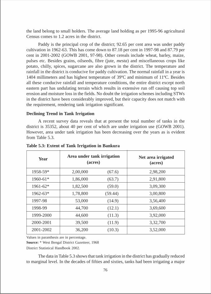
the land belong to small holders. The average land holding as per 1995-96 agriculturalCensus comes to 1.2 acres in the district.
Paddy is the principal crop of the district; 92.65 per cent area was under paddycultivation in 1962-63. This has come down to 87.18 per cent in 1997-98 and 87.79 percent in 2001-2002 (GOWB 2001, 97-98). Other cereals include wheat, barley, maize,pulses etc. Besides grains, oilseeds, fibre (jute, mesta) and miscellaneous crops likepotato, chilly, spices, sugarcane are also grown in the district. The temperature andrainfall in the district is conducive for paddy cultivation. The normal rainfall in a year is1404 millimeters and has highest temperature of 39ºC and minimum of 11ºC. Besidesall these conducive rainfall and temperature conditions, the entire district except northeastern part has undulating terrain which results in extensive run off causing top soilerosion and moisture loss in the fields. No doubt the irrigation schemes including STWsin the district have been considerably improved, but their capacity does not match withthe requirement, rendering tank irrigation significant.
Declining Trend in Tank Irrigation
A recent survey data reveals that at present the total number of tanks in thedistrict is 35352, about 40 per cent of which are under irrigation use (GOWB 2001).However, area under tank irrigation has been decreasing over the years as is evidentfrom Table 5.3.
The data in Table 5.3 shows that tank irrigation in the district has gradually reducedto marginal level. In the decades of fifties and sixties, tanks had been irrigating a major
Table 5.3: Extent of Tank Irrigation in Bankura
1958-59* 2,00,000 (67.6) 2,98,200
1960-61* 1,86,000 (63.7) 2,91,800
1961-62* 1,82,500 (59.0) 3,09,300
1962-63* 1,78,800 (59.44) 3,00,800
1997-98 53,000 (14.9) 3,56,400
1998-99 44,700 (12.1) 3,69,600
1999-2000 44,600 (11.3) 3,92,000
2000-2001 39,500 (11.9) 3,32,700
2001-2002 36,200 (10.3) 3,52,000
Values in paranthesis are in percentage.Source: * West Bengal District Gazetteer, 1968
District Statistical Handbook 2002.
Area under tank irrigation(acres)
Net area irrigated(acres)
Year
76
part of the agricultural land. Whereas in the 1990s, the percentage area under tankirrigation varied between 14.9 and 10.3. Not only in percentage term but also in aggregateterms, tank irrigation has declined. It came down from 53,000 acres in 1997-98 to 36,200 acres in 2001-02. The decline in the tank irrigation has been a recurring featuredespite a fairly large number of tanks desilted by the TID. The number of tanks improvedunder the provisions of Bengal Tank Improvement Act during 1956- 59 was 67 and thearea benefited was 2,896 acres. In the 1960s, a number of such schemes were taken upjointly by the TID and the department of fisheries. Tanks were departmentally selectedand their owners were given loan under certain conditions. The decline has been due toreasons such as, the neglect of tanks both by users and the government bodies andfarmers’ shifting interest towards tubewells of different types and densities. The STWhas already been covering a considerable area, and the irrigation under STW has beenrising year after year, from 43704 acres in 1997 to 87690 acres in 2001-2002. Besides,the expansion of Kangsabati canal irrigation project in the district has been anotherreason of decline of tank irrigation.
The most important reason for neglect of private tanks by owners is the multiplicityof ownership. Private tanks have large number of owners, ranging from 15 to 70, evenmaking just one ansha (share) of a paisa (64 paisas = one rupee = 100%). In suchsituations, the owners find it unattractive to invest in system improvement (samskar)measures. However in the case of fishery tanks, the owners still have interest in collectingtheir share of income, however paltry, and invest in protection of fish.
In case of tanks owned by panchayats, there are tank committees in the villages.Two office bearers of the committee maintain the accounts concerning the tanks. Thesecommittees handle mainly the pisciculture in the tank, and income generated from it isspent on community activities such as prayer, kirtan in temple or other such culturalactivities. The repair of the tank is done to the extent it is necessary for protection offish. Irrigation gets least priority; this is also a reason of decline of tank irrigation.
Birbhum
Birbhum extends over 4538 sq. kilometrs. The importance of the district is justifiedby three theories postulated about the origin of its name. It has three literary meanings,i.e., the land of braves (bir+bhum)), the land of jungles (as vir means jungle in Santali)and the land of Virmati (vigorous soil). The topography of the district is heterogeneous.The apex is situated at its northern extremity not far from south of the point where riverGanga and hill of Santhal Pargana begins to diverge. Almost in the entire district, theterrain is intercepted by a succession of undulations, the general trend of which is fromnorth west to south west. To the south east upland ridges are less pronounced. Due tothis, the valleys become narrower and gradually merge into the broad alluvial plains ofGangetic delta. The larger ridges are covered with thick but stunted sal (teak) forest andonly the bottom of the valley is being cultivated.
As the lands become less steep, paddy is grown in terraces up the sides and onlythe board flat and usually dry summits are left untilled, forming the rain scantly pasture
77
grounds. As a whole, the rapidity with which hills changes to ridges, ridges toundulations and undulations to plains varies considerably. The western portions of theMayureswar and Suri thanas are covered with high ridges extending to the southeast.The hollows between the ridges form natural drainage channels, which in widervalleys are streams of considerable size and in a few cases expand into wide rivers.Since the medieval times (13th century), the district was ruled by Mohaummadans,which in the 16th century was brought under Mughal rule. After Maratha invasion, thedistrict came under zamindari of Asad-ulla-khan in 18th century. After the famines of18th century, the British administration took over the rule. The important tribes andcastes of the district are bagdi, muchis, doms, bauris, tari, mals (all SCs), sadgops(OBCs), brahmins (HCs), and bantals (ST). Brahmins were the zamindar, tenure holders,occupancy ryots, pleaders, muharirs, money lenders and government servants.Besides, brahmins and sadgops were also good cultivators, owned landed property andsome had government service, commonly titled as mandal. Landlords’ servants weregumashtas who looked after the accounts and management of the land and weresupervised by a naib (O’Malley 1910a).
As in the case of other parts of southwest Bengal, Birbhum district for most part,has porous soil and rapid drainage. This makes irrigation a necessity in years of scantyrainfall, particularly for paddy and cultivation in terraced slopes. The cultivators dividetheir field into numerous little plots and enclose each one by a bund, which retains thewater. Each plot thus becomes a reservoir and lower fields can be irrigated by letting thewater into them from a higher level during sufficient rains.
Tanks have been the most useful source from which the fields have been irrigatedfor centuries. Several of these tanks are old and large in size. Besides, smaller tanks arenumerous in the district. It was estimated that each village had at least five tanks on anaverage. O’ Malley (1910a, 60) writes, “In the village of Sankarpur, for instance, thereare 111 tanks occupying 167 acres and 46 are too close to each other that only footpathson the top of the banks separate one from another. Owing, however, to the neglect ofZamindar (many of them absentees) and the capacity….of the population at large, manyof the irrigation tanks have silted up and become useless, some of them have become sodry that they are let out for cultivation”.
When the tanks are full, water is let into the fields through a cut in their banks;when the water level is low, cultivators have to lift water by several means. Earlier, thecultivators used traditional devices such as cheni or swing basket or an instrument calleddhuni. Irrigation by teura, a kind of Grecian lever, was also common. The ‘do’ fields(a category of land) were largely irrigated by teura. The crops which were irrigated byteura are sugarcane, oil seeds, flax and vegetables.
Survey Findings
Looking at the age of tanks (Table W-1), based on data from the surveyed tanks,it is found that more than 77 per cent tanks are either ancient/medieval or from theBritish times, while about 23 per cent of them have come into existence during the post
78
Independence period. Further, about 10 per cent of them were laid after the 1990s.However, one major difference amongst districts is that while about 20 per cent of tanksin Bankura are of ancient origin, in the other two districts none of the tanks are ancient.The main reason why Bankura contains such tanks as seen in Bishampur, Taldangra,Jaypur and Indpur is that the tradition of irrigation is very ancient here. Contrary to this,in Purulia, about 74 per cent of the tanks belonged to the British period. Another 26 percent tanks were constructed after Independence, which included about 16 per cent, thatwere constructed after 1990. The main reason of a spurt in interest in tanks is the district’speculiar geo-hydrology, which makes well irrigation infeasible. Another limitation inPurulia is the absence of any major canal-based irrigation system. The situation is notmuch different in case of Birbhum and 100 per cent of the tanks surveyed in the districtbelonged to British period.
As regard the ownership of the surveyed tanks in three districts (Table W-2), it isfound that about 65 per cent of the tanks are private, 29 per cent panchayat and 6 percent government. Among the private tanks, about 42 per cent are with limited ownershipwhile 23 per cent are of multiple ownership30. Among the panchayat tanks, it is foundthat such tanks in all the three districts were earlier under private ownership, includingthat of zamindars, but now belong to government.
Fisheries or minor irrigation departments own government tanks. The nature ofownership over the private tanks in the district is multifaceted such as; (i) private tanksunder TID working under District Magistrate; (ii) private tank with induced share ofwhole of panchayats; (iii) tanks currently under panchayat ownership; (iv) private tankswith multiple ownership. Most of the tanks are still privately owned and some oldzamindari tanks are now under the control of the panchayat. It is also interesting to notethat certain private tanks are virtually controlled by members of the lower castes (SC-bauri). The reason behind such a situation is the land reform measures and power transferfrom landed upper castes to the middle castes or landless lower castes. A majority oftanks fall in the category of tanks previously owned by zamindars and now with thepanchayats. Further, over 50 per cent private tanks were found to be having multipleownership viz., 15 to 30 families owning one tank, each possessing smaller ‘anshas’.These anshas (shares) have been tradable, resulting in a rise in the number of shareholders.There is no evidence of exclusive rights over the tank water by anyone. However, theowners engaged in pisciculture or the fish contractors restrict use of tank water in orderto protect the fish population.
The irrigation rights over the ponds were different from tank ownership rights.The land-revenue department and the panchayat held what is called sech (irrigation)records. These records, reportedly in existence from the British period, record the plotnumbers on the cadastral map of land that can legally receive irrigation from a pond.The irrigation rights had been assigned only for those ponds that were found to have
30 Any tank with 7 or less owners has been treated as private tank with limited ownership, while tanks withmore than 7 owners have been treated as private tanks with multiple ownership.
79
sufficient water for irrigation. The plots mentioned in the irrigation records, irrespectiveof whether the owners of these plots owned a share in the pond or not, had a legal rightto irrigation water from these ponds. However, this delineation of irrigation rights fromtank ownership rights was only partial. The sech records refer to only the kharif andrabi crops. As boro cultivation was not prevalent at the time when the irrigation potentialof the ponds was assessed and because very little water remained even in relatively bigponds by the summer, the sech records mentioned provision of irrigation only for thekharif and rabi crops and not for boro cultivation (Rawal 1999, 134)
As regards access to water (Table W-3), about 77 per cent of tanks are accessibleto all, and in the remaining 23 per cent tanks, access is confined to owners. The secondcategory of tanks is same as those in which ownership is confined to limited number offamilies. The district wise pattern shows that in Bankura, access is open to all in all thetanks. In Purulia, 68 per cent tanks are open to all, while 32 per cent are accessible to theowners only. In Birbhum, 50 per cent tanks are open to all while in rest 50 per cent areopen to owners only.
Rawal (1999, 133) reports that ponds were used for many purposes: irrigation,cultivation of fish, bathing, washing and cleaning. Access to ponds for irrigation wasgoverned by sets of rules. Ponds were owned both individually and collectively. Therewere well-established norms for holding of shares (anshas) in a pond. Shares of pondscould be traded, and the price was determined primarily by the area equivalent of theshare. As ponds were of different sizes, the worth of a share in different ponds (say onehundredth of a pond) was different.
Looking at the size of tanks (Table W-4) in three districts together, it can be seenthat nearly half of the tanks (48.5 per cent) have size below 2.5 acres. This very clearlyshows that majority of the tanks are of very small size. Tanks with size ranging from2.5 acres to 10 acres constitute 29 per cent. About 13 per cent of the tanks are in the sizerange of 21-50 acres. However, there is a lot of variation in the average size of tanks indifferent districts. In Bankura, it is 27.4 acres, followed by 19.4 acres in Birbhum andthen 3.9 acres in Purulia.
Among the districts, the average area irrigated per tank is same in Birbhum(55 acres) (Table W-5), and Bankura, (54 acres). In case of Purulia, a tank irrigates onlyabout 5 acres, which is mainly because nearly 90 per cent of the tanks here are verysmall. Comparing the ratio of irrigated area per acre of tank area, it is found that it ishighest in Bankura where one acre of tank area irrigated 3.6 acres, followed by Birbhumwhere this ratio is 2.8 acre. The ratio is lowest in case of Purulia where it is 1.2 acre.
In Tables W-6 and W-7 modes of irrigation in relation to three cropping seasonsare examined. It is found that maximum area is irrigated during kharif (56.2 per cent),followed by rabi (40.1 per cent) and minimum in summer (3.7 per cent). It is also foundthat during kharif, gravity irrigation constitutes 85.4 per cent of the irrigated area, followedby pumps, which irrigates 13.2 per cent area. Only 1.4 per cent of the area is irrigated bymanual means during kharif. During rabi, on the other hand, about 53 per cent of the
80

irrigated area is covered by pumps, about 44 per cent of the area by gravity flow andabout 3 per cent by manual means. During summer, very little area is irrigated andpumps do all of it. The pre-eminence of flow irrigation is again discernable when welook at the gross irrigated area (Table W-7). It is found that about 67 per cent of the GIAcomes from gravity irrigation, 31 per cent from pump irrigation and 2 per cent frommanual irrigation. By and large this broad pattern is applicable to all the three districts.Bankura depends on manul irrigation the most, with 35 per cent of GIA covered by it.Purulia follows it with 21 per cent and Birbhum with 15 per cent.
Area irrigated by tanks varies from one mode to another, one season toanother and one type of topography to another. In earlier days, water was taken out ofthe tank through surface flow modes. However, when the water of tank is either low ortank is situated on a low land, the water was taken out with the help of manuallyoperated mechanisms or energized pump sets. Sometimes, it happens that the bund isextremely high and in such cases water is taken out with the help of siphon pipe to thesurface flow structures. After proliferation of diesel engines, most of the farmersresort to lifting water from the tank with these pumps. In some cases, the electric pumpsare also hired-in.
The water market in the tank-irrigated area is of three kinds:
1. Hiring in of diesel pumps or electric pumps on the basis of hours or areairrigated. The rate is almost similar throughout the districts i.e., Rs 50-60 per houror per bigha that amounts to Rs. 120 per acre. The rates vary in accordance withthe capacity of the machines as well as availability and price of diesel during thepeak period. In case the user supplies fuel of the pump, the rental rate for the machineis Rs. 20/- per hour.
2. In tanks having higher embankment than the water level and agricultural field,siphon pipes are used to take water out from tank to distribution system. Not everyfarmer owns a siphone pipe. Hence, theses siphon pipes are hired-in at the rateRs.6/- per bigha.
3. The other option is to hire-in the panchayat pumps by bearing the cost of fuel whichamounts to Rs. 30 for a bigha, or Rs. 90 per acre. Such pumpsets in the district arevery few in number. Since they have to serve a large number of farmers, the farmershave to resort to renting in pumps from private parties.
Manual irrigation is still practiced in the district. In the very big tanks nearBishnupur town (Bankura district), it is found that these tanks are now mainly in domesticuse and whatever irrigation takes place, it is done with canals or manual means. Dungi(karing type of mode being used in Bihar) is the most common traditional irrigationdevice. In the winter season, the dungi is used to fetch water from the tanks and intofield channels. A hole fitted with hume pipe in the bunds makes the outlet. Using thedungi, an adult can irrigate nearly one-sixth of an acre in a day.
81
Irrigation from ponds is by means of gravity when the water level in the pond ishigher than the field level and by means of water lifting when it is the other way round.Simli is the simplest lifting device and is relatively inexpensive. It is a triangular metaltray tied with ropes on both the sides. The ropes are held by two persons, one on eitherside and pulled and released successively to throw water. The most commonly usedlifting device, however, is a dungi, which is a longitudinal vessel about 10-15 feet long,mounted on a pivot with a counterweight. A person who stands on any one side (eitherin the pond or outside) operates it manually and pushes it up and down to lift water.Though on the whole simli is more labour intensive (relative to the amount of irrigationit provides), it requires less force in each cycle to lift water. Women and children oftenoperate them. A dungi, on the other hand, is heavy and lifts large amounts of water ineach cycle and is usually operated by a man. In 1995, the price of a dungi was betweenRs. 600 and Rs. 1000, depending on the size (Rawal 1999, 134-135).
The bandhs that are built along the downside of a slope easily supply water to thefields through the surface flow structures but only when the sufficient water isavailable in the tank. In case of shortage of water, the water has to be lifted to the levelof surface flow structures to irrigate the fields through manual device or energizedwater lifting devices.
In Baghudih of Purulia block and Nawagarh and Barua Kocha of Jhalda block,there were very few pumping sets and no water markets of any significance were found.Two pumping sets were found in Baghudih whereas no pump was found in hamlets ofJhalda I blocks. However, the rates of pumping sets were same as that found elsewherein the state; varying from Rs. 120 to 180 /hour/acre for diesel operated pumps. Therewas no renting of debuka and the needy farmers themselves made them.
It was noticed that a large area in the reservoir of Jamuna bandh (Bishnupore)was encroached upon by farmers for vegetable cultivation as the bandh got silted up.About 30 acres of land was cultivated in rabi and summer seasons. Jamuna bandh hadthree outlets serving the fields of Gopalpur and Tejpal villages. One outlet with a humepipe of 6’’ diameter towards east of the tank was constructed by farmers of Tejpal villagein the year 2000 irrigate about 4 acres of land owned by nearly 25 farmers. Lal bandh,another big tank in Bishnupur irrigated the area falling in two sides of the tank. Nearly6-7 acres of land in western embankment falling in Tilbari village, coming mostly underurban settlement, was irrigated by the tank water. The water for irrigation from the tankwas taken out through dungi and passed through a hume pipe outlet fitted across thebandh. All the land belonged to a brahmin landlord of Bishnupore, but five scheduledcaste farmers were found to be doing sharecropping in this land.
If pressure on tank water for irrigation is examined (Table W-8) a great deal ofvariations can be seen across districts. Although the average for three districts comes toabout 6 irrigators per acre of tank area, in Bankura, the pressure is maximum as about12 irrigators depend on one acre of tank area. On the other extreme is Birbhum whereabout 2 acres of tank area is available to each irrigator. In between comes Purulia wherethe dependence on tank irrigation is 3 irrigators per acre of tank area.
82
In Table W-9 a, b and c, the depth of storage of water in the tank during rainyseason, winter season and summer season are shown. As is expected, in all the districtsthe depth of water storage level in the tank goes on reducing from rainy season throughthe winter, till the end of summer. It goes down to such an extent that about 20 per centof the tanks get dried up during winter season and about 55 per cent get dried up duringsummer. The main reason for such a high proportion of tanks getting dried up orwater level coming down below 3 feet is that an overwhelming proportion of tanks(77 per cent) in the three districts depend exclusively on rains and another 13 per centdepend on rains and canal water (Table W-10). Among the districts, 95 per cent ofPurulia tanks depend on rainwater. The high dependence of Purulia tanks on rains isreflected by the fact that 63 per cent of the surveyed tanks in the district dries up duringsummer, which is the highest figure among the three districts.
Tables W-11, W-12 and W-13 provide data on repair and maintenance of tanks. InTable W-11, the category “Others” refer to maintenance by occupants, fish contractorsetc. Owners seem to be responsible for maintaining 58 per cent of the tanks in WestBengal and the proportion goes up to 84 per cent in Purulia district. The second mostimportant category of tanks are those in which the responsibility for maintenance lieswith panchayat/community and this accounts for 29 per cent of the tanks. Lastly, thereare about 6 per cent of the tanks for which the maintenance responsibilities lie eitherwith the state government or with such persons who occupy the tanks or the fishcontractors who have a vested interest in maintaining them.
In respect of maintenance, two main activities, i.e., the repair of embankmentsand desilting have been examined (Table W-13). Lack of maintenance is reflected bythe fact that in 58 per cent of cases, embankments have never been repaired. This figuregoes as high as 69 per cent in the case of Purulia, followed by 50 per cent in case ofBirbhum and 40 per cent in case of Bankura. However, when we examine the dataconcerning desilting, it is found that in a much higher proportion of tanks (65 per cent),desilting was never done. The proportion varies between 100 per cent in case of Birbhum,and 60 and 63 per cent respectively in case of Bankura and Purulia. In tanks whichundergo some repair of embankments or desilting, the frequency seems to be more infavour of repair of embankments than desilting. It is found that while about 19 per centof tanks in West Bengal undergo annual repair of embankments, none of the tanks undergodesilting on an annual basis. In the case of 19 per cent of the tanks for which desilting isdone, the period varied between 2 and 10 years. Again while in 16 per cent of the cases,repair of embankment is done between 2 and 10 years, the frequency of desilting is oncein 11 to 30 years. This indicates that generally there is a time lag of 10 years betweenrepair of embankment and the desilting of the tank.
The next important (Table W-13) issue is who incurs the expenses formaintenance. It is found that most of the tanks fall in a category in which no one spendsany money, leading to their deterioration and declining irrigation performance. In thecase of 26 per cent of the tanks, money is spent by the panchayats towards maintenance
83
and community contribution is also found to be forthcoming in the form of physicallabour. In 10 per cent of the cases, the state government provides the funds and inanother 10 per cent of cases both the state government and the panchayat provide thefunds. All this indicates that in about 46 per cent of the cases, funds are coming fromeither the state government or local government or both. In the rest 22 per cent cases,occupants or those who benefit from the tanks, particularly through fisheries, providethe funds for the repair and maintenance.
In case of private tanks, the responsibility of maintenance was of owners in thefirst few decades post Independence. When the zamindari tanks were turned over to thepanchayats after 1960s, the responsibility of maintenance came down to the panchayats.In our study areas, mainly three kinds of tasks were undertaken. First was the repair ofthe embankments. This was done in the following three ways: a) minor repairs in orderto protect fish, almost taking place annually. The responsibility of such repairs went toeither owners engaged in pisciculture or by the fish contractors, b) the panchayat bodyfrom time to time did some repair work out of development schemes and c) the TIDundertook the repair of selected tanks for multipurpose use. Such repairs (category band c) had taken place only once in the past 20 to 30 years. In 2004-05, cement lining ofthe tank was done by the panchayat samiti (block level panchayat body) in Manjhipukur of Lagda village. But this did not serve any purpose.
The second was desilting and enlargement of tank beds. This took place in a fewcases through panchayat or development funds. No community action was seen in Puruliadistrict for renovation (sonskar in local dialect).
The third was clearing of grass etc., which has taken place in only two tanks outof 18. By and large the same position is applicable in respect of two other districts also.
In the case of Purulia district, the maintenance of such tanks was very poor. Astudy conducted by an NGO named PRADAN in 1996 revealed that though the tankcatchments in Midnapore district received good rainfall, only one sixth of the runoffflowing into the tanks could be harnessed. The poor harvesting of water was due to poormaintenance of tanks. Poor maintenance was because of the multiplicity of ownership,poverty and mono cropping in the commands. PRADAN has undertaken a microwatershed programme in Jhalda area. The programme selects tanks and encourageslocal people to be involved in their maintenance. Besides, the land in the upper reach istreated and for better harvesting of water, ‘seepage tanks’ are created at the lower end ofthe slopes. Several small tanks are also being dug in the operation area named as5 per cent model (a tank having a water spread area equal to 5 per cent of the agriculturalplot that it serves) is dug at the upper reach of the plot with a storage depth of 5 to 6 feet.PRADAN has planned to create 600 to 700 such tanks and also seepage tanks with theinvolvement of the local people in Nawagarh village in Jhalda.
Some private tanks in Jhalda area were however found to have attractedconsiderable investments from government for renovation of tanks. For instance,
84
the capacity of Dubrajsingh’s tank in Nawagarh was enhanced with an investment ofRs. 50,000 by the panchayat. This irrigated 8 acres of land owned by the tank owners.Dubrajsingh happened to be a member of Jhaldadarda panchayat who got the fundsthrough his personal efforts made at the panchayat. Similar cases could be found inBarua Kocha under Beladih panchayat of Jhalda I block.
In Bankura district also, tanks were victim of gross neglect by the government aswell as the public. Majority of the tanks in the district were not renovated sinceIndependence. Of the eleven tanks surveyed, only one was found to have been repairedalmost annually, but was done for protection of fish. Moira bandh in Bishunpursubdivision had undergone lining of the banks, which was undertaken by the TID around1985. Cement lining was done in Devil Beria in Tal Dangra block around 1995, but wasdone to help fishing, and hence did not help irrigation. In the same block, capacityenhancement of Lal bandh tank took place in the year 2000, with Rs. 6 lakh spent fromMPLADS31 for desilting. Then there is Chand bandh, which was first deepened in1978, and thereafter desilting of part of the tank was done in year 2003 with an expenditureof Rs. 1.5 lakh from panchayat.
Dharampur tank was also renovated in 1977-78. However, despite farmers’persistent efforts, no substantial renovation work took place. Nevertheless, the fishingcommittee invested between Rs. 500 to 1000 every year in order to protect the fish .Thesize of the great Jamuna bandh in Bishnupur had been reducing day by day. The localpeople had shown great concern for its renovation for various purposes such as irrigation,fishing, tourism, lotus cultivation and boating etc. There is committee named JamunaBandh Bachao Committee, which had even written to the President of India for preservingthis great tank.32
No community action was found in any of the villages for renovation of tanks andthe government had also not paid adequate attention to the tanks in Bankura district.Thewater right for irrigation was not restricted and the practice of restricting the right to usewater for irrigation etc., for pisciculture was not exercised here. However, the villagersof Lal bandh voluntarily restricted themselves from taking water from the tank whenthe storage level came down to 4 - 5 feet in order to protect the fish.
Tables W-14 and W-15 deal with the tank uses. Although both the tables deal withsame set of categories, the main difference is that while Table W-14 deals with tankssurveyed by us, Table W-15 furnishes data on all the tanks that existed in the villages/hamlets where tank survey was undertaken. Consequently, while Table W-14 contains
31 Member of Parliament Local Area Development Scheme (MPLADS) is a scheme formulated byGovernment of India and initiated in December 1993 that provides that each member of the Indian parliamenthas the choice to suggest to the Head of the District works to the tune of Rs.1 crore per year, to be taken upin his/her constituency. Elected Members of Rajya Sabha representing the whole of the State as they do,may select works for implementation in one or more district(s) as they may choose. Nominated Members ofthe Lok Sabha and Rajya Sabha may also select works for implementation in one or more districts, anywherein the country. The allocation per MP per year stands increased to Rs.2 crores from the year 1998-1999.32 One Mr. Somendranath Basu, the secretary of the committee informed the authors that the unregisteredcommittee was making efforts to save Jamuna Bandh since 1995.
85
data for 31 tanks, Table W-15 contains data for 88 tanks. Among the surveyed tanks,about 65 per cent were multipurpose tanks, followed by 19 per cent used for domesticpurpose, 10 per cent for pisciculture and 6 per cent for irrigation purpose alone. InBirbhum, all the tanks were multi purpose in nature while in Bankura such tanksconstituted 90 per cent. In Purulia only 48 per cent were multi purpose tanks and alarge proportion of tanks (32 per cent) were used for only domestic purposes. At thevillage level (Table W-15), it is found that as high as 44 per cent of the tanks wereabandoned. If we exclude this category and consider only those tanks that are in use,about 63 per cent of them are of multi purpose nature, followed by 20 per cent fordomestic, 12 per cent for pisciculture and only 4 per cent for agriculture.
Table W-16 deals with pisciculture aspect of the tanks. The valuation of fishingactivities in the tank could be done only in 12 out of 31 tanks surveyed in West Bengal.As a matter of fact, there were 11 such tanks where fishing was being practiced but theannual income could not be ascertained33. Based on the data on 12 tanks, the total valueaccruing from fisheries was estimated to be Rs. 3.11 lakh, annually which comes toRs. 259 lakh per tank. The annual value of fish production per acre of tank area wasestimated to be Rs. 2,806, with Rs. 4,882 for Purulia and Rs. 2,187 for Bankura.Considering the fact, that pisciculture is more popular in West Bengal compared toBihar and Jharkhand, such a low productivity of pisciculture in West Bengal isinexplicable.
Tables W-17 and W-18 provide data on the surveyed villages/hamlets. In TableW-17 on the left side are the data on the number of households of various caste categories,and on the right side are the data on the land owned by these caste categories. Lookingat the overall data, it is seen that 29 per cent of HCs own 41 per cent of the village land.The OBCs, which constitute 15 per cent of the households, own about 21 per cent of theland. As regards the SCs, they constitute about 43 per cent of the households but ownonly 23 per cent of the village land. In case of STs, it is found that the surveyed villageshave 14 per cent ST households, but own 15 per cent of land. The data do not speak veryfavourably about land reforms. It seems “Operation Bargha”, which literally meant“operation sharecroppers”, did benefit the OBCs, but SCs, who were to a large extentlandless agricultural labourers, were naturally left out. The middle castes/OBCs werethe sharecroppers, and hence benefited the same way they were benefited in Bihar andUttar Pradesh.
If we look at the average land holding (Table W-18) of different caste groups, wefind empirical evidences to our contention in the preceding paragraph. It clearly showsOBCs are the ones having the largest land holdings, averaging at 1.2 acre per household,followed by HCs (1.16), and then the ST (0.89). The SCs are found to have a lower landholding, averaging at 0.43 acres per household, which is just one third of the size of theholdings of OBCs.33 The reason was either of the following: i) the fish catch was divided among large number of families, sometimes as many as 70, or the entire village; and ii) the fish was consumed only by the owners/local people withthe permission of 16 anna committees. In some other tanks, the entire village was allowed to fish.
86
CHAPTER VI
ORISSA
The western part of Orissa has the most favourable physical environment for tankirrigation. In a way it is continuation of eastern plateau extending across Jharkhand,West Bengal, Madhya Pradesh and Orissa. Located between Chattisgarh plains in thewest and Mahanadi delta in the east; and between Orissa high lands in the north and theEastern Ghats in the south, western Orissa was relatively isolated till the early part ofthe 20th century. Fertile plains appearing between the undulating landscapes arecrisscrossed by a number of semi-perennial rivers. Monsoons bring plentiful rains inwestern Orissa. Annual average rainfall in this tract is between 1000mm and 1200mm.The monsoon runoff quickly drains away due to undulating terrain. Indigenous earthentanks are most appropriate for retaining surface water for use in the dry season. Thereforeit is no surprise that every village in western Orissa has a network of tanks. While someof these tanks can be traced to ancient times, others are no more than 50 to 80 years old,constructed by prosperous land owners.
Irrespective of their age, even today tanks are the most reliable source of water inwestern Orissa for human beings and cattle in the summer months. Further, on accountof the ingenuity in design and location, they continue to serve as a sustainable source ofprotective irrigation for the crops. However, the usefulness of these tanks is severelyrestricted by age and lack of maintenance. Their maintenance severely suffered after theownership was vested with the government, including the panchayats. As a result, tankswith broken bunds and silted beds stored much less water and irrigate far less area eachyear as compared to that in the past (Sengupta 2000, 4695-96).
The importance of tank irrigation in Orissa in the past can be visualized by thefact that nearly three decades ago (1971-72) tanks accounted for about 51 per cent of thenet irrigated area (Table-2.3). However, within a span of five years (1976-77), it fell bynearly half, as tanks irrigated about 26 per cent area. In the subsequent years, there is afurther lowering of the net irrigated area by tanks so much so that the area fell down to14.6 per cent in 1999-2000 and to 7.70 per cent by year 2002-2003.
Prior to Independence there were a number of zamindaries and feudal states inOrissa. In the early 18th century when the British and Marathas were fighting fordominance, gond, kondh and pinjhal tribal chieftains held most of the zamindaries.
87
Tribal village headmen called gountias held villages on the basis of inheritance. Theyconstructed tanks for irrigation purpose. The story on the origin of technology of tankconstruction has many versions. It is popularly narrated that kulthos kultas who migratedto the area around the later half of the 18th century were expert tank diggers and broughtwith them the unique art and designs of tank building. This position is however contestedon account of existence of ancient reservoirs and the living memory of the binjhals,kondhs and gonds. They believe that their ancestors had evolved the design of tanksbased on the topography of the land (Sengupta 2000, 4700).
It should be noted that gountias or the village headman played a very importantrole in the construction and maintenance of the tanks in Orissa. “During Maratha rule, asystem of auctioning villages or giving them out to favourites after deposition of longestablished headmen became rather wide spread. It was during the latter years of Maratharule that the village headman began to be displaced by the lessee or the ‘thekedar’.Practically everywhere, the headman became responsible for the payment of land revenueof the entire village to the state” (O’ Malley 1909). It is to be further noted that duringthe renewal of the lease, a large fee called ‘nazrana’ was charged and the gountia had topay the nazrana out of this profits. Between 1850 and 1870, a large number of villageshad been alienated from the tribal gountia due to their inability to contribute for thenazrana. Thus, the changes in the ‘gountiahi’ system accompanied by high revenuedemands laid the foundation of intensive agriculture. This was followed by proliferationof tank construction activity. This was so because, when a village was leased out to agountia, he was required to execute an agreement to construct tanks for the agriculturalprosperity of the village. British administration recognized that construction of tanksfollowed improvement in agricultural production. As a reward, the gountia was granteda protected status by the British administration, which meant that he would not be evictedarbitrarily from his village (Sengupta 2000, 4696-97).
Selected Districts for the Survey
Based on discussions with the officials of irrigation department, academiciansand other knowledgeable persons, we selected districts of Sambalpur, Bolangir andKalahandi for the survey. While Kalahandi and Bolangir (erstwhile Patna Estate)constituted part of feudatory estates, Sambalpur was a part of the erstwhile Gondwanakingdom. The feudatory states provided the natural features of the country that lendsitself to irrigation, and hills on the southern border formed a natural watershed fromwhich many small streams find their way to Mahanadi river. The land covered by thefeudatory states provided great prospects for the construction of tanks (Cobden-Ramsay1982, 193). As regard Sambalpur, the tract revealed the striking features of gondsettlements where the land was abundantly cultivated and the fields were appropriatelyterraced and irrigated. The reservoirs also displayed remarkable ingenious engineeringskills. The village chief was legally bound to build reservoirs and repair the old ones.Enterprising village chiefs were granted protected status. Rent free service land wasgiven to skilled workers in return for the work of reservoir maintenance. The lakha bata
88
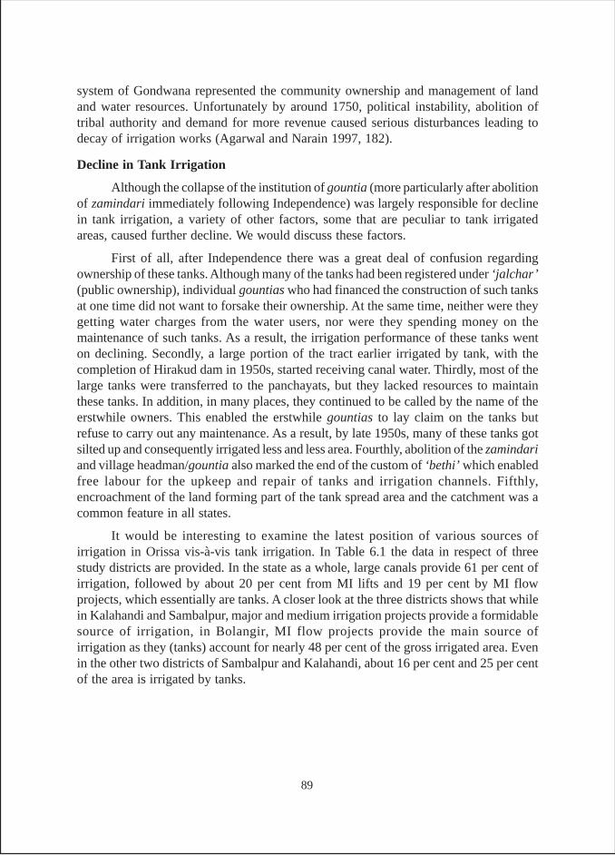
system of Gondwana represented the community ownership and management of landand water resources. Unfortunately by around 1750, political instability, abolition oftribal authority and demand for more revenue caused serious disturbances leading todecay of irrigation works (Agarwal and Narain 1997, 182).
Decline in Tank Irrigation
Although the collapse of the institution of gountia (more particularly after abolitionof zamindari immediately following Independence) was largely responsible for declinein tank irrigation, a variety of other factors, some that are peculiar to tank irrigatedareas, caused further decline. We would discuss these factors.
First of all, after Independence there was a great deal of confusion regardingownership of these tanks. Although many of the tanks had been registered under ‘jalchar’(public ownership), individual gountias who had financed the construction of such tanksat one time did not want to forsake their ownership. At the same time, neither were theygetting water charges from the water users, nor were they spending money on themaintenance of such tanks. As a result, the irrigation performance of these tanks wenton declining. Secondly, a large portion of the tract earlier irrigated by tank, with thecompletion of Hirakud dam in 1950s, started receiving canal water. Thirdly, most of thelarge tanks were transferred to the panchayats, but they lacked resources to maintainthese tanks. In addition, in many places, they continued to be called by the name of theerstwhile owners. This enabled the erstwhile gountias to lay claim on the tanks butrefuse to carry out any maintenance. As a result, by late 1950s, many of these tanks gotsilted up and consequently irrigated less and less area. Fourthly, abolition of the zamindariand village headman/gountia also marked the end of the custom of ‘bethi’ which enabledfree labour for the upkeep and repair of tanks and irrigation channels. Fifthly,encroachment of the land forming part of the tank spread area and the catchment was acommon feature in all states.
It would be interesting to examine the latest position of various sources ofirrigation in Orissa vis-à-vis tank irrigation. In Table 6.1 the data in respect of threestudy districts are provided. In the state as a whole, large canals provide 61 per cent ofirrigation, followed by about 20 per cent from MI lifts and 19 per cent by MI flowprojects, which essentially are tanks. A closer look at the three districts shows that whilein Kalahandi and Sambalpur, major and medium irrigation projects provide a formidablesource of irrigation, in Bolangir, MI flow projects provide the main source ofirrigation as they (tanks) account for nearly 48 per cent of the gross irrigated area. Evenin the other two districts of Sambalpur and Kalahandi, about 16 per cent and 25 per centof the area is irrigated by tanks.
89
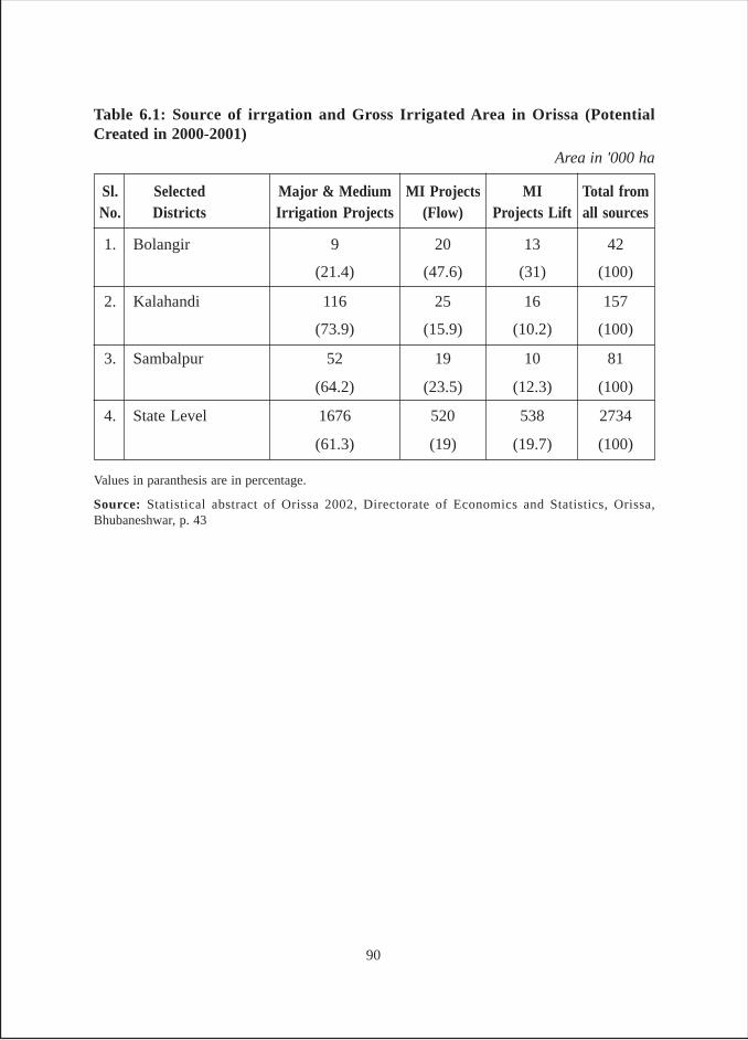
Values in paranthesis are in percentage.
Source: Statistical abstract of Orissa 2002, Directorate of Economics and Statistics, Orissa,Bhubaneshwar, p. 43
Sl. Selected Major & Medium MI Projects MI Total fromNo. Districts Irrigation Projects (Flow) Projects Lift all sources
1. Bolangir 9 20 13 42
(21.4) (47.6) (31) (100)
2. Kalahandi 116 25 16 157
(73.9) (15.9) (10.2) (100)
3. Sambalpur 52 19 10 81
(64.2) (23.5) (12.3) (100)
4. State Level 1676 520 538 2734
(61.3) (19) (19.7) (100)
Table 6.1: Source of irrgation and Gross Irrigated Area in Orissa (PotentialCreated in 2000-2001)
Area in '000 ha
90
Table 6.2 General Abstract of District wise M.I.Ps (Ayacut Less than 40 ha.), Orissa(as in July 2003)
Sl.
DistrictNo.
Completed Partly CompletelyTotal Kharif Rabi Kharif RabiDerelict Derelict
1. Angul - - 14 14 382 - - -2. Balasore 3 - 2 5 132 - 66.60 -3. Bargarh 6 3 41 50 1348.52 4.04 249.83 3.394. Bolangir 18 21 65 104 2786.79 184.06 835.65 855. Bhadrak - - - - - - - -6. Boudh 4 1 5 10 275.70 - 130.57 -7. Cuttack 13 10 41 64 1697.13 35 412.53 -8. Deogarh 3 - 7 10 282.39 - 96.62 -9. Dhenkanal 2 3 30 35 923 - 121.55 -
10. Gajapati 15 25 4 44 1272.57 24.27 753.56 -11. Ganjam 241 75 34 350 10255.36 265.04 8709.88 -12. Jagatsinghpur - - - - - - - -13. Jaipur 3 5 69 77 1948.61 - 176.50 -14. Jharsuguda 11 - 25 36 1041.65 10.13 417.81 -15. Kalahandi 3 1 19 23 564 18 63 -16. Kendrapada - 3 4 7 174.14 - - -17. Keonjhar 11 3 23 37 1007.58 4 454.66 -18. Khurda 3 1 40 44 1425 - 64 -19. Koraput 2 1 - 3 79 6 70.48 -20. Malkangiri 1 1 1 3 78.21 30 35 -21. Mayurbhanj 20 5 6 31 945.34 - 778.14 -22. Nawarangpur 2 4 1 7 210.31 4 144.67 -23. Nayagarh 4 3 30 37 1006 60 48 -24. Nuapada 16 - 1 17 462 - 441 -25. Phulbani 9 - 5 14 408.10 64 163.06 3.0626. Puri - - 3 3 93 - - -27. Rayangada 15 - 6 21 585 8 308.60 -28. Sambalpur 8 2 46 56 1636.71 - 275.27 -29. Sonepur 24 6 9 39 1051.30 - 746.50 18.2130. Sundargarh 19 1 15 35 788.70 8.09 633.32 -
Total 456 174 546 1176 32860.11 724.63 16196.80 109.66
Ayacut in ha.
No. of M.I.Ps Designed Ayacut Certified Ayacut
Source: Chief Engineer, Minor Irrigation, Orissa, Bhubaneshwar
91
But as mentioned in the preceding section, tank irrigated area has been decliningover the years. In Table-6.2 we provide the latest data in respect of MIPs which have anayacut of less than 40 ha. These are essentially tanks handed over to the panchayats formanagement. Here an examination of the designed ayacut and certified ayacut areaclearly shows a huge gap between the two areas. Whereas for all the 30 districts ofOrissa, the certified ayacut for kharif is 49.3 per cent of the designed ayacut, for rabi thecertified ayacut is a mere 15 per cent. This is understandable considering the fact that asrabi season progresses, the tanks start drying up. However, if the tanks get dried up inwinter, it is mainly on account of over estimation of water availability.
In year 2002, the Directorate of Economics and Statistics, GOO conducted adetailed study of a sample drawn from the MI Census (1993-94). The survey was carriedout in year 2000-01 with 1998-99 as reference year. In respect of flow irrigation schemes,which were essentially tanks, it was found that only 48 per cent of the MI schemes thatwere in use in 1993-94, were actually functional after five years, i.e., in 1998-99. Of the22 per cent schemes that went out of use, 65 per cent were temporarily out of use, while35 per cent were permanently out of use, largely on account of lack of adequate inflowsand storage capacity.
In terms of loss of CCA, it was found that 12.4 per cent of CCA was not in use,while 87.6 per cent of the CCA of 1993-94 was in use in 1998-99. Of the CCA, whichwas not in use, 7.2 per cent was permanently out of use, while 5.2 per cent was temporarilyout of use. The study also dealt with relationship between tank irrigation and differentholding sizes. The data revealed that 75 per cent tanks irrigated the marginal (0-1 ha)holding size. In case of small holdings (1-2 ha), 7 per cent tanks catered to them. In caseof medium (2-10 ha) and big (7-10 ha) holdings put together, 17 per cent tanksirrigated such holdings. Taking marginal and small holdings together, it was found that82 per cent of land holdings still depended on tanks as a source of irrigation. This clearlymeans that tank irrigation is by and large pro poor (Anon 2002, 80-82). It shows thatit is the poor who mostly depend on tanks, as they do not have access to wells, whichare more productive, particularly in Orissa where available groundwater is beyondthe reach of poor.
Table 6.2 contains data in respect of MIPs with less than 40 ha command that areinvariably tanks. The data emerging from the three study districts indicate that in caseof Bolangir, the certified ayacut in kharif is about 30 per cent of the designed area,whereas in rabi certified area is 46.2 per cent of the designed area. In case of Kalahandi,the certified area is 11.2 per cent for kharif and nil for rabi. In the case of Sambalpurthere is no designed area for rabi and the certified kharif ayacut/area is just 16.8 per centof the designed ayacut area. This clearly illustrates that while tanks in Bolangir aredoing reasonably well compared to those in the rest of the state, tanks in Kalahandi andSambalpur are doing rather poorly in comparison to the rest of the state. This isunderstandable considering the fact that major and medium irrigation projects in thesetwo districts irrigate large areas. This is further substantiated by the fact that these two
92
districts have a very high proportion of MI schemes, which are completely derelict. Onthe other hand, a much lower proportion of schemes in Bolangir are completely derelict.
Having talked at some length about the present status of tank irrigation in threestudy districts, it would be useful to have a look at the history of tanks in the threedistricts.
Sambalpur
The district of Sambalpur has been named after its headquarter,the town ofSambalpur. The origin of town is said to be older than the establishment of Sambalpurkingdom some 450 years ago. It is one of the western most districts of the state ofOrissa and is roughly triangular in shape. The district of Deogarh binds it on the northand the northwest. The southern portion of the district is surrounded by theboundaries of three districts, namely Sonepur, Boudh and Angul. On the west lies thedistrict of Baragarh (Senapati 1971, 3). Sambalpur consists of a wide expanse offairly open country fringed by forest hills as well as a series of low hill ranges ofextremely irregular shape. The cultivated plains of the district yield numerousvarieties of paddy, some of which are the finest in India.
The areas of the pre-colonial states of Patna (presently Bolangir district) andSambalpur have the ruins of old irrigation works, reminiscent of the involvement of theentire community in their construction and maintenance. Building of reservoirs forirrigation was the foremost duty of the village chief/gountia. Since the present districtwas for long under the gond and binjhal chiefs, it had some of the most monumentaltanks, irrigating large tract of land.
Although gonds had strong central government, the territories were groupedunder various chiefs. Villages were formed as autonomous units that remainedunaffected by higher level upheavals except perhaps during the Maratha raids. Evenwhen empires were formed, the autonomy of these autonomous units remainedunaffected. The administrative system was a natural growth from bottom to top, anddemocratic in form. The panchayat played an active role in limiting the arbitrarypowers of the chiefs at every stage. The village was primarily a settlement of peasants,and its assembly and association of cultivators. Each village was independent in itseconomy and governance. Its prosperity rested on proper management of land and waterresources. Repairs of water-distribution channels and embankments were taken upimmediately after the onset of first rains. Rent free land was given to kodas, a class ofpeople who were experts in excavating water reservoirs, and looked after themaintenance of irrigation works. Such land grants were known as sagar rakshya jagir(Agarwal and Narain 1997, 182-183).
In the past, irrigation in the district was mostly by tanks owing to the favourablephysical environment in the district for tank making. In early 1930s, O’ Malley observedthat no less than 75 per cent of the cultivated area was rice and water was a far moreimportant factor contributing to this than the soil type. In most years the amount of
93
rainfall was sufficient, the average for the whole district being 58.34" (1482mm) but itwas often unevenly distributed and hence irrigation was mainly provided by tanks.
Another way of irrigation commonly used in the district is by building temporarydams across nullahs by which water is diverted and carried into the fields. For raisingwater from a lower to higher level, the common lever lift called tenda is used. Thisconsists of a long pole poised between two uprights and with a counterweight at itslower end. It is used invariably when water is to be lifted from a well or from a tank.Where there is only a small difference of level between the field and the water, baskets(sena) worked by two men are often used.
There are three kinds of tanks in the district viz., the kata, munda and bandh.These were the main irrigation sources of gonds and were found to be most prevalentmodes in the early 1930s as mentioned by O’ Malley and King (1932, 127-130). Thefeatures of these structures are discussed below.
Kata
Most of the katas were built by the village headman/gountias, who in turn receivedland from the gond kings. Kata is an ordinary irrigation tank, which is constructed bybuilding a strong earthen embankment, slightly curved at either end across a drainageline so as to hold fast flowing sheets of water. The undulations of the country usuallydetermine its shape as that of a long isosceles triangle of which the dam is the base. Itcommands a valley, the bottom of which is bahal land and the sides of which are the malterraces34. As a rule, there is a cutting high up the slope near one end of the embankment.From this, water is led either by a small channel or tal, from field to field along theterraces, down its way to land at lower levels. In years when irrigation is not needed, thesurplus water is passed along until it falls into the nullah in which the small valley ends.Such tanks supply water to at least 5 acres and usually to an area of 30 to 200 acres.
The traditional tanks played a major role in reducing severity of droughts andfamine. In 1897, when most parts of the country suffered from one of the worst faminesof the century, Sambalpur managed to save half of their crops due to katas. This waspossible because of the patronage extended by the gond kings to the gountias, who wereresponsible for the O & M of the tanks for a certain period of time. Gountias were givenlands called bhogra for personal use at a highly concessional rate, equivalent to only 25per cent of the rent paid by the ryots/cultivators (Chhotroy 1997, 189).
Munda
It is an embankment of smaller size across a drainage channel. Embankments ofthis sort are very common, as they can easily be constructed by the raiyats(individual farmers) themselves for the benefit of their own holding. The munda can beuseful in case the rainfall deficit is not very major. It may then provide water enough inthe latter stage of plant growth to save the crop. The munda usually serves smallland holdings.34 Land is classified into four groups on the basis of its topography; aat refers to highland, mal is slopeland, berna is the medium land, and bahal is the low land (Chhotroy 1997, 183).
94
Bundh
It is a four sided tank excavated below the kata from which it derives its water bypercolation. They are almost invariably used for drinking purposes only and are properlyregarded as suitable monuments of piety or charity and are invariably consecrated ormarried to a god. Apart from their obvious sanitary (hygienic) advantages, they add tothe irrigated area by spreading percolation and by rendering it possible in years of droughtto empty the irrigation tank completely without danger.
There is a big difference between the methods of irrigation practiced by aghariamigrants from Chattisgarh, who have settled in flatter riparian tracts to the north, andthe Oriya kultas, who prefer a comparatively undulating country. One glance at a stretchof rice fields is sufficient to distinguish between kulta and agharia cultivation. Theformer, who is a poor tank builder and constructs only the shallow square tank, buildsonly low and narrow banks between his fields, seldom more than two feet high, as hehas to cut them frequently in order to move irrigation water from plot to plot. Theagharia, on the contrary, builds high field boundaries, making a tank of each field, aseach has to capture and keep the rainfall that falls on it. Both the systems suit the tractsto which they are applied. In a normal favourable year, the agharia reaps the bumpercrop but in a bad year he loses more than the kulta does.
Since construction of tanks was so vital for the agrarian economy of the district,special concessions were made to increase their capacity. In addition, land made irrigableby tank construction was secured against assessment at rates for irrigated land, at theensuring settlement. In addition, in case of raiyatwari villages, if a gountia or ryot madea tank in his land, he was entitled to remittance of the revenue on the area submergedfrom the date on which the tank construction was completed.
A common feature of the tanks not constructed on the proprietary land and inspiteof being recorded as government/public property was that they were vulnerable to mostpervasive encroachments on their beds by farmers and conversion of that into privateholdings. The distribution of water from such public tanks was left in the hands ofpanchayat or village committees (O’ Malley and King 1932, 129-130).
Arrangements were made during the construction of tanks to prevent theirwater inlet/outlet, conveyance structures, embankments etc., from being eroded orbreached. The operational work included cutting and closing of embankment; andmaintenance work included de-silting of tank beds and prevention of embankmenterosion. Constant vigil was maintained during the monsoon months against suddenbreaches in the embankment. Water distribution was supervised by the village panch(Chhotroy 1997, 183).
Bolangir
The district of Bolangir like many other districts of Orissa is named after thedistrict headquarter town’s name. Bolangir was also the headquarters of the feudal stateof Patna since 1880s. According to historical records, the town of Bolangir was established
95
by the 12th raja of Patna in the mid 16th century (Senapati 1968, 1). The district isflanked in the north west by the Gandha Manda hills, a name of Ramayan fame, and inthe north east by the rock infested Mahanadi. It is traversed by many hill streams and isinterspersed with overgrown woodlands. The district is situated in the valleys of “Aug”and “Tel”, the two main tributaries of Mahanadi. The district of Baragarh binds it on thenorth; on the east lie the districts of Sonapur and Boudh; on the south lies the district ofKalahandi; and on the west lies Nuapada district.
The former durbar of Patna encouraged tenants to dig more tanks and developother water sources with permission of the authorities and to utilize water free of rentduring the period of settlement. After the next settlement, such water sources were to bedeclared as public jalchar land. Water from these sources was being distributed to thefields by the village panchs and villagers were required to keep them in good condition.An extract from Wajib-ul-urz of 1937 settlement report of ex-state of Patna providesilluminating details in respect of O & M and water distribution of public water reservoirs(Senapati 1968, 138)35.
The villages of the erstwhile Patna state (present Bolangir district) were prosperousand irrigation tanks were overwhelming. There were more than 3000 tanks in the stateirrigating 33,700 ha of land in 1919, which went up to 53,356 ha by 1937.
Compared to the past what is witnessed today is the widespread occurrence ofdroughts in the region in general and in the district in particular. This is mainly due tocomplete collapse of the tank irrigation system. Records show that 30.12 per cent of thetotal cultivable land in Bolangir district was irrigated as early in 1936. The figure droppedto a pathetic 6 per cent by 1996. This is the result of large-scale deforestation andconsequently high siltation, making the water bodies partially or completely defunct.The responsibility of maintaining these traditional water bodies is now with the grampanchayats that seldom have the funds for the purpose. The panchayats receive sizeablerevenue by auctioning these water bodies for fishing purposes, but are reluctant to utilizefunds on their maintenance36. Further, once these tanks are auctioned for pisciculture,such tanks are rendered out of bounds for irrigation purposes (Vikalpa 1997, 9).
35 “Public Reservoirs – the work of distribution of water from all water reservoirs recorded in the JalcharKhation shall be done under the supervision of the village Panch with reference to irrigation Khatian ofthe village. No fee shall be charged for the distribution of water for irrigation. Repair of Irrigation Works– All water reservoirs entered in the Jalchar Khatian of the village shall be kept in good repairs by theRayats working under the direction of the Ticcadar. All expenses incurred for keeping the roads andreservoirs in good repairs may be met from subscriptions raised from the villagers by the Ticcadars inconsultation with the village Panch –the Ticcadar, his co-shares and members of the village Panch alsocontributing in proportion of the area held by them.”36 The main sources of fish supply in the district are tanks and rivers. A number of tanks have been takenover by Gram Panchayats, which supply a good amount of fish. They derive good income out of fishcontracts and it is one of panchayat’s main source of income.
96
Kalahandi
The word Kalahandi is made of two words i.e., kala (black) + handi (pot), meaningblack pot. The name has originated from the black cotton soil dominant in the district,which brings out black pots from the potter’s wheel that are available in plenty in themarkets of the district and neighbourhood.
The present district is constituted by a part of the feudal states of Orissa duringBritish time. After Independence, the princely state of Kalahandi was merged with Orissaalong with other princely states on 1st November 1949. During colonial period the relationsbetween the princely state of Kalahandi and the British government were regulated bythe sanad (charter) of 1867, which was revised in 1905 when the state was transferred toOrissa Division. In 1907-8, the total income of the princely state was Rs.2,32,868 andthe state paid an annual tribute of Rs. 16,000 to the British government (Cobden-Ramsay1982, 209). Junagarh was the headquarters of Kalahandi until 1849. The name,“Kalahandi” for the first time occurred in 1718 (Senapati 1978, 2).
Till a few decades ago, Kalahandi was famous for being the home of man-eatingtigers. But during the last several years, the district has acquired the notoriety onaccount of sale of female infants due to extreme poverty caused by frequent occurrenceof drought and famine. The latest case reported from the district was in October 2004,which brought out the story of the 27-year old Kusum Majhi of Palisipada village whosold her 20 days old daughter to a neighbour for Rs. 600 (about $13).
The district is bound in the north by Bolangir and Nuapada; on the south byRayagada; on the west by Nabrangpur; and Raipur (in Chhatisgarh) and on east by theRayagada and Phulbani. The district headquarters town of Bhavanipatna is almost closeto the eastern border of the district.
The district has two distinct physiographic regions, the plain land and the hillytracts. The plains run southward upto Bhawanipatna and then westward through Junagarhand Dharamgarh and then further up to the boundary of the district. The plainscover about 59 per cent of the total geographical area of the district. The hilly tract(41 per cent) mostly located in the south western part of Bhawanipatna sub-division,covers some of the dense forests in the district. Some big progressive farmers, who haveintroduced modern farming practices, inhabit the plains of the district. In the hilly tract,which is inhabited by tribal people, agricultural practices are primitive and are dominatedby shifting cultivation (Senapati 1978, 122).
The general elevation of the plains is about 900 feet above the sea level. It isintersected by hill ranges and isolated peaks, but contains a large portion of cultivatedlands.37 It is occupied largely by the kaltuas/kultas, clever and capable agriculturists,who have constructed numerous embankments and tanks in the tract. Also seen here are37 The land in the feudatory state of Kalahandi was classified into four following categories. (i) bahal,1st class lands, (ii) berna, 2nd class lands, (iii) mal or beda, 3rd class lands, (iv) bhata or uplands. There arealso barchha or sugarcane plots and homestead land or bari (Cobden – Ramsay 1982, 205).
97
a certain number of khonds, who have left their hill habitations and taken to settledagriculture. The kaltuas are a race of cultivators nearly allied to malis but of a distinctcaste. They cultivate generally everything but their special forte is cultivation of sugarcaneand preparation of sugar. Malis/gardners, on the other hand, cultivate vegetables.
The district has extreme climatic conditions. It is dry except during monsoon.There is a large difference between the day temperature and night temperature. Theaverage annual rainfall in the district is 1378 mm. The rainfall is erratic in nature, anduneven in distribution. The monsoon seasons lasts for four months from June-September,and accounts for 90 per cent of the annual rainfall that the district receives. Drought, asmentioned in the preceding section, is a normal feature of the district.
Tank structures of all sizes from smallest to largest, viz bandh, munda, kata andsagar are visible all over Kalahandi. Such structures, particularly the largest ones calledsagar, are the most distinct feature of all feudal states including Kalahandi. Since hillyland and plain land are in the proportion of 41 per cent and 59 per cent respectively andperennial streams intersect valleys, various types of tanks of varying sizes are built allaround. The region now forming part of the district never suffered from any seriouscrop failure, even in 1900 when there was a severe drought. This was quite contrary towhat happened in Bishnupur kingdom (part of the present Bankura district) during thefamine of 1866 when even rich Brahmins were reduced to beggers overnight (Cobden-Ramsay 1982, 133-138)
There was a custom in Kalahandi to make an agreement with the village chief(gountia) whenever a village was leased out, to make him accountable for the excavationof tanks for the agricultural improvement of the village. However, by as early as mid1940s, these practices had started eroding to a great extent. This was mainly on accountof some of the policies of the British government that did not favour gountias the waythe earlier policies did. Earlier, the gountias were getting several facilities like protectedstatus. While all this dampened the spirit of gountias, the Independence and the subsequentpolicies of the state government completely removed gountia from the scene, leading toprogressive decline of tanks in the state (Anon 1946, 7-9). All this does not mean thetank irrigation withered away. On the contrary, even today tank irrigation is one of themost important sources of irrigation in the district.
Sagar
Kalahandi has some of the largest tanks, found in Orissa. In Oriya, the name forsuch tanks is sagar, which means a very large tank. Pant in the course of his field visitsto the district during September 2004 and May 2005 visited a number of such tanks.Those visited were Udaya sagar/asursagar, Devi sagar, Asha sagar and Karuna sagar.The others that were also said to be large tanks but could not be visited were, Manabhangasagar, Deundi Sibsagar, Matigaon sagar, Ram sagar, Baya sagar and Maluma sagar. Allthese tanks were very large but the one that was most impressive was Asursagar/Udayasagar located in a small village. Asuragarh is situated in Narla block and is 5 km from
98
Narla and 3 km from Rupra Road railway station. Close to village is the oval shapedtank with nearly 200 acres (80.934 ha) water spread area. It is said to have the deepest,cleanest and sweetest water38.
Survey Findings
Considering the fact that the tanks surveyed in Orissa were drawn from the districtswhich had long tradition of tank irrigation, a large proportion of the surveyed tankswere found to be either ancient or from British times (Table O-1). In fact, of the manytanks surveyed in Orissa, none were constructed after 1990. Thus 19 per cent of thetanks were found to be from the ancient/medieval period, 62 per cent from the Britishperiod and another 19 per cent were constructed after 1947, but before 1991.
The ownership of tanks (Table O-2) in Orissa indicates a picture that is quitedifferent from what is seen in Bihar, Jharkhand and West Bengal. In Orissa, anoverwhelming proportion of tanks (62 per cent) are owned by government, followed by33 per cent by panchayats and only 5 per cent by individuals. Part of the reason for thiskind of ownership pattern in case of Orissa was that the tanks selected were importantfrom irrigation perspective. Further, unlike other states, in Orissa we received a greatdeal of cooperation from the MI department who took keen interest in going with us totheir tank sites. Since about 95 per cent of the tanks are either owned by the governmentor by the panchayats, it is natural that all these tanks would be of open access. The samepattern emerges from Table O-3, which shows that 90 per cent of tanks are of openaccess while in 5 per cent of the cases, access is restricted and open to owners only. Inanother 5 per cent of cases there are other kinds of restrictions and was mainly seen incase of a MIP in Kalahandi district where water of a MIP in initial reaches was exclusivelyfor a government agricultural farm.
Looking at the size of the tanks (Table O-4) in Orissa, the surveyed tanks are byand large, big in size. This becomes amply clear from the fact that one third of the tankssurveyed are having a water-spread area of 51-100 acres and another 19 per cent arehaving water spread area of more than 100 acres. Among the districts, Sambalpur is theonly districts, which has small size tanks also. Not only are tanks in Orissa big, but alsothese tanks irrigate large areas (Table O-5). Thirteen of the 21 tanks surveyed, and forwhich data is available, together irrigate a total area of 2104 acres, which comes toabout 162 acres irrigation per tank. However, the real test of tank efficiency comes fromthe ratio of irrigated area per acre of tank water submergence area. Here also Orissasurvey shows excellent results. On an average, the area irrigated by one acre of tankwater spread area is 2.76 acres. Among the three districts however, differences in thisrespect can be seen. The tank efficiency is highest in Sambalpur (1:3.20), followed byBolangir with a ratio of 1:2.91 and then the lowest in Kalahandi with a ratio of 1:2.55.
38 A controversy arose in the village when the taxi driver who took Pant the author there referred to it asasur sagar and said it was constructed by an asur (demon). The villagers vehemently opposed and saidthat the name of the tank was Udaya Sagar. In fact in MI schemes of Government of Orissa also, it ismentioned as Udaya Sagar.
99
Like other states, in Orissa also an overwhelming proportion of tank irrigationhappens during kharif, which accounts for 66 per cent of the gross tank irrigated area.During rabi about 31 per cent of area is irrigated and about 3 per cent of the irrigation isduring summer (Table O-6). The table also provides data on the modes of irrigation. Asthe table shows, during kharif season, flow irrigation is the most common modeaccounting for 69 per cent of the area irrigated during the season. This is followed by 27per cent area irrigated by pumps. During rabi the picture is reversed as 57 per cent ofarea is irrigated by pumps; 40 per cent area by flow irrigation, and 3 per cent by manualmeans. During summer, although the tank-irrigated area is drastically reduced, 88 percent of it is irrigated through pumps.
The predominance of flow irrigation is again evident from the analysis of grossirrigated area (Table O-7). It is found that in the three districts flow irrigation accountsfor 58 per cent of the GIA, followed by 38 per cent by pumps and about 4 per cent bymanual means. All the three districts have almost same pattern emerging with regard tothe mode of irrigation. The only noticeable difference is in Sambalpur where more areais irrigated by pumps and less area by gravity method.
The intensity of tank irrigation can be gauged on the basis of the extent to whichirrigators have to struggle for the tank water. Hence, it is analyzed in Table O-8. Theaverage size in case of Orissa is found to be 58.6 acre and there are about 43 irrigatorsscrambling for water in this tank area. Looking at the data from the viewpoint of averages,it is found that there is less concentration of irrigators in terms of demand per acre oftank area. It is found out on an average one irrigator has nearly 1.5 acres of tank area.The concentration is highest in Sambalpur, where one irrigator finds about an acre oftank area available to him. The concentration is lowest in Kalahandi, where one irrigatorfinds nearly 2 acres of tank area available to him.
Tables O-9a, 9b and 9c provide the data regarding the depth of storage of water inthe tank in various seasons. The first thing that strikes is that in comparison to otherstates, the depth of storage of water is far higher in Orissa. This becomes obvious if dataof O-9a Table is closely examined. In 38 per cent of the tanks in Orissa, the storagedepth is above 10 feet. Nearly 24 per cent of the tanks have water storage depth rangingbetween 7-10 feet. In another 29 per cent of the tanks, water storage depth is in 5-7 feetrange. All these mean that 91 per cent of tanks have a water depth of more than 5 feet.As found in other states, the storage depth goes on reducing from rainy season throughwinter and then to have the lowest depth in summer. This becomes obvious from thefact that while no tanks go dry during rainy season, 5 per cent tanks become dry duringwinter and 19 per cent go dry during summer.
In comparative terms, it is found no tanks go dry in Bolangir, 80 per cent tanks godry in Kalahandi, and 43 per cent of the tanks go dry in Sambalpur (Table O-9c). As faras sources of inflow into the tanks are concerned, it is found that 57 per cent tanksdepend on rains in the catchment, followed by 38 per cent depending on a combination
100
of sources other than rains such as rivulet, floods, and inflow from another tank. Finallyabout 5 per cent tanks depend on canal water and rains in the catchment.
Table O-11 to Table O-13 deal with tank maintenance related aspects. The data inrespect of responsibility of maintenance (Table O-11) are quite similar to the data relatingto ownership of tanks (Table O-2) except that as per Table O-11 responsibility of tankmaintenance in about 10 per cent cases lies with “others”. This category includes fishcontractors, illegal occupants and also in some tanks renovated under the EuropeanUnion project through some NGOs and tank beneficiary, who have taken the responsibilityto repair and maintain these tanks. This is the reason why while as per Table O-2, about36 per cent of the tanks are owned by panchayats, only in 24 per cent cases beneficiariesmention panchayat/community to be responsible for tank maintenance.
Another important difference in respect of government tanks is that here all thesurveyed tanks belonged to MI department and none to the fisheries department. However,the frequency of repair and desilting in Orissa is as poor as in other states. It is foundthat the frequency of repair of embankments is higher than that of desilting. This becomesobvious when we consider the fact that only in about 10 per cent of the tanks theembankments were never repaired, while in 43 per cent of cases tanks were never desilted.Again while in about 5 per cent of the tank, embankments were annually repaired, noneof the tanks were desilted every year. Yet again, while in about 72 per cent tanks, theembankment was repaired once in 2-10 years, only in about 29 per cent of tanks werethey desilted with the same periodicity. This brings into fore the question of who providesfunds for the repairs of embankments and desilting. Looking at the data (Table O-13),one can see that in 62 per cent of cases, funds come from the government, followed bypanchayats in 14 per cent cases and other (such as NGOs, illegal occupants, fishcontractors etc.,) in another 14 per cent cases. In 5 per cent cases, owners themselvesand in another 5 per cent cases, panchayat and government jointly provide the funds.
The results of analysis of pattern of use of tanks are presented in Tables O-14 andO-15. While in the former table, results for only surveyed tank data are included, in thelatter, results for all the existing tanks including the abandoned tanks in the surveyedtank villages are presented. Table O-14 shows that the largest proportion of the surveyedtanks (62 per cent) are of multipurpose, followed by 19 per cent of the tanks cateringexclusively to irrigation needs, and another 10 per cent each exclusively for domesticand pisciculture. One of the reasons why nearly one fifth of the tanks in Orissa areexclusively kept for irrigation is that in Orissa a large proportion of the samples wereMIPs belonging to the MI department. However, when the larger picture is looked at inTable 0-15, it is found to be slightly different as multipurpose tank constitute a higherproportion (77 per cent) whereas a much lower proportion of tanks (3 per cent) exclusivelycater to irrigation. By and large the picture that emerges is more or less same as what isfound in other states.
In Table O-16, the estimates of the economic value of fish production from thetanks are presented. Here also data is available for 8 tanks against 21 which were studied.
101
It is found that these 8 tanks together generate an economic value of Rs. 3.68 lakh,which works out to be about Rs. 46,000 per tank. Further analysis shows that the annualeconomic value generated per acre of tank area comes to Rs. 765. Comparing the dataacross districts clearly shows wide variations with the highest value per acre of Rs. 820obtained for Kalahandi, followed by Rs. 765 for Bolangir and the lowest of Rs. 655 forSambalpur.
Tables O-17 and O-18 deal with data relating to various castes which dwell in thestudy villages and their land ownership. Here, the trend is similar to what was foundin Bihar and Jharkhand. Analysis shows that the higher castes own a much higherproportion of the village land than the households. Overall, it is found that HCsconstituting 6 per cent of the households own about 14 per cent of land, followed byOBCs accounting for 49 per cent of the households, but owning 51 per cent of the land;STs accounting for 27 per cent of the households and owning about 24 per cent of land.The situation of SCs is bad as they own only 11 per cent of the village land, whileconstituting 18 per cent of the village households. The same fact emerges if the averageland holdings of various caste groups are examined. The data (Table O-18) shows thaton an average, HCs have the largest land holding at 2.67 acre per household, followedby OBCs with 1.2 acre. The STs have an average holding of 1.03 acre per household.The land ownership is smallest for SCs whose average holding is just 0.72 acre perhousehold. If a closer look at the district wise data on landholding is taken, it is seen thatthe HCs are not well off in all the districts, as in Kalahandi their condition is worse thanall other caste groups, including SCs and the average holding size they own in thatdistrict is as low as 0.41 acres per household. Similarly in Kalahandi and BolangirOBCs do not seem to be well off. While in Sambalpur, OBCs appear to be very well offas their average land holding in that district is as high as 3.07 acre per household.
102
CHAPTER VII
FISHERY – NON IRRIGATION USES OF TANKS
Tanks have been playing a significant role in agriculture in the entire easternIndia as a source of irrigation. Besides irrigation, these tanks have been serving thesociety in various ways such as provision of water storage for pisciculture and recreation,water for domestic uses and performing religious rites, and water for miscellaneouscultivation (cultivation of water borne fruits). When water storage is available, tanks areused to cultivate singhara (a water fruit), makhana (a kind of dry fruit grown in water),bhent (a flower used as vegetable), and lotus. Then there are several tanks, which areused for religious purposes, such as the Suraj kund in Nalanda district. Though this isthe case, pisciculture has been one of the most important sources of income and a meansof meeting the nutritional requirement of people in the local areas.
Neglect of Fisheries from Tanks by Irrigation Experts
As mentioned in the introductory chapter, “tank fisheries” did not attract seriousattention of researchers who worked on tanks in the past. However, as the study proceededand more particularly after the first phase of the field visit involving reconnaissance inthe state of Bihar, West Bengal and Orissa, we found that fisheries was an inseparablepart of tanks/ponds. Therefore, it was decided to incorporate fisheries aspect also intoour survey in the four states viz., Bihar, Jharkhand, West Bengal and Orissa.
Here it would not be out of context to mention that although fisheries is an integralpart of tank activities, it escapes the attention of researchers dealing with tank irrigation.For instance, Vikas Rawal who has done a detailed study of irrigation development inWest Bengal (1978-1995) and analyzed patters of irrigation by ponds in Panahar andMuidara villages in Bankura district, mentions that irrigation rights over ponds weredifferent from ownership rights over pond water spread area. He also observes thatthere was a market for shares of ponds and the price was determined primarily by thearea equivalent of the share. As ponds were of different sizes, the worth of a share wasdifferent in different ponds, say one hundredth of a pond (Rawal 1999). However, heforgot to mention the concept of ansha (share) in respect of ponds in West Bengal andthat the value of a tank was largely dependent on the production of fish from that tank.Similarly, a study of tanks done by Saktivadivel for Asian Development Bank mentionsdifferent functions of tanks except fisheries (ADB 2006, 3).
103
Fisheries in Ancient and Pre Colonial Period
Although it may not be possible to cover the historical aspect of tank fisheries,it would be necessary to delve a bit into the history of fisheries. Fishing is referred to inthe earliest Indian texts although it has been argued that it was the occupation ofthe pre-Aryan inhabitants of India, and not an occupation, that the Aryans ever followed.Tarak Chandra Das wrote, in 1931, the word “fish” is mentioned only once in the Rigveda(X. 68,8) where a whole Sukta39 is devoted to it. But it does not indicate fish as an itemof food among the Rigvedic Aryans. It refers to the method of catching them with netsand that also by people probably belonging to a different racial stock (Das 1931, 294)40
Sadhale and Nene have provided a very interesting description of fishing in the12th century compendium in Sanskrit titled Abhilashitarthachintamani or Manasollasaand authored by the western Chalukya king Someshvardeva (1126–1138 AD)41. Thetext includes description of 35 kinds of marine and fresh water fishes, each with a distinctname, the feeds provided to a few fishes and the art of angling. The text also includes abrief description of the procedure for cooking fish. Someshvardeva has given an excellentdescription of the art of making the ropes required for angling from the local resources.He discussed about materials from which ropes can be made of different strengths,lengths and thickness. Likewise a very useful description of the rods, hooks, baits, andstriking, and playing fish has been given. Fishes described in the text include sharks,sawfish, triggerfish, garfishes, carps, croakers, spiny eel, catfishes, arbels, murrels, rayfish, gobies, and snakeheads. It is evident that considerable knowledge of fishes wasgathered almost 900 years ago, but was ignored in subsequent centuries (Sadhale andNene 2005, 177-199).
In the early 1870s, while writing about Nalanda the then Assistant Magistrate andCollector of Patna, A.M. Broadlay mentions that the authentic history of the rise ofNalanda monastery commences in 415AD, when Fa-hien the first of the Chinese Budhistpilgrims, paid a visit to the spot. Although his description mostly gives details of thestyles of architecture and sculpture displaced at Rajgir and Burgaon (presently Baragaon),he also gives details of a number of large tanks located there. He mentions thatapproaching the ruins from Bihar, one first arrives at an enormous tank running east towest for nearly a mile, and about a quarter of a mile broad, which at that time was called‘Digee Pokar’. He also mentions about another tank to the south of the convent, andsituated in the midst of a garden of mango trees, which was said to be inhabited by adragon named Nalanda, which the author identifies with great Indrapokoor. Since themonastery was built at this site, it was called the Nalanda–Vihar. Broadlay also mentionsof a beautiful square-shaped tank known as “Suroj–poker”, which according to him
39 The word sukta in Sanskrit means “that which is well said” and usually refers to Vedic hyms prayers.40 This reference has been taken from Reeves (1995).41 The Western Chalukya king Someshvardeva or Someshvara III, ruled from Kalyani (near Bidar innorthern Karnataka) between 1126 and 1138 AD, composed Manasollasa or Abhilashitarthachintamaniaround 1131 AD.
104
measured about 400 feet on each side. Another tank which he mentions in his writingson Nalanda, is Pansoker. According to him, the then modern village of Burgaon waslocated to the north of the ruins and was between Pansoker and Suraj–poker tanks(Broadlay 1872, 1-6). Since the most glorious times of the monastery was during 500-1000 AD when 2000-4000 students stayed and studied there, it is assumed that thesetanks provided sustenance to agriculture at that time.
The evidences of existence of these huge tanks in the ancient periods can also befound in the accounts of Fergussion and Hiuen Tsiang. Fergussion, in his discussion onthe architects of ancient India, makes brief description of the tanks. He writes, “It is, ofcourse, always difficult, sometimes impossible, to realize the form of buildings (Nalandamonastery) from verbal descriptions only". While the Chinese pilgrims were not adeptsat architectural definition, still Hiuen Tsiang’s description of the great Nalanda monasteryis important and so germane to our present subject that it cannot be passed over. Thiscelebrated monastery, which was the Monte Casino of India for the first five centuriesof our era, was situated at the modern Baragaon42, 34 miles south, south west of Patnaand seven miles north of old capital Rajagriha. This is probably no exaggeration, andwith its groves of mango trees, and its immense tanks that still remain, it must have beenas he says “an enchanting abode” (Ferguson 1876, 173-4).
Further, Hiuen Tsiang, the Chinese pilgrim visited India during 630 AD to 647AD; during this period he first reached Nalanda and Rajgriha in 637. In the first leg ofhis journey he stayed for some time and in the second leg he stayed for fifteen monthsand left in 642 AD. His total stay at Nalanda was for about two years. The Nalandamonastery had already existed 700 years when he visited place. Hiuen Tsiang writes,“And then we may add how the deep, translucent ponds bear on their surface the bluelotus intermingled with the Knaka flower, of deep red colour and at intervals the Amragroves spread all over, their shade”. Inference can be drawn that the villagers engagedin agriculture used these tanks from the following lines of the Chinese pilgrim, “Thereare about 3500 priests in the temple at Nalanda, which is supported by the revenuesderived from land (villages) given by a succession of kings to the Monastery” (Hwui Li1884, iv-xxxviii)
Peter Reeves (1995) who has extensively studied the subject of fishery during thecolonial period opines that although fishing was an occupation of antiquity in India,adequate description of its practices, and the controls over it during pre-colonial times,is not readily available. This according to him, was mainly because fishing in earliertimes was associated with an occupation of low caste people and in addition, fisherieswas never seen as being of the same importance as agriculture.
42 The village Muzaffarpur surveyed by us falls under Baragaon panchayat about which Hiuen Tesiangtalks. There are seven tanks in the village of which one is at present of big size measuring nearly 30 acresof water spread area.
105
Fisheries in Colonial India
Buchanan's published account of Patna and Bihar in early 19th century highlightsthe remunerative role of fisheries. He mentioned that small reservoirs, which were filledwith water during rainy season, got dried up by the time winter crops were sown. Sincereservoir beds retained enough moisture, it encouraged farmers to grow winter cropslike, wheat, barley or pulse. But in case of larger reservoirs where much water remained,no winter crop was possible and hence fishing was practiced. To such families fishingprovided sufficient remuneration and compensated the loss of the crop that otherwisewould have been sown. As a matter of fact, fishing provided them enough ready moneyfor the upkeep and repair of such reservoirs (Buchanan 1934, 533).
Reeves asserts that in the late 18th and through the 19th century, the British createda new regime for control over, access to and exploitation of inland waters in India. “Thisnew regime was the result of various activities: decisions about riparian rights implicitin the development of British systems for the control and administration of land and thesettlement of land revenues; the building of irrigation works to support agriculture andother engineering works; and a range of new uses to which rivers were put in relation togrowing urban and industrial areas” (Reeves 1995).
Talking of fisheries in colonial Bengal, Bob Pokrant mentioned that the importanceof fish in the lives of Bengalis was not surprising, given Bengal’s location at the delta ofthe three great river systems of the Ganga/Padma, Jamuna/Brahmaputra, and the Meghna.According to him, the waters of these rivers and their many branches and tributaries hadremained central to the economic and social lives of both fishing and non-fishingcommunities. Apart from rivers, various types of water bodies producing fish in Bengalas mentioned by him are, beels (open water bodies, sometimes marshy or deeper sectionsof low-lying natural depressions), pukur and dighis (ponds and tanks), baors (ox-bowlakes or segments of rivers cut off from the main channel), haors (low-lying naturaldepressions), floodplains, Kaptai lake, the Sundarbans, shrimp farms and bheries - saltwater fish enclosures or farms (Pokrant 1996).
On the basis of empirical data, Pokrant (1996) illustrates the high importance ofinland fisheries to the economic life of colonial Bengal. He is of the view that althoughnot comparable to rice production in its impact on the economy, it was sufficientlyimportant to involve a majority of the rural population who supplemented their maindiet of rice with a wide variety of fishes. He however asserts that fishing was able tosustain a substantial number of professional or full-time fishermen and women drawnmainly from low caste Hindus and poorer segments of the Muslim community. Hementions that there were more than thirty castes, sub-castes or jati and other non-Hindugroups that specialised to a greater or lesser extent in fishing as their chief source oflivelihood (Pokrant 1996). Pokrant et al (2001) claims that by the end of the 19th century,fish were consumed by an estimated 85 per cent of Bengal’s population and by the latterpart of the 19th century the price of fish as a commodity rose significantly, especially for
106
highly valued fish such as hilsa which was central to various household ceremonies(Pokrant, Reeves, McGuire 2001).
Discussing the social composition of the fishing community as a consequence ofpartition, Pokrant et al., (2001) points out that one notable impact of partition was agradual change in the communal composition of the fishing work force. The full timespecialised fishing community, which was predominantly Hindu, left east Bengal forwest Bengal and other parts of India or took up other occupations. By the 1960s and1970s signs of increasing population pressure and environmental degradation werebecoming apparent. This resulted in an increase in population of Muslim landlesslabourers and marginal farmers, many of whom shifted to fishing which appeared morelucrative than farming. It also led to new fishing practices as more and more Muslimsabandoned their traditional prejudices against fishing and entered the profession. Thesechanges added pressure on the Hindu fishing community, that have been reduced tomore of a minority. This shift according to them, may also have resulted in the loss oftraditional skills in professional fishing as well as the development of new ones amongthe new entries (Pokrant, Reeves, McGuire 2001).
The position of Bengali fishing community, according to Pokrant, under the Britishwas shaped by various legal changes which began in the 18th century, which led to anumber of important changes in the management and organisation of Bengali fisheriesthat were later inherited by governments of India, Pakistan and Bangladesh. “The essenceof these changes was to vest in indigenous estate holders and local rulers known aszamindars (from the Arabic zamin or `earth/land’ and the Hindi dar meaning `one whoholds’) the right of private ownership of water bodies or jalkar (from the Sanskrit jalmeaning `water’ and kara meaning `tax’) attached to their estates. Such jalkar rightscovered non-navigable rivers, beels, ponds, haors and tanks.” As a result, during thecolonial period, fishermen and women were subject to the twin pressures of people withrent seeking and commercial interests who were able to appropriate the lion’s share ofthe surplus product (Pokrant 1996).
In fact in a survey of Burma’s fisheries at the end of the colonial period, U. Khinargued that expansion of fishing industry was of great importance because it involvedthree distinct interests: the revenue of the state; the welfare of the large communityengaged in the industry; and the needs-considerable in a country where fish was themain accompaniment to the staple food (rice) of a large body of home consumers (Khin,1948, 2).43. Consequently Maxwell’s picture of fisheries (as reported by Reeves et al.,1999) was one of an industry in which control had moved from the administration topowerful local interests for whom fishing was merely labour and a source of extortionaterents and payments.44
43 This reference has also been taken from Reeves et al 1999. Furnivall in 1943 but it was not publisheduntil after Burma’s independence in 1948.44 Maxwell, Report on Inland and Sea Fisheries (1904).
107
Although Reeves’s paper “Regional diversity in South Asian inland fisheries:colonial Bengal and Uttar Pradesh” is essentially a ‘work in progress’ paper, some ofthe secondary data provided in the paper points to the regional diversity, particularlybetween Bengal and Uttar Pradesh with regard to fisheries. Comparing the two states heobserves that while about 12 per cent of Bengali fishermen and women were part-timers,in Uttar Pradesh about 30 per cent of fishermen and women were part-timers. He furtherpoints out that in spite of the fact that the two provinces had nearly the same population(Bengal 50 million plus; Uttar Pradesh 49 million plus in 1931) and that both had thesame sort of basis – in their rivers, lakes and private tanks and ponds, - for importantfishing activity, fishing among the Bengal population was larger and more stable thanthat in Uttar Pradesh. According to him one important difference between the twoprovinces was that Bengal was settled ‘permanently’ while Uttar Pradesh, except for theBenaras Division, was ‘temporary’ – which usually meant that the zamindars had a landtenure of 30 years, for which revenue assessment was made. He concluded that it couldbe quite possible that the developments arising from the permanent settlement in Bengal,that prompted the development of the ijara45 as the basic form for the control of thejalkar, made a difference. This may have prompted a stronger base from which thecommercial side of the inland fisheries was developed by providing for the creation ofa group of strong capitalist, controllers of fishing activity. But then he also raises thequestion, if that was the case, it would be of interest to study, whether or not Benaras,which also had a permanent settlement, showed signs of ijara development, and if not,why? (Reeves 2002).
Post Independence Period
In Cuttack, Government of India (GOI) established a research sub-station in themid-sixties for composite fish culture. Since its inception it has come a long way throughvarious research and extension projects of the ICAR, central/state governments and theagricultural universities. Later on, with a view to providing intensive extension supportto development of composite fish culture, the GOI initiated the establishment of FishFarmers’ Development Agencies (FFDA) under the chairmanship of the district collectorsfrom 1974–75. This led to establishment of hundreds of such agencies in Orissa. Theseagencies are autonomous registered societies. Besides popularising composite fishculture, they are expected to coordinate the activities of various institutional agenciesengaged in inland fishery development. As a result, a large number of derelict tankshave been renovated, new ponds developed, institutional finance provided, inputsavailability increased and training of farmers organised. Although fish production inFFDA ponds is not very high, yield rates are increasing in almost all the states.
On one hand, the GOI took upon itself the major responsibility for the developmentof pond and tank fisheries in almost all the States through its Fish Farmers’ Development
45 Ijara pronounced as ijarah is related to the usufructs of assets and properties. In this sense it means ‘totransfer the usufruct of a particular property to another person in exchange for a rent claimed from him.’ Inthis case, the term ijara is analogous to the English term leasing.
108
Agencies and Total Aquaculture Technology Centres (TATC). On the other, StateAgricultural Universities too strengthened their research capabilities, and built upinfrastructure facilities for seed production, demonstration and training for effectivetechnology transfer. The newly developed technology has been considerably updatedover the years and thoroughly adapted to major agro-ecological zones existing in differentparts of the country.
The National Fisheries Development Board (NFDB), India, located in Hyderabad,was formed by a decision of the Union Cabinet on June 16, 2006. It was established onthe assumption that rural livelihoods can be improved by connecting the “large untappedpotential in fisheries and aquaculture” to the vast reservoir of fish consumers in thecountry, through “adoption of new and innovative production technologies”. The NFDBaims at increasing fish production from aquaculture and culture-based fisheries:enhancing the value of fish output through better post harvest practices; and providingeffective marketing facilities and employment opportunities. In the process, the NFDBseeks to ensure better returns on investment to fish farmers, in particular, and greateravailability of quality fish to the consumers. Mathew (2006, 4943) feels that NFDBdoes not really address issues that persist in fish production, processing and marketing;neither does it engage in sustainable utilisation of fishery resources through far-sightedinstitutional and legal reforms. It is felt that the wisdom of creating a top-heavy structurewith poor stakeholder consultation and participation and without incorporating the rightlessons from history under the assumption that what really matters is the adrenaline oftechnology and capital, is questionable. The NFDB has often been compared to theNDDB. But, it should be recognised that the NDDB laid as much emphasis on buildingcooperatives in production, processing and marketing and ensuring an incentive priceto primary producers of milk, as on promotion of technology and enhanced productionof milk.
Production of Fish
There has been phenomenal growth in fish production in India during the pastfive decades. The total fish production in the country increased from 0.752 m ton in1950-51 to 5.657 m ton during 1996-2000. Of this increase, 2.834 m ton came frommarine fisheries. The average annual growth rate in fish production during the periodfrom 1955-56 to 1999-2000 was 7.48 per cent. The growth recorded in the marine andinland sectors were 5.07 per cent and 2.46 per cent per annum, respectively, during theperiod 2002-03. The average annual growth rate from 1990-91 to 2002-2003 was 4.45per cent (Dehadrai and Yadav 2004, 43).
Looking at the data in Table 7.1 from the view points of eastern and southernregions, it is found that the contribution of eastern states in respect of inland fishproduction is much higher than that of the four south Indian states. During the last10 years the four east Indian states have contributed 51 per cent to 59 per cent in country’sinland fish production. The contribution of the four southern states on the other hand,has varied between 19 per cent and 25 per cent. Together, these eight states contribute
109
74 per cent to 79 per cent of country’s inland fisheries, which clearly indicates thepredominant position of these eight states in India’s inland fisheries. It is ironical thatwhile in respect of tank irrigation about two third of area is irrigated by the four southIndian states and about one third of the area is irrigated by four east Indian states, inrespect of inland fisheries the picture is just opposite. Although, not all inland fishproduction comes from tanks/reservoirs, the same contribute a great deal in the productionof inland fisheries. An interesting trend emerging from the data is that while in case ofeast Indian states, there was a consistent decline in the percentage contribution to nationalfish production over the years, in case of south Indian states, there has been an increasein contribution over the years. The increase was so much so that the contribution of eastIndian states went down to about 51 per cent in 1999-2000 from 59 per cent in 1990-91.Here, it is notable that this decline took place despite a consistent increase in fishproduction over the years46. Among the states which contribute most to growth in fishproduction are West Bengal and Bihar from the east and Andhra Pradesh from the south.The contribution of West Bengal in relation to the country’s total production has variedfrom 31 per cent to 36 per cent, followed by Bihar, whose contribution went up from 9per cent to 11 per cent and then Andhra Pradesh, whose contribution went up from amere 8 per cent to 13 per cent during the last 10 years.
Among the Asian countries, India ranks second in aquaculture and third incapture fisheries. The growth in marine fish production over recent years has been ratherslow (an average annual growth 2.2 per cent during the period from 1991-1992 to 1999-2000) as compared to inland fisheries (average annual growth of 6.55 per cent duringthe corresponding period).
The inland fisheries have shown a significantly higher growth rate during the lastthree Five Year Plans as compared to that in marine fisheries. Fish production frominland fisheries (including aquaculture) has increased from 1,536.25 tons in 1990-1991to 2,822.70 tons during 1999-2000 as shown in Table 7.1. Presently, fish catch frominland waters contribute about 49 per cent to the total fish production, while the restcomes from marine water (Dehadrai and Yadav 2004, 46). The pattern is almost same asthat existed at the time of partition. However at that time, a Government of Indiacommittee report on fisheries, prepared as a part of the post war rehabilitation planning,pointed out that while in India, freshwater fisheries produced less than half the quantityof fish produced by marine fisheries, the value of freshwater fisheries was more thantwice the value of the marine catch (GOI 1948, 5).47
46 For instance, fish production in the four East Indian states in 1991was 0.9 million tones it rose to 1.4million tones in 1999-2000.47 The reference has been taken from Reeves (2002), who mentions that the figures (inland figures first)were as follows: production - 62.6 lakh maunds compared to 116.7 lakh maunds; value - Rs 742.3 lakh toRs 302.7 lakh.
110
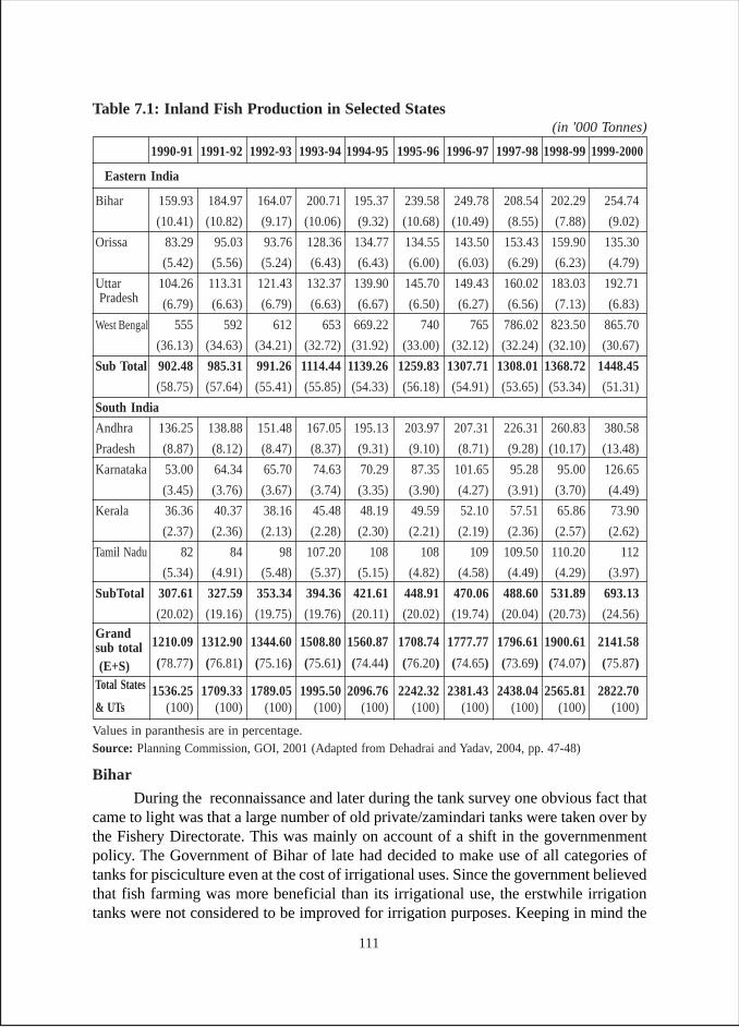
Table 7.1: Inland Fish Production in Selected States(in '000 Tonnes)
1990-91 1991-92 1992-93 1993-94 1994-95 1995-96 1996-97 1997-98 1998-99 1999-2000
Eastern India
Bihar 159.93 184.97 164.07 200.71 195.37 239.58 249.78 208.54 202.29 254.74
(10.41) (10.82) (9.17) (10.06) (9.32) (10.68) (10.49) (8.55) (7.88) (9.02)
Orissa 83.29 95.03 93.76 128.36 134.77 134.55 143.50 153.43 159.90 135.30
(5.42) (5.56) (5.24) (6.43) (6.43) (6.00) (6.03) (6.29) (6.23) (4.79)
Uttar 104.26 113.31 121.43 132.37 139.90 145.70 149.43 160.02 183.03 192.71 Pradesh (6.79) (6.63) (6.79) (6.63) (6.67) (6.50) (6.27) (6.56) (7.13) (6.83)
West Bengal 555 592 612 653 669.22 740 765 786.02 823.50 865.70
(36.13) (34.63) (34.21) (32.72) (31.92) (33.00) (32.12) (32.24) (32.10) (30.67)
Sub Total 902.48 985.31 991.26 1114.44 1139.26 1259.83 1307.71 1308.01 1368.72 1448.45
(58.75) (57.64) (55.41) (55.85) (54.33) (56.18) (54.91) (53.65) (53.34) (51.31)
South India
Andhra 136.25 138.88 151.48 167.05 195.13 203.97 207.31 226.31 260.83 380.58
Pradesh (8.87) (8.12) (8.47) (8.37) (9.31) (9.10) (8.71) (9.28) (10.17) (13.48)
Karnataka 53.00 64.34 65.70 74.63 70.29 87.35 101.65 95.28 95.00 126.65
(3.45) (3.76) (3.67) (3.74) (3.35) (3.90) (4.27) (3.91) (3.70) (4.49)
Kerala 36.36 40.37 38.16 45.48 48.19 49.59 52.10 57.51 65.86 73.90
(2.37) (2.36) (2.13) (2.28) (2.30) (2.21) (2.19) (2.36) (2.57) (2.62)
Tamil Nadu 82 84 98 107.20 108 108 109 109.50 110.20 112
(5.34) (4.91) (5.48) (5.37) (5.15) (4.82) (4.58) (4.49) (4.29) (3.97)
SubTotal 307.61 327.59 353.34 394.36 421.61 448.91 470.06 488.60 531.89 693.13
(20.02) (19.16) (19.75) (19.76) (20.11) (20.02) (19.74) (20.04) (20.73) (24.56)
Grand1210.09 1312.90 1344.60 1508.80 1560.87 1708.74 1777.77 1796.61 1900.61 2141.58sub total
(E+S) (78.77) (76.81) (75.16) (75.61) (74.44) (76.20) (74.65) (73.69) (74.07) (75.87)
Total States 1536.25 1709.33 1789.05 1995.50 2096.76 2242.32 2381.43 2438.04 2565.81 2822.70& UTs (100) (100) (100) (100) (100) (100) (100) (100) (100) (100)
Values in paranthesis are in percentage.Source: Planning Commission, GOI, 2001 (Adapted from Dehadrai and Yadav, 2004, pp. 47-48)
Bihar
During the reconnaissance and later during the tank survey one obvious fact thatcame to light was that a large number of old private/zamindari tanks were taken over bythe Fishery Directorate. This was mainly on account of a shift in the governmenmentpolicy. The Government of Bihar of late had decided to make use of all categories oftanks for pisciculture even at the cost of irrigational uses. Since the government believedthat fish farming was more beneficial than its irrigational use, the erstwhile irrigationtanks were not considered to be improved for irrigation purposes. Keeping in mind the
111
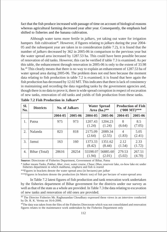
fact that the fish produce increased with passage of time on account of biological reasonswhereas agricultural farming decreased year after year. Consequently, the emphasis hadshifted to fisheries and the banana cultivation.
Although water turns more fertile in jalkars, yet taking out water for irrigationhampers fish cultivation48. However, if figures relating to jalkars during the year 2004-05 and the subsequent year are taken in to consideration (table 7.2), it is found that thenumber of jalkars decreased by 362 in 2005-06 in comparison to the pervious year butthe water spread area increased by 1287.53 ha. This could have been possible becauseof renovation of old tanks. However, this can be verified if table 7.3 is examined. As perthis table, the enhancement through renovation in 2005-06 is only to the extent of 33.98ha.49 This clearly means that there is no way to explain an enhancement of 1287.53 ha ofwater spread area during 2005-06. The problem does not end here because the momentdata relating to fish production in table 7.2 is examined; it is found that here again thefish production has decreased by 12.02 MT. This indicates that there is lack of consistencyin maintaining and recording the data regarding tanks by the government agencies and,though there is no data to prove it, there is wide spread corruption in respect of excavationof new tanks, renovation of old tanks and yields of fish production from these tanks.
48 The Director Fisheries Mr. Raghunandan Choudhary expressed these views in an interview conductedby Dr. R. K. Verma on 16-6-2006.49The data was taken from the files of the Fisheries Directorate which was not consolidated and renovationfigures relates to the maintenance work undertaken by the Fisheries Department only
Source: Directorate of Fisheries Department, Government of Bihar, Patna* Jalkar means Tanks, Pokhar, Ahar, river, water course, Chaur, Dhav, reservoir lake, ox-bow lake etc under
fisheries department in which makhana, singhara and fish is reared**Figures in brackets denote the water spread area (in hectares) per jalkar***Figures in brackets denote the production (in Metric ton) of fish per hectare of water-spread area
Table 7.2 Fish Production in Jalkars*
Sl. Districts No. of Jalkars Water Spread Production of FishNo. Area (ha.)** (‘000 MT)***
2004-05 2005-06 2004-05 2005-06 2004-05 2005-06
1. Patna 975 973 1207.43 1204.23 8 8.5(1.24) (1.24) (6.64) (7.05)
2. Nalanda 823 818 2175.09 2089.34 4 5.05(2.64) (2.55) (1.83) (2.41)
3. Jamui 163 160 1373.33 1351.62 2.12 2.33(8.42) (8.44) (1.54) (1.72)
4. Bihar (Total) 28616 28254 55598.07 56885.60 279.53 267.51(1.94) (2.01) (5.02) (4.70)
In Table 7.2 latest figures of fish production and tank renovation work undertakenby the fisheries department of Bihar government for the districts under our survey aswell as that of the state as a whole are provided. In Table 7.3 the data relating to excavationof new tanks and renovation of old ones are provided.
112
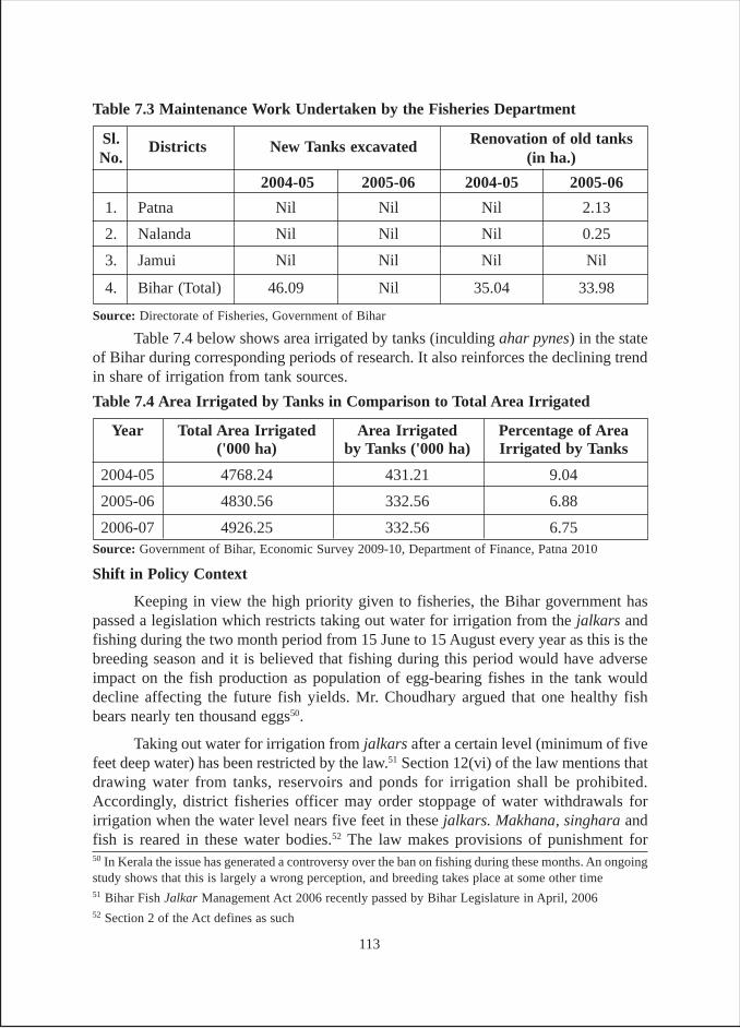
Shift in Policy Context
Keeping in view the high priority given to fisheries, the Bihar government haspassed a legislation which restricts taking out water for irrigation from the jalkars andfishing during the two month period from 15 June to 15 August every year as this is thebreeding season and it is believed that fishing during this period would have adverseimpact on the fish production as population of egg-bearing fishes in the tank woulddecline affecting the future fish yields. Mr. Choudhary argued that one healthy fishbears nearly ten thousand eggs50.
Taking out water for irrigation from jalkars after a certain level (minimum of fivefeet deep water) has been restricted by the law.51 Section 12(vi) of the law mentions thatdrawing water from tanks, reservoirs and ponds for irrigation shall be prohibited.Accordingly, district fisheries officer may order stoppage of water withdrawals forirrigation when the water level nears five feet in these jalkars. Makhana, singhara andfish is reared in these water bodies.52 The law makes provisions of punishment for50 In Kerala the issue has generated a controversy over the ban on fishing during these months. An ongoingstudy shows that this is largely a wrong perception, and breeding takes place at some other time51 Bihar Fish Jalkar Management Act 2006 recently passed by Bihar Legislature in April, 200652 Section 2 of the Act defines as such
Sl. Districts New Tanks excavated Renovation of old tanksNo. (in ha.)
2004-05 2005-06 2004-05 2005-06
1. Patna Nil Nil Nil 2.13
2. Nalanda Nil Nil Nil 0.25
3. Jamui Nil Nil Nil Nil
4. Bihar (Total) 46.09 Nil 35.04 33.98
Table 7.3 Maintenance Work Undertaken by the Fisheries Department
Source: Directorate of Fisheries, Government of Bihar
Table 7.4 below shows area irrigated by tanks (inculding ahar pynes) in the stateof Bihar during corresponding periods of research. It also reinforces the declining trendin share of irrigation from tank sources.
Year Total Area Irrigated Area Irrigated Percentage of Area('000 ha) by Tanks ('000 ha) Irrigated by Tanks
2004-05 4768.24 431.21 9.04
2005-06 4830.56 332.56 6.88
2006-07 4926.25 332.56 6.75
Table 7.4 Area Irrigated by Tanks in Comparison to Total Area Irrigated
Source: Government of Bihar, Economic Survey 2009-10, Department of Finance, Patna 2010
113
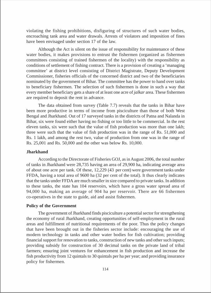
violating the fishing prohibitions, disfiguring of structures of such water bodies,encroaching tank area and water drawals. Arrests of violators and imposition of fineshave been envisaged under section 17 of the law.
Although the Act is silent on the issue of responsibility for maintenance of thesewater bodies, it makes provisions to entrust the fishermen (organized as fishermencommittees consisting of trained fishermen of the locality) with the responsibility asconditions of settlement of fishing contract. There is a provision of creating a ‘managingcommittee’ at district level consisting of District Magistrate, Deputy DevelopmentCommissioner, fisheries officials of the concerned district and two of the beneficiariesnominated by the government of Bihar. The committee has the power to hand over tanksto beneficiary fishermen. The selection of such fishermen is done in such a way thatevery member beneficiary gets a share of at least one acre of jalkar area. These fishermenare required to deposit the rent in advance.
The data obtained from survey (Table 7.7) reveals that the tanks in Bihar havebeen more productive in terms of income from pisciculture than those of both WestBengal and Jharkhand. Out of 17 surveyed tanks in the districts of Patna and Nalanda inBihar, six were found either having no fishing or too little to be commercial. In the resteleven tanks, six were such that the value of fish production was more than one lakh;three were such that the value of fish production was in the range of Rs. 51,000 andRs. 1 lakh, and among the rest two, value of production from one was in the range ofRs. 25,001 and Rs. 50,000 and the other was below Rs. 10,000.
Jharkhand
According to the Directorate of Fisheries GOJ, as in August 2006, the total numberof tanks in Jharkhand were 28,735 having an area of 29,900 ha, indicating average areaof about one acre per tank. Of these, 12,229 (43 per cent) were government tanks underFFDA, having a total area of 9600 ha (32 per cent of the total). It thus clearly indicatesthat the tanks under FFDA are much smaller in size compared to private tanks. In additionto these tanks, the state has 104 reservoirs, which have a gross water spread area of94,000 ha, making an average of 904 ha per reservoir. There are 66 fishermenco-operatives in the state to guide, aid and assist fishermen.
Policy of the Government
The government of Jharkhand finds pisciculture a potential sector for strengtheningthe economy of rural Jharkhand, creating opportunities of self-employment in the ruralareas and fulfillment of nutritional requirements of the poor. Thus the policy changesthat have been brought out in the fisheries sector include: encouraging the use ofmodern technology in tanks and other water bodies for fish cultivation; providingfinancial support for renovation to tanks, construction of new tanks and other such inputs;providing subsidy for construction of 30 decimal tanks on the private land of tribalfarmers; ensuring joint ventures for enhancement in fish production and increase thefish productivity from 12 quintals to 30 quintals per ha per year; and providing insurancepolicy for fishermen.
114
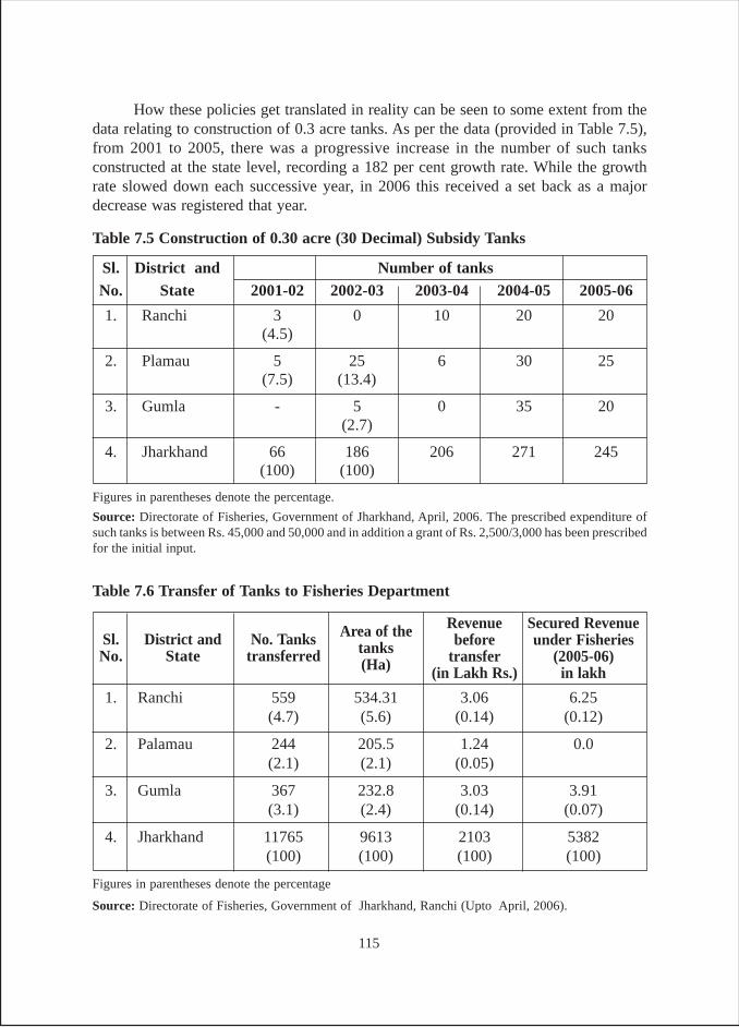
How these policies get translated in reality can be seen to some extent from thedata relating to construction of 0.3 acre tanks. As per the data (provided in Table 7.5),from 2001 to 2005, there was a progressive increase in the number of such tanksconstructed at the state level, recording a 182 per cent growth rate. While the growthrate slowed down each successive year, in 2006 this received a set back as a majordecrease was registered that year.
Sl. District and No. Tanks Area of the Revenue Secured Revenue
No. State transferred tanks before under Fisheries
(Ha) transfer (2005-06)(in Lakh Rs.) in lakh
1. Ranchi 559 534.31 3.06 6.25(4.7) (5.6) (0.14) (0.12)
2. Palamau 244 205.5 1.24 0.0(2.1) (2.1) (0.05)
3. Gumla 367 232.8 3.03 3.91(3.1) (2.4) (0.14) (0.07)
4. Jharkhand 11765 9613 2103 5382(100) (100) (100) (100)
Table 7.6 Transfer of Tanks to Fisheries Department
Figures in parentheses denote the percentage
Source: Directorate of Fisheries, Government of Jharkhand, Ranchi (Upto April, 2006).
Sl. District and Number of tanksNo. State 2001-02 2002-03 2003-04 2004-05 2005-06
1. Ranchi 3 0 10 20 20(4.5)
2. Plamau 5 25 6 30 25(7.5) (13.4)
3. Gumla - 5 0 35 20(2.7)
4. Jharkhand 66 186 206 271 245(100) (100)
Table 7.5 Construction of 0.30 acre (30 Decimal) Subsidy Tanks
Figures in parentheses denote the percentage.
Source: Directorate of Fisheries, Government of Jharkhand, April, 2006. The prescribed expenditure ofsuch tanks is between Rs. 45,000 and 50,000 and in addition a grant of Rs. 2,500/3,000 has been prescribedfor the initial input.
115
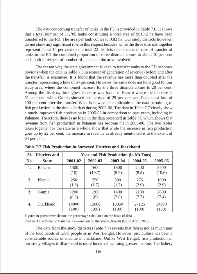
The data concerning transfer of tanks to the FD is provided in Table 7.6. It showsthat a total number of 11,705 tanks constituting a total area of 9613.2 ha have beentransferred to the FD. The area per tank comes to 0.82 ha. Our study districts however,do not show any significant role in this respect because while the three districts togetherrepresent about 14 per cent of the total 22 districts of the state, in case of transfer oftanks to the FD the combined proportion of three districts comes to about 10 per centeach both in respect of number of tanks and the area involved.
The reason why the state government is keen to transfer tanks to the FD becomesobvious when the data in Table 7.6 in respect of generation of revenue (before and afterthe transfer) is examined. It is found that the revenue has more than doubled after thetransfer representing a hike of 64 per cent. However the same does not hold good for ourstudy area, where the combined increase for the three districts comes to 28 per cent.Among the districts, the highest increase was found in Ranchi where the increase is51 per cent, while Gumla showed an increase of 29 per cent and Palamau a loss of100 per cent after the transfer. What is however inexplicable is the data pertaining tofish production in the three districts during 2005-06. The data in Table 7.7 clearly showa much-improved fish production in 2005-06 in comparison to past years, including inPalamau. Therefore, there is no logic in the data presented in Table 7.6 which shows thatrevenue from fish production in Palamau has become nil in 2005-06. The two tablestaken together for the state as a whole show that while the increase in fish productiongoes up by 22 per cent, the increase in revenue as already mentioned is to the extent of64 per cent.
Sl. Districts and Year and Fish Production (in Mt Tons)No. State 2001-02 2002-03 2003-04 2004-05 2005-06
1. Ranchi 1400 1600 1800 2400 3700(10) (10.7) (9.9) (8.8) (10.6)
2. Plamau 250 250 300 775 1000(1.8) (1.7) (1.7) (2.9) (2.9)
3. Gumla 1200 1200 1400 2100 2600(8.6) (8) (7.8) (7.7) (7.4)
4. Jharkhand 14000 15000 18050 27125 34970(100) (100) (100) (100) (100)
Table 7.7 Fish Production in Surveyed Districts and Jharkhand
Figures in parentheses denote the percentage calculated on the basis of data
Source: Directorate of Fisheries, Government of Jharkhand, Ranchi (Up to April, 2006)
The data from the study districts (Table 7.7) reveals that fish is not as much partof the food habits of tribal people as in West Bengal. However, pisciculture has been aconsiderable source of income in Jharkhand. Unlike West Bengal, fish production inour study villages in Jharkhand is more lucrative, accruing greater income. The fishery
116
tanks are either government owned tanks that were earlier zamindari tanks, or are purelyprivate tanks. Out of the eight government tanks studied, six belong to the fisheriesdepartment and one each to minor irrigation and revenue departments. Pisciculture inthese tanks of Jharkhand is practiced in the following ways: (i) government leasing outtanks to private contractors for fishing; (ii) tank owners cultivating fish on their own;and (iii) owners leasing out their tanks to private contractors.
West Bengal
Fish, an important source of nutrition, is an integral part of daily diet in Bengal.In all the auspicious ceremonies of social and cultural importance, the fish is consideredto be an essential item in food served. Besides, pisciculture has been an important sourceof income in the state. West Bengal has witnessed a considerable growth in fish productionfrom inland sector, mainly from tank fisheries. The fish production in the state has goneup to 988,000 ton in 2003-04 from just 340,000 ton in 1980-81 in inland sector alone(GOWB, Economic Review 2003-04; Statistical Appendix 2004).
Four patterns of undertaking pisciculture were found in our study area. Theywere as follows: (i) one year/three years contract, leased out by the owners of the tankseither on negotiated cash or kind; ii) shared farming of fish in which 50 per cent of theproduction was given by the farmers to the tanks owners, iii) the entire fish produce wasconsumed by the owners themselves; and, iv) pisciculture by the panchayat body. Incase of the third pattern, the amount of fish or value of the produce could not be assessed.In case of shared farming also, it is difficult to estimate the actual amount of fish produced.During our survey it was found that the tank owners of Lagda village had no option butto lease out tanks for pisciculture to the bauris or fishing castes (SCs) as they held thebarga rights53. The rent fixed for pisciculture was divided among the owners in theproportion of ‘anshas’ or shareholding of the individual owners in the tank.
Bankura district has almost similar pattern of pisciculture with a minor difference,(i) pisciculture by 16 ana (100 per cent) tank committee (committee for the entire tank),(ii) tank leased out (contracted out) by the owners for pisciculture on annual rent, (iii)tank contracted out by government to the private party for fishery production; iv)pisciculture by the panchayat body. The multiple owners of tanks got their trivial sharesof fish produce at the time of harvesting, which could not be measured as each ownergot only consumable amount of fish.
Moira bandh in Bankura gets water from Kangsabati canal, as a result the tankdoes not go dry in summer. Sufficient water remains in the tank in season too, renderingfish cultivation profitable. The tank was renovated by TID around 1985 and leased outfor fish cultivation. At present a person named, Paltu Gorai is the contractor who produces
53 Barga rights refer to land reforms initiative taken by the left front government of West Bengal for recordingthe names of sharecroppers (bargadars) while avoiding the time-consuming method of recording throughthe settlement machinery. It bestowed on the bargadars, the legal protection against eviction by the landlords,and entitled them to the due share of the produce. Operation Barga was launched in 1978 and concluded bythe mid 80’s.
117
over 20 quintals of fish, value of which amounts to over Rs. 60,000. Paltu is considereda powerful man. In Tatir bandh, the fish cultivation is done on shared basis, i.e., the fishcontractor would give 50 per cent of the catch to the ansha holders in proportion to theirshare in the tank. The exact income could not be ascertained. However, it is estimatedthat more than 10 quintals of fish is produced in Tatir bandh. Purno pukur in Deol Beriavillage was renovated by the panchayat in the year 2000. The banks of the tank wererepaired with cement lining and the main purpose of repair was pisciculture. The tankownership is peculiar viz., the eight ana ansh (50 per cent share) is held by four familiesof khan caste from the Muslim community and the rest eight ana ansh is held by thewhole village. Every villager receives a trivial amount of fish to complete 50 per cent ofthe total produce and rest 50 per cent of produce is taken by the four khan families asthey are the traditional owners of the tank.
Lal bandh tank having five acres of water spread area was renovated in 2004-05on a large scale. Here also fish is cultivated by the khans of Deol Beria on contractualbasis. The produce is marketed through bazaar samiti. The value of fish produced fromthe tank is estimated to be Rs. 50,000 annually. It was claimed that the Lal bandh villagehad introduced fishing in Bengal. Dharampur bandh is also a big tank and the villagersthrough the 16-ana tank committee practice pisciculture and market the produce. Thevalue of fish it produces is about Rs. 20,000 a year. In the same village, there are twomore tanks. Two 16-ana committees manage Mondal pukur and Nautun pukur speciallymeant for pisciculture, one each separately. In all such committees, brahmins hold thedominant offices. The income of the tanks is invested in community functions of thevillage, and not used for any individual benefits. The work carried out of the incomeearned from sale of fish are mainly of two types: (i) minor repair of bunds embankmentsof the tanks, (ii) religious functions such as kirtan (reciting prayer), construction andrepairs of temples, and organizing folk music and drama. The religious collective efforts,it seems, are owing to the fact that brahmins, the worshiping high caste, mainly constitutethe village. It is estimated that the Chand bandh of Gokulnagar, Indpur produces fishworth Rs. 25,000. Chand bandh was previously a private bandh of Chand and Duttafamilies. But since the inception of new panchayats raj system in 1978, it was takenover by the panchayat. The panchayat is responsible for maintenance of the tank andcultivation of fish.
In Birbhum too, pisciculture has been a characteristic feature of tanks. Earlier thetank owners themselves cultivated fish in the tanks and marketed the produce in largequantities. But now fishing is done by the panchayat. It is interesting to note that asizable share of the produce is given to members of ST community who have settledaround the tank. These ST settlers are supposed to look after the tank and get share inlieu of the duty they performed. It seems that these families had been enjoying ghatwali54
tenures. The rest of the fish produce is marketed and income is used for buying ponha
54 Ghatwali tenure is a kind of tenure system granted to Scheduled Tribes with martial traditions who hadsettled around the tank. In this system these settlers were expected to look after the tanks and get share inlieu of their duty.
118
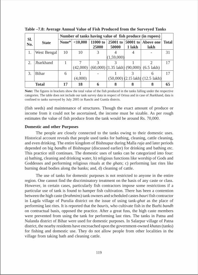
(fish seeds) and maintenance of structures. Though the exact amount of produce orincome from it could not be ascertained, the income must be sizable. As per roughestimates the value of fish produce from the tank would be around Rs. 70,000.
Domestic and other Purposes
The people are closely connected to the tanks owing to their domestic uses.Historical account reveals that people used tanks for bathing, cleaning, cattle cleaning,and even drinking. The entire kingdom of Bishnupur during Malla raja and later periodsdepended on big bandhs of Bishnupur (discussed earlier) for drinking and bathing etc.This practice still continues. The domestic uses of tanks can be categorized into four:a) bathing, cleaning and drinking water, b) religious functions like worship of Gods andGoddesses and performing religious rituals at the ghats; c) performing last rites likeburning dead bodies along the banks; and, d) cleaning of cattle.
The use of tanks for domestic purposes is not restricted to anyone in the entireregion. One cannot find the discriminatory treatment on the basis of any caste or class.However, in certain cases, particularly fish contractors impose some restrictions if aparticular use of tank is found to hamper fish cultivation. There has been a contentionbetween the high caste (brahmins) tank owners and scheduled castes bauri fish contractorin Lagda village of Purulia district on the issue of using tank-ghat as the place ofperforming last rites. It is reported that the bauris, who cultivate fish in the Burhi bandhon contractual basis, opposed the practice. After a great fuss, the high caste memberswere prevented from using the tank for performing last rites. The tanks in Patna andNalanda district of Bihar were used for domestic purposes. In Salarpur village of Patnadistrict, the nearby residents have encroached upon the government-owned khatas (tanks)for fishing and domestic use. They do not allow people from other localities in thevillage from taking bath and cleaning cattle.
Note: The figures in brackets show the total value of the fish produced in the tanks falling under the respectivecategories. The table does not include our tank survey data in respect of Orissa and in case of Jharkhand, data isconfined to tanks surveyed by July 2005 in Ranchi and Gumla distrcts.
Sl.
State
Number of tanks having value of fish produce (in rupees)
No. None* <10,000 11000 to 25001 to 50001 to Above one Total25000 50000 1 lakh lakh
1. West Bengal 10 10 3 4 4 - 31(1,59,000)
2. Jharkhand 1 7 3 3 1 2 17(42,000) (60,000) (1.35 lakh) (90,000) (6.5 lakh)
3. Bihar 6 1 - 1 3 6 17(4,000) (50,000) (2.15 lakh) (12.5 lakh)
Total 17 18 6 8 8 8 65
Table –7.8: Average Annual Value of Fish Produced from the Surveyed Tanks
119
The scenario was no less different in Orissa and tanks were being used for allkinds of human and cattle needs. The most unforgettable memory of Pant was that of theNarayan Sagar in Bolangir and Udaya Sagar in Kalahandi district. The ancestor of theerstwhile raja, a 72-year-old graduate was still living in an old, sprawling palace complexin the village/pachayat/block Loisingha, and had constructed the first tank in that area.The tank was spread over an area of 130 acres. During the visit, all sides of the tankwere found occupied by men, women and children, bathing, washing clothes and utensils.Some others were engaged in ritualistic prayers and some were preparing their nets andboats for fishing. In fact the whole scene put up a fair-like/festive atmosphere. It lookedas if the whole town of Loisingha had descended on the tank site. An important noticeablepoint was that there was clear segregation of the crowd on gender grounds, except in thecase of children. In the lower reaches of the tank, a large number of farmers were foundto be engaged in irrigating fields or repairing the channels that took water to their fields.
The Udaya Sagar tank was a huge one, and was spread over an area of 200 acres.As the author had reached this tank site in the afternoon, a big crowd around the tankwas missing. Nevertheless, women were seen involved in various domestic activities.Some men were bathing or guarding some of the many pumps located on various spotson the embankment around the tank. A unique aspect of this tank, unlike the former one,was that the bathing location for women was completely invisible from other placesaround the tank.
The storage of water in tanks also enables cultivation of water borne fruits likesinghara and makhana. Singhara is another edible and nutritional fruit found in theentire eastern region and is grown naturally in water bodies. Those tanks that can retainwater throughout the year can be used for cultivation of these fruits.
In West Bengal, Jharkhand and Bihar, cultivation of singhara is a common practice.Although no tank in West Bengal under survey was found having singhara cultivation,in Jharkhand and Bihar the surveyed tanks were found to be cultivating singhara andpeople were accruing income out of it. In Jharkhand one tank named Burha bandh atDanadih village had singhara and lotus cultivation. It was interesting to note that thetank owners did not restrict anyone from plucking lotus or singhara.
In Bihar, makhana is grown in the tanks of north Bihar plains, particularly inDarbhanga, Madhubani and Samastipur districts and singhara is grown in Nalanda andPatna districts.
Tanks can also be developed as places of tourist attraction. The big ancient/medieval tanks at Bishnupur named Jamuna bandh, Lal bandh etc. are still places oftourist attraction. During the field visit to Bishnupur in January 2004, the authors saw anumber of tourists, but were greatly enthused by a British scholar who told them that heliked the place so much that he visited the place every year around that time. Theresearchers were informed that very big tanks like Jamuna bandh could be developedfor boating and other recreational activities55. In Jharkhand, Bada talab at Bundu hasbeen undertaken by Central Government for its improvement as a tourist place.
55 Interview with S.N. Chattopadhayay in January 30, 2005.
120
CHAPTER - VIII
INTER STATE VARIATIONS AND SUMMING UP
INTER-STATE COMPARISON – PART - I
Looking at the origin of the tanks in the states where the survey was carried out(Table E-1), 19 per cent of the tanks in the four eastern states belonged to the ancient/medieval period. However the largest proportion of tanks (60 per cent) belonged to theBritish period. Twenty two per cent of tanks were built after Independence. Of theseonly about 4 per cent were built during the last sixteen years. This findings of ours doesnot auger well particularly because in almost all the studied states, tank constructionand rehabilitaion was being done in a big way under GOI sponsored watershedprogramme.
In terms of origin, it seems the respondents have not distinguished ancientperiod clearly from the British period. If the two categories are merged, it can be seenthat that Bihar has the largest proportion of tanks belonging to the ancient/Britishperiod (95 per cent). About 81 per cent tanks in Orissa, 77 per cent in West Bengal, and70 per cent in Jharkhand also come under the same category.
Based on the ownership of the tanks (Table E-2) it is found that about 44 per centof tanks are owned by government, closely followed by 37 per cent, owned/occupied/captured by individuals. This is followed by 19 per cent, owned by panchayats. If wetake a close look at these categories, it can be seen that there is great deal of variationacross states.
In case of government tanks it is found that their proportion is as high as 64% incase of Jharkhand, immediately followed by Orissa (62 per cent). On the other hand, inWest Bengal, only about 7 per cent of the tanks from the survey sample belonged to thiscategory. In respect of panchayat owned tanks, it is found that their proportion is againquite high in Orissa (34 per cent), whereas they constitute a mere 9 per cent of thesample tanks in Jharkhand.
As regards private tanks, they constitute 64 per cent of the surveyed tanks in WestBengal, and they were of substantial portion of the tank samples in both Bihar (40 percent) and Jharkhand (30 per cent). On the other hand, only about 5 per cent of the tankssurveyed in Orissa belong to this category. However when it comes to the question ofaccessibility of these tanks (Table E-3), about 83 per cent of tanks are open to all, while
121
about 10 per cent are accessible to only owners and about 7 per cent have some otherkind of restrictions. Looking at this data in relation to the fact that 37 per cent of tanksare privately owned/possessed or captured, it is clear that even in such tanks, non-ownersdo not have any accessibility problems.
As far as the size of the tanks is concerned (Table E-4), it is found that the largestproportion of tanks across states are in the size category of 2.5-10 acres (36 per cent),followed by those having area less than 2.5 acres (32 per cent) and the proportion oftanks in the size category of 11-20 and 21-50 acres is 9 per cent each. It is found thatbeyond this size as we move to the higher size categories, their proportion goes ondecreasing. This becomes obvious as only 8 per cent of the tanks fall in the size categoryof 51-100 acres and only 5 per cent of the tanks in the size category of above 100 acres.However, there are inter-state variations and it is found that while Orissa had a highproportion of large sized tanks, Jharkhand, West Bengal and Bihar have a high proportionof smaller size tanks, particularly in the size category of below 2.5 acres and 2.5-10acres. While about 52 per cent of tanks in Orissa are of size above 50 acres; 90 per centof the tanks in Jharkhand, 77 per cent of the tanks in West Bengal and 60 per cent of thetanks in Bihar are of size below 10 acres.
The estimates of net area irrigated per tank and irrigation efficiency of tanks areprovided in Table E-5. The figures reveal that 105 tanks across four states irrigate a netarea of 4061 acres that comes to about 44 acres per tank. The irrigation efficiency oftank water comes to about 2.5 acre irrigated field area per acre of tank area. This meansthat one acre of tank area irrigates about two and a half times its size. However, thisfigure is not representative of all states and is highly influenced by the condition inBihar and Orissa as the tanks of these two states irrigate nearly 75 per cent of the totalirrigated area of all four states. The ratio of irrigated area in relation to tank area variesacross states, and is highest in Bihar where it is 2.9 followed by Orissa with 2.8 and thenWest Bengal with 2.6. The lowest area irrigated per acre of tank area is found in case ofJharkhand with a ratio of 1.5.
Tables E-6 and E-7 provide data on season wise irrigation and modes of irrigationused by farmers across states. In all four states, major proportion of irrigation is doneduring kharif, followed by rabi. Summer irrigation from tanks form a meager portion ofthe gross tank irrigated area. Although across the board, kharif irrigation accounts for62 per cent of gross irrigated area, the variation is between 51 per cent in Jharkhand and66 per cent in Orissa. As regards rabi irrigation, the average for the four states comes toabout 36 per cent. Again, there are variations across the states, from 31 per cent in caseof Orissa to a maximum of 43 per cent in case of Jharkhand. Two points need to beexplained here:
First, the main reason why Jharkhand lags behind other states during kharif butmarches ahead of other states in case of rabi is that most of the tank irrigators in Jharkhanduse pumps for irrigating their rabi crop, while during kharif most of them depend onsurface flow. The low level of kharif irrigation in Jharkhand is on account of high
122
monsoon rains. The reason why West Bengal lags behind other states exceptJharkhand in terms of irrigation during kharif season is the farmers’ preference for rabipaddy. This is borne out of the fact that in West Bengal about 40 per cent of GIA isachieved during rabi. Since increasingly large number of farmers in West Bengal go forboro paddy, large scale rabi irrigation is becoming essential. During kharif also theygrow paddy as in Jharkhand and depend on high monsoons. Irrigation is required onlywhen rain fails. Since the monsoon rains in the state are adequate for kharif paddy andrains during the year of survey (2004-05) were normal, perhaps there was not muchneed of irrigation. As against this, irrigation is a must for aus (February/March to April/May) paddy. In contrast to West Bengal, kharif paddy is the most popular crop in Orissa,and it is on account of this, that kharif irrigated area goes up to as high as 66 per cent inthis state.
Looking at GIA vis-à-vis modes of irrigation (Table E-7), it comes out very clearthat while in the three states gravity flow irrigation is the most important mode ofirrigation, in the case of Bihar energized lifting is very much in use. In fact, all kinds ofpumping devices are used to cover 73 per cent of the GIA and only in about 21 per centGIA, gravity irrigation is used.
One of the reasons for such a large use of energized pumping devices is that insouth Bihar, more particularly districts of Patna and Nalanda have a flat topographycompared to the other regions of eastern India where the topography is undulating. Dueto flat topography, tank water has to be lifted as soon as its level goes down even a bit.Hence all kinds of pumps such as diesel and kerosene are used. The other reason is thatall these districts form part of the alluvial plains having the finest aquifers and waterlevel in wells during rainy season is very close to the ground level. In fact during thereconnaissance, Pant saw a large number of pumps working in the fields and found theChinese diesel pumps to be most popular. The local farmers called it CD (Chinese diesel).In respect of other states, since the topography enables a great deal of water to flow tofields by gravity owing to the fact that they are generally located lower down thereaches, a large area is irrigated by flow irrigation. This aspect becomes obvious asabout 67 per cent of GIA area in West Bengal, 59 per cent in Jharkhand and 58 per centof GIA area in Orissa utilizes gravity flow for irrigation.
As regard manual irrigation, although only 4 per cent of GIA is covered throughthis mode of irrigation, Bihar again tops the list of states as over 6 per cent of GIA inBihar is irrigated manually. Again the main reason of greater prevalence of this mode inBihar than in other states is the flat topography and high water level in the tanks. Duringthe field reconnaissance it was observed that tanks/khatas/pynes were brimful with waterbut it still required water to be lifted by a couple of feet. The farmers were found to beusing a variety of traditional water lifting devices such as karing, latha-kundi and swingbaskets requiring a great deal of human power.
Table E-8 provides data on the tank area in different states. It needs to be explainedhere that although 119 tanks from four states were surveyed, the data on this aspect was
123
available for only 91 tanks and only for a small proportion of the tanks in Orissa andBihar. The total area of these 91 tanks was about 1428 acres giving an average size of 16acres per tank. The figures varied across states. The largest tanks were found in Orissawhere the average size of the tank was 59 acres. The smallest tank was found in WestBengal with an average area of 6.4 acres, preceded by 6.6 acres in case of Jharkhand. Inthe case of Bihar the average size of the tank was 19 acres. The main reason for such alarge size in Orissa was the sample included a number of MIPs. In the case of Biharalso, the focus of enquiry was the large tanks of Nalanda district that were found nearthe ruins of the ancient university.
Tables E-9a to E-9c deal with an important physical attribute relating to theperformance of tanks during the three seasons of monsoon, winter and summer i.e.,water storage depth. Across the states, the storage depth is largest during the monsoonand lowest during summer and this is on expected lines. The interesting aspect ofexamination would be, which state tanks have high depth and where the depth is low.Looking at the depth during rainy/monsoon season it is found that across the states,tanks are distributed more or less evenly across all depth categories. To elaborate, on anaverage, 29 per cent of the tanks fall in above 10-feet depth category. The proportion ishighest in case of Orissa with about 38 per cent of tank falling in this category. Orissa isfollowed by Bihar where 35 per cent of tanks fall in this category. Whereas inWest Bengal, about 23 per cent of the tanks fall in this category and in Jharkhand about28 per cent of tanks find a place in this category.
Another way of looking at this aspect of the tank would be to see which state hasthe highest proportion of tanks falling in each depth category. First of all, largestproportion of tanks in the 7.5-10 feet depth category is from Jharkhand (47 per cent)(Table E-9a). In the 5-7.5 feet depth category, Bihar tanks have the largest proportion of45 per cent. The data further shows that all Bihar tanks are in this category or in thehigher depth categories. In other words, it means that, by and large, Bihar tanks are oflarger size when compared to West Bengal and Jharkhand. The same is true of Orissaalso where over 90 per cent of tanks fall in these categories.
In case of West Bengal the largest proportion of tanks (36 per cent) are found tobe having a storage depth of 3-5 feet, as against the average of 14 per cent tanks of allthe states taken together. More or less the same trend continues in winter and summerseasons with a lesser number of tanks finding place in higher depth categories in allstates. The most dramatic effect of the change in seasons can be seen from this. Whilenone of the tanks become dry in monsoon in any of the states, 5 per cent of the tanksturn dry during winter (Table E-9b) and 37 per cent turn dry during summer (Table E-9c). Of the tanks that turn dry during summer, the Bihar tanks make the largest proportion(55 per cent), followed by West Bengal (45 per cent) and Jharkhand with 30 per cent.Orissa has the lowest proportion of tanks getting dry (19 per cent) in summer. This moreor less explains the higher storage capacity of tanks of Orissa. The devastating impactof high aridity on the storage of tanks is evident from the fact that in total 37 per cent ofthe tanks dry up during summer and another 12 per cent have a water level below 3 feet,
124
which render them unusable for irrigation. Thus, 49 per cent of the tanks across the 4states are redundant in providing irrigation services (Table E-9c).
About 60 per cent of the tanks across the states receive their inflows from rains inthe catchment. However, there are inter-state variations. While about 78 per cent oftanks in West Bengal receive their inflows from catchment rains, 45 per cent of Bihartanks receive their inflows from rains. The next important source consists of acombination of sources such as rain + rivulet + another tank + flood water. Across thestates, 21 per cent of tanks get their inflows from these combined sources. The proportionvaries across states with 38 per cent in Orissa; followed by 35 per cent in Bihar; 17 percent in Jharkhand. In the case of West Bengal, only 5 per cent of tanks get their fillingthrough these combined sources. Another source is a combination of rains and canals.They provide inflows to about 6 per cent of the tanks across states. Looking at state-wise scenario, about 13 per cent of West Bengal tanks get water from this combinedsource, while in the case of Bihar and Orissa 5 per cent in each case get their inflowsfrom this source. There are about 11 per cent tanks, which get filled up by “other sources”.They mainly consist of artesian wells and drainage from villages. There are no suchtanks in Orissa, while a negligible proportion of tanks in West Bengal are of this type.Nevertheless, 17 per cent of the tanks in Jharkhand and 15 per cent of the tanks in Biharbelong to this category.
As regards the responsibility for maintenance (Table E-11), it is found that thelargest proportion of tanks (45 per cent) across the states is to be maintained by thegovernment. The government tanks are of two types: those under the FD; and thoseunder the MID. The rest (32 per cent) are expected to be maintained by the owners,which consist of both rightful owners and illegal occupants. The extent to which illegaloccupants rule the roost can be understood from the fact that while in about 19 per centof cases; the ownership is with the panchayats, only in about 14 per cent of casespanchayat is supposed to be responsible for maintenance. This aspect becomes moreobvious if the next category denoted as “others” is taken into consideration. This categoryhas about 10 per cent of tanks and consists of defacto occupants, fish contractors etc.,and this phenomenon is noticeable mainly in Bihar where “public” resource might beconverted into “private” resource by grabbing and encroachment.
One of the main reasons for the decline of tank irrigation is the deterioration inthe physical condition of the tanks, in lieu of lack of proper maintenance. During thesurvey this question has been addressed, and maintenance was divided into two categories.The first one concerns the frequency of repair of embankment, and the other concernsthe frequency of desilting. Looking across states, it is found that generally desiltingtakes place less frequently in comparison to repairs of embankments. The only exceptionin this regard are tanks in Bihar, where in 15 per cent cases, repairs of embankments anddesilting takes place annually. These are the tanks which are managed by individualswho own the tanks or have occupied them, when cases are pending in courts for thesettlement of the title.
125
Looking at frequency of repairs of embankments across states, it is found thatin about 10 per cent cases, embankments are repaired annually. This happens in19 per cent of the tanks in West Bengal, followed by 15 per cent in Bihar and about5 per cent in Orissa and 4 per cent in Jharkhand. In largest proportion of tanks(31 per cent) embankments were repaired once in 2-10 years. Looking at the states,nearly 71 per cent of the tanks in Orissa find a place in this category. In addition, 26 percent of the tanks in Jharkhand, 25 per cent of the tanks in Bihar and 16 per cent of thetanks in West Bengal also fall in this category. The next category consists of those tankswhere embankments get repaired once in 11-30 years and about 12 per cent of tanksfrom the four states find a place in this category.
As regards the frequency of desilting, it is found that only in Bihar and Jharkhand,the tanks are annually desilted. While in Bihar 15 per cent of the surveyed tanks aredesilted annually, the percentage is just four in Jharkhand. In other states whateverdesilting takes place, it is done once in 2-10 years. About 24 per cent tanks across thestates fall in this category. About 29 per cent of the surveyed tanks of Orissa are desiltedonce in 2-10 years. The percentage is 23 and 19 for Jharkhand and West Bengal,respectively. Only a small proportion of the tanks (5 per cent) in Bihar fall in this category.
The most disturbing aspect of tank maintenance is that in 47 per cent of the casesembankments are never repaired and in 55 per cent of the cases, tanks are never desilted.Looking at state level survey data, in 62 per cent tanks in Jharkhand, repair was neverundertaken. The same applies to 58 per cent tanks in West Bengal and 35 per cent inBihar. But the proportion is a meager 10 per cent in the case of Orissa. Coming to thescenario within each state, West Bengal has a very high proportion of such tanks(65 per cent), followed by Jharkhand (57 per cent) Bihar (50 per cent) and Orissa with43 per cent.
As regards the funds for maintenance, in about 32 per cent of the cases it isreported that there is no agency to provide funds for the maintenance. In 68 per cent ofthe cases where some funds are available, the largest proportion (36 per cent) is fromthe government. In another 13 per cent cases, funds come from panchayat and communityprovides the labour. In another 4 per cent cases, government and panchayat togetherprovide the funds. This feature is more rampant in West Bengal compared to other statesas about 10 per cent of tanks in West Bengal get funds in this manner. In about 7 per centof the cases, owners provide the funds. In Bihar the proportion is 20 per cent. Finallythere is a category of “others” which provide funds in about 9 per cent of cases. Theothers constitute defacto occupants, fish contractors, NGOs etc. Looking at state wisedetails, it is found that in Orissa and Jharkhand, government is the main funding agency.In case of West Bengal, the panchayat and the state government appear to be the mainfunding agencies. In Bihar, the panchayat and the owner/occupant appear to be the mostimportant funding sources.
The results of analysis of data relating to tank use pattern are presented in TableE-14. It can be seen that majority of the surveyed tanks (71 per cent) are of multipurpose.
126
About 11 per cent of the tanks are used exclusively for irrigation. Nine per cent of thetanks are exclusively for the domestic purposes, and another eight per cent exclusivelyfor fisheries. The tank use pattern is also examined for all the tanks in the villages/hamlets where the surveyed tanks are located. The size of this sample is three timesbigger than the earlier survey sample. The results are presented in Table E-15. The firststriking point that emerges from the results is that about 16 per cent tanks are found tobe abandoned because the deterioration had reached a stage where no repair can beundertaken. The proportion of such tanks was as high as 44 per cent in West Bengal. InJharkhand, 12 per cent of the tanks were dilapidated, while no such tanks in disuse arefound in Orissa and Bihar. In village tank survey, we find lesser proportion ofmultipurpose tanks (68 per cent compared to 72 per cent in case of tanks in the samplesurvey). The proportion of tanks used for pisciculture and irrigation is lesser, but thoseused for domestic purpose was more or less the same.
The estimates of income accrued from tanks are presented in Table E-16. Overallit is found that a total of 73 tanks for which data is available put together generate avalue of Rs. 43.9 lakhs. The value accrued per tank across the states comes to Rs. 60,200,but varies from a highest of Rs.1.13 lakhs per tank in Bihar to a lowest of Rs. 25,960 pertank in West Bengal. To assess the comparative performance of tanks in different states,the incomes per acre of tank area is estimated. It is found that in Bihar, tanks generatethe highest income of Rs. 7,677 per acre of tank area, immediately followed by Jharkhand(Rs. 6,573 per acre of tank area), West Bengal (Rs. 2,806 per acre) and then lowest is forOrissa with an income of Rs.765 per acre tank area.
Tables E-17 and E-18 present figures of landholdings of different castes that arerepresented as beneficiaries of the commands of tanks surveyed. The figures areirrespective of the extent and the quality of irrigation received by them. The data inTable E-17 show that the HCs and the STs have larger holdings as compared to OBCsand SCs. Further, these averages are for tanks from all the states put together. But thereis great deal of variation across the states. For instance, HCs enjoy the best position inBihar where they constitute 17 per cent of the households, but own about 35 per cent ofthe land. In comparison to this, they are in the lower position in West Bengal. But evenhere their position is better than that of other castes. As regards OBCs, their position iscomparatively better in Bihar than in other states. But in Jharkhand OBCs’ status withregard to landholding is very bad. The land holding of SCs is poor in all states exceptJharkhand where they constitute 5 per cent of the beneficiary household and also ownabout 5 per cent of village land. STs are found to be in the best position in Jharkhandwhere 43 per cent households own 53 per cent of village land.
A better idea of the comparative position of various castes vis-à-vis land holdingin various states comes from Table E-18. Here, the average for all castes in all statescomes to 1.11 acre. But there are differences in this respect. In Orissa the average size ofthe holding is 1.35 acre and is the largest. Bihar has the second position with an averageholding size of 1.34 acres. Jharkhand comes next and the average holding is 1.10 acres.West Bengal is at the bottom position, with an average holding of 0.81 acres.
127
As regards the position of different castes across states, HCs with an averageholding of 2.54 acres are better positioned in all states except West Bengal where theiraverage holding is just 1.16 acres56. The HCs’ average holding is largest in Jharkhandwith 3.9 acres per household. The STs have an average holding of 1.24 acres. It ishighest in Jharkhand (1.33 acre) and lowest in West Bengal (0.91 acre). OBCs have anaverage holding of 0.89 acre. Their position is better in Bihar with an average holding of1.44 acre and their land holding in Jharkhand is least (0.58 acre). SCs land holdingaverage at 0.61 acre, with highest holding in Jharkhand (1.11 acre) and least inWest Bengal (0.43 acre).
SUMMING UP - PART II
The rationale behind writing a book on tanks in eastern India was the utter neglectof tanks in this region. Tanks are the most important source of irrigation in the southernand eastern Indian states. As per the Land Use Statistics (2002-03), the four south Indianstates together constitute 59 per cent of India’s tank irrigated area and the four (ratherthree because Uttar Pradesh contains negligible area) east Indian states together cover32 per cent of NIA. The ratio of tank irrigated area in the south and east is 65: 35. Evenfrom the perspective of contribution of tanks in total irrigated area in each region, theavailable data for 1998-99 for five states shows the following: West Bengal (14 percent), Orissa (15 per cent), Karnataka (10 per cent), Kerala (13 per cent) and TamilNadu (23 per cent). South Indian tank irrigation gets more attention, while the tanks ofeast suffer from an utter neglect in respect of research and funds for their rejuvenation.Also, researchers and funders have been preoccupied with south India tanks which ledto greater publication and publicity. This showcasing of south India tanks led to fundsbeing made available for their rehabilitation/rejuvenation by both government and foreigndonors.
The need of such a study is further stressed because despite the pivotal role playedby tanks in the eastern region over the centuries, this remains an unknown territory forresearchers. In terms if irrigated area, this region may lag behind south India but interms of number of tanks it surpasses the south. Hence, from the point of view oflivelihoods of rural families, they have greater importance in eastern India, As per MIcensus 1986-87, there were a total of 4,74,427 tanks and ponds in India. As per this data,the four south Indian states of Andhra Pradesh, Tamil Nadu, Karnataka and Keralatogether constitute 35.6 per cent of the ponds /tanks, while the four states of east constitute56 per cent of the total ponds/tanks in India.
56 A closer look at the WB data reveals that HCs do not have such large holdings as they are found to havein other states. The second thing is the gap between the OBC land holding size (1.10 acre) and the HC landholding size (1.16 acre) is marginal. The third thing is the SC position is miserable. All this suggests thatland reforms have redistributed land from HCs to OBCs as a result of “Operation Barga” which literallymeant operation in favour of sharecroppers. Since SCs were landless agricultural labourers, they were leftout of the land reform scheme. The fact that OBCs were sharecroppers, they benefited most from operationbarga and thereby from the process of land reforms.
128
The Glorious Past
Agriculture being the main source of livelihood in India, has been important forboth the people and the country’s rulers for ages. But the need of irrigation arises fromthe fact that the spatial and temporal distribution of rainfall does not generally come inaccordance with the requirements of the crops cultivated over space and time. Thismakes conservation, storage and conveyance of the rain water imperative. The types ofirrigation system created for a region has to take into account the geographical specialtiesand pattern of social and power relations there. The most common types of irrigationsystems were water harvesting and storage structures for tapping stream flows generatedfrom rains. Tanks being the most significant and feasible structure for irrigation in easternIndia, had been part and parcel of rural life as they served multiple needs of the ruralpopulace in these parts. The topography of this region facilitated the tank irrigation forcenturies. Despite having different kinds of topographical specialties, the entire easternregion have suitable topographical conditions for creation of water harvesting and storagestructures known differently in different regions like bandh, talab, pokhar, pukur, ahar,pains, khata, goria etc. These structures served the multiple needs of the local people,besides irrigation and pisciculture.
Historically, tanks were very much significant for rural life in general andagricultural practices in particular in the eastern region of the country. Tanks had beenconsidered a big boon for the people, which harvested run-off and captured floodwaterfor use in the periods of scarcity. Besides, tanks provide ideal field for rabi cultivationwhen the same are dry. Pisciculture, cultivation of makhana, singhara, lotus etc., werepracticed and still continues. It is for this reason that no village can be found withouttanks. It is no coincidences that in the sample villages, an average of three tanks pervillage were found across the states.
In the past, the skills of association and cooperation were fostered and developedto a degree that the tasks which had been beyond the means and enterprise of the individualcultivators had been successfully carried through by united efforts of the community.The cooperation was seen not only in the construction, but also in the maintenance andrepair of bandhs, tanks and other irrigation works. People’s collective action foundplace in operation and maintenance works as well. The maintenance work includeddesilting of ahar and pyne beds, and regular repair of embankments. Apart from theseroutine activities, an important task was to keep constant vigil, particularly duringmonsoon against sudden damage of protective works, which could occur due to naturalcause or due to man-made reasons. The operational works included cutting and closingembankments for diversion, erection of bandhs or garandis across the pynes, openingand closing of outlets and at times even resorting to manual water lifts to irrigate uplands.Repairs of feeder and water-distribution channels and embankments were taken upimmediately after the onset of first rainfall.
Although gonds had strong centralized governance, the territories were groupedunder various chiefs. Villages were formed as autonomous units that remained unaffectedby higher-level upheavals except perhaps during Maratha raids. Even when empires
129
were formed, the autonomy of these small administrative units remained unaffected.The administrative system was a natural growth from bottom to top, and democratic inform. The panchayat played an active role in limiting the arbitrary powers of the chiefsat every stage. The village was primarily a settlement of peasants, its assembly andassociation of cultivators. Each village was independent in its economy and governance.Its prosperity rested on proper management of land and water resources.
Water allocation, managed by the cultivators, was a potential source of conflict.Hence, the parabandi system was used to distribute water amongst the villages from acommon source (usually a tank). Parabandi was exercised for water allocation /distribution. Each village had its fixed turns of so many days and hours to avail thewater. These turns were assigned by mutual agreements or ancient customs. The operationand maintenance works, particularly overseeing of water distribution, was looked afterby functionaries such as headman, barahill (supervisor) and gudait (watchman).
Social Context of Tank Irrigation and Fisheries
In the ancient times, kings, warlords, rich and the influential built tanks. But theactual construction was undertaken by communities of professional earth workers, suchas vadders and boyas, under the supervision of members of the dominant castes/families(Subbhalakshmi 1988).
Rent-free land was given to kodas, a class of people who were experts in excavatingwater bodies and looked after the maintenance of irrigation works. Such land grantswere known as sagar, rakshya, jagir etc., and ryot (tenant) were free to constructembankments and lot of concession was given to them in this respect. The landlordswere self-restrained to interfere with the work of improvement of tanks, and left individualryots free to think and execute their own ideas of the same for irrigation and agriculture.The lakha bata system of gondwana represented the community ownership andmanagement of land and water resources. It should be noted that gountias or the villageheadman, who held an inherited position till the beginning of the Maratha rule, played avery important role in the construction and maintenance of the tanks in Orissa. When avillage was leased out to a gountia, he was required to execute an agreement to constructtanks for the prosperity of agriculture in the village.
Besides the farmers, the other main actors in tank irrigation in the context ofsouth India were the neerkattis, literally meaning ‘water binders’. Neerkatties were waterregulators who actually distributed water from the tanks to the various fields. Theyusually belonged to the untouchable castes of malas and madigas. Occasionally, theycame from other castes as well. More than one neerkatti was required for bigger tanks.The neerkatti’s right was passed on from one generation to the next, i.e., it was aninheritance right. If a neerkatti had more than one son, the ayacut could be divided intodifferent sections, each under one neerkatti. If the ayacut was small enough to be handledby one neerkatti, they could hold the office by rotation. In the next generation, the
130
children of the eldest son could enjoy the right. However, the rules of transmission ofthis right were not very rigid (Shankari 1991, 97-98)
Similar customs are seen in eastern India also. A unique feature of tankmanagement system in some parts of south Bihar was that some functions are associatedwith particular castes alone. For instance, only dusadh, scheduled caste persons werehired for the job of watch and ward. Similarly, the drumbeaters used to be from theMuslim caste of dafalis. A special feature of tanks in Orissa as also in Bihar was theassociation of particular castes with tank construction and its management. For instance,people of chunkar community, were consulted for brick working and lining in the tank.An excellent practice of the gond kings in Orissa was to grant a rent-free land to anyonewho made a tank. During this period rent-free land was given to kodas, a class of peoplewho were experts in excavating water reservoirs, and looked after the maintenance ofirrigation works.
In case of fisheries also, association of certain communities and castes was foundto be more prominent in the colonial Bengal. Before partition of Bengal, Hindu casteswere more prominent in fishery activities, while Muslim presence was negligible.According to Pokrant in undivided Bengal there were more than thirty castes, sub-castesor jati and other non-Hindu groups who were specialised in fishing, which was theirchief source of livelihood. Fishing rights were often separated from the surroundinglands and when owned by a single person, separate accounts were kept. The “rights tojalkar formed part of landed estates and were rented out to mustajirs who in turn,employed fishers to do the actual work. The relation between mustajirs and fisherstook various forms with some paying wages for the fish caught while others took ashare of total catch. Others re-let river stretches which may have involved givingfishermen exclusive rights to fish there.” He also talks about the special place ofparticular castes in various fishery related activities, and drawing from Buchanan-Hamilton, he describes one such activity from Shahabad district. Pools called chharancut off from the main channel during the dry season provided the best fishing. Landlordsowned these pools and fishermen paid rent to fish in them. While fishing in tanks wasfound, the owners generally consumed the fish caught. Much fishing was of the trap andbasket variety and carried on by low caste musahars, chamars (leather workers) anddosadhs (Pokrant 1996).
The Decay in the Present
The indigenous agrarian social order was fundamentally transformed with theadvent of the British. The British were attached to the notion of private property, madearable land either the private property of the zamindars or that of individual ryots(ryotwari). Tenurial relations changed from collective obligations of the community toindividual obligations of the zamindar or the farmer. On the other hand, the governmentstarted controlling the access to forests, grazing lands and village commons includingtanks, henceforth redefined as the non-arable lands. Meanwhile, land revenue wasenhanced to as much as 50 per cent of the gross produce and this was ruthlessly collected
131
as well. The zamindars had to pay nine-tenths of their revenue collection while theircounterparts in England had to pay only one-tenth. Farmers were reduced to a state ofutter deprivation. The indigenous institutions of local self-government took a severeblow and even gradually disappeared as a result of this change (Dharampal 1983, 1988).
An important aspect of decline of tanks was the British practice of dividingirrigation works into ‘productive works’ yielding relatively enhanced revenues and‘protective works’ yielding relatively low revenues. While a lot of resources were spenton productive works, protective works such as tanks were neglected. It was when therevenues started falling drastically that the British government woke up to realize theimportance of these ‘minor’ irrigation works. In view of the enormous cost and effortinvolved, for which the government had no means, it favoured the view that ryotsthemselves should look after the routine maintenance of these works and thus initiatedthe concept of kudimaramath, which meant community maintenance of irrigation works.The ryots however simply refused to undertake kudimaramath in spite of tremendouspressure from the government to do so. As a result, by 1930 the government had toaccept its obligations to repair and maintain the ‘minor’ irrigation works (Mukundan1988; Reddy 1988).
The tanks in eastern India have been of great significance since ancient times.However, the extent of tank irrigation has been declining sharply particularly post 1960sin the entire region. These tanks have been serving the needs of all social sections invarying degrees. The way tank ownership patterns emerged in different regions adverselyimpacted tank irrigation. Despite gross neglect by both the society and government, thetanks were still of much significance in the rural areas of eastern India. In this study oftanks, the extent of water harnessing capacity, pattern of storage of water, modes andextent of irrigation and socio-economic viability of these tanks, water rights, efforts formaintenance of tanks, management of water for irrigation and non-irrigation uses havebeen examined by the authors through detailed survey of individual tanks.
It is argued that if these tanks are improved and integrated with the wholehydrological system of the sub basins/watersheds in which they are falling, the farmersand the rural society as a whole can reap dividends and that too with relatively smallerinvestments and with community action. If this happens, tanks can become effectivetools of sustainable rural development.
The community has not only been neglecting the tanks, but have also beenencroaching the tank area. The powerful farmers in the village illegally occupy the dryportions of tanks for unauthorized cultivation on a regular basis resulting in reduction oftank area. This encroachment continues because this part of the tank normally does notget submerged due to insufficient inflow. This has been happening in all the states withoutany exception. Similarly some tanks have grown shallow, full of grass, becoming unfitfor irrigation and other economic purposes. The tanks have been falling prey tonegligence, both in the case of public and private tanks. In case of private tanks, due tothe increasing number of owners with the passage of time, the income from tanks gets
132
further divided reducing the stake of each owner. This has made the owners reluctant tomake investments in the tanks.
On the other hand, share of income from the fishing can be easily distributed.Hence, the owners are more interested in contracting out tanks for fishing. Multipleowners have paltry shares (anshas) in paises (64th part of the tank) and that is marketable.That makes the small shareholders disinterested in tank development. (Lagda andBaghudih in West Bengal). Government tanks also fall prey to negligence. Governmentpolicies are also more leaning towards fishing than irrigation and the officials are alsohaving more interest in fishing for optimizing their individual income by way of fishingcontract (Nalanda the actual fishing contract amounted to lakhs of rupees whereas onpaper it was for Rs. 22,000 only). Government funds for private tanks have been accruedby those owners who have connections in or part of the local power structure. Suchinvestments have not been made after proper assessment of the tanks in terms of irrigationpotential, and rather by keeping pisciculture in mind. The government investments forrenovation of the old public tanks have been either improper or inadequate. In otherwords, such constructions or repair works are of no use for irrigation. The West Bengalgovernment through TID had identified and selected village tanks in order to renovatethem for proper use and made investments 20 years ago. The investment was realisedfrom the increase in income generated from the tanks. Such tanks were subsequentlyhanded over to the owners. But this programme has now wound-up. For the last tenyears, the department has not selected any tank for improvement.
Sometimes singhara/makhana cultivation and fishing hamper the use of tank waterfor irrigation. The persons who take these tanks on contract for fish farming do notallow farmers to take water as it may damage the prospects of fish farming. This practicehas adversely affected the irrigation use of the tanks. The rise in groundwater use thatensures independent and demand oriented water availability has also affected tankirrigation in south Bihar as has the introduction of canal irrigation in parts of Sambalpur(Hirakud) and Bankura (Kangsawati).
Although estimates are available about their number as well as area irrigated bythem, nowhere does one find any estimate about the number of farmer managed tanksand the area irrigated by such tanks, at all India or at state level. The collective efforts ofpeople are becoming a remote thing. goam or kudimaramat, gilandazi and nazranahave become things of past. Though many instances are cited of collective efforts incase of our surveyed tanks, there were hardly cases of beneficiaries participation in tankmaintenance, except sometimes when panchayat provided the funds. It was found thatin case of all states, collective efforts had not taken place for the last ten years. As far asthe maintenance and repair of tank structures are concerned, funds come only from thegovernment. Further, the maintenance and repairs are not integrated with ongoingirrigation modes and no collective action is evoked. The government money is spentwithout any community involvement. In the absence of active farmer involvement andlack of maintenance in both public and private/occupied tanks, the tanks have deterioratedgreatly, leading to a decline in their irrigation performance. The principle reasons behind
133
decline of tanks are similar but the factors leading to them vary from state to state andsystem to system.
In case of Bihar there are three important reasons for the decline of ahar-pynesystem: First, till the abolition of zamindari system, the zamindars used to maintainthese systems because they had the capital resources and had a vested interest in doingso. Second: a large number of alternatives became available to the farmers during thepost Independence period in the form of new canal schemes and tubewells. The growthof tubewells, particularly during the post green revolution period is phenomenal. Thethird reason was the non-integration of these systems in the new diversion schemesbuilt after Independence. The problem got accentuated on account of not taking overthese systems formally and legally.
The reasons behind neglect of tanks by their owners in case of West Bengal are:(i) increase in number of owners owing to family divisions, (ii) change in agriculturalpractices like use of the improved implements besides seeds, fertilizers and mechanicalirrigation facilities that required dependable supply of water, (iii) growing disinterest ofthe owners in cultivation and (iv) lack of a sense of responsibility among tenants for thelands they cultivated. Traditionally zamindars, rajas or high caste landlords in the stateowned the tanks and bandhs. But with the passage of time, they lost control or ownershipover the tanks gradually due to abolition of zamindari. Finally, due to land reforms inWest Bengal, the owners either lost ownership rights, or the tank title was given to toomany farmers. The multiple ownership owing due to division in families has alsoadversely affected the care farmers used to take of their tanks57.
The sharp decline in the tank irrigation is caused by a number of factors such as,disappearance of labour intensive traditional modes of fetching water from the tank;growing disinterest of traditional tank owners in agriculture owing to land reforms andnon owner’s control over the tanks; new power equations at the society level andincreasing use of tanks for pisciculture at the cost of irrigation for getting cash income.
In case of Orissa, the disappearance of the institution of gountia after zamindariabolition was the first and the foremost reason. After Independence the gountias wereneither getting water charges from the users in any form, nor were they spending moneyon the maintenance of such tanks. Consequently, the irrigation from tanks went ondeclining. Second, in a large portion of the tract earlier irrigated by tanks, by 1950s withthe completion of Hirakud dam, farmers started depending on canal water. Thirdly,most of the large tanks were transferred to the panchayat. This did not go in favour oftank irrigation as panchayat lacked resources to maintain them. Fourthly, abolition ofthe zamindari and the post of erstwhile village headman/gountia also marked the end ofthe custom of ‘bethi’, which enabled provision of free labour for the upkeep and repairtanks and other related networks such as irrigation channels etc. Fifthly, encroachmentof the land forming part of the tanks was found to be a common feature in all states.
57 Such private tanks have large number of owners amounting from 15 to 70 owners of one tank, makingownership of even one ansh of a paisa (64 paise equals 100 per cent).
134
The social settings are almost similar in all the states of eastern India. The castesare placed in the following hierarchy: forward or general castes, other backward castes(OBC) and scheduled castes. In Bihar, the land owning castes (other than forward castes)among OBCs are kurmi, koiri and yadav whereas in West Bengal they are ghosh andmondal. The scheduled castes do not hold much land in any of the states. Although,access to tank water is not restricted on the basis of caste, one can mark the hiddengrudge and rivalry. The socially well off people grab the land of the tank for unauthorizedcultivation. But the lower caste people cannot do so. In case of private tanks, this doesnot happen, if owners belong to the same hamlet.
Prospect of Revival
The integration of tanks with large irrigation works was a matter of deliberatepolicy on the part of British colonial rulers. In 1854, they devised a definite irrigationpolicy laying a criterion for investments on irrigation works by establishing PWD. ThePWD provided separate funds for minor works like tanks. Later, in 1903 IrrigationCommission recognized the importance of small irrigation works and assessed that suchworks were responsible for more than half the irrigated area in the country. Today tankscome under various agencies, departments and tiers of government within a state; thereis no proper coordination among them
Rawal in his study of two villages of Bankura district in West Bengal highlightsthe significance of canal and pond/tank irrigation that had come about accidentally ratherthan in a planned way. He mentions that use of ponds significantly changed in the studyvillages as a result of the absence of institutional mechanism for the distribution ofcanal water. Ponds were no more just the reservoirs for collecting runoff from the rainfall,but were also reservoirs to store canal water. This led to increased use of ponds forirrigating rabi and boro crops (November-March). The use of ponds for storage of canalwater had been associated with a number of problems for the canal irrigation as a whole,the integrated use of a large irrigation scheme like the Kangsabati Project with localreservoirs of water introduced additional flexibility in the use of canal water. Such aninformal arrangement is quite crucial, particularly when the scheme provides irrigationto areas that have very different cropping patterns and water requirements on the onehand and highly fluctuating rainfall conditions on the other. (Rawal 1999, 135).
The most promising part of tank rejuvenation programme lies in the integrationof these tanks with other larger irrigation systems in the hydrological system of watershedsand basins of which the tank form a part. As a matter of fact, planning of irrigationthrough tanks is not integrated with the larger irrigation development interventions withinthe hydrological system. Thus a lot of the initiatives to rehabilitate the tanks are noteffective. This can be explained in the context of ahar-pyne systems in Bihar. In thedecade of 1950’s, particularly during the first and the second Five Year Plans, a numberof diversion schemes were undertaken in south Bihar. In most of the cases, the area
135
brought under the command of these schemes had very elaborate system of indigenousirrigation through ahars and pynes, particularly in the upper reaches. The plannersrealising the valuable contribution of this indigenous system in subsidiary storage andwater distribution, dovetailed it in their plan, thereby increasing the capability of therun-off-the-river scheme on rivers, whose performance was highly susceptible tomonsoon fluctuations. They relied on the contribution of the existing ahars so muchthat they planned for about two thirds of the command area to be irrigated during thecritical hathia period through the ahars which were to be filled up from canal networksby drawing maximum possible water during favourable period of river flow. However,the envisaged integration of ahar-pynes with the new schemes could not be done in alarge number of cases and this indigenous system was made to languish over time.Considering the fact that today’s per ha cost of canal irrigation comes to over 1 lakhrupees and keeping in mind that 46 per cent of the total annual precipitation of 350mham in India is lost to the sea as river flow, the rejuvenation, development andintegration of tanks with new diversion schemes offer great potential. The reason being,it mainly involves mobilisation of local material and manpower with very little capitalrequirement. The focus of attention is on institutional reforms, centering on participatoryirrigation management as against physical rehabilitation of small tank systems. There isneed to address both physical as well as the governance aspects to keep these multipurposewater bodies in good form.
136
REFERENCES
Asian Development Bank. 2006. Rehabilitation and Management of Tanks in India –A Study of Select States, Philippines VI-102.
Agarwal, Anil and Sunita Narain. 1997. State Dying Wisdom of India’s Environment.A Citizen’s Report-4. Centre for Science and Environment, New Delhi
Anon 1903. Report of the Indian Irrigation Commission 1901 – 1903, Part-II. Office ofthe Superintendent of Government Printing Press.
Anon. 1937 – Bolangir. Orissa District and State Gazetteers. Land Revenue of PatnaState. Superintendent, Government Printing Bihar and Orissa, Patna.
Anon 1946. Final Report of the Land Revenue settlement in Kalahandi District1945-46, Ex-state Khalsa Area.
Anon. 1991 (March) – Surface Water Minor Irrigation Department in India. GOI, MOWR,MI, New Delhi
Anon 2002 – Report on Status of Minor Irrigation Schemes in Use during 1993-94 –Based on Sample Survey during 2000-01 with reference year 1998-99. Directorateof Economics and Statistics Orissa, Bhubaneshwar.
Anon 2004 – Jalabhumi Sanrakshan of Bishunpurer Bandh (Preservation of water bodiesand the tanks of Bishunpur), Mandi Nagorir Sangbad (News of the Temple Town),June 29, Jadubhatta Lane, Shake Para, Bishanpur, Bankura
Atkinson, E.T. 1881. Statistical, Descriptive and Historical Account of the North-WesternProvinces of India Vol. VI. North-Western Provinces and Oudh GovernmentPress, Allahabad.
Bagchi, Kathakali S. 1995. Irrigation in India; History and Potential of SocialManagement. Uplabdhi Trust for Developments, Delhi.
Banerjee, A. K. 1968. Bankura, West Bengal District Gazetteers, Calcutta.
Bankura 2002. District Statistical Hand Book, Bureau of Applied Economics & Statistical,Government of West Bengal
Barah, B.C. 1996. Traditional Water Harvesting System – An Ecological EconomicSurvey. New Age International Publishers, New Delhi.
Bhattacharya, J. P. 1961. Study of Problems of Minor Irrigation PEO. PlanningCommission on New Delhi.
137
Boyce, James K. 1987. Agrarian Impasse in Bengal: Agricultural Growth in Bangladeshand West Bengal 1949-1980. Oxford University Press.
Buchanan, Francis. 1934 (reprint 1986). An Account of Districts of Bihar and Patna in1811-1812 (printed from the Buchanan Mass in the India office library), USHA,Oriental Press, Calcutta.
Buchanan, Francis. 1939. An Account of District of Bhagalpur in 1810-11, Bihar andOrissa Research Society, Patna.
Broadley (Esq) A.M. 1872. Ruins of Nalanda Monasteries at Burgaon, Sub DivisionBihar, Zila Patna, Bengal Secretariat, Calcutta.
Chhotroy, P.K. 1997 – “Orissa: Indigenous Marvel” in Dying Wisdom Anil Agarwaland Sunita Narain, (eds.) Centre for Science and Environment, New Delhi.
Cobden – Ramsay L.E.B. 1982. Feudatory States of Orissa. Firma KLM Private Limited,Calcutta.
Das, Tarak Chandra, V. 1931. The Cultural Significance of Fish in Bengal, Man in India,vol. XI (p. 294).
Dehadrai, P.V. and Y.S. Yadav. 2004. Fisheries Development in State of the Indian Farmer,(Vol. 13 of the 27 Vol. Millenium Study by Department of Agriculture andCooperation, MIA, GOI), Academic Foundation, New Delhi.
Dharampal, 1983. A Note on the disruption and disorganisation of Indian Society in thelast two centuries, PPST Bulletin, November: 18-47.
Dharampal, 1988. Indian Agriculture at the turn of the century, Readings from thePPST Bulletin.
Dhawan, B. D. 1996 – Studies in Irrigation: Commonwealth Publishers, New Delhi
Fergussion, James. 1876. History of Indian and Eastern Architecture, Vol. I, MunshiramManohar Lal Oriental Publisher, 1876 reprint 1967, pp 173-4, Delhi.
Furnivall, J. S. 1938. An Introduction to the Political Economy of Burma (Rangoon:Burma Book Club, 2nd ed.).
Government of India. 1948. Report of the Fish Sub-Committee of Policy CommitteeNo. 5 of Agriculture, Forestry and Fisheries (Delhi: Manager of Publications).
Government of India. 1966 (June) – All India Review of Minor Irrigation Works,Committee on Plan Projects, Planning Commission, New Delhi
138
Government of India 1968 (November). Indian Agriculture in Brief, 9th edition,Directorate of Economics & Statistics, Ministry of Food , Agriculture, CD andCo-operation, New Delhi.
Government of India 1975 (April). Indian Agriculture in Brief, 14th edition, Directorateof Economics & Statistics, Ministry of Agriculture and Irrigation, New Delhi.
Government of India 1980 (August).Indian Agriculture in Brief, 18th edition, Directorateof Economics & Statistics, Ministry of Agriculture, New Delhi.
Government of India. 1989 (July) – Report of the working Group on MOI Minor Irrigationfor Formulation of the Eighth Plan (1990 – 95) Proposals Constituted by PlanningCommission. Minor Irrigation Division, Ministry of Water Resources.
Government of India. 1991 (March) – Surface Water Minor Irrigation Development inIndia. Minor Irrigation Division, Ministry of Water Resources.
Government of India 1994 (June) Indian Agriculture in Brief, 18th edition, Directorateof Economics & Statistics, Ministry of Agriculture, New Delhi.
Government of India. 2001 (August) – Report of the working Group on Minor Irrigationfor Formulation of the Tenth Plan (2002 – 2001) Proposals. Minor IrrigationDivision, New Delhi.
Government of India. 2005 (October). Report on 3rd Census of Minor Irrigation Schemes,Minor Irrigation Division, Ministry of Water Resources.
Government of Orissa. 2001 – District Statistical Handbook Kalahandi, Directorate ofEconomics and Statistics, Orissa, Bhubaneshwar
Government of Orissa. 2002 – Statistical Abstract of Orissa, Directorate of Economicsand Statistics, Orissa, Bhubaneshwar.
Government of Bihar. 1972. Season and Crop Report (table-III A), 1970-71, Patna.
Government of Bihar. 1997. Directorate of Statistics and Evaluation, Patna,Unpublished data.
Government of West Bengal. 2002 – District Statistical Handbook – Purulia, Bureau ofApplied Economics and Statistics.
Government of West Bengal. 2003 (December) – Third Minor Irrigation Census(2000 – 2001) in West Bengal, Water Investigation and Development Department.
139
Higham T. 1908. Imperial Gazetteer of India- The Indian Empire, Vol. III, Chapter VI –Irrigation and Navigation, pp. 316-363, Economic New Edition, oxford atClarendon Press.
Hofmann, Rev. J. et al. 1950. ‘Ghus’ Encyclopaedia Mundarika, Vol. IV Patna.
Hunter, W. W. 1877 – Districts of Bardwan, Bankuraand Birbhum (Vol. IV) – A StatisticalAccount of Bengal, Trubner Co. London.
Hwui Li. 1884. The life of Hiuen Tsiang Academica Asiatics. Indian reprint 1973 (originaltitle page by Kegan Paul Trench, Trubner & Co. London 1911).
Jewitt, Sarah.1996 (March). Agro-Ecological Knowledge and Forest Management inthe Jharkhand, India:Tribal Development or Populist Impasse, Ph.D dissertation,Department of Geography and Newnham College, University of Cambridge.
Kumar, D. 1985. Private property in Asia? The case of medieval south India. Comparativestudies in society and history 27, 2: 340-66.
Kumar, N. 1970. Patna, Bihar District Gazetteers GOB, Gazetteers Branch, RevenueDepartment, Patna.
Kumar, N. 1970 a . Ranchi – Bihar District Gazetteers, GOB, Patna.
Kumar, N. 1976. Ranchi – District Gazetteers, GOB, Patna.
Khin, U. 1948. Fisheries in Burma, Rangoon: Superintendent of Printing and Stationery.
Mallik, A. P. 1921. History of Bishampur Raj – An Ancient Kingdom of West Bengal,The New Minerva Press College Road, Bishampur, District Bankura.
Marothia, D. 2004 Minor irrigation water storage tanks (Dabries) in Chattisgarh: A casestudy. Paper presented at the Clnl Synthesis workshop, Anand, Gujarat, 3-4January.
Meinzen-Dick, Ruth S. 1984. Local management of tank irrigation in south India:Organisation and operation. Cornell studies in irrigation, number 3. CornellUniversity.
Methew, Sabastian. 2006. Fisheries Development Board - How Colour-fast Is Blueprintfor a ‘Blue’ Revolution? Economic and Political Weekly December 2, 4939-43.
Metaplanner and Management Consultant. 1990 (July). Report of Post Facto Study ofUpper Morhar Irrigation Project, Bihar: XII.
140
Mosse, David. 2003 – The Rule of Water Statecraft, Economy and Collective Action inSouth India, Oxford University Press.
Mukundan, T.M. 1988. The ery systems of south India, PPST Bulletin,September: 1-37.
Nevill, H. R. (ICS) 1908. Jaunpur – A Gazetteers, Vol. XXVIII, District Gazetteers ofthe United Provinces of Agra and Oudh, Superintendent Government Press,United Provinces, Allahabad.
Nevill, H. R. (ICS) 1909 Gorakhpur – A Gazetteers Vol. XXXI, District Gazetteers ofthe United Provinces of Agra and Oudh, Superintendent Government Press,United Provinces, Allahabad.
Nevill, H. R. (ICS) 1911. Allahabad – A Gazetteers, Vol. XXIII, District Gazetteers ofthe United Provinces of Agra and Oudh, Superintendent Government Press,United Provinces, Allahabad.
O’Malley, L. S. S. 1907. Palamau, Bengal District Gazetteers, Calcutta.
O’Malley, L.S.S. 1907a. Patna, Bengal District Gazetteers, the Bengal Secretariat BookDepot, Calcutta.
O’Malley, L.S.S. 1908. Bankura, Bengal District Gazetteers. The Bengal SecretariatBook Depot., Calcutta.
O’Malley, L.S.S. 1909. Sambalpur, Bengal District Gazetteers Calcutta.
O’Malley, L.S.S. 1910. Santal Parganas Bengal District Gazetteers, The BengalSecretariat Book Depot, Calcutta.
O’Malley, L. S. S. 1910a. Birbhum – Bengal District Gazetteers, The Bengal SecretariatBook Depot, Calcutta.
O’Malley, L.S.S. 1919. – Gaya, Bengal District Gazetters Superintendent, GovernmentPrinting, Bihar and Orissa, Calcutta.
O’Malley, L.S.S. 1926. Monghyr, Bihar and Orissa District Gazetteers, SuperintendentGovernment Printing, Bihar and Orissa, Patna.
O’Malley, L.S.S. and J.F.W James. 1924. – Patna, Bihar and Orissa District Gazetteers,Patna.
O’Malley, L.S.S. and F.C King 1932 – Sambalpur. Bihar and Orissa district Gazetteers,Superintendent Government Printing, Bihar and Orissa, Patna.
141
Oraon, P. C. 1993 (January). The Oraon Economy : Then and Now, Bulletin of BiharTribal Welfare Research Institute, Ranchi, Vol. XXXII, No 1.
Oraon, P. C. 2003. Land and People of Jharkhand, Jharkhand Tribal Welfare Institute,Ranchi.
Pant, Niranjan. 1982 – Major and Medium Irrigation Projects : An Analysis ofCost Analysis and Delay in Completion. Economic and Political Weekly, 17, 26.
Pant, Niranjan. 1998 – Indigenous Irrigation in South Bihar: A case of Congruent ofBoundaries Economic and Political Weekly, Vol. 33, No. 49.
Pant, Niranjan. 2004 – Trends in Ground Water Irrigation in Eastern and Western U.P.Economic and Political Weekly, July 31, 2004 pp 3463 – 3468.
Pant, Niranjan. 2005 – Control of and Access to Ground Water in U.P. Economic andPolitical Weekly, June 25, 2005 pp 2672 – 2679.
Pant, Niranjan and R.K. Varma. 1983. Formers Organisations and Irrgation Management,Ashish Publishing House, New Delhi.
Pokrant, Bob. 1996. ‘Riparian Rights and the Organisation of Work and Market Relationsamong the inland fishers of colonial Bengal(1793-1950)’ in Youssouf Ali andChu-fa Tsai (ed.), Open water Fisheries of Bangladesh, 27-48, Universities Pressand Bangladesh Center for Advanced Studies, Dhaka.
Pokrant, Bob, Peter Reeves and J.G McGuire (ed). 2001. ‘Bengal Fishers and Fisheries:a historiographical essay’ in S. Bandhopaddhyaya(ed.), Essays on Writing ofBengal’s History, 260-292, Manohar, Delhi.
Prasad, T. and I.D. Sharma. 1991. Ground Water Development for agriculture in EasternIndia. Problems, Prospects and Issues in Future Directions for Indian Irrigation– Research and Policy Issues (eds.), Ruth Meinzin-Dick and Mark Svesdson,IFPRI, Washington D.C.
Rawal, Vikas. 1999 (January) – Irrigation Development in West Bengal, 1977-98 to1994-95 (Ph.D. Dissertation). Indira Gandhi Institute of Development Research,Mumbai.
Reddy, D. N. 1988. A note on the decline of tank irrigation. Paper presented at theLokayan Workshop on Tank Irrigation, Bangalore, July.
Reddy, M. A. 1996. Kudimaramat (Chapter 3) in Traditional Water Harvesting Systems– An Ecological Survey (eds.) Bhuban C Barah, New Age InternationalPublishers. New Delhi.
142
Reeves, Peter. 1995. Inland Waters and Freshwater Fisheries: some issues of control,access and conservation in colonial India’, in Arnold and Guha (eds.), Nature,Culture, Imperialism. Essays on the environmental history of South Asia, Oxford,260-292
Reeves, Peter. 2002 (August). Regional diversity in South Asian inland fisheries: colonialBengal and UttarPradesh compared, South Asia, vol. XXV, no. 2, 121-130.
Reeves, Peter, Bob, Pokrant and J.G McGuire. 1999 (Sept.). The Auction Lease Systemin Lower Burma’s Fisheries, 1870-1904: implications for artisanal fishers andlessees, journal of Southeast Asian Studies, vol. 30, no. 2, 249-62.
Roychoudhry, P. C. 1957. Bihar District Gazetteers: Gaya, Government of Bihar,Patna: 2005.
Roychaudhury, P. S. 1961. – Bihar District Gazetteers, Palamau, Revenue Department,GOB, Patna.
Sadhale, N. and Y. L. Nene. 2005. On Fish in Manasillasa (c.1131AD), Asian Agri -History, vol, 9, no. 3, 177-199.
Sen, N. N. 1985. Purulia. Gazetteers of India West Bengal, Government of West Bengal,Calcutta.
Senapati, N. 1968. Bolangir. Orissa district Gazetteers. Orissa Government Press, Cultack.
Senapati, N. 1971. Sambalpur. Orissa District Gazetteers. Orissa Government Press,Cuttack.
Senapati, N. 1978 – Kalahandi Orissa District Gazetteers, Gazetteers Unit, Departmentof Revenue, Government of Orissa.
Sengupta, Sohini 2000. Political Economy of Irrigation Tanks in Orissa, 1850 – 1996.Economic and Political Weekly, December 30.
Sengupta, Nirmal. 1996. “The Indigenous Irrigation Organisation in South Bihar” inB.C. Barah (ed), Traditional Water Harvesting Systems - An Ecological EconomicSurvey, New Age International Publishers, New Delhi: 175.
Shankari, Uma 1991. Major problems in minor irrigation : Social change and tankirrigationin Chittoor district of Andhra Pradesh. Cotributions to Indian Sociology(n.s.) 25,1. Sage publications , New Delhi.
Sharma, I. D. 1985. Water Management in Drought Prone Areas. Criterion Publication,New Delhi..
143
Singh, K. S. 1975. – The Indian Famine, 1967 People’s Publishing House, New Delhi
Sinha, D. S. 1956 (April) – Principles and Practices of Minor Irrigation in India, Ministryof Community Development, GOI, New Delhi.
Subbalakhmi, 1988. Common property and community maintenance: Dasabandhan andpre-British irrigation works. Paper presented at Lokayan Workshop on TankIrrigation, Bangalore, July.
Sunder, D. H. E. 1898. Final Report on the Survey and Settlement of the PalamauGovernment Estate, Palamau District in Chotanagpur, Bengal Seasons, 1894-95to 1896-97. Bengal Secretariat Press.
Tanner, E.L. 1919. Final Report on the Survey and Settlement Operations in the Districtof Gaya, 1911-1918. Bihar and Orissa Government, Patna.
Vaidyanathan, A. 1999 – Water Resource Management : Institutions and IrrigationDevelopment in India. Oxford University Press.
Vaidyanathan, A. (ed) 2001 – Tanks of South India Centre for Science and Environment,New Delhi.
Verma, Umesh Kumar. 2002 (January). Tribal Peasantry in Jharkhand : A Socio HistoricalExploration, Bulletin of Jharkhand Tribal Welfare Research Institute, Vol. XXXX.
Vikalpa. 1997 (Jul) – The Spiral of Poverty – A report based on the survey in Bongomundaand Turekela block of Bolangir. Kanta-banji, Bolangir.
Von Oppen, and K.V. Subba Rao. 1980. Tank irrigation in semi-arid tropical India.Hyderaad: ICRISAT.
Willcocks, William 1930. – Lectures on the Ancient System of Irrigation in Bengal andits Application to Modern Problems, University of Calcutta.
Yogi, Bhartiya. 1973. Kautilya Arthasastra (in Hindi). Sanskrit Sansthan, Bareilly.
144
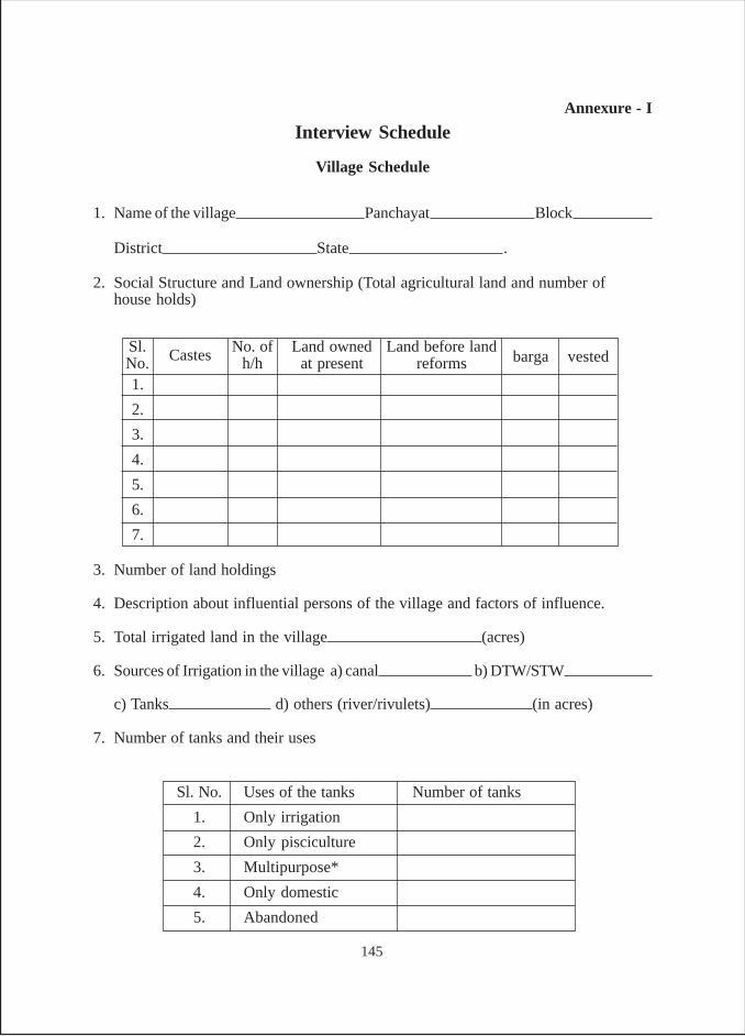
Annexure - I
Interview Schedule
Village Schedule
1. Name of the village Panchayat Block
District State .
2. Social Structure and Land ownership (Total agricultural land and number ofhouse holds)
3. Number of land holdings
4. Description about influential persons of the village and factors of influence.
5. Total irrigated land in the village (acres)
6. Sources of Irrigation in the village a) canal b) DTW/STW
c) Tanks d) others (river/rivulets) (in acres)
7. Number of tanks and their uses
Sl. No. Uses of the tanks Number of tanks
1. Only irrigation
2. Only pisciculture
3. Multipurpose*
4. Only domestic
5. Abandoned
Sl.No. Castes No. of
h/hLand owned
at presentLand before land
reforms barga vested
1.
2.
3.
4.
5.
6.
7.
145
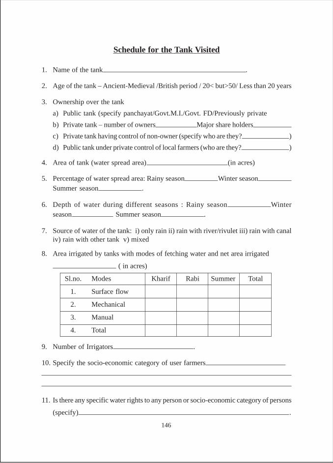
Schedule for the Tank Visited
1. Name of the tank .
2. Age of the tank – Ancient-Medieval /British period / 20< but>50/ Less than 20 years
3. Ownership over the tank
a) Public tank (specify panchayat/Govt.M.I./Govt. FD/Previously private
b) Private tank – number of owners Major share holders
c) Private tank having control of non-owner (specify who are they? )
d) Public tank under private control of local farmers (who are they? )
4. Area of tank (water spread area) (in acres)
5. Percentage of water spread area: Rainy season Winter seasonSummer season .
6. Depth of water during different seasons : Rainy season Winterseason Summer season .
7. Source of water of the tank: i) only rain ii) rain with river/rivulet iii) rain with canaliv) rain with other tank v) mixed
8. Area irrigated by tanks with modes of fetching water and net area irrigated
( in acres)
9. Number of Irrigators .
10. Specify the socio-economic category of user farmers
11. Is there any specific water rights to any person or socio-economic category of persons
(specify) .
Sl.no. Modes Kharif Rabi Summer Total
1. Surface flow
2. Mechanical
3. Manual
4. Total
146
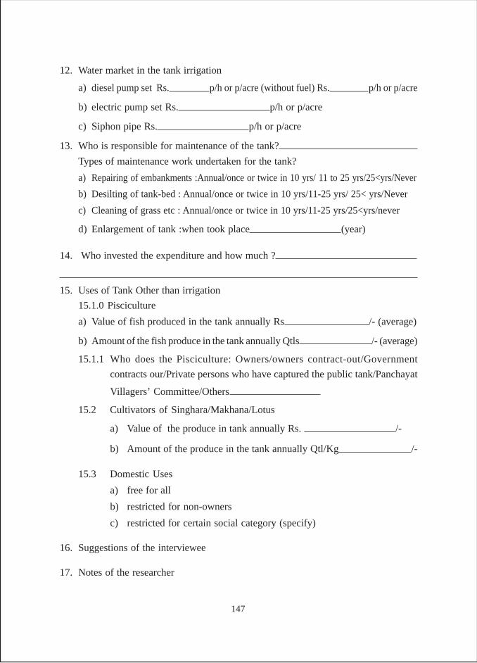
12. Water market in the tank irrigation
a) diesel pump set Rs. p/h or p/acre (without fuel) Rs. p/h or p/acre
b) electric pump set Rs. p/h or p/acre
c) Siphon pipe Rs. p/h or p/acre
13. Who is responsible for maintenance of the tank?
Types of maintenance work undertaken for the tank?
a) Repairing of embankments :Annual/once or twice in 10 yrs/ 11 to 25 yrs/25<yrs/Never
b) Desilting of tank-bed : Annual/once or twice in 10 yrs/11-25 yrs/ 25< yrs/Never
c) Cleaning of grass etc : Annual/once or twice in 10 yrs/11-25 yrs/25<yrs/never
d) Enlargement of tank :when took place (year)
14. Who invested the expenditure and how much ?
15. Uses of Tank Other than irrigation
15.1.0 Pisciculture
a) Value of fish produced in the tank annually Rs /- (average)
b) Amount of the fish produce in the tank annually Qtls /- (average)
15.1.1 Who does the Pisciculture: Owners/owners contract-out/Government
contracts our/Private persons who have captured the public tank/Panchayat
Villagers’ Committee/Others
15.2 Cultivators of Singhara/Makhana/Lotus
a) Value of the produce in tank annually Rs. /-
b) Amount of the produce in the tank annually Qtl/Kg /-
15.3 Domestic Uses
a) free for all
b) restricted for non-owners
c) restricted for certain social category (specify)
16. Suggestions of the interviewee
17. Notes of the researcher
147
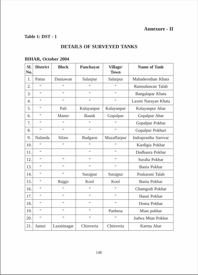
Sl. District Block Panchayat Village/ Name of TankNo. Town
1. Patna Daniawan Salarpur Salarpur Mahadeosthan Khata
2. " " " " Ramsuhawan Talab
3. " " " " Bangalapar Khata
4. " " " " Laxmi Narayan Khata
5. " Pali Kalayanpur Kalayanpur Kalayanpur Ahar
6. " Maner Baank Gopalpur Gopalpur Ahar
7. " " " " Gopalpur Pokhar
8. " " " " Gopalpur Pokhari
9. Nalanda Silaw Badgaon Muzaffarpur Indraprastha Sarovar
10. " " " " Kardigia Pokhar
11. " " " Dudhaura Pokhar
12. " " " " Suraha Pokhar
13. " " " " Bania Pokhar
14. " " Surajpur Surajpur Puskarani Talab
15. " Rajgir Kool Kool Bania Pokhar
16. " " " " Chamgodi Pokhar
17. " " " " Hasni Pokhar
18. " " " " Doma Pokhar
19. " " " Panhesa Mian pokhar
20. " " " " Judwa Mian Pokhar
21. Jamui Laxminagar Chinveria Chinveria Karma Ahar
Annexure - II
DETAILS OF SURVEYED TANKS
BIHAR, October 2004
Table 1: DST - 1
148
Sl. No. District Block Panchayat Village/ Town Name of Tank
1. Palamau Chainpur Neora Neora Jethia talab
2. " " " " Neora Talab
3. " " N.S. Pathra Narsingh Pathara Purana Pokhar
4. " " Rabda Nenua Nenua Talab
5. " " Majhgawa Majhawa Majhgawa Talab
6. " " " Bhairawa Bhairwa Talab
7. " " " Nagwa Nagwa Talab
8. " " Chainpur Chainpur Bathi Talab
9. " " Harbhanga Nimiya Nimiya Talab
10. " " Taleya Bhabundi Ahari Talab
11. " " " " Nawka Pokhar
12. " " " " Baduraha Pokhar
13. " " Chainpur Semra Semra Pokhar
14. " " " " Budhwa Pokhar
15. " " " Semra Tal Ahar
16. Ranchi Bero Khukhra Khukhra Naya Talab
17. " " " " Dhobkar Talab
18. " " " " Bhating Talab
19. " " " " Bair Talab
20. " Sonahatu Sonahatu Sonahatu Nimdi bandh
21. " " " " Brahman bandh
22. " " " " Babu bandh
23. " " Baruhatu Danadih Burha bandh
24. " " " " Gopal bandh
25. " Bundu Baradih Tunju Garia Talab
26. " " Reladih Chitodih Darisokra
27. " " " " Uturraidyar
28. " " Kanchi Kanchi Kalibandh
29. " " Baradih Amjora Nichla Talab
JHARKHAND, February, July 2005 and August 2006
Table 1: DST - 2
149
Sl. No. District Block Panchayat Village/ Town Name of Tank
30. " " " " Mansingh Talab
31. " " Bundu Bundu Boda Talab
Gumla District visited during August 2006
32. Gumla Bharno Turiumba Turiumba Math Talab
33. " " " " Khas Talab I
34. " " " " Khas Talab II
35. " Sisai Kudhra Gurugaon Pachimari Bara bandh
36. " " " " Pahani Don
37. " " " " Bar Garha
38. " " " " Majhesh Pokhar
39. " Bharno Domba Domba Math Talab
40. " " " " Purna Talab
41. Sisai Sidhnathpur Chhoti Sainda Vishra Talab
42. " " " " Panchayat Talab
43. " " " " Sainda bandh
44. " " Sisai Sisai Sisai talab
45. " " Kudhra Kudhra Purana talab
46. " " Bargaon Pilkhi Rosanpur talab
47. " " Redwa Digdon Dadi Doin
150

Sl. No. District Block Panchayat Village/ Town Name of Tank
1. Purulia Purulia I Lagda Lagda Budhi bandh
2. " " " " Mukherjee bandh
3. " " " " Bodo Pukur
4. " " " " Raidas bandh
5. " " " Baghudih Mahato bandh
6. " " " " Gadhir bandh
7. " " " " Nautun bandh
8. " " " " Tal Goria
9. " " " " Bamni Goria
10. " " " " Banka bandh
11. " " " " Bakhla Goria
12. " " " " Asman Goria
13. " " " " Manjhi bandh
14. " Jhalda Jhaldadarda Nawagarh Nehal bandh
15. " " " " Rengtu Singh bandh
16. " " " " Dubrajsingh bandh
17. " " " " Gansa Bandh
18. " " " Baruakocha Bamesar bandh
19. " " " " Barin bandh
20. Bankura Indpur Dharampur Gokulnagar Chand Bandh
21. " " " Dharampur Dharampur bandh
22. " " " " Nautun Pukur
23. " " " " Mondal Pukur
24. " " Hadmauli Moira Moira bandh
25. " " " " Tatir bandh
26. " Panchmuda Devil Beria Lalbandh Lalbandh
27. " " " Devil Beria Purnopukur
28. " Bishnupore Bishnupore Gopalpur, Tejpal Jamuuna bandh
29. " " Bishnupore Tilwari Lal Bandh
30. Birbhum Suri II Maipur Maipur Subhas Mondal Bandh
31. " Suri I Bhuguna Dolgobindpur Budhnath Dey Bandh
WEST BENGAL, October-December 2004
Table 1: DST - 3
(sub-urban)
(sub-urban)
151
ORISSA, September 2004 and May 2005
Table 1: DST - 4
Sl. No. District Block Panchayat Village/ Town Name of Tank
September, 2004
1. Sambhalpur Dhankauda Sasan — Lamal Kata (I & II)
2. " Sambhalpur Kilasama Bhurwaballi Rani KataSadar
3. " Rengali Nisanbhanga Nisanbhanga Bar Kata
4. " " — Babuchakdi ---
5. Bolangir Loisingha Loisingha Loisingha Narayan Sagar
6. " Deogaon Deogaon Deogaon Jogi Sagar
7. Kalahandi Bhawani Mednipur Sairagalangi Khiri KotaPatna (Kara Munda)
8. " Narla Sargiguda NA Asurgarh/Uday Sagar
9. " " Tulapadi NA Tulapada
10. " " Bhanpur Bhanpur Bhanpur Tank
11. " " Santpur Goihrapahar Suknabhata/Khajuri Kata
May, 2005
12. Sambhalpur Jujumura Ghenupali Ghenupali Padma Kata
13. " " Nuabarangamal Nuabarangamal Badasahir Kata No.9
14. " " " " Badasahir Kata No.8
15. Kalahandi Bhawanipatna Mednipur Sujanpur Pipalnala
16. " Bero " Kauntabanji Devi Sagar
17. " " NA Munispal B.P Asha Sagar
18. " Kesinga Kasurpada Kantesir Kantesir
19. " " " Kasurpada Karuna Sagar
20. " Junagarh Kalia Kundal Kalia Kundal Badobandh
21. " " Chhooriagarh Chhooriagarh —
22. " Sadar (B.P.) Dwarson Dwarson Duarsuni Kata(Sundhi Munda)
152
Annexure -IIITables of Tank Irrigation (Bihar)
Table B-1 (Bihar)Age of the Surveyed Tanks
Patna - 7 (87.5) 1 (12.5) - 8 (100)Nalanda 8 (72.7) 3 (27.3) - - 11 (100)Jamui - 1 (100) - - 1 (100)Total 8 (40) 11 (55) 1 (5) - 20 (100)
Total
Categories of age of the tank
DistrictsAnc/Med
Britishperiod
Postindependence Post 1990s
Patna 4 (50) - 4 (50) 8 (100)Nalanda 3 (27.2) 4 (36.6) 4 (36.2) 11 (100)Jamui - 1 (100) - 1 (100)Total 7 (35) 5 (25) 8 (40) 20 (100)
TotalCategories of ownership
Districts Government
Table B-2 (Bihar)Pattern of Ownership of the Tanks
Panchayat Private
Patna 4 (50) 1 (12.5) 3 (37.5) 8 (100)
Nalanda 11 (100) - - 11 (100)Jamui 1 (100) - - 1 (100)Total 16 (80) 1 (5) 3 (15) 20 (100)
TotalCategories of Restrictions
Districts Open to All
Table B-3 (Bihar)Nature of People’s Access to the Tanks
Owners Others
Patna 2(1) 2(8) 2(27) 1(50) 1 (75) - 8(161)
Nalanda 1(1.6) 6(34.9) 2(29) 1(34) 1 (60) - 11(159.5)Jamui - 1(3) - - - - 1(3)Total 3(2.6) 9(45.9) 4(56) 2(84) 2(135) - 20(323.5)
TotalCategories by size of Tanks
Districts
Table B-4 (Bihar)Tanks by their size (in acres)
> 10051-10021-50< 2.5 11-202.5-10
Note : Figures in the brackets show the total area of tanks
153
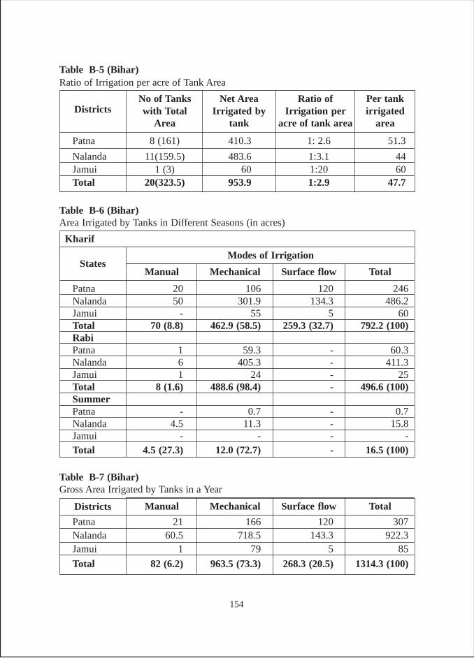
Patna 8 (161) 410.3 1: 2.6 51.3
Nalanda 11(159.5) 483.6 1:3.1 44Jamui 1 (3) 60 1:20 60Total 20(323.5) 953.9 1:2.9 47.7
Table B-5 (Bihar)Ratio of Irrigation per acre of Tank Area
Ratio ofIrrigation per
acre of tank area
Net AreaIrrigated by
tank
No of Tankswith Total
AreaDistricts
Per tankirrigated
area
Patna 20 106 120 246Nalanda 50 301.9 134.3 486.2Jamui - 55 5 60Total 70 (8.8) 462.9 (58.5) 259.3 (32.7) 792.2 (100)RabiPatna 1 59.3 - 60.3Nalanda 6 405.3 - 411.3Jamui 1 24 - 25Total 8 (1.6) 488.6 (98.4) - 496.6 (100)SummerPatna - 0.7 - 0.7Nalanda 4.5 11.3 - 15.8Jamui - - - -Total 4.5 (27.3) 12.0 (72.7) - 16.5 (100)
Table B-6 (Bihar)Area Irrigated by Tanks in Different Seasons (in acres)
States
Kharif
Modes of Irrigation
Manual Mechanical Surface flow Total
Table B-7 (Bihar)Gross Area Irrigated by Tanks in a Year
Patna 21 166 120 307Nalanda 60.5 718.5 143.3 922.3Jamui 1 79 5 85
Total 82 (6.2) 963.5 (73.3) 268.3 (20.5) 1314.3 (100)
Districts Manual Mechanical Surface flow Total
154
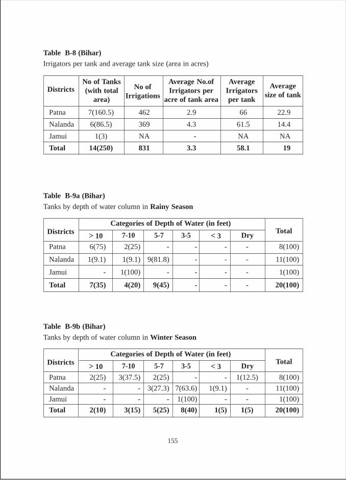
Patna 2(25) 3(37.5) 2(25) - - 1(12.5) 8(100)
Nalanda - - 3(27.3) 7(63.6) 1(9.1) - 11(100)
Jamui - - - 1(100) - - 1(100)
Total 2(10) 3(15) 5(25) 8(40) 1(5) 1(5) 20(100)
TotalCategories of Depth of Water (in feet)
Districts
Table B-9b (Bihar)
Tanks by depth of water column in Winter Season
Dry< 33-5> 10 5-77-10
Patna 6(75) 2(25) - - - - 8(100)
Nalanda 1(9.1) 1(9.1) 9(81.8) - - - 11(100)
Jamui - 1(100) - - - - 1(100)
Total 7(35) 4(20) 9(45) - - - 20(100)
TotalCategories of Depth of Water (in feet)
Districts
Table B-9a (Bihar)
Tanks by depth of water column in Rainy Season
Dry< 33-5> 10 5-77-10
Patna 7(160.5) 462 2.9 66 22.9
Nalanda 6(86.5) 369 4.3 61.5 14.4
Jamui 1(3) NA - NA NA
Total 14(250) 831 3.3 58.1 19
Table B-8 (Bihar)
Irrigators per tank and average tank size (area in acres)
AverageIrrigatorsper tank
Average No.ofIrrigators per
acre of tank area
No of Tanks(with total
area)Districts Average
size of tankNo of
Irrigations
155
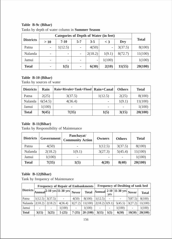
Patna - 1(12.5) - 4(50) - 3(37.5) 8(100)
Nalanda - - - 2(18.2) 1(9.1) 8(72.7) 11(100)
Jamui - - - - 1(100) 1(100)
Total - 1(5) - 6(30) 2(10) 11(55) 20(100)
TotalCategories of Depth of Water (in feet)
Districts
Table B-9c (Bihar)Tanks by depth of water column in Summer Season
Dry< 33-5> 10 5-77-10
Patna 2(25) 3(37.5) 1(12.5) 2(25) 8(100)
Nalanda 6(54.5) 4(36.4) - 1(9.1) 11(100)
Jamui 1(100) - - - 1(100)
Total 9(45) 7(35) 1(5) 3(15) 20(100)
Table B-10 (Bihar)Tanks by sources of water
Districts TotalOthersRain+CanalRain Rain+Rivulet+Tank+Flood
Patna 4(50) - 1(12.5) 3(37.5) 8(100)
Nalanda 2(18.2) 1(9.1) 3(27.3) 5(45.4) 11(100)
Jamui 1(100) - - - 1(100)
Total 7(35) 1(5) 4(20) 8(40) 20(100)
Table B-11(Bihar)Tanks by Responsibility of Maintenance
OthersOwnersGovernmentDistricts TotalPanchayat/
Community Action
Patna 1(12.5) 3(37.5) - 4(50) 8(100) 1(12.5) - - 7(87.5) 8(100)Nalanda 2(18.2) 2(18.2) 4(36.4) 3(27.2) 11(100) 2(18.2) 1(9.1) 5(45.5) 3(27.2) 11(100)Jamui - - 1(100) - 1(100) - - 1(100) - 1(100)Total 3(15) 5(25) 5 (25) 7 (35) 20 (100) 3(15) 1(5) 6(30) 10(50) 20(100)
Table B-12(Bihar)Tank by frequency of Maintenance
AnnualDistricts
Frequency of Repair of Embankments2-10 yrs 11-30 yrs Never Total TotalAnnual 2-10
yrs11-30 yrs
Frequency of Desilting of tank bed
Never
156
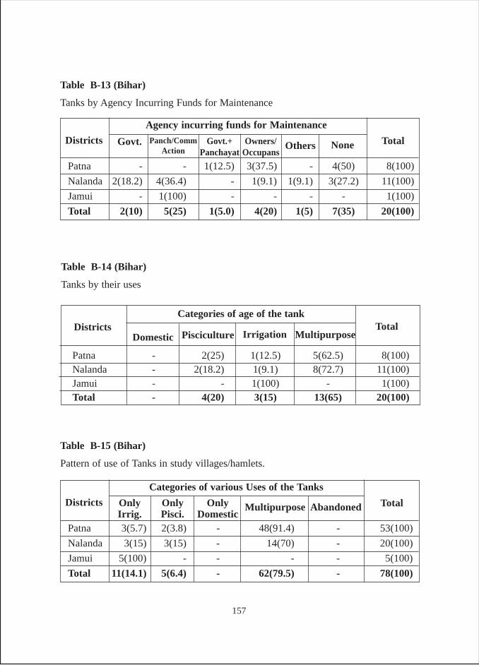
Table B-13 (Bihar)
Tanks by Agency Incurring Funds for Maintenance
Patna - - 1(12.5) 3(37.5) - 4(50) 8(100)
Nalanda 2(18.2) 4(36.4) - 1(9.1) 1(9.1) 3(27.2) 11(100)
Jamui - 1(100) - - - - 1(100)
Total 2(10) 5(25) 1(5.0) 4(20) 1(5) 7(35) 20(100)
Total
Agency incurring funds for Maintenance
Districts NoneOthersOwners/Occupans
Govt. Govt.+Panchayat
Panch/CommAction
Table B-14 (Bihar)
Tanks by their uses
Patna - 2(25) 1(12.5) 5(62.5) 8(100)Nalanda - 2(18.2) 1(9.1) 8(72.7) 11(100)Jamui - - 1(100) - 1(100)Total - 4(20) 3(15) 13(65) 20(100)
TotalCategories of age of the tank
DistrictsDomestic Pisciculture Irrigation Multipurpose
Table B-15 (Bihar)
Pattern of use of Tanks in study villages/hamlets.
Patna 3(5.7) 2(3.8) - 48(91.4) - 53(100)
Nalanda 3(15) 3(15) - 14(70) - 20(100)
Jamui 5(100) - - - - 5(100)
Total 11(14.1) 5(6.4) - 62(79.5) - 78(100)
Total
Categories of various Uses of the Tanks
Districts AbandonedOnlyDomestic
MultipurposeOnlyPisci.
OnlyIrrig.
157
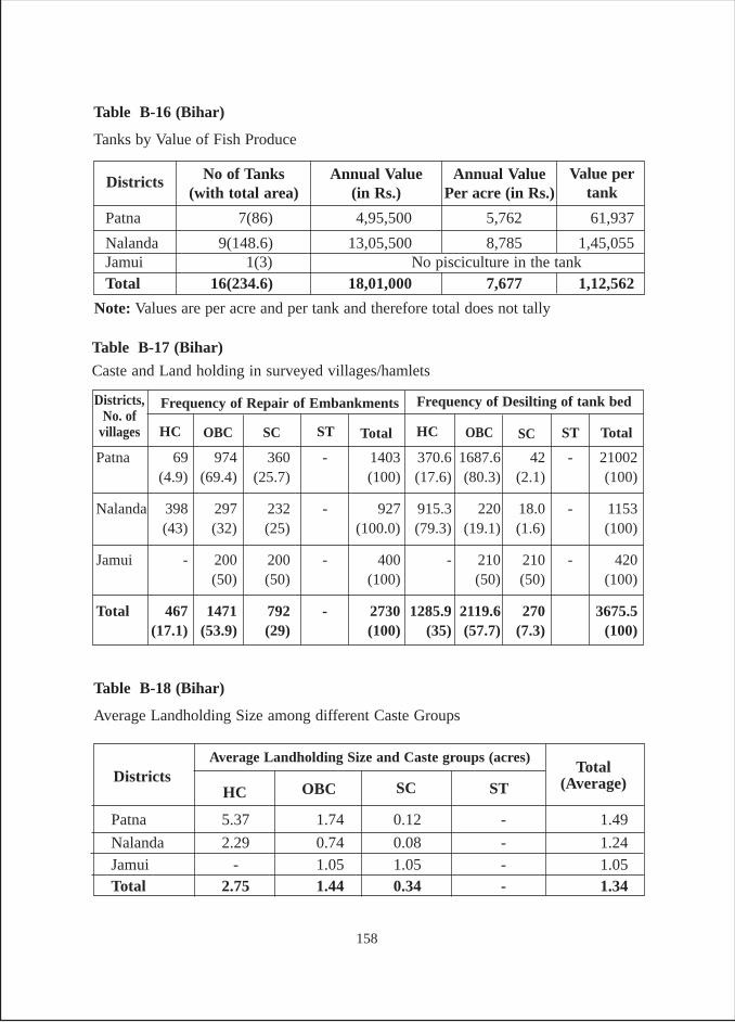
Table B-16 (Bihar)
Tanks by Value of Fish Produce
Annual Value(in Rs.)
No of Tanks(with total area)
Districts Value pertank
Annual ValuePer acre (in Rs.)
Patna 7(86) 4,95,500 5,762 61,937
Nalanda 9(148.6) 13,05,500 8,785 1,45,055Jamui 1(3) No pisciculture in the tankTotal 16(234.6) 18,01,000 7,677 1,12,562
Table B-18 (Bihar)
Average Landholding Size among different Caste Groups
Patna 5.37 1.74 0.12 - 1.49
Nalanda 2.29 0.74 0.08 - 1.24Jamui - 1.05 1.05 - 1.05Total 2.75 1.44 0.34 - 1.34
Total(Average)
Average Landholding Size and Caste groups (acres)Districts
HC OBC SC ST
Patna 69 974 360 - 1403 370.6 1687.6 42 - 21002(4.9) (69.4) (25.7) (100) (17.6) (80.3) (2.1) (100)
Nalanda 398 297 232 - 927 915.3 220 18.0 - 1153(43) (32) (25) (100.0) (79.3) (19.1) (1.6) (100)
Jamui - 200 200 - 400 - 210 210 - 420(50) (50) (100) (50) (50) (100)
Total 467 1471 792 - 2730 1285.9 2119.6 270 3675.5(17.1) (53.9) (29) (100) (35) (57.7) (7.3) (100)
Table B-17 (Bihar)
Caste and Land holding in surveyed villages/hamlets
HC
Districts,No. of
villages
Frequency of Repair of Embankments
OBC SC ST Total TotalHC OBC SC
Frequency of Desilting of tank bed
ST
Note: Values are per acre and per tank and therefore total does not tally
158
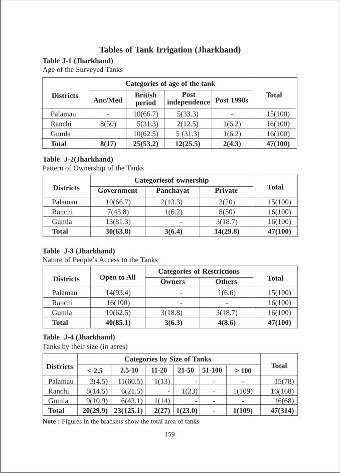
Palamau 10(66.7) 2(13.3) 3(20) 15(100)Ranchi 7(43.8) 1(6.2) 8(50) 16(100)Gumla 13(81.3) - 3(18.7) 16(100)Total 30(63.8) 3(6.4) 14(29.8) 47(100)
TotalCategoriesof ownership
Districts Government
Table J-2(Jharkhand)Pattern of Ownership of the Tanks
Panchayat Private
Palamau 14(93.4) - 1(6.6) 15(100)Ranchi 16(100) - - 16(100)Gumla 10(62.5) 3(18.8) 3(18.7) 16(100)Total 40(85.1) 3(6.3) 4(8.6) 47(100)
TotalCategories of Restrictions
Districts Open to All
Table J-3 (Jharkhand)Nature of People’s Access to the Tanks
Owners Others
Palamau 3(4.5) 11(60.5) 1(13) - - - 15(78)Ranchi 8(14.5) 6(21.5) - 1(23) - 1(109) 16(168)Gumla 9(10.9) 6(43.1) 1(14) - - - 16(68)Total 20(29.9) 23(125.1) 2(27) 1(23.0) - 1(109) 47(314)
TotalCategories by Size of Tanks
Districts
Table J-4 (Jharkhand)Tanks by their size (in acres)
> 10051-10021-50< 2.5 11-202.5-10
Note : Figures in the brackets show the total area of tanks
Tables of Tank Irrigation (Jharkhand)Table J-1 (Jharkhand)Age of the Surveyed Tanks
Palamau - 10(66.7) 5(33.3) - 15(100)Ranchi 8(50) 5(31.3) 2(12.5) 1(6.2) 16(100)Gumla 10(62.5) 5 (31.3) 1(6.2) 16(100)Total 8(17) 25(53.2) 12(25.5) 2(4.3) 47(100)
Total
Categories of age of the tank
DistrictsAnc/Med
Britishperiod
Postindependence Post 1990s
159
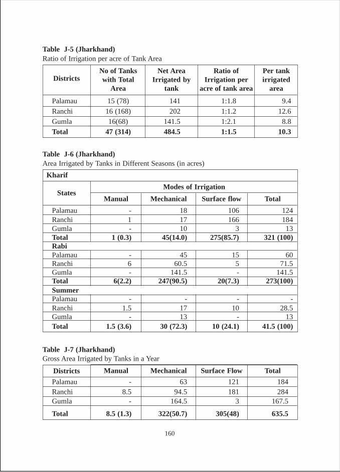
Palamau 15 (78) 141 1:1.8 9.4
Ranchi 16 (168) 202 1:1.2 12.6
Gumla 16(68) 141.5 1:2.1 8.8
Total 47 (314) 484.5 1:1.5 10.3
Table J-5 (Jharkhand)Ratio of Irrigation per acre of Tank Area
Ratio ofIrrigation per
acre of tank area
Net AreaIrrigated by
tank
No of Tankswith Total
AreaDistricts
Per tankirrigated
area
Palamau - 18 106 124Ranchi 1 17 166 184Gumla - 10 3 13Total 1 (0.3) 45(14.0) 275(85.7) 321 (100)RabiPalamau - 45 15 60Ranchi 6 60.5 5 71.5Gumla - 141.5 - 141.5Total 6(2.2) 247(90.5) 20(7.3) 273(100)SummerPalamau - - - -Ranchi 1.5 17 10 28.5Gumla - 13 - 13Total 1.5 (3.6) 30 (72.3) 10 (24.1) 41.5 (100)
Table J-6 (Jharkhand)Area Irrigated by Tanks in Different Seasons (in acres)
States
Kharif
Modes of Irrigation
Manual Mechanical Surface flow Total
Table J-7 (Jharkhand)Gross Area Irrigated by Tanks in a Year
Palamau - 63 121 184Ranchi 8.5 94.5 181 284Gumla - 164.5 3 167.5
Total 8.5 (1.3) 322(50.7) 305(48) 635.5
Districts Manual Mechanical Surface Flow Total
160
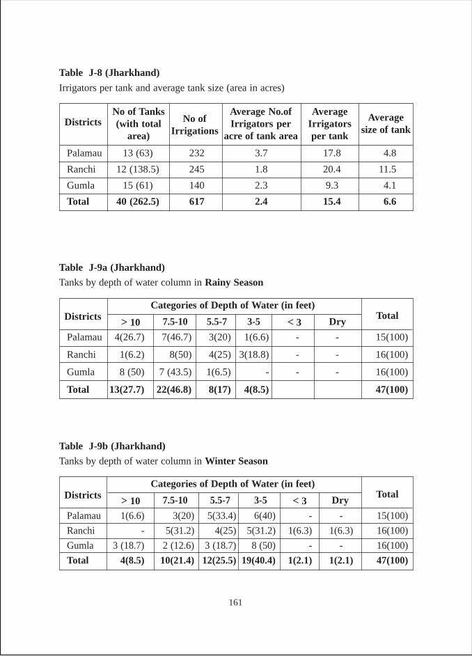
Palamau 1(6.6) 3(20) 5(33.4) 6(40) - - 15(100)
Ranchi - 5(31.2) 4(25) 5(31.2) 1(6.3) 1(6.3) 16(100)
Gumla 3 (18.7) 2 (12.6) 3 (18.7) 8 (50) - - 16(100)
Total 4(8.5) 10(21.4) 12(25.5) 19(40.4) 1(2.1) 1(2.1) 47(100)
TotalCategories of Depth of Water (in feet)
Districts
Table J-9b (Jharkhand)
Tanks by depth of water column in Winter Season
Dry< 33-5> 10 5.5-77.5-10
Palamau 4(26.7) 7(46.7) 3(20) 1(6.6) - - 15(100)
Ranchi 1(6.2) 8(50) 4(25) 3(18.8) - - 16(100)
Gumla 8 (50) 7 (43.5) 1(6.5) - - - 16(100)
Total 13(27.7) 22(46.8) 8(17) 4(8.5) 47(100)
TotalCategories of Depth of Water (in feet)
Districts
Table J-9a (Jharkhand)
Tanks by depth of water column in Rainy Season
Dry< 33-5> 10 5.5-77.5-10
Palamau 13 (63) 232 3.7 17.8 4.8
Ranchi 12 (138.5) 245 1.8 20.4 11.5
Gumla 15 (61) 140 2.3 9.3 4.1
Total 40 (262.5) 617 2.4 15.4 6.6
Table J-8 (Jharkhand)
Irrigators per tank and average tank size (area in acres)
AverageIrrigatorsper tank
Average No.ofIrrigators per
acre of tank area
No of Tanks(with total
area)Districts Average
size of tankNo of
Irrigations
161
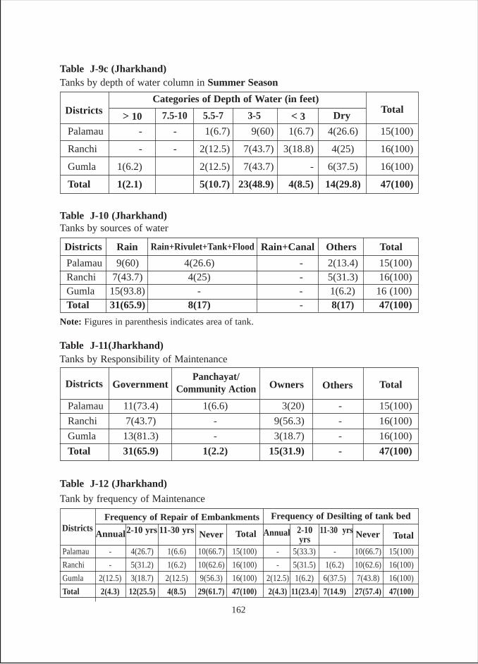
Palamau - - 1(6.7) 9(60) 1(6.7) 4(26.6) 15(100)
Ranchi - - 2(12.5) 7(43.7) 3(18.8) 4(25) 16(100)
Gumla 1(6.2) 2(12.5) 7(43.7) - 6(37.5) 16(100)
Total 1(2.1) 5(10.7) 23(48.9) 4(8.5) 14(29.8) 47(100)
TotalCategories of Depth of Water (in feet)
Districts
Table J-9c (Jharkhand)Tanks by depth of water column in Summer Season
Dry< 33-5> 10 5.5-77.5-10
Palamau 11(73.4) 1(6.6) 3(20) - 15(100)
Ranchi 7(43.7) - 9(56.3) - 16(100)
Gumla 13(81.3) - 3(18.7) - 16(100)
Total 31(65.9) 1(2.2) 15(31.9) - 47(100)
Table J-11(Jharkhand)Tanks by Responsibility of Maintenance
OthersOwnersGovernmentDistricts TotalPanchayat/
Community Action
Palamau - 4(26.7) 1(6.6) 10(66.7) 15(100) - 5(33.3) - 10(66.7) 15(100)
Ranchi - 5(31.2) 1(6.2) 10(62.6) 16(100) - 5(31.5) 1(6.2) 10(62.6) 16(100)
Gumla 2(12.5) 3(18.7) 2(12.5) 9(56.3) 16(100) 2(12.5) 1(6.2) 6(37.5) 7(43.8) 16(100)
Total 2(4.3) 12(25.5) 4(8.5) 29(61.7) 47(100) 2(4.3) 11(23.4) 7(14.9) 27(57.4) 47(100)
Table J-12 (Jharkhand)
Tank by frequency of Maintenance
AnnualDistricts
Frequency of Repair of Embankments2-10 yrs 11-30 yrs Never Total TotalAnnual 2-10
yrs11-30 yrs
Frequency of Desilting of tank bed
Never
Table J-10 (Jharkhand)Tanks by sources of water
Palamau 9(60) 4(26.6) - 2(13.4) 15(100)Ranchi 7(43.7) 4(25) - 5(31.3) 16(100)Gumla 15(93.8) - - 1(6.2) 16 (100)Total 31(65.9) 8(17) - 8(17) 47(100)
Districts TotalOthersRain+CanalRain Rain+Rivulet+Tank+Flood
Note: Figures in parenthesis indicates area of tank.
162
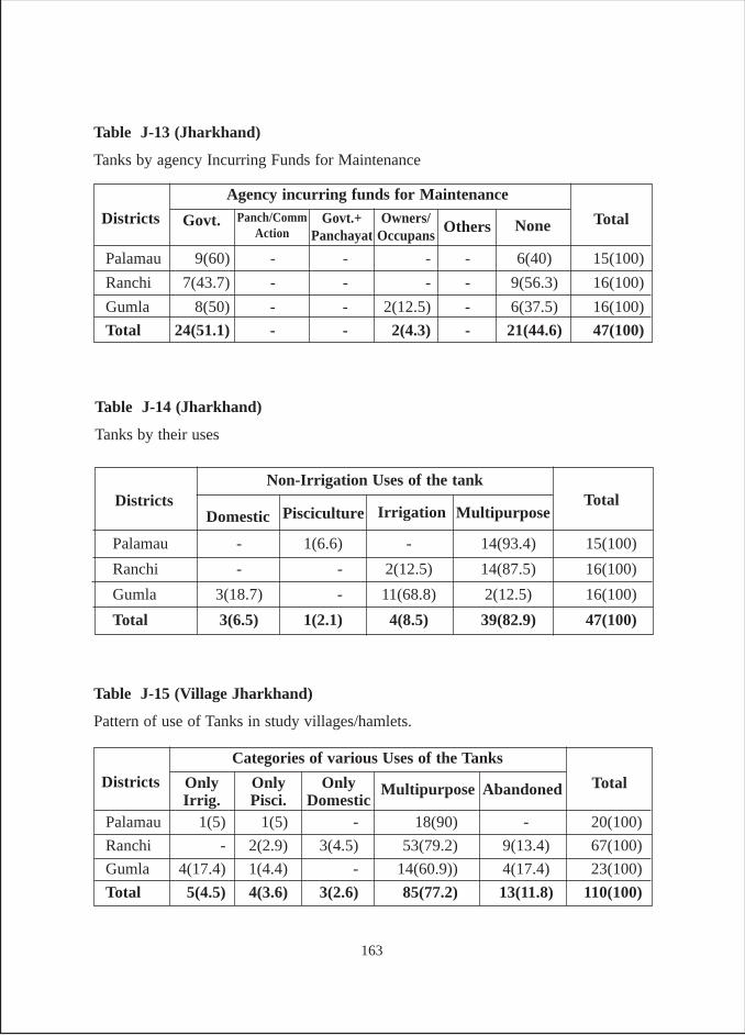
Table J-13 (Jharkhand)
Tanks by agency Incurring Funds for Maintenance
Palamau 9(60) - - - - 6(40) 15(100)
Ranchi 7(43.7) - - - - 9(56.3) 16(100)
Gumla 8(50) - - 2(12.5) - 6(37.5) 16(100)
Total 24(51.1) - - 2(4.3) - 21(44.6) 47(100)
Total
Agency incurring funds for Maintenance
Districts NoneOthersOwners/Occupans
Govt. Govt.+Panchayat
Panch/CommAction
Table J-15 (Village Jharkhand)
Pattern of use of Tanks in study villages/hamlets.
Palamau 1(5) 1(5) - 18(90) - 20(100)
Ranchi - 2(2.9) 3(4.5) 53(79.2) 9(13.4) 67(100)
Gumla 4(17.4) 1(4.4) - 14(60.9)) 4(17.4) 23(100)
Total 5(4.5) 4(3.6) 3(2.6) 85(77.2) 13(11.8) 110(100)
Total
Categories of various Uses of the Tanks
Districts AbandonedOnlyDomestic
MultipurposeOnlyPisci.
OnlyIrrig.
Table J-14 (Jharkhand)
Tanks by their uses
Palamau - 1(6.6) - 14(93.4) 15(100)
Ranchi - - 2(12.5) 14(87.5) 16(100)
Gumla 3(18.7) - 11(68.8) 2(12.5) 16(100)
Total 3(6.5) 1(2.1) 4(8.5) 39(82.9) 47(100)
TotalNon-Irrigation Uses of the tank
DistrictsDomestic Pisciculture Irrigation Multipurpose
163
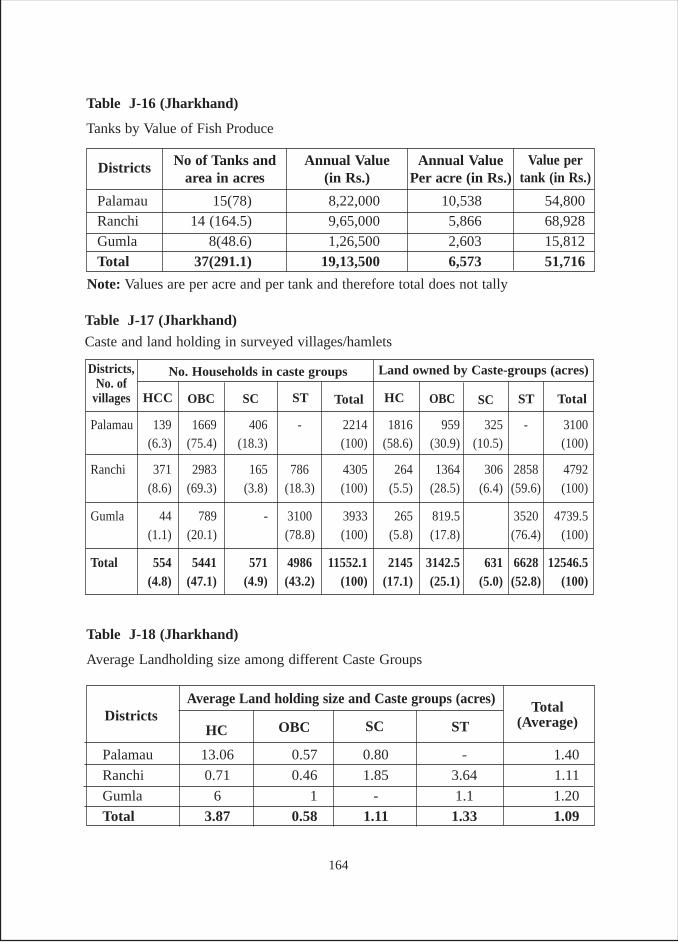
Table J-16 (Jharkhand)
Tanks by Value of Fish Produce
Annual Value(in Rs.)
No of Tanks andarea in acres
Districts Value pertank (in Rs.)
Annual ValuePer acre (in Rs.)
Palamau 15(78) 8,22,000 10,538 54,800Ranchi 14 (164.5) 9,65,000 5,866 68,928Gumla 8(48.6) 1,26,500 2,603 15,812Total 37(291.1) 19,13,500 6,573 51,716
Table J-18 (Jharkhand)
Average Landholding size among different Caste Groups
Palamau 13.06 0.57 0.80 - 1.40
Ranchi 0.71 0.46 1.85 3.64 1.11
Gumla 6 1 - 1.1 1.20
Total 3.87 0.58 1.11 1.33 1.09
Total(Average)
Average Land holding size and Caste groups (acres)Districts
HC OBC SC ST
Palamau 139 1669 406 - 2214 1816 959 325 - 3100(6.3) (75.4) (18.3) (100) (58.6) (30.9) (10.5) (100)
Ranchi 371 2983 165 786 4305 264 1364 306 2858 4792(8.6) (69.3) (3.8) (18.3) (100) (5.5) (28.5) (6.4) (59.6) (100)
Gumla 44 789 - 3100 3933 265 819.5 3520 4739.5(1.1) (20.1) (78.8) (100) (5.8) (17.8) (76.4) (100)
Total 554 5441 571 4986 11552.1 2145 3142.5 631 6628 12546.5(4.8) (47.1) (4.9) (43.2) (100) (17.1) (25.1) (5.0) (52.8) (100)
Table J-17 (Jharkhand)
Caste and land holding in surveyed villages/hamlets
HCC
Districts,No. of
villages
No. Households in caste groups
OBC SC ST Total TotalHC OBC SC
Land owned by Caste-groups (acres)
ST
Note: Values are per acre and per tank and therefore total does not tally
164
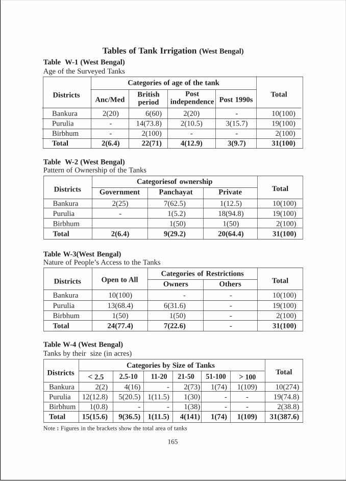
Tables of Tank Irrigation (West Bengal)
Table W-1 (West Bengal)Age of the Surveyed Tanks
Bankura 2(20) 6(60) 2(20) - 10(100)Purulia - 14(73.8) 2(10.5) 3(15.7) 19(100)Birbhum - 2(100) - - 2(100)Total 2(6.4) 22(71) 4(12.9) 3(9.7) 31(100)
Total
Categories of age of the tank
DistrictsAnc/Med
Britishperiod
Postindependence Post 1990s
Bankura 2(25) 7(62.5) 1(12.5) 10(100)Purulia - 1(5.2) 18(94.8) 19(100)Birbhum 1(50) 1(50) 2(100)Total 2(6.4) 9(29.2) 20(64.4) 31(100)
TotalCategoriesof ownership
Districts Government
Table W-2 (West Bengal)Pattern of Ownership of the Tanks
Panchayat Private
Bankura 10(100) - - 10(100)Purulia 13(68.4) 6(31.6) - 19(100)Birbhum 1(50) 1(50) - 2(100)Total 24(77.4) 7(22.6) - 31(100)
TotalCategories of Restrictions
Districts Open to All
Table W-3(West Bengal)Nature of People’s Access to the Tanks
Owners Others
Bankura 2(2) 4(16) - 2(73) 1(74) 1(109) 10(274)Purulia 12(12.8) 5(20.5) 1(11.5) 1(30) - - 19(74.8)Birbhum 1(0.8) - - 1(38) - - 2(38.8)Total 15(15.6) 9(36.5) 1(11.5) 4(141) 1(74) 1(109) 31(387.6)
TotalCategories by Size of Tanks
Districts
Table W-4 (West Bengal)Tanks by their size (in acres)
> 10051-10021-50< 2.5 11-202.5-10
Note : Figures in the brackets show the total area of tanks
165
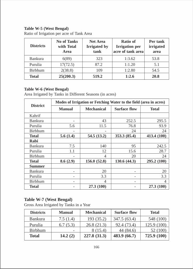
Bankura 6(89) 323 1:3.62 53.8
Purulia 17(72.5) 87.2 1:1.20 5.1Birbhum 2(38.8) 109 1:2.80 54.5
Total 25(200.3) 519.2 1:2.6 20.8
Table W-5 (West Bengal)Ratio of Irrigation per acre of Tank Area
Ratio ofIrrigation per
acre of tank area
Net AreaIrrigated by
tank
No of Tankswith Total
AreaDistricts
Per tankirrigated
area
Table W-7 (West Bengal)Gross Area Irrigated by Tanks in a Year
Bankura 7.5 (1.4) 193 (35.2) 347.5 (63.4) 548 (100)Purulia 6.7 (5.3) 26.8 (21.3) 92.4 (73.4) 125.9 (100)Birbhum - 8 (15.4) 44 (84.6) 52 (100)Total 14.2 (2) 227.8 (31.3) 483.9 (66.7) 725.9 (100)
Districts Manual Mechanical Surface flow Total
Table W-6 (West Bengal)Area Irrigated by Tanks in Different Seasons (in acres)
KahrifBankura - 43 252.5 295.5Purulia 5.6 11.5 76.8 93.9Birbhum - - 24 24Total 5.6 (1.4) 54.5 (13.2) 353.3 (85.4) 413.4 (100)RabiBankura 7.5 140 95 242.5Purulia 1.1 12 15.6 28.7Birbhum - 4 20 24Total 8.6 (2.9) 156.0 (52.8) 130.6 (44.3) 295.2 (100)SummerBankura - 20 - 20Purulia - 3.3 - 3.3Birbhum - 4 - 4Total - 27.3 (100) - 27.3 (100)
DistrictModes of Irrigation or Fetching Water to the field (area in acres)
Manual Mechanical Surface flow Total
166
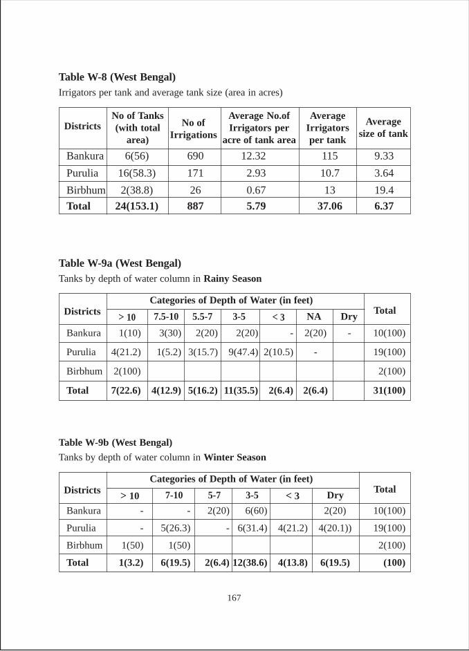
Table W-9b (West Bengal)
Tanks by depth of water column in Winter Season
Table W-9a (West Bengal)Tanks by depth of water column in Rainy Season
Bankura 6(56) 690 12.32 115 9.33
Purulia 16(58.3) 171 2.93 10.7 3.64
Birbhum 2(38.8) 26 0.67 13 19.4
Total 24(153.1) 887 5.79 37.06 6.37
Table W-8 (West Bengal)Irrigators per tank and average tank size (area in acres)
AverageIrrigatorsper tank
Average No.ofIrrigators per
acre of tank area
No of Tanks(with total
area)Districts Average
size of tankNo of
Irrigations
Bankura - - 2(20) 6(60) 2(20) 10(100)
Purulia - 5(26.3) - 6(31.4) 4(21.2) 4(20.1)) 19(100)
Birbhum 1(50) 1(50) 2(100)
Total 1(3.2) 6(19.5) 2(6.4) 12(38.6) 4(13.8) 6(19.5) (100)
TotalCategories of Depth of Water (in feet)
Districts Dry< 33-5> 10 5-77-10
Bankura 1(10) 3(30) 2(20) 2(20) - 2(20) - 10(100)
Purulia 4(21.2) 1(5.2) 3(15.7) 9(47.4) 2(10.5) - 19(100)
Birbhum 2(100) 2(100)
Total 7(22.6) 4(12.9) 5(16.2) 11(35.5) 2(6.4) 2(6.4) 31(100)
TotalCategories of Depth of Water (in feet)
Districts Dry< 33-5> 10 5.5-77.5-10 NA
167
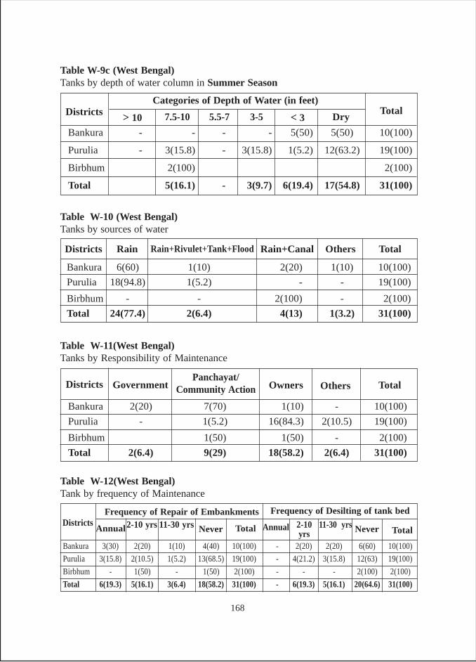
Bankura 3(30) 2(20) 1(10) 4(40) 10(100) - 2(20) 2(20) 6(60) 10(100)
Purulia 3(15.8) 2(10.5) 1(5.2) 13(68.5) 19(100) - 4(21.2) 3(15.8) 12(63) 19(100)
Birbhum - 1(50) - 1(50) 2(100) - - - 2(100) 2(100)
Total 6(19.3) 5(16.1) 3(6.4) 18(58.2) 31(100) - 6(19.3) 5(16.1) 20(64.6) 31(100)
Table W-12(West Bengal)Tank by frequency of Maintenance
AnnualDistricts
Frequency of Repair of Embankments2-10 yrs 11-30 yrs Never Total TotalAnnual 2-10
yrs11-30 yrs
Frequency of Desilting of tank bed
Never
Bankura 2(20) 7(70) 1(10) - 10(100)
Purulia - 1(5.2) 16(84.3) 2(10.5) 19(100)
Birbhum 1(50) 1(50) - 2(100)
Total 2(6.4) 9(29) 18(58.2) 2(6.4) 31(100)
Table W-11(West Bengal)Tanks by Responsibility of Maintenance
OthersOwnersGovernmentDistricts TotalPanchayat/
Community Action
Bankura 6(60) 1(10) 2(20) 1(10) 10(100)
Purulia 18(94.8) 1(5.2) - - 19(100)
Birbhum - - 2(100) - 2(100)
Total 24(77.4) 2(6.4) 4(13) 1(3.2) 31(100)
Table W-10 (West Bengal)Tanks by sources of water
Districts TotalOthersRain+CanalRain Rain+Rivulet+Tank+Flood
Bankura - - - - 5(50) 5(50) 10(100)
Purulia - 3(15.8) - 3(15.8) 1(5.2) 12(63.2) 19(100)
Birbhum 2(100) 2(100)
Total 5(16.1) - 3(9.7) 6(19.4) 17(54.8) 31(100)
TotalCategories of Depth of Water (in feet)
Districts
Table W-9c (West Bengal)Tanks by depth of water column in Summer Season
Dry< 33-5> 10 5.5-77.5-10
168
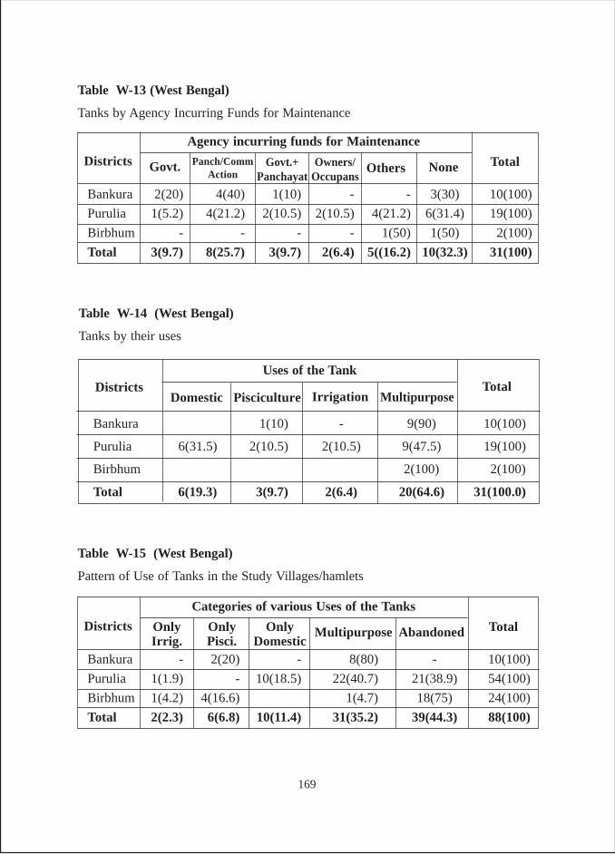
Table W-13 (West Bengal)
Tanks by Agency Incurring Funds for Maintenance
Bankura 2(20) 4(40) 1(10) - - 3(30) 10(100)
Purulia 1(5.2) 4(21.2) 2(10.5) 2(10.5) 4(21.2) 6(31.4) 19(100)
Birbhum - - - - 1(50) 1(50) 2(100)
Total 3(9.7) 8(25.7) 3(9.7) 2(6.4) 5((16.2) 10(32.3) 31(100)
Total
Agency incurring funds for Maintenance
Districts NoneOthersOwners/Occupans
Govt. Govt.+Panchayat
Panch/CommAction
Table W-15 (West Bengal)
Pattern of Use of Tanks in the Study Villages/hamlets
Bankura - 2(20) - 8(80) - 10(100)
Purulia 1(1.9) - 10(18.5) 22(40.7) 21(38.9) 54(100)
Birbhum 1(4.2) 4(16.6) 1(4.7) 18(75) 24(100)
Total 2(2.3) 6(6.8) 10(11.4) 31(35.2) 39(44.3) 88(100)
Total
Categories of various Uses of the Tanks
Districts AbandonedOnlyDomestic
MultipurposeOnlyPisci.
OnlyIrrig.
Table W-14 (West Bengal)
Tanks by their uses
Bankura 1(10) - 9(90) 10(100)
Purulia 6(31.5) 2(10.5) 2(10.5) 9(47.5) 19(100)
Birbhum 2(100) 2(100)
Total 6(19.3) 3(9.7) 2(6.4) 20(64.6) 31(100.0)
TotalUses of the Tank
DistrictsDomestic Pisciculture Irrigation Multipurpose
169
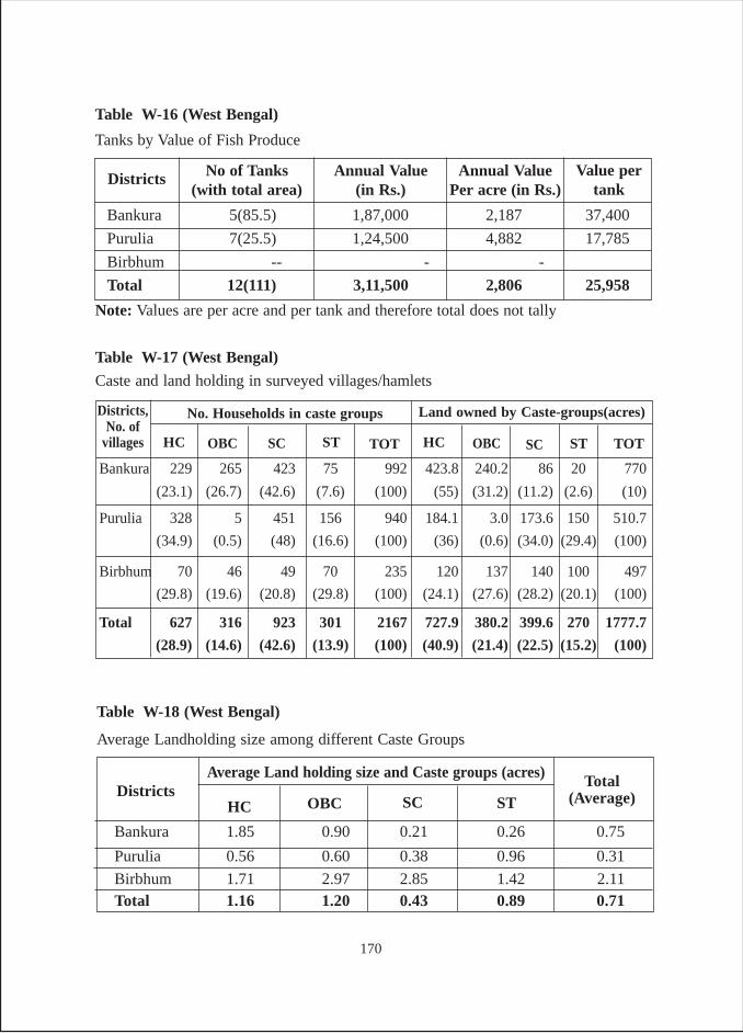
Table W-16 (West Bengal)
Tanks by Value of Fish Produce
Annual Value(in Rs.)
No of Tanks(with total area)
Districts Value pertank
Annual ValuePer acre (in Rs.)
Bankura 5(85.5) 1,87,000 2,187 37,400
Purulia 7(25.5) 1,24,500 4,882 17,785
Birbhum -- - -
Total 12(111) 3,11,500 2,806 25,958
Table W-18 (West Bengal)
Average Landholding size among different Caste Groups
Bankura 1.85 0.90 0.21 0.26 0.75
Purulia 0.56 0.60 0.38 0.96 0.31
Birbhum 1.71 2.97 2.85 1.42 2.11Total 1.16 1.20 0.43 0.89 0.71
Total(Average)
Average Land holding size and Caste groups (acres)Districts
HC OBC SC ST
Bankura 229 265 423 75 992 423.8 240.2 86 20 770
(23.1) (26.7) (42.6) (7.6) (100) (55) (31.2) (11.2) (2.6) (10)
Purulia 328 5 451 156 940 184.1 3.0 173.6 150 510.7
(34.9) (0.5) (48) (16.6) (100) (36) (0.6) (34.0) (29.4) (100)
Birbhum 70 46 49 70 235 120 137 140 100 497
(29.8) (19.6) (20.8) (29.8) (100) (24.1) (27.6) (28.2) (20.1) (100)
Total 627 316 923 301 2167 727.9 380.2 399.6 270 1777.7
(28.9) (14.6) (42.6) (13.9) (100) (40.9) (21.4) (22.5) (15.2) (100)
Table W-17 (West Bengal)
Caste and land holding in surveyed villages/hamlets
HC
Districts,No. of
villages
No. Households in caste groups
OBC SC ST TOT TOTHC OBC SC
Land owned by Caste-groups(acres)
ST
Note: Values are per acre and per tank and therefore total does not tally
170
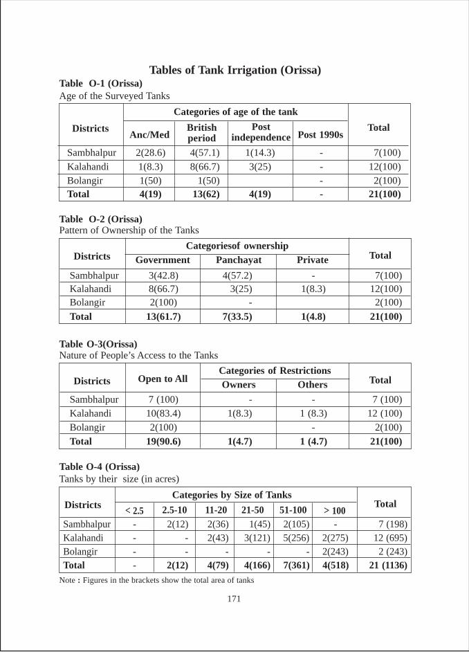
Tables of Tank Irrigation (Orissa)Table O-1 (Orissa)Age of the Surveyed Tanks
Sambhalpur 2(28.6) 4(57.1) 1(14.3) - 7(100)Kalahandi 1(8.3) 8(66.7) 3(25) - 12(100)Bolangir 1(50) 1(50) - 2(100)Total 4(19) 13(62) 4(19) - 21(100)
Total
Categories of age of the tank
DistrictsAnc/Med
Britishperiod
Postindependence Post 1990s
Sambhalpur 3(42.8) 4(57.2) - 7(100)Kalahandi 8(66.7) 3(25) 1(8.3) 12(100)Bolangir 2(100) - 2(100)
Total 13(61.7) 7(33.5) 1(4.8) 21(100)
TotalCategoriesof ownership
Districts Government
Table O-2 (Orissa)Pattern of Ownership of the Tanks
Panchayat Private
Sambhalpur 7 (100) - - 7 (100)Kalahandi 10(83.4) 1(8.3) 1 (8.3) 12 (100)Bolangir 2(100) - 2(100)Total 19(90.6) 1(4.7) 1 (4.7) 21(100)
TotalCategories of Restrictions
Districts Open to All
Table O-3(Orissa)Nature of People’s Access to the Tanks
Owners Others
Sambhalpur - 2(12) 2(36) 1(45) 2(105) - 7 (198)Kalahandi - - 2(43) 3(121) 5(256) 2(275) 12 (695)Bolangir - - - - - 2(243) 2 (243)Total - 2(12) 4(79) 4(166) 7(361) 4(518) 21 (1136)
TotalCategories by Size of Tanks
Districts
Table O-4 (Orissa)Tanks by their size (in acres)
> 10051-10021-50< 2.5 11-202.5-10
Note : Figures in the brackets show the total area of tanks
171
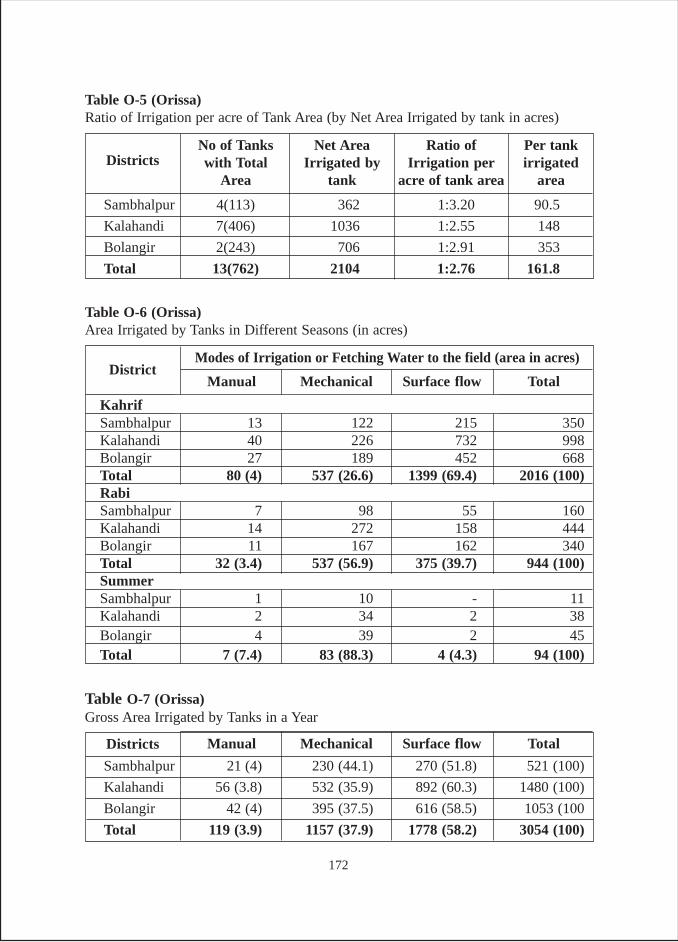
Sambhalpur 4(113) 362 1:3.20 90.5
Kalahandi 7(406) 1036 1:2.55 148
Bolangir 2(243) 706 1:2.91 353
Total 13(762) 2104 1:2.76 161.8
Table O-5 (Orissa)Ratio of Irrigation per acre of Tank Area (by Net Area Irrigated by tank in acres)
Ratio ofIrrigation per
acre of tank area
Net AreaIrrigated by
tank
No of Tankswith Total
AreaDistricts
Per tankirrigated
area
Table O-7 (Orissa)Gross Area Irrigated by Tanks in a Year
Sambhalpur 21 (4) 230 (44.1) 270 (51.8) 521 (100)
Kalahandi 56 (3.8) 532 (35.9) 892 (60.3) 1480 (100)
Bolangir 42 (4) 395 (37.5) 616 (58.5) 1053 (100
Total 119 (3.9) 1157 (37.9) 1778 (58.2) 3054 (100)
Districts Manual Mechanical Surface flow Total
Table O-6 (Orissa)Area Irrigated by Tanks in Different Seasons (in acres)
KahrifSambhalpur 13 122 215 350Kalahandi 40 226 732 998Bolangir 27 189 452 668Total 80 (4) 537 (26.6) 1399 (69.4) 2016 (100)RabiSambhalpur 7 98 55 160Kalahandi 14 272 158 444Bolangir 11 167 162 340Total 32 (3.4) 537 (56.9) 375 (39.7) 944 (100)SummerSambhalpur 1 10 - 11Kalahandi 2 34 2 38Bolangir 4 39 2 45Total 7 (7.4) 83 (88.3) 4 (4.3) 94 (100)
DistrictModes of Irrigation or Fetching Water to the field (area in acres)
Manual Mechanical Surface flow Total
172
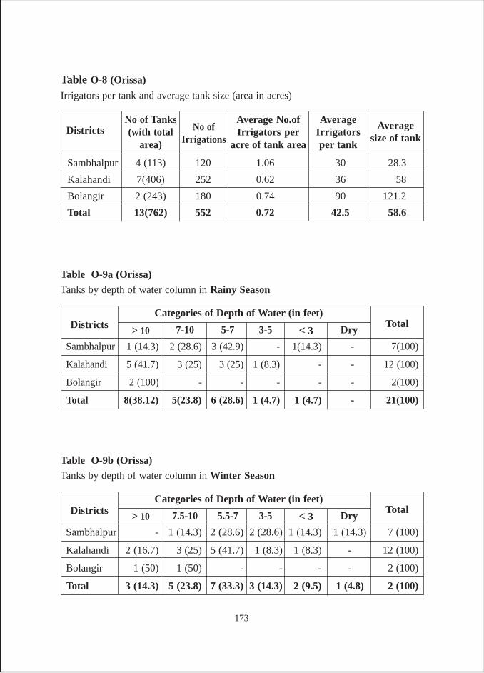
Sambhalpur 4 (113) 120 1.06 30 28.3
Kalahandi 7(406) 252 0.62 36 58
Bolangir 2 (243) 180 0.74 90 121.2
Total 13(762) 552 0.72 42.5 58.6
Table O-8 (Orissa)
Irrigators per tank and average tank size (area in acres)
AverageIrrigatorsper tank
Average No.ofIrrigators per
acre of tank area
No of Tanks(with total
area)Districts Average
size of tankNo of
Irrigations
Sambhalpur 1 (14.3) 2 (28.6) 3 (42.9) - 1(14.3) - 7(100)
Kalahandi 5 (41.7) 3 (25) 3 (25) 1 (8.3) - - 12 (100)
Bolangir 2 (100) - - - - - 2(100)
Total 8(38.12) 5(23.8) 6 (28.6) 1 (4.7) 1 (4.7) - 21(100)
TotalCategories of Depth of Water (in feet)
Districts
Table O-9a (Orissa)
Tanks by depth of water column in Rainy Season
Dry< 33-5> 10 5-77-10
Sambhalpur - 1 (14.3) 2 (28.6) 2 (28.6) 1 (14.3) 1 (14.3) 7 (100)
Kalahandi 2 (16.7) 3 (25) 5 (41.7) 1 (8.3) 1 (8.3) - 12 (100)
Bolangir 1 (50) 1 (50) - - - - 2 (100)
Total 3 (14.3) 5 (23.8) 7 (33.3) 3 (14.3) 2 (9.5) 1 (4.8) 2 (100)
TotalCategories of Depth of Water (in feet)
Districts
Table O-9b (Orissa)
Tanks by depth of water column in Winter Season
Dry< 33-5> 10 5.5-77.5-10
173
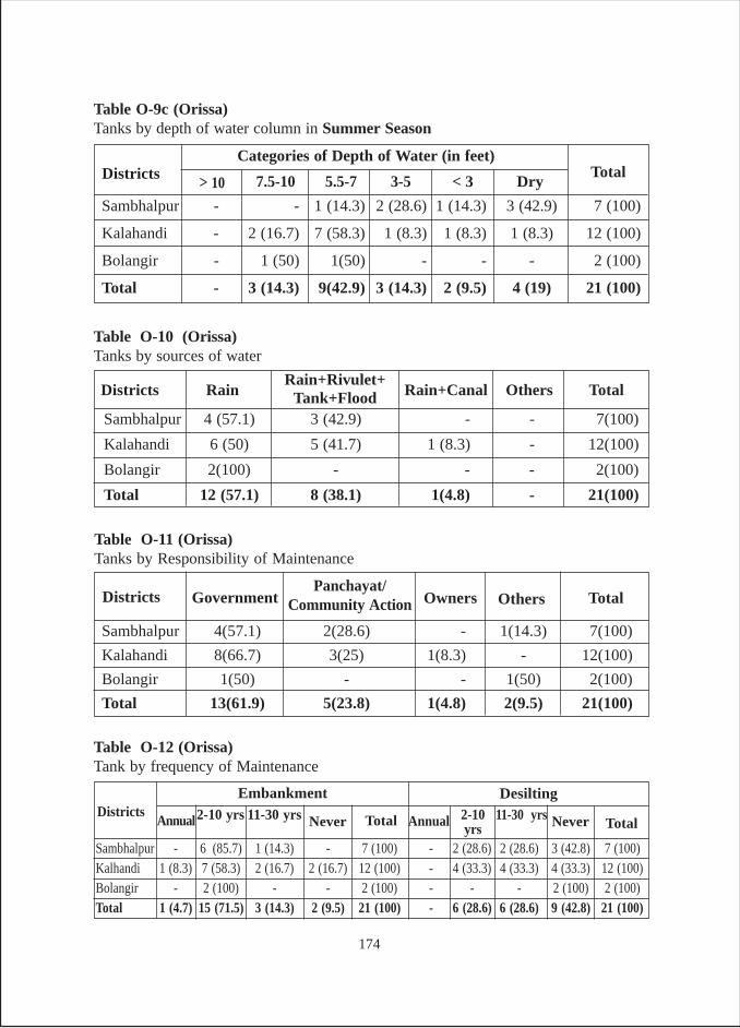
Sambhalpur - 6 (85.7) 1 (14.3) - 7 (100) - 2 (28.6) 2 (28.6) 3 (42.8) 7 (100)Kalhandi 1 (8.3) 7 (58.3) 2 (16.7) 2 (16.7) 12 (100) - 4 (33.3) 4 (33.3) 4 (33.3) 12 (100)Bolangir - 2 (100) - - 2 (100) - - - 2 (100) 2 (100)Total 1 (4.7) 15 (71.5) 3 (14.3) 2 (9.5) 21 (100) - 6 (28.6) 6 (28.6) 9 (42.8) 21 (100)
Table O-12 (Orissa)Tank by frequency of Maintenance
AnnualDistricts
Embankment2-10 yrs 11-30 yrs Never Total TotalAnnual 2-10
yrs11-30 yrsDesilting
Never
Sambhalpur 4(57.1) 2(28.6) - 1(14.3) 7(100)
Kalahandi 8(66.7) 3(25) 1(8.3) - 12(100)
Bolangir 1(50) - - 1(50) 2(100)
Total 13(61.9) 5(23.8) 1(4.8) 2(9.5) 21(100)
Table O-11 (Orissa)Tanks by Responsibility of Maintenance
OthersOwnersGovernmentDistricts TotalPanchayat/
Community Action
Sambhalpur 4 (57.1) 3 (42.9) - - 7(100)
Kalahandi 6 (50) 5 (41.7) 1 (8.3) - 12(100)
Bolangir 2(100) - - - 2(100)
Total 12 (57.1) 8 (38.1) 1(4.8) - 21(100)
Table O-10 (Orissa)Tanks by sources of water
Districts TotalOthersRain+CanalRainRain+Rivulet+
Tank+Flood
Sambhalpur - - 1 (14.3) 2 (28.6) 1 (14.3) 3 (42.9) 7 (100)
Kalahandi - 2 (16.7) 7 (58.3) 1 (8.3) 1 (8.3) 1 (8.3) 12 (100)
Bolangir - 1 (50) 1(50) - - - 2 (100)
Total - 3 (14.3) 9(42.9) 3 (14.3) 2 (9.5) 4 (19) 21 (100)
TotalCategories of Depth of Water (in feet)
Districts
Table O-9c (Orissa)Tanks by depth of water column in Summer Season
Dry< 33-5> 10 5.5-77.5-10
174
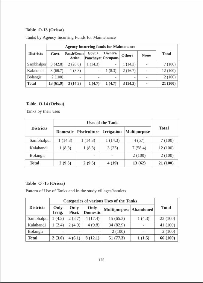
Table O-13 (Orissa)
Tanks by Agency Incurring Funds for Maintenance
Sambhalpur 3 (42.8) 2 (28.6) 1 (14.3) - 1 (14.3) - 7 (100)
Kalahandi 8 (66.7) 1 (8.3) - 1 (8.3) 2 (16.7) - 12 (100)
Bolangir 2 (100) - - - - - 2 (100)
Total 13 (61.9) 3 (14.3) 1 (4.7) 1 (4.7) 3 (14.3) - 21 (100)
Total
Agency incurring funds for Maintenance
Districts NoneOthersOwners/
OccupansGovt. Govt.+
PanchayatPanch/Comm
Action
Table O -15 (Orissa)
Pattern of Use of Tanks and in the study villages/hamlets.
Sambhalpur 1 (4.3) 2 (8.7) 4 (17.4) 15 (65.3) 1 (4.3) 23 (100)
Kalahandi 1 (2.4) 2 (4.9) 4 (9.8) 34 (82.9) - 41 (100)
Bolangir - - - 2 (100) - 2 (100)
Total 2 (3.0) 4 (6.1) 8 (12.1) 51 (77.3) 1 (1.5) 66 (100)
Total
Categories of various Uses of the Tanks
Districts AbandonedOnlyDomestic
MultipurposeOnlyPisci.
OnlyIrrig.
Table O-14 (Orissa)
Tanks by their uses
Sambhalpur 1 (14.3) 1 (14.3) 1 (14.3) 4 (57) 7 (100)
Kalahandi 1 (8.3) 1 (8.3) 3 (25) 7 (58.4) 12 (100)
Bolangir - - 2 (100) 2 (100)
Total 2 (9.5) 2 (9.5) 4 (19) 13 (62) 21 (100)
TotalUses of the Tank
DistrictsDomestic Pisciculture Irrigation Multipurpose
175
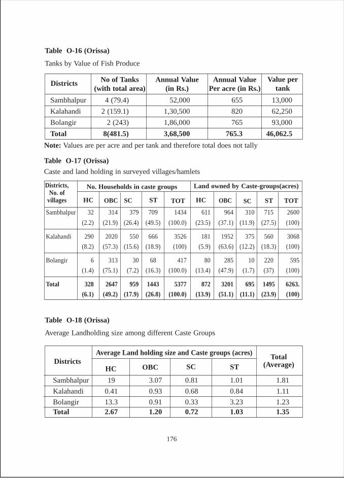
Table O-16 (Orissa)
Tanks by Value of Fish Produce
Annual Value(in Rs.)
No of Tanks(with total area)
Districts Value pertank
Annual ValuePer acre (in Rs.)
Sambhalpur 4 (79.4) 52,000 655 13,000
Kalahandi 2 (159.1) 1,30,500 820 62,250
Bolangir 2 (243) 1,86,000 765 93,000
Total 8(481.5) 3,68,500 765.3 46,062.5
Table O-18 (Orissa)
Average Landholding size among different Caste Groups
Sambhalpur 19 3.07 0.81 1.01 1.81
Kalahandi 0.41 0.93 0.68 0.84 1.11
Bolangir 13.3 0.91 0.33 3.23 1.23Total 2.67 1.20 0.72 1.03 1.35
Total(Average)
Average Land holding size and Caste groups (acres)Districts
HC OBC SC ST
Sambhalpur 32 314 379 709 1434 611 964 310 715 2600
(2.2) (21.9) (26.4) (49.5) (100.0) (23.5) (37.1) (11.9) (27.5) (100)
Kalahandi 290 2020 550 666 3526 181 1952 375 560 3068
(8.2) (57.3) (15.6) (18.9) (100) (5.9) (63.6) (12.2) (18.3) (100)
Bolangir 6 313 30 68 417 80 285 10 220 595
(1.4) (75.1) (7.2) (16.3) (100.0) (13.4) (47.9) (1.7) (37) (100)
Total 328 2647 959 1443 5377 872 3201 695 1495 6263.
(6.1) (49.2) (17.9) (26.8) (100.0) (13.9) (51.1) (11.1) (23.9) (100)
Table O-17 (Orissa)
Caste and land holding in surveyed villages/hamlets
HC
Districts,No. of
villages
No. Households in caste groups
OBC SC ST TOT TOTHC OBC SC
Land owned by Caste-groups(acres)
ST
Note: Values are per acre and per tank and therefore total does not tally
176
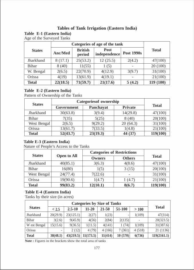
Tables of Tank Irrigation (Eastern India)Table E-1 (Eastern India)Age of the Surveyed Tanks
Jharkhand 8 (17.1) 25(53.2) 12 (25.5) 2(4.2) 47(100)Bihar 8 (40) 11(55) 1 (5) - 20 (100)W. Bengal 2(6.5) 22(70.9) 4(12.9) 3(9.7) 31(100)Orissa 4(19) 13(61.9) 4(19.1) - 21(100)Total 22(18.5) 71(59.7) 21(17.6) 5 (4.2) 119 (100)
TotalCategories of age of the tank
StatesAnc/Med
Britishperiod
Postindependence Post 1990s
Jharkhand 30(63.8) 3(9.4) 14(29.8) 47(100)Bihar 7(35) 5(25) 8 (40) 20(100)West Bengal 2(6.5) 9(29.2) 20 (64.3) 31(100)Orissa 13(61.7) 7(33.5) 1(4.8) 21(100)Total 52(43.7) 23(19.3) 44 (37) 119(100)
TotalCategoriesof ownership
StatesGovernment
Table E-2 (Eastern India)Pattern of Ownership of the Tanks
Panchayat Private
Jharkhand 40(85.1) 3(6.3) 4(8.6) 47(100)Bihar 16(80) 1(5) 3 (15) 20(100)West Bengal 24(77.4) 7(22.6) - 31(100)Orissa 19(90.6) 1(4.7) 1 (4.7) 21(100)Total 99(83.2) 12(10.1) 8(6.7) 119(100)
TotalCategories of Restrictions
States Open to All
Table E-3 (Eastern India)Nature of People’s Access to the Tanks
Owners Others
Jharkhand 20(29.9) 23(125.1) 2(27) 1(23) - 1(109) 47(314)Bihar 3(2.6) 9(45.9) 4(56) 2(84) 2(135) - 20(323.5)W est Bengal 15(15.6) 9(36.5) 1(11.5) 4(141) 1 (74) 1(109) 31(387.6)Orissa - 2 (12) 4 (79) 4 (166) 7 (361) 4 (518) 21 (1136)
Total 38(48.1) 43(219.5) 11(173.5) 11(414) 10 (570) 6(736) 119(2161.1)
TotalCategories by Size of Tanks
States
Table E-4 (Eastern India)Tanks by their size (in acres)
> 10051-10021-50< 2.5 11-202.5-10
Note : Figures in the brackets show the total area of tanks
177
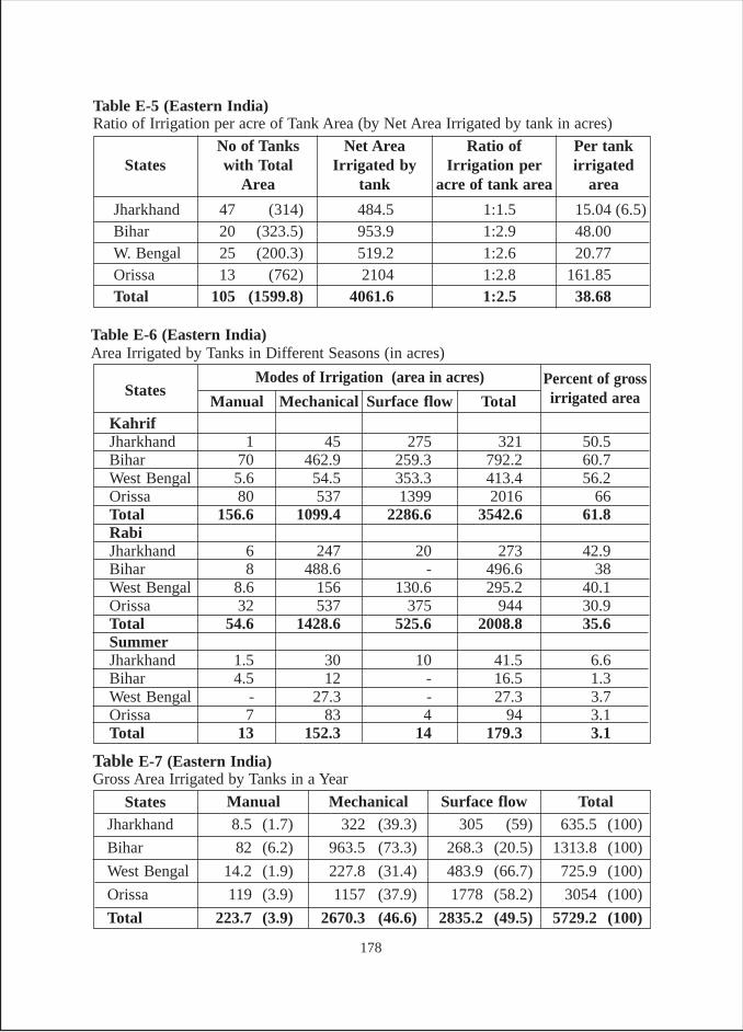
Jharkhand 47 (314) 484.5 1:1.5 15.04 (6.5)Bihar 20 (323.5) 953.9 1:2.9 48.00W. Bengal 25 (200.3) 519.2 1:2.6 20.77Orissa 13 (762) 2104 1:2.8 161.85Total 105 (1599.8) 4061.6 1:2.5 38.68
Table E-5 (Eastern India)Ratio of Irrigation per acre of Tank Area (by Net Area Irrigated by tank in acres)
Ratio ofIrrigation per
acre of tank area
Net AreaIrrigated by
tank
No of Tankswith Total
AreaStates
Per tankirrigated
area
Table E-7 (Eastern India)Gross Area Irrigated by Tanks in a Year
Jharkhand 8.5 (1.7) 322 (39.3) 305 (59) 635.5 (100)
Bihar 82 (6.2) 963.5 (73.3) 268.3 (20.5) 1313.8 (100)
West Bengal 14.2 (1.9) 227.8 (31.4) 483.9 (66.7) 725.9 (100)
Orissa 119 (3.9) 1157 (37.9) 1778 (58.2) 3054 (100)
Total 223.7 (3.9) 2670.3 (46.6) 2835.2 (49.5) 5729.2 (100)
States Manual Mechanical Surface flow Total
Table E-6 (Eastern India)Area Irrigated by Tanks in Different Seasons (in acres)
KahrifJharkhand 1 45 275 321 50.5Bihar 70 462.9 259.3 792.2 60.7West Bengal 5.6 54.5 353.3 413.4 56.2Orissa 80 537 1399 2016 66Total 156.6 1099.4 2286.6 3542.6 61.8RabiJharkhand 6 247 20 273 42.9Bihar 8 488.6 - 496.6 38West Bengal 8.6 156 130.6 295.2 40.1Orissa 32 537 375 944 30.9Total 54.6 1428.6 525.6 2008.8 35.6SummerJharkhand 1.5 30 10 41.5 6.6Bihar 4.5 12 - 16.5 1.3West Bengal - 27.3 - 27.3 3.7Orissa 7 83 4 94 3.1Total 13 152.3 14 179.3 3.1
StatesModes of Irrigation (area in acres)
Manual Mechanical Surface flow TotalPercent of grossirrigated area
178
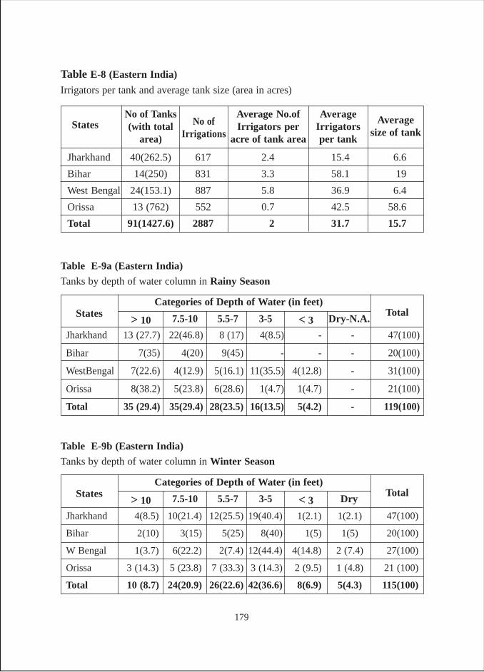
Jharkhand 40(262.5) 617 2.4 15.4 6.6
Bihar 14(250) 831 3.3 58.1 19
West Bengal 24(153.1) 887 5.8 36.9 6.4
Orissa 13 (762) 552 0.7 42.5 58.6
Total 91(1427.6) 2887 2 31.7 15.7
Table E-8 (Eastern India)
Irrigators per tank and average tank size (area in acres)
AverageIrrigatorsper tank
Average No.ofIrrigators per
acre of tank area
No of Tanks(with total
area)States Average
size of tankNo of
Irrigations
Jharkhand 13 (27.7) 22(46.8) 8 (17) 4(8.5) - - 47(100)
Bihar 7(35) 4(20) 9(45) - - - 20(100)
WestBengal 7(22.6) 4(12.9) 5(16.1) 11(35.5) 4(12.8) - 31(100)
Orissa 8(38.2) 5(23.8) 6(28.6) 1(4.7) 1(4.7) - 21(100)
Total 35 (29.4) 35(29.4) 28(23.5) 16(13.5) 5(4.2) - 119(100)
TotalCategories of Depth of Water (in feet)
States
Table E-9a (Eastern India)
Tanks by depth of water column in Rainy Season
Dry-N.A.< 33-5> 10 5.5-77.5-10
Jharkhand 4(8.5) 10(21.4) 12(25.5) 19(40.4) 1(2.1) 1(2.1) 47(100)
Bihar 2(10) 3(15) 5(25) 8(40) 1(5) 1(5) 20(100)
W Bengal 1(3.7) 6(22.2) 2(7.4) 12(44.4) 4(14.8) 2 (7.4) 27(100)
Orissa 3 (14.3) 5 (23.8) 7 (33.3) 3 (14.3) 2 (9.5) 1 (4.8) 21 (100)
Total 10 (8.7) 24(20.9) 26(22.6) 42(36.6) 8(6.9) 5(4.3) 115(100)
TotalCategories of Depth of Water (in feet)
States
Table E-9b (Eastern India)
Tanks by depth of water column in Winter Season
Dry< 33-5> 10 5.5-77.5-10
179
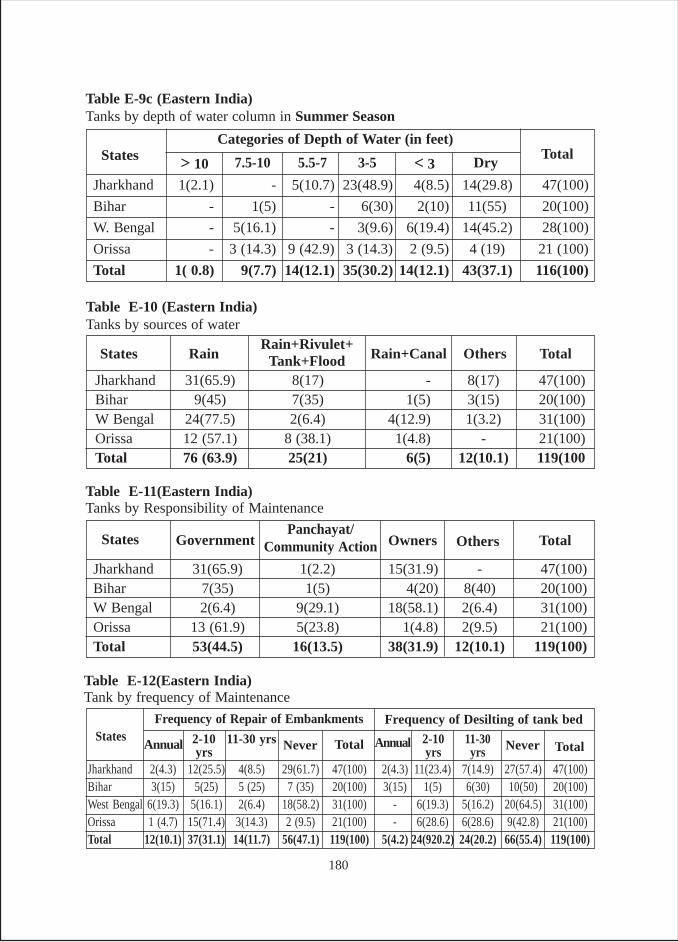
Jharkhand 2(4.3) 12(25.5) 4(8.5) 29(61.7) 47(100) 2(4.3) 11(23.4) 7(14.9) 27(57.4) 47(100)Bihar 3(15) 5(25) 5 (25) 7 (35) 20(100) 3(15) 1(5) 6(30) 10(50) 20(100)West Bengal 6(19.3) 5(16.1) 2(6.4) 18(58.2) 31(100) - 6(19.3) 5(16.2) 20(64.5) 31(100)Orissa 1 (4.7) 15(71.4) 3(14.3) 2 (9.5) 21(100) - 6(28.6) 6(28.6) 9(42.8) 21(100)Total 12(10.1) 37(31.1) 14(11.7) 56(47.1) 119(100) 5(4.2) 24(920.2) 24(20.2) 66(55.4) 119(100)
Table E-12(Eastern India)Tank by frequency of Maintenance
AnnualStates
Frequency of Repair of Embankments
2-10yrs
11-30 yrs Never Total TotalAnnual 2-10yrs
11-30yrs
Frequency of Desilting of tank bed
Never
Jharkhand 31(65.9) 8(17) - 8(17) 47(100)Bihar 9(45) 7(35) 1(5) 3(15) 20(100)W Bengal 24(77.5) 2(6.4) 4(12.9) 1(3.2) 31(100)Orissa 12 (57.1) 8 (38.1) 1(4.8) - 21(100)Total 76 (63.9) 25(21) 6(5) 12(10.1) 119(100
Table E-10 (Eastern India)Tanks by sources of water
States TotalOthersRain+CanalRainRain+Rivulet+
Tank+Flood
Jharkhand 1(2.1) - 5(10.7) 23(48.9) 4(8.5) 14(29.8) 47(100)
Bihar - 1(5) - 6(30) 2(10) 11(55) 20(100)
W. Bengal - 5(16.1) - 3(9.6) 6(19.4) 14(45.2) 28(100)
Orissa - 3 (14.3) 9 (42.9) 3 (14.3) 2 (9.5) 4 (19) 21 (100)
Total 1( 0.8) 9(7.7) 14(12.1) 35(30.2) 14(12.1) 43(37.1) 116(100)
TotalCategories of Depth of Water (in feet)
States
Table E-9c (Eastern India)Tanks by depth of water column in Summer Season
Dry3-55.5-77.5-10
Jharkhand 31(65.9) 1(2.2) 15(31.9) - 47(100)Bihar 7(35) 1(5) 4(20) 8(40) 20(100)W Bengal 2(6.4) 9(29.1) 18(58.1) 2(6.4) 31(100)Orissa 13 (61.9) 5(23.8) 1(4.8) 2(9.5) 21(100)Total 53(44.5) 16(13.5) 38(31.9) 12(10.1) 119(100)
Table E-11(Eastern India)Tanks by Responsibility of Maintenance
OthersOwnersGovernmentStates TotalPanchayat/
Community Action
> 10 < 3
180
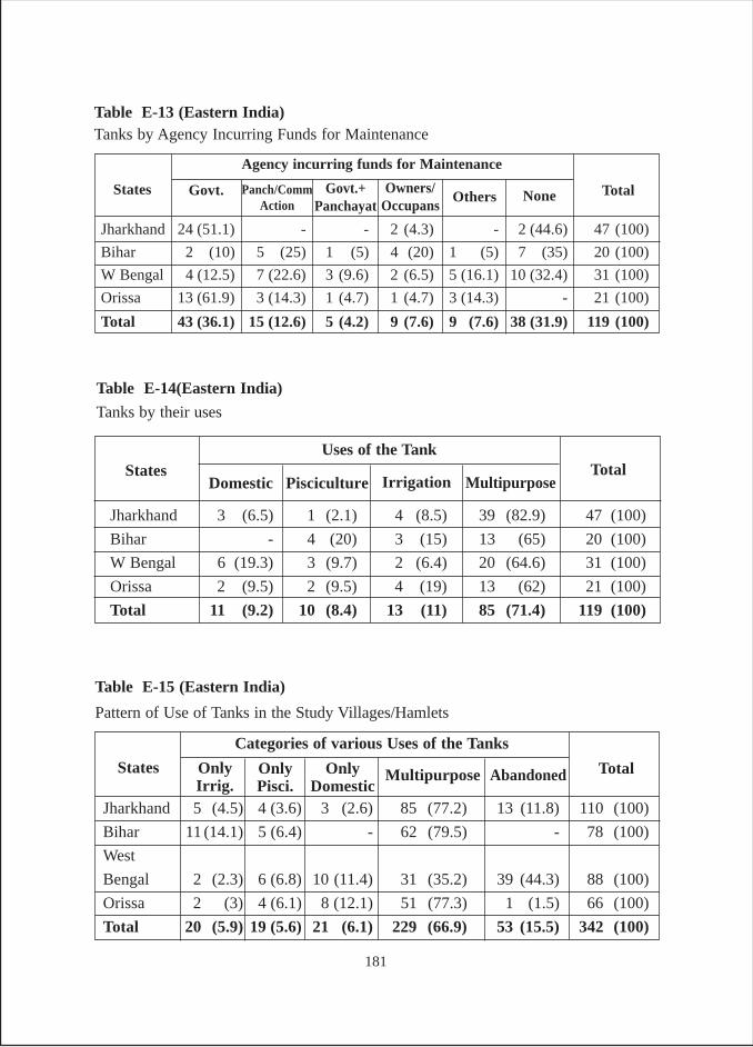
Table E-13 (Eastern India)Tanks by Agency Incurring Funds for Maintenance
Jharkhand 24 (51.1) - - 2 (4.3) - 2 (44.6) 47 (100)
Bihar 2 (10) 5 (25) 1 (5) 4 (20) 1 (5) 7 (35) 20 (100)
W Bengal 4 (12.5) 7 (22.6) 3 (9.6) 2 (6.5) 5 (16.1) 10 (32.4) 31 (100)
Orissa 13 (61.9) 3 (14.3) 1 (4.7) 1 (4.7) 3 (14.3) - 21 (100)
Total 43 (36.1) 15 (12.6) 5 (4.2) 9 (7.6) 9 (7.6) 38 (31.9) 119 (100)
Total
Agency incurring funds for Maintenance
States NoneOthersOwners/
OccupansGovt. Govt.+
PanchayatPanch/Comm
Action
Table E-15 (Eastern India)
Pattern of Use of Tanks in the Study Villages/Hamlets
Jharkhand 5 (4.5) 4 (3.6) 3 (2.6) 85 (77.2) 13 (11.8) 110 (100)
Bihar 11 (14.1) 5 (6.4) - 62 (79.5) - 78 (100)
West
Bengal 2 (2.3) 6 (6.8) 10 (11.4) 31 (35.2) 39 (44.3) 88 (100)
Orissa 2 (3) 4 (6.1) 8 (12.1) 51 (77.3) 1 (1.5) 66 (100)
Total 20 (5.9) 19 (5.6) 21 (6.1) 229 (66.9) 53 (15.5) 342 (100)
Total
Categories of various Uses of the Tanks
States AbandonedOnlyDomestic
MultipurposeOnlyPisci.
OnlyIrrig.
Table E-14(Eastern India)
Tanks by their uses
Jharkhand 3 (6.5) 1 (2.1) 4 (8.5) 39 (82.9) 47 (100)
Bihar - 4 (20) 3 (15) 13 (65) 20 (100)
W Bengal 6 (19.3) 3 (9.7) 2 (6.4) 20 (64.6) 31 (100)
Orissa 2 (9.5) 2 (9.5) 4 (19) 13 (62) 21 (100)
Total 11 (9.2) 10 (8.4) 13 (11) 85 (71.4) 119 (100)
TotalUses of the Tank
StatesDomestic Pisciculture Irrigation Multipurpose
181
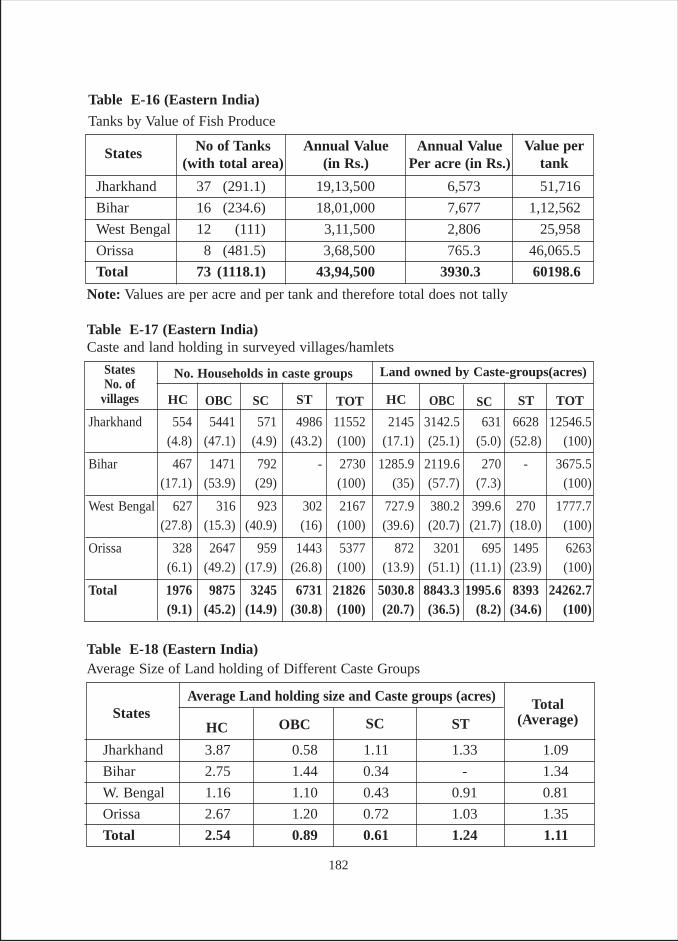
Table E-18 (Eastern India)Average Size of Land holding of Different Caste Groups
Jharkhand 3.87 0.58 1.11 1.33 1.09
Bihar 2.75 1.44 0.34 - 1.34
W. Bengal 1.16 1.10 0.43 0.91 0.81
Orissa 2.67 1.20 0.72 1.03 1.35
Total 2.54 0.89 0.61 1.24 1.11
Total(Average)
Average Land holding size and Caste groups (acres)States
HC OBC SC ST
Table E-16 (Eastern India)
Tanks by Value of Fish Produce
Annual Value(in Rs.)
No of Tanks(with total area)
States Value pertank
Annual ValuePer acre (in Rs.)
Jharkhand 37 (291.1) 19,13,500 6,573 51,716
Bihar 16 (234.6) 18,01,000 7,677 1,12,562
West Bengal 12 (111) 3,11,500 2,806 25,958
Orissa 8 (481.5) 3,68,500 765.3 46,065.5
Total 73 (1118.1) 43,94,500 3930.3 60198.6
Jharkhand 554 5441 571 4986 11552 2145 3142.5 631 6628 12546.5(4.8) (47.1) (4.9) (43.2) (100) (17.1) (25.1) (5.0) (52.8) (100)
Bihar 467 1471 792 - 2730 1285.9 2119.6 270 - 3675.5(17.1) (53.9) (29) (100) (35) (57.7) (7.3) (100)
West Bengal 627 316 923 302 2167 727.9 380.2 399.6 270 1777.7(27.8) (15.3) (40.9) (16) (100) (39.6) (20.7) (21.7) (18.0) (100)
Orissa 328 2647 959 1443 5377 872 3201 695 1495 6263(6.1) (49.2) (17.9) (26.8) (100) (13.9) (51.1) (11.1) (23.9) (100)
Total 1976 9875 3245 6731 21826 5030.8 8843.3 1995.6 8393 24262.7(9.1) (45.2) (14.9) (30.8) (100) (20.7) (36.5) (8.2) (34.6) (100)
Table E-17 (Eastern India)Caste and land holding in surveyed villages/hamlets
HC
StatesNo. of
villages
No. Households in caste groups
OBC SC ST TOT TOTHC OBC SC
Land owned by Caste-groups(acres)
ST
Note: Values are per acre and per tank and therefore total does not tally
182
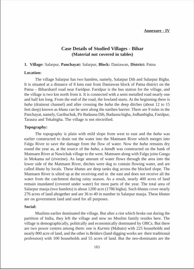
Annexure - IV
Case Details of Studied Villages - Bihar(Material not covered in tables)
1. Village: Salarpur, Panchayat: Salarpur, Block: Daniawan, District: Patna
Location:
The village Salarpur has two hamlets, namely, Salarpur Dih and Salarpur Bigha.It is situated at a distance of 8 kms east from Daniawan block of Patna district on thePatna – Biharsharif road near Faridpur. Faridpur is the bus station for the village, andthe village is two km north from it. It is connected with a semi metalled road nearly oneand half km long. From the end of the road, the lowland starts. At the beginning there isbaha (drainout channel) and after crossing the baha the deep ditches (about 12 to 15feet deep) known as khata can be seen along the earthen barrier. There are 9 tolas in thePanchayat, namely, Garibuchak, Pir Badauna Dih, Badauna bigha, Jodhanbigha, Faridpur,Taraura and Tekabigha. The village is not electrified.
Topography:
The topography is plain with mild slope from west to east and the baha wasearlier constructed to drain out the water into the Matmaen River which merges intoFalgu River to save the damage from the flow of water. Now the baha remains dryround the year as, at the source of the baha, a bandh was constructed on the bank ofMatmaen River at Nawichak village to the west. Matmaen along with Falgu joins Gangain Mokama tal (riverine). As large amount of water flows through the area into thelower side of the Matmaen River, ditches were dug to contain flowing water, and arecalled khata by locals. These khatas are deep tanks dug across the blocked slope. TheMatmaen River is silted up at the receiving end in the east and does not receive all thewater from the catchment during rainy season. As a result, nearly 400 acres of landremain inundated (covered under water) for most parts of the year. The total area ofSalarpur mauja (two hamlets) is about 1200 acre (1786 bigha). Such khatas cover nearly276 acres of land altogether and are 36 to 40 in number in Salarpur mauja. These khatasare on government land and used for all purposes.
Social:
Muslims earlier dominated the village. But after a riot which broke out during thepartition of India, they left the village and now no Muslim family resides here. Thevillage is demographically, politically and economically dominated by OBCs. But thereare two power centres among them: one is Kurmis (Mahato) with 225 households andnearly 800 acre of land, and the other is Beldars (land digging works are their traditionalprofession) with 100 households and 55 acres of land. But the neo-dominants are the
183
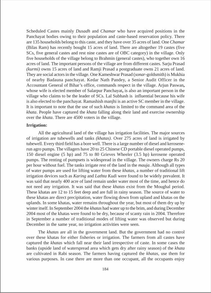
Scheduled Castes mainly Dusadh and Chamar who have acquired positions in thePanchayat bodies owing to their population and caste-based reservation policy. Thereare 135 households belong to this caste, and they have over 35 acres of land. One Chamar(Bilas Ram) has recently bought 15 acres of land. There are altogether 19 castes (fiveSCs, five general castes and rest nine castes are of OBC category) in the village. Onlyfive households of the village belong to Brahmin (general castes), who together own 16acres of land. The important persons of the village are from different castes. Sarju Prasad(kurmi) owns 15 acres of land and Ramji Prasad a postgraduate owns 21 acres of land.They are social actors in the village. One Kameshwar Prasad (sonar-goldsmith) is Mukhiaof nearby Badauna panchayat. Kedar Nath Pandey, a Senior Audit Officer in theAccountant General of Bihar’s office, commands respect in the village. Arjun Paswan,whose wife is elected member of Salarpur Panchayat, is also an important person in thevillage who claims to be the leader of SCs. Lal Subhash is influential because his wifeis also elected to the panchayat. Ramashish manjhi is an active SC member in the village.It is important to note that the use of such khatas is limited to the command area of thekhata. People have captured the khata falling along their land and exercise ownershipover the khata. There are 4500 voters in the village.
Irrigation:
All the agricultural land of the village has irrigation facilities. The major sourcesof irrigation are tubewells and tanks (khatas). Over 275 acres of land is irrigated bytubewell. Every third field has a bore well. There is a large number of diesel and kerosene-run agro pumps. The villagers have 20 to 25 Chinese CD portable diesel operated pumps,150 diesel engine (5 hp) and 75 to 80 Grieves Wheeler (3.5 hp) kerosene operatedpumps. The renting of pumpsets is widespread in the village. The owners charge Rs 20per hour without fuel. The tanks irrigate rest of the land in the mauja. Although all typesof water pumps are used for lifting water from these khatas, a number of traditional liftirrigation devices such as Karing and Lathta Kudi were found to be widely prevalent. Itwas said that nearly 400 acre of land remain under water most of the time, and hence donot need any irrigation. It was said that these khatas exist from the Moughal period.These khatas are 12 to 15 feet deep and are full in rainy season. The source of water tothese khatas are direct precipitation, water flowing down from upland and khatas on theuplands. In some khatas, water remains throughout the year, but most of them dry up bywinter itself. In September 2004 the khatas had water up to the brim, and during December2004 most of the khatas were found to be dry, because of scanty rain in 2004. Thereforein September a number of traditional modes of lifting water was observed but duringDecember in the same year, no irrigation activities were seen.
The khatas are all in the government land. But the government had no controlover these khatas for either fisheries or irrigation. The farmers from all castes havecaptured the khatas which fall near their land irrespective of caste. In some cases thebanks (upside land of waterspread area which gets dry after rainy season) of the khataare cultivated in Rabi season. The farmers having captured the khatas, use them forvarious purposes. In case there are more than one occupant, all the occupants enjoy
184
equal rights over the tank. One Arjun Paswan and his brothers have captured MahabirSthan Khata having a waterspread area of 4 acres. Their houses are near the khata. Theyearn Rs 90,000 to 1,20,000 per year by growing fish in that khata. All brothers share theincome and investment. The khata irrigates a maximum of 6 acres and a minimum ofone acre. The occupants have very little amount of land there, but irrigation is notrestricted to the non-occupant farmers. They fetch water with the help of portablepumpsets. They grow vegetables and earn Rs.10,000 per bigha/per season. Here, therenting rate for machine is different say Rs. 6 per katha (0.03 acres).
There are domestic uses of khatas, such as cleaning cattle, worship, bathing etc.The water rights in this village are of a peculiar kind. The water is free for those who fallin the area of the khata. Water is not allowed to be taken to any area outside the commandof the khata. The people of other localities of the village are also restricted from usingthe tanks even for domestic purposes.
The maintenance of the khata is the responsibility of the occupants. It was seenthat the occupants maintained the khatas properly and repaired almost every year. Thevillagers once mobilized community action to prevent floods. Six years ago, the bandhof Matmaen River was broken, the goam of villagers gathered to control the water bypreparing guds (earthen boulders quickly made with husk and mud). They controlledthe flooding within 7 to 8 hours and the village was saved.
Other Uses:
Two tanks in the village are specially used for pisciculture (including cultivatingfish seeds) which generates handsome income. One of the owners of these tanks,Ramsubhawan Prasad, earns nearly one lac sixty thousand rupees from these tanks everyyear. The fish seeds are grown in 15 days. He brings the smaller seeds from the marketand they grow up to a transferable size within 15 days and he sells it out to put the nextbatch of fishlings. The price of fish seeds comes in the range of Rs. 100 and 150 per kg.There are some khatas where water remains round the year and in those khatas cultivationof fish is very profitable. As discussed earlier, the villagers illegally occupy khatas fallingnear their land. One Arjun Paswan has occupied Mhadevsthan khata of nearly 4 acresand earns around rupees one lac from the tanks. He keeps the khata well maintained andkeeps an account of the fish production and sale proceeds, as he has to share the incomeand expenses with his two brothers. The villagers have also filed case in court of law forallowing the khatas to be under their occupation. It was said the case is pending for lastten years and they believe they will get the ownership legally. Rameshwar Paswan andhis brothers occupy another khata named Banglapar ka khata for last several years. Itgets dry in summer season and has very little water in winters. At the time of survey (9-12-2004) the khata was almost dry and rabi crops such as mustard and masoor (a kind ofpulses) were sown in the tank area.
The khatas are used for all domestic purposes irrespective of the amount of waterthat remains in the tanks. However, people from the commands of other khatas are notallowed to use a khata’s water for any purpose except irrigation.
185
2. Village: Kalyanpur, Panchayat: Kalayanpur-Paipura, Block: Paliganj,District: Patna
Location:
It is situated at the distance of nearly 60 km in the south west direction from Patnanear the border of Jehanabad district. Village Khapuri in the north, Baduri in the west,Raksipura in the east and Paliganj in the south surround it.
Social:
In the social constitution of the village, bhumihars (a land owning upper castewith nearly 60 h/h) dominate in terms of social and economic status. However, in termsof population, binds (fishing caste in nearly 100 h/h) constitute the largest part of thevillage social setting. Binds fall under the category of BC-I. (extremely other backwardcastes). Kahar, kumhar and tanti all BC-I (29 h/h), yadav, koeri and teli all BC-II (upperOBC), chamar and musahar of SC category (27 h/h) and Muslim (2 h/h) constitute thesocial structure in small numbers. Bhumihars enjoy the power supremacy as posts ofboth the mukhia and up-mukhia are held by bhumihar (Lalit Singh and Ram UdayaSingh respectively).
Land holding pattern is heavily in favour of bhumihars who own nearly 350 acresout of total area of 400 acres. yadav, tanti and bind (20, 15, 12 acres respectively) are theother major owners of agricultural land. Out of 400 acres nearly 350 acres have irrigationfacilities. The source wise division is as follows – Canal (Sone Canal System) – 175acres, Tubewells – 25 acres and Tank/Ahar – 150 acres. There are 125 marginal farmers,30 small farmers and nearly 10 medium farmers.
Kalayanpur Ahar:
Water spread area of the Ahar is 50 acres, which irrigates nearly 150 acre ofland in kharif season and all through surface flow. It benefits nearly 200 farmers. Thetank is maintained by fisheries department but no maintenance work has taken place inthe last 25-30 years. The annual fish production is over 50 quintals amounting to nearlyRs. 2 lakh in monetary terms (estimate of the villagers). The actual contract amountfixed by the Government (fisheries department) is not known.
The villagers complained that the dried up area of the Ahar has been grabbed bythe dominant castes in the village and the Ahar has not been desilted/enlarged orundergone repair in the embankment for long. Now, villagers also do not take collectiveeffort as it is under control of fisheries department and any attempt may hamper thepisciculture. They suggested that government should forcibly evacuate the encroachersand resort to regular maintenance work for making it more productive for agriculture.
3. Village: Gopalpur, Panchayat: Baank, Block: Maner, District: Patna
Location:
It is situated at the distance of nearly 32 km in the west of Patna near the Patna –Ara highway in Patna district.
186
Social:
In the social constitution of the village, upper OBC kurmi (a land owningupper OBC caste in 250 h/h) dominate in terms of social and economic status. However,lower OBC castes such as tanti, hazam/barber and kahar constitute 60 h/h (30, 5 and 25h/h respectively) constitute a small part of the village. Yadavs, and teli of BC-II (upperOBC) in eight households, chamar and musahar of SC category (165 h/h) and brahmins(4 h/h) constitute the social structure. Kurmis enjoy supremacy in the village. Twovillagers hold important positions. One Jay Prakash Roy holds the post of mukhia andanother Harinarayan Roy is the member of Panchayat Samiti of Maner block.
Land and topography:
Land holding pattern is heavily skewed towards kurmis who own nearly600 acres out of total area of 650 acre. Others having very small holding are tanti,hazam and kahar all falling in category of OBC-I58 who own 10, 2, and 2 acresrespectively. Yadav and teli (4, 3 acres respectively) are the other owners of agriculturalland in small sizes.
Irrigation:
Out of 650 acres, nearly 600 acres of land have irrigation facilities. The sourcewise division is as follows: Tubewells – 200 acres, Tank/ahar – 250 acres and 150 acresfrom river/rivulets (may be pynes). There are altogether 8 tanks/ahars in the village ofwhich three have been surveyed – first an ahar, second a big tank and third a small tank.There are 100 marginal farmers, 40 small farmers and nearly 20 medium farmers in thevillage.
Tanks and Irrigation:
Gopalpur Ahar - Water spread area of the ahar is 75 acres which irrigates nearly 200acres of land in kharif season of which, 80 acres through surface flow, 100 acres throughmechanical modes and 20 acres through traditional manual modes. It benefits nearly200 farmers. Panchayat bodies are responsible for the maintenance of tank andmaintenance works are undertaken mostly annually as per requirements. In 2005, Onelakh rupees was spent on maintenance work of the tank. No pisciculture is practiced inthe tank. Total number of irrigators in the command area of tank is 200.
Gopalpur Pokhar - Water spread area of the tank is 15 acres which irrigates nearly 25acres of agricultural land. In kharif, 25 acres of land is irrigated through surface flowwhereas similar amount of land (25 acres) is irrigated in Rabi season through mechanicalmodes. No irrigation could be done in summer season. The total number of irrigators ofthe tank is 25 and all of them belong to kurmi caste. Although the maintenanceresponsibility lies with the fisheries department, which has never undertaken anymaintenance work.
58 BC-I and BC-II constitute OBC BC-I and BC-II are two lists under OBC. BC-I has extremely backwardcasts listed in it while BC-II lists the upper sections under OBC.
187
Pisciculture is practiced in the tank and FD contracts out the tank on the annualbasis. According to villagers, nearly Rs. 80,000 is earned from the tank from fisheriesproduction of over 20 quintals per year. The villagers complained that the tank has notbeen desilted or its embankment repaired for a long time.
Gopalpur Pokhari - Water spread area of the tank is 12 acres which irrigates nearly 15acres of agricultural land. In kharif, 15 acres of land is irrigated through surface flowwhereas similar amount of land (15 acres) is irrigated in rabi season through mechanicalmodes and no irrigation is given in summer. The total number of irrigators of the tank is20 and almost all are of kurmi caste. Like the bigger tank in the village, although themaintenance responsibility is with the fisheries department, it has never undertaken anymaintenance work. Pisciculture is practiced in the tank and government contracts out onthe annual basis. According to villagers nearly Rs. 40,000 is earned from the tank fromfisheries production of over 10-15 quintals per year.
4. Village: Kool, Panchayat: Kool, Block: Rajgir, District: Nalanda
Location:
It is situated nearly 1.5 km away from Nalanda-Rajgir road at Nalanda Mod(turning) towards south. It is surrounded by village Saken in the north, Manhori in thesouth, Bhadari in the east and agricultural land in the west.
Social:
The village is dominated by bhumihar caste both in terms of population size andsocio-economic resources. The main actors of the village are Ashutosh Kumar (presentmukhia), Rajeshwar Prasad (ex-mukhia), Jamo Singh, Bipin Singh, Kameshwar Singhand Ramashray Singh all bhumihars. Three out of them have formed a social organizationin 1998 named Gram Vikash Samiti. The Samiti looks after development of the villageand contracts out the tanks for pisciculture. The income from the fish produce is investedin development work of the village like drains, transformer etc. the Samiti has threeoffice bearers – Rajeshwar Singh as Chairman, Ramashray Singh as Secretary andAshutosh Kumar as Treasurer. The Samiti has an account with Canara Bank, NalandaMod Branch. It is ironical to note that since its inception it has not spent any money forrepair of tanks. It is also noteworthy that non-Bhumihar castes are against the bhumiharson the tank issue. They have not been given representation in the Samiti. They blamethat bhumihars have virtual control over the tank and they contract it out for fishing toonly youths of their fellow caste-member arbitrarily. Once some village people, whowere against the bhumihars, poisoned the Doma pokhar. However, they did not want tospeak about it in the open out of fear of bhumihars. The village has a middle schoolsituated near one of the tanks. There are 1800 voters in the village. It is an electrifiedvillage.
Topography:
The topography of the village is plain with ‘dih’ lands (homestead up land). Thevillage has nearly 500 acres of agricultural land of which 300 acres have irrigation
188
facilities. The main crops of the village are paddy in kharif season and wheat, gram,masoor and other pulses like moong. The dih land is used for growing vegetables roundthe year like potato, brinjall, cabbage and other green vegetables.
Irrigation:
Major source of irrigation in the village is private tube wells with pumpsets. Thefields have borings and the diesel operated portable pumpsets are used. Nearly 200acres of land is irrigated by tube wells. A branch of Chani canal touches the village thatis at the tail end and irrigation water does not reach. There are no wells for irrigationpurposes in the village. Tanks and pynes irrigate a considerable amount (nearly 100acres) of land. The main method of fetching water from the tanks in scarce periods islifting by using pumpsets. The practice of manual modes of fetching water from tanksand pynes is in use through karing and lathakudi, but rare. But irrigation from tanks isreducing year after year due to pisciculture. The tanks are contracted out for piscicultureby the panchayat. The contractors do not allow diversion of water for irrigation after thewater level drops to a certain mark in the tanks. There are four tanks and a pyne in thevillage. Irrigation from pyne depends on rain and under most favourable conditionsnearly 50 acres land is irrigated. All the tanks in the village are in public land (gairmajarualand) and managed by villagers’ committee as mentioned in social section. The fourtanks are – Bania pokhar, Chamgodi pokhar, Hasani pokhar and Doma pokhar. Theformer two tanks are of relatively bigger size (16 acres and 13 acres respectively) andthe latter two are of smaller size (4 acres and 6 acres respectively). During the past tenyears, the tanks were neither renovated nor repaired. The village was declared as adrought-affected village in 1966.
Other Uses:
All four tanks of the village are used for pisciculture. The value of fish producecomes in the range of Rs 1,60,000 and 2,00,000 in Bania pokhar and in Chamgodipokhar each, in the last five years and between Rs 80,000 and 1,20,000 in Hasani pokharand Doma pokhar each, in last five years. The village committee (Gram Vikash Samiti)manages the practice of pisciculture. The contracts are taken by the bhumihars of thevillage; sometimes two or more persons take fishing contract. These contractors restrictfarmers from taking water from the tanks in the interest of fish cultivation, when waterin the tanks is insufficient. They invest money for fish seeds but do not spend money forrenovation or repair of the tanks.
The tanks are also used for domestic purposes such as bathing, cleaning cattle,etc. The cultivation of water fruits or flowers is not undertaken in these tanks.
5. Village: Panhesa, Panchayat: Kool, Block: Rajgir, District: Nalanda
Location:
Panhesa falls under Kool panchayat and is a smaller village. It is one km westfrom Nalanda Mod, on the Nalanda-Rajgir road. It is surrounded by a powerhouse innorth, Fatehpur in south, Madhopur in west and Kool in the east. This village was declareda drought village in 1966.
189
Social:
The village consists of OBCs, SCs and Muslims, of which Muslims are thedominant community. They are the largest constituents (100 h/h) and land (100 acres)owners. Among SCs (mushars and nats) constitute 75+5 h/h and own nearly 20 acresland. The important persons of the village belong to Muslim community – Jamal Mian,Shafique Mian, Bakasur Mian and Farukh Mian are social workers of the village.
Topography:
The land is plain with a few low-lying patches. The main crops are paddy, wheat,pulses with mustard and vegetables.
Irrigation:
The major irrigation source is tubewells fitted with pumpsets (diesel operated).Nearly 70 bighas (55 acres) of land is irrigated by tube wells. The canal alsoirrigates about 30-35 acres; when there is sufficient rain, otherwise left un-irrigated as itis situated at the tail end. The tanks also irrigate a considerable amount of land (nearly25-30 acres).
There are three tanks in the village. All are private and used for irrigation,pisciculture and domestic purpose. In kharif, irrigation is through surface flow but inscarce periods water from tank is lifted using pumpsets. The biggest tank of the village,named Mian pokhar, has nearly 10 acres of waterspread area and is in existence sincethe British period. The tank has five owners, namely Md. Jamal, Jaqui Ahmed, JubairAhmed, Md Adar Hussain and Safi Ahmed, all having equal shares. It irrigates nearly22 acres of land of which 16 acres belong to the owners and rest 5 to 6 acres belong tonon-owners. But non-owners are not charged for irrigation. Two other tanks are situatedside by side. These tanks are also of the British period. The waterspread area of the twotanks amounts to 1.6 acres (1+0.6). These two tanks have five owners with equal shares.The owners are same for both the tanks. These tanks are called Judwan Mian pokhar.Tanks are used for irrigation, pisciculture and domestic purposes. It was said that oneowner takes the contract for fishing on Rs 30000, which is distributed among rest fourshareholders, and the contractor-owner takes the income exceeding the contract amount.
It is interesting to note that all these tanks of the village are repaired and renovatedevery year. All the owners incur expenses in equal amounts for repair and maintenance.These tanks are in better position than the government maintained tanks of village Kool.
Other Uses:
All the three tanks in the village are private property and the five owners themselvescarry out pisciculture. For last fifteen years one of the owners Jamal Mian takes thecontract of fishing in these tanks on Rs. 30,000 per year, which is shared by the otherfour owners. But as the contractor-owner incurs investments including that for renovation/repair of tanks, the net earnings are solely with Jamal. It is also considered that by thisarrangement the other owners indirectly pay the share in expenses of repair and renovationof tanks.
190
The domestic uses like bathing, cloth cleaning and cattle cleaning are done in thetanks. For this no restriction is exercised. Cultivation of water fruits and flowers is notpracticed in these tanks.
6. Village: Muzaffarpur, Panchayat: Badgaon, Block: Rajgir, District: Nalanda
Location:
The village is located just behind the walls of Nalanda University ruins on themetal road connecting Nalanda township, nearly half kilometer away from NalandaNav Mahabihar (A Prakrit Research Institute) and in front of Huen Sang Memorial. Itfalls under Badgaon panchayat of Silaw block.
Social:The village is dominated by kurmis (land owning OBC caste) and bhumihar
(General Caste). These two castes have nearly 100 households and 166 acres of landeach. The other OBC castes are barahi (carpenter), kahar, dhanuk, kumhar (traditionallymanufacturing earthen pots) together constituting 64 h/h with 35 acres of agriculturalland. The SCs of the village are musahar and chamar (cobbler) together constituting 42h/h and almost landless (only 1 acre of land). Mr. Shiv Nandan Prasad Kesari (65) akurmi, Kishori Prasad Singh and Yogendra Singh both bhumihars, Ashok Kumar aliasSuresh Bhante a barahi turned Budhist and Brijnandan Ram an employee of NalandaNav Mahabihar are the important persons of the village. Mr. Keshari owns 50 acres ofland and is a political worker attached to J.D. (U), the ruling party. He had earlier gifted0.30 acres of land for residential purpose to SCs. He exercises control over the tanks.Mr. Kishori Singh is a retired Veterinary Doctor and provides veterinary services for thecattle of the village free of cost. Mr. Bhante runs a public school and imparts educationfree of cost with financial support of Buddhist Circuit. Mr. Ram renders social service,runs evening school and works for adult education. Mr. Yogendra Singh is Ward Memberof Badgaon panchayat. The village has no government school but has a degree college.The children of the village go to the government school situated in a nearby village ofSurajpur panchayat. The village has a club for social work and promotion of sports. TheClub consists of mainly youths of both kurmi and bhumihar castes. Although the clubobjectives do not include tank related activities, the young people still get involved intank activities. The village has a population of approximately one thousand people.
In 1985, there was a conflict between village farmers and fish contractors on theissue of taking water from the Indrprastha Sarovar. One Binda Kewat of another villageNirmalbigha had taken contract of fishing in the tank, and he prevented farmers fromtaking water from the tank for irrigation when the water was just three feet deep. Therewas a tussle between villagers and fisherman and violence was about to break out. Butlocal administration interfered and villagers were allowed to take water for winter cropsin 1985. Since then no such incident took place.
Topography:
The land of the village is plain, but undulated patches of land can be found in theside of Nalanda monuments. It was said that these ditches might have been dug in the
191
ancient times for constructing the buildings of the University. There are certain uplands(tilhas) here and there. The village is said to have existed from the ancient times. Majorcrops of the village are paddy, wheat, and pulses like moong, gram, oilseed like mustard,and cattle fodder. The village also produces vegetables, specifically green vegetables inconsiderable quantity. In some of the tanks, there has been practice of growing waterfruit singhara, but this has now reduced considerably. In the last ten years, cultivationof vegetables has increased.
Irrigation:
The total agricultural land is about 300 acres and all the land has irrigation facilities.Tubewells irrigate nearly 36 acres of land and the rest is irrigated by tanks. There are afew tubewells (both diesel and electric operated) in the village. Tank is the major sourceof irrigation. Nearly 75 per cent of the irrigation is dependent on tanks. These tanks alsoirrigate some land of another village named Murgiachak. There are ten tanks in thevillage, of which 7 exist since the ancient period and the rest three were constructed inrecent years by individual farmers for fishing. The biggest tank Indraprastha Sarovarhas about 36 acres of water spread area of which nearly a 3–4 acre portion is silted upand used for cultivation in rabi. This tank is a government tank, looked after by theforest and fisheries department. Kardigia pokhar (4 acres of waterspread area) is also agovernment tank under fisheries department and its source of water is rain and also theIndraprastha Sarovar. Dudhaura pokhar (4.6 acres) is a private tank owned by MunniSingh (bhumihar) and his five brothers of Surajpur village. The Suraha pokhar isgovernment tank, but now is captured by the farmers having their land around the tanklike Kamala Singh, Umesh Singh and Bipin Singh (barahi carpenter), Ramnath Prasad(kurmi) and a few others. Banail pokhar was earlier owned by bhumihar of Badgaon butnow the tank is taken over by fisheries department. Two tanks named Satauti pokhar Iand II are owned by Shivnanadan Keshari and his nearest kins. It was dug during theBritish period. The rest three ponds belong to Brijnandan Ram and Bipin Singh, eachhaving less than half an acre area, and were constructed in 1994 for fishing. The ownersconsume the fish produce and in case of surplus sell it.
All the three modes of irrigation from tank (surface flow, manual and energizedlifting) are practiced. Both diesel operated and electric motor operated pumps are used.In order to carry water from tank to the fields, delivery pipes are used in place of surfacechannels for the last 6-7 years as the farmers feel that carrying water through fieldchannels cause wastage of water and time. The delivery pipes are not very expensiveand easily available in the market. When water is in abundance, irrigation is done throughgravity flow method, and pumps are not used. It happens only in the kharif season. Inthe years of scanty rain, nearly 170 acres of land are irrigated through delivery pipes inkharif and nearly 60 acres in rabi season. The practice of lifting water from the tank hasnow considerably reduced and at present, 0.7 to 2.5 acres of land is irrigated manually.Generally farmers having their land at the bank of tanks use this method to cultivatevegetables in summer season. Fodder grass is also irrigated manually. The modes are‘Karing’ and ‘Latha Kundi’. The renting of diesel pumps is in practice, the rates of
192
which is Rs. 60 per hour with fuel and in case of electric pump Rs. 20 is charged perbigha (0.6 acres). The electric pump owners pay a fixed monthly charge for electricity,irrespective of hours of power availability.
The major source of water of these tanks is rain. But in the case of IndraprasthaSarovar, there is a pyne connecting the tank with Giriyak Chhilka (checkdam) constructedon the Panchane river which confluences into Ganga near Bakhtiarpur. The rain is theonly source of water for the rest of the tanks in the village. There have been communityactions for repair of the tanks and pynes, details of which are given below:
1. Desilting of pyne and outlets – twice before 1975
2. Repair of Structures by shramdan and money contribution (total of Rs. 5,000)– twice in 1990 and 1992
3. Cleaning of banks of the Sarovar by village volunteers for Chhath Puja fromtime to time
Other maintenance works done by the following agencies:
1. Cleaning of grass and weeds – by fish contractor almost seasonally
2. Construction of ghat (bank for bathing) – forest department in 1994
3. Desilting of tanks by fisheries department – once in last ten years
Some powerful villagers have illegally captured the dried out portion of the tankarea for cultivation. Nearly 3–4 acres of land was captured from the Indraprastha Sarovaralone by three of the bhumihar farmers and they grow gram in the dried up tank bed.Same is the case with other tanks of the village.
Other Uses:
The tanks in the village have numerous non-irrigation uses. Pisciculture is practicedin seven of the ten tanks. The fisheries department contracts out the Indraprastha tankfor a paltry sum of Rs.22,000, but the net income earned by the contractor is over onelac. Same is the case with other tanks under the control of the fisheries department in thevillage. In the small private tanks, the fish produce in very less and three of them aresuch that they fulfill the owners’ requirements only.
Three such tanks have earlier been used for cultivation of singhara, but in theyear of survey singhara was seen in only one Kardigia pokhar. The singhara was sownalong with fish and Rs. 3,000 to 4,000 per season was given as the lease charge. Ithampered irrigation use, hence now it is not being cultivated.
The tanks have also various other uses such as worshiping, bathing, cleaningcattle and clothes. Indraprastha Sarovar is used for the most auspicious and pious worshipof Sun God known as Chhath. The villagers contribute labour for washing and cleaningof the banks for the Chhath Puja. The tanks are renovated by forest department andtrees were planted along the banks and new ghats were constructed with a view toattract tourists as it falls in front of the Nalanda Nav Mahabihar, now run by CentralGovernment.
193
7. Village: Chinveria, Panchayat: Chinveria, Block: Laxmi Nagar, District: Jamui
Location and Social Constitution:
Village Chinveria is the largest hamlet of Chinveria panchayat, which consists of12 other small hamlets. It is a revenue village under Lakshamipur block of Jamui district.It is situated at a distance of 7 km south from Kenhat on the Mallayapur – Lakshipurroad. It is connected by a metal road of five km and two km un-metalled road from theinhabitation. The village is not electrified. It has a population of nearly 4000 people,with 2000 voters. It is demographically and economically dominated by SCs particularly,rabidas chamar, paswan and mushahar. There is no general caste or forward castepopulation in the village. The other backward castes (OBCs) like yadav, mandal koiri,nai and kumhar are settled in different hamlets. One hamlet is inhabited by Scheduledtribes. It is interesting to note that rabidas were the landlords-Zamindars of the villageunlike in other villages in the state.
Topography and Agriculture:
The topography of the land is mostly undulating. It is situated in a hilly terrainand the slope runs from north to south. There are two very old and whethered (eroded)small hills (locally called dead hills) namely Chinveria and Singhia paharis found in thenorth side of the village. The fields looks less fertile and the soil is hard (pathrili). Thereis one incomplete panchayat bhawan and a well-constructed samudaik bhawan which isused for teaching children. It was informed that the villagers themselves with the helpof C.I. Dev informally ran those schools (an NGO by the name C.I. Dev is supported bya South Korean NGO named World Head Quarters of Cannon Farmers Movement ofSouth Korea). The government primary school of the village is abandoned, as the teachershave not been attending the school for long. It was claimed by the NGO that 75 per centof the children of the village are getting primary education in these schools. The villagehas 12 women self-help groups (SHGs) and one of men. Besides, there is a ChinveriaVikas Club consisting of 25 members of whom 10 are below 25 years of age and rest fallin the age category of 26-45 years.
The village has nearly 400 acres of agricultural land of which rabidas collectivelyhas 150 acres, mandal 100 acres, yadav 90 acres and rest is owned by other castes. Theland is not properly tilled or irrigated and the cropping intensity of the village is justabove 100 per cent. Majority of the field are sown once in a year due to water shortage.The main staple crops are paddy in kharif and gram, arhar, masur, barley and wheat inrabi and in summer, vegetables are grown on a few patches of lands. The productivity islow and vegetable cultivation is not so profitable.
Irrigation:
Agricultural productivity depends, in India, on assured irrigation due to uncertainmonsoon rains. The steep slope of the village makes the rain water run down fast to thenearby river. As such, soil does not absorb rainwater adequately.
194
Ahars : The only sources of irrigation in the panchayat are the five ahars namely, MaduaTariyani, Kumhartoli, Domajot, Mandaltola and Karma ahars in which Karma ahar issituated adjacent to the village Chinveria. These ahars were constructed way back duringthe early 20th century and are now in a dilapidated condition. The beds of the ahars aresilted up and covered by grasses and weeds. All this makes the harvesting of rain waterinefficient. The dilapidated ahar structures render most of the water to flow down. Thenearby farmers have further narrowed the water carrying structures by encroachment ofland. The maintenance of the ahars has not been undertaken for many decades. Thefarmers use both manual and mechanical modes to fetch water from these ahars. Latha-kundi is the main manual mode, which costs Rs. 600. This device is used for irrigatingsmall patches of land near the ahars. The mechanical mode of fetching water involvesthe use of diesel pumpsets. The panchayat has nearly 25 pumpsets of which five are inthe village, all owned by members of rabidas community. Water from the ahars is takento the fields in two ways – (i) using the surface flow structures and (ii) using pumpsfitted with delivery pipes (flexible and portable). Farmers prefer delivery pipes in orderto avoid wastage during conveyance. The pump owners charge Rs.50 per hour from theusers. This includes the cost of diesel.
Karma Ahar: is situated adjacent to the village and has a command area of over a 100acres, but, its irrigation potential is now reduced to 50-70 acres. The area of the ahar is3 acres whereas the water spread area is 2 acres. The bed of the ahar is silted up and isfull of grass and weeds. Peripheral area of the ahar is also dry and grassy. It has threeoutlets on the southern bank. Two outlets are earthen and situated at the extreme westand extreme east of the embankment. The third one is situated in middle between thetwo outlets and is a large (6 feet) cemented chhilka (check dam). The check dam is veryold and low too. This renders the overflow of water down the slope. The banks are in adilapidated condition and other structures are also not in good shape.
The maintenance of the ahar’s structures was undertaken in the 1970s and sincethan no maintenance has been undertaken for more than thirty years. As ahar’smaintenance was the joint responsibility of the villagers earlier and now of the panchayatbody, but it is nobody’s concern. The embankment of the ahar was hitherto repaired anddesilted by ‘goam’ (collective community action). Goam was summoned by ‘dugdugi’(informing villagers by beating drums). The then mukhia-(village head) took the leadfor the maintenance work. The poorly maintained ahar irrigates between 50-70 acres ofland in kharif season, 10-40 acres in rabi season and 1-2 acres in the summer with thehelp of latha kundi. Irrigation in kharif is mainly done through gravity and throughdiesel pumps fitted with delivery pipes in rabi. A very few farmers grow vegetables onsmall patches of land and irrigate it with latha kundi.
The ahar is not used by villagers for non-irrigation uses such as pisciculture,singhara (water fruit) cultivation, domestic purposes such as bathing, drinking, worshipetc. The reason as shared by the villagers is the shallow water column and dirty water.
195
Villagers also use the ahar for disposal of night soil. Non-maintenance, dilapidatedcondition and irresponsible treatment by the village community is making the ahar lessuseful.
Canal: the other source of irrigation to village is a minor canal named Bazan Nahartaking off from Bhurahwa river barrage. This canal was constructed 30 years ago but isabandoned for the last two decades as no water reaches the village. It is said that thecanal is blocked by silt at the mouth, which has not been cleaned for long. The mouth ofthe canal does not fall in the jurisdiction of the panchayat and the responsibility lieswith the MI department.
The note on the village Chinveria can be concluded with the following observations
- As the community has disowned the ahars, these are in poor conditions and havereduced their (ahars’) irrigation potential and income generating ability
- The village panchayat is not taking care of ahars, but it prefers concentrating onconstruction of roads
- Irrigation potential of the ahars can be enhanced by repair and proper maintenance
- Collective community action is urgently required as only then can sound economicviability of the ahars be achived
- Pisciculture and singhara cultivation are feasible in the ahars, if people take tovoluntary action
- The income generated from non-irrigation use of such ahars can be used forcommunity welfare and public works
- There is urgent need of government investment to initiate improvement in theahars. Karma ahar appears to be more feasible for the purpose
- This will instigate village community to come-up, as there is no glaring casterivalry in the village
- The villagers have already been mobilized by the initiatives of C.I. Dev. Theyneed proper direction for fast development
196
Annexure - V
Case Details of Studied Villages - Jharkhand(Material not covered in tables)
1. Village: Turiumba, Panchayat: Turiumba, Block: Bharno, District: Gumla
Location and Topography:
Turiumba is a big village spread over three hamlets, and begins at 1.5 km away,towards south, from the 46.5 km mark on Ranchi Gumla Road (NH) and stretches deepinto 2.5 km towards west from the un-metalled link road. It forms the panchayat(Turiumba panchayat) under Bharno block of Gumla district. A river Ghaghari flowsfrom east to west in the south of the village which forms a deep gorge; as a result theriver water cannot be used particularly for irrigation purposes by the villagers. The totalarea of agricultural land is more than 850 acres. The village has sufficient number ofhand pumps for drinking and other domestic purposes. However, these seem to be recentlydug. The people use tanks for domestic purposes. The agricultural land is highlyundulating and the slope is from east to west. At some places, the slope is too steep.There are unmetalled roads inside the village, which are motorable because of the redsandy soil locally called ‘muram mitti’. The muram kind of soil also hampers pisciculturein the tanks. The village has a big dancing floor locally known as ‘Akhara’, constructed15 years ago by the villagers with governmental support for performing traditional tribaldance.
Social/Power Constitution:
This is a tribal village. It is inhabited by four kinds of tribes namely oraon, mahli,lohra and cheek baraik. Oraon is placed at the top in the social hierarchy. Traditionallythey were cultivators and have average land holding of 2.42 acres compared to 1.3 acresamong lower Scheduled Tribes. Mahlis a backward tribe, with basket weaving and drumbeating as their traditional occupation, constitute nearly 10 households. The drum beatingwas earlier used for information dissemination. Lohra, is a backward tribe with traditionaloccupation of blacksmith is low in the social hierarchy and constitutes nearly 10households. Cheek Baraiks, another lower tribe, constitute nearly 30 households;traditionally, are weavers.
Besides tribes, there are 45 households of 4 Hindu castes who have migratedfrom other places. They are yadavas, koiri/mahato, and brahmins. There are nearly 25h/h of yadavas, 10 h/h each of brahmins and koiri/mahatos. They have migrated fromBihar plains five generations ago. Together they own land of over 150 acres in thevillage, of which brahmins have an average holding size of nearly 5 acres, compared to3.42 acres of all OBCs (yadavas and koiris/mahtos).
Most influential persons in the village belong to oraon tribe. Chandernath Bhagat(56) is a cultivator (owns seven acres of land) and has been mukhia of the village since
197
1978 (elections of panchayat has not held after 73rd Amendment). He is a brahmin whocommands respect in the village, as he works for the tribes. He is also a progressivecultivator and has connections with the local bureaucracy. Suraj Mohan Oraon, a retiredmilitary man, is another influential man in the village who happens to be a progressivefarmer and involves himself in social activities. Sukhdeo Oraon, another retired armyman also commands a lot of respect. Both these have sizeable amount of agriculturalland (7 and 10 acres of land respectively). Balram Das, a brahmin, is also an influentialperson of the village as he works in the Jharkhand Electricity Board as a meter reader.He is helpful in providing the villagers approach to the local bureaucracy. There is aSelf Help Group (SHG) in the village led by one Mrs. Chandramani Bhagat (oraon)whose husband is a cultivator having five acres of land. It is interesting to note that allthese influential persons work in tandem with no power rivalry in the village. ChandernathOraon and Suraj Mohan Oraon take lead in organizing cultural and festival ceremoniesand they motivate other tribes to engage themselves in agriculture. The village is affectedby naxal activities (MCC). A solar power plant was installed in the village five yearsago, but the MCC people took the solar panels away, leaving the plant defunct.
Agriculture and Irrigation:
The village has terraced fields due to undulating land topography. Main crops inthe village are paddy, maize, peas, potato, ginger and vegetables. The cultivation ofpotato, ginger and vegetables has been practiced during the past ten years with inspirationof the progressive oraon cultivators with a view to improve income from farming. Theyplough the fields with bullocks but a few tribes have tractor, power tiller and some otherimproved agricultural implements. There is good number of pumsets in the villageprovided by the government under various schemes. Men and women both work in thefield but some well off tribal families do not allow their women to work in fields. Theonly source of irrigation in the village is tanks. It is difficult to dig wells in the villagedue to hard rock texture.
Irrigation and Tanks:
Nearly 10 per cent of the total agricultural land has the assured irrigation fromtanks and ditch type water bodies, particularly in the rabi and summer seasons. Thereare a number of such small structures. ‘Guard walls’ can be found constructed along theslopes to check the runoff. These guard walls prevent the water flowing out towards thenorthern low land and help water reach the upper reaches during kharif season to irrigatefields. There are four tanks in the village, of which three are multipurpose and one isexclusively for irrigation as it is not fit for the pisciculture.
Tank I (Math Talab): Math talab is situated at the eastern most side of the villageflanked by unmetalled road in the east and south. It is the tank transferred to fisheriesdepartment from revenue department. Hitherto, the tank was the property of a Hindumath, which does not exist now, and was constructed during the British period after afamine in the 19th century. There is a big inlet constructed on the eastern bank of the
198
tank. Although the tank area is 15 acres, the water spread area is 10 acres and the rest ofthe land, forms embankment and space for the guard wall. The tank is 20 feet deep, butwater in peak season is 17 feet deep (rainy season), 15 feet deep in winter and 7 feetdeep in summer. The main source of water of the tank is rain and catchment runoff.
Tank irrigates nearly 30 acres of land in rabi season and 6 acres in summer,serving about 20 farmers belonging to mahli, oraon tribes and yadav castes. The watercannot be taken out through surface flow structures due to the undulating topographyand the high banks. The farmers fetch water with diesel operated pump sets. Some ofthe irrigators grow potato, ginger and vegetables in summer. There is no practice ofpump renting. Farmers borrow the machines free of cost as government has providedthe machines to the farmers under welfare schemes. So far as the maintenance of structuresis concerned, there have been government investments thrice in the tank. In 1989-90 thetank was desilted. In the year 2005 the tank was desilted again and the guard wall wasconstructed by the Rural Engineering Organisation, Government of Jharkhand.
The extraction of tank water is restricted after the water level reaches a certaindepth, for cultivation of fish alone. The tank is used for pisciculture and fisheriesdepartment contracts out the tank to oraon and mahli farmers whose land falls near thetank, on an yearly bid of Rs. 6,000. It was told that the actual value of fish productionper season ranges from Rs. 8,000 to Rs. 10,000. All kinds of domestic uses like bathing,washing clothes, cattle washing, cattle drinking etc are in practice in the tank. A greaterlevel of cooperation among farmers of the village, in irrigation matters, was found andthey take all possible local measures collectively to prevent water flowing out of thevillage. It was opined by the villagers that if the tank was desilted properly, and liftirrigation system introduced, it would be more beneficial to the farmers.
Tank II (Khas Talab I): It is also an old tank of the British period under the fisheriesdepartment of the state. The water spread area of the tank is 3 acres and is situated in thenorthern most side of the village. The water column of the tank is 8 feet deep in rainyseason, 3 feet deep in winter season and is dry in the summer season. The guard wallconstructed in the eastern part of the village directs the runoff into this tank.A guard wall is also constructed near the southern bank of the tank to guide water fromrain and the catchment runoff to the third tank of the village. This tank was desilted inthe year 1990 under the JRY scheme and Rs. 60,000 to 70,000 was spent. An amount ofRs 1,45,000 was sanctioned under a development scheme for deepening of the tank andwork had also started after the rainy season in 2005.
From irrigation point of view, the tank does not seem to be of much significance.It irrigates only five acres of land in rabi season and ten farmers are benefited.
Water is fetched using diesel pump sets and there are no rent charges for thepump. The irrigators belong to all tribes and castes. Others with land at a distance fromthe tank, are not allowed to take water from the tank for irrigation in view of watershortage. The water in rabi season is used for cultivation of potato and other vegetables.
199
The tank is used for pisciculture and domestic purposes. There is no restrictionon anyone using the tank for domestic purpose. It is a FD tank and governmentcontracts out the tank for fishing. This year it was contracted out for Rs. 2,000. It waslearnt that the actual worth of fish produce from the tank is nearly Rs. 5,000 per year.
Tank III (Khas Talab II): This tank is situated on the western most side of the village,at a distance of 3.5 km from the NH. The tank exists since the British period. It has alsobeen transferred to the fisheries department of the government of Jharkhand. The water-spread area is 1.5 acres. It has an 8 feet deep water column in the rainy season, 3 feetdeep in the winter season and it is dry in the summer season. The source of water is rainand runoff. A farmer Suraj Mohan claims that he lifts water from the river to fill the tankfor irrigation purposes. If the guard walls of the upper region of the village work properlythe water runoff will be directed to the tank. He argues that if the government makesprovision to deepen the tank, check the water running off to the low-lying land and liftthe water from the river to the tank, it will be of much benefit for agriculture. He isworking hard to get his idea implemented. He has personal interest in the tank as hegrows ginger in nearby field, which needs irrigation, and is also interested in reclamationof land in the nearby areas, which are fallow. This tank is solely used for irrigation.
The tank irrigates an area of 10 acres in rabi season and water is fetched throughpumpsets. There are nearly five irrigators under this tank who grow peas, potato andginger in the field. Although Suraj Mohan takes care of the tank, the fisheries departmenttakes the responsibility of the tank. As no person comes up to obtain the fishing contractfrom the government, the FD has so far not invested in renovation of the tank. However,Suraj Mohan has managed to get an amount of Rs. 95,000 under Rural LabourEmployment Guarantee Programme (RLEGP) sanctioned for renovation (desilting) ofthe tank. As the tank is far away from the locality, the villagers do not come to this tankfor domestic uses. Also, there is no pisciculture practiced in the tank. Suraj Mohansuggested making provisions for lifting water from river so that the tank remains full insummer also.
2. Village: Gurugaon Panchayat: Kudhra Block:Sisai District:Gumla
Location and Topography:
The village falls under Kudhra Panchayat of Sisai block under Gumla district. Itis located at a distance of 2 km north from the national highway (NH), 70 km fromRanchi on the Ranchi-Gumla road. An unmetalled link road leads to the village. Thetopography of the village is relatively less undulating and the soil texture is better incomparison to that of Turiumba. It has also the tanr land. The total agricultural area ofthe village is approximately 300 acres.
Social/Power Constitution:
The village has nearly 130 households of which 109 households are of oraontribe. The lohras (7h/h) and cheek baraiks (7 h/h) add to the tribal population. There aretwo castes of Hindu, namely mahatogope (yadav) and brahmin 2 h/h each. Oraon alone
200
own 235 acres of land that gives them an average land holding size of 2.16 acres. Lohraand baraik tribes own 50 acres of land and the rest 15 acres of land belong to mahatogope(yadav) and brahmins 5 acres and 10 acres respectively. There is an institution of Pahanamong the tribes. The Pahan is considered to be religious leader who commands influenceover the villagers. Fagua Oraon is the Pahan of the village and keeps knowledge of landand social relations in the village. He is 65 years old, engaged in social work andcommands respect by virtue of his position as Pahan. He claims to have 63 acres of landin his name. Sukra Oraon, having 3 acres of agricultural land, is also a knowledgeableperson and supports the tribes. He has good leadership qualities. There is a Gram VikasSamiti in the village. It had collected money for making efforts to get the villageelectrified. But its members embezzled the money and work was not done. Hence Pahandisregard this samiti. Late Hira Sao (vaishya) was a rich man who invested money inagriculture in the village and his son Dwarika Sao developed agricultural practice in thevillage. Now Dwarika Sao has sold off his land and resides elsewhere. The Saos wereinfluential persons till recently but now they have left agriculture for doing business inGumla and Ranchi. Now these lands belong to tribes of the village. Hira sao and his sonDwarika sao were the owners of this tank. But, now it is under the control of the fisheriesdepartment. The people of the village go to urban areas for earning a livelihood. Peoplein this village are not progressive and not willing to work hard in the fields. Some areindulged in activities of the leftist outfits. The youth is not interested in farming at all(as informed by Fagun Oraon, the Pahan of the village).
Agriculture and Irrigation:
The land of village is undulating but the terraced fields are of bigger size than thatof Turiumba. The land slopes towards the north. The tribals of the area have very littleinterest in agriculture. The major crops are paddy, maize, peas, potato and vegetables.The agriculture mainly depends on rain and tank water for the rabi crops with no othersource of irrigation in the village. There are four tanks in the village. But no irrigation ispossible through gravity.
Tank I (Pachchimari Bada Bandh): The tank is situated on the western side of thevillage. It is an old tank of British period and now under the ownership of the fisheriesdepartment. At present the water spread area of the tank is 4.5 acres. In the year 1970,Hira Sao raised the capacity of the tank by investing his own money as he owned a largepiece (14 acres) of land in the neighbourhood of the tank. He renovated the tank to makehis land productive. Later in 1990 Rs. 80,000 was spent for repair of its embankmentsunder a development scheme. The depth of the water column in the tank during therainy season is 11 feet, 7 feet in winter and 5 feet or less in summer season. Earlier thetank was irrigating 14 acres of land, but now it irrigates only 6 acres of three farmersbelonging to oraon tribes. The water is fetched through diesel operated pumpsets. Thecrops irrigated by this tank are peas, potato and vegetables. The farmers of far off areaare not allowed to take water from the tank because the people want to reserve sufficientwater for pisciculture.
201
The tank is used in both the domestic purposes and pisciculture. Governmentcontracts out the fishing activity to the local people. The contracts are normallytaken by oraons of the village. The present rate for obtaining the fishing contract isRs. 27,000 for six years. The value of the annual production of fish in the tank is nearlyRs. 10,000 per year. The tank is free for all for domestic purposes. The people are notallowed to take water for any purpose, including irrigation, if the water level dropsdown to 5 feet deep. Fagun Oraon who is also a beneficiary of the tank wants the capacityof this tank to be raised to make it more useful in agriculture.
Tank II (Pahnai Don): The tank is situated in the eastern part of the village and it isnamed after ‘Pahan’ the religious leader of the village. It is located near the ‘don’ landpatch. This tank was dug in 1985 under a government scheme, and is a governmentproperty. The water-spread area is 2 acres. It has 8 feet deep-water column in rainyseason, 5 feet in winter season, but the tank remains dry in summer season. The tank hasnot been renovated since long. The banks of the tank are not in good shape and muchmud has accumulated in its bed and hence the capacity has been reduced.
The tank irrigates 2 acres of land owned by 11 farmers. These farmers use thetank water to grow peas and potato on small pieces of land. Fagun Oroan lamented thatthe tank could have irrigated larger area, but farmers here are reluctant to farm. They docultivate the farms only to meet their consumption requirement of food. The villagershave adopted the cultivation of peas and potatoes only in the past 10 to 12 years. Thereare no restrictions imposed on taking water from the tank. The reasons behind it are thenon-interest of farmers in agriculture and also that pisciculture is difficult due to unrulyattitude of some of the people.
There is ample use of the tank for various domestic purposes, however pisciculturehas not been successful. There were several unsuccessful attempts to cultivate fish inthe tank. Some people tried to practice pisciculture by collective efforts. Some progressivepersons from oraon community came up to start pisciculture by collecting money frominterested parties for putting fish seeds and fingerlings in the tank twice. But other localpeople started poaching after some time. As such every time the donors (chanda givers)had to bear the losses. Thus, nobody dares to take contracts for fishing or invest anymoney for fishing. Tank urgently requires renovation and community efforts forpisciculture and irrigation, as noted by Pahan.
Tank III (Bar Garha): Bar Garha tank is also a post independence tank. It was dug in1985 under government development scheme of minor irrigation. The name of the schemeand amount involved could not be ascertained. The water-spread area of the tank is 1.5acres. It is a bit deeper than the Pahan don. The depth of water column in the tank is 10feet in rainy season, 6 feet in winter season and 5 feet in summer. It has also not beenrenovated for long. The tank irrigates a meager 1.5 acres of land owned by three farmersin rabi and summer period for cultivation of potato and peas. The farmers of nearbytank could cultivate more land from the tank but they do not do so here because thecattle left for free grazing in this area, destroy the crops. These cattle also damage thetank bund.
202
The tank is fit for pisciculture. But organized pisciculture is not practiced in thetank for fear of poaching. The fish naturally grow in the tank and people can catch thesefishes from the tank at their will. So it was difficult to estimate the production of fishfrom the tank. They call it ‘dehati machchali’ (local fish that grows without cultivation).All have rights over the tank fish. Nobody is prevented from fishing in the tank and alsonobody puts fish seeds or fingerling. No discrimination on the basis of caste or tribe wasnoticed in the village.
Tank IV (Majhesh Pokhara): The tank is called majhesh that means second in size.The water-spread area of the tank is 2 acres. The depth of water column is 8 feet in rainyseason and 5 feet in winters. The tank gets dried up in summer. Dwarika Sao the son oflate Hira Sao, who desired to provide irrigation to his fields from this tank, dug it in1990 by investing his own personal funds. The amount invested by him could not beascertained but the villagers informed that he invested several thousands of rupees fordigging this tank. Now Dwarika Sao has sold off his land and settled at Gumla forbusiness and the tank belongs to government of Jharkhand.
The tank irrigates 2 acres of land in the rabi season for cultivation of peas andpotato. The kharif crops do not need any irrigation as a rainfall is high and the land inthe command is low-lying wetland. Three to four farmers, who belong to oraon andyadav community, are benefited from the tank. The tank is getting abandoned and nobodytakes care of it. It has not been renovated since it was first dug. One Jyotish Bara (32)told that if the tank is deepened, it could retain more water to be used both for irrigationand pisciculture. It can motivate farmers of nearby field.
3. Village: Domba Panchayat: Domba Block: Bharno District: Gumla
Location and Topography:
Domba is big village and constitutes the panchyat under Bharno block of Gumladistrict. This village is located at a distance of about 5 km south of the Ranchi GumlaRoad (NH) between 58 and 60 km milestone. There is a metalled road leading to thevillage. However, the metalled road starts only after nearly 1 km of kuchcha road fromthe NH. The topography of the village is hilly and constitutes parts of Chhota Nagpurplateau. Some dome-shaped hard rocks can be found here and there. People use theserock pieces as floor of their houses and courtyards. The front open place of one JagdishChoudhary’s house is built of such rock pieces. The slope of the locality is from south tonorth. It has over 500 acres of agricultural land. Again, the fields are terraced in thistribal village.
Social/Power Constitution:
The tribal people dominate the village numerically but migrated Hindu castes arein sizeable number in the village. Most of them have migrated four generations agofrom Rohtas district of Bihar. There are 400 households of oraon tribe that own nearly300 acres of land at present. The land household ratio in this village is lower than that of
203
other oraon villages. It comes to an average holding size of merely 0.75 acres amongoraon in comparison to much greater holding size in other villages of the Bharno block.There are three OBC castes in the village namely koiri (100 h/h), vaishya (5 h/h) andnai-Barber (4 h/h) who together own 151.5 acres of land. Among these, vaishya familieshave average holding size of 10 acres compared to 1 acre of koiris, 0.37 acres of nai and0.75 acres of oraon tribe. There are 40 h/h of Muslims. They belong to the most backwardcaste category (ansari –weavers). They also own 40 acres of land. There are two morecastes in the village, namely, ghashi, a scheduled caste, whose traditional occupation isfishing, constitute 4 households (own 10 acres of land). Only one brahmin family doesnot own any land in the village and earns his livelihood from Jajmani59 (priestship) forthe other Hindu families in the village. Jagdish Choudhary, a vaishya rules the roost inthe village. He commands respect among oraons also. He has been Pramukh of Bharnoblock under the previous panchayat system and owns 20 acres of land. He has a stonecrusher machine and he sells crushed stones as building material. Besides, he has atractor and a showroom dealing in pumping set and other machines at Sisai. He takesthe contracts of supplying such machines and stones from the government, particularlyto be used in the village. He prevails over the social domain of the locality throughparticipation of his sons. They dominate in the fish committees in taking contract offishing from fisheries department. He informed that four-generations ago his forefathersmigrated to this area from the then Shahabad district (presently Rohtas district) of Bihar.They introduced agriculture in this area. Now with change in social and economic patternof life he expanded his activities in the business field along with agriculture. Otherinfluential persons of the locality are Dudha Pahan, a Pahan religious leader of oraontribe and Jairam Oraon. Dudha, the owner of 10 acres of land, commands respect amongthe tribes as he is a Pahan. Jairam Oraon owns 8 acres of land and is a social activist.
Agriculture and Irrigation:
The agriculture is practiced on terraced lands, and paddy and maize aremainly grown. But some people grow vegetables in small plots. Important rabicrops are peas, potato and other vegetables. Cultivation of wheat is very rare. The peopleof this area are reluctant to take up farming and therefore reclamation of landdid not take place. Jagdish Choudhary termed them as kodiya (lazy, not willing to work),which was confirmed by the local people. Farming is mainly dependent on rains andthe tanks and ditches irrigate very little area. At present use of tanks as a source ofirrigation is considerably less. Out of the 500 acres of land in the village, the tanksirrigate only 16 acres.
59 Castes are often linked in what has been called the jajmani system, after the word jajman, which insome regions means patron. Members of various service castes perform tasks for their patrons, usuallymembers of the dominant caste, that is, most powerful landowning caste of the village (commonly castesof the Kshatriya varna ). Households of service castes are linked through hereditary bonds to a householdof patrons, with the lower-caste members providing services according to traditional occupationalspecializations. Thus, client families of launderers, barbers, shoemakers, carpenters, potters, tailors, andpriests provide customary services to their patrons, in return for which they receive customary seasonalpayments of grain, clothing, and money. Ideally, from generation to generation, clients owe their patronspolitical allegiance in addition to their labors, while patrons owe their clients protection and security.
204
Tanks and Irrigation:
There are two tanks in the village. Earlier these tanks were the main source ofirrigation. But now these tanks are neglected because of change in work pattern and theattitude of the native population. They prefer to go for daily wage labour in the nearbytown (Sisai) for their livelihood instead of developing agriculture.
Tank I (Domba Math Talab): The tank is an old one constructed during the British ruleafter the great famine. At present the tank is under the fisheries department. The water-spread area of the tank is 8.64 acres. Its depth was earlier much greater but at presentthe maximum water column depth is 12 feet in rainy season, 5 feet in winter season and3.5 feet in summer season. The main source of water of the tank is rain. There is bigculvert constructed for smoothening the water inlet to the tank in eastern side. But theinlet culvert was not found in a good condition. Five years ago the tank was transferredto fisheries department. But the department is not taking care of the tank. Nearly 25years ago, the tank was renovated with an investment of Rs.1,50,000 under the Food forWork Programme by the Rural Development Department of Bihar. Since then norenovation, embankment repair or desilting of the tank has taken place. Neither thepeople nor the local leaders seem to be concerned about its dilapidated condition. Theembankment of the tank is nearly 18 feet high.
The tank earlier irrigated nearly 30 acres of land but now it irrigates hardly14 acres of nearly 25 farmers belonging to different caste categories. The irrigationtakes place in rabi season for crops like potato and vegetables in small plots of land.The water is lifted by using pumpsets. As the water level is much lower than the bank, itbecomes a bit difficult to fetch water. The other uses of the tank include pisciculture anddomestic uses such as bathing, cleaning cattle and clothes etc. The tank water is neverused for the drinking purpose. Private individuals practice pisciculture by obtainingcontract from the government. There is a fish committee that takes the fishing contract.The committee is dominated by vaishyas of the village. It was informed that the value ofthe annual fish production amounts to Rs. 25,000.
Tank II (Purana Talab): This tank has a water-spread area of 7 acres, and was alsobuilt during the British period. It has much lesser depth of water than that of the Mathtalab. The depth of water column remains between 10 feet to 3 feet from rainy season tothe summer season. This tank has also been transferred to fisheries department 5 yearsago. The embankments are not in good condition. There has not been any renovation ofthe tank for long.
It irrigates merely 2 to 3 acres of vegetables. The water is lifted with the help ofpumpsets. Unlike in other places, the pumping machinery is lent out free of charge andthe user has to bear the cost of fuel only. But the farmers of the locality are not muchinterested in agriculture and hence no progress has been seen.
Like other tanks, this tank is also a multipurpose tank used for pisciculture anddomestic purposes. Sons and kins of Jagdish Choudhary take the contract of fishing in
205
the tank from fisheries department and the value of the fish produce is Rs. 25,000. Itwas suggested that the renovation and care of the tank was required to be taken up bythe government. A dire need was also felt for motivating the native tribes to take upfarming.
4. Village: Chhoti Sainda Panchayat: Sidhnathpur Block: Sisai District: Gumla
Location and Topography:
The village is located in the remote interior of the Sisai block of Gumla district. Itis situated at a distance of 7 km from the NH at the point 3 km towards Gumla after Sisaibus stand. From this point Charda road (Banda-Lohardagga link road) starts and goestowards north. After 2 km on this road, another road goes towards west that leads to thevillage. The entire region is a high altitude plateau. The dome shaped landscape of hardrocks can be seen around the locality. The intensively undulating land has a slope fromeast to west. The agricultural fields are terraced, the soil is laterite (red and sandy loam)and brown in colour. The Kanas River flows from east to west in south of the village.The village Chhoti Sainda is a hamlet of Sidhnathpur panchayat. A big dome shapedhilltop divides Badi Sainda and Chhoti Sainda. Badi Sainda has a tank with water spreadarea of 10 acres. Chhoti Sainda a truly hilly tribal village, located in the midst of theplateau, has 508 acres of agricultural land of which 35 acres receive irrigation from thetank and river.
Social/Power Constitution:
The village is of the oraon tribe with only two households of yadavas. Out oftotal 508 acres of agricultural land, 500 acres belong to oraon, the native inhabitants.There are 110 households of the oraon tribe and 2 h/h of yadavas who own merely 8acres of land. It is obvious that these yadavas might have migrated from Bihar.
All the influential persons of the village belong to oraon community. It is interestingto note that ex-servicemen and persons having a government job of any categorycommand respect here. Ignis Tirky (55), an ex-service man retired from Bihar Regement,holds the post of Vice President of Jharkhand Mukti Morcha (JMM), Sisai block. He isan active political worker in the locality and is as a link between villagers andadministration at the block level. He has a small house in the outskirt of Sisai. Anotherinfluential person John Kundo is also an ex-serviceman of oraon community and owns15 acres of agricultural land in the village. Lakho Oraon, working in the JharkhandPolice also commands respect of the villagers. He owns approximately 17 acres of land.A social worker Kailash Oraon does also have influence over the villagers. He has thelargest landholding (37 acres approximately) as told by Mangra Oraon (40) and confirmedby Tirky. Bhaua Oraon, the ex-Mukhia of the village, is also an influential person.
Agriculture and Irrigation
Paddy, maize and potato are the major crops grown in the village. The cultivationof vegetables is gaining popularity in the village. The main source of irrigation in the
206
village is tank and river. Nearly 35 acres of land of the village gets irrigation during therabi and summer seasons. There are three tanks in the village, two are private tanks andone is government tank. One of the private tank is abandoned.
Tank I (Vishra Pokhar): The tank is relatively new, dug around 1985. It is a privatetank owned by four brothers of an oraon family, who look after the tank. The water-spread area of the tank is 0.5 acres. The depth of water column is 15 feet in the rainyseason, 7 feet in winter and 4 feet in summer season. The main source of water to thetank is direct rainfall and runoff. The net area irrigated by the tank is nearly 8 acres. Theresponsibility of the repair and maintenance of the tank lies with the owners, amongwhom Ignis Tirky takes greater interest in the tank. Unlike government tanks, the ownersrestrict others from taking water from it for any purpose other than domestic uses, whichis free for all. The tank was desilted in 2001 and the owners had invested Rs. 2,000 forthis purpose.
The gross area irrigated by the tank is 10.5 acres. The tank with surface flowstructure irrigates 1 acre of kharif crop. Nearly 7.5 acres of land is irrigated in rabi and2 acres in summer season by mechanical devices. The irrigators are the four share holdersof the tank. The access to tank water is limited to the owners only. Besides domesticpurposes, pisciculture is also practiced in the tank by the owners, and on an average thevalue of fish produce ranges from Rs 2,500 and Rs 3,000 per year.
Tank II (Panchayat Tank): The panchayat tank is an old one, dug during the Britishperiod and water spread area of the tank is merely 0.4 acres. It has 5 feet deep watercolumn in rainy season, 3 feet in winter season and goes dry in the summer season. It islocated at the low land with shallow embankments. This facilitates the farmers to takewater from the tank through gravity method. All the farmers using water from the tankbelong to oraon community. In 1990, the tank was desilted through community action.The villagers were also interested in taking the silt out from the tank bed for spreadingit in their agricultural fields as manure. The tank irrigates two acres of land throughsurface flow structure. The land irrigated by this tank belongs to 3 oraon families whocultivate moong dal (a kind of pulse) in rabi season.
There is no restriction on the use of tank water for domestic purpose. People wereseen bathing and children use the tank for recreation purpose. The tank has no organizedpisciculture, but fish grows naturally in the rainy season, which can be caught by anyvillager without restriction.
Tank III (Vishra Talab II): The tank is situated on the western side of the village. Itbelongs to the same owners as the Vishra talab I. The water-spread area of the tank is0.75 acres and the depth is nearly 7 feet. But interestingly the tank was dry when Vermavisited it on 20th August when it was raining. It was told that the water in the tank bedpercolates down into in the nearby lower field; hence, water harvesting is not possible.This tank has not been included in the surveyed tank.
207
5. Village: Digdon Panchayat: Redwa Block: Sisai District: Gumla
Location and topography:
The village is situated nearly four kilometers away from NH at Redwa turning,which is five kilometers away from Sisai towards Gumla. From this turning, after twokilometers on Sogra Road, an unmetalled road leads west up to the village. Digdonvillage has a bit different topography than that of Domba and Sainda. It mainly consistsof don type of soil, which is more fertile than the tanr land. As usual in this region, thetopography is undulating and the fields are terraced. Dome shaped landscape cannot befound in this locality. However, the roads are found with brown sand soil (kankarilimitti). The slope of the topography is from east to west and as usual undulating.
Social/Power Constitution:
Although oraon and a few other tribes dominate the village demographically,Hindu Rajputs are socially important and dominant. Five tribes oraon, nagasia, kharia,cheek baraik and lohra are native inhabitants of the village. All these tribes togetherhave nearly hundred households of which 65 households are of oraon. Rajputs are in 15households and ahirs and kumhar (OBCs) have 15 households. The village has a totalof 126 households. Rajputs constituting merely 12 per cent of households but haveapproximately 22 per cent share in land ownership at the village level. The averagelandholding size of the Rajputs is nearly six acres whereas for the oraons the averageholding size is nearly 3 acres. Oraons, who constitute 52 per cent of the villagehouseholds, own a bit less than 50 per cent of the land. These two communities are themajor landholders in the village. Among the landless families 4 households are fromcheek baraik, 5 from lohra and kharia (all STs) and 4 from Rajput households.
All the influential persons of the village belong to Rajput castes except one tribalpahan (the tribal religious leader). Vikram Babu, a professor at Sisai College, holds 32acres of land. He is also a social activist. He has lost nearly equal amount of land underthe Land Ceiling Act (land reforms), which were distributed among the Scheduled Tribes(cheek baraik, kharia and lohra) of the locality. It was said that for a long period oftime, he held actual control of the land which was given off. But now the beneficiariesare in possession of the land. Another Rajput, Suhai Singh commands respect in thevillage. He has a land holding size of 15 acres. He is a social activist. The tribal Pahan,Khari Panhia, holds 25 acres of land. He commands respect among all the tribes.
Agriculture and Irrigation:
The village has over 400 acres of agricultural land. All the agricultural land isterraced. The major crops of the village are paddy, potato, vegetables and moong. Insome fields, maize, bajara and such other crops are also grown. Out of the 405 acres ofland, 60 acres are irrigated from tanks and wells irrigate 15 per cent of the total irrigatedland. The water from the wells is lifted with the help of pumpsets. There are three tanksin the village; one is very old and two new tanks have been dug recently under 0.30acres scheme. It is a fisheries department scheme, helping those farmers who are ready
208
to spare 30 decimals of land for constructing tanks. The amount incurred for tankconstruction could not be ascertained.
Tank I (Darhi Doin): It is an old tank constructed during the British period. It is aprivate tank owned by two Rajput families. The water-spread area of the tank is 0.5acres. Although it is a small tank, it serves agricultural purposes beyond its capacity.The depth of water column in the tank is 12 feet in rainy season, 10 feet in winters andmore than 5 feet in summer season. The tank has a peculiar feature that its major sourceof water is artesian. Water comes out from the aquifer automatically. As such the sourcesof water for the tank are artesian and rain. The amount of water is greater in the rainyseason. Another peculiarity of this tank is related to fetching water. The owner hasconstructed an underground water channel of nearly 2000 feet length along the divider(merdha, constructed between two fields) leading to a well type structure. The waterwhich comes to the well is later lifted mechanically to the fields in the upper reach. Thebanks of the tank have been lined with stone to keep it intact. The channel is also linedwith stones so that water does not seep. Although the responsibility of the maintenanceof the tank lies with the owners, they manage to get governmental financial support forits improvement and renovation. The desilting of the tank was done in 1990 and againfive years ago Rs. 35,000 was incurred for the repair of its banks under a developmentscheme. The Rajput owners are very conscious of irrigated agriculture and the importanceof tanks, whereas none of the oraon tribal landholder was found to have dug a tank forirrigation. Their fields are irrigated by wells.
The tank irrigates 10 acres owned by its two owners. Ten acres of land are irrigatedin rabi season for cultivation of crops like moong, peas etc., and 4 acres in summerseason for cultivation of all kinds of vegetables using water lifting devices. The ownersalso irrigate kharif paddy from the tank when there is scanty rain. However, such situationis very rare. There is no practice of hiring in or hiring out the pumpsets. The entire tenacres of land falls on the lower side of the tank. But some patches of land near the tankare of other farmers who are not allowed water from the tank. The practice of pisciculturewas not found when visited. Earlier the owners themselves cultivated fish in the tankbut the villagers stole fishes. Hence they have stopped cultivating fish. However, no oneis restricted from using the tank for domestic purpose. It is also a fact that the location ofthe tank is such that it is difficult to use it frequently.
Tank II (Ambadarh Talab): The tank was constructed in 2004 under the scheme of“30 decimal pond” of the FD. Vishun Singh from the village managed to dig a 10 feetdeep tank located on the south east part of the village. The tank is yet to function as nowater has accumulated in it. Hence the tank is not included in the survey.
Tank III (Lauka tongari Darh): It was dug during 2005. It is also a 30 decimal tankdug by fisheries department on the land of Bandhan Oraon. The tank is situated on thenorth west part of the village. It is also a non-functional tank. The benefits will be seenonly after some time. This tank has not been included for the survey either.
209
6. Village: Sisai Panchayat: Sisai District: Gumla
Location and Topography:
The village is located on NH 23 at a distance of 65 kilometer from Ranchi and itsoutskirts have been developed as a tiny township. It is a big village stretched through alarge area and has over 1000 acres of agricultural land (as told by Sri KameshwarSharma). Kameshwar Sharma said that the village land records are in 10 sheets. Onesheet contains more than hundred acres of land. The topography of the village is sameas that of other villages of Sisai block. However, it seemed to be relatively more fertilethan the land in the hilly terrain. The soil is sandy brown. Kudhra binds it in the east andPadaria in west and a tiny township in the south.
Social/Power Constitution:
It is dominated by tribal population. But the migrant brahmin family, which is nowdivided into three families, is powerful and has ample financial resources. It was revealedthat the family, when migrated to the area (nearly 400 years ago) was the royal priest inthe court of Chintamani Sharan Sahdeo, the king of Chhota Nagpur. The king had gifteda large piece of land amounting to nearly 100 acres in the area besides the big tank of 14acres. They migrated from Bhaluni Dham of Rohtas district. According to Kameswar,the family now has 50 acres of land. There are nearly 1000 oraon households in thevillage. The oraons have 150 acres of land. Besides oraon, there are lohra tribe familiesconstituting 10 households, having 10 acres of land. Other major constituent of thevillage belong to the Muslims community (ansari-the most backward caste) with nearly500 households. They have nearly 300 acres of land. The non-tribal castes like sahu(vaisya) have 30 households with 50 acres of land, yadavas having 15 households with30 acres of land. Among the influential persons of the village, Pramod Sharma, anadvocate, comes first. He is also an advisor of a local NGO. The families commandrespect among tribals. Another influential person in the village is Deo Nandan Yadavwho is a social worker. There is an NGO named, Gramin Yuva Vikas Sangathan, workingin the village. The members of Sharma family dominate the constitution of the Sangathan.I.P. Sharma and Yugal Kishore Sharma are office bearers of the organization and havecontrol over other members. The living standard of Sharmas is quite high in comparisonto other tribes and castes. The vaishyas (according to Manager Sahu, President of theJharkhand Mukti Morcha) migrated to this place from Bhagalpur, much before thetribes migrated to this area, perhaps after Santhal rebellion.
Agriculture and Irrigation:
The village seems to be agriculturally progressive. The major crops grown in the villageare paddy, wheat and potato. The cultivation of wheat in the village is unusual for thearea. The only source of irrigation in the village is tank but now, the tank has becomeinsignificant for irrigation. There are two tanks in the village – first is Sisai tank underprivate ownership locally called Kalibabu’s tank. The other tank is located almost adjacentto the Kalibabu’s tank, and belongs to the agriculture department.
210
Tank I (Sisai talab/ Kalibabu’ tank): The water-spread area of the tank is 14 acres.The banks of the tank are not in good shape, but the embankment is very high. The tankis of the British period owned by Kalibabu’s successors. The three major sharers of thetank are Arvind Prasad Sharma, Pramod Sharma and Kameshwar Sharma. The depth ofwater in the tank is 20 feet in the rainy and winter seasons but it goes down to 15 feet inthe summer season. The tank is never dry and sufficient water remains in the tank andhence may be used both for the irrigation and pisciculture. The source of water in thetank is only precipitation in the catchment. No major repair or desilting has been done inthe tank for long. But Mr. Kameshwar claimed that the owners spend some money inrepair of the embankments and other work in maintenance almost every year. But theexpenditure being incurred is paltry, between Rs. 1,000 to 5,000. This investment ismade to protect the fish in the tank.
Irrigation from the tank has now drastically reduced. But till recently it irrigatednearly 10 acres in kharif and 10 acres in rabi with the help of pumpsets. The fieldchannels were constructed for irrigating from the tank. But the channels were in verybad shape and there was a lot of weed growth in these channels. It reveals that thechannels were earlier used to carry water to the farm.
Among the other uses of the tank, domestic use and pisciculture are dominant.The value of fish production from the tank amounts to Rs. 40,000 yearly. All the ownersincur expenses in fish seeds and fingerlings and they share the income in proportion totheir share in the tank. At the time of visit (August 2006), the fingerlings were releasedinto the tank by making a boundary using a mosquito net nearly 200 square feet areawithin the tank. Later the net would be lifted and fishes freed into the tank. The villagerswithout any restriction use the tank for non-consumptive domestic purposes. But theowners do not allow anybody to take water from the tank for irrigation purpose.
Tank II (Agricultural talab): The tank is situated adjacent to the Kalibabu’s tank, witha water-spread area of one acre. The tank was dug by the agriculture department in orderto support irrigation. But it remains dry most of the time and it is neither used for irrigationnor for pisciculture.
7. Village: Pilkhi Panchayat: Bargaon Block: Sisai District: Gumla
Location and Social Constitution:
The village Pilkhi under Bargaon panchayat is located at a distance of one kmnorth from the NH and 2 km after Sisai. The topography of the village is similar to thatof other villages in the area. There are 150 h/h of oraon, 15 of mahato, 10 of mahali, 4of lohra, 8 of yadav, 15 of kumhar and 3 of kayastha (lala). The land details could notbe obtained as it was raining in the area and transportation was difficult.
Tank I (Roshanpur Talab): The tank was dug in 1990 with the development fundprovided by the government. The water-spread area is 1.5 acres. Although tank is 20feet deep, it contains water only up to 8 feet in kharif, 3 feet in winter and it is dry in
211
summer season. The maintenance of the tank is the government's responsibility. Thisyear (2006) the tank was renovated by FD. The desilting and fortification of embankmentswere seen to have been carried out recently.
Until last year, it has irrigated 4 acres of land belonging to three oraon farmers. Itwas informed that it would now irrigate more than ten acres of land and there will bepisciculture as well. The irrigation water is fetched mechanically and there is no gravityflow structure. The government contracts out the tank for fishing and the value of thefish produce has been nearly Rs. 5,000 annually. The tank is not used for domesticpurposes. The reason behind it is that the habitation is a kilometer away from the tankand only a few some houses are built around the tank.
8. Village: Kudhra Block: Sisai District: Gumla
Location and Topography:
The village is situated on NH 23. It is a very big village and its topography is thesame as that of Sisai. It is the bordering panchayat of Sisai.
Social/Power Constitution:
It is a tribal village consisting of nearly 800 households of oraon, 20 h/h of mahli,50 h/h of lohra and merely 3 h/h of cheek baraik. Besides, there are 10 h/h of Rajputsand 3 h/h of yadavas in the village. The average landholding size of oraons comes to0.63 acre, lohra and mahli, 0.5 acres each and baraiks, 6 acres. The average landholdingsize of Rajputs comes to 5 acres and yadavas above 3 acres. The total area of landamounts to 615 acres. The influential and active persons of the village are Arjun Singh,Sudama Singh (both Rajputs), Bichnu Ram, Vikram and Bijula Ram. Of these, ArjunSingh is a young man of 32 and a field officer of Sahara India. He holds 32 acres of land.Sudama Singh, an educated cultivator, commands respect among the villagers. BichnuRam a tribe is also an educated cultivator. Bijula Ram (50) and Vikram Singh (50) areex-servicemen and are respected persons of the village.
Agriculture and Irrigation:
Tanks, wells and rivulets irrigate about 50 acres of land. There are four tanks inthe village of which one is a multipurpose tank, two are for pisciculture exclusively andone is exclusively for irrigation.
Purana Talab: It is a tank built during the British period and is under the control of thefisheries department now. The water-spread area of the tank is one acre. It has a waterdepth of 15 feet in rainy season, 10 feet in winter and 5 feet in summer season. Thesources of water to the tank are drainage and rain. The tank has been renovated twiceafter Independence with government funds. But it is still full of silts and the embankmentis also not in a good shape. It irrigates 10 acres of land belonging to 25 farmers in rabiseason. Pisciculture is practiced in the tank. The value of fish production is Rs. 4,000annually. The villagers take the contract of fishing. They also use the tank for domesticpurposes.
212
Special Case Details
9. Village: Hariharpur Panchayat: Jamtoli Block: Bero District: Ranchi
The village Hariharpur is a unique example of development of agriculture andreclamation of land engineered by community effort and by the use of local knowledgewith quality leadership of a traditional institution named padaha raja (chairman of thetribal social institution). First of all Bhuinhar, the landlords, migrated to this area fortheir livelihood. But they did not do reclamation of forestland and improve the agriculture.This was why they suffered and led a miserable life. But their leader padaha raja SriSimon Oraon (a septuagenarian) took the initiative intially and then got support fromboth the people and the government. First of all he applied his wisdom to increase theagricultural land. By using field experiences he stepped up reclamation of forestland,improved the ditches and chanwra (inundated land patch). He also identified suitablesoils for cultivation of paddy in the locality. Later, embankments were constructed acrossthe streams to check the water for future use. A 35 feet high and 45 feet long embankmentcan be seen. Simon claims that he first invested Rs. 12,000 to construct Deshbali bandh.Later, impressed by his efforts, the District Commissioner provided funds forimprovement of tanks and bandhs in the village. For meeting the financial needs of thecommunity work and the needy, he has created a Jamin Bank (land bank) in whichcertain amount of paddy is stored for such exigencies and improvement of agriculture inthe village. There are four major water bodies (tanks) in the village namely Deshmalibandh, Jharianala bandh, Antmalu talab and Gayaghat bandh. There are channelsconstructed from these water bodies. An 8000 feet channel (they call it nahar-canal)from Jharianala bandh, 5500 feet from Gayaghat bandh and 5000 feet from Deshmalibandh. For all these constructions funds were obtained from the jamin bank and externalsources like DC, Soil Conservation Department and Rural Development Departmentand the Christian Mission, a charitable trust. The Christian Mission had provided 30quintals of paddy for construction of channels.
Simon Oraon informed that these structures and water bodies irrigate nearly 1,000acres of land during kharif and rabi and 20 acres during summer season. The irrigationis done through surface flow structures and energized water-lifting devices. The villagehas practice of hiring in and hiring out of pumps and the rate is in the range of Rs. 100and 150 per hour with fuel, depending upon availability of fuel.
The villagers carry out maintenance of these structures, sometimes individuallyand at other times collectively. Pisciculture is also practiced in the village throughvoluntary action. All those farmers who are involved get their proportionate share infish produce. Nearly 25 to 30 acres of land is pahan khet (tax free land, locally calledpujar or girahi). The padaha raja is the Supreme Court of Tribes. Simon claimed thatnot only their social disputes but serious cases such as murder and assaults have alsobeen settled by the raja.
213
Following are the findings of these case details:
Topographical conditions
- The land topography facilitates the construction and sustenance of tanks inthis region.
- The land resource is poor in the sense that the soil of the area is not as fertileas in the plains.
- The source of water for the tanks are fourfold – rain, runoff, drainage rivuletand artesian sources. These are all due to uniqueness of the topography.
- The construction of guard walls in some of the localities is the outcome of thetopographical requirements and local wisdom.
Natives and Migrants
- Among the tribes, oraons are not only the cultivators and landowners in thearea but they are progressive agriculturists too. They also enjoy power owingto land ownership and knowledge of agriculture.
- The migrant inhabitants introduced progressive agriculture in the area,particularly in terms of reclamation of land for agriculture and improvementin agricultural pattern.
- Most of the migrants are from different areas of Bihar, particularly from oldShahabad district (now mainly Rohtas) and Bhagalpur districts settled hereand acquired land for agriculture.
- The non-tribal migrants, (rajputs, vaishyas, koiris and yadavas) enjoyedinfluence and power over the tribal people because of the tribes' ignoranceand reluctance in agriculture.
- Except oraons, the tribal attitude has not been agriculture-friendly.
Structures and Management of Tanks
- People of the region realize the importance of tanks and other water bodies
- The average size of tanks is not large as found in West Bengal, Orissa and insome cases in Bihar.
- The migrants do also realize the importance of tanks. They have inventeddevices to make use of natural water in the scarce periods.
- They made efforts to obtain government support for the betterment of thetanks
214
- In those areas where the tribal population was reluctant to do farming, thecondition of land and tanks are very poor. They not only leave the naturalresources unharnessed, but lead a miserable life too.
- Wherever the local people were active and progressive, the situation turnsbetter. The tanks can be sustainable source of income and livelihood if peoplevolunteer wholeheartedly or provisions are made to create participatoryorganizations
- Tanks have begun to lose their significance for agriculture and are turninginto fish production units because they provide the farmers with tangibleincome and quick cash.
The Policy Contexts and Community Action
- Government of Jharkhand has been investing money in the tanks throughvarious schemes but it seems the potential and prospects of such tank projectsare undertaken without judging the local factors and their conduciveness.
- Such unfruitful constructions and repair of tanks may also be caused by someother factors like people influencing the echelons of power for their ownbenefits.
- The government policies have been conducive for turning tanks into fish ponds,which is evident from the fact that large number of tanks belonging to eitherrevenue department or agriculture department have been transferred to fisheriesdepartment.
- The traditional social institutions, particularly those among the tribes likepahana, padaha raja etc., have played important role in the management oftank-systems in the villages.
215
Related Documents