i
RE-ORGANIZATION OF PERI-URBAN RESIDENTIAL GROWTH
IN RUAKA.
MAINA JOSPHINE KARIMI
B65/0381/2006
A PLANNING DEVELOPMENT PROJECT SUBMITTED IN
PARTIAL FULFILMENT FOR THE REQUIREMENT FOR THE
BACHELOR OF ARTS DEGREE IN PLANNING, DEPARTMENT
OF URBAN AND REGIONAL PLANNING.
UNIVERSITY OF NAIROBI
JULY 2010.

ii
DECLARATION
This Planning development project is my original work and has not been presented for a
degree in any other University.
Signed……………………………………..Date……………………………………….
Maina Josphine Karimi
(Candidate)
This Planning research project has been submitted for examination with my approval as
University supervisor.
Signed…………………………………….Date……………………………………………
Mrs. Margaret Ng’ayu
(Supervisor)

iii
DEDICATION To my parents Mr. and Mrs. Leonard Maina and my sponsors Mr. and Mrs. David Schaal
for the moral and financial support.

iv
ACKNOWLEDGEMENTS I thank the almighty God for making me get this far in my Education.
To all my lecturers may God bless you so much for the great work for me to acquire new
knowledge and skills. Sincere acknowledgements go to my supervisor Mrs. Margaret
Ng’ayu for her support, guidance and responsible supervision.
Special thanks to my sponsors Mr. and Mrs. David Schaal for the continous
encouragement and positive comments.
v
ABSTRACT Today’s world is rapidly urbanising, with radical urban expansion in developing
countries. Increasing urbanisation impacts on the periurban in terms of changes in land
use, new forms of household composition, differential access to urban benefits (such as
health infrastructure and employment) and increased pressure on common natural
resources.
Peri-urban growth has become a major problem in developing countries. This has been
caused by the increasing population in these countries caused by high growth rates and
urbanization. This has in turn resulted to high demand for housing in these areas. These
areas are characterized by major land use changes from agriculture land use to residential
and commercial land uses.
Development in Ruaka is mostly uncoordinated and uncontrolled hence resulting to
haphazard growth. There is a lot of pressure on the available facilities due to the
increasing population. Demand for housing is also very high hence private developers
convert their land to residential land use. They are putting up these houses on very small
pieces of land hence there has been cases of 100% plot coverage leaving no space for
community facilities and causing a lot of pressure on the scarce land in the area.
There is need to reorganize and redevelop the growth in the area. This will be done
through application of the relevant planning standards and guidelines and the urban
design guidelines. This will be demonstrated using a map showing the preferred plan
after reorganization and redevelopment has taken place and three dimensional design
models to illustrate how residential development and the landscaping of the area will look
like once the plan has been completed.
vi
TABLE OF CONTENTS Declaration…………………………………………………………………………...........ii
Dedication ………………………………………………………………………………..iii
Acknowledgements……………………………………………………………………….iv
Abstract……………………………………………………………………………………v
List of Tables……………………………………………………………………………..ix
List of Figures…………………………………………………………………………….x
List of Charts……………………………………………………………………………..x
1.0 CHAPTER 0NE: INTRODUCTION………………………………………………1
1.1 Context of the development project…………………………………………………...1
1.2 The Research project .......……………………………………………………………..1
1.3 The main Recommendations of the planning research project …………………….....1
1.4 Rationale of the development project …………………………………………….…..2
1.5 Location ………………..……………………………………………………………..3
1.6 Objectives …………..………………………………………………………………...3
1.7 Assumptions …………………………..……………………………………………....3
1.8 Scope of development project and organization of chapters……………………….....3
1.9 Research methodology………………………………………………………………...4
1.9.1 Data sources……………………………………………………………………....4
1.9.2 Methods of data collection……………………………………………………….4
1.9.3 Methods of Data Analysis and presentation……………………………………...5
1.9.4 Limitations………………………………………………………………………..5
1.9.5 Definition of key terms and concepts……………………………………………5
2.0 CHAPTER TWO: REVIEW OF POLICY GUIDELINES ……………………...7
2.1 Planning for peri-urban growth………………………………………………………..7
2.1.1 Previous planning Efforts in Ruaka……………………………………………..7
2.1.2 Residential development in peri urban areas: Policy Guidelines ………...…......8

vii
2.2 Planning for residential development: Regulatory guidelines, planning and design
standards……………………………..................................................................................9
2.2.1 Matters for consideration in peri-urban areas .....................................................9
2.2.2 Planning Principles and Standards (Physical planning handbook) ………........12
2.3 Planning for new residential development: Case studies…………………………….17
2.4 Conceptual framework for the project……………………………………………….24
3.0 CHAPTER THREE: SITUATION ANALYSIS ……………….……………....26
3.1 Location context of the project area…………………………………………………26
3.2 Historical background of the study area………………………………………..........30
3.3 Physical and natural environmental characteristics………………………………….30
3.3.1 Climate……………………………………………………………………………30
3.3.2 Topography and slope analysis…………………………………………………...30
3.3.3 Hydrology and drainage systems…………………………………………………30
3.4 Population and demographic characteristics…………………………………………31
3.5 Land use analysis within the project area……………………………………………33
3.5.1 Housing….………………………………………………………………………33
3.5.2 Commercial………………...…………..………………………………………..34
3.5.3 Infrastructure……..…..…………………………………………………………34
3.6 Institutional, legal and financial issues of the project area…………………………..36
3.6.1 Town council of Karuri…………………………………………………………36
3.6.2 Other Actors in the planning process include…………………………………..37
3.6.3 Financial………………………………………………………………………...38
4.0 CHAPTER FOUR: PROJECT PLANNING, DESIGN AND
IMPLEMENTATION ………………………................................................................39 4.1 Planning and design of project……………………………………………………….39
4.1.1 Development of the spatial plans: Evaluation of alternatives plan proposals……..39
4.2 Site planning/design process stages………………………………………………….44
4.2.1 Detailed design formulation stage and the development of detailed action
plans……………………………………………………………………………………...42
viii
4.2.2 Implementation strategies….………………………………………………….50
4.2.3 Implementation schedule………………………………………………………..51
5.0 CHAPTER FIVE: MONITORING AND EVALUATION………….................54
5.1 Expected outputs and outcomes of the project…..…………………………………..54
5.2 Monitoring and evaluation stages in the implementation of the project……………..55
5.3 Guidelines for the implementation process…..………………………………………56
5.4 Site/ Environmental Management plan………………………………………………57
Bibliography……………………………………………………………………………..58
LIST OF TABLES
Table 2.1 Land use allocations in residential neighbourhood development………….....12
Table 2.2 Recommended densities for residential development………………………...13
Table 2.3: Recommended minimum plot frontage by type of housing…………………13
Table 2.4 Recommended minimum Plot sizes for different housing schemes…………14
Table 2.5 Minimum plot coverage recommended………………………………………15
Table 2.6 Minimum setback of dwelling from plot lines………………………………..15
Table 2.7 Minimum street width per given number of plots……………………………16
Table 2.8 An overview of project timelines in Carlton…………………………………23
Table 3.1: Population of Ruaka Sublocation…………………………………………….30
Table 3.2: Projected population for the project area……………………………………..30
Table 3.3: The existing land use situation in the project area……………………………32
Table 4.1 Role of stakeholders in the implementation of the project…………………...48
Table 4.2 Phasing of the project…………………………………………………………49
Table 5.1 The expected Output and indicators of success………………………………51
LIST OF FIGURES
Fig. 2.1 Medium density multi-family residential design concepts……………………...18
Fig. 2.2 Multi-Family residential plan…………………………………………………...19

ix
Fig. 2.3 Urban design guidelines in Lindbergh, San diego………………………………20
Fig. 2.4 Construction of houses in Carlton………………………………………………22
Fig 2.5 High-rise towers at Carlton housing redevelopment…………………………….22
Fig. 3.1 National context of the project area……………………………………………..26
Fig. 3.2 Location within the Town Council of Karuri…………………………………...26
Fig. 3.3 The neighbourhood context of the project area…………………………………27
Fig. 3.4 Detailed study area……………………………………………………………...28
Fig. 3.5 Existing land uses in the study area……………………………………………..35
Fig. 3.6 Administrative structure of the Town Council of Karuri……………………….37
Fig. 3.7 Opportunities and Constraints in the project area……………………………....39
Fig. 4.1 Alternative Plan one…………………………………………………………….41
Fig. 4.2 Design for the alternative one…………………………………………………..42
Fig. 4.3: Landscaping of Alternative plan one…………………………………………...43
Fig. 4.3 Preferred Plan for the project area……………………………………………....45
Fig. 4.4 Design of the preferred model…………………………………………………..46
Fig. 4.6 Detailed street design showing street design, pedestrianization and
landscaping………………………………………………………………………………49
LIST OF CHARTS Chart 3.1: Household sizes in the study area……………………………………………31
Chart 3.2: Reason for out-migration from the study area………………………………..32

x

1
CHAPTER ONE: INTRODUCTION
1.1 Context of the development project
This project has been based on the previous research project done in Ruaka on Impacts of land
use changes on agriculture and livelihoods in the rural-urban fringe of Ruaka. It was found out
that there has been increasing demand for housing in the area due to the increasing population
caused mainly by in-migration into the area. It is for this reason that private developers are
converting their land from agricultural to residential in order to accommodate the population and
better their livelihoods. This has resulted to unplanned and uncoordinated peri-urban growth in
the area.
This development project is aimed at minimizing the unplanned growth and enhance some sense
of order in the area by re-organizing and redeveloping the residential developments. This will be
achieved through applying the right planning standards and guidelines and also looking at other
peri-urban areas that have been planned successfully in order to borrow ideas from that.
1.3 The Research project.
The goal of the research project was to investigate the impacts of land uses changes on
agriculture and livelihoods in Ruaka rural urban fringe. This was achieved by collecting and
analyzing both secondary and primary data on the issues of land use changes from agricultural to
residential and commercial and the impacts from the same on the agricultural land use and the
livelihoods. The results of the project included the fact that there is tremendous land conversion
from agricultural to residential and commercial with interspersed agricultural activities.
There has been an increase in demand demand for housing in the area. This demand has been
caused by the increasing population from the working population in Nairobi in search of cheap
accommodation. Another reason is that investments in real estate bring back higher returns than
agricultural activities hence more and more people prefer to invest there.
1.3 The main Recommendations of the planning research project
The main recommendations of the project was that there is need for comprehensive planning so
as to reorganize residential land use in the area. This is in order to reduce haphazard growth
through control of development. Projects should be undertaken in Ruaka to provide middle
income housing. This is mostly because of the already existing high level development of the

2
residential function that has poised the area as a key location for residential development. Ruaka
being located very close to the city of Nairobi enhances its attractiveness as a possible settlement
area for city residents who may want to locate at Ruaka. There is need for properly developed
guidelines that indicate the basic requirements for a residential property. Developments should
be controlled especially of high rise development through zoning to enhance aesthetics of the
area. This could be achieved through re-planning of the area.
Other recommendations were: Restrictive urban growth policies especially population
distribution should be put in place by the government in order to reduce the rate of rural-urban
migration and policies must be directed at transforming the rural economy in order to slow down
the rate of urban sprawl. Comprehensive land use planning and revision of planning standards
and administrative procedures should be applied in Ruaka in order to manage the rate of urban
growth in the area. A land use model should be prepared in order to incorporate all land uses in
the area and enhance compatibility.
1.4 Rationale for the development project
Ruaka has been experiencing high rates of growth which has been uncontrolled due to lack of a
planning framework in the area. There has been rapid land use changes from agricultural land
use to residential and commercial land uses where developers have not been following the
planning standards and regulations leading to uncontrolled and uncordinated residential growth.
There is very high demand for residential developments hence there is need to avoid haphazard
growth and enhance good aesthetics of the area and also in order to reduce cases of congestion
which could breed other problems of pollution. There has been intense residential developments
which lack the necessary infrastructural facilities to support growth for example sewerage
networks, drainage facilities and there is poor accessibility into the area. Therefore there is need
to develop a planning framework that integrates all the land uses in a coherent manner. The study
aims to re-organise and redevelop the area in order to achieve some sense of order and also
observe all the planning standards and regulations.

3
1.5 Location
The study area is located in Ruaka sublocation within the Town Council of Karuri. This is in
Kiambu East district. The project area is a cluster of Ruaka bordering the Ruaka shopping centre
on the south east and Ruaka police post on the northern side. This area is part of the peri-urban
fringes of the city of Nairobi to the North West.
1.6 Objectives
To prepare a spatial strategy for peri-urban residential development .
To develop a strategy that incorporates the relevant planning standards and regulations to
residential buildings in the peri-urban areas.
To promote a monitoring and evaluation implementation strategy for the project.
1.7 Assumptions
The development project has been carried out with the following assumptions.
That agricultural land use will give way to residential land use in the near future hence the need
to plan for residential purposes.
That the planning authorities will provide support for this new planning strategy because the
implementation of this project will fully address the problems of uncontrolled and un-
coordinated growth in the project area and the project can be further adopted to solve problems
faced in other peri-urban areas. That the stakeholders are willing to participate in the
implementation of this project.
That the continued uncontrolled growth of Ruaka will result into haphazard development hence
congestion in Ruaka. If proper guidelines and standards are followed to redevelop and reorganize
peri-urban growth, there will be harmonized growth in Ruaka.
1.8 Scope of development project and organization of chapters
The scope of the project is to come up with designs and models for reorganization of residential
land use in Ruaka. The project covers an area of 4.0 hectares.
The project is organized into five chapters. Chapter one introduces the study by reviewing the
findings of the research project, the recommendations made, the area of coverage, the objectives,
assumptions, justification, scope of the study, the methodology of the project and the limitations

4
to the project. Chapter two reviews relevant literature related to the study, this includes the
relevant policies, relevant design standards, relevant case studies, regulatory guidelines
handbooks and manuals related to the study. Chapter three gives the situation analysis of the
project study area. This includes the background of the study area, the location, historical
background, site analysis, population and demographic characteristics and land use analysis and
their effects on peri-urban growth. Chapter four deals with the actual design of the proposed
projects which entails alternative plan proposals. The chapter also outlines the implementation
strategies and schedule of the project in terms of programmes, actors/agencies and costing of the
project. Chapter five discusses the monitoring and evaluation aspects and the site management
plan for the project.
1.9 Research methodology
The study will refer to relevant case studies on peri-urban residential growth and replanning or
reorganization of the same, also the project will refer to standards and guidelines in the physical
planning handbook, existing policies and government acts, which include the physical planning
Act (1996) and the Local government act (1998). The study will also refer to guidelines
regarding peri-urban growth observed in other countries.
1.9.1 Data sources
Data from both primary and secondary sources will be used. Primary data will be sourced from
field survey which includes the physical and natural environmental aspects, existing residential
developments and economic aspects. This will be in form of photographs.
Secondary data will be obtained from the library books and journals and the internet.
1.9.2 Methods of data collection
Data will be collected using both primary (these are the photographs that were taken on the
specific site for the development project) and secondary methods. Various instruments will be
used including questionnaires, interview schedules, photography, mapping, key informants and
focused group discussions.

5
1.9.3 Methods of Data Analysis and presentation
The collected data will be harmonized for analysis of the problems. The instruments used for
analysis include photographs and maps. The final presentation will be in form of text reports,
photographs, maps, two dimensional plans and models.
1.9.4 Limitations
Some limitations and difficulties may be faced in the successful implementation of this project.
These difficulties include: The project requires huge amounts of funds which may not be readily
available as well as limited time frame for implementation.
1.9.5 Definition of key terms and concepts
Peri-urban area
A peri-urban area refers to a transition or interaction zone, where urban and rural activities are
juxtaposed, and landscape features are subject to rapid modifications, inducing by human
activities (Douglas, 2006). McGranahan et al. (2004) observed that peri–urban zones are often
far more environmentally unstable than either urban or rural settings. From ecosystem’s point of
view, physical, chemical and biological factors generally interact among themselves, and are
interrelated with socioeconomic forces. These factors have their own functions, which can be
enhanced or reduced depending on the conditions of other factors in the same system (Fang et
al., 2005).
A peri-urban area is not only a zone of direct impact experiencing the immediate impacts of land
demands from urban growth and pollution, but is also a wider market-related zone of influence
that is recognizable in terms of the handling of agricultural and natural resource products (Simon
et al., 2006)..
Peri-urbanisation
Peri-urbanization refers to a process where urban grows disorderedly and sprawls to peri-urban
area. Peri-urbanization can be regarded both as a driver and an effecter of global environmental
changes. Observing land use and land cover change over time can perceive effects and impacts
of urbanization on peri-urban areas.

6
Re-organization
Re-organization means to organize again or anew. It may also refer to undergo or effect changes
in organization or to change the way (something) has been organized.
7
CHAPTER TWO: REVIEW OF POLICY GUIDELINES
2.1 Planning for Peri-urban growth:
Peri-urban areas are located on spaces that act as changing margins of cities and towns. With the
principle of encroachment that all cities portray, peri-urban areas have different values to
different groups of people: They are places to build cheap shelter and occupy land for
agriculture. They are potential residential zones for the middle-class, they are the sites of various
valuable protected areas for conservationists e.t.c.
Ruaka being a peri-urban area face numerous challenges which often include: Rapid land-cover
and land use changes, Increasing population, Uncoordinated residential growth, Water shortages,
Lack of waste disposal systems and increased pollution.
2.1.1 Previous planning Efforts in Ruaka
Town Council of Karuri strategic plan
Town Council has prepared a Strategic Plan for the period 2007-2012 which is aimed at enabling
efficient and effective delivery of services to the people within its jurisdiction.
There are various documented constraints to planning and implementation at the local level and
they include: Lack of human capacity- This is mainly of professional/technical staff e.g.
planners, engineers, High turnover of Local Authority officers- This is mainly of politicians.
Planning periods often do not correspond to the electoral terms of politicians and this turnover in
between planning periods constrains plan implementation, Low management capacity- This
often attributed to the low education levels of politicians which in turn impede both the plan-
making and implementation stages, Unstable financial status of the local authorities- In most
local authorities, the larger proportion of revenue is used for recurrent expenditure and thus only
small amounts are allocated for development purposes and Lack of political goodwill- There is
often lack of political goodwill without which plan implementation becomes just a dream that
continues to gather dust until its period expires.
8
2.1.2 Residential development in Peri-urban areas: Policy Guidelines
Housing policy
This policy is intended to arrest the deteriorating housing conditions countrywide and to bridge
the shortfall in housing stock arising from demand that far surpasses supply particularly in urban
and peri-urban areas. The situation has been exacerbated by population explosion, rapid
urbanization, widespread poverty, and escalating costs of providing housing. The shortage in
housing is manifested in overcrowding, slums and proliferation of informal settlements
especially in peri-urban areas. In the rural areas the shortage manifests itself in the poor quality
of the housing fabric. The policy aims at: Enabling the poor access housing and basic services,
Promote and fund research aimed at development of low cost building materials, Facilitate
increased investment by the private sector in the creation of low cost housing, Create a housing
development Fund to be financed through budgetary allocations and financial support from
development partners.
Vision 2030: Housing and Urbanisation
Given the current demographic trends, Kenya will be a predominantly urban country by 2030.
Following the current population trends, more than half of our nation’s population is likely to be
residing in urban areas at that time. This need not imply that agriculture will matter less or that
the quality of life will be lower. But Kenya will need to plan for decent and high quality urban
livelihoods for her population. The 2020 vision for housing and urbanization is “an adequately
and decently housed nation in a sustainable environment”. The medium-term goal for 2012 is to
increase the annual production of housing units from the current 35,000 annually to over
200,000. In addition, an initiative for high quality urban planning will be undertaken. Kenya’s
cities and towns are now poorly planned and that must change. There is an acute need, therefore,
for an effective capacity for regional and urban development planning starting with adequate
housing for those now living in slums. In addition, there will be better development of and access
to affordable and adequate housing for the rest of the population, enhanced access to adequate
finance for developers and buyers, and targeted key reforms to unlock the potential of the
housing sector through private public partnerships. Kenya’s new nationwide urban planning and
development campaign will start with her major cities and towns. But rural settlements will be

9
catered for as well. This calls for a rapid build-up of her urban planning an implementation
capacity, and this is part of the commitments under Vision 2030.
Nairobi Metro 2030: Urban redevelopment strategy
The Nairobi Metropolitan region currently has no urban redevelopment strategy in place to guide
regeneration, densification and utilization of inner development potential. The need for
redevelopment is evident in areas of Eastlands, Westlands, the CBD, Kikuyu town, Karuri
(Project area), Machakos and ruiru. There will be a comprehensive Urban regeneration and
renewal plan; implementation of targeted housing incentives for the middle and lower income
households and facilitating increased supply of serviced urban land. This will be implemented
under the aegis of the Metropolitan Housing and quality of Life working group.
2.2 Planning for residential development: Regulatory guidelines, standards and regulations
2.2.1 Matters for consideration in peri-urban areas (when assessing development)
The physical characteristics of the land including slope, aspect, topography, land capability,
drainage, vegetation and landscape attributes; The implications to the development on the future
pattern of land use, including likely future road networks in the locality; The relationship of the
development to the existing and likely future urban use of land in the locality; The availability of
an adequate water supply; The availability of facilities for the removal or disposal of sewage
effluent and wastes including, where necessary and appropriate, the ability of the land to
accommodate on-site disposal; The availability of other public utility services and social
facilities, having services or facilities and the cost of their provision; The siting and design of
any buildings, structures or works proposed; The need for all-weather vehicular access to the
development; The risk from flooding, bushfire or other natural hazard, and the adequacy of any
measures proposed for the prevention or mitigation or risk; The demand for development of the
land; and To provide appropriate controls to maintain and enhance the physical characteristics,
environmental qualities and scenic qualities of fringe urban lands; To permit limited
development which is in keeping with the existing character of the locality and compatible with
the likely future use of the land for urban or other purposed as determined by the Council;
To ensure that future urban land is not fragmented or developed in such a way as to make urban
development more costly or difficult; and To ensure that development does not create an

10
unreasonable or uneconomic demand for the provision of or extension of public amenities or
services.
Subdivision design and Site Analysis
Subdivision is the first stage of development and consequently determines where structures can
be built and how the land can be utilized. The subdivision (boundaries) should work with the
land, not against it. The Council will require evidence that the applicant has conducted a basic
site analysis to determine each site’s opportunities and constraints, for example:
Site Opportunities
There are various opportunities that could encourage residential development. These include:
Topography i.e. gentle slopes and suitable building sites, Vehicle access to points to public road,
Surrounding catchment area for water collections, and views across the city or hillside areas.
Site Constraints
The various constraints to development include: Steep slopes with high potential for erosion or
instability, Sites in exposed positions (to major roads or clearly visible from the City), Areas of
vegetation which may constitute a fire risk, or may have environmental significance, areas
remote from a sealed public road, particularly where long, dead end private roads are required,
areas containing power line, water, sewerage or other easements, areas which may be subject to
noise and/or odour from the garbage pits, and areas required for future drainage lines or
infrastructure routes.
Allotment sizes for residential purposes
Within the Urban Fringe zone, the minimum allotment size for residential purposes is 2000m2 –
where reticulated water and reticulated sewerage is available, and 3 hectares – where reticulated
sewerage is not available.
Building envelopes and House design
The nominating of a building envelope is aimed at ensuring that buildings are adequately
separated and appropriately placed according to the basic site analysis. Every application for a

11
residential subdivision is to be accompanied by a building envelope - which will also incorporate
outbuildings. Building envelopes on adjoining allotments are to be a minimum of 250 metres
apart. The design of the house and the building envelope location should take into account the
following factors: 1. Locating the house away from steep slopes which may be highly visible
from a public road or exposed against the hillside or skyline. 2. Minimising vegetation loss and
maximising the use of existing vegetation for house screening purposes. 3. Adopting a roof form
and colour which blends-in with the surrounding land features.
Roads and Access roads
The following should be considered in designing for roads within the peri-urban area: Vehicular
access should be to a local road, not a collector or arterial road. Access roads are to have all
weather construction and are to be located along contour lines or across gentle slopes. Steep
slopes, drainage lines and areas requiring excessive cut and fill are to be avoided. Dwellings are
to be set back a minimum of 15 metres from the roads.
Water supply
Subdivision and/or new dwellings within the Urban Fringe zone are to be provided with an
adequate water supply at a preferred pressure of 30 metres head and a minimum pressure of 20
metres head at peak instantaneous demand. The location of water any tanks should be included
within the building envelope and should not be in exposed or highly visible areas.
If reticulated water is available to the property or within a reasonable distance the Council may
permit the installation of a break-pressure tank system supplied by a low flow line from the
Council’s infrastructure. This method of water supply is preferred as it is likely to remove the
need for large water tanks being located higher on the land than the dwelling (and in potentially
exposed positions).
2.2.2 Physical planning handbook (Planning Principles and Standards)
Residential areas: Land Allocation:
Residential areas are seen as integral parts of the overall built-up area (dwelling plots) together
with day-to-day services, recreation and communication network. The following guidelines may

12
be used as a guide in planning for residential estates and reasonable variations may be permitted
depending on local conditions.
Table 2.1. Land use allocations in residential neighbourhood development
Number Land use Percentage of developed area
High density Medium density Low density
1. Dwelling plots 40-60 64-74 80-90
2. Recreation 21-29 7-16 __
3. Community
Facilities
5-20 9-10 0.1-1
4. Roads
Streets
4-15
1-7
6-7
3-4
8-8.8
0-2.2
Table 2.2 Recommended densities for residential development
Type of dwelling No. of dwelling per hectare Space allocation per
dwelling (m squared)
Bungalow detached
(ii) Medium density
(iii) High density
16
35
500
285
Semi detached/Row housing
(ii) Medium density
(iii) High density
32
70
333
250
Multi – Family dwellings
(ii) Medium density
(iii) High density
60
70
167.6
142.8
13
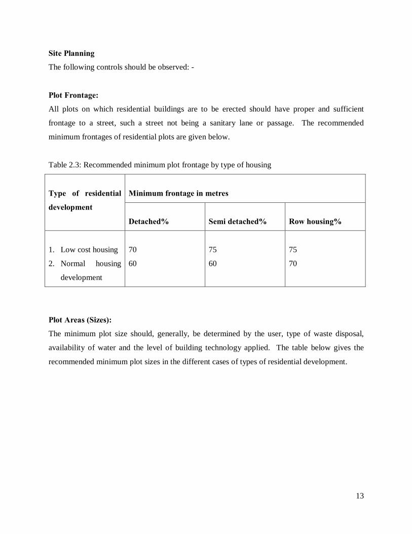
Site Planning
The following controls should be observed: -
Plot Frontage:
All plots on which residential buildings are to be erected should have proper and sufficient
frontage to a street, such a street not being a sanitary lane or passage. The recommended
minimum frontages of residential plots are given below.
Table 2.3: Recommended minimum plot frontage by type of housing
Type of residential
development
Minimum frontage in metres
Detached%
Semi detached%
Row housing%
1. Low cost housing
2. Normal housing
development
70
60
75
60
75
70
Plot Areas (Sizes):
The minimum plot size should, generally, be determined by the user, type of waste disposal,
availability of water and the level of building technology applied. The table below gives the
recommended minimum plot sizes in the different cases of types of residential development.
14
Table 2.4 Recommended minimum Plot sizes for different housing schemes
Type of housing
Minimum Plot sizes in square Metres
Detached
Semi detached
Row housing
1. Low cost housing
2. Normal housing
development
334.8
465
223.2
309.7
167.4
232.5
Plot Coverages:
Plot coverage as applied to a building means the portion of horizontal area of the site of the
building permitted to be built. The essence of fixing plot coverages is to ensure a healthy
environment and allow for expansion and improvement of infrastructural facilities and social
amenities. The minimum plot coverage recommended are shown in Table below
Table 2.5 Minimum plot coverage recommended
Type of residential
development
Maximum percentage plots coverage
Detached housing Semi detached Row housing
1. Low cost housing 50 60 65
2. Normal housing 40 50 60
Building lines (set back lines):
The principle value of building lines is either to achieve a visual effect or reserve a certain access
of area of ground. It is not necessary to set uniform lines, they maybe flexibly drawn to produce
spatial coherence and variegated character. In prime locations, it may be necessary to set
minimum as well as maximum line. The minimum distance of a house or an ancillary structure
from the plot line (boundary line) may be indicated as shown in the table below.

15
Table 2.6 Minimum setback of dwelling from plot lines
Type of residential
development
Minimum set-back in metres
Front
Side
Rear
Low cost housing
Normal housing
3
4.5
1.5
3
4.5
6
Distance Between Buildings:
The distance between any two dwellings, front to front, across a street, walk or common area
shall be not less than 2 times the total height of the taller buildings.
Street Width:
It is recommended that the width of streets or access lane in a residential area be determined by
the number of dwelling units or plots to be served. The minimum street width for given number
of plots may be indicated as shown in the table below. It is further recommended that the street
network be hierarchical so that in the future urban areas will have a high rise urban morphology
even in residential areas
Table 2.7 Minimum street width per given number of plots
Number of plots Street width
1 -20 9m
21 -50 12m
Dead-end Streets (Culs-de-sac):
A dead-end street should be aligned such that it shall give access to not more than 8 to 10
residential plots. It should not exceed 60m in length and shall have a turning radius of at least
15m at the inner end

16
2.3 Planning for new residential development: Case studies
Case 1: Redevelopment and designation of residential land use in Lindbergh, San diego
Objectives
Provide a variety of housing opportunities for persons of all ages and income levels, and retain
and enhance the physical conditions of existing neighborhoods through rehabilitation and/or
redevelopment. Preserve and upgrade existing residential areas which have developed at medium
and medium-high densities. Promote the availability of low- and moderate-income housing units
within market rate residential projects. Minimize negative impacts resulting from more intensive
land use activities. Limit the intensity of residential development in those areas subject to high
community noise levels. Require new residential projects to provide adequate recreational
opportunities for residents.
Medium-Density
Rezone areas designated for medium-density residential use to a multifamily residential zone
which permits a maximum of 29 dwelling units per net residential area.
Rezone the Orchard Apartment area from Commercial (C-l) to R-1500. Although the
Orchard Apartment complex has a higher density as a senior housing project, the base density of
the C-l Zone currently applied to the property is 29 units to an acre.
Rezone the Gateway Village complex to multifamily residential zone which permits a maximum
of 29 dwelling units per net residential acre, to allow for a medium-density residential project to
be built adjacent to the future canal. Apply a medium-density designation to the Sports Arena
site, including surrounding City-owned land (approximately 69 acres total), to provide for a
residential community to be built following eventual relocation of the Sports Arena. Designation
of the properties to the north of the Sports Arena site and the three privately-owned Sports Arena
outparcels (approximately three acres) for residential use should be re-evaluated upon
redevelopment of the Sports Arena site and in consideration of the pending Lindbergh. Field
Master Plan. Also apply the CPIOZ—Type B to ensure that the property is redeveloped as an
exemplary, comprehensive project that provides quality residential development which conforms
to the design recommendations of this community plan.

17
Application of CPIOZ—Type B will also facilitate the dedication of the necessary right of- way
and comprehensive review of overall site design to accommodate: (1) the bay-to bay canal; (2) a
school site in accordance with standards of the San Diego Unified School District; and (3) the
integration of ancillary neighborhood commercial development, either as vertical mixed-used
consisting of up to 100,000 commercial square feet, or as one or two neighborhood commercial
centers encompassing up to three acres, as needed to support the residential development.
As part of the comprehensive redevelopment process described above, and concurrent with
approval of any development project(s), the Sports Arena site and all surrounding residentially
designated properties should be rezoned to a multifamily residential zone which permits a
maximum of 29 dwelling units per net residential acre.
Medium-High Density
Apply a multifamily residential zone which permits a maximum of 43 dwelling units per net
residential acre to areas designated as suitable for medium-high density. Designate the following
areas for medium-high density residential use:
The Cauby Street area is currently zoned R-400 and R-1000. The properties in this area are
developed at or close to the maximum allowable density within the R-1000 Zone.
Retain the R-1000 Zone and medium-high designation of the Kemper Court area.
This element also establishes development guidelines for any new residential development, the
rehabilitation of existing structures, and the possible development of mixed-use projects. The
following guidelines have been developed with special emphasis on the aesthetic and functional
qualities of individual projects. Improvement in the quality of individual residential projects will
promote a desirable living environment for residents and contribute to the overall improvement
of the community.

18
Fig. 2.1 Medium density multi-family residential design concepts
Author: Internet.
19
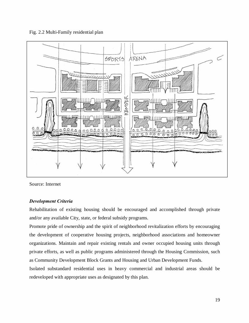
Fig. 2.2 Multi-Family residential plan
Source: Internet
Development Criteria
Rehabilitation of existing housing should be encouraged and accomplished through private
and/or any available City, state, or federal subsidy programs.
Promote pride of ownership and the spirit of neighborhood revitalization efforts by encouraging
the development of cooperative housing projects, neighborhood associations and homeowner
organizations. Maintain and repair existing rentals and owner occupied housing units through
private efforts, as well as public programs administered through the Housing Commission, such
as Community Development Block Grants and Housing and Urban Development Funds.
Isolated substandard residential uses in heavy commercial and industrial areas should be
redeveloped with appropriate uses as designated by this plan.

20
Urban Design Guidelines
Incorporate defensible space techniques into the design of multifamily projects by providing
architectural detailing and individual unit features which will promote pride of ownership and
delineate public, semiprivate and private space. The visual and spatial orientation of recreational
and open space areas should be linked to specific residential units within the project. Projects
should provide adequate lighting in all areas, avoid hidden “pockets” within landscaped areas,
and eliminate long, narrow hallways or passageways. Parking areas, pedestrian pathways and
entrances should be well-marked and open to visual surveillance.
Fig. 2.3 Urban design guidelines in Lindbergh, San diego
Source: Internet
Provide recreational facilities specifically designed for the residents of the project, e.g.,
playgrounds, benches, pools, Jacuzzis, barbecue areas, passive recreational areas and recreational
meeting rooms. Recreational design features should focus on the usability and functionality of
the space provided, i.e., benches facing interesting street scenes for the elderly, secure play areas
or tot lots in housing which accommodates families with young children, etc.
Discretionary permits should limit the amount of signage visible from the public right-of-way.
Signs should readily identify the project, incorporate landscaping, and be architecturally
integrated into the scale and style of the surrounding neighborhood.

21
Improve neighborhood streetscapes by preserving significant street trees and landscape patterns.
If a street tree pattern does not exist, new trees should be located between the sidewalk and the
curb.
Development of housing on and around the Sports Arena site should be designed around off-
shoots or “finger” canals to maximize the amount of waterfront property and make the canal
amenity available to many residents. The main channel should be designed as described in the
bay-to-bay element (as a navigable link), but the off-shoots may be narrower and shallower.
Dwelling unit types that are permitted in this area are townhouses, row houses, courtyard
buildings and apartments. Buildings should orient to the streets or around central courtyards,
with entrances on the street side and garages internal. Parking should be underground or
structured. Parking lots, driveways and garage doors are not permitted along the canal.
Pedestrian access to the canal should be frequent, convenient and well-defined. Streets shall be
designed as numerous small facilities, rather than major streets and cul-de-sacs. A grid system
should be designed, and all streets shall be public. Individual residential projects should
incorporate private recreational facilities to serve the needs of residents.
Case 2: Carlton Housing Redevelopment
The redevelopment delivered the largest and most environmentally sustainable social and
private housing redevelopment in Victoria's history. The project spans 7.5 hectares across three
Carlton sites: Lygon/Rathdowne precinct, Keppel/Cardigan precinct and Elgin/Nicholson
precinct. These major areas of Carlton were revitalised into vibrant community precincts with
new public parks, community gardens and pedestrian and bicycle pathways. The high-rise towers
near Lygon and Elgin Streets were retained and were progressively upgraded to significantly
improve accommodation, security and sustainability of the high-rise towers. The first stage of
construction commenced on the $260 million Carlton Housing Redevelopment to replace 192
old, walk up flats with 246 new social housing apartments and 550 new private apartments. It
also included new public parks and landscaping. A health and aged care facility and retirement
living precinct was proposed.
22
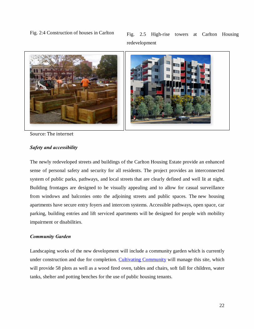
Fig. 2:4 Construction of houses in Carlton
Source: The internet Safety and accessibility
The newly redeveloped streets and buildings of the Carlton Housing Estate provide an enhanced
sense of personal safety and security for all residents. The project provides an interconnected
system of public parks, pathways, and local streets that are clearly defined and well lit at night.
Building frontages are designed to be visually appealing and to allow for casual surveillance
from windows and balconies onto the adjoining streets and public spaces. The new housing
apartments have secure entry foyers and intercom systems. Accessible pathways, open space, car
parking, building entries and lift serviced apartments will be designed for people with mobility
impairment or disabilities.
Community Garden
Landscaping works of the new development will include a community garden which is currently
under construction and due for completion. Cultivating Community will manage this site, which
will provide 58 plots as well as a wood fired oven, tables and chairs, soft fall for children, water
tanks, shelter and potting benches for the use of public housing tenants.
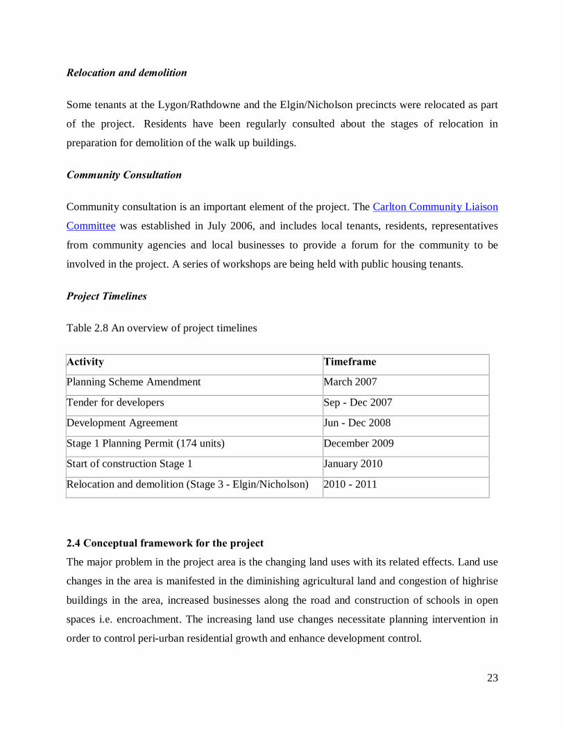
Fig. 2.5 High-rise towers at Carlton Housing
redevelopment
23
Relocation and demolition
Some tenants at the Lygon/Rathdowne and the Elgin/Nicholson precincts were relocated as part
of the project. Residents have been regularly consulted about the stages of relocation in
preparation for demolition of the walk up buildings.
Community Consultation
Community consultation is an important element of the project. The Carlton Community Liaison
Committee was established in July 2006, and includes local tenants, residents, representatives
from community agencies and local businesses to provide a forum for the community to be
involved in the project. A series of workshops are being held with public housing tenants.
Project Timelines
Table 2.8 An overview of project timelines
Activity Timeframe
Planning Scheme Amendment March 2007
Tender for developers Sep - Dec 2007
Development Agreement Jun - Dec 2008
Stage 1 Planning Permit (174 units) December 2009
Start of construction Stage 1 January 2010
Relocation and demolition (Stage 3 - Elgin/Nicholson) 2010 - 2011
2.4 Conceptual framework for the project
The major problem in the project area is the changing land uses with its related effects. Land use
changes in the area is manifested in the diminishing agricultural land and congestion of highrise
buildings in the area, increased businesses along the road and construction of schools in open
spaces i.e. encroachment. The increasing land use changes necessitate planning intervention in
order to control peri-urban residential growth and enhance development control.

24
Re-organisation of the residential growth is considered as the best approach in dealing with
problems of land use changes, congestion and the loss of asthetics in the area. In order to ensure
proper implementation and sustainability of reorganization of growth in this area, the following
aspects have to be considered. First there is need to educate the community about urban sprawl
and peri-urban growth and engage them in the project. There is need for supportive tools and
policies, the town council of Karuri needs to formulate policies that will provide for control of
residential redevelopment in the project area to ensure the approval and sustainability of the
proposed project. There is also need to involve the experts in developing alternative proposals
for reorganization of residential growth in the project area: who will apply their professional
expertise and carry out feasibility study and an environmental impact assessment to determine
the impacts of each proposal on the environment. There is also need for political support for the
proposed plan.
If all of the above requirements are met, the proposed re-organisation plan for the project area
will be sustainable. These will result into attractive aspects and improved aesthetics, reduced
congestion and improved linkages. Re-organization of residential growth will help control the
rate of land use changes hence the rate of development in the area. This will therefore enhance a
sustainable, vibrant and aesthetically attractive area.

25
CHAPTER THREE: SITUATION ANALYSIS
3.1 Location context of the project area
The project area covers the Ruaka sublocation in Kiambaa division in Kiambu East district . The
area falls under the town council of Karuri. Ruaka is located approximately 12 Km from the city
of Nairobi. The area is accessed via Limuru road. The area has an attitude of 1⁰12'0"S and
36⁰47'0"E. The altitude of the area is 1746 m above sea level. The study area covers an area of
approximately 4 hectares. There has been rapid development of residential and commercial
facilities in the study area leading to uncoordinated growth therefore re-organisation of these
developments is necessary in order to ensure orderly development.
Fig. 3.1 National context of the project area
Source: Survey of Kenya
Ruaka is found in central province in Kenya

26
Source: Town Council of Karuri.
Fig. 3.2 Location within the Town Council of Karuri
Position of Ruaka in the town council of Karuri.

27
Fig. 3.3 The neighbourhood context of the project area.
Legend
Source: Author, 2010
1. The project area borders
the ruaka police post to the
west, Ruaka shopping centre
to the south, the road
junction branching from
Limuru road to Muchatha is
on the East of the study area
and on the northern side are
other residential
developments.
2. Limuru road is adjacent to
the project area on the
south.

28
Fig. 3.4 Detailed Study Area
Housing development within the agricultural land
Small scale agricultural activities still present in the project area.
Limuru road adjacent to the site
Source: Author, 2010

29
3.2 Historical background of the study area
Ruaka is named after River Ruaka that flows across the area, where it is believed that women
used to bath. The land was owned communally where people began building huts. When
colonization began, the people were regrouped into villages. The first village was in Ruaka
shopping centre, where the people worked in the white settler’s coffee farms. Some shops
were built at the current Ruaka shopping centre. The land was therefore subdivided into
private plots where most people practiced agriculture as a main source of livelihood.
Urbanisation then caused there to be various land use changes where people have been
developing residential and commercial houses on their land.
3.3 Physical and environmental characteristics
3.3.1 Climate
The area receives an average of 900 mm of rainfall annually with a mean monthly average
temperature of 22⁰c and a maximum of 27⁰c. Precipitation is in two rainfall seasons i.e.
bimodal that is between March and May and between October and December, there are two
intervening dry seasons. Rainfall is influenced by relief. Winds are weak with the strongest
occurring during August and October (5-10m/s) and blowing from varying directions. The
annual precipitation rate is 1883 exceeding the precipitation rate. The hottest months are
December to March (27⁰c) and the coldest month is July (22⁰c). This presents a very
favourable climate for development of housing in the project area.
3.3.2 Topography and Slope Analysis
Ruaka area slopes eastwards towards the city of Nairobi. The area is characterized by rugged
and deeply incised landscape. Ruaka River is the major hydrological feature which forms the
boundary between Ruaka and Kiambaa sub-locations on the North-East while River Rueru
forms the boundary between Ruaka and Kihara location to the west. Since the area is gently
sloping, this area is very favourable for residential development with minimal costs, this has
been evidenced by the existing and increasing residential developments.
3.3.3 Hydrology and Drainage systems
The main hydrological features in the area are River Ruaka, River Rueru and Kandakomu
spring. The two rivers drain their water in Nairobi River. Other rivers in the river include
Kagongo River which drains its water into Karura River.
30
Manmade boreholes and wells are also other major sources of water in the area. Availability
of water in the area shows that there is great potential to serve the increasing population. The
area has problem which needs to be addressed, that is: it lacks storm water drains hence there
is poor drainage during the rainy season which could be a threat to people’s lives since it may
breed mosquitoes which may bring Malaria.
3.4 Population and demographic characteristics
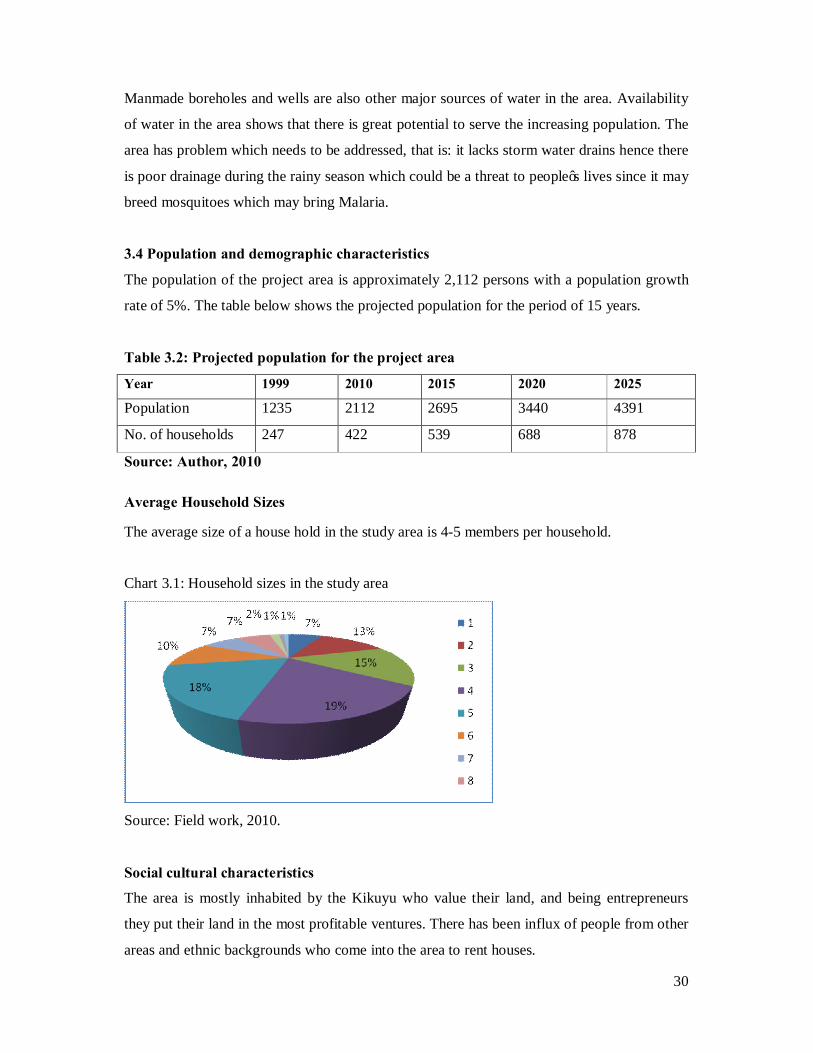
The population of the project area is approximately 2,112 persons with a population growth
rate of 5%. The table below shows the projected population for the period of 15 years.
Table 3.2: Projected population for the project area
Year 1999 2010 2015 2020 2025 Population 1235 2112 2695 3440 4391
No. of households 247 422 539 688 878
Source: Author, 2010
Average Household Sizes
The average size of a house hold in the study area is 4-5 members per household.
Chart 3.1: Household sizes in the study area
Source: Field work, 2010.
Social cultural characteristics
The area is mostly inhabited by the Kikuyu who value their land, and being entrepreneurs
they put their land in the most profitable ventures. There has been influx of people from other
areas and ethnic backgrounds who come into the area to rent houses.

31
Migration trends
There is high immigration of people into this area resulting to high rate of population growth.
This has led to very high demand for housing hence more development of residential houses
to accommodate the population. The main reasons contributing to people moving into this
area are :- Cheaper housing in the area than major urban areas, search for employment e.t.c.
Most of the people who migrated into the project area intend to permanently live here. This is
because the area is close to Nairobi where they can access goods and other services easily.
Also most of them are employed in Nairobi where they access easily due to a good transport
network. There are also few cases of outmigration whose main reasons are: holidays, visits
and employment. Holiday here refers to the movement of people annually to their ancestral
homes, this factor is greatest especially for those whose ancestral home is not in the project
area.
Chart 3.2: Reason for out-migration from the project area
Source: Field work, 2010
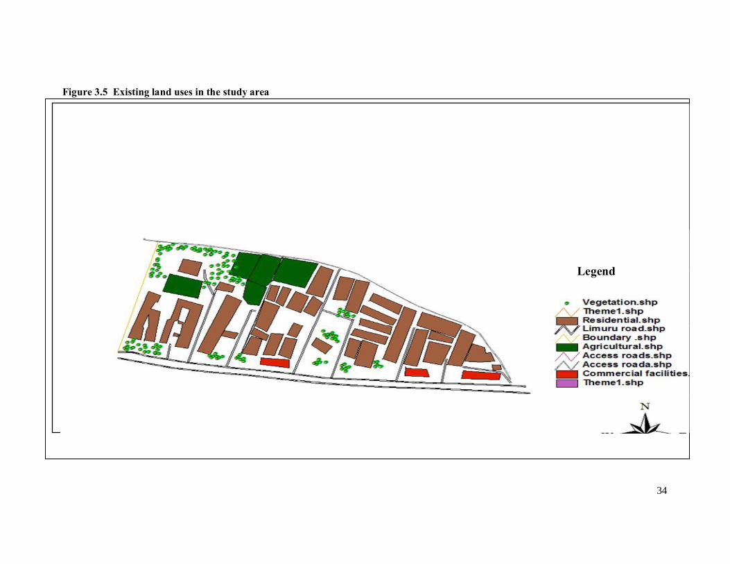
3.5 Land use analysis within the project area.
The main land use in the study area is currently residential, others include commercial
activities, open spaces, urban agriculture and infrastructural and transportation facilities. The
private developers have fully developed the land into residential houses for rental purposes to
the working population in Nairobi. There is need to re-organize what is existing in order to
achieve orderly development.

32
Table 3.3: The existing land use situation in the project area
Land use Percentage Residential 60% Commercial (Economic activities) 5% Open spaces (Vegetation) 20% Agriculture (mainly urban agriculture) 5% Infrastructural and transportation 10%
Source: Field survey, 2010.
3.5.1 Housing
This is the major land use in the area taking about 60% of the land. There are mainly middle
income housing in the project area. The construction of these houses have eliminated the
initial land use which was agricultural. There has been emergence of highrise (flats) houses in
the area where building standards and building codes are not well adhered to. The rental
charges for the apartments and bungalows range from 8,000 for single dwelling units and
20,000 for double dwelling units. The increasing development of these housing has led to
congestion and loss of open spaces in the area. This has hence led to lack of aesthetic value in
the study area. There is therefore need for redevelopment in order to instill order in this area.
3.5.2 Commercial
There are numerous unplanned commercial activites taking place along the roads. This has
led to congestion on the road lanes and has also hindered accessibility into the interior. There
has been high competition for road use. This activities include retail shops, informal open air
markets, jua kali artisans, welding and maize roasting.
3.5.3 Infrastructure
Water supply
The increased residential and commercial activities have led to increase on the water demand
in the area. Some residents who live in bungalows also harness rain water through roof
catchment. Water is supplied by the City Council of Nairobi and Karuri water and sanitation
company.

33
Storm water drainage
There is a problem of storm water drains especially during the rainy season. This is because
there are no adequate storm water drainage systems in this area. The town council council
where Ruaka falls has not addressed to the problem for storm water drainage.
Sewerage disposal
The project area lacks a sewerage network hence most residential households use septic tanks
and conservancy tanks especially in the high-rise buildings. Others use pit latrines especially
those living in bungalows. The septic tanks are emptied by private exhausters every three
months. There are plans by the Athi waters board to buy exhausters. The lack of sewerage
systems for sewage disposal poses health risks and other environmental concerns like
pollution and air borne diseases.
34
Figure 3.5 Existing land uses in the study area
Legend

35
3.6 Institutional, legal and financial issues of the project area.
3.6.1 Town Council of Karuri
This is the major planning agency in the project area. According to the local government Act
and the physical planning Act, it has the following functions: To prohibit or control the use
and development of land and buildings in the interests of proper development of its area of
jurisdiction, also to consider and approve all development applications and grant all
development permissions (according to the P.P.A section 29). The town council formulate
by-laws to guide development activities in the area. The council plays a role in development
control through approval of submitted development proposals.
There are various challenges faced by the council in development control. These include:
Resistance by the public, lack of capacity to inspect all construction works from the approved
plans, lack of technical staff, insecurity, and political interference.
Therefore, there is need for strict measures to be put in place regarding development by the
Town Council of Karuri in order to ensure that all planning standards and regulations are
adhered to by developers.

36
Fig. 3.6 Administrative structure of the Town Council of Karuri
3.6.2 Other Actors in the planning process include:
Ministry of Lands
This is the overall government agency that approves land uses changes on land in the area.
Therefore this makes it a major Actor in the implementation of this project.
Ministry of Roads
The ministry of roads will also be involved in the implementation of the project in the
reorganization of the road network in the area. The ministry will help in the construction of
the new proposed roads.
Membership: Councilors The Chairman: Formulate policies for the council and approves all decisions
Committee1: Finance Staff and General Purposes
Committee 2: Works and Town Planning
Committee 3: Education, Social Services and Housing
Committee 4: Public Health and Environment
Town Clerk Chief Executive
Departments
Town Clerks Department
Treasury Department Town Treasurer
Works Department Town Engineer
Planning Department
Public Health Department

37
Community development fund
Community development fund (CDF) will be used to fund the implementation of the project.
The private sector
The private sector is also included in the financing and implementation of development
activities in the area. These can provide housing facilities together with the necessary
facilities to the community.
Community leaders
The aim of community leaders is to ensure conformity to the planning regulations by the
community hence sustainability of the project. The community leaders should be involved in
all the development stages of the plan making to implementation.
3.6.3 Financial
The project will require a lot of money for its implementation. The town council of Karuri
should review its policies that will help in directing enough funds for the implementation of
the project. The planning standards and regulations should also be reviewed in order to
reduce the cost of developing the residential houses, provision of infrastructural facilities and
community facilities.
The community based organizations in the area can also lobby for funds from development
agencies willing to engage in the implementation of this project i.e. both local and
international agencies such as U.N Agencies and the World Bank.

38
Fig. 3.7 Opportunities and Constraints in the project area.
Source:Author,2010
Opportunities
• The Nairobi northern By-pass will help reduce traffic congestion, increase accessibility and promote urban growth.
• Proximity to Nairobi will this will spur growth in Ruaka.
• The proposed Nairobi metropolitan region is likely to bring some trickling Bdown effects from the city.
• Heavy development in housing for rental purposes is a source of income for the residents.
• Availability of building materials. • The high land prices in the area
present an opportunity for major urban residential developments.
Constraints
• Non-adherence to building codes by developers.
• Poor zoning and land uses. • Lack of a functioning sewerage and
drainage systems exhibited. • High rates of land subdivision.
Legend

39
CHAPTER FOUR: PROJECT PLANNING, DESIGN AND IMPLEMENTATION
Overview
This chapter will deal with the aspects of developing plan proposals for the project area and
implementation of the preferred plan. There are various alternative designs for peri-urban
residential development for harmonious growth. The adoption of the plan by the town council
of Karuri will help to manage the haphazard residential growth in their area of jurisdiction.
4.1 Planning and design of project
The re-organised peri-urban growth plan for housing developments will bring about a vibrant
and sustainable project in the area. Housing blocks will be provided following the required
planning standards. There will be adequate accessibility within the study area and also with
the neighboring areas. This will provide a compact neighbourhood which is sufficient in all
ways where people can interact and socialize with others freely. There will be enhanced
linkages with the periphery of this area and the city of Nairobi.
The compatibility of the residential land use with other land uses in the area will enhance
healthy interactions and control of development in the area. There will be provision of
various housing typologies in order to promote a variety of choice among different
households. Provision of housing will observe the required standards and building by-laws.
4.1.1 Development of the spatial plans: Evaluation of alternatives plan proposals
The Existing situation
The project area is currently characterized by multiple storey residential buildings where the
planning standards and regulations have not been adhered to properly. For instance,
developers develop upto 100% plot coverage. This has led to haphazard development in this
area. Ruaka also lacks a planning framework which could also be the cause for the
uncoordinated growth. There is therefore need for a planning framework in the area in order
to control growth.
Alternative Plan one: Medium density single storey buildings
There will be rezoning of the current multiple storey housing into development of uniform
type of housing that is single storey buildings in the study area each on its own piece of land
and serving only one household. These houses will all be similar in terms of design and
provided with all infrastructural facilities like sewerage facilities. There will be no
commercial facilities provided in the type of development. Construction for such housing will
40
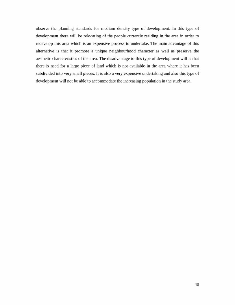
observe the planning standards for medium density type of development. In this type of
development there will be relocating of the people currently residing in the area in order to
redevelop this area which is an expensive process to undertake. The main advantage of this
alternative is that it promote a unique neighbourhood character as well as preserve the
aesthetic characteristics of the area. The disadvantage to this type of development will is that
there is need for a large piece of land which is not available in the area where it has been
subdivided into very small pieces. It is also a very expensive undertaking and also this type of
development will not be able to accommodate the increasing population in the study area.

41
Fig. 4.1 Alternative Plan one map.
Source: Author, 2010.
Legend

42
Fig. 4.2 Design for the alternative one
Source:Author,2010
• Uniform type of housing that is single storey buildings
• Houses similar in terms of design • There are no commercial facilities
provided • Construction for such housing will
observe the planning standards for medium density type of development
43
Fig. 4.3: Landscaping of Alternative plan one
Source: Author, 2010

44
Alternative plan two: High density multi-storey buildings
In this intervention measure, the area will be designated for purely high density multifamily
residential zone. Where possible there will be rehabilitation of the existing structures which
have followed the required guidelines in order to conform with the redevelopment plan. In
this alternative it will provide multi-storey buildings where the ground floors of buildings
facing the road are used for commercial purposes while the upper floors are used for
residential purposes. This will enhance optimum utilization of the available land for
development. This measure works well in areas where there is limited developable land like
the case in the project area.
The advantages of this alternative are that there will be various uses in the same building and
also will help accommodate the increasing population in the project area. This will also help
create a very good skyline in the project area. This type of development should be well
integrated with the existing neighbouring land uses.
Preferred plan
The most preferred plan for the area is the high density multi-storey buildings.
This is because 1) It will blend well with the existing residential development in the area
which is multi-storey buildings, 2) Land available for development is limited in the project
area and there is high population growth rate, where it has also been increasing due to high
rates of in migration into the area, 3) This type of development will ensure optimal use of the
available land in the project area. The local authority where this area falls (the town council
of Karuri) will also be able to collect more revenue from this development. This is because is
there will be guidelines to enhance inspection of approved buildings by the council hence no
housing will be constructed without approval.
Urban design Guidelines
The residential redevelopment should be well linked with visual and spatial orientation of
recreational and open space areas.
Adequate lighting should be provided in all areas to avoid hidden “pockets” within
landscaped areas.
Provide recreational facilities specifically designed for the residents of the project, e.g.
benches, footpaths e.t.c.
Improve neighborhood streetscapes by preserving significant street trees and landscape
patterns.
45
4.2 Site planning/design process stages
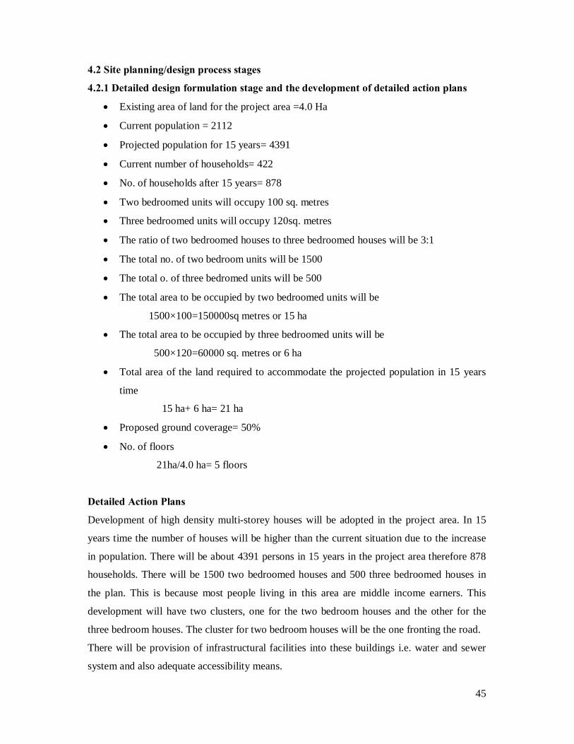
4.2.1 Detailed design formulation stage and the development of detailed action plans
• Existing area of land for the project area =4.0 Ha
• Current population = 2112
• Projected population for 15 years= 4391
• Current number of households= 422
• No. of households after 15 years= 878
• Two bedroomed units will occupy 100 sq. metres
• Three bedroomed units will occupy 120sq. metres
• The ratio of two bedroomed houses to three bedroomed houses will be 3:1
• The total no. of two bedroom units will be 1500
• The total o. of three bedromed units will be 500
• The total area to be occupied by two bedroomed units will be
1500×100=150000sq metres or 15 ha
• The total area to be occupied by three bedroomed units will be
500×120=60000 sq. metres or 6 ha
• Total area of the land required to accommodate the projected population in 15 years
time
15 ha+ 6 ha= 21 ha
• Proposed ground coverage= 50%
• No. of floors
21ha/4.0 ha= 5 floors
Detailed Action Plans
Development of high density multi-storey houses will be adopted in the project area. In 15
years time the number of houses will be higher than the current situation due to the increase
in population. There will be about 4391 persons in 15 years in the project area therefore 878
households. There will be 1500 two bedroomed houses and 500 three bedroomed houses in
the plan. This is because most people living in this area are middle income earners. This
development will have two clusters, one for the two bedroom houses and the other for the
three bedroom houses. The cluster for two bedroom houses will be the one fronting the road.
There will be provision of infrastructural facilities into these buildings i.e. water and sewer
system and also adequate accessibility means.

46
Fig. 4.4 Preferred Plan for the project area.
Source: Author, 2010.
Legend

47
Fig. 4.5 Design of the preferred model
Source:Author,2010
Two bedroom and three bedroom flats. Flats have Five floors each Provides a good skyline. 50% plot coverage Good landscaping with trees. Adequate space for community facilities Six metres access road

48
Infrastructure facilities
Adequate infrastructure will be provided to cater for the population. Drainage channels will
be constructed and integrated with the footpaths A sewerage network will be provided to
cater for foul water and waste water from the houses. Also proper methods of solid waste
disposal will be adopted to enhance hygiene.
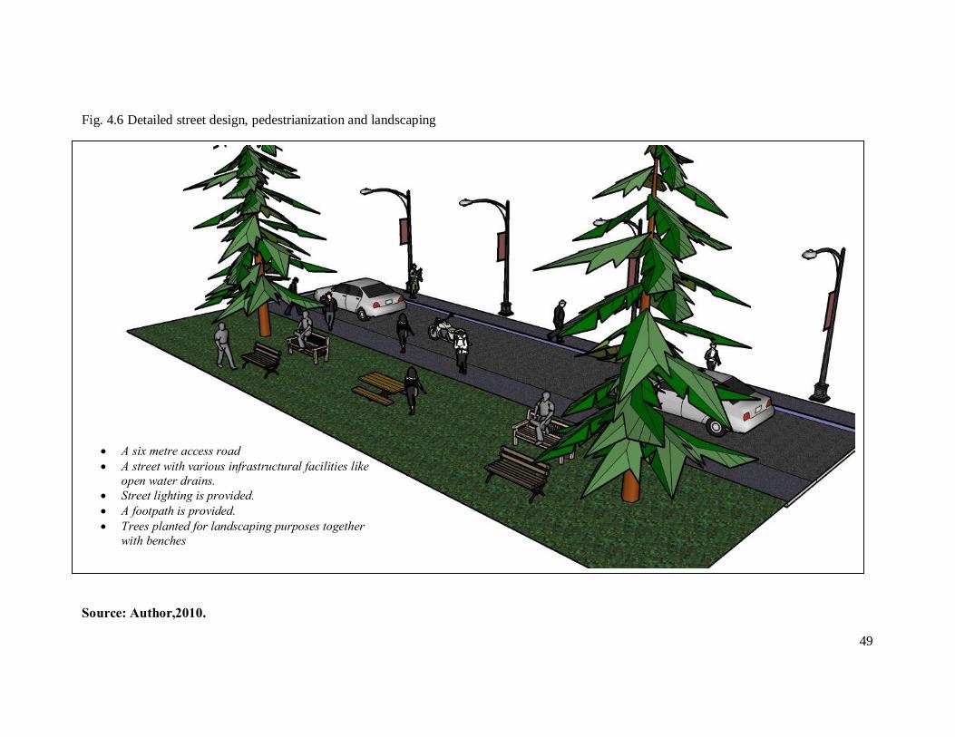
Access roads and pedestrianization
A six metre wide access road will be provided in order to serve pedestrians, and cyclists.
Pedestrianization will improve the linkages within the neighborhood. Other facilities like
trees, benches, street lights and garbage bins, sidewalks and foot paths will be designed for
the area to link with other parts within and outside the project area.
Landscaping
Trees will be planted along Limuru road to act as a buffer and also within the area so as to
maintain a good landscape. There will also be flowers at the compounds of these houses to
improve on aesthetic value.
Peri-Urban agriculture
To ensure that agriculture is not completely phased out of the area, there will be small
gardens to practice small-scale peri-urban agriculture like planting of vegetables.
49
Fig. 4.6 Detailed street design, pedestrianization and landscaping
Source: Author,2010.
• A six metre access road • A street with various infrastructural facilities like
open water drains. • Street lighting is provided. • A footpath is provided. • Trees planted for landscaping purposes together
with benches

50
4.2.2 Implementation strategies
Problem Strategies Programmes Actors High demand for housing due to increasing population.
Provide enough housing for the increasing population in the area. Provide buildings to accommodate and curb the increasing demand for housing.
Build five storeyed apartments to accommodate the population.
The Town Council of Karuri
Increasing land use changes from agricultural land use to residential land use.
Ensure that the land use changes are approved by the Town Council of Karuri. Inspection and follow up by the council.
The Town council of Karuri to approve all developments in the area and the do a follow up during construction.
Town Council of Karuri Private developers
Development of housing without following planning standards.
Ensure construction of buildings adhering to the required planning standards
Provide the planning standards to developers at the time of approval of buildings
Town Council of karuri Private developers.
Congestion due to emergence of unplanned residential growth.
Re-plan and redevelop for residential growth in the area. Co-ordinate residential growth by applying the required standards during development.
Redevelop the residential housing observing a 50% plot coverage.
Town Council of Karuri Private developers
Lack of infrastructure facilities like sewerage network
Provide a sewerage network in the area.
Consruct a high capacity sewerage network, water and drainage systems
Athi Water Company The Town Council of Karuri.
Source: Author, 2010
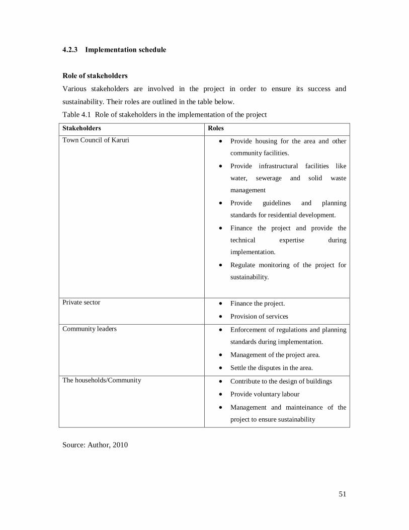
51
4.2.3 Implementation schedule
Role of stakeholders
Various stakeholders are involved in the project in order to ensure its success and
sustainability. Their roles are outlined in the table below.
Table 4.1 Role of stakeholders in the implementation of the project
Stakeholders Roles Town Council of Karuri • Provide housing for the area and other
community facilities.
• Provide infrastructural facilities like
water, sewerage and solid waste
management
• Provide guidelines and planning
standards for residential development.
• Finance the project and provide the
technical expertise during
implementation.
• Regulate monitoring of the project for
sustainability.
Private sector • Finance the project.
• Provision of services Community leaders • Enforcement of regulations and planning
standards during implementation.
• Management of the project area.
• Settle the disputes in the area. The households/Community • Contribute to the design of buildings
• Provide voluntary labour
• Management and mainteinance of the
project to ensure sustainability
Source: Author, 2010

52
Phasing of the project and the Time Frame
The project shall require a phasing plan that describes and illustrates the format of implementation of the proposed plan when development is
anticipated to occur in multiple phases over a number of years. The phasing plan will show how the project is to be incrementally developed.
Table 4.2 Phasing of the project
Phase 1 Time Frame Cost(Kshs) Phase 2 Time frame Cost (Kshs) Compensate the land owners for their
land for redevelopment
Identifying a temporary site to
relocate the displaced population.
Acquisition of required materials for
construction.
Layout of infrastructural facilities
Construction of flats
6 months
6 months
1 year
1 year
3 years
500 million
1 million
50 million
10 million
500 million
Landscaping and pedestrianization
Tree planting
Relocation of the displaced population
Regular inspection and monitoring to
ensure sustainability
2 months
3 months
5 months
100 million
50, 000
Source: Author, 2010

53
Resource requirements
Land resource
Land is the major component in the implementation of this project. The land is not readily
available since the ownership of land in the area is private and the land has been subdivided
into very small pieces. There will be compensation to the owners of land in order to
redevelop the area.
Financial resources
The project requires huge amounts of financial resources. The Town council of Karuri will be
the main financier of the project. Other stakeholders will include; the private developers and
other development agencies.
Human resources
Human labour will be needed in the construction, supervision, management and mainteinance
of the project. The town council of Karuri will provide the technical support and supervision
of the project. The community members will provide casual labour which will be a form of
employment for them.

54
CHAPTER FIVE: MONITORING AND EVALUATION
Overview
This chapter articulates the expected outcomes from the project as well as the indicators.
5.1 Expected outputs and outcomes of the project
The re-organised residential growth plan is expected to reduce the cases of congestion in the
study area and enhance aesthetic characteristics, that will present a well organized residential
developments in Ruaka. There will be reduced haphazard development in the area and
therefore present an orderly sense of development in the area. There will be increased
accessibility within and outside the area to enhance the interactions between the people.
Adequate space for commercial facilities will be provided in order to enhance the peoples
livelihoods in this area.
Table 5.1 The expected Output and indicators of success.
Expected outcomes Indicators
Spatial implications • A well organized
residential
development
• Reduced haphazard
development
• A well maintained
neighbourhood.
• Increased
accessibility of the
area.
• Increased linkages
(exrenal and internal).
• Controlled
development
• Easier movement
• Improved aesthetic
characteristics
Social implications • Improved living
standards of the
residents.
• Improved livelihoods
of the residents.
• Good housing
• Improved way of life
of the community

55
conditions
Economic implications • Increased revenue for
the town council of
Karuri.
• Increased incomes
from investment in
residential
development
• Increased
employment
opportunities for the
community especially
the youth
• Optimal use of land
• Increased revenue
base i.e surplus.
• Improved way of life.
• Creation of
employment
opportunities.
Environmental implications • A well maintained
neighbourhood
• A cleaner
environment
• Proper waste
management
• A cleaner
environment
• Improved aesthetic
components
5.2 Monitoring and evaluation stages in the implementation of the project
There is need for community participation and constant monitoring and evaluation
mechanisms in order for the project to become a success and to ensure that the expected
outputs are realized. Monitoring is an essential part of the planning process. Monitoring of
the project ensures that there is a base to measure the success of the plans.

56
The success of the project will be ensured by the provision of training programmes and
community sensitization forums. The community based organizations as well as the
community members will be at the fore front in the management and the monitoring the level
of success of the project. The indicators as illustrated in the table above will serve as the
measure of the general success of the project.
Goal achievement matrix
This reflects the expectations of the stakeholders in terms of the goals and the
recommendations they have made. It will reflect the achieved goals and whether they have
been achieved within the proposed time limits. The goals not achieved within the stated time
limit should be devised on how they would be achieved
Site performance inventory
Regular site visits and monitoring will be done after the construction process to access
general performance of the project. This is to check whether there are any negative impacts as
well as the intended goals and objectives have been met.
5.3 Guidelines for the implementation process
The harmonization of the project will be ensured by a guideline that will act as an
organization structure for the entire project, which shall include various steps and procedures.
The implementation stages of this project should be a participatory process of the town
council of Karuri, the community, developers and other development agencies, this is in order
to enhance the ownership of the project hence its sustainability. The community should be
actively involved from the decision making stage to the implementation.
The town council of Karuri needs to observe the following:
• Reviewing of by-laws in order to provide for the peri-urban residential re-organisation
and redevelopment in Ruaka.
• Formulation of cross sectoral framework for project implementation.
• Negotiations and meetings between different stakeholders for a partnership and
participation plan formulation
• Commencement of the community training programmes.
57
• Enforcement of the appropriate legal framework in regards to construction or
development of the area, ie. Getting development permission by the town council of
Karuri as per the local government Act and the physical planning Act of 1996.
• Implementation of the proposed policies for peri-urban residential growth to enhance
the sustainability of the project.
• When these guidelines are in place implementation sequence will begin with less
technical phases of the project implementation as outlined in the table.
5.4 Site/ Environmental Management plan
Construction activities on the sites need to be strictly regulated to ensure that all projects are
developed and implemented according to sound environmental standards and norms.
To ensure that the project proceeded with minimum distractions on the physical environment
and the public, an environmental management plan which prescribes specific actions that
should be undertaken during planning, construction and operation of an approved
development will be prepared.
The main objectives are: 1) To come up with cost effective measures to prevent or reduce
significant negative impacts of development to minimum levels. 2) To understand the degree
of the impacts when considering compensation to affected parties. 3) To minimize noise
during construction.
58
Bibliography
• Arbury Joshua, From Urban Sprawl to Compact City – An Analysis of Urban growth
management in Auckland.
• Andersen Jorgen, Department of Human Settlements, School of Architecture,
Copenhagen, Meanings and perceptions of the built environment in peri-urban areas
of Maputo, Mozambique.
• Chirisa Innocent, Peri-urban dynamics and regional planning in Africa: Implications
for building healthy cities.
• Dávila D. Julio with, A review of policies and strategies affecting the peri-urban
interface.
• Heimlich E. Ralph and Anderson D. William, Development at the urban fringe and
beyond: Impacts on agriculture and rural land.
• Ikhwan Hakim, and Parolin Bruno, Spatial Structure and Spatial Impacts of the
Jakarta Metropolitan Area: a Southeast Asian EMR Perspective.
• John Friedmann-University of british Columbia, The peri-urban: the unfolding drama
of china’s city-regions.
• Kithia Shadrack, Land use changes and their effects on sediment transport and soil
erosion within the Athi drainage basin, Kenya.
• Kjell Nilsson & Thomas S. Nielsen, Peri-urban land use relationships – Strategies and
sustainability assessment tools for urban-rural linkages
• Ministry of Nairobi metropolitan Development, Nairobi Metro 2030; A vision for a
world class Metropolis, First and foremost in Africa and the world.
• On the Edge of Sustainability: Perspectives on Peri-urban Dynamics
• Professor-Emeritus Helen Armstrong-Centre for Cultural Research, University
of Western Sydney, Post-Urban/Suburban Landscapes: Design and Planning
the Centre, Edge and In-between.
• Republic of Kenya (2002-2008) Kiambu district development plan. Government
printer Nairobi.
• Republic of Kenya, Kiambu District Strategic Plan, 2005 - 2010 for implementation
of the national population policy for sustainable development, government Printer.
• Republic of Kenya, County Council of Kiambu Strategic Plan, 2008 to 2013,
government Printer.
59
• Rijksuniversiteit Groningen, Peri-urban Planning in Indonesia Contexts, approaches
and institutional capacity.
• Socio-economic transitions;changing livelihoods in the peri-urban area. A
comparative study of Kotwi and Tikrom in the Atwima Kwawoma. District and the
Ejisu Municipality of Ghana respectively.
• Stergios Jim, Rehabbing Urban Redevelopment
• The Peri-Urban Interface in Developing Areas: Approaches to sustainable natural and
human resource use Developing Areas Research Group
• Urban Fringe Management and Role of Good Governance: Integrating Stakeholders
in Land Management Process Fahria MASUM, Germany