Murray–Darling Basin Plan Groundwater Methods Report
Determining the groundwater baseline and
sustainable diversion limits
November 2020
Murray–Darling Basin Authority Murray–Darling Basin Plan Groundwater Methods Report ii
Published by the Murray–Darling Basin Authority
MDBA publication no: 42/20
ISBN (online): 978-1-922396-09-9
© Murray–Darling Basin Authority 2020
Ownership of intellectual property rights
With the exception of the Commonwealth Coat of Arms, the MDBA logo, trademarks and any exempt
photographs and graphics (these are identified), this publication is provided under a Creative Commons
Attribution 4.0 licence. (https://creativecommons.org/licenses/by/4.0)
The Australian Government acting through the Murray–Darling Basin Authority has exercised due care and skill in preparing
and compiling the information and data in this publication. Notwithstanding, the Murray–Darling Basin Authority, its
employees and advisers disclaim all liability, including liability for negligence and for any loss, damage, injury, expense or
cost incurred by any person as a result of accessing, using or relying upon any of the information or data in this publication
to the maximum extent permitted by law.
The Murray‒Darling Basin Authority’s preference is that you attribute this publication (and any Murray‒Darling Basin
Authority material sourced from it) using the following wording within your work:
Cataloguing data
Title: Murray–Darling Basin Plan Groundwater Methods Report, Murray‒Darling Basin Authority Canberra,2020. CC BY 4.0
Accessibility
The Murray‒Darling Basin Authority makes its documents and information available in accessible formats. On some
occasions the highly technical nature of the document means that we cannot make some sections fully accessible. If you
encounter accessibility problems or the document is in a format that you cannot access, please contact us.
Acknowledgement of the Traditional Owners of the Murray–Darling Basin
The Murray−Darling Basin Authority pays respect to the Traditional Owners and their Nations of the Murray−Darling Basin.
We acknowledge their deep cultural, social, environmental, spiritual and economic connection to their lands and waters.
The guidance and support received from the Murray Lower Darling Rivers Indigenous Nations, the Northern Basin
Aboriginal Nations and our many Traditional Owner friends and colleagues is very much valued and appreciated.
Aboriginal people should be aware that this publication may contain images, names or quotations of deceased persons.
GPO Box 1801, Canberra ACT 2601 1800 230 067
[email protected] mdba.gov.au

Murray–Darling Basin Authority Murray–Darling Basin Plan Groundwater Methods Report iii
Contents Figures and tables ................................................................................................................................... iv
Abbreviations ........................................................................................................................................... v
Introduction ..............................................................................................................................................1
The Basin Plan and groundwater management .......................................................................................3
Basin Plan commenced in November 2012..........................................................................................4
SDL reviews completed in November 2014 .........................................................................................4
Basin Plan amendment in July 2018 .....................................................................................................4
SDLs commenced 1 July 2019...............................................................................................................6
WRP areas and SDL resource unit boundaries .........................................................................................7
Groundwater boundaries pre-Basin Plan .............................................................................................7
Defining boundaries for the Basin Plan ................................................................................................7
Excluded areas ......................................................................................................................................9
Baseline diversion limits ........................................................................................................................ 11
Setting the baseline diversion limits ................................................................................................. 11
Assessment to determine groundwater SDLs ....................................................................................... 12
Groundwater SDLs ............................................................................................................................. 12
Environmentally sustainable level of take ........................................................................................ 12
Groundwater dependent ecosystems ........................................................................................... 13
Surface water–groundwater connectivity ..................................................................................... 13
Preservation of the productive base ............................................................................................. 13
Water quality ................................................................................................................................. 13
Groundwater recharge ...................................................................................................................... 14
Modelled SDL resource units ............................................................................................................ 14
Recharge Risk Assessment Method .................................................................................................. 17
Risks to the four ESLT characteristics ............................................................................................ 17
The level of uncertainty within an SDL resource unit ................................................................... 18
Groundwater assessment framework ............................................................................................... 20
Applying the assessment framework ............................................................................................ 20
SDL resource unit categories ......................................................................................................... 22
Potential impacts on surface water of growth in groundwater extraction .................................. 44
References ............................................................................................................................................. 46

Murray–Darling Basin Authority Murray–Darling Basin Plan Groundwater Methods Report iv
Figures and tables Table 1: Groundwater BDL and SDL changes in Schedule 4 of the Basin Plan, as a result of 2018
amendments (MDBA, 2018) .................................................................................................................... 6
Figure 1: Water resource plan areas – Groundwater ............................................................................. 8
Figure 2: Groundwater SDL resource units ........................................................................................... 10
Figure 3: Modelled groundwater SDL ................................................................................................... 16
Table 2: RRAM salinity classes ............................................................................................................... 18
Figure 4: Example of the RRAM process showing the reduction in groundwater volume (GL/y) after
each assessment step to determine the PEL ......................................................................................... 19
Figure 5: Groundwater assessment framework decision tree .............................................................. 21
Figure 6: Deep groundwater SDL resource units .................................................................................. 24
Figure 7: Non-renewable groundwater SDL resource units .................................................................. 26
Figure 8: Classifications of connected groundwater and surface water (sourced from Parsons
Brinckerhoff, 2009) ................................................................................................................................ 28
Figure 9: Connected systems classification (adopted from Braaten and Gates, 2003) showing the
connectivity between surface and groundwater considering geology and topography ...................... 29
Figure 10: Connected groundwater SDL resource units ....................................................................... 31
Table 3: Effect of the ASGE program on groundwater entitlements .................................................... 35
Figure 12: Upper Condamine Alluvium including the Upper Condamine Alluvium (Central Condamine
Alluvium) (GS64a) and the Upper Condamine Alluvium (Tributaries) (GS64b) .................................... 37
Table 4: Summary table of Upper Condamine Alluvium SDL resource unit ......................................... 39
Figure 13: Groundwater SDL resource units with existing planning arrangements being adopted as
the SDL ................................................................................................................................................... 41
Figure 14: Unassigned groundwater SDL resource units ...................................................................... 43

Murray–Darling Basin Authority Murray–Darling Basin Plan Groundwater Methods Report v
Abbreviations ASGE – Achieving Sustainable Groundwater Entitlements program
Basin – Murray–Darling Basin
Basin state – Queensland, New South Wales, Victoria, South Australia or Australian Capital Territory
BDL – baseline diversion limit
CSG – coal seam gas
CSIRO – Commonwealth Scientific and Industrial Research Organisation
ESLT – environmentally sustainable level of take
GAB – Great Artesian Basin
GDE – groundwater dependent ecosystem
GMA – groundwater management area
GMU – groundwater management unit
Guide – the Guide to the Basin Plan (October 2010)
KEA – key environmental assets
KEF – key ecosystem functions
KEO – key environmental outcomes
MDB – Murray–Darling Basin
MDBA – Murray–Darling Basin Authority
PB – productive base
PEL – preliminary extraction limit
RCL – resource condition limit
RRAM – Recharge Risk Assessment Method
S&D – stock and domestic
SAFE – Secure Allocations, Future Entitlements
SDL – sustainable diversion limit
SF – sustainability factor
SIS – salt interception scheme
SKM – Sinclair Knight Merz
WAVES – Water Vegetation Energy and Solute model
WRP – water resource plan
WSPA – water supply protection area

Murray–Darling Basin Authority Murray–Darling Basin Plan Groundwater Methods Report 1
Introduction The Murray–Darling Basin Authority (MDBA) has a vision of a healthy working Basin that has vibrant
communities, productive and resilient industries, and healthy and diverse ecosystems. One of the key
actions to achieve this vision is ensuring a balance between the water needs of communities,
industries and the environment, while protecting and restoring the ecological and other values of
water-dependent ecosystems so they remain healthy.
The Basin Plan aims to do this through the establishment of long-term average sustainable diversion
limits (SDLs). They came into effect in 2019, along with a range of other measures that will improve
the management of water in the Basin. SDLs are limits on the volumes of water that can be taken for
human uses from both surface water and groundwater systems across the Basin. This also includes
domestic, urban and agricultural use. The Water Act 2007 (Cwlth) requires that these new limits
reflect an environmentally sustainable level of take (ESLT).
This groundwater methods report is aimed at groundwater practitioners and other informed readers
to support understanding of the Basin Plan and its amendments (MDBA, 2018) in the development of
sustainable level of diversion limits. The report details the history and technical detail behind the
methods and assessments used to determine both the groundwater baseline diversion limits (BDLs)
and sustainable diversion limits (SDLs) for the Basin Plan. It provides details for the quantification of
recharge, risk assessments and numerical modelling used to determine SDLs, as well as the
information used to determine the BDL.
The report reflects Basin Plan amendments in 2018, and consolidates and combines information
published previously by the MDBA, including:
• the Groundwater Methods Report (MDBA 2012b);
• Addendum (MDBA, 2012c); and
• the Groundwater SDL Methodology for the Murray–Darling Basin Plan (CSIRO and SKM,
2010a).
As part of the amendments in 2018 the Authority made several changes to how groundwater is
managed under the Basin Plan. The changes were based on several drivers including:
• the outcomes of groundwater reviews specified in the Basin Plan; and
• requests by Basin states to improve alignment of the water planning boundaries in the Basin
Plan with their state water management plans.
There were three main areas in which changes to the Basin Plan groundwater provisions were made:
SDLs and mandatory local management rules in the review areas, the groundwater compliance
method and groundwater SDL unit boundaries. These are discussed in this report.
This report also has a companion document, the 2020 ‘report cards’ (available on the MDBA
website), which provides information on each individual SDL resource unit including how the BDL and
SDL have been determined. This replaces the previously published version of the report cards report
(CSIRO and SKM, 2010; MDBA, 2012).

Murray–Darling Basin Authority Murray–Darling Basin Plan Groundwater Methods Report 2
Each Basin state has a groundwater management framework in place. In developing the Basin Plan,
the MDBA considered the state frameworks and drew on the expertise and knowledge held by the
states. Significantly, since the Basin Plan was established, for the first time there was:
• a limit on groundwater use established across the whole Basin (in contrast to surface water,
where a cap has been in place since the mid-1990s); and
• a consistent set of management arrangements to be applied across all the Basin’s
groundwater resources.
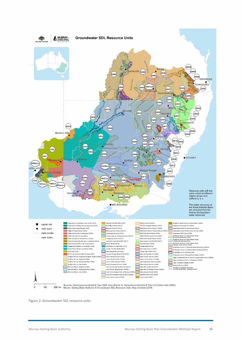
The groundwater resources in the Basin have been split into 19 groundwater water resource plan
(WRP) areas, which are further divided into 80 SDL resource units (Schedule 4 of the Basin Plan). The
boundaries of SDL resource units were determined to reflect state planning boundaries and
accommodate the level of connectivity of various groundwater resources. There is an SDL volume
determined for each SDL resource unit in the Basin Plan. Several SDL resource units have also been
vertically or horizontally separated. This was to reflect that water is or can be extracted from
different aquifers within the same area.
The requirement to set SDLs is just one element of the 2012 Basin Plan and its amendments in 2018.
SDLs are considered to work in parallel to other water resource management elements (e.g. water
quality management plans under Chapter 10 of the Basin Plan), required to deliver a healthy working
Basin.

Murray–Darling Basin Authority Murray–Darling Basin Plan Groundwater Methods Report 3
The Basin Plan and groundwater management The Basin Plan, and its framework for managing groundwater and surface water resources through
SDLs and accredited WRPs, came into force in late 2012.
Enforcement of SDLs commenced on 1 July 2019. Determining SDLs was an iterative process. Basin
states provided information and comments to refine SDLs based on the best available science and
information. The timeline of the Basin Plan with major milestones, followed by detailed explanation,
is provided as follows.
2010 - 2012
• Initial groundwater SDLs were agreed with Basin states
November
2012
• Basin Plan commenced
November
2014
• Groundwater SDL reviews completedSDL reviews completed for Goulburn–Murray (Vic), Western Porous Rock (NSW) and Eastern Porous Rock (NSW) WRP areas and recommendations made to the MDBA
July
2018
• Basin Plan amendmentsAmendments included boundary changes, changes recommended from SDL reviews, other minor BDL/SDL updates and changes to the groundwater compliance method.
July
2019
• SDLs commenceSDLs commenced in all groundwater SDL resource units on1 July 2019

Murray–Darling Basin Authority Murray–Darling Basin Plan Groundwater Methods Report 4
Basin Plan commenced in November 2012 The Basin Plan commenced on 24 November 2012. Schedule 4 of the Basin Plan lists the
characteristics for groundwater areas, including SDL resource unit groundwater names and
definitions, BDLs and SDLs.
SDL reviews completed in November 2014 When the Basin Plan was finalised in 2012, concerns were raised by the NSW and Victorian
Governments in relation to the SDLs for the Western Porous Rock SDL resource unit (GS50), the
Eastern Porous Rock WRP area (GW16) (comprising of the Gunnedah-Oxley Basin MDB (GS17) and
the Sydney Basin MDB (GS41) SDL resource units) and the Goulburn-Murray: Sedimentary Plain SDL
resource unit (GS8c). In response, the Basin Plan included a requirement that the SDLs for these
areas would be reviewed (Section 6.06(6) to (9)).
Review panels were established to undertake the reviews and a consultant was appointed to
synthesise the relevant information for each review. The review and synthesis reports are available
on the MDBA website:
• Western Porous Rock - https://www.mdba.gov.au/publications/research-report/western-
porous-rock-sdl-resource-unit-review (Review, Forbes et al, 2014; Synthesis report, Evans,
2014)
• Eastern Porous Rock - https://www.mdba.gov.au/publications/independent-reports/eastern-
porous-rock-water-resource-plan-area-review (Review, Forbes et al, 2014; Synthesis report,
Evans, 2014)
• Goulburn-Murray: Sedimentary Plain - https://www.mdba.gov.au/publications/research-
report/goulburn-murray-sedimentary-plain-sdl-resource-unit-review (Review, Forbes et al,
2014; Synthesis report Wade, 2014)
These three reviews recommended that the SDLs under consideration could be increased ‘once
assurances have been given by the relevant state to demonstrate that the resource will be managed
by state policies and plans so as to limit impacts to acceptable levels’. This outcome reflected the
view of the review panels, that a less conservative approach to setting SDLs could be considered if
suitable management actions are in place to manage the potential impacts of increased groundwater
take.
Basin Plan amendment in July 2018 The Basin Plan was amended on 3 July 2018 (MDBA, 2018b). The proposed amendments were open
for public comment from 22 November 2016 to 24 February 2017.
The amendments:
• Addressed boundary issues to reflect alignment with state water management plans to
reduce complexity and administrative burden:
Murray–Darling Basin Authority Murray–Darling Basin Plan Groundwater Methods Report 5
o NSW Western Porous Rock WRP area (GW6) and Eastern Porous Rock WRP area
(GW16) were amalgamated into the NSW Murray–Darling Basin Porous Rock WRP
area (GW6).
o Lachlan and South Western Fractured Rock WRP area (GW11) and New England
Fractured Rock and Northern Basalts WRP area (GW17) were amalgamated into the
NSW Murray–Darling Basin Fractured Rock WRP area (GW11).
o WRP area boundary changes in Darling Alluvium (GW7), Murray Alluvium (GW8),
Murrumbidgee Alluvium (GW9), Macquarie-Castlereagh Alluvium (GW12) and Namoi
Alluvium (GW14). These area changes are less than 1% of the NSW Murray–Darling
Basin area and do not change the SDLs in the SDL resource units.
o Vertical boundary changes to some NSW groundwater SDL resource units to align
with state plans and allow separate accounting for buried resources (where one SDL
resource unit is buried by another).
o Queensland Border Rivers WRP area (GW19) and Moonie WRP area (GW20) were
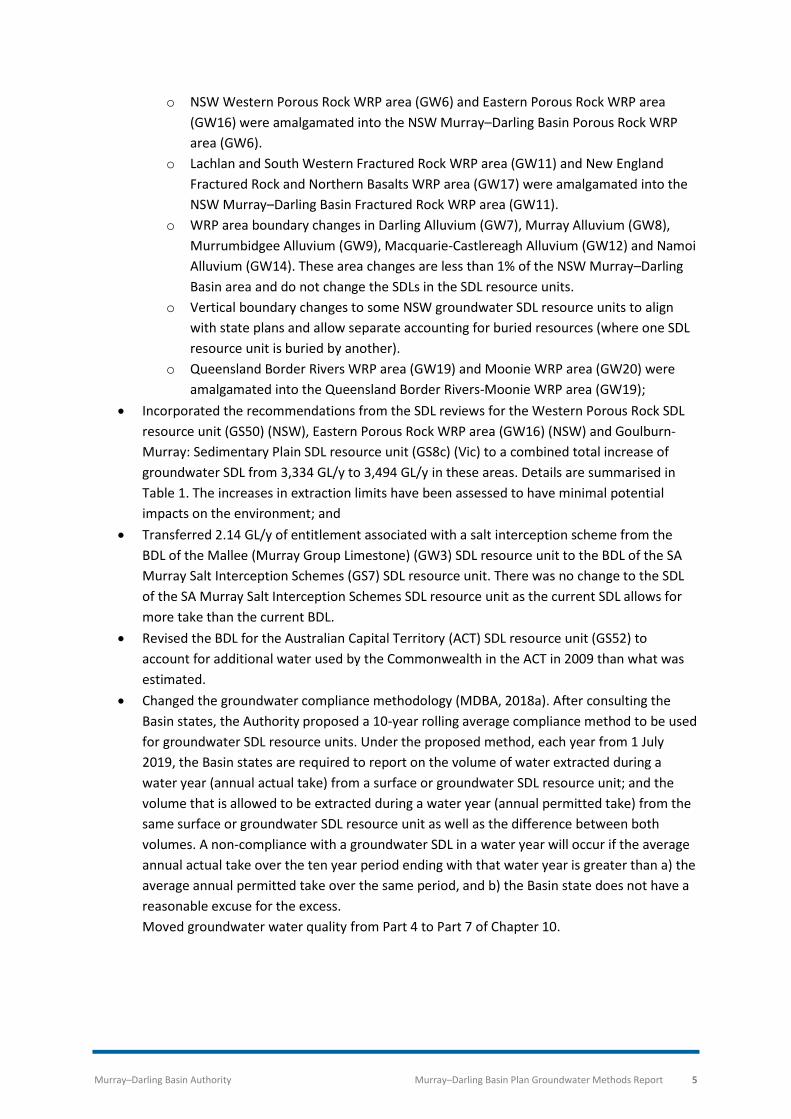
amalgamated into the Queensland Border Rivers-Moonie WRP area (GW19);
• Incorporated the recommendations from the SDL reviews for the Western Porous Rock SDL
resource unit (GS50) (NSW), Eastern Porous Rock WRP area (GW16) (NSW) and Goulburn-
Murray: Sedimentary Plain SDL resource unit (GS8c) (Vic) to a combined total increase of
groundwater SDL from 3,334 GL/y to 3,494 GL/y in these areas. Details are summarised in
Table 1. The increases in extraction limits have been assessed to have minimal potential
impacts on the environment; and
• Transferred 2.14 GL/y of entitlement associated with a salt interception scheme from the
BDL of the Mallee (Murray Group Limestone) (GW3) SDL resource unit to the BDL of the SA
Murray Salt Interception Schemes (GS7) SDL resource unit. There was no change to the SDL
of the SA Murray Salt Interception Schemes SDL resource unit as the current SDL allows for
more take than the current BDL.
• Revised the BDL for the Australian Capital Territory (ACT) SDL resource unit (GS52) to
account for additional water used by the Commonwealth in the ACT in 2009 than what was
estimated.
• Changed the groundwater compliance methodology (MDBA, 2018a). After consulting the
Basin states, the Authority proposed a 10-year rolling average compliance method to be used
for groundwater SDL resource units. Under the proposed method, each year from 1 July
2019, the Basin states are required to report on the volume of water extracted during a
water year (annual actual take) from a surface or groundwater SDL resource unit; and the
volume that is allowed to be extracted during a water year (annual permitted take) from the
same surface or groundwater SDL resource unit as well as the difference between both
volumes. A non-compliance with a groundwater SDL in a water year will occur if the average
annual actual take over the ten year period ending with that water year is greater than a) the
average annual permitted take over the same period, and b) the Basin state does not have a
reasonable excuse for the excess.
Moved groundwater water quality from Part 4 to Part 7 of Chapter 10.

Murray–Darling Basin Authority Murray–Darling Basin Plan Groundwater Methods Report 6
Table 1: Groundwater BDL and SDL changes in Schedule 4 of the Basin Plan, as a result of 2018 amendments (MDBA, 2018)
Basin state
WRP area SDL resource unit Basin Plan BDL (GL/y)
BDL (GL/y)
Basin Plan SDL (GL/y)
SDL (GL/y)
SDL change (GL/y)
State Plan Limit
NSW NSW Western Porous Rock (GW6)
Western Porous Rock (GS50)
63.1 No change
116.6 226.0 +109.4 530.5
Gunnedah-Oxley Basin (GS17)
22.1 No change
114.5 127.5 +13.0 205.6
Sydney Basin (GS41) 3.12 No change
17.2 19.1 +1.9 60.4
VIC Goulburn-Murray (GW2)
Goulburn-Murray: Sedimentary Plain (GS8c)
203.5 No change
203.5 223.0 +19.5 223.0
Goulburn-Murray: Highlands (GS8b)
38.3 No change
50.5 68.7 +18.2 41.6
Wimmera-Mallee (GW3)
Wimmera-Mallee: Sedimentary Plain (GS9b)
68.9 No change
190.7 190.1 -0.6 68.9
Wimmera-Mallee: Highlands (GS9a)
1.26 No change
2.14 2.75 +0.6 1.26
SA South Australian Murray Region (GW4)
Mallee (Murray Group Limestone) (GS3b)
65.7 63.6 65.7 63.6 -2.1 63.6
SA Murray Salt Interception Schemes (GS7)
11.1 13.2 28.6 28.6 No change
13.2
Total +159.9
SDLs commenced 1 July 2019 SDLs commenced in all groundwater SDL resource units on 1 July 2019. WRPs are the main
mechanism for giving effect to SDLs and the Basin Plan. The 2019–2020 water year is the first year
where water accounting and compliance is applied by the MDBA across the Basin. Prior to this, from
2012–13 ‘transition period water take reports’ have been published by MDBA consistent with the
framework, processes and procedures for assessing SDL compliance. They also trialled how water
accounting and compliance reports will be presented. Transition period water take reports are
available on the MDBA website (https://www.mdba.gov.au/publications/mdba-reports/transitional-
sdl-water-take-reports).

Murray–Darling Basin Authority Murray–Darling Basin Plan Groundwater Methods Report 7
WRP areas and SDL resource unit boundaries
Groundwater boundaries pre-Basin Plan Prior to the Basin Plan, a groundwater management unit (GMU) was defined by the 2000 National
Land and Water Resources Audit as a ‘hydraulically connected groundwater system that is defined
and recognised by Territory and State agencies’ (Richardson et al., 2008; NLWRA, 2001).
There were 96 GMUs located across the Murray–Darling Basin, with major differences in definition
and size. For example, across New South Wales, all areas were within at least one GMU, while other
states have large unincorporated areas for which GMUs do not exist. GMUs were three dimensional
in nature and often associated with a geological formation or aquifer. The aquifers may overlie one
another.
Defining boundaries for the Basin Plan Mandatory content in the Water Act 2007 (Cwlth) (Section 22 (1) item 2) framed the definition of
boundaries for WRP areas and SDL resource units. Basin states were included in the process for
defining WRP areas and SDL resource units.
For WRP areas, the approach was to:
• preserve Basin state management areas as much as possible;
• have fewer and larger WRP areas to enable flexible management approaches; and
• ensure a commonality between WRPs for surface water and groundwater resources
wherever possible.
For SDL resource units, the approach was to:
• preserve Basin state management boundaries where possible;
• include unincorporated areas into hydrogeological or surface water catchment-based units;
and
• aggregate very detailed management areas into larger areas that allow Basin states some
flexibility of management without over-burdening the Basin Plan with too much detail.
The Basin has been divided into 19 groundwater WRP areas. The boundaries of these areas are
shown in . The WRP areas cover the entire Basin, including those areas not previously subject to
water planning arrangements.

Murray–Darling Basin Authority Murray–Darling Basin Plan Groundwater Methods Report 8
Within these WRP areas there are 80 SDL resource units (Figure 2). There is an SDL volume for each
SDL resource unit.
Figure 1: Water resource plan areas – Groundwater

Murray–Darling Basin Authority Murray–Darling Basin Plan Groundwater Methods Report 9
Excluded areas The Water Act 2007 (Cwlth) specifically excludes water resources of the Great Artesian Basin (GAB)
from being considered as Basin water resources. As such, the GAB is not covered by a WRP.
The following water resources were excluded from the Murray–Darling Basin (MDB) water resources
by regulation:
• groundwater resource of the Tintinara-Coonalpyn Prescribed Wells Area;
• groundwater resources of the Victorian West Wimmera Groundwater Management Area;
and
• groundwater and surface water resources of specified areas in South Australia.
These water resources were excluded by the MDB boundary defined under Section 18A of the Water
Act 2007 (Cwlth). Section 18A of the Water Act 2007 (Cwlth) informs the definition of Basin water
resources, which were originally determined based on states’ surface water planning areas. The
excluded water resources are on the edge of non-MDB state water planning areas or fall partially
inside and partially outside of the MDB boundary. The SDL for the Victorian Wimmera-Mallee:
Sedimentary Plain SDL resource unit was modified to account for the exclusion.
Murray–Darling Basin Authority Murray–Darling Basin Plan Groundwater Methods Report 10
Figure 2: Groundwater SDL resource units

Murray–Darling Basin Authority Murray–Darling Basin Plan Groundwater Methods Report 11
Baseline diversion limits Specifying a baseline diversion limit (BDL) for each SDL resource unit is required under Section 78 of
the Water Act 2007 (Cwlth). BDLs provide the baseline against which SDLs are assessed. BDLs were a
common starting point for discussions with Basin states and communities on the groundwater SDLs.
In surface water, the 1995 Cap on diversions (often referred to as ‘The Cap’) effectively provided a
common starting point for much of the Basin. However, for groundwater, no similar arrangement
was in place prior to the development of the Basin Plan.
Setting the baseline diversion limits The specification of BDLs has implications for the Commonwealth’s commitment to water recovery
programs. It is important to have a Basin-wide policy for setting BDLs that accurately reflects the
potential limit of diversions in place at the making of the Basin Plan. The BDL for each SDL resource
unit was determined on the following basis:
• where a water management plan or proposed plan existed, the BDL is the plan limit unless
the plan limit is greater than the level of entitlement, in which case the BDL is set as the
entitlement volume;
• where there is no plan, the BDL is the entitlement volume along with the effect of any rules
managing extraction1; and
• where there is a cross-border agreement for groundwater management, the extraction limit
under the agreement is the BDL.
Basin states provided the information used by the MDBA to determine BDLs. During the
development of the Basin Plan, some Basin states reviewed and updated the baseline information
they had initially provided. This new information represented the most up-to-date understanding of
the level of groundwater water access rights and basic landholder rights (the taking of water for
stock and domestic use).
Except for the ACT, groundwater extraction under basic landholder rights is not metered in the Basin.
Each state has a different definition of basic landholder right use and applies different methods to
estimate basic landholder right take volumes. The MDBA used these state estimates to determine
the basic landholder rights volumes within the BDLs.
1 For the Upper Condamine Alluvium, metered use from 2002-03 to 2007-08 for 5 sub-areas of the Queensland management area was used to estimate the limit imposed by the management arrangements.

Murray–Darling Basin Authority Murray–Darling Basin Plan Groundwater Methods Report 12
Assessment to determine groundwater SDLs
Groundwater SDLs Under the Water Act 2007 (Cwlth) (Section 22(1) Item 6), the Basin Plan must include SDLs for:
• the Basin water resources as a whole; and
• the water resources, or parts of the water resources, of each water resource plan area.
Groundwater SDLs were informed by numerical modelling or an analytical risk assessment.
Numerical modelling was carried out in 12 SDL resource units where there were fit for purpose
numerical models available. The analytical risk assessment, known as the recharge risk assessment
method (RRAM), was developed for the MDBA (CSIRO and SKM 2010a), to inform the SDLs. Both the
numerical groundwater modelling and the RRAM derived preliminary estimates of the SDL for
consumptive use which is known as the preliminary extraction limit (PEL).
The PEL represents the MDBA’s numerical assessment of the level of groundwater extraction that
can be maintained in an aquifer while preserving its environmentally sustainable level of take
characteristics. To determine the final groundwater SDLs the MDBA applied an analytical framework
taking other factors into account that were not considered in determining the PEL (see Groundwater
Assessment Framework).
The groundwater SDLs are a limit and not a target. In some areas due to poor water quality and
difficulty in accessing groundwater, it is unlikely that extraction will approach the SDL in the medium
term (20 to 30 years).
Environmentally sustainable level of take The SDLs reflect the environmentally sustainable level of take (ESLT) for a water resource. The ESLT is
defined as the level at which water can be taken from that water resource which, if exceeded, would
compromise:
• key environmental assets (KEA) of the water resource; or
• key ecosystem functions (KEF) of the water resource; or
• the productive base (PB) of the water resource; or
• key environmental outcomes (KEO) for the water resource.
For groundwater resources specifically, the ESLT is the level at which water can be taken from a
groundwater resource which, if exceeded, would compromise:
• groundwater dependent ecosystems; or
• surface water – groundwater connectivity; or
• the productive base of the resource; or
• water quality.

Murray–Darling Basin Authority Murray–Darling Basin Plan Groundwater Methods Report 13
Groundwater dependent ecosystems Some Basin ecosystems are completely groundwater dependent. Others rely on groundwater for part
of the time.
The Water Act 2007 (Cwlth) defines environmental assets as those that include water-dependent
ecosystems and sites with ecological significance and ecosystem services. As part of the RRAM,
MDBA identified and mapped environmental assets of ecological significance. The determination of
dependence on groundwater and sensitivity to groundwater take of these assets was largely based
on the understanding, conceptualisation and local knowledge of hydrogeologists with extensive
experience of the groundwater resources of the Basin. State based groundwater management plans
were also used to identify groundwater dependent ecosystems.
Surface water–groundwater connectivity Surface water and groundwater are components of one hydrologic system. Connected systems can
be described as those where there is a zone of continuous saturation between a stream and the
aquifer. If the connection between these components is strong, groundwater extraction may directly
affect stream flow by inducing leakage to groundwater. Similarly, groundwater extraction may
intercept potential groundwater-derived base flows to streams.
The MDBA used the following classification system to describe connectivity for the purposes of the
Basin Plan:
• gaining stream: groundwater flows to surface water;
• losing stream: surface water flows to groundwater;
• maximum losing stream: surface water flows to groundwater, however, the groundwater
and stream are not connected; and
• disconnected stream: there is no connection between the surface water and groundwater.
Preservation of the productive base The preservation of the productive base means the maintenance of the groundwater resource
availability and quality, to allow uses to continue, e.g. for:
• supporting environmental assets and ecosystem functions;
• providing water for irrigation; and
• providing drinking water for people and stock.
Water quality For Basin groundwater resources, the key environmental outcome is the protection of groundwater
resources from salinisation. Groundwater salinisation can occur via multiple processes including
excessive groundwater take. However, groundwater salinisation from groundwater take is not a
threat in all Basin groundwater resources.

Murray–Darling Basin Authority Murray–Darling Basin Plan Groundwater Methods Report 14
Groundwater recharge An important input into the development of the PEL is groundwater recharge. Across the Basin, there
are many small-scale recharge studies. However, little information is known about recharge to
groundwater at an SDL resource unit scale. A recharge assessment was undertaken to establish
recharge volumes across the Basin in a repeatable and uniform manner. The assessment also
investigated the impact of climate change and climate variability on estimates of groundwater
recharge across the Basin.
CSIRO developed the Water Vegetation Energy and Solute (WAVES) model for the Murray–Darling
Basin Sustainable Yields project (CSIRO 2008). The WAVES model was subsequently updated and
used to determine recharge for the Basin. The recharge assessment using the WAVES model is
described in full in the CSIRO/SKM technical report on dryland diffuse groundwater recharge
modelling across the Murray–Darling Basin (CSIRO 2010c).
The MDBA continues to work in collaboration with Basin states and industry partners to increase the
understanding of groundwater recharge processes in the Basin and estimation techniques. The
MDBA will examine the information used in setting limits and incorporate new information where
available, as part of the Basin Plan review in 2026. Regular 10 yearly reviews of the Basin Plan are
required, which allow for emerging climate change patterns, new information, tools and techniques
to be considered. These reviews could result in changing water limits or other water management
arrangements.
Modelled SDL resource units In developing SDLs, the MDBA found there were 11 numerical groundwater models available that
cover 13 SDL resource units (Figure 3). The numerical groundwater models are predominately alluvial
groundwater systems with high levels of take in NSW, Victoria and Queensland. These models were
developed or modified for the CSIRO Murray–Darling Basin Sustainable Yields Project (CSIRO, 2008).
All NSW numerical models were originally developed and calibrated by the New South Wales
Department of Planning, Industry and Environment – Water (or its predecessors).
The models cover all or parts of the following groundwater SDL resource units:
• Upper Condamine Alluvium (Qld);
• Lower Gwydir Alluvium (NSW);
• Lower Namoi Alluvium (NSW);
• Upper Namoi Alluvium (NSW;
• Lower Macquarie Alluvium (NSW);
• Upper Macquarie Alluvium (NSW);
• Lower Lachlan Alluvium (NSW);
• Upper Lachlan Alluvium (NSW);
• Lower Murray Shallow Alluvium (NSW);
• Lower Murray Deep Alluvium (NSW);
• Lower Murrumbidgee Alluvium (NSW);

Murray–Darling Basin Authority Murray–Darling Basin Plan Groundwater Methods Report 15
• Mid-Murrumbidgee Alluvium (NSW); and
• Goulburn-Murray Sedimentary Plain (Vic).
The models represent groundwater systems that covered 73% of the groundwater extracted in the
Murray–Darling Basin in 2007-08. The MDBA used the above modelling results as an input to
determine the SDLs. Other evidence was also considered, including groundwater hydrographs and
extraction information.
The results from the South Australian numerical model for the Angas–Bremer were used to confirm
the SDL for Angas-Bremer SDL resource unit.

Murray–Darling Basin Authority Murray–Darling Basin Plan Groundwater Methods Report 16
Figure 3: Modelled groundwater SDL

Murray–Darling Basin Authority Murray–Darling Basin Plan Groundwater Methods Report 17
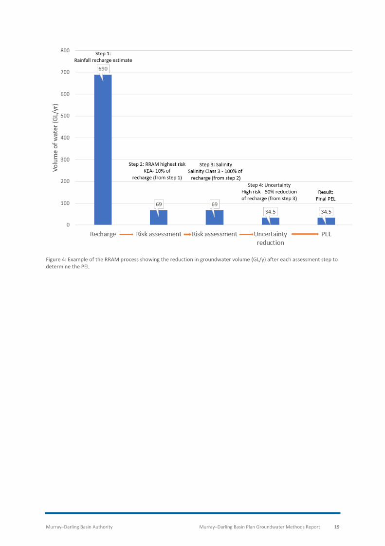
Recharge risk assessment method
The recharge risk assessment method (RRAM) is a risk assessment process used to determine the PEL
for SDL resource units without a numerical groundwater model. The method was developed by the
MDBA, CSIRO and Sinclair Knight Merz (SKM) specifically for the Basin Plan (CSIRO and SKM, 2011).
The method establishes a sustainability factor (SF) by assessing the level of risk that groundwater
take poses to the ESLT characteristics of the groundwater system. The PEL is then determined by
applying the SF to the volume of rainfall recharge received by the SDL resource unit. The PEL can
therefore be expressed as a fraction of the recharge that can be taken, with all the groundwater in
storage reserved for the environment.
The RRAM is described in four steps, as follows:
Step 1: Rainfall recharge across the Basin was determined using the WAVES
model. Upscaling techniques developed for the Murray–Darling Basin
Sustainable Yields project, subsequently refined for the Basin Plan, were also
used (CSIRO and SKM, 2010a, 2010c). Additional recharge information was
also used where it was made available by Basin states.
Basin wide recharge modelling explored several historic and future climate scenarios. Of these
scenarios, the median historic climate recharge scenario was used for all SDL resource units. Prior to
the draft Basin Plan in November 2011, the historic dry climate recharge scenario was used for all
SDL resource units where the PEL was greater than the BDL. For the draft Basin Plan the median
historic climate recharge scenario was used. The decision to use the median historic climate recharge
scenario was made in response to recommendations from a peer review of the methodology
conducted during the development of the Basin Plan.
To inform the review of the Basin Plan in 2026, the MDBA will work collaboratively with Basin states
and industry partners to collect new and updated scientific data and information on groundwater
recharge across the Basin. To further improve the RRAM assessment and the risks to the ELST
characteristics, the MDBA also aims to improve its knowledge of salinity, water levels and surface-
groundwater connectivity.
Risks to the four ESLT characteristics The next three steps determined the SF using a risk matrix that assessed:
• risks to the four ESLT characteristics; and
• the level of uncertainty within an SDL resource unit.
Step 2: Criteria were developed to assess the level of risk that groundwater
extraction represents to compromise one of the ESLT characteristics. A higher
risk resulted in a lower SF, with the following risk rankings used:

Murray–Darling Basin Authority Murray–Darling Basin Plan Groundwater Methods Report 18
• High risk – 10% of recharge;
• Medium risk – 50% of recharge; or
• Low risk – 70% of recharge.
Step 3: The risk of groundwater extraction compromising groundwater
quality was assessed separately. Where there is a risk of groundwater
extraction compromising groundwater quality, the SF was further reduced.
Each SDL resource unit was separated into four salinity classes:
Table 2: RRAM salinity classes
Salinity Class Salinity (mg/L)
Class 1 0 – 1,500
Class 2 1,500 – 3,000
Class 3 3,000 – 14,000
Class 4 14,000+
Where groundwater extraction created a risk of compromising salinity Class 1 or 2
groundwater, the following factors were applied to the SF determined in Step 2:
• Class 1 – 80% of the available recharge volume (from Step 1);
• Class 2 – 90% of the available recharge volume (from Step 1); or
• Class 3 and 4 – 100% of the available recharge volume (from Step 1).
The level of uncertainty within an SDL resource unit Step 4: The level of uncertainty reflects the quantity and quality of
information and data that was used in the assessment. It also reflects the
level of understanding of groundwater processes in an SDL resource unit.
Where there is high uncertainty regarding the groundwater system, the SF
was further reduced. The reduction was determined by the level of risk to the
ESLT characteristics determined in Step 2:
• Risk to ESLT characteristics is high or medium – SF reduced by 50%; or
• Risk to ESLT characteristic is low – SF reduced by 25%.
The resulting SF from the above steps was then applied to the available recharge volume calculated
in Step 1, to determine the PEL.
Figure 4 shows an example of a graphical representation of the four steps in the RRAM process used
to determine the PEL (potential volume that can be taken), prior to other assessments used to inform
SDLs.
Murray–Darling Basin Authority Murray–Darling Basin Plan Groundwater Methods Report 19
Figure 4: Example of the RRAM process showing the reduction in groundwater volume (GL/y) after each assessment step to determine the PEL
Murray–Darling Basin Authority Murray–Darling Basin Plan Groundwater Methods Report 20
Groundwater assessment framework The MDBA developed a groundwater assessment framework, building on PEL values, to determine
groundwater SDLs that reflect the ESLT. This framework was developed and refined during the
development of the Basin Plan.
Applying the assessment framework In applying the groundwater assessment framework, a two-stage approach was taken. The first stage
considered characteristics (geology, recharge, ESLT characteristics etc.) of the individual groundwater
resource units. Each groundwater SDL resource unit was characterised as either:
• Deep groundwater;
• Non-renewable groundwater;
• Connected to surface water resources; or
• Not connected to surface water resources.
The second stage assessed the BDL in relation to the PEL and the groundwater management
arrangements in place to determine the SDLs in the connected and non-connected resource units.
The assessment then considered if:
• there was an existing reduction program in place (e.g. Achieving Sustainable Groundwater
Entitlements program);
• the BDL was greater than the PEL and whether there was a need for an entitlement
reduction program;
• better science or knowledge of the resource existed; or existing or proposed water
management arrangements were in place and how they related to the BDL and PEL. If there
was, the SDL was set to the BDL; or
• the BDL was less than the PEL and if the resource unit was:
o connected to surface water resources; and whether
o the SDL was equal to the BDL; or
o the SDL was greater than the BDL (unassigned groundwater); or
o there was no connection to surface water resources (unassigned groundwater).
Figure 5 outlines the process of assessment used to determine which assessment was applied to
the PEL for each SDL resource unit. The 2020 Report Cards provide summaries of the assessment
that has been applied to individual groundwater SDL resource units.

Murray–Darling Basin Authority Murray–Darling Basin Plan Groundwater Methods Report 21
Figure 5: Groundwater assessment framework decision tree

Murray–Darling Basin Authority Murray–Darling Basin Plan Groundwater Methods Report 22
SDL resource unit categories The application of the framework resulted in seven categories in which the groundwater SDL
resource units can be assigned. The categories are outlined in the following sections of this report:
• Deep groundwater;
• Non-renewable groundwater;
• Connected resources;
• Achieving Sustainable Groundwater Entitlements program (now ceased);
• SDL resource units with reduction;
• Existing planning arrangements and up to date science; and
• Unassigned groundwater.
Deep groundwater resources Deep groundwater resources are described as the groundwater resources below those currently
accessed for productive use and stock and domestic (S&D) needs. Deep groundwater resources are
not usually accessed for agricultural purposes due to the costs associated with bore construction or
poor water quality.
Interest in groundwater extraction has extended to several deep groundwater resources that are
considered Murray–Darling Basin water resources under the Water Act 2007 (Cwlth). The
incorporation of deep groundwater in the Basin Plan was an outcome of the MDBA’s improved
knowledge regarding these systems. Each Basin state was consulted during the development of the
deep groundwater assessment.
Deep groundwater SDL resource units are attributed to either the WRP area where the deep
groundwater resource outcrops or, if the deep groundwater is fully sub-cropped, the WRP area that
the majority of the deep groundwater resource underlies (i.e. Oaklands Basin SDL resource unit).
Note that the outcrop areas of deep groundwater resources are considered part of the deep
groundwater resource unit and not the overlying resource. The SDL volumes are based on the
available knowledge of these deep aquifers. It is possible that new knowledge may inform a change
to these SDLs as part of future reviews of the Basin Plan. There are seven deep SDL groundwater
resource units in the Basin Plan (Figure 6), described below. The total of deep groundwater SDLs are
291.1 GL/y, which represents about 8.3% of the total of groundwater SDLs (3,494 GL/y).

Murray–Darling Basin Authority Murray–Darling Basin Plan Groundwater Methods Report 23
Australian Capital Territory
There are no deep groundwater SDL resource units in the Australian Capital Territory pursuant to the
Basin Plan.
New South Wales
In NSW, there are three deep groundwater SDL resource units: Gunnedah-Oxley Basin MDB (GS17),
Sydney Basin MDB (GS41) and Oaklands Basin (GS38) (Figure 6).
The Gunnedah-Oxley Basin MDB SDL resource unit is in northern NSW and has been defined in the
Basin Plan as all rocks of Permian, Triassic, Jurassic, Cretaceous or Tertiary age; and all alluvial
sediments within the outcropped areas. The SDL for the Gunnedah-Oxley Basin SDL resource unit is
127.5 GL/y. This SDL resource unit is part of the NSW Murray–Darling Basin Porous Rock WRP area.
The Sydney Basin MDB SDL resource unit lies in the eastern part of the NSW MDB. Basin Plan defines
it as all rocks of Permian, Triassic, Jurassic, Cretaceous or Tertiary age; and all alluvial sediments
within the outcropped areas. The Sydney Basin MDB SDL resource unit has an SDL of 19.1 GL/y. It is
part of the NSW Murray–Darling Basin Porous Rock WRP area.
The Oaklands Basin SDL resource unit lies in southern NSW and has been defined as the water
resources within the Oaklands geological Basin. Oaklands Basin receives negligible volumes of
recharge and could be classified as a non-renewable groundwater resource. It is buried underneath
other SDL resource units and the MDBA has classified it as a deep resource. The SDL for the resource
is 2.5 GL/y, which represents 0.0006% of the storage. Oaklands Basin is included in the NSW Murray–
Darling Basin Porous Rock WRP area.
Queensland
There are four deep geological basins within the Queensland MDB. These are the Bowen, Galilee,
Adavale and Drummond Basins. These basins contain groundwater resources in excess of 2,000 m
depth that lie within the MDB boundary and beneath the GAB.
MDBA assigned a single SDL resource unit, Queensland MDB deep (GS56), with an SDL of 100 GL/y,
for all groundwater resources below the GAB in Queensland. Given the geographic extent of the
area, the volume was set to allow for future development. It may be reviewed should more
information about water resources in these geological basins become available.
South Australia
South Australia has one deep groundwater resource called the Renmark Group. The MDBA
established a separate deep groundwater SDL resource unit for the Renmark Group in the Mallee
grouping of SDL resource units (GS3). The Mallee (Renmark Group) (GS3c) SDL resource unit has an
SDL of 2 GL/y, as determined by the deep groundwater assessment process. South Australia manages
this SDL resource unit under the SA Murray Region WRP. The decision to assign the Renmark group
to the Mallee SDL resource unit is consistent with the requirement of the Water Act 2007 (Cwlth), to
align boundaries as much as practical with existing water management boundaries.

Murray–Darling Basin Authority Murray–Darling Basin Plan Groundwater Methods Report 24
Figure 6: Deep groundwater SDL resource units

Murray–Darling Basin Authority Murray–Darling Basin Plan Groundwater Methods Report 25
Victoria
There are two deep groundwater SDLs in Victoria the Murray–Goulburn: deep (GS8d) and Wimmera-
Mallee: deep (GS9c) SDL resource units. There is little information available regarding the
groundwater resources of these two deep resource units. Each SDL was set to 20 GL/y. This volume
will enable any potential water users to extract groundwater while further collecting information to
refine the deep groundwater SDLs.
Non-renewable groundwater A non-renewable groundwater resource is a semi-confined or confined aquifer receiving negligible
recharge. Groundwater contained in these units was recharged during different climatic periods and
is several thousand or more years old. Non-renewable groundwater resources can have very large
storages which, to a certain point, can be extracted with minimal environmental consequences.
Within the Basin, there are two groundwater SDL resource units that have been categorised as non-
renewable resources: the Mallee (Murray Group Limestone) (GS3b) SDL resource unit in South
Australia and the Wimmera-Mallee: Sedimentary Plain (GS9b) SDL resource unit in Victoria (Figure 7:
Non-renewable groundwater SDL resource units). These SDL resource units straddle the South
Australian and Victorian Border and the water is extracted from the Murray Group Limestone
Aquifer. The SDL for the Mallee (Murray Group Limestone) (GS3b) SDL resource unit is 63.6 GL/y. The
SDL for the Wimmera-Mallee: Sedimentary Plain (GS9b) SDL resource unit is 190.1 GL/y. This SDL also
includes a sub-area with unassigned water.
The extraction of groundwater along the border is regulated by a cross-border agreement pursuant
to both South Australian and Victorian legislation (the Groundwater (Border Agreement) Act 1986 (SA
and Vic.)). This agreement allows for groundwater in the designated area, a 40 km-wide strip centred
on the South Australian–Victorian border, to be depleted by approximately 15% in 200 years.
In setting the SDLs for the non-renewable resource units, the MDBA adopted the limits set by the
South Australian and Victorian cross-border agreement. The SDLs for non-renewable groundwater
resources reflect the maximum permitted rate of groundwater decline under the state acts for the
Border Groundwaters Agreement area. The principles used in the Border Groundwaters Agreement
area were applied to the surrounding Mallee groundwater, which is also considered a non-renewable
water. Additionally, the groundwater resources of the Victorian West Wimmera Groundwater
Management Area are excluded by regulation from this WRP area due to limited hydrologically
connectivity to the rest of the Murray–Darling Basin. Approximately half of the West Wimmera GMA
is outside the Basin, so exclusion of this GMA fits with Victoria’s reporting requirements and allows
for all of the West Wimmera to be managed and reported as one resource. Notwithstanding this, the
Section 10.05 of the Basin Plan requires Victoria to identify in relevant water resource plans, the
effect of the use of this resource on Basin water resources (and if required, undertake management
actions).

Murray–Darling Basin Authority Murray–Darling Basin Plan Groundwater Methods Report 26
Figure 7: Non-renewable groundwater SDL resource units

Murray–Darling Basin Authority Murray–Darling Basin Plan Groundwater Methods Report 27
Connected Systems
Surface and groundwater systems are not separate resources; they are components of one
hydrologic system. Where the connection between surface and groundwater is strong, groundwater
extraction may directly affect surface-water stream flow. The effects can include inducing leakage to
groundwater, or intercepting groundwater-derived base flow over both short and long timeframes.
Conversely, excessive surface water extraction may reduce recharge to groundwater systems.
Connected systems are described as those where there is a zone of continuous saturation between
the river and the aquifer. Connectivity between streams and groundwater can vary along stream
reaches i.e. in a given section of a stream, there can be gaining and losing sections. Changes can also
occur over time as changes in groundwater levels can change streams from gaining streams to losing.
Traditionally, classifications of connectivity focussed on classifying streams according to the direction
of flux between surface and groundwater, particularly whether the rate of flux is influenced by
groundwater abstraction. Classification systems have typically defined up to four different stream
types on this basis; classified as connected or disconnected and gaining or losing.
The MDBA used the following classification system to describe connectivity for the purposes of the
Basin Plan (Figure 8):

Murray–Darling Basin Authority Murray–Darling Basin Plan Groundwater Methods Report 28
Figure 8: Classifications of connected groundwater and surface water (sourced from Parsons Brinckerhoff, 2009)

Murray–Darling Basin Authority Murray–Darling Basin Plan Groundwater Methods Report 29
The connectivity between groundwater and surface water varies across the Basin. Connected
systems can be further classified based on geomorphology and similarities in the connectivity
between surface and groundwater in the following way (Figure 9):
• fractured rock systems (e.g. Lachlan Fold Belt) – variable connectivity due to the nature of
the geology of these systems;
• shallow alluvial aquifers (e.g. Belubula Alluvium) – typically highly connected system with the
stream both losing and gaining water from the groundwater;
• mid-valley alluvial aquifer systems (e.g. Mid-Murrumbidgee Alluvium) – generally losing
streams;
• floodplain alluvial aquifer systems (e.g. Lower Namoi Alluvium) – streams are mostly
disconnected from the aquifer and lose water to the groundwater at a maximum rate; and
• end of system aquifers (e.g. SA Murray) – typically a mixture of gaining, losing and
disconnected streams but discharge is usually saline.
Figure 9: Connected systems classification (adopted from Braaten and Gates, 2003) showing the connectivity between surface and groundwater considering geology and topography
The connectivity between groundwater and surface water resources was considered for every SDL
resource unit, through the methods to develop the PEL. The MDBA considered an SDL resource unit
to be highly connected, if during the RRAM process, the risk of groundwater extraction to impacts on
the surface water streams was determined to be high or medium. The criteria used to assess the risk
to surface water streams were:

Murray–Darling Basin Authority Murray–Darling Basin Plan Groundwater Methods Report 30
• high – In the current state, groundwater discharge provides base flow to the unregulated
river reach. Groundwater extraction is likely to result in stream flow depletion;
• medium – rivers in the SDL resource unit are regulated and highly connected to the
groundwater system (i.e. >50% of the groundwater pumped would have contributed to
stream flow within 50 years); or
• low – rivers in the SDL resource unit are regulated or unregulated and they have low-
moderate connection with the groundwater system (i.e. <50% impact of pumping on stream
flow within 50 years).
Using the risk classification in relation to the connectivity assessment, the MDBA set SDLs for the
Basin Plan, in systems with:
• high or medium levels of risk to surface water resources, where the SDL was set at the BDL.
This ensures that, in these systems, groundwater extraction will have no further impact on
surface water resources beyond the level accounted for within the BDL; and
• low levels of risk to surface water systems, where a different assessment is used compared
to high and medium risk assessments.
Additional decisions were made considering connectivity and associated risks to surface water
resources, in relation to floodplain alluvial aquifer systems, groundwater extraction for salinity
management and fractured rock systems, as follows:
Floodplain alluvial aquifer systems were informed by numerical groundwater models. The models
accounted for connectivity between surface and groundwater.
Take from saline groundwater systems is beneficial for connected surface water resources as it
reduces salt entering rivers and streams. The MDBA determined that groundwater extraction from
these systems is low risk to the groundwater system and beneficial to the connected surface water
resource. The MDBA set the SDL for these resource units on the maximum volume of existing
entitlements and incorporated a future growth allowance.
Additional groundwater was made available above the BDL in seven fractured rock systems, due to
the large size of the systems and variability of connectivity (unassigned groundwater). Additional
protection of surface water resources in fractured rock systems will be provided through inclusion of
local management rules in the state developed water resource plans.
There are 20 groundwater SDL resource units classified as highly connected (Figure 10). The total of
the SDLs is 365.3 GL/y, which represents 10.5% of the total of groundwater SDLs.
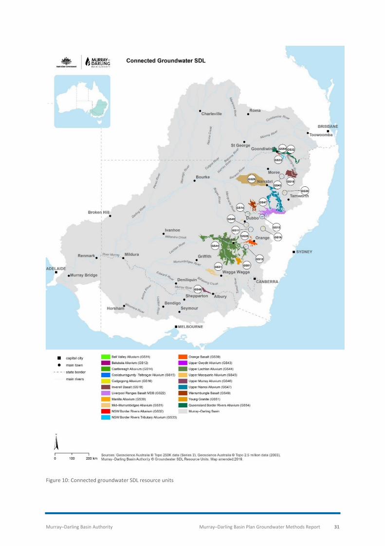
Murray–Darling Basin Authority Murray–Darling Basin Plan Groundwater Methods Report 31
Figure 10: Connected groundwater SDL resource units

Murray–Darling Basin Authority Murray–Darling Basin Plan Groundwater Methods Report 32
In determining groundwater SDLs for connected systems, the MDBA assessed potential volumetric
impacts on surface water associated with increases above the groundwater BDL (BDL to SDL).
Based on volumes of unassigned water, the location and extent of potential increases in
groundwater commitments are mainly in the northern and western areas of the Basin. Further, the
Basin Plan does not allow for increased extraction in the large alluvial systems.
The MDBA assessment (MDBA, 2012b) categorised unassigned groundwater SDL resource units
based on potential impacts of increased groundwater extraction into three broad systems based on
their hydrogeological characteristics:
• Lachlan Fold Belt: a fractured rock system that lies under several surface water catchments
and shallow alluvial aquifers, spanning the width of the Basin from Albury to Bourke;
• Highland aquifer systems: fractured and porous rock systems with overlying small shallow
alluvial aquifers, located in the eastern and southern elevated parts of the Basin; and
• Western aquifer systems: fractured or porous rock systems stretching from the southwest to
the north of the Basin, with relatively flat terrain and mostly saline resources that can be
difficult to access.
For each of the broad systems the MDBA used the assumptions regarding connectivity from the
Murray–Darling Basin Sustainable Yields project (CSIRO, 2008) and applied those assumptions to SDL
increases in the Basin Plan. The MDBA calculated a potential reduction of between 29 and 58 GL/y in
surface water resources from additional groundwater extraction in the Lachlan Fold Belt and
Highland systems (MDBA, 2012c). It is essential to note the time span of potential impacts can vary
from a few years to hundreds of years, and in some cases may never be realised. Therefore, the
MDBA finds this to be an acceptable risk.
For the western aquifer systems, the MDBA determined minimal or no connectivity. In areas where
there was groundwater flowing to the river systems, it was saline and any extraction could
potentially reduce the flux of salt into the river. Considering these factors coupled with a lack of
information, the MDBA did not calculate a potential reduction in surface water resources from
additional groundwater extraction in the western aquifers systems.
Of the remaining SDL resource units, there are three where groundwater is managed to control
salinity, water logging and the flow of saline groundwater to surface water resources:
• Lower Murray Shallow Alluvium (GS27a);
• Lower Murrumbidgee Shallow Alluvium (GS28a); and
• Goulburn-Murray: Shepparton Irrigation Region (GS8).
In these units a reduction in saline groundwater flow to surface water resources is considered to be
beneficial. The BDL was set at the entitlement levels (625.6 GL/y) to ensure maximum flexibility to
manage salinity and water logging. The total difference between the BDL and estimated take in the
three areas is 212.7 GL/y. This represents a considerable portion (34%) of the total potential for
increased groundwater take within the Basin wide BDL. In setting the BDLs for these systems, the
MDBA did not include potential impacts on surface water from any increases in groundwater take.

Murray–Darling Basin Authority Murray–Darling Basin Plan Groundwater Methods Report 33
The MDBA implemented this approach to setting BDLs with the view to most accurately reflect limits
of groundwater take in groundwater planning at the time of the making of the Basin Plan. While
there remains a potential impact on surface water from groundwater use within the BDL, the MDBA
views that potential impact as pre-existing risk. That risk has been incorporated into surface water
and groundwater planning under the Basin Plan.
Achieving Sustainable Groundwater Entitlements program (now ceased) The Achieving Sustainable Groundwater Entitlements program (ASGE) was introduced in 2005. The
program was funded by the NSW government and the Australian Government under the National
Water Initiative (NWI). ASGE was introduced to achieve the sustainable use of groundwater
resources in seven alluvial groundwater systems in NSW (later designated as SDL resource units in
the Basin Plan) (Figure 11):
• Lower Gwydir;
• Lower Lachlan;
• Lower Macquarie;
• Lower Murray;
• Lower Murrumbidgee;
• Upper Namoi; and
• Lower Namoi.

Murray–Darling Basin Authority Murray–Darling Basin Plan Groundwater Methods Report 34
Figure 11: Existing reduction program groundwater SDL resource units. Note that reduction programs are now finalised; at
the time of publication, the term “existing reduction program” is used as an historical category name

Murray–Darling Basin Authority Murray–Darling Basin Plan Groundwater Methods Report 35
These systems were identified as over-allocated and most of them were also over-used. Reductions
in entitlement were required to achieve sustainable levels of take. The program was put in place
through the development and introduction of water sharing plans in the seven areas. Table 3 details
the ASGE reductions in entitlements, which ranged from 46% to 69% across the various SDL resource
units. The total of groundwater SDLs for these seven SDL resource units, after reductions and Basin
Plan amendments, was 771.4 GL/y.
Table 3: Effect of the ASGE program on groundwater entitlements
Groundwater SDL resource unit
Initial Entitlement
(GL)
Reduction Volume
(GL)
Entitlements (excluding S&D) at completion
of ASGE (GL)
Reduction (%)
Completion date
GS24 Lower Gwydir Alluvium 70.7 38.4 32.3 54.3% 30 Jun 17
GS25 Lower Lachlan Alluvium 212.3 104.3 108.0 49.1% 30 Jun 18
GS26 Lower Macquarie Alluvium
136.8 67.5 69.3 49.3% 30 Jun 17
GS27b Lower Murray Deep Alluvium
267.6 183.9 83.7 68.7% 30 Jun 17
GS28b Lower Murrumbidgee Deep Alluvium
514.6 244.6 270.0 47.5% 30 Jun 17
GS29 Lower Namoi Alluvium 172.2 86.2 86.0 50.1% 30 Jun 17
GS47 Upper Namoi Alluvium 301.9 179.8 122.1 59.6% 30 Jun 17
Total 1,676.1 904.9 771.4

Murray–Darling Basin Authority Murray–Darling Basin Plan Groundwater Methods Report 36
Numerical groundwater modelling of the ASGE areas indicated that in four areas the PEL was less
than the BDL. The modelling recommended further reductions in diversion limits in these units.
However, the MDBA received feedback from Basin states and through peer review on the use of
numerical modelling in the ASGE areas. The feedback questioned the need for further reductions to
the SDL before the ASGE program was completed and outcomes from the program realised.
After receiving this feedback, the MDBA further considered the following:
• risks to ESLT characteristics for the resources;
• peer review of the numerical models; and
• assessment of additional information supplied by both the NSW government and water
users.
The MDBA also considered additional uncertainties associated with modelling in those groundwater
systems and the associated changes in groundwater take. Additionally, these resource units had
large groundwater storages estimated to be available for a minimum of 200 years at current levels of
take. There was a low risk of depleting the volume of groundwater stored in these aquifers from
implementing the Basin Plan in 2012 and its review in 2026.
Considering these factors, the MDBA adopted an approach that allowed the reduction program to
reach completion and the outcomes be determined before considering any changes to the SDL. For
the seven NSW SDL resource units in the ASGE program, the SDLs were set at the final water sharing
plan limit. The MDBA will continue to monitor and assess the impacts of groundwater take in these
systems with the aim of reviewing the plan limits on an ongoing basis.
SDL resource unit with a reduction in entitlement In most groundwater SDL resource units in the Basin Plan, SDLs were set equal to or greater than
BDL. The exception is the Upper Condamine Alluvium SDL resource unit grouping (GS64), located in
the headwaters of the Condamine River, and extending from Killarney in the south-east to
downstream of Chinchilla in the west (Figure 12). It is an alluvial groundwater system being heavily
utilised to irrigate crops.

Murray–Darling Basin Authority Murray–Darling Basin Plan Groundwater Methods Report 37
Figure 12: Upper Condamine Alluvium including the Upper Condamine Alluvium (Central Condamine Alluvium) (GS64a) and the Upper Condamine Alluvium (Tributaries) (GS64b)

Murray–Darling Basin Authority Murray–Darling Basin Plan Groundwater Methods Report 38
Initially, the MDBA assessed the Upper Condamine Alluvium (GS64) as having a higher BDL than SDL.
To determine the BDL and SDL, the MDBA divided the Upper Condamine Alluvium into two SDL
resource units, the Upper Condamine Alluvium (Central Condamine Alluvium) (GS64a) (which
matches Queensland’s management area) and the Upper Condamine Alluvium (Tributaries) (GS64b)
(the area outside the Central Condamine Alluvium) (CCA)). The Queensland Government has
managed extraction in the CCA through regulation. These regulations were formalised in August
2012 through the Water Management Plan for the Upper Condamine Alluvium Sustainable Diversion
Limit Area (August 2012).
Upper Condamine Alluvium (Central Condamine Alluvium, CCA) SDL resource unit (GS64a)
At the time of setting the SDLs, the CCA consisted of eight sub-areas. Five of the sub-areas (1, 2, 3, 4
and 5) made up the former Condamine Groundwater Management Area (CGMA), which
corresponded to the model domain used to determine part of the SDL. The remaining three sub-
areas (6, 7 and 8) of the CCA were not within the model domain.
The original CCA BDL of 81.4 GL/y was based on the MDBA BDL policy of using entitlement in addition
to basic landholder rights, along with the effect of any rules managing extraction (Section 3). The BDL
breakdown was:
• 52.6 GL/y of metered take for the five sub-areas of the former CGMA. Metered take was
used in this case to estimate the limit imposed by the current arrangements; plus
• 22.8 GL/y, which is 100% of entitlement for sub-areas 6, 7 and 8; plus
• 6.0 GL/y of basic landholder rights for the whole CCA.
Note: Entitlement, rather than current take, was used for sub-areas 6, 7 and 8 because there was no
metering in these zones at the time of preparing the Basin Plan. Metering was introduced into sub-
areas in the 2010-11 water year.
Prior to the enactment of the Basin Plan, the Queensland Government consulted with groundwater
users in the CCA and agreed upon an extraction limit of 40.0 GL/y for the entire CCA. The MDBA
assessed this volume as meeting the ESLT and adopted this number as the SDL. An estimate for basic
landholder rights take of 6.0 GL/y was added to make the total SDL 46.0 GL/y (Table 4). This SDL
represents a reduction of 35.4 GL/y from the BDL of 81.4 GL/y.
To reduce groundwater use from the BDL to SDL in the CCA the Australian Government has purchased
groundwater entitlements under its water recovery program ‘Bridging the Gap’. The status of the
recovery is reported on the Department of Agriculture, Water and the Environment’s website.
Upper Condamine Alluvium (Tributaries) SDL resource unit (GS64b)
At the time of setting the SDLs, there was no plan or information on metering in the Upper
Condamine Alluvium (Tributaries). The BDL of 45.5 GL/y was based on entitlement of 42.0 GL/y plus
basic landholder rights of 3.5 GL/y (Table 4).
For the Tributaries area, the PEL of 40.5 GL/y was determined using the RRAM. The PEL represents
the volume assessed to meet the ESLT requirements and has been adopted as the SDL. This volume
which is 5 GL/y below the BDL was set due to the high risk of salinisation and the high level of
uncertainty associated with the Tributaries area.

Murray–Darling Basin Authority Murray–Darling Basin Plan Groundwater Methods Report 39
Table 4: Summary table of Upper Condamine Alluvium SDL resource unit
SDL resource unit Entitlement (GL/y)
Stock and domestic
(GL/y)
Basin Plan BDL
(GL/y)
Basin Plan PEL
(GL/y)
Basin Plan SDL
(GL/y)
Upper Condamine Alluvium (Central Condamine Alluvium) (GS64a)
86.2 6.00 81.4 46.0 46.0
Upper Condamine Alluvium (Tributaries) (GS64b)
42.0 3.50 45.5 40.5 40.5
Total 128.2 9.50 126.9 86.5 86.5
For the Upper Condamine Alluvium as a whole (GS64a and GS64b), the BDL is 126.9 GL/y and the SDL
is 86.5 GL/y, representing a reduction of 40.4 GL/y, or 32%.
To reduce groundwater use from the BDL to SDL in the Tributaries the Australian Government has
purchased groundwater entitlements under its water recovery program ‘Bridging the Gap’. The
status of the recovery is reported on the Department of Agriculture, Water and the Environment’s
website.
Murray–Darling Basin Authority Murray–Darling Basin Plan Groundwater Methods Report 40
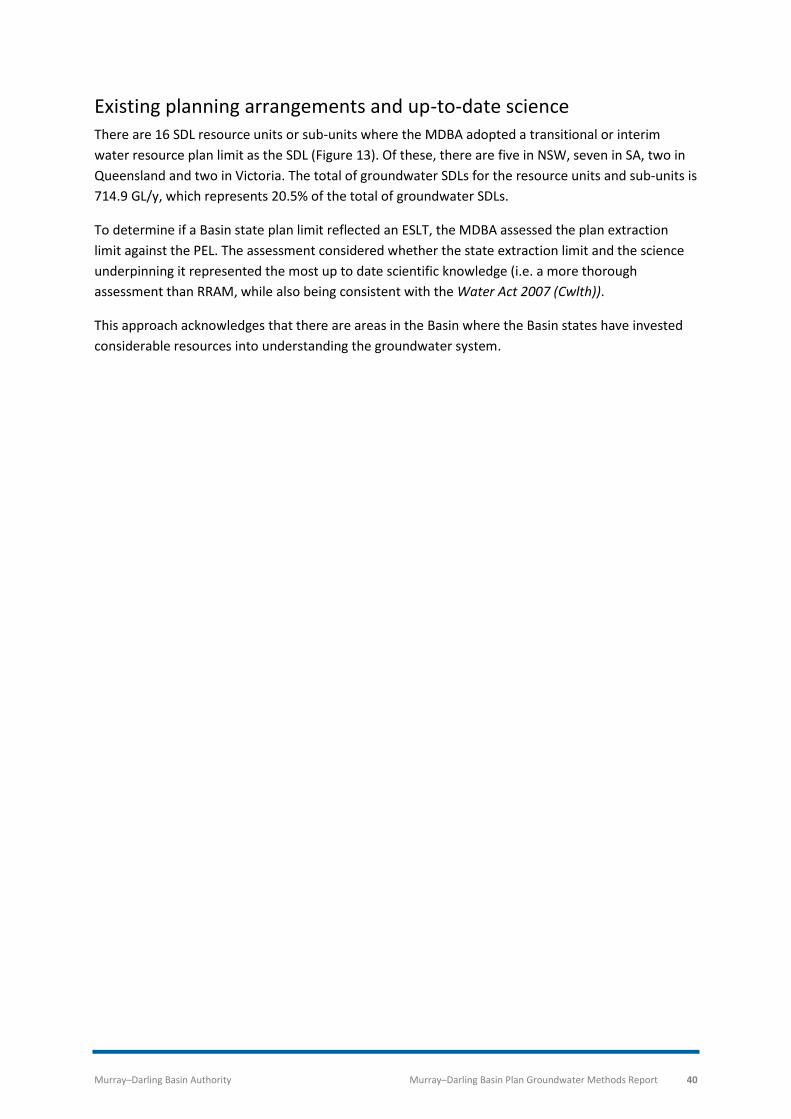
Existing planning arrangements and up-to-date science There are 16 SDL resource units or sub-units where the MDBA adopted a transitional or interim
water resource plan limit as the SDL (Figure 13). Of these, there are five in NSW, seven in SA, two in
Queensland and two in Victoria. The total of groundwater SDLs for the resource units and sub-units is
714.9 GL/y, which represents 20.5% of the total of groundwater SDLs.
To determine if a Basin state plan limit reflected an ESLT, the MDBA assessed the plan extraction
limit against the PEL. The assessment considered whether the state extraction limit and the science
underpinning it represented the most up to date scientific knowledge (i.e. a more thorough
assessment than RRAM, while also being consistent with the Water Act 2007 (Cwlth)).
This approach acknowledges that there are areas in the Basin where the Basin states have invested
considerable resources into understanding the groundwater system.

Murray–Darling Basin Authority Murray–Darling Basin Plan Groundwater Methods Report 41
Figure 13: Groundwater SDL resource units with existing planning arrangements being adopted as the SDL

Murray–Darling Basin Authority Murray–Darling Basin Plan Groundwater Methods Report 42
Unassigned groundwater There are groundwater SDL resource units with low volumes of water access rights and take relative
to the size of the groundwater system, resulting in a higher SDL than BDL. The total of unassigned
groundwater SDLs is 1,142.6 GL/y and represents 32.7% of the overall Basin wide total of
groundwater SDLs. The low use volumes in these systems are associated with difficulty accessing
groundwater, either due to the system’s geology and/or poor water quality. In these systems the BDL
reflects the volume of water access rights, not the volume of groundwater that can be taken without
compromising ESLT characteristics. The SDL in these systems is higher than the BDL. The additional
volume making the SDL greater than the BDL is known as ‘unassigned water’. Using the RRAM
(Section 4), unassigned groundwater was identified when the preliminary extraction limit (PEL)
exceeded the BDL. In unassigned water areas, groundwater may be suitable for stock and domestic
use, salt interception schemes, mining and industrial activities. There are 23 SDL resource units that
contain unassigned water. For many of these SDL resource units with unassigned water this is the
first time an extraction limits has been implemented. Of these 23 resource units with unassigned
water, there are nine in NSW, two in SA, one in Victoria, 10 in Queensland and one in the ACT (Figure
14).
Unassigned water assessment
The assessment of unassigned water is a precautionary approach to develop groundwater resources.
The SDLs were determined by allowing a percentage of the water between the BDL and the PEL to be
made available for consumptive use. The amount available is determined by applying an ‘unassigned
groundwater factor’ to the total volume of unassigned water.
In the draft Basin Plan, for groundwater systems where unassigned water was identified, half or all of
the amount between the BDL to the PEL was allowed (i.e. an unassigned groundwater factor of 0.5 or
1.0 was applied). For the final version of the Basin Plan in 2012, the MDBA adopted a conservative
unassigned groundwater factor of 0.25 due to unknown potential impacts. An exception was made
for two groundwater SDL resource units, the SA Murray Salt Interception Scheme and the NSW
Adelaide Fold Belt. In both cases, the PEL was adopted as the SDL. For the SA Murray Salt
Interception Scheme, this enables additional groundwater take where the take is purely for beneficial
salinity control in the River Murray. In the Adelaide Fold Belt SDL resource unit, the PEL was adopted
as the SDL recognising the nature of this system.
The precautionary approach adopted for unassigned groundwater will allow development to occur in
areas with unassigned groundwater without negatively impacting on surface water resources or
allowing the over-extraction of groundwater resources. As better knowledge becomes available,
particularly in resource units where data is currently poor, the MDBA will reassess and may revise the
SDLs. This is a key consideration in those resource units with high uncertainty and limited amounts of
data and information.

Murray–Darling Basin Authority Murray–Darling Basin Plan Groundwater Methods Report 43
Figure 14: Unassigned groundwater SDL resource units

Murray–Darling Basin Authority Murray–Darling Basin Plan Groundwater Methods Report 44
Potential impacts on surface water of growth in groundwater extraction The MDBA understood that that the actual take in several SDL resource units could be below the
BDL. Where this occurred in groundwater SDL resource units that are connected to surface water
resources, there was potential for increased groundwater take, up to the BDL, which may have an
impact on surface water resources.
The MDBA quantified the potential surface water impact of increased groundwater take within the
BDL, based on an estimate of take against the BDL. There are several issues and assumptions used to
estimate groundwater take across the Basin:
• at the time of making the 2012 Basin Plan, the most up to date Basin-wide groundwater take
information held by the MDBA was for the period 2003-04 to 2007-08. This information was
sourced from the Basin states;
• metered data is concentrated in areas of high groundwater take where -
o approximately 75% of the annual average groundwater extraction in the Basin occurs
across 40% of the SDL resource units;
o take is generally at least 50% of the BDL in these areas; or
o the quality of water take data in most of these areas is considered reasonable with
lower levels of uncertainty and
• in the non-metered SDL resource units, take was estimated as 60% of the volume of
entitlement plus an estimate of S&D take. The quality of water take data for these areas is
highly variable and has high levels of uncertainty.
Considering these issues, the MDBA estimated average take across the Basin for the period 2003-04
to 2007-08 to be 1,745 GL/y. The BDL in the Basin Plan is 2,386 GL/y, which is 641 GL/y higher than
the estimated average use in the 2003-04 to 2007-08 period.
The MDBA estimated the potential impact of this increased groundwater take on surface water
within the BDL by applying the same assessment method as outlined previously. To determine the
potential impact, the method applied the connectivity ratio for the relevant system to the difference
between estimated take and the BDL.
At the time of the 2012 Basin Plan, the potential Basin wide impact on surface water, of increased
take within the BDL under this method, was estimated to be 56 GL/y. This impact related to potential
increases in 24 SDL resource units where the connectivity assessment was used to determine the
SDL. In the remaining SDL resource units, either the connectivity assessment was not used, or no
increases were possible as take was already at the BDL.
The MDBA commissioned an independent review investigating the potential impacts of groundwater
SDL under three different growth scenarios and irrigation efficiency projects on river flow volume
under the Basin Plan (Wang et al., 2018). The growth scenarios were no growth, 2%/y growth and
4%/y growth. These scenarios give credence to the expectation that any future growth will be from
commitments prior to the Basin Plan (i.e. BDLs) rather than the ‘unassigned’ water resulting from the
high SDLs. The analysis has also assessed the impact of extraction growth to the full SDLs. Although
there is no evident trend in historic use, plausible growth scenarios over the next 40 years indicate

Murray–Darling Basin Authority Murray–Darling Basin Plan Groundwater Methods Report 45
that the total groundwater use will almost all be from prior commitments within the BDL. The impact
on river flow under these scenarios is in the range of 0 to 360 GL/y, with 170 GL/y as the most likely.
The high uncertainty is associated with the growth in groundwater extraction and ground-surface
water connectivity factors. Impacts are likely to be significant for low flow during extended dry
periods and would affect both quantity and quality. The estimated reduction under this review
differs from the previous estimate by the MDBA mainly because the ground-surface water
connectivity factor used in this review is higher than by MDBA.
Murray–Darling Basin Authority Murray–Darling Basin Plan Groundwater Methods Report 46
References
Braaten R and Gates G 2003, Groundwater-surface water interaction in inland New South Wales, a
scoping study. Water Science and Technology, 48 (7), 215-224.
Cresswell R and Herczeg A 2004, Groundwater recharge, mixing and salinity across the Angas–
Bremer Plains, South Australia: Geochemical and Isotopic Constraints, CSIRO Land & Water Report
29/04 / BRS Technical Report.
CSIRO 2008, Murray–Darling Basin Sustainable Yields project. Available online at :
https://www.csiro.au/en/Research/LWF/Areas/Water-resources/Assessing-water-
resources/Sustainable-yields/MurrayDarlingBasin
CSIRO and SKM 2010a, The groundwater SDL methodology for the Murray–Darling Basin Plan.
Murray–Darling Basin Authority, Canberra.
CSIRO and SKM 2010b, Guide to the proposed Basin Plan. (Guide released in October 2010). Murray–
Darling Basin Authority, Canberra.
CSIRO and SKM 2010c, Dryland diffuse groundwater recharge modelling across the Murray–Darling
Basin. A report to the MDBA from the CSIRO/SKM Groundwater SDL Project, CSIRO: Water for a
Healthy Country National Research Flagship, Canberra, 73 pp.
CSIRO and SKM (2011). Risk Recharge Assessment Method RRAM, Murray–Darling Basin Authority,
Canberra.
Department of Agriculture and Water Resources (DAWR) 2018, Queensland Upper Condamine
Alluvium Groundwater Purchase Tender Outcomes. Accessed 18 October 2018. Available online at:
http://www.agriculture.gov.au/water/markets/commonwealth-water-mdb/groundwater-purchase-
tender
Evans, R and E Murrihy 2014, Eastern Porous Rock Water Resource Plan Area Review. A synthesis
report. Available online at: https://www.mdba.gov.au/publications/independent-reports/eastern-
porous-rock-water-resource-plan-area-review
Forbes M, Simmons C, Coram J, Walker G, Cook P, Williams M and Hyde P 2014, Western Porous
Rock Groundwater Sustainable Diversion Limit Review. Synthesis Report. Available online at:
https://www.mdba.gov.au/publications/research-report/western-porous-rock-sdl-resource-unit-
review
Murray–Darling Basin Authority 2010, Developing the Guide to the proposed Basin Plan: Peer Review
Reports. Murray–Darling Basin Authority, Canberra.
Murray–Darling Basin Authority 2012a, Draft Basin Plan released in November 2011. Murray–Darling
Basin Authority, Canberra.
Murray–Darling Basin Authority 2012b, The proposed Groundwater Baseline and Sustainable
Diversion Limits: methods report. Murray–Darling Basin Authority, Canberra. Available online at:
https://www.mdba.gov.au/sites/default/files/archived/proposed/Proposed-BP-GW-BDL-SDL.pdf
Murray–Darling Basin Authority Murray–Darling Basin Plan Groundwater Methods Report 47
Murray–Darling Basin Authority 2012c, Addendum to the proposed Groundwater Baseline and
Sustainable Diversion Limits: methods report. Murray–Darling Basin Authority, Canberra. Available
online at:
https://www.mdba.gov.au/sites/default/files/archived/revised-BP/Addendum-to-Groundwater-
Methods.pdf
Murray Darling Basin Authority 2018a Compliance and enforcement policy 2018–21. Murray–Darling
Basin Authority, Canberra. Available online at:
https://www.mdba.gov.au/sites/default/files/pubs/MDBA-Compliance-and-enforcement-policy-
2018.pdf
Murray Darling Basin Authority 2018b, The Basin Plan amendment process. Murray–Darling Basin
Authority, Canberra. Available online at: https://www.mdba.gov.au/basin-plan-roll-out/basin-plan-
amendments.
Murray Darling Basin Authority 2019, Basin Plan amendments - snapshot of groundwater changes.
Murray–Darling Basin Authority, Canberra. Available online at:
https://www.mdba.gov.au/publications/mdba-reports/BPamendments-snapshot-groundwater
National Land and Water Resources Audit (NLWRA) 2001, Australian Water Resources Assessment
2000. Commonwealth of Australia, Canberra. Available online at:
http://nrmonline.nrm.gov.au/catalog/mql:1674
Parsons Brinkerhoff 2009, Groundwater–surface water connectivity: practical approaches for
identifying and accounting, Murray–Darling Basin Authority, Canberra. Available at:
http://www.mdba.gov.au/kid/files/311-Groundwater-surfacewater-connectivity-report.PDF
Richardson S, Walker GR, Barnett B, Daamen C, Davies P, Evans RS, Evans WR, Goode A, Pritchard J
and Waklawik V 2008, Groundwater management unit prioritisation and assessment ranking. A
report to the Australian Government from the CSIRO Murray–Darling Basin Sustainable Yields
Project. CSIRO, Australia. 33pp. Available online at:
http://www.clw.csiro.au/publications/waterforahealthycountry/mdbsy/technical/Q-GMU-
Prioritisation.pdf
Wade, A 2014, Goulburn-Murray Sedimentary Plain Groundwater SDL Review - Synthesis Report.
Available online at: https://www.mdba.gov.au/publications/research-report/goulburn-murray-
sedimentary-plain-sdl-resource-unit-review
Wang, QJ, Walker, G and A Horne 2018, Potential impacts of groundwater Sustainable Diversion
Limits and irrigation efficiency projects on river flow volume under the Murray–Darling Basin Plan. An
Independent review, MDBA. Available online at:
https://www.mdba.gov.au/publications/independent-reports/return-flows-independent-review
Zulfic D and Barnett S 2007, Bremer PWA – groundwater status report 2007. DWLBC Report 2007/27,
Department of Water, Land and Biodiversity Conservation, Government of South Australia.

Office locations Adelaide Albury-Wodonga Canberra Goondiwindi Griffith Mildura Murray Bridge Toowoomba
mdba.gov.au 1800 230 067 [email protected]