www.lpi.nsw.gov.auLPI | LOREM IPSUM DOLOR
www.lpi.nsw.gov.au
www.lpi.nsw.gov.auLPI | HISTORICAL PARISH MAPS
www.lpma.nsw.gov.auwww.lpi.nsw.gov.au
HISTORICAL PARISH MAPS
Facts at a glance• Parishmapsareanindextoidentifyinghistoricalland
recordssuchastitles,surveyplans,tenuresandgazettes.
• Mostmapsshow:
- boundariesofindividuallandparcelsinrelationtophysicalfeaturessuchasroads,rivers,railwaysandwaterbodies;
- referencestoCrownplans,theofficialsurveyplansforportionsofland;
- namesofthefirstlandowner,granteeorlesseeandthefirsttitleinformation(Volume-Folio)foreachparcelgrantedafter1863;and,
- administrationactivitiesoverCrownlandssuchasreserves,licenses,leasesandroads.
• The‘cancelled’mapsareagoodstartingpointforresearchifyouare:
- investigatingthehistoryofyourproperty;
- establishingthehistoryofalocality;or,
- interestedinareasthatyourfamilysettledinNewSouthWales.
• Therearemorethan35,000earlyeditionparishandpastoralmapsonline,accessibleviatheHistoricalLandRecordsViewer.TheviewercanbeaccessedfromhomeortheofficebyselectingtheHistoricalLandRecordsviewericononwww.six.nsw.gov.au
Readfurtherformoreinformationabouthistoricalparishmaps,howtoaccessthemapsonlineusingtheHistoricalLandRecordsViewerandacommonsearchexample.
Description The‘HistoricalParishMap’collectionisavailableonlineviatheHistoricalLandRecordsVieweronLPI’sSpatialInformationeXchangeportal(www.six.nsw.gov.au).Thecollectionincludes35,000earlyeditionparishandpastoralmaps.
TheparishmapwasthebasicfabricforlandadministrationinNewSouthWalesandisakeyindextoidentifyinghistorical
landrecords.Themapswereusedformorethan150yearsrecordingpropertyboundariesandprovidingreferencestoCrownlanddealingsandthefirstgrants.
Asparishmapsrecordedchangestolandovertimetheywereprogressivelysupersededonceitbecamedifficulttochartornotefurtherinformationonthem.Themapswerecancelledasneweditionsreplacedthem.
Twosetsofcounty,parish,townandvillagemapswerecreatedandmaintainedbytheformerDepartmentofLandsanditspredecessors.Onesetofmapswaskeptatthedistrictofficeandaduplicatesetwaskeptintheheadoffice.
TheHistoricalParishMapcollectionareallthecancelledCrownlandparishmapsandpastoralholdingmapsoriginallycapturedaspartoftheParishMapPreservationProject.Themajorityofthesewerefromthedistrictoffice.
Thehistoricalparishmapscomplementthe‘ChartingMap’collection,alsoaccessibleonlineviatheHistoricalLandRecordsViewer.TheChartingMapcollectionincludesthelasteditionsoftheLandTitlesOffice(LTO)chartingmapsandCrownlandparishmapsincirculationbeforecomputerisation.
Background to the maps – dividing NSWIn1825GovernorBrisbanewasorderedtoundertakeageneralsurveyofthecolonyofNewSouthWalesandbreakitupintocountiesforthepurposeoflandadministration.Eachcountywastobedividedintoparishes,theboundariesofwhichwerefixedbyconveniencesuchasfollowingtheborderofsurveyedlandornaturalfeatureslikerivers.ThefirstcountyinNewSouthWaleswasnamedCumberlandbyGovernorPhilliponthebirthdayofKingGeorgeIIIinJune1788.
In1829settlersinthecolonywereonlypermittedtotakeuplandwithinanareadefinedbythe19Counties.ThelimitsofsettlementextendedtoKempseyinthenorth,BatemansBayinthesouthandWellingtontothewest.
Despitethedefinedboundariessquattersranlivestockoutsidethelimits.By1836theSquattersActwasproclaimedallowinggrazinglicensesoutsidethe19Counties.Withtheintroductionofselectionoflandbeforesurveyin1861,landwasquicklysettledthroughoutthestateandthelimitsofsettlementbecameredundant.By1848NewSouthWaleswasdividedintothe141countiesthatstillexisttoday.

www.lpi.nsw.gov.auLPI | HISTORICAL PARISH MAPS
Maps available online in the Historical Parish Map collectionPastoral Maps
Pastoralmapsshowboundariesofholdingswhichwereagriculturalrunssettledbysquatters.
Afterthe1850sgoldrush,whichsawalargeinfluxofnewsettlers,therewasademandforlandthatwasalreadytakenupbysquatters.Asaresult,the1861“Freeselectionbeforesurvey”Actallowedselectionoverleasedareas.Thepastoralmapsrecordedwhichpartoftheholdingwasresumed,andmadeavailabletothenewsettlers,andwhichpartwasleased.Thepartremainingwithsquatterswasusuallytheareawhichhadundergoneimprovements.Theseimprovementsaresometimesshownonthepastoralholdingmaps.
Extract from the ‘Pastoral Run Carinda’ map available via the Historical Land Records Viewer
Onlyonecopyofthesefragilemapsonpaperandlinenexist,andthesearethePastoralHoldingMapsavailableonlineviatheHistoricalLandRecordsViewer.In1882theGardenPalaceExhibitionBuildingintheBotanicGardensburntdownandwithitnearlyalltheCrownlandleasedocuments,plansandmapsstoredtherewhiletheLandsDepartment’sBridgeStreetbuildingwasbeingconstructed.Departmentalstaffreconstitutedrecordsfromsecondaryinformationwithmapsshowingtherunsdividedintoleasedandunleasedareaspursuanttothe1883MorrisandRankineRoyalCommissionandthesubsequent1884CrownLandsAct.
County Maps
Countymapsusuallycoveranareaofabout10,360hectares.Thisis40squaremilesatascaleof4milestoaninch,whichisabout1:250,000.Atsuchasmallscale,theyareusefulasacadastralmapforshowingmajorphysicalfeatures,largeportionsandtheparisheswithinthecounty.
Parish Maps
Theparishmapisalandadministrationtoolthatprovidedthebasisforrecordinglandtransactions.ParishmapswerepreparedbytheCrownLandsOfficeusingplansofportions.Portionsaresequentiallynumberedparcelsoflandineachparish.Parishmapsshowtherelationshipofportionboundariestoroads,rivers,railwaysandwaterbodies.
Aswellasrecordingboundaries,parishmapsareanindextolandrecordssuchastitles,deeds,gazettes,tenuredocuments,surveyplansandotherlandrecordsforeachoftheparcelsoflandinthatparish.
Forexample,grantees’namesanddatesofgrantsmadepriorto1863maybeshownonthefaceofthemap(markedintherelevantportion)orrecordedwithinaschedulewiththeportion’snumber.ParishmapsalsoreferenceoriginallandgrantsandfirsttitlesissuedbetweenthecommencementoftheRealPropertyActon1January1863and1October1981.Firsttitlereferencesissuedsince1October1981areshowninaschedule.
Note:ForlandadministrationpurposesNewSouthWalesissplitintothreedivisions:Eastern,CentralandWestern.FewCrownparishmapshavebeencompiledforlandintheWesternDivision(whichisroughlywestofalinefromMunginditoBalranald).PrivateparishmapsforlandwithintheAustralianAgriculturalCompany’sgrantinthecountyofGloucesterwerepreparedbythecompany.
Town Maps
Whenatownlieswithinaparishitslocationisindicatedonthemapbutrelevantinformationisshownonamoredetailedscaleinatownorvillagemap.
Townmapshavesimilardetailtotheparishmapbutshowallotmentsandsectionsofthetowninsteadofportionsoftheparish.Itisimportanttorecordthesectioninatownasallotmentnumbersareduplicatedineachsectionwhichcanleadtoconfusion.
Note:Crowntownmapshavenotbeencreatedfor‘private’townswhichweresubdividedoutofprivatelyownedland.
What the Historical Parish Maps are used forHistoricalparishmapsshowinganareaforthetimeperiodyouareresearchingprovideinformationaboutalocationanditspeople.Itisakeyindexforidentifyinglandtitlerelatedrecords.BystartingyoursearchwiththeearliestparishmapyoucantracelandstatusfromwhenthelandwasfirstgrantedbytheCrownandworkforwardsovertime.
Byexaminingpreviouseditionsofmapsatdifferentpointsintimeyoucanalsoseehowsubdivisionsandotheractionshavealteredpropertyboundaries.
How the records are indentifiedThehistoricalparishmaps(cancellededitions)areidentifiedbycounty,parishandedition.Itisimportanttoselectthecorrectcountyasthesameparishnamecanexistinmorethanonecounty.
Otherthantownmaps,aparishmapnamedoesnotnecessarilyrelatetoalocation.IfyoudonotknowtheparishusetheGeographicalNamesBoard’sonline‘namesearch’(www.gnb.nsw.gov.au).Asearchbylocalityorsuburbwillrevealtheparishandcountyname.
Identifying Pastoral Holding Maps
ToidentifyapastoralholdingmapnameyoucanviewthePastoralMapIndex.Theindexallowsyoutogeographicallylocatethepastoralholdingonastatemapwhichwillhaveanumberandacorrespondingnameofthepastoralholdingmaponaschedule.
www.lpi.nsw.gov.auLPI | HISTORICAL PARISH MAPS
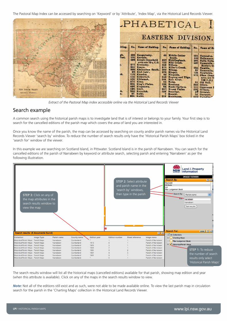
ThePastoralMapIndexcanbeaccessedbysearchingon‘Keyword’orby‘Attribute’,‘IndexMap’,viatheHistoricalLandRecordsViewer.
?Extract of the Pastoral Map index accessible online via the Historical Land Records Viewer
Search exampleAcommonsearchusingthehistoricalparishmapsistoinvestigatelandthatisofinterestorbelongstoyourfamily.Yourfirststepistosearchforthecancellededitionsoftheparishmapwhichcoverstheareaoflandyouareinterestedin.
Onceyouknowthenameoftheparish,themapcanbeaccessedbysearchingoncountyand/orparishnamesviatheHistoricalLandRecordsViewer‘searchby’window.Toreducethenumberofsearchresultsonlyhavethe‘HistoricalParishMaps’boxtickedinthe‘searchfor’windowoftheviewer.
InthisexamplewearesearchingonScotlandIsland,inPittwater.ScotlandIslandisintheparishofNarrabeen.YoucansearchforthecancellededitionsoftheparishofNarrabeenbykeywordorattributesearch,selectingparishandentering‘Narrabeen’asperthefollowingillustration.
STEP 2:Selectattributeandparishnameinthe‘searchby’windows,thentypeintheparish
STEP 1:Toreducethenumberofsearchresultsonlyselect‘HistoricalParishMaps’
STEP 3:Clickonanyofthemapattributesinthesearchresultswindowtoviewthemap
Thesearchresultswindowwilllistallthehistoricalmaps(cancellededitions)availableforthatparish,showingmapeditionandyear(whenthisattributeisavailable).Clickonanyofthemapsinthesearchresultswindowtoview.
Note:Notalloftheeditionsstillexistandassuch,werenotabletobemadeavailableonline.Toviewthelastparishmapincirculationsearchfortheparishinthe‘ChartingMaps’collectionintheHistoricalLandRecordsViewer.

www.lpi.nsw.gov.auLPI | HISTORICAL PARISH MAPS
Extracts of cancelled Narrabeen Parish maps which shows the orginal grantee of Scotland Island.
Onceyouhavefoundtheparishyoucanusetheviewertozoomintotheareaofinterest.Theparishmapwilltypicallyshowtheboundariesofland,oftenwithaportionnumber(orallotmentandsectionifwithinatown).Thelaterparishmapswillhavescheduleswhichidentifythecorrespondingplannumberandtitlereferencesforeachoftheportions.ThetitlesandplanscanthenbeorderedviaLPI’sOnlineShop,accessibleviatheshoppingcarticononwww.lpi.nsw.gov.au
The Parish Map extract shows the original grantee for portion 20. The schedule shows the plan for portion 20 is 179-1572 and the Torrens Title is Volume 3477 Folio 248. Images of these records can be purchased from the LPI Online Shop.
Important: Tofindouthowtointerpretaparishmapyoucanaccessadetailedguidecalled‘SearchingtheRegistrarGeneral’sMapsandPlans’.Theresourceincludesaglossaryforthedifferentacronymsusedonaparishmap.Thisguide,alongwithothers,isavailabletoviewordownloadforfreeontheLPIwebsite:http://www.lpi.nsw.gov.au/about_lpi/publications/search_guides
Further informationAlthoughtheparishmapwasnotdesignedorintendedasanarchivaldocument,itisanindispensiblesourceforidentifyinglandrecordsandunearthingvaluablehistoricalinformation.
Furtherassistancewithfamilyandlocalhistoricalsearchingcanbesoughtfrom:
State Records
TheWesternSydneyRecordsCentre(WSRC),143O’ConnellStreet,Kingswood(originalarchivesandmicroform)
www.records.nsw.gov.au
State Library of NSW MacquarieStSydneyNSW2000www.sl.nsw.gov.au
Portion number
Original grantee name
Plan number for portion
Torrens Title (Vol. Fol.) for portion 20
Location on the face of the parish map
Portion number
Land and Property Information
Head office1PrinceAlbertRoad
QueensSquareSYDNEYNSW2000
GPOBox15SYDNEYNSW2001
T 130005263761292286666
F61292334357
Disclaimer:Thisdocumenthasbeenproducedformarketingandcommunicationpurposesonly.ImagesareusedforartisticpurposesonlyandmaynotbeindicativeofCrownland.
Informationiscorrectattimeofprintingandissubjecttochangewithoutnotice.
©August2012LPI(B)P12/10/049