www.lpi.nsw.gov.au LPI | LOREM IPSUM DOLOR www.lpi.nsw.gov.au www.lpi.nsw.gov.au LPI | HISTORICAL PARISH MAPS www.lpma.nsw.gov.au www.lpi.nsw.gov.au HISTORICAL PARISH MAPS Facts at a glance • Parish maps are an index to identifying historical land records such as titles, survey plans, tenures and gazettes. • Most maps show: - boundaries of individual land parcels in relation to physical features such as roads, rivers, railways and water bodies; - references to Crown plans, the official survey plans for portions of land; - names of the first land owner, grantee or lessee and the first title information (Volume-Folio) for each parcel granted after 1863; and, - administration activities over Crown lands such as reserves, licenses, leases and roads. • The ‘cancelled’ maps are a good starting point for research if you are: - investigating the history of your property; - establishing the history of a locality; or, - interested in areas that your family settled in New South Wales. • There are more than 35,000 early edition parish and pastoral maps online, accessible via the Historical Land Records Viewer. The viewer can be accessed from home or the office by selecting the Historical Land Records viewer icon on www.six.nsw.gov.au Read further for more information about historical parish maps, how to access the maps online using the Historical Land Records Viewer and a common search example. Description The ‘Historical Parish Map’ collection is available online via the Historical Land Records Viewer on LPI’s Spatial Information eXchange portal (www.six.nsw.gov.au). The collection includes 35,000 early edition parish and pastoral maps. The parish map was the basic fabric for land administration in New South Wales and is a key index to identifying historical land records. The maps were used for more than 150 years recording property boundaries and providing references to Crown land dealings and the first grants. As parish maps recorded changes to land over time they were progressively superseded once it became difficult to chart or note further information on them. The maps were cancelled as new editions replaced them. Two sets of county, parish, town and village maps were created and maintained by the former Department of Lands and its predecessors. One set of maps was kept at the district office and a duplicate set was kept in the head office. The Historical Parish Map collection are all the cancelled Crown land parish maps and pastoral holding maps originally captured as part of the Parish Map Preservation Project. The majority of these were from the district office. The historical parish maps complement the ‘Charting Map’ collection, also accessible online via the Historical Land Records Viewer. The Charting Map collection includes the last editions of the Land Titles Office (LTO) charting maps and Crown land parish maps in circulation before computerisation. Background to the maps – dividing NSW In 1825 Governor Brisbane was ordered to undertake a general survey of the colony of New South Wales and break it up into counties for the purpose of land administration. Each county was to be divided into parishes, the boundaries of which were fixed by convenience such as following the border of surveyed land or natural features like rivers. The first county in New South Wales was named Cumberland by Governor Phillip on the birthday of King George III in June 1788. In 1829 settlers in the colony were only permitted to take up land within an area defined by the 19 Counties. The limits of settlement extended to Kempsey in the north, Batemans Bay in the south and Wellington to the west. Despite the defined boundaries squatters ran livestock outside the limits. By 1836 the Squatters Act was proclaimed allowing grazing licenses outside the 19 Counties. With the introduction of selection of land before survey in 1861, land was quickly settled throughout the state and the limits of settlement became redundant. By 1848 New South Wales was divided into the 141 counties that still exist today.

Welcome message from author
This document is posted to help you gain knowledge. Please leave a comment to let me know what you think about it! Share it to your friends and learn new things together.
Transcript

www.lpi.nsw.gov.auLPI | LOREM IPSUM DOLOR
www.lpi.nsw.gov.au
www.lpi.nsw.gov.auLPI | HISTORICAL PARISH MAPS
www.lpma.nsw.gov.auwww.lpi.nsw.gov.au
HISTORICAL PARISH MAPS
Facts at a glance• Parishmapsareanindextoidentifyinghistoricalland
recordssuchastitles,surveyplans,tenuresandgazettes.
• Mostmapsshow:
- boundariesofindividuallandparcelsinrelationtophysicalfeaturessuchasroads,rivers,railwaysandwaterbodies;
- referencestoCrownplans,theofficialsurveyplansforportionsofland;
- namesofthefirstlandowner,granteeorlesseeandthefirsttitleinformation(Volume-Folio)foreachparcelgrantedafter1863;and,
- administrationactivitiesoverCrownlandssuchasreserves,licenses,leasesandroads.
• The‘cancelled’mapsareagoodstartingpointforresearchifyouare:
- investigatingthehistoryofyourproperty;
- establishingthehistoryofalocality;or,
- interestedinareasthatyourfamilysettledinNewSouthWales.
• Therearemorethan35,000earlyeditionparishandpastoralmapsonline,accessibleviatheHistoricalLandRecordsViewer.TheviewercanbeaccessedfromhomeortheofficebyselectingtheHistoricalLandRecordsviewericononwww.six.nsw.gov.au
Readfurtherformoreinformationabouthistoricalparishmaps,howtoaccessthemapsonlineusingtheHistoricalLandRecordsViewerandacommonsearchexample.
Description The‘HistoricalParishMap’collectionisavailableonlineviatheHistoricalLandRecordsVieweronLPI’sSpatialInformationeXchangeportal(www.six.nsw.gov.au).Thecollectionincludes35,000earlyeditionparishandpastoralmaps.
TheparishmapwasthebasicfabricforlandadministrationinNewSouthWalesandisakeyindextoidentifyinghistorical
landrecords.Themapswereusedformorethan150yearsrecordingpropertyboundariesandprovidingreferencestoCrownlanddealingsandthefirstgrants.
Asparishmapsrecordedchangestolandovertimetheywereprogressivelysupersededonceitbecamedifficulttochartornotefurtherinformationonthem.Themapswerecancelledasneweditionsreplacedthem.
Twosetsofcounty,parish,townandvillagemapswerecreatedandmaintainedbytheformerDepartmentofLandsanditspredecessors.Onesetofmapswaskeptatthedistrictofficeandaduplicatesetwaskeptintheheadoffice.
TheHistoricalParishMapcollectionareallthecancelledCrownlandparishmapsandpastoralholdingmapsoriginallycapturedaspartoftheParishMapPreservationProject.Themajorityofthesewerefromthedistrictoffice.
Thehistoricalparishmapscomplementthe‘ChartingMap’collection,alsoaccessibleonlineviatheHistoricalLandRecordsViewer.TheChartingMapcollectionincludesthelasteditionsoftheLandTitlesOffice(LTO)chartingmapsandCrownlandparishmapsincirculationbeforecomputerisation.
Background to the maps – dividing NSWIn1825GovernorBrisbanewasorderedtoundertakeageneralsurveyofthecolonyofNewSouthWalesandbreakitupintocountiesforthepurposeoflandadministration.Eachcountywastobedividedintoparishes,theboundariesofwhichwerefixedbyconveniencesuchasfollowingtheborderofsurveyedlandornaturalfeatureslikerivers.ThefirstcountyinNewSouthWaleswasnamedCumberlandbyGovernorPhilliponthebirthdayofKingGeorgeIIIinJune1788.
In1829settlersinthecolonywereonlypermittedtotakeuplandwithinanareadefinedbythe19Counties.ThelimitsofsettlementextendedtoKempseyinthenorth,BatemansBayinthesouthandWellingtontothewest.
Despitethedefinedboundariessquattersranlivestockoutsidethelimits.By1836theSquattersActwasproclaimedallowinggrazinglicensesoutsidethe19Counties.Withtheintroductionofselectionoflandbeforesurveyin1861,landwasquicklysettledthroughoutthestateandthelimitsofsettlementbecameredundant.By1848NewSouthWaleswasdividedintothe141countiesthatstillexisttoday.

www.lpi.nsw.gov.auLPI | HISTORICAL PARISH MAPS
Maps available online in the Historical Parish Map collectionPastoral Maps
Pastoralmapsshowboundariesofholdingswhichwereagriculturalrunssettledbysquatters.
Afterthe1850sgoldrush,whichsawalargeinfluxofnewsettlers,therewasademandforlandthatwasalreadytakenupbysquatters.Asaresult,the1861“Freeselectionbeforesurvey”Actallowedselectionoverleasedareas.Thepastoralmapsrecordedwhichpartoftheholdingwasresumed,andmadeavailabletothenewsettlers,andwhichpartwasleased.Thepartremainingwithsquatterswasusuallytheareawhichhadundergoneimprovements.Theseimprovementsaresometimesshownonthepastoralholdingmaps.
Extract from the ‘Pastoral Run Carinda’ map available via the Historical Land Records Viewer
Onlyonecopyofthesefragilemapsonpaperandlinenexist,andthesearethePastoralHoldingMapsavailableonlineviatheHistoricalLandRecordsViewer.In1882theGardenPalaceExhibitionBuildingintheBotanicGardensburntdownandwithitnearlyalltheCrownlandleasedocuments,plansandmapsstoredtherewhiletheLandsDepartment’sBridgeStreetbuildingwasbeingconstructed.Departmentalstaffreconstitutedrecordsfromsecondaryinformationwithmapsshowingtherunsdividedintoleasedandunleasedareaspursuanttothe1883MorrisandRankineRoyalCommissionandthesubsequent1884CrownLandsAct.
County Maps
Countymapsusuallycoveranareaofabout10,360hectares.Thisis40squaremilesatascaleof4milestoaninch,whichisabout1:250,000.Atsuchasmallscale,theyareusefulasacadastralmapforshowingmajorphysicalfeatures,largeportionsandtheparisheswithinthecounty.
Parish Maps
Theparishmapisalandadministrationtoolthatprovidedthebasisforrecordinglandtransactions.ParishmapswerepreparedbytheCrownLandsOfficeusingplansofportions.Portionsaresequentiallynumberedparcelsoflandineachparish.Parishmapsshowtherelationshipofportionboundariestoroads,rivers,railwaysandwaterbodies.
Aswellasrecordingboundaries,parishmapsareanindextolandrecordssuchastitles,deeds,gazettes,tenuredocuments,surveyplansandotherlandrecordsforeachoftheparcelsoflandinthatparish.
Forexample,grantees’namesanddatesofgrantsmadepriorto1863maybeshownonthefaceofthemap(markedintherelevantportion)orrecordedwithinaschedulewiththeportion’snumber.ParishmapsalsoreferenceoriginallandgrantsandfirsttitlesissuedbetweenthecommencementoftheRealPropertyActon1January1863and1October1981.Firsttitlereferencesissuedsince1October1981areshowninaschedule.
Note:ForlandadministrationpurposesNewSouthWalesissplitintothreedivisions:Eastern,CentralandWestern.FewCrownparishmapshavebeencompiledforlandintheWesternDivision(whichisroughlywestofalinefromMunginditoBalranald).PrivateparishmapsforlandwithintheAustralianAgriculturalCompany’sgrantinthecountyofGloucesterwerepreparedbythecompany.
Town Maps
Whenatownlieswithinaparishitslocationisindicatedonthemapbutrelevantinformationisshownonamoredetailedscaleinatownorvillagemap.
Townmapshavesimilardetailtotheparishmapbutshowallotmentsandsectionsofthetowninsteadofportionsoftheparish.Itisimportanttorecordthesectioninatownasallotmentnumbersareduplicatedineachsectionwhichcanleadtoconfusion.
Note:Crowntownmapshavenotbeencreatedfor‘private’townswhichweresubdividedoutofprivatelyownedland.
What the Historical Parish Maps are used forHistoricalparishmapsshowinganareaforthetimeperiodyouareresearchingprovideinformationaboutalocationanditspeople.Itisakeyindexforidentifyinglandtitlerelatedrecords.BystartingyoursearchwiththeearliestparishmapyoucantracelandstatusfromwhenthelandwasfirstgrantedbytheCrownandworkforwardsovertime.
Byexaminingpreviouseditionsofmapsatdifferentpointsintimeyoucanalsoseehowsubdivisionsandotheractionshavealteredpropertyboundaries.
How the records are indentifiedThehistoricalparishmaps(cancellededitions)areidentifiedbycounty,parishandedition.Itisimportanttoselectthecorrectcountyasthesameparishnamecanexistinmorethanonecounty.
Otherthantownmaps,aparishmapnamedoesnotnecessarilyrelatetoalocation.IfyoudonotknowtheparishusetheGeographicalNamesBoard’sonline‘namesearch’(www.gnb.nsw.gov.au).Asearchbylocalityorsuburbwillrevealtheparishandcountyname.
Identifying Pastoral Holding Maps
ToidentifyapastoralholdingmapnameyoucanviewthePastoralMapIndex.Theindexallowsyoutogeographicallylocatethepastoralholdingonastatemapwhichwillhaveanumberandacorrespondingnameofthepastoralholdingmaponaschedule.
www.lpi.nsw.gov.auLPI | HISTORICAL PARISH MAPS
ThePastoralMapIndexcanbeaccessedbysearchingon‘Keyword’orby‘Attribute’,‘IndexMap’,viatheHistoricalLandRecordsViewer.
?Extract of the Pastoral Map index accessible online via the Historical Land Records Viewer
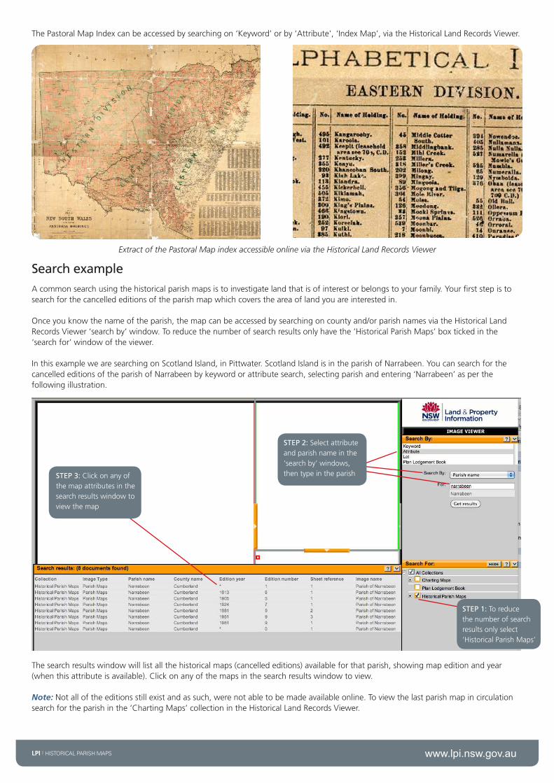
Search exampleAcommonsearchusingthehistoricalparishmapsistoinvestigatelandthatisofinterestorbelongstoyourfamily.Yourfirststepistosearchforthecancellededitionsoftheparishmapwhichcoverstheareaoflandyouareinterestedin.
Onceyouknowthenameoftheparish,themapcanbeaccessedbysearchingoncountyand/orparishnamesviatheHistoricalLandRecordsViewer‘searchby’window.Toreducethenumberofsearchresultsonlyhavethe‘HistoricalParishMaps’boxtickedinthe‘searchfor’windowoftheviewer.
InthisexamplewearesearchingonScotlandIsland,inPittwater.ScotlandIslandisintheparishofNarrabeen.YoucansearchforthecancellededitionsoftheparishofNarrabeenbykeywordorattributesearch,selectingparishandentering‘Narrabeen’asperthefollowingillustration.
STEP 2:Selectattributeandparishnameinthe‘searchby’windows,thentypeintheparish
STEP 1:Toreducethenumberofsearchresultsonlyselect‘HistoricalParishMaps’
STEP 3:Clickonanyofthemapattributesinthesearchresultswindowtoviewthemap
Thesearchresultswindowwilllistallthehistoricalmaps(cancellededitions)availableforthatparish,showingmapeditionandyear(whenthisattributeisavailable).Clickonanyofthemapsinthesearchresultswindowtoview.
Note:Notalloftheeditionsstillexistandassuch,werenotabletobemadeavailableonline.Toviewthelastparishmapincirculationsearchfortheparishinthe‘ChartingMaps’collectionintheHistoricalLandRecordsViewer.

www.lpi.nsw.gov.auLPI | HISTORICAL PARISH MAPS
Extracts of cancelled Narrabeen Parish maps which shows the orginal grantee of Scotland Island.
Onceyouhavefoundtheparishyoucanusetheviewertozoomintotheareaofinterest.Theparishmapwilltypicallyshowtheboundariesofland,oftenwithaportionnumber(orallotmentandsectionifwithinatown).Thelaterparishmapswillhavescheduleswhichidentifythecorrespondingplannumberandtitlereferencesforeachoftheportions.ThetitlesandplanscanthenbeorderedviaLPI’sOnlineShop,accessibleviatheshoppingcarticononwww.lpi.nsw.gov.au
The Parish Map extract shows the original grantee for portion 20. The schedule shows the plan for portion 20 is 179-1572 and the Torrens Title is Volume 3477 Folio 248. Images of these records can be purchased from the LPI Online Shop.
Important: Tofindouthowtointerpretaparishmapyoucanaccessadetailedguidecalled‘SearchingtheRegistrarGeneral’sMapsandPlans’.Theresourceincludesaglossaryforthedifferentacronymsusedonaparishmap.Thisguide,alongwithothers,isavailabletoviewordownloadforfreeontheLPIwebsite:http://www.lpi.nsw.gov.au/about_lpi/publications/search_guides
Further informationAlthoughtheparishmapwasnotdesignedorintendedasanarchivaldocument,itisanindispensiblesourceforidentifyinglandrecordsandunearthingvaluablehistoricalinformation.
Furtherassistancewithfamilyandlocalhistoricalsearchingcanbesoughtfrom:
State Records
TheWesternSydneyRecordsCentre(WSRC),143O’ConnellStreet,Kingswood(originalarchivesandmicroform)
www.records.nsw.gov.au
State Library of NSW MacquarieStSydneyNSW2000www.sl.nsw.gov.au
Portion number
Original grantee name
Plan number for portion
Torrens Title (Vol. Fol.) for portion 20
Location on the face of the parish map
Portion number
Land and Property Information
Head office1PrinceAlbertRoad
QueensSquareSYDNEYNSW2000
GPOBox15SYDNEYNSW2001
T 130005263761292286666
F61292334357
Disclaimer:Thisdocumenthasbeenproducedformarketingandcommunicationpurposesonly.ImagesareusedforartisticpurposesonlyandmaynotbeindicativeofCrownland.
Informationiscorrectattimeofprintingandissubjecttochangewithoutnotice.
©August2012LPI(B)P12/10/049
Related Documents