Gaging-Station Records in the Missouri River BasinBy B. R. COLBY and R. E. OLTMAN *
GEOLOGICAL SURVEY WATER-SUPPLY PAPER 1077
An index and summary giving kinds of records, published sources, and explanation of data
PROPEBTt* offc-V B^ PHVATI
s. i,», v«r. 9.»

UNITED STATES DEPARTMENT OF THE INTERIOR J. A. Krug, Secretary
GEOLOGICAL SURVEY W. E. Wrather, Director
UNITED STATES
GOVERNMENT PRINTING OFFICE
WASHINGTON : 1948
For sale by the Superintendent of Documents, U. S. Government Printing Office Washington 25, D. C.

CONTENTS
PageIntroduction............................................. 1Sources of gaging-station data........................... 2Gaging-station names..................................... 2Map showing gaging stations.............................. 3Bar charts of records.................................... 4
Summary of records by basins......................... 17Base data for gaging stations............................ 19
Drainage areas....................................... 19Approximate areas irrigated.......................... 20Approximate usable capacity of reservoirs............ 21Average discharge for water years 1938-43............ 22Average runoff for water years 1938-43............... 24Sources of records................................... 25Period of discharge record........................... 25Maximum discharge.................................... 25Minimum discharge.................................... 26Annual discharge records.............................. 26Average discharge.................................... 27
Bibliography......... *................................... 27Index.................................................... 213
ILLUSTRATIONS
Page Plate 1. Map showing locations of gaging stations and
diversions in Missouri River Basin..... In pocket Figure 1. Diagram showing relative locations of trib
utaries and canals along Milk River in Montana..................................... 5
2. Diagram showing relative locations of trib utaries and canals in Bighorn Basin above Manderson, Wyo.............................. 6
3. Diagram showing relative locations of trib utaries and canals in White River Basin above Oglala, S. Dak........................ 7
4. Diagram showing relative locations of trib utaries and canals along North Platte River from Guernsey Reservoir, Wyo., to Minatare, Nebr........................................ 8
5. Diagram showing relative locations of trib utaries and canals along North Platte River from Minatare to Lewellen, Nebp............. 9
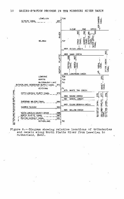
6. Diagram showing relative locations of trib utaries and canals along North Platte River from Lewellen to Sutherland, Nebr........... 10
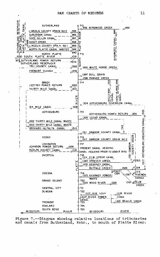
7. Diagram showing relative locations of trib utaries and canals from Sutherland, Nebr., to mouth of Platte River.................... 11
8. Diagram showing relative locations of trib utaries and canals in South Platte River Basin in Nebraska........................... 12
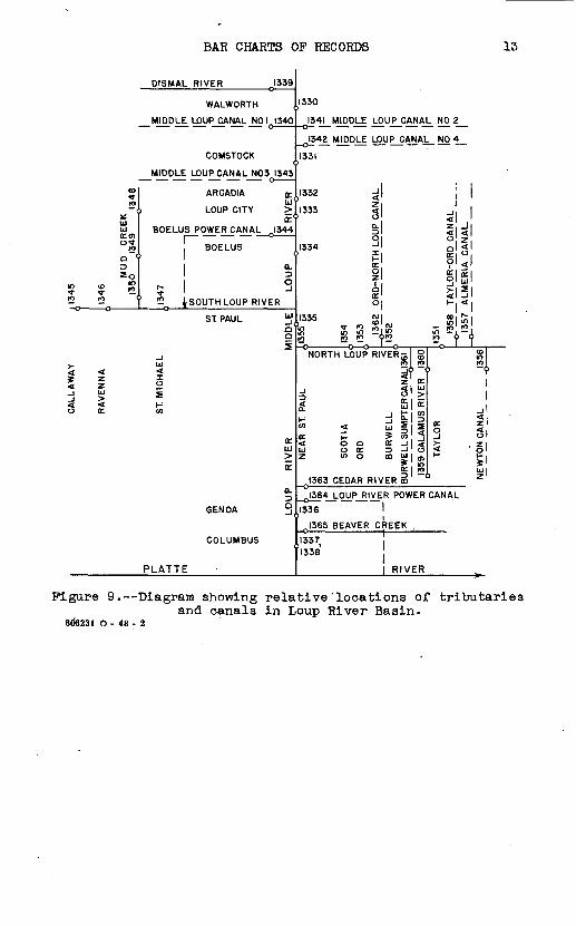
9. Diagram showing relative locations of trib utaries and canals in Loup River Basin...... 13
III

IV ILLUSTRATIONS
PageFigure 10. Diagram showing relative locations of trib
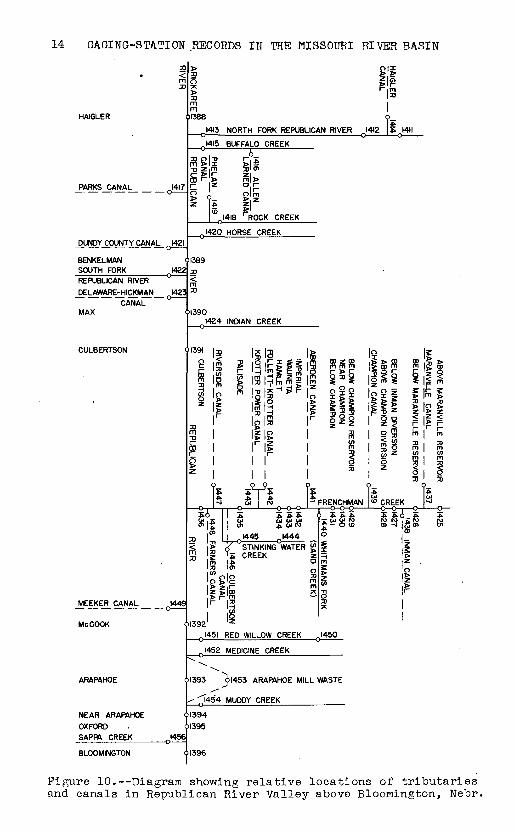
utaries and canals in Republican River Valley above Bloomington, Nebr............. 14
TABLES AND CHARTS
Page Table 1. Approximate station years of stream-flow
records...................................... 182. Comparison of average discharge 1938-43 with
average discharge for long periods of rec ord. ......................................... 23
3* Base data for gaging stations in Missouri RiverBasin........................................ 33
Chart 1. Duration of records at gaging stations in Mis souri River Basin............................ 107

GAGING-STATION RECORDS IN THE MISSOURI RIVER BASIN
By Bruce R. Colby and Roy E. Oltman
INTRODUCTION
Many hundreds of gaging stations on streams, canals, and
reservoirs in the Missouri River Basin have been maintained
for different periods of time* Records for most of these
periods have been published somewhere, but the publications
have been prepared by several governmental agencies so that
looking through all the possible sources of stream-flow data
to find records at a particular place or in a certain area
may be difficult. This index and summary of gaging stations
in the Missouri River Basin is intended to fill the need for
information on the kinds and lengths of records available, on
the published sources of, these records, and on facts required
to explain the meaning and applicability of the records.
After extensive but not necessarily exhaustive investiga
tion of possible sources of gaging-station records, this index
in the form of bar charts has been prepared. A graphical
presentation of the periods of record was used because it
shows conveniently (l) the periods covered by the records,
(2) the kind of records for each period, and (3) where gaging-
station records have been published* A summary table listing
pertinent facts for nearly a thousand of the gaging stations
has also been made.
This report was prepared in the division of water utiliza
tion under the general supervision of R. W. Davenport, chief.*
1

2 GAGING-STATION RECORDS IN THE MISSOURI RIVER BASIN
SOURCES OF GAGING STATION DATA
The principal sources of the gaging station records are
(1) publications of the United States Geological Survey,
(2) publications of the Corps of Engineers, Department of the
Army, and (3) reports of state engineers and other state
officials. The publications from which gaging station rec
ords were obtained are listed specifically under the heading
"Bibliography," on pages 17-21 of this report.
GAGING-STATION NAMES
Records for the same gaging station or two or more sta
tions, giving approximately equivalent records but obtained
at slightly different sites, have sometimes been published
under different names. An attempt has been made in this
report to combine all such substantially equivalent records
under one name unless the practically equivalent r'ecords were
for gaging stations that were operated concurrently. Paren
theses enclose words that appear in earlier published names
of a gaging station and follow immediately after the words
that supersede them. A comma within parentheses separates
words that occurred in two different earlier names of a gag
ing station. Brackets in a station name enclose words that
did not appear in the name under which some earlier records
have been published. At three or four places in the Missouri
River Basin, records that were not equivalent have been pub
lished under one name. In this report these nonequivalent
records have been separated.
Canal records that have been published in water-supply
papers are ligted on the bar charts under the name used in
the water-supply papers. The names of canals for which
MAP SHOWING GAGING STATIONS 3
records have been given only in other publications frequently
have been extended to make them more distinctive. This exten
sion consisted of the addition of the name of a nearby town
to the canal name if the canal diverted water from a main
stream. The name of a canal diverting water principally from
some source other than a main stream was extended to show the
source from which water was diverted. Thus, the name "Hooper
Canal" was extended to "Hooper Canal diversion from Blue Creek,
Nebr."
Records for a few gaging stations on streams have been
published in state reports under a stream name and a land-
line location. Names of these stations have also been
extended to include reference to a nearby town.
Names of reservoirs and lakes have been given without
reference to the stream on which they are situated, provided
their location was readily apparent from the names of stations
that precede them in the table or on the bar charts. Whenever
the location of a reservoir might otherwise be in doubt, a
reference has been made to the stream on which it is located*
Offstream reservoirs, which do not occupy the stream channel
supplying most of their water, have been noted; and the prin
cipal source of supply for each of them has been shown.
Some diversions by pumping from Bighorn River have been
published in special reports by the state engineer of Wyoming.
Diversions reported as being made by pumps have been shown in
this report as ditch diversions. For example the Joe Riedl
pump diversion is shown as Joe Riedl ditch.
MAP SHOWING GAGING STATIONS
Gaging stations for which records have been published for
periods prior to October 1, 1944, have been plotted with ref
erence numbers on the map of the Missouri River Basin (pi. 1).

4 GAGING-STATION RECORDS IN THE MISSOURI RIVER BASIN
Open circles represent stations on streams, and short bars
represent stations on diversions. Gaging stations on streams
and canals are too close together in several areas to plot on
a map, so schematic diagrams have been prepared to show the
relative locations of stations in these areas (figs* 1-10)*
These diagrams are not to scale. A £ew of the smaller diver
sions may be indicated as diverting from the wrong side of the
stream. Plate 1 and figures 1-10 have been prepared primarily
from published maps and descriptions, but some indefinite loca
tions of gaging stations and canals have been checked by oral
or written inquiry. The map reference numbers are listed on
the bar charts and in the summary table of gaging-station data*
The reference numbers were assigned to stations in down
stream order beginning with the station farthest upstream on
Red Rock River (head of the Missouri River) and going down
stream along the main stream. Following the farthest down
stream station on Missouri River is the most upstream station
on the tributary that is nearest the source of the Red Rock
River. Other tributaries follow in order downstream, with the
list progressing down each tributary as though it were a main
stream. This is the order used in most water-supply papers.
Gaging stations on canals have been listed in the down
stream order they would occupy if the canals were tributaries
entering the stream at .the point where the canal diverts water
from the stream. All gaging stations on one canal, diversions
to it, or wastes from it have been listed in consecutive down
stream order along that canal in the order that they would
have if the canal were a natural stream.
BAR CHARTS OF RECORDS
The durations and kinds of records for individual gaging
stations are shown on the accompanying bar charts. This method

BAR CHARTS OP RECORDS
-iLITTLE BOXELDER CREEK
HAVRE A. 248
.,261
CLEAR CREEK ^262
FORT BELKNAP CANAL 263
LOHMAN 249
WINTER-ANDERSON CANAL
CHINOOK A 250
_ __^6^
265
PARADISE VALLEY CANAL
AGENCYJJITCH _
PEOPLES CREEK
279
281t
282
SUPPLY CANAL TO NELSON RESERVOIR
MALTA
BEAVER CREEK 29t
VANDALIA
267 LODGE CREEK
.273 BATTLE CREEK
280 HARLEM CANAL
251
2B4 WHITEWATER CREEK
285 FRENCHMAN RIVER
294 ROCK CREEK
252
. NASHUA A 253
MISSOURI RIVER
298 PORCUPINE CREEK
Figure 1. Diagram showing relative locations of tributaries and canals along Milk River in Montana.

6 GAGING-STATION RECORDS IN THE MISSOURI RIVER BASIN
WARM SPRING CREEK 386
DUBOIS
RED CREEK 388DINWOODY CREEK n 389DRY CREEK ,,390
MEADOW CREEK 391
WILLOW CREEK ^392
393 BULL LAKE CREEK 394 ^395
JOHNSTOWN CANAL
RIVERTON407 POPO AGIE RIVER ^408
BAKER DITCH
C.R. INGLE DITCH
419
424
KIRBY DITCH
KIRBY CREEK
THERMOPOLIS426
439
NAKAMyRA_DITCH
NELSON DITCH
LOWERJHAJVIOVER CANAL
NOWATER CREEK
441Y
443
O
iCO
452
FRITZ DITCH 456
MANDERSON
387 HORSE CREEK
379
397_ WYOMING CANAL | 396 WYOMING CANAL [ 2 D DIVISION
I 398 PILOT CANAL
399_HURTADO DITCJH_ _ _ _ _ _ _
| 400_ARAGOJ\I_DJTCH_ _ _ _ _ _ _
, 4012J^ECJ.AJRjRjyERJ3%CANAL_N0.2 "403
> 404JJEFT HAND_CANAL_ _ _ _ _ _
405 WYOMING CANAL NO.2
380
418 FIVEMILE CREEK
> 420_PLUMMER AND N)CKELSONJ)ITCH
421 JOE RIEDL DITCH
> I22 ..LEO RONCO DITCH
423 CURTIS DITCH
425 JUKNOVICH DITCH
381
427_WqRTHAM _DITCH_
428 GWYNN DITCH
429 CYCLONE DITCH
430 OWL CREEK DITCH
435 - OWL CREEK 434
440 J.NOLL DITCH
442 PAUL JONES DITCH
444 ANDERSON DITCH
( 445_yPPER_HANOyER CA_NAL_
446 COTTONWOOD CREEK
447 J3LyF_F_CANAL__ _
449 GOOSEBERRY CREEK 448
450 BIGHORN CANAL
454 FIFTEENMILE CREEK
451
455 SLICK CREEK
457 FIVEMILE CREEK
382
Figure 2. Diagram showing relative locations of tributaries and canals in Bighorn- Basin above Manderson, Wyo.
BAR CHARTS OP RECORDS
CRAWFORD (UPPER STATION)
CRAWFORD (LOWER STATION)
WHITE CLAY CREEK ,,619
WHITNEY
ASH CREEK
605
606
ABOVE WHITNEY PIPE LINE "I ^
BELOW WHITNEY PIPE LINE
,624
CHADRON
CHADRON CREEK ,,625 ,626 627 ^628
OGLALA
HjALL_ CAN/iL_ __ __^_ __
WHITE _RJVE R_CA_N_AL_ _
HARRIS-COOPE'RCANAL
607 . . g
^21 WHI_TNEY_PIP_E_LINE__ _ _
608
,,623 LITTLE COTTONWOOD CREEK
610
611
Figure 3. Diagram showing relative locations of" tributaries and canals in White River Basin above Oglala, S. Dak.

8 GAGING-STATION RECORDS IN THE MISSOURI RIVER BASIN
GUERNSEY RESERVOIR
BELOW GUERNSEY RESERVOIR FORT LARAMIE CANALr~
BELOW WHALEN ,800 LARAMIE RIVER82I\
j J"| LINGLE POWER WASTE
0 ^ VAUGHN
g u TORRINGTON 0 2 CHERRY CREEK DRAIN31 si5131g'fc 1<|0 KATZER DRAINu>| MITCHELL CANALz l
-i WYOMING-NEBRASKA LINE tu
W HENRY » 786 HORSE CREEK LATERAL
,845^ HORSE CREEK
LANE DRAIN
MORRILL
BALD DRAIN
MITCHELL
CE_NTRAL_ CANAL _ ______
SCOTTSBLUFF
GERING DRAINSTEAMBOAT CANAL
CASTLE ROCK CANAL1 -
MELBETA DRAIN
0 784
^801
D 785
;Q 823
D 827
0 828
0 830
n 846
C 849
cc"LJ
<r
n 861
LJK
2
0 873
X
0 878 0879
0680
o 885
! 69I
692 _0 787 INTERSTATE CANAL
693
_ 822 RAWHIDE CREEK
>694
695
Q 824 ARNOLD DRAIN
0 825 PULLEN DRAIN_o 826__FRENCH_CANAL_
696 0 829 SPRING CREEK
>697 0 832 TRI-STATE CANAL
842_RAMSJ1PRN_CANAL_
0 850 SHEEP CREEK
_o I5.1 _JNIE f5^I_ CA_NAL _
) RQRMORRILL DRAIN
i
i i
i i
__ ,8578S2|^AKERS DRAW
STEWARTS DRAIN J35fyffc**
_o 8_59_rP-0H-EJ_§pJy-w*1L_ _ 0 860 TOOHEY DRAIN
0 862 DRY SPOTTED TAIL CR
> 699 _863 FANNING SEEP0 Q 869 Y
MITCHELL | 867
X CREEK 864
"SPOTTED TAIL SPILLWAY 0 870 TUB SPRINGS
_., 871 _WiNTER^REEK_CANAL
Pl< >7OO m z
JS74 SCOTTSBLUFF w|oDRAIN t|£
0 875 WINTER CREEK 9
882 SCOTTSBLUFF DRAINQ 883 NIN E_M 1 LE _CANA L
|ro
EEK1//853 1,^835
1 (RON BERG SEEP
1 o 866 o 86Sk854 ^836
a ' 837o
I
^_ENTER_PRISE^ _
Oi OD V
ATE CANAL
1 o< CD
£
NO 2
1poi
Figure 4. Diagram showing relative locations of tributaries and canals along North Platte River from Guernsey Reservoir, Wyo., to Minatare, Nebr.

y h*
?
M O
CD
3
13
SO
C»*
1 _ 1
^*fe
(/
)ca
05
o
^
0<5
?
0*
H P
L"
4
03
0
* >3
C
*"f*
""
as Q
£
28
OS
f
^
^4
H
. m
>
§
d- P
p
r
tn
z
1 j~
j (^
1 ^
$£
-HC
r tT
Q
(p
CD
H
* °*
m
33
CD
_
^
S<!
M
2
CD
O
m
4O
(~
n,d-
i4
H
* a
0
O
3)
33
>-^
G
RA
F
95
5H
- O
C
AN
AL
§
*"*
HO
PP
ER
9
53
d-
d-
CA
NA
L
05 4
B
LU
E
CR
EE
K
Q95
2m
5
* C
AN
AL
Sd-
d-
A *1
(f>
(DO
o;
Jicn
en
rE
§m
-i
o
go
1
S
z5
* £
"
1
[«1
ft MIDLAND-OVEF >
y I
OSHKOSH CAN r-
(0
O
3)
X
X
cn
cn
zII
Zo
o
>m
pm
o
rn
C.
t*
x *
z>
r
?
z
5)>
0
,,i
I ,
TtP
TtO
T
d)
,A
<
SPOHN
CANAL
LYONS
CANAL
95
4 U
NIO
N
CA
NA
L
NO
RT
H R
IVE
R
CA
NA
L
LIS
CO
Q9
5I
PA
ISLE
Y
CA
NA
L
(Oti
CO
LDW
AT
ER
C
AN
AL 9
39^
° ^
o
94
9
CR
ES
CE
NT
LA
KE
O
UT
FLO
W
£
9
94
8
CR
ES
CE
NT
LA
KE
OB
93
4
*> i- m
o
> M
RA
DC
LIF
FE
C
AN
AL
LOG
AN
C
AN
AL
Q9I6
MU
TU
AL
C
AN
AL
91
7 <j
S
BE
LM
ON
T
LAW
RE
NC
E
FO
RK
c30
y SI
B r~
>i^
5:Z
\Z'
ir!° S
MIT
H
WH
EE
LER
92
1m
C
AN
AL
°
CO
UR
T H
OU
SE
RO
CK
n9
22
tfS
1C
AN
AL
J
.AS
T C
HA
NC
E C
AN
AL
923S
ItnG
RE
EN
WO
OD
C
RE
EK
o?
-?2
4
co M
ER
ED
ITH
-AM
ME
R926
ml§
0
CA
NA
L1^3 '«, w
w
Xi A
(DO
|U
3
o
r
z
o
s
o5
g
H
>
°
a)m
z
<x
^
rnr-
3
)o m
>
^
^ i
CA
NA
L
|">
^ m 3)
>
P
i1 5 J
NO
RTH
wr
LAMORE
CANA
r~
(O F
CA
ST
LE
CA
NA
L
-o
092
0
u> T3 ^C
DE
OO
<D 5§
RO
CK
CA
NA
L
BIR
D
CA
GF
-OU
INN
1
CA
NA
LF
01
MDH
CU
S:
RO
CK
CA
NA
L
MP
Rh
C/
W z >-
L-^°^
^
Xio
- oi
P
LA
TT
E
A A
A ^
<!<D
T
(P
<p
(0
O
oj
ro
po
ro
roO
(O
00
^1
|-
CD
T3
tfl
o
rn r
" p
m
2
S
rn
S is
|c
pi
.
<r>
n
rn
r~
1 |*
3"
* 1
m
L PO BROWNS CREEK
)(o
<
c T3 m X o
o
V 5 INDIAN
CREEK
O /DeGRAW
DRAI
N
i) I p > 3) A
5
AL
LIA
NC
E C
AN
AL
0Q
931
C
OO
PE
R
CA
NA
L
? r~m
m
m T3
RIV
ER
u o SCHERMERHORN o Sz
1 f
DRAIN
',.904
RED
WILL
Q o m
84
I_ N
OR
TH
PO
RT
CA
NA
L
|s > >
3) 0) m 5° cn 0
^-U
C
5
-i
Si
^
A <
8 S HOT
H SEE
P BAYAR
D SUGA
R
>8
99
A
89
8
>
(
m
m i- z Z L A ALLIANCE
CAN r~ NIN
E
S m 3) o o z ^ L !S { ^ SHOR
T LIN
E CA Z
MIL
E s\
] S
NE
LL
890
; D
RA
IN
c/) i- m 0 0 i I
§ ^
> °
§1-
3k-
wI
00 z
z
m m
o z
) -i
0O
OO
>
Tj
03
RECORDS
FAIRFIELD
SEE
CA
NA
L
L o
1 w
>AW
z
kT
RI-
ST
AT
E C
AN
AL
00 IdS
?
r~ r o m
CO
10 GAGING-STATION RECORDS IN THE MISSOURI RIVER BASIN
Si
ALFALFA CANAL ^957
CCLU
E
BELMAR
LUH-
0.
CC Oz
LEMOYNE (
MARTIN £
McCONAUGHY LAKE ( SUTHERLAND RESERVOIR SUPPLY CANAL Q 972
KEYSTONE <
KEITH-LINCOLN COUNTY CANAL 979
SHERIDAN -WILSON CANAL 982
SARBEN SLOUGH 984
KEITH- LINCOLN COUNTY DRAIN Q986NORTH PLATTE CANAL 987
[ PAXTON-HERSHEY CANAL Q99I
* SUTHERLAND
CLEAR 958 Ctol ° <M| -ID to ID
CCI
_i * _JH' ,707 || |l||ll
1 964 OTTER CREEK
966 SAND CREEK
81 fel
§[ o z o
1 Q 969 LONERGAN CREEK
,708
,709 ,710
,711 975 WHITE TAIL CREEK
Q 980 SKUNK CREEK981 GRAVEL CREEK
983 CEDAR BRANCH CREEK
9B5 WILLOW CREEK
.712
OQ <tr 'z.S|S01m
REEK ?
CLEAR CREEK 1 CANAL 960
s1
1 £
H_ t-
SiSI5
00 Is- <OM !*- |s- ^6 °Y> °>i
J 1 "> _,§| £ §
H I §0, -1Z>- 0 < < LU5l x o ^:
Figure 6. Diagram showing relative locations of tributaries and canals along North Platte River from Lewellen to Sutherland, Nebr.
BAR CHARTS OP RECORDS 11
> < SUTHERLAND C iu 5 J2 o LINCOLN COUNTY DRAIN NO 2 Q995
K ^ y I SJJBURBANJJAN AL _ _ _ _ Q996 z'< < CODY_ DILLON_CAJ>JAL_ _ _ _ Q997
31° EL ' ® SCOUT CREEK Q998
||ixl\LINCOLN COUNTY DRAIN NO 1 Q999
til £^£ NORTH PLATTE CANAL WASTES 989CO CO Z qqn
NORTH PLATTE 9W ( 1030 SOUTH PLATTE RIVER 1031
97iSUTHERLAND POWER RETURN / SUTHERLAND RESERVOIR _ _ TRJ-GOUNTY CANAj^ _ QI292
' FREMONT SLOUGH 1296
BRADY < JEFFREY POWER RETURN Q I293
THIRTY MILE CANAL 1301
a:UJ
ESIX_M[LE_CANAL o !306
GOTHENBURG (
QI302 THIRTY MILE, CANAL WASTE
| Q I303 THIRTY MILE CANAL WASTEORCHARD-ALFALFA CANAL 1310
COZAD <
LEXINGTON < JOHNSON POWER RETURN QI294PHELPS_COyNTY_CANAlL_ _ _ QI3I8
OVERTON <
UJt-
tt
0. ODESSA (
GRAND ISLAND <
CENTRAL CITY < DUNCAN <
FREMONT c
ASHLAND (SOUTH BEND <
MISSOURI RIVER
712 ^993 BIRDWOOD CREEK 992
«* [0£ 0*
> -V(£. ' ^
iii Z l_ <
5 . oQ- Oo
1C
JE HI 1C 0
Z I295 WHITE HORSE CREEK
Q I297 BULL DRAIN
,J298 PAWNEE CREEK
~?\A O C>
1 1
IL fjSlz z zO < UJ < 10 i£ 0
_QJ304 GOTHENBURG DIVERSION CAN
GOTHENBURG POWER RETURN
_I309 COZAD CANAL _
cJ
1311 DAWSON COUNTY CANAL 2.
716 Q I3I7 DAWSON COUNTY DRAIN N0.2
>7I7 \
PRESENT CANAL HEADING j CANAL HEADING PRIOR TO ABOUT 1942 c.
i 718 c _0 !3L9_ELM _CREEK_CANAL 1
1320 STREVER CREEK^322 KEARNEY_CAJVIAL
BUFFALO CREEK] ^1326
ftL
1305 !2|o
_i
!|
g <
F^ COUNTY DRAIN
OJ u
07 GOTHENBURG IRRIG
j 2i Vl3l4 _2
1719 1324 >, no\XcDCKiru 1325 KEARNEY POWER | QJ327X; FRENCH
WASTE \
1329 WOOD RIVER 1328 '31
' 721
' Q 1337,1338 LOUP Q I336 RIVE
1 CREEK
K^ELM
CREEK
R
_LO_y_P_RIVER_ POWER _ 1 J*I364
>723 AL 1 Q I365 BEAVER CREEK
> 724
i 725 MISSOURI RIVER
Figure 7. Diagram showing relative locations of tributaries and canals from Sutherland, Nebr., to mouth of Platte River.

12 GAGING-STATION RECORDS IN THE MISSOURI RIVER BASIN
WYOMING-NEBRASKA STATE LINE BUSHNELL CANAL
112621276
NEAR BUSHNELL <
AT BUSHNELL <
OLIVER RESERVOIR < NEW RUTTNER CANAL Q I277
KIMBALL RESERVOIR CANAL 1278(SOUTH)
BELOW OLIVER RESERVOIR < RUTTNER-KINNEY CANAL 1279
(SOUTH NO. 1)
HURLEY- LILLY- POLLY CANAL Q I28I
BICKEL CANAL Q I283
KIMBALL <
>I263
) 1264
1265
^1278 KIMBALL
'1266
^IgSOJtlNNEY^
^^82_ATK,NS_-
'1267 1284 OWASCO
RESERVOIR CANAL (NORTH)
CANAL JNQRTH_Np_2)
POLLY ^ANAL
CANAL
ABOVE BENNETT RESERVOIR < MclNTOSH CANAL 1285
DIX < TROGNITZ CANAL J287
SIDNEY BOOTH CANAL (SOUTH) 1288
H268
^IgBejJIRCLE, ARRpW_CANAL_
> 1269
>I270
1288 BOOTH CANAL (NORTH)
LOOGEPOLE <
-0
>I27I ft
CHAPPELL i 1272 j|
COLORADO -NEBRASKA STATE LINE 01273
OVID . <
UJ
o
%0 UJ rf tpM a
§
CJ
| SOUTH PLATTE
f 12741-
_j
| | Sy w §3 5 ? oo <j> a>CJ CJ CJ
RIVER - - <
$^
i-
0 2 NORTH PLATTEi
, 8 S<J> O flO 9)CJ P4
713
BRADY
UJito'
Figure 8. Diagram showing relative locations of tributaries and canals in South Platte River Basin in Nebraska.
BAR CHARTS OP RECORDS 13
DISMAL RIVER 1339
WALWORTH
MIDDLE LOUP CANAL NO I 1340
COMSTOCK
MIDDLE LOUP CANAL N03 1343
1330
I34MDDJ_E j_OUP_CANAL_ NO 2_
-o!34!. M1P_D.LE yOJJP_J5ANAL_ NO 4_
1331
00
JO
UJ UJccn°M
Q (
ioin <o j{}
IO (O " O O '
rf ^
1 1J UJ >o a.
ARCADIA Q: 1332 -}It' * ^
LOUP CITY >M333 < E< o
BOELUS POWER CANAL 1344. o -
BOELUS1
0.
o* _J!2 i SOUTH LOUP RIVER O »
ST PAUL ^O Q
UJ
o2
V)
a:UJ
E
a.
GENOA 3
COLUMBUS
PLATTE
a.o
,1334 xi-
ozIaa: o
,'335 g
Q !2 C 9!2
NORTH LOUP RIVERjl JIO 1 t-JV "
Z 0 i S^ 5 '
« < u! S| 3 o: P ? w '< o o o: j ; uj o a: n -i cz wo <n y i o
* i
QI363 CEDAR RIVER m
1
<! '\ i\o 5o <l§ °li EQ w
g'3i <00 f~10 S
~t T3 <Oi> in <> 9
5 ' '> 1
\ Jli <r z|5 3 Si5 £ 'I 1? Si-1 UJ 1~O Z '
_0l364_LqUP_RiyER POWER CANAL
^336
J365 BEAVER CREEK ,
1337 i'l338
I RIVER
Figure 9. Diagram showing relative"locations of tributaries and canals in Loup River Basin.
806231 O - 48 - 2
14 GAGING-STATION RECORDS IN THE MISSOURI RIVER BASIN
2 > o|i < 2? 5iB
HAIGLER 1)1388
J4I3 NORTH FORK REPUBLICAN RIVER J4I2
PARKS CANAL 1417
J^UNDYj:pyNT Y_CANAJ__ QI42I
BENKELMAN <SOUTH FORK 1422REPUBLICAN RIVER °
DELAWARE-HICKMAN 1423CANAL" °
MAX
CULBERTSON <
MEEKER CANAL QI449
Me COOK '
Q I4I5 BUFFALO CREEK
f lz o r~C? n o m > 9- > z
\<o &j Q I4I8 ROCK CREEK
Q I420 HORSE CREEK
'13893)
m3)
1390Q I424 INDIAN CREEK
11391 l| 5P |3 5 92 =5 u> m3 m g *
i i " 3> '3i- ^
orn z
oi rc>
Is iYSo 5*ll a
^ 1 1 o 1445
Pi - 'S JI>gS|3 mmp
?Sill i 5 ii-«SP z o§o § g 5l>U g ?lif r ^ 2 o3J g Z Z
> m> m? 1
o
?5 ?5
ilsps s il|
gsi I EiIII isiO O ^ <Z <!
Z < r- ^ f-2 3 m m
j 3 o f fi S ffiz ^ >o o3) 3)
T* T*iS |- FRENCHMAN [^ CREEK [^
Hi "sigi^1444 °
< |S^ iT STINKING WATER g § 3 'i Y5 CREEK z H
I m | ^la) iff>o o o^ Z II Z >|OD
11392 z
o mo§
S w5 3
jg
IS"j8 i
§z
8111^
11
Q I45I RED WILLOW CREEK J450
1452 MEDICINE CREEK
ARAPAHOE
NEAR ARAPAHOE OXFORD SAPPA CREEK
BLOOMINGTON
1393 J>I453 ARAPAHOE MILL WASTE
MUDDY CREEK
1396
Figure 10.--Diagram showing relative locations of tributaries and canals in Republican River Valley above Bloomington, Nebr.
BAR CHARTS OP RECORDS 15
shows graphically the sources of published data and identifies
the daily, monthly, and yearly discharge records. The year
used on the charts is the water year, the 12-month period
ending September 30.
The period covered by the forms on which the bar charts
are drawn is October 1, 1871, to September 30, 1944. The ear-
lies't published record of systematic gage readings that have
been, found for Missouri River or its tributaries were the read
ings for Missouri River at St. Charles, Mo., where the record
begins in 1868. Systematic gage readings of Missouri River
beginning in 1872 have been published for stations at
St. Joseph, Mo., Leavenworth, Kans., and Omaha, Nebr. No rec
ords have been shown on the bar charts for periods after
September 30, 1944, principally because no later records had
been published by the Geological Survey in water-supply papers
at the time the bar charts were prepared.
The bar charts cover practically all published records of
gage height or discharge for stations in the Missouri River
Basin. Records for stations in Canada operated solely by the
Canadian government and a few short records in the United
States of flow of wasteways, or drains, or of small diversions
from wasteways and drains, have been omitted. Gaging stations
maintained jointly by the United States and Canada have been
included.
The publications containing the various gaging station rec
ords are shown by letter symbols and simple bars, placed above
the symbolic bars, to indicate the period of record covered by
that symbol. The simple bars indicate only the length of rec
ord to be found in the publication indicated by the letter
symbol and may have no direct relation to the class of record
indicated by the symbolic bars.,
The symbolic bars represent the highest class of record

16 GAGING-STATION RECORDS IN THE MISSOURI RIVER BASIN
that can be assembled from the different sources of published
data» That is, for a particular gaging station, discontinuous
daily discharge figures may have been published in water-supply
papers and complete figures of monthly discharge may have been
published by the Corps of Engineers. The resulting 'composite
record would be in class 5 (see below), "Daily discharge not
continuous, monthly discharge continuous."
The symbolic bars have six different symbols to indicate
six classes of record. These classes in ascending order of
value for stream-flow stations are:
1. Gage-height (stage) records only.
2. Annual discharge only.
3. Monthly discharge.
4. Daily discharge not continuous.
5. Daily discharge not continuous? monthly discharge
continuous.
6. Daily discharge continuous (accompanied by monthly
and annual discharge).
Clas's 1 has not been subdivided to differentiate between
periods of complete daily gage height and periods of discon
tinuous gage heights or to differentiate between periods-of
daily gage heights and periods for which only average weekly
gage heights have been published.
Class 2 consists of records of annual discharge or runoff
only.
Class 3 designates records of monthly mean discharge in
second-feet or monthly runoff in acre-feet. It also includes
reservoir records of contents at the end of each month or of
change in contents during each month. Some of the figures of
monthly discharge were estimates,,
Class 4 contains records of daily discharge for which
neither daily discharge nor monthly discharge was continuous

BAR CHARTS OF RECORDS 17
throughout the period shown.
Class 5 is composed of records that have incomplete fig
ures of daily discharge but for which monthly figures of dis
charge are Qomplete for the period shown. Many of the records
in this class have figures of daily discharge, except during
the winter months for which only figures of monthly discharge
have been published. Some early gage-height records published
by the Geological Survey are considered to be equivalent to
daily discharge records because rating tables were published
with the gage heights. Incomplete gage-height records of this
type have been placed in class 5.
Class 6 comprises records of daily discharge throughout
the period shown. Records that contain short periods of flat
estimates of daily discharge during winter months have been
included. Class 6 also includes early records of dally gage
heights that were complete, or had no important break, if
these gage heights had been published with an applicable table
showing the stage-discharge relation.
In general, the bar charts have been plotted to the nearest
month, but for a few gaging stations a period of record was so
short that the length of the bar chart was somewhat exagger
ated in order to show a legible amount of the classification
symbol. Sometimes a station was discontinued shortly after
the end of a water year; sometimes one was started near the
end of a water year. Whenever bnly a few months of record
preceded or followed a water year of record, the symbol for
the short period was usually made the same as the symbol for
the adjoining water year, provided that no part oi1 the record
was poorer than the symbol indicated it to be.
Summary of records by basins
In the Missouri River Basin about 16,400 station years of

18 QAGING-STATION RECORDS IN THE MISSOURI RIVER BASIN
discharge record at gaging stations have been obtained and
published for periods prior to October 1, 1944. This number
was computed by adding the years of complete and incomplete
discharge record for all gaging stations on streams and canals
in the Missouri River Basin except those bperated in Canada
solely by the Canadian government. Table 1 shows the distri
bution of the published stream-flow records by drainage basina
Figures of total station years of record have been rounded
somewhat.
______Table 1. Approximate station years of discharge records_______
Stream or basin Approximate station years
Missouri River main stem................................. 630Missouri River main stem above Yellowstone River..... 360Missouri River main stem below Yellowstone River..... 270
Jefferson River Basin................................ 290Madison River Basin.................................. 60Gallatin River Basin................................. 80Sun River Basin...................................... 150
Missouri River Basin above Marias River.................. 1,000Marias River Basin................................... 330Musselshell River Basin.............................. 250Milk River Basin (excluding most Canadian stations).. 810
Missouri River Basin above Yellowstone River.*............ 2,650Clarks Fork River Basin.......................... 150Bighorn River Basin.............................. 890Tongue River Basin............................... 100Powder River -Basin............................... 160
lellowstone River Basin.............................. 1,800Missouri River Basin above Cheyenne River................ 4,800
Cheyenne River Basin................................. 220White River Basin.................................... 180
Missouri River Basin above Platte River.................. 5,500North Platte River Basin above Laramie River......... 1,080
Laramie River Basin.............................. 380North Platte River Basin............................. 4,220
South Platte River Basin above Clear Creek....... 980Clear Creek Basin............................ 350St. Vrain Creek Basin........................ 1,1°0Thompson River Basin......................... 100
South Platte River Basin above Cache la Poudre... 2,850Cache la Poudre River Basin..............*... 120Lodgepole Creek Basin........................ 220
South Platte River Basin......................... 3,460Platte River Basin above Loup River.................. 8,250
Loup River Basin................................. 220Platte River Basin................................... 8,550
Missouri River Basin above Kansas River.................. 14,200Republican River Basin above Frenchman Creek......... 160
Frenchman Creek Basin............................ 210Republican River Basin............................... 610

BASE DATA FOR GAGING STATIONS 19
Table 1, Approximate station years of discharge records Continued
Stream or basin
Republican River Basin Continued
Approximate station years
290930
1,02015,600
160360150
16,400
BASE DATA FOR GAGING STATIONS
For gaging stations in the Missouri River Basin table 3
has been prepared to show a summary of most of the records
that have been published for- periods prior to October 1, 1944.
Stations on streams or on reservoirs usually have been includ
ed in the table if records of discharge or contents were
available for three or more complete water years or for five
or more incomplete water years. Gaging stations on drains, or
on creeks that are essentially drains rather than natural
streams, generally have been omitted. No stations in Canada
have been included except international gaging stations, which
are, or have been, jointly maintained by the United States and
Canada. Gaging stations on canals and on large wasteways have
bsen included, provided they divert from, or return to a stream
channel' an average of at least 2,000 or 5,000 acre-feet of
water annually depending on the size of the stream, and have
at least three complete water years or five incomplete water
years of records. Canal diversions from drains, wasteways, or
other canals have not been included,
Drainage areas
Drainage areas above a gaging station are usually those
given in the last water-supply paper for which records for t}iat
20 GAGING-STATION RECORDS IN THE MISSOURI RIVER BASIN
station have been published. A few drainage areas have been
taken from compilation reports in water-supply papers and a
few from Water-Supply Paper 847. Drainage area figures that
have been obtained from any source other than water-supply
papers are shown by a reference mark that indicates either the
published source of the figure or that it Is approximate*
Approximate drainage areas have been computed if no published
figure was available or if the published drainage area was
Inconsistent with the published drainage areas for stations
immediately upstream or downstream. These approximate areas
have been measured on topographic maps for regions covered by
such maps. Usually, they had to be measured on state base
maps because these base maps were the best maps available.
Drainage areas of streams flowing out of the Sand Hill area of
Nebraska are usually indefinite. Parts of many drainage areas
in the Missouri River Basin have no surface runoff in normal
years but are included in the drainage areas to which they
would contribute if runoff occurred.
Approximate areas irrigated
The figures given are approximate areas Irrigated during
1939 by diversions above each gaging station. They are based
almost entirely on "Irrigation of Agricultural Land, 1940" by
the Bureau of the Census. They include small scattered areas
Irrigated by pumping from ground water wells. To avoid Incon
sistent increments from one gaging station to another, the
acreages generally are given to more significant figures than
their accuracy warrants. These figures are subject to errors
in the census figures and on the 'maps showing the distribution
of Irrigated land during 1939 as well as to errors of inter
pretation. Some of the figures are probably only rough approx
imations of the actual areas irrigated. Irrigated acreages

BASE DATA FOR GAGING STATIONS 21
In Canada were estimated from available maps and from figures
furnished by Canadian officials of irrigable acreage with
water rights in several drainage areas in Canada, Of course,
not all of the irrigable acreage was irrigated during 1939.
The quantity of water diverted for irrigation has not been
published- for some of the small interbasin diversions. The
estimated acreage of land irrigated during 1939 by these small
diversions of unknown quantity was subtracted from> the area
irrigated in the basin to which the water was diverted and was
added to the area irrigated in the basin in which the water
originated.
Obviously, the figures of irrigated acreage are not exact,
especially for areas where the irrigation systems are complex
and information on the distribution and use of water is incom
plete. .In many areas, however, the area irrigated by diver
sions above each gaging station could be determined with
reasonable accuracy by a study of the diversion points of
canals and of the irrigable acreages under each canal system.
The approximate figures of irrigated acreages, although inex
act, are a useful index of the irrigation development above
each gaging station and of the effect of diversions for
consumptive use on the stream flow at each station.
Approximate usable capacity of reservoirs
The table gives the figures of approximate total usable
capacity of reservoirs in 1940 above gaging stations in opera
tion in 1940 or started since then. These figures are based
on known reservoirs of more than 1,000 acre-feet usable capac
ity and on census figures that summarize, by drainage areas
and by counties, the small reservoirs available during 1940 to
store water for irrigation. Offstream reservoirs are included
at the point of diversion of their principal water supply.
22 GAGING-STATION RECORDS IN THE MISSOURI RIVER BASIN
Where a gaging station is at a reservoir, the capacity of that
reservoir Is Included In the total capacity above the gaging
station. The usable capacity as given for gaging stations on
major streams is carried to more significant figures than
accuracy warrants to avoid large Inconsistencies of reservoir
capacity in areas drained by tributaries that discharge into
the major streams between successive gaging stations.
No separate compilations of usable capacity of reservoirs
above gaging stations would produce identical results, as pub-
Dished figures of usable capacities of Individual reservoirs
often differ widely. Some published capacities do not show
whether they are usable or total capacities. Changes in
capacity owing to sedimentation are continuous for many reser
voirs. Although the figures of approximate usable capacities
above gaging stations are not exact, they are a good measure
of developed storage capacity above each station.
Average discharge for water years 1958-45
The figures of average discharge for the water years
1958-45 are based on the observed discharges at each gaging
station. When the observed discharge has been adjusted for
diversions and storage, It Is usually termed runoff and Is so
designated. Discharges for periods of no discharge record
were estimated; averages, Including such estimates, are
Indicated by footnote reference.
Some comparisons of average discharge for long periods of
record and average discharge for the water years 1958 to 1945
are shown In table 2. In general, the average effect of stor
age and diversions has been greater in Montana and Wyoming
during the water years 1958 to 1945 'than during the long
periods of discharge record. Thus, the difference between
the average discharge for the water years 1958 to 1945 and

Tabl
e 2. Comparison
of average
discharge
1938-43
with a
verage d
ischarge for
lone periods
of r
ecord
Gag
ing
stat
ion
Bea
verh
ead
Riv
er a
t B
arr
att
s,
Mon
t.M
isso
uri
Riv
er at
Fo
rt B
ento
n,
Mon
t,.M
adis
on R
iver
at
Wes
t Y
ello
wst
one,
M
ont.
Judit
h R
iver
nea
r U
tica
, M
ont,
Muss
elsh
ell
Riv
er at
Har
low
ton,
Mon
t.Y
ello
wst
one
Riv
er a
t C
orw
in S
pri
ngs,
Mon
t.B
igho
rn R
iver
at
The
rmop
olis
, W
yo.
Bull
Lak
e C
reek
nea
r L
enor
e,
Wyo
.Po
wde
r R
iver
at
Arv
ada,
Wyo
.C
anno
nbal
l R
iver
at
Bre
ien
(nea
r T
imer)
, N
. D
ak,
Nor
th P
latt
e R
iver
at
Sar
atoga,
W
yo.
Nor
th P
latt
e R
iver
bel
ow G
uern
sey,
W
yo.
La
Pre
le C
reek
nea
r D
ougl
as,
Wyo
,L
aram
ie R
iver
nea
r Je
lm,
Wyo
.L
ittl
e L
aram
ie R
iver
nea
r F
illm
ore
, W
yo,
Blu
e C
reek
nea
r L
ewel
len,
N
ebr«
Sou
th P
latt
e R
iver
at
Sou
th P
latt
e,
Col
o.S
outh
Pla
tte R
iver
at
Jule
sburg
, C
olo.
Sou
th B
ould
er C
reek
nea
r. E
ldor
ado
Spri
ngs,
C
olo.
St.
V
rain
Cre
ek a
t L
yons
, C
olo.
Cac
he l
a P
oudr
e R
iver
nea
r F
ort
Col
l In
s,
Col
o,M
iddl
e L
oup
Riv
er a
t S
t. P
aul,
N
ebr,
Kan
sas
Riv
er a
t B
onne
r S
pri
ng
s,
Kan
s.Sm
oky
Hil
l R
iver
at
Ell
swo
rth
, K
ans,
Solo
mon
Riv
er a
t N
iles
, K
ans*
Big
Blu
e R
iver
at
Ran
dolp
h,
Kan
s,O
sage
Riv
er n
ear
Ott
awa,
K
ans.
Osa
ge R
iver
nea
r B
agn
ell,
Mo,
Gas
cona
de R
iver
at
Jero
me.
Mo.
Per
iod o
f re
cord
1908
-44
1882
-194
419
14-4
419
20-3
2,
1935
-44
1907
-29,
193
2,
1935
-44
1890
-93,
191
1-44
1901
-5,
1911
-44
1918
-44
1917
-44
1904
-8,
1912
-18,
19
22-2
7, 1
929-
31,
1934
, 19
35-4
419
04-4
419
01-4
419
20-4
419
05,
1911
-44
1903
, 19
12-2
6,
1934
-44
1921
-44
1888
-91,
189
6-97
, 18
99,
1901
-44
1902
-44
1896
-99,
19
05,
1907
-44
1888
-91,
189
6-19
03,
1905
,19
08-4
418
84-1
944
1895
-191
5,
1929
-44
1918
-44
1896
-190
4, 1
919-
25,
1928
-44
1898
-190
3,
1918
-44
1918
-44
1903
-5,
1920
-44
1881
-194
419
04.
1905
. 19
16-4
4
Len
gth
of
reco
rd i
n
yea
rs
37 63 31 23 34 38 39 27 28 32 41 44 25 35 27 24 51 43 43 50 61 37 27 33 33 27 28 64 31
Ave
rage
dis
char
ge
Per
iod o
f re
cord
ic
fs) 40
18,
201
469 51 181
2,95
01,
910
288
445
184
1,23
92,
077 42 168
106 78 371
484 77 133
420
1,31
05,
422
216
492
1,25
456
59,
505
2.55
3
1938
-43
(cfs
) 336
6,22
041
9 46 141
2,90
01
,40
022
427
322
1
917
1,45
0 37 144 93 71 391
507 77 126
374
1,05
06,
110
26?
555
1,42
059
9.9,
840
2.60
0
I to
ea

24 GAGING-STATIQN RECORDS IN THE MISSOURI RIVER BASIN
the average during periods of record as shown in table 2, is
somewhat more than would be shown by corresponding figures of
runoff.
Average runoff for water years 1958-45
The figures of average annual runoff in inches for the
water years 1958-45 are based on the discharge adjusted for
estimated net diversions, for changes in storage in reservoirs,
for interbasin diversions, and for evaporation from large res
ervoirs. The adjustments for changes in storage and for evap
oration were usually small. Net diversions for irrigation and
gross diversions for power frequently were large. The amounts
of water diverted have been estimated from records of gross
diversions whenever such records were available. Most diver
sions for consumptive use have been computed from bhe approxi
mate acreage irrigated and from an estimate of the use of water
per acre. A few of these adjustments probably are far from
correct, but most of the adjustments could not cause appreci
able errors in average runoff. The figures of runoff also
contain uncertainties that are due to errors in the estimates
of discharge. Some streams flowing from the Sand Hill area of
Nebraska receive ground water that originates from precipita
tion outside of the surface drainage area of those streams'.
The discharge and runoff for gages on these streams include
the total ground water contribution to stream flow.
The figures for average runoff for the period from
October 1, 1957, to September 50, 1945 (water years 1958 to
1945), are reasonably representative of average runoff for the
periods of record for all parts of the Missouri River Basin.
However, in parts of Montana and Wyoming the average runoff for
this period was somewhat less than the average runoff for long
periods of record.

BASE DATA FOR GAGING STATIONS 25
Sources of records
The principal sources of published records of discharge
are the water-supply papers and other publications of the-
Geological Survey. However, several other sources of gaging
station records of discharge and gage heights also exist.
When those sources are needed to complete the record of dis
charge for stream-flow stations or to complete the record of
contents or gage heights for reservoir gages, they are indi
cated by letter symbol in table 3. Parts or all of the rec
ords may have been published by other agencies also. Some
records of diversions published in water-supply papers appear
only as part of the information given for the first downstream
gaging station affected by the diversion either to or from the
basin. A few transmountain diversions to the Missouri River
Basin have been published in water-supply papers for* the Colo
rado River Basin but not in those for the Missouri River Basin.
Period of discharge record
The calendar years in which the records begin and end are
listed in table 3; if no concluding year is given, the station
was still in operation after September 30, 1944. Breaks in
the record of less than a year are.not shown except by foot
note reference.
A continuous record may consist of daily and monthly fig
ures of discharge or of monthly figures onlyj some estimates
may be included.
Maximum discharge
The maximum discharge given in the table is the maximum
momentary discharge that occurred during the period or periods
of record unless otherwise noted. Many gaging stations were

26 GAGING-STATION RECORDS IN THE MISSOURI RIVER BASIN
not equipped with water-stage recorders at the time the maxi
mum discharge occurred. Observations of gage height at some
of these stations were discontinued during winter months and
sometimes for short periods during the open water months; in
a few instances, the maximum discharge observed may have been
exceeded by a discharge occurring When the gage observations
had been temporarily discontinued. Any maximum discharge
listed in the table which may have been exceeded by an ungaged
flow during the period of record is footnoted accordingly.
Minimum discharge
The minimum discharge given in table 3 is the minimum
momentary discharge during the period or periods of record
except as noted.
The dates when the minimum* discharges occurred have been
listed in the next column. If a particular minimum discharge
occurred on several scattered days, the phrase "at times" is
used.
Annual discharge records
The. water years for which annual discharges have been pub
lished are listed by showing the first and last water years of
any consecutive period. Thus, 1925-30 represents the continu
ous 6-year period from October 1, 1924, to September 30, 1930.
The fact that a figure of annual discharge has been published
does not necessarily imply that figures of monthly discharge
arc also published; some of the annual discharges are partly
estimated.
Canal records both in state publications and in water-
supply papers have frequently been given only for the summer
months without sufficient explanation to show whether there
was flow during the periods for which there is no record.
BASE DATA FOR GAGING STATIONS ' 27
Probably a number of mistakes have been made in -estimating
which canal records were complete" records of diversion for the'
entire water year.
Average discharge
The average discharge was computed on the basis of all
water years for which the annual discharge was available. The
average discharges have not been adjusted for diversions or
for changes in storage. The water years included in some
averages may not have been representative water years but may
have been years of abnormally low or abnormally high discharge.
Also, diversions or storage upstream from a gaging station may
have changed materially at some time during the period of rec
ord. The average discharge is specifically a summarized
statement of recorded flow for the indicated years; it is not
an acceptable measure of expected future discharge without
further study.
BIBLIOGRAPHY
Canada, Dept. of Mines and Resources
Dominion Water and Power Bureau.
Water Resources Papers: 31, 36, 40, 44, 46, 50, 54,
57, 62, 66, 68, 71, 75, 82, 84, 88.
St. Mary and Milk Rivers Water Development Committee.
Report on further storage and irrigation works
required to utilize fully Canada's share of inter
national streams in southern Alberta1 .
Colorado
Colorado State Planning Commission, Water Conservation
Board, and State Engineer.
Water Resources of Colorado:
Appendix No. 2. Data on stream gaging stations of

28 QAQINQ-STATION RECORDS IN THE MISSOURI RIVER BASIN
Colorado.
Appendix No. 3. Stream flow data of Colorado.
Appendix No. 4. Canal diversion data of Colorado.
State Engineer.
Biennial reports.
Iowa
Iowa State Planning Board.
Stream flow records of Iowa 1873-1932.
Iowa Geological Survey.
Water-Supply Bulletin No. 1, Summaries of yearly and
flood flow relating to Iowa streams 1873-1940.
Water-Supply Bulletin No. 2, Surface water resources
of Iowa 1940-42, Miscellaneous measurements and
summary of maximum discharges.
Kansas
Kansas Water Commission.
Surface Waters of Kansas 1895-1919.
Surface Waters of Kansas 1919-1924.
Kansas State Board of Agriculture.
Report of Division of Water Resources 1924-1928.
Stream-Plow Data of Kansas 1928-1935.
Stream-Plow Data of Kansas 1935-1939.
Stream-Plow Data of Kansas 1939-1941*
Missouri
Missouri Bureau of Geology and Mines.
Water Resources of Missouri 1857-1926.
Missouri Geological Survey and Water Resources.
Surface Waters of Missouri 1927^1939.
Missouri River Commission-
Stages of the Missouri River from St. Charles, Missouri,
to Port Pierre, South Dakota, between 1872 and 1885.
Stages of the Missouri River from St. Charles, Missouri,
BIBLIOGRAPHY 29
* to Sioux City,, Iowa, gage records 1886-1889, Inclusive.
Stages of the Missouri River from Its mouth to Sioux City,
Iowa, gage records 1890-1894, Inclusive. Also stages
above Sioux City, Iowa, up to and Including 1894.
Stages of the Missouri River from Its mouth to Sioux City,
Iowa, gage records 1895-1899, Inclusive. Also stages
above Sioux City, Iowa, up to and Including 1899.
Montana
Fifth biennial report of State Engineer 1889-1911.
Montana Agricultural Experiment Station.
Water resources of Montana and their use, Part 2,
Water Supply:
Vol. I, Special Report No. 10, Yellowstone and
Little Missouri Rivers.
Vol. IIj, Special Report No. 11, Missouri River
above Port Benton.
Vol. Ill, Special Report No. 12, Missouri River
below Port Benton.
Vol. IV, Special Report No. 13, Clark Pork,
Kootenal and St. Mary Rivers.
Nebraska
Department of Roads and Irrigation (formerly Department
of Public Works).,
Biennial reports.
Hydrographlc report 1895-1914.
Hydrographlc report 1914-1928.
Hydrographlc report 1929-1932.
Nebraska State Planning Board
Water Resources of Nebraska.
Department of Public Works
Special Survey Report.
806231 O - 48 - 3
30 GAGING-STATION RECORDS IN THE MISSOURI RIVER BASIN
North Dakota
State Water Conservation Commission and State Engineer.
Biennial reports.
South Dakota
State Engineer.
Biennial reports.
U. S. Department of Agriculture
Soil Conservation Service.
Special Report No. 8.
U. S. Department of the Army, Corps of Engineers
73d Cong., 2d sess., H. Doc. 238 (Missouri River).
72d Cong., 1st sess., H. Doc. 193 (Jefferson, Madison, and
Gallatin Rivers).
72d Cong., 1st sess., H. Doc. 191 (Marias River).
72d Cong., 1st sess., H. Doo. 146 (Musselshell River).
73d Cong., 1st sess., H. Doc. 88 (Milk River).,
73d Cong.. 2d sess., H. Doc. 256 (Yellowstone River).
73d Cong., 1st sess., H. Doc. 64 (Little Missouri River).
73d Cong., 1st sess., H. Doc. 76 (Cannonball, Grand, and
Moreau Rivers).
72d Cong., 1st sess., H. Doc. 190 (Cheyenne River).
73d Cong., 2d sess., H. Doc. 189 (White and Bad Rivers).
73d Cong., 1st sess., H. Doc. 90 (Niobrara River).
73d Cong., 1st sess., H. Doc. 83 (James River).
72d Cong.,'1st sess., H. Doc. 189 (Big and Little Sioux
Rivers) <>
73d Cong., 2d sess., H. Doc. 197 (Platte River).
73d Cong., 2d sess., H. Doc. 195 (Kansas River).
73d Cong., 1st sess., H. Doc. 91 (Osage River).
72d Cong., 1st sess., H. Doc. 192 (Gasconade River).
U. S. Department of Commerce, Weather Bureau
Daily River Stages, vols. I-XL.
BIBLIOGRAPHY 31
U. S. Department of the Interior, Geological Survey
Annual reports of the Director: 11, 12> 13, 14, 18, 19,
20, 21, 22.
Bulletins: 131, 140.
Water-Supply Papers: 11, 15, 16, 27, 36, 37, 49, 50, 66,
74, 75, 84, 99, 130, 131, 172, 208, 230, 246, 266, 286,
306, 326, 356, 386, 406, 436, 456, 469, 476, 491, 506,
526, 546, 566, 586, 606, 626, 646, 666, 686, 701, 716,
731, 746, 761, 786, 806, 826, 847, 856, 876, 896, 899,
917, 926, 929, 956, 959, 976, 979, 1006, 1009.
Wyoming
State Engineer
Biennial reports.
Special reports: Diversions from the Wind and
Bighorn Rivers 1942-45.

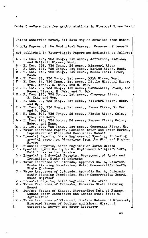
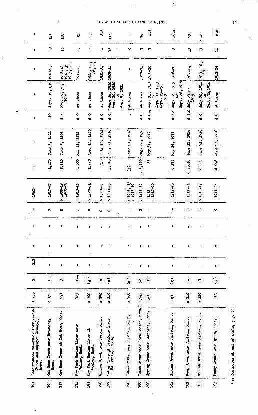
Table 3. Base data for gaging stations in Missouri River Basin
Unless otherwise noted, all data may be obtained from Water-
Supply Papers of the Geological Survey. Sources of records
not published in Water-Supply Papers are indicated as follows:
A - H. Doc. 193, 72d Gong., 1st sess., Jefferson, Madison,and Gallatin Rivers, Mont.
B - H. Doc. 238, 73d Gong., 2d sess., Missouri River C - H. Doc. 191, 72d Gong., 1st sess., Marias River, Mont. D - H. Doc. 146, 72d Gong., 1st sess., Musselshell River,
Mont.E - H. Doc. 88, 73d Gong., 1st sess., Milk River, Mont. F - H. Doc. 64, 73d Cong., 1st sess., Little Missouri River,
Wyo., Mont., S. Dak., and H. Dak. G - H. Doc. 76, 73d Cong., 1st sess., Cannonball, Grand, and
Moreau Rivers, N. Dak. and S. Dak. H - H. Doc. 190, 72d Cong., 1st sess., Cheyenne River,
S. Dak. and Wyo. I - H. Doc. 90, 73d Cong., 1st sess., Niobrara River, Hebr.
and Wyo. J - H. Doc. 83, 73d Cong., 1st sess., James River, N. Dak.
and S. Dak. K - H. Doc. 197, 73d Cong., 2d sess., Platte River, Colo.,
Wyo., and Sebr. L - H. Doc. 195, 73d Cong., 2d sess., Kansas River, Colo.,
Nebr., and Kans.M - H. Doc. 192, 72d Cong., 1st sess., Gasconade River, Mo. N - Water Resources Papers, Dominion Water and Power Bureau,
Department of Mines and Resources, Canada 0 - Biennial Reports, State Engineer of Wyoming, including
special report on Diversions from the Wind and BighornRivers
P - Biennial Reports, State Engineer of North Dakota R - Special Report No. 8, TJ. S. Department of Agriculture,
Soil Conservation Service S - Biennial and Special Reports, Department of Roads and
Irrigation, State of Nebraska T - Water Resources of Colorado, Appendix No. 3, Colorado
State Planning Commission, Water Conservation Board,State Engineer
U - Water Resources of Colorado, Appendix No. 4, ColoradoState Planning Commission, Water Conservation Board,State Engineer
V - Biennial Reports,.State Engineer of Colorado W - Water Resources, of Nebraska, Nebraska State Planning
Board X - Surface Waters of Kansas, Stream-Plow Data of Kansas,
Kansas Water Commission and Kansas State Board ofAgriculture
XY - Water Resources of Missouri, Surface Waters of Missouri,Missouri Bureau of Geology and Mines, MissouriGeological Survey and Water Resources
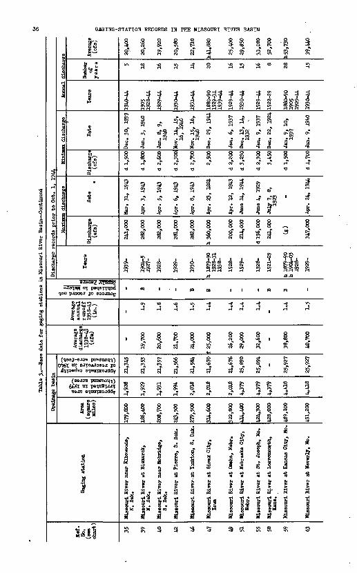
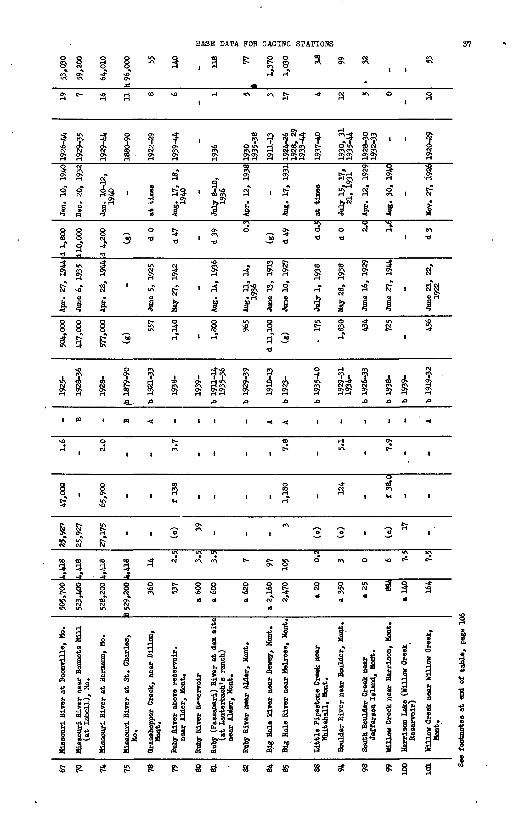
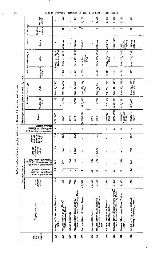
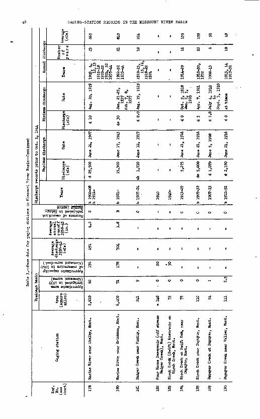
33

«& P .*&
If If f
8- * f *
s?a
El*
0» H O O In vo so CO
Approximate area irrigated in 1939 (thousand acres}
Approximate capacity of reservoirs in 1940 (thousand acre-feet)
Sources of records not published in Water- Supply Papers
N M Cs q «-!!Y ? *
VjJ H ft
4 ? 4" 4"
ai-
I II
911-16 921-31 934-39s s s I I - K> -i
*- O 10
H3AIH IHflOSSIH 3HI HIHOI1VIS-OHIOVO

BASE DATA FOR OAGIHG STATIONS
* *HH H H
ci S£ o g^H H
r-f ' ' ' "'
1 1
H- ' 3 a
H H
ag 01
ri * i'a CQ
r? Tl
a
1 ,
«? -
J . ^
s *
, «3 H
l^cn to"
r iH
a1 g?
1
Tl
1
s§Q
enT)
I-a
1
a
CT* iHS\ Sv
<q 01W Of
I 1<M «\ en <^ -T en
fc 8
? , ?
a g a-d- w\ so * oi <H CM OI -^ He
1 i i i l r
a a
m in in innt i i i i
C SO 5 5
&l 3
1 a'3 d
er .
River below ear Helena,
i i
6* § s I g I i >»» ^-«^ E ^ >.eck t.
River near
.
r r r ra s a
GAGING-STATION RECORDS IN THE MISSOURI RIVER BASIN
s? s?H-*T "f > -d; -*\ 3- 3
) ITiON O
igg S?
S3
>0 8
CM CM
3933 2? £j 2? 2J
i I
W VJ «-» *Jf i i *H H H
-a*)*M jou pjooaj jo saojnog
"* "?
H H
3 8 rf C?
8 §CM O
£ SI
pueenoq^) «T eJTfOAJassj jo
if cf if F!(88JOB
6C6T trr «3je e^Bnrpcojddy ^ 'Tl
I | §
I I I s i s I, I, 1,111
Sa gK aoi a
1 S S S
BASE DATA FOR GAGING STATIONS 37
o©
3
I3
3to
H" a
is?$§<j'
H
§
5
&u\ft
3_£
|
s.
»«"
^
IS
i
1 § 1 RS CD ^
siC- NQ i-f <0
? ? ? ?
g g? 8 g
Of
S «rC4
°" ^! ' 10 B^ *"
a -1 "8
§8-329 *« T>
rrt Oj W OJ H CPJ
^ to* i ^
41- 4§ § K£r fc M 4 K ^-
vO O f\ f'X CN f'XTO TO O* rH S OJ t 8
S-. *
« 1 « ««
O
1 ^ 1 1
°i i ivO
N t^
U\ C^CM Of
10 (0 <D -*
ij ^ 3
-* -? -f
Pj3 o a %o * ^ d1 §* I| 1 °. 1
u ; * j^ .gpp-j p » o 3*3 5 5 h 04 -S 2 nt g
^NO H WN ff\
-* 10 m f i 77 o vo o«\ Artv rtv ^rtv n*H H 3H H
8J" H
33 ' ti<^ 3 '
tH jj §
5 o d ^^T> ' £ .5
vO Q
-i O* -^ ON ON H i-t H
^ . 4 s§ a1 1 f I4 8 c^ SH- H- jf
-J^> C>* Q
SN § 3^ It K
A A
III 1 <
C-j
"* 1 1 II
to
2 r~. °* 'o "* i II
"j "0 "J ^ ^o
R § § § I0) 0) 0) Of
0a1 i
1 & i «r iR| | 5|| 3 |
j?3 fe a!3 j? «
o©
3
NO «-^
^ \
f g
3 t»
13
4
no
-
«
«
UN
^
1
Of
i fD
|
§
i
a
-*
1937-40
H p"8
f
to
si-T
1
s
?SJAi
i
o
o
f.
1
1
sig wt^"a
1 1
Pj «\ O Q
H
f'XffX |l Cil
"_. s § sC* H ON ON ON
oJw\ w o t~
t 01 b » i § 3 *
O dl p? c^
to of 5 >g 3 3 a« > ^" gf i aa
2fill 4O -* «\ NOS 3 S. SH" i
<-\ v\ <M f'x i O i i r *
§S § S5 S^ Ita a a o
i i i i ' «<
"* i ^ i i
o
1 M 1 1
3 ' 3
o NO rS 5
- * -
i iX X %£ a % J
1 § 1 S d
i 11 § I ii |s I i? 1g 1 £ t 4 g S
? i? ( a'* * Ȥ
River y (Bo
on River ed Bluff on Riveron River servoir,
ir el
10 10 10
N« H H
Approximate area irrigated in 1939 (thousand acres)
Approximate capacity of reservoirs in 1940 (thousand acre-feet)
G '
Sources of record not published in Water- Supply Papers
H I-1
S S 0, NO
O1) OQ
S 8
SIO V 1
cr mm
H1 O
NO N> ONox HO
£2V-Xfi
Kisva HSAiy xanossiw am HI sanooaH ROIJ,VJS-ONISVO

"BASK OATA FOR GAGING STATIONS
Pi t^ 0 ' tj CJ rH
S^SSR 3 * *" ^ 3
P rH CN1
' H ^T*^ ^
So 81 Sn H H H H H H
§ 0s
?(
S|» 3
ll I
§ P d -d
1 ia" a"
J-
g gs* °" d -d
J£J UN
a a aa
^ -
o i
Pi £
3 i
TO £>-
t S
H
fc 'i^-%4J «Q g Si
u* <?Oallatin (West 0*11 near Salesville, Oallatin River at L
ir\ g p-i
HI |d-o*« (*\H &*
S -f !I l jp O' 0
3 toOJ TO
» ^ '
ir\ vo ^ ox
a i
*|*
S5 8?8?n%Si ?5H HHHrH H
a a
t I 1
vO vQ
oj n;: . R
O O 1
PI O |
2f S ,
r3 Jd 9 D
"8 ^w S ig
3 JS 1^ 311 lh {*r-i omg^ »g
II A
« « C^ «J
^ S? Si ^fjl
3 » £ d»
jj r^
3 -* 3S pj «CM pT H r-T C*- N H 3 . .3 .
Jill
H "} H O p} CM -* <* -a -d
p7 o t~Ox PJ CM
i a - ^o o o§ § 1 ? -5 ?
^ 5 StI -d -d
3 ol H OH N
rf>
i <s at at
i i i 'i
i i i i
, O O H
-^ & to ^\ C5 c-' <s at H
i i.3 ^
§ & fa*"* *B &
d * S 11 1- i- ^ ° . s s s s 1 .Tola <3!J» &3 <S"S "
s«£ st i^ 1^gH *^-» S^-* oo1 E i -a« 0 0 P.
1910-13
a«t
1
H*s
1
s d
i-tJO
at
i
i
PI
(0
4»
1
Prickly Pear Creek East Helena, Morr
1922-24
_£
75
t"
Wl
o d
3
OX
ia
1921-24
at
i
i
Hd
3
Datchnan Creek near Alhambra, Mont.
!Si
H-
|vO H tl
1*
1
H
at
'
i
o
Jj
nKu
1
'! |jj »3 fH
/Voi -* 'OnvOP] C*N r-f
ft ^
'8 N
O d O
1 1 t >
4 15 §
d
3 3
03 0)
1 1
1 1
H PJ 0 0
a £at at
fn
» ito S
fa C
Ainamora, none. Lump Qulch Creek at near Clancjr, Mon lamp Qulch Creek at Zastrow's ranch,
Clancy, Mont.
%0>
3 9.«
e footnotes at end of
a a s a a a a P P

gI!&sitto tote
8to-J
1
1
ft)
o-
soG
wd>6to -5
0.
!To12to3
o.ptota ArssM
H HNO NO VO O?R u>H
10
R
*
ffl* f % w
p. »j
piP H*
rpfi
3.E P O
m o
«
PON O
H
P
^
£vn
b
1
of
1
&
S
f
P
to vSON
0.
O5o
ys f~oNO NO*- V*J H O^
K §
H
£
£
110
1
s
H
P
1
o-
iso'
1
1
1
1
1
1
fc
1to S-
l!t
hj
g
^
(ft
E *3°
M10 ON
P\n
1
ft)
u UJ
ss*- K>ivi> ONH
«*ttsON.
o.o
y H «* «'
K
S8 vnVAi
*»
P
?to
g
H
9
1o
1
£8»M
g
*
19
o
ft)
S *|'
a
S
1*
ION
1
Ot)
1
i s !>
Vrf
>R
£
1ta
S
1E! Pio"1
sp
0^
8
£M
o- a1JHH H^^g
w to H NVrf H
to
sIGto6
o--J
o& to'
NO M
eJ L_l L_l |_l
ja»s <o^E ;v-^p
13
?
G0»
oBffl 3§g.^
"3S-(D
H
s*-
ft)
HI-1SO NQ
£p
o.»
1so
toG
O.
o
&rt-iwa
i909-n 1914-24
p
ft
G-^
$11?p. H-
w <^
r-B
O
3S-hj
p
|:
o
1,
1
ft)
id>to
S
1S^ -j»
.*
0.
N
r « ^ eg i
1914-31
£
toON.to
G to G .p- NO to
CO 1-3 1-3
r J 1 A K ff
to Gi ta
ft)' 3C W
p. fe1 P-
"S* o* 6s1 * -&
to
s S £
0 VO o
1to to
P ON
10 H
v/i so
19 19 ft)
o- cr
to so to
G
*
2, f» NO <JC £-vn t>
|l I IO l-J
, p,« « .to$ § K3 --3 -^
P. a ao o oH
I| & »0 u. t*
=>" ,° 1 1-1L_I MM h-1 h-1
NO NONO NO NOQ V>»Q V*»H NO UtND \ftVt
G pa tS
NO Mvn vn -J
» 3 toH 0» 0>
ar'm'ss 3) |S.° R
O
c*(W
I§
&ffr ii«Approximate areairrigated in 1939 (thousand acres)
Approximate capacityof reservoirs in 1940(thousand acre-feet)
1arB-
^-.toa'5'Q vO O QH) m *3- H
» °
h?»j » >
?i!M ^.i H, p JSCoH,!-' 0
Sources of record notpublished in Water- Supply Papers
K
«
&a a
it <n
1
o .->»'ft B*N--1
<D
1O
r*4 ?* o i1 S(0 »j
^5"a!Hi
i§&8
2
P-5
^0
|&
10
o§a*t
3*g°rt- 0O5ij^ H
NISVS HHAJ.H IHflOSSIH 3Hi SI SCIH003H SOIIVIS-DSIBVO

BASK DATA FOR GAGING STATIONS 41
r* o Si ??
s , a
« CM -* q ir\7 t f Itir\ « ir\ ^o en£ O f£ OrK2i 5r o? 2*.j
^ ^ SO O C1^O^ O^ Oj
r-t H H
6 & ac^
v«r
1
*
ii
s«
ft
' ifO*4
, 1(M
O CO
ft * ft
.0
1 0)
to
ftSi4
S15
ft^
(Q
5
I t
1
1S
Ia
8 , S ,
1 S ft 5i
if ' *T '0 "
4 1
« i fJ i
S5
a
i i ' n \
°l "5O so O O -*
a -a -a -a i
I ft I 1 1
44444
c^ TO t^ MM |
-* -a -a -^ -'
-* CJ CM C* >O
i T T *? 7
A
a t ca li i
a
§Pi
4
gH"
IA
1
1
IrH
u?o
4
s
rft o
o
I II II
I I I
3I I r* ' I I I
CM H
O O O CM O O O O O O
H CM CO
3 5 S
. gi
So S > .MaS M o 5 15.3.h fl OH C4 O 09°5 ag fe I
& & o a x ?CO ncO +3-a!
o 5« o
it ?l ?! !*f\ W\ lf\ lt\ vO >O vQ "vQ vO D- H r-l Hi-i H rH H rHH r-i
42 GAGING-STATION RECORDS IN THE MISSOURI RIVER BASIN
s K
"*H ir\
CM'CM'CM
i i -a -a -a
| $ 8rH H O>
I I I
sinO* Ov Os
CM <*}
£ i& &<jv o
saadeg iCpldng M "T pet?ercqTKt
q.oupao38J jo ssoanogI O 00
piresnotjq.) 0^761 "T sjrpojusssj jo
6£6T "T BSJB
o o o
ff stream voir on
t. es
Res reeI* *iij? -el
r Ho Badg^ I" Ife* I ft -** 11 I o o
BASE DATA FOR G^INU STATIONS
I %0 <f
O* 0^ ON ON
ON Oj» r-H H (
>a o oCM CM -PC
8 13
I I I 4 4 I
1
Q
a
H-
en
RCM
<s
0 0
CM TO
H CO
UN OS;*
£ £c5g) O CM
a
0 0
' '
1 1
1 1
o m
O H
a
0 0 O 0 0*0
S oi § 53 5 ^°T( i-( cn 60 US
et>
H en w CM rH en ev
H CM CM O OH CM rHi-(2i a a a oc> o^ 212^A A A J3 J3 J3
o o o o i M I
1 1 1 1 III
till III
1 1 1 1 III
-*
° 3 "° 3 5 & °
CM O CA -4 "O -d" ^^ rl m CM i-l CM O 60
a a a <s Hm
a o
oX1.'
1
1
'
60
'M
o 3 *>0 « c>
in T< T< a
-* C- irt
2 CM 2
a a. aa
o o o
I I i
I 1 I
i I i
-* en IM)
| § 8<S a)
85 8

S K S £
f ! f 1 CO M EC CD ££** f C*g- <t go Fcr <t sr
a § o cr H-O H- o 3. 2j §.£1 § & g &
* § PS "L * s; ?c «* PC pp a p
r! F! it rl , , rE e£0 WM. hj.
J? §
B P
O H H O
\n H M m <jj vO £- O O O 0»
^ roM VI <J1 O
' <ol ' 'O
1 H 1 1
p
1 1 1«J
M
0000
cr crH H H H H
S ^ t £? F w to
&ro CL CL
O^ OQ \J* \Ji
O ^^ W \>i
1 1 1 |H <D « *<J
O fO M fO M
^ * HT3 io H £
\jj ro ju 0> to
p, p. CL CL
ro o o o
P <D c*~ P &"» ~a ^ IN j«
OU1O* P H*« *- too-.t \xro <t o " a> ro vo a fo *
P *" SMH H H K H-1 H H
i i ro i i ii A f~ PJ p A> H>-5 4=~ ^o -t" o» w
U> Hv>s *- o» K>
3 S S K00
H
North Fork Mi Delpine, 1
fS 5 a
' &8"
PB
p
fo H0>
OJo
^^0
1
1
1
H
H
$
1 (t
i°
._,sO
fj
ot
I ' . 1
H ip ! H
I
^
P
H
ro ro N w H H P o F to H ®
6s S f &
s r$ rf 1 3 p. M LJ.
a-f s=r g* i* Wo S B p 0 H-^_^ 4
p ® w o BO fS* * x H) p
* .&a "jpft c
° ri 1 3. < K
f *
0 v ' CN H
p 0 H p w Jo vn
^ x~.1 O O
~ CN ^
1 so ' *--J \J1
-J
1 ' ' H
SO
'to i i to
H H H H
sp M so sp
°- i"1U> H 1 Hf\J vB 8
I1 £ f» 5 f -*a ro
so H
M to o
CL"" ~3 1 °"0 0- 0
f &" 5" ^
0g-M »V ^S 3> * Oft 1- 5 " P8 p
H H H H
M U> Ui M
H ' M -3 W Vd
H S 1 p
To H
fo
Blackleaf Cr<
«
1a
gi
1
\ji
2x
i
i
i
o
H
I*-
O
8
1H1*
so
&
CL
O
&«*
8
H H H H
CO
H Oto
&«Tass)|S?R
I4
1*
1
§"i *? s< PO T _<5 ^>
Approximate area ^irrigated in 1939 . (thousand acres) g
' " - ' &
Approximate capacityof reservoirs in 1940(thousand acre-feet)
H&>
S^»|i^i-jr- j-j (S
a *
^_^H1 P :>»
^ '9* O C sL/*- Hl'P (S
to H H 0
Sources of record notpublished in Water-Supply gapers
0
" Io ma
2_g 8
** W S- °
« I 1& C**H- 0
1 1 r
H
_(2 £00 *
*i ip- H*
1 I » ^°
H<
3 I
<t P H-P ° S o
o J} M^
llalanossiw SSL HI scraooan NOIIVIS-OMOVS

221
222
223
224
225
226
227
228
229
230
231
232
233
235
Muss
elsh
ell
Riv
er a
ti-
iuss
elsh
ell,
Mon
t.
Muss
elsh
ell
Riv
er a
t K
osby
, M
ont.
Dur
and
Res
ervoir
on
Nor
th F
ork
Mtt
ssel
shel
l R
iver
(off
st
ream
Che
cker
boar
d C
reek
),
Mon
t.
Che
cker
boar
d C
reek
at
(nea
r)D
elpin
e, M
ont.
Spr
ing
Cre
ek n
ear
Mar
tin
sdal
e,M
ont.
Sou
th F
ork
Muss
elsh
ell
abov
eM
arti
nsd
ale,
Mon
t.
Sou
th F
ork
Muss
elsh
ell
Riv
er n
ear
Mar
tin
sdal
e, M
ont.
Mar
tans
dale
Res
erv
oir
(o
ff s
trea
mS
outh
For
k M
uss
elsh
ell
Riv
er),
Mon
t.
Am
eric
an F
ork
nea
r H
arlo
wtc
n, K
ent.
Leb
o C
reek
nea
r H
arlo
wto
n,
Mon
t.
Dea
dman
s B
asin
Res
ervoir
(o
ffst
ream
Muss
elsh
ell
Riv
er),
Mon
t.
Car
eles
s C
reek
nea
r L
ivin
g S
prin
gs,
Mon
t.
Car
eles
s C
reek
at
WaX
Lum
, M
ont.
*
Ro
ber
ts
Cre
ek a
t H
edges
vil
le,
Mon
t.
D 4,
760
8,01
0
a 70 24
.3
35
a 31
0
D 32
0
D 32
0
D 10
0 48
a 1
,45
0 18.5
a 40
0
300
40 56 0.2
0.1
0 8 B 8 5 3 32 0.4
1 0
_
62 7
_ _ (e) _
23
_ _
30
_ (c) _
_ 318
_ _ _ _ _ _ _ _ _ f 9.
5
_
_ 0.7
_ _ _ _ _ _ _ _ _ 0.4
_
D B _ D D _ D _ D D _ D _ _
b 19
23-3
2
1929
-32
1VJ4
-
1940
-
1908
-14
b 19
21-3
2
1921
-24
b 19
41-
1906
-15
b 19
30-3
2
1940
-
1906
-14
b 19
23-3
2
1908
-14
b 19
23-3
2
1941
-
1920
-23
b 19
34-4
2
1920
-23
2,13
0
18,0
00
_ d 16
7
d 23
0
954
d 1,
260
_ d
870
417
d 69 410
e 2,
290
June
9,
1932
June
18,
194
4
_
July
16,
19
23
June
21-
22,
1923
June
4,
1942
June
2-4
,19
11 _
June
1,
1908
July
6,
1928
June
15,
192
2
June
19,
193
8Ju
ne 4
or
519
42
June
17,
19
21
d 0
d 0
_ d 0.
6
(g) 5.
3
d 0
_ d 0
d 0
_ d 0
d 0
d 0
at t
imes
at t
imes _
July
13-
15,
1931 _
Feb.
28,
19
43
at t
imes _
at t
imes
at t
imes _
Apr
. 20
, 19
21to
May
7,
1921
at t
imes
at t
imes
1929
, 32
1930
-32
1935
-44,
_
1909
-14,
1922
-29
1932
1922
-24
1943
-44
1907
-15
-
1907
-14
1924
-28
1909
-14
1924
-28
_
1921
-23
1935
, 36
1938
-42
1921
-23
2 13 _ 15 3 2 9
.
V 11
3 7 3'
109
222 _ 9.
5
13 95 99 _ 22 15.6
_ 6.4
6.0
11.1
See
foot
note
s at
en
d of
tab
le,
page
106

Approximate area irrigated in 1939 (thousand acres)
5 H
Approximate capacity of reservoirs in 1940 (thousand acre-feet)
Sources of record not published in Wate Supply Papers
er er er er
§ JS fj * £ *-o *-oCo Co Co Co Co Coo to to to o> to
I §I ..I
p. p. o o
8- »
I I a a
8- §-
-
8)2A,jJ coo
vOVO (-"To-
MISVS HHAIH IHAOSSIW 3Hi HI SaHOCSH HOIiViS-OMIOVtj

248
249
251
252
253
255
256
257
258
260
262
266
268
269
Milk
Riv
er a
t H
avre
, H
ont.
Milk
Riv
er a
t L
ohna
n, H
ont.
Milk
Riv
er a
t M
alta
, H
ont.
Milk
Riv
er n
ear
Van
dali
a(a
t H
insd
ale)
, M
ont.
Milk
Riv
er a
t N
ashu
a, M
ont.
Nor
th F
ork
Milk
Riv
er a
bove
St.
Mar
y C
anal
,n
ear
Bro
wni
ng,
Mon
t.
Nor
th F
ork
Milk
Riv
er n
ear
inte
rnat
ional
bou
ndar
y(n
ear
Kim
ball
, A
lber
ta)
St.
Mar
y C
anal
at
Hud
son
Bay
div
ide,
nea
r B
row
ning
, M
ont.
Bfg
San
dy C
reek
nea
r B
ox E
lder
,M
ont.
Bea
ver
Cre
ek n
ear
Hav
re,
Mon
t.
For
t B
elkn
ap C
anal
nea
r C
hino
ok (
Tan
tio),
Mon
t.
Lodg
e C
reek
at
inte
rnat
ional
boun
dary
MoR
ae C
oule
e at
inte
rnat
ional
boun
dary
Nor
th C
hino
ok C
anal
nea
rH
avre
, H
ont.
a 5,
600
6,07
0
a 32
,500
21,9
00
23,3
00 62 101
_
a 1,
500
E9
5
- 797 53 _
n 10
n32
n 80
n 11
9
n 12
5 0 0
_ 2 2 -
n 2 0 _
- 130
- _ 324
(o)
(c) _ - - -
11
(c) _
-
fit
242
- _
f 79
5
f 11
.2
fit
213
f 20
2
- - - f 37 f
2.5
_
- 0.3
- _ 0.5
2.4 1.3
_ - - - 0.7
0.6
_
E E E E - E £ _ E E - E E _
1898
-192
2
1922
-25
b 19
34-
1902
-22
1907
-20
1928
-39
1939
-
1911
-12
b 19
20-
b 19
09-
b 19
17-
b 19
27-3
2b
1934
-38
1918
-21
b 19
03-2
1
b 19
10-
b 19
26-
b 19
28-
(8)
3,45
0
d 11
,500
25,2
00
17,4
00 659
1,49
0
_
561
500
- 5,11
0
976
_
Mar
. 12
, 19
16
Mar
. 21
, 19
39
Mar
. 27
, 19
18
Apr
. 11
, 19
17
Apr
. 2,
19
43
June
12,
19
37
June
12,
193
7
_
June
25,
19
38
July
13,
19
20
-
Mar
. 30
, 19
43
abou
tM
ar.
29,
1943 _
d 0
d 0
d 0
d 0 11 0
d 0
d 0
d 0
d 0.
1
d 0
d 0
d 0
d 0
at t
imes
at t
imes
at t
imes
at t
imes
May
24,
194
1
Oct
. 29
, 19
42
Mar
. 1,
2,
1940
at t
ines
at t
imes
June
26-
28,
1919
at t
imes
at t
imes
at t
imes
at
tim
es
1899
1922
1923
-25
1935
,19
39-4
4
1903
-22
1908
^20
1929
-39
1940
-44
1912
1921
-30
1910
-30
1917
1920
-23
1926
-30
1932
-41
1943
, 44
1928
-30
1919
-21
1904
-5
1911
-13
1916
1917
-31
1934
1936
, 37
1927
-31
1933
-37
1929
-31
1933
, 34
1938
-40
1944
24 10 20 24 5 11 21 22 3 3 6 18 10 9
m30
4
m25
1
m44
8
m67
7*
678 31
m 11
4 g 5 M
156
fe > *d § i17
8 B
Q
9.6
g ^14
.0
1
oo
38 1.7
5.6
See
foot
note
s at e
nd o
f table, p
age
106
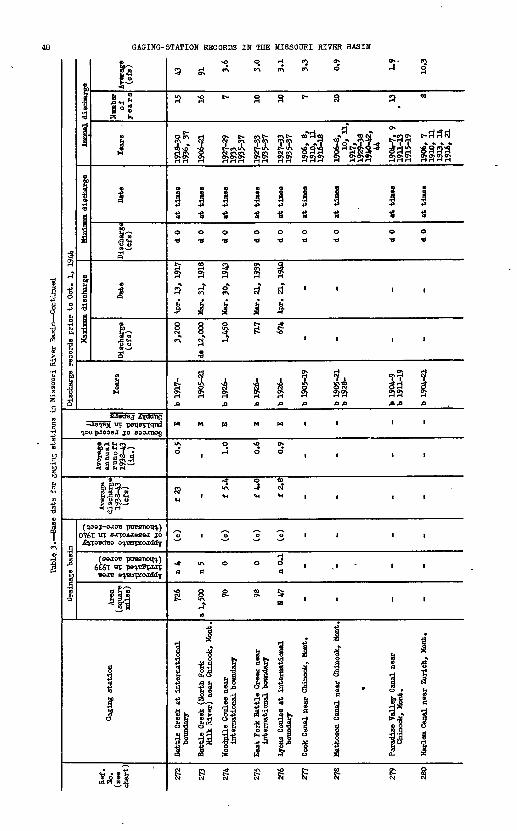
Table, 3. Base d
ata
for ga
ging
stations
in Mis
sour
i River Basin Continued
Ref
. N
o.
(see
ch
art)
272
273
274
275
276
277
278
279
280
Gag
ing
stat
ion
Bat
tle
Cre
ek a
t in
tern
atio
nal
boun
dary
Bat
tle
Cre
ek (
Nor
th F
ork
Milk
Riv
er)
near
Chi
nook
, M
ont.
Woo
dpile
Cou
lee
near
inte
rnat
iona
l bo
unda
ry
Eas
t Fo
rk B
attl
e C
ree*
nea
rin
tern
atio
nal
boun
dary
lyon
s C
oule
e at
int
erna
tion
albo
unda
ry
Cook
Can
al n
ear
Chi
nook
, M
ont.
Mat
heso
n C
anal
nea
r C
hino
ok,
Mon
t.
m
Par
adis
e V
alle
y C
anal
nea
r C
hino
ok,
Mon
t.
Har
lem
Can
al n
ear
Zur
ich,
Mon
t.
Dra
inag
e ba
sin
Are
a (s
quar
e m
iles
)
726
a 1,
500 70 98
H 47 _ _ - _
o*
^
fij!
ill n 4
n 5 0 0
n 0.
1
_ '_ - _
£§5
oximate capaci reserv
oirs in
1 nusand
acre-fee
B
M
V
£"*
*£
(c)
_ (c)
(c)
(c) _ _ - _
Ave
rage
di
scha
rge
1938
-43
(cfs
)
f 23 _ f 5.
4
f 4.
0
f 2.
8
_ _ - _
Ave
rage
an
nu
al
runoff
19
38-4
3 (i
n.) 0.5
_ 1.0 0.6
0.9
_ _ - _
1 U
V *
H -
PI
8||
oh
a
M
H
4>l
itl £ E E E E _ _ - _
Dis
char
ge r
ecor
ds p
rior
to O
ct.
1, 1
944
Tea
rs
b 19
17-
1905
-21
b 19
26-
b 19
26-
b 19
26-
b 19
05-1
9
b 19
05-2
1b
1928
-
b 19
04-9
b
1911
-19
b 19
04-3
1
Har
imum
dis
char
ge
Dis
char
ge
(cfs
)
3,20
0
do 1
2,00
0
1,45
0
717
674
_ _ - _
Dat
e
4pr.
13,
191
7
Mar
. 31
, 19
18
Mar
. 30
, 19
43
Mar
. 21
, 19
39
Apr
. 21
, 19
40
_ _ - _
M^rv
tinmn
dis
char
ge
Dis
char
ge
(cfs
)
d 0
d 0
d 0
d 0
d 0
d 0
d 0
A 0
d 0
Dat
e
at t
imes
at t
imes
at t
imes
at t
imes
at t
inea
at t
imes
at t
imes
at t
imes
at t
imes
Ann
ual
disc
harg
e
Tea
rs
1918
-30
1936
, 37
1906
-21
1927
-29
1933
1935
-37
1927
-33
1935
-37
1927
-33
1935
-37
1906
, 8,
1910
, 11
1916
-18
1906
-8,
10,
11,
1917
,19
29-3
*19
40-4
2,44
1904
-7,
9 19
11-1
319
15-1
9
1906
, 7
1910
, 11
1913
, 14
1916
, 21
Num
ber
of
years 15 16 7 10 IX
) 7 20 13 d
Ave
rage
(c
fs)
43 91 3.6
3.0
3.1
3.3
0.9
1.9
10.3
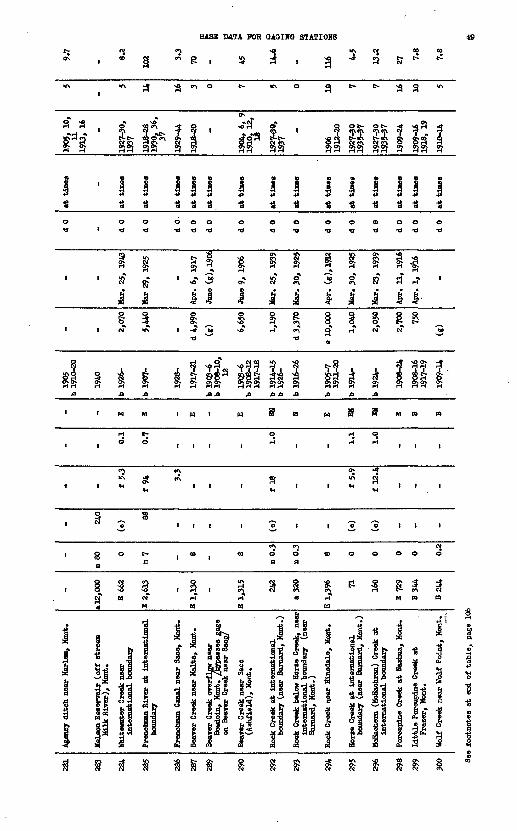
281
283
284
235
286
287
289
290
292
293
294
295
296
298
299
300
Age
ncy
dit
ch n
ear
Har
lem
, M
ont.
Kel
son
Res
ervo
ir (
off
str
eam
M
ilk
Riv
er),
Mon
t.
Whi
tew
ater
Cre
ek n
ear
inte
rnat
ional
bou
ndar
y
Fren
chm
an R
iver
at
inte
rnat
ion
al
boun
dary
Fren
chm
an C
anal
nea
r S
aco,
Hon
t.
Bea
ver
Cre
ek n
ear
Mal
ta,
Mon
t.
Bea
ver
Cre
ek o
verf
low
nea
r B
ovdo
in,
Mon
t, /b
ypas
ses
cage
on
Bea
ver
Cre
ek n
ear
Sac
o/
Bea
ver
Cre
ek n
ear
Saco
(A
shfi
eld),
Mon
t.
Roo
k C
reek
at
inte
rnat
ion
al
boun
dary
(ne
ar B
arna
rd,
Mon
t.)
Roc
k C
reek
bel
ow H
orse
Cre
ek,
near
in
tern
atio
nal
bou
ndar
y (n
ear
Bar
nard
, H
ont.
)
Roc
k C
reek
nea
r H
insd
ale,
Moa
t.
Hor
se C
reek
at
inte
rnat
ion
al
boun
dary
(ne
ar B
arna
rd,
Mon
t.)
McE
ache
m (
MeE
aehr
an)
Cre
ek a
t in
tern
atio
nal
bou
ndar
y
Por
cupi
ne C
reek
at
Nas
hua,
Mon
t.
Lit
tle P
orcu
pine
Cre
ek a
t F
raze
r, M
ont.
Wol
f C
reek
nea
r W
olf
Po
int,
Mon
t.
-
a 12
, 000
E 66
2
B 2,
613
-
B 1
,13
0
~
E 1,
315
242
a 32
0
E 1,
396 71 160
B 72
9
B3
44
B24
4
-
n 80 0
n? - 8 - 8
n 0.
3
n 0.
3
8 0 0 0 0 0.2
- 240
(c) 88
- - - - (c) - - (o)
(o) - - -
- - f 5.
3
f 94 3.
3
- - - f 18 - - f 5.
9
f 12
.4
- - -
- - 0.1
0.7
- - - - 1.0
- - 1.1 1.0
- - -
- - E E - E - B EH N E EH EH E B B
1905
b
1910
-20
1940
b 19
26-
b 19
07-
1928
-
1917
-ZL
b 19
03-6
b
1908
-10,
12
1903
-6
b 19
08-1
2 19
17-1
8
b 19
14-1
5 b
1926
-
b 19
16-2
6
b 19
05-7
19
11-2
0
b 19
14-
b 19
24-
1908
-24
1908
-16
1917
-19
1909
-14
- - 2,07
0
5,44
0
-
d 4,
990
(g) 6,65
0
1,19
0
d 3,
370
e 10
,000
1,04
0
2,05
0
2,70
0
750
(g)
- -
«ar
, 25
, 19
43
Mar
29,
192
5
-
Apr
. 6
, 19
17
June
(g
), 1
906
Jane
9,
1906
Mar
. 25
, 19
39
Mar
. 30,
1925
Apr
. (g
),19
J2
Mar
. 30
, 19
25
Har
. 23
, 19
39
Apr
. 11
, 19
16
Apr
. 1
, 19
l6
-
d 0
- d 0
d 0
d 0
d 0
d 0
d 0
d 0
d 0
d 0
d 0
d 0
d 0
d 0
d 0
at
tines -
at
tines
at
tines
at
tines
at
tines
at
tines
at
tines
at
tines
at
tin
es
at
tim
es
at
tines
at t
ines
at
tines
at
tines
at
tines
1905
, 10,
11
19
U,
16 -
1927
-30,
19
37
1918
-28
1930
, 36
, 37
1929
-44
1918
-20 -
1904
, 6
, 9
1910
, 12
,
1927
-30,
19
37
-
1906
19
12-2
0
1927
-30
1935
-37
1927
-30
1935
-37
1909
-24
1909
-16
1918
, 19
1910
-14
5
-
5 14 16 3 0 7 5 0 10 7 7 16 10 5
9.7
- 8.2
102 3.3
70 - 45 14.6
- r*
4.5
13.2
27 7.8
7.8
See footnotes
at e
nd of ta
ble,
page 1
06

GAGING-STATION RECORDS IB TBS MISSOURI RIVER BASIN
+»o
h
t
|
1 ria
o
Annual dischar
o
H o
!
CO D9
S l>>
1 .
i
f!
I
fl i
saoagj jrtaang *is^ft or peii&^qnd
y>u pjooaa jo eaojnog
»r^y g^
Z rt m fS 9 O <*"\ O** 3^*^'
Drainage basin
0*761 UT Bj^oAJasaj jo
(BSJOB poesTioift) 6£6l "T pe^B&iirp
a S'o o 2 »
I
frjl
rj
3
1930-32, 36 1939-44
1
0 a -
15?
t
!m
-* o
°1
4-1
i-l
-O
<3
-*
I
1OS
8
2CM
-0*
S
I*0 o
1141Sa*
A
i
d
O--9*4-1
O
0
t
Middle fork Poplar River at international boundary
8
'
0
i
n
«
0 o
1311
!1
-0
d
34-1
O
d
1N
S
ra
1|
(2
it
t~
a
as? '
«o^
a
o a
ia1-
s
1908-24
ca
I
i
I
d
IM
CL.
I
CL,
S
to
CM
1
1
*
0 o
1?J18r-T
d
,4
i
«0
d
ON
I-l
3
o
CM
'oplar River at .ional boundary
PS
«> o
CM
ia
1
*
O a
ON
S?
1M
A
i
o
-
o
o
3
'oplar River at tional boundary
l!8
3 u\
H w\
SO Ns a
1 * * 1 .»d co
0 0 o -o
_, 1CM H
i" i
of i-T a -o
?R SH i-l
i n
45
CJ
1
O 1
-* 'o d '
§ IA JO
d i-Tn
1 lsi *o S
?!S 3
s ' !-a « a
I IS S
-0
S! ' * P 0
"S a
0 , S
H CM
S . S
A ' ??
1 1
H" 1 ^ 0 T*
1 ^ i
a i i
, 9*
1 1 CM r?
/' 2 3
d o o
CM* r? rfCO
3reek near Bon, Hont.
a Lake at Lake Hotel, bone National Park
a River at
$ ff 2
a a a
&S
s-r!
lellowstone Lake Outlet, 7ellow8tone National Park

BASE DATA FOR GAGING STATIONS
988 S 3
o
'
'
M
a
CM
4o
to*
1P
''
0
1H
>rl
n CL,
ll 1
IsJe S^98g|j
w^ '
«0
1890-93 19U-44
S5'
1<oCM O
«
rla48
CM a
b o
1CM
^
""^
O
O
CM
i
i153h m
8*|q
^
a P
ICM-* S * 3?J ^«JCNCM C^ CM ^C-l
0 CM
rH* H
a" a"§ §^ Q
0 0
£ S3 o
3 3
4 48 8o *
oONCM
ONCM gj o c^rH rH rH rH H
1 1
CM H
P
<2 oI 3CO NO
CM
S 4>
e£ ^1 . l|MS B! 3 on*
a s
CM WJ.
O f\
H rH*
«- 1w rH
CM O 3
g §a a
0 NO
H" -a d
3 3
4 48 8«0* vO*U\ CT*
1 !<*S iH rH
1 1
NO
1 "
, 1s
o1 °"
s &§ £
U UJ'
!i !*MS? «£
pp§ 5
* 51 S S S
4- H -* <M co *r\O *^ -* CJ\ -T CJ\
H S S H H H H
r-l *» i-l i-l &J
^ *»r^ I W ri tf + H \OW^OPi t^ iH W
i 4 i i i i
H H T3
d -o
S ' S § c7 8'H ^ r-l r-l
CT* W CM O ^
O O
§ § q] & &
88 838£? o? CM* -d cp
d
1^ S *!??& Ogj H gj N gl
H rH H rH rH rH
11 III
t^ r- PJ CM ro fr
0 H £j
II ^1 Vi
i? - -II 00
3 © <o^ ° °
O O O pH OSo UN R -5CT> TO -* NO
ij * 3* * I ll | IHj L* P^ ^ si** sf s * ** 'i ^^°1JS-5 Jo* Jfel os Jiffll
CM cQ CM CM CM
u% C^
J* J
H rH H
cf
s?g I1 uO O
S3 3
H" Pi r«a «a
, 1f- f-
S S
1 1
-O
t^
s-> S-*
o o
0 0
i i
L io| "
*l d!i|ia § 3 f
11 !]
N P"l
1
1
fi13
ii

fc 15 H
H!?
e a
o o o ok Jo
o o o oApproximate area irrigated in 1939 (thousand acres)
O O O IApproximate capacity of reservoirs in 1940 (thousand acre-feet)
i i i
Sources of record not published in Water-
tr <f 0" 0" 0-H H ^t ^J ^t ^t
r| |S8 «
*- B. H B.
r r iH 5
J? ?
I s;S
SO 0» IS
j\» \>> 1 O 9^-vl> i- M 3*-
H O (O O
MISVS HSAIH IHflOSSIH SEH£ HI SdHOOSH
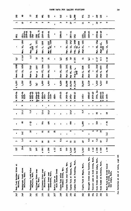
BASE DATA FOR OAOISS STATIONS 53
«r» ° 3
»CM3 I
8§ I S Ssl §
1 3
J. B
jCM*
is* 'ii i i
sj-f » * i I£ a ?
' ' if
i ? a8 a
3 "5
j ja a
I I f i I 11111
a a 3 T»
a >
I*as?» ^T190 193
CM Q ST T .
18} S?
i i
i 3' S i
O O -*
§i ST S 8i-f H ON <^
II
O 4> *}I
P« M
a 1 «* w w
P Pi i ii 11 i ii ^ ^ ^ West F Bas Red
-2*«ys ysb 1^5*^9 _Q 1$'3"^'-« - "-..-3 *a aii ii ii i I* s ai il 1 « -a * « § i f «* g05h F-t *H«*H«i^«kOj5jQOd(0Q <0 « 8> ** O 8) **
SH U ! I Hlliin ! 5!i r s

Table 3. -Base data for
gagi
ng s
tations
in Mis
sour
i River Basin Continued
Ref
. N
o.
(see
ch
art)
368
369
370
371
373
376
377
380
381
382
383
Gag
ing
stat
ion
Wes
t Fo
rk R
ock
Cre
ek n
ear
Red
Lodg
e, M
ont.
Red
Lodg
e C
reek
abo
ve
Coon
ey R
eser
voir
, ne
ar B
oyd,
Mon
t.
Coon
ey R
eser
voir
on
Red
Lodg
e C
reek
, M
ont.
Red
Lodg
e C
reek
bel
ow
Coon
ey R
eser
voir
, ne
ar
Boy
d, M
ont.
Will
ow C
reek
nea
r B
oyd,
Mon
t.
Pryo
r C
reek
nea
r B
illi
ngs
(at
Cob
urn)
, M
ont.
Fryo
r C
reek
at
Hun
tley,
Mon
t.
Hin
d R
iver
at
(nea
r) R
iver
ton
(nea
r A
rapa
hoe
Age
ncy)
, W
yo.
Big
horn
Riv
er a
t T
henn
opol
is,
Wyo
.
Big
horn
Riv
er a
t M
ande
rson
, W
yo.
Big
horn
Riv
er a
t K
ane,
Wyo
.
Dra
inag
e ba
sin
Are
a (s
quar
e .f
iles
)
a 80
a 14
0
a 21
0
a 21
0
a 45
a 40
0
800
2,32
0
3,08
0
U,9
00
15,9
00
_o»
3 S
I'S
8H
2 »
58
|fi 3.0
10 21 21 11 2 2.2
73
128
187
275
oaimate
capacity reservoir
s in
1940 aiaand
acre-f
eet)
K
M a
Q*
tCJ
%'S
S
(c)
(c) 28 23
(c)
(c) - 17
7
193
199
257
Ave
rage
di
scha
rge
1938
-43
(cfs
) 70
f 70 - 96
f 28
f 46 - 80
4
1,40
0
-
2,21
0
Ave
rage
an
nual
ru
noff
19
38-4
3 (i
n.) 16 10 - 10 15 1.
7
- 5.9
2.9
- 2.5
xses of
record
not Liahed
in
Water-
xbr
Papers
ItH- - - ~ - - '- - - - ~
Dis
char
ge r
ecor
ds p
rior
to O
ct.
1, 1
944
Yea
rs
1932
, 19
34^4
4
b 19
37-
1939
-
1937
-
b 19
37-
b 19
11-2
4 19
38-
b 19
04-1
6
b 19
06-8
19
11-2
7 b
1928
-
1900
-05
1910
-
1941
-
1928
-
MaT
rirnin
n di
scha
rge
Dis
char
ge
(cfs
)
1,85
0
1,05
0
-
1,51
0
469
1,50
0
d 1,
560
d 12
,300
29,8
00
17,9
00
25,2
00
Dat
e
June
22,
193
7
June
17,
194
4
-
May
30,
194
2
June
2?,
194
4
May
H,
1942
July
3,
1912
June
14,
190
6
July
24,
192
3
Jane
4,
1944
June
16,
193
5
Mjjr
^miiT
fl di
scha
rge
Dis
char
ge
(cfs
) 2.5
1.5
-
1.6
1.2
dO d 0
d 80
d 16
2
d 16
0
d 17
9
Dat
e
Mov
. 18
, 19
39
May
27,
193
7
-
Dec
. 21
, 19
37
Aug
. 1,
193
9
at t
imes
July
26-
28
1908
Nov
. 13
, 19
40
Nov
. 14
, 19
40
Dec
. 11
, 12
, 19
43
Aug
. 21
, 19
44
July
22,
193
4
Ann
ual
disc
har
Yea
rs
1935
-44
- -
1938
-44
-
1939
-44
19U
, 14
1908
19
11-2
7 19
29-4
4
19G
1-05
19
11-4
4
1942
-44
1929
-44
Num
ber
of
year
s
10 0
-
7 0 6 2 34 39 3 16
;e Ave
rage
(c
fs)
66.5
- - 101
- 54 48
1,10
6
1,91
0
2,05
0
2,28
4

BASE DATA FOR GAGING STATIONS
s a * P a
a
3R
sON
%
1
S
RH
S
1S a
4-S
1
=*
^7^S58
S^
^
1 a
«p(
ii3*
«£
H i-l
f>
1
3 a H
i $ $ ? g g g
S in cR *
^I i I a *a M
0? t] ON
iH rH ON
0? 3 r-T
t § & §11
ass ^H H H
2 ^ ST> e
% ' "i O>tq H O>H u OH gj O w o
A .0 j:
1 1 |
1 <» n
-* -* _* -* (M 15 J-
f ' ? T f , . T3 S g | g g gi~l rH M rH rH rH rH
a H g ^ gOJ
| 4 i 4 iX fr, ^ &, ^J
' *d I * *o Ms.^ 7S
-^ 40 3 H «-f -f
^ H S ^ SoT ' 3* ' ' e^ ?}& oT0) B ID ID M <DII IIIs s § s s*M 1 Q> 1 C*- C1* rH
Ol p\ Ol O\ ^
a T»
, a-* o,s1 ^ i i i i il IH> JO .CUt)
III 0 0 1 1 1
R
Sa"
1 a
1a^1
H
1
'
1a"33.21
d a
7td r?
^
1 .
H a
e-
I*!JO JB
O
I I I I I
I ,
I I I I
000
I *
I ,1
II »;I! If
i Si
i * i I ! fiI £ 3 I !!. : «i3 § 1,? 5 "S 2 s- fei ^ !* ! I 1 § .£i I8 & JL* §, 38 «,? ?* «* 1 II * 3l bl 8. SS1 S II 8.1 Si I ff *| *&« I «! K 3I a § tl a«r& 5 ' w I-N.S 5* S'g si 1^ <fi«
« «l S ^i ft, ft. S5 3
o ON

Tabl
e 3.
Bas
e data for
gaging
stat
ions
in Mi
ssou
ri River Bas
in C
onti
nued
Ref
. N
o.
(see
ch
art)
412
414
415
417
431
432
433
434
435
436
439
Gag
ing
stat
ion
^Sou
th F
ork?
Lit
tle
Win
d R
iver
ne
ar F
ort
Was
haki
e, W
yo.
Lit
tle
Win
d R
iver
abo
ve
Ara
paho
e, W
yo.
Nor
th F
ork
Lit
tle
Win
d R
iver
at
For
t W
asha
kie,
Wyo
.
Bea
ver
Cre
ek n
ear
Lan
der,
Wyo
.
Sout
h Fo
rk O
wL C
reek
nea
r A
ncho
r, W
yo.
Sout
h Fo
rk O
wl
Cre
ek a
bove
(at
) C
urti
s R
anch
, ne
ar T
hera
opol
ia,
Wyo
.
Sout
h Fo
rk O
wl
Cre
ek n
ear
The
rmop
olis
(O
wl
Cre
ek n
ear
Eufc
ar),
Wyo
.
OwL
Cre
ek n
ear
The
rmop
olis
, W
yo.
Ow
l C
reek
nea
r L
ucer
ne,
Wyo
.
Nor
th F
ork
Ow
l C
reek
nea
r A
ncho
r, W
yo.
Kir
by C
reek
nea
r L
ucer
ne,
Wyo
.
Dra
inag
e ba
sin
Are
a (s
quar
e B
ilee
)
118
716
127
118 86 139
191
484
505 58
.2
240
11
1
H a
n
0 22 1 0.3
0 0.2 1.6
9 12 0.5
0.1
Approximate
capacity of
resarvoirs
in
1940
(thousand
acre-feet) 8
- (c)
(c)
(c)
(c) ~
1 1
(c)
(c)
Ave
rage
di
scha
rge
1938
-43
(cfs
)
- - - - f 35
f 33 - f 35
f 23 - -
Ave
rage
an
nual
ru
noff
19
38-4
3
- - - - 5.4
3.4
~ 1.5
1.4
- -
Sources of
record
not publish
ed in
Water- Supply
Paper
s
- - - 0 - - ~ 0 - - -
Dis
char
ge r
ecor
ds p
rior
to
Oct
. 1,
194
4
Tea
rs
b 19
21-4
0
b 19
06-9
b
1911
-13
b 19
21-4
0
1938
^41
b 19
39-4
3
1931
-32
1938
-
b 19
21-2
2 b
1929
-32
b 19
10-1
? 19
31-3
2 19
38-
1932
-33
b 19
38-
b!9
41
-
1941
-
Mft-
gim^n
i di
scha
rge
Dis
char
ge
(cfs
)
5,22
0
3,84
0
2,64
0
167
1,94
0
1,07
0
480
1,19
0
698
1,08
0
980
Dat
e
July
9,
1926
June
17,
191
1
July
9,
1926
July
26,
193
8
July
25,
194
1
Aug
. 11
, 19
41
Aug
. 15
, 19
30
Jane
4,
1944
May
27,
194
2
May
25,
19
42
Mar
. 10
, 19
42
MJJI
J^IW
P di
.sch&
rge
)isc
harg
e (c
fs)
(g) (g) d 8.
5
dl.
2
dl.
9
d 0
d 0
d 0
d 0
d 0.
9
d 0
Dat
e - -
Oct
. 28
,193
9 to
N
ov.
1, 1
939
Au»
. 17,1
940
Nov
. 10
,193
9
at t
imes
July
17,
21,
24
, 19
31
at t
imes
at t
imes
Nov
. 16
, 19
43
at t
imes
Ann
ual
disc
harg
e
Tea
rs
1921
-37
1912
, 16
1921
-37
1939
-41
1941
1939
-44
1931
1939
-44
1939
, 40
, 19
42-4
4
-
1942
-44
Num
ber
of
years 17 2 17 3 1 6 1 6 5 0 3
Ave
rage
(c
fs)
132
260
125 11 56 37 33 47 28 - 15

BASE DATA FOR GAGXHG STATIONS 57
* rf .a
C<\ <^l C<\
<^ o* 0*0*H H H H
I 1 '
18 H
I « '
i i ft ftM g 1
1 1
» §
d
r-\ H H
O O O
£ £ '
ON at
CM CM |
3 S
t& P*s*
1 1
i(ij§ § B 'd
II 1 ^
- C7
e-> c<\
1 ft
a a
1 14» 4»
* *
0 0
11 HO
1'M "i**-* rH
O
H0 0
1 1
o o
H0 0
ft S
" "
1
i ii l$ "£9 O «
" I 93 »lrt £3°
Pt
c<\
1942-44
i
ii8 1 d
1
o
o
o
r1Creek near
3i!
S
ir>
H
1aic-o d
10 QsiCM CM
iis
ii
CM
<0
-a
CM"*
§
i
1eek near T
3
!
i0
1
1-?
c^ft
rusH d
1
1?
1O
«?
ftJ3
1
1
1
a
|H
1
in
6
!
ga
«
ftSft
ft ^1
n*
HH
1
RsO
CM
ft^i
i
i
a
CM
CM
1
186-1
1-
1O
8-
CM «8 O lf\ e<\
H CM
3 Oi 9JS 3^ 5JT fl If »*!
oj?1 -j oj &jHOJ ON H H
CM O? CM* CM N
tt i I i«~ 3 -3 ° 'Si dH H ,) >S H
-f c? S M S-5 CN CTJ r-l O> ON H H ON H
« cl a" c^ 8"1 J I 8 1«> O O Q Q
** « ^ s d
* c- QPJ fjvg r ^ rftf f ^
ft ft
I 1 1 1 1
0
1 1 1 I
£Ro o 1 1
0 0 -* xO g
S | | | §
1
§ £ £
h a& « s P -a 2 1 * -si f* 2^I la H Is |«0 ^S HI d-i ^-l
1 i* 1^ 1^ P
ft
s
2s
1
o d
1aiRUN
i
'
CM
£ft
£R
S
oaH
1
1EiTer near
3I
a
s
Hiirf4ON d
1«*
1
Ii-i
iujAH rfjft ftftft
o
'
CM
to
«
O
<&CT\
a
1i
ib
IPS
S
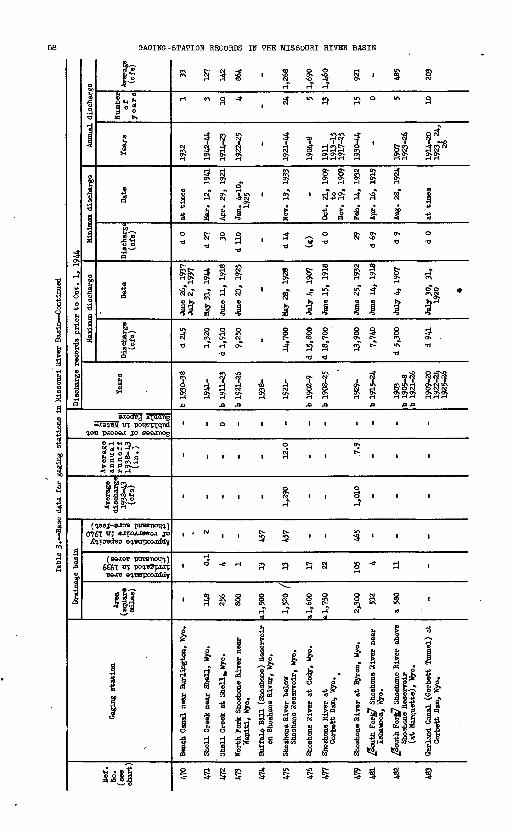
v5 fS ?3 ^B ^3 3^ vi ^ Ci To p3
£ fc Jf« g o^ f J 5 *J ^ «II S-ffl |? | f| | fl ^| f!* o o
Iff ill II » !» » l» fg H 1 1b Cj a W^^^ * ^""^ w piSSwSp X* Cf* te aI ^ S-g" ,S" * J< * * » * » ££ og * g
1 fit If.* 1 $ If » f 1I? 5" !? " *; ^ § » S ? ^
t ! i ' !§P W H I-1 H H ^ ****** \n \jt \ji -»jcr* ^rt vi &MK
i K"1 Q M (-* J~* J~*
' ' ' ^ ' ' § § ' ' !0
I 1 > g ' « ^g ' ' ' 'O O
, , ' ' G ' ' '
§
1
O
1aH
1
f
f
1
1
i 1
1
1
1 1 | 1 II 1 1 1 O 1 |
o-er er er o- er er|_lt-l|-J|_IUl-l t-ll-l t_lt_l |-l |-l |-l|_l|_lso so so sOsOsO so so so so so so so so so MMQIOOQ HW Qfi N ^ Nh1^"OtK>*o P05CS vjisp T*i T ?* ill &>K>IO Nfc N 10 si) A> J« O\^- o os £- , vn Os \*>
P. P. pi M>
p. vi -J tj otvnf- soHl-1
£ O{~Q SxS snl-JIO
t, t, t, t, t, t, DK c, c,. S& &&B SP4 iff
g% ^gg §^K, °fflW So f" t\« inf" ?* (opi""
i_i t_i t_i i_iVd sOI-'l-1 HsOsO HHsO
-H SK^ 5s* iSS1'O.
CNIO Clxl-i ' Pv>)M O sOsOso O £" OO-»4
p >>*4aao ^! <L, > s;
H 1 ? .& ? r ? H.S ? F & M JH H H e* W H to*- to M
fcjiovOvO^JD in ioio
^- sO W vD M3 ^>> H H
ss tsg e sss s e s s s^** ^ ' ' Jl J ' X. ' ' iii
SH >J M H VtOVt O>u<4> ^- O \jJ
^ ^ »
S « i3 000» *-fi-4
tr
1930-38
P.fc?G
I-j
o
8-
r
sIO
I-1
U)
|irj,
fi'mm
& tg
sL§
Approximate area irrigated in 1939 (thousand acres)
Approximate capacity of reservoirs in 1940(thousand acre-feet)
fa
H£>
||||o
H 1 f >
FfSSS s^-f-HP" SC» f* !- ffl
Sources of record notpublished in Water-Supply Papers
o
~K2" S
o3o
5
«J
go
!2 r p o B * ^g
-1"
2,9
sX
i
1m
fP:S?
|
|o
at-*
OD 0
§
a a
oc*o
c*
H
i?!
eHId
Ig
E£ 9
ikg-c*- H-
H*
to
w8
to
NISVa H3AIH IHnOSSIR 3HJ, NI SOH003H NOIiViS-ONIOVO

BASE DATA FOR GAGING STATIONS
«
IA
9
i3*
io *
Is18"5H
IA
1
rj
«\ CM
<H
O
-*
o
a
^£$$* 2I*"
1
"* 8H <M
O mom
$ S
ON 5} t^ > ;?S H £H cvj ON
8?°° 33 cijUN 0?
4> ;-) . J4 *»M p. a b o. . g ,2 j? o. fe<< CO ' a *q CO
O 01 CM t-cJ m CM o
ON ^ O> ^
0 « NO* «P"\ C^ ?1 -^
i J 1 1
§ I N| I4 W H c^i
? 7 .SN s 555 FK SH H H H
.n ja
i i i
NO «
3 P
1 Q | O
CM <M
O O H NO
«\ ON O ON «\ ON NO M rH rH CM -»
a
b t, t*
' I ^ 1
1 1 Is\ 51 5.51°| §* g| ^|*2 ^^ § s-xs ""^ A
g| |o| ^| ||1
i"1- I »S »ll*j^ ^"S^ ^« §-°^>S d d d
§ 3 § 1
*
to
CM
1 gH trj
1 i0 e
IR
J
1
-
>ON«a «oON ON ON SN
ft ft ft
'
0
1
M
r?
»
§r?
1
!- 5 .3»
j g^s§ c^
§
3
NO
1s«m
1
O
1s£S
sA
1
*:
-rVl
2ir>
*
3
I
t"
8M
in
cu
-*
(M
to
"
1940-44
a
13
o e
13'
4
1rH
1
1
NO
O
-r
2CMO
3
1
iJMc
1^£
3
3
.
I3g
V3S
II-*"
1-?
1
*
1
'
2
<H
2c^o
®
JII*$f y .
fiBJB 0 *
III|2i-J
1
1
0
1
§1H
CM
Jt-
(M
1t?
1
1932-15 19a-24
* ft
i
i
IA
O
3n)
N ^
i^o >
b|MLJJ
s-* 3
-tri s g
O "* P O NO
3 *"" 5 5
S rtN r5 f?\ H H S S
a g a 3O\ WJ Os, o\
N O P^ g Qj 1 -a1
1 1 S i i-« o o to ^. "^ e ti no -o
O> ON ^ ON
1 rT " S -*
Kg S3,Q JP l§ §
t- o o o
3 3 d SH H H H H H H
ft ft ft ft
1 II 01
ON, r4 t*-
O ON NOI 1
J § . «- d c^ NO g
«\ u\H' 0 CM p £
P <3 O^ ON ON
a> i-T
ctf
1
1 g- 1 !" s 1 l"
*1 * t isr s i 4 g°3 1 6 | b0 S Jj P P ?
£ M « °* °* °* S)fl 1«> fi
Si,3 » Si 3> 5i*R s so3 0! H H H
3 33 3 K
ao1afo a
u
11<s1
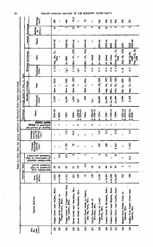
Tab
le 3
B
ase
dat
a fo
r ga
ging
sta
tions
in M
isso
uri
Riv
er B
asin
Con
tinu
ed
Ref
. N
o.
(see
ch
art)
501
502
503
506
507
510
512
515
516
517
518
519
520
Gag
ing
stat
ion
Tong
ue R
iver
nea
r D
ecke
r, M
ont.
Tong
ue R
iver
Res
ervo
ir o
n To
ngue
Riv
er,
Mon
t.
Tong
ue R
iver
at
Tong
ue R
iver
Dam
, ne
ar D
ecke
r, M
ont.
Goo
se C
reek
nea
r S
heri
dan,
Wyo
.
Goo
se C
reek
at
She
rida
n, W
yo.
Lit
tle G
oose
Cre
ek i
n C
anyo
n,
near
Big
Hor
n, W
yo.
Lit
tle G
oose
Cre
ek a
t S
heri
dan,
Wyo
.
Pow
der
Riv
er a
t (n
ear)
A
rvad
a, W
yo.
Pow
der
Riv
er a
t M
oorh
ead,
Mon
t.
Pow
der
Riv
er n
ear
Kiz
pah,
Mon
t.
Pow
der
Riv
er n
ear
Loc
ate,
Mon
t.
Mid
dle
For
k Po
wde
r R
iver
at
Kay
cee,
Wyo
.
Mid
dle
For
k Po
wde
r R
iver
nea
r K
ayce
e, W
yo.
Dra
inag
e ba
sin
Are
a (s
quar
e m
iles
)
1,61
0
a 1,
740
a 1,
740
120
182 51 159
6,05
0
a 8,
030
a 11
, 900
a 12
,900 64
7
980
Ox
II 58
58 58 11 18 0.2
18 23 68 70 70 5 9
mate
capacity rvoirs
in
194
0 nd
acre-feet)
III
ih£ 11
5
115 9
-
3
-
4 35-
35
- (e)
Ave
rage
di
scha
rge
1938
-43
(cfs
)
-
f 37
0 79 - - - 273
488
-
f 61
3
-
f 13
0
Ave
rage
an
nual
ru
no
ff
1938
^43
- 3.9
10.7
- - - 0.7
1.0
- 0.8
- 2.0
of
record
not ed
in
Water
- Papers
|||
- - - 0 - 0 - - - - - "Dis
char
ge r
ecor
ds p
rio
r to
Oct
. 1
, 19
44
Tea
rs
1928
-38
b 19
39-
1939
-
1929
-
b 19
09-1
3 b
1915
-16
1941
-
b 18
96-9
7 b
1909
-12
b 19
15-
b!9
29-
b 19
28-3
3
1938
-
b 19
11-1
2 b
1929
-32
b 19
33-3
4 b
1938
-
Mair
imnm
dis
char
ge
Dis
char
ge
(cfs
)
7,22
0
6,18
0
1,90
0
(g) 92
8
(g)
72,0
00
14,8
00
d 14
,700
31,0
00
1,68
0
5,23
0
Dat
e
June
2,
1929
Jane
5,
1944
Jane
18,
19
37
-
Jane
3,
1944
-
Sep
t. 2
9, 1
923
Aug
. 30
, 19
33
Mar
. 12
, 19
39
Feb
. 19
, 19
43
May
14,
193
2
Aug
. 11
, 19
41
Min
imum
dis
char
ge
Dis
char
ge
(cfs
)
d 2.
9
(g)
d 2.
2
(g)
d 5.
2
d 0
d 0
d 0
d 0
d 1.
2
d 19 d 0
Dat
e
Aug
. 20
, 21
, 19
34
in 1
940
Nov
. 27
, 19
39
-
Mar
. 12
, 19
44
at t
imes
at t
imes
at t
ines
at t
imes
Sep
t. 2
0,
21,
1940
July
20,
193
1
July
14-
16,
19
38
Aug
. 1-
11,1
4,
1938
, A
nnua
l dis
char
Tea
rs
1929
-38
1940
-44
1930
-44 -
1942
-44 -
1917
-44
1935
-44
1931
1939
-44
1931
1939
19
41-4
4
Num
ber
ofyea
rs 10 5 15 0 3 0 28 10 1 6 1 5
Fe Ave
rage
(e
fs)
389
446 79
.5
- 71 - 445
504
345
804
102
161
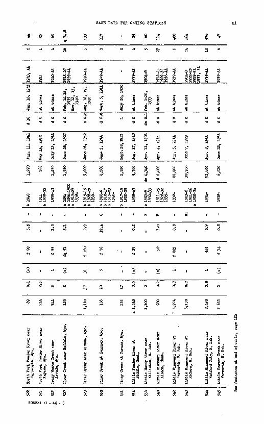
cc
522
o
ai "
523
O *
525
Cn 01
527
529
530
531
534
- 53
8
540
542
543
544
545
Nor
th F
ork
Pow
der
Riv
er n
ear
May
oMor
th,
Wyo
.
Nor
th F
ork
Pow
der
Riv
er n
ear
Kay
cee,
Wyo
.
Cra
zy W
oman
Cre
ek n
ear
Arv
ada,
Wyo
.
Cle
ar C
reek
nea
r B
uffa
lo,
Wyo
.
Cle
ar C
reek
nea
r A
rvad
a, W
yo.
Pin
ey C
reek
at
Kea
rney
, W
yo.
Pin
ey C
reek
at
Ucr
oss,
Wyo
.
Lit
tle
Pow
der
Riv
er a
tB
iddl
e, M
ont.
Lit
tle
Mud
dy R
iver
nea
rW
illi
sto
n,
N.
Dak
.
Lit
tle M
isso
uri
Riv
er n
ear
Alz
ada,
Mon
t.
Lit
tle
Mis
sour
i R
iver
at
Mar
mar
th,
N.
Dak
.
Lit
tle
Mis
sour
i R
iver
at
Med
ora,
N.
Dak
.
Lit
tle
Mis
sour
i R
iver
nea
rW
atfo
rd C
ity,
N.
Dak
.
Lit
tle
Bea
ver
Cre
ek n
ear
Mar
mar
th,
N.
Dak
.
69 244
944
120
1,11
0
106
253
a 1,
540
1,10
0
780
P 4,
724
6,19
0
8,49
0
P 63
3
0.1
2.5
8 8 37 10 17 0.5
0 0.2
0.7
0.7
0.8
0
(o)
_ 1 (c)
31 5 _ .
(c)
_ (c) 1 _ 1
(c)
f 28 _ f 55
fq 5
1
f 18
0
f 76 _ f 23 _ 58
f 28
3
_ 545
f 34
5.5
_ 1.0 8.1
2.9
12.4
_ 0.2
_ 1.0 0.8
_ 0.9
0.8
^ _ _ _ _ 0 _ _ B F _ BP _ _
b 19
40
1911
b 19
29-3
2
1939
-43
b 18
94b
1896
-190
0b
1917
-27
1938
-
b 19
15-1
9 '
b 19
28^2
919
39-
b 19
02-6
b 19
10-1
7b
1919
-23
1940
-
b 19
17-1
919
20-2
3
1938
-43
b 19
03-9
1932
-33
1911
-25
1928
-32
1935
-
1938
-
1903
-819
21-2
6b
1928
-34
1934
-
1938
-
1,27
0
966
1,85
0
1,38
0
9,00
0
2,36
0
2,58
0
5,70
0
de 4
,340
d 6,
000
22,2
00
38,7
00
32,6
00
6,82
0
Aug
. 11
, 19
41
May
14,
193
2
July
13,
19
41
June
28,
19
27
June
26,
19
42
June
3,
1944
Sep
t. 2
8, 1
523
Aug
. 17
, 19
40
Apr
. 11
, 19
04
Apr
. 4,
194
4
Apr
. 5,
19
44
June
7,
1929
Apr
. 8,
19
44
June
22,
19
44
d 10 d 0
d 0
d 0
d 0.
2
d 6.8
1
d 0
de 0
.1
d 0
d 0
d 0
d 0
d 0
Jan.
16,
19
43
at t
imes
at
tim
es
Feb
. 14
-16,
1939
Nov
. 12
, 13
,19
40
Aug
. 16
, 17
,19
40
Sep
t. 5
, 19
11
July
30,
192
0
at t
imes
Feb
. 1-
20,
1933
at t
imes
at t
imes
at t
ines
at t
imes
at t
imes
1943
, 44
1931
1940
-43
1918
^27
1939
-44
1940
-44
1942
WA _
1939
-42
1904
-8
1912
-25
1929
-32
1936
-tt
1939
-44
1904
-819
22-2
519
29-3
119
33,
34
1935
-44
1939
-44
2 1 4 16 5 3 0 4 5 27 6 14 10 6
44 25 63
q74.8
233
03
117
t m o ja >TJ o
*
I H
60
W CO 1-3
U*
H
* "*
o §
400
564
576 47
See
foot
note
s at
end
of ta
ble
, pa
ge 1
06
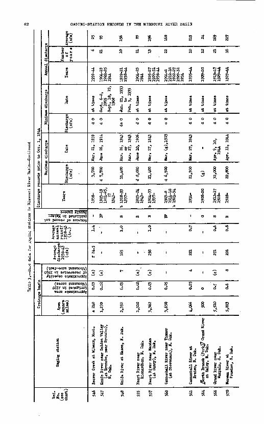
vn sji sji
f f "Si
P- » P H* S» W
of Is SBco"1 cots " §
k* k* «? r . R-5-Q
}\« \n
S § 8
p p oON >*1
O 1
£ 2
? ? ON ON
CO td Q
to soso to
H W-3 O
(0 VO1° M C~ « * 04
§ 1
!l- 1 * 'p. p. O.o o o
a a o
II! I£ p K
H $ £
* § 3 SO O EC EC
1 ill!' OH * B *
1
*- vo vo H*O ON vO vO
O O O O
& & 8 8
1 O O
to M|2 ' S ' '
' H '-3 O
1 tg td td
vT 0* H HHH |J|JJo'|J
^ d>^<!» " 'i ' ^ f~ CO \jJ £-
CL fL
PJ ON f^ 0>
\O sO JC- OS3 o o to
? ? y i M *~- M H
H fj H H SO so NO VO CM ^" O <i$ \>> ON
p. o a o.o o o o
I IIIV*> UlIOFOHO U>tOIO ** Qv» ^»ororo^ (p^ovi ^*-X- Ul ISi H TO £-V*>fc W J- H -O w t" H "*3 Vj>>
l_i tO J-* M5 io C P*
£3 K 5
uj \n \n
gi w td
K tS'^rt < o . » » 3so o^so "
& Fn f r f | ItS ^*S sP
if M-1^° r * « CJ ^ M O O
O O O
8 S 8
o o
H ' Ho - *-
- «
H H H K H H
vO vn\O
P-
ft IFH K I-1 H
6 S £ v§
p. p.0 00
n t, co co a
** vO«NO« H-
H°" -S t "
^ cl ^
11 *IHS P ON
Xs \S *°
p* a ts? so
a-8-g
&FiP |
Approximate area ° irrigated in 1939 g" (thousand acres) S.
Approximate capacity of reservoirs in 1940 (thousand acre-feet)
p. H P >
O
^^(-i*! » j>?
^ o P 2 >HH»
Sources of record not published in Water- SUPD^V Papers
eK"
H o
a
_g 8
° 1 °S ? 1 * c<- We*- it 0 st"'
?! f *§ i'
gct- §
a
0 1
of ?
5^1 1
ifaKISV9 H3AIH IHaOSSIW EEi KI SOHOOaH KOIiViS-SHISVO
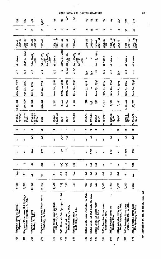
I S
BASE DATA FOR GAGING STATIONS
tj v<j pj O t^ CM jj Ift Ift j
63
-* vO vO
JH ?4 ?4 * fit
NO C*\ * -*
u?0> O- O-Is s s°? r ^ T ^W H S3 Nft ej\go> o> o> o> o>o> o> o ss
J n « «
I'll H -H -ri
TS TJ TSO O
TS TS.-x *~. r$ ° ° ^ «0 «0 T» TS HI
VO CM
s «a 3M Q
CM Oj CM OjOJ H 0} H
» «k » 1 prv * sp
f\ t-f C*- CM
I I i i i I* 8 I S
M" vo" vo"
?CM 33 3Sj§»^ Ov ON OvOjO^I *~* iH rH l~l l~l l-l
CM Q >? , , f
S S Ii I 1 Ii& s?f?f H
m i m m m i i i S3 04 W &3
I I
I O O O I o o
H -* H OO O
CM CM e<\ O O O O O O
III Ic^ oa a
OJ CM C3 p O p QH ej\ ^ <5 g wj H
k * * *rH CM e^ -*
"' S & & ^ Jj^j
a« If sj 1«. a « a a fl .fe 01 tSr g s | mif ij !« l|
1^tS Ct,
^ * fe i* fe°> fe°9|> &| | £ 8 | . 8 ,« * a sl a- di si
Biver , S. D

Tabl
e 3.
Bas
e data for
gaging
stat
ions
in
Mis
sour
i River Basin Continued
Ref
. H
o.
(see
ch
art)
597
599
600
603
604
606
607
610
612
614
615
Gag
ing
stat
ion
Red
wat
er C
reek
nea
r B
eula
h, W
yo.
Red
wat
er C
reek
(R
iver
) at
B
elle
Fou
rche
, S.
Dak
.
Spe
arfi
sh C
reek
nea
r S
pear
fish
, S.
Dak
.
Bad
Riv
er n
ear
Fcr
t P
ierr
e, S
. D
ak.
Nor
th F
ork
Bad
Riv
er a
t P
hili
p, S
. D
ak.
Whi
te R
iver
at
Cra
wfo
rd,
Neb
r.
Whi
te R
iver
abo
ve W
hitn
ey
pipe
lin
e ne
ar C
raw
ford
, H
ebr.
Whi
te R
iver
nea
r C
hadr
on,
Heb
r.
Whi
te R
iver
nea
r In
teri
or,
S.
Dak
.
Whi
te R
iver
' at
(nea
r)
Wes
tove
r, S.
Dak
.
Whi
te R
iver
nea
r O
acom
a, S
. D
ak.
Dra
inag
e ba
sin
Are
a (s
quar
e m
iles
)
459
B 1,
048
(g)
3.W 16
4
295
a 35
0
750
4,12
0
7,85
0
10,2
00
1
III 0.5
9 0 0 0 0.4
0.5
11.7
12.1
13 W.5
mate
capacity irvoirs
in
1940
ind
acre-feet)
| gs
I'g
l
- - - (c,
(c)
(c) - 15 «* - 16
Ave
rage
di
scha
rge
1938
-43
(cfs
)
- - - 189
t 5.
4
21.5
- 27
"* - 544
Ave
rage
an
nual
ru
noff
19
38-4
3 (i
n.) - - - 0.
8
0.4
1.0
- 0.8
-
0.7
i of
record
not led
in
Water-
Papers
®5,
M
Ml
- H H B - S S sw " -
Dis
char
ge r
ecor
ds p
rior
to
Oct
. 1,
194
4
Tea
rs
1929
-31
1936
-37
1903
-6
1903
-6
1928
-32
1934
-
1939
-44
b 19
24-2
? 19
31-4
3
1922
-23
b 19
26-2
9
1924
-43
b 19
04-6
b
1912
-18
1928
-32
1939
-42
b 19
12-1
8
1928
-
Hax
iMm
dis
char
ge
Dis
char
ge
(cfs
)
3,25
0
8,11
0
d 4,
150
34,2
00
1,64
0
1,17
0
(8>
3,69
0
17,1
00
d 15
,200
35,3
00
Dat
e
July
17,
193
7
Jnne
5,
1904
June
4,
1904
May
1,
1942
June
4,
1942
Aug
. 2,
194
0
-
May
12,
194
2
May
i,
±tt#
.
Apr
. 4,
191
5
May
8,
1942
Mjfl
i^m
m d
isch
arge
)isc
harg
e (c
fs)
d 0
(s)
(s)
d 0
d 0
d3
.9
(s)
d 0
d 0
d 4
d 0.
5
Dat
e
Aug
. 13
-15,
19
29 - -
at t
imes
at t
imes
Aug
. 11
, 19
36
-
at t
imes
at t
imes
HOT.
U.,
1912
July
21,
23,
19
36
Aug
. 8.
10,
19
36
Ann
ual
disc
harg
e
Tea
rs
1930
, 31
1904
-6
1904
-6
1V29
-31
1935
-44
1940
-44
1925
, 26
19
32-4
3
1923
, 28
1925
-29
1931
-43
1918
, 19
29-3
1 19
40-4
2
1918
1929
-44
Num
ber
of
ye a
rs 2 3 3 W 5 14 2 18 7 1 16
Ave
rage
(o
fs)
55 228
104
155 6.
2
22.3
31 29 218
567
505
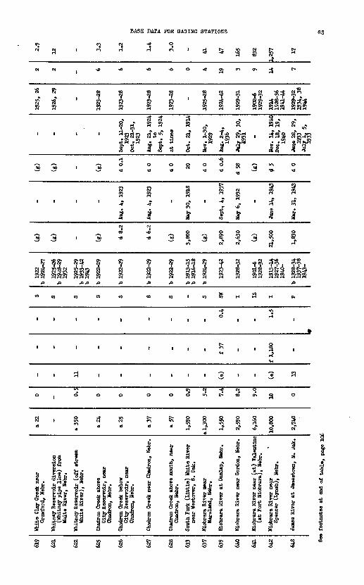
BASE DATA FOR OAOINO STATIONS 65
3W W *0 sO
CM Ol <0 <O CNl 01
* * I f 1 tf\ v0 * c*> C*S
rf H"
H
M M 1 M
Iit i ' _»
1CM
«0
MM 1 M IS
O! CM CM N c«\ NC*?9 SI O!
A ft ft ft ft ft
to to to to at
i I i I 1
I i I I I
I I 3 I 1
o ( o o o
SI 1 S\ CM 0?
cd " cd cd
S l 1 S
frf ll"^ 15 sis" lia"
nf
- « - - 9 - « 4
1 I I I i iM!-d- -* -± ON N H » 31 *
O *
C<4> S C4 HOJCMCJJ Ot g\ 1 H 3 ST
M U ** J ^ H M H i^ P* g 0 H
4 co "S o J§ 4 *? SQ
O O O O O <0 * "» U\
0
B 2 « 3rl O* CM OJ
-* ' o" ' "* o ' H cri ^ «O
CM
^ ttftuttlwvottltrt ^^ p? "^ oT of ^ jj*
^Q ^ .a ft ft
<a to I to OT H H H
-* "A
0 H1 1 1 1 II
. , , 5 , , l<H
1 1 1 1 'o 1 1 'o
Ox CM -* CM O
o ooiA^<ocAg
cd cd *il«h*** H
1 1 f! £ 1 1 R -H JJ H «
a i? > £
J i^ 3! &*, i ^ n* ^1A Is" *l «1 a a a* s s
t>
<0
i^
CM «
^
i¥o a
i5?
1
o
H*
ft
a,
i
l
»
o
^
ta
u?
: *>-§ 6 *> ! S S § £ b § P b § § b 1 « ^1 P^I 9 11 -| |b | | 83 If _oo o O
Cb \o so

5
1
1&
?
M
g
O
'
'H
I
a
£
io.^
tsi
*-
3S
I §
West Fork ditch at
Holly Springs, Iowa Honona-Harrison ditch near
Turin (Blencoe), Iowa
1 s
o o
^
1 1
1 1
1 1
to io u> u>1 1
i i1 1 K f
|
o.W o
i-
co ai ?H I-1
1 I
vn vi
TO Oxvo jo
^a u>
Little Sioux River near
Turin (Blencoe), Iowa Maple River at Mapleton, Iowa
H O
0 0
v £-
1 1
1 1
1 1
H I-1
* *-
vS io
! 1
1 6
S sr j< a
I I
U> Vl
io *2
1 ^
Little Sioux River at
Correctionville, Iowa
Little Sioux River near Eennebec, Iowa
«° »°
0 0
o n
VI
to
i to
-1
6 G
! r 0 01
G B
g £
" *$- M
Ox
J?NJ vSn
H M
£- U> N> H
5
J3 £ 1v> o
i § §Big Sioux at Akron, Iowa Floyd River at James, Iowa Little Sioux River at
Spencer, Iowa
^ V?*
8xO CQ i_t ^_n
0 W H
O O p H
O O x»J
' P S -J Ox
1 i"1 r O> xo
1 1 tD
r T ?
« ^ P§ i §s * 1i £ r .* H H
| £ ft
&&&
* H -a
F H» H*
g ij ?*
! I t. . K
t_i i_i 0s sO f- sO (» M C*
§ *
James River near Scotland, S. Dak. Big Sioux near Flandreau, S. Dak.
M P
O O to
1 0
s
ip Jo
1 M
o-
to SO
us ro
o. o- vn S
§ §
F F Q 6^
i*
§ 6
o. o. o o
Co P
VJ NJ
t-1 o^
N S
§B*
I 8-
CO
H
O Jo
p
1
CH
H H
N>
O.
N>
g
{
J8
o. o
iIS
VO
S
lfff>
!!fr
Approximate area irrigated in 1939 (thousand acres)
Approximate capacity of reservoirs in 1940 (thousand acre-feet)
I
f|M a a
to l-% I-1 0)
Sources of record not published in Water- Supply Papers
rH-
Fl
5- a
a
I a
M!
£ 0 B21*?
||
I
O. H'
a
\
a
a
3
3 I?
xO
Kisva H3AIH lanossiJi ani HI SOHOOHH tcoiiivis-OKiovo

BASE DATA FOR aAOINO STATIONS
a *
n 5sHR nS
S .cM«g §
01 1«
0 0
O Tl
i iOJ H
« 3CT* rH
4o 3
* 'Tia H
lilt- sCM O
ON 0
**
o a
0 5
§ K CM
7 "Boyer River at Logs frizzly Creek near Walden (Hebron),
ON \o
tj\°^ ^^
if gH
S J* 0}
+» S t>& fCO "5
CM
° «
I &H H
2? d
.
-* CM
H 0
V 1 ^tl
XJ^>
5 M
ON t^
PN Q
^
O [^
3- R
c^ Q^ 3
H
Js-3' &i s° s|
forth Platte River Walden (Hebron), Jorth Platte River Northgate (Pinkl
H
$
£
3
cT
S*to
RS«T
8
i8
":
s0*
to
»"
iCM
8
li+> rt
51
«N
j ,
S
il5? i
CO
1
§s« 1
CD
1g'"i 1
P|
S5 S\H H
1 1
O
c.ON 1VH
9 ^s QH
UN CM M C^\
1 §
a
Hforth Platte River Seminoe Reserve: Sinclair (Parco
Seminoe Reservoir
H H H H
vO v£> «0 UN
1 |
S J . Hs s as£ R
1 ' i ' I ^3 'S IS *»
N O O er\2 * - s
g . ct c5H & H 3c? ' oi5 ' S o"
0 g 00
1 ON | « ^,
s s a a o -o
III III.0.0
K 01 M III
CM CM111 1
o c.1 II | H CM
H H
1 33 sisCM CM CM CM CM
ass ass§ 8 | | § 8 ^ s" s 3" 3" a"
1 1 g I
g - gj, 1 §
I* | f^ 1 | |°
o
1
.,
CM*
i^sH
1
8"i ^
O
1919-24
a
i
i
.
3
|a
'S
Jorth Platte River Parkerton, Wyo.
H
3
ON
X
St^
S
43
t^Ha
8 ^
1891-94 1919-23 1929-39
.0.0
1
1
1
ir\ <o
8CM
S
8
1
o
(
i ni
CO
g
i3CM
a>
Q
^
Rf o
siA
i
CM ON
§
3
1*
Jorth Platte River (Orin Junction)
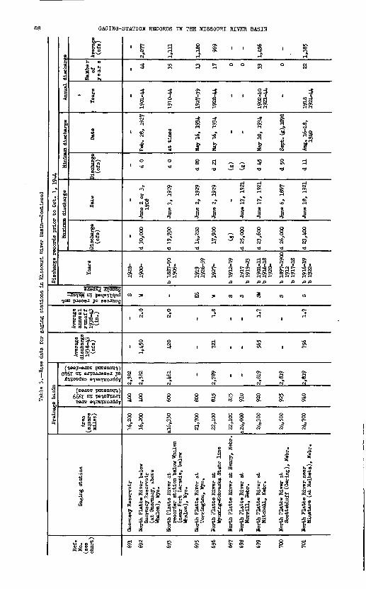
g Ho5 ?
|& |l
-I I! ?| -^
gs 1"?» i if «*-" 1§ ? i
^ ^ -*J Vl
8 8
VO NO
i5 «M 10
P P
-J 1ON
K «
CO CO
erer er erIJ |_I l_l 1 J U(NgNO NO NO Cg
'III
P- P-
§ §
i r H ON05
M CD
g ~3
B. P.
P 0
If CO
t5 ON J5^(ij fr**
* S
TO
!_,!_,
Mg
^
lo 0
S '
$
9&
'latte Hiver shell, Nebr.
S-
£V>i
8
NO
P
vn
r
egerer
?up- £
81*a
«
Sp.
in
1
**
g4>
ife
ar *
ON
z
ft
Platte River rill, Nebr.
S-
10
O8NO
g
I
1
'
CO
er
rp. 10
§fo5
SST '^
1
1
o
i
5
53- tr
'latte River
fttc
I
KK"
8
oa
1
1
1
CO
erNO
£
^
1
ST
i
i
o
'
O>- Vft
5s ?
'latte River rington, Wyo. 5latte River ning-Nebraska
CO c» e*
&«
£CD
M M
i_i ,j
8 8
NH o
SI
-J 1f"1
K 1
05
« S
-*3 ON>O1 I
NO
P-
£ *NO 10
1* 1 o »M M
NO £
tt NO
p. p.
{3 8
* IP 5 ^£ £M H
*- f
M M
* NO
5 ti
NO M
§ M ^
1 If
Z*x--H 3" S!-^Cl3p 4?{3<6cr ffjuptr g
s^at1 gg'lfc1 ^ CxiriaS- C-S m J» (d »o *5 S » §«5 S a
f*|J file § 0> C*~ <! * <D < Ofi I-" <D 4 » H-gg^ g.J < *TS»8- 3 try p. « & IIif
g
K & &§
M
8
ON C t
8 i 1
^ S S
ft 5 ' o o
to 10 '
b b
I f. CO
er
$4 ? ^ o
p. p.
8 8
i- r^ So 'NO **
S
0 O
S ?a ?* '
NO
ij
I-1 H
1 i
* * '
I-1 M
B-ITsito1 1 ? ft
S-
§
fiffr w £ 2N^S
Approximate areairrigated in 1939 (thousand acres)
Approximate capacity of reservoirs in 1940(thousand acre-feet)
hi
fag
H o»tr 1^'Cw o
^~*NO d O ^
iilll t)H4H 0
Sources of record notpublished in Water-Supply Papers
s1i
2. 2.??
o1
°
H&^f
H<
a
VI e0 H
a
&
Pa
i?'a
v
1
S1"S
v
i|CD
o
I1
1
I«*
8-!_,
I-"
1
NISV9 H3AIH IHflOSSIM S&L NI SQHOD3H

BASE DATA FOR GAGING STATIONS
o81r-i
-* C\
1
si *
II^
SI
4
1c? d
1
F±
32)So
9«
1
O
'
a
1 p
*
Rp-\
1aiu\ CM o
^
3
.0
to
c-arH
a
1932-44
-*
s
Ito 0
8?£5
k§8 o
^s 1"*
?}Sa
m
1rH
^
1929-U
if^3 *H
sl
0 0
Ii8
S d
^
1&
S?)ja
OJ
sH
C\
S
ia
1a
i £
1
S f\to
l-t O
1
§CM
0
?
II
1
g
8, J
ga8
18Si 0
u\
H?}ja
a
§ >H
<0
3 S
-*SJIs '
"oil
O
d 1
1
& 'o>
1
§
S
<B
« d
S ?t
1 I
ICM
1943-44
i*1^t d
£
Sg
i8oCM O
&^5SS
o
Oi
*~ S3R £
OI
tO CK
i 35 S
«-Srf 8 Sfjl *Kc^ KH ^
S 8
rH C--C- C>
<O * «. K CM CM U\ \O
§ §
8 £
d 13
CJH
^-H l^i IA
°J3S Hja A
CO OJ
o» t>8 K
«O u\
1939-44 1940-44
S^ I 05 -3Dp1 '-8
0 0
a -d
$ i*? s1 1§ §U> NO
tL CM^i
S ?t ?tja ja
CO CO
|c\
S
*? 1!O*'lO r^
H H
1 p
8
o d
rH
4d
^
1u\ c^ d
^t
8Sa??
S
SCM
Of\
§a
1 p 8
oTJ
U\
Su^
48 oC-c<->
1aR
CM CM CM
CM 13 C\? * rn,_____rt___rt______, o3
h h. 8 . 8s
feg
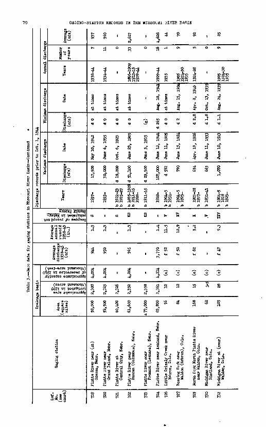
a a
I § OS- Q& 5* 9 <* ???
NJ IOVO VO
KH ON vnM H 0»
NJ NJ M fOApproximate area irrigated in 1939 (thousand acres)
Approximate capacity of reservoirs in 1940 (thousand acre-feet)
H> H,
G P H
Sources of record not published in Water- Supply Papers
o-o- o- o1<af o <af
t» 'vi,
K P Kso so
1 & I n ^ *
sflsOsO VOM Ovnc-vn
I
*J ^ f g ' ii ' S 5
HISV3 H3AIH IHflOSSIW 3HI NI SOHOOHH NOIIVIS-SKISVS

BASE DATA FOR OASINO STATIONS
o
t
S5 8
o a
10
s?S
v
1
S
ON ONHHJ3 a
'
to
:-°§
River near ejr, Colo.
94
o
g t
en
fCO"i a
cXH
t
CM
1
NO
a
1931-40
fi
>
i
o
^
Fl
4o
"33
Creek near B
5
<0 O H
O
CM"^ °
2?^ S
^ fj
a an >
5 iU IHo o o a TJ -a
* » $2? H H
«r ~r 2 s\?m
1 1 4o to oCM NO Qin CM NOCM TJ TJ
ONON SN ONONSN
J3J3 fl £>£> fl
B > .
10 10
NO CM
£ ' £
'c) "c?
m NO CM
ON H ^
M H
^ at s.« a -SP s § &so o os ^
" " S^
as°
n CM
H H
a s «"5J ON M
r-T 3
f h -g^H
§" CO1-1
U\ NO UN
0 TJ
3H
' ' H"O
4ON
M bO ON -^-
7 ? 1
H H H H
.0 ^>
S § *
1 1 1
1 1 1
1 ' 3 * 3 3
g s S
|iJ31 M
° S ^
ff jljif " "S.
o
?l
S?
ior4 a
aaON
4
§CM" a
H
r-l
J3
O
1
1
1
S
toON
1
i%§CO '"N
9 iH
6 §
-*
1ilHON
cSr-T
IIw
3aH~
4
1940-44
i
i
o
-*
S
o
I*1 »
H ^ ON
-*H 3 3 -* CM m ^ .(?*?
ON
ON NtT
J? nS S H
t tj,^ tj,^
4 4
CMPN. in O a -a -a
3 SNON H
' rl 3
0 0^-N l-t C\M «1 PN.
^ -*
-*CM C--* CV f% H CM
£> JO
O j
1 1 1
1 1 1
1 O 1
to ON O
ON O CM
1 '
§ S &
% $ gJP I a
3^ So' 1*:i :i |f
if If 8 »j
Fl
1912-17 1920-24
II p
ot3
H"
f?
^
§CM
TJ
1911-17 1919-24
to
1
1
1
H"
S
' 4
Bow River m ine Bow, Wyo
S5
u\
1940-44
»
rCM-d
%CM
1
O
NO
ck
S
1
H
<H
ON
S
8CM
olO
Bow River al oe Reservoir
, l^-o.
aa a
t-
1914-18 1940-41
NtT
rHTJ
1
bO~~"
to H
O ON
fl f
O
H
S4-1
3«N
R
£
S5r i ;
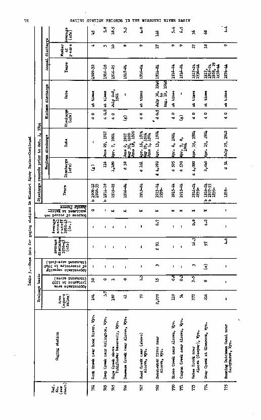
3 i! 3 ^ f I 2 f §w omoffi co to o co o E 0 (*> gj o C £ 2 rfi ®
pp. P to 08 H 3* H Op4 & o o g 6 * go o c*- o o
ttO 09*0 S* Z!W Sits 0) (D P PS-S- $ p 3 tJ *<P M^JS PTIO1*- 1 o^g if ?S ?§ B td9 f!! f i § I S r i I" ir
1 *' J? }? i
-J
a
Ies
to
1
t NJ xO H IO H H H-OVJlH ^a ~^ £jG? ^
ia
' W^OO £ H OHO *J> to la to
' £ W ' ' W ' " 1 1
«, H ' ' ^ ' III f" ^3 bs H
r p ' ' P ' ' ' ' M o» ^a
1 ftftftfi ft ft ftft(
o-cr crl_i f-i H H HH H H HH H Jo so so
VOo
1
1
1
o
b 1909-12 1928-33
C. C.
M-P-P-O* * O« Q.*"1 *"*
&1 »ff « & "a "6 &l^*6 R^p *O p P « q ^ ti ^ 5<34 S<55 q 5JJ . .H.. » / » ~ so IO VO IO H Hl\)~3Ot HH^OHHON ^alOvn vn vn ^~^ ^ v«) to « ON Q^W * * so < to to to « to to
0& H H H H H H SO so V K> so {OMSONPN9H MsO
p. o.c.m'c. P- o- m^ p. p, o oo^o p o o p
\n 10
S-8-8- S-fS 8- I"8"
i if f * *s i i i mm 'coto0*3 a .wo
H HHHH HH H H H H to so H
C c'* K'ElI^ E^ £2 K i^MS-n
i
P.0
8-
fa:1929-32
H H H H
.p- ottO^o^y ^ f~ soo»yiv/i i-. vn*- O?o\nO»
Jfrs
Gaging station
!La *
Approximate area irrigated in 1939 (thousand acres)
Approximate capacity of reservoirs in 1940 (thousand acre-feet)
Drainage basin
H> m&q"""So? 0
^H1 (B >
s-xir- MI 99 o5 to Hi HO
Sources of record not published in Water- Supubr Papers
HI
o
&§"s-**5
8
o8-»
if
ta
1 . 4 S
5*1 0 "-I
a
1ig
g
1
d- O
so
HSAIU IHQOSSIW ani HI SQHODSH

776
777
778
779
780
781
782
783
784
785
787
790
Box
elde
r C
reek
nea
rC
arey
hUrs
t, W
yo.
Dou
glas
(M
orio
n) C
anal
nea
rO
rpha
, W
yo.
La
Pre
le C
reek
nea
r D
ougl
as,
Wyo
.
La P
rele
Cre
ek n
ear
Orp
ha (
Fet
ter-
man
), W
yo.
Wag
onho
nnd
Cre
ek n
ear
La
Bon
te,
Wjro
.
La B
onte
Cre
ek n
ear
La B
onte
, W
yo.
Hor
sesh
oe C
reek
nea
r O
rlend
o, W
yo.
Cot
tonw
ood
Cre
ek a
t (n
ear)
Wen
dove
r, W
yo.
For
t L
aram
ie C
anal
at
Wha
len,
Wyo
.
Lin
gle
Pow
er W
aste
fro
mF
ort
Lar
amie
Can
al
Inte
rsta
te C
anal
at
Wha
len,
Wyo
.
Lar
amie
Riv
er n
ear
Orl
ende
vey,
Col
o.
202
_ 146
227
125
302
203
159
- _ _ 101
2.5
_ i.3
10.7 2.3
4.3
3.4
1.2
- _ _ 0.7
(c)
_ (c)
20 (c)
(c)
(c)
(c)
- _ _ (o)
45
_
37 12.4
f 6.
4
48 27 t 5.
0
340
_ 572
f 66
3.3
_ 3.7
2.4
1.1
2.5
2.2
0.6
_ _ _ 12.2
K _ - K K K KO KO S S S KV
1911
1915
^4b
1928
-33
1935
-
b 19
35-
1919
-
1916
, 17-1
8'19
22^2
4b
1927
-33
1935
-
1916
-24
b 19
29-3
2b
1937
-
1916
-24
b 19
28-3
319
35-
b 19
09-1
019
15-1
919
20-2
4b
1927
-33
1935
-
b 19
09-1
019
15^4
b 19
29-3
319
35-4
2
1918
-28
1932
-
1925
-27
1930
-31
b 19
09-2
819
30-3
119
32-
1904
-5b
1910
-
2,36
0
112
1,22
0
1,14
0
2,00
0
2,75
0
11,9
00
4,14
0
-
d 48
2
_
2,24
0
May
23,
193
3
Aug
. 6,
194
1
May
11,
192
0
May
23,
193
3
July
12,
193
7
Hay
22,
23,
1923
May
30,
193
5
Sep
t. 23
,194
0
-
Aug
. 8,
192
7
_
June
9,
1923
d 0
d 0
d 0
d 0
d 0
d 0
d 0
d 0
d 0
d 0
d 0
d 5
at t
imes
at t
imes
at t
imes
at t
imes
at t
imes
at t
imes
at t
imes
July
12-
15,
1932
at t
imes
Nov
. 9,
16,
1930
at t
imes
Feb.
14,
15,
1911
1916
-24
1929
1936
-44
1936
, 37
1940
-44
1920
-44
1918
, -23
,24
,19
28,
2919
36-4
4
1917
-24
1940
-44
1917
-24
1929
1936
-44
1916
-19
1921
*24
1928
, 29
1936
^44
1916
-24
1936
-42
1918
-28
1933
-44
1926
, 2?
1931
1911
1917
-28
1931
1933
-44
1905
1911
-29
19 7 25 14 13 18 19 16 23 3 26 20
52 13.1
42.3
17.6
16.5
w i6?
g > 3
34
§ Q S a a 0
9.6
g S M g CO
318
180
606 87
See
foo
tnot
es a
t en
d of
tab
le,
pa»e
!;>
'

g 2
| | 3 3H (D
I 'I ?
f f
vi° f "H "Jo
8 S
r
Approximate area irrigated in 1939 (thousand acres)
Approximate capacity of reservoirs in 19AO (thousand acre-feet)
B-§!
Sources of record not published in Water- Supply Papers
i i!p. P.\jj H
i rIO NO
g ^
p. Ho o
HISV9 H3AIH IHnOSSIK 3ffil HI 9QHOCSH HOIiVlS-BHIOVB
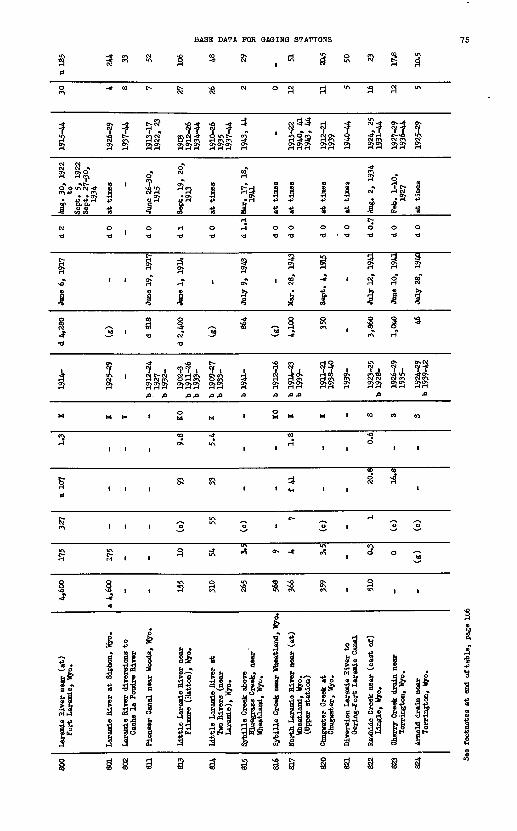
800
801
802
en 813
814
815
816
817
820
821
822
823
824
Lar
amie
Riv
er n
ear
(at)
For
t L
aram
ie,
Wyo
.
Lar
amie
Biv
er a
t S
ipho
n, W
yo.
Lar
amie
Riv
er d
iver
sions
toC
ache
la P
oudr
e R
iver
Pio
neer
Can
al n
ear
Woo
ds,
Wyo
.
Lit
tle L
aram
ie R
iver
nea
rF
ilao
re
(Hat
ton)
, W
yo.
Lit
tle
Lar
amie
Riv
er a
tTw
o R
iver
s (n
ear
Lar
amie
), W
yo.
Sybil
le C
reek
abo
veB
lueg
rass
Cre
ek,
near
Whe
atla
nd,
Wyo
.
Syb
ille
Cre
ek n
ear
Whe
atla
nd,
Wyo
.
Nor
th L
aram
ie R
iver
nea
r (a
t)W
heat
land
, W
yo.
(Upp
er s
tati
on)
Chu
gwat
er C
reek
at
Chu
gwat
er,
Wyo
.
Div
ersi
on L
aram
ie R
iver
to
tter
ing-
For
t L
aram
ie C
anal
Raw
hide
Cre
ek n
ear
(eas
t of
)L
ingl
e, W
yo.
Che
rry
Cre
ek d
rain
nea
rT
orri
ngto
n, W
yo.
Arn
old
dra
in n
ear
Tor
ring
ton,
Wyo
.
4,60
0
a 4,
600
_ _ 155
310
265
568
366
359
_ 510
.. _
175
175
_ _ 10 54 3.5 9 4 3.5
_ 0.3
0
(g)
327
- _ _ (c) 55
(o) -
7
(c)
_
1
(c)
(c)
u 10
7
- _ _
93 33
_ - f 41
_ _
20.8
1&.6
_
1.3
- _ _
9.8
5.4
_ - 1.8
_ _
0.6
_ _
K K V _ KO K _ KO K K _ S S S
1914
-
1925
-29
_
b 19
12-2
419
27b
1932
-
1902
-3b
19
n-2
6b
1933
-
b 19
09-2
7b
1933
-
b 19
41-
b 19
12-1
6
b 19
14-2
3b
1939
-
1911
-21
1938
-40
1939
-
1923
-25
b 19
28-
1926
-29
1935
-
1924
-29
b 19
39-4
2
d 4,
280
(g) _ d 81
8
d 2,
400
(g) 86
4
(g)
4,10
0
350
_ 3,86
0
1,0*
0 46
Jane
6,
1917
- _
June
19,
19
17
Jane
1,
1914
_
July
9,
1943
-
Mar
. 28
, 19
43
Sep
t. 4
, 19
15
_
July
12,
19
41
Jane
10,
19
41
July
28,
19
40
d 2
d 0 _ d 0
d 1
d 0
dl.
l
d 0
d 0
d 0
d 0
d 0.
7
d 0
d 0
Aug
. 30
, 19
22to
Sep
t.
5, 1
922
Sep
t. 2
7-30
,19
34
at
tim
es _
June
26-
30,
1915
Sep
t. 1
9, 2
0,19
13
at t
imes
Mar
. 17
, 18
,19
41
at
tim
es
at t
imes
at t
imes
at t
imes
Aug
. 2,
19
34
Feb
. 1-
10,
1927
at t
imes
1915
-44
1926
-29
1937
-44
1913
-17
1922
, 23
1903
1912
-26
1934
-44
1910
-26
1935
1937
-44
1943
, 44
-
1915
-22
1940
, 41
1943
, 44
1912
-21
1939
1940
-44
1924
, 25
1931
-44
1927
-29
1936
-44
1925
-29
30 4 8 7 27 26 2 0 12 n 5 16 12 5
u 18
5
244 33 52 106 48 29 -
51 20.5 50 23 17.8
lfl.5
See
foot
note
s at e
nd of ta
ble,
pa
ge 1
06

Tabl
e 3.
Bas
e data f
or gaging
stations in
Mis
sour
i River Basin Continued
Ref
. N
o.
(see
ch
art)
82?
828
829
830
832
833
834
£85
836
838
Gag
ing
stat
ion
Kat
zar
dra
in n
ear
Hen
ry,
Neb
r.
Mit
chel
l C
anal
at
Wyo
min
g-N
ebra
ska
Sta
te l
ine
Spr
ing
Cre
ek n
ear
Hen
ry,
Neb
r.
dari
ng C
anal
nea
r H
enry
, N
ebr.
Tri
-Sta
te C
anal
nea
r H
enry
, N
ebr.
Tri
-Sta
te C
anal
div
ersi
on f
rom
Shee
p C
reek
, N
ebr.
Tri
-Sta
te C
anal
div
ersi
on f
rom
Ake
rs D
raw
, N
ebr.
Tri
-Sta
te C
anal
div
ersi
on f
rom
Dry
Spo
tted
Tai
l C
reek
, N
ebr.
Tri
-Sta
te C
anal
div
ersi
on f
rom
Wet
Spo
tted
Tai
l C
reek
, N
ebr.
*
Tri
-Sta
te C
anal
div
ersi
on f
rom
Tub
Spr
ings
, N
ebr.
Dra
inag
e ba
sin
Are
a (s
quar
e m
iles
)
' - (g
)
- _ _ _ _ _ _
Approximate area
irrigated in
1939 (thous
and acres)
0 (g)
- . _ _ _ _ _
sS-
Approximate
oapacil o
f reservoirs in
I' (thous
and acre-feel
(c)
(c) - _ _ _ _ _ _
Ave
rage
di
scha
rge
1938
-43
(cfs
)
15.9
51 - 46 289 .. _ _ _
Ave
rage
an
nual
ru
no
ff
1938
-43
(in.)
- - - _ _ _ _ _
1,,
Sources of
record i
published
in
Water- suppl
y Papers
S OS
S S S S S S S S
Dis
char
ge r
ecor
ds p
rio
r to
Oct
. 1,
19
44
Tea
rs
b 19
26-
1915
-19
1920
-
1931
-42
1916
-
1916
1919
1921
-
1915
1919
1921
-42
1929
-42
1914
-15
1931
-42
1915
1919
1921
1923
-42
1915
1922
-26
1928
1931
-42
Max
imum
dis
char
ge
Dis
char
ge
(cfs
)
1,23
0
(e) - _ _ _ _ _ _
Dat
e
May
19,
19
38
- - . _ _ _ _ _
Min
imum
dis
char
ge
Dis
char
ge
(cfs
)
d O
.5
d 0
d 0
d 0
d 0
d 0
d 0
d 0
d 0
d 0
Dat
e
Jan.
4,
1937
at t
imes
at t
ines
at t
imes
at t
ines
at t
ines
at t
imes
at
tin
es
at t
imes
at t
imes
Ann
ual
disc
harg
e
Tea
rs
1927
-29
1932
-44
1916
-19
1921
-44
1932
-42
1916
-44
1916
, 19
1921
^44
1915
, 19
1921
-42
1929
-42
1914
, 15
1931
-41
1915
, 19
,21
,19
23-4
2
1915
,19
22-2
619
2819
31-4
2
Num
ber
of
yea
rs 16
28 11 29 *6 24 14 13 23 19
Ave
rage
(c
fs)
.14.
7
60 9.5
.« 331 25 4.
7
4.3
6.5
6.4

844
845
846
850
851
854
855
859
864
871
872
873
875
877
878
880
883
Hor
se C
reek
nea
r L
a O
rang
e, W
yo.
Hor
se C
reek
nea
r T
oder
, W
yo.
Hor
se C
reek
nea
r Ly
man
, N
ebr.
Shee
p C
reek
nea
r M
orr
ill,
Neb
r.
En
terp
rise
Can
al n
ear
Mox
rill
, N
ebr.
En
terp
rise
Can
al d
iver
sion f
rom
Wet
Spo
tted
Tai
l C
reek
, N
ebr.
Ente
rpri
se C
anal
div
ersi
on f
rom
Tub
Spr
ings
, N
ebr.
Too
hey
Spi
llw
ay f
rom
Tri
-Sta
te C
anal
, N
ebr.
Mit
chel
l S
pill
way
fro
mT
ri-S
tate
Can
al,
Neb
r.
Win
ter(
s) C
reek
Can
al n
ear
Sco
ttsb
luff
, N
ebr.
Win
ter(
s) C
reek
Can
al d
iver
sion
from
Win
ter(
s) C
reek
, N
ebr.
Cen
tral
Can
al n
ear
Ore
ring
, N
ebr.
Win
ter
Cre
ek n
ear
Sco
ttsb
luff
, N
ebr.
Min
atar
e C
anal
nea
rM
inat
are,
Neb
r.
Ore
ring
dra
in n
ear
Ore
ring
, N
ebr.
Cas
tle
Roc
k C
anal
nea
rO
reri
ng,
Neb
r.
Nin
e M
ile C
anal
nea
rM
inat
are,
N
ebr.
683
1,32
0
1,86
0
a 70
_ _ _ - _ _ _ -
a 13
0
_ _ _ _
9 23 24 a 8 _ _ _ - - _ _ -
v 5 _ 0 _ _
_ 30 30 (c) _ _ _ _ _ _ _ - (c) _ (c) _ _
_ _ 44 42 30 3.4
6.7
- _
7.0
12.1
7.5
53 20 34 23.8
17.3
_ 0.6
- _ _ _ - _ _ _ - _ _ _ _
KO 0 sw s s s s s s s s s s s s s s
b 19
09-1
0b
1912
-14
b 19
15-2
0
1928
-33
b 19
38-
1920
-
1919
-
1916
1919
-
1925
-
1920
-27
1928
-
1923
1925
-40
1920
-38
1916
1917
-
1918
-
1918
-
b 19
19-
1919
-
1923
-
1916
1917
-
1919
1921
-
(8) 45
5
1,97
0
(g) _ _ _ d
220
d 50
0
_ _ - 590
,_ 3,00
0
_ _
^
June
8,
1929
May
19,
193
8
- _ _ _
May
10,
192
3M
ay 4
, 19
33
July
15,
192
3Ju
ne 2
9, 1
928
_ w -
June
5,
1940
_
June
30,
193
5
_ _
5.5
d 0
d 1
d 0
d 0
d 0
.
d 0
d 0
d 0
d 0
d 0
d 0
d 1
d 0
d 0.
5
d 0
d 0
July
12,
191
6
at t
imes
Jan.
4-8
, 19
42at
tim
es
at t
imes
at t
imes
at t
imes
at t
imes
at t
imes
at t
imes
at t
imes
at t
imes
Aug
. 16
, 19
35
at t
imes
Jan.
1,
1923
toFe
b. 5
, 19
23
at t
imes
at t
imes
1916
-19
1929
-33
1921
-44
1920
-44
1916
1919
-44
1925
-44
1919
-27
1929
-44
1926
-38
1920
-29
1931
-38
1916
1918
-44
1919
-44
1919
-44
1921
-44
1919
-44
1924
-44
1916
1918
-44
1919
1921
-44
4 5 24 25 27 20 25 13 18 28,
26 26 24 26 21 28 25
37 224
65 50 26 3.7
5.8
£ 5 H
9.8
a >
21
% §
9.9
|
12.8
*
7.7
g
57
M
20.6
32 22.4
15.4
See
foot
note
s at e
nd of
table, page 1
06

GAGING-STATION RECORDS IN THE MISSOURI RIVER BASIN
£-) S-t C<-i vO I
-* -4 P\ ^O * -*
T T <? 2? T.H C1- OM-I «0 <6 CMC» H H N H C\l P>
O\ O> O>H H CM CM
-8 -8
S 31 a
O O O O O O d -d -d -d rt -O
o o d -d
a ox H H
i ^j, , ,
MH ffltt) H ^QF3 r-lc\i R H
\ O\ ON O^ CT^ O^
??
to to to co
1 1 1
0%T "T 8JTOAJ3ESJ JO O I )
6£6T n esjce
, , CM , , -* 1ft 0 0
1 1 1
I f<£? .
1 I
ock , N
'S o S

BASE DATA FOR GAGING STATIONS
CM tO tO CM
C- O C- sO c^v CO C^V
CM tO CM
r-l 1-
OX !
1
1 1
CM C
CA U\ U CM CM CV
4> 4!
W o!
1 1
1 1
f\ ""*
0 H
S 8CT\ O
a Hd
3 10 cd
npkin (Punpkinseed) Creek
Harrisbarg, Nebr.
nmHn f Pnnmlrinaaari ^ ftxeaU
£ £
S g
1 C^ \OC\f CM
> cS ^cis sis i S SS
1-; i-*
0 O
$ -0 TJ
1
0? «
1*
0 « ,
CM
M rjcrj
S CO
01
O ^
2 'O
11-1
1n
Greenwood Creek, 'near
Bridgeport, Nebr. opkin Creek near Bridgeport, Nebr.
art House Rock Canal divei from Pumpkin Creek, Nebr
& u
u^ CM
s s & &
Q CNW f- f-CV -S
r ^ T T ^ *?"!r-l COir-l W H U>O>lf> f^ Ol gj CM -jT CM CV g
1 1 i 1
« * « H
0 r< 0 0
o -a -a- -a
to t_Of ox " r-l
8 ^ ' '
ti8 8H ^ 1 1
H t^ f-
rt H HH HH
CO CO cq CO
III 1
-*
1 1 1
"o 7) 1 1
O O
t- u\
- « ' '
1 1!4
am Creek near Bridgeport, iar Creek near Broadwaterrtb Biver Canal near
Lisco, N^br.
sco Cana] near Lisco, Nebi
PL, U 8 3
<0 ff\ V\ sO
s
1923-26 1928-40
1U
o o
OX
k
1o
1a
<a
i
i
u
t-o'
s
jss
Ldwater Creek near Lisco,
u
to
rH CM CM
85 at olSox§5
1 1 1
* -8 -a
o o o a -a -a
« ' c^
1vn
a I t
J Jl L *AO CK Ci-rtCr\ I/\rH C*\ H r-l Cx Ol CM C"^
H H HHHHH
. S .
11 1
OEl N*
i
o t- |
3. *"a * '
f-l& 1 -
st Creek near Oshkosh, He' tie Creek near Lewellen, N< isley Canal diversion froi
Blae Creek, Nebr.
3 CO PL,
^ v\ C\
S a
ill illi J+» -pt§ U
o o o -o
1 1
1 1
5^ i ^ i«|f3r-l OXrW,-l
OsSx OXOSOX4Hr-IH r-lr-tr-tr-t
. .
1 1
r-l <0
O cA r-l
1 I
1 1
gh
ae Creek Canal diversion :
Blue Creek, Nebr.
oper Canal diversion fron
Blue Creek, Nebr.
3 at
$ §

GAGING-STATION RECORDS IN THE MISSOURI RIVER BASIN
iH
O
1
8
I
1
!
Q)
Sfm ® o
MtS
oI
fi
1a
o "o(fl* *
Q
iSJddBj jctddtig
^on pjoosj jo csoanog
HIPlisl
Q
0*161 UT BJTOJUI388J JO
X^fpoisd&o a^BmpcoiXddy
(saJOB puesnoqq.) 6£6T wf pe^BSrjor
111
Gaging station
S*jJ
<"> "> ^ ^ £ ^ "" K ' §
C? » 388 3 3 OV ^ VO
H C*-* Of- -* H CN1 W ^O tt) W <D -31 -* -*
rf2j T^f Iff ^Tt ^j J fwrHO C"-r-lO O^rn C^ <*\ C^ TO Q W\ H **> Ov H N P*\ H « <n H« W CV ^^^ CM -T C^ f^
S §a o na««n OB o0 <D <D ffl i-j O r-l £ S 9 | S1 M M iN^c^l §J S H .H «H -H -rt -H -H -rt +3 .p 4^ +3 0 ^ +3 +3+3 +3
oo oooooo o
1 ff ' ' ' ' ' '1
i i i ^ 'S 'M 'M i i i
<qHOC~HCMOOvH<MOCM ^ * "^ ^^ *"
CO CO CO CO CO CO CO CO CO 02
1 1 III 1 II."
-* oc^ in t- 1
iii i ' £R '
1 1 1*5*0 1> I? ' O^ 1
vO in CM cij
I | ° O O O | g
1 1 1 M ° *~ ° 1 § 1
1 £ . Ill ""Sja o S«
1* g* a % § S ^ si 85 ?£ 0^1 5^ HOC » g »-g S-g .5,2
gl 1 1 * * M 5 Tj& Sis! 5
al °l | * " " S1 s| il ifom um oj a <D TJ o £ c jca a js w H rt iu q +a a S-tJ-SlJ1 S 33S .3 .SScSc?
g g g 1 * % § s g g

975
979
980
981
983
987
991
993
994
996
997
1,00
2
1,00
4
1,00
8
1,01
0
1,01
1
Whi
te T
ail
Cre
ek n
ear
Key
ston
e, H
ebr.
Kei
th-L
iaco
ln C
ount
y C
anal
nea
r K
eyst
one,
N
ebr.
Skun
k C
reek
nea
r Fa
xbon
, N
ebr.
Gra
vel
Cre
ek n
ear
Faxb
on,
Neb
r.
Ced
ar B
ranc
h C
reek
nea
r Fa
xbon
, N
ebr.
Nor
th F
latt
e C
anal
nea
r S
uthe
rlan
d, N
ebr.
Faxb
on-H
ersh
ey C
anal
nea
r S
uthe
rlan
d, N
ebr.
Bird
-woo
d C
reek
nea
r H
ersh
ey,
Neb
r.
Bird
-woo
d C
anal
div
ersi
on f
rom
B
irdw
ood
Cre
ek,
Neb
r.
Subu
rban
Can
al n
ear
Sut
herl
and,
Neb
r.
Cod
y-D
illon
Can
al n
ear
Nor
th F
latt
e,
Neb
r.
Sout
h F
ork
Sou
th F
latt
e R
iver
at
Twin
Bri
dges
(n
ear
Fai
rpla
y),
Col
o.
Sou
th F
ork
Sout
h F
latt
e R
iver
be
low
Ant
ero
Res
ervo
ir,
Col
o.
Sout
h F
latt
e R
iver
abo
ve
Ele
vena
dle
Can
yon
Res
ervoir
, n
ear
Har
tsel
, C
olo.
Ele
venn
dle
Can
yon
Res
ervo
ir
(Sou
th F
ork)
Sou
th F
latt
e R
iver
ne
ar (
at)
Lak
e G
eorg
e, C
olo.
a 27 - a
24
a. Z
s.3
- - 286
- - ~ T87
Ta 2
00 861
»925 92
9
0.3
- 0 0 0 - - 6 - - ~ 0.1 1.2
24 24.5
929
(c)
- - - - - - (c) - - - - - 33 115
115
- 20
.6
- - - 54 21.0
146 9.
0
16.6
6.3
- - f 65
-
54
- - - - - - - 7.3
- - - - -
1.7
- 1.6
s s s s s s s sw s s s T T T - KV
b 19
22-4
2
1918
-
b 19
28-3
9
b 19
26-3
8
1928
-38
1919
-
b!9
l6
1918
-
1920
19
21-
1921
-28
1930
-
1919
19
21-
1919
19
21-5
8 19
30-
b 19
16-1
7 b
1933
-38
1916
b
1933
-38
b 19
33-
1938
-
b 19
10-
d 61 - («)
(«)
(s) - -
d 85
0
- - ~ («)
(«)
(s) - (s)
May
7,
1933
- - - - - -
Oct
. 12
, 19
30
- - ~ - - - - -
(s) d 0
d 0
d 0
(«) d 0
d 0 30 d 0
d 0
d 0
(«)
(«)
(«) - d 0
-
at t
imes
Aug
. 1-
5,
1930
at t
inea -
at t
ines
at t
imeo
Jan.
19,
193
5
at t
imes
at t
imes
at t
imes - - - -
at t
imes
1923
-26
1928
-42
1918
-44
1930
19
32-3
9
1928
, 2?
19
31-3
8
1929
, 30
19
32-3
8
1919
-44
1918
^4
1922
-44
1921
-28
1930
-44
1919
19
21-4
4
1919
19
21-2
8 19
30-4
4
- -
1944
-
1911
-28
1930
-44
19 27 9 10 9 26 27 23 23 25 24 0 0 1
- 33
28 24.4
2.2
3 2.
7
2.2
56 22.0
170 6.
9
17.0
6.5
- - 73 - 86.1
See
foot
note
s at
end
of
table
, pa
ge 1
06

iSouth Platte River at
Henderson, Colo.
1g
5
S
10
o
<
1
S-sj
8
t£%
g0.
ON
f
1- oHM
f
K
Vo
H
8
South Flatte River at D
§5
|10
I£
£
H
MON
H
o-o-
NO &
ISo8
IH,®
NO
a
«
f«*i HHS
^|
^vo
H
1South Flatte River at Idttleton, Colo.
VjO
1S
H
1
1
1
1
SO-O
0
f
8
S
0.NO
O8
£^*
iHli
vo
VB
ISouth Flatte River at Waterton, Colo.
M
8
£
1
IV.
ON
S
S
Y
8
f8**
1P-0H
If 1
, Ho-
Hroi'
to
S
£ P ON vn
(South Fork) South Flat above North fork, at South FlattJ, Cole.
(South Fork) South Plat
at South Flatte (nea Deanstary, Flatte Ca
| 0 .
* 3 I
PIO M
\J\ Ovft S
w -^ovn
* '
M 'ON
PI PI
O* O* *
pi p|
VJ »
1 1 .°» N^
H)8 tS P 3
S 0
O 65S §
«" (K)
H * to H,
*° 8HHHH HO H?NO w O
i is G
H ^,
3 1
f I
Lake Cheesaan Reservoir South Platte River beloLake Cheesman, Colo.
£
H f
VO VjJ NO NOP t-
to to
« '
H '0>
3 '<
^In f*"s
IK) 1
1 1
£ '
1 1
HO
* '
5 '
S '
1
South Flatte River abov Lake Cheesoan, Colo.
1
10fO
g
>*
g
HON
M
t>* <
NO NO
m
1
IK)
1
HHWQ
s°
M
1
firs
1
iftApproximate areairrigated in 1939 (thouaand af**"^)
Approximate capacityof reservoirs in 1940 (thousand acre-feet)
f 51ij||
o
^Jo*1 * 5/yg g|^EHHO
Sources of record notpublished in Water-Supply Papers
r
SQ
^ff
"1»
SA
S
off
>
sJ
c
1&p-
OQO
pfU
O-
f°
o
|o.tr& 5a
I0
0
a oJoi
vO
HISV9 H3AIH lUnOSSIH SHi HI SOHOOaH HOLLViS-OHIOVO

3 $P- tM
BASE DATA FOR GAGING STATIONS
8 <f § § I I I I
s
1930-44
H
S3
1
3 0
a t
0}
I0
Ov
II
ON
CM
§
$
1
|IA
ath Platte River at Fort Lupton, Colo.
s
8 CM
ȣ 3"
O
g 5
C-
1
g
?\ O
ll
f.
C^v
f\
g
1is
8ON
ith Platte River near
Kersey, Colo.
*
IIj
5c^
*
£
a
(0
^ir\
1-
8
a
||
i
8
1
8a
8
II(BO -p o*n
*
s
§ ?N
3s*a
14S 0
grM
^CM
8p) 0
I
il4343n
i§
ath Platte River at
Orchard, Colo*
a
avOC^v
«1-J 0
s5r^i
1
&
«0r-\
5
!o8
I&
ith Platte River at .
Balzac, Colo.
3 o
f °ifC§ *M Q O f\--Ta sa0
as I1 «0 0 0 -0
f\ f4
* ^
. t"
8 8s a
«^
O vO
i-l r-\
1 1
S 5
I 3
1 gSI 8
ith Platte River at Julesbnrg (Ovid), Colo
ith Platte River at
Pazton (Ogallala), Nebi
C- O O O O «J
1 ' ' *to pi.s sg 1 II 1 1
0
o to to to to I
1H 1 1 1 1 1
ig
» M M 60 to 1
flO flO <0 to1 ^ ^ ^ ^
Oftft f> ft J3f>
%in
^
ml II | I
3 ' ' ' ' '
H^ "HI
O to O tr\
« ? 1 H S 1-J? EH III IIIN EH EH
(T
O h h O *" i-l
g ? g° g«
. ** . . «5 S^lJ 3 410 4iB pio^
1 H| H§ bd2
S* UJ U -.> ^5 gllI/ -si « 11 Iti ^24» o> (2 « wS* coa -pug* 5^ 6« <S AJ| iji |8£<iO» » bft. ba M -H ^ a d8 d " S "2^ 'Sad,?£1 »3 » al ^1 "III55 (.3 j, g2 gl ^^1,3
O
1
'
to
1
^-*
«
1
'
1
K}
c-
»s
1rryall Creek above Como,
o
'
i
60
1^
Q*
$o
r! 0
c-
s
1
1
'3
8
rryall Creek near Jefferson, Colo.
o
'
i
~
«3s
1
I
'a
3£
rryall Creek below Rock Creek, Colo.
vO [^
8 8 i

oo o o. o ooo o S"1 VJ1 t^iiS M ^ io to
fa Q ts a a a &, x to
a§ -.1 1 o-l £ 1 «.& t." «H,^
o g> o go ^ < £ J*2 O3 88 2 " (5 to t?
PMCO*^ C*"01O (DHPHO'WflH
£ 5" 1 3 <? p & 3 e P " ? 5 ? 1 * H . AOIDS E0HO>P P O <t OOC^O» " 5 8- oci-oS'g g H" <t a°f> O o o c<- v-^ c*- d- O H ootr HawfDtt* o
'If « f « J0>
I £- frj \ ~3 0} G vn g> H I-1 *- *- OH CN M NO
^H
Tarryall Creek near '
Lake George (Hayman), Colo.
o
o ro pp Pi^V 'H O N H H vn O
1 1 ox £ ' £ ' ' > U)
11 &t ' « ' '* ~J
1 ' r ' ' v ' ' ' -J >O
K«
IS
ro b
at 14 HI ^ H H <] <i
O*O* O*D*O*< O*O* O*
?o i~» o -t" S *~" MS2^ w w i ro H
w £ *iL <£ ?^£ S S YK? 0>WO^W-P O>O> N>
^-» H a. ^^ ^ ^^
r i r r i_i rn 0& Hj- «> ,« j- iii iio to £ io £ P' w -F^
1 &T to to to to to I*-
D8
1 1 ^0> 1 1 III |
ro
o> tap f fi t" t £S° *"
>o~a o vji M crs o o a>
NO -si ON C4 &* ^ ^- H ON SO -ill p
1
H
O
of
1H
roVI
|s Fft
Gaging station
If? Approximate area irrigated in 1939 (thousand acres)
Approximate capacity of reservoirs in 1940 (thousand acre-feet)
D
(D
st|l ^J£H P !»
!L^H>I^
Sources of record not published in Water- Supply Papers
ID
O
D H-
f
H|
0 4
a"!
o
Ka
0
ia
s
H3AIH IHnOSSIW SH1 NI SOHOCHH NOI1V1S-ONIOVO

BASE DATA FOH GAGIHG STATIONS
S 8
3
1-
n
1
8
o
1
1
40
I
0
3
1927-38
n
1
8
o
1
1
«0
1 1
1
a a CM- & ?i
c- «> «o ON-4 -j «o
g ^°H ?I
a a i > a
11^ 8 1
8 15 I 1 H40 C~
O O O O O
§ ga bj
1 ' cf «? '
? ^*
8 8w c^\fl>
tO <0 i-H O*" CM toC^ f^\ O^ rrl CO
ii. JL ' * '<\I CM W <J^ H rH W
& &
» » 1 > »
fr- fr-, I "^ «
CM w
«0 «0 m mc- ">I g
o n
1 i 8 13
o o
1 1
«0 «0
3 31 1
-* in CM CM H rn CO
H Q t- j-T c\l UN
f «
Oj.
3 -*-*3 ||l H
I -8 -8 1-oo o o -*. to a » -d *"
*^
H Q -o co-* ^ O CO
t U c Um o ra
8 8 S § "i 1 °i>
-* -* CM UN
a
to «g
CN' ON ON CO TO ON ON
4343 43
,, B a >CM O O
H H , , «*
EH
I 'iad1_o
«0
^u
Rn"\
il
«0
I I I
I I I 110
CO CO
Irrig ear
3 . ~4 88Ss*!0>2
S3
II- ?!reek at
edale,
outh, lo.
.M o J4 01 o
S S8 5-35 -US ^^IN PS o j?I p t> m +> 0>
Ros f Tur
ill ii I*.. 2> t-i t-t h M @
4* > <0 Ofl) 0) O
SS* U* 16
r,1 g S ia s ? s *
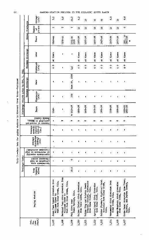
H
set e E BBS s iogl J of o.I 4 ~J § J ,4 j^ s o IK if & S ^ 1 H B 1 0 1^, & f2 & £ |
Op oc a 2 **J o **" OOP- o s^ . <D >*j o> SS HB 0$ H- (o HC HErc* H <? to 1 oi"0 p STS- " 03 tel ?'--AI «H t) a S co
Pfo cod' 3B PP> P PO ^f*3 R^ca Ro, HC. aCt 3 HM r!0-P> ^£X H*O «Oco
p. R R*c«- H,K P-5 C-^ 5S OH* 5 O -To i?- Ott Ocf-5- O (fi'l H4P-to *<p- tr oca **P-*-io 4O*ca oeop-
S>1 Sp o g 3S- a o-ta a £ B"*? H. &o °JH^ off S-S- S'SC- £o o c*&
fflS5'3'?^ fe1(i-"o.<'''s-<'ffP' ?°P-
S» ?& 2 15 g ?? o&S SS ° 85 o>? n5 H- o PS p5 H ? pr 5 **B°S 8 oSo^otSopS < >i
- | § I *f § 1^ § ? H
** B
111 ii i i £j i
i i i i i i i i o
«!
S- P "o
,as tunnel diversion ams River to Fork Clear Creek, C
& 9
i
i
III II III 1 1
III II III 1
III II III 1
G G G G G G . G < <
or
5-to io £ S io io VO -S \jj\jj IOIO MM IOWW
0>IO 0> 0> 01 t» TO 0> 0>
III II | . £ 1\71
r§TO
p.0<0. O.P. &.&.oq |o o o o o o o
& & 8- ft ft ft ft
i i i r r ii. .HH !_, H H H H j-jj-ij-j |_i
* Vt H -*a -o -O -O -O -O 0» H Cft
to
'
i
i
i
1
i
&o
1
1
O^MW MW MM-O -O \n
« 5 o. S& Sc^g09 O V*> -O 01
~J«1
0 r-.
|Ifn
I Sft8
If*
Approximate area irrigated in 1939 (thousand acres)
Approximate capacityof reservoirs in 1940(thousand acre-feet)
I(D
1
^
&
2"f iff-Gig'8
ffiM5*>H H ffl
Sources of record notpublished in Water-Supply. Papers
a?
o
too
S"
<D
C*-5
!
o1
» 0CO !
R|
"§
a
1& p-2.
i!n<»
|p-
.scharge
HP-
0
!"
»
,_,
1
§
a^g-Q
H
>o
H3AIH IHflOSSIW 3HI HI SQHOOaH NOIIVIS-ONIOVO

BASK DATA FOR GAGING STATIONS
to
3
c-Si
n
a
o o
1
'to
H
S3
1
'
1
'
'
"8
0
® co o
IIIh H i-Hgco o
Ha
ft
- *C\j CM
to to
CM CM O-. CTJ
0 0
a -a
1 1
1 1
to co
CM CM
S3 S3
1 1
I r
i i
i |
' '
Aggregate diversions 18 to 20
"""IT ditches from Ralston Creek, Colo.Fisher ditch diversion from
Clear Creek, Colo.
jf w
*
a
to
Si
1
0 o
t
1
toTa
a
i
i
i
'
i
Colorado Agricultural ditch
diversion from Clear Creek, Colo.
COa
aa
to
Ii
0 o
1
1
to
1
S3
1
1
1
1
I
Clear Creek and Platte River
ditch diversion from Clear Creek, Colo.
8
3
a
to
CM
n
0 O
'
1
toIS3
I
1
1
1
'
Fulton ditch near Brighton, Colo.
oa
2?
a
to
n
1
o o
r
i
to
CM
S3
1
'
1
1
1
Brantner ditch near Brighton, Colo.
a
a
a
to
1
0 a
i
'
to
S3
1
1
r
i
i
Brighton ditch near Brighton, Colo.
CMa
CM CM
a a a
to to to
si si si
i i io o o a -a -a
i i i
i i i
co to to
CM CM CM
S3 S3 S3
1 I I
1 1 1
1 1 1
1 1 1
1 1 1
Lupton Bottom and Ellwood ditches
near Fort Lupton, Colo. Platteville Irrigating and Milling Co. ditch near
Fort Lupton, Colo.
Side Hill and Meadow Island Ho. 1 ditches near Fort Lupton, Colo.
-d- TI >oa a a
*£>&} >- ft r-1 f\
a a a
to to to
CM OI W
1 I i00 0
a -a -a
i t i
i i i
to to to? T ?s 8 aS3 S3 S3
1 1 1
1 1 1
1 1 -1
1 1 1
1 1 1
Evans Ho. 2 ditch near Fort Lupton, Colo.Meadow Island Ho. 2 and Beeman ditches near
Platteville, Colo.
Farmers Independent ditch near
Platteville, Colo.
c~- to Qa a 3*, *. *
&
a
toCJS
101
0 o
'
1
to
&
o
\
1
'
'
'
Hewes and Cook and Western ditches
near Platteville, Colo.
3

Tabl
e 3. Base d
ata
for
gagi
ng stations i
n Mi
ssou
ri River Basin Continued
Eef
.H
o.
(see
ch
art)
1,14
3
1,14
5
1,14
7
1,14
8
1,14
9
1,15
1
1,15
4
1,15
5
1,15
6
1,15
7
Gag
ing
stati
on
Nor
th S
t. V
rain
Cre
ek n
ear
Ali
ens
Par
k,
Col
o.
Nor
th S
t. V
rain
Cre
ek a
tL
ongm
ont
Dam
, n
ear
Lyo
ns,
Col
o.
St.
V
rain
Cre
ek a
t L
yons
, C
olo.
St.
Vra
in C
reek
at
mou
th n
ear
Pla
ttevil
le,
Col
o.
Sou
th S
tc V
rain
Cre
ek n
ear
War
d,
Col
o.
Mid
dle
St.
V
rain
Cre
ek n
ear
Ali
ens
Par
k,
Col
o.
Lef
than
d C
reek
at
mou
th,
at
(nea
r)L
ongm
ont,
Col
o.
Mid
dle
Bou
lder
Cre
ek a
bove
Car
din
al C
reek
, C
olo.
Mid
dle
Bou
lder
Cre
ek a
tN
eder
land
, C
olo.
Bou
lder
Cre
ek n
ear
(at)
Oro
del
l,
Col
o.
Dra
inag
e bas
in1
Are
a (s
quar
e m
iles
)
33 109
226
1,0
00 15 28 74
T 32
.3
38 105
°^
e .3
§
'R 1
5 n
2 y §
S
M 5
a!
-rl^ 0 0.3
40 160 0 0 12 0 0 0
.1
0,3-
.O
">
a %'
.<E
X'H
1
0)
-rt
CO
'Run
E£ §
s-i -p
<(
O^
_ 2 20 87 _ _ 1 _ (c) 16
Ave
rage
d
isch
arg
e 19
38-4
3 (c
fs)
_ 88 126
221
_ _ _ _ _ 87
Ave
rage
annual
runoff
19
38-4
3 (i
n.)
_ 11.0
11
.0
6.3
_ _ _ _ _ 11.3
g li " 5
"I Si
o TJ
51
0)
01
>J
ij §1
o
3
Pl
to B
.ra|
_
KW KV V _ _ V T
TV KV
Dis
char
ge r
ecord
s pri
or
to O
ct.
1,
1944
Yea
rs
b 19
25-3
0
1912
-13
b 19
14-1
719
22-2
3b
1925
-
1887
-91
b 18
95-
1904
-6,
1519
27-
b 19
26-2
719
29-3
1
1926
-30
1927
-42
1907
1908
-10
b 19
17-4
0
b 18
87-9
019
07-1
419
16-
Max
imun
dis
char
ge
Dis
char
ge
(ofs
)
e 1,0
00
1,2
10
10,5
00
11,3
00 313
322
812
(g)
(g)
2,5
00
Dat
e
June
9,
1929
June
22,
19
41
June
22,
19
41
Sep
t. 3
, 19
38
June
7,
1926
June
6,
1926
Sep
t. 2
, 19
38
_ _
June
6,
1921
Min
imum
dis
char
ge
Dis
char
ge
(cfs
)
(g)
d3.3
d 0
d 12 d
1 3.1
d 0.
4
(g)
(g)
d 1.
4
Dat
e _
Dec
. 19
, 19
39
at t
imes
Apr
. 23
, 19
35
Mar
. 20
, 19
30
Mar
. 5,
1929
Sep
t.
20,
1939
_ _
Feb.
7,
1943
Ann
ual
disc
harg
e
Tea
rs
1926
, 27
1929
, 30
1926
-44
1383
-91
1896
-190
319
0519
08-4
4
1928
-44
1930
, 31
1927
-30
1928
-42
1914
-16
1909
, 10
1918
-40
1907
-14
1917
-44
Num
ber
of
years 4 19 50 17 2 4 15 3 25 36
Ave
rage
(c
fs)
62 87.7
133
174 25 42 13
.9
57 53.1
93.9
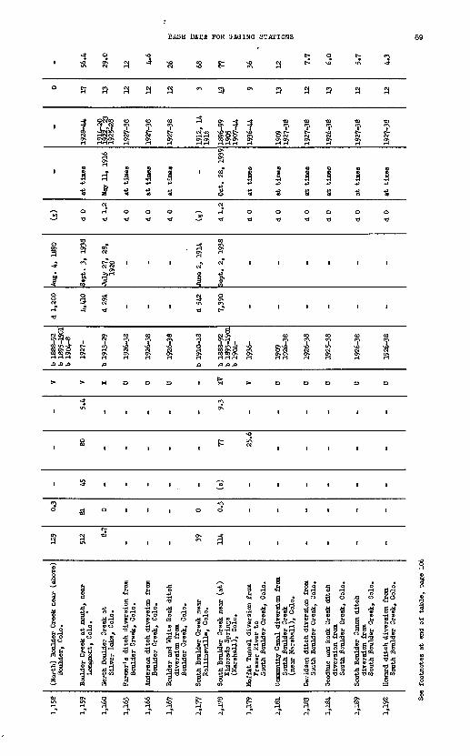
BASE DATA FOR GAGING STATIONS
a a a a H
3
i 8
H
* .
J I
1 11
«0 «0T *?
1 I 8 3
H^ ON -* J
ON
3
* m1 «0 «1
p o 'S
to to to
S t* c*. NO CM W W
n ra ra
I 1 1
U -8 -8
<oT
i
I 8
1927-38
I 8
I I I
«0 g.O CM S* H H H H 3
> > «
to to <oCJ\ CJ\ W
CM CM M (JN Qv ON
o o a
b 1910-18
i
b 1888-92 b 1895-1901
b 1904-
B
Ni
§
>
to
O CM O\ ON
»
<O
CMH
»
«0 «0
ir\ NO
S 3
B =>
SH~»
O I I | O O I \ I
a a I I I
NO f-
H H

Tabl
e 3. Base
data
for
gag
ing
stations i
n Missouri River Bas
in C
onti
nued
Hef
. H
o.
(see
ch
art)
1,19
6
1,20
1
1,20
3
1,20
4
1,22
7
1,22
9
1,23
1
1,23
2
1,23
3
1,23
4
1,23
5
Gag
ing
stat
ion
Leg
get
(Cha
rity
) -d
itch
div
ersi
on
Bou
lder
Cre
ek,
Col
o.
Ley
ner
and'
Cot
tonw
ood
No.
1
dit
ches
, di
vers
ion
from
D
ry C
reek
, C
olo.
Low
er B
ould
er d
itch
div
ersi
on
from
Bou
lder
Cre
ak,
Col
o.
Bou
lder
and
Wel
d C
ount
y dit
ch
dive
rsio
n fr
om
Bou
lder
Cre
ak,
Col
o.
mgh
innH
(G
oddi
ng)
dit
ch
div
ersi
on f
rom
B
ould
er C
reek
, C
olo.
Rur
al d
itch
div
ersi
on f
rom
B
ould
er C
reek
, C
olo.
Uni
on d
itch
nea
r P
latt
evil
le,
Col
a
Sec
tion
Ho.
3 d
itch
nea
r L
a S
alle
, C
ole.
Thom
pson
Riv
er n
ear
Est
es P
ark,
Gol
o.
Thom
pson
Riv
er (
belo
w p
ower
hou
se )
near
Dra
ke,
Col
o.
Thom
pson
Riv
er a
t m
outh
of
cany
on,
near
Dra
ke,
Col
o.
Dra
inag
e ba
sin
Are
a (s
quar
e m
iles
)
- - - - - - - - 158
277
302
i HI - - - ~ - - - 0.5
1.0
1.0
udmate capacity sser
voirs in
1940 isand
acre-fe
et)
B*
J
- - - - - - - - (o)
(c)
(o)
Ave
rage
di
scha
rge
1938
-43
(cfs
)
- - - - - - - - 125
159
f 17
8
Ave
rage
an
nu
al
run
off
19
38-4
3 (i
n.)
- - - - - - - 10.7 7.8
8.1
,es of
record not Lshed
in
Water
- Ijr
Papers
CO
B.C
OI
U U U B U U U U V K V
Dis
char
ge r
ecor
ds p
rio
r to
Oct
. 1,
19
44
Tea
rs
1926
-38
1926
-38
1926
-38
1926
-38
1926
-38
1926
-38
1926
-38
1926
-38
1930
-
1917
-26
1928
-
b 19
26-3
3 19
38-
M^-K
-jmum
dis
char
ge
Dis
char
ge
(cfs
) - - - - - - - -
1,59
0
8,00
0
5,60
0
Dat
e - - - - - - - -
June
16,
19
35
July
13,
19
19
Sep
t. 1
, 19
38
Min
imum
dis
char
ge
Dis
char
ge
(cfs
)
d 0
d 0
d 0
d 0
d 0
d 0
d 0
d 0
d4
.4
d4
.9
d 7
Dat
e
at t
imes
at t
imes
at t
imes
at t
imes
at t
imes
at t
imes
at t
imes
at t
imes
Dec
. 12
, 19
40
Dec
. 20
, 19
39
Dec
. 20
, 26
, 27
, 19
39
Dec
. 12
, 19
40
Ann
ual
disc
harg
e
Tea
rs
1927
-38
1927
-38
1927
-38
1927
-38
1927
-38
1927
-38
1927
-38
1927
-38
1931
-44
1918
-26
1929
-44
1927
, 28
, 33
19
39-4
4
Num
ber
of
years 12 12 12 12 12 12 12 12 14
' 25 9
Ave
rage
(c
fs)
8.5
6.2
20 3.8 4.1
6.0
39 11 124
178
173

BASE DATA FOR BASINS STATIONS 91
CM
«0 Qa 3
- a
O TO ft PI
rH rH
' 1 p
u- OJ? ^
to ?? c^\oj a
^ fp w 5 co
S 8 d
pj
JO O^ 3 CM
*#
> >
<M
3i
1 C-
CM to rH CN-
S §c^\ to
a
Lg) Thompson River (Creek) ne
Arkins, Colo.
jmpson River at mouth near
La Salle, Colo.
H u\O CM O -41 vO c^\ C^\3 H «U\ CM H t- CO CO CO
^.4 to ON ox r$ 5 $ $ci c- ^ WalO c- c- c-
CM to OHCMen CJ^ e>
i 11I § o^ H'CM" I i i
+> S ? » d Q ««co
O d M1 -d * -d III
-4- *
ON CM
1 1 » -4"C*- i i a °*s! '& 1§ ?
i 1 'M ^ illN-* -d1
* "f ? "?
.0
>->>>>>
O u>
II III
£ Bi i <^ iii
i i § § iii
' i ° w iii
3 3, 0 « III
5 I ,,3| 1 a 3» ^° 5ft <o ft a ^vi. 4> 2 S t1 a fe 2 h
OH d ^o Hp5?§S-|oc§ s fe a & ES ss idS 43 -^ 5i4c§5 gggofeo
11 ^ I. tla ?4 *f ^1 IIJai |i r,i |3 ni ^i :lo a a f<5 5§!n 5» -Sd -Sd )>d-p'gS fl ""S & «
:il J | ^ 3 « *i ii |i aiIcSl Si &*& |S ScS p 11
NO
CM
M
1
1 puo d
1to
p
CO
(0 m
J3
>
1
'
1
C-
d
R?
letree Creek near Qranite Canyon, Wyo.
u\c^
M
-*s
1 puo d
1to
UCO
u\
3
uf> f
'to
NO<M
O
Hd
f?
idle Fork Crow Creek near
Hecla, Wyo.
mr-l
CM
1
1
u0 d
1a
ON
g
A
1
FJ
CM
5
H
O
rH
d
NO
xbh Fork Crow Creek near
Hecla, Wyo.
r\M
M
-I1
1 p
8
o d
1to
? 5>CO
1
£,
'
M
5<*
rH
rH
0
£
rth Fork Crow Creek near
Hecla, Wyo.
-41
M
M
1
i p
%
O a
i*
CO
toT
f>
I
I
'CM
O
M
i
dgepole Creek near Federal, \
mto
-*
1928-31
i
i
'3
rHs.0
CO
1
'
NO
Rd
.
igepole Creek at
Wyoming-Nebraska State line
CMj.
8
1925-4A
S
*.
51
CM d
1
o3.fi
^
D]
d
a
CM
NO
O
rf
I
igepole Creek at Bashnell (a)
Oliver Reservoir), Nebr.
M CM M M 9 I

H
«
8=tD&
ern Canal near ig Springs, Hebr.
i
I
i
Vrt
i
fa
1
1
1
P.O
ft1w
I
ij
is
f
P!
all Reservoir Cana rom Lodgepole Cree
-Tfe1
ss5" 3 i
S
i
i
i
fc
i
ca
1
1
P.O
ftg-
o
ioio
^j
£
^ju>
Jr> j-1
$ i «c<- ST
epole Creek at Ovi h Fork Lodgepole C ederal, Vlyo.
W o
§ 1B *
o10NO
fc 8
O NO H
1 1
( (
1 1
1 fa H
NO NOio ly VJ to
^
00 00
CO
*» '
s* 5T O *~r
ftti1 '
H H
?l
M M
H ia^a o
IO
to - -aK
epole Creek at olc-rado-Nebraska S at Ralton, interst tation), Nebr.
Ho
g
10
§NO
1
1
t
CO
NO
*»00
1
p.o
ifON
gH
d>O
U>
P
vn
i> "jo ij ^ n3 p 0 -J
! ol J Jf-^o wo oo »»o
^c*-*?*- &S- *o
1? ^? 1
ftP 0 0
10 IO IO H
g § § gK g K K
1 1 1 1
till
1 1 t 1
CO CO CO CO
H H 10 H
£X-N x-x V
°L " « X! N_- 5
1 111^
s100>
JJN p, p. 0,
N O O O
ft ft fty g- g*co a a
1 II p p v HK o
M ON \n vn
0> ON M £NO Ul NO ON
_H (H-
Ox vn
I I
all (Oliver) Eeaer epole Creek below (Oliver) Heservoir
** P1
P PH H
g e-* -*t i
i iCO CO
o* o4
?P| ? v^^
vo 'M
1K ,
S
0 'O
8-g-a
Ur
., '
V*> 1
vn
CF CO SI PC
i
i ia- ft§
.S wP"! §
Approximate areairrigated in 1939 (thousand acres)
Approximate capacityof reservoirs in 1940(thousand acre-feet)
1
|
?B-
P.
O VjJ O <D
CD
^H IP*-
Sources of record not published in Water- Supply Papers
<D
B
t)
£i$o
ft (C
aH-
~&
1o
1-4
-
S'^B
a 4
<r|£ja>
f|
&
I<D
P
f
&
<D
1
8Sa
g
8
i§ p.iftH
1
HISV9 H3AIH IHflOSSIH 3HI HI SdHOOaH HOIJ.VJ.S-OHIOVO

BASE DATA FOR GAGXNG STATIONS
*
1941-44
I
u0 a
^
1941-44
I
15
0 a
-* -* c-
r cy fTi --J
I I I
IS 15 15
O O 0
a -a -a
a » » »*
« 3 cy <pcp 3- ^os^ "f f "fC\j C^ C1- rH w CM C NOr-lrHc^ w (?*
C«A ^ SI SO ^ *"* °* ffi *"*
sa a a i H *H *H »H *ri
8 IS "8 15U
00 0 00
a -a -a -a -a
SJ
1918-44
ra
1
15
o a
« .
a i
I 1* u0 0
o -a
a *
p\O ir\SiS SH rH H
I !IS IS
0 0
a -o
i i
a a
CO CO
i i
i i
i i
a&
§ "8 SHc a j| g
l| fej? *£ l|
1? s?o Ti 5?.rt^5 6A£ 3
8 8
806231 O
r-
1 I
CO CO
1 1
1 1
I o
Rrt
£
s *?, ^fp £
g'l ^0! 0 S
inson Power Tri-County xnee Creek n
O 0) -a cu
j§ £
- 48 - 7
il l i i i i i i i i
<0 O^H 0^2-4- vo32A ti oL <0 tt r!| Ori J\CM rHOi rHCVc'J rlp^OIC'NrHp^ rH ff\ (*\ rtirji^
COCO CO CO CQCOCOCOCQCOCQ
II 1 1 | | 1 | 1 1 1
°-£?§ rt ^^f2 gH rl l|l
|| 1 1 | 1 | 1 1 1 1
II 1 1 1 1 1 1 1 1 1
1 'l 1 ' t 1 1 1 1 1 1
£ ji £ g » .D
1. * . *
t t« | | | £ £to g o c a (3 (3 S G i!
M G Bi 'D 'S'S c53 g S £ § S ?
tO^iC ?* h*« (DV|h {H L ajQ> Q> OJ3S DM t<bO Gr-jJ3(>>*S'>gaH Hk
a>o cu^ n^i roj)42®-*3gs ro do (DSi g ^ r-jViSQ&igoojvej a H * ff ME HG c3*>O«*ObOilOO OHS>,3 38 ? S 3fTlOT<oqB+> o Ofl ,S.C £-C OTJO ro -HtDH^ >»<t~t
SB ^ e^ S+3 KsGNnx^iDi? STH i> ^ B Bo Sp doaoSoo.ojotp GS T< « xi XI c5 J3 c5 g ^o rao H i-l o g ^(0
^*c3 c5 c5 ooopuP^^t^
ri-* "N SB CNOrHtOOtNlcn OO O O OHr-lr-lCMCVOJ
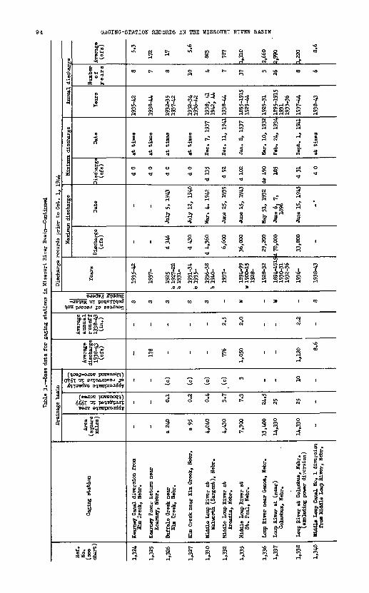
Table 3.
Bas
e data for g
aging
stat
ions
in Mi
ssou
ri River Bas
in C
onti
nued
Bef
. N
o.
(see
ch
art)
1,32
4
1,32
5
1,32
6
1,32
7
1,33
0
1,33
2
1,33
5
1,33
6
1,33
7
1,33
8
1,34
0
Gag
ing
stat
ion
Kea
rney
Can
al d
iver
sion f
rom
El
m C
reek
, N
ebr.
Kea
rney
Pow
er R
etur
n ne
ar
Kea
rney
, N
ebr.
Buf
falo
Cre
ek n
ear
Elm
Cre
ek,
Neb
r.
Elm
Cre
ek n
ear
Elm
Cre
ek,
Neb
r*
Mid
dle
Loup
Riv
er a
t W
alw
orth
(S
argen
t),
Neb
r.
Mid
dle
Loup
Riv
er a
t A
rcad
ia,
Neb
r.
Mid
dle
Loup
Riv
er a
t S
t. P
aul,
Neb
r.
Loup
Riv
er n
ear
Gen
oa,
Neb
r.
Loup
Riv
er a
t (n
ear)
C
olum
bus,
Neb
r.
Loup
Riv
er a
t C
olum
bus,
Neb
r.
(exc
ludi
ng p
ower
div
ersi
on)
Mid
dle
Loup
Can
al N
o. 1
div
ersi
on
from
Mid
dle
Loup
Riv
er,
Neb
r.
Dra
inag
e ba
sin
Are
a (s
quar
e m
iles
)
- -
a 24
0
a 95
4,04
0
4,43
0
7,30
0
13,4
00
14,3
30
14,3
30
ON
P? :.s§ 111 - - 0.1
0.2
0.4 3.7
7.3
24.5
25 25
oximate capacity eservoir
s in
194
0 usand acre fee
t)
8 "
2 e.
^j -P
<
O^-'
- - (o)
(c)
(c)
.(o) 3 - ~ 10 "
Ave
rage
di
scha
rge
1933
H0
(ofs
)
- 178 ~ - - 776
1,05
0 - -
1,12
0 8.6
Ave
rage
an
nual
ru
no
ff
1938
-43
(in.)
- - - - - 2.5
2.0
- - 2.2 "
ces of
record
not Ished
in
Water
- ill
Papers
la! s s s 3 S - w - w - s
Dis
char
ge r
ecor
ds p
rio
r to
Oct
. 1,
194
4
Tea
rs
1935
-42
1937
-
1925
b
1927
-28
b 19
31-
1931
-34
b 19
35-
1936
-38
b 19
40-
1937
-
1894
-99
w 1
900-
15
1928
-
1928
-32
1894
-191
5 19
30-3
1 19
32-3
6
1936
-
1938
-43
Mai
ri mu
m di
scha
rge
Dis
char
ge
(ofs
) - -
d346
d 43
0
d 4,
360
6,60
0
36,0
00
29,2
00
d 70
,000
33,8
00 "
Dat
e
- -
July
5,
1943
July
12,
19
40
Mar
. 4.
194
2
June
25,
19
39
June
15,
19
43
May
31,
19
32
June
6,
7,
1896
June
15,
194
3
"
Min
imum
dis
char
ge
Dis
char
ge
(cfs
)
d 0
d 0
d 0
d 0
d 13
5
d 92
d 10
2
de 4
90 185
d31
d 0
Dat
e
at t
imes
at t
imes
at t
imes
at t
imes
Dec
. 7,
19
37
Dec
. 11
, 19
41
Jan.
8,
19
37
Mar
. 10
, 19
32
Feb
. 24
, 19
34
Sep
t. 1
, 19
41
at t
imes
Ann
ual
disc
harg
e
Tea
rs
1935
-42
1938
-44
1932
-35
1937
-42
1932
-34
1936
-42
1938
> 41
19
42,
44
1938
-44
1895
-191
5 19
29-4
4
1929
-31
1895
-191
5 19
31
1933
-36
1937
-44
1938
-43
Num
ber
of
years 8 7 8 10 4 7 37 3 26 8 6
Ave
rage
(c
fs)
5.3
172 17 5.
6
803
787
1,31
0
2,66
0
2,99
0
1,22
0 8.6
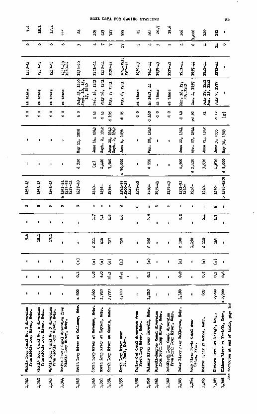
BASE DATA FOR GAGING STATIONS
tjSt O *I "* >ft CM O * w
i
J$0 a
i
i
S
CO
1
2 2 53 1
J § § s s i H -H »t~3 13 13 If
000 0
<0
1 ' ' J1
III £ a
I I 11,O
CQ CO CO CO
iii i
0*1
1 J J I? ?H TO <0 lf\0» CT»
5 S S5 8?^ S5
> H H
' . "hi ^ * 1' O r? M U) S.dd 3 ja Q < 4 -5 W
Ift Ift Ift IA O« « 2 * "*m (J Mtv
?1 ?) S?l ffi
-^ ciT o'ciT ^« i
i 1 it i^ 3 '"A 8 1
- CM* t? 0"
5 5D *^ £> O CM CA
^
III* 0)
Tj H <0 v<J i-l t^l CM CM
1
1
isf11 o
1
CM
1939-43
1fl
0 o
1
1CO
I
1939-43
at tine
0 o
i
1
CO
i
i 1s S t-
0" rH
?;3 g
i icf S?
i ii i >o <«\
u
CM
? J ^
c^ ^ cr\CACA y^
1 1
CM1
* 4
! Ia aifif W HH g
&S CM*
lit o
1 sif « i 1e^ H
i ^
' -
C? r4
0
'
1
M
8
0*
1
a
IA
'
1
a 3 S 3
I I I O O O o I o. I o. o i
till O*J ° * ?-3 -* O
CM O CM* CM*
J5 »^ J3 u5fe 3 g E-8I ^1 5*a . s" 3 «T
fe d
c? .gEH CO h
fl fl I.
I i i'II KW M 1-4
1 3 ll ll31 11 3! d s3
*^ I g * Ig a |s °! & y |
;« 1 g na 5
s

o o o o
Approximate area irrigated in 1939 (thousand acres)
Approximate capacity of reservoirs in 19AO (thousand acre-feet)
00 OJ I IOJ OJ OJ I
Sources of record not published in Water- Supply Papers
p. O.
o om
I I4 r?
a to
B SNISVS H3AIH IHflOSSIK HffiL KI SCIH003H96

BASE DATA FOR GAGING STATIONS
-30 -44
W c^ P-\ CM <£<O> O> O> O> *t> Ci-l H i-l i-l H r
CJ 01 II
U\O <ttCM -* at o*. -3
^-* - O NO C*NON 4*
£ p
§ sUN UN
I i i i 1 I8 8 8 £a R a s
Of ffN rN
1 P5 1 B
JO O
I S 8C " o^
UN H
I III
s a i
§ o S
8 Jd
CM
d ia a
OT 01
0- UN" U? U?« s ?! aH ^
i iftit£* * - .
E? R ISp s &sUN ^ ONON i-l r-i w ON ON
3
I <0 <0
t^i t^i rn
§ S 8 388
a si
ON O« ON
§
H H r-<

e s
SP S1 g"S ?
f f
8 ? ft
tn 5T
Approximate area irrigated in 1939 (thousand acres)
Approximate capacity tif reservoirs in 1940 (thousand acre-feet)
Sources of record not published in Water- Supply Papers
!B $S §
iG K
o. o. o o
SI
JsO \o O^O NO
IHnOSSIW 3HJ, HI SdHOOaH HOIIVdS-ONISVB

BASE DATA FOR GAGING STATIONS 99
o e- UN en UN
vO UN H CM i-l CM O O O
c*- cn UNTO en -^to to voCM PN SS^gJ St N S, i-l r-i r-4i»lf-< i-l i-l i-l i-l
' J ' ' '
8
,-» 0 f> r* r*to to to to
II III
£> ^S *w "3 "M
cJ£J rfSJ JOri rt 2C|*enenen cy en YM^
CM cn ^ SN St 81*^ ^*
A A A
mm m n to
i i ill
II 11,
1 l til
3 <V, CM CM CM 0 (S c\t CM
O O O O O CM cn UN Vs- to
a a add
i 1PI- 1 . If ! i0 p <p p §> 53 P 3 P *1 S?
l! |! || |I |I|*| sl g^ gl g^f
|l |i |l |! ]!3£ fa fi £ b.
cy c^ CM S CM_ » * * n »
t>-
1933-39
a"
^f?gi-i 1
a
1>o~
1
!?i-i
CO
1
CM
CM
CM
i-l
OS
1 .
|i"^|!**o
a s
CN O-*7 ?T^ 5?S3 as
tf ||C^W - » 1 CM en en eni*&
v5
1 iOf rH
*
1 1
2" *
IUN ^i
sS Is^>CO CO
r- o
9 ,
CM -*
CM enCM CM
S ^ CM
rT .-T
CO <«
"5
1 | C
1*: s»,5^ s ^I-s1 s* IxSa
st s^&
p JHb. b.
i-l CM
*>
1925-30
i
vS?
1
"to
!sCO
1
1
-*CM
ScnH"
a
i1
tio *
jl&.
1$rH
S
I
1Si
1
1e=
1
CM*
*
i-l
-
to o
1-*
UN
CM
§
HCO
1ss
1is
1i1
Ct,
H~
"^ J9
cn ^UNtO Oj
' i4*
-5 *
1
1 ri
1
3 s-o
vO QON en-*UNCx- A
SSS s
co SB
to O1
, s,
3 3o Q5 Si-l CM
OS CO
iiIf &!- *Js« gl
r r* * ITt \O
H" H
-*
iio o
1
'
Jen!
is'sSS#
m
i
'
i
i
1.I1
rjO
°1
fl
tf
§,-T

GAGIKG-STATION RECORDS IN TBE MISSOURI RIVER BASIN
o> go
j W N* I
I i a
1 ft
-* rl'"' * Q
£ tl $
° 1 ** 3
U I a-O -rl"^
£ 1 - 0
Q
BJeefej jglddng-oaq^fi irp pansT^qnfl
^ ^ou pjoosj jo saojnog
^ a h S""*
<a( ^ H "'
0*761 Ut SJTOJU9S9J JO
^ 6£6T "T pa^eSraJT
1 l|l
Gaging station
*H S> ^to o o> g
t- CM «0*
" * * * " " '
CM -* H OX-J 5>?CM Ox -1T T 7 7 .« « T 7
olcM 3 CMJn CMcn CMWgj CM-3 3 i-t H r-4 HfH H H H H i-t HHi-t
9 CO ON 0 H H
J en ' 11 I * II I .j
** H 8*UN. CM
o >A ^* o o o -i V -a ££ it it tl tt
t5 f^a a 1 a ' 'a"
i 1I -* 1o I I i 'X
'-' H
NCM(n -* CMCMcjJ CMCA CMCMCMNCA CM ;jt
a ft a a
1 1 1 1 1 II
vO
1 1 1 ^ 1 II
2 , , , , 3i> r- H
i d d i i i o
§ o o SJ i i i P
H r-T <3
a a
1S % n ^ II <E5 1 g*
dS ^ C g^|^ ^ S
PC 4> -p* UgJ^Ct i-f Oa
^f< 3 cf s >d el ^ g g j>
CM -* u> sO C>; O> O
33333 <f -*
* *O*> NO
H -$ H IO
SI c?Iaa SS
3 3
d S a sCM- ai I° 8
H
i-t H
CM en CM en
XI XI
VJ «
-*
H1
, *
O O
H H
o d
O O
<Q CO
VI
Red Willow Creek near Red Willow, Nebr.
Medicine Creek at (near)
Cambridge, Nebr.
rt S(
VO
*
8srf.a
1oIS
1
3
H
X>
ra
i
i
i
0
aCM
CD
8*
1u
t-4-
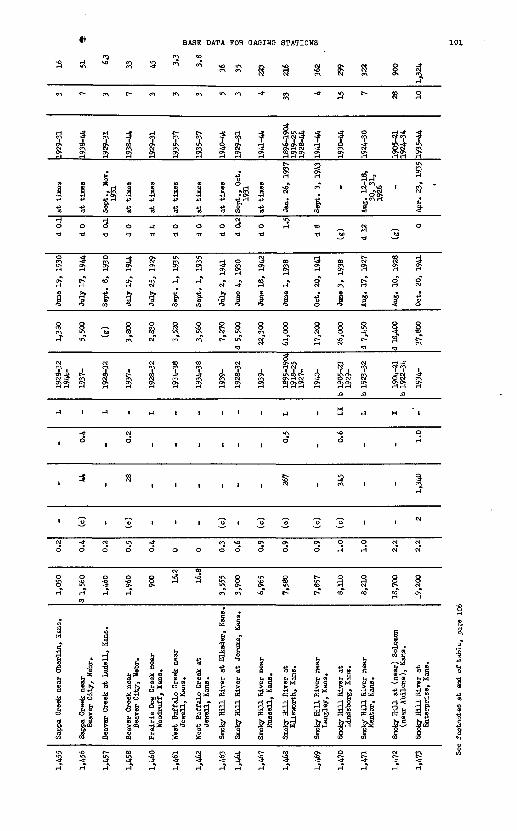
BASE DATA FOR OAOINO STATIONS
1-1
en
1929-31
I
8
d o
K ^
t^ en
^ en
S a
§
I *»
U to
o 3TJ t)
en
^
1938-44
a 8
o o
"*
en
1929-31
1
8
^ a
en
1935-37
1
uoTJ
- * 8
en IA en
c- -* H? J <? S 3 ?fa a a
+>
J l w""1 H CT*
U U 01
0 0 <3
0 TJ TJ
8 *
1941-44
1
13
0 a
N m N
S * rH
IJ^J ? Jiga g g3 rH H rH rH
a 3rH rH
so en I
s. f"3 tO
UJ
rH «0
tf bO
SI 8en o»
- R
? ^7-i "A -If
§.<£.rH rHrH
SH
1
a
^ i-?s
1935-44
cP
CM
1
0
a a
8 8
CM tO tO
CM CM
CM CM
CM «0
2 4
. 3
n£fe 6o ^
I a.i3 Jd n
6§ p 5 5 :s s3 § S^«d sis"
* fc s-*-*-* B P

o
S
f
1P!
1
1
r
f
H
1
.
f
1
W
§
s
H
^
SvO
S
Big Blue River at Hull, Kans.
1vo o
0
1
1
f
1919-25 1928-40
H vnvo8
I
P.
CO
{-*
H H
§
Big Blue River at Barnston, Nebr.
1
O
£
*
H
1
I
vn
§
J
P-
II
1933-44
£ON
f
1
I
&
I4
& <9
f
*
u> o
ro
t->
|P-IS
8
IN)
«
H
P.
CO
H
!
vn
^ o
pra
I
i*
0
'
i
i
i
1934-38
^_
1
Sp. o
ft
1935-37
i
East Limestone Creek near Ionia, Kans.
-avo
0
I
i
I
I
S
5VJ
81at
g
P.0
I
gA
I H 1 §
South Fork Solomon River at Alton, Kans. Solomon River at Beloit, Kana. Solomon River at Niles (near Bennington), Kans. North Fork Solomon River at Kirwin, Kans.
H ON vn H
o o o o
000 0vn NO 0» H
0 H .JL £,
' Vn VJ '
1 1
.H P H NO
H H H HH HH hj H H
N« NO
i_t j> Ui 1 ' v!n P ^3 P
8 § § 8
N*3 VjJ H
""* io NO "H
§ ^ S
p. p. p. p.OHO 0
H
(U CO P 03 C*- O t* <D
HHH HH HH HHH
S -J *
S
Ig
1P!
i
it
§
0
'1
1
00 NO
1a.
§
o
£
1
H
-0
Saline River at Tescott, Kans.
!oH
H
B
o
t-1
io
o> o
1
H
P.
0
8-d-
S
H
5
Saline River near Wilson, Kans.
ioaH
B.
p
i
§ f
8
rvn
p. H
1
1930-44
iSSK^^ P«^ HON^ti
H M
11§o-vO* 8 g sHs§
ETlTsBW ^ <D . M,
Gaging station
p.^0 fa*
Approximate area » irrigated in 1939 g" (thousand acres) g.
Approximate capacity of reservoirs in 1940 (thousand acre-feet)
01
^-,io 4 p 5" g-^o o ^'"'S r» H O
Sources of record not published in Water- Supply Papers
o K a
o
I <n
a
<n
1 4 9
H^<D
£1 ~%
i ! ><f
o o
H
944
Minimum discharge
o
I a
&ISV3 H3AIH IHaOSSIW SffiL NI SCIH003H NOIIVIS-flNKVC

BASE DATA FOR BASING STATIONS 103
o^
CM
3
1896-1905
3
1r?
i§Si
0
S
-
'
'
1
-*
-*
1 ON
Big Blue River near Manhattan, Kana.
H5i
£
of
II
Ia"
1
rr
aON
1
§
*
O CM
-
NO
r*
NOON CM
O
0 H
3 oT
Little Blue Eiver near
Endicott (Fairbury), Nebr.
s?
S8
1922-25 1929-44
-*
a"
1
a
ia"
|sUN.
-
1-1
CM
S
0
2
!
Little Blue Eiver at Waterville, Kana.
0?'
* § 8 S« WS CM UN.
r-l CM H
S a a S
a o a o
1 1 Jg 1
s 15 15 nrj
O O O Orr rr rr rr
^ s 3 aoC F9 ^ F9t* fe & fcI $ a *8 § § 8O> ON -* tO
i i i ii i j i
NO r* 0 CMt^ UN. ITl -*
O O (O ONO O f^\ ^
rH C^ iH
0 0 ^ "*
"J 0 0 O 0
40 <0 CM 40
S $ cX 3
° 3 4> 8 n8 a Si "jf fl ^ |i 1^ ll !.- rj » *H PE« <H 0> H« h« 2. (4S S §) 5 0 tf at 3
& m o *
UN. NO C>- «0 ON ON ON ON
o tos s
s «
1 a
at times at timea
O 0
o -a
3 5$ as » g i0 <
1 1m NO
1 1
S Si
' '
CM -*NO C-
NO a to oVI
o o
0 0
3 8^3" n
Stranger Creek near Tonganozle, Kana.
Blue River near Kansas City, Mo.
§ S
!r7
1922-44
CM
cMgj i*
0
-*CM
ICM
1
§
*
ii
NO
a
o
o
o of CM"
i |
I 1
8
v\
oCM
VI-SZ61
a"
1
a
ii§
i
CMITS
CM
0
o
NO"
Grand River near Sunner, Ho.
S
3
a
I115
0rr
1NOCM
I
1NO
Jtss
'ON
a
o
o
ON
East Fork Big Creek near
Bethany, Ho.
&
§ CM >!" C^ O** P S 8 S
* a ^ a a
si» s? » SJ SKSJONON ON ON- ON C/> ONON 1-li-IHrMrM Mi-li-l
H H CA
J « n «T o <9 Q S 9Jf3 Er S H M a CM H m a
- S i S io' S 315 1 « I«S 15
M CM r-l M O 0 Orr rr rr rr rr
a 3 3 3 3ON ON ON ON Os
H CM CM CM c3
CM *
f <a
I I I i I
ITS -* -*
ITS UN. ITS 1 I
© ON ON I * , H
O O O O O
0 O O 0 O
CJ O NO -* U%
c- NO CM -* Nr?
Thompson (Grand) Eiver at
Davis City, Iowa
Thompson River at Trenton, Ho. Weldon -River near Mercer, Mo. Welden River at Mill Qrove, Ho.Medicine Creek near Gait, Ho.

o o
II
g 8 13
g* 8 4£ S c+- o5- to <n s a H* u8 I M P * PS ? » STf?
1 1 O 4
» » sss s srs
o o o00 O
Approximate area irrigated in 1939 (thousand acres)
o I iApproximate capacity of reservoirs in 19W> (thousand acre feet)
\ji f vn
Sources of record not published in Water- Supply Papers
i£ £M NdKJ NO
NO NO NO NO
Iff III f
a £
C. p.
0 0o o *-00 M
at t at t
I M M H-P VI O>. » »
- -a a
<rt-6CC-C2« a| ? v3 cJj
tnsva BHAIS iHflossni ana HI saaooaa

BASE DATA FOR GAGING STATIONS 106
NQ
H*
*
S-j
1 pISO d
to
a3
1
§o
aa
i-*
H
3
0
aCM
I
8o
«"8
is»
C-
*
^
H H
NO
Sa3o-*
1H"CM
1
H O
aa
i
to
oCM
-X
a
0
o
to
33s0
u10>
O VN N <r> O °* ° ON
V\ -^ C*N, UN, c*> U\ tO CTV NO K H CM
o i§ :ff :J 3. ^ $ ? IfJ> ' d « <| ° i 8 0 jfa 2 a a a a a H aO CM H O
H3M II ! J ^ 0*4343 434* JP JJ fP -p +i 4>4> ?
toCO OOOO O O O
oi 3- TI TJ -d -d
?? 33^1 afss a aa HH H aa ^1 **CMO c^v ^ *
Os' ONOCMCM CM <a ON
b &&&+> ^ & & 1 III.S 5-11
d
9 , A , , * , J, ,WNH QHONON ON "S^H
CM gj S SN ON ON ON ON&i ON
1 (H tH 1 1 1 1 1 1
. , 5 a s , 335
Os g <H
1 S 3" -S" Of O O O CM CM CM ^-^ N-* ' N^»
H H H
O O OOOO O O O
oo S2H^ -* rl 9OO OOrHCM C^V rH ^ UNO OUN.r-JcTi f^ ~* "^
J ;f ;f ;f
. 4
^ * | I * ^ 5 S £? rt rt §SB I) 4j'i5" ° f!""!h«J .JS'S.'S.isij* S. ^ S h g"§ 2g Cud m"8 osi 1 I § H°3 "J g+»" §
I !»" I 1 ! |If ^" l\ Io Soo^tjojaoiartott!
^
r\
1928-30
8
H
0 d
1
i§
1927-31
'
1
1
1
o
S
L-°5h 53
i|H R
S
ON.
a
,
I0^
0 d
1
1
1ON
a
,
0
3
,2as'c> $ ^
O cfl
JjH
CM
0
1922-44
1
«
o d .
IoT
I
§°.
1
i
NOa"
§NO
3
0
NO
8
»S '"* &
S y &t eS
§0
3
S?
H
1
IS
O d
Ia
1
Is
ia
ON
t>
i
2
o
H
(H
fcsir.d) 8
1 ff11 Srf?
m
*
1931-44
S
CM
1
ON
ioCM
1
|
O
A
1
3
S
O
O
S
§a a»
P
Go «>
8f-T
1924-30
0
H
O
§
TO
d
ION
I
§
£F
o
I
1
1
1
0
to
d
j?is
04
ia1i?
s
*
ON ON
aa
Sa1
45 o
aoCM
1
§ *
CM m
W
1
1
1
0
1
*-?'d *
43 bp
4> (3
^i
OH CM

Table 3. Ba
se data for
gagi
ng stations i
n Mi
ssou
ri River B
asin Continued
Ref
.N
o.
(see
ch
art)
1,55
3
1,55
4
1,55
5
1,55
6
1,55
8
1,55
0
Gag
ing
stat
ion
Gas
cona
de R
iver
nea
rH
azle
gree
n, M
o.
Gas
cona
de R
iver
nea
rW
ayne
gvil
le,
Mo.
Gas
cona
de R
iver
at
Jero
me
(Arl
ingt
on),
Mo.
Gas
cona
de R
iver
nea
rR
ich
Fou
ntai
n, M
o.
Big
Pin
ey R
iver
(P
iney
Cre
ek)
near
Big
Pin
ey,
Mo.
Lit
tle P
insy
Cre
ek a
t N
ewbu
rg,
Mo.
Dra
inag
e ba
sin
Are
a (s
quar
e m
iles
)
1.25
0
1,68
0
2,84
0
3,18
0
560
200
£~
jjss
ill
0
bfg
!3£ 0 0 0 0 0 0
t»3~
Tpf
Si
r* 0
.1cunate
cap; jervo
irs ii iand
acre-:
P £
SH
h
O
(c)
(c)
(c)
(c)
(c)
(c)
Ave
rage
di
scha
rge
1938
-43
(cfs
)
1,11
0
1,45
0
2,60
0
2,95
0
550
160
Ave
rage
annual
ru
noff
19
38-4
3 (i
n.)
12.0
11.7
12.4
32.6
13.3
10.9
1 g&
l3s of
reco: 3hed
in
Wa
I
Papers
ill
la!
M Y M M M M
Dis
char
ge r
ecor
ds p
rio
r to
Oct
. 1,
19
44
Yea
rs
1928
-
1914
-
1903
-619
15-
1915
-
1921
-
1928
-
Max
imum
dis
char
ge
Dis
char
ge
(cfs
)
68,7
00
69,0
00
76,8
00
86,0
00
32,7
00
28,0
00
Dat
e
Mar
. 12
, 19
35
Mar
. 33
, 19
35
Mar
. 13
, 19
35
Mar
. 14
, 19
35
Dec
. 26
, 19
42
June
26,
19
35
Min
imum
dis
char
ge
Dis
char
ge
(cfs
)
18
d 50 (g)
(g)
d 75
d 24
Dat
e
Aug
. 1,
193
6
Aug
. 30
, 31
,19
36 _ _
Aug
. 6,
7,
1934
Aug
. 22
-31,
1936
Ann
ual
disc
harg
e
Yea
rs
1929
-44
1915
-44
1904
, 5
1916
-44
1916
-44
1922
-44
1929
-44
Num
ber
of
years 16 30 31 29 23 16
Ave
rage
(c
fs)
930
3,39
0
2,55
3
2,84
5
523
144
s Ap
prox
imat
e figure.
b Re
cord
s incomplete f
or parts o
f period.
c On
ly a
sma
ll amo
unt
of u
sabl
e storage;
probably les
s than 1,0
00 a
cre-
feet
d Daily di
scha
rge.
e Es
tima
ted.
f Pa
rtly
est
imat
ed.
g No
t dete
rmin
ed.
h Figure o
r re
cord
s of
dou
btfu
l ac
cura
cy.
i Re
cord
s ex
clud
ing
flow
int
o Pi
shku
n Canal av
aila
ble J.
936-
38j Includes a
ppre
ciab
le r
etur
n fl
ow from
irri
gati
on.
k Pe
ak dis
char
ge n
ot d
etermined
for
larg
er f
lood i
n 1908 during
peri
od o
f DO r
ecord.
m Since J
une
1917,
flow
has
been in
crea
sed by wat
er f
rom
St.
Mary C
anal
.
n Includes e
stim
ates
of ir
riga
ted
acre
ages
in Canada.
p Records
for tw
o pe
riod
s equivalent if
dis
char
ge of
Woodbine
Creek
is a
dded
to
disc
harg
e at
station
for
1924
-27.
q Does n
ot i
nclu
de f
low of
about 7
second-feet d
iverted
around s
tation,
r Includes d
rainage
area
of Monona-Harrison
ditc
h near T
urin
, Io
wa,
s May
have been
exce
eded
during
1912 o
r 19
14.
t Includes flow of
King
Canyon C
anal f
or 1
940, 41.
u Includes div
ersi
on t
o Gering-Jort
Laramie
Canal.
v Diversions f
or irrigation were p
artly
from
return
flow
, w Est
imat
es o
f di
scha
rge by
months.
x Pr
obab
ly too
hig
h ow
ing
to b
ackw
ater
from
ice.
y to
inin
um daily after f
low
in c
anal began.

Chart 1.- Duration of records at gaging stations In Missouri River Basin
Sourcea of recejtis are Indicated as follows
A - Annual Reports, Bulletins, and Water-Supply Papers, U. 3. Department of Interior,Geological Survey
B - Water Resources of Montana and Their Use, vols. I-IV, Montana AgriculturalExperiment Station
C - H. Doc. 193, 72d Gong., 1st sess., Jefferson, Madison, and Gallatln Rivers, Mont. D - H. Doc. 238, 73d Cong., 2d sess., Missouri RiverE - Dally River Stages, vols. I-XL, U. S. Department of Commerce, Weather Bureau P.- Biennial Reports, State Engineer of North Dakota G - Biennial Reports, State Engineer of South Dakota H - Stream Plow Records of Iowa 1873-1932, Water-Supply Bulletins No. 1 and No. 2, Iowa
State Planning Board, Iowa Geological SurveyI - Water Resources of Nebraska, Nebraska State Planning Board J - Water Resources of Missouri 1857-1926, Surface Waters of Missouri 1927-39, Missouri
Bureau of Geology and Mines, Mlssouir Geological Survey and Water Resources K - H. Doc. 146, 72d Cong., 1st sess., Musselshell River, Mont. 1 - H. Doc. 191, 72d Cong., 1st sess., Marlaa River, Mont. M - H. Doc. 88, 73d Cong., 1st sesa.. Milk River, Mont. N - Water Resources Papers, Dominion Water and Power Bureau, Department of Mines and
Resources, Canada 0 - Biennial Reports, State Engineer of Wyoming, including special report on Diversions
from the Wind and Bighorn Rivers _ P - H. Doc. 64, 73d Cong., 1st sess., Little Missouri River, Wyo., Mont., S. Dak., and
N. Dak. Q - H. Doc. 76, 73d Cong., 1st sess., Cannonball, Grand, and Moreau Rivers, N. Dak. and
S. Dak.R - H. Doc. 190, 72d Cong., 1st sess., Cheyenne River, S. Dak. and Wyo. S - Special Report No. 8, U. S. Department of Agriculture, Soil Conservation Service T - Biennial and Special Reports, Department of Roads and Irrigation, State of Nebraska U - H. Doc. 90, 73d Cong., 1st sess., Niobrara River, Nebr. and Wyo. V - H. Doc. 83, 73d Cong., 1st sess., James River, N. Dak. and S. Dak. W - H. Doc. 189, 72d Cong., 1st sess., Big and Little Sioux Rivers, Iowa and South
DakotaX - H. Doc. 197, 73d Cong., 2d sess., Platte River, Colo., Wyo., and Nebr. Y - Water Resources of Colorado, Appendices 3 and 4, Colorado State Planning Commission,
Water Conservation Board, State Engineer Z - Biennial Reports, State Engineer of Colorado
AA - H. Doc. 195, 73d Cong., 2d seas., 'Kansas River, GOJ.O. , Nebr., and Kans. AB - Surface Waters of Kansas, Stream Flow Data of Kansas, Kansas Water Commission,
Kansas State Board of Agriculture AC - H. Doc. 192, 72d Cong., 1st sess., Gasconade River, Mo. AD - Stages of the Missouri River, Missouri River Commission
Explanation of bara
Daily discharge not Gage heights or stages yffiffiffifa continuous
Daily discharge notAnnual discharge B&888poq continuous, monthly
discharge continuous
Monthly discharge ^^fl "continuous
107

OAOIH8-STATION RECORDS IN THE MISSOURI RIVER BASIS
t,
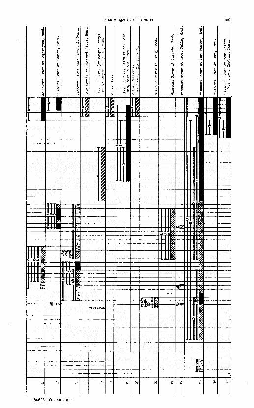
BAR CHARTS OP RECORDS
806231 O - 48 - 8"

GAGINO-STATION RECORDS IN THE MISSOURI RIVER BASIN

BAR CHARTS OP RECORDS

Chart
1.- Duration o
f re
cord
s at
gag
ing
stat
ions
in
Missouri River Basin Continued
Miss
ouri
River a
t At
chis
on,
Kans
tiss
ouri
iiiver at
Fort
.^'
3»
ssou
ri River
at
Kans
as 3
ityt
Mo
iiss
ouri
River
at
Avondale
!.S-
3sou
ri R
iver
at Sl
bley
, 't
o
Missouri R
iver
at
Lexington, Mo
Miss
ouri
River
at Tfaverly, Mo
Miss
ouri
River
at
Dewi
tt.
Mo.
'ELssouri River
at B
runswick.
Mb
Missouri R
iver a
t QlasRov/.
Mo.
Miss
ouri
River a
t Je
ffer
son Ci
ty,
Uo,
Miss
ouri
Riv
er at Sw
ing'
s La
ndin
g,
TIo
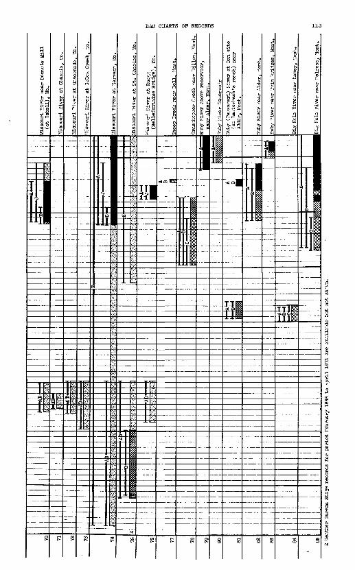
BAR CHARTS OP RECORDS

GAGING-STATION RECORDS IN THE MISSOURI RIVER BASIN
to n,
iELittle jhit
8 .
P0) O
a.-.Cree lan
,1TTI
11
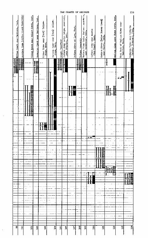
BAR CHARTS OP RECORDS

GAGING-STATION RECORDS IN THE MISSOURI RIVER BASIN

BAR CHARTS OP RECORDS 117
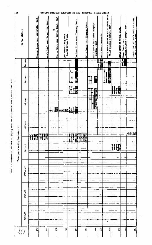
118 OAOIHO-STATIOH RECORDS IH THE MISSOURI RIVER BASIH
£
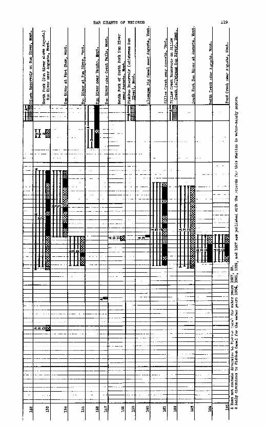
Gibs
on Reservoir
on Sun
River, M
ont.
154
North Fork (
Sun Ri
ver above
Augusta)
Sun
River near Augusta, Mont.____
Sun River
at F
ort
Shaw,
Mont
.
Sun
River
at Sun R
iver
. Mo
nt.
.ver near Vaughn.
tfon
t.
Great F
alls.
Mont.
South Fork o
f No
rth
Fork
Sun Riv
er
near Augusta. Mont._________
Pishkun Re
serv
oir
(offstream Sun
River). Mont._________
Floweree B
ig Can
al nea
r Augusta, M
ont.
TTil
low Creek Re
serv
oir
on Willow
Creek
(offstream Sun Riv
er).
Mont.
South
Fork
Sun
Riv
er at
Augusta. M
ont.
Smith Creek ne
ar Augusta,
Mont
.
Ford Creek nea
r Augusta, Mo
nt.
3 Does not
con
tain
div
ersi
on to
Pish
kun
Canal
4 Daily diversions to
Pis
hkun
Can
al for
the
TO
water years
year
s 19
24,
38.
1937,
1925,
1986
, an
d 1927 a
re p
ubli
shed
with
the
reco
rds
for this s
tati
on i
n water-supply p
apers.

GAOING-STATION RECORDS IN THE MISSOTTRI RIVER BASIN
1
iif
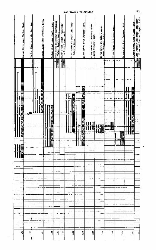
BAR CHARTS OF RECORDS

GAGING-STATION RECORDS IN THE MISSOURI RIVER BASIN

BAR CHARTS OF RECORDS 123
{]
TT
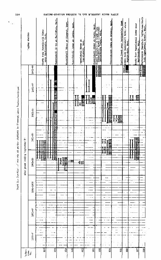
124 GAGING-STATION RECORDS IN TH3 MISSOURI RIVER BASIN
w *a
11n IT-!« 5! i
ffl

BAR CHARTS OP RECORDS 125

Char
t 1.
- Duration o
f records
at g
aging
stat
ions
in Missouri R
iver
Basin Continued
fate
r ye
ars
endi
ng Sep
temb
er S
O
Milk Diver at eastern
crossing o
f
Freano Res
ervo
ir o
n Mi
lk River,
Mont
Milk River above H
avre
. Mo
nt
mil,
M«r. at Ha
vre.
Mont
Mil
k R
iver
at
tohm
an.
Uon
t.
til* mm nt
Milk River at Ma
lta.
Uo
nt
Milk Riv
er nea
r Vandalla
). M
ont.
t Na
shua
. Mont
North Fork Mil
k Diver ne
ar
Brom
ilii
g. M
ont

North Fork Mil
k River above St
. Ma
ry
Canal, n
ear
Broi
mins
-. Mont.
North Fo
rk Mil
k River ne
ar inter
nati
onal
bou
ndar
y (K
imba
ll,
Alta
.)
St. Mary Canal
at Hudson Bay divide
near
Bro
wnin
g. M
ont.
Sandy Cree
k ne
ar Box
Eld
er,
Mont
.
Big Sandy Cree
k near L
aredo, M
ont.
ro
Beav
er Creek near Havre, M
ont
Little B
ozelder Cr
eek near
Havr
e. I
font
.
Fort Belknap Can
al near Chinook. M
ont.
Clea
r Cr
eek ne
ar Bea
rpaw
, Mo
nt
New
Para
dise
Valley Ca
nal
near
Chi
nook
, Mo
nt.
Winter-Andersen Ca
nal
near Chi
nook
. Mo
nt.
Lodg
e Creek
at international bou
ndar
y
lodg
e Creek
(Wes
t Fo
rk M
iOJc
River)
H
at C
hino
ok.
Ifont.
S

Chart
1.- Du
rati
on o
f re
cord
s at
gag
ing
stat
ions
in Missouri River Basin
Wate
r ye
ars
ending Sep
temb
er 3
0
Monae
Coulee a
t in
tern
atio
nal
boundary
North Ch
inoo
k Canal ne
ar Havre,
Hoot
Reser di
tch ne
ar Chi
nook
, Mo
nt.
'Jes
t Fork d
itch
nea
r Ch
inoo
k, I
tont
.
Battle C
reek a
t In
tern
atio
nal boundary
Battle C
reek (
Nort
h Po
rk Mil
k River)
near Chinook.
Mont
.
Woodpile Coulee ne
ar
international boundary
East
Fork Battle C
reek
near
int
erna
tion
al boundary
lyon
s Co
ulee
at
inte
rnat
iona
l boundary
Cook Canal nea
r Chinook, M
ont.
Uatheson Canal nea
r Ch
inoo
k, M
ont.

BAR CHARTS OF RECORDS 129

Chart 1.- Du
rati
on o
f re
cord
s at g
agin
g stations i
n Mi
ssou
ri River Bas
in C
onti
nued
Rook Creek below Hor
se C
reek
, near i
nternational bou
ndar
y
Hors
e Creek
(nea
r Ba
rnar
d, M
ont.
) at i
nternational boundary
Eaohern
(MoEaohran)
Creek at
international bo
unda
ry
Rook Creek Canal near Hi
nsda
le.
Mont
.
jPorcupine Creek at Na
shua
, Mont.
? Li
ttle
Porcupine Creek
at F
razer. M
ont
Ifolf Creek near Wol
f Po
int.
Ifo
nt.
iter Creek at
Circ
le,
Mont
.
Fork Pop
lar
Riirer
at 'internationa
l boundary

River
near Bre
dett
e. Mont
Poplar River near
Poplar,
Mont
East
Fork
Popl
ar Riv
er
at i
nterna
tional boundary
East F
ork Po
plar
Riv
er nea
r Soobey,
Mont
.
West For
k Poplar Riv
er
at i
nternati
onal bou
ndar
y
West
Fork Po
plar
River
near
Ric
hlan
d, M
ont.
Big Muddy Gree
k at
Res
erve
. Mo
nt
Big
Muddy Greek ne
ar
Culb
erts
on.
Mont
.
Wolf Creek nea
r Medicine L
ake.
Mon
t
Smok
e Creek ne
ar Poplar. M
ont
Tellowatone
Lake at
Lake
Hotel,
Tell
owst
one
National Park
Yell
oire
tone
Riv
er at Te
llow
ston
e Lake
Outlet.
Tell
owst
one
National Par
k
ellowstone Riv
er near Ca
nyon
Hot
el
(at Canyon s
oldier s
tati
on),
Te
llow
ston
e Na
tion
al Park
Tellomtone R
iver a
t Co
rwin
ellowstone R
iver
near
Liv
iiur
st**
"- l
imit
.
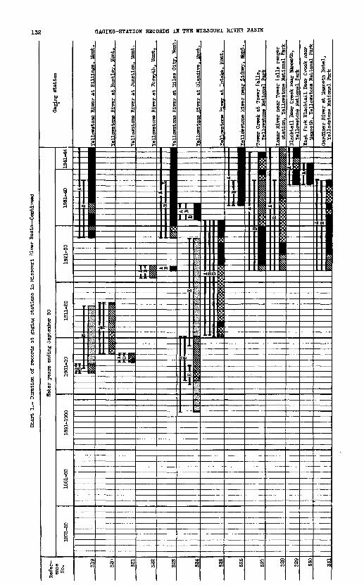
Chart
1.- Duration of
rec
ords
at
gaging s
tations
in Mis
sour
i River Ba
sin
Cont
inue
d
Water ye
ars
ending Sep
temb
er 3
0
1951-40
1941-44
River at
Bil
line
s. B
ont
Yell
ows-
tone
River
at Huntley. Mo
nt.
Yellowstone Ri
ver at J
unct
ion.
Mon
t.
Yell
owst
one
Rive
r at
For
syth
, Mo
nt.
Yellowstone
Rive
r at Mil
es C
ity.
Mo
nt
tone Riv
er at
Glen
dive
. Mo
nt
llow
eton
e River at
Int
ake.
Mont.
owstone Ri
ver near Sid
ney.
Mont.
Tower Cr
eek at Tow
er Falls,
ellowstone N
atio
nal Pa
rk
Lamar River near Tow
er Falls r
anger
stat
ion,
Yellowstone Na
tion
al Par
k
Blacktail Deer Cre
ek nea
r Mammoth,
Tellowetone
Nati
onal
Par
k
East F
ork Blackt
ail De
er Cre
ek nea
r Mammoth, T
sllowstone Nat
iona
l Park
Gard
iner
River
at Mammoth
Hote
l,

BAR CHARTS 07 RECORDS
1.Ij
11
II
|:i1

134 QAQIHa-STATIOH RECORDS IN THE MISSOURI RIVER BASIN

BAR CHARTS OP RECORDS 135

Char
t 1.
- Du
rati
on o
f records
at g
aging
stat
ions
in Missouri R
iver Basin Continued
Water ye
ars
ending September S
O
Wind River at
Dubo
is.
Wyo.
Wind
River at
(nea
r) Rlverton
Bigh
orn River at T
herm
opol
is.
Wyo
River at M
ande
rson
. Wy
o.
River
at K
ane,
Wyp
,
River near St.
Xav
ier,
Mon
t.
Bigh
orn River ne
ar Har
din
(nea
r Fort Ouster).
Mont
.
Warm Spring Creek near Dubois. W
yo
Hors
e Creek at D
uboi
s. W
YO.
Red Creek near Dub
ois.
Wyo
.
Dimroody Creek near Bu
rris
(C
rowh
eart
. Le
nore
}. V
fyo.
Dry Creek near Bur
ris
(Cro
whea
rt,
Leno
re).
Wyo.
Mead
ow Creek nea
r Le
nore
(J
.K.
ranc
h post o
ffic
e), Wy
o

*'.rillow Creek
nea
r Cr
owhe
art
(J.K.
ranch
post
office, Le
nore
), W
yo
Bull Lake
Cree
k above
Bull
Lake
Reservoir. W
yo
Bull Lake
Rese
rvoi
ron
Bull Lake C
reek
. Wv
o.
'Wyo
ming
Canal,
near
Len
ore.
Wyo
Wyom
ing Cana
l 2n
d di
visi
on
Pilot
Canal di
vers
ion
from Wyomine Canal,
Wyo.
Araaon d
itch n
ear
Leno
re.
Wyo
John
stow
n Ca
nal near Riv
erto
nLe
Clair-Riv
erto
n Ca
nal
Ho.
2 Ri
vert
on.
'.Tv
o.Le
Clair-Riv
erto
n Ca
nal
No.
2 at
Delfeld
er F
lume.
Wvo.
anal
nea
r Ri
vert
on.
wyo
Vfyoming Can
al No.
2
near Riv
erto
n. f
fro.
Elid
dle]
Po
po Agie Ri
ver
near
Lande
r,
Popo A
gie
(Lit
tle Wind)
Rive
r be
low
Arap
ahoe
. Wyo.
A/zi
s Rive
r near Riv
erto
n. T
rro.
North
(North F
ork)
Po
po Agie Ri
ver
near
Lande
r. >7
yo.
Little P
opo Agie R
iver
at
Ttol
laa
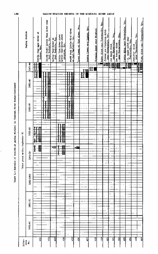
Chart
1.- Du
rati
on o
f records
at g
agin
g st
atio
ns in
Missouri River Basin Continued
'.Va
ter years
endi
ng Sep
temb
er 3
0
1901
-10
Gag
ing
stati
on
(Sou
th F
ork)
L
ittl
e W
ind
Riv
er n
ear
Fo
rt W
asha
teL
e,
Y/y
o.
Lit
tle '
,7in
d R
iver
abo
veL
ittl
e
Win
d R
iver
abo
veA
rapa
hoe,
Yiy
o._
__
__

Geo
rge
"for
thar
a d
itch
nea
r T
herm
opol
is.
Tfro
.Q
wyn
n (T
horn
ton)
d
itch
li
s.
Tffy
o.
429
Cvc
lotiB
djt
ch n
ear
Tfae
nnop
olA
s^ W
iyo«
_4SO
J § ^
Onr
l C
reek
dit
ch n
ear
The
rmop
olis
, W
yo.
Sout
h Fo
rk O
wl
Cre
ek n
ear
Anc
hor,
Wyo
.
482
South Fork Owl
Cre
ek above (a
t) C
urtis
ar Thermopolis. Wyo._____
South
Fork Owl
Cre
ek near Thermopolis
(Owl Creek near Embar). Wyo.____
H-l
On C
reek
nea
r T
herm
opol
is,
Ow
l C
reek
nea
r L
ucer
ne,
Wyo
.
Hor
th F
ork
Ow
l C
reek
r ar
Anc
hor.
Wyo
.
Nor
th F
ork
Ow
l C
reek
[a
t C
rann
ran
clj]
, nea
r
Mud
Cre
ek n
ear
The
rmop
olis
. iT
yo.
489
Kirb
v Creek near Lucerne,
Wyo.
Jacob Boll dit
ch nea
r Kirby. W
yo.
Naka
mura
ditch
Paul J
ones
ditch ne
ar Kir
by.
Wyo.
Nelson d
itch near Kirbv. W
vo.
_444
lAn
dera
on d
itch
nea
r Kirby. W
yo.

QAQINQ-STATION RECORDS IN THE MISSOURI RIVER BASIN

BAR CHARTS OF RECORDS
806231 O - 48 - 10

Char
t 1.-
Duration o
f re
cord
s at g
agin
g stations i
n Mi
ssou
ri H
i-ver ba
sin
Cont
inue
d
Wate
r years
ending Sep
temb
er SO
Shos
hone
River
at
Corb
ett
Dam.
Wyo
.
Shos
hone
River
at Willwood D
am,
Vfyo
SIroShone River
at B
yron
. iT
yo.
Shos
hone
Ri-
ver at
Lov
ell,
Wyo.
(Sou
th F
orkf
J Sh
osho
ne Riv
er nea
r Ts
hawo
oa.
',7vo.
(Sou
th F
orlc]
Shos
hone
Riv
er
above
Shoshone R
eser
voir
te
). W
vo.
Garl
and Canal
(Corbett Tunnel)
at Corbett D
am.
WYO.
k near
St.
Xav
ier.
Mo
nt
Rottengrass Cr
eek ne
ar
St.
Xavier.
Mont.
cm Riv
er at
state
line
Wy
ola.
Mont.
Little B
igho
rn Riv
er bel
ow
Pass
Creek,
near
Wyola,
Mont
.
orn
River near
Crow Agency,
Mont.

Qoo
se C
reek
nea
r S
heri
dan,
rry
o
Qoo
ee C
reek
at
She
rida
n. V
tro

Ch
art
1.-
Dur
atio
n of
reco
rds
at
gagi
ng s
tati
ons
in M
isso
uri
Riv
er B
asin
Conti
nued
Qoo
se C
reek
bel
ow L
ittl
e O
oose
C
reek
at
Sh
erid
an.
Wro
Riv
er a
t it
oorh
ead.
M
ont.
Pow
der
Riv
er n
ear
Hiz
pah,
Uon
t.

BAR CHARTS OP RECORDS .145

Chart
1. Du
rati
on o
f re
cord
s at
gaging
stations i
n Missouri R
iver Basin Continued
wate
r years
endi
ng September S
O
lower Yellowstone Ca
nal at
Low
er
Yellowstone
Dam,
at
Intake, Hont
Litt
le Mud
dy River
near Tilliston,
N. Dak.
Litt
le M
isso
uri
Rive
r near Alz
ada.
Ifont.
Litt
le M
isso
uri Ri
ver
at C
amp Crook. S. Dak.
Little M
isso
uri
Rive
r at
Ma
rmar
th,
H. Dak.
Litt
le l
!issouri R
iver
at
Medora.
I!. Dak.
Litt
le M
isso
uri
River near
V/atford Cit
v. N. Dak.
Little B
eaver Cr
eek near
Harm
arth
, N.
Dak
.
r Creek
at '
.Tibaux. Mo
nt
Knif
e Ri
ver near
Qol
den Valley
fat Broncho, ne
ar Bro
ncho
1. N. Da
k
River at
Hazen,
N. Da
k.
Jlort
h B
ranc
h (F
ork)
] G
rand
Riv
er
at H
aley
. K
. D
ak
Chart
1.-
Duration o
f re
cord
s at gating
stations i
n Mi
ssou
ri Riv
er Bas
in C
onti
nued
Cheyenne R
iver
near Hot Springs
(Cascade S
prin
gs),
S.
Dak.

BAR CHARTS OP RECORDS 149
i
i
H

Char
t 1.
- Duration o
f re
cord
s at gag
ing
stat
ions
in Missouri Riv
er Basin Continued

Thi
te R
iver
at
Cra
wfo
rd,
Neb
r.
Thi
te R
iver
at
Cra
wfo
rd,
Neb
r.
stati
on
)TT
hite
Riv
er a
bove
TT
hitn
ey p
ipe
lin
e
nea
r C
rair
ford
. N
ebr.
VJh
ite R
iver
bel
owT
Jhit
ney
pipe
lin
e,
nea
r C
raw
ford
(b
elow
Cra
irfo
rd).
N
ebr
V/h
ite R
iver
nea
r ff
lhit
nev.
N
ebr.
ver
near
Cha
dron
, N
ebr.
Whi
te R
iver
nea
r O
gla
la,
S.
Dak
.
ver
nea
r K
adok
a, S
. D
ak.
Thi
te R
iver
at
(nea
r) W
esto
ver,
S
. D
ak.
Hal
l C
anal
div
ersi
on f
rom
V
.Tiit
e R
iver
. N
ebr.
vhit
e R
iver
Can
al d
iver
sio
n f
rom
"/
hit
e .R
iver
and
Tlh
ite
Cla
y C
reek
Har
ris-
Co
op
er C
anal
div
ersi
on
from
'.B
iite
Riv
er,
Heb
r.
k n
ear
Cra
wfo
rd.
Neb
r.H
oFar
land
Can
al d
iver
sion f
rom
c
nla
ir r
.-rs
taV
. H
ah
'/hit
ney
Pip
elin
e d
iver
sio
n f
rom
W
hite
Rly
er.
Neb
r.T
Oiit
ney
Res
erv
oir
(off
stre
am
Tlh
ite
Riv
er).
N
ebr,

SAGING-STATION RECORDS IN THE MISSOURI RIVER BASIN
a
gl=.i:5.
« .:
13

Niobrara Riv
er near
(at)
Va
lent
ine
(at Fort Niobrara).
Hebr
.

Char
t 1
. D
ura
tio
n o
f re
cord
s at
gagi
ng s
tati
on
s in
Mis
sour
i R
iver
Bas
in C
on
tin
ued
Big
Sio
ux R
iver
nea
r F
lan
dre
au.
S.
Dak
Big
Sio
ux R
iver
at
(nea
r)
Sio
ux F
all
s.
S.
Dak
.
Roc
k R
iver
at
Luv
erne
, ::j
nn.
Lit
tle S
ioux
Riv
er n
ear
Turi
n
nea
r B
lenco
e),
Iow
a
Spir
it L
ake
at
Orl
ean
s.
Toira
"&:?
3l
(1ko
b°0i
late
at
Lak
esid
e L
abora
tory
(A
rnol
ds P
ark).
nea
r 'I
llfo
rd.
Iow
a

BAR CHARTS OP RECORDS 155

Char
t 1.
- Duration o
f re
cord
s at g
aging
stat
ions
in
"issouri R
iver
Basto Continued
.'later years
ending September 3
0
Nort
h KLatte R
iver abo
ve P
athfinder
Reservoir. V
ivo.
Nort
h Pl
atte
River bel
ow Pat
hfin
der
Rese
rvoi
r, W
yo.
North
Plat
te R
iver near
Casper.
Wyo.
Nort
h Platte R
iver below (
at)
r. H
yo.
Nort
h Platte R
iver at
Parkerton
North
Plat
te River at Orin
(Orin Junction), I
Byo
North
Plat
te R
iver at HoKinley,
'Wyo

BAR CHARTS DP RECORDS 157
806231 0-48-11

Chart
1.- Duration o
f records
at g
agin
g st
atio
ns i
n Missouri River Basin- Continued
McConaughy Lak
e on
North Flatte
, near K
eyst
one,
Ne
br.
;
- Platte R
iver near So
uth
Bend
. Hebr

GAGIKG-STATION RECORDS IN THE MISSOURI RIVER BASIN
r
*( «.lb 1ffi
-


Chart
1.- Duration of
records
at g
-agi
n^ s
tati
ons
in M
isso
uri
Elver Basin Continued
Jack Creek a
t Blydenburg's r
anch
, near S
arat
oga,
"Ivo.
Medicine Bow River a
bove
Seminoe
Rese
rvoi
r, near H
anna
, 'f
lyo.

BAR CHARTS OF RECORDS 163
I I
a
1

Char
t 1. Duration o
f re
cord
s at g
agin
g stations i
n Missouri R
iver Basin Continued
Water years
endi
ng Sep
temb
er 3
0
Douglas
(Mor
ion)
Ca
nal near O
rpha
,
Prel
e Creek near Douglas.
Wyo.
Prele
Creek ne
ar(Fetterman). ff
yo.
und Cree
k near L
a Bonte. W
yo
orseshoe C
reek
nea
r Gl
endo
. Wyo
Cottoiwood Cre
ek at
(nea
r)
Power
wast
e ne
ar Lin
gle.
ITyo.
Horse
Creek
Lateral
of F
ort
Laramie
Canal at Wyoming-Nebraska State
line
Interstate Can
al at
IVha
lan.
YJy
o.Lateral No
. 1 or I
nterstate Ca
nal at
YJ
yomi
ng-N
ebra
ska St
ate
line
Lara
mie
River be
low
Laramie
Poudre T
unne
l. Co
lo

BAH CHARTS OP RECORDS

166 QAGINQ-STATION RECORDS IN THE MISSOURI RIVER BASIN
8»

BAR CHARTS OF RECORDS

OAOINO-STATION RECORDS IN THE MISSOURI RIVER BASIH

I Enterprise Cana
l di
vers
ion fr
om
"fet
Spo
tted
Tail Cr
eek.
Ne
br.
Ente
rpri
se C
anal tai
l waste
near
Sc
otts
bluf
f. Hebr.
'./i
nter
Creek C
anal div
ersi
on f
rom
Winter Cre
ek.
Hebr.
Central Canal ne
ar Qering. Hebr.
|Scottsbluff drain nea
r ib
luff
. Ne
br.
(Sco
ttsb
luff
Fac
tory
Can
al div
ersi
on
from Winter Cr
aek,
Hebr.______

170 OAOINO-STATION RECORDS IN THE MISSOURI RIVER BASIN
I
:

BAR CHARTS OP RECORDS
Char
t 1.
- Du
rati
on of records
at ja
gin-
st
atio
ns in
Mis
sour
i F.iver Basin Continued
Refe
r
ence
H
o. 916
917
918
919
920
921
922
923
924
925
926
927
929
930
931
932
93-
.'ate
r yea
rs
endin
g S
epte
mber
30
1872
-80
|
I i
I , I
;
! i H
18S
1-90
L -
'
1891
-190
0
^ -
1
-
1901
-10
i 1
1 1 '
1911
-20 I-
^J
I? 1- %
T I
) f
1921
-30
rr ! I > 3> ^ * \c P '. ^ f% i>
i
y ^^
Wt *^fy
\
1931
-40
MH m i
'd& t t
fy'>
\
1 JT T'^
1 ytyb.
p # W.
H 15 M H ^! ^
1 |
JT-ty m
m % % IV it
'4 T
?? T I'
%
X V ^
V9W
.
1941
-4-
^ %
^ >^ ^
^
1
Log
an
Can
al d
ivers
ion
fro
m
Pum
pkin
Cre
ek.
Keb
r.
Mutu
al C
anal
div
ers
ion
fro
m
Pum
pkin
Cre
ek.
Neb
r.
Kin
g C
anal
div
ers
ion f
rom
L
awre
nce
For
k P
umpk
in C
reek
, N
ebr.
Bir
d C
age-
Qui
nn C
anal
div
ers
ion
fro
m
Pum
pkin
Cre
ek,
Keb
r.
Rou
nd H
ouse
E
ock
Can
al d
ivers
ion
fr
om P
unpk
in C
reek
, H
ebr.
imit
h-'
.Thee
ler
Can
al d
ivers
ion
fro
m
Pum
pkin
Cre
ek,
Neb
r.
Court
Hou
se
Roc
k C
anal
div
ers
ion
from
Pum
pkin
Cre
ek,
Neb
r.
Las
t C
hanc
e C
anal
div
ers
ion f
rom
Pum
pkin
Cre
ekr
Neb
r.T
rinnie
r C
anal
d
ivers
ion
fro
m
Gre
enw
ood
Cre
ek,
Heb
r.
"egle
mre
C
anal
div
ers
ion
fro
m
Gre
enw
ood
Cre
ek,
Neb
rM
ered
ith-
Am
mer
Can
al d
ivers
ion
Tmmm
mmmm
mmmm
mmmm
mmmm
mVflK
fllS/Q
mKiSA
B
ridge
port.
Neb
r.B
1
1 i
!* *
a fc=
fyT- ?, L
1 i ;i 1
I MII
-
^'
w I
- 0
\ i-_ ,
-.Low
er
Dug
out
Cre
ek n
ear
Bro
adw
ater
, N
ebr.
Coo
per
Can
al d
ivers
ion
fro
m
Low
er D
ufj-
out
Cre
ek.
Keb
r.
Lam
ore
Can
al n
ear
Bro
adw
ater
, N
ebr
Rad
cli
ffe
Can
al d
ivers
ion
fr
om
Ced
ar C
reek
r N
ebr.

BAR CHARTS OF RECORDS
II II ..II II ^Mllii ii ii nIISJIISSHISSII
.U IIIIII
M n Li.ii
USl^ll^ll 1 1^1 !«ll II II II II^
^li^ii^n ii^n^ii n n n ta ta n»ii^ii^ii^n^ii upliftII II II C II IlllfSll^ll^ll^ll^ll US;
ll II Q 11$ ll II II 11$
U.M IBM II ll^ll N
mi ii w n w ta nIII! II II II II II IImi ii^ii^ii^ii^ii^iiIII! II II II II II 3mi ii^ii^ii^n^ii^iimi ii^ii^ii^n^ii^iiIlli: U_U_U_ll II II
U.II U.II II
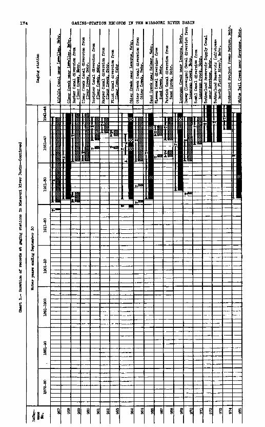
Chart 1.- Du
rati
on of records at gag
ing
stat
ions
in
liLs
sour
i River Basin Continued
Wate
r Tears en
ding
Sep
temb
er 3
0Ga
ging
station
1881
-90
Alfalfa Canal near L
ews l
ien. Ba
br
Barb
er Canal diversion from
Clear Cr
eek. N
ebr.
Clear Creek Canal
diversion from
Clear
Cree
k. N
ebr.
Sori
pter
Canal diversion f
rom
Clea
r Creek. Nebr.______
Harper Can
al diversion from
Clear
Cree
k,. Hebr._____
Finc
h Canal diversion from
Clear Cr
eek.
Hebr_____
Otter Creek near L
eraoyne. N
ebr.
Otte
r Creek Canal diversion from
Otter Cr
eek. Nebr.__________
and Creek near Belmar. N
ebr
Niss
en Canal d
iversion from
Sand Creek.
Nebr
.___
____
__Patrick Canal diversion fr
om
Sand Creek.
Nebr._________
Greek near L
emoy
ne.
Nebr.
Hane
jr (
Lone
rgan)
Canal diversion from
Soehl Canal
diversion from
Nebr
. Sutherland Reservoir Sup
ply Canal
Nebr.
Sutherland Reservoir (
offstream
North
Platte R
iver). H
ebr
Sutherland Project P
oner Ret
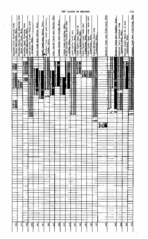
Key
ston
e C
anal
div
ersi
on f
rom
'.T
hite
Tai
l C
reek
, N
ebr.
Hol
low
ay-F
help
s C
anal
div
ersi
on f
rom
Ih
ite T
ail
Cre
ek.
Neb
r.M
cCar
thy
Can
al d
iver
sion f
rom
W
hite
T
ail
Cre
ek.
Neb
rK
eith
-Iin
coln
Cov
mty
Can
al n
ear
Key
ston
e.
Beb
r.
Skun
k C
reek
nea
r P
axto
n,
Neb
r.
Cre
ek n
ear
Pax
ton.
N
ebr.
rida
n-17
-i I
son
Can
al n
ear
Sar
lien
, S
arbe
n.
Neb
r.
Ced
ar B
ranc
h G
reek
nea
r P
axto
n.
Heb
r
Sar
ben
Slo
wS
i n
ear
Sar
ben,
M
ebr.
Iree
k at
Sar
ben.
M
ebr.
Kei
th-L
inco
ln C
ount
y d
rain
nea
r S
arbe
n.
Neb
r.
Nor
th P
latt
e C
anal
Pow
er '
Jast
e nea
r S
uth
erla
nd.
Neb
r.
Bir
diro
od R
anal
div
ersi
on f
rom
B
irdw
ood
Cre
ek.
Neb
r
Nor
th P
latt
e C
anal
nea
r S
uth
erla
nd.
Neb
r.

OA&INS-STATION RECORDS IN THE MISSOURI RIVHt BASIN
11
i-i

BAR CHAHTS OF RECORDS 177

Jhart
1.- Du
rati
on o
f re
cord
s at
g^
ginr
st
atio
ns in
"is
sour
i Ri
ver Basin Continued
111 l?our
liile Cr
eek
at mou
th.
Colo

BAR CHARTS OF RECORDS 179

flAOIHO-STATION RECORDS IN THE MISSOURI RIVER BASIN
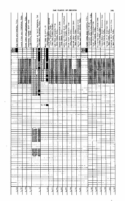
BAR CHARTS OF RECORDS

Char
t 1.
- du
rati
on of records
at ga'^inq
stat
ions
in
Mis
sour
i Ri
ver Ba
sin
Cont
inue
d
Tate
r ye
ars
endi
n^ Soptenber 3
0
1C91
-190
0
Gag
ing
stati
on
UcB
room
dit
flh d
iver
sion f
rom
B
ear
Crs
ek,
Co
lo._
__
__
__
Ols
on a
nd B
all
dit
ch d
iver
sio
n f
rom
B
ear
Crs
ek.
Col
o.
Pla
tte
Val
ley
dit
ch a
t D
enve
r,
Col
o.
PF
arm
ers
and
Gar
dene
rs d
itch
at
Een
ver,
C
olo.
Cre
ek n
ear
Fra
nkto
wn.
C
olo.
Cre
ek n
err
Kel
vin
. C
olo.
Crs
ek a
t D
enve
r.
Col
o.
iver
side
Cem
eter
y C
anal
at
Den
ver.
C
olo
.___________
Burl
inst
on d
itch
at
Den
ver.
C
olo.
iiD
usrg
an d
itch
at
Den
ver.
C
olo.
Den
ver-
Hud
son
Can
al a
t D
enve
r.
Col
o.
O'B
rien
Can
al a
t D
enve
r.
Col
o.
Gar
den
er's
(H
elle
r)
dit
ch n
ear
Den
ver,
C
olo.
HS
- rM
Cle
ar C
reek
at
Idah
o S
pri
ngs,
C
olo.
u- \xC
lear
Cre
ek a
tF
orlr
s C
reek
(ab
ove
Gol
den
^,
Col
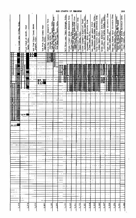
Gold
en.
Cole
.ear Creek a
t mo
uth,
near
1.1
05
Ves
t F
ork
Cle
ar C
reek
abo
ve
Col
o.
____
1.1
06
7est
For
k C
lear
Cre
ek n
ear
Col
o.
1.1
07
Jone
s Pa
ss t
unnel
dive
rsio
n from
..'illiams R
iver to
"est F
ork Clear
Cree
k. Colo.
1.1
08
Ber
thou
d P
ass
dit
ch d
iver
sio
n i
rom
T
illi
ams
Riv
er t
o
'.Tes
t F
ork
Cle
ar C
reek
. C
olo.
____
_
1.10
9Fall River nea
r Id
aho
Spri
ngs,
Co
lo.
1.11
0G
olde
n (V
felc
h) dit
ch d
iver
sion f
rom
C
lear
Cre
ek.
Col
e
1-11
1C
ity
ana
tta
isto
n u
reeK
--'-
r*-
"- -
--
div
ersi
on
s fr
om
1.11
2Ag
ricu
ltur
al d
itch
div
ersi
on f
rom
Clear
Creek. Colo._________
1.115
Golden (F
arme
r's Hi
ghli
ne)
Canal
dive
rsio
n from Cle
ar Cre
ek.
Colo
.Va
nnem
aker
dit
ch d
iver
sion
fro
m Clear Creek. Colo.________
1.11
5Le
e, Stewart
and Eskins di
tch
dive
rsio
n fr
om Clear Creek.
Colo.
Rocky Mountain d
itch
div
ersi
on f
rom
Clear
Cree
k. Colo.___________
Crok
e Canal di
vers
ion fr
om Clear,
Rals
ton,
an
d Le
yden
Gre
eks.
Co
lo.
1.11
8Hi
les
and
Eski
ns di
tch
dive
rsio
n from
Olear
Cree
k. Colo.___________
Reno a
nd J
uohe
m di
tch di
vers
ion fr
om
Clear Cr^ek. C
olo.
1.12
0Le
es a
nd Baugh d
itch
div
ersi
on fro
m Clear Creek, Colo.__________

GAGINO-STATION RECORDS IN THE MISSOURI RIVER BASIN
"S s
M*lKH
.1_§
h
fl
S'31 p3 el
il-pP 0 S
35H 0)
6 43 s^
s^C 01^' ti «plfi 1
W 4^ h 43
f 3

"ewes
and
Cook,
and
Tfes
tern
dit
ches
Ne
ar P
latt
evll
le.
Colo.
Lefthand Creek near
Boulder. Co
lo.

Cha
rt 1
.- D
urat
ion
of
reco
rds
at
gagi
ng s
tati
on
s in
Mis
sour
i R
iver
Bas
in C
on
tin
ued
Tat
er y
ears
end
ing
Sept
embe
r 30
Mid
dle
Bou
lder
Cre
ek a
t N
eder
land
. C
olo.
Bou
lder
Cre
ek n
ear
(at)
(Nor
th)
Bou
lder
Cre
ek n
ear
(abo
ve)
5
Bou
lder
. C
olo.
"*
Bou
lder
Cre
ek a
t m
outh
, ne
ar
Nor
th B
ould
er C
reek
at
Sil
ver
Lak
e.
Col
o.
Nor
th B
ould
er C
reek
nea
r N
eder
land
. C
olo.
Bou
lder
dit
ch d
iver
sion
fro
m
Nor
th B
ould
er C
reek
. C
olo.
Fou
mdl
e C
reek
at
mou
th,
near
O
rode
ll.
Col
o.
Sil
ver
Lak
e d
itch
div
ersi
on f
rom
B
ould
er C
reek
, C
olo.
Far
mer
's d
itch
div
ersi
on f
rom
Id
er C
reek
. C
olo.
And
erse
n d
itch
div
ersi
on f
rom
V
. C
olo.
Bou
lder
and
Thi
te R
ock
dit
chdiv
ersi
on f
rom
Bou
lder
Cre
ek.
Col
oll
cCar
ty d
itch
div
ersi
on f
rom
B
ould
er C
reek
. C
olo.
Dry
Cre
ek d
itch
div
ersi
on
fro
m
ould
er C
reek
. C
olo.

Harden ditch d
iver
sion
from
Boulder Gr
eek,
Colo.__________
,'ellman,
llichols,
and Hahn ditch
dive
rsio
n from Bou
lder
Cre
ek.
Colo
.BQ
ulde
r an
d Lefthand dit
ch d
iver
sion
from Boulder
Cre
ek,.
Colo.
North Boulder
Farm
er's
di
tch
dive
rsio
n fr
om Bou
lder
Creek.
Colo
.Smith and
Goss d
itch
div
ersi
on f
rom
Roul
riBr
Cre
ek. Colo.
'el
lman
dit
ch d
iver
sion
from
Boul
der Cr
eek.
Colo.
Butt
e 10
.11
dit
ch d
iver
sion f
rom
B
ould
er C
reol
e C
olo
outh
Bou
lder
Cre
ek n
ear
RoT
HnsV
lTIa
. C
olo
.
South Boulder Cr
eek ne
ar (at
)Eldorado Springs (Marshall),
Colo
.
'Tof
fat
Tfater tunnel di
vers
ion fr
om
Fraz
er River t
o South Bo
ulde
r Cr
eek
South Boulder an
d Co
al Creek ditch
dive
rsio
n fr
om South Bou
lder
Cree
outh Bou
lder
ana
Foo
tnil
ls a
itcn
dive
rsio
n fr
om
ulde
r C
Davidson d
j,tc
h di
vers
ion from
South Boulder
Creek. C
olo.
Goodhue and Ro
ck Creek d
itch
dive
rsio
n fr
om South Bou
lder
Cre
ek
Sout
h Boulder an
d Be
ar Creek d
itch
dive
rsio
n from South Bou
lder
Creek
Dry Creek
No.
2 di
tch
dive
rsio
n from
South Boulder
Cre
ekf Co
lo.
ffarshallville d
itch
div
ersi
on fro
m South Boulder Cr
eek.
Colo._____
Schearer dit
ch d
iver
sion
fro
m South Boulde
r Creek. C
olo.
Sout
h Boulder Canon
ditc
h di
vers
ion
from South Boulder Cre
ek,
Colo
.

Char
t 1.
- Du
rati
on of
re
cord
s at
ga
inin
g stations in
Mis
sour
i River Ba
sin
Ref
er
ence
Ho.
1.1
90
1.1
91
1.1
92
1,1
93
,,,W
94
1.1
95
1,1
96
1,1
97
1,1
98
1.1
99
1.2
00
1.2
01
1,2
02
1.2
03
1.2
04
1.2
05
1,2
06
1.2
07
1.2
08
/ate
r yea
rs
endin
g S
epte
mb
er
30
1872
-80
1881-9
018
91-1
900
' >
1901
-10
1911-2
01921-3
0
K ti § 8 $ K $ s$ 8 $ S$ R8 K K ^ ^ ^ ^ $ ^ ^ ^ ^ $ §& N R £JH} $ fc&& ^ ^ ^ ^^ $$$
^ S$
$$&
**$
^ ^ ^ $$ ^ ^ ^
H ^ ^ ^ ^ ^ ^ ^ ^ ^ ^ ^ ^ ^ $fc
^ ^ ^ ^
19
31
-40
^ ^ ^ mm § & & § ^ § SS § ^ ^ S i^ ^ ^ S AS
^ ^ s $! 8 ^ ^ ^ ^ 8 ^ ^ S ^ ^ !S !*!
^ ^ ^ r- ^ ^ ^ ^ ^ ^ ij %f!
£ § ^ i ? * I- i> $ i § ss^ ^ mm § § ^ $ ^ ^ mm $ i mm $ § % mm
t
mm ^ mm $ ^
% $ mm * $ ^ ^ ^ ^ ^ 8 IB $ ^ § mm
a ^ ^ ^ $ ^ ^ ^ § mm $ $ $ §
^ J5J ^ mm
mm ^
$ $ mm $ &
§ $ & i s ^ si s mm *! § $ ^ ^ ^ HI ^ ^ ^ fc
19^
IH-
-
i $9 T "
i ^~~
m _|l
P i ^! SS
:
T""
T
,3 T
^ di P hi __
_L
1-4
4
HcG
inn
dit
ch div
ers
ion f
rom
S
outh
B
ould
er C
reek
. C
olo
.
, Centr
al
and
So
uth
dit
ch
div
ers
ion
i
from
South
Bould
er C
reek
. C
olo
.
ftow
ard
dit
ch d
ivers
ion
fro
m
South
Bould
er C
reek
. C
olo
.
Eas
t B
ould
er d
itch d
ivers
ion f
rom
S
outh
B
ou
lder
Cre
ek.
Co
lo.
Jones
an
d D
onel
ly d
itch div
ers
ion
from
South
B
ould
er C
reek
. C
olo
.
Gre
en d
itch div
ers
ion f
rom
B
ould
er C
reek
, C
olo
.
Leg
^et
(Ch
ari
ty)
dit
ch div
ers
ion f
rom
B
ould
er C
reek
. C
olo
.
Ente
rpri
se dit
ch div
ers
ion f
rom
D
ry C
reek
. C
olo
.C
otto
nwoo
d N
o.
2 dit
ch
div
ers
ion
fro
m
Dry
Cre
ek,
Colo
.
Dry
Cre
ek dit
ch div
ers
ion f
rom
D
rv C
reek
. C
olo
.
And
rew
s an
d F
anre
ll d
itch d
ivers
ion
from
Dry
Cre
ek,
Colo
,
Ley
ner
and C
otto
nwoo
d N
o.
1 d
itch
es
div
ert
ine f
rom
Dry
Gre
ek,
Co
lo.
Lew
is,
Hom
e,
and D
avid
son
dit
ch
div
ers
ion f
rom
Drv
Cre
ek.
Co
lo.
Low
er B
ould
er dit
ch d
ivers
ion
fro
m
Bould
er C
rsek
, C
olo
.
Bould
er a
nd I
Tel
d C
ounty
dit
ch
div
ers
ion f
rom
Bould
er C
reek
. C
olo
.
How
ell
dit
ch d
ivers
ion
fr
om
Bo
uld
er
Cre
ek,
Co
lo.
Plu
mb
dit
ch
div
ers
ion f
rom
i
Bould
er C
reek
C
olo
.
1 L
ast
Cha
nce
dit
ch d
ivers
ion f
rom
1
Coal
Cre
ek.
Col
o'.
Zan
g dit
ch d
ivers
ion
from
1
Co
al C
reek
, C
olo
.
BAR CHARTS OF RECORDS 189
So
I
II1
6
fII"
. -38 21 n o
806231 0-48-13

Char
t 1.
- Du
rati
on o
f re
cord
s at
gaging
stat
ions
in Missouri River Ba
sin
Cont
inue
d
ater
yea
rs e
ndin
g Se
ptem
ber
30
Sect
ion
No.
5 di
tch ne
ar
La Sal
le,
Colo.
on River nea
r Es
tes
Park.
Colo
.
Thompson River
Dbelow pow
er house)
, near Dra
ke.
Colo
.
Thompson River
at mouth of Canyon,
lo.
(Big
) Thompson River (
Creek) n
ear
jis. C
olo
Thompson River at
mouth, near
La Sane, Colo.
Eure
ka ditch d
iver
sion
fro
m Colorado
River to
Thompson River. P
olo.
Handv ditch ne
ar Arkins. C
olo.
Little T
hompson River ne
ar
Bert
houd
. Colo.
Lowe
r La
tham
dit
ch n
ear
Evan
s. Colo
Patt
erso
n di
tch
near Eva
ns.
Colo.
Highland (
Plum
b) di
tch
near
Oree
lev.
Col
o.
Cach
e la P
oudr
e River ab
ove
! I
nhamhary T
^ke
outl
et.
Colo.
Cache
la P
oudr
e Ri
ver
near
Elldiorn.
Colo.
Cache
la Poudre Ri
ver near
Log
Cabi
n. Co
lo.
Cach
e la P
oudr
e Ri
ver ne
ar
Fort
Collins.
Colo
.
e la
Pou
dre Ri
ver at
mouth o
f near
Fort
Collins, Co
lo
he la
Poudre Ri
ver
near
. Co
lo.
Colorado R
iver div
ersi
on t
o Cache
la P
oudre
Rive
r. Co
lo.
Mich
igan
Riv
er diversions
to
Cache
la Poudre. Co
lo.
South Fork Cac
he l
a Poudre Riv
er
near
Eeeers. Co
lo.
J'or
th F
ork Cache
la P
oudre
Rive
r at
vermore. Colo.
Lonetree C
reek
nea
r Gr
anit
e Ca
nyon
, Vf
yo.
addle
Fork Crow Cr
eek ne
ar
Hecl
a. T
fvo.
Croi
r Cr
eek
at Silver
Crown. T
hro
Cha
rt 1
.- D
urat
ion
of
reco
rds
at
gagi
ng s
tati
ons
in "
isso
uri
Riv
er P
asin
Conti
nued
"ate
r yea
rs e
ndin
g S
epte
mbe
r 30
Gat
ing
stati
on
Sou
th F
ork
Cro
w C
reek
nea
r H
ecla
. V
fyo.
Nor
th
For
k C
row
Cre
ek n
ear
t'eel
a.
,'ivo
.__
__
__
_
_
3oxe
lder
Cre
^k n
ear
Hud
son,
C
olo.
Lod
geoo
le C
reek
nea
r F
eder
al.
Jyo.
Lod
gepo
le C
reek
at
'I'vo
mlji
g-N
ebra
ska
Sta
te li
ne_
__
__
Lod
geoo
le
Cre
ek n
ear
Bush
nel
l,
Neb
r.
Lod
geoo
le
Cre
ek a
t P
ush
nel
l (a
bove
Um
bal
l fO
liv
er)
Res
ervoir
Lod
jepo
le C
reek
bel
owrj
iver
(Kim
ball
) R
eser
voir
, N
ebr.
Lod
ge p
ole
Cre
ek n
ear
(nort
h o
f)
Lod
'repo
le C
reek
abo
ve
Ben
nett
Res
ervoir
, N
ebr.
Cre
ek n
ear
Dix
. K
ebr.
Lod
gepo
le C
reek
at
(nea
r,
sout
h of)
S
idne
y.
Heb
r.___
____
____
____
____
____
_L
odge
pole
3r
e-k
at
(one
mil
e w
est
of)
Lod
geoo
le.
Neb
r.______________
Lod
frex
>le
Cre
ek a
t C
happ
ell.
H
ebr.
Lod
trep
ole
"ree
k a
t C
olor
ado-
Neb
rask
a S
tate
li
ne (a
t P
.alt
on.
i:eb
r.,
inte
rsta
te st
atio
n)

1.87
4
1.8
75
1,27
6
_.
Lod
gepo
le C
reek
at
Ovi
d.
Col
Sou
th
For
k L
odge
pole
Cre
ek n
ear
nea
r F
eder
al.
?fy
o._
__
__
__
_B
ush
nel
l C
anal
div
ersi
on
fro
m
Lod
gepo
le C
reek
. N
ebr.
_____
New
Ru
ttn
er C
anal
div
ersi
on
fro
m
Lod
gepo
le C
reek
. N
ebr.
1.2
78
Klm
haT
l R
eser
voir
Can
al d
iver
sio
n
from
Lod
gepo
le
Cre
ek.
Heb
rK
inne
y N
o.
1 (i
outh
, R
uttn
er-K
inne
y.)
Can
al d
iver
sio
n f
rom
L
odge
pole
Cre
ek.
Keb
r._
__
__
__
__
1.280
Kinney Can
al,
North
(No. 2)
dive
rsio
n from Lod
gepo
le C
reek.
Hebr
.Hurley-Lilly
-Pon
y Ca
nal
dive
rsio
n fr
om Lod
gepo
le Cre
ek.
Nebr
.
1.28
2A
tkin
s-P
oll
y C
anal
div
ersi
on
from
Lod
gepo
le C
reol
e. K
ebr.
1,28
5E
ick
el C
anal
div
ersi
on
fr
om L
odge
pole
Cre
ek.
Neb
r.
Oir
asoo
Can
al
div
ersi
on f
rom
Lod
gepo
le C
reek
. N
ebr.
Ucl
nto
sh C
anal
div
ersi
on
from
Lod
gepo
le C
reek
. N
ebr.
Cir
cle
Arr
ow C
anal
voT«
g-1o
n fr
om L
odge
pol
e C
reek
. N
ebr.
1.28
7T
rognit
z C
anal
dive
T-a
ion
from
Lnd
irep
ole
Cre
ek r
Nab
r.
1.28
8B
ooth
Can
als,
F
ort
h a
nd S
ou
th,
dlv
gytl
ng f
roiq
Lfl
dgep
ole
Cre
ek.
Neb
r.
1.28
9'.T
este
m C
anal
nea
r B
ig S
pri
ng
s,
Neb
r.
Hol
ling
swor
th C
anal
nea
r O
gal
lala
. K
ebr.
1,291
Paxton Canal nea
r Pa
zton
. He
br.
1.29
2^ri
-County
Can
al n
ear
ort
h P
latt
e.
Neb
r.
1.29
3
1.29
4
Jeff
rey
Pow
er R
etur
n fr
om
.-C
ount
y S
yst
em
__
__
[Joh
nson
Po
wer
Ret
urn
from
.-
Cou
nty
Syst
em
____
Chart
1.- Du
rati
on of
records
at g
agin
g stations i
n Missouri R
iver Bas
in C
onti
nued
Kent-Burke C
anal d
iver
sion
fro
m Pawnee Creek,
Nebr
.Holcombe Can
al d
iver
sion
fro
m Pa
wnee
Creek,
Kebr
.
m County Can
al n
ear Cozad. He
br
Danson C
ounty Canal
dive
rsio
n fr
omCozad Canal
waste. He
br.
Daur
son County Can
al was
te to
Strever
Creek. Me
br.

BAR CHARTS OF RECORDS 196
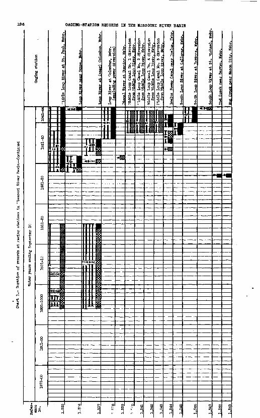
196 GAOING-STATION RECORDS IH THE MISSOURI RIVER BASIN

BAR CHARTS OF RECORDS 197
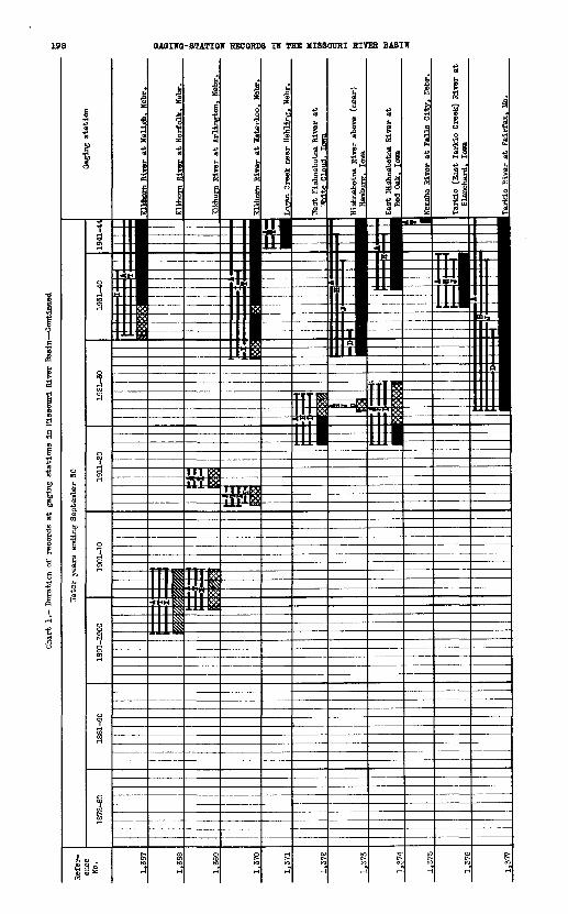
Char
t 1.
- Du
rati
on o
f records
at g
aging
stat
ions
in Missouri River Basin Continued
Tarl
do (
East
Tarkio
Creek) R
iver
at
Blan
ohar
d. Io
wa

(Nor
th F
orte
) R
epub
lica
n R
iver
at
(nea
r) B
enke
Lna
n. N
ebr.

Chart
1.- Du
rati
on o
f record
s at
gaging
stat
ions
in Missouri River Bas
in C
onti
nued
Republican Riv
er a
t (near)
Culb
erts
on,
Nebr
.
Republican River a
t (near)
LlcCook, Ne
br.
Republican River n
ear Ar
apah
oe,
Nebr
Republican River below Hud
dy Cre
ek,
near A
rapa
hoe.
Ke
br.
Republican Riv
er near
Oxford.
Nebr.
Republican River near
br.
Republican River a
t Gu
ide
Rock
, Nebr
Republican River n
ear Hardy
(nea
r Su
peri
or,
at B
ostw
ick)
. Ne
br.
Republican River a
t Se
andi
a. Ka
ns
v-l Republican River
at Con
cord
ia.
Ka
Republican River a
t Clyde, Kans.
Republican River a
t Cl
ay Cen
ter
(TTa
kef i
eld)
. Ka
ns.
Republican River a
t Junction (
Junc
tion
City).
Kans
.
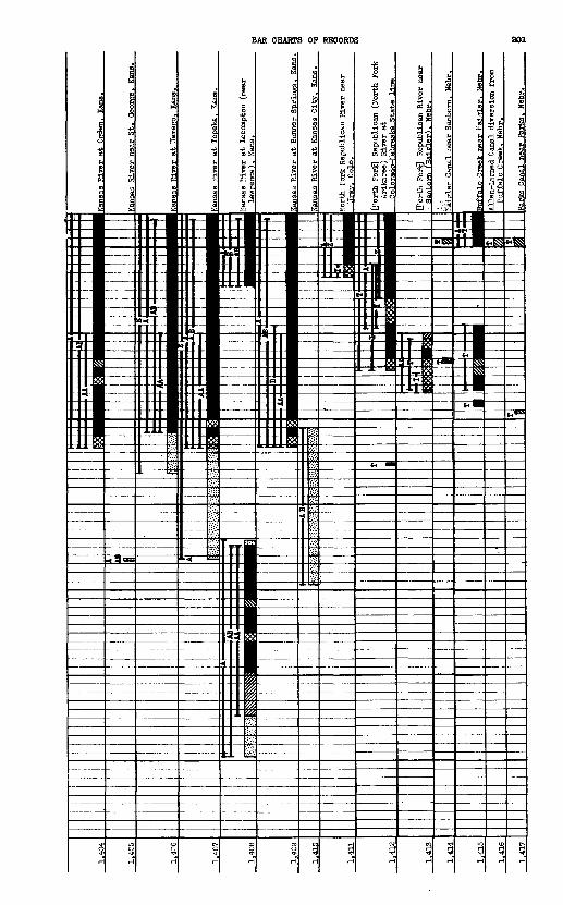
Kana
as R
iver near
St.
Geor
ge.
Kans
s River at "Tameeo,
Kans.
River
at Top
eka.
Kans.
Kans
as R
iver at
Leco
mpto
n (n
ear
nee).
Kans.
River at Bon
ner Sp
ring
s. Ka
n
Kansas R
iver a
t Kansas C
ity.
Ka
ns.
Jorth
Fork
Republican
River near
. Co
lo.
O'or
th Forlc] Republican (
Kort
h Fo
rk
Arik
aree
) River at
Rt.A
t.« Uns
ort
h
Fork
) R
epub
lica
n R
iver
nea
r fH
ajgle
r).
Neb
r.
Haj
gle
r C
anal
nea
r S
anbo
rn.
Neb
r.
ar
Hai
?ler
. H
ebr.
L
amed
Can
al d
iver
sion f
rom
B
uff
alo C
reek
. N
ebr.
Par
ks C
anal
nea
r P
ark
s.
Heb
r.

202 GAGING-STATION RECORDS IN THE MISSOURI RIVER BASIN
ig ."8 I £
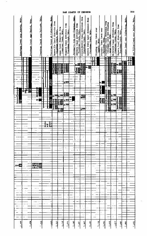
Fren
chma
n Creek near Vfauneta. Nebr
t Cu
lber
taon
. Nehr.
Haranville C
anal
div
ersi
on from
TiVe
nehm
an C
reelr. Ne
br.
Inman Canal
dive
rsio
n from
Fren
chma
n Creek. Ne
br.
Champion C
anal d
iver
sion
from
Fren
chma
n Craelc.
Nehr.
Aberdeen C
anal d
iver
sion
fro
m Fr
ench
man
Creek. Nebr.
Follet-Krott
er Canal d
iver
sion
from
Fren
chma
n Creek, H
ebr.
Krotter
Power Canal di
vers
ion fr
om
Fren
chma
n Creek. We
br.
Stin
king
"Ta
ter Cr
eek ne
ar
'Tauneta.
Nebr.
Stinking '
Tate
r Creek
near
sade.
Ne
Rive
rsid
e Canal
dive
rsio
n fr
omF
renchm
an
Gre
alf
. N
ehr.
Farmers Canal di
vers
ion fr
omFr
ench
man
Cree
ki Nebr.
eeke
r Ca
nal
near Cul
bert
son.
Nebr.
Red
.Tillow Creek
near M
cCook. He
br.
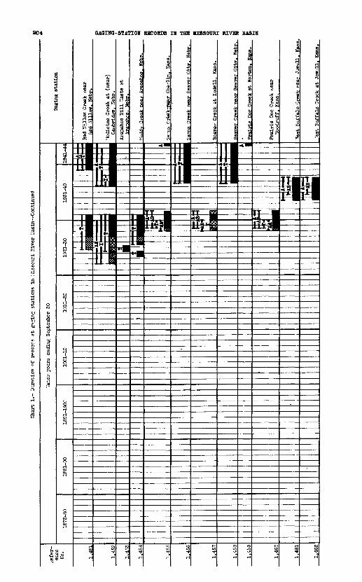
Chart
1.- Du
rati
on o
f re
cord
s at
gamine; s
tations
in M
isso
uri
River Basin Continued
"Vater yea
rs e
nding Se
ptem
ber
30Gaging sta
tion
Jree
k ne
ar Bea
Tgr
City.
Nebr
Prairie
Doe Creek
at N
orton. Cans.

BAR CHARTS OF RECORDS 206
806231 O - 48 - 14
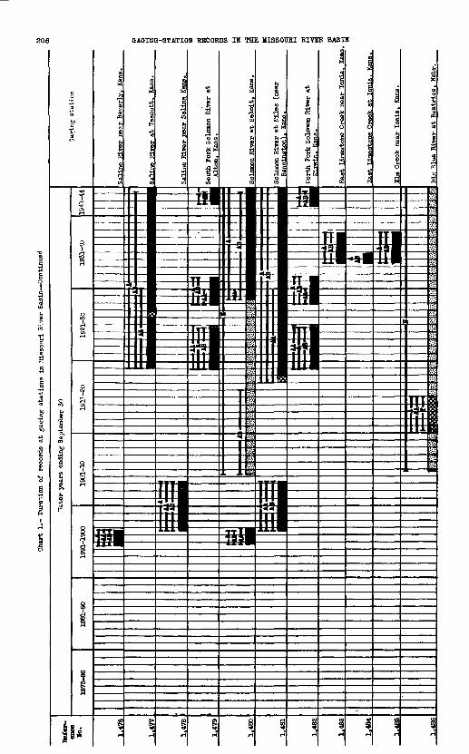
Char
t 1. Du
rati
on o
f records
at g
agin
g stations i
n Missouri R
iver
Basin Continued
T.imBgtfme C
reek near
Ionia. Kans. H
Big Bl
ue R
iver at Beatrice,
Hebr

BAR CHARTS OF RECORDS 207

208 OAOIHO-STATIOH RECORDS IH THE MISSOURI RIVER BASIH
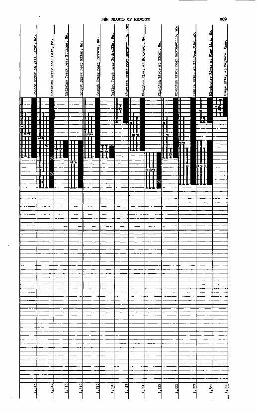
B|p CHARTS OF RECORDS

Char
t 1.- Du
rati
on o
t records
at g
aging
stations i
n Missouri Riv
er Basin Continued
lake o
f th
e Oz
arka
nea
r Bagnell. M
o. B/K
Hundred an
d Te
n Mile (D
rago
on)
reek near
Ouen
emo.
Ka
ns.

BAR CHARTS OF RECORDS 811
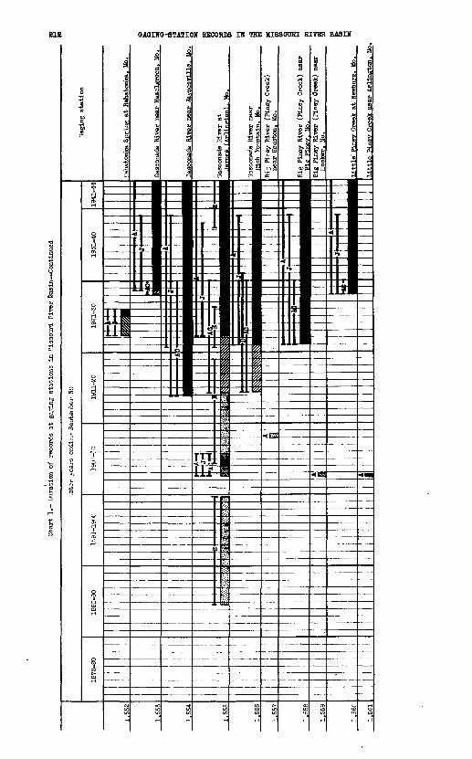
Cha
rt 1
.- D
urat
ion
of
reco
rds
at
gat
ing
sta
tions
in I
liss
ou
ri P
irer
Bas
in C
onti
nued
Big
Pin
ey R
iver
(P
iney
Cre
ek)
nea
r H
ooke
r. M
o.
Pin
ey C
reek
at
New
burg
. M
o.
Lit
tle F
iner
Cre
ek n
ear
Arl
ingto
n.
Mo
INDEX
(Jumbers In parentheses refer to table 3, chart 1, and plate 13
Page Aberdeen Canal, Nebr. (1,441)......... 203Aokley Lake Reservoir, Mont. (211)....44,123Agency ditch, Mont. (281).............49,129Agricultural ditch, Colo. (1,112).....86,183Alcova Reservoir, Wyo. (683)..........67,156Alfalfa Canal, Nebr. (957)............80,174Allen-Larned Canal, Nebr. (1,416)..... 201Alliance Canal, Nebr. (894).......78,170,171Almerla Canal, Nebr. (1,357).......... 197American Fork, Mont. (229)............45,125Anderaon ditch, Colo. (1,166).........89,186Anderson ditch, Wyo. (444)............ 139Andrews and Farwell
ditch, Colo. (1,200)............ 188Annual discharge records.............. 26Apple Creek, N. Dak. (558)............ 147Approximate areas irrigated........... 20Approximate usable capacity
of reservoirs................... 21Aragon ditch, Wyo. (400)..............55,137Arapahoe Mill waste, Nebr. (1,453).... 204Arickaree River, Nebr. (1,388)........97,199Arnett and Robert Lewis
ditches, Colo. (1,074)..........85,181Arnold drain, Wyo. (824)..............75,167Ash Creek, Nebr. (624)................ 152Atkins-Polly Canal, Nebr. (1,282)..... 193Autrey and Eggleston
ditch, Colo. (1,212)...........\. 189Average discharge..................... 27Average discharge for water
years 1938-43................... 22Average runoff for water
years 1938-43................... 24
Bad River, S. Dak. (603)..............64,150Bad River, North
Fork, S. Dak. (604).............64,150Badger Creek, Mont. (181).............42,121Baker ditch, Wye. (419)............... 138Bald drain, Nebr. (861)............... 169Bangtail Creek, Mont. (338)........... , 133Bar charts cf records................. 4Barber Canal, Nebr. (959)............. 174Base data for gaging stations......... 19Bates Creek, Wyo. (772)...............72,163Battle Creek, Mont. (272).............48,128Battle Creek, S. Dak. (581)........... 149Battle Creek,
East Fork, Mont. (275)..........48,128Bayard drain No.. 3, Nebr. (898)....... 171Bayard Sugar Factory
drain, Nebr. (899)..............78,171Bazille Creek, Nebr. (647)............ 153Bean Lake, Mo. (1,382)................ 199Bear Creek, Colo. (1,072).............85,181Beaver Creek, Cole. (1,043)........... 179Beaver Creek, Kans. (tributary tc
Smoky Hill River) (1,474)....... 205Beaver Creek, Kans.-Nebr. (tributary
to Sappa Creek) (1,457)........101,204Beaver Creek, Mont, (tributary to
Milk River near Havre) (260)....47,127 Beaver Creek, Mont, (tributary to Milk
River near Bcwdoin) (287).......49,129Beaver Creek, Mont, (tributary tc
Little Missouri River) (546)....62,146Beaver Creek, Nebr. (1,365)...........95,197Beaver Creek, S. Dak. (tributary tc
Cheyenne River) (580)...........63,149Beaver Creek, S. Dak.-Wye. (tributary
to Cheyenne River) (576)........63,148Beaver Creek, Wye. (tributary to
North Platte River) (745)....... 161Beaver Creek, Wyo. (tributary to
Popo Agie River) (417)..........56,138Beaver Creek overflew, Mcnt. (289). ...49,189Beaverhead River, Mont. (9)...........34,108Beerline Canal, Nebr. (929)........... 172Bell Creek, Mcnt. (86)................ 114Belle Fcurche River,
S. Dak.-Wro. (591)..........63,149,150Belmont Canal, "ebr. (901)............78,171
Belt Creek, Mont. (172)............... 120Bench Canal, Wyo. (470)...............58,141Bennett Spring, Mo. (1,551)..........105,211Bergen ditch, Colo. (1,083).......... 181Berthoud Pass ditch, Colo. (1,108)....86,183Bibliography.......................... 27Bickel Canal, Nebr. (1,283)........... 193Big Bend ditch, Colo. (1,230)......... 189Big Blue River,
Kans.-Nebr. (1,486)....102,103,206,207Big Bull Creek, Kans. (1,539)......... 211Big Creek, Wyo. (741).................7^161Big Creek, East Fork, Mo. (1,507)....1031208Big Hole River, Mont. (84)............37,113Big Muddy Creek, Mont. (310)..........50,131Big Piney River, Mo. (1,557).........106,212Big Pipestone Creek, Mont. (87)....... 114Big Sandy Creek, Mont. (258)..........47,127Big Sioux River,
lowa-S. Dak. (652)..........66,153,154Big Spring Creek, Mont. (212).........44,123Big Sugar Creek, Kans. (1,540)........ 211Big Timber Creek, Mont. (341).........52,133Big Timber Creek. North Fork,
Mont. (340).....................52,133Big Timber Creek. South Fork,
Mont. (342).....................52,133Bighorn Canal, Wyo. (450).............57,140Bighorn River, Mont.-Wyo. (381)....54,55,136Birch Creek, Mont, (tributary to
Marias River) (184).............42,121Birch Creek Reservoir, Mont. (183).... 42*121Bird Cage-Qulnn Canal, Nebr. (919).... 172Birdwood Canal, "ebr. (994)...........81,175Birdwood Creek, Nebr. (992)...........81,175Blackleaf Creek, Mcnt. (207)..........44,123Blacktail Deer Creek (Yellowstone
National Park) (329)............51,132Blacktail Deer Creek, East Fork (Yellow-
stone National Park) (330)......51,132Blackwater River, Mo. (1,524)........104,209Blue Creek, aebr. (950)...............79,173Blue Creek Canal, Nebr. (952).........79,173Blue River, Mo. (1,500)..............103,208Bluff Canal, Wyo. (447)............... 140Bcelus Power Canal, Nebr. (1,344)... ..95,196Booth Canals, Nebr. (1,288)........... 193Boreas Pass diversion, Cole. (1,048)..84,179 Boulder and Lefthand
ditch, Colo. (1,172)............ 187Boulder and Weld County
ditch, Colo. (1,204)............90,188Bculder and White Rock
ditch, Colo. (1.167)............89,186Boulder Creek, Cole. (1,157).......88,89,186Boulder ditch, Colo. (1,162).......... 186Boulder River, Mont, (tributary to
Missouri River) (91)............37,114Boulder River, Mcnt. (tributary to
Yellowstone River) (343)........52,133Bculder River, East Fork, Mcnt. (345). 133 Boulder River,
West Fork, Mont. (346).......52,53,133Box Elder Creek, Mont. (237)..........46,125Boxelder Creek, Colo. (1,260)......... 192Bcxelder Creek, S. Dak. (589)......... 149Boxelder Creek, Wyo. (776)........i...73,163Boyer River, Iowa (672)...............67,155Bcyles ditch, Cclo. (1,125)........... 184Brackett Creek, Mont. (336)...........52,133Brantner ditch, Cclo. (l,131).........87,184Brighton ditch, Cole. (1,132).........87,184Broadwater East Canal, Mont. (119)... .39,116Brcadwater West Canal, Mont. (120)... .39,116Brown ditch, Colo. (1,070)............ 181Brown's Creek Canal, Nebr. (912)......78,171Brush Creek, Wyo. (743)...............71,161Sucker'3 ditch, Colo. (1,139)......... 184Buffalo Bill (Shoshone)
Reservoir, Wyo. (474)...........58,141Buffalo Creek, Nebr; (tributary to
Platte River) (1,326)...........94,195Buffalo Creek, Nebr. (1,415)..........98,201
213

PageBuffalo Springs Branch, Colo. (1,033). 178 Bull drain, Nebr. (1,297)............. 194Bull Lake Creek, Wyo. (393)...........55,137Bull Lake Reservoir, Wyo. (394)...... .55,137Burlington ditch, Colo. (1,096).......85,182Burwell-Sumpter Canal, Nebr. (1,361)..95,197 Bushnell Canal, Nebr. (1,276)......... 193Butte Mill ditch, Colo. (1,176)....... 187
Cache la Poudre River, Colo. (1,244).. 91,190,191
Cache la Poudre River,North Pork, Colo. (1,253)....... 191
Cache la Poudre River,South Fork, Colo. (1,252)....... 191
Calamus River, Nebr. (1,359)..........95,197Camp Clark seep, Nebr. (909).......... 171Canadian River, Colo. (738)...........71,161Cannonball River, N. Dak. (559).......62,147Canyon Creek, Mont, (tributary to Little
Prickly Pear Creek) (142)....... 118Canyon Creek, Mont, (tributary to
Shields River) (337)............ 133Canyon Creek, Wyo. (tributary to
North Platte River) (771).......72,163Canyon Creek, Wyo. (tributary to
Tensleep Creek) (461)...........57,141Careless Creek, Mont. (232)...........45,125Carr and Tyler ditch, Colo. (1,224)... 189 Castle Rock Canal, Hebr. (880)........77,170Castle Rock Canal waste, Nebr. (881).. 170 Cedar Branch Creek, Nebr. (983)......'. 175Cedar Creek, Mo. (1,546).............105,211Cedar Creek, Nebr. (933)..............79,172Cedar Creek, N. Dak. (562)............ 147Cedar River, Nebr. (1,363)............95,197Central Canal, Nebr. (873)............77,169Central and South ditch, Colo. (1,191) 188 Chadron Creek, Nebr. (625)............65,152Champion Canal, Nebr. (1,439).........99,203Chariton River, Iowa-Mo. (1,519).....104,209Checkerboard Creek, Mont. (224).......45,124Cherry Creek, Colo. (1,092)...........85,182Cherry Creek drain, Wyo. (823)........75,167Cheyenne River, S. Dak. (571).........63,148Chimney Rock Canal, Nebr. (892).......78,170Chugwater Creek, Wyo. (820)...........75,167Church ditch, Colo. (1,209)........... 189Churn ditch, Colo. (1,078)............ 181Circle Arrow Canal, Nebr. (1,286) ..... 193City ditch, Colo. (1,066).............85,180Clancy Creek, Mont. (129)............. 117Clarks Pork, Mont.-Wyo. (358).....53,134,135Clear Creek, Colo. (1,101)........85,182,183Clear Creek, Mont. (263).............. 127Clear Creek, Nebr. (958)..............80,17,4Clear Creek, Wyo. (526)......^.......61,145Clear Creek, West Pork, Colo. (1,105). 183 Clear Creek and Platte
River ditch, Colo. (1,129)......87,184Clear Creek Canal, Nebr. (960)........ 174Cleveland drain, Nebr. (893).......... 170Cody-Dillon Canal, Nebr. (997)........81,176Coldwater Canal, Nebr. (939).......... 173Coldwater Creek, Nebr. (938)..........79,173Colorado Agricultural ditch,
Colo. (1,128)...................87,184Colorado River diversions to Cache la
Poudre River, Colo. (1,250).....91,191Community Canal, Colo. (1,181)........89,187Cook Canal, Mont. (277)............... 48,128Cooney Reservoir, Mont. (370).........54,135Cooper Canal, Nebr. (931)............. 172Corbin-Morse ditch, S. Dak. (588)..... 149Cort, Graves, and Hewes
ditch, Colo. (1,123)............ 134Cottonwood Creek, Mont, (tributary to
Little Prickly Pear Creek) (143) 118 Cottonwood Creek, Nebr. (645)......... 153Cottonwood Creek, Wyo. (tributary to
Bighorn River) (446)............57,140Cottonwood Creek, Wyo. (tributary to
North Platte River) (783).......73,164Cottonwood No. 2 ditch, Colo. (1,198). 188 Court House Rock Canal, Nebr. (922).. .79,172 Cow Creek, Wyo. (749).......... 161Cozad Canal, Nebr. (1,309) .........- .93,194Crazy Woman Creek, Wyo. (524).........61,145Crescent Lake, Hebr. (948)............ 173Crescent Lake outflow, Nebr. (949).... 173Croke Canal, Colo. (1,117)............86,183
Page row Creek, Mont. (121)..............39,116row Creek, Wyo. (1,256)............. 191row Creek, Middle Pork, Wyo. (1,255)91,191 row Creek, North Fork, Wyo. (1,259).91,192 row Creek, South Fork, Wyo. (1,268).91,192 rown Butte Canal, Mont. (166)....... 120ruez ditch, Wyo. (532).............. 145ulbertson Canal, Nebr. (1,446).....100,203urtis ditch, Wyo. (423)............. 138ut Bank Creek, Mont. (192)..........43,122yclone ditch, Wyo. (429)............ 139
Davidson ditch, Colo. (1,183)........89,187Dawson County Canal, Nebr. (1,311)... 93,
194,195Dawson County drain No.l, Nebr.(1,319) 195 Dawson County drain No.2, Nebr.(1,317) 195 Deadman Creek, Mont. (140)........... 118Deadman's Basin Reservoir,
Mont. (231)....................45,125Dearborn River, Mont. (144)..........40,118Deep Creek, Mont, (tributary to
Missouri River) (124).......... 116Deep Cre'ek, Mont, (tributary to
Teton River) (202)......... 43,122,123Deep Creek, Wyo. (763)............... 72,163Deer Creek, Colo. (1,067)............ 180Deer Creek, Mont. (536).............. 146Deer Creek, Wyo. (774)...............72,163DeGraw drain, Nebr. (908)............ 171Delaware River, Kans. (1,497)....... 103,207Delaware-Hickman Canal, Nebr. (1,423) 202 Delehant ditch, Colo. (1,226)........ 189Denver City Pipeline, Colo. (1,063)..84,180 Denvfer-Hudson Canal, Colo. (1,098)... 182 Deweese Creek, Wyo. (766)............72,163Dinwoody Creek, Wyo. (389)...........55,136Dismal River, Nebr. (1,339).......... 196Douglas Canal, Wyo. (777)............73,164Douglas Creek, Wyo................... 161Drainage areas....................... 19Dry Creek, Mont. (241)...............46,125Dry Creek, Wyo. (390)................55,136Dry Creek ditch, Colo. (diversion
from Boulder Creek) (1,169).... 186 Dry Creek ditch, Colo. (diversion
from Dry Creek) (1,199)........ 188Dry Creek No. 2 ditch, Colo. (1,186). 187 Dry Fork Marias River, Mont.(194)....43,122Dry Spotted Tail Creek, Nebr. (862).. 169 Duck Lake Creek, Colo. (1,861)....... 180Duggan ditch, Colo. (1,097).......... 182Dundy County Canal, Nebr. (l,42l).... 202Dupuyer Creek, Mont. (189)...........42,121Durand Reservoir, Mont. (223)........45,124Dutchman Creek, Mont. (127)..........39,116
East Boulder ditch, Colo. (1,193).... 188East Gallatin River, MOnt. (117)..... 39,116East Limestone Creek, Kans. (1,483).102,206 East Nishnabotna River,Iowa (1,374)..96,198 East Rosjebud Creek, Mont. (354).....- 134East Tarkio Creek, Iowa (See Tarkio River) Eggleston No. 1 ditch, Colo. (1,213). 189 Eggleaton No. 2 ditch, Colo. (1,214). 189 Elevenmlle Canyon Reservoir,
Colo. (1,010)..................81,176Elk Creek, S. Dak. (590)............. 149Elkhorn River, Nebr. (1.366)..95,96,197,198 Elm Creek, Kans. (1,485)............102,206Elm Creek, Nebr. (1,327).............94,195Elm Creek, S. Dak. (636) .............< 152Elm Creek Canal, Bebr. (1,320).......93,195Empire Canal, Bebr. (902)............ 171Encampment River, %o. (746).........71,161Enterprise Canal, Bebr. (851)....77,168,169Enterprise ditch, Colo. (1,197)...... 188Erie-Coal Creek ditch, Colo. (1,221). 189 Eureka ditch, Colo. (1,238)..........91,190Evans No. 2 ditch, Colo. (1,137).....87,184
Falrfield seep, Nebr. (886).......... 170Pall River, Colo. (1,109)............86,183Fall River, S. Dak. (579)............63,149Falls Creek, Mont. (145).............40,118Fanning seep, Nebr. (863)............ 169Farmers Canal, Nebr. (1,448)......... 803Farmer's ditch, Colo. (1,165)........89,186Farmers and Gardeners
ditch, Colo. (1,091)........... 182Farmers Independent ditch,Colo.(1140)87,184
215
Page *lfteenmile Creek, Wyo. ( 454)........57,140Pinch Canal, Nebr. (963)............. 174Fisher ditch, Colo. (1,127)..........87,184Flvemlle Creek, Wyo. (near
Manderson) (457)...............57,140Fivemile Creek, Wyo. (near
Shoshoni) (418)................ 138Flatwillow Creek, Mont. (239)........46,125Floyd River, Iowa (658).............. 66,154Floweree Big Canal, Mont. (160)...... 119Follet-Krotter Canal, Webr. (1,442).100,203 Ford Creek, Mont. (165)..............41,119Fort Belknap Canal, Mont. (262)......47,127Fort Laramie Canal, Wyo. (784).......73,164Port Peck Reservoir, Mont. (28)......35,110Four Horns Reservoir, Mont. (182)....42,121Four Mile Creek, Colo. (tributary to
South Fork Seuth Platte River)(1,036)........................83,178
Fourmile Creek, Colo. (tributary toBoulder Creek) (1,163)......... 186
Fremont Slough, Nebr. (1,296)........ 194French Canal, Nebr. (826)............ 167French Creek, Wyo. (74S)............. 71,161Frenchman Canal, Mont. (286).........49,129Frenchman Creek, Nebr. (1,425)...99,202,203 Frenchman River, Mont.-Sask. (285)... 49,129 Fresno Reservoir, Mont. (246)........46,126Frit z ditch, Wyo. (456).............. 140Fulton ditch, Colo. (1,130)..........87,184
Gaging-station names................. 2Gallatin River, Mont. (114)...38,39,115,116 Gardener's ditch, Colo. (1,100)...... 182Gardiner River (Yellowstone
National Park) (331).......52,132,133Garland Canal, Wyo. (483)............58,142Gasconade River, Mo. (1,553)........106,212Geneva Creek, Colo. (1,057)..........84,180Gering Canal, Nebr. (830)............76,167Gering drain, Nebr. (878)............77,170Gering-Fort Laramie Canal diversion
from Laramie River. Wyo. (821).75,167 Gibbon River, Mont. (103)............ 115Gibson Reservoir, Mont. (152)........41,119Glacier Lake Reservoir, Mont. (364)..53,135 Golden Canal, Colo. (1,113)..........86,183Golden City and Ralston Creek
ditches, Colo. (1,111).........86,183Golden ditch, Colo. (1,110)..........86,183Goodhue and Rock Creek
ditch, Colo. (1,184)...........89,187Gooding, Daily, and Plumb
ditch, Colo. (1,222)........... 189Goose Creek, Colo. (1,052)...........84,179Goose Creek, Wyo. (506)..........60,143,144Gooseberry Creek, Wyo. (448).........57,140Gothenburg Canal, Nebr. (1,304)......93,194Grace Creek, Colo. (808)............. 166Graf Canal, Nebr. (955)..............80,173Srand River, Mo. (1,501)............103,208Grand River, S. Dak. (565)........... 62,148Grand River, North Fork,
H. Dak.-S. Dak. (564)..........62,147Grasshopper Creek, Mont. (78)........37,113Sravel Creek, Nebr. (981)............81,175Green ditch, Colo. (1,195)........... 188Sreybull River, Wyo. (466)...........57,141Grizzly Creek, Colo. (673J............67,155Guernsey Reservoir, Wyo. (691).......68,157Gwynn ditch, Wyo. (428).............. 139
212 201 189 151 190 174 173
(1,170).......... 187(280)............48,129(962)............ 174
Harris ditch, Colo. (1,220).......... 189Harris-Cooper Canal, Nebr. (618)..... 151Harrison Lake Reservoir, Mont. (100).37,115 Hat Creek, S. Dak. (578)............. 149Hauser Lake Reservoir, Mont. (19)....35,109Hawk Springs, Wyo. (847)............. 168Heart River, N. Dak. (554)...........62,147Hebgen Reservoir, Mont. (105)........38,115
Hahatonka Spring, Mo. (1,552). Haigler canal, Nebr. (1,414).. Hake ditch, Colo. (1,216).....Hall Canal, Nebr. (616).......Handy ditch, Colo. (1,239)....Haney Canal* Nebr. (970)......Hannah Canal, Nebr. (937). Harden ditch, Colo. Harlem Canal, Mont. Harper Canal, Nebr.
Page Hewes and Cook, and Western
ditches, Colo. (1,141)..........87,185Highland ditch, Colo. (diversion
from Boulder Creek) (1,227).....90,189 Highland ditch, Colo. (diversion
from South Platte River)(1,243). 190 Hlghline ditch, Wyo. (505)............ 143Highwood Creek, Mont. (173)........... 120Hindry ditch, Colo. (1,076)........... 181Hodgson ditch, Colo. (1,086).......... 181Holcombe Canal, Nebr. (1,300)......... 194Holllngsworth Canal, Nebr. (1,290).... 193Holloway-Phelps Canal, Nebr. (977).... 175Holter Reservoir, Mont. (21)..........35,109Hooper Canal, Nebr. (953).............79,173Horse Creek, Mont. (295).............. 49,130Horse Creek, Nebr.-Wyo. (843).........77,168Horse Creek, Nebr. (1,420)............98,202Horse Creek, Wyo. (387)............... 136Horse Creek, Wyo. (tributary to
Sweetwater River) (770).........72,163Horse Creek Lateral, Wyo. (786)....... 164Horseshoe Creek, Wyo. (782)...........73,164Hoth seep, Nebr. (897)................ 171Houck No. 2 ditch, Colo. (1,223)...... 189Howard ditch, Colo. (1,192)...........89,188Howell ditch, Colo. (1,205)........... 188Hundred and Ten' Mile
Creek, Kans. (1,536)...........105,210Hurley-Lllly-Polly Canal.Nebr. (3,281).. 193 Hurtado ditch, Wyo. (399)............. 137Hyalite Creek, Mont. (118)............39,116
Illinois Creek, Colo. (735)...........71,160Independent Highline
ditch, Colo. (1,082)............ 181Indian Creek, Nebr. (tributary to
North Platte River) (910).......78,171Indian Creek, Nebr. (tributary to
Republican River) (1,424)....... 202Indian Creek, S. Dak. (602)........... 150Ingle, C. R. ditch, Wyo. (424)........ 138Inman Canal, Nebr. (1,438)............ 203Interstate Canal, Wyo. (787)..........73,164Introduction........................... 1
Jack Creek, Wyo. (752)................71,162James River, N. Dak.-S. Dak. (648).65,66,153 Jay Thomas ditch, Colo. (1,142)....... 185Jefferson Creek, Colo. (1,050)........84,179Jefferson River, Mont. (l2)........... 34,108Jeffrey Power Return, Nebr. (1,293).. .93,193 Johnson Creek, Wyo. (810)............. 166Johnson Power Return, Nebr. (1,294).. .93,193 Johnstown Canal, Wyo. (401)........... 137Jones and Donelly ditch, Colo. (1,194) 188 Jones Pass tunnel, Colo. (1,107)......86,183Jones, Paul, ditch, Wyo. (442)........ 139Judith River, Mont. (208).............44,123Juknovich ditch, Wyo. (425)........... 138
Kansas River, Kans. (1,404)....... .97,98,201Katzer drain, Nebr. (827).............76,167Kearney Canal, Nebr. (1,322)...... .93,94,195Keith-Lincoln County
Canal, Nebr. (979)..............81,175Keith-Lincoln County drain, Nebr.(986) 175 Kent-Burke Canal, Nebr. (1,299)....... 194Kerr No. 1 and No. 2
ditch, Colo. (1,218)............ 189Kershaw ditch, Colo. (1,126).......... 184Keya Paha River, S. Dak. (646)........ 153Keystone Canal, Nebr. (976)........... 175Klmball Reservoir, Nebr. (1,265)......92,192Klmball Reservoir
Canals, Nebr. (1,278)...........92,193King Canal, Nebr. (918)............... 172Klnnear ditch, Colo. (1,210).......... 189Kinney Canal, North, Nebr. (1,280).... 193Kinney No. 1 Canal, Nebr. (1,279)..... 193Kirby Creek, Wyo. (439 ).............. .56,139Kirby ditch, Wyo. (426)............... 138Knife River, N. Dak. (547)............62,146Kronberg seep, Nebr. (869)............ 169Krotter Power Canal (1,443)........... 203
La Bonte Creek, Wyo. (781)............73,164La Garde Creek, Colo. (807)........... 166La Prele Creek, Wyo. (778)............73,164Lake Cheesman Reservoir, Colo. (1,013)82,177
INDEX
Page Lake Creek, S. Dak. (634)............. 152Lake Prances Reservoir, Mont. (191K..43,121 Lake of the Ozarka, Mo. (1,531)......105,210Lake Sewall Reservoir, Mont. (17).....35,109Lamar River (Yellowatone
National Park) (328)............51,132Lamlne River, Ho. (1,523)............104,209Laraore Canal, Nebr. (932)............. 172Lane drain, Ne bf. (849)............... 168Laramle River, Colo.-Wyo. (789)73-75,164,165 Laramle River diversions to
Cache la Poudre River (802).....75,165Laat Chance Canal, Nebr. (923).-;...... 172Last Chance ditch, Colo. (1,207)...... 188Lebo Creek, Mont. (230)...............45,125Le Clalr-Rlverton Canal No. 2,
Wyo. (402)......................55,137Lee, Sbewart, and Esklna ditch,
Colo. (1,115)................... 183Leea and Baugh ditch, Colo. (1,121)... 183 Left Hand Canal, Wyo. (404)........... 137Lefthand Creek, Colo. (1,153).........88,185Legget ditch, Colo. (1,196)...........90,188Lewellen drain, Hebr. (956)........... 173Lewis and Strouse ditch, Colo. (1,077) 181 Lewis, Home, and Davldson ditch,
Colo. (1,202)................... 188Leyner and Cottonwood No.l ditches,
Colo. (1,201)...................90,188Lincoln County drain Ho. 1,
Nebr. (999)..................... 176Lincoln County drain Ho. 2,
Nebr. (995)..................... 175Llngle power waste, Wyo. (785)........73,164Liaco Canal, Nebr. (936)..............79,173Little Beaver Creek, N. Dak. (545)....61,146Little Bighorn River, Mont. (486).....59,142Little Blue River, Kans.-Hebr. (1,492)
103,207 Little Boulder River, North Fork,
Mont. (97)...................... 114Little Boxelder Creek, Mont. (261).... 127Little Cottonwood Creek, Nebr. (623).. 152 Little Soose Creek, Wyo. (510)........60,144Little Grizzly Creek, Colo. (726).....70,159Little Laramle River, Wyo. (813)......75,166Little Missouri River,
Mor.t.-H. Dak.-S. Dak. (539).... .61,146 Little Muddy (Creek) River,
N. Dak. (538)...................61,146Little Osage River, Mo. (1,541)....... 211Little Plney Creek, Mo. (1,560)......106,212Little Plpestone Creek, Mont. (88).... 37,114Little Popo Agle River, Wyo. (410)55,137,138 Little Porcupine Creek, Mont. (298)...49,130 Little Powder River, Mont. (534)...... 61,145Little Prickly Pear Creek, Mont. (136)40,117 Little Sac River, Mo. (1,545)........105,211Little Sioux River, Iowa (660)........66,154Little Thompson River, Colo. (1,240).. 190 Little Whltetail Creek, Mont. (90).... 114Little Wind River, Wyo. (412).........56,138Little Wind River, Horth Fork,
Wyo. (415)......................56,138Locust Creek, Mo. (1,516)............104,209Lodge Creek, Mont. (266)..............47,127Lodgegrass Creek, Mont. (492). ........59,143Lodgepole Creek,
Colo.-Hebr.-Wyo. (1,261).91,92,192,193 Lodgepole Creek, South Fork,
Wyo. (1,275)....................92,193Logan Canal, Nebr. (916).............. 172Logan Creek, Hebr. (1,371)............96,198Lonergan Creek, Nebr. (969 )............80,174Lonetree Creek, Wyo. (1,254)..........91,191Lost Creek, Mont. (378)............... 136Lost Creek, Nebr. (946)...............79,173Lost Horse Creek, Mont. (139)......... 117Loup River, Hebr. (1,336).............94,196Loup River power canal, Nebr. (1,364) .95,197 Lower Boulder ditch, Colo. (1,203)....90,188Lower Dugout Creek, Nebr. (930)....... 172Lower Hanover Canal, Wyo. (452)....... 140Lower Lapham ditch, Colo. (1,241).....91,190Lower Two Medicine Lake, Mont. (174)..41,120 Lower Yellowstone Canal, Mont. (537).. 146 Lump Gulch Creek, Mont. (130).........39,117Lupine Creek, (Yellowstone
National Park) (333)............52,133
Page Lupton Bottom and Ellwood
ditches, Colo. (1,134).........87,184Lupton Shortline ditch, Colo. (1,133) 184 Lyons Canal, Nebr. (943)............. 173Lyona Coulee, Mont. (276)............48,128
McBroom ditch, Colo. (1,088)......... 182McCarthy Canal, Hebr. (978).......... 175McCarty ditch, Colo. (1,168)......... 186McConaughy Lake, Nebr. (710).........69,158McDonald Creek, Mont. (238)..........46,125McEachern Creek, Mont. (296).........49,130McFarland Canal, Nebr. (620)......... 151McGlnn ditch, Colo. (1,190).......... 188clntosh Canal, Hebr. (1,285)........ 193
Mclntyre Creek, Colo. (805).......... 166IcKenzie ditch, Colo. (1,211)........ 189IcRae Coulee, Mont. (268)............47,128Madison Reservoir, Mont. (108).......38,115[adlson River, Mont. (104)...........38,115Madison River, West Fork, Mont. (113) 115 MandaaLake Creek, H. Dak. (550)...... 147lap ahowlng gaging stations.......... 3Maple River, Iowa (667)..............66,155Maranville Canal, Nebr. (1,437)...... 203Marias des Cygnes. (See Osage River) Marias River, Mont. (178)............42,121Marmaton River, Kans. (1,542).......105,211Marsh Creek, Mont. (141)............. 118iarshallville ditch, Colo. (1,187)... 187 Martlnsdale Reservoir, Mont. (228)...45,124 Matheson Canal, Mont. (278)..........48,128Maximum discharge.................... 25ieadow Creek, Wyo. (391).............55,136Meadow Island No. 2 and Beeman
ditches, Colo. (1,138).........87,184Medicine Bow River, Wyo. (757).......71,162Medicine Creek, Mo. (1,514).....103,104,209Medicine Creek, Hebr. (1,452).......100,204:edlclne Lodge Creek, Wyo. (465)..... 141Meeker Canal, Hebr. (1,449).........100,203Meglemre Canal, Hebr. (925)......... 172Melbeta drain, Nebr. (885)........... 170Meredlth-Anuner Canal, Nebr. (926).... 172Michigan Creek, Colo. (tributary to
Tarryall Creek) (1,049)........84,179Michigan River, Colo. (tributary to
Horth Platte River) (730)...70,71,160 Michigan River diversions to
Cache la Poudre River (1,251)..91,191 Middle Boulder Creek, Colo. (1^.55)88,185,186 Middle Loup Canal, Hebr. (1,340)..94,95,196 Middle Loup River, Hebr. (1,330).94,195,196 Middle Popo Agie River, Wyo. (406)...55,137 Middle St. Vrain Creek, Colo. (1,151)88,185 Midland-Overland Canal, Nebr. (945).. 173 Miles and Eskins ditch, Colo. (1.118) 183 Milk River, Alta.-Mont. (244).....46,47,126 Milk River, North Fork,
Mont. (254)................47,126,127Milk River, South Fork,
Mont. (242)................ 46,125,126Minatare Canal, Hebr. (877)..........77,170Minimum discharge.................... 26Minks and Autrey ditch, Colo. (1,215) 189 Missouri Coulee, N. Dak. (553)....... 147Missouri River (15)........... 34-37,109-113Mitchell Canal, Nebr.-Wyo. (828).....76,167Mltchell Spillway, Hebr. (864).......77,169Moffat water tunnel, Colo. (1,179)...89,187 Monona-Harrlson ditch, Iowa (670)....66,155Moreau River, S. Dak. (567)..........62,148Morrlll drain, Nebr. (857)........... 169Mud Creek, Nebr. (1,348)............196,197Mud Creek, Wyo. (438)................ 139Muddy Creek, Mont, (tributary to
Sun River) (170)............... 41,120Muddy Creek, Mont, (trlbutarty to
Teton River) (205)............. 43,123Muddy Creek, Nebr. (1,454)..........100,204Mucldy Creek, Wyo. (764).............. 163Mullen Creek, Wyo. (740)............. 161Muskrat Creek, Mont. (96)............ 114Musselshell River, Mont.'(218)....44,46,124Musselshell River, North Fork,
Mont. (215)................44,123,124Musselshell River, South Fork,
Mont. (226)....................45,124Mutual Canal, Nebr. (917)............ 172

INDEX
Page, Mystic Lake Reservoir, Mont. (357)....53,134 PI
Hakamura ditch, Wyo. (441)............ 139Nelson ditch, Wyo. (443).............. 139Helson Reservoir, Mont. (283).........49,129Nemaha River, Hebr. (1,375)........... 198Nevada ditch, Colo. (1,069)...........85,181New Paradise Valley Canal, Mont. (264). 127 New Ruttner Canal, Nebr. (1,277)...... 193Newton Canal, Nebr. (1,356)........... 1971Niangua River, Mo. (^549)............105,211Nine Mile Canal, Nebr. (883)..........77,170Ninemile (Nine Mile) drain, Nebr.(888)78,170 Niobrara River, Nebr. (637).......65,152,153Nishnabotna River, Iowa (1,373).......96,198Nissea Canal, Nebr. (967)............. 174Nodaway River, Iowa-Mo. (1,379).......96,199Noll, Jacob, ditch, Wyo. (440)........ 139North Boulder Creek, Colo. (1,160)....89,186North Boulder Farmer 1 s ditch,
Colo. (1,173)................... 187North Chinook Canal, Mont. (269)......47,128North Laramie River, Wyo. (817)...75,166,167 North Loup River, Nebr. (1,351).......95,197'North Platte Canal, Nebr. (987).... ...81,178North Platte River,
Colo.-Nebr.-Wyo. (674,...67-69,155-158 North Platte River, North Fork,
Colo. (728).....................70,160North Popo Agie River, Wyo. (409).....55,13VNorth River Canal, Nebr. (935)........79,173North St. Vrain Creek, Colo. (1,143)..88,183 North Spring Creek, Wyo. (751)........ 161Northern Colorado Irrigation Co.
Canal, Colo. (1,064)............85,180Norwegian Creek, Mont. (102)..........38,113Nowater Creek, Wyo. (453).............57,140Nowood Creek, Wyo. (458)..............57,140
O 1 Brian Canal, Colo. (1,099).......... 1821Ocheda Lake, Minn. (666) .............. 155,Okoboji Lake, Iowa (665).............. 154!Olson and Bell ditch, Colo. (1,089)... 1821 One Hundred and Two River, Mo. (1,386)97,199 Orchard-Alfalfa Canal, Nebr. (1,310). .93,194 Ord-North Loup Canal, Nebr. (1,362)...95,197 Osage River, Kans.-Mo. (1,525).......104,109
209,210 Oshkosh Canal, Nebr. (944)............ 173Otter Creek, Nebr. (964)..............80,174Otter Creek Canal, Nebr. (965),....... 174Ouelette ditch, Colo. (1,122)......... 184Owasco Caial Nebr. (1,284)............ 193Owl Creek, Colo. (734)................. 160Owl Creek, Mont. (491)................59,143Owl Creek, Wyo. (434).................56,139Owl Creek ditch, Wyo. (430)........... 139Owl Creek, North Fork, Wyo. (436).....56,139Owl Creek, South Fork, Wyo. (431).....56,139Owl River, S. Dak. See Moreau River
Painted Woods Creek, N. Dak. (551).... 147Pairitrock Creek, Wyo. ( 462)......... ...57,143,Paisley Canal, Nebr. (951)............79,173Paradise Valley Canal, Mont. (279)... .48,129Parks Canal, Nebr. (1,417)............ 201,Pass Creek, Mont. (490)...............59,142Pass Creek, Wyo. (755)................71,163Passamari River, Mont. (See Ruby River) Pathfinder Reservoir, Wyo. (681)......67,159Patrick Canal, Nebr. (968)............ 174Patterson ditch, Colo. (1,842)........ 190Pawnee Creek, Nebr. (l,S98)...........93,194Paxton Canal, Nebr. (1,291)........... 193Paxton-Hershey Canal, Nebr. (991).....81,17$Peoples Creek, Mont. (282)............ 129Period of discharge record............ 85Petersburg Company ditch, Colo.(1,071) 181 Phelan Canal, Nebr. (1,419)........... 20?Phelps County Canal, Nebr. (1,318). ...93,195Pilot Canal, Wyo. (398)............... 137Plney Creek, Wyo. (530)...............61,14$Pioneer Canal, Wyo. (811).............75,169Pioneer-Union ditch, Colo. (1,085).,..85,181 PIshkun Reservoir, Mont. (159)........41,119Platte Canon ditch, Colo. (1,065)....85,180Platte River (Iowa-Mo.), Mo. (1,383)..97,199 Platte River, Nebr. (714).... ..69,70,158,159Platte Valley ditch, Colo. (1,090).... 18*
Page attevllle Irrigating and
Milling Co. ditch, Colo. (1,135)87/184 Plum Creek, Colo. (1,068)........... 181Plum Creek, Nebr. (928).......... ....79,172Plumb ditch, Colo. (1,206).......... 188Plunmer and Nickelson ditch,
Wyo. (420).................... 138Pomme de Terre River, Mo. (1,547)..105,211 Poney Creek, Colo. (V>34)........... 178Poplar River, Mont. (304)...........50,131Poplar River, East Pork, Mont. (306)50,131 Poplar River, Middle Fork,
Mont. (303)...................50,130Poplar River, West Fork, Mont. (308)50,131 Popo Agie River, Wyo. (407).........55,137Porcupine Creek, Mont. (298)........49,130Pottawatomie Creek, Kans. (1,537)... 105
210,211 Powder River, Mont.-Wyo. (514)......60,144Powder River, Middle Fork,
Wyo. (519)....................60,144Powder River, North Fork,
Wyo. (528)....................61,145Powder Riveij South Fork,
Wyo. (513).................... 144Prairie Dog Creek, Kans» (1,459)...101,204 Prairie Dog ditch, Wyo. (533)....... 145Prickly Pear Creek, Mont. (1S5).....39,116Pryor Creek, Mont. (374)............54,135Pullen drain, Wyo. (885)............ 167Pumpkin Creek, Hebr. (913)..........79,171
Radcllffe Canal, Nebr. (934)........ 172Ralston Creek, diversions from,
Colo. Cy.24)................. .87,184Ramshorn Canal, Nebr. (842)......... 168Rapid Creek, S. Dak. (584)..........63,149Rawah Creek, Colo. (803)............ 166Rawhide Creek, Wyo. (822).......... .75,167Red Creek, Wyo. (388)............... 136Red Fork, Wyo. (521)................ 145Red Lodge Creek, Mont (369).........54,135Red Rock River, Mont. (1)...........34,108Red Willow Creek, Nebr. (tributary to
North Platte River) (904).....78,171Red Willow Creek, Nebr. (tributary to
Republican River) (3^450) .100,203,204 Redwater Canal, S. Dak. (601)....... 150Redwater Creek, Mont. (302).........50,130Redwater Creek, S. Dak.-Wyo. (597)..64,150 Reno and Juchem ditch, Colo. (1,119) 183 Republican River,
Kans.-Nebr. (1,389).......97,199,800Republican River, North Fork,
Colo.-Nebr. (1,411)...........98,201Republican River, South Fork,
Colo.-Kans.-Nebr. (1,422).....98,202Reser ditch, Mont. (870)............ 128Rledl, Joe, ditch, Wyo. (421)....... 138Riverside °anal, Nebr. (1,447).....100,203Riverside Cemetery Canal,
Colo. (1,095).................. 182Roaring Fork, Colo. (727)...........70,159Roberts Creek, Mont. (235)..........45,125Rock Creek, Colo. (1,051)........... 179Rock Creek, Mont, (tributary to
Boulder River) (95)............ 114Rock Creek, Mont, (tributary to
Clarks Fork) (365).............53,135Rock Creek, Mont, (tributary to
Milk River) (292)........ 49,129,130Rock Creek, Nebr. (1,418)...........98,202Rock Creek, Wyo. (tributary to
Medicine Bow River) (760)...71,72,162 Rook Creek, West Fork,
Mont. (367).................53,54,135Rock Creek Canal, Mont. (297)....... 130Rock River, Minn. (657)............. 154Rocky Mountain ditch, Colo. (1,116).86,183 Roncco, Leo, ditch, Wyo. (482)...... 138Rosebud Creek, Mont, (tributary to
Stillwater River) (356)........53,134Rosebud Creek, Mont, (tributary to
Yellowstone River) (496).......59,143Rottengrass Creek, Mont. (485)......59,148Round House' Rock Canal, Nebr. (920). 172 Ruby River, Mont. (79)..............37,113Ruby River Reservoir, Mont. (80)....37,113Running Dutchman Canal, Wyo. (775)..72,163

218
Page Rural ditch, Colo. (1,229)............90,189Rush Creek, Nebr. (941)............... 173Rush Creek Canal, Nebr. (940)......... 173
Sac River, Mo. (1,543)...............105,211Sage Creek, Mont, (tributary to
Judith River) (213)............. 123Sage Creek, Wyo. (765)................72,163St. Mary Canal, Mont. (257)...........47,127St. Vrain Creek, Colo. (1,147)........88,185Salt Creek, Colo. (1,035)............. 178Salt Creek, Kans. (1,535)............105,210Saline River, Kans. (1,475)......102,205,206Sand Creek, Nebr. (966)...............80,174Sand Creek, Wyo. (767)................72,163Sappa Creek, Kans.-Nebr. (1,455).... .101,204Sarben Slough, Nebr. (984)............ 175Schearer ditch, Colo. (1,188)......... 187Schermerhorn Canal, Nebr. (907)....... 171Scott Gomer Creek, Colo. (1,062)...... 180Scottsbluff drain, Nebr. (874)........ 169Scottsbluff drain No. 2, Nebr. (882).. 170 Scottsbluff Factory Canal, Nebr. (876) 169 Scout Creek, Nebr. (998).............. 176Scripter Canal, Nebr. (961)........... 174Section No. 3 ditch, Colo. (1,232)....90,190Seminoe Reservoir, Wyo. (679)........,67,155Sevenmile Creek, Mont. (134)..........40,117Sheep Creek, Mont, (tributary to
Red Rock River) (77)............ 113Sheep Creek, Mont, (tributary to
Smith River) (150)..............41,118Sheep Creek, Nebr. (850)..............77,168Shell Creek, Wyo. (471)...............58,141Sheridan-Wilson Canal, Nebr. (982).... 175Shields River, Mont. (334)............52,133Short Line Canal, Nebr. (891)......... 170Shoshone River, Wyo. (475)........58,141,142Shoahone River, North Fork, Wyo. (473)58,141 Shoshone River, South Fork, Wyo. (481)58,142 Side Hill and Meadow Island
No. 1 ditches, Colo. (1,136)....87,184Signal Bluff Canal, Nebr. (947)....... 173Silver Lake ditch, Colo. (1,164)...... 186Silvernail drain, Nebr. (927)......... 172Simonton ditch, Colo. (1,087)......,'.. 181Six Mile Canal, Nebr. (1,308)......... 194Skunk Creek, Nebr. (980)..............81,175Slick Creek, Wyo. (455)............... 140Slough (North Branch Clear Creek)
diversions from, Colo. (1,120). .87,183. Smelter Creek, Colo. (1,060)......... 180Smith and amnons ditch, Colo. (1,2S8J. 189 Smith and Goss ditch, Colo. (1,174)... 187 Smith and Tyler ditch, Colo. (1,225).. 189 Smith Creek, Mont. (164)..............41,119Smith River, Mont. (146)..............40,118Smith River Reservoir, Mont. (147)....40,118Smith-Wheeler Canal, Nebr. (921)...... 172Smoke Creek, Mont. (313).............. 131Smoky Hill River, Kana. (1,463)......101,205Snell and Nine Mile drains,
Nebr. (887)..................... 170Snell drain, Nebr. (890).............. 170Soap Creek; Mont. (484)........... ....59,142Soehl Canal, Nebr. (971).............. 174Soldier Creek Kans. (1,496).........103,207Soldier Creek Wyo. (812)............. 166Soldier River Iowa (671).............66,155Solomon River Kans. (1,480).........102,206Solomon River North Pork,
Rans. (1,482)..................102,206Solomon River, South Pork,
Kans. (1,479)..................102,206Sources of gaging station data........ 3Sources of records.................... 25South Boulder and Bear Creek ditch,
Colo. (1,185)................... 187South Boulder and Coal Creek ditch,
Colo. (1,180) ................... 187South Boulder and Foothills ditch,
Colo. (1,182)................... 187South Boulder Canon ditch,
Colo. (1,189)...................89,187South Boulder Creek, Colo. (1,177)....89,187South Boulder Creek, Mont. (98).......37,114South Grand River, Mo. (1,548).......105,211South Loup River, Nebr. (1,345).......95,196
Page South Platte River,
Colo.-Nebr. (1,006).....81-83,176-178 South Platte River, Middle Pork,
Colo. (1038)...................83,179South Platte River, North Pork,
Colo. (1,053)..............84,179,180South Platte River, South Fork,
Colo. (1,000)..................81,176South St. Vrain Creek, Colo. (1,149).88,185 South Willow Creek, Mont. (236)...... 125Spearfish Creek, S. Dak. (600).......64,150Spickerman ditch, Colo. (1,084)...... 181Spirit Lake, Iowa (664).............. 154Split Rock Lake, Minn. (656)......... 154Spohn Canal, Nebr. (942)............. 173Spring Creek, Mont (tributary to
Musselshell River) (225).......45,124Spring Creek, Mont, (tributary to
Teton River) (200).............43,122Spring Creek, Nebr. (829)............76,167Spring Creek, N. Dak. (549).......... 147Spring Creek, S. Dak. (582)..........63,149Spring Creek, Wyo. (750)............. 161State Line and Gilmore Canal,
Nebr. (848).................... 168Steamboat Canal, Nebr. (879)......... 170Stewarts drain, Nebr. (858).......... 169Stillwater River, Mont. (351)........53,134Stinking Water Creek, Nebr. (1,444).100,203 Stranger Creek, Kans. (1,499).......103,207Strever Creek, Nebr. (1,321)......... 195Strouse ditch, Colo. (1,079)......... 181Stub Creek, Colo. (804). .............. 166Stuck Creek, Colo. (809)............. 166Suburban Canal, tfebr. (996)..........81,175Summary of records by basins......... 17Sun River, Mont. (154)...............41,119Sun River, North Fork, Mont. (153)...41,119 Sun River, North Fork of
North Pork, Mont. (151)........ 118Sun River, South Pork, Mont. (163)...41,119 Sun River, South Fork of
North Fork, Mont. (158)........ 119Sun River Canal, Mont. (168)......... 120Sunlight Creek, Wyo. (363)...........53,135Sutherland Reservoir, Nebr. (973)....80,174Sutherland Reservoir Supply Canal,
Nebr. (972).................... .80,174Supply ditch, Colo. (1,152).......... 185Sweetgrass Creek, Mont. (348)........53,134Sweetwater River, Wyo. (768).........72,163Sybille Creek, Wyo. (815)............75,166
Tarkio River, Iowa-Mo. (1,376).......96,198Tarryall Creek, Colo. (1,044).... .83,84,179Taylor-Ord Canal, Nebr. (1,358)......95,197Tenmile Creek, Mont. (132)...........40,117Tensleep Creek, Wyo. (460)...........57,140Teton River-, Mont. (197).............43,122Thirty Mile Canal, Nebr. (1,301).....93,194Thompson River, Colo. (1,233).....90,91,190Thompson-River, Iowa-Mo. (1,508)....103,208Tongue River, Mont.-Wyo. (497)....59,60,143Tongue River Reservoir, Mont. (502)..60,143 Toohey drain, Nebr. (860)............ 169Toohey Spillway, Nebr. (859).........77,169Tower Creek (Yellowstone
National Park) (327)...........51,132Tri-County Canal, Nebr. (1,292)......93,193Trinnier Canal, Nebr. (924).......... 172Tri-State Canal, Nebr. (832).....76,167,168Trognitz Canal, Nebr. (1,287)........ 193Trout Creek, Wyo. (416).............. 138Tub Springs, Nebr. (870)............. 169Turkey Creek, Colo. (1,081).......... 181Turtle Creek, N. Dak. (552).......... 147Twelve Mile Creek, Colo. (1,032)..... 178Two Medicine River, Mont. (175)......41,120
Union Canal, Nebr. (954).............80,173Union ditch, Colo. (1,231)...........90,189Upper Dugout Creek, Nebr. (911)......78,171Upper Hanover Canal, Wyo. (445)...... 140Upper Sevenmile Creek, Mont. (535)... 145
Vermillion Creek, Kans. (1,495).....103,207
Wagonhound Creek, Wyo. (780).........73,164

219
Page Wakarusa River, Kans. (1,498)........103,207Wallace ditch, Colo. (1,217).......... 189Wannemaker ditch, Colo. (1,114).......86,183Ward ditch, Colo. (1,075)............. 181Warm Spring Creek, Wyo. {386)......... 136Warm Springs Creek, Mont. (128).......39,117Warrior ditch, Colo. (1,080)..........85,181Weldon River, Mo. (1,512)........103,208,209Wellman ditch, Colo. (1,175).......... 187Wellman, Nichola, and Hahn ditch,
Colo. (1,171)................... 187West and east Hooaier Pass
diversions, Colo. (1,042).......83,179West Buffalo Creek, Kans. (1,461)....101,204West Careless Creek, Mont. (234)...... 125West Pork ditch, Iowa (669)...........66,155West Pork ditch, Mont. (271). ......... 12&West Nishnabotna River, Iowa (1,372)..96,198 West Nodaway River, Iowa (1,381)......96,199West Tarkio Creek, Mo. (1,378).|.......96,199Western Canal, Nebr. (1,289 ).. J...... .92,193Wet Spotted Tail Creek, Nebr. (865).., 169 White Clay Creek, Nebr. (619).........65,151White Horse Creek, Nebr. (1,295)...... 194White River, Nebr.-S. Dak. (605)......64,151White River, South Fork, S. Dak. (629).65,152 White River Canal, Nebr. (617)........ 151White Tail Creek, Nebr. (975).........81,174Whiteman's Pork, Nebr.(1,440)......... 203Whitetail Creek, Mont. (89)........... 114Whitewater Creek, Mont. (264). ....... .49,129Whitney; pipeline diversiony
Nebr. (621).....................65,151Whitney Reservoir, Nebr. (622)........65,151Wild Horse drain, Nebr. (906)......... 171Willls ditch, Colo. (1,219)........... 189Willow Creek, Colo. (737),............71,160Willow Creek, Mont, (tributary to Deep
Creek and Teton River) (204)....43,123
Page Willow Creek, Mont, (tributary to
Marias River) (196)............43,122Willow Creek, Mont, (tributary to
Jefferson River) (99).......... 37,115Willow Creek, Mont, (tributary to
Red Lodge Creek) (373).........54,135Willow Creek, Mont, (tributary to
Shields River) (339)........... 133Willow Creek, Mont, (tributary to
Sun River) (161)............... 41,119Willow Creek, Nebr. (985)............ 175Willow_Cre_ek, Wyo. ( 392).............55,137Willow Creek Reservoir, Mont. (162)..41,119 Wind River, Wyo. (379)...............54,136Winter Creek, Nebr. (875)............77,169Winter Creek Canal, Nebr. (871)......77,169Winter-Anderson Canal, Mont. (265)... 127 Wolf Creek, Mont, (tributary to
Big Muddy Creek) (312)......... 131Wolf Creek, Mont, (tributary to
Judith^ River) (214) ........... .44,123Wolf Creek, Mont, (-tributary to
Missouri Rive,r) ( 300)..........49 ,130Wolf Point ditch, Mont. (301)........ 130Wood River, Nebr. (1,328)............ 195Wood River, Wyo. (469)...............57,141Woodbine Creek, Mont. (353).......... 134Woodpile Coulee, Mont. (274).........48,128Wortham, George, ditch, Wyo. (427J... 139 Wyoming Canal, Wyo. (396)............ 137Wyoming Canal No. 2, Wyo. (405)...... 137
Yellow Creek, Mo. (1,518)............ 209Yellowstone Lake (Yellowstone
National Park) (314)...........50,131Yellowstone River, Mont.(Yellowstone
National Park) (315)....50,51,131,132
Zang ditch, Colo. (1,208)............ 188
U. S. GOVERNMENT PRINTING OFFICE : 0 1948