© Midwest Archaeological Conference Inc 2014 midwest archaeological conference inc. occasional papers, V ol. 1, 2014, 73–96 Crop Selection: Perspectives from the Lower Missouri River Basin Patti J. Wright University of Missouri–St. Louis, USA Christopher A. Shaffer University of Missouri–St. Louis, USA The lower 200 km of the Missouri River basin provides an interesting case for examining crop selection strategies and cropping systems. Between cal A.D. 650 and 1200, so-called Late Woodland and Mississippian populations occupied the Missouri River floodplain and tributary valleys. Multiple lines of evidence, including crop selection, show considerable interaction between central and eastern Missouri populations, and boundaries between these ar- eas are more tenuous and permeable than had once been interpreted. In this study, we assess intersite variability in the presence of starchy seeds and maize for eleven sites. We explore ecological and cultural variables affecting the decision to adopt maize cultivation at some sites and to continue to rely on members of the starchy-seed complex at others. keywords paleoethnobotany; maize; Midwest; prehistoric period Decisions about what crops to plant, how large a field to prepare, how to process the crops, and what to do with surpluses can depend on ecological factors such as climate, landform, soil type, and rainfall, as well as cultural factors like values, traditions, and degree of technological complexity. We use archaeobotanical data from 11 sites excavated within the lower 200 km of the Missouri River basin to assess some of these dynamic, decision-making processes. The archaeobotanical assemblages range between cal A.D. 650 and 1200. Various ecological and cultur- al aspects of the decision-making processes leading to the continued reliance on members of the starchy-seed complex—chenopod, erect knotweed, little barley, and maygrass—and the addition of maize to an existing repertoire of crops are explored. We consider the frameworks of the niche breadth model (Kennett and

Welcome message from author
This document is posted to help you gain knowledge. Please leave a comment to let me know what you think about it! Share it to your friends and learn new things together.
Transcript
© Midwest Archaeological Conference Inc 2014
midwest archaeological conference inc. occasional papers, Vol. 1, 2014, 73–96
Crop Selection: Perspectives from the Lower Missouri River BasinPatti J. Wright
University of Missouri–St. Louis, USA
Christopher A. Shaffer
University of Missouri–St. Louis, USA
The lower 200 km of the Missouri River basin provides an interesting case for examining crop selection strategies and cropping systems. Between cal A.D. 650 and 1200, so-called Late Woodland and Mississippian populations occupied the Missouri River floodplain and tributary valleys. Multiple lines of evidence, including crop selection, show considerable interaction between central and eastern Missouri populations, and boundaries between these ar-eas are more tenuous and permeable than had once been interpreted. In this study, we assess intersite variability in the presence of starchy seeds and maize for eleven sites. We explore ecological and cultural variables affecting the decision to adopt maize cultivation at some sites and to continue to rely on members of the starchy-seed complex at others.
keywords paleoethnobotany; maize; Midwest; prehistoric period
Decisions about what crops to plant, how large a field to prepare, how to process the crops, and what to do with surpluses can depend on ecological factors such as climate, landform, soil type, and rainfall, as well as cultural factors like values, traditions, and degree of technological complexity. We use archaeobotanical data from 11 sites excavated within the lower 200 km of the Missouri River basin to assess some of these dynamic, decision-making processes. The archaeobotanical assemblages range between cal A.D. 650 and 1200. Various ecological and cultur-al aspects of the decision-making processes leading to the continued reliance on members of the starchy-seed complex—chenopod, erect knotweed, little barley, and maygrass—and the addition of maize to an existing repertoire of crops are explored. We consider the frameworks of the niche breadth model (Kennett and
74 PATTI J. WRIGHT AND CHRISTOPHER A. SHAFFER
Winterhalder 2006; Piperno 2006; Winterhalder and Goland 1997), the more re-cent niche construction model (Smith 2007, 2011), and the shifting balance theory (Wright 1932, 1978) as applied to maize evolution in eastern North America (e.g., Hart 1999; Hart and Lovis 2013) in considering the factors that led to the adop-tion of maize cultivation at some sites but not at others.
Physiographic settingThe data presented herein come from archaeological excavations along the lower 200 km of the Missouri River basin (Figure 1). This stretch of the Missouri River defines the southern limit of continental glaciations and separates the unglaciated Ozark Plateau to the south and the Dissected Till Plains to the north (Galat et al. 2005; U.S. Fish and Wildlife Service 1999). The elevations along this stretch of the river range from about 130 to 530 m asl. The Ozark Plateau is comprised of karst topography with a well-developed drainage system consisting of steep valleys and narrow floodplains. Hill-slope soils are thin and thoroughly leached, while gravelly alluvial soils are found in the secondary stream valleys. The drainage systems on the glaciated side are smaller, having developed since the melting of the Wisconsin ice. This region tends to be characterized by thick loess deposits overlaying lime-stone bedrock with clay, sand, gravel, and boulders deposited by glacial actions and dissected by glacial runoff.
The Missouri River floodplain varies in width from about 3 to 16 km, with the widest locations nearer its outfall into the Mississippi River (Galat et al. 2005). Historically, the river was braided and shifted frequently, creating sandbars, is-lands, and unstable banks. The turbidity was high and sediment load and transport was enormous. Over-bank flooding would have been common.
Over 2,500 species of plants and bushes have been documented, making this re-gion one of the richest floral zones in North America (Galat et al. 2005; Ricketts et al. 1999; Wright 1984). Land cover classes include wet and dry prairie/forbs fields, early successional forests, and mature forests. Willow, cottonwood, American elm, sycamore, green ash, and silver maple typify riparian areas. Mixed hardwoods, in-cluding a great number of oaks and hickories as well as ash, black walnut, hackber-ry, redbud, and wild black cherry, characterize talus slopes and secondary stream valleys, with oak and hickories dominating bluff-top forests.
Today, as was most likely the case in the distant past, the climate is mesic. The annual precipitation averages over 100 cm (Galat et al. 2005). Mean monthly tem-perature ranges from a low of –6oC in January to high of about 32oC in July. The growing season consists of about 180 days.
The Missouri River basin would have supplied late prehistoric Native American communities with an abundant supply of water, game, and wood, as well as other economically useful wild plants. The river additionally provided a means of trans-portation and an avenue for communication. Its outfall in the Mississippi River (see Figure 1) is only a short distance from the outfall of the Illinois River and from the American Bottom of Illinois; such proximity afforded opportunities for com-munication with peoples living in these nearby areas.
75CROP SELECTION: PERSPECTIVES FROM THE LOWER MISSOURI RIVER BASIN
CropsWhile a number of crops have been identified for the region during late prehis-toric times, we concentrate on starchy grains including maize and members of the starchy-seed complex. The latter include chenopod (Chenopodium berlandieri), maygrass (Phalaris caroliniana), erect knotweed (Polygonum erectum), and little barley (Hordeum pussillum). All are well represented at sites discussed herein and have been recovered in quantities that indicate they were cultivated dietary staples. The relative proportional representation of the individual members tends to vary by site, time, slope, and soil type. Some of the observed variance may be explained by seasonal differences in site occupations. For example, little barley and maygrass are late spring/early summer crops, whereas chenopod and erect knotweed would have been harvested in late summer/early fall. Yet, all could be stored for future use. Factors such as carbonization or recovery are unlikely sources of intersite vari-ation as members of the starchy-seed complex share similar carbonization trajec-tories (Wright 2003a) and their recovery rates by flotation are relatively similar (Wright 2005). Alternative explanations for the variations may include differences in food preference, in taste, and in tradition (Egan-Bruhy, this volume).
For this research, we are especially interested in the selection and distribution of maize. Its domestication in Mexico, its diffusion across the Americas, and its rise to a major dietary component has been the topic of many discussions that range
figure 1 Study area.
76 PATTI J. WRIGHT AND CHRISTOPHER A. SHAFFER
in depth from published articles (e.g., Barlow 2002; Crawford et al 1997; Diehl 2005; Fritz 2011; Hart and Lovis 2013; Lopinot 1992) to entire volumes (e.g., Smith et al. 2004; Staller et al. 2009). As a case in point, in this volume, Mary Simon reviews the evidence for early maize (i.e., before cal A.D. 900) for nearby west-central Illinois.
Time frameThe sites included in this research span the time frame of cal A.D. 650–1200. Look at any text or site report describing the late prehistoric archaeology of the lower Missouri River basin for this time range and you will see chronological/taxonom-ic terms like Late Woodland period, Emergent Mississippian period, Mississip-pian period, Boone phase, Ralls phase, Meramec phase, Stauffer phase, Patrick phase, Dohack phase, and Lohmann phase, among others. Periods and phases are cultural-historical units used to organize archaeological assemblages and are based on fossiles directeur—such as pottery and/or projectile point types—as the underlying criteria. The terms have a long history of use in the state; some can be traced back to at least W. C. McKern’s use of Linnaean taxonomy as the model for development of an archaeological classification system (McKern 1939). The terms are loaded with historical meaning and imply cultural similarity, contemporaneity, and geographic range (see O’Brien and Lyman 2002). While one can argue that they remain beneficial in categorizing data for discussion, late prehistoric periods and phases are frequently based on pottery types, and these types can overlap in space and vary in time. Discussion of the types and relationships are still being argued today, including in the cultural resource management (CRM) reports from which the archaeobotanical data for this study are derived. Ultimately, periods and phases imply temporal and geographic ranges and associated artifacts and certain historical, political, economic, and ecological characteristics particular to them. They do not allow for relations and interactions with members of other communi-ties and the flow of ideas and technological innovations between the areas that are crucial to this study. For that reason, we choose not to use period and phase names, but rather to rely on 14C dates associated with the plant assemblages.
The archaeological sites, plant remains, and other dataData obtained from the site files housed at the State Historic Preservation Office of the Missouri Department of Natural Resources indicate that 61 late prehistoric sites (ca. A.D. 300–1400) have been recorded as of March 1, 2013, for the western limits of our study area (viz., Cole and Osage counties) while 167 Late Woodland and 72 Mississippian sites have been recorded as of March 1, 2013, for the eastern limits of this study (viz., St. Charles and St. Louis counties). Undoubtedly, these figures are biased toward the greater St. Louis region where a larger number of archaeological projects have been conducted. The higher population densities of
77CROP SELECTION: PERSPECTIVES FROM THE LOWER MISSOURI RIVER BASIN
these areas also mean a greater number of individuals are likely to find and report sites. Nevertheless, there is a sense among archaeologists working in the region that upstream sites trend toward being smaller and spatially more dispersed.
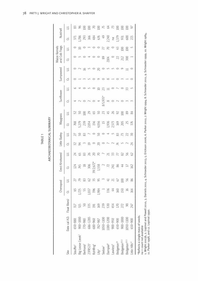
Unfortunately, formal excavations in which flotation samples were systemati-cally collected and analyzed are few. Starting downstream and moving west or up-stream (see Figure 1), we compared data from the Little Hills, Bridgeton, Lawless, Dampier, Stelzer, Lily, Rohlfing, 23FR521, Berhorst, Big Loose Creek, and Stauffer sites. The descriptions provide information about the date of the sites, their physio-graphic locations, the kinds of features found during excavation, with special notes being made about the presence of large cylindrical or bell-shaped pits that may reflect crop storage and implements that reflect specific types of cropping systems.
Little Hills (23SC572), cal A.D. 650–900Little Hills is located in eastern St. Charles County, Missouri (Lopinot 1990). It is sit-uated on the bluff edge overlooking the Missouri River floodplain only a few kilome-ters from where it merges with the Mississippi River. Little Hills is a multicomponent site; the most recent occupation, cal A.D. 650–900, is the subject of this research.
Dating to cal A.D. 650–900, two feature clusters were identified in the excavat-ed area (Lopinot 1990). Cluster 1 reflects the remains of a farmstead. A rectilinear structure basin and nine pit features, three large bell-shaped storage pits were iden-tified. Cluster 2, dominated by large bell-shaped storage pits, possibly represents a year-round occupation with a slight temporal difference from Cluster 1. The ceramic assemblage is very similar in style to that found in coeval sites elsewhere in east-central Missouri and in the American Bottom of Illinois. Eight polished flakes found in seven different pit features and a recovered of a hoe fragment reflect the agricultural technology of the occupants.
Cultivated members of the starchy-seed complex, including chenopod, erect knotweed, little barley, and maygrass, were well represented (Table 1). A single, highly eroded maize cupule was tentatively identified (Lopinot 1990:213). Soils in the area of Little Hills are dominated by Menfro silt loam, which is well drained and easily tilled but of moderate fertility. It is also subject to moderate to severe erosion. By modern standards, Menfro silt loam is considered most suitable for growing wheat, which led Lopinot (1990:213) to suggest that this loam may be more conducive to growing maygrass or the other native crops than the tropical cultigens, maize.
Bridgeton (23SL442), cal A.D. 650–900, 900–1050, and 1050–1200The Bridgeton site is located in western St. Louis County, Missouri, on a second terrace of the Missouri River. Like Little Hills, local soils are dominated by Menfro silt loam.
During the 1980s, several University of Missouri–St. Louis (UMSL) field schools (Harl 1991; Wright 1984) and a cultural resource management study (Galloy and Vollman 1998) were conducted. The site is multicomponent, with a small probable farmstead for the occupation dating cal A.D. 650–900 and relatively larger villages for the time frames cal A.D. 900–1050 and cal A.D. 1050–1200.
78 PATTI J. WRIGHT AND CHRISTOPHER A. SHAFFER
Site
Date
cal
A.D
.Flo
at (l
iters
)
Chen
opod
Erec
t Kno
twee
dLit
tle B
arle
yM
aygr
ass
Sunf
low
erSu
mpw
eed
Mai
ze K
erne
lsan
d Co
b Fr
ags
Nuts
hell
Ct.
U.I.
Ct.
U.I.
Ct.
U.I.
Ct.
U.I.
Ct.
U.I.
Ct.
U.I.
Ct.
U.I.
Ct.
U.I.
Stau
ffer1
650
–880
317
6
5 2
7
124
2432
27
768
52
4 6
0 0
0
0
371
83
Big
Loos
e Cr
eek2
900
–100
051
51,
725
79
74
565
9450
5,27
9 5
02
41
2
5
10
1,78
6 9
6
Berh
orst
3 7
70–9
80 5
0
55
83
1
883
383
23
910
00
03
16
0
0
29
310
0
23FR
5214
686
–128
533
51,
037
62
30
626
19 7
2,05
4 2
92
55
5
4
3
16
610
0
Rohl
fing5
680
–960
191
39
6 3
539
/2,6
72*
20 0
0
156
65
0 0
0 0
0
0
484
70
Lilly6
782
–987
169
1,98
4 9
51,
558
7020
504,
056
50
410
920
0
0
676
100
Stel
zer7
1050
–110
023
9
1
3
2 7
0 0
1
5 2
38/
5,93
5*23
0 0
8
9 7
7
49
75
Dam
pier
811
00–1
200
530
33
6 4
1
72
21 7
41,
936
45
811
8 5
7,104
70
2,24
0 6
4
Law
less
9 9
00–9
5045
4
44
21
24
133
2 5
2,57
3 2
60
01
5
0
0
na 7
3
Brid
geto
n10 6
50–9
0017
0
160
67
8
677
7483
16
9 9
22
70
0
22
43
1,37
910
0
Brid
geto
n10,11
900
–100
027
2
150
100
4
482
573
20
510
00
03
9
212
100
93
110
0
Brid
geto
n10,11
1050
–110
0 9
0
16
56
1
756
222
2
5 8
93
331
11
300
100
60
010
0
Little
Hills
12 6
50–9
0024
7
164
86
16
262
2430
37
4 8
43
50
0
1
5
22
1 9
7
*Ref
lect
s a
sing
le m
ass
of s
eeds
.na
= co
unt n
ot a
vaila
ble
1. W
right
200
3b, 2
. Lop
inot
and
Pow
ell 2
010,
3. D
anie
ls 2
011,
4. S
chro
eder
201
3, 5
. Eric
kson
200
6, 6
. Par
ker 2
012,
7. W
right
1994
, 8. S
chro
eder
201
1, 9
. Sch
roed
er 19
99, 1
0. W
right
1984
, 11
. Par
ker 1
998,
and
12. L
opin
ot 19
90.
TABL
E 1
ARCH
AEO
BOTA
NICA
L SUM
MAR
Y
79CROP SELECTION: PERSPECTIVES FROM THE LOWER MISSOURI RIVER BASIN
Features associated with the cal A.D. 650–900 occupation consist of hearths and pits. Galloy and Vollman (1998:3:14), considering pit location and volume from their excavations as well as from the previous UMSL field schools, note the existence of two pit clusters. Differences in the pit sizes and morphologies of the two clusters are interpreted by Galloy and Vollman (1998:3:21) as possibly reflecting special-ized activity areas within the settlement or even temporal planning associated with increased needs for bulk storage as horticulture intensified. Ample evidence for the cultivation of the starchy-seed complex is noted (see Table 1). In addition, several fragments (n = 22) of maize kernels and cob fragments have been recovered.
For the later (cal A.D. 900–1050) occupation, perhaps as many as eight struc-tures and 43 pits have been identified and excavated (Galloy and Vollman 1998; Harl 1991). Galloy and Vollman note a dramatic 112.2 percent increase in the vol-ume of these pits as compared to those of the earlier occupation. This increase may be associated with a greater need to cache large amounts of foodstuffs that came with more intensive cultivation of maize and members of the starchy-seed com-plex. Also recovered were a complete hoe, made from Mill Creek chert, and nine polished flakes, three of which are also derived from Mill Creek chert, while the other six are from Burlington derived chert. In the American Bottom, hoes and hoe flakes of Mill Creek chert, a raw material that is imported from southern Illinois, are almost synonymous with maize agriculture. Along with the presence of the hoes is a dramatic increase in the frequency and ubiquity of maize (see Table 1). These data, coupled with the greater numbers for members of the starchy-seed complex, suggest an increase in the intensity of cultivation and a reliance on these crops as dietary staples.
Relatively few features are associated with the cal A.D. 1050–1200 occupation. These include five wall-trench houses and 31 pits. The storage capacity of the pits was roughly 80 percent less than the earlier occupation, leading Galloy and Voll-man (1998:3:39) to suggest “a reversal of the trend towards underground storage of large amounts of foodstuffs associated with the adoption of maize agriculture.” Interestingly, Parker (1998:8:43) notes a marked decline in the relative density of maize between the earlier and later occupations; through time, maize drops from 329.8 to 33.3 fragments per 10 L. No stone hoes but seven polished flakes, three of Mill Creek and the others of Burlington chert, were recovered. The fewer features, relative decline in maize, and less evidence of Mill Creek hoes may reflect a smaller and, perhaps, shorter occupation, a difference in site use, or a sampling bias for the period cal A.D. 1050–1200.
Lawless (23SL319), cal A.D. 900–950 (A.D. 620–1140)The Lawless site is located in western St. Louis County (Harl 1999). Situated in a secondary stream valley about a kilometer from the Missouri River bluff edge, it occupies a high terrace above Caulks Creek. The creek is deeply entrenched with a narrow floodplain of only 100–150 m in extent. Here too, Menfro silt loam dom-inates the local soils.
Six calibrated 14C dates range at 2σ from cal A.D. 620 to 1140 (Harl 1999:41). However, Harl (1999:41) notes that the flakes and the point and pottery styles (e.g., jars cordmarked to rounded shoulders and plain rims with angled or extruded lips
80 PATTI J. WRIGHT AND CHRISTOPHER A. SHAFFER
and an occasional lug, jars with angled lips and loop handles, and the frequency of red slipping) are more consistent with findings in the nearby American Bottom of Illinois that date between cal A.D. 900 and 1050. All things considered, Harl (1999) suggests a transitional occupation, and the date of roughly cal A.D. 900–950 is used herein for purposes of analysis and discussion.
At Lawless, a possible structure, perhaps cremation pits, and 51 pit features were discovered, including three large storage pits with volumes ranging from 136 to 179 m3 (Harl 1999). A small fragment of a biface exhibiting high polish was classified as a digging tool, but no polished flakes were mentioned in the report. Interestingly, 17 fragments of chert typical of southern Illinois deposits were iden-tified, indicating access to southern Illinois resources, but Mill Creek chert, which is associated with hoe manufacture, was not found. No maize remains were recov-ered, but a large quantity of maygrass with smaller numbers of chenopod, erect knotweed, and little barley were retrieved (see Table 1).
Dampier (23SL2296), cal A.D. 1100–1200Dampier is a major market and civic-ceremonial center located in far eastern St. Louis County in the Missouri River bottoms (Harl et al. 2011). It was occu-pied during cal A.D. 1100–1200 or during the climax of occupation at Cahokia Mounds, and as Harl and colleagues (2011:1) note, “The Dampier Site is unique in that it represents the first major Mississippian center excavated in east-central Mis-souri in modern times. A number of these centers have been identified, but many were destroyed by development without detailed excavations, and their artifacts have been lost.” Two-hundred and twenty-eight features were identified within the right-of-way excavation. These include at least 13 structures with interior and exterior associated pits, an additional 53 wall trenches, earth ovens, post molds, work areas, hearths, aboveground storage structures, earth ovens, and other deep and shallow pit features. Compared to the other sites under study, a wealth of agri-cultural tools and plant food-processing implements were recovered. These include one complete stone hoe with noticeable polish at its distal end, 2 stone hoe frag-ments, 157 polished flakes, 15 mussel-shell hoes, 42 metates and manos, and 14 nutting stones. This wealthy assemblage reflects the increase in intensity of growing and processing of plant foods associated with a more densely occupied site.
The relatively broad floodplain surrounding the Dampier site afforded fertile soils belonging to the Black-Eudora-Waldron association (Benham 1982) and ample space for planting maize as well as members of the starchy-seed complex and oily-seed domesticates, like sunflower and marsh elder. Indeed, of all the sites discussed here-in, the greatest amount of maize is found at Dampier (see Table 1). Members of the starchy-seed complex and nuts continue to be dietary staples, but they are relatively less well represented compared to maize at Dampier, affording a maize:starchy seed ratio of 3.02:1 and a maize:nutshell ratio of 3.17:1. While the floodplain might sup-port more intensive planting of maize, we know from the historic period that prior to the construction of artificial levees, floodwaters occasionally destroyed crops planted in this area. Additionally, geomorphological research indicates that the site began to be covered with alluvium shortly after its abandonment. Periodic inundation contin-ued over the next 800 years, resulting in burial of the site beneath 1.2 to 1.5 m of
81CROP SELECTION: PERSPECTIVES FROM THE LOWER MISSOURI RIVER BASIN
alluvium. In addition, the southern end of the terrace and associated portions of the site have been cut away by episode(s) of extreme flooding.
Stelzer (23SC910), cal A.D. 1050–1100Stelzer is situated within the Missouri River bottoms on a natural levee bordering an old meander scar. During the 1993 flood of the Missouri River, portions of the site—including human remains—were exposed. Excavations at Stelzer salvaged 27 pit features, one house basin, a human burial and a dog burial and have been inter-preted as the remnants of a small farmstead comprised of one or two families (Harl and Wright 1994). No 14C dates were obtained, but the similarity in pottery styles to that found in the American Bottom of Illinois and elsewhere in east-central Mis-souri led Harl and Wright (1994) to suggest a date of cal A.D. 1050–1100 for the occupation at Stelzer. One hoe flake was found but no hoe blades. Chenopod, erect knotweed, and maygrass occur but not in large quantities. Maize kernel and cob fragments were located with a relatively large maize:starchy seed ratio of 4.94:1. Stelzer is surrounded by Haynie soils, which tend to be richer than Menfro and in the present day are associated with good yields of maize (USDA 2013).
Lilly (23FR1553), cal A.D. 900–950Lilly is situated on a bluff overlooking the confluence of St. Johns Creek with the Missouri River, in northern Franklin County, Missouri, and probably represents a small farmstead of several families (Harl et al. 2012). Excavations revealed 132 features, mostly pits of various sizes, including large storage pits and earth ovens. Harl and colleagues (2012:190–191) speculate that structural remains possibly ex-ist outside the right-of-way.
Four 14C dates were obtained. However, Harl and colleagues (2012:120–121) deemed two of the dates “erroneous.” At 2 σ, the dates for the other two samples range between cal A.D. 686 and 1157, but overlap between cal A.D. 782 and 987. Based on the dates and artifacts, Harl and colleagues (2012:121) suggest that Lilly dates around A.D. 900–950, as the styles of the features and their contents are similar to those observed for cal A.D. 900–950 in the American Bottom of Illinois and in St. Louis County, Missouri.
All members of the starchy-seed complex are well represented, especially may-grass and erect knotweed (see Table 1). No maize remains were recovered. Nine polished flakes, comprising only .1 percent of the flaking debris, were identified, but no stone hoes or digging implements were noted (Harl et al. 2012). Six nutting stones, eight metates‚ and a mano were recovered and attest to the processing of nuts and the grinding of nuts or starchy seeds into meal. Tools are consistent with the plant data and indicate small-scale farming of indigenous cultivars and contin-ued use of wild resources like nuts. Local soils are dominated by the moderately productive Menfro silt loams (USDA 2013).
Rohlfing (23FR525), cal A.D. 680–960Rohlfing, found in northern Franklin County, is located on a ridge spur above Big Berger Creek and some 2 km upstream from its confluence with the Missouri River
82 PATTI J. WRIGHT AND CHRISTOPHER A. SHAFFER
(Herndon 2006). Local soils are dominated by Haymond silt loam, with lower areas subject to frequent flooding (USDA 2013).
Two clusters of pits, possibly representing two farmsteads, were identified. In total, 12 pit features were excavated (Herndon 2006). These include basins, deep basins and bell-shaped pits. At the 2σ, dates on two features range from cal A.D. 680 to 960. A large mass (n = 2,672) of erect knotweed was discovered (see Table 1). In addition, remains of chenopod and maygrass were identified, but there was no mention of little barley or maize or stone implements associated with cultivation. Two possible metates, most likely associated with the grinding of starch grains or nuts into meal, were found.
23FR521, cal A.D. 686–1265Site 23FR521, situated in Franklin County, occupies an elevated terrace remnant along Fiddle Creek, just upstream from emergence of the creek into the Missouri River valley (Ahler et al. 2013). Soils within the project area east of Fiddle Creek consist of Menfro silt loam and Menfro silt loam variants (Held 1989:25–26).
Forty-six pits, three house basins, and forty postholes were identified along with bell-shaped and deep cylindrical pits. Neither digging implements nor hoe flakes were discussed. Eleven 14C dates were obtained (Ahler et al. 2013:85–92). Ahler and colleagues (2013:293) suggest that the “locality showed continuous, but episodic, use for a period of five or six centuries (cal A.D. 686–1265), without evidence of complete abandonment. Archaeobotanical remains associated with those two occu-pations are discussed herein. A few fragments of maize were identified, while mem-bers of the starchy-seed complex prevail among carbonized seeds (see Table 1).
Berhorst (23OS174), cal A.D. 770–980Berhorst is located on a terrace near the Gasconade River approximately 44 km upstream from its confluence with the Missouri River (Daniels 2011). Soils at this location consist of the gravel-laden Reuter silt loam (USDA 2013).
At 2σ, a single 14C date indicates an occupation between cal A.D. 770 and 980. Excavation at the Berhorst site reflects the salvage of a large storage pit. This pit is similar in morphology to storage pits described by Maxi’diwiac in Wilson’s 1917 classic, Agriculture of the Hidatsa Indians. It contained a relatively large quantity of grass stem that may reflect the lining of the pit as described by Maxi’diwi-ac. Members of the starchy-seed complex were also recovered, but no maize was. Tools, possibly associated with digging or agricultural activities, were lacking.
Big Loose Creek (23OS1208), cal A.D. 900–1000The Big Loose Creek site is located in northern Osage County, Missouri (Grantham 2010). It lies on the floodplain of a creek by the same name, about a mile from the Missouri River floodplain. Soils in the area include Menfro and Gatewood silt loams (USDA 2013).
Considering three calibrated 14C dates (cal A.D. 790–1010, A.D. 870–1030, and A.D. 890–1040) and the ceramic assemblage, Grantham (2010:22) suggests an oc-cupation that ranges from cal A.D. 900 to 1000. Grantham (2010:139) considers
83CROP SELECTION: PERSPECTIVES FROM THE LOWER MISSOURI RIVER BASIN
this site to be one of the largest within central Missouri to be found and excavated for that time frame. The site covers at least 8.1 ha but may extend to about 24.3 ha; the excavations were limited to the Missouri Department of Transportation (MoDOT) right-of-way.
Within that right-of-way, 99 features—including two house areas, two middens, and a concentration of pits—were excavated. Both earth ovens and deep storage pits were identified. Ten polished flakes were noted, but no hoes were found. One complete metate and six fragments were recovered. Archaeobotanical remains in-clude relatively large numbers of members of the starchy-seed complex, especially maygrass and chenopod (see Table 1). A total of five kernel and cob fragments of maize were recovered. Cupule widths suggest that they derive from one or more high row-numbered cobs (Lopinot and Powell 2010:102).
Stauffer (23CO499), cal A.D. 625–973Stauffer is located on a slope overlooking the floodplain of Meadows Creek. It is about a kilometer upstream from where Meadows Creek enters the floodplain of the Missouri River. Soils in the area include Wrengart silt loam and members of the Gatewood-Moko Complex, all of which tend to be “very stony” loams (Davis 2003:21; USDA 2013).
The Stauffer site is a small settlement. At least two structures, deep storage pits, earth ovens, hearths, and shallow basin pits were identified and excavated (Hoard et al. 2003). Seven burial mounds are located within 2 km of the site. At 2 σ, the two radiocarbon dates from the site range from cal A.D. 625 to 973. One fragment of a limestone hoe was recovered, as were several manos, grinding slabs, and celt and pestle fragments. No maize is recorded, but members of the starchy-seed complex are well represented (see Table 1).
The impact of slope and soilsFor decades, archaeologists have suggested a high correlation between the distri-bution of fertile soils and the settlement location of late prehistoric farmers in the region (e.g., Woods 1986). Because slope and soil types are interrelated and be-cause they can influence tillage costs and crop productivity, we set out to model the potential relationship between slope, soil type, and solar radiation potential—as measured by slope and orientation—in the addition of maize to the assembly of starchy-seed annuals.
We used catchment areas one km in diameter to quantify the topography and distribution of soil types for each site. We then calculated the percentage of total land area within each site catchment that fell into six slope categories: 0–2 percent rise, 2–5 percent, 5–9 percent, 9–14 percent, 14–20 percent, and 20 percent and higher. We also calculated the percentage of total land area for each of 115 differ-ent soil types from the U.S. Department of Agriculture Soil Survey (2013). We lim-ited our analyses to the 30 most common soil types for all the sites. In addition, we calculated the mean solar radiation for each catchment over the course of a year. We conducted all analyses in ArcMap 10.1 (ESRI).
84 PATTI J. WRIGHT AND CHRISTOPHER A. SHAFFER
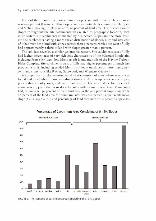
For 7 of the 11 sites, the most common slope class within the catchment areas was 0–2 percent (Figure 2). This slope class was particularly common at Dampier and Stelzer, making up 58 percent to 90 percent of land area. The distribution of slopes throughout the site catchments was related to geographic location, with more eastern site catchments dominated by 0–2 percent slopes and the more west-ern site catchments having a more varied distribution of slopes. Lilly and sites east of it had very little land with slopes greater than 9 percent, while sites west of Lilly had approximately a third of land with slopes greater than 9 percent.
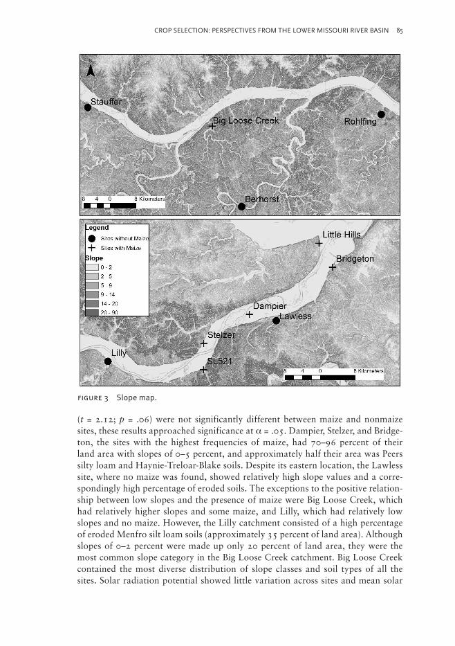
The soil data revealed a similar geographic pattern. Site catchments east of Lilly had higher percentages of very rich soils characteristic of the Missouri floodplain, including Peers silty loam, low Missouri silt loam, and soils of the Haynie-Treloar-Blake Complex. Site catchments west of Lilly had higher percentages of much less productive soils, including eroded Menfro silt loam on slopes of more than 9 per-cent, and stony soils like Rueter, Gatewood, and Wrengart (Figure 3).
A comparison of the environmental characteristics of sites where maize was found and those where maize was absent shows a relationship between low slopes, poorly drained silty soils, and maize cultivation. The mean slope for sites with maize was 4.74 and the mean slope for sites without maize was 8.04. Maize sites had, on average, 50 percent of their land area in the 0–2 percent slope class while 20 percent of the land area for nonmaize sites was 0–2 percent slope. While mean slope (t = –2.14; p = .06) and percentage of land area in the 0–2 percent slope class
figure 2 Percentage of catchment area consisting of 0–2% slopes.
85CROP SELECTION: PERSPECTIVES FROM THE LOWER MISSOURI RIVER BASIN
(t = 2.12; p = .06) were not significantly different between maize and nonmaize sites, these results approached significance at σα = .05. Dampier, Stelzer, and Bridge-ton, the sites with the highest frequencies of maize, had 70–96 percent of their land area with slopes of 0–5 percent, and approximately half their area was Peers silty loam and Haynie-Treloar-Blake soils. Despite its eastern location, the Lawless site, where no maize was found, showed relatively high slope values and a corre-spondingly high percentage of eroded soils. The exceptions to the positive relation-ship between low slopes and the presence of maize were Big Loose Creek, which had relatively higher slopes and some maize, and Lilly, which had relatively low slopes and no maize. However, the Lilly catchment consisted of a high percentage of eroded Menfro silt loam soils (approximately 35 percent of land area). Although slopes of 0–2 percent were made up only 20 percent of land area, they were the most common slope category in the Big Loose Creek catchment. Big Loose Creek contained the most diverse distribution of slope classes and soil types of all the sites. Solar radiation potential showed little variation across sites and mean solar
figure 3 Slope map.
86 PATTI J. WRIGHT AND CHRISTOPHER A. SHAFFER
radiation was not significantly different between maize-producing and nonmaize sites (t = –1.42; p = .20).
Ecological and cultural explanations for maize adoptionMany explanations exist for why farmers decide to adopt certain crops, ranging from strictly ecological to strictly cultural. The data presented above suggest local ecological conditions played an important role in whether or not maize cultiva-tion was adopted. One commonly invoked model for the adoption of new subsis-tence strategies is the diet-breadth model, derived from optimal-foraging theory. Optimal-foraging theory predicts that individuals will employ behavioral strate-gies that maximize the rate of food energy gained per unit of energy spent in its procurement and consumption. Optimality models range from general heuristic frameworks to mathematical modeling of decision making. The diet-breadth model predicts that individuals and groups should expand their dietary breadth (in terms of different resources exploited) when preferred resources become more scarce. According to this model, as humans deplete their environments, the return rates (caloric intake per unit time spent foraging) of traditional resources decrease, and they are forced to expand their diets to include previously low-ranked resources (Kennett and Winterhalder 2006; Piperno 2006). In the context of maize adoption, the diet-breadth model predicts that greater investment in maize cultivation is ex-pected with decreased return rates on other crops and should be associated with a broader, more diverse diet (Barlow 2002).
The diet-breadth model suggests one scenario by which maize would be adopted and become more prominent in the eastern sites. Maize would initially have been included as a relatively minor crop, with minimal field investment, in a mixed system of horticulture and wild resource collection (Barlow 2002). Maize culti-vation may have initially been restricted to certain households, with considerable within-site variation in the intensity of cultivation. Within-site variability in maize cultivation has been reported for several Eastern Woodland sites and may have been related to status, household size, and suitability of particular household gar-dens for growing it (Rose 2008). As settlement sizes increased and return rates for traditional crops dropped, more individuals in the community would have found it advantageous to intensify maize cultivation as part of an expansion of diet breadth. As the community expanded, the gardens of some community members would have become smaller, necessitating more investment in other productive and/or re-liable crops. As return rates on other crops or wild resources such as nuts dropped, the cultivation of maize would have become more uniform across the community. Changing circumstances due to habitat depletion would have made it advantageous to exploit the benefits of maize cultivation vis-à-vis traditional crops, like better storage life and higher yields (Rose 2008). In summary, the diet-breadth model predicts that decreased return rates on traditional crops from increased population density would cause people to turn to novel crops, intensifying maize cultivation and increasing their diet breadth. This explanation is consistent with the higher populations found at sites with maize and the fact that maize appears to have been
87CROP SELECTION: PERSPECTIVES FROM THE LOWER MISSOURI RIVER BASIN
one of a variety of other crops and wild nuts at most of the sites at which it was cul-tivated. It has long been postulated (e.g., Johanessen 1984; Wright 1984) that some decrease in nut exploitation does occur as maize cultivation intensifies. However, there is little evidence to indicate that traditional crops were being diminished at the sites where maize was found. In fact, at the Bridgeton site, an increase in maize cultivation appears to have been accompanied by a commensurate intensification in the cultivation of starchy seeds as well.
A different explanation for the adoption of alternative subsistence strategies is the niche construction model (Smith 2007). Niche construction describes the process by which an organism modifies its environment and that modified envi-ronment acts as a selective pressure for the organism (Laland et al. 1996, 2000). In his adaptation of the niche construction model to explain the advent of food production, Smith (2007, 2011) suggests that the adoption of agriculture was a re-sult of human enhancement of agriculturally productive environments rather than of decreased return rates due to environmental depletion. This model emphasizes traditional ecological knowledge and the engineering of ecosystems through this knowledge. The niche construction model predicts that maize cultivation should be greatest in the most productive environments but need not be associated with decreasing returns for other crops. Using the framework of the niche construction model, the adoption of maize in the eastern sites may have started with low-invest-ment experimentation in areas with highly productive soils. As individuals grew more maize and increased their crop diversity in these productive areas, they would have acquired traditional ecological knowledge about the new crop. This knowl-edge would in turn allow them to develop more efficient cultivation and processing methods, providing a positive feedback mechanism. Our results fit many of the predictions of the niche construction model. For example, the adoption of maize occurred in resource-rich environments, in settlements that reflect long-term occu-pation without population packing or overexploitation of resources, and there is evidence of a broad-spectrum resource base at sites where maize was present.
If one broadens the scope of this project to include the American Bottom of Illi-nois (see Figure 1), Smith’s model becomes even more relevant, as evidence points to the flourishing of maize agriculture along with the intensified cropping of the starchy-seed complex in the rich bottomlands of the Mississippi River (Lopinot 1992). Evidence for intensification includes not only archaeobotanical remains but also increases in the manufacture of hoe blades, which includes importation of Mill Creek chert from southern Illinois, and increases in the number and kinds of stor-age facilities (e.g., Bareis and Porter 1984; Pauketat and Emerson 1997).
Hart (1999) and Hart and Lovis (2013) offer yet another approach to the discus-sion of maize selection and distribution, this one set in northeastern North Ameri-ca and based on Wright’s (1932, 1978) shifting-balance theory. Here the ability of the plant, in this case maize, to adapt to new natural and cultural circumstances and how that adaption might appear in the archaeological record is considered. As Hart and Lovis (2013:183) describe for the Northeast, maize in the Midwest is just another grain added to an existing complex of indigenous cultivated annuals like maygrass (Phalaris caroliniana), chenopod (Chenopodium berlandieri), little barley (Hordeum pusillum), and the like. In “phase I,” demes of a maize population would
88 PATTI J. WRIGHT AND CHRISTOPHER A. SHAFFER
be introduced. In “phase II,” one or more demes would ascend to higher fitness peaks as elements of the microdomesticate landscape improved. For example, the demes may respond to improved edaphic conditions or technological changes, and those changes may be seen at the site level as maize frequencies increase. As maize became more productive, its cost relative to other food sources diminished and the human population would have increased the amount of maize sown. During “phase III,” the fitness of the entire meta population would have increased, and one might expect to see increases in the recovery of maize remains at the regional level. This process can be slow and from an archaeological perspective may result in what appears to be patchy distributions. This is especially true when predicating discussion of crop adoption on carbonized seed assemblages, which are subject to a host of biases (see Wright 2010). Acknowledgment of these biases has led Hart and Lovis (2013) among others to call for integrating multiple lines of evidence (e.g., macroremains, microremains, residue analysis, stable carbon isotopic analysis of human bone, and so on).
Ultimately, when discussing the adoption of maize or any crop, the issue becomes whether or not the interacting local human population was willing to expend time and energy on its production. Gremillion (1993), Lopinot (1986), Newsom and Trieu Gahr (2011) have tackled this issue by using ethnographic and historical ev-idence to model some of the biological and cultural aspects of the decision-making process. We use their suggestions about the acceptance or rejection of exotic crops by Native Americans during historic times to discuss further the prehistoric adop-tion of maize in the lower Missouri River basin:
1. Suitability to local climate and edaphic conditions. We have presented ar-guments describing potential relationships between maize and edaphic con-ditions and ground slope. Climate, including length of growing season and available moisture, would also play a factor in the initial introduction of a “tropical” crop like maize.
2. Prolific early successional or pioneer species that readily colonize, grow, and multiply with little or no human intervention. Members of the starchy-seed complex are pioneer species and would thrive in disturbed environments. Maize, however, may have required greater spacing, more weeding, and addi-tional moisture and nutrients (Scarry and Yarnell 2011). Growing maize may have required the acquisition of new knowledge about growth-promoting techniques gained either through experimentation or interaction with other people more familiar with the crop.
3. Potential to blend with the established seasonal cycle of plant production. Like chenopod and erect knotweed, maize would have been planted in the spring and harvested in the fall.
At first glance, these criteria may be thought of as limiting factors. However, they too may be viewed as the most parsimonious paths to positive feedback. For example, if a new crop is chosen based on its ability to blend with an established seasonal cycle of plant production, the likelihood for a successful harvest may be increased.
89CROP SELECTION: PERSPECTIVES FROM THE LOWER MISSOURI RIVER BASIN
Cropping systems in the lower Missouri River basin
The Missouri River is well known for its meander within the floodplain resulting in high sediment loads and transport, hence, its nickname “Big Muddy.” While flood-plain soils would have been frequently replenished by alluvial additions, flooding and the unpredictability of the Missouri River could have posed major problems. For example, ultimately, the large settlement at Dampier was abandoned and even-tually covered with deep deposits of alluvium. (Comparatively, the Mississippi Riv-er is a much more entrenched, predictable system, and perhaps, its floodplain a much better location for prehistoric agricultural fields [Galat et al. 2005]).
Décrue agriculture, whereby seeds are sown following the recession of floodwa-ters, is a possibility. Perhaps best described by Harlan (1998), this method has been documented for numerous societies in Africa. Smith (2011) suggests it as a pos-sibility for small-scale, preindustrial societies of the Americas. Although suitable for crops planted in late spring and harvested in late summer or fall, this system would not be practical for planting maygrass or little barley. Both of these crops need to be planted in early spring or late fall and harvested in May or early June; their growth cycles would have been destroyed by seasonal flooding. Rather than planting in the floodplain, Lopinot (1990:27–28) points out that the relatively less productive Menfro soils found along the higher terraces and bluffs of the Missou-ri River basin may have better supported indigenous crops, especially the annual grasses, like maygrass, as this soil type is noted for production of an analogous plant, wheat (Tummons 1982:Table 5).
Smith (2011), among many others, suggests a slash-and-burn (aka swidden) strategy. Scarry and Yarnell (2011; see also Monaghan et al., this volume) find this strategy probable given ethnohistoric descriptions. They suggest the slashing and burning to clear plots; tolerating useful volunteer plants in active plots; and shifting cultivation with a preference for clearing growth from old fields rather than creat-ing new plots where useful nut and fruit trees and shrubs could be found. They go on to argue that if broadcasting small seeds is the preferred method then crops may have been planted in zones rather than intercropped. Ultimately, Scarry and Yarnell (2011) recount several lines of evidence to suggest that Native Americans may have used different practices for planting indigenous crops versus maize. For example, the small starchy seeds may have been more suited for broadcasting or sowing in rows, while maize could have been planted as individual seeds.
The location of the fields is hard to ascertain archaeologically. An argument could be made that, when found, the presence of harvest by-products such as cobs, cupules, and glumes suggest that maize farming and harvesting took place near the occu-pation area. Some ethnohistoric accounts confirm this. Adair (Williams 1974:435 [1775]), for example, states, “Every dwelling-house has a small field pretty close to it; and, as soon as the spring of the year permits, there they plant a variety of large and small beans, peas, and the smaller sort of Indian corn, which usually ripens in two months.” Others (e.g., Swanton 1922; Varner and Varner 1951) describe small settlements with extensive fields of maize in alluvial settings, which is probably a better fit with the settlement-subsistence strategies of the American Bottom and Mississippi River valley occupants. Maize is a demanding crop and its yields would
90 PATTI J. WRIGHT AND CHRISTOPHER A. SHAFFER
fluctuate and perhaps decrease over time as its growth depleted soil nutrients. Such circumstances could be ameliorated with perhaps the least amount of labor and the greatest amount of positive feedback by taking advantage of seasonal flooding, as is the case in some floodplain-situated, ridged field systems to the north.
In the Missouri River basin, farming technology based on broad-flat bladed stone hoes, especially those crafted from Mill Creek chert, is lacking. Methods of breaking the ground could have involved wooden digging sticks and hoes that have not survived. Historic records document the use of hafted antler rakes and hoes hafted with blades of bone or mussel shell (Woods 1986). Indeed at Damp-ier, 15 shell hoe blades were identified (Harl et al. 2011). Ultimately, most of the Missouri River occupants seem to have been using a strategy different from that of the “maize agriculturalists” at Cahokia and other sites in the nearby American Bottom of Illinois.
The above discussion of possible cropping systems is by no means exhaustive as the potential agricultural activities not only include preparing land and sowing crops but also weeding, fertilizing, watering, harvesting, transporting, storing, and processing for consumption. These activities would be determined and scheduled within a much larger complex of behaviors, including hunting, collecting wild plants, and manufacturing tools and vessels, among many other important social, economic, and political pursuits.
ConclusionsWhile all cultures are dynamic, cultural change can be slow and seemingly haphaz-ard, as people can be very conservative when it comes to adopting new cultural ele-ments, including new or altered technology and subsistence strategies (Cruz-Torres 2004; Lepowsky 1991). From an archaeological viewpoint, the road to the cul-tivation of the starchy seeds and their eventual inclusion as dietary staples took place over hundreds of years if not more. As Simon (this volume) describes, several researchers have discussed that the initial use of maize may have been limited to ritual use or beer production. If true, one may not expect to find many macrobo-tanical remains, as the formation of the archaeobotanical record in this region is dependent on the plant resources coming into contact with fire during processing or disposal. The idea is interesting to entertain, given that most maize remains found in the Missouri River basin sites are cupules. Perhaps the number of kernels was few, but they were used and discarded in ways that have obscured their archae-ological visibility. Negative evidence is not always indicative of the absence of use. As Hart and Lovis (2013) point out, early macrobotanical evidence for maize use can be uneven across regions as the fitness of the demes was tested.
No doubt complex relationships exist between the crops people grow, their cul-tural beliefs and practices, and ecological variables such as soil and topography. Adoption of any crop is difficult to understand through solely ecological or cultur-al explanations. People do not exist in isolation or in a cultural vacuum. Contact with others can play an important role. Several archaeologists (e.g., Ahler et al. 2013; Grantham 2010; Harl 1991; Harl et al. 2011, 2012) who conducted the
91CROP SELECTION: PERSPECTIVES FROM THE LOWER MISSOURI RIVER BASIN
original cultural resource management investigations from which the archaeobo-tanical data we use here are drawn remark about similarities in pottery styles that cross previously conceived of phase boundaries. In recent years, the applicability of “frontiers,” “boundaries,” and “borders” has been reviewed (Trader 2011). Light-foot and Martinez (1995:475) warn that archaeologically drawn cultural spheres should not be thought of as having inhibited intercultural relationships. These boundaries are, in fact, extremely porous, and interactions among people over large geographic areas were possible. These kinds of interactions likely spawned similarity in pottery styles, as well as fostered the diffusion of maize in the Missouri River basin. In such discussion about interaction, gender may be an important vari-able. If women were the carriers of knowledge about production and stylization of pottery and production and processing procedures of crops, they may have been the agents of change, and any similarities may be explained as being the by-prod-ucts of intermarriage and matrilocal residence or the captivity of women (Cameron 2008; Hart 2001; Junker 2008; Wright 1983).
Ecological factors are also extremely important in determining subsistence strategies, as shown by the quantitative and qualitative data presented herein. The adoption of maize would have included an element of uncertainty until well under-stood and adapted in various ways, allowing it to eventually achieve a measure of importance among a number of groups. Our results indicate that the adoption and intensification of maize in late prehistoric Missouri was part of a broad-spectrum subsistence strategy. Its relative degree of cultivation at individual sites appears to have been highly dependent on local ecological conditions, especially access to areas with low slopes and fertile floodplain soils. In areas with highly productive soils, the cultivation of maize may have started as low-investment experimenta-tion that gradually intensified through time, with increased traditional ecological knowledge and cultural importance providing a positive feedback loop.
AcknowledgmentsWe would like to thank Maria E. Raviele and William A. Lovis for the opportunity to participate in the MAC 2012 sponsored symposium and for their thoughtful in-sights on and editing of this article. We would also like to acknowledge the insight-ful comments offered by Jonathan Hart, Joseph Harl, and any anonymous review-ers. And of course, we take responsibility for any and all mistakes or omissions.
Notes on ContributorsPatti J. Wright is an associate professor of archaeology and manages the archae-ological collection and lab at the University of Missouri–St. Louis. Her research interests include the formation of the archaeobotanical record and the subsistence adaptations of late prehistoric and early historic populations in the lower Missouri and middle Mississippi River valleys.
92 PATTI J. WRIGHT AND CHRISTOPHER A. SHAFFER
Christopher Shaffer is an assistant professor of anthropology at Grand Valley State University with research interests in nonhuman and human primate behav-ioral ecology. He is particularly interested in the application of geospatial analysis for better understanding of primate foraging behavior and human-environment interactions.
ReferencesAhler, Steven R., Dennis M. Naglich, Marjorie B. Schroeder, Terrance J. Martin, Erin Brand, Jennifer Cochran,
and Daniel J. Wescott (2013) Archaeological Mitigation Excavations at 23FR521, 23FR522, and 23FR523,
along County Highway T, Franklin County, Missouri. Submitted to the Missouri Department of Transporta-
tion, Jefferson City, Missouri. Manuscript on file, Archaeology Laboratory, University of Missouri–St. Louis.
Bareis, Charles J., and James W. Porter, Eds. (1984) American Bottom Archaeology: A Summary of the FAI-
270 Archaeological Project. University of Illinois Press, Urbana–Champaign.
Barlow, K. Renee (2002) Predicting Maize Agriculture among the Fremont: An Economic Comparison of
Farming and Foraging in the American Southwest. American Antiquity 67:65–88.
Benham, Ken E. (1982) Soil Survey of St. Louis County and St. Louis City, Missouri. United States Department
of Agriculture, Soil Conservation Service, Washington, D.C.
Cameron, Catherine M. (2008) Introduction: Captives in Prehistory as Agents of Social Change. In Invisible
Citizens: Captives and Their Consequences, edited by Catherine M. Cameron, pp. 1–24. University of Utah
Press, Salt Lake City.
Crawford, Gary W., David G. Smith, and Vandy E. Bowyer (1997) Dating the Entry of Corn (Zea mays) into
the Lower Great Lakes Region. American Antiquity 62:112–119.
Cruz-Torres, Maria Luz (2004) Lives of Dust and Water: An Anthropology of Change and Resistance in
Northwestern Mexico. University of Arizona Press, Tucson.
Daniels, Nicole (2011) Paleoethnobotanical Analysis of the Berhorst Site (23OS174). Unpublished senior the-
sis, Department of Anthropology, Sociology, and Languages, University of Missouri–St. Louis.
Davis, Keith O. (2003) Soil Survey of Cole County, Missouri. United States Department of Agriculture, Soil
Conservation Service, Washington, D.C.
Diehl, Michael W. (2005) Morphological Observations on Recently Recovered Early Agricultural Period
Maize Cob Fragments from Southern Arizona. American Antiquity 70:361–375.
Erickson, Annette G. (2006) Ethnobotanical Analysis. In Phase III Investigations at the Rohlfing (23FR525)
and Schove (23FR526) Sites in Franklin County, Missouri, edited by Richard L. Herndon, pp. 189–198.
Cultural Resource Analysts, Inc., Lexington, Kentucky. Submitted to the Missouri Department of Transpor-
tation, Jefferson City, Missouri. Report on file, Archaeology Laboratory, University of Missouri–St. Louis.
Fritz, Gayle J. (2011) The Role of “Tropical” Crops in Early North American Agriculture. In The Subsistence
Economies of Indigenous North American Societies, edited by Bruce D. Smith, pp. 501–516. Smithsonian
Institution Scholarly Press, Washington, D.C.
Galat, David L., Charles R. Berry Jr., Edward J. Peters, and Robert G. White (2005) Missouri River Basin. In
Rivers of North America, edited by Arthur C. Benke and Colbert E. Cushing, pp. 427–480. Elsevier, Oxford.
Galloy, Joseph M., and Brant Vollman (1998) Late Prehistoric Life along the Missouri River II: The Bridgeton
Site (23SL442). Hansen Engineering, Inc., St. Louis, Missouri. Submitted to West Lake Quarry and Materials
Company, St. Louis, Missouri. Report on file, Archaeology Laboratory, University of Missouri–St. Louis.
Grantham, Larry (2010) Archaeological Investigations at the Big Loose Creek Site, Osage County, Missouri:
Mitigation of Adverse Effects from Road Construction on Route C. Historic Preservation Section of the
Missouri Department of Transportation, Jefferson City, Missouri. Submitted to the Federal Highway Admin-
istration. Report on file, Archaeology Laboratory, University of Missouri–St. Louis.
Gremillion, Kristen J. (1993) Adoption of Old World Crops and Processes of Cultural Change in the Historic
Southeast. Southeastern Archaeology 12:1–16.
93CROP SELECTION: PERSPECTIVES FROM THE LOWER MISSOURI RIVER BASIN
Harl, Joseph L. (1991) An Alternative Explanation for the Shift from a Late Woodland to a Mississippian
Lifestyle Based on Evidence from the Bridgeton Site (23SL442) and Other Sites along the Lower Missouri
River Valley. Unpublished master’s thesis, Department of Anthropology, Washington University, St. Louis.
Harl, Joseph L. (1999) Data Recovery Investigations at the Lawless Site (23SL319): A Dohack Phase Com-
munity in Chesterfield, Missouri. Submitted to Lawless Homes, City of Chesterfield, and U.S. Army Corps
of Engineers, St. Louis District. Report on file, Archaeology Laboratory, University of Missouri–St. Louis.
Harl, Joe, Meredith Hawkins Trautt, Kathryn Parker, and Lucretia Kelly (2012) Data Recovery Investigations
at the Lilly Site (23FR1553): A Meramec Spring Phase, Late Woodland Site in the City of Washington,
Franklin County, Missouri. Submitted to City of Washington, Washington Engineering and Architecture,
U.S. Housing and Urban Development, and U.S. Economic Development Administration. Report on file,
Archaeology Laboratory, University of Missouri–St. Louis.
Harl, Joe, Sophie Kohn, Lucretia Kelly, and Marjorie Schroeder (2011) Recovery Investigations at the Dampier
Site (23SL2296): Mississippian Center in the City of Chesterfield, St. Louis County, Missouri. Submitted
to U.S. Army Corps of Engineers, St. Louis District. Report on file, Archaeology Laboratory, University of
Missouri–St. Louis.
Harl, Joseph L., and Patti Jo Wright (1994) Data Recovery Investigations at the Stelzer Site (23SC910) St.
Charles County, Missouri. Submitted to Historic Preservation Program, Missouri Department of Natural Re-
sources, Jefferson City, Missouri. Report on file, Archaeology Laboratory, University of Missouri–St. Louis.
Harlan, Jack (1998) The Living Fields of Our Agricultural Heritage. Cambridge University Press, Cambridge.
Hart, John P. (1999) Maize Agriculture Evolution in the Eastern Woodlands of North America: A Darwinian
Perspective. Journal of Archaeological Method and Theory 6:137–180.
Hart, John P. (2001) Maize, Matrilocality, Migration, and Northern Iroquoian Evolution. Journal of Archae-
ological Method and Theory 8:151–182.
Hart, John P., and William A. Lovis (2013) Reevaluating What We Know about the Histories of Maize in North-
eastern North America: A Review of Current Evidence. Journal of Archaeological Research 21:175–216.
Held, Robert J. (1989) Soil Survey of Franklin County, Missouri. United States Department of Agriculture, Soil
Conservation Service, Washington, D.C.
Herndon, Richard (2006) Phase III Investigations at the Rohlfing (23FR525) and Schove (23FR526) Sites in
Franklin County, Missouri. Submitted to Missouri Department of Transportation, Jefferson City, Missouri.
Report on file, Archaeology Laboratory, University of Missouri–St. Louis.
Hoard, Robert J., Aaron A. Anglen, John R. Bozell, Danielle Montague-Judd, Elizabeth J. Miksa, Terrell L.
Marting, and Patti J. Wright (2003) The Late Woodland Component of the Stauffer Site, 23CO499. Plains
Anthropologist, Memoir 35.
Johannessen, Sissel (1984) Paleoethnobotany. In American Bottom Archaeology: A Summary of the FAI-270
Archaeological Project, edited by Charles J. Bareis and James W. Porter, pp. 197–214. University of Illinois
Press, Urbana.
Junker, Laura Lee (2008) The Impact of Captured Women on Cultural Transmission in Contact-Period Philip-
pine Slave-Raiding Chiefdoms. In Invisible Citizens: Captives and Their Consequences, edited by Catherine
M. Cameron, pp. 110–137. University of Utah Press, Salt Lake City.
Kennett, Douglas J., and Bruce Winterhalder, Eds. (2006) Behavioral Ecology and the Transition to Agricul-
ture. University of California Press, Berkeley.
Kevin N. Laland, John Odling-Smee, and Marcus W. Feldman (1996) On the Evolutionary Consequences of
Niche Construction. Journal of Evolutionary Biology 9:293–316.
Kevin N. Laland, John Odling-Smee, and Marcus W. Feldman (2000) Niche Construction, Biological Evolu-
tion, and Cultural Change. Behavioral and Brain Sciences 23:131–146.
Lepowsky, Maria (1991) The Way of the Ancestors: Custom, Innovation, and Resistance. Ethnology
30:217–235.
Lightfoot, Kent G., and Antoinette Martinez (1995) Frontiers and Boundaries in Archaeological Perspective.
Annual Review of Anthropology 24:471–492.
Lopinot, Neal H. (1986) The Spanish Introduction of New Cultigens into the Greater Southwest. The Missouri
Archaeologist 47:61–84.
94 PATTI J. WRIGHT AND CHRISTOPHER A. SHAFFER
Lopinot, Neal H. (1990) Archaeology of the Little Hills Expressway Site (23SC572), St. Charles, Missouri.
Submitted to the Missouri Department of Transportation, Jefferson City, Missouri. Report on file, Archaeol-
ogy Laboratory, University of Missouri–St. Louis.
Lopinot, Neal H. (1992) Spatial and Temporal Variability in Mississippian Subsistence: The Archaeobotanical
Record. In Late Prehistoric Agriculture, edited by William I. Woods, pp. 44–93. Studies in Illinois Archaeol-
ogy No. 8. Illinois Historic Preservation Agency, Springfield.
Lopinot, Neal H., and Gina S. Powell (2010) Archaeobotanical Remains. In Archaeological Investigations at
the Big Loose Creek Site, Osage County, Missouri: Mitigation of Adverse Effects from Road Construction on
Route C, edited by Larry Grantham, pp. 94–117. Historic Preservation Section of the Missouri Department
of Transportation. Submitted to the Federal Highway Administration. Report on file, Archaeology Labora-
tory, University of Missouri–St. Louis.
McKern, Will C. (1939) The Midwestern Taxonomic Method as an Aid to Archaeological Culture Study.
American Antiquity 4:301–313.
Newsom, Lee A., and D. Ann Trieu Gahr (2011) Fusion Gardens: Native North America and the Columbian
Exchange. In The Subsistence Economies of Indigenous North American Societies: A Handbook, edited by
Bruce D. Smith, pp. 557–576. Smithsonian Scholarly Press, Washington, D.C.
O’Brien, Michael J., and R. Lee Lyman (2002) The Epistemological Nature of Archaeological Units. Archae-
ological Theory 2:37–56.
Parker, Kathryn (1998) Floral Remains. In Late Prehistoric Life along the Missouri River II: The Bridgeton Site
(23SL442), edited by Joseph M. Galloy and Brant Vollman, pp. 8-1–8-50. Hansen Engineers, Inc., St. Louis,
Missouri. Submitted to West Lake Quarry and Materials Company, St. Louis, Missouri. Report on file, Ar-
chaeology Laboratory, University of Missouri–St. Louis.
Parker, Kathryn (2012) Botanical Remains from the Lily Site. In Data Recovery Investigations at the Lilly Site
(23FR1553): A Meramec Spring Phase, Late Woodland Site in the City of Washington, Franklin County,
Missouri, compiled by Joe Harl, Meredith Hawkins Trautt, Kathryn Parker, and Lucretia Kelly, pp. 96–110.
Submitted to City of Washington, Washington Engineering and Architecture, U.S. Housing and Urban De-
velopment, and U.S. Economic Development Administration. Report on file, Archaeology Laboratory, Uni-
versity of Missouri–St. Louis.
Pauketat, Timothy, and Thomas E. Emerson (1997) Cahokia: Ideology and Domination in the Mississippian
World. University of Nebraska Press, Lincoln.
Piperno, Dolores (2006) The Origins of Plant Cultivation and Domestication in the Neotropics: A Behavioral
Ecological Approach. In Behavioral Ecology and the Transition to Agriculture, edited by Kennett D. Winter-
halder, pp. 137–166. University of California Press, Berkeley.
Ricketts, Taylor H., Eric Dinerstein, David M. Olson, Colby J. Loucks, William. Eichbaum, Dominick Della-
Sala, Kathryn Kavanaugh, P. Hedao, Patrick T. Hurley, Karen M. Carney, R. Abell, and S. Walters (1999)
Terrestrial Ecoregions of North America: A Conservation Assessment. Island, Washington, D.C.
Rose, Fionnuala (2008) Intra-community Variation in Diet during the Adoption of a New Staple Crop in the
Eastern Woodlands. American Antiquity 73:413–439.
Scarry, C. Margaret, and Richard A. Yarnell (2011) Native American Domestication and Husbandry of Plants
in Eastern North America. In The Subsistence Economies of Indigenous North American Societies, edited by
Bruce D. Smith, pp. 483–501. Smithsonian Institution Scholarly Press, Washington, D.C.
Schroeder, Marjorie B. (1999) Archaeobotanical Analysis. In Data Recovery Investigations at the Lawless Site
(23SL319): A Dohack Phase Community in Chesterfield, Missouri, compiled by Joe Harl, pp. 126–138. Sub-
mitted to Lawless Homes, City of Chesterfield, and U.S. Army Corps of Engineers, St. Louis District. Report
on file, Archaeology Laboratory, University of Missouri–St. Louis.
Schroeder, Marjorie B. (2011) Stirling Phase Plant Remains from the Dampier Site. In Recovery Investigations
at the Dampier Site (23SL2296): Mississippian Center in the City of Chesterfield, St. Louis County, Mis-
souri, compiled by Joe Harl, Sophie Kohn, Lucretia Kelly, and Marjorie Schroeder, pp. 368–381. Submitted
to U.S. Army Corps of Engineers, St. Louis District. Report on file, Archaeology Laboratory, University of
Missouri–St. Louis.
95CROP SELECTION: PERSPECTIVES FROM THE LOWER MISSOURI RIVER BASIN
Schroeder, Marjorie B. (2013) Botanical Assemblage from 23FR521. In Archaeological Mitigation Excavations
at 23FR521, 23FR522, and 23FR523, along County Highway T, Franklin County Missouri, compiled by Ste-
ven R. Ahler, Dennis M. Naglich, Marjorie B. Schroeder, Terrance J. Martin, Erin Brand, Jennifer Cochran,
and Daniel J. Wescott, pp. 155–178. Submitted to the Missouri Department of Transportation, Jefferson
City, Missouri. Report on file, Archaeology Laboratory, University of Missouri–St. Louis.
Smith, Bruce D. (2007) Niche Construction and the Behavioral Context of Plant and Animal Domestication.
Evolutionary Anthropology 16:188–199.
Smith, Bruce D. (2011) A Cultural Niche Construction Theory of Initial Domestication. Biological Theory
6:260–271.
Smith, C. Wayne, Javier Betrán, and Ed C. A. Runge (2004) Corn: Origin, History, Technology, and Produc-
tion. Wiley, New York.
Staller, John, Robert Tykot, and Bruce Benz, Eds. (2009) Histories of Maize: Multidisciplinary Approaches
to the Prehistory, Linguistics, Biogeography, Domestication, and Evolution of Maize. Left Coast, Walnut
Creek, California.
Swanton, John R. (1922) Early History of the Creek Indians and Their Neighbors. Bureau of American Eth-
nology. Bulletin 73. Smithsonian Institution, Washington, D.C.
Trader, Patrick D. (2011) Fragmented Frontier: Examining a Late Woodland Settlement in West-Central Illi-
nois. Illinois Archaeology 23:124–157.
Tummons, Richard L. (1982) Soil Survey of St. Charles County, Missouri. United States Department of Agriculture,
Soil Conservation Service in cooperation with the Missouri Agricultural Experiment Station, Washington, D.C.
United States Department of Agriculture (2013) Soil Survey Geographic (SSURGO) Database for Missouri.
Soil, Natural Resources Conservation Service. Electronic document, http://soildatamart.nrcs.usda.gov, ac-
cessed March 2, 2013.
U.S. Fish and Wildlife Service (1999) Big Muddy National Fish and Wildlife Refuge Final Environmental Im-
pacts Statement. Puxico, Missouri.
Varner, John Grier, and Jeannette Johnson Varner, Eds. (1951) The Florida of the Inca. University of Texas
Press, Austin.
Williams, Samuel Cole, Ed. (1974) Adair’s History of the American Indians. Promontory, New York. Origi-
nally published 1775, History of the American Indian, by James Adair. Edward and Charles Dilly, London.
Wilson, Gilbert Livingstone (1917) Agriculture of the Hidatsa Indians: An Indian Interpretation. Studies in the
Social Sciences, No. 9. University of Minnesota, Minneapolis.
Winterhalder, Bruce, and Carol L. Goland (1997) An Evolutionary Ecology Perspective on Diet, Risk, and
Plant Domestication. In People, Plants, and Landscapes: Studies in Paleoethnobotany, edited by Kristen J.
Gremillion, pp. 123–160. University of Alabama Press, Tuscaloosa.
Woods, William I. (1986) Prehistoric Settlement and Subsistence in the Upland Cahokia Creek Drainage. Un-
published Ph.D. dissertation, Department of Geography, University of Wisconsin–Milwaukee.
Wright, Marcia (1983) Technology, Marriage and Women’s Work in the History of Maize-Growers in Maza-
buka, Zambia: A Reconnaissance. Journal of Southern African Studies 10:71–85.
Wright, Patti J. (1984) Analysis of Plant Remains from the Bridgeton Archaeological Site (23SL442): Late
Woodland and Emergent Mississippian Assemblages. Unpublished master’s thesis, Department of Anthro-
pology, Washington University, St. Louis, Missouri.
Wright, Patti J. (1994) Paleoethnobotany. In Data Recovery Investigations at the Stelzer Site (23SC910) St.
Charles County, Missouri, compiled by Joseph L. Harl and Patti Jo Wright, pp. 56–63. Submitted to Historic
Preservation Program, Missouri Department of Natural Resources, Jefferson City, Missouri. Report on file,
Archaeology Laboratory, University of Missouri–St. Louis.
Wright, Patti J. (2003a) Preservation or Destruction of Plant Remains by Carbonization? Journal of Archaeo-
logical Science 30:577–583.
Wright, Patti J. (2003b) Paleoethnobotanical Analysis. Plains Anthropologist Memoir 35, 48:51–57.
Wright, Patti J. (2005) Flotation Samples and Some Paleoethnobotanical Implications. Journal of Archaeolog-
ical Science 32:19–26.

96 PATTI J. WRIGHT AND CHRISTOPHER A. SHAFFER
Wright, Patti J. (2010) On Methodological Issues in Paleoethnobotany. In Integrating Zooarchaeology and
Paleoethnobotany: A Consideration of Issues, Methods, and Cases, edited by Amber M. VanDerwarker and
Tanya M. Peres, pp. 37–64. Springer, New York.
Wright, Sewall (1932) The Roles of Mutation, Inbreeding, Crossbreeding and Selection in Evolution. Proceed-
ings of the Sixth International Congress of Genetics 1:356–366.
Wright, Sewall (1978) Evolution and the Genetics of Populations: 4. Variability within and among Popula-
tions. University of Chicago Press, Chicago.
Related Documents