ST. LOUIS DISTRICT . LTURALRESOURCE MANAGEMENTREV)RT UMBER 17 AD-A2 45 724 SHALLOW SUBSURFACE GEOLOGY, GEOMORPHOLOGY AND LIMITED CULTURAL RESOURCE INVESTIGATIONS OF THE MEREDOSIA VILLAGE A AND MEREDOSIA LAKE LEVEE AND DRAINAGE DISTRICTS, SCOTT, MORGAN, AND CASS COUNTIES ILLINOIS Contract No. DACW43-82-D-O083 by Edwin R. Hajic and David S. Leigh Harold Hassen, Principal Invesiiigator, DTAC Center for American Archeolox l E LEO32 C Tr ~~~FEB 0 3 W9z 4 I (,. p' hic l:., o d =Ql; its BEST AVAILABLE . ... M 92-02602 IUJS Arliy CorpsI I ' i I of Engineers * 9. ~31 Z8April 198.5

Welcome message from author
This document is posted to help you gain knowledge. Please leave a comment to let me know what you think about it! Share it to your friends and learn new things together.
Transcript

ST. LOUIS DISTRICT . LTURALRESOURCEMANAGEMENTREV)RT UMBER 17
AD-A2 4 5 724
SHALLOW SUBSURFACE GEOLOGY, GEOMORPHOLOGY ANDLIMITED CULTURAL RESOURCE INVESTIGATIONS OF THEMEREDOSIA VILLAGE A AND MEREDOSIA LAKE LEVEE ANDDRAINAGE DISTRICTS, SCOTT, MORGAN, AND CASSCOUNTIES ILLINOIS
Contract No. DACW43-82-D-O083
by Edwin R. Hajic and David S. Leigh
Harold Hassen, Principal Invesiiigator, DTACCenter for American Archeolox l E LEO32C Tr
~~~FEB 0 3 W9z4
I (,. p' hic l:., o d =Ql; its
BESTAVAILABLE ....
M 92-02602
IUJS Arliy CorpsI I ' i Iof Engineers
* 9. ~31 Z8April 198.5

SECURITY CLASSIFICATION OF THIS PAGE (hbn Dats tntered)REPORT DOCUMENTATION PA6E READ INSTRUCTIONS
BEFORE COMPLETING FORM1. REPORT NUMBER 2. GOVT ACCESSION NO. 3. RECIPIENT'S CATALOG NUMBER
4. TITLE (anud Subtle) SALW UTURFACL GEOLOGY, 5. TYPE OF REPORT & PERIOD COVEREDGEOMORPHOLOGY AND LIMITED CULTURAL RESOURCE
INVESTIGATIONS OF THE MEREDOSIA VILLAGE ANDMEREDOSIA LAKE LEVEE AND DRAINAGE DISTRICTS, 6. PERFORMING ORG. REPORT NUMBERSCOTT, MORGAN, AND CASS COUNTIES, ILLINOIS. SLD CRM REPORT 17
7. AUTHOR(e) 8. CONTRACT OR GRANT NUMBER(a)
Edwin R. Hajic and David S. Leigh DACW43-82-D-0083
9 PERFORMNG ORGAN17ATION NAME AI ADDRESS 10. PROGRAM ELEMENT. PROJECT, TASKenter. for Amezc~n A'c e8ov AREA & WORK UNIT NUMBERSiampsv le^Arcneo -g al enor
P.O. Box 20
Kampsville, IL 62053
I. CONTROLLING OFFICE NAME AND ADDRESS 12. REPORT DATE
U.S. ARMY ENGINEER DISTRICT, ST. LOUIS April 1985
1222 SPRUCE STREET 13. NUMBER OF PAGES
ST. LOUIS, MISSOURI 63103-2833 163-1, MOITORING AGENCY NAME & ADDRESS(iU different from Controlling Offlce) 15. SECURITY CLASS. (of this report)
N/A unclassified
ISa. OECLASSI FICATION/ DOWNGRADINGSCHEDULE
16. DISTRIBUTION STATEMENT (of this Report)
Approved for release; distribution unlimited.
17. DISTRIBUTION STATEMENT (of the abstract entered In Block 20, If different from Report)
18. SUPPLEMENTARY NOTES
19. KEY WORDS (Continue on reveree side it neceeary and Identify by block number)
20. ANSTRACr raftfte m pepeo &fi bf necesary ai idetWIfy by block number)
- The Meredosia Village and Meredosia Lake Levee and Drainage District study isthe fifth of an ongoing series of combined geologic, geomorphic, andarcheological surveys of lower Illinois River valley levee and drainagedistricts. Subsurface investigations in Illinois Valley deposits are used inconcert with geomorphic analysis and radiocarbon dates to identify, spatiallydelimit and date lithostratigraphic units, interpret depositionalenvironments, and reconstruct the terminal Wisconsinan and Holocene valley - --
DO ,o" 1473 OMroN oF t oV 5OkOLETI1 AN7 SEC¢UmrvYCLAI~t PICA'rOW OF "rhtl'"At .....es nt~d

SECURITY CLASSIFICATION OF THIS PAGE(Whan Data Entered)
Block 20:
evolution. Within this contextual framework, evaluations of the location andpreservation potentials for surface and buried archeological sites are made.
SECURITY CLASSIFICATION OF THIS PAGE(W7en Date Entered)

ST. LOUIS DISTRICT CULTURAL RESOURCE MANAGEMENT REPORT NUMBER 17
Shallow Subsurface Geology, Geomorphology and Limited Cultural Resource
Investigations of the Meredosia Village and Meredosia Lake Levee and
Drainage Districts, Scott, Morgan, and Cass Counties, Illinois.
Contract No. DACW43-82-D-0083
by7Edwin R. Hajic and David S. Leigh 4.,--Harold Hassen, Principal InvestigatorCenter for American Archeology L
By
US Army Corpsof EngineersSt. Louis District September 1984

IIIABSTRACT
The Meredosia Village and Meredosia Lake Levee and Drainage Districtstudy is the fifth of an ongoing series of combined geologic, geomorphic,and archeological surveys of lower Illinois River valley levee and drain-age districts. Subsurface investigations in Illinois Valley deposits areused in concert with geomorphic analysis and radiocarbon dates toidentify, spatially delimit and date lithostratigraphic units, interpretdepositional environments, and reconstruct the terminal Wisconsinan andHolocene valley evolution. Within this contextual framework, evaluationsof the location and preservation potentials for surface and buried
archeological sites are made.
Ii

ACKNOWLEDGEMENTS
Those deserving special thanks are the many landowners and tenants inthe Meredosia Village and Meredosia Lake Levee and Drainage Districts whoallowed soil coring on their land:
Albert Alhorn G. 0. Head Farms Inc.Henry Alhorn Herbert HinnersJ. J. Alhorn Ruel Hobrock
Bob Banghart Velma D. KineyGary Banghart William KleinschmidtByron Beauchamp Harold C. KuhlmanMrs. Virgil Beauchamp Earl LovekampTom Brackett Edwin LovekampMartin Burrus Leona LovekampDrew Carls Albert MaySteven Carls James McCormickMarion C. Chute James MerrimanEverett Dunham Harold OakesLorance Fricke William PineBob Gregory Zelmer RohlfingEdward Hammon Edgar SouleGary Hammon Freida WeberLarry Hardwick Leland WeberMaurice Hardwick Clarence WinklemanNadine Hardwick Eldon WinklemanRoscoe Hardwick Marlin WinklemanAndrew Harris Michael WinklemanJames 0. Harris Harlan YeckHelen 0. Head
The cooperation of the U.S. Army Corps of Engineers, St. LouisDistrict, in particular Terry Norris, is greatly appreciated.
Alan Goodfield, Illinois Department of Transportation, providedadditional subsurface data.
Field assistance was provided by Julia Clifton and Cynthia Danley.Carbonate and mechanical analyses were performed by Cynthia Danley.Figures were skillfully drafted by Cynthia Danley and Frieda Odell-Vereecken. The final manuscript was processed by Beverly Sexauer andMarjorie Schroeder.
This study was conducted under contract between the Contract Arche-ology Program, Center for American Archeology, and the U.S. Army Corps ofEngineers, St. Louis District, Contract #DACW43-82-D-O083.
The U.S. Army Corps of Engineers Illinois Valley geomorphic andarcheologic surveys are coordinated by Dr. Harold Hassen, Center forAmerican Archeology.
ii

TABLE OF CONTENTS
page
Abstract. .. ....... ................ .. .. .. ....
Acknowledgements.................. . . ... . .. .. .. .. .. . ...
List of Figures .. ......... ......... ....... iv
Listof Tables. .. ........... ......... ..... vi
Introduction - Problem Statement. .. .... ....... ...... 1
Theoretical Orientation. ..... ......... .......... 2
Research Goals and Methodology. .. .... ....... ........ 4
Location .. ....... .............. ......... 5
Field and Laboratory Methods .. .. ....... ............ 7
Meredosia Village and Meredosia Lake District Geomorphology and SoilGeomorphic Relationships. .. ..... ......... ....... 15
Stratigraphy. .. ............. ......... .... 19
Meredosia Village and Meredosia Lake District Archeology .. .. ... 32
Geomorphic, Stratagraphic, and Archeological ContextualRelationships. .. ... ......... .............. 324
Conclusions ... ............. ......... .... 38
References Cited. .. ........ ......... ........ 42
Appendix A: Core Descriptions. .. ...... ....... ..... 48
Appendix B: Particle Size and Carbonate Data .. ........... 130
Appendix C: Outline of Late Wisconsinan and Holocene Geology ofthe lower Illinois River Valley, by Edwin R. Hajic . . . 133
Appendix D: Scope of Work .. .... ........ ......... 153
LIST OF FIGURES
page
Figure 1. Location of the Meredosia Village and Meredosia LakeLevee and Drainage Districts, Scott, Morgan and CassCounties, Illinois ...... ...................... 6
Figure 2. Location of core holes and cross sections, MeredosiaVillage District ....... ...................... 8
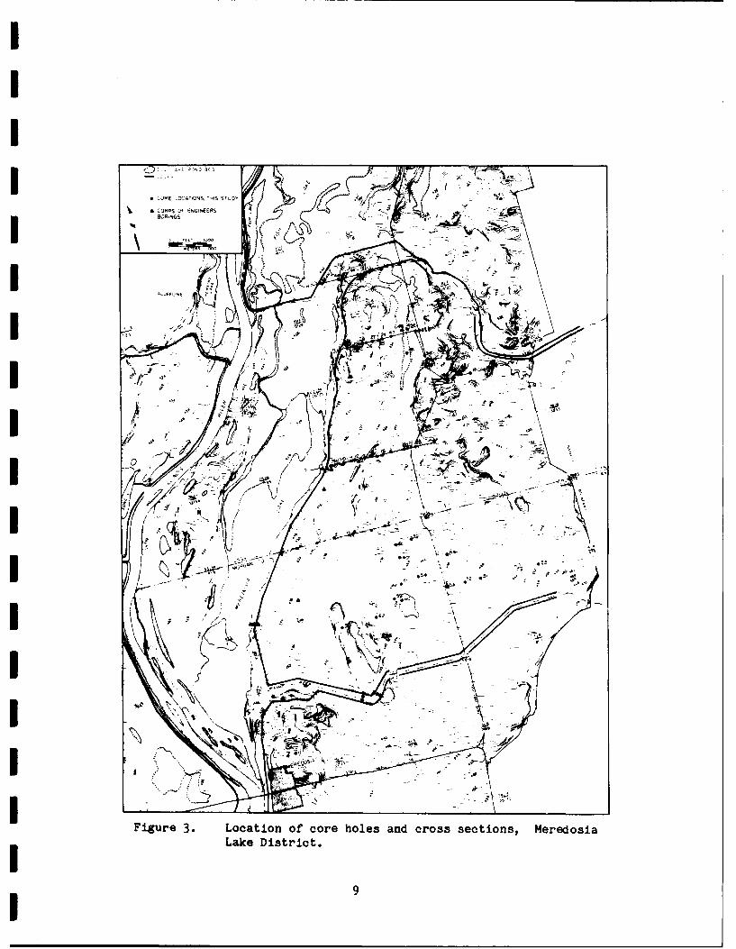
Figure 3. Location of core holes and cross sections, MeredosiaLake District .......... ..................... 9
Figure 4. Geomorphology of the Meredosia Village District . . .. 16
Figure 5. Geomorphology of the Meredosia Lake District .. ..... 17
Figure 6. General soil groupings by texture within theMeredosia Village District ..... .............. ... 20
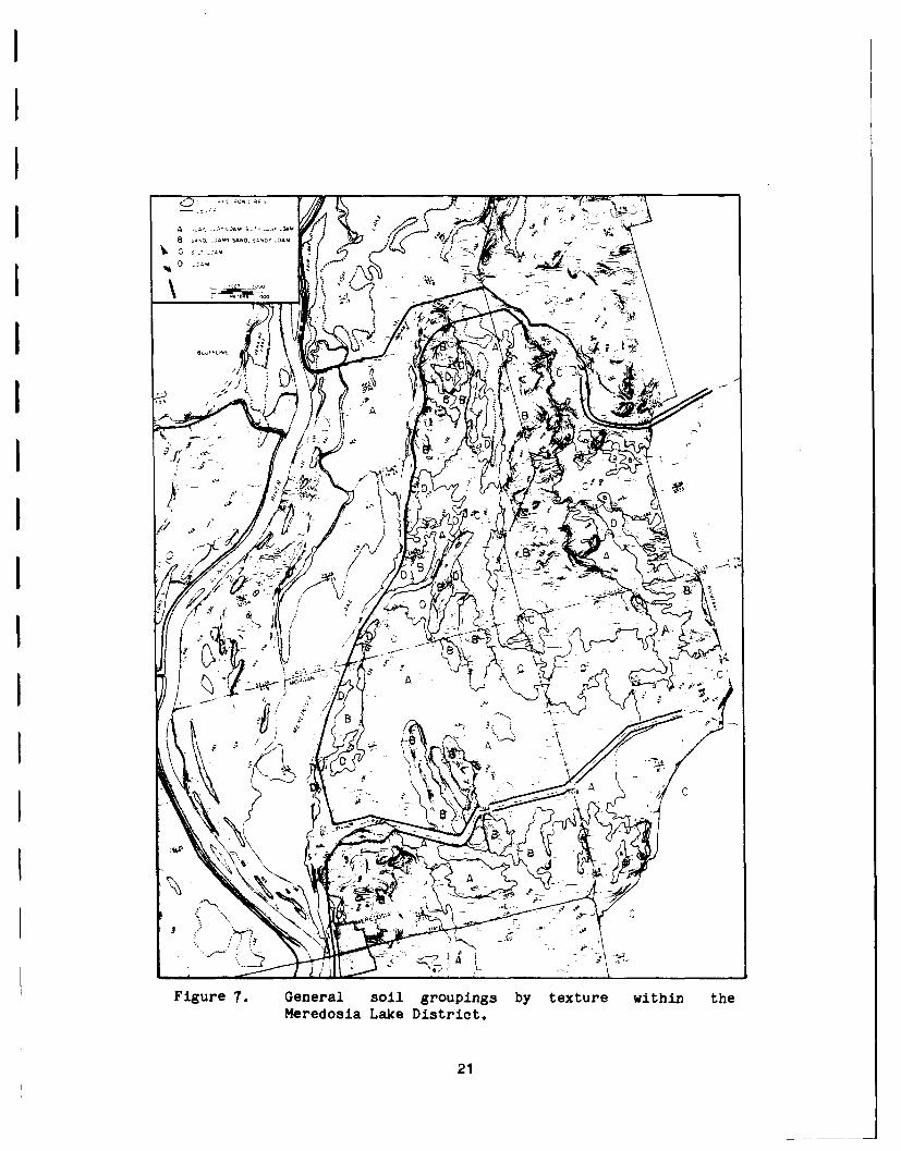
Figure 7. General soil groupings by texture within theMeredosia Lake District ...... ................ ... 21
Figure 8. Meredosia Village cross-section A-A' .. ......... ... 23
Figure 9. Meredosia Village cross-section B-B'. .. ......... ... 23
Figure 10. Meredosia Village cross-section C-C'. .. ......... .... 24
Figure 11. Meredcaia Village cross-section D-D'. .......... . 24
Figure 12. Meredosia Village cross-section E-E'. .. ......... ... 25
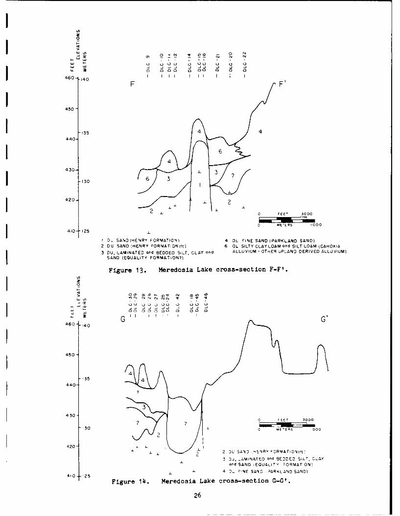
Figure 13. Meredosia Lake tross-section F-F'. ............... ... 26
Figure 14. Meredosia Lake cross-section G-G'. ... ........... ... 26
Figure 15. Meredosia Lake cross-section H-H'. ... ........... ... 27
Figure 16. Stratigraphy, particle size and carbonate data forcore MLC-19 .......... . ..................... 29
Figure 17. Stratigraphy, particle size and carbonate data forcore DLC-28 ........ ...................... ... 30
Figure 18. Location and preservation potentials for surface andburied archeological sites in the Meredosia Villageand Meredosia Lake Districts .... ............. ... 35
iv

LIST OF FIGURES continuedI page
Figure 19. Estimated buried site potentials in the MeredosiaVillage District ......... ................... 40
Figure 20. Estimated buried site potentials in the MeredosiaLake District ............................... 41
Figure C-i. General geomorphology of the lower Illinois RiverI valley, north section, east of the Illinois River . . . 137
Figure C-2. General geomorphology of the lower Illinois Riveri valley, south section ......................... 138
Figure C-3. Longitudinal profile of major geomorphic surfaces,lower Illinois River valley .... .............. ... 139
I Figure C-4. Generalized summary of lower Illinois River valleystratigraphy, depositional environments, and episodes
i of lower Illinois valley history ..... ............ 142
Figure C-5. Schematic cross-section of Illinois Valley .......... 143
IIIIIIIIII
LIST OF TABLES
page
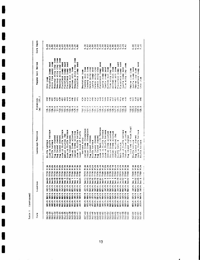
Table 1. Core location, landscape position, and associated SCSsoil, Meredosia Village and Meredosia Lake Districts . . 11
Table 2. Soils groups, by texture . . . ............... 22
Table 3. Known Meredosia Village and Meredosia Lake Districtarcheological sites, cultural affiliation and landscapeposition ........... ........................ 33
Table B-i. Particle size and carbonate data ... ............ .. 131
Table C-i. Lower Illinois River Valley Levee and Drainage Districtradiocarbon dates .... ..................... 135
vi

INTRODUCTION - PRODLDI STATEMT
I Since the late 1920's the Illinois River valley has undergone con-
siderable artificial modification, conducted largely by federal agencies.
An extensive levee system has been constructed along the Illinois and its
major tributaries for flood control and navigation purposes. Floodplain
drainage ditch networks also serve needs of the local farming community.
The U.S. Army Corps of Engineers, St. Louis District, is planning a
program of renewed levee modification and extension of drainage ditch
networks in the lower valley of the Illinois River from Otter Creek
(River mile 15) to Beardstown (River mile 90).
Archeological sites in alluvial contexts are frequently buried by
I sediments indicative of a variety of depositional environments charac-
teristic of dynamic fluvial systems (i.e. Hoyer, 1980; Bettis and
Thompson, 1981; Gladfelter, 1981; Ahler, 1976; Stafford, 1981; Chapman,
1978; Hoffman, 1980). The Illinois River valley is no exception to these
conditions (Wiant, 1980; Hajic and Styles, 1982; Hajic, 1981a; Kraus,
1980; Houart, 1971; Farnsworth, 1976). Levee and drainage ditch con-
struction on and within the Illinois floodplain necessarily requires
excavation and sediment movement, potentially at the expense of buried
archeological deposits. Aware of these archeological concerns, the Corps
of Engineers desires to select borrow locations which would minimize
archeological damage, and still provide construction material with suit-
able engineering properties. The Corps of Engineers has contracted the
Center for American Archeology, Contract Archeology Program, to develop a
predictive model that can effectively estimate the relative potential of
encountering buried surfaces which might contain archeological material
in selected levee and draiage districts (i.e. Scope of Work, Appendix
D). The problem involves identification of possible buried site
locations and their preservation potentials.
I Historically, the Corps of Engineers has partitioned the Illinois
floodplain into a continuous series of levee and drainage districts.
These districts comprise the basic study units of the ongoing project.
Districts extend roughly 7 to 14 km along the valley and are separated by
1I

canalized and/or leveed major valley tributaries. It is within this
organizational framework of selected districts that the predictive
modeling necessarily proceeds.
THEORETICAL ORIENTATION
The Illinois valley has been a changing landscape for at least the
last 13,000 years (Hajic, 1983b; Hajic and Styles, 1982; Butzer, 1977).
Because archeological sites are deposits on landscapes, the quality of
archeological site location predictive modeling capabilities directly
depends upon the degree to which the present landscape, former landscapes
An systematic formational processes are understood. In the strati-
graphic record landscape change by geomorphic processes operating through
time is evidenced. Furthermore, the stratigraphic record holds clues to
archeological site location through interpretation of depositional envi-
ronments by identifying and dating sedimentary units and lithofacies
associations. Consequently, the Corps of Engineers project has been
viewed from inception as a geologic problem as much as an archeological
one. Buried archeological site potentials are most adequately evaluated
in the context of a model of terminal Wisconsinan and Holocene evolution
of the lower Illinois River fluvial system developed from a temporally
grounded stratigraphic and sedimentologic framework. The reconstruction
emphasizes identification of sedimentary units and paleogeomorphic sur-
faces as well as providing interpretations of the depositional environ-
ments and processes responsible for the observed stratigraphy. Further-
more, while broad in scope, the geologic reconstruction emphasizes con-
struction of an absolute time framework which is sufficiently detailed to
be archeologically relevant (see Appendix C, this volume).
Prior to fieldwork, several expectations regarding investigations of
the lower Illinois River valley were outlined: 1) Due to the regional
physiographic position of the Illinois River in the midcontinent, the
geologic history would be potentially complex. The Illinois is tributary
to the Mississippi River and the lower Illinois valley would have adjus-
ted in response to fluvial events in the Mississippi valley (Clayton,
1982; Clayton and Moran, 1982). Simultaneously the Illinois valley has
periodically served as drainageway for variable discharge from the Lake
2

II
Michigan Basin (Hansel et al., in preparation; Evenson et al., 1976;Willman, 1971; Hough, 1958). 2) Fluvial processes are likely to vary
along the 120 km study reach of the Illinois valley at any particular
time. This expectation is largely a consequence of current theoretical
views of fluvial systems and processes. Changes external to a fluvial
system, as well as changes inherent in the system, (i.e. eclipsing a
geomorphic threshold) can trigger a set of complex responses involving
erosion and deposition which may co-occur along different reaches of the
system (Schumm, 1973; 1976).
WithLi a complex natural fluvial system, one event can trigger a
complex reaction (morphologic and/or stratigraphic) as the
components of the system respond progressively to change. This
principal provides an explanation of the complexities of the
alluvial chronologies, and it suggests that an infrequent event,
although performing little of the total work within a drainage
system, may, in fact be the catalyst that causes the crossing of
a geomorphic threshold and the triggering of a complex sequence
of events that will produce significant landscape modification
(Schumm, 1973:307).
3) In addition to evaluating buried site potential, the collection of
* cores for a three dimensional reconstruction would provide a wealth of
paleoenvironmental data. 4) Due to the mandated organizational framework
of the valley, subsurface investigations would be intensive within indi-
vidual districts selected by the Corps of Engineers and proceed one
district at a time. The model would ultimately be for the entire lower
120 km of the Illinois valley although not all districts would be ex-
amined. The predictive capability of successive district studies would
increase as the geologic model progressively developed. 5) A large
number of radiocarbon dates would be required to develop the geologic
*model at an appropriate scale.
3
RESEARCH GOALS AND METHODOLOGY
The primary research goal, as outlined in Corps of Engineers scope
of work, is to model location and preservation potentials for buried
archeological sites in Illinois River valley levee and drainage dis-
tricts. While the goal is archeological in nature, achieving it requires
utilizing not just geomorphic and geologic techniques and methods, but
more importantly, the interpretations of landscape change and development
resulting from these techniques and methods.
Unlike previous geological and geomorphological investigations in
the lower Illinois River valley (Butzer, 1977; Rubey, 1952; Root, 1935),
most effort is being invested in subsurface stratigraphic investigation
using solid cores collected with a Giddings hydraulic soil probe.
Holocene sediments may be in excess of 15.2 m (50 ft.) in thickness and
valley-bottom outcrops are normally limited to a ftvi meters exposed in
drainage ditches. The cores are being used to identify and trace deposi-
tional units, buried surfaces and soils; identify vertical ana lateral
stratigraphic relationships; interpret depositional environments; define
paleochannel locations and morphology; recover datable organic material;
and on occasion recover evidence of cultural occupation. Transverse
valley cross-sections are constructed to provide a three-dimensional
stratigraphic framework. Known surface site distributions from a variety
of largely systematic surveys are being examined for each district and a
limited survey at core locations is conducted. Under separate scopes of
work, surface surveys are being performed along corridors paralleling
levees (c.f. Hassen and Batura, 1983). These surveys normally lag behind
the geologic/geomorphic investigations. Supplementing the principal
research goals, the solid cores contain a wealth of paleoenvironmental
data. Organic matter, molluscs and gastropods are at times abundant.
The scope of work does not allow faunal and floral analyses; however, the
collections have been curated for future study. Also, information pro-
vided from cores allows the alluvial record of the lower Illinois valley
to be integrated into the regional late Wisconsinan and Holocene se-
quence. As the Illinois system is intimately linked through fluvial
processes and responses to both the Mississippi valley and the Lake
Michigan Basin, its evolution may provide clues to the timing of events
in these related systems.
The intent of this report, the fifth in the series of studies of
Illinois River levee and drainage districts, is to evaluate the potential
of encountering buried archeological sites in the Meredosia Village and
Meredosia Lake Levee and Drainage Districts. The first report of this
series (Eldred and Spankey Districts; Hajic and Hassen, 1980) (Figure 1)
focused on the recognition and familiarization of soils, sediments,
valley geomorphic features and their interrelationships. Rough approxima-
tions of buried site potentials were made. In addition to identifying
this potential in the Nutwood District (Hajic, 1981b), it was noted that
shallow subsurface sediments could be divided into seven distinct units
traceable within the district. It was further noted that the distribu-
tion of some of these units had little or no relationship to the present
floodplain morphology.
In the Hartwell and Hillview Districts (Hajic, 1981c; 1983b) empha-
sis was placed on identifying the continuity and variability of the seven
sedimentary units defined in the Nutwood District. The definition of
l unit boundaries was refined. A limited number of radiocarbon dates from
the Nutwood, Hartwell and Hillview Districts (see Appendix C, Hajic,
1983b) allowed construction of an initial temporal framework for the
sedimentary units. At this stage, radiocarbon dates are second only to
stratigraphic data in their importance to the project, and a considerably
larger number of samples must be run for the model to be truly effective.
I The Meredosia Districts provide an opportunity to investigate relict
landforms and associated sediments which are absent from previously
I studied Illinois Valley districts located farther to the south (Figure
1).
I LOCATION
The Meredosia Village and Meredosia Lake Levee and Drainage
Districts are located in northwestern Scott, western Morgan, and south-
western Cass counties (Figure 1). The Meredosia Village District is
II

LEVEE DISTRICTS -
I z NUTWOOD
2=ELDRED- '
4 4: H)LLV)EWCHAG '-5 =MEREDOSIA S
6 6z MEREDOSIALAKE---------- KOI1-O#
JII
I - 3
M~isso~jr ST LOUIS
I 0 MILES 40
0 KMI 50
Figure 1. Location of the Meredosia Village and Meredosia LakeLevee and Drainage Districts, Scott, Morgan and CassCounties, Illinois.I 6

I
bounded by canalized Coon Run to the south and southeast, and by levees
on Willow Creek to the north. To the west are Illinois River backwaters,
most notably Smith Lake and the southern extent of Meredosia Lake, and
the Illinois River by the town of Meredosia (Figure 2). Valley margin
bluffs form the eastern boundary of the northern half of the district and
are 200-300 km east of Coon Run in the southern half. The Meredosia
Village Levee and Drainage District spans Illinois River miles 67.0 to
72.9.
Southern and northern boundaries on the Meredosia Lake Levee and
Drainage District are levees of Willow Creek and Indian Creek respective-
ly (Figure 3). To the west is Meredosia Lake. The eastern boundary is
primarily state Highway 100. The Meredosia Lake Levee and Drainage
District is between Illinois River miles 72.9 and 79.0.
At Willow Creek, the Illinois Valley is 13 km wide. To the south it
gradually tapers to 5 km at its mouth. Immediately north of Willow
Creek, it abruptly widens to over 16 km. The Illinois River hugs the
western valley margin for its first 6? river miles, but uncharacteristi-
cally diverts up to 7.5 km away from the western bluffline at the lati-
tude of the Meredosia Districts.
FIELD AND LABORATORr METHODSTo reconstruct the three dimensional Holocene valley structure in
the Meredosia Village and Meredosia Lake Levee and Drainage Districts,
coring was a necessity. One hundred twenty-seven solid cores 6.4 cm (2.5
in) or 8.9 cm (3.5 in) in diameter were extracted with a trailer mounted
Giddings hydraulic soil probe. Additional sampling, depending upon sedi-
ment type, was accomplished with a 5.1 cm (2 in) flight auger.
The Giddings machine retrieves a largely undisturbed solid core by
hydraulically pushing a hollow 1.25 meter (4 ft) core barrel into the
ground. When the tube is retracted, the sediment/soil core is gently
retained within the tube by friction at the cutting bit until shaken out
the top of the core barrel by the operator. A continuous core is ob-
tained by returning repeatedly to the same hole. The machine cannot
7

-'-PE
-ITI
Figure 2. Location of core holes and cross sections, MeredosiaVillage District.
8
A ORPS DF FN3tNEERS
<1CI
Fiur 3. Loaino oehlsad rs etos eeo
LaeDstiti ,; *j 9

penetrate gravels and some sands, nor can it retrieve saturated sediments
not sufficiently cohesive to hold an open hole while the tube is retrac-
ted and being emptied. The latter condition was not a problem and most
cores were terminated due to refusal on pebbly sand or sand.
After coring, a limited surface survey for archeological material
was conducted within approximately 6 m (20 ft) of the core hole. The
purpose of the surface survey was to determine presence or absence of
archeological sites. The surface survey was not intended to determine
specific parameters of any site discovered, and only diagnostic or unique
material was to be collected.
Evaluation of potential sediment/soil core hole locations necessi-
tated consideration of the following aims: 1) construction of valley
cross-sections; 2) identification of subsurface sediments and sedimentary
relationships; 3) tracing of terraces and deposits of known age and
origin; and 4) sampling of a variety of soil types and floodplain geomor-
phic features. Fifty percent of the cores in the Meredosia Levee and
Drainage Districts were required to be taken within a corridor paral-
leling the main and lateral levees (see Scope of Work, Appendix D). Crop
cover and problems with obtaining access necessarily restricted coring in
some preferred locations. Core locations were selected with the aid of
black and white, and color aerial photographs, topographic maps, soil
series maps and information obtained from preceeding cores. Core hole
and cross-section locations are indicated on Figures 2 and 3 and listed
with reference to the cadastral system in Table 1. Each core was ex-
amined in the field, briefly described, and wrapped in plastic wrap and
aluminum foil for transport. More detailed descriptions were performed
under uniform conditions in the field laboratory using standard USDA soil
terminology (Soil Survey Staff, 1975). Because of time limit/ions, only
depth, interval, color (moist Munsell), texture, structure and boundary
were described. Although developed primarily for till and loess de-
posits, standard weathering zone terminology (Hallberg, Fenton and
Miller, 1978) was useful in describing carbonates and oxidation state
(see Appendix A for an explanation of the terms "oxidized", "deoxidized",
and "unoxidized"). Engineering textural descriptions (U.S. Army Engineer
II

*~ ~~~~~~~ g0 0O e d 0 0..e 0 0 0 O O 0 0 0 00 0 0 0 ~ e
I- COO NN-INg0#1 en-0 0 LlON 0 0 v 3 . -~. O CJ . . 0 a
*.- ~ -cOe u~~-0 ot- 0Ut.t- enLS-1Ce o-eho - - - -- -- c -0I.Q
c 0 aUWe v
0 J.J0O.F. L
O0OId~ xo ent 'eeeO. N NN .N 0~t 0-00 NQ-amal-" e-.0#--a a:"=9mS13-S*55 Q3 m -055 5 5. 3 0 j - x E~S S . 0 V) 'n 3 V) m m 11) :m
en s S itt LOS 0S .fL ssn. *% 19 1 efl**C 7 7rne
0 dw o w UNwN o* -Ce.--,- .O-..flOaelOO C'n F- t-t---et.-en~Nn - ~~-en'en~a.Nenea,0
I,,0
0 1411 1 1, 1 j 1- 1 ij -I
ho n - n -1 bo - -0-.4V
V .0 .3 8a
2:s2:S2 2 2 1 11 112 2 :1 1 2:TL 2 !: 2 1.2 . ,1
0 I "JN N - 6-- 1-- " " I - Fn 4 I-N - - - - - - - -
00 00 0 0 0 40 0 0 0 0 0 0
0 s s w s s s s s s a as s s s 0s s * s u 4a5*5*50 u a a u
, 0-1 0 W W ) 3 F ~ f~ m 33 3 mz 1 3Fi2 15CJ23 133 .J3 M zzC 33
o ~ ~~~~~ W- -3 2 2 2 2 2 2 2 2 2~w m0a w ~ ~ s ~ s s fl f S S S S S 5 5 S . 5
0 N N N N NN N N N N N
~ 0 1 T 1
uuuuu uu Uuuu ll11uI11 - I X1X 3 4 1i M 4

Ii.L 1 1 1 ! c 1 1 ~ 11 v l l 9c 1 1
0U
1~2 4 440 C
V mo
oLao- 0e4L~.4%.L o C~04 lllBl 'a.
0 4O.4~ no Oen I o o ~~ 0 N No e
cl~ v o9 cao -_
0 a 4 a000ol ev n . .. .o .113. 11 m4 , rz o'0 6L L. oI 9.l 4. L.~V 0V 44440 0~
U-44fl11-IA.-4f 35 n -x443B.4A u4. Olaa .m,, 4- n00,om.m Q C~,
.1 af IV a o 0 o ~4 -~
-4 - u ~ ~ ~33333 3333 333~ 3 ~33~3 3 3ow3 33 33-3333-3cI~~ ~~ >n en eu eeneeneeneeneeneNNN eneeneene en eennennen ne ee~neeee
ZZ.62Z U Z Z Z-v2Z Iv I2 2 3 a- m 'a v vovvm v ZCO -04 e0 te c0 Ii lUtU 4.4 - Q-4 c- 4- a ~ a~1 r--- Q-, a- w- (-- -- (4-en~ 4
.4 a
73o*o ' 1 Totttttt~l~eleeee 00 105 0 0 0- c.c,
*o 12Al I I l
o 0N~ClJ~O'C' 0J UN -0N - O~ 0 '- f 0O0
0001. 30 10 0.2 0 L. " vvV Q - m
~~~~L CC O O C -
Z~ 0 '.3 0 a 33 I 1 a,-. 0 1 ~ '
0 ~ 0u 0- 0LW 0 1o 1. ~ - -, c a 0
0........ ....... .
on0 .0 -. 4. ,10 J1, A0 01 0
V- R1 5 1w W31333
gamwcm MI) z ) l
(n~~Cn~=U* U- u n
~ ~ 313

Waterways Experiment Station, 1960) for major units were also recorded
per request in the Scope of Work (Appendix D). Any special features or
inclusions (organic matter, charcoal, gastropod and bivalve shells,
krotovina, lithic debris) were noted. Various units were sampled, air
dried and stored f'or future analyses of particle size, clay and sand
mineralogy, carbonates, C-14 and identification of micro- and macro-
botanical organic matter. Core descriptions are presented in Appendix A.
Additional subsurface data were obtained from the Corps of Engineers, St.
Louis District, Illinois Department of Transportation, and Illinois River
maps (Woermann, 1904).
Although stratigraphic data derived from cores provides the primary
data base, laboratory analyses were deemed necessary to begin to charac-
terize lithostratigraphic units and verify field descriptions. Methods
and procedures of chemical and physical analyses employed are considered
standard for the evaluation of unconsolidated Quaternary sediments and
soils in the midwest (Hallberg, 1978; 1980). Particle size analyses were
completed using the method of Kilmer and Alexander (1949) as modified by
Walter et al. (1978). Calcite and dolomite were determined gasometrical-
ly using the Chittick apparatus (Dreimanis, 1962). Values were
calculated using the following empirical equations for the graphed
lines of Dreimanis, as reported by Walter and Hallberg (1980):
% calcite F (0.232)
% dolomite E (0.223) + 0.3.
The values E and F are corrected volumetric readings of CO2 for dolomite
and calcite respectively. Chemical and physical data are tabulated in
Appendix B.
Cross-sections and geomorphologic maps (see below) were constructed
and interpreted by utilizing both new core hole descriptions and other
previous boring records, black and white, and color aerial photographs,
color infrared aerial imagery, topographic maps and soils data. Land-
owner interviews also provided valuable information on subsurface sedi-
ments as most farmers have excavated deep wells or have sunk sand points
14
on their property.
Because of the complex nature of fluvial sediments and the sampling
intervals, cross-sections are generalized to some extent. Nevertheless,
a clear stratigraphic picture emerges. All elevations are based on
Illinois River floodplain topographic maps with 2 ft contour intervals
(U.S. War Department, 1944) with vertical datum plane referred to 1929
General Adjustment USC & GS (Mean Sea Level). Spoil from drainage ditch
construction since 1944 has been included in core descriptions, but was
omitted and adjusted for in cross-sections.
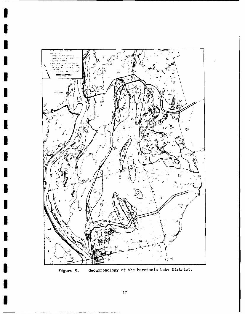
IER DOSIA VILLAGE AND NEREDOSIA LAKE GEONORPDOLOGY
The Meredosia Districts differ from previously studied districts
(Figure 1) because they encompass several geomorphic surfaces and fea-
tures which are not represented in the southern half of the lower
Illinois valley. Two previously defined terraces, the Bath Terrace (Wan-
less, 1957; Styles, 1984; Hajic, 1983b) and Bluffs Terrace (Hajic, 1983b;
Styles, 1984) in part border unburied remnants of the Bug Island Paleo-
channel, a broad, straight Illinois River paleochannel (Figures 4 and 5).
Also represented are extensive alluvial fans and a broad range of allu-
vial features associated with tributary creeks which have traversed much
of the Bug Island Paleochannel after abandonment by the Illinois River.
The Bath Terrace has almost a continuous cover of eolian dunes at-
taining elevations over 143 m (470 ft), but more commonly ranging between
139 m (455 ft) and 142 m (465 ft). Where dunes are absent, the sandy
surface is at about 137 m (450 ft). One large Bath remnant extends the
full length of the western side of the Meredosia Village District while
two large remnants are preserved in the Meredosia Lake District.
Less obvious is the Bluffs Terrace which also has a primarily sandy
surface, but may on occasion have a silt loam surface. It is found at
elevations ranging from 133.5 m (438 ft) to 134.7 m (442 ft). The Bluffs
Terrace sometimes has low eolian dunes or reworked dunes that may reach
elevations of about 137.8 m (452 ft). Remnants are preserved adjacent
to the east side of Bath Terrace remnants in both districts and as
15

J'6
ADA
Figure 4. Geomorphology of' the Meredosia Village District.
16
IIE I
4Q
Fiue5Iemrhlg fteMrdsaLk itit-- ~->17

isolated remnants in the Bug Island Paleochannel. The latter are relict
channel bars or islands and generally have low eolian dunes associated
with them. The boundary between the Bath and Bluffs terrace is at times
indistinct, but generally mapped where large dunes occur on the Bath
Terrace. North of the Meredosia Lake District and just south of
Beardstown the Bluffs Terrace slopes up to and apparently merges with the
Bath Terrace. The close association at the Bluffs terrace with the Bug
Island Paleochannel suggests the Bluffs may be a related floodplain
surface.
The Bug Island Paleochannel derives its name from one of the mid-
channel bars/islands (now considered Bluffs Terrace remnants) that is
approximately 4 km south of the triple junction of canalized Coon, Eagle
and Wolf Run (Styles, 1984). One reach of the paleochannel is located in
the two districts and extends their lengths (Figures 4 and 5). In the
Meredosia Village District, the paleochannel is located between the
eastern bluffline and Bath and Bluffs remnants. Terrace remnants bound
either side of the paleochannel in the Meredosia Lake District (Figure
5). On high altitude aerial photographs, the paleochannel appears at
least 8 to 10 times the width of the present Illinois River channel.
In the Meredosia Village District, most of the Bug Island Paleochan-
nel has been filled by a broad apron of coalescing yet distinct alluvial
fans. Major fans occur at the mouths of Wolf Run, Eagle Run, Spring Run,
and Coon Run. The westward extent of Eagle Run fan has been restricted
by a Bluffs terrace remnant. Tributary creek channel traces on the
fans exhibit both braided and meandering patterns. At times, the larger
creeks extended beyond their fans and eventually terminated in small
splays and distributary networks probably in shallow lakes, in the Bug
Island Paleochannel.
In the Meredosia Lake Levee and Drainage District, much of the
paleochannel has been modified by fluctuating coarses of Willow Creek and
Indian Creek. Indian Creek is now diverted and forms the northern dis-
trict boundary. In past times it flowed south on the east side of a
large Bath Terrace remnant, then west and to the north of a large channel
18

I
bar/island (Figure 5). Meandering channel traces of Indian Creek are
clear in high altitude aerial photographs and may have reworked some
Bluffs terrace remnant margins east of Highway 100 (Figure 5). Willow
Creek has been similarly active, reworking much of the Bug Island Paleo-
channel between canalized Willow Creek and the Cass-Morgan county line.
The resulting landscape in this area is a low hummocky topography of
infilled channels, low natural levees and bars.
Along the eastern margin of Meredosia Lake is either a natural levee
remnant deposited by a former Illinois River or an eroded Bluffs terrace
remanant (Figure 5).
Major soils (those formed over largest areas) (Figures 6 and 7;
Table 2) on the Bath Terrace are the Plainfield sand and Sparta loamy
sand. These reflect the largely dune mantled terrace surface. While
sharing some soil similarities, the Bluffs Terrace also has Keomah silt
loam, Hoopeston sandy loam, Orio silt loam, and even some Ambraw clay
loam in depressional areas. Major soils in the Bug Island channel, where
not buried by upland derived sediments, include Darwin silty clay,
Beaucoup silty clay loam and Ambraw clay loam. Worthen and Littleton
(Table 2) silt loams dominate the proximal and medial alluvial fans and
reflect the upland origin of the sediment. Dupo silt loam is mapped on
distal fans where upland derived sediments are thin and underlying Bug
Island Paleochannel sediments may be incorporated in the lower soil pro-
file. Grouping the soils by texture (Table 2) illustrates a close corres-
pondence to the geomorphology of the districts (Figures 6 and 7).
STRATIGRAPHI
Eight lithostratigraphic units were defined on physical criteria
observed in cores. Eight valley cross-sections illustrate stratigraphic
relationships of these units and shallow subsurface valley structure in
the Meredosia Village and Meredosia Lake Levee and Drainage Districts
(Figures 8-15).
SUi _L This unit consists of oxidized and leached loamy fine sand
to pebbly medium and coarse sand with depth. In the surface soil, tex-
19

I C.101
I -~ C
-E-00 1
IE ft.
-0-IS0I
Fiue6Ieea ol gopig ytxuewti hIeeoi ilg itit
I2
DD
A C
~D
Figure 7. General soil groupings by texture within theMeredosia Lake District.
21
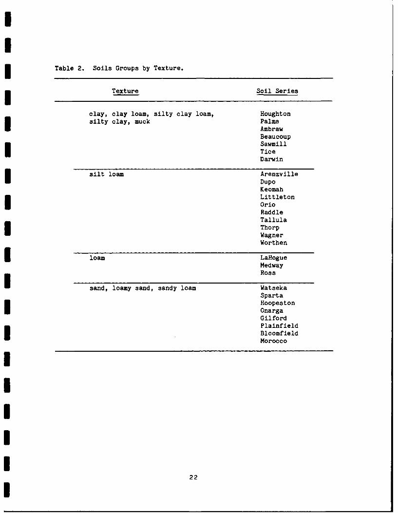
Table 2. Soils Groups by Texture.
Texture Soil Series
clay, clay loam, silty clay loam, Houghtonsilty clay, muck Palms
AmbrawBeaucoupSawmillTiceDarwin
silt loam ArenzvilleDupoKeomahLittletonOrioRaddleTallulaThorpWagnerWorthen
loam LaflogueMedwayRoss
sand, loamy sand, sandy loam WatsekaSpartaHoopestonOnargaGilfordPlainfieldBloomfieldMorocco
22

0
48
_145/
I 470
I 460 -_40
I 450-
4
I440- -15
430-I '30 20 FEET 30420- 0 MjETERS 000
IOL SAND (HENRY FORMATION)I2 DU SAND (HENRY FORMATION (?)) 5 C/O, L/U SILT LOAM ond SILT ICAHOKIA3 DU, LAMINATED and BEDDED SILT, ALLUVIUM - ALLUVIAL FANS)
41 5 CLAY 0 nd SAND (EQUALITY FORMATION?) 8 OIL, L/U SILTY CLAY, SILTY CLAY LOAM and PEAT
TI0'2 4 OL FINE SAND (PARKLAND SAND) (CAHOKIA ALLUVIUM - BUCK LAKE MEMBER)
zFigure 8. Meredosia Village cross-section A-A'.
46 __ 40'8
I 135
430
-130OL SAND (HENRY FORMATION)
2 DU SAND (HENRY rORMA~hON(7l)
420- 3 OU, LAMINATED and BEDDED SILT, CLAY
and SAND (EQUALITY FORMATION?) 8 0,L, L/U SILTY CLAY, SILTY CLAY LOAM and PEAT5 O/D, L/U SILT LOAM and SILT ICAHOKIA CAHOKIA ALLUVIUM - BUCK LAKE MEMBER)
ALLUVIUM - ALLUVIAL FANS) P__ LE_ 30006 OL SILTY CLAY LOAM and SILT LOAM (CAHrKIA .E 00
ALLUWVIUM -OTHER UPLAND DERIVED ALLU', UM)!9&i410 '125 0 mETERS '000
IFigure 9. Meredosia Village cross-section B-B'.23

II
> 0470
C
460I '40
450 ,
35
440-
I3430-
I 00 EET 3000
. 0 METES 000420 OL SAND 'HENRY PORMAT,0N) 5 /0 -j I -7 CM 4n' S AHOKIA ALL.JVjM -
2 DU SAND 'HENRY P0RMAT'ON0)j) A-.. VA4L. PANS)
3 DU, LAMINATED Old BEDDED SILT, _aY B OIL. -U SILT
Y CLAY SILT Y
CLAY LCAM Old "EATold SAND (EQUALITy PORMAT ON7) 0 ALLJVIUM " BUCK LAKE MEMBER
4,0 '125
0 Figure 10. Meredosia Village cross-section C-C'.0
I t I r i iID D'
460
35
440
430.30
420 -'IET 3000
IETES 000
3L SAND 'HENRY 'OQMATiON) -CAM d 3,9 CAY0I ai_- UM-4?) 25 1 DU SAND (,EPY RCQMA ION ALI-,jA .AL ANSI, OAM NA oEC 9 )®m0 E E Y _r, ' .Y _A.-Y.
Y ' Y -_ 02 O d EA -
I'~d SAND EGUA.. ' r A'm AUI A-E MEM9E6
Figure 11. Meredosia Village cross-section D-D'.
24

Iw
I LU
I 019~~ --f
o
ujW
0-1w 4
- -j
0I0 L)
-I 02
0
020
~J0- 0
LUi
Sn 0 J)
ii 0 0 _0 0, CL
vn cN-I >0(I . LI 25 -
0
L- 0- ~
uJi w ~J _j J j _j j .J j _ja. 0 00 0 00 0 0 0
460-.40 I I II
450-
440135 4
430 1303
420-
2o FEET 3000
0 METERS 000
41 f15 ILSNDCLAYLFOMTIN 4 OLFINE SAND (PARKLAND SAND)ALVIM
DU SND HENY FRMATON()) OLSILTY CLAY LOAM and SILT LOAM (CAHOKIA
Figure 13. Meredosia Lake cross-section F-F'.
z0
> 0O, M~~ Nn cm f a)C
0 OOO 0 000
000o000 0 0 30
460--140
450-
354
440-
430430- 0 PEET 3000
0 METERS .000
420-
2L 2 DU SAND HENRY PORMATiON),))
3 '3U, -AMI NATED and BEDDED SILT, CLAY
am d SAND EQUALITY POPN4AT ON)
_L 4 OL PINE SAND PaRK~LAND SAND)410- -25
Figure 1J4. Meredosia Lake cross-section G-Gf.
26

O
V> L Q
._j
460 -- 140 I I
450
430-6
~13
420 -
~41
0 0EET 3000
0 METERS 1000
400 -120
2 DU SAND (HENRY FORMATION 7)) 6 OL SILTY CLAY LOAM and SILT LOAM (CAHO KIA
3 DU, LAMINATED ond BEDDED SILT, ALLUVIUM - OTHER UPLAND DERIVED ALLUVIUM)
CLAY and' SAND (EQUALITY FOR- 7 U, L/U SI LTY CLAY and CL AYE Y S? LT (GAHOKI AM AT ION 7) ALLUVIUM - HARTWELL MEMBER)
4 OL FINE SAND: (PARKLAND SAND) 8 O/U, L/U SILTY CLAY, SILTY CLAY LOAM ond PEAT
(CAHOKIA ALLUVIUM -SBUCK LAKE MEMBER)
Figure 15. Meredosia Lake cross-section H-H'.
27

tures may be fine sandy loam and there is weak indication of original
stratification. The unit occurs beneath dunes on the Bath Terrace
(Figures 8-13). The Bluffs Terrace, when adjacent to the Bath, is also
developed on Unit 1. Corps of Engineers boring records indicate this
unit to be in excess of 9 m (30 ft) thick. The unit belongs to the Henry
Formation (Willman and Frye, 1970) which consists of outwash sand and
gravel of Wisconsinan age.
U= 2,. Most cores terminated in this unit and it occurs throughout
the Bug Island Paleochannel as a basal unit. Unit 2 consists of deoxi-
dized to unoxidized, unleached fine to medium sand (Figures 8-15).
Coarse sand with very fine to fine pebbles occur at depth. The upper
meter is most commonly interstratified with laminae and thin beds of
deoxidized, unleached, sandy silt to silty clay. The silty laminae are
occasionally organic, and may consist entirely of fine pieces of uncar-
bonized organic matter. The Henry Formation is the closest formaly de-
fined correlate.
_U= a is also confined to the Bug Island Paleochannel and overlies
Unit 2. The contact is abrupt, but in most cases conformable with Unit
2. Unit 3 consists of interlaminated and interbedded sediments of a wide
textural range. The core of the unit is commonly a strongly laminated to
thinly bedded silt (Figures 16 and 17). It is generally deoxidized and
unleached, but often contains some reddish brown silt strata or clay
laminae that are leached or only very slightly effervescent with dilute
hydrochloric acid. Commonly underlying the unit is a thin bed of oxi-
dized, unleached or leached fine or medium sand. Fine sand may be inter-
stratified throughout the unit. Overlying the unit core are generally
sandy clay loam, loam, or clay loam strata, or strongly laminated silt to
silty clay loam. Laminae of fine pieces of uncarbonized organic matter
are common both above and below reddish brown strata. Unit 3 was de-
posited primarily in slackwater or lacustrine environments in the Bug
Island Paleochannel with occasional fluvial input. The closest litbo-
stratigraphic correlate formaly defined is the Equality Formation
(Willman and Frye, 1970).
28

I MILC -19
STRATIGRAPHY DEPTH PARTICLE SIZE CARBONATES
u 00 0 20
w N 00 0J 0L
Ap LL U44L 'AllA P l) MN T UNI T 5
Al - CALCITE82t DOLOMITE
5
Alb,
-~-2ID 9 ,. .....
I 0J CL,.. . . .. . .. . .LL . ... ... ... ...
0 ......U........I. ...< SILT.......
... .. .....0.. .. .. ... .. ..I PvAL...........20.
.. . . . . .I3 . . . . . . . . . . . . . . . . . . ..____ ___ ___
Figure16. Sratigaphypartile.sie.a.dcarboate.dta..oI..core........D UI-. ............ .. .. . .. . .. .

DLC-28
STRATIGRAPHY DEPTH PARTICLE SIZE CARBONATESo (%M) N%
< U U0 3uLO 0 U- .0 50 100 0 5 '
0 __C I
LAJ EOLIf.N SAND (UNIT 4)Z Alb,
................o.. CALCITE......... 0: DOLOMITE
C Cr
82! L ACUST RINE i: ::-
22 S ED. ME NT ?)5 .::*:~§..
K22(U I )0a . . . ...
C.. ... ..I- .-- ...
.. .. .. ...... ....
823b2-. .. .. .. .
- 2. . .. . ..
LUb
. . . . .. .. ..
Z Z
UJzb .. . . ..
OL J~d..........SAN
10 Cu.. . .. .
zL LAU -IN
SEOIME20Z
(U IT3:D IL
7. . . .. . .
O/DL . ..... .....
S. _____._____
Figur 17. tratgraph, paticlesizeand . rbonte.daa..ocore.........
30. . .. . .

I
i Unit _k is composed of oxidized and leached fine sand of eolianorigin (Figure 17). This unit comprises dunes over Unit 1 and less com-
monly, Unit 3. In only a few instances is there an intervening paleosol,
and when present, it is very weakly developed. Unit 4 belongs to the
Parkland Sand (Willman and Frye, 1970).
Unit a is located along the eastern half of the Meredosia Village
District and consists of upland derived silt loam deposited primarily as
alluvial fans (Figures 8-12). Colluvial deposits are also mapped as Unit
5. The uppeo, fan deposits are weathered and leached, having oxidized to
deoxidized colors. In most fans, one or more tracable buried soils
occur. The lower part of Unit 5 is laminated with the distinctness of
laminae increasing with depth, particularly where fans are thickest.
Well preserved laminae suggest either rapid deposition, or fan delta
deposition in standing water. Carbonates also pick up in lower Unit 5
sediment (Figure 16). Also common to the lower part of the unit are beds
of silty clay loam which are slightly weathered. Basal fan sediments
are conformable with the underlying Unit 3, and sometimes grade down into
very strongly laminated deoxidized, unleached, silt and very fine sand.
Laterally, Unit 5 interfingers with or buries Unit 8. It also is later-
ally continous with or buried by Unit 6, and basal fan sediments may be
laterally continuous with youngest Unit 3 deposits in the western part of
the Bug Island Paleochannel. Unit 5 is currently mapped as part of the
Cahokia Alluvium (Willman and Frye, 1970).
Unl .6 consists of oxidized and leached silt loam and silty clay
loam largely of upland origin. It occurs most commonly in the Bug Island
Paleochannel, especially in the vicinity of abandoned Willow and Indian
Creek channels in the northeast part of the Meredosia Village District
and southeast part of the Meredosia Lake District (i.e. Figure 12). Unit
6 was deposited by tributary creeks primarily as natural levees, splays
and overbank deposits. It overlies Unit 3 and laterally can be
interstratified with Units 5 and 8. Unit 6 is part of the CahokiaI Alluvium.
_U= 7 is located only in cores DLC-43 and DLC-44 (Figure 14), west
I31I
of the western Bath Terrace remnant in the Meredosia Lake District. This
unit consists of unoxidized and leached silty clay and clayey silt of
slackwater origin. It is probably equivalent to the Hartwell member of
the Cahokia Alluvium defined and described in districts to the south
(i.e. Hajic, 1983b). Here it is underlain by Unit 2(?) and uncon-
formably overlain by Unit 6.
_U= -a consists of leached silty clay loam and silty clay which is
commonly organic. It is the surface unit in the Bug Island Paleochannel
where alluvial fan and tributary creek deposition has not occurred
(Figures 8-12, 15). In the southern part of the Meredosia Village dis-
trict peat and peaty silty clay textures dominate. Here the unit con-
tains abundant gastropods and bivalves, and is calcareous. Unit 8 was
deposited in swamps and shallow intermittant lakes in the Bug Island
Paleochannel following channel abandonment. It may be interstratified
with Units 5 and 6. At least part of Unit 8 may be equivalent to the
Buck Lake member of the Cahokia Alluvium defined and described in dis-
tricts to the south (i.e. Hajic, 1983b).
MERMOSIA VILLAGE AND MEREDOSIA LAKE DISTRICT ARCHEOLOGY
One previously unrecorded archeological site was documented during
the course of this study. The Marlin Winkleman site is located immedi-
ately north of core DLC-35 in the northernmost part of the Meredosia Lake
District. It occurs just north of a dune on the Bath Terrace. The site
consists of a light scatter of chert debris, and no retouched lithics
were found.
Eighteen previously recorded sites in Center for American Archeology
files occur within the Meredosia Districts (Table 3). The sites range
in age from Middle Archaic through Mississippian. They are all as-
sociated with the Bluffs Terrace or Bath Terrace or related dunes except
the Sunset Beach site located on a probable relict natural levee of the
Illinois River.
32

Table 3. Known Meredosia Village and Meredosia Lake District ArcheologicalSites, Cultural Affiliation, and Landscape Position.
Cultural Affiliation Landscaoe Position
Willow Creek Late Woodland Bluffs terrace marginRoscoe Archaic, Late Woodland dune on Bath TerraceHoney Point Late Archaic thru dunes on Bluffs terrace
Late WoodlandShearl Middle and Late Archaic dune on Bluffs terrace(?)Sunset Beach Middle Woodland relict natural levee(?) of
Illinois River, now beachof Meredosia Lake
Wells Early(?) and Late Woodland Bluffs Terrace marginChute indeterminate dune on Bath TerraceDawson Middle Woodland thru Bath Terrace
MississippianMeredosia Middle and Late Woodland dunes on Bath TerraceNational Starch Early and Late Woodland eroded Bath Terrace(?)Virginia Holding Late Woodland Bluff TerraceCo.
Ruthless indeterminate Bluffs TerraceMeadowlark indeterminate Bluffs TerracesNorth Star indeterminate Bluffs TerraceSmall Star indeterminate Bluffs TerraceEleana indeterminate Bluffs TerraceHahn Late Woodland Bluffs TerracePessina indeterminate Bluffs Terrace
Cultural chronology of the lower Illinois River Valley drainage:
Culture Group a (..
Historic post 650Mississippian 850- 650Late Woodland 1500- 850Middle Woodland 2050-1500Early Woodland 2800-2050Late Archaic 4500-2800Middle Archaic 7000-4500Early Archaic 9500-7000Paleo-Indian 11000-9500
33

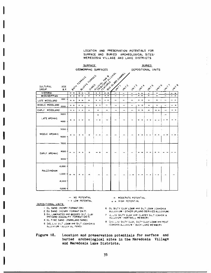
GEOMORPHIC, STRATIGRAPHIC, AND ARCHECLOGICAL CONTEXTUAL RELATIOMSSIPSi A model for predicting site location potential for both buried and
surface manifestations for specific cultural groups in the Meredosia
Districts is summarized in Figure 18. The evaluation is based upon the:
1) evolving reconstruction of the lower Illinois Valley landscape history
(see Appendix C, this report); 2) three dimensional reconstruction of the
Meredosia Districts based upon core stratigraphic data (i.e. the spatial
location of lithostratigraphic units within the districts): 3) age and
depositional origin of lithostratigraphic units; 4) identification and
location of buried surfaces and soils; 5) present geomorphic configura-
tion of the valley, relationships between known archeological sites,
geomorphic features and geomorphic surface ages, and relationships be-
tween geomorphic surfaces and the age and origin of underlying deposits.
While absolute certainty in predictions is unattainable, it is felt
Figure 18 represents very close approximations, given the extent of
information upon which they are based.
Seven radiocarbon dates from the Bug Island Paleochannel system
indicate it was cut prior to about 14,590±240 B.P. (ISGS-1285) (see
Appendix C, this report) and was intermittantly active until about
9830±160 B.P. (ISGS-1282). Six of the dates were from lacustrine Unit 3
and fluvial Unit 2 at or near the contact with Unit 3. The next to
youngest date is 12,360±240 B.P. (ISGS-1283) from Unit 3 which
corresponds with the end of the Deer Plain lake phase in the lower
Illinois valley (see Appendix C). The youngest age from Unit 2 is
9830±160 B.P. (ISGS-1282), Core MLC-29 (Figure 12), which indicates
intermittent fluvial reactivation of the western side of the Bug Island
Paleochannel system from which the dated material was obtained.
The Bath Terrace probably formed when the Bug Island Paleochannel
system developed (see Appendix C, this report). The Bluffs Terrace,
which consists of several mid-channel bars or islands in the Bug Island
Paleochannel and what appears to be reworked or incised Bath Terrace
margins, formed when the Bug Island channel was active but before about
9800 B.P. (see Appendix C, this report).
34
LOCATION AND PRESERVATION POTENTIALS FORSURFACE AND BURIED ARCHEOLOGICAL SITES:MEREDOSIA VILLAGE AND LAKE DISTRICTS
SURFACE BURIEDGEOMORPHIC SURFACES DEPOSITIONAL UNITS
CULTURAL AGE A" b' ,. ,,GROUP B.P <e ",'" ".",HISTORIC 4- + + + + + - - - : - ]MISSISSIPPIAN + - - I - - -+ - -
LATE WOODLAND 0 + - + + -+ + + -
MIDDLE WOODLAND 2000 -+ +
+ +
+ + +
+
EARLY WOODLAND + + + + + 4- + -
3000 -
LATE ARCHAIC400 4+ +4+ + -4 - - - - 14-i 4+ +- - + -+
4000
5000
MIDDLE ARCHAIC +- 4 + - - --+ + + -I- + 4 - - +6000
7000
EARLY ARCHAIC 4- + + + 4- -+ -- 4- " + - --4-
9000-
PALE"OINOIAN 1,0
,O00{0 - + + +--
12,000
I 13,000
- NO POTENTIAL + MODERATE POTENTIAL
- + LOW POTENTIAL + + HIGH POTENTIAL
DEPOSITIONAL UNITS
I OL SAND (HENRY FORMATION) 6 OL SILTY CLAY LOAM and SILT LOAM (CAHOKIA2 DU SAND (HENRY FORMATION?) ALLUVIUM - OTHER UPLAND DERIVED ALLUVIUM)3 DU, LAMINATED ond BEDDED SILT, CLAY 7 U, L/U SILTY CLAY and CLAYEY SILT (CAHOKIA
and SAND (EQUALITY FORMATION ?) ALLUVIUM - HARTWELL MEMBER)4 OL FINE SAND (PARKLAND SAND) 8 O/U, _/U SILTY CLAY, SILTY CLAY LOAM and PEAT
5 O/D, L/U SILT LOAM and SILT (CAHOKIA (CAHOKIA ALLUVIUM - BUCK LAKE MEMBER)
ALLUVIUM - ALLUVIAL FANS)
I Figure 18. Location and preservation potentials for surface andburied archeological sites in the Meredosia Villagei and Meredosia Lake Districts.
35I

Therefore both the Bath Terrace and Bluffs Terrace surfaces were
available for occupation to all cultural groups. The underlying sedi-
ments of Unit 1 can be practically eliminated from buried site considera-
tion due to antiquity and origin as outwash aggradation. Similarly,
sites will probably not be located within Unit 2. This unit represents
bed load sand when the Bug Island Paleochannel was an active sluiceway.
The interstratified finer units in the top meter probably represent
subsequent lacustrine deposits which accumulated with initial channel
abandonment or initiation of subsequent valley lake phases. In the Bug
Island paleochannel-filling Unit 3 there is only a low potential for
encountering Paleo-Indian camp sites. The strongly laminated to thinly
bedded unit is primarily lacustrine or slackwater in origin with occa-
sional fluvial input of sands. The unit is found over a range of eleva-
tions that parallel the top of Unit 2. Fluctuations of valley lake
levels between circa 12,000 B.P. and 10,000 B.P. (see Appendix C, this
report) would have resulted in large horizontal shifts of lake shorelines
and near shore environments. It is possible that younger Unit 3 surfaces
were at times briefly exposed and available for occupation, and thus the
low potential.
Dunes in the Meredosia Districts are primarily relict features.
Dunes occur on the two sandy terraces and occasionally on Unit 3 silts;
no eolian sand bodies were identified in or on alluvial fans. Several
dunes encroaching upon the Bug Island Paleochannel from the west are
probably due to reactivation as a result of modern farming. Farming may
also account for several blowouts on the Bath Terrace. Unit 4 dune sand
is considered to have a high potential for containing buried cultural
material of all time periods even though the latest dune forming activity
was probably shortly after 10,900 B.P. (Appendix C, this report). Burial
is possible because of local historic reactivation and the action of soil
processes in loose sandy sediment which may vertically move larger ob-
jects down the soil profile. Local farmer Henry Likes indicated to us
that several decades ago, before intensive deep plowing, archeological
sites were abundant in the Meredosia Districts, but now there are no-
ticeably fewer visible sites (personal communication, 1984).
36
IThe alluvial fans in the Meredosia District, composed of Unit 5 silt
and silt loam, are stratigraphically conformable with the underlying Unit
3. Basal fan sediment is strongly laminated, possibly being deposited in
a shallow lacustrine environment, and may be temporally equivalent with
youngest Unit 3 deposits along the western margin of the Bug Island
Paleochannel. Investigations of other Illinois Valley fans suggest the
bulk of fan deposition in the region occurred after circa 8500 B.P. and
nearly ceased by about 2000 B.P. with noticably decreased rates since
circa 4000 B.P. (Hajic, 1981a; Wiant et al., 1983; Styles, 1984 ). The
preservation of archeological sites in alluvial fan environments is a
common occurrence in the Illinois Valley, and the Meredosia fans are
accorded a high to moderate potential for all cultural periods. Because
of slower depositional rates for the last 4000 years, the potential of
Woodland occupations being fan surface manifestations is greater than the
Archaic. Nevertheless, over a meter of relatively young alluvial fan
deposition (lacking soil development) was recorded in several cores
indicating even the youngest occupations can be buried.
Unit 6, which consists of primarily upland derived alluvium de-
posited as tributary creek overbank deposits is considered to have a
moderate to high potential for containing buried archeological components
as old as about 9800 B.P., or the latest time the Bug Island Paleochannel
could have functioned. Most Unit 6 depositional environments are rela-
tively low energy subsystems and would be conducive to preservation by
burial. Much of Unit 6 deposited by tributaries entering the Meredosia
Village District probably post-dates about 4000 B.P., when fan surfaces
began to stabilize and tributaries incised fan surfaces. Abundant Early
and Middle Woodland sites on similar landscape positions and sediment to
the south suggest Unit 6 deposition nearly ceased by about 2000 B.P. In
similar situations in districts to the south, archeological sites are
often associated with natural levees that rise several feet above local
floodbasins (Hajic, 1981b; 1981c; 1983b).
Unit 7 is correlated with the Hartwell member which is a major
Holocene valley-filling unit in districts to the south (Hajic, 1983b).
The Hartwell was deposited under lacustrine conditions or in a very
37

I
slowly moving fluvial regime. There is little to no potential of buried
cultural deposits in the Hartwell member. There is, however, the possi-
bility of burial of encampments along the lower Bath Terrace scarp as a
result of progressively higher river stages (lake levels?) and Hartwell
member aggradation.
Unit 8 was deposited primarily in swamp and shallow lacustrine
environments occupying depressions in the Bug Island Paleochannel. Accu-
mulation was probably very slow. In districts to the south, the equiva-
lent of this unit, the Buck Lake member, was deposited in the last 3000
years. This may be the case in the Meredosia districts, but the possi-
bility of earlier accumulation exists since the Bug Island channel was
abandoned by about 9800 B.P. Floodbasins and depressional areas, while
seemingly unlikely for habitation, cannot be excluded from burial or
surface site consideration. While perhaps not large in numbers, or size,
specialized camps for activities related to aquatic food procurement are
I a possibility. Equally possible is the lacustrine burial and preserva-
tion of such sites as well as their erosion and destruction by an active-
ly meandering tributary creek.
CONCLUSIONSFor any given study area, the needs for settlement patterning and
predictive modeling of buried and surface site location potentials in
archeological research and cultural resource management are most effi-
ciently and economically served by first modeling the evolutionary histo-
ry of the landscape. Such an analysis includes not only identification
of surficial features and their ages. The location and morphology of
previous landscape features may be deeply buried and have no readily
apparent relationship to the present landscape. The vertical dimension
requires equal emphasis to temporally and spatially define terminal
Wisconsinan and Holocene depositional units and environments, erosional
hiatuses, and paleo-landscapes. In alluvial environments, such a recon-
struction is paramount to establishing the framework which provides the
basis for making sound archeological interpretations.
In the Meredosia Districts, several lithostratigraphic units, which
38

I
comprise large volumes of valley fill, can categorically be excluded from
consideration of buried site potential based upon either their age and/or
environment of deposition. The location and vertical and horizontal
limits of other units that have a high potential for including buried
archeological deposits, such as alluvial fans, have been clearly defined
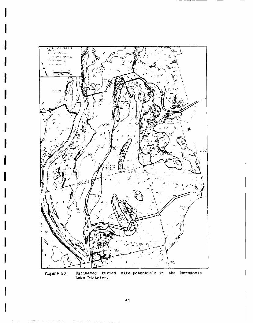
by subsurface investigation.IBuried and surface site potentials can be evaluated for any poten-
tial borrow areas by using Figure 18 in conjunction with the geomorphic
maps (Figures 4 and 5) and stratigraphic cross-sections (Figures 8-15) of
the Meredosia Districts. A generalized summary for buried site potential
is presented in Figures 19 and 20. Prior to any borrow activities, a
systematic site specific surface survey must still be conducted.IThis investigation is considered a component of the archeological
survey. During subsequent archeological testing and mitigation phases,
specific environments and deposits can, and should, be investigated in
I more detail.
IIIII
: 39

Ip QI
,Ii
I .. - ~-j.
--IA
Fiue1. Etmtd breIit oetasi h eeoiVilgIitit
I4
Aki
r
I 41kA,/
t Figure 20 . stimated buri d site poten i s i th e do aLaeDstit
I 41

IREFERENCES CITED
Ahler, S. A.1976 Sedimentary Processes at Rodgers Shelter. In, Prehistoric Man
and His Environments, eds. W. R. Wood and R. B. McMillan.Academic Press, New York.
Batura, James M. and David S. Leigh1983 Phase II Archeological Investigations at the Fox Pup and Gravity
sites, Nutwood Levee and Drainage District, Jersey and GreeneCounties, Illinois. St. Louis District Cultural ResourceManagement Report Number 6. U.S. Army Corps of Engineers.
Bettis, E. Arthur, III and Dean M. Thompson1981 Holocene landscape evolution in western Iowa - concepts, methods
and implications for archeology. In, Current Directions inMidwestern Archaeology: selected papers from the MankatoConference, ed. S. Anfinson. Occasional Publications inMinnesota Anthropology 9.
Butzer, Karl W.1977 Geomorphology of the lower Illinois River valley as a spatial-
temporal context for the Koster Archaic site. Illinois State
Museum Reports of investigations No. 34, 60p.
I Chapman, Jefferson1978 The Bacon Farm site and a buried site reconnaissance. University
of Tennessee, Department of Anthropology Report of Investigations23. Tennessee Valley Authority Publications in Anthropology 21.
Clayton, Lee1982 Influence of Agassiz and Superior drainage on the Mississippi
River. In, Quaternary history of the Driftless Area, J. C. Knox,ed. 29th Annual Meeting, Midwest Friends of the Pleistocene,Field Trip Guide Book Number 5, pp. 83-87.
1983 Chronology of Lake Agassiz drainage to Lake Superior. In,Glacial Lake Agassiz, J. T. Teller and L. Clayton eds.,Geological Association of Canada Special Paper 26, pp. 291-308.
Clayton, Lee and Stephen R. Moran1982 Chronology of Late Wisconsinan glaciation in middle North
America: Quaternary Science Reviews, Vol. 1:55-82.
Coleman, D. D.1974 Illinois State Geological Survey radiocarbon dates V.
Radiocarbon 16:105-117.
Dreimanis, A.1962 Quantitative gasometric determination of calcite and dolomite by
using Chittick apparatus. Journal of Sedimentary Petrography Vol32(3):520-529.
42
Evenson, E. B., W. R. Farrand, D. F. Eschman, D. M. Michelson, and L. J.Maher
1976 Greallakean Substage: A replacement for Valderan Substage in thelake Michigan basin. Quaternary Research Vol 6:411-424.
Farnsworth, Kenneth B.1976 An archeological survey of the lower Illinois River shoreline
(Miles 1-80). Center for American Archeology, ContractArcheology Program Report of Investigations 25.
Flint, R. F. and E. S. Dewey1951 Radiocarbon dating of Late-Plesitocene events. American Journal
of Science 249:257-300.
Gladfelter, Bruce G.1980 Investigations at the Labras Lake site, Volume II -
Geomorphology. Illinois Department of Transportation.
Goodfield, A. G.1965 Pleistocene and surficial geology of the city of St. Louis and
the adjacent St. Louis County, Missouri. Unpublished Ph.D.dissertation, University of Illinois, Urbana.
Hajic, Edwin R.1981a Geology and Paleopedology of the Koster archeological site,
Greene County, Illinois. Unpublished Masters thesis, Universityof Iowa, Iowa City.
1981b Shallow subsurface geology, geomorphology and limited culturalresource investigations of the Nutwood Levee and DrainageDistrict, Jersey and Greene County, Illinois. Center forAmerican Archeology, Contract Archeology Program Report ofInvestigations 108. U.S. Army Corps of Engineers, St. LouisDistrict.
1981c Shallow subsurface geology, geomorphology and limited culturalinvestigations of the Hartwell Levee and Drainage District,Greene County, Illinois. Center for American Archeology,Contract Archeology Program Report of Investigations 109. U.S.Army Corps of Engineers, St. Louis District.
1983a Excavations at Smiling Dan site: Delineation of site structureand function during Middle Woodland period, B. Stafford and M.Sant eds. Center for American Archeology, Contract ArcheologyProgram Report of Investigations 137:81-115.
1983b Shallow subsurface geology, geomorphology and limited culturalresource investigations of the Hillview Levee and DrainageDistrict, Scott and Greene counties, Illinois. Center forAmerican Archeology, Contract Archeology Program Report ofInvestigations 136. U.S. Corps of Engineers, St. Louis District.
43

Hajic, Edwin R. and Harold Hassen1980 Geomorphological, subsurface and limited cultural resource inves-
tigations of the Eldred and Spankey Levee and Drainage District,Greene County, Illinois. Center for American Archeology,Contract Archeology Program Report of Investigatinn3 90. U.S.Army Corps of Engineers, St. Louis District.
Hajic, Edwin R. and Thomas Styles1982 Dynamic surficial geology of the lower Illinois Valley region and
the impact on the archeological record. Paper presented at the47th Annual Meeting, Society for American Archaeology,Minneapolis.
Hallberg, George R., ed.1978 Standard procedures for evaluation of Quaternary materials in
Iowa. Iowa Geological Survey Technical Tnformation Series 8.
1980 Illinoian and pre-Illinoian stratigraphy of southeast Iowa andadjacent Illinois. Iowa Geological Survey Technical InformationSeries II.
Hallberg, George R., T. E. Fenton and G. A. Miller1978 Standard weathering zone terminology for the description of
Quaternary sediments in Iowa. In, G. R. Hallberg ed., Standardprocedures for evaluation of Quaternary materials in Iowa. IowaGeological Survey Technical Information Series 8:75-109.
Hansel, Ardith K., David M. Mickelson, Allan F. Schneider and Curtis E.Larson
in prep. Late Wisconsinan and Holocene history of the Lake MichiganBasin.
Hassen, Harold and James M. Batura1983 Archeological investigations along the lower Illinois River
floodplain: Cultural resource surveys of the Hartwell andNutwood Levee and Drainage Districts, Jersey and Greene Counties,Illinois. St. Louis District Cultural Resource Management ReportNumber 4. U.S. Army Corps of Engineers, St. Louis District.
Hassen, Harold and Edwin R. Hajic1983 Shallowly buried archeological deposits and geologic context:
Archeological survey in the Eldred and Spankey Drainage and LeveeDistricts, Greene County, Illinois. St. Louis District CulturalResource Management Report Number 8. U.S. Army Corps ofEngineers, St. Louis District.
Hofman, Jack L.1981 Test excavation at a buried Middle Archaic component on tne Duck
River, middle Tennessee. Southeastern Archaeological Conference,Bulletin 24:44-48.
44
I
Houart, G. L.1971 Koster: A stratified Archaic site in the Illinois Valley.
Illinois State Museum Reports of Investigations No. 22.
Hough, J. L.1958 Geology of the Great Lakes. University of Illinois Press,
Urbana, 313p.
-- Hoyer, B. E.1980 The geology of the Cherokee Sewer site. In, The CherokeeExcavations, Holocene Ecology and Human Adaptations inNorthwestern Iowa, D. C. Anderson and H. A. Semken eds. AcademicPress, New York.
Kilmer, V. J. and Alenxander, L. T.1949 Methods of making mechanical analysis of soils: Soil Science,Vol. 68:15-24.
I Kraus, Lyn M.1980 Archeological Evaluation of the Buried Gardens of Kampsville.
Center for American Archeology, Contract Archeology ProgramReport of Investigations 87.
McKay, E. D.1977 Stratigraphy and zonation of Wisconsinan loesses in southwestern
Illinois. Unpublished Ph.D. dissertation, University ofIllinois, Urbana.
Robertson, P.
1938 Some problems of the middle Mississippi River region duringPleistocene time. Transactions, Academy of Science of St. Louis29:169-240.
Rubey, W. W.1952 Geology and mineral resources of the Hardin and Brussels
quadrangles in Illinois. U.S. Geological Survey ProfessionalPaper No. 218.
Schumm, Stanley A.1973 Geomorphic thresholds and complex response of drainage systems.
In, Fluvial Geomorphology, ed. M. Morisawa, pp. 299-310. George,Allen and Unwin, London.
1976 Episodic erosion: A modification of the geomorphic cycle. In,Theories of Landform Development, eds. W. N. Melhorn and R. C.Flemal, pp. 69-85. George, Allen and Unwin, London.
Soil Survey Staff1975 Soil taxonomy: A basic system of soil classification for makingI and interpreting soil surveys. Agricultural Handbook 436, U.S.
Government Printing Office, Washington, D. C., p. 745.
45

I Stai'ord, Thomas Jr.1981 Alluvial geology and archaeological potential of the Texasi southern High Plains. American Antiquity 46(3):548-565.
Styles, T. R.1984 Holocene and late Pleistocene geology of the Napoleon Hollow
archeological site in the lower Illinois Valley. UnpublishedMasters thesis, University of Illinois, Urbana.
U.S. Army Engineer Waterways Experiment Station1960 The unified soil classification system. Technical Memorandum No.
3-357. Corps of Engineers, Vicksburg, Mississippi.
U.S. War Department1944 Survey of Illinois River and tributaries for flood control,
Illinois River, Illinois.
I Walter, N. F. and G. R. Hallberg1980 Anlaysis of matrix calcite and dolomite by the Iowa State
University Soils Lab. In, Illinoian and pre-Illinoianstratigraphy of southeast Iowa and adjacent Illinois, G. R.Hallberg ed. Iowa Geological Survey Technical Information SeriesNo. 11:199-206.
1 Walter, N. F., G. R. Hallberg, and T. E. Fenton1978 Particle size analysis by Iowa State University Soil Survey
Laboratory. In, Standard procedures for the evaluation ofQuaternary materials in Iowa, G. R. Hallberg ed. Iowa GeologicalSurvey Technical Information Series No. 8:61-74.
Wanless, Harold R.1957 Geology and mineral resources of the Beardstown, Glasford, Havana
and Vermont quadrangles. Illinois Geological Survey Bulletin 82.
Wiant, Michael D., ed.1980 Napoleon Hollow interim report. Center for American Archeology,
Contract Archeology Program Report of Investigations 76a.
I Wiant, Michael D., Edwin R. Hajic and Thomas R. Styles1983 Napoleon Hollow and Koster site stratigraphy: Implications for
Holocene landscape evolution and studies of Archaic periodsettlement patterns in the lower Illinois River valley. In,Archaic Hunters and Gatherers in the American Midwest, J. L.Phillips and J. A. Brown eds., pp. 147-164. Academic Press, New
I York.
Willman, H. B.1971 Summary of the geologv of the Chicago area: Illinois Geological
Survey Circular 460.
46
Willman, H. B. and J. C. Frye1970 Pleistocene stratigraphy of Illinois. Illinois Geological Survey
Bulletin 94$.
Willman, H. B., et al.1975 Handbook of' Illinois Stratigraphy. Illinois Geological Survey
Bulletin 95.
Woermann, J. A.1904$ Map of the Illinois and Des Plaines Rivers.
47

I
I
I
I
APPEND)IXA
Core Descriptions
IIII
Note: Weathering zone terminology is after Hallberg, Fenton, and Miller(1979). The terms "oxidized" (0), "deoxidized" (D), and"unoxidized" (U) are stardard terminology based upon certain moistMunsell colors and iron segregations. The weathering zones arealso related to hydrologic conditions such as the length ofsaturated conditions. The second letter refers to unleached (U)and leached (L) condition of the sediments in relation to carbonateminerals. Mottling of the sediment is signified by (M).
I
148

0-I
SI~ ~~~ E 0it. i .
Vulo
-c V to C4 V7
C,4 r4 aS 04 0 > ) CCt C',
m-. cC 4.4 mN zt 2 IV a ILV 1 I 4 z. " 2> c 3- 3 -- V
'a I4t. * - 3: 4 s .
CD e r 0 Q o
- 04. 4.4 C -4
I01 V4 41C .. Vl .LN 10 Z -bC If. 0 . -
>~ > )- > E.QV~ '- -- 3 . aa C '-
IE~ U)4 3.- C > '-0- 4 . . t' C .
- In m C.
4,'jt Vn cc a aCIC,I L
.'COL ~ 4 L04 0 0' N-u (-"- 4 - .
- .1 vI q1 Cq rfl VI 'n7
I3 IAa-I
Ca 0 a - a
aN L. 3 u0> u
lo Vol. )- u1-o 4.
* I -2 . . 4 04 4- a4 - 0. V'DI4 aS L3 r0 9.a oN - a 30 c0
o X. !VJ- 4 N 43 !LA0
01 -Q~ t lo 4C If OS' >0 -0a0 00 >V0 . >-t50 .
I >N4.. >6 > .2'
C L 2 03V I '>o 0 00-~~~~. N I 4. C r0C 3
- 13 7. 7 0* a 0 - 4 a V *
-0 -n IVI 000-0 L4 C4..
_0- - . I- u- V ~4-40'- 0 a
h..iZ 71 a. a aa. .
'1 .
3 z~ C>4N h~2~
C 4L
z I0 c 3Y c o LI - - oa -* ; . . c
33
II13za
1-0
CN
2 .D E' V,. I
ILto ~ vv C V - 70 +,
- - - N -i 0 -i. N -.V V c b -- t I I t I I I
0- I
(As-I3 4 LJ 4
V q4. Va
N. I >- V1 Q~~.. f D V nm ~~~~~~0 I IC 5-~ S - la
- I t -v a--. C.. 30-S- * i- fa V
0 o.*l . . s ~ a DI 5V - S JL5 SIO.- SC i.~~~a~~ 0 iV a 0V Od
5> i~ EAD 4~ >a
W, 4- > I. *
C at30-- a D 30 V . 0-4
-- ~ ~ ~ r 0)4 CNi Of VV > N
Vt IOrD- V 3 ~ N t
-L L2 a

-0 1
0-.I
Cc z
, >
0: v 84. -i> U > > .I- EL 4E-
4' i. t--~
a.-. -
II Li~~ 6TC' .- 3
II
C3 L.3 --
a L- ' . . 2 v
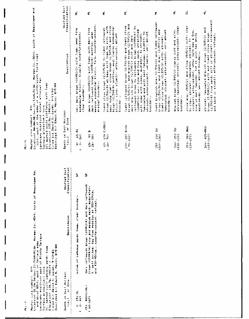
4 -'-I
U -ab
-- U03 - 4 04 C,. -
C ~ ~ ~ ~ ~ C 44 C. C .N 3 4 ) -
2 * I1a ZC a . Q.. CrI Cv a. aV c M a -
i 13 rV4.UI C.. U -. 14-
I Z4 .'' ~ 44' V 4 - 4 C.- ~ - q ~ 4~f44U* U .C .'
z ~ - ~ m i1. C C C > C > N'- - C
C L4 uC >"44'3 4 l. -. . f O C
Ll Q-U Q 4~C0 C . CA 4-4 N14 >.W4C C l C - - C *~ -.-..- *a 41-C '- 4.-..:- 340
-i ~C t- *:-4 4 auaa-4--*a- aon63 t. - '. 4a .4V a
Ix 0 CN- - 91.1'2 .m 45 4 ... Z.l
'2 ~ ~ ~~~~~~~ ~~~~ In . 01. -. C4 -~4CS 4 5 V0 '.
.. I~~~~~~4 * A - 3- I ~ .-... v-C ' 44 ~ ~~~~~ ~~~~ U - - .C )q9VCLI. 3. f.
'a l.. - ' 1 ~ . 14- 544 C .4 '
vi~~~ ~~~ NC 0.. *a. '~l'6t o C... ..
* ~ P44 aU S4. 4 4.- I. V-... a. a
I .4 ~e.4-N4. 5 -3.I~~~~~~~~# o"- C i > ~ 3 > a C45 4 4 .. 5 -
I ix C3 . - .. CC 4 4 - - 42 .V>'. al 4-S .SCC:UU. - as V..
a.~~~~~~ ~~~~~ 3 - 0. 46* . .. '~ V (.* . 4S I -~ ~~~~~~ tC' 3 - - 44~N-4. .- l
.- 4 (a L CU*> . - a .-. > C -. 5,.. C0).-1 C ~I I 3 .:i .q.q 4.L3- . .t.. C > 4 N
- J15 I 0. 4S :NN -N C.I .. 2. - UC. ...
3 J .2 -C 06 3S...-4 - 5 '.4- dC3 -l (a 3 4 I>>. C -aa . C. C 4-.. 5-.-
'a- .13 32.. -..- -:- V . 0- . 4- - C C'2 IS 4 -S 4> . a 41 j'
L C a Q.I0-2 0 a ((C .444 ~ ."-> ,' 4.- -q
4-* -3 1 +32 - --- - - 4-. aC-. .-. S1' .. N
I VS Q2-S a- -CJD'e.44 .4 SC C I-O 4 C- 3 aC CV - C: CV 4C.Ct V 44 . C4
I6 >-4 .'' 3 U 3--.4 C 4 4C 1C v.4 ~*X~~ .SU.C4-US I .. A4 ~~~...V 'o23 S . 0. o~n 4. 4 C. .C .
rL I -2- Ij 42- 44. 63-C -O -. CC ... C C C ..

r
* uc N v
x vm- r N ~ 3
'0 . *Ca'D t
- L Cb3
L acco
>34 4 4AZt
>mC 6~
-L 4p 64 00 cc "1 6 3
> nC -4oE .?> ta C C
*0~~~ -44T.C-.
>0~ Vn -43443.,-. N >C
ZS 4-. ; - a-1 0r3 L )-Q*-6
>0L- * LWQ 046
C4>~~~ &43 *4
-a a -
Z C
m-r o o3
i-q. W)34.o - N4.
3 Cl N 0 000
-CI
81 IE A0m
WuV
La 6Z .A .14 -
b 4I *- c - . > - 6*s n N
I L' A.4 o .~ C* Zl> L-I -0.* 4 - - 0-n .4- ~ n
O 1 3 C n 3 .'4- 4 -I V -~ *~ -~- 354-- 3q-41 E C

>
.
7,
C4>
LO.4
'1E9k~ *4
L (N >3-
C L
,, , ,: 1
a -J *JL j.
vi~1 L rb
*~~ z !> B " l '10£ 2
I1 4 V
IoL . A :C ZO .- 3 - ~ N
en f4 1._j to' O-..h f,. e -

IE 1
- C 41
0041
c4 -43
'0uIt4 4 4.>.
*0 4 4w~ 3 >>. : #;
z.e. N:( (14C c> . A
- a U) J
CC.J L 04
Z4S 44.4
4:4111 04
- c. >Va>.L 3 A4. 1 Cl .. -
01-N C...4
0 >4.. >
->- -4X.-!U
- 3
0- C-
-o b)l
V 0-x>A- >J .. 2 >l -J .. 3 a Ja
N.4 IV.ZU1 a c
0 Z - 0 a44Cal '- . 4.) * 3
4A, (x a41 . C D 10 A.,- C A .4 . z - a C I
. 4. -l 4 0: ) C - - - . .Li 4 1 - . ,C 4>-N
-~~~~~~ ~ I L4 . . 444 4 0 C3 4 - n
IL -. 4. 44! . PC440... : * A .404. C.. -, .> 4.. .VV U ij - 0I w4 Q. .. E 4 C - . - 4 4 4

00 .4
4- z i 1
3'.. 4 1 -4 'D >4 .0t* 3 1>4CL '
z L a W 3> c-
43V" 4 S0 4 > .VV. v a0c4' ca4 'sw-.>4
0'o c t, *3 .- > - 3
a~~-0--- aV V -4 *
CrC~ >4 4 * > 4 4 N
C'1 L~ Z414 C La" >..
>~~ ~ 4tA. 044 r*)~44olb 0-4 N ->A>-
-- 0 > S>-
04- 14, r C(3 * C-V O
2~~~~C 3A f4 2 * 403~~~~1 4, - ccIiC 'E ~ . 4a
Q-~~3-ru >>fS aa- .
- ~ ~~ ~~ 3>Lr4 A 'O A 4-- 0 *C3" >aC 4V
>2- o .*V' - .VVO 334hl
20 -1 a :446.4 Sa': '.4 -'--, ,C .
L4 wz 4
2A' -' C'- - IT,- 9
CIif)
C') In In

V o
-o *-i4 4 Q- L- z Cr0Ni 1 - . --
W)a .xo o 1. '0z' mL )ZL - 4-V
4-I V1a C- 'S a. eL Ix- (Ic C
IN z >.> Ca> OWcu~ . q - a
I~-' - L Zl 4 (4L a l.4 E t E lv
10-o 3a cc 0a ,-d ' 4 ~
-T 4 .4 CC- >X -1 OL Z-a .. 4 > ~ > Wwl NI V U 3fiv C34 S-0 a-u o a
LI 0 0 a>4 4. ~ .
-. 4.4~~a INI UaC I ) #E C 33
.0 ~ ~ ~ ~ 0 I 14 CD .0 ' .V NV* C' I.0 ~ ~ ~ ~ ~ ~ ~~~~Q I1 Ol4C - 3 C-. hC4 W- -k. v,-- a.)
-4 C Ij V) -. W0
Q. IM 641C '>4If IN ~ blaa -NI

40 4 J '
aa
-" 44 3 ' 3 ean>
'.04 > "3A.
C~4o C C, A> a.- 0 ~ £'
33 -44I 3 a 4. 4
.D 7D- - .- 3CQ- . 4 V .. 4
a- 3 c - a a a I C 04
--- 44 4. -'6eN 'Y 4 4''
4.5~a ZN~- -3- aO4. 6> ~ ~ ~ ~ ~ r a0ea i.~ 51~L
-C4U-cl N)0l 34>
-4C40.-~~ *3 c>- 3 6 a *-3- c ~ r.Z) - . -c 3s v
-r. A> . 4> 41 4L
u-.ZqC~ '20 -C- :--' -.l,4- 0
-4 '- C'. .. * >i*J L >- ;- C C ', ' r
- .4Z .' * >4 4 4C L I C -
4-C)~~ .4 v S . -- f
Sa~~aCQI'5~ 441C sa S- . A
~~C-4--e.-a '4-C4 4 4-N- 4a .44.
1645 *> Eb4- rn3- *0 * . f
4. WIN In -
bl 04 "InX J 9 I

m0 3 - Ca V -
C- > - >4 C
I6> .44 ~ nma > . >C 4-
-- m ~ 3 a 305 V.. ,I
3 4 4f - -. ON> W, '
v0 1 0 A 3> 3£ b z--- .3 V Z U4'- 34,4.0z*O 22 ;w'- zO> c.- a-*.40 3- '-~- - z0 . A 3 u4 IA 44
a l 10 se .:>> >. a a4- 4-
-C41 ~C 4 o - .. C O C a
0"'0 SCA". 0 .O0. 4. 4o 5.
CaL CsC
40 4- 4'0 00-'44 0N~~~~~ '0 Z 40N0 0 0' ~
z-X ' - IV CS L ('rE V I Et AI ILINo -V4 -o 0, -1 'm -Nr 'M v~ '35 Z"-12
NZ 2'O 00 4N$0
ZO 0- I- 9).- SSh' - > 41(4
li cu z4 IV -1
4'- L4. 1 > 4
.4 A;l -0 C> IL C a. A0 N au-0
-, .C'a C 4. C4 .0C C4, . AD NCC 4' 04
U,*-w:- 4 4 - M ~ '~ -. 4 C.U~ ~ ~ ~~~~~- VI W fiC A, C - 4C-. . 4 4CA
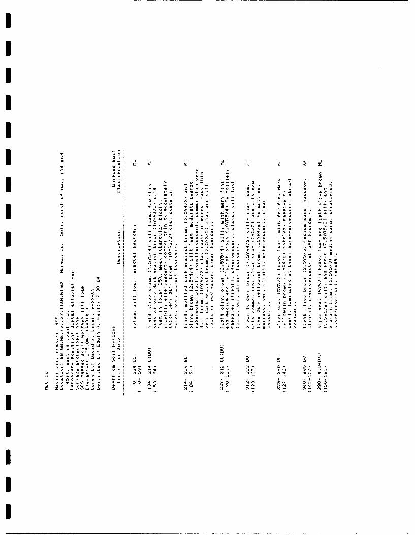
IIII
In-CCA
IL& 14. 00 *
.1'O >--...CdC >NC
Cl~~~L z I~ 3- I - C0u S '.-,-- .- - vCt - v. 5>
-IL v 301 c' ILW40 I'4 c4> -41 4 Ud
DI 00 Lt0' . .- >on -b1 N(. 0
> CO V I0C 0j L C - 10.'oCL V4 In. C"
> 1 ~ 3 0 -> - *C0 . 4JN
CC o I o 6Q1.X v 3--o i33
CCcc >l 0 NCiI.-.V-3IN~~ I4 Il, I 4* v
- j Q- I Li ICA-
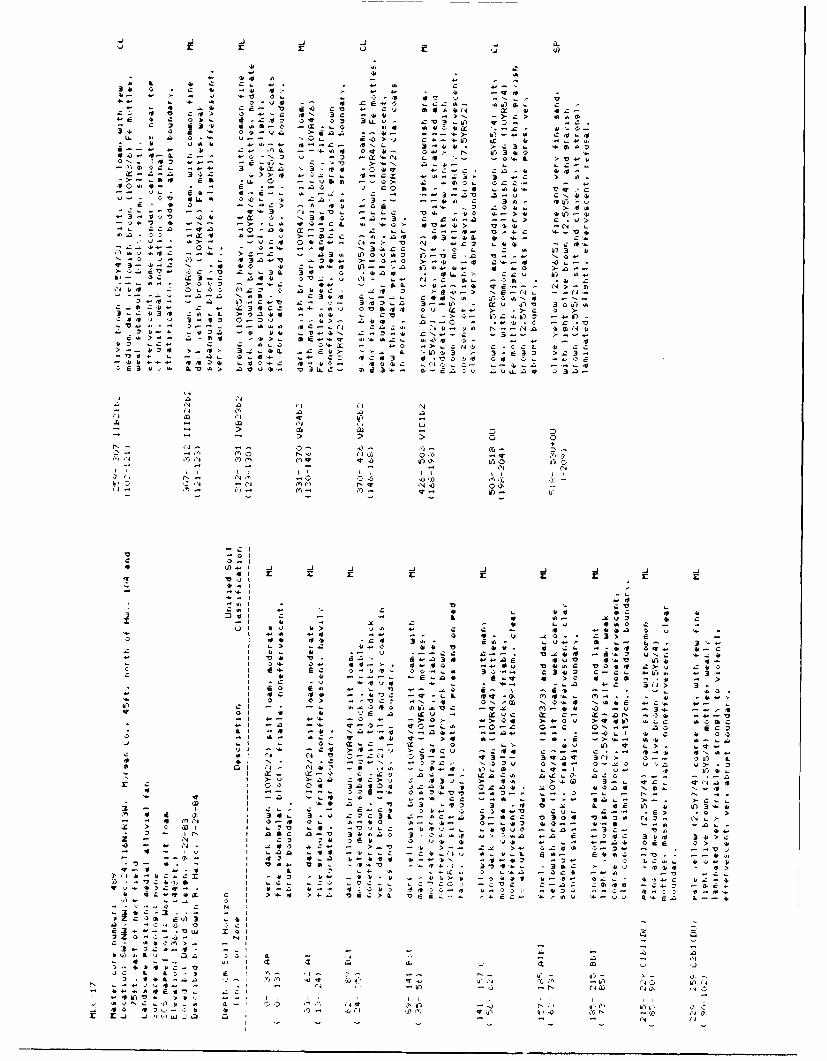
44 4.
Z L 4 -a. z u* D - - - I
-~~~~ >* 4 ~ - .- 4
4*~ C L4 * > - C 4 N 3 * - 4 . , - > >
-0.3 L" '-O 54->- Cr.4 4. u .. 4
.4.>>4* b4... 4*.C " 2L 3 .4 >>- S4 20 - 4 L - u n > 14 .. U5. 3524:-. Z
V ~ ~ ~ ~ ~ ~ ~ ~ L zL IV.. 3 : , 3-- ~ j ~ 44>.
k4> ''a 43* 4 0 4 .O 0 *. 4 4a ' - 4 . 4 . V . . ~ C V4 -3 0 . - 4 * 4 3 54
-~~~I -07d.. 5 3 5 5 3 44 > C u-.. ,*fl~~~~~C 4* .- > -. u 0 C ' '45- 4 0.* 1 t "44
4, 'V ~ .- to >-S C C '-4 -cc4-4 * . t CI' . 44
-. 4..- s.>-. -.- VC 04*: -- 0..)- V 'CN .0 )4 C
it~F 3t. 45 C4- * * co
0*~~ ~ 0~. I%* N')4. j>C E N 4 c* 4 - Z' 00
LID4 4 3.4* 0- 3* IL4* E u5- W3* '4 '4
SI4 ,3* '. 0* '* 4* 4;5' (*44 !
'>G
a .1
"'4 ah 0'j U,
rj. (4 a
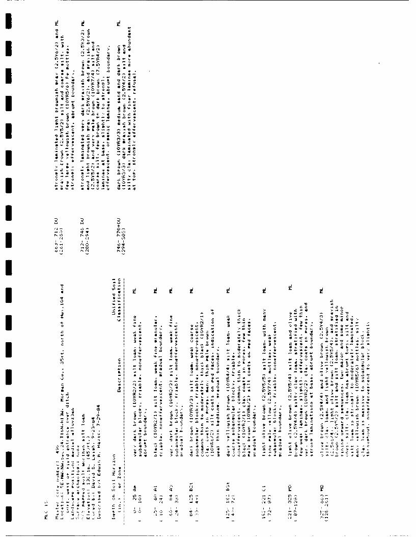
4 4 v
ZC NO Z'C- .j- C1_ *
0 hc 0
Z 4 N A .A o) - V ob iv
0 -X V l4C,
C L.
so 3In cI
* rVC' a3'0
A3 3s 'i- VLb-
.- w1 cm I- -. V L*Lc eflC A LC 1
6-0> >c* o > -> -V a3 Za la
-* IV ;. 0t5
>mc 2.2.5 X' B0 0 C'. -* .fl-..4 0a
>x. 00>W. E 3 U
'0 0 i -
.11.-i ~ I Ix- 4 4.4t
-. 44 N6:-i V

C C-
4~ -- my CI 4.> -
'-' v- '
C' 3'
- - 0
"A~~ .0q
.. Cc : *: -> :c :-. - 'o a ' Ul -
-- 3 L -cv i > -- bo
>t~ --- 1 0 4-- 'a u 0 .? 5- ..-~-2 .- 4 c C
>-. >> s' cy.
>- >
U' a 4
C4Co '0?'4 u-) vi i-C
I~ L I I II I I
-cic
-a I
I'- 4 -0 - -
ra cc c cra 2. 4 'a C4- Z- 3- Q
444 a -- " a- 44- cC0>it I C 4 -0 *'- CO 34 -C :. C: !
I 4V aV * L- -1- -'4 "a 3 Ia3 ~a I 3 ~ 3c a:s ay,2C 'aI ~~~ ~ ~ ~ ~ C z CC"-.~ .>li
'a I .>" .. 2a 'o0 -2aC'i 3O0cci1 -t - 04 -t S -n
C Aal en I-X - 3X 4 CC -ai -b -- it' '>07S ' -a
w* LI it -- > CL ~~- -C a" CX N
a It 10 a CC 11 '" 4'4c- a-M C
ca 73-~4 LC~a ' Ii .c
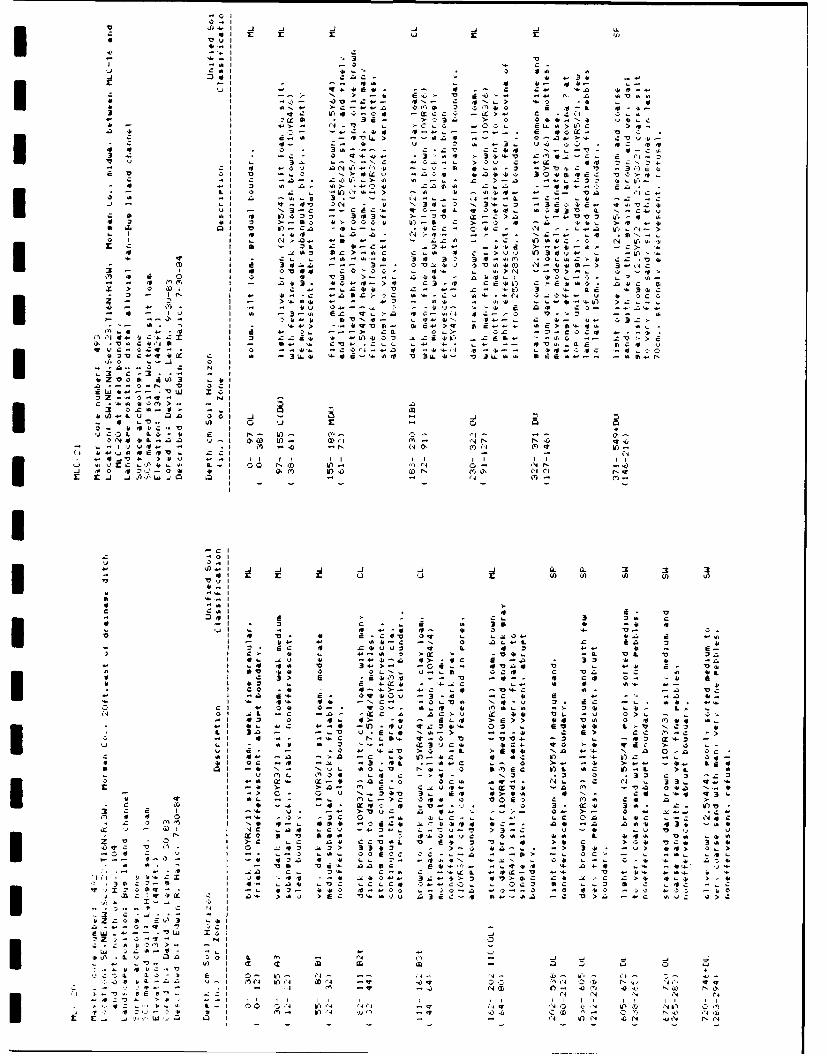
S0I:lip
* I o
a1 -3 . o 3 I> Cal 'D. 10 D) C
-I . -
C3. 10c -- t
*. c4 z lb z c4 -- 30>-bt
4A - .-. a >z
z~ ~~ ~ '. Ch.'' . ' - S
q..4o CCI 4' N 3z' '. ~ .> j L I ..i > iU. -a Co W3 LLVa
-,b a. -D'1 - C 44' '4"A-i V,4-4 3~.- 4 31 4..4l -- .- L C-0~C ~ 4 -
a-( o~C 'j - S. - C *C. . -. '.1. - - +f4.L 1 4
C NCA
ab a-- Lo-Al-
c '.C3.- >~ r-- 4,0-- IE
II! .3-VI
.10 IL
I L. Zn
cia CL -a IN.f -3 3i IC4 -. l
I ~~~ . .~A -'3 IT4-N * 3
-~~~~~~~~~ -. I - 0. 0 U N. I) 3. 49 4 ga . C . 3
LLC
>-i 3.44Z fl> 34Z - >- an.. * -> .. *..a eC> 3'.
-J I -. .- 3 '.a . C)40 CC -..- - 5) '- C- -a. .4LI '- C~ C 4 '.. Z. .. 94.bN .. 4--- . C 4 L . C - . -s>
Ar 114 I U4 - 4 -- 4'-4 3Z.4> E'>fi ct .- > .4 ~I 4-wa . . L 4 --. c . C C '', S C .C
lZZ C 4 . P .14
4 1
-L -A --
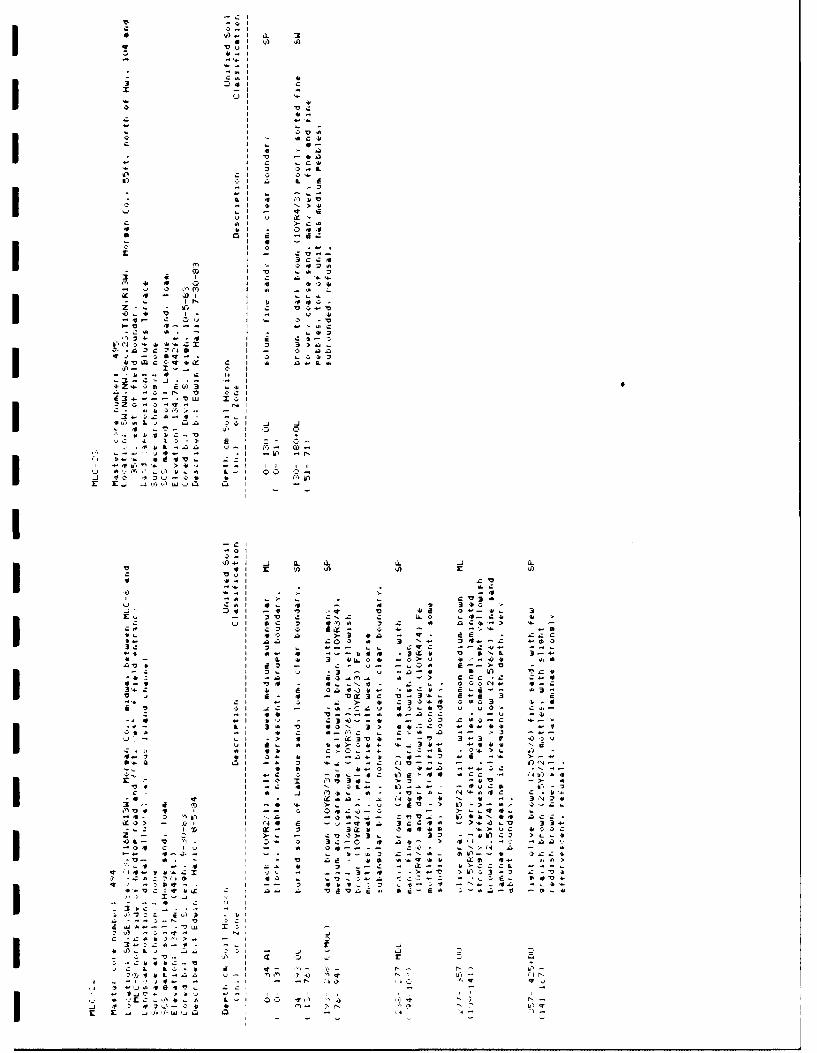
V
4 'A.-I a. 3VuI 'A Si
4.-I~*4. I
C41I 4.3 ~.I CS LII
-z -II 4.I 4.-I --
C I - cc).I .- 4-
*v~ -4.aI 4 a
'4. I ~ 0..L
0B) I
- I4-I
- I 0.1
LI ~.Ivi u4, I
4 .4. I V* 01
t
'a 4-.41I V .41 33 4. I I 4.Si 4' 4 0 I 4 410*- 3 AM I u. -41CC 4 - I
- (I I C'0..41 V I - I - II 4.
Ir- I Ii 440-Ov I ' 3 -VI-V 4.- I
.C41 4'. -, I .. 41313" 4.-S I e :,.-a
4t'43'4. 4. 41.25 I o 3 >aI - 'a anI .> ... 'a4.3
V~CCt*CC C I * a4-L:4,.... 4 C I. I
-- 0..N V
- '.4,- I
4.Q.C~-4-i- .4~.L-na ,.i-I ~-
- .1 -40 N* 4d4V~ 2:1
II I I
.. ) - C B A. I - A
I-C'~0I0-I4)..-I .j a.. a. a. .4 'a.
V CI S 4) 4) 4) 5 4)VV I41..I LV
cC-; 5 :2>LI C411 4.. 341.3.1 D.VI -4 V VS.. -I 2V C CNL C LLO
- SI SC 3 4~fl41 3 C 4'-- - C - - -m
IL I CC a >3 en - 4-4.4- i an 203 * 3 '"- 4-mO
- ..- .4C --- v.--. 4 4'- 4 .3CC) V liNt 3~..4-* - I 0. 41 3
4ILLO* .. 6>Y 414'
'VB I 4.3 - C - v- ~ t-.->V- - 3.. C .3 .4 -a4. 5 4) VL41
~41Z I 43v1'0.. A -> C4-47)4 - 4t..N4 . 2 ..
4. 'an4Q4,- 413-.j. 4 - O~3C u-S.-
Cl - C 2 > 4. C3044 .4.44 V CI sC - -. -CLV 43~4.V C41-
- -i 44. V...-....c 0.-aC: -v ~.4,1 *'J - - - 03 .410-,.. '...-~-
0. 341 ') CON 3> * 4 1 .tCO 44V4'41'i. .~V-I * .Z C..41 a -- ;-~ --
4.. 4' 4'~>~*. '4U±t-> 4 - -" 33 f 4)CV
44-3 4.1 34. 4. ~4.3 -m -~. >-.-S.Q C.' -. 3 *....- -C C.V-'- - --
e-o N 4.a 0C ."....-.- C 4)4~CC 0CC - ~4Ib4'4
I -~ I Ii,34
. >3 - 41
V -> 41St I -c 4 3) ..-...---- EvCm 45-3
I 4' .4 flb.. 4'~ .1)41.. t44.414C C .4.4.-- I -. 4. -. 47)-> 4)->'41
* 4 I - (4~C 4. N * -. 3N34.7)4 C I -- -
-c- a I -a 4'N..-,..7)V... - 4i4.eN04 ac: -CCO> - A I ?4C 4. ~ 3CCC4' -. >..OLO 33-
-1.C '~ ' ~-. 3 3.cb 34441S -. >vC 4.00C- ' >.. - .Z~3>3.. 33 4.flC3 >L,..4.
0.- V '~- ' 0 SC-C ii at.- > CI .- :04 C ~, ' - 4' 0s-~.- Cv - ..N~-iNj a - 41
V-. 4'. ' V 4>4.- 4.5 04.44.41 .CS 44.. U~41><-4 .C 4. 3 C- C - CC." i.>CCCt
#444-341.21 ' 'C - -.. 3..4 - .>V >4)C3-3 2.-7)b*Ls:3 5 ' 43 7)..;....a ~CC-C - .~.,t.. 3147)4.
4 -, ~51~4-. ' -- 3 434.23 .V~* .- N.~4a -. 4.4.WVCtSC C an a 7)4.Va4.... *4-4.41 s-41a-t. -01.41
I-a:2bC~a.* -
......... 4ii .17)23. SyIS -4'
a..,'. 7) 0:.4. L.441 -V.44 I.
C -2418 f'I>.. - ' f -.4
- -. arI -C & L04, 4. ' 4- ,0 C- '..- N20)4411-4>0-I.-, ,44- -.3 "..IO4E4VL -4~47)4. ) 4.. --'43Q-C41 4. I fl >N K'E..JSLIK'W4C. C. - --. 4 .~ ~

0 0
a- 3 Cc*
~-, 0-
04 .0 C b 4 .0- ;
b'. > 0) > C C4
-u > 0 0 0 . 4 .
IN & L L. U 4
to-c4 4X> s->)0 a> ** o o c w
>-. 0z0* >4u-.3A b 33 04 4 N I
4L. ~ ~ 3 -- ( 5.L0..
(4 4N)- b Ni
..- >a z>c 4 >.
A7C r) -C 4-40- -v
>5a >'. c4cf QS.4C0N S0 .C 50 0 -- C0CA>0
-n~ *.,. w.2 C2 E -
rc ar '.c 03'C
a-. vC a00 CC0 > - 4 ZaZ0(Ao -- > 4 0> r1~3
-- r) 'n4 4o It'tN . 0-2 0
-- q.- 0:4 .1 a
. 2 ('1 W! u5 W) -
3i a- a- 0*>
.20
0 I
114 c 3 A 3 fz 1 -
0 C il -' .l C * a41$ C C -.> 0
3 0 -0 014 a- w 3 -ro .444L 3
.0 I3 z W. z' c OC 0 4 bI - L .4 t1* I. vC >0 4 30 C 100 Q V 5- >0 -0 4* El'3
b Ll N. -0 N. ~ ' 0 > a . 0 > L I''L
to aso 4' >C C0 .. ' * '0 - -
II > C -C a. -0 40 -- --1M...) .
It -l > i . 0 C, U) I. C I0 II- -b4 -*>CVI -- : - D - a* 3*, 11- %0 - . -
Cl . .4. *'4. >C---05V 0>.0I' >s .a4> 0 o
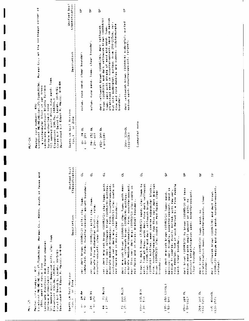
I-I
a WL V wX -o-I
v a3C S
... aatIL4M4j .' -
_j a. aL-4 au L)i t - 3
-0 c -3 >Cs -r40I 2 -.. 3,4 a
*~ L* 0 c . - - 4)
aZXo 4'4 at
Oo 'o
I (o 0 A. 0 v
-- A~I z~ I t I
0 m4'~x 60 C,- 1)C0
- *4t ~
I I 14 Ci A '

V.
4)4- , I .-J -J JJ.J ~ - .
- o- -T
. SI C C C
L f - _14> + c , - 1 1. - c , -+ ,- I +
'OVX
•~Ci 0- C4, CP+" 4-b- " >
A!' II r3Q
S7--. r
>+ o 1_ 13 'No . +,> >
0 '4.- A
3 . " a cCal V Al 4
St ZSI.- 3 -Q-
I 141" -% 03- --,3 -Z . o L j.
VS C4.. at - - - ,' V .- I .- -r .+,, -*1- , 5 * * -o ,54 .. ,C r-
00 c 3. 3* 4-L - .
Ai + , += . .-. + I . --" O s t 5 . O t' C ,, ,-,,0 ,''al I t 3 L1
3 - 'Iz 5 -- cOI I
.i a- ,I - e - no - .
01 -u * *4 ! M -t) .
,') -l 5" - > 1-,Ot Nf .
- 1I 1t 4 ''5 C1. O *14
LI-0> 5 O "" >-.>-Z L 44- N-4 .
LI Q- M 00 - 4 L 4I r--j .. l 4
'J ,, l .'4tt Nh-" >V 0.. >45 u,-*,+1 .".,- . c 3 CC C - 4 a o .
E r
Ca~~~~I 0I -t S .0 > .3,- S -
S.i 5 o 0 ? ,z+ -- o + I C
*~~ ~ ~~~ IJ C a N N 3 > N-- ~~~~~~ ~~ ~~ I '- u C.3 WC ~ 0 0 S. c~ .
0... C I I NC >3 ~ 0s * 2> Va
CS SI ~. - #4 * ~ U)0 (00 L) k-c
V ~ C '4I c'- - > 4 > C 4 .. 4 . a 0 * S
e S u) 3 - - - 4 £ ~ . 0. 3 5 N .5 N IIE .2 0 0 f S 3 t ".. 3"' 3 4' N 3 ..
bl 3 nI3 C 6 u S 3 - ' -3 u 0- > - o > - OS L * (* 0- .
- -I.I S. 0 - - - - -u s- .>-J
-- I S uI o T- * .4 -4 0A )I . - C -ID 4 O N 0 -- u : - * t t -
-~ ~~~~~~~~~~~ -. ' s ) -' 00> a- ra ' I- I)WI S . L SI C t > >C. -C .'

c' r r r £ r
V nV9
-~~4 All -
IL 41 41 a 1a !.* - L 1CCAw c n0 41- 1 -
- a-a z:! .I I4 - - - a
I ~ ~ ~ ~ ~ ~ o a2 >a ' 1 Z2'~. a I)41 Q 3- z1' a.: 'a - Z' r 41 4 C 4
Ii -- -C 3Zo ~ - i 1 u
'4~~ v I :e .. 7u -. 343,0 - .4 1 4 0 1V C a.-)~ ~~ ~~~~~~~ ->1~ a-1 4. -'3 '40 3 )-
4A V-- >f 40 u.fl c44.4 E~ C~ TC NV
-I -. 21.C -Z2 4 - t '1, 0o -I a>0- ( 1 ~--.: .: w > 0
VI AMa -. 4t C 4 -- Vf 4n1 -1Ci -4 >N-3 )*> a I ~ .un N
4 411 N0a N ah'C '4 >41 ': 4 -. C .Z
V 1 Ir 3 '14 1-0 - i 3 O-~ C0 (4- I 0 41o '3 w1 0 ~ ~ - C
(4 1 > 'II 3 C C4' fl C . r .,a ('4 q 4.4i a-D -, .-c C: 4C4 . a a- 1 CO 4 S 4 ' 4.
~ I -V)3 w-. _j- 3 -'a CA.-' 4. .a --~ r rq a a 4 V 0101a .'. . ~ 4. a.
2 V I .41 C ~2.'31 a .. >.4. .> a in> 304 na3 ~4aOf0 C - I- I x4> 41 J> l41w - .-. C V V ~ o -wo
- 1 -Ow I .-. ~o ~ 4 Nw -a0- -4. Z :a ia- ~ a -u--~ Ia14 1. - 4 ~ l... . a d 22'.~ a1.
-~~ q -* C i4'"I- a 0>4 11 -4> - -&
vic -. 10. E
,a I
Q..0 0.3I , 411
a4Z1014>- - 1 0
I 4,
L.w a -A 3- - - (4 4 (C NO '0 N(4-
ae0. a: Cl L
-CCO
-01
I0-
41- N VA t a l (CC a V
I 'i~ - Ca- .4

0 2Vf.. .4 _j -J a. a.L
433-
4~ 3-I
-l IV a U
I 4'O .. Ct:3 z 4
a, , q) C
a a I C9 3 .c .
* C I cl 0.4'4 r sI vs - -i -. a>I
*ar -j _j V)Vi

V 4
L4A.
c' n 7 -b
-4U0
11 IL -4.4-X Va . Q a .4I
41 c2
C.0
II v
0-I0
r4 10 M z a I S
00 >
oL -': 7
3- I0
-4.11 2 C a, 0.4.1 .Cal 44. 4
,.J '.' 'Lc 0 6. b-.'. c-
4.4. a >.f 4z > O V * -3 CC33 C0 . Z
34. 0 --- >- 4 a. 4. a.. 4. 4j .-. .- l- *. -- 44 C 4~' 4
.4 4 -40 4 . a... 0 j 1 '-4-- 1 CO - C C'4 O44 .. 4.. cisO o
4- z In* 44 M- 2 4t.u~ 3.
2W..I * -- 0 ~ - 42..-a. -z.c~gO 140vIt
044.Cl 4.~iiO S -'t >-4''4- '.- 2 - - --.
4-4, ~ l 4. I-I ~fl.4C -204-'. O~v0fl~4.' 'a

Li 4'i
>4 0 c o I '
S~~~ '-I
'-4) .- - vflu , -. . -- Z
> 3 -U" r .. 3 .t
ID I m- -2 a-1 .. U -14 --- I -2 ; a4.:
I g a .- i 4'. 3 0 q. CIL 3 -3
X 1 >L -6 .0 E.- a >.-.O m~4' >
33 If)'> 0 N J ~ ~ f '-U k74 0 (1
>l 4 4>' tj >l '1' >' aC .'.E1 4_' J V) 0'- W' C3 04 34-1 *..'
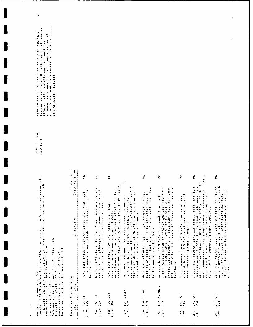
3 4-4
3 > 4* 4o
lo
0 N r4
Q~ m
> 1-
- 444, X
2; 4,Z:> 2
11 4- Ctfl '
C 3 v N N(D N0
7711(4 - W
-n -IlV

II
,ip a:
0
Z CL -j--
-. 4'> . r..
71
4+z c. . I
4..1
-0ii .0 + , a- I ,-a-Cs . '--.,
;+ +0 >.V+
- VL-, N a
4. 4C .
S .+. 0..
- 3u+t C C I.-- ,u
.4.4.S Ea"2.'4
II'-a Cc
--2 r '
4,- LLLa La Z 4 r -. 0
z N
40 a0 >0 > L
-n Z. 4.
0. 3L -.- c4 . . C. 0. .: - ...... .- " . .
C .- . -- • , t
34- V a 4.-> > a v T'L
4.. .-- U ,- .. .. '0 . .. . . 2 .- C. . .
,: :4.... .+.ltJ, ..2C4-I CI.- -'C. t 4, 4 .V,,4 . 4. 4 -4 +-0 00 , 4-. '-I+ 7-,:+. 4 . ... +..C> Z'203,, D. -.''. C .,.' ..
... .".' 40. laO= 4-CCC'..+ 4..t ,-~ .++ 45.:-,,... - -. C -- ,, + .-: 3 ... j - ' - :... of...
0, , ,::.. -O r.. .... o"4 .. " .. '+' 40 . .. . .4.. - .+. 4 4 ...0 - e C. .-.. . .. . ..+! , V. + ,'C .C,4' 00.L, -7 . ,, 0+. ' " . .. t V . ' ..b-S 1 lI~ C3 . V C ... ..,. _4-L . -sa . -...' -+-' - 0' , o- 2.. . . .,. ,- 0,,, -: > 4..2_, - 0. - -,,,, - -044 . , jI+,L 4 - .+ +- .Q > C+ .....C.. .+- J a
1 3b C C , -- ,, .. E .. rt 'O -. ..a5,
,,, I 4. .0 04. '. + ,.- + '2- , 0+ . LN,, .,-.. , +:.+ + ; + .++ .Ca- u ~ 0 - -
-C . 4 iN -3" 004. ->++
a a+,-: +. ,,2:. I 4. 4. Ca - 00 . o- ,t 4 arac-r
'2:. f + , ,,,44 C> U N . 0 . . - 'c 3I : - 3+ -' ., I V: - - n . . .. .04 54. Z .4 -
40 InV42 0 42 aM* 4 4.. "O - M
"i ...-j': • .
2Z ' ".-$ ,. -' Q . .40 . - - 4 - . . - '1 a .. . " 2I+, .... 2 a.>. V4.C --" Q4.4t.j *3=' .. '2240 .-' - C N I .. : -o
,, - F -" ' " .,, 2:;.. .. 4..-o..N V+ > O +CI-:
, C4,: . +,- . .4IF
.-.. O w + ..a ,,,,,C.-V -,
.. J- 4- 2 - -,,, I I I , I I ,,1,,

* ~IV
0C Cv. IL U 3
-IV4 -Vj
a~~ 0 a.-i- ~
* 0 4
IEC
LI >. Q
-41
C -L
-0 a 441 Z I1 IIX,.1 444 - ! J~. 4 4 .. > 4 '. 4
-j to '-IC O. lE 2 .- ,- -Z. . .
C 4.
MZ...ZU.r 4.4i .
-~> YA4Ct'. -
4C7- >4' C* x
o~1 41~~i
-Cb

%E 3
OD I C
i, I l'
0. c tu'
z I1 '301 ' v 0
.3,
73 CE, 01*
z* 2l 'o' *- O4- - q'.
C L f 3 r ,0
.3*1 Z' .- > N 3
0 c > - 4
a* II z a N4
Z . -j Ia C I
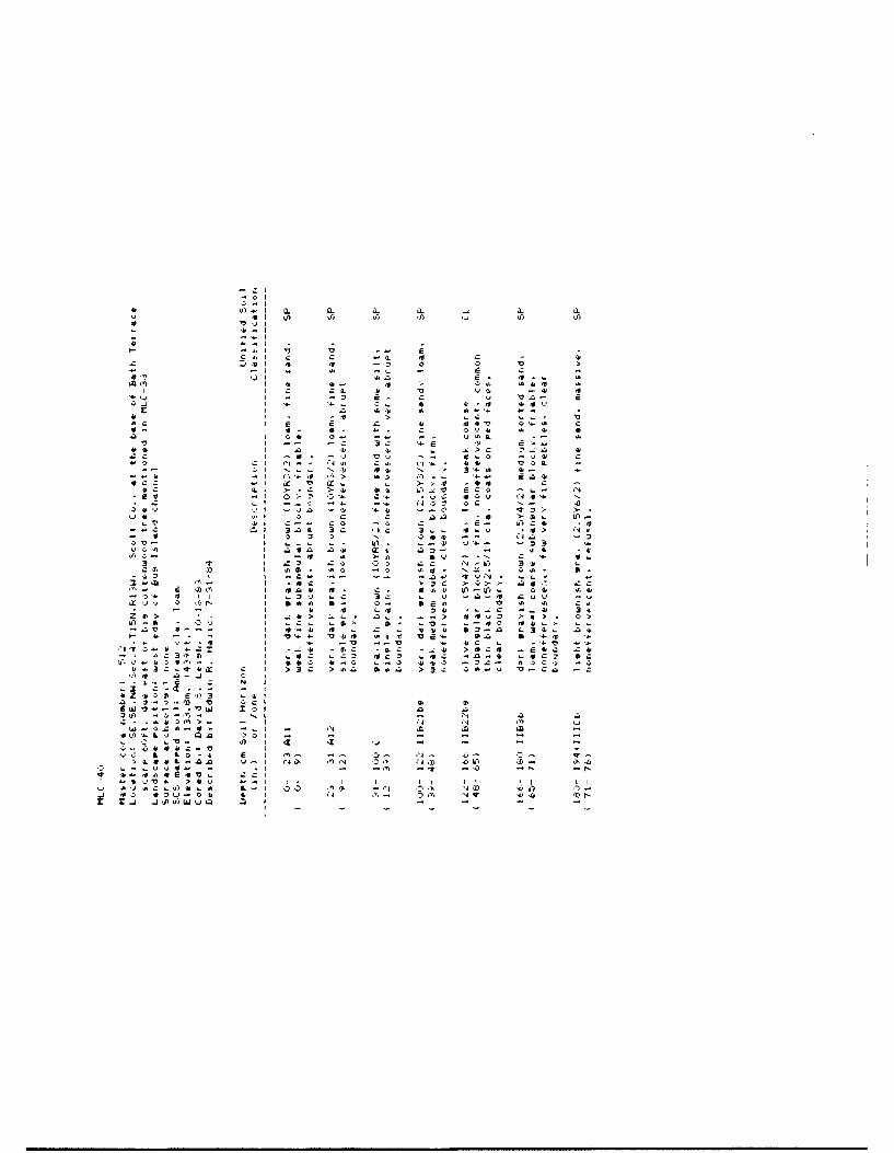
-CIL
0 -It
vi .10 to) 'v
4'0
IL ~41 4, cVCs. IVo r441
Ca4, 4', 4' -s1)
3 1. v ', - 4
444~4 0..4 ''r I _- ! . _ - -
-- L' 34 4-
INI InIU In
4' Fy 4''4OP .4, j J4'

m-5 -o 4 4 L 3 *
V- c .- > C z C
-1.4 ~ 0 - 1 l 4
6t-4 -1 - N,, I3) J ; 34
, 4c t'r - 4,
>..- >r 4). b - ". .
-4) o3-' .-. c~ 4Y a
3c 5.84 * .o, 4 - NJ4 '- -, z. I' t -. 34
-7' ~ -- U , -. C >-0 4 4.'1,4 34a'r4) I C.... -s re . . .---. o. S
4' V4 4~ *. '') s- lu :. ~ 0Ma
C'') ,0r , 0l -N
I 4)-.1
-4- 4- kC
041~0 > ~ 4
hi~~ -' *- o83'1 4
-~~ '3 t f 1,,) 4 aWC44 ~ ~ ~~~* -. X -4 4>- 4' i-
I~~~ ~ Z- Z 1's, .4 4l4'.4h
I ~ ~ ~ ~ ~ ~ ~ 4 ziC 4 '4 0 ''4)4 44- N
a 4) o--- --. -4)2 O.00L-zo
I L. ' -- 4~ - >'- . 3- -
Ij -j u)~ fi.0 w.i4 . - 3

-J *4. -Z 0.4 r
- 2
- 42- 4. 6
-4.'.'-'36V.-. .4.
-n-4' C- -C- -
C 6.. E 4.Q4* -'d'.4 4.4 .. 4 *
CC'') -" 4..... a..C 4.: 4.~-.
-, C2 *- a'N 42$ -~ 424 -
- .2 4.42 C...- .'.>4') is4~- 4. --
*'j.-a C'It ---4 42 N~ .-. 4.C C
4'... '-.424 4ra 136 a
C 24 >4 )~'.3-- C a-o ~.340'- -- tIC C-
4AJv42& 4. -0 '-a
) C> ''Od42.4.- 3 ced -,
- 3. ,-4..0 4.~ '.4 041) N'.'-.2~C 42.: C I* *4. 4. 42..-
340* Ca ~4CLI. -t C.4. 4.
> 1-> 4. V *'.--L 4... 4.-a.. 4.
')"4-'4. 3'.'. 03>4 a>. C'.', '.
->44 -44. .400C .~4.
4...) '40 4.'4-'2 4.>-0C 'CC V~4.fl '04.
-a ~'-4 0
4.N- 0-. O'-. z.-.us, 0"' -t 'N~45- 45'N vt -Ct
"'4 "'4 'N NI II I ii
"IQ N+ Oi> +1"IQ 4'1- ore -q
4~''4 d~'N 'ON
- Cl
* '2-.I4 4.1 4 J - 4 .4 4
-- El t S S S S £4* - I
4.I.4--I
3w -. j.l ' .' 434 Cs.I - ., 42 3 -
'a: VI 4*4 - - 'Ca' --i 4 '4- Vd. 1 - 4-2 4. ''. - ''VJI 4. C..- ) - 4 4
- .... -- a - 441.'21> I 424 4.'.. 2!' - - .. u.CC -''04* 424- I ,. -* C -. CCJC I 4 32 "~
4 .. 3 4*2- ~.t 42".0 fl'..O "'1'4 3.2I a. 3 ~I. .)..~ *'...'.? CC'4.'n 'AICC a-
.23 I - - 4'. V~434. 34. 42 04 d'.'. N>I -.. '.42 u a- 34 4' C4*" 4' lcd- '4
'3 di. >a' ) -CY>I C'0.-'a 4-4.. '14*-- I - ~ - ... 426 - - .'>fl2 W~'-"4 442 4' --
I 4 0.- -14 -3 -, 04*" - '2 -'UU I 4 ~.-'.4* 3-. '--.44 C-C 4ME I 3 :4.4- 3.. Oi.'.!J4-~* 4-4.. '-32 -' 2. --
CI - -4-')'.' - 4.oJ '-.1' 34.. 4. Cm 424.3-d 24 - 42 d')C 4 3:-. .~'.h:.2 Cc 'C.. -c'Co I - ~-4-- 4C4,.q .. '-. 4-3-0- 3d- 21.2C' 4 4.4 4.
- *.~'.U. ~4 24* '.4- C, dv 4.'.o-4. LI .. N'.2DI* - -' 45 -. L..4. 4...:4-t '.4. C 4.
C "g'.>'. -**; 42 4 >4.4.2 ~4* 2 '04*3'C '.1 IX 2 4".N '- - ~42. 4'> tO C>44 ci .3 ".>C4 42 -3242 "-.2 4..
2 4,1 - 45~-- U'1> 4 -~ 3)44 -~ 4' 4*iii ,-.-......CC .. 'ii" '4, '~--44 *4*4. 4.'~ 4.
4 0' d 45-.'J~ MI. - 'C 434. 'C" 414- 44'3) I . - 'N '2 '-o3 C i. 4 .
34 'at) 0 45- C '1>4*.: UI 4*' .. 'C 42 >.0b 4*
S @1 -42' - - ~ -.. E --a C . I, - - I."
-ad d 4' I 34 '4 4..'. N4ta,334. 4 41 * '-'V .'' 2 d>> h,'2V> 'I'
0 2'.'. 2' C'.. 2-...- - - '3'.) I 4 C-.*4. 4'4.di
144> II I 's- 4* '. 3'Ca. -C *4.- '.2 4. 'I'D I 2 4.34~i C>' 4.4'. 'CI. OOE4. ~ 4.4.
Z -4- - 'N I '.444. '4.~4."4..''..- - . - I 4 '~ - 4 4. 44. -) 4'C
4 ~2'-' I '.- '.3.4 '.-2 S'i'..'.4. 'C - .. 3- - .'C -~ 4.'--.4. '4 4' I, 42C4. 344' 014. .4. 3*.
- .- C. - ' 3'2 '03 1.'j' 3>'. E4.- ~4.-- 44* - 4 34. -E I a'') - i.CC 4a.2 3 - -c 4. cc 4.C
113 --..-.. cI I 4.> ).-. I '-4.3 >42411 4.-.
- .3'C'2CtI2S I -2 *:'2C .. S'2.2---------EC'-------3: -e
E-Ee'.-!tLc C 2L ::2Z ;z~t~ 4.2. 404'.. 2ZC- C N I
'-2, - -4'P'0S26 m'03 ~t'
'C CCIiWa....-- ''CU) 53'2 is. re ' 4
- I - - 0U). - -*'..' - ., '4 5
4,454. 231 .4 42 - - - . - 4 -,- 3 .4. I Ce '4 Xi Xi 'j 3 0 ZICe 4. 8 ' 4"' 4-.. 'I- I- - '4- 4.-' -- r-
OX A .t-.i -Q '145 CC IN ~ "''N ~ ,, .44
t'4 '..*I)4 - .1 -t 4' .4143 Ifs .'4 'IN 14 1'> 404 M .- *EjE'2.. ZCI - - - - - "4
.~ a is a a c 4. 4. 3 - r : ~ 441 AC 'I N 0 .3 '0 'N .~ 4 *', ml
1.3 *2
'.j-~4
a. I -'a ~45 CL 04.4 .'1. "N 42.4 '4*'!" 0.'>4*4,fl)4j*4
*~ Q p - - .4 04 ..4 1- f-* 4- 4'-.

Cu I
6.4' 3s
> -.
F. 41c -.
I1 -~ c dca
I 6-1
Cl
1'1 4 '-4. 4
47 I -
.451 044

.,. - I
De "i-.-o -
'41 Cel,,
* , -,
7,,-'=' - ... ,;
I a. S-,
I) .. a. J G
I- 4 - c -
..4' - ..
T ... '>4*: -4 . -- 4

'4~I-J -. i-
.4- 4-
-'Al - 'zT
E' .4. aq
4 - Eki
--z , 4 4-C4
'-'4
E 0 l - O p
4.4- -D
-I -I''
'j -'q "'"h a
v vi L iq13
IfI

-- 30
r4-
E 3
I.
4I 4
3 c*
CC4
2 I
q. 1. Do
o' I
IC C
IA w *l Mq

0-I./1-I J~ 0.
4 I 9) ~iti-fla-i-~4.i
-al ICalZC - -
i.,I . *I 4 £I a
I aI ~ 4I -I r *
I a -
I * Cl01-I * ."
- -I C it
0 iii - -a' Nci .. C
- ~i ,~4 S- I ~ 00 I >. I.i-I-- I 09)1. I -
I. I13 I S
-a I C. -3-V I 3 >..I-, C I 0'- 4--
44 I ... 4 -cZua I no *t
.4 I CI .~3 4.a I .. 0 - £I 4J~ 4~.I V 0
tqz - I ~-c -~Cl.~4. I i-Cw)'Jc.-~I I 4- *4
*4X*.-? I >~J )t9) uq 0 I
* 2- ii Ii-3c9) - I1.3: aw -a'
* ... r.TI0. CCI10 ~ I
- -. ui r- I fl
i-I -j 041 I 9) i-j
I 4~P a i ~ u~)-
cL-2.n u-i tO n-(I ~.-y4- - .1 - -- 0
14t >aQ "-.1 ii iiIj 4.JCJI 1.4~ L I 00 WIlD
j .904.j.-0o ii tE ZJj9w'.~0 ~.
31
9)~i -J 0.WI t 9)
"via-i
4. I-- I-4.1Calflcl -
- It~)i 4 a
I -u CuI C 3g.I 2 34I 0 L>
a~.a
I ~. ~4.I .4 a-aI a -a
- ScI i~. 00
I -at a a.- I 4 C-V
- ~I 02 LI -
0 ~I i-ai~I - 4
- al C 2a ci 4 0..* 01 a fla04 I 0 4C, I - '1
V Ia I I ')C
I 4 ICc3 I 0 >
I --V I -c
I 0I -
a 3--- I 4 3~I- - I 0
I -I IL
- I -:1.2*4-. I -
I - c-a.- J. :c, C I a.p -t 0 I- .. - .7 ?4 I
- I
r- a 2 .u .. - -
3:a-v- - -4.1 ~I -3>Zt 0.3 CCI 0 -- - - 9I I 9) -0-. baC..') I 4-~c~a,-~ a i ~- 5-
C4&-~:jn v-I .7N 0<4- - u4.. - .1 -. 0 NOWI 24.sat~-. ZCI
~4i 'a - .. ' I I.j aJCv-%. ,. L- '0 ~
~.

X- 3
-e vj.. Z:
-L- t
I. f- w
.4 I,
La 43-c
Lo UII
-c Cl -. 44
ai
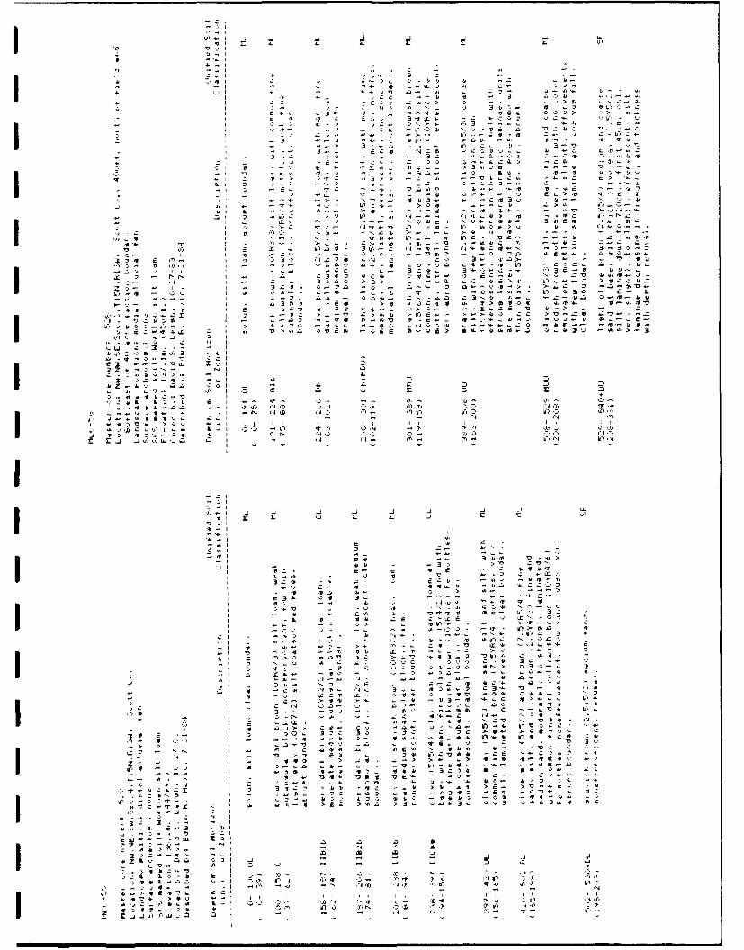
'4' - I U U -4-4 VIIb 4I
U, z.0 -. >
-'S 0 3 E>
IIIfI >47, .- ii- ''
J* J) -c .71.
.1 E.>s q- s a4
a all > Q
C.' '4.~4> 0 '-0..
->- ~ ~ ~ ~ ~ ~ L 'Va.' fl '0 I' '.4 - 5 '
320 E 3. L-10'0
32 ~ ~ ~ 4 -4 - -1- . a
-- I -.- ID.. .N ".l 23 - -. ' .4 .-. I - a30 >0~.sCt0 . 7> 000 ,0D
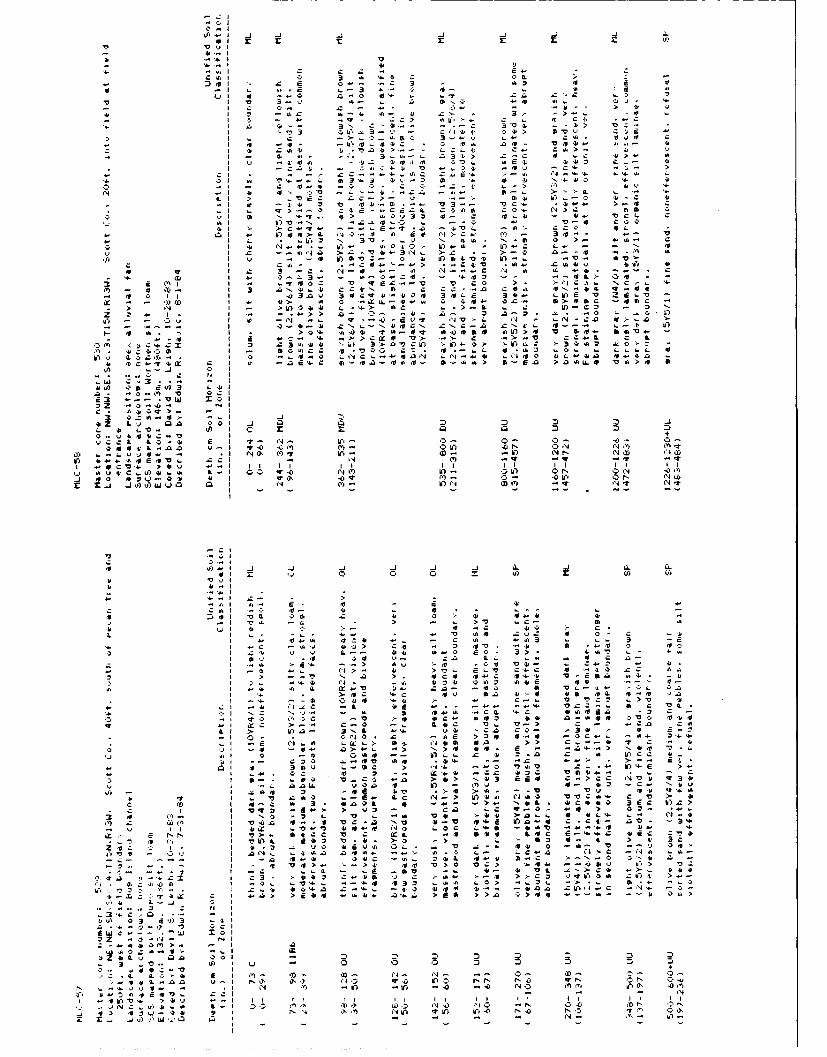
*lr- 7v v 4 II
V Vvv
C41 C, 3 41 '4.3 C 04 I '5 . b-~~~ A4i . 3o o.3.. 3led, 1
-T > c 1 4.. a -:431.. , . '
I~ C -o4 - a 1 .1 .
I ~ ~ ~ 4 r,.w- i
'42 13 ot ' > 5.1
I0 c1 a'4 'Ig-. m34 . 2.1 V.3-' "~ 3
, . 0 c v . L -c 41 L- 3> '0Ix 0 4 A ) 313 .. )-o4. v'1 z m > 2 ff. -a'm
01, 4C10 L3>L1
A,- N Vu f n--i.. - -N > -- c * .4
LI z1 .. Vt Ir~- . o 4 ir.- 3 C.1, 4, AD1 a Q w3.c5c..I. V 3- 0C4 .4 . 1. L
,a A 0 v3 w 3 4 V.- >-1 0 4'41~ ~~~~~~ 41 Na-~' 3 0 3 4 -' ~ ~
- I . N A0 c1 ) 1 - n 1. . 1
40 1' I1 Q.- ~ ~ - 4 -"- 1 4 . ..- v4 I D 4 4. -- - - C,73 -3 - t44) 4
3 3 "I -. L3'3 C V 3'3..4. CC 31- rN'-~4- N~r..
- 1 I - 41 33 t'o SC W C -
vZ Al 44 I -I . 3 ' OT 2 . . -
if) ~ ~ ~ ~ ~ ~ _ -j -j 0' - 3---- U 4 -l I C 4AI~ 0'.4 . '"N 4 C . j. 3~. .. * I
~ 4 41 -) >14 1'0 t 13t 41-~ed 411>4 V )44. rnV4-441I 3'4 .. 1.Ci~1 > ->-..V CC'L E
C'0I~ii~i-CI I 2 3 '-11 3>.VCI >14-0- 3414C 5-041 .4o'L
3C3C6l - 1041.C .V O C. 3 4141. ~04 4-).L~ >
41'- 4-,2.31 0 4 NC--441fN )N".43 .. No 34.32 41.'t. >
-. . .x L I*
4-1V va.. .- -
C- 41.;03'.C -
33 >.1.1 L4- >.E >*Z~~~~> L0. 01 .-
-L 21 C. . >4 I > . .0. c41 C I Ix+ 1
'4>4 LC, at I t' N- 4:'. 0'-
A1 34443 1 2.C NQ ') L-3 -> o4 '0t ... 41CV'. 30- >b.. II II II >nI I
'2 41II.)4i '- 0 lo N0 4. 4' N N
I , t- tICL .', 1
44~~A 41 2.1 3lobI a- 4- 3o -. o A o
Cu.I14 zC 3.'t 4cr M I o24 IC - 31 -> 1 C 1
4~~~~~7 Q.1 3 - -4 4 0C
I L -ID 03 cU4- C"I 4-- 4 4
.5 a- :' '43 N- All' 323 0. 41 341 I 443 1 4-~ 4.V i~b. 2.2. -41 3 04i4

a ,, I a.
uv z
Iaa 4--
3 3I
'3o
I '1T, 4-31 -0
11,4 1 > 3-, z3-'-
43 (0' 4.3 .4 '
.4-V I .- 3
I' > 3
x3 Ij U'A v.
- I 3Q43
d CL L a. B- V
-~ ~~~~ CE . .- 3 - '
3 4 -- ,0('4~~~ EC ' N 0 3 .- .3 V .. ~ '
-~~~. V. C LL .'v 14fC-
V ~ 1 a - C43 >- 0-C 33-
I 3 C.W. V ~ l, u3 I >,3 0 '.;-) 3 ;'5 .I . 33C. - 3 C 3- V 4; a: C ~ "I' . 3
'.3 C -. '.
4.3 --- *0 N
0~ Lu 0.c -al XZ Z04 0 4,5 0 Z 0
jCCL~~~ 3.-4 4 II-"
C,~~~~~r 4.4.43V- ..'.t3':'- >4~ 4-43 I 3; I I
3 3 .4~i'jI0 0 3
4.I 'V -4 , IDI In-
if 4.I 4
0,0 4- , C-IIoa ... 2>4,3 a.rC 4 C 44

0' v I
c 4, 4, I
a 110 a4 we 10
0 -3 -D > - - ' 55 4 -*3 f.'-.-..l -> .2V - 2~
4---V 4 4-- C. . 2-- -4* ~ ~~~ '4 L 0 .3 ~C -4C 4
-4- I I Q- .- -M - -$ 3 -0$~4 C lo C 412V 0 4 0 - -l - ' l 4 I
-3 44 -i -> 4 4 3z . 4.- 4'b -Wo I...>4
si vi Zr L 0 4' L. -. 0* 0o ~~~ E. >.-4&- > V - .-.-
cc *, 4 0. -55 .4 ~ >w I a -
t 5I 3 .- i 0. -v 50CA. - Nc. v 4 u-4 b I 00 "J 4$-0" 442 CL N . 0 4$ S
3~~~~! m Ui It 41o s - ot > - n~.
'N --'N I, O'V N- q44 16V O4o 4004 SiN r5 C-_j 1 .0 2 04 I. 0,uX 01.*4. 0 0 -afx ~ e 0, V 4 $ .r ~ - 4 -f 0 V> >V C4 644 00-..4 2- -. ' i-
2~I - 0 c -- e U 4 -~$ .- 4- vI 0016.- i-i. 4 LsN .. aSdt
- - ~ ~ ~ ~ ~~~~~ 4 .- . 5 - c 4 4 4 5a I N 43
4--- -- 4 -I n iI3'b VS. V S 05~ q C4$- V4 04 4.
al- 4.0, C IE>l1 c 0 C N
IX. Vo 0.2 4.CO4o23.--XV "El0 . .i 0
0 Z .- ~ - --. Iji v-i 10 >2 4 2
0-.~~ 4$4C-1v.2~ ~~~~~~~~ .o -3 42- 0 m. '~ .- > ,
.1 -. t'-'4.3 NO N.- )0 "1 ) ~ .
Q - - - - - -
-r 0..IA c v
A. V)-. a -J .4 asi 12 5£.
.4.41
3> Ca -' S~ N -'Vi
4. 4. 4' 1e -4 S.3.11 Z4 L2 0 'a.- z
'4- I4 4 V- - V 4- .0I L. .. Lli 2 ,C 4C 2-
-4 L ml$C 23 c S o 4 5Iro t- - ' 0 e -- 2 C u 4
4- I >5e0.4 - 3 - $ -i 1.Ij 0.O n 5.3 M.0 0,.IC-q
r V I _..j4 4$> InV. t S 5.e
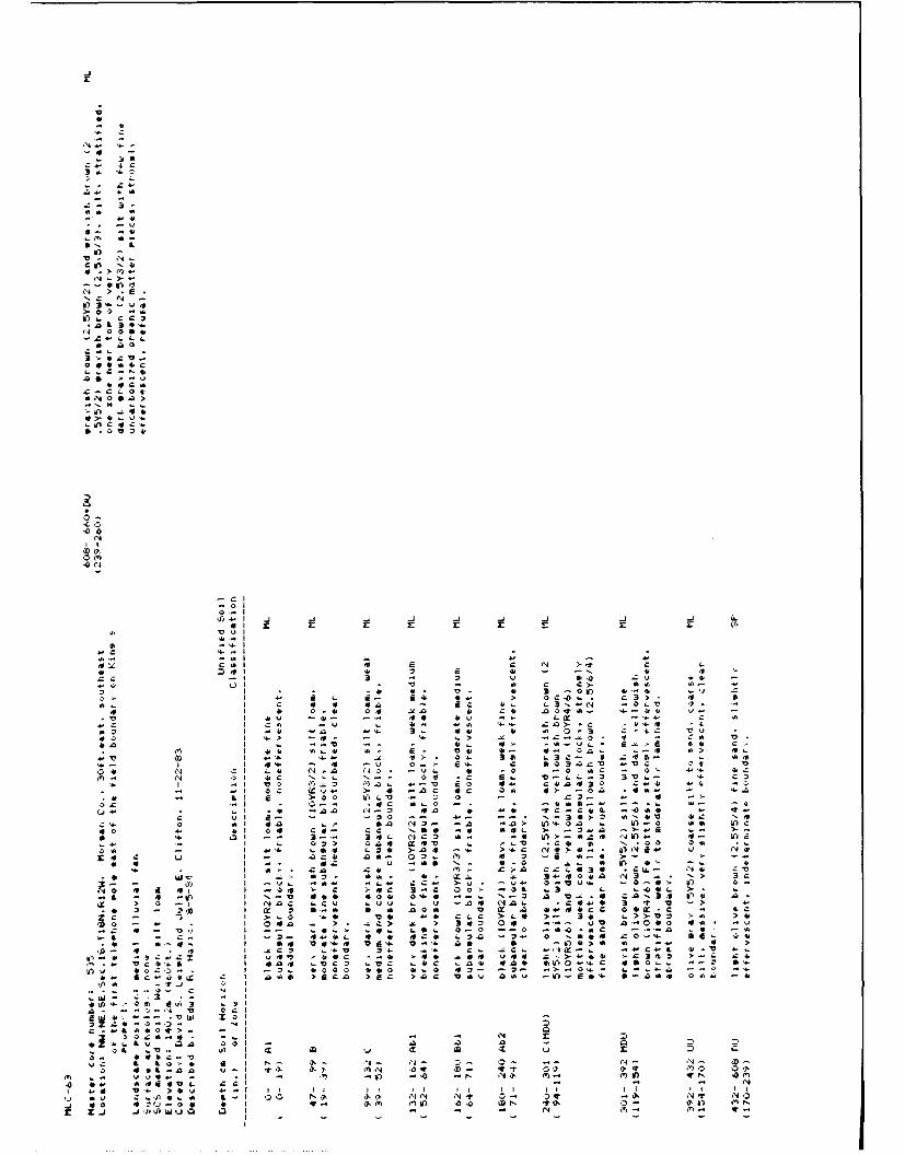
14
>4 -
L 3m
0 a
z a .0
J-
toLo
-~ at
b.M 0
a-a
41
IT) . 0 ' =0L
It) 3* L Eg
>0,, -
14 0 00 e
* nOol*
C 3 c0 L .3 s L'
no
14 z 4 3
*> 4' .1 LI*. ,
Lt C 14 Cp* , .O 24, 0 "
A 7v - - -%)-,
*0 vN
0-I 0 k
APPENDIX B
Particle Size and Carbonate Data
1 30
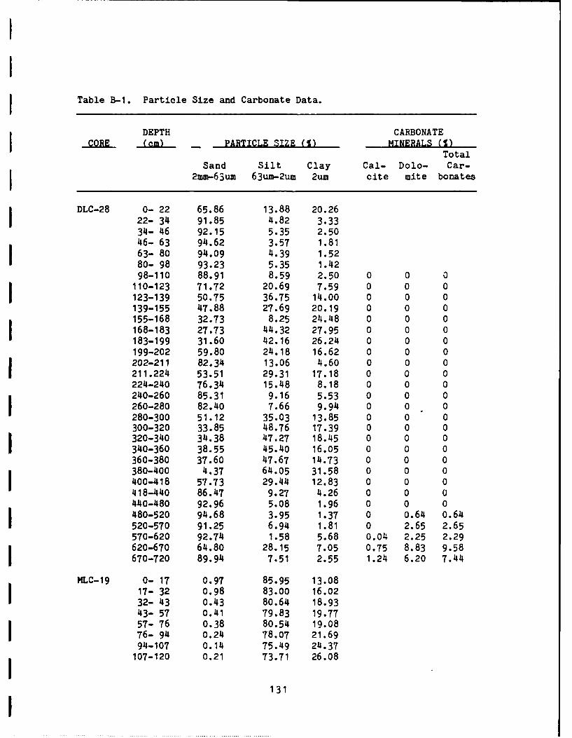
Table B-I. Particle Size and Carbonate Data.
DEPTH CARBONATECORE _(am PARTICLE SIZE (1) MINERALS (T)
Total
Sand Silt Clay Cal- Dolo- Car-I 2mm-63um 63um-2um 2um cite mite bonates
DLC-28 0- 22 65.86 13.88 20.2622- 34 91.85 4.82 3.3334- 46 92.15 5.35 2.5046- 63 94.62 3.57 1.8163- 80 94.09 4.39 1.5280- 98 93.23 5.35 1.4298-110 88.91 8.59 2.50 0 0 0110-123 71.72 20.69 7.59 0 0 0123-139 50.75 36.75 14.00 0 0 0139-155 47.88 27.69 20.19 0 0 0155-168 32.73 8.25 24.48 0 0 0168-183 27.73 44.32 27.95 0 0 0183-199 31.60 42.16 26.24 0 0 0199-202 59.80 24.18 16.62 0 0 0202-211 82.34 13.06 4.60 0 0 0211.224 53.51 29.31 17.18 0 0 0224-240 76.34 15.48 8.18 0 0 0240-260 85.31 9.16 5.53 0 0 0260-280 82.40 7.66 9.94 0 0 0280-300 51.12 35.03 13.85 0 0 0300-320 33.85 48.76 17.39 0 0 0320-340 34.38 47.27 18.45 0 0 0
340-360 38.55 45.40 16.05 0 0 0360-380 37.60 47.67 14.73 0 0 0380-400 4.37 64.05 31.58 0 0 0400-418 57.73 29.44 12.83 0 0 0418-440 86.47 9.27 4.26 0 0 0440-480 92.96 5.08 1.96 0 0 0480-520 94.68 3.95 1.37 0 0.64 0.64520-570 91.25 6.94 1.81 0 2.65 2.65570-620 92.74 1.58 5.68 0.04 2.25 2.29620-670 64.80 28.15 7.05 0.75 8.83 9.58670-720 89.94 7.51 2.55 1.24 6.20 7.44
MLC-19 0- 17 0.97 85.95 13.0817- 32 0.98 83.00 16.02
32- 43 0.43 80.64 18.9343- 57 0.41 79.83 19.7757- 76 0.38 80.54 19.0876- 94 0.24 78.07 21.69
94-107 0.14 75.49 24:37107-120 0.21 T3.71 26.08
131
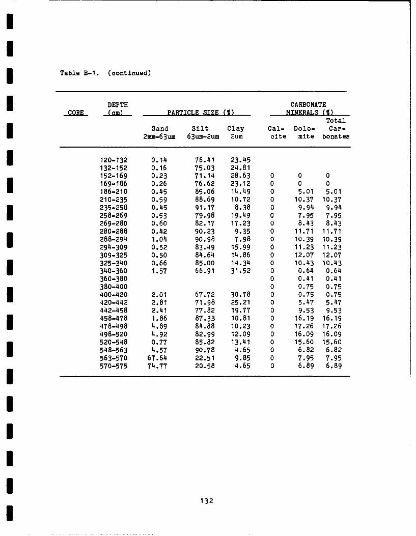
I
ITable B-1. (continued)
DEPTH CARBONATE-CORE _(a PARTICLE SIZE (1) MINERALS (1)
TotalSand Silt Clay Cal- Dolo- Car-
2mm-63um 63um-2um 2um cite mite bonates
120-132 0.14 76.41 23.45132-152 0.16 75.03 24.81152-169 0.23 71.14 28.63 0 0 0169-186 0.26 76.62 23.12 0 0 0186-210 0.45 85.06 14.49 0 5.01 5.01210-235 0.59 88.69 10.72 0 10.37 10.37235-258 0.45 91.17 8.38 0 9.94 9.94258-269 0.53 79.98 19.49 0 7.95 7.95269-280 0.60 82.17 17.23 0 8.43 8.43
280-288 0.42 90.23 9.35 0 11.71 11.71288-294 1.04 90.98 7.98 0 10.39 10.39294-309 0.52 83.49 15.99 0 11.23 11.23309-325 0.50 84.64 14.86 0 12.07 12.07325-340 0.66 85.00 14.34 0 10.43 10.43
340-360 1.57 66.91 31.52 0 0.64 0.64360-380 0 0.41 0.41380-400 0 0.75 0.75400-420 2.01 67.72 30.78 0 0.75 0.75420-442 2.81 71.98 25.21 0 5.47 5.47442-458 2.41 77.82 19.77 0 9.53 9.53458-478 1.86 87.33 10.81 0 16.19 16.19I 478-498 4.89 84.88 10.23 0 17.26 17.26498-520 4.92 82.99 12.09 0 16.09 16.09520-548 0.77 85.82 13.41 0 15.60 15.60
548-563 4.57 90.78 4.65 0 6.82 6.82563-570 67.64 22.51 9.85 0 7.95 7.95
570-575 74.77 20.58 4.65 0 6.89 6.89
I1
132

APPEN IX C
Outline of Late Wisconsinan and Holocene
Geology of the Lower Illinois River Valley
by
Edwin R. Hajic
133
The purpose of this appendix is twofold: first, to briefly summarize
the geomorphology, stratigraphy and depositional environments, and out-
line a chronology of late Wisconsinan and Holocene events in the lower
Illinois River Valley; and second, to report 21 radiocarbon dates from
levee and drainage districts, 11 of which are previously unreported
(Table C-i). Most descriptive information contained in previous levee and
drainage district reports (Hajic and Hassen, 1980; Hajic, 1981b;c; 1983b;
Hajic and Leigh, this volume) is not repeated here and is deferred to a
more comprehensive summary report now in preparation. Similarly, not all
evidence or supporting agruments are developed here.
The geologic history outlined represents a collection of working
hypotheses. It is certain there will be some refinement or revision of
these ideas as further analyses of the hundreds of collected cores takes
place.
Prior to summarizing geologic events, several salient points re-
garding the general geomorphology of the lower 120 km of the Illinois
Valley which constitutes the project area need to be presented. A varie-
ty of late Wisconsinan and very early Holocene terraces of diverse origin
and morphology are recognized in the lower valley (Figures C-i and C-2).
Two general down-valley trends are evident in all but the Deer Plain
Terrace. Percent valley area occupied by terraces decreases and
sequentially lower terraces progressively drop out (Figures C-I, C-2 and
C-3). The only exception is the Deer Plain Terrace for which the
opposite is true (Rubey, 1952). In the Illinois Valley, the Deer Plain
is characterized by a reverse slope relative to the present Illinois
River. It is broad and featureless except for some dunes at the extreme
southern end. The Bath Terrace (Wanless, 1957; Styles, 1984) is mantled
almost entirely by dunes and has a relatively low slope. In contrast,
the Bluffs Terrace (Styles, 1984; Hajic, 1983b; this report) is
relatively steep and grades up-valley to the Bath (Figure C-3). The
Bluffs is a slightly undulating surface dissected by a broad shallow
paleochannel, the Bug Island Paleochannel. The Bluffs Terrace and
paleochannel abruptly end at a chain of Bath Terrace remnants cutting
diagonally across the va'ley. The Keach School Terrace (Butzer, 1977) is
134

0* 0*V04 0..4 0 g0
0 0r0 0 1) 0. c
4141 0 4 0 C. 00 440 0004.
*3.~ ~~~ ~~ 0 410 1 1 40-3 4. ' -
4 0* .,'0 04 -10 0.3
.0 . 3 4-.444 4-3, 0,-, 4.. .
I4-L.I.- -0O.1 1 . o 00 a0 .0
4)4 z 0
4144 a1 o 041L: 1a4 o. A 44.) 41 444 04-
41
:5 0 >
0 ~ ~~~ -n-- - --
V.04-~ ~~ ~~~~~ 0 00V40V4.4.4 0 2 4 VV 04114 a-4 a 14 3'44 411 430 a1 41
4.4..~~~ w00 w..4 *0 V4 r, 4 4
VC :"s* 41 0- 3.4 1 4- a,4V%. "a V a0 C .14 ~ ;V
4 4
40 aV4 .104 04 3 04n0.00004
n Q
a14 0 41 . 1,,-
*04-.~~V 41- VI434
40~~~: ;A 303 " 4 -4 -U 40 .
-4.-Iz 41 044.z4 434 4 11 .
V) V). In04 n11 04 01 4
'40.1w 09 D14*C404 014 010 444 11 043>~V OC It04 410 IO 4>0 34 4 0 0 4
403 ~ ~ ~ ~ ~ ~ ~ ~ e 04 - - .... 0. 0).4 100 11 - 3
4141~~V 0101 . 4 0 4*4. 0 44 4,-1- 4
C'-4 - = 3 * .C, 0* CO 2 0'4 41 '*4- 441. A 0
'4.4 41 41044* 01.140 40 "4 13 C V 134 *4 0*
a-44 0.4 4 *4 30 0 0 4.4 ~ 31
4,40 41 41' .0 430> 44 10441 . 041 41 4.110 141
'~lCS 44 0V * 30 .-,0 ~ .-. .fl 41 .1350

-~0 0.0 3 4
0 ~ ~ a 0
0a a
q~ 000(a) 79 00
00 0) Qa 0
C.'.-0/3 00 0 0.:C
a0 0 aN0 V6 N4 0
VZ0 0-iE C 0 .)0 4
0 00
0)). ~ ~ r NM .'L
v 0
c4 m) 0.-0C Id *.4)- a~ Z4
>00 0> 0 t..4 0 >L C-. 400.3 >30 C~ 3s 0 4 - 0 > . '1 0
44-40~~ aa a. 000 0 o '6.). 0 a 0 U
. ~~~ m0 00 a -l 000 e.).bo . 0 0
446%, ' 8.4 0 .. 4 ~ -
4..0) 0.0 > cor w 0~(
.. - 0) -0 03 '4.>4 044 C-I aa-*... oa o- 34 0 Oa 0)4 04-.0 0 0 w.~ ~0 .44 4
4 0 L 04 0- 0 0 m.44 .0 0- C . 0>W .0 0 4l 4 0 v.. a0 CY Ca 16 .M CC10 10 0.0 .
0.0 00 n 0.0) a30 0>: 30.0
00 o 0 .0 0 00 4 0- 0 0 2 4. 0
3 00) ... 31 00 0 0 i3~0 ) Z 0-a. 00 0
a/304 0 0 >. a>. 44.0) ~ 0) L 0)-400 0-444-. IC
Ca~I 0.4>0 V). 060- UL.- m'106 0-
V0 VI z 4 2
'I u 0.
-3
...... ~44 0 ........
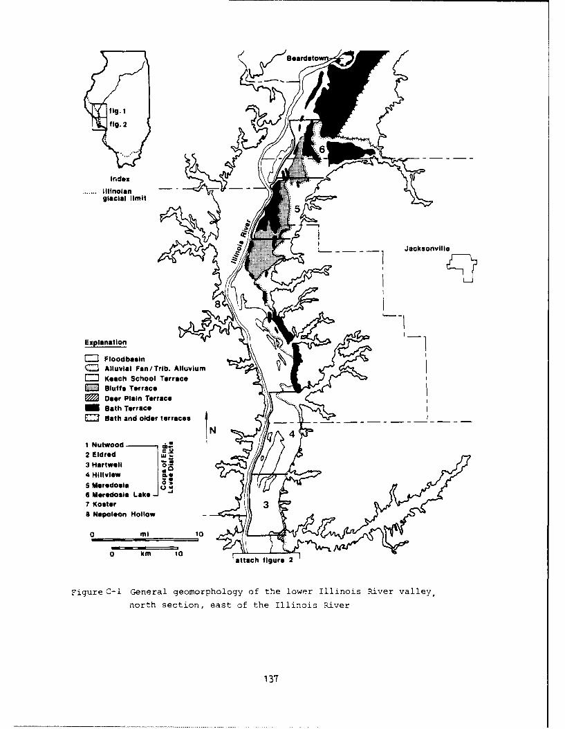
r/ Beardstow
flg. 2
Inedex
.*.. Ililnolan-glacial limit
0 Jacksonville
Explanation
SFioodbaslnSAlluvial Fan/Trib. AlluviumSKeach School Terrace
EM Bluffs TerraceSDeer Plain Terrace....
Bath TerraceEI Bath and older terraces
1 Nutwoodli2 Eldred -.3 H~artwell
Hiliview *
S Meredosla6 Meredosia Lake -7 Koster38 Napoleon Hollow-
attmch figure 2
Figure C-i General geomorphology of the lower Illinois River valley,
north section, east of the Illinois R-iver
137
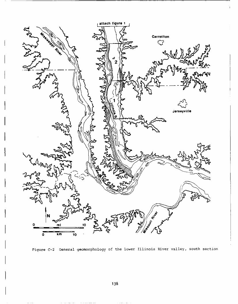
attach figure 1
00 Carrollton
Figure C-2 General geomorphology of the lower Illinois River valley, south section
138

.s
II 0
0~ Ii 00)
U. 4, -4
CC WU -4
0 cc -4
LL M WLUI--J-
z 0
Z1 144, 4W
I 0
u 9
o o-A 0 0 -IU
>J Ob,) 4'L
0--<eo i w uj44
IAll 0 0.
2W0 0 .
'- 00
0 0 -
4, -4
O1390

Ialmost featureless and exhibits a nearly level surface. It occurs south
of the chain of Bath remnants. Typical Beardstown Terrace (Wanless,
1957) morphology consists of point bars with evidence for scroll bars.
In mapping the Beardstown Terrace, which is identified only in a
restricted reach of the valley above and below Beardstown, Wanless
undoubtedly included some isolated Bath Terrace remnants.ISeveral distinct paleochannel systems are also evident. The Bug
Island Paleochannel (Hajic and Leigh, this volume; Styles, 1984) is a
broad, shallow and straight channel cutting the Bath and Bluffs terraces.
Although largely buried by upland derived deposits, it can be traced from
east of Beardstown south to the diagonal chain of Bath Terrace remnants
where it ends or is abruptly truncated. The Bug Island Paleochannel is
* closely associated with the Bluffs terrace and several channel
bar/islands are considered to be Bluffs remnants. A broad, shallow
anastomosing system, consisting of one to three branches, cuts the Keach
School Terrace and is younger than the Bug Island Paleochannel. This
paleochannel system has common mid-channel bars. Remnants can be traced
at least as far south as Macoupin Creek.
This "multiple channel" system is precursor to an entrenched system
consisting of one to two branches oriented along channel branches of the
anastomosing system, favoring straight reaches, and favoring a course
along the western valley margin. The considerably narrower modern
Illinois River course consists of straight reaches, probably inherited
from this entrenched system, connected by broad bends. It follows the
western valley margin from Valley City to the mouth.
Nearly all preserved paleochannel reaches have been partially re-
worked by yazoo and deferred tributary stream systems.
In sharp contrast to all other Illinois River paleochannel systems
are a series of meanders restricted to the middle Illinois Valley and
best expressed several kilometers northeast of Beardstown. Associated
point and scroll bars were mapped as typical Beardstown Terrace by
Wanless (1957). Styles (1984) has inferred an early Holocene age for
140

this meandering system from its possible lower elevation in relation to
the Keach School Terrace. That the the meanders were produced by the
Sangamon River which presently enters the Illinois Valley just north of
Beardstown remains a possibility.
Figure C-4 schematically summarizes generalized stratigraphy, depo-
sitional environments and episodes of lower Illinois Valley history.
Figure C-5 schematically illustrates in cross-section the stratigraphic
relationships of most lighologic units. It is clear the lower Illinois
record is as much that of a settling basin as a river and outwash stream.
"Kankakee Flood" - 13,300 B.P.
The Bug Island Paleochannel system and the Bath Terrace developed on
Valley train sand and gravel probably in response to the "Kankakee
Flood", described as a large discharge down the Illinois Valley during
construction of the Valparaiso Moraine system sometime between 14,000 and
15,000 B.P. (Willman and Frye, 1970). Although large discharges probably
occurred, there is no indication they were catastrophic. Illinois Valley
discharge was probably augmented by drainage from an initial Glenwood
phase of Lake Chicago between about 14,500 and 13,500 B.P. (Hansel, et
al., in preparation). Oldest radiocarbon dates from the Bug Island
Paleochannel system are 14,590±240 (ISGS-1285) and 14,300±290 B.P. (ISGS-
1263) (Table C-i) and correspond with what possibly is initial Glenwood
phase discharge. The dates also indicate the Bug Island Paleochannel
system and Bath Terrace may just predate about 14,600 B.P. Hansel et al.
indicate from about 13,500 to 13,000 the Chicago Outlet was temporarily
abandoned in favor of lower outlets. This would cause a relative
decrease in Illinois River discharge but the Bug Island Paleochannel
system, at least in part, probably remained functional.
13,300 - 12,000 B.P.
Rubey (1952) suggested the Deer Plain Terrace resulted from blockage
of the mouth of the Illinois Valley by an aggrading Mississippi flood-
plain. Dates of 13,390±190 (ISGS-894) and 13,010±140 B.P. (ISGS-900)
from earliest lacustrine silt below the Deer Plain Terrace indicate
aggradation of the Mississippi Valley effectively dammed the mouth of the
141

WJ C. a -0
cc gI I I I
CL
V'sL u's -~0
I0 -A 2' ~-4 0
>.~ o b
~ 44~ ' '~ S.. 4>
04W Z-T aO~ -p ~'O~~0 n
I 3
U) - I 0 0 .44 S.
0~ a) 0
LJ
0 ~~~ cc - c -
-0 cd
o 0 oo 0
:3 4):
<. <o Co -4
UJ N0 a
0 0. c
4) 0~ 41002
CD
NO P
ZU) 0 V,0. - 12 ~4142
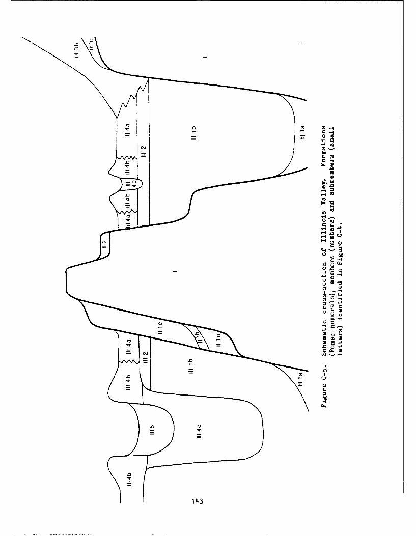
40
0
O.
'-4C~02
0
00
0
Lin u
143-
Illinois Valley prior to 13,300 B.P. Clayton (1982) has inferred periods
of aggradation and degradation in the upper Mississippi Valley based upon
glacial, lacustrine, and glaciofluvial events in the southern Agassiz and
western Superior basins. A period of Mississippi Valley aggradation
postulated to have begun prior to 13,500 B.P. and to have continued until
about 12,200 B.P. (Clayton, 1982) agrees with blockage of the Illinois
Valley.
ISGS-894 and ISGS-900 are directly associated with reddish-brown
clay laminae and correspond to a third previously unreported date of
13,360±1OOB.P. (ISGS-875) from uncarbonized coniferous wood and bark
(Hajic, unpublished data). ISGS-875 is also associated with reddish-
brown clay laminae in the Eldred District. The reddish brown clay can be
traced deep in the subsurface below the Deer Plain Terrace (lake plain)
and associated lacustrine clay in the lower Illinois Valley southward to
the lower solum of surface soils on the sediment dam part of the Deer
Plain Terrace thus indicating the majority of Mississippi Valley
aggradation preceeded 13,300 B.P. The two lower Illinois Valley dates
are from unoxidized, ,inleached silt with reddish brown clay, some of the
first sediments accumulating in the lower Illinois Valley in response to
the sediment dam. They mark initiation of a high lake phase (Deer Plain
phase) in the lower valley. Farther upvalley dates of 13,360.t240 (ISGS-
1262) and 13,340±180 B.P.(ISGS-1284) were recovered at or near the
transition from glaciofluvial to lacustrine sediments in the Bug Island
Paleochannel and firmly support lake initiation. Thick sequences of
green moutmorilloritic clay accumulated in the resultant lake until it
drained.
Preserved remnants of the lake plain and sediment dam comprise the
Deer Plain Terrace in the lower Illinois Valley. A date of 12,000±100
B.P. (ISGS-911) is from slackwater and alluvial sediments below a Keach
School Terrace remnant which is inset to a Deer Plain remnant. The date
indicates the Deer Plain Lake phase probably drained just before 12,000
B.P. and the Deer Plain Terrace is older than 12,000 B.P. A thin, firm,
laminated clay unit with pebbles below ISGS-911 records an erosional
interval predating 12,000 B.P. (Hajic, 1981b:85). The erosional episode
144

is probably related to drainage of the Deer Plain lake phase. A date of
12,360±240 (ISGS-1283) was obtained from the lacustrine sediment unit in
the Bug Island Paleochannel. A date of 12,325±75 B.P. (ISGS-415)
(Butzer, 1977; Hajic, 1981a) was recovered from lake margin related
sediments (Hajic, unpublished data). The exact context of ISGS-415 is
questionable, but the two dates narrow the interval of lake drainage and
exposure of the Deer Plain Terrace to between about 12,325 and 12,000
B.P. This interval corresponds with an estimated time of initiation of
Mississippi Valley downcutting of 12,200 (Clayton, 1982) during the
Twocreekan.
In the Mississippi Valley, the deposits below the Deer Plain are
composed of coarser alluvium than in the Illinois Valley (Rubey, 1952).
A wood sample collected from sandy outwash 23 feet below a terrace sur-
face at the mouth of the Missouri River dated to 12,148 B.P. (Flint and
Dewey, 1951). Flint and Dewey (1951) correlated the terrace with the
Festus Terrace of Robertson (1938). Goodfield (1965) suggested the date
could possibly be from below a Deer Plain remnant. If the date is valid,
the remnant is probably not Deer Plain, but rather a younger terrace and
fill indicating a second episode of aggradation in the Mississippi Valley
to levels approaching that of the Deer Plain. At the Sievers South
Quarry section where Deer Plain sediment dam deposits are exposed (Hajic,
unpublished data), a second, lower terrace is preserved. This unnamed
terrace verifies an erosional episode between Deer Plain formation and a
second episode of Mississippi Valley aggradation. A highly dynamic,
fluctuating Mississippi is implied.
Flock (1984) names and describes surficial sediments of the Savanna
Terrace in the Mississippi Valley extending from Pepin County, Wisconsin
to Jackson County, Illinois. He correlates the Deer Plain as part of the
Savanna Terrace, and in fact Rubey (1952) originally mapped the Deer
Plain in both Mississippi and Illinois Valleys. Flock characterized the
upper 1 to 3 meters of Savanna Terrace sediment as being dominated by red
and gray clay originating from Lake Superior sources and lake basin(s)
farther to the west, respectively. These are the same deposits traced
deep into the Illinois Valley subsurface. Interpreting Hajic's dates of
145
13,360± 100 (ISGS-875), 13,390±190 (ISGS-894) and 13,010±140 B.P. (ISGS-
900), and Goodfield's date of 12,148±700 B.P., he concluded the SavannaTerrace formed sometime between 13,000 and 9500 B.P.
Flock considers the red and gray clays to be deposited during
flooding of either early Lake Superior sometime between 12,000 and 11,000
B.P., Lake Grantsberg sometime between 12,700 and 11,800 B.P. or/and Lake
Agassiz sometime after about 12,000 B.P. In view of earlier discussions,
these ages, with possible exception of early Lake Grantsberg ages, are
probably too young for the Savanna Terrace and associated reddish brown
clay. They are all certainly too young for the considerable thickness of
Deer Plain (Savanna Terrace) forming sediments below the surficial
reddish-brown clay zone at the mouth of the Illinois Valley.
Elevations of the Illinois Valley mouth sediment dam and documented
wave-cut scarps preserved beneath valley margin alluvial fans in the
Illinois Valley, along with soil-geomorphic relationships on the Deer
Plain Terrace, indicate lake levels were high enough to inundate the
entire lower valley and considerable reaches of most tributary streams
(Figure C-3).
During this Deer Plain lake phase, the Illinois River, when active,
would have been terminating at the head of the lake, probably north of
Beardstown. Hansel et al. (in preparation) indicate the Chicago Outlet
was operating when Glacial Lake Chicago in the Michigan basin was at the
Glenwood level probably between 14,500 and 15,500 B.P. and again between
13,000 and 12,200 B.P. There would have been relatively reduced dis-
charge down the Illinois Valley as the Deer Plain sediment dam formed.
Stratified lacustrine fill in the Bug Island Paleochannel may in part
reflect distal alluvial fan delta deposition. Terrace elevations are
such that surficial sediments associated with the Bath or Bluffs Terrace
may also be lacustrine in origin (Figure C-3).
The existance of a lake in the lower to mid-Illinois Valley from
after 13,300 B.P. to about 12,325 B.P. indicates conditions unfavorable
for deposition of loess with an Illinois Valley source during this
146
interval and probably Mississippi Valley source as well. The time range
is compatible with estimates on terminal loess deposition for the region
(McKay, 1977).
12,000 - 9,800 B.P.
A detailed chronology of Illinois Valley events for the period
following drainage of the Deer Plain lake phase until about 10,600 B.P.
is elusive. It is probably characterized by fluctuating intermittant
glaciofluvial, fluvial and lacustrine regimes with only little indication
of deposition. Where sedime; ts from this interval have been preserved,
such as in the Bug Island Paleochannel, they record a varied history of
slackwater deposition with only occasional fluvial input. There is no
indication lake levels approached those of the Deer Plain lake phase.
Exposure of a sandy alluvial plain (Bug Island Paleochannel system)
is evidenced by the migration of dunes onto Bath Terrace remnants shortly
after 10,900 B.P. Radiocarbon dates of 10,900±80 (ISGS-1169) and
11,070±80 B.P. (ISGS-1277) were obtained from wood samples from a woody
peat and underlying fine sandy loam, respectively, which were overlain by
dunes and underlain probably by reworked valley train material. The
presence of fluvially reworked dunes or absence of dunes on the Bluffs
Terrace suggests it may be younger than about 10,900 B.P.
By about 10,600 B.P. and perhaps slightly earlier, another lake
phase was initiated in the lower Illinois Valley and continued into the
very earliest Holocene, about 9800 B.P. The lake plain which was exposed
around the latter date is the Keach School Terrace.
Styles (1984) has recovered organic matter from slackwater sediments
at the mouth of Napoleon Hollow which dated 9950±260 (ISGS-819). The
sample was above the Keach School Terrace elevation indicating the Keach
School lake phase lasted at least through 9950 B.P. Similarly, Hajic
(1983a; in preparation) obtained a wood sample from a corresponding
slackwater unit in Campbell Hollow on the east side of the Illinois
Valley. The material yielded a date of 10,460±220 B.P. (ISGS-989). The
147

Keach School Terrace is incised by an early meander belt of Mauvaise
Terre Creek which was contemporaneous with the "multiple channel" system
of the Illinois River. Wood from basal slackwater sediment filling the
meander belt dated to 9750±70 B.P. (ISGS-1264) (Table C-I) indicating
Keach School Terrace formation predates this age.
Keach School lake phase related deposits include a surface veneer of
interstratified silt, silty sand and sand on the Keach School Terrace.
At several locations the individual fine textured beds were tracable for
hundreds of feet (Hajic, unpublished data). Basal laminated alluvial fan
silt deposits occurring in the south segment of the preserved Bug Island
Paleochannel probably date to this interval. They reflect either rapid
alluvial fan accumulation or alluvial fan delta deposition during
temporarily higher lake level stands.
A probable shoreline is recorded along the northern extent of the
Keach School Terrace at the diagonal chain of Bath Terrace remnants. The
Bug Island Paleochannel is either truncated by this Keach School lake
phase or at least in part contemporaneous with it because the
paleochannel appears to abruptly terminate on the north side of the chain
of Bath Terrace remnants.
Changes in relative amounts of discharge entering the lower valley
during this interval can be inferred from work in the Lake Michigan Basin
by Hansel et al. (in preparation). During the Two Creeks low lake phase
in the Lake Michigan Basin, beginning about 12,000 B.P., the Chicago
Outlet was temporarily abandoned. Considerably reduced discharge would
have been entering the lower Illinois Valley. An increase in discharge
would have accompanied reactivation of the Chicago Outlet at about 11,800
B.P. with establishment of the Calumet Lake phase. Shortly before 11,000
B.P. the Chicago Outlet was abandoned again as deglaciation opened
outlets to the east and Illinois Valley discharge decreased. It is
shortly after 11,000 B.P. that an episode of dune formation is evident in
the lower Illinois Valley.
During the Twocreekan interval the Mississippi River is inferred to
148

have been downcutting (Clayton, 1982). After a brief period of aggrada-
tion, another interval of downcutting occurred until about 10,800 B.P.
The beginning of the aggradational episode at this time may correspond
with initiation of the Keach School lake phase. According to Clayton and
Moran (1982) and Clayton (1982), the Marquette advance of the Superior
Lobe was probably responsible for blocking eastern outlets of Lake
Aggassiz initiating the Emerson Phase in that basin at 9900 B.P. With
blockage, Lake Aggassiz drained into the Mississippi River via the Minne-
sota River. The episode of Mississippi Valley downcutting which this
chain of events initiated caused the Keach School lake phase to drain and
the Illinois River to downcut rapidly. Lake drainage probably caused the
streamlining of several Bath Terrace remnants along the south and east
part of the diagonal chain of Bath remnants.
9800 - 7000 B.P.
Initial downcutting occurred in an anastomosing pattern of 1 to 2,
and possibly 3, channels which are best expressed immediately north and
south of highway U.S. 36. Morphology of this channel system may have been
influenced in part by Keach School lake drainage. This channel system
was only temporary and with continued rapid downcutting some branches
where abandoned and preserved. There is some evidence to suggest the
preserved bed of this anastomosing system was subaerially exposed for an
undetermined period of time. An early Archaic site, now buried by late
Holocene deposits, is preserved on this surface in the Eldred District
and there are some indications of associated soil development (Hassen and
Hajic, 1983). This buried surface, which is most extensive south of the
Hillview District, is informally referred to as the Columbiana surface.
Ultimately, downcutting was on the order of at least 15.2 m for
channel bases. River stage fluctuation is not yet clear. There is no
evidence of subaerial exposure of Holocene surfaces (i.e., floodplain)
greater than 5 to 6 m below present floodbasins. Near-surface sediments
below the Keach School Terrace indicate subsequent Holocene river (and
flood) and lake stages did not eclipse Keach School elevations to leave a
recognizable overbank deposit. Apparently all fluvial and lacustrine
events post-dating the very early Holocene downcutting were confined to
149

the incised channels defined by the Columbiana, Keach School and older
terrace margins, and the bedrock valley walls.
Maximum downcutting was accompoished by about 9500 B.P. and a
probable lake phase, restricted to incised channels, ensued for an
unknown length of time. Radiocarbon dates on wood from slackwater(?)
clay at relatively low elevations are 9480±130 (ISGS-1135) and 9300±150
(ISGS-1122) (Table C-i).
The period between 9000 and 7000 B.P. is not well known and there
are only several areas where deposits from this interval are recognized
at all. The present general location of the Illinois River is currently
viewed as the location of the main channel of the several utilized during
downcutting with only several areas of exception. This view tends to be
supported by Corps of Engineers boring records along artificial Illinois
River levees which indicate the greatest depths of fine textured
sediments found in the valley. The Illinois River, when functioning as
such, has apparently assumed a general position along the western valley
margin and has not varied significantly throughout the Holocene. Largely
negative evidence for this is derived from the slackwater Hartwell member
of the Cahokia Alluvium. The Hartwell, filling paleochannels incised
during the initial Holocene and deposited between about 6000 and 3000
B.P., constitutes the bulk of Holocene valley fill, yet it is a very
uniform deposit for considerable thickness at any given location.
Texturally and structurally it exhibits little, if any, indication of
alluvial channel, bar, natural levee, or floodplain facies.
7000 - 3000 B.P.
Infilling of paleochannels was possibly underway by at least around
7000 B.P. as indicated by stratigraphic contexts of a burled Archaic
horizon at the Napoleon Hollow Site (Styles, 1984). Sometime before
6400 B.P. the Illinois River clearly established its course along the
western side of the valley south of the Hillview district and is evi-
denced by remnants of a well de-eloped natural levee system. The Quasar
site, a shallowly buried Archaic horizon within these natural levee
deposits, yielded a date of 6320±90 (ISGS-1278) (Table C-i). In downcut
150

paleochannel segments abandoned by Illinois River straightening and
channel definition by first subaqueous, then subaerial natural levee
formation, Hartwell lacustrine or nearly slackwater conditions were
established by 5700±140 B.P. (ISGS-930) and most likely continued beyond
3650±70 B.P. (ISGS-903) (Table C-I). Hartwell deposition occurred in
relatively deep backwaters. Deposition was relatively rapid and
paleochannels infilled to several meters below the present floodplain
surface. Structure of lower soil horizons is preserved at the top of the
Hartwell indicating an emergent floodplain.
3000 B.P. - 1920's
The presettlem-nt general structure of floodbasins and natural
levees evolved during the 500 years predating about 2500 B.P. Around
3000 B.P. a primarily erosional eposide, referred to as the McFain event,
effectively planed the Hartwell surface, reworked terrace margins, and
scoured portions of the Columbiana surface. The associated McFain member
probably represents a lag resulting from either a large Illinois River
discharge or active yazoo streams meandering across the emergent
floodplain. A radiocarbon date of 2890±75 B.P. (ISGS-143) on shell
(Coleman, 1974) was obtained from deposits interpreted to be the McFain.
Buck Lake member deposition followed in shallow backwater lakes,
possibly intermittent, as a floodbasin aetwork of coelescing tributary
creeks rapidly built a natural levee system. Slow aggradation occurred
in floodbasins. The Illinois River went through minor redefinitions of
its channel position and there is evidence to suggest a second natural
levee set, finer textured than the first, rapidly developed during this
interval. Early Woodland settlements are common on the natural levees
indicating they were well established by about 2500 B.P. Dates of
2420±70 B.P. (ISGS-1120) and 1980±80 B.P. (ISGS-1084) were recovered from
the bottom and top respectively of fill from one of the floodbasin yazoo
stream channels (Table C-I). The dates may indicate a rough range for
the infilling and final deactivation of the yazoo system, but clearly
more dates will be necessary.
The Illinois River has maintained its west side channel with little
151
modification throughout the last 2500 years as indicated by Early
Woodland settlements on Illinois River natural levees (Farnsworth, 1976;
Butzer, 1977).
1
I
I5

APPENDIX D
Scope of Work
153
CULTURAL RESOURCE SURVEY OF SELECTS) PORTIONS OF THEHEREDOSIA AND MEREDOSIA LAK DRAINAGE AND LEVEE DISTRICTS
SCOPE OF WORK
1. Statement of Work. The work to be accomplished by the Contractorconsists of furnishing all labor, supplies, materials, plant andequipment necessary to perform a Cultural Resource Survey of selectedportions of the Meredosia and Meredosia Lake Drainage and LeveeDistricts, Scott, Cass and Morgan Counties, Illinois, and furnish awritten report thereon as set forth in the Scope of Work.2. Location and Descriotion of Study Area. The project area is situatedin the Illinois River floodplain between river miles 65.0-72.0 (MeredosiaD & LD) and 72.0-79.0 (Meredosia Lake D & LD) in Scott, Cass and MorganCounties, Illinois. The total area to be physically surveyed consists of3140 acres and represents approximately a 20% sample of the entire areacontained within the two districts (15,725 acres).
3.1 Genera1. The Contractor is responsible forthe formulation,justification and conduct of the study to include the design andexecution of all survey methods and procedures as well as thepresentation of the study results unless otherwise set forth in thisScope of Work.
3.2 Sample Design. The survey will be structured so as toinvestigate a representative portion of each topographic andphysiographic zone (i.e., ridges, terraces, etc.). As a result, theContractor will restrict his investigation to a 20% stratified randomsample of appropriately selected zones. Before initiating the fieldwork,the Contractor will provide the Contracting Officer's Representative withmaps showing the sample units selected and with a narrative describinghow the units were chosen and describing the research goals andobjectives, as these relate to larger questions about Illinois RiverValley prehistory (i.e., a "research design"). The Contracting Officer'sRepresentative will comment (see Paragraph 6.1).
3.3 Principal Informant Interviews. Principal Informant Inter-views constitute preliminary surveys based on verbal descriptions of sitelocations. The Contractor will contact amateur archaeologists and col-lectors within the region in an attempt to identify the location ofpreviously known archaeological or historic sites within the Meredosiaand Meredosia Lake Drainage and Levee Districts. On-site analysis shallconsist only of a visual confirmation of the verbal description.
3.4 Pedestrian Survey. The Pedestrian Survey will consist of anintensive on-the-ground survey of each sample unit, sufficient todetermine the number and extent of cultural resources within each unit.This process will include one complete surface collection at eachidentified site.
3.5 Lab Procedures. Artifacts collected during survey activitiesshall be washed, permanently labeled and catalogued according to standardlab procedures. These collections shall be analyzed in an attempt todetermine each site's temporal affiliation and horizontal surfacedistribution. All artifacts will be separated into various general
154

categories, then subdivided into smaller, functional and stylisticcategories. These distributions shall be quantitatively assessed in aprofessional, concise manner.
3.6 Curation of Material. The report shall contain a statementindicating the exact location of all materials and records resulting fromthis contract work. This statement shall include at a minimum, the nameand address of the curatorial building, the storage room number, and ifpossible, the rack, shelf or cabinet number where this material isstored. Containers in which artifacts are stored shall be clearlylabeled "Property of the U.S. Government, St. Louis District, Corps ofEngineers."4. Final genort. The Contractor shall prepare a written report whichpresents and interprets survey results, and describes in detail datacollection techniques. A discussion of each site located, its culturalaffiliation and artifact assemblage, as well as their relation to othersites found during the survey shall be presented in the text of thereport. These data shall then be compared to other previously reportedsites in the Illinois River Valley and surrounding areas in order toplace the results of this study into regional context. In addition theFinal Report shall include the following:
a. U.T.M. coordinates of each site, detailed site-specificdescriptions, locational data and maps attached as appendix to the FinalReport.
b. Maps which accurately define site locations, site numbers,areas surveyed, and ground cover conditions as well as other pertinentdata. These data must be recorded on U.S.G.S. topos (scale 1:24000)although other maps may be used as well.
c. No hand lettering is acceptable other than that necessary torecord data on base maps.
d. Oversized maps will be folded and included in a pocket inthe back of the appropriate report section or appendix.
e. A full set of reproducible maps, plates and drawings.f. Black and white prints (half-tones) of diagnostic and
functionally significant artifacts will be incorporated into the reportbody or attached as appendix.
g. A photographic log of annotated 35mm slides, showing eachphase of lab and fieldwork in progress shall be included with FinalReport original.
h. An abstract not to exceed one typewritten page.i. Completed site forms shall be submitted for each site
identified during these surveying activities.
5. Permits and Rights of Entry. Rights of Entry upon work sites forperformance of work under this contract shall be obtained by theContractor. The Contractor shall obtain the necessary approval to enteron any private property and to permanently remove any artifacts recoveredduring subsequent surveying activities. Should access to certainportions of this project area referenced in Paragraph 2 above be denied,the actual amount of this order will be decreased in an amount equal tothe percentage of difference between the original required acreage andthat acreage actually surveyed.
155

6. Schedule of Work6.1 Research Design. Research Design (see Paragraph 3.2) shall be
submitted to the Contracting Officer's Representative within 20 days ofthe date of the delivery order. The Contracting Officer's representativewill review and comment within 7 calendar days of receipt of ResearchDesign.
6.2 F. All fieldwork related to this item shall becompleted within 200 days after the date of the delivery order.
6.3 Draft Report. Five copies of the draft report shall besubmitted by the Contractor to the Contracting Officer's Representativewithin 90 days after fieldwork is completed. Government representativeswill review the report for compliance with the requirements of thecontract and will return the preliminary report, together with anywritten comments thereon, which may require changes in the report, to theContractor within 50 calendar days after its receipt. The report shallbe organized in a manner consistent with the St. Louis District reportformat guidelines. The title page shall be organized in a mannerconsistent with the St. Louis District title page format guides.
6.4 Finl Coy=. While the St. Louis District is reviewing thecontractor's draft report, the St. Louis District will prepare reportcovers for the final report and will forward these to the Contractor withdraft comments. The Contractor shall be responsible for binding thefinal report in these covers, using Plastic Spiral Binding.
6.5 FinReo The Contractor shall submit 30 bound copies ofthe Final Report, including the original copies signed by the principleinvestigator, to the Government within 30 days after the Contractorreceives the St. Louis Districts written comments. A set ofreproducibles of all drawings, plates and other graphics, including siteforms, shall be furnished at the time of submission of the Final Report.7. Exesin, In the event these schedules are exceeded due to causesbeyond the control and without fault or negligence of the Contractor,this delivery order will be modified in writing, and the contractcompletion date will be extended one calendar day for each calendar dayof delay.
156

-14 U.. CL C. 4S U) U Si S U)
4,-V
-a I
I - 41
71 .
C4 ~ l 43 '
-~~~~ -' > 7 ' u g
2 N -cc
CA: z. Z . V
I0 OC C C 3 C ' -3"- l
C I ..- 9-, i, 0....U~IL
if.-4-'> w.-13 .. ''4'U . C
a) .1 Lj .-4 V.. 3.
0 _j- -V1I'. C- * -
-~ r '- 91
.I*4 1 f
Z L
I, Z, a
4.SL 0 " Q 5 .
N1 > ( .0 >- :) jC '. (C. - '.-1 1W40 I- -t iV ~= ~~. C - Cl '4 ~>
bl -:- .5' 4 U ' - C U
oI' Q ) >- - f C c '~
:lV V I
CL 4-
'>I 0 1
w 14

.4C- I
-4 .44
r-4'
C.>
. - VJ- c oI
- .-.1 E 4 N '
2 , C. DI V..C 3-o*,LC I Lo, rI ,u a:
v - 04
4 .4 I-I N -t A k
01~~ 1 0~- -C
e4 -v
-CI1
414 c 4,J
a !, -
-2 N3 aL
ID o. 4.
I .5 IC~>
_j, -.
I J -'l
D l1 44-
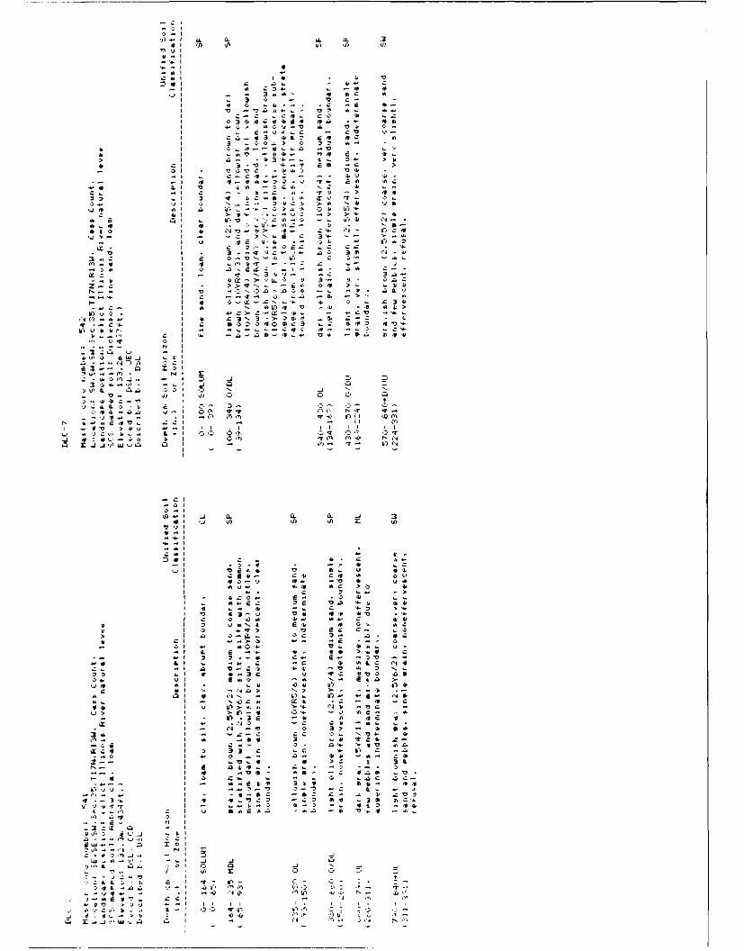
v)Cl LLa
4 4
>~ I
4C
*0C 0,r. . 4.- S
L 1 &.
A24 VI C -Z IL ~ 3 C 0 44
I >
I > lN .!4
I~ ~ 3 L.- >N =
I 'j 4 44. - IjI44
I C- L .q44 0 44
3...CI S -. VN-''+
M..4 I 4 ~ "'I4 - n
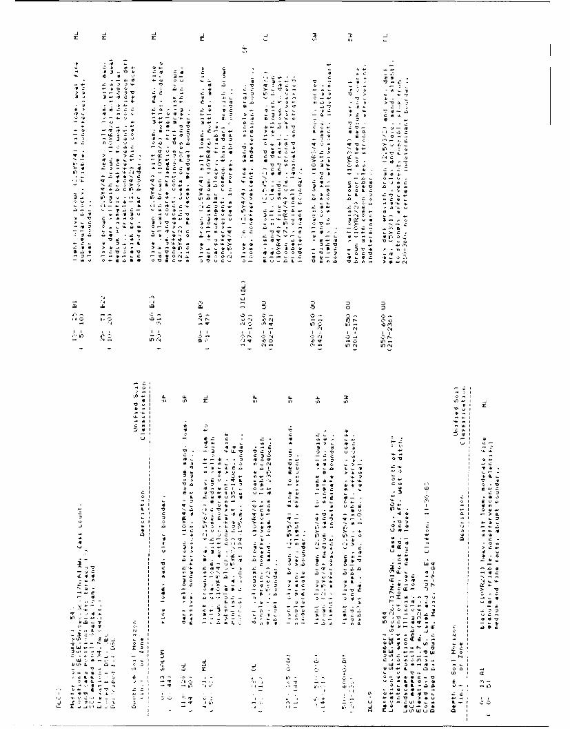
'J -J - j .j >j 3b
-1.
I, -L
C. C
-- ~~~C A ' I.44 4'i -
ill, 3 z3
N r- It A4' 11 C
4 3--
:t ~~~~~~ It' ~4' > '4
04 4. "I4. LV'3 N
ac V' C 14 .1 f714a >c cc No a.4-
CC -a4 >L- 4-
a 3-C c.- U- 1. --l -, I -
N~ ~ ~~~ - 2 ta t - b--
L a '>I .'- t - r I l f
v , -7 l
'l4 .x. #- C 5
-L L- C-0
Cii- -. i~s 0(4 W
4 "4 0 (~ q ' C I' - 0 1 l
-~- -l W. -j Q

4'1
LC I
I r 3 'o 4
E 3 I
.4.4
>1 z1 > o> .
ul aa a
r~ L.a Q. :- a 'oI
a3 C. 9-' -. .
Le -w c L f
c40a 4 - 4 'A ", Q 7
Iv7.9 *t j c-i --. lci 34 3.-C 3 413
I~~~t Iv.. 941, 4
'
34
2 9 CC '4-
>- 1
41~~~~c LL.09 it 4~N 4
I .- 3Q .41.9 -43U .4Q .. V .'I .. .4,
NL - > o>-l-> 3 W - 2 ' ~ 1
4, A VA3 I Q o, 0Q Qt 44 0- t,
-4. L- zI
-~ -z,. 'C00
L- 9
IL L
I 41
aCL L01 S - *ro .* u- aa v-

.4 A~i .j a
a3 -b Z
I5 V ! -.0
40
> -4 0
C > 0'4 L~43 Ccl '44 a4
at'!'ki . .. 3 .-
- C 0,05 z34'. u9-
C C - '3 .. -b C - Cl
4. A L L4 *
-~ ~~~ L.3 4 > 4, '
N.~ L q-A.4( 4
Os') ('63 -4 .
.t 63
-~ ~~ ~ I ~ k'5 -31.3 . -'-15 4. V)4 V3 41 Z13ZL
'-9' C N 4 0 31Q
I3 C v4 3 151. * Z > I
O Ca 40 4 C ,-0-
2C~ -- -- Cc.35* a.
4943 aC' E ~ . ~' f. . CUN~~~~~~aC -s a V a o a>4 3 4
a tW4 LLI
Z1.S 11 I > 0
z~~~ -% L-,c vl 304 0- >.4 > 3 I I 0
4O CN 1N IV 4
1'I.' flN ~U)-i 3 Z s -.. .. 3 0-
V) C CZ L C~ .41W 0 0
I44 4
a. L4C4L I T3* cao. 0-4
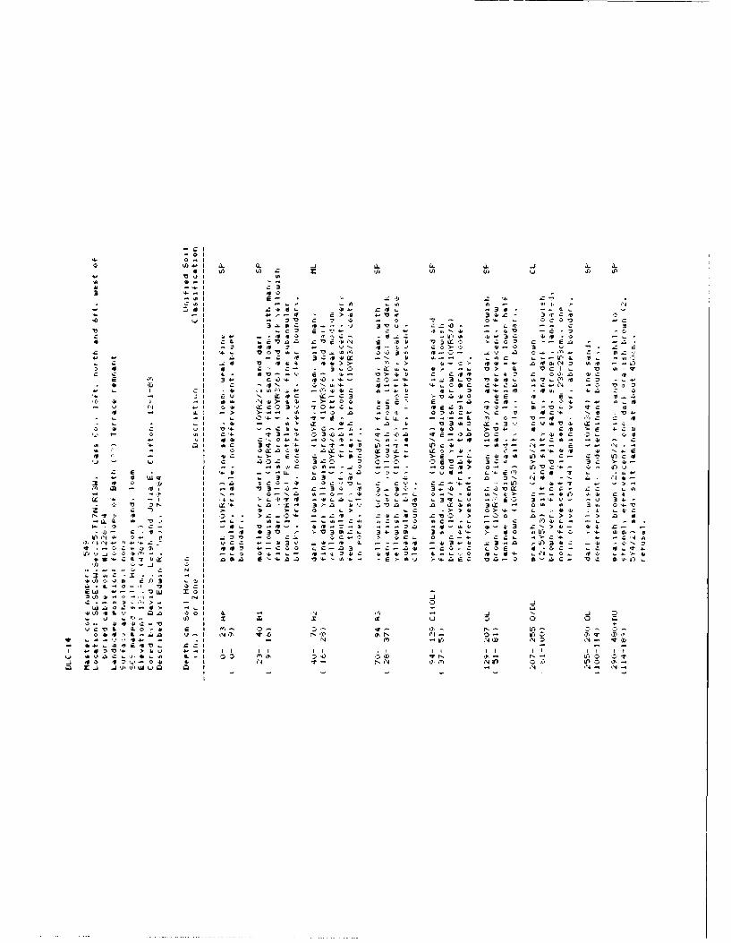
0-I0
it ~ ~ ~ ~ ~ f ISOI)q u )S
3 X~' 46
3.s Z41 Q- 13 IxI 4 3 C
.0 '3 iE >- a v , osa - -:ZC - 0
r. 3wm it... oV - C-- , .3 -
J -. 2 Wi 0 N -n ~ IN' If). in-. 35 .~
-r Ij -- U. V.4. U- ab .- . ~ C .- I a 3

4,
9- C,
k-4
It V '
Jr >4' L L C LLC
j.IV
4' >
4LC a .-1,-
41 c) C.) a , bi u4 ', h '
L. I c.a
C 4C 4'. X' '410
> L.' - 4 - ')4 ,- 14. 04- 14. 4. C -CC.".3
*41 )V d 0 44 - -'4 3.)C,4 4''0LW ID o hr," 43' 4 43 4 --
.2 73 ): 4 . A. 4'4Q . -- 4 2-4.~~~ ~~ I CU ... 44,.
3 4 E4 , C -0 a. C - It- ACfI It') C. V0 V. 4 ' L. 4 4 C
cI LL -4 .. .4V 4 I-4'~~~~~~~~.~ c., 4 ' 'v -- . 0 . ~ 4 I
0 4> ' C 4.4' 4.4 4' 4'C 00 '.04 * 47 3 I 4- 4 V 4- t-V4A
4o I ')> zC *C 44 3'. - * I . V . '
-~~4 "0 I I#4. - C C 4LV',0 3 43 4*> C>'I 1. 4.V 4'- .s '"
VI V,4
q7 '0
. 4T, CA ,
o 4' - 1 1- OD ts y 4 '- V4O OkS C oi - s . > 4 . V 0, 0 f> ' - > 4
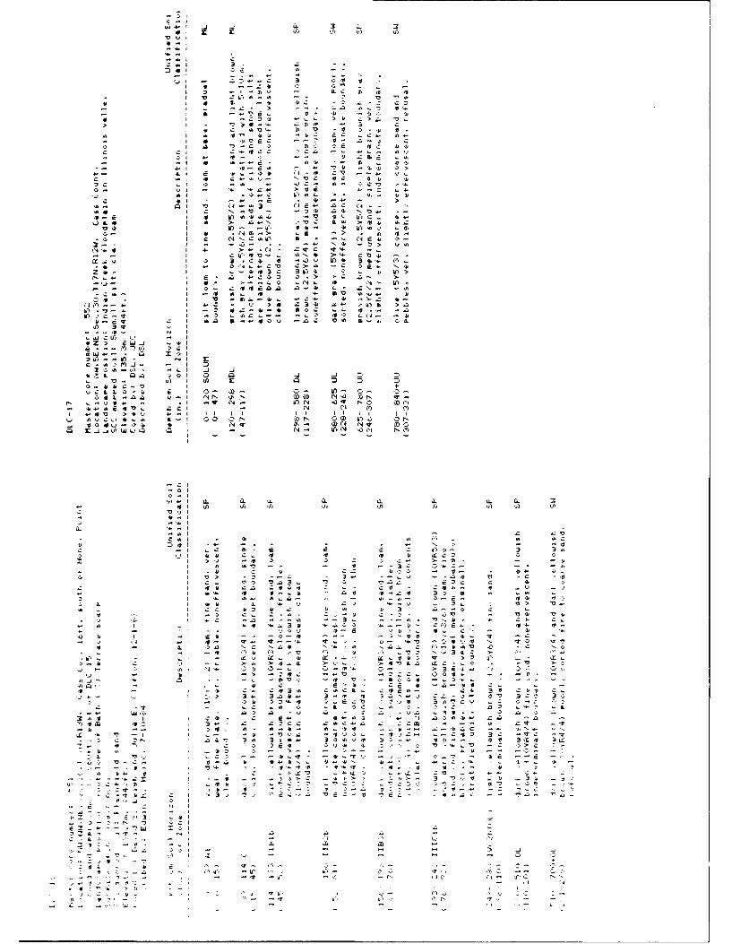
Q0 L0 -0 c L
- - I
-~lo-
A > r: z 3>03~ 4c-4.:
f I E z '3 a Q L
3'o'3, 3 U), 43
3J 4 --- j3
If)-'2 a.c.-CD
_j4 v) w Q.-' Q *4-24 N4
'2
3045 45 a.4. Q..3 6LG
0- 3 * .4 3.-> 3 > 33.
I~~~~l Cv 3N 44 3 .T334 .3-- - .- N4 '2> 344
I 4 - ~ 34 C 4
-~~I - I.3 3s... A t >- C 4
Li-44 I C. -43' 304 34.~- r).
-4. ~ ~ ~ ~ ~ ~ ~ I 3 34-... >A - 1C4~
341- 303. 0 .- , IT
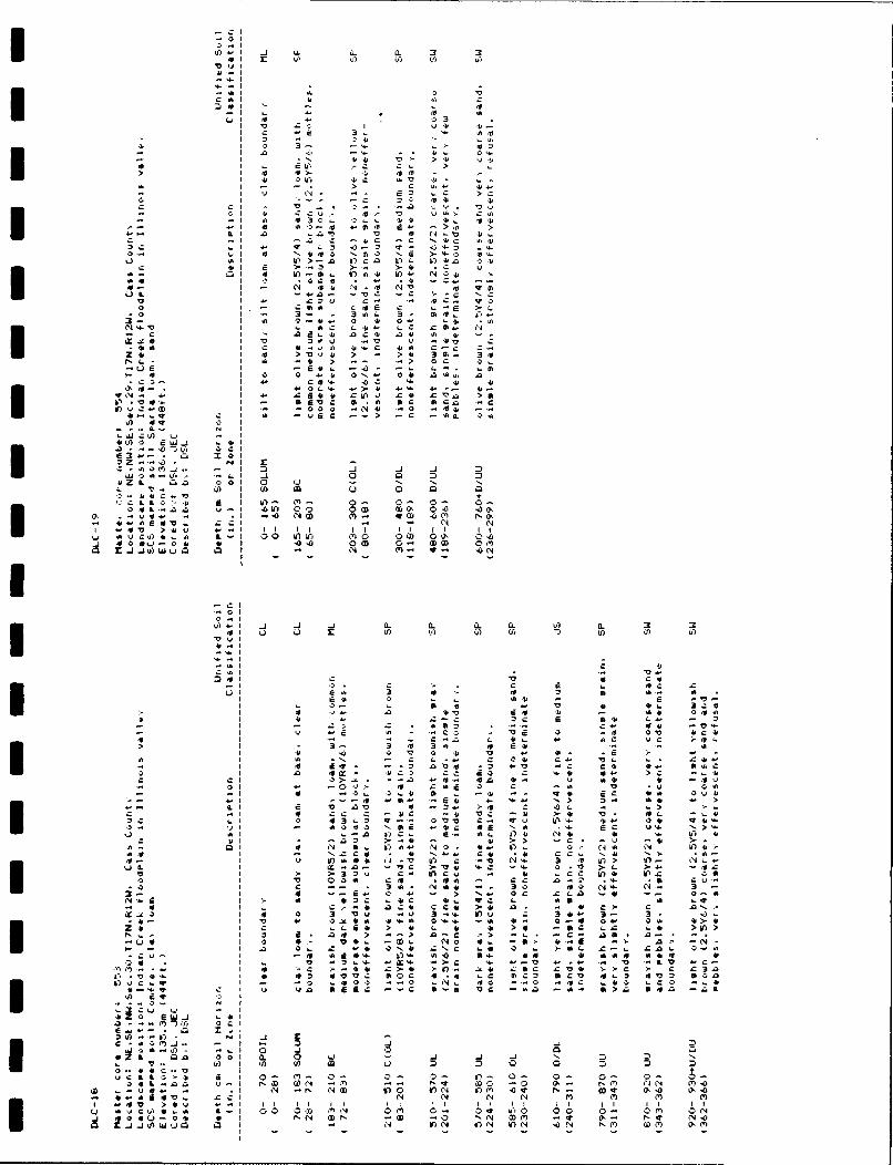
'A.) ' -1 C. a. a1 3 3
CU' - 4
> a:IL I Q T). &..
1- E> > ;
)'O.> > - >4' 3i. 3
>iw
-~~ ! ..LLA0t U >
-a 0', 0
-IL4
.. U2 'A I A 0U
ILLC<i ODI ) I 0- OD '3 0' " 0-4t'o a w- 'AlD 00 00 00' 0( ' -
.1 -0'0 NW C'- 30 'o o
0~~' 0.4..~ u 0D OD 011)) 4' '
I - - C- (- (- C-UI0"0
'2 Ej ;Ib
I- 40
vb rmI ' 4 Ct>Ut 4,. 40 3 5 ,
-b 4' 3C 6 M .4.
-E2 - A U' ) N" C4U4 '2"
Ii~~ 'A > >2- 4. .4
tA 'N - C 04 C.. '4, 1.. .C'6W-~CI - U" >C W)' C M 4... t
Ci Ll v>. > L.. >14 U SM 4- >1 -0r 4r C1 c1 ' U
4 0i 0iM 4 04 04 w M'4 O>-014 0 fl Z -4. (4 C 'L Q 4 4.
>- ' C 40. 4- >-
.2 -. "o, >L N) a. 'Ac~ N q- *> 0'2(h Q' A-
44~~~ Ia" - -'IV4 .4 '.. C. *' L M > U
. 40 (4 1 * 4 1 0 0 c I 4 0 a0 Ni
It0. a '2 >''2 a 10c z. A > a >4 4
A' > 3 . ~ 4 4' .C )' 12 0
I 4
v LLI4 L 0' >, -S >I~~ ~ N 4D 'CO 4 M 04 No Mid r06 i-- fIa1 P.. N U.D 4 if) .CN iV) 0 c t.S4 2' . 0.U
w -u. O -- LNL 0 "t0 .44C i0 L O .0 ()2- C4 L. N OD NS -- c r- 'C N CD -U' *>a 540 -v N
* Zj I4 .)L QN14 o f 4 N N,1) () o 1
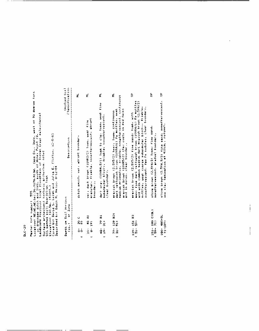
V) _jj _jI j
IV -T
C~~~ 'A1414
o~ c1 31 03m 4
*~ -1 4! v10 1' r'4C 40
o .0I CO *'4 4104 ."3 fl 4
N4 C C4' N14 0 A 1-3 - 41
X. 41 I Z1 1> 1 10 of. -E 4>1 a I (1 -'00 .- C 4 o Lo1
IX C L1 41 t.44 3- -. 41.
0-41~.0 .0 -.I > >i 0 C.11 .
- ~ ~~~~ 1I 0 > - > C < .10 0 1
10 L 0 1 0 Ic OD .N0t0 -,4 0 ('4.
rvI OC a,4 flC'Il u~"3
(11 o
- .. V)n 0. 00 0 O-3.0~~~ if OD onro -' u- ..
V)-11 41 4 0- 0. .1 4 N

400
0.41
.Q C. I1
3 . .3 4
V ai 10 0. C
r . L .-0 .
.4 >. > V 1.0.4.
a- -u CP a 1= 4' DC * 4
> .1 4-C L ~ Z 4 >
a> -- (A 2 4..2 >. '
0 .1#-. C 4' 640-) CC > -' t '
E4. 0 1 4 0. O t o (4a.~ ~~~ c4 :? -- - L> o' C'.. le
lb,4 a. 00 -. 7I 024 4 0 L 4 O
mt 0 a4 IV M0n4 0' .4: L4 :4rC CAm C I c-n > Lu L>3 > 3 -
34 V I ~~~ 1 > a - 0 4. 0 -
204' ~ ~ ~ ~ ~ ~ ~ 3 r.. VI0' 4 #'- 4' .0' .aC
Cu0 Nuu4' 4' %o I+4 0 q -- - .
0-. L --. I0 ba L-6 04 j34 Nta4*4 .0 ..4'- I1 N3u ). '4 C C
~~ -o I ~ ,.- - o .o' O a.e a nu4 -r -U 4'IC*4C C I 6.3 ODc - o- oa
_j 0 .o 4-. r ; 0 MlIn -I-- 4' If V) ID0
.. 3~1 CL3.- -
4'Z'4-oa 4'A3 44'30 ,.. .Oj 7o
E IV
> CC4' 03 . L Ic 0Q m -I
0-'44 ' o. 0 IL*~~7 ucfi c0-4 4' I -40 -00
0-~~ > t ea n u- o> N X - 'ON~~~~~ ~~ Cv*V ' -4 - W '# CO '4 N
NN~~ I . -
a > Al . z D a41--I c
I4.4? 1 4'44t 0Vr LD 0 >4
0 Cc N- .0 4c X' V -.~ 0: 4'
4 .>ii . 4' n .4 nJ
6-L44 >4 3 U.0 L 6 C 3 u- a- V- Z4~~ - ii4 'X it * r - u -3 -
I; CL2 4o -b0 -b a ' a4 r .C C-
- 0 I ~ ~ ~ 4 34 v-u 4a' - 3' 4' b .:0-ia 4 - 4
*. 4' I L- >. - >-'- u 2 .
0% ? C > > ..Qo 0- 'cc L :~p ' .0 6a4 L >.O
CO.. CI u-iL 0 03m 3 > c4 -CcC4' L i 3z C0 M0'.> 0- 4 N-'N. z
- 0. > 0. - -0 I' IA '4I I4. I' 1r7aC. w Vl 40 -24 00)4 V' 04' 022; 0 ,0 40
44"~~O 4- DI 04' -1 P- (A..D mlN C C. 4 ' 4 >
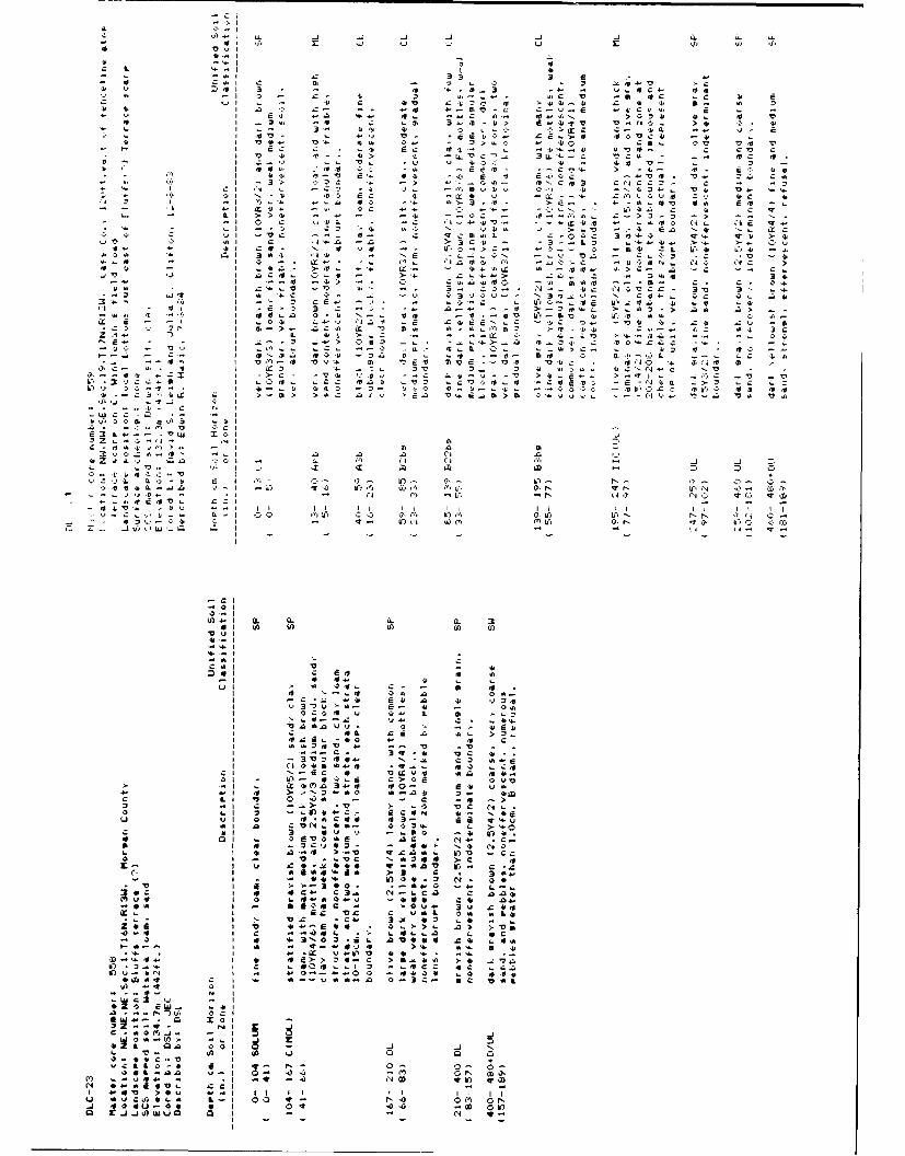
'o
3 a7 , v 3
E >
z E
3 LL a V a r
IF IV E>
I>r >X A. IV 0> E
ILL u-,
X LC>
>., - - :' .
E 0 ;, -V IE v3
ix E , z -'I z ! ! '? ! .1, cIF. Cc E
CC 3
&1 E 0, 1, -C. IL
I T. IV4.
Lr > 4> >
LL a a
LUZ
Cl<1 xi LD D C.
k4 y
r ILI Q. Lr, C. "j ILI ull -1 7- '7
. -'T - ir)
C4
jL 0. L'L 3
E 4. 0 M.;C
2.
L*4
>
3 V
a c cc o ccl C 7 ' 3 ,) . ' ! RE U-0
> Q w u a.
C., L>.30 a
a ION 4, 3 ra > u
.4
A3 C (,4 v
L AA 0 00 V L 10 '0
c : 4 >>W)
- a 0 -of c 14 L C 4
0r " %J -
r v a L L vo
3 x 40 2
L L 00 Z L 'Q 0 L .0 A.'r- - 's v -V >
IX > V b. '0
>to
OC
r
2 C W
L
ip c 'ors
cu4 V '2
N r ','a OD qr N) v OD
> 0 1 1 1 1 -1a v 4 0 0 L - 00 -e 0 P,
.41 VU) 00 o if)N lw
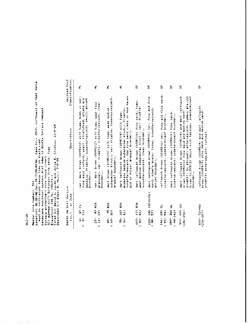
c -v0z
>- >
fl I 4L8 C r - v -
'4~~~~~o >I> D 4.. 4 V ' .3 -o~~~o itl X. :. 4 4 V0 5.
4.CA C I S' > V 43 -Z. ' 4 -
'I L Z04 - 44
* P p >3I 04. > 30 30 4' 4 4 Q.Qo5 .1
- .. I l44h' 4> )4 44. '...'44> .0 ' -4 J *4 '
44 o oI zo , --. 10 -a6 u) .Q. L u o . 45 V
L 0.1 Im-4 _j '- 5 . .. V N 40 ' 5- o 'a I 4~ 4C) 40 O~t .. 4. s
u 04 Q o.. LC. C 0Z~~
'V _ - 1 I' -r 4' w. r 5 . -4 -V.,' v0 -w N CMS IN 0 .
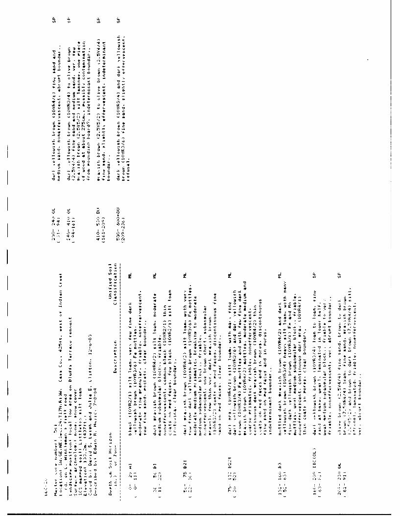
11 a. L C
OC f
Ix4. 0414 41 -t4
CCA
1t 0V z. p
a, S.2 0' c
Ca~~ C, .4 -
0.~~~L 0C04. . '.
!- -, a 4 .4 tu4
aC~ .2N.. NL
- Q-
3-t3
L- ui. 3,
IL-
>4 -- .",- v b )No. 4. IC - 4 aaZ 1 jT
-r CA0 14IN m
13 .4 a.a
Eu 41 £EwSS. 4
Z*- I. IV-41.4-- I a 4o
17-V *44 .i4.~~~~~~~C Ct , S -4.a.4
Dii -0 4.4.. C .4~ C 4'. .- . -

,A 10 L
o: 0 D 4 'b r :- i La*
0 , 1, r >
4, - .
V--' e.,4.r' 4 4 IN z*C
ZC- >~. CC
q). 6 -0* V
. 44 44s
2' > t. L V
a 0-5 " e e
CC C r N eL C
J. .- N. Co.C.-- e a- - *- s
4 ' .0 LL , -
> > w 0' 0 0 C -a- 0- 00 >o-a00
N N
'A0 0 0o c--
14 ~~~ c'. . i
> ~ - >j . 4.4a 4aCi 10 2 c z S
Co--
zIC . -t v, 0 0 IZE -p 4 4
>i aI a4E , au44 I.. > a 34.0
I, -c 4 3C m)- -
4, , I. 04- LO ~ C),4 ~ 0 E - w3( . ,1, -a, 4.4w - Ooc 0434 .
- 0 Z 3 C a -4 oo. L4L N kn- ~ 44 .0- - -4
aQ 6 - - . 4 '' - - ' L -
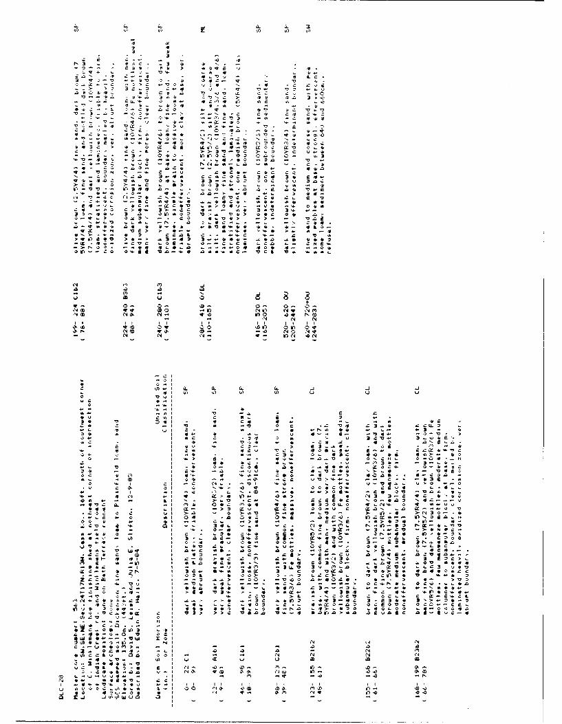
A. CL . 3
0 .30
-o ~ ~ -I ) 34. )- 4
-- ~Q 7 @ - --- ~ 4E - 4- ,-
IF.- -- zC 4
10 0 . Q .
3 V -.3 l: 0
.4.- ~4 - *j - 3 .3 4 -
'4 a 1 N4 ... N A 40 '.0 N
C.. 4 4 4L4. C)U ~ C
>> V V > U4
> 3- 10*' -o cra c: 0
-. 4. -- 4.4- - 4.L
N~ N.L 3U-C N2.0 3N4>4 0 >. 4-- N if 3,)V O
.4- 4- , (4- 04 .M cl -' If) 4''. 10 44
4 V- C A .24. ZN'-.. -4.02 4C4. :.- 4.-~~~~~L -. w. -C 4444 .4* C. 4.. 4 4
.24~ ~~~~~ A:JA C 4 3> C - -LL 4 '. -34.- 4.t 3 L Od AQO -~ Vt> .9. 04
. q.4 ) 3~' C S 4 > ~ - U 4
N...' >.4- N i z.4. -. : 23
Li4 4.3, L~a 4. t4.4. .. 4VS4-.4 44.. 4.- 0.3q4:~~~1 A: cc. IV*-4 4- '4 >- 4 -ON>~~~~~ .43 c. 2 EtC . -.. - .
OD z' - .
IL IU z 6 0 0
'0' NO N- e4 o (2a . 0 cc NO .o r 4 o '
- . - 0 N>E x >. 0 04 cOW OW
3f. a- a. a.f a. 2 -J"0
a Lo cA
- 7-" - 34r.a 3r
4.1) .2. 2 . . 2 -134. Al fl0 a 4 .2 a. - 4 "I
C~~ - A a 40 " V 0 2. : 4 4 3 . 4 : C L
0A A 121 C c xItV 4 0.00 0 c
c. - ' $ 4. 4 E 4. ' a '- .-~ >. A>. - C A m - 0. -
L -V A -I 0- .204 Li cs44 4:.4, - C3 L
24.~ ~~~~~ -A 4.4 Li '.A03 2 4'. .44 -A.4CC .3 13 A0 4a 4r-. CSaO c * -CI
04 ~ ~ ~ ~ O 4 -- . N- 'V '2- Nf N0QD i 04:-.-.
4.4 - i I. AZ- ->2 0:u M 0 u c 4:i N . >",

I - . 51 Z
U. -3? 5 W -
>5
43- 5'4 C
-IV
-c
Z~h~Cs Ct-
> cc:.
Z.3 4 N4D ,4
('4Y L'- W T- !oAE c
>- 5. C. 4 4
>' i >.bwOC
.. 4v wo w IC
o 4EC.-.
N N
) I IxImi
A2 A
I-'

lb P ) ~ ) (I, Vc,
71 c*1
If.. I
-4. x X' x. v-3> - - -- - 4
If 4'64
> > -0- v 0 4z.O 12-2. u 40'. c-0 r.
10 LLVI Nr "r 1"
'.40'-'~~~ > q. ' > ~ ) - . -
* - 4- z a nc r. ; 4i ! 't L
a v,-4 a,
c 5 - 0 i I 0 0c 44i.
-3 f 21' Z 341 3 3c t 3.'2 3i .
-f -I 4'. N 3'. -On -N -V ->) -o 54 . 0* c
#0 N I* hl qVV rtI N~0. * C C2I ~ 2 00-Ii La- u' -' - - .- ,0. o c y 4 4 ... 30
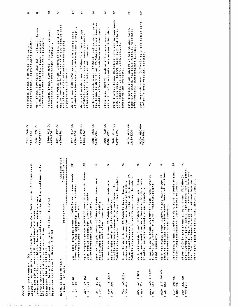
-J a. C. (A. CL C. a-Ca- a
z '0 '
- .3 V c- v - a
3 ~ ~~ ~~ -4
-. d. 0
- eV- -C~ 4.10 44 0
4.444 7. 5>4- 4443 05 . '
*~ ~ L>' E r .d -> '
0CC ~ ~ ~ I L3. 4 ) .>. -do QV ->R > O.4' 4-ca
Si.' 4..' C .>i" 3d I.>- ' IL a: L
4.4 6c40 -0 C4 . '4 0 a* - * -- 's;4
5 35 - N1S N. C MV4 -L.O4 C, 0, Cm 4- 4 I I '4 - 4 . 4V 1 4 I - C
- VS.. V) V- 0 O-N N .'. N N.- N a5 -N Ns -l N- dOD M4b 4.4 q
0.. 3 .. -CC t- VC - > > Ca.Ns CSS .~-.~. 44-C -. in -. in-W
-~ ~~ 3~l 41 't. 3 fjV. a Us 3E 4
c) >'V 44 S -- 44 14 4 Z 4 C C 4 '4
0> 3- > >4 . 3 V C. 54 >--. 3-U >
0'Q L-. LL 3V4 C 3.ac s .
-- ~ ~~~~ AC -, aVV a"404 .. .3 t - L
-J 4 :4 4 'z C C 0 Al
p~q P)4' 44 #0 inC0 - 0 ' 1 O D- O 4
L)' 7t N0 V4 00 v0 xm z,3 -00 --(I.- 0). I'.- *c 4' .I -L -O C-N >. - 0 0
ga01
A0 &- a. 0. -J -4 -4 Nj 0
C0 CI L I Ca Cn N f
* 4 N'4. CD N m '
.4'- IV 00 4-V o r
-A * C.I V u IN (n s Nj. m--r tJ 4a-k d -11 C) 0l -l w. N'

'4. 13
B.. S
SN 4
0 A4S -? 4 U1
U4) C a 0 . . C
- aC E -bOb aI L4.- Z
U L'-" 4 Lv
0- a
V 4 a a 2i0 w.C a4N 2 v QL J.
N a*. U C. - -
N~ OaD - 4- ;' C. .4(J0 ' -- .o -In if)mga.I
NN C4 106 0CD ft) .
r4 0 a) E C ' N S O Q
-4Mb~.6 C-. >L> aa''a"-. v- '0 Z fo . t
-- '444 0 0MU ' 4
>3 C 3 Cc 03 44 - 4c
-2 0 4-.. C- 44- -40040
>~ L- .0:a -- -0i 2-A
IN N0 2N
>- -a c * q
04L' N 4)- 014>>1
-010 0 '
'-4
Q d1 N
.')) 4i C. t a4I~~ I ;4 '2 1 - -
41~~r 0 N1 C0- 24 4 aMI ~i * - 4 04. ~ 44 - s. U 4 '0
10 a 0.. - 4 0 ' t. '. t..4
Up C, 4 Jg 4 4 4 U. 0 04. - 4.4.~~ ~ 4 iI -W. o " 'U d ' - 4- S C
O I 0 - i 4. 44 IN0 4 -C-

0- 0-
44
a !' C,- .4 41 C4 ~ '. C a 20
* V SE .1 *.. tr i I)il )
I) N IV
-0 14 ' 0 4 4 4' 1 > PC 4
N A2 -- 3- -- 'a 4 'r, CL.c 4 .
t* 13 4'N 34 L. 0 4'* a Uc*~~~~~~1. 1 . a. * -0-E s- 44 d - 4C
~~~6r >'-0 ' > U ' 0 N c ~ 6 0 4 4 V q * j ~ . L CO~~~ ~ C L IV SM .. -. t' -1i -' . -
CL C N .. I 4 a.>---i-a ye S NI
4'I ' .b I'>-k '0 C.
- 4 . 1 4 6 c * O . 4 .
* 14 -61o~ -.- 4N3 -cc -e.. 0 N
5y 5o -* Ii .0'. 4Uo z c Int*- N0 In4N CQ CA V Z C) t J) >b0- >L A-c 0, IV ol--3 I* C1 .-. -4
I Aj -4 I-' -1 -v LO A. P4- - v4S S t.* NmO > -,3 N
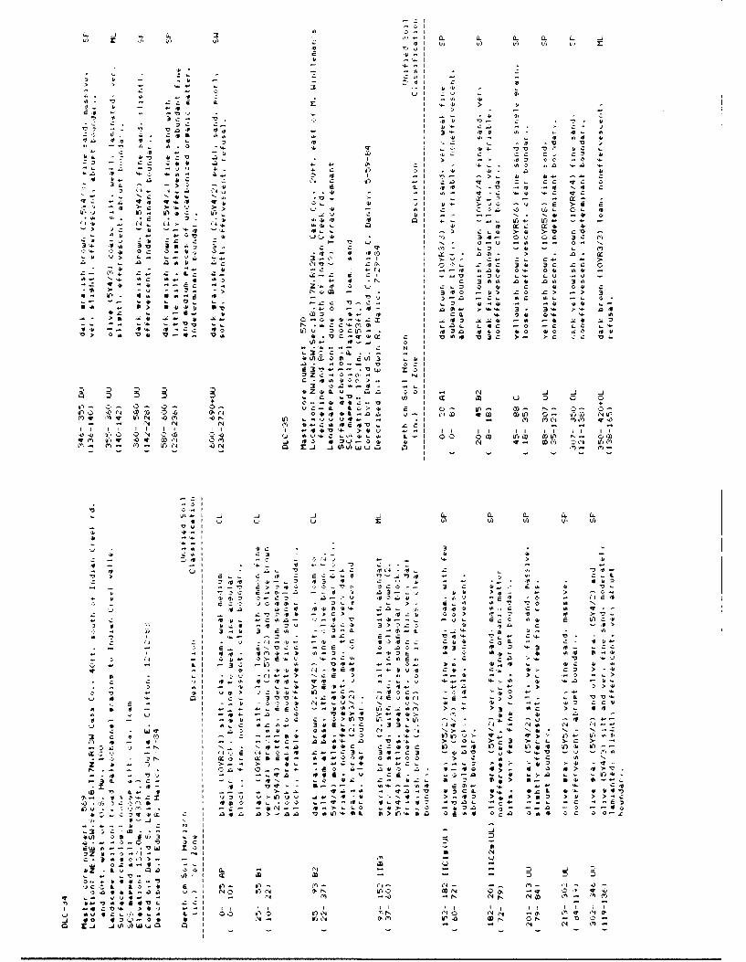
a. CL ti L k. _4- 2 .- I . a 0
30 IIV,1
;74 '4 illCr' .
E~' I 1 -
-~ 0 0 4 4- 0 4- I- '-'ICI '3 4 - i 1n v 44- ' 4. , .3 4'.3,4 0V 2Cr 3'c
CC IM. C2, L4
Z) q 07. CC 4'
- 3 . 4 ' -2 -o w L Q
'2- .~- t 4* 3 j 3 41 3,- '4 '4 -4> >1 3
0 >~. >4- > U 4 - C--z - CL- 0'
Z io C, Q 0-04 0 N
a I43 v~ b 043 0 OD i > l
N'D CO~ Z'0 343 EC C
- 43 ". 4. 1( 4-C4 04D 04 4-3 IN
43" 'o -1 01.- C) C. 3 3-, ~ ~ ~ ~ ~ ~ ~ I 2-N E- -I 3 0 3> C > -
- 4. 4a. C 4 -. 2
*j 2- -C ~ -c -01'-C N- J2 -j( ) L
-~~~C .3-. I - 34 43 44 L.'
U11 t- at' ., 3,.. E3 IIf 3' 0 11 4
3 g3
4310Eo 43>4) 0 41
I- -. 2 1 0121 -IN.- N I
C.C>-
Cm 0 1 - N lb1Z- CC-U. v
+ O .. 414 43 . I0+3,1 ~ ~ ~ ~ ~ ~ r 0,0LC0 .>3 4 I 0 3l 0- I-- 2
IC 12( w' 0 0 G'N44 4t'l - 'D W h) 0" Ilj h

.5 --
SI v a. >. In rv
'VI
Z* I
-I ~ s 3 . ,.
L 3.. C .4 1
I 4 4. L o4A,.r4 4>16A
0 3. D4 >
Vrl Gil '. V ,. .1.
_j>
C LI LCI~r .4 44.' qEl,)- ~-
.3,3~01 .- 24 110 r% "'0 '.
a~~c I 2 .,344 f
-~~~~~~~~ I 10:44.- f4, .4 .. 4 43
e3u, c4I -M
NC~~~~ I> - o0, > ,'' > 4:-41 I z. >-.. ~ .4 's a. ~I-..-. I) aa C N4 4 WC14 ,44 ' C
C 0 U -, Iti.' of3. C cr 4 ,A 3. .4.. Nr cI&o 4
,24 N NiI o o.n4
L 0. A I ( f
0.. 5C .VI _j
C L G' .0I 0 IN N N
.. 0 >,1 ''4 I I I v I INII I
Il L
-Clu - C
4.41 3.44' Q*r4.jV'0I

uI4- -j _j Qs. -J Ci.
'0-I
o.. ICal
Ole C62ea - L
t) .Al L' Sl L z.
I ~ 4 U,5 .. L C
t I. --- I>,- V ~ W g- w)s>
nI >S *5 .0OC 3
V.. Ca J 0 Z C
LI !- 0 .-35 l L 0 a 0, 10LZO a C a0 4c c-
U>, -r. 4-C c
LI aJC4 c. *
4> C 'a +I C fj !- &4- 0 sI L !, U4 0- N. C L
Vs I 3 CD C 1 #-0
u4 I 4h0 0 Ca LM OD -"Na O 0J4n~ _u InC w C n
,a C a . a04 a.I 0 4- > ) a.- -
-~ ~~~ a I 0aCO O L LI~ *- >' ~ >~ a
54--0 3 "C Z
c c C C - at r *
0 (10v
Ln 41 .0 I N)sI 0
.14 N. NW>> C>
IC U-00 0 I a 'O400 N 0 r0. I -v N C) C'
I610 -140 Qw a
L-Iaf4I . 3's 10 3 .Oc 0 aA.U
01 KuU)) I ) 0
*II o L -
Ul~C a.00,
1 - #U,: " U)00
m0 64 a6 - nV L. InO V 5 OD - 0 59Z ';: an ! 1 07
14 091 4 - 64 - - *N
A u I f 0 q NL a) Vl4 4 -U)I a NoJ -O V C4.0 44 Mrl M0 0 :
3* owo C. (-

.10
Z1 - 1 S
- >. -,C
.0 4.C!a .a0
v.i 4 4
,. a- a..- (
u~ Ch -4 r
Q 0 q 4. 4, )-
-u 4 - .t
011 L00 4.
>C3 >100 agi.>
-'4- -3
LL LO4.
o1 a o 4 4w a.
0- 0--A .
r.- - m 4-"A'0 W 4 a 0O
>b I* ILc r03> .3z- A:o0
A4- i. L If) -L C. 0. 4
31* (13a in' -4. N4
-I LI L . X. 4 4 -! ON- IrUt V. -. 'CS > . . a C4
I 0 &. !. 45 :4 4 a. >* : - C - o a
I 0 ,l. .-- 4 -c c ,a 4:.4 0- 4-s 3-4Io ..- 04b 1-.C (o A-s- 4a4. 0. .0 s
I C: L, aL CD od t - - - C -L -
I C- U .v -N-V b - n ', *C T- 4 M. - 0
0 1 t 44 - - C- U W 4 L . s)a .V ir)N ( e. N ~0V-'I- .. 44. - dC00 .. C O ~ .
'a 010, '* 4.-C C.- *C* --M. I;- ca -- cc N' 0'.. 1, 6 al . oC, LI w) N0Z .,C N-- (D3u MC> (4 ..
C 4 ~.. 0-..- Njpg 4. 4.jl~ N.4.L 4.-4. ,rt
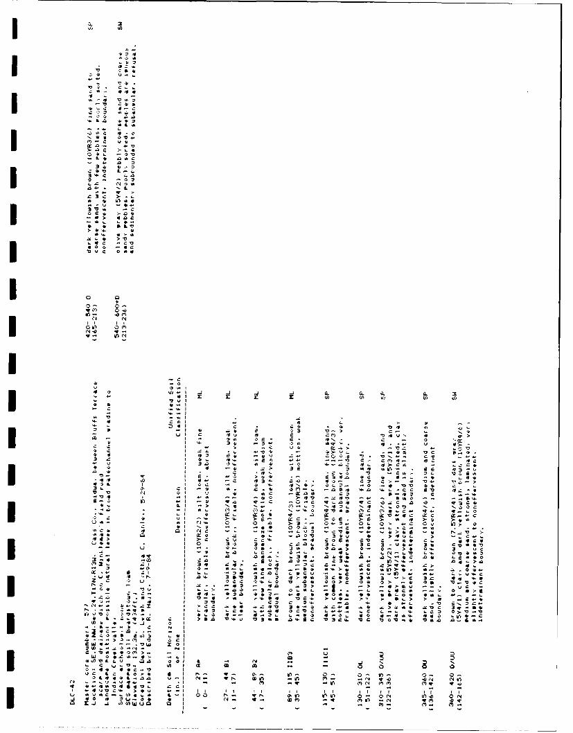
IL
- -b
L A,L. r
0' 'A'
aV wQ a 4.
414V~C -
%f4 Q'3C'
z4 L ICA.t aac
a n
c 4. L-L 3 V& .4
>c~ >
C4~ LL4.4. *1cc 0 c 34 0
4 AZ 4h
I
* a q. c I4
In.
_ I V L* .. L 0r 4 , v Q1' - 4 V i
* 0 1?I 4. a3
VI >2 OQ tV V '. 0 --.- 1 10. LO. cU 'V C0 NO44) 1 1 : :4 OD'- mt:
a j ) )W

-CIE
3 LL. 0 0 >
0 0 04.. a-. aC .V.~3
I -CM 014-4. Cc. (, >4 .-. OA' t 'c7,~~~ IZ E4 . 4,07 u- -1 v~ -I .. LMD 3)
-7, 4-0bN -M- ~ 47, ~ ) o - 3-- 4.',3
'I 1,4. . 4.t4 A -- 'A LA * V - -- ~ 0-. > ~ 44 14 -u -.- -!s'....
Cc L 3-- 4. c~l-47U ('4 30. ~ > .L - -
U~ -~1 3 M-- M. In I > 4 Z.-. O 4-.. 0.-4- 7
*c 0 4. M N. J, V0 aOrMmM..a
wa bL a. m -3, NM 3 0 -- > a- ZQ 7 a A-.4.L >-- w>>N00Q
4. 0 I' > . I - O - ,. a.. L S 140 o
v if I aM 0 -.. u II-o.* >0a ?- +u-'C I L I - 04(11a3 :C 0r0 3> ;lt M7, 07M M-
26 U VI L 00+c ~ - o.t.f M N 0, a,~ MO ~gn a .0N 31 -4-4.0L2. -4 -1 W) 0l -)a >-p C0..
r _,-I0j4 0-. aN 0,. M a- 0 7a c A >

-:13
L 3'-L
41 0
-44. Z .1 -41C4.I c U- .. 4 C
*l ot 41 -* w.
-- -.I 0 C 41 41 4~4
41I v1 C2 --c
I -. . a~ 41 1 z 1 . 40t4:01~~~~ I i . o f 1
* 41 u I1' z4-B I4 .I f -3ca 0 nl I 4o 3> -. 4
0: I '4* I- CA b' -.4s1 -A 2 . N
o ~ ~ ~ k Wi7) Qi 0 * 4 4-~I DI o -- u)-41 01 N 4
- M, - -is z1 X41 *> U.OD lo' eI r ia10 0 VO c4 >.0.-LW( (r 04 - 4.1 L Iv-4 -Q o >0
I a ZD Cj & - w-.' LSf > o
3 0 C If r.f'4O
C 410 a *a c +~ ~C 0% 04 I n C4 ~ 0-u 14' l
o-1 V l I l r r OIf3 0 -.0 I Y N4. N-0 0 .
4.. C -- 0l4ll4. ') U . ~ .. MN_ * 0 .0 0 * a- S 31 3
N*O -i _j >C. _j>W > -. -
I- ~ ~ ~ ~ ~ ~ ~ v 3v. -D.I - 1 '~-4 O 1--- '- 1. - I 11040 5- 40 .0
.3O O L41o>Dc
C~~~~~~ 41 -3~q~ C I NC'. A3 4Cn B n > A V
3 :3 , -Z c..-o-
03~~A' c.S 4y3 .0
if). >- -V 4 01a - . * f i . -. I1 Sl12z4 l
* O---4 - ,0"I :fl1I +
1)0 .71 c0V 4 - a1 a - N- 4,W
c4 3 Oa00ac4E0V .. C>
S0 00 > o vI 3i iiiiii
-0 4 0 0 U-O * N ~ - N O >>A 0 IX4 u4 10) U 0* - N ,a>*
I - q z-
N. :- avC rV> 3-
CV I
41 1. 11 4-
V) LC -0 31C *
LI e4
3 to 0N C 0 ~ * N C
0 I 1~ -V CD ko 0--. 3 1 '
J) I Im 0 4 b r In A C wa . - 3 0 CD 4VO In :!
02 14 - m C C i3a 4 OC
L ~ ~~~~~ N' l . m -0 4. 3 -, N . L 1 .

Ih0 4 4J 3
a '
XV a
4 U) 4~
-- ~ ~ L. b 2
IW r. -v 0. -
(Wx a -ab.>I C a0 >, .04L'0
XI .0 L' 2-a
2~ LI V . .
CD 1 a .' > >I al*x I - XC aC
- I0 4 > 3 ab >* c@3 A" L 4'4 C- 4*
4 uu f#4. 34. 0 L C
LE V N .4
NC Io .. *2u ;- 0 ;54-40 I 0 Et -IQ A*.NCCp.-- VI ;. a Vc '--a- I *a *- *
I -0 -A t -N
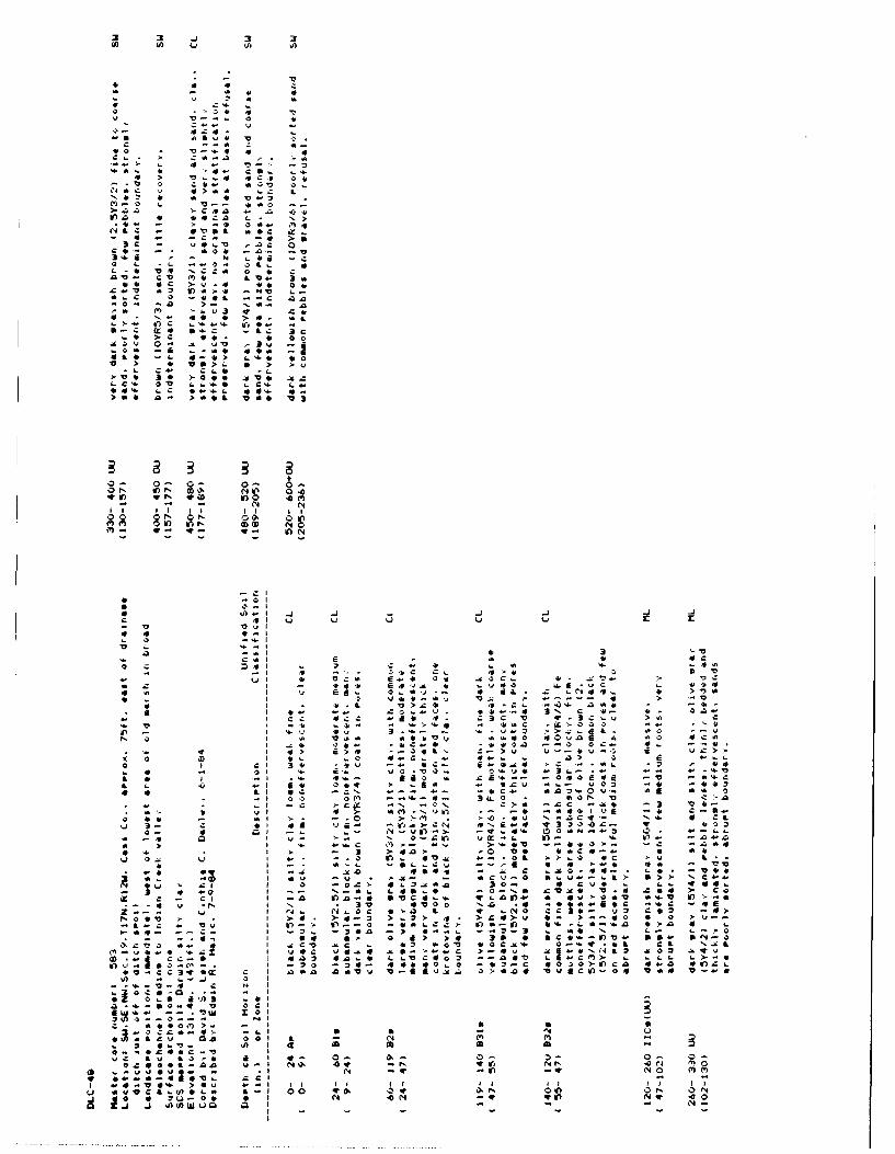
C 4 > A a r L
c 4.4L
3
3 G0 L o, o rt c
6 V '00 r a a 0a V-
> * *'a L12 0 L Q 'aa> - a- Aw .3 w c *> L
32 t V'O
a L a - : >0> v ce > L a >
10 lb 3 1- 0 0 V 60 L C -L .0 0
> 6 a > a 0 IL v a
0 O;z 0 0 00 In OD N 0
QD In 0 a mN
N
0 r- CD OD N 0In (14
cc
V),r 10V
4,
41
C. zu C r -V 041
4L 0> z -V a
4 3a 3 c 3 c
3 u L
10 or 03 0 -.- b v 0 a 6.9
-13 0 Val 0 e
z v
Cc oc x C c -b 41Am a I T
)I..
41>
10 of c a 0, x Q - 4 ! : - : v 00IR W - a > ). , c Z -
q r L . . . L3
a 44 C* 'ovo o o 0 C c
3tl
OL v c': , . > 0 3
0 , 'a I! > > 4 a cr
70 4 r, I - t " > L L La 0 0 Al 0 c .1 0 0 > in c Z L
0'a 3 w ox c -a *,a a a V V 10 -6 4 z 0 >. a A 0 4 4 40
o 0 r. 'A. 3* 10,Q 0,2 vu x a
a- 10 L ull0 L
0 - 1 0 0 C 13L 91 10
0 0 L 2 or, NN in -W N 0
(wo v : 4 - " I1 0 v - - I I f I I , I I I Ic a 'A 0 L a 00 (p, " -W J 01) 0 1 0 1-1.1 Q 0 o N

-0.0
- I a 4 .7 -l -
b4-I
3. 3
-4. 4''
ul. 4' 1)
v V V S
E -4()..ID
b V, L C. k
I cE T2 3" 4 ,C rI a.~.-e,.VV 4.41 40
I- 7CIr r, (I C
0 I a. LL 4'
a I - ;,04 -> v' L)
-r 4 .4w-4 -0 -D >4 Nv * 0
4 ~ ~~~~ 39 - - > >4 4 f.
'-'4C I .. N1 4'
- 33 -- 'V
' Ic c. 'a- .~ Cc .
3 a -- C-b * *;w
I 3b'5-~ .- 0
I C LI& 4' 4'- - 1 - --, 4 4I *' Z** t' .3 vI4 a-)ba '-4'' e4 in5)
-> 4'') LV 7 1 7
4 0
=~- ,fJ

- t r r r r rr
- -, I --3 flv 4, 424
-- I 4f - 4.- N , 3 > ..4~~I I E a>E - - - ~ -
3 ~ ~ ~ ~ ~ ~ 1 a D 3. 4 4 '
4.-. C I 4 ~ 3.. > 1 0 v-- .,U '.. -
I~~~~I ..- N >4 3 'C Q >bU .
a LU Q .-0 e 4-*. .-
4. .CC - a.4 O 4
I L. r4 It. - C.4 C4D ~ (4. 22, --v . 4,4 -* 4.4, C -f -3 -.-- -& -'o 3 .. q-g
-II 4 LI 3 -> ~ V'4..44 42s44 DC 1£4 0.
4, ~ ~ ~ ~ ~ ~ ~ ~ ~ ~ 7 - I U g.tI. '' .4.- C i LL'- LI .0 j. 344. 1~C $ 45 0 3 442 .O &J L IC4
.4 4L C4 I C, - -. L CL. Q7 4 d 3 w 4 . l f . 4
10 4, 0E- - - 43
I -. 4 34.-
I* Nb 4.4' , I . * S
I2 I o l 4 .142 t 4 V4. V .. 3
2 - "' I !. - D 4.
I V4 OD. 31 .0- 'M 1- ~ 0i - 1.3.. 0.~~~ ~~~~~ 0 Ls 04.I - V 4 a S , 4 ' -- .I-1.4 454
-I'M.-~ ~~~ 4 2DC",'. - 4
oa av)
L4, 0
c ;J-E - 'V! o logxL.14 0
-w ! I'.
L-3 Z
- L v 0 - I4 0 4a0v Cot 'Do - -' 4 I-,--
- Lv 1 < L I
4I tr. It4..2 E 0 M '4 > , I ~ N .- .~ 7 -n
4144 A .1-0 # - 10N i c
C C - -.. 0.-L0 .. I ~ 'o . - I ' C
1rIr)N-DI (
on - a. 11Q4C. C. L a*0 a EI N IC ) o J, NO 'A0
a -in5- Cal C 4

_a j -j j L -i CL.
LA 12t A i I0~- I
ca> L 3 40
A=i a.-.
Q2 * c, 1. -a
I~~C 34- a-40V. c>
410 401 0t
I ~ ~ 1 4a 0 '.
C C I- - L N.
Cl ~ ~ - C- C 4-
0 ~ V JI Cj CL - N a 3
3~~~4 LI0 * 0- 4.
ma If LL L -0 .L 4V
Z - C-c -
I ~ ~ ~ 1 u, -. -C V- . 1
3 3I 3
C;5 I0 w Al '
a~ Ic 1> >-t -i a33
1004.S..
oL >
53- a Li Z~
61 * , . I - IJin -J 0 In-,V
3' 0D -- (IDflr, I La Ai fl fl a C4
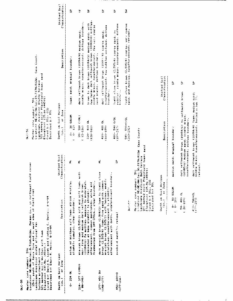
a 4i C. It>
El -I (L CL U
z V14II
cal
241c,41 4
0UI 41 -a a
:4I.L". o
V 4CVCC>~ >43 4
'. V T
>- V163C .) -T af
-2 0~ Q4t 3..' 4 4 .
at~~- .> 4 0a 01 ) -L -.. n -- 4
3; a2 c- - 01 Ql'Nt~4 Z ' .n
0
E
Ij 41 Z114 k) -. a --
o! z lo. Z L- Q1 0. -
E q 0 II
LO -. I-- I 0 4
~~Lt. a., 430 01, 0
0' C' 01 L -Y~ V.
a.41U10 >it Ui go AL Cc i I i i C >-
u w-0 0 I. 4- c~i01 a
Ck Id V)
3a a 1. 4-u 10. I. 0V4 a
a' I c14 I V, 3 rO
V') VLl wL I a M

> ?
I X- Sb I 'A ' A
'4.-.0 L
X 3> -, - '
-qI c3- C4 . C-'
.4 4C Et-l -v'. -:- 50 CZ . -- - .C - . 4£ .7
-C '-. ti .v..m
a -a2- .. C.O VC 41, 4 44 a- -. C- 2)-
4 - .4- ac 11I* ,'j.I
0j I ~ Q. W,-0 C C In C 4U0
al - CA 6 4 'AX2- CL 34 .
C> 'A
C4 >' 4 u
Ir c. 0 r 3. C -I C.C
>ChUI V-.4. 4a 3- 0 - 0'.ac
r l. 2.> '' a a L
L C 3 a.44 1 O 4
IN e bq 0
N C N l
-E (-'d 4 1
-4v) 04 01 C 01. aC 4 '41 5 FA ' , 1 0 0 C
a .bI . I: j Ju-s nC

0 -) V) V
ai ~ ~ ~ ~ 4 3f , ta) A A ~Vt, I
4~-IV
Cal Cc
ci a a >4 >
Lii~~~ 4. 4 i S 4 C 0N
CL4. .4-, i
. 01a :.. a C Oj - -
vi:'c > 4 4 4_3C (CV. :
004 k>-.4 3
I 1a .02- C. -I 422.
a ..... >P 24. L,4
o' .1 4' It.4 T..64.
41 2- C4 - 4
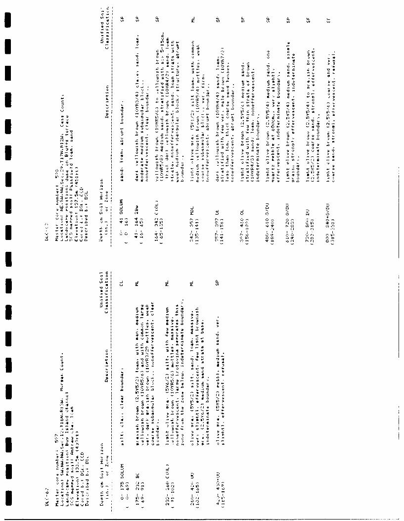
Ih. ILC- LLII I
Z,4 IL
E E
C4Z Ut
ajI - 1 I-sEv-1
aD0> z 1 . .z 44 q>>- l. qt.-Lu ~1a "l -j : . 'U0 .
-0,
zI -zi-'bl 4'O tu' ma
Ig Q r2,> 4 , 1' >, C >. 4 >- > C
CN-1
II-CCa
~0t
3-a
vyv3-
II

(1. L CL. ItSI L) U (A tf
'4-. I
'4 :a -* a C1
n lC41 S,
I s L 40C >-
1 I Z C C N-i4Cj41
6* - I '41 at .c e..n5,I 3 Ci 40- Q> l-I C*5 > > L U 4
2 C I iss- .. 4- -4 c-- 54. '-4o. N C4 C V
C.) I 1 0b4. 3 3 -O > ~ -4
- v I .4 .- a Ix Sc 0- 5-.. -
O q I .- F .5 -C ... .. L4
-~9 .5 OI .. SS s aN.C 03~~~ -I I 10CC C O SC 0I
o 7; 4 l .5.. 0 0* .c -3 f
r OM >. aC ~ --- a. S4
-l L, LI L CC-j O SS - A
-0 +- 0 CjC S C44
*1 '. 9. Is.- 4 L-. 2 -a4'rl4L 0 W1 4- N -l r4. NO
4 03U 0 I in'-0 co.N . - 0 .m:CC ) 4' uO kN C )
Related Documents