JOINING FORCES Metropolitan governance & competitiveness of European cities “Governance “Governance “Governance “Governance in Strategic and Spatial Planning in Strategic and Spatial Planning in Strategic and Spatial Planning in Strategic and Spatial Planning at City Region Level” at City Region Level” at City Region Level” at City Region Level” EINDHOVEN EINDHOVEN EINDHOVEN EINDHOVEN - Seminar Working Document Seminar Working Document Seminar Working Document Seminar Working Document 29, 30 & 31 October 2008

Welcome message from author
This document is posted to help you gain knowledge. Please leave a comment to let me know what you think about it! Share it to your friends and learn new things together.
Transcript
JOINING FORCES Metropolitan governance & competitiveness of European cities
“Governance“Governance“Governance“Governance in Strategic and Spatial Planning in Strategic and Spatial Planning in Strategic and Spatial Planning in Strategic and Spatial Planning at City Region Level”at City Region Level”at City Region Level”at City Region Level” EINDHOVEN EINDHOVEN EINDHOVEN EINDHOVEN ---- Seminar Working Document Seminar Working Document Seminar Working Document Seminar Working Document 29, 30 & 31 October 2008

Joining Forces - Eindhoven – Seminar Working Document 2
Joining Forces - Eindhoven – Seminar Working Document 3
CCCCONTENTSONTENTSONTENTSONTENTS
PARPARPARPARTTTT 1111 5
1. Introductory Note to the theme 7 2. Contributions from partners 11 2.1. Brno 13 2.2. Brussels-Capital Region 17 2.3. Burgas 23 2.4. Eindhoven 25 2.5. Florence 29 2.6. Krakow 31 2.7. Lille Metropole 35 2.8. Seville 41 3. Synthesis 45 4. Appendix 49 4.1. Working session 49 4.2. Sub-national public administration in countries of Partners in the project Joining Forces - System, basic terms, and data (2008) 49
PARTPARTPARTPART 2222 51
1. Programme 53 Programme 53 Evaluation of the seminar 54 2. Visits 55 3. Meeting with the Local Support Group 57 4. Documents 59 4.1. Speech burgemeester Van Gijzel t.g.v. studieconferentie voor Urbact II 59 4.2. Summary of Eindhoven Presentations 60 4.3. Map: Ruimtelijk Programma Brainport region Eindhoven 64

Joining Forces - Eindhoven – Seminar Working Document 4
Joining Forces - Eindhoven – Seminar Working Document 5
““““Governance in Strategic and Spatial Planning Governance in Strategic and Spatial Planning Governance in Strategic and Spatial Planning Governance in Strategic and Spatial Planning at Ciat Ciat Ciat City Region Level”ty Region Level”ty Region Level”ty Region Level”
EINDHOVEN EINDHOVEN EINDHOVEN EINDHOVEN –––– seminar Working Document seminar Working Document seminar Working Document seminar Working Document 29, 30 & 31 October 2008
PARTPARTPARTPART 1111

Joining Forces - Eindhoven – Seminar Working Document 6
Joining Forces - Eindhoven – Seminar Working Document 7
1.1.1.1. IIIINTRODUCTORY NOTE TO NTRODUCTORY NOTE TO NTRODUCTORY NOTE TO NTRODUCTORY NOTE TO THE THEME THE THEME THE THEME THE THEME ’G’G’G’GOVERNANCE IN OVERNANCE IN OVERNANCE IN OVERNANCE IN SSSSTRATEGIC AND TRATEGIC AND TRATEGIC AND TRATEGIC AND SSSSPATIAL PATIAL PATIAL PATIAL PPPPLANNING LANNING LANNING LANNING AT AT AT AT CCCCITYITYITYITY----REGION REGION REGION REGION SSSSCALECALECALECALE’’’’ The objective of the seminar in Eindhoven was to scrutinize the roles and instruments of governance in the strategic and spatial planning at city-region scale. We intended to work on the development, implementation, and evaluation of strategic and spatial planning documents. We are especially interested in that forms of governance which support implementation of strategic goals by planning at city region scale. In order to highlight the linkage between basic issues of our working group and strategic spatial planning, we should start with some introductory statements in brief. The story of cityThe story of cityThe story of cityThe story of city----regionsregionsregionsregions Urban areas are engine of development and progress all over Europe. The ongoing metropolitan regional processes might require resources and organizational support to consolidate their autonomy and possibly set them apart from other territorial units of states. From the one side competitiveness, from the other, cohesion are very much based on activities taking place in the frame of cities and their outskirts. City-region is a scale for cooperation among different public and private stakeholders on market, projects or quite a lot of any other basis. Nevertheless, this intention is restricted by quite a lot of counter-interested counterparts in the political arena at every level of governments in national states and the European Union. What is the basis of arisen contrasts? In general, a city-region unit is not nowadays a direct framework of working institutions for formal government. Although there are exceptions to the rule, regularly local or regional governments are not formulated in these areas. The former metropolitan rhetoric and all the linked institutional reforms of the 1970s had been dropped for decades. Elected political institutions and their administrative offices in this framework seemed to be too strong compared with the traditional structures, national governments were therefore reluctant to accept metropolitan units as partners, instead of facing them as competitors. That is why the failure of that movement was well-known. After that period, regionalization became more popular in many of European countries. The progress was not independent from the rise of regions in the financial system of the European Union. Naturally, cities and their surrounding areas still play a crucial role in the development of their wider territory, however, the regional scale may be too wide, or from other aspects too tight to frame all of the important connections in space. Since about 2000, some of the European countries have appeared to look again for different solutions for their major cities. Methods of governance in cityMethods of governance in cityMethods of governance in cityMethods of governance in city----regionsregionsregionsregions The term ‘city-region’ has already appeared to cover a lot of multilateral linkages between cities and their wider surrounding area notwithstanding their institutional or any other character. Methods of governance are preferred to traditional institutions of government. In fact governance is focused more than forms of administration itself. It means, first of all, strong incentives for business relations between different stakeholders interested in. Secondly, a lot of soft methods are implemented by local governments and any other public organizations and agencies in order to fulfil local tasks or provide any public services.
Joining Forces - Eindhoven – Seminar Working Document 8
Thirdly, governments as such involve alternative techniques to mobilize resources and activities outside from the public sector. ‘Joining forces’ characterizes these newly defined, however traditionally existing activities taking place at city-region scale between public and private stakeholders, formal and non-institutionalized activities, interaction between administration and providers of public services in field of quasi markets. In addition, linking this complex process as a whole, this project focuses on innovative character of public administration and agencies as forms of governance, instead of more formal and institutionalized phenomena of government. In some European countries, different acts and other types of motivation from the national level make incentives and establish frameworks for local governments to operate more focused mechanisms on deepening their linkage to the market and local society more intensively. Example of Greece, UK (England), the Netherlands, Italy, Spain show a direction to find different types of accepted city-region for big cities. However, it is really an ongoing process, about which the knowledge of professional audience is rather limited. The whole process is not straightforward enough, because new models are under preparation and discussion in many countries. That is why we need to exchange experiences, spread good examples, disseminate relevant information and experience in order to support practitioners in the evaluation of different strategies for the future urban development in Europe. We should know that it is impossible to simply copy solutions, but good ideas must be relevant everywhere if specific local circumstances and tradition are respected in the process of policy formulation for the near future. Our general statement is twofold:Our general statement is twofold:Our general statement is twofold:Our general statement is twofold: i)i)i)i) citycitycitycity----region may be a scale forregion may be a scale forregion may be a scale forregion may be a scale for further territorial development in the European Union further territorial development in the European Union further territorial development in the European Union further territorial development in the European Union
concerning particular functions provided by the public sector;concerning particular functions provided by the public sector;concerning particular functions provided by the public sector;concerning particular functions provided by the public sector; ii)ii)ii)ii) an essential innovative relationship can be improved at cityan essential innovative relationship can be improved at cityan essential innovative relationship can be improved at cityan essential innovative relationship can be improved at city----region level in a way region level in a way region level in a way region level in a way
which is not necessarily based on institutional structuwhich is not necessarily based on institutional structuwhich is not necessarily based on institutional structuwhich is not necessarily based on institutional structures, instead of it methods and res, instead of it methods and res, instead of it methods and res, instead of it methods and forms of governance are focused in the contemporary practice of public forms of governance are focused in the contemporary practice of public forms of governance are focused in the contemporary practice of public forms of governance are focused in the contemporary practice of public management.management.management.management.
Lessons to be learned are how to adopt other partners’ motivation to local actions in particular circumstances. In addition, scrutinizing existing practice, which mistakes and mismatches could be avoided, if one intends to maximize advantages of co-operative forms at city-region scale. We would like to test, whether city-regions are established mainly for enhancing competitiveness, or this framework also emerges potentially with the aim of sustainability and cohesion. Governance in strategic and spatial planningGovernance in strategic and spatial planningGovernance in strategic and spatial planningGovernance in strategic and spatial planning Forms of governance appear to concern the provision of different functions in the public sector. Our working group does not have a chance to scrutinize any of the city-regional tasks in-depth. We should present only functional cases in order to specify key methods of typically non-institutionalized practice of bureaus and stakeholders to cooperate with each other in order to enhance their efforts. Strategic and spatial planning is one of the functions, which may be area for governing activities at city-regional scale. Our starting hypothesis is that strategy formulation is reactive enough to cross any of the existing borders either in geographical and economic senses. We should focus especially on the following groups of issues.

Joining Forces - Eindhoven – Seminar Working Document 9
1. Frames of strategic and spatial planning
1.1. Strategic plans may be social, economic, financial, spatial, physical plans, policy proposals etc. In particular cases in what extent are strategic plans spatial?
1.2. What is the relevant territory of spatial planning? How is it (or not) adjusted to the territory of general municipal competencies?
1.3. What is the scale of spatial planning? 1.4. Who gives commission for preparing the plans, and/or which authority is competent
in planning? 1.5. What kinds of instruments are used in preparation of strategic plans?
2. Process of strategic and spatial planning
2.1. What is the process of decision-making? How do regulatory functions operate between the different local authorities?
2.2. How are private stakeholders involved in the process of preparation and decision-making?
2.3. Which instruments are used for making strategy? 2.4. How are resources of strategy planned? 2.5. In what extent is strategic planning more than simple designing? What is the process
of implementation? What are the monitoring links with public policies? 3. Options for the future development
3.1. Is there any idea, conception to develop the method, system, or framework of strategic and spatial planning at the particular city-region level?
3.2. In what ways will implementation be improved in the future? Strategic and spatial planning is supposed to be a field of governance at the city-region scale. Social networks can be involved in the preparation and also in the implementation phase. Information technology must be channelled in the whole process from many different aspects. Any forms of civil participation are also very interesting. Linkages to the private sector in order to get additional sources should be found out.

Joining Forces - Eindhoven – Seminar Working Document 10
Joining Forces - Eindhoven – Seminar Working Document 11
2.2.2.2. CCCCONTRIBUTIONSONTRIBUTIONSONTRIBUTIONSONTRIBUTIONS FROM FROM FROM FROM PPPPARTNERSARTNERSARTNERSARTNERS 2.1. Brno 2.2. Brussels-Capital Region 2.3. Burgas 2.4. Eindhoven 2.5. Florence 2.6. Krakow 2.7. Lille Metropole 2.8. Seville

Joining Forces - Eindhoven – Seminar Working Document 12
Joining Forces - Eindhoven – Seminar Working Document 13
2.2.2.2.1111. Brno. Brno. Brno. Brno 1. Frames of strategic and spatial planning1. Frames of strategic and spatial planning1. Frames of strategic and spatial planning1. Frames of strategic and spatial planning There are three basic levels of the strategic and spatial planning in the Czech Republic - the national, regional, and local ones. The city of Brno is the metropolis of the South Moravian Region “Jihomoravsky kraj” (NUTS 3) that came into force on the 1st January 2001. NUTS 3 units are – apart from the municipalities (NUTS 5) - responsible for strategic and spatial planning. To be accurate, on the 1st January 2003, the former District Authority was cancelled and the Municipality with Extended Competence (obec s rozšířenou působností) - unofficially named "Little District" (malý okres) - took over most of the administration of the former District Authority. However, these little districts do not have their own spatial and strategic documents. There is also a NUTS 2 level between the national (NUTS 0 and NUTS1) and regional (NUTS 3) ones. The city of Brno is part of the NUTS 2 Southeast Cohesion Region consisting of two territorial units - the South Moravian Region and the Vysočina Region. (NUTS 2 are territorial units without governments of their own, artificially set up for the purposes of the NUTS nomenclature). NUTS 4 are the former districts (in the case of Brno it is the City of Brno as former city district covering the whole area of the city), and NUTS 5 are the municipalities (in the case of Brno it is the City of Brno). Strategic Plan of the Development of the City of Brno – Strategy for Brno – consists of 5 priorities (3 pillars). It defines the framework development focus of the city. There are also sectoral (or domain) conceptual documents, general plans and strategies in place. In the social welfare domain, for example, there exists a Community Plan of Social Welfare Services of the City of Brno; a similar document for the finance (fiscal) domain is the budget outlook. (The budget is approved for each single calendar year.) The development of the territory is regulated by the Master Plan. At the political level there is a document named Programme Statement of the Brno City Council. It is based on the programmes of the individual political parties that are represented in the ruling coalition and is a matter of consensus. Each project has a spatial projection of its own. That is why a part of the Strategy for Brno was a strategy territorial projection document, which was based on the database of projects/project designs. Similarly, the budget of the city of Brno has a spatial projection of its own (although it does not physically exist). The Master Plan is commissioned and issued for the whole territory of the municipality – in this case, for the whole territory of the city of Brno. Regulation plans are prepared for specific parts of the municipal territory – such as industrial zones. Principles for Spatial Development are issued for the territory of each region, and at the national level, the Spatial Development Policy of the Czech Republic has been published. The relevant territory for the spatial planning purposes corresponds with the delimited territory of the municipality, on which the municipality exerts its powers. A municipality cannot issue a master plan for the territory of another municipality (it falls under the autonomous powers). A municipality with extended competence can, however, commission a master plan, a regulation plan or a planning study also for a municipality within its administrative boundaries, which requests it to do so (delegated powers). The city of Brno, as a municipality with extended competence covers only the territory of the city of Brno,
Joining Forces - Eindhoven – Seminar Working Document 14
including its city districts, and has no other municipalities within administrative boundaries – hence it commissions and issues spatial planning documentation designed exclusively for its own territory. The Master Plan of the City of Brno is normally made in the scale of 1:10,000 (printed in 1:5,000) and it is provided for the territory delimited by administrative boundaries of the city. The adjacent municipalities are asked for their opinions thereabout. The superior authority is the Regional Authority of the South Moravian Region. The powers concerning spatial planning are exerted by municipal and regional bodies, by the Ministry for Regional Development of the Czech Republic, and on the territories of military ranges by the Ministry of Defense. In the case of the city of Brno, the Assembly of the city substantially: makes decisions under its autonomous powers on the commissioning of a master plan and of a regulation plan, approves under its autonomous powers the terms of reference of the master plan, issues under its autonomous powers the master plan and issues the regulation plan. The commissioner for the spatial planning documentation (the master plan and the regulation plans) in Brno is the Spatial Planning and Development Department of the Brno City Hall, which develops this activity under its delegated powers and reports to the Assembly of the City of Brno, which in turn approves the spatial planning documentation. The contractor is then a private entity with authorization for spatial planning work (the contract is subsequently to be approved by the Brno City Council). The Assembly of the South Moravian Region issues under its autonomous powers the Principles of Territorial Development of the South Moravian Region – binding on the master plan and regulation plans of municipalities throughout the region. The commissioner for the Principles of Territorial Development is the Spatial Planning and Building Regulation Department of the Regional Authority of the South Moravian Region (under delegated powers). The Ministry for Regional Development of the Czech Republic is the central administrative authority for matters concerning spatial planning. It carries out the state supervision, and commissions and issues the Spatial Development Policy of the Czech Republic. It provides methodological support and establishes an organizational unit of the State for the solution of conceptual issues of theory and practice in the area of spatial planning, urban design, and architecture – the Institute for Spatial Development. As far as kinds of instruments used in preparation of strategic plans are concerned, it is necessary to gather and study various available conceptual documents and general plans, and address relevant experts (horizontal cooperation is envisaged inside the organization). The setting up of thematic expert groups and the holding of round tables lead to very good results. At the beginning, it should be defined whether the strategy should come up on a turnkey basis, or in the cooperation with a third party contractor, or it will be formulated exclusively with the use of internal staff capacities. Communication with the public should not be underestimated. A self-standing visual presentation, based on the municipality's corporate design, should be a matter of course. Additional optional tools are dedicated websites, the use of periodicals issued by the city, and raising of public awareness (both for the general and for the professional public through periodicals) of the creation process of the strategy.
Joining Forces - Eindhoven – Seminar Working Document 15
2. Process of strategic and spatial planni2. Process of strategic and spatial planni2. Process of strategic and spatial planni2. Process of strategic and spatial planningngngng Concerning the process of decision-making the issuance of each decision in the domain of spatial planning is governed by valid legislation. Strategic planning has no specific legislative arrangement; however, it is a good habit to have all important decisions approved by the assembly. There are no substantial differences in the approval procedures at the individual hierarchical units of the territory (municipality, region). Regarding the involvement of the relevant stakeholders the terms of reference, the concept and the draft master plan are discussed with relevant state administration bodies, with the Regional Authority, with adjacent municipalities, with relevant organizations and with the public (lay and professional alike – no difference is made). Forms: calls for opinions and observations, joint discussions with relevant bodies, with the Regional Authority of the South Moravian Region and with adjacent municipalities, announcements on official notice boards, public discussions of the concept and possibility of viewing and studying of the documentation. The methods of discussing and objection raising (including deadlines) are set forth by the by the law on town and country planning and building regulations (in operation since 1 January 2007). According to this law, the Regional Authority of the South Moravian Region is no longer a direct "superior authority" to the City of Brno, but it must evaluate and provide its opinion for the master plan (namely its terms of reference and draft version). The draft master plan, after the integration of possible objections thereto and after receiving the opinions, is to be approved by the Assembly of the City of Brno. The methods of discussing of spatial planning documentation of the city and of the development programme of the city with the city districts is set forth in the Statute of the City of Brno. As instruments used for making strategy can approval of sectoral concepts – monitoring of indicators, which show how the individual priorities of the strategy are fulfilled – is a pilot action in the Czech Republic. Furthermore all implemented projects must comply with the Strategy for Brno. Concerning resources the city strategy has no its own sources. It is interlinked with the city (municipal) budget. There are plenty of projects which are co-financed by the central budget (grants, subventions), the regional budget (grants, subventions), and financial instruments of EU. But it is clear that insurance of financing is very important – without it, it is impossible to implement the strategy and strategic planning becomes simple designing. 3. Options for the future development3. Options for the future development3. Options for the future development3. Options for the future development Strategic and spatial planning is supposed to be a field of governance at city-region scale. Social networks can be involved in the preparation and also in the implementation phases. There are plenty of cases (institutions and agencies) representing first steps towards city-region matters that operate in informal/formal structure: for example Association of Municipalities and Cities of South Moravia www.somjm.cz, Regional Economic Chamber Brno www.rhkbrno.cz, Regional Development Agency of South Moravia www.rrajm.cz, Tourist Authority of South Moravia www.ccrjm.cz, South Moravian Innovation Centre www.jic.cz with its Regional Innovation Strategy for the South Moravian Region. Apart from these activities there is a need to establish any formal territorial unit. Municipalities can establish for example inter-communal unions. But such a union hasn’t been established yet in the case of Brno.

Joining Forces - Eindhoven – Seminar Working Document 16
Joining Forces - Eindhoven – Seminar Working Document 17
2.2.2.2.2222. Brussels. Brussels. Brussels. Brussels----Capital RegionCapital RegionCapital RegionCapital Region A regionalized competence with a lack of coordination at the metropolitA regionalized competence with a lack of coordination at the metropolitA regionalized competence with a lack of coordination at the metropolitA regionalized competence with a lack of coordination at the metropolitan levelan levelan levelan level A regionalized competence … A regionalized competence … A regionalized competence … A regionalized competence … Within the Belgian federal state, the competences of strategic and spatial planning were entirely regionalized in the 80's. Consequently, each of the 3 Regions (Brussels-Capital Region, Flemish Region, and Walloon Region) is the only Institution qualified for planning on its territory, and this in an autonomous way. The Federal state does not lay out any more competences on the matter, not even a competence of coordination. In the Belgian federal state, all policies with a geographical basis and/or purpose are competence of the Region and this explains why strategic and spatial planning is a regionalized competence. In the Brussels-Capital Region, heart of the urban community of Brussels, strategic and spatial planning is regulated by the following plans1:
− the Regional Development Plan (PRD- Plan Régional de Développement) at the strategic level;
− the Regional plan of Assignment of Ground = i.e. land use plan (PRAS- Plan Régional d'Affectation du Sol) at the level of the assignments.
The procedure of development of the two plans, with a description of the different actors involved, is described in the appendix to this document, … But not coordinated at the metropolitan level … But not coordinated at the metropolitan level … But not coordinated at the metropolitan level … But not coordinated at the metropolitan level The regional plans of Brussels are thus limited exclusively to the territory of the Brussels-Capital Region without taking into account decisions taken by the Walloon and Flemish regions. A de facto urban community However, when studying the beam of the relations within Belgium, one can immediately note the interactions between the Brussels-Capital Region and the two other Regions. This is due to the great intensity of the relations between Brussels, Flanders, and Wallonia in the whole and between Brussels and its immediate hinterland. Indeed, such as any other big city, due to its urban development Brussels became an urban community with the development of intense interactions in several fields between the city and its periphery. This urban community exceeds the institutional borders of the Brussels-Capital Region, and a coherent policy in the urban community of Brussels could be completed only with the help of the co-operation and the dialogue between the different political entities located in the urban community of Brussels.
1 At the municipal level, there are also in the Region of Brussels-Capital two local plans: - Municipal Development Plans (PCD) - Municipal Plan of Assignment of Grounds (PPAS)
Joining Forces - Eindhoven – Seminar Working Document 18
The role of Brussels as a national and international capital is also beyond the interactions of the urban area. The developments of the urban community of Brussels must thus be considered in an integrated manner by the three Regions: Brussels, Flanders, and Wallonia. 3 regional strategic plans: Currently there are three regional strategic plans and each one deals about on part of the functional territory which constitutes the urban community of Brussels: − Le Plan Régional de Développement - The Regional plan of development (PRD) of the
Brussels-Capital Region − Ruimtelijk Structuurplan Vlaanderen – The Spatial structural Plan (RSV) of the Flemish
Region − And the Schéma de Développement de l'Espace régional - The Development scheme of
the Regional space (SDER) of the Walloon Region These plans aim each one for its territory, to create the best conditions for the development of the population and the economic activities. Moreover all of the three plans intend to take into account the positives effects in terms of jobs and growths of Brussels as a national and international capital. Problems caused by the lack of coordination at the metropolitan level The situation is more difficult to manage in the case of strategic development creating a competition between the three Regions such as attracting new companies or new inhabitants. In some cases, the growth of the periphery, whether it is at the residential or economic level is clearly made with the detriment of Brussels. In others, the strong growth of the periphery brings a natural conjunction of interests between the different Regions, as testifies the Flemish will to better control the development of the Flemish Brabant, by avoiding a too strong dilution of the frame and activities. One can thus quote several examples of decisions taken without dialogue and having a trans-regional impact: − the opening of certain zones of land reserves to residential destination in the Walloon
Brabant; − the extension of the airport of Brussels in Zaventem (Flemish Area). On the other hand, the development of the RER (Regional Express Train Network) aiming at improving the connexions to Brussels by public transport has been realised through a cooperation agreement signed in 1999 between the Federal state and the 3 Regions. Its implementation is elsewhere (???) in progress. However, the measures to be taken to avoid the delocalisation of business and residents towards the peripheral zones are always under discussion and no agreement has been found yet. The project of widening the capacities of the ring road surrounding Brussels, for a part located in the Flemish Region, is currently a subject for important debates. The phase of diagnosis and drafting of guide lines was achieved and the project is currently under the Public Debate phase in the Region of Flanders (from September 8 to November 6 2008). The Government of Brussels will also address an opinion within the framework of this Public Debate to the Flemish Region. Later, the Flemish Government should take into account the remarks and opinion and should realize an impact study evaluating more deeply the environmental incidences of the project. Conclusion Each of 3 regional strategic and spatial plans underlines the importance of coordination at the trans-regional level:
Joining Forces - Eindhoven – Seminar Working Document 19
− The PRD (Brussels-Capital Region): “It is appropriate for this purpose to avoid any drift of interregional competition by developing a strong culture of collaboration and dialogue. It would thus be necessary also to consider structures of adequate dialogue and co-operation within the Belgian institutional structure even, in order to be able to determine the choices and measurements to direct the political axes within the urban community of Brussels. By reference to the models of "urban communities" developed in other European countries, and taking into account the specific situation of the area of Brussels, it will be advisable to develop with the Municipalities located in the hinterland of Brussels a new model of relations. Those will be, for example, founded on the sharing of a certain number of equipment or infrastructures (public transport, equipment related to waste management and public cleanliness, the parking…). The authorities of Brussels plead so that, through this new model of relation, the three Regions carry out reciprocal profits and install a win/win situation.”
− SDER (Walloon Region): “… it is necessary to draw up a territorial development scheme which will deal with all the aspects of the relations to establish with Brussels in particular on the socio-economic level and that of transport. This scheme will lead to a space development project defining the optimal manner to structure this space. Supported by the Region, it will have to be drawn up in close cooperation with the Brussels-Capital Region and the various partners of the zone concerned. A priority will be given to the realization of this scheme.”
− The RSV (Flemish Region): “It is necessary that the Regions coordinate mutually their options concerning spatial policy. That must happen on the basis of equivalence”
However, in practice, a structured dialogue over strategic and spatial planning at the However, in practice, a structured dialogue over strategic and spatial planning at the However, in practice, a structured dialogue over strategic and spatial planning at the However, in practice, a structured dialogue over strategic and spatial planning at the metropolitan level was never implemented between the 3 Regions, at least until now.metropolitan level was never implemented between the 3 Regions, at least until now.metropolitan level was never implemented between the 3 Regions, at least until now.metropolitan level was never implemented between the 3 Regions, at least until now.
Joining Forces - Eindhoven – Seminar Working Document 20
Appendix: Appendix: Appendix: Appendix: The procedure of drafting of the two tools for strategiThe procedure of drafting of the two tools for strategiThe procedure of drafting of the two tools for strategiThe procedure of drafting of the two tools for strategic and c and c and c and spatial spatial spatial spatial planning within the planning within the planning within the planning within the BrusselsBrusselsBrusselsBrussels----Capital RegionCapital RegionCapital RegionCapital Region 1. The regional development Plan (PRD)1. The regional development Plan (PRD)1. The regional development Plan (PRD)1. The regional development Plan (PRD) 1.11.11.11.1 Contents Contents Contents Contents The PRD is a strategic plan, which lays down the objectives and priorities of development to be followed by the public authorities of Brussels. It has an indicative value. It covers all matters for which the Region has competences or which contribute to its development: housing, economy, employment, mobility, environment, safety, research, heritage, tourism, trade, culture, social policy. The PRD, dating from September 12, 2002 and published in the Belgian Monitor on October 15, 2002, constitutes a truly ambitious urban project for the city articulated around 12 priorities. It determines: 1° the general and sectoral objectivesobjectivesobjectivesobjectives as well as the priorities of development, including spatial planning, answering the needs in economic, social, cultural, mobility and environmental sectors; 2° the means to implementmeans to implementmeans to implementmeans to implement in a transversal and sectoral way to achieve the objectives and priorities thus defined, in particular by means of Maps showing these measurements in the regional territory; 3° the priority intervention zones priority intervention zones priority intervention zones priority intervention zones of the Region; 4° if necessary, the modifications to be made to the normative provisions, plans and applicable programmes to the Brussels-Capital Region according to the objectives and the means thus specified. 1.2.1.2.1.2.1.2. Procedures to draft the PRDProcedures to draft the PRDProcedures to draft the PRDProcedures to draft the PRD - Within the six months of its installation, the Government works out a report on its
intention to carry out a possible total or partial modification of the regional development plan.
- As soon it is decided to proceed to the drafting of a new PRD or the modification of the existing PRD, the Government demands that each regional administration and each organization of regional public interest provide with the elements related to its competences.
- On the basis of prior studies, Government adopts the project of plan in the calendar year which follows that of its installation. The project of plan enters into force fifteen days after its publication in the Belgian Monitor.
- The Government submits then the project of plan to a sixty days Public Debate. - At the same time, the Government submits the project of plan for Opinion to the Regional
Administration for spatial planning and Housing and to the Brussels Institute for the management of the environment (IBGE).
- At the end of the Public Debate and within the following sixty days, the town councils and advisory authorities the list of which is drawn up by the Government, draw up their opinion, and address it to the Government.
- The project of plan with all complaints, opinions and observations is then submitted by
Joining Forces - Eindhoven – Seminar Working Document 21
the Government to the Regional Commission of Development, which is made up of: − representatives of the qualified advisory authorities in economic and social
matters, monuments and sites, environment and mobility; − representatives of the municipalities − independent experts.
The Commission has ninety days to deliver its opinion. Procedures of coordination with other entities in case of environmental incidences - When the project of plan is likely to have a notable impact on the environment of another
Region, or another Member State of the European Union or another State part of the Espoo Convention of February 25, 1991 on evaluation of environmental impacts in a crossborder context, the project plan accompanied by the report on the environmental incidences and possible information on the crossborder incidences is transmitted to the competent authorities of this other Region, or of this other Member State of the European Union, or of this other State Part to the Espoo Convention.
- In the twelve months following the adoption of the project of plan, the Government adopts the final plan. The Government summarizes, in its motivation, the way in which the environmental considerations were integrated in the plan and how the report on the environmental impact, the opinions, complaints and observations expressed over the project of plan were taken into account as well as the reasons of the choices made in the plan as adopted, taking into account the other reasonable solutions considered. When the Government draws aside from the Opinion of the regional Commission, its decision has to be justified.
- The Government ” order” (Arrêté) adopting the plan is published in the Belgian Monitor, the plan enters into force fifteen days after its publication.
1.3. Follow1.3. Follow1.3. Follow1.3. Follow----up of the plan up of the plan up of the plan up of the plan The Administration in charge of spatial planning and housing (Administration of the Brussels-Capital Region) is charged to draft annually to the Government a report on the follow-up of the notable environmental incidences of the implementation of the PRD, in order to identify at an early stage the unforeseen negative impacts and possible correct measurements to engage. These reports are presented on the desk of the Council of the Brussels-Capital Region and are accessible to the public. 2. The Regional plan of assignment of ground 2. The Regional plan of assignment of ground 2. The Regional plan of assignment of ground 2. The Regional plan of assignment of ground (land use plan)(land use plan)(land use plan)(land use plan)(PRAS)(PRAS)(PRAS)(PRAS) 2.1.2.1.2.1.2.1. ContentsContentsContentsContents The regional plan of assignment of the ground has to be in accordance with the PRD. It indicates: 1° the existing situation in fact and right; 2° the general assignment of the various zones of the territory and the regulations which apply to it; 3° the way to develop the main transport routes; 4° the zones where a specific protection is justified for cultural, social, historical, aesthetic, economical reasons or for the protection of the environment. 2.2.2.2.2.2.2.2. Procedure to draft theProcedure to draft theProcedure to draft theProcedure to draft the PRAS PRAS PRAS PRAS It is similar to that of the PRD, with the difference that the Government is not obliged to take a decision.

Joining Forces - Eindhoven – Seminar Working Document 22
Joining Forces - Eindhoven – Seminar Working Document 23
2.2.2.2.3333. Burgas. Burgas. Burgas. Burgas 1. Frames of strategic and spatial planning1. Frames of strategic and spatial planning1. Frames of strategic and spatial planning1. Frames of strategic and spatial planning The Municipality of Burgas is situated in Eastern Bulgaria on the coast of the Black Sea and has a territory of about 48,200 hectares. Burgas is the fourth largest city in Bulgaria. The territory of the municipality consists of the city of Burgas and 14 villages and 1 town. The main urban area is divided into six housing districts with altogether more than 226,000 inhabitants. There are four basic levels of the strategic planning in Bulgaria – at the local, district, regional and national levels. On local level, the Municipal Development Plan has been developed for the period 2007 – 2013. The Municipality of Burgas is part of the district Burgas (NUTS 3) and South East Planning region (NUTS 2). On district level the District Development Strategy for the period 2005 – 2015 has been developed. The regional development plan for South East Planning region (2007-2013) has been developed and coming into force. The Municipality of Burgas is responsible for leading the strategic and spatial governance process on local level. There are two basic documents related to the strategic development and spatial planning of the Burgas Municipality: - Municipal Development Plan (2007 Municipal Development Plan (2007 Municipal Development Plan (2007 Municipal Development Plan (2007 –––– 2013). 2013). 2013). 2013). The aim of the plan is to formulate objectives
and specific actions needed for the sustainable development of the city. This strategy also has the specific objective to engage public and private actors in the development of the region. In the Municipal Development plan the vision and main goal of the municipality were determinate. The Municipal Development Plan will be revised in 2008.
- Spatial plans. Spatial plans. Spatial plans. Spatial plans. The new new new new spatial planning lawspatial planning lawspatial planning lawspatial planning law of Bulgaria (2003) indicates how spatial planning is intended to be performed by two types of spatial plans: - Master (general) spatial plan.Master (general) spatial plan.Master (general) spatial plan.Master (general) spatial plan. - Land use spatial plan. Land use spatial plan. Land use spatial plan. Land use spatial plan.
The first regulates the compact part of the city together with the suburban developments, balancing between different land uses of the urbanised and non-urbanised areas. The detailed spatial plan regulates construction activities and the regimes related to these. It also regulates the designation of land and functions of the urban zones, private properties and the development and maintenance of the public spaces. At this moment, these two plans serve as a planning instrument of the urban planners allowing them to regulate, change, develop, and maintain the urban territory in Bulgaria. These plans have a major impact on the consumption of land. The recent changes in the spatial planning structure have to be embedded in an organisational routine and culture which is still highly influenced by the central policies before the 1990’s. The current Master Spatial Plan of Burgas Master Spatial Plan of Burgas Master Spatial Plan of Burgas Master Spatial Plan of Burgas has been adopted in 1986. These plans can be considered as master plans which were valid for 15 to 20 years and used to guide local developments. It is a document highly influenced by ‘experts’ (architects and urban planners) and its ‘blueprint’ style has long been in conflict with the current socio-political transitions in Bulgaria. At present the new Master Spatial Plan of Burgas is in the process of elaboration. The spatial plan is relevant to the territory of the city of Burgas. As described in the above question there are two types of spatial plan: 1. MastMastMastMaster (general plan)er (general plan)er (general plan)er (general plan) of the Municipality relevant to the whole territory of the
municipality.
Joining Forces - Eindhoven – Seminar Working Document 24
2. Land use plan Land use plan Land use plan Land use plan which could be developed for the whole territory or for one district area. There are two scales of spatial planning. The first scale is spatial planning for the whole territory and the second one is the land use plan. 2. Process of strategic and spatial planning2. Process of strategic and spatial planning2. Process of strategic and spatial planning2. Process of strategic and spatial planning The Burgas Municipal Council is the authorised body which has the power to take a decision for elaboration of the Municipal Master Plan and the Municipal Strategic Plan. The Municipal Council assigns the mayor of the municipality to start the elaboration process. Usually external consultants are hired on the base of procurement procedures. The mayor of the Municipality, the regional governor or the minister of regional development and public can initiated a process of elaboration of a land use plan. Each stakeholder interested to develop the territory can initiated the process after approval by the Mayor of the Municipality. Both plans should be adopted by the Burgas Municipal Council. The Burgas municipal council is a legislative body who has a power to adopt all strategic documents, plans, and rules related to the municipality development. The municipal council members are elected on a proportion basis for a period of 4 years. At the moment there are 51 members and 15 permanent commissions (on urban development, land use, environment, budget and etc.). The municipal administration participates in the process of elaboration and consultation of the document. In order to initiate discussion with them, all relevant stakeholders are invited to make comments, remarks, etc. How are resources of strategy planned? How are resources of strategy planned? How are resources of strategy planned? How are resources of strategy planned? The internal resources (human, financial, infrastructure, etc.) of the municipality are taken into consideration in the strategic planning process. The external available resources – funding opportunities of national, EU and international funds, external expertise, partnering organisation is planned as well in the Municipal Development Plan. 3. Options for the future development3. Options for the future development3. Options for the future development3. Options for the future development Strategic and spatial planning is supposed to be a field of governance at city-region scale. Social networks can be involved in preparation and also in implementation phase. Information technology must be channelled in the whole process from many different aspects. All forms of civil participation are also very interesting. Linkages to the private sector in order to get additional sources should be found out. Next year the new integrated plan for urban development for middle-sized and big cities should be developed. The Municipality of Burgas is obliged to develop an integrated plan.
Joining Forces - Eindhoven – Seminar Working Document 25
2.4. Eindhoven2.4. Eindhoven2.4. Eindhoven2.4. Eindhoven 1. 1. 1. 1. Frames of strategic and spatial planningFrames of strategic and spatial planningFrames of strategic and spatial planningFrames of strategic and spatial planning 1.1. Description of the region1.1. Description of the region1.1. Description of the region1.1. Description of the region The city-region Eindhoven is located between the economic centres of the Dutch Randstad conurbation, the Ruhr conurbation of Central Germany, Brussels, and Antwerp. The region covers an area of 1370 km², representing 3.3% of the total area of the Netherlands. The region has 725,000 inhabitants and 32,000 businesses. The economic structure is characterised by the presence of a high quality industrial base, and a service sector which is continuously undergoing steady growth. Industrial MainIndustrial MainIndustrial MainIndustrial Main Port Port Port Port The city-region Eindhoven is known in the Netherlands as the Industrial Main Port. Key industrial clusters include mechatronics, the automotive industry, and electronics. New sectors are industrial distribution, environmental technology, medical technology, and information technology. Research and development activities are particularly prevalent in the region. Of the total amount spent annually on research and development in the Netherlands, some 50% goes to the Eindhoven Region. The slogan for the Eindhoven region is therefore justifiably "Leading in Technology". The presence of a sound industrial base and high quality service sector calls for an excellent regional infrastructure. Eindhoven is located at the hub of a number of international transport routes. The region is highly accessible by road, rail, and air (Eindhoven International Airport). Knowledge InfrastructureKnowledge InfrastructureKnowledge InfrastructureKnowledge Infrastructure Besides this excellent physical infrastructure, the region also has a superb knowledge infrastructure, as home to a large number of centres of knowledge, all of which have an influence which extends far beyond the region. These include the Eindhoven University of Technology, Fontys Hogescholen, the Innovation Center, TNO Centre for Industrial Research, the Centre for Microelectronics, the Frits Philips Institute for Quality Management, the Mikrocentrum Nederland and the High Tech Campus. Tasks and Competences Tasks and Competences Tasks and Competences Tasks and Competences The SRE looks after the common interests of the municipalities in the region. For example in the field of spatial planning, traffic and transport, housing, the environment, recreation and tourism, education, health, culture and socio-economic affairs. The purpose is to bring about a balanced development of the region, in which there are rural districts in addition to a clearly defined urban district, each with its own set of problems and opportunities. The SRE tasks are mainly of a planning, (organizing?) and co-ordinating nature. The Regional Council task is for example to define town and country planning, an environmental policy plan and a socio-economic policy plan. The implementation is left to the municipalities. However, there are some large-scale regional projects under the control of the SRE, mainly recreation projects 1.2. Administrative structure of the region1.2. Administrative structure of the region1.2. Administrative structure of the region1.2. Administrative structure of the region As in most other countries, the Netherlands have three levels of government: the state, the provinces, and the municipalities. The SRE is an inter-municipal co-operative union in which municipalities co-operate in order to promote common interests; in other words government by the municipalities for the municipalities. The working area covers 21 municipalities with a total population of almost 725,000.
Joining Forces - Eindhoven – Seminar Working Document 26
Regional CouncilRegional CouncilRegional CouncilRegional Council The Regional Council is the highest administrative body, and consists of 50 members. It is made up of municipal representatives. The Town Councils nominate one or more representatives for the Regional Council in proportion to the number of inhabitants. Executive CommitteeExecutive CommitteeExecutive CommitteeExecutive Committee The Executive Committee or so to say Day-to-Day Management consists of the chairman and 5 members, and is elected by and from the Regional Council. ChairmanChairmanChairmanChairman The chairman is nominated by and from the Regional Council; there is consensus of opinion about the nomination of the Mayor of the city of Eindhoven as the Chairman of the Regional Council. Advisory CommitteesAdvisory CommitteesAdvisory CommitteesAdvisory Committees Advice / Proposals from the Day-to-Day-Management are first presented to Regional Council Committees for advice before decisions are being made 1.3. Several stages of planning1.3. Several stages of planning1.3. Several stages of planning1.3. Several stages of planning At national level ‘de nota ruimte’ sketches the vision of the national government about the spatial development of the Netherlands and contains the spatial contribution to a strong economy: a safe and sustainable society and an attractive country. It creates space for spatial development on basis of the principle of ‘decentralise development what decentralise can and central development what central should be!’ It is a changing of decor from central development to decentralise development. Changing from a central spatial straitjacket to stimulating decentralise territory development. At provincial level of Brabant ‘the umbrella memorandum spatial planning’ gives a picture of 14 several regional spatial visions. It is a look through to 2020! It is the basis for the specific elaboration at regional level. At regional level the region Eindhoven developed the ‘spatial structure plan’. It is a vision till 2015. It forms the basis for a balanced development of the different functions of the economy, the ecology, recreation, living, and traffic. The RSP is similar to a part of the memorandum of the province of Brabant. But at this time a new law is accorded by the parliament. This means that the province and the region must develop special regional spatial plans. In our region we have the task to give colour to develop a “compact green metropolis” Central in the plans are; economic development to a region with international charisma: a good infrastructure; development of the central area focused on the knowledge axle A2 (highway with knowledge based industry on both sides) – the focus on “brainport” Eindhoven – and the development of the public transport system. In the central area we also want to develop a restricted central park with a characteristic culture historic structure as touristic and recreative attraction. We also want to develop high quality living areas (e.g. country estates) spread out to the rural areas. The spatial development of the region is a cooperation of representatives of the national government: the provincial government: the Eindhoven region (SRE) and representatives of the main cities of Eindhoven and Helmond. Central is to get commitment of all representatives (included the councils of all municipalities of the Eindhoven region. Every month the aldermen of the cities are informed about developments and also their public administrations.
Joining Forces - Eindhoven – Seminar Working Document 27
2. 2. 2. 2. From government to governanceFrom government to governanceFrom government to governanceFrom government to governance The governments of the Netherlands are famous about their ‘poldermodel’. It means that we discuss with all parties concerned until we get an agreement on all points. It means that we invest a lot of time in discussing with the inhabitants; the industry and so on. But the model is current in discussion because it means that a central developed model is communicated with the inhabitants and this costs a lot of time and money. With the development of the central green area of the Eindhoven region we are inviting target groups at the start of the project to prevent a top down thinking and change to a bottom up thinking. It is a new and interesting integral project which will be a showcase for all other regions and provinces in the Netherlands. Thinking transnationalThinking transnationalThinking transnationalThinking transnational The region is also a border region with Belgium. At this moment a new spatial plan for Flanders has to be developed. The Eindhoven region and the province of Limburg are challenged to develop a special plan for the border between the Netherlands and Belgium. When Europe form the border of all countries it is very thinkable that we have to think transnational in developing spatial planning. Thinkable is sharing areas for living for industry and improving the transnational infrastructure for people moving freely around in the area. This development is very new and is a task of “VlaNed”, cooperation between governments around the border region. It is very similar to development at the Lille region. At this time it is a voluntary cooperation but at the end we hope to organize a formal cooperation between the municipalities at both side of the border with Belgium. In 2009 new meetings will be organized to think about this new concept.

Joining Forces - Eindhoven – Seminar Working Document 28
Joining Forces - Eindhoven – Seminar Working Document 29
2.5. Florence2.5. Florence2.5. Florence2.5. Florence 1. Frames 1. Frames 1. Frames 1. Frames of strategic and spatial planningof strategic and spatial planningof strategic and spatial planningof strategic and spatial planning The metropolitan borders of Florence can not be easily drawn because of the overlapping visions that different administrative bodies governing on vast area of Florence have. The area on which the municipality of Florence has jurisdiction is narrow (102,41 km2), especially considering that Florence has a daily flow of city-users of about 178.000 people. The area of the 11 municipalities which in 2005 signed an agreement on public local transport and that use to take part to metropolitan’s area strategic plan process can be conceptualised as the metropolitan area of Florence,. The 11 municipalities are: Firenze, Fiesole, Impruneta, Calenzano, Signa, Lastra a Signa, Pontassieve, Bagno a Ripoli, Campi Bisenzio, Sesto Fiorentino and Scandicci (657,8 km2 and 612.534 inhab.). Beside the strategic plan’s metropolitan area conception and as far as the national and regional debate on metropolitan city is going onward, there are two other possible different conceptions of the city-region scale: that of the Province of Florence and that of the Tuscany Region. The former corresponds to the province area (44 municipalities, about 970.000 inhab. and a density of 277 habitants per squared km). The latter, refers to an area corresponding to 73 municipalities, 4.844 squared km and about 1.200.000 inhabitants in the provinces of Pistoia, Prato and Florence, namely the Central Tuscany metropolitan system. The strategic planning process concerning the metropolitan area of Florence is led by an ONG called Firenze Futura. Firenze Futura associates territorial main stakeholders such us the Chamber of Commerce of Florence, local employers associations, trade unions, Superintendence of museums of Florence, and the municipalities of Firenze, Bagno a Ripoli, Campi Bisenzio, Fiesole, Impruneta, Pontassieve, Scandicci, Sesto Fiorentino and Signa. Firenze Futura’s task is to coordinate partners’ work on metropolitan and local issues as well as to prepare a Strategic Plan which deals with intersectoral and sectoral policies (culture, environment, local public transport and mobility, social cohesion etc…). The new Strategic Plan will also regard the constitution of a Union of the 11 municipalities of the metropolitan area. The Union of Municipalities is a multi-level form of governance that would account for planning (strategic planning, city planning, mobility management), some authoritative functions (building permission, public local transport licences, administrative tasks on fairs and markets, tourism facilities etc.) and local police. 2. Process of strategic and spatial planning2. Process of strategic and spatial planning2. Process of strategic and spatial planning2. Process of strategic and spatial planning The decision-making process of Firenze Futura has been played by institutional actors of the association. Firenze Futura has a President (the mayor of Florence, Mr Leonardo Domenici), a Secretary-General (the Councillor of Florence responsible for Economic development and Strategic Plan, Mr Riccardo Nencini) and a General Assembly that gathers all partners. The General Assembly, led by the President, has to approve the annual plan of activities, the balance sheet, and the budget, while the Secretary-General addresses and coordinates Firenze Futura’s activities. Strategic planning activities are organized in “projects boards” open to main stakeholders and technicians concerned in the topic of the board. The ongoing boards are: Scientific and
Joining Forces - Eindhoven – Seminar Working Document 30
Technological Park and Campus board, Union of Municipalities board, “Hills of Florence” board and Metropolitan Mobility board. Boards are collective sessions of talks which aim at coming to an agreement on the development of the topics. Outputs of the boards are minutes and documents periodically arranged by Firenze Futura’s staff in a more comprehensive draft that represents the base for the Strategic Plan. Strategic plan process involves private stakeholders only occasionally. When they are included they have the role of backer (i.e. urban regeneration projects). Concerning the resources of planning, Firenze Futura has its own budget. It is funded by association’s partners’ fees and by extraordinary contributions given by partners or other stakeholders. Firenze Futura does not accomplish the implementation of the projects neither their funding. Each municipality accounts for the parts of the projects they committed to. Actually, despite a formal approval of the Plan within the municipalities’ political bodies,the Strategic Plan remains a voluntary act that doesn’t bind administratively the municipalities. In other words, Firenze Futura coordinates the strategic planning process, draws the Plan and uses to monitor and to assess the enforcement of the policies planned by the municipalities. The project of the Union of Municipalities foresees a metropolitan institution entitled with administrative powers in specific functions such as strategic planning. 3. Options for the future development3. Options for the future development3. Options for the future development3. Options for the future development The area that Florence uses to plan strategically is undoubtedly small. Actually, the constitution of a Union of Municipalities is a first step towards a city-region level of governance. It is a bottom up process that starts to deal with city-region matters. In the meanwhile, the Tuscany Region is forwarding his top-down project of city-region government by regulating the borders of the area by a regional law and by using the European Regional Development Fund to promote actions and projects at a city-region scale.
Joining Forces - Eindhoven – Seminar Working Document 31
2.6. Krakow2.6. Krakow2.6. Krakow2.6. Krakow 1. Frames of strategic and spatial planning1. Frames of strategic and spatial planning1. Frames of strategic and spatial planning1. Frames of strategic and spatial planning The range of Kraków Metropolitan Area (the "KMA") was determined in regional zoning plan in 2003. The area does not form any formal unit, but constitutes a planning unit. The KMA covers the surface area of 4,068.55 km2 (including 326 km2 of the city of Kraków itself) and population of ca. 1,416,580. In addition to centrally located Kraków (740,000 population), the urban region is composed of 52 communes, including 13 towns, with the towns of Bochnia (29,390 population) and Skawina (23,800 population) as the largest among them. Planning of developmental processes of the metropolitan area is conducted both by regional governments, and local governments. They prepare two types of planning documents: 1) regional and local development strategies, and 2) spatial plans for regions and communes. All those documents jointly establish goals and priorities, and channel activities, which shall influence directions of the metropolitan area development. Regional levelRegional levelRegional levelRegional level ---- Regional zoning plan Regional zoning plan Regional zoning plan Regional zoning plan for the Małopolskie Region was prepared in 2003. This document determines regional residential structure, as well as transportation networks, infrastructure, trans-border connections, and protected areas. A plan includes a specific part of the metropolitan area. In the document, in addition to establishing the KMA borders, the following elements were determined: special goals and tasks of that area within regional structure, directions of transformations in internal structure with emphasising the necessity for polycentric development, projects that foster the development of metropolitan functions, and projects related to social and technical infrastructures. Since 2003, when the regional plan was adopted, there have been annual meetings of KrOM communes (The Forum of Krakow Metropolitan Area Communes) organized by regional authorities, to discuss area development issues, as introduction to the preparation of the spatial plan of metropolitan area. ---- Strategy of Development of the Małopolskie Region Strategy of Development of the Małopolskie Region Strategy of Development of the Małopolskie Region Strategy of Development of the Małopolskie Region for the period of 2007-2013 was developed and adopted in 2006. That document is cohesive with regional zoning plan as regards policy of strengthening metropolitan functions and balancing the internal structure of the metropolitan area. Regional documents have a strategic character, by virtue of defining general directions of regional development, including special significance of the metropolitan area within the region. They also perform coordinating functions in relation to local development policies, mainly as regards the layout of main transportation networks and technical infrastructure networks. Local levelLocal levelLocal levelLocal level At the local level of administration, two types of documents are developed:
1. Studies of SpatialStudies of SpatialStudies of SpatialStudies of Spatial Planning Conditions and Directions (SUiKZP). Planning Conditions and Directions (SUiKZP). Planning Conditions and Directions (SUiKZP). Planning Conditions and Directions (SUiKZP). These documents are compulsory and determine the conditions for spatial development and constitute the structure plans of communes.
2. Local Physical Plans (MPZP).Local Physical Plans (MPZP).Local Physical Plans (MPZP).Local Physical Plans (MPZP). These plans present the land-use issues and the standards of development for housing, roads, and technical infrastructure.
Municipal authorities are obligated to implement in their local spatial documents the spatial development policy determined in the Regional Plan. However, local governments are highly
Joining Forces - Eindhoven – Seminar Working Document 32
competent in physical planning, and the close connections between regional and local planning concern mainly infrastructure projects. Studies of Spatial Planning Conditions and Directions have been prepared for Kraków and all communes of Kraków Metropolitan Area, whereas local physical plans are prepared only for part of areas. Special functions of the metropolitan area are highlighted only in planning documents related to Kraków. In remaining communes, the functions of the metropolitan area have been reflected to a lesser extent. Also, there is no full cohesion of local spatial policies, which would contribute to complement the urban region special structure. That is why, on the initiative of Kraków, in 2007 communes started to develop joint activities for the development of the urban region. 2. Process of strategic and spatial planning2. Process of strategic and spatial planning2. Process of strategic and spatial planning2. Process of strategic and spatial planning Regional spatial plans are prepared mandatorily, without defining their effective periods. Resolution on setting about working on the plan, and later on adopting it is passed by the Regional Assembly, composed of councillors elected in a direct election. The Marshal, as chairman of the executive body, that is Regional Board, controls the procedure of the plan preparation. Following the announcement on setting to working on the spatial plan, there is a stage of submission of motions, proposals, and demands concerning the plan, which can be submitted by every citizen, and which shall have to be investigated when drafting the plan. The draft plan, with the environmental impact assessment enclosed to it, is then mandatorily reviewed by an architectural and urban planning committee, local government bodies, as well as state government bodies for what regards its conformity with national zoning plan. Customarily, in the course of the plan preparation, proposed solutions are discussed with various public institutions and scientific communities. It is also a responsibility of the Regional Assembly to pass the strategy of the development for the Region (i.e. the administrative unit). When developing that strategy, local government shall cooperate with other regional authorities, local governments, business self-government organizations, state administration agencies, as well as other organizations and scholarly bodies. It can also cooperate with international organizations and regions from other states. Resolutions on setting about working on local spatial documents and on the adoption thereof are passed by commune councils. The city/town mayor controls the performance of the procedure. The procedure involves collecting of proposals, process of coordination and approval, presentation for public perusal, as well as a public discussion. A projection of environmental impact is prepared for each document. Together with local physical plans, also projections of financial results of their implementation are developed. The possibility of submitting proposals and demands related to the plan by organizations and private persons, as well as comments, which have to be mandatorily investigated, constitutes a significant element of the procedure for the preparation of planning documents at the local level. Both regional and local strategies of development, as well as spatial plans take into consideration economic, social, environmental and cultural issues, as well as those related to transport and technical infrastructure issues. However, sectoral plan play a significant role, too, including regional and local plans of environment protection, public transport
Joining Forces - Eindhoven – Seminar Working Document 33
development plan, and, first of all, regional operating plan directed towards improving the economy competitiveness and innovation, improvement of intra-regional cohesion, and growth of institutional potentials. 3333.... Prospects and needs for improving management Prospects and needs for improving management Prospects and needs for improving management Prospects and needs for improving management at at at at metropolitan levelmetropolitan levelmetropolitan levelmetropolitan level The system of planning of the KMA development is a complex one. Main responsibility in the field of coordination of developmental processes within the urban region is in the hands of regional authorities, which should mandatorily prepare spatial plan for the metropolitan area. At the same time, local governments exercise strong powers for what regards planning of special structures. Recently, a need for increasing the integration level of regional and local development policies and for an enhanced, mutual cohesion of local policies has been suggested. It concerns mainly balancing labour, job and housing markets in combination with public transport, increasing the effectiveness of use of technical structure, protecting open areas and water supply areas, ensuring flood protection of land. Those needs have been expressed by initiatives of the KMA Communes Forum and KMA Communes Council. Those tasks should be solved in the metropolitan area spatial plan. Increasing the effectiveness of management of the metropolitan area shall require a higher inclusion of business and economy circles in planning processes.
Joining Forces - Eindhoven – Seminar Working Document 34
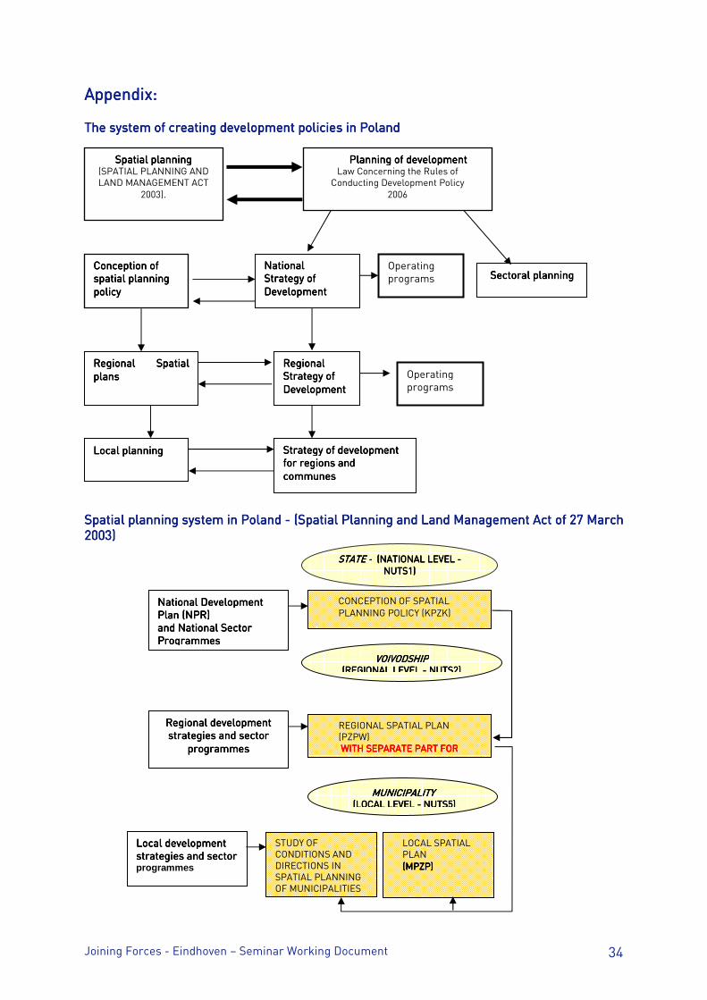
Appendix: Appendix: Appendix: Appendix: The system of creating development policies in PolandThe system of creating development policies in PolandThe system of creating development policies in PolandThe system of creating development policies in Poland Spatial planning system in Poland Spatial planning system in Poland Spatial planning system in Poland Spatial planning system in Poland ---- (Spatial Planning and Land Manageme (Spatial Planning and Land Manageme (Spatial Planning and Land Manageme (Spatial Planning and Land Management Act of 27 Marchnt Act of 27 Marchnt Act of 27 Marchnt Act of 27 March 2003)2003)2003)2003)
Conception of Conception of Conception of Conception of spatial planningspatial planningspatial planningspatial planning policypolicypolicypolicy
National National National National StratStratStratStrategy of egy of egy of egy of DevelopmentDevelopmentDevelopmentDevelopment
Sectoral plannSectoral plannSectoral plannSectoral planninginginging Operating programs
Spatial planningSpatial planningSpatial planningSpatial planning (SPATIAL PLANNING AND LAND MANAGEMENT ACT
2003).
Planning of developmentPlanning of developmentPlanning of developmentPlanning of development Law Concerning the Rules of
Conducting Development Policy 2006
RegionalRegionalRegionalRegional Strategy of Strategy of Strategy of Strategy of DevelopmentDevelopmentDevelopmentDevelopment
StratStratStratStrategy of development egy of development egy of development egy of development for regions and for regions and for regions and for regions and communes communes communes communes
Regional Spatial Regional Spatial Regional Spatial Regional Spatial plans plans plans plans
Local planningLocal planningLocal planningLocal planning
Operating programs
STATE STATE STATE STATE ---- (NATIONAL LEVEL (NATIONAL LEVEL (NATIONAL LEVEL (NATIONAL LEVEL ---- NUTS1)NUTS1)NUTS1)NUTS1)
CONCEPTION OF SPATIAL PLANNING POLICY (KPZK)
VOIVODSHIPVOIVODSHIPVOIVODSHIPVOIVODSHIP (REGIONAL LEVEL (REGIONAL LEVEL (REGIONAL LEVEL (REGIONAL LEVEL ---- NUTS2)NUTS2)NUTS2)NUTS2)
REGIONAL SPATIAL PLAN (PZPW) WITH SEPARATE PART FORWITH SEPARATE PART FORWITH SEPARATE PART FORWITH SEPARATE PART FOR
MUNICIPALITYMUNICIPALITYMUNICIPALITYMUNICIPALITY (LOCAL LEVEL (LOCAL LEVEL (LOCAL LEVEL (LOCAL LEVEL ---- NUTS5) NUTS5) NUTS5) NUTS5)
STUDY OF CONDITIONS AND DIRECTIONS IN SPATIAL PLANNING OF MUNICIPALITIES
LOCAL SPATIAL PLAN (MPZP)(MPZP)(MPZP)(MPZP)
National Development National Development National Development National Development Plan (NPR)Plan (NPR)Plan (NPR)Plan (NPR) and National Sector and National Sector and National Sector and National Sector ProgrammesProgrammesProgrammesProgrammes
ReReReRegional development gional development gional development gional development strategies and sector strategies and sector strategies and sector strategies and sector
programmesprogrammesprogrammesprogrammes
Local development Local development Local development Local development strategies and sectorstrategies and sectorstrategies and sectorstrategies and sector programmes
Joining Forces - Eindhoven – Seminar Working Document 35
2.7. Lille Metropole2.7. Lille Metropole2.7. Lille Metropole2.7. Lille Metropole 1. Frames of strategic and spatial planning1. Frames of strategic and spatial planning1. Frames of strategic and spatial planning1. Frames of strategic and spatial planning France has a longstanding tradition of spatial planning for regional and urban development. The planning is carried out by the central government or by local governments. It may focus on a specific sector, such as transportation planning, or cover several sectors in a given area, such as a Région2. Regional Development Planning Regional Development Planning Regional Development Planning Regional Development Planning Public Service PlansPublic Service PlansPublic Service PlansPublic Service Plans (Schémas de services collectifs - SSC) The Public Service Plans were instituted by the 1999 Regional Planning Act and adopted in 2002. They set the guidelines up until 2020 for policies on higher education and research, culture, health, information and communication, energy, conservation of natural and rural areas, and sports. They are carried out by the national government at national level but they have obviously regional definitions. Regional Spatial Planning and Development PlansRegional Spatial Planning and Development PlansRegional Spatial Planning and Development PlansRegional Spatial Planning and Development Plans (Schémas régionaux d’aménagement et de développement du territoire - SRADT) Regional Spatial Planning and Development Plans were established under the terms of the 1995 Spatial planning and Development Act. These plans, carried out by the Regions, set the basic guidelines for sustainable regional development in the medium term. They are not intended to be normative, but they are meant to shape the content of contracts between the central government and the regional authorities. The regional councils draft the Regional Spatial Planning and Development Plans in partnership with the Regional Economic and Social Councils (which are actually advisory committees), some local governments, and inter-municipal structures, “Pays”, the regional nature parks and the civil society. Each Regional Spatial Planning and Development Plan must include a review and outlook document, a sustainable regional development charter that sets out the actions and programmes to be implemented, and maps. The Plan deals with:
• the locations of the major facilities, infrastructures and services of general interest, • development of economic projects, • harmonious development of urban, suburban and rural areas, • protection and conservation of the environment, sites, landscapes and natural
heritage, • rehabilitation of derelict areas, • Incorporation of the interregional or cross-border dimension of planning.
The Regional Spatial Planning and Development plan also includes a specific section on transport (Regional Transport Infrastructure Plan) that sets out the infrastructure programme, as well as the organisation of regional transport, and, more specifically, rail transport.
2 In this paper the terms Region and/or regional refer to an official tier of territorial authority in France and in Belgium: 22 in metropolitan France, 3 in Belgium.
Joining Forces - Eindhoven – Seminar Working Document 36
Regional Economic Development PlansRegional Economic Development PlansRegional Economic Development PlansRegional Economic Development Plans (schémas régionaux de développement économiques –SRDE) The Decentralisation Act of 13 August 2004 enabled regional councils to experiment for five years with setting strategic guidelines for promoting balanced development under a Regional Development Plan (SRDE). The plans are drawn up in consultation with local authorities and representatives of the civil society. The plans enable regional governments to allocate certain grants to businesses on behalf of the central government. These grants used to be allocated by the central government. Other thematic plans are being developed by the Regional Council in specific fields such as higher education etc. UrbanUrbanUrbanUrban Planning Planning Planning Planning Spatial Planning DirectivesSpatial Planning DirectivesSpatial Planning DirectivesSpatial Planning Directives (Directives territoriales d’aménagement - DTA) Spatial Planning Directives were instituted at the fringes of spatial planning and urban planning by the 1995 Spatial Planning and Development Act. They are local planning documents drafted by the central government on its own initiative or at the initiative of the regional government. They are intended to cover certain strategic areas
• Where there are problems choosing suitable locations for major transport infrastructures, community facilities, etc. This can be the case in major urban areas or transport corridors that are subject to geographical constraints,
• Where there are strong population pressures, shortages of land or ecological risks (coastal regions, mountains, fringes of urban areas).
DTAs are supposed to summarise the central government’s spatial planning objectives and guidelines for the area concerned, with the aim of striking a balance between development and conservation. The guidelines set out in a Spatial Planning Directive apply to other less authoritative urban planning documents, such as Territorial Cohesion Plans (SCOT) or Local Urban Planning Plans (PLU). Territorial Cohesion PlansTerritorial Cohesion PlansTerritorial Cohesion PlansTerritorial Cohesion Plans (Schémas de cohérence territoriale - SCOT) The Territorial Cohesion Plans were established by the “Urban Solidarity and Renewal” Act of 13 December 2000 (as amended by the Urban Planning and Housing Act of 2 July 2003). They are strategic planning documents used at the level of conurbations to align sectoral policies relating to urban planning, housing, transportation, and commercial facilities. The Plans set out the general guidelines for spatial planning, and, more specifically, for maintaining a balance between areas to be developed and natural, farming or forested areas. It also sets out the objectives for balancing housing, the social mix, public transport, as well as commercial and business facilities. It may be more specific on certain topics, for example, defining major projects (by-pass roads, sewage treatment plants, etc.) and services. Before drawing up the plan, a development strategy needs to be set out in Spatial Planning and Sustainable Development Proposal for the area concerned. A local authority: Public Corporation for Cooperation between Communes (EPCI - such as communautés urbaines) or a mixed syndicat (Syndicat Mixte) - bringing together several municipalities and / or EPCIs – is taking the responsibility of developing a SCOT. The area concerned has to be approved by the national government. (After consultation of the other concerned public authorities). This being done, the responsible local authority draft the
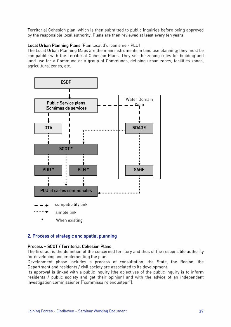
Joining Forces - Eindhoven – Seminar Working Document 37
Territorial Cohesion plan, which is then submitted to public inquiries before being approved by the responsible local authority. Plans are then reviewed at least every ten years. Local Urban Planning Local Urban Planning Local Urban Planning Local Urban Planning PlansPlansPlansPlans (Plan local d’urbanisme - PLU) The Local Urban Planning Maps are the main instruments in land use planning; they must be compatible with the Territorial Cohesion Plans. They set the zoning rules for building and land use for a Commune or a group of Communes, defining urban zones, facilities zones, agricultural zones, etc.
compatibility link
simple link
**** When existing 2. Process of strategic and spatial2. Process of strategic and spatial2. Process of strategic and spatial2. Process of strategic and spatial planning planning planning planning Process Process Process Process –––– SCOT / SCOT / SCOT / SCOT / Territorial Cohesion PlansTerritorial Cohesion PlansTerritorial Cohesion PlansTerritorial Cohesion Plans The first act is the definition of the concerned territory and thus of the responsible authority for developing and implementing the plan. Development phase includes a process of consultation; the State, the Region, the Department and residents / civil society are associated to its development. Its approval is linked with a public inquiry (the objectives of the public inquiry is to inform residents / public society and get their opinion) and with the advice of an independent investigation commissioner (“commissaire enquêteur”).
SDAGESDAGESDAGESDAGE
SAGESAGESAGESAGE
ESDPESDPESDPESDP
Public Service plans Public Service plans Public Service plans Public Service plans ((((SSSSchémas de services chémas de services chémas de services chémas de services
collectifs)collectifs)collectifs)collectifs)
DTADTADTADTA
SSSSCOT *COT *COT *COT *
PDU *PDU *PDU *PDU * PLH *PLH *PLH *PLH *
PLU et cartes communalesPLU et cartes communalesPLU et cartes communalesPLU et cartes communales
Water Domain l’eau
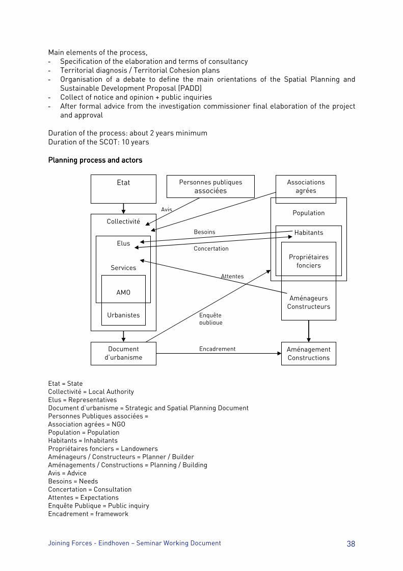
Joining Forces - Eindhoven – Seminar Working Document 38
Main elements of the process, - Specification of the elaboration and terms of consultancy - Territorial diagnosis / Territorial Cohesion plans - Organisation of a debate to define the main orientations of the Spatial Planning and
Sustainable Development Proposal (PADD) - Collect of notice and opinion + public inquiries - After formal advice from the investigation commissioner final elaboration of the project
and approval Duration of the process: about 2 years minimum Duration of the SCOT: 10 years Planning process and actorsPlanning process and actorsPlanning process and actorsPlanning process and actors Etat = State Collectivité = Local Authority Elus = Representatives Document d’urbanisme = Strategic and Spatial Planning Document Personnes Publiques associées = Association agrées = NGO Population = Population Habitants = Inhabitants Propriétaires fonciers = Landowners Aménageurs / Constructeurs = Planner / Builder Aménagements / Constructions = Planning / Building Avis = Advice Besoins = Needs Concertation = Consultation Attentes = Expectations Enquête Publique = Public inquiry Encadrement = framework
Etat Personnes publiques associées
Associations agrées
Document d’urbanisme
Aménagement Constructions
Collectivité
Urbanistes
Elus
Services
AMO
Population
Habitants
Propriétaires fonciers
Aménageurs Constructeurs
Avis
Besoins
Concertation
Attentes
Enquête publique
Encadrement
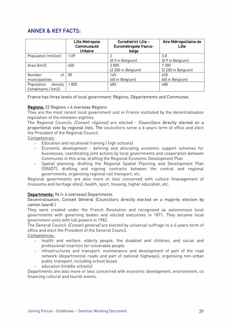
Joining Forces - Eindhoven – Seminar Working Document 39
ANNEX & KEY FACTS:ANNEX & KEY FACTS:ANNEX & KEY FACTS:ANNEX & KEY FACTS: Lille Metropole Lille Metropole Lille Metropole Lille Metropole
Communauté Communauté Communauté Communauté UrbaineUrbaineUrbaineUrbaine
Eurodistrict Lille Eurodistrict Lille Eurodistrict Lille Eurodistrict Lille –––– Eurométropole francoEurométropole francoEurométropole francoEurométropole franco----
belgebelgebelgebelge
Aire Métropolitaine de Aire Métropolitaine de Aire Métropolitaine de Aire Métropolitaine de LilleLilleLilleLille
Population (million) 1.09 2 (0.9 in Belgium)
3.8 (0.9 in Belgium)
Area (km2) 600 2 800 (2 200 in Belgium)
7 300 (2 200 in Belgium)
Number of municipalities
85 145 (60 in Belgium)
620 (60 in Belgium)
Population density (inhabitants / km2)
1 800 680 480
France has three levels of local government: Régions, Départements and Communes. Regions:Regions:Regions:Regions: 22 Regions + 4 overseas Régions They are the most recent local government unit in France instituted by the decentralisation legislation of the nineteen-eighties. The Regional Councils (Conseil régional) are elected - Councillors directly elected on a proportional vote by regional lists. The councillors serve a 6-years term of office and elect the President of the Regional Council. Competences:
- Education and vocational training ( high schools) - Economic development : defining and allocating economic support schemes for
businesses, coordinating joint actions by local governments and cooperation between Communes in this area, drafting the Regional Economic Development Plan
- Spatial planning: drafting the Regional Spatial Planning and Development Plan (SRADT), drafting and signing contracts between the central and regional governments, organising regional rail transport, etc.
Regional governments are also more or less concerned with culture (management of museums and heritage sites), health, sport, housing, higher education, etc. Departments:Departments:Departments:Departments: 96 (+ 4 overseas) Departments Decentralisation, Conseil Général (Councillors directly elected on a majority election by canton (ward) ) They were created under the French Revolution and recognised as autonomous local governments with governing bodies and elected executives in 1871. They became local government units with full powers in 1982. The General Council (Conseil general) are elected by universal suffrage to a 6-years term of office and elect the President of the General Council. Competences:
- health and welfare: elderly people, the disabled and children, and social and professional insertion for vulnerable people
- infrastructures and transport: maintenance and development of part of the road network (departmental roads and part of national highways), organising non-urban public transport, including school buses
- education (middle schools) Departments are also more or less concerned with economic development, environment, co financing cultural and tourist events.
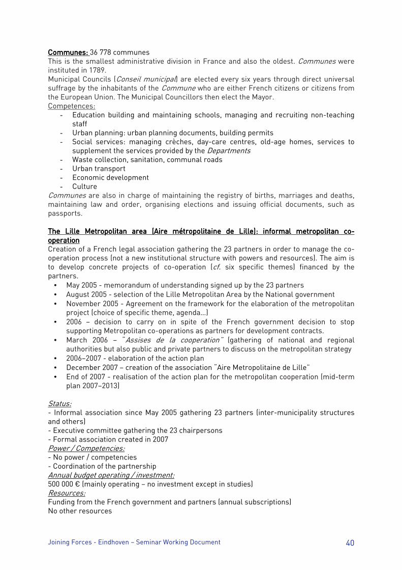
Joining Forces - Eindhoven – Seminar Working Document 40
Communes: Communes: Communes: Communes: 36 778 communes This is the smallest administrative division in France and also the oldest. Communes were instituted in 1789. Municipal Councils (Conseil municipal) are elected every six years through direct universal suffrage by the inhabitants of the Commune who are either French citizens or citizens from the European Union. The Municipal Councillors then elect the Mayor. Competences:
- Education building and maintaining schools, managing and recruiting non-teaching staff
- Urban planning: urban planning documents, building permits - Social services: managing crèches, day-care centres, old-age homes, services to
supplement the services provided by the Departments - Waste collection, sanitation, communal roads - Urban transport - Economic development - Culture
Communes are also in charge of maintaining the registry of births, marriages and deaths, maintaining law and order, organising elections and issuing official documents, such as passports. The Lille Metropolitan area (Aire métropolitaine de Lille): informal metropolitan coThe Lille Metropolitan area (Aire métropolitaine de Lille): informal metropolitan coThe Lille Metropolitan area (Aire métropolitaine de Lille): informal metropolitan coThe Lille Metropolitan area (Aire métropolitaine de Lille): informal metropolitan co----operationoperationoperationoperation Creation of a French legal association gathering the 23 partners in order to manage the co-operation process (not a new institutional structure with powers and resources). The aim is to develop concrete projects of co-operation (cf. six specific themes) financed by the partners.
• May 2005 - memorandum of understanding signed up by the 23 partners • August 2005 - selection of the Lille Metropolitan Area by the National government • November 2005 - Agreement on the framework for the elaboration of the metropolitan
project (choice of specific theme, agenda…) • 2006 – decision to carry on in spite of the French government decision to stop
supporting Metropolitan co-operations as partners for development contracts. • March 2006 – “Assises de la cooperation” (gathering of national and regional
authorities but also public and private partners to discuss on the metropolitan strategy • 2006–2007 - elaboration of the action plan • December 2007 – creation of the association “Aire Metropolitaine de Lille” • End of 2007 - realisation of the action plan for the metropolitan cooperation (mid-term
plan 2007–2013) Status: - Informal association since May 2005 gathering 23 partners (inter-municipality structures and others) - Executive committee gathering the 23 chairpersons - Formal association created in 2007 Power / Competencies: - No power / competencies - Coordination of the partnership Annual budget operating / investment: 500 000 € (mainly operating – no investment except in studies) Resources: Funding from the French government and partners (annual subscriptions) No other resources
Joining Forces - Eindhoven – Seminar Working Document 41
2.8. Seville2.8. Seville2.8. Seville2.8. Seville Existing background and expectations in SevillaExisting background and expectations in SevillaExisting background and expectations in SevillaExisting background and expectations in Sevilla 1. We agree in considering strategic and spatial planning at city-region scale as a key driver in building the new metropolitan governance. 2. At local levelAt local levelAt local levelAt local level Sevilla is performing separately but in close coordination strategic planning [which is a socio-economic planning] and urban or physical planning. The City Council is the main promoter of both processes although in the case of strategic planning a specific management committee composed by the main private and public local stakeholders governs the process. Wide citizen participation is a distinguishing characteristic in both planning processes. At the end of this year the city will launch a new strategic planning process “Sevilla 2020”. 3. Without any doubt, the art of combining physical and strategic planningthe art of combining physical and strategic planningthe art of combining physical and strategic planningthe art of combining physical and strategic planning has produced a new comprehensive and clear urban model and a renaissance period in the city. For instance, under the motto “Sevilla, City for People”, the city is currently undertaking one of the most impressive sustainable mobility schemes in Spain comprising a new subway; electric trams [Metrocentro] for the city centre; the largest bike-lane network in Spain; the improvement of the open public spaces; and a radical enlargement of pedestrian streets. The current project for the transformation and modernization of the city of Seville is the result of both a combination in time of strategic and spatial planning processes and a strong leadership by the Mayor. 4. At the same time, the city is aware that major projects and urban processes are coming up the city is aware that major projects and urban processes are coming up the city is aware that major projects and urban processes are coming up the city is aware that major projects and urban processes are coming up against the city limitsagainst the city limitsagainst the city limitsagainst the city limits, in other words against the current administrative space. The true supra-local scale of this kind of urban projects is requiring a new way of metropolitan governance. Recent success in Sevilla in the metropolitan coordination of public transports and water-cycle management are claiming for moving forward in the question of metropolitan governance. In addition, the current local government assumes that the questions of financial devolution for local governments in Spain and a better articulation with both the State & Regional levels must be posed urgently. 5. At cityAt cityAt cityAt city----region levelregion levelregion levelregion level, there is not any kind of strategic planning process at present but it recently exists on the side of spatial planning: the so-called “Plan de Ordenación del Territorio de la Aglomeración Urbana de Sevilla” [POTAUS]. From a top-down approach, the POTAUS has been promoted by the Regional Ministry of Spatial Planning. It comprises 46 municipalities and 1.421.000 inhabitants [around 50% in the central city]. The regional promoter has not established any kind of cooperative management body or any mechanism for local-local cooperation on territorial issues. Comments to the group of issues that will be tackled during the Eindhoven meetingComments to the group of issues that will be tackled during the Eindhoven meetingComments to the group of issues that will be tackled during the Eindhoven meetingComments to the group of issues that will be tackled during the Eindhoven meeting Frames of strategic and spatial planningFrames of strategic and spatial planningFrames of strategic and spatial planningFrames of strategic and spatial planning Strategic plans may be social, economic, financial, spatial, physical plans, policy proposals etc. In particular cases in what extent are strategic plans spatial?
Joining Forces - Eindhoven – Seminar Working Document 42
All spatial plan or scheme should be settled on a strategic vision or framework. On the contrary a local strategic plan has not to develop a detailed spatial development but be coherent with the existing or proposed city model. So, the key is not to promote a sort of convergence in content between spatial and strategic planning but a good articulation and coherence between them. What is the relevant territory of spatial planning? How is (or is not) it adjusted to the territory of general municipal competencies? The current local scale is suitable for urban planning and the same, city-region and region are also useful scales to approach spatial planning. The key question is not the most relevant scale for urban and spatial planning but how we articulate the maps and visions from these practices at different scales. So, it is a question of governance. Who gives commission for preparation of the plans, and/or which authority is competent in planning? In our case, at local level the City Council is the competent authority to promote both strategic and urban planning [this last one has to be finally approved by the Regional Government]. Concerning local strategic planning, a specific management committee composed by key institutional stakeholders is set up. At regional level, the Regional Ministry in charge of Spatial Planning promotes several processes of supra-local spatial planning. What kinds of instruments are used in preparation of strategic plans? At local level in Seville a number of elements should be mentioned: - The above mentioned management committee composed by a selection of main
stakeholders. It is the monitoring platform of the planning and implementation process. - The assembly of the strategic plan. Here are represented all kind of civic associations
and local stakeholders. - The Office for the Strategic Plan, as a permanent staff in charge of the technical
secretariat of the process with a budget financed by the City Council. The Office for the Strategic Plan with the support of a consultancy team organizes all the citizen participation and a high number of expert panels.
Process of strateProcess of strateProcess of strateProcess of strategic and spatial planninggic and spatial planninggic and spatial planninggic and spatial planning What is the process of decision-making? How does regulatory function operate between different local authorities? How are private stakeholders involved in the process of preparation and decision-making? Which instruments are used for making strategy? How are resources of strategy planned? a) Concerning the urban or physical planning at local level, the City Council formulates a
first draft and after a long period of citizenship participation [the participation process not always but in the case of Seville] a first draft is exposed to public remarks for a limited period of time before approval by the Local Assembly. Then, the approval of the Regional Government is required which could introduce new recommendations and remarks.
b) Concerning the urban or physical planning at city-region level, the Regional Government formulates a first draft which is opened up to public remarks for a limited period of time [usually four months]. Then, the Regional Government has the capability to decide which suggestion is taken into account and which not. All local urban plans affected
Joining Forces - Eindhoven – Seminar Working Document 43
theoretically must be adapted to the new metropolitan urban planning. There is not any specific technical office in charge of the monitoring function along the implementation phase.
c) Concerning local strategic planning, there is no formal procedure or rules as regional guidelines for local practitioners in this field. Usually, after a wide citizenship participation process, the management committee formulates a draft which is approved by the Local Assembly. Then, the Office for the Strategic Plan together with the Management Committee are commissioned to co-ordinate and monitor the implementation phase.
In what extent is strategic planning more than simple designing? What is the process of implementation? What are monitoring links with public policies? Basically, the Strategic Plan is a model, a framework. It provides the basic guidelines for all the city council departments and it identifies the flagship projects for the planning period. The Office for the Strategic Plan, directly depending on the Mayor, is in charge of monitoring the implementation, making reports periodically. Also the Office for the Strategic Plan has the mission to brand the city and communicate the city model worldwide. Options for the future developmentOptions for the future developmentOptions for the future developmentOptions for the future development Is there any idea, conception to develop the method, system, or framework of strategic and spatial planning at the particular city-region level? In what ways will implementation be improved in the future? - The way is not to provoke a convergence between spatial and strategic planning into one
single process or planning document, but to assure a right articulation amongst these two process. This is a question of governance.
- In our context, we lack formal strategic planning at city-region level at present. This situation should be improved urgently.
- Approaching this existing gap, some questions should be taken into consideration: a) to take the support and involvement from the Regional level but avoiding any kind of top-down or tutorial approach; b) to give the central city [50% of the population of the metro area] a central role in the process; c) to set up a specific technical office or body with the mission to monitor the city-region strategic plan and display activities in the field of city-region branding and communication; at the same time this Office or body could be in charge of monitoring the city-region physical plan.

Joining Forces - Eindhoven – Seminar Working Document 44
Joining Forces - Eindhoven – Seminar Working Document 45
3.3.3.3. SSSSYNTHESIS YNTHESIS YNTHESIS YNTHESIS OOOOF THEF THEF THEF THE THEME THEME THEME THEME “G“G“G“GOVERNANCE REGARDING OVERNANCE REGARDING OVERNANCE REGARDING OVERNANCE REGARDING STRATEGIC AND SPATIASTRATEGIC AND SPATIASTRATEGIC AND SPATIASTRATEGIC AND SPATIAL PL PL PL PLANNING AT LANNING AT LANNING AT LANNING AT
CITYCITYCITYCITY----REGION LEVELREGION LEVELREGION LEVELREGION LEVEL”””” The objective of the seminar in Eindhoven was to scrutinise the role and instruments of governance in strategic and spatial planning at city-region level. This summary is based on direct lessons from the case (1) grouping of partner city-regions from the point of view of strategic and spatial planning, including some preliminary conclusions on governance as one of the key issues the working group has to deal with (2). 1/1/1/1/ Lessons learned from the case of the Eindhoven city Lessons learned from the case of the Eindhoven city Lessons learned from the case of the Eindhoven city Lessons learned from the case of the Eindhoven city----rrrregionegionegionegion There are different instruments in the city-region for the promotion of thinking in a strategic way. These are, in particular, a formal voluntary association (Eindhoven City Region – SRE), a joint foundation (Brainport) and a cross-border strategic cooperation process (ELAt). 1.1. Regional voluntary association1.1. Regional voluntary association1.1. Regional voluntary association1.1. Regional voluntary association There is no official regional level of government in the Netherlands, however, the law allows municipalities to work together and create regional forms of government. These voluntary institutions are called WGR-regions. Most of them don’t have a specific separate body but the WGR gives a legal basis for cooperation to municipalities in one or more specific issues. These regions have statutory policy competences, such as economic development, transport, and environment and until the 1st of July 2008 spatial planning. The Eindhoven City Region (SRE) covers a quarter of the North Brabant province and consists of 21 municipalities and around 750,000 people living in the region. With more than 209,000 inhabitants, Eindhoven is the largest city in Southern Netherlands. The municipalities in the region decided in 1993 to create a new separate regional body: the Eindhoven city-region (SRE), one of the eight formal city-regions in the Netherlands. The mission of the SRE is to strongly encourage cooperation between municipalities and promote the interests of the region at upper government level. It is also dedicated to obtaining investment grants. Each region, including the SRE, has a common agreement in which is specified the way the regional body is funded. In this case, each municipality has to contribute on a per capita basis. Thus, large cities and municipalities with a bigger population have to pay more than the smaller ones. Besides the costs for the regional body, municipalities also pay a certain amount to a regional fund, which finances or stimulates small regional projects. The main tasks of the SRE are housing, spatial planning, environment, transport, and recreation. The regional body consists of the council, the executive, and the support organisation. The regional council is the highest authority within the region and consists of members delegated by the municipal councils and aldermen from municipalities in the region. They are chosen indirectly by the inhabitants of the region. The more residents a municipality has, the more members are delegated to the regional council. The chairman of the regional council is the mayor of the biggest city. The regional council appoints its executive body. It is responsible for the day-to-day administration of the region within the scope of the regional policy. The mayor of the largest city chairs both the regional and the executive council.
Joining Forces - Eindhoven – Seminar Working Document 46
1.2. Foundation for regional economic development 1.2. Foundation for regional economic development 1.2. Foundation for regional economic development 1.2. Foundation for regional economic development In 1993, South-East Brabant was hit by an economic crisis that led to mass redundancies among larger employers such as DAF and Philips, with many suppliers in the region falling victim in the wake of this recession. At the initiative of the Eindhoven City Region (SRE), businesses, knowledge institutions, and public authorities joined forces to get out of the economic malaise. The 21 SRE municipalities created a joint fund to strengthen the economic structure of the region and set up the Stimulus programme. This led to the creation of the current Brainport Foundation. The willingness to cooperate in Brainport is high. With so many players aiming for strong growth, that willingness benefits from some coordination. Business, knowledge institutions, and public authorities have joined together in the Brainport Foundation to make these ambitions happen. Together they have charted the course in the strategic programme: Brainport Navigator 2013; beyond Lisbon! In summary, the Brainport status essentially lies in the prominence of private R&D that is directly linked to the prominence of a competitive manufacturing industry. Nowadays the Eindhoven region has an internationally-recognised reputation for high-tech activities. Its leading role in the world of cutting-edge R&D has caused it to become known as ‘Brainport’: a hotspot within the South-East Netherlands’ top technology zone. Brainport is also an action programme. An example is the High Tech Campus in Eindhoven (HTCE). The campus involves: � originally a Philips research and development site � 90 ha of green business park, 35% of which is available for non-Philips companies (R&D
firms and institutes) � more than 180,000 m2 of office space; 50,000 m2 of laboratory space and 10,000 m2 of
clean rooms � the Strip: the heart of the campus with meeting rooms, recreational and sports facilities
and other amenities � access to technologies (incl. nanotechnology, signal processing, embedded systems,
optical storage, wireless connectivity and broadband) � access to facilities and equipment (technology services devices, prototyping and
instrumentation, computer services, centre for technical training, EMC competence centre)
� management support (e.g., participation in international R&D programmes, advice on intellectual property rights and financing)
access to regional know-how – and industrial / economic infrastructure Brainport is also a City marketing strategy aimed at promoting the Eindhoven City-region through an attractive concept “The Brainport” and marketing strategies to attract the creative classes and investors. The final aim is to position the City-Region of Eindhoven amongst the most famous European or worldwide creative cities. The Eindhoven City-region (SRE) wants to implement its goals through concrete spatial projects. To do this, the SRE is now developing a Brainport Spatial Programme. The regional spatial structure plan prepared by the SRE is not binding in legal terms; however it is based on negotiations and consensus among the municipalities involved in the framework of the city-region. Structure plans prepared and approved by regions are very much strategy-oriented. The region’s financial resources including project funds are linked to the priorities of strategic goals and spatial plans.
Joining Forces - Eindhoven – Seminar Working Document 47
1.3. Cross1.3. Cross1.3. Cross1.3. Cross----border strategic coopeborder strategic coopeborder strategic coopeborder strategic cooperation ration ration ration There are frameworks for cross-border cooperation in innovation financed by INTERREG and other programmes. First of all, “ELAt” covers cities and their areas featuring high-tech, knowledge-based industries in the Netherlands, Belgium, Germany, and France. This transnational cooperation among international cities focuses on joint innovation strategy, benchmarking, community business, and technology, development of entrepreneurship and access to investors. There is no a pre-set leadership by any public authority. Priorities are defined as strategic directions. Another recent initiative is “VlaNed” from the national government level. It is based on cooperation between governments in the border region. It is similar to urban development in the Lille region. It is voluntary cooperation on both sides of the Dutch-Belgian border. 2222//// Similarities and differences between partners’ cities Similarities and differences between partners’ cities Similarities and differences between partners’ cities Similarities and differences between partners’ cities City-regions are not involved in formal systems of local government (see Appendix). However, informal structures and / or frameworks of governance can be defined in relation to the working local authorities at different levels. Apart from Eindhoven, Lille and Krakow are involved in city-regional or regional (Krakow) spatial planning collaboration. It can be voluntary, statutory or central government type. The voluntary model is represented by the Eindhoven City Region (SRE) as described and summarised above. There are some statutory city-regional forms of association for municipalities in France. The most comprehensive one is the ‘Communauté Urbaine’ framework adopted by Lille on the basis of an act of Parliament in 1968. Thus, Territorial Strategic documents and land use plans have been established at this level, even if the legal strategic spatial plan is set up on a slightly bigger scale (arrondissement). In the case of Krakow, the Malopolska Region prefers Krakow Metropolitan Area as a separate functional area in its regional plans. Regional government has legal power and instruments to influence this type of development. On the other hand, there is no formal city-regional framework in the case of, Brno, Florence, and Burgas. We can say that this is also the case in Brussels, even if a formal region does exist, the Brussels- Capital Region, but with too tight limits to represent the true city-region. However, regional or national government levels usually take responsibility for spatial and strategic cohesion in the city and its area. This means, for example, that, in Florence, project management (PIUSS) is working at city regional level. Nevertheless, this is not the case for Belgium, where only the Regions have competences in strategic and spatial planning. The Federal State does not lay down any more competences on the matter, and not even a competence of coordination. Here, governance efforts focus on cooperation between the different public partners involved at the city-region level3.
3 (1) In Belgium, each of the 3 regional strategic and spatial plans underlines the importance of coordination at the city-region level, however, in practice; a structured dialogue over strategic and spatial planning at the metropolitan level has never been implemented between the 3 Regions, at least until now. Actually, for the Brussels metropolitan area, cooperation is more organised through specific project development, such as the construction of the Regional Mass Rapid Transit Railway Network (RER), the construction of a water treatment plant or the management of trans-regional forests and rivers. These collaboration projects are implemented through “Cooperation Agreements” signed between the Brussels-Capital Region and the other two Regions and sometimes with the Federal State.
Joining Forces - Eindhoven – Seminar Working Document 48
The main instruments of governance in planning at the city-regional level identified in our sample are the following: � voluntary cooperation among municipalities in the area (SRE–Eindhoven City Region,
Firenze Futura, Krakow Metropolitan Area Council) � project management (SRE–Eindhoven City Region, Lille Métropole, Krakow Metropolitan
Area Council) � adding strong general policy orientation to spatial planning (SRE–Eindhoven City Region) � citizen or civil society participation in planning process (Bourgas, Brno, Brussels-Capital
Region, Lille Métropole) � funding is involved as an issue in plans (SRE–Eindhoven City Region, Lille Métropole) � partnership with entrepreneurs (SRE–Eindhoven City Region, Firenze Futura) Our further task is to widen this list of instruments and methods, either in strategic and spatial planning or in any other field that is investigated further on. Strategic and spatial planning at city-region level particularly focuses on the enhancement of competitiveness, including reorganisation and economic crisis management. It is also often oriented towards sustainability of development and environment. This is, for instance, the case in the city-Regions of Eindhoven and Lille. In conclusion, we can see in our working group that there are instruments of governance everywhere (legal, administrative, budgetary, project, planning) in strategic and spatial planning at the city-region level. In some cases, the instruments are more integrated (Eindhoven, Lille, Firenze); in other cases, the instruments are more minimalist (Brussels, Brno, Krakow...). The question is whether the city-region level has also a specific visibility and framework. Less or non-institutional forms and instruments were found on a differently specified level in different countries. Some of them can be and should be implemented in a way to build it into the formal systems and to spread active operational practice of local governments, territorial state administration, and territorial branches of civil and entrepreneurial organisations. However, particular solutions, development of own models, etc. depend very much on specific economic and social circumstances.
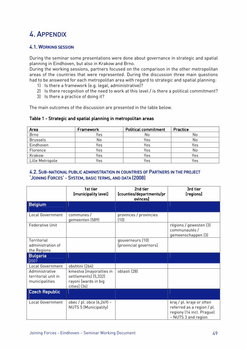
Joining Forces - Eindhoven – Seminar Working Document 49
4.4.4.4. AAAAPPENDIXPPENDIXPPENDIXPPENDIX 4.4.4.4.1.1.1.1. WWWWORKING SESSIONORKING SESSIONORKING SESSIONORKING SESSION During the seminar some presentations were done about governance in strategic and spatial planning in Eindhoven, but also in Krakow and Brno. During the working sessions, partners focused on the comparison in the other metropolitan areas of the countries that were represented. During the discussion three main questions had to be answered for each metropolitan area with regard to strategic and spatial planning:
1) Is there a framework (e.g. legal, administrative)? 2) Is there recognition of the need to work at this level / is there a political commitment? 3) Is there a practice of doing it?
The main outcomes of the discussion are presented in the table below. Table 1 Table 1 Table 1 Table 1 ---- Strategic and spatial planning in metropolitan areas Strategic and spatial planning in metropolitan areas Strategic and spatial planning in metropolitan areas Strategic and spatial planning in metropolitan areas AreaAreaAreaArea FrameworkFrameworkFrameworkFramework Political commitmentPolitical commitmentPolitical commitmentPolitical commitment PracticePracticePracticePractice Brno Yes No No Brussels No Yes No Eindhoven Yes Yes Yes Florence Yes Yes No Krakow Yes Yes Yes Lille Metropole Yes Yes Yes
4.4.4.4.2.2.2.2. SSSSUBUBUBUB----NATIONAL PUBLIC ADMINATIONAL PUBLIC ADMINATIONAL PUBLIC ADMINATIONAL PUBLIC ADMINISTRATION IN COUNTRNISTRATION IN COUNTRNISTRATION IN COUNTRNISTRATION IN COUNTRIES OF IES OF IES OF IES OF PPPPARTNERS IN THE PROJEARTNERS IN THE PROJEARTNERS IN THE PROJEARTNERS IN THE PROJECTCTCTCT
‘J‘J‘J‘JOININGOININGOININGOINING FFFFORCESORCESORCESORCES’’’’ ---- SSSSYSTEMYSTEMYSTEMYSTEM,,,, BASIC TERMS BASIC TERMS BASIC TERMS BASIC TERMS,,,, AND DATA AND DATA AND DATA AND DATA (2008)(2008)(2008)(2008) 1st tier 1st tier 1st tier 1st tier
[municipality level] [municipality level] [municipality level] [municipality level] 2nd tier2nd tier2nd tier2nd tier
[counties/departments/pr[counties/departments/pr[counties/departments/pr[counties/departments/provinces] ovinces] ovinces] ovinces]
3rd tier 3rd tier 3rd tier 3rd tier [regions][regions][regions][regions]
BelgiumBelgiumBelgiumBelgium
Local Government communes / gemeenten (589)
provinces / provincies (10)
Federative Unit régions / gewesten (3) communautés / gemeenschappen (3)
Territorial administration of the Regions
gouverneurs (10) [provincial governors]
BulgariaBulgariaBulgariaBulgaria 2007
Local Government obshtini (264) Administrative territorial unit in municipalities
kmestva [mayoralties in settlements] (5,332) rayoni [wards in big cities] (34)
oblasti (28)
Czech RepublicCzech RepublicCzech RepublicCzech Republic
Local Government obec / pl. obce (6,249) – NUTS 5 (Municipality)
kraj / pl. kraje or often referred as a region / pl. regiony (14 incl. Prague) – NUTS 3 and region
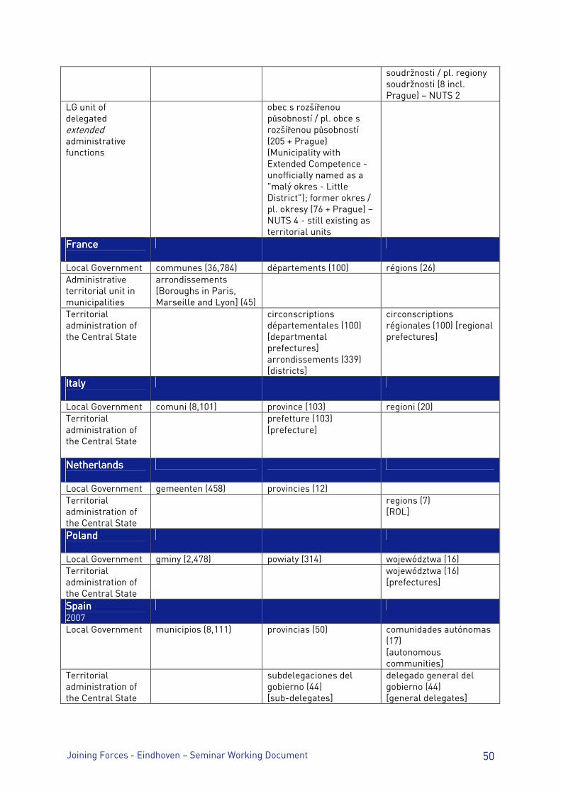
Joining Forces - Eindhoven – Seminar Working Document 50
soudržnosti / pl. regiony soudržnosti (8 incl. Prague) – NUTS 2
LG unit of delegated extended administrative functions
obec s rozšířenou působností / pl. obce s rozšířenou působností (205 + Prague) (Municipality with Extended Competence - unofficially named as a "malý okres - Little District"); former okres / pl. okresy (76 + Prague) – NUTS 4 - still existing as territorial units
FranceFranceFranceFrance
Local Government communes (36,784) départements (100) régions (26) Administrative territorial unit in municipalities
arrondissements [Boroughs in Paris, Marseille and Lyon] (45)
Territorial administration of the Central State
circonscriptions départementales (100) [departmental prefectures] arrondissements (339) [districts]
circonscriptions régionales (100) [regional prefectures]
ItalyItalyItalyItaly
Local Government comuni (8,101) province (103) regioni (20) Territorial administration of the Central State
prefetture (103) [prefecture]
NetherlandsNetherlandsNetherlandsNetherlands
Local Government gemeenten (458) provincies (12) Territorial administration of the Central State
regions (7) [ROL]
PolandPolandPolandPoland
Local Government gminy (2,478) powiaty (314) województwa (16) Territorial administration of the Central State
województwa (16) [prefectures]
SpainSpainSpainSpain 2007
Local Government municipios (8,111) provincias (50) comunidades autónomas (17) [autonomous communities]
Territorial administration of the Central State
subdelegaciones del gobierno (44) [sub-delegates]
delegado general del gobierno (44) [general delegates]

Joining Forces - Eindhoven – Seminar Working Document 51
““““Governance in Strategic and Spatial Planning Governance in Strategic and Spatial Planning Governance in Strategic and Spatial Planning Governance in Strategic and Spatial Planning at City Region Level”at City Region Level”at City Region Level”at City Region Level”
EINDHOVEN EINDHOVEN EINDHOVEN EINDHOVEN –––– seminar Working Document seminar Working Document seminar Working Document seminar Working Document 29, 30 & 31 October 2008
PARTPARTPARTPART 2222

Joining Forces - Eindhoven – Seminar Working Document 52
Joining Forces - Eindhoven – Seminar Working Document 53
1.1.1.1. PPPPROGRAMMEROGRAMMEROGRAMMEROGRAMME Wednesday October 29Wednesday October 29Wednesday October 29Wednesday October 29thththth 2008 2008 2008 2008 13.00 – 13.30 Reception at Eindhoven City Hall 13.30 – 13.45 Welcome by Rob van Gijzel, President of the SRE and major of
Eindhoven 13.45 – 14.00 Welcome by Jean Paul Kroese, member of the board of SRE 14.00 – 15.00 Introduction to North Brabant and the SRE 15.00 – 15.30 City-walk in Eindhoven 15.30 – 16.00 Introduction to Brainport, by J.S.G. Brouwers, member of the board of
the Brainport Foundation. 16.00 – 17.00 Sessions by lead partner and lead expert:
- Objectives and programme of the seminar - Report from the Urbact Monitoring Committee (26/09/08) and evaluation made by the External Assessment Panel
18.30 – 19.30 Arrival at hotel 19.30 – 22.00 Dinner in Eindhoven at Eetcafe Ravensdonck Thursday October 30th 2008Thursday October 30th 2008Thursday October 30th 2008Thursday October 30th 2008 8.45 – 9.00 Reception at Centrum Kunstlicht in de Kunst 9.00 – 9.30 Introduction to regional planning by Harm Mertens 9.30 – 10.00 Spatial Programme Brainport by Jean van Zeeland 10.00 – 12.00 Region-tour* (part 1) 12.00 – 13.00 Lunch at Eindhoven Airport 13.00 – 14.00 Region-tour* (part 2)
*: The region tour is not just a tour, but a necessary addition to the lecture. We want to visit some essential elements of the Brainport programme (for example Strijp S and the High Tech Campus), that can be used as input for the workshop in the afternoon.
14.00 – 14.30 Reception at Dynamo 14.30 – 15.15 Preparation of the meeting with the Local Support Group (working
group) 15.15 – 17.00 Workshop “The ideal Brainport”/ Meeting with Local Support Group 17.00 – 17.30 Debriefing session 18.00 – 19.00 Arrival at hotel 19.30 – 22.00 Dinner in Eindhoven at Listers Friday October 31st 2008 Friday October 31st 2008 Friday October 31st 2008 Friday October 31st 2008 8.45 – 9.00 Reception at Aristo 9.00 – 10.30 Governance in strategic and spatial planning in Brno / Krakow 10.30 – 12.00 Seminar Conclusions 12.00 – 13.00 Lunch 13.00 – 15.00 Evaluation of the seminar
Management of the working group (finance and management questions) Working group identity and communication
15.00 – 17.00 Preparation of the next seminar: Transport / Florence, January 2009 17.00 End of seminar
Joining Forces - Eindhoven – Seminar Working Document 54
EEEEVALUATION OF THE SEMVALUATION OF THE SEMVALUATION OF THE SEMVALUATION OF THE SEMINARINARINARINAR At the end of the seminar it was asked to each participant to highlight:
• Special issues / points regarding visits, discussions, etc. • Strengths and weaknesses of the seminar programme
Special issues / pointsSpecial issues / pointsSpecial issues / pointsSpecial issues / points
• Private companies that are serving public purposes • Role of territorial and spatial limits • Bigger organisation can lead to better implementation of strategic plans (e.g. SRE is
involved in both the making of and the implementation / management of the strategic plans)
• Flexible cooperation, limit of metropolitan area is not relevant Strengths and weaknesses of the seminar programmeStrengths and weaknesses of the seminar programmeStrengths and weaknesses of the seminar programmeStrengths and weaknesses of the seminar programme
PositivePositivePositivePositive NegativeNegativeNegativeNegative
Excursion Absence of Bourgas / attendance
Good balance between excursions and meetings
Accommodation
Ambiance (good balance between formal / informal)
Limited visits to places in metropolitan area
Meeting with the Local support Group (in English!)
A better link should be made between site visits (why these locations) and metropolitan topic
Interactive (workshop in particular) Expression of participants in English
Meetings / activities on different locations Use of different vocabulary
Group sticked to subject (governance, spatial planning)
No city tour (only a few parts)
Well organized The general conclusion was that the Eindhoven Seminar gives a good standard for the upcoming seminars.
Joining Forces - Eindhoven – Seminar Working Document 55
2.2.2.2. VVVVISITSISITSISITSISITS CityCityCityCity----walkwalkwalkwalk in Eindhoven and RegionRegionRegionRegion----tourtourtourtour were a necessary addition to the lecture. We wanted to visit some essential elements of the Brainport programme (for example Strijp S and the High Tech Campus), that can be used as input for the workshops and discussions. Visit of StrijpVisit of StrijpVisit of StrijpVisit of Strijp----S, the largest rezoning site of Europe. S, the largest rezoning site of Europe. S, the largest rezoning site of Europe. S, the largest rezoning site of Europe. On this terrain a tour was planned to the old Philips laboratory and factory. What used to be the Philips estate will become an urban area that is unique in every respect. No less than 66 acres are turned into new inspiring environment with a mix of living, working, and recreation. The Final Urban Development Plan provides with the preservation and renovation of historic buildings combined with new estate. With creativity and culture being made visible in all aspects, Strijp-S becomes a new neighbourhood of Eindhoven with an unequalled character and ambiance. Eindhoven Airport. Eindhoven Airport. Eindhoven Airport. Eindhoven Airport. Eindhoven Airport has primary a military function but is also a growing international airport with destinations all over the world. The expansion of the airport is possible thanks to the collaboration with the surrounding businesses. Both sides have benefited from the recent expansion, since there are many advantages to have an international airport in the area. Every million passengers creates 1000 direct and 500 indirect jobs. The airport contributes to the region by bringing together an exchange of know-how. Furthermore it gives people a wider range of destinations to choose from, whether travelling for business or for pleasure. This is one of the factors that makes the region attractive for new businesses and makes Eindhoven Airport the gateway to the rest of the world. High Tech Campus Eindhoven (HTCE). High Tech Campus Eindhoven (HTCE). High Tech Campus Eindhoven (HTCE). High Tech Campus Eindhoven (HTCE). On the way there, the tour passed Meerhoven (one of the largest new housing sites in the region) and the group had a look at the work that is done on the A2 highway, which is under construction at the moment to improve the accessibility of the region. At the High Tech Campus the group had the opportunity to have a look at the Brainport at work. The HTCE is a hotspot for human-focused innovation and has a worldwide reputation. The industrial side was founded in 1963 by Philips, a company which was founded in Eindhoven at the beginning of the 19th century. In a first period the side was used by Philips as its most important invention centre. Over the past 100 years Philips has developed and introduced many successful technologies. An atmosphere of collaboration has been crucial to these achievements. This led to a decision at Philips to start developing technology more from the philosophy of open innovation. In this philosophy a single-firm solution is a thing of the past. The technological palette has become too wide-ranged and products have become too complex for this. In many ways it is better to share knowledge and experience as well as expensive research facilities. The High Tech Campus Eindhoven is the epitome of this philosophy. Since 2002, non-Philips companies have been able to establish their businesses on the campus site, on condition that their activities are linked to the type of activities that take place on the campus. Joint research and development may result in mutual reinforcement and inspiration. With thousands of top-notch engineers and advanced facilities, nowadays this side provides a unique working environment for the companies on the campus. The HTCE focuses on technological products such as microsystems, infotainment, high-tech systems, embedded
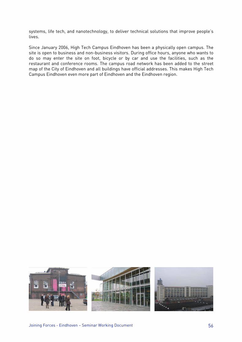
Joining Forces - Eindhoven – Seminar Working Document 56
systems, life tech, and nanotechnology, to deliver technical solutions that improve people’s lives. Since January 2006, High Tech Campus Eindhoven has been a physically open campus. The site is open to business and non-business visitors. During office hours, anyone who wants to do so may enter the site on foot, bicycle or by car and use the facilities, such as the restaurant and conference rooms. The campus road network has been added to the street map of the City of Eindhoven and all buildings have official addresses. This makes High Tech Campus Eindhoven even more part of Eindhoven and the Eindhoven region.
Joining Forces - Eindhoven – Seminar Working Document 57
3.3.3.3. MMMMEETING WITH EETING WITH EETING WITH EETING WITH LLLLOCAL OCAL OCAL OCAL SSSSUPPORT UPPORT UPPORT UPPORT GGGGROUPROUPROUPROUP WWWWORKSHOP ORKSHOP ORKSHOP ORKSHOP “T“T“T“THE IDEAL HE IDEAL HE IDEAL HE IDEAL BBBBRAINPORTRAINPORTRAINPORTRAINPORT”””” The Local Support Group consists of people from the municipality of Eindhoven, the province of North Brabant, the Brainport Foundation and SRE-professionals. They had prepared a workshop titled “The ideal Brainport”. Central challenge was to combine information given during the seminar on Brainport (and the Spatial Programme Brainport) with the home-experience and knowledge of the people in the Joining Forces Working Group and answer the question: “How could the Eindhoven Region stand out and become a real attractive international place of residence for high-tech industry and centres of excellence’? Local Support Group Eindhoven:Local Support Group Eindhoven:Local Support Group Eindhoven:Local Support Group Eindhoven:
- C. Van Dijk (Municipality Eindhoven) - E. ten Berge (Province of North Brabant) - I. Naus (Brainport Foundation) - A. Lamers (City Regio Haaglanden) - A. Oosting (SRE) - H. Mertens (SRE)
To make interaction as fruitful as possible, three subgroups were formed. During the workshop, several themes were discussed. For example, the groups were encouraged to think of surprising elements that they had noticed in the presentations and the Region-tour. The impressions of the region, together with its strengths and weaknesses, opportunities and threats for the development of Brainport were considered very important as well. The subgroups were asked to think of spatial measures that should be taken to realize the ambitions of Brainport as an international place of residence (advise). The most important conclusions of the workshop are displayed below and are represented as a SWOT-Analysis. Strengths, weaknesses, opportunities, and threatStrengths, weaknesses, opportunities, and threatStrengths, weaknesses, opportunities, and threatStrengths, weaknesses, opportunities, and threatssss STRENGTHSSTRENGTHSSTRENGTHSSTRENGTHS
• High quality of industrial heritage • High quality of green (green village) • Strong planning process • Coalition business – government • No (internal) traffic congestion • High rate of private/ corporate
investment • High spatial quality within new area
developments (public space and architecture)
• High amount of research and development
• High buildings (orientation)
THREATSTHREATSTHREATSTHREATS • Too much influence of corporate parties /
risk of influence of business interest on public affairs
• Virtualization of personal contact • Industrial tradition versus new age/
brainport • Competition foreign centres of
excellence • Footloose inhabitants/ lack of social
cohesion • Region can get isolated
WEAKNESSESWEAKNESSESWEAKNESSESWEAKNESSES • No city life (lack of a vibrant down town) • Lack of structure and orientation
(Broadacre). ‘Where is the city centre?’ • Lack of city image / city feeling • Functional division of space
OPPORTUNITIESOPPORTUNITIESOPPORTUNITIESOPPORTUNITIES • Spin over effects companies and
developments • Strategic location in Europe • Eindhoven Airport • National (governmental) support
Brainport

Joining Forces - Eindhoven – Seminar Working Document 58
• HTC not in inner-city • Strong corporate influence • Too much planning and no flexibility
within new area developments • No (visible) high quality public transport
(tram) / facilities and too many parking spots
• No transnational train connections • Brainport has no visible image in this
region • No (high-tech) Brainport hotels available • No international housing in city centre
• Industrial (hands on) tradition • Lots of space for new businesses • Reorganization traditional industry
toward research and development • Networking (Triple helix) • Strong economy
With regard to spatial measures (on housing, employment, recreation, retail, and mobility) that have to be taken in order to realize the ambitions of Brainport, the participants suggested the following:
1. Create visible Brainport conventions and events a. Temporary presentation of new products so that inhabitants can be local
entrepreneurs / public consultation (bottom-up approach) b. Permanent exhibition / develop a corporate marketing design to promote
Brainport c. Field labs in the neighbourhood (local support and ambassadors)
2. Build city tramways, Central Station-High Tech Campus and Airport (city image and sustainability)
3. Add some major international train connections 4. Keep free space in city and region for future developments 5. Create a vibrant city centre with a high quality of public space 6. Realize a better fit of housing, services, retail (not connected to work) to Brainport in
order to make it sustainable
At the end of the workshop there was time for a discussion with the Local Support Group on the findings, in a small debriefing session. In this discussion it was emphasized that a lot of work has to be done on the image of Brainport to make clear to people what is so special about it. Therefore, improving the visibility of Brainport on different domains will be an important input for the Local Action Plan.
Joining Forces - Eindhoven – Seminar Working Document 59
4.4.4.4. DDDDOCUMENTSOCUMENTSOCUMENTSOCUMENTS 4.1. Speech burgemeester Van Gijzel t.g.v. studieconferentie voor Urbact II 4.1. Speech burgemeester Van Gijzel t.g.v. studieconferentie voor Urbact II 4.1. Speech burgemeester Van Gijzel t.g.v. studieconferentie voor Urbact II 4.1. Speech burgemeester Van Gijzel t.g.v. studieconferentie voor Urbact II Good afternoon, ladies and gentlemen, On behalf of the City of Eindhoven I would like to welcome you to Eindhoven’s City Hall. We are thankful and proud that you have chosen this location for ‘Joining Forces’, a seminar on sustainable strategic and spatial planning, which is part of the European program Urbact Two. Over the past few decades, large cities and metropolitan areas have become more and more important as generators of economic development on a national level. The economic influence of these ‘City-regions’ has grown beyond their administrative borders, extending into the surrounding metropolitan area and beyond, to a national and international level. Cities and their metropolitan areas have more resources and assets than areas that are less urbanized. For instance, they have more educational institutions and facilities for research and development; they are more densely populated; their population is generally younger, but also better educated; they have a better infrastructure and they are very well connected to the rest of the world via air, rail and roads. But large cities also face a distinct set of problems and challenges. They typically have a larger concentration of people and neighbourhoods that are socially and economically vulnerable; they face environmental issues around traffic, mobility, pollution, and urban sprawl; and then there is the pressure of globalisation and increasing international competition. Cities cannot face all these problems alone. And they don’t have to. Urbact’s mission is to improve the exchange of ideas, experiences, and knowledge between European cities, with a focus on sustainable urban development. Under the very successful program Urbact One, two-hundred and seventeen European cities from twenty-nine countries collaborated in as many as thirty-eight different projects, ranging from case studies and thematic networks to working groups and training programs. Among other things, these projects focused on economic activity and employment, populations of foreign origin, urban regeneration and security, and issues concerning young people. As an extension of the first program, Urbact Two will address similar issues. But at the same time there will be a strong focus on sustainability and the environment. The objective is to develop a long term, sustainable and integrated policy for the economic development of cities and metropolitan areas within the so-called Lisbon Strategy. For those who are not familiar with the Lisbon Strategy, here is a definition: the Lisbon Strategy aims to make the EU "the most dynamic and competitive knowledge-based economy in the world, capable of sustainable economic growth with more and better jobs and greater social cohesion, and respect for the environment.”
Joining Forces - Eindhoven – Seminar Working Document 60
That is not a small task. But it can be done. As I mentioned earlier, large cities and metropolitan areas are leading the way when it comes to European economic development. Through international cooperation and a thorough exchange of knowledge and ideas, they can take this to the next level and drive economic development on an international, European level. I am thinking of creating a positive synergy between institutions and organisations in the field of education, technology, research and innovation, to name a few. The Eindhoven Metropolitan Area, ladies and gentlemen - with Our City at the heart of it - has a long and rich history when it comes to technology, research and innovation. We have been a determining factor in the economic development of the South-Eastern part of the Netherlands, ever since Philips started manufacturing light bulbs here, in the late 1800’s. Not surprisingly, Eindhoven is known as the Technology Capital of the Netherlands. We are a leading centre of the knowledge industry and top technology, and the birthplace of such revolutionary inventions as the audio Compact Cassette and the Compact Disc. The Eindhoven City-region is also known as ‘Brainport of the Netherlands’. We receive forty percent of the Dutch investments in research and development, and no other part of the Netherlands files for more patents. Our contribution to the Dutch Gross National Product is around 14 percent; larger than that of the Amsterdam and Rotterdam areas. We think that the Eindhoven Metropolitan Area and Brainport Eindhoven can benefit enormously from cooperation on a European scale. We have a lot of knowledge and experience to share, but of course there is also a lot we can learn by ‘joining forces’ with the other cities that participate in Urbact Two: Sevilla (Spain), Florence (Italy), Brno (Czech Republic), Bourgas (Bulgaria), Krakow (Poland), and metropolitan areas such as Lille (France) and Brussels (Belgium). Ladies and gentlemen, during the seminar that is about to start, you will be looking at ways in which metropolitan areas like the Eindhoven City-region can deal more effectively with the challenges that Urban Europe is facing: competitiveness, cohesion and sustainability. Looking at our local situation, you will no doubt be able to come up with recommendations, conclusions and strategies that will benefit the success of Urbact, as well as Brainport and the Eindhoven City-region. I hope you will find much inspiration and creativity in the task that lies ahead, and I look forward to seeing you again in Eindhoven. Thank you very much. 4.2. Summary of Eindho4.2. Summary of Eindho4.2. Summary of Eindho4.2. Summary of Eindhoven Presentationsven Presentationsven Presentationsven Presentations Elements / Summary of: - Welcome by Rob van Gijzel, President of the SRE and major of Eindhoven - Welcome by Jean Paul Kroese, member of the board of SRE - Introduction to North Brabant and the SRE
Joining Forces - Eindhoven – Seminar Working Document 61
- Introduction to Brainport, by J.S.G. Brouwers, member of the board of the Brainport Foundation.
- Introduction to regional planning by Harm Mertens - Spatial Programme Brainport by Jean van Zeeland Mr. Rob van Gijzel, the mayor of the city of Eindhoven and president of the Eindhoven City Region (SRE), gave all participants a warm welcome. His speech started with an introduction to Eindhoven as a knowledge city. The city has an important position when it comes to European economic development. Some global participants in the technological market, such as Philips and ASML, were founded in the Eindhoven region. In his speech the mayor emphasized the focus of the URBACT programme on sustainability and on development of cities as metropolitan areas. It is one of the big challenges of European metropolitan areas to develop as leading actors in the current competitive world. After the speech of the mayor, Jean Paul Kroese (SRE Board member) gave an introduction to the Eindhoven region and the position of the SRE in particular. The first topic of his interactive presentation was the position of city regions in the Dutch governmental system. The City Region Eindhoven consists of 21 municipalities and has a tradition of cooperation that started on a voluntary basis more than 40 years ago. The focus of the SRE is on activities that exceed municipal boundaries and ask for a regional approach. The SRE organises interaction and cooperation between different stakeholders.
The SRE works on the following domains: The SRE works on the following domains: The SRE works on the following domains: The SRE works on the following domains:
1. Economic development
2. Spatial development and housing
3. Infrastructure and transportation
4. Rural development
5. Recreation and tourism
6. Environmental issues
7. Healthcare and social services
8. Cultural history
After his general introduction, the scope narrowed to Brainport and its four strategic domains (People, Technology, Business, Basics). Brainport is the name of the high technology region of the south-eastern part of the Netherlands. It is an area with intensive and innovative cooperation between organizations, based on research and development. This is shown in the number of innovative products, services, machines and systems that are found in the Brainport region. Geographically the Brainport region largely equals the SRE region. Mr. Kroese explained the roll of the SRE on ‘Basics’ (as part of the four domains) with the Regional Spatial Programma Brainport (RPB). When it comes to Brainport it is important for organizations to built alliances: voluntary commitments based on both trust and contracts in order to realise regional development with a focus on mutual gains. He also mentioned the ELAt (triangle of Eindhoven, Leuven, Aachen), an ecosystem of cross-border cooperation and an example of a network of networks.
Joining Forces - Eindhoven – Seminar Working Document 62
After the break, Joep Brouwers (vice director of the Brainport Foundation) gave a more specific introduction to the Brainport programme. His presentation started with a short film that showed the position of Brainport (the SRE-Region) as a technological top-region. Brainport equals an open and innovative ecosystem which owns its success to the cooperation in the ‘Triple Helix’: a close cooperation between businesses, governments and knowledge institutes. The ecosystem for open innovation is based on Research and Development, which creates the right conditions to attract new industrial companies. Concerning the Basics he emphasized the importance of creating an attractive living environment to attract new knowledge workers. Brainport has to compete with other knowledge regions in the world in an ongoing battle for talent. During the presentation the participants asked questions on the way the different organisations in the Eindhoven region are financed and how they cooperate, especially in strategic planning. The second day started with a reception at the Centrum Kunstlicht in de Kunst. Over 100 years ago this building was used by Philips for the production of the first light bulbs. The development of Brainport as a region of excellence started in this very building. Nowadays the building is used as an art museum. The first presentation was given by Harm Mertens (policy adviser on spatial development at the SRE). He gave a brief summary of the new Dutch spatial planning system. An important element of the new Planning Act is the clear distinction between the spatial planning policy on one hand and the (legal) implementation of that policy on the other. In the old system those elements were closely connected: it included national key planning decisions and regional plans, with policy decisions that had an impact that trickled down to lower tiers of government. The new Spatial Planning Act has been in power from the 1st of July 2008. Based on this act, municipalities, provinces and the national government are required to set out their policy in one or more structural visions. The structural vision can be characterized as a strategic policy document, containing the basic principles of the spatial policy and the methods of implementation. In legal terms, the structural vision does not affect other tiers of government. However, it does represent a commitment for the government body that institutes it. The zoning scheme is (re)positioned in the new Spatial Planning Act as the central instrument in municipal spatial planning. One change compared to the old Spatial Planning Act is that the zoning scheme will become compulsory for all municipal lands. Under the old act that requirement only applied to the area outside the built-up area. Another alteration lies in the possibility for provinces and the national government to institute an integration plan. This integration plan for the provinces and the national government can be compared to the zoning scheme for municipalities. The primary authority of the zoning scheme lies at a municipal level. The provinces and the national government can only use their authority for an integration plan if provincial or national interests are at stake. After a short break Jean van Zeeland (senior policy adviser on spatial development at the SRE) gave a presentation on the spatial program for Brainport (RPB) and its roll in regional spatial planning. In this framework, he elaborated on the overall Brainport strategy and its key areas. He also presented the city of Eindhoven as a creation of multinationals; the government only facilitated this development. The central question of Van Zeeland’s presentation was “how does the Brainport program relate to spatial planning at city region level”?
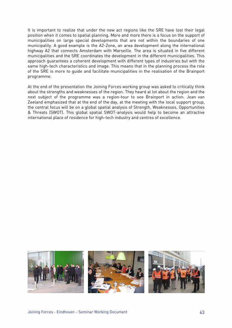
Joining Forces - Eindhoven – Seminar Working Document 63
It is important to realize that under the new act regions like the SRE have lost their legal position when it comes to spatial planning. More and more there is a focus on the support of municipalities on large special developments that are not within the boundaries of one municipality. A good example is the A2-Zone, an area development along the international highway A2 that connects Amsterdam with Marseille. The area is situated in five different municipalities and the SRE coordinates the development in the different municipalities. This approach guarantees a coherent development with different types of industries but with the same high-tech characteristics and image. This means that in the planning process the role of the SRE is more to guide and facilitate municipalities in the realisation of the Brainport programme. At the end of the presentation the Joining Forces working group was asked to critically think about the strengths and weaknesses of the region. They heard al lot about the region and the next subject of the programme was a region-tour to see Brainport in action. Jean van Zeeland emphasized that at the end of the day, at the meeting with the local support group, the central focus will be on a global spatial analysis of Strength, Weaknesses, Opportunities & Threats (SWOT). This global spatial SWOT-analysis would help to become an attractive international place of residence for high-tech industry and centres of excellence.
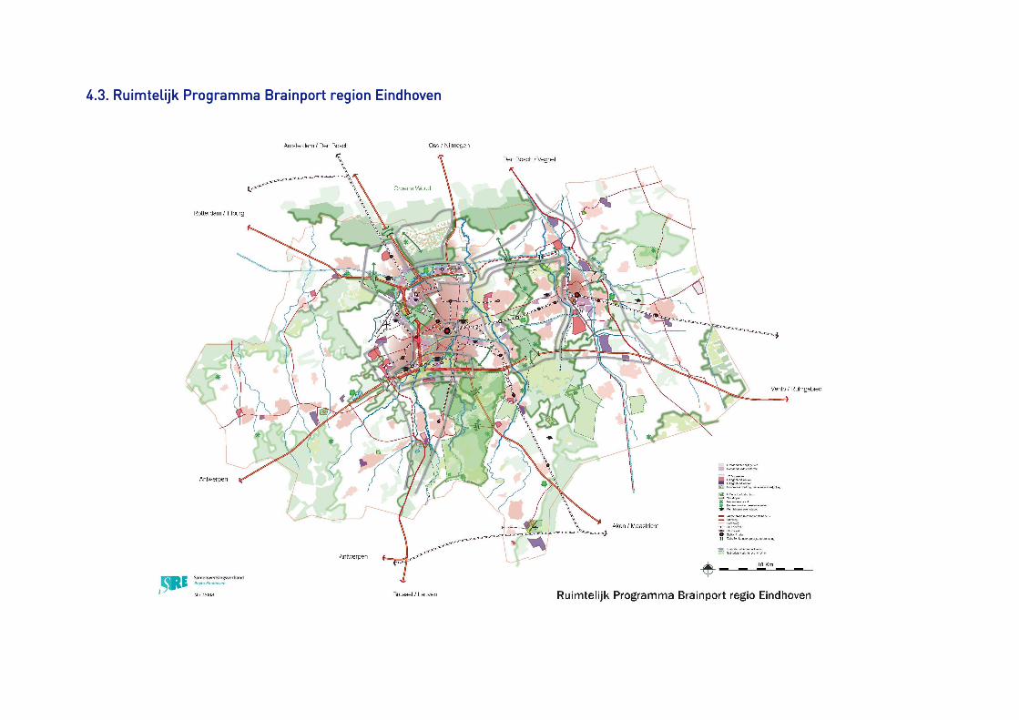
4.3. Ruimtelijk Programma Brainport region Eindhoven4.3. Ruimtelijk Programma Brainport region Eindhoven4.3. Ruimtelijk Programma Brainport region Eindhoven4.3. Ruimtelijk Programma Brainport region Eindhoven

Joining Forces - Eindhoven – Seminar Working Document 66
Agence de développement et d’urbanisme de Lille Métropole 299, Boulevard de Leeds 59 777 EURALILLE - France Phone +33 (0)3 20 63 33 50 / Fax +33 (0)3 20 63 73 99
CCCCONTACTSONTACTSONTACTSONTACTS:::: Lead Partner: Thierry Baert / [email protected] Mathilde Ballenghien / [email protected] Lead Expert: Tamás M. Horváth / [email protected]
www.urbact.euwww.urbact.euwww.urbact.euwww.urbact.eu Editorial:Editorial:Editorial:Editorial: Joining Forces / Agence de développement et d’urbanisme de Lille Métropole Author: Author: Author: Author: T Horvath / Eindhoven – SRE / Agence de développement et d’urbanisme de Lille Métropole / members of the working group Joining Forces Design:Design:Design:Design: Agence de développement et d’urbanisme de Lille Métropole Photography:Photography:Photography:Photography: MB / Agence de développement et d’urbanisme de Lille Métropole
Related Documents