1 BIODATA & CURRICULUM VITAE ASSOCIATE PROFESSOR Sr Dr. ZULKIFLEE ABD LATIF Head of Research Monitoring Unit Research Management Centre Institute Of Research Management & Innovation Universiti Teknologi MARA Associate Professor (Remote Sensing & GIS) Centre Of Studies for Surveying Science & Geomatics Faculty of Architecture, Planning & Surveying Universiti Teknologi MARA(UiTM) 40450 Shah Alam, Selangor, Malaysia. Tel: +603 – 55442876 /4399 Fax : +603-55444545

Welcome message from author
This document is posted to help you gain knowledge. Please leave a comment to let me know what you think about it! Share it to your friends and learn new things together.
Transcript

1
BIODATA & CURRICULUM VITAE
ASSOCIATE PROFESSOR Sr Dr. ZULKIFLEE ABD LATIF
Head of Research Monitoring Unit Research Management Centre
Institute Of Research Management & Innovation Universiti Teknologi MARA
Associate Professor (Remote Sensing & GIS)
Centre Of Studies for Surveying Science & Geomatics Faculty of Architecture, Planning & Surveying
Universiti Teknologi MARA(UiTM) 40450 Shah Alam, Selangor, Malaysia.
Tel: +603 – 55442876 /4399 Fax : +603-55444545

2
ZULKIFLEE ABD LATIF
PERSONAL INFORMATION
Date of birth : 31 May 1972 Place of birth : Segamat Gender : Male
ACADEMIC QUALIFICATIONS 1. Ph.D. (Remote Sensing), Lancaster University, U.K. 2. M.Sc. (Remote Sensing & GIS), Universiti Putra Malaysia, Malaysia 3. Bachelor of Geomatics, The University of Melbourne, Australia
CURRENT POSITION:
Head, Research Monitoring Unit Research Management Centre (RMC) Institute Of Research Management & Innovation (IRMI) Universiti Teknologi MARA, 40450 Shah Alam, Selangor, Malaysia E‐mail : [email protected]; [email protected]
Homepage:
https://www.researchgate.net/profile/Zulkiflee_Abd_Latif
https://orcid.org/0000-0002-6005-5551
https://scholar.google.com/citations?hl=en&user=1O3NfqUAAAAJ
https://www.scopus.com/authid/detail.uri?authorId=39661219700
Field Expertise: Forestry, Remote Sensing & GIS, Environmental & Natural Resources Modelling
Professional Affiliations
1. Fellow, The Royal Institute of Surveyors, Malaysia (RISM)
2. Exco. Member, IEEE Geoscience & Remote Sensing, Malaysia Chapter
3. Working committee member for National Geospatial Data Committee, Malaysia
4. Member of IEEE Geoscience and Remote Sensing Society (GRSS), USA.
5. Member of International Society of Photogrammetry & Remote Sensing (ISPRS), since 2011
6. Full member of Malaysian Remote Sensing Society, since 2003
7. Member, Photogrammetry & Remote Sensing Society, UK from 2007 – 2009

3
EMPLOYMENT HISTORY November 1994 – February 1995 Trainee Surveyor Jurukur Aman Kuantan, Pahang.
(3-month survey work/practical) as part of the Bachelor of Geomatics
working as Trainee Surveyor with Jurukur Aman, Kuantan, Pahang.
Checking and processing field surveyors survey data in the office
using survey softwares (TRPS and GeoComp) - mainly for
topographical and title surveys.
Assist a senior surveyor for field experience mainly doing title
surveys besides minor topographical and engineering survey tasks.
Survey Equipment used :- Total Station Topcon GTS 6 besides other
conventional theodolite and levels
January 1996 – February 2002
Surveyor 1
Kuala Lumpur City Center
Berhad (KLCCB)
PETRONAS
Joined Kuala Lumpur City Centre Berhad (KLCCB), Project
Management company for PETRONAS as a Surveyor 1.
Involved in various national mega projects managed by KLCCB as
stated below :-
1. Kuala Lumpur City Centre (KLCC) Project:-
Kuala Lumpur City Centre Project (Phase One) comprises of the
Petronas Twin Towers, KLCC Park, Maxis Tower, Esso Tower,
Mandarin Oriental Hotel, District Cooling Centre, KLCC Mosque,
Suria KLCC, KLCC Underground Parking and KLCC Access
Tunnels.
Involved full time in KLCC Project above from Jan. 1996 until Jan.
2000.
Managing, supervising and coordinating KLCCB Survey
Department in every job aspects i.e. field survey works, survey data
processing, administrative works, inter departmental work
management etc.
Coordinating, supervising and providing advice on survey activities
to all relevant main contractors’ surveyors involved in the project.
Provide precise primary horizontal and vertical survey control
points to be adopted by all contractors’ survey as common survey
reference points/datum. The establishment of primary survey
control points were ongoing works throughout construction progress
and established when jobs required.
Provide maintenance and periodical checks to verify the stability of
the control points and revised their coordinates if required.
Provided all aspect of QAIQC engineering survey checks on
contractors’ setting out survey works either as requested by KLCCB
project managers or as independent self-checking and record.
Provide as-built or topographical surveys as requested by KLCCB

4
project managers mainly for feasibility study, planning or logistics
purposes.
Meeting and dealing with KLCCB executives (project managers,
engineers, architects etc.), consultants and contractors on solving
survey issues and problems.
Managing department administrative tasks such as managing filing
system, field and office equipment maintenance, staff welfare,
training and recruitment, purchasing etc.
Specific Petronas Twin Tower Survey Tasks :-
Monitoring the verticality of the Twin Towers periodically as part
of independent check or verification on contractors’ survey reports
on their verticality results which were submitted periodically (based
on construction progress stages).
Monitoring the horizontal and vertical survey control point transfer
to higher floors to counter check control points established by
contractors.
Monitoring raft foundation settlement of both towers periodically as
an independent check on contractors’ works and survey reports.
Other surveys which were carried out as QA/QC checks include
monitoring tower column and floor slab concrete shrinkage, creep
age, shortening; monitoring of verticality of lift guide rails and
verification of as-built concrete structures such as columns, core
walls, floor slabs, curtain wall, lifts etc.
2. Putrajaya Project(Federal Government Administration
Centre)
Involved as per on call basis (part time) as required by KLCCB
Putrajaya management team during the early stage of Putrajaya
construction from early of 1996 until end of 1996 (until Jurukur
Perunding Services hired fulltime as survey consultant).
Coordinating and supervising the establishment of Putrajaya Project
primary survey control points using GPS system (carried out by
JPS) to be adopted by all relevant contractors involved in the
project.
Marking on the ground the proposed top water levels of the
proposed lakes (to determine water catchment area) for feasibility
studies and planning.
Marking of Putrajaya main axis (alignment) for feasibility study and
planning.
3. Universiti Teknologi Petronas (UTP) Project ,Tronoh, Perak
5
Monitoring and checking on the progress of the topographical
surveys throughout the proposed UTP project area as conducted by
Jurukur Hashim Serantau
Survey works involved in the UTP Project are mainly in the
construction of the Student Administration Building (Package 3A),
Academic Buildings (Package 3B1 and 3B2), Student
Accommodation (Package 4), Earthwork and Infrastructure
(Package IA, I B and IC) and Landscape (Package 2).
The establishment and maintenance of UTP primary survey control
points, to be adopted by all relevant contractors as their survey
reference. This survey work is an ongoing survey work. Survey
control points will be periodically checked and their coordinates
revised if necessary. New control points will be established and
densified when job or site work requires.
Verification survey or QA/QC survey checks on the setting
out.survey works carried out by the various contractors. QAIQC
checks carried out include verification of positions (alignment) and
levels of road works, sewerage and drainage, utilities or services i.e.
for Infrastructure Package. For building constructions, QAIQC
checks done include as-built pile, column/wall positions; floor slab
levels; MEP services positions and levels, building gridlines,
contractors’ survey control points, settlement and verticality
monitoring survey, cladding/curtainwall installation, column/wall
and lift rail verticality and many others.
Topographical surveys for actual design works or logistic or
planning purposes as required by KLCCB project managers or
consultants.
Setting out surveys especially for logistics and planning purposes as
required by KLCCB project managers or consultants. Providing
advice to contractors’ surveyors on the requirement to keep or
ensure the standard of good and appropriate field survey techniques
in order to obtain accuracy as required throughout construction
progress.
June 2002 – April 2004 Lecturer (Contract),
Centre of Studies for Surveying Science & Geomatics Faculty of
Architecture, Planning & Surveying
Universiti Teknologi MARA, Shah Alam, Malaysia
April 2004 – December 2009 Young Lecturer (Permanent),
Centre of Studies for Surveying Science & Geomatics Faculty of
Architecture, Planning & Surveying
Universiti Teknologi MARA, Shah Alam, Malaysia
January 2010 – Dec 2013 Senior Lecturer,
Centre of Studies for Surveying Science & Geomatics Faculty of
Architecture, Planning & Surveying

6
Universiti Teknologi MARA, Shah Alam, Malaysia
January 2014 – Current Associate Professor,
Centre of Studies for Surveying Science & Geomatics Faculty of
Architecture, Planning & Surveying
Universiti Teknologi MARA, Shah Alam, Malaysia
Jan 2012 – March 2014 Fellow,
Research Management Institute (RMI)
Universiti Teknologi MARA, Shah Alam, Malaysia
April 2014 - Present Head of Research Monitoring Unit
Institute of Research Management & Innovation
Universiti Teknologi MARA, Shah Alam, Malaysia
PUBLICATIONS
Total 28 ISI/SCOPUS Journals, H- Index = 11, Citations = 421
1Book,
67 Conference Proceedings, seminar, workshop
BOOK 1. Zulkiflee Abd Latif (2011). Modelling Microclimates in Forests Using Remotely Sensed Data:Case
study of broadleaved deciduous forest. VDM Verlag Dr. Mueller e.K. 292p.
SCIENTIFIC JOURNALS 1. Nordin, S. A., Latif, Z. A., & Omar, H. (2018) Individual tree crown segmentation in tropical peat
swamp forest using airborne hyperspectral data, Geocarto International, https://doi.org/10.1080/10106049.2018.1475511
2. Mohd Zaki, N. A., Latif, Z. A., & Suratman, M. N. (2018, April 18). Modelling above-ground live trees biomass and carbon stock estimation of tropical lowland Dipterocarp forest: integration of field-based and remotely sensed estimates. International Journal of Remote Sensing. Taylor and Francis Ltd. https://doi.org/10.1080/01431161.2017.1421793
3. Mohd Zaki, N. A., & Abd Latif, Z. (2017). Carbon sinks and tropical forest biomass estimation: a review on role of remote sensing in aboveground-biomass modelling. Geocarto International, 32(7). https://doi.org/10.1080/10106049.2016.1178814
4. Dom, N. C., Ahmad, A. H., Latif, Z. A., & Ismail, R. (2017). Integration of GIS-based model with epidemiological data as a tool for dengue surveillance. EnvironmentAsia, 10(2), 135–146. https://doi.org/10.14456/ea.2017.29
5. Rahman, M. Z. A., Bakar, M. A. A., Razak, K. A., Rasib, A. W., Kanniah, K. D., Kadir, W. H. W., … Latif, Z. A. (2017). Non-destructive, laser-based individual tree aboveground biomass estimation in a tropical rainforest. Forests, 8(3). https://doi.org/10.3390/f8030086

7
6. Adnan, N. A., Razi, N. M., Yusoff, Z. M., & Latif, Z. A. (2017). Spatial temporal estimation and
analysis of carbon sequestration. Advanced Science Letters, 23(7). https://doi.org/10.1166/asl.2017.9227
7. Hasnan, S. N. A., Dom, N. C., Latif, Z. A., & Madzlan, F. (2017). Surveillance of Aedes mosquitoes in different residential types in central zone of Shah Alam, Selangor. Asian Pacific Journal of Tropical Disease, 7(6), 332–340. https://doi.org/10.12980/apjtd.7.2017D7-44
8. Mohd Zaki, N. A., Latif, Z. A., & Zainal, M. Z. (2016). Aboveground biomass and carbon stock estimation using double sampling approach and remotely-sensed data. Jurnal Teknologi, 78(5–4). https://doi.org/10.11113/jt.v78.8551
9. Dom, N. C., Ahmad, A. H., Latif, Z. A., & Ismail, R. (2016). Application of geographical information system-based analytical hierarchy process as a tool for dengue risk assessment. Asian Pacific Journal of Tropical Disease, 6(12), 928–935. https://doi.org/10.1016/S2222-1808(16)61158-1
10. Mohd Zaki N.A., Abd Latif, Z., Suratman, N., (2016). Modelling The Carbon Stocks Estimation Of The Tropical Lowland Dipterocarp Forest Using LiDAR And Remotely Sensed Data, ISPRS Annals of the Photogrammetry, Remote Sensing and Spatial Information Sciences.
11. Mohd Zaki N.A., AbdLatif, Z., Suratman, N., 2016. Aboveground biomass and carbon stocks modelling using non-linear regression model, IOP Conf. Series: Earth and Environmental Science 37 http://doi.org/10.1088/1755-1315/37/1/012030
12. Abd Latif, Z., Aman, S.N.A. & Pradhan, B., (2015). Landslide Susceptibility Assessment Using High Resolution Lidar-derived Parameters And Probabilistic Frequency Ratio Model, Malaysian Journal Of Remote Sensing and GIS, 4(2), 72-84.
13. Hashim, R., & Latif, Z. A., (2015). Langkawi’s sustainable regeneration strategy and natural heritage preservation. EnvironmentAsia, 8(2), 1-8.
14. Mustafa, N., Ya’acob, N., Latif, Z. A., & Yusof, A. L. (2015). Quantification of oil palm tree leaf pigment (chlorophyll a) concentration based on their age. Jurnal Teknologi, 75(11). https://doi.org/10.11113/jt.v75.5341
15. Blackburn, G. A., Latif, Z. A., & Boyd, D. S. (2014). Forest disturbance and regeneration: A mosaic of discrete gap dynamics and open matrix regimes? Journal of Vegetation Science, 25(6), 1341–1354. https://doi.org/10.1111/jvs.12201
16. Salleh, S. A., Latif, Z. A., Pradhan, B., Wan Mohd, W. M. N., & Chan, A. (2014). Functional relation of land surface albedo with climatological variables: a review on remote sensing techniques and recent research developments. Geocarto International, 29(2), 147–163. https://doi.org/10.1080/10106049.2012.748831
17. Saeidi, V., Pradhan, B., Idrees, M. O., & Latif, Z. A. (2014). Fusion of airborne LiDAR with

8
multispectral SPOT 5 image for enhancement of feature extraction using dempster-shafer theory. IEEE Transactions on Geoscience and Remote Sensing, 52(10), 6017–6025. https://doi.org/10.1109/TGRS.2013.2294398
18. Khalid, N., Hamid, J. R. A. & Latif, Z. A. (2014). Accuracy assessment of tree crown detection using local maxima and multi-resolution segmentation, IOP Conference Series: Earth and Environmental Science. 1 ed. Institute of Physics Publishing, Vol. 18, 012023.
19. Idris, R., Latif, Z. A., Hamid, J. R. A., Jaafar, J. & Ahmad, M. Y. 2014. Integrating airborne LiDAR dataset and photographic images towards the construction of 3D building model. IOP Conference Series: Earth and Environmental Science. 1 ed. Institute of Physics Publishing, Vol. 18, 012049
20. Aman, S. N. A., Latif, Z. A. & Pradhan, B. 2014. Spatial probabilistic approach on landslide susceptibility assessment from high resolution sensors derived parameters, IOP Conference Series: Earth and Environmental Science. 1 ed. Institute of Physics Publishing, Vol. 18, 012057
21. Dom, N. C., Ahmad, A. H., Latif, Z. A., Ismail, R., & Pradhan, B. (2013). Coupling of remote sensing data and environmental-related parameters for dengue transmission risk assessment in Subang Jaya, Malaysia. Geocarto International, 28(3), 258–272. https://doi.org/10.1080/10106049.2012.696726
22. Dom, N. C., Hassan, A. A., Latif, Z. A., & Ismail, R. (2013). Generating temporal model using climate variables for the prediction of dengue cases in Subang Jaya, Malaysia. Asian Pacific Journal of Tropical Disease, 3(5), 352–361. https://doi.org/10.1016/S2222-1808(13)60084-5
23. Dom, N. C., Ahmad, A. H., Latif, Z. A., & Ismail, R. (2013). Measurement of dengue epidemic spreading pattern using density analysis method: Retrospective spatial statistical study of dengue in subang jaya, Malaysia, 2006-2010. Transactions of the Royal Society of Tropical Medicine and Hygiene, 107(11), 715–722. https://doi.org/10.1093/trstmh/trt073
24. Pradhan, B., Latif, Z. A., & Aman, S. N. A. (2012). Application of Airborne LiDAR-Derived Parameters and Probabilistic-Based Frequency Ratio Model in Landslide Susceptibility Mapping. Applied Mechanics and Materials, 225(December 2012), 442–447. https://doi.org/10.4028/www.scientific.net/AMM.225.442
25. Dom, N. C., Latif, Z. A., Ahmad, A. H., Ismail, R., & Pradhan, B. (2012). Manifestation of GIS tools for spatial pattern distribution analysis of dengue fever epidemic in the city of Subang Jaya, Malaysia. EnvironmentAsia, 5(2), 82–92. https://doi.org/10.14456/ea.2012.22
26. Latif, Z. A., & Blackburn, G. A. (2010). The effects of gap size on some microclimate variables during late summer and autumn in a temperate broadleaved deciduous forest. International Journal of Biometeorology, 54(2), 119–129. https://doi.org/10.1007/s00484-009-0260-1
27. Fisher, J. B., Nawaz, R., Fauzi, R., Nawaz, F., Eran, E. S., Abd. Latif, Z., & Blackett, M. (2008). Balancing water, religion and tourism on Redang Island, Malaysia. Environmental Research Letters, 3(2). https://doi.org/10.1088/1748-9326/3/2/024005
28. Abd Latif, Z., Wan Mohd, W.M.N., Mohd Nor, A.M. and Md Sadek, E.S.S., (2005). GIS-Based Soil

9
Erosion Modelling of Highland Areas. Case study of Genting Highland &Cameron Highlands. Scientific Research Journal, Vol 2(1), 30-40.
CONFERENCE PROCEEDINGS (INDEXED & NON-INDEXED) 1 Roslan, N. S., Latif, Z. A., & Dom, N. C. (2017). Dengue cases distribution based on land surface
temperature and elevation. In 2016 7th IEEE Control and System Graduate Research Colloquium, ICSGRC 2016 - Proceeding (pp. 87-91). [7813307] Institute of Electrical and Electronics Engineers Inc.. DOI: 10.1109/ICSGRC.2016.7813307
2. Majid, I. A., Latif, Z. A., & Adnan, N. A. (2017). Tree species classification using worldview-3 data. In 2016 7th IEEE Control and System Graduate Research Colloquium, ICSGRC 2016 – Proceeding (pp. 73-76). [7813304] Institute of Electrical and Electronics Engineers Inc.. DOI: 10.1109/ICSGRC.2016.7813304
3. Nordin, S. A., Latif, Z. A., & Omar, H. (2017). Watershed transformation for crown segmentation of Gonystylus Bancanus. In 2016 7th IEEE Control and System Graduate Research Colloquium, ICSGRC 2016 – Proceeding (pp. 77-81). [7813305] Institute of Electrical and Electronics Engineers Inc.. DOI: 10.1109/ICSGRC.2016.7813305
4. Latif, Z. A., Mohd Zaki N.A. & Suratman, N. (2017). Quantifying Tropical Forest Above-Ground Biomass And Carbon Stock Using Geographically Weighted Regression (Gwr) Approach. In 38th Asian Conference on Remote Sensing, ACRS 2017 New Delhi India.
5. Latif, Z. A., Abd Majid, N.A., Mat Nasir, N. (2017). Spatio-Temporal Analysis Of Forest Loss Related To Urban Growth In Central Peninsular Malaysia. In 38th Asian Conference on Remote Sensing, ACRS 2017 New Delhi India.
6. Mohd Zaki N.A., Abd Latif, Z. (2016). Aboveground biomass and carbon stocks modelling using non-linear regression model, 8th IGRSM International Conference and Exhibition on Geospatial & Remote Sensing, Kuala Lumpur, Malaysia.
7. Mohd Zaki N.A., Abd Latif, Z. (2016). Modelling The Carbon Stocks Estimation Of The Tropical Lowland Dipterocarp Forest Using LiDAR And Remotely Sensed Data, ISPRS 2016 - XXIII ISPRS Congress, Prague, Czech republic
8. Ab Majid, I, Abd Latif, Z. & Adnan, N.A. (2016). Tree Species Classification Using Worldview-3 Data, 2016 7th IEEE Control & System Graduate Research Colloquium, Shah Alam, Malaysia
9. Razak, K. A., Mohamad, Z., Ramli, Z., Abu Bakar, R., Roslee, R., Abd Latif, Z., Mohamed, Z. (2015). An Integrated Multi-Hazard Risk Assessment: Outlining An Emerging Field of Research and Practice in Malaysia. In: Proceeding of the 4th International Conference on Slopes, Malaysia 2015, 14-16 September 2015, ISBN 978-967-13627-0-9, Slope Engineering Branch Public Work Department Malaysia 2015, Kuala Lumpur, 193-204.
10. Mohd Zaki N.A., Abd Latif, Z. Suratman, N.,(2015). Individual Tree Crown (ITC) Delineation Technique For Tropical Lowland Dipterocarp Using Watershed Transformation Algorithm, IEEE , International Conference on Space Science and Communication (IconSpace2015), Langkawi,

10
Malaysia
11. Rahman, M.Z.A, Bakar, M.A.A., Rasib, A.W., T.K.Pang, K.A. Razak, Lehan, F.A.M., Yusof, H.H.M. Bakar, R.A., Latif, Z.A. (2014). Terrestrial laser scanning as a method for individual tree measurement: framework and challenges in tropical rainforest. In: Proceeding of the National Conference on Royal Belum 2014, 09- 10 December 2014, Gerik, Perak.
12. Mohd Zaki N.A., Abd Latif, Z. (2014). Allometric Equations for Estimating the Above-Ground Biomass and Carbon Stock in Tropical Lowland Dipterocarp: Case study of Royal Belum Forest Reserve, Perak, Malaysia.
13. Mohd Zaki N.A., Abd Latif, Z. (2015). Aboveground Biomass And Carbon Stock Estimation Using Double Sampling Approach And Remotely-sensed Data, Environmental and Civil Engineering Technology International Conference (ENVICET 2015)
14. Nordin, S,, Abd Latif Z, Omar H. (2015). Crown Segmentation Of Ramin Melawis Tree Using Hyperspectral Imagery, The 36th Asian Conference On Remote Sensing, Manila, Phillipines.
15. Nordin, S,, Abd Latif Z, Omar H. (2015). Automatic Tree Crown Segmentation Algorithm Of Gonystylus Bancanus Using Hyperspectral Image, IEEE Workshop And Geoscience And Remote Sensing, Kuala Lumpur, Malaysia.
16. Nordin, S,, Abd Latif Z, Omar H. (2016). Automatic Crown Segmentation Of Gonystylus Bancanus Using Watershed Transformation, IEEE 7th Control And System Graduate Research Colloquium, Shah Alam, Malaysia.
17. Roslan, N.S., Abd Latif Z , Che Dom, N. (2016). Dengue Cases Distribution Based on Land Surface Temperature and Elevation, IEEE 7th Control And System Graduate Research Colloquium, Shah Alam, Malaysia.
18. Hasan, R. C., Kamaruddin, M. H. & Latif, Z. A. (2015). Height retrieval and vertical accuracy for quantifying biomass and carbon stock. International Conference on Space Science and Communication (Iconspace 2015), Langkawi , Malaysia 75-74.
19. Zaki, N. A. M., Latif, Z. A., Zainal, M. Z. & Zainuddin, K , (2015). Individual tree crown (ITC) delineation using watershed transformation algorithm for tropical lowland dipterocarp. International Conference on Space Science and Communication (Iconspace 2015), Langkawi , Malaysia 237-242.
20. Salleh, S. A., Latif, Z. A., Chan, A., Morris, K. I., Ooi, M. C. G. & Mohd, W. M. N. W. (2015). Weather Research Forecast (WRF) modification of land surface albedo simulations for urban Near Surface Temperature. International Conference on Space Science and Communication (Iconspace 2015), Langkawi , Malaysia 243-247.
21. Mustafa, N., Ya'Acob, N. & Latif, Z. A. (2014). A review on quantification of tree leaf pigment using wavelet analysis and remote sensing. 5th IEEE Control and System Graduate Research Colloquium, (ICSGRC 2014). Shah Alam, Malaysia. 158-163.
11
22. Zainal Abiden M.Z., Muhd Arshad S.H., Jaafar J., Abd Latif, Z., Zainal Abiden S.Z., (2013). Comparative Study on Stochastic and Deterministic Approaches in Urban Growth Model. 9th International Colloquium on Signal Processing & Its Applications (CSPA 2013).,Kuala Lumpur, Malaysia. 8 – 10 March 2013,
23. Zamhury N., Hashim R., Merican F. M., Abd. Latif Z. (2013). The Praxis of Langkawi’s Sustainable Regeneration Strategy Through Eco-Tourism. 4th Asia Pacific International Conference on EnvironmentBehaviour Studies (AicEBs2013), London,U.K., 4-6 September 2013
24. Salleh S. A., Abd.Latif Z., Wan Mohd ,W.M.N.,Chan, A. (2013). Urban Heat Island in Putrajaya, Malaysia: Urbanization vs.Climate Change Effects. 4th Asia Pacific International Conference on Environment-Behaviour Studies (AicEBs2013), London,U.K. 4-6 September 2013
25. Idris, R., Abd Latif, Z., Abd Hamid, J.R., Jaafar J., Ahmad, M.Y., (2013). Integrating Airborne LiDAR dataset and photographic images towards the construction of 3D building model. The 8th International Symposium on Digital Earth (ISDE 2013), Kuching, Sarawak. 26-29 August 2013
26. Aman, S.N.A, Abd Latif Z., Pradhan, B. (2013). Spatial Probabilistic Approach on Landslide Susceptibility Assessment with Integration of High Resolution Derived Parameters. The 8th International Symposium on Digital Earth (ISDE 2013), Kuching, Sarawak. 26-29 August 2013
27. Khalid, N., Abd Hamid, S., Abd Latif, Z. (2013). Accuracy Assessment of Tree Crown Detection and Delineation Based on Local Maxima and Multi-resolution Segmentation Approach. The 8th International Symposium on Digital Earth (ISDE 2013), Kuching, Sarawak. 26-29 August 2013
28. Abd Latif Z. A,man, S.N.A, Pradhan, B. (2013). Exploitation of LiDAR data for spatial prediction of landslides in tropical area. International Symposium & Exhibition on Geoinformation (ISG2013), Kuala Lumpur . 24-25 September 2013
29. Mohd Eris, S., Abd Latif, Z., Salleh, S.A., Pradhan, B., (2013). Solar Photovoltaic Potential Assessment Over Residential Area Rooftops Using LiDAR techniques. International Symposium & Exhibition on Geoinformation (ISG2013), Kuala Lumpur . 24-25 September 2013.
30. Salleh S. A., Abd.Latif Z., Wan Mohd ,W.M.N.,Chan, A. (2013). The Influence of Land Surface Albedo to Urban Heat Island Formation in Putrajaya . International Symposium & Exhibition on Geoinformation (ISG 2013), Kuala Lumpur . 24-25 September 2013.
31. Abd Latif. Z., Ibrahim, N.H., Zamri, Izzati, Pradhan, B., (2013). Tree species identification and classification using high resolution remotely-sensed data. International Symposium & Exhibition on Geoinformation (ISG 2013), Kuala Lumpur . 24-25 September 2013
32. Abd Latif, Z., Zamri, I and Omar, H., (2012). Determination of tree species using Worldview-2 data. 2012 8th International Colloquium on Signal Processing & Its Applications (CSPA 2012). 23 – 25 March 2012, Melaka, Malaysia.
33. Abd Latif, Z., Mohd Zaki, N.A and Salleh, S.A, (2012). GIS-based Estimation of Rooftop Solar Photovoltaic Potential using LiDAR. 2012 8th International Colloquium on Signal Processing & Its Applications (CSPA 2012). 23 – 25 March 2012, Melaka, Malaysia.

12
34. Salleh, S.A., Abd Latif, Z., Wan Mohd, W.M.N. and Chan, A. (2012). Air Quality Parameters
Dependency of Remotely-Sensed Albedo. 2012 8th International Colloquium on Signal Processing & Its Applications (CSPA 2012). 23 – 25 March 2012, Melaka, Malaysia.
35. Abd Latif, Z., Aman, S.N.A. and Pradhan, B. (2012). Landslide susceptibility mapping using LiDAR derived factors and frequency ratio model: Ulu Klang area, Malaysia. 2012 8th International Colloquium on Signal Processing & Its Applications (CSPA 2012). 23 – 25 March 2012, Melaka, Malaysia
36. Ghazali, R., Adzmi, M.F., Rasam, A.R.A., Abd Latif, Z. and Samad, A.M. (2012. The evaluation of 3D traverses of three different distance lengths toward the quality of the network for deformation survey. 2012 8th International Colloquium on Signal Processing & Its Applications (CSPA 2012). 23 – 25 March 2012, Melaka, Malaysia.
37. Idris, R. , Abd Latif, Z., Jaafar, J.,2012, Evaluation of LIDAR DSM for topographic map revision: Urban Environment Mapping Application. Proceedings of AKEPT 2nd Global Annual Young Researchers Conference and Exhibition 2012. 29-31October 2012, Melaka, Malaysia.
38. Idris, R. , Abd Latif, Z., Jaafar, J., Abd Hamid, JR, Ahmad, MY, 2012, Quantitative Assessment of LiDAR dataset for Topographic maps. Proceedings of International Conference on System Engineering & Technology 2012. 11-12 September 2012, Bandung, Indonesia.
39. Abd Latif, Z., Aman, S.N.A and Ghazali, R., 2011. Delineation of tree crown and canopy height using LiDAR and aerial photo. 2011 7th International Colloquium on Signal Processing & Its Applications (CSPA 2011). 4 – 6 March 2011, Penang, Malaysia.
40. Mohd Disa, N., Maarof, I., Abd Latif, Z., and Samad, A.M., 2011. LiDAR: A Review on Generating Digital True Orthophoto. 2011 7th International Colloquium on Signal Processing & Its Applications (CSPA 2011). 4 – 6 March 2011, Penang, Malaysia.
41. Ghazali, R., Abd Latif, Z., Abdul Rasam, A.R. and Samad, A.M., 2011. Integrating Cadastral GIS Database into GPS Navigation System for Locating Land Parcel Location in Cadastral Surveying. 2011 7th International Colloquium on Signal Processing & Its Applications (CSPA 2011). 4 – 6 March 2011, Penang, Malaysia.
42. Idris, R., Abd Latif, Z. and Samad, A.M.,2011. Multi-Criteria Selection of Nuclear Power Plants Using Analytical Hierachy Process, 2011 7th International Conference on Computer Science & Education ( ICCSE 2011), 25-27 November 2011, Penang Malaysia.
43. Bohari, S.N., Mohd Disa, N., Abd Latif, Z. and Samad, A.M., 2011. The use of single orthorectified high resolution satellite imagery for topomap revision and updating, 2011 7th International Conference on Computer Science & Education ( ICCSE 2011), 25-27 November 2011, Penang Malaysia.
44. Ghazali, R., Enche Sukri, A.E., Abdul Latif, A.R., Abd Rasam, A.R., Abd Latif, Z.,and Samad, A.M., 2011. Evaluating the relationship between scanning resolution of laser scanning with the accuracy of the 3D model constructed. 2011 7th International Conference on Computer Science &
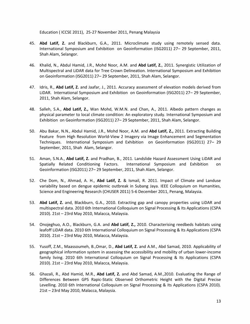
13
Education ( ICCSE 2011), 25-27 November 2011, Penang Malaysia
45. Abd Latif, Z. and Blackburn, G.A., 2011. Microclimate study using remotely sensed data. International Symposium and Exhibition on Geoinformation (ISG2011) 27– 29 September, 2011, Shah Alam, Selangor.
46. Khalid, N., Abdul Hamid, J.R., Mohd Noor, A.M. and Abd Latif, Z., 2011. Synergistic Utilization of Multispectral and LiDAR data for Tree Crown Delineation. International Symposium and Exhibition on Geoinformation (ISG2011) 27– 29 September, 2011, Shah Alam, Selangor.
47. Idris, R., Abd Latif, Z. and Jaafar, J., 2011. Accuracy assessment of elevation models derived from LiDAR. International Symposium and Exhibition on Geoinformation (ISG2011) 27– 29 September, 2011, Shah Alam, Selangor.
48. Salleh, S.A., Abd Latif, Z., Wan Mohd, W.M.N. and Chan, A., 2011. Albedo pattern changes as physical parameter to local climate condition: An exploratory study. International Symposium and Exhibition on Geoinformation (ISG2011) 27– 29 September, 2011, Shah Alam, Selangor.
50. Abu Bakar, N.N., Abdul Hamid, J.R., Mohd Noor, A.M. and Abd Latif, Z., 2011. Extracting Building Feature from High Resolution World-View 2 Imagery via Image Enhancement and Segmentation Techniques. International Symposium and Exhibition on Geoinformation (ISG2011) 27– 29 September, 2011, Shah Alam, Selangor.
51. Aman, S.N.A., Abd Latif, Z. and Pradhan, B., 2011. Landslide Hazard Assessment Using LiDAR and Spatially Related Conditioning Factors. International Symposium and Exhibition on Geoinformation (ISG2011) 27– 29 September, 2011, Shah Alam, Selangor.
52. Che Dom, N., Ahmad, A. H., Abd Latif, Z. & Ismail, R. 2011. Impact of Climate and Landuse variability based on dengue epidemic outbreak in Subang Jaya. IEEE Colloquium on Humanities, Science and Engineering Research (CHUSER 2011) 5-6 December 2011, Penang, Malaysia.
53. Abd Latif, Z. and, Blackburn, G.A., 2010. Extracting gap and canopy properties using LiDAR and multispectral data. 2010 6th International Colloquium on Signal Processing & Its Applications (CSPA 2010). 21st – 23rd May 2010, Malacca, Malaysia.
54. Onojeghuo, A.O., Blackburn, G.A. and Abd Latif, Z., 2010. Characterising reedbeds habitats using leafoff LiDAR data. 2010 6th International Colloquium on Signal Processing & Its Applications (CSPA 2010). 21st – 23rd May 2010, Malacca, Malaysia.
55. Yusoff, Z.M., Maassoumeh, B.,Omar, D., Abd Latif, Z. and A.M., Abd Samad, 2010. Applicability of geographical information system in assessing the accessibility and mobility of urban lower-income family living. 2010 6th International Colloquium on Signal Processing & Its Applications (CSPA 2010). 21st – 23rd May 2010, Malacca, Malaysia.
56. Ghazali, R., Abd Hamid, M.R., Abd Latif, Z. and Abd Samad, A.M.,2010. Evaluating the Range of Differences Between GPS Rapic-Static Observed Orthometric Height with the Digital Precise Levelling. 2010 6th International Colloquium on Signal Processing & Its Applications (CSPA 2010). 21st – 23rd May 2010, Malacca, Malaysia.

14
57. Abd Latif, Z. and Blackburn, G.A. 2009. Extraction of gap and canopy properties derived from LiDAR
and multispectral imagery for forest microclimate modelling. International Symposium on Remote Sensing of Environment ISRSE 33. 8-11th May, 2009,Stresa, Italy
58. Abd Latif, Z. and Blackburn, G.A. 2009. Driving a forest microclimate model using gap and canopy properties derived from LiDAR and multispectral data. RSPSoc2009, “New Dimensions in Earth Observation”, University of Leicester, 8-11th September 2009, Leicester, UK.
59. Abd Latif, Z. and Blackburn, G.A., 2008. Forest microclimate modelling using gap and canopy properties derived from LiDAR and hyperspectral imagery. Silvilaser 2008: 8th International conference on LiDAR applications in forest assessment and inventory, Edinburgh, U.K. 18-19 September, 2008.
60. Abd Latif, Z. and Blackburn, G.A., 2008. Extraction of gap and canopy properties using LiDAR and hyperspectral imagery for forest microclimate modelling. 2008 International Society of Photogrammetry and Remote Sensing Conference, Beijing, China. 3-13 July, 2008.
61. Abd Latif, Z., and Blackburn, G.A., 2008. Modelling the effects of gap size on microclimate and soil water balance in semi natural deciduous forest using remotely sensed data. Annual Student Meeting, Remote Sensing and Photogrammetry Society, Foxlease Activity Centre, Hampshire, U.K., 10-11 March 2008.
62. Abd Latif., Z. 2007. Modelling microclimates using remotely sensed data. International Climate Change Conference 2007, British Council, Aston Conference Centre, Birmingham, 28 -31 March, 2007.
63. Benjamin,A., Wan Mohd, W.M.N., Md. Sadek, E.S.S., Abd Latif, Z. and Md Rani, M. N., 2006. Utilising Radio-Controlled Helicopter for Large Scale Mapping. International Symposium & Exhibition on Geoinformation 2006, 19-21 September, 2006, Kuala Lumpur, Malaysia.
64. Abd. Latif, Z. 2006. Summary of past, present and future research. International Networking of Young Scientists on Imaging Techniques and GIS: Applications in Environmental and Natural Resources Management. British Council, Universiti Malaya, Kuala Lumpur, Malaysia. September 2006.
65. Abd. Latif, Z., Wan Mohd, W. M. N., Md. Sadek, E.S.S., and Mohd Noor, A.M., 2006. Soil erosion modelling of Cameron Highlands using GIS techniques, Proceedings of International Seminar on Civil and Infrastructure Engineering 2006 (ISCIE’06), 13-14 June 2006, Shah Alam, Malaysia.
66. Abd Latif, Z., Wan Mohd, W. M. N., Md. Sadek, E.S.S., &Mohd, Noor, A.M., (2005) GIS-based soil erosion modelling of highland areas: Case study of Genting Highlands and Cameron Highlands, Proceedings of Conference on Scientific and Social Research 2005 (CSSR 2005).
67. Mohd Noor, A. M., & Wan Mohd, W. M. N., Abd Latif, Z., &Md.Sadek, E.S.S., (2004) Soil Erosion Modeling of Highland Areas: Case Study of Genting Highland and Cameron Highland. Proceedings of International Symposium & Exhibition on Geoinformation 2004 (ISG 2004).

15
RESEARCH GRANTS
No.
Project title Amount(RM)
Year Source of fund
1. GIS-based Soil Erosion Modelling Of Highland Areas-case Study Genting Highlands And Cameron Highlands - 600-BRC/ST5/3/584
9,943 2003-2004
Dana UiTM
2. Integrating Airborne Hyperspectral Remote Sensing And GIS Technology For Analysing Urban Heat Island: Case Study Of Penang Island -600-IRDC/ST5/3/996
12,000 2005-2006
Dana UiTM
3. Digital Aerial Photogrammetry Using Radio ControlledHelicopter-600-IRDC/ST5/3/995
12,000 2005-2006
Universiti Teknologi MARA (UiTM)
4. Characterizing Forest Microclimates Using Numerical Modelling and Remote Sensing - 600-RMI/ST/DANA5/3/Dst(36/2010)
7,000 2010-2011
Universiti Teknologi MARA (UiTM)
5. Feasible Study on Establishment of Passive GPS Reference Station in UiTM, Shah Alam -600- RMI/ST/DANA5/3/Dst(323/2009
10,000 2010-2012
Universiti Teknologi MARA (UiTM)
6. Microclimate Assessment of Edge Fragmentation Due to the Clearing Interface in Taman Negara and Its Surrounding Areas- 600 - RMI/ST/FRGS5/3/Fst(25/2009)
40,000 2009- 2013
Ministry of Education (MoE), Malaysia
7. Albedo Pattern Changes as Physical Parameter to Remote Sensing Athropogenic Factors: Functional Relation to Global Climate Condition.- 600-RMI/SSP/FRGS5/3/Fsp (90/2010)
65,600 2010- 2013
Ministry of Education (MoE), Malaysia
8. Terrestrial Laser Scanning For The New Approach Of Large Scale Three dimensional (3D) Topographic Mapping
173,000 2012- 2013
Ministry of Science, Technology & Innovation (MOSTI), Malaysia
9. Modelling Urban Growth and Spatial Structure For Urban Area in Malaysia-600-RMI/DANA 5/3/RIF(550/2012)
32,000 2012- 2013
Dana UiTM
10. Forest Microclimate Dynamics And Patterns With Functional Relation To Global Climate Condition- 600-RMI/FRGS5/3(120/2012)
68,800 2012- 2014
Ministry of Education (MoE), Malaysia
11. Spatially-derived Allometric Relationship Amongst Tree Biophysical Parameters – 600- RMI/DANA5/3/RIF(267/2012)
32,000 2012- 2013
Universiti Teknologi MARA (UiTM)
12. Interception Loss Canopy Cover C Formulation Theory-600-RMI/ST/FRGS5/3/Fst(57/2011)
75,000 2011- 2013
Ministry of Education (MoE), Malaysia
13. Developing A Policy-Based For Sustainable Regeneration Among Communities In Langkawi -600-RMI/RAGS5/3(169/2012)
35,000 2012- 2014
Ministry of Education (MoE), Malaysia

16
14. Quantifying Tropical Rainforest Biomass By Fusing Lidar And Satellite Remote Sensing Data For Sustainable Forest Management - 600-RMI/RAGS 5/3 (156/2014)
80,000 2014-2016
Ministry of Education (MoE), Malaysia
15. Applied Remote Sensing & Geospatial - 600-RMI/DANA 5/3/REI (10/2014)
32,000 2014-2016
Universiti Teknologi MARA (UiTM)
16. Understanding Disturbance And Regeneration In Tropical Forests To Support Sustainable Forest Management - 600-RMI/REG 5/3 (111/2014)
841,725 2014-2017
Natural Environment Research Council (NERC), U.K.
17. Impak Jaringan Universiti Teknikal Malaysia (MTUN) Dan Impak Geran Penyelidikan, Pembangunan Dan Pengkomersilan (R&D&C) Terhadap MTUN - 100-RMI/GOV 16/6/2 (1/2015)
250,000 2015-2016
Ministry of Education (MoE), Malaysia
18. Tropical Rainforest Carbon Sinks And Biomass Estimates With Integration Of Multi-Source Remote Sensing Data Fusion.(600-RMI/FRGS 5/3 (144/2015)
86,200 2015-2017
Ministry of Education (MoE), Malaysia
19. Integrating Mixed Methods In Developing Governance Model To Prevent Aedes Breeding In Construction Projects (600-RMI/FRGS 5/3 (0061/2016))
62,200 2016-2018
Ministry of Education (MoE), Malaysia
20. Multicriteria Decision Making For Sinkhole Susceptibility Hazard Zones -FRGS
77,300 2016-2018
Ministry of Education (MoE), Malaysia
21. Mapping Of Urban Forest Structure And Function Using Airborne Lidar And High Resolution Multispectral Data –BESTARI
50,000 2017-2019
Universiti Teknologi MARA (UiTM)
22. Developing A Space Syntax Embedded Environmental Design Model (Edm) For A Safe Heritage Area (Shea)-FRGS
90,100 2017-2019
Ministry of Education (MoE), Malaysia
22. Modelling Aboveground Biomass And Carbon Stock In Logged-Over Tropical Forest In Berkelah, Malaysia Using Lidar And Uav-Based Stand-Alone System
30,000 2018-2020
Universiti Teknologi MARA (UiTM)
TOTAL AMOUNT 2,171,868
17
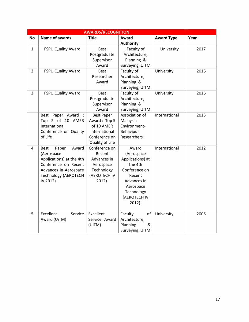
AWARDS/RECOGNITION
No Name of awards Title Award Authority
Award Type Year
1. FSPU Quality Award Best Postgraduate
Supervisor Award
Faculty of Architecture, Planning &
Surveying, UiTM
University 2017
2. FSPU Quality Award Best Researcher
Award
Faculty of Architecture, Planning & Surveying, UiTM
University 2016
3. FSPU Quality Award Best Postgraduate
Supervisor Award
Faculty of Architecture, Planning & Surveying, UiTM
University 2016
Best Paper Award : Top 5 of 10 AMER International Conference on Quality of Life
Best Paper Award : Top 5
of 10 AMER International
Conference on Quality of Life
Association of Malaysia Environment-Behaviour Researchers
International 2015
4, Best Paper Award (Aerospace Applications) at the 4th Conference on Recent Advances in Aerospace Technology (AEROTECH IV 2012).
Conference on Recent
Advances in Aerospace Technology
(AEROTECH IV 2012).
Award (Aerospace
Applications) at the 4th
Conference on Recent
Advances in Aerospace Technology
(AEROTECH IV 2012).
International 2012
5. Excellent Service Award (UiTM)
Excellent Service Award (UiTM)
Faculty of Architecture, Planning & Surveying, UiTM
University 2006
18
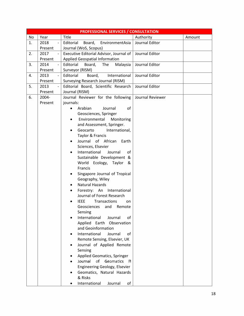
PROFESSIONAL SERVICES / CONSULTATION
No Year Title Authority Amount
1. 2018 - Present
Editorial Board, EnvironmentAsia Journal (WoS, Scopus)
Journal Editor
2. 2017 - Present
Executive Editorial Advisor, Journal of Applied Geospatial Information
Journal Editor
3. 2014 - Present
Editorial Board, The Malaysia Surveyor (RISM)
Journal Editor
4. 2013 - Present
Editorial Board, International Surveying Research Journal (RISM)
Journal Editor
5. 2013 - Present
Editorial Board, Scientific Research Journal (RISM)
Journal Editor
6. 2004- Present
Journal Reviewer for the following journals:
Arabian Journal of Geosciences, Springer
Environmental Monitoring and Assessment, Springer.
Geocarto International, Taylor & Francis
Journal of African Earth Sciences, Elsevier
International Journal of Sustainable Development & World Ecology, Taylor & Francis
Singapore Journal of Tropical Geography, Wiley
Natural Hazards
Forestry: An International Journal of Forest Research
IEEE Transactions on Geosciences and Remote Sensing
International Journal of Applied Earth Observation and Geoinformation
International Journal of Remote Sensing, Elsevier, UK
Journal of Applied Remote Sensing
Applied Geomatics, Springer
Engineering Geology, Elsevier
Geomatics, Natural Hazards & Risks
International Journal of
Journal Reviewer

19
Geoinformatics
Pertanika Journal of Science & Technology
Remote Sensing
Computers, Environment and Urban Systems, Springer
Land Degradation & Development, Wiley publication
International Journal of Forestry and Wood Science
Urban Forestry & Urban Greening
7. 2003 Remote Sensing Course 2003 – Module 1 and 2 organised for the Malaysian Center of Remote Sensing (MACRES)
Speaker / Facilitator 10,000
8. 2003 Short Course on Geographical Information System (GIS) 2003 – Data Collection 19rganized for Malaysian Center for Geospatial Data Infrastructure (MaCGDI)
Speaker / Facilitator 10,000
9. 2003 Geographical Information System (GIS) and Remote Sensing Course 2003- Module 1 organised by National Soil Erosion Center (NASEC)
Speaker / Facilitator
10,000
10. 2004 Remote Sensing Course 2004 – Module 1 and 2 organised for the Malaysian Center of Remote Sensing (MACRES)
Speaker / Facilitator 10,000
11. 2004 Short Course on Geographical Information System (GIS) 2004 – Data Collection organised for Malaysian Center for Geospatial Data Infrastructure (MaCGDI)
Speaker / Facilitator
10,000
12. 2004 Geographical Information System (GIS) and Remote Sensing Course 2004- Module 1 organised by National Soil Erosion Center (NASEC)
Speaker / Facilitator
10,000
13. 2004 Revision Classes for Institute of Surveyors, Malaysia (ISM) Professional Examination 2004 organized by Institute of Surveyors, Malaysia (ISM).
Speaker / Facilitator
3,000
14. 2004 Short Course on Engineering Surveying 2004 organised by Insitute of Research, Development and
Speaker / Facilitator 10,000

20
Consultancy (IRDC)
15. 2005 Remote Sensing Course 2005 – Module 1 organised for the Malaysian Center of Remote Sensing (MACRES).
Speaker / Facilitator 10,000
16. 2005 Short Course on Geographical Information System (GIS) 2005 – Data Collection 20rganized for Malaysian Center for Geospatial Data Infrastructure (MaCGDI)
Speaker / Facilitator 10,000
17. 2005 Revision Classes for Institute of Surveyors, Malaysia (ISM) Professional Examination 2005 organized by Institute of Surveyors, Malaysia (ISM).
Speaker / Facilitator 3,000
18. 2005 Series of GeoHits Technical Workshops : Series 1 – Construction Survey organized by Geotechnical, Highway and Engineering Survey Division, Faculty of Civil Engineering, UiTM.
Speaker / Facilitator 3,000
19. 2006 Short Course on Geographical Information System (GIS) 2006 – Data Collection 20rganized for Malaysian Center for Geospatial Data Infrastructure (MaCGDI)
Speaker / Facilitator 10,000
20. 2006 Geographical Information System (GIS) Course 2006 – Data Collection organised for National Institute of Land and Survey (INSTUN).
Speaker / Facilitator 10,000
21
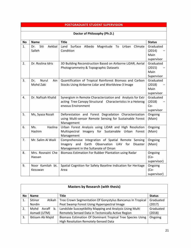
POSTGRADUATE STUDENT SUPERVISION
Doctor of Philosophy (Ph.D.)
No Name Title Status
1. Dr. Siti Aekbal Salleh
Land Surface Albedo Magnitude To Urban Climate Condition
Graduated (2014) – Main supervisor
2. Dr. Roslina Idris 3D Building Reconstruction Based on Airborne LiDAR, Aerial Photogrammetry & Topographic Datasets
Graduated (2015) – Main Supervisor
3. Dr, Nurul Ain Mohd Zaki
Quantification of Tropical Rainforest Biomass and Carbon Stocks Using Airborne Lidar and Worldview-3 lmage
Graduated (2018) – Main supervisor
4. Dr. Nafisah Khalid Synergism in Remote Characterization and Analysis for Extracting Tree Canopy Structural Characteristics in a Heterogeneous Environment
Graduated (2018) – Co-supervisor
5. Ms, Syaza Rozali Deforestation and Forest Degradation Characterization using Multi-sensor Remote Sensing for Sustainable Forest Management
Ongoing (Main)
6. Ms. Haslina Hashim
Urban Forest Analysis using LiDAR and High Resolution Multispectral Imagery for Sustainable Urban Forest Management
Ongoing (Main)
7. Mr. Salim Al Waili Comprehensive Integration of Spatial Remote Sensing Imagery and Earth Observation UAV for Disaster Management in the Sultanate of Oman
Ongoing (Main)
8. Mrs. Rosnaini Che Hassan
Biomass Estimation For Rubber Plantation using Radar Ongoing (Co-supervisor)
9. Noor Kamilah bt. Kezuwan
Spatial Cognition for Safety Baseline Indication for Heritage Area
Ongoing (Co-supervisor)
Masters by Research (with thesis) No Name Title Status
1. Sitinor Atikah Nordin
Tree Crown Segmentation Of Gonystylus Bancanus In Tropical Peat Swamp Forest Using Hyperspectral Image
Graduated (2017)
2. Mohd Asraff b. Asmadi (UTM)
Landslide Susceptibility Mapping and Analysis Using Multi Remotely Sensed Data in Tectonically Active Region
Graduated (2018)
3. Ibtisam Ab Majid Biomass Estimation Of Dominant Tropical Tree Species Using High Resolution Remotely-Sensed Data
Ongoing
22
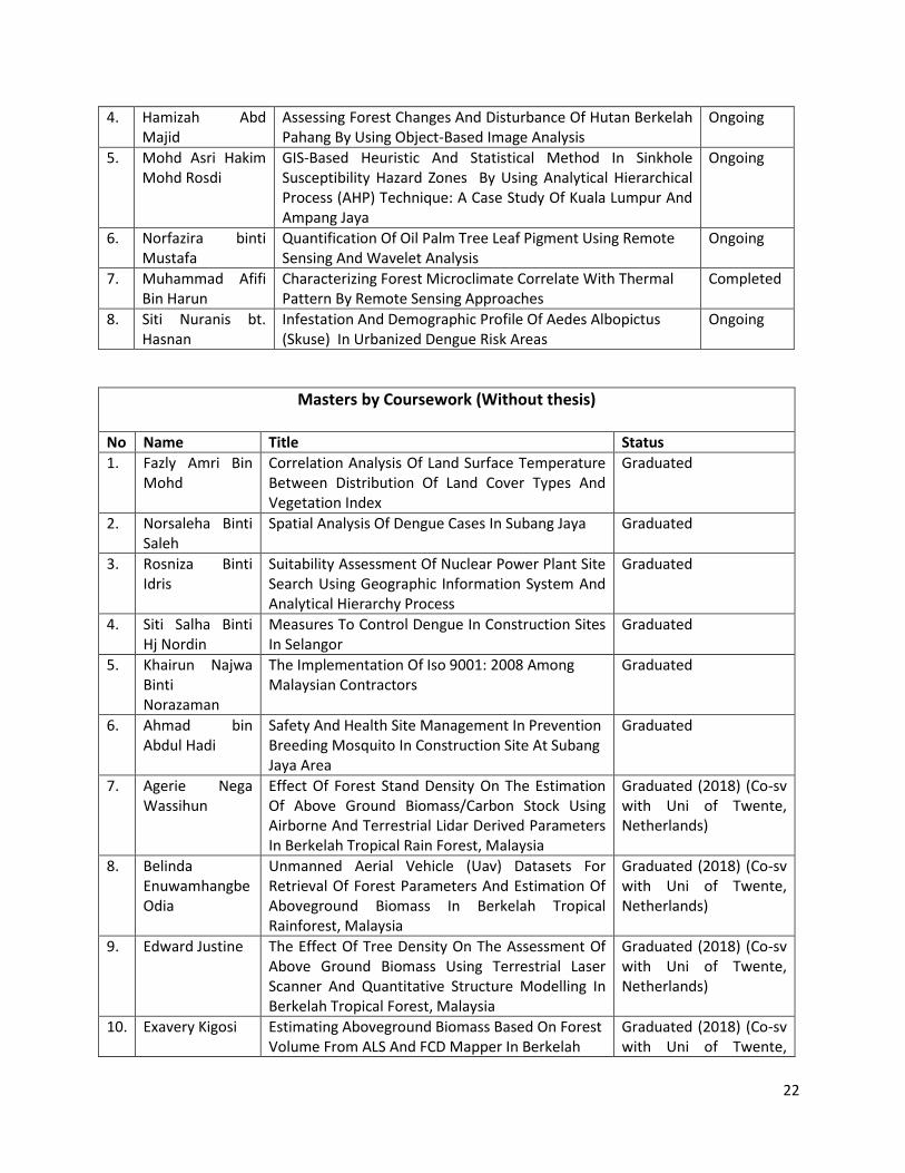
4. Hamizah Abd Majid
Assessing Forest Changes And Disturbance Of Hutan Berkelah Pahang By Using Object-Based Image Analysis
Ongoing
5. Mohd Asri Hakim Mohd Rosdi
GIS-Based Heuristic And Statistical Method In Sinkhole Susceptibility Hazard Zones By Using Analytical Hierarchical Process (AHP) Technique: A Case Study Of Kuala Lumpur And Ampang Jaya
Ongoing
6. Norfazira binti Mustafa
Quantification Of Oil Palm Tree Leaf Pigment Using Remote Sensing And Wavelet Analysis
Ongoing
7. Muhammad Afifi Bin Harun
Characterizing Forest Microclimate Correlate With Thermal Pattern By Remote Sensing Approaches
Completed
8. Siti Nuranis bt. Hasnan
Infestation And Demographic Profile Of Aedes Albopictus (Skuse) In Urbanized Dengue Risk Areas
Ongoing
Masters by Coursework (Without thesis) No Name Title Status
1. Fazly Amri Bin Mohd
Correlation Analysis Of Land Surface Temperature Between Distribution Of Land Cover Types And Vegetation Index
Graduated
2. Norsaleha Binti Saleh
Spatial Analysis Of Dengue Cases In Subang Jaya Graduated
3. Rosniza Binti Idris
Suitability Assessment Of Nuclear Power Plant Site Search Using Geographic Information System And Analytical Hierarchy Process
Graduated
4. Siti Salha Binti Hj Nordin
Measures To Control Dengue In Construction Sites In Selangor
Graduated
5. Khairun Najwa Binti Norazaman
The Implementation Of Iso 9001: 2008 Among Malaysian Contractors
Graduated
6. Ahmad bin Abdul Hadi
Safety And Health Site Management In Prevention Breeding Mosquito In Construction Site At Subang Jaya Area
Graduated
7. Agerie Nega Wassihun
Effect Of Forest Stand Density On The Estimation Of Above Ground Biomass/Carbon Stock Using Airborne And Terrestrial Lidar Derived Parameters In Berkelah Tropical Rain Forest, Malaysia
Graduated (2018) (Co-sv with Uni of Twente, Netherlands)
8. Belinda Enuwamhangbe Odia
Unmanned Aerial Vehicle (Uav) Datasets For Retrieval Of Forest Parameters And Estimation Of Aboveground Biomass In Berkelah Tropical Rainforest, Malaysia
Graduated (2018) (Co-sv with Uni of Twente, Netherlands)
9. Edward Justine The Effect Of Tree Density On The Assessment Of Above Ground Biomass Using Terrestrial Laser Scanner And Quantitative Structure Modelling In Berkelah Tropical Forest, Malaysia
Graduated (2018) (Co-sv with Uni of Twente, Netherlands)
10. Exavery Kigosi Estimating Aboveground Biomass Based On Forest Volume From ALS And FCD Mapper In Berkelah
Graduated (2018) (Co-sv with Uni of Twente,

23
Tropical Rainforest, Malaysia Netherlands)
11. Solomon Begashaw
Accuracy Of DTM Derived From UAV Imagery And Its Effect On Canopy Height Model Compared To Airborne Lidar In Part Of Tropical Rain Forests Of Berkelah, Malaysia
Graduated (2018) (Co-sv with Uni of Twente, Netherlands)
12. Tiegsti Hadush Berhe
Towards A UAV Based Standalone System For Estimating And Mapping Aboveground Biomass/ Carbon Stock In Berkelah Tropical Rain Forest, Malaysia
Graduated (2018) (Co-sv with Uni of Twente, Netherlands)
Dissertation / Project (Bachelor of Surveying Science & Geomatics)
No Name Title Status
1. Nur Hidayah Bt Ishak Hizam
The Oil Palm Biomass Mapping Using Remote Sensing Method
Graduated
2. Nur Hidayat Bt Moh Nasir
Oil Palm Fertility Mapping Using Remote Sensing Method
Graduated
3. Nur Roshima Bt Mat Rasid
Underground Utility Mapping Using Ground Penetrating Radar
Graduated
4. Siti Nur Afiqah Binti Aman
Extraction Of Tree Crown And Canopy Height Using Airborne Lidar And Aerial Photo
Graduated
5. Zahidan Bin Mamat
Pemantauan Pergerakan Bangunan Tinggi Menggunakan Kaedah Gps
Graduated
6. Nor Azam Bin Othman
Aplikasi Gps Menghasilkan Kontur Dalam Pemetaan Topografi
Graduated
7. Mohd Jasmin Bin Mohd Sharif
Statik Dan Kinematik Gps Dalam Pengukuran Strip Graduated
8. Mohd Fuad Bin Abdullah @ Hashim
Perbandingan Kaedah Penentududukan Titik Kawalan Gps Menggunakan Satu Dan Dua Alat Kawalan Gps Merujuk Kepada Peta Digital
Graduated
9. Fudynathra Bin Abbas
Kajian Ketepatan Ketinggian Gps Dengan Menggunakan Geoid EGM96 Dan Geoid Malaysia
Graduated
10. Failzulni Bin Zulkarnine
Kajian Ketepatan Cerapan Gps Terhadap Kesan Penggunaan Jarak Dan Masa
Graduated
11. Ahmad Ridzuan Bin Ahmad
Zawawi
Penggunaan Alat Laser Total Station (Leica Tcr307) Dalam Kerja-Kerja Pemantauan Bangunan Tinggi
Graduated
12. Mohd Fuad Bin Abdullah @
Hashim
Perbandingan Ketepatan Nilai Ketinggian Orthometrik Menggunakan Kaedah GPS Dan Ukur Aras
Graduated
13. Nurul Nadia Azhar
(2015102455)
3D building reconstruction of Menara SAAS, UiTM using Photogrammetry & LiDAR approach
Ongoing
14. Shahira Amira binti Ibrahim (2015110133)
3D Feature Extraction of Buildings and Trees using LiDAR and World View 3 in UiTM Shah Alam
Ongoing

24
15. Nurul Fatin Izati binti Aziz
Mapping of Carbon Stock at UiTM by Using LiDAR Application
Graduated
16. Nur Hamizah Abd Majid
(2014297712)
Tropical Forest Change and Mapping using Remote Sensing Technique: Case study of Bukit Cherakah Forest Reserve.
Graduated
17. Muhammad Amirul Hafiz Mohamed
Jazman (2014698618)
GIS-based Landslides Hazard Mapping Prediction using Multi-criteria Decision Analysis
Graduated
18. Nurul Zakirah binti Rosly
(2014264912)
Identifying unhealthy and healthy plants near to Bauxite mining area in Pahang
Graduated
19. Muhammad Emran Syamil bin Kamsan
(2014849404)
Integrating Correlation between satellite remote sensing and in-situ measurement for urban heat island in Putrajaya.
Graduated
20. Nurul Elena binti Mohd Arif (2014402878)
Characterising forest species composition in Hutan Simpan Bukit Cherakah using remote sensing
Graduated
21. Floyd Froline (2013815352)
Relationship between earthquake and movement of land
Graduated
22. Norlatifah binti Mohd Yusof (2013780235)
Analysis of soil erosion at Lojing Highland, Kelantan
Graduated
23.
Tuan Norsyafira binti Tuan Azam (2012149861)
Relationship between landuse and water quality at Lojing Highland, Kelantan
Graduated
24. Amir Aizat bin Mohd Rosdi (2014395545)
Identification of flood evacuation centres for immediate escape at Kuala Krai, Kelantan
Graduated
25. Mohamad Murshidi b. Zohari (20141666049)
Identification of oil palm and rubber tree using remote sensing at Kuala Lipis
Graduated
26. Khairil Hazrin Ab Jabal (2013424598)
Assessment of Biomass abd Carbon stock at Hutan Ayer Hitam using high resolution data
Graduated
27. Shamsul Jalil (2013629002)
Tree Identification and tree crown delineation mapping using LiDAR
Graduated
28. Mohd Hazmil b. Mohd Radzi (2011370565)
Land use pattern of agriculture and forested area using Remote Sensing: Case study of Cameron Highland
Graduated
29. Nur Syahirah Mokhtar (2013215826)
Height assessment of forest canopy from airborne LiDAR data at Ayer Hitam Forest
Graduated
Related Documents