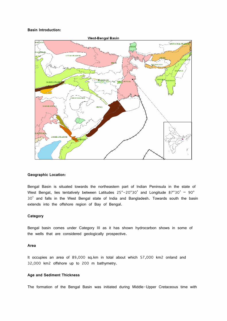
Basin Introduction: Geographic Location: Bengal Basin is situated towards the northeastern part of Indian Peninsula in the state of West Bengal, lies tentatively between Latitudes 25°-20°30’ and Longitude 87°30’ – 90° 30’ and falls in the West Bengal state of India and Bangladesh. Towards south the basin extends into the offshore region of Bay of Bengal. Category Bengal basin comes under Category III as it has shown hydrocarbon shows in some of the wells that are considered geologically prospective. Area It occupies an area of 89,000 sq.km in total about which 57,000 km2 onland and 32,000 km2 offshore up to 200 m bathymetry. Age and Sediment Thickness The formation of the Bengal Basin was initiated during Middle-Upper Cretaceous time with

Welcome message from author
This document is posted to help you gain knowledge. Please leave a comment to let me know what you think about it! Share it to your friends and learn new things together.
Transcript
Basin Introduction:
Geographic Location: Bengal Basin is situated towards the northeastern part of Indian Peninsula in the state of West Bengal, lies tentatively between Latitudes 25°-20°30’ and Longitude 87°30’ – 90° 30’ and falls in the West Bengal state of India and Bangladesh. Towards south the basin extends into the offshore region of Bay of Bengal. Category Bengal basin comes under Category III as it has shown hydrocarbon shows in some of the wells that are considered geologically prospective. Area It occupies an area of 89,000 sq.km in total about which 57,000 km2 onland and 32,000 km2 offshore up to 200 m bathymetry. Age and Sediment Thickness The formation of the Bengal Basin was initiated during Middle-Upper Cretaceous time with
differential subsidence. This episode corresponds with the deposition of the subaerial fluvial clastics of the Bolpur Formation and its facies variant of the shell limestone and shale–sandstone of the Ghatal Formation in the shelf area. Proximal deposition of a portion of the orogenic sediment from the eastern Himalaya and the Indo-Burman Uplifts has built a thick sequence of approximately 20km of deposits in the Bengal basin.
Tectonic Framework Tectonically, Bengal basin had a polycyclic history. From carboniferous to upper Eocene time it was a divergent margin basin and was initiated as a response to the breakup of the Gondwanaland along the rifted margin of the Indian plate. It depicts all evolutionary characteristics related to marginal sag basins. Indian plate finally got separated from Gondwanaland during lower cretaceous moved northwards and during upper Eocene had first collision with Eurasian Plate in the north and with Burmese plate in the northeast. Since then Bengal basin, attained the status of convergent margin basin . The basin shows two distinct phases of development :
1. Gondwana phase 2. post–Gondwana phase
During the Gondwana phase, non-marine sediments got deposited within a graben oriented in N-S direction. This initial phase of sedimentation was followed by a period of peneplanation and initiation of a general tilt of the shelf towards east. After the outpouring of Rajmahal lavas, an uninterrupted phase of marine sedimentation in a subsiding basin started in Late Cretaceous. Marine inundation covered practically the whole of the basin up to its western margin. A thick sedimentary prism was deposited during Tertiary. Following are the main tectonic and structural zones identified in the basin :
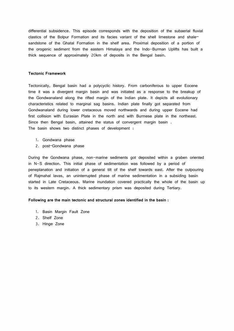
1. Basin Margin Fault Zone 2. Shelf Zone 3. Hinge Zone
4. Deep Basin
Basin Margin Fault Zone This NNE-SSW trending fault zone demarcates the western crystalline/metamorphic complex of Precambrian age from the shelf sediments. The fault zone is, apparently, the result of distension and down warping of the shelf region during Early Cretaceous, probably, concomitant with the eruption of Rajmahal basaltic lavas. West of this feature are the exposures of Gondwana sediments resting on the Precambrian granitic basement.
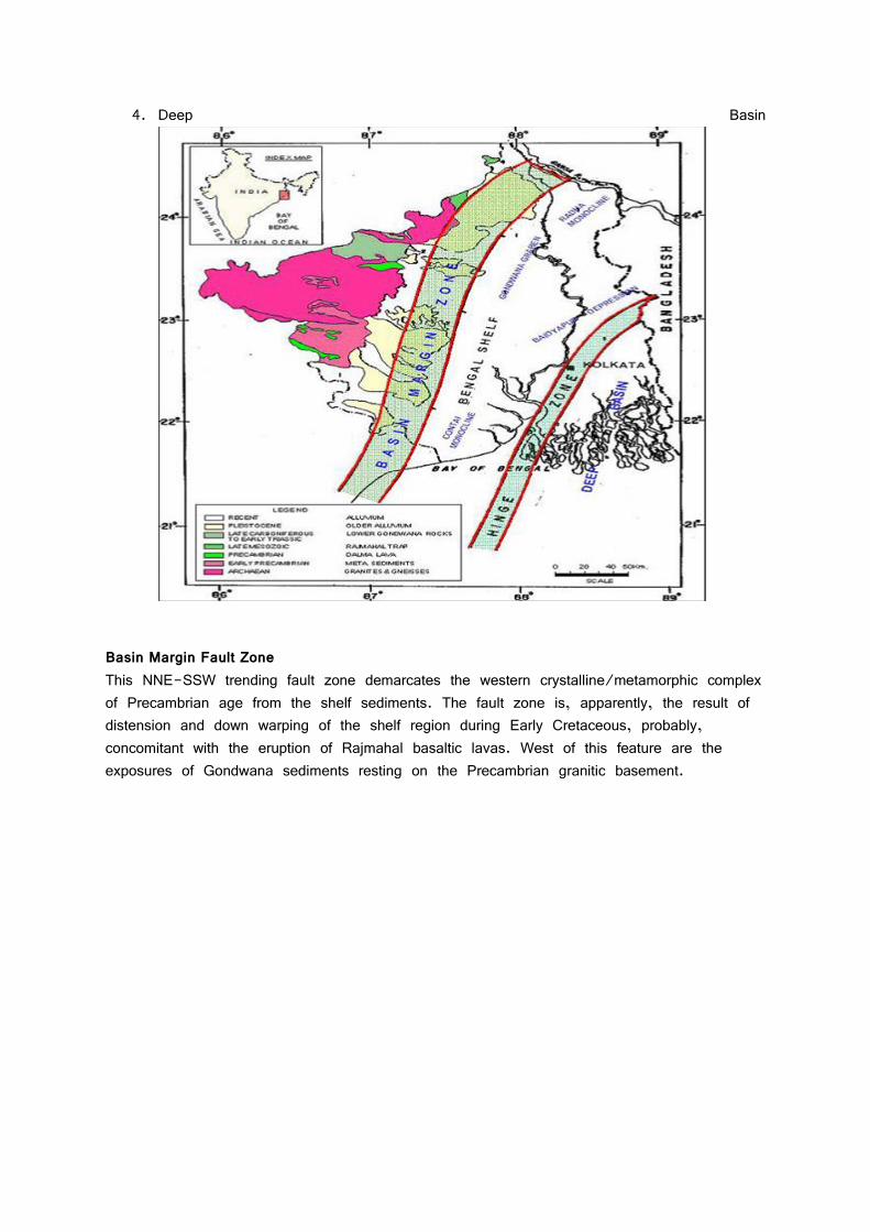
Shelf Zone The Bengal foreland shelf is more than 100 km wide in north and narrows a little towards south. The Tertiary sedimentary prism thickens towards east and merges with the deep shelf beyond the hinge. Most of the exploration activities including drilling remained confined within this broad zone. West of Burdwan the break in the basement slope is conspicuous. The basement slopes gently towards east and is marked by numerous step faults with small displacements. The post-Paleocene period witnessed a gradual deepening of the basin. This created necessary environment for the development of shelf carbonates during Eocene. Development of a linear zone of thick limestone along the shelf edge, interpreted as a reefal build-up along the shelf break. All the sequences show gradual change in depositional environment from fluvial through deltaic to marine conditions from west to east. Hinge Zone Bengal ‘Hinge Zone’ is a narrow elongated zone separates the thick Post-Eocene sediments in the east from the shelf zone of the west. This feature runs in NNE-SSW direction from east of Kolkata. It is seen to be prominent on seismic records as an abrupt change of slope and a flexure at ‘D’ reflector corresponding to of Eocene limestone. Eocene limestone further east of hinge zone possibly grades to shales and other deep
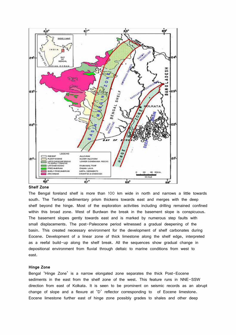
basin sediments. This zone has given rise to a belt of possible flexures and faulting during Oligocene and Miocene. Truncations and wedgeouts against the hinge zone are characterstic. Golf Green and Ichapur wells are observed to fall in this trend. The hinge zone is associated with gravity high and magnetic low. However, seismic data indicates only a change in basement slope along this zone.
Deep Basin The basinal part (of the shelf slope–basinal system) southeast of the Eocene shelf break (hinge zone), hosts a thick prism of 10–15 km of sediments which are largely made-up of post–middle Miocene deltaic deposits. Oligocene and older sediments have not yet been penetrated by the drilling bit in this part. The prominent ‘D’ reflector, corresponding to the of the Kalighat Formation/ Sylhet Limestone, loses its character in the basinal part, perhaps due to change of facies from limestone to shale.
Basin Evolution The Evolution of the Bengal Basin, beginning with the formation of the Gondwana graben, followed by continental rifting and drifting, bears similarity with that of the east coast basins of India. However, the graben mapped is oriented in a dominant north-south trend instead of northwest-southeast trend as in other east coast basins. After a brief volcanic activity
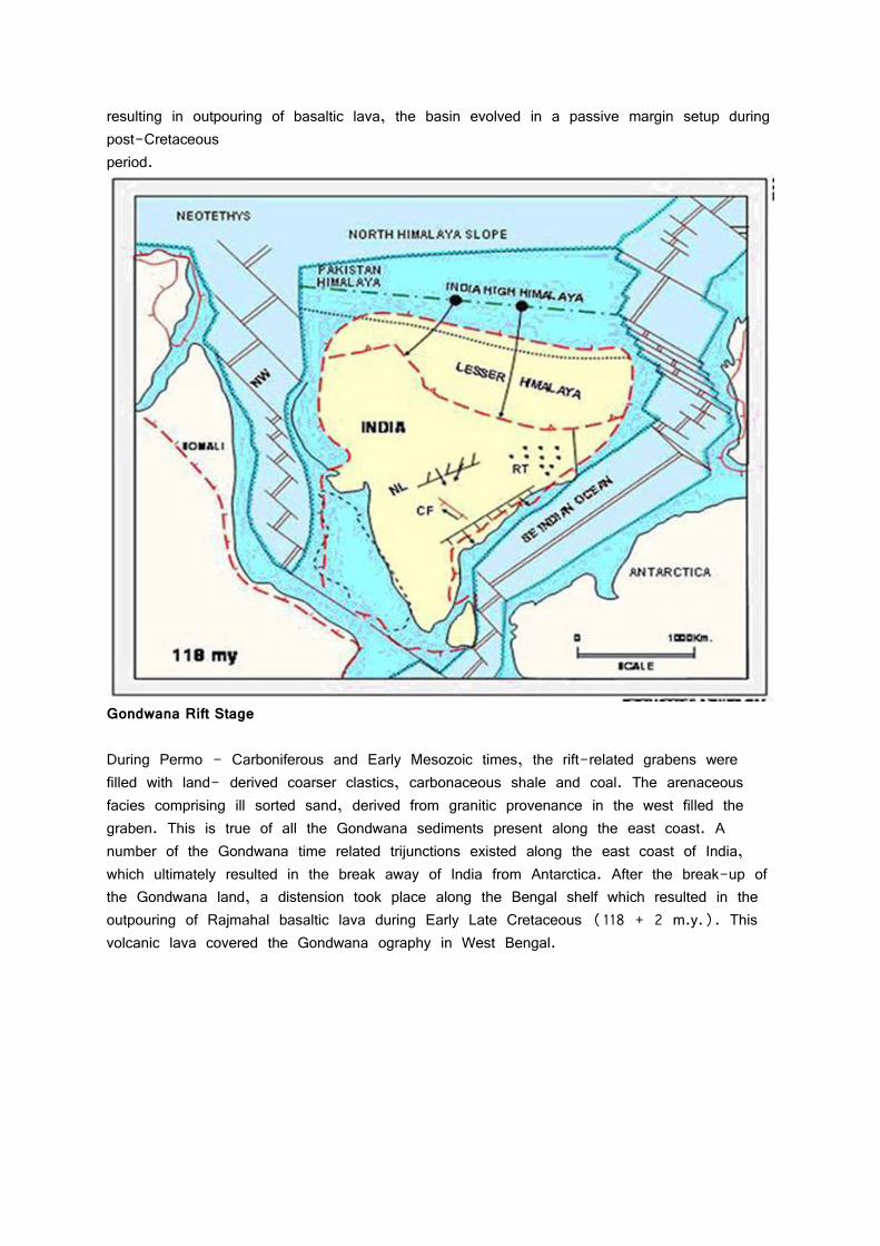
resulting in outpouring of basaltic lava, the basin evolved in a passive margin setup during post-Cretaceous period.
Gondwana Rift Stage During Permo - Carboniferous and Early Mesozoic times, the rift-related grabens were filled with land- derived coarser clastics, carbonaceous shale and coal. The arenaceous facies comprising ill sorted sand, derived from granitic provenance in the west filled the graben. This is true of all the Gondwana sediments present along the east coast. A number of the Gondwana time related trijunctions existed along the east coast of India, which ultimately resulted in the break away of India from Antarctica. After the break-up of the Gondwana land, a distension took place along the Bengal shelf which resulted in the outpouring of Rajmahal basaltic lava during Early Late Cretaceous (118 + 2 m.y.). This volcanic lava covered the Gondwana ography in West Bengal.
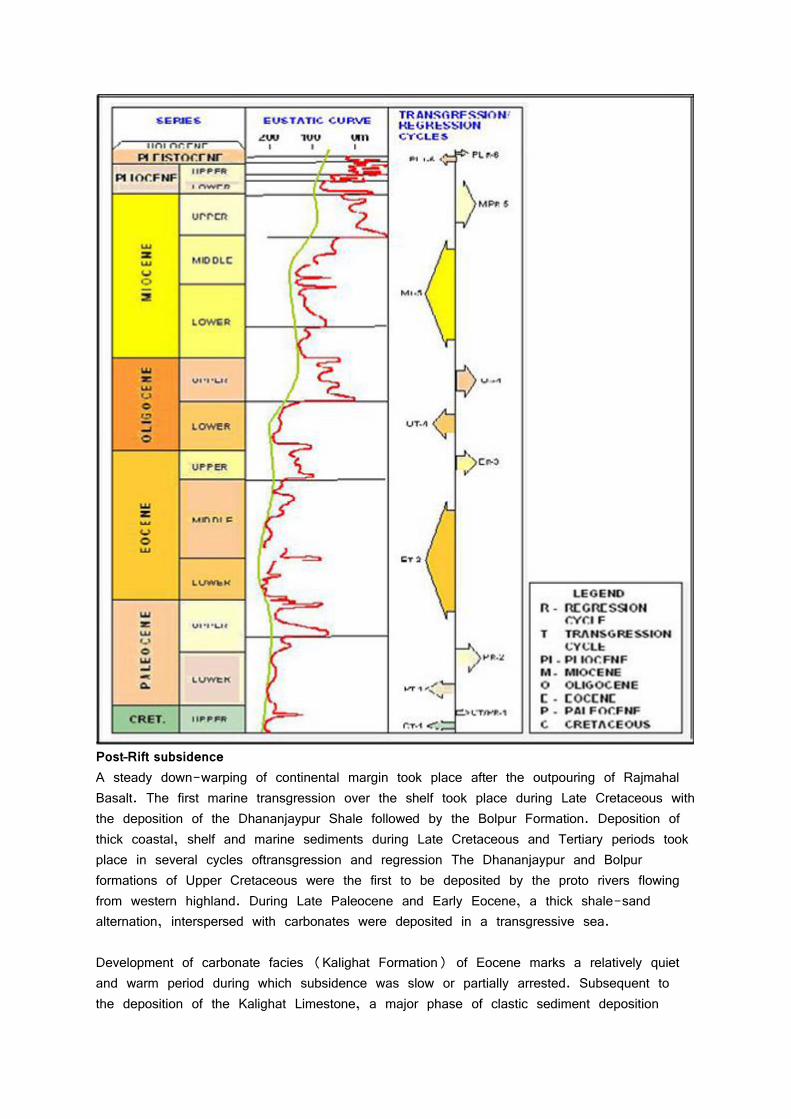
Post–Rift subsidence A steady down-warping of continental margin took place after the outpouring of Rajmahal Basalt. The first marine transgression over the shelf took place during Late Cretaceous with the deposition of the Dhananjaypur Shale followed by the Bolpur Formation. Deposition of thick coastal, shelf and marine sediments during Late Cretaceous and Tertiary periods took place in several cycles oftransgression and regression The Dhananjaypur and Bolpur formations of Upper Cretaceous were the first to be deposited by the proto rivers flowing from western highland. During Late Paleocene and Early Eocene, a thick shale-sand alternation, interspersed with carbonates were deposited in a transgressive sea. Development of carbonate facies (Kalighat Formation) of Eocene marks a relatively quiet and warm period during which subsidence was slow or partially arrested. Subsequent to the deposition of the Kalighat Limestone, a major phase of clastic sediment deposition
started. This is attributed to the initiation of collision of the Indian Plate with the Eurasian Plate towards the end of Eocene. This event also marks the beginning of a marked shift in the direction of drainage system from easterly to southerly, consequent upon the emergence of Himalayas. The Oligo-Miocene sedimentation condition was followed by a strong deltaic environment. Early Miocene-Pliocene epoch is characterised by the deposition of a thick succession sediments brought by the Brahmaputra-Ganga river system as delta fan deposits over the lower shelf-slope system.
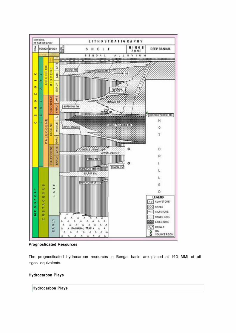
Stratigraphy The Stratigraphic framework of the Bengal Basin has been reconstructed from a study of rocks exposed along the western flank of the basin and met with in drilled wells. Generalised stratigraphy of the basin.
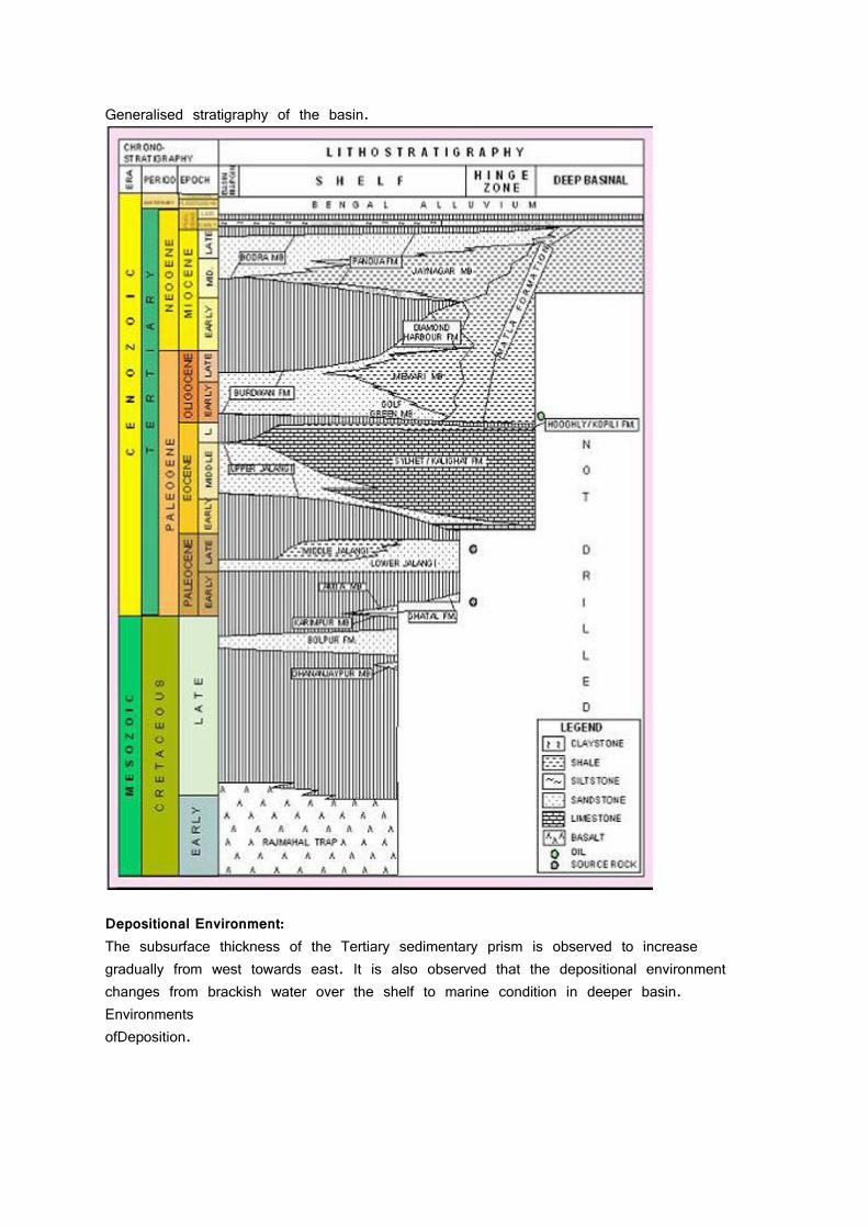
Generalised stratigraphy of the basin.
Depositional Environment: The subsurface thickness of the Tertiary sedimentary prism is observed to increase gradually from west towards east. It is also observed that the depositional environment changes from brackish water over the shelf to marine condition in deeper basin. Environments ofDeposition.
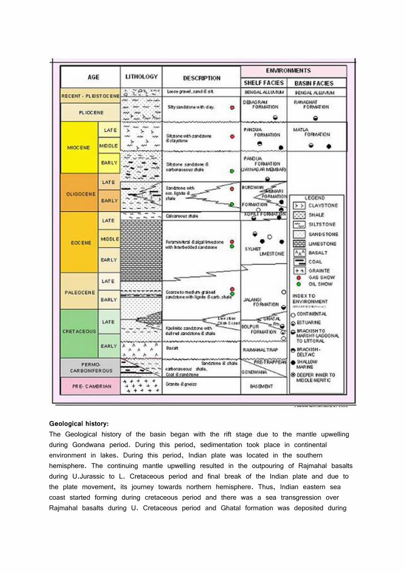
Geological history: The Geological history of the basin began with the rift stage due to the mantle upwelling during Gondwana period. During this period, sedimentation took place in continental environment in lakes. During this period, Indian plate was located in the southern hemisphere. The continuing mantle upwelling resulted in the outpouring of Rajmahal basalts during U.Jurassic to L. Cretaceous period and final break of the Indian plate and due to the plate movement, its journey towards northern hemisphere. Thus, Indian eastern sea coast started forming during cretaceous period and there was a sea transgression over Rajmahal basalts during U. Cretaceous period and Ghatal formation was deposited during
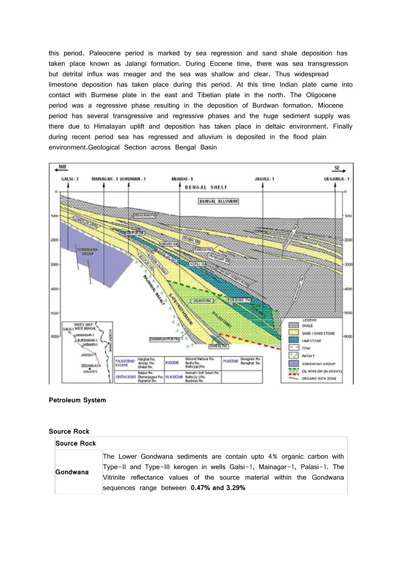
this period. Paleocene period is marked by sea regression and sand shale deposition has taken place known as Jalangi formation. During Eocene time, there was sea transgression but detrital influx was meager and the sea was shallow and clear. Thus widespread limestone deposition has taken place during this period. At this time Indian plate came into contact with Burmese plate in the east and Tibetian plate in the north. The Oligocene period was a regressive phase resulting in the deposition of Burdwan formation. Miocene period has several transgressive and regressive phases and the huge sediment supply was there due to Himalayan uplift and deposition has taken place in deltaic environment. Finally during recent period sea has regressed and alluvium is deposited in the flood plain environment.Geological Section across Bengal Basin
Petroleum System Source Rock
Source Rock
Gondwana
The Lower Gondwana sediments are contain upto 4% organic carbon with Type-II and Type-III kerogen in wells Galsi-1, Mainagar-1, Palasi-1. The Vitrinite reflectance values of the source material within the Gondwana sequences range between 0.47% and 3.29%
Cretaceous and Paleocene
Cretaceous sediments show good maturation in Bolpur, Ghatal and Dhananjaypur Formation Paleocene sediments of VRo maturation value of 0.65% and shows a good source development with type II & III Kerogen in the Jalangi Formation. Source beds within the Ghatal Formation, having a good to moderate percentage of TOC are in the early stage of maturation.
Eocene
The Early Eocene section is characterized by the development of alternating continental and marine facies and the Middle to Late Eocene sequence, by the development of a thick carbonate facies comprising Nummulitic limestone with intervening shales. The carbonate facies is observed to change basinward into highly organic-rich marine shale in several wells.
Oligocene
Oligocene to Miocene sediments are, by and large, immature within the Bengal Shelf. Beyond the ‘Hinge zone’, maturation of Oligocene sediments is expected to increase with the increase in the depth of occurrence of such sediments. The source rock maturation for various stratigraphic units and probable oil window zone across the shelf. Maturation values for various stratigraphic sequences such as Paleocene, Eocene, and Miocene show that the hinge zone and deeper basinal areas form favourable areas for maturation of organic matter. This is also observed in case of the Jalangi Formation which forms an important source sequence in the Bengal Basin.
Reservoir Facies
Reservoir facies are available in abundance within the Gondwana and Paleocene sequences are of arenaceous character. Sandstone reservoirs occur in abundance within the Bolpur, Lower Jalangi and Upper Jalangi formations and higher up within the Burdwan Formation of Oligocene age. A Sand within the Burdwan Formation is found oil bearing in well Ichapur–1. In the Miocene sequence, sandstone reservoirs are present in abundance within the Bodra and Pandua formations.
Cap Rock and Entrapment
Cap Rock and Entrapment
Gondwana
Gondwana rocks have been deposited as an alternating sequence of sand, shale and coal in Galsi, Mainagar and Chandkuri areas. Graben setting, together with composite lithology, may provide suitable conditions for hydrocarbon accumulation in structural, stratigraphic and strati-structural traps. Barakar and Raniganj shales should serve as good seals.
Cretaceous and Paleocene
The argillaceous Amta Member of the Ghatal Formation can serve as seal for Bolpur sand reservoirs. Argillaceous Middle Jalangi unit also may serve as seal for the reservoirs of the Lower Jalangi unit. Hydrocarbon accumulation in this section is expected to be mostly in stratigraphic traps.

Eocene
Tight limestone of the Eocene section and the Hoogly Shale may serve as seal for the porous reefoidal Eocene reservoirs. Accumulation in the Eocene section is expected to be in stratigraphic and strati-structural traps.
Oligo – Miocene
In the deeper part of the shelf, the Matla Formation is observed to thicken considerably .The Memari Member of this formation may act as a good seal for reservoirs within the Burdwan Formation and the Jayanagar Member can be a seal over Miocene reservoirs. The deltaic system with composite lithofacies within the Oligocene and Miocene sections has a potential to form stratigraphic hydrocarbon plays in the area near and beyond the hinge zone.
Prognosticated Resources The prognosticated hydrocarbon resources in Bengal basin are placed at 190 MMt of oil +gas equivalents. Hydrocarbon Plays
Hydrocarbon Plays
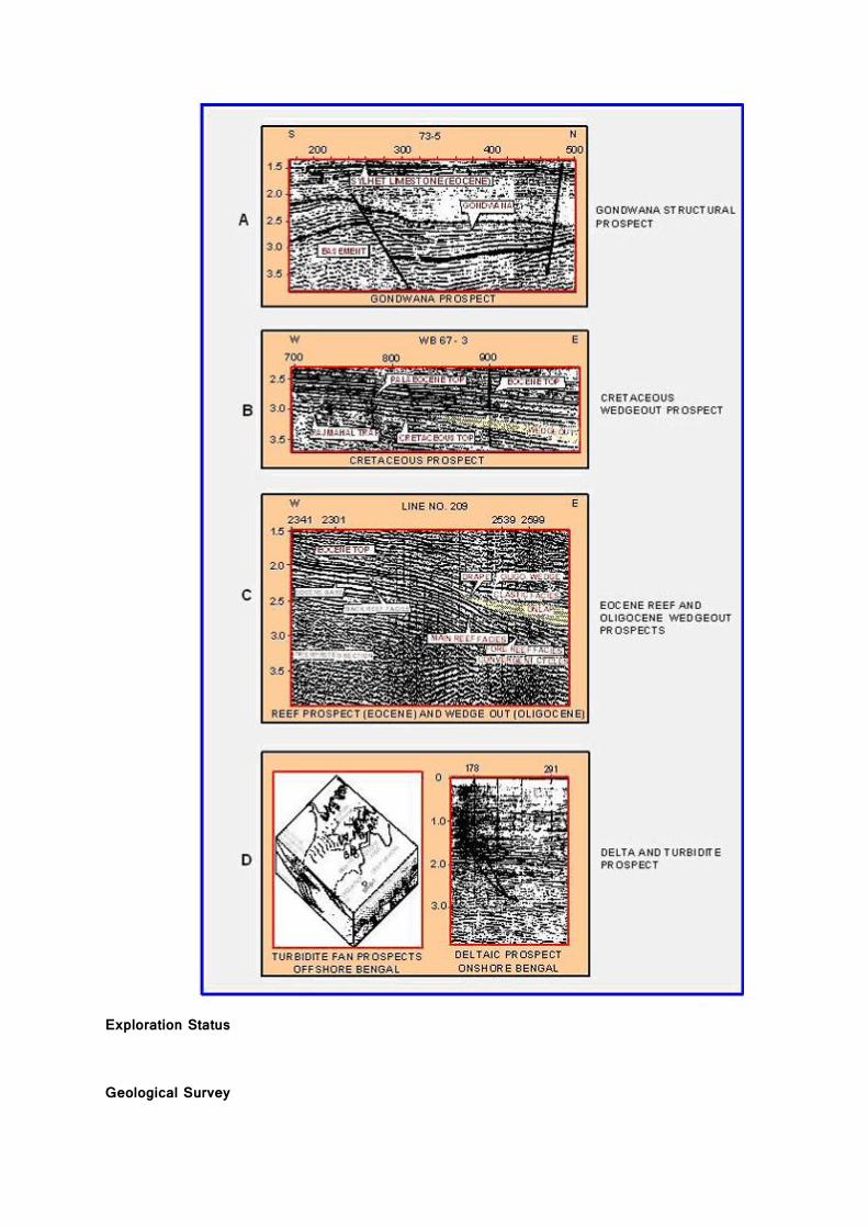
Gondwana Entrapment conditions are expected to exist in basement related structures and stratigraphic wedgeouts in the central, northern and southern parts of the Gondwana graben.
Cretaceous and Paleocene
a) Low amplitude structural highs, broadly in a NE-SW trend through Contai–Ghatal-Jalangi–Karimpur areas. b) Growth fault related low amplitude structural prospects in the depositional low in Krishnanagar–Ranaghat area.
Eocene Eocene shelf edge forms a favorable locale for the development of carbonate reef prospects.
Oligocene
Onlapping reflectors of good continuity and moderate to high amplitude are observed in the seismic sequence corresponding to the Oligocene section. Velocity analysis suggests that these anomalies correspond to sand-shale alternations within Oligocene and can be target for exploration. The wedgeout zones are equally interesting for stratigraphic accumulation.
Mio – Pliocene Prospects
Seismic facies analysis and basin modeling (done by ongc) indicate development of two types of prospects in the Mio-Pliocene section (a) deltaic, and (b) prospect associated with turbidite facies along the shelf–slope area south of Sunderbans
Exploration Status Geological Survey
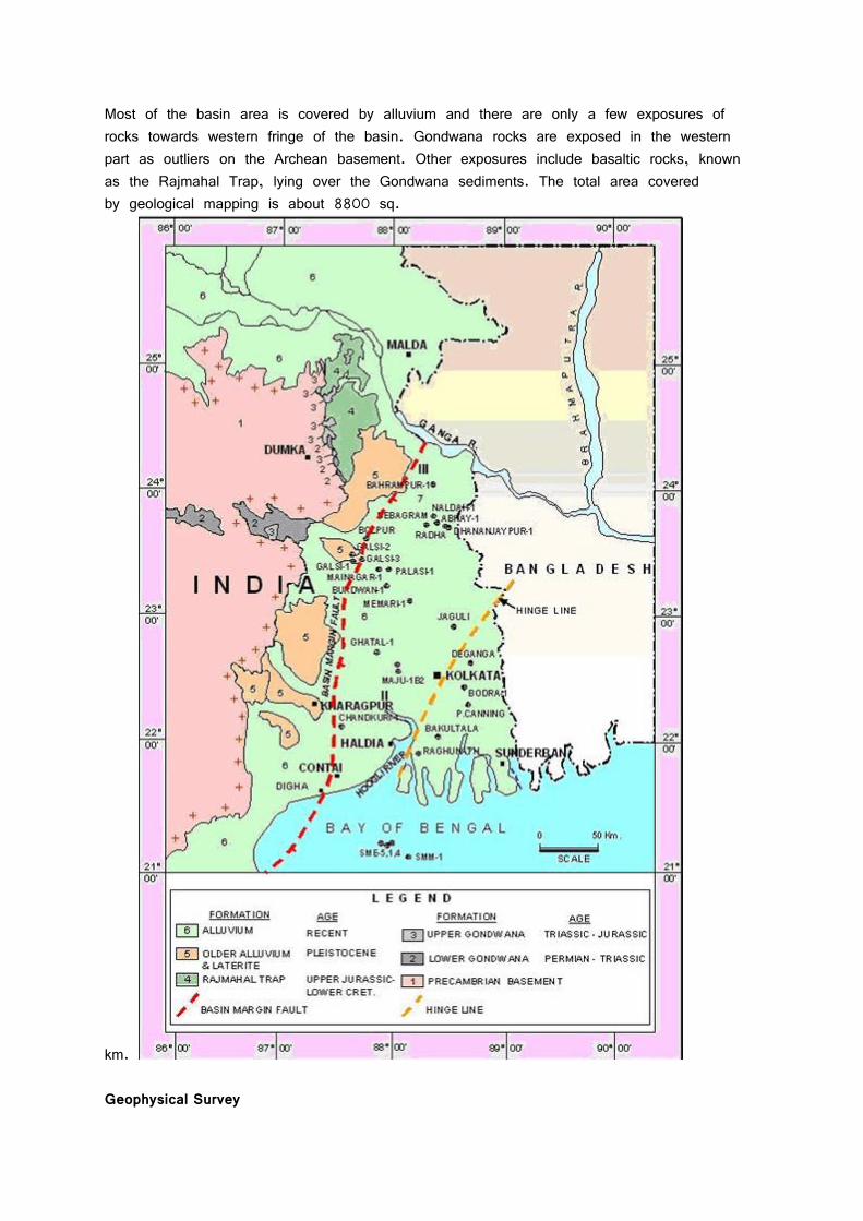
Most of the basin area is covered by alluvium and there are only a few exposures of rocks towards western fringe of the basin. Gondwana rocks are exposed in the western part as outliers on the Archean basement. Other exposures include basaltic rocks, known as the Rajmahal Trap, lying over the Gondwana sediments. The total area covered by geological mapping is about 8800 sq.
km. Geophysical Survey
The Bengal Basin is extensively covered by geophysical surveys. Aeromagnetic and gravity surveys were carried out during the early stages of exploration (1963-1970). Many parts of the basin were extensively covered by 24 and 48 fold surveys from 1975 to 1988. 3D seismic data (4217 LKM, equivalent to 210 SKM) was acquired in 1989-91 for confirming the presence and mapping the extension of reefs and other features / prospects which were inferred to occur in Amtala, Golf Green and Ichapur areas. Offshore areas were also covered by 24 fold seismic surveys conducted in 1975. This was followed by additional CDP survey in offshore areas and in the Sunderban estuaries during 1979-81. 3D seismic survey in offshore area measures 1248 LKM (60 Eq. SKM). Exploration Drilling The Bengal Basin drew early interest of exlplorationists, when 10 wells were drilled by StandardPetroleum under Indo- Stanvac Petroleum Project (ISPP) during 1958 - 1960. Sedimentarysequences of Pliocene to Cretaceous age were encountered in these wells. Most of these wells are reported to have given hydrocarbon shows at various depths during drilling in the following table.
Well Hydrocarbon Shows
SME-4 Gas at 2270-2465, 3070-3125 & 3850-4050m
Burdwan – 1 Asphalt at 1951m
Galsi – 1 Gas at 1050 & 1058m
Jalangi – 1 Pale +ve cut at 2133m; asphalts at 2545m & gas at 3049m
Debagram – 1 Gas at 1050,1428 & 2131m & GYF at 1426m
Memari – 1 Gas at 2015 - 2022m
Port Canning –1 Gas at 546-613, 2373 & 2543.25m
West Ranaghat – 1 Dissolved gas at 2526 – 2544m
Related Documents