Miocene tidal-influenced sedimentation to continental Pliocene sedimentation in the forebulge–backbulge depozones of the Beni–Mamore foreland Basin (northern Bolivia) Martin Roddaz * , Ste ´phane Brusset, Patrice Baby, Ge ´rard He ´rail IRD UR 154 LMTG-UMR 5563, Universite ´ Paul Sabatier Toulouse 3, 14 avenue Edouard Belin 31400 Toulouse, France Received 1 January 2004; accepted 1 November 2005 Abstract Mio-Pliocene deposits of the forebulge–backbulge depozones of the Beni-Mamore foreland Basin indicate tidally to fluvially dominated sedimentation. Seven facies assemblages have been recognized: FAA–FAG. FAA represents a distal bottom lake assemblage, FAB and FAD are interpreted as tidal flat deposits, FAC and FAG are interpreted as fluvial systems, FAE sediments are deposited in a subtidal/shoreface setting, and FAG represents a meandering fluvial system. The identification of stratigraphic surfaces (SU, MFS, and MRS) and the relationship among the facies assemblages permit the characterization of several systems tracts: a falling-stage systems tract (FSST) followed by a lowstand systems tract (LST), a transgressive systems tract (TST), and a highstand systems tract (HST). The FSST and LST may have been controlled by the uplift of the Beni-Mamore forebulge, whereas TST may result from a quiescent stage in the forebulge. Subaerial unconformity two (SU2) records the passage from a tide-influenced depositional system to a fully continental depositional system. The Miocene tidal-influenced deposits in the Beni–Mamore Basin suggest that it experienced a connection, either with the South Atlantic Ocean or the Caribbean Sea or both. q 2006 Elsevier Ltd. All rights reserved. Keywords: Amazonian foreland Basin; Forebulge; Backbulge; Tidal deposits; Sequence stratigraphy; Bolivia 1. Introduction The depositional setting of the Mio-Pliocene formations of western Amazonia (i.e. Pebas Formation in Peru, Solimoes Formation in Brazil) has received a lot of attention and remains a matter of debate. Because of the scarcity and poor quality of the outcrops, several conflicting hypotheses have been proposed to explain the origin of the Pebas/Solimoes deposits. One hypothesis is that they formed as a result of a catastrophic Pleistocene flood resulting from the sudden draining of glacial Lake Titicaca (Campbell and Frailey, 1984). Another is that the deposits represent deltaic deposition in an enormous Pleisto- cene–Holocene lake (Lago Amazonas, Frailey et al., 1988). A third hypothesis suggests that they correspond to an alluvial fan draining the Andes (Latrubesse, 1992; Latrubesse et al., 1997). The debate has moved to arguing a fluvial versus marine origin for the Pebas/Solimoes formations. It is now well accepted that from the Middle Miocene to the Late Miocene, western Amazonia was completely flooded by a fluviolacustrine (Hoorn, 1993, 1994a; Hoorn et al., 1995) and/or marine (Ra ¨sa ¨nen et al., 1995, 1998; Gingras et al., 2002a,b; Hovikoski et al., 2005) system or a combination thereof (Wesselingh et al., 2002; Vonhof et al., 2003). Difficulties in constraining the temporal and spatial boundaries of the Miocene Amazonian sea/lake arose from the lack of age and outcrop data, especially in the southern part of the Amazon Basin. The southern extension of the Pebas Sea/Lake has been reported as far as in southern Peru (Gingras et al., 2002b; Hovikoski et al., 2005), whereas the northern extension of the Paranan Sea is known to have reached the southern part of Bolivia (Marshall et al., 1993; Hernandez et al., 2005; Uba et al., 2005). The extent of the Pebas Sea/Lake to the south and its possible connection with the Paranan Sea, constituting a hypothetic Miocene Amazonian interior seaway, is not well documented; recent studies of the Paranan and Pebas seas (Marshall et al., 1993; Gingras et al., 2002b; Hernandez et al., 2005; Hovikoski et al., 2005; Uba et al., 2005) lack about 1100 km to sustain this connection (Fig. 1). Most articles dedicated to the interpretation of the Pebas system do not explore the role of Andean tectonics on the evolution of the Amazonian foreland basin system. As Journal of South American Earth Sciences 20 (2006) 351–368 www.elsevier.com/locate/jsames 0895-9811/$ - see front matter q 2006 Elsevier Ltd. All rights reserved. doi:10.1016/j.jsames.2005.11.004 * Corresponding author. Tel.: C33 5 61332599; fax: C33 5 61332560. E-mail address: [email protected] (M. Roddaz).

Welcome message from author
This document is posted to help you gain knowledge. Please leave a comment to let me know what you think about it! Share it to your friends and learn new things together.
Transcript

Miocene tidal-influenced sedimentation to continental Pliocene
sedimentation in the forebulge–backbulge depozones of the Beni–Mamore
foreland Basin (northern Bolivia)
Martin Roddaz *, Stephane Brusset, Patrice Baby, Gerard Herail
IRD UR 154 LMTG-UMR 5563, Universite Paul Sabatier Toulouse 3, 14 avenue Edouard Belin 31400 Toulouse, France
Received 1 January 2004; accepted 1 November 2005
Abstract
Mio-Pliocene deposits of the forebulge–backbulge depozones of the Beni-Mamore foreland Basin indicate tidally to fluvially dominated
sedimentation. Seven facies assemblages have been recognized: FAA–FAG. FAA represents a distal bottom lake assemblage, FAB and FAD are
interpreted as tidal flat deposits, FAC and FAG are interpreted as fluvial systems, FAE sediments are deposited in a subtidal/shoreface setting, and
FAG represents a meandering fluvial system. The identification of stratigraphic surfaces (SU, MFS, and MRS) and the relationship among the
facies assemblages permit the characterization of several systems tracts: a falling-stage systems tract (FSST) followed by a lowstand systems tract
(LST), a transgressive systems tract (TST), and a highstand systems tract (HST). The FSST and LST may have been controlled by the uplift of the
Beni-Mamore forebulge, whereas TST may result from a quiescent stage in the forebulge. Subaerial unconformity two (SU2) records the passage
from a tide-influenced depositional system to a fully continental depositional system. The Miocene tidal-influenced deposits in the Beni–Mamore
Basin suggest that it experienced a connection, either with the South Atlantic Ocean or the Caribbean Sea or both.
q 2006 Elsevier Ltd. All rights reserved.
Keywords: Amazonian foreland Basin; Forebulge; Backbulge; Tidal deposits; Sequence stratigraphy; Bolivia
1. Introduction
The depositional setting of the Mio-Pliocene formations of
western Amazonia (i.e. Pebas Formation in Peru, Solimoes
Formation in Brazil) has received a lot of attention and remains
a matter of debate. Because of the scarcity and poor quality of
the outcrops, several conflicting hypotheses have been
proposed to explain the origin of the Pebas/Solimoes deposits.
One hypothesis is that they formed as a result of a catastrophic
Pleistocene flood resulting from the sudden draining of glacial
Lake Titicaca (Campbell and Frailey, 1984). Another is that the
deposits represent deltaic deposition in an enormous Pleisto-
cene–Holocene lake (Lago Amazonas, Frailey et al., 1988). A
third hypothesis suggests that they correspond to an alluvial fan
draining the Andes (Latrubesse, 1992; Latrubesse et al., 1997).
The debate has moved to arguing a fluvial versus marine origin
for the Pebas/Solimoes formations. It is now well accepted that
from the Middle Miocene to the Late Miocene, western
0895-9811/$ - see front matter q 2006 Elsevier Ltd. All rights reserved.
doi:10.1016/j.jsames.2005.11.004
* Corresponding author. Tel.: C33 5 61332599; fax: C33 5 61332560.
E-mail address: [email protected] (M. Roddaz).
Amazonia was completely flooded by a fluviolacustrine
(Hoorn, 1993, 1994a; Hoorn et al., 1995) and/or marine
(Rasanen et al., 1995, 1998; Gingras et al., 2002a,b; Hovikoski
et al., 2005) system or a combination thereof (Wesselingh
et al., 2002; Vonhof et al., 2003).
Difficulties in constraining the temporal and spatial
boundaries of the Miocene Amazonian sea/lake arose from
the lack of age and outcrop data, especially in the southern part
of the Amazon Basin. The southern extension of the Pebas
Sea/Lake has been reported as far as in southern Peru (Gingras
et al., 2002b; Hovikoski et al., 2005), whereas the northern
extension of the Paranan Sea is known to have reached the
southern part of Bolivia (Marshall et al., 1993; Hernandez et
al., 2005; Uba et al., 2005). The extent of the Pebas Sea/Lake to
the south and its possible connection with the Paranan Sea,
constituting a hypothetic Miocene Amazonian interior seaway,
is not well documented; recent studies of the Paranan and
Pebas seas (Marshall et al., 1993; Gingras et al., 2002b;
Hernandez et al., 2005; Hovikoski et al., 2005; Uba et al., 2005)
lack about 1100 km to sustain this connection (Fig. 1).
Most articles dedicated to the interpretation of the Pebas
system do not explore the role of Andean tectonics on the
evolution of the Amazonian foreland basin system. As
Journal of South American Earth Sciences 20 (2006) 351–368
www.elsevier.com/locate/jsames

Fig. 1. Distribution of the Miocene Pebas and Paranan seas (Marshall and
Lundberg, 1996). BA, El Baul arch; CB, Chapare Buttress; FM, Freites
Formation; MAA, Monte Alegre arch; PA, Purus arch; PF, Pirabas Formation;
and VA, Vaupes arch. Southern extension of the Pebas Sea is reported in
Gingras et al. (2002b); the northern extension of the Paranan Sea is mapped in
Marshall et al. (1993).
M. Roddaz et al. / Journal of South American Earth Sciences 20 (2006) 351–368352
underlined by Paxton et al. (1996), the Miocene Amazonian
sea/lake (Pebas/Solimoes system) may be ‘a result of tectonic
mechanisms such as lithospheric loading by the Andean
orogenic wedge, or dynamic topography related to the Andean
subduction, or both.’ Furthermore, recent studies have pointed
to the influence of Andean foreland basin dynamics on the
Miocene evolution of the northwestern Amazonian paleoenvir-
onment (Hermoza et al., 2005; Roddaz et al., 2005).
The aim of this article is to present the first data relative to
tide-influenced deposits in northern Bolivia (Beni–Mamore
Basin) and document how the transition between these tide-
influenced deposits and the fully fluvial modern Amazon
drainage basin was controlled by the dynamics of the
Amazonian foreland Basin.
2. Geological setting
The western Amazon drainage basin extends from southern
Colombia to northern Bolivia. In the northern branch of the
Bolivian Orocline, the Beni–Mamore Basin forms the southern
part of the western Amazon Basin. It is limited to the southwest
by the western boundary of the Eastern Cordillera and to the
northeast by the Brazilian Craton (Figs. 2 and 3).
This foreland basin system was formed in response to
flexural subsidence driven by thrusting and loading of the
Andean retroarc thrust wedge, the forward propagation of
which has been approximately 74 km during the past 10 Ma
(Baby et al., 1997). In the structural cross-section shown in
Fig. 3, the architecture of the Beni–Mamore sedimentary Basin
is constrained by field, geophysical, and borehole data (Baby
et al., 1995, 1997). This cross-section and the geomorphic map
in Fig. 2 provide evidence of Andean tectonic control in the
Amazon Basin of Bolivia.
The Beni–Mamore sedimentary Basin can be considered the
prototype of a modern foreland system, as defined by DeCelles
and Giles (1996), in which orogenic loading leads to
partitioning into deformed and flexural provinces, such as the
wedge top, foredeep, forebulge, and backbulge depozones. The
wedge top depozone of the Beni–Mamore Basin corresponds to
the frontal part of the orogenic wedge (sub-Andean foothills,
see Fig. 2), where most of the Neogene and Pleistocene
syntectonic sediments accumulated and were progressively
deformed. The most internal syncline of the sub-Andean
foothills (Alto Beni syncline) developed as a piggyback basin
during the Neogene (Baby et al., 1995). Sub-Andean external
thrusts involved Neogene foredeep sediments. The boundary
between the present wedge top and foredeep depozones
corresponds to the sub-Andean frontal thrust. The maximum
thickness of the continental Neogene and Pleistocene deposits
filling the Beni–Mamore foredeep is approximately 6 km
(Fig. 3), located at the footwall of this frontal thrust. The
foredeep depozone consists of a 175 km wide cratonward-
tapering wedge. The forebulge is approximately 100 km wide
and poorly eroded. To the northeast, the Precambrian rocks of
the Brazilian Craton are exposed. Pleistocene sediments
accumulate between the craton and the forebulge, constituting
a 140 km wide backbulge depozone. The wedge top, foredeep,
forebulge, and backbulge zones correspond to distinct
geomorphic regions (Fig. 2). The localization of the foredeep
and forebulge depozones has been more precisely defined
through a GPS survey of longitudinal gradient (Aalto et al.,
2003).
Sedimentary deposits outcropping along the Beni River are
poorly dated. Campbell and Frailey (1984) refer to two
formations that outcrop in cutbanks along the Beni River:
Tertiary Ipururo red beds and the Pleistocene Inapari
Formation, separated by a subaerial unconformity termed the
‘Uncayali unconformity.’ Mammal-bearing faunas of ‘possible
or reputed Huayquerian age’ (Late Miocene) have also
been found within the deposits of the so-called ‘Cobija’
Formation (Marshall et al., 1993). The localities (Cobija and
Candelaria, Fig. 4) where the mammals were collected are
situated 170 and 30 km northwest, respectively, of our studied
deposits (Fig. 4).
Given that these deposits have no structural dip, reasonable
correlations can be made between our studied deposits and the
Late Miocene deposits of the Cobija Formation. Hence, the
deposits outcropping within the forebulge–backbulge depo-
zones of the Beni-Mamore foreland Basin range from Miocene
to Pleistocene.

Fig. 2. The Madeira drainage Basin (geomorphic map from USGS GTOPO-30 digital database, 1996). The dark line indicates the location of the structural cross-
section shown in Fig. 3. Modified from Baby et al. (1999).
M. Roddaz et al. / Journal of South American Earth Sciences 20 (2006) 351–368 353
3. Modern and ancient foreland deposits in the Bolivian
foreland basin system
The modern foreland basin system adjacent to the central
Andes is exemplary of a retroarc foreland basin (Jordan et al.,
1983; Jordan, 1995; Horton and DeCelles, 1997). In southern
Bolivia, this system propagated eastward since at least Late
Paleocene times (DeCelles and Horton, 2003), whereas in
northern Bolivia, the Amazonian foreland Basin started its
eastward propagation since the Neogene (Baby et al., 1997,
Fig. 3. Structural cross-section across the Beni–Mamore foreland system. Modifi
forebulge, backbulge; bounded to the west by the Eastern Cordillera and to the eas
1999). Because of its connections with the uplift of the
Altiplano, the synforeland tertiary sedimentation in the
southern Bolivian foreland basin has been extensively studied
(e.g. Horton et al., 2001; DeCelles and Horton, 2003,
references therein), whereas such studies are lacking for the
northern part. Miocene Beni deposits also should be
compared with the sedimentation and depositional environ-
ment in the ancient foreland basin systems of southern
Bolivia and the modern sedimentation of the Beni Basin
(Aalto et al., 2003).
ed from Baby et al. (1999). Note the four depozones: wedge top, foredeep,
t by the Brazilian Craton.

Fig. 4. Map of the study area. Main outcrops are black stars. Main rivers are represented. The grey filled circle represents the location of the outcrops studied by
Gingras et al. (2002b) and locations of ‘reputed’ Late Miocene mammals faunas (Marshall et al., 1993).
M. Roddaz et al. / Journal of South American Earth Sciences 20 (2006) 351–368354
3.1. Ancient (Tertiary) synorogenic sediments of the southern
Bolivian foreland basin
The Tertiary synorogenic sediment succession is mainly
located in the Altiplano, the Eastern Cordillera, and the sub-
Andean zone. In the Altiplano and Eastern Cordillera, it
consists of the Santa Lucia, Potoco, Impora, Cayara, Camargo,
and Suticollo formations; in the sub-Andean zone, it is the
Petaca, Yecua, Tariquia, and Guandacay formations.
The Santa Lucia Formation (Mid-Paleocene–Middle
Eocene, Sempere et al., 1997; Horton et al., 2001) consists
of 50–300 m of quartzose, lenticular sandstone bodies
alternating with red siltstones (DeCelles and Horton, 2003)
and can be found in both the Altiplano and the Eastern
Cordillera. The sandstone bodies (1–6 m thick) are character-
ized by trough and planar cross-stratifications (lithofacies St
and Sp, Miall, 1996) and ripples. The base of the sandstone
bodies is erosive, and they typically fine upward (DeCelles
and Horton, 2003). The red siltstones are massive with
carbonate nodules, root traces, and small tubular burrows. The
Santa Lucia Formation has been interpreted as formed by
fluvial channels and overbank deposits (Horton et al., 2001;
DeCelles and Horton, 2003). The lenticular sandstone bodies
of lithofacies St and Sp are fluvial channel deposits, the
rippled sandstones are crevasse splay deposits, and the
massive red siltstones are interpreted as paleosols. The
Santa Lucia Formation ends with a massive sandy paleosol.
It is thought to have been deposited into the backbulge
depozone of the Paleogene central Andean foreland basin
system (Horton et al., 2001; DeCelles and Horton, 2003).
The Potoco Formation, only found in the Altiplano, is 3000–
6500 m thick (Horton et al., 2001). The lowermost Potoco
Formation is composed of tens of meters thick intervals of
stacked paleosols that formed during the Mid-Paleocene–
Middle Eocene. The main body (Late Eocene–Oligocene) is
composed of sheet sandstones and interbedded siltstones
(Horton et al., 2001). Sandstones are characterized by
horizontal, ripple, and trough cross-stratification; their bases
are nonerosive or slightly erosive. They are interpreted as
channel and crevasse splay deposits. The siltstones represent
overbank deposits. The Potoco Formation thus is interpreted as
deposited in a high-sediment accumulation aggradational
fluvial system. The lowermost Potoco paleosol interval records
the passage of the forebulge, and the overlying sediments
accumulated in the foredeep of the Tertiary central Andean
foreland basin system (Horton et al., 2001).
The Impora Formation (60–80 m thick) is poorly con-
strained in age and outcrop in the Eastern Cordillera. It consists
of massive gray and red mudrock with carbonate nodules,
massive nodular limestone, thin sandstone beds with roots and
trough and ripple cross-stratifications, laminated gray silt-
stones, and gray marly limestone. It is interpreted as a ‘mixture
of calcareous paleosols, lacustrine deposits and minor fluvial
deposits’ (DeCelles and Horton, 2003). The upper part of the
formation (gray marly limestone) is interpreted as profundal-
lake deposits. The formation was deposited in the forebulge to
foredeep depozones of the Tertiary central Andean foreland
basin system (DeCelles and Horton, 2003).
The Cayara Formation (190 m thick, age unconstrained) is
found in the Eastern Cordillera. It is composed of white to gray
quartzarenite sandstones with trough cross-stratifications,
termite burrows, mudcracks, and siltstone intraclastic con-
glomerates arranged in overlapping lenticular bodies (DeCelles
and Horton, 2003). Fine-grained rocks consist of pervasive
mottling siltstones with occasional nodular gypsum. The
Cayara Formation is interpreted as fluvial channel deposits,
paleosols, and playa-lake deposits (Sempere et al., 1997;
DeCelles and Horton, 2003). It is deposited in the distal
foredeep depozone of the Tertiary central Andean foreland
basin system (DeCelles and Horton, 2003).

M. Roddaz et al. / Journal of South American Earth Sciences 20 (2006) 351–368 355
The Camargo (O2000 m thick, Oligocene–Early Mio-
cene) and Sutillo (up to 850 m thick, Oligocene–Early
Miocene) formations are found in the Eastern Cordillera.
They are composed of (1) broad, lenticular, upward-fining,
medium-grained to conglomeratic sandstones with trough
cross-stratification (lithofacies St, Gt, Miall, 1996); (2) thick
(0.5–10 m) beds of lenticular, well-organized, imbricated
conglomerates with cross-stratifications; (3) massive mottled
red siltstones (0.25–2.5 m thick) with carbonate nodules; and
(4) thin (0.05–0.20 m) laminated siltstones (DeCelles and
Horton, 2003). The Camargo and Sutillo formations are
interpreted as large, bedload-dominated fluvial channels with
associated floodplain deposits and paleosols. They also are
interpreted as deposited in the foredeep depozone of the
Oligocene–Early Miocene central Andean foreland basin
system (DeCelles and Horton, 2003).
The Petaca Formation (Late Oligocene; Sanjinez and
Jimenez, 1975; Sempere et al., 1990) is considered to have
been deposited in arid conditions interrupted by ephemeral
stream deposits (Hermoza, 2004; Uba et al., 2005); it recently
was interpreted to have been deposited in a forebulge–
backbulge depocenter (Uba et al., 2005).
The Yecua Formation (Middle–Late Miocene, 11–8 Ma) is
found in the southern Bolivian plain. It consists of clays, black
to green marls, and subordinate calcareous sandstones
(Marshall et al., 1993). This formation bears many fossils
that indicate continental, brackish, and shallow-marine
environments (Marshall et al., 1993). The shallow marine
deposits are interpreted to record several short-lived
transgressive and regressive cycles (Uba et al., 2005). Some
authors interpret the Yecua Formation as deposited in the
Miocene backbulge depozone of the central Andean foreland
basin (Horton and DeCelles, 1997). For others, it represents
distal foredeep deposits (Uba et al., 2005).
The Tariquia Formation (Early Late Miocene) is 1400 m
thick. Its top part is considered the lateral equivalent of the
sub-Andean zone of the distal Yecua Formation (Hermoza,
2004). It is divided into two members (Hermoza, 2004). The
lower member is composed of sand bars (lithofacies Sp, St,
Sh) interbedded with reddish siltstones (lithofacies Fm, Miall,
1996). The depositional environment of this member is a
sandy fluvial meandering system (Hermoza, 2004). The upper
member consists of 20–30 m thick sand bars (lithofacies Sm,
St, Sp, Sh) interbedded with reddish siltstones (lithofacies Fm;
Miall, 1996). The upper member represents distal, sandy,
braided deposits (Hermoza, 2004). This formation is
interpreted as deposited in the Miocene foredeep of the
central Andean foreland basin system (Hermoza, 2004; Uba
et al., 2005).
The Guandacay Formation (Late Miocene–Pliocene, up to
1000 m thick, southern Bolivia sub-Andean zone) consists of
Table 1
Localization of the main outcrops. Localization of Puerto Cavinas and Riberalta ar
Name BEN 61 BEN 70 BEN 76 B
Longitude
latitude
66855.049’W 66854.516’W 66849.439’W 6
12832.243’S 12803.526’S 11842.439’S 1
a thickening, coarsening-upward sequence (Hermoza, 2004).
It is composed of medium to coarse channelized sandstones
(lithofacies St, Sh, Sp, Sm) interbedded with reddish
siltstones (lithofacies Fm) passing upward to conglomerates
(lithofacies Gmm, Gt) and thick sandstones (lithofacies Sm,
St). It is interpreted as deposited in a gravel-sand braided
system (Hermoza, 2004). The Guandacay Formation was
deposited in a piggy-back basin of the Pliocene wedge top
depozone of the central Andean foreland basin system
(Hermoza, 2004).
3.2. Modern synorogenic sediments of the northern Bolivian
foreland basin
The modern sedimentation of the Beni foreland Basin is
dominated by episodic accumulation of floodplain deposits
controlled by La Nina cycles (Aalto et al., 2003). The
episodic sediments form 20–80 cm thick packages of silts
with ‘fine horizontal lamination and other submillimeter-
scale structures and no evidence of bioturbations’ (Aalto et
al., 2003). These ‘thick’ deposits, which account for more
than 95% of the core sediment accumulation of the Beni
lowland, are interpreted as small crevasse splays formed
during levee failure (Aalto et al., 2003). Other annual regular
floodplain deposits consist of fine sediments similar to
ancient foreland deposits (see Section 3.1). These ENSO-
induced crevasse splays were the dominant mechanism of
floodplain sediment accumulation in the modern Beni
foreland Basin (Aalto et al., 2003).
4. Study area
This study is based on outcropping strata of the Neogene
deposits that occur along the Beni River (Beni province,
northern Bolivia) between Puerto Cavinas (66855.049 0W;
12832.243 0S) and Riberalta (66803.265W; 10859.091S). This
article focuses on 5 selected (among 32) exposures in
cutbanks along the Beni River (Fig. 4). The sections are
BEN 61, BEN 70 and BEN 76, BEN 82, and BEN 85 outcrops
(Fig. 4). Their localizations appear in Table 1. These sections
illustrate different parts of the sedimentary evolution of the
Puerto Cavinas–Riberalta transect (i.e. forebulge–backbulge
of the Beni-Mamore Basin).
5. Depositional environment
This study divides the strata of the Miocene outcropping
strata into seven facies assemblages. Each has been interpreted
in terms of its depositional environment.
e also given
EN 82 BEN 85 Puerto Cavinas Riberalta
6844.073’W 66821.140’W 66855.049’W 66803.265’W
1828.841’S 11821.848’S 12832.243’S 10859.091’S

Fig. 5. Representative sedimentary logs of the study area. Location of the measured sedimentary section is in Table 1.
M. Roddaz et al. / Journal of South American Earth Sciences 20 (2006) 351–368356
5.1. Facies A: offshore distal bottom lake
5.1.1. Description
Facies A (40–50 cm–1 m thick, Fig. 5) comprises blue
massive silt to massive mud. Sedimentary structures are
generally absent, except for local, faint, parallel laminations.
The base of this facies, elsewhere located below the Beni
River flood level, cannot be observed.
5.1.2. Interpretation
Blue mud clays are very common in the Upper Tertiary of
western Amazonia (Pebas Formation) and indicative of a
widespread bottom dysoxia with low hydraulic energy
(Wesselingh, 2002). They have been interpreted as having
been deposited offshore in the Pebas bottom lake system, as
defined by Wesselingh et al. (2002).
5.2. Facies assemblage B: tidal flat and tidal bar
5.2.1. Description
Facies assemblage B is divided into facies B1 and B2
(Fig. 5). Facies B1 (1.5 m thick, Fig. 5) comprises regular
alternations of very fine to fine-grained sand and mud layers
exhibiting lenticular and wavy bedding (Figs. 6 and 7). The
base of this facies is channel-shaped (Fig. 8). Bidirectional,
asymmetric, bedform, heterolithic, and ripple-scale cross-
stratifications are present in wavy bedding (Figs. 6 and 7),
thus forming inclined heterolithic strata (IHS, Thomas et al.,
1987; Gingras et al., 2002b; Fig. 8). Set heights are 1.8–4.8 cm
with wavelengths of 8.5–6.5 cm. The ripples are occasionally
draped by continuous clay layers, 0.1–0.5 cm thick, containing
plant debris and coal fragments. Bidirectional currents indicate
paleoflows to the northeast and southwest. Slumps are
occasionally present, and strata coarsen upward. Facies B2
(1.5 m thick, Fig. 5) comprises massive, well-sorted, medium-
grained, yellow silty sands. Slumps are also present.
5.2.2. Interpretation
An overbank depositional environment dominated the
sedimentary filling of the ancient and modern Bolivian foreland
basin system (Horton et al., 2001; Aalto et al., 2003; DeCelles
and Horton, 2003). The overbank depositional environment
consists of levees, crevasse channels, crevasse splays, flood-
plain fines, and abandoned channels (Miall, 1996). The levee
sediments are made of rhythmically bedded units of silty,
ripple-laminated sand a few decimeters thick (lithofacies Fl;
Miall, 1996). Bioturbations or roots commonly obscure
laminations (Miall, 1996). The crevasse channel deposits
usually consist of fine- to medium-grained sandstones with
trough cross-bedding and ripple cross-lamination (lithofacies
St, Sr) forming ribbon-like bodies (Miall, 1996). Internal scours
are common (lithofacies Ss). The crevasse splay deposits are
made of fine- to medium-grained sandstones with abundant
trough cross-bedding and ripple cross-lamination (lithofacies
St, Sr) and laminated siltstones (lithofacies Fl). Plant roots and
bioturbations are common. Floodplain sediments are composed
of massive silts and muds (lithofacies Fsm), finely laminated
silts (lithofacies Fl), massive muds with desiccation cracks
(lithofacies Fm), and massive muds with roots (lithofacies Fr).
Abandoned channel fill deposits are made of the same fine-
grained facies as the preceding. The crevasse splay element is
the only one in the overbank depositional environment
composed of sandstones and mudstones, but its lobe-shaped
geometry does not account for the channel-like geometry of
facies B1 (Fig. 8). With the exception of abandoned channel fill
deposits and crevasse channels, overbank deposits have a sheet-
like sedimentary shape, inconsistent with the general channel
shape of facies B1 (Fig. 7). Abandoned channel fill deposits
commonly fine upward, which is not the case for facies B1.
Wavy and flaser bedding can also form in ephemeral streams
(Martin, 2000). However, the absence of desiccation cracks in
facies B1 excludes this mechanism for the formation of wavy
bedding. None of the facies that characterize the depositional
environments of the ancient and modern Beni foreland Basin

Fig. 6. Photograph and interpretation of wavy bedding in facies B1. Black areas represent mud and white areas sand. Dashed lines mark reactivation surfaces, and
arrows indicate the direction of the paleoflow. Pen is 15 cm long.
M. Roddaz et al. / Journal of South American Earth Sciences 20 (2006) 351–368 357
corresponds to facies that composed facies assemblage B.
However, IHS channel fill deposits are commonly associated
with tide-influenced point bar and tidal creeks (Smith, 1989;
Ranger and Pemberton, 1992; Rasanen et al., 1995; Falcon-
Lang, 1998; Gingras et al., 1999, 2002b; Miall, 2000). Ripple-
scale laminations with opposite bidirectional currents are
frequent in tide-dominated systems (Dalrymple et al., 1992,
2003; Lanier and Tessier, 1998). Moreover, the abundance of
wavy and lenticular bedding, reactivation surfaces, and mud
drapes on cross-bedding ripples associated with opposite
bidirectional currents in facies B1 indicate a strong tidal
influence on deposition (Nio and Yang, 1991). In modern
environments, the vertical evolution of lenticular to wavy and
flaser bedding marks an increase in the tidal range from neap to
spring (Tessier et al., 1995). Hence, this facies is interpreted as
having been deposited in a restricted tidal-flat environment.
Because facies B2 is laterally associated with facies B1, facies
B2 may represent a tidal bar. Facies assemblage B thus is

Fig. 7. Photograph and interpretation of the reversal of ripple migration in facies B1. Note plant and coal debris in the mud drapes. Black areas represent mud and
white areas sand. Dashed lines mark reactivations surfaces, and arrows indicate opposite directions of the paleoflow. Pens are 15 cm long.
M. Roddaz et al. / Journal of South American Earth Sciences 20 (2006) 351–368358
interpreted as part of a tide-dominated depositional
environment.
5.3. Facies assemblage C: fluvial association
5.3.1. Description
Facies assemblage C consists of facies C1 and C2 (Fig. 5).
Facies C1 (1–2 m thick, Fig. 5) is composed of medium- to fine-
grained red sands resting over an erosonial base covered with
mud pebbles and mud breccias. Trough cross-stratification
(lithofacies St; Miall, 1996) indicates paleocurrents to the
southeast. Facies C2 (1 m thick, Fig. 5) is composed of
centimetric layers of white and red muds. Faint planar
horizontal stratifications are present. This facies also exhibits
synsedimentary normal faults (Fig. 9). Its basal contact is a
channel-shaped erosonial surface. Facies C1 and C2 are
laterally equivalent (Fig. 5).
5.3.2. Interpretation
The muds of facies C2 are probably floodplain deposits.
Because they fill a channel, they are interpreted to represent
floodplain deposits in an abandoned channel (element FACH);
Miall, 1996). The depositional environment of facies C1 can be
interpreted as channel-bottom reworking lag deposits and bank
collapse and likely corresponds to a distributary channel.
Facies assemblage C thus can be interpreted as a fluvial system
(Miall, 1996).

Fig. 8. Channel-shaped geometry of facies B1 displaying IHS (Thomas et al., 1987).
M. Roddaz et al. / Journal of South American Earth Sciences 20 (2006) 351–368 359
5.4. Facies assemblage D: tidal flat association
5.4.1. Description
Facies assemblage D is made up of two facies, D1 and D2
(Fig. 5). Facies D1 (1–2 m thick, Fig. 5) consists of strongly
bioturbated, fining-upward, muddy sand with plant debris
(Fig. 10). Facies D2 (1 m thick, Fig. 5) consists of alternations
of medium- to fine-grained sands and muds. The base of the
facies displays a type-B climbing ripple, containing sigmoid
laminations with an unidirectional paleoflow to the northeast.
Set heights vary from 9.8 to 13.5 cm with wavelengths of 31–
35 cm. Reactivation surfaces with mud drapes and bioturba-
tions are common (Fig. 11). The upper part of this facies is
characterized by wavy to flaser bedding laminations (Fig. 11).
5.4.2. Interpretation
Interlamination of mud, silt, and very fine-grained sand
may occur in overbank deposits (lithofacies Fl, Miall, 1996).
Their deposition results from suspension and weak traction
currents. Very small-scale ripples also may be present in
overbank sand or mud layers. Compared with modern Beni
sedimentation, laminations are thinner, and bioturbations are
present in facies D. Overall, sigmoid laminations, reactivation
surfaces, and millimetric wavy and flaser bedding alternation
of sand/mud laminae are rather rare in overbank facies. Their
occurrence, together with mud drapes in facies D2, most likely
suggests a tidal influence on the deposition. Within a tidal
environment, the dominance of one preserved current
direction implies that (1) the subordinate current velocity
was lower than the sand entrainment threshold velocity and
hence unable to transport sediment; (2) the subordinate
current velocity was capable of entraining sediment, resulting
in bedform migration, but was followed by erosion from the
subsequent stronger dominant current; or (3) no subordinate
current existed due to a dominantly fluvial influence (Davies
et al., 2003). The second mechanism constitutes probably the
best explanation, as mud drapes are preserved within the
foresets and above the reactivation surface. Wavy bedding
may be ascribed to an environment in which current velocities
and sediment supply are lower than during the formation of
flaser bedding. In modern environments, the passage from
flaser to wavy bedding ripples marks a decrease in tidal
current velocities ascribed to the passage from neap to spring
(Tessier et al., 1995). Evidence of climbing ripples combined
with the flaser-wavy bedding succession indicates deposition
from a waning flow in an intertidal setting (Dalrymple, 1992).
Facies D1 probably formed in a distributary bay environment.
Facies assemblage D thus likely represents a tidal flat
association.
5.5. Facies assemblage E: subtidal/shoreface association
5.5.1. Description
Facies assemblage E is made up of four facies: E1, E2, E3,
and E4 (Fig. 5). Facies E1 (1–1.5 m thick, Fig. 5) consists of
fine- to medium-grained sands with abundant bidirectional
trough cross-stratifications. Cross-sets, 8–30 cm in height,
show opposing current directions to the southwest and
northeast. Foresets are highlighted by clay clasts (1–3 m
thick) and occasional millimeter-thick clay drapes. Coset
packages are draped by 1–9 mm thick clays, which preserve
trough widths of 1–3 cm. This facies ends with an undulate
wavy surface with heights of 1.5–2.5 cm and wavelengths of
10–19 cm. The base of the facies is not exposed.

Fig. 9. Photograph and interpretation of facies C2 showing floodplain red fines. Note the presence of a synsedimentary normal fault.
M. Roddaz et al. / Journal of South American Earth Sciences 20 (2006) 351–368360
Facies E2 (1–1.5 m thick, Fig. 5) is made up of fine- to
medium-grained yellow sands containing complex sigmoidal
cross-bedding with rare mud drapes on the foresets.
Reactivation surfaces and rare bidirectional cross-bedding
are present. These ‘megaripples’ are 33–45 cm thick.
Thicknesses of the foresets vary within a megaripple from
1 to 5 cm. Reactivation surfaces are sometimes capped
by 1–4 cm thick clay drapes. This facies ends with an
undulate wavy surface, 30 cm in wavelength and 10–15 cm
in height.
Facies E3 (1–1.5 m thick, Fig. 5) consists of fine- to
medium-grained yellow sands with unidirectional trough cross-
stratification. Trough cross-sets are 30–70 cm in height with
wavelengths varying from 1.5 to 2 m (Fig. 12). Foresets record
a current direction to the southwest. Facies E3 and E2 are
laterally equivalent.
Facies E4 (1 m thick, Fig. 5) is made up of medium-grained
sands with parallel, nearly horizontal stratification. Thicknesses
of the beds vary from 6 to 15 cm. Its contact with facies E2 is
gradual.

Fig. 10. Photograph showing horizontal laminated muds and sands in Facies D1 in the interdistributary deposits (indicated by arrow). Facies G1 and G2 constitute the
meandering modern Beni association. Person (1.7 m) for scale.
M. Roddaz et al. / Journal of South American Earth Sciences 20 (2006) 351–368 361
5.5.2. Interpretation
Reactivation surfaces and mud layers may occur in fluvial
point bar deposits (Collinson, 1996; Miall, 1996). During a
falling water stage, two-dimensional fluvial dunes (lithofacies
Sp, Miall, 1996) may be abandoned and exposed to subaerial
erosion, producing a curved upper dune surface. If the dune
experiences a risen water stage, it may be reactivated, and the
erosion surface may be preserved as a cross-cutting surface
within the dune (termed ‘reactivation surface’) (Collinson,
1970). Also, in low energy streams with a substantial sediment
load, mud may be deposited in the upper part of the point bar
surfaces. Because of their cohesion, these layers may not be
eroded during later high-stage flows (Collinson, 1996). Clay
clast and mud layers separating sandy foresets are rare in fluvial
point bars and likely indicate alternating, successive stages of
high and low energy. Clay clasts probably result from the
erosion of a preceding deposited mud layer. Sandy foresets can
also be bounded by reactivation surfaces. A sandy foreset
bound by either mud layers (mud couplets) or a mud layer and a
reactivation surface defines a tidal bundle (Boersma, 1969;
Visser, 1980; de Mowbray and Visser, 1984; Nio and Yang,
1991). Furthermore, thick–thin variations of the bundle, clay
drapes on the foresets, reactivation surfaces, and bidirectional
cross-bedding suggest deposition within a tidal environment.
Medium to large dune bedforms (Ashley, 1990) with
bidirectional cross-strata exhibiting facies E1 typify a subtidal
environment, with the two tidal current directions of either
similar velocity when the preserved thicknesses of the foresets
are equal or dissimilar current velocities that result in different
preserved cross-set thicknesses (Davies et al., 2003). The
undulate surface of facies E1 represents the deposition of
current ripples, defined as having a maximum height of 6 cm
and wavelength of 50 cm (Stride, 1982; Dalrymple and Rhodes,
1995) within a subtidal environment. This type of ripple can be
also superimposed on larger-scale dune bedforms (Davies et al.,
2003), like those of facies E1 and E2. Bedforms of facies E2 can
be classified as medium-sized, three-dimensional dunes
(Ashley, 1990) and are common in subtidal settings (mega-
ripples cross-bedded sets; Nio and Yang, 1991). Migration of
the megaripples (or medium-sized three-dimensional dunes;
Ashley, 1990) is mainly to the northeast, which probably
corresponds to the offshore dominant current. The wavy
undulate surface bounding the upper part of facies E2 is a
reactivation surface, indicating neap-spring tidal variations
(Nio and Yang, 1991) or seasonal fluctuations (Davies et al.,
2003). The paucity of mud drapes on foresets may indicate a
more distal setting. Facies E2 corresponds to a subtidal sand bar.
Large-scale ripples of facies E3 lie in the field of medium to
large three-dimensional dunes (Ashley, 1990) and are formed in
a subtidal setting. Parallel stratifications of facies E4 are
interpreted as the topset of the prograding sand bars of facies E2.
5.6. Facies assemblage F: meandering fluvial system
5.6.1. Description
Facies assemblage F consists of two facies: F1 and F2
(Fig. 5). Facies F1 (1–2 m thick, Fig. 5) comprises white to
yellow mud clasts in a silty matrix. The sizes of the clasts vary
from 1 to 30 cm. The base of the facies is channel shaped.
Facies F2 consists of medium- to fine-grained yellow sand with
trough cross-stratification (lithofacies St; Miall, 1996; Fig. 13)
Fig. 11. Photograph and interpretation of facies D showing ripple migration, mud drapes, and reactivation surfaces. Black areas represent mud and white areas sand.
Pen is 15 cm long.
M. Roddaz et al. / Journal of South American Earth Sciences 20 (2006) 351–368362
deposited over a channel-shaped erosonial surface. It contains
mud clasts in its basal part.
5.6.2. Interpretation
Facies F1 represents basal channel-filling mass flow
deposits. The depositional environment of Facies F2 corre-
sponds to a channel. Basal mud clasts indicate reworking of
underlying facies FAC and others. Facies F1 and F2 could
represent an incipient meandering fluvial system.
5.7. Facies assemblage G: meandering modern Beni
association
5.7.1. Description
Facies assemblage G is made up of facies G1 and G2 (Fig. 5).
Facies G1 (1–1.5 m thick, Fig. 5) consists of medium- to fine-
grained sands with abundant planar cross-bedding stratifica-
tion. Facies G2 (1–2 m thick, Fig. 5) consists of red massive
muds and silts with occasional ferrolithic nodules.
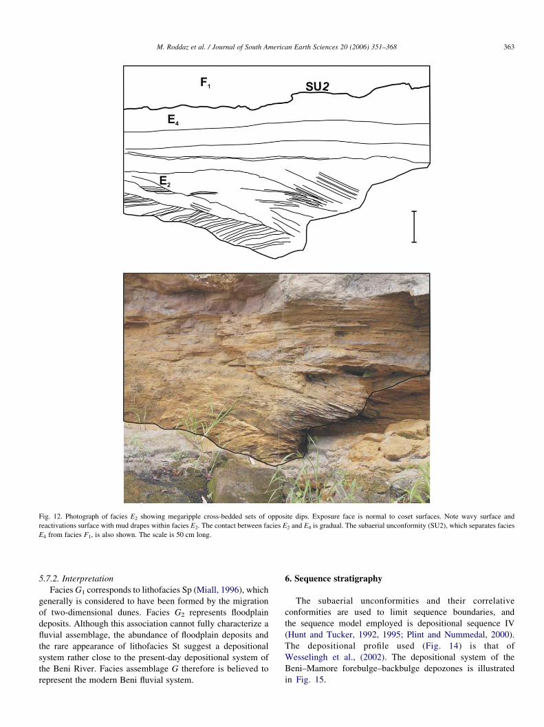
Fig. 12. Photograph of facies E2 showing megaripple cross-bedded sets of opposite dips. Exposure face is normal to coset surfaces. Note wavy surface and
reactivations surface with mud drapes within facies E2. The contact between facies E2 and E4 is gradual. The subaerial unconformity (SU2), which separates facies
E4 from facies F1, is also shown. The scale is 50 cm long.
M. Roddaz et al. / Journal of South American Earth Sciences 20 (2006) 351–368 363
5.7.2. Interpretation
Facies G1 corresponds to lithofacies Sp (Miall, 1996), which
generally is considered to have been formed by the migration
of two-dimensional dunes. Facies G2 represents floodplain
deposits. Although this association cannot fully characterize a
fluvial assemblage, the abundance of floodplain deposits and
the rare appearance of lithofacies St suggest a depositional
system rather close to the present-day depositional system of
the Beni River. Facies assemblage G therefore is believed to
represent the modern Beni fluvial system.
6. Sequence stratigraphy
The subaerial unconformities and their correlative
conformities are used to limit sequence boundaries, and
the sequence model employed is depositional sequence IV
(Hunt and Tucker, 1992, 1995; Plint and Nummedal, 2000).
The depositional profile used (Fig. 14) is that of
Wesselingh et al., (2002). The depositional system of the
Beni–Mamore forebulge–backbulge depozones is illustrated
in Fig. 15.

Fig. 13. Photograph of trough cross-stratifications in the yellow sands of facies F2. Hammer is 30 cm long.
M. Roddaz et al. / Journal of South American Earth Sciences 20 (2006) 351–368364
6.1. Subaerial unconformity (SU) and falling stage systems
tract (FSST)
Significant erosion affected the coarsening-upward tidal
flat and tidal bar association (FAB), though such erosion is
restricted to the western part of the basin and interpreted to
have formed by subaerial erosion. During the base level fall,
the SU formed coevally with the deposition of coastal
sedimentary wedges. The duration of base level fall caused
a SU to form at the top of the coastal wedges. The FAB laid
above the bottom lake sediments (FAA) with a basal scoured
surface. Above this surface, grain size increased, and
bathymetry decreased abruptly. Therefore, the coarsening-
upward coastal sedimentary wedges (FAB) are interpreted as
having been deposited as a result of a base level fall and hence
can be defined as a falling stage systems tract (FSST)
(Catuneanu, 2002). In the central part of the basin, the contact
between bottom lake sediments (FAA) and subtidal/shoreface
association (FAE) is conformable and facies change is
gradual. The FAE is interpreted as the distal equivalent of
FAB. This FSST is bound at its base by the scoured basal
Fig. 14. Depositional profile of the Pebas system (modified from Wesselingh et a
assemblage C; FAD, facies assemblage D; and FAE, facies assemblage E.
surface of forced regression (BSFR) and topped by the
subaerial unconformity (SU, Fig. 15).
6.2. Lowstand systems tract (LST) and maximum regressive
surface (MRS)
The western SU is covered by a fluvial series consisting of
fluvial channels (facies C1) and floodplain fines (facies C2).
As the FAC overlaid the SU, it recorded an incipient stage of
base level rise during normal regression when the rate of
deposition was greater than the rate of base level rise. FAC
represents a lowstand stage systems tract (LST) whose fluvial
portion has low preservation potential due to subsequent
ravinement erosion. Gliding features maintain accommodation
and preserve a low gradient for the mean depositional surface
(Catuneanu, 2002). This part of the LST is overlaid by the
tidal flat association FAD, which is sharp based and only
preserved in the BEN 70 section (Fig. 5). This sharp contact is
considered as the maximum regressive surface (MRS,
Fig. 15).
l., 2002). FAA, facies assemblage A; FAB, facies assemblage B; FAC, facies

Fig. 15. Wheeler diagram illustrating the stratigraphic architecture of the Beni–Mamore forebulge–backbulge depozones. FAA, Facies Assemblage A; FAB, Facies
Assemblage B; FAC, Facies Assemblage C; FAD, Facies Assemblage D; and FAE, Facies Assemblage E. BSFR: Basal Surface of Forced Regression; FSST: Falling
Stage Systems Tract; LST: Lowstand Systems Tract: TST: Transgressive Systems Tract; HST: Highstand Systems Tract; SU: Subaerial Unconformity; MRS:
Maximum Regressive Surface; MFS: Maximum Floading Surface. See text for explanations.
M. Roddaz et al. / Journal of South American Earth Sciences 20 (2006) 351–368 365
6.3. Transgressive systems tract (TST), maximum flooding
surface (MFS), and highstand systems tract (HST)
The tidal flat association (FAD) overlays the fluvial
association (FAC) and characterizes a transgression when the
rates of base level rise outpace the sedimentation rates (Plint,
1988; Posamentier et al., 1992; Catuneanu, 2002). The FAD
assemblage records a transgression and hence defines a
transgressive systems tract (TST). Its base is the previously
defined MRS of the later LST, and its top is the maximum
flooding surface (MFS), where preserved. The preservation
potential of the transgressive deposits is expected to be high
because the subsequent normal regression leads to sediment
aggradation across the entire basin (Catuneanu, 2002). The
BEN 70 section (Fig. 5) shows, in ascending order, the
succession FAC, FAD, FAC (Fig. 5b). The floodplain deposits
of FAC (facies C2) overlying the estuarine facies of FAD
(facies D2) record an increase in sedimentation rate during base
level rise, which corresponds to a late-stage base level rise
when the rate drops below the sedimentation rates, inducing
normal regression. These floodplain deposits are interpreted as
part of the poorly preserved continental. In the BEN 82 section
(Fig. 5d), the floodplain deposits of the FAC (facies C2) are
incised by the meandering fluvial system of the FAF (facies F2)
and hence belong to the HST (Fig. 15).
6.4. Subaerial unconformity 2 (SU2) and the ‘modern’
continental sequence
The surface that eroded the TST of BEN 61, the HST of
BEN 70 and BEN 82, and the LST of BEN 76 (Fig. 5)
corresponds to the erosion surface at the base of FAF and
defines a second subaerial unconformity, SU2. We do not
include in the stratigraphic architecture the meandering
modern Beni association (FAG) because of its fully continental
origin. In a fully continental setting, facies changes may be out
of phase with those driven by base level changes at the
shoreline (Miall, 1996) and thereby lead to improper
interpretations.
7. Discussion
7.1. Forebulge–backbulge dynamics
The western Amazonian Basin is considered the foreland
basin of the Cenozoic Andes. Recent studies in northern Peru
(Hermoza et al., 2005; Roddaz et al., 2005) have shown that the
north Amazonian foreland basin entered a four-component
configuration (wedge top, foredeep, forebulge, and backbulge
depozones) after the Middle–Late Miocene (15–10 Ma). In
southern Bolivia, the foreland basin system initiated at least in
Paleocene times (DeCelles and Horton, 2003). The area studied
herein comprises the present-day forebulge and backbulge
depozones (Baby et al., 1999; Aalto et al., 2003). Depending on
the rheology of the lithosphere and the rate of thrust-wedge
advance, the forebulge can migrate toward the orogen (Patton
and O’Connor, 1988) or the craton (Price and Hatcher, 1983;
Currie, 1997; Horton et al., 2001; White et al., 2002; DeCelles
and Horton, 2003) or remain stationary (Waschbusch and
Royden, 1992). The wedge front of the Beni–Mamore foreland
basin has migrated cratonward, recording a 74 km shortening
since the Late Miocene (10 Ma; Baby et al., 1997).
Depositional architecture in the forebulge–backbulge
depozones depends on base level rise and fall, which is
controlled by the positive or negative subsidence of the
forebulge with respect to the stationary craton, as well as
eustatic fluctuations. Falling stage systems tracts result from
forced regression imposed by base level falls. In a foreland
basin setting, this finding offers evidence that stratigraphic
sequences are correlated with local to regional tectonics (e.g.
Miall, 2000). In the study area, an eustasy-induced base level
fall would have generated an FSST in the western forebulge
and eastern cratonic parts of the basin. The FSST is only
located in the forebulge area. Therefore, it is likely that the
FSST was created by local/regional tectonics. Two mechan-
isms capable of generating uplift in this part of the foreland
basin may be envisaged: fault-related or forebulge flexural
uplift. Faulting would have induced steep topographic
gradients unable to preserve the FAB association of the
FSST. Slumps and soft sediment deformation are common in

M. Roddaz et al. / Journal of South American Earth Sciences 20 (2006) 351–368366
tidal estuary or delta inlets but not in the FAB. Their
occurrence in the FAB indicates slope creation during
sedimentation. However, because the FAD association is
preserved, the slope cannot have been greater than approxi-
mately 18, and the sloping rate must have been low. This trend
is compatible with incipient forebulge uplift, which is likely to
have controlled the deposition of the FSST. The succeeding
systems tracts (LST1, TST, and HST) were deposited during
base level rise but depend only on sedimentation. During
LST1, the sedimentation rate is assumed to have been high, and
sediment was supplied by the erosion of the adjacent Andes.
Once a steady state was reached, the sediment was trapped in
the eastern foredeep. In the forebulge–backbulge, the sedi-
mentation rate drops, and TST can develop. The subsequent
HST record an increase in sediment supply, which can be
correlated with renewed erosion within the Andes to generate
normal regression. Such an increase in supply can be ascribed
to thrust activity renewal, whose climax was later recorded by
eastward forebulge migration, the occurrence of SU2, and
emplacement of the modern Beni fluvial system.
7.2. Paleoenvironment implications
The Miocene depositional environment of western Amazo-
nia (Pebas/Solimoes) is still a matter of debate. It is unclear
whether a fluviolacustrine system (Hoorn, 1993, 1994a,b;
Hoorn et al., 1995), a tidally influenced sea (Rasanen et al.,
1995; Gingras et al., 2002a,b; Hovikoski et al., 2005) or tide-
influenced megalake (Wesselingh et al., 2002; Vonhof et al.,
2003) occupied Amazonia. Controversy comes from the
freshwater signature of mollusks found in the tidal deposits
of the Pebas system (Vonhof, 2003). Tidal deposits can also
form in freshwater environments (Kvale and Archer, 1990;
Dalrymple, 1992; Shanley et al., 1992; Greb, 1993; Archer
et al., 1994; Eberth, 1996; Kvale and Mastalerz, 1998). This
could be due to (1) inland propagation of tide influence (e.g.
Saint Lawrence river in Canada; Kvale and Mastalerz, 1998),
(2) extension of riverine freshwater plumes offshore in a tide-
dominated area (Amazon River; Lentz and Limeburner, 1995),
or (3) high runoff caused by high rainfall in a tropical climate
(Kvale and Mastalerz, 1998). A combination of these could be
a possible explanation for the freshwater signature of the Pebas
mollusk fauna.
The tide-influenced deposits of the Beni Basin necessitate
an open connection with the Atlantic Ocean during the Late
Miocene. In the Late Miocene, the Paranan transgression
reached at least southern Bolivia (Marshall et al., 1993). Recent
studies in the Brazilian Acre Basin (Rasanen et al., 1995;
Gingras et al., 2002b) and southern Peru (Roddaz et al., 2004;
Hovikoski et al., 2005) report Miocene tidal deposits with
mesohaline ichnofaunas (Gingras et al., 2002b; Hovikoski et
al., 2005). Given the poor stratigraphic control on the age of the
Beni tidal-influenced deposits, they could represent either the
southern extension of the tidal deposits of the Acre Basin or the
northern extension of the marine Yecua Formation. Another
possibility is that they record the presence of the putative
Miocene Amazon Seaway (Rasanen et al., 1995; Webb, 1995).
8. Conclusions
This study shows that the Miocene deposits of the
forebulge–backbulge foreland Beni–Mamore Basin were
tidally influenced and that the sedimentary evolution from
tidal to fully continental deposits was controlled by the
forebulge–backbulge dynamics of the Beni–Mamore foreland
basin system. Given the poor stratigraphic control on these
deposits, they could be the northernmost deposits of the
Miocene marine incursions within the Pebas system, the
southernmost deposits of the Late Miocene Paranan ingression,
or the central deposits of the Miocene Amazon interior seaway.
More work should be carried out to establish a more precise
spatiotemporal framework for these tidal deposits.
Acknowledgements
This research was supported by IRD, INSU grant
99PNSE59 (Tectonique, erosion et sedimentation dans le
bassin de l’Amazone: du Mio-Pliocene a l’Actuel) and INSU
grant «Erosion des Andes». We thank Jose Darrozes and
Magali Strub for field assistance. We also thank Pierre-Olivier
Antoine, Frederic Christophoul, Jose Darrozes, and Jean-
Claude Soula for reviewing previous versions of this article.
Mike Leeder and an anonymous reviewer offered helpful
reviews that contributed to greatly improve this article.
References
Aalto, R., Maurice-Bourgoin, L., Dunne, T., Montgomery, D.R.,
Nittrouer, C.A., Guyot, J.-L., 2003. Episodic sediment accumulation on
Amazonian flood plains influenced by El Nino/Southern Oscillation. Nature
425, 493–497.
Archer, A.W., Feldman, H.R., Kvale, E.P., Lanier, W.P., 1994. Comparison of
drier-to wetter-interval estuarine roof facies in the Eastern and Western
Interior coal basins, USA. Palaeogeography, Palaeoclimatology, Palaeoe-
cology 106, 171–185.
Ashley, G.M., 1990. Classification of large-scale subaqueous bedforms: a new
look at an old problem. J. Sediment. Petrol. 60 (1), 160–172.
Baby, P., Colletta, B., Zubieda, D., 1995. Etude geometrique et experimentale
d’un bassin transporte; exemple du synclinorium de l’Alto Beni (Andes
centrales). Bull. Soc. geol. France 166, 797–811.
Baby, P., Guyot, J.-L., Herail, G., 1999. The high Amazonian basin: tectonic
control and mass balance, Manaus’99—Hydrological and Geochimical
Processes in Large Scale Basins, Manaus.
Baby, P., Rochat, P., Mascle, G., Herail, G., 1997. Neogene shortening
contribution to crustal thickening in the back arc of the Central Andes.
Geology 25 (10), 883–886.
Boersma, J.R., 1969. Internal structures of some tidal mega-ripples on a shoal
in the Westerschelde Estuary. The Netherlands. Geol. en Mijnbouw 48,
409–419.
Campbell Jr.., K.E., Frailey, C.D., 1984. Holocene flooding and species
diversity in southwestern Amazonia. Quaternary Res. 21, 369–375.
Catuneanu, O., 2002. Sequence stratigraphy of clastic systems: concepts,
merits, and pitfalls. J. Afr. Earth Sci. 35, 1–43.
Collinson, J.D., 1970. Bedforms of the Tana River. Norway. Geogr. Ann. 52,
31–56.
Collinson, J.D., 1996. Alluvial sediments. In: Reading, H.G. (Ed.), Sedimentary
Environments: Processes, Facies and Stratigraphy. Blackwell Science,
Oxford, pp. 37–83.

M. Roddaz et al. / Journal of South American Earth Sciences 20 (2006) 351–368 367
Currie, B.S., 1997. Sequence stratigraphy of nonmarine Jurassic–Cretaceous
rocks, central Cordilleran foreland basin system. Geol. Soc. Am. Bull. 109
(9), 1206–1222.
Dalrymple, R.W., 1992. Tidal depositional systems. In: Walker, R.G.,
James, N.P. (Eds.), Facies Models—Response to Sea Level Change.
Geological Association of Canada, St John’s, Newfoundland, pp. 195–218.
Dalrymple, R.W., Rhodes, R.N., 1995. Estuarine dunes and barforms. In:
Perillo, G.M. (Ed.), Geomorphology and Sedimentology of Estuaries.
Developments in Sedimentology. Elsevier, Amsterdam, pp. 359–422.
Dalrymple, R.W., Zaitlin, B.A., Boyd, R., 1992. Estuarine facies models:
conceptual basis and stratigraphic implications. J. Sedim. Petrol. 62, 1130–
1146.
Dalrymple, R.W., Baker, E.K., Harris, P.T., Hughes, M., 2003. Sedimentology
and stratigraphy of a tide-dominated, foreland-basin delta (Fly River, Papua
New Guinea). In: Sidi, F.H., Nummedal, D., Imbert, P., Darman, H.,
Posamentier, H.W. (Eds.), Tropical Deltas of Southeast Asia-Sedimentol-
ogy, Stratigraphy, and Petroleum Geology. Society of Sedimental
Geological (SEPM) Special Publication, pp. 147–173.
Davies, C., Best, J., Collier, R., 2003. Sedimentology of the Bengal shelf,
Bangladesh: comparison of late Miocene sediments, Sitakund anticline,
with the modern, tidally dominated shelf. Sedim. Geol. 155 (3–4), 271–300.
de Mowbray, T., Visser, M.J., 1984. Reactivation surfaces in subtidal channel
deposits, Oosterschelde, Southwest Netherlands. J. Sedim. Petrol. 54, 811–
824.
DeCelles, P.G., Giles, K.A., 1996. Foreland basin systems. Basin Res. 8, 105–
123.
DeCelles, P., Horton, B.K., 2003. Early to middle Tertiary basin development
and the history of Andean crustal shortening in Bolivia. Geol. Soc. Am.
Bull. 115, 58–77.
Eberth, D.A., 1996. Origin and significance of mud-filled incised valley (Upper
Cretaceous) in southern Alberta, Canada. Sedimentology 43, 459–477.
Falcon-Lang, L.H., 1998. The impact of wildfire on an Early Carboniferous
coastal environment, North Mayo, Ireland. Palaeogeography, Palaeocli-
matology, Palaeoecology 139, 121–138.
Frailey, C.D., Lavina, E., Rancy, A., de Souza Filho, J., 1988. A proposed
Pleistocene/Holocene lake in the Amazon Basin and its significance to
Amazonian geology and biogeography. ActaAmazonica 18 (3–4), 119–143.
Gingras, M.K., Pemberton, S.G., Saunders, T.D.A., Clifton, H.E., 1999. The
ichnology of modern and Pleistocene brackish-water deposits at Willapa
Bay, Washington: variability in estuarine setting. Palaios 14, 352–374.
Gingras, M.K., Rasanen, M.E., Pemberton, S.G., Romero Pittman, L., 2002a.
Ichnology and sedimentology reveal depositional characteristics of bay
margin parasequences in the Miocene Amazonian Foreland Basin. J. Sed.
Res. 72 (6), 871–883.
Gingras,M.K., Rasanen,M.E., Ranzi, A., 2002b.The significance of bioturbated
inclined heterolithic stratification in the southern part of the Miocene
Solimoes Formation, Rio Acre, Amazonia Brazil. Palaios 17 (6), 591–601.
Greb, S.F., 1993. Peat accumulation and sedimentation in the Livingston
Paleovalley (Morrowan), eastern Kentucky. In: Archer, A.W., Feldman,
H.R., Lanier W.P. (Eds.), Incised Paleovalleys of the Douglas Group in
Northeastern Kansas: Field Guide and Related Papers. Kansas Geological
Survey Open File Report, 15.1–15.6.
Hermoza, W., 2004. Dynamique tectono-sedimentaire et restauration
sequentielle du retro-bassin d’avant-pays des Andes Centrales PhD Thesis,
University Paul Sabatier, Toulouse, 196 pp.
Hermoza, W., Brusset, S., Baby, P., Gil, W., Roddaz, M., Guerrero, N.,
Bolanos, R., 2005. The Huallaga foreland basin evolution: thrust
propagation in deltaic environment, in the northern Peruvian Andes.
J. South Am. Earth Sci. 19 (1), 21–34.
Hernandez, R.M., Jordan, T.E., Dalenz Farjat, A., Echavarrıa, L.,
Idleman, B.D., Reynolds, J.H., 2005. Age, distribution, tectonics, and
eustatic controls of the Paranense and Caribbean marine transgressions in
southern Bolivia and Argentina. J. South Am. Earth Sci. 19, 495–512.
Hoorn, C., 1993. Marine incursions and the influence of Andean tectonics on
the Miocene depositional history of norhtwestern Amazonia: results of a
palynostratigraphic study. Palaeogeography, Palaeoclimatology, Palaeoe-
cology 105, 267–309.
Hoorn, C., 1994a. An environmental reconstruction of the paleo-Amazon River
system (Middle–Late Miocene, NW Amazonia). Palaeogeography,
Palaeoclimatology, Palaeoecology 112, 187–238.
Hoorn, C., 1994b. Fluvial paleoenvironments in the intracratonic Amazonas
Basin (Early Miocene–Early Middle Miocene, Colombia). Palaeogeogra-
phy, Palaeoclimatology, Palaeoecology 109, 1–54.
Hoorn, C., Guerrero, J., Sarmiento, G.A., Lorente, M.A., 1995. Andean
tectonics as a cause for changing drainage patterns in Miocene northern
South America. Geology 23 (3), 237–240.
Horton, B.K., DeCelles, P.G., 1997. The modern foreland basin system
adjacent to the central Andes. Geology 25, 895–898.
Horton, B.K., Hampton, B.A., Waanders, G.L., 2001. Paleogene synorogenic
sedimentation in the Altiplano plateau and implications for initial mountain
building in the central Andes. Geol. Soc. Am. Bull. 113, 1387–1400.
Hovikoski, J., Rasanen, M.E., Gingras, M.K., Roddaz, M., Brusset, S.,
Hermoza, W., Pittman, L.R., Lertola, K., 2005. Miocene semi-diurnal tidal
rhythmites in Madre de Dios. Peru. Geol. 33 (3), 177–180.
Hunt, D., Tucker, M.E., 1992. Stranded parasequences and the forced
regressive wedge systems tract: deposition during base-level fall. Sedim.
Geol. 81, 1–9.
Hunt, D., Tucker, M.E., 1995. Stranded parasequences and the forced
regressive wedge systems tract: deposition during base-level fall-reply.
Sedim. Geol. 95, 147–160.
Jordan, T.E., 1995. Retroarc foreland and related basins. In: Busby, C.J.,
Ingersoll, R.V. (Eds.), Tectonics of Sedimentary Basins. Blackwell
Science, Oxford, pp. 331–362.
Jordan, T.E., Isacks, B.L., Allmendinger, R.W., Brewer, J.A., Ramos, V.A.,
Ando, C.J., 1983. Andean tectonics related to geometry of subducted Nazca
plate. Geol. Soc. Am. Bull. 94, 341–361.
Kvale, E.P., Archer, A.W., 1990. Tidal deposits associated with low-sulfur
coals, Brazil Formation (Lower Pennsylvanian), Indiana. J. Sedim. Petrol.
60, 563–574.
Kvale, E.P., Mastalerz, M., 1998. Evidence of Ancient freshwater tidal
deposits. In: Alexander, C.R., Davis, R.A., V.J., H. (Eds.), Tidalites:
Processes and Products. SEPM, Special Publication, pp. 95–107.
Lanier, W.P., Tessier, B., 1998. Climbing-ripple bedding in the fluvio-estuarine
transition: a common feature associated with tidal dynamics (modern and
ancient analogues). In: Alexander, C.R., Davis, R.A., Henry, V.J. (Eds.),
Tidalites: Processes and Products. Soceity of Sedimental Geological
(SEPM) Special Publication, Tulsa, pp. 109–119.
Latrubesse, E.M., 1992. The Cenozoic of the Purus basin in the Acre State,
Brazil. Phd Thesis, Thesis, Universidad Nacional San Luis, 219 pp.
Latrubesse, E.M., Bocquetin, J., Santos, J.C.R., Ramonell, C.G., 1997.
Paleoenvironmental model for the Late Cenozoic of southwestern
Amazonia: paleontology and geology. Acta Amazonica 27 (2), 103–118.
Lentz, S.J., Limeburner, R., 1995. The Amazon River during AMASSEDS:
spatial characteristics and salinity variability. J. Geophys. Res. 100, 2355–
2375.
Marshall, L.G., Lundberg, J.G., 1996. Miocene deposits in the Amazonian
Foreland Basin (Technical comments). Science 273, 123–124.
Marshall, L.G., Sempere, T., Gayet, M., 1993. The Petaca (Late Oligocene–
Middle Miocene) and Yecua (Late Miocene) formations of the Subandean-
Chaco basin, Bolivia, and their tectonic significance. Docum. Lab. Geol.
Lyon 125, 291–301.
Martin, A.J., 2000. Flaser and wavy bedding in ephemeral streams: a modern
and an ancient example. Sedim. Geol. 136, 1–5.
Miall, A.D., 1996. The Geology of Fluvial Deposits, Sedimentary Facies, Basin
Analysis and Petroleum Geology. Springer, Berlin. 582 pp.
Miall, A.D., 2000. The Geology of Stratigraphic Sequences. Springer, Berlin,
p. 435.
Nio, S.D., Yang, C.S., 1991. Diagnostic attribute of clastic tidal deposits: a
review. In: Smith, D.G., Reinson, G.E., Zaitlin, B.A., Rahmani, R.A.
(Eds.),. Canadian Society of Petroleum Geologists, pp. 3–28.
Patton, T.L., O’Connor, S.J., 1988. Cretaceous flexural history of northern
Oman mountain foredeep, United Arab Emirates. Am. Assoc. Petrol. Geol.
Bull. 72, 797–809.
Paxton, C.G.M., Crampton, W.G.R., Burgess, P., 1996. Miocene deposits in the
Amazonian Foreland Basin (Technical comments). Science 273, 123.
M. Roddaz et al. / Journal of South American Earth Sciences 20 (2006) 351–368368
Plint, A.G., 1988. Sharp-based shoreface sequences and offshire bars in the
Cardium Formation of Alberta; their relationship to relative changes in sea
level. In: Wilgus, C.K. et al. (Ed.), Sea Level Changes-An Integrated
Approach. SEPM Special Publication, pp. 357–370.
Plint, A.G., Nummedal, D., 2000. The falling stage systems tract: recognition
and importance in sequence stratigraphic analysis. In: Hunt, D.,
Gawthorpe, R.L. (Eds.), Sedimentary Response to Forced Regression.
Geological Society of London Special Publication, pp. 1–17.
Posamentier, H.W., Allen, G.P., James, D.P., Tesson, M., 1992. Forced
regressions in a sequence stratigraphic framework: concepts, examples, and
exploration significance. Am. Assoc. Petrol. Geol. Bull. 76, 1687–1709.
Price, R.A., Hatcher, R.D., 1983. Tectonic significance of similarities in the
evolution of the Alabama–Pennsylvania Appalachians and the Alberta-
British Columbia Canadian Cordillera. In: Hatcher, R.D., Williams, H.,
Zietz, I. (Eds.), Contributions to the Tectonics and Geophysics of Mountain
Chains. Mem. Geol. Soc. Am., 149–160.
Ranger, M.J., Pemberton, S.G., 1992. The sedimentology and ichnology of
estuarine point bars in the McMurray Formation of the Athabasca oil sands
deposits, northesatern Alberta, Canada. In: Pemberton, S.G. (Ed.),
Applications of Ichnology to Petroleum Exploration. SEPM Core Work-
shop Notes, 401–421.
Rasanen, M.E., Linna, A.M., Santos, J.C.R., Negri, F.R., 1995. Late
Miocene Tidal Deposits in the Amazonian Foreland Basin. Science 269,
386–390.
Rasanen, M.E., Linna, A.M., Irion, L., Rebata Hernani, L., Vargas Huamas, R.,
Wesselingh, F., 1998. Geologıa y geoformas de la zona de Iquitos.
In: Kalliola, R., Flores Paitan, S. (Eds.), Geoecologıa y desarrollo
Amazonico: estudio integrado en la zona de Iquitos, Peru. Ser A II.
Annales Universitatis Turkuensis, Turku, 544.
Roddaz, M., Hermoza, W., Hovikoski, J., Brusset, S., Antoine, P.-O., Baby, P.,
2004. Late Miocene tidal sedimentation in the foredeep of the southwestern
Amazonian foreland basin system (Madre de Dios basin, South Peru). In:
Bartholdy, J., Pedersen, J.B.T. (Eds.), Tidalites 2004. Institute of
Geography, University of Copenhagen, Copenhagen, pp. 161–164.
Roddaz, M., Baby, P., Brusset, S., Hermoza, W., Darrozes, J., 2005. Forebulge
dynamics and environmental control in western Amazonia: the case study
of the arch of Iquitos (Peru). Tectonophysics 399, 87–108.
Sanjinez, S.G., Jimenez, F., 1975. Comunicacion preliminar acerca de la
presencia de fosiles vertebrados en la Formacion Petaca del area de Santa
Cruz. Revista tecnica de YPFB 4, 147–158.
Sempere, T., Herail, H., Oller, J., Bonhomme, M.G., 1990. Late Oligocene–
Early Miocene major tectonic crisis and related basins in Bolivia. Geology
18, 946–949.
Sempere, T., Butler, R.F., Richards, D.R., Marshall, L.G., Sharp, W., Swisher
III., C.C., 1997. Stratigraphy and chronology of Upper Cretaceous–Lower
Paleogene strata in Bolivia and northwest Argentina. Geol. Soc. Am. Bull.
109, 709–727.
Shanley, K.W., McCabe, P.J., Hettinger, R.D., 1992. Tidal influence in
Cretaceous fluvial strata from Utah, USA, a key to sequence stratigraphic
interpretation. Sedimentology 39, 905–930.
Smith, D.G., 1989. Comparative sedimentology of mesotidal (2–4 m) estuarine
channel point bar deposits frommodern examples and ancient Athabasca oil
sands (Lower Cretaceous), McMurray Formation. In: Reinson, G.E. (Ed.),
Modern and Ancient Examples of Clastic Tidal Deposits; a Core and Peel
Workshop. Canadian Society of Petroleum Geologists, Calgary, pp. 60–65.
Stride, A.H., 1982. Offshore Tidal Sands: Processes and Deposits. Chapman
and Hall, London. 239 pp.
Tessier, B., Archer, A.W., Lanier, W.P., Feldman, H.R., 1995. Comparison of
ancient tidal rhythmites (Carboniferous of Kansas and Idiana, USA) with
modern analogues (the Bay of Mont-Saint–Michel, France). In:
Flemmings, B.W., Bartholoma, A. (Eds.), Tidal Signatures in Modern
and Ancient Sediments. IAS Special Publication, pp. 259–271.
Thomas, R.G., Smith, D.G., Wood, J.M., Visser, J., Calverly-Range, E.A.,
Koster, E.H., 1987. Inclined heterolithic stratification; terminology,
description, interpretation and significance. Sedim. Geol. 53, 123–179.
Uba, C.E., Heubeck, C., Hulka, C., 2005. Facies analysis and basin architecture
of the Neogene Subandean synorogenic wedge, southern Bolivia. Sedim.
Geol. 180, 91–123.
Visser, M.J., 1980. Neap-Spring cycles reflected in Holocene subtidal
large-scale bedform deposits. A preliminary note. Geology 8, 543–546.
Vonhof, H.B., Wesselingh, F.P., Kaandorp, R.J.G., Davies, G.R.,
van Hinte, J.E., Guerrero, J., et al., 2003. Paleogeography of Miocene
Western Amazonia: Isotopic composition of molluscan shells constrains the
influence of marine incursions. Geol. Soc. Am. Bull. 115, 983–993.
Waschbusch, P.J., Royden, L.H., 1992. Spatial and temporal evolution of
foredeep basins: lateral strength variations and inelastic yielding in
continental lithosphere. Basin Res. 4, 179–196.
Webb, S.D., 1995. Biological Implications of the Middle Miocene Amazon
Seaway. Science 269, 361–362.
Wesselingh, F.P., Rasanen, M.E., Irion, G., Vonhof, H.B., Kaandorp, R.,
Renema, W., et al., 2002. Lake-Pebas: a palaeocological reconstruction of a
Miocene long-lived lake complex in Western Amazonia. Cainozoic
Research 1 (1–2), 35–81.
White, T., Furlong, K.P., Arthur, M., 2002. Forebulge migration in the
Cretaceous Western Interior basin of the central United States. Basin Res.
14, 43–54.
Related Documents