For permission to copy, contact [email protected] q 2002 Geological Society of America 991 GSA Bulletin; August 2002; v. 114; no. 8; p. 991–1006; 9 figures; 5 tables; Data Repository item 2002102. Drainage reversals in Mono Basin during the late Pliocene and Pleistocene Marith C. Reheis* U.S. Geological Survey, M.S. 980, Federal Center, Denver, Colorado 80225, USA Scott Stine Department of Geography and Environmental Studies, California State University, 25800 Carlos Bee Boulevard, Hayward, California 94542, USA Andrei M. Sarna-Wojcicki U.S. Geological Survey, M.S. 975, 345 Middlefield Road, Menlo Park, California 94025, USA ABSTRACT Mono Basin, on the eastern flank of the central Sierra Nevada, is the highest of the large hydrographically closed basins in the Basin and Range province. We use geo- morphic features, shoreline deposits, and basalt-filled paleochannels to reconstruct an early to middle Pleistocene record of shorelines and changing spillways of Lake Russell in Mono Basin. During this period of time, Lake Russell repeatedly attained altitudes between 2205 and 2280 m—levels far above the present surface of Mono Lake (;1950 m) and above its last overflow level (2188 m). The spill point of Lake Russell shifted through time owing to late Tertiary and Quaternary faulting and volcanism. During the early Pleistocene, the lake pe- riodically discharged through the Mount Hicks spillway on the northeastern rim of Mono Basin and flowed northward into the Walker Lake drainage basin via the East Walker River. Paleochannels recording such discharge were incised prior to 1.6 Ma, possibly between 1.6 and 1.3 Ma, and again after 1.3 Ma (ages of basaltic flows that plugged the paleochannels). Faulting in the Adobe Hills on the southeastern margin of the basin eventually lowered the rim in this area to below the altitude of the Mount Hicks spillway. Twice after 0.76 Ma, and possibly as late as after 0.1 Ma, Lake Russell discharged southward through the Adobe Hills spillway into the Owens–Death Valley system of lakes. This study supports a pre- Pleistocene aquatic connection through Mono *E-mail: [email protected]. Basin between the hydrologically distinct Lahontan and Owens–Death Valley sys- tems, as long postulated by biologists, and also confirms a probable link during the Pleistocene for species adapted to travel up- stream in fast-flowing water. Keywords: biogeography, drainage chang- es, fish, Great Basin, Mono Basin. INTRODUCTION The Mono Basin abuts the eastern flank of the central Sierra Nevada (Fig. 1). This young structural depression (Gilbert et al., 1968; Pakiser, 1976; Huber, 1981) is the highest of the large hydrographically closed basins in the Basin and Range province. Mono Lake is the saline, alkaline remnant of Pleistocene Lake Russell, which occupied Mono Basin (Fig. 2). Throughout much of the Pleistocene the lake stood at altitudes far above its present surface (1958 m in A.D. 1950) and its late Pleistocene levels; at times the lake spilled into adjacent watersheds through gaps in the basin rim. We find that the spill point of Lake Russell shifted through time, and we infer that the shifts were caused by late Tertiary and Quaternary fault- ing and volcanism (Gilbert et al., 1968; Bailey et al., 1976; Metz and Mahood, 1985; Bursik and Sieh, 1989). During the early Pleistocene, the lake periodically spilled northward into the Lahontan drainage basin; afterward, it spilled southward into the Owens–Death Valley sys- tem of lakes. A high-standing basin with shifting spill points has the capacity to function as a bio- geographic ‘‘switchyard’’ through which ob- ligately aquatic species (those that cannot sur- vive out of water for even short periods) can expand their range across otherwise insur- mountable drainage divides. Biologists, point- ing to several such species that today occur in the hydrologically distinct Lahontan and Owens–Death Valley systems (e.g., Hubbs and Miller, 1948; Minckley et al., 1986; Hershler and Sada, 2002), have long specu- lated that Mono Basin may have linked these two systems at some time in the past (e.g., Hubbs and Miller, 1948; Taylor, 1985). This study confirms that linkage and places the transfer from north to south at sometime after 1.3 Ma and likely after 0.76 Ma. Hydrographic Setting The rim of Mono Basin is much lower on the east than on the north, west, and south. This eastern rim is breached in several places by low divides, two of which show evidence of past scouring by lake overflow (Fig. 2). The lowest divide at present lies in greatly faulted terrain of the Adobe Hills at an altitude of 2189–2190 m. This feature, here informally named the ‘‘Adobe Hills spillway,’’ is the gap through which the lake would spill today if it were to fill the basin. A south-draining chan- nel heading at this gap carried the last over- flow of Lake Russell into Adobe Valley and thence into the Owens–Death Valley system (Figs. 1 and 2; Putnam, 1949). Farther north along the east rim of the ba- sin, at the north edge of a small subbasin called Alkali Valley, lies the informally named ‘‘Mount Hicks spillway.’’ At an altitude of 2237 m, it stands ;47 m above the Adobe Hills spillway. A channel that heads at this

Welcome message from author
This document is posted to help you gain knowledge. Please leave a comment to let me know what you think about it! Share it to your friends and learn new things together.
Transcript

For permission to copy, contact [email protected] 2002 Geological Society of America 991
GSA Bulletin; August 2002; v. 114; no. 8; p. 991–1006; 9 figures; 5 tables; Data Repository item 2002102.
Drainage reversals in Mono Basin during the latePliocene and Pleistocene
Marith C. Reheis*U.S. Geological Survey, M.S. 980, Federal Center, Denver, Colorado 80225, USA
Scott StineDepartment of Geography and Environmental Studies, California State University, 25800 Carlos Bee Boulevard, Hayward,California 94542, USA
Andrei M. Sarna-WojcickiU.S. Geological Survey, M.S. 975, 345 Middlefield Road, Menlo Park, California 94025, USA
ABSTRACT
Mono Basin, on the eastern flank of thecentral Sierra Nevada, is the highest of thelarge hydrographically closed basins in theBasin and Range province. We use geo-morphic features, shoreline deposits, andbasalt-filled paleochannels to reconstructan early to middle Pleistocene record ofshorelines and changing spillways of LakeRussell in Mono Basin. During this periodof time, Lake Russell repeatedly attainedaltitudes between 2205 and 2280 m—levelsfar above the present surface of Mono Lake(;1950 m) and above its last overflow level(2188 m). The spill point of Lake Russellshifted through time owing to late Tertiaryand Quaternary faulting and volcanism.During the early Pleistocene, the lake pe-riodically discharged through the MountHicks spillway on the northeastern rim ofMono Basin and flowed northward into theWalker Lake drainage basin via the EastWalker River. Paleochannels recordingsuch discharge were incised prior to 1.6Ma, possibly between 1.6 and 1.3 Ma, andagain after 1.3 Ma (ages of basaltic flowsthat plugged the paleochannels). Faulting inthe Adobe Hills on the southeastern marginof the basin eventually lowered the rim inthis area to below the altitude of the MountHicks spillway. Twice after 0.76 Ma, andpossibly as late as after 0.1 Ma, Lake Russelldischarged southward through the AdobeHills spillway into the Owens–Death Valleysystem of lakes. This study supports a pre-Pleistocene aquatic connection through Mono
*E-mail: [email protected].
Basin between the hydrologically distinctLahontan and Owens–Death Valley sys-tems, as long postulated by biologists, andalso confirms a probable link during thePleistocene for species adapted to travel up-stream in fast-flowing water.
Keywords: biogeography, drainage chang-es, fish, Great Basin, Mono Basin.
INTRODUCTION
The Mono Basin abuts the eastern flank ofthe central Sierra Nevada (Fig. 1). This youngstructural depression (Gilbert et al., 1968;Pakiser, 1976; Huber, 1981) is the highest ofthe large hydrographically closed basins in theBasin and Range province. Mono Lake is thesaline, alkaline remnant of Pleistocene LakeRussell, which occupied Mono Basin (Fig. 2).Throughout much of the Pleistocene the lakestood at altitudes far above its present surface(1958 m in A.D. 1950) and its late Pleistocenelevels; at times the lake spilled into adjacentwatersheds through gaps in the basin rim. Wefind that the spill point of Lake Russell shiftedthrough time, and we infer that the shifts werecaused by late Tertiary and Quaternary fault-ing and volcanism (Gilbert et al., 1968; Baileyet al., 1976; Metz and Mahood, 1985; Bursikand Sieh, 1989). During the early Pleistocene,the lake periodically spilled northward into theLahontan drainage basin; afterward, it spilledsouthward into the Owens–Death Valley sys-tem of lakes.
A high-standing basin with shifting spillpoints has the capacity to function as a bio-geographic ‘‘switchyard’’ through which ob-ligately aquatic species (those that cannot sur-
vive out of water for even short periods) canexpand their range across otherwise insur-mountable drainage divides. Biologists, point-ing to several such species that today occur inthe hydrologically distinct Lahontan andOwens–Death Valley systems (e.g., Hubbsand Miller, 1948; Minckley et al., 1986;Hershler and Sada, 2002), have long specu-lated that Mono Basin may have linked thesetwo systems at some time in the past (e.g.,Hubbs and Miller, 1948; Taylor, 1985). Thisstudy confirms that linkage and places thetransfer from north to south at sometime after1.3 Ma and likely after 0.76 Ma.
Hydrographic Setting
The rim of Mono Basin is much lower onthe east than on the north, west, and south.This eastern rim is breached in several placesby low divides, two of which show evidenceof past scouring by lake overflow (Fig. 2). Thelowest divide at present lies in greatly faultedterrain of the Adobe Hills at an altitude of2189–2190 m. This feature, here informallynamed the ‘‘Adobe Hills spillway,’’ is the gapthrough which the lake would spill today if itwere to fill the basin. A south-draining chan-nel heading at this gap carried the last over-flow of Lake Russell into Adobe Valley andthence into the Owens–Death Valley system(Figs. 1 and 2; Putnam, 1949).
Farther north along the east rim of the ba-sin, at the north edge of a small subbasincalled Alkali Valley, lies the informally named‘‘Mount Hicks spillway.’’ At an altitude of2237 m, it stands ;47 m above the AdobeHills spillway. A channel that heads at this

992 Geological Society of America Bulletin, August 2002
REHEIS et al.
Figure 1. Regional map showing extent of late Pleistocene lakes, particularly Lake Russellin Mono Basin, and overflow connections along the eastern Sierra Nevada.
gap drains north toward Mud Spring Canyon(Fig. 2), a tributary of the East Walker River.
Geologic Setting
Mono Basin (Fig. 2) is a southwest-tiltedhalf graben that probably began forming at ca.4–3 Ma (Gilbert et al., 1968; Huber, 1981).Most of the subsidence is due to displacementalong the Sierra Nevada frontal fault (Bursikand Sieh, 1989). The basin is structurally andtopographically closed by a west-trendingmonocline on the north, coincident with theBodie Hills, and by the north-dipping flank ofthe Long Valley caldera on the south. The gra-nitic and metamorphic rocks exposed alongthe Sierra Nevada on the west likely also formthe basement complex beneath Mono Basin.These rocks are overlain by a thick accumu-lation of Miocene to Holocene volcanic rocks
and interbedded alluvial and lacustrine sedi-ments (Gilbert et al., 1968).
Of particular interest to our study are thePliocene and Pleistocene volcanic flows thatform the eastern margin of the basin. The areaof the Adobe Hills spillway (Fig. 2) is under-lain by voluminous flows of olivine basalt lo-cally interbedded with lacustrine and fluvialdeposits. These diatomaceous sands and siltscontain abundant fossils of mollusks and fish.On the basis of several K-Ar ages, the basaltflows were emplaced between ca. 4 and 3 Ma(Gilbert et al., 1968; Robinson and Kistler,1986). The volcanic flows are extensively cutby north-striking normal faults and intersect-ing northeast-striking, presumably left-lateralfaults (Fig. 3). This configuration has pro-duced a zone of extension and net down-to-the-south displacement described by Gilbert etal. (1968) as a structural ‘‘knee’’ or pull-apart
zone. The concentration of microseismicity inthis zone (dePolo et al., 1993) shows that ex-tension is ongoing.
Andesitic flows of late Pliocene and Pleis-tocene age cover much of the northeasternmargin of the Mono Basin (Fig. 2) in the vi-cinity of the Mount Hicks spillway (Gilbert etal., 1968; Robinson and Kistler, 1986; Langeet al., 1993). These flows are cut locally bynorth- and northeast-striking faults that areless abundant, shorter, and apparently of lessdisplacement than those in the area of theAdobe Hills spillway (Stewart, 1982).
Previous Work
Lake Russell/Mono Lake has a well-knownlate Quaternary history established by Russell(1889), Putnam (1949), Lajoie (1968), andStine (1987, 1990). About 13 000 yr ago thelake attained its highest level of late-glacialand postglacial time (Lajoie et al., 1982; Ben-son et al., 1990). A conspicuous strandline en-circling the basin marks this highstand at analtitude of 2155 m (Fig. 2), though at placesalong the Sierran front it has been downfault-ed by as much as 27 m. This shoreline lies 35m below the Adobe Hills spillway, indicatingthat the lake has not overflowed since before13 000 yr B.P.
Discontinuous but conspicuous remnants ofa higher shoreline terrace lying at and belowan altitude of 2188 m are found at many plac-es around the basin (Figs. 2 and 4A). Suchterrace remnants extend into the Adobe Hillsspillway; the slightly higher apparent altitudeof the spillway (;2189–2190 m) is due eitherto inaccurate contours in the topographic mapor to displacement by faults near the spillway(Fig. 3). Putnam (1949), who first noted thisterrace and its associated spillway, thoughtthat it dated from the time of Tahoe glaciation,because he found the terrace on the Tahoe mo-raines of June Lake (at Aeolian Buttes, Fig.2). He recognized that Lake Russell over-flowed through a series of shallow basins (Fig.3) into Pleistocene Lake Adobe in Adobe Val-ley. Lake Adobe, in turn, overflowed intoBenton Valley (Fig. 2), a northeastern arm ofOwens Valley, by way of a narrow slot cutinto granitic rocks of the Benton Range (Fig.4C; Hubbs and Miller, 1948). The late Pleis-tocene highstand of Lake Adobe lay at an al-titude of ;1975 m (Fig. 2; Snyder et al.,1964; Batchelder, 1970).
Previous information on fluctuations ofLake Russell that predate the conspicuousshorelines at 2155 m and 2188 m is scant. Adriller’s log from a wildcat well drilled onPaoha Island in 1908 (Scholl et al., 1967) re-

Geological Society of America Bulletin, August 2002 993
DRAINAGE REVERSALS IN MONO BASIN DURING THE LATE PLIOCENE AND PLEISTOCENE
Figure 2. Map showing geography of Mono Basin and surrounding area, shorelines of Lake Russell and Lake Adobe, and locations oflacustrine deposits higher than the last overflow altitudes of these lakes. Diagonal lines are modern lakes. Light dashed lines show areasof Figures 3 and 5. KS—Kirkwood Spring, BC—mouth of Bridgeport Canyon, AHS—Adobe Hills spillway, MHS—Mount Hicksspillway.
cords ;600 m of apparently lacustrine sedi-ment that contains a thick layer of light pinkrock and pink sand at depths between 411 and451 m. Lajoie (1968) interpreted this pink ma-
terial to be the 760 ka Bishop Tuff (age fromSarna-Wojcicki et al., 1991). When he appliedthe sedimentation rate of material overlyingthe presumed Bishop Tuff (;0.6 m/k.y.) to the
sediments underlying it, Lajoie concluded thata lake may have occupied Mono Basin con-tinuously for at least the past million years.
Russell (1889) hinted, and Hubbs and Mill-

994 Geological Society of America Bulletin, August 2002
REHEIS et al.
Figure 3. Geologic and topographic map of the area of Adobe Hills spillway (AHS) anddrainage channel. Dual map units (e.g., Qly/Tv) indicate thin surficial deposit overlyingolder unit.
er (1948) proposed, that there had been an ear-lier connection between the Lahontan andMono Basins via the East Walker River andAlkali Valley by way of the gap here calledthe Mount Hicks spillway. Taylor (1985) andHershler and Sada (2002) inferred a similarconnection from the distribution of fresh-water mollusks. Miller and Smith (1981) usedfossils and data on modern distributions ofChasmistes sp. (a sucker) in the western GreatBasin to argue that populations of this fishranged south from the Lahontan system intoMono Basin during the Pliocene (no fish cur-rently live in Mono Lake); they also reportedChasmistes fossils in lower Pleistocene de-posits near China Lake (Fig. 2).
Dating Methods
Stratigraphic sections within the study arealocally contain tephra layers; the U.S. Geolog-ical Survey Tephrochronology Laboratory hasidentified these through chemical correlationwith tephra samples of known age. Glassshards from tephra layers were analyzed byelectron microprobe for major-oxide compo-sition by using methods of Sarna-Wojcicki etal. (1984) and Sarna-Wojcicki (2000). Samplecompositions were compared with composi-tions in a database of previously analyzedtephra layers by using statistical programs (Ta-ble 1). Values for glass compositions in Table1 are normalized to 100% to correct for thevariable amounts of hydration of the volcanicglass (original analytical data are in AppendixTable A1). In addition to hydration, somepostdepositional alkali exchange has occurredin many of the samples. Correlations werebased on similarity in chemical compositionas well as petrographic characteristics (such asshard morphology and phenocryst mineral as-semblage) and stratigraphic data.
Radiometric dating of the Quaternary basaltflows includes whole-rock K-Ar ages for thisstudy (Table 2) and from previous work (sum-marized by Robinson and Kistler, 1986, andLange et al., 1993), as well as 40Ar/39Ar ages(Table 3) provided by the New Mexico Geo-chronology Research Laboratory. Laboratoryanalytical procedures and methods of age cal-culation are described in GSA Data Reposi-tory Table DR1.1 Following recommendationsin the analytical report (W.C. McIntosh, 2000,written commun.), we use the inverse isochronages here.
1GSA Data Repository item 2002102, analyticaldata and descriptions of stratigraphic units, isavailable on the Web at http://www.geosociety.org/pubs/ft2002.htm. Requests may also be sent [email protected].
EVIDENCE FOR YOUNGERSOUTHWARD OVERFLOW INTOADOBE VALLEY
Mapping conducted in the area of the Ado-be Hills spillway (Fig. 2) shows that LakeRussell last overflowed through a series ofsmall, shallow, fault-controlled subbasins(Figs. 3 and 4A). These subbasins developedas pull-apart structures at the intersections of
north- and northeast-striking faults (Gilbert etal., 1968). The apparent displacement of Pli-ocene basalt along most of the faults is downto the east and southeast, effectively loweringthe rim of the Mono Basin near the AdobeHills spillway. Owing to areally extensive andlocally thick blankets of Holocene ejecta fromthe Mono and Inyo Craters to the southwest(Fig. 2), scarps associated with these faults areoften obscured. The fresh appearance of some

Geological Society of America Bulletin, August 2002 995
DRAINAGE REVERSALS IN MONO BASIN DURING THE LATE PLIOCENE AND PLEISTOCENE
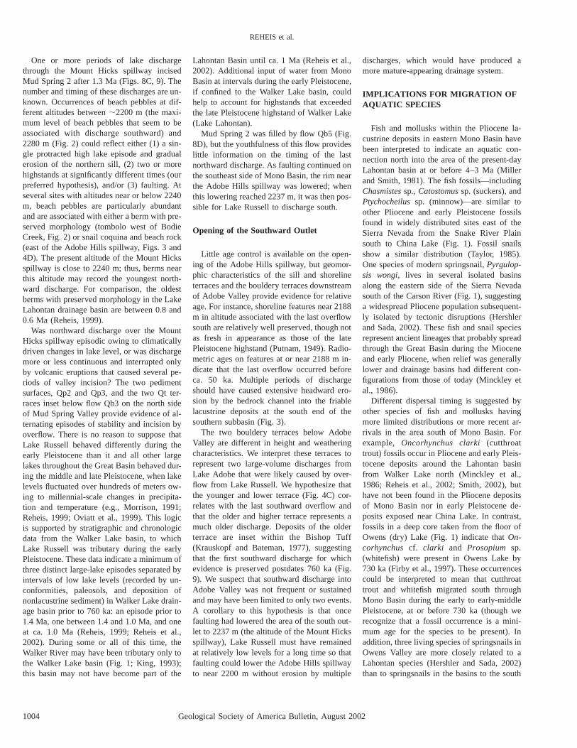
Figure 4. Photographs of lacustrine and other geomorphicfeatures around Adobe Hills spillway and overflow path.(A) Low-oblique aerial view south-southeast of the AdobeHills spillway (AHS). Road ascends over tufa-cementedbeach rock and snail coquina below the 2188 m shoreline.(B) Low-oblique view to southwest of meanders of overflowchannel incised into basalt, taken near position marked‘‘bedrock channel’’ at bottom of Figure 3. (C) Low-oblique aerial view west up the channel cut through the Benton Range;Adobe Valley in the distance. Large granite boulder (at tip of arrow) lies on lower flood terrace. (D) Comparison of beachpebbles and snail coquina (left side) associated with 2188 m shoreline with identical materials (right side) from an altitudeof ;2243 m east of Adobe Hills spillway; 50 mm lens cap for scale. Ovoid pits in clasts at left are imprints of snail shells,commonly lined with shell material. White spots on clast at right are smaller snail shells.
of the scarps and the concentration of micro-seismicity in the area of the Adobe Hills spill-way (dePolo et al., 1993) indicate that someof these faults remain active.
Character of the Adobe Hills Spillway andOverflow Channel
The Adobe Hills spillway consists of a 300-m-wide gap, ,8 m deep at its deepest point,cut into a sill composed of Pliocene basalt(AHS in Figs. 3 and 4A). A broad bench(shown as Qly/Tv in Fig. 3) that slopes gentlyupward from 2195 to 2200 m in altitude forms
most of the southwest side of the spillway;this bench is abundantly littered with verywell rounded pebbles interpreted as beachpebbles.2 Inset below this bench is the lowestpart of the spillway at ;2190 m altitude. Im-
2Here and throughout the paper, ‘‘beach pebbles’’or ‘‘beach gravel’’ refers to clasts that are very wellrounded and usually polished and commonly haveflattened discoidal or spindle shapes that are pro-duced by wave erosion at shorelines of lakes oroceans. The beach pebbles in the Adobe Hills areaand in many other parts of the Mono Basin are alsodistinguished by an abundance of polished black,red, and clear obsidian.
mediately southeast of the 75-m-wide spill-way are two small basins, each defined by abedrock sill, through which the waters of LakeRussell spilled during episodes of overflow.Hydrographically closed prior to the overflowevents, these basins became connected whenoverflow breached their confining sills. Thesouthern lip of the southern basin in this over-flow chain is breached by a 100-m-wide chan-nel incised 12–15 m deep into basalt (Figs. 3and 4B); this meandering channel conductedspillage southward into Adobe Valley, whereit fed Lake Adobe (Fig. 2). The upper end ofthis channel is currently at 2173 m, well be-

996 Geological Society of America Bulletin, August 2002
REHEIS et al.
TABLE 1. LIST OF COMPOSITIONALLY CLOSEST MATCHES TO TEPHRA LAYERS
No. Field sample no. SiO2 Al2O3 Fe2O3 MgO MnO CaO TiO2 Na2O K2O Sim. coeff. Comments
1 EL-38-AV 76.7 13.2 0.76 0.03 0.05 0.44 0.07 3.81 4.93 1.0000 Tephra layer exposed on hillslope below, and presumably2 TECO-30B-2 77.9 13.1 0.74 0.03 0.04 0.44 0.07 3.75 4.98 0.9890 stratigraphically beneath, beach gravel of Lake Adobe on3 OL92-1030 76.9 12.9 0.74 0.04 0.03 0.44 0.07 3.90 4.93 0.9872 the west side of Adobe Valley (Fig. 2). Tephra lies within4 TECO-28B 77.0 12. 9 0.75 0.04 0.03 0.43 0.06 3.80 5.00 0.9863 diatomaceous, freshwater marsh deposits. Closest5 BT-14 77.2 12. 8 0.75 0.03 0.04 0.43 0.06 3..77 4.92 0.9851 matches are to Mono Glass Mountain ash beds, ca. 0.9 to7 TECO-10 76.8 13.1 0.78 0.04 0.03 0.42 0.08 3.78 5.01 0.9822 ca. 1.2 Ma (2, 3, 9, 15), and to the Bishop Tuff and ash9 TECO-29 76.7 13.1 0.81 0.04 0.04 0.43 0.07 3.85 4.96 0.9818 bed, ca. 0.76 Ma (4, 5, 7, 16, and 19).
15 BT-15 77.2 12.8 0.77 0.04 0.03 0.46 0.06 3.85 4.85 0.979316 YJC-1-87 77.3 12.9 0.73 0.04 0.05 0.44 0.07 3.74 4.75 0.979019 BT-11D2 77.2 13.1 0.76 0.02 0.04 0.42 0.05 3.73 4.66 0.9775
1 EL-102-MS 74.4 13.8 2.27 0.12 0.05 0.94 0.17 4.34 3.86 1.0000 Tephra layer exposed in small prospect cut in fluvial2 758-218 73.7 14.4 2.24 0.10 0.04 0.90 0.15 4.30 4.12 0.9703 deposits of unit Ts on north side of Mud Spring Canyon3 KT-6 74.3 13.6 2.24 0.09 0.05 0.89 0.18 4.61 4.05 0.9683 (Fig. 5). Closest matches with the Lawlor Tuff, ca. 4.1 Ma,4 ALT-11 73.5 14.5 2.17 0.10 0.03 0.95 0.16 4.33 4.16 0.9681 and next best with the Huichica Tuff, ca. 4.0 Ma (Sarna-8 JCD-(1) 73.6 14.3 2.25 0.08 0.03 1.06 0.17 4.39 4.04 0.9628 Wojcicki et al., 1991), both erupted from the Sonoma9 MP-8 74.0 14.1 2.19 0.09 0.03 0.86 0.16 4.33 4.19 0.9624 volcanic field in the Coast Ranges of California. The Lawlor
10 KT-7(2) 73.6 14.3 2.16 0.09 0.04 0.91 0.18 4.69 3.98 0.9618 Tuff is found in the San Joaquin Valley, the Los Angeles11 WC-B3B 73.8 13.9 2.17 0.09 0.07 0.93 0.17 4.30 4.55 0.9614 Basin, the Mojave Desert, and the Alturas area of12 KT-7(1) 74.0 13.5 2.22 0.10 0.04 0.94 0.17 4.77 4.25 0.9611 California. There, it underlies the ‘‘Alturas ash,’’14 H-1 73.6 14.6 2.29 0.09 0.06 1.05 0.19 4.44 3.70 0.9594 which correlates with the Kilgore Tuff, dated ca. 4.5 Ma by
Morgan and McIntosh (2002).
1 EL-103-MS 77.1 12.8 0.61 0.05 0.05 0.50 0.09 2.72 6.00 1.0000 Tephra layer in pumiceous sand and gravel of unit Tg,2 2379-57B 77.0 13.0 0.62 0.08 0.07 0.54 0.10 2.68 5.98 0.9799 buried by flow Qb5 on south side of Mud Spring Canyon.3 FLV-25-WW 77.6 12.4 0.61 0.07 0.07 0.56 0.10 2.89 5.66 0.9567 Closest matches with late Miocene tephra at ca. 11.5 Ma5 SP-98-1 77.2 12.7 0.58 0.05 0.05 0.42 0.10 2.83 6.06 0.9556 (2), the age of which is interpolated from position between6 FLV-33-WW 76.9 12.9 0.64 0.07 0.07 0.62 0.12 2.69 5.96 0.9552 beds correlated to beds of known age (Stewart et al.,7 FLV-121-WW 76.6 12.9 0.65 0.04 0.06 0.57 0.07 2.85 6.20 0.9539 1999). Also similar to a closely related group of tephra9 FLV-32-WW 77.2 12.9 0.61 0.07 0.08 0.62 0.12 2.80 5.65 0.9527 from Willow Wash in southern Fish Lake Valley (3, 6, 7, 9,
18 FLV-34-WW 76.8 12.9 0.62 0.08 0.06 0.62 0.10 2.52 6.22 0.9453 18) and to a nearby tephra, EL-35A-MS, in similar20 EL-35A-MS 77.4 12.6 0.63 0.05 0.05 0.53 0.06 2.25 6.37 0.9429 sediments (20; see Fig. 7). The proximity of these beds and
their stratigraphic relationships support a preferred correlationto the Fish Lake Valley tephra group, whose age range is.2.58 Ma, ,2.81 Ma (Reheis et al., 1991, 2002).
1 EL-104-MS 76.8 13.0 1.14 0.03 0.06 0.54 0.05 3.74 4.66 1.0000 Tephra layer within colluvium or landslide deposits burying2 WL-8-2A 77.0 12.8 1.12 0.03 0.05 0.54 0.06 3.76 4.66 0.9928 the flank of flow Qb5 on south side of Mud Spring Canyon.
(28.5–33.0 cm) Closest matches are to a Mono Craters tephra layer (2)3 WL-4-4 76.9 12.9 1.10 0.04 0.06 0.54 0.06 3.77 4.64 0.9912 from a core in Walker Lake, with an interpolated age from
(10.83 m) 14C dates of 1190 yr B.P. (Sarna-Wojcicki et al., 1988).4 KRL82282 76.7 12.9 1.13 0.02 0.06 0.54 0.06 3.87 4.68 0.9909 Other matches are with tephra samples from Walker Lake5 WL-4-4B 76.9 12.8 1.13 0.03 0.05 0.55 0.05 3.79 4.64 0.9898 cores that range from early to late Holocene (3, 5, 11), and
(12.00 m) to the surface pumice from Panum Crater (4). Also similar8 WL 4-2 (3.31 m) 76.7 12.9 1.14 0.04 0.04 0.55 0.06 3.92 4.67 0.9876 to a tephra from Fish Lake Valley (30) dated by associated
11 WL 8-1B 77.0 12.7 1.11 0.02 0.06 0.54 0.07 3.84 4.65 0.9869 charcoal as 1,620 6 60 14C yr B.P. Thus, tephra EL-104-MS(92–94 cm) is probably from the Mono Craters and is most likely late
30 FLV-164-LC 77.2 12.6 1.10 0.03 0.06 0.55 0.06 3.76 4.61 0.9831 Holocene in age.
1 EL-105-MS 77.1 13.0 0.63 0.06 0.06 0.62 0.09 3.05 5.41 1.0000 Tephra layer from north of Alkali Valley. Poorly exposed;2 FLV-24-WW 76.7 13.0 0.67 0.07 0.07 0.63 0.08 3.18 5.58 0.9741 pumiceous deposits appear to overlie Miocene andesite3 FLV-32-WW 77.2 12.9 0.61 0.07 0.08 0.62 0.12 2.80 5.65 0.9725 and underlie a terrace formed by discharge from Lake4 FLV-85-HT 76.7 13.1 0.72 0.06 0.05 0.62 0.08 3.11 5.56 0.9690 Russell through the Mount Hicks spillway (unit Qg, Fig. 5).5 FLV-86-HT 76.6 13.1 0.72 0.06 0.05 0.60 0.07 3.06 5.71 0.9619 Closest matches are to a related group of tephra from6 FLV-33-WW 76.9 12.9 0.64 0.07 0.07 0.62 0.12 2.69 5.96 0.9614 Willow Wash in southern Fish Lake Valley (2, 3, 6, 12)
12 FLV-25-WW 77.6 12.4 0.61 0.07 0.07 0.56 0.10 2.89 5.66 0.9546 whose age range is .2.58 Ma, ,2.81 Ma (Reheis et al.,1991; Sarna-Wojcicki et al., 1999, written commun.), as wellas to older Miocene tephra from Horsethief Canyon in northernEureka Valley (4, 5) that are between 5.9 and 5.3 Ma (Reheisand Sawyer, 1997).
Note: Analyzed in this study (localities in Figs. 2 and 5), based on electron-microprobe analysis of volcanic glass shards. Shards were analyzed by using theJEOL8900*instrument. Total (R) 5 total recalculated to a 100% fluid-free basis. Analyses were performed by C.E. Meyer, U.S. Geological Survey, Menlo Park, California,during 1996–1999. Identifications of closest matches are based on calculations of similarity coefficients (Sim. coeff.) by using oxides of the following elements: Na, Al, Si,K, Ca, and Fe. Closely matching samples that do not provide age constraints or stratigraphic context were omitted from the table. Initial oxide concentrations and totalsfor the samples analyzed in this study are given in Appendix Table A-1.
*Use of trade names is for informational purposes only and does not imply endorsement of product by the U.S. Geological Survey.
TABLE 2. ANALYTICAL DATA FOR K-Ar AGE DETERMINATION
Samplenumber
Mapunit*
Material dated K2O(wt%)
40Ar(3 10–11mol/g)
40Ar*/S40Ar(%)
Age(Ma 6 s)
EL-KA-2 Qa Whole rock 3.49 2.3424 23.3 1.44 6 0.06
Note: E. McKee, U.S. Geological Survey, 1995, written commun.; analysis by U.S. Geological Survey MenloPark laboratory.
*See Figure 5 for map unit and sample location.
low the 2189–2190 m level at the spillway.Whether this incision was accomplished byspillage from just one or several overflowevents is unknown. At the lower end of thecanyon in Adobe Valley, young fan depositshave buried any possible evidence of deltaicdeposits.
Geological Society of America Bulletin, August 2002 997
DRAINAGE REVERSALS IN MONO BASIN DURING THE LATE PLIOCENE AND PLEISTOCENE
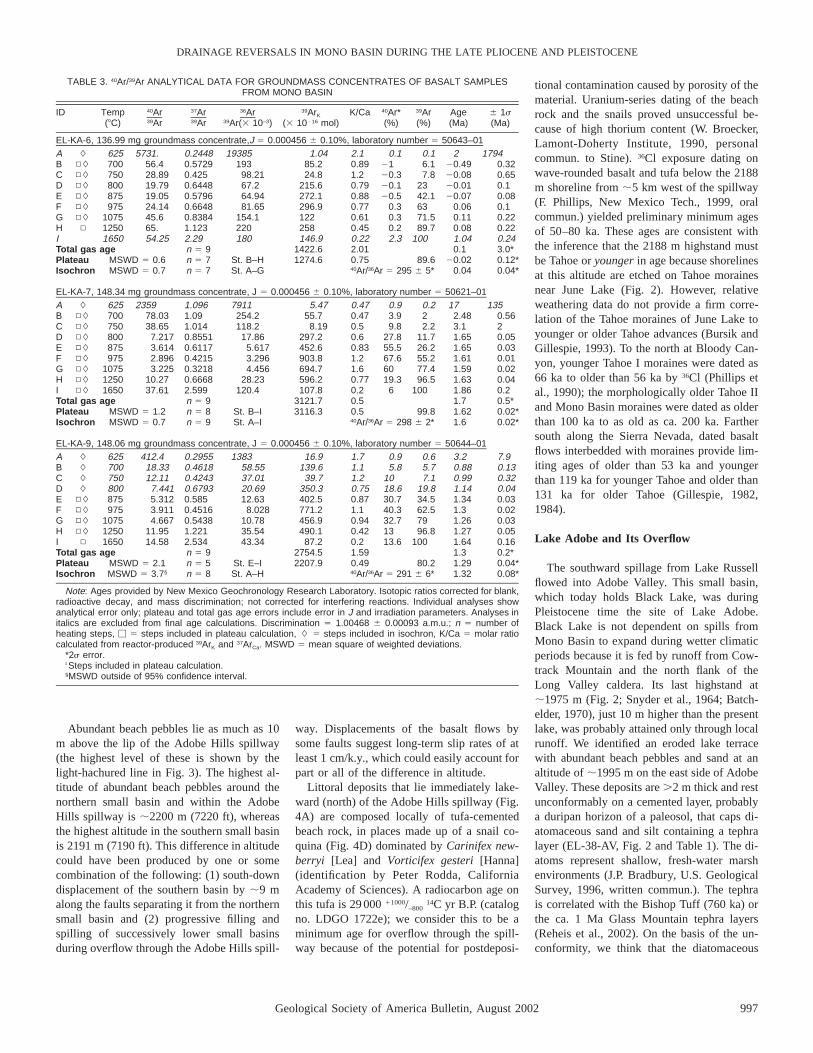
TABLE 3. 40Ar/39Ar ANALYTICAL DATA FOR GROUNDMASS CONCENTRATES OF BASALT SAMPLESFROM MONO BASIN
ID Temp 40Ar 37Ar 36Ar 39ArK K/Ca 40Ar* 39Ar Age 6 1s(8C) 39Ar 39Ar 39Ar(3 10–3) (3 10216 mol) (%) (%) (Ma) (Ma)
EL-KA-6, 136.99 mg groundmass concentrate,J 5 0.000456 6 0.10%, laboratory number 5 50643–01A # 625 5731. 0.2448 19385 1.04 2.1 0.1 0.1 2 1794B ▫# 700 56.4 0.5729 193 85.2 0.89 21 6.1 20.49 0.32C ▫# 750 28.89 0.425 98.21 24.8 1.2 20.3 7.8 20.08 0.65D ▫# 800 19.79 0.6448 67.2 215.6 0.79 20.1 23 20.01 0.1E ▫# 875 19.05 0.5796 64.94 272.1 0.88 20.5 42.1 20.07 0.08F ▫# 975 24.14 0.6648 81.65 296.9 0.77 0.3 63 0.06 0.1G ▫# 1075 45.6 0.8384 154.1 122 0.61 0.3 71.5 0.11 0.22H ▫ 1250 65. 1.123 220 258 0.45 0.2 89.7 0.08 0.22I 1650 54.25 2.29 180 146.9 0.22 2.3 100 1.04 0.24Total gas age n 5 9 1422.6 2.01 0.1 3.0*Plateau MSWD 5 0.6 n 5 7 St. B–H 1274.6 0.75 89.6 20.02 0.12*Isochron MSWD 5 0.7 n 5 7 St. A–G 40Ar/36Ar 5 295 6 5* 0.04 0.04*
EL-KA-7, 148.34 mg groundmass concentrate, J 5 0.000456 6 0.10%, laboratory number 5 50621–01A # 625 2359 1.096 7911 5.47 0.47 0.9 0.2 17 135B ▫# 700 78.03 1.09 254.2 55.7 0.47 3.9 2 2.48 0.56C ▫# 750 38.65 1.014 118.2 8.19 0.5 9.8 2.2 3.1 2D ▫# 800 7.217 0.8551 17.86 297.2 0.6 27.8 11.7 1.65 0.05E ▫# 875 3.614 0.6117 5.617 452.6 0.83 55.5 26.2 1.65 0.03F ▫# 975 2.896 0.4215 3.296 903.8 1.2 67.6 55.2 1.61 0.01G ▫# 1075 3.225 0.3218 4.456 694.7 1.6 60 77.4 1.59 0.02H ▫# 1250 10.27 0.6668 28.23 596.2 0.77 19.3 96.5 1.63 0.04I ▫# 1650 37.61 2.599 120.4 107.8 0.2 6 100 1.86 0.2Total gas age n 5 9 3121.7 0.5 1.7 0.5*Plateau MSWD 5 1.2 n 5 8 St. B–I 3116.3 0.5 99.8 1.62 0.02*Isochron MSWD 5 0.7 n 5 9 St. A–I 40Ar/36Ar 5 298 6 2* 1.6 0.02*
EL-KA-9, 148.06 mg groundmass concentrate, J 5 0.000456 6 0.10%, laboratory number 5 50644–01A # 625 412.4 0.2955 1383 16.9 1.7 0.9 0.6 3.2 7.9B # 700 18.33 0.4618 58.55 139.6 1.1 5.8 5.7 0.88 0.13C # 750 12.11 0.4243 37.01 39.7 1.2 10 7.1 0.99 0.32D # 800 7.441 0.6793 20.69 350.3 0.75 18.6 19.8 1.14 0.04E ▫# 875 5.312 0.585 12.63 402.5 0.87 30.7 34.5 1.34 0.03F ▫# 975 3.911 0.4516 8.028 771.2 1.1 40.3 62.5 1.3 0.02G ▫# 1075 4.667 0.5438 10.78 456.9 0.94 32.7 79 1.26 0.03H ▫# 1250 11.95 1.221 35.54 490.1 0.42 13 96.8 1.27 0.05I ▫ 1650 14.58 2.534 43.34 87.2 0.2 13.6 100 1.64 0.16Total gas age n 5 9 2754.5 1.59 1.3 0.2*Plateau MSWD 5 2.1 n 5 5 St. E–I 2207.9 0.49 80.2 1.29 0.04*Isochron MSWD 5 3.7§ n 5 8 St. A–H 40Ar/36Ar 5 291 6 6* 1.32 0.08*
Note: Ages provided by New Mexico Geochronology Research Laboratory. Isotopic ratios corrected for blank,radioactive decay, and mass discrimination; not corrected for interfering reactions. Individual analyses showanalytical error only; plateau and total gas age errors include error in J and irradiation parameters. Analyses initalics are excluded from final age calculations. Discrimination 5 1.00468 6 0.00093 a.m.u.; n 5 number ofheating steps, M 5 steps included in plateau calculation, # 5 steps included in isochron, K/Ca 5 molar ratiocalculated from reactor-produced 39ArK and 37ArCa. MSWD 5 mean square of weighted deviations.
*2s error.†Steps included in plateau calculation.§MSWD outside of 95% confidence interval.
Abundant beach pebbles lie as much as 10m above the lip of the Adobe Hills spillway(the highest level of these is shown by thelight-hachured line in Fig. 3). The highest al-titude of abundant beach pebbles around thenorthern small basin and within the AdobeHills spillway is ;2200 m (7220 ft), whereasthe highest altitude in the southern small basinis 2191 m (7190 ft). This difference in altitudecould have been produced by one or somecombination of the following: (1) south-downdisplacement of the southern basin by ;9 malong the faults separating it from the northernsmall basin and (2) progressive filling andspilling of successively lower small basinsduring overflow through the Adobe Hills spill-
way. Displacements of the basalt flows bysome faults suggest long-term slip rates of atleast 1 cm/k.y., which could easily account forpart or all of the difference in altitude.
Littoral deposits that lie immediately lake-ward (north) of the Adobe Hills spillway (Fig.4A) are composed locally of tufa-cementedbeach rock, in places made up of a snail co-quina (Fig. 4D) dominated by Carinifex new-berryi [Lea] and Vorticifex gesteri [Hanna](identification by Peter Rodda, CaliforniaAcademy of Sciences). A radiocarbon age onthis tufa is 29 000 11000/–800
14C yr B.P. (catalogno. LDGO 1722e); we consider this to be aminimum age for overflow through the spill-way because of the potential for postdeposi-
tional contamination caused by porosity of thematerial. Uranium-series dating of the beachrock and the snails proved unsuccessful be-cause of high thorium content (W. Broecker,Lamont-Doherty Institute, 1990, personalcommun. to Stine). 36Cl exposure dating onwave-rounded basalt and tufa below the 2188m shoreline from ;5 km west of the spillway(F. Phillips, New Mexico Tech., 1999, oralcommun.) yielded preliminary minimum agesof 50–80 ka. These ages are consistent withthe inference that the 2188 m highstand mustbe Tahoe or younger in age because shorelinesat this altitude are etched on Tahoe morainesnear June Lake (Fig. 2). However, relativeweathering data do not provide a firm corre-lation of the Tahoe moraines of June Lake toyounger or older Tahoe advances (Bursik andGillespie, 1993). To the north at Bloody Can-yon, younger Tahoe I moraines were dated as66 ka to older than 56 ka by 36Cl (Phillips etal., 1990); the morphologically older Tahoe IIand Mono Basin moraines were dated as olderthan 100 ka to as old as ca. 200 ka. Farthersouth along the Sierra Nevada, dated basaltflows interbedded with moraines provide lim-iting ages of older than 53 ka and youngerthan 119 ka for younger Tahoe and older than131 ka for older Tahoe (Gillespie, 1982,1984).
Lake Adobe and Its Overflow
The southward spillage from Lake Russellflowed into Adobe Valley. This small basin,which today holds Black Lake, was duringPleistocene time the site of Lake Adobe.Black Lake is not dependent on spills fromMono Basin to expand during wetter climaticperiods because it is fed by runoff from Cow-track Mountain and the north flank of theLong Valley caldera. Its last highstand at;1975 m (Fig. 2; Snyder et al., 1964; Batch-elder, 1970), just 10 m higher than the presentlake, was probably attained only through localrunoff. We identified an eroded lake terracewith abundant beach pebbles and sand at analtitude of ;1995 m on the east side of AdobeValley. These deposits are .2 m thick and restunconformably on a cemented layer, probablya duripan horizon of a paleosol, that caps di-atomaceous sand and silt containing a tephralayer (EL-38-AV, Fig. 2 and Table 1). The di-atoms represent shallow, fresh-water marshenvironments (J.P. Bradbury, U.S. GeologicalSurvey, 1996, written commun.). The tephrais correlated with the Bishop Tuff (760 ka) orthe ca. 1 Ma Glass Mountain tephra layers(Reheis et al., 2002). On the basis of the un-conformity, we think that the diatomaceous

998 Geological Society of America Bulletin, August 2002
REHEIS et al.
sediments are significantly older than theoverlying beach deposits; these deposits at1995 m altitude indicate that Lake Adobeonce stood ;20 m above its youngestshoreline.
A perched, stream-cut terrace within thebedrock notch through which Adobe Valleydrains into Benton Valley (Fig. 4C) lies at thesame height (30 m) as the older beach gravelabove Black Lake. Within and at the mouthof a precipitous granite gorge below the notch,remnants of two terraces ;43 m and 30 mabove the modern drainage are littered withgiant granite boulders, as much as 5 m in di-ameter, that clearly were eroded from withinthe gorge. The older terrace deposit overliesrhyolite mapped as the ca. 2 Ma tuff of TaylorCanyon (Krauskopf and Bateman, 1977); bothterraces also are inset within nearby outcropsof the Bishop Tuff. We interpret these boul-dery deposits to represent two episodes ofhigh-volume, possibly catastrophic, dischargefrom Adobe Valley that postdated the eruptionof the Bishop Tuff. These episodes may havebeen caused by discharge from Lake Russellthat filled Lake Adobe and caused it to spillover a formerly much higher sill. These dis-charge episodes likely produced rapid incisionof the bedrock gorge, as indicated by the giantflood boulders (Fig. 4C). Such boulders couldbe easily transported because the gradient isso steep; the present valley floors are only 3.5km apart but 245 m different in altitude, andthe upper part of the gorge is a virtual water-fall with a 17% slope. Active faulting alongthe valley margins may also have contributedto incision.
EVIDENCE FOR SHORELINESHIGHER THAN 2188 m
Recent discoveries (Fig. 2) include (1) la-custrine deposits in the southeastern corner ofMono Basin representing at least one lakestand that greatly exceeded the 2188 m shore-line, and (2) beach gravels at three sites on thenorth side of the basin at altitudes between2215 m and 2268 m. The modern altitudesmay be different from the original altitudesowing to postdepositional faulting in this re-gion of active tectonics. However, they shouldgenerally represent minimum values of theoriginal altitudes because the extensional re-gime in this area during the Pleistocene shouldproduce mainly downward displacement. Aswe lack age data, correlations among shorelinesites affected to different degrees by faultingis clearly speculative.
Description of High Shoreline Deposits
Lacustrine deposits near the Adobe Hillsspillway (Fig. 3) overlie basalt and crop outat altitudes between 2205 and 2220 m. Thedeposits comprise an upwardly coarsening se-quence of tuffaceous silt, sand, and beachgravel containing two tephra layers. Correla-tions based on chemical analyses indicate thatthese tephra (EL-53-ML and 54-ML) are latestPliocene in age (2.5–2.0 Ma; Reheis et al.,2002). These lacustrine sediments are mappedas part of unit Tl (Fig. 3), but they presumablyoverlie the older ca. 3 Ma lacustrine deposits,which consist mostly of diatomaceous beds inthe spillway area. In addition, beach pebblesand rare large chunks of tufa-cemented beachrock and snail coquina (unit Qlo, Figs. 3 and4D) are found on slopes at altitudes as highas 2280 m; they document a lake that in pasttime(s) stood much higher than that repre-sented by the tephra-bearing deposits. Thoughexposures are poor, we infer that the tuffa-ceous beds and the higher beach rock and lagpebbles represent at least two different lacus-trine episodes that reached ;2220 m and 2280m, respectively. Several northeast-strikingfaults progressively displace the 2280 m de-posits of beach gravel down to the south (Fig.3), decreasing their maximum altitude to aslow as 2228 m.
Beach pebbles within a similar range of al-titudes in areas of less faulting (Dohrenwend,1983) on the north side of Mono Basin (sitesare shown as dots with altitudes in Fig. 2) con-firm that Lake Russell once stood at very highlevels. At one site southwest of BridgeportCanyon, a dissected berm at an altitude of;2212 m forms a tombolo between a smalloutlier of bedrock and the Bodie Hills; thetombolo slopes upward to a bedrock notch,resembling a shoreface angle, at ;2225 m.Abundant beach gravel crops out below thetombolo and also occurs as lag on bedrock ashigh as 2274 m. At a second site, north ofKirkwood Spring, beach pebbles and cobble-sized clasts shaped into ovoid rollers are scat-tered on a gentle bedrock slope to as high as2252 m. Beach pebbles occur as high as 2219m in the southeast corner of Alkali Valley.The preservation of geomorphic shoreline fea-tures and the similarity of the elevated beachpebbles to those of known highstands stronglysuggest that these deposits are Pleistocene inage. We have not made an exhaustive searcharound Mono Basin, but anticipate that manysimilar sites exist with evidence for shorelinesabove the 2188 m altitude of the last overflow.
Tectonically Induced Opening of theAdobe Hills Spillway
The topography of the Mono Basin rim nearthe Adobe Hills spillway must have been verydifferent when Lake Russell reached altitudesof 2210–2280 m, because no topographic bar-rier at or near the spillway is high enough toenclose so large a lake (Fig. 3). Numerous,closely spaced faults cutting 3 Ma basalt flows(Gilbert et al., 1968) have evidently loweredthe landscape in this area, eventually creatinga gap through which Lake Russell could drainsouth. This inference is consistent with the ap-parent down-to-the-south displacement of thehighest level of beach pebbles east of the Ado-be Hills spillway, totaling at least 52 m acrossseveral faults.
EVIDENCE FOR OLDERNORTHWARD OVERFLOW OF LAKERUSSELL
As noted by Russell (1889), a low divide innortheastern Mono Basin lies at an altitude of2237 m in the northwest corner of Alkali Val-ley, a northeastern appendage of Mono Basin(Fig. 2). At the time of the ca. 13 ka highstandat 2155 m, Lake Russell inundated the south-ern part of Alkali Valley but did not reach thehigher northeastern part of the valley. Sub-dued lake terraces in the northern part of thevalley below 2180 m probably were depositedduring the 2188 m highstand of Lake Russellthat did enter the valley. The late Tertiary andQuaternary sedimentary and volcanic stratig-raphy (Tables 4 and DR2) of the area betweenAlkali Valley and Mud Springs Canyon (Figs.5 and 6), records a history of older northwardoverflow from Lake Russell. This record canbe deduced from the ages of deposits thatwere incised by paleodrainages carrying lakedischarge and subsequently plugged by vol-canic flows (Figs. 7 and 8).
Mount Hicks Spillway and OverflowChannel
A broad, gentle ridge ;0.5 km wide formsthe lowest point in the northern rim of AlkaliValley (Fig. 7C) at an altitude of ;2237 m.This ridge is composed of andesite flow Qa(Fig. 5). The andesite ridge locally bearspatches of subrounded pebble to cobble gravelof various lithologies, including granitic, rhy-olitic, and basaltic clasts, suggesting a formerdrainageway across the ridge. We informallyrefer to this feature as the Mount Hicks spill-way. The andesite flow emanated from MountHicks and is similar in age to flow Qb1, also

Geological Society of America Bulletin, August 2002 999
DRAINAGE REVERSALS IN MONO BASIN DURING THE LATE PLIOCENE AND PLEISTOCENE
TABLE 4. AGES AND RELATIONSHIPS OF CRITICAL MAP UNITS IN THE AREA OF MOUNT HICKSSPILLWAY AND MUD SPRING CANYON
Unit Approximate age* Description and relationships to other units†
Qb5 ,0.08 Ma, late Pleistocene Elongate flow of hornblende andesite. West end of flow Qb5emplaced in paleovalley incised into units Tp and Ts; east endburies Qp2 and Tg.
Qb4 0.2–0.5 Ma, middle Pleistocene Andesite flow erupted from Aurora Crater. Includes olderandesite at north edge (Lange and Carmichael, 1996). Burieswestern end of flow Qb3 and paleovalley occupied by Qb3.Appears inset below surfaces of Qp2 and Qt.
Qp3 Middle(?) Pleistocene Unconsolidated, granitic pediment gravel. Inset below surface ofQp2; truncates higher Qt terrace.
Qt Middle(?) to early Pleistocene Well-washed, bedded fluvial sand and gravel. Lap onto fan/pediment gravel along Mud Spring Canyon west of flow Qb5.Two nested terraces lie 12–20 m above present drainage;higher terrace appears slightly inset below Qp2.
Qp2 Early Pleistocene Unconsolidated granitic gravel, mapped as pediment gravel(Gilbert and Reynolds, 1973) but locally an aggradational unit.Inset below Qp1 surface.
Qb3 1.3 Ma (early Pleistocene) Elongate flow of basaltic andesite. Emplaced in west-drainingpaleovalley incised into units Qp1 and Ts and floored byalluvium.
Qb2 .1.3 Ma, ,1.6 Ma (earlyPleistocene)
Basaltic andesite erupted from cone on northern edge of flowQb1. Younger than Qb1; appears older than Qb3, but fieldrelationships are unclear.
Qp1 .1.3 Ma (early Pleistocene to latePliocene?)
Unconsolidated, granitic pediment gravel. Mainly overlies unit Ts;likely younger than unit Tg, but field relationships are unclear.
Qa 1.4–1.6 Ma (early Pleistocene) Andesite; forms broad ridge that contains Mount Hicks spillway.Flowed north from spillway area down paleovalley incised intounit Tg and older rocks.
Qb1 1.5–1.7 Ma (early Pleistocene) Basaltic andesite erupted from Mount Hicks, coeval with flowQa.
Tg 2.9–2.5 Ma (late Pliocene) Poorly consolidated, pale tuffaceous alluvium, including debrisflows and air-fall pumice layers. Inset within unit Ts andhighest pediment Tp.
Tp .2.9 Ma, ,4.8 Ma (Pliocene) Unconsolidated, granitic pediment gravel. Overlies unit Ts butnot younger deposits.
Ts ca. 4.8 Ma Upwardly coarsening sequence of diatomite, mudstone, siltstone,sandstone, and pebble conglomerate; indurated, flat to gentlydipping (about 108), and cut locally by small faults. OverliesMiocene andesite.
*See Tables 1–3 for details of age control.†See Data Repository Table DR-2 (described in footnote 1 in text) for detailed descriptions and Figs. 5 and 6
for locations.
from Mount Hicks: A K-Ar age on unit Qa atthe spillway is 1.44 6 0.06 Ma (EL-KA-2,Table 2; E. McKee, U.S. Geological Survey,1995, written commun.), overlapping the ageof Qb1 (1.6 6 0.1 Ma (Gilbert et al., 1968);age corrected by using new isotopic ratios ofRobinson and Kistler, 1986) within 2s errorlimits.
A small valley ;40 m deep drains northfrom the spillway. This valley narrows from200 m wide at its head to only ;25 m widenear its north end, where it is incised intoMiocene and older rocks as well as tuffaceousalluvium of unit Tg of late Pliocene age (Ta-bles 1 and 4). Tightly paralleling the valley onthe west side is the same andesite as that un-derlying the spillway ridge (Figs. 5 and 7C).A sample from this down-valley part of flowQa was dated by 40Ar/39Ar at 1.6 6 0.02 Ma(EL-KA-7, Table 3). This flow is at least 20m thick and has a gently sloping top with agradient like that of the modern valley floor.The shape of flow Qa and its relationship tothe present valley clearly indicate that the an-
desite flowed down a paleovalley that resem-bled the present valley in shape, size, and ori-entation. The paleovalley must postdate 2.5Ma, the youngest tephra identified in unit Tg.For ease of reference, we term the andesite-filled paleovalley ‘‘Hicks Valley 1’’ (HV1)and the present valley ‘‘Hicks Valley 2’’(HV2, Fig. 8).
Hicks Valley debouches onto a broad allu-vial surface that is ponded on the north andwest by flows Qb5 and Qb3. A small terrace,beveled across both unit Tg (at tephra locality105-MS, Fig. 5 and Table 1) and Miocene an-desite, stands ;10 m above the eastern valleyfloor just south of the debouchment. The ter-race top and flank are littered with very wellrounded, polished pebbles and cobbles (iden-tical to those already described herein as‘‘beach gravel’’) of a variety of volcanic types(Fig. 7D). Less well-rounded boulders derivedfrom Miocene andesite and granitic rockscould have been transported from nearbysources (unit R, Fig. 5). Clasts in modern al-luvium, in older fan deposits, and in Miocene
alluvium in the Mud Spring Canyon drainagebasin are much less well rounded than mostof the clasts on this terrace. The terrace gravelmust represent erosion and transport by acompetent stream flowing down Hicks Valley,which is currently dry, has no springs, anddrains a very small basin. Furthermore, thepolished clasts suggest that this stream wascarrying beach gravel from an overflowingLake Russell.
Mud Spring Canyon and ItsPaleodrainages
Mud Spring Canyon is dry but for onesmall spring. The flat-floored, steep-walledcanyon is 300–400 m wide and ;40 m deepfor much of its length (Figs. 5 and 7B), butnarrows quickly above a point ;3 km up-canyon from the western end of flow Qb5.The modern drainage area above the spring is;75 km2, in our judgment disproportionatelysmall compared to the size of the valley. Wesuggest that much larger discharge is neces-sary to explain the size of Mud Spring Canyonthan could be generated from the modern ba-sin, even during pluvial periods. The moderncanyon is cut into alluvial deposits of units Tsand Tg, of Pliocene age, and several cappingpediment gravels. Flows Qb5 and Qb3 dividewest-draining Mud Spring Canyon fromnorth-draining Hicks Valley.
On the south side of Mud Spring Canyon,the surface of flow Qb3 slopes westward atthe same gradient as the canyon floor (Fig.7A). A 40Ar/39Ar age on a sample from thewest end of flow Qb3 is 1.32 6 0.08 Ma(EL-KA-9, Table 3). This flow originatesfrom a cone adjacent to the north end of HicksValley. All along its northern margin, flowQb3 overlies gravel of unit Qp1 and the un-derlying unit Ts (Fig. 7, A and B; Table 4); abaked contact is apparent in one road cut.West of where flow Qb3 diverges from themodern canyon, the flow thickens southward.This thickening is due to descent of the baseof the flow toward the axis of a west-drainingpaleovalley, south of and subparallel to MudSpring Canyon, that headed near the exit ofnorth-draining Hicks Valley. The paleovalleywas floored by alluvium and was incised intounits Qp1 and Ts; at the western end of flowQb3, the basalt-alluvium contact is inset near-ly 10 m below the surface of Qp1 to the north.We term this paleovalley ‘‘Mud Spring 1’’(MS1, Fig. 8)
At least two pediment levels as well as twofluvial terraces are inset below the surface ofQp1 on the north side of Mud Spring Canyon(Table 4, Fig. 5). Adjacent to the western

1000 Geological Society of America Bulletin, August 2002
REHEIS et al.

Geological Society of America Bulletin, August 2002 1001
DRAINAGE REVERSALS IN MONO BASIN DURING THE LATE PLIOCENE AND PLEISTOCENE
Figure 6. Aerial photograph of the area of the Mount Hicks spillway in northern AlkaliValley and Mud Spring Canyon, showing surface morphology and relationships amongbasalt flows; photo covers most of the area shown in Figure 5.
Figure 5. Geologic map of the area of the Mount Hicks spillway (MHS) in northern Alkali Valley and Mud Spring Canyon (modifiedfrom Stewart et al., 1981; Dohrenwend, 1982; Stewart, 1982; and Lange and Carmichael, 1996). Ages of volcanic rocks from this study(Qa, Qb3, and Qb5, Table 2) and from Lange et al. (1993) and Robinson and Kistler (1986). Dual map units (e.g., Qly/Tv) indicate thinsurficial deposit overlying older unit.N
reach of the modern canyon, west of flowQb5, unit Qp2 abuts terrace deposits of unitQt. The terraces lie 12–20 m above the presentdrainage; there appear to be at least two nestedterrace levels. The higher terrace is onlyslightly (,2 m) lower than the Qp2 surface.The terraces consist of well-washed, relativelywell-bedded fluvial sand and gravel that laponto reddish, more poorly sorted and beddedfan gravel. Similar terraces do not exist fartherupstream along the eastern reach of MudSpring Canyon. This distribution of terraceremnants suggests that the stream that trans-ported and deposited these fluvial sedimentsalong the western reach of Mud Spring Can-yon did not flow down the eastern reach. Inaddition, the stratigraphic relationships indi-
cate that pediment Qp2 postdates flow Qb3and that the upper Qt terrace was depositedwithin a valley incised into pediments Qp2and Qp1. Pediment Qp3 is lower and youngerthan Qp2; Qp3 appears to crosscut, hence isyounger than, the upper Qt terrace (Fig. 5).
Like flow Qb3, flow Qb5 parallels andslopes westward at the same gradient as MudSpring Canyon. At its western end, flow Qb5was clearly emplaced in a west-draining pa-leovalley defined by abrupt thickening of theflow from ;2 m on the north side to nearly40 m against flow Qb3. The width of thisthick part of the flow is ;300 m, the same asthe width of the modern canyon. In contrast,the thickness of the eastern part of the flow ismore uniform. Stratigraphic relationships in-
dicate that this paleovalley, termed ‘‘MudSpring 2’’ (MS2, Fig. 8), was incised on theeast and north sides of flow Qb3 after its erup-tion blocked Mud Spring 1. The northern val-ley wall of Mud Spring 1 was preserved byits burial beneath the resistant cap of basalt.The modern valley, Mud Spring 3, was incisedinto the northern valley wall of Mud Spring 2adjacent to flow Qb5; west of flow Qb5 thecourses of Mud Spring 2 and 3 coincide. Theeast end of Mud Spring 1 and the west end ofMud Spring 2 coincide spatially with the northend of Hicks Valley. We interpret these rela-tionships to mean that Hicks Valley and MudSpring Valley formed a combined paleodrain-age that carried discharge from the MountHicks spillway at times when Lake Russellstood much higher than 2188 m.
No drainageway connects the upper part ofthe Mud Spring basin, east of flow Qb5, withspillways of Lake Russell. The canyon northof flow Qb5 narrows greatly east of samplesite EL-KA-6 and merges east of the flow witha smooth piedmont slope covered with young(post-Qb5) fan alluvium. In addition, the lateQuaternary age of flow Qb5 indicates that thisflow postdates the opening of the southwarddrainage of Lake Russell. Thus, the eastern,narrow reach of present-day Mud Spring 3was probably formed by local discharge fromthe drainage basin of upper Mud Spring Can-yon rather than by post-Qb5 overflow fromLake Russell.
DISCUSSION OF OVERFLOWHISTORY OF LAKE RUSSELL
Mono Basin is uniquely situated in a to-pographically high area with active faultingand volcanism. This setting, combined withclimatically induced changes in lake level, hasled to a complex Quaternary history of chang-es in lake level and discharge direction. Al-though the geomorphic and sedimentary rec-ord of these changes is fragmentary, enoughevidence exists to place broad constraints onlake levels and on the timing of overflows andincision of discharge channels. The followingdiscussion provides a framework for this his-tory and presents alternative hypotheses whereappropriate. We also present implications ofthe overflow history for the distribution of

1002 Geological Society of America Bulletin, August 2002
REHEIS et al.
Figure 7. Photographs of features in vicinity of Mount Hicks spillway (scale shown by roads except in D). (A) View west from ruggedtop of flow Qb5 along north flank of flow Qb3; Qb3 is thin atop northern paleovalley wall of Mud Spring 1 and thickens southward.Qb3 overlies thin gravel capping whitish sediments of unit Ts. (B) View east along Mud Spring Canyon from top of northern valleywall of Mud Spring 1. Note that flow Qb3 in middle distance is lower than foreground as it follows a paleovalley diverging southwest(to right). Rugged surface in distance is flow Qb5 overlying whitish sediments of unit Ts. (C) View south from top of flow Qa in HicksValley toward Mount Hicks spillway (fringe of trees in middle ground). (D) Well-rounded and polished pebbles collected from withina 1 m radius on unit Qg at north end of Hicks Valley; pebbles were transported by discharge from Lake Russell; 50 mm lens cap forscale.
fossil and modern fish along the eastern sideof the Sierra Nevada.
Pliocene Lakes in Mono Basin
Gilbert et al. (1968) documented a lake thatexisted between ca. 4 and 3 Ma in the easternpart of Mono Basin and eastward as far asHuntoon Valley (Fig. 2). Fossil mollusks andfish indicate that this lake was fresh, and thefish species suggest an aquatic connection tothe north (Hubbs and Miller, 1948; Miller andSmith, 1981). However, Gilbert et al. (1968)thought that the lake had an outlet to the eastor south. If so, this outlet must have been ob-structed eventually by the voluminous out-pouring of basalt east and south of Mono Ba-sin (Gilbert et al., 1968). The apparentabsence of deep-water mud and the presenceof oolitic sand suggest that this lake was rel-
atively shallow and quiet. Deposits of the Pli-ocene lake are represented in our study by unitTl near the Adobe Hills spillway (Fig. 3). Asingle tephra correlation (EL-102-MS, Table1) suggests that unit Ts in Mud Spring Canyon(Fig. 5) represents somewhat older fluvial andlacustrine deposition at ca. 4.8 Ma, possiblyin a different basin that extended north alongthe modern valley of the East Walker River(Gilbert and Reynolds, 1973).
Coarse tuffaceous lacustrine deposits con-stitute the upper part of unit Tl near the AdobeHills spillway (Fig. 3). Tephra correlationsyield ages of 2.5–2.0 Ma (Reheis et al., 2002).The beach gravels in these deposits suggest ahigher-energy environment than do the oolitebeds in the lower part of unit Tl. The tuffa-ceous lacustrine beds overlap in age with thetuffaceous alluvium of unit Tg in upper MudSpring Canyon and Hicks Valley (Fig. 5). The
coarse bedding, poor sorting, and abundanceof locally derived clasts in debris-flow beds ofunit Tg indicate local derivation rather thandeposition by an overflowing lake. Frequentrhyolitic eruptions in the Long Valley–GlassMountain area south of Mono Basin (Fig. 2;Metz and Mahood, 1985) combined with theolder basaltic eruptions probably blockedsouthward drainage during the late Pliocene.These relationships suggest that Mono Basinmay have become internally drained throughstructural deepening and volcanism between2.5 and 2.0 Ma, but much more work couldbe done to elucidate basin history during thisperiod. Clearly, Mono Basin must have beenclosed on the south and east before 1.6 Ma(the age of flow Qa in the Mount Hicks spill-way), and faulting in the structural kneearound the Adobe Hills spillway was limitedor had not begun.

Geological Society of America Bulletin, August 2002 1003
DRAINAGE REVERSALS IN MONO BASIN DURING THE LATE PLIOCENE AND PLEISTOCENE
Figure 8. Schematic reconstruction of the sequence of valley incision and volcanic erup-tions (A–D) in the area of Mount Hicks spillway (MHS) and Mud Spring Canyon. Maparea and units same as in Figure 5, except that northernmost part of Figure 5 is notshown. Heavy lines show drainageways of Hicks Valley (HV1, HV2) and Mud SpringsCanyon (MS1, MS2, MS3); dashed where uncertain, dotted where buried by volcanicflows. Numbers in meters are estimated altitudes of the spillway and coeval lake levels.
Figure 9. Timeline showing proposed timing of volcanic and discharge events near theMount Hicks spillway and of discharge events through the Adobe Hills spillway. Lines attop show suggested changes in sill altitude with time.
Early Pleistocene Lakes and NorthwardDischarge
Hicks Valley 1 is incised into Miocene andPliocene volcanic rocks and deposits of unitTg (2.8–2.5 Ma). The paleovalley must havebeen incised prior to the emplacement of flowQa. We interpret this incision as the first re-corded overflow of Lake Russell sometime af-ter 2.5 Ma and before 1.6 Ma (Figs. 8A, 9).Because flow Qa had not yet been emplaced,the lake need only have risen to ;2219 m (onthe basis of modern topography). However,the lake could have been higher because thefault that displaces flow Qa may have also dis-placed the preexisting sill downward (Fig. 5).Mud Spring 1 conducted lake discharge westfrom the northern end of Hicks Valley 1 to-ward the East Walker River.
Flow Qa filled Hicks Valley 1 at ca. 1.6 Ma(Figs. 8B, 9), likely raising the Mount Hicksspillway by at least 20 m (estimated thicknessof flow Qa beneath the current sill) and pos-sibly by 60 m (altitude of flow Qa on the westside of the sill). Subsequent dissection, pre-sumably by an overflowing Lake Russell, cre-ated Hicks Valley 2. Flow Qb3 filled MudSpring 1 at ca. 1.3 Ma, following which MudSpring 2 was incised along the north edge ofthe flow. Whether discharge occurred between1.6 and 1.3 Ma, causing incision of flow Qato form Hicks Valley 2 and reutilizing MudSpring 1, is unknown.
We suspect that the initial flow over theMount Hicks spillway after it was raised byflow Qa occurred at the altitude of the highestbeach gravels known, which now lie at 2277m near the Adobe Hills spillway and near2280 m north of Mono Lake (Fig. 2). To over-flow the raised spillway today would requirethat Mono Lake reach a minimum altitude of2237 m (the modern sill altitude). However,the altitude of the surface of flow Qa adjacentto the spillway on the footwall block of thefault is 2280 m (Fig. 5). Thus, the prefaultingsurface of flow Qa likely controlled the shore-line altitude required to discharge northward.The sill was probably lowered to its presentaltitude by a combination of faulting and ero-sion by overflow. A shoreline altitude of 2280m suggests an additional possibility: One ormore overflows through a pass at 2264 m(marked by a bold query [?] on Fig. 5) eastof the Mount Hicks spillway. However, nochannel leads north from this pass, and wehave not found any other evidence, such aswell-rounded gravels, that suggests overflowby this route. The apparently unused passmust have been higher in altitude during earlyPleistocene discharge events.
1004 Geological Society of America Bulletin, August 2002
REHEIS et al.
One or more periods of lake dischargethrough the Mount Hicks spillway incisedMud Spring 2 after 1.3 Ma (Figs. 8C, 9). Thenumber and timing of these discharges are un-known. Occurrences of beach pebbles at dif-ferent altitudes between ;2200 m (the maxi-mum level of beach pebbles that seem to beassociated with discharge southward) and2280 m (Fig. 2) could reflect either (1) a sin-gle protracted high lake episode and gradualerosion of the northern sill, (2) two or morehighstands at significantly different times (ourpreferred hypothesis), and/or (3) faulting. Atseveral sites with altitudes near or below 2240m, beach pebbles are particularly abundantand are associated with either a berm with pre-served morphology (tombolo west of BodieCreek, Fig. 2) or snail coquina and beach rock(east of the Adobe Hills spillway, Figs. 3 and4D). The present altitude of the Mount Hicksspillway is close to 2240 m; thus, berms nearthis altitude may record the youngest north-ward discharge. For comparison, the oldestberms with preserved morphology in the LakeLahontan drainage basin are between 0.8 and0.6 Ma (Reheis, 1999).
Was northward discharge over the MountHicks spillway episodic owing to climaticallydriven changes in lake level, or was dischargemore or less continuous and interrupted onlyby volcanic eruptions that caused several pe-riods of valley incision? The two pedimentsurfaces, Qp2 and Qp3, and the two Qt ter-races inset below flow Qb3 on the north sideof Mud Spring Valley provide evidence of al-ternating episodes of stability and incision byoverflow. There is no reason to suppose thatLake Russell behaved differently during theearly Pleistocene than it and all other largelakes throughout the Great Basin behaved dur-ing the middle and late Pleistocene, when lakelevels fluctuated over hundreds of meters ow-ing to millennial-scale changes in precipita-tion and temperature (e.g., Morrison, 1991;Reheis, 1999; Oviatt et al., 1999). This logicis supported by stratigraphic and chronologicdata from the Walker Lake basin, to whichLake Russell was tributary during the earlyPleistocene. These data indicate a minimum ofthree distinct large-lake episodes separated byintervals of low lake levels (recorded by un-conformities, paleosols, and deposition ofnonlacustrine sediment) in Walker Lake drain-age basin prior to 760 ka: an episode prior to1.4 Ma, one between 1.4 and 1.0 Ma, and oneat ca. 1.0 Ma (Reheis, 1999; Reheis et al.,2002). During some or all of this time, theWalker River may have been tributary only tothe Walker Lake basin (Fig. 1; King, 1993);this basin may not have become part of the
Lahontan Basin until ca. 1 Ma (Reheis et al.,2002). Additional input of water from MonoBasin at intervals during the early Pleistocene,if confined to the Walker Lake basin, couldhelp to account for highstands that exceededthe late Pleistocene highstand of Walker Lake(Lake Lahontan).
Mud Spring 2 was filled by flow Qb5 (Fig.8D), but the youthfulness of this flow provideslittle information on the timing of the lastnorthward discharge. As faulting continued onthe southeast side of Mono Basin, the rim nearthe Adobe Hills spillway was lowered; whenthis lowering reached 2237 m, it was then pos-sible for Lake Russell to discharge south.
Opening of the Southward Outlet
Little age control is available on the open-ing of the Adobe Hills spillway, but geomor-phic characteristics of the sill and shorelineterraces and the bouldery terraces downstreamof Adobe Valley provide evidence for relativeage. For instance, shoreline features near 2188m in altitude associated with the last overflowsouth are relatively well preserved, though notas fresh in appearance as those of the latePleistocene highstand (Putnam, 1949). Radio-metric ages on features at or near 2188 m in-dicate that the last overflow occurred beforeca. 50 ka. Multiple periods of dischargeshould have caused extensive headward ero-sion by the bedrock channel into the friablelacustrine deposits at the south end of thesouthern subbasin (Fig. 3).
The two bouldery terraces below AdobeValley are different in height and weatheringcharacteristics. We interpret these terraces torepresent two large-volume discharges fromLake Adobe that were likely caused by over-flow from Lake Russell. We hypothesize thatthe younger and lower terrace (Fig. 4C) cor-relates with the last southward overflow andthat the older and higher terrace represents amuch older discharge. Deposits of the olderterrace are inset within the Bishop Tuff(Krauskopf and Bateman, 1977), suggestingthat the first southward discharge for whichevidence is preserved postdates 760 ka (Fig.9). We suspect that southward discharge intoAdobe Valley was not frequent or sustainedand may have been limited to only two events.A corollary to this hypothesis is that oncefaulting had lowered the area of the south out-let to 2237 m (the altitude of the Mount Hicksspillway), Lake Russell must have remainedat relatively low levels for a long time so thatfaulting could lower the Adobe Hills spillwayto near 2200 m without erosion by multiple
discharges, which would have produced amore mature-appearing drainage system.
IMPLICATIONS FOR MIGRATION OFAQUATIC SPECIES
Fish and mollusks within the Pliocene la-custrine deposits in eastern Mono Basin havebeen interpreted to indicate an aquatic con-nection north into the area of the present-dayLahontan basin at or before 4–3 Ma (Millerand Smith, 1981). The fish fossils—includingChasmistes sp., Catostomus sp. (suckers), andPtychocheilus sp. (minnow)—are similar toother Pliocene and early Pleistocene fossilsfound in widely distributed sites east of theSierra Nevada from the Snake River Plainsouth to China Lake (Fig. 1). Fossil snailsshow a similar distribution (Taylor, 1985).One species of modern springsnail, Pyrgulop-sis wongi, lives in several isolated basinsalong the eastern side of the Sierra Nevadasouth of the Carson River (Fig. 1), suggestinga widespread Pliocene population subsequent-ly isolated by tectonic disruptions (Hershlerand Sada, 2002). These fish and snail speciesrepresent ancient lineages that probably spreadthrough the Great Basin during the Mioceneand early Pliocene, when relief was generallylower and drainage basins had different con-figurations from those of today (Minckley etal., 1986).
Different dispersal timing is suggested byother species of fish and mollusks havingmore limited distributions or more recent ar-rivals in the area south of Mono Basin. Forexample, Oncorhynchus clarki (cutthroattrout) fossils occur in Pliocene and early Pleis-tocene deposits around the Lahontan basinfrom Walker Lake north (Minckley et al.,1986; Reheis et al., 2002; Smith, 2002), buthave not been found in the Pliocene depositsof Mono Basin nor in early Pleistocene de-posits exposed near China Lake. In contrast,fossils in a deep core taken from the floor ofOwens (dry) Lake (Fig. 1) indicate that On-corhynchus cf. clarki and Prosopium sp.(whitefish) were present in Owens Lake by730 ka (Firby et al., 1997). These occurrencescould be interpreted to mean that cutthroattrout and whitefish migrated south throughMono Basin during the early to early-middlePleistocene, at or before 730 ka (though werecognize that a fossil occurrence is a mini-mum age for the species to be present). Inaddition, three living species of springsnails inOwens Valley are more closely related to aLahontan species (Hershler and Sada, 2002)than to springsnails in the basins to the south

Geological Society of America Bulletin, August 2002 1005
DRAINAGE REVERSALS IN MONO BASIN DURING THE LATE PLIOCENE AND PLEISTOCENE
TABLE A1. ORIGINAL ANALYTICAL DATA FROM ELECTRON-MICROPROBE ANALYSIS OF VOLCANICGLASS SHARDS SEPARATED FROM TEPHRA LAYERS
Sample SiO2 Al2O3 FeO MgO MnO CaO TiO2 Na2O K2O Total
EL-38-AV,T335-10Mean (n 5 18) 72.98 12.59 0.649 0.031 0.052 0.414 0.063 3.624 4.689 95.10Std. deviation 1.00 0.43 0.076 0.012 0.041 0.031 0.044 0.208 0.134 1.06EL-102-MS,T433-6Mean (n 5 20) 69.96 12.99 1.916 0.114 0.047 0.883 0.163 4.083 3.625 93.78Std. deviation 0.88 0.16 0.101 0.012 0.029 0.049 0.025 0.360 0.459 0.92EL-103-MS,T433-7Mean (n 5 28) 72.31 12.05 0.514 0.049 0.051 0.472 0.086 2.551 5.625 93.71Std. deviation 0.46 0.14 0.045 0.012 0.028 0.021 0.025 0.341 0.515 0.54EL-104-MS,T433-8Mean (n 5 29) 75.59 12.80 1.011 0.027 0.060 0.529 0.051 3.681 4.587 98.34Std. deviation 0.54 0.14 0.080 0.007 0.033 0.025 0.020 0.115 0.065 0.67EL-105-MS,T433-9Mean (n 5 25) 73.01 12.29 0.535 0.054 0.053 0.590 0.081 2.887 5.124 94.63Std. deviation 0.48 0.12 0.060 0.011 0.030 0.021 0.028 0.243 0.208 0.64
Note: Shards were analyzed by using the JEOL8900* instrument; n 5 number of shards analyzed for eachsample. Varying fluid contents account for differences in totals from 100%. Analyses performed by C.E. Meyer,U.S. Geological Survey, Menlo Park, California, 1996–1999.
and east, suggesting that the Owens Valleyspecies arrived there more recently.
Our reconstructions of the late Pliocene andPleistocene history of Mono Basin place someconstraints on dispersal of aquatic life alongthe eastern slope of the Sierra Nevada. Forexample, the coarse tuffaceous lake depositson the east side of Mono Basin represent alake that existed between ca. 2.5 and 2.0 Ma.Debris-flow deposits of similar age on thenorth suggest that the basin was closed on thatside, and it seems likely that frequent volcaniceruptions in the Long Valley–Glass Mountainarea had closed the basin to the south as well.Thus, easy aquatic dispersal along the eastflank of the Sierra Nevada probably had endedby the late Pliocene, and some populations be-came isolated. A connection to the north viathe Mount Hicks spillway was apparently re-established before 1.6 Ma and was sporadi-cally available for aquatic migration untilsometime after 1.3 Ma. This connection mayhave been viable only for species adapted totravel upstream in fast-flowing water, such ascutthroat trout and whitefish.
Sometime after 1.3 Ma, following incisionof Mud Spring 2, the Mount Hicks spillwaywas abandoned and highstands of Lake Rus-sell began to flow through the Adobe Hillsspillway, permitting fish and mollusks thenliving in the lake to move south into theOwens River drainage. Mapping for this studyindicates that the new outlet was created byintense faulting in the area of the Adobe Hillsspillway. The relatively youthful appearanceof many of the fault scarps suggests that thisfaulting might have accompanied and/or fol-lowed the 760 ka (Sarna-Wojcicki et al., 1991)eruption of the Bishop Tuff from Long Valleycaldera (Bailey et al., 1976); several studieshave concluded that vertical slip rates of faultzones in the area increased markedly after thiseruption (dePolo, 1989; Gillespie, 1991; Re-heis and Sawyer, 1997). If this scenario is cor-rect, a migration route south from Mono Basinopened sometime after 760 ka.
The two bouldery terraces in the canyoneast of Adobe Valley combined with the geo-morphic appearances of the canyon and theAdobe Hills spillway suggest two high-volume discharge and incision events—a rel-atively young event and a much older eventthat postdates the 760 ka Bishop Tuff. In ad-dition, the presence of cutthroat trout andwhitefish remains in the Owens Lake core in-dicates at least one episode of southward dis-charge prior to 730 ka. Of course, such fishcould have migrated through the Mono Basinduring the early Pliocene before the basin be-came closed on the south, and fossils record-
ing this migration simply have not beenfound. Nevertheless, it is interesting to spec-ulate on the effect that the 760 ka eruption ofthe Bishop Tuff from Long Valley calderamight have had on waters and aquatic speciesin the area. The presence of nearly 40 m ofrock and ash interpreted to be the Bishop Tuffbeneath Mono Lake (Lajoie, 1968) suggests acatastrophic event that would have heated thewater and raised lake level significantly; if thelake were high at this time, the added volumeof rock combined with eruption-induced fault-ing could have triggered an overflow. TheBishop Tuff also flowed into Adobe Valleyand far south down the present valley of theOwens River past Bishop (Fig. 1). It seemsunlikely that fish could have survived suchchaos; thus, the appearance of trout and white-fish in Owens Lake may reflect either colo-nization prior to 760 ka or rapid dispersalsouthward between 760 and 730 ka. CouldLake Russell fish have ridden a seiche of wa-ter, created by the ash flow pouring into theMono Basin, south into the Owens River?
In conclusion, this paper provides a foun-dation for future work. Much more could bedone in Adobe and Benton Valleys on possi-ble downstream evidence for large dischargesfrom Lake Russell. Very few areas aroundMono Basin have been examined for evidenceof higher-than-last-overflow shorelines. Cos-mogenic dating techniques could be applied tothe beach gravels that represent fragmentaryevidence of such highstands. Lastly, the an-cient, very high lake levels documented in thisstudy provide additional evidence for climateswetter than those of the late Quaternary alongthe eastern Sierra during the early and middlePleistocene (Reheis, 1999; Reheis et al.,2002); the several factors that separately or
together may have produced these wetter cli-mates should be investigated and tested.
APPENDIX
Original analytical data from electron-microprobeanalysis of volcanic glass shards separated fromtephra layers are shown in Table A1.
ACKNOWLEDGMENTS
Ted McKee of the U.S. Geological Survey(USGS) kindly provided K-Ar ages for one basaltsample, and the New Mexico Geochronology Re-search Laboratory provided 40Ar/39Ar ages of othersamples; Elmira Wan (USGS) prepared tephra sam-ples for analysis. We thank Mitchell W. Reynolds(USGS), Alan Gillespie (University of Washington),and Doug Clark (Western Washington University)for helpful reviews and suggestions; Gail Mahood(Stanford University) for pointing out relevant ref-erences; and Nadine Calis (USGS Volunteer for Sci-ence) for her help in the field.
REFERENCES CITED
Bailey, R.A., Dalrymple, G.B., and Lanphere, M.A., 1976,Volcanism, structure, and geochronology of Long Val-ley Caldera, Mono County, California: Journal ofGeophysical Research, v. 81, p. 725–744.
Batchelder, G.L., 1970, Postglacial ecology at Black Lake,Mono County, California [Ph.D. dissert.]: Tempe, Ar-izona State University, 180 p.
Benson, L.V., Currey, D.R., Dorn, R.I., Lajoie, K.R.,Oviatt, C.G., Robinson, S.W., Smith, G.I., and Stine,S., 1990, Chronology of expansion and contraction offour Great Basin lake systems during the past 35,000years: Palaeogeography, Palaeoclimatology, Palaeoe-cology, v. 78, p. 241–286.
Bursik, M.I., and Gillespie, A.R., 1993, Late Pleistoceneglaciation of Mono Basin, California: Quaternary Re-search, v. 39, p. 24–35.
Bursik, M.I., and Sieh, K., 1989, Range front faulting andvolcanism in the Mono Basin, eastern California:Journal of Geophysical Research, v. 94B,p. 15587–15609.
dePolo, C.M., 1989, Seismotectonics of the White Moun-tains fault system, east-central California and west-central Nevada [M.S. thesis]: Reno, University of Ne-vada, 354 p.

1006 Geological Society of America Bulletin, August 2002
REHEIS et al.
dePolo, C.M., Peppin, W.A., and Johnson, P.A., 1993, Con-temporary tectonics, seismicity, and potential earth-quake sources in the White Mountains seismic gap,west-central Nevada and east-central California: Tec-tonophysics, v. 225, p. 271–299.
Dohrenwend, J.C., 1982, Reconnaissance surficial geologicmap of the Aurora Quadrangle, Nevada and Califor-nia: U.S. Geological Survey Miscellaneous FieldStudies Map MF-1373, scale 1:62 500.
Dohrenwend, J.C., 1983, Map showing late Cenozoic faultsin the Walker Lake 18 by 28 Quadrangle, Nevada-California: U.S. Geological Survey MiscellaneousField Studies Map MF-1382-D, scale 1:250 000.
Firby, J.R., Sharpe, S.E., Whelan, J.F., Smith, G.R., andSpaulding, W.G., 1997, Paleobiotic and isotopic anal-ysis of mollusks, fish, and plants from core OL-92:Indicators for an open or closed lake system, in Smith,G.I., and Bischoff, J.L., eds., An 800,000-year paleo-climatic record from core OL-92, Owens Lake, south-east California: Geological Society of America SpecialPaper 317, p. 121–126.
Gilbert, C.M., and Reynolds, M.W., 1973, Character andchronology of basin development, western margin ofthe Basin and Range province: Geological Society ofAmerica Bulletin, v. 84, p. 2489–2510.
Gilbert, C.M., Christensen, M.N., Al-Rawi, Y., and Lajoie,K.R., 1968, Structural and volcanic history of MonoBasin, California-Nevada, in Coats, Robert R., et al.,eds., Studies in volcanology: A memoir in honor ofHowel Williams: Geological Society of AmericaMemoir 116, p. 275–329.
Gillespie, A.R., 1982, Quaternary glaciation and tectonismin the southeastern Sierra Nevada, Inyo County, Cal-ifornia [Ph.D. dissert.]: Pasadena, California Instituteof Technology, 705 p.
Gillespie, A.R., 1984, Evidence for both Wisconsin and Il-linoian ages for the Tahoe glaciation, Sierra Nevada,California: Geological Society of America Abstractswith Programs, v. 16, p. 519.
Gillespie, A.R., 1991, Quaternary subsidence of OwensValley, California, in Hall, C.A.J., Doyle-Jones, V.,and Widawski, B., eds., Natural history of eastern Cal-ifornia and high-altitude research: V: Los Angeles,University of California, Proceedings of the WhiteMountain Research Station Symposium, v. 3,p. 356–382.
Hershler, R., and Sada, D.W., 2002, Biogeography of GreatBasin fresh water snails of the genus Pyrgulopsis, inCurrey, D., Hershler, R., and Madsen, D., eds., GreatBasin aquatic systems history: Washington, D.C.,Smithsonian Institution (in press).
Hubbs, C.L., and Miller, R.R., 1948, The Great Basin: II.The zoological evidence: University of Utah Bulletin,v. 38, p. 17–166.
Huber, N.K., 1981, Amount and timing of late Cenozoicuplift and tilt of the Sierra Nevada, California—Evi-dence from the upper San Joaquin River basin: U.S.Geological Survey Professional Paper 1197, 28 p.
King, G.Q., 1993, Late Quaternary history of the lowerWalker River and its implications for the Lahontanpaleolake system: Physical Geography, v. 14,p. 81–96.
Krauskopf, K.B., and Bateman, P.C., 1977, Geologic mapof the Glass Mountain Quadrangle, Mono County,California, and Mineral County, Nevada: U.S. Geo-logical Survey Geologic Quadrangle Map GQ-1099,scale 1:62 500.
Lajoie, K.R., 1968, Late Quaternary stratigraphic and geo-logic history of Mono Basin, eastern California [Ph.D.dissert.]: Berkeley, University of California, 271 p.
Lajoie, K.R., Robinson, S.W., Forester, R.M., and Brad-bury, J.P., 1982, Rapid climatic cycles recorded inclosed-basin lakes: American Quaternary AssociationAbstracts, v. 7, p. 53.
Lange, R.A., and Carmichael, I.S.E., 1996, The Aurora vol-canic field, California-Nevada: Oxygen fugacity con-straints on the development of andesitic magma: Con-tributions to Mineralogy and Petrology, v. 125,p. 167–185.
Lange, R.A., Carmichael, I.S.E., and Renne, P.R., 1993, Po-tassic volcanism near Mono basin, California: Evi-dence for high water and oxygen fugacities inheritedfrom subduction: Geology, v. 21, p. 949–952.
Metz, J.M., and Mahood, G.A., 1985, Precursors to theBishop Tuff eruption: Glass Mountain, Long Valley,California: Journal of Geophysical Research, v. 90B,p. 11121–11126.
Miller, R.R., and Smith, G.R., 1981, Distribution and evo-lution of Chasmistes (Pisces: Catostomidae) in west-ern North America: Occasional Papers of the Museumof Zoology, University of Michigan, v. 696, p. 1–46.
Minckley, W.L., Hendrickson, D.A., and Bond, C.E., 1986,Geography of western North American fresh waterfishes: Description and relationships to intracontinen-tal tectonism, in Hocutt, C.H., and Wiley, E.O., eds.,Zoogeography of North American fresh water fishes:New York, John Wiley and Sons, p. 519–613.
Morgan, L.A., and McIntosh, W.C., 2002, 40Ar/39Ar ages ofsilicic volcanic rocks in the Heise volcanic field, east-ern Snake River Plain, Idaho: Timing of volcanismand tectonism, in Bonnichsen, W., White, C.M., andMcCurry, M., eds., Tectonic and magmatic evolutionof the Snake River Plain volcanic province: IdahoGeological Survey Bulletin 30 (in press).
Morrison, R.B., 1991, Quaternary stratigraphic, hydrologic,and climatic history of the Great Basin, with emphasison Lakes Lahontan, Bonneville, and Tecopa, in Mor-rison, R.B., ed., Quaternary nonglacial geology: Con-terminous U.S.: Geological Society of America, Ge-ology of North America, v. K-2, p. 283–320.
Oviatt, C.G., Thompson, R.S., Kaufman, D.S., Bright, Jor-don, and Forester, R.M., 1999, Reinterpretation of theBurmester core, Bonneville Basin, Utah: QuaternaryResearch, v. 52, p. 180–184.
Pakiser, L.C., 1976, Seismic exploration of Mono Basin,California: Journal of Geophysical Research, v. 81,p. 3607–3618.
Phillips, F.M., Zreda, M.G., Smith, S.S., Elmore, D., Kubik,P.W., and Sharma, P., 1990, Cosmogenic chlorine-36chronology for glacial deposits at Bloody Canyon,eastern Sierra Nevada: Science, v. 248, p. 1529–1532.
Putnam, W.C., 1949, Quaternary geology of the June Lakedistrict, California: Geological Society of AmericaBulletin, v. 60, p. 1281–1302.
Reheis, M.C., 1999, Highest pluvial-lake shorelines andPleistocene climate of the western Great Basin: Qua-ternary Research, v. 52, p. 196–205.
Reheis, M.C., and Sawyer, T.L., 1997, Late Cenozoic his-tory and slip rates of the Fish Lake Valley, EmigrantPeak, and Deep Springs fault zones, Nevada and Cal-ifornia: Geological Society of America Bulletin,v. 109, p. 280–299.
Reheis, M.C., Sarna-Wojcicki, A.M., Burbank, D.M., andMeyer, C.E., 1991, The late Cenozoic section at Wil-low Wash, east-central California—A tephrochronol-ogic rosetta stone, in Reheis, M.C., et al., eds., LateCenozoic stratigraphy and tectonics of Fish Lake Val-ley, Nevada and California: U.S. Geological SurveyOpen-File Report 91–290, p. 46–66.
Reheis, M.C., Sarna-Wojcicki, A.M., Reynolds, R.L., Re-penning, C.A., and Mifflin, M.D., 2002, Pliocene tomiddle Pleistocene lakes in the western Great Basin:Ages and connections, in Currey, D., Hershler, R.,and Madsen, D., eds., Great Basin aquatic systemshistory: Washington, D.C., Smithsonian Institution(in press).
Robinson, A.C., and Kistler, R.W., 1986, Maps showingisotopic dating in the Walker Lake 18 by 28 Quadran-
gle, California and Nevada: U.S. Geological SurveyMiscellaneous Field Studies Map MF-1382-N, scale1:250 000.
Russell, I.C., 1889, Quaternary history of Mono Valley,California: U.S. Geological Survey Annual Report,v. 8, p. 261–394.
Sarna-Wojcicki, A.M., 2000, Tephrochronology, in Noller,J.S., Sowers, J.M., and Lettis, W.R., eds., Quaternarygeochronology, methods and applications: AmericanGeophysical Union Reference Shelf, v. 4, p. 357–377.
Sarna-Wojcicki, A.M., Bowman, H.R., Meyer, C.E., Rus-sell, P.C., Woodward, M.J., McCoy, G., Rowe, J.J.,Jr., Baedecker, P.A., Asaro, F., and Michael, H., 1984,Chemical analyses, correlations, and ages of upper Pli-ocene and Pleistocene ash layers of east-central andsouthern California: U.S. Geological Survey Profes-sional Paper 1293, 40 p.
Sarna-Wojcicki, A.M., Lajoie, K.R., Meyer, C.E., Adam,D.P., Robinson, S.W., and Anderson, R.S., 1988, Te-phrochronologic studies of sediment cores from Walk-er Lake, Nevada. U.S. Geological Survey Open FileReport 88-548, 25 p.
Sarna-Wojcicki, A.M., Lajoie, K.R., Meyer, C.E., Adam,D.P., and Rieck, H.J., 1991, Tephrochronologic cor-relation of upper Neogene sediments along the Pacificmargin, conterminous United States, in Morrison,R.B., ed., Quaternary nonglacial history: Contermi-nous U.S.: Geological Society of America, Geologyof North America, v. K-2, p. 117–140.
Scholl, D.W., Von Huene, R., St. Amand, P., and Ridlon,J., 1967, Age and origin of topography beneath MonoLake, a remnant Pleistocene lake, California: Geolog-ical Society of America Bulletin, v. 78, p. 583–600.
Silberman, M.L., and McKee, E.H., 1972, A summary ofradiometric age determinations on Tertiary volcanicrocks from Nevada and eastern California: Part II,Western Nevada: Isochron/West, no. 4, p. 7–28.
Smith, G.R., 2002, Historical biogeography of Great Basinfishes, in Currey, D., Hershler, R., and Madsen, D.,eds., Great Basin aquatic systems history: Washing-ton, D.C., Smithsonian Institution (in press).
Snyder, C.T., Hardman, G., and Zdenek, F.F., 1964, Pleis-tocene lakes in the Great Basin: U.S. GeologicalSurvey Miscellaneous Investigations Map I-416,scale 1:1 000 000.
Stewart, J.H., 1982, Geologic map of Walker Lake 18 3 28Quadrangle: U.S. Geological Survey MiscellaneousField Studies Map MF-1382-A, scale 1:250 000.
Stewart, J.H., Johannesen, D.C., and Dohrenwend, J.C.,1981, Geologic map of the Powell Mountain Quad-rangle, Mineral County, Nevada: U.S. Geological Sur-vey Miscellaneous Field Studies Map MF-1268, scale1:62 500.
Stewart, J.H., Sarna-Wojcicki, A.M., Meyer, C.E., and Wan,Elmira, 1999, Stratigraphy, tephrochronology, andstructural setting of Miocene sedimentary rocks in theCobble Cuesta area, west-central Nevada. U.S. Geo-logical Survey Open File Report 99-352, 21 p.
Stine, S., 1987, Mono Lake: The past 4000 years [Ph.D.dissert.]: Berkeley, University of California, 615 p.
Stine, S., 1990, Late Holocene fluctuations of Mono Lake,eastern California: Palaeogeography, Palaeoclimatol-ogy, Palaeoecology, v. 78, p. 333–381.
Taylor, D.W., 1985, Evolution of fresh water drainagesand molluscs in western North America, in Smiley,C.J., ed., Late Cenozoic history of the PacificNorthwest: San Francisco, Pacific Division, Amer-ican Association for the Advancement of Science,p. 265–321.
MANUSCRIPT RECEIVED BY THE SOCIETY JUNE 27, 2001REVISED MANUSCRIPT RECEIVED FEBRUARY 18, 2002MANUSCRIPT ACCEPTED MARCH 4, 2002
Printed in the USA
Related Documents