1
E4224v2
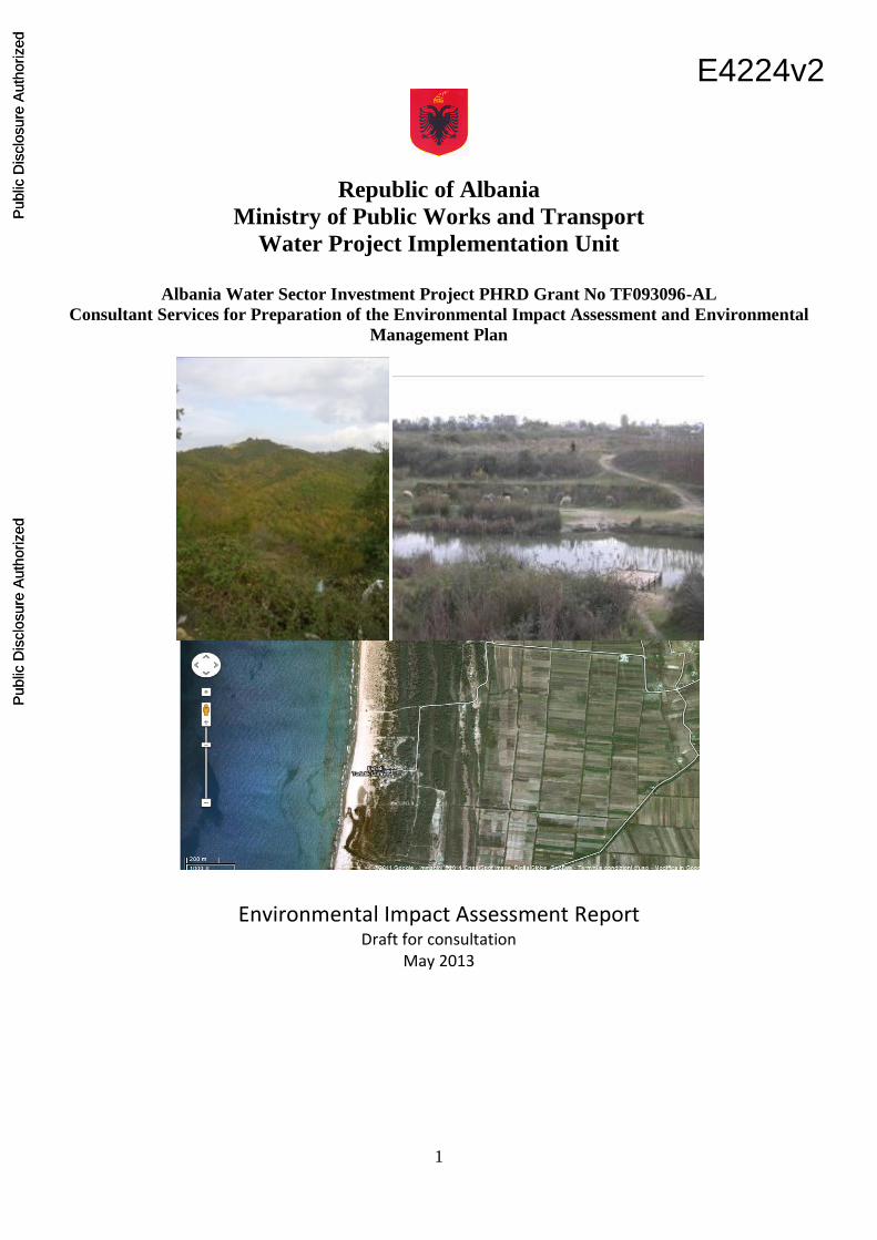
Republic of Albania
Ministry of Public Works and Transport
Water Project Implementation Unit
Albania Water Sector Investment Project PHRD Grant No TF093096-AL
Consultant Services for Preparation of the Environmental Impact Assessment and Environmental
Management Plan
Environmental Impact Assessment Report
Draft for consultation May 2013
Pub
lic D
iscl
osur
e A
utho
rized
Pub
lic D
iscl
osur
e A
utho
rized
Pub
lic D
iscl
osur
e A
utho
rized
Pub
lic D
iscl
osur
e A
utho
rized
Pub
lic D
iscl
osur
e A
utho
rized
Pub
lic D
iscl
osur
e A
utho
rized
Pub
lic D
iscl
osur
e A
utho
rized
Pub
lic D
iscl
osur
e A
utho
rized
2
SUMMARY
SUMMARY ...................................................................................................................................................... 2
LIST OF FIGURES ......................................................................................................................................... 5
1 EXECUTIVE SUMMARY ....................................................................................................................... 8
Policy, legislation and administrative framework ............................................................................................. 8
Objectives and summary description of the proposed project ........................................................................... 8
Impacts of Project Component 1 - Priority Water Supply Investments......................................................... 9
Socio-economic environment .................................................................................................................... 9
Summary of the Main Environmental impacts ........................................................................................ 10
Analysis of project alternatives ................................................................................................................ 14
Conclusions of the draft EIA report in respect to water supply component ............................................ 14
Project Component 2: Wastewater Investments .............................................................................................. 15
Description of the Project Area................................................................................................................ 16
Expected Impacts of the Wastewater Component ................................................................................... 16
Analysis of alternatives and their impact on the environment ................................................................. 17
Conclusions of the EIA in respect to wastewater component .................................................................. 17
2 POLICY, LEGAL AND ADMINISTRATIVE FRAMEWORK ............................................................ 18
2.1 The legal and institutional framework .................................................................................................. 18
2.1.1 General legislation on the Environment .................................................................................... 18
2.1.2 Legislation on Water Management ............................................................................................ 19
2.1.3 Legislation on Environmental Impact assessment and Environmental Permitting ................... 20
2.1.4 INSTITUTIONAL ASPECTS FOR WATER PROTECTION AND ADMINISTRATION .... 21
2.1.5 World Bank EIA Requirements and applicable OPs. ................................................................ 22
3 OBJECTIVES AND SUMMARY DESCRIPTION OF THE PROPOSED PROJECT ......................... 25
3.1 Previous World Bank projects .............................................................................................................. 25
3.2 The Present Project ............................................................................................................................... 25
3.3 Studies funded under the present project .............................................................................................. 26
3.4 The proposed infrastructures................................................................................................................. 27
3.4.1 Project Component 1 - Priority Water Supply Investments....................................................... 27
3.4.2 Project Component 2 - Wastewater Investments ....................................................................... 27
4 PROJECT COMPONENT 1- PRIORITY WATER SUPPLY INVESTMENTS (WELLFIELDS,
PIPELINE, BULK RESERVOIRS)................................................................................................................. 29
4.1 Description of Project Component 1- Priority water supply ................................................................ 29
4.1.1 The Fushe Milot Wellfield ......................................................................................................... 29
4.1.2 The Pumping Station.................................................................................................................. 30
4.1.3 The Main Transmission Pipeline ............................................................................................... 32
4.1.4 The Bulk reservoirs .................................................................................................................... 32
4.2 The socio-economic context ................................................................................................................. 34
4.2.1 Water demand in the Durres region ........................................................................................... 35

3
4.2.2 Water Demand in the Rural Area............................................................................................... 37
4.2.3 Social impact of the project ....................................................................................................... 38
5 RISK ANALYSIS AND ENVIRONMENTAL IMPACTS .................................................................... 40
5.1 Water resources ..................................................................................................................................... 40
5.1.1 Hydrology .................................................................................................................................. 40
5.1.2 Aquifer and Groundwater .......................................................................................................... 44
5.1.3 The expected impacts during the construction phase ................................................................ 51
5.1.4 The expected impacts during the project’s life .......................................................................... 51
5.1.5 The investigations considered as necessary before project implementation ............................. 52
5.2 Geological and soil system ................................................................................................................... 52
5.2.1 Geology and lithology................................................................................................................ 52
5.2.2 Soil pollution and solid wastes .................................................................................................. 53
5.2.3 The expected impacts during the construction phase ................................................................ 53
5.2.4 The expected impacts during the project’s groundwater extraction phase ................................ 54
5.3 Natural habitats ..................................................................................................................................... 54
5.3.1 The investigations considered necessary before project implementation .................................. 56
5.3.2 The expected impacts during the construction phase ................................................................ 57
5.3.3 The expected impacts during the project’s life .......................................................................... 57
5.4 Air quality ............................................................................................................................................. 60
5.4.1 Sources of atmospheric pollution and their potential impact on the project area. ..................... 60
5.4.2 The investigations considered as necessary before project implementation ............................. 61
5.4.3 The expected impacts during the construction phase ................................................................ 61
5.4.4 The expected impacts during the project’s life .......................................................................... 61
5.5 Climate change...................................................................................................................................... 62
5.5.1 Rainfall ....................................................................................................................................... 62
5.5.2 Sea Level Rise and Coastal Erosion .......................................................................................... 64
5.5.3 The investigations considered as necessary before project implementation. ............................ 65
5.5.4 The expected impacts during the construction phase ................................................................ 66
5.5.5 The expected impacts during the project’s life .......................................................................... 66
5.6 Physical cultural resources .................................................................................................................... 67
5.6.1 Archaeological areas and historical buildings ........................................................................... 67
5.6.2 General Pre-Construction Impacts and Mitigation Measures .................................................... 67
5.6.3 General Construction Impacts and Mitigation Measures ........................................................... 68
5.6.4 Assumptions and Limitations .................................................................................................... 68
5.6.5 Conclusions, Recommendations and Residual Impacts ............................................................. 68
5.6.6 The expected impacts during the project’s life .......................................................................... 69
5.7 Cumulative and Long Term Impacts .................................................................................................... 69
5.8 Analysis of alternatives and their impact on the environment .............................................................. 69
5.8.1 No-project option ....................................................................................................................... 69
4
5.8.2 Alternative sources of water supply ........................................................................................... 70
5.9 Alternatives for the routing of the pipeline and the location of pumping stations. .............................. 73
5.10 Conclusions of the EIA ......................................................................................................................... 78
5.10.1 Impacts ....................................................................................................................................... 78
5.10.2 Triggering of World Bank’s OPs ............................................................................................... 79
6 PROJECT COMPONENT 2- WASTEWATER INVESTMENTS ......................................................... 83
6.1 The need for the project ........................................................................................................................ 84
6.2 Description of the Wastewater component ........................................................................................... 84
6.3 Description of the works ....................................................................................................................... 85
6.4 Description of the Project area .............................................................................................................. 86
6.5 Topography ........................................................................................................................................... 88
6.6 Hydrology and Drainage ....................................................................................................................... 89
6.7 Risk analysis and environmental impacts ............................................................................................. 90
6.7.1 Water resources .......................................................................................................................... 90
6.7.2 Geological and soil system ........................................................................................................ 90
6.7.3 Natural habitats .......................................................................................................................... 91
6.7.4 Air quality .................................................................................................................................. 91
6.7.5 Physical cultural resources ......................................................................................................... 91
6.7.6 Socio-economic environment .................................................................................................... 91
6.8 Analysis of alternatives and their impact on the environment .............................................................. 91
6.8.1 No project Option ...................................................................................................................... 91
6.8.2 Alternatives for the routing of the mains and the location of pumping stations. ....................... 92
6.9 Conclusions of the EIA ......................................................................................................................... 92
6.10 Triggering of World Bank’s OPs .......................................................................................................... 92
7 Public disclosure ...................................................................................................................................... 94
8 Environmental Mitigation Plan ................................................................................................................ 94
9 Environmental Monitoring Plan .............................................................................................................. 94
ANNEX 1 – DESCRIPTION OF HYDROLOGY IN THE PROJECT AREA ............................................. 95
ANNEX 2 DATA SOURCES ....................................................................................................................... 103
5
LIST OF FIGURES
FIGURE 1 MAP OF DURRES SUPPLY ZONES & PROJECT AREA ................................................ 11
FIGURE 2 PROPOSED NEW WELLFIELD ............................................................................................ 31
FIGURE 3- ROUTE OF PROPOSED MAIN TRANSMISSION PIPELINE FROM NEW PUMPING
STATION TO DURRES ............................................................................................................................... 33
FIGURE 4- ROUTE OF PROPOSED MAIN TRANSMISSION PIPELINE FROM WELLSFIELD
TO PUMPING STATION ............................................................................................................................. 34
FIGURE 5 PROJECTED DEVELOPMENTS OF DURRES TO 2027 ................................................... 35
FIGURE 6- PROJECTED WATER DEFICIT FOR DURRES CITY ..................................................... 36
FIGURE 7 FUSHE KUQE BASIN ............................................................................................................... 41
FIGURE 8 RIVER MATI AND ISHMI BASINS ....................................................................................... 42
FIGURE 9 Hydrogeological Regions of Fushe Kuqe Basin ....................................................................... 50
FIGURE 10 IMPORTANT BIRD AREAS (PATOKU LAGOON AND LALZI BAY) ......................... 56
FIGURE 11 PROTECTED AREAS IN PROJECT AREA ....................................................................... 58
FIGURE 12 EXISTING ROADS IN THE ISHMI HILLS AT PIPLEINE CROSSING ........................ 59
FIGURE 13 - VARIATION OF PREDICTIONS IN CLIMATE CHANGE MODELS-RAINFALL
2020-2039 ........................................................................................................................................................ 63
FIGURE 14 VARIATION OF PREDICTIONS IN CLIMATE CHANGE MODELS-RAINFALL
2040-2059 ........................................................................................................................................................ 63
FIGURE 15 SEA LEVEL RISE PROJECTIONS IN THE MEDITERRENEAN SEA ......................... 65
FIGURE 16 WATER SUPPLY ALTERNATIVES CONSIDERED BY IC CONSULENTEN ............. 72
FIGURE 17 - VARIANT 1 - ROUTES OF PIPELINE AND LOCATION OF PUMP STATION ....... 74
FIGURE 18 VARIANT 2 - ROUTES OF PIPELINE AND LOCATION OF PUMP STATION ......... 75
FIGURE 19 – MAP OF PROJECT AREA FOR COMPONENT 2 (WASTEWATER
INVESTMENTS) ........................................................................................................................................... 84
FIGURE 20 – SATELLITE IMAGE OF PROJECT AREA FOR COMPONENT 2 (WASTEWATER
INVESTMENTS) ........................................................................................................................................... 85
FIGURE 21 -CLOSE UP OF THE AREA WHERE THE MAINS WILL RUN ALONG THE BEACH
.......................................................................................................................................................................... 87
FIGURE 22 -SATELLITE IMAGE OF THE SITE OF SUB-COMPONENT 2 ..................................... 88
FIGURE 23 RIVER MATI AND ISHMI BASINS .................................................................................... 96

6
ACRONYMS
AAS Albanian Archeological Service
AIEC Average Incremental Economic Cost
ALL Albanian Lek
BP Bank Policy
CV Curriculum Vitae
DDWW Durres District Water Works
DN Diameter Nominal
DTEM Digital Terrain Elevation Model
DWSRP Durres Water Supply Rehabilitation Project
DWU Durres Water Utility
EC European Commission
EIB European Investment Bank
EOI Expression of Interest
EU European Union
EUR Euro
FIDIC International Federation of Consulting Engineers
GCM Global Circulation Model
GDEM Geo-referenced Digital Elevation Model
GDWSS General Directorate of Water Supply and Sewerage
GEF Global Environment Facility
GIS Geographical Information System
GPS Global Positioning System
GRP Glass Fiber Reinforced Pipes
IDA International Development Association
km2 Square kilometers
LRMC Long Run Marginal Cost
m3/sec Cubic meters per second
Mamsl Meters above mean sea level
Masl Meters above sea level
Mbgl Meters below ground level
METI Ministry of Economy, Trade and Industry
MPWT Ministry of Public Works and Telecommunications
MWWP
NAC
Municipal Water and Wastewater Project
National Archaeological Council NASA National Aeronautics and Space Administration
NGO Non Governmental Organization
NPV Net Present Value
NRW Non-Revenue Water
O&M Operation and Maintenance
OP Operational Procedures
PAD Project Appraisal Document
PAP Project Affected Persons
PID Project Information Document
PDO Project Development Objectives
PFS Pre-Feasibility Study
PIU Project Implementation Unit
PV Present Value
QA Quality Assessment
7
QC Quality Control
RAP Resettlement Action Plan
REA Regional Environmental Agency
RFP Request for Proposals
RTA Rapid Technical Assessment
SLR Sea Level Rise
TDS Total Dissolved Solids
TOR Terms of Reference
UTM Universal Trans Mercator
WGS World Geodetic System
WRA Water Regulatory Agency
WRM Water Resources Management
WSIP Water Supply Investment Project
WSS Water Supply System
WSURP Water Supply Urban Rehabilitation Project
% Percent
◦C Degrees Celsius
g/l Micrograms per liter
Mg/l Milligrams per liter
8
1 EXECUTIVE SUMMARY
This Environmental Impact Assessment Report has been prepared on behalf of the Ministry of Public Works
and Transport (MPWT) as foreseen in the TOR. It presents the state of the environment in the condition ex-
ante the implementation of the project, and the expected impacts of the project on the environment - in terms
of impact on soil, water, air, vegetation, natural habitats - as well as the social consequences of these same
impacts. It also compares the different project alternatives.
Policy, legislation and administrative framework
The National Law of Albania sets out the rules and modalities for carrying out an EIA. The present report
follows the guidelines of World Bank Operational Policy (OP) 4.01 and Albanian legislation. The other OPs
which have been taken into account are: OP 4.04 Natural Habitats; OP 4.11 Physical Cultural Resources; OP
4.12 Involuntary Resettlement; OP 4.37 Dams; OP 4.36 Forests; OP 7.50 Projects in International Waters;
OP 7.60 Projects in Disputed Areas. Details of legislation and applicable procedures above are provided in
Section 2 of the report.
Objectives and summary description of the proposed project
The Project Development Objectives (PDO) are:
(i) to improve the quality of water services in the Durres Utility Service Area;
(ii) to improve access to wastewater services and transmission of wastewater to treatment in critical parts
of the Service Area; and
(iii) to improve operational and financial performance of Durres Water Utility.
As the second largest city of Albania, with a population that swells to twice its 200,000 residents during the
summer months, Durres was the Government’s priority location for piloting its institutional and policy
reform agenda, coupled with critical investment financing.
The project will be implemented by a Project Management Unit (PMU) established at the Ministry of Public
Works and Transport (MPWT). The following project components are assessed in the present study:
Component 1 - Priority Water Supply Investments. This component consists of:
The development of a new wellfield
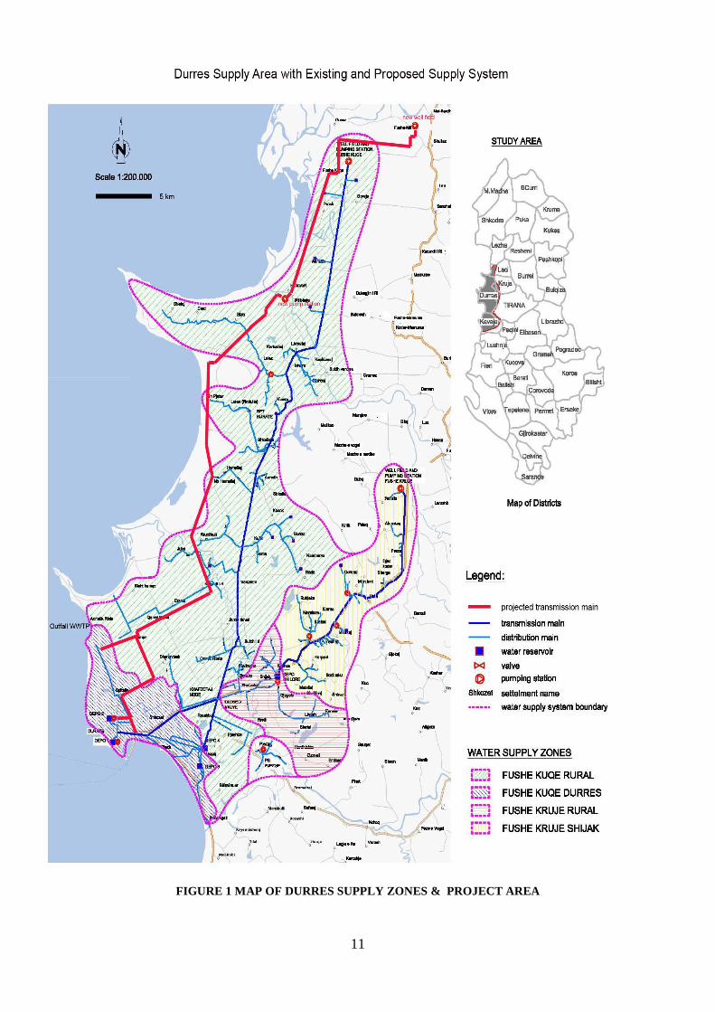
At initial phase of the project, two wellfield alternatives have been considered. These two
alternatives are the existing Fushe Kuqe wellfield area and Fushe Milot wellfield area (See Figure 1).
Hydrogeological studies performed during the project show that the existing Fushe Kuqe wellfield
may have already reached its maximum yield, and therefore cannot provide additional amounts of

9
water. Additional groundwater extraction at this location will likely cause a decrease in groundwater
level that would lead to seawater intrusion into the groundwater system. On the other hand, Fushe
Milot wellfield is found to be the feasible and is the preferred option. Discussion of alternatives is
presented in Section 5.9 of this Report. The location of proposed Fushe-Milot wellfield is shown in
Figure 1. The proposed wellfield, which would be rehabilitated, will consist of five extraction wells
as well as one monitoring well. Two of the new production wells will be adjacent to the existing
wells that are no longer operational (due to closure of industrial facility they served), while the others
will be located up to 50 meters from two other existing wells (due to land ownership issues or
physical constraints). More details on this is to be found in section 4.1 of this Report.
A pump station
As it is given in Figure 1, two alternative pipe routings were proposed by COWI for transmission
main, with two variants. Variant 2, which is located adjacent to the existing polder pump station –
Hydrovore - is chosen as the pump station area. A discussion of these alternatives is provided in
section 5.9 of this Report.
A transmission main (pipeline)
The proposed route for the transmission main alternatives are shown in Figure 1. In terms of route
selection methodology, mainly existing roads are selected as pipeline route in order to minimize
environmental impacts. In this respect, the pipeline route follows almost entirely existing roads,
leading from the well field to Durres, with a branch off at Porto Romano. A discussion of route
alternatives is provided in section 5.9 of this Report.
Bulk water reservoirs
Bulk water reservoirs are planned to supply the villages along Fushe Kruje main pipeline route and
Fushe Kuqe main pipeline route.
Component 2: Wastewater Investments
This component will finance priority wastewater investments in Durres aimed at enhancing the existing
sewerage network’s capacity to handle the increased water supply in an environmentally and socially
sustainable manner, including upgrading of critical parts of the sewerage network and provision of high-
pressure sewer cleaning equipment.
Impacts of Project Component 1 - Priority Water Supply Investments
Socio-economic environment
The project responds to the urgent need to satisfy water demand in Durres and also improves access to
potable water for the villages along the Fushe Kuqe main pipeline route. A separate study of the social
impact of the project has been prepared by DRN-ACER entitled “Durres Water pipeline Resettlement
Action Plan and Social Assessment” – with the draft final analysis produced in January 2012. In addition to

10
this study, a specific study is performed for resettlement and land acquisition requirement of the Project. In
that respect a study report named “Resettlement Action Plan (RAP) and Resettlement Policy Framework
(RPF)” was prepared by Government of Albania and cleared by the World Bank in January 2013, in
compliance with the Albanian Law on Land Acquisition and the World Bank’s OP 4.1.2. The RAP reveals
that the only affected parties from land acquisition, for the construction of the new Water Pipeline, are the
private land owners. A total of 28 land owners are identified in locations where a small portion of their land
will need to be expropriated according to the Albanian legislation in force. Land acquisition affects 34 plots
in four administrative units, in total 3487m2: (i.) Milot Commune – 6 land owners; (ii) Fushe Kuqe
Commune – 3 land owners; (iii) Ishem Commune – 18 land owners; (iv) Sukth Municipality – 1 land owner.
The estimated total cost of land compensation for the proposed project is calculated to the amount of
4,246,330.00 ALL (approximately US$ 40,442) for a total of land surface of 3487m2. Details of socio-
economic impacts are available in separate studies, as indicated above.
Summary of the Main Environmental impacts
This section outlines only the main impacts of the proposed Project. More comprehensive analysis is
presented in sections 5 and 6 of this Report.
Water resources
Potential impact of the project is expected on groundwater resources. There are specific risks associated with
water extraction from any aquifer, which may produce impacts that need to be prevented, or limited, through
mitigation measures, and adequately monitored.
The major potential risks over groundwater sources are as follows:
Overexploitation of the groundwater resource can cause a decrease in groundwater level, and a risk
of seawater intrusion. In the area of Fushe Kuqe plain, the phenomenon of seawater intrusion is
already an evident risk. The proposed location of the wellfield in Fushe Milot is further east of the
Adriatic coast and is likely to be of a lower risk of sea water intrusion. Over exploitation of the well-
field could lower the water table and adversely affect the production rate of the existing wells used to
locally irrigate some agricultural land downstream from the Project area, and/or could damage the
local vegetation and eco-systems. This situation could further have negative impact on water quality
in the local rivers and wells, cause changes in local aquatic ecosystems and have other negative
effects. It is worth noting that the proposed project aims to rehabilitate an existing wellfield (Fushe
Milot) to its original production level, following closure of the existing production wells in early
1990. During its prior operation, no observable phenomenon, such as those described above, were
detected. As a further measure, however, and in order to safeguard the aquifer, periodic monitoring
of water quality and impacts, if any, of extraction on areas surrounding the production wells during
construction and operation of the Fushe Milot Wellfield has been included in the project design and
EMP. If water extraction is managed carefully and responsibly, any potential negative effects can be
mitigated and/or completely avoided.
11
FIGURE 1 MAP OF DURRES SUPPLY ZONES & PROJECT AREA
12
The old, closed mines and landfills situated at the zone of contribution (up-gradient) of
rehabilitated wellfield in the catchment area of Mati River, which is the main recharge
source of Fushe Milot alluvial aquifer, poses the risk of contaminating the aquifer. Site visits
were carried out to the landfills and confirmed to be closed under an EU-financed hotspot
closure program. Furthermore, according to a specific hydrogeological study performed in
the scope of the Project, the quality monitoring data testify that the groundwater quality has
not suffered significant changes since the start of water extraction in the Fushe Kuqe and
Fushe Milot alluvial aquifer, in early 1960s. Several sample water quality tests carried out
by the Albanian Geological Survey and Institute of Public Health confirm that all water
quality parameters within the Fushe Milot wellfield area are within acceptable limits.
Soils and Geo-hazards
Main project impact on soils is expected during pipeline construction. Land preparations for
construction corridor, trenching, pipeline installation and re-instatement activities are main impact
sources. Permanent above ground facilities are also causes of soil loss. In order to minimize these
impacts, the existing roads will be used as pipeline routes. In addition to mitigation, surface soil
(vegetable soil) will be separately stored and not mixed with excavated materials. Additionally,
effective reinstatement techniques including erosion control will be used. These mitigations will be
addressed in the EMP.
During the operation of the project, subsidence (that is, of sinkholes developing as a consequence of
the alteration of the level and pressure of the underground water table) is the only risk in terms of
geo-hazard. Existing well sites show that such impact is not observed in the project area. Therefore,
the potential subsidence problem is not expected in the rehabilitated wellfield area. However, the
risk should be monitored. In this respect, especially in the initial years of exploitation of the
rehabilitated wellfield, careful monitoring of potential impacts shall be undertaken; details are
provided in the EMP report.
Natural habitats
Major units of the project including underground wells, pumping station and bulk reservoirs are
located on public lands surrounded with agricultural fields and rural developments, none of which
are classified as natural habitats or protected areas. The transmission main is routed alongside
existing paved roads or between the roads and the agricultural fields. There are two protected areas
located in the project area of the transmission main. These areas are “Rruskull” in Durres and
“Patok-Fushekuge-Ishem” in Kurbin. These areas, at the time of classification, were comprised of
marshes and agricultural fields, and both areas have the same protection category of IV. The

13
existing level of protection has been enacted in 1960s, and various developments have taken place
since that time. The land, as observed during project preparation in 2012 and 2013, is heavily
modified by human impact in what can now be described as a peri-urban area. The section of the
transmission main that traverses Patok-Fushekuge-Ishem protection area is of an approximate
distance of 9,000 meters. In this section, a local road in agricultural fields is selected as a
transmission route. Therefore, there will be no direct impact to the marshes during the construction.
Additionally, the hydrogeological study shows that the aquifer used as water source has no
connection to marshes. According to environmental legislation of Albania, there is no limitation for
transmission main construction in the agricultural fields.
Air quality and noise
A temporary impact on air quality is expected during construction period of the project. Dust and
exhaust emissions are the major impact sources for air quality in this period. These emissions are
originated by movement of vehicles along construction corridor, soil stripping, trench excavation,
back-filling and reinstatement during the construction. No impact on air quality is expected during
operational phase. Impact on noise will be temporary during construction activities. Site
preparedness and construction of the pipeline will include the following noise-generating activities:
Route passage preparation; soil stripping; trenching; pipe stringing, welding and laying; and
backfilling. Generally, these activities involve the use of a mobile plant along the spread. During the
operation phase there will only be a minor impact (noise) for some point sources, namely the
pumping station and pumps of wells. Noise impacts are related to point sources such as electricity
cabs, pumps site, wellfields and they will be limited to the proximity of these sites.
Climate change
Although the present knowledge about climate change is not such as to allow for precise predictions
at the local scale and over the medium term time horizon, climate change should be factored in the
present evaluation since it may affect adversely the quantity and quality of water resources. In
practical terms, this can be done by factoring climate change in a hydrological model for the
management of the well field, coupled with adequate monitoring of levels and quality of
underground water table. This will allow prediction of the sensitivity of the well field to the effects
of climate change, and early warning to decision makers so that extraction can be adapted if need be
in order to prevent negative effects (seawater intrusion, concentration of pollutants).
Physical cultural resources
The Project is unlikely to have an impact on Physical cultural resources, as no known cultural
resources are impacted upon by the pipeline, the pumping station and reservoirs. Nevertheless, a
14
protocol has been developed as part of the EMP report to set out the procedure to be followed in
case of findings during the construction phase.
Cumulative impacts
The risks of excessive lowering of the underground water table using inadequate or inappropriate
operating practices; resulting seawater intrusion; and pollution of the underground water table from
upstream industrial facilities, if these activities are re-started at certain point in future – could have a
cumulative effect. However, application of relevant mitigation measures in respect to water
extraction, and due diligence in respect to currently closed industrial facilities will prevent this
situation from occurring.
The impact of climate change is liable to further exacerbate these risks, through an intensification of
extreme events and periodical fall in the recharging of the underground water table. The existing
body of knowledge in this respect is rather limited, and more research of climate change related
impacts is necessary in future years.
Analysis of project alternatives
Several alternative options were reviewed: “no project”; two wellfield locations; two transmission
main routes; and two locations for the pumping station. In addition, consideration was given to the
impact of a water demand management program, such as the universal metering program under the
proposed project. However, even with a substantial reduction of waste and losses, a water demand
management program could not sufficiently reduce losses to the point that the deficit of 30,000
m3/day could be alleviated. Details of this are shown in section 5.8 and 5.9 of this Report. Taking
into account the above considerations, the final selection has been to use Fushe Milot Wellfield, the
western transmission route and Hydrovore location for the pumping station.
Conclusions of the draft EIA report in respect to water supply component
Impacts
The project will have a definite beneficial impact on the socio economic conditions in Durres and in
the villages of communes Thumana, Fushe Kuqe, Ishem, Manza, Katund i Ri, Xhafzotaj, Sukth,
Rashbull. However, the project might have a limited negative impact on the rural populations if
their wells should be affected; this risk shall be offset by appropriate monitoring and management
of the wellfield.
The main risks of the project regarding i) excessive use of the water aquifer, ii) intrusion of
seawater; and iii) pollution from the infiltration of surface waters, are minimized by selection of a
suitable site as a result of a detailed hydrogeological study. Additionally, an effective monitoring

15
program has been suggested for the management of groundwater table and water quality. Durres
Water Utility will be supported under the project in designing and implementing a water demand
management program that will include universal metering to better control and monitor water use
and reduce wastage and theft, as well as a Performance Improvement Plan to monitor and reduce
technical and managerial non-revenue water losses.
The project’s impact on soils is expected to be minor. The risk of subsidence, cannot be ruled out
entirely, even though the experience of similar projects in the area has not produced such effects.
Based on past experience with the wellfield, however, the risk of subsidence is considered very
minor. No evidence has arisen in the course of preparing this report that suggests any incidence of
subsidence during the 30 year period of prior operation. Therefore, if it were to occur it would most
likely be localized and limited and occur during the initial production phase for which the
contractor would be responsible for undertaking remedies. Appropriate monitoring at the beginning
of the exploitation of the new wellfield is recommended and has been provisioned under the
construction contract.
The project will have negligible impacts on air quality, noise, and natural habitats.
The project will have a minor impact in terms of involuntary resettlement. This issue is dealt with in
the Resettlement Action Plan (RAP) and Resettlement Policy Framework (RPF), which provide
additional information.
Project Component 2: Wastewater Investments
This component will finance priority wastewater investments in Durres aimed at enhancing the
existing sewerage network’s capacity to handle the increased water supply in an environmentally
and socially sustainable manner, including upgrading of critical parts of the sewerage network and
provision of high-powered sewer cleaning equipment.
The works consist of the rehabilitation of an existing sewage system in the prime tourism area of
Durres (which is declared a wastewater priority of the Durres Water Utility), and connection of the
said network with the existing, recently completed Wastewater Treatment Plant, which is capable
of receiving the complete load from this development. This project component will replace the
existing decrepit wastewater network built in 1970s, which is in a very bad state of repair, where
two out of six pumping stations do not function, and some of the manholes are damaged and
without covers.
The new wastewater network (primary, secondary and tertiary) that will replace the existing one,
will serve an area approximately 6 km long and 600 m wide, which is currently home to
16
approximately 15 thousand residents. The improvement in wastewater collection and treatment,
over and above replacing the old network will also cater for the tourism facilities which have been
developed in the area (Hotels, high rise apartment blocks) and the resulting influx of tourists during
the peak summer season (June-July-August) which brings additional load of up to 95,000
capita/day.
Description of the Project Area
The project area for subcomponent 2 (wastewater network) is a built up area facing the beach,
where the network runs along existing roads, replacing the old dilapidated one. Only for a tract of
3km does the new piping run along the upper limit of the beach (alongside the main road), which is
used for recreational purposes and retains no features as a natural habitat. From the northern limit of
the area being serviced, the route runs along existing roads and through a suburb (light service
industry, residential) to reach the existing Wastewater Treatment Plant. The location of various
investments related to wastewater component are shown in FIGURE 19 – MAP OF PROJECT AREA
FOR COMPONENT 2 (WASTEWATER INVESTMENTS) in section 6.2 -“Description of the Wastewater
component “of this report.
Expected Impacts of the Wastewater Component
The project has no anticipated adverse impacts on natural habitats or forests, as none exist on site.
Regarding water resources, the project will have beneficial impacts only, as its implementation will
considerably reduce the amount of untreated wastewater polluting the surface and underground
water resources.
The project will have no negative impact on soils. The project will produce very limited air
pollution during the construction phase, due to the use of machinery for excavation and vehicles
servicing the site. This will take place within residential and commercial areas; however pollution
levels will remain within acceptable limits as for extraordinary maintenance works. Air pollution
levels will be abated by applying the mitigation measures as a part of good construction practice.
No negative impact on air quality is expected during the project’s operational phase.
The project will produce noise during the construction phase, due to the use of machinery for
excavation and vehicles servicing the site. This will take place within residential and commercial
areas; however noise levels will remain within acceptable limits as for extraordinary maintenance
works. Noise levels will be abated by applying appropriate prescriptions in the BOQ, as detailed in
the EMP report. No negative impact on noise is expected during the project’s operational phase.
Physical cultural resources

17
As the wastewater mains will be running along existing roads, without requiring the excavation of
new areas or affecting existing buildings, no impact with Physical cultural resources is foreseen in
either the construction or the exploitation phase.
Socio-economic environment
The Project brings about an improvement in quality of life, public health, and in the general quality
of the environment, and improves the area’s value as a tourism attraction. Disruption of the
recreational use of the beach will be limited during the construction phase only.
Positive impacts of the Project
The project will produce beneficial impacts on water resources (abating pollution), air (elimination
odors from leakage and uncovered manholes), on international waters (by reducing wastewater
pollution into the Adriatic Sea) on quality of life and public health, and on the economy by
enhancing the value as a tourism attraction, of the area being serviced
Analysis of alternatives and their impact on the environment
The “no project-option” would mean leaving wastewater system in a decrepit state; leakage of
wastewater would continue, and untreated wastewater would seep into the soil and the water table,
and ultimately the Adriatic Sea. There would be no advantages of any kind in this option.
There are no practical alternatives to replacing the network within this built-up environment.
Conclusions of the EIA in respect to wastewater component
There shall be no negative environmental impacts from the implementation of this project
component. The very limited negative impacts in the construction phase are not different from those
of any large-scale maintenance operation. No negative impacts are to be expected in the operational
phase, provided that ordinary maintenance of the network and the pumping stations is exercised.

18
2 POLICY, LEGAL AND ADMINISTRATIVE FRAMEWORK
The Republic of Albania has adopted a body of environmental laws and regulations which cover the
issues of environmental protection and management, water management including groundwater
extraction, public participation in environmentally-related matters, wastewater disposal,
management of surface waters and marine environment. Albania has made considerable progress
towards its objective of aligning to EU legislation, in view of Albania’s goal of joining the
European Union.
Albania is also a signatory to several international agreements on the environment, with which the
project shall comply. These developments resulted in a complex set of rules and regulations that are
applicable to the present Project.
This section of the Report briefly presents the relevant legislation and norms which have been
considered during Project preparation.
2.1 The legal and institutional framework Approved in 1998, the Albanian Constitution establishes the general framework for the protection
of environment, and endorses the principles of sustainable development and sustainable
management of natural resources, as well as the public’s right to freedom of information on the
environment.
2.1.1 General legislation on the Environment
The main legislation is consisting of:
Fundamental Law on Environmental Protection with related laws and by-laws;
Legislation on Water Management
Legislation on EIA and Environmental Permit
Legislation dealing with the public information and consultation
Fundamental Law on Environmental Protection and Related Legislation
The fundamental law on the environment is Law No. 10431 of 9.6.2011, “On Environmental
Protection”, which has the purpose of aligning the Albanian environmental laws with EU
environmental legislation, and in particular with the Directive 2004/35/KE of the European
Parliament and Council, dated 21 April 2004 on environmental liability, prevention and
rehabilitation of damage on environment. The Law has come into force in January 2013. The Law
elevates the obligation for environmental protection to a higher level from the laws related to this
field enacted in period 1993-2002. The Law specifies protection and improvement of environment,
prevention or reduction of risk for human health, prevention of human life risks, improvement of
life quality, and provisions of means for Albania’s sustainable development. The Law is giving
references to water resource protection, water quality norms and standards, air and soil protection
etc. It also deal with goals and principles of EIA, EIA relation to technical designs and declares the
National Environmental Agency (NEA) as the competent authority for definition of conditions
related to environmental permits. This Law is also underlining the obligation of any state or private
entity to invite public and other interested parties to participate at activities related to environmental
protection.
Other relevant pieces of legislation:

19
Law No. 10463, of 22.9.2011, “On Integrated Management of Wastes”, which gives rules and
framework for environmental protection caused from waste contamination.
Law No. 8897, of 16.5.2002 “On Protection of Air from Pollution”, which details measures for
prevention from air pollution.
Law No. 8905, of 2002, “On Protection of Marine Environment from Pollution and Damage”,
which incorporates into the Albanian national legislation the obligations that result from her joining
the Convention for the Protection of Mediterranean Sea and its Protocols.
Law No. 8364, of 2.7.1998 “On Hazardous Substances and Waste”, which refers to pollution
control in respect to hazardous substances generation and solid and wastewater management.
Law No. 9587, of 20.7.2006, “On Biodiversity Protection”, which provides for the protection of
animal and plant species, and contributes towards the approximation of national environmental law
to EU norms.
Law No. 9868, of 4.2.2008, “Amendments to Regulations of the Law on Protected Areas, No
8906, dated in 6.6.2002”, that amends previous laws and by-laws regarding protected areas, in
compliance with IUCN categories and structure of protected areas. Among others it prescribes the
integration of buffer zones in the peripheral parts of protected areas, gives the land-use in any
subcategory of protected areas as well as defines the prohibited activities in any sub-zones of
protected areas.
2.1.2 Legislation on Water Management
The basic Law on water management is Law No. 111 of 15.11.2012, on “Integrated Management
of Water Resources”, which focusses on protection of water sources, distribution and efficient
administration of water and defines the institutional framework for administration and management
of waters for community benefits and socio-economical interest of the country. This Law is referred
to in the Law on Environmental Protection of 2011, and the Law Environmental Permit (No. 10448
of 2011), in part related to environmental permit procedures for water extraction and discharge
related projects. The Law describes the hygienic-sanitary areas for protection of water resources
defined for water production, which are considered as Protected Areas, provides spatial structure of
such areas (composed of First Protected Area, Closed Protected Area and Remote Protected Area),
including lists of prohibited activities for each of them. The Law defines the Water Basin Agency
as the responsible institution for monitoring of surface and groundwater bodies to be used for
drinking water supply.
Law No. 8102, of 28.3.2008, on “Regulatory Framework for Water Supply, Removal and
Treatment of Waste Waters”, specifies the establishment of a regulatory framework and an
independent regulatory entity for water supply and removal or treatment of polluted waters. The
Law specifies the functions, competences, procedures and standards, under which the Regulatory
Entity will operate.
Law No. 9115, of 27.4.2003, on “Environmental Treatment of Polluted Waters” addresses the
treatment of polluted industrial and urban waters. The Law establishes a separate license system on
requirements, terms and conditions for construction sites of plants and installations for water
purification operations. The purpose of this Law is to protect the environment and human health
from the negative impact of polluted waters by setting rules for environmental treatment of such
waters and defining binding obligations upon subjects who discharge polluted waters in the
environment. In this regard, and following the provisions of this Law, the Council of Ministers
approved the Decision (DCM) No. 177, of 31.3.2005, on “Permitted norms for liquid discharges
20
and criteria for environmental zoning of rivers or sea waters”, which defines measurable and
controlled discharges coming from the water treatment plant.
Water resources were also regulated by Law No. 8093, of 21.3.1996, “Law on Water Resources”,
which established the National Water Council (NWC) and its Technical Secretariat. The Law
regulates the conservation, development and utilization of water reserves and its distribution. It
establishes a separate system of permits, authorizations and concession for different purposes of
water use.
Water supply and wastewater management were further regulated by Law No. 8102 on “Some
Changes and Additions to the Law No. 8093 on Water Resources”, which aims at ensuring a
safe and reliable drinking water supply and wastewater treatment. The Law establishes the national
Water Supply and Sanitation Regulatory Commission under the auspices of the Ministry of
Territorial Adjustment and Tourism.
Several Decision of Council of Ministers (DCM), where also relevant for this Project. These are: DCM No. 35, dated 18.1.2006, “On Approval of the Regulation for Works on Pipeline Systems and Removal of Wastewaters”. It described technical condition for wastewater pipelines, and conditioning norms for discharges of used water in approximation with EU legislation. DCM No. 145, dated 26.2.1998, “On Approval of Hygienic-Sanitary Regulation for Evaluation of Drinking Water Quality, Design, Construction and Supervision of Drinking Water Supply Systems”. This DCM, among others, provides the spatial dimensions of protective sanitary areas.
2.1.3 Legislation on Environmental Impact assessment and Environmental Permitting
Economic activities that could have a significant impact on the environment or are connected to use
of natural resources are permitted only after conducting an Environmental Impact Assessment
(EIA).
The latest Law regarding EIA is Law No. 10440, of 7.7. 2011 on “Environmental Impact
Assessment”. The Law has come in force in early 2013. This Law specifies general procedures for
EIA, the authorities which formalize and approve procedures and defines two types of EIA, namely
“profound” and “preliminary”. The classification of EIA categories in respect to various
investments are given in the annexes to the Law (Annex 1 for the profound EIA and Annex 2 for
the preliminary EIA). The Law defines the requirements for the issuance of the environmental
permit for EIA categories. It also refers to NEA, which is according to the Law No. 10431 of 2011
designated as a competent authority for definition of conditions for the environmental permit. The
Law gives the rules regarding the process of public information during EIA preparation process. In
accordance with types of investment (groundwater extraction), the Project related to Durres Water
Supply is belonging to group for which the clauses referring to profound EIA should apply.
Law No. 10448, of 14.7.2011, on “Environmental Permits”, gives the rules and new procedures
related to the EIA process, categorization and permits. This Law categorizes the types of
environmental permits, the competent authority for verification of each type of license, consultation
procedures etc. The Law describes the general principles that conditions basic obligations of the
subjects that apply for environmental permits and in respect to profound EIA specify that the
documentation should be presented to the National Center of Licensing (NCL) after consultation
with National Environmental Agency. The Law also specifies required documentation needed to be
delivered to NCL for requesting the environmental permit.

21
DCM No. 13, of 4.1.2013, on “Approval of the Rules, Responsibilities and Deadlines for
Development of EIA Procedures”, details the procedures, clarifies the documentation needed for
environmental permit requests, defines consultation and information procedures etc. In accordance
with this DCM, the time required to get the Environmental Permit for Profound EIA Reports is up
to 2 months from date of submission of relevant documentation.
Public Consultation
Albania has signed the Aarhus Convention in 1999 and ratified it in 2001. From this period
onwards, public consultation remains an important part of any new development actions. In the
Article 17 of the Law No. 10440 of 2011, the EIA preparation process is conditioned upon public
hearing process. The Law specifies how and when the public hearing and consultation should be
organized and how these should be reflected in the EIA Report. Furthermore, DCM No. 994, of
2008, on “Public Opinion on Environmental Decision Making”, deals with rules of public
participation on decisions for environmental permit of activities that impact the environment.
2.1.4 INSTITUTIONAL ASPECTS FOR WATER PROTECTION AND ADMINISTRATION
During the period 1995-2005, water resources management activities were extremely complex due
to a number of sectors, ministries and agencies involved. This complexity is underlined in
respective provisions of the Water Resource Law, which defined the composition of National Water
Council (NWC) as a body responsible for determining the main lines of policy and for making
major decisions related to it.
Main Authorities on Water Administration
The main authorities responsible for water resources management are the National Water Council
(NWC); The Ministry of Environment, Forests and Water Administration; the Technical Secretariat;
and the River Basin Agencies (RBAs) which operate on a regional level. Recently the Technical
Secretariat has been re-organized and a new General Directorate on Water Administration
established that will take over the functions of the Technical Secretariat and will supervise work of
the RBA’s. The Water Regulatory Authority functions under the National Water Regulatory
Commission, as an independent body with the exclusive right to set tariffs and license operators in
the water sector.
River Basin Agencies
The territory of Albania is divided into six River Basins (Semani, Drini/Buna, Vjosa, Ishem/Erzen,
Shkumbini, and Mati). For each of these basins the Law on Water Resources established the River
Basin Council and the River Basin Agency. The River Basin Councils’ responsibilities are (i)
rational protection, development, and operation of water resources within the boundaries of its
basin; (ii) fair distribution of water within the boundaries of its basin, according to the purposes for
water use and effective administration; and (iii) protection of water resources against pollution,
misuse, and overuse. The River Basin Councils are headed by the Prefect and have between 9 and
19 members selected from ministries, representatives of businesses, and consumer representatives.
They are supported by the River Basin Agencies (RBAs) that function as a technical secretariat to
RBCs.
The River Basin Agencies are responsible for implementation of the Law on Water Resources,
decisions made “their” RBC and for management of water resources within its basin areas. They
undertake the technical evaluation of applications for water abstraction and recommend them to
22
RBC for approval. They also support the respective municipalities in solving problems related to
the water resources.
The Durres water Supply Project Area falls within the administrative territory of two River Basin
Councils/Agencies, (i) RBC Mati, with offices in Lezha and RBC Ishem/Erzen, with offices in
Tirana. The respective RBCs gather in Lezha and Tirana.
2.1.5 World Bank EIA Requirements and applicable OPs.
The World Bank’s safeguard policies are designed to avoid, mitigate, or minimize adverse
environmental and social impacts of projects supported by the World Bank (WB). WB promotes the
implementation of systems that meet the above purposes and at the same time ensures that
development resources are used transparently and efficiently to achieve desired outcomes. In
addition to Safeguard Operational Policy (OP) for Environmental Assessment (OP 4.01), several
other policies have been taken into account during preparation of the Project, and in particular:
- OP 4.04 Natural Habitats
- OP 4.11 Physical Cultural Resources;
- OP 4.12 Involuntary Resettlement
- OP 4.37 Dams
- OP 4.36 Forests
- OP 7.50 Projects in International Waters
- OP 7.60 Projects in Disputed Areas
The Bank requires preparation of the environmental assessments (EA) of projects proposed for
Bank financing, to help ensure that they are environmentally sound and sustainable. While
preparing EA, the authors should take into account that:
EA takes into account the natural environment (air, water, and land); human health and safety;
social aspects (involuntary resettlement, indigenous peoples, and physical cultural resources); and
transboundary and global environmental aspects.
EA considers natural and social aspects in an integrated way. It also takes into account the
variations in project and country conditions; the findings of country environmental studies;
national environmental action plans; the country's overall policy framework, national legislation,
and institutional capabilities related to the environment and social aspects; and obligations of the
country, pertaining to project activities, under relevant international environmental treaties and
agreements.
EA Instruments
Depending on the project (dimension, scope of the project and impacts), a variety of instruments
can be used to answer the Bank's EA requirement:
- environmental impact assessment (EIA),
- regional or sectoral EA,
- environmental audit,
- hazard or risk assessment,
- Environmental management plan (EMP).
Environmental Screening
The Bank undertakes environmental screening of each proposed project to determine the
appropriate extent and type of EA. The Bank classifies the proposed project into one of four

23
categories, depending on the type, location, sensitivity, and scale of the project and the nature and
magnitude of its potential environmental impacts.
The four categories are:
a. Category A: A proposed project is classified as Category A if it is likely to have significant
adverse environmental impacts that are sensitive, diverse, or unprecedented. These impacts may
affect an area broader than the sites or facilities subject to physical works.
b. Category B: A proposed project is classified as Category B if its potential adverse environmental
impacts on human populations or environmentally important areas - including wetlands, forests,
grasslands, and other natural habitats - are less adverse than those of Category A projects.
c. Category C: A proposed project is classified as Category C if it is likely to have minimal or no
adverse environmental impacts. Beyond screening, no further EA action is required for a Category
C project.
d. Category FI: A proposed project is classified as Category FI if it involves investment of Bank
funds through a financial intermediary, in subprojects that may result in adverse environmental
impacts.
It has been determined that the present Project falls in the second group of projects and belongs to
environmental Category B. This type of project could have adverse impact on human health and
environmental components (air, water, soil, flora, fauna and landscape), but in the present case its
likely effects are site-specific, not major and not irreversible. Where existing, the negative effects
could be effectively offset and mitigated by application of the environmental mitigation activities,
as specified in EMP.
2.1.6 Conclusion
In the above sections of this chapter the main legislative framework is analyzed in terms of
international and national, as well as the institutional administrative structure of the water
management system and the World Bank procedures for environmental assessment. In broad terms
Albanian legislation and regulations are consistent with World Bank procedures. The Albanian
regulations for projects classified as requiring a profound assessment (Annex 1 of Law No. 10440
on Environmental Impact Assessment) require preparation of: (a) an Environmental Impact
Assessment (not a technical summary of the EIA) drafted with respect to the project type; (b) a
technical description of the project or activity; (c) a report containing information on public
awareness and consultation carried out in preparing for the proposed project; and (d) invoices for
services rendered in preparing the environmental assessment documentation. All of these
requirements are in line with World Bank OP 4.01 procedures for a project classified as Category B
with the additional requirement of preparing an Environmental Management Plan (EMP). An
Environmental Mitigation and Monitoring Plan has been prepared for this Project and is included to
this report under Sections 6.10.2-3 Specific measures stipulated in the EMP note where they are
compliant with national legislation or regulations, such as establishment of protections zones
around the production wells, by defining the protection area and method used to ensure protection.
In other instances where national laws or regulations are silent or do not indicate specific measures
for environmental mitigation or management, these actions or measures are set out in the EMP.
This includes, for example, water sampling/testing measures, preparing a groundwater basin
management plan, including chance find procedures in tender documents with respect to protection
of cultural heritage, among other such measures.
The consultants are satisfied that the project being the subject of the present EIA study complies,
through its technical design and its implementation procedures will comply with the applicable

24
body of law, provided that the mitigation and monitoring measures that are recommended in the
EMP Report will be fully applied.
25
3 OBJECTIVES AND SUMMARY DESCRIPTION OF THE PROPOSED PROJECT
3.1 Previous World Bank projects
The World Bank is actively supporting the Government of Albania’s efforts to improve
environment and health conditions in Durres and surrounding area.
Of particular importance in this respect are:
Two emergency repair projects,;
i. the Durres Water Supply Rehabilitation Project (DWSRP), approved in May 1994 (total
cost US$17.6 million, of which US$11.6 million was financed by IDA and US$5.5 million
by the Government); and
ii. The Albania Water Supply Urgent Rehabilitation Project (WSURP), approved in February
2000 (total cost US$14.6 million of which US$10 million was financed by IDA).
Following on from the above a third World Bank financed project was the MWWP (US$15
million), which focused on building capacity for managing water and wastewater services. Part
of this project included an Independent Performance Reviewer Audit of the Operator (BWI).
Finally, the World Bank, on behalf of the Global Environment Facility (GEF) financed the US$
4.87 million Integrated Water and Ecosystems Management Project that attempted to provide
low-cost nutrient removal for Durres sewerage and wastewater and which also complemented
the European Investment Bank (EIB) initiative -financing of conventional wastewater treatment
plants in Durres, Lezha, and Saranda.
In spite of the past projects water supply and wastewater services still remain woefully deficient in
the Durres region.
3.2 The Present Project
The GoA has received grant financing from the Japanese Policy and Human Resources
Development (PHRD) Fund, administered by the World Bank (WB) toward the preparation of the
proposed Albania Water Sector Investment Project (WSIP).
The WSIP is being implemented by the Ministry of Public Works and Transport (MPWT) through
the Water Project Implementation Unit (PIU) of the General Directorate of Water and Sanitation
Services (GDWSS).
26
Rapid urbanization has been underway for some time in Albania, due in part to the inability of rural
residents to sustain themselves in agricultural activities and the opportunities for new jobs in larger
cities. This has caused serious demand pressure for services in Durres City, including water supply
and sanitation, that the Project is designed to address. Currently, there is very little evidence that
rural population moves to urban areas just to access water from networks. Reliable water service is
now a problem which is widespread and is not confined to rural areas. A major part of the Project is
expected to ensure additional quantities of water for water supply of Durres residents (who are now
facing a deficit of about 30,000 m3/day) by rehabilitating the Fushe Milot Wellfield and
construction of the related transmission main, which will, together with comprehensive demand
management program of Durres Water Utility, provide better communal services in the area of
potable water. The Project is also aiming to address the wastewater situation by extending the
existing wastewater network and replacing some of its old, dilapidated parts with new higher
capacity mains, which will be connected to the newly completed Durres Wastewater Treatment Plan
that is now being commissioned. The new Durres WWTP is capable of accepting the wastewater
that will be produced in the area that is served by the Project, after linking the Project-related
investments to the existing wastewater system. The Project is also helping to implement the
universal water metering program, thus reducing water waste and help in adequate billing and
enforcement of water tariffs. In respect to rural areas, the Project will support activities aiming to
dismantle rooftop water tanks combined with installation of elevated water reservoirs serving
settlement areas that do not receive pressurized water, since inefficient and leaky rooftop water
tanks are considered one of the major sources of water loses.
3.3 Studies funded under the present project
The COWI Feasibility, Validation and Detailed Design
The PHRD grant was funding the “Validation and Finalization of the Feasibility Study and
Preparation of Preliminary and Detailed Design for Bulk Water Supply Line to Durres Region”
developed by COWI. This study has so produced an Inception report (August 2011), a “preliminary
Design Report” (October 8th
2011), and a “Final Draft Design Report/ main Report of November
19th
2011, and revised Validation and Finalization of Feasibility Study and Preparation of
Preliminary and Detailed Design (January 2013).
The Barry & Partners study
27
The European Union has funded (on Project Europe Aid/127584/C/WKS/AL) a full technical study
of the Project’s Wastewater Component for Durres, which has produced the technical tender
documents in June 2010.
The Social assessment and Resettlement Plan
The PHRD grant is also funding the “Durres water pipeline resettlement action plan and social
assessment”, which was produced by DRN- ACER in January, 2012. In addition to this study, a
Resettlement Action Plan (Rap) and Resettlement Policy Framework (RPF) has been prepared by
DRN in January, 2013.
As part of the preparation of the proposed Water Sector Investment Project for Durres, to be co-
financed by the World Bank, the Government wishes to carry out an Environmental Impact
Assessment (EIA) to assess the potential environmental impacts of the project, and develop an
environmental management plan to ensure implementation of the project consistent with applicable
World Bank and GoA environmental safeguards policies. The present EIA report follows an
Inception Report and a Data Collection Report.
3.4 The proposed infrastructures
3.4.1 Project Component 1 - Priority Water Supply Investments
Following detailed studies and consideration of alternatives, the proposed WSIP Project includes
(detailed description is provided in section 4.1.1 of this Report):
Rehabilitation of the Fushe Milot Wellfield, consisting of six new production wells, one of
which would be used for back-up and monitoring;
A pump station, to be located adjacent to the existing polder pumps station at Hydrovore
Patok;
A transmission main (pipeline), whose route will follow almost entirely existing roads,
leading from the Wellfield to Durres, with a branch off at Porto Romano, with a total length of
an estimated 63 km;
Bulk reservoirs and their feeder lines, to supply the villages along Fushe Kuqe main
(approximately 7 reservoirs).
3.4.2 Project Component 2 - Wastewater Investments
The investments consist of the rehabilitation of an existing and decrepit sewage system in the prime
tourism area of Durres, and in the connection of the said network to the newly built Wastewater
Treatment Plant capable of handling the increased load. The area to be served by the wastewater
network (primary, secondary and tertiary), being the main tourism area of Durres and facing the
beach, is about 6 km x 600 m of extension, is now home to 15 000 residents; however, as a

28
considerable capacity of tourism facilities has been developed in the area (Hotels, high rise
apartment blocks) which cater for tourists and during the peak summer season (June-July-August)
bring the population number up to 95,000. The primary network comprises 6,313m of 315 to
1000mm main collector gravity sewer and 2,481m of 280 to 710mm sewer rising mains together
with the refurbishment of four existing pumping stations and the construction of four new pumping
stations. The link to the newly constructed Durres Waste Water Treatment Plant, which has been
commissioned and is fully operational, runs for 4km from the seafront, along the motorway
connecting Durres to Tirana, and then to the north across a suburban area. A detailed description of
the infrastructure is provided in section 6.2 ” Description of the Wastewater component” of this
Report.
29
4 PROJECT COMPONENT 1- PRIORITY WATER SUPPLY INVESTMENTS (WELLFIELDS, PIPELINE, BULK RESERVOIRS)
4.1 Description of Project Component 1- Priority water supply
4.1.1 The Fushe Milot Wellfield
Fushe Milot Wellfield is an existing wellfield area, originally developed in 1960’s when the first
two wells have been constructed, and further expanded with another two wells in 1980’s. The
combined capacity of these wells during peak-time production was 500 l/s, and they were used to
supply the industrial facilities in the nearby small town. Wells were constructed using the then-
standard methods, with top section being executed using reinforced concrete rings diameters of
around 1500mm, and were equipped with horizontal pumps. However, during late 1980’s the
industrial facilities gradually declined and were eventually shut down in 1990, with resulting wells
being shut-down or abandoned. The civil engineering structures protecting the wells are now in
various stages of repair (from moderately to severely dilapidated) and show lack of maintenance
during the last decade. Some of the facilities have been occupied and are now used for housing.
The proposed rehabilitation of the existing Wellfield area would be comprised of construction of a
total of six wells (5 intended for continuous operation, and one for emergency stand-by, water level
monitoring and water quality testing). Total extraction capacity of the installed pumps in 6 wells
will be 630 l/s, but considering that one well is intended for emergency back-up only, the maximum
extraction at any one time would be up to 500 l/s. The wells will be drilled to an average depth of
60 meters, will be equipped with a gravel filter and 400 mm (outer well diameter will be 660 mm)
well casings/screens and supplied with submersible pumps. The piping within the wells will be of
galvanized mild steel, and all wells will be closed with an appropriate well head.
The filters will have a length of 40 meters and plain casing for a length of 30 meters. First 30 m
from surface will also be protected with second concrete casing for potential surface water intrusion
to the well.
Construction of wells and execution of safety protection zones for each well location will require
minimum of 100m2 of land, to be protected by a wire fence with a height of 2.5 meters, and an

30
operator room (12 m2). In addition, the safety protection zones will be established to fully comply
with the Albanian legislation, which will be finalized in the detailed designs, based on actual
situation on the field. The wells will be fitted with submersible pumps with a rating of 62 l/s.
Additional observation wells will be drilled, to monitor water quality and aquifer behavior including
water table height during operation. For continuous monitoring of water table height, all wells will
be equipped with height measurement devices with data loggers.
Implementation of a water monitoring program is an essential part of the Environmental Mitigation
and Monitoring measures, to offset and control the potential impacts of the Project on water
resources, as described in section 5.1.4 “The expected impacts during the project’s life” of the
present Report.
4.1.2 The Pumping Station
The main pumping station serves the purpose of channeling the water in the main transmission
pipeline that delivers it to Durres. It will consist of two reinforced concrete collection tanks (300
cubic meters each), main pump house with 8 pumps each capable of pumping 104,5 l/s (six for
normal operation and two on standby), a surge vessel, and necessary electrical works to provide
power from the existing power sub-station at the pump in Fushe Kuqe. The overall land required for
this facility is 5000 m2 while the constructed surface will be of 380 m
2.
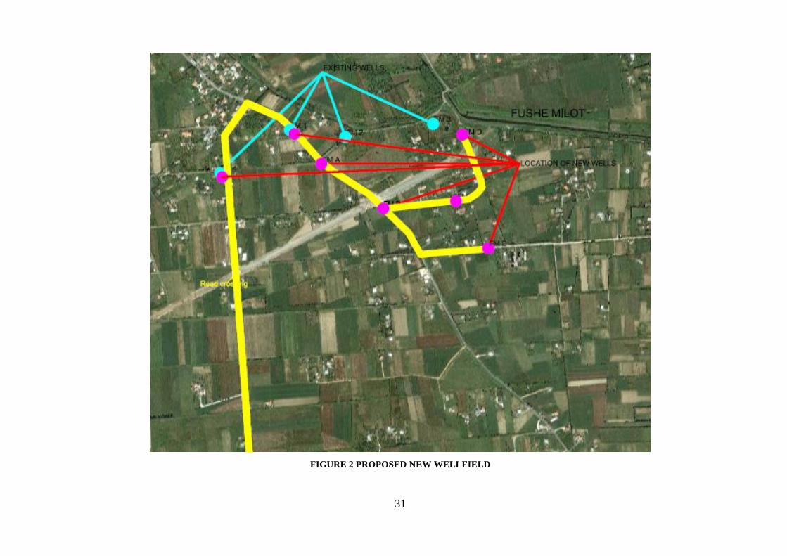
31
FIGURE 2 PROPOSED NEW WELLFIELD
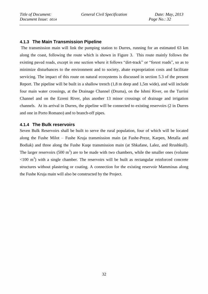
Title of Document: General Civil Specification Date: May, 2013
Document Issue: 001A Page No.: 32
32
4.1.3 The Main Transmission Pipeline
The transmission main will link the pumping station to Durres, running for an estimated 63 km
along the coast, following the route which is shown in Figure 3. This route mainly follows the
existing paved roads, except in one section where it follows “dirt-track” or “forest roads”, so as to
minimize disturbances to the environment and to society, abate expropriation costs and facilitate
servicing. The impact of this route on natural ecosystems is discussed in section 5.3 of the present
Report. The pipeline will be built in a shallow trench (1,8 m deep and 1,5m wide), and will include
four main water crossings, at the Drainage Channel (Druma), on the Ishmi River, on the Turrini
Channel and on the Ezreni River, plus another 13 minor crossings of drainage and irrigation
channels. At its arrival in Durres, the pipeline will be connected to existing reservoirs (2 in Durres
and one in Porto Romano) and to branch-off pipes.
4.1.4 The Bulk reservoirs
Seven Bulk Reservoirs shall be built to serve the rural population, four of which will be located
along the Fushe Milot – Fushe Kruja transmission main (at Fushe-Preze, Karpen, Metalla and
Bodiak) and three along the Fushe Kuqe transmission main (at Shkafane, Lalez, and Rrushkull).
The larger reservoirs (500 m3) are to be made with two chambers, while the smaller ones (volume
<100 m3) with a single chamber. The reservoirs will be built as rectangular reinforced concrete
structures without plastering or coating. A connection for the existing reservoir Mamminas along
the Fushe Kruja main will also be constructed by the Project.
Title of Document: General Civil Specification Date: May, 2013
Document Issue: 001A Page No.: 33
33
FIGURE 3- ROUTE OF PROPOSED MAIN TRANSMISSION PIPELINE FROM NEW PUMPING STATION
TO DURRES

Title of Document: General Civil Specification Date: May, 2013
Document Issue: 001A Page No.: 34
34
FIGURE 4- ROUTE OF PROPOSED MAIN TRANSMISSION PIPELINE FROM WELLSFIELD TO
PUMPING STATION
4.2 The socio-economic context
As mentioned in previous works of consultants involved in the analyses of Durres region and the
surroundings, this region has been identified as the Europe’s fastest growing region in terms of
demographic increase. This area has also been rated as one of the fastest growing areas in economic
terms with growth’s forecasts over 65% in the next twenty years (ref.: EC/Landell Mills SIDTDR
project) 1
.
Within this region, the city of Durres has grown rapidly. Durres city and the Keneta's illegal
settlements in 2008, were counted a population of approx. 170,000 and in addition rural areas
surrounding the Industrial area of Porto Romano had approx. 30,000. The large Durres city area is
1 Regional Development Framework for the Tirana-Durres Region 2008-2027 – Action Plan, December 2007

Title of Document: General Civil Specification Date: May, 2013
Document Issue: 001A Page No.: 35
35
expected to progress to nearly 300,000 by 20272. The maps below present the development pattern
of Durres region from 1900 to 2007 and its projections to 20273.
FIGURE 5 PROJECTED DEVELOPMENTS OF DURRES TO 2027
4.2.1 Water demand in the Durres region
The Durres region (Districts of Fushe Kuqe, Fushe Kruje, and Kavaja) has grown rapidly (see the
above tables in chapters 6.9.1 and 6.9.2). Since the mid-1990s, massive new suburbs have been
developed, where most of the buildings are still illegal without planning permission. Consequently
these new settlements have no official water system connection; many of them have illegal
connections of electricity and/or water and very low percentage of buildings have waste water
connections.
In this context the property issues are very complex and often not documented with official
registration, in some cases dwellings have been built on someone else’s land and it’s very difficult
to understand and define property rights. Furthermore many areas in the city centers have been
intensively redeveloped with apartment blocks of up to twelve floors replacing buildings only two
2 Rapid Environmental Assessment for the Industrial and Energetic Park's at Porto Romano, Durres, Albania, 25
th
May 2008 and Regional Development Framework for the Tirana-Durres Region 2008-2027 – Action Plan,
December 2007. 3 Rapid Environmental Assessment for the Industrial and Energetic Park's at Porto Romano, Durres, Albania, 25
th
May 2008 and Regional Development Framework for the Tirana-Durres Region 2008-2027 – Action Plan,
December 2007.

Title of Document: General Civil Specification Date: May, 2013
Document Issue: 001A Page No.: 36
36
floors high. The development has affected both residential zones, industrial areas, holiday homes
and services areas. A large industrial area (about 20 km length) has been developed along-side the
eastern end of the highway which joins Tirana and Durres.
A strip of holiday homes of nearly similar length has sprung up along the south coastal area of
Durres. About a dozen private universities have been opened. Tourism influx considerably
increases water demand especially during the peak summer season (June-July-August). These
developments have jointly caused considerable increase in water demand in the last decade. The
assessment of water demand includes all the main consumption sources:
Domestic use;
Institutional and small industries;
Industries;
Tourism sector;
Pipe and network losses.
The Inception Report of COWI4 provides water demand projections as follows:
2010: The total water demand for Durres and rural area along Fushe Kuqe main during a peak
summer day (weekend) is 87,539m3/day (1,013 l/s). Comparing this to the production of
65,664m3/d (760 l/s) and a calculated consumption along the main of 27,159m3/d (314.385 l/s)
gives a deficit of 21,875m3/d (253.19 l/s) for the town. This is clearly reflected in the fact that only
once per day there is enough water to feed the major supply lines and fill the house storage tanks.
The calculated deficit per capita is around 70 l/c/d or 47 % of the actual demand.
FIGURE 6- PROJECTED WATER DEFICIT FOR DURRES CITY
4 4 Validation and Finalisation of Feasibility Study and Preparation of Preliminary and Detailed Design for Bulk
Water Supply Line to Durres Region – Inception Report COWI 29th
August 2011.
0
200
400
600
800
1000
1200
1400
1600
2010 2020 2030
Lite
rs p
er
seco
nd
Year Demand Production Durres city deficict

Title of Document: General Civil Specification Date: May, 2013
Document Issue: 001A Page No.: 37
37
2020: If present supply levels remain unchanged, by 2020 the deficit will be doubled. The total
water demand for Durres and rural area along Fushe Kuqe main during a peak summer day
(weekend) will be 110,262 m3/day (1,275 l/s).
Comparing this to the production of 65,664m3/d (760 l/s) and a calculated consumption along the
main of 34,261 m3/d (396.55 l/s) gives a deficit of 44,578 m3/d (515.96 l/s) for the town. The
calculated deficit per capita in 2020 will then reach 110 l/d or 73 % of the present demand.
2030: The situation will be severely aggravated unless production is increased. The total water
demand for Durres and rural area along Fushe Kuqe main during a peak summer day (weekend)
will be 119,304.76m3/day (1,380.84 l/s). Comparing this to the production of 65,664 m3/d (760 l/s)
and a calculated consumption along the main of 37,609.13 m3/d (435.29l/s) gives a deficit of
53,640 m3/d (620.84 l/s) for the town. The per capita deficit in 2030 is estimated at around 120 l/d
or 82 % of the present demand.
4.2.2 Water Demand in the Rural Area
The Socio-Economic survey5 has highlighted indications that the services provided for the rural
area are not satisfied for the population according to the standards of life. Main findings are
presented below:
The respondents declared that they generally have access to basic services, 97% to electricity and
only about 77.4% have access to water. The results of the survey show that communities have not
proper access also to the sewerage system, while resulting that only 60% of them have access to
regular system.
When analyzing the access to water as per project implementation sites, it is observed that rural
areas have less access to water supply, especially the Communes of Fushe Kuqe and Thumane,
where respectively 4% and 2.2% of their communities have access to water. It is noted that access
problems are related much more to reliable supply of water than to actual household connections.
Between urban areas, the community in the municipality of Mamurras has less access to water
which is of comparable level to rural areas, respectively 2.2%. While, community of Durres
municipality has more access to water and is followed by the municipality of Sukth and Manza,
respectively 25.4%, 19.2% and about 16%.
Communities of the surveyed areas have as the primary source of water the piped into their
houses/apartments (60.2%), but this is slightly higher share from those community members who
5 DRN- ACER . “Final Analytical Report of January 19th 2012.
Title of Document: General Civil Specification Date: May, 2013
Document Issue: 001A Page No.: 38
38
receive water through the wells in their yard (18.6%). The percentage of private well usage shows
the lack of water supply in the respective areas, and lack of access to the pipelines especially in the
rural areas. In addition, 14% of the respondents declared that they have access to water supply
system, but access water through piped into yard or plot.
Private wells in the yard of the households are more frequently being reported in Manza
Municipality in 26.2% of cases (17 HH use private wells out of 45 surveyed in the area), in Durres
Municipality in 20% of cases. The communities who have access to water piped into houses are the
Municipality of Durres and Sukth. However, there is evidence that in Ishem commune majority of
respondents access water through piped into the yard or plot, showing for poor water infrastructure
in their houses, which is an indicators or poverty, lack of resources to install water pipe into the
house, or poor pressure of the water supply system to reach their reservoirs. In Manez there are 6
households access water only through the spring in the village.
The results of the SA survey show that Water is used more for drinking (99%), hygiene (95%),
cooking (89%) and less for irrigation (27%). However, 37.3% of the respondents consider the
water quality as below average (somehow, bad and very bad) and 62.7% above average (good 46%
and very good 17%).
Respondents were asked on average how much do they currently pay for their monthly provision of
water supply and how much they will pay in case of provision of a better water supply service.
………. The households would pay slightly more money in case they would be provided with more
water and better service (appropriate pressure, etc)
4.2.3 Social impact of the project
The main pipeline transmission route and the location of all project components have been
designated in such a way as to minimize the need for expropriation and resettlement.
Expropriation of land for the rehabilitation of the existing wellfield at Fushe Milot and in some
locations along the main pipeline transmission route has been assessed in depth by the consultancy
group DRN- ACER. A separate report regarding social impact assessment of project “Durres Water
pipeline Resettlement action plan and Social Assessment” has been prepared. In addition to this
study, a specific study is performed for resettlement and land acquisition requirement of project. In
that respect a study report named as “Resettlement Action Plan (RAP) and Resettlement Policy
Framework (RPF)” was prepared in January, 2013, in compliance with the Albanian Law on Land
Acquisition and the World Bank’s OP 4.1.2.
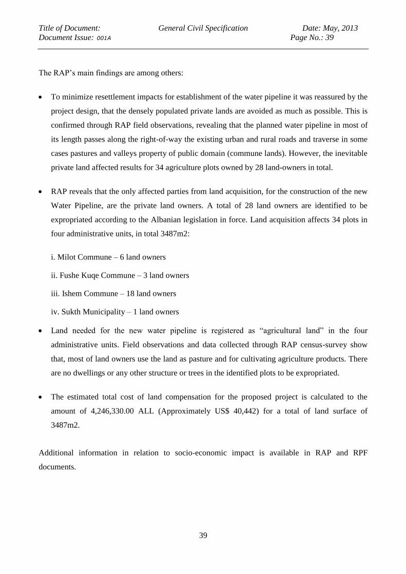
Title of Document: General Civil Specification Date: May, 2013
Document Issue: 001A Page No.: 39
39
The RAP’s main findings are among others:
To minimize resettlement impacts for establishment of the water pipeline it was reassured by the
project design, that the densely populated private lands are avoided as much as possible. This is
confirmed through RAP field observations, revealing that the planned water pipeline in most of
its length passes along the right-of-way the existing urban and rural roads and traverse in some
cases pastures and valleys property of public domain (commune lands). However, the inevitable
private land affected results for 34 agriculture plots owned by 28 land-owners in total.
RAP reveals that the only affected parties from land acquisition, for the construction of the new
Water Pipeline, are the private land owners. A total of 28 land owners are identified to be
expropriated according to the Albanian legislation in force. Land acquisition affects 34 plots in
four administrative units, in total 3487m2:
i. Milot Commune – 6 land owners
ii. Fushe Kuqe Commune – 3 land owners
iii. Ishem Commune – 18 land owners
iv. Sukth Municipality – 1 land owners
Land needed for the new water pipeline is registered as “agricultural land” in the four
administrative units. Field observations and data collected through RAP census-survey show
that, most of land owners use the land as pasture and for cultivating agriculture products. There
are no dwellings or any other structure or trees in the identified plots to be expropriated.
The estimated total cost of land compensation for the proposed project is calculated to the
amount of 4,246,330.00 ALL (Approximately US$ 40,442) for a total of land surface of
3487m2.
Additional information in relation to socio-economic impact is available in RAP and RPF
documents.

Title of Document: General Civil Specification Date: May, 2013
Document Issue: 001A Page No.: 40
40
5 RISK ANALYSIS AND ENVIRONMENTAL IMPACTS
5.1 Water resources The description of water resources (groundwater, surface water), pollution and seawater intrusion
threats, recharge and flow of the aquifer are presented in the following sections. More detailed
description of these aspects is provided in Annex 1 to the present report.
In order to define the potential environmental impacts with the transmission main and the wellfield
area, the main and hydro-geological and hydrological characteristics have been analyzed. A
summary of this analysis study is given in Section 5.1.1. As shown in Figure 7, the area of existing
wellfield covers the Fushe Kuqe Plain, whose total surface amounts to about 45 km2 and belongs to
the Southern part of the Mati River basin. To the North, the area is bordered by the Mati River. To
the East, this plain is borders with a mountain ridge with peaks that reach up to 600 - 800 m.a.s.l.
The Southern West border are the Adriatik villages; whereas to the West the Fushe Kuqe Plain
borders on the Adriatic Sea and towards the South East is confined to Fushe Kruja Plain. The Plain
consists of a flat terrain gently sloping towards the sea, with elevations ranging < from 0 - 8 m.a.s.l.
The wellfield to be rehabilitated by the Project is located in the Fushe Milot Area, north-east from
the existing Fushe Kuqe Wellfield.
5.1.1 Hydrology
Rivers and channels
The Fushe Kuqe plain is a former marshland, which has been reclaimed and features an open
drainage system on its surface, with a final pumping station (hydrovore) that discharges the drained
water into the Adriatic Sea. As shown in Figure 8, main hydrological feature of the Fushe Kuqe
Plain is the Mati River, which forms the area's natural northern border. The Mati River’s catchment
area is 2441 km², the main tributary of it is Fani River, that flows from the north eastern mining
district of Rubik and Rreshenin the Lezhe County to its confluence with the Mati River near the
town of Milot while Mati itself flows from the south East Diber County to its confluence with Fani
and then to the west meandering through the flat plain area with an average gradient of around 0.5 -
0.6 m/km, to its estuary into the Adriatic Sea, near the city of Lezhe.
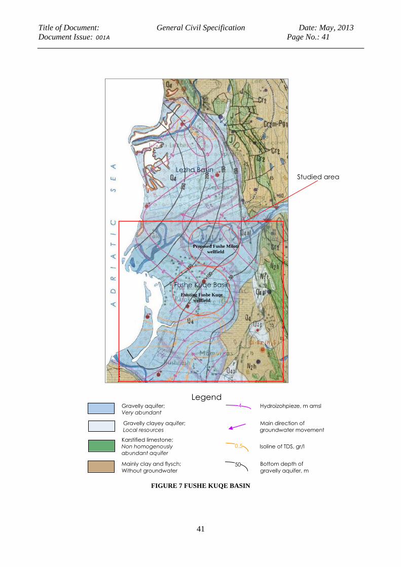
Title of Document: General Civil Specification Date: May, 2013
Document Issue: 001A Page No.: 41
41
FIGURE 7 FUSHE KUQE BASIN
16
Figure 5: Hydrogeologic map of Mati River delta (northern sector of Tirana-Ishmi depression).
From the Hydrogeological Map of Albania, scale 1:200.000.
Fushe Kuqe Basin
Legend
Gravelly aquifer; Hydroizohpieze, m amsl
Very abundant
Gravelly clayey aquifer; Main direction of
Local resources groundwater movement
Karstified limestone;
Non homogenously Isoline of TDS, gr/l
abundant aquifer
Mainly clay and flysch; Bottom depth of
Without groundwater gravelly aquifer, m
4
50
0.5
Studied area Lezha Basin
Existing Fushe Kuqe
wellfield
Proposed Fushe Miloti
wellfield
Title of Document: General Civil Specification Date: May, 2013
Document Issue: 001A Page No.: 42
42
In the upper reaches of Mati River, two hydroelectric power plants and associated dams were
constructed in the past (1952-1970). Therefore, the natural regime of the Mati River has been
completely changed, but this happened before development of Fishe Milot Wellfield in 1960’s; the
Fani River, on the contrary, has maintained its natural regime.
Downstream of its confluence with Fani in the plain, the flow of Mati River can be considered as a
sum of the continuous discharge from the hydropower plants and flow of Fani River. The discharge
from the hydropower plants varies between 10m3/s and 15m3/s with peak flows of more than
50m3/s. 6
FIGURE 8 RIVER MATI AND ISHMI BASINS
The Fani River exhibits a very variable discharge ranging from a mean minimum monthly flow of
about 10m3/s in August to a mean maximum monthly discharge of about 71m3/s in January with an
annual average of around 45 m3/s.
6 The Institute of Hydrometeorology of Albania).

Title of Document: General Civil Specification Date: May, 2013
Document Issue: 001A Page No.: 43
43
Records between 1951 and 1985 indicate that the Mati had a mean annual discharge of 103m³/s, of
which 60m³/s e from the Mati itself and 42m³/s from the Fani. The resulting specific discharge was
about 40 l/s.km² and the runoff coefficient 0.75.
The river’s annual discharge volume is 3,250 million m³ , specific discharge is 40 l/s.km², with a
ratio of 10 between the wettest month (December) and the driest month ( August); the storage
capacity of Ulza reservoir hydropower plants is 240 million m³ (about 15% of annual flow of the
Mati).
In the southern part of the plain the Rivers Zeza and Gjole cut through the plain and then flow into
the Ishem River. In the River Terkuza , flows of between 0 to 14 m3/sec are reported (the source
river of the Gjole River is the River Tirane, this flows along the northern outskirts of Tirana and
joins the River Tërkuzë, near Preze, to form the Gjole). The River Droja flows across the center of
the plain and then into the sea at the town of Adriatik (flow data unavailable).
Surface water quality and pollution loads
The quality of water was investigated in several studies which concur in indicating the presence of
heavy metals in the waters of the Mati river basin. Chemical analysis of samples taken from the
Mati before 1990 when the polluting industries were in operation showed a high content of metallic
ions (iron, manganese and copper), The impacts on irrigated agriculture and human health are not
fully assessed and the implications for marine coastal waters are also not clear 7
The most recent (2010) tests of chemical pollution of the Mati and Shkumbini rivers, found
concentrations of Chrome, Nickel, Zinc, Cadmium, Copper and Arsenic exceed the maximum
acceptable values. These appear to be based on residual deposits in the river basin sediment, rather
than the water itself. Relatively high concentration of Cu in sediments of river Mati reflect both the
natural background value of heavy metals minerals from geological characteristic of rocks in the
area, and the pollution from dumps of solid wastes of mines and former metallurgical plants.
Especially important contributors of this type of pollution are the dumps in Fani river banks (as in
Repsi, Rresheni and Rubiku) and numerous mining works in Sparci and Kader Sparci slopes, from
which acid waters drain, including also the natural leaching of surface outcrops of mineralized
zones. It was estimated that the Fani River transports each year 1 ton Cu, 1.5 ton Zn, 27 ton Fe and
800 ton S. Remediation measures including closing of a hot spot dump site related to these
materials has been carried out with the support of the European Commission. Furthermore, over 6
water quality testing samples have been taken in the four existing wells by the Geological Survey
7 The Institute of Hydrometeorology of Albania
Title of Document: General Civil Specification Date: May, 2013
Document Issue: 001A Page No.: 44
44
Institute during the period 2009-2013 in the Fushe Milot wellfield area and all results showed water
quality across a broad array of standard indicators to be within acceptable limits.
5.1.2 Aquifer and Groundwater
Hydro geological characteristics
The Fushe Kuqe Plain is a multilayered artesian aquifer system formed by alluvial deposits with
permeable layers of gravel and sandy gravel. According to the existing hydro geological studies,
clay and silt deposits seem to cover progressively these permeable deposits, which outcrop along
the Mati River in the Northern part of the Plain in a South- Western direction. Only in the area
along the Mati River where are outcrops of gravelly deposits, the aquifer system can be found
partially unconfined. In the Northern part of the Fushe Kuqe Plain, along the Mati River where the
proposed Fushe Milot Wellfield is located, the aquifer is considered as continuous, whereas towards
the South, there are two intermediate clay layers characterized by a variable thickness of 10 till 20
m and enable the generation of three aquifer horizons.
First and second aquifers are separated by a clay layer with a variable thickness of 15 to 30 m. The
upper aquifer is partly unconfined in the recharge area, and partly in confined conditions at Ishmi
River section. On the other hand, second aquifer is mainly in confined condition, which gives
advantage for protection from surface contamination. In the Fushe Kruja area the groundwater flow
direction has been established as being predominantly south-east to north-west, while in the south
part of aquifer, from Fushe Kuqe area, the flow is from the north-east to the south-west. A
piezometric map of the upper aquifer, based on measurements made by the Hydro geological
Institute in 1983, confirms Lotti’s (1993) observation that in the Fushe Kruje area the direction of
groundwater flow was predominantly south-east to north-west and in the Fushe Kuqe area it was
north-east to south-west. In the northern part of Fushe Kuqe plain, this map suggests that the major
source of recharge is close to where the River Mati flows into the plain. The static level of
underground waters varies from 2.5 m above the surface in Fushe Kuqe village to 2.25 m below the
surface in the south in Fushe Milot.
Anthropogenic influences on the aquifer system
The Fushe Kuqe Plain is mainly extracted by two wellfields located in the Fushe Kuqe and in the
Fushe Milot area. Increase in the extraction of groundwater has increased over the years, and now
reached a limit where significant increase in extraction may produce the risk of seawater intrusion,
especially in Fushe Kuqe region. However, the Project will not contribute to this situation, as

Title of Document: General Civil Specification Date: May, 2013
Document Issue: 001A Page No.: 45
45
planned extraction rates for Fushe Milot Wellfield will be maintained to originally extracted
amounts in that Wellfield, which is 500 l/s.
This is because piezometric levels have been altered over the years by effect of such extraction,
such that the flow of the aquifer has been modified: it is possible to estimate the total fall in
groundwater levels in Fushe Kuqe as being between 3.5 and 5 m over the period 1963 to 2001.
The groundwater resource is also extracted by both deep and shallow private wells. In the Fushe
Kuqe Plain there are 115 drilled wells; these wells are used by local inhabitants to ensure the water
supply of small communities. Most of these wells only reach the first aquifer layer, but some of
them, drilled for exploration purpose only, have reached the third aquifer layers.
Groundwater flow balance and potential resource
The recharge of the aquifer system mainly seems to occur in the Northern part of the Plain by
infiltration from the Mati River’s surface waters through its banks , and in the Eastern part
partially by groundwater inflow from the lateral outcrops of limestone rocks bordering the Plain,
plus inflow from precipitations.
In the north, the smaller contribution from Mati River is partially offset by inflows from the sea and
groundwater infiltrations from the north. These are no excess flow to sea or to rivers (1285 l/s in
Lotti’s balance). In fact the opposite occurs: the groundwater depression in the north, created by the
wellfield in Fushe Kuqe, is responsible for inflows from the sea.
Groundwater Recharge
As is already known, the main recharge source for the groundwater of the Fushe Kuqe plain is Mati
River, which riverbed gravel deposits has direct connection with the gravelly aquifer layers. The
recharge can be estimated via the calculation of the natural groundwater flow in an aquifer section
perpendicular to the flow direction.
The calculation is done applying Darcy’s law :
Q = KxMxLxI
In which:
K – is the average coefficient of permeability of the aquifer in the area, in m2/day;
M – is the thickness of the aquifer along the section of calculation in m;
L – is the total width of the aquifer section perpendicular to the groundwater flow in m ;
I – is the average gradient of the groundwater flow.
Title of Document: General Civil Specification Date: May, 2013
Document Issue: 001A Page No.: 46
46
The total natural groundwater flow in a section with orientation NW-ES, which is located parallel to
and in immediate vicinity to the piezoizohipse elevation 4.0m amsl (plate 1) can therefore be
estimated as follows:
Q = 180m/day * 60m * 6000m * 0.003 = 194.400m3/day = 2250l/s
Groundwater Discharge
The groundwater discharge occurs mainly by extraction via wells through pumping or free
flowing artesian discharge, and through groundwater flow to the Adriatic Sea.
From Fushe Kuqe well field (7 wells for Durres water supply) 900 l/s
From Milot (2 wells) 30 l/s
From Laçi plain (2 wells) 40 l/s
From Fushe Kuqe plain (4 wells for Fushe Kuqe Commune water supply) 90 l/s
Free flowing wells and private wells (about 250) 150 /s
Total 1210 l/s
Groundwater drainage to Adriatic Sea
Fushe Kuqe groundwater system has two gravelly aquifer layers. Most of the groundwater is
extracted from the first aquifer layer while the groundwater of the second aquifer practically is
totally drained into the Adriatic Sea.
An indirect estimation of the groundwater drainage to the Adriatic Sea can be done as the difference
of the total groundwater flow and the groundwater extraction:
2250 - 1210 = 1040 l/s
The calculated value should be verified by updating the hydropizometric contour map for the first
aquifer layer and the compilation of such a map for the second one. Based on the existing data, it is
difficult to calculate the water quantity drained in the Sea separately by each aquifer layer.
Groundwater Balance
Using the above computed figures, the groundwater balance of the Fushe Kuqe Hydrogeological
system can be summarized as below:
Recharge, l/s Drainage l/s
Recharge from Mati River 2250
Title of Document: General Civil Specification Date: May, 2013
Document Issue: 001A Page No.: 47
47
Extraction from pumping wells,
and private wells 1210
Groundwater drainage into the sea 1040
Total 2250 l/s 2250 l/s
Groundwater quality
The chemical groundwater composition has been identified by analyses in the framework of
different studies. Generally, these analyses indicated low groundwater mineralization as well as a
chemical composition and bacteriological conditions in compliance with the requirements of
potable water.
In terms of groundwater quality and hydraulic properties, Fushe Kuqe basin is divided into four
regions. The identification of the regions is based on the hydraulic properties of the aquifer and on
hydro-chemical characteristics of groundwater. These regions are shown in Figure 9.
Region 1 includes the southern portion of Fushe Kuqe basin, from Goreja village in the north, to the
southern border of the study area (See Figure 9). This is the area with lower values of hydraulic
parameters and mostly with bad quality groundwater. The average parameters of this area are as
follow:
Coefficient of filtration, K 50-170 m/d
Coefficient of transmissibility, T <1000 to 4000 m2/d
Specific capacity of wells, q < 10 to 30 l/s/m
Groundwater chemical type HCO3-Mg-Ca, HCO3-Cl-Na
Total dissolved solids 0.5 to more than 1000 mg/l
Total hardness 10 to 30 °German
Cl concentration 50 to more than 300 mg/l
From the Region 1 good quality groundwater for the water supply could not be provided. It could
even be stated that the mineralized water of Region 1 could deteriorate the water quality of Durres
Fushe Kuqe well field, if the groundwater extraction should be increased in the future.
Title of Document: General Civil Specification Date: May, 2013
Document Issue: 001A Page No.: 48
48
Region 2 includes the area located west to Fushe Kuqe well field which includes the Patok seashore
area. This is the intermediate zone between Fushe Kuqe well field and Adriatic Sea. This zone at
most has good hydraulic parameters and good quality groundwater. The average parameters of this
area are as follow:
Coefficient of filtration, K 50-170 m/d
Coefficient of transmissibility, T <1000 to 4000 m2/d
Specific capacity of wells, q < 10 to 30 l/s/m
Groundwater chemical type HCO3-Mg-Ca, HCO3-Cl-Na
Total dissolved solids 0.5 to more then 1000 mg/l
Total hardness 10 to 30 °German
Cl concentration 50 to more then 300 mg/l
Only small diameter wells for private water supply with capacity no bigger than 1 l/s could be
drilled in this region; the extraction of water for irrigation is strong. In Region 2, it is not
recommended to drill water supply wells due to the reason of piesometric depression that might
cause seawater intrusion. Therefore, this area should be kept under serious monitoring.
Region 3 includes the central-north part of Fushe Kuqe basin; this is the transit area for
groundwater flowing from recharge area to the discharge one, which is Adriatic Sea. In the western
part of this area are located the extraction wells for Durres water supply. The average parameters of
this area are as follow:
Coefficient of filtration, K about 150 to 2700 m/d
Coefficient of transmissibility, T about 4000 to 7000 m2/d
Specific capacity of wells, q about 20 to 50 l/s/m
Groundwater chemical type HCO3-Ca-Mg; HCO3-Mg-Na
Total dissolved solids about 200 to 300 mg/l
Total hardness 5 to 10 °German
Cl concentration about 10 to 20 mg/l
As seen in the hydrogeological map around the Fushe Kuqe well field is created a piesometric
depression with maximal drawdown about 4.0 to 4.5 m. If for future water needs we will rely on the
drilling of extraction wells in Region 3, by no means the existing piesometric depression can be
increased both as surface, as well as depth. This can compromise the groundwater quality. This is
the reason that the groundwater extraction from Region 3 cannot be increased; in this area should
not be drilled other big quantity large diameter wells. Only small diameter wells, for private water
supply wells, each well capacity no bigger than 1 l/s could be drilled.

Title of Document: General Civil Specification Date: May, 2013
Document Issue: 001A Page No.: 49
49
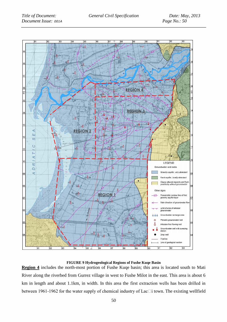
Title of Document: General Civil Specification Date: May, 2013
Document Issue: 001A Page No.: 50
50
FIGURE 9 Hydrogeological Regions of Fushe Kuqe Basin
Region 4 includes the north-most portion of Fushe Kuqe basin; this area is located south to Mati
River along the riverbed from Gurrez village in west to Fushe Milot in the east. This area is about 6
km in length and about 1.1km, in width. In this area the first extraction wells has been drilled in
between 1961-1962 for the water supply of chemical industry of Lac i town. The existing wellfield
Title of Document: General Civil Specification Date: May, 2013
Document Issue: 001A Page No.: 51
51
consists of 7 wells, the capacity of which is about 70 l/s each. The project will construct 2 new
wells next to 2 existing wells that are no longer operational, and drill 4 additional wells within 50
meters of the existing wells. The depth of the wells is mostly about 30 to 60 m. The average
parameters of this area are as follows:
Coefficient of filtration, K about 200 to 350 m/d
Coefficient of transmissibility, T about 5000 to 8000 m2/d
Specific capacity of wells, q about 25 to 75 l/s/m
Groundwater chemical type HCO3-Ca-Mg
Total dissolved solids about 150 to 200 mg/l
Total hardness 5 to 8 °German
Cl concentration about 10 mg/l
This area has the better hydraulic conditions; because the hydraulic parameters are very high, the
area is near the river and the future wells could be recharged through the induced infiltration. As the
new wells (proposed Fushe Milot wellfield) should be recharged by the induced infiltration, the
drawdown should be relatively small. This way the influence of the new wells in the extraction
wells of Fushe Kuqe basin should be minimal.
5.1.3 The expected impacts during the construction phase
The surface water system is not expected to suffer any notable impact during the construction
phase. On the other hand, during the drilling of the new wells, special attention is required if these
should be reaching the deep water table.
This is because of the risk that the new wells will cause water to flow from the semi-confined and
partially confined upper water table, into the deeper water table; such flows may be affected by
pollution from fertilizers and other pollutants affecting the aquifer where it runs nearest to the
surface.
For this reason, technical measures (described in the further sections of this report) will need to be
taken, so as to avoid that, by drilling the wells, communications are established between the
different levels of the water table.
5.1.4 The expected impacts during the project’s life
The analysis of the impacts were performed on water resources management, conservation,
overexploitation of groundwater resources, quality and control of water pollution. Special attention
was given to the aspects connected to environmental sustainability of the aquifer exploitation.

Title of Document: General Civil Specification Date: May, 2013
Document Issue: 001A Page No.: 52
52
By using groundwater numerical flow models (Strazimiri 1995 and COWI 2011) it has been
possible to analyze the possible futures scenarios. The models were used to make predictive
analysis, but there are several limitations. The results of the models also identified several risks
linked to changes in the state of the environment, although these are much less relevant to the
situation on the ground, since the Fushe Milot Wellfield Area is already widely and heavily
subjected to anthropogenic pressure. In respect to cumulative impact on groundwater sources, the
rehabilitated Fushe Milot Wellfield site has been identified in line with numerical flow model. The
model also shows that Fushe Milot Wellfield area has no impact on Fushe Kuqe Basin in terms of
saline water intrusion.
5.1.5 The investigations considered as necessary before project implementation
A new groundwater model for Fushe Kuqe Basin should be set up and calibrated against current
piezometric data. The model should be based on the more sophisticated MODFLOW and SEAWAT
code. Construction of a mathematical model in order to provide a reliable groundwater balance, and
understanding of piezometric trends for different groundwater exploitation scenarios, especially for
the areas where future piezometric levels will be near or below sea-level (See Strazimiri et al 1995).
5.2 Geological and soil system
In evaluating the geological and soil component, the consultants have examined and synthesized all
the geological characteristics of the study area , such that it was possible to assess the relationship
and the impact of the infrastructures being planned with the in the wellfield area and along the
route of the planned main pipeline.
Therefore an overall picture has been drawn, based on the lithology the morphology and the
exogenous phenomena, forming the baseline from which the consultant has then focused more
specifically on the interaction between the proposed infrastructure and the surrounding geological
environment. Such information has then allowed us to identify the sectors which are most
vulnerable from the point of view of morphologic stability and /or exposed to hydro geological risks
and to identify the mitigation measures to be undertaken.
5.2.1 Geology and lithology
In general terms, the areas affected by the well fields and the transmission line forms part of the
deposition of the upper cretaceous, the Tortonian, the lower Pliocene and the quaternary. Deposits

Title of Document: General Civil Specification Date: May, 2013
Document Issue: 001A Page No.: 53
53
of the upper cretaceous are present in the eastern part and limited spreads appear in the north-
eastern part of zone too. These deposits are dolomites combined with carbonate dolomites and
bioclasctic dolomites in thick layers. The thickness of the upper cretaceous deposition in the zone
varies from 250 m till 350 m. The Tortonian deposition spreads in the east of the zone. In the east, it
contacts with the upper cretaceous carbonates and in the west with the quaternary deposits.
Regarding lithology, they represent layers composed of siltstone, clays and sandstone. The lower
Pliocene is spread on the surface of the eastern part of the zone and under the quaternary deposits.
As to lithology, it represents combined layers of clays and sandstone. The quaternary deposits are
spread on the surface in the whole flat area.
The alluvial quaternary deposits consist of gravel, sandy gravel, and sand and to a small extent of
medium clays. The water bearing horizon is composed of gravel, sandy gravel and sands. They are
formed by a solid fluvial material sedimentation brought by Main River. The clays of medium grain
size, have a distribution in surface and cover the biggest part of the aquifer, they are placed above
the gravel layer which spreads in all the basin elongation. The clays are at shape of layers between
the gravels, their thickness ranges from 15 -30m.
5.2.2 Soil pollution and solid wastes
There was prior industrial activity and a solid waste disposal site near to the Fushe Kuqe wellfield
area. The possible risk is posed by mines and related industrial waste sites located at northern
section of the aquifer basin, in the former mining centers of Laci, Repsi, Rreshen and Kurbnesh.
The industrial activity ceased in 1990 and an EU-financed activity has enabled closure of the hot
spot with mine waste in an appropriate manner. Therefore, the proposed site is not under the risk of
direct groundwater pollution.
5.2.3 The expected impacts during the construction phase
Consideration of the different route variants for the main transmission pipeline in relation to the
geological and hydro geological characteristics of the area has resulted in the following
observations regarding the project’s potential impacts on soils.
Slope stability
At the time of trench excavation, special attention needs to be paid to the following main
lithological and geomorphologic conditions:
intersection of morph types of rapid evolution (cones, ground debris);
intersection or pass close to forms of geomorphologic potential or actual disruption;

Title of Document: General Civil Specification Date: May, 2013
Document Issue: 001A Page No.: 54
54
Conditions of stability of the side walls of the excavation.
The construction of the main transmission pipeline may cause impact on morphological and
hydrological conditions. These problems occur mainly in the hilly tract of the pipeline where there
is a presence of numerous active and inactive landslides, typical of the clay land surface. These
areas may be subject to soil erosion and landslides already under way in an ex-ante situation. In
particular, between the towns of Safetaj, Bize and Reka Koder, along the link road where the
pipeline will pass, there, are clay deposits that give rise to forms of erosion (badlands) in evolution.
5.2.4 The expected impacts during the project’s groundwater extraction phase
Risk of land subsidence
Land subsidence is a possible consequence of wellfield impact on subsurface water, caused by the
compaction of compressible sediments in and around areas of extensive groundwater pumping.
Land subsidence attributable to the compaction of aquifer systems is an often overlooked hazard
and an environmental consequence of groundwater withdrawal.
The alluvial plain of Fushe Kuqe is especially vulnerable because surface-water supplies are limited
and groundwater in unconsolidated aquifer is extensively relied upon for agriculture and other
purposes, with unregulated extraction rates. The coastal regions also are commonly affected
because they are often underlain by unconsolidated, compressible coastal plain and shallow marine
sediments. Some of potential hazards and environmental consequences include damage to
engineered structures (such as buildings, roadways, pipelines, aqueducts, sewerages, and well
casings), earth fissures, enhanced coastal and riverine flooding, loss of saltwater- and freshwater-
marsh ecosystems, and reactivation of surface faults creating new potential pathways for surface
runoff to contaminate aquifers.
The risks related to localized land subsidence as an outcome of the operation of the Project related
facilities could materialize. However, this is very unlikely to occur given that the wellfield is being
rehabilitated to its prior production level and no such prior occurances have been observed.
However, to mitigate against this risk, the project will support development of the groundwater
model and diligent development and implementation of groundwater monitoring and changes of
Durres water Supply operating policies, as the case may be.
5.3 Natural habitats
Title of Document: General Civil Specification Date: May, 2013
Document Issue: 001A Page No.: 55
55
The Fushe Milot Wellfield is located in the hinterland of the natural reserve of Bregu i Matit, in a
rural area which has low ecological value and is not under any regime of protection. This area is
now heavily modified by agricultural and rural development, although in the orto-photograph's
maps of the project area it is still possible to see and read the ancient riverbeds which existed all
around the broad plain before the reclamation interventions (an example is the area surrounding
Patok).
The natural reserve of Bregu i Matit extends in the south of the Project to the mouth of Ishem River.
The route of the Project's pipeline will cross over the River through a pipe over it, producing no
relevant impact. From here the pipeline enters the Durres district crossing through a small
agricultural plain area which was drained several decades ago, and has a low ecological value.
Then the pipeline enters the hilly area of Ishmi, where the water pipeline follows rural roads that are
in very poor condition. The first section of the route passes near an open marine pine forest which is
developed on the lower northern slopes of the hills (North-East). Apart from this limited area, the
remaining forests are characterized by various Mediterranean scrub species and by a widespread
oak forest.
Descending along the southern slopes again of the hills, the pipeline enters a flat agricultural area.
Currently most of the area is occupied by farmland. Further along the route the first biotopes
encountered are those of Lalzi Bay, a Bay of sand with naturalistic value, because it constitutes the
source of sand which is deployed in the form of dunes accumulated through the wind action from
early embryonic dunes to those which are consolidated as mature ones. There are no erosion events
along the coast and at present it seems to be in balance with the supplied sediment of local rivers.
The pinewood forest is however threatened by two entrepreneurial initiatives in touristic sector
(residences/villas) and Golf courses.
After passing a drainage channel from the reclaimed area the pipeline continues on existing roads,
without affecting a coastal wetland characterized by a beautiful brackish lagoon of shallow water
which is a breeding and wintering site for many birds species (recent censuses of waterfowl have
identified this area as Important Bird Areas IBA: over 10,000 birds). Passing the drainage channel,
the pipeline’s route then follows existing agricultural ditches until it reaches the urban and
industrial area of Durres, crossing rural areas and gardens of private houses.
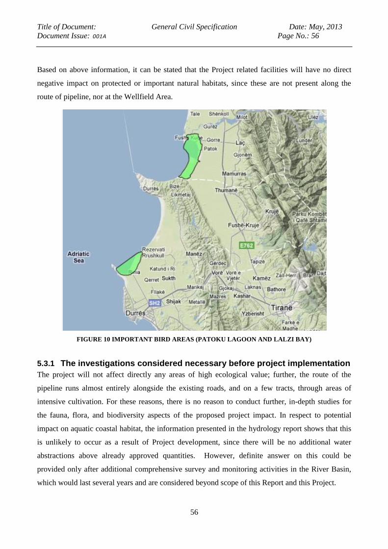
Title of Document: General Civil Specification Date: May, 2013
Document Issue: 001A Page No.: 56
56
Based on above information, it can be stated that the Project related facilities will have no direct
negative impact on protected or important natural habitats, since these are not present along the
route of pipeline, nor at the Wellfield Area.
FIGURE 10 IMPORTANT BIRD AREAS (PATOKU LAGOON AND LALZI BAY)
5.3.1 The investigations considered necessary before project implementation
The project will not affect directly any areas of high ecological value; further, the route of the
pipeline runs almost entirely alongside the existing roads, and on a few tracts, through areas of
intensive cultivation. For these reasons, there is no reason to conduct further, in-depth studies for
the fauna, flora, and biodiversity aspects of the proposed project impact. In respect to potential
impact on aquatic coastal habitat, the information presented in the hydrology report shows that this
is unlikely to occur as a result of Project development, since there will be no additional water
abstractions above already approved quantities. However, definite answer on this could be
provided only after additional comprehensive survey and monitoring activities in the River Basin,
which would last several years and are considered beyond scope of this Report and this Project.

Title of Document: General Civil Specification Date: May, 2013
Document Issue: 001A Page No.: 57
57
5.3.2 The expected impacts during the construction phase
The work to position the pipeline – especially at the building site itself- may produce some slight,
temporary, and localized forms of environmental impacts, which are reversible and temporary in
nature (these are related to noise, dust, traffic disturbance, temporary storage of material,
disturbance to local wildlife). Project implementation will not produce any significant conversion
of natural habitats, and the mitigation measures in respect to localized impacts could be fully
mitigated by applying site-specific measures specified in EMP and code of good construction
practice.
5.3.3 The expected impacts during the project’s life
The Project has no relevant negative impact on natural habitats and on land use; it integrates with
the existing national and regional development plans, and is not in conflict with the conservation of
natural habitats, neither in the area nor with the natural ecosystems.
The facilities to be constructed under the Project will not cause the conversion or degradation of
any natural habitats, nor will it negatively affect ecologically important species.
On the other hand, mitigation measures associated with the project could be an opportunity to
enhance the value of natural habitats, through mitigation measures which may support ecological
balance and reduce pressures on the eco system. The extraction of water from the deep underground
aquifer, if managed carefully and responsibly, will not affect the levels of the upper water table, thus
preventing any impact on natural habitats.
The route of the pipeline runs alongside the existing secondary roads for most of its extension, and
only a very minor part of the route affects agricultural or marginal areas, where the ex-ante
conditions may easily be restored once the main has been placed. The width and the depth of the
trenches to be excavated are small enough (less than 2 m wide and up to 3 m deep) that the absence
of negative impacts can be ensured by applying code of good construction practice. On the other
hand, such earth-moving works may improve, albeit only locally and marginally, the condition of
the local roads, which are presently in very poor state.
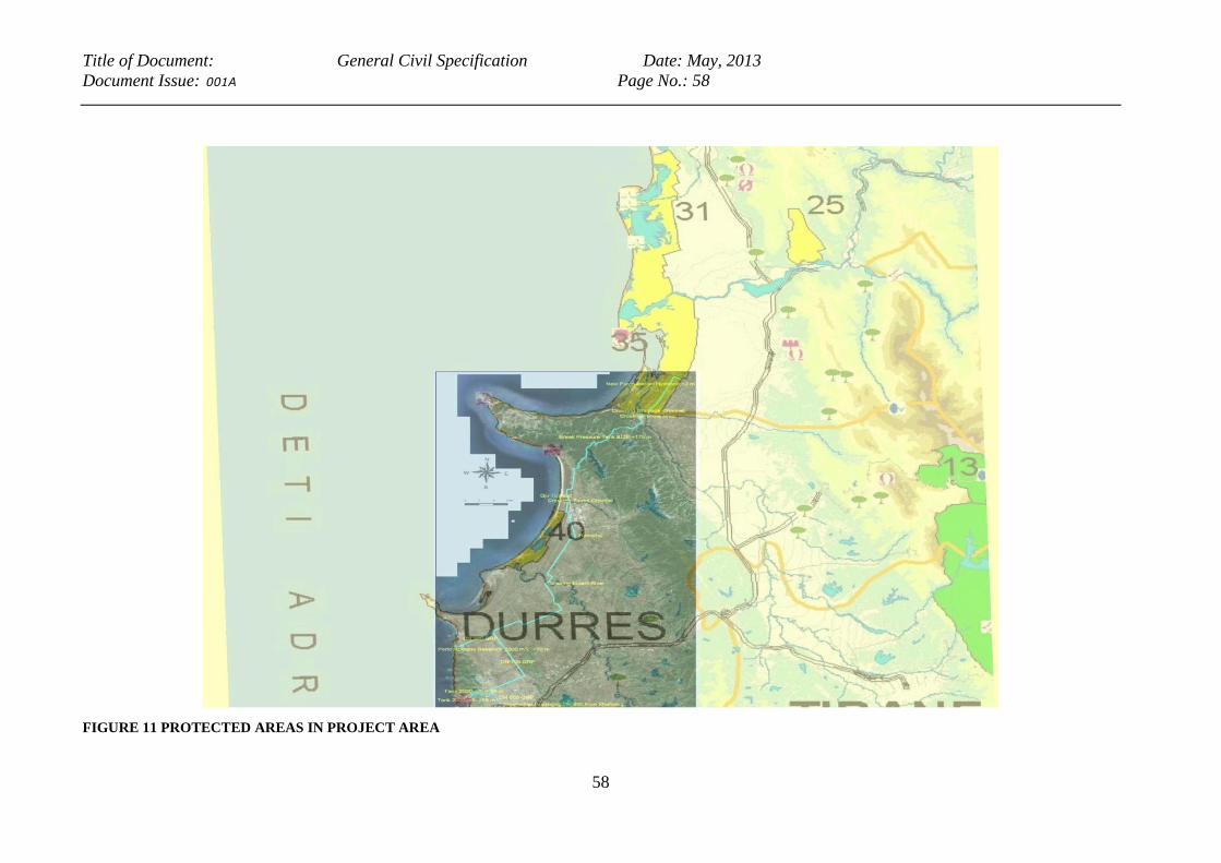
Title of Document: General Civil Specification Date: May, 2013
Document Issue: 001A Page No.: 58
58
FIGURE 11 PROTECTED AREAS IN PROJECT AREA

Title of Document: General Civil Specification Date: May, 2013
Document Issue: 001A Page No.: 59
59
As regards OP 4.36 Forest, the project will not produce any significant degradation or conversion of
critical forest areas and critical forest habitats. The route along the existing forest roads is selected
as transmission main route at places where the pipeline is to cross the hills. However, the impact on
forest areas is not expected, as the civil work related disturbance will be only along the existing
forest roads and affect strip which is less than 2 meters wide. Any potential negative impact is
therefore easily mitigated by application of good engineering practice. The forest crossing section
of transmission main is given in Figure 12.
FIGURE 12 EXISTING ROADS IN THE ISHMI HILLS AT PIPLEINE CROSSING
The project is not contradicting any international treaty or agreement concerning the environment.
Mitigating measures (which are detailed hereinafter), that include planting of vegetation will be
done using autochthonous trees suited for this bioclimatic region, in harmony with the site’s
potential vegetation as functional to the specific fito-sociological component , with the nature of
Title of Document: General Civil Specification Date: May, 2013
Document Issue: 001A Page No.: 60
60
soils, with the depth of the water table, of altitude and of exposure to sunlight, and also in harmony
with the neighboring habitats.
The project does not imply any gathering or commercialization of wood products. It does not
interfere with the vegetation biomass and with the potential productivity; nor does it have any effect
on the mechanization of forestry operations.
5.4 Air quality
5.4.1 Sources of atmospheric pollution and their potential impact on the project area.
Sources of air pollution in the project area are related with the urban/industrial areas of the Durres
city. The other major pollution source is the “Durres hot spot”. The Durres hotspot sites are former
industrial facilities where hazardous waste is causing unacceptable human exposure requiring
urgent risk reduction measures. One hotspot is the chemical waste storage located approximately 10
km north to the center of Durres City at the southeast foot of the Bishti Palles Cape. In this hotspot
there are three storage buildings overloaded with chemicals like carbon disulfide, methanol,
dimethyl amine, HCH residue etc. The second hotspot is the chromate plant, the chromate dumpsite
and the lindane at the former Durres chemical plant located about 6.5 north to the center of the city
of Durres and less than 1 km south of Porto Romano. The site is located on the Durres Plain, at the
foot of Durres Hills. The chromate waste was dumped between the former chemical plant and the
drainage channels in a layer approximately 1.5-2 m high. Two highly polluted areas represent the
Industrial area of Durres located about 3 km east to the city center, and the poultry farm located
about 5 km northeast to the city center. While most of the former industrial establishments currently
are not functioning the poultry farm is normally working. No specific studies of the transport of
pollutants by the atmosphere and rainfalls into the water have been made in Albania. Thus the
amount of chemical pollution, falling out into the surface waters through atmospheric settling is
unknown.
Car ownership has increased at least three times since 1990, traffic congestion has made movement
painfully slow and the resulting air pollution at key junctions is serious enough to damage health.
Further, the Durres landfill produces toxic fumes from the fires which are lit, and judged to produce
highly cancerogenic emissions (polyaromatic hydrocarbons, dioxin, etc.)8
8 “Rapid Environmental assessment for the Industrial and Energetic Parks at Porto Romano, Durres, Albania”
Landel Mills, May 2008

Title of Document: General Civil Specification Date: May, 2013
Document Issue: 001A Page No.: 61
61
5.4.2 The investigations considered as necessary before project implementation
While on the one hand atmospheric pollution certainly is a concern in the project area, especially
because of industrial pollution and the burning of waste, the project is expected to have an
insignificant impact on worsening this situation, as detailed in the paragraphs which follow.
Therefore, while it is definitely recommended that a major effort be deployed to address the issues
of solid waste collection and disposal and to solve the complex and pressing issue of environmental
hotspots and toxic pollution, this falls outside the scope of this Project. Consequently, it is
considered unnecessary to conduct further investigations of air quality for the specific purpose of
the present Project.
5.4.3 The expected impacts during the construction phase
Air quality during the construction of the will be locally affected by traffic and excavations.
The Albanian norm refers to the norms for emission to the air (VKM No. 435, date 12.09.2002) and
the norms for urban air quality (VKM No. 803, date 04.12.2003) respectively9.
Construction work like construction of reservoirs, tanks, pipelines, water plant, and wells can cause
pollution loads partly exceeding the norms limits, due to the earth moving machines and trucks.
However, air circulation towards and from the sea can be expected to affect air quality in a positive
way, such that the pollutant source could have only a point source effect.
No data on noise levels are available for the area. There are no significant point sources of noise
emissions. Vehicular traffic and associated noise emissions are associated mainly with the local
road connecting Tirana and Durres areas, and the traffic connected.
The construction works will generate noise from the earth moving machines, but only for a very
limited period of time, and further this will take place in sparsely populated areas (with the
exception of work taking place in Durres itself).
5.4.4 The expected impacts during the project’s life
The quality of air at the location of the pumping station will not be affected in a significant way by
the functioning of the plants, of the pumps and of the complementary gears.
During the exercise phase, that is to say during the running of the plant, impact on air quality due to
the movements of machinery will be negligible.
9 “Rapid Environmental assessment for the Industrial and Energetic Parks at Porto Romano, Durres, Albania”
Landel Mills, May 2008
Title of Document: General Civil Specification Date: May, 2013
Document Issue: 001A Page No.: 62
62
Noise caused by functioning of the plant is related to point sources such as electricity cabs, pumps
site, wellfields. The effects of these sources will be limited to a restricted area close to these sites.
The project is designed mainly in rural areas with wide cultivations, grassy fields, small villages
and scattered houses.
It is therefore concluded that the project’s operational phase will have no relevant impact on air
quality and noise.
5.5 Climate change
According to a recent World Bank study, Albania ranks amongst the most affected by climate
change among the ECA countries and the most vulnerable to its impacts10
.
The previous studies on the present project and on the water sector in Durres– including those of IC
Consulenten, and COWI) have not taken into account the impact of climate change. Although
predictions on climate change have a low degree of confidence, and high degrees of variable values,
they can be taken into account in planning the present project, so that adequate mitigating measures
against the risks from climate change can be built into the project’s design.
5.5.1 Rainfall
Projections for future scenarios, based on Global Circulation Models predict that rainfall will
diminish considerably (World Bank Climate Change Knowledge Portal)11
. The magnitude and
timeframe of this phenomenon is such that it is likely to have a relevant impact on the present
project.
Over the 2020-2039 period, GCMs predictions for Albania are of a variation in rainfall which the
models estimate with different levels, (but of 15 different GCMs, only 2 predict an increase in
rainfall, the remaining 13 concurring in predicting a decrease, with a peak of 32mm loss in the
month of October for one model, and 8 models showing peak losses of 20 plus mm in different
months).
10
Adapting to climate change in Europe and Central Asia, World Bank, June 2009 11
http://sdwebx.worldbank.org/climateportal/index.cfm?page=country_future_climate&ThisRegion=Europe&ThisCc
ode=ALB
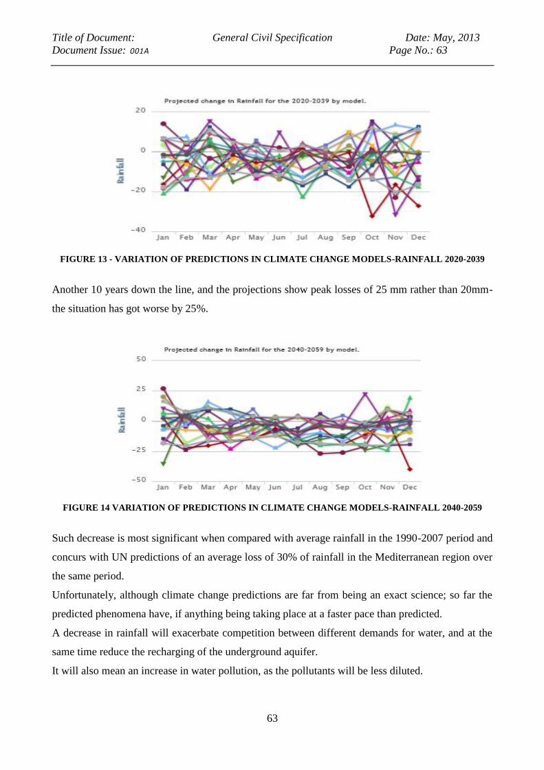
Title of Document: General Civil Specification Date: May, 2013
Document Issue: 001A Page No.: 63
63
FIGURE 13 - VARIATION OF PREDICTIONS IN CLIMATE CHANGE MODELS-RAINFALL 2020-2039
Another 10 years down the line, and the projections show peak losses of 25 mm rather than 20mm-
the situation has got worse by 25%.
FIGURE 14 VARIATION OF PREDICTIONS IN CLIMATE CHANGE MODELS-RAINFALL 2040-2059
Such decrease is most significant when compared with average rainfall in the 1990-2007 period and
concurs with UN predictions of an average loss of 30% of rainfall in the Mediterranean region over
the same period.
Unfortunately, although climate change predictions are far from being an exact science; so far the
predicted phenomena have, if anything being taking place at a faster pace than predicted.
A decrease in rainfall will exacerbate competition between different demands for water, and at the
same time reduce the recharging of the underground aquifer.
It will also mean an increase in water pollution, as the pollutants will be less diluted.
Title of Document: General Civil Specification Date: May, 2013
Document Issue: 001A Page No.: 64
64
At the same time, an increase in the frequency and intensity of extreme weather events will mean
faster water runoff – and consequently, a smaller percentage of the rainfall will be finding its way
into the aquifer. The CGMs return a prediction of drought affecting up to 3 million people in
Albania.
All of the above factors conjure in making the water supply systems more vulnerable, and increase
the urgency to develop a whole group of climate-resilient solutions related to sustainable use of
water resources. However, the activities related to climate change, although very important, are
considered outside the scope of this Project, and would need to tackled using concentrated efforts of
GoA and wide international community.
5.5.2 Sea Level Rise and Coastal Erosion
Among the effects of climate change, Sea Level Rise (SLR) is perhaps the most difficult to
quantify, as witness the fact that estimates vary considerably in the CGM-based predictions.
This is well represented in the figure below, projecting SLR in the Mediterranean under different
scenarios. According to these projections, Albania would be affected, but in less severe way than
other countries.
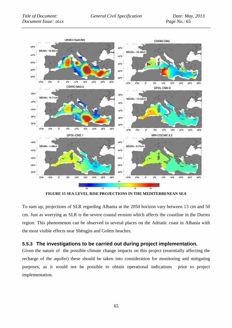
Title of Document: General Civil Specification Date: May, 2013
Document Issue: 001A Page No.: 65
65
FIGURE 15 SEA LEVEL RISE PROJECTIONS IN THE MEDITERRENEAN SEA
To sum up, projections of SLR regarding Albania at the 2050 horizon vary between 13 cm and 50
cm. Just as worrying as SLR is the severe coastal erosion which affects the coastline in the Durres
region. This phenomenon can be observed in several places on the Adriatic coast in Albania with
the most visible effects near Shëngjin and Golem beaches.
5.5.3 The investigations to be carried out during project implementation.
Given the nature of the possible climate change impacts on this project (essentially affecting the
recharge of the aquifer) these should be taken into consideration for monitoring and mitigating
purposes, as it would not be possible to obtain operational indications prior to project
implementation.

Title of Document: General Civil Specification Date: May, 2013
Document Issue: 001A Page No.: 66
66
5.5.4 The expected impacts during the construction phase
The impacts of Climate Change on the project will take place in the medium and long term;
therefore they will not affect its construction phase.
5.5.5 The expected impacts during the project’s life
Climate change is expected to have an impact on the project’s life, and at the same time, the project
itself will have an impact on how the region will be able to cope with climate change, through the
necessary adaptations. Adequate mitigating measures and monitoring will be required, as described
in the relevant sections of the EMP report. These are essentially the same ones which are foreseen
for the purpose of managing Water resources and cumulative impacts, the difference being that
climate change will be factored into the hydrological model and medium-long term projections will
be produced, on the basis of realistically foreseeable climate trends.
Variations in rainfall
These variations (decrease) will affect the water balance in the region, with resources becoming
increasingly scarce, and increasing competition over their use.
Higher loads of pollutants will impact on the quality of surface waters, and could threaten the
underground aquifers on which the Durres water supply relies.
The decrease in rainfall and the change in the intensity and frequency of rainfall will negatively
affect the recharge of the underground aquifers.
On the other hand, the new wellfield and pipeline can be a precious instrument for the management
of what safe water will be available in the region- but it may be necessary to review its utilization in
terms of balancing its distribution between different stakeholders in the region, rather than
dedicating 100% of the resource to the sole use of the Durres urban population.
SLR and Coastal erosion
Both of these phenomena are likely to increase the risk of saline intrusion, which would have a
direct impact in terms of limiting the amount of water that can be safely pumped from the
wellfields. The main pipeline, running along the coastline and in several spots along sand dunes,
may be directly affected, in the long term, by coastal erosion and sea level rise.

Title of Document: General Civil Specification Date: May, 2013
Document Issue: 001A Page No.: 67
67
5.6 Physical cultural resources
5.6.1 Archaeological areas and historical buildings
Founded as Epidamnos, circa 627 BC by the Greek, Durres is one of the oldest cities in Europe. It
was part of the ancient region of Illyria and its region was called Epidamnia. Over the centuries,
the city changed hands several times, as the military powers in the region prized it for it military
and commercial importance- and it was dominated by the Illyrians, the Romans, the Byzantines, the
Republic of Venice, and the Serbians.
The most important archeological site in Durres is the Amphitheatre (2nd century AD), located in
the center of the city, it is one of the largest amphitheaters in the Balkan Peninsula, once having a
capacity of 20,000 people.
An unknown quantity of archeological remains has been destroyed during the excavations for new
constructions, with the first case of construction being halted to safeguard archeological remains
dating from September 2010 with the find of a Byzantine tomb in Durres.12
Experts believe that Byzantine tombs are a frequent find in the region, especially in the proximity of
Durres and Porto Romano.13
As in the present state of knowledge it is not possible to predict with
certainty whether the project shall have an impact on Physical Cultural resources, the following
precautions will be taken.
5.6.2 General Pre-Construction Impacts and Mitigation Measures
During the preliminary phases of construction, in sensitive areas such as the Porto Romano, it is
proposed that a suitably qualified archaeologist will monitor soil stripping, or ground preparation
works. Based on the Albanian Law No. 9048, of 2003 on Cultural Heritage, Article 47, and
Contractor prior starting the works on site should receive a written approval letter from the National
Archaeological Council (NAC) which shall conduct the superficial survey on the site. In addition,
the Contractor should sign a pre-contract agreement with the NAC.
Archeological finds of importance might necessitate amending the design. In the event of discovery
of archaeological finds or remains, the relevant authority should be notified immediately. The area
will in that case be subsequently investigated and fenced off, thus preventing further development
to take place in that area until the site is explored and conserved, as necessary.
12
“Medieval archives” September 23rd
2010 13
Skender Bushi,, personal comment, September 2010

Title of Document: General Civil Specification Date: May, 2013
Document Issue: 001A Page No.: 68
68
5.6.3 General Construction Impacts and Mitigation Measures
All construction work will be confined to the minimum possible. In cases where archaeological
sites could be compromised by construction activity, these will be protected by substantial fencing
to prevent inadvertent or negligent damage to the archaeology.
Construction compounds will be placed in areas free from known archaeological sites or
archaeologically sensitive areas.
If archaeological or religious artifacts are discovered then the Albanian Archaeological Service
(AAS) of the Albanian Ministry of Culture, Tourism, Youth and Sports should be immediately
informed. A team of field specialists of AAS & Durres Archaeological Service should then visit the
site in order to identify the relicts.
5.6.4 Assumptions and Limitations
It is assumed that the archaeological resource baseline is incomplete. For instance, archaeological
remains can remain undetected beneath buildings, superficial geological deposits, woodland and
permanent pasture. It is assumed that the presence of archaeological remains is quite unlikely as the
biggest part of the survey area was a marsh unfavorable for any human activities. However, some
attention needs to be given at Porto Romano area where the potential presence of findings is higher.
In such cases, chance find provisions that are standard in World Bank-financed contracts should be
sufficient to ensure a protocol is in place in the event that any cultural heritage elements are
detected during the course of implementation. Furthermore, the obligations of the Albanian Law on
Cultural Heritage must be followed in all these cases and it should be part of the contractual duties.
With regard to temporary construction sites and access routes on brown-field sites it is assumed that
disturbance would be limited to the top 300mm – 500mm of the soil profile and that there would be
no impact on any archaeological remains.
5.6.5 Conclusions, Recommendations and Residual Impacts
The new transmission main will pass near some potential sites containing archaeological remains..
During the works for the construction of the pipelines, constant collaboration will take place with
specialized archaeologists of AAS in order to minimize potential damage to the sites and
monuments. Where findings should occur, consultations will be furthered with the Albanian
Archaeological Service and relevant authorities in order to elaborate further the required mitigation
measures. The obligations of the Albanian Law on Cultural Heritage will be followed in all these
cases and it should be part of the contractual obligations of future contractors. No visual
interference is foreseen with historical buildings, since the main will be running underground.
Title of Document: General Civil Specification Date: May, 2013
Document Issue: 001A Page No.: 69
69
5.6.6 The expected impacts during the project’s life
Any impacts will be limited to the construction phase.
5.7 Cumulative and Long Term Impacts
A reduction of rainfall and consequently in the recharging of the underground aquifer , such as may
be caused by climate change, could in the long term adversely affect the infiltration of water in the
ground. This may result not only from an overall reduction in rainfall quantities, but also from a
change in their character, by which precipitations would become shorter and more intense, thus
reducing the soil’s capability of absorbing them. This would result in turn in an increase of the
pollution load. The following could have long term impacts, and be further exacerbated by the
effects of climate change.
1. Excessive lowering of the groundwater water table;
2. Seawater intrusion;
3. Groundwater Pollution.
However, these impacts would not be sudden, and can be prevented through:
Adequate monitoring of the state of the aquifer (levels, pressure, quality)
Management of the quantity of water to be extracted, in combination with an advanced
computer model.
In respect to cumulative impacts, the activities under the Project could contribute to reduction of
water table due to simultaneous overexploitation of existing wellfields; deterioration of Mati River
water quality; deterioration of aquatic ecosystems that benefit from discharge of Milot aquifer into
the Adriatic etc. However, present state of knowledge is not such that definite answers on these
questions could be provided and suggest that they be addressed as a part of the currently ongoing
World Bank activities in relation to establishment of River Basin Management Plans.
5.8 Analysis of alternatives and their impact on the environment
5.8.1 No-project option
This option would leave the population of Durres with a severe water shortage (currently estimated
at 400 l/s14
). People would resort to using unsafe water sources, and this would affect especially the
most vulnerable social groups. In this scenario, urban consumption of already polluted surface
water would increase and the same water would then be discharged as highly polluted wastewater
into the Adriatic Sea. The pressure related to lack of urban water supply will only increase, creating
14
Nicolin Braho, pers. Comm. 2011
Title of Document: General Civil Specification Date: May, 2013
Document Issue: 001A Page No.: 70
70
the situation which is unacceptable for the local and central government. Clearly, this situation
cannot continue.
The existing wastewater amounts will continue to be discharged into the Adriatic as untreated
waste, which will have negative impacts on sea quality around Durres. On the other hand, the Fushe
Milot aquifer, which the project plans to use would remain as unused reserve/resource, which can
be utilized if other developments should materialize in Durres area.
Under this alternative, the issue of lack of safe and reliable water provision to Durres would most
likely be solved through construction of the Arapaj Dam - a facility which may be required when
the additional water supply provided under the present Project will no longer suffice (however, this
is not expected for the next 20 or more years, provided that Project is implemented as planned,
including the comprehensive water demand management activities. The Dam would certainly have
a considerable negative environmental impact, with its construction and commissioning time lasting
over a decade – all of which would have further negative impacts on Durres, which would continue
to deteriorate.
Therefore, the “No Project” alternative does not seem to offer advantages in terms of environmental
impact, provided that the present Project will be implemented together with the Environmental
Mitigation measures as being recommended.
5.8.2 Alternative sources of water supply
Alternative sources of water supply have been the subject of an in-depth study by the Austrian Firm
IC Consulenten, from January to August 2008. These consultants examined the existing water
supply infrastructure, demographic data, projected water demand, and water quality; they analyzed
existing wellfields, water reservoirs, water courses and aquifers; they fed the results into a computer
model, and finally came up with 7 alternative solutions (3 wellfields and 4 surface reservoirs)15
which they then proceeded to compare in terms of advantages and disadvantages.
These alternatives, (See Figure 16) were namely:
Wellfields: Kushe Milleo, Vidhas, Kalush;
Surface Reservoirs: Bovilla (existing), Tujani (dam to be built), Skorona (dam to be built) – the
existing reservoir at Maskuria was judged as not offering any additional capacity.
15
IC Consulenten had dismissed, early in their study, the option of developing a desalinization plant, on the grounds of
comparative costs.
Title of Document: General Civil Specification Date: May, 2013
Document Issue: 001A Page No.: 71
71
Comparison among these alternatives indicated that the Fushe – Milot alternative was the most
economical one among those which could yield a sufficient quantity of water to respond to
projected demand (the Kalusha wellfield being able to yield only 200 l/s and the enhancement of
the Bovilla reservoir 500 l/s; all other alternatives being considerably more costly).
Also, the Fushe Milot alternative offered the fastest implementation (4-5 years) of all options, with
surface reservoirs requiring 8-9 years to become operational.
IC Consulenten did not go into a comparative analysis of environmental impacts, except to state
that surface reservoirs would have a more severe impact.
The considerations we have developed in sections 5.1”Water resources” and 5.5 “Climate change”
of the present report confirm that while the Fushe Milot option is the only viable one known at
present, it needs to be carefully monitored, using a new model which must be more sophisticated.
Simulations of climate change effects need also to be factored in the management of the wellfield,
by inclusion of appropriate algorithms in the computer model to be used.
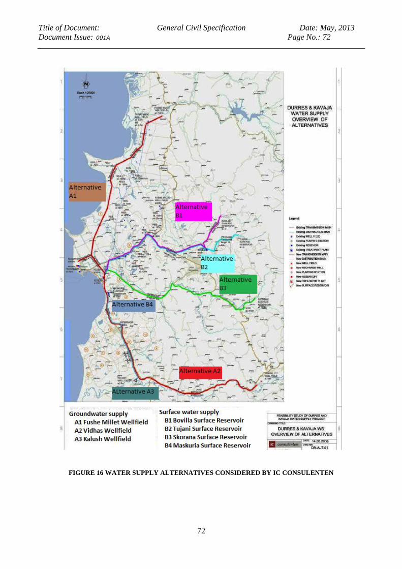
Title of Document: General Civil Specification Date: May, 2013
Document Issue: 001A Page No.: 72
72
FIGURE 16 WATER SUPPLY ALTERNATIVES CONSIDERED BY IC CONSULENTEN
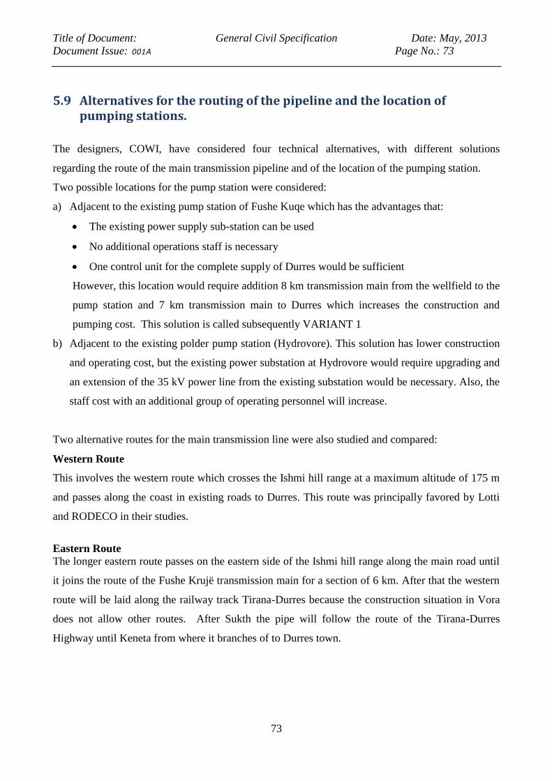
Title of Document: General Civil Specification Date: May, 2013
Document Issue: 001A Page No.: 73
73
5.9 Alternatives for the routing of the pipeline and the location of pumping stations.
The designers, COWI, have considered four technical alternatives, with different solutions
regarding the route of the main transmission pipeline and of the location of the pumping station.
Two possible locations for the pump station were considered:
a) Adjacent to the existing pump station of Fushe Kuqe which has the advantages that:
The existing power supply sub-station can be used
No additional operations staff is necessary
One control unit for the complete supply of Durres would be sufficient
However, this location would require addition 8 km transmission main from the wellfield to the
pump station and 7 km transmission main to Durres which increases the construction and
pumping cost. This solution is called subsequently VARIANT 1
b) Adjacent to the existing polder pump station (Hydrovore). This solution has lower construction
and operating cost, but the existing power substation at Hydrovore would require upgrading and
an extension of the 35 kV power line from the existing substation would be necessary. Also, the
staff cost with an additional group of operating personnel will increase.
Two alternative routes for the main transmission line were also studied and compared:
Western Route
This involves the western route which crosses the Ishmi hill range at a maximum altitude of 175 m
and passes along the coast in existing roads to Durres. This route was principally favored by Lotti
and RODECO in their studies.
Eastern Route
The longer eastern route passes on the eastern side of the Ishmi hill range along the main road until
it joins the route of the Fushe Krujë transmission main for a section of 6 km. After that the western
route will be laid along the railway track Tirana-Durres because the construction situation in Vora
does not allow other routes. After Sukth the pipe will follow the route of the Tirana-Durres
Highway until Keneta from where it branches of to Durres town.
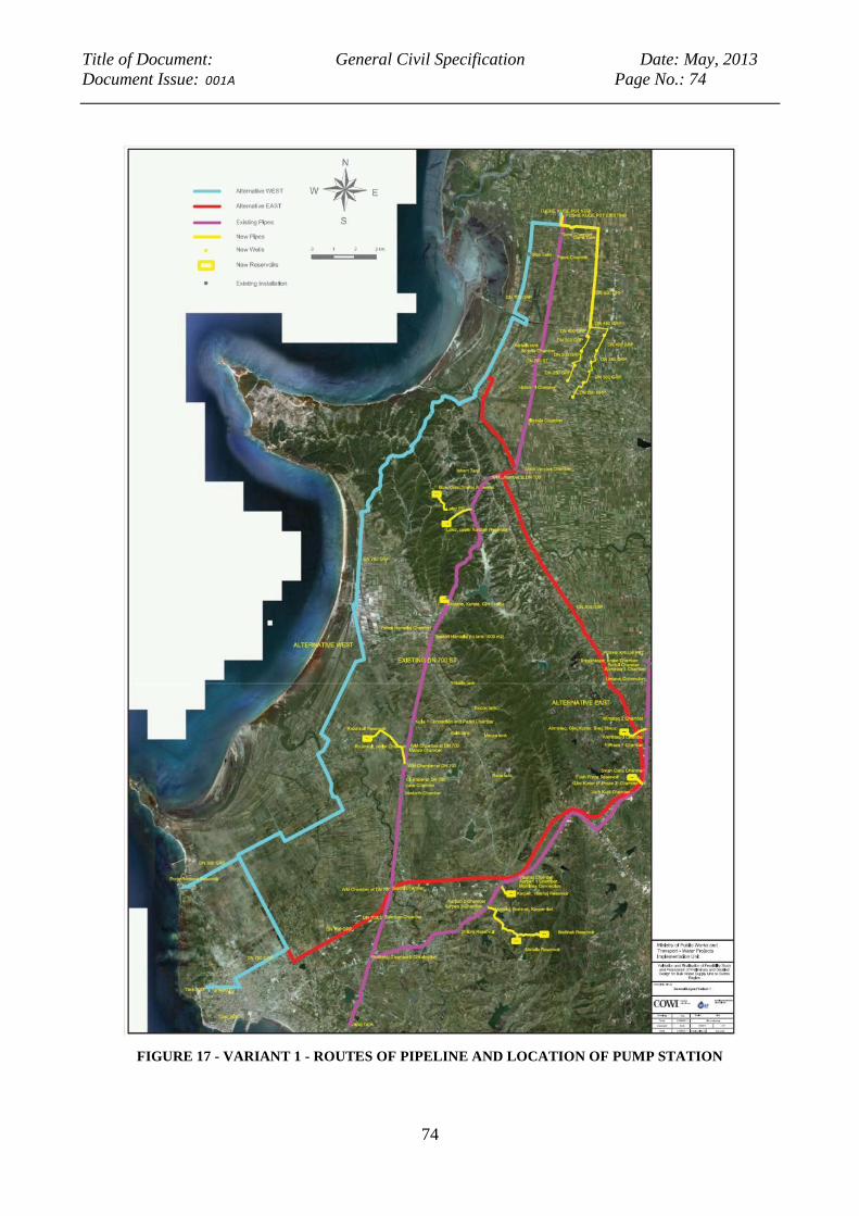
Title of Document: General Civil Specification Date: May, 2013
Document Issue: 001A Page No.: 74
74
FIGURE 17 - VARIANT 1 - ROUTES OF PIPELINE AND LOCATION OF PUMP STATION
Title of Document: General Civil Specification Date: May, 2013
Document Issue: 001A Page No.: 75
75
FIGURE 18 VARIANT 2 - ROUTES OF PIPELINE AND LOCATION OF PUMP STATION
Title of Document: General Civil Specification Date: May, 2013
Document Issue: 001A Page No.: 76
76
The Variant solutions are described in the table that follows
TABLE 1 SUMMARY OF INVESTMENT ALTERNATIVES16
Variant 1
Alternative east Alternative west
5.9.1. The new pump station will be built
close to existing pump station, a new well
field (9 wells, 62 l/s per, total 558 l/s) will be
developed south of the existing wellfield and
one additional well will be built in Fushe
Kuqe (62) l/s. The water will be pumped to
Durres via the eastern route.
5.9.2 The new pump station will be built close to
existing pump station, a new well field (9 wells,
62 l/s per, total 558 l/s) will be developed south
of the existing wellfield and one additional well
will be built in Fushe Kuqe (62) l/s. The water
will be pumped to Durres via the western route.
Variant 2
Alternative east Alternative west
5.9.3 The new pump station will be built
close to existing polder pump station
(hydrovore); a new well field (5 production
wells + 1 stand-by well, 126 l/s per, total 630
l/s) will be developed south of the existing
wellfield. The water will be pumped to
Durres via the eastern route.
5.9.4 The new pump station will be built close to
existing polder pump station (Hydrovore); a new
well field (5 production wells + 1 stand-by well,
126 l/s per, total 630 l/s) will be rehabilitated in
the existing Fushe Milot wellfield. The water
will be pumped to Durres via the western route.
COWI’s reports further state:
“The Consultant has undertaken a review of the alternatives to the existing transmission main and
decided on the Western Route which crosses the Ishmi hill and ranges from a maximum altitude of
175 m passing along the coast in existing roads to Durres. It will be laid along the Tirana-Durres
railway track because the construction situation in Vora does not allow other routes. After Sukth
the pipe will follow the route of the Tirana-Durres Highway until Keneta from where it branches of
to Durres town. The new main should be connected to the reservoir 2 (2x 2000 m3) and reservoir 1
(3600 m3). Because the elevation of these reservoirs (57m ground elevation) is not sufficient to
reach the town quarters Spitalla and Porto Romano a branch is foreseen to supply the exiting
(however presently defunct) reservoir in Porto Romano which would require rehabilitation. Given
the advantages of other nature that are described in the COWI reports, this choice is the correct
one. The table below gives a detailed comparison in terms of the advantages and disadvantages for
each of the two alternatives.
16
COWI Inception report, August 2011

Title of Document: General Civil Specification Date: May, 2013
Document Issue: 001A Page No.: 77
77
TABLE 2 COMPARISON OF VARIANTS with main considerations
Var. 1 Western
Route
Var. 2 Western
Route
Var. 1 Eastern
Route
Var. 2 Eastern
Route
Economic Higher Staff
Cost.
Minimum Capital
Cost.
Lowest AIEC.
Higher Staff Cost.
Lowest Energy
Cost.
Highest Capital
Cost, Highest
AIEC.
Lower Staff Cost.
Highest Energy
Cost.
Lower Staff Cost
Technical Break Pressure
Tank. Required
Pipe To Be
Drained Easier
Due To Higher
Gradients.
Longer
Construction
Time.
Pipe Is At
Maximum
Capacity.
Pipe Laying
More Difficult,
Partly In
Presence Of
Groundwater
Break Pressure
Tank. Required
Pipe To Be
Drained Easier
Due To Higher
Gradients.
Shortest Pipe
Route.
Longer
Construction
Pipe.
Better Control of
Pipe Route.
More Difficult
Foundation of
Pipe Station.
Pipe Has Extra
Capacity For
Higher Flows.
Pipe Laying More
Difficult, Partly In
Presence Of
Groundwater.
Highest
Pressures.
Better Access for
Maintenance.
Longest Pipe
Route.
Shortest
Construction
Time.
Pipe Is At
Maximum
Capacity.
Better Access
for
Maintenance.
Shortest
Construction
Time.
More Difficult
Foundation of
Pipe Station.
Pipe Has Extra
Capacity For
Higher Flows.
Title of Document: General Civil Specification Date: May, 2013
Document Issue: 001A Page No.: 78
78
It should be noted that in terms of land acquisition/expropriation for the pump station, all solutions
are identical because the pipe routing remains in public land and the only land requirements are
for the sites of the pump station and the new wellfield. From the details obtained so far, the Western
route, Variant 2 has a slightly higher environmental impact and poses more difficult construction,
but it has operational advantages, especially the lower risk of water theft plays a great role here.
This, together with the significantly lower investment and AIEC would make it the preferable option
for the project.”
Our team has carefully analyzed the assessment of COWI, and concurs entirely with their findings.
Therefore the chosen alternative is in our opinion, correct and implementable.
5.10 Conclusions of the EIA
5.10.1 Impacts
The project will have a definite beneficial impact on the socio economic conditions in Durres and in
the villages of communes Thumana, Fushe Kuqe, Ishem, Manza, Katund i Ri, Xhafzotaj, Sukth,
Rashbull. The project might have a negative impact on the rural populations if their wells should be
affected, an eventuality which should be offset by appropriate monitoring and management of the
wellfield.
Probable risks of the project under EIA Process are negatively affecting water resources by the
excessive lowering of the water tables, intrusion of seawater and pollution from the infiltration of
surface waters. Appropriate measures and monitoring are presented in the EMP report.
Var. 1
Western Route
Var. 2 Western
Route
Var. 1 Eastern
Route
Var. 2
Eastern Route
Environmenta
l/Social
Less Disruption
from
Construction
Work Due To
More Remote,
Less Populated
Area.
Pipe Passes
Forest Area,
Impact During
Construction.
Less Disruption
from Construction
Work Due To
More Remote,
Less Populated
Area.
Less Settlement
Along Pipe Route,
Less Risk Of
Water Theft.
Routing Along
Already
Developed Areas
Hence Less
Overall
Environmental
Impact.
High Risk of
Water Theft.
Routing Along
Already
Developed
Areas Hence
Less Overall
Environmental
Impact.
High Risk of
Water Theft.

Title of Document: General Civil Specification Date: May, 2013
Document Issue: 001A Page No.: 79
79
The project’s impact on soils is expected to be minor, save for the risk of localized subsistence,
which cannot be ruled out, even though the experience of similar projects in the area has not
produced such effects. Should this risk materialize, it is expected to affect only reduced and a very
localized areas, and be dealt with as and when it arises. Appropriate monitoring at the beginning of
the exploitation of the new wellfield is recommended.
The project will have negligible impacts on air quality, and natural habitats.
The project is not expected to have an impact on physical cultural resources, but a remote
possibility of such impact exists and a protocol to address this possibility is recommended in the
EMP report.
The project will have a minor impact in terms of involuntary resettlement.
5.10.2 Triggering of World Bank’s OPs
The EIA and EMP studies follow the indications and guidelines of the Operational Policy for the
Environmental Assessment procedure (OP 4.01).
The project which is assessed has environmental and social purposes and effects. It aims to develop
and improve the present water supply system to enhance water quality for the urban and rural
system and reduce water loses along the route.
The consultants are satisfied that the technical solutions have been chosen to achieve efficiently the
desired outcomes and to avoid, mitigate, or minimize adverse environmental and social impacts of
the whole project.
The selected technical solutions and the scenario seek to outline a low impact network water
supply, considering also the natural features of the territory.
The project has taken in to account the features of the water components to achieve solutions for
water conservation, reduction of water loses, protection of quality parameters, better allocation of
water resources along the project region.
The project has included analysis of salinity problems to find solutions for preventing intrusion of
seawater which may occur during exploitation if inappropriate management is applied.
The project has included analysis of salinity's problems for find out solutions for preventing
intrusion of seawater which may occur during excavation (such as management practices to control
water pollution, building of the pipelines network along the roadways (i.e. adjacent to the rural and
forest roads) and building of new boreholes in safer areas).

Title of Document: General Civil Specification Date: May, 2013
Document Issue: 001A Page No.: 80
80
With regards to Natural Resources, Forests and Physical Cultural Resources, the project will not
cause relevant adverse impacts in the construction phase neither in the operational phase.
The chosen technical solution aims to preserve local ecosystems and also to minimize the
overexploitation of groundwater resources, giving priority to the provision of adequate water and
sanitation services for the urban and rural population of the Durres region.
The pipeline will be constructed along the existing roads and in the rural areas affected by the
project there is the intensive agricultural (wheat) production and isolated houses. Only in the urban
area of Durres the project may slightly interfere with residential areas or cultural resources. The
project does not impact any of the high value ecosystems.
Landscape will not be directly affected by the project. There will be no visual impacts because the
pipeline will be built almost entirely below the ground level, and the only visible structures will be
the pump station, well heads, and bulk reservoirs. Only during the excavations it may be possible to
uncover some unknown archaeological elements. Any action in this respect will be defined in
agreement with the Albanian Archaeological Service.
From the socio-economic point of view, the present study, as well as the “DRN-ACER Durres
Water pipeline Resettlement action plan and Social Assessment” have concluded that, while the
present project does not warrant it in itself by its minimal impacts, carrying out a major cleanup of
soil and water resources in the rural areas is a high priority and urgent action, as pollution levels are
inacceptable.
The assessment report and therefore the project have considered the cross-sect oral impacts as the
project activities (above all during the construction phase).
Finally, the Environmental Impact Assessment analysis of the project has led to definition of
actions and solutions which allow to protect, manage and respect as much as possible natural
ecosystem, forestry resources, physical resources, groundwater and surface water components.
The EMP plan will define monitoring measures to control and prevent likely impacts and also
mitigations and compensations actions to reduce as much as possible what impact cannot not be
avoided, and to prevent severe impact on the water resources as would result from inappropriate
management.
The World Bank’s Operational Policies used for defining and assessing the magnitude of the
project’s impacts and to outline the mitigation actions are:
Title of Document: General Civil Specification Date: May, 2013
Document Issue: 001A Page No.: 81
81
- OP 4.04 Natural Habitats; TRIGGERED: The pipeline main follows mostly existing roads, and
consists of a shallow trench and manholes. Valuable natural habitats are at sufficient distance such
that disturbance during construction will be not existing or negligible and that there shall be no
disturbance at all during the exploitation phase. However, the Pipeline route crosses forest area at
Ishimi Hill area with an approximate distance of 9,000 meters, comprised of marches and
agricultural fields with a protection category of IV, according to Albanian Legislation. In this
section, the transmission main follows mostly existing roads, and consists of a shallow trench and
manholes. Forests are at sufficient distance such that disturbance during construction will be
absolutely minimal (please refer to section 5.3 “Natural habitats”) and that there shall be no
disturbance at all during operation phase. The reservoirs will be placed in built up areas, and the
pumping station is adjacent to the site of the pre-existing hydrovore, such that it shall not produce a
disturbance of present (ex-ante) conditions. Pre-construction mitigation has taken place by
designing the route of the pipeline transmission way in such a way as to minimize impact on natural
ecosystems, namely by following existing roads for almost the entire length of the pipeline. In
addition, the EMP identifies additional measures for the construction phase to mitigate remaining
impacts on natural habitats.
- OP 4.11 Physical Cultural Resources; NOT TRIGGERED at the state of present knowledge.
Monitoring and mitigation measures have been identified in the EMP to manage chance finds
during the construction phase.
- OP 4.12 Involuntary Resettlement; TRIGGERED: To minimize resettlement effects for
establishment of the water pipeline it was reassured by the project design, that the densely
populated private lands are avoided as much as possible. This is confirmed through Resettlement
Action Plan (RAP) study, showing that the planned water pipeline in most of its length passes
along the right-of-way the existing urban and rural roads and traverse in some cases pastures and
valleys property of public domain (commune lands). However, the inevitable private land affected
is comprised of 34 agriculture plots owned by 28 land owners in total, amounting to 3,487 m2. RAP
reveals that the only affected parties from land acquisition, for the construction of the new Water
Pipeline, are the private land owners. A total of 28 land owners are identified to be expropriated
according to the Albanian legislation in force.
- OP 4.37 Dams; NOT TRIGGERED: The project does not involve any works similar to a dam, nor
does it affect any existing dams in any way.
Title of Document: General Civil Specification Date: May, 2013
Document Issue: 001A Page No.: 82
82
- OP 4.36 Forests; NOT TRIGGERED: The project does not involve cutting down or using the
forest for productive purposes.
- OP 7.50 Projects in International Waters; NOT TRIGGERED: The project does not have any
relevant negative impact on International waters related to the Water Supply Component. Water is
being extracted from an aquifer located within the boundaries of Albania without relationship to
countries contiguous to Albania.
- OP 7.60 Projects in Disputed Areas; NOT TRIGGERED: There are no disputed areas in the
project area.

Title of Document: General Civil Specification Date: May, 2013
Document Issue: 001A Page No.: 83
83
6 PROJECT COMPONENT 2- WASTEWATER INVESTMENTS
The project’s Component 2: Wastewater Investments is designed to finance priority wastewater
investments aimed at enhancing the existing sewerage network’s capacity to handle the increased
water supply in an environmentally and socially sustainable manner, including upgrading of critical
parts of the sewerage network and provision of high-powered sewer cleaning equipment.
This project falls within the framework of the EU’s set of interventions in support of water
management in Albania, which are summarized in the table below.
These interventions, in turn, fall within a comprehensive water strategy, comprehensively described
in IC Consulenten’s “Water and Wastewater Management Plan” of November 2011.
That document provides a clear strategic framework for the water sector, within which the EU’s
support to the Water sector in Albania is to be developed.
Title of Document: General Civil Specification Date: May, 2013
Document Issue: 001A Page No.: 84
84
6.1 The need for the project
The existing wastewater network in parts of Durres is in very poor condition, resulting in leakage of
wastewater and overflow of wastewater during heavy rains.
The project intervention area is at present served by an existing concrete pipe gravity main
collector, and by six lift pumping stations (of which two are presently not functioning). This system
was constructed in the mid-1970.
6.2 Description of the Wastewater component
This project component is designed to rehabilitate the wastewater system in downtown Durres
(between Ura e Dajlanit to Perroi i Agait) and to connect the wastewater network with the new
Wastewater Treatment Plant, constructed in the Kenetes Zone (to the north of the Durres – Tirana
state highway SH2) in an area that was once a salt marsh but is now under development as a low-
rise service industry and residential suburb.
FIGURE 19 – MAP OF PROJECT AREA FOR COMPONENT 2 (WASTEWATER INVESTMENTS)
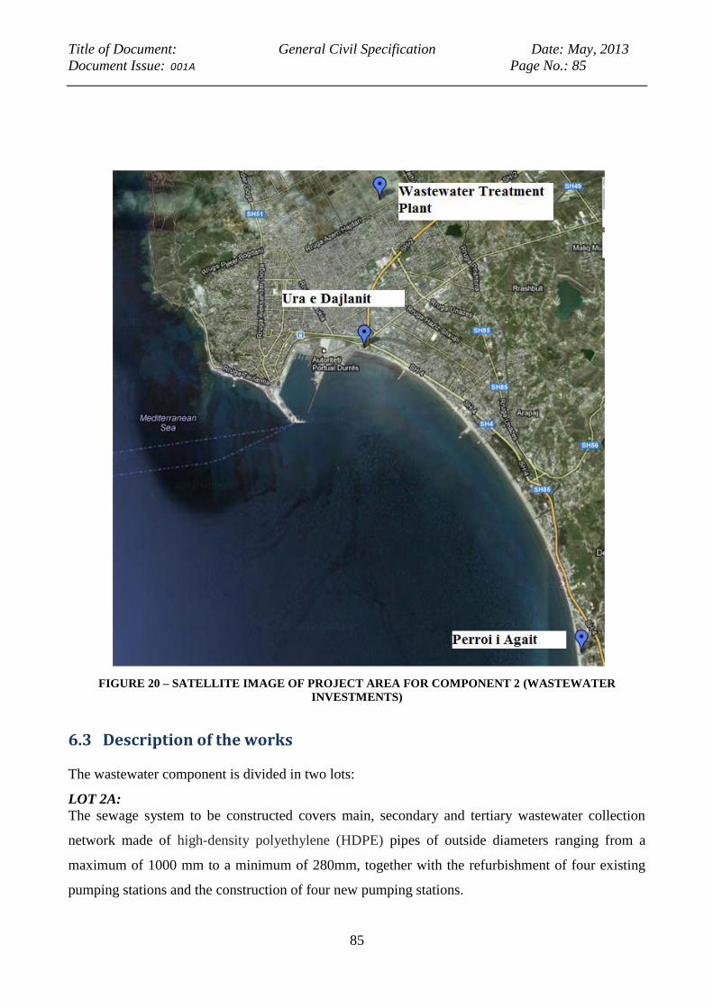
Title of Document: General Civil Specification Date: May, 2013
Document Issue: 001A Page No.: 85
85
FIGURE 20 – SATELLITE IMAGE OF PROJECT AREA FOR COMPONENT 2 (WASTEWATER
INVESTMENTS)
6.3 Description of the works
The wastewater component is divided in two lots:
LOT 2A:
The sewage system to be constructed covers main, secondary and tertiary wastewater collection
network made of high-density polyethylene (HDPE) pipes of outside diameters ranging from a
maximum of 1000 mm to a minimum of 280mm, together with the refurbishment of four existing
pumping stations and the construction of four new pumping stations.

Title of Document: General Civil Specification Date: May, 2013
Document Issue: 001A Page No.: 86
86
The sewerage system, running from Ura e Dajlanit (the entrance to Durres) to Perroi i Agait. This
includes the installation of a primary, secondary and tertiary network of sewers in the Plazh (beach)
area of Durres between Ura e Dajlanit and Perroi i Agait.
The primary network comprises 6,313m of 315 to 1000mm main collector gravity sewer and
2,481m of 280 to 710mm sewer rising mains together with the refurbishment of four existing
pumping stations and the construction of four new pumping stations. The gravity sections of the
main collector incorporate HDPE manholes.
Except for a 3km section along the beach, installation of pipe work is generally in public roads in
close proximity to buildings, including high-rise up to 12 floors, of unknown construction quality.
Refurbishment of existing pumping stations involves civil and building works. New pumping
station and penstock structures are of reinforced concrete construction. At all existing and new
pumping stations mechanical and electrical works are required for the supply and installation of
pumps, pipe work and control equipment.
The secondary and tertiary network comprises DN315 HDPE SN8 corrugated twin-wall pipes.
Installation is confined to side roads and tracks in the area between Ura e Dajlanit and Plepa. Many
of the roads are unpaved and are flooded during heavy rain events.
Lot 2B: Discharge to Durres WWTP (Waste Water Treatment Plant)
This consists of the installation of 710 /800 mm HDPE rising main from EPS6 to the WWTP,
generally in unpaved roads or tracks running adjacent to or across open drainage channels,
including a 800m section along the banks of the Durres main drainage channel and a 800m section
alongside channel K16 prior to entering the WWTP. In addition to crossing nine tertiary drainage
channels there are a number of major crossings along the rising main alignment, namely the Durres
main drainage channel, two secondary channels (one covered and one open), the new dual carriage
way (from the Shkozet / Rrogozhine intersection on SH2) and a twin 2250mm concrete pipe
conduit beneath the road.
6.4 Description of the Project area
The project’s subcomponent of renewed wastewater primary, secondary and tertiary collection
(lot 2A) is cited in the Plazh (beach) area of Durres City, and runs from the Ura e Dajlanit flyover to
Perroi i Agait over a distance of approximately 8 km in a NNW-SSE direction. In the cross section,
i.e. the WSW- ENE direction, the site is limited on its western side by the high water mark on the

Title of Document: General Civil Specification Date: May, 2013
Document Issue: 001A Page No.: 87
87
beach , while inland (ENE) it is bounded by the railway line and, from the roundabout to Perroi i
Agait, by state highway SH4.
FIGURE 21 -CLOSE UP OF THE AREA WHERE THE MAINS WILL RUN ALONG THE BEACH
At its widest point the site is approximately 600m wide. Access throughout the site is provided by
Rruga e Plazhit and SH4, both of which are dual-carriageway roads, the former with parallel
parking lanes on each side and the latter with a service road on the seaward side. The area has
undergone, and is still undergoing, considerable development for tourism purposes, with the
construction of hotels and apartment buildings over ten stories high. As a consequence of the influx
of tourists, the area’s resident population of 15,000 grows to as much as an estimated 95,000 during
the peak summer season, from 15th
June to 31st August.
17
17
“Lot 2: Sewerage System in Perroi i Agait – Ura e Dajlanit and Discharge to Durres WWTP”- Volume 3.1 –
Particular Specification - Barry & partners consulting Engineers, Ireland, June 2010
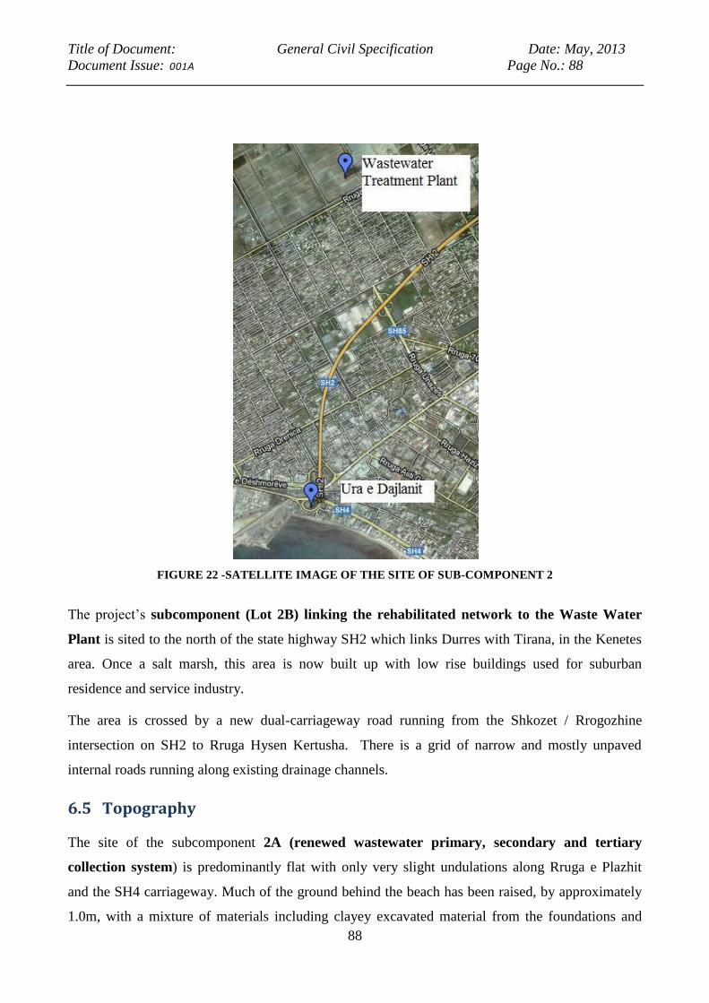
Title of Document: General Civil Specification Date: May, 2013
Document Issue: 001A Page No.: 88
88
FIGURE 22 -SATELLITE IMAGE OF THE SITE OF SUB-COMPONENT 2
The project’s subcomponent (Lot 2B) linking the rehabilitated network to the Waste Water
Plant is sited to the north of the state highway SH2 which links Durres with Tirana, in the Kenetes
area. Once a salt marsh, this area is now built up with low rise buildings used for suburban
residence and service industry.
The area is crossed by a new dual-carriageway road running from the Shkozet / Rrogozhine
intersection on SH2 to Rruga Hysen Kertusha. There is a grid of narrow and mostly unpaved
internal roads running along existing drainage channels.
6.5 Topography
The site of the subcomponent 2A (renewed wastewater primary, secondary and tertiary
collection system) is predominantly flat with only very slight undulations along Rruga e Plazhit
and the SH4 carriageway. Much of the ground behind the beach has been raised, by approximately
1.0m, with a mixture of materials including clayey excavated material from the foundations and
Title of Document: General Civil Specification Date: May, 2013
Document Issue: 001A Page No.: 89
89
basements of buildings, river gravel, quarry waste, construction debris and industrial and domestic
refuse. Where the ground has not been raised there is a possibility for it to flood during rainy
weather and not drain away.
The area linked to Lot 2B is flat and is generally slightly above or below mean sea level. Roads
have generally been raised up to 1.0m above surrounding ground level with a mixture of materials
(river gravel, quarry waste, construction debris and industrial and domestic refuse). The lower
ground, especially where it has been disturbed by building activities or road construction, has a
tendency to flood during rains.
6.6 Hydrology and Drainage
Site of 2A (renewed wastewater primary, secondary and tertiary collection system :
The only natural water course is Perroi i Agait, which defines the southern boundary of the site.
There is also a large man-made channel, the Shën Vlash drain, which drains higher ground from
before discharging into the Adriatic Sea. The water level in this channel rises during heavy rains by
approximately 2m.
A man-made drainage channel traverses the site longitudinally between Rruga e Plazhit and the
railway line from the vicinity of Shkozet railway station to the flyover at Ura e Dajlanit. Some
sections of the channel are covered and at Ura e Dajlanit it is piped in a DN1500 conduit. Due to a
lack of maintenance and an accumulation of refuse the drain is not free-flowing. In the summer
months it is stagnant.
The underground water table in this area has been found to be at only 0,8 m below the natural
ground level (Grusmar Ingegneria y Consulting ground investigation, 2010) and as a consequence is
highly exposed to pollution from seepage of surface waters.
Site of the project’s subcomponent of linkage of the renewed network to the Waste Water
Plant : There are no natural watercourses in this site, although the site is criss-crossed by an
extensive drainage system established on a rectangular grid pattern, connecting to the Durres main
drainage channel. The said channel runs across the site in a south-east to north-west direction, to the
Hydrovore in Porto Roman, from where it discharges into the Adriatic Sea. The channel’s water is
heavily polluted from wastewater leakage and overflows, and from solid waste.
Title of Document: General Civil Specification Date: May, 2013
Document Issue: 001A Page No.: 90
90
6.7 Risk analysis and environmental impacts
6.7.1 Water resources
The project will not have negative impacts on water resources, as it does not affect surface waters.
On the other hand, the replacement of heavily corroded and leaking wastewater systems, and the
channeling of wastewater to the treatment plant will eliminate seepage of polluted water into the
soil and in the underground water table, and of wastewater into surface water runoff, and ultimately
into the Adriatic Sea.
The expected impacts during the construction phase
During the reconstruction of pumping stations, and at all operations of linkup of the new
wastewater system with the existing network, precautions need to be taken to prevent spillage of
wastewater.
These are described in the EMP report.
The expected impacts during the project’s life
The project’s impact on water resources in its exploitation phase will be a positive one, as it will
eliminate leakage of wastewater and its seepage in the soil, and pollution of surface water.
Possible adverse impacts could result in case of leakage of the newly constructed wastewater mains.
This risk will be offset by ordinary maintenance and periodic inspections. These are described in
the EMP report.
6.7.2 Geological and soil system
No adverse impacts on the stability of soil are to be expected from the implementation of this
project, as the wastewater pipes will be running along public roads. The one exception is the 3 km
tract where the pipes will be running along the man-made beach will not produce effects on soil
stability, as this beach is a stabilized and intensively used for recreational purposes.
The expected impacts during the construction phase
In the construction phase, namely during the reconstruction of pumping stations, and at all
operations of linkup of the new wastewater system with the existing network, precautions need to
be taken to prevent spillage of wastewater, which could pollute the soil. These are described in the
EMP report.
The expected impacts during the project’s life
Possible adverse impacts could result in case of leakage of the newly constructed wastewater mains.
This risk will be offset by ordinary maintenance and periodic inspections. These are described in
The EMP report.
Title of Document: General Civil Specification Date: May, 2013
Document Issue: 001A Page No.: 91
91
6.7.3 Natural habitats
No natural ecosystems are present in the area affected by the project; as it is located within urban
and semi-urban areas . For this reason, the project does not affect in a negative way notable species,
or protected and globally significant ecosystems. On the other hand, the project does have a positive
impact, by contributing to the reduction of pollution in the Adriatic Sea.
6.7.4 Air quality
In the present situation, air quality is negatively affected by the odors of sewage from links in the
decrepit network and from old manholes which no longer have their covers.
The project will a have very limited impact on the quality of air during the construction phase, due
to the use of small construction machinery and of over pumping while the pumping stations to be
rehabilitated are temporarily out of commission.
In the exploitation phase, the project will only have a positive impact, as leakage of wastewater will
be eliminated and as the decrepit manholes now in place, many of which have no cover, will be
replaced by modern manholes, complete with their covers.
6.7.5 Physical cultural resources
As the wastewater mains will be running along existing roads, without requiring the excavation of
new areas or affecting existing buildings, no impact with Physical cultural resources is foreseen in
either the construction or the exploitation phase.
6.7.6 Socio-economic environment
The project will have no negative impacts on the socio-economic environment, as it brings about an
improvement in quality of life, public health, and in the general quality of the environment.
Economically, it improves the area’s value as a tourism attraction.
During the construction phase, when works will be carried out in the tract running along the beach,
the project will disrupt the recreational use of the beach itself; however this effect will be
minimized, since, during the summer season (June, July and September) in compliance with the
existing Municipal regulations, no works shall be carried out in this tract.
6.8 Analysis of alternatives and their impact on the environment
6.8.1 No project Option
The “no project-option” would mean leaving in a decrepit state the wastewater network of this part
of Durres, which has special importance not simply for its residents, but also for the city’s tourism
Title of Document: General Civil Specification Date: May, 2013
Document Issue: 001A Page No.: 92
92
industry. Leakage of wastewater would continue, and untreated wastewater would seep into the soil
and the water table, and ultimately the Adriatic Sea.
There would be no advantages of any kind in this option, while the opportunity to improve
environmental quality, public health and the city’s quality of life and tourism potential would be
lost.
6.8.2 Alternatives for the routing of the mains and the location of pumping stations.
There are no practical alternatives to routing of the network within this built-up environment. The
choice which has been made of retracing the route of the pre-existing wastewater network is the
only possible one. Regarding the 3 km tract which runs at the higher end of the public beach, the
alternative to run the mains more inland, through private proprieties would have obvious
disadvantages in terms of costs (expropriation or compensation) while not offering any advantages.
6.9 Conclusions of the EIA
The conclusions of the EIA are that there will be no notable negative environmental impacts from
the implementation of wastewater component of this project. The very limited impacts in the
construction phase are not different from those of extraordinary maintenance operation, very limited
in terms of quantity and in time.
The Technical Specifications for the works contract, as developed by Barry & Partners in June
2010, make provision that shall prevent and mitigate adverse impacts on the environment and
disturbance to the residents. These conditions should become an integral part of the construction
contract in due course.
Further, negative impacts can be efficiently mitigated by additional equate prescriptions to the
contractor, whose application can easily be monitored by the works supervision without requiring
any specialist professional inputs. No negative impacts are to be expected in the operational phase,
provided that ordinary maintenance of the network and the pumping stations is exercised.
6.10 Triggering of World Bank’s OPs
The EIA and EMP studies follow the indications and guidelines of the Operational Policy (OP) for
the Environmental Assessment procedure (OP 4.01).
The project which is assessed has environmental and social purposes and effects. It aims to develop
and improve the present waste water collection system in Durres.
Title of Document: General Civil Specification Date: May, 2013
Document Issue: 001A Page No.: 93
93
The consultants are satisfied that the project’s nature and the technical solutions that have been
chosen to achieve efficiently the desired outcomes without producing adverse environmental and
social impacts.
Only one of the applicable World Bank’s Operational Policies is triggered, for the following
reasons:
- OP 4.04 Natural Habitats and OP 4.36 Forests NOT TRIGGERED: No critical habitats nor forests
are affected by this component. The beach tract where the collection main is running has long since
lost any characterization of a natural habitat, and so has the former marshland which is now a semi-
urban settled area linked to the Waste Water Treatment Plant. This has taken place by man-made
activities long preceding the implementation of the project, and there is no connection between such
events and the present project.
- OP 4.11 Physical Cultural Resources; NOT TRIGGERED: All works are conducted in area where
previous excavations have taken place, and the works do not affect any historical building or
monuments. Monitoring and mitigation measures have been identified in the EMP to manage
chance finds during the construction phase.
- OP 4.12 Involuntary Resettlement; NOT TRIGGERED: Current level of information indicate that
this OP is not triggered. However, if the situation on ground during implementation finds that they
are objects on the route, relevant clauses from the RPF will be invoked.
- OP 7.50 Projects in International Waters TRIGGERED: The project has a beneficial effect by
reducing wastewater pollution in the Adriatic Sea. However, because of the increased volume of
water supplied by the new transmission main and the current arrangement of discharging untreated
wastewater to the Adriatic, this policy is triggered and arrangements have been made to notify all
other riparian countries in the Adriatic Basin of the project and its proposed activities.
Title of Document: General Civil Specification Date: May, 2013
Document Issue: 001A Page No.: 94
94
7 Public disclosure
This document – the Environmental Impact Assessment Report, as well as the site-specific
Environmental Mitigation Plan and Environmental Monitoring Plan, will be publicly disclosed in
accordance with the World Bank OP 4.01. The summary of the disclosure process will be
inserted here upon completion of the process.
8 Environmental Mitigation Plan (TO BE INSERTED)
9 Environmental Monitoring Plan (TO BE INSERTED)
Title of Document: General Civil Specification Date: May, 2013
Document Issue: 001A Page No.: 95
95
THE ANNEXES TO THE PRESENT REPORT CONTAIN ADDITIONAL INFORMATION
WHICH DESCRIBES IN MORE DETAIL SOME OF THE ACTIVITIES CONTAINED IN THE
MAIN TEXT.
ANNEX 1 – DESCRIPTION OF HYDROLOGY IN THE PROJECT AREA
Rivers and channels
The Fushe Kuqe plain is a reclaimed former marshland, with an open drainage system on its
surface, with a final pumping station (hydrovore) that discharges the drained water into the Adriatic
Sea.
The main hydrological feature of the Fushe Kuqe Plain is River Mati, which forms the area's natural
northern border. The Mati River’s catchment area is 2441 km², the main tributary of it is Fani River,
that flows from the north east to (insert where), while Mati itself flows from the south west to
(insert where) to the confluence with Fani and then to the west meandering through the flat plain
area with an average gradient of around 0.5 - 0.6 m/km, to its estuary into the Adriatic Sea, near
(insert name of the city, or other location for reference).
In the upper reaches of Mati River, two hydroelectric power plants and associated dams were
constructed in the past (1952-1970). Therefore, the natural regime of the River has been completely
changed; however, Fani River has preserved its natural conditions.
After its confluence with Fani in the plain, the flow of Mati River can be considered as a sum of the
continuous discharge from the hydropower plants and flow of Fani River. The discharge from the
hydropower plants varies between 10 m3/s and 15 m3/s with peak flows of more than 50 m3/s 18
18
The Institute of Hydrometeorology of Albania).
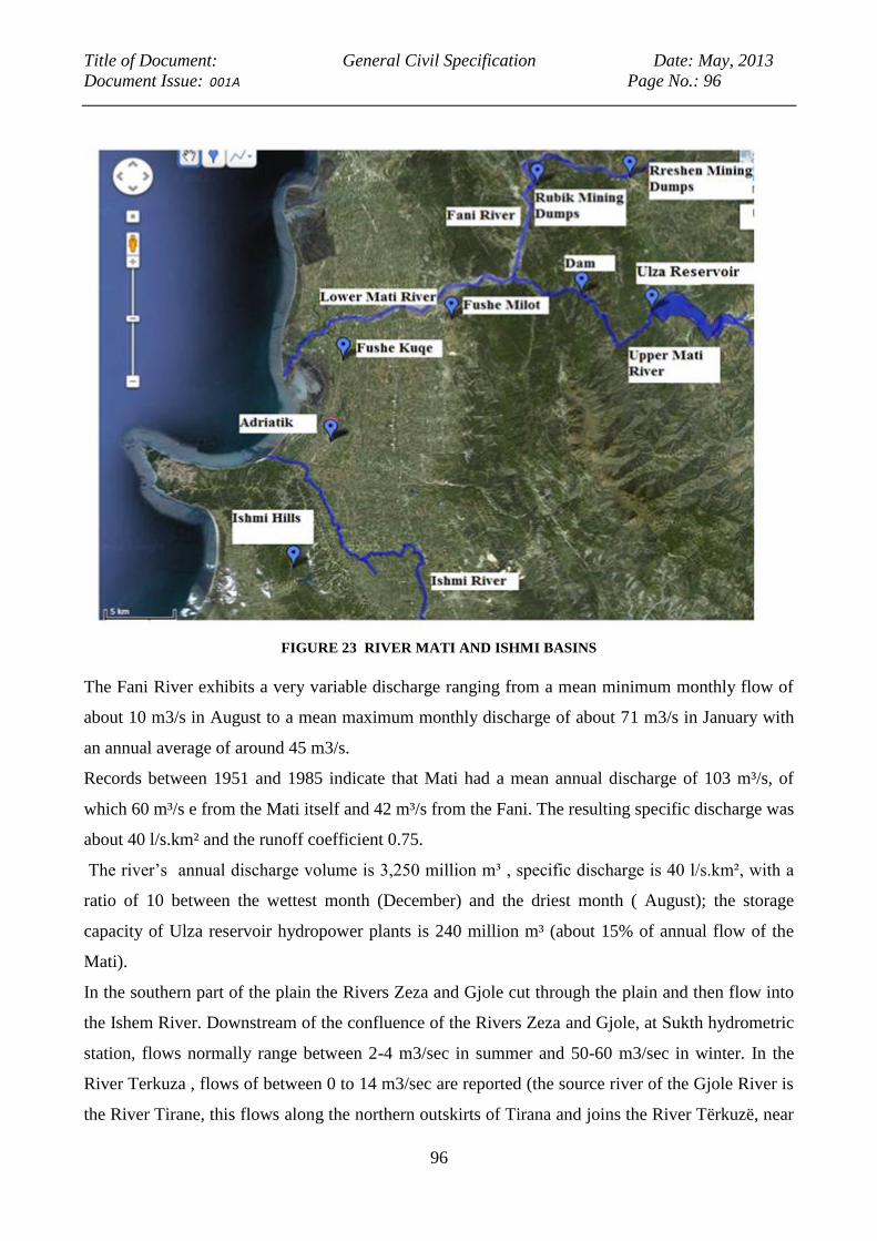
Title of Document: General Civil Specification Date: May, 2013
Document Issue: 001A Page No.: 96
96
FIGURE 23 RIVER MATI AND ISHMI BASINS
The Fani River exhibits a very variable discharge ranging from a mean minimum monthly flow of
about 10 m3/s in August to a mean maximum monthly discharge of about 71 m3/s in January with
an annual average of around 45 m3/s.
Records between 1951 and 1985 indicate that Mati had a mean annual discharge of 103 m³/s, of
which 60 m³/s e from the Mati itself and 42 m³/s from the Fani. The resulting specific discharge was
about 40 l/s.km² and the runoff coefficient 0.75.
The river’s annual discharge volume is 3,250 million m³ , specific discharge is 40 l/s.km², with a
ratio of 10 between the wettest month (December) and the driest month ( August); the storage
capacity of Ulza reservoir hydropower plants is 240 million m³ (about 15% of annual flow of the
Mati).
In the southern part of the plain the Rivers Zeza and Gjole cut through the plain and then flow into
the Ishem River. Downstream of the confluence of the Rivers Zeza and Gjole, at Sukth hydrometric
station, flows normally range between 2-4 m3/sec in summer and 50-60 m3/sec in winter. In the
River Terkuza , flows of between 0 to 14 m3/sec are reported (the source river of the Gjole River is
the River Tirane, this flows along the northern outskirts of Tirana and joins the River Tërkuzë, near
Title of Document: General Civil Specification Date: May, 2013
Document Issue: 001A Page No.: 97
97
Preze, to form the Gjole). The River Droja flows across the centre of the plain and then into the sea
at the town of Adriatik (flow data unavailable).
Surface water quality and pollution loads
The quality of water was investigated in several studies which concur in indicating the presence of
heavy metals in the waters of the Mati river basin. Chemical analysis of samples taken from the
Mati before 1990 showed a high content of metallic ions (iron, manganese and copper), which is
not surprising as this is an important mining area. The impacts on irrigated agriculture and human
health are not fully assessed and the implications for marine coastal waters are also not clear 19
Water quality parameters and heavy metal levels were monitored during 2002 - 2004 by the Faculty
of Natural Science of Tirana, which carried out field investigations on the most impacted rivers of
the Adriatic lowland, including the Mati, with its tributary the Fani and the Ishmi River. The
relatively high concentration of copper in sediments and algae of the Mati River can be attributed to
pollution from copper-rich minerals found in this area, and to pollution from dumps of solid wastes
of mines and former metallurgical plants.
In a quality evaluation of rivers based on the NIVA (1997) classification of Norwegian Institute for
Water Research, the physicochemical parameters of Mati River were defined as “good to fair” and
moderately polluted by heavy metals contaminants.
The investigations carried out by Cullaj (2003), Beqiraj (2009) and Gjoka (2010) indicate that high
levels of Cd, Pb, Zn, Cu, Cr and As were found in the old metallurgical plant located in Laçi, high
concentrations Cd, Pb, Zn, Cu, Cr, As and Ni were in sediments downstream of Rubik in the River
Fani, and high levels of Cd and Hg were found in the Fani and Mati River water.
The most recent (2010) and also the most alarming, tests of chemical pollution of the Mati and
Shkumbini rivers, found concentrations of Chrome, Nickel, Zinc, Cadmium, Copper and Arsenic
exceed the maximum acceptable values.
The concentration of As in a Mati river is higher in the northern section, ranging from upstream of
the alluvial plain area (uncontaminated), to the alluvial area (contaminated). Samplings were taken
near an ex copper smelter plant, and the influence of Cu dumps from this factory is still significant
at this site.
19
The Institute of Hydrometeorology of Albania
Title of Document: General Civil Specification Date: May, 2013
Document Issue: 001A Page No.: 98
98
The relatively high concentration of Cu in sediments of river Mati reflect both the natural
background value of heavy metals minerals from geological characteristic of rocks in the area, and
the pollution from dumps of solid wastes of mines and former metallurgical plants.
Especially important contributors of this type of pollution are the dumps in Fani river banks (as in
Repsi, Rresheni and Rubiku) and numerous mining works in Sparci and Kader Sparci slopes, from
which acid waters drain, which add to the natural leaching of surface outcrops of mineralized zones.
Water analysis of the river Fani where it runs through these areas show the presence of a high level
of ions of Cu, Fe, Zn, and SO4. A study of the degree of pollution of the Fani River20
from the
copper extracting and processing industry clearly indicates that gravity of the pollution is very high.
It was estimated that the Fani river transports each year to the Repsi dumps 1 ton Cu, 1.5 ton Zn, 27
ton Fe and 800 ton S, collected from the mining works and mineralized zones exposed in its
uppermost parts. Further downstream of the Repsi dumps, the material transported annually by Fani
river reaches about 41 ton Cu, 42 ton Zn, 0.3 ton Pb, 0.08 ton Cd, 3 200 ton Fe, 05 ton As and 10
600 ton S (Daci A. et al., 2007). Such an increase of the material transported by Fani River after
passing the zone of the dumps is a clear proof of the influence of the dumps in water pollution.
AQUIFER AND GROUNDWATER
Hydro geological characteristics
The Fushe Kuqe Plain is a multilayered artesian aquifer system formed by alluvial deposits with
permeable layers of gravel and sandy gravel. According to the existing hydro geological studies,
clay and silt deposits seem to cover progressively these permeable deposits, which outcrop along
the Mati River in the Northern part of the Plain in a South- Western direction. Only in the area
along the Mati River where are outcrops of gravelly deposits, the aquifer system can be found
partially unconfined. The cumulative thickness of the gravel layers, which form the most productive
aquifer of the area, varies from 40 m - 200 m.
In the Northern part of the Fushe Kuqe Plain, along the Mati River, the gravel deposits are
characterized by a high thickness. The aquifer seems to be continuous, whereas towards the South,
there are two intermediate clay layers characterized by a variable thickness of 10 till 20 m and
enable the generation of three aquifer horizons.
The upper or first aquifer seems to be continuous throughout the plain.
20
(Sweco & MPTI, 1999)

Title of Document: General Civil Specification Date: May, 2013
Document Issue: 001A Page No.: 99
99
Below the first, is a second aquifer layer, the two being separated by a clay layer with a variable
thickness of 15 to 30 m. The first aquifer is partly in unconfined conditions (in the recharge area)
and partly in confined conditions whereas the second one is always in confined conditions.
In the Fushe Kruja area the groundwater flow direction has been established as being predominantly
south-east to north-west, while in the south part of aquifer, from Fushe Kuqe area, the flow is from
the north-east to the south-west. During the flow towards the drainage zone, the groundwater
hydraulic head pressure increases. In the northern part of Fushe Milot, towards the Mati River, the
underground waters exhibit no pressure. The static level of underground waters varies from 2.5 m
above the surface in Fushe Kuqe village to 2.25 m below the surface in the south in Fushe Milot.
As result of aquifer exploitation, the groundwater levels have been lowered. In the pumping zone
the dynamic level is 2.5 m under the soil surface. The oscillation of underground water level in
different seasons of the year is not significant and does not exceed the amount of 0.2 m.
A piezometric map of the upper aquifer, based on measurements made by the Hydro geological
Institute in 1983, confirms Lotti’s (1993) observation that in the Fushe Kruje area the direction of
groundwater flow was predominantly south-east to north-west and in the Fushe Kuqe area it was
north-east to south-west. In the northern part of Fushe Kuqe plain, this map suggests that the major
source of recharge is close to where the River Mati debouches onto the plain.
Anthropic influences on the aquifer system
The Fushe Kuqe Plain is exploited by two wellfields, in the Fushe Kuqe and the Fushe Milot area.
In Fushe Milot are located 5 wells with an average depth of 30 m, which were originally drilled
near the Mati River with the purpose of supplying a maximum discharge of 670 l/sec the industrial
area of Lac Town. These wells are no longer operational.
The Fushe Kuqe wellfield is located 31 km north of Durres, in alluvial deposits; it consists of 7
wells, with an average depth of 35 m. Each well is fitted with a submersible pump and has a
maximum recommended discharge of 140 l/s. In the years 1968 to 1993 there were no significant
increases in abstraction from the Fushe Kuqe wellfield with daily mean production reported to be
626 l/s, while extraction from Milot Fushe wells was estimated at 305 l/s.21
In the 2001 extraction from the Fushe Kuqe wellfield was increased to 775 l/s, 22
(RODECO) and
by 2007 the abstraction had reached 816 l/s 23
. The current pumping rate is 881 l/s, which that
represent the theoretical transmission system capacity of the wellfield (July 2011).
21
Lotti Durres Water Supply Rehabilitation and Demand Management Project, 1993 22
Feasibility Study for the Durres Rural Areas Project, 2003, prepared by RODECO Consulting GmbH (Germany)

Title of Document: General Civil Specification Date: May, 2013
Document Issue: 001A Page No.: 100
100
The groundwater resource is also exploited by both deep and shallow private wells. In the Fushe
Kuqe Plain there are 115 drilled wells; some of them were drilled under application of the
percussion method whereas the remaining were drilled according to the rotary method. The depth of
the drilled wells ranges from 25 m to 200 m. Mostly, they feature free flowing conditions, and
discharges span from 1 - 2 l/s up to about 10 l/s. The wells are used by local inhabitants to ensure
the water supply of small communities. Most of these wells only reach the first aquifer layer, but
some of them, drilled for exploration purpose only, have reached the third aquifer layers. Many of
these exploration wells are presently abandoned. In the northern part, the specific discharges
oscillate from 6 to 82 l/s/m. In the southern part, the specific discharges are lower and vary from 0.5
to 3 l/s/m.
In the RODECO Report (2001) it was noted that the total number of wells in the Fushe Kuqe -
Fushe Krujë plain was around 450 and that these pumped ~2000 l/s. It also stated that these
extractions resulted in groundwater levels dropping 4 to 5 m regionally over the period 1964 to
1993, but that in the Duress - Lac area groundwater levels dropped only 2 to 3 m. It was also stated
that in 1993, despite many years of groundwater extractions, regional piezometric levels had
stabilized around 1.5 - 2.0 m above the groundwater levels of today.
In conclusion, it is possible to estimate the total fall in groundwater levels in Fushe Kuqe as being
between 3.5 and 5 m over the period 1963 to 2001.
However there are no available monitoring datasets showing the temporal evolution of piezometric
head in the area near the wellfield. According to recent information derived from the staff of the
water supply centre of Fushe Kuqe in November 2011, the local drawdown observed in the
pumping wells produces a piezometric head between -2 and -10 m.a.s.l.
Groundwater flow balance and potential resource
The evaluation of the groundwater potential in the Fushe Kuqe Plain will be limited to the quantity
of groundwater flowing in the gravel aquifer. The recharge of the aquifer system mainly seems to
occur in the Northern part of the Plain by infiltration from the Mati River’s surface waters through
its banks , and in the Eastern part partially by groundwater inflow from the lateral outcrops of
limestone rocks bordering the Plain, plus inflow from precipitations.
23
Feasibility study of Durres and Kavaja water supply, IC Consulenten August 2008
Title of Document: General Civil Specification Date: May, 2013
Document Issue: 001A Page No.: 101
101
Lotti (1993) estimated a flow balance of the Fushe Kuqe and Fushe Kruja Aquifer System.
According to this estimate, there was about 1250 l/sec of groundwater flowing out into the sea or
into rivers, while the groundwater exploitation was quantified at an average in 800 l/s from Fushe
Kuqe wellfields and of 1980 l/s total pumping by wells of the plain. The main aquifer recharge
comes from alluvial fans and infiltration or surface water from Mati River represents 85% of the
groundwater recharge, into the Fushe Kuqe - Fushe Kruja aquifer, with a total discharge of 2915 l/s,
while the direct infiltration from rainfall is only 125 l/s.
Strazimiri (1995) provides a regional finite difference mathematical model, and defines the
groundwater balance. This balance is very different from Lotti’s (1993) balance. Most notable is the
absence of direct infiltration, the 50% reduction in total inflows and outflows, and the much smaller
contribution from the River Mati, with an infiltration flow of 1239 l/s against Lotti’s 2915 l/s.
In the north, the smaller contribution from Mati River is partially offset by inflows from the sea
and groundwater infiltrations from the north. These are no excess flow to sea or to rivers (1285 l/s
in Lotti’s balance). In fact the opposite occurs: the groundwater depression in the north, created by
the wellfield in Fushe Kuqe, is responsible for inflows from the sea.
The reduced contributions from this river are offset by increased flows from the sea (101 l/s) and
increased “filtrations from the north” (386.3 l/sec). The filtrations from the north appear to refer to
groundwater transfers from the alluvial aquifer located north of the Mati River.
In the IC Consulenten Feasibility study of 2008 the total groundwater flow was evaluated
considering the transmissivity values used in Darcy's law calculated for the total thickness of all
gravel layers. The groundwater discharge in the hydro geological system of the Fushe Kuqe Plain
occurs mainly by well extraction and groundwater seepage into the Adriatic Sea. The present
groundwater extraction from the existing wells has been reported to be 1095 l/s. The groundwater
balance existing in the hydro geological system of the Fushe Kuqe Plain can be summarized as
follows: groundwater flow 2222 l/s, groundwater extraction by wells 1005 l/s and groundwater flow
to sea 1217 l/s.
The results of this numerical groundwater flow model can be used to assess the flow balance.
In particular from 1968 until the present total abstractions the seawater contributions into the
wellfield have increased. The reduction of withdrawals from the Milot wellfield area, industrial area
of Lac, has determined a change in flow directions, the main contributions come from Ishmi Valley
and from the mountains. At the present that aquifer zone makes up the bulk of groundwater flowing
to the wellfield, where previously it was from River Mati. Wellfield inflow from Mati river area is
calculated in ~367 l/s (420 l/s in the historic simulation), while the flow from the Ishmi Valley is

Title of Document: General Civil Specification Date: May, 2013
Document Issue: 001A Page No.: 102
102
estimated in 474 l/s. A progressive increase over time of the pumping wellfield Fushe Kure, from
626 l/s to 881 l/s, has caused an increased flow contribution from the sea, a total of 38 l / s
compared with only 4 l / s.
Groundwater quality
The chemical groundwater composition has been identified by analyses in the framework of
different studies. Generally, these analyses indicated low groundwater mineralization as well as a
chemical composition and bacteriological conditions in compliance with the requirements of
potable water. The first horizon groundwater, from upper layer aquifer, features a low
mineralization between 240 and 850 mg/l, typical carbonate hydrofacies. However, in some places
water quality is poor, and this includes the area south of the Fushe Kuqe wellfield, in the Patok-
Shellinxe sector, where values of Total Dissolved Solids (TDS) of between 1,000 to 1,500 had been
recorded in the top aquifer and 3,000 to 3,500 mg/l in the second aquifer (IC Consulenten report
2008).
The contents of chlorides is 400 - 600 mg/l is evidence of saline intrusion phenomenon.
Details of some smaller wells drilled for village or private supplies wells are also included in the
Strazimiri (1995) report. These details include water salinity data, in the form of TDS, for a shallow
well (50 m) drilled near the coast in Patok (600 mg/l) and deeper wells (82 to 100 m) drilled in
Adriatik (1106 to 3595 mg/l). Also for shallow wells (54 to 61 m) drilled in Fushe Kuqe (300 to
874 mg/l30) and deep wells (148 to 220 m) drilled in Fushe Kuqe (310 to 2226 mg/l). TDS values
are also provided for one well in Fushe Milot (27.5 m deep, TDS of 257.2 mg/l) and one well in Lac
(41 m deep, TDS of 250 mg/L). In general, these data suggest brackish water occurs at depth along
the coast and in places in the deeper aquifer beneath Fushe Kuqe.
Currently the quality of the groundwater in Fushe Kuqe remains unclear, and the last analysis were
performed are not in line with EU standards, so is not possible to confirm if it is of acceptable
standards for human consumption and to determine the current status of the aquifer. In particular
there is no information about the heavy metals contaminants in the groundwater.
Title of Document: General Civil Specification Date: May, 2013
Document Issue: 001A Page No.: 103
103
ANNEX 2 DATA SOURCES
In order to obtain the necessary data for the EIA report the following activities have been carried
out:
Meetings and Field Visits24
Meetings with, PMU, WB Office Tirana, COWI, Dr. F. Brusberg, TL Team Leader, Sustainability
& Safeguards at CGAP. , the Directorate of Water and Sewerage in Durres and Technicians in
operational units in Fushe Kuqe.
Field visits (wellfields in Fushe Kuqe, main pipeline route, villages sited along the pipeline route)
Meetings were also scheduled with the Local government of Durres, Water management
authorities, the Local communities and villages mentioned above, NGOs, IEP Albania, and Tirana
Polytechnic.
Consultations have been conducted with local stakeholders in the drilling field areas, key locations
along the pipeline route, Durres and Porto Romano. Such consultations have been organized in
collaboration with the team in charge of Social Impact Assessment.
Literature review covered:
o Previous studies preceding this Project;
o Technical studies produced for this project by WB funded and EU funded
consultants;
o State and local government decrees, laws, regulations and policies
o WB’s environmental and social safeguard policies
o WB’s operational manual/policies
o Existing physical environment such as: Climate and meteorology, soil, water,
topography, land use in the selected community.
o Existing socio-economic environment
Main sources of data:
Water resources
Title of Document: General Civil Specification Date: May, 2013
Document Issue: 001A Page No.: 104
104
o Durres Water Supply Rehabilitation and Demand Management Project, 1993,
prepared by C. Lotti & Associati of Rome, Italy, in association with SEBA
Messtechnik of Klagenfurt, Austria,
o Feasibility Study for the Durres Rural Areas Project, 2003, prepared by RODECO
Consulting GmbH (Germany) under the WSURP
o Feasibility study of Durres and Kavaja water supply, IC Consulenten August 2008
o Data Collection- Report of the Water Sector Investment Project Durres Municipality
(This report provides the baseline data information on Climate, Geology and
Structure, Topography, Existing Land Use, Surface Water Catchments, Ground
Water and Springs, Biodiversity, Air Quality, Noise, Historical and Cultural
Heritage based on data from previous studies and in addition information
collected from project team during site visits and meetings with relevant
institutions.)
o “Water supply and Sewerage Master Plan” Final inception report, IC
Consulenten, November 2011.
Legal and institutional framework:
o http://faolex.fao.org/
o Albania – Water Supply and Sanitation sector Strategy, World Bank, June 2003.
o Management and sustainable development of protected transitional waters
[Cooperation between Italy, Greece, Romania, Bulgaria, Albania, Mejdiaj/Ponari,
Nomos+Physis, 2004.
o Albania Overview of EIA system Elaborated within the REReP 1.4 project EIA
Capacity-Building in South Eastern Europe Funded by the European Union’s Phare
Programs, Prepared by Entela Cobani, Elvana Cani, Alma Bako, November 2002.
o http://ec.europa.eu/environment/eia/home.htm
Air quality and climate analysis
o Rapid Environmental assessment for the Industrial and Energetic Parks at Porto
Romano, Durres, Albania” Landel Mills, May 2008
o Http://sdwebx.worldbank.org/climateportal/index.cfm?page=country_future_climate
&ThisRegion=Europe&ThisCcode=ALB
Title of Document: General Civil Specification Date: May, 2013
Document Issue: 001A Page No.: 105
105
o CLIMATE-INDUCED WATER AVAILABILITY CHANGES IN EUROPE, Floor
Brouwer (Research Scholar, Environment Program, International Institute for
Applied Systems Analysis (IIASA), A-2361 Laxenburg, Austria) and Malin
Falkenmark (Professor of International Hydrology, Swedish Natural Science
Research Council, S-11385 Stockholm, Sweden), Received December, 1988
o Adapting to climate change in Europe and Central Asia, World Bank, June 2009
Socio economic environment
o Regional Development Framework for the Tirana-Durres Region 2008-2027 –
Action Plan, December 2007
o Rapid Environmental Assessment for the Industrial and Energetic Park's at Porto
Romano, Durres, Albania, 25th May 2008
o Regional Development Framework for the Tirana-Durres Region 2008-2027 –
Action Plan, December 2007.
o Validation and Finalization of Feasibility Study and Preparation of Preliminary and
Detailed Design for Bulk Water Supply Line to Durres Region – Inception Report
COWI 29th August 2011.
o DRN- ACER . “Final Analytical Report of January 19th 2012.
o Population data DURRESI DISTRICT, INSTAT branch of DURRESI
o FEASIBILITY STUDY FOR THE WATER SUPPLY PROJECT IN DURRES
AND KAVAJA Annex 1 Population figures – Details, IC Consulenten ZT GmbH,
August 2008
World Bank Safeguard Operational Policy (OP)
o Environmental Assessment Sourcebook 1999. CHAPTER 2 GLOBAL AND
CROSS-SECTORAL ISSUES IN ENVIRONMENTAL REVIEW.
o THE WORLD BANK OPERATIONS POLICIES MANUAL:
OP 4.01 Environmental Assessment procedure (January, 1999 – Revised in
August 2004 and March 2007; updated in February 2011)
OP 4.04 Natural Habitats (June, 2001 – updated in August 2004)
OP 4.11 Physical Cultural Resources (July, 2006 – updated in March 2007)
OP 4.12 Involuntary Resettlement (December, 2001 – Revised in August
2004 and March 2007; updated in February 2011)
Title of Document: General Civil Specification Date: May, 2013
Document Issue: 001A Page No.: 106
106
OP 4.37 Dams (October, 2001 – Replacement of the September 1996
versions; revised in April 2012)
OP 4.36 Forests (November, 2002 – Revised in August 2004)
OP 7.50 Projects in International Waters (June, 2001 – Revised in August
2004 and in March 2012)
OP 7.60 Projects in Disputed Areas (June, 2001 – Revised in August 2004
and in March 2012)
The above reports should be referred to for details of data. Data relating to the two key
environmental aspects of the present study are discussed in the following sections, and
environmental impacts are accordingly assessed.