


NIGCOMSAT1R SatelliteBased Augmentation System(SBAS) test bed trial
Article (Published Version)
http://sro.sussex.ac.uk
Salami Lawal, Lasisi, Chatwin, Chris and Li, Dongjun (2020) NIGCOMSAT-1R Satellite-Based Augmentation System(SBAS) test bed trial. IJRDO - Journal of Electrical And Electronics Engineering, 6 (5). pp. 1-9. ISSN 2456-6055
This version is available from Sussex Research Online: http://sro.sussex.ac.uk/id/eprint/91773/
This document is made available in accordance with publisher policies and may differ from the published version or from the version of record. If you wish to cite this item you are advised to consult the publisher’s version. Please see the URL above for details on accessing the published version.
Copyright and reuse: Sussex Research Online is a digital repository of the research output of the University.
Copyright and all moral rights to the version of the paper presented here belong to the individual author(s) and/or other copyright owners. To the extent reasonable and practicable, the material made available in SRO has been checked for eligibility before being made available.
Copies of full text items generally can be reproduced, displayed or performed and given to third parties in any format or medium for personal research or study, educational, or not-for-profit purposes without prior permission or charge, provided that the authors, title and full bibliographic details are credited, a hyperlink and/or URL is given for the original metadata page and the content is not changed in any way.
NIGCOMSAT-1R SATELLITE-BASED AUGMENTATION
SYSTEM(SBAS) TEST BED TRIAL
Lawal S Lasisi
Satellite Applications and Development, Nigerian Communications Satellite Ltd, Obasanjo
Space Center, affiliated to Federal University of Technology, Minna-Nigeria.
e-mail: [email protected]; +2348023151587.
Li Dongjun
SpaceStar Technology Company Ltd
[email protected]; +86715001023347
Chatwin R Chris
Engineering and Design, School of Engineering and Informatics, Room 2B07, Shawcross
Building, University of Sussex, Falmer, Brighton-UK, BN1 9QT
e-mail: [email protected]; +441273678901.
Abstract
In October, 2016 China Great Wall Industry Corporation and Spacestar Technology
Company Ltd of China entered into cooperative agreement with Nigerian Communications
Satellite Ltd on a Satellite-Based Augmentation System (SBAS) performance test and
assessment of the Nigerian Communications Satellite (NIGCOMSAT-1R) augmentation
System exploiting NIGCOMSAT-1R L Band. This paper examines test bed experimentation
conducted in conjunction with partners to validate functional requirements, performance
validation of units, sub-systems and systems of both the SBAS payload and ground
infrastructure before a pilot project demonstration of capabilities and proof-of-concept
nationwide and extension to parts and regions of Africa
Keywords : Augmentation System, NIGCOMSAT-1R, NSAS, Satellite, SBAS, Testbed.
INTRODUCTION OF NIGERIAN COMMUNICATIONS SATELLITE
(NIGCOMSAT-1R)
Nigerian Communications Satellite (NIGCOMSAT-1R) is a 9kW quad-band spacecraft built
on the DFH-4 satellite platform and is equipped with a total of 26 transponders, including
L1/L5 navigation augmentation transponder payloads. The other bands are C, Ku and Ka
Band. NIGCOMSAT-1R (N-1R); the insurance replacement for the NIGCOMSAT-1
communication satellite weighing 5 tonnes, N-1R was launched into orbit in December, 2011
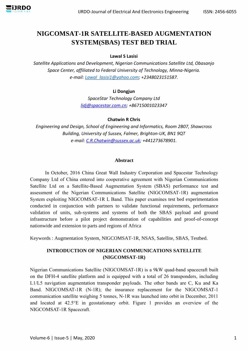
and located at 42.5°E in geostationary orbit. Figure 1 provides an overview of the
NIGCOMSAT-1R Spacecraft.
IJRDO-Journal of Electrical And Electronics Engineering ISSN: 2456-6055
Volume-6 | Issue-5 | May, 2020 1
Figure 1: Pictorial view of NIGCOMSAT-1R satellite
NIGCOMSAT-1R L-BAND FPR NAVIGATION OVERLAY SERVICES
The NigComSat-1R Navigation (L-band) payload provides a Navigation Overlay Service
(NOS) known as Nigerian Satellite Augmentation System (NSAS). The system augments the
Global Navigation Satellite System (GNSS) over Europe and Africa. Dual user frequencies
(L1 and L5 frequencies) rather than a single L1 frequency was implemented as a hosted
payload on NIGCOMSAT-1R Communication Satellite recognizing its importance and
advancement over the single L1 frequency capabilities of the previous GNSS considering the
GPS constellation modernization with the additional civil signal on the L5 frequency and the
Galileo system.
The system functionality is similar to the European geostationary Navigation Overlay Service
(EGNOS), where a number of ground reference stations monitor the GPS satellites’ signals
and provide their observations to one or more Master Control stations (MCS). An
augmentation message is generated by the MCS and two signals, C1 and C5, are transmitted
via uplink stations within the uplink coverage areas on the C-band. The navigation payload
down converts the C-band signals to L-band, L1 and L5, and broadcasts these signals
regionally to users with messages to improve positioning accuracy with integrity.
IJRDO-Journal of Electrical And Electronics Engineering ISSN: 2456-6055
Volume-6 | Issue-5 | May, 2020 2

Figure 2: Coverage of NIGCOMSAT-1R Navigation Overlay Services
Figure 2 illustrates coverage of NIGCOMSAT-1R Navigation Overlay Services called
Nigerian Satellite Augmentation System (NSAS). The NOS augments the GPS standard
positioning service by providing three types of information to users: Ranging information,
Differential GPS corrections and Integrity monitoring information (NIGCOMSAT-1R, 2009).
The onboard navigation payload has various component redundancies. It is a dual-channel
bent-pipe transponder that down-converts two C-band (C1 and C5) uplink signals from a
ground earth station to two downlink signals in the two separate bands, L1 and L5. A 4.0
MHz-wide C1 band uplink channel relays in the L1 downlink channel and allows the
transmission of the L1 signal while a 20.0 MHz-wide C5 band uplink channel relays in the L5
downlink channel and allows transmission of the L5 signal (1,2,3,4,5 &7).
Table 1: Downlink Frequency and Polarization of NIGCOMSAT-1R L-Band Payload.
Channel Frequency (MHz) Polarization Bandwidth
(MHz)
L1-Downlink 1575.42 RHCP 4
L5-Downlink 1176.45 RHCP 20
The beam from the downlink L-band navigation antenna is global, ensuring that NigComSat-
1R is capable of broadcasting to its coverage area, GEO ranging signals and Satellite Based
Augmentation System (SBAS) signals through the L1 and L5 frequencies as depicted in
Table 1. The In-Orbit Test (IOT) was used to validate the functional capability of the
navigation payload and its readiness for function and purpose. Figure 4 and 5 shows the EIRP
IJRDO-Journal of Electrical And Electronics Engineering ISSN: 2456-6055
Volume-6 | Issue-5 | May, 2020 3

results of the re-launched Nigerian Communications Satellite (NIGCOMSAT-1R) in the L1
and L5 signal bands respectively with the colored right-hand bar showing measured results in
dBW(6).
Figure 3: The Downlink coverage beam (L1-Band) of NIGCOMSAT-1R Geo-Navigation
Satellite using Dual L-Band Helix Antenna.
Figure 4: The Downlink coverage beam (L5-Band) of NIGCOMSAT-1R Geo-Navigation
Satellite using Dual L-Band Helix Antenna.
IJRDO-Journal of Electrical And Electronics Engineering ISSN: 2456-6055
Volume-6 | Issue-5 | May, 2020 4
DISCUSSION OF NIGERIAN SATELLITE AUGMENTATION SYSTEM (NSAS)
TESTBED TRIAL.
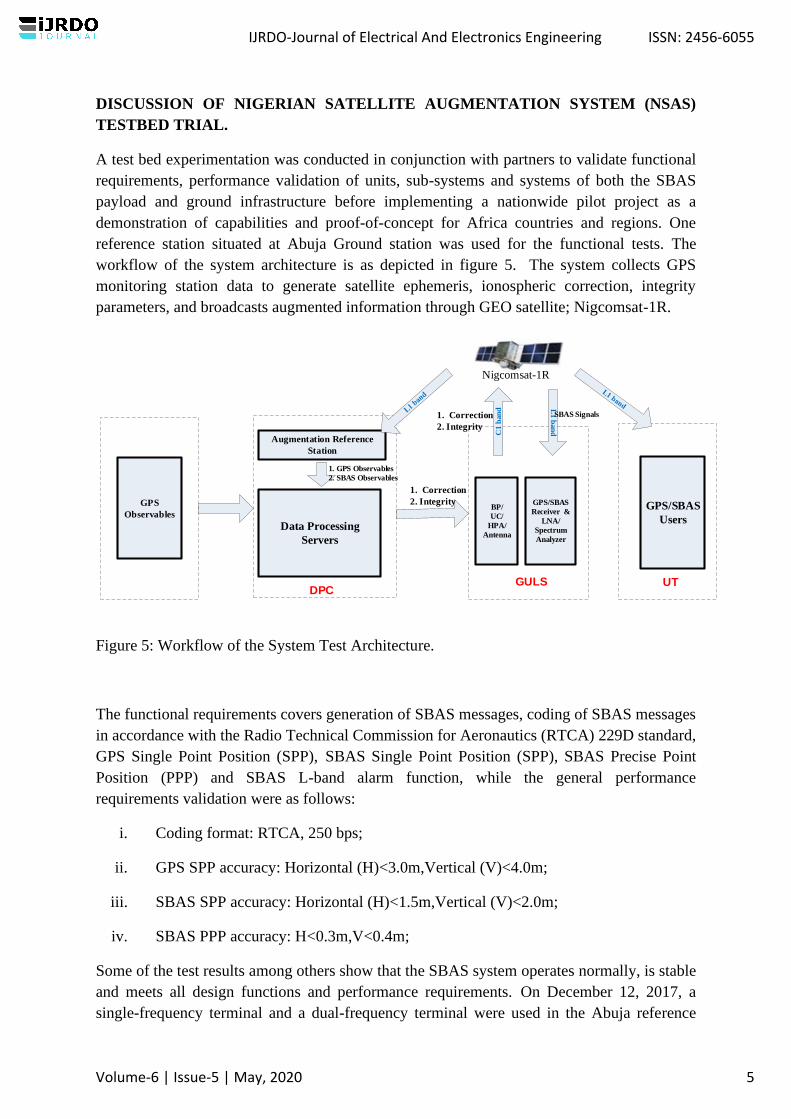
A test bed experimentation was conducted in conjunction with partners to validate functional
requirements, performance validation of units, sub-systems and systems of both the SBAS
payload and ground infrastructure before implementing a nationwide pilot project as a
demonstration of capabilities and proof-of-concept for Africa countries and regions. One
reference station situated at Abuja Ground station was used for the functional tests. The
workflow of the system architecture is as depicted in figure 5. The system collects GPS
monitoring station data to generate satellite ephemeris, ionospheric correction, integrity
parameters, and broadcasts augmented information through GEO satellite; Nigcomsat-1R.
Data Processing
Servers
1. Correction
2. Integrity GPS/SBAS
Users
C1 b
an
d
1. Correction
2. Integrity
BP/
UC/
HPA/
Antenna
Nigcomsat-1R
GPS
Observables
Augmentation Reference
Station
1. GPS Observables
2. SBAS Observables
DPCGULS UT
L1 b
an
d
SBAS Signals
GPS/SBAS
Receiver &
LNA/
Spectrum
Analyzer
Figure 5: Workflow of the System Test Architecture.
The functional requirements covers generation of SBAS messages, coding of SBAS messages
in accordance with the Radio Technical Commission for Aeronautics (RTCA) 229D standard,
GPS Single Point Position (SPP), SBAS Single Point Position (SPP), SBAS Precise Point
Position (PPP) and SBAS L-band alarm function, while the general performance
requirements validation were as follows:
i. Coding format: RTCA, 250 bps;
ii. GPS SPP accuracy: Horizontal (H)<3.0m,Vertical (V)<4.0m;
iii. SBAS SPP accuracy: Horizontal (H)<1.5m,Vertical (V)<2.0m;
iv. SBAS PPP accuracy: H<0.3m,V<0.4m;
Some of the test results among others show that the SBAS system operates normally, is stable
and meets all design functions and performance requirements. On December 12, 2017, a
single-frequency terminal and a dual-frequency terminal were used in the Abuja reference
IJRDO-Journal of Electrical And Electronics Engineering ISSN: 2456-6055
Volume-6 | Issue-5 | May, 2020 5

station to perform single-frequency and dual-frequency SPP and PPP positioning
performance tests. The Klobuchar ionosphere model estimation was used for the single-
frequency; SPP while ionosphere-free combination was used for the dual-frequency PPP.
GPS SPP is a single-point positioning using basic navigation, SBAS SPP is a wide area
differential correction mode, and SBAS PPP is a precise single-point positioning using SBAS
augmentation information (8).
Figure 6 shows both the tracking graph and Skyplot of the GNSS and SBAS signal-in-space
including the NIGCOMSAT-1R Augmentation Signal on Pseudo Random Noise (PRN) Code
147 known as Nigerian Satellite Augmentation System (NSAS)
Figure 6: Tracking Graph of GNSS and SBAS signals (G=GPS, R=GLONASS, C=BDS,
S147=Nigerian SBAS)
IJRDO-Journal of Electrical And Electronics Engineering ISSN: 2456-6055
Volume-6 | Issue-5 | May, 2020 6
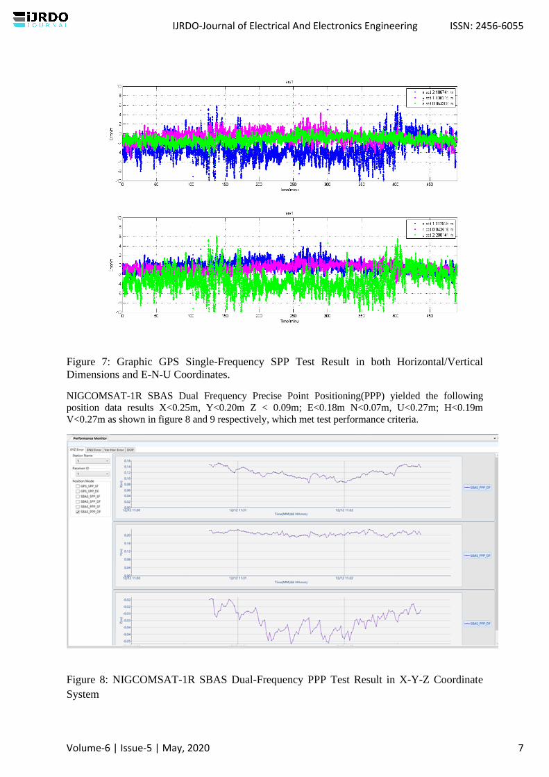
Figure 7: Graphic GPS Single-Frequency SPP Test Result in both Horizontal/Vertical
Dimensions and E-N-U Coordinates.
NIGCOMSAT-1R SBAS Dual Frequency Precise Point Positioning(PPP) yielded the following
position data results X<0.25m, Y<0.20m Z < 0.09m; E<0.18m N<0.07m, U<0.27m; H<0.19m
V<0.27m as shown in figure 8 and 9 respectively, which met test performance criteria.
Figure 8: NIGCOMSAT-1R SBAS Dual-Frequency PPP Test Result in X-Y-Z Coordinate
System
IJRDO-Journal of Electrical And Electronics Engineering ISSN: 2456-6055
Volume-6 | Issue-5 | May, 2020 7
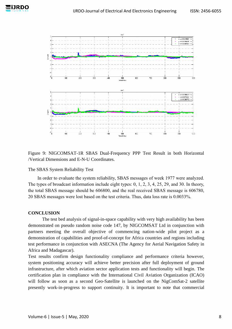
Figure 9: NIGCOMSAT-1R SBAS Dual-Frequency PPP Test Result in both Horizontal
/Vertical Dimensions and E-N-U Coordinates.
The SBAS System Reliability Test
In order to evaluate the system reliability, SBAS messages of week 1977 were analyzed.
The types of broadcast information include eight types: 0, 1, 2, 3, 4, 25, 29, and 30. In theory,
the total SBAS message should be 606800, and the real received SBAS message is 606780,
20 SBAS messages were lost based on the test criteria. Thus, data loss rate is 0.0033%.
CONCLUSION
The test bed analysis of signal-in-space capability with very high availability has been
demonstrated on pseudo random noise code 147, by NIGCOMSAT Ltd in conjunction with
partners meeting the overall objective of commencing nation-wide pilot project as a
demonstration of capabilities and proof-of-concept for Africa countries and regions including
test performance in conjunction with ASECNA (The Agency for Aerial Navigation Safety in
Africa and Madagascar).
Test results confirm design functionality compliance and performance criteria however,
system positioning accuracy will achieve better precision after full deployment of ground
infrastructure, after which aviation sector application tests and functionality will begin. The
certification plan in compliance with the International Civil Aviation Organization (ICAO)
will follow as soon as a second Geo-Satellite is launched on the NigComSat-2 satellite
presently work-in-progress to support continuity. It is important to note that commercial
IJRDO-Journal of Electrical And Electronics Engineering ISSN: 2456-6055
Volume-6 | Issue-5 | May, 2020 8

aircraft are five times more likely to have an accident flying a non-precision approach than
flying a precision approach as reiterated by the Flight Safety Foundation.
REFERENCES:
1. Carlos, R. (2016). Wise Area Augmentation System (WAAS) Update. Federal Aviation
Administration (FAA) Satellite Navigation Program Manager. Retrieved on 24th
February, 2019 from https://www.icao.int/SAM/Documents/2016-
PBNGNSS/12%20FAA%20SBAS%20Overview.pdf
2. Lawal, L.S., & Chatwin, C.R. (2011). Essential Parameters of Space-Borne Oscillators
That Ensures Performance of Satellite-Based Augmentation System. Proceedings of
3rd IEEE International Conference on Science and Technology, ICAST, (pp42-50).
Abuja-Nigeria. doi: 10.1109/ICASTech.2011.6145156.
3. Lawal, L.S & Chatwin, C.R. (2015). Enhancing Public Safety and Security of Critical
National Infrastructure Utilizing the Nigerian Satellite Augmentation System (NSAS).
2015 National Engineering Conference and Annual General Meeting of Nigerian
Society of Engineers (NSE) on 16-20 November, 2015 at Akure, Ondo State, Nigeria.
4. Lawal, L. S., & Chatwin, C. R. (2019). A REVIEW OF GLOBAL NAVIGATION SATELLITE
AND AUGMENTATION SYSTEMS. IJRDO - Journal of Electrical And Electronics
Engineering (ISSN: 2456-6055), 5(3), 01-21. Retrieved from
https://www.ijrdo.org/index.php/eee/article/view/2731
5. Lawal, L. S., & Chatwin, C. R. (2019). DESIGN OF A LOW-COST AUGMENTATION
NAVIGATION SYSTEM: THE UNITED KINGDOM’s IMMEDIATE ANSWER TO THE
GALILEO BREXIT CONUNDRUM. IJRDO - Journal of Electrical And Electronics
Engineering (ISSN: 2456-6055), 5(1), 01-25. Retrieved from
https://www.ijrdo.org/index.php/eee/article/view/2625
6. NigComSat-1R. (2009). Preliminary Design Review (PDR) and Critical Design Review
(CDR) of NIGCOMSAT-1R Communications Satellite Project. Nigerian Communications
Satellite Limited. Abuja, Nigeria: NIGCOMSAT-1R.
7. Reza, Z., & Buehrer, R. M. (2012). Overview of Global Navigation Satellite Systems.
Handbook of Position Location: Theory, Practice, and Advances, First Edition: John
Wiley & Sons, Inc, 923-974. Doi:1002/9781118104750.Ch28
8. Sobreira, H., Bougard, B., Barrios, J., & Calle, J. D. (2018) SBAS Australian-NZ Test
Bed: Exploring New Services, Proceedings of the 31st International Technical Meeting
of the Satellite Division of The Institute of Navigation (ION GNSS+ 2018), Miami,
Florida, September 2018, pp. 2119-2133. https://doi.org/10.33012/2018.15849
IJRDO-Journal of Electrical And Electronics Engineering ISSN: 2456-6055
Volume-6 | Issue-5 | May, 2020 9


![SBAS DFMC SIS ICD EPO Inputs to IWG#26 [from Pro-SBAS studies]](https://static.cupdf.com/doc/110x72/568145f5550346895db2fb3e/sbas-dfmc-sis-icd-epo-inputs-to-iwg26-from-pro-sbas-studies.jpg)


