NI 43-101 Technical Report on the Fond Du Lac ProjectAthabasca Basin, Saskatchewan, Canada
Prepared for:
CanAlaska Uranium Ltd.
Prepared by:
Ron Parent, P.Geo.
Project No. 165521
Effective Date: 15 October 2010
AMEC Americas Limited 111 Dunsmuir Street, Suite 400 Vancouver, B.C. V6B 5W3 Tel (604) 664-4315 Fax (604) 669-9516 www.amec.com
CERTIFICATE OF QUALIFIED PERSON
Ron R. Parent, P. Geo. AMEC Americas Limited
111 Dunsmuir Street, Suite 400 Vancouver, B.C. V6B 5W3
Tel (604) 664-3054 Fax (604) 669-9516
I, Ron Parent, P.Geo., am employed as a Principal Geologist with AMEC Americas Ltd.
This certificate applies to the technical report entitled “NI 43-101 Technical Report on the Fond Du
Lac Project” (the “Technical Report”), dated 15 October 2010.
I am a Professional Geologist registered in Saskatchewan (License # 16390) and British Columbia (License # 27031). I graduated with a Bachelor of Science with Honours in Geology in 1990 from the University of Alberta, preceeded by graduation from the Northern Alberta Institute of Technology in Mineral Resources Engineering Technology (1986). I have practiced my profession for 20 years. During this period I have been directly involved in active mining operations and exploration operations. I have compiled, produced and reviewed many geological models and exploration data sets. I have authored or co-authored several NI 43-101 reports on a variety of mineral projects covering commodities including uranium, gold, copper-molybdenum and coal. As a result of my experience and qualifications, I am a Qualified Person as defined in National
Instrument 43–101 Standards of Disclosure for Mineral Projects (NI 43–101).
I personally examined the Fond Du Lac deposit area during a site visit to the property on June 10,
2010.
I have prepared all the sections of this report.
I am independent of CanAlaska Uranium Ltd. as independence is described by Section 1.4 of
NI 43-101.
I had not previously provided technical assistance to the Fond Du Lac Project, and have no prior
involvement with the project.
I have read NI 43–101 and this report has been prepared in compliance with that Instrument.
AMEC Americas Limited 111 Dunsmuir Street, Suite 400 Vancouver, B.C. V6B 5W3 Tel (604) 664-4315 Fax (604) 669-9516 www.amec.com
As of the date of this certificate, to the best of my knowledge, information and belief, the technical
report contains all scientific and technical information that is required to be disclosed to make the
technical report not misleading.
“Signed and sealed”
Ron R. Parent, P. Geo.
Dated: 15 October 2010
IMPORTANT NOTICE
This report was prepared as a National Instrument 43-101 Technical
Report for CanAlaska Uranium Ltd. (“CanAlaska”) by AMEC Americas
Limited (AMEC). The quality of information, conclusions, and
estimates contained herein is consistent with the level of effort involved
in AMEC’s services, based on: i) information available at the time of
preparation, ii) data supplied by outside sources, and iii) the
assumptions, conditions, and qualifications set forth in this report. This
report is intended to be used by CanAlaska subject to the terms and
conditions of its contract with AMEC. That contract permits CanAlaska
to file this report as a Technical Report with Canadian Securities
Regulatory Authorities pursuant to provincial securities legislation.
Except for the purposes legislated under provincial securities laws, any
use of this report by any third party is at that party’s sole risk.
CANALASKA URANIUM LTD.
ATHABASCA BASIN, SASKATCHEWAN, CANADA NI 43-101 TECHNICAL REPORT ON THE FOND DU LAC PROJECT
Project No.: 165521 TOC ii 15 October 2010
C O N T E N T S
1.0 SUMMARY .................................................................................................................. 1-1
2.0 INTRODUCTION ......................................................................................................... 2-1
3.0 RELIANCE ON OTHER EXPERTS ............................................................................. 3-1
4.0 PROPERTY DESCRIPTION AND LOCATION ............................................................ 4-1 4.1 Summary .................................................................................................................... 4-1 4.2 Mineral Rights and Agreement Summary ................................................................. 4-1
4.2.1 Option Phase ................................................................................................. 4-2 4.2.2 General Conditions of the Option Phase of the Agreement as Amended .... 4-3
5.0 ACCESSIBILITY, CLIMATE, LOCAL RESOURCES, INFRASTRUCTURE, AND PHYSIOGRAPHY ........................................................................................................ 5-1
6.0 HISTORY .................................................................................................................... 6-1
7.0 GEOLOGICAL SETTING ............................................................................................. 7-1 7.1 Athabasca Basin ........................................................................................................ 7-1 7.2 Regional Geology – Fond Du Lac ............................................................................. 7-3 7.3 Local Geology – IR 228 and 233 ............................................................................... 7-5
8.0 DEPOSIT TYPES ........................................................................................................ 8-1
9.0 MINERALIZATION ....................................................................................................... 9-1
10.0 EXPLORATION ......................................................................................................... 10-1 10.1 Summary .................................................................................................................. 10-1 10.2 Geophysics .............................................................................................................. 10-2
10.2.1 Airborne Aeromagnetic, Radiometric and VLF survey ............................... 10-2 10.2.2 Gravity Survey ............................................................................................. 10-6 10.2.3 Resistivity-IP survey .................................................................................... 10-8 10.2.4 Discussion ................................................................................................. 10-11
10.3 2008 Boulder and Soil Sampling Program ............................................................ 10-11 10.3.1 Introduction ................................................................................................ 10-11 10.3.2 Boulder Sampling ...................................................................................... 10-12 10.3.3 Soil Sampling ............................................................................................ 10-14 10.3.4 Discussion ................................................................................................. 10-16
11.0 DRILLING .................................................................................................................. 11-1 11.1 Introduction .............................................................................................................. 11-1 11.2 Core logging procedures ......................................................................................... 11-6 11.3 Down-Hole Probing .................................................................................................. 11-7 11.4 Collar Surveys .......................................................................................................... 11-7 11.5 Discussion of Results .............................................................................................. 11-8
12.0 SAMPLING METHOD AND APPROACH .................................................................. 12-1
13.0 SAMPLE PREPARATION, ANALYSES, AND SECURITY ......................................... 13-1 13.1 Procedures and Methods Summary ........................................................................ 13-1 13.2 Mineralogical and Chemical Analyses ..................................................................... 13-1
CANALASKA URANIUM LTD.
ATHABASCA BASIN, SASKATCHEWAN, CANADA NI 43-101 TECHNICAL REPORT ON THE FOND DU LAC PROJECT
Project No.: 165521 TOC iii 15 October 2010
13.3 Quality Assurance-Quality Control (QA/QC) ........................................................... 13-2
14.0 DATA VERIFICATION ............................................................................................... 14-1
15.0 ADJACENT PROPERTIES ........................................................................................ 15-1
16.0 MINERAL PROCESSING AND METALLURGICAL TESTING ................................... 16-1
17.0 MINERAL RESOURCE AND MINERAL RESERVE ESTIMATES .............................. 17-1
18.0 OTHER RELEVANT DATA AND INFORMATION ...................................................... 18-1
19.0 ADDITIONAL REQUIREMENTS FOR TECHNICAL REPORTS ON DEVELOPMENT PROPERTIES AND PRODUCTION PROPERTIES ................................................... 19-1
20.0 INTERPRETATION AND CONCLUSIONS ................................................................ 20-1
21.0 RECOMMENDATIONS.............................................................................................. 21-1 21.1 Drilling and assaying procedures ............................................................................ 21-1
21.1.1 Sampling Interval ......................................................................................... 21-1 21.1.2 Certified Reference Material (Standards) ................................................... 21-1 21.1.3 Blanks .......................................................................................................... 21-1 21.1.4 Duplicates .................................................................................................... 21-2 21.1.5 Re-analysis (Pulp Check) ............................................................................ 21-2
21.2 Work Program .......................................................................................................... 21-3
22.0 REFERENCES .......................................................................................................... 22-1
23.0 DATE AND SIGNATURE PAGE ................................................................................ 23-1
T A B L E S
Table 4-1: Mineral Dispositions of the Fond Du Lac Project ................................................................... 4-1 Table 6-1: Historical Drill Holes in the Fond Du Lac deposit area .......................................................... 6-2 Table 9-1: Fond Du Lac Deposit Assays – Camok 1970 (from SMDI no. 1572) .................................... 9-1 Table 10-1: CanAlaska work completed from 2006 to 2009 ................................................................... 10-1 Table 11-1: CanAlaska drilling highlights (true thickness unknown) ....................................................... 11-1 Table 21-1: Phase 1 and 2 Proposed Exploration Budgets .................................................................... 21-5
F I G U R E S
Figure 2-1: Project Location ..................................................................................................................... 2-2 Figure 4-1: Tenure .................................................................................................................................... 4-5 Figure 6-1: Fond Du Lac Deposit Drilling ................................................................................................. 6-3 Figure 7-1: Regional Geology of the Athabasca Basin ............................................................................ 7-2 Figure 7-2: Regional Lithostratigraphic Section of the Athabasca basin ................................................. 7-2 Figure 7-3: Regional Geology................................................................................................................... 7-4 Figure 7-4: Local Geology ........................................................................................................................ 7-6 Figure 8-1: Examples of unconformity-associated uranium deposits ...................................................... 8-2 Figure 9-1: Fond Du Lac Deposit Detail Geology..................................................................................... 9-2 Figure 9-2: Fond Du Lac Deposit Schematic Geological Cross Section .................................................. 9-3
CANALASKA URANIUM LTD.
ATHABASCA BASIN, SASKATCHEWAN, CANADA NI 43-101 TECHNICAL REPORT ON THE FOND DU LAC PROJECT
Project No.: 165521 TOC iv 15 October 2010
Figure 10-1: Airborne Magnetics Vertical 1st derivative ............................................................................ 10-3
Figure 10-2: Airborne VLF EM .................................................................................................................. 10-4 Figure 10-3: Airborne Radiometrics Equivalent Uranium ......................................................................... 10-5 Figure 10-4: Gravity Survey Residual Bouger Gravity ............................................................................. 10-7 Figure 10-5: Resistivity slice at a depth of 50 m ....................................................................................... 10-9 Figure 10-6: Chargeability slice at a depth of 50 m ................................................................................ 10-10 Figure 10-7: Boulder Sampling Program ................................................................................................ 10-13 Figure 10-8: Uranium ppm in Soil Samples ............................................................................................ 10-15 Figure 10-9: Mineralization in historical drillholes near boulder area F .................................................. 10-18 Figure 15-1: CanAlaska Uranium Projects in the Athabasca Basin ......................................................... 15-1 Figure 21-1: Location of proposed work ................................................................................................... 21-4

CANALASKA URANIUM LTD.
ATHABASCA BASIN, SASKATCHEWAN, CANADA NI 43-101 TECHNICAL REPORT ON THE FOND DU LAC PROJECT
Project No.: 165521 TOC v 15 October 2010
U N I T S O F M E A S U R E
Billion years ago .......................................................................................................... Ga
Degree ........................................................................................................................ °
Foot ............................................................................................................................. ft
Greater than ................................................................................................................ >
Hectare (10,000 m2) .................................................................................................... ha
Kilometre ..................................................................................................................... km
Kilovolt ........................................................................................................................ kV
Lead ............................................................................................................................ pb
Less than .................................................................................................................... <
Metre ........................................................................................................................... m
Million years ago ......................................................................................................... Ma
Ohm (electrical) ........................................................................................................... Ω
Parts per million .......................................................................................................... ppm
Percent........................................................................................................................ %
CANALASKA URANIUM LTD.
ATHABASCA BASIN, SASKATCHEWAN, CANADA NI 43-101 TECHNICAL REPORT ON THE FOND DU LAC PROJECT
Project No.: 165521 Page 1-1 15 October 2010
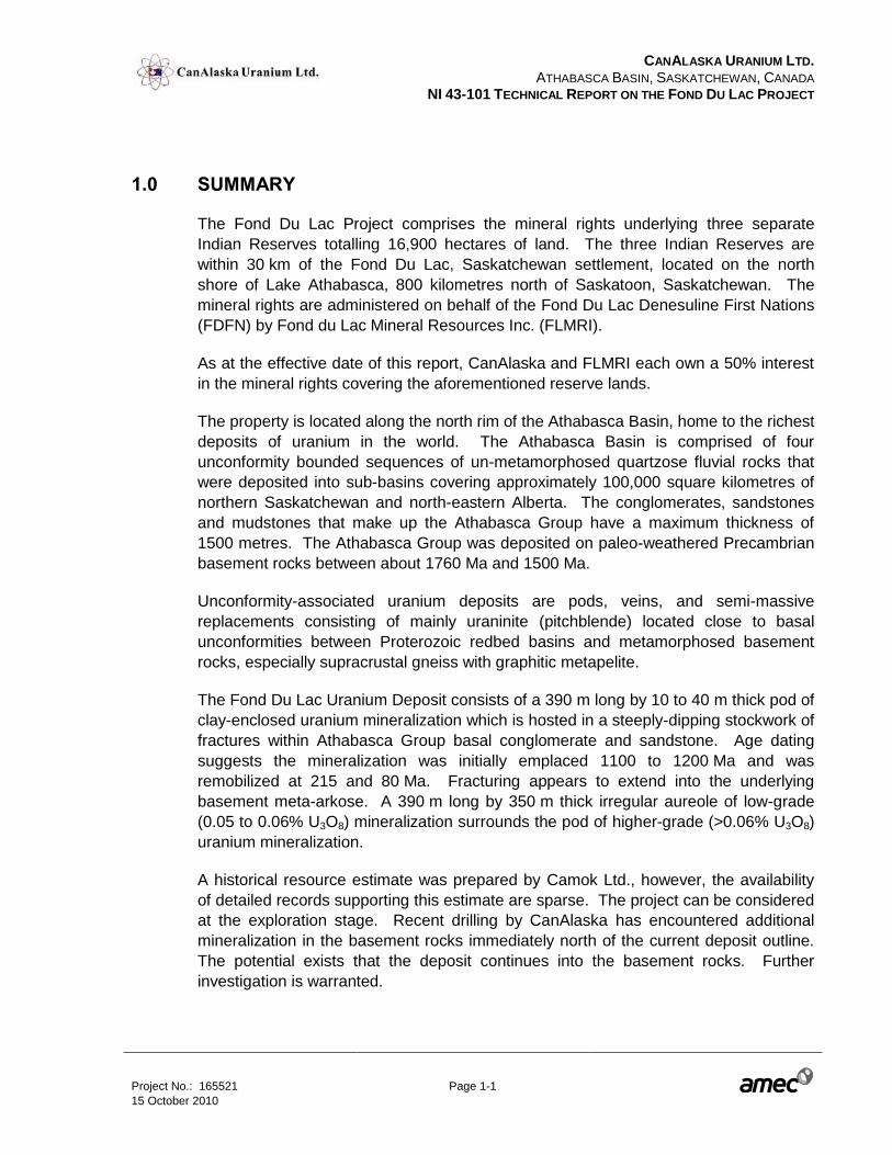
1.0 SUMMARY
The Fond Du Lac Project comprises the mineral rights underlying three separate
Indian Reserves totalling 16,900 hectares of land. The three Indian Reserves are
within 30 km of the Fond Du Lac, Saskatchewan settlement, located on the north
shore of Lake Athabasca, 800 kilometres north of Saskatoon, Saskatchewan. The
mineral rights are administered on behalf of the Fond Du Lac Denesuline First Nations
(FDFN) by Fond du Lac Mineral Resources Inc. (FLMRI).
As at the effective date of this report, CanAlaska and FLMRI each own a 50% interest
in the mineral rights covering the aforementioned reserve lands.
The property is located along the north rim of the Athabasca Basin, home to the richest
deposits of uranium in the world. The Athabasca Basin is comprised of four
unconformity bounded sequences of un-metamorphosed quartzose fluvial rocks that
were deposited into sub-basins covering approximately 100,000 square kilometres of
northern Saskatchewan and north-eastern Alberta. The conglomerates, sandstones
and mudstones that make up the Athabasca Group have a maximum thickness of
1500 metres. The Athabasca Group was deposited on paleo-weathered Precambrian
basement rocks between about 1760 Ma and 1500 Ma.
Unconformity-associated uranium deposits are pods, veins, and semi-massive
replacements consisting of mainly uraninite (pitchblende) located close to basal
unconformities between Proterozoic redbed basins and metamorphosed basement
rocks, especially supracrustal gneiss with graphitic metapelite.
The Fond Du Lac Uranium Deposit consists of a 390 m long by 10 to 40 m thick pod of
clay-enclosed uranium mineralization which is hosted in a steeply-dipping stockwork of
fractures within Athabasca Group basal conglomerate and sandstone. Age dating
suggests the mineralization was initially emplaced 1100 to 1200 Ma and was
remobilized at 215 and 80 Ma. Fracturing appears to extend into the underlying
basement meta-arkose. A 390 m long by 350 m thick irregular aureole of low-grade
(0.05 to 0.06% U3O8) mineralization surrounds the pod of higher-grade (>0.06% U3O8)
uranium mineralization.
A historical resource estimate was prepared by Camok Ltd., however, the availability
of detailed records supporting this estimate are sparse. The project can be considered
at the exploration stage. Recent drilling by CanAlaska has encountered additional
mineralization in the basement rocks immediately north of the current deposit outline.
The potential exists that the deposit continues into the basement rocks. Further
investigation is warranted.
CANALASKA URANIUM LTD.
ATHABASCA BASIN, SASKATCHEWAN, CANADA NI 43-101 TECHNICAL REPORT ON THE FOND DU LAC PROJECT
Project No.: 165521 Page 1-2 15 October 2010
A two phase work program is recommended. The first phase would include a
geochemical soil survey accompanied by radon gas measurements in the deposit area
in order to define limits of the known mineralization and perhaps uncover previously
unidentified areas of mineralization. This will be followed by the completion of 10
diamond drillholes to test for additional basement mineralization in the area north of
the deposit. The total budget for phase 1 is estimated at $962,000.
A phase 2 budget of $1,910,000 is to include an additional 30 holes for roughly
6100 m, which should include some infill or close spaced drilling to test for the
continuity of mineralization. Additionally, a computerized geological model should be
created in order to help establish the geometry, position and relationship of the various
drillhole intercepts to establish targets for infill and / or resource definition drilling.
CANALASKA URANIUM LTD.
ATHABASCA BASIN, SASKATCHEWAN, CANADA NI 43-101 TECHNICAL REPORT ON THE FOND DU LAC PROJECT
Project No.: 165521 Page 2-1 15 October 2010
2.0 INTRODUCTION
This technical report was prepared for CanAlaska Uranium Ltd. (CanAlaska) for the
purpose of summarizing the geology and mineralization on the Fond Du Lac Property
(Figure 2-1) and to provide recommendations for further exploration. The report
focuses specifically on the Fond Du Lac deposit area. The main sources of
information and data were internal company reports supplied to AMEC by CanAlaska
and federal (DIAND on the Indian Reserve) and Saskatchewan government
assessment files. These include:
A draft Report on the mineral potential of the Indian Reserve Lands of the Fond Du
Lac Denesuline First Nation with recommendations for further exploration for
Uranium by J.S. Kermeen, M.Sc., P. Eng. Dated February 14, 2007.
Report on 2008 and 2009 Drilling and Prospecting, Fond Du Lac Project,
Saskatchewan, Canada, Report # FDL 2009-02; Submitted by: Marnie Muirhead,
Erin Smart, Karl Schimann Dated January, 2010.
2008-2009 Geophysics Fond Du Lac Project, Saskatchewan Report # FDL2009-01
Submitted by: Guy Marquis Karl Schimann December 2009, Vancouver, BC
A site visit was performed by the author on June 10, 2010. The visit only included that
immediate area of the FDL deposit and camp area. Observations of the following were
made:
Access to the site
core storage and sampling;
mineralization in the drill core;
state of the property and locations of CanAlaska and historical drillholes;
deposit geology through discussions with CanAlaska personnel accompanying
AMEC on the site visit.
XYXYXYXYXYXY
XY
XY
XY
XY
XYXYXY
h
__
__________________________
_
_[_
___
[_
[___
"
"
"
"
"
"
"
"
"
"
" "
"
"
"
"
"
"
"
"
"
"
"
"
"
"
""
"
"
"
"
"
"
"
"
"
"
"
"
"
"
"
"
"
"
"
"
"
"
"
"
""
"
"
"
"
"
"
"
"
"
"
"
"
"
"
"
"
"
"
"
"
"
"
"
"
"
"
"
"
""
"
"
"
"
"
"
!(
!(
!(
!(
!(
"
"
"
"
"
"
"
"
"
"
"
!
!!
!
!
[_
Prince Albert National Park
Saskatchewan
Manitoba
Alberta
Northwest Territories Nunavut
Tisdale
Nipawin
La Ronge
Battleford
Meadow Lake
La Loche
Missinippi
Fond Du Lac
Points North
Uranium City
Stoney Rapids
Pinehouse Lake
Wollaston Lake
Buffalo Narrows
Camsell Portage
Melfort
Flin Flon
Lloydminster
Prince Albert
North Battleford
Fond-du-Lac Deposit
100°0'0"W
105°0'0"W
105°0'0"W
110°0'0"W
110°0'0"W
60°0'0"N60°0'0"N
59°0'0"N59°0'0"N
58°0'0"N 58°0'0"N
57°0'0"N 57°0'0"N
56°0'0"N 56°0'0"N
55°0'0"N 55°0'0"N
54°0'0"N 54°0'0"N
53°0'0"N 53°0'0"N
Legend
[_ Fond du Lac DepositMines and mineral projects(commodity, status)
XY Gold, Past Producer
h Nickel-copper, Past Producer
[_ Uranium, Advanced Project
_ Uranium, Past Producer
[_ Uranium, Producer
highway
all season road
ice road
Railroads
Transmission Line (>25kV)
Indian Reservation
Wilderness Parks
Provincial Park
National Park
Figure 2-1 Project LocationFond Du Lac Project
UTM NAD 83Zone 13 North
Date: October 15, 2010Drawn by: RP Report: FDL 43-101
CanAlaska Uranium Ltd.
Northern MiningDivision
Saskatchewan1:3,500,000
50 0 5025
Kilometers
CANALASKA URANIUM LTD.
ATHABASCA BASIN, SASKATCHEWAN, CANADA NI 43-101 TECHNICAL REPORT ON THE FOND DU LAC PROJECT
Project No.: 165521 Page 3-1 15 October 2010
3.0 RELIANCE ON OTHER EXPERTS
With regard to CanAlaska’s right to mineral tenure and property agreements, AMEC
has fully relied upon, and disclaims responsibility for, information in documents
supplied by CanAlaska, namely:
Letter of legal opinion by Bruce J. Slusar, Barrister & Solicitor of Saskatoon,
Saskatchewan dated September 27, 2010.
AMEC has relied on this information in the property description and location in
Section 4 of the Report.

CANALASKA URANIUM LTD.
ATHABASCA BASIN, SASKATCHEWAN, CANADA NI 43-101 TECHNICAL REPORT ON THE FOND DU LAC PROJECT
Project No.: 165521 Page 4-1 15 October 2010
4.0 PROPERTY DESCRIPTION AND LOCATION
4.1 Summary
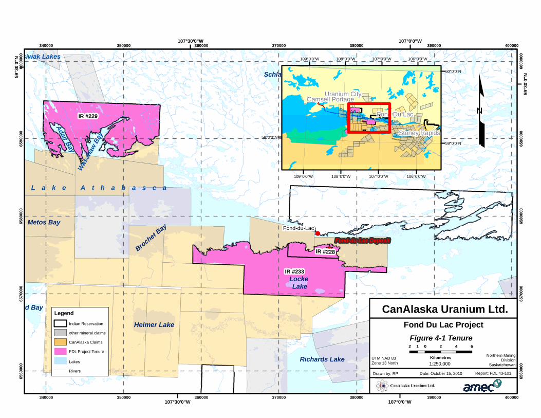
The Fond Du Lac Project comprises the mineral rights to three separate Indian
Reserves totalling 16,900 hectares of land (Table 4-1, Figure 4-1). The Indian
Reserves are within 30 km of the settlement of Fond Du Lac, located on the shore of
Lake Athabasca, 680 kilometres north of Prince Albert and 800 km north of Saskatoon,
Saskatchewan. The mineral rights are administered on behalf of the FDFN by FLMRI.
As at the effective date of this report, CanAlaska and FLMRI each own a 50% interest
in the mineral rights covering the aforementioned reserve lands.
FLMRI currently has a valid Mineral Exploration permit, which is renewable annually
for work on the Fond Du Lac Project which was granted by Department of Indian and
Northern Affairs Canada (INAC).
FLMRI may obtain a mining lease for the purpose of developing a mining operation
upon application to INAC under the Indian Act Mining Regulations.
The Fond Du Lac Indian Reserves No. 228, 229 and 233 are reserves within the
meaning of the Indian Act of 1985. The Fond Du Lac Band of Indians is a Band as
defined pursuant to Section 2(1)a of the Act.
Table 4-1: Mineral Dispositions of the Fond Du Lac Project
Reserve No. Project Name
Reserve Area
(Hectares) Survey Plan no*
I.R. 228 Fond Du Lac 1,082 55692
I.R. 229 Fond Du Lac 7,821 55690
I.R. 233 Fond Du Lac 7,997 68164
Total: 16,900
*in the Canadian Land Surveys Records in Ottawa
The following legal summary are supported and / or excerpted from a letter dated
September 27, 2010 by Mr. Brue J. Slusar, legal counsel for FLMRI and FDFN. This
information was fully relied upon in preparing Section 4.2 of the Report.
4.2 Mineral Rights and Agreement Summary
Mineral rights held in the name of FLMRI are appropriately designated to FLMRI and
are valid and in good standing, and are held for the purpose of the Option Agreement
CANALASKA URANIUM LTD.
ATHABASCA BASIN, SASKATCHEWAN, CANADA NI 43-101 TECHNICAL REPORT ON THE FOND DU LAC PROJECT
Project No.: 165521 Page 4-2 15 October 2010
between FLMRI and CanAlaska. The mineral exploration permit tenures are not
subject to any outstanding liens or encumbrances, and are not pledged in any way to
any other parties.
By Agreement dated October 18, 2006, FLMRI entered into an Option Agreement with
CanAlaska Ventures Ltd. (now known as “CanAlaska Uranium Ltd.”) which has been
subsequently amended by Amending Agreements dated November 8, 2008 and
September 10, 2010 which provide that CanAlaska Uranium Ltd. will act as a principal
exploration consultant and contractor to the project.
4.2.1 Option Phase
The Option Phase includes CanAlaska exploring for minerals and providing cash
payments and share payments to FLMRI in consideration of earning a 49% interest in
all mineral resources located on the Reserve lands, and having an option to enter into
a Joint Venture Agreement to develop a mining operation.
If FLMRI decides not to fund its share of any exploration program carried out under the
terms of this agreement, then CanAlaska can elect to fund the program or revise the
program and budget. CanAlaska may then elect, at its option, to fund Fond du Lac’s
share of the project to a maximum amount without diluting Fond du Lac’s interest.
The Option Agreement provides that CanAlaska may earn a 49% interest in any and
all mineral resources located on the aforesaid Reserve lands based upon the following
terms:
1. CanAlaska is required to spend a minimum of $2,000,000.00 (CDN) in exploration
work and expenditures over a four (4) year period as follows:
a) A minimum of $300,000 June 30, 2009, which has been completed.
b) A minimum of $700,000 by June 30, 2010, which has been completed.
c) A minimum of $1,200,000 by June 30, 2011, which has been completed.
d) A minimum of $2,000,000 by June 30, 2012, which has been completed.
2. In addition, CanAlaska shall make cash payments to Fond du Lac Denesuline First
Nation through its designate as follows:
a) $20,000 paid on execution of agreement (November 8, 2006). Completed
b) $20,000 paid on or before December 14, 2007, which has been completed.
c) $10,000 paid on or before September 5, 2008, which has been completed.
d) $40,000 paid on or before June 30, 2010, which has been completed.
e) $40,000 paid on or before June 30, 2011.
CANALASKA URANIUM LTD.
ATHABASCA BASIN, SASKATCHEWAN, CANADA NI 43-101 TECHNICAL REPORT ON THE FOND DU LAC PROJECT
Project No.: 165521 Page 4-3 15 October 2010
3. In addition, CanAlaska will issue to FDFN through its designate, subject to regulatory
approval, the following payment of shares:
a) 100,000 CanAlaska shares on December 18, 2006, which has been completed.
b) 100,000 CanAlaska shares on September 12, 2008, which has been
completed.
c) 50,000 CanAlaska shares on June 30, 2010, which has been completed.
d) 50,000 CanAlaska shares on June 30, 2011.
Further Amendment to Option Agreement of September 10, 2010
CanAlaska and FLMRI have entered into a further Amendment of Agreement dated
September 10, 2010 which recognized that CanAlaska has exceeded its minimum
expenditures in exploration work as at December 31, 2009, resulting in a further
advance of the payments of cash and shares previously due on or before
June 30, 2011 to September 10, 2011.
In addition, CanAlaska has agreed to pay FLMRI an additional 100,000 CanAlaska
Common Shares towards earning a 50% ownership interest in the Fond du Lac Project
resulting in an amendment to the Option Agreement which provides that during the
Option Phase of the Agreement, CanAlaska will vest with a 50% interest in all mineral
resources located on the project land and the Parties will enter negotiations regarding
a joint venture in which FLMRI will hold a 50% ownership interest and CanAlaska will
hold an initial 50% ownership interest.
The Option Agreement as amended will apply until execution of a Fond du Lac Joint
Venture Agreement which will then supersede the amended Option Agreement.
4.2.2 General Conditions of the Option Phase of the Agreement as Amended
Upon CanAlaska completing the exploration expenditures, cash payments, and share
payments required, CanAlaska will automatically vest with a 50% interest in all mineral
resources located on the project land, and the Option Phase of the Agreement will
terminate.
The Joint Venture Phase of the Option Agreement will then commence where Fond du
Lac will hold a 50% ownership interest and CanAlaska will hold an initial 50%
ownership interest.
During both the Option and Joint Ventures Phases, CanAlaska will act as exploration
program operator and will present exploration programs and budgets to a
Management Committee comprising of two (2) representatives each from Fond du Lac
CANALASKA URANIUM LTD.
ATHABASCA BASIN, SASKATCHEWAN, CANADA NI 43-101 TECHNICAL REPORT ON THE FOND DU LAC PROJECT
Project No.: 165521 Page 4-4 15 October 2010
and CanAlaska respectively. CanAlaska will hold a casting vote on the Management
Committee in relation to programs and budgets.
As exploration program operator, CanAlaska will provide quarterly reports detailing
program results together with an annual report to Fond du Lac, and all information will
be regarded as confidential and not disclosed to any other parties except by way of
approved news release.
Both CanAlaska and FLMRI will fund their respective share of the Joint Venture
Project Program. However, should Fond du Lac decide not to fund its share, then
CanAlaska has the option to solely fund the project on Fond du Lac’s behalf to a
maximum of $3,000,000.00 (CDN) without diluting Fond du Lac’s interests. Fond du
Lac will reimburse CanAlaska twice the amounts funded on its behalf by CanAlaska
out of its share of net cash flow from any operations on the lands, and any
compensation due under the terms of the Agreement. Any subsequent non-funding of
its share will result in a progressive dilution of Fond du Lac’s interest pursuant to an
agreed formula. Should either party dilute their respective interest to 5%, then that
parties’ ownership interest shall automatically revert to a 2% yellowcake royalty from
the sale of any uranium products, and a 2% net smelter return from the sale of any
other mineral products derived from the lands.
!
[_
rd Bay
Metos Bay
Adair Bay
Locke Lake
Brochet Bay
Was
ahaw
Bay
Helmer Lake
siwak Lakes
Schlater Lake
McKenzie Lake
Richards Lake
L a k e A t h a b a s c a
IR #233
IR #229
IR #228
Fond-du-Lac
Fond-du-Lac Deposit
340000
340000
350000
350000
360000
360000
370000
370000
380000
380000
390000
390000
400000
400000
6560
000
6560
000
6570
000
6570
000
6580
000
6580
000
6590
000
6590
000
6600
000
6600
000
107°0'0"W
107°0'0"W
107°30'0"W
107°30'0"W
59°3
0'0"
N
59°3
0'0"
N
£
Legend
Indian Reservation
other mineral claims
CanAlaska Claims
FDL Project Tenure
Lakes
Rivers
"
"
"
"
Fond Du Lac
Uranium City
Stoney Rapids
Camsell Portage
106°0'0"W
106°0'0"W
107°0'0"W
107°0'0"W
108°0'0"W
108°0'0"W
109°0'0"W
109°0'0"W
60°0'0"N
59°0'0"N59°0'0"N
Figure 4-1 Tenure
Fond Du Lac Project
UTM NAD 83Zone 13 North
Date: October 15, 2010Drawn by: RP Report: FDL 43-101
CanAlaska Uranium Ltd.
2 0 2 4 61
Kilometres Northern MiningDivision
Saskatchewan1:250,000
CANALASKA URANIUM LTD.
ATHABASCA BASIN, SASKATCHEWAN, CANADA NI 43-101 TECHNICAL REPORT ON THE FOND DU LAC PROJECT
Project No.: 165521 Page 5-1 15 October 2010
5.0 ACCESSIBILITY, CLIMATE, LOCAL RESOURCES,
INFRASTRUCTURE, AND PHYSIOGRAPHY
The following description of accessibility, climate, local resources, infrastructure and
physiography is taken from CanAlaska’s 2009 assessment report.
The settlement of Fond Du Lac (pop. 700) is located approximately in the centre of the
Fond Du Lac Project area. Local residents are employed by several uranium mines
and facilities in the area (Rabbit Lake, MacArthur River, Cigar Lake), typically on a
fly-in basis to the remote sites. A paved landing strip at the settlement of Fond Du Lac
offers daily scheduled air service from Saskatoon along with connecting flights to other
northern communities and mine sites. Chartered air service of float or ski-equipped
bush planes and helicopters is available in Stony Rapids which is 80 km east of the
settlement. A gravel road connects Stony Rapids to Points North then on to La Ronge.
A paved road connects La Ronge to Saskatoon.
Figure 2-1 indicates the location of high voltage transmission lines in the area which
come within a few km of the property.
The climate of the area is temperate continental with extremes in temperature. In
summer the temperature may reach 30°C and in winter it may go down to -50°C or -
60°C with the wind chill. Break-up of ice on the lakes usually occurs late in May or
very early June and the freeze-up is usually early in October. In a normal summer
field season about ten to fifteen days of precipitation are to be expected.
The topography of the area is typical of the Canadian Shield in Northern
Saskatchewan, with rolling and locally steep hills and intervening fairly flat lowland
areas in-filled with bogs, swamps and muskeg. Lake Athabasca, one of the largest
lakes in the province, is the most prominent feature in the project area. Local relief is
approximately 60 metres. The elevation ranges from about 210 metres at lake level to
325 metres above sea level.
The area has been glacially scoured, with ice movement from northeast to southwest.
The area north of Lake Athabasca has excellent exposure of basement rocks from the
shoreline to very steep hills and glacially carved ridges. The area south of the lake is
comprised of sandstone of the Athabasca Basin and is predominantly flatter to gently
rolling in topography with poorer outcrop exposure and is covered by unconsolidated
glacial material consisting of eskers, moraines, drumlins and raised beaches along the
lake shoreline. Felsenmeer boulder fields are common. The project area has mixed
stands of jack pine, black spruce, minor trembling aspen and paper birch, with
tamarack, willows and alders present in the low-lying wet areas.
CANALASKA URANIUM LTD.
ATHABASCA BASIN, SASKATCHEWAN, CANADA NI 43-101 TECHNICAL REPORT ON THE FOND DU LAC PROJECT
Project No.: 165521 Page 6-1 15 October 2010
6.0 HISTORY
The following description of the history of the Fond Du Lac deposit was taken from the
Saskatchewan Mineral Deposit Inventory (SMDI), an online database of mineral
deposits in Saskatchewan, maintained by the Saskatchewan Government.
In 1968, A.J. Baer reconnaissance mapped the showing area for the Geological
Survey of Canada.
Special Permit No. 3 was granted in 1969 under special agreement to Camok Ltd.,
who conducted ground radiometric surveys, geological studies and rotary and diamond
drilling (Saskatchewan assessment file no. (AF) 74O05-0058) to obtain stratigraphic
information for structural cross sections, isopach and structural maps. A glacial fan
distribution of radioactive boulders was outlined extending into claim S-82992.
In 1970, an extensive drill program in 1970 was completed on S-82992 (AF 74O06-
0022). Drilling was carried out with AQ diameter wire line equipped drills on a
systematic square grid pattern with a spacing of 650 m. All 35 holes (totalling
2245.5 m) were probed for radioactivity, resistivity and self potential.
In 1971, the FDL deposit showing area was staked as CBS 2639 within Camok Permit
No. 3. In 1970, Camok released the deposit reserves figures of 450,000 kg
(990,000 lb) of uranium grading 0.25% U3O8. The method used to calculate these
numbers is unknown due to the lack of available historical reports. These figures are
not compliant with NI43-101 and are included for informational purposes only. They
are not to be relied upon.
By 1975, Amok Ltee owned the claim CBS2639. In this year, Eldorado Nuclear
completed a ground radiometric survey over the deposit (AF 74O06-0011). In 1976,
Camok completed prospecting, soil sampling and grid EM surveys on the property
(AF 74O06-0023). In the same year, the surface rights covering the claims were given
to the crown as IR 22 and an agreement between Camok Ltd., Eldorado Nuclear Ltd.
and the federal government was reached.
In June of 1978, Eldorado Nuclear staked the remainder of the property as ML 5233.
In 1979, they completed gravity and helium-in-till surveys and till trench sampling
(AF 74O06-0037).
In 1986, C.T. Harper mapped portions of NTS 74O-06, at a scale of 1:50,000 for the
Saskatchewan Geological Survey.
CANALASKA URANIUM LTD.
ATHABASCA BASIN, SASKATCHEWAN, CANADA NI 43-101 TECHNICAL REPORT ON THE FOND DU LAC PROJECT
Project No.: 165521 Page 6-2 15 October 2010
On 1 November 1986, ML 5233 was allowed to lapse. Subsequently the mineral rights
covering IR 228 reverted to the FDFN.
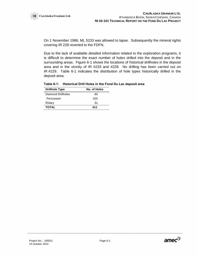
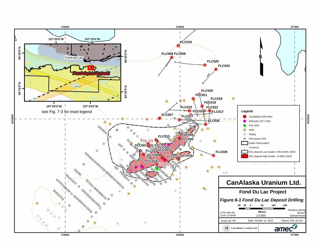
Due to the lack of available detailed information related to the exploration programs, it
is difficult to determine the exact number of holes drilled into the deposit and in the
surrounding areas. Figure 6-1 shows the locations of historical drillholes in the deposit
area and in the vicinity of IR #233 and #228. No drilling has been carried out on
IR #229. Table 6-1 indicates the distribution of hole types historically drilled in the
deposit area.
Table 6-1: Historical Drill Holes in the Fond Du Lac deposit area
Drillhole Type No. of Holes
Diamond Drillholes 60
Percussion 320
Rotary 31
TOTAL 411
750
FDL-22
FDL-23
FLC029
FLC028FLC027
FLC026
FLC025FLC024
FLC023 FLC022
FLC021
FLC019
FLC017
FLC016
FLC015
FLC014
FLC013FLC012
FLC011
FLC010
FLC009FLC008
FLC007
FLC006FLC005
FLC004FLC003
FLC001
FLC020
FLC018
FLC002
376000
376000
376500
376500
377000
377000
6576
000
6576
000
£
3 8
3 8
!
[_
Locke Lake
Fond-du-LacFond-du-Lac
Fond-du-Lac Deposit
107°10'0"W
107°10'0"W
107°20'0"W
107°20'0"W
59°2
0'0"
N
59°2
0'0"
N
59°1
5'0"
N
59°1
5'0"
N
Legend
!. CanAlaska Drill Holes
!. Eldorado 1977 DDH
!. FDL DDH
!. DDH
5 Rotary
!> Percussion Drill
Indian Reservation
Contours
FDL deposit Low Grade: 0.05-0.06% U3O8
FDL deposit High Grade: >0.06% U3O8
Figure 6-1 Fond Du Lac Deposit Drilling
Fond Du Lac Project
UTM NAD 83Zone 13 North
Date: October 15, 2010Drawn by: RP Report: FDL 43-101
CanAlaska Uranium Ltd.
Northern MiningDivision
Saskatchewan
50 0 50 100 15025
Metres1:5,000
see Fig. 7-3 for inset legend
CANALASKA URANIUM LTD.
ATHABASCA BASIN, SASKATCHEWAN, CANADA NI 43-101 TECHNICAL REPORT ON THE FOND DU LAC PROJECT
Project No.: 165521 Page 7-1 15 October 2010
7.0 GEOLOGICAL SETTING
The following sections have been taken from CanAlaska’s 2009 assessment report on
their drilling and prospecting activities.
7.1 Athabasca Basin
The Regional and Local Geology has been summarised from papers within EXTECH
IV: Geology and Uranium Exploration Technology of the Proterozoic Athabasca Basin,
Saskatchewan and Alberta, 2007. Geological Survey of Canada Bulletin 588; Ed. by
C.W. Jefferson and G. Delaney.
The Athabasca Basin is comprised of four unconformity bounded sequences of
un-metamorphosed quartzose fluvial rocks that were deposited into sub-basins
covering approximately 100,000 square kilometres of northern Saskatchewan and
north-eastern Alberta (Figure 7-1 and Figure 7-2). The conglomerates, sandstones
and mudstones that make up the Athabasca Group have a maximum thickness of
1500 metres. The Group was deposited on paleo-weathered Precambrian basement
rocks between about 1760 Ma and 1500 Ma.
Rocks of the Rae and Hearne provinces and the Taltson magmatic zone make up the
basement to the Athabasca Basin (Card et el., 2007). The Taltson magmatic zone
underlies the western most edge of the Basin and is characterized by a basement
complex intruded by continental magmatic arc granitoid rocks and peraluminous
granitoid rocks. The basement rocks in the central portion of the Basin are made up of
metasedimentary supracrustal rock sequences and Archean and Proterozoic granitoid
rocks of the Rae Province. The metasedimentary rocks of the Hearne Province make
up the eastern portion of the basement.
CANALASKA URANIUM LTD.
ATHABASCA BASIN, SASKATCHEWAN, CANADA NI 43-101 TECHNICAL REPORT ON THE FOND DU LAC PROJECT
Project No.: 165521 Page 7-2 15 October 2010
Figure 7-1: Regional Geology of the Athabasca Basin
Figure 7-2: Regional Lithostratigraphic Section of the Athabasca basin
CANALASKA URANIUM LTD.
ATHABASCA BASIN, SASKATCHEWAN, CANADA NI 43-101 TECHNICAL REPORT ON THE FOND DU LAC PROJECT
Project No.: 165521 Page 7-3 15 October 2010
7.2 Regional Geology – Fond Du Lac
Basement Rocks
The basement rocks in the area covered by the Fond Du Lac property are Archean
garnet pyroxene gneisses and quartz-rich biotite gneisses of the eastern portion of the
Beaverlodge Domain, Rae Province (Figure 7-3). The rocks have been
metamorphosed to granulite facies with an amphibolite retrograde overprint (Baer,
1969). The aluminous chemistry of these rocks indicates a sedimentary protolith and
may represent a deep sea depositional environment (Card et al, 2007). Northeast of
Fond Du Lac, Proterozoic granodiorite intrudes the gneissic terranes.
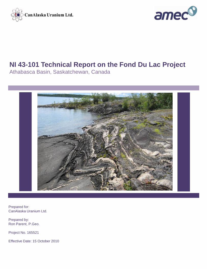
The garnet pyroxene gneiss is commonly well foliated with well developed gneissic
bands of interlayered quartz and feldspar bands with darker, fine grained bands of
primarily mafic minerals (see cover photo). Pink to red coloured garnets are 3-5 mm in
diameter, but when altered the garnets are rimmed and almost completely replaced by
pale green chlorite and/or brown biotite.
The quartz biotite gneisses can have a mafic content that varies between 5 and 25 per
cent of the total rock volume. The rocks are well foliated and locally may have a
granular texture, depending on the level of mylonitisation and metamorphic grade.
Thin section description of this rock type shows that the rock is primarily comprised of
feldspar and quartz with minor biotite, chlorite and garnet. The rock had undergone a
peak metamorphic grade of granulite to amphibolite facies, with a retrograde lower
amphibolite to greenschist facies overprint. Where large scale faults crosscut this rock
type plagioclase feldspar is hydrothermally altered to sericite and carbonate, and
sericite overprints biotite and chlorite (Mysyk, W. K., 2009).
Athabasca Basin Rocks
South of Lake Athabasca flat-lying to shallowly southwest dipping sandstone rocks of
the Athabasca Group unconformably overlie the basement rocks. Within the deposit
area, these sandstones have not been differentiated but are probably the MFc member
of the Manitou Falls Formation (Ramaekers et al, 2007), based on the fact that the
sandstones encountered in drill holes are medium to coarse grained, with some
pebbles, intraclasts are present but are not abundant, and the heavy mineral
conglomeratic layers, typical of MFb, are essentially absent. A thin medium to coarse
conglomeratic horizon may be present at the unconformity.
!
!
Rgf
Rp
W
MFd-p
MFr-cr
LZd
Rgf(m)
LLs
Rgd
Rgn
Rgf
MFr-ps
Rhf
Rhf
MFb-l
LLb
MFc
Rgd
Rm
Tp
LLmOb
Rgd
Rgd
Rgd
RgnRgf
z
Oa
MFc
Rm
MFc
RsRgf
Fond-du-Lac
Fond Du Lac Deposit
340000
340000
350000
350000
360000
360000
370000
370000
380000
380000
390000
390000
6560
000
6560
000
6570
000
6570
000
6580
000
6580
000
6590
000
6590
000
6600
000
6600
000
107°0'0"W
107°0'0"W
107°30'0"W
107°30'0"W
59°3
0'0"
N
59°3
0'0"
N
"
"
Fond Du Lac
Uranium City
107°0'0"W
107°0'0"W
108°0'0"W
108°0'0"W109°0'0"W
59°0'0"N59°0'0"N
LegendIndian Reservation
Grease River Shear Zone
Fault
Ob - Otherside Fm: quartz arenite
Oa - Otherside Fm: pebbly quartz arenite
LLm - Locker Lake Fm: Upper pebbly quartzarenite
LLb - Locker Lake Fm: Conglomeratic quartzarenite
LLs - Locker Lake Fm: Lower pebbly quartarenite
W - Wolverine Point Fm: Quartzarenite and mudstone
LZd - Lazenby Lake Fm: Quartzrenite, siltstone + mudstone
MFd-p - Manitou Falls Fm: Quartzarenite
MFc - Manitou Falls Fm: Quartzarenite
MFr-cr - Manitou Falls Fm: Clay-intraclast-rich quartzarenite
MFr-ps - Manitou Falls Fm: Quartzarenite, pebbly quartzarenite
MFb-l - Manitou Falls Fm: Lower conglomeratic quartzarenite
Rgd - Granite-granodiorite
Rgf - Garnet-feldspar gneiss
Rgf(m) - Garnet-feldspar gneiss (retrometamorphic)
Rgn - Granite-granodiorite gneiss
Rhf - Hypersthene-feldspar gneiss
Rm - Metabasites, amphibolite, ultramafic
Rp - Psammopelitic/psammitic gneiss
Tp - Hybrid-garnet-pyroxene orthogneiss
z - Mylonitic gneiss
£
Figure 7-3 Regional GeologyFond Du Lac Project
UTM NAD 83Zone 13 North
Date: October 15, 2010Drawn by: RP Report: FDL 43-101
CanAlaska Uranium Ltd.
Northern MiningDivision
Saskatchewan
2 0 2 4 61
Kilometers
1:250,000
CANALASKA URANIUM LTD.
ATHABASCA BASIN, SASKATCHEWAN, CANADA NI 43-101 TECHNICAL REPORT ON THE FOND DU LAC PROJECT
Project No.: 165521 Page 7-5 15 October 2010
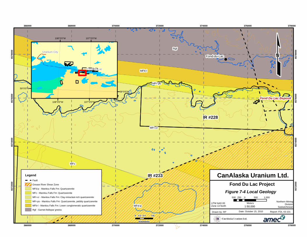
7.3 Local Geology – IR 228 and 233
The area is underlain by rocks of the Manitou Falls Formation of the Athabasca Group.
It consists of up to 30 m (98.4 ft) of white to beige, medium-grained sandstone with
minor intercalated discontinous interlayers of siltstone and shale. A basal
conglomeratic layer of variable thickness occupies the unconformity surface. The
paleo-regolith, which varies in thickness from 0 to 10's cm, varies in colour from green
to white to red (if hematized). The flat-lying unconformity dips 2°S.
This sequence of fluvial sediments is unconformably underlain by a series of
percambrian Tazin Group-type Archean (2864±300 Ma) granulite facies meta-arkoses
and Aphebian, lower amphibolite facies meta-pelites. The meta-arkose is separated
from the meta-pelite by a non-mineralized zone of faulting and alteration.
Depth to basement ranges from 16 to 320 m. Basement lithologies include meta
pelitic rocks, gneiss and schist. A large fault zone (Grease River Shear zone?) cuts
across IR #233 and is mapped to offset a quartzarenite (MFc) layer of the Manitou
Falls Formation by about 2 km laterally in a direction of about 70 degrees east of north.
Exposure is limited in the area and consequently boulder and soil sampling are the
prospecting methods of choice in the area.
!
!
MFr-cr
Rgf
MFd-p
MFb-l
MFc
MFc
MFr-ps
Fond-du-Lac
Fond Du Lac Deposit
IR #233
IR #228
366000
366000
368000
368000
370000
370000
372000
372000
374000
374000
376000
376000
378000
378000
6572
000
6572
000
6574
000
6574
000
6576
000
6576
000
6578
000
6578
000
0 0.4 0.80.2
Kilometres
£"
"
Fond Du Lac
Uranium City
107°0'0"W
107°0'0"W
108°0'0"W
108°0'0"W
59°0'0"N59°0'0"N
LegendFault
Grease River Shear Zone
MFd-p - Manitou Falls Fm: Quartzarenite
MFc - Manitou Falls Fm: Quartzarenite
MFr-cr - Manitou Falls Fm: Clay-intraclast-rich quartzarenite
MFr-ps - Manitou Falls Fm: Quartzarenite, pebbly quartzarenite
MFb-l - Manitou Falls Fm: Lower conglomeratic quartzarenite
Rgf - Garnet-feldspar gneiss
Figure 7-4 Local Geology
Fond Du Lac Project
UTM NAD 83Zone 13 North
Date: October 15, 2010Drawn by: RP Report: FDL 43-101
CanAlaska Uranium Ltd.
Northern MiningDivision
Saskatchewan
500 0 500 1,000250
Meters1:50,000
CANALASKA URANIUM LTD.
ATHABASCA BASIN, SASKATCHEWAN, CANADA NI 43-101 TECHNICAL REPORT ON THE FOND DU LAC PROJECT
Project No.: 165521 Page 8-1 15 October 2010
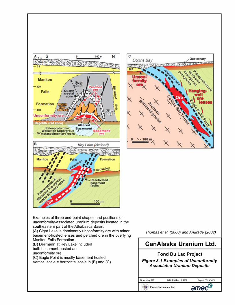
8.0 DEPOSIT TYPES
The following description of unconformity-associated uranium deposits was taken from
Jefferson et al., 2003; Unconformity-Associated Uranium Deposits of the Athabasca
Basin, Saskatchewan and Alberta:
Unconformity-associated uranium deposits are pods, veins, and semimassive
replacements consisting of mainly uraninite dated mostly 1600 to 1350 Ma, and
located close to basal unconformities between Proterozoic redbed basins and
metamorphosed basement rocks, especially supracrustal gneiss with graphitic
metapelite.
The Athabasca Basin consists of 1 to 3 kilometres thick, relatively flatlying,
unmetamorphosed but pervasively altered, Proterozoic (ca. 1.8 to <1.55 Ga), mainly
fluvial conglomeratic sandstone. The basement gneiss is paleoweathered with
variably preserved thicknesses of reddened, clay-altered hematitic regolith grading
down through a green chloritic zone into fresh rock.
Monometallic deposits (of which Fond Du Lac is one) consist of generally basement-
hosted ore pods, veins, and breccia in reactivated fault zones. Polymetallic deposits
consist of commonly subhorizontal ore lenses which straddle the unconformity,
replacing sandstone and altered basement rock with variable amounts of U, Ni, Co,
and As, and traces of Au, PGEs, Cu, REEs, and Fe.
0 5 102.5
Metres
Examples of three end-point shapes and positions ofunconformity-associated uranium deposits located in the southeastern part of the Athabasca Basin. (A) Cigar Lake is dominantly unconformity ore with minorbasement-hosted lenses and perched ore in the overlying Manitou Falls Formation. (B) Deilmann at Key Lake included both basement-hosted and unconformity ore. (C) Eagle Point is mostly basement hosted. Vertical scale = horizontal scale in (B) and (C). Figure 8-1 Examples of Unconformity
Associated Uranium Deposits
Fond Du Lac Project
Date: October 15, 2010Drawn by: RP Report: FDL 43-101
CanAlaska Uranium Ltd.
Thomas et al. (2000) and Andrade (2002)
CANALASKA URANIUM LTD.
ATHABASCA BASIN, SASKATCHEWAN, CANADA NI 43-101 TECHNICAL REPORT ON THE FOND DU LAC PROJECT
Project No.: 165521 Page 9-1 15 October 2010
9.0 MINERALIZATION
The following description of the Fond Du Lac deposit mineralization was also taken
from the SMDI database (SMDI no 1572).
The Fond Du Lac Uranium Deposit is located on the south shore of Lake Athabasca
approximately 2 km (1.2 miles) southeast of the hamlet of Fond Du Lac. In 1967,
Famok located a >10 km (>6.2 miles) long 255°-trending fan/train of uraniferous glacial
erratics at this site. The train consists of large flaggy radioactive Athabasca Group
sandstone boulders within ground morraine ablation till. The radioactivity of the
boulders, diminishes to the southwest. In 1970, Famok discovered the underlying in
situ mineralization while drill testing along this train. The Athabasca Group sandstones
and conglomerates, in the Fond Du Lac Deposit area, are covered by 10 m (33 ft) of
unconsolidated glacial drift.
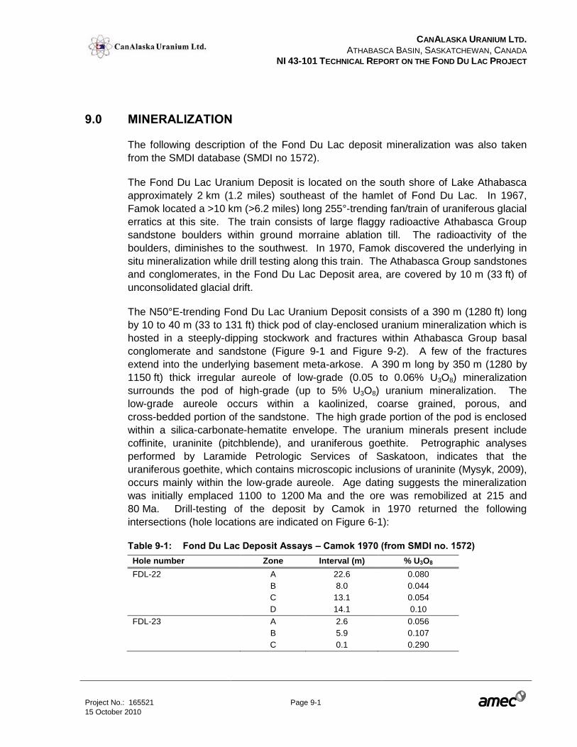
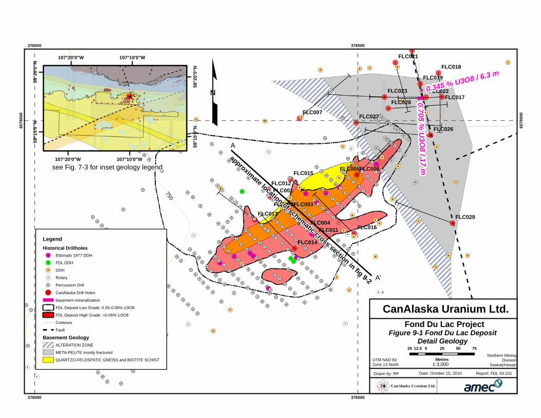
The N50°E-trending Fond Du Lac Uranium Deposit consists of a 390 m (1280 ft) long
by 10 to 40 m (33 to 131 ft) thick pod of clay-enclosed uranium mineralization which is
hosted in a steeply-dipping stockwork and fractures within Athabasca Group basal
conglomerate and sandstone (Figure 9-1 and Figure 9-2). A few of the fractures
extend into the underlying basement meta-arkose. A 390 m long by 350 m (1280 by
1150 ft) thick irregular aureole of low-grade (0.05 to 0.06% U3O8) mineralization
surrounds the pod of high-grade (up to 5% U3O8) uranium mineralization. The
low-grade aureole occurs within a kaolinized, coarse grained, porous, and
cross-bedded portion of the sandstone. The high grade portion of the pod is enclosed
within a silica-carbonate-hematite envelope. The uranium minerals present include
coffinite, uraninite (pitchblende), and uraniferous goethite. Petrographic analyses
performed by Laramide Petrologic Services of Saskatoon, indicates that the
uraniferous goethite, which contains microscopic inclusions of uraninite (Mysyk, 2009),
occurs mainly within the low-grade aureole. Age dating suggests the mineralization
was initially emplaced 1100 to 1200 Ma and the ore was remobilized at 215 and
80 Ma. Drill-testing of the deposit by Camok in 1970 returned the following
intersections (hole locations are indicated on Figure 6-1):
Table 9-1: Fond Du Lac Deposit Assays – Camok 1970 (from SMDI no. 1572)
Hole number Zone Interval (m) % U3O8
FDL-22 A 22.6 0.080
B 8.0 0.044
C 13.1 0.054
D 14.1 0.10
FDL-23 A 2.6 0.056
B 5.9 0.107
C 0.1 0.290
5
5!>
!>!>
!>!>!>!>
!>
!>!>!>!>!>!>!>!>!>!>!>
!>
!>
!.5!> 5
!>!>!>!>!>!>!>!>!>!>!>!>
!>!>!>!>!>!>!>!>!>!>!>!>
!>!>!>!>!>!>
!>
!>!>!>!>!>!>!>!>!>!>!>
!>!>!>!>
!>!>!>!>
!>!>!>!>!>!>!>
!>
!>
!>
!>
!>
!>
!>
!>
!>
!>!>
!>!>
!>
!.!.
!.!.
5
!>
!>
!>
!>
!>
!>!>!.!>
!>5!>
!>
!.
!>
!>
!>!>
!>
!>
!>
!>!>
5
!>!>
!>
!>
!>
!>
!.
!>
!>!>
!>!>
!>
!>
!>!>
!>!>
!>
!>
!>
!.!>!>!>!>!>
!>!>!>!>!>
!>
!>
!>!>!>!>!.
!>!.!>
!>!>!>!>!>!.!>
!>!>
!>!>
!.
!>
!>!>
!>!>
!>!>
!>!>!>!>!>!>!>!>!>!>
!>
!>
!> !.
!>!>
!>!>!. !>
!>!>!>!>!>!>!>
!.
5
!.
!>!>!>!>!>!>!>!>!>!>!.!>!>!>
!>!>!>
!>!>!>!>!>!>!>!>!>!>
!.!>!>!>!>!>!>
!>
!>!>!>!>
!.
!.5
5
5!>!>
!>!.
!.!>
!.
!>
!>
!.
!>!>!>!>!>
!.
!.!.
!.
!.
!.
!>!>!>!>!>!>!>!>!>!>
!>!>!>!>
!>!>!>
!.!.
!>!>
!>!>
!>!>
!>
5!.!>!>!>
!> !>
!>!>
!>!.
!.
!.
!>!>
!>
!>
!.
!>!>
!>!>
!>!>
!.
!.
!. !.
!.
!.5
!>
5
5
!>!>
!.
5
5
!>
5
!>!>!>
!>!>
!>
!>!> !>
!>!>
!>
!.!.
!>!>
!>
!>!>!>
!.
!.
!.!.!.!.
!.
!.
!.
750
0.705 % U
3O8 / 17 m
FLC029
FLC028
FLC027
FLC026
FLC023 FLC022
FLC021
FLC019
FLC018
FLC017
FLC016
FLC015
FLC014
FLC013
FLC012
FLC011
FLC007
FLC006FLC005
FLC004
FLC003FLC002
FLC001
0.345 % U3O8 / 6.3 m
376000
376000
376500
376500
6576
000
6576
000£
3 8
3 8
Locke Lake
Fond-du-Lac
107°10'0"W
107°10'0"W
107°20'0"W
107°20'0"W
59°2
0'0"
N
59°2
0'0"
N
59°1
5'0"
N
59°1
5'0"
N
LegendHistorical Drillholes!. Eldorado 1977 DDH
!. FDL DDH
!. DDH
5 Rotary
!> Percussion Drill
!. CanAlaska Drill Holes
basement mineralization
FDL Deposit Low Grade: 0.05-0.06% U3O8
FDL Deposit High Grade: >0.06% U3O8
Contours
Fault
Basement GeologyALTERATION ZONE
META-PELITE mostly fractured
QUARTZO-FELDSPATIC GNEISS and BIOTITE SCHIST
Figure 9-1 Fond Du Lac DepositDetail Geology
Fond Du Lac Project
UTM NAD 83Zone 13 North
Date: October 15, 2010Drawn by: RP Report: FDL 43-101
CanAlaska Uranium Ltd.
Northern MiningDivision
Saskatchewan
25 0 25 50 7512.5
Metres1:3,000
A
A'
approximate location of schematic cross section in fig 9-2
see Fig. 7-3 for inset geology legend
Looking Northeast (see Figure 9-1 for approximate location)
from Homeniuk, L.A. and Clark, R.J. (1986)
Figure 9-2 Fond Du Lac DepositSchematic Geological Cross Section
Fond Du Lac Project
UTM NAD 83Zone 13 North
Date: October 15, 2010Drawn by: RP Report: FDL 43-101
CanAlaska Uranium Ltd.
Northern MiningDivision
Saskatchewan
10 0 105
Meters1:500
Legendsection_dh_trace
unconformity
Geologymaterial
overburden
sandstone
high grade
low grade
hematized zone
chloritized zone
biotite gneiss
A A'
CANALASKA URANIUM LTD.
ATHABASCA BASIN, SASKATCHEWAN, CANADA NI 43-101 TECHNICAL REPORT ON THE FOND DU LAC PROJECT
Project No.: 165521 Page 10-1 15 October 2010
10.0 EXPLORATION
All of the sub-sections in this section are summarized from Canalaska’s 2008/09
exploration assessment reports on prospecting, drilling and geophysics.
10.1 Summary
In 2006, CanAlaska conducted exploration using modern geophysical survey methods
that could identy subtle basement structures missed by earlier surveys.
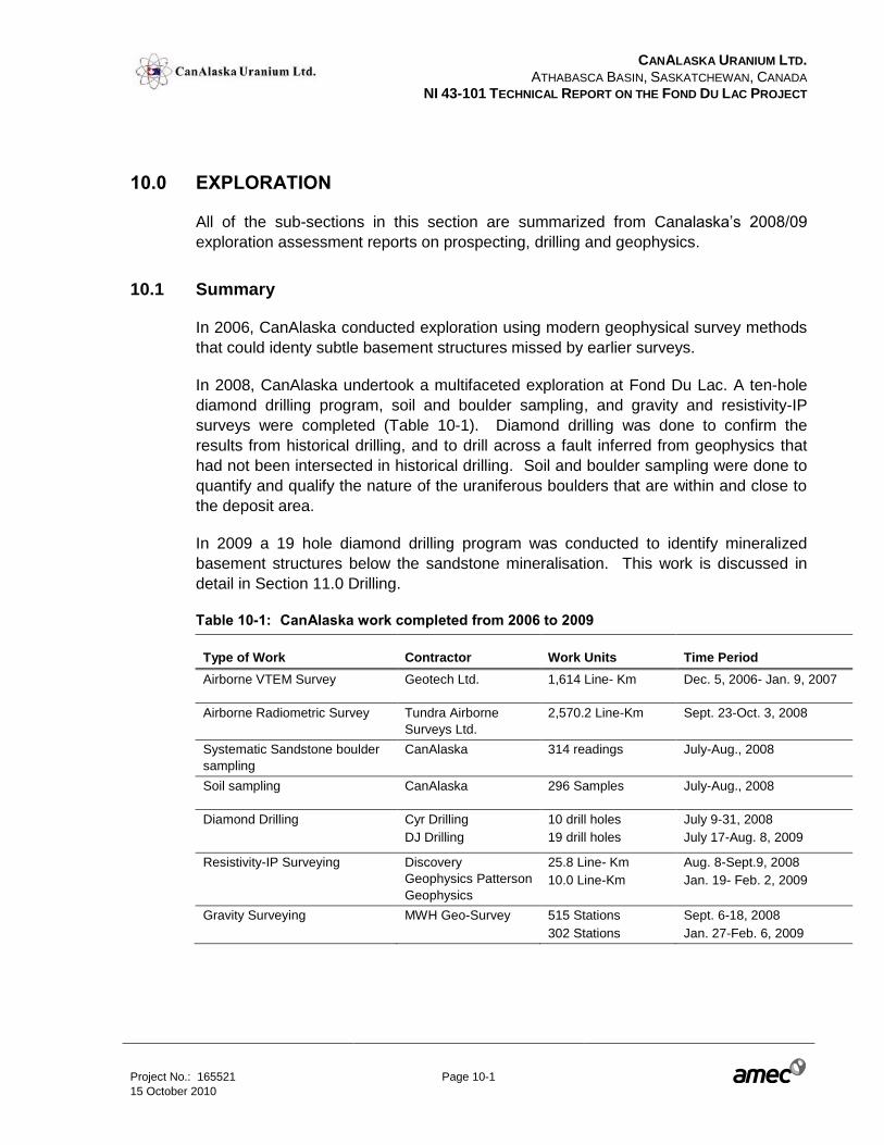
In 2008, CanAlaska undertook a multifaceted exploration at Fond Du Lac. A ten-hole
diamond drilling program, soil and boulder sampling, and gravity and resistivity-IP
surveys were completed (Table 10-1). Diamond drilling was done to confirm the
results from historical drilling, and to drill across a fault inferred from geophysics that
had not been intersected in historical drilling. Soil and boulder sampling were done to
quantify and qualify the nature of the uraniferous boulders that are within and close to
the deposit area.
In 2009 a 19 hole diamond drilling program was conducted to identify mineralized
basement structures below the sandstone mineralisation. This work is discussed in
detail in Section 11.0 Drilling.
Table 10-1: CanAlaska work completed from 2006 to 2009
Type of Work Contractor Work Units Time Period
Airborne VTEM Survey Geotech Ltd. 1,614 Line- Km Dec. 5, 2006- Jan. 9, 2007
Airborne Radiometric Survey Tundra Airborne
Surveys Ltd.
2,570.2 Line-Km Sept. 23-Oct. 3, 2008
Systematic Sandstone boulder
sampling
CanAlaska 314 readings July-Aug., 2008
Soil sampling CanAlaska 296 Samples July-Aug., 2008
Diamond Drilling Cyr Drilling
DJ Drilling
10 drill holes
19 drill holes
July 9-31, 2008
July 17-Aug. 8, 2009
Resistivity-IP Surveying Discovery
Geophysics Patterson
Geophysics
25.8 Line- Km
10.0 Line-Km
Aug. 8-Sept.9, 2008
Jan. 19- Feb. 2, 2009
Gravity Surveying MWH Geo-Survey 515 Stations
302 Stations
Sept. 6-18, 2008
Jan. 27-Feb. 6, 2009
CANALASKA URANIUM LTD.
ATHABASCA BASIN, SASKATCHEWAN, CANADA NI 43-101 TECHNICAL REPORT ON THE FOND DU LAC PROJECT
Project No.: 165521 Page 10-2 15 October 2010
In the summer of 2010, CanAlaska conducted a soil and radon survey in the FDL
Deposit area. At this time the data has yet to be processed.
10.2 Geophysics
10.2.1 Airborne Aeromagnetic, Radiometric and VLF survey
A fixed-wing airborne Aeromagnetic, Radiometric and VLF survey was carried out on
the Fond-du-Lac Properties in September-October 2008. Two thousand and eighty
four line-km of data have been acquired.
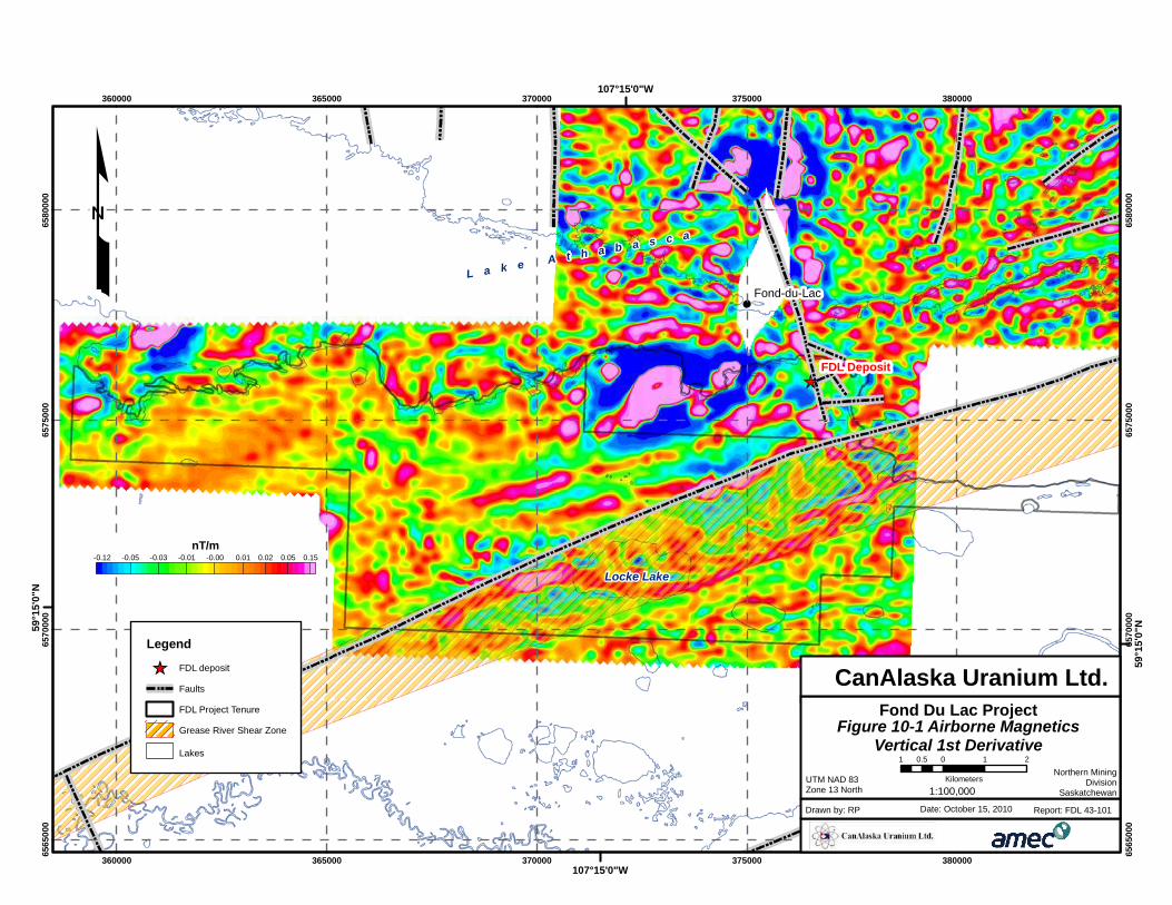
Figure 10-1 shows the vertical gradient of the measured magnetic field, which
emphasizes the anomaly sources.
The area north of the claims displays a large number of narrow, strongly contrasted
magnetic anomalies caused by the presence of basement rocks here. In the
immediate vicinity of I.R. 228 and 233) fewer, wider anomalies are present explained
by the presence of the non-magnetic Athabasca sandstone at surface.
The location of the Grease River Shear Zone is also indicated. It is a major structure
in the NE Athabasca Basin.
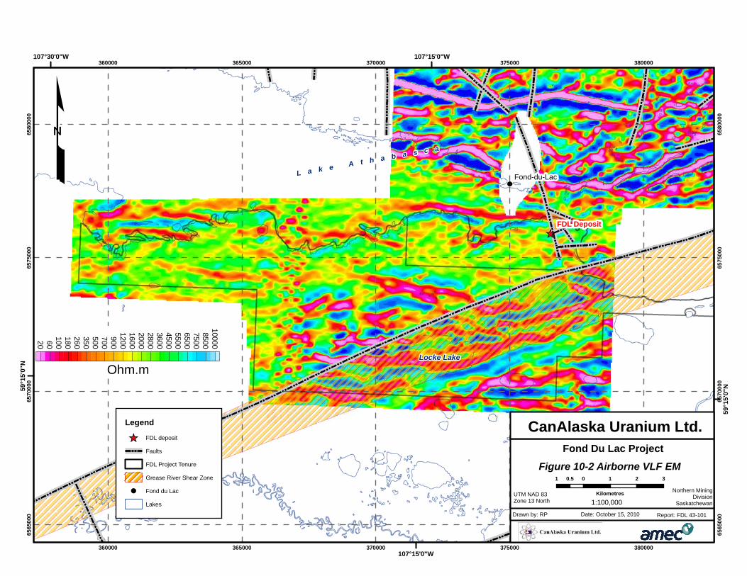
Figure 10-2 shows the combined total field response of the VLF survey. This product
is calculated from the responses from two VLF transmitters, Cutler (USA) and Rugby
(UK). Zones of strong contrasts (e.g. pink-blue) indicate the presence of conductors.
Several elongated features can be recognized on the map, here again related to
stratigraphy and to faults. Where faults occur, fractures in the rock act as conduits for
the movement of mineralizing fluids that help form uranium deposits.
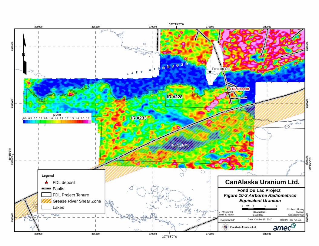
Figure 10-3 shows the equivalent Uranium content calculated from radiometric counts
and calibration factors measured by flying the system over the Geological Survey of
Canada calibration pad in Ottawa. The low values (dark blue) correspond to the area
of the lake because gamma-rays emitted from the subsurface are absorbed by the
lake water. However, a series of patches of high U values are observed trending
toward the lake in I.R. 233 and 228: they correspond to surface boulder trains. In I.R.
229, some stratigraphic units are also characterized by a high uranium content. This
observation was confirmed later by ground samples.
Locke Lake
FDL Deposit
Fond-du-Lac
360000
360000
365000
365000
370000
370000
375000
375000
380000
380000
6565
000
6565
000
6570
000
6570
000
6575
000
6575
000
6580
000
6580
000
107°15'0"W
107°15'0"W
59°1
5'0"
N
59°1
5'0"
N
L a k e A t h a b a s c a
Legend
[_ FDL deposit
Faults
FDL Project Tenure
Grease River Shear Zone
Lakes
1VD Magnetics-0.12 -0.05 -0.03 -0.01 -0.00 0.01 0.02 0.05 0.15
nT/m
Figure 10-1 Airborne MagneticsVertical 1st Derivative
Fond Du Lac Project
UTM NAD 83Zone 13 North
Date: October 15, 2010Drawn by: RP Report: FDL 43-101
CanAlaska Uranium Ltd.
Northern MiningDivision
Saskatchewan
1 0 1 20.5
Kilometers1:100,000
Locke Lake
FDL Deposit
Fond-du-Lac
360000
360000
365000
365000
370000
370000
375000
375000
380000
380000
6565
000
6565
000
6570
000
6570
000
6575
000
6575
000
6580
000
6580
000
107°15'0"W
107°15'0"W107°30'0"W
59°1
5'0"
N
59°1
5'0"
N
L a k e A t h a b a s c a
Legend
[_ FDL deposit
Faults
FDL Project Tenure
Grease River Shear Zone
! Fond du Lac
Lakes
20 60100180260350500700900
1200160020002800360045005500650075008500
10000
Ohm.m
Figure 10-2 Airborne VLF EM
Fond Du Lac Project
UTM NAD 83Zone 13 North
Date: October 15, 2010Drawn by: RP Report: FDL 43-101
CanAlaska Uranium Ltd.
1 0 1 2 30.5
Kilometres Northern MiningDivision
Saskatchewan1:100,000
Locke Lake
IR #233
IR #228
FDL Deposit
Fond-du-Lac
360000
360000
365000
365000
370000
370000
375000
375000
380000
380000
6565
000
6565
000
6570
000
6570
000
6575
000
6575
000
6580
000
6580
000
107°15'0"W
107°15'0"W
59°1
5'0"
N
59°1
5'0"
N
£ L a k e A t h a b a s c a
0.0 0.3 0.6 0.7 0.8 1.0 1.1 1.2 1.2 1.3 1.4 1.5 1.7ppm
Legend
[_ FDL depositFaultsFDL Project TenureGrease River Shear ZoneLakes
Figure 10-3 Airborne RadiometricsEquivalent Uranium
Fond Du Lac Project
UTM NAD 83Zone 13 North
Date: October15, 2010Drawn by: RP Report: FDL 43-101
CanAlaska Uranium Ltd.
1 0 1 20.5
KilometersNorthern Mining
DivisionSaskatchewan1:100,000
CANALASKA URANIUM LTD.
ATHABASCA BASIN, SASKATCHEWAN, CANADA NI 43-101 TECHNICAL REPORT ON THE FOND DU LAC PROJECT
Project No.: 165521 Page 10-6 15 October 2010
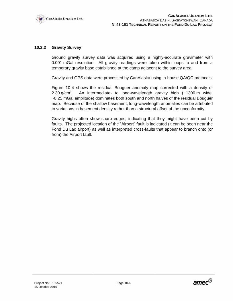
10.2.2 Gravity Survey
Ground gravity survey data was acquired using a highly-accurate gravimeter with
0.001 mGal resolution. All gravity readings were taken within loops to and from a
temporary gravity base established at the camp adjacent to the survey area.
Gravity and GPS data were processed by CanAlaska using in-house QA/QC protocols.
Figure 10-4 shows the residual Bouguer anomaly map corrected with a density of
2.30 g/cm3. An intermediate- to long-wavelength gravity high (~1300 m wide,
~0.25 mGal amplitude) dominates both south and north halves of the residual Bouguer
map. Because of the shallow basement, long-wavelength anomalies can be attributed
to variations in basement density rather than a structural offset of the unconformity.
Gravity highs often show sharp edges, indicating that they might have been cut by
faults. The projected location of the “Airport” fault is indicated (it can be seen near the
Fond Du Lac airport) as well as interpreted cross-faults that appear to branch onto (or
from) the Airport fault.
FDL Deposit
Fond-du-Lac
375000
375000
6575
000
6575
000
L a k e A t h a b a s c a
-0.29-0.20-0.16-0.14-0.11-0.09-0.06-0.04-0.03-0.010.010.030.050.080.100.120.160.200.24
mGal
Airport Fault
Figure 10-4 Gravity SurveyResidual Bouger Gravity
Fond Du Lac Project
UTM NAD 83Zone 13 North
Date: October 15, 2010Drawn by: RP Report: FDL 43-101
CanAlaska Uranium Ltd.
Northern MiningDivision
Saskatchewan
0 250 500 750125
Meters
1:24,000
Legend
FDL DepositFaultsFDL Project TenureGrease River Shear ZoneLakes
CANALASKA URANIUM LTD.
ATHABASCA BASIN, SASKATCHEWAN, CANADA NI 43-101 TECHNICAL REPORT ON THE FOND DU LAC PROJECT
Project No.: 165521 Page 10-8 15 October 2010
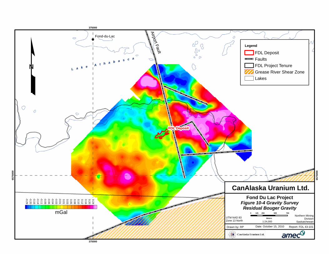
10.2.3 Resistivity-IP survey
From 20 August to 9 September 2008 and from 19 January to 10 February 2009, two
Resistivity-IP surveys were carried out by Discovery Geophysics Ltd. of Hague (SK)
and Patterson Geophysics Inc. of La Ronge (SK) respectively.
Data was acquired using a Pole-Dipole configuration array with an electrode
separation step (a) of 25 m with N=1 to 10.
The Resistivity data set was processed and modeled by CanAlaska using in-house
QA/QC protocols.
The first survey data acquired in 2008 had good electrode contacts with the ground
and produced very high-quality data. Data quality was also good for the land portion of
the second survey in 2009. For measurements on the lake, electrodes were laid on
the lake bottom most of the time in order to get an electrode contact directly with
ground. Because of good ground contact, the IP data on the lake are of good to
excellent quality for almost all stations.
Figure 10-5 shows the resistivity slice at 50 m depth extracted from the 3D inversion of
the resistivity data. Concidental with the gravity data, there is a SSE-trending contact
between a conductive (yellow-red) and a more resistive (green) block. This sharp
feature coincides with the so-called “Airport” fault.
Farther to the south, it can be observed that the contact is cut at right angle, offset by
about 500 m, then resumes toward the SSE. This pattern indicates several episodes
of faulting in this area, providing an excellent exploration target.
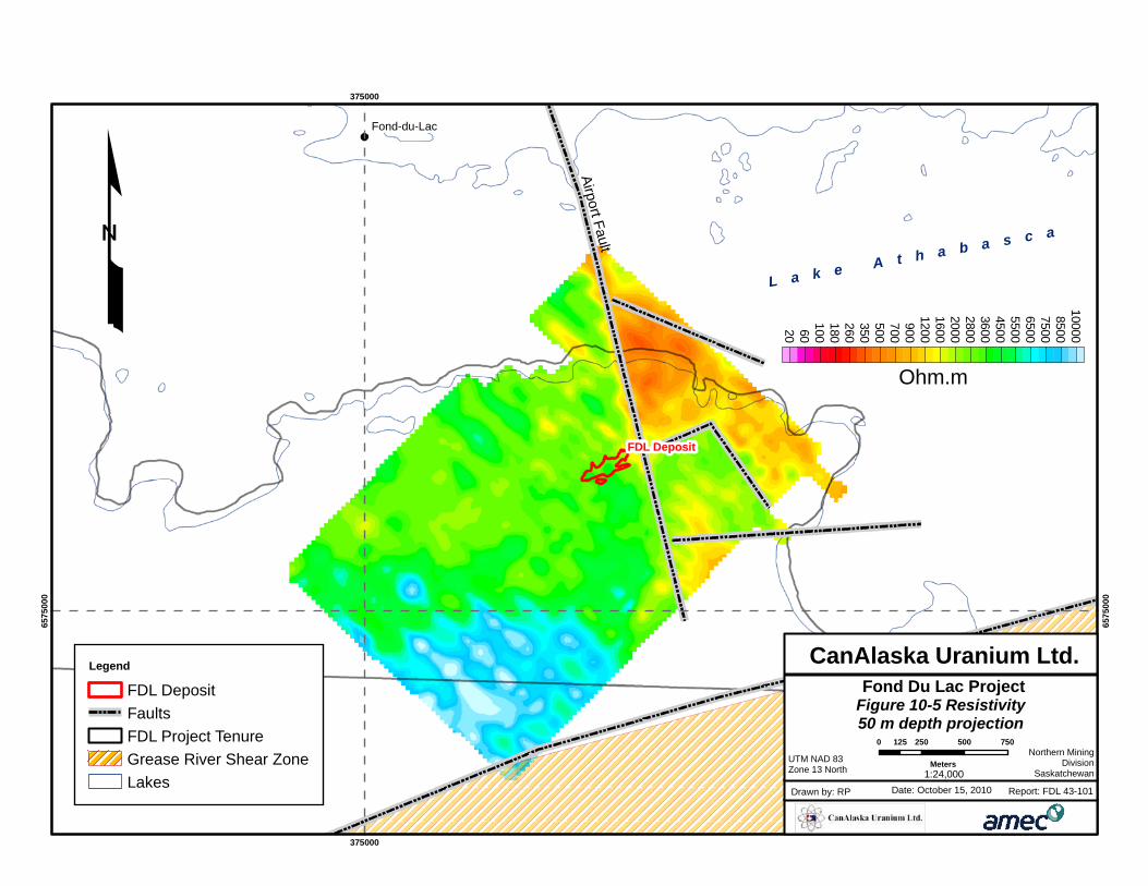
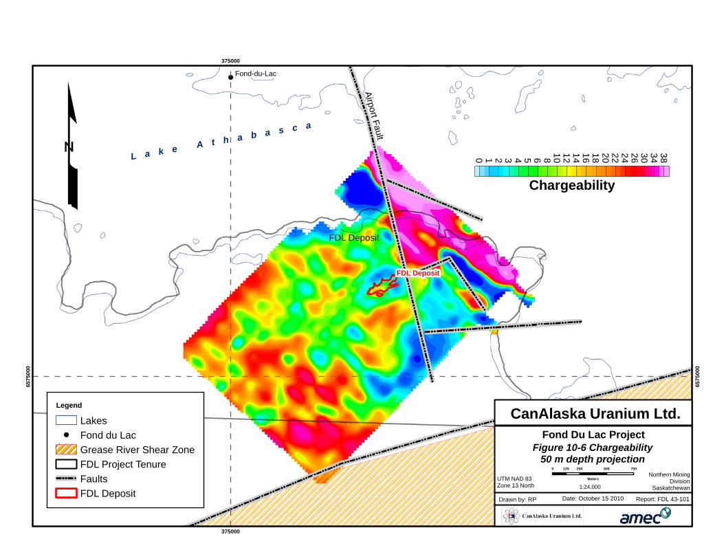
The chargeability slice at 50 m depth extracted from a 3D joint inversion of resistivity-
IP data is shown in Figure 10-6. Here again, the trace of the Airport fault is clearly
visible, separating a high- and a low-chargeability domains.
The known deposit area is located within a chargeability high surrounded by
chargeability lows. This suggests the presence of a volume of chargeable material.
Neighbouring boreholes indicate that disseminated sulphides are present in the area
(Muirhead et al., 2010) and they usually produce strong chargeability anomalies.
These sulphides are a product of large hydrothermal fluid circulation events, a
mechanism that also favours concentration of uranium in the subsurface.
FDL Deposit
Fond-du-Lac
375000
375000
6575
000
6575
000
L a k e A t h a b a s c a
20 60100180260350500700900
1200160020002800360045005500650075008500
10000
Ohm.m
Legend
FDL DepositFaultsFDL Project TenureGrease River Shear ZoneLakes
Airport Fault
Figure 10-5 Resistivity50 m depth projection
Fond Du Lac Project
UTM NAD 83Zone 13 North
Date: October 15, 2010Drawn by: RP Report: FDL 43-101
CanAlaska Uranium Ltd.
Northern MiningDivision
Saskatchewan
0 250 500 750125
Meters1:24,000
FDL Deposit
Fond-du-Lac
375000
375000
6575
000
6575
000
L a k e A t h a b a s c a
0 1 2 3 4 5 6 8 10 12 14 16 18 20 22 24 26 30 34 38
Chargeability
Figure 10-6 Chargeability50 m depth projection
Fond Du Lac Project
UTM NAD 83Zone 13 North
Date: October 15 2010Drawn by: RP Report: FDL 43-101
CanAlaska Uranium Ltd.
Northern MiningDivision
Saskatchewan
0 250 500 750125
Meters
1:24,000
FDL Deposit
Airport Fault
Legend
Lakes! Fond du Lac
Grease River Shear ZoneFDL Project TenureFaultsFDL Deposit
CANALASKA URANIUM LTD.
ATHABASCA BASIN, SASKATCHEWAN, CANADA NI 43-101 TECHNICAL REPORT ON THE FOND DU LAC PROJECT
Project No.: 165521 Page 10-11 15 October 2010
10.2.4 Discussion
Based on resistivity-IP and gravity results, several potential drill targets were identified.
Breaks along the Airport fault, and others, as evidenced by geophysical anomalies, are
promising targets as they provide favourable structures for uranium mineralization.
Additionally, evidence for the occurrence of past hydrothermal events is supported by
observable patterns of chargeability anomalies.
10.3 2008 Boulder and Soil Sampling Program
10.3.1 Introduction
In 2008 CanAlaska conducted a boulder and soil sampling program. The program
involved locating the historically documented boulder trains and sampling of the
boulders for geochemical analyses. Previously, Eldorado Nuclear had defined
11 areas of boulder concentration across the property that can be constrained by the
generally north-east to south-west trending main ice direction into four, possibly five,
boulder trains (Figure 10-7).
These trends do not appear to be continuous and the gaps can be explained in most
cases by the presence of bog or swamp where no boulders would be visible. Boulder
area F contained the highest uranium values. Soil sampling was restricted to the
deposit area and outlined a zone of clay and uranium enrichment in soil to the
southeast of the deposit, in a down ice direction. A higher clay content would be
expected to be associated with elevated uranium values in soil eroded from our target
model of uranium enrichment enclosed in a clay altered halo.
Four main phases of ice-flow directions have been documented in the Fond Du Lac
area (Campbell et al, 2006). The oldest ice flow direction (Phase I) was to the west,
followed by a change in ice flow direction to the southeast (Phase II), then a change in
ice flow direction to the southwest (Phase III), and the last ice flow direction changed
back to a westerly direction (Phase IV). After glaciation, Glacial Lake Athabasca
covered the area with lake sediments to a height of 365 m above sea level. These
surficial deposits were reworked by the waters of Glacial Lake Athabasca into boulder
lags, cobble beaches, terraces and wave-cut notches that are visible today. Glacio-
lacustrine clays underlie most present day swamps and lakes.
CANALASKA URANIUM LTD.
ATHABASCA BASIN, SASKATCHEWAN, CANADA NI 43-101 TECHNICAL REPORT ON THE FOND DU LAC PROJECT
Project No.: 165521 Page 10-12 15 October 2010
10.3.2 Boulder Sampling
A total of 314 boulders were examined by CanAlaska crews in the field. The samples
were collected from 174 radioactive boulders and sent for geochemical analysis.
Samples were taken in the field and brought back to camp to be described. This
procedure ensured that all sample descriptions were standardized. All samples were
measured for radioactivity using hand-held Ludlum Model 19-10 and/or SPP2 hand
held scintillometers. Samples sent for geochemical analysis were placed in a bag with
an issued sample tag. The sealed bags were then packaged into a plastic pail for
shipment to Acme Analytical Labs. Geochemical results are presented in Figure 10-7.
Sample descriptions were used for interpretation of the trend and shape of the
mineralized boulder trains.
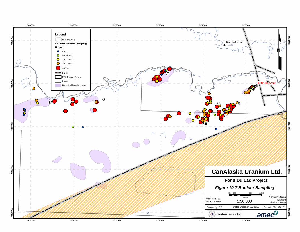
I
HG
F
E
D
C B
A
FDL Deposit
Fond-du-Lac
366000
366000
368000
368000
370000
370000
372000
372000
374000
374000
376000
376000
6570
000
6570
000
6572
000
6572
000
6574
000
6574
000
6576
000
6576
000
6578
000
6578
000
£Legend
FDL Deposit
CanAlaska Boulder Sampling
U ppm<500
500-1000
1000-2000
2000-5000
>5000
Faults
FDL Project Tenure
Lakes
Historical boulder areas
Figure 10-7 Boulder Sampling
Fond Du Lac Project
UTM NAD 83Zone 13 North
Date: October 15, 2010Drawn by: RP Report: FDL 43-101
CanAlaska Uranium Ltd.
Northern MiningDivision
Saskatchewan
500 0 500 1,000250
Meters
1:50,000
CANALASKA URANIUM LTD.
ATHABASCA BASIN, SASKATCHEWAN, CANADA NI 43-101 TECHNICAL REPORT ON THE FOND DU LAC PROJECT
Project No.: 165521 Page 10-14 15 October 2010
10.3.3 Soil Sampling
A 1.5 km x 1.9 km soil sampling grid was completed over boulder areas A, B and C.
A total of 318 stations were located on the grid and 296 of these were sampled, with
four samples representing “B” horizon and 292 samples representing the “C” horizon.
All soil samples were collected using a soil auger, with the intent of collecting a “C”
horizon sample. In some rockier areas shovels were used to get down to the “C
horizon. If a “C” horizon sample could not be collected then a “B” horizon sample was
taken. Samples were placed into a gusseted Kraft paper bag, and hung to dry. Once
dry, the samples were analyzed using a SWIR spectrometer to determine the type and
content of clay. No QA/QC data from these analyses were obtained. It is thought that
the presence of illite and dravite are indicative of areas of mineralization or potential
mineralization.
After the SWIR analysis was completed, the samples were packaged and placed into
plastic pails with lids, and shipped to Acme Analytical Labs for geochemical analysis.
Results are presented on Figure 10-8.
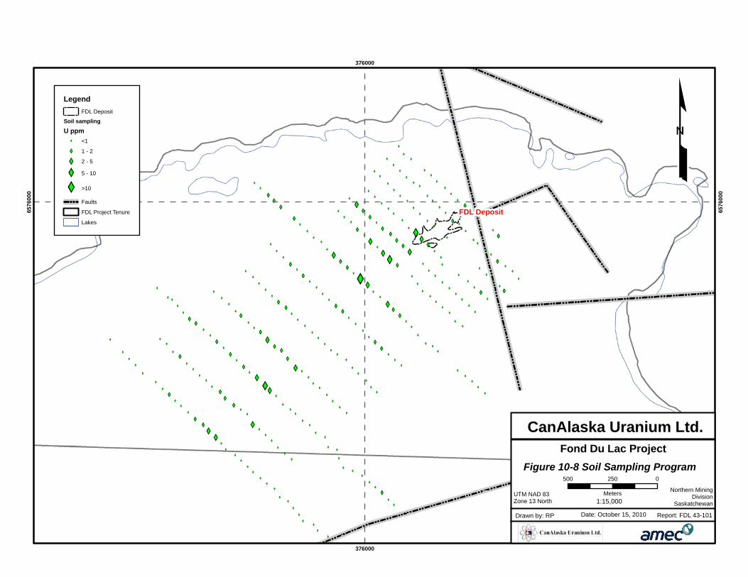
XY
XY
XY
XY
XY
XY
XY
XY
XY
XY
XYXY
XY
XY
XY
XY
XY
XY
XY
XY
XY
XY
XY
XY
XY
XY
XY
XY
XY
XY
XY
XY
XY
XY
XY
XY
XY
XY
XY
XY
XY
XY
XY
XY
XY
XY
XY
XY
XY
XY
XY
XY
XY
XY
XY
XY
XYXY
XY
XY
XY
XY
XY
XY
XY
XY
XY
XY
XY
XY
XY
XY
XY
XY
XY
XY
XY
XY
XY
XY
XY
XY
XY
XY
XY
XY
XY
XY
XY
XY
XY
XY
XY
XY
XY
XY
XY
XY
XY
XY
XY
XY
XY
XY
XY
XY
XY
XY
XY
XY
XY
XY
XY
XY
XY
XY
XY
XY
XY
XY
XY
XY
XY
XY
XY
XY
XY
XY
XY
XY
XY
XY
XY
XY
XY
XY
XY
XY
XY
XY
XY
XY
XY
XY
XY
XY
XY
XY
XY
XY
XY
XY
XY
XY
XY
XY
XY
XY
XY
XY
XY
XY
XY
XY
XY
XY
XY
XY
XY
XY
XY
XY
XY
XY
XY
XY
XY
XY
XY
XY
XY
XY
XY
XY
XY
XY
XY
XY
XY
XY
XY
XY
XY
XY
XY
XY
XY
XYXY
XY
XY
XY
XYXY
XY
XY
XY
XY
XY
XY
XY
XY
XY
XY
XY
XY
XY
XY
XY
XY
XY
XY
XY
XY
XY
XY
XY
XY
XY
XY
XY
XY
XY
XY
XY
XY
XY
XY
XY
XY
XY
XY
XY
XY
XY
XY
XY
XY
XY
XY
XYXY
XY
XY
XY
XY
XY
XY
XY
XY
XY
XY
XY
XY
XY
XY
XY
XY
XY
XY
XY
XY
XY
XY
XY
XY
XY
XY
XY
XYXY
XY
XY
XY
XY
XY
XY
XY
XY
XY
XY
XY
XY
XY
FDL Deposit
376000
376000
6576
000
6576
000
£Legend
FDL Deposit
Soil sampling
U ppmXY <1
XY 1 - 2
XY 2 - 5
XY 5 - 10
XY >10
Faults
FDL Project Tenure
Lakes
Figure 10-8 Soil Sampling Program
Fond Du Lac Project
UTM NAD 83Zone 13 North
Date: October 15, 2010Drawn by: RP Report: FDL 43-101
CanAlaska Uranium Ltd.
Northern MiningDivision
Saskatchewan
500 0250
Meters1:15,000
CANALASKA URANIUM LTD.
ATHABASCA BASIN, SASKATCHEWAN, CANADA NI 43-101 TECHNICAL REPORT ON THE FOND DU LAC PROJECT
Project No.: 165521 Page 10-16 15 October 2010
A minor amount of the soil samples had anomalous (>5 ppm) uranium. The highest
results were located southeast of the deposit, which lies down-ice of the major ice
movement over the deposit. The highest assayed value of 27.2 ppm uranium
(0.003% U3O8) came from sample ES150 which was located to the southeast corner of
the deposit.
Bivariate analyses show that uranium correlates moderately with arsenic and weakly
with molybdenum. Spectra analyses results indicate that illite is the dominate clay in
the soil samples collected, although kaolinite was also present. Dravite occurs
throughout the grid and is usually associated with illite or kaolinite. Dickite is present
in small, sporadically located areas.
10.3.4 Discussion
Boulder Sampling
There are three, well documented ice-directions in the Fond Du Lac area, with the
main ice direction moving from north-east to south-west.
Based on the chemistry and the results of the bivariate analysis, boulder areas A, B, C,
D and E are interpreted to be part of the same boulder train and likely have the same
source of mineralized boulders. The chemistry of boulder area F is unique in terms of
its higher uranium concentrations and is interpreted to be from a source different from
all of the other boulder areas. Boulders from areas G and H are high in arsenic, unlike
the other boulder areas. The remaining geochemistry of area H boulders is different
from that of G and areas G and H are interpreted to be from different sources.
The boulder sampling programme identified four populations of boulders that are
geochemically and spatially unique. It is interpreted that these four populations have
four different sources of mineralized boulders. The source of one of the four
populations has been identified as the Fond Du Lac deposit.
There are historical drill holes in an up-ice direction from area F. They were drilled
from the lake and as such are not on the FDL property but on claims held wholly by
CanAlaska. These drill holes intersected radioactive peaks of 15-730 cps
(Figure 10-9). Information on the depth and nature of mineralization is not available.
Future drill holes should target an area to the south of the historical drill holes, where
mineralization is open-ended. Additional historical drillholes that are north of boulder
area H did not intersect any uranium mineralization and appear to be drilled too far to
the west to be considered up-ice. There are no drill holes up ice of boulder area G.
Boulder areas G and H should have up-ice sources tested with drilling.
CANALASKA URANIUM LTD.
ATHABASCA BASIN, SASKATCHEWAN, CANADA NI 43-101 TECHNICAL REPORT ON THE FOND DU LAC PROJECT
Project No.: 165521 Page 10-17 15 October 2010
Soil Sampling
The soil samples collected over the Fond Du Lac deposit came back with anomalous
results of up to 27 ppm uranium. Soil sampling proved to be effective in delineating
uranium anomalies in the soils, that may point to a bedrock source nearby.
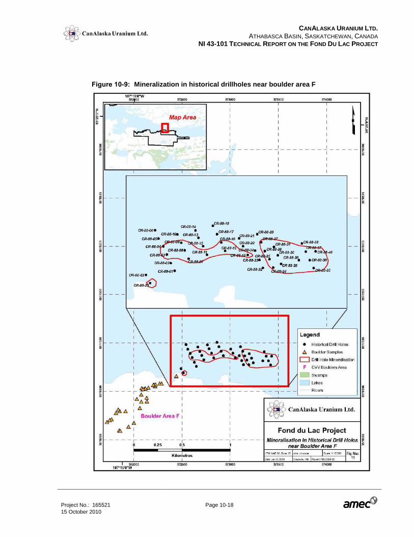
CANALASKA URANIUM LTD.
ATHABASCA BASIN, SASKATCHEWAN, CANADA NI 43-101 TECHNICAL REPORT ON THE FOND DU LAC PROJECT
Project No.: 165521 Page 10-18 15 October 2010
Figure 10-9: Mineralization in historical drillholes near boulder area F
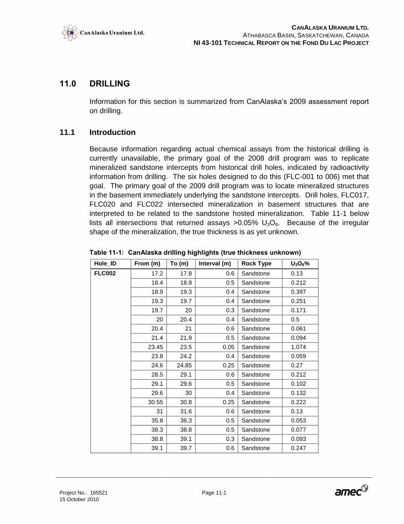
CANALASKA URANIUM LTD.
ATHABASCA BASIN, SASKATCHEWAN, CANADA NI 43-101 TECHNICAL REPORT ON THE FOND DU LAC PROJECT
Project No.: 165521 Page 11-1 15 October 2010
11.0 DRILLING
Information for this section is summarized from CanAlaska’s 2009 assessment report
on drilling.
11.1 Introduction
Because information regarding actual chemical assays from the historical drilling is
currently unavailable, the primary goal of the 2008 drill program was to replicate
mineralized sandstone intercepts from historical drill holes, indicated by radioactivity
information from drilling. The six holes designed to do this (FLC-001 to 006) met that
goal. The primary goal of the 2009 drill program was to locate mineralized structures
in the basement immediately underlying the sandstone intercepts. Drill holes, FLC017,
FLC020 and FLC022 intersected mineralization in basement structures that are
interpreted to be related to the sandstone hosted mineralization. Table 11-1 below
lists all intersections that returned assays >0.05% U3O8. Because of the irregular
shape of the mineralization, the true thickness is as yet unknown.
Table 11-1: CanAlaska drilling highlights (true thickness unknown)
Hole_ID From (m) To (m) Interval (m) Rock Type U3O8%
FLC002 17.2 17.8 0.6 Sandstone 0.13
18.4 18.9 0.5 Sandstone 0.212
18.9 19.3 0.4 Sandstone 0.397
19.3 19.7 0.4 Sandstone 0.251
19.7 20 0.3 Sandstone 0.171
20 20.4 0.4 Sandstone 0.5
20.4 21 0.6 Sandstone 0.061
21.4 21.9 0.5 Sandstone 0.094
23.45 23.5 0.05 Sandstone 1.074
23.8 24.2 0.4 Sandstone 0.059
24.6 24.85 0.25 Sandstone 0.27
28.5 29.1 0.6 Sandstone 0.212
29.1 29.6 0.5 Sandstone 0.102
29.6 30 0.4 Sandstone 0.132
30.55 30.8 0.25 Sandstone 0.222
31 31.6 0.6 Sandstone 0.13
35.8 36.3 0.5 Sandstone 0.053
38.3 38.8 0.5 Sandstone 0.077
38.8 39.1 0.3 Sandstone 0.093
39.1 39.7 0.6 Sandstone 0.247
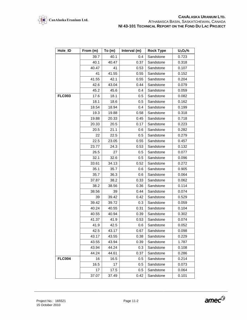
CANALASKA URANIUM LTD.
ATHABASCA BASIN, SASKATCHEWAN, CANADA NI 43-101 TECHNICAL REPORT ON THE FOND DU LAC PROJECT
Project No.: 165521 Page 11-2 15 October 2010
Hole_ID From (m) To (m) Interval (m) Rock Type U3O8%
39.7 40.1 0.4 Sandstone 0.723
40.1 40.47 0.37 Sandstone 0.318
40.47 41 0.53 Sandstone 0.107
41 41.55 0.55 Sandstone 0.152
41.55 42.1 0.55 Sandstone 0.204
42.6 43.04 0.44 Sandstone 0.079
45.2 45.6 0.4 Sandstone 0.059
FLC003 17.6 18.1 0.5 Sandstone 0.082
18.1 18.6 0.5 Sandstone 0.162
18.54 18.94 0.4 Sandstone 0.199
19.3 19.88 0.58 Sandstone 0.318
19.88 20.33 0.45 Sandstone 0.718
20.33 20.5 0.17 Sandstone 0.223
20.5 21.1 0.6 Sandstone 0.282
22 22.5 0.5 Sandstone 0.279
22.5 23.05 0.55 Sandstone 0.457
23.77 24.3 0.53 Sandstone 0.132
26.5 27 0.5 Sandstone 0.077
32.1 32.6 0.5 Sandstone 0.096
33.61 34.13 0.52 Sandstone 0.272
35.1 35.7 0.6 Sandstone 0.905
35.7 36.3 0.6 Sandstone 0.064
37.87 38.2 0.33 Sandstone 0.062
38.2 38.56 0.36 Sandstone 0.114
38.56 39 0.44 Sandstone 0.074
39 39.42 0.42 Sandstone 0.529
39.42 39.72 0.3 Sandstone 0.059
40.24 40.55 0.31 Sandstone 0.104
40.55 40.94 0.39 Sandstone 0.302
41.37 41.9 0.53 Sandstone 0.074
41.9 42.5 0.6 Sandstone 0.052
42.5 43.17 0.67 Sandstone 0.098
43.17 43.55 0.38 Sandstone 0.229
43.55 43.94 0.39 Sandstone 1.787
43.94 44.24 0.3 Sandstone 0.108
44.24 44.61 0.37 Sandstone 0.286
FLC004 16 16.5 0.5 Sandstone 0.214
16.5 17 0.5 Sandstone 0.073
17 17.5 0.5 Sandstone 0.064
37.07 37.49 0.42 Sandstone 0.101
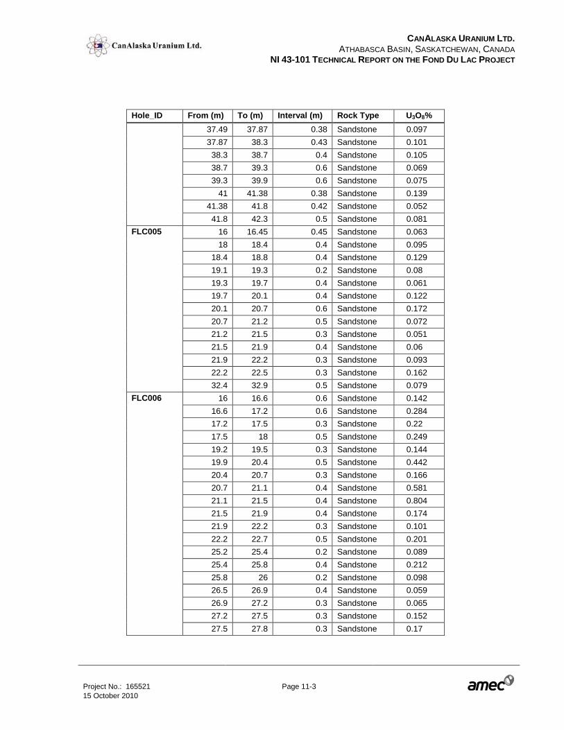
CANALASKA URANIUM LTD.
ATHABASCA BASIN, SASKATCHEWAN, CANADA NI 43-101 TECHNICAL REPORT ON THE FOND DU LAC PROJECT
Project No.: 165521 Page 11-3 15 October 2010
Hole_ID From (m) To (m) Interval (m) Rock Type U3O8%
37.49 37.87 0.38 Sandstone 0.097
37.87 38.3 0.43 Sandstone 0.101
38.3 38.7 0.4 Sandstone 0.105
38.7 39.3 0.6 Sandstone 0.069
39.3 39.9 0.6 Sandstone 0.075
41 41.38 0.38 Sandstone 0.139
41.38 41.8 0.42 Sandstone 0.052
41.8 42.3 0.5 Sandstone 0.081
FLC005 16 16.45 0.45 Sandstone 0.063
18 18.4 0.4 Sandstone 0.095
18.4 18.8 0.4 Sandstone 0.129
19.1 19.3 0.2 Sandstone 0.08
19.3 19.7 0.4 Sandstone 0.061
19.7 20.1 0.4 Sandstone 0.122
20.1 20.7 0.6 Sandstone 0.172
20.7 21.2 0.5 Sandstone 0.072
21.2 21.5 0.3 Sandstone 0.051
21.5 21.9 0.4 Sandstone 0.06
21.9 22.2 0.3 Sandstone 0.093
22.2 22.5 0.3 Sandstone 0.162
32.4 32.9 0.5 Sandstone 0.079
FLC006 16 16.6 0.6 Sandstone 0.142
16.6 17.2 0.6 Sandstone 0.284
17.2 17.5 0.3 Sandstone 0.22
17.5 18 0.5 Sandstone 0.249
19.2 19.5 0.3 Sandstone 0.144
19.9 20.4 0.5 Sandstone 0.442
20.4 20.7 0.3 Sandstone 0.166
20.7 21.1 0.4 Sandstone 0.581
21.1 21.5 0.4 Sandstone 0.804
21.5 21.9 0.4 Sandstone 0.174
21.9 22.2 0.3 Sandstone 0.101
22.2 22.7 0.5 Sandstone 0.201
25.2 25.4 0.2 Sandstone 0.089
25.4 25.8 0.4 Sandstone 0.212
25.8 26 0.2 Sandstone 0.098
26.5 26.9 0.4 Sandstone 0.059
26.9 27.2 0.3 Sandstone 0.065
27.2 27.5 0.3 Sandstone 0.152
27.5 27.8 0.3 Sandstone 0.17
CANALASKA URANIUM LTD.
ATHABASCA BASIN, SASKATCHEWAN, CANADA NI 43-101 TECHNICAL REPORT ON THE FOND DU LAC PROJECT
Project No.: 165521 Page 11-4 15 October 2010
Hole_ID From (m) To (m) Interval (m) Rock Type U3O8%
27.8 28.3 0.5 Sandstone 0.061
28.3 28.8 0.5 Sandstone 0.069
29.3 29.8 0.5 Sandstone 0.065
FLC011 18.45 18.95 0.5 sandstone 0.051
18.95 19.45 0.5 sandstone 0.067
19.45 20.15 0.7 sandstone 0.278
21.15 21.65 0.5 sandstone 0.068
22.15 22.65 0.5 sandstone 0.053
23.15 23.65 0.5 sandstone 0.288
23.65 24.15 0.5 sandstone 0.089
25.15 25.65 0.5 sandstone 0.12
25.65 26.15 0.5 sandstone 0.103
26.15 26.65 0.5 sandstone 0.097
27.65 28.15 0.5 sandstone 0.057
34.15 34.65 0.5 sandstone 0.115
FLC012 36.55 37 0.45 sandstone 0.089
FLC013 24.25 24.65 0.4 sandstone 0.059
33.1 33.45 0.35 sandstone 0.076
35.7 36 0.3 sandstone 0.106
36 36.4 0.4 sandstone 0.166
36.4 36.9 0.5 sandstone 0.05
38.6 39.1 0.5 sandstone 0.06
FLC014 12.3 12.9 0.6 sandstone 0.178
12.9 13.4 0.5 sandstone 0.219
13.4 13.9 0.5 sandstone 0.371
15.4 15.9 0.5 sandstone 0.136
15.9 16.4 0.5 sandstone 0.236
16.4 16.9 0.5 sandstone 0.203
16.9 17.4 0.5 sandstone 0.096
17.4 17.9 0.5 sandstone 0.156
17.9 18.4 0.5 sandstone 0.139
18.4 18.9 0.5 sandstone 0.108
18.9 19.4 0.5 sandstone 0.294
19.4 19.9 0.5 sandstone 0.146
19.9 20.4 0.5 sandstone 0.185
23.9 24.4 0.5 sandstone 0.109
24.4 24.9 0.5 sandstone 0.12
25.9 26.4 0.5 sandstone 0.085
27.4 27.9 0.5 sandstone 0.096
33.4 33.7 0.3 sandstone 0.05
CANALASKA URANIUM LTD.
ATHABASCA BASIN, SASKATCHEWAN, CANADA NI 43-101 TECHNICAL REPORT ON THE FOND DU LAC PROJECT
Project No.: 165521 Page 11-5 15 October 2010
Hole_ID From (m) To (m) Interval (m) Rock Type U3O8%
FLC015 27.55 27.75 0.2 sandstone 0.08
FLC016 28.05 28.55 0.5 sandstone 0.099
28.55 29.05 0.5 sandstone 0.136
29.05 29.55 0.5 sandstone 0.082
37.7 38.2 0.5 sandstone 0.056
40.55 41.3 0.75 sandstone 0.054
42.9 43.4 0.5 sandstone 0.066
FLC017 54.5 55 0.5 basement 0.124
55 55.5 0.5 basement 0.256
56.3 56.8 0.5 basement 0.479
57.3 57.8 0.5 basement 1.179
57.8 58.3 0.5 basement 0.115
58.3 58.8 0.5 basement 0.397
59.3 59.8 0.5 basement 0.314
59.8 60.3 0.5 basement 1.179
60.8 61.3 0.5 basement 3.774
61.3 61.8 0.5 basement 1.073
61.8 62.3 0.5 basement 0.211
62.3 62.8 0.5 basement 0.116
62.8 63.3 0.5 basement 0.33
63.3 63.8 0.5 basement 1.368
63.8 64.3 0.5 basement 3.172
64.3 64.8 0.5 basement 0.554
64.8 65.3 0.5 basement 0.33
65.3 65.8 0.5 basement 1.439
66.3 66.8 0.5 basement 0.082
66.8 67.3 0.5 basement 0.075
67.3 67.8 0.5 basement 0.814
67.8 68.3 0.5 basement 0.735
70.8 71.3 0.5 basement 0.384
71.3 71.8 0.5 basement 3.078
73.3 73.8 0.5 basement 0.101
73.8 74.3 0.5 basement 2.842
74.8 75.3 0.5 basement 0.061
86.3 86.7 0.4 basement 0.574
86.7 87.1 0.4 basement 0.236
FLC019 12.55 13.1 0.55 sandstone 0.116
15.4 15.9 0.5 sandstone 0.083
FLC020 101.2 101.7 0.5 basement 0.062
104.7 105.2 0.5 basement 0.252
CANALASKA URANIUM LTD.
ATHABASCA BASIN, SASKATCHEWAN, CANADA NI 43-101 TECHNICAL REPORT ON THE FOND DU LAC PROJECT
Project No.: 165521 Page 11-6 15 October 2010
Hole_ID From (m) To (m) Interval (m) Rock Type U3O8%
105.2 105.7 0.5 basement 1.07
105.7 106 0.3 basement 0.764
106.4 106.9 0.5 basement 0.153
110.5 111 0.5 basement 0.731
111 111.5 0.5 basement 1.934
120.1 120.6 0.5 0.06
FLC022 41.35 41.85 0.5 basement 0.139
43.2 43.6 0.4 basement 0.095
11.2 Core logging procedures
CanAlaska has established a systematic drill hole logging protocol for the
documentation of drill core observations modeled on the system used by the
Saskatchewan Geological Survey (CanAlaska, 2009). Logging is carried out on laptop
computers, recording data in a series of tables.
The data records include the following characteristics and observations and use
different templates for sandstones and basement:
Sandstone description is done on a metre per metre basis and includes maximum
grain size in mm, volume of grains over 2 mm, volume of conglomeratic beds thicker
than 2 cm, volume of thickness of mudstone intraclasts, colour, colour intensity, colour
pattern, pattern of sedimentary features, and bedding angles to core axis,
Basement description is based on major and minor lithologies, texture, grain size,
colour, colour intensity, graphite, sulphide and leucosomes concentrations.
Alteration description is an observation of weak, moderate or strong occurrences of
friability, clay content, silica content (in both pervasive and vuggy modes of
occurrence), hematite, limonite, regolith, and chlorite. The presence of sulphides and
leucosomes are noted as percentages. Magnetic susceptibility is logged on this form
and is collected using a K-9 handheld magnetic susceptibility meter
Geotechnical information is limited to RQD and core recovery which are logged in the
“Reading” files for each drill hole.
Structure data is obtained from both oriented core and non-oriented core. The
“Fracture” log contains fracture frequency, angle to core axis, fill type and surface
description for fractures and faults. Measurements are collected every metre. The
“Bedding Orientation” log contains oriented core data of bedding planes with an
CANALASKA URANIUM LTD.
ATHABASCA BASIN, SASKATCHEWAN, CANADA NI 43-101 TECHNICAL REPORT ON THE FOND DU LAC PROJECT
Project No.: 165521 Page 11-7 15 October 2010
averaging function to ensure consistency and accuracy of the data and to verify the
oriented core measurements made by the drill crew.
Radioactivity levels are measured on all core and recorded as averages over each
metre interval, and any spikes encountered, using a Ludlum M3/M44-2 and/or SPP-II
hand held scintillometers.
Down hole probing of drill holes for radioactivity (in rods) and resistivity (open hole
where possible) was performed using a Geovista down hole probe system.
11.3 Down-Hole Probing
Gamma probing was carried out immediately upon completion of the hole within the
drill rod string. Resistivity probing was attempted in the holes once the drill string was
removed (open-hole). Gamma probing was successfully conducted in all holes.
Resistivity probing was conducted in all holes except FLC010, FLC024 and FLC029
due to a collapse of the hole and in FLC015 which was abandoned.
Down-hole probing was carried out with a Geovista Probing unit using a GV500 series
winch with a 38 mm natural gamma sonde, first inside the drill-rods and then, where
possible, in open hole, combining the same sonde with a 38 mm dual guard focused
resistivity sonde (Polutnik, R., 2009). The data was collected using the proprietary
software Geovista Logger.
11.4 Collar Surveys
Drill hole collars are surveyed in the field with a Thales ProMark3 GPS System. The
Thales ProMark3 GPS system is a WAAS (wide area augmentation system) enabled
DGPS (differential geographic positioning system) that provides survey-grade
accuracy. The collar survey is performed after a drill hole has been completed and the
drill has moved to a different location. A DGPS with a base-station is used for collar
surveys rather than a basic handheld GPS due to the significant improvement in
positioning accuracy (1 cm vs. 10-15 m). For a static survey, the Thales ProMark3 has
a horizontal accuracy of 0.005 m (± 1 mm), and a vertical accuracy of 0.01 m (± 2 cm).
The accuracies stated assume a minimum of 5 satellites and good satellite geometry.
If these conditions are not met due to errors such as poor satellite geometry, multi-
path, and atmospheric noise then the resultant accuracy will be less.
The GPS survey process consists of two parts: GPS data collection and post-
processing using specialized software. The software used for post-processing of the
GPS data is GNSS Solutions. In a static survey two GPS receivers are utilized to
establish cm scale accuracy for points requiring surveying. One GPS receiver is
CANALASKA URANIUM LTD.
ATHABASCA BASIN, SASKATCHEWAN, CANADA NI 43-101 TECHNICAL REPORT ON THE FOND DU LAC PROJECT
Project No.: 165521 Page 11-8 15 October 2010
defined as the base-station and the second becomes the rover. The base-station GPS
is placed in an open area with a clear view of the sky and the location kept constant
throughout the entire survey. The rover GPS moves between each point to be
surveyed. Performing a static survey results in high accuracy positional data, but
requires that the data be post-processed on a computer using the GNSS Solutions
software.
11.5 Discussion of Results
The orientation of the mineralized structures encountered in drill holes FLC017,
FLC020 and FLC022 can be loosely grouped into two sets. The mineralized structures
in FLC017 and FLC022 average a 062° azimuth, which is sub parallel to the 050°
regional fabric created by the Grease River Shear Zone. The average azimuth of the
mineralized structures in FLC020 is 305°. These two groups of mineralized structures
may be considered to be conjugate to one another. The NNE linear trend of the high
grade mineralization shape of the sandstone hosted historical resource is also sub
parallel to the regional fabric, suggesting that the regional fabric is the primary
structural orientation that hosts uranium mineralization in the area (Figure 9-1).
The regional fabric is offset in a sinistral sense by the NW trending structures; perhaps
creating dilatant zones out of the older Grease River Shear parallel structures. The
mineralized breccia zone in FLC017 has at least two phases of brecciation which
indicates a relatively long and episodic structural history of the area and the uranium
mineralizing processes.
Uranium-lead age dating indicates two ages of uranium mineralization. This technique
is one of the oldest and most refined of the radiometric dating schemes which relies on
the decay of two sets of radioactive U and Pb isotopes. Both of the indicated ages are
consistent with the two major uranium mineralizing events that have affected the
Athabasca Basin (Fayek, 2009). In drill hole FLC017 the uraninite is dated at 1016 to
1323 Ma, and in FLC020 the uraninite is dated at 515-751 Ma (Fayek, 2009).
Uranium-lead age dates of coffinite in basement rocks from both FLC017 and FLC020
have dates of 4 to 296 Ma. A Uranium-lead age date from brannerite (UTi2O6)
mineralization in the sandstone is 13 to 691 Ma. This suggests that the primary
uranium mineralization events that precipitated uraninite in high angle structures in the
basement rocks experienced a secondary event that remobilized the uranium and
precipitated it as coffinite in the basement rocks, and as brannerite in the sandstone.
In cross section, the high grade shape of the historical resource is centrally located
and surrounded by the lower grade (0.05-0.06% U3O8) shape (Figure 9-2). The
majority of the higher grade mineralization in the sandstone have been documented as
CANALASKA URANIUM LTD.
ATHABASCA BASIN, SASKATCHEWAN, CANADA NI 43-101 TECHNICAL REPORT ON THE FOND DU LAC PROJECT
Project No.: 165521 Page 11-9 15 October 2010
occurring along high angle fractures, or structures with little to no vertical
displacement, and the lower grade mineralization occurring along bedding planes.
The shape, location and age dates of the uranium mineralization in the sandstone
reinforces the theory that the uranium mineralization was remobilized into the
sandstone along high angled structures and then out along bedding planes.
CANALASKA URANIUM LTD.
ATHABASCA BASIN, SASKATCHEWAN, CANADA NI 43-101 TECHNICAL REPORT ON THE FOND DU LAC PROJECT
Project No.: 165521 Page 12-1 15 October 2010
12.0 SAMPLING METHOD AND APPROACH
This information is included in the sections on Exploration and Drilling.
CANALASKA URANIUM LTD.
ATHABASCA BASIN, SASKATCHEWAN, CANADA NI 43-101 TECHNICAL REPORT ON THE FOND DU LAC PROJECT
Project No.: 165521 Page 13-1 15 October 2010
13.0 SAMPLE PREPARATION, ANALYSES, AND SECURITY
Information for this section is summarized from CanAlaska’s 2009 assessment report
on drilling.
13.1 Procedures and Methods Summary
CanAlaska’s project geologist supervised the sample shipment procedure. Systematic
samples (which were small 5 to 10 cm samples taken at regular intervals that were not
continuously sampled) were shipped to Acme Analytical Laboratories Ltd for analysis,
and continuous samples were shipped to SRC Geoanalytical Laboratories for analysis.
The systematic samples were shipped in sealed rice bags and the continuous samples
were shipped in sealed plastic pails. All samples were shipped by barge to Stoney
Rapids, SK then by A&L Transport and Saskatoon Canada Freightways trucks to the
designated labs in Vancouver, BC and Saskatoon, SK. The samples were tracked by
office staff to ensure arrival at each of the shipping locales and finally, the lab. A
request for analysis, which outlines the requested analytical method, is submitted with
each sample shipment. Analytical packages requested from Acme are Group 1DX,
Group 1EX, Group 7TX and Group 2A. The analytical package requested from SRC is
ICP1. A select group of SRC samples were analyzed for the Au5 package.
13.2 Mineralogical and Chemical Analyses
Analysis of the samples consisted of two phases: clay mineralogy determination and
chemical analysis. CanAlaska uses a portable TerraSpec Spectrum to identify the clay
alteration. A representative sample from each metre of core is scanned. The
proportion of each clay species (kaolinite, dickite, illite, and chlorite) and dravite is
determined using TSG-Pro software and controlled by visual examination of each
spectrum by a trained geologist. These results are averaged for each sample,
expressed as a percentage of total clay + dravite and recorded in the database.
Samples were sent to ACME Laboratories in Vancouver, BC or SRC in Saskatoon,
SK. ACME tested for chemical analyses of compounds and elements such as uranium,
arsenic, lead and nickel by the 1DX and 1EX analytical packages. The 2A B analytical
procedure measures boron by fusion. The 1DX analytical procedure is a partial
digestion process using HNO3 and HCl and the 1EX analytical procedure is a total
digestion multi-element package using HF, HNO3 and HClO4. If a sample had a
uranium value that exceeded the threshold of the 1DX or 1EX analytical procedure,
then the sample was reanalyzed for uranium using the 7TX analytical procedure.
CANALASKA URANIUM LTD.
ATHABASCA BASIN, SASKATCHEWAN, CANADA NI 43-101 TECHNICAL REPORT ON THE FOND DU LAC PROJECT
Project No.: 165521 Page 13-2 15 October 2010
SRC tested for chemical analyses of a similar suite of compounds and elements as
those analysed at Acme; uranium, arsenic, lead and nickel. The Uranium
Multi-Element Exploration Analysis by ICP-OES is a partial digestion analysis using
HNO3 and HCl, and the total digestion process using HF, HNO3 and HClO4.
13.3 Quality Assurance-Quality Control (QA/QC)
It is important to note that QC samples were not utilized at the field level, but that
CanAlaska relied on the QC results for samples inserted by the analytical laboratory.
It is recommended that a system of QC samples consisting of blanks, standards, and
field duplicates be included in future drilling programs. Additionally, the coarse rejects,
pulps and core from previous programs should also be retained in order to allow a
portion of the previous drill results to be reproduced with QA/QC.
Internal analytical controls by the lab included systematic reanalysis of samples as well
as insertion of standards for each batch processed. Standards were selected to
represent average anomalous values for uranium and are unique to the type of
analysis. Standards DS7 and OREAS 45Pa are used with Acme’s 1DX analysis.
Standards DST6, OREAS 45 P, OREAS 24P and AMIS0064 are used with Acme’s
1EX analysis. Standard SF-3T and BL-3 are used with Acme’s 7TX analysis.
Standard C3 and LKSD-3 are used with Acme’s 2A Boron analysis. Standards
ASR209 and CGS51509 are used with SRC’s U Exploration Package analysis. Blank
G-1 is a CVV blank and is used on both Acme and SRC analyses.
Results of the re-analyses and standards were examined to verify the effectiveness of
the laboratory procedures. Review of the analytical precision shows that the
laboratory preformed within standard tolerances.
CANALASKA URANIUM LTD.
ATHABASCA BASIN, SASKATCHEWAN, CANADA NI 43-101 TECHNICAL REPORT ON THE FOND DU LAC PROJECT
Project No.: 165521 Page 14-1 15 October 2010
14.0 DATA VERIFICATION
During the site visit a number of observations were made that support the data
contained herein:
Evidence of historical drilling was prevalent, with numerous holes (percussion
series) having plastic “casing” sticking out of the ground, some with legible DH
labels scribed on metal tags attached to pickets. Recently drilled holes by
CanAlaska have steel casing with metal caps and scribed tags.
GPS surveying of several holes revealed good correlation with coordinates
provided by CanAlaska (+/- 5 m). The GPS survey by AMEC was uncorrected
data and as such AMEC considers the survey coordinates provided by CanAlaska
to be valid.
Drill core is stored in boxes on covered racks and organized by hole number. All
core boxes are labelled with aluminum tags and with marker blocks for depths.
An old, collapsed building located adjacent to the core shack appears to contain
the remains of the historical core, which does not appear to be salvagable.
Mineralization consisting mainly of uraninite was observed in split half cores
remaining in the core boxes.
Hole logging has been performed adequately, although the myriad of log data
available from each hole should be compiled and presented in an easily readable
form. Additionally, this information should be imported into a database to allow for
effective retrieval and analysis of the data.
Geotechnical logging consisted of measuring core recovery and RQD (rock quality
designation, which is the rough measure of the degree of jointing or fracture in a
rock mass, measured as a percentage of the drill core in lengths of 10 cm or
more.).
Historical assessment reports obtained from the Government of Saskatchewan
archives were examined on a cursory level to confirm some of the information in the
history section of the report. Otherwise, AMEC has relied solely on information
provided to it by CanAlaska personnel.
Only sporadic historical drilling information is available, as a result, the historical
resources cannot be relied upon nor can they be confirmed at this stage.
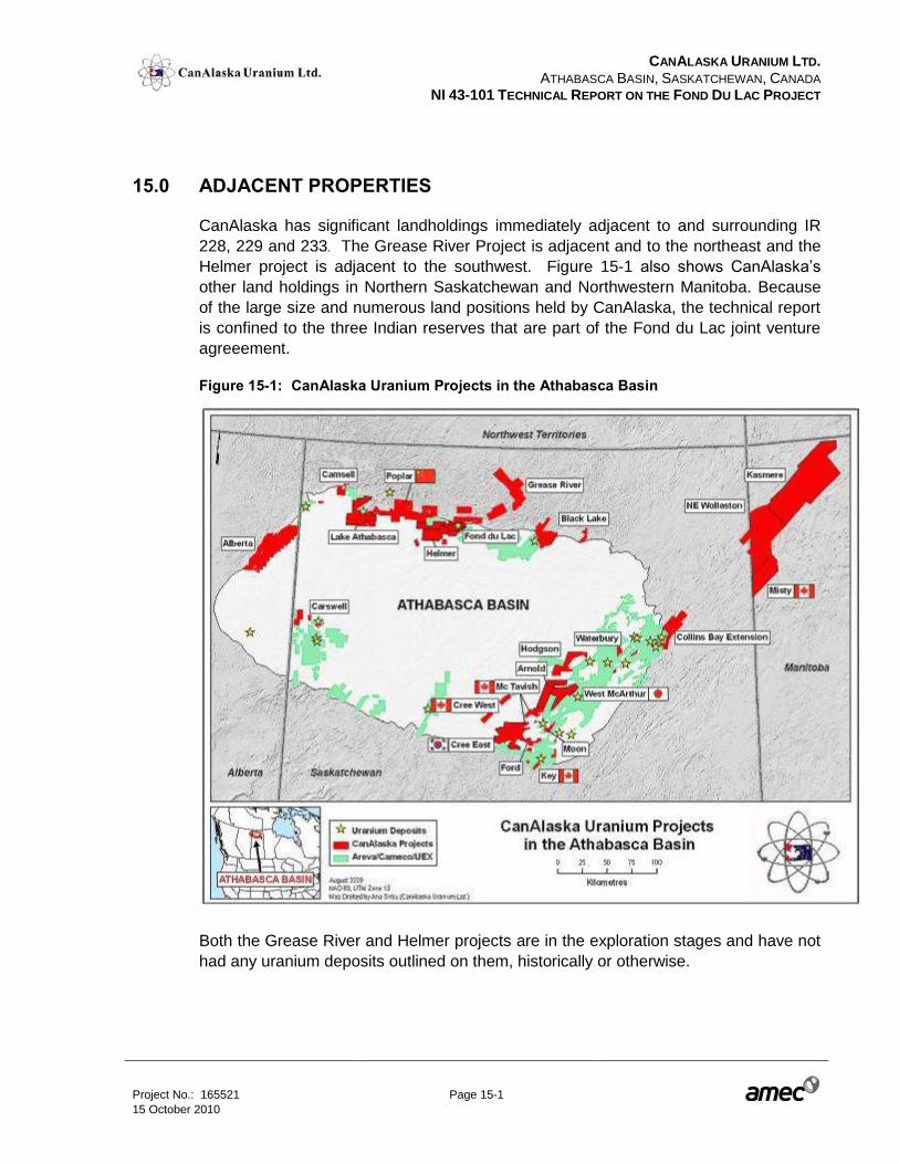
CANALASKA URANIUM LTD.
ATHABASCA BASIN, SASKATCHEWAN, CANADA NI 43-101 TECHNICAL REPORT ON THE FOND DU LAC PROJECT
Project No.: 165521 Page 15-1 15 October 2010
15.0 ADJACENT PROPERTIES
CanAlaska has significant landholdings immediately adjacent to and surrounding IR
228, 229 and 233. The Grease River Project is adjacent and to the northeast and the
Helmer project is adjacent to the southwest. Figure 15-1 also shows CanAlaska’s
other land holdings in Northern Saskatchewan and Northwestern Manitoba. Because
of the large size and numerous land positions held by CanAlaska, the technical report
is confined to the three Indian reserves that are part of the Fond du Lac joint venture
agreeement.
Figure 15-1: CanAlaska Uranium Projects in the Athabasca Basin
Both the Grease River and Helmer projects are in the exploration stages and have not
had any uranium deposits outlined on them, historically or otherwise.
CANALASKA URANIUM LTD.
ATHABASCA BASIN, SASKATCHEWAN, CANADA NI 43-101 TECHNICAL REPORT ON THE FOND DU LAC PROJECT
Project No.: 165521 Page 16-1 15 October 2010
16.0 MINERAL PROCESSING AND METALLURGICAL TESTING
Not applicable.
CANALASKA URANIUM LTD.
ATHABASCA BASIN, SASKATCHEWAN, CANADA NI 43-101 TECHNICAL REPORT ON THE FOND DU LAC PROJECT
Project No.: 165521 Page 17-1 15 October 2010
17.0 MINERAL RESOURCE AND MINERAL RESERVE ESTIMATES
Not applicable.
CANALASKA URANIUM LTD.
ATHABASCA BASIN, SASKATCHEWAN, CANADA NI 43-101 TECHNICAL REPORT ON THE FOND DU LAC PROJECT
Project No.: 165521 Page 18-1 15 October 2010
18.0 OTHER RELEVANT DATA AND INFORMATION
None.
CANALASKA URANIUM LTD.
ATHABASCA BASIN, SASKATCHEWAN, CANADA NI 43-101 TECHNICAL REPORT ON THE FOND DU LAC PROJECT
Project No.: 165521 Page 19-1 15 October 2010
19.0 ADDITIONAL REQUIREMENTS FOR TECHNICAL REPORTS ON
DEVELOPMENT PROPERTIES AND PRODUCTION PROPERTIES
Not applicable.
CANALASKA URANIUM LTD.
ATHABASCA BASIN, SASKATCHEWAN, CANADA NI 43-101 TECHNICAL REPORT ON THE FOND DU LAC PROJECT
Project No.: 165521 Page 20-1 15 October 2010
20.0 INTERPRETATION AND CONCLUSIONS
The Fond Du Lac Property is considered to be a property of merit with significant
exploration potential for unconformity type uranium mineralization. Historical drilling
activities in the vicinity of the FDL deposit appear to have been limited to the search for
strictly sandstone hosted deposits, as evidenced by the fact that the drill holes were
generally stopped after intersecting basement rocks. Recent drilling by CanAlaska
suggests that uranium mineralization extends into basement structures.
Boulder prospecting appears has been an effective tool for establishing prospective
areas for detailed follow up. Geophysical surveys are also critical to helping locate
prospective structures.
The available historical drilling information is not of suitable quality to support a mineral
resource estimate at this time. There are generally no chemical assays available in
the historical data set. Most assays were derived from radioactivity measurements.
Complete logs are also generally not available. Should additional information become
available as a result of outstanding queries by CanAlaska to other organizations
associated with the historical drilling (Cameco and Arreva) be acquired, its reliability
will have to be assessed.
Results from available historical information and newly acquired information by
CanAlaska’s field crews indicate the presence of several promising targets for the
discovery of additional unconformity associated uranium deposits and / or the
expansion of the known limits of the FDL deposit itself.
The purpose of this report was to provide a summary of the exploration results to date
on the Fond Du Lac project. The exploration work carried out to date by CanAlaska
has confirmed the presence of a mineralized zone. To that end the project has met its
original objectives. Additional work will be required to determine the precise extent
and grade of the mineralization. Further exploration is warranted on the property.
CANALASKA URANIUM LTD.
ATHABASCA BASIN, SASKATCHEWAN, CANADA NI 43-101 TECHNICAL REPORT ON THE FOND DU LAC PROJECT
Project No.: 165521 Page 21-1 15 October 2010
21.0 RECOMMENDATIONS
21.1 Drilling and assaying procedures
If it is CanAlaska’s intention to be in a position to establish a resource estimate for the
property in the future, a number of recommendations should be followed.
Future drilling
The use of consistent sample lengths
The implementation of an appropriate QA/QC program
Existing data
Partial re-assay program with appropriate QA/QC program, to include sending
samples to a secondary “umpire” lab.
These recommendations are outlined below.
21.1.1 Sampling Interval
The current dataset includes a large range of sampling intervals (0.2 to 19.5 m).
Future sampling programs should involve maintaining a consistent sample length,
where geological conditions permit. Normally the sampling interval would be related to
the minimum width of a “selective mining unit”. For a deposit of this type, sample
intervals in the 1 – 2 m range should be considered.
21.1.2 Certified Reference Material (Standards)
Many assay labs offer certified reference material for Uranium exploration. It is
convenient to obtain the standard material in pre-packaged quantities.
21.1.3 Blanks
Blanks can be any type of material that contains no mineralization. Typically it should
be rock and not sand or topsoil. Additionally, it is good practice to utilize the same
material for all the inserted blanks. Certain landscaping rock purchased from a home
and garden store is a good blank. A large outcrop of unmineralized material is also a
good source. In either, samples should be submitted for assay to ensure they are
below detection limit for the elements of interest.

CANALASKA URANIUM LTD.
ATHABASCA BASIN, SASKATCHEWAN, CANADA NI 43-101 TECHNICAL REPORT ON THE FOND DU LAC PROJECT
Project No.: 165521 Page 21-2 15 October 2010
21.1.4 Duplicates
A “duplicate” refers to the taking of an identical portion of a sample from an original
sample. This is distinctly different than a “check assay”, which is usually a re-assay of
a small amount of the original material after sample preparation is complete.
Split Duplicates (Twin sample dulplicate)
It is best practice that field duplicates are obtained during the original sampling, where
one can use both halves of a split core sample, or two halves (quarter cut) of one-half
split core (this is usually difficult unless a core saw is utilized). In the case of
re-analysis, the duplicates will have to be extracted from the pulps received from the
lab.
Of particular importance for duplicates is to make sure that a wide range of grades are
represented in the samples submitted for duplicates.
Preparation Duplicates (Coarse reject duplicate)
Preparation duplicates are created by taking a second split of the crushed sample.
These samples are used to detect errors during the preparation phase.
Pulp Duplicates
Pulp duplicates are created by taking a second split of the pulp. These samples are
used to detect errors during the assaying phase.
21.1.5 Re-analysis (Pulp Check)
In preparation for any future resource estimate it is also recommended that enough
samples be re-assayed with QC samples inserted into the sample stream such that
one of each (blank, standard, pulp duplicates) QC samples is included in each batch of
25 samples. In order to obtain results that are statistically significant, 25 QC samples
of each type must be submitted.
If 550 samples were included in this process, the resulting analyses would contain
25 QC samples of each type for analysis. The total number of re-assays, including QC
samples, would be 625. These samples should be re-numbered such that the QC
samples are included in the sequential numbering and, in the best case, submitted to
another lab.
CANALASKA URANIUM LTD.
ATHABASCA BASIN, SASKATCHEWAN, CANADA NI 43-101 TECHNICAL REPORT ON THE FOND DU LAC PROJECT
Project No.: 165521 Page 21-3 15 October 2010
AMEC can help with the design of the QA/QC program or provide a review of the
designed program.
Additionally, a representative portion of these samples should be sent to a secondary
“umpire” lab for further QA/QC determinations.
21.2 Work Program
A two phase work program is recommended. The first phase would include a
geochemical soil survey accompanied by radon gas measurements in the deposit
area. This results of this program should be utilized in planning follow up drilling to
target the new mineralized zone discovered in 2009, immediately northeast of the FDL
deposits historical extents.
Initial follow up diamond drilling should consist of 10 holes for 2,100 m with a total
budget of $640,000. A phase 2 budget of an additional 30 holes for roughly 6,100 m.
The size of the phase 2 program will be determined based upon results encountered in
phase 1. Additionally, a computerized geological model should be created in order to
help establish the geometry, position and relationship of the various drillhole intercepts
versus the deposit as a whole.
CANALASKA URANIUM LTD.
ATHABASCA BASIN, SASKATCHEWAN, CANADA NI 43-101 TECHNICAL REPORT ON THE FOND DU LAC PROJECT
Project No.: 165521 Page 21-4 15 October 2010
Figure 21-1: Location of proposed work
CANALASKA URANIUM LTD.
ATHABASCA BASIN, SASKATCHEWAN, CANADA NI 43-101 TECHNICAL REPORT ON THE FOND DU LAC PROJECT
Project No.: 165521 Page 21-5 15 October 2010
Table 21-1: Phase 1 and 2 Proposed Exploration Budgets
Type of Work Total Phase 1 Total Phase 2
General – administration 48,000 75,000
Camp accommodation and operation 192,000 300,000
Road and trail construction, sampling labour. 12,000 25,000
Geochemistry 60,000
Geology 180,000 400,000
Geophysics 12,000 30,000
Drilling 420,000 1,000,000
Environment and safety 24,000 50,000
Contingency 14,000 30,000
Grand Total 962,000 1,910,000
CANALASKA URANIUM LTD.
ATHABASCA BASIN, SASKATCHEWAN, CANADA NI 43-101 TECHNICAL REPORT ON THE FOND DU LAC PROJECT
Project No.: 165521 Page 22-1 15 October 2010
22.0 REFERENCES
Baer, A.J., 1969. The Precambrian Geology of Fond-Du-Lac Map-Area (74-O),
Saskatchewan.
Card, C.D., Pană, D., Portella, P., Thomas, D.J., and Annesley, I.R., 2007. Basement
Rocks to the Athabasca Basin, Saskatchewan And Alberta.
Campbell, J.E., Ashton, K.E., and Knox, B., 2006. Quaternary Investigations West of
Fond-Du-Lac, Northeast Lake Athabasca (Part Of Nts 74o-5 And-6), Fond-Du-
Lac Project In Summary Of Investigations 2006, Volume 2, Saskatchewan
Geological Survey.
Fayek, M., 2009. Petrography of Samples from the Fond Du Lac Deposit, Athabasca
Basin, Saskatchewan, Canada. Report Prepared for Canalaska Uranium Ltd.
Fayek, M., 2009. Petrography of Samples from the Fond Du Lac Deposit, Athabasca
Basin, Saskatchewan, Canada. Report Prepared For Canalaska Uranium Ltd.
Homeniuk, L.A. And Mch. Clark, R.J., 1986. North Rim Deposits, Athabasca Basin, in
Uranium Deposits of Canada, Special Volume 33, The Canadian Institute of
Mining and Metallurgy, (Ed.) E. L. Evans.
Jefferson, C.W. and Delaney, G., 2007. Extech IV: Geology and Uranium Exploration
Technology of the Proterozoic Athabasca Basin, Saskatchewan and Alberta,
(Ed.); Geological Survey of Canada, Bulletin 588; 644 pp.
Jefferson et al., 2007. Unconformity-Associated Uranium Deposits of the Athabasca
Basin, Saskatchewan and Alberta.
Kermeen, J.S., 2007. A Report on the Mineral Potential of the Indian Reserve Lands
of the Fond Du Lac Denesuline First Nation with Recommendations for further
exploration for Uranium Athabasca Basin Northern Saskatchewan Canada.
Marquis, G. and Schimann, K., 2009. 2008-2009 Geophysics Fond Du Lac Project,
Saskatchewan Report # FDL2009-01.
Muirhead, M., Smart, E. and Schimann, K., 2010. Report On Summer 2008 and 2009
Exploration Programmes Fond Du Lac Project Saskatchewan, Canada Report
# FDL 2009-02.
Mysyk, W. K., 2009. Petrographic Analysis of Ten Drill Core Samples, Fond Du Lac
Project, Northern Saskatchewan. Report prepared for Canalaska Uranium Ltd.
CANALASKA URANIUM LTD.
ATHABASCA BASIN, SASKATCHEWAN, CANADA NI 43-101 TECHNICAL REPORT ON THE FOND DU LAC PROJECT
Project No.: 165521 Page 22-2 15 October 2010
Polutnik, R., 2009. Canalaska Uranium Ltd. Down Hole Probing Manual: Geovista.
Radjee, A and Marquis, G, 2009. 2009 Geophysics Report. Fond Du Lac Project.
Saskatchewan, Canada. Canalaska Uranium Ltd. Report # FDL2009-01.
Ramaekers et al., 2007. Revised Geological Map and Stratigraphy of the Athabasca
Group, Saskatchewan and Alberta.
CANALASKA URANIUM LTD.
ATHABASCA BASIN, SASKATCHEWAN, CANADA NI 43-101 TECHNICAL REPORT ON THE FOND DU LAC PROJECT
Project No.: 165521 Page 23-1 15 October 2010
23.0 DATE AND SIGNATURE PAGE
The undersigned prepared this Technical Report, titled NI 43-101 Technical Report on
the Fond Du Lac Project, dated 15 October 2010. The format and content of the report
are intended to conform to Form 43-101F1 of National Instrument 43-101 (NI 43-101)
of the Canadian Securities Administrators.
The effective date of this Technical Report, prepared on behalf of CanAlaska Uranium
Ltd., and entitled “NI 43-101 Technical Report on the Fond Du Lac Project” is
15 October 2010.
On behalf of AMEC Americas Limited
“Signed and Sealed”
Ron Parent, P. Geo.
Principal Geologist, Mining & Metals
AMEC Americas Limited
Dated: 15 October 2010