ICF International
MADHYA PRADESH URBAN INFRASTRUCTURE INVESTMENT PROGRAMME (MPUIIP)
Handbook of Smart Solutions Ready Reckoner for Preparation of Smart City Proposals in Madhya Pradesh
September 2015
ICF International 2
List of Acronyms
ABPAS Automated Building Plan Approval System
ALPASS Automated Layout Process Approval and Scrutiny System
AMRUT Atal Mission for Rejuvenation and Urban Transformation
ATM Automated Teller Machine
BOD Biochemical Oxygen Demand
BPO Business Process Outsourcing
BRTS Bus Rapid Transit System
COD Chemical Oxygen Demand
CST Central Sales Tax
DFID Department for International Development
DMA District Metering Areas
EHS Employees Health Scheme
FAR Floor Area Ratio
FSI Floor Space Index
GDP Gross Domestic Product
GIFT Gujarat International Finance Tec-City
GIS Geographic Information System
GOI Government of India
GoMP Government of Madhya Pradesh
GPR Ground Penetrating Radar
GPRS General Packet Radio Service
GPS Global Positioning System
GSM Global System for Mobile Communications
gTLDs Generic Top-level Domains
ICT Information and Communication Technology
IEM Industrial Entrepreneur Memorandum
IOT Internet of Things
IT Information technology
ITS Intelligent Transport System
LPCD Litres Per Capita Per Day
MIS Management Information System
MoUD Ministry of Urban Development
MPUIIP Madhya Pradesh Urban Infrastructure Investment Programme
MRTS Mass Rapid Transit System
MSWM Municipal Solid Waste Management
NBCC National Building Construction Corporation
NFC Near Field Communication
NRW Non-Revenue Water
O&M Operations and maintenance
OBITS On- Bus Vehicle Intelligent Transport System
PPA Power Purchase Agreement

ICF International 3
PPP Public Private Partnership
RFID Radio Frequency Identification
RSPM Respirable Suspended Particulate Matter
RTS Rooftop Solar Project
SCADA Supervisory Control and Data Acquisition
SCU Single Control Unit
SHG Self Help Groups
SPM Suspended Particulate Matter
SPV Special Purpose Vehicle
TC Technical Consultant
TDS Tax Deducted at Source
TIN Triangulated Irregular Network
TMCC Traffic Management Control Centre
UDA Urban Development Authority
ULB Urban Local Bodies
VAT Value Added Tax
VHMD Vehicle Health Monitoring & Diagnostics System

ICF International 4
Table of Contents
1 INTRODUCTION ......................................................................................... 7
1.1 Models of Smart Solutions ............................................................................................................. 8
1.2 Principles to Identify Smart Solutions ............................................................................................ 9
1.3 Summary of Smart Solution ......................................................................................................... 10
2 SMART SOLUTIONS FOR TRANSPORT SECTOR ............................................. 14
2.1 Smart Parking ............................................................................................................................... 14
2.2 Vehicle Health Monitoring & Diagnostics System ....................................................................... 14
2.3 Smart Information System for Public Transport Services ............................................................ 15
2.4 Traffic Information System .......................................................................................................... 15
2.5 Incident Reporting System ........................................................................................................... 15
2.6 GIS Based Transportation Asset Management System ............................................................... 16
2.7 Citizen Reporting Tools for Road Safety ...................................................................................... 16
2.8 Smart Street and Pavement Lighting ........................................................................................... 16
2.9 Pelican and Puffin pedestrian crossing system ............................................................................ 16
2.10 Common Mobility Card ................................................................................................................ 16
3 SMART SOLUTIONS FOR WATER SECTOR .................................................... 17
3.1 Water Quality Surveillance Monitoring ....................................................................................... 17
3.2 Pressure Monitoring .................................................................................................................... 17
3.3 Production Metering.................................................................................................................... 17
3.4 Zonal Metering System ................................................................................................................ 17
3.5 Consumer Metering ..................................................................................................................... 18
3.6 Setting up District Metering Areas (DMAs) ................................................................................. 18
3.7 Hydraulic Modelling ..................................................................................................................... 18
3.8 GIS based Asset Management System ........................................................................................ 18
3.9 Geo-Thermal Imaging for Leakage Detection .............................................................................. 19
4 SMART SOLUTIONS FOR WASTE WATER MANAGEMENT .............................. 20
4.1 Sewerage Network Decision Support Tool .................................................................................. 20
4.2 Run-off Simulation Model ............................................................................................................ 20
4.3 Integrated Watershed Management ........................................................................................... 21
4.4 Asset Management and Capital Planning .................................................................................... 21
4.5 Waste Water Quality Monitoring ................................................................................................ 22
4.6 Decentralized Waste Water Treatment ....................................................................................... 22
4.7 Wastewater Discharge Monitoring .............................................................................................. 22
4.8 Smart Manholes ........................................................................................................................... 22
5 SMART SOLUTIONS FOR MUNICIPAL WASTE MANAGEMENT ........................ 23
5.1 Smart Application for SWM Resource Plan ................................................................................. 23
5.2 Sensor Enabled Smart Bins .......................................................................................................... 24
5.3 GPS Enabled Vehicles ................................................................................................................... 24
5.4 RFID Tags on Collection Vehicles ................................................................................................. 24
5.5 Road Side Cameras or Drones ..................................................................................................... 24
5.6 Smart Human Resource Management for SWM ......................................................................... 25
ICF International 5
5.7 Smart Environment Monitoring ................................................................................................... 25
5.8 Smart Grievance Portal for Citizens ............................................................................................. 25
5.9 Smart Dashboard for Revenue Management .............................................................................. 25
6 SMART SOLUTIONS FOR ENERGY EFFICIENCY ............................................. 26
6.1 Smart Light Poles ......................................................................................................................... 26
6.2 Roof Top Solar Projects ................................................................................................................ 27
6.3 Operation & Maintenance of Street Lighting Projects ................................................................ 27
6.4 Web Application for O&M of Water Pumping & Storage Application ........................................ 27
7 SMART SOLUTION FOR GOVERNANCE USING ICT ........................................ 28
7.1 Expansion of e-Nagarpalika ......................................................................................................... 28
7.2 City Level Cloud ............................................................................................................................ 28
7.3 GIS Based Solutions ..................................................................................................................... 28
7.4 Common Portal ............................................................................................................................ 29
7.5 Mobile Applications and Kiosks ................................................................................................... 29
7.6 Common Service Centers ............................................................................................................. 29
7.7 Use of Big Data Analytics ............................................................................................................. 29
7.8 Seamless Wi-Fi Connectivity ........................................................................................................ 29
7.9 Smart Metering Software Solutions ............................................................................................ 30
7.10 ICT Research Lab .......................................................................................................................... 30
7.11 Smart City Cards ........................................................................................................................... 30
8 SMART SOLUTIONS FOR PLANNING AND HOUSING ..................................... 31
8.1 Smart Planning and Implementation Process.............................................................................. 31
8.2 Building Approvals ....................................................................................................................... 32
8.3 Smart Solutions for Housing ........................................................................................................ 32
8.4 Smart Real-Estate Dashboard ...................................................................................................... 33
9 SMART SOLUTIONS FOR LOCAL ECONOMY ................................................. 34
9.1 Education-Industry-Research Interface ....................................................................................... 34
9.2 Entrepreneurs Centres ................................................................................................................. 34
9.3 Testing Facilities ........................................................................................................................... 34
9.4 MIS for Tracking Environmental Impact of Industries ................................................................. 34
9.5 Smart Buildings for Industry ........................................................................................................ 34
9.6 Business Facilitation Portal .......................................................................................................... 35
10 SMART SOLUTIONS FOR HERITAGE AND TOURISM ...................................... 36
10.1 Smart Phones Rental Service ....................................................................................................... 36
10.2 City level Tourist Applications...................................................................................................... 36
10.3 Tourist Friendly Public Transportation ........................................................................................ 36
10.4 Wi-Fi on Tourists Places and E-guide ........................................................................................... 36
10.5 Home Stay Registration Portal ..................................................................................................... 37
10.6 Historic Area Management System ............................................................................................. 37
10.7 Smart Museum and Interpretation Center .................................................................................. 37
11 SMART SOLUTIONS FOR INCLUSIVE DEVELOPMENT AND SAFE CITIES ........... 38
11.1 Special Fare Cash Card ................................................................................................................. 38
11.2 Women Shuttles for Women Working at Night Shifts in Offices................................................. 38

ICF International 6
11.3 Domestic Help Information System ............................................................................................. 39
11.4 Connected Communities ............................................................................................................. 39
11.5 Smart Public Service Kiosks.......................................................................................................... 40
11.6 Smart IEC for Public Awareness ................................................................................................... 40
12 SMART SOLUTIONS FOR HEALTH SERVICES ................................................. 41
12.1 Medicine Dispensing Machine and Diagnostic Point ................................................................... 41
12.2 E Health Point .............................................................................................................................. 41
12.3 Smart Medical Outreach Services ................................................................................................ 41
12.4 E-Health Card ............................................................................................................................... 42
13 SMART SOLUTIONS FOR EDUCATION SERVICES ........................................... 43
13.1 Smart Classroom .......................................................................................................................... 43
13.2 Smart School Management System ............................................................................................. 43
13.3 E-Monitoring System ................................................................................................................... 44
14 ANNEXURE 1 – BEST SMART SOLUTIONS FROM ‘MERA SHEHAR MERA
SAPNA’ COMPETITION ............................................................................. 45

ICF International 7
1 Introduction
The Smart City Mission (SCM) was launched on 25th June, 2015 by the Ministry of Urban
Development, Government of India (MoUD) and is being rolled out in 100 Cities geographically
spread across the Country. The objective of the SCM is to promote cities that provide job
opportunities and improve the livability of cities, so as to create a clean and sustainable environment
and ‘Smart’ Solutions.
To realize these objectives, SCM have strategic components of Area-Based Development including
place improvement (Retrofitting), City Renewal (Redevelopment) and city extension (Greenfield
Development) plus a Pan-city initiative in which Smart Solutions are applied covering larger parts of
the city. For getting selected under SCM, each city has to clear two stage city challenge selection
process.
The 1st stage of the selection process involved an intra-state competition between the cities within
the state. The competition was based on the conditions precedent and scoring criteria given in SCM
guidelines. In Madhya Pradesh, seven cities including Bhopal, Indore, Gwalior, Jabalpur, Sagar, Ujjain
& Satna have been shortlisted in 1st stage and have been included in the list of 100 cities shortlisted
by the MoUD for Smart Cities.
In the 2ndstage of the Selection Process, each of the shortlisted 100 cities are to prepare their
proposals for participation in the ‘City Challenge’ as prescribed in the Smart City Guidelines and by
the stipulated date as to be informed by the MoUD.
The MPUIIP TC team at the Urban Development & Environment Department, GoMP has conducted a
diagnostic study during the work of preparation of Smart City Plan for Indore in which a
compendium of Smart Solutions pertaining to various sectors of a Smart City Plan were explored
based on secondary research, global best practices and applicability of the particular smart solutions.
Based on the key learning’s from these studies, the MPUIIP TC team has prepared a handbook of
sector specific ‘Smart Solutions’ with a view of providing inputs and bouquet of innovative and best
in class smart solutions.
The Handbook on Smart Solution intends to provide selected city under Smart City Mission a
compilation of possible Smart Solutions for various sub components of a Smart City Plan. The
Handbook focuses on ideas to provide Smart Solutions which are sustainable, replicable and
inclusive. The Handbook also tries to highlight the potential benefits and value addition of the Smart
Solution in terms of financial and operational sustainability of such solutions.
It is intended that this Handbook acts as a ready reckoner to the local governments for designing of
the smart solutions and thus ensuring that smart city plan for each city meets international
standards & quality aspects and is prepared in a manner aligned to the Government of India’s Smart
City Guidelines.

ICF International 8
1.1 Models of Smart Solutions
The purpose of the Smart Cities Mission is to drive economic growth and improve the quality of life
of people by enabling local area development and harnessing technology, especially technology that
leads to Smart outcomes. The key consideration and requirement for conceptualizing the Smart
Solutions are based upon understanding their impact on strategic components of Area-based
development and Pan-city initiative which are further discussed below.
Area-based development
Area-based development will transform existing areas (retrofit and redevelop), including slums, into
better planned ones, thereby improving the livability of the whole City. New areas (Greenfield) will
be developed around or in close proximity to cities with a view to decongest the city and creating
growth centers with optimal quality of life. The three strategic components of Area-based
development as stipulated by Smart City Mission Statement and Guidelines, GoI are being stated
below.
Retrofitting aims to improve upon the existing situation of any area of the city. This will introduce
planning in an existing built-up area to achieve Smart City objectives, along with other objectives, to
make the existing area more efficient and liveable. As per the Mission statement and Guidelines, an
area consisting of more than 500 acres will be identified by the city in consultation with citizens.
Depending on the existing level of infrastructure services in the identified area and the vision of the
residents, the cities will prepare a strategy to become smart. Since existing structures are largely to
remain intact in this model, it is expected that more intensive infrastructure service levels and a
large number of smart applications will be packed into the retrofitted Smart City. This strategy may
also be completed in a shorter time frame, leading to its replication in another part of the city.
Redevelopment aims for city renewal and will effect a replacement of the existing built-up
environment and enable co-creation of a new layout with enhanced infrastructure using mixed land
use and increased density. As per the Mission statement and Guidelines, Redevelopment envisages
an area of more than 50 acres, identified by Urban Local Bodies (ULBs) in consultation with citizens.
For instance, a new layout plan of the identified area will be prepared with mixed land-use, higher
FSI and high ground coverage. Two examples of the redevelopment model are the Saifee Burhani
Up-liftment Project in Mumbai (also called the Bhendi Bazaar Project) and the redevelopment of
East Kidwai Nagar in New Delhi being undertaken by the National Building Construction Corporation.
Greenfield aims to develop new area that will act as a city extension. It will introduce most of the
Smart Solutions in a previously vacant area (more than 250 acres) using innovative planning, plan
financing and plan implementation tools (e.g. land pooling/ land reconstitution) with provision for
affordable housing, especially for the poor. Greenfield developments are required around cities in
order to address the needs of the expanding population. One well known example is the GIFT City in
Gujarat. Unlike retrofitting and redevelopment, Greenfield developments could be located either
within the limits of the ULB or within the limits of the local Urban Development Authority (UDA).
Pan-city initiative
Pan-city development envisages application of selected Smart Solutions to the existing city-wide
infrastructure. Application of Smart Solutions will involve the use of technology, information and

ICF International 9
data to make infrastructure and services better. As per the Mission and Guideleines, GoI, Pan-city
solutions are to be devised in a manner that are fully inclusive and can be applied on a city wide
basis such that it impacts and covers the overall citizens in a positive manner and improve the
overall livability of the city. For example, applying Smart Solutions in the transport sector (intelligent
traffic management system) and reducing average commute time or cost to citizens will have
positive effects on productivity and quality of life of citizens. Another example can be waste water
recycling and smart metering which can make a substantial contribution to better water
management in the city. This section of the Smart City Plan will focus upon holistic initiative that the
local government presumes would deliver maximum domino effect of development, prosperity and
transform the overall urban fabric of the city.
1.2 Principles to Identify Smart Solutions
Based on the assessment of the above
categorized development initiatives, the
Smart Solutions should have a view of
creating a benchmark for the city’s urban
fabric space, the implementation
framework for the initiatives need to be
identified and prioritized such that it
creates a maximum value addition for all
the stakeholders. This Handbook
prioritizes creation of a Compendium
based on the following parameters:
i. Quality of life: Improved quality of life is most vital aspect of Smart City and thus the idea
behind all Smart Solution should considered its implication on this aspect of city’s’ nature.
ii. Outreach: The benefits of Smart Solution should reach to larger section of society and it shall
have an outreach to larger population of city so that it can be replicated to other parts of city in
near future.
iii. Value for money – Implementation of Smart Solution should be cost effective in a manner that it
provides the best quality and outreach to the city programmes without putting extensive burden
on the funds of implementing agency or city. It is advisable that, benefits of Smart solution shall
match the expenditure on the respective Smart Solution.
iv. Time-horizon – Smart solution shall be time bound initiative which shall start reaping benefits
for the citizens as early as possible. This is also going to be an important characteristic of Smart
Solution.
v. Ease of implementation – Even though few of the Smart Solution will have difficulty in initial
phase of acceptance by citizens, but the overall ease of implementing the Smart Solution will be
an important factor in success of any Smart Solution.
vi. Replicability & Inclusiveness: Depending upon the overall potential of the idea and its
replicability across the entire city or to create an impact on a larger section of the city which
would largely depend upon the diagnostic studies and the current progress and preparedness of
the local governments and the specific city’s infrastructural and urban reforms.
Compendium on Smart Solutions
Quality of life
Outreach
Value for money
Ease of implementation Replicability &
Inclusiveness Incemental Benefits
Time Horizon
Amenability to Private
Participation

ICF International 10
vii. Incremental Benefits: Creating a solution that identifies the Smart Solution at its root and
creates maximum value addition and accrues benefits to the city, in general over the period of
time in terms of socio-economic development and financial sustainability.
viii. ICT focused: Effective utilization of the ICT platform shall form an integral part of any Smart
Solution which can easily assimilate with the infrastructure such that it leads to improvements in
delivery, efficiency and efficacy of the respective municipal service.
ix. Amenability to Private Sector Participation: The Smart Solution shall have to be designed in
a manner such that it can dovetail with an existing sector specific state sponsored financing
schemes, Grants, Debts, Bonds, Equity of the SPV, AMRUT, coupled with financing mode like PPP
etc or possible participation from multi-lateral funding & donor agencies. Another important
aspect to be looked into is to check the preparedness of the concerned ULB in implementing the
sector specific initiative.
x. Efficiency: Smart solution should target the maximum efficiency of the existing and the
proposed systems to minimize the wastage and achieve quality service delivery. This will ensure
optimum utilization of resources.
1.3 Summary of Smart Solution
This table below covers the summary of Smart Solutions as identified in this report and provides
their applicability in respect to city level infrastructure, area based development & pan city initiative.
The report further details out the Smart Solutions.
Sector Smart Solution R
edeve
lopm
ent
Retr
ofit
ting
Gre
enfield
Pan
-city
Transportation
Smart Parking
Vehicle Health Monitoring & Diagnostics System
Smart Information System for Public Transport Services
Traffic Information System
Incident Reporting System
GIS Based Transportation Asset Management System
Citizen Reporting Tools for Road Safety
Smart Street and Pavement Lighting
Pelican and Puffin Pedestrian Crossing System
Common Mobility Card
Water
Water Quality Surveillance Monitoring
Pressure Monitoring
Production Metering
Zonal Metering System
Consumer Metering

ICF International 11
Sector Smart Solution
Redeve
lopm
ent
Retr
ofit
ting
Gre
enfield
Pan
-city
Setting up District Metering Areas (DMAs)
Hydraulic Modelling
GIS Based Asset Management System
Geo-Thermal Imaging for Leakage Detection
Waste Water
Management
Sewerage Network Decision Support Tool
Run-off Simulation Model
Integrated Watershed Management
Asset Management and Capital Planning
Waste Water Quality Monitoring
Decentralized Waste Water Treatment
Wastewater Discharge Monitoring
Municipal Solid
Waste
Management
Smart Application for SWM Resource Plan
Sensor Enabled Smart Bins
GPS Enabled Vehicles
RFID Tags on Collection Vehicles
Road Side Cameras or Drones
Smart Human Resource Management for SWM
Smart Environment Monitoring
Smart Grievance Portal for Citizens
Smart Dashboard for Revenue Management
Energy Efficiency
Smart Light Poles
Rooftop Solar (RTS) Projects
Operation & Maintenance of Street Lighting Projects
Web application for O & M of Water Pumping & Storage
Application
ICT
Expansion of e-Nagarpalika
City Level Cloud
GIS Based Solutions
Common Portal
Mobile Applications and Kiosks
Common Service Centers

ICF International 12
Sector Smart Solution
Redeve
lopm
ent
Retr
ofit
ting
Gre
enfield
Pan
-city
Use of big data analytics
Seamless Wi-Fi Connectivity
Smart Metering Software Solutions
ICT Research Lab
Smart City Cards
Planning &
development and
Housing
Smart Planning and Implementation Process
Building Approvals
Smart Solutions for Housing
Smart Real-Estate Dashboard
Local Economy
Education-Industry-Research Interface
Entrepreneurs centres
Testing facilities
MIS for tracking environmental impact of industries
Smart Buildings for Industry
Business Facilitation Portal
Heritage and
Tourism
Smart Phones Rental Services
City Level Tourist Applications
Tourist friendly Public Transportation
Wi-Fi on Tourists Places and E-guide
Home Stay Registration Portal
Historic Area Management System
Smart museum and Interpretation Center
Inclusive
development and
Safety
Special Fare Cash Card
Women Shuttles for Women Working in Night Shifts in Offices
Domestic Help Information System
Connected Communities
Smart Public Service Kiosks
Awareness on schemes and services
Health
Drugs ATM
E health Point
Smart Medical Outreach Services

ICF International 13
Sector Smart Solution
Redeve
lopm
ent
Retr
ofit
ting
Gre
enfield
Pan
-city
E-Health Card
Education
E-monitoring system
Smart School Management System
Smart Classroom

ICF International 14
2 Smart Solutions for Transport Sector
Public Transport system at varying levels of efficiencies are still plagued by similar problems which
involve chronic inefficiency and non-dependent like level of services, congested road networks
which slow down municipal bus services, low levels of co-ordination in the delivery of municipal
transport services etc. These when developed and operated through a sustainable O&M framework
can lead to overall institutional, physical and social infrastructure strengthening and promoting
prosperity and overall economic growth of the region.
2.1 Smart Parking
Smart parking involves using low-cost sensors, real-
time data collection, and mobile-phone-enabled
automated payment systems that allow people to
locate and reserve parking in advance or very
accurately predict where they will likely find a spot.
When deployed as a system, smart parking will not
only ease parking related problems but will also prove
helpful in regulation of entire traffic flows and also
generate revenue to ULBs. A smart parking system
typically comprises the following components such as
Sensors, Over- time Indicators, Dynamic Signage & Mobility Application, Static Signage, Parking
Management Softwares.
2.2 Vehicle Health Monitoring & Diagnostics System
Most of the urban conglomerates in India are getting
increasingly polluted. The main reason for any city’s air
pollution is from the vehicular exhaust leading to high
concentration of respirable suspended particulate
matter (RSPM) and other suspended particulate matter
(SPM). Vehicle Health Monitoring and Diagnostic System
is a Smart Solution for reducing vehicular pollution. The
single control unit ‘SCU’, together with single bus driver
console ‘BDC’, form the nucleus of the on- bus vehicle
intelligent transport system (OBITS) and VHMD is a
component of the intelligent transport system.
The Traffic Management Control Centre (TMCC) can be
integrated with the Vehicle Health Monitoring and
Diagnostic System (VHMD) in the municipal transport
buses through on-bus ITS. The Vehicle Health data is
logged and monitored and action can be taken by the
TMCC whenever required. The system captures the
vehicle health data coming from on-bus ITS and logs it.
As soon as health data crosses a pre-selected threshold

ICF International 15
limit, alerts are generated. The threshold limit as well as parameters to be measured for vehicle
health can be chosen from the following which can be individually selected and adjusted as required:
Fuel & Oil Pressure Blocks, Braking Pedal Position, Accelerator Pedal Position, Engine Status, Coolant
etc.
2.3 Smart Information System for Public Transport Services
The shift to public transport can be aided through the use of Smart Application based solutions
which can provide all the necessary information related to various modes of public transport to the
passengers. An Integrated Transport Application can ideally provide the following features:
i. Provide the best ways to travel from one location to another, within the city in perspective of
the overall vehicular traffic on the streets on a real time basis. Since mobile phones trace a path,
potentially origin-destination information can also be collected.
ii. Cover all modes of public transportation such as MRTS, buses, BRTS, out station trains, Nagar
Seva Vehicles, radio Taxis, Feeder Services which also lets you set your preferred mode.
iii. Contain the most accurate and up to date public transit information
iv. Combines different bus and local train options along the same path and simplifies route choices
v. Give scheduled departures and arrivals for all modes of Public Transport
vi. Allow the user to set their usual places; and take them there in a click
vii. Provides detailed directions from the start location to chosen end location - Map overlay on
Google Maps
viii. Minimal data consumption and operable on simple phones
ix. Simple and easy-to-use interface
2.4 Traffic Information System
Building from real-time data, the historical data archive
will allow traffic police and others to identify where the
traffic hotspots are. This saves the city money by not
having to go out and conduct traffic studies repeatedly.
The project is an extension of the Cellular based
advanced traffic monitoring system described above.
Real-time data will be archived and data visualization
tools will be created to illustrate delays, queue lengths,
travel times.
2.5 Incident Reporting System
Goods crash and incident information is critical to understand the problems faced by the citizens.
However, asking the busy police man to come back and type a report is not conducive. Providing the
officer with tablets having cellular connectivity, a common incident reporting form can be used to
collect data and automatically geo-tagged the information. The incident reporting system can also
include photographs.

ICF International 16
2.6 GIS Based Transportation Asset Management System
Information about transportation assets and also their
characteristics allows the city to manage their system
better gaining both cost and time efficiencies in
maintenance of equipment. This GIS-based asset
management system for transportation will provide a
one-stop resource for all of the city’s assets including
location of roads, signals, transit facilities, buses, other
fleets. In its full conception, this tool would also
include pavement and bridge information and is also
consistent with other Smart Transport initiatives.
2.7 Citizen Reporting Tools for Road Safety
Providing citizens an opportunity to report on traffic conditions [congestion, incidents], road
conditions [potholes, weather] and other complaints engages them as a stakeholder in the
transportation system operations. Either private (like Waze) or public sector applications or even a
dedicated phone line (like 311 in the US) can be used for this purpose.
2.8 Smart Street and Pavement Lighting
Pavement lighting directly affects the commuter safety as visibility of
roadways plays an important role in driving behaviour. Smart
Pavement lighting (including some emerging trends like dynamic
paint, solar absorption glow lines etc.) can be used to create safe
roadways. The improved visibility will further optimize the usage of
street lights, due to improved reflective visibility. This will further
save the energy demand for street lights.
2.9 Pelican and Puffin pedestrian crossing system
Pedestrian conflicts are a major source of concern especially among the busy
routes of city. Using call buttons and lit pedestrian crossings at key locations
can provide an effective mechanism for reducing pedestrian conflict with
traffic.
2.10 Common Mobility Card
A common mobility fare card has a significant impact on public
transportation use especially if it can be combined with other
value added services. A common fare card would allow users to
pay for BRT, buses, inner city buses and maybe even parking in
some locations.

ICF International 17
3 Smart Solutions for Water Sector
Water Supply augmentation and distribution management is one of the critical service provided by
ULB. Smart Solutions for water management should be designed in a manner that it pertains over
the entire ecosystem of the water supply system, right from its augmentation to customer service
management. The compilation of smart solution focuses on initiatives that can make the delivery of
water supply services, smart and efficient. Smart solutions that can be implemented for improving
the water supply system through ICT enabled interventions are further detailed below.
3.1 Water Quality Surveillance Monitoring
The technologies are available in the market for online-monitoring of water quality (pH, TDS,
Chlorine etc). These system can be installed both at the outlet of the water treatment works as well
as on the outlets of service reservoirs for the effective water quality monitoring. Thus the timely
interventions for leaks, bursts or cross connections with sewage which affects the quality of water
and service provision at the customer end can be deployed. The water quality report generated by
these systems can be directly shared with residents of the concerned area via online and mobile
portal.
3.2 Pressure Monitoring
Continuous real time pressure monitoring using pressure transducers which can be installed with a
central server can help the Water Supply Department in undertaking the dynamic hydraulic network
modelling for managing the distribution system. Applications based on predictive technologies using
historical pressure profiles can predict potential failures of pipes. Also, the differential pressure
shocks and pressure transients can be utilized for the efficient planning of the system. These sensors
cab be installed through hot tapping methods on existing pipelines at regular intervals.
3.3 Production Metering
The water sourced from both surface and ground water sources are measured by installing
production meter. Also the water finally produced from Water Treatment Plant will be measured to
understand the efficiency of system and procure the real time data on production of water. This
software application is easy to use and can be used to generate and download reports.
3.4 Zonal Metering System
The water flow from transmission mains to major zones of the network, needs to be metered which
shall include inflow/outflow on all the main service reservoirs and intermediate pumping stations.
Also, the electro-magnetic flow meters (battery operated) and pressure transducers with sufficient
capacity data loggers need to be installed at all strategic locations for the effective monitoring of the
distribution network.

ICF International 18
3.5 Consumer Metering
The high revenue customers like hotels, colleges, restaurants, private institutions and industries as
well as the domestic users can be provided with electronic smart water meters (like Automatic
Meter Reading) and can be charged, based on their respective volumetric consumption so as to
increase the revenue earning of ULBs. These meters have transmitting modems which uses the
GPRS/GSM platforms and can be further programmed for two way communications between
consumer and service provider for facilitating customers to pay their respective bills.
3.6 Setting up District Metering Areas (DMAs)
Under this system of operation, the network is sub-divided into District Metering Areas (DMAs) so as
to decentralize the water supply distribution network, supplied by a limited number of key mains.
The flow meters will be installed on each of them respectively. This will enable the service provider
to regularly quantify the leakages for each DMA. The leakage location is identified and resources are
directed to such parts of the network to provide a permanent solution to the leakage problems.
3.7 Hydraulic Modelling
Hydraulic modeling is required to simulate the
operations of the on ground network in all of its
key elements. Hydraulic modeling can simulate
the existing network virtually, to assess the
consumption pattern and leakage levels using an
iterative simulation process which will duly
capture the flow and pressure data of the current
network. When the network has been properly
calibrated, it will enable the concerned
department to understand the current operation
of the network. This will enable the department
to identify the anomalies and thereafter
optimize/modify the design of the system and configure the network before they are designed for
the on ground implementation. This will further reduce the customer complaints due to better
management of the system.
3.8 GIS based Asset Management System
Water supply department technicians generally
repair two to three leaks on an average every day
per technician, but they do not maintain records of
the location, nature of repair and materials used. A
simple solution is to deploy an IT service provider for
database management who can accompany the
technicians and maintain a data log. Such data log
can be remotely updated and uploaded to the
central server of the Water Utility for further

ICF International 19
necessary use.
A complete set of network maps covering the entire water supply system is required for the
effective network management and customer services using applications like Google Track, which
can automatically capture the investigation and upload it on Google Earth. Also, the tools for cable
and pipe locators can be used to check and confirm data as and when required. The Ground
Penetrating Radar (GPR) can also be deployed through private service providers which will provide
more reliable data on the underground utilities. Trial excavations can also be undertaken at critical
locations to confirm pipe diameters, materials. Locations of all valves and other appurtenances can
be geo-referenced using GIS based system.
3.9 Geo-Thermal Imaging for Leakage Detection
It is a non-invasive and non-destructive method to detect water leakage. The system is based upon
basic understanding that water will always choose the path of least resistance. An object that is wet
and comes in contact of air; a cooling effect takes place on the surface of objects. The infrared
camera detects this effect of water on objects related to temperature and environment. It enables
us to visually interpret the leakage point in the supply line and produces alerts and reports in such
cases. The recovery of water loss due to distribution system leakage can be controlled using leak
detection and repair programs. Such a technology can be used by a line-man to detect leakage at
household level.

ICF International 20
4 Smart Solutions for Waste Water Management
The existing waste water infrastructure system prevalent in the state is either insufficient or aging.
Using smart networks to optimize system performance will help service providers to become more
proactive in sewer collection system management and control.
There is widespread concern regarding the condition and adequacy of existing wastewater disposal
systems available with the local governments. Most of the urban areas are lacking in proper
sewerage network system and its treatment mechanism. Storm water also gets mixed with sewage
which is being disposed as raw sewage into rivers, lakes, streams, and estuaries each year, causing
deterioration in water quality and threatening drinking water supplies.
The necessary approach to be adopted in this regard can range from improving the system
performance by optimizing operations rather than relying solely on capital improvements. Recent
advancements in smart waste water networks are helping wastewater utility operators to boost
efficiency and become more proactive in sewer collection-system management and control.
Although geographic information system (GIS) data and supervisory control and data acquisition
(SCADA) systems can help operators locate their facilities, monitor system operations, and remotely
control pumps and diversion structures. These systems don’t have the predictive network modelling
and optimization capabilities necessary to assess the effects of operational or physical changes on
system performance and integrity. They also lack the forecasting capabilities required to identify
avoidable overflows and in order to plan for effective mitigation strategies.
4.1 Sewerage Network Decision Support Tool
In this modern time many system dynamics and analytics models can be fully integrated with GIS
and SCADA systems to help operators optimize wastewater operations and performance in real
time. Such smart models provide a comprehensive waste water management decision-support tool
for operators. They provide operators significant management advantages, including greater
operational efficiency and emergency preparedness, reduced system vulnerability, shortened
response time, and more informed decision making to effectively mitigate untoward events and
meet required Water Act obligations.
4.2 Run-off Simulation Model
Dynamic rainfall runoff simulation models are the most effective way to predict the behaviour of
sewer collection networks under various external loads and operating conditions. These models
account for various hydrologic processes that produce runoff from urban areas, using hydraulic
modelling to route runoff, external inflows, and water quality constituents through the sewer
network and track runoff quantity and quality, so that the specific goals of waste water management
can be achieved.
These models require accurate and continuously updated view of collection network. This can be
accomplished by synthesizing SCADA, radar rainfall, and other real time telemetry data with network
ICF International 21
models. The resulting model provides continuous real time insight about a collection of networks’
performance.
The waste water utilities can analyse the impact of a predicted incoming storm potentially affected
by flooding or over flows. Thereafter mitigation measures can be rapidly and accurately analysed
and compared to determine the most appropriate solution and associated costs. The system notifies
about equipment failures, shutdowns, maintenance and repairs and other planned and unplanned
incidents. The key network parameters like flow, depth, storage, capacity, under/over utilization can
also be assessed. When SCADA feeds go offline and data loggers are not available then using the
real-time network modelling the management can progress from active to proactive management,
resulting in more efficient operations and improved network maintenance and customer service.
4.3 Integrated Watershed Management
Waste water utilities can use the models to evaluate numerous operational scenarios, explore
alternative real-time control strategies (e.g., the effect of switching on a pump earlier than planned),
and visualize each change’s effects on the system. The models also allow management to evaluate
trade-offs among various combinations of infrastructure technology options. Such advanced
capabilities greatly enhance Managements’ ability to ;
i. Predict flood risks, evaluate damage, and assess effective mitigation measures.
ii. Support cost-effective drainage design and management.
iii. Develop online urban flooding forecasts.
iv. Conceive and evaluate sound and reliable urban catchment strategies, such as storm-sewer
separation, active real-time control, and adequate storage.
v. Improve drainage system operation.
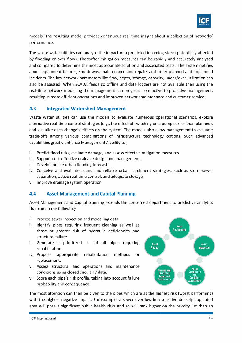
4.4 Asset Management and Capital Planning
Asset Management and Capital planning extends the concerned department to predictive analytics
that can do the following:
i. Process sewer inspection and modelling data.
ii. Identify pipes requiring frequent cleaning as well as
those at greater risk of hydraulic deficiencies and
structural failure.
iii. Generate a prioritized list of all pipes requiring
rehabilitation.
iv. Propose appropriate rehabilitation methods or
replacement.
v. Assess structural and operations and maintenance
conditions using closed circuit TV data.
vi. Score each pipe’s risk profile, taking into account failure
probability and consequence.
The most attention can then be given to the pipes which are at the highest risk (worst performing)
with the highest negative impact. For example, a sewer overflow in a sensitive densely populated
area will pose a significant public health risks and so will rank higher on the priority list than an

ICF International 22
overflow with minimal impact in a sparsely populated area, even if the latter exhibits a larger
overflow. Using this ranking process, wastewater utilities can track distressed areas and develop
fully prioritized short-and long-term pipe replacement, rehabilitation, and maintenance and
management plans that will improve system performance and work within the capital improvement
budgets.
4.5 Waste Water Quality Monitoring
Technologies for online-monitoring of the water quality (BOD, COD, pH etc) of the waste water
before the point of offloading into the river or lake, flowing nearby the city. This will lessen the
health issues to the citizens.
4.6 Decentralized Waste Water Treatment
Decentralized waste water treatment
procedures also known as On – Site Systems
deals with the waste water collected from
individual units or small clusters of users at
the neighbourhood level in a similar fashion
as is being used for industrial waste water
management. There are many aerobic,
anaerobic & physio-chemical processes that
can treat waste water upto the required
standards of effluent which further can be subsequently used for non-potable & gardening
purposes. These may vary from a simple to high complex processes depending upon land
requirements, effluent type, cost, affordability & energy consumption. Natural treatment
technologies that utilizes attenuation and buffering quality of natural soil aquifer & plant root
system including waste stabilization ponds, waste water lands is also one of the options. The same
can be encouraged for implementation especially for the bigger townships by the provisions of
subsidies and necessary building regulations, so that the treated wastewater can be utilized as a
resource, locally. Hotels, hospitals, industrial organizations should be encouraged to install the
decentralized waste treatment systems by bringing necessary changes in existing policies.
4.7 Wastewater Discharge Monitoring
Remote monitoring sensors can be easily integrated with the existing source of water in the form of
rivers and lakes within the city such that it can monitor the quality of water in order to protect the
source from illegal sewage discharges from industry or from houses located on the banks.
4.8 Smart Manholes
The ultrasonic level sensors integrated with GSM modem to monitor the sewerage level in manholes
at strategic locations in the sewer pipe network can be installed. This system will raise an alarm/s for
the Central Monitoring Station whenever the level in manholes will exceed the present limit value.
This system will also produce the daily, weekly and monthly reports and enable the concerned
department for all the mentioned parameters.
ICF International 23
5 Smart Solutions for Municipal Waste Management
The Municipal Solid Waste Management (MSWM) system encompasses waste segregation,
collection, transportation, recycling, processing and disposing waste within the designed land fill
site. A comprehensive monitoring and evaluation system should be adopted for assessing progress
towards meeting the targets in the MSWM plan and for monitoring successful implementation of
the plan. The monitoring system adopted should:
i. Collect data regularly, and
ii. Analyse collected information, take/propose corrective measures, and support the planning and
implementation process.
Collection and analysis of data related to solid waste management is required to assess the existing
situation and propose adequate measures to improve service delivery. A Management Information
System (MIS) can retrieve relevant information which can then be used by decision makers.
MIS assists in monitoring the efficiency of SWM systems. It increases transparency and
accountability of officials in the solid waste management system. It helps in establishing a strong and
reliable information data base necessary to facilitate planning, mid-course corrections and decision
making. Geographic Information systems (GIS) and visual capture of information using cameras are
now being integrated with the MIS to provide spatial and visual validation for provision of services.
Communication technologies such as Radio Frequency Identification (RFID), Global Positioning
System (GPS) and General Packet Radio System (GPRS) are now integrated with Geographic
Information System (GIS) for monitoring the solid waste management system. These can be suitably
adopted by cities to improve the efficiency of service.
Even though a lot of efforts have been made to ensure SWM services to citizens in various cities,
many haven’t fructified due to lack of transparency and monitoring in the operations for improving
the Municipal Solid Waste Management. The Smart Solution for SWM are further discussed in
below.
5.1 Smart Application for SWM Resource Plan
Single point availability of general city wide information on Wards, households, roads, urinals, etc
mapped on GIS portals with access to any citizens is necessary for efficient MSWM. Such information
would help in precise estimations of solid waste generation and optimum allocation of resources
through GIS (Geographic Information System)-based analysis. These will result in a more rational and
efficient design of collection, transport and disposal systems. The GIS-based analysis could use
triangulated irregular network (TIN) for waste estimation, allocation to containers and removal
frequency, taking into consideration the available container size, type and placement possibilities.

ICF International 24
5.2 Sensor Enabled Smart Bins
The smart waste approach consists of associating a physical
waste with digital information. Using smart sensors such as
ultrasonic sensors can monitor the amount of waste in the
bins and transfers this information to the control rooms. Such
sensor collects the data, evaluates the filling level of the bins
and provides the information to the private operator engaged
for collection and transportation of waste. Further, such
information can be used to generate a daily report of the
quality of the work being done by the private operators and
hence helps the ULBs to incentivize or penalize the private
operator for its services. These bins will setup an alerting
system that will send a notification if one of the bins is full and hence the collection and
transportation systems can be optimized, resulting in use of fewer vehicles and hence saving on fuel
consumptions. Such sensors can also identify the availability of hazardous waste and e-waste in the
bins. These bins can also be equipped with additional sensors like temperature, flame or humidity,
providing additional information about the conditions of the bin. For example, an alarm will be sent
if the bin is being vandalized.
5.3 GPS Enabled Vehicles
GPS can be deployed on vehicles involved in
collection and transportation of waste and the
real time movement can be monitored through a
centralized control room. Such GPS enabled
mapping will track the vehicular movement as
per the designated hours of operation.
Furthermore, these GPS would enable the
identification of vehicles that would have broken
down during operations and hence enable the
routing of stand-by vehicles or closest collection
vehicles. GPS enabled vehicles would also
promote the coordination of various categories of vehicles such as 3 wheelers, 4 wheelers, Refuse
compactors etc. to reduce the dependency on road side temporary storage facilities.
5.4 RFID Tags on Collection Vehicles
These tags will read the information about the collection vehicles through installed RFID tag readers
at key junctions or at the entry of landfill and processing facilities.
5.5 Road Side Cameras or Drones
Cameras or Drones can be used for monitoring of activities at various stages – collection and
transportation, processing and land filling, of waste collection and disposal. These cameras/ drones
would provide a bird’s eye view to the authority to monitor the work of the private operators
engaged along the value chain.

ICF International 25
5.6 Smart Human Resource Management for SWM
This would capture the real time data of staff position, waste storage depots, transfer station,
treatment and disposal, and workshop performance, etc. This could be achieved by establishing
Smart Control room as this centralized facility will coordinate with all the smart equipment listed
above and hence will help in management and control of all resources.
5.7 Smart Environment Monitoring
This would promote the monitoring of waste spillage, garbage heaps across the city, real time
monitoring of leachate management, rainfall management, emission data from processing etc. This
could be achieved by using Emission & leachate control sensors as these sensors would measure
the characteristics of emissions as well as the outflow of treated leachate from leachate treatment
units. Such sensors would collect data for the authority to review and would enable in alarming the
private operator in case the emission and treated leachate standards are not of permissible limits.
Also processing facilities as well as landfill sites are generally prone to sudden fires due to presence
of processed RDF, methane etc. Heat sensors at the processing/landfill facilities would raise an
alarm in case of any fire at the processing/landfill facilities and would inform the relevant authorities
for corrective actions.
5.8 Smart Grievance Portal for Citizens
This would promote the usage of mobile phones via smart mobile applications or SMS facilities to
enable the citizens to lodge complaints and hence promote civic governance. These mobile based
applications would inform the users about the timings of collection of waste, authorized personals,
and even enable them to pay the monthly user charges. These applications would increase the
collection efficiency of waste as well as the user charges. Hence these applications would increase
the accountability of the private operators to the citizens.
5.9 Smart Dashboard for Revenue Management
This would provide a real time data of the households, commercials, institutions etc, on the payables
of user charges by citizens and would also provide online portal for user charges payment. This
would also help in levying cross-subsidized user charges to various sections of society and tacking
their realizations. Realized user charges will help city authorities to meet its solid waste
management expenses.

ICF International 26
6 Smart Solutions for Energy Efficiency
Street Lights are very important aspect of the overall Smart City Plan as it provides public safety
which is an important responsibility of ULBs in India. The cost to energy consumption towards the
street lights and water pumping, which are essential municipal services provided to the city by ULBs
is one of the major revenue expenditure incurred by ULBs. The expenses on electricity bills accounts
for more than 80% of the total energy consumption by ULBs for the respective services. Hence, it is
imperative to provide for an energy saving mechanism in order to reduce the costs incurred on
electricity bills and to make this function of the ULBs, truly efficient. The graphical representation
below provides the gist of Smart Solution in achieving energy efficiency in regard to Smart Light
Poles, Solar Energy and O&M framework. Proposed intervention of IEMS can help ULBs and
concerned department to procure the real-time data through the smart light poles intervention.
6.1 Smart Light Poles
The smart light poles can be used to integrate multiple services thus reducing the overall cost
incurred on respective services and produce greater benefits to the residents of the city. The various
components of such services which are part of Smart Solution may include-
i. Speakers- to communicate audio messages and
alerts to the public.
ii. Digital Signage- Signage’s through digital display
screens can convey messages of planned and
unplanned events, display of routes and direction
which can be connected to GPS in order to reflect the
accurate real time data on traffic direction,
congestion and other alerts. It can also be used for
posting advertisements which would be a good
source of revenue earning for the respective ULBs.
iii. Environment sensors- Sensors can be installed on
the street lights that can detect the existing pollution
level in air, or any seismic waves to detect
earthquake.
iv. Light intensity detection sensors- Such sensors
can detect the illumination required on the street and
can thus help in saving electricity through dimming of
lights, if required.
v. Street grid network- Application based central
wireless controlled network of smart street poles will
be helpful at street level network management,
which makes it easier to manage street lights as
compared to individual street lights.
vi. Water sensors-In the flood prone areas, water
detection sensor can detect the level of water and provide pre-emptive warnings for flood or
water clogging for quick action.

ICF International 27
vii. Aesthetics- Lights near buildings, parks and other scenic places can have colour changing façade
lighting for better aesthetics.
viii. Optical Fibre Cables-The Optic Fibre networks can be re-laid along with the electric cables of
the street lights which can be also utilized for creating wi-fi Hotspots with a provision of routers
to be appended on the smart street light poles.
ix. Emergency light system and surveillance cameras- Emergency lights can be installed as
‘Push to talk’ system to convey messages about any emergency on the road like accidents, fire
alarm etc. Also, surveillance cameras can help to keep check and ensuring safety.
6.2 Roof Top Solar Projects
Rooftop Solar (RTS) projects- can improve upon the availability of additional electricity and reduce
our dependence on conventional sources of energy which will result in more sustainable use of our
natural resources and green environment. The electricity produced can be used for in house
consumption and the surplus can be sold on the grid.
GIS based mapping can be used to estimate solar potential for different parts of the city and thus the
implementation on individual households through a Power Purchase Agreement (PPA) with Power
Grid could be conceptualised. The technology can also be used to monitor for the trouble shooting &
power generation capacity augmentation.
6.3 Operation & Maintenance of Street Lighting Projects
Interventions under IEM are aimed to improve the ULBs existing service facilities making it energy
efficient and responsive to the real time conditions. This will not require any specific policy level or
regulatory interventions. Also, the present power regulation encourages efficient usage of electricity
and demands efficient management of resources. Some of the energy management alternatives and
initiatives for Street Lighting management could include:
i. Time based automatic system to switch on and off the street lights / group of street lights.
ii. Monitoring energy data like voltage, current etc. for better decision making.
iii. Remote wireless switches to control the street lights/ group of street lights from a remote
system.
iv. Fault alarms monitoring & acknowledgement with necessary actions from central control room.
v. Light intensity based switching ON/OFF street lights using light sensors.
vi. This Data exchange will be a wireless system using GSM/GPRS modems and /or through web
server connected to controller PLC on each pole.
6.4 Web Application for O&M of Water Pumping & Storage Application
Some of the energy management alternatives and initiatives for Water Pumping & Storage could
include:
i. Monitoring and control of water levels in the tank remotely.
ii. Requirement based automatic trigger to ON/OFF the pump.
iii. Jerk less operation of pumps and motors by using variable frequency drives.
iv. Data acquisition at central location
v. Alerts thru SMS on mobile.
vi. City wise overview of all pump stations over web.

ICF International 28
7 Smart Solution for governance using ICT
Madhya Pradesh Govt. has successfully conceived and implemented ICT systems in past to improve
the efficiency of service delivery and administration. State Data Center, SWAN system, Urban sector
management information system, Tele-samadhan, Common service centers, e-procurement, cyber
treasury, ULB websites, property tax system, license systems, accrual based double entry accounting
system, marriage certificate system, ABPAS, social security system, colony cell system, grievance
redressal system, revenue collection system, HR payroll system, court case management system,
ALPASS, file tracking system, AVLS, passenger information system, electronic ticketing machine,
wireless traffic system, and RLDVS are some of the existing initiatives which either are fully
operational or have been successfully piloted. Moreover, some of the smart solutions apart from
mentioned above have been highlighted below which can lead to smart e-governance:
7.1 Expansion of e-Nagarpalika
E-Nagarpalika/ similar solution can be implemented for other government department (inclined to
urban functions). It will ensure reusability of the solution thereby reducing costs, implementation
timeframe and moreover bringing all departments on a common backbone. It will have positive
impact & extended benefits such as enabling information sharing, interoperability, ease of
maintenances, reduced vendor dependency, reduced cost of maintenance as well as will establish a
common language across the city/state. Such enriched data bank can later be integrated at central
level and utilised for future studies.
7.2 City Level Cloud
Madhya Pradesh hosts a Tier-III State Data Centre, accommodated in state-of-the-art building with
international standards; 1680 sqft of space for server farm for 23 servers and 43 racks; well
equipped with infrastructure & skilled manpower for maintenance & support services; fully secured
with access control along with having a DR site in Delhi. It can be used as a common backbone for all
government departments thereby creating a city-level cloud where the infrastructure, applications,
databases can be hosted & maintained centrally. It will ensure reduced total-cost-of-operation,
enhanced service levels, effective maintenance & overall smart functioning of the State.
7.3 GIS Based Solutions
Geographic information system is a multi-
functional tool which can be utilized across
various scales and for distinct purposes. It
can be utilised to strengthen several services
in a city such as water supply, sewage,
power, property, transport, health facilities,
and many more. A comprehensive GIS
solution will help improve the service delivery, effective management of assets, future planning, and
economic development by promotion combined with market assessment and demographic analysis.
Further, a common portal can be created to integrate geo-spatial data from all the departments on a
single portal and can be leveraged for various purposes by any department.

ICF International 29
7.4 Common Portal
To improve the reach to citizens as well as to promote transparency and citizen participation - a
common, integrated, comprehensive portal can be provided. City need to utilize the ‘Open Data’
approach while implementing the Portal to ensure shared policy & rules. This will ensure
transparency leading to accountability of the officials in the departments. Further, it will lead to
enhancement in service delivery and will encourage investors to participate in the city utilising the
key data and statistics for assessing the viability of their businesses.
7.5 Mobile Applications and Kiosks
Mobile applications, Kiosks can be considered as an additional medium for information
dissemination to ensure social inclusiveness and citizen participation. Such application ensures
outreach and easy accessibility of e-services provided by the ULBs. These applications can also be
utilized to promote citizen participation, information distribution, fixing citizen problems, and
providing online access to municipal services.
7.6 Common Service Centers
Common service centers for strengthening of Single window solution for G2G & G2B services at
common service centers by enhancing ICT infrastructure. This will lead to efficient and effective
service delivery and will improve the financial growth of the city.
7.7 Use of Big Data Analytics
Enhanced use of ICT across various
departments will generate huge data sets that
will need to be managed & there would be a
need to exploit the data into meaningful
information so that the decisions can be taken
based on the real-time data. It would be
imperative to explore/implement the
emerging technologies such as Big Data for
effective & efficient decision making for
‘Smart’ governance and future planning of city development. This will help in analysis of disparate,
huge data sets in much lesser time to convert data into meaningful solutions and will lead to data
driven quick decision making.
7.8 Seamless Wi-Fi Connectivity
City wide Wi-Fi connectivity is one of the essential desired item of a ‘Smart City’, as connectivity
should not be a bottleneck in any smart governance application. High speed internet provides an
opportunity to enhance city management and public safety, utility for national and international
tourists and accessibility to tourism friendly services and a social service to people without access to
high speed internet. Cities such as Indore has already embarked on implementation of a City level
network connectivity (initiated by Reliance) along with fully-operational SWAN connectivity in the
state, showcases a step already taken towards achieving the ‘Smart City’ goal.

ICF International 30
7.9 Smart Metering Software Solutions
Smart metering software and solutions, when
integrated with smart meters, facilitate access to vast
data (central repository) of meter-reading values to
perform further analysis. The advanced metering
systems can help respond to power outages, address
dynamic rate structures, support demand response
programs, and provide billing-related information to
customers. Also, Smart meters enable customers to
monitor and optimize their power usage, reducing
overall greenhouse gas emissions.
7.10 ICT Research Lab
Each city can partner with an existing eminent
engineering college of the city to promote the research
on use of ICT for social interventions in the city and can
act as city level social laboratory for piloting the projects.
Such an arrangement will require no cost and will foster
the talent and encourage youth to take the ownership of
the city. Research laboratory can study actively urban
analytics for which data can be accessed through the
authorities leading to much transparent system.
7.11 Smart City Cards
Data is one of the most important components while
planning any intervention such as city master plan, real
estate development, deciding location of a mall, or
other such interventions. Hence, it is imperative to gain
quality and latest data from most reliable sources. City
cards with bare minimum initial information and access
to multiple services such as all choice of transportation
modes, mobile GPS, property tax payment, etc., can
enrich data about every individual in the system and
later can be utilised as a trusted and enriched source of
information for better planning of cities.

ICF International 31
8 Smart Solutions for Planning and Housing
This note describes Smart Solutions for cities as part of the smart city plan, in order to improve the
planning and implementation processes for area development plans, for building approvals in
general and housing.
The objective of Smart Solution for urban planning is following:
i. To streamline the planning process
ii. To facilitate participation by landowners and other stakeholders in the planning area
iii. To enable planning and implementation of smart infrastructure
iv. To improve the service of building plan approval
The section below, discusses about Smart Solutions for area based development pan city initiative
and housing
8.1 Smart Planning and Implementation Process
The following technological interventions can be used by cities to streamline the planning and
implementation process
i. GIS based analysis for delineation and phasing: Develop a GIS map for the city’s Master Plan
and mark out the undeveloped areas zoned for urban uses. Create a weighted scoring system to
carry out a GIS based analysis of development potential and on that basis prepare a phasing plan
for area based development. Thereby, Select and delineate area for a project
ii. Base map and area planning on GIS -
Prepare a detailed base map of the
selected area having cadastral
information (plot boundaries, area,
ownership, etc.), topography and physical
features (contours, roads, water bodies,
structures, etc.), existing utilities, all other
relevant information. In the case of land
acquisition, utilise the GIS for managing
the land acquisition process and In the
case of land pooling, use the GIS for
detailed planning of land allocation to
land owners, etc. Create new/old layout of streets and plots and thereafter use GIS based
technology to manage sale and allocation of plots. Also GIS can be used to manage
implementation of infrastructure development.
iii. Website for stakeholder interface-Develop an interactive web interface for relevant
stakeholders to participate in the planning process at all stages. The website shall have
registered members as: a. Land owners during land acquisition/ land pooling process
b. Buyers during sale and allocation of plots

ICF International 32
c. New owners during development phase
8.2 Building Approvals
The objective of Smart Solution for Building Approvals is to enable fast and transparent building
approvals by ULB or concerned approving agency. The building approval processes in most cities
have the potential for streamlining, both in terms of the content of the building regulations and in
terms of the administrative process of approval. The following interventions may be considered by
the city to streamline the planning and implementation process:
i. Reorganize and streamline the building regulations document
Reorganize the building regulations document under the following broad sections:
a) Procedural regulations – covering all procedures to be followed for securing building
approvals
b) Building Performance Standards – all regulations covering structural safety, fire safety,
health, hygiene, environmental norms, etc.
c) Planning Regulations – all regulations related to physical planning such as FSI/ FAR,
coverage, margins, setbacks, etc.
d) Within each section, organize the provisions/ clauses such that the process of verifying
compliance is logically sequenced and amenable for workflow automation.
ii. Establish a computerized system with web interface for workflow automation
a) Online submission of building approval application with parallel hard copy submission of
original documents as required
b) Automation of internal workflow for all steps involved in scrutiny of applications and issue of
responses, official notices, certificates, etc.
c) Web interface for users to track status, making payments, downloading documents and for
communication with concerned officers.
8.3 Smart Solutions for Housing
The status of IT enabled services in public housing may be explored through stakeholder
consultations for the following services in the sector:
i. Maintenance of property records using data record management and GIS application
All property record shall be digitized and if possible GIS based system shall be used to maintain the
records of properties at city level. This may enable the concerned department to have an updated
interface on city maps to manage the workforce for property tax collection and other user charges
tax and deploy the resources where the collection is weak or low. The said system requires constant
update of records for new properties to enable the process of managing the revenue collection with
higher efficiency.
ii. Booking and allotment of new properties using web based interface
ICF International 33
Housing department and other development agencies, developing new housing stocks should use a
web based service or web portal for allotment and disbursal of housing stocks which will bring
transparency to the process and enable efficient and ease in process of service.
iii. Property listing and beneficiary listing
Enabling the user through online process for property listing and beneficiary listing will provide ease
in better record management and end user ease.
iv. Online payment facility for property tax/lease/rent/installment/other charges
Online payment facility for property tax /lease/rent/instalment/other charges with provide option to
users to make payments to concerned department using web based and mobile based online
interfaces. This will provide an easy option for users to check their bills and payment history and pay
their bills on walk from any part of country and world. The data on payments history can be linked
with GIS based maps for better decision making process as discussed in point a) above.
v. Building Permission / Planning Permission / Land Use Certificate
This Smart Solution has already been discussed above. This Smart Solution will enable and provide
ease to the efforts for coordination among housing development agencies which will in return
improve the efficiency of department in processing various cases of development works.
8.4 Smart Real-Estate Dashboard
An online dash board can be prepared and maintained at city level focusing on the housing market
within the city. It will capture the critical information related to the housing sector such as circle
rate, product mix, housing stock, nearby attractions and more. The information from various
departments such as ULBs (building permissions), development authorities, housing board, and
more can be integrated. This dashboard should also include distinct analysis such as supply demand
analysis of a catchment area, GAP identification for product development and positioning, difference
in price trend, highest rated projects, and visualisation of market penetration and share of asset
class on maps, aggregate real estate transactions information, and more.

ICF International 34
9 Smart Solutions for Local Economy
For a sustainable and smart city creation, there is a need for sustainability goals and establishing
industrial or economic growth centres which are resilient and adaptive for the overall socio-
economic well-being of the city. Almost 80% of the employment is generated in the MSME sector
which also provides the necessary culture and ownership to its citizens and contributes to the overall
GDP contribution of the city.
Hence, there is a requirement for convergence of technologies to provide services to its citizens and
entrepreneurs & create a hassle free atmosphere for doing business & other related day to day
activities so as to encourage more broad based development. The following broad initiatives could
be examined in greater detail with a view to providing Smart Solutions for industries and the local
economy:
9.1 Education-Industry-Research Interface
Encourage development of a strong education-industry-research interface as appropriate. A city with
numerous IT and technical educational institutions such as Indore could support IT/ITES based
industries. A city such as Gwalior with numerous research institutions could encourage the setting
up of related industries.
9.2 Entrepreneurs Centres
Entrepreneurs can be provided space on subsidised prices from
the government with all world class facilities to encourage
entrepreneurial spirit of the city. This will enable city to have a
common spaces where innovative ideas can be exchanged and
investors can come and explore the ideas.
9.3 Testing Facilities
Government can provide live atmosphere to promote specific kind of technology in the city where
innovative ideas can be piloted, tested and then scaled for global consumption.
9.4 MIS for Tracking Environmental Impact of Industries
Common database can be created for tracking environmental impacts of industries through live
sensors at their waste (air, water and solid waste) generation points. In case of violation of pre-
decided norms, a notification can be sent to the monitoring authority real time. Further, smart
metering systems can be encouraged to monitor the consumption of utilities with a view to checking
wastage.
9.5 Smart Buildings for Industry
Energy efficient factory buildings should be encouraged along with IT enabled communication
systems between various units of a factory with a view to minimizing wastage and enhancing
efficiency. Further, law of critical few can be used to get Benchmark insights against successful
business models in other parts of the world.

ICF International 35
9.6 Business Facilitation Portal
With a view of providing a fillip to the overall industrial development and provide encouragement
the Industrial Development Department has improved the ease of doing business in the state
through empowerment in the form of single window clearance systems, Online filing and tracking of
'Intention to invest' on www.invest.mp.gov.in with dedicated relationship manager, Online filing of
EM 1 and EM II and acknowledgement issued instantly, Online allotment of industrial land, Online
building permission, Online water connection in industrial areas , Online registration of partnership
firms, Online payment of dues in industrial areas. A system can be developed offering fiscal
incentives through an online support system, and subsidy claims like VAT, CST etc. and to ensure the
benefits roll back to the entrepreneurs in a timely manner. The Single Window system can be
utilized for allotment of land for industrial purposes.
i. ICT enabled services for sewer and drainage, city waste and it’s recycling and energy production,
water supply, intelligently connected city roads and their linkages to state highway and national
highways can be rightly envisaged so as to provide necessary leverage to its entrepreneurs.
ii. Maximum value additions at right places with the dictum of doing more with less resources i.e.
holistic optimization all resources.
iii. Digital platform for relevant data collection and data mixing for right and Smart Solutions
through convergence of technologies.
iv. Use law of critical few to get insights. Bench mark insights against successful business models
elsewhere
ICF International 36
10 Smart Solutions for Heritage and Tourism
Heritage and Tourism can act as a successful economic driver of the city if the interventions are
carefully planned and incorporated. ICT interventions can address prevalent issues faced by tourists
such as safety, integration of services, safe accommodations, historical facts, and more. Better ICT
based services to the tourists will lead to high inflow of both national and international tourists
leading to stronger local economy. Furthermore, it is imperative, to conserve our cultural heritage by
reviving it through linking it with economic opportunities. The Smart Solutions to achieve the same
are further discussed below.
10.1 Smart Phones Rental Service
Service for providing smart phones on rent can be initiated for both national and international
tourists with dedicated, pre-installed tourism related applications which can enable tourists to
access information such as dining options, accommodation, currency rates, weather information,
guide maps, historical facts, emergency contact facilities, and more. Further, technology in smart
phones such as Near Field Communication (NFC) chip can be utilised for making payments within the
city for various purposes, Global Positioning System (GPS) can be utilised for accessing coordinates
of tourists in case of emergency or danger, and more. This will enable authorities to gather
important data related to tourists and carry out studies for planning better services in future.
10.2 City level Tourist Applications
City can provide a comprehensive mobile based application which can offer services such as
walkthroughs, guide maps, railway or airplanes booking facilities, access to visa facilities, and more.
Such applications with the government ownership provide much greater reliability and ensure the
safety of tourists in the city.
10.3 Tourist Friendly Public Transportation
Dedicated tourism transportation can be provided at city level, connecting various heritage sites of
the city. City should also target for the last mile connectivity between tourist places of the cities and
tourists accommodation by regulating para-transit service of the city and also keeping the safety of
tourists in mind. Applications should be created to book seats in these buses, gain information about
the sites, and more. Also, the existing Public transport facilities of the city should be made more
tourists friendly.
10.4 Wi-Fi on Tourists Places and E-guide
Wi-Fi can be made available for free to all the tourists within 200 meters of the area of any heritage
structure. This will ensure accessibility to various e-services and enhanced safety of the tourists.
Apart from the tourist centric applications, pre-installed free videos hosted through Internet of
things (IoT) can be made available to the national and international tourists which can provide
accurate historical facts and significance about the site.
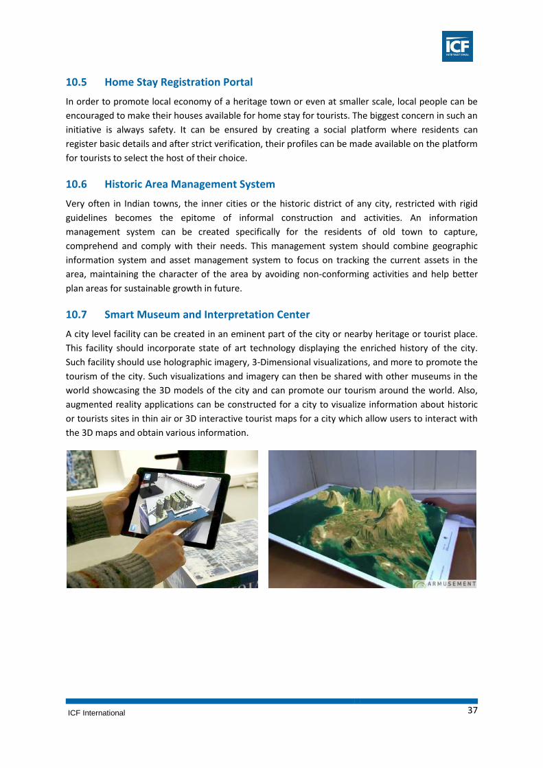
ICF International 37
10.5 Home Stay Registration Portal
In order to promote local economy of a heritage town or even at smaller scale, local people can be
encouraged to make their houses available for home stay for tourists. The biggest concern in such an
initiative is always safety. It can be ensured by creating a social platform where residents can
register basic details and after strict verification, their profiles can be made available on the platform
for tourists to select the host of their choice.
10.6 Historic Area Management System
Very often in Indian towns, the inner cities or the historic district of any city, restricted with rigid
guidelines becomes the epitome of informal construction and activities. An information
management system can be created specifically for the residents of old town to capture,
comprehend and comply with their needs. This management system should combine geographic
information system and asset management system to focus on tracking the current assets in the
area, maintaining the character of the area by avoiding non-conforming activities and help better
plan areas for sustainable growth in future.
10.7 Smart Museum and Interpretation Center
A city level facility can be created in an eminent part of the city or nearby heritage or tourist place.
This facility should incorporate state of art technology displaying the enriched history of the city.
Such facility should use holographic imagery, 3-Dimensional visualizations, and more to promote the
tourism of the city. Such visualizations and imagery can then be shared with other museums in the
world showcasing the 3D models of the city and can promote our tourism around the world. Also,
augmented reality applications can be constructed for a city to visualize information about historic
or tourists sites in thin air or 3D interactive tourist maps for a city which allow users to interact with
the 3D maps and obtain various information.

ICF International 38
11 Smart Solutions for Inclusive Development and Safe Cities
Living on the geographical edge of the city, especially for the poor, can mean living on the edge of
the society. Several national and state level schemes are being enrooted through Municipal
Corporation for urban poor and other underprivileged section of society. Lack of awareness on
various schemes is a major drawback in accessing these services by urban poor. Many a times, the
documents required for being eligible for schemes benefits are not easily obtainable. These
challenges also stand true for accessing other municipal services such as birth/ death registration,
social security schemes, ration cards etc.
Accessing entitlements is critical for the urban poor as denial of critical rights have a major effect on
implementation of various schemes. Location and distance is also a factor that cut across services.
Many services are centralized at the headquarters with no decentralized windows to collect
applications or give information on the status of applications at the zone/ward level. As a result,
peripheral slums located far from service counters have particularly low access. In this section we
are targeting safety solution for women/residents safety and inclusive development that provide
development initiative for all including urban poor.
11.1 Special Fare Cash Card
A special fare ID card for women has a significant impact. The idea is to provide an ID card which is
enabled with Radio Frequency Identification (RFID) system and has credit balance in it. The female
commuters having this card should swap the same card with the machine installed in the vehicle
after which an immediate alert is sent to the parent's/ spouse mobile number with all information
like; the person has boarded the bus along with the detail of the driver and route which the vehicle
would follow. Once you swap the card while boarding out the registered number is updated with
most recent information as well. After the trip ends, the said amount from the cash card will be
deducted. The swipe of the card can be interlinked with some incentives such as free mobile
recharge after ‘n’ no. of trips, free coupons, gift cards, etc.
11.2 Women Shuttles for Women Working at Night Shifts in Offices
Women shuttle can be used to make the IT corridors in cities with IT and BPO companies like Indore
and Bhopal, the safest place for women employees. The Women Shuttles can be used to provide a
security shield and convenience to the women employees who commute at regular and at odd hours
of the day. The application can be designed to provide services like shuttle timings, expected time of
arrival of shuttle, security services like tracking & raising alert, all Police /Ambulance / Emergency
contacts, WhatsApp to nearby police official, feedback & reporting issues. The application can
provide information and analytics to stakeholders such as the police and civic authorities on safety
concerns and possible actions to improve.

ICF International 39
11.3 Domestic Help Information System
Domestic work is one of the oldest and most important occupations for many women in many
countries. The majority of the women living in slums in cities of Madhya Pradesh are majorly
engaged in household activities. An extensive database should be created and shared on an open
platform that provides the information of all the labour class women in slums. The information can
be used to procure work timings of a particular employee, past record, identification proof, monthly
earning, family information, area of specialization, education, etc. This data can also be utilized for
building applications that can provide employment opportunities. The database will help in
enhancing the knowledge base and develop practical tools for protecting and promoting the rights
of registered female workers.
11.4 Connected Communities
Across the state, the cities can reserve localities names to create online hubs for civic engagement,
online organizing and information sharing. These websites will utilize a data-driven template which
will provide real-time information for a certain area. The city domain is part of the creation of a new
class of generic top-level domains (gTLDs) that greatly expand the web’s domain name system.
A connected locality can inform inhabitants about on-going activities, publicize breaking news in the
area, promote the feeling of cordiality and unity among the residents of the locality, organize sport
activities, strengthen security arrangements in the locality, keep a watch on services provided by
municipalities, run libraries, reading room, community centre, etc; take up activities like tree
plantation, environment protection and pollution control, take appropriate measures for recharging
the ground water and motivate residents for adoption of rain water harvesting measures. They can
also inform the municipality about the encroachments and illegal construction and can give active
support to the municipality and remind the residents of localities about the timely payment of
municipal taxes, fees and user charges.
With the launch of the city domain, the cities can become the first in a country with a top-level
domain, creating new opportunities to support local businesses, organizations & residents, and
establishing an unprecedented level of geographic authority to the digital sphere. The ULBs can
generate revenues that will help residents take advantage of government services, encourage local
businesses to thrive, markets and promote tourism, and spread the dynamic image of Madhya
Pradesh around the world.
Domain names have social, cultural, and financial value. Their confer status, can help search engine
optimization, and help them to drive internet traffic. In addition, localities will have the option of
licensing third-level domains (e.g., hometiffin.mpnagar.bhopal), which can generate revenue for the
entity managing the site. For a locality, overseeing the content that appears on a neighbourhood site
can be quite powerful and help shape the local activity. A good domain name is one of the strongest
ways to promote an organization or business, increasing one’s visibility online. With a city domain
address (.bhopal,etc), the geographic authority of the locality is amplified. It promotes the image of
the city across the web and provides a unique forum for fostering community among constituents.
ICF International 40
11.5 Smart Public Service Kiosks
The said smart public service kiosks can be situated in markets, malls, petrol pumps, near/ within
ATM booths and other community areas, Angawadi centers, community halls, local grocer shops etc.
The kiosks for the residents should be simple in operation, and must allow quick and easy
transactions so that it becomes successful and known. Through the proposed kiosk the citizens can
access information, apply for the entitlements/schemes and keep track on progress of procedures.
There is a need to incorporate simple procedural solutions especially for accessing, filling forms,
documents requirement, accessible windows, computerized acknowledgement slips, transparent
systems, efficiency in processing and sensitization of civic staff towards the poor and their needs
and, suitably located to reduce the barrier of distance. To break the technology barrier, the
proposed Kiosks should prominently display on their notice boards the details of operators working
at kiosk, details of service/ entitlement, procedures for submitting applications, lists of documents
to be appended, people to be contacted, fees to be paid etc.. The explanations should be given in a
simple and attractive manner. All these should also be available online and accessible from
anywhere as the e-governance initiatives are being up scaled in the state. The kiosks must be
protected from any tampering.
New models can be explored such as revamping zonal offices and ward offices, franchise outlets
with NGO partnerships, linking with existing platforms like MPONLINE, recognition of agents as
service center facilitators, using local grocery shops as locations, engaging local entrepreneurs to
manage kiosks, and engaging women SHGs in managing the kiosks and facilitation. These models can
lead to various benefits such as improvement in access to services/schemes to all especially poor,
reduction in critical barriers such as location, procedure, attitude, social and economic, reduction in
multiple visits to distant locations, and reduction in dependence on agents charging high charges.
11.6 Smart IEC for Public Awareness
It is important to spread awareness about the rights, on-going schemes/initiatives, programs, and
policies through the medium of television, radio, SMS service for general public. Also the campaign
should be launched on social media for neo literates by printing booklets in simple Hindi/local
language which they can understand such that it provides details on their rights/entitlements,
explains to them the procedures for applying for any service, the agencies/institutions involved in
dispensing the service, the responsibilities of various concerned officials, how to calculate the
fees/fines if any and so on.

ICF International 41
12 Smart Solutions for Health Services
Health services can be drastically improved through ICT intervention. This enables cities to have
wider outreach to the medical facilities at low cost. Global level experts can be consulted online at
much cheaper cost and can provide best solutions to the patients. Further, with the help of
initiatives such as health cards, online database of patients can be created. This also allows hospitals
to leverage information on medical history and family conditions for identification of genetic medical
conditions and determine the root cause of diseases.
12.1 Medicine Dispensing Machine and Diagnostic Point
ATM and diagnostic point could be set in the vicinity
of slum population so that they can access the
generic drug and economical diagnostic facility close
to their homes. ATM machine can dispense generic
medicine charging a very nominal cost. This would
be aligned with upcoming national health assurance
scheme and could be funded under the same.
Similarly package of diagnostic services could be
offered using readily available mobile point which
conducts many diagnostic facilities and provides the
report as well linkage with nearby appropriate
facility in case needed.
12.2 E Health Point
‘E health point’ will be established in each of the slum area/ward/basti which can provide the host of
facilities which includes e-consultation, ECG and other check-up like measuring Hb, BP, eye check-up,
dental check-up and also connect with doctor through telemedicine. It also offers prescription and
medicine is dispensed by paramedic posted in these points. The same point will also offer RO water
to take care the need for safe drinking water on a very nominal rate of INR 2 /litter. Globally and in
many parts of India, this model is successfully running as a low cost business model. Such E health
points are self-sufficient and recover their operational cost including the salary of service providers.
12.3 Smart Medical Outreach Services
Medical services can be improved further through new
innovative ICT applications like mHealth which provides
remote medical consultation facility through kiosks.
Further, demand and quality of existing medical services
can be improved by introducing transparency into
existing health governance structure and implementing
effective citizen grievance redressal system. The health
care delivery should be citizen centric and suited to local
needs, for e.g., morning and evening clinics, clinics with comprehensive service provision, all primary
health care under one roof etc.

ICF International 42
12.4 E-Health Card
Many times health system users, particularly poor users are not able to keep a paper record of their
health status. This severely affects in providing the emergency care as well as many times causes the
wastage of resource, time and efforts as well delay in providing appropriate care. The absence of
such record also affects the proper planning by various organisations. It is proposed to develop
Electronic Health Card for every citizen which will include all their health related status including
past and current aliments. This would also help medical facilities to understand the disease load and
time of occurrence of particular episode of Ds. It would enable quick access for both primary and
secondary care as well as emergency care.

ICF International 43
13 Smart Solutions for Education Services
Education services can have an improved infrastructure and service delivery mechanism through ICT
intervention. This enables cities to create safer and modern facilities for students. Experts and
teachers can connect with students using internet interventions, to share knowledge at national and
international level. Global experts can be consulted online at much cheaper cost and can impart best
education to the students. This system of education can also be used to provide education to remote
places where teachers cannot be recruited. This will improve the overall literacy rate of the society
and will allow education to reach to all section of society curtailing the barriers that our society faces
today.
13.1 Smart Classroom
Smart classroom with internet connectivity can conduct
collaborative learning programs using video
conferencing, which will allow students from different
schools to have an access to the teachings of different
schools/teachers who are awarded with better
performance assessment. Also similar collaboration with
national and international level good schools can be
conducted, to provide students with an exposure to
world class education. This will also allow students to
interact with students from various colleges and schools, to share knowledge among them and take
career oriented counselling from various professionals and seniors. Such schools can arrange online
trainings for students on subjects wherein they themselves don’t have a permanent teacher for the
said subjects/topic. Also the online library should be provided to students with facilities of e-books
and online notes sharing which will make the teaching experience more interactive and fun for all.
13.2 Smart School Management System
The smart school management system will include the online recruitment of teachers, online
centralised admission system, attendance of teachers and students using biometric system and
student & teacher performance review system. This system will make the procedures of schooling
more transparent and efficient as the review system will become more robust. The data can be
monitored online by administration, teachers and parents and thus will have a positive impact on
the result and performance of students. The performance of both teacher and student will be
available on a click of a computer which will further generate competition among teachers and
schools to perform better. Better results can be directly linked to the performance assessment and
such schools and teachers can be given recognition at district and state level in form of
prize/awards.

ICF International 44
13.3 E-Monitoring System
Schools can be provided with CCTV surveillance for monitoring the activities at school which will not
only allow local and district administration to monitor activities of school but will also provide safer
avenues for students and teachers. Also the GPS tracking and CCTV surveillance for school buses will
provide the safe and efficient system for students travel.

ICF International 45
14 Annexure 1 – Best Smart Solutions from ‘Mera Shehar Mera
Sapna’ Competition
Understanding the importance of participation of a common man in building smart cities, MoUD
organized ‘Mera Shehar Mera Sapna’ competition in collaboration with MyGOV and National
Institute of Urban Affairs. The competition ran from 15th June, 2015 to 20th June, 2015. The main
objective of this competition was to encourage citizens to contribute their ideas and solutions for
addressing challenges faced by Indian cities. The format of competition was such that it posed 14
questions related to city level challenge, possible solutions and innovative ideas with a limit of 250
words to answer each question in three categories.
1. Common Solutions for all cities (694 entries published)
2. Smart Solutions for traffic problems (645 entries published)
3. Use of Information Technology to improve Governance services (316 entries)
The questions varied widely from traffic congestion strategies to application of big data and more.
All the questions were aimed at understanding common man’s hopes and aspirations for their cities.
Further, one question asked participants to choose the top 3 solutions (out of a list of 21) that must
be prioritized in Indian cities while another asked for a listing of 3 municipal services that can be
improved using mobile phones. The best selected solutions from each of the above mentioned
categories were.
Category 1 - Common Solutions for All Cities
In this section, following questions were asked and best selected answers have been mentioned:
Question 1: Out of the following 21 smart solutions, select 3 solutions that should be applied to all
Indian cities and provide a brief write-up (max 50 words) to explain why.
Smart cities and most solutions need an effective infrastructure foundation in place before being
deployed. The 3 solutions below provide the basis for this.
i. Integrated Multi-Modal Transport: Accessibility and travel to jobs, services, etc. enables a
citizen to earn and spend, is critical to income generation and economic growth. This
provides effective accessibility for citizens to travel and multiple options – affordability.
ii. Renewable Energy: Core issues on energy are energy security and greenhouse gas
emissions, largely due to fossil fuel dependence and use. Energy efficiency reduces the
impact but may still be derived from fossil fuels. Renewable energy is the best option
towards minimizing these issues.
iii. Waste water to be treated: Guaranteeing water supply, quality and quantity, is a critical
need for citizens’ living. Treating waste water removes a key contributor to contamination of
water sources, ensuring quality, and becomes an additional water supply source, ensuring
quantity.

ICF International 46
Question 2: Describe a ‘smart’ idea that you have seen in some other city (anywhere in the world)
that you would like to see replicated in your own city. ‘Smart idea’ means doing more with less.
Open-Data sets on the metrics that determine a smart city – infrastructure, air quality, water quality,
parking, etc, i.e. smart governance| Helsinki
Helsinki is one of the most successful stories in the smart city space because of a very ‘smart’ idea to
make open data sets and information related to the metrics of a city for its citizens. By making such
information open, any citizen, can use these data sets to create products and services that provide
better options to citizens in terms of providing information or utilizing better services. It is not just
transparency to show open data sets of the city’s functioning, Helsinki also sponsors hackathons to
encourage developers to create tech products derived from these data sets.
This ‘smart’ idea allows for improvements and solutions that help citizens to be developed by
citizens who know how things function and operate at the ground-level. Municipal governments can
only do so much in supporting citizens to a variety of constraints including resource availability,
manpower, etc. but making such information available to citizens means the responsibility is shared.
It is also attractive for citizens to utilize them as there is a potential to develop products and
services, and entire businesses, from this data and information that defines the city, helping to
promote entrepreneurship that drives job creation, greater income creation, and diversify the
economic growth potential for the smart city, all while benefitting the city, without the municipal
corporation having to devote significant funds.
Question 3: Describe three ways that Indian cities can reduce the gap between rich and poor.
i. Skill development initiative where municipalities engages with local business, individually or
through associations, to identify current skill deficiencies and requirements, and work with
educational institutions to offer programs that provide poor people with skills, relevant and
current with a guarantee of employment. Businesses can even be made the offer to sponsor
programs that are tailored to their operations. Skills can be academic or vocational, with an
aim to be complimentary and iterative with others
ii. Performance based funding schemes, with funds and mentorship provided at various
increments of progress, which allows for poor people to start their own business in their
local area from a good idea, not by offering security. Most programs for poor people focus
on employment in other companies, but they are inventive with meager resources to
operate their own. Entrepreneurial ventures to their local community will have an incentive
to succeed, towards supporting local development, offering jobs, and more services to
people. Not all may succeed but a fair number will, given the opportunity.
iii. Offering accessibility and affordability to key services - health, education, housing (water
and electricity as well), and food as the basics towards a good quality of living, and internet
access for connectivity relevance to those around them. The quality of these services will be
budget version of offerings, not with the same level, but with a similar output. Freebies do
not work, only if there is a purchase amount even, with subsidies, is there a value linked to
expect returns.

ICF International 47
Question- 4 List out 5 essential facts about your local municipal corporation that should be
available to all citizens
i. Status and progress of planned, on-going and completed projects undertaken by municipal
corporation, including budget and actual spend allocation, expected outcome/impact of
project, etc. since records have been kept
ii. Income / Revenue of Municipal Corporation – Taxes constitute the majority of income, and
as such it is public money. Citizens have a right to know what they are contributing
iii. Expenditure / Disbursement of Funds of Municipal Corporation towards functional and
administrative areas – the same point as above.
iv. Hierarchy with responsibility relating to specific municipal corporation departments, and
resolution and escalation matrix for grievance redressal, with defined timelines for
communication, escalation, recourse and closure of grievances and complaints. A similar
system can be in place for receiving suggestions from citizens, with a bit more relaxed
timeline.
v. A real-time tracking of approved public works projects across the entire municipal
corporation area, either on-going or planned, and with proof of permission for the public
work project, including list of completed public works project that can be accessed for a
specified duration.
Category 2: Smart Solutions for Traffic Problems
Question 1: Suggest one smart solution and/or innovative technology for conveniently dealing
with traffic congestion outside your home.
When we see congestion visually outside our home or on our urban roads, we see all modes (slow
and fast), hawkers, and pedestrians in the area and on carriageway, thus reducing the road capacity.
Further, the traffic congestion is associated with many other factors starting from road cross
sections, infrastructures, engineering, road manners/education, government policies and their
enforcement etc.
The smart and workable solution to solve traffic problems, arising out of above basic reasons, is to
‘Organize Road Cross Section’ and will involve methodical and professional studies of the different
areas and aesthetically planning “road cross sections” as per the road side activities and providing
and maintaining road infrastructures which include “continuous” footpaths, cycle paths, road
crossing, motor vehicle lanes, parking and hawker area. All these infrastructures are interrelated and
one weak link can cause failure in dealing with congestion. This solution, if implemented, would
result in the last mile connectivity via foot or cycle and also organize the designated areas for
different users, on the road cross section, thus enhancing the road capacity and creating clean,
pollution free and healthy environment.
Question 2: One motorcar carries 4 people comfortably; one public bus carries 40 people
comfortably. How can a smart city balance the needs of the car and the bus?
Modal shift from private to public transport and retaining public transport users are two big
challenges which the Government need to successfully meet. The proposed solution advocates the
introduction of variable tax-free allowances for commuting expenses on travel by public transport

ICF International 48
(bus & metro train) viz-a-viz, travel by private vehicles, taxis and autos. For government, the
proposed tax measures provide an effective lever to stimulate public transport demand and capture
the bottom-line benefits associated with reduced urban congestion. This is called as “RIDE n SAVE”.
The proposed system can be implemented in a SMART CITY with a common SMART CARD. This card
has to be a photo ID card linked with PAN card (registered with Income Tax Department) and would
be a common public transport card which can be used in all Public Transport modes available in the
city. At the time of IT returns all the expenditure made on use of public transport can be accessed to
avail TAX REBATE. Riding on Public transport would not only be encouraged but also lead to tax
saving. This vast data can be further utilised by city planners, government departments for
improving the operations, setting out short and long term planning goals and also authorities to
monitor the data. Whereas, it is difficult to implement levying congestion charges, higher private
vehicle taxes etc. in metropolitan cities, this ‘RIDE & SAVE’ provides adequate incentives for use of
public transport and would benefit the lower middle class and higher class of the community.
Question 3: How can travelling by bus in your city become safer and more comfortable with the
use of innovative technologies and smart solutions?
The above two innovative ideas, if implemented, it would surely make the public transport very
beneficial as well as comfortable in terms of accessibility and mode choice. Next comes the public
transport operations. Operations would cover the safe travelling, comfort and reliability. This can be
better achieved by introducing application based (which is currently in place in some metropolitan
cities) bus tracking which needs to be further improved in terms of accuracy and detailed
information. The innovative technologies can be used for introducing “Integrated SMART Cards” for
paperless and quick operations, regular monitoring of the up-keep and maintenance of buses,
organizing bus staff grooming programs, off board ticketing, and using pax boarding/alighting data
to improve the bus routes.
For safety of bus users the Smart card can be linked with the mobile number (emergency number)
through internet and smart application, the boarding and alighting time of the passenger can be
automatically updated/sent along with the bus driver phone number, bus number and conductor
details to a family member. This would make public transport a safe mode of travel.
Category 3: Use of Information Technology to Improve Governance Services
Question 1: List three municipal services that can be improved with the use of a mobile phone.
India has the second largest number of mobile phones in use in the world. With tremendous growth
in mobile penetration in India there exists huge potential in using this resource to improve service
delivery, feedback mechanism, accountability and transparency in all aspects of life. Municipal
services can benefit largely by effective use of mobile phone for example:
i. Various tax/bill payments such as house, water etc. and birth & death registration.
ii. Using mobile phones as mobile IDs for a range of services including Grievance redressal.
iii. Monitoring of various services such as garbage disposal, sanitation, preventive health &
hygiene through citizen feedback using mobile phones to ensure compliance and effective
service delivery.

ICF International 49
Question 2: Describe 3 aspects of your daily life that have improved with the use of the mobile
phone.
i. Connectivity & dissemination of information –Mobile phone by its sheer technology has
allowed 24*7 connectivity with not only my loved ones but also the whole world. It has not
only increased the accessibility and availability of individual but also has also ensured fast
information disbursal. Timely and accurate information dissemination has received a boost
by the use of mobile phones.
ii. Saving in time and money by easy and on the go banking, gas cylinder booking, online
shopping, rail ticket, bus ticket, cab booking etc.
iii. Quick service delivery and Grievance redressal, through direct communication with
respective agencies or departments.
Question 3: Suggest 5 ways in which the use of big data can make Indian cities into smart cities.
i. Smart Healthcare:
a. On suspecting a disease outbreak, interrogative, sentimental, contextual analysis of
big social forum data together with hospital data can identify the pattern, source of
the outbreak. o Hospital facilities, bed availability, appointments etc. can be tracked.
b. Using birth data for immunization drive of the young ones with automated alerts to
the parents.
ii. Smart Revenue Collection and Utilization:
a. Big data from bank transactions, applications such as vehicle permits, house permit
application etc. gives more insights into what a person owes and prevent false tax
return filing.
b. Tracking of fund for various citizen programs can be made easily using big data
analysis.
iii. Smart Transportation:
a. Big data analysis would help to,
b. Improve on-time performance and provide real-time bus arrival information to
riders. Analyzing bus location data to understand traffic conditions and predict
arrivals, synchronize with train timings.
iv. Saving energy and water:
a. Intelligent matching of supply with demand without wastage and anticipating any
future changes in demand related to various events across the city.
v. Setting up of a Central intelligent Operating system for a city:
a. Just like a computer OS, this platform would acquire and process information on the
running of the city quickly, effectively, efficiently and analyse and relate events so it
can produce simulations and anticipate any problem that might affect the city,
including emergency situations and make the city ‘Always Ready’.
Question 4: Mention 3 new ways that information technology can improve Governance.
i. Service request tracking system:
Any application for a service such as passport, driving, house building permits, vehicle
permits, license, etc. can be tracked to bring transparency, delay analysis and increase
government efficiency.
ii. Reduction of leakage in PDS:

ICF International 50
The quantity of ration allotted to ration shops will be intimated to the residents through
mobile phones, and the distribution of ration card can be done based on their aadhar cards,
so that the benefit reaches direct to the citizen.
iii. Using Data Sharing tools for better coordination among government departments:
The online data sharing would enable accurate tracking of the funds allotted and their
expenditures, flow of revenues, Different social services programs, run by different
Ministries, often have shared goals. Which can almost certainly be accomplished better if
agencies work together to address them.
Question 5: How can access to information and data make our public spaces safe and secure?
The access to information would allow a person to be aware of the various aspects of a public place,
the nearest police stations, hospitals, fire stations, etc. The safety and security can be achieved using
data and information analysis in the following ways:
i. Analysis of the various data from police records, distance from nearest police station,
availability and timing for immediate help to reach etc. can be used to make a safety meter
for any location in the city which gives safety level of that location directly to mobile
phones.
ii. Smart control of traffic lights to allow ambulance and fire brigades to reach the destinations
quickly.
iii. Monitoring of congestion of roads, public spaces, using data from mobile phones
iv. Real time alert of fire, dangerous pollution levels, disease outbreak and vulnerable locations
etc.
v. Prevention of crimes with preventive policing using smart data analysis.

ICF International 51
End of Report
For any clarifications please contact:
Dr. Richard Slater
Team Leader, MPUIIP
Mr. Ram Khandelwal
Deputy Team Leader, MPUIIP
Disclaimer: The information and images provided in this report are gathered from various sources
available on internet. This report is for information purpose only and the user of report must use
their own discretion. We reserve no rights or liabilities for content of this report.