Folding and Faulting at Tanliwun along Leading Edge 1999
Chi-Chi Thrust
Wen–Jeng Huang1,2, Arvid M. Johnson1, Wen–Shan Chen3,
Yuan–His Lee4 and Shih-Ting Lu5 1 Department of Earth and Atmospheric Sciences, Purdue University, Indiana. 2 Department of Geological Sciences, Indiana University, Indiana 3 Department of Geosciences, National Taiwan University, Taipei, Taiwan 4 Department of Earth and Environmental Sciences, Chiayi, Taiwan 5 Central Geological Survey, MOEA, Taiwan
Abstract
The 1999 Chi–Chi earthquake in Taiwan provided excellent opportunities for
studying earthquake faulting and folding in escarpments 1 to 10 m high at the leading
edge of the Chi-Chi thrust which extended for some 100 km. Trenches excavated
across the escarpments showed well–preserved fault and fold structures at scales
ranging from mm to m. We studied in detail relations between profile shapes of
escarpments and subsurface structures exposed in Chushan trench at Tanliwun, near
the south end of Chi–Chi rupture. We mapped faults and sedimentary bedding at
scales of 1:10 or 1:20 in the trench walls. In order to understand the structures
exposed in the trench walls, we supplemented the observational approach with
theoretical modeling. For example, we used multi–fault dislocation modeling to show
that the multiple small faults exposed in the trench walls could have produced the
monocline–like escarpments observed there. The field observations and the modeling
suggest that the structures that first appeared to be continuous monoclinal bending of
layers are, in fact, discontinuous. The appearance of gross bending is a result of slip in
the same sense along numerous small faults inclined to the sedimentary bedding and
subparallel to the main fault in the near subsurface.
Introduction
Escarpments of various forms developed along a surface rupture about 100 km
long at the leading edge of the thrust sheet of the 1999 Chi–Chi earthquake in Taiwan.
2
Many of these forms, including monocline–like and the parabola–like shapes have
been described by Huang (2006). He analyzed the forms of the profiles mechanically,
using dislocation theory, and showed that one might explain the general features of
the shapes in terms of the depth, slip and dip angle of a single dislocation–fault. Thus,
the theoretical analysis supported the basic idea of a mechanism of monocline
formation put forward many years ago by John Wesley Powell (1871) who pointed
out that monoclines on the Colorado Plateau can be traced laterally or vertically in
some places into a fault. He argued that the monoclines and the faults must be
genetically related. The plausibility of associating some monoclines and faults was
demonstrated by Sanford (1959) who produced monoclines experimentally in sand or
mixtures of sand and clay layers by vertical slippage across a fault beneath the layers
and showed theoretically why such an association makes sense mechanically. Mitra
and Islam (1994) made experiments with the forced–fold configuration (Johnson and
Johnson, 2002) using a rigid substratum containing a fault and a soft clay overburden.
One of their observations which, in retrospect is important, was that instead of a
single fault forming in the soft clay, there was a broom–shaped package of tiny faults
expanding upward from the single basement fault.
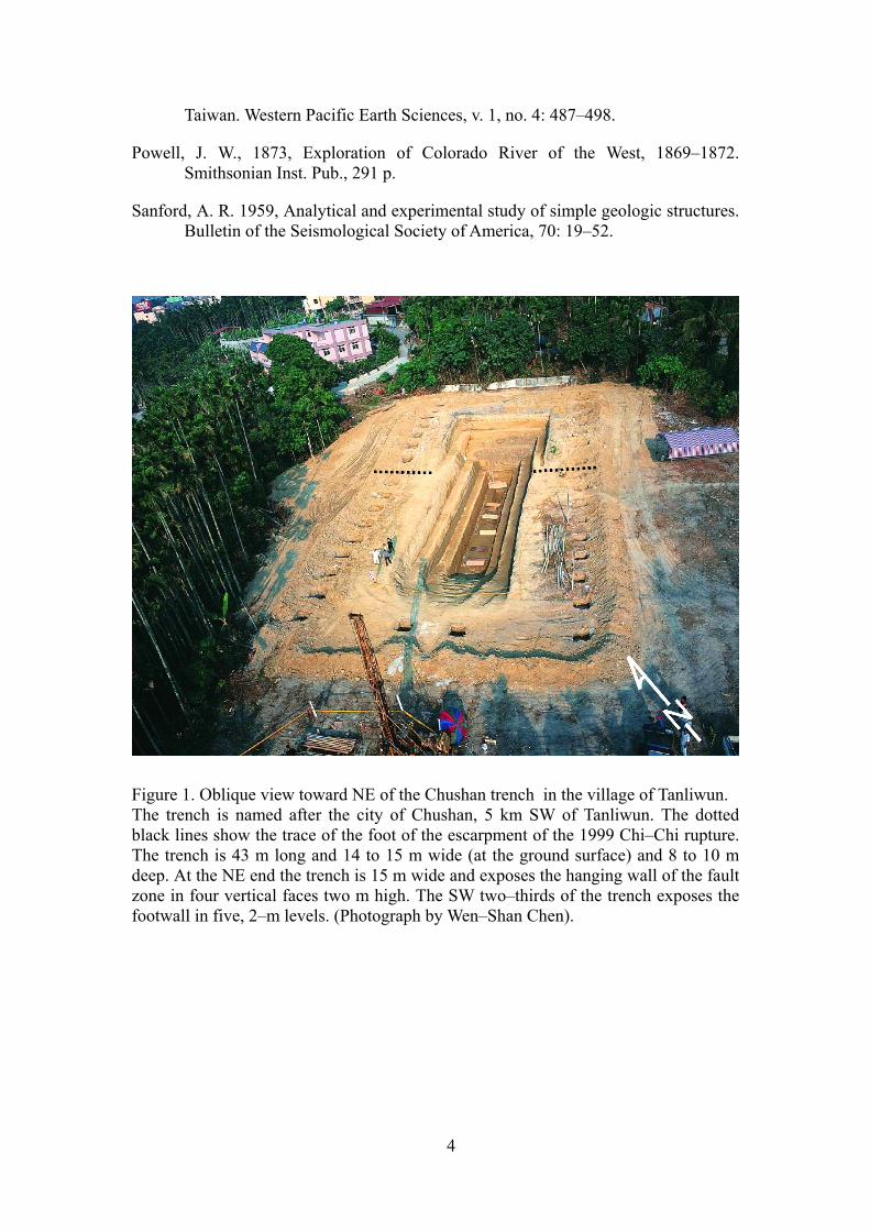
One of the best possible illustrations of relations between shapes of escarpments
and subsurface structures is exposed in Chushan trench at Tanliwun, near the south
end of 1999 Chi–Chi deformation–zone (Figure 1). The trench provided an ideal
combination of wonderful exposure, distinctive stratigraphic units, material properties
conducive to faulting, and variety of structures. We mapped the structures and
distinctive displacement markers in detail, at scales of 1:10 or 1:20, for several
months over a period of three years in order to determine the geometry and history of
the Chushan structure. We took many photographs of the trench walls at various
stages of excavation of the final trench. Study of the photographs showed the way
profiles of structures changed in trench faces as the faces were advanced by
excavation.
It became clear during examination of the structures in a series of trenches dug by
Chen (2003; also, see Ota, 2001) across escarpments of the Chi–Chi earthquake that
the common notion in structural geology that a single fault underlies escarpments of
monoclinal or parabola–like shape is not at all clearly related to what one actually
observes. The picture was not simple even where a trench was dug in ground that was
3
flat before the Chi–Chi earthquake and the surface form was a remarkably simple,
monoclinal form. The trenches exposed not a single fault but either no obvious fault
or several obvious faults. In short, the observations in the trenches were at odds with
the notion that an escarpment must be underlain by an obvious fault. Rather, the
common subsurface structures are multiple active faults at several different scales—
faults that were either reactivated or produced during the Chi–Chi earthquake. A
similar phenomenon was described by Barrows and Kahle (1971) in a trench across
the San Fernando, California, earthquake rupture near the mouth of Lopez Canyon.
The trench exposed two separate groups of parallel faults of different sizes beneath a
parabola–like escarpment.
By using a multi–fault dislocation model, we are able to show that the multiple
small faults exposed in the trench walls Tanliwun could have produced the
monocline–like escarpments observed there. Thus, the field observations and the
modeling suggest that the structures that first appeared to be continuous monoclinal
bending of layers are, in fact, discontinuous. The appearance of gross bending is a
result of slip in the same sense along numerous small faults inclined to the
sedimentary bedding and subparallel to the main fault in the near subsurface.
References
Barrows, A. G., 1973, Surface effects and related geology of the San Fernando earthquake in the foothill region between little Tujunga and Wilson Canyons, California. Division of Mines and Geology Bulletin, 196: 98–117.
Chen, W. S., Lee, L. S., Yang, C. C., Liu, L. H. and Chen, Y. C., 2003, Paleoseismic study of the Chelungpu fault in the Chushan, Nantao County, field report of Central Geological Survey, Taiwan, no. 92–7. Project no. 5226902000–03–9201.
Huang, W. J., 2006, Deformation at a leading edge of thrust faults. Ph.D. dissertation, Department of Earth and Atmospheric Sciences Library, 435 p.
Johnson, K. M., and Johnson, A. M., 2002, Mechanical analysis of the geometry of forced-folds. Journal of Structural Geology, 24: 401-410.
Mitra, S., and Islam, Q.T., 1994, Experimental (clay) models of inversion structures. Tectonophysics, 230, 211–222.
Ota, Y., Huang, C. Y., Yuan, P. B., Sugiyama, Y., Lee, Y., Watanabe, M., Sawa, H., Yanagida, M., Sasaki, S. Suzuki, Y., Hirouchi, D. and Taniguchi, K., 2001, Trenching Study at the Tsaotun Site in the Central Part of the Chelungpu Fault,
4
Taiwan. Western Pacific Earth Sciences, v. 1, no. 4: 487–498.
Powell, J. W., 1873, Exploration of Colorado River of the West, 1869–1872. Smithsonian Inst. Pub., 291 p.
Sanford, A. R. 1959, Analytical and experimental study of simple geologic structures. Bulletin of the Seismological Society of America, 70: 19–52.
Figure 1. Oblique view toward NE of the Chushan trench in the village of Tanliwun. The trench is named after the city of Chushan, 5 km SW of Tanliwun. The dotted black lines show the trace of the foot of the escarpment of the 1999 Chi–Chi rupture. The trench is 43 m long and 14 to 15 m wide (at the ground surface) and 8 to 10 m deep. At the NE end the trench is 15 m wide and exposes the hanging wall of the fault zone in four vertical faces two m high. The SW two–thirds of the trench exposes the footwall in five, 2–m levels. (Photograph by Wen–Shan Chen).