KCT RR
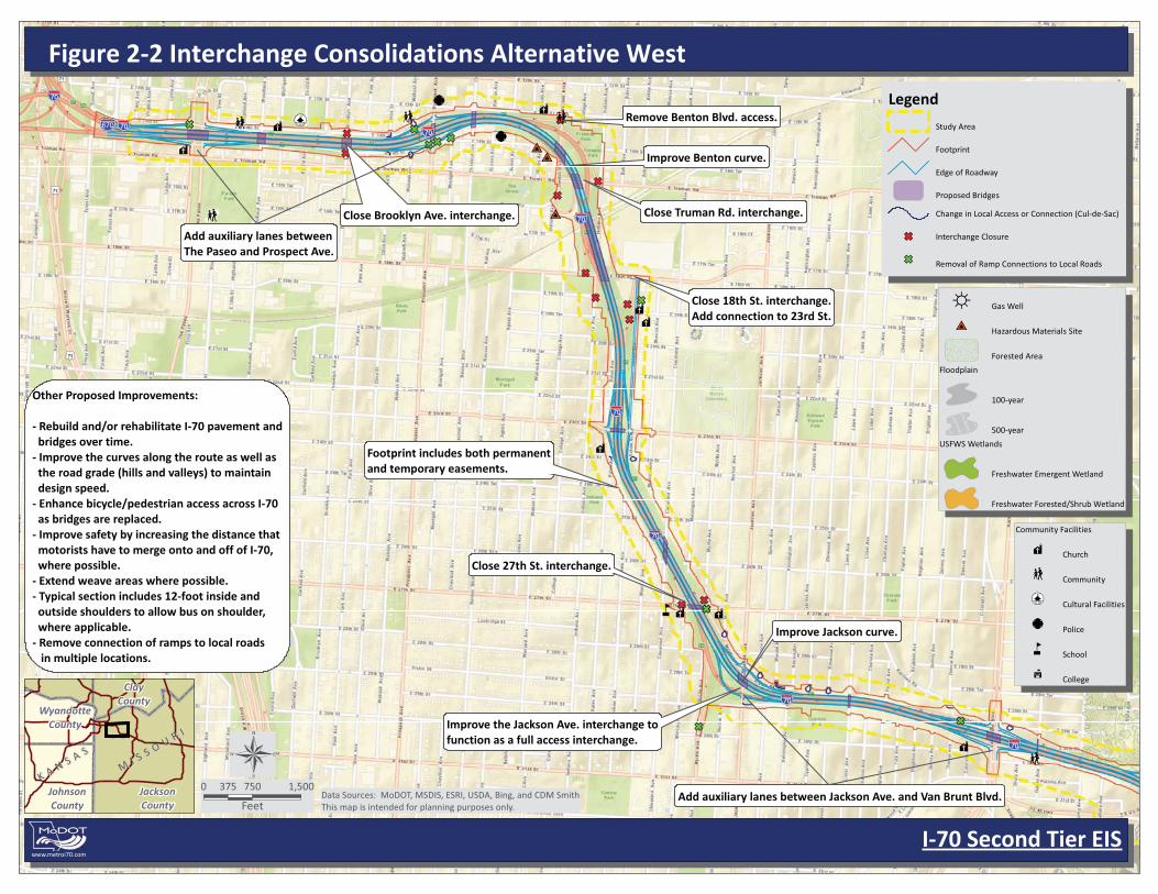
Other Proposed Improvements:
- Rebuild and/or rehabilitate I-70 pavement and bridges over time.- Improve the curves along the route as well as the road grade (hills and valleys) to maintain design speed.- Enhance bicycle/pedestrian access across I-70 as bridges are replaced.- Improve safety by increasing the distance that motorists have to merge onto and off of I-70, where possible.- Extend weave areas where possible.- Typical section includes 12-foot inside and outside shoulders to allow bus on shoulder, where applicable.- Remove connection of ramps to local roads in multiple locations.
Close Brooklyn Ave. interchange.
Close 18th St. interchange.Add connection to 23rd St.
Improve the Jackson Ave. interchange tofunction as a full access interchange.
Footprint includes both permanentand temporary easements.
Close 27th St. interchange.
Close Truman Rd. interchange.
Add auxiliary lanes betweenThe Paseo and Prospect Ave.
Add auxiliary lanes between Jackson Ave. and Van Brunt Blvd.
Improve Benton curve.
Improve Jackson curve.
Remove Benton Blvd. access.
Interchange Consolidations Alternative
I-70 Second Tier EIS
MI S S O U R I
MI S S O U R I
K A N S A S
K A N S A S
JacksonCounty
JohnsonCounty
ClayCounty
WyandotteCounty
Data Sources: MoDOT, MSDIS, ESRI, USDA, Bing, and CDM SmithThis map is intended for planning purposes only.
0 750 1,500375
Feet
Legend
Study Area
Footprint
Edge of Roadway
Proposed Bridges
Change in Local Access or Connection (Cul-de-Sac)
Interchange Closure
Removal of Ramp Connections to Local Roads
www.metroi70.com
Gas Well
Hazardous Materials Site
Forested Area
Floodplain
100-year
500-year
USFWS Wetlands
Freshwater Emergent Wetland
Freshwater Forested/Shrub Wetland
Community Facilities
Church
Community
Cultural Facilities
Police
School
College

KCS
UP RR
Other Proposed Improvements:
- Rebuild and/or rehabilitate I-70 pavement and bridges over time.- Improve the curves along the route as well as the road grade (hills and valleys) to maintain design speed.- Enhance bicycle/pedestrian access across I-70 as bridges are replaced.- Improve safety by increasing the distance that motorists have to merge onto and off of I-70, where possible.- Extend weave areas where possible.- Typical section includes 12-foot inside and outside shoulders to allow bus on shoulder, where applicable.- Remove connection of ramps to local roads in multiple locations.
I-435 improvements to eliminate left lane exitsand improve existing tight loop ramps. Improvethe curves along the route as well as the roadgrade (hills and valleys) of I-70.
Consider US 40 at Manchester Trafficwayimprovements as part of closing ManchesterTrafficway interchange.
Close Manchester Trafficway interchange. ConsiderStadium Dr. crossing under railroad improvements.Consider new on-ramp from Stadium Dr. to EB I-70.
Collector-DistributorRoad System.
Interchange Consolidations Alternative
I-70 Second Tier EIS
MI S S O U R I
MI S S O U R I
K A N S A S
K A N S A S
JacksonCounty
JohnsonCounty
ClayCounty
WyandotteCounty
Data Sources: MoDOT, MSDIS, ESRI, USDA, Bing, and CDM SmithThis map is intended for planning purposes only.
0 750 1,500375
Feet
Legend
Study Area
Footprint
Edge of Roadway
Proposed Bridges
Change in Local Access or Connection (Cul-de-Sac)
Interchange Closure
Removal of Ramp Connections to Local Roads
www.metroi70.com
Gas Well
Hazardous Materials Site
Forested Area
Floodplain
100-year
500-year
USFWS Wetlands
Freshwater Emergent Wetland
Freshwater Forested/Shrub Wetland
Community Facilities
Church
Community
Cultural Facilities
Police
School
College

70
12TH ST
14TH ST
TRUMAN RD
13TH ST
THE
PASE
O
18TH ST
NINTH ST
11TH ST
PRO
SPEC
T AV
E
BR
OO
KLY
N A
VE
WO
OD
LAN
D A
VE
OLI
VE S
T
CH
ESTN
UT
AVE
TENTH ST
PAR
K A
VE
TRA
CY
AVE
GA
RFI
ELD
AVE
AG
NE
S AV
E
PEERY AVE
EUC
LID
AVE
LYD
IA A
VE
FOR
EST
AVE
BEL
LEFO
NTA
INE
AVE
VIN
E S
T
VIR
GIN
IA A
VE
MO
NTG
ALL
AVE
17TH ST
MIC
HIG
AN
AVE
16TH TER
15TH TER
WA
BA
SH A
VE
KA
NSA
S AV
E
BA
SIE PL
HIG
HLA
ND
AV
E
16TH ST
ILLI
NO
IS A
VE
12TH TER
BEN
TON
BLV
D
GILLESPIE PL
11TH ST
OLI
VE S
T
ILLI
NO
IS A
VE
70
15TH TER
MIC
HIG
AN
AVE
VIR
GIN
IA A
VE
WA
BA
SH A
VE
VIN
E ST
HIG
HLA
ND
AVE
LYD
IA A
VE
13TH ST
MIC
HIG
AN
AVE
TENTH ST
GA
RFI
ELD
AVE
EUC
LID
AVE
16TH ST
EUC
LID
AVE
MIC
HIG
AN
AVE
TENTH ST
TRA
CY
AVE
PAR
K A
VE
17TH ST
KA
NSA
S AV
E
MO
NTG
ALL
AVE
17TH ST
GA
RFI
ELD
AVE
14TH ST
LYD
IA A
VE
11TH ST
OLI
VE S
T
17TH ST
GA
RFI
ELD
AVE
AG
NE
S AV
E
17TH ST
EUC
LID
AVE
BEL
LEFO
NTA
INE
AVE
16TH TER
WA
BA
SH A
VE
16TH ST
Parade Park
The Grove Park
Prospect Plaza Park
Goin’ To Kansas City Plaza Park
Harmony Park
Source: Esri, DigitalGlobe, GeoEye, i-cubed, USDA, USGS, AEX, Getmapping, Aerogrid, IGN, IGP, swisstopo, and the GIS User Community
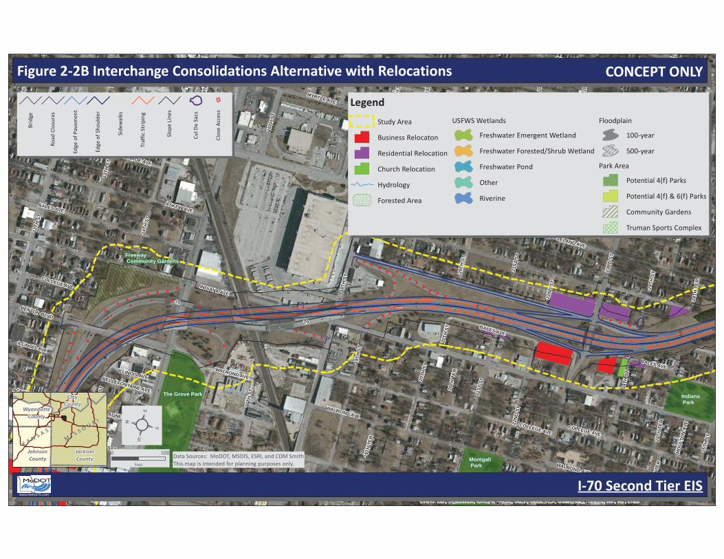
Figure 2-2A Interchange Consolidations Alternative with Relocations
I-70 Second Tier EIS
MI S S O U R I
MI S S O U R I
K A N S A S
K A N S A S
JacksonCounty
JohnsonCounty
ClayCounty
WyandotteCounty
0 500
Feet
Data Sources: MoDOT, MSDIS, ESRI, and CDM SmithThis map is intended for planning purposes only.
www.metroi70.com
B
ridg
e
R
oad
Clos
ures
Edge
of P
avem
ent
Edge
of S
houl
der
Side
wal
ks
Tr
affic
Str
ipin
g
Slop
e Li
nes
Cul D
e Sa
cs
Clos
e A
cces
s
Legend
Study Area
Business Relocaton
Residential Relocation
Church Relocation
Hydrology
Forested Area
USFWS Wetlands
Freshwater Emergent Wetland
Freshwater Forested/Shrub Wetland
Freshwater Pond
Other
Riverine
Floodplain
100-year
500-year
Park Area
Potential 4(f) Parks
Potential 4(f) & 6(f) Parks
Community Gardens
Truman Sports Complex
CONCEPT ONLY
The Grove Park
Montgall Park
Indiana Park
Freeway Community Gardens
70
INDIANA AVE
23R
D S
T
13TH
ST
18TH
ST
TRU
MA
N R
D
12TH
ST
CLEVELAND AVE
MONROE AVE
21ST
ST
JACKSON AVE
22N
D S
T
ASKEW AVE
MYRTLE AVE
24TH
ST
19TH
ST
BALES AVE
14TH
ST
COLLEGE AVE
20TH
ST
WALROND AVE
17TH
ST
BENTON BLVD
20TH
TER
19TH
TER
SPRUCE AVE
AGNES AVECHESTNUT AVE
25TH
ST
11TH
ST
24TH
TER
14TH
TER
16TH
ST
12TH
TER
NORTON AVE
KANSAS AVE
MERSINGTON AVE
18TH
TER
ILLINOIS AVE
BELLEFONTAINE AVE
BER
NA
RD
PO
WE
LL D
R
KENSINGTON AVE
18TH
CT
MO
ULT
ON
AVE
23R
D T
ER
MERSINGTON CT
14TH
ST
MONROE AVE
22N
D S
T
KANSAS AVE
BELLEFONTAINE AVE
70
24TH
TER
AGNES AVE
20TH
ST
NORTON AVE
20TH
ST
18TH
ST
AGNES AVE
19TH
ST
ILLINOIS AVE19
TH S
T
20TH
TER
COLLEGE AVE
MYRTLE AVE
17TH
ST
20TH
ST
WALROND AVE
24TH
ST
18TH
ST
BALES AVE
CLEVELAND AVE
21ST
ST
WALROND AVE
24TH
ST
24TH
ST
17TH
ST
BALES AVE
COLLEGE AVE
24TH
TER
22N
D S
T
MERSINGTON AVE
Source: Esri, DigitalGlobe, GeoEye, i-cubed, USDA, USGS, AEX, Getmapping, Aerogrid, IGN, IGP, swisst
Figure 2-2B Interchange Consolidations Alternative with Relocations
I-70 Second Tier EIS
MI S S O U R I
MI S S O U R I
K A N S A S
K A N S A S
JacksonCounty
JohnsonCounty
ClayCounty
WyandotteCounty
0 500
Feet
Data Sources: MoDOT, MSDIS, ESRI, and CDM SmithThis map is intended for planning purposes only.
www.metroi70.com
B
ridg
e
R
oad
Clos
ures
Edge
of P
avem
ent
Edge
of S
houl
der
Side
wal
ks
Tr
affic
Str
ipin
g
Slop
e Li
nes
Cul D
e Sa
cs
Clos
e A
cces
s
Legend
Study Area
Business Relocaton
Residential Relocation
Church Relocation
Hydrology
Forested Area
USFWS Wetlands
Freshwater Emergent Wetland
Freshwater Forested/Shrub Wetland
Freshwater Pond
Other
Riverine
Floodplain
100-year
500-year
Park Area
Potential 4(f) Parks
Potential 4(f) & 6(f) Parks
Community Gardens
Truman Sports Complex
CONCEPT ONLY
70
27TH
ST
JACKSON AVE
31ST
ST
26TH
ST
25TH
ST
CLEVELAND AVE
30TH
ST
23RD S
T
LISTER AVE
MYRTLE AVE
NORTON AVE
ASKEW AVE
BALES AVE
SPRUCE AVE
28TH
ST
MONROE AVE
INDIANA AVE
24TH
ST
CYPRESS AVE
RAYTOWN RD
KENSINGTON AVE
MERSINGTON AVE
LAWN AVE
ELMWOOD AVE
LINW
OOD BLV
D
COLLEGE AVE29
TH T
ER
29TH
ST
CHELSEA AVE
WENZEL AVE
YORK ST
24TH
TER
POPLAR AVE
BRIGHTON AVE
28TH
TER
WALROND AVE
QUINCY AVE
33RD S
T
DENVER AVE
MOULTON A
VE
23RD T
ER
POPLAR AVE
BRIGHTON AVE
CYPRESS AVE
28TH
ST
25TH
ST
70
26TH
ST
24TH
TER
CHELSEA AVE
30TH
ST
MONROE AVE
QUINCY AVE
BALES AVE
29TH
ST
SPRUCE AVE
KENSINGTON AVE
CYPRESS AVE
ELMWOOD AVE
29TH
ST
NORTON AVE
MERSINGTON AVE
MYRTLE AVE
70
24TH
ST
LISTER AVE
KENSINGTON AVE
SPRUCE AVE
28TH
ST
ELMWOOD AVE
28TH
ST
24TH
ST
MYRTLE AVE
CHELSEA AVE
Cypress Park
Indiana Park
Source: Esri, DigitalGlobe, GeoEye, i-cubed, USDA, USGS, AEX, Getmapping, Aerogrid, IGN, IGP, swisstopo, and the GIS User Community
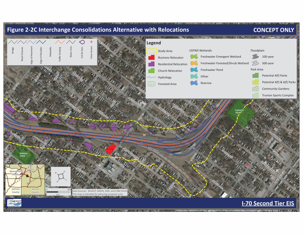
Figure 2-2C Interchange Consolidations Alternative with Relocations
I-70 Second Tier EIS
MI S S O U R I
MI S S O U R I
K A N S A S
K A N S A S
JacksonCounty
JohnsonCounty
ClayCounty
WyandotteCounty
0 500
Feet
Data Sources: MoDOT, MSDIS, ESRI, and CDM SmithThis map is intended for planning purposes only.
www.metroi70.com
B
ridg
e
R
oad
Clos
ures
Edge
of P
avem
ent
Edge
of S
houl
der
Side
wal
ks
Tr
affic
Str
ipin
g
Slop
e Li
nes
Cul D
e Sa
cs
Clos
e A
cces
s
Legend
Study Area
Business Relocaton
Residential Relocation
Church Relocation
Hydrology
Forested Area
USFWS Wetlands
Freshwater Emergent Wetland
Freshwater Forested/Shrub Wetland
Freshwater Pond
Other
Riverine
Floodplain
100-year
500-year
Park Area
Potential 4(f) Parks
Potential 4(f) & 6(f) Parks
Community Gardens
Truman Sports Complex
CONCEPT ONLY
70
4031ST ST
27TH ST
LISTER AVE
30TH ST
29TH ST
28TH TER
LINW
OOD BLV
D28TH ST
OA
KLEY AVE
29TH TER
TOPPIN
G AVE
EMAN
UEL
CLEA
VER
II BL
VD
BONITA AVE
RAYTOWN RD
30TH TERSTADIUM DR
27TH TER
BR
IGH
TON
AVE
POPLA
R AVE
CH
ELSEA AVE
32ND ST
US40 TO IS70W
YOR
K ST
DEN
VER AVE
US40 TO IS70E
ELMW
OO
D AVE
26TH ST
QU
INC
Y AVE
PALOMA AVE
HA
RD
ESTY AVE
BELLA
IRE AVE
DR
URY AVE
WH
ITE AVE
LINW
OO
D EA
ST D
R
QUINCY DR
WH
EELING
AVE
CO
LOR
AD
O AVE
BR
IGH
TON
AVE
CO
LOR
AD
O AVE
DR
URY AVE
BR
IGH
TON
AVE
30TH ST
POPLA
R AVE
CH
ELSEA AVE
TOPPIN
G AVE
LISTER AVE
32ND ST
28TH TER
DEN
VER AVE
DEN
VER AVE
QU
INC
Y AVE
28TH ST
BELLA
IRE AVE
OA
KLEY AVE
29TH ST
QU
INC
Y AVE
POPLA
R AVE
CH
ELSEA AVE
28TH ST
Santa Fe Trail Park
Van Brunt Park
Blue Valley Park
Cypress Park
Source: Esri, DigitalGlobe, GeoEye, i-cubed, USDA, USGS, AEX, Getmapping, Aerogrid, IGN, IGP, swisstopo, and the GIS User Community
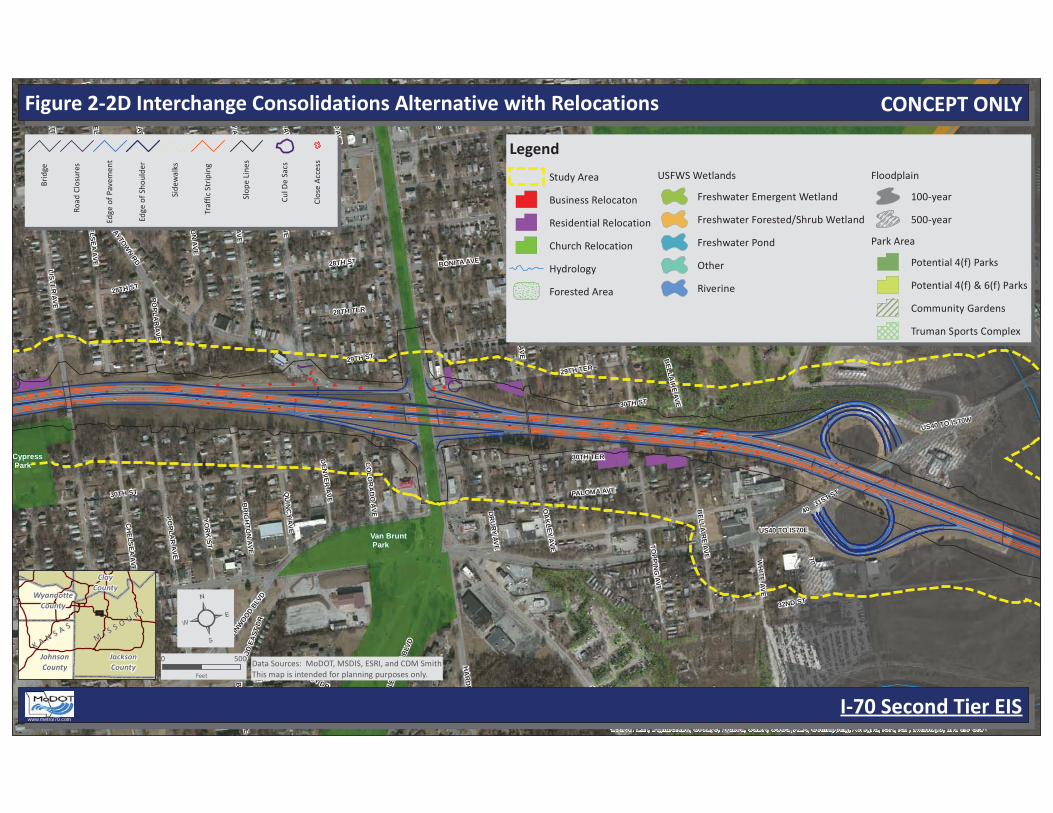
Figure 2-2D Interchange Consolidations Alternative with Relocations
I-70 Second Tier EIS
MI S S O U R I
MI S S O U R I
K A N S A S
K A N S A S
JacksonCounty
JohnsonCounty
ClayCounty
WyandotteCounty
0 500
Feet
Data Sources: MoDOT, MSDIS, ESRI, and CDM SmithThis map is intended for planning purposes only.
www.metroi70.com
B
ridg
e
R
oad
Clos
ures
Edge
of P
avem
ent
Edge
of S
houl
der
Side
wal
ks
Tr
affic
Str
ipin
g
Slop
e Li
nes
Cul D
e Sa
cs
Clos
e A
cces
s
Legend
Study Area
Business Relocaton
Residential Relocation
Church Relocation
Hydrology
Forested Area
USFWS Wetlands
Freshwater Emergent Wetland
Freshwater Forested/Shrub Wetland
Freshwater Pond
Other
Riverine
Floodplain
100-year
500-year
Park Area
Potential 4(f) Parks
Potential 4(f) & 6(f) Parks
Community Gardens
Truman Sports Complex
CONCEPT ONLY
40
435
MA
NC
HES
TER
TR
FY
MA
RSH
AVE
33RD ST
DO
NN
ELLY AVE
WA
LLAC
E AVE
31ST ST
IS70W TO
IS435N
32ND ST
BU
NK
ER R
D
PALM
ER AVE
PALM
ER TER
30TH ST
OA
KLA
ND
AVE
30TH TER
LINWOOD BLVD
35TH STSM
ALL
EY T
ER
ALLEY
SMA
LLEY
AV
E
BO
OTH
AVE
CRYS
TAL AVE
EASTER
N AVE
GARY
ST
BR
ISTO
L AV
E
WIN
CH
ESTE
R A
VE
EWIN
G A
VE
CO
RR
ING
TON
AVE
34TH ST
LEN
N A
VECIRCLE DR
31ST ST
PALM
ER TER
435
Source: Esri, DigitalGlobe, GeoEye, i-cubed, USDA, USGS, AEX, Getmapping, Aerogrid, IGN, IGP, swisstopo, and the GIS User Community
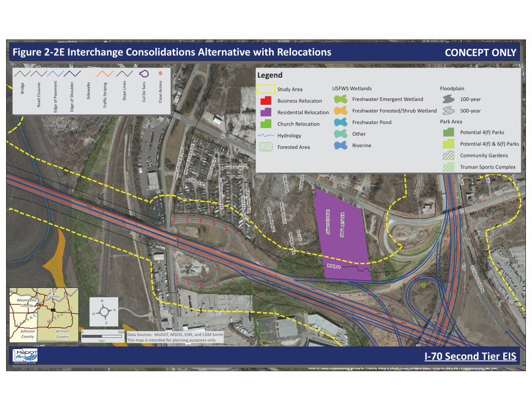
Figure 2-2E Interchange Consolidations Alternative with Relocations
I-70 Second Tier EIS
MI S S O U R I
MI S S O U R I
K A N S A S
K A N S A S
JacksonCounty
JohnsonCounty
ClayCounty
WyandotteCounty
0 500
Feet
Data Sources: MoDOT, MSDIS, ESRI, and CDM SmithThis map is intended for planning purposes only.
www.metroi70.com
B
ridg
e
R
oad
Clos
ures
Edge
of P
avem
ent
Edge
of S
houl
der
Side
wal
ks
Tr
affic
Str
ipin
g
Slop
e Li
nes
Cul D
e Sa
cs
Clos
e A
cces
s
Legend
Study Area
Business Relocaton
Residential Relocation
Church Relocation
Hydrology
Forested Area
USFWS Wetlands
Freshwater Emergent Wetland
Freshwater Forested/Shrub Wetland
Freshwater Pond
Other
Riverine
Floodplain
100-year
500-year
Park Area
Potential 4(f) Parks
Potential 4(f) & 6(f) Parks
Community Gardens
Truman Sports Complex
CONCEPT ONLY

70
435
STAD
IUM
DR
ROYAL WAYCHIEFS WAY
DUBI
NER
CIR
BLU
E RID
GE C
UTO
FF
LEEDS RD
39TH ST
HUNTER ST
36TH TER
LANC
ER L
N
RED
COAT
DR
DENTON RD
IS70W TO IS435N
DITZLER AVE
40
WINDSOR RD37TH ST
35TH ST
ASHLAND RIDGE RD
PEEK
DR
LAUREL AVE
CRESCENT AVE
SPECTACULAR DR
38TH TER
FARLEY AVE
40TH ST
BOOTH AVE
40TH TER
OXFO
RD AVE
STAD
IUM
ENTR
AN
CE A D
R
DENTON RD
37TH ST
Truman Sports Complex Park
Source: Esri, DigitalGlobe, GeoEye, i-cubed, USDA, USGS, AEX, Getmapping, Aerogrid, IGN, IGP, swisstopo, and the GIS User Community
Figure 2-2F Interchange Consolidations Alternative with Relocations
I-70 Second Tier EIS
MI S S O U R I
MI S S O U R I
K A N S A S
K A N S A S
JacksonCounty
JohnsonCounty
ClayCounty
WyandotteCounty
0 500
Feet
Data Sources: MoDOT, MSDIS, ESRI, and CDM SmithThis map is intended for planning purposes only.
www.metroi70.com
B
ridg
e
R
oad
Clos
ures
Edge
of P
avem
ent
Edge
of S
houl
der
Side
wal
ks
Tr
affic
Str
ipin
g
Slop
e Li
nes
Cul D
e Sa
cs
Clos
e A
cces
s
Legend
Study Area
Business Relocaton
Residential Relocation
Church Relocation
Hydrology
Forested Area
USFWS Wetlands
Freshwater Emergent Wetland
Freshwater Forested/Shrub Wetland
Freshwater Pond
Other
Riverine
Floodplain
100-year
500-year
Park Area
Potential 4(f) Parks
Potential 4(f) & 6(f) Parks
Community Gardens
Truman Sports Complex
CONCEPT ONLY
435
STAD
IUM
DR
RAY
TOW
N R
D
LAN
CER
LN
STADIUM DR TO IS435S
WINCHESTER AVE
IS435N TO STADIUM DR
DUBINER CIR
IS70
W TO
IS43
5N
CH
IEFS
WAY
EASTERN AVE
RAYTOWN RD TO IS435S
41ST ST
RO
YAL W
AYSMALLEY TER
34TH ST 39TH ST
LANCER DR
STADIUM ENTRANCE A DR
435
Truman Sports Complex Park
Source: Esri, DigitalGlobe, GeoEye, i-cubed, USDA, USGS, AEX, Getmapping, Aerogrid, IGN, IGP, swisstopo, and the GIS User Community
Figure 2-2G Interchange Consolidations Alternative with Relocations
I-70 Second Tier EIS
MI S S O U R I
MI S S O U R I
K A N S A S
K A N S A S
JacksonCounty
JohnsonCounty
ClayCounty
WyandotteCounty
0 500
Feet
Data Sources: MoDOT, MSDIS, ESRI, and CDM SmithThis map is intended for planning purposes only.
www.metroi70.com
B
ridg
e
R
oad
Clos
ures
Edge
of P
avem
ent
Edge
of S
houl
der
Side
wal
ks
Tr
affic
Str
ipin
g
Slop
e Li
nes
Cul D
e Sa
cs
Clos
e A
cces
s
Legend
Study Area
Business Relocaton
Residential Relocation
Church Relocation
Hydrology
Forested Area
USFWS Wetlands
Freshwater Emergent Wetland
Freshwater Forested/Shrub Wetland
Freshwater Pond
Other
Riverine
Floodplain
100-year
500-year
Park Area
Potential 4(f) Parks
Potential 4(f) & 6(f) Parks
Community Gardens
Truman Sports Complex
CONCEPT ONLY