Coordinate Systems, Projections,
and Transformations
An Overview
Outline
Acronyms, Terminology
Coordinate System Components
Conversion between Coordinate
Systems
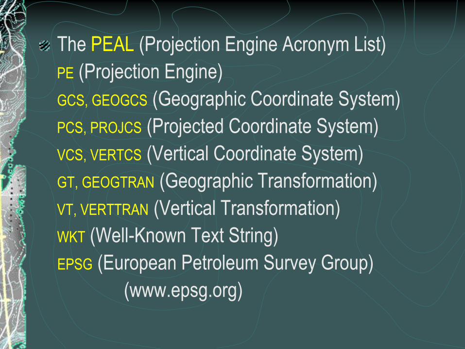
The PEAL (Projection Engine Acronym List)
PE (Projection Engine)
GCS, GEOGCS (Geographic Coordinate System)
PCS, PROJCS (Projected Coordinate System)
VCS, VERTCS (Vertical Coordinate System)
GT, GEOGTRAN (Geographic Transformation)
VT, VERTTRAN (Vertical Transformation)
WKT (Well-Known Text String)
EPSG (European Petroleum Survey Group)
(www.epsg.org)
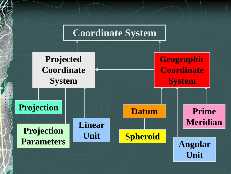
Datum
Spheroid
Prime
MeridianProjection
Parameters
Projection
Projected
Coordinate
System
Geographic
Coordinate
System
Coordinate System
Angular
Unit
Linear
Unit

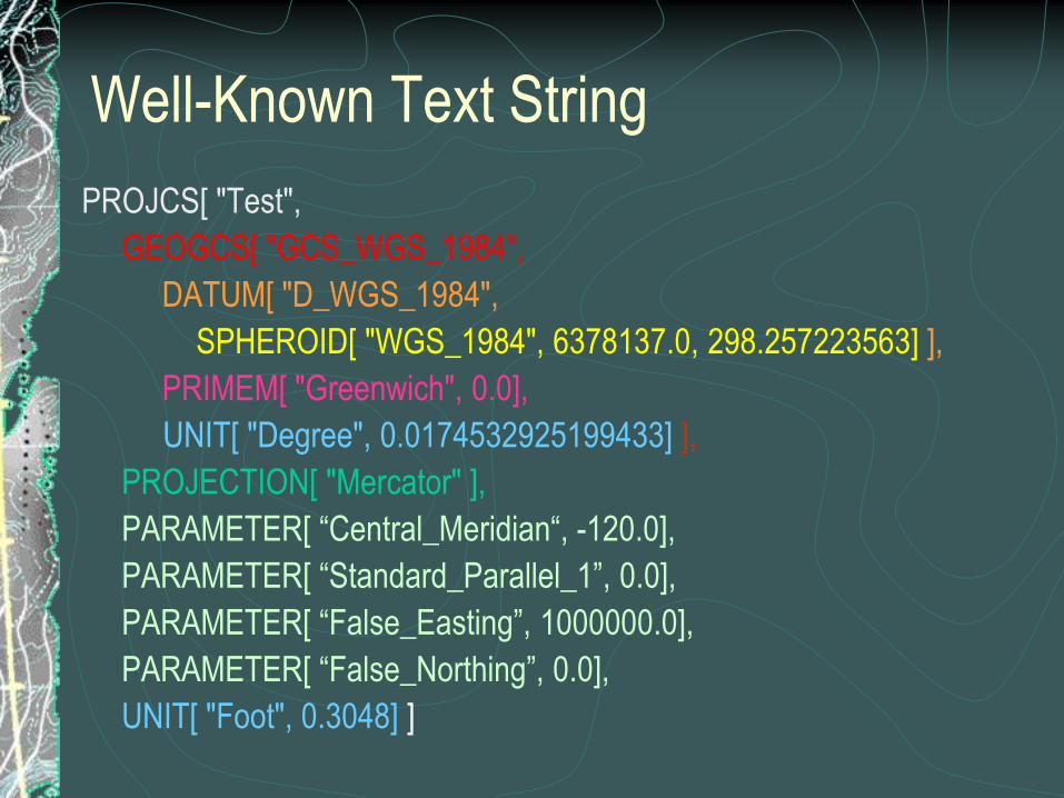
Well-Known Text String
PROJCS["Test",GEOGCS["GCS_WGS_1984",DATUM[
"D_WGS_1984",SPHEROID["WGS_1984",6378137,29
8.257223]],PRIMEM["Greenwich",0.0],UNIT["Degree",0.
0174532925199433]],PROJECTION["Mercator"],PARA
METER["Central_Meridian",120.0],PARAMETER["Stan
dard_Parallel_1",0.0],PARAMETER["False_Easting",10
00000.0],PARAMETER["False_Northing",0.0],UNIT["Fo
ot",0.3048]]
Well-Known Text String
PROJCS[ "Test",
GEOGCS[ "GCS_WGS_1984",
DATUM[ "D_WGS_1984",
SPHEROID[ "WGS_1984", 6378137.0, 298.257223563] ],
PRIMEM[ "Greenwich", 0.0],
UNIT[ "Degree", 0.0174532925199433] ],
PROJECTION[ "Mercator" ],
PARAMETER[ “Central_Meridian“, -120.0],
PARAMETER[ “Standard_Parallel_1”, 0.0],
PARAMETER[ “False_Easting”, 1000000.0],
PARAMETER[ “False_Northing”, 0.0],
UNIT[ "Foot", 0.3048] ]
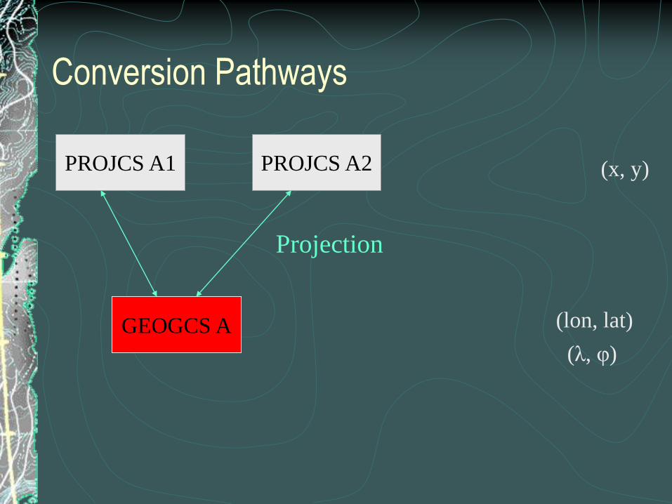
PROJCS A2
GEOGCS A
PROJCS A1
Projection
Conversion Pathways
(lon, lat)
(x, y)
(λ, φ)

PROJCS A2
GEOGCS A
PROJCS A1
GEOGCS B
PROJCS B1
Projection
Geographic Transformation
(lon, lat)
(x, y)
(λ, φ)
Conversion Pathways

Units, Spheroids, Prime Meridians
Angular - UNIT["Degree", 0.0174532925199433]
UNIT[“Grad”, 0.01570796326794897]
The value is Radians / Unit
Linear - UNIT["Foot", 0.3048]
The value is Meters / Unit
SPHEROID[ "WGS_1984", 6378137.0, 298.257223563]
The values are Semi-Major axis length in Meters,
Inverse Flattening (1 / f)
Prime Meridian – PRIMEM[“Paris”, 2.337229166666667]
PRIMEM[“Greenwich”, 0.0]
The value is Decimal Degrees based on Greenwich
10Figure 1.2
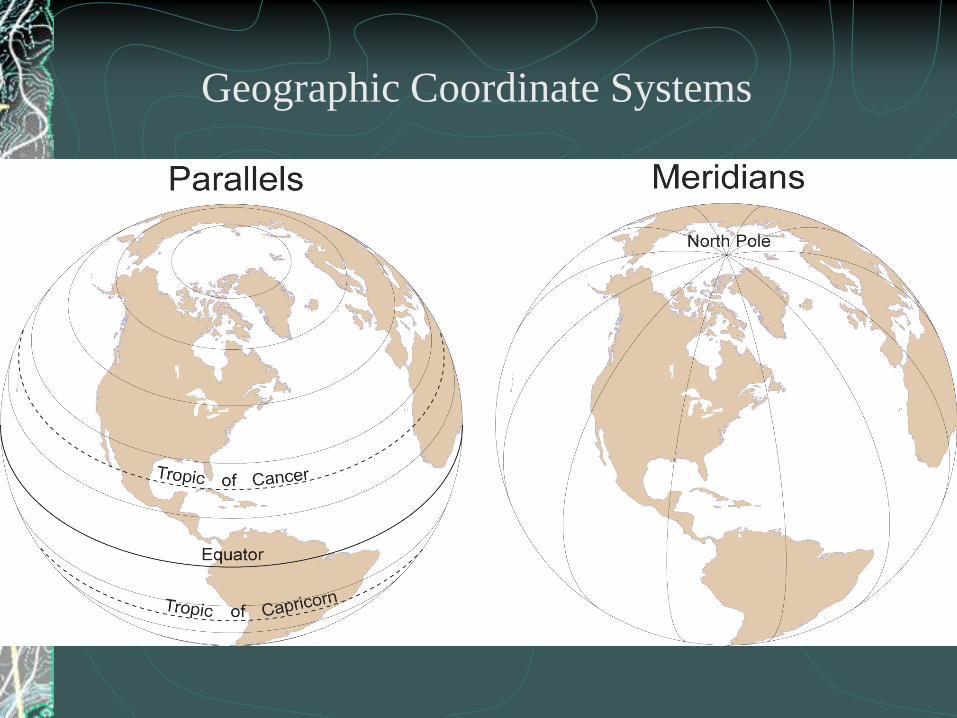
Geographic Coordinate Systems

11Figure 1.3

Distances and Angular Units

Figure 1.4 13

More background geometry
Rotating a circle or ellipse creates a sphere or
spheroid (oblate ellipsoid of revolution)
Defines the size and shape of the Earth “model”
SpheroidSphere

Figure 1.5 15
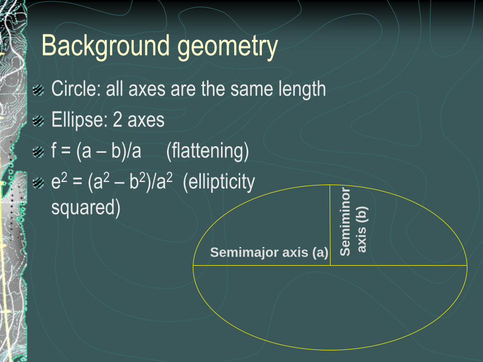
Background geometry
Circle: all axes are the same length
Ellipse: 2 axes
f = (a – b)/a (flattening)
e2 = (a2 – b2)/a2 (ellipticity
squared)
Se
mim
ino
r
ax
is (
b)
Semimajor axis (a)
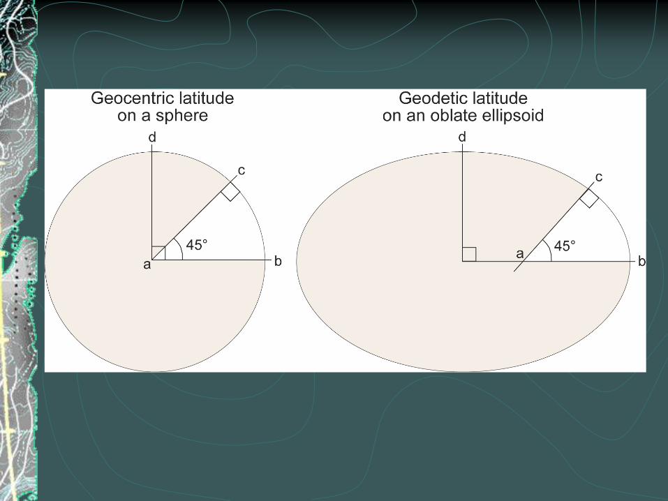
Figure 1.7 17

Earth as sphere
simplifies math
small-scale maps
(less than 1:5,000,000)
Earth as spheroid
maintains accuracy for larger-scale maps (>
1:1,000,000)

Datums
Reference frame for locating points on Earth‟s
surface
Defines origin & orientation of latitude/longitude
lines
Defined by spheroid and spheroid‟s position
relative to Earth‟s center

Creating a Datum
Pick a spheroid
Pick a point on the Earth‟s surface
All other control points are located relative to the
origin point
The datum‟s center may not coincide with the
Earth‟s center
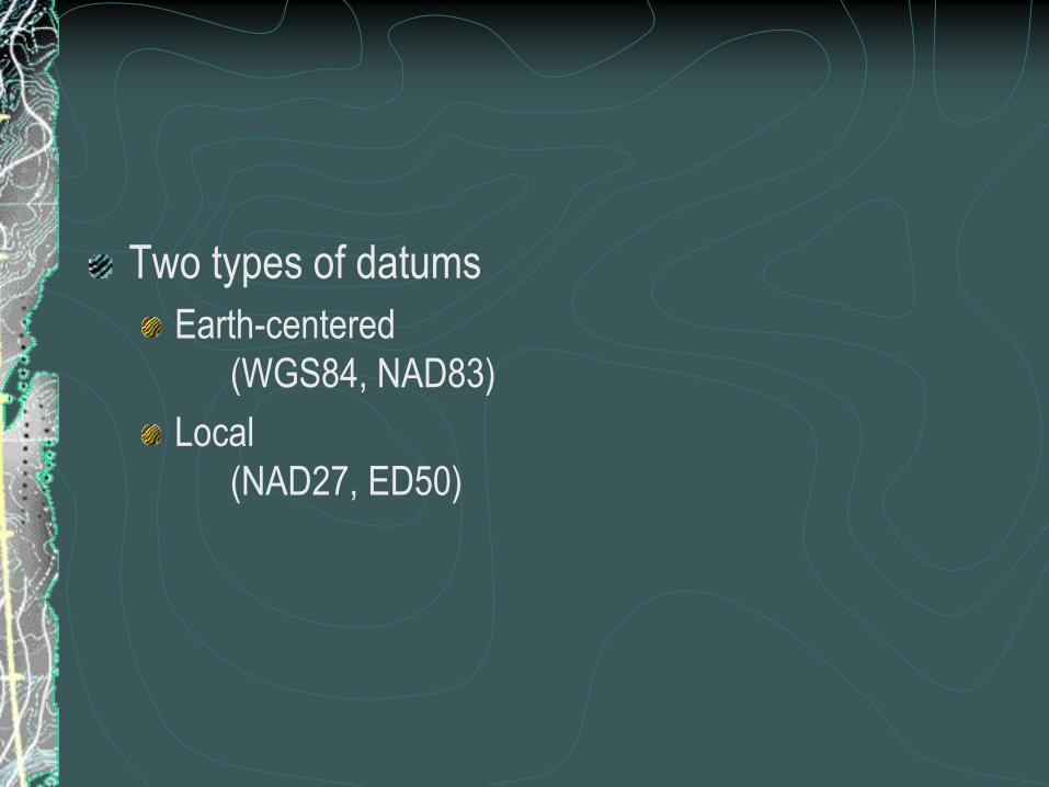
Two types of datums
Earth-centered
(WGS84, NAD83)
Local
(NAD27, ED50)
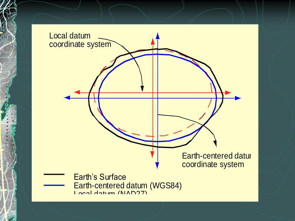
Earth’s SurfaceEarth-centered datum (WGS84)Local datum (NAD27)
Local datumcoordinate system
Earth-centered datumcoordinate system

What is a datum?
Classical geodesy (before 1960) – 5 quantitiesLatitude of an initial point
Longitude of an initial point
Azimuth of a line from this point
Semi-major axis length and flattening of ellipsoid
Satellite geodesy (after 1960) – 8 constantsThree to specify the origin of the coordinate system
Three to specify the orientation of the coordinate system
Semi-major axis length and flattening of ellipsoid

Why so many datums?
Many estimates of Earth‟s size and shape
Improved accuracy
Designed for local regions

North American Datums
NAD27
Clarke 1866 spheroid
Meades Ranch, KS
1880‟s
NAD83
GRS80 spheroid
Earth-centered datum
GPS-compatible
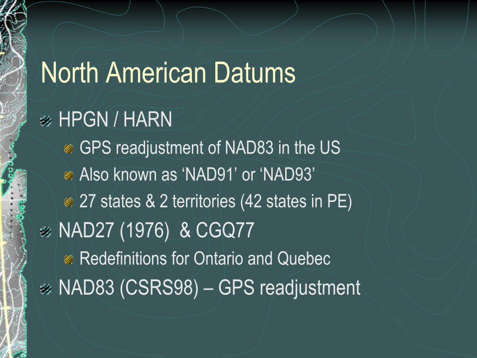
North American Datums
HPGN / HARN
GPS readjustment of NAD83 in the US
Also known as „NAD91‟ or „NAD93‟
27 states & 2 territories (42 states in PE)
NAD27 (1976) & CGQ77
Redefinitions for Ontario and Quebec
NAD83 (CSRS98) – GPS readjustment

International DatumsDefined for countries, regions,
or the world
World: WGS84, WGS72
Regional:
ED50 (European Datum 1950)
Arc 1950 (Africa)
Countries:
GDA 1994 (Australia)
Tokyo
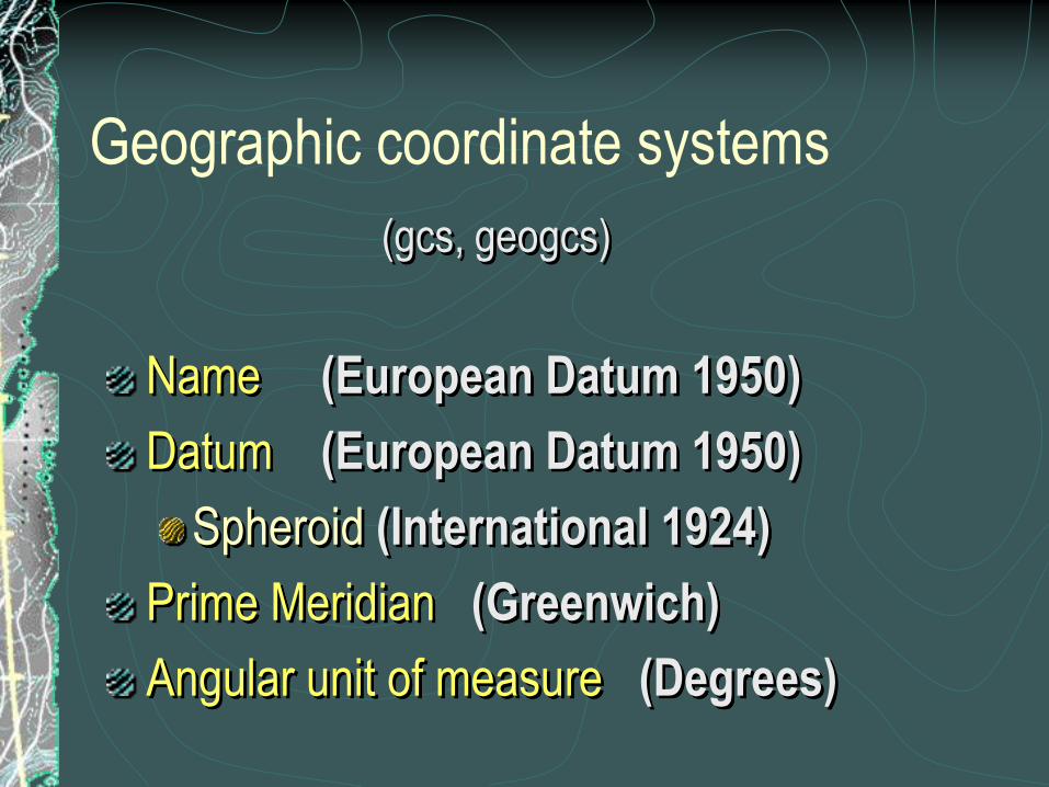
(gcs, geogcs)
Name (European Datum 1950)
Datum (European Datum 1950)
Spheroid (International 1924)
Prime Meridian (Greenwich)
Angular unit of measure (Degrees)
Geographic coordinate systems

Geographic transformations
“datum” transformations
Convert between GCS
Includes unit, prime meridian, and spheroid
changes
Defined in a particular direction
All are reversible

dXdY
X
dZY
Z
(0,0,0)
(145,-39,6)
Relationship between two datums

X Y
Z
Rotations

Transformation methods
Equation-based
Molodensky, Abridged Molodensky, Geocentric
Translation
Coordinate Frame, Position Vector, Molodensky-
Badekas
Longitude Rotation, 2D lat / lon offsets
File-based
NADCON, HARN, NTv2

Transformation exampleWGS 1984 (WGS 1984)
a = 6378137.0 meters
f = 1 / 298.257223563
e2 = 0.0066943799901…
European 1950 (International 1924)
a = 6378388.0
f = 1 / 297.0
e2 = 0.006722670022…
40 different geographic transformations
Geocentric Translation
Position Vector, Coordinate Frame
NTv2
Why so many?
Areas of use
Accuracy
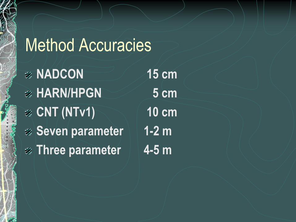
Method Accuracies
NADCON 15 cm
HARN/HPGN 5 cm
CNT (NTv1) 10 cm
Seven parameter 1-2 m
Three parameter 4-5 m

GEOGTRAN["ED_1950_To_WGS_1984_23",
GEOGCS["GCS_European_1950",
DATUM["D_European_1950",
SPHEROID["International_1924",6378388.0,297.0]],
PRIMEM["Greenwich",0.0],
UNIT["Degree",0.0174532925199433]],
GEOGCS["GCS_WGS_1984",
DATUM["D_WGS_1984",
SPHEROID["WGS_1984",6378137.0,298.257223563]],
PRIMEM["Greenwich",0.0],
UNIT["Degree",0.0174532925199433]],
METHOD["Position_Vector"],
PARAMETER["X_Axis_Translation",-116.641],
PARAMETER["Y_Axis_Translation",-56.931],
PARAMETER["Z_Axis_Translation",-110.559],
PARAMETER["X_Axis_Rotation",0.893],
PARAMETER["Y_Axis_Rotation",0.921],
PARAMETER["Z_Axis_Rotation",-0.917],
PARAMETER["Scale_Difference",-3.52]]
Example of GT in WKT format
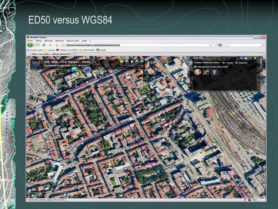
ED50 versus WGS84

Figure 1.17 37

Figure 1.18 38
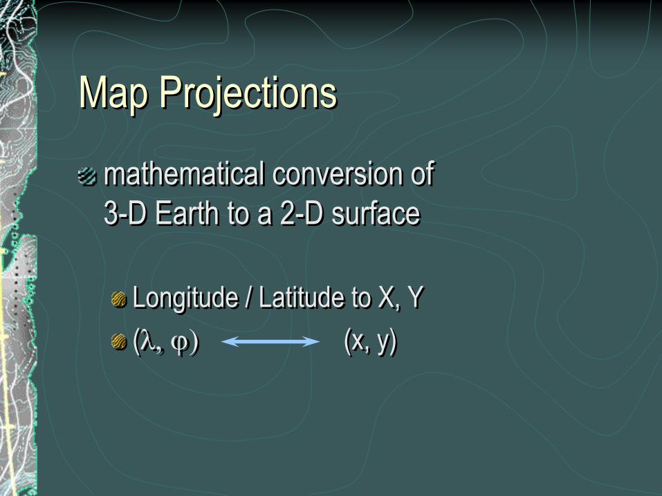
Map Projections
mathematical conversion of
3-D Earth to a 2-D surface
Longitude / Latitude to X, Y
(l, j) (x, y)

Projected coordinate system
Linear units
Shape, area, and
distance may be
distorted
X -
Y +
X +
Y +
X -
Y -
X +
Y -
X
Data
usually here
Y

Visualize a light shining through the
Earth onto a surface

plane
This much earthsurface has to fitonto this muchmap surface . . .
therefore, much of the Earth surfacehas to be represented smaller thanthe nominal scale.
projection
Fitting sphere to plane causes stretching or
shrinking of features
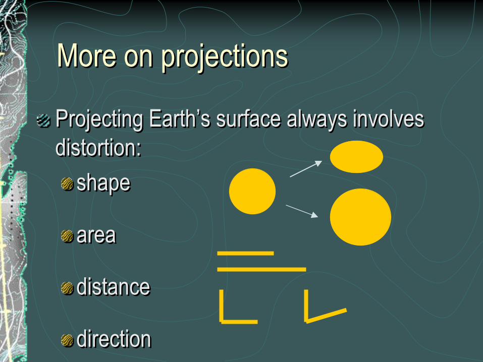
Projecting Earth‟s surface always involves
distortion:
shape
area
distance
direction
More on projections

Projection properties
Conformalmaintains shape
Equal-areamaintains area
Equidistantmaintains distance
Directionmaintains some directions
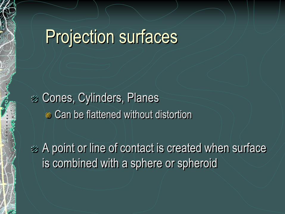
Projection surfaces
Cones, Cylinders, Planes
Can be flattened without distortion
A point or line of contact is created when surface
is combined with a sphere or spheroid

Tangent
projection surface touches spheroid
Secant
surface cuts through spheroid
No distortion at contact points
Increases away from contact points
More on
projection surfaces
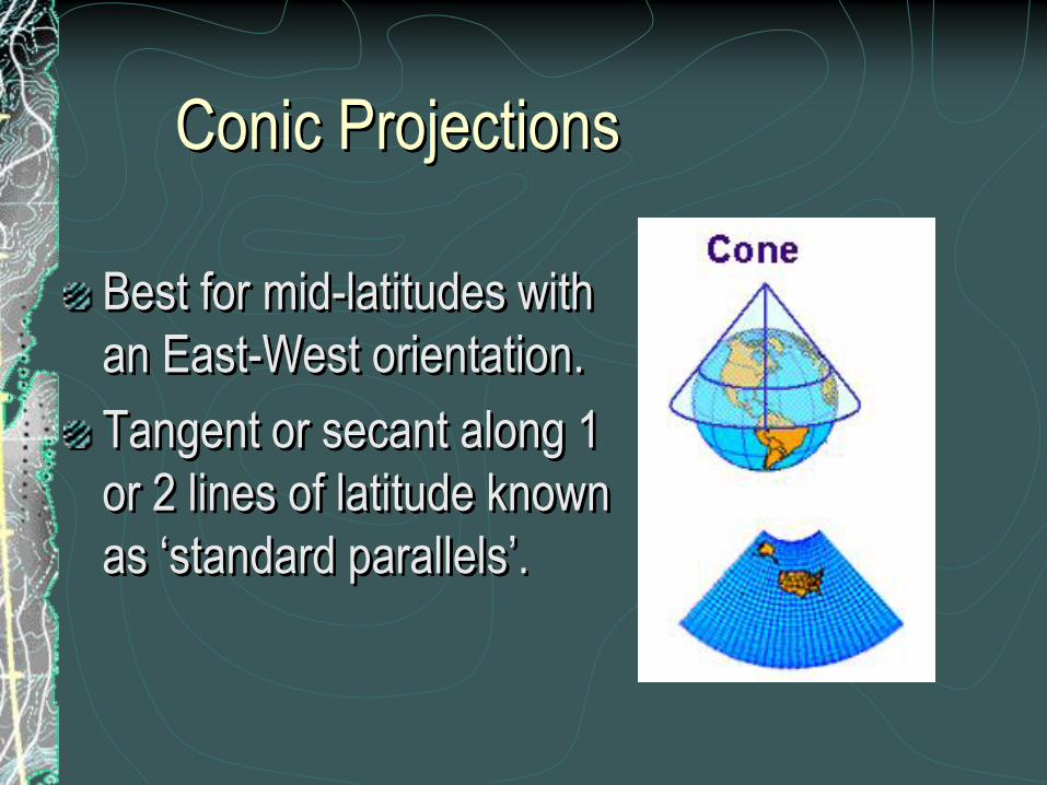
Conic Projections
Best for mid-latitudes with
an East-West orientation.
Tangent or secant along 1
or 2 lines of latitude known
as „standard parallels‟.
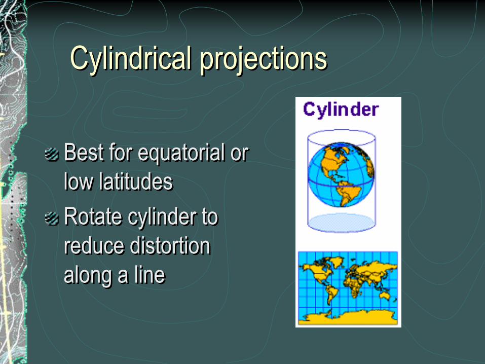
Cylindrical projections
Best for equatorial or
low latitudes
Rotate cylinder to
reduce distortion
along a line

Planar projections
Best for polar or circular regions
Direction always true from center
Shortest distance from center to another
point is a straight line

Also called azimuthal or zenithal
Can be any aspect

Projection parameters
Central meridian
Longitude of origin
Longitude of center
Latitude of origin, Latitude of center
Standard parallel
Scale factor
False easting, False northing

X
Y
Central
Meridian:
X = 0
Latitude of
Origin:
Y = 0
false easting =
500,000
false northing =
10,000,000

Choosing a
coordinate system
Often mandated by organization
Thematic = equal-area
Presentation = conformal (also
equal-area)
Navigation = Mercator, true
direction or equidistant
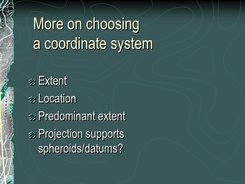
More on choosing
a coordinate system
Extent
Location
Predominant extent
Projection supports
spheroids/datums?

Web Mercator
Online mapping services use a sphere-only
Mercator
Two ways to emulate it
Sphere-based GCS
Projection that can force sphere equations
Mathematically EQUAL

PROJCS["WGS_1984_Web_Mercator",
GEOGCS["GCS_WGS_1984_Major_Auxiliary_Sphere",
DATUM["D_WGS_1984_Major_Auxiliary_Sphere",
SPHEROID["WGS_1984_Major_Auxiliary_Sphere",
6378137.0, 0.0]],
PRIMEM["Greenwich", 0.0],
UNIT["Degree", 0.0174532925199433]],
PROJECTION["Mercator"],
PARAMETER["False_Easting", 0.0]
PARAMETER["False_Northing", 0.0],
PARAMETER["Central_Meridian", 0.0],
PARAMETER["Standard_Parallel_1", 0.0],
UNIT["Meter", 1.0]]
# 102113
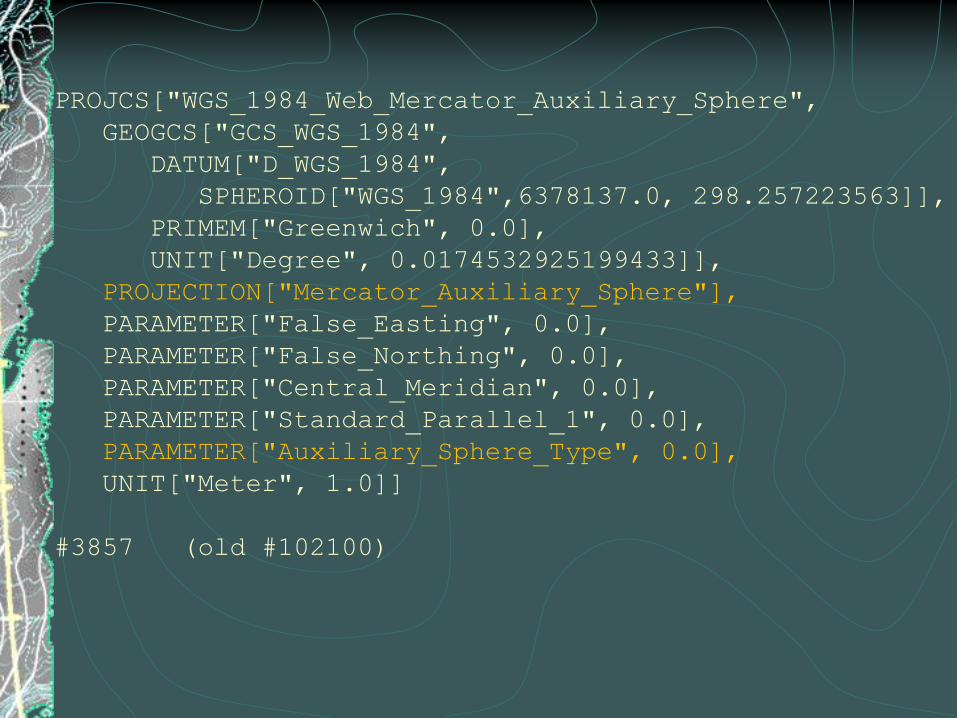
PROJCS["WGS_1984_Web_Mercator_Auxiliary_Sphere",
GEOGCS["GCS_WGS_1984",
DATUM["D_WGS_1984",
SPHEROID["WGS_1984",6378137.0, 298.257223563]],
PRIMEM["Greenwich", 0.0],
UNIT["Degree", 0.0174532925199433]],
PROJECTION["Mercator_Auxiliary_Sphere"],
PARAMETER["False_Easting", 0.0],
PARAMETER["False_Northing", 0.0],
PARAMETER["Central_Meridian", 0.0],
PARAMETER["Standard_Parallel_1", 0.0],
PARAMETER["Auxiliary_Sphere_Type", 0.0],
UNIT["Meter", 1.0]]
#3857 (old #102100)
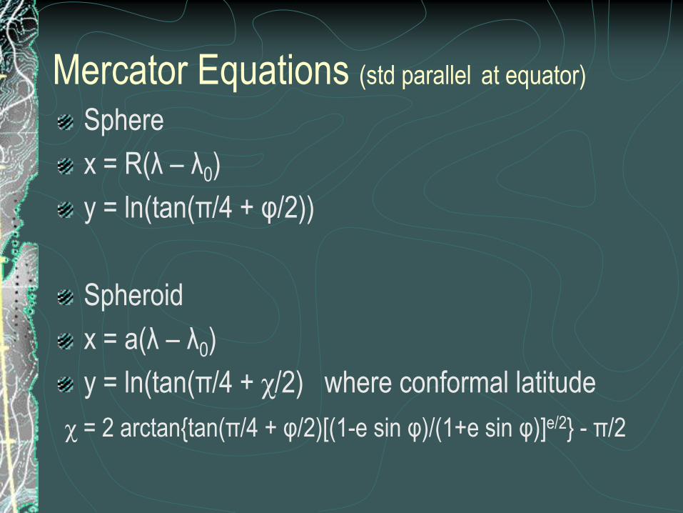
Mercator Equations (std parallel at equator)
Sphere
x = R(λ – λ0)
y = ln(tan(π/4 + φ/2))
Spheroid
x = a(λ – λ0)
y = ln(tan(π/4 + χ/2) where conformal latitude
χ = 2 arctan{tan(π/4 + φ/2)[(1-e sin φ)/(1+e sin φ)]e/2} - π/2

UTM
Universal Transverse Mercator
60 zones, 6° wide
Transverse Mercator
zone 1, central meridian = -177
scale factor = 0.9996
false easting = 500,000 m
In Southern Hemisphere, false northing =
10,000,000 m

SPCS
State Plane Coordinate System
States have 1 or more zones
Uses either NAD27 or NAD83 datums
Uses Lambert Conic, Transverse Mercator, and
Oblique Mercator

Horizons
GCS
PCS

Spatial Domain
12,000,000
4,000,000
10,000
90
180 10,000 4,000,000
UTM
(meters)
UTM
(feet)
Decimal
Degrees

When is a foot not a foot?
esriUnits is limited
ArcMap, “Foot” is US survey foot
US survey foot, 1 ft = 0.3048006096012192 m
Int‟l foot, 1 ft = 0.3048 m
PE, “Foot” is Int‟l foot; “Foot_US” is US survey
foot

9002 UNIT["Foot", 0.3048]
9003 UNIT["Foot_US", 0.3048006096012192]
9005 UNIT["Foot_Clarke", 0.304797265]
9041 UNIT["Foot_Sears", 0.3047994715386762]
9051 UNIT["Foot_Benoit_1895_A", 0.3047997333333333]
9061 UNIT["Foot_Benoit_1895_B", 0.3047997347632708]
9070 UNIT["Foot_1865", 0.3048008333333334]
9080 UNIT["Foot_Indian", 0.3047995102481469]
9081 UNIT["Foot_Indian_1937", 0.30479841]
9082 UNIT["Foot_Indian_1962", 0.3047996]
9083 UNIT["Foot_Indian_1975", 0.3047995]
9094 UNIT["Foot_Gold_Coast", 0.3047997101815088]
9095 UNIT["Foot_British_1936", 0.3048007491]
9300 UNIT["Foot_Sears_1922_Truncated", 0.3047993333333334]
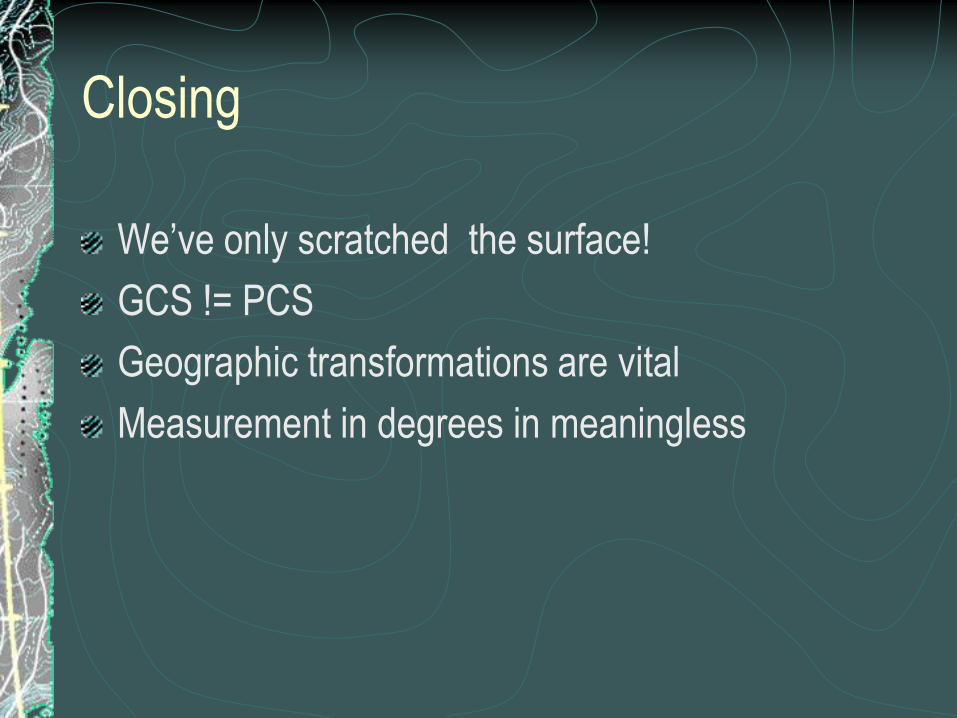
Closing
We‟ve only scratched the surface!
GCS != PCS
Geographic transformations are vital
Measurement in degrees in meaningless

Questions?