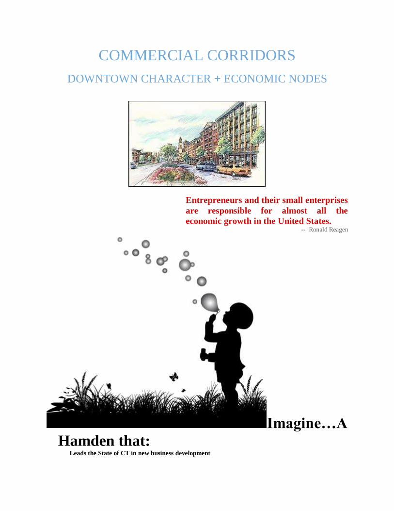
COMMERCIAL CORRIDORS
DOWNTOWN CHARACTER + ECONOMIC NODES
Entrepreneurs and their small enterprises
are responsible for almost all the
economic growth in the United States. -- Ronald Reagen
Imagine…A
Hamden that:
Leads the State of CT in new business development
Shows the greatest improvement neighborhood businesses
Has more locally owned businesses than any other CT municipality
Has the greatest percentage of high school students employed in the region
Is designed to encourage residents to walk to grocery stores, banks, and pharmacies.
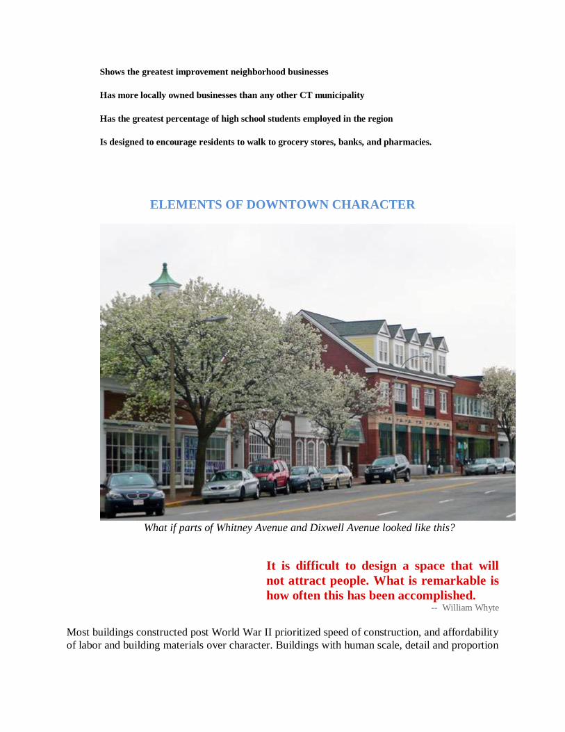
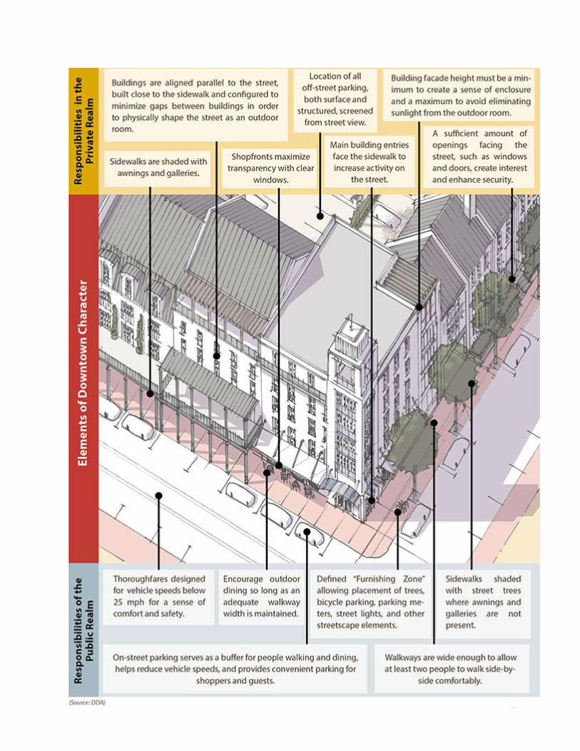
ELEMENTS OF DOWNTOWN CHARACTER
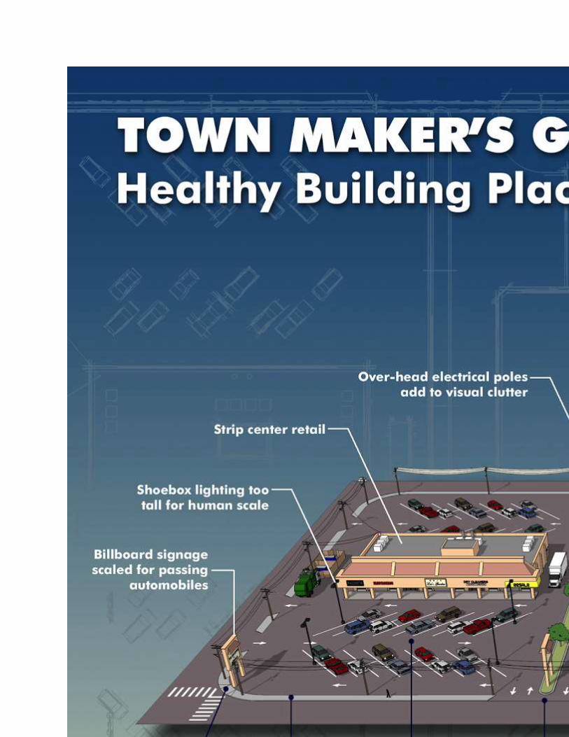
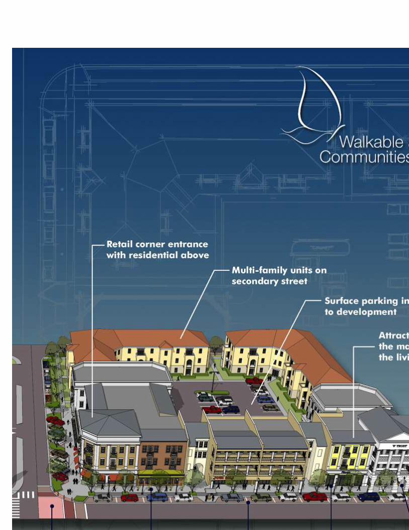
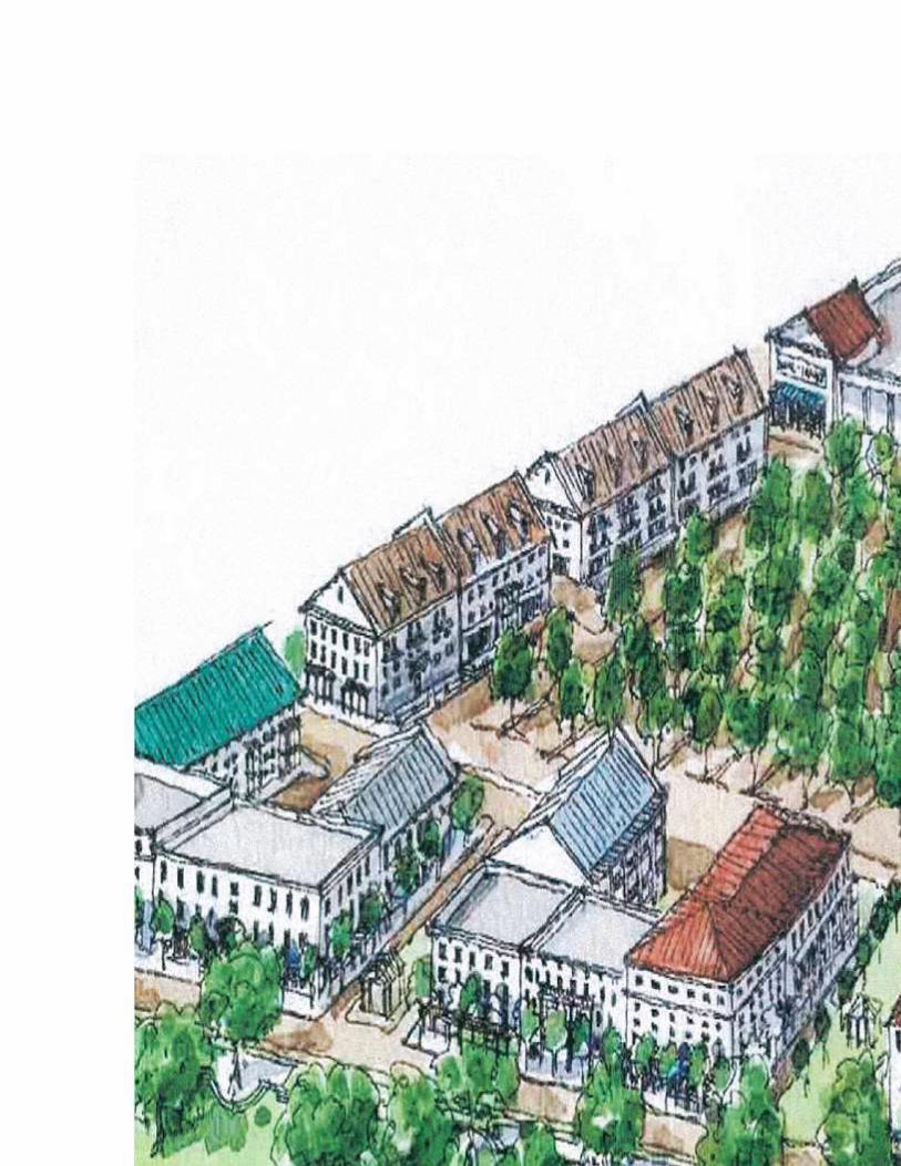
What if parts of Whitney Avenue and Dixwell Avenue looked like this?
It is difficult to design a space that will
not attract people. What is remarkable is
how often this has been accomplished. -- William Whyte
Most buildings constructed post World War II prioritized speed of construction, and affordability
of labor and building materials over character. Buildings with human scale, detail and proportion
of elements became a rarity. Buildings that respect these characteristics do not need to add cost
to construction, but the do require thoughtful design.
Buildings that invite window shopping, spark visual curiosity and evoke a welcoming
environment are typically those with historic scale and detail, feature public art or unique design
elements, or contribute as an edge of a great public space.
Hamden’s citizens place a high value on access to food, whether at restaurants, from local
grocery stores or farmers markets. Food is often the excuse for social and cultural
gatherings. Private parties and picnics, food truck events, restaurants, wine tastings and summer
concerts are all places we build relationships and experience new places. Recognizing that food
can activate an area, adding outdoor cafes, and on-street benches to enjoy a cup of coffee or an
ice cream cone can make the difference between cultivating a social space or deadening an area
and discouraging human occupation. Hamden’s commercial corridors should be studied for ways
to enliven the social realm in safe and desirable ways; in ways that encourage social vitality, and
economic investment in combinations of retail, commercial and residential uses.
What Hamden citizens don’t like is traffic! Encouraging economic growth and limiting
vehicular traffic along Hamden’s commercial corridors are not mutually exclusive. They are, in
fact, symbiotic. Accomplishing this combination requires three steps:
1. Slow traffic down enough that travellers can take note of the stores and services available
along the way;
2. Provide public space infrastructure, such as sidewalks, bike lanes, benches, recycling and
trash receptacles, lighting and street trees, that spur economic development;
3. Encourage parking! If cars are parked, people are walking. This may seem a simple
concept, but it is the single most effective way to positively activate a commercial
corridor. Providing on-street parking and parking behind a line of shops and service
centers is one of the most successful ways to positively activate a street with pedestrians.
Active pedestrians are the best tool for creating a profitable, safe and fun commercial
corridor. [See Chapter on CIRCULATION, TRAFFIC + PARKING for further
discussion.]
To create, preserve and enhance successful places, a balance between good food, good
architecture and traffic flow that does not inhibit social activity and non-vehicular travel along
sidewalks and bike lanes. The goal of public space along Hamden’s commercial corridors is to
shape a series of satisfying, sustainable, and safe spaces in each part of Town. They must be
developed or enhanced based upon “economic realities, cultural needs, environmental concerns
and design opportunities.”
WHAT MAKES A PLACE SUCCESSFUL?
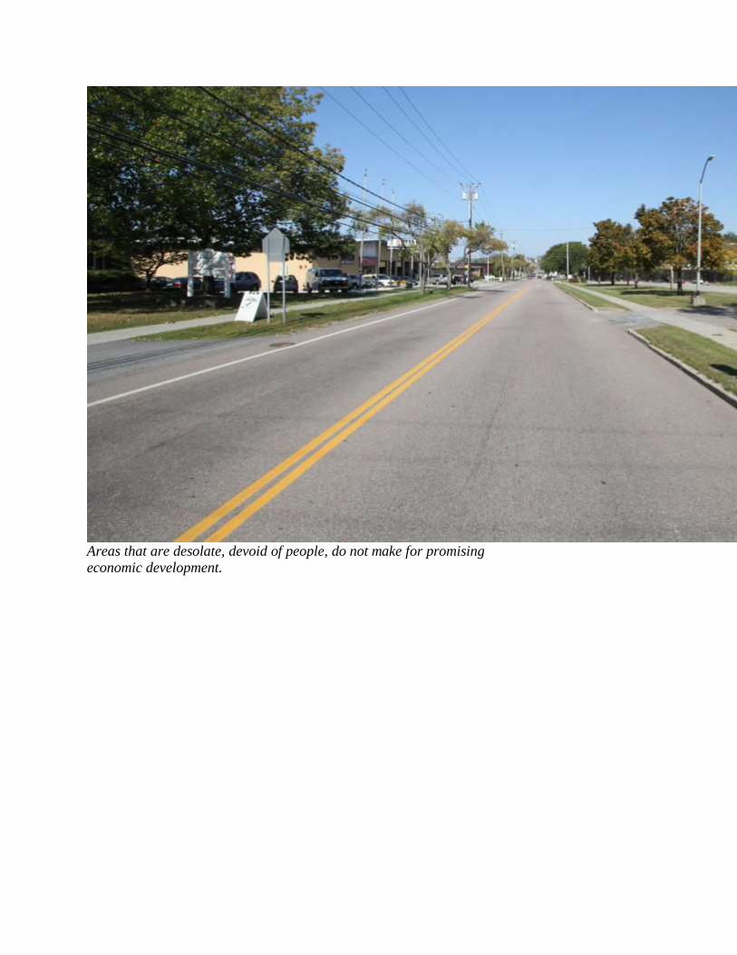
Areas that are desolate, devoid of people, do not make for promising
economic development.
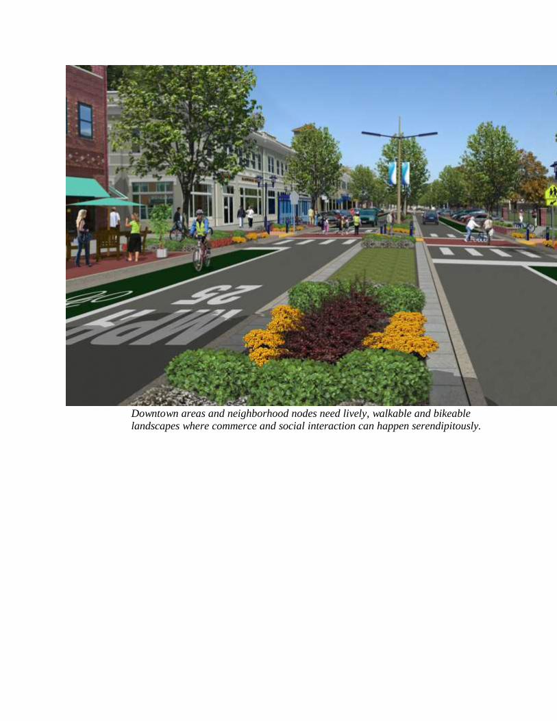
Downtown areas and neighborhood nodes need lively, walkable and bikeable
landscapes where commerce and social interaction can happen serendipitously.
In October, 2007 the Hamden Planning Office conducted a four day charrette. This intensive
design workshop studied twelve neighborhoods, and Hamden’s three major commercial
corridors: Dixwell Avenue, Whitney Avenue and State Street. An enormous amount of work
was completed during these four days, with a great deal of polishing by the consultants during
the post-charrette phase. Hamden’s new zoning regulations were written based upon the values
and vision articulated during the charrette process, resulting in the most progressive and
comprehensive zoning regulations in the State of Connecticut. The hybrid form- and use-based
zoning regulations were adopted in December, 2009 and became effective January 1, 2010.
Bookstores are lonely forts, spilling light
onto the sidewalk. They civilize their
neighborhoods. -- John Updike
Hamden’s citizens, neighborhood associations, planning staff, and planning and zoning
commissioners worked diligently to clarify a vision for three critical aspects of the town’s future:
1. Protect and enhance the relationship between existing and future buildings, and
the social spaces that form between them;
2. Strengthen the potential for responsible economic growth, and an expansion of the
local tax base,
3. Locate optimal areas for economic nodes along Hamden’s major commercial
corridors, where benefits outweigh negative impacts on adjacent neighborhoods
and the preservation of their character, and
4. Prioritize environmentally sustainable development of buildings, the public realm,
neighborhoods and the region.
By planning ahead, the important questions of "What should be built?", "Where should it be
built?", "How it should be built?" were addressed in the updated zoning regulations. The
questions regarding the physical and economic development of the Town and Region are
considered here. "What infrastructure is needed to support future development?" “What goods
and services can be provided on a regional level, resulting in cost savings to Hamden and other
area municipalities?” By addressing these questions in this Plan, and not leaving them to be
discussed and debated only during the permitting process for individual projects, principles and
public policy are articulated and will serve as a dispassionate guide for future development.
Development of large-scale plans for most of the town, without regard to individual projects, has
allowed Hamden to secure its long-term goals in public policy, not personality. The public,
developers, public officials and anyone else that chose to share their ideas and concerns were
heard. Their ideas and concerns were vetted and incorporated into the revised zoning
regulations. Now, not just the allowed uses in a zone are clear, but so is the intended form for
each zone. Investors in Town can now be clear about what Hamden expects to be built, prior to
spending money on architects, land surveyors, engineers and other design professionals. This
creates a much more business-friendly atmosphere in commercial areas, while giving a level of
confidence to the public regarding what new spaces will feel like and how new buildings will
present themselves to the street. In addition, improved streetscapes, pedestrian- and bicycle-
friendly designs and the opportunity for an improved tax base increases with each new
development.
The new zoning regulations have helped set the stage for “development readiness” in areas along
the three major commercial corridors and within Hamden’s various and unique neighborhood
nodes.
Pre-Planned Zoning and Streamlined Permitting Hamden has planned and zoned each Transect and Special District for appropriate development
and has modify its zoning regulations to reflect this planning. Subdivision and other land use
regulations should be reviewed and revised to meet the intent of this Plan.
To improve permitting processes for applicants and ensure coordination between land use
permitting agencies, it is recommended that applicants be able to apply for locally issued permits
through a single point of contact at the municipality. Coordination between the Planning &
Zoning Department, the Building Department, the Engineering Department and the Fire
Department would streamline the permitting processing.
Market-Based Planning
Hamden has planned and zoned each Transect and Special District for appropriate uses and
densities based upon existing and projected market demand. The Planning & Zoning
Commission has modified its zoning regulations to reflect this long-range planning. The allowed
uses may change over time as market demand fluctuates.
Fairness to Neighbors
The adjacencies between Zoning Districts, as shown on the Zoning Map and in the Transect, as
shown in the Zoning Regulations, are meant to consider appropriate neighboring uses, building
form and densities. The opportunity for symbiotic relationships between various uses and
densities should be encouraged, as well as mitigation of possible negative impacts. New
development should balance the positive and negative impacts on neighboring communities, and,
where applicable, on those who may be displaced by the new development.
Transportation Access
Permitted uses, building form and densities along Hamden’s three major commercial corridors
should consider access to mass transportation in lieu of automobiles as a development
asset. Development that will be supported by existing transportation infrastructure or by
reasonable identifiable upgrades to that infrastructure should be encouraged, as should that
which will decrease the number of vehicle miles travelled (vmt).
The street is the river of life of the city,
the place where we come together, the
pathway to the center. -- William Whyte
Adequate Utilities and other Infrastructure
Uses, building form and densities should be supported by existing water, sewer and other utility
infrastructure or by reasonable identifiable upgrades to that infrastructure.
Utility and infrastructure upgrades located within ¼ mile of major commercial corridors, mass
transit routes and/or areas that have been zoned to accommodate increased development density
and intensity and also have one or more of these additional characteristics:
1. Job Opportunities: New development within economic nodes will create employment
additional job opportunities;
2. Housing Opportunities: economic nodes will include new "workforce housing" or "starter
home" opportunities.;
3. Community Enhancement: New development within the economic nodes will support or
revitalize existing uses and structures;
4. Land Re-Use: Much or all of the new development within economic nodes will be located on
previously disturbed land;
5. Transit Availability: Economic nodes should be designated within convenient walking distance
to public transit;
6. Smart Energy: Zoning and other regulations within a growth district should promote or require
efficient use of energy through improved design, high efficiency technologies and conservation
and/or the use of clean renewable resources to create electricity and heat;
7. Green Buildings and Low-Impact Development: Zoning and other regulations within a growth
district should promote the efficient use of water and other resources, including best practices for
water conservation, wastewater management and stormwater management;
8. Good Design: Zoning and other regulations within a growth district should incorporate best
practices for building, site and neighborhood design.
New growth and development will continue to occur throughout the Hamden outside of
identified economic nodes. Nonetheless, a successful economic growth initiatives should:
Create an inventory of development-ready sites for new and expanding
businesses, especially in T-4, T-5 and Special Districts where appropriate;
Cooperate and coordinate with other municipalities in the Greater New Haven
region to promote the fair and equitable distribution of new economic growth
throughout the region;
Create a range of new workforce housing opportunities throughout the town;
Promote new commercial and residential growth that is consistent with the State’s
Smart Growth principles;
Act as a catalyst for the revitalization of the Greater New Haven region;
Provide a focal point for coordinated action by the various state, regional and
local entities involved in land use and development
By concentrating new development and
redevelopment in areas that have existing
or planned infrastructure, we can create
jobs, avoid sprawl, expand
transportation, and protect our
environment. -- Martin O’Malley
Governor of Maryland
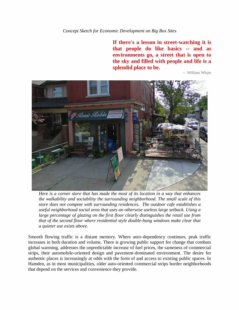
Concept Sketch for Economic Development on Big Box Sites
If there's a lesson in street-watching it is
that people do like basics -- and as
environments go, a street that is open to
the sky and filled with people and life is a
splendid place to be. -- William Whyte
Here is a corner store that has made the most of its location in a way that enhances
the walkability and sociability the surrounding neighborhood. The small scale of this
store does not compete with surrounding residences. The outdoor cafe establishes a
useful neighborhood social area that uses an otherwise useless large setback. Using a
large percentage of glazing on the first floor clearly distinguishes the retail use from
that of the second floor where residential style double-hung windows make clear that
a quieter use exists above.
Smooth flowing traffic is a distant memory. Where auto-dependency continues, peak traffic
increases in both duration and volume. There is growing public support for change that combats
global warming, addresses the unpredictable increase of fuel prices, the sameness of commercial
strips, their automobile-oriented design and pavement-dominated environment. The desire for
authentic places is increasingly at odds with the form of and access to existing public spaces. In
Hamden, as in most municipalities, older auto-oriented commercial strips border neighborhoods
that depend on the services and convenience they provide.
We can never get a re-creation of
community and heal our society without
giving our citizens a sense of belonging.
-- Patch Adams There is a silver lining to the creeping obsolescence of strip malls. Redevelopment of these areas
into walkable, mixed-use, transit-oriented streets typically result in:
1. A greater tax base for the Town;
2. Greater desirable economic development;
3. Environmentally responsible site design, architectural design, and product use;
4. Improved access to quality mass transit, for those with or without access to automobiles,
and
5. Coveted housing for millennials and baby-boomers.
RESTRUCTURING THE COMMERCIAL CORRIDOR
In the 1990’s, contemporary planning was just beginning to move in the direction of mixed-use
developments. Plans that combined shopping with residential, commercial and entertainment
uses on a single large parcel, complete with internal streets and walkways are now replacing
large malls and open-air strip malls.
Strip malls sprouted like dandelions, up and down commercial corridors across America during
the 1950’s through the early 1980’s. “A legacy of low-quality, short-lived construction” along
wide commercial streets were the result of several factors:
1. The post-World War II love affair with the automobile;
2. An oversupply of properties zoned for retail use, and
3. An inflexible design with very long blocks, many curb cuts and the front two-thirds of the
lots swathed in parking spaces.
Strip mall sites have buildings that are typically limited to a single story, and are located as far
back from the street as possible to advertise how much parking they supply. The Hamden Plaza
and the Hamden Mart were among the very first strip malls built in America. They were the
shopping destination for those who lived and worked in New Haven. The most trendy shopping
in the area was in Hamden, and it was only a trolley ride away.
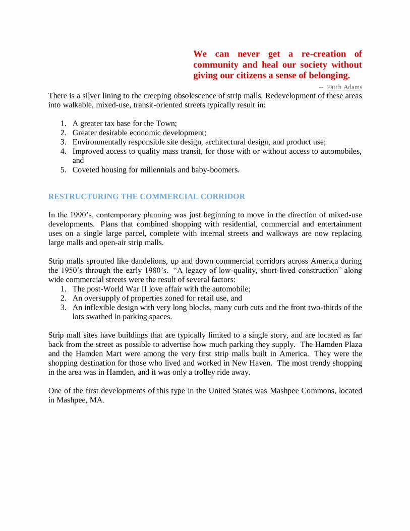
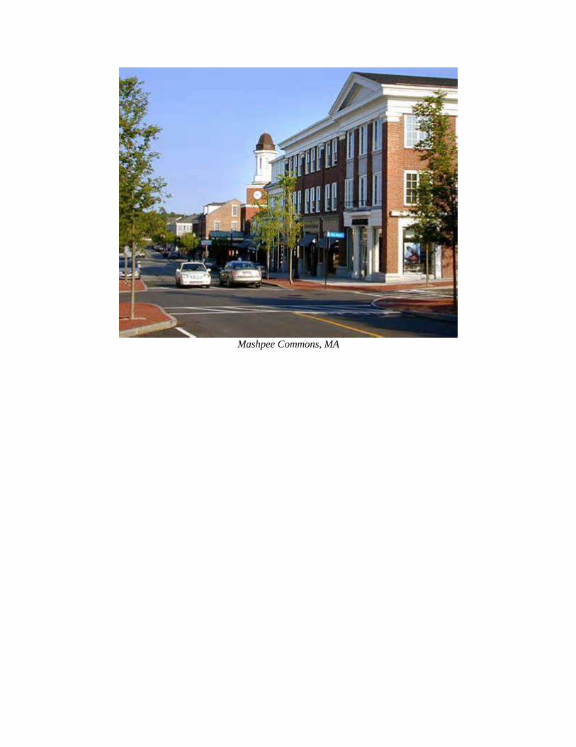
One of the first developments of this type in the United States was Mashpee Commons, located
in Mashpee, MA.
Mashpee Commons, MA
Mashpee Commons Site Plan, Mashpee, MA
Mixed-use developments have come a long way since Mashpee Commons. Unlike Mashpee
Commons, most mixed-use developments are no longer designed to face inward. As the map
above shows, the existing major roadways ended up with parking lots at their face, spacialy
segregating the newer development from existing development. Mixed-use developments are
now designed to mirror the form and scale of buildings on the opposite side of the development
site. It is this balance of form and scale on each side of a street that goes a long way toward
creating public space that communicates comfort and human scale to any space.
As this new mixed-use construction was just beginning to gain traction in the 1990’s, Hamden
residents held their ground, fending off the most insular, auto-dominated, and traffic generating
suburban shopping form: the mall. Hamden residents fended off an attempt to build the Sears
Mall on the southeast corner of Skiff and Dixwell Avenue.
In their landmark book Retrofitting Suburbia, Ellen Dunham-Jones and June Williamson discuss
market forces, environmental considerations, and public policy as tools for “diversification or
densification” of existing suburban sprawl. Consumer preferences have shifted from enclosed
shopping malls and strip malls to more walkable, amenity-driven design, shopping
areas. Responsive development has evolved, and now, what once might have been acres of
parking and a one-story strip mall, is now a town center development that includes housing and
offices over retail development, a town green and entertainment venues.
Successful restructuring of commercial corridors needs to address the following:
1. Reduction in vehicle miles traveled (VMT);
2. Improve public health by locating a mix of uses within a walkable street patterned;
3. Create and/or upgrade the public transit system to serve a majority of the population,
regardless of automobile ownership;
4. Reduce land consumption and per capita costs of public infrastructure investment by
absorbing growth along existing commercial corridors, thus preventing expansive sprawl;
5. Increase the connectivity of local streets;
6. Increase public and civic space;
7. Increase choice in housing type and affordability;
8. Increase the diversification of the tax base.
Commercial corridors need more than just the redevelopment of privately owned parcels: they
need to be safe enough for people of all ages and abilities to cross. In some cases this means
narrowing the width of the roadway, in other cases it may mean adding a planted median down
the middle of the street. There are many tools that can be employed in multiple combinations to
slow traffic, and create pedestrian and bicycle safety (See Chapter on Circulation, Traffic +
Parking).
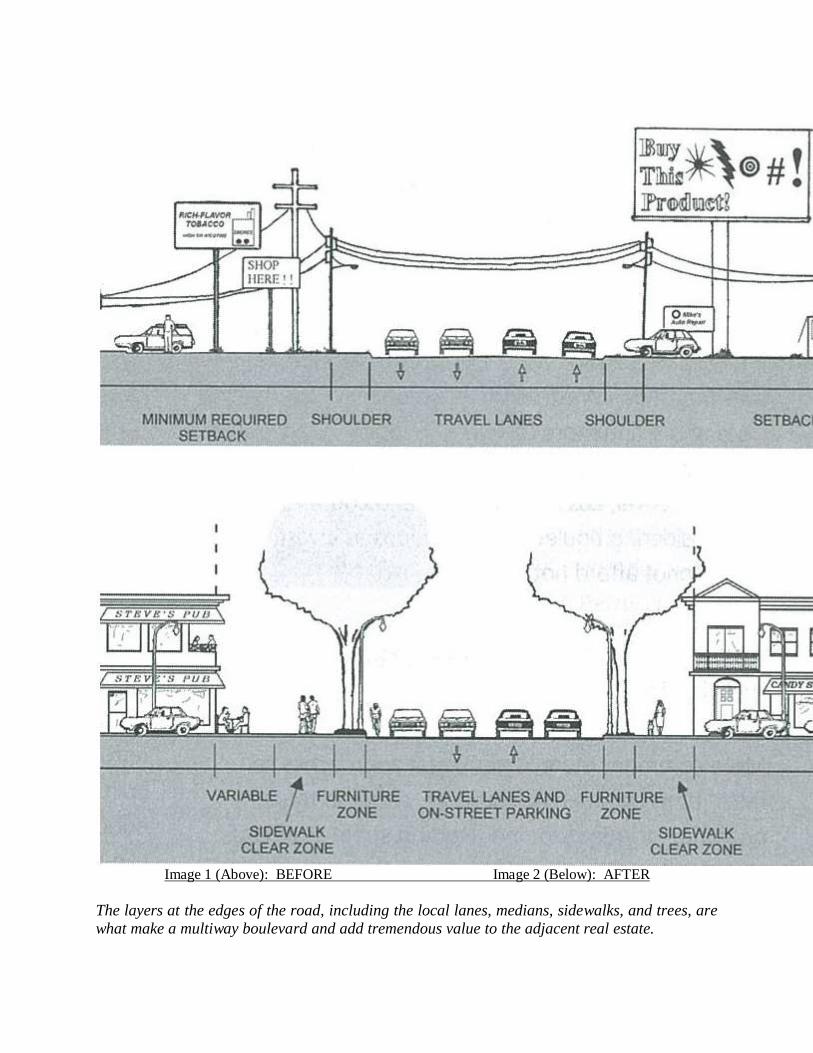
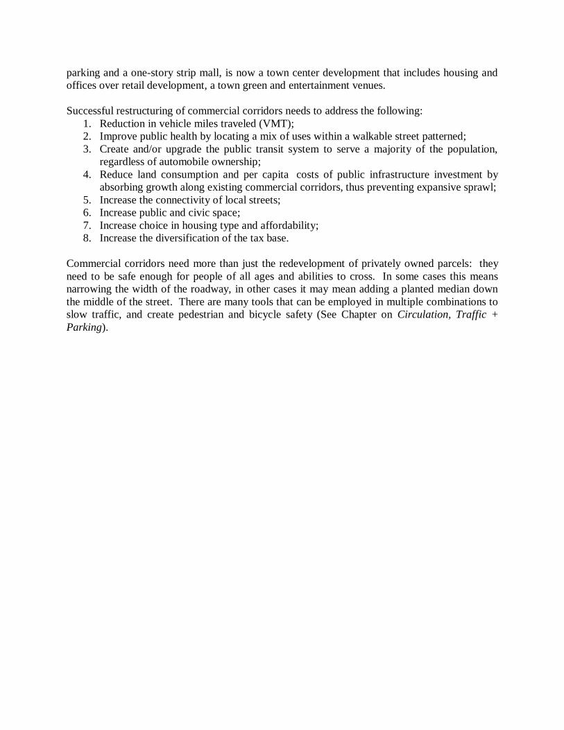
Image 1 (Above): BEFORE Image 2 (Below): AFTER
The layers at the edges of the road, including the local lanes, medians, sidewalks, and trees, are
what make a multiway boulevard and add tremendous value to the adjacent real estate.

What are the differences? Why do you like one better than the other?
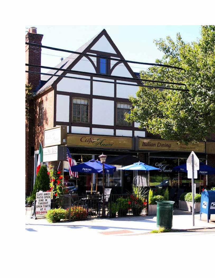
Cafe Amici on Whitney Avenue Cafe Renaissance in Vienna, VA
Where would you rather walk, shop, eat and even drive? What are the design interventions
that make the most difference, and how many are there?
__________________________________________________________________
__________________________________________________________________
__________________________________________________________________
__________________________________________________________________
__________________________________________________________________
__________________________________________________________________
__________________________________________________________________
__________________________________________________________________
__________________________________________________________________
__________________________________________________________________
__________________________________________________________________
__________________________________________________________________
ECONOMIC DEVELOPMENT WITHIN ECONOMIC NODES
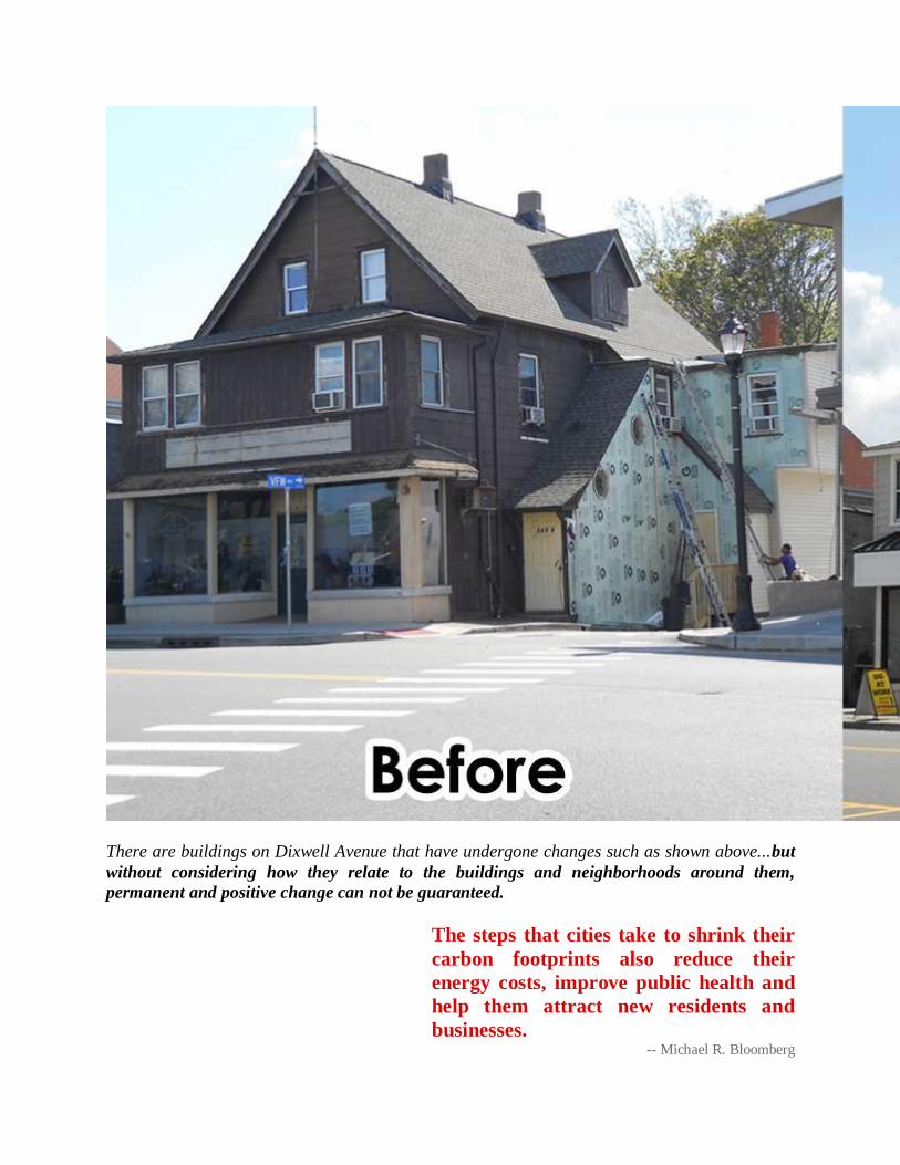
There are buildings on Dixwell Avenue that have undergone changes such as shown above...but
without considering how they relate to the buildings and neighborhoods around them,
permanent and positive change can not be guaranteed.
The steps that cities take to shrink their
carbon footprints also reduce their
energy costs, improve public health and
help them attract new residents and
businesses. -- Michael R. Bloomberg
UN Secretary-General’s Special Envoy for Cities and Climate Change
What is Economic Development?
Economic development is the active process of creating conditions that encourage economic
growth. Economic Development requires effective, collaboration between institutions that are
focused on advancing mutual gain for the public and the private sector. Economic growth is
essential to ensuring a stable, affordable and healthy future for Hamden’s citizens.
Most commercial corridors in the northeast began as cart paths and trolley lines. The most
intensive development took place post World War II during the most car-centric period of
commercial and retail expansion. The form that these developments took were the all-too-
familiar single story strip malls with the sea of parking between the shops and the roadway. It is
this form that Hamden’s 2010 Zoning Regulations is structured to revamp, returning pedestrian
activity and commerce to the street, instead of the rear of a parking lot.
What is an Economic Node?
Economic nodes are a two- to four block area that anchors a neighborhood center. In Hamden,
these nodes are located primarily along the three major commercial corridors; Whitney Avenue,
Dixwell Avenue and State Street. Locating appropriately scaled retail and commercial
development in neighborhood nodes, and using form-based zoning to establish, or re-establish
how buildings face streets and each other, public space between these buildings is created. It is
the space between buildings that forms Hamden’s commercial corridors.
What is a Commercial Corridor?
Commercial corridors help to sustain neighborhoods by promoting local investment, boosting
property values, and preserving the urban context of neighborhoods. But, to succeed in today's
retail environment, commercial corridors must incorporate new retail formats, find new market
niches, and make strategic capital investments. Infill development will be an essential part of
remaining competitive.
Vibrant commercial corridors have long been associated with healthy neighborhoods, and
municipal fiscal health. They are the economic rope that ties together shopping, jobs and
entrepreneurial opportunities, and keeps dollars local. Promotion of local investment helps
increase local property values and preserves the social and physical fabric of Hamden’s older
neighborhoods.
Not all segments of commercial corridors are the same. Some operate as regional centers, such
as the Magic Mile between the Wilbur Cross Parkway and Skiff Street, others serve a more local
constituency. Each segment type should be developed at a scale appropriate to the character by
which it is surrounded. Portions may serve as neighborhood nodes, which should be of much
smaller scale than regional centers.
Hamden is fortunate that much of the length of its commercial corridors have maintained their
scale, and in many places, the original architecture. Some areas along Hamden’s commercial
corridors, however, are neglected spaces. These spaces come in many forms. In some places
they are vast and/or under-utilized parking lots. One good example are the parking lots at the
Hamden Plaza and the Hamden Mart. Another is the parking lot at Walgreens in Spring
Glen. While very different in scale and surrounding character, nevertheless, both of these sites
illustrate neglected spaces that detract from the overall surroundings. Some of the decline along
southern Dixwell Avenue can be attributed to neglected spaces, and clusters of vacant buildings
and land. Over time, under-utilized sites can interfere with the implementation of revitalization
projects and new development; they can ultimately threaten neighborhood stability and impede
positive economic, social and cultural growth.
It is inevitable that, while some buildings can be renovated, others will need to be
demolished. These are the places where opportunity occurs. Construction of appropriately
scaled infill buildings that can sustain a variety of uses over time, not only serve as new sites for
investment, but they can cause a positive ripple effect by catalyzing an area and inspiring similar,
appropriately scaled development enhance retail, residential, and commercial investment. One
example of upgrading a site is when an establishment that only serves liquor expands their
services to become a full service restaurant. Another example is when a coffee shop adds
outdoor seating or the opportunity for evening music recitals, book or poetry readings and the
like. What if there was a coffee shop at the library? Or a storefront that was dedicated to helping
start-up entrepreneurs, giving them a public presence and the opportunity to build a consumer
base? These types of upgrades do not necessarily require a large footprint, simply a vision and
the will to make a positive impact in an area.
REVITALIZING THE COMMERCIAL CORRIDOR: Reorganizing commercial and
retail development from linear to nodal form
Revitalization of commercial corridors needs to start with a reevaluation of retail development
patterns. The market is demanding a different development formula from the strip-malls and
mega-malls of past decades. Health consequences associated with a car-dominated culture
include a rise in obesity, heart health issues, asthma, and diabetes to name a few. The trends of
rising fuel prices, increases in the world’s carbon footprint, large scale environmental cataclysms
such as major oil spills and multi-state wildfires that contribute to the devastation of nature and
release of carcinogens, have helped to raise public awareness of the fragility of our ecosystem.
People are willing to do their part to help reduce and to reverse environmental degradation.
Hamden’s citizens have made clear that they like to walk to places, but they need places worth
walking to.
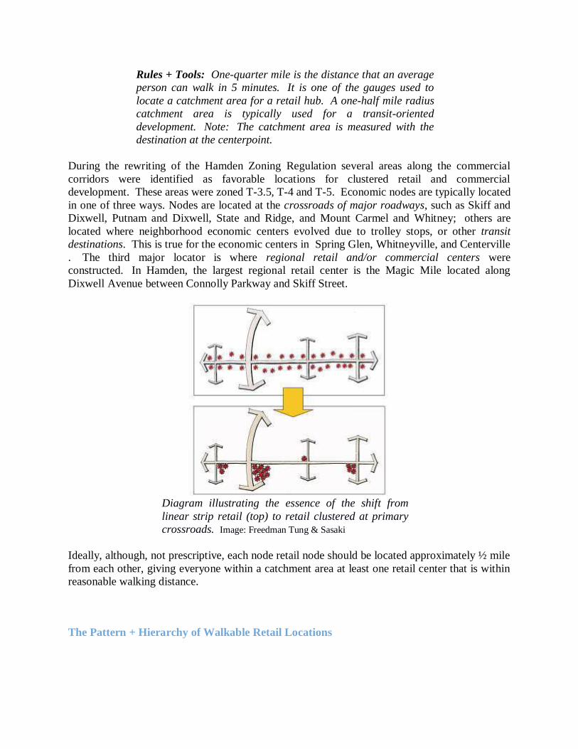
Rules + Tools: One-quarter mile is the distance that an average
person can walk in 5 minutes. It is one of the gauges used to
locate a catchment area for a retail hub. A one-half mile radius
catchment area is typically used for a transit-oriented
development. Note: The catchment area is measured with the
destination at the centerpoint.
During the rewriting of the Hamden Zoning Regulation several areas along the commercial
corridors were identified as favorable locations for clustered retail and commercial
development. These areas were zoned T-3.5, T-4 and T-5. Economic nodes are typically located
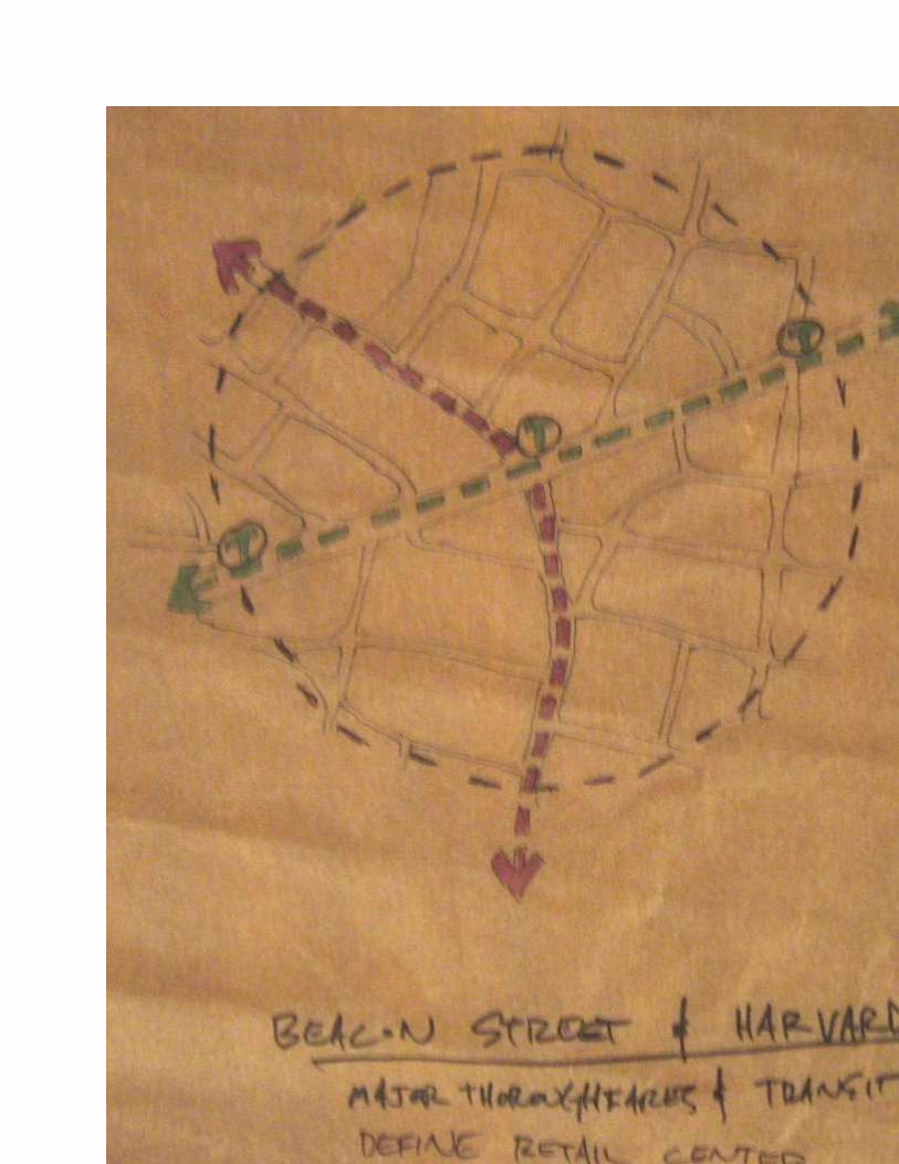
in one of three ways. Nodes are located at the crossroads of major roadways, such as Skiff and
Dixwell, Putnam and Dixwell, State and Ridge, and Mount Carmel and Whitney; others are
located where neighborhood economic centers evolved due to trolley stops, or other transit
destinations. This is true for the economic centers in Spring Glen, Whitneyville, and Centerville
. The third major locator is where regional retail and/or commercial centers were
constructed. In Hamden, the largest regional retail center is the Magic Mile located along
Dixwell Avenue between Connolly Parkway and Skiff Street.
Diagram illustrating the essence of the shift from
linear strip retail (top) to retail clustered at primary
crossroads. Image: Freedman Tung & Sasaki
Ideally, although, not prescriptive, each node retail node should be located approximately ½ mile
from each other, giving everyone within a catchment area at least one retail center that is within
reasonable walking distance.
The Pattern + Hierarchy of Walkable Retail Locations

With the exception of the corner store, each of the types of destinations identified below work
most efficiently, economically and generate the best revenue rates when they are stationed on
both sides of the same roadway.
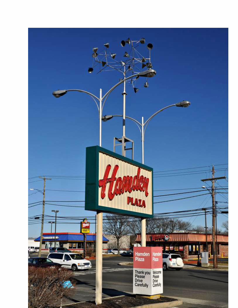
Regional Hub Catchment Area: A minimum of 150,000 households within 12 to 15 miles from the center;
Location: At an interstate highway interchange that provides a convenient junction
between the communities that it serves;
Features: Regional hubs are anchored by department stores and increasingly include
big-box and superstore retail, including major “category killer” stores.
Regional hubs provide comparison-shopping opportunities, especially for
clothing, and specialty goods such as furniture, home improvement, and
electronics. A wide assortment of restaurants is part of the standard mix,
as are movie theaters and other entertainment anchors.
Hamden Examples: Hamden Mart, Hamden Plaza, Parkway Plaza (Home Depot)
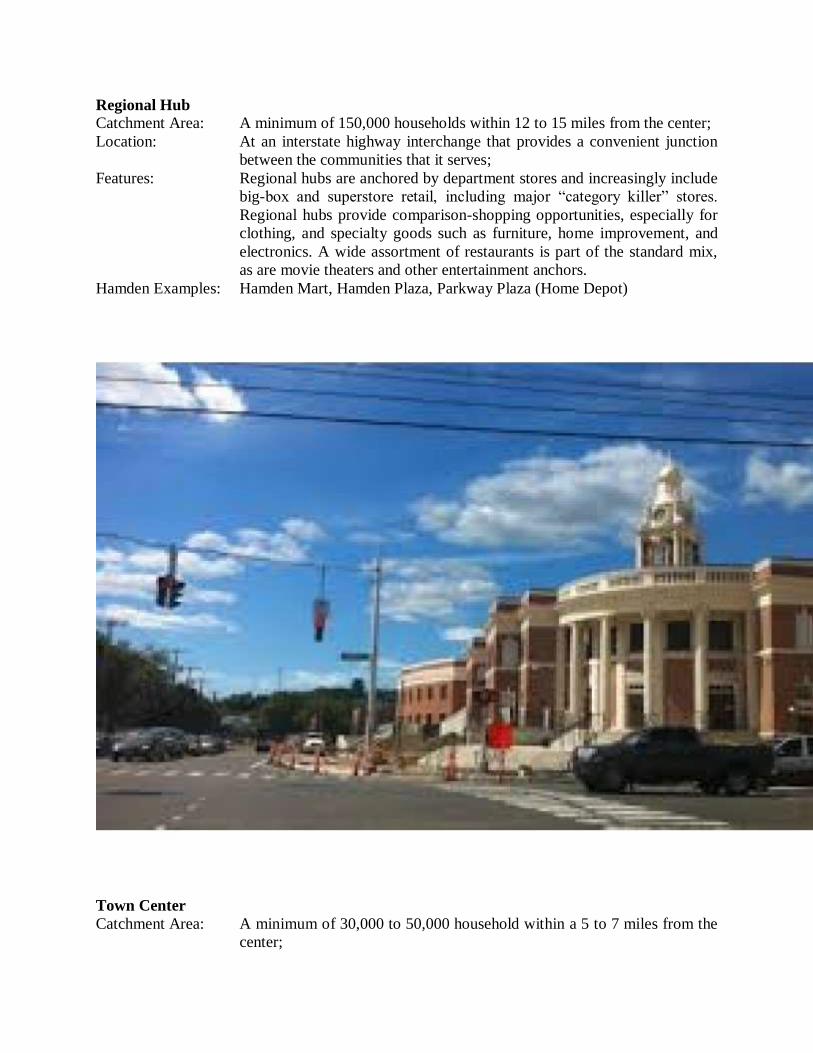
Town Center
Catchment Area: A minimum of 30,000 to 50,000 household within a 5 to 7 miles from the
center;

Location: Convenient to the homes in the catchment area;
Features: Town centers are ideal locations for supermarkets, banks, and pharmacies
but incorporate significantly fewer major anchors than regional centers.
Many of them are built around civic or cultural anchors, which also
distinguishes them from regional hubs. Mainstays include restaurants,
shops, and entertainment venues oriented to a walkable street. Shops can
offer a wide range of goods.
Hamden Examples: The intersection of Whitney/Dixwell, and between the new Hamden
Middle School to Miller Library.
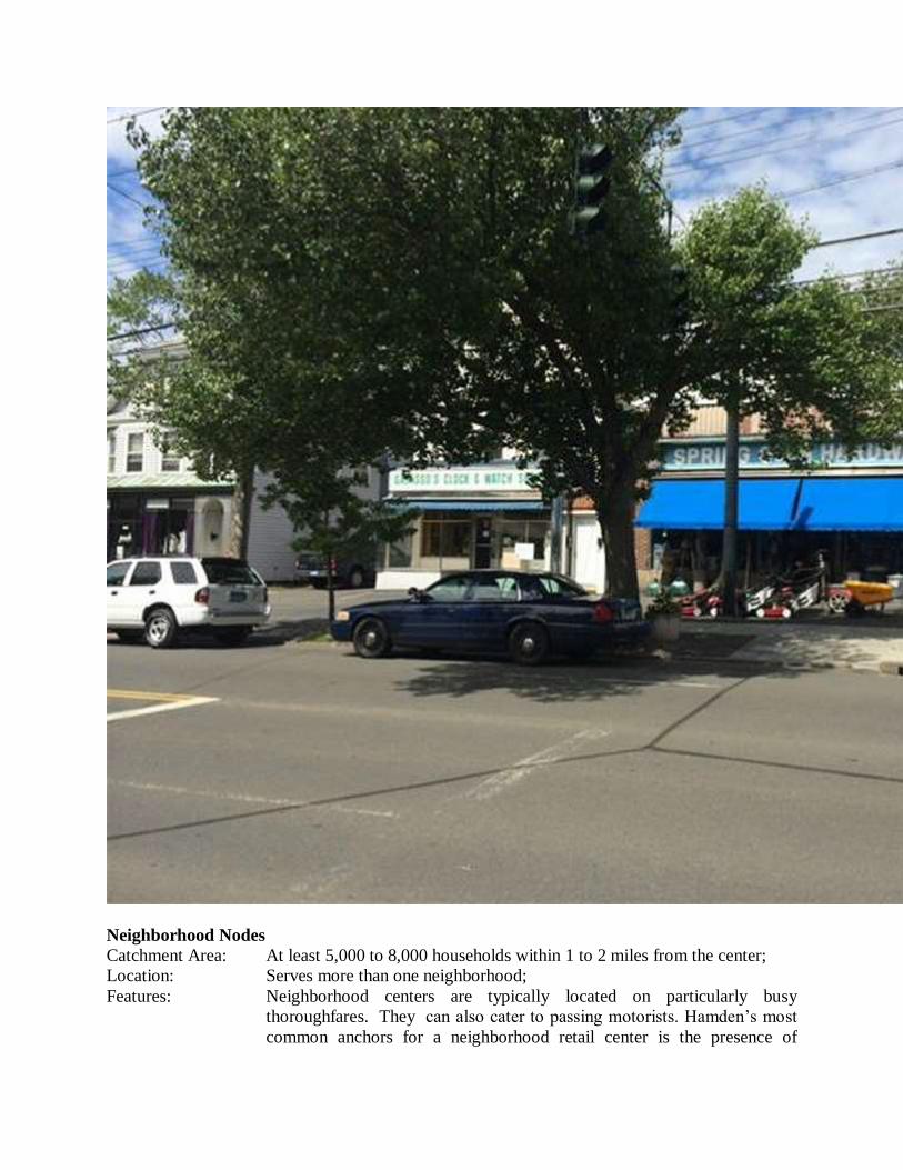
Neighborhood Nodes
Catchment Area: At least 5,000 to 8,000 households within 1 to 2 miles from the center;
Location: Serves more than one neighborhood;
Features: Neighborhood centers are typically located on particularly busy
thoroughfares. They can also cater to passing motorists. Hamden’s most
common anchors for a neighborhood retail center is the presence of

several restaurants. Larger neighborhood nodes that are served by a
significant amount of mass transit are anchored by a supermarket of up to
65,000 square feet at one end and a pharmacy at the opposite end, with
smaller shops and services in between.
Hamden Examples: Putnam Place, surrounding the Putnam/Whitney intersection, State/Ridge
intersection, along Whitney Avenue between Park and Haverford,
surrounding the Ives/Whitney intersection and Mount Carmel/Whitney
intersection.

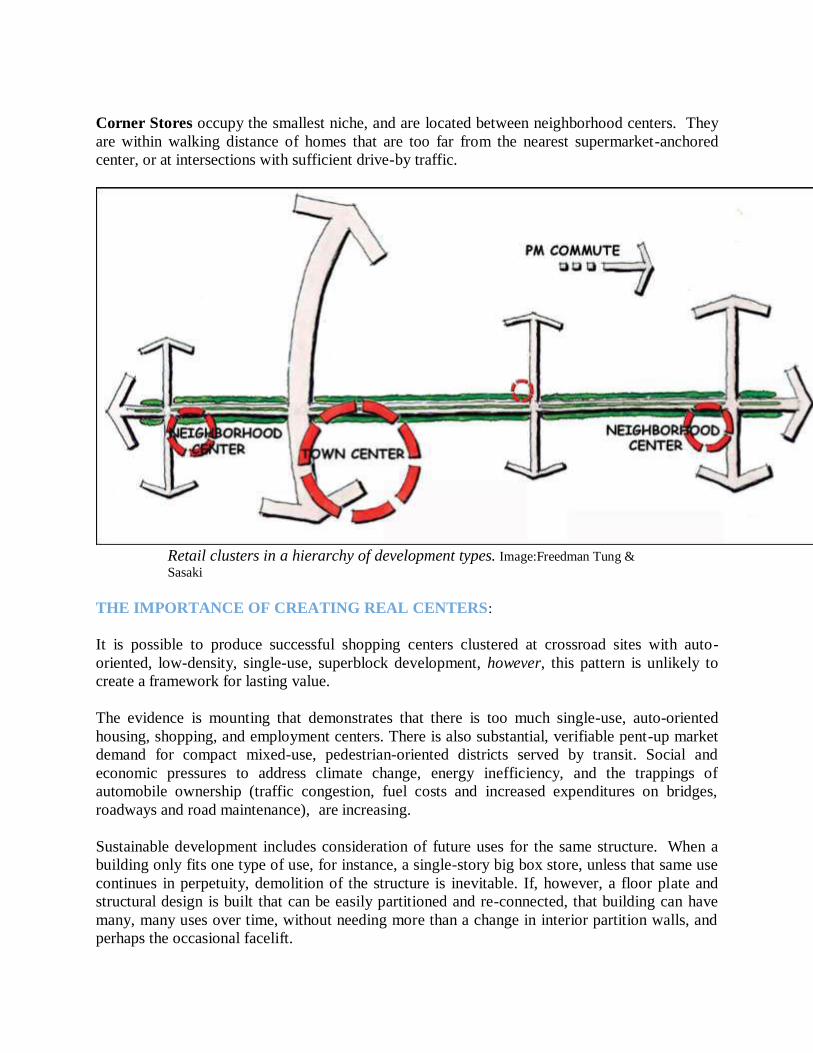
Corner Stores occupy the smallest niche, and are located between neighborhood centers. They
are within walking distance of homes that are too far from the nearest supermarket-anchored
center, or at intersections with sufficient drive-by traffic.
Retail clusters in a hierarchy of development types. Image:Freedman Tung &
Sasaki
THE IMPORTANCE OF CREATING REAL CENTERS:
It is possible to produce successful shopping centers clustered at crossroad sites with auto-
oriented, low-density, single-use, superblock development, however, this pattern is unlikely to
create a framework for lasting value.
The evidence is mounting that demonstrates that there is too much single-use, auto-oriented
housing, shopping, and employment centers. There is also substantial, verifiable pent-up market
demand for compact mixed-use, pedestrian-oriented districts served by transit. Social and
economic pressures to address climate change, energy inefficiency, and the trappings of
automobile ownership (traffic congestion, fuel costs and increased expenditures on bridges,
roadways and road maintenance), are increasing.
Sustainable development includes consideration of future uses for the same structure. When a
building only fits one type of use, for instance, a single-story big box store, unless that same use
continues in perpetuity, demolition of the structure is inevitable. If, however, a floor plate and
structural design is built that can be easily partitioned and re-connected, that building can have
many, many uses over time, without needing more than a change in interior partition walls, and
perhaps the occasional facelift.
Public policy geared toward economic efficiencies, social equity and environmental
sustainability promote the condensing of the space that is used to live, work, play and recreate, in
other words, a decrease in the human footprint, one region at a time. Pressure is mounting for
regional commitments to extend existing mass transportation services, such as the New Haven-
Springfield rail service, the CTfastrak bus route from Bristol, CT to Hartford, and additional rail
spurs off of MetroNorth.
Effective public transit relies on a pattern of centers with density, activity, and
mixed land uses at transit stops, along with safe, walkable streets connecting to
the surrounding ridership base.
Communities can only benefit from restructuring commercial corridors if developers and
property owners can benefit from how it is reconstructed. Priority must be placed on “assembling
the conditions that foster diversity, dynamic interaction, and activity.”
PROVIDING A DEVELOPMENT FORM THAT ENCOURAGES A HEALTHY MIX OF
USES:
The primary characteristics of sustainable regional and town centers are diversity, dynamic
interaction and activity. The more uses incorporated into a center designated for economic
growth, the more reasons for people to explore. Retail, food service , and entertainment are the
most activity-generating uses. They are the critical elements for an active street presence and
economic vitality. Retail, food service , and entertainment should be the principal elements of
at-grade uses in regional and town centers.
The greatest diversity of retail, residences and employment centers should be accommodated.
Plans to redevelop existing shopping centers strongly consider retaining older buildings with
architectural and structural integrity, if they exist. These buildings will offer more affordable
spaces for a variety of uses. The range of affordable locations within regional and town centers
allow businesses to “incubate and support the distinctive businesses, shops, and services that do
so much to distinguish a thriving urban district.”
Land use policy that governs the development and/or redevelopment of regional and town
centers should require greater lot coverage, smaller front- and side-yard setbacks, and greater
building height. Hamden’s T-4 and T-5 zones are designed to create easily distinguished
regional, town and neighborhood nodes.
It is difficult to design a space that will
not attract people. What is remarkable is
how often this has been accomplished. -- William H. Whyte
BUILDINGS AND THE SPACES BETWEEN THEM
How to cultivate safe and social street life:
Successful public spaces prioritize the following characteristics:
1. They are accessible and link to other public places, visually and physically; pedestrian
comfort and safety is paramount;
2. Orient buildings to activate streets;
3. People of all ages and abilities have constructive activities in which they can engage;
4. Spaces are comfortable and have a positive image;
5. There is a high parking turnover, and ideally, these spaces are near public transportation;
6. Provide a central focus;
7. Keep the pattern of blocks small, with aligned streets;
8. Create a park-one-and-walk experience; on-street and garage parking are recommended;
9. Locate civic buildings on one edge of regional and town centers;
10. They are conducive to social interaction.
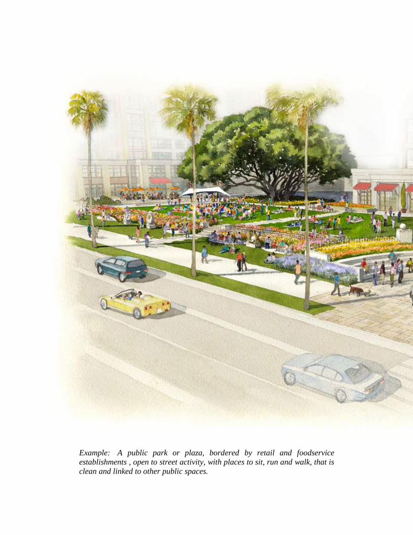
Example: A public park or plaza, bordered by retail and foodservice
establishments , open to street activity, with places to sit, run and walk, that is
clean and linked to other public spaces.
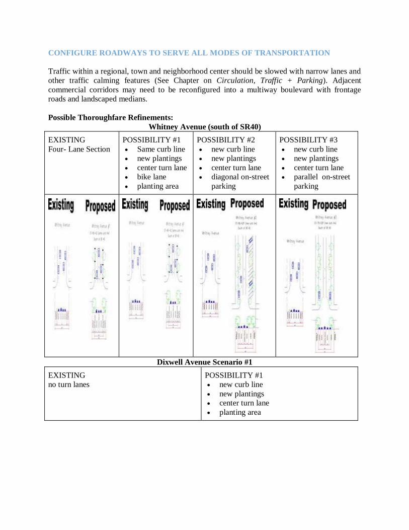
CONFIGURE ROADWAYS TO SERVE ALL MODES OF TRANSPORTATION
Traffic within a regional, town and neighborhood center should be slowed with narrow lanes and
other traffic calming features (See Chapter on Circulation, Traffic + Parking). Adjacent
commercial corridors may need to be reconfigured into a multiway boulevard with frontage
roads and landscaped medians.
Possible Thoroughfare Refinements:
Whitney Avenue (south of SR40)
EXISTING
Four- Lane Section
POSSIBILITY #1
Same curb line
new plantings
center turn lane
bike lane
planting area
POSSIBILITY #2
new curb line
new plantings
center turn lane
diagonal on-street
parking
POSSIBILITY #3
new curb line
new plantings
center turn lane
parallel on-street
parking
Dixwell Avenue Scenario #1
EXISTING
no turn lanes
POSSIBILITY #1
new curb line
new plantings
center turn lane
planting area
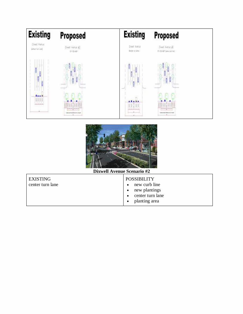
Dixwell Avenue Scenario #2
EXISTING
center turn lane
POSSIBILITY
new curb line
new plantings
center turn lane
planting area
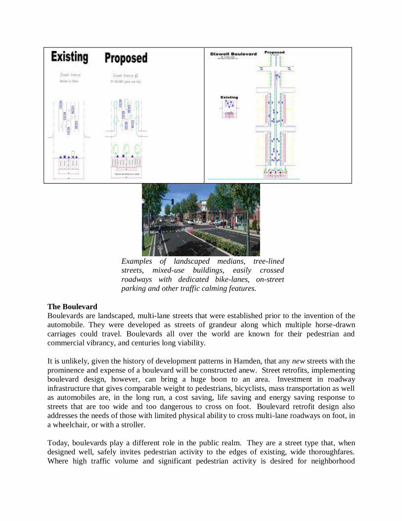
Examples of landscaped medians, tree-lined
streets, mixed-use buildings, easily crossed
roadways with dedicated bike-lanes, on-street
parking and other traffic calming features.
The Boulevard
Boulevards are landscaped, multi-lane streets that were established prior to the invention of the
automobile. They were developed as streets of grandeur along which multiple horse-drawn
carriages could travel. Boulevards all over the world are known for their pedestrian and
commercial vibrancy, and centuries long viability.
It is unlikely, given the history of development patterns in Hamden, that any new streets with the
prominence and expense of a boulevard will be constructed anew. Street retrofits, implementing
boulevard design, however, can bring a huge boon to an area. Investment in roadway
infrastructure that gives comparable weight to pedestrians, bicyclists, mass transportation as well
as automobiles are, in the long run, a cost saving, life saving and energy saving response to
streets that are too wide and too dangerous to cross on foot. Boulevard retrofit design also
addresses the needs of those with limited physical ability to cross multi-lane roadways on foot, in
a wheelchair, or with a stroller.
Today, boulevards play a different role in the public realm. They are a street type that, when
designed well, safely invites pedestrian activity to the edges of existing, wide thoroughfares.
Where high traffic volume and significant pedestrian activity is desired for neighborhood
cohesion, bustling commerce, and links between adjacent pedestrian and bicycle areas, boulevard
retrofits are often the answer. Boulevard retrofits typically contain the same number of
through-lanes down its center. These lanes operate as any arterial roadway, but the lanes are
divided by a tree-lined median that separates traffic going in opposite directions. Boulevards
incorporate on-street parking to maximize access to retail establishments, and to provide an
additional layer of safety for pedestrians traversing sidewalks.
Boulevards can also be designed with lanes that carry higher speed traffic down the center ofthe
roadway, with fewer turning lanes and traffic lights, and medians separating the higher speed
lanes from frontage roads that are used for slower, local traffic. The lanes closest to the
buildings, are separated from the higher-speed traffic lanes by landscaped medians, and feel like
completely different street environments. This configuration eliminates most of the friction
between through-traffic and slower, and local access behavior. They create a safer and more
pleasant pedestrian environment, and a more profitable and vibrant economic center.

Street medians can add a great deal to an area: when designed as a rain garden, they
help with the infiltration of stormwater and reduce flooding; trees add shade and
reduce the heat-island effect, they provide areas of refuge for pedestrians and
bicyclists when crossing a roadway, and they can result in narrower lane widths
which calm traffic.
Carbon policy is going to impact our
business, and we have to be prepared for
that. It can be a threat or an opportunity.
I'd rather make it an opportunity --- Robert C. Flexon,
Chief Executive of Houston-based Dynegy
You say you want pedestrian-friendly areas... “In order to have pedestrian-friendly neighborhoods, you need pedestrians, which means you
need housing in which those pedestrians live.” Safe sidewalks are also required. On-street
parking, sidewalks with trees, buildings with shops, ground-level entrances facing the street, all
help create safe, pedestrian-friendly areas. Streets with safe and attractive sidewalks make for
desirable addresses for restaurants, upper-story workplaces and residences. They also help boost
the local tax base.
Architecture and site design characteristics, appropriate circulation and access features are all
critical elements of boulevards. On-site parking should be accessed from rear alleys or side
streets, allowing for uninterrupted and more appealing front yards and sidewalks along the
boulevard frontage. This key access management strategy also provides a less conspicuous
location for service activities such as deliveries by truck and trash removal.
Exploration is the engine that drives
innovation. Innovation drives economic
growth. So let’s all go exploring. -- Edith Widder
Land Use Context The context of adjacent land uses should be considered when designing streetscapes. Designs
appropriate for low-density residential neighborhoods, such as the West Woods and the Dunbar
Hill area, should be treated differently than the area around Memorial Town Hall. Likewise,
industrial areas with large volumes of truck traffic may need wider traffic lanes and larger curb
radii. These are design elements that should be avoided in commercial and residential
areas. Appropriate speed moderating devices should be included in all street designs to help
ensure safety for all users.
1. Requires the accommodation the safety and convenience of all users on the roadway
system using a complete streets hierarchy of users, which begins with pedestrians,
bicyclist and transit users. These users shall be accommodated and balanced in all types
of transportation and development projects and through all phases of projects so that the
vulnerable – children, elderly, and persons with disabilities – can travel safely within the
public right of way;
2. Mandates the application of this policy, through adherence to principles of the Streets 2.0
Design Manual, to any new construction or improvements projects affecting public
streets and sidewalks (including resurfacing, restoring, and rehabilitation projects);
3. Prioritizes walkability, inter-modal transit, traffic calming and pedestrian-based urban
economic development over competing goals; and
4. References performance standards, with measurable benchmarks and outcomes.
At their best, streets:
Create space for social interaction and physical activity;
Provide a clean and attractive framework for economic development;
Embrace the vernacular of a place thereby defining a unique identity;
Provide for the safe and efficient movement of goods and people of all ages and abilities.
Context sensitive streets includes more than just attention to traffic. Elements that contribute to a
livable, sustainable and economically vibrant community include the:
Combination of land uses on both sides of a street;
Neighborhood density and the distribution of pedestrian, bicycle and vehicular use over
the course of day;
Neighborhood character and aesthetics including historic architecture, development
patterns, and parcels that have water or mountain views;
Existing transportation systems such as roadway classification, mass transit, on-street
parking availability and limited rights-of-way.
Context is also determined by social and demographic factors that influence who and how a
street is likely to be used. For example, residents without a car are likely to need a robust
pedestrian network that connects important destinations and allows for safe and efficient travel.
They also require easy access to mass transit and bicycle routes. According to census data,
____% of households in Hamden do not have access to an automobile. Elderly residents in
particular may be highly dependent upon pedestrian and mass transit routes. Pedestrians with
children, the elderly, and those with physical limitations require strategically located crosswalks,
longer crossing times and areas of refuge at mid-crossing points such as medians and traffic
islands.
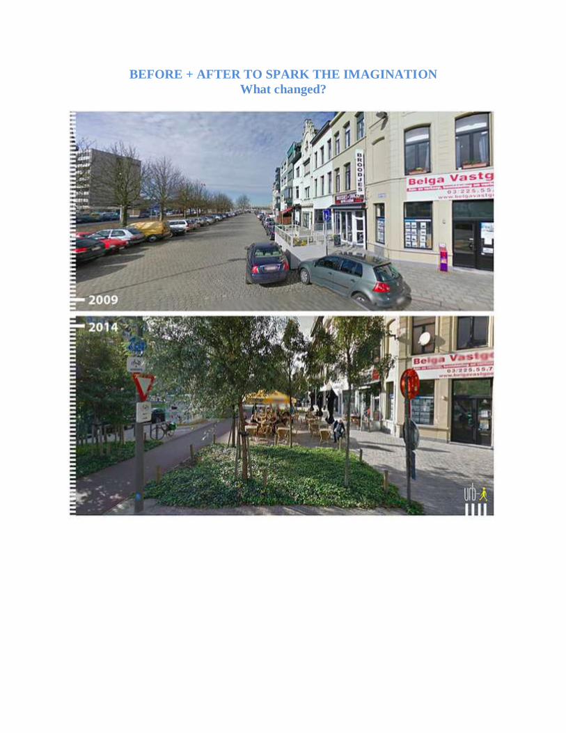
BEFORE + AFTER TO SPARK THE IMAGINATION
What changed?
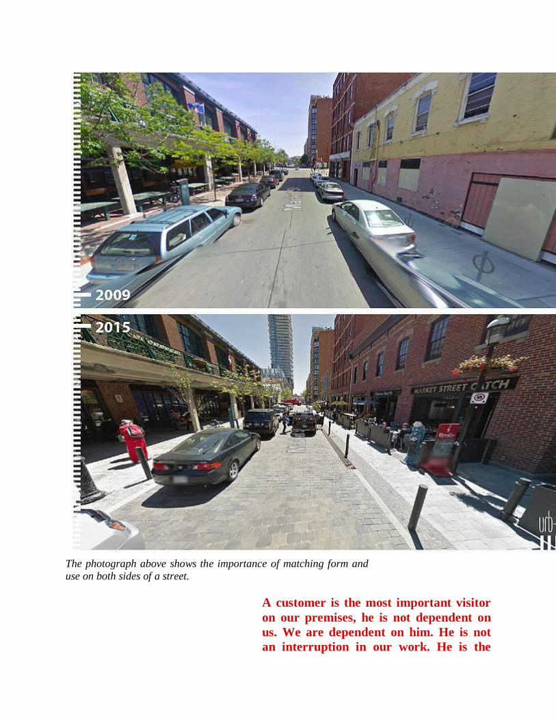
The photograph above shows the importance of matching form and
use on both sides of a street.
A customer is the most important visitor
on our premises, he is not dependent on
us. We are dependent on him. He is not
an interruption in our work. He is the
purpose of it. He is not an outsider in our
business. He is part of it. We are not
doing him a favor by serving him. He is
doing us a favor by giving us an
opportunity to do so. --- Mahatma Gandhi
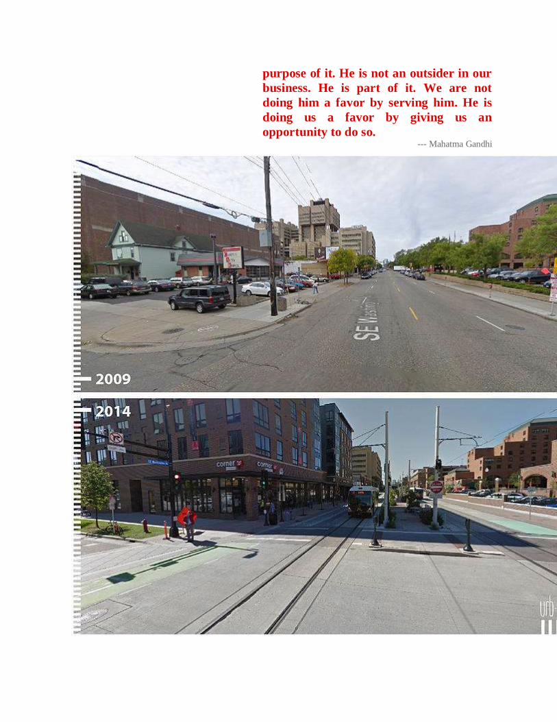
Although there are no plans for light rail in Hamden, the before and after photographs above
show the important role that buildings play in defining outdoor space. What was once a
parking lot that just left the public space at the corner drift away, is now an active, tax
producing and income generating property that defines the street edge.
By concentrating new development and
redevelopment in areas that have existing
or planned infrastructure, we can create
jobs, avoid sprawl, expand
transportation, and protect our
environment. --- Martin O’Malley
Governor of Maryland
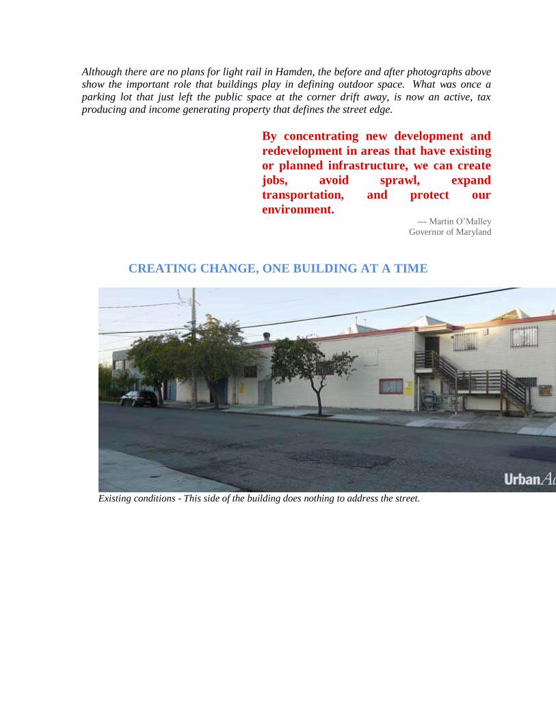
CREATING CHANGE, ONE BUILDING AT A TIME
Existing conditions - This side of the building does nothing to address the street.
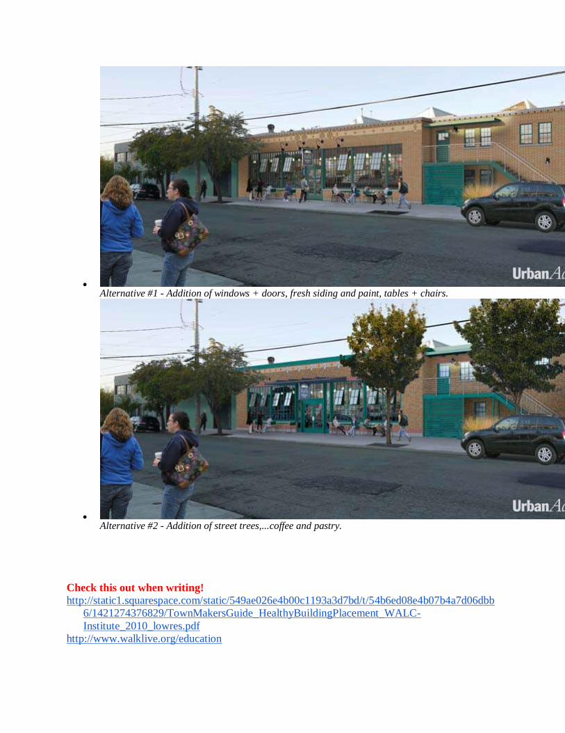
Alternative #1 - Addition of windows + doors, fresh siding and paint, tables + chairs.
Alternative #2 - Addition of street trees,...coffee and pastry.
Check this out when writing!
http://static1.squarespace.com/static/549ae026e4b00c1193a3d7bd/t/54b6ed08e4b07b4a7d06dbb
6/1421274376829/TownMakersGuide_HealthyBuildingPlacement_WALC-
Institute_2010_lowres.pdf
http://www.walklive.org/education
Coffee shop at library, bookstore, Netherlands Alzheimer's center, Eds + Meds,
It is the set of the sails, not the direction
of the wind that determines which way we
will go.
--- Jim Rohn
Genius is one percent inspiration, ninety-
nine percent perspiration.
--- Thomas Edison
If I’d asked my customers what they
wanted, they would have said ‘faster
horses’
--- Henry Ford
It turns out that advancing equal
opportunity and economic empowerment
is both morally right and good economics,
because discrimination, poverty and
ignorance restrict growth, while
investments in education, infrastructure
and scientific and technological research
increase it, creating more good jobs and
new wealth for all of us. --- William J. Clinton
If all the economists were laid end to end,
they would not reach a conclusion.
--- George Bernard Shaw
POLICIES,
BLUEPRINT FOR SUCCESS +
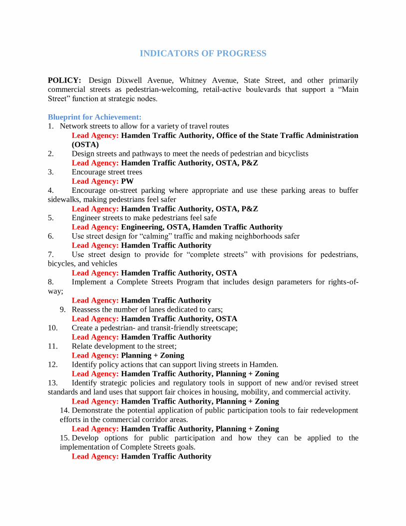
INDICATORS OF PROGRESS
POLICY: Design Dixwell Avenue, Whitney Avenue, State Street, and other primarily
commercial streets as pedestrian-welcoming, retail-active boulevards that support a “Main
Street” function at strategic nodes.
Blueprint for Achievement: 1. Network streets to allow for a variety of travel routes
Lead Agency: Hamden Traffic Authority, Office of the State Traffic Administration
(OSTA)
2. Design streets and pathways to meet the needs of pedestrian and bicyclists
Lead Agency: Hamden Traffic Authority, OSTA, P&Z
3. Encourage street trees
Lead Agency: PW
4. Encourage on-street parking where appropriate and use these parking areas to buffer
sidewalks, making pedestrians feel safer
Lead Agency: Hamden Traffic Authority, OSTA, P&Z 5. Engineer streets to make pedestrians feel safe
Lead Agency: Engineering, OSTA, Hamden Traffic Authority
6. Use street design for “calming” traffic and making neighborhoods safer
Lead Agency: Hamden Traffic Authority
7. Use street design to provide for “complete streets” with provisions for pedestrians,
bicycles, and vehicles
Lead Agency: Hamden Traffic Authority, OSTA 8. Implement a Complete Streets Program that includes design parameters for rights-of-
way;
Lead Agency: Hamden Traffic Authority
9. Reassess the number of lanes dedicated to cars;
Lead Agency: Hamden Traffic Authority, OSTA
10. Create a pedestrian- and transit-friendly streetscape;
Lead Agency: Hamden Traffic Authority
11. Relate development to the street;
Lead Agency: Planning + Zoning
12. Identify policy actions that can support living streets in Hamden.
Lead Agency: Hamden Traffic Authority, Planning + Zoning
13. Identify strategic policies and regulatory tools in support of new and/or revised street
standards and land uses that support fair choices in housing, mobility, and commercial activity.
Lead Agency: Hamden Traffic Authority, Planning + Zoning 14. Demonstrate the potential application of public participation tools to fair redevelopment
efforts in the commercial corridor areas.
Lead Agency: Hamden Traffic Authority, Planning + Zoning
15. Develop options for public participation and how they can be applied to the
implementation of Complete Streets goals.
Lead Agency: Hamden Traffic Authority
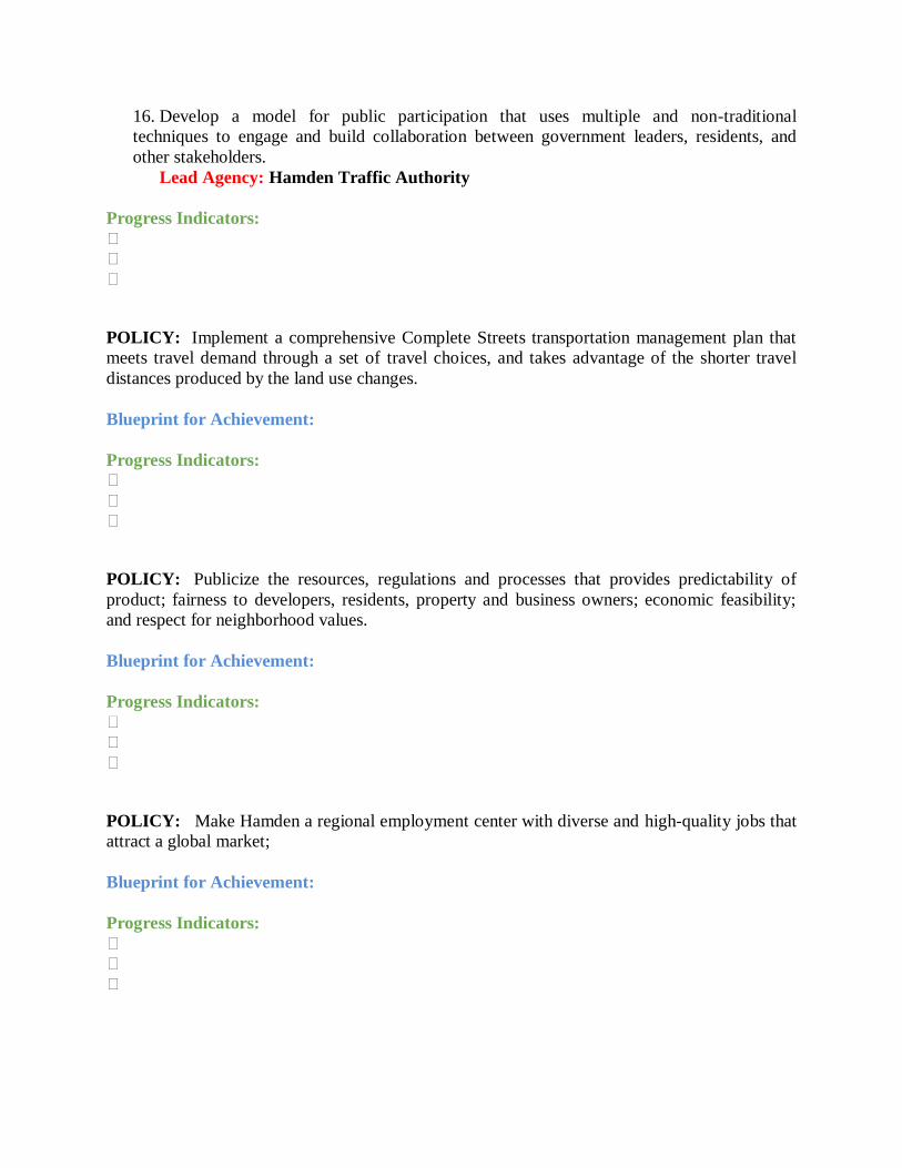
16. Develop a model for public participation that uses multiple and non-traditional
techniques to engage and build collaboration between government leaders, residents, and
other stakeholders.
Lead Agency: Hamden Traffic Authority
Progress Indicators:
⏭
⏭
⏭
POLICY: Implement a comprehensive Complete Streets transportation management plan that
meets travel demand through a set of travel choices, and takes advantage of the shorter travel
distances produced by the land use changes.
Blueprint for Achievement:
Progress Indicators: ⏭
⏭
⏭
POLICY: Publicize the resources, regulations and processes that provides predictability of
product; fairness to developers, residents, property and business owners; economic feasibility;
and respect for neighborhood values.
Blueprint for Achievement:
Progress Indicators:
⏭
⏭
⏭
POLICY: Make Hamden a regional employment center with diverse and high-quality jobs that
attract a global market;
Blueprint for Achievement:
Progress Indicators:
⏭
⏭
⏭
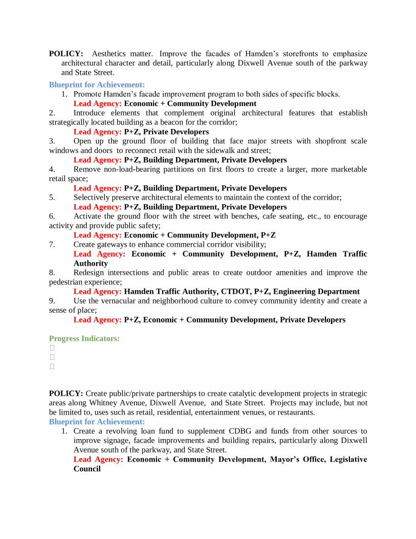
POLICY: Aesthetics matter. Improve the facades of Hamden’s storefronts to emphasize
architectural character and detail, particularly along Dixwell Avenue south of the parkway
and State Street. Blueprint for Achievement:
1. Promote Hamden’s facade improvement program to both sides of specific blocks.
Lead Agency: Economic + Community Development
2. Introduce elements that complement original architectural features that establish
strategically located building as a beacon for the corridor;
Lead Agency: P+Z, Private Developers 3. Open up the ground floor of building that face major streets with shopfront scale
windows and doors to reconnect retail with the sidewalk and street;
Lead Agency: P+Z, Building Department, Private Developers
4. Remove non-load-bearing partitions on first floors to create a larger, more marketable
retail space;
Lead Agency: P+Z, Building Department, Private Developers 5. Selectively preserve architectural elements to maintain the context of the corridor;
Lead Agency: P+Z, Building Department, Private Developers 6. Activate the ground floor with the street with benches, cafe seating, etc., to encourage
activity and provide public safety;
Lead Agency: Economic + Community Development, P+Z
7. Create gateways to enhance commercial corridor visibility;
Lead Agency: Economic + Community Development, P+Z, Hamden Traffic
Authority 8. Redesign intersections and public areas to create outdoor amenities and improve the
pedestrian experience;
Lead Agency: Hamden Traffic Authority, CTDOT, P+Z, Engineering Department
9. Use the vernacular and neighborhood culture to convey community identity and create a
sense of place;
Lead Agency: P+Z, Economic + Community Development, Private Developers
Progress Indicators: ⏭
⏭
⏭
POLICY: Create public/private partnerships to create catalytic development projects in strategic
areas along Whitney Avenue, Dixwell Avenue, and State Street. Projects may include, but not
be limited to, uses such as retail, residential, entertainment venues, or restaurants.
Blueprint for Achievement:
1. Create a revolving loan fund to supplement CDBG and funds from other sources to
improve signage, facade improvements and building repairs, particularly along Dixwell
Avenue south of the parkway, and State Street.
Lead Agency: Economic + Community Development, Mayor’s Office, Legislative
Council
2. Organize merchant associations block by block. Encourage local leadership development
and coordinated efforts to promote aesthetic improvements that include, plantings, street
furniture, trash and recycling receptacles.
Lead Agency: Economic + Community Development, Mayor’s Office, Chamber of
Commerce 4. Develop a funding mechanism to reimburse up to 50% of the cost of exterior
improvements to a specified maximum amount for a single commercial property, or, to a
higher percentage for a multiple-address or corner business property improvement
project.
Lead Agency: Economic + Community Development, Mayor’s Office, Legislative
Council
Progress Indicators: ⏭ Blocks develop a clear identity; tree lined on both sides of the street with other distinctive
interventions.
⏭ As signage becomes coordinated, the visual assault of advertising becomes an attractive
invitation. Positive social and cultural activity begins to occupy public space.
POLICY: Streetscapes, corridor beautification, and corridor cleaning are critical to
maintaining, and promoting positive economic development. All interventions of this type
must be implemented on both sides of a street to maximize effectiveness.
Blueprint for Achievement:
1. Hamden’s major commercial corridors are State Highways. The single most effective
public investment in positive economic development is to add medians to portions of
Dixwell Avenue and State Street to create boulevards. This public investment, done
correctly, would help manage stormwater runoff, generate positive economic
development, result in greater traffic and pedestrian safety. Lead Agency: Economic + Community Development, Mayor’s Office, Hamden
Neighborhood Associations, and Hamdens’ Citizens
2. Hamden’s State Legislative Delegation should be charged by the Town’s citizens and
administration to provide funding to undertake design and construction of streetscape
improvements for neighborhood commercial corridors along the three state highways that run
through town. Projects should include enhancements such as new curbs and sidewalk, lighting
upgrades, street trees and landscaping, and street furniture including solar trash compactors,
benches, and bike racks. Lead Agency: Hamden’s State Legislators, Hamdens’ Neighborhood Associations
and Hamden Citizens
3. Protect, enhance and create economically competitive areas along Hamden’s major
commercial corridors. Establish, or re-establish, Neighborhood Improvement Districts
(NIDs). An NID can levy an assessment on property and/or business owners to fund
projects within the boundaries of the NID. NIDs can also receive other funding through
public and private grants, as well as private donation. These districts often provide
services above and beyond those of the government such as cleaning streets, providing
security, implementing streetscape improvements and marketing the area.
Lead Agency: Economic + Community Development, Chamber of Commerce,
Hamdens’ Neighborhood Associations, and Hamdens’ Citizens
Progress Indicators: ⏭ An influx of new businesses generate an area with a name or brand.
POLICY: Vibrant commercial corridors contribute to strong neighborhoods. They provide a
place to work, shop and socialize.
Blueprint for Achievement: 1. Strong corridors require management to provide assistance to businesses, bring planning
and resources to the corridor, block by block, and oversee activities to make, and keep
Hamden’s corridors clean and safe, and attractive to new businesses. Hamden should
consider adding a Corridor Coordinator position to the Department of Economic +
Community Development.
Lead Agency: Mayor’s Office, Legislative Council, Economic + Community
Development
Progress Indicators: ⏭ Positive social and cultural events occur along Hamden’s commercial corridors;
⏭ Merchant’s Associations for block-by-block and street improvements occur organically;
⏭ Property and business owners along Hamden’s commercial corridors organize to influence
State investment in economic opportunity areas.
POLICY: Hamden has strategically important commercial nodes that, if fully developed, can
result in tremendous benefits to the quality of life for residents, business owners, and the Town’s
tax base. Development at this scale requires physical planning, an implementation strategy and
financing framework.
Blueprint for Achievement: 1. Hamden should add a professional position to the Department of Economic +
Community Development. This position should be responsible for creating and
managing a consortium that includes expert advisors and funders to facilitate positive
economic growth and development in specific areas of town that would benefit from such
professional and economic investment.
Progress Indicators: ⏭ Large scale investment along Hamden’s commercial corridors brings positive growth to the
Town’s social, cultural and tax base.
POLICY: Support a business-friendly environment that attracts and retains businesses;
Blueprint for Achievement:
Progress Indicators: ⏭
POLICY: Support growth and provide opportunities to residents of all social and economic
levels.
Blueprint for Achievement:
Progress Indicators:
⏭
POLICY: Invest in the talents, skills and education of Hamden’s citizens. Build an educational
system that encourages businesses to start here, grow here and stay here;
Blueprint for Achievement:
Progress Indicators:
⏭
POLICY: Integrate Commercial Corridors and economic nodes to encourage future
development and economic activity.
Blueprint for Achievement:
Progress Indicators:
⏭
POLICY: Design thoughtful, context sensitive, pedestrian oriented, mixed-use development in
the areas zoned as T-5 and on Whitney Avenue near Quinnipiac University. Transform these
areas into dynamic transit-oriented districts that will serve as economic engines and compliment
neighborhood economic nodes.
Blueprint for Achievement:
Progress Indicators:
⏭
POLICY: Preserve housing options for existing Hamden residents. Economic revitalization
should result in neighborhood revitalization for current property owners as well as new investors;
Blueprint for Achievement:
Progress Indicators:
⏭
POLICY: Retrofit existing buildings to contribute to a safe, walkable and vibrant public
realm.
Blueprint for Achievement:
1. Secure the commercial land use development in the center of Hamden. Protect the retail
viability of the center of town, the Magic Mile, Southern Dixwell Avenue and Southern
Whitney Avenue by encouraging these areas to be developed to their fullest potential.
Lead Agency:
2. Investigate opportunities to develop alliances between University research programs and
economic development opportunities within Hamden. Encourage connections between QU and
the new business incubator located on Morse Street;
Lead Agency: Area colleges + universities, Hamden Economic Development,
Hamden Economic Development Corporation, Hamden Regional Chamber of
Commerce, Hamden Real Estate community
3. Link industry and research to leverage the attraction of new business to Hamden.
Lead Agency: Area colleges + universities, Hamden Economic Development,
Hamden Economic Development Corporation, Hamden Regional Chamber of
Commerce, Hamden Real Estate community
Progress Indicators:
⏭
POLICY: Make Hamden a regional employment center with diverse and high-quality jobs that
attract a global market.
Blueprint for Achievement:
1. Upgrade cell and internet services, particularly along the commercial corridors.
2. Develop strategies for cross-pollination of ideas by creating spaces where people in various
fields of work can meet easily.
3. Establish venues and create events that spur innovation for teenagers, such as science fairs
and engineering competitions, poetry slams, theater workshops, etc.
4. Use Town and other civic events to highlight new business ideas.
Progress Indicators:
⏭
POLICY: Support a business-friendly environment that attracts and retains a mix of businesses
that can start here, grow here and stay here.
Blueprint for Achievement:
1. Study the New Haven Region’s strengths and weaknesses regarding skills available and skills
required.
a. Conduct a skills analysis of the New Haven Region;
b. Develop an inventory of legal “underground” businesses and services and work with
owners to get proper permitting and space for these businesses and services;
c. Use Town and other civic events to highlight new business ideas.
Progress Indicators:
⏭
POLICY: Subdivision and other land use regulations should be reviewed and revised as
necessary. (not really a policy - relocate)
Blueprint for Achievement:
Progress Indicators: ⏭
Marketing Hamden 1. Build a strong brand:
a. Who is affected;
b. What is so great about Hamden;
c. Where is Hamden and what is it near;
d. When should people explore Hamden;
e. How can we get to Hamden? Car, bike, train, plane, bus …;
f. Why should people come to Hamden.
2. Sell the Town’s values: Hamden is a great place to live, work and raise a family;
3. Get started early;
4. Establish a “Welcome Wagon” that includes local and regional information;
5. Systematise information:
. Create outdoor informational signage that responds to the way pedestrians and bicyclists
think and doesn’t add to visual pollution:
i. Develop a map system that shows street with important buildings coded;
ii. Add a ¼ mile radius to denote easy walkability;
iii. Show one-way streets, bike lanes, and bus stops;
iv. Show bus schedules, fares and ticketing information;
v. Show standardized station/bus stop markers;
vi. Install information kiosks at strategic locations;
vii. Create and advertise apps/signage that show real-time arrival information.
b. Create uniform banners for various Town sponsored events such as parades, farmers
markets, movie nights, etc.;
c. Reformat Town website;
d. Create and coordinate Arts + Culture events calendar, local businesses map by type and
location, etc.
6. Create easy to use feedback loops to find out:
a. Who is taking mass transit, and who isn’t, and why not;
b. Who is shopping locally, and who isn’t, and why not;
c. Learn what residents, business owners and other property owners want, what they don’t
want, and why.
7. Control the narrative;
8. Be responsive to citizen input;
Offer new ways to access information, such as apps, websites.