Arctic, Antarctic, and Alpine Research, Vol. 38, No. 2, 2006, pp. 153–162
A Revised and Extended Holocene Glacial History of Icy Bay,Southern Alaska, U.S.A.
David J. Barclay*§
Julie L. Barclay*
Parker E. Calkin� and
Gregory C. Wiles�*Geology Department, SUNY Cortland,
Cortland, NY 13045, U.S.A.
�INSTAAR, University of Colorado,
Boulder, CO 80309, U.S.A.
�Department of Geology, The College
of Wooster, Wooster, OH 44691, U.S.A.
Abstract
Tidewater glaciers have coalesced to advance through Icy Bay, Alaska, three times during
the past 3800 yr. Radiocarbon ages show that the first of these expansions was underway
by 3750 cal yr B.P. and culminated at the outer coast between 3505 and 3245 cal yr B.P.
Subsequent recession and readvance brought the ice margin back to the outer coast by
1525 cal yr B.P. (cal A.D. 425) where it remained for about 650 yr before retreating. Tree-
ring cross-dates of glacially killed trees show that the most recent ice advance was
underway through the inner bay by the A.D. 1640s and reached into the outer bay in the
1810s. Historical data support ice expansion through the outer bay in the early 19th century
and show a late 19th century maximum prior to 20th century retreat. These results are
a significant revision and extension of previous studies of the Holocene glacial history of
Icy Bay. Average advance rates for the most recent expansion were typical of modern
tidewater glaciers in the inner bay but much faster in the outer bay; shallow water here may
have been important to this latter phase of unusually rapid advance.
Introduction
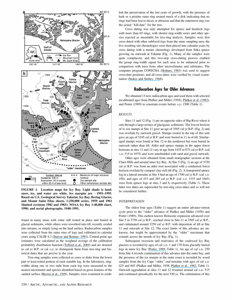
Icy Bay and its tributary fiords were revealed by over 40 km of
tidewater glacier retreat during the 20th century (Fig. 1). Subfossil
remnants of shoreline forests abound in the deglaciated areas, and ra-
diocarbon ages of these materials show that the glaciers of this system
have coalesced to make two major expansions through Icy Bay during
the past 2000 yr (Plafker and Miller, 1958; Porter, 1989). However, the
exact timing of the more recent of these advances is unresolved due
largely to differing interpretations of historical data. Maddren (1914),
Tarr and Martin (1914), and Taliaferro (1932) suggest that ice ad-
vanced through Icy Bay after 1794 when the explorer George
Vancouver visited Icy Bay. In contrast, the more generally held inter-
pretation is that of Russell (1893), Davidson (1904), Plafker and Miller
(1958), Miller (1964), Alpha (1975), Molnia (1977), and Porter (1989),
who suggest that ice had already reached the outer coast by 1794 and
that the ‘‘Icy Bay’’ seen by Vancouver was actually a small interlobate
bay in the area of the modern Yahtse River delta (Fig. 1).
Resolving this chronologic question is important to studies of fiord
sedimentation rates and landscape evolution in the Icy Bay area (Molnia,
1977, 1985; Jaeger and Nittrouer, 1999; Meigs and Sauber, 2000). It is
also important to regional studies of vegetational (Heusser, 1995), gla-
cial (Calkin et al., 2001), and cultural (de Laguna, 1958) history. There
are also glacial dynamic implications; calculations by Porter (1989)
suggest that past advances of the Icy Bay glacier were unusually rapid
relative to expansions of other Alaskan iceberg-calving glaciers, and this
significant result depends directly on a well-constrained glacial history.
In this paper we address the timing of the most recent ice advance
using high precision tree-ring cross-dates of glacially killed trees. We
also re-examine the historical data and consider historical sources that
have not previously been applied to this question. In addition, we use
new radiocarbon ages to extend the Holocene glacial history of Icy Bay
back to 3800 yr ago.
Setting
Icy Bay comprises a shallow outer bay and a deeper inner bay (Fig.
1). Low relief forelands adjacent to the outer bay are composed of late
Quaternary coastal, glaciofluvial, and glacial deposits, with the latter
being divided into ‘‘older’’ and ‘‘younger’’ moraine systems (Plafker
and Miller, 1958; Plafker et al., 1982). Coastal mountains formed of
uplifted late Neogene glaciomarine strata rim the inner bay (Eyles et al.,
1991), while Cretaceous metamorphic and igneous intrusive rocks form
the high peaks of the Saint Elias Mountains (Plafker et al., 1994). Peaks
in the coastal ranges reach altitudes of 1000 to 2000 m, while Mount
Saint Elias, just 20 km from tidewater, reaches 5489 m.
Four fiords radiate from inner Icy Bay and each has a major tide-
water glacier at its head (Fig. 1). Guyot is the trunk glacier of the Icy
Bay system and shares neves with Yahtse and Tsaa glaciers between
the coastal ranges and the Saint Elias Mountains for a combined area
of 1624 km2 (Viens, 1994). Tyndall Glacier in Taan Fiord is an
independent system covering 154 km2 on the southern slopes of Mount
Saint Elias. The piedmont lobe of Malaspina Glacier is situated im-
mediately east of the study area and currently supplies meltwater and
glaciofluvial sediment to Icy Bay via the Caetani River.
The study area has a maritime climate with Yakutat (Fig. 1)
recording mean temperatures of�3.48C in January, 12.08C in July, and
a mean annual precipitation of 407 cm for the period 1971 to 2000
(National Climatic Data Center normals). Glaciers in this region are
very active with high annual mass turnovers; firn lines vary from 520
to 980 m on the Yahtse-Guyot-Tsaa system and from 730 to 1100 m on
Tyndall Glacier (Viens, 1994).
Dominant tree species around outer Icy Bay are western hem-
lock [Tsuga heterophyllia (Raf.) Sarg.], mountain hemlock [Tsuga
mertensiana (Bong.) Carr.], and Sitka spruce [Picea sitchensis (Bong.)
Carr.]. Sitka spruce is also found around inner Icy Bay together with
black cottonwood (Populus trichocarpa Torr. and Gray) and Sitka
alder [Alnus sinuata (Reg.) Rydb.], and the latter alone forms dense
thickets along the shores of the tributary fiords. This distribution of
arboreal taxa is a seral sequence, with faster colonizers found in areas
that have been deglaciated more recently (Heusser, 1995).
Methods
Landforms and surficial stratigraphy around the shores of Icy Bay
were mapped in the summers of 1995 and 1996. Subfossil logs were
� 2006 Regents of the University of Colorado D. J. BARCLAY ET AL. / 1531523-0430/06 $7.00
found in many areas with some still rooted in place and buried in
glacial sediments, while others were reworked into till, recently eroded
into streams, or simply lying on the land surface. Radiocarbon samples
were collected from the outer rims of logs and calibrated to calendar
years using CALIB 4.3 (Stuiver and Reimer, 1993). Central-point age
estimates were calculated as the weighted average of the calibration
probability distribution function (Telford et al., 2004) and are denoted
as cal yr B.P. or cal A.D. to distinguish them from tree-ring and his-
torical dates that are precise to the year.
Tree-ring samples were collected as cores or disks from the lower
part or least-rotted portion of each suitable log. In the laboratory, ring-
widths along one or two radii from each log were measured to the
nearest micrometer and species identified based on gross features of the
sanded surface (Brown et al., 1949). Samples were examined to estab-
lish the preservation of the last years of growth, with the presence of
bark or a pristine outer ring around much of a disk indicating that no
rings had been lost to decay or abrasion and that the outermost ring was
the actual ‘‘kill-date’’ for the tree.
Cross dating was only attempted for spruce and hemlock logs
with more than 65 rings, with shorter ring-width series and other spe-
cies rejected as unsuitable for tree-ring analysis. Samples were first
cross-dated with other subfossil logs from the same sampling area; the
five resulting site chronologies were then placed into calendar years by
cross dating with a master chronology developed from Sitka spruce
growing on outwash at Yakutat (Fig. 1). Many of the samples were
quite complacent, and this two-step cross-dating process enabled
the group ring-width signal for each area to be enhanced prior to
comparison with trees from other microclimates and substrates. The
computer program COFECHA (Holmes, 1983) was used to suggest
cross-date positions, and all cross-dates were verified by visual exami-
nation (Stokes and Smiley, 1968).
Radiocarbon Ages for Older Advances
We obtained 13 new radiocarbon ages and used them with selected
recalibrated ages from Plafker and Miller (1958), Plafker et al. (1982),
and Porter (1989) to constrain events before A.D. 1500 (Table 1).
RESULTS
Sites 11 and 12 (Fig. 1) are on opposite sides of Big River where it
cuts through a large terrace of glacigenic sediments. The lowest horizon
of in situ stumps at Site 11 gave an age of 3505 cal yr B.P. (Fig. 2) and
was overlain by outwash gravel. Stumps rooted in the top of this unit
gave an age of 3245 cal yr B.P. and were buried in 11 m of till. Similar-
aged stumps were found at Site 12 to the northwest but were buried in
outwash rather than till. Alder and spruce stumps in the upper forest
horizons at sites 11 and 12 vary in age from 1435 to 875 cal yr B.P. (cal
A.D. 515 to 1075) and were interbedded with sand and gravel outwash.
Other ages were obtained from small stratigraphic sections at the
Chaix Hills and around inner Icy Bay. At Site 5 (Fig. 1) an age of 3750
cal yr B.P. was from an alder root associated with a condensed forest
horizon overlain by compact clay-rich till (Fig. 2). A transported spruce
log in a lateral moraine at Site 4 had an age of 1700 cal yr B.P. (cal A.D.
250), and ages of 415 and 285 cal yr B.P. (cal A.D. 1535 and 1665)
were from spruce logs at sites 3 and 6, respectively (Table 1). These
latter two dates are superseded by tree-ring cross-dates and so will not
be considered further.
INTERPRETATION
The oldest four ages (Table 1) suggest an entire advance-retreat
cycle prior to the ‘‘older’’ advance of Plafker and Miller (1958) and
Porter (1989). This earliest known Holocene expansion advanced over
Site 5 in 3750 cal yr B.P., reached close to Site 11 at 3505 cal yr B.P.,
and culminated around 3250 cal yr B.P. with deposition of till at Site
11 and outwash at Site 12. The exact limits of this advance are un-
known, but might be approximated by the ‘‘older’’ maximum that
extends across the mouth of Icy Bay (Fig. 1).
Subsequent recession and readvance of the coalesced Icy Bay
glaciers is recorded by ages of cal A.D. 1 and 170 from glacially buried
logs in inner Icy Bay (Porter, 1989; Table 1). An age of cal A.D. 250
from Site 4 records continuation of this advance into the outer bay, and
the presence of the ice margin at the outer coast is recorded by wood
samples from the Icy Cape ‘‘older’’ end moraine with ages of cal A.D.
425 and 845 (Plafker and Miller, 1958; Plafker et al., 1982; Table 1).
Outwash aggradation at sites 11 and 12 resumed around cal A.D. 515
and continued episodically for the next 550 yr. The culmination of this
FIGURE 1. Location maps for Icy Bay. Light shade is land;snow, ice, and water are white. Ice margins are ;1991–1995.Based on U.S. Geological Survey Yakutat, Icy Bay, Bering Glacier,and Mount Saint Elias sheets, 1:250,000 series, 1959 and 1961(limited revisions 1982 and 1983); NOAA Icy Bay 1:40,000 chart,1990; and aerial photographs, 1948–1991.
154 / ARCTIC, ANTARCTIC, AND ALPINE RESEARCH
second known Holocene expansion is marked by the moraine and
related outwash of the ‘‘older’’ maximum at both Icy Cape and Point
Riou (Fig. 1).
An alternate source of sediment to sites 11 and 12 is Beare
Glacier, a small valley glacier nearby that was at an advanced position
in about cal A.D. 600 and again in the A.D. 1640s (G. Wiles and D.
Frank, unpublished data). However, we attribute most of the deposition
at sites 11 and 12 to the coalesced Icy Bay glaciers based on the size
and lateral continuity of this deposit and the similar timing of much of
the outwash aggradation here with construction of the nearby ‘‘older’’
end moraine.
The penultimate retreat of ice into the tributary fiords is recorded
by ages of cal A.D. 1075, 1155, and 1175 from wood and organic layers
in inner Icy Bay (Table 1; Porter, 1989). The two standard deviation
radiocarbon age range of these samples overlaps with the age range of
the later outwash aggradation events at Site 11; this suggests that ice
recession was very rapid, allowing these radiocarbon ages to appear
almost coeval.
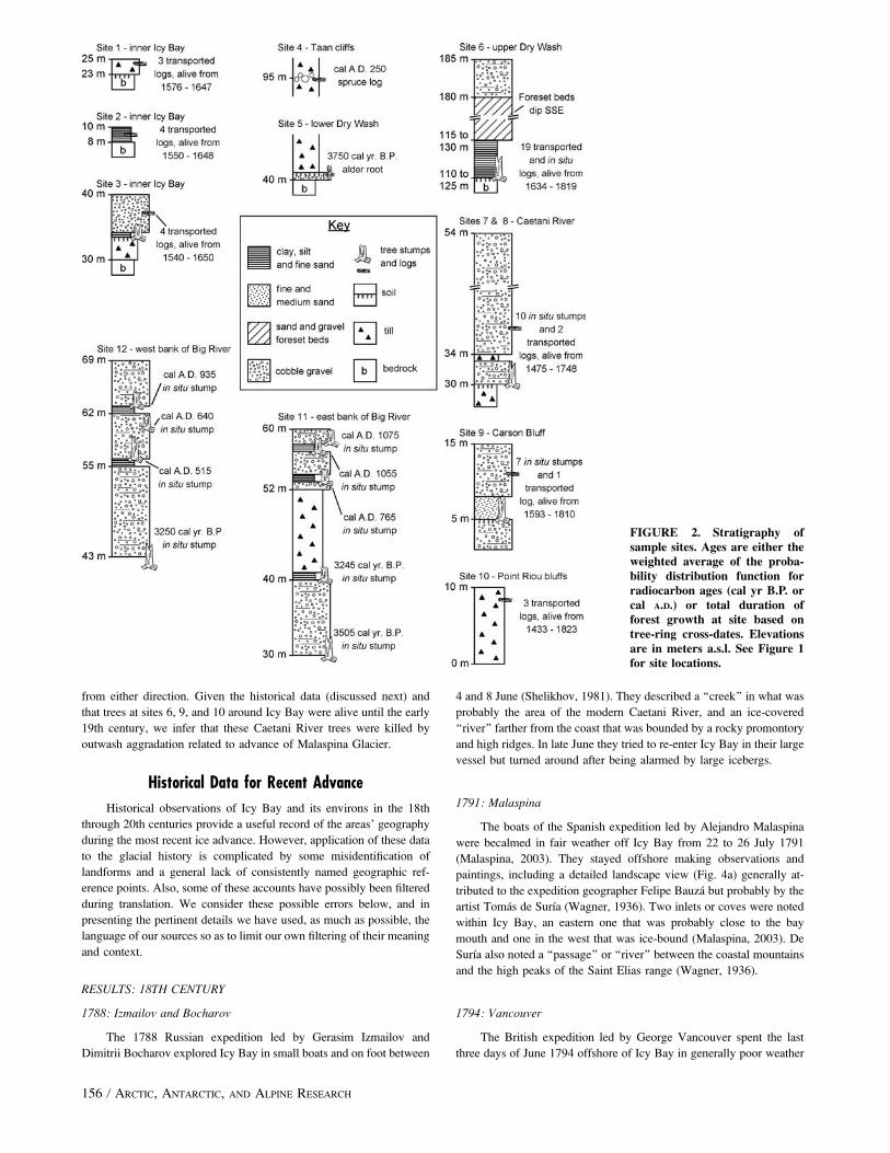
Tree-Ring Cross-Dates for Recent Advance
Tree-ring chronologies were developed for five distinct sampling
areas (Fig. 3, Table 2), and these were then fixed in time by cross dating
with the Yakutat master tree-ring-width chronology. The Caetani and
Riou chronologies both contain a mix of spruce and hemlock samples;
the successful cross dating of these taxa reflects their similar den-
droclimatic response in the northern Gulf of Alaska region (Wiles et al.,
1998). The other four chronologies are composed of just Sitka spruce.
All cross-dates, both within and between site chronologies, are sig-
nificant at or above the 99% confidence level (Table 2). A total of 53
subfossil logs were cross-dated and we consider next the implications of
their individual kill-dates (Table 3) to the glacial history of Icy Bay.
RESULTS
The earliest tree-ring dates for ice advance are from the
southwestern shore of inner Icy Bay. At Site 1 (Fig. 1), three spruce
logs were found in a thin till unit overlying a soil horizon (Fig. 2); the
outer rings of all three were intact and cross-dates show that they died
in A.D. 1647 (Table 3). Four spruce logs from a narrow gully at Site 2
were less well preserved but record growth until at least 1648. And
a kill-date of 1650 was obtained from the two best-preserved logs at
Site 3, this being a deposit of till and ice-marginal gravel overlying
a soil horizon, plus the adjacent surface of a modern fan delta.
Trees in growth position were found along the Caetani River at
sites 7 and 8. These stumps were encased in outwash and truncated at
the base of an overlying till unit (Fig. 2). Cross-dates of the best-
preserved samples indicate tree deaths clustered into 1705 and the
1740s (Table 3).
Over 100 subfossil logs and stumps were found between 110 and
125 m a.s.l. in a southwest-draining valley at Site 6 (Figs. 1 and 2).
They were buried in lacustrine and deltaic sediments, and the kill-dates
of well-preserved samples range from 1811 to 1819. In outer Icy Bay,
eight trees encased in outwash at Site 9 were killed in about 1810, and
three logs in till at Site 10 record growth until at least 1823 (Table 3).
INTERPRETATION
The kill-dates of trees along the southwest shore of inner Icy Bay
(sites 1 to 3) suggests advance of a coalesced Yahtse-Guyot-Tsaa ice
margin in the A.D. 1640s. This would have made an oblique con-
vergence with the shoreline in this area and so would account for the
rapid southeastward succession of kill-dates. Although most of these
samples were from displaced logs rather than in situ stumps, the rugged
topography of the side valleys here would have limited glacial
transport of these trees from their immediate areas of growth.
The samples from sites 6, 9, and 10 show continued ice margin
advance into the outer bay in the 1810s and 1820s. At Site 6 the
deposits and setting indicate that the trees drowned in an ice-marginal
lake, and the range in kill-dates likely reflects a gradual rise in water
level behind a thickening ice dam at the valley mouth. Outwash ag-
gradation over the stumps at Site 9 could only have occurred with the
ice margin well south of Kichyatt Point (Fig. 1). The logs at Site 10
were glacially reworked into a till unit; we found no evidence for a
paleo-land surface here and so suggest that these logs originally grew
on islands in the outer bay to the north of Point Riou.
The Caetani River is situated between Malaspina Glacier and Icy
Bay and so the tree deaths at sites 7 and 8 could relate to ice advance
TABLE 1
New and recalibrated radiocarbon ages from Icy Bay. See Figure 1for locations and Figure 2 for stratigraphy.
Laboratory
number
Uncalibrated
agea
(B.P.)
Calibrated ageb
Sample location
and descriptiond
2r range
(cal yr B.P.)
Weighted averagec
(cal yr B.P.) (cal A.D.)
b-98,980 3480 6 50 3885–3615 3750 — Site 5. Alder root
in a soil.
b-95,985 3270 6 70 3680–3360 3505 — Site 11. Wood from
forest bed.
b-84,921 3060 6 70 3445–3005 3250 — Site 12. Wood from
forest bed.
b-95,986 3050 6 60 3385–3075 3245 — Site 11. Wood from
forest bed.
I-12,280 1990 6 80 2145–1735 1950 1 c. Po89. Wood
beneath till.
UW-530 1855 6 105 2035–1535 1780 170 d. Po89. Wood
beneath till.
b-98,981 1780 6 50 1820–1565 1700 250 Site 4. Spruce log
in till.
W-4510 1630 6 70 1695–1355 1525 425 e. Pl82. Log in till.
b-84,920 1540 6 60 1535–1310 1435 515 Site 12. Wood from
forest bed.
b-84,922 1400 6 50 1410–1190 1310 640 Site 12. Wood from
forest bed.
b-95,988 1270 6 60 1290–1060 1185 765 Site 11. Wood from
forest bed.
W-374 1200 6 160 1405–790 1105 845 e. Pl58. Wood in till.
b-84,923 1090 6 60 1170–920 1015 935 Site 12. Wood from
forest bed.
b-95,989 1000 6 60 1055–760 895 1055 Site 11. Wood from
forest bed.
b-95,987 980 6 60 1045–740 875 1075 Site 11. Wood from
forest bed.
I-12,214 1000 6 90 1065–675 875 1075 c. Po89. Base of
peat layer.
I-12,281 865 6 80 925–670 795 1155 b. Po89. Log in drift.
I-12,303 860 6 80 930–565 775 1175 a. Po89. Peat layer.
b-93,993 380 6 60 515–310 415 1535 Site 3. Spruce log
in gravel.
b-93,995 250 6 40 435–5 285 1665 Site 6. Spruce stump
in gravel.
a Ages for sites 3, 4, 5, and 6 are corrected for isotopic fractionation using measured13C/12C ratios.
b Calibrated using decadal dendrocalibration curve (Stuiver et al., 1998) in CALIB
4.3 program (Stuiver and Reimer, 1993). Peat samples calibrated using assumed
d13C of�27 6 3&.c Central-point estimates calculated as weighted average of the probability
distribution (Telford et al., 2004).d Pl58 (Plafker and Miller, 1958), Pl82 (Plafker et al., 1982), Po89 (Porter, 1989).
D. J. BARCLAY ET AL. / 155
from either direction. Given the historical data (discussed next) and
that trees at sites 6, 9, and 10 around Icy Bay were alive until the early
19th century, we infer that these Caetani River trees were killed by
outwash aggradation related to advance of Malaspina Glacier.
Historical Data for Recent Advance
Historical observations of Icy Bay and its environs in the 18th
through 20th centuries provide a useful record of the areas’ geography
during the most recent ice advance. However, application of these data
to the glacial history is complicated by some misidentification of
landforms and a general lack of consistently named geographic ref-
erence points. Also, some of these accounts have possibly been filtered
during translation. We consider these possible errors below, and in
presenting the pertinent details we have used, as much as possible, the
language of our sources so as to limit our own filtering of their meaning
and context.
RESULTS: 18TH CENTURY
1788: Izmailov and Bocharov
The 1788 Russian expedition led by Gerasim Izmailov and
Dimitrii Bocharov explored Icy Bay in small boats and on foot between
4 and 8 June (Shelikhov, 1981). They described a ‘‘creek’’ in what was
probably the area of the modern Caetani River, and an ice-covered
‘‘river’’ farther from the coast that was bounded by a rocky promontory
and high ridges. In late June they tried to re-enter Icy Bay in their large
vessel but turned around after being alarmed by large icebergs.
1791: Malaspina
The boats of the Spanish expedition led by Alejandro Malaspina
were becalmed in fair weather off Icy Bay from 22 to 26 July 1791
(Malaspina, 2003). They stayed offshore making observations and
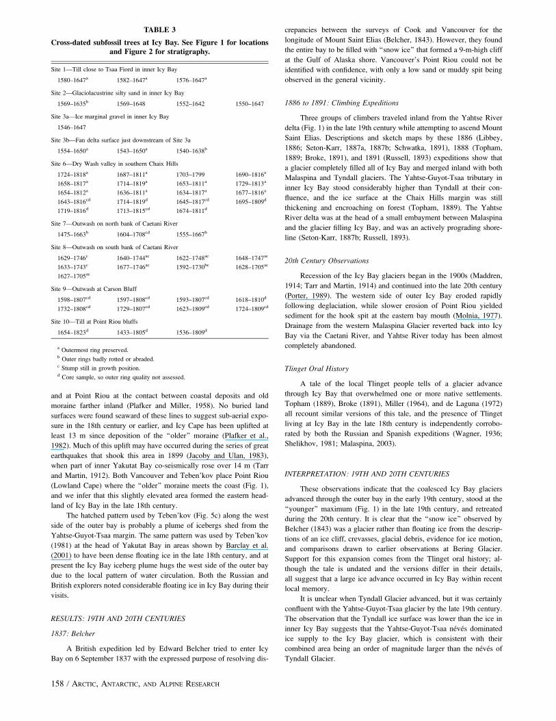
paintings, including a detailed landscape view (Fig. 4a) generally at-
tributed to the expedition geographer Felipe Bauza but probably by the
artist Tomas de Surıa (Wagner, 1936). Two inlets or coves were noted
within Icy Bay, an eastern one that was probably close to the bay
mouth and one in the west that was ice-bound (Malaspina, 2003). De
Surıa also noted a ‘‘passage’’ or ‘‘river’’ between the coastal mountains
and the high peaks of the Saint Elias range (Wagner, 1936).
1794: Vancouver
The British expedition led by George Vancouver spent the last
three days of June 1794 offshore of Icy Bay in generally poor weather
FIGURE 2. Stratigraphy ofsample sites. Ages are either theweighted average of the proba-bility distribution function forradiocarbon ages (cal yr B.P. orcal A.D.) or total duration offorest growth at site based ontree-ring cross-dates. Elevationsare in meters a.s.l. See Figure 1for site locations.
156 / ARCTIC, ANTARCTIC, AND ALPINE RESEARCH
(Vancouver, 1984). A ‘‘high cliffy point’’ that was probably Kichyatt
Point was described at the west side of the bay, against which stood
a ‘‘solid body of ice or frozen snow.’’ The expedition doctor, Archibald
Menzies, noted that Icy Bay was choked with ice and formed a
considerable valley that extended to the western side of Mount Saint
Elias (Menzies, 1993). Sketches by midshipman Thomas Heddington
were subsequently used to make a slightly stylized view of the land-
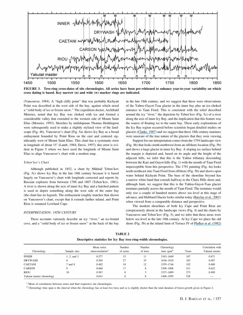
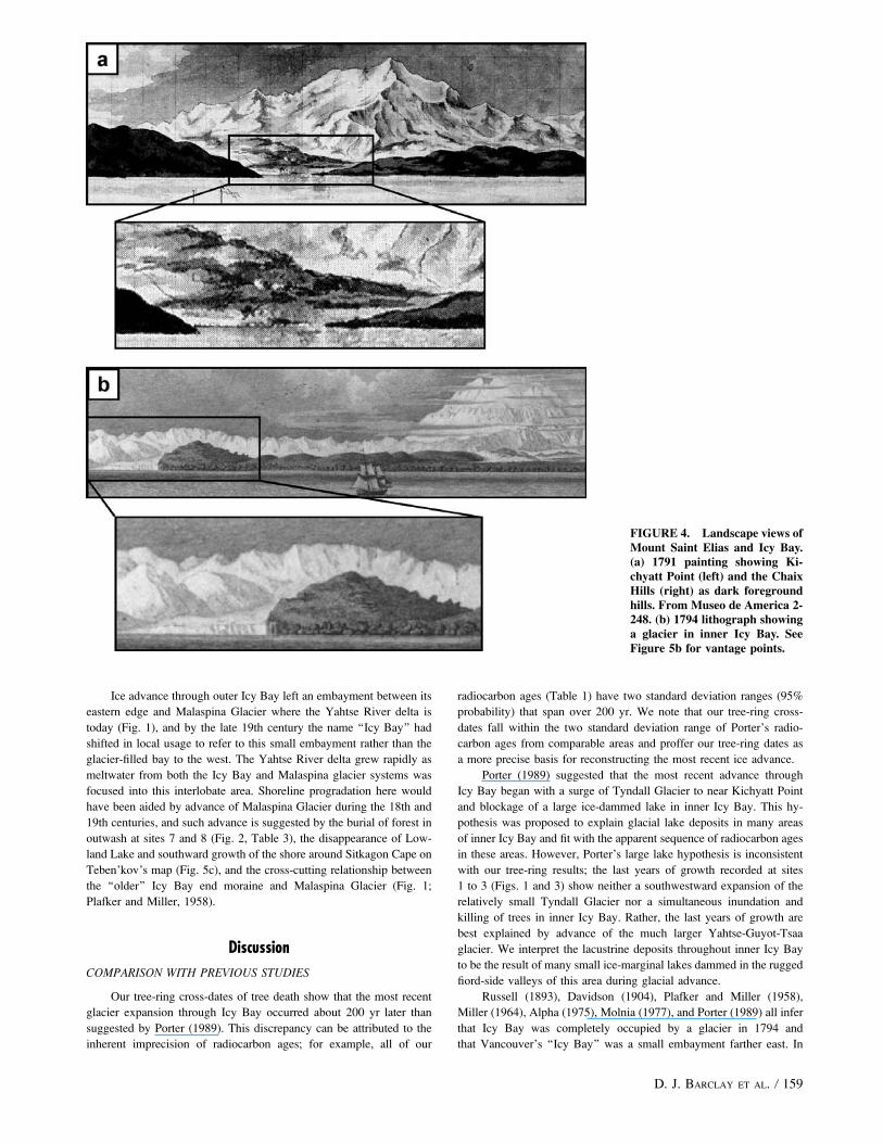
scape (Fig. 4b). Vancouver’s chart (Fig. 5a) shows Icy Bay as a broad
embayment bounded by Point Riou on the east and centered sig-
nificantly west of Mount Saint Elias. This chart has a systematic error
in longitude of about 159 (Lamb, 1984; Davis, 1997); this error is evi-
dent in Figure 5 where we have used the longitude of Mount Saint
Elias to align Vancouver’s chart with a modern map.
Teben’kov’s Chart
Although published in 1852, a chart by Mikhail Teben’kov
(Fig. 5c) shows Icy Bay in the late 18th century because it is based
largely on Vancouver’s chart with longitude corrected and reports by
Russian explorers from between 1788 and 1807 (Teben’kov, 1981).
A river is shown along the axis of inner Icy Bay and a hatched pattern
is used to depict something along the west side of the outer bay
(the chart has no legend). The embayment roughly matches that shown
on Vancouver’s chart, except that it extends farther inland, and Point
Riou is renamed Lowland Cape.
INTERPRETATION: 18TH CENTURY
These accounts variously describe an icy ‘‘river,’’ an ice-bound
cove, and a ‘‘solid body of ice or frozen snow’’ at the back of the bay
in the late 18th century, and we suggest that these were observations
of the Yahtse-Guyot-Tsaa glacier in the inner bay plus an ice-choked
entrance to Taan Fiord. This is consistent with the relief described
around the icy ‘‘river,’’ the depiction by Teben’kov (Fig. 5c) of a river
along the axis of inner Icy Bay, and the implication that this feature was
the source of floating ice to the outer bay. These early explorations of
the Icy Bay region occurred before scientists began detailed studies on
glaciers (Clarke, 1987) and we suggest that these 18th century mariners
were unaware of the true nature of the glaciers that they were viewing.
Support for our interpretation comes from the 1794 landscape view
(Fig. 4b) that looks north-northwest from an offshore location (Fig. 5b)
and shows a large glacier in inner Icy Bay. A sloping ice surface behind
the margin is depicted and, based on its angle and the height of the
adjacent hills, we infer that this is the Yahtse tributary descending
between the Karr and Guyot hills (Fig. 1) with the mouth of Taan Fiord
imperceptible from this perspective. The 1791 painting (Fig. 4a) looks
north-northeast into Taan Fiord from offshore (Fig. 5b) and shows open
water behind Kichyatt Point. The base of the shoreline beyond has
a narrow white band that extends halfway to the Chaix Hills shore and,
although faint, we suggest that this is the Yahtse-Guyot-Tsaa glacier
terminus partially across the mouth of Taan Fiord. The terminus would
only rise a couple of hundred meters above sea level at this stage of
advance, and Hubbard Glacier looks similar today (Barclay et al., 2001)
when viewed from a comparable distance and perspective.
The modern shorelines of both Icy Cape and Point Riou are
conspicuously absent in the landscape views (Fig. 4) and the charts by
Vancouver and Teben’kov (Fig. 5), and we infer that these areas were
below sea level in the late 18th century. At Icy Cape we place the old
shore (Fig. 5b) at the inland limit of Terrace IV of Plafker et al. (1982)
FIGURE 3. Tree-ring cross-dates of site chronologies. All series have been pre-whitened to enhance year-to-year variability on whichcross dating is based. Key narrow (n) and wide (w) marker rings are indicated.
TABLE 2
Descriptive statistics for Icy Bay tree-ring-width chronologies.
Chronology Sample sites
Mean series
intercorrelationa
Number
of series
Number
of trees
Chronology
time spanb Years
Correlation with
Yakutat master
INNER 1, 2, and 3 0.577 15 11 1543–1649 107 0.471
DRYWASH 6 0.504 27 19 1636–1818 183 0.487
CAETANI 7 and 8 0.482 18 12 1555–1746 192 0.488
CARSON 9 0.660 17 8 1598–1808 211 0.622
RIOU 10 0.567 8 3 1537–1809 273 0.490
Yakutat master chronology 0.641 8 8 1468–1995 528 —
a Mean of correlations between series and their respective site chronologies.b Chronology time span is the interval when the chronology has at least two trees and so is slightly shorter than the total duration of forest growth given in Figure 2.
D. J. BARCLAY ET AL. / 157
and at Point Riou at the contact between coastal deposits and old
moraine farther inland (Plafker and Miller, 1958). No buried land
surfaces were found seaward of these lines to suggest sub-aerial expo-
sure in the 18th century or earlier, and Icy Cape has been uplifted at
least 13 m since deposition of the ‘‘older’’ moraine (Plafker et al.,
1982). Much of this uplift may have occurred during the series of great
earthquakes that shook this area in 1899 (Jacoby and Ulan, 1983),
when part of inner Yakutat Bay co-seismically rose over 14 m (Tarr
and Martin, 1912). Both Vancouver and Teben’kov place Point Riou
(Lowland Cape) where the ‘‘older’’ moraine meets the coast (Fig. 1),
and we infer that this slightly elevated area formed the eastern head-
land of Icy Bay in the late 18th century.
The hatched pattern used by Teben’kov (Fig. 5c) along the west
side of the outer bay is probably a plume of icebergs shed from the
Yahtse-Guyot-Tsaa margin. The same pattern was used by Teben’kov
(1981) at the head of Yakutat Bay in areas shown by Barclay et al.
(2001) to have been dense floating ice in the late 18th century, and at
present the Icy Bay iceberg plume hugs the west side of the outer bay
due to the local pattern of water circulation. Both the Russian and
British explorers noted considerable floating ice in Icy Bay during their
visits.
RESULTS: 19TH AND 20TH CENTURIES
1837: Belcher
A British expedition led by Edward Belcher tried to enter Icy
Bay on 6 September 1837 with the expressed purpose of resolving dis-
crepancies between the surveys of Cook and Vancouver for the
longitude of Mount Saint Elias (Belcher, 1843). However, they found
the entire bay to be filled with ‘‘snow ice’’ that formed a 9-m-high cliff
at the Gulf of Alaska shore. Vancouver’s Point Riou could not be
identified with confidence, with only a low sand or muddy spit being
observed in the general vicinity.
1886 to 1891: Climbing Expeditions
Three groups of climbers traveled inland from the Yahtse River
delta (Fig. 1) in the late 19th century while attempting to ascend Mount
Saint Elias. Descriptions and sketch maps by these 1886 (Libbey,
1886; Seton-Karr, 1887a, 1887b; Schwatka, 1891), 1888 (Topham,
1889; Broke, 1891), and 1891 (Russell, 1893) expeditions show that
a glacier completely filled all of Icy Bay and merged inland with both
Malaspina and Tyndall glaciers. The Yahtse-Guyot-Tsaa tributary in
inner Icy Bay stood considerably higher than Tyndall at their con-
fluence, and the ice surface at the Chaix Hills margin was still
thickening and encroaching on forest (Topham, 1889). The Yahtse
River delta was at the head of a small embayment between Malaspina
and the glacier filling Icy Bay, and was an actively prograding shore-
line (Seton-Karr, 1887b; Russell, 1893).
20th Century Observations
Recession of the Icy Bay glaciers began in the 1900s (Maddren,
1914; Tarr and Martin, 1914) and continued into the late 20th century
(Porter, 1989). The western side of outer Icy Bay eroded rapidly
following deglaciation, while slower erosion of Point Riou yielded
sediment for the hook spit at the eastern bay mouth (Molnia, 1977).
Drainage from the western Malaspina Glacier reverted back into Icy
Bay via the Caetani River, and Yahtse River today has been almost
completely abandoned.
Tlinget Oral History
A tale of the local Tlinget people tells of a glacier advance
through Icy Bay that overwhelmed one or more native settlements.
Topham (1889), Broke (1891), Miller (1964), and de Laguna (1972)
all recount similar versions of this tale, and the presence of Tlinget
living at Icy Bay in the late 18th century is independently corrobo-
rated by both the Russian and Spanish expeditions (Wagner, 1936;
Shelikhov, 1981; Malaspina, 2003).
INTERPRETATION: 19TH AND 20TH CENTURIES
These observations indicate that the coalesced Icy Bay glaciers
advanced through the outer bay in the early 19th century, stood at the
‘‘younger’’ maximum (Fig. 1) in the late 19th century, and retreated
during the 20th century. It is clear that the ‘‘snow ice’’ observed by
Belcher (1843) was a glacier rather than floating ice from the descrip-
tions of an ice cliff, crevasses, glacial debris, evidence for ice motion,
and comparisons drawn to earlier observations at Bering Glacier.
Support for this expansion comes from the Tlinget oral history; al-
though the tale is undated and the versions differ in their details,
all suggest that a large ice advance occurred in Icy Bay within recent
local memory.
It is unclear when Tyndall Glacier advanced, but it was certainly
confluent with the Yahtse-Guyot-Tsaa glacier by the late 19th century.
The observation that the Tyndall ice surface was lower than the ice in
inner Icy Bay suggests that the Yahtse-Guyot-Tsaa neves dominated
ice supply to the Icy Bay glacier, which is consistent with their
combined area being an order of magnitude larger than the neves of
Tyndall Glacier.
TABLE 3
Cross-dated subfossil trees at Icy Bay. See Figure 1 for locationsand Figure 2 for stratigraphy.
Site 1—Till close to Tsaa Fiord in inner Icy Bay
1580–1647a 1582–1647a 1576–1647a
Site 2—Glaciolacustrine silty sand in inner Icy Bay
1569–1635b 1569–1648 1552–1642 1550–1647
Site 3a—Ice marginal gravel in inner Icy Bay
1546–1647
Site 3b—Fan delta surface just downstream of Site 3a
1554–1650a 1543–1650a 1540–1638b
Site 6—Dry Wash valley in southern Chaix Hills
1724–1818a 1687–1811a 1703–1799 1690–1816a
1658–1817a 1714–1819a 1653–1811a 1729–1813a
1654–1812a 1636–1811a 1634–1817a 1677–1816a
1643–1816cd 1714–1819d 1645–1817cd 1695–1809d
1719–1816d 1713–1815cd 1674–1811d
Site 7—Outwash on north bank of Caetani River
1475–1663b 1604–1708cd 1555–1667b
Site 8—Outwash on south bank of Caetani River
1629–1746c 1640–1744ac 1622–1748ac 1648–1747ac
1633–1743c 1677–1746ac 1592–1730bc 1628–1705ac
1627–1705ac
Site 9—Outwash at Carson Bluff
1598–1807cd 1597–1808cd 1593–1807cd 1618–1810d
1732–1808cd 1729–1807cd 1623–1809cd 1724–1809cd
Site 10—Till at Point Riou bluffs
1654–1823d 1433–1805d 1536–1809d
a Outermost ring preserved.b Outer rings badly rotted or abraded.c Stump still in growth position.d Core sample, so outer ring quality not assessed.
158 / ARCTIC, ANTARCTIC, AND ALPINE RESEARCH
Ice advance through outer Icy Bay left an embayment between its
eastern edge and Malaspina Glacier where the Yahtse River delta is
today (Fig. 1), and by the late 19th century the name ‘‘Icy Bay’’ had
shifted in local usage to refer to this small embayment rather than the
glacier-filled bay to the west. The Yahtse River delta grew rapidly as
meltwater from both the Icy Bay and Malaspina glacier systems was
focused into this interlobate area. Shoreline progradation here would
have been aided by advance of Malaspina Glacier during the 18th and
19th centuries, and such advance is suggested by the burial of forest in
outwash at sites 7 and 8 (Fig. 2, Table 3), the disappearance of Low-
land Lake and southward growth of the shore around Sitkagon Cape on
Teben’kov’s map (Fig. 5c), and the cross-cutting relationship between
the ‘‘older’’ Icy Bay end moraine and Malaspina Glacier (Fig. 1;
Plafker and Miller, 1958).
Discussion
COMPARISON WITH PREVIOUS STUDIES
Our tree-ring cross-dates of tree death show that the most recent
glacier expansion through Icy Bay occurred about 200 yr later than
suggested by Porter (1989). This discrepancy can be attributed to the
inherent imprecision of radiocarbon ages; for example, all of our
radiocarbon ages (Table 1) have two standard deviation ranges (95%
probability) that span over 200 yr. We note that our tree-ring cross-
dates fall within the two standard deviation range of Porter’s radio-
carbon ages from comparable areas and proffer our tree-ring dates as
a more precise basis for reconstructing the most recent ice advance.
Porter (1989) suggested that the most recent advance through
Icy Bay began with a surge of Tyndall Glacier to near Kichyatt Point
and blockage of a large ice-dammed lake in inner Icy Bay. This hy-
pothesis was proposed to explain glacial lake deposits in many areas
of inner Icy Bay and fit with the apparent sequence of radiocarbon ages
in these areas. However, Porter’s large lake hypothesis is inconsistent
with our tree-ring results; the last years of growth recorded at sites
1 to 3 (Figs. 1 and 3) show neither a southwestward expansion of the
relatively small Tyndall Glacier nor a simultaneous inundation and
killing of trees in inner Icy Bay. Rather, the last years of growth are
best explained by advance of the much larger Yahtse-Guyot-Tsaa
glacier. We interpret the lacustrine deposits throughout inner Icy Bay
to be the result of many small ice-marginal lakes dammed in the rugged
fiord-side valleys of this area during glacial advance.
Russell (1893), Davidson (1904), Plafker and Miller (1958),
Miller (1964), Alpha (1975), Molnia (1977), and Porter (1989) all infer
that Icy Bay was completely occupied by a glacier in 1794 and
that Vancouver’s ‘‘Icy Bay’’ was a small embayment farther east. In
FIGURE 4. Landscape views ofMount Saint Elias and Icy Bay.(a) 1791 painting showing Ki-chyatt Point (left) and the ChaixHills (right) as dark foregroundhills. From Museo de America 2-248. (b) 1794 lithograph showinga glacier in inner Icy Bay. SeeFigure 5b for vantage points.
D. J. BARCLAY ET AL. / 159
contrast, we concur with Maddren (1914), Tarr and Martin (1914), and
Taliaferro (1932) that the bay seen by Vancouver was a broader
version of outer Icy Bay, through which the coalesced Icy Bay glaciers
advanced in the decades after 1794. The bay observed by the late
18th century explorers fits with the general appearance and location of
outer Icy Bay, and Kichyatt Point is shown as ice-free to sea level
in the 1791 painting (Fig. 4a). Furthermore, our tree-ring dates
show that trees were alive at sites 6 and 9 until at least 1810, and this
is hard to reconcile with complete glaciation of Icy Bay by 1794.
The hypothesis for rapid sediment infilling of Icy Bay due to
progradation of the Yahtse River delta (Russell, 1893; Alpha, 1975;
Molnia, 1977; Porter, 1989) remains applicable to the easternmost edge
of outer Icy Bay. This area was open water in the late 18th century, was
beyond the ‘‘younger’’ maximum (Fig. 1), and would have received
focused meltwater and glaciofluvial sediment from both the Icy Bay
and Malaspina glacier systems after the coalesced Icy Bay glaciers
advanced past the Caetani River. However, sedimentation rates for this
infilling should be re-evaluated on the basis of the revised glacial
history presented herein.
CAUSES AND RATES OF ADVANCE
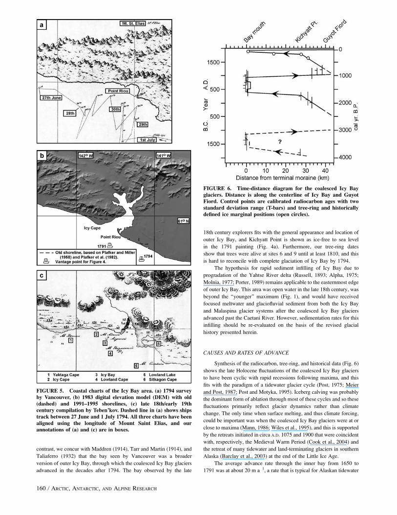
Synthesis of the radiocarbon, tree-ring, and historical data (Fig. 6)
shows the late Holocene fluctuations of the coalesced Icy Bay glaciers
to have been cyclic with rapid recessions following maxima, and this
fits with the paradigm of a tidewater glacier cycle (Post, 1975; Meier
and Post, 1987; Post and Motyka, 1995). Iceberg calving was probably
the dominant form of ablation through most of these cycles and so these
fluctuations primarily reflect glacier dynamics rather than climate
change. The only time when surface melting, and thus climate forcing,
could be important was when the coalesced Icy Bay glaciers were at or
close to maxima (Mann, 1986; Wiles et al., 1995), and this is supported
by the retreats initiated in circa A.D. 1075 and 1900 that were coincident
with, respectively, the Medieval Warm Period (Cook et al., 2004) and
the retreat of many tidewater and land-terminating glaciers in southern
Alaska (Barclay et al., 2003) at the end of the Little Ice Age.
The average advance rate through the inner bay from 1650 to
1791 was at about 20 m a�1, a rate that is typical for Alaskan tidewater
FIGURE 5. Coastal charts of the Icy Bay area. (a) 1794 surveyby Vancouver, (b) 1983 digital elevation model (DEM) with old(dashed) and 1991–1995 shorelines, (c) late 18th/early 19thcentury compilation by Teben’kov. Dashed line in (a) shows shipstrack between 27 June and 1 July 1794. All three charts have beenaligned using the longitude of Mount Saint Elias, and ourannotations of (a) and (c) are in boxes.
FIGURE 6. Time-distance diagram for the coalesced Icy Bayglaciers. Distance is along the centerline of Icy Bay and GuyotFiord. Control points are calibrated radiocarbon ages with twostandard deviation range (T-bars) and tree-ring and historicallydefined ice marginal positions (open circles).
160 / ARCTIC, ANTARCTIC, AND ALPINE RESEARCH
glaciers in deep fiords today (Meier and Post, 1987). In contrast,
between 1791 and 1886 the terminus expanded over an area of about
370 km2, an along-flowline distance of about 28 km at an average of
295 m a�1. This latter phase of advance was far larger and faster than
any other recent tidewater glacier expansion in Alaska. Taku Glacier in
southeastern Alaska did advance rapidly between 1890 and 1973 at
average rates of 50 to 150 m a�1, but total ice margin displacement for
this interval only amounted to about 6 km (Post and Motyka, 1995).
And the 150 m a�1 maximum average advance rate at Taku was only
sustained for 8 yr, whereas the 295 m a�1 average advance rate at Icy
Bay would have had to been sustained for 95 yr to accomplish the
reconstructed ice margin displacement. Perhaps the only 20th century
glacier expansion of comparable rate and magnitude was the 20 km
surge advance of Brasvellbreen in Svalbard between 1936 and 1938
(Schytt, 1969).
The reason for the rapid advance may have been a decrease in
iceberg calving caused by shoaling at the terminus. The ice margin
could not have advanced through inner Icy Bay without a submerged
morainal bank (Post, 1975), and this feature may have become emer-
gent as the terminus entered the shallow water of the outer bay. Post
and Motyka (1995) inferred shoaling at the terminus to have been
important to the 20th century rapid advance of Taku Glacier, and
Belcher (1843) suggested that a muddy beach underlay the Icy Bay ice
margin in 1837. We consider rapid advance during a surge to be less
likely because Yahtse, Guyot, and Tsaa glaciers have no record of
surging, and both of the more recent expansions appear to have
accelerated in the same place (Fig. 6), suggesting a geometric control
on rapid advance in this area of Icy Bay.
Conclusions
New radiocarbon ages were used to extend the glacial history of
Icy Bay back to 3800 yr ago and to constrain a previously un-
recognized cycle of advance and retreat. This earliest known Holocene
expansion was underway by 3750 cal yr B.P. and reached to the bay
mouth between 3505 and 3245 cal yr B.P. A second Holocene
expansion, previously described by Plafker and Miller (1958) and
Porter (1989), brought the ice margin back to the bay mouth where it
remained from about 1525 to 875 cal yr B.P. (cal A.D. 425 to 1075).
Tree-ring and historical data were used to constrain the most
recent ice expansion through Icy Bay. Cross-dates of glacially killed
trees show that the coalesced Yahtse-Guyot-Tsaa glacier was ad-
vancing in inner Icy Bay in the A.D. 1640s and expanded through the
outer bay in the early 19th century; this was about 200 yr later than
suggested in most previous studies. Descriptions, paintings, and charts
by 18th and 19th century explorers support this revised history and
suggest that a hypothesis for 19th century sediment infilling of Icy Bay
only applies to the easternmost bay mouth.
Initiation of the last two ice recessions coincided with warming
intervals in southern Alaska, suggesting that climate change may have
triggered these rapid retreats. Advance through the inner bay was at
a typical rate for Alaskan tidewater glaciers in deep-water fiords today;
in contrast, expansion through the outer bay was far larger and faster
than any Alaskan tidewater glacier advance in the 20th century. The
penultimate advance also accelerated through outer Icy Bay, and
decreased iceberg calving in the shallow water here may have caused
these unusually large and rapid expansions.
Acknowledgments
We thank Austin Post for providing aerial photographs and for
spirited discussion of our results and their implications. Gordon Jacoby
helped initiate this project, David Frank assisted with fieldwork, and
Andre Kurbatov translated text on Teben’kov’s map. Comments by
Roman Motyka, Charles Warren, Colin Laroque, and an anonymous
reviewer are appreciated. This research was supported by the National
Science Foundation under grant OPP-9321213.
References Cited
Alpha, T. R., 1975: The evolution of Icy Bay, Alaska. In Carlson,
P. R., Conomos, T. J., Janda, R. J., and Peterson, D. H. (eds.),
Principal sources and dispersal patterns of suspended particulatematter in near shore surface waters of the Northeast Pacific Ocean.Houston: NASA, 4-9 (E75-10266; NASA-CR-142641).
Barclay, D. J., Calkin, P. E., and Wiles, G. C., 2001: Holocene history
of Hubbard Glacier in Yakutat Bay and Russell Fiord, southern
Alaska. Geological Society of America Bulletin, 113: 388–402.
Barclay, D. J., Wiles, G. C., and Calkin, P. E., 2003: An 850 year record
of climate and fluctuations of the iceberg-calving Nellie Juan Glacier;
south central Alaska, U.S.A.: Annals of Glaciology, 36: 51–56.
Belcher, E., 1843: Narrative of a voyage round the world: performedin Her Majesty’s ship Sulpher, during the years 1836–1842.London: Henry Colburn.
Broke, G., 1891: With sack and stock in Alaska. London: Longmans,
Green and Co.
Brown, H. P., Panshin, A. J., and Forsaith, C. C., 1949: Textbookof wood technology, volume 1. New York: McGraw-Hill Book
Company.
Calkin, P. E., Wiles, G. C., and Barclay, D. J., 2001: Holocene coastal
glaciation of Alaska: Quaternary Science Reviews, 20: 449–461.
Clarke, G. K. C., 1987: A short history of scientific investigations on
glaciers. Journal of Glaciology, Special Issue: 4–24.
Cook, E. R., Esper, J., and D’Arrigo, R. D., 2004: Extra-tropical
Northern Hemisphere land temperature variability over the past 1000
years. Quaternary Science Reviews, 23: 2063–2074.
Davidson, G., 1904: The glaciers of Alaska that are shown on Russian
charts or mentioned in older narratives. Geographical Society ofthe Pacific, Transactions and Proceedings, series 2, 3: 2–93.
Davis, A. C., 1997: Testing a new technology: Captain George
Vancouver’s survey and navigation in Alaskan waters, 1794. InHaycox, S., Barnett, J. K., and Liburd, C. A. (eds.), Enlightenmentand exploration in the North Pacific 1741–1805. Seattle: University
of Washington Press, 103–115.
de Laguna, F., 1958: Geological confirmation of native traditions,
Yakutat, Alaska. American Antiquity, 23: 434.
de Laguna, F., 1972: Under Mount Saint Elias: the history and cultureof the Yakutat Tlingit. Washington, DC: Smithsonian Institution
Press, Smithsonian Contributions to Anthropology, 7.
Eyles, C. H., Eyles, N., and Lagoe, M. B., 1991: The Yakataga
Formation; a late Miocene to Pleistocene record of temperate glacial
marine sedimentation in the Gulf of Alaska. In Anderson, J. B.,
and Ashley, G. M., (eds.), Glacial marine sedimentation; paleo-climatic significance. Boulder, CO: Geological Society of America,
Special Paper 261, 159–180.
Heusser, C. J., 1995: Late-Quaternary vegetation response to climatic-
glacial forcing in North Pacific America. Physical Geography, 16:
118–149.
Holmes, R. L., 1983: Computer-assisted quality control in tree-ring
dating and measurement. Tree-Ring Bulletin, 43: 69–78.
Jacoby, G. C., and Ulan, L. D., 1983: Tree ring indications of uplift at
Icy Cape, Alaska, related to 1899 earthquakes. Journal of Geo-physical Research, 88(B11): 9305–9313.
Jaeger, J. M., and Nittrouer, C. A., 1999: Sediment deposition in an
Alaskan fjord: controls on the formation and preservation of
sedimentary structures in Icy Bay. Journal of Sedimentary Geology,69: 1011–1026.
Lamb, W. K., 1984: Introduction. In Vancouver, G., A voyage ofdiscovery to the North Pacific Ocean and around the world,1791–1795. London: Hakluyt Society.
Libbey, W., 1886: Some of the geographical features of southeastern
Alaska. Journal of the American Geographical Society of New York,18: 279–300.
D. J. BARCLAY ET AL. / 161
Maddren, A. G., 1914: Mineral deposits of the Yakataga District. U.S.Geological Survey Bulletin, 592: 119–153.
Malaspina, A., 2003: The Malaspina Expedition, 1789–1794, Volume2, Panama to the Philippines. London: Hakluyt Society (ed. by
David, A., Fernandez-Armesto, F., Novi, C., and Williams, G.).
Mann, D. H., 1986: Reliability of a fjord glaciers fluctuations for
paleoclimatic reconstruction. Quaternary Research, 25: 10–24.
Meier, M. F., and Post, A., 1987: Fast tidewater glaciers. Journal ofGeophysical Research, 92(B9): 9051–9058.
Meigs, A., and Sauber, J., 2000: Southern Alaska as an example of the
long-term consequences of mountain building under the influence of
glaciers. Quaternary Science Reviews, 19: 1543–1562.
Menzies, A., 1993: The Alaska travel journal of Archibald Menzies,1793–1794. Fairbanks, AK: University of Alaska Press (introduction
and annotation by Olson, W. M.).
Miller, M., 1964: Inventory of terminal position changes in Alaskan
coastal glaciers since the 1750’s. Proceedings of the AmericanPhilosophical Society, 108: 257–273.
Molnia, B., 1977: Rapid shoreline erosion and retreat at Icy Bay,
Alaska—a staging area for offshore petroleum development. Ninth Off-shore Technology Conference, May 2–5 1977, Proceedings, 115–126.
Molnia, B. F., 1985: Processes on a glacier-dominated coast, Alaska.
Zeitschrift fur Geomorphologie, N.F. Suppl. Bd. 57: 141–153.
Plafker, G., and Miller, D. J., 1958: Glacial features and surficial
deposits of the Malaspina District, Alaska. U.S. Geological SurveyMiscellaneous Geologic Investigations I-271, map, scale 1: 125,000.
Plafker, G., Hudson, T., Rubin, M., and Dixon, K. L., 1982: Holocene
marine terraces and uplift history in the Yakataga seismic gap near
Icy Cape, Alaska. U.S. Geological Survey Circular, 844: 111–115.
Plafker, G., Moore, J. C., and Winkler, G. R., 1994: Geology of the
southern Alaska margin. In Plafker, G., and Berg, H. C. (eds.), Thegeology of Alaska. Boulder, CO: Geological Society of America,
The Geology of North America, G-1: 389–449.
Porter, S. C., 1989: Late Holocene fluctuations of the fiord glacier
system in Icy Bay, Alaska, U.S.A. Arctic and Alpine Research, 21:
364–379.
Post, A., 1975: Preliminary hydrography and historical terminal
changes of Columbia Glacier, Alaska. U.S. Geological SurveyHydrological Investigations Atlas HA-559, 3 maps, scale 1: 10,000.
Post, A., and Motyka, R. J., 1995: Taku and LeConte glaciers, Alaska:
calving-speed control of late Holocene asynchronous advances and
retreats. Physical Geography, 16: 59–82.
Russell, I. C., 1893: Second expedition to Mount St. Elias, in 1891.
U.S. Geological Survey 13th Annual Report, 7–91.
Schwatka, F., 1891: The expedition of the New York Times. Century,41: 865–872.
Schytt, V., 1969: Some comments on glacier surges in eastern
Svalbard. Canadian Journal of Earth Sciences, 6: 867–873.
Seton-Karr, H. W., 1887a: The alpine regions of Alaska. Proceedingsof the Royal Geographical Society and Monthly Record ofGeography, 5: 269–285.
Seton-Karr, H. W., 1887b: Shores and Alps. London: Sampson Low,
Marston, Searle and Rivington.
Shelikhov, G. I., 1981: A voyage to America, 1783–1786. Kingston,
Ontario: Limestone Press (translated by Ramsay, M.; ed. by
Pierce, R. A.).
Stokes, M. A., and Smiley, T. L., 1968: An introduction to tree-ringdating. Chicago: University of Chicago Press.
Stuiver, M., and Reimer, P. J., 1993: Extended 14C database and
revised CALIB radiocarbon calibration program. Radiocarbon, 35:
215–230.
Stuiver, M., Reimer, P. J., Bard, E., Beck, J. W., Burr, G. S., Hughen,
K. A., Kromer, B., McCormac, F. G., van der Pilcht, J., and Spurk,
M., 1998: INTCAL98 radiocarbon age calibration 24,000–0 cal BP.
Radiocarbon, 40: 1041–1083.
Taliaferro, N. L., 1932: Geology of the Yakataga, Katella and
Nichawak districts, Alaska. Geological Society of America Bulletin,43: 749–782.
Tarr, R. S., and Martin, L., 1912: The earthquakes at Yakutat Bay,
Alaska, in September, 1899. U.S. Geological Survey ProfessionalPaper 69, 135 p.
Tarr, R. S., and Martin, L., 1914: Alaskan glacier studies of theNational Geographic Society in the Yakutat Bay, Prince WilliamSound and lower Copper River regions. Washington DC: National
Geographic Society.
Teben’kov, M. D., 1981: Atlas of the northwest coasts of America.Kingston, Ontario: Limestone Press (translated and ed. by Pierce,
R. A.).
Telford, R. J., Heegaard, E., and Birks, H. J. B., 2004: The intercept is
a poor estimate of a calibrated radiocarbon age. The Holocene, 14:
296–298.
Topham, H. W., 1889: A visit to the glaciers of Alaska and Mount St.
Elias. Proceedings of the Royal Geographical Society and MonthlyRecord of Geography, 11: 424–435.
Vancouver, G., 1984: A voyage of discovery to the North PacificOcean and around the world, 1791–1795. London: Hakluyt Society
(ed. by Lamb, W. K.).
Viens, R. J., 1994: Dynamics and mass balance of temperate tidewater
calving glaciers of southern Alaska. M.A. thesis, University of
Washington, Seattle.
Wagner, H. R., 1936: Journal of Tomas de Surıa of his voyage with
Malaspina to the northwest coast of America in 1791. PacificHistorical Review, 5: 234–276.
Wiles, G. C., Calkin, P. E., and Post, A., 1995: Glacial fluctuations
in the Kenai Fjords, Alaska, U.S.A.: an evaluation of controls
on iceberg-calving glaciers. Arctic and Alpine Research, 27:
234–245.
Wiles, G. C., D’Arrigo, R. D., and Jacoby, G. C., 1998: Gulf of Alaska
atmosphere-ocean variability over recent centuries inferred from
coastal tree-ring records. Climatic Change, 38: 289–306.
Revised ms submitted August 2005
162 / ARCTIC, ANTARCTIC, AND ALPINE RESEARCH