PRoPERty ACqUiSitionS And diSPLACEMEntS EXISTING CONDITIONS AND ENVIRONMENTAL CONSEQUENCES • 3-79
FinAL EnviRonMEntAL iMPACt StAtEMEnt
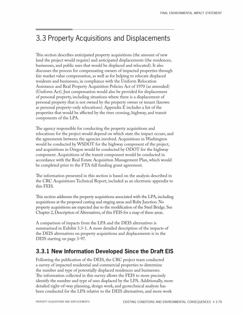
3.3 Property Acquisitions and Displacements
This section describes anticipated property acquisitions (the amount of new land the project would require) and anticipated displacements (the residences, businesses, and public uses that would be displaced and relocated). It also discusses the process for compensating owners of impacted properties through fair market value compensation, as well as for helping to relocate displaced residents and businesses, in compliance with the Uniform Relocation Assistance and Real Property Acquisition Policies Act of 1970 (as amended) (Uniform Act). Just compensation would also be provided for displacement of personal property, including situations where there is a displacement of personal property that is not owned by the property owner or tenant (known as personal property–only relocations). Appendix E includes a list of the properties that would be affected by the river crossing, highway, and transit components of the LPA.
The agency responsible for conducting the property acquisitions and relocations for the project would depend on which state the impact occurs, and the agreements between the agencies involved. Acquisitions in Washington would be conducted by WSDOT for the highway component of the project, and acquisitions in Oregon would be conducted by ODOT for the highway component. Acquisitions of the transit component would be conducted in accordance with the Real Estate Acquisition Management Plan, which would be completed prior to the FTA full funding grant agreement.
The information presented in this section is based on the analysis described in the CRC Acquisitions Technical Report, included as an electronic appendix to this FEIS.
This section addresses the property acquisitions associated with the LPA, including acquisitions at the proposed casting and staging areas and Ruby Junction. No property acquisitions are expected due to the modification of the Steel Bridge. See Chapter 2, Description of Alternatives, of this FEIS for a map of these areas.
A comparison of impacts from the LPA and the DEIS alternatives is summarized in Exhibit 3.3-1. A more detailed description of the impacts of the DEIS alternatives on property acquisitions and displacements is in the DEIS starting on page 3-97.
3.3.1 New Information Developed Since the Draft EISFollowing the publication of the DEIS, the CRC project team conducted a survey of impacted residential and commercial properties to determine the number and type of potentially displaced residences and businesses. The information collected in this survey allows the FEIS to more precisely identify the number and type of uses displaced by the LPA. Additionally, more detailed right-of-way planning, design work, and geotechnical analysis has been conducted for the LPA relative to the DEIS alternatives, and more work
CoLUMBiA RivER CRoSSing
3-80 • CHAPTER 3 PRoPERty ACqUiSitionS And diSPLACEMEntS
has been done to identify necessary temporary construction easements and potential staging sites and casting yards.
Updated information on residential and commercial vacancy rates, home price and supply, and rental rates has been included in the Existing Conditions section. A marina study was completed that provides an overview of the feasibility of private development for new floating home marinas in North Portland Harbor.
In addition to new information developed since the DEIS, the FEIS includes refinements in design, impacts and mitigation measures. Where new information or design changes could potentially create new significant environmental impacts not previously evaluated in the DEIS, or could be meaningful to the decision-making process, this information and these changes were applied to all alternatives, as appropriate. However, most of the new information did not warrant updating analysis of the non-preferred alternatives because it would not meaningfully change the impacts, would not result in new significant impacts, and would not change other factors that led to the choice of the LPA. Therefore, most of the refinements were applied only to the LPA. As allowed under Section 6002 of SAFETEA-LU [23 USC 139(f )(4)(D)], to facilitate development of mitigation measures and compliance with other environmental laws, the project has developed the LPA to a higher level of detail than the other alternatives. This detail has allowed the project to develop more specific mitigation measures and to facilitate compliance with other environmental laws and regulations, such as Section 4(f ) of the DOT Act, Section 106 of the National Historic Preservation Act, Section 7 of the Endangered Species Act, and Section 404 of the Clean Water Act. FTA and FHWA prepared NEPA re-evaluations and a documented categorical exclusion (DCE) to analyze changes in the project and project impacts that have occurred since the DEIS. Both agencies concluded from these evaluations that these changes and new information would not result in any new significant environmental impacts that were not previously considered in the DEIS. These changes in impacts are described in the re-evaluations and DCE included in Appendix O of this FEIS. Relevant refinements in information, design, impacts and mitigation are described in the following text.
3.3.2 Existing ConditionsVacancy and rental rates for residential, commercial, and industrial properties are indicators of the potential for finding viable sites for relocating displaced residents and businesses. Higher vacancy rates generally indicate greater potential for relocating a displaced use to a location that is desirable to the property or business owner or tenants. The monthly supply of homes for sale (see sidebar), average length of time that single-family homes are on the market prior to sale, and median single-family home sale prices also indicate the potential for finding viable sites for relocating residents of single-family homes.
Portland-Vancouver AreaIn March 2011, the Portland area (including Oregon suburbs but excluding communities in Washington) had a 7.1-month supply of homes for sale (single-family residences took an average of 161 days to sell) and a year-to-date median home sale price of $215,000. In the same month, Clark County had an
Monthly Supply of Homes
The monthly supply of homes is derived by dividing the number of homes listed for sale at the end of the given month with the number of sales that occurred during that month. This value provides an approximation for how long it should take to find buyers for all of the homes that are currently on the market. It is useful for determining how easy or hard it would be to purchase a replacement home, as it takes into account not only how many homes are for sale (the supply), but, based on recent sales activity, how quickly one would expect those homes to sell (the demand).
FinAL EnviRonMEntAL iMPACt StAtEMEnt
EXISTING CONDITIONS AND ENVIRONMENTAL CONSEQUENCES • 3-81PRoPERty ACqUiSitionS And diSPLACEMEntS
8.3-month home supply (single-family residences took an average of 160 days to sell) and a year-to-date median home sale price of $190,000 (RMLS 2011a, b). The decreases in home prices in recent years, coupled with a significant amount of housing stock on the market, should make it relatively easier to find replacement homes for residents displaced by project construction. Year-to-date median home prices for 2011, up to and including the month of March 2011, are also available for smaller geographic areas and are included in the CRC Acquisitions Technical Report (included as an electronic appendix to this FEIS); year-to-date home supply data for smaller geographies were not available and thus are not included in that report.
Industry reports for the first quarter of 2011 showed a 3.8 percent multi-family residential vacancy rate for rentals in the Portland-Vancouver metropolitan area, with a rental rate averaging $0.94 per square foot per month (MMHA 2011). Within the CRC project area, the West Vancouver subarea, which includes the Vancouver portion of the project area, had a similar vacancy rate and lower costs per square foot for multi-family residential units than the North Portland/St. Johns area (MMHA 2011).
Multi-family vacancy rates trend with unemployment rates. The economic downturn that began in late 2007 had resulted in rising unemployment rates through 2009, and year over year increases in multi-family vacancy rates were experienced during this time (Nguyen 2011). However, 2010 saw a reversal in both trends (Nguyen 2011). Unemployment is expected to continue to decrease through 2014 (Vander Vliet 2011), which should result in keeping multi-family vacancy rates relatively low. Lower vacancy rates should make it relatively more difficult to find replacement multi-family housing for residents displaced by the LPA.
Office space in the greater Portland/Vancouver metropolitan area is more available (14.4 percent vacancy rate) than either retail (6.3 percent) or industrial (8.9 percent) space (Norris, Beggs & Simpson 2011, Grubb & Ellis 2011).
Building retail vacancy information on a submarket level was also available from Norris, Beggs & Simpson, a market research firm (2011). In the first quarter of 2011, the North Portland/Jantzen Beach submarket of the Eastside Portland market experienced an estimated 6.4 percent vacancy rate, while the Vancouver submarket experienced an estimated vacancy rate of 8.1 percent.
Industry research data show vacancy rates for office and retail in the region are now decreasing with recent gains in employment. Although industrial vacancy rates increased in the first quarter of 2011, industry research suggests that these vacancy rates will also decrease with expected improvements in the local economy (Grubb & Ellis 2011).
North Portland Harbor, Portland, OregonThe LPA would require the displacement of floating homes in the North Portland Harbor. Information regarding floating home availability in the North Portland Harbor is not provided in the reports that informed the above discussion, although some information can be gleaned from the Regional Multiple Listing Service (RMLS) searchable database. A search of the active listings in April 2011 showed approximately 109 housing units listed for sale
CoLUMBiA RivER CRoSSing
3-82 • CHAPTER 3 PRoPERty ACqUiSitionS And diSPLACEMEntS
in Hayden Island, North Portland Harbor, and North Portland.5 Of that number, 40 were floating homes, 38 were condos, and 31 were conventional homes. The above numbers do not include private listings.
In the course of conversations with potentially affected property owners, CRC staff received inquiries about the potential for constructing a new marina to accommodate displaced floating homes. To better understand new marina permitting and construction, the project conducted research on the development of marinas. This research found that there are some likely challenges to developing a new floating home marina, including: permitting through local jurisdictions and environmental resource agencies, acquisition of property, and eventual sale or lease of marina slips (CRC 2011). The project is not pursing the construction of a new floating home marina.
Gresham, OregonTriMet’s Ruby Junction Maintenance Facility in Gresham, Oregon, would be expanded to accommodate the additional light rail vehicles required by the CRC and Portland-Milwaukie Light Rail projects. This expansion would result in the displacement of residences, retail/services, and industrial uses. As this area is relatively removed from the main project area, an additional analysis of vacancy rates was performed for the area around the Ruby Junction facility.
In March 2011, the Gresham/Troutdale subarea within which the Ruby Junction Maintenance Facility is located, single-family residences took an average of 147 days to sell and had a median year-to-date sale price of $174,900. The boundaries of the Gresham/Troutdale subarea are the Columbia River to the north; 182nd Avenue to the west; Highway 212 to the Mount Hood Highway, excluding Boring, but including Sandy, to the south; and a line extending south from the Columbia River along Saltzman Road to Langensand Road at the Mount Hood Highway to the east.
In the first quarter of 2011, industry reports showed a 4.4 percent multi-family residential vacancy rate and average rental rate of $0.81 per square foot for rentals in the Gresham/Troutdale/Fairview/Wood Village subarea; this subarea is larger than the Gresham/Troutdale subarea mentioned above, and includes the Ruby Junction Maintenance Facility (MMHA 2011). The multi-family units in the Gresham/Troutdale/Fairview/Wood Village subarea tend to have slightly higher vacancy rates, and lower rents per square foot, than found in the metro area as a whole. Two different nearby subareas, located within one-half mile of the maintenance facility, similarly had higher vacancy rates and lower rental rates than the Portland-Vancouver average.
The expansion of the Ruby Junction facility will displace a mix of small light industrial and retail businesses. As the subarea that includes the Ruby Junction Maintenance Facility has higher retail vacancy rates than the greater Portland-Vancouver area, those retail businesses that are displaced by the Ruby Junction facility expansion have higher potential for relocating relatively close by.
5 This analysis was conducted on April 15, 2011, using the RMLS database and selecting the Faubion Elementary School district in North Portland as the main search criterion, with secondary criteria including floating homes, condominiums, and single-family detached homes. Many residents of Hayden Island and the floating home communities send their children to the Faubion Elementary School.
FinAL EnviRonMEntAL iMPACt StAtEMEnt
EXISTING CONDITIONS AND ENVIRONMENTAL CONSEQUENCES • 3-83PRoPERty ACqUiSitionS And diSPLACEMEntS
3.3.3 Long-term Effects
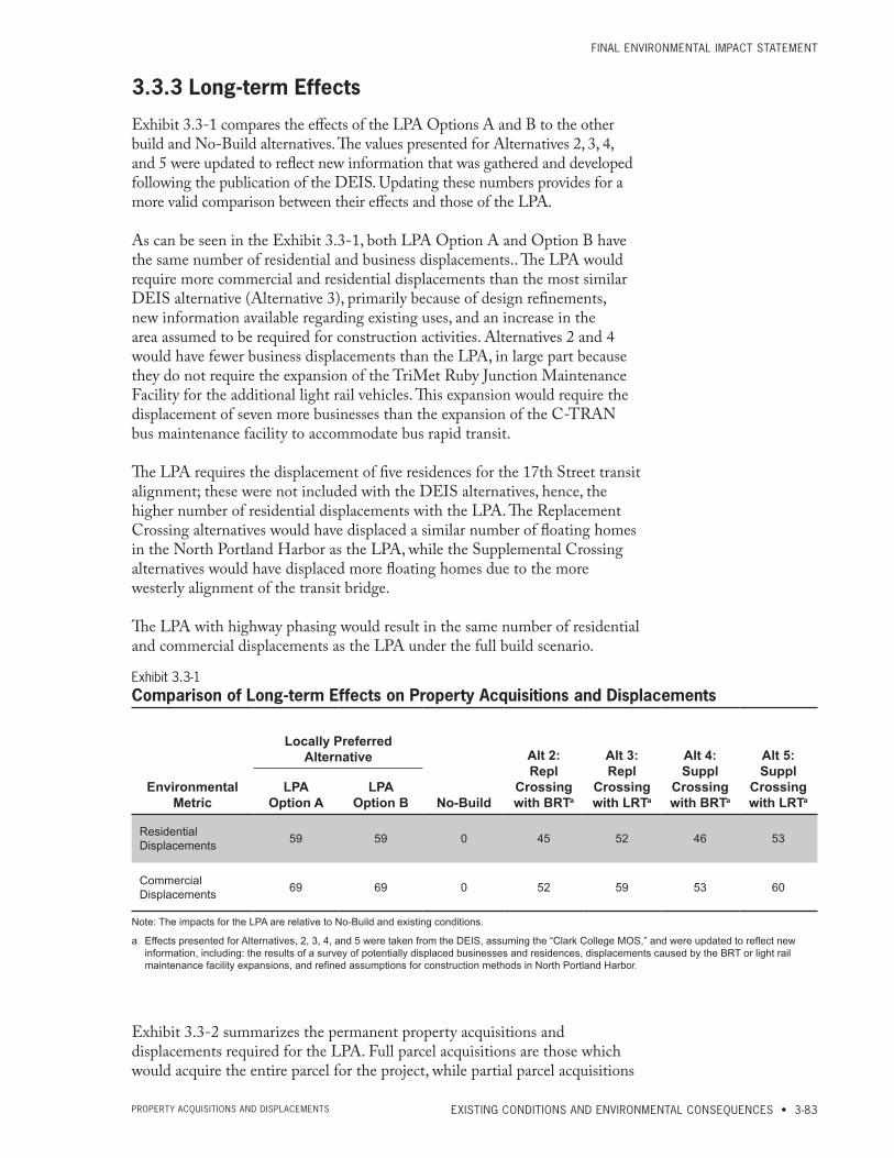
Exhibit 3.3-1 compares the effects of the LPA Options A and B to the other build and No-Build alternatives. The values presented for Alternatives 2, 3, 4, and 5 were updated to reflect new information that was gathered and developed following the publication of the DEIS. Updating these numbers provides for a more valid comparison between their effects and those of the LPA.
As can be seen in the Exhibit 3.3-1, both LPA Option A and Option B have the same number of residential and business displacements.. The LPA would require more commercial and residential displacements than the most similar DEIS alternative (Alternative 3), primarily because of design refinements, new information available regarding existing uses, and an increase in the area assumed to be required for construction activities. Alternatives 2 and 4 would have fewer business displacements than the LPA, in large part because they do not require the expansion of the TriMet Ruby Junction Maintenance Facility for the additional light rail vehicles. This expansion would require the displacement of seven more businesses than the expansion of the C-TRAN bus maintenance facility to accommodate bus rapid transit.
The LPA requires the displacement of five residences for the 17th Street transit alignment; these were not included with the DEIS alternatives, hence, the higher number of residential displacements with the LPA. The Replacement Crossing alternatives would have displaced a similar number of floating homes in the North Portland Harbor as the LPA, while the Supplemental Crossing alternatives would have displaced more floating homes due to the more westerly alignment of the transit bridge.
The LPA with highway phasing would result in the same number of residential and commercial displacements as the LPA under the full build scenario.
Exhibit 3.3-1Comparison of Long-term Effects on Property Acquisitions and Displacements
Environmental Metric
Locally Preferred Alternative
No-Build
Alt 2: Repl
Crossing with BRTa
Alt 3: Repl
Crossing with LRTa
Alt 4: Suppl
Crossing with BRTa
Alt 5: Suppl
Crossing with LRTa
LPA Option A
LPA Option B
Residential Displacements 59 59 0 45 52 46 53
Commercial Displacements 69 69 0 52 59 53 60
Note: The impacts for the LPA are relative to No‑Build and existing conditions.
a Effects presented for Alternatives, 2, 3, 4, and 5 were taken from the DEIS, assuming the “Clark College MOS,” and were updated to reflect new information, including: the results of a survey of potentially displaced businesses and residences, displacements caused by the BRT or light rail maintenance facility expansions, and refined assumptions for construction methods in North Portland Harbor.
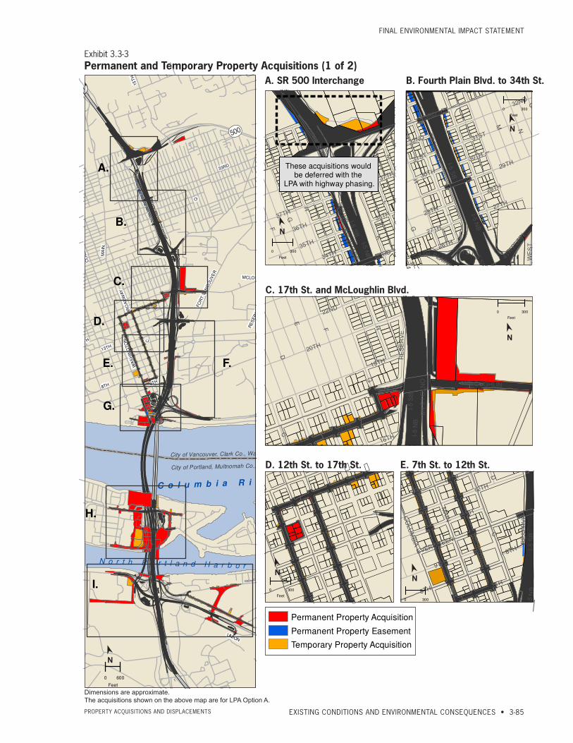
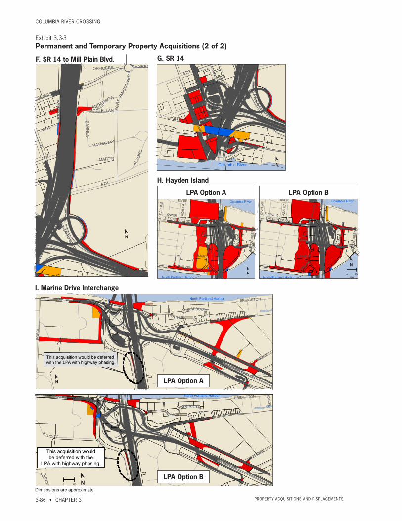
Exhibit 3.3-2 summarizes the permanent property acquisitions and displacements required for the LPA. Full parcel acquisitions are those which would acquire the entire parcel for the project, while partial parcel acquisitions

CoLUMBiA RivER CRoSSing
3-84 • CHAPTER 3 PRoPERty ACqUiSitionS And diSPLACEMEntS
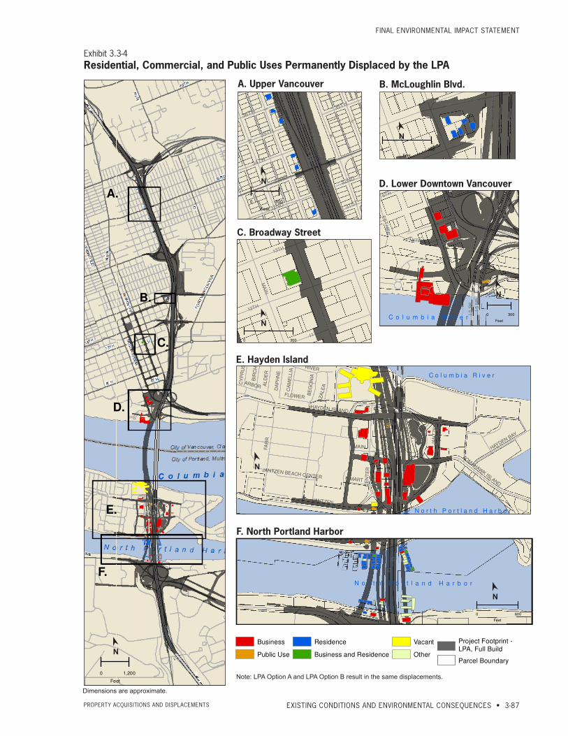
would acquire only a part of the parcel. Both full and partial acquisitions could result in the displacement of residences, businesses, or public facilities from the parcel. Exhibit 3.3-3 shows the temporary and permanent property acquisitions, while Exhibit 3.3-4 shows the permanent displacements that would result from these acquisitions. A list of properties that may be partially or fully acquired for the LPA can be found in Appendix E.
Constructing the LPA with highway phasing would defer an acquisition of a small amount of property required for the LPA Full Build (approximately 0.5 acre), but would not change the number of residential, commercial, or other displacements.
Exhibit 3.3-2Summary of Permanent Property Acquisitions and Displacements for the LPAa
Impact Type Impact LPA Option A LPA Option B
Parcel Impacts (count)Full Parcel Acquisitions 74 73
Partial Parcel Acquisitions 143 131
Total Parcels Impacted 217 204
Displacement of Use (count)
Residential Displacements Total: 59 Total: 59
Single-family 55 55
Multi-family 4 4
Commercial Displacements Total: 69 Total: 69
Retail/Services 50 50
Office/Professional/Healthcare 15 15
Lodging 1 1
Otherb 3 3
Public Use Displacements Total: 2 Total: 2
Public Service w/ Employees 2 2
Religious/Community Center 0 0
Park/Historic Site/Museum 0 0
School 0 0
Permanent Easementsc (acres)
Airspace Easements 2.3 acres 2.3 acres
Subsurface Easements 3 acres 3 acres
Property Easements Less than 1 acre Less than 1 acre
Area required (acres) Total Area Acquired 91 acres 93 acres
a Does not include ODOT‑ or WSDOT‑owned property or right‑of‑way or City‑owned right‑of‑way.
b Includes the displacement of two cellular phone towers on Hayden Island and a billboard near the Marine Drive interchange.
c For information about utility easements, please see Section, 3.6 Public Services and Utilities.
FinAL EnviRonMEntAL iMPACt StAtEMEnt
EXISTING CONDITIONS AND ENVIRONMENTAL CONSEQUENCES • 3-85PRoPERty ACqUiSitionS And diSPLACEMEntS
Exhibit 3.3-3Permanent and Temporary Property Acquisitions (1 of 2)
FOURTH PLAIN
C
Q
8TH
49TH
FO
RT V
AN
CO
UV
ER
RE
SE
RV
E
15
TH
13TH15TH
WA
SH
ING
TO
N
6TH
CO
LUM
BIA
MCLOUGHLIN
UNION
MA
I N
33RD
BR
OA
DW
AY
MARINE
C o l u m b i a R i v e r
City of Portland, Multnomah Co., Oregon
City of Vancouver, Clark Co., Washington
N o r t h P o r t l a n d H a r b o r
0 600
Feet
C
MA
IN
8TH
12TH
I-5 S
B
9TH
7TH
11TH
13TH
BR
OA
DW
AY
EVERGREEN
WA
SH
ING
TO
N
CO
LU
MB
IA
D
6TH I-5 N
B
RE
SE
RV
E
8TH
E. 7th St. to 12th St.D. 12th St. to McLoughlin Blvd.
A. SR 500 Interchange
E.
B.
D.
I.
A.
Permanent Property Acquisition
Permanent Property Easement
Temporary Property Acquisition
C.
F
E
D
G
H
C
19TH
20TH
I-5
SB
I -5 N
B
17TH
22ND
MCLOUGHLIN
ON
TO
I-5 N
B
RE
SE
RV
E
16TH
C. McLoughlin Blvd.
I
KL
H
N
M
I-5 S
B
I-5 N
B
29TH
O
33RD
G
FR
ON
TA
GE
27TH
28TH
30TH
WE
ST
4TH P
LAIN
F
31ST
B
C
ONTO I-5 S
B
26TH
32ND
4TH PLAIN
28TH
27TH
30TH
31ST
32ND
These acquisitions would be deferred with the
LPA with highway phasing.
I
G
K
L
F
I-5 S
B
I-5 N
B
H
M
50
0 W
B
35TH
37TH
36TH
34TH33RD
FR
ON
TA
GE
35TH
37TH
B. 4th Plain Blvd. to 34th St.
F.
G.
H.
0 300
Feet
0 300
Feet
0 300
Feet
0 300
Feet0 300
Feet
FOURTH PLAIN
C
Q
8TH
49TH
FO
RT V
AN
CO
UV
ER
RE
SE
RV
E
15T
H
13TH15TH
WA
SH
ING
TO
N
6TH
CO
LUM
BIA
MCLOUGHLIN
UNION
MA
I N
33RD
BR
OA
DW
AY
MARINE
C o l u m b i a R i v e r
City of Portland, Multnomah Co., Oregon
City of Vancouver, Clark Co., Washington
N o r t h P o r t l a n d H a r b o r
0 600
Feet
C
MA
IN
8TH
12TH
I-5 S
B
9TH
7TH
11TH
13TH
BR
OA
DW
AY
EVERGREEN
WA
SH
ING
TO
N
CO
LU
MB
IA
D
6TH I-5 N
B
RE
SE
RV
E8TH
E. 7th St. to 12th St.D. 12th St. to McLoughlin Blvd.
A. SR 500 Interchange
E.
B.
D.
I.
A.
Permanent Property Acquisition
Permanent Property Easement
Temporary Property Acquisition
C.F
E
D
G
H
C
19TH
20TH
I-5
SB
I -5 N
B17TH
22ND
MCLOUGHLIN
ON
TO
I-5 N
B
RE
SE
RV
E
16TH
C. McLoughlin Blvd.
I
KL
H
N
M
I-5 S
B
I-5 N
B
29TH
O
33RD
G
FR
ON
TA
GE
27TH
28TH
30TH
WE
ST
4TH P
LAIN
F
31ST
B
C
ONTO I-5 S
B
26TH
32ND
4TH PLAIN
28TH
27TH
30TH
31ST
32ND
These acquisitions would be deferred with the
LPA with highway phasing.
I
G
K
L
F
I-5 S
B
I-5 N
B
H
M
50
0 W
B
35TH
37TH
36TH
34TH33RD
FR
ON
TA
GE
35TH
37TH
B. 4th Plain Blvd. to 34th St.
F.
G.
H.
0 300
Feet
0 300
Feet
0 300
Feet
0 300
Feet0 300
Feet
A. SR 500 Interchange
FOURTH PLAIN
C
Q
8TH
49TH
FO
RT V
AN
CO
UV
ER
RE
SE
RV
E
15
TH
13TH15TH
WA
SH
ING
TO
N
6TH
CO
LUM
BIA
MCLOUGHLIN
UNION
MA
I N
33RD
BR
OA
DW
AY
MARINE
C o l u m b i a R i v e r
City of Portland, Multnomah Co., Oregon
City of Vancouver, Clark Co., Washington
N o r t h P o r t l a n d H a r b o r
0 600
Feet
C
MA
IN
8TH
12TH
I-5 S
B
9TH
7TH
11TH
13TH
BR
OA
DW
AY
EVERGREEN
WA
SH
ING
TO
N
CO
LU
MB
IA
D
6TH I-5 N
B
RE
SE
RV
E
8TH
E. 7th St. to 12th St.D. 12th St. to McLoughlin Blvd.
A. SR 500 Interchange
E.
B.
D.
I.
A.
Permanent Property Acquisition
Permanent Property Easement
Temporary Property Acquisition
C.
F
E
D
G
H
C
19TH
20TH
I-5
SB
I -5 N
B
17TH
22ND
MCLOUGHLIN
ON
TO
I-5 N
B
RE
SE
RV
E
16TH
C. McLoughlin Blvd.
I
KL
H
N
M
I-5 S
B
I-5 N
B
29TH
O
33RD
G
FR
ON
TA
GE
27TH
28TH
30TH
WE
ST
4TH P
LAIN
F31ST
B
C
ONTO I-5 S
B
26TH
32ND
4TH PLAIN
28TH
27TH
30TH
31ST
32ND
These acquisitions would be deferred with the
LPA with highway phasing.
I
G
K
L
F
I-5 S
B
I-5 N
B
H
M
50
0 W
B
35TH
37TH
36TH
34TH33RD
FR
ON
TA
GE
35TH
37TH
B. 4th Plain Blvd. to 34th St.
F.
G.
H.
0 300
Feet
0 300
Feet
0 300
Feet
0 300
Feet0 300
Feet
D. 12th St. to 17th St.
FOURTH PLAIN
C
Q
8TH
49TH
FO
RT V
AN
CO
UV
ER
RE
SE
RV
E
15
TH
13TH15TH
WA
SH
ING
TO
N
6TH
CO
LUM
BIA
MCLOUGHLIN
UNION
MA
I N
33RD
BR
OA
DW
AY
MARINE
C o l u m b i a R i v e r
City of Portland, Multnomah Co., Oregon
City of Vancouver, Clark Co., Washington
N o r t h P o r t l a n d H a r b o r
0 600
Feet
C
MA
IN
8TH
12TH
I-5 S
B
9TH
7TH
11TH
13TH
BR
OA
DW
AY
EVERGREEN
WA
SH
ING
TO
N
CO
LU
MB
IA
D
6TH I-5 N
B
RE
SE
RV
E
8TH
E. 7th St. to 12th St.D. 12th St. to McLoughlin Blvd.
A. SR 500 Interchange
E.
B.
D.
I.
A.
Permanent Property Acquisition
Permanent Property Easement
Temporary Property Acquisition
C.
F
E
D
G
H
C
19TH
20TH
I-5
SB
I -5 N
B
17TH
22ND
MCLOUGHLIN
ON
TO
I-5 N
B
RE
SE
RV
E
16TH
C. McLoughlin Blvd.
I
KL
H
N
M
I-5 S
B
I-5 N
B
29TH
O
33RD
G
FR
ON
TA
GE
27TH
28TH
30TH
WE
ST
4TH P
LAIN
F31ST
B
C
ONTO I-5 S
B
26TH
32ND
4TH PLAIN
28TH
27TH
30TH
31ST
32ND
These acquisitions would be deferred with the
LPA with highway phasing.
I
G
K
L
F
I-5 S
B
I-5 N
B
H
M
50
0 W
B
35TH
37TH
36TH
34TH33RD
FR
ON
TA
GE
35TH
37TH
B. 4th Plain Blvd. to 34th St.
F.
G.
H.
0 300
Feet
0 300
Feet
0 300
Feet
0 300
Feet0 300
Feet
C. 17th St. and McLoughlin Blvd.
FOURTH PLAIN
C
Q
8TH
49TH
FO
RT V
AN
CO
UV
ER
RE
SE
RV
E
15T
H
13TH15TH
WA
SH
ING
TO
N
6TH
CO
LUM
BIA
MCLOUGHLIN
UNION
MA
I N
33RD
BR
OA
DW
AY
MARINE
C o l u m b i a R i v e r
City of Portland, Multnomah Co., Oregon
City of Vancouver, Clark Co., Washington
N o r t h P o r t l a n d H a r b o r
0 600
Feet
C
MA
IN
8TH
12TH
I-5 S
B
9TH
7TH
11TH
13TH
BR
OA
DW
AY
EVERGREEN
WA
SH
ING
TO
N
CO
LU
MB
IA
D
6TH I-5 N
B
RE
SE
RV
E8TH
E. 7th St. to 12th St.D. 12th St. to McLoughlin Blvd.
A. SR 500 Interchange
E.
B.
D.
I.
A.
Permanent Property Acquisition
Permanent Property Easement
Temporary Property Acquisition
C.
F
E
D
G
H
C
19TH
20TH
I-5
SB
I -5 N
B17TH
22ND
MCLOUGHLIN
ON
TO
I-5 N
B
RE
SE
RV
E
16TH
C. McLoughlin Blvd.
I
KL
H
N
M
I-5 S
B
I-5 N
B
29TH
O
33RD
G
FR
ON
TA
GE
27TH
28TH
30TH
WE
ST
4TH P
LAIN
F31ST
B
C
ONTO I-5 S
B
26TH
32ND
4TH PLAIN
28TH
27TH
30TH
31ST
32ND
These acquisitions would be deferred with the
LPA with highway phasing.
I
G
K
L
F
I-5 S
B
I-5 N
B
H
M
50
0 W
B
35TH
37TH
36TH
34TH33RD
FR
ON
TA
GE
35TH
37TH
B. 4th Plain Blvd. to 34th St.
F.
G.
H.
0 300
Feet
0 300
Feet
0 300
Feet
0 300
Feet0 300
Feet
B. Fourth Plain Blvd. to 34th St.
FOURTH PLAIN
C
Q
8TH
49TH
FO
RT V
AN
CO
UV
ER
RE
SE
RV
E
15
TH
13TH15TH
WA
SH
ING
TO
N
6TH
CO
LUM
BIA
MCLOUGHLIN
UNION
MA
I N
33RD
BR
OA
DW
AY
MARINE
C o l u m b i a R i v e r
City of Portland, Multnomah Co., Oregon
City of Vancouver, Clark Co., Washington
N o r t h P o r t l a n d H a r b o r
0 600
Feet
C
MA
IN
8TH
12TH
I-5 S
B
9TH
7TH
11TH
13TH
BR
OA
DW
AY
EVERGREEN
WA
SH
ING
TO
N
CO
LU
MB
IA
D
6TH I-5 N
B
RE
SE
RV
E
8TH
E. 7th St. to 12th St.D. 12th St. to McLoughlin Blvd.
A. SR 500 Interchange
E.
B.
D.
I.
A.
Permanent Property Acquisition
Permanent Property Easement
Temporary Property Acquisition
C.
F
E
D
G
H
C
19TH
20TH
I-5
SB
I -5 N
B
17TH
22ND
MCLOUGHLIN
ON
TO
I-5 N
B
RE
SE
RV
E
16TH
C. McLoughlin Blvd.
I
KL
H
N
M
I-5 S
B
I-5 N
B
29TH
O
33RD
G
FR
ON
TA
GE
27TH
28TH
30TH
WE
ST
4TH P
LAIN
F
31ST
B
C
ONTO I-5 S
B
26TH
32ND
4TH PLAIN
28TH
27TH
30TH
31ST
32ND
These acquisitions would be deferred with the
LPA with highway phasing.
I
G
K
L
F
I-5 S
B
I-5 N
B
H
M
50
0 W
B
35TH
37TH
36TH
34TH33RD
FR
ON
TA
GE
35TH
37TH
B. 4th Plain Blvd. to 34th St.
F.
G.
H.
0 300
Feet
0 300
Feet
0 300
Feet
0 300
Feet0 300
Feet
E. 7th St. to 12th St.
Dimensions are approximate. The acquisitions shown on the above map are for LPA Option A.
FOURTH PLAINC
Q
8TH
49TH
FO
RT V
AN
CO
UV
ER
RE
SE
RV
E
15T
H
13TH15TH
WA
SH
ING
TO
N
6TH
CO
LUM
BIA
MCLOUGHLIN
UNION
MA
I N33RD
BR
OA
DW
AY
MARINE
C o l u m b i a R i v e r
City of Portland, Multnomah Co., Oregon
City of Vancouver, Clark Co., Washington
N o r t h P o r t l a n d H a r b o r
0 600
Feet
C
MA
IN
8TH
12TH
I-5 S
B
9TH
7TH
11TH
13TH
BR
OA
DW
AY
EVERGREEN
WA
SH
ING
TO
N
CO
LU
MB
IA
D
6TH I-5 N
B
RE
SE
RV
E
8TH
E. 7th St. to 12th St.D. 12th St. to McLoughlin Blvd.
A. SR 500 Interchange
E.
B.
D.
I.
A.
Permanent Property Acquisition
Permanent Property Easement
Temporary Property Acquisition
C.F
E
D
G
H
C
19TH
20TH
I-5
SB
I -5 N
B
17TH
22ND
MCLOUGHLIN
ON
TO
I-5 N
B
RE
SE
RV
E16TH
C. McLoughlin Blvd.
I
KL
H
N
M
I-5 S
B
I-5 N
B
29TH
O
33RD
G
FR
ON
TA
GE
27TH
28TH
30TH
WE
ST
4TH P
LAIN
F
31ST
B
C
ONTO I-5 S
B
26TH
32ND
4TH PLAIN
28TH
27TH
30TH
31ST
32ND
These acquisitions would be deferred with the
LPA with highway phasing.
I
G
K
L
F
I-5 S
B
I-5 N
B
H
M
50
0 W
B
35TH
37TH
36TH
34TH33RD
FR
ON
TA
GE
35TH
37TH
B. 4th Plain Blvd. to 34th St.
F.
G.
H.
0 300
Feet
0 300
Feet
0 300
Feet
0 300
Feet0 300
Feet
N
N
N
N
N
N
CoLUMBiA RivER CRoSSing
3-86 • CHAPTER 3 PRoPERty ACqUiSitionS And diSPLACEMEntS
Exhibit 3.3-3Permanent and Temporary Property Acquisitions (2 of 2)
G. SR 14
H. Hayden Island
F. SR 14 to Mill Plain Blvd.
I. Marine Drive Interchange
Dimensions are approximate.
This acquisition would be deferred with the LPA with highway phasing.
North Portland Harbor
I5
MARINE
UNION
FO
RC
E
EXPO
VANCOUVERMARTIN LUTHER KING JR
PIER 99
EXPO TC
ANC HOR
HANEY
BRIDGETON
HARBOUR
I5 F
WY-UNION CT
I5
Analysis by J. Koloszar; Analysis Date: 19 Aug 2011; File Name: F:\Transfer071911\ACQ\ACQs_KM242_Page21.mxd
I. Marine Drive Interchange
F. SR 14 to Mill Plain Blvd. G. SR 14 Interchange
H. Hayden IslandColumbia River
North Portland Harbor
I5
CE
NT
ER
HAYDEN ISLAND
JA
NT
ZE
N
RIVER
FLOWERDA
PH
NE
MAIN
AZ
AL
EA
K MART
I5 F
WY
-MA
IN D
R
MA
IN D
R-I5
FW
Y
JA
NT
ZE
N B
EA
CH
I5
JANTZEN
C
I-5
NB
I-5
SB
5TH
14 WB
14 EB
14
WB
EX
IT T
O I
-5 N
B
EVERGREEN
I-5 S
B E
XIT
1A
TO
SR
-14 E
B
ALV
OR
D
8TH
FO
RT
VA
NC
OU
VE
R
7TH
MCCLELLAN
TO
6T
H S
T
HATHAWAY
BA
RN
ES
A NDERSON
6TH
OFFICERS
12TH
RE
SE
RV
E
MARTIN
ON
TO
I-5 S
B
EVE RGREEN
Columbia River
I-5 S
B
I-5 N
B6TH
CO
LU
MB
IA
4TH
5TH
14 WB
TO
6T
H S
T
WA
SH
ING
TO
N
ONTO
I-5 SB
3RD
MA
IN
14
WB
EX
IT TO I-5 NB
5TH
4TH
N
— DRAFT — FINAL ENVIRONMENTAL IMPACT STATEMENT
EXISTING CONDITIONS AND ENVIRONMENTAL CONSEQUENCES • 3-79PROPERTy ACQUISITIONS AND DISPLACEMENTS
123456789
101112131415161718192021222324252627282930313233343536373839404142434445464748495051 52
Exhibit 3.3-3
Permanent and Temporary Property Acquisitions (2 of 2)
North Portland Harbor
I5
MARINE
UNION
EX PO VANCOUVER
MARTIN LUTHER KING JR
HANEY
PIER 99
EX P O TC
ANC HOR
BRIDGETON
FORCE
HARBOUR
I5 FWY-UNION CT
MO
OR
E
I5
Analysis by J. Koloszar; Analysis Date: June 7, 2010; File Name: ACQs_KM242_Page2.mxd
I. Marine Drive Interchange
F. SR 14 to Mill Plain Blvd. G. SR 14 Interchange
H. Hayden Island
0 300Feet
Columbia River
North Portland Harbor
I5
CE
NTE
R
HAYDEN ISLAND
JAN
TZE
N
RIVER
FLOWERDAP
HN
E
MAIN
AZAL
EA
K MART
I5 F
WY-
MAI
N D
R
MA
IN D
R-I5 FW
Y
JAN
TZE
N B
EAC
H
5I
JANTZEN
C
BN 5-I
I-5 S
B
5TH
14 WB
14 EB
14 W
B E
XIT
TO
I-5
NB
EVERGREEN
I-5 SB EXIT 1A TO SR-14 EB
ALVO
RD
8TH
FO
RT
VANC
OU
VER
7TH
MCCLELLAN
TO 6
TH S
T
HATHAWAY
BA
RN
ES
ANDERSON
6TH
OFFICERS
12TH
RE
SE
RV
E
MARTIN
ON
TO I-5 SB♪◙
EVE RGREEN
Columbia River
I-5 S
B
I-5 N
B6THC
OLU
MBIA
4TH
5TH
TO 6
TH S
T
WASH
ING
TON
14 WB
MAIN
ONTO I-5 SB
3RD
14 WB E
XIT TO I-5 NBEST
HER4TH
5TH
5TH
0 300Feet
0 300Feet
0 300Feet
This acquisition would be deferred with the
LPA with highway phasing.
G. SR 14 to Mill Plain Blvd.
North Portland Harbor
I5
MARINE
UNION
EXPOVANCOUVER
MARTIN LUTHER KING JR
HANEY
PIER 99
EX P O TC
ANC HOR
BRIDGETON
FORCE
HARBOUR
I5 FWY-UNION CT
MO
OR
E
I5
This acquisition would be deferred with the
LPA with highway phasing.
Analysis by J. Koloszar; Analysis Date: Jan. 20, 2010; File Name: ACQs_KM242.mxd
I. Marine Drive Interchange
F. SR 14 to Mill Plain Blvd. G. SR 14 Interchange
H. Hayden Island
0 300Feet
Columbia River
North Portland Harbor
I5
CE
NT E
R
HAYDEN ISLAND
UNNAMED
JAN
TZE
N
RIVER
FLOWERDA
PH
NE
MAIN
AZA
LEA
K MART
I5 F
WY-
MA
IN D
R
MA
IN D
R-I5 FW
Y
JAN
TZE
N B
EA
CH
UN
NAM
ED I5
JANTZEN
C
I-5 N
BI- 5
SB
5TH
14 WB
14 EB
14 W
B E
X IT
TO I-
5 N
B
EVERGREEN
I-5 SB EXIT 1A TO SR
-14 EB
ALVO
RD
8TH
FOR
T VA
NCO
UVE
R
7TH
MCCLELLAN
TO 6
TH S
T
HATHAWAY
BA
RN
ES
ANDERSON
6TH
OFFICERS
12TH
RE
S ER
V E
MARTIN
ON
TO I-5 S
B
EVE RGREEN
Columbia River
I-5 S
B
I-5 N
B6THC
OLU
MBIA
4TH
5TH
TO 6
TH S
T
WASH
ING
TON
14 WB
MA
IN
ONTO I-5 SB
3RD
14 WB
EXIT TO I-5 NB
ESTHER
4TH
5TH
5TH
0 300Feet
0 300Feet
0 300Feet
H. Hayden Island with LPA Option B
I.Marine Dr. Interchange with LPA Option B
North Portland Harbor
I5
MARINE
UNION
EX PO VANCOUVER
MARTIN LUTHER KING JR
HANEY
PIER 99
EX P O TC
ANC HOR
BRIDGETON
FORCE
HARBOUR
I5 FWY-UNION CT
MO
OR
E
I5
Analysis by J. Koloszar; Analysis Date: June 7, 2010; File Name: ACQs_KM242_Page2.mxd
I. Marine Drive Interchange
H. Hayden Island
0 300Feet
Columbia River
North Portland Harbor
I5
CE
NTE
R
HAYDEN ISLAND
JAN
TZE
N
RIVER
FLOWERDAP
HN
E
MAIN
AZAL
EA
K MART
I5 F
WY-
MAI
N D
R
MA
IN D
R-I5 FW
Y
JAN
TZE
N B
EAC
H
5I
JANTZEN
C
I-5 S
B
5TH
14 WB
14 EB14
WB
EX
IT T
O I-
5 N
B
I-5 SB EXIT 1A TO SR-14 EB
ALVO
RD
8TH
7TH
TO 6
TH S
T
HATHAWAY
BA
RN
ES
6TH
MARTIN Columbia River
CO
LUM
BIA
0 300Feet
0 300Feet
0 300Feet
This acquisition would be deferred with the
LPA with highway phasing.
H. Hayden Island with LPA Option A
North Portland Harbor
I5
MARINE
UNION
EXPOVANCOUVER
MARTIN LUTHER KING JR
HANEY
PIER 99
EX PO TC
ANC HOR
BRIDGETON
FORCE
HARBOUR
I5 FWY-UNION CT
MO
OR
E
I5
This acquisition would be deferred with the
LPA with highway phasing.
Analysis by J. Koloszar; Analysis Date: Jan. 20, 2010; File Name: ACQs_KM242.mxd
I. Marine Drive Interchange
F. SR 14 to Mill Plain Blvd. G. SR 14 Interchange
H. Hayden Island
0 300Feet
Columbia River
North Portland Harbor
I5
CE
NT E
RHAYDEN ISLAND
UNNAMED
JAN
TZE
N
RIVER
FLOWERDA
PH
NE
MAIN
AZA
LEA
K MART
I5 F
WY-
MA
IN D
R
MA
IN D
R-I5 FW
Y
JAN
TZE
N B
EA
CH
UN
NAM
ED I5
JANTZEN
C
I-5 N
BI- 5
SB
5TH
14 WB
14 EB
14 W
B E
X IT
TO I-
5 N
B
EVERGREENI-5 SB EXIT 1A TO
SR-14 EB
ALVO
RD
8TH
FOR
T VA
NCO
UVE
R
7TH
MCCLELLAN
TO 6
TH S
T
HATHAWAY
BA
RN
ES
ANDERSON
6TH
OFFICERS
12TH
RE
S ER
V E
MARTIN
ON
TO I-5 S
B
EVE RGREEN
Columbia River
I-5 S
B
I-5 N
B6TH
CO
LUM
BIA
4TH
5TH
TO 6
TH S
T
WASH
ING
TON
14 WB
MA
IN
ONTO I-5 SB
3RD
14 WB
EXIT TO I-5 NB
ESTHER
4TH
5TH
5TH
0 300Feet
0 300Feet
0 300Feet
North Portland Harbor
I5
MARINE
UNION
EXPO VANCOUVER
MARTIN LUTHER KING JR
HANEY
PIER 99
EX P O TC
ANC HOR
BRIDGETON
FORCE
HARBOUR
I5 FWY-UNION CT
MO
OR
E
I5
Analysis by J. Koloszar; Analysis Date: June 7, 2010; File Name: ACQs_KM242_Page2.mxd
I. Marine Drive Interchange
F. SR 14 to Mill Plain Blvd. G. SR 14 Interchange
H. Hayden Island
0 300Feet
Columbia River
North Portland Harbor
I5
CE
NTE
R
HAYDEN ISLAND
JAN
TZE
N
RIVER
FLOWERDAP
HN
E
MAIN
AZAL
EA
K MART
I5 F
WY-
MAI
N D
R
MA
IN D
R-I5 FW
Y
JAN
TZE
N B
EAC
H
I5
JANTZEN
C
I-5 N
BI-5
SB
5TH
14 WB
14 EB
14 W
B E
XIT
TO
I-5
NB
EVERGREEN
I-5 SB EXIT 1A TO SR-14 EB
ALVO
RD
8TH
FO
RT
VANC
OU
VER
7TH
MCCLELLAN
TO 6
TH S
T
HATHAWAY
BA
RN
ES
ANDERSON
6TH
OFFICERS
12TH
RE
SE
RV
E
MARTIN
ON
TO I-5 SB♪◙
EVE RGREEN
Columbia River
I-5 S
B
I-5 N
B6THC
OLU
MBIA
4TH
5TH
TO 6
TH S
T
WASH
ING
TON
14 WB
MAIN
ONTO I-5 SB
3RD
14 WB E
XIT TO I-5 NB
ESTHER
4TH
5TH
5TH
0 300Feet
0 300Feet
0 300Feet
This acquisition would be deferred with the
LPA with highway phasing.
I. Marine Dr. Interchange with LPA Option A
Dimensions are approximate.
COLUMBIA
8TH
33RD
DEN
VER
T
MLK
COLUMBIA HOUSE
MARINE
!̀
?£
13THTH
WA
SH
ING
TON
6TH
UNION
COLUMBIA
MARINE
C o l u m b i a R i v e rCity of Portland, Multnomah Co., Oregon
City of Vancouver, Clark Co., Washington
N o r t h P o r t l a n d H a r b o r
C o l u m b i a S l o u g h
0 600Feet
C
MAIN
8TH
12TH
I-5 S
B
9TH
7TH
11TH
13TH
BRO
ADW
AY
EVERGREEN
WASH
ING
TON
CO
LUM
BIA
D
6TH I-5 N
BE
VR
ES
ER
8TH
E. 7th St. to 12th St.D. 12th St. to 17th.
E
I
F
E
D
GH
C
19TH
20TH
I-5 S
BI-5
NB
17TH
MCLOUGHLIN
ON
TOI 5- N
B
EV
RE
SE
R
16TH
GF
H
0 300Feet
0 300Feet
14
5
MAIN
BRO
ADW
AY
MILL PLAIN
16TH
15TH
12TH
17TH
WASH
ING
TON
N
N
N
N
N
This acquisition would be deferred with the LPA with highway phasing.
North Portland Harbor
I5
MARINE
UNION
FO
RC
E
EXPO
VANCOUVERMARTIN LUTHER KING JR
PIER 99
EXPO TC
ANC HOR
HANEY
BRIDGETON
HARBOUR
I5 F
WY-UNION CT
I5
Analysis by J. Koloszar; Analysis Date: 19 Aug 2011; File Name: F:\Transfer071911\ACQ\ACQs_KM242_Page21.mxd
I. Marine Drive Interchange
F. SR 14 to Mill Plain Blvd. G. SR 14 Interchange
H. Hayden IslandColumbia River
North Portland Harbor
I5
CE
NT
ER
HAYDEN ISLAND
JA
NT
ZE
N
RIVER
FLOWERDA
PH
NE
MAIN
AZ
AL
EA
K MART
I5 F
WY
-MA
IN D
R
MA
IN D
R-I5
FW
Y
JA
NT
ZE
N B
EA
CH
I5
JANTZEN
C
I-5
NB
I-5
SB
5TH
14 WB
14 EB
14
WB
EX
IT T
O I
-5 N
B
EVERGREEN
I-5 S
B E
XIT
1A
TO
SR
-14 E
B
ALV
OR
D
8TH
FO
RT
VA
NC
OU
VE
R
7TH
MCCLELLAN
TO
6T
H S
T
HATHAWAY
BA
RN
ES
A NDERSON
6TH
OFFICERS
12TH
RE
SE
RV
E
MARTIN
ON
TO
I-5 S
B
EVE RGREEN
Columbia River
I-5 S
B
I-5 N
B6TH
CO
LU
MB
IA
4TH
5TH
14 WB
TO
6T
H S
T
WA
SH
ING
TO
N
ONTO
I-5 SB
3RD
MA
IN
14
WB
EX
IT TO I-5 NB
5TH
4TH
N
— DRAFT — FINAL ENVIRONMENTAL IMPACT STATEMENT
EXISTING CONDITIONS AND ENVIRONMENTAL CONSEQUENCES • 3-79PROPERTy ACQUISITIONS AND DISPLACEMENTS
123456789
101112131415161718192021222324252627282930313233343536373839404142434445464748495051 52
Exhibit 3.3-3
Permanent and Temporary Property Acquisitions (2 of 2)
North Portland Harbor
I5
MARINE
UNION
EX PO VANCOUVER
MARTIN LUTHER KING JR
HANEY
PIER 99
EX P O TC
ANC HOR
BRIDGETON
FORCE
HARBOUR
I5 FWY-UNION CT
MO
OR
E
I5
Analysis by J. Koloszar; Analysis Date: June 7, 2010; File Name: ACQs_KM242_Page2.mxd
I. Marine Drive Interchange
F. SR 14 to Mill Plain Blvd. G. SR 14 Interchange
H. Hayden Island
0 300Feet
Columbia River
North Portland Harbor
I5
CE
NTE
R
HAYDEN ISLAND
JAN
TZE
N
RIVER
FLOWERDAP
HN
E
MAIN
AZAL
EA
K MART
I5 F
WY-
MAI
N D
R
MA
IN D
R-I5 FW
Y
JAN
TZE
N B
EAC
H
5I
JANTZEN
C
BN 5-I
I-5 S
B
5TH
14 WB
14 EB
14 W
B E
XIT
TO
I-5
NB
EVERGREEN
I-5 SB EXIT 1A TO SR-14 EB
ALVO
RD
8TH
FO
RT
VANC
OU
VER
7TH
MCCLELLAN
TO 6
TH S
T
HATHAWAY
BA
RN
ES
ANDERSON
6TH
OFFICERS
12THR
ES
ER
VE
MARTIN
ON
TO I-5 SB♪◙
EVE RGREEN
Columbia River
I-5 S
B
I-5 N
B6TH
CO
LUM
BIA
4TH
5TH
TO 6
TH S
T
WASH
ING
TON
14 WB
MAIN
ONTO I-5 SB
3RD
14 WB E
XIT TO I-5 NB
ESTHER
4TH
5TH
5TH
0 300Feet
0 300Feet
0 300Feet
This acquisition would be deferred with the
LPA with highway phasing.
G. SR 14 to Mill Plain Blvd.
North Portland Harbor
I5
MARINE
UNION
EXPOVANCOUVER
MARTIN LUTHER KING JR
HANEY
PIER 99
EX P O TC
ANC HOR
BRIDGETON
FORCE
HARBOUR
I5 FWY-UNION CT
MO
OR
E
I5
This acquisition would be deferred with the
LPA with highway phasing.
Analysis by J. Koloszar; Analysis Date: Jan. 20, 2010; File Name: ACQs_KM242.mxd
I. Marine Drive Interchange
F. SR 14 to Mill Plain Blvd. G. SR 14 Interchange
H. Hayden Island
0 300Feet
Columbia River
North Portland Harbor
I5
CE
NT E
R
HAYDEN ISLAND
UNNAMEDJA
NTZ
EN
RIVER
FLOWERDA
PH
NE
MAIN
AZA
LEA
K MART
I5 F
WY-
MA
IN D
R
MA
IN D
R-I5 FW
Y
JAN
TZE
N B
EA
CH
UN
NAM
ED I5
JANTZEN
C
I-5 N
BI- 5
SB
5TH
14 WB
14 EB
14 W
B E
X IT
TO I-
5 N
B
EVERGREEN
I-5 SB EXIT 1A TO SR
-14 EB
ALVO
RD
8TH
FOR
T VA
NCO
UVE
R
7TH
MCCLELLAN
TO 6
TH S
T
HATHAWAY
BA
RN
ES
ANDERSON
6TH
OFFICERS
12THR
ES E
RV E
MARTIN
ON
TO I-5 S
B
EVE RGREEN
Columbia River
I-5 S
B
I-5 N
B6TH
CO
LUM
BIA
4TH
5TH
TO 6
TH S
T
WASH
ING
TON
14 WB
MA
IN
ONTO I-5 SB
3RD
14 WB
EXIT TO I-5 NB
ESTHER
4TH
5TH
5TH
0 300Feet
0 300Feet
0 300Feet
H. Hayden Island with LPA Option B
I.Marine Dr. Interchange with LPA Option B
North Portland Harbor
I5
MARINE
UNION
EX PO VANCOUVER
MARTIN LUTHER KING JR
HANEY
PIER 99
EX P O TC
ANC HOR
BRIDGETON
FORCE
HARBOUR
I5 FWY-UNION CT
MO
OR
E
I5
Analysis by J. Koloszar; Analysis Date: June 7, 2010; File Name: ACQs_KM242_Page2.mxd
I. Marine Drive Interchange
H. Hayden Island
0 300Feet
Columbia River
North Portland Harbor
I5
CE
NTE
R
HAYDEN ISLAND
JAN
TZE
N
RIVER
FLOWERDAP
HN
E
MAIN
AZAL
EA
K MART
I5 F
WY-
MAI
N D
R
MA
IN D
R-I5 FW
Y
JAN
TZE
N B
EAC
H
5I
JANTZEN
C
I-5 S
B5TH
14 WB
14 EB
14 W
B E
XIT
TO
I-5
NB
I-5 SB EXIT 1A TO SR-14 EB
ALVO
RD
8TH
7THTO
6TH
ST
HATHAWAY
BA
RN
ES
6TH
MARTIN Columbia River
CO
LUM
BIA
0 300Feet
0 300Feet
0 300Feet
This acquisition would be deferred with the
LPA with highway phasing.
H. Hayden Island with LPA Option A
North Portland Harbor
I5
MARINE
UNION
EXPOVANCOUVER
MARTIN LUTHER KING JR
HANEY
PIER 99
EX PO TC
ANC HOR
BRIDGETON
FORCE
HARBOUR
I5 FWY-UNION CT
MO
OR
E
I5
This acquisition would be deferred with the
LPA with highway phasing.
Analysis by J. Koloszar; Analysis Date: Jan. 20, 2010; File Name: ACQs_KM242.mxd
I. Marine Drive Interchange
F. SR 14 to Mill Plain Blvd. G. SR 14 Interchange
H. Hayden Island
0 300Feet
Columbia River
North Portland Harbor
I5
CE
NT E
R
HAYDEN ISLAND
UNNAMED
JAN
TZE
N
RIVER
FLOWERDA
PH
NE
MAIN
AZA
LEA
K MART
I5 F
WY-
MA
IN D
R
MA
IN D
R-I5 FW
Y
JAN
TZE
N B
EA
CH
UN
NAM
ED I5
JANTZEN
C
I-5 N
BI- 5
SB
5TH
14 WB
14 EB
14 W
B E
X IT
TO I-
5 N
B
EVERGREEN
I-5 SB EXIT 1A TO SR
-14 EB
ALVO
RD
8TH
FOR
T VA
NCO
UVE
R
7TH
MCCLELLAN
TO 6
TH S
T
HATHAWAY
BA
RN
ES
ANDERSON
6TH
OFFICERS
12TH
RE
S ER
V E
MARTIN
ON
TO I-5 S
B
EVE RGREEN
Columbia River
I-5 S
B
I-5 N
B6TH
CO
LUM
BIA
4TH
5TH
TO 6
TH S
T
WASH
ING
TON
14 WB
MA
INONTO I-5 SB
3RD
14 WB
EXIT TO I-5 NB
ESTHER
4TH
5TH
5TH
0 300Feet
0 300Feet
0 300Feet
North Portland Harbor
I5
MARINE
UNION
EXPO VANCOUVER
MARTIN LUTHER KING JR
HANEY
PIER 99
EX P O TC
ANC HOR
BRIDGETON
FORCE
HARBOUR
I5 FWY-UNION CT
MO
OR
E
I5
Analysis by J. Koloszar; Analysis Date: June 7, 2010; File Name: ACQs_KM242_Page2.mxd
I. Marine Drive Interchange
F. SR 14 to Mill Plain Blvd. G. SR 14 Interchange
H. Hayden Island
0 300Feet
Columbia River
North Portland Harbor
I5
CE
NTE
RHAYDEN ISLAND
JAN
TZE
N
RIVER
FLOWERDAP
HN
E
MAIN
AZAL
EA
K MART
I5 F
WY-
MAI
N D
R
MA
IN D
R-I5 FW
Y
JAN
TZE
N B
EAC
H
I5
JANTZEN
C
I-5 N
BI-5
SB
5TH
14 WB
14 EB
14 W
B E
XIT
TO
I-5
NB
EVERGREEN
I-5 SB EXIT 1A TO SR-14 EB
ALVO
RD
8TH
FO
RT
VANC
OU
VER
7TH
MCCLELLAN
TO 6
TH S
T
HATHAWAY
BA
RN
ES
ANDERSON
6TH
OFFICERS
12TH
RE
SE
RV
E
MARTIN
ON
TO I-5 SB♪◙
EVE RGREEN
Columbia River
I-5 S
B
I-5 N
B6TH
CO
LUM
BIA
4TH
5TH
TO 6
TH S
T
WASH
ING
TON
14 WB
MAIN
ONTO I-5 SB
3RD
14 WB E
XIT TO I-5 NB
ESTHER
4TH
5TH
5TH
0 300Feet
0 300Feet
0 300Feet
This acquisition would be deferred with the
LPA with highway phasing.
I. Marine Dr. Interchange with LPA Option A
Dimensions are approximate.
COLUMBIA
8TH
33RD
DEN
VER
T
MLK
COLUMBIA HOUSE
MARINE
!̀
?£
13THTH
WA
SH
ING
TON
6TH
UNION
COLUMBIA
MARINE
C o l u m b i a R i v e rCity of Portland, Multnomah Co., Oregon
City of Vancouver, Clark Co., Washington
N o r t h P o r t l a n d H a r b o r
C o l u m b i a S l o u g h
0 600Feet
C
MAIN
8TH
12TH
I-5 S
B
9TH
7TH
11TH
13TH
BRO
ADW
AY
EVERGREEN
WASH
ING
TON
CO
LUM
BIA
D
6TH I-5 N
BE
VR
ES
ER
8TH
E. 7th St. to 12th St.D. 12th St. to 17th.
E
I
F
E
D
GH
C
19TH
20TH
I-5 S
BI-5
NB
17TH
MCLOUGHLIN
ON
TOI 5- N
B
EV
RE
SE
R
16TH
GF
H
0 300Feet
0 300Feet
14
5
MAIN
BRO
ADW
AY
MILL PLAIN
16TH
15TH
12TH
17TH
WASH
ING
TON
N
N
N
N
N
This acquisition would be deferred with the LPA with highway phasing.
North Portland Harbor
I5
MARINE
UNION
FO
RC
E
EXPO
VANCOUVERMARTIN LUTHER KING JR
PIER 99
EXPO TC
ANC HOR
HANEY
BRIDGETON
HARBOUR
I5 F
WY-UNION CT
I5
Analysis by J. Koloszar; Analysis Date: 19 Aug 2011; File Name: F:\Transfer071911\ACQ\ACQs_KM242_Page21.mxd
I. Marine Drive Interchange
F. SR 14 to Mill Plain Blvd. G. SR 14 Interchange
H. Hayden IslandColumbia River
North Portland Harbor
I5
CE
NT
ER
HAYDEN ISLAND
JA
NT
ZE
N
RIVER
FLOWERDA
PH
NE
MAIN
AZ
AL
EA
K MART
I5 F
WY
-MA
IN D
R
MA
IN D
R-I5
FW
Y
JA
NT
ZE
N B
EA
CH
I5
JANTZEN
C
I-5
NB
I-5
SB
5TH
14 WB
14 EB
14
WB
EX
IT T
O I
-5 N
B
EVERGREEN
I-5 S
B E
XIT
1A
TO
SR
-14 E
B
ALV
OR
D8TH
FO
RT
VA
NC
OU
VE
R
7TH
MCCLELLAN
TO
6T
H S
T
HATHAWAY
BA
RN
ES
A NDERSON
6TH
OFFICERS
12TH
RE
SE
RV
E
MARTIN
ON
TO
I-5 S
B
EVE RGREEN
Columbia River
I-5 S
B
I-5 N
B6TH
CO
LU
MB
IA
4TH
5TH
14 WB
TO
6T
H S
T
WA
SH
ING
TO
N
ONTO
I-5 SB
3RD
MA
IN
14
WB
EX
IT TO I-5 NB
5TH
4TH
N
This acquisition would be deferred with the LPA with highway phasing.
North Portland Harbor
I5
MARINE
UNION
FO
RC
E
EXPO
VANCOUVERMARTIN LUTHER KING JR
PIER 99
EXPO TC
ANC HOR
HANEY
BRIDGETON
HARBOUR
I5 F
WY-UNION CT
I5
Analysis by J. Koloszar; Analysis Date: 19 Aug 2011; File Name: F:\Transfer071911\ACQ\ACQs_KM242_Page21.mxd
I. Marine Drive Interchange
F. SR 14 to Mill Plain Blvd. G. SR 14 Interchange
H. Hayden IslandColumbia River
North Portland Harbor
I5
CE
NT
ER
HAYDEN ISLAND
JA
NT
ZE
N
RIVER
FLOWERDA
PH
NE
MAIN
AZ
AL
EA
K MART
I5 F
WY
-MA
IN D
R
MA
IN D
R-I5
FW
Y
JA
NT
ZE
N B
EA
CH
I5
JANTZEN
C
I-5
NB
I-5
SB
5TH
14 WB
14 EB
14
WB
EX
IT T
O I
-5 N
B
EVERGREEN
I-5 S
B E
XIT
1A
TO
SR
-14 E
B
ALV
OR
D
8TH
FO
RT
VA
NC
OU
VE
R
7TH
MCCLELLAN
TO
6T
H S
T
HATHAWAY
BA
RN
ES
A NDERSON
6TH
OFFICERS
12THR
ES
ER
VE
MARTIN
ON
TO
I-5 S
B
EVE RGREEN
Columbia River
I-5 S
B
I-5 N
B6TH
CO
LU
MB
IA
4TH
5TH
14 WB
TO
6T
H S
T
WA
SH
ING
TO
N
ONTO
I-5 SB
3RD
MA
IN
14
WB
EX
IT TO I-5 NB
5TH
4TH
N
LPA Option A
LPA Option A
LPA Option B
LPA Option B
FinAL EnviRonMEntAL iMPACt StAtEMEnt
EXISTING CONDITIONS AND ENVIRONMENTAL CONSEQUENCES • 3-87PRoPERty ACqUiSitionS And diSPLACEMEntS
Exhibit 3.3-4Residential, Commercial, and Public Uses Permanently Displaced by the LPA
Analysis by J. Koloszar; Analysis Date: Tuesday, July 26, 2011; File Name: F:\Transfer071911\ACQ\Displacements_KM242_11_Shumway.mxd
Business
Public Use
Residence
Business and Residence
Vacant
Other
Project Footprint - LPA, Full Build
Parcel Boundary
0 1,200
Feet
I
K
H
L
G
33RD
I-5 S
B
I-5 N
B
32ND
FR
ON
TA
GE
34TH
35TH
36TH
ON
TO
I-5 S
B
500 W
B
I-5 N
B E
XIT
2 T
O S
R-5
00 E
B
31ST
32ND
35TH
A. Shumway Neighborhood
A.
B.
E.
F.
D.
Project Area
C.
Note: LPA Full-Build and LPA Phase I result in the same displacements
0 300
Feet
Dimensions are approximate.
Note: LPA Option A and LPA Option B result in the same displacements.
E. Hayden Island
N o r t h P o r t l a n d H a r b o r
C o l u m b i a R i v e r
I5
HAYDEN ISLAND
CE
NT
ER
FA
RR
JA
NT
ZE
N
RIVER
ARBOR
TOM
AHAWK ISLAND
HAYDEN BAY
FLOWER
AL
DE
R
BE
GO
NIA
BIR
CH
DA
PH
NE
MAIN
AZ
ALE
A
K MART
CA
ME
LL
IA
I5 F
WY
-MA
IN D
R
CY
PR
US
JANTZEN BEACH CENTER
HA
YD
EN
ISL
AN
D D
R-I5
FW
Y
JANTZEN
I5
E. Hayden Island
N
F. North Portland Harbor
N o r t h P o r t l a n d H a r b o r
I5I 5
Analysis by J. Koloszar; Analysis Date: Wednesday, June 29, 2011; File Name: F:\Transfer060811\ACQ\Displacements_KM242_11.mxd
Business
Public Use
Residence
Business and Residence
Vacant
Other
Project Footprint - LPA, Full Build
Parcel Boundary
0 1,200
Feet
N o r t h P o r t l a n d H a r b o r
C o l u m b i a R i v e r
I5
HAYDEN ISLAND
CE
NT
ER
FA
RR
JAN
TZEN
RIVER
ARBOR
FLOWER
AL
DE
R
BE
GO
NIA
BIR
CH
DA
PH
NE
MAIN
AZ
ALE
A
K MART
CA
ME
LL
IA
I5 F
WY
-MA
I N D
R
CY
PR
US
JANTZEN BEACH CENTER
HA
YD
EN
ISL
AN
D D
R-I5
FW
Y
JANTZEN
I5
C o l u m b i a R i v e r
I-5
SB
I-5
NB
4TH
CO
LU
MB
IA
6TH
5TH
ON
TO
I-5
SB
3RD
WA
SH
ING
TO
N
TO
6T
H S
TES
TH
ER
I-5 N
B E
XIT
1A T
O SR-1
4 EB
4TH
F
G
I-5
SB
17TH
I-5
NB
MCLOUGHLIN
I-5
SB
EX
IT 1
C T
O M
ILL P
LA
IN
I
L
K
H
G
F
M
33RD34TH
35TH
I-5 S
B
I-5 N
B
31ST
32ND
36TH
FR
ON
TA
GE 32ND
E. Hayden Island
C. Esther Short Neighborhood D. Lower Downtown Vancouver
B. Arnada NeighborhoodA. Shumway Neighborhood
A.
B.
E.
F.
D.
Project Area
C
12THM
AIN
13TH
11TH
BR
OA
DW
AY
C.
F. North Portland Harbor
Note: LPA Full-Build and LPA Phase I result in the same displacements
0 300
Feet
0 300
Feet
0 300
Feet 0 300
Feet
0 600
Feet
0 600
Feet
N o r t h P o r t l a n d H a r b o r
I5I 5
Analysis by J. Koloszar; Analysis Date: Wednesday, June 29, 2011; File Name: F:\Transfer060811\ACQ\Displacements_KM242_11.mxd
Business
Public Use
Residence
Business and Residence
Vacant
Other
Project Footprint - LPA, Full Build
Parcel Boundary
0 1,200
Feet
N o r t h P o r t l a n d H a r b o r
C o l u m b i a R i v e r
I5
HAYDEN ISLAND
CE
NT
ER
FA
RR
JAN
TZEN
RIVER
ARBOR
FLOWER
AL
DE
R
BE
GO
NIA
BIR
CH
DA
PH
NE
MAINA
ZA
LE
A
K MART
CA
ME
LL
IA
I5 F
WY
-MA
I N D
R
CY
PR
US
JANTZEN BEACH CENTER
HA
YD
EN
ISL
AN
D D
R-I5
FW
Y
JANTZEN
I5
C o l u m b i a R i v e r
I-5
SB
I-5
NB
4TH
CO
LU
MB
IA
6TH
5TH
ON
TO
I-5
SB
3RD
WA
SH
ING
TO
N
TO
6T
H S
TES
TH
ER
I-5 N
B E
XIT
1A T
O SR-1
4 EB
4TH
F
G
I-5
SB
17TH
I-5
NB
MCLOUGHLIN
I-5
SB
EX
IT 1
C T
O M
ILL P
LA
IN
I
L
K
H
G
F
M
33RD34TH
35TH
I-5 S
B
I-5 N
B
31ST
32ND
36TH
FR
ON
TA
GE 32ND
E. Hayden Island
C. Esther Short Neighborhood D. Lower Downtown Vancouver
B. Arnada NeighborhoodA. Shumway Neighborhood
A.
B.
E.
F.
D.
Project Area
C
12TH
MA
IN
13TH
11TH
BR
OA
DW
AY
C.
F. North Portland Harbor
Note: LPA Full-Build and LPA Phase I result in the same displacements
0 300
Feet
0 300
Feet
0 300
Feet 0 300
Feet
0 600
Feet
0 600
Feet
N
Analysis by J. Koloszar; Analysis Date: Tuesday, July 26, 2011; File Name: F:\Transfer071911\ACQ\Displacements_KM242_11_Shumway.mxd
Business
Public Use
Residence
Business and Residence
Vacant
Other
Project Footprint - LPA, Full Build
Parcel Boundary
0 1,200
Feet
I
K
H
L
G
33RD
I-5 S
B
I-5 N
B
32ND
FR
ON
TA
GE
34TH
35TH
36TH
ON
TO
I-5 S
B
500 W
B
I-5 N
B E
XIT
2 T
O S
R-5
00 E
B
31ST
32ND
35TH
A. Shumway Neighborhood
A.
B.
E.
F.
D.
Project Area
C.
Note: LPA Full-Build and LPA Phase I result in the same displacements
0 300
Feet
A. Upper Vancouver
N
N
N o r t h P o r t l a n d H a r b o r
I5I 5
Analysis by J. Koloszar; Analysis Date: Wednesday, June 29, 2011; File Name: F:\Transfer060811\ACQ\Displacements_KM242_11.mxd
Business
Public Use
Residence
Business and Residence
Vacant
Other
Project Footprint - LPA, Full Build
Parcel Boundary
0 1,200
Feet
N o r t h P o r t l a n d H a r b o r
C o l u m b i a R i v e r
I5
HAYDEN ISLAND
CE
NT
ER
FA
RR
JAN
TZEN
RIVER
ARBOR
FLOWER
AL
DE
R
BE
GO
NIA
BIR
CH
DA
PH
NE
MAIN
AZ
ALE
A
K MART
CA
ME
LL
IA
I5 F
WY
-MA
I N D
R
CY
PR
US
JANTZEN BEACH CENTER
HA
YD
EN
ISL
AN
D D
R-I5
FW
Y
JANTZEN
I5
C o l u m b i a R i v e r
I-5
SB
I-5
NB
4TH
CO
LU
MB
IA
6TH
5TH
ON
TO
I-5
SB
3RD
WA
SH
ING
TO
N
TO
6T
H S
TES
TH
ER
I-5 N
B E
XIT
1A T
O SR-1
4 EB
4TH
F
G
I-5
SB
17TH
I-5
NB
MCLOUGHLIN
I-5
SB
EX
IT 1
C T
O M
ILL P
LA
IN
I
L
K
H
G
F
M
33RD34TH
35TH
I-5 S
B
I-5 N
B
31ST
32ND
36TH
FR
ON
TA
GE 32ND
E. Hayden Island
C. Esther Short Neighborhood D. Lower Downtown Vancouver
B. Arnada NeighborhoodA. Shumway Neighborhood
A.
B.
E.
F.
D.
Project Area
C
12TH
MA
IN
13TH
11TH
BR
OA
DW
AY
C.
F. North Portland Harbor
Note: LPA Full-Build and LPA Phase I result in the same displacements
0 300
Feet
0 300
Feet
0 300
Feet 0 300
Feet
0 600
Feet
0 600
Feet
B. McLoughlin Blvd.
N
N o r t h P o r t l a n d H a r b o r
I5I 5
Analysis by J. Koloszar; Analysis Date: Wednesday, June 29, 2011; File Name: F:\Transfer060811\ACQ\Displacements_KM242_11.mxd
Business
Public Use
Residence
Business and Residence
Vacant
Other
Project Footprint - LPA, Full Build
Parcel Boundary
0 1,200
Feet
N o r t h P o r t l a n d H a r b o r
C o l u m b i a R i v e r
I5
HAYDEN ISLAND
CE
NT
ER
FA
RR
JAN
TZEN
RIVER
ARBOR
FLOWER
AL
DE
R
BE
GO
NIA
BIR
CH
DA
PH
NE
MAIN
AZ
ALE
A
K MART
CA
ME
LL
IA
I5 F
WY
-MA
I N D
R
CY
PR
US
JANTZEN BEACH CENTER
HA
YD
EN
ISL
AN
D D
R-I5
FW
Y
JANTZEN
I5
C o l u m b i a R i v e r
I-5
SB
I-5
NB
4TH
CO
LU
MB
IA
6TH
5TH
ON
TO
I-5
SB
3RD
WA
SH
ING
TO
N
TO
6T
H S
TES
TH
ER
I-5 N
B E
XIT
1A T
O SR-1
4 EB
4TH
F
G
I-5
SB
17TH
I-5
NB
MCLOUGHLIN
I-5
SB
EX
IT 1
C T
O M
ILL P
LA
IN
I
L
K
H
G
F
M
33RD34TH
35TH
I-5 S
B
I-5 N
B
31ST
32ND
36TH
FR
ON
TA
GE 32ND
E. Hayden Island
C. Esther Short Neighborhood D. Lower Downtown Vancouver
B. Arnada NeighborhoodA. Shumway Neighborhood
A.
B.
E.
F.
D.
Project Area
C
12THM
AIN
13TH
11TH
BR
OA
DW
AY
C.
F. North Portland Harbor
Note: LPA Full-Build and LPA Phase I result in the same displacements
0 300
Feet
0 300
Feet
0 300
Feet 0 300
Feet
0 600
Feet
0 600
Feet
N
C. Broadway Street
N
N o r t h P o r t l a n d H a r b o r
I5I 5
Analysis by J. Koloszar; Analysis Date: Wednesday, June 29, 2011; File Name: F:\Transfer060811\ACQ\Displacements_KM242_11.mxd
Business
Public Use
Residence
Business and Residence
Vacant
Other
Project Footprint - LPA, Full Build
Parcel Boundary
0 1,200
Feet
N o r t h P o r t l a n d H a r b o r
C o l u m b i a R i v e r
I5HAYDEN ISLAND
CE
NT
ER
FA
RR
JAN
TZEN
RIVER
ARBOR
FLOWER
AL
DE
R
BE
GO
NIA
BIR
CH
DA
PH
NE
MAIN
AZ
ALE
A
K MART
CA
ME
LL
IA
I5 F
WY
-MA
I N D
R
CY
PR
US
JANTZEN BEACH CENTER
HA
YD
EN
ISL
AN
D D
R-I5
FW
Y
JANTZEN
I5
C o l u m b i a R i v e r
I-5
SB
I-5
NB
4TH
CO
LU
MB
IA
6TH
5TH
ON
TO
I-5
SB
3RD
WA
SH
ING
TO
N
TO
6T
H S
TES
TH
ER
I-5 N
B E
XIT
1A T
O SR-1
4 EB
4TH
F
G
I-5
SB
17TH
I-5
NB
MCLOUGHLIN
I-5
SB
EX
IT 1
C T
O M
ILL P
LA
IN
I
L
K
H
G
F
M
33RD34TH
35TH
I-5 S
B
I-5 N
B
31ST
32ND
36TH
FR
ON
TA
GE 32ND
E. Hayden Island
C. Esther Short Neighborhood D. Lower Downtown Vancouver
B. Arnada NeighborhoodA. Shumway Neighborhood
A.
B.
E.
F.
D.
Project Area
C
12TH
MA
IN
13TH
11TH
BR
OA
DW
AY
C.
F. North Portland Harbor
Note: LPA Full-Build and LPA Phase I result in the same displacements
0 300
Feet
0 300
Feet
0 300
Feet 0 300
Feet
0 600
Feet
0 600
Feet
D. Lower Downtown Vancouver
N
CoLUMBiA RivER CRoSSing
3-88 • CHAPTER 3 PRoPERty ACqUiSitionS And diSPLACEMEntS
To construct and operate LPA Option A, approximately 91 acres of property would need to be permanently acquired from approximately 217 parcels, including approximately 5 acres in permanent easements, Option B would require slightly more property (93 acres) due to different right-of-way assumptions on Hayden Island, but would impact fewer parcels (204) overall, because this option would have a different local roadway design in the Bridgeton Neighborhood. Option B would require approximately the same amount of property in easements as Option A. These permanent easements include subsurface easements for soil stabilization near the Marine Drive and Hayden Island interchanges, and for the installation of long, slender reinforcing bars (referred to as soil nails or tie backs) that would anchor a retaining wall into the soil along the west side of I-5 in Vancouver. Additionally, airspace easements would be required for the operation of I-5 and the light rail guideway over the Burlington Northern Santa Fe (BNSF) railroad in Vancouver and within the Vancouver National Historic Reserve (VNHR).
Of the approximately 90 acres permanently acquired for the LPA Option A or B, more than one-half of the total acquisitions would occur on Hayden Island, as would 32 of the 59 residential displacements. The 32 displaced residences are floating homes located in North Portland Harbor, including 20 homes from Rows A, B, and C of the Jantzen Beach Moorage and 12 homes from Row 9 of the Columbia Crossings Jantzen Bay Moorage.
Businesses displaced from Hayden Island would include a Safeway grocery store, five large chain restaurants, a gas station, a car wash, 14 small cafes/bars, a cigar shop, a mailing service business, an office supply store, two cellular phone carriers, an inflatable marine craft business, a mattress store, a vitamin store, and one of the two bank branches located on the island. Additionally, a billboard and two cellular arrays that are classified as businesses would be displaced, as would three offices reported in floating homes in the Columbia Crossings moorage and one office in a floating home in the Jantzen Beach moorage. There are multiple vacant buildings on the island, including a closed hotel that would have to be demolished to accommodate the local street, transit, and bridge improvements. The Oregon Department of Transportation (ODOT) permit center on the west side of I-5, one of the two public facilities impacted by the construction of the LPA, would also be displaced.
Nearly one-quarter of the total property acquisitions required to construct the LPA would occur in Vancouver, with both options requiring the same property acquisitions and displacements. The LPA would require 17 commercial displacements, 13 of the residential displacements and the second public facility displacement (the Clark Public Utilities Energy Conservation Office) in Vancouver. Property acquisitions would occur in narrow strips along I-5 and the transit guideway, and on the north shore of the Columbia River at the bridge touchdown and at the terminal transit station and park and rides at Columbia Street and Clark College. On the Vancouver riverfront, a large hotel and conference center would be displaced by the replacement I-5 bridge, which is aligned farther west than the existing bridge, while on the other side of I-5, a new bicycle and pedestrian path connecting the northbound I-5 bridge to Columbia Way would displace the Clark Public Utilities Energy Conservation Office. The realignment of the SR 14 eastbound to City Center movement would displace an auto repair
Property Acquisitions: “in fee” versus easements
The acquisition of land, or space underground (subsurface) or in the air (airspace), could be required for the long-term maintenance of the new or improved facilities. These impacts could be a permanent acquisition “in fee” by which the agency obtains complete ownership of the property, or a permanent easement granting the agency certain rights, such as access to the land, subsurface, or airspace, but not ownership. For example, a subsurface easement could allow for the installation of retaining wall components beneath privately owned land without fully acquiring the property above.
FinAL EnviRonMEntAL iMPACt StAtEMEnt
EXISTING CONDITIONS AND ENVIRONMENTAL CONSEQUENCES • 3-89PRoPERty ACqUiSitionS And diSPLACEMEntS
shop and electrical repair business, while the Columbia Park and Ride would require the displacement of 11 professional offices that provide a variety of services in the fields of law, engineering, construction, architecture, land use, and energy, as well as a food cooperative. Most of these are very small professional offices located in one building. The light rail guideway on 17th Street would displace five single-family residences, and an additional six residential displacements would occur as the result of the placement of a ramp from SR 500 to I-5 southbound.
Automobile access (i.e. driveways) to properties along the transit alignment through downtown Vancouver may be eliminated or modified. Accesses along the east side of Washington Street and the west side of Broadway between 7th and 17th Streets would be eliminated, as would accesses on the west side of Washington between 5th and 6th Streets. Most, but not all properties with such access impacts have alternate access points on side streets that will allow the property to continue to function with little to no modification. Several properties have been identified as not having such alternate access nor is there an immediately obvious way to mitigate for this loss of access to these properties. One of these properties houses a funeral home that could be displaced, along with two apartments located in the building; this business would no longer be able to function without access onto Broadway Street. Loss of access from Washington to a bank parking garage and drive-thru teller will be mitigated in order to maintain circulation and the functioning of these uses. The remaining properties would lose access to parking lots or garages, but these impacts would not likely result in the displacement of any businesses or residences.
Accesses located on the west side of Broadway Street would be modified to right-in/right-out only once the street is converted to one-way traffic. As Washington Street is already a one-way street, no changes in access are anticipated on the west side of the street (i.e., automobiles would still be limited to right-in/right-out movements). Additionally, accesses on 17th Street between Washington Street and I-5 and 7th Street between Washington and Broadway Streets would be converted to right-in/right-out to accommodate the center-running light rail track.
WSDOT would extend access limitations near the I-5/SR 14 interchange and along 39th Street to limit the number of access points located close to the new facilities. Many access points could increase the likelihood of safety hazards and traffic congestion which could overwhelm the project improvements soon after construction. Access control would not result in the closure of any existing private access points, though access into a City of Vancouver parking lot on 5th Street would be limited to one access point. This parking lot would be fully acquired by the LPA as a site for off-street parking mitigation. Limits on the construction of new or relocation of existing access points would also be in place in these areas.
The Ruby Junction Maintenance Facility expansion (intended to provide capacity for servicing light rail vehicles from the CRC and Portland-Milwaukie Light Rail projects) accounts for a little more than 10 percent of the total acreage to be permanently acquired for the LPA (Exhibit 3.3-5). Eight light industrial businesses and nine residences located on 14 separate parcels would be displaced by this expansion, and a 15th parcel would be
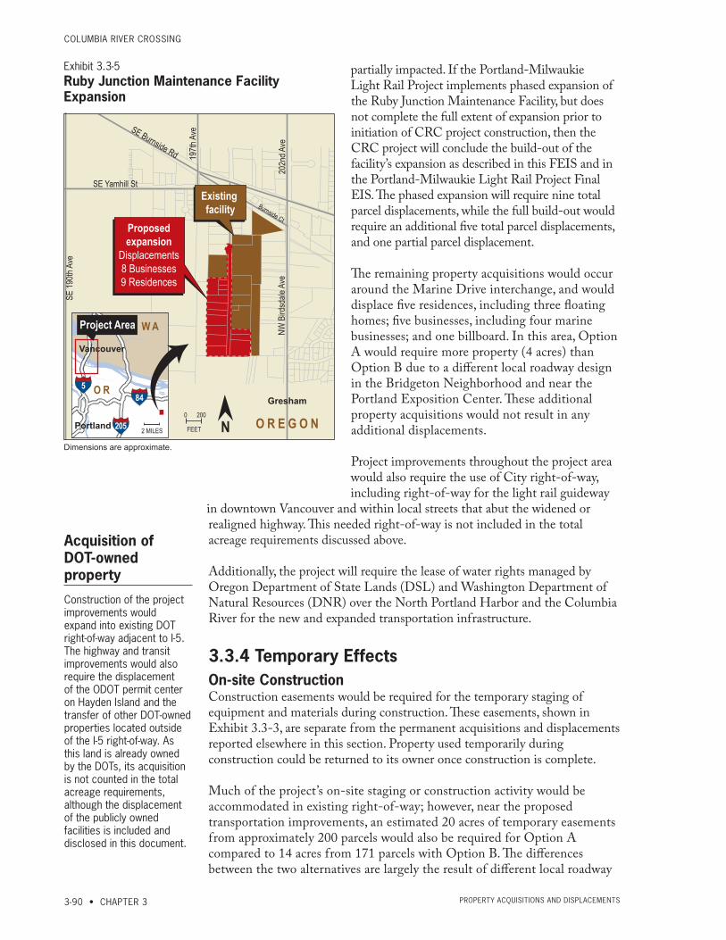
CoLUMBiA RivER CRoSSing
3-90 • CHAPTER 3 PRoPERty ACqUiSitionS And diSPLACEMEntS
partially impacted. If the Portland-Milwaukie Light Rail Project implements phased expansion of the Ruby Junction Maintenance Facility, but does not complete the full extent of expansion prior to initiation of CRC project construction, then the CRC project will conclude the build-out of the facility’s expansion as described in this FEIS and in the Portland-Milwaukie Light Rail Project Final EIS. The phased expansion will require nine total parcel displacements, while the full build-out would require an additional five total parcel displacements, and one partial parcel displacement.
The remaining property acquisitions would occur around the Marine Drive interchange, and would displace five residences, including three floating homes; five businesses, including four marine businesses; and one billboard. In this area, Option A would require more property (4 acres) than Option B due to a different local roadway design in the Bridgeton Neighborhood and near the Portland Exposition Center. These additional property acquisitions would not result in any additional displacements.
Project improvements throughout the project area would also require the use of City right-of-way, including right-of-way for the light rail guideway
in downtown Vancouver and within local streets that abut the widened or realigned highway. This needed right-of-way is not included in the total acreage requirements discussed above.
Additionally, the project will require the lease of water rights managed by Oregon Department of State Lands (DSL) and Washington Department of Natural Resources (DNR) over the North Portland Harbor and the Columbia River for the new and expanded transportation infrastructure.
3.3.4 Temporary EffectsOn-site ConstructionConstruction easements would be required for the temporary staging of equipment and materials during construction. These easements, shown in Exhibit 3.3-3, are separate from the permanent acquisitions and displacements reported elsewhere in this section. Property used temporarily during construction could be returned to its owner once construction is complete.
Much of the project’s on-site staging or construction activity would be accommodated in existing right-of-way; however, near the proposed transportation improvements, an estimated 20 acres of temporary easements from approximately 200 parcels would also be required for Option A compared to 14 acres from 171 parcels with Option B. The differences between the two alternatives are largely the result of different local roadway
Acquisition of DOT-owned property
Construction of the project improvements would expand into existing DOT right-of-way adjacent to I-5. The highway and transit improvements would also require the displacement of the ODOT permit center on Hayden Island and the transfer of other DOT-owned properties located outside of the I-5 right-of-way. As this land is already owned by the DOTs, its acquisition is not counted in the total acreage requirements, although the displacement of the publicly owned facilities is included and disclosed in this document.
5
W A
O R
Portland
Vancouver
845
205
Project Area
2 MILES
NW
Bird
sdale
Ave
202n
d Ave
197th
Ave
SE
190th
Ave
SE Burnside Rd
Burnside Ct
SE Yamhill St
O R E G O N
Gresham
Existing facility
0 200
FEET
Dimensions are approximate.
N
Ruby Junction Maintenance Base ExpansionLight Rail Transit
Proposedexpansion
Displacements8 Businesses9 Residences
1/21/10
Exhibit 3.3-5Ruby Junction Maintenance Facility Expansion
Dimensions are approximate.
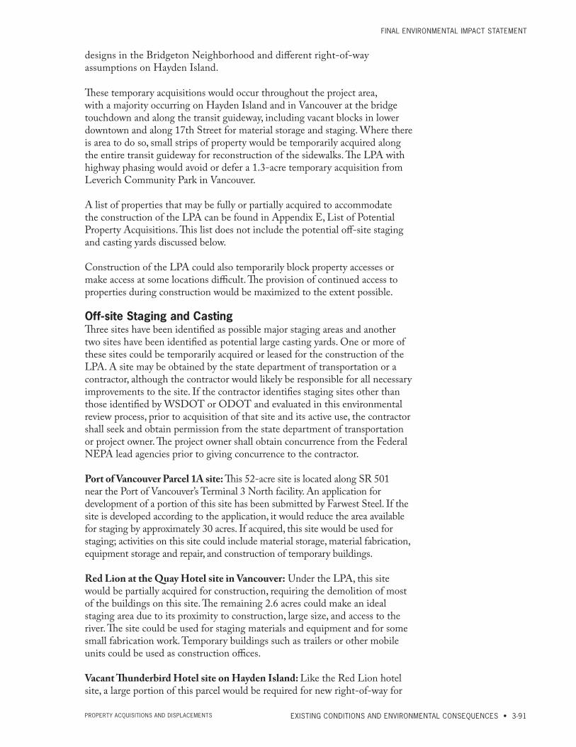
FinAL EnviRonMEntAL iMPACt StAtEMEnt
EXISTING CONDITIONS AND ENVIRONMENTAL CONSEQUENCES • 3-91PRoPERty ACqUiSitionS And diSPLACEMEntS
designs in the Bridgeton Neighborhood and different right-of-way assumptions on Hayden Island.
These temporary acquisitions would occur throughout the project area, with a majority occurring on Hayden Island and in Vancouver at the bridge touchdown and along the transit guideway, including vacant blocks in lower downtown and along 17th Street for material storage and staging. Where there is area to do so, small strips of property would be temporarily acquired along the entire transit guideway for reconstruction of the sidewalks. The LPA with highway phasing would avoid or defer a 1.3-acre temporary acquisition from Leverich Community Park in Vancouver.
A list of properties that may be fully or partially acquired to accommodate the construction of the LPA can be found in Appendix E, List of Potential Property Acquisitions. This list does not include the potential off-site staging and casting yards discussed below.
Construction of the LPA could also temporarily block property accesses or make access at some locations difficult. The provision of continued access to properties during construction would be maximized to the extent possible.
Off-site Staging and CastingThree sites have been identified as possible major staging areas and another two sites have been identified as potential large casting yards. One or more of these sites could be temporarily acquired or leased for the construction of the LPA. A site may be obtained by the state department of transportation or a contractor, although the contractor would likely be responsible for all necessary improvements to the site. If the contractor identifies staging sites other than those identified by WSDOT or ODOT and evaluated in this environmental review process, prior to acquisition of that site and its active use, the contractor shall seek and obtain permission from the state department of transportation or project owner. The project owner shall obtain concurrence from the Federal NEPA lead agencies prior to giving concurrence to the contractor.
Port of Vancouver Parcel 1A site: This 52-acre site is located along SR 501 near the Port of Vancouver’s Terminal 3 North facility. An application for development of a portion of this site has been submitted by Farwest Steel. If the site is developed according to the application, it would reduce the area available for staging by approximately 30 acres. If acquired, this site would be used for staging; activities on this site could include material storage, material fabrication, equipment storage and repair, and construction of temporary buildings.
Red Lion at the Quay Hotel site in Vancouver: Under the LPA, this site would be partially acquired for construction, requiring the demolition of most of the buildings on this site. The remaining 2.6 acres could make an ideal staging area due to its proximity to construction, large size, and access to the river. The site could be used for staging materials and equipment and for some small fabrication work. Temporary buildings such as trailers or other mobile units could be used as construction offices.
Vacant Thunderbird Hotel site on Hayden Island: Like the Red Lion hotel site, a large portion of this parcel would be required for new right-of-way for
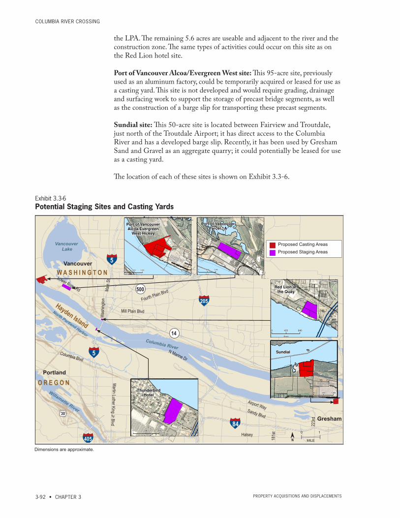
CoLUMBiA RivER CRoSSing
3-92 • CHAPTER 3 PRoPERty ACqUiSitionS And diSPLACEMEntS
the LPA. The remaining 5.6 acres are useable and adjacent to the river and the construction zone. The same types of activities could occur on this site as on the Red Lion hotel site.
Port of Vancouver Alcoa/Evergreen West site: This 95-acre site, previously used as an aluminum factory, could be temporarily acquired or leased for use as a casting yard. This site is not developed and would require grading, drainage and surfacing work to support the storage of precast bridge segments, as well as the construction of a barge slip for transporting these precast segments.
Sundial site: This 50-acre site is located between Fairview and Troutdale, just north of the Troutdale Airport; it has direct access to the Columbia River and has a developed barge slip. Recently, it has been used by Gresham Sand and Gravel as an aggregate quarry; it could potentially be leased for use as a casting yard.
The location of each of these sites is shown on Exhibit 3.3-6.
Figure 3-22. Proposed Staging/Casting Areas
Columbia River
North Portland Harbor
Willamette River
W A S H I N G T O N
O R E G O N
Vancouver
Portland
Hayden Island
5
205
5
84
Vancouver Lake
30
405
500
14
N Marine Dr
Sandy Blvd
Sandy Blvd
Airport Way
Halsey
Columbia Blvd
Martin Luther King Jr Blvd
33rd
223r
d
181s
tLower River Rd
Fourth Plain Blvd
Mill Plain Blvd
Gresham
Main
StW
ashin
gton
0 1
MILEDimensions are approximate.
MARINE
SR-14
SR-500
ST H
ELE
NS
SANDY
HALSEY
1ST
I-205
18TH
LOMBARD
16
2N
D
15
2N
D
78TH
28TH
39TH
WARD
63RD
ST
JO
HN
S
FOURTH PLAIN
LAKE
C
5TH
Q
112
TH
COLUMBIA
AIRPORT
99TH
KILLINGSWORTH
EVERGREEN
33
RD
18
1S
T
FREMONT
15TH
YEON
6TH
SR 500
9TH
42
ND
94TH
10
7T
H
LOWER RIVER
HA
ZE
L D
ELL
83RD
19
2N
D
MILL PLAIN
AN
DR
ES
EN
7TH
68TH
GR
EE
LE
Y
WILLAMETTE
8TH
88TH
38TH
13
7T
H
INT
ER
ST
AT
E
NAITO
53RD
13
8T
H
ING
LE
CU
LLY
49TH
BURTON
25
TH
19
TH
MINNEHAHA
97
TH
66
TH
13
0T
H
GR
AN
D
22
3R
D
MCGILLIVRAY
LAKESH
OR
E
PRESCOTT
LIN
CO
LN
EVERGREEN
15
TH
17
2N
D
18TH
13TH
PORTL
AND
54TH
58TH
DAVIS
LIN
CO
LN S
T J
AM
ES
MACARTHUR
I40
5
MA
RT
I N L
UT
HE
R K
ING
BRADY
PA
RK
ER
FR
UIT
VA
LL
EY
34TH
WEIDLER
LIE
SE
R
LEADBETTER23
8T
H
57
TH
FA
LK
17
6T
H
ROSS
33R
D
TA
LT
ON
DE
VI N
E
DE
NV
ER
16TH
GOING
MCINTOSH
98
TH
LLOYD
109TH
NICOLAI
GO
ODW
IN
FRO
NT
BLU
E LA
KE
CO
VIN
GTO
N
PACIFIC
RIM
BR
AN
DT
FA
RG
O
EL
LS
WO
RT
H
STA
PL
ET
ON
SMITH
PO
RT
77
TH
BER
NIE
VAUGHN
PA
RK
CR
ES
T
MA
RT
IN L
UT
HE
R K
ING
JR
FORT V
ANCO
UVER
KA
UF
FM
AN
RE
SE
RV
E
CASCADE PARK
I84-I205
FOREST HOME
10
4T
H
AS
TO
R
15
5T
H
CA
SC
AD
EFA
IRV
I EW
26
2N
D
COLUMBIA HOUSE
BLA
ND
FO
RD
48TH
I84 FWY-I205 FWY
CHERRY PARK
LOVEJOY
HWY 30
CH
KA
LO
V
BE
LL
A V
ISTA
GH
ER
I84
-I5
POPLAR
MARINE
!̀
THU
RSTO
N
ROSEWOOD
ER
WIN
O R
EIG
ER
ME
MO
RIA
L
I84-181ST
BRIA
R W
OO
D
I84-207TH
OS
WE
GO
I205
FW
Y-I8
4 F
WY
SIE
RR
A
VIL
LA
GE
PHILADELPHIA
NORTH FRONTAGE
VANCOUVER MALL
238TH-I84
93RD
?£
A¬
STEEL
AD
AM
S
I84-HALSEY
I5-GR
EELE
Y
RIC
HM
ON
D
VILLAGE LOOP
13
1S
T
10
8T
H
I 5- I
40
5
I84 FWY-H
ALSEY ST
HE
AR
TH
WO
OD
I20
5-G
LIS
AN
223RD-MARINE
I5 F
WY
-GO
ING
ST
I205-8
4HALSEY-I84
UNNAMED
I5-M
OR
RIS
ON
24
TH
WA
RD
WAY
I205-A
IRP
OR
T
SIM
PS
ON
13
6T
H
41ST
13
7T
H
63RD
12
1S
T
LAKESHORE
FRONTAGE
BROADWAY
45TH
99TH
15TH
WA
SH
I NG
TO
N
82
ND
PORTLAND
I84
28TH
AN
DR
ES
EN
83RD
76TH
20TH
10
2N
D
16
TH
6TH
88TH
39TH
HO
OD
10
9T
H
109TH
PORTLAND
47TH
CO
LU
MB
I A
BYBEE
12
2N
D
20
7T
H
72
ND
50
TH
I405
43RD
34TH
23
2N
D
MCLOUGHLIN
49TH
UNIO
N
28TH
72
ND
5TH
19
9T
H
54
TH
18TH
AS
TO
R
39
TH
29TH
13
TH
98
TH
MA
IN
20TH
AS
TO
R
IVY
SR
- 50
3
88TH
14
2N
D
PRESCOTT
16
2N
D
18
2N
D
33RD
IVY
18TH
I40
5
21
ST
GR
AN
D
SR
-501
40TH
14
2N
D
31
ST
ST HELENS
10
2N
D
DIV
ISIO
N
164TH
WEIDLER
20TH
9T
H
44TH
82
ND
21
ST
BR
OA
DW
AY
78TH
16
0T
H
23
RD
94
TH
60
TH
11TH
10TH
SANDY
11T
H
72
ND
13THMILL PLAIN
EVERGREEN
COLUMBIA
MARINE
COLUMBIA
!̀
!̀
?¿
FREMONT
33
RD
LOMBARD
C o l u m b i a R i v e r
Columbia Slough
City of Portland, Multnomah Co., Oregon
City of Vancouver, Clark Co., Washington
Or e
go
n Sl o u
gh
Analysis by J. Koloszar; Analysis Date: Tuesday, September 06, 2011; File Name: F:\Transfer071911\Stage_Cast_DC212.mxd
0 1 2
Miles
Exhibit 1-4. Proposed Staging and Casting Areas
Parcel Boundaries
Proposed Staging andCasting Areas
Port of VancouverAlcoa/Evergreen
West/Hickey
LOW
ER
RIV
ER
Port of VancouverParcel 1A
LOWER RIVER
Red Lion at the Quay
I-5
CO
LU
MB
IA
SR
-14
SR
-14
I-5
I-5
ThunderbirdHotel
I5I5
Sundial
0 1,000 2,000
Feet
0 1,000 2,000
Feet
0 420 840
Feet
0 390 780
Feet
0 990 1,980
Feet
MARINE
SR-14
SR-500
ST H
ELE
NS
SANDY
HALSEY
1ST
I-205
18TH
LOMBARD
16
2N
D
15
2N
D
78TH
28TH
39TH
WARD
63RD
ST
JO
HN
S
FOURTH PLAIN
LAKE
C
5TH
Q
112
TH
COLUMBIA
AIRPORT
99TH
KILLINGSWORTH
EVERGREEN
33
RD
18
1S
T
FREMONT
15TH
YEON
6TH
SR 500
9TH
42
ND
94TH
10
7T
H
LOWER RIVER
HA
ZE
L D
ELL
83RD
19
2N
D
MILL PLAIN
AN
DR
ES
EN
7TH
68TH
GR
EE
LE
Y
WILLAMETTE
8TH
88TH
38TH
13
7T
H
INT
ER
ST
AT
E
NAITO
53RD
13
8T
H
ING
LE
CU
LLY
49TH
BURTON
25
TH
19
TH
MINNEHAHA
97
TH
66
TH
13
0T
H
GR
AN
D
22
3R
D
MCGILLIVRAY
LAKESH
OR
E
PRESCOTT
LIN
CO
LN
EVERGREEN
15
TH
17
2N
D
18TH
13TH
PORTL
AND
54TH
58TH
DAVIS
LIN
CO
LN S
T J
AM
ES
MACARTHUR
I40
5
MA
RT
I N L
UT
HE
R K
ING
BRADY
PA
RK
ER
FR
UIT
VA
LL
EY
34TH
WEIDLER
LIE
SE
R
LEADBETTER
23
8T
H
57
TH
FA
LK
17
6T
H
ROSS
33R
D
TA
LT
ON
DE
VI N
E
DE
NV
ER
16TH
GOING
MCINTOSH
98
TH
LLOYD
109TH
NICOLAI
GO
ODW
IN
FRO
NT
BLU
E LA
KE
CO
VIN
GTO
N
PACIFIC
RIM
BR
AN
DT
FA
RG
O
EL
LS
WO
RT
H
STA
PL
ET
ON
SMITH
PO
RT
77
TH
BER
NIE
VAUGHN
PA
RK
CR
ES
T
MA
RT
IN L
UT
HE
R K
ING
JR
FORT V
ANCO
UVER
KA
UF
FM
AN
RE
SE
RV
E
CASCADE PARK
I84-I205
FOREST HOME
10
4T
H
AS
TO
R
15
5T
H
CA
SC
AD
EFA
IRV
I EW
26
2N
D
COLUMBIA HOUSE
BLA
ND
FO
RD
48TH
I84 FWY-I205 FWY
CHERRY PARK
LOVEJOY
HWY 30
CH
KA
LO
V
BE
LL
A V
ISTA
GH
ER
I84
-I5
POPLAR
MARINE
!̀
THU
RSTO
N
ROSEWOOD
ER
WIN
O R
EIG
ER
ME
MO
RIA
L
I84-181ST
BRIA
R W
OO
D
I84-207TH
OS
WE
GO
I205
FW
Y-I8
4 F
WY
SIE
RR
A
VIL
LA
GE
PHILADELPHIA
NORTH FRONTAGE
VANCOUVER MALL
238TH-I84
93RD
?£
A¬
STEEL
AD
AM
S
I84-HALSEY
I5-GR
EELE
Y
RIC
HM
ON
D
VILLAGE LOOP
13
1S
T
10
8T
H
I 5- I
40
5
I84 FWY-H
ALSEY ST
HE
AR
TH
WO
OD
I20
5-G
LIS
AN
223RD-MARINEI5
FW
Y-G
OIN
G S
T
I205-8
4HALSEY-I84
UNNAMED
I5-M
OR
RIS
ON
24
TH
WA
RD
WAY
I205-A
IRP
OR
T
SIM
PS
ON
13
6T
H
41ST
13
7T
H
63RD
12
1S
T
LAKESHORE
FRONTAGE
BROADWAY
45TH
99TH
15TH
WA
SH
I NG
TO
N
82
ND
PORTLAND
I84
28TH
AN
DR
ES
EN
83RD
76TH
20TH
10
2N
D
16
TH
6TH
88TH
39TH
HO
OD
10
9T
H
109TH
PORTLAND
47TH
CO
LU
MB
I A
BYBEE
12
2N
D
20
7T
H
72
ND
50
TH
I405
43RD
34TH
23
2N
D
MCLOUGHLIN
49TH
UNIO
N
28TH
72
ND
5TH
19
9T
H
54
TH
18TH
AS
TO
R
39
TH
29TH
13
TH
98
TH
MA
IN
20TH
AS
TO
R
IVY
SR
- 50
3
88TH
14
2N
D
PRESCOTT
16
2N
D
18
2N
D
33RD
IVY
18TH
I40
5
21
ST
GR
AN
D
SR
-501
40TH
14
2N
D
31
ST
ST HELENS
10
2N
D
DIV
ISIO
N
164TH
WEIDLER
20TH
9T
H
44TH
82
ND
21
ST
BR
OA
DW
AY
78TH
16
0T
H
23
RD
94
TH
60
TH
11TH
10TH
SANDY
11T
H
72
ND
13THMILL PLAIN
EVERGREEN
COLUMBIA
MARINE
COLUMBIA
!̀
!̀
?¿
FREMONT
33
RD
LOMBARD
C o l u m b i a R i v e r
Columbia Slough
City of Portland, Multnomah Co., Oregon
City of Vancouver, Clark Co., Washington
Or e
go
n Sl o u
gh
Analysis by J. Koloszar; Analysis Date: Tuesday, September 06, 2011; File Name: F:\Transfer071911\Stage_Cast_DC212.mxd
0 1 2
Miles
Exhibit 1-4. Proposed Staging and Casting Areas
Parcel Boundaries
Proposed Staging andCasting Areas
Port of VancouverAlcoa/Evergreen
West/Hickey
LOW
ER
RIV
ER
Port of VancouverParcel 1A
LOWER RIVER
Red Lion at the Quay
I-5
CO
LU
MB
IA
SR
-14
SR
-14
I-5
I-5
ThunderbirdHotel
I5I5
Sundial
0 1,000 2,000
Feet
0 1,000 2,000
Feet
0 420 840
Feet
0 390 780
Feet
0 990 1,980
Feet
MARINE
SR-14
SR-500
ST H
ELE
NS
SANDY
HALSEY
1ST
I-205
18TH
LOMBARD
16
2N
D
15
2N
D
78TH
28TH
39TH
WARD
63RD
ST
JO
HN
S
FOURTH PLAIN
LAKE
C
5TH
Q
112
TH
COLUMBIA
AIRPORT
99TH
KILLINGSWORTH
EVERGREEN
33
RD
18
1S
T
FREMONT
15TH
YEON
6TH
SR 500
9TH
42
ND
94TH
10
7T
H
LOWER RIVER
HA
ZE
L D
ELL
83RD
19
2N
D
MILL PLAIN
AN
DR
ES
EN
7TH
68TH
GR
EE
LE
Y
WILLAMETTE
8TH
88TH
38TH
13
7T
H
INT
ER
ST
AT
E
NAITO
53RD
13
8T
H
ING
LE
CU
LLY
49TH
BURTON
25
TH
19
TH
MINNEHAHA
97
TH
66
TH
13
0T
H
GR
AN
D
22
3R
D
MCGILLIVRAY
LAKESH
OR
E
PRESCOTT
LIN
CO
LN
EVERGREEN
15
TH
17
2N
D
18TH
13TH
PORTL
AND
54TH
58TH
DAVIS
LIN
CO
LN S
T J
AM
ES
MACARTHUR
I40
5
MA
RT
I N L
UT
HE
R K
ING
BRADY
PA
RK
ER
FR
UIT
VA
LL
EY
34TH
WEIDLER
LIE
SE
R
LEADBETTER
23
8T
H
57
TH
FA
LK
17
6T
H
ROSS
33R
DTA
LT
ON
DE
VI N
E
DE
NV
ER
16TH
GOING
MCINTOSH
98
TH
LLOYD
109TH
NICOLAI
GO
ODW
IN
FRO
NT
BLU
E LA
KE
CO
VIN
GTO
N
PACIFIC
RIM
BR
AN
DT
FA
RG
O
EL
LS
WO
RT
H
STA
PL
ET
ON
SMITH
PO
RT
77
TH
BER
NIE
VAUGHN
PA
RK
CR
ES
T
MA
RT
IN L
UT
HE
R K
ING
JR
FORT V
ANCO
UVER
KA
UF
FM
AN
RE
SE
RV
E
CASCADE PARK
I84-I205
FOREST HOME
10
4T
H
AS
TO
R
15
5T
H
CA
SC
AD
EFA
IRV
I EW
26
2N
D
COLUMBIA HOUSE
BLA
ND
FO
RD
48TH
I84 FWY-I205 FWY
CHERRY PARK
LOVEJOY
HWY 30
CH
KA
LO
V
BE
LL
A V
ISTA
GH
ER
I84
-I5
POPLAR
MARINE
!̀
THU
RSTO
N
ROSEWOOD
ER
WIN
O R
EIG
ER
ME
MO
RIA
L
I84-181ST
BRIA
R W
OO
D
I84-207TH
OS
WE
GO
I205
FW
Y-I8
4 F
WY
SIE
RR
A
VIL
LA
GE
PHILADELPHIA
NORTH FRONTAGE
VANCOUVER MALL
238TH-I84
93RD
?£
A¬
STEEL
AD
AM
S
I84-HALSEY
I5-GR
EELE
Y
RIC
HM
ON
D
VILLAGE LOOP
13
1S
T
10
8T
H
I 5- I
40
5
I84 FWY-H
ALSEY ST
HE
AR
TH
WO
OD
I20
5-G
LIS
AN
223RD-MARINE
I5 F
WY
-GO
ING
ST
I205-8
4HALSEY-I84
UNNAMED
I5-M
OR
RIS
ON
24
TH
WA
RD
WAY
I205-A
IRP
OR
T
SIM
PS
ON
13
6T
H
41ST
13
7T
H
63RD
12
1S
T
LAKESHORE
FRONTAGE
BROADWAY
45TH
99TH
15TH
WA
SH
I NG
TO
N
82
ND
PORTLAND
I84
28TH
AN
DR
ES
EN
83RD
76TH
20TH
10
2N
D
16
TH
6TH
88TH
39TH
HO
OD
10
9T
H
109TH
PORTLAND
47TH
CO
LU
MB
I A
BYBEE
12
2N
D
20
7T
H
72
ND
50
TH
I405
43RD
34TH
23
2N
D
MCLOUGHLIN
49TH
UNIO
N
28TH
72
ND
5TH
19
9T
H
54
TH
18TH
AS
TO
R
39
TH
29TH
13
TH
98
TH
MA
IN
20TH
AS
TO
R
IVY
SR
- 50
3
88TH
14
2N
D
PRESCOTT
16
2N
D
18
2N
D
33RD
IVY
18TH
I40
5
21
ST
GR
AN
D
SR
-501
40TH
14
2N
D
31
ST
ST HELENS
10
2N
D
DIV
ISIO
N
164TH
WEIDLER
20TH
9T
H
44TH
82
ND
21
ST
BR
OA
DW
AY
78TH
16
0T
H
23
RD
94
TH
60
TH
11TH
10TH
SANDY
11T
H
72
ND
13THMILL PLAIN
EVERGREEN
COLUMBIA
MARINE
COLUMBIA
!̀
!̀
?¿
FREMONT
33
RD
LOMBARD
C o l u m b i a R i v e r
Columbia Slough
City of Portland, Multnomah Co., Oregon
City of Vancouver, Clark Co., Washington
Or e
go
n Sl o u
gh
Analysis by J. Koloszar; Analysis Date: Tuesday, September 06, 2011; File Name: F:\Transfer071911\Stage_Cast_DC212.mxd
0 1 2
Miles
Exhibit 1-4. Proposed Staging and Casting Areas
Parcel Boundaries
Proposed Staging andCasting Areas
Port of VancouverAlcoa/Evergreen
West/Hickey
LOW
ER
RIV
ER
Port of VancouverParcel 1A
LOWER RIVER
Red Lion at the Quay
I-5
CO
LU
MB
IA
SR
-14
SR
-14
I-5
I-5
ThunderbirdHotel
I5I5
Sundial
0 1,000 2,000
Feet
0 1,000 2,000
Feet
0 420 840
Feet
0 390 780
Feet
0 990 1,980
Feet
MARINE
SR-14
SR-500
ST H
ELE
NS
SANDY
HALSEY
1ST
I-205
18TH
LOMBARD
16
2N
D
15
2N
D
78TH
28TH
39TH
WARD
63RD
ST
JO
HN
S
FOURTH PLAIN
LAKE
C
5TH
Q
112
TH
COLUMBIA
AIRPORT
99TH
KILLINGSWORTH
EVERGREEN
33
RD
18
1S
T
FREMONT
15TH
YEON
6TH
SR 500
9TH
42
ND
94TH
10
7T
H
LOWER RIVER
HA
ZE
L D
ELL
83RD
19
2N
D
MILL PLAIN
AN
DR
ES
EN
7TH
68TH
GR
EE
LE
Y
WILLAMETTE
8TH
88TH
38TH
13
7T
H
INT
ER
ST
AT
E
NAITO
53RD
13
8T
H
ING
LE
CU
LLY
49TH
BURTON
25
TH
19
TH
MINNEHAHA
97
TH
66
TH
13
0T
H
GR
AN
D
22
3R
D
MCGILLIVRAY
LAKESH
OR
E
PRESCOTT
LIN
CO
LN
EVERGREEN
15
TH
17
2N
D
18TH
13TH
PORTL
AND
54TH
58TH
DAVIS
LIN
CO
LN S
T J
AM
ES
MACARTHUR
I40
5
MA
RT
I N L
UT
HE
R K
ING
BRADY
PA
RK
ER
FR
UIT
VA
LL
EY
34TH
WEIDLER
LIE
SE
R
LEADBETTER
23
8T
H
57
TH
FA
LK
17
6T
H
ROSS
33R
D
TA
LT
ON
DE
VI N
E
DE
NV
ER
16TH
GOING
MCINTOSH
98
TH
LLOYD
109TH
NICOLAI
GO
ODW
IN
FRO
NT
BLU
E LA
KE
CO
VIN
GTO
N
PACIFIC
RIM
BR
AN
DT
FA
RG
O
EL
LS
WO
RT
H
STA
PL
ET
ON
SMITH
PO
RT
77
TH
BER
NIE
VAUGHN
PA
RK
CR
ES
T
MA
RT
IN L
UT
HE
R K
ING
JR
FORT V
ANCO
UVER
KA
UF
FM
AN
RE
SE
RV
E
CASCADE PARK
I84-I205
FOREST HOME
10
4T
H
AS
TO
R
15
5T
H
CA
SC
AD
EFA
IRV
I EW
26
2N
D
COLUMBIA HOUSE
BLA
ND
FO
RD
48TH
I84 FWY-I205 FWY
CHERRY PARK
LOVEJOY
HWY 30
CH
KA
LO
V
BE
LL
A V
ISTA
GH
ER
I84
-I5
POPLAR
MARINE
!̀
THU
RSTO
N
ROSEWOOD
ER
WIN
O R
EIG
ER
ME
MO
RIA
L
I84-181ST
BRIA
R W
OO
D
I84-207TH
OS
WE
GO
I205
FW
Y-I8
4 F
WY
SIE
RR
A
VIL
LA
GE
PHILADELPHIA
NORTH FRONTAGE
VANCOUVER MALL
238TH-I84
93RD
?£
A¬
STEEL
AD
AM
S
I84-HALSEY
I5-GR
EELE
Y
RIC
HM
ON
D
VILLAGE LOOP
13
1S
T
10
8T
H
I 5- I
40
5
I84 FWY-H
ALSEY ST
HE
AR
TH
WO
OD
I20
5-G
LIS
AN
223RD-MARINE
I5 F
WY
-GO
ING
ST
I205-8
4HALSEY-I84
UNNAMED
I5-M
OR
RIS
ON
24
TH
WA
RD
WAY
I205-A
IRP
OR
T
SIM
PS
ON
13
6T
H
41ST
13
7T
H
63RD
12
1S
T
LAKESHORE
FRONTAGE
BROADWAY
45TH
99TH
15TH
WA
SH
I NG
TO
N
82
ND
PORTLAND
I84
28TH
AN
DR
ES
EN
83RD
76TH
20TH
10
2N
D
16
TH
6TH
88TH
39TH
HO
OD
10
9T
H
109TH
PORTLAND
47TH
CO
LU
MB
I A
BYBEE
12
2N
D
20
7T
H
72
ND
50
TH
I405
43RD
34TH
23
2N
D
MCLOUGHLIN
49TH
UNIO
N
28TH
72
ND
5TH
19
9T
H
54
TH
18TH
AS
TO
R
39
TH
29TH
13
TH
98
TH
MA
IN
20TH
AS
TO
R
IVY
SR
- 50
3
88TH
14
2N
D
PRESCOTT
16
2N
D
18
2N
D
33RDIV
Y
18TH
I40
5
21
ST
GR
AN
D
SR
-501
40TH
14
2N
D
31
ST
ST HELENS
10
2N
D
DIV
ISIO
N
164TH
WEIDLER
20TH
9T
H
44TH
82
ND
21
ST
BR
OA
DW
AY
78TH
16
0T
H
23
RD
94
TH
60
TH
11TH
10TH
SANDY
11T
H
72
ND
13THMILL PLAIN
EVERGREEN
COLUMBIA
MARINE
COLUMBIA
!̀
!̀
?¿
FREMONT
33
RD
LOMBARD
C o l u m b i a R i v e r
Columbia Slough
City of Portland, Multnomah Co., Oregon
City of Vancouver, Clark Co., Washington
Or e
go
n Sl o u
gh
Analysis by J. Koloszar; Analysis Date: Tuesday, September 06, 2011; File Name: F:\Transfer071911\Stage_Cast_DC212.mxd
0 1 2
Miles
Exhibit 1-4. Proposed Staging and Casting Areas
Parcel Boundaries
Proposed Staging andCasting Areas
Port of VancouverAlcoa/Evergreen
West/Hickey
LOW
ER
RIV
ER
Port of VancouverParcel 1A
LOWER RIVER
Red Lion at the Quay
I-5
CO
LU
MB
IA
SR
-14
SR
-14
I-5
I-5
ThunderbirdHotel
I5I5
Sundial
0 1,000 2,000
Feet
0 1,000 2,000
Feet
0 420 840
Feet
0 390 780
Feet
0 990 1,980
Feet
MARINE
SR-14
SR-500
ST H
ELE
NS
SANDY
HALSEY
1ST
I-205
18TH
LOMBARD
16
2N
D
15
2N
D
78TH
28TH
39TH
WARD
63RD
ST
JO
HN
S
FOURTH PLAIN
LAKE
C
5TH
Q
112
TH
COLUMBIA
AIRPORT
99TH
KILLINGSWORTH
EVERGREEN
33
RD
18
1S
T
FREMONT
15TH
YEON
6TH
SR 500
9TH
42
ND
94TH
10
7T
H
LOWER RIVER
HA
ZE
L D
ELL
83RD
19
2N
D
MILL PLAIN
AN
DR
ES
EN
7TH
68TH
GR
EE
LE
Y
WILLAMETTE
8TH
88TH
38TH
13
7T
H
INT
ER
ST
AT
E
NAITO
53RD
13
8T
H
ING
LE
CU
LLY
49TH
BURTON
25
TH
19
TH
MINNEHAHA
97
TH
66
TH
13
0T
H
GR
AN
D
22
3R
DMCGILLIVRAY
LAKESH
OR
E
PRESCOTT
LIN
CO
LN
EVERGREEN
15
TH
17
2N
D
18TH
13TH
PORTL
AND
54TH
58TH
DAVIS
LIN
CO
LN S
T J
AM
ES
MACARTHUR
I40
5
MA
RT
I N L
UT
HE
R K
ING
BRADY
PA
RK
ER
FR
UIT
VA
LL
EY
34TH
WEIDLER
LIE
SE
R
LEADBETTER
23
8T
H
57
TH
FA
LK
17
6T
H
ROSS
33R
D
TA
LT
ON
DE
VI N
E
DE
NV
ER
16TH
GOING
MCINTOSH
98
TH
LLOYD
109TH
NICOLAI
GO
ODW
IN
FRO
NT
BLU
E LA
KE
CO
VIN
GTO
N
PACIFIC
RIM
BR
AN
DT
FA
RG
O
EL
LS
WO
RT
H
STA
PL
ET
ON
SMITH
PO
RT
77
TH
BER
NIE
VAUGHN
PA
RK
CR
ES
TM
AR
TIN
LU
TH
ER
KIN
G JR
FORT V
ANCO
UVER
KA
UF
FM
AN
RE
SE
RV
E
CASCADE PARK
I84-I205
FOREST HOME
10
4T
H
AS
TO
R
15
5T
H
CA
SC
AD
EFA
IRV
I EW
26
2N
D
COLUMBIA HOUSE
BLA
ND
FO
RD
48TH
I84 FWY-I205 FWY
CHERRY PARK
LOVEJOY
HWY 30
CH
KA
LO
V
BE
LL
A V
ISTA
GH
ER
I84
-I5
POPLAR
MARINE
!̀
THU
RSTO
N
ROSEWOOD
ER
WIN
O R
EIG
ER
ME
MO
RIA
L
I84-181ST
BRIA
R W
OO
D
I84-207TH
OS
WE
GO
I205
FW
Y-I8
4 F
WY
SIE
RR
A
VIL
LA
GE
PHILADELPHIA
NORTH FRONTAGE
VANCOUVER MALL
238TH-I84
93RD
?£
A¬
STEEL
AD
AM
S
I84-HALSEY
I5-GR
EELE
Y
RIC
HM
ON
D
VILLAGE LOOP
13
1S
T
10
8T
H
I 5- I
40
5
I84 FWY-H
ALSEY ST
HE
AR
TH
WO
OD
I20
5-G
LIS
AN
223RD-MARINE
I5 F
WY
-GO
ING
ST
I205-8
4HALSEY-I84
UNNAMED
I5-M
OR
RIS
ON
24
TH
WA
RD
WAY
I205-A
IRP
OR
T
SIM
PS
ON
13
6T
H
41ST
13
7T
H
63RD
12
1S
T
LAKESHORE
FRONTAGE
BROADWAY
45TH
99TH
15TH
WA
SH
I NG
TO
N
82
ND
PORTLAND
I84
28TH
AN
DR
ES
EN
83RD
76TH
20TH
10
2N
D
16
TH
6TH
88TH
39TH
HO
OD
10
9T
H
109TH
PORTLAND
47TH
CO
LU
MB
I A
BYBEE
12
2N
D
20
7T
H
72
ND
50
TH
I405
43RD
34TH
23
2N
D
MCLOUGHLIN
49THUNIO
N
28TH
72
ND
5TH
19
9T
H
54
TH
18TH
AS
TO
R
39
TH
29TH
13
TH
98
TH
MA
IN
20TH
AS
TO
R
IVY
SR
- 50
3
88TH
14
2N
D
PRESCOTT
16
2N
D
18
2N
D
33RD
IVY
18TH
I40
5
21
ST
GR
AN
D
SR
-501
40TH
14
2N
D
31
ST
ST HELENS
10
2N
D
DIV
ISIO
N164TH
WEIDLER
20TH
9T
H
44TH
82
ND
21
ST
BR
OA
DW
AY
78TH
16
0T
H
23
RD
94
TH
60
TH
11TH
10TH
SANDY
11T
H
72
ND
13THMILL PLAIN
EVERGREEN
COLUMBIA
MARINE
COLUMBIA
!̀
!̀
?¿
FREMONT
33
RD
LOMBARD
C o l u m b i a R i v e r
Columbia Slough
City of Portland, Multnomah Co., Oregon
City of Vancouver, Clark Co., Washington
Or e
go
n Sl o u
gh
Analysis by J. Koloszar; Analysis Date: Tuesday, September 06, 2011; File Name: F:\Transfer071911\Stage_Cast_DC212.mxd
0 1 2
Miles
Exhibit 1-4. Proposed Staging and Casting Areas
Parcel Boundaries
Proposed Staging andCasting Areas
Port of VancouverAlcoa/Evergreen
West/Hickey
LOW
ER
RIV
ER
Port of VancouverParcel 1A
LOWER RIVER
Red Lion at the Quay
I-5
CO
LU
MB
IA
SR
-14
SR
-14
I-5
I-5
ThunderbirdHotel
I5I5
Sundial
0 1,000 2,000
Feet
0 1,000 2,000
Feet
0 420 840
Feet
0 390 780
Feet
0 990 1,980
Feet
Dimensions are approximate.
Parcel Boundaries
Proposed Staging and Casting Areas
Proposed Casting AreasProposed Staging Areas
N
Exhibit 3.3-6Potential Staging Sites and Casting Yards
Dimensions are approximate.
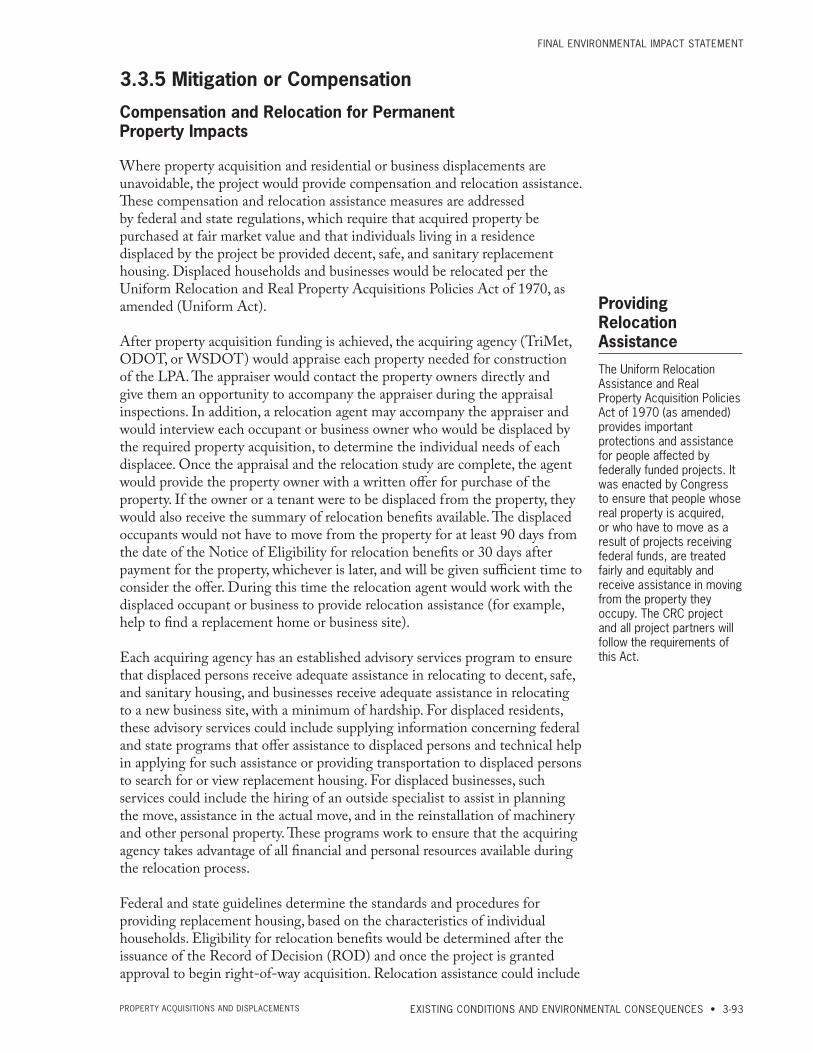
FinAL EnviRonMEntAL iMPACt StAtEMEnt
EXISTING CONDITIONS AND ENVIRONMENTAL CONSEQUENCES • 3-93PRoPERty ACqUiSitionS And diSPLACEMEntS
3.3.5 Mitigation or Compensation
Compensation and Relocation for Permanent Property Impacts
Where property acquisition and residential or business displacements are unavoidable, the project would provide compensation and relocation assistance. These compensation and relocation assistance measures are addressed by federal and state regulations, which require that acquired property be purchased at fair market value and that individuals living in a residence displaced by the project be provided decent, safe, and sanitary replacement housing. Displaced households and businesses would be relocated per the Uniform Relocation and Real Property Acquisitions Policies Act of 1970, as amended (Uniform Act).
After property acquisition funding is achieved, the acquiring agency (TriMet, ODOT, or WSDOT) would appraise each property needed for construction of the LPA. The appraiser would contact the property owners directly and give them an opportunity to accompany the appraiser during the appraisal inspections. In addition, a relocation agent may accompany the appraiser and would interview each occupant or business owner who would be displaced by the required property acquisition, to determine the individual needs of each displacee. Once the appraisal and the relocation study are complete, the agent would provide the property owner with a written offer for purchase of the property. If the owner or a tenant were to be displaced from the property, they would also receive the summary of relocation benefits available. The displaced occupants would not have to move from the property for at least 90 days from the date of the Notice of Eligibility for relocation benefits or 30 days after payment for the property, whichever is later, and will be given sufficient time to consider the offer. During this time the relocation agent would work with the displaced occupant or business to provide relocation assistance (for example, help to find a replacement home or business site).
Each acquiring agency has an established advisory services program to ensure that displaced persons receive adequate assistance in relocating to decent, safe, and sanitary housing, and businesses receive adequate assistance in relocating to a new business site, with a minimum of hardship. For displaced residents, these advisory services could include supplying information concerning federal and state programs that offer assistance to displaced persons and technical help in applying for such assistance or providing transportation to displaced persons to search for or view replacement housing. For displaced businesses, such services could include the hiring of an outside specialist to assist in planning the move, assistance in the actual move, and in the reinstallation of machinery and other personal property. These programs work to ensure that the acquiring agency takes advantage of all financial and personal resources available during the relocation process.
Federal and state guidelines determine the standards and procedures for providing replacement housing, based on the characteristics of individual households. Eligibility for relocation benefits would be determined after the issuance of the Record of Decision (ROD) and once the project is granted approval to begin right-of-way acquisition. Relocation assistance could include
Providing Relocation Assistance
The Uniform Relocation Assistance and Real Property Acquisition Policies Act of 1970 (as amended) provides important protections and assistance for people affected by federally funded projects. It was enacted by Congress to ensure that people whose real property is acquired, or who have to move as a result of projects receiving federal funds, are treated fairly and equitably and receive assistance in moving from the property they occupy. The CRC project and all project partners will follow the requirements of this Act.
CoLUMBiA RivER CRoSSing
3-94 • CHAPTER 3 PRoPERty ACqUiSitionS And diSPLACEMEntS
replacement housing for displaced persons, moving costs, and assistance in locating replacement housing. Similarly, relocation assistance for businesses could include moving costs, site search expenses, business reestablishment expenses, and assistance in locating a replacement business site. The specifics of relocation assistance are determined on an individual basis and are based, in part, upon ownership or tenant status.
The relocation potential for certain types of displacements are discussed below.
• Public Use Facilities: Publicly owned facilities that are displaced, such as ODOT permit center, could be functionally replaced with another facility that would provide equivalent utility. Alternately, such facilities could be provided relocation assistance in a similar fashion as displaced businesses, as is assumed for the Clark Public Utilities Energy Conservation Office.
• Floating Homes in North Portland Harbor: Up to 35 floating homes in North Portland Harbor would be displaced with the LPA. Floating homes will be treated as real property in accordance with ODOT policy. The floating homes will be purchased at fair market value and the occupants will be provided relocation assistance that may include payments. A search of the active listings in April 2011 showed approximately 109 housing units listed for sale in the project area. Of that number, there were 40 floating homes, 38 condos, and 31 conventional homes. These numbers do not include private listings. Considering that some of the occupants will choose to leave the project area, there appears to be a sufficient supply of replacement housing in the project area.
• Businesses on Hayden Island: More than half of the commercial uses displaced by the LPA are located on Hayden Island. Although there are multiple vacant buildings on the island, including several in and around the Jantzen Beach SuperCenter, the island is limited in its capacity to provide appropriate replacement sites for the 39 businesses that would be displaced by the LPA. As a result, many of these businesses may have to relocate outside the main project area. Consistent with the Hayden Island Plan (City of Portland 2009), the owners of Jantzen Beach SuperCenter have proposed redeveloping their site. This redevelopment would include new commercial space that could house existing businesses and attract new ones to the island. It is not known when this redevelopment would occur, and therefore it is not known whether businesses displaced by the LPA could be directly relocated to the newly constructed space.
• Safeway Store on Hayden Island: The acquiring agencies may suggest replacement sites for this business, but it is up to the store owners to choose their replacement location, if any. Safeway officials have indicated that it would be difficult for the store to relocate to another site on Hayden Island or in the Delta Park area because of the current lack of available sites. They may be able to locate a replacement store in either the North Portland area or South Vancouver. Alternately, Safeway may choose to remodel or expand existing stores in Vancouver or Portland.
• Marine Businesses in North Portland Harbor: The marine businesses displaced from the south shore of North Portland Harbor may be
FinAL EnviRonMEntAL iMPACt StAtEMEnt
EXISTING CONDITIONS AND ENVIRONMENTAL CONSEQUENCES • 3-95PRoPERty ACqUiSitionS And diSPLACEMEntS
difficult to relocate, given the limited waterfront space available and the necessary in-water infrastructure needed to support these businesses. These businesses may have to relocate to available sites upstream or downstream on the Columbia or to sites on the Willamette River.
• Shared Light Industrial and Residential Uses in Ruby Junction: Eight light industrial businesses and nine residences would be displaced by the Ruby Junction Maintenance Facility expansion (Exhibit 3.3-5). Although replacement industrial property is available in the Gresham area, as indicated in the existing conditions discussion, many of these businesses are also associated with residences that share the same building or are located nearby. Relocation assistance would be provided to assist the owners in a search for suitable residential/industrial properties. However, some of these displacees may have to locate in separate residential and commercial sites.
For a discussion of the relocation potential for other displaced residences and businesses throughout the project area, please see the Acquisitions Technical Report, included as an electronic appendix to this FEIS.
Compensation for Temporary Property ImpactsCompensation for construction easements could include payment to property owners in exchange for the use of their property during construction. For example, one method for compensation would be to pay the equivalent of a “rental” based on the property appraisal. Temporary or permanent impacts to real or personal property, due to temporary construction uses, would be compensated according to fair-market or contributory value.
The project would also provide mitigation where construction activities would block essential access to certain properties. A partial reduction in general access would not necessarily be mitigated, but the provision of continued access to properties during construction would be maximized to the extent possible.

CoLUMBiA RivER CRoSSing
3-96 • CHAPTER 3 PRoPERty ACqUiSitionS And diSPLACEMEntS
This page intentionally left blank.