WHY ARE WE HERE TODAY? We are here to share information and gather feedback and comments on the Draft Terms of Reference for the Environmental Assessment, including: • Baseline studies to support the EA • Criteria and indicators for the evaluation of potential environmental effects (positive and negative) • Preliminary route alternatives • Methods of consultation and engagement We encourage you to review the information and maps, and speak to our Project Team to provide feedback, ask questions, or about any concerns. We also have information available on our website: www.supplyroad.ca WSR240-WEB-PR-PN-0020 Web-display boards for Open Houses-2019-10-09

Welcome message from author
This document is posted to help you gain knowledge. Please leave a comment to let me know what you think about it! Share it to your friends and learn new things together.
Transcript

WHY ARE WE HERE TODAY? We are here to share information and gather feedback and comments on the Draft Terms of Reference for the Environmental Assessment, including:
• Baseline studies to support the EA
• Criteria and indicators for the evaluation of potential environmental effects (positive and negative)
• Preliminary route alternatives
• Methods of consultation and engagement
We encourage you to review the information and maps, and speak to our Project Team to provide feedback, ask questions, or about any concerns.
We also have information available on our website: www.supplyroad.ca
WSR240-WEB-PR-PN-0020 Web-display boards for Open Houses-2019-10-09

BACKGROUND
• This is not an environmental assessment for the proposed Ring of Fire mining developments
• This is not an environmental assessment for a road connecting to the provincial road network
• This is a Supply Road connecting Webequie First Nation (WFN) to the Ring of Fire
• The purpose of the Supply Road is to allow WFN to benefit from opportunities associated with the planning, development and operation of any mines that might be developed in the area, as well as mineral exploration activities.

PROJECT SETTING - REGIONAL

WEBEQUIE’S THREE-TIER APPROACH
RELATIONAL TIER: Preserving the Indigenous Culture of the Community
• Increasing understanding of the culture by others • Language • Traditional cultural activities • Ancestral knowledge inheritance – recording and passing
down knowledge from the elders
FOUNDATIONAL TIER: Treaty and Partnerships
• Fair sharing of benefits from the land with government and industry
• Physical health
• Mental health
• Social health
• Education
• Employment opportunities
• Income
CORE TIER: The Community and their Overall Well-Being The three tiers are closely connected
and depend on each other.

WEBEQUIE’S ELDERS’ PRINCIPLES
The Elders’ Principles are infused in our approach to consultation
›Mutual recognition of inherent rights
›Mutual recognition of ancestral knowledge
›Mutual recognition of traditional knowledge and practices
›Mutual recognition of clan families and relationships
›Mutual recognition of sustainable livelihood
›Mutual recognition of traditional protocols
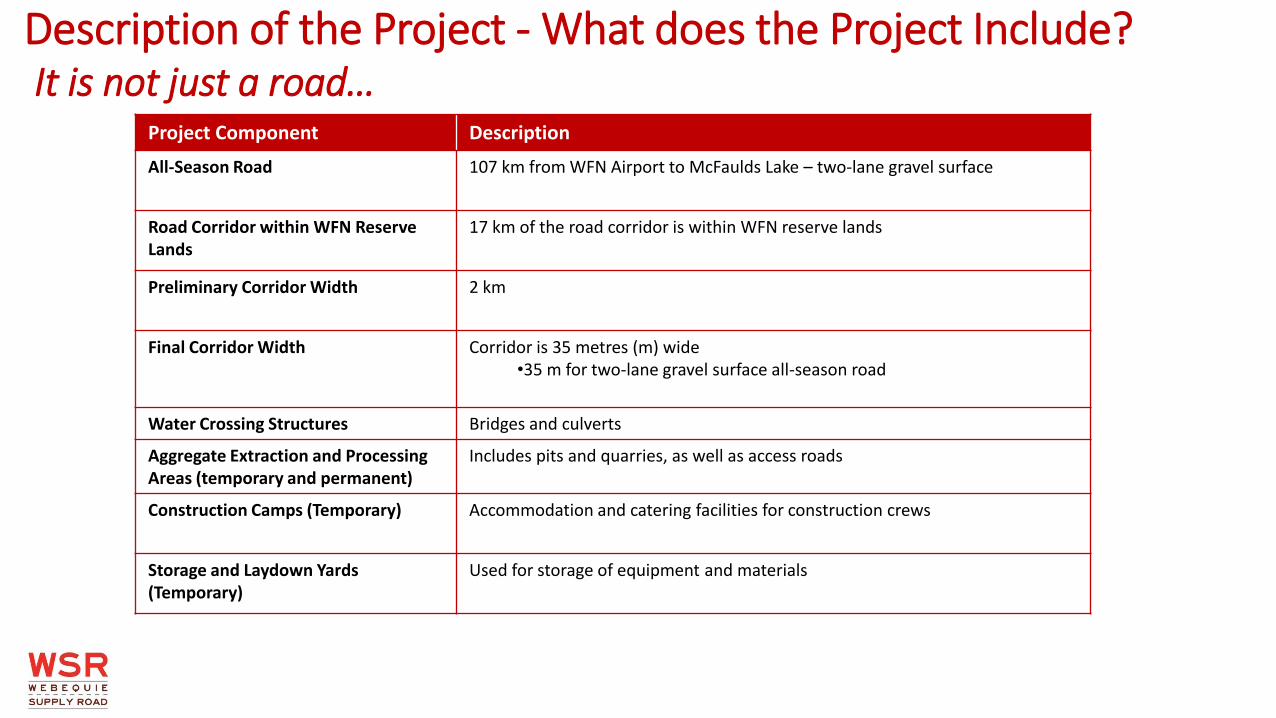
Description of the Project - What does the Project Include? It is not just a road…
Project Component Description
All-Season Road 107 km from WFN Airport to McFaulds Lake – two-lane gravel surface
Road Corridor within WFN Reserve Lands
17 km of the road corridor is within WFN reserve lands
Preliminary Corridor Width 2 km
Final Corridor Width Corridor is 35 metres (m) wide •35 m for two-lane gravel surface all-season road
Water Crossing Structures Bridges and culverts
Aggregate Extraction and Processing Areas (temporary and permanent)
Includes pits and quarries, as well as access roads
Construction Camps (Temporary) Accommodation and catering facilities for construction crews
Storage and Laydown Yards (Temporary)
Used for storage of equipment and materials
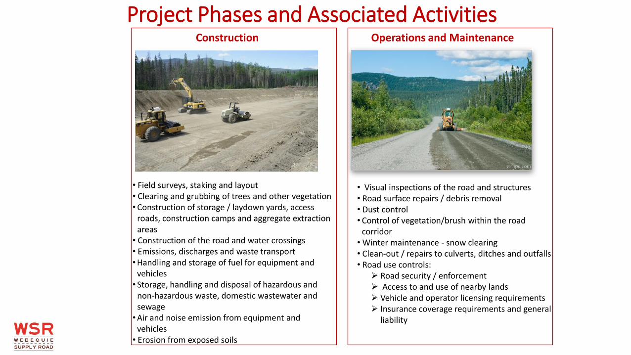
Project Phases and Associated Activities
• Field surveys, staking and layout • Clearing and grubbing of trees and other vegetation • Construction of storage / laydown yards, access
roads, construction camps and aggregate extraction areas
• Construction of the road and water crossings • Emissions, discharges and waste transport •Handling and storage of fuel for equipment and
vehicles • Storage, handling and disposal of hazardous and
non-hazardous waste, domestic wastewater and sewage
•Air and noise emission from equipment and vehicles
• Erosion from exposed soils
Construction Operations and Maintenance
• Visual inspections of the road and structures • Road surface repairs / debris removal • Dust control • Control of vegetation/brush within the road
corridor • Winter maintenance - snow clearing • Clean-out / repairs to culverts, ditches and outfalls • Road use controls: Road security / enforcement Access to and use of nearby lands Vehicle and operator licensing requirements Insurance coverage requirements and general
liability

Coordinated Webequie-Federal–Provincial EA Process
Webequie prepares ToR (draft & final) for Minister’s decision
Ministry Review
Provincial EA Decision
Agency Issues TISG
Webequie conducts studies,
consults, and prepares
EAR/IS in accordance with approved
ToR/TISG and
3-Tier Model
Draft and Final IA
Report and Potential
Conditions
Federal Decision
Statement
Coordinated Federal-
Provincial-Webequie review of,
and consultation on
EAR/IS (draft & final)
Provincial EA
Federal EA
Voluntary Agreement
Webequie submits Initial
Project Description
Compliance &
Enforcement
Permits &
Approvals
Mitigation &
Monitoring/ Follow-up
Webequie submits Detailed
Project Description
Ongoing opportunities for consultation with Indigenous communities
You are here Formal opportunity for Indigenous consultation & public participation
Agency determines if EA required
Step completed
Acronyms:
ToR = Terms of Reference
TISG = Tailored Impact Statement Guidelines
EAR/IS = Environmental Assessment
Report/Impact Statement
Determine if EA is Required and Plan EA
Evaluate Project: Gather Info and Assess Effects
Review the EAR/IS
Make EA Decision
Post EA Approvals/
Permits
3-Tier Model Inherent
Rights
Webequie Principles
Webequie prepares to engage membership and neighbours
on ToR & TISG
Community Review
Council Decision
Webequie FN Principles &
Environmental Stewardship -----------------
Project Description ---------------- Traditional Knowledge
Project Description Evolution
8

WHAT DOES AN ENVIRONMENTAL ASSESSMENT CONSIDER?
An Environmental Assessment is a planning tool to:
• Identify potential effects (positive and negative) to the environment (natural, social, cultural)
• Identify mitigation measures to reduce or remove potential negative effects
• Facilitate decision-making
• Provide opportunities to comment on how the Project may impact communities and their use of land
IDENTIFY NET AND CUMULATIVE EFFECTS
Are there effects that cannot be avoided? Are there effects that could be combined with
effects of other projects?
IDENTIFY MITIGATION MEASURES
What can we do to avoid/reduce/remove the potential effect?
ASSESS POTENTIAL EFFECTS
What are the positive effects as a result of the Supply Road?
What are the negative effects as a result of the Supply Road?
CONDUCT BASELINE STUDIES
What does the environment look like now?

BASELINE STUDIES
Natural Environment
• Wildlife
• Species at Risk
• Vegetation
• Aquatic
• Soils
• Surface Water
Socio-Cultural Environment
• Population & Demographics
• Human Health
• Community Well-Being
• Infrastructure and Services
• Land and Resource Use
• Cultural Heritage Resources
White Sucker Marsh Grass of Parnassis Wood Frog Juvenile Northern Pike Fireweed

Potential Environmental Effects – Biophysical Environment Project Component or Activity Potential Effects Mitigation / Control Measures
Field surveys, staking and layout
Soil compaction and increased rates of erosion (soil loss) from equipment use and exposed soils
• Erosion control blankets, seed and cover/mulch to prevent erosion and/or control soil from entering waterways
Clearing and grubbing of trees and other vegetation
Loss of vegetation from clearing; and associated loss of wildlife habitat
• Chipping, leaving in place and small wood scattering
• Avoid vegetation clearing during migratory bird nesting period and/or sensitive life cycle periods for Species at Risk (e.g., caribou, bats, etc.)
Construction of infrastructure, including storage and laydown yards, access/haul roads, construction camps and aggregate extraction areas
Changes or disturbances to wildlife habitat (e.g., migratory birds, species at risk)
• Restore disturbed areas related to temporary infrastructure (e.g., access roads, construction camps)
Construction of the road, including permanent and temporary waterbody crossings
Changes to surface water quality and flow, and/or fish habitat
Negative impacts on environmentally significant or sensitive areas
• Protect fish during the spawning and rearing period by avoiding work in water during certain time periods
• Install erosion and sediment control measures and use best management practices
• Isolate and temporarily shift water flow away from work zone
• Use appropriate capture, handling and release techniques to avoid harm to fish

Potential Environmental Effects – Biophysical Environment Project Component or Activity Potential Effects Mitigation Measures
Transport, handling and storage of fuel, disposal of waste oil, lubricants and other fluid
Storage, handing and disposal of hazardous waste and non-hazardous domestic waste, domestic wastewater, sewage
Operation of construction equipment and vehicles
Blasting (to obtain rock for crushing to build road)
Impact to groundwater level, quality, and/or contribution to waterbodies or wetlands
Spills of oil, gasoline and other chemicals that contaminate soil, groundwater or waterbodies
Dust and exhaust emissions from equipment and vehicles
Increase in noise levels during construction and operation phases, with potential impact to wildlife
Blasting can disrupt community activities, wildlife behaviour, or harm fish/fish habitat where near a waterbody
• Store, handle and dispose of all excess materials in a manner that prevents release to the environment
• Operate, maintain and store (e.g., fuel, lubricates, waste oils) all equipment and materials using best management practices (the accepted most responsible ways to do things)
• Maintain vehicles and equipment
• Control dust
• Provide timely notification to residents and control blasting in environmentally sensitive areas
Operations and maintenance, such as road repairs, vegetation management
Rehabilitation/restoration of temporary infrastructure
Wildlife mortality (death) due to vehicle collisions during operations

Potential Environmental Effects - Socio-Economic Environment Positive Effects/Benefits
Economic
• Employment and economic benefits to community members and businesses of neighbouring Indigenous communities during construction and operation/maintenance (i.e., heavy equipment operation, environmental monitoring, catering, camp operations)
• Emergence of economic opportunities along the road (i.e., gas stations, restaurants)
• Opportunity for WFN and other First Nations to own and/or construct, and operate and maintain the road, including opportunity for revenue generation and potential for subsequent investment in economic development opportunities
Education/Training
• Opportunities for capacity building and business training
• Opportunity for youth - employment and training opportunities
• Possible higher overall educational levels and capacity
Social
• Higher household incomes from increased economic activity allowing for improved standard of living

Negative Effects
Social/Health
• May offer easier access to undesirable substances, possibly causing more health and social issues in community
• More outsiders coming into area causing possible social issues
Economic
• Possible loss of government transfer payments currently paid to community due to remote isolation status
• May facilitate more outsiders coming into community, such as resource users, that put strain on traditional territories for hunting, fishing, mineral resource exploration, as well as pressure on wildlife populations and movements
Culture
• Loss of disruption to current traditional land and resource uses such as hunting, gathering, fishing, trapping (from possible direct project impacts to wildlife and fish habitats, plants, or navigation at watercourse crossings)
• Easier access to outside influences that could put pressure on traditional language, traditions and culture; and/or decrease interest and participation in traditional land use activities (e.g., trapping, hunting, fishing, etc.)
• Possible for outsiders to access and use cultural/spiritual/sacred sites
Potential Environmental Effects - Socio-Economic Environment

Preliminary Criteria and Indicators for Evaluation Natural Environment
Criterion (way to evaluate) Indicator (measurement method)
Upland Ecosystems, Riparian Ecosystems and Wetlands • Effects to upland ecosystems, riparian ecosystems and wetlands • Ecosystem availability • Ecosystem distribution • Ecosystem composition
Fish and Aquatic Habitat • Brook Trout • Lake Trout • Walleye • Lake Sturgeon
• Number or area of waterbodies crossed • Effects on fish spawning, nursery or rearing areas • Habitat quantity • Habitat quality • Abundance
Wildlife and Wildlife Habitat • Area (ha) of significant wildlife habitat crossed or fragmented • Habitat availability (i.e., quantity and quality) • Habitat distribution (i.e., arrangement and connectivity) • Survival and reproduction
Species at Risk (SAR) • Woodland Caribou habitat alteration • Caribou nursery areas • Other SAR including regionally and locally rare species
• Effects on Woodland Caribou habitat areas (ha) • Area within the corridor which is known by Indigenous community
members to be frequented by caribou • Number and type of SAR including regionally and locally rare species
(plants, animals, fish)
Significant Ecological Area (defined by Ministry of Natural Resources and Forestry)
• Number of area of Significant Ecological Areas affected
Migratory Birds • Areas (ha) of migratory bird flyways, feeding habitat and resting areas

Criterion (way to evaluate) Indicator (measurement method)
Traditional Land and Resource Uses (hunting/fishing/trapping)
• Disruption (number of sites) or loss (ha) of intensively used areas supporting traditional land use activities by community members
• Number of fish spawning areas affected
• Number of seasonal hunting areas affected
• Number of moose mating areas affected
• Area (ha) used for harvesting of plants for medicinal or human consumption affected
• Number of trap lines affected
Commercial Activities and Labour Market • Effects to business related activities and local employment
• Training opportunities
Mineral and/or Aggregate Resources • Area of significant aggregate deposits affected (ha)
• Number of mining claims in Local Study Area
Recreational Activities (camps, trails, outfitters, movement of small watercraft)
• Number of activities affected
Provincial Parks, Areas of Natural and Scientific Interest (ANSI’s) or Conservation Reserves
• Number of Provincial Parks, Areas of Natural and Scientific Interest (ANSIs) or Conservation Reserves affected
Preliminary Criteria and Indicators for Evaluation Socio-Economic Environment
Criterion (way to evaluate) Indicator (measurement method)
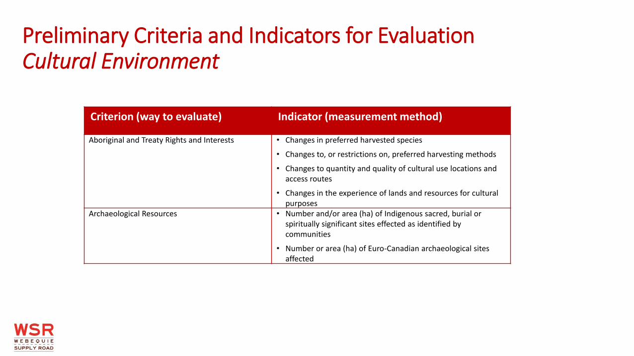
Aboriginal and Treaty Rights and Interests • Changes in preferred harvested species
• Changes to, or restrictions on, preferred harvesting methods
• Changes to quantity and quality of cultural use locations and access routes
• Changes in the experience of lands and resources for cultural purposes
Archaeological Resources • Number and/or area (ha) of Indigenous sacred, burial or spiritually significant sites effected as identified by communities
• Number or area (ha) of Euro-Canadian archaeological sites affected
Preliminary Criteria and Indicators for Evaluation Cultural Environment
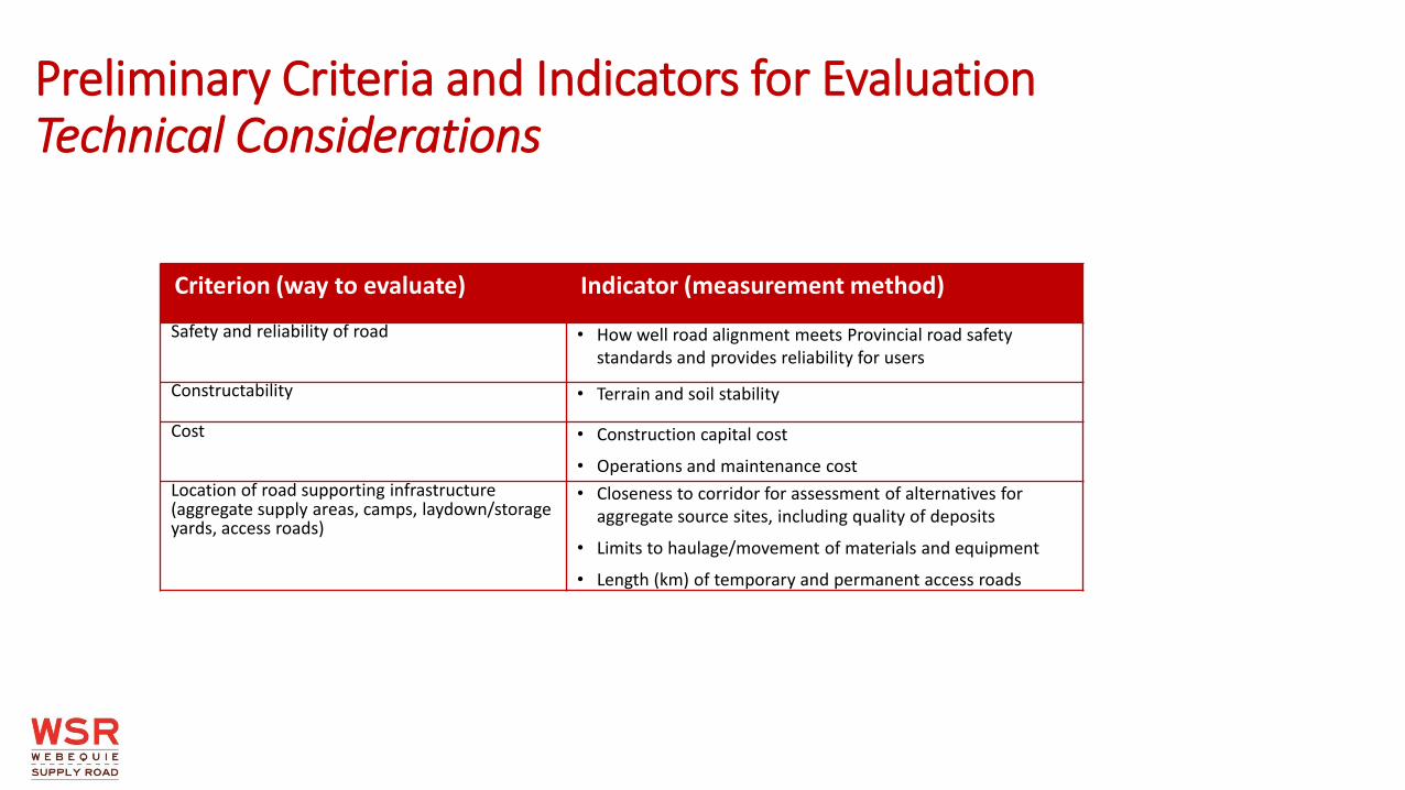
Preliminary Criteria and Indicators for Evaluation Technical Considerations
Criterion (way to evaluate) Indicator (measurement method)
Safety and reliability of road • How well road alignment meets Provincial road safety standards and provides reliability for users
Constructability • Terrain and soil stability
Cost • Construction capital cost
• Operations and maintenance cost
Location of road supporting infrastructure (aggregate supply areas, camps, laydown/storage yards, access roads)
• Closeness to corridor for assessment of alternatives for aggregate source sites, including quality of deposits
• Limits to haulage/movement of materials and equipment
• Length (km) of temporary and permanent access roads

ROAD DESIGN
• The biggest road construction challenge is through the muskeg (James Bay Lowlands) in the east-west portion of the road corridor
• Our field work indicates that peat thicknesses range from 1-5 metres
• Peat is too thick and too poorly drained to be excavated and replaced with other soil - road must be constructed to “float” on muskeg
• Geogrid, a synthetic material, is used to make the sub-base of the road stronger, which will limit settlement of the road, reduce maintenance costs and enhance safety
• Water is another challenge - there are 3 major water crossings (Winisk Lake (250 m wide); Winiskesis Channel (100 m); and Muketei River (30 m)); and 31 crossings in total
Water Crossing
Drainage area associated with water crossing
Muskeg terrain type found in east-west portion of road corridor
Use of Geogrid in road construction- James Bay Lowlands

HYDROLOGY IN ROAD DESIGN
• Hydrology includes the study of the movement of water on the land
• Used for the design of drainage structures (such as culverts)
• Hydrology assessment is done to determine the peak flows for a range of flood frequencies (i.e., 1 in 100 year) within a drainage basin
• Culverts, bridges, or other structures are then sized to handle these design flows without overtopping the road or causing excessive backwater (buildup of water) or upstream flooding
• Also used to size local drainage features, such as ditches, which help keep rainwater off the road and reduce the amount of ponding water
Water Crossing
Drainage area associated with water crossing

What are Examples of Ways to Limit Potential Environmental Effects During Design?
Project Component How to minimize environmental effect
Water Crossings • Changing type of structure
• Length of span (to avoid having bridge supports/piers in water)
• Lifecycle - build structure to last longer
• Construction staging methods - change order of construction activities to minimize impacts to fish and fish habitat
Road • Adjust horizontal alignment (i.e., curves, straight sections)
• Adjust vertical alignment (i.e., steepness or slope)
• Adjust cross-section – shape/width of the road if you sliced through it
• Width of the corridor (the “footprint” of the road)
Alternative Sites for Temporary Supportive Infrastructure • Adjusting locations and sizes of storage / laydown areas and associated access roads to limit project “footprint”

Project Component How to minimize environmental effect
Alternative Sites for Temporary and/or Permanent Aggregate Extraction Pits and Production Facilities
• Selection of sites with shorter access roads
• Selection of sites with shorter haul distances
• Selection of sites with lower water tables
Construction Timing (Seasonal) and Staging • Reducing disturbance (i.e., vegetation damage, soil erosion) to land and watercourses by conducting certain activities at times of year when the lands and resources are less sensitive to disturbance
What are Examples of Ways to Limit Potential Environmental Effects During Design? (cont’d)

Alternatives Considered
Alternatives to
Alternative Methods or Means
• Different ways of addressing a problem or opportunity to come up with a preferred planning solution o Do nothing o Upgrade the existing trail system to a seasonal winter road o Alternative modes of transportation (i.e., hoverbarge, airship, rail) o Manage travel demand o New all-season road
• Different ways of implementing the preferred planning solution o Alternative Concept 1 o Alternative Concept 2

Alternative Concepts
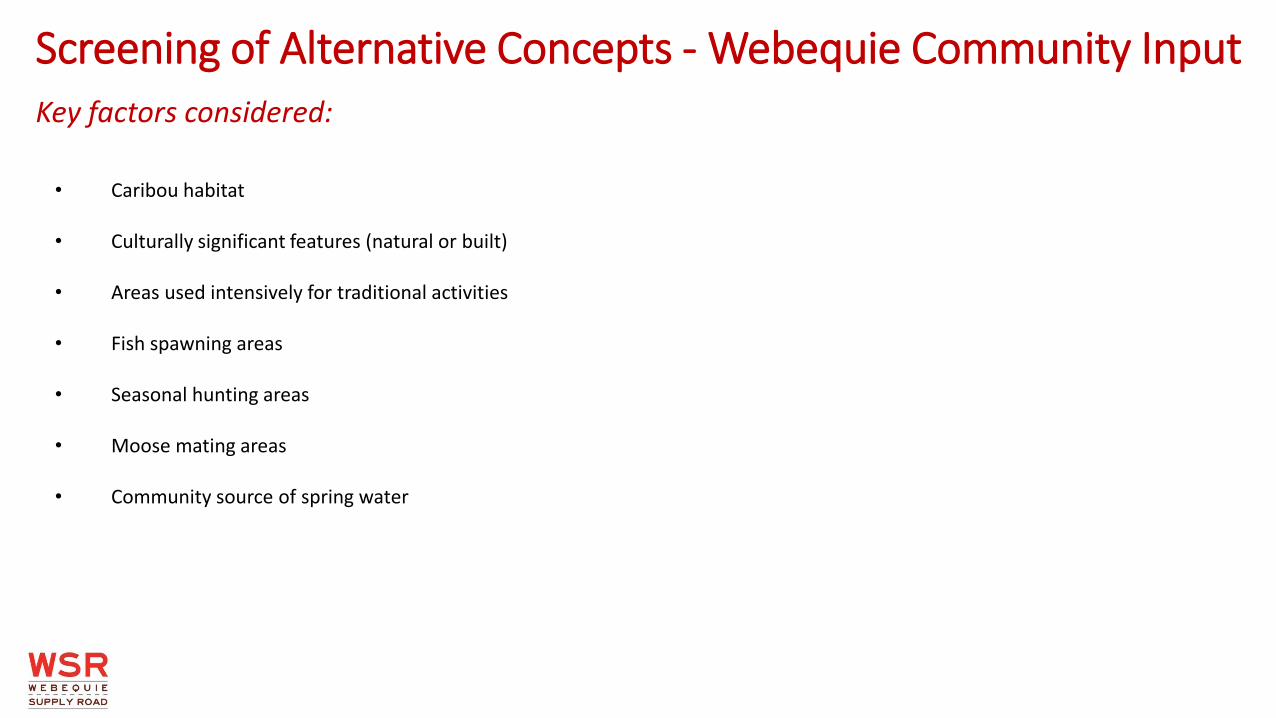
• Caribou habitat • Culturally significant features (natural or built) • Areas used intensively for traditional activities • Fish spawning areas • Seasonal hunting areas • Moose mating areas • Community source of spring water
Screening of Alternative Concepts - Webequie Community Input Key factors considered:

Preferred Corridor Based on Community Input

Best Route Based on Terrain/Soils (in green)

Summary
• The Webequie Supply Road Project is a road to the McFaulds Lake mineral exploration and mine development area for WFN economic development purposes, not for proposed mine developments in the Ring of Fire
• The environmental assessment (EA) identifies and evaluates potential environmental impacts and effects of the Project. To do this, a
number of technical studies, including gathering Indigenous Knowledge from First Nations communities, will be conducted • The EA Terms of Reference document is the work plan for the environmental assessment • While we already know many of the environmental impacts of a project like this and how to control or limit these impacts, we don’t
know the Project Area as well as you do • You know the land and have a special connection with the land - we need to hear from you on the EA Terms of Reference • An approved EA will include both the commitments to building and operating an environmentally sustainable project and how
those commitments will be fulfilled, such as environmental monitoring and additional consultation and engagement

Project Timeline
• Consultation with Indigenous Communities Ongoing
• Finalize and Submit Terms of Reference to Ministry of Environment, Conservation and Parks (MECP)
• Complete Detailed Project Description and submit to Impact Assessment Agency of Canada
Fall 2019
• Start preparation of Environmental Assessment Winter 2020

WE WANT TO HEAR FROM YOU! • Provide comments through the Website (www.supplyroad.ca)
• Speak with the Project Team after the presentation
• Fill out a Feedback Form
Principal Contacts for the EA and Engagement:
Michael Fox
Regional Consultation Lead
Webequie First Nation
1000 Chippewa Road
Thunder Bay, ON
P7J 1B6
Tel: 807 472-6147
Fax: 807 577-0404
E-mail: [email protected]
Samson Jacob
Local Consultation Lead
Webequie First Nation
P.O. Box 268
Webequie, ON
P0T 3A0
Phone: 807-353-6531
Fax: 807-353-1218
E-mail: [email protected]
Don Parkinson
Consultation Lead
SNC-Lavalin Inc.
195 The West Mall
Toronto, ON
M9C 5K1
Tel: 416-252-5315 ext. 52584
Fax: 416-235-5356
E-mail: [email protected]
Related Documents