International Review of Environmental and Resource Economics, 2008, 2: 321–366 Urban Sprawl and Ecosystems — Can Nature Survive? Daniel Czamanski 1 , Itzhak Benenson 2 , Dan Malkinson 3 , Maria Marinov 4 , Rafael Roth 5 and Lea Wittenberg 6 1 Technion — Israel Institute of Technology; E-mail: [email protected] 2 Tel Aviv University; E-mail: [email protected] 3 University of Haifa; [email protected] 4 Technion — Israel Institute of Technology; E-mail: [email protected] 5 Technion — Israel Institute of Technology; E-mail: [email protected] 6 University of Haifa; E-mail: [email protected] ABSTRACT Contrary to the popular notion that the advancing frontier of urban development has been swallowing and destroying natural ecosystems we present evidence that the sprawl of cities creates ample open space in peri-urban areas. Traditional view of city–nature dichotomy and clear spatial separation should be substituted by a vision that reflects the complex spatial dynamics of city–rural–natural fabric with extended areas of overlap among them. We present a survey of the relevant research concerning urban and ecological systems spatial dynamics and conclude that nonregular, leapfrogging spatial expansion, characteristic of the majority of the modern western cities, may buffer between urban and intensively cultivated agricultural areas and counter their impacts on natural ecosystems. The wealthy sprawling suburbs provide essential habitats for native species and ensure their survival. Keywords: Urban spatial dynamics; sprawl; landscape dynamics; urban ecology. Classification: Urban economics, urban ecology ISSN 1932-1465; DOI 10.1561/101.00000019 © 2008 D. Czamanski et al.

Welcome message from author
This document is posted to help you gain knowledge. Please leave a comment to let me know what you think about it! Share it to your friends and learn new things together.
Transcript

International Review of Environmental and Resource Economics, 2008, 2: 321–366
Urban Sprawl and Ecosystems — CanNature Survive?Daniel Czamanski1, Itzhak Benenson2, Dan Malkinson3, Maria Marinov4,Rafael Roth5 and Lea Wittenberg6
1Technion — Israel Institute of Technology; E-mail: [email protected] Aviv University; E-mail: [email protected] of Haifa; [email protected] — Israel Institute of Technology; E-mail: [email protected] — Israel Institute of Technology; E-mail: [email protected] of Haifa; E-mail: [email protected]
ABSTRACT
Contrary to the popular notion that the advancing frontier of urban developmenthas been swallowing and destroying natural ecosystems we present evidence thatthe sprawl of cities creates ample open space in peri-urban areas. Traditional viewof city–nature dichotomy and clear spatial separation should be substituted bya vision that reflects the complex spatial dynamics of city–rural–natural fabricwith extended areas of overlap among them. We present a survey of the relevantresearch concerning urban and ecological systems spatial dynamics and concludethat nonregular, leapfrogging spatial expansion, characteristic of the majority ofthe modern western cities, may buffer between urban and intensively cultivatedagricultural areas and counter their impacts on natural ecosystems. The wealthysprawling suburbs provide essential habitats for native species and ensure theirsurvival.
Keywords: Urban spatial dynamics; sprawl; landscape dynamics; urban ecology.
Classification: Urban economics, urban ecology
ISSN 1932-1465; DOI 10.1561/101.00000019© 2008 D. Czamanski et al.
322 Czamanski et al.
1 INTRODUCTION
The urban population of the world has been increasing very rapidly in the past fewdecades. At the beginning of the 20th century, only 14 percent of humanity lived incities. Today, the number of city dwellers has grown to about 50 percent. This meansan almost fifteen-fold increase in the world’s urban population, from 200 million in1900 to 2.9 billion a hundred years later (United Nations, 2004). In many developingcountries huge dense cities are draining the rural hinterland. In the more developedregions of the world there is undisputed evidence of processes of urban dispersal andsprawl.
During the last 100 years rural populations more than doubled, increasing from 1.4 bil-lion to 3.2 billion (United Nations, 2002). The area occupied by agriculture, includingarable land and permanent crops, has gradually been increasing since the beginning ofthe 20th century and today comprises roughly 11 percent of the total land area (FAO,2007). Notably, the trend is different in developing and developed countries. Despiteoverall growth in agricultural area, in most developed countries the trend has beenreversed, at least since the 1960s, and the amount of agricultural land is decreasing. Inaddition, in some areas of the United States and Western Europe, mainly in places thatare proximate to the densely populated regions, there is evidence of land-use transitionfrom agricultural land to natural open space. For example, in the Netherlands, land thatis not economic in agricultural use is systematically being purchased by the governmentand left alone (Louw et al., 2003).
It has become a popular notion that the advancing frontier of urban development hasbeen swallowing and destroying natural ecosystems. There is evidence that in placeswhere the islands of natural habitats survive, they are suffering from pollution, frag-mentation, and constant interactions with humans (McKinney, 2002). Thus, often it isclaimed that the never-ending expansion of urban and semi-urban land-uses leads to thedisintegration and weakening of the adjacent ecosystems and their ultimate degradation(e.g., Paul and Meyer, 2001).
At the same time, there is a growing understanding that although urban areas are cre-ated by humans and for humans, they are also home to many plant and animal species thatoften display remarkable resilience to urban hazards. Species and communities undergothe necessary adjustments, adapt their spatial, temporal, and reproductive behavior to thenew conditions and coexist comfortably, and even thrive, within the broader boundariesof cities (McGranaham et al., 2005). These areas can provide nature-related amenitiesand cultural values, particularly if they are well managed. Moreover, there is much evi-dence that species richness and abundance in peri-urban areas is higher than in areas ofrural monocultures.
This changed view of the urban boundary raises a serious challenge to both urban andecological theory. Traditional view of the city–nature dichotomy with the prevalence ofthe city and clear spatial separation should be replaced by the gradient reflecting thecity–rural–natural fabric with extended areas of overlap among them. The view of thecomplex spatial dynamics along this gradient is necessary for managing landscapes of
Urban Sprawl and Ecosystems — Can Nature Survive? 323
each of the three main types and, especially for broad understanding how modern cityreally functions and evolves (Berkowitz et al., 2003). The novel paradigm considers urbansystem as including areas and habitats suitable for native species and natural communities.The interface between urban and rural systems is of particular interest, and typicalurban–rural gradients are characterized by various levels of heterogeneity, the latterbeing critical for persistence of ecological communities rather than individual species.Specifically, the dynamics of the ecosystems in and around urban areas is influenced by arate of introduction of alien species, habitat diversity and fragmentation, human-inducedhabitat disturbances and many other factors (Rebele, 1994, Niemela, 1999).
Human and eco-systems along the urban–rural–nature gradient are all complex adap-tive self-organizing systems in which structure and patterns at higher levels emergefrom local behavior and interactions (Levin, 1998, Portugali, 2006). Heretofore, thequestions concerning urban and natural system dynamics varied and were raised sep-arately. The literature concerned with the spatial dynamics of urban systems is vast,as is the ecosystem literature. However, the typical questions asked regarding urbansystems concern the temporal and spatial dynamics of the built-up area. In contrast,the typical questions asked regarding ecosystems concern the dynamics of its hierarchi-cal structure and the ability to adapt to local and global environmental changes, alongwith issues concerning the spatial and temporal dynamics of species and communities.Seemingly urban system studies and ecological system studies take a complementaryview of the landscape. Much too commonly the urban approach views the landscape asa matrix comprised of urban areas and a void among them, while the ecological pointof view sees the urban areas as gaps within the matrix of natural areas. Rural systemsare generally studied much less than urban or natural systems. It is our view that thetime has come to study all three main land-use systems jointly. It is the purpose of thispaper to present a detailed picture of the state of knowledge concerning the dynamicspatial behavior of urban systems and of the relevant ecological systems within the urbanshadow and thus to provide a basis for a better understanding of the interaction amongthese systems. We compare and contrast among the approaches taken in urban systemstudies and ecological studies, in an attempt to bridge between the disciplines, and in thefinal section we synthesize among the emerging ideas and address direction for futureinvestigation.
2 THE SPATIAL DIMENSION — ZONES AND BOUNDARIES
Cities, like other complex systems consist of many intertwined elements at variousorganizational levels. Their spatial evolution takes place at different timescales. Micro-patterns of houses, street segments and open areas exhibit fast dynamics measured inmonths and, mostly years, whereas macro-patterns of center-periphery gradient developslower (Weidlich, 1999). The same is true for ecosystems — the local changes of species’abundance and communities’ structure can take weeks, months or seasons, while it willtake decades and sometimes centuries for an ecosystem to adapt to the environment,
324 Czamanski et al.
following a disturbance. Generally speaking, the dynamics of urban frontiers are thus the“fastest,” comparing to the rest of the urban space, as consisting of interacting micro-structures of all three — urban, rural and natural — types. That is, at the boundarythe time–space cross-derivatives are largest. In this paper, we choose to focus on therelatively short term timescales of years and few decades.
Conceptually, the dynamics at the boundary or at the frontier delimiting cities andtheir surrounding nonurban areas (henceforth “peri-urban dynamics”) is just a particularcase of general spatial dynamics of the landscapes. In what follows we define the peri-urban area as a zone of a varying width, from several to 10–20 kilometers wide. We focuson phenomena that occur within this geographical band at spatial resolutions that varyfrom the typical spaces between buildings to neighborhoods and blocks, and at temporalresolution of seasons, years, and decades.
In order to delimit the relevant region we rely on the existing knowledge about theurban frontier in the general terms of complex system theory. Here, we follow thesomewhat ambiguous view that in order to decide whether some spatial unit belongs tothe interface zone one has to know whether it is “essentially” influenced by/influences theprocesses on the “other side.” That is, the very definition of the frontier is endogenous;it should be resolved together with the description of the dynamics of adjacent areas.
It is apparent that within many spaces surrounding urban areas human interferencewith the nature has become increasingly more frequent and significant, thus renderingsuch areas heterogeneous. The effects of human presence are felt in a variety of aspectsand mediums, such as soil, waterways, and air, along roads and railways, power-lines andpipelines, often passing through areas of wilderness. In some cases the human presenceis barely affecting the ecosystem. In other cases, despite the low frequency of humanpresence, the influence may be significant. It is quite likely that in many cases the fullspan of the human intervention is not completely understood.
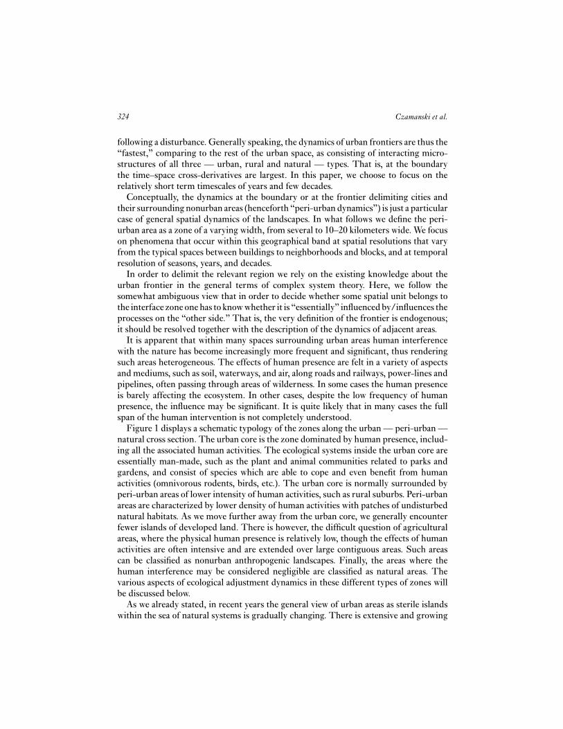
Figure 1 displays a schematic typology of the zones along the urban — peri-urban —natural cross section. The urban core is the zone dominated by human presence, includ-ing all the associated human activities. The ecological systems inside the urban core areessentially man-made, such as the plant and animal communities related to parks andgardens, and consist of species which are able to cope and even benefit from humanactivities (omnivorous rodents, birds, etc.). The urban core is normally surrounded byperi-urban areas of lower intensity of human activities, such as rural suburbs. Peri-urbanareas are characterized by lower density of human activities with patches of undisturbednatural habitats. As we move further away from the urban core, we generally encounterfewer islands of developed land. There is however, the difficult question of agriculturalareas, where the physical human presence is relatively low, though the effects of humanactivities are often intensive and are extended over large contiguous areas. Such areascan be classified as nonurban anthropogenic landscapes. Finally, the areas where thehuman interference may be considered negligible are classified as natural areas. Thevarious aspects of ecological adjustment dynamics in these different types of zones willbe discussed below.
As we already stated, in recent years the general view of urban areas as sterile islandswithin the sea of natural systems is gradually changing. There is extensive and growing

Urban Sprawl and Ecosystems — Can Nature Survive? 325
Figure 1. Schematic profile of the frontier as dependent on distance.
empirical evidence that many peri-urban areas, especially adjacent to high income lowdensity residential areas, display greater biodiversity than many rural areas outsidecities and can be compared favorably to natural habitats. This is partly due to theintroduction of exotic (nonnative) species, and partly to the fact that such environmentscan support a wider range of species, providing favorable conditions such as food, water,shelter, and clean air. It is only natural that same characteristics that are preferred byhumans in their living environment are also advantageous to many species of plants andanimals.
Thus, the urban fringe becomes a pseudo-reserve where the anthropogenic influencemay yield positive effects compared to the urban and agriculture landscapes that sur-round it. The wider the fringe, the lower the proportion of the built-up areas in it and thehigher the socio-economic level of the population there, the higher is area’s suitabilityfor natural species and ecological communities. This is especially true for those speciesthat are able to adapt and exploit the advantages of proximity to the human population.
This relatively new phenomenon of recovering ecosystems may be termed the “thirdnature.” It stands in sharp contrast to nature that exists in light of minimal humanpresence. It also stands in a stark contrast to urban systems that are in essence the “secondnature.” Third nature regions may offer simultaneously convenient habitats for varietyof species as well as produce the much desired amenities that are evidently highly valuedby the upper class households.1
1 There exists an extensive literature concerned with the valuation of natural environments. Thereare numerous reviews of this literature and we do not present it here.

326 Czamanski et al.
In the following sections of the paper we first review the classical literature on urbanspatial dynamics. We discuss the economic and noneconomic models of urban devel-opment. Thereafter we turn to the ecological side of the story. We present the reviewof empirical studies dealing with the ecosystems at the peri-urban frontier and theirdynamics. We especially focus on the simulation models in both urban and ecologicalresearch that serve as powerful tools to unravel the mechanisms underlying the complexspatial dynamics of the systems. In the final section, we bring it all together and outlinedirections for further research.
3 WHAT DO WE KNOW ABOUT URBAN SPATIAL DYNAMICS?
In this section, we briefly discuss what is known about the changing perception ofthe spatial dynamics of urban systems. We present an overview of the theories andmodels within the framework of urban research that attempt to describe and explain thespatial form of urban areas and their evolution. We begin with a number of well-knownclassical theories that are at the basis of the main body of studies conducted in the field,such as bid-rent theory, the mono-centric city model and the theory of central places.We then proceed to review the more sophisticated economic models of developer andpoly-centricity. Thereafter, we review the self-organization and noneconomic spatialapproaches that made an important contribution to the understanding of dynamic urbansystems in the past decade. We conclude this section with an overview of agent-basedsimulation models, some of which originated in natural sciences and similar in theirapproach to the ecological simulation models.
3.1 Classical Models
3.1.1 The Mono-centric City Model
The mono-centric city model is associated with the bid-rent theory, formulated by Alonso(1964) and originally proposed by von Thünen as early as 1826. The theory suggests asingle-center city with concentric distribution of land uses and activities, where locationsare determined as a result of competitive bidding. Alonso constructed the bid-rent curvesfor each land-use as decreasing away from the center, slopes reflecting the sensitivity ofeach land-use to accessibility.
The standard mono-centric city is envisaged as a circular residential area surround-ing a central business district (CBD) in which all jobs are located. Households chooseresidential locations at different distances from the center and spend their exogenouslydetermined income on apartment space, goods and transportation costs, or commutingcosts. The model assumes a trade-off between utility gained from the size and locationof residential lot and transportation costs that are incurred by traveling to the center(Mills, 1967, 1972, Muth, 1969). The mono-centric city model assumes a Pareto optimalequilibrium and much of the criticism is related to the fact that a static model is unableto capture the dynamic reality of a developing city (Anas et al., 1998).

Urban Sprawl and Ecosystems — Can Nature Survive? 327
The bid-rent theory predicts the density gradient dropping monotonously away fromthe CBD, and as population and incomes grow, the city expands and tends to decentralize.This feature of the model has difficulty accounting for the fact that housing is durable andreadjustments due to outward growth occur much too slowly to maintain the equilibriumstate suggested by the theory.
In general, defining the local density ρ(t, x, y), where t is time and x and y are loca-tion coordinates, can be rather complicated. In reality the density function displaysdiscontinuities and often it is difficult to calibrate. In the past it was common to replacelocal density by a radial density at time t at a radial distance r from the center —ρc(t, r). Some researchers suggest that radial density may be assumed to decrease expo-nentially with distance from the center (Clark, 1951, Batty and Longley, 1994, Makseet al., 1995), while others suggested applying more complex mathematical expressions(Krakover, 1983, 1985, Longley and Mesev, 1997). The choice of this kind of functionimplies some isotropy in the development of the city, clearly a questionable generaliza-tion. Essentially, the mono-centric city model portrays urban growth as a radial wave ofdevelopment, crawling outwards from the center and swallowing up all the open spacesin its way.
The mono-centric city model has attracted much criticism in the past few decades.Its validity and its connection to modern cities have been questioned skeptically. Anaset al. (1998) assess that “…the monocentric model has been an excellent conceptual toolfor thinking about an urban economy, particularly about the role of commuting costs.It facilitates accounting for general-equilibrium effects and it appears to identify somepowerful determinants of urban structure. But it provides no more than a useful startingpoint in explaining the observed spatial structure of modern cities.”
3.1.2 Theories of Central Places
Another well-known classical theory proposed by Christaller (1933) and Lösch (1940)offers an explanation for the spatial patterns of settlements, or central places that dispensegoods and services to the surrounding markets. In spatial context, the theory of centralplaces claims that the most efficient structure is accomplished by a series of hexagonal-shaped markets. The original version of the central place theory referred to towns servinga rural hinterland, but similar principles are applied to modern metropolitan areas. Thepatterns are explained by the notion of the hierarchy of centers, where goods and servicesof different order are available at different levels of the hierarchy.
The basic hierarchical structure of central places was empirically verified at a varietyof geographical scales (Berry and Garrison, 1958, Davies, 1967). However, the evidenceconcerning the spatially regular pattern is rather contradictory (Clark, 1982, Guy, 1998).The most common criticism of the central place theory concerns the over simplisticassumptions of uniform, featureless space and identical players making single purposetrips to nearest centers (Kivell and Shaw, 1980). It is hardly surprising that areas, wherespatial patterns consistent with the postulates of the central place theory were verifiedempirically, are usually uniform and lacking in physical irregularities (Munroe, 1999).

328 Czamanski et al.
Another drawback of the central place theory was pointed out by Krugman (1996). Itis its inability to demonstrate the mechanism by which the decisions of individuals onthe micro-level would lead to the suggested spatial structure. The central place theoryis also essentially limited for our purposes as disregarding the interaction between thegrowing built-up areas and the open spaces. This interaction is critical for descriptionof the expanding urban frontier.
3.1.3 The Poly-centric City
A crude view of a metropolitan area may result in an ordered structure of center places.However, at a finer resolution the distribution of activities reveals irregularity and poly-centricity that depends on scale of observation.
Decentralization and suburbanization in most western countries has led to the emer-gence of multiple centers of urban activity away from the traditional CBD. Substan-tial empirical evidence exists in support of poly-centricity in the spatial structure ofurban and metropolitan areas (Erickson, 1983, 1986, Bourne, 1989, Hartshorn andMuller, 1989, Heikkila et al., 1989, McDonald and McMillen, 1990, Giuliano and Small,1991, Shukla and Waddell, 1991, Garreau, 1992, Cervero and Wu, 1997, McMillen andMcDonald, 1998).
Poly-centricity may be recognized by measuring various aspects of urban activity, suchas, population and employment density, height of buildings, land value and firm location.Number of sub-centers is sensitive to the particular definition, and it usually involvesminimum density or employment criteria. In their overview Anas et al. (1998) describethe three functional forms that generalize Alonso’s (1964) mono-centric postulates to thepoly-centric structure. These three forms are heavily discussed in literature and appearto be suitable for different cases in measurement of urban densities (Gordon et al., 1986,Small and Song, 1994, Anas et al., 1998).
Recent criticism of the poly-centric model stems from the fact that the employmenthas become increasingly dispersed and does not explain the formation of centers (Gordonand Richardson, 1996). Generally, as in the case of the mono-centric city, it appears thatthe mainstream poly-centric city models have come to a point where the real cities andmetropolitan areas has become too complex and dynamic, for the models to keep up andprovide an appropriate explanation. Just as the central places theory, poly-centric modeldisregards the complexity of urban frontier and thus has limited value for our purposes.
3.1.4 Dynamic Economic Models of Land Developers
The classical static economic models focused on the demand side of the housing mar-ket and ignored the supply side, the considerations of planners and developers andthe characteristics of locations. The basic models assumed homogeneity of all param-eters except one — the consumer’s willingness to pay for houses’ proximity to thecenter or multi-centers in the urban space (Alonso, 1964; Mills, 1967; Muth, 1969;

Urban Sprawl and Ecosystems — Can Nature Survive? 329
Wheaton, 1974). This simplistic assumption leads to a well-behaved pattern of concen-tric land-use circles around the city centers (CBD). The classical models lead to verysuperficial outcomes of continuous spreading of people, activities and buildings aroundthe centers and supported rent gradient patterns.
One more basic limitation of the classical models is their inability to describe temporaldynamic processes in the urban space. These models ignored the durability characteristicof buildings and the main assumption was that buildings can be destructed and rebuild ina short time and without any limitations and costs. The early dynamic land-use modelsovercame part of the above limitations (Ohls and Pines, 1975, Anas, 1978, Brueckner,1981a, 1981b, 1982, Mills, 1981, Fujita, 1982, Wheaton, 1982a, 1982b, Braid, 1988, 1990,Turnbull, 1988, Capozza and Helsley, 1989, 1990, Bar-Ilan and Strange, 1996). Thesemodels described the consequences of developers’ decisions with the use of temporalprofit functions. These functions represent the value of the cash flow of developers,consisting of capitalization of future rents with the deduction of capitalize future costs.The decision variables are timing, footprint area and building intensity or height ofbuildings. The models are different in their assumptions about the future: perfect orlimited foresight of developers about future rents and uncertainties lead to variety ofspatial outcomes. In the model outcomes, rent gradient and the continuous expansionare substituted by more realistic patterns and interesting anomalies: rents and heightsdecreasing in noncontinuous way, leapfrogging in the development process and evenincreasing rents and heights with distance from the CBD.
The new wave of urban economic studies focused on the supply side of the housingmarket (Sofer, 1994, Huriot and Thisse, 2000, Ginat, 2001, Glaeser and Kahn, 2003,Glaeser et al., 2005, Glaeser and Ward, 2006, Czamanski and Roth, 2008). The approachin these studies considers much of the spatial–temporal evolution of cities to be the resultof land developers’ choices. In particular, the models concerning the decision develop-ers make about the parcels of land to be developed and the intensity of development.Although developers are not the only actors in cities (there are also municipalities, resi-dent households, firms, etc.), developer’s behavior is assumed to reflect the dynamics andthe main activities in the housing market. One of the critical variables in decision-makingof developers is time. By means of these models it is possible to demonstrate that undercertain market and spatial conditions the developer’s behavior generates leapfroggingpatterns, mainly during recession periods.
3.2 From General Complexity Theory to Urban Dynamics
3.2.1 Self-organization and New Economic Geography (NEG)
In the past decade models of self-organization have become increasingly popular inthe study of urban systems (Krugman, 1996, Portugali, 1999). The elaboration of newscientific approaches based on such phenomena as bifurcations, self-organized criticality,deterministic chaos and self-similarity of urban patterns at different level of spatialhierarchy has generally emphasized the fact that exact prediction in complex socio-economic and socio-environmental systems is not possible.

330 Czamanski et al.
In dynamic economic modeling the idea of self-organization was thoroughly exploredby Krugman (1996). In his Self Organizing Economy he discusses the traditional the-ories (reviewed above) in light of the complexity theory. Krugman maintains that theinteraction among economic agents in cities, and especially during periods of acceleratedgrowth at the edge of urbanized areas, displays self-organized criticality, similar to landavalanches and earthquakes. The system that is developing in reaction to a certain setof factors along the steady trajectory, approaches the boundary of the trajectory basin ofattraction. At this boundary, the system is sensitive to the minor factors whose influencewas marginal till then. The system at this stage can be driven by positive feedbacks, andundergo bifurcations and other qualitative changes that can cause sudden and unexpectedchanges in system dynamics. Krugman (1996) illustrates the idea by several models ofself-organizing city, in which the interaction between centrifugal and centripetal forcesenable spatial structure described by Garreau in his Edge Cities — urban concentrationsaway from existing centers.
The Spatial Economy (Fujita et al., 1999) which was published some years later discussand reinterpret, in view of the theory of self-organization, a series of analytic resultsaccumulated in the fields of economic geography and urban economics. The authorspropose incorporating the economies of scale and the interaction between transport costand factor mobility as well as the Dixit–Stiglitz model of monopolistic competition tocreate a new model of city formation. Their core-periphery model introduces a two-sector economy: An agricultural sector with constant returns to scale and without factormobility and a manufacturing sector with increasing returns to scale and with factormobility that are both modeled in a discrete location space.
Skeptics argue that the NEG “… is neither that new, nor is it geography. Instead, itis a reworking (or reinvention) — using recent developments in formal (mathematical)mainstream economics — of traditional location theory and regional science” (Martin,1998). We agree with this statement — both geographers and economists involved inthe debate are concerned with the same issues of spatial dynamics: the distribution ofeconomic activity, explanations for the processes of urban sprawl, regional inequalities,processes of decentralization, and suburbanization in cities. Despite the market progressin the development of spatial urban models, they are still reliant on simplistic assumptionsand produce a rather generalized depiction of urban structure; their relation to the ex-urban area as to agricultural periphery and they focus on the processes at the city sideof the urban boundary.
3.2.2 Fractals
What should be expected as the spatial pattern of a self-organizing city? Assuming thatthe forces shaping the city at different levels of urban hierarchy are similar, the resultingspatial pattern of the built-up area should be fractal, or should display self-similarity. Inother words, the pattern of built-up and open areas in a city observed at a low resolutionshould be similar to that observed at a high resolution. Observed fractal characteristic ofcities indicates that self-similarity is present at several hierarchical levels, at least at the

Urban Sprawl and Ecosystems — Can Nature Survive? 331
typical resolutions of urban regions, census areas, neighborhoods, and surroundings ofindividual buildings.
The concept of self-similarity and fractals was introduced by Mandelbrot (1982)and results in “fractal dimension” — a noninteger number, between 1 and 2, thatcharacterizes density of the built-up area in the city. Many researchers liked the ideathat urban patterns might be described by one number and tested urban systems forthe presence of fractality. In their book Fractal Cities Batty and Longley (1994) set outto conduct a comprehensive study of fractal geometry of cities and found that in factmany cities do display fractal characteristics. Batty and Longley report estimated fractaldimensions for many cities around the world, with the results in the range 1.55 to 1.93.The same interval was estimated by Frankhauser (1994) and Benguigui (1992, 1995).It is worth noting that their comparison of the maps of built-up area in London foreach decade between 1820 and 1962, and of Berlin from 1875 to 1945, suggest thatthe fractal dimension has been increasing steadily over time. These findings suggestthat the density of the built-up area in the city increases over time (Batty and Longley,1994).
Despite the potential usefulness of the fractal dimension of urban areas as indicatorof extant patterns of built-up and open areas, it should be used with care. First, not allcities are necessarily fractal. Benguigui et al. (2000, 2006) analyzed the fractal dimensionof the Tel Aviv metropolitan between 1935 until 2000 and revealed that not every partof the metropolis can be represented, even approximately, by a fractal. Second, andmore importantly, spatial patterns at different scales of resolution appear to be similar,despite the fact that the mechanisms that govern the creation of these patterns aredifferent. The micro-processes that govern local land-use changes, land and dwellingprices and construction permits are significantly different from the macro-processes atlarge scales, including regional planning, regional economic base dynamics, the evolutionof transportation infrastructure (Batty and Longley, 1994).
3.2.3 Diffusion, Percolation and Leapfrogging
Fractal patterns are the results among the “simplest” self-organizing structures. Theycan be considered as special outcomes of more general models that originate in physics.These models consider “particles” of the built-up area that occupy open urban spaceand, sometimes, “leave” it (i.e., are destroyed). These models include the Eden model(Vicsek, 1989), the diffusion limited aggregation (DLA) model (Witten and Sander,1981, Batty and Longley, 1994), and correlated percolation model (Makse et al., 1995).A detailed description and comparison between these models is given by Benguigui et al.(2000).
For example, Makse et al. (1995) propose a “correlated percolation model.” In it theprobability of constructing a new building is not constant but is correlated with theinstantaneous density of the emerging clusters. It is shown that this model produces agood simulation of Berlin and London patterns from the middle of the 19th century anduntil today.
332 Czamanski et al.
Percolation and DLA models represent a half-step toward the full representation of thedynamics of discontinuous urban patterns. Such patterns are generated fully by modelsof leapfrogging. For example, according to the p-model (Benguigui, 1995, 1998) the cityis growing following developers’ decisions to construct at a location that they “visited”several times. The intuition behind the model is that each visit represents a unit of timeand provides a confirmation of the worthiness of construction at the particular location.In the p-model simulations the city starts with a well-developed center. Thereafter,secondary centers are generated, not adjacent to the initial center. Each of the centerscontinues to grow and generate new centers until they coalesce with each other or withthe initial center.
Leapfrogging mechanisms can be identified by measuring population growth at vari-ous urban locations at a distance from the center of a metropolitan area. Recently severalresearches have performed such studies (Benguigui et al., 2001a, 2001b, Heimlich andAnderson, 2001, Newburn and Berck, 2006). Leapfrogging results in spatial patternsthat contain much open space that can be used for agricultural and/or natural areas. Inthe context of urban frontier, the study of clusters and leapfrogging is most attractive. Itmay thus provide more accurate description of the changing size and shape of the openspaces and the built-up areas.
3.2.4 The Problem of Urban Boundary
One obvious source of disparity between urban theory and practice is the lack of data thatadequately represent urban spatial dynamics. Many researchers have recognized that theuse of data delimited on the basis of municipal partitions leads to severe distortions, sincetheir boundaries often are an anachronism and do not signify any actual spatial entities(Anas et al., 1998, Benguigui et al., 2006). This problem becomes especially importantwhen the research follows metropolitan area over time. However, much of the research ofurban systems is inevitably based on data aggregated into long-standing administrativeunits that might not be conducive to uncovering the true mechanisms of urban growth.
One way of getting around the problems is to focus on the data of real-world objectsat their natural resolution, i.e., on the footprint of the building when studying thedynamics of built-up areas in cities, and then search for clusters of these basic objects(Schweitzer, 1997). The rigorous geometrical analysis of the clusters, their shapes andsize distributions tells an entirely different story of evolution that can then be correlatedto the historical trends in the development of the study area. Unlike the studies basedon socio-economic data, analysis of urban clusters, especially in time, can lead to verygeneral hypotheses concerning the formation of urban structures, their arrangement inspace and of changes in their character and distribution over time (Benguigui et al., 2006).
3.3 Urban Simulation Models
The use of high-resolution real-world data affords the extraction of a large number ofempirical rules and laws underpinning our theories and models. The data-driven view

Urban Sprawl and Ecosystems — Can Nature Survive? 333
of urban and ecological simulation modeling enables the use of empirically justifieddependencies, even if their theoretical basis has yet to be developed. In urban andregional research simulation models are commonly based on cellular automata (CA)or multi-agent systems (MAS) principles and are applied to the explicit simulation ofspatial systems in dynamic and high-resolution contexts (Torrens and O’Sullivan, 2001).
The general idea of CA models is associated with a view that space is partitioned intohomogeneous cells, usually, but not necessarily, organized into square grid. Each cell isfound in one of the predefined discrete states. In the classical version of cellular automataeach cell has the capacity to process information from their surroundings, and the stateof each cell changes automatically with time according to a set of rules, based on theinformation about its own state and the states of its neighbors. CA models are flexible andefficient abstractions that enable the construction of detailed, complex, dynamic models,well suited to handling geographic phenomena (Torrens and Benenson, 2005). Just astheoretical models, simulations help us to learn about the nature and dynamic behaviorof the real-world systems and to find out how they are critically bounded (Engelen et al.,1997). Also, they can be used for making predictions about the future of the spatialsystems modeled.
From the early days of modern urban research CA simulations have been concernedwith urban area only. While distinguishing between several states of urban lands andpopulation, Lowry (1964) and Forrester (1969) combined the rest of the region into“unusable” lands that are the passive recipients of the consequences of urban processes.This view was shared by many since Forrester (1961) and Meadows et al. (1972). For twodecades, the resolution of urban simulation models remained relatively high within citesand ignored processes outside the built-up area (Chapin and Weiss, 1962, Chapin andWeiss, 1965, Chapin and Weiss, 1968, Allen and Engelen, 1986, Putman, 1970, Batty,1976, Tobler, 1970).
Despite this, the first generation of the simulation models pioneered several importantapproaches to modeling of the real-world cities. For example, Chapin and Weiss (1962),Steinitz and Rogers (1970), and Tobler (1970) were, first, to distinguish between theactual state of an urban cell and its potential for change that is later realized in case ofsufficient demand. Second, the potential for changes is multi-dimensional and includescomponents for many urban and nonurban land-uses. Third, the model did not go beyondsimple, usually linear and piecewise-linear dependencies of development potentials onenvironmental factors, just because, neither data nor theoretical justification existed formore complicated view.
A major step forward was made in the 1980s with the introduction of high-resolutionCA models (Couclelis, 1985, Nakajima, 1977, Itami, 1988, Cecchini and Viola, 1990,1992). These developments paved the way for acceptance of CA as a modeling tool,capable of explicit simulation of urban dynamics.
3.3.1 Land-use Transitions and Markov Field Models
Modeling land-use changes by means of probabilistic transitions of micro units from onestate to another is associated with “Markov field” models (Conlisk, 1992). Markov models

334 Czamanski et al.
rely on estimates of transition probabilities and make them dependent on neighbors’states — assuming such dependence exists. The typical Markov model considers severaldiscrete and easily recognized land-uses and a matrix of transition probabilities that aredependent on the state of the neighboring cells.
Statistical confirmation of the influence of neighborhood on cell land-use changesis of paramount importance, and has been demonstrated by several research projects.McMillen (1989) used the multinomial logit model and demonstrated that transitionsbetween vacant, agricultural, and residential land-uses in fringe areas of Chicago dependon property size, distance from Chicago and nearby smaller towns, and characteristicsof the quarter in which the property is located. De Almeida et al. (2003) demonstratedthat distance to roads, industrial areas, as well as existence of subsidized dwellings andservices, in the zone that a land unit is affiliated with, all influence land transitionsin the Brazilian city of Bauru. Wu and Yeh (1997) regard factors of land-use changein Guangzhou, China and use logistic regression to represent transition from nonur-ban into urban land-use as a function of several groups of factors: characteristics of aland unit itself, fraction of neighbors of urban use, transport accessibility, potentials ofemployment, population, and investment, etc.
3.3.2 The Era of Cellular Automata
One of the earliest CA applications for real-world urban modeling is the constrained CAmodel of land-use dynamics by White and Engelen (1993). White and Engelen basedtheir approach on the potential of a land cell to undergo a certain land-use transformationdepending on the states of the cells’ neighborhood. White and Engelen claim that atthe resolution of homogeneous land units, the influence extends beyond a circle of theimmediately adjacent cells. Based on this, the neighborhood is extended from a standardfor CA 3×3 to 113 cells at a distance six or less cell units from the center. This extensionis critical for representing interface dynamics. The characteristic size of the urban landunit is about 50 × 50 m. The sizes of nonurban land units vary, but they usually arelarger. Thus the typical resolution of the land-use CA is usually no higher than 50 mand the six-cell distance is about 300 m, with an intuitive view of minimal width of theperi-urban zone.
“Constrained” CA of White and Engelen (1997) follows the basic principle that wasfirst introduced by Chapin and Weiss (1968). The numbers Ni of cells that must havespecific use Si , i = 1, . . . , K , at time step t is considered as an external parameter thatdetermines the amount of the overall changes. Traditionally the demand comes fromthe urban land uses and is given in terms of dwellings, offices, commercial areas etc. Foreach land-use i the model determines the cells for which the potential for transformationinto Si is the highest, and distributes Ni among these cells. In this way, it is possible todistribute the demand for built-up uses among the land cells within the urban core andperi-urban belt.
With several variations, the framework of constrained CA was successfully employedfor simulating real-world dynamics of many cities, mostly in USA, Europe (Xie, 1996,

Urban Sprawl and Ecosystems — Can Nature Survive? 335
Batty and Xie, 1997, White and Engelen, 1997, Engelen et al., 2002, Barredo et al., 2003),China (Li and Siu, 2001, Li and Yeh, 2000, Yeh and Li, 2001, 2002, Sui and Zeng,2001), Australia (Bell et al., 2000, Ward et al., 2000a, Ward et al., 2000b) and became astandard in urban CA modeling. The typical cell-size in these models is 100 × 100 —250 × 250 m and six-cell neighborhood radius results in ∼0.5–1.5 km range of influenceof the factors.
From the very beginning of the CA regional modeling era, the CA scholars realizedthe limitations of the short-range modeling and the need for distant action. The first torise the challenge were Batty and Xie (Batty and Xie, 1994, Xie, 1996) who includedinto the model the interaction field F(C) that is bigger than the neighborhood N(C) andrepresents an intermediate urban scale between the neighborhood level and that of thecity as a whole. They apply their model to description of the urbanization processes in a20 × 20 km area around the city of Amherst (Buffalo metropolitan area) represented bymeans of a 600 × 600 grid of cells of the size of 1/3 × 1/3 km.
Another approach to the distant action was proposed by Keith Clarke and co-authors(Clarke, 1997; Clarke and Gaydos, 1998; Candau et al., 2000) who have further exploreda diffusion-based view of urban development. Clarke and colleagues proposed andbuilt a general heuristic CA model called SLEUTH (Slope, Land cover, Exclusion,Urban, Transportation, and Hillshade). Developing the idea of the SLEUTH modelthat urban growth rates depending on the age of urban cluster, Candau et al. (2000)consider clusters of urban cells as Deltatrons, which act as self-existing urban entitiesgrowing on their edges. At each iteration a Deltatron cell ages by one unit of time,and, reaching a threshold age, a cell “dies” and can then be recruited as a seed for anew Deltatron. The Deltatron model has also been applied at a regional level (Hester,1998), the most extensive being the Mid-Atlantic Integrated Assessment (MAIA) studyarea. MAIA includes seven states on the eastern coast of the United States: Delaware,Maryland, North Carolina, New York, Pennsylvania, Virginia, West Virginia, as well
as the District of Columbia, and is designated by the Environmental Protection Agencyfor the implementation of research, monitoring, and assessment of ecological conditionsthere.
3.3.3 CA Models in 3D
It should not be surprising that consideration of biodiversity in and around cities needsto consider the 3D evolution of cities. Although most of CA models in 3D were developedin the natural sciences (Hua and Sprung, 1998, Siregar et al., 1998, Hunt et al., 2005and others), there are also a few originating in the urban studies. The pioneering workof Semboloni in simulating the evolution of virtual cities (Semboloni, 1997, 2000a,2000b) suggests that the 3D growth of cities results in spatial specialization in termsof types of land-uses. In Semboloni’s models the weight of the neighboring land-usesin the development potential function for a given site dominates land-uses that do notalready exist on the site. There is also some literature concerning visualization of citiesin 3D (Batty et al., 2000, Evans and Hudson-Smith, 2001, Benenson and Torrens, 2004,

336 Czamanski et al.
Maguire and Batty, 2005, Evans et al., 2006). And yet, there is a paucity of simulationmodels that focus on the dynamics of the spatial distribution of high-rise buildings. Oneexception is the “Evo city” model of Austern et al. (2007). This model attempts to offerpractical solutions and propose interesting ways to plan better cities in the future. Themodel is based on realistic economic considerations and influences and its outcome isthe evolution of virtual city in 3D.
Another 3D simulation model is presented in Benguigui et al. (2008). With the useof simple means and intuitive mechanism this model proposes to explain the dynam-ics of heights observed in real cities. It presents a quasi-3D CA simulation model ofcities. In this model 2D dynamics include a cell attribute that represents building heightinformation. Dynamic processes are depicted using four parameters: initial building cov-erage, interaction with adjacent neighborhood, inertia, and noise. These parameters canassume simple economic interpretations, and combination of their values can generateinteresting spatial results.
To conclude, development of simulation models has contributed a great deal to theunderstanding of urban spatial dynamics. Much progress has been made since the emer-gence of early CA models and the process is still under way. The models are able toreproduce both the mono-centric and the poly-centric structures, managed to grasp thevariation in density and the complex spatial patterns of the multiple land-uses. Someof the more sophisticated models differentiate between the different types of “undevel-oped” open spaces, such as natural versus agricultural. Despite their inability to predictfuture outcomes and few other limitations, the simulations are useful in defining thebasic rules of land-use transition and in recognition of the factors effecting the urbangrowth. In some cases the connection between the simplistic behavioral mechanisms canbe linked to spatial patterns on a macro level. It is clear however, that majority of thesimulation models disregard the ecological aspects of development.
3.4 Modeling Sprawl
Urbanization and decentralization are occurring simultaneously in urban systems. Onthe one hand, in most developed countries cities are continuously growing at the expenseof the periphery, thus causing more and more of the population and the activities to belocated inside the urban area. This can be regarded as centralization of the system as awhole (Henderson et al., 2001). On the other hand, the decentralization and suburbani-zation trends are taking place in many places, where the growth is characterized by lowdensities and noncontiguous development. The latter processes are associated with theconcept of urban sprawl.
Most of the academic debate on the subject of sprawl revolves around its negativeimpacts of excessive costs on the economy (Ewing, 1997, Burchell et al., 1998, Downs,1998, Brueckner, 2000, Johnson, 2001). These include lack of exploitation of scaleeconomies in public services, infrastructure and energy consumption, increased use ofprivate vehicles, resulting in congestion and pollution. It is also claimed by opponents ofsprawl that it causes further decline of central cities. Clearly, scattered and discontinu-ous urban development also causes irreversible changes in ecosystems, by reducing their

Urban Sprawl and Ecosystems — Can Nature Survive? 337
total area and fragmenting them into separate systems, often lacking the critical mass forsome species to survive.
Some researchers consider sprawl to be a mature stage in the evolution of a citytoward a compact urban structure. Hall (1983) discusses sprawl in the context of a citypassing from a condition of primary industrialization to absolute centralization, relativecentralization, relative decentralization, and absolute decentralization. Thus sprawl isclaimed to be characteristic of the latter two stages of an urban evolution process. Inorder to fully understand the phenomenon, there is generally a motivation to uncover thebehavioral drivers or micro-motives. A simple and obvious explanation for the on-goingand overwhelming sprawl processes is that it offers amenities people prefer and chooseto pay for, whether or not planners and academics consider it to be sustainable (Morill,1991). In addition to the standard life-style amenities, such as clean environment andproximity to open spaces, sprawl also offers the social benefits of safety and segregationfrom the lower income groups (Audirac et al., 1990).
Although the reasons for sprawl are easily recognized, it is not so simple to quantifyand measure sprawl. Torrens and Alberti (2000) provide a concise overview of the variousaspects of sprawl and their measurement. Among other issues, they discuss the ecologyof sprawl and ways of measuring its effect on the composition and spatial distribution ofhabitat patches.
Another very recent empirical work, performed by Frenkel and Ashkenazi (2008)applied various techniques of measuring sprawl to a series of land-use maps of urbansettlements. The authors name five major groups of sprawl measures: growth rates,density, spatial geometry, accessibility, and aesthetic measures. The geometric measures,originate mostly from ecological research (McGarigal and Marks, 1995, Turner, 1989)or from fractal geometry (Batty and Longley, 1994). Some common measures of spatialgeometry of sprawl include leapfrog or continuity measures (Galster et al., 2001), measureof circularity (Gibbs, 1961), fractal dimension, and mean patch size, M (Batty and Kim,1992, Batty and Longley, 1994, Benguigui, 1995, Torrens and Alberti, 2000, Herold andMenz, 2001).
Torrens (2006) demonstrates the application of a geographically derived automatamethodology to the simulation of sprawl. He claims that the CA framework is particularlybeneficial in modeling sprawl, since it allows for the description of system dynamicsas a function of spatial interactions between mobile, agent-like entities and a staticenvironment.
According to the author, the simulations yield evidence that sprawl is, to a certainextent, inevitable and is the likely end-state in the natural evolution of a city-system.Having said this, various potential options for managing sprawl are discussed. Theresults of the simulations suggest that sprawl might best be tackled geographically, byencouraging compact and sustainable clusters of leapfrog development in close prox-imity. Sprawl on the periphery of these clusters should serve as an in-fill mechanismrather than continuing on the periphery of a larger urban mass in an unsustainablefashion.
Yet, another agent-based model deals with measuring and simulating sprawl (Brownet al., 2004). The authors present several scenarios of residential development at the

338 Czamanski et al.
rural–urban fringe to evaluate the effectiveness of a greenbelt located beside a developedarea, for delaying development outside the greenbelt. Essentially, the aim of the model isto determine the width and location of the greenbelt that would slow or reduce sprawl.Here, as well as in many other studies, the sprawl is a presumed, if inevitable evil, inneed of restraining and controlling by means of planning policies and regulation. Thediscussion of whether every type of sprawl is undesirable and what alternatives urbanspatial processes may have to offer will be presented in the concluding section of thepaper.
3.5 Key Features of Urban Spatial Structure
To sum up what is known about urban spatial dynamics, here are some key features:
(1) Urban spatial dynamics are discontinuous in space and nonuniform in time. As aresult, precise descriptions based on a central principle, are elusive. Simple theoriesand models provide a very general depiction of the urban areas only. They disre-gard the essential processes occurring within the urban core and, especially, in theboundary zone.
(2) The very basic model of the city suggests a density gradient, steadily droppingwith distance from the urban core. The classical models of urban growth describean expansion wave of outward development. The majority of classical theories andmodels disregard the outlying nonurban land-uses completely.
(3) Urban systems are self-organizing, and urban growth is regulated by numerous feed-back mechanisms, regulating the location, rate, and type of development. Methodsand models, traditionally applied in analyses of physical systems, enable a vision ofcities as self-organizing and give rise to the representation of discontinuities in spatialdynamics, sudden changes and criticality. These models generate great variety ofurban patterns that reflect real-world cities better than classic models.
(4) An important consequence of self-organization is urban leapfrogging — the expan-sion of the developed area by a series of jumps, creating discontinuous spatial pat-terns. It also leads to irregularity of spatial growth and to self-similarity as indicatedby estimated fractality and clustering.
(5) It has been shown that cities display clustering of built up areas, types of land-usesand functions. Analysis of anomalies in the evolution of clusters suggests that thereis a relationship between cluster characteristics and socio-economic development.Clusters themselves possess irregular shapes and fractal dimensions.
(6) Leapfrogging and fractality lead to a stable fraction of open spaces within urban areas.These spaces — patches and narrow corridors are often regarded as undesirablewaste of space and their benefits to the city dwellers are often underestimated.
(7) A city’s spatial evolution is governed, among other things, by its characteristic time.This parameter represents the time from the acquisition of property rights in a plotof land by a developer and until the return on investment is realized. The city’scharacteristic time varies over time and over the city’s geography. There is a need tostudy the time related aspects of urban evolution and its relation to biodiversity.

Urban Sprawl and Ecosystems — Can Nature Survive? 339
(8) The noncontinuous expansion of low density land-uses is generally defined as urbansprawl, which is considered undesirable and in need of regulation and limitation.Much attention is dedicated in academic literature to measurement of sprawland to the policy measures to be taken in order to slow it down. It is recog-nized however, that sprawl is an inevitable, natural stage in the evolution of urbansystems.
(9) The boundary zone of the intensive urban areas — the peri-urban fringe is of partic-ular interest. It is in this zone that the interaction between urban uses and plant andanimal species and communities is most significant and where the fastest processesof change take place. The discontinuous urban growth guarantees the fringe area ofparticular and essential width and extent. The processes taking place in the peri-urban fringe are generally understudied and in particular, have not been viewed interms of their interactions with the communities and ecosystems within and adjacentto this area.
4 BEYOND THE BUILT-UP ENVIRONMENT
Urban systems are only one of the three main components of the landscape. The other twoare agricultural and natural ecosystems. From very general and casual spatial observation,agricultural systems are the successors of the urban ones. Examination of the generaltrajectories from city centers suggests out that city scapes are gradually substitutedby agriculture and by natural systems further away. However, each pair of land-usesdisplays numerous interfaces and directly “competes for space” on the one hand, whilebeing connected by numerous flows of energy, matter, and population on the other.Every model of landscape dynamics should explicitly define the city–agriculture–natureinteractions.
As mentioned several times in the above sections, until mid 1990s attitude of urbanmodelers to agriculture and natural lands was very simple. Both types of land-useswere considered as “non-urban.” The encroachment of cities and the transformationof such lands into urban uses are determined solely by urban needs and some direct orindirect “price” the city should pay for it. As is evident below, during the long historyof its development ecological modeling was evolving in parallel to urban modeling. Itfocused on natural ecosystems while considering the urban uses as boundary conditions.Agriculture land-uses comprising up to 40 percent of the land area in many developedcountries and steadily growing in most of Africa and Asia (FAO, 2007) are an essentialpart of the landscapes in the Western world. They fell “between the chairs” so to speakand did not attract much attention of modelers.
During the last decade this situation started to change. First, models that consideragriculture land-use dynamics began to appear. Usually models of this kind are limitedto predefined boundaries of the farms and focus on the descriptions of crop dynamicswithin this area, too far from the goals of the current review. Second, explicit modelsof landscape dynamics that account for all three main types of land-uses at comparable

340 Czamanski et al.
levels of detail, at least with regard to spatial resolution and acting mechanisms, becameone of the mainstreams of regional studies.
The interfaces between urban–rural, rural–natural, and urban–natural land-usesbecame a hot topic of the environmental modeling. Usually, the researchers considereither sufficiently large administrative area or water catchment area. The former is con-venient for approaching collecting data on human activities, the latter for the descriptionof the ecological natural process — and aim at representing the main processes thatgovern the land-use dynamics within each of three main land-uses and on the interfacesbetween them. The models are usually applied to either administrative area or riverbasins and usually aim at assessment of the development plans that regard these areas oftheir parts.
One of the pioneers in this respect is the Research Institute of Knowledge Systems(RIKS, www.riks.nl) that developed a software for high-resolution integrated modelingof socio-economic and land-use dynamics toward the 2000 (White et al., 2000, Whiteand Engelen, 2000, Engelen et al., 2002, Oxley et al., 2004, van Delden et al., 2007) andfrom then on successfully implementing the software for assessment of the developmentplants at different scales, from the city of Dublin to the St Lucia island in Caribbean.The modeling environment accounts for 10 sub-models that simulate hydrology, humaninfluences, crops, natural vegetation and climatic conditions and operate on differentspatial and temporal scales. Many sub-models and, consecutively, numerous parametersmake presentation of the model essentially problematic. After studying several appli-cations of the models the authors claim that the contributions of actors and drivingforces — political, economic and cultural, are of critical importance for model pro-jections. This conclusion is supported in Schneeberger et al. (2007), who defined therelative importance of different actors and forces in the sequence of changes observed innorthern fringe of the Swiss Alps during last 120 years. In the same venue, Bolte et al.(2007) compared different scenarios of actors’ behavior aiming at conducting alternativefutures analyses in the Willamette Basin, Oregon.
In order to work effectively with landscape simulation models one has to be an expertin the problems and development trends of the particular area being studied. Withoutsuch particular knowledge there is no basis to check the validity of the simulated results.Commonsense logic may lead to mistakes. The best practice in these cases is to defineseveral scenarios of the landscape development, and then to investigate the sensitivity ofthe model dynamics to parameters for the scenarios (Hagen-Zanker and Lajoie, 2008),including sensitivity to changes in the spatial resolution of the model (Evans and Kelley,2004). In this way the parameters that are important for the scenario can be revealed andtheir values can be checked more carefully. Investigations of this kind can be supportedby clustering the observed land-use patterns into groups (Poudevigne and Alard, 1997,Kristensen et al., 2004). In this way one can distinguish between more and less possiblecombinations of the parameters of the land-units.
Landscape simulation models explicitly consider agriculture as another importanttype of land-use that has been almost completely disregarded so far in this paper. Agri-culture is often regarded as a buffer between the urban and the natural “worlds,” underthe assumption that it provides a suitable environment for the survival of native species,
Urban Sprawl and Ecosystems — Can Nature Survive? 341
displaced by the sprawling cities. Costanza et al. (2002) presented an example of acomprehensive model framework that aims at comparing many scenarios to study thedevelopment of ∼ 2500 km2 Patuxent River watershed in Maryland. The model inte-grates data over several spatial and temporal scales and investigates the effects of thespatial patterns of human settlements and agricultural practices on hydrology, plant pro-ductivity, and nutrient cycling in the landscape. The spatial resolution is variable, witha maximum of 200 × 200 m to allow adequate depiction of the pattern of ecosystemsand human settlement on the landscape. The temporal resolution is different for variouscomponents of the model, ranging from hour in the hydrology component to a year inthe land-use dynamics module.
After calibration, 18 scenarios of alternative land-use patterns and policies were com-pared. These scenarios include: (1) historical land-use in 1650, 1850, 1950, 1972, 1990,and 1997; (2) a “buildout” scenario based on fully developing all the land currently zonedfor development; (3) four future development patterns based on an empirical economicland-use conversion model; (4) agricultural “best management practices” that lowerfertilizer application; (5) four “replacement” scenarios of land-use change to analyzethe relative contributions of agriculture and urban land-uses; and (6) two “clustering”scenarios with significantly more and less clustered residential development than thecurrent pattern. As is often the case, the model dynamics display nonlinear dependenceon parameters and one should interpret the results with great care.
Recently there are other simulation models that deal with urban–agriculture–naturalinterfaces. Bithell and Brasington (2008), for example present a modeling system to sim-ulate land-use change by bringing together an agent-based model of subsistence farming,an individual-based model of forest dynamics and a spatially explicit hydrological modelwhich predicts distributed soil moisture and basin scale water fluxes. Using this modelthey investigate how demographic changes influence deforestation and assess the impactof the demographic changes on forest ecology, stream hydrology, and changes in wateravailability.
To conclude, we consider the landscape simulation model as a working tool for thefuture studies of the Urban–Rural–Ecosystem interface.
5 URBAN AND PERI-URBAN ECOLOGIES
While urban studies investigate changes in the distribution of human population andactivities, built-up patterns and urban land-uses, ecological research deals with similarissues pertaining to plant and animal species and communities, usually in their naturalhabitats. As will be detailed below, some of the ideas that have been considered byecologists also parallel those ideas considered by urban system studies, such as thehierarchical structure of ecological systems, their spatial and temporal dynamics, species’and communities’ succession.
The study of urban and natural ecosystems in isolation and conjointly requires con-ceptual as well as practical definitions of the boundaries of these systems. In the urbanrealm the unitary infrastructure elements, such as buildings, back yards, parking lots and

342 Czamanski et al.
industrial areas usually have sharp and well-defined boundaries (Alberti, 2005). Thisis true for a single patch or a single element. However, when higher order systems areperceived as a collection of such elements, identifying their precise boundaries becomesmore complicated. On the gradient from city center to periphery the density of builtareas decreases toward the outskirts, resulting in an increased average distance betweenconstructed areas and higher variance of this distance. Consequently, defining urbanareas and demarking their edges becomes dependent on the discipline’s criteria and maybe defined by political, social, physical, and structural characteristics or commuting radii(for example see Pickett et al. (2001)).
Ecosystem boundaries may be defined by watersheds, airsheds, the extent of animalmovement among areas, and like the urban systems they may depend on the extentand resolution of the study area. In addition, due to the strong interactions among theelements of the system, and due to the fact that they are not readily decomposable asopposed to urban infrastructure, identifying the spatial boundaries of ecosystem becomesincreasingly complicated (Urban et al., 1987).
The effects of urban areas are not limited to, and do not cease at the physical bound-aries of the cities. As it is well known, the activities of urban inhabitants as well as theair pollution emitted in urban areas may affect regions well beyond the city boundaries.This also holds true for water pollution. The interactions among urban and neigh-boring ecosystems are reciprocal as non-native species present in the urban systems,may invade the natural ecosystems, and vice versa (Godefroid and Koedam, 2003) (seeSection 3.5).
McDonnell and Pickett (1990) propose to consider “ecological forcing functions”created by the growth of cities and human activities. Individual components as structures,physical and chemical environments, populations, communities, ecosystems, and humanculture must be quantified to discover the ecologically important impacts of the urbandevelopment. Accordingly, within the urban setting, areas not intensively managed bypeople, such as parks, lakes, and streams are erroneously considered to be “natural” evenwhen they include a variety of introduced as well as native species.
5.1 Urban Core to Periphery Gradients — The Ecological Aspect
Due to the difficulties in defining distinct boundaries to urban and natural ecosystems,a number of methods adopt a gradient analysis approach. Under this approach differentindices are evaluated from the core of urban areas along a trans-section to rural areas.Luck and Wu (2002) for example, examined various landscape indices such as patchtype percent cover, mean patch size, patch density, and patch size variability alongsuch a gradient in the Phoenix urban–rural region. They contend that a single index isnot sufficient to detect the spatial pattern of urbanization and that different land-uses(e.g. urban, natural, agriculture) may exhibit different “spatial signatures” (i.e., meanpatch size, distance to closest neighbors, etc.). Comparing the spatial signatures amongdifferent urban–rural gradients may therefore provide insights to the extant urbanizationprocesses.
Urban Sprawl and Ecosystems — Can Nature Survive? 343
The urban–natural array is often conceived as spatially structured and organized. Thetraditional “gradient paradigm” suggests that environmental variation is ordered in spaceand governs the corresponding structure and function of ecological systems. The “nat-ural gradient” is a common approach among ecologists, applied to understand the rela-tionship between environmental variation and ecosystems structure (McDonnell et al.,1997). Recently, the gradient paradigm was adapted to urban environments (McDonnelland Pickett, 1990, McDonnell et al., 1993). Urban areas in the United States typicallyconsist of densely populated urban core surrounded by asymmetric rings of diminishinglandscape modification (Dickinson, 1966, Forman and Godron, 1986). The resultingpattern of natural and human-modified ecosystems within a metropolitan area can beconceived as a simple gradient of land-uses coupled with a more complex gradient ofurban effects (McDonnell and Pickett, 1990, McDonnell et al., 1993).
In contrast to the densely populated highly modified urban core, natural areas aredefined as ecosystems which persist primarily because of natural processes of plantestablishment, water availability, nutrient cycling, and plant–animal interactions withminimal or limited human manipulation (McDonnell, 1988). Since the introduction ofthe urban–rural gradient concept by McDonnell and Pickett (1990), it has been widelyused. In contrast to urban studies, ecological studies commonly observe such gradientsfrom the opposite direction, namely as rural–urban gradients. There are several patternsthat emerge from the related studies (Mckinney, 2002):
Physical gradient: A number of studies demonstrated increased physical changes, alongthe gradient, towards the inner core of the city. Examples are abundant and includesoil chemical and physical properties (McDonnel et al., 1997), soil and water pollution,heat island effects, etc. Physical changes also include the increase in impervious surfacestoward the inner city and other land-use transformation.
Habitat loss gradient: The physical changes produce a gradient of natural habitat losstoward the urban center that is replaced by four types of altered habitats: built habitats,managed vegetation spaces, ruderal vegetation, and natural remnant vegetation.
The increasing fragmentation of natural habitat by human disturbances tends to causebiodiversity changes and to reduce species richness providing the conditions for oppor-tunistic species to gain dominance. This has been shown for many taxa including plants(Guntenspergen and Levenson, 1997), birds (Blair, 2001, Mortberg, 2001, Crooks et al.,2004), butterflies (Blair and Launer, 1997), and insects (Niemela et al., 2003). The issueof biodiversity in urban and peri-urban areas is discussed below in greater detail.
5.2 What are Urban and Peri-urban Ecologies?
Intra and inter-species competition, predation, parasitism and several other types ofinteractions (facilitation, symbiosis, etc.) dictate the dynamics of ecological systems.Their rates, magnitudes, manifestation, and relative importance differ among the varioussystems and depend on species characteristics, energy fluxes and nutrient availabilitieswithin each ecosystem. To identify the result of human presence and activities withinurban ecosystems and along the urban–rural gradient, Pickett et al. (1997) suggest that

344 Czamanski et al.
social and behavioral aspects of human activity should be incorporated, in contrast tonatural ecosystems in which the human aspect is usually implicitly addressed. As willbe detailed below, the landscape structure and spatial distribution of the built-up versusnatural elements, is a seminal system driver in urban and human dominated ecosystems.
Ecosystems transformed by human activities are also termed “cultural ecosystems”and are characterized by urban and agriculture landscapes. Such systems are evidentlynot self-sustaining and are characterized by input of energy, materials, and nutrientsfrom anthropogenic sources. Human activities determine their structure and functionalorganization (Brussard et al., 1998). The rate and magnitude of ecological succes-sion depends, besides environmental conditions, on the degree of human intervention.Cramer et al. (2008) argue that an ecosystem subject to anthropogenic effects passes twotransition thresholds: a biotic and an abiotic one. With the strengthening of these effectsthe system first passes the biotic threshold: the biological properties of the system areessentially affected, while manipulations only of the vegetation are required to restorethe system, as the physical properties of the system are still intact. When the abioticthreshold is crossed, physical intervention is required to restore the system to its naturalstate.
Due to the gradual and fuzzy nature of the transition from natural to anthropogenicenvironment (the growth of built-up areas, for example), it is virtually impossible todefine a boundary or a threshold beyond which “natural” ecosystems2 become “urban”ecosystems. The place of a certain ecosystem on the natural-urban continuum is usuallydefined based on species diversity and abundance, both clearly associated with humanpresence. Clergeau et al. (1998) indicate that in Québec bird abundance was highest inthe most urbanized plots studied, and that only three species (house sparrows, Europeanstarling, and rock dove) accounted for more than 50 percent of the observed birds. Henceabundance of some species may serve as indicators for higher degrees of urbanization.Another possible approach is to estimate the ratio of natural vs non-native species.Threshold values remain the key problem of such approaches. In addition, the ecosystemstructure may be affected by the social welfare of the human population. Rapoport(1993) reports that in Bariloche, Argentina, for a given housing density, the number ofexotic species was higher in affluent compared to less affluent neighborhoods. Thesefindings are similar to the ones obtained in the Phoenix metropolitan area, as describedby Hope et al. (2003).
Is the degree of human influence the key difference between urban and natural ecosys-tems? Several urban ecologists agree (Sukopp and Numata, 1995, Walbridge, 1997), butothers suggest that differentiation should be based on ecological processes and not onurban characteristics. Trepl (1995) proposed three main properties distinguishing urbanlandscapes from rural ones: (a) fragmentation and interconnectivity, (b) succession, and(c) invasion by alien species. These properties may be evaluated independently of theurban properties, and thus may serve as an alternative approach to distinguish betweenurban/rural ecosystems.
2 Since the effects of human activities are global, and extend well beyond the boundaries of particularecosystems, then practically, strictly speaking, there are no “natural” ecosystems.

Urban Sprawl and Ecosystems — Can Nature Survive? 345
The identification of ecosystems within an urban environment entails further diffi-culties. It is possible to view the city as one ecosystem or as several separate ecosystemswithin the urbanized space, such as trees lawns, parks, lakes or seas, urban forests, wet-lands and streams (Bolund and Hunhammar, 1999). We support the view of Rebele(1994), who argues that the important thing is not the mere use of the term ecosystem,but the way in which it is used.
5.3 Spatial Ecological Patterns in Urban/Peri-urban Systems
Ecological studies recognize the spatial heterogeneity of the environment. Levins (1969)was the first to introduce the term “meta-population,” suggesting that populationsmay be viewed as a composite of several sub-populations, each occupying a distinctpatch in space. Following the recognition and incorporation of spatial structure intoecological models, Holt (1985) and Pulliam (1988) introduced the concept of sink–source populations. In some patches the conditions are sufficient to sustain individuals,but not the population, i.e., reproduction rates are lower than mortality rates. Suchpopulations are considered to be sink populations. In source populations conditionsare favorable and a surplus of individuals is produced. A fraction of the dispersingindividuals may successfully arrive at the sink populations, and their immigration servesto demographically sustain these populations. This concept is especially important forurban–rural landscapes, where the urbanized areas may serve as sink patches for thespecies that cannot self-sustain under strong anthropogenic influence.
Harveson et al. (2004), for example, studied the population dynamics of the endangeredFlorida Key Deer (Odocoileus virginianus clavium). They demonstrated that the deerpopulations of south Big Pine Key, which is densely developed, are at risk of extinctionif incoming dispersal were to be eliminated from north Big Pine Key. Sink–sourcerelationships are an extreme example of population dynamics at the landscape or meta-population scale.
In other cases species may be able to successfully reproduce in urban areas, but theurban landscape may not be sufficient to sustain populations which are large enoughto be considered viable. Research indicates that medium and large-sized carnivores aremore sensitive to urbanization. Riley et al. (2003) studied coyote (Canis latrans) andbobcat (Lynx rufus) populations in peri-urban areas in southern California, and foundthat home-range sizes were positively associated with the degree of urbanization. In spiteof the increased prey availability in these areas, they postulated that the larger homeranges (i.e., lower densities of bobcats and coyotes) result from lower availability of denlocations, and increased human activities. In addition, the behavior of wildlife species maynotably change in urban areas (Ditchkoff et al., 2006). Riley et al. (2003) show changes inthe activity times of the individual animals occupying the increasingly urbanized areas:more frequent during the night hours, compared to the “rural individuals.” Needless tomention, that studies on large predators in completely urbanized areas are lacking, dueto the fact that they are rarely found in such habitats.
In contrast to the observed decrease of predator densities in urban and peri-urbanareas, other species tend to be strongly affiliated with human presence and activities.

346 Czamanski et al.
Scenes of piazzas and city squares with a plethora of rock doves (Columba livia) arecommon and familiar. News reports of municipalities requesting the assistance of citizensin eradicating rat (Rattus rattus) populations are all too common.3 These are examplesof species which have well adapted to human presence, and in conjunction with the lackof natural predators may become over-abundant (Vuorisalo et al., 2003). In addition, inurban areas people actively enhance habitat quality by providing bird food and artificialnesting boxes. According to the 1996 National Survey of Fishing, Hunting, and Wildlife-Associated Recreation approximately 54 × 106 Americans actively fed birds. Accordingto a 2002 US Fish and Wildlife survey Americans spend annually over 2.03 billiondollars on packaged bird food, and over 730 million dollars on bird boxes and artificialnests.
Such activities do not benefit all species uniformly, and as a result the species com-munity structure in urban and peri-urban areas is altered compared to the naturalones. While wildlife in the urban settings may be a source of aesthetic value and localrecreation, the increasing abundance of these populations may lead to human–wildlifeconflicts. Consequently, wildlife related disease may be of higher prevalence in urbanareas compared to neighboring rural areas (Ditchkoff et al., 2006).
5.4 Dispersal in the Urban-rural Landscape
Movement and dispersal of individuals between suitable habitat patches is essential fora variety of causes: search for more ample food resources, search for a breeding mate,avoidance of inbreeding and others. Assessment of the degree to which a landscape isfragmented due to urbanization, however, is species specific, and therefore scale depen-dent. Landscapes may be viewed as suitable patches surrounded by a hostile matrix(Forman, 1995), although the binary model of suitable/nonsuitable landscape structuredoes not depict reality adequately.
The physical characteristics of the landscape may affect the mobility of the organismsand their displacement speed (Baguette and Van Dyck, 2007). For example, predationrisk and movement speed through orchards may be different than that in meadows,particularly for ground-dwelling species.
Intuitively, the dispersal of organisms with flying capabilities should be affected to alesser degree by the urban landscape, compared to ground dwelling organisms. Evidence,however, suggests that this is not always the case. Hodgson et al. (2007) investigated themovement of bird species across habitat edges interconnecting bushland and suburbanhousing developments of different densities in Australia. They found that insectivorespecies tended to cross less into urbanized areas compared to omnivores and nectarivores.They reasoned that this may be due to either differential behavioral response to thephysical structure in the urbanized systems or in response to differences in forage avail-abilities. Similar results have been observed in flying insect populations by Bhattacharyaet al. (2003), who experimentally moved bumblebees among forage patches. The results
3 In 2005, for example, the Government of Hong Kong requested the assistance of the citizens incapturing rats, in attempts to eradicate a rat infestation.

Urban Sprawl and Ecosystems — Can Nature Survive? 347
indicated that the bumblebees were able to fly over roads and railroads, but they werereluctant to do so. Evidently, some species avoid movement into and over the urban-ized patches or human constructed elements, hence perceiving them as nonpreferredelements in the landscape matrix.
Dispersal corridors were suggested to alleviate the reluctance of species to cross urbanlandscapes. Dispersal corridors may be defined as landscape elements connecting patchesof suitable habitats, which enhance individual’s movements among them and increasetheir survival probabilities (Vos et al., 2002). Examples of corridors may include stretchesof riparian zones, fencerows, underpasses and tunnels beneath highways, or any otherdistinct feature in the landscape providing cover or enhancing dispersal. Dispersal corri-dors are species and scale dependent. A strip of riparian vegetation, for example, whichmay facilitate movement of a bear across the landscape, may be sufficiently large toprovide a living habitat for a warbler. The importance of the landscape corridors is stillbeing debated, however, as experimental studies provide inconclusive evidence (Beierand Noss, 1988, Haddad et al., 2000).
Experimental studies point out the importance of dispersal corridors in the land-scape matrix. Haddad et al. (2003) compared movements of organisms between patchesconnected with corridors to isolated patches. They analyzed movements of organismsfrom different taxa, ranging from dispersal of plant species, through insects to rodents.Altogether 10 species were studied, which all dispersed in higher rates among corridorconnected patches. In addition, the movement rates among connected patches were 67to over 400% higher compared to nonconnected patches. Other studies present similarresults, in which corridors facilitate movement among patches (e.g., Haas, 1995, Mechand Hallett, 2001), but in others results are not conclusive. Experimental studies inves-tigating rodent movements across the landscape (e.g. Bowne et al., 1999, Mabry andBarrett, 2002) suggest that movement of the individuals among patches that were notconnected by corridors was much higher than expected, and accounted for a significantproportion of dispersal movements.
5.5 Biodiversity in Urban Landscapes
Recognition and awareness of the need to protect biodiversity has become part of main-stream ecology during the 1980s (Ehrlich and Ehrlich, 1981, Wilson and Peter, 1988).Since then much attention has been given to the causes of biodiversity loss, the eco-logical, social and economical importance of maintaining biodiversity, and the ethicalresponsibilities of humans to maintain it. Consequently, attention has been given to theinvestigation of biodiversity in urban systems. The studies addressing these issues pro-vide mixed results that depend on the taxa and on the life-history patterns of the speciesstudied. Roy et al. (1999) analyzed vegetation species richness in Britain, comparingamong urbanized and rural areas. They concluded that increased urbanization does notreduce overall species richness of plants. The proportion of alien (non-native) speciesincreased significantly with the increase in urban densities, resulting in a loss of thenative species. These trends are expected in human managed gardens and parks withmany exotic (non-native) species.

348 Czamanski et al.
Hope et al. (2003) addressed a similar question regarding vegetation species richness,but rather than correlating it with the urban–rural gradient, assessed the effects of socio-economic welfare and found that socio-economic factor is positively correlated withvegetation species richness. Once again, the increase in species richness in this researchwas associated with an increase in alien species and a decrease in the proportion of thenative ones. Ecologists are particularly concerned with the trend of loss of the nativeand invasion of exotic species, which can be observed along urban–rural gradient. Forexample, in Berlin, Sukopp et al. (1979) documented an increase from 28% to 50% inalien species along a transect from the city’s suburbs to the center. In a longer term,approximately 180 plant species became locally extinct in Munich, Germany duringthe last 100 years (Duhme and Pauleit, 1998). Drayton and Primack (1996) suggestthat mechanisms such as soil trampling, development of trail systems in urban parksand fires may accelerate the invasion of exotics species. They report that 155 of theplant species recorded in an urban park in Boston were absent in 1993, and 64 specieswere new.
In avian communities two general types of species richness responses to the urbaniza-tion gradient have been reported. First, several studies describe a negative correlationbetween urbanization and total species richness. Clergeau et al. (1998) compared birddiversities along urban–rural gradients in Quebec, Canada, and Rennes, France. Thesecities share similar urban characteristics, but are located in different climatic areas. Inboth cases bird species richness declined with increased urbanization, and this declinehas been repeatedly observed in other studies (e.g., Melles et al., 2003). The secondtype of response reported in the literature entails a peak in species richness in the urbanoutskirts, rather than in the rural areas. Blair (1996), for example, surveyed the aviancommunity along an urban–rural gradient in Santa Clara County, California. He clas-sified the landscape to six categories, ranging from most urban to natural: businessdistrict, office park, residential, golf course, open-space recreation, and a reserve. Thehighest number of species observed was in the golf-course habitat (28 species). At theopen-space recreation area 21 species were observed, similarly to the number of speciesobserved in the reserve. In the residential area 16 species were observed, and the low-est number observed was eight at the business district. Similar findings were reportedby Crooks et al. (2004). Such findings have also been reported for other taxa, such asmammals (Racey and Euler, 1982), butterflies (Blair, 2001), and lizards (Germaine andWakeling, 2001). The difference in the patterns may be attributed to the fact that in aridand semi-arid areas, as in Southern California, human presence enriches and diversifiesthe environment, providing for higher species richness. It is argued that mild humaninterference promotes increased environmental heterogeneity in addition to improvedconditions such as water, food, and nutrients (McKinney, 2002).
In addition, in many cases human activities in the city centers provide ample resourcesfor the species that have adapted for this type of environment. Studies along a rural–urban gradient in New York indicate, for example, that both the abundance and biomassof earthworms increased in urban forests compared to rural forests by more than anorder of magnitude (McDonnell et al., 1997). With respect to bird and mammal species,Shochat et al. (2006) suggest that there is an inverse relationship between number of

Urban Sprawl and Ecosystems — Can Nature Survive? 349
species and the density of individuals along the urban–rural gradient. At city centers thenumber of species is lower, compared to the rural areas, but the number of individuals ishigher.
Hope et al. (2003) point out, however, that such studies have been traditionally carriedout along urban rural gradients, that do not necessarily correspond to the gradient ofecologically important factors. They suggest considering a wider range of gradients, thatare nested within the urban–rural gradient, such as resource availability, disturbance,cultural, and socio-economic characteristics of the neighborhood.
Succession is another fundamental ecological process that can be essentially alteredfollowing human development in peri-urban areas. Succession is defined as a predictablereplacement of a set of species by a different one over time. Biodiversity, in a long run,is evidently related to succession. It has been suggested by Hansen et al. (2005) thatthe response of biodiversity to changes in peri-urban areas may last several decades.Consequently, positive or negative effects of human activities on the ecosystem may notbe noticed or evaluated in the short term.
To summarize the relationships between urban development and ecological systemsit is important to note that the fundamental processes driving the latter are similar, be itin an urban, peri-urban or a natural landscape. However, due to the intense interventionof humans in urban and peri-urban systems, the rates and predominance of differ-ent processes change. Finally, this review has strictly touched upon the relationshipsof urban-ecological systems, and did not address tangent fields such as environmentalquality and landscape aesthetics.
5.6 Ecological Models
Ecological systems are complex and as in many other fields of research dealing with com-plexity, a considerable effort was invested in modeling. The initial models of ecologicalsystems were restricted to temporal modeling and ignored spatial patterns of species andcommunities. The first models of population and community dynamics were carried outby Lotka (1925) and Volterra (1926). Both independently developed a set of couplednonlinear differential equations, to describe the temporal characteristics of interactingpredator and prey populations. This approach has been extended to species competingfor limited resources, and to systems with n > 2 species.
The first notable effort was carried out by MacArthur and Wilson (1967), whointroduced the Theory of Island Biogeography. Within the framework of this theoryMacArthur and Wilson implicitly considered the spatial relationships between islandson which species can exist, surrounded by a hostile environment. They argued thatthe number of species expected to be found on such islands depends on the distanceto the closest mainland, and the sizes of the mainland and the island. Accordingly,the equilibrium number of species is a function of natural extinction and colonizationprocesses. The closer the islands–mainlands and the larger their sizes, the higher theequilibrium number of species on the island is expected to be. Hence, this approach laidthe foundation for considering patch size, connectivity and hostility matrices and theeffects of these parameters on species distribution. Just as the original urban models,

350 Czamanski et al.
MacArthur and Wilson (1967) focus on equilibrium distribution of species and did notinvestigate the convergence to equilibrium.
Ideologically similar model for a single species was provided by Levins (1969), whointroduced the idea of a metapopulation as a set of N habitat patches suitable for pop-ulation and characterized by extinction and colonization probabilities. Levins’ modelpredicts the proportion, N∗, of habitats occupied by the subpopulations, and assumesequal dispersal and equal local dynamics within the patches, but lacks explicit spatialstructure. However, it was a major foundation and advancement in the incorporation ofspatially structured populations.
More recent approaches synthesize implicitly or explicitly between the concept ofIsland Biogeography and metapopulations and represent spatial distribution of suitablehabitats explicitly. In addition, explicit consideration of local dynamics and dispersalsuccess has also been incorporated. Hanski (1998) divides spatial ecological models intothree general categories: (1) landscape ecology models where the entire landscape is con-sidered, commonly its spatial structure is quantified, but the dynamics of populationsare usually ignored; (2) metapopulation models explicitly addressing species dynamicswhile considering different spatial patterns of habitat distribution, and overlooking thebackground matrix which exists among the patches; (3) “theoretical models” investigat-ing short-term interactions among individuals, and the emergent patterns which arisefrom these interactions. These models commonly ascribe a homogeneous landscape overgrid surfaces, and assume the CA approach presented in previous sections.
Another prominent feature of ecological models is scale. As we have already stated,ecological processes are scale-dependent. In order to model spatial patterns at a certainscale, relevant factors should be considered (Levin, 1992). Ecological models attempt topredict the dynamics of systems at scales ranging from internal changes in an individual,as a result of host-parasitoid interactions, to global climate models impacts on ecologicalsystems. Urban–rural interactions focus on intermediate scales, where landscape modelsare commonly applied. An example of extremely high resolution models is the CAmodel of Köchy and Tielbörger (2007) which uses a 2 cm cell size and an extent of 1 m2
to model dynamics of herbaceous vegetation in daily increments. At the other extreme,Pearson et al. (2002) used a grid based model, with a resolution of 5 km, to model theeffects of climatic changes on the distribution of plant species in Great Britain.
Complex models of interrelationships between species dynamics and emerging land-scape patterns, e.g., between grazing and vegetation patterns, are still lacking. Grazingmay generate spatially heterogeneous vegetation patterns, which in turn may affect thegrazing regimes. Farnsworth and Anderson (2002) applied diffusion models to simulatethe effect of animal foraging behavior on vegetation cover and the reciprocal response ofthe animals to the emergent vegetation spatial patterns.
Typically, landscape changes are represented by the Markov models. In such modelsthe status of a land parcel changes based on a set of predefined rules and dependent ofits state at a previous time-step, similar to the approach applied to urban models anddescribed in Section 3.3. However, despite evident common background and method-ological similarity, these two disciplines have not been participating in a dialog, but ratherviewing the other discipline as a confounding variable at best. Ecological models consider

Urban Sprawl and Ecosystems — Can Nature Survive? 351
urbanization processes as ones, which consume natural areas, while urbanization modelsconsider open areas as areas waiting to be converted. Ecologists for example, lack theunderstanding of the effects of different policies on land use changes, and how these mayaffect the long term dynamics of the landscape (Bockstael, 1996). On the other hand,many development decisions fail to account for the decreased biodiversity and abun-dance, quality of air and water, pollution and loss of esthetic value, due to the destructionof natural habitats.
The spatial resolution and temporal scales of urban and ecological models overlap,but are not identical. Vermaat et al. (2005) review and compare among spatial economicmodels and landscape ecological ones, and demonstrate that the cell size and the extentmodeled in ecological models are typically smaller when compared with the ones used inthe spatial economic models. Apparently, the next phase of modeling ought to considerbridging the gap between the two disciplines, in order to investigate the consequencesof the interrelationships to landscape changes.
Some rare exceptions to the ecology–urbanization dichotomy exist, however. Theresearch conducted by Costanza et al. (2002) presented in Section 4, presents anintegrated ecological and economic modeling approach. The model attempts to explainthe long term changes of the landscape while explicitly considering effects on thehydrology, vegetation productivity and nutrient cycling in the watershed. The land-usechanges are based on an economic model which considers factors such as selling priceof the land unit, distance to recreation areas, employment centers, infrastructure andother economic drivers which may affect land-use transition probabilities. Due to themagnitude of processes considered, several modules were developed, each operating indifferent spatial and temporal resolutions. This modeling approach currently seems tobe a rare exception in which an attempt was made to bridge between the two disciplines.
5.7 Key Features of Ecological Systems in the Urban Setting
1. Parallel to urban systems identification of ecosystem boundaries are fuzzy. Conse-quently, the ecological scientific discourse is concerned with the processes along theurban–rural–natural gradient.
2. The spatial arrangement of natural patches has critical implications to the dynamicsof flora and fauna populations. Ecological corridors serve as important conduits forthe landscape matrix of species movements.
3. Species response to human presence is differential. Some species are strongly affiliatedwith human activities and thrive in areas dominated by human presence. Other speciesare extremely sensitive to anthropogenic intervention, which may result in their localextinction.
4. For some species, the biomass and abundance of individuals peak in urban areas dueto the ample sources of food and water. Species richness generally increases withincreasing distance from urban centers and may be highest in peri-urban areas, dueto the presence of both native and introduced species.
5. Ecological and urban models apply similar approaches based on scale, hierarchy, andspatial interactions, but lack operational interaction.

352 Czamanski et al.
5.8 Where Do We Stand and Where Do We Go From Here?
The main purpose of this survey is to shed light on the existing knowledge concerningthe joint evolution of urban and natural systems and on the character of their dynamiccoexistence. This perspective is especially important for understanding the developmentsat the urban fringe. While the literature on the various aspects of the dynamics of urbanand ecological systems is extensive, the two disciplines appear to be developing almostindependently of each other. The study of the dynamics and evolution of the urban–rural–natural land-use triad has yet to be launched.
As a first approximation we propose to base such studies on three broad categories oflandscapes:
1. Build up areas that include dwelling, commerce, office, and industrial areas.2. Rural areas with significant agriculture use.3. Open/natural areas where human intervention is negligible.
In this section, we present the main issues that are perplexing and that are suggested bythis survey.
As we hope was demonstrated in this review, the predominant view of the trans-sectionthat begins in the center of the city and goes outside has essentially evolved during lasthalf of a century. Figure 2 presents a traditional “Classical City” view introduced by theurban theories of 1950s–1960s. Based on stylized facts these theories suggest that thecity boundary is a narrow belt and an outer area is used for agriculture. Close to the cityboundary the fraction of the cultivated land is close to 100 percent, gradually decreasingwith distance from the city. On the city side boundary, there are species associatedwith human society only (e.g., flies, mosquitoes, or pigeons). These are associated withnegative ecological impacts. On the rural side, the agricultural areas serve as an ecologicalsink, or as a dispersal corridor for migrating species. As the fraction of uncultivatedarea increases with distance from the city boundary it is capable of supporting more andmore endemic species, with species diversity and abundance growing proportionally.Ecological theory adds to this that species richness grows slower than abundance withdistance. This is due to essential vulnerability of some of the species to the presence ofman. Further away from the city, uncultivated area eventually reaches 100 percent andthe species abundance and richness become maximal.
Modern cities are much more complex than this mono-centric model suggests.Numerous observations of urban footprints, such as that of Tel Aviv presented inFigure 3, confirm empirically that cities are not mono-centric and that cities donot evolve as a wave of expansion. Urban expansion is discontinuous in space andin time.
The “Sprawling City” is illustrated in Figure 4. This illustration represents the state-of-the-art view of urban and ecological research. With increasing distance the proportionof open areas increases and agricultural areas dominate. Further away from the city,natural ecosystems take over. Consequently, we argue that species diversity will be higherin such landscapes, compared to mono-centric city landscapes.

Urban Sprawl and Ecosystems — Can Nature Survive? 353
Figure 2. Land uses (upper diagram) and biodiversity (lower diagram) at various dis-tances from the urban core in the classic city.
The essential feature of the modern city is heterogeneity. Even the very dense centerof modern cities contains “green areas” that serve for temporary, and sometimes evenpermanent, use by few wild species that can coexist with humans (e.g., squirrels or deer).Further away from the city center and in the context of the wealthier neighborhoodsthere are more and larger “green” patches. The possibility of dispersal among these areasresults in a variety of species and communities and the necessity for explicit accountingfor the tight interactions between the urban and ecological dynamics in our attempts tounderstand and model landscape dynamics.
We consider especially important the low-density residential neighborhoods. Incontrast to extensive pasture-type agriculture, these neighborhoods “repel” intensiveagriculture from the nearby land. This is due to the negative economic impact onthe neighborhoods due to low esthetic value, lack of trees, machinery and pesticidesinvolved, etc. The economics forces instigate widening of this belt of uncultivatedlands that inevitably may become suitable habitat for endemic species. The land usedynamics enforces a positive feedback in this case: more sprawl-more pseudo-naturalfringe areas, that raises the value of the already existing and of the nearby lands yet

354 Czamanski et al.
Figure 3. The urban footprint of Tel Aviv metropolitan area.
available for low-density construction. As a by-product, these “sprawl-adjacent” areasbecome peri-urban wildlife reserves that supply sufficiently connected heterogeneousand “protected” habitats.
Species abundance and richness peak within the sprawl-adjacent urban belt. Beyondit we approach agricultural land-uses. Agriculture land-uses are the buffer between theurban and the natural “worlds.” The habitats of the majority of species are incompatiblewith intensive agriculture, whose goal, by definition, is to minimize impacts and damagescaused by nonagricultural species and thus to maximize crop production. Species abun-dance and richness drops at some distance beyond the fringe of sprawling neighborhoodsand remains low until beyond the belt of intensive agriculture. As the natural landscapes

Urban Sprawl and Ecosystems — Can Nature Survive? 355
Figure 4. Land uses (upper diagram) and biodiversity (lower diagram) at various dis-tances from the urban core in the sprawling city.
become more and more abundant species richness increases respectively. It is our viewthat species’ richness peaks in peri-urban areas and is associated with increased humaninduced environmental heterogeneity and diversity. It should be emphasized that max-imization of the number of species is not the ultimate goal of environmental normativetheory. The ultimate objective is to maintain the value and functioning of the environ-ment by protecting the endemic species communities.
It appears to be in consensus that in most developed countries urban sprawl is inevitableand so is the direct harm it perpetuates on the natural systems. However, it may be truethat the sprawling city is not the monster it was made out to be. If managed with careand with better understanding of the complex interactions taking place in the fringezone, the peri-urban areas may serve as “third nature” reserves for many native species.The noncontinuous piecemeal pattern of development with patches and corridors ofopen spaces, linking the peri-urban areas to the outlying natural spaces, may provide theconditions for “symbiotic” existence of man and the nature.

356 Czamanski et al.
Accordingly, developers and environmentalists should seek practices that minimizedamage to the endemic flora and fauna communities and ecological processes, whileaccommodating for and optimizing the inevitable alterations caused by human presence.Synthesizing between the state-of-the-art urban sprawl and ecological knowledge andmodels may provide sound insights into the dynamics of the fringe areas. The urbanleapfrogging is not incompatible with the ecological demand of habitants’ quality andconnectivity. The guidelines for large scale development policies should be matched tothe small scale policies that address the single household, particularly those located atthe edge of urban sprawl. Urban planners should consider maintaining or replicating thespatial footprint formed by modern sprawling cities in order to sustain this phenomenon.Further, the urban green areas should be viewed as complementing the natural areaslocated in the rural areas (Lehvavirta, in press), and planners should not view them solelyas facilities for raising the well being of the human residents. Such areas, including golfcourses, back yards, city parks and other facilities, should be allowed to undergo naturalsuccession processes. At least to some extent this would alleviate the negative impacts ofurban development.
The discussion presented here is based on the fundamental perception that the demandfor developed land at the city’s edge will ultimately take place, even when opposed byplanning authorities. Refraining from any development might be preferred managementoption for natural ecosystems but seems unrealistic. We claim that the negative effectsof development may be alleviated by a better understanding of the role of the urbanfringe, and its dynamics. The third nature reserve — urban fringe — is self-organizingdynamic entity, as it may move along the distance axis with time, following changesin the proportion of build up and open lands. Attempts to reconcile urban dynamicswith ecosystem conservation ought to recognize that these, dynamic in space and timesystems, become the valid landscape component that should not be lost in larger spatialscales.
We thus suggest that nonregular, leapfrogging spatial expansion, characteristic ofthe majority of the modern western cities, may serve as a buffer between urban andintensively cultivated agricultural areas and counter their impacts on natural ecosystems.As has been repeatedly demonstrated the low density sprawling suburbs provide essentialhabitats for endemic species and ensure their survival.
To test these ideas and to provide a basis for the management of sprawl there is aneed for dynamic models of the landscape that are based on the models presented inSection 4 of this review and explicitly incorporate the experimental views of urban andecology dynamics along with small-scale agriculture economics. The fundamental build-ing blocks of such models include a representation of the economics of agro-production,a land-use dynamics module that incorporates economic and lifestyle factors and thatfocuses on sprawl and a representation of wildlife dynamics. The economic drivers affectand ultimately determine the land use that in turn affects the species habitats in the land-scape. The driver of the model is the interaction between urban morphology dynamics,that determines sizes and shapes of open spaces, and the economics that determine theextent and nature of sprawling built-up areas, the feasibility of agriculture and regulatoryreactions that govern interactions among these three components. In addition, species

Urban Sprawl and Ecosystems — Can Nature Survive? 357
composition affects changes in land-use structure by influencing economic processes andpolicy regulations. Together these interactions determine the prospects and resilienceof the third nature within the urban realm.
REFERENCES
Alberti, M. 2005. “The Effects of Urban Patterns on Ecosystem Function.” International RegionalScience Review 28: 168–192.
Allen, P. M., G. Engelen, et al. 1986. “Self-organizing Systems and The ‘Laws of Socio-economicGeography.” European Journal of Operational Research 37: 42–57.
Alonso, W. 1964. Location and Land Use. Cambridge: Harvard University Press.Anas, A. 1978. “Dynamics of Urban Residential Growth.” Journal of Urban Economics 5: 66–87.Anas, A., R. Arnott, and K. Small. 1998. “Urban Spatial Structure.” Journal of Economic Literature 36:
1426–1464.Audirac, I., A. H. Shermyen, and M. T. Smith. 1990. “Ideal Urban Form and Visions of the Good
Life: Florida’s Growth Management Dilemma.” Journal of the American Planning Association 56(4):470–482.
Austern, G., M. Fidelman, Y. Grobman, and E. Noyman. 2007. Evo_city. Fac-ulty of Architecture and Town Planning, Technion Israel Institue of Technology,http://tx.technion.ac.il/∼tcode/evo_city.html.
Baguette, M. and H. Van Dyck. 2007. “Landscape Connectivity and Animal Behavior: FunctionalGrain as a Key Determinant for Dispersal.” Landscape Ecology 22: 1117–1129.
Bar-Ilan, A. and W. Strange. 1996. “Urban Development with Lags.” Journal of Urban Economics 39:87–113.
Barredo, J. I., M. Kasanko, et al. 2003. “Modelling Dynamic Spatial Processes: Simulation of UrbanFuture Scenarios Through Cellular Automata.” Landscape and Urban Planning 64: 145–160.
Batty, M. 1976. Urban Modelling: Algorithms, Calibration, Predictions. Cambridge: Cambridge Univer-sity Press.
Batty, M., D. Chapman, S. Evans, M. Haklay, S. Kueppers, N. Shiode, A. Smith, and P. Torrens. 2000.“Visualizing the City: Communicating Urban Design to Planners and Decision-Makers.” UCLworking papers — CASA, http://www.casa.ucl.ac.uk/visualcities.pdf.
Batty, M. and K. S. Kim. 1992. “Form Follows Function: Reformulating Urban Population DensityFunctions.” Urban Studies 29(7): 1043–1070.
Batty, M. and P. Longley. 1994. Fractal Cities. London: Academic Press.Batty, M., P. Longley, and A. S. Fotheringham. 1989. “Urban Growth and Form: Scaling, Fractal
Geometry and Decision-limited Aggregation.” Environment and Planning A 21: 1447–1472.Batty, M. and Y. Xie. 1994. “From Cells to Cities.” Environment and Planning B: Planning and Design
21: 531–538.Batty, M. and Y. Xie. 1997. “Possible Urban Automata.” Environment and Planning B: Planning and
Design 24(2): 175–192.Beier, P. and R. F. Noss. 1988. “Do Habitat Corridors Provide Connectivity?” Conservation Biology 12:
1241–1252.Bell, M., C. Dean, et al. 2000. “Forecasting the Pattern of Urban Growth with PUP: A Web-based
Model Interfaced with GIS and 3D Animation.” Computers, Environment and Urban Systems 24:559–581.
Benenson, I. and Paul M. Torrens. 2004. Geosimulation: Automata-Based Modeling of Urban Environ-ments. London: Wiley.
Benguigui, L. 1992. “The Fractal Dimension of Some Railway Networks.” Journal de Physique I 2:385–388.
Benguigui, L. 1995. “A Fractal Analysis of the Public Transportation System of Paris.” Environmentand Planning A 27: 1147–1161.
Benguigui, L. 1998. “Aggregation Models for Town Growth.” Philosophical Magazine B 77: 1269–1275.

358 Czamanski et al.
Benguigui, L., E. Blumenfeld, and D. Czamanski. 2006. “The Dynamics of Urban Morphology.”Environment and Planning B, Planning and Design 33(2): 269–284.
Benguigui, L., D. Czamanski, and M. Marinov. 2001a. “Urban Spatial Dynamics: The Case of PetahTikvah.” Environment and Planning B: Planning and Design 28: 447–460.
Benguigui, L., D. Czamanski, and M. Marinov. 2001b. “City Growth as a Leapfrogging Process: AnApplication to the Tel Aviv Metropolis.” Urban Studies 38(10): 1819–1839.
Benguigui, L., D. Czamanski, M. Marinov, and Y. Portugali. 2000. “When and Where Is a City Fractal?”Environment and Planning B: Planning and Design 27: 507–519.
Benguigui, L., D. Czamanski, and R. Roth. 2008. “Modeling Cities in 3D: A Cellular AutomatonApproach. Environment and Planning B: Planning and Design 35(3): 413–430.
Benenson, I. and P. Torrens. 2004. Geosimulation: Automata-based Modeling of Urban Phenomena. JohnWiley & Sons.
Berkowitz, A. R., C. H. Nilon, and K. S. Hollweg (eds.), 2003. Understanding Urban Ecosystems: A NewFrontier for Science and Education. New York: Springer-Verlag.
Berry, B. J. L. and W. L. Garrison. 1958. “A Note on Central Place Theory and The Range of a Good.”Economic Geography 34: 304–311.
Bhattacharya, M., R. B. Primacka, and J. Gerwein. 2003. “Are Roads and Railroads Barriers to Bumble-bee Movement in a Temperate Suburban Conservation Area?” Biological Conservation 109: 37–45.
Bithell, M. and J. Brasington. 2008. “Coupling Agent-based Models of Subsistence Farming withIndividual-based Forest Models and Dynamic Models of Water Distribution.” Environmental Mod-elling and Software 24(2): 173–190.
Blair, R. B. 1996. “Land Use and Avian Species Diversity Along an Urban Gradient.” EcologicalApplications 6: 506–519.
Blair, R. B. 2001. “Birds and Butterflies Along Urban Gradients in Two Ecoregions of the U.S.” In BioticHomogenization, eds. J. L. Lockwood and M. L. McKinney, Norwell (MA): Kluwer, pp. 33–56.
Blair R. B. and A. E. Launer. 1997. “Butterfly Diversity and Human Land Use: Species AssemblagesAlong an Urban Gradient.” Biological Conservation 80: 113–125.
Bockstael, N. E. 1996. “Modeling Economics and Ecology: The Importance of a Spatial Perspective.”American Journal of Agricultural Economics 78: 1168–1180.
Bolte, J. P., D. W. Hulse, S. V. Gregory, and C. Smith. 2007. “Modeling Biocomplexity — Actors,Landscapes and Alternative Futures.” Environmental Modelling and Software 22(5): 570–579.
Bolund, P. and S. Hunhammar. 1999. “Ecosystem Services in Urban Areas.” Ecological Economics 29:293–301.
Bourne, L. S. 1989. “Are New Urban Forms Emerging? Empirical Tests for Canadian Urban Areas.”Canadian Geographer 33: 312–328.
Bowne, D. R., J. D. Peles, and G. W. Barrett. 1999. “Effects of Landscape Spatial Structure on MovementPatterns of the Hispid Cotton Rat (Sigmodon hispidus).” Landscape Ecology 14: 53–65.
Braid, R. M. 1988. “Uniform Spatial Growth with Perfect Foresight and Durable Housing.” Journalof Urban Economics 23: 41–59.
Braid, R. M. 1990. “Spatial Growth and Redevelopment with Perfect Foresight and Durable Housing.”Unpublished paper, Wayne State University.
Brown, D. G., S. E. Page, R. Riolo, and W. Rand. 2004. “Agent-based and Analytical Modeling toEvaluate the Effectiveness of Greenbelts.” Environmental Modelling and Software 19(12): 1097–1109.
Brueckner, J. 1981a. “Testing a Vintage Model of Urban Growth.” Journal of Regional Science 21:23–35.
Brueckner, J. 1981b. “A Dynamic Model of Housing Production.” Journal of Urban Economics 10: 1–14.Brueckner, J. K. 1982. “Building Ages and Urban Growth.” Regional Science and Urban Economics 12:
197–210.Brueckner, J. K. 2000. “Urban Sprawl: Diagnosis and Remedies.” International Regional Science Review
23: 160–171.Burchell, R. W., N. A. Shad, D. Listokin, H. Phillips, A. Downs, S. Seskin, J. Davis, T. Moore, D. Helton,
and M. Gall. 1998. “The Cost of Sprawl-Revisited.” Report 39, Transit Cooperative ResearchProgram (TCRP) Transportation Research Board, National Research Council, Washington, DC,pp. 83–125.
Brussard, P. F., J. M. Reed, and C. R. Tracey. 1998. “Ecosystem Management: What is it Really?”Landscape and Urban Planning 40: 9–20.

Urban Sprawl and Ecosystems — Can Nature Survive? 359
Candau, J. T., S. Rasmussen, et al. 2000. “A Coupled Cellular Automata Model for Land Use/LandCover Change Dynamics.” 4th International Conference on Integrating GIS and Environmental Mod-eling (GIS/EM4): Problems, Prospects and Research Needs, Banff, Alberta, Canada.
Capozza, D. and R. Helsley. 1989. “The Fundamentals of Land Prices and Urban Growth.” Journal ofUrban Economics 26: 295–306.
Capozza, D. and R. Helsley. 1990. “The Stochastic City.” Journal of Urban Economics 28: 187–203.Cecchini, A. and F. Viola. 1990. “Eine Stadtbausimulation.” Wissenschaftliche Zeitschrift der Hochschule
fur Architekture und Bauwesen 36(4): 159–162.Cecchini, A. and F. Viola. 1992. “Ficties (fictitious cities): A Simulation for the Creation of Cities.”
International Seminar on Cellular Automata for Regional Analysis, DAEST, Universitario di Architet-tura, Venice.
Cervero, R. and K. L. Wu. 1997. “Polycentrism, Commuting, and Residential Location in the SanFrancisco Bay Area.” Environment and Planning A 29: 865–886.
Chapin, F. S. and S. F. Weiss. 1962. “Factors Influencing Land Development.” An Urban StudiesResearch Monograph, Chapel Hill: Institute for Research in Social Science, University of NorthCarolina.
Chapin, F. S. and S. F. Weiss. 1965. “Some Input Refinements for a Residential Model.” An UrbanStudies Research Monograph, Chapel Hill: Institute for Research in Social Science, University ofNorth Carolina.
Chapin, F. S. and S. F. Weiss. 1968. “A Probabilistic Model for Residential Growth.” TransportationResearch 2: 375–390.
Christaller, W. 1933. Central Places in Southern Germany. Translated in 1966 by C. Baskin, EnglewoodCliffs, NJ: Prentice-Hall.
Clark, C. 1951. “Urban Population Densities.” Journal of the Royal Statistical Society Series A 114:490–496.
Clark, D. 1982. Urban Geography. London: Croom Helm.Clarke, K. C. 1997. Land Transition Modeling With Deltatrons. http://www.geog.ucsb.edu/∼
kclarke/Papers/deltatron.html.Clarke, K. C. and L. Gaydos. 1998. “Loose Coupling a Cellular Automaton Model and GIS: Long-
term Growth Prediction for San Francisco and Washington/Baltimore.” International Journal ofGeographical Information Science 12(7): 699–714.
Clergeau, P., J. L. Savard, G. Mennechez, and G. Falardeau. 1998. “Bird Abundance and Diversity alongan Urban-Rural Gradient: A Comparative Study between Two Cities on Different Continents.”The Condor 100: 413–425.
Conlisk, J. 1992. “Stability and Monotonicity for Interactive Markov Chains.” Journal of MathematicalSociology 17: 127–143.
Costanza, R., A. Voinov, R. Boumans, T. Maxwell, F. Villa, L. Wainger, and H. Voinov. 2002. “Inte-grated Ecological Economic Modeling of The Patuxent River Watershed, Maryland.” EcologicalMonographs 72: 203–231.
Couclelis, H. 1985. “Cellular Worlds: A Framework for Modeling Micro-Macro Dynamics.” Environ-ment and Planning B 17: 585–596.
Cramer, V. A., R. J. Hobbs, and R. J. Standish. 2008. “What’s New About Old Fields? Land Abandon-ment and Ecosystem Assembly.” Trends in Ecology and Evolution 23(2): 104–112.
Crooks, K. R., A. V. Suarez, and D. T. Bolger. 2004. Avian Assemblages Along a Gradient of Urbanizationin a Highly Fragmented Landscape 115: 451–462.
Czamanski, D. and R. Roth. 2008. “Characteristic time, Developers’ Behavior and LeapfroggingDynamics of High-rise Buildings: the Case of Tel Aviv.” Submitted to The Annals of Regional Science.
Davies, W. K. 1967. “Centrality and Central Place Hierarchy.” Urban Studies 4: 61–79.De Almeida, C. M., M. Batty, et al. 2003. “Stochastic Cellular Automata Modeling of Urban Land Use
Dynamics: Empirical Development and Estimation.” Computers, Environment and Urban Systems27: 481–509.
Dickinson, R. E. 1966. “The Process of Urbanization.” In Future Environments of North America, eds.F. F. Darling and J. P. Milton, New York, USA: Natural History Press, Garden City, pp. 463–478.
Ditchkoff, S. S., S. T. Saalfeld, and C. J. Gibson. 2006. “Animal Behavior in Urban Ecosystems:Modifications Due to Human-induced Stress.” Urban Ecosystems 9: 5–12.

360 Czamanski et al.
Downs, A. 1998. “How America’s Cities are Growing: The Big Picture.” Brookings Review 16: 8–12.Drayton, B. and R. B. Primack. 1996. “Plant Species Lost in an Isolated Conservation Area in
Metropolitan Boston from 1894 to 1993.” Conservation Biology 10: 30–39.Duhme, F. and S. Pauleit. 1998. “A Landscape Ecological Masterplan for the City of Munich.” In
Habitat Creation and Wildlife Conservation in Urban and Post-industrial Environments, eds. J. O. Rileyand S. E. Page, Chichester: Packard Publishing Ltd.
Ehrlich, P. R. and A. H. Ehrlich. 1981. Extinction: The Causes and Consequences of Disappearance ofSpecies, New York: Random House.
Engelen, G., R. White, et al. 2002. “The MURBANDY and MOLAND models for Dublin.” Submittedto European Comisssion Joint Research Center, Ispra, Italy. Dublin, ERA-Maptec, p. 172.
Engelen, G., R. White, and I. Ulijee. 1997. “Integrating Constrained Cellular Automata Models, GISand Decision Support Tools for Urban Planning and Policy-making.” In Decision Support Systemsin Urban Planning, ed. H. Timmermans, E & FN Spon, GB.
Erickson, R. A. 1983. “The Evolution of the Suburban Space Economy.” Urban Geography 4: 95–121.Erickson, R. A. 1986. “Multinucleation in Metropolitan Economies.” Annals of the Association of Amer-
ican Geographers 76: 331–346.Evans, S. and A. Hudson-Smith. 2001. “Information Rich 3D Computer Modeling of Urban Environ-
ment.” UCL working papers — CASA, http://www.casa.ucl.ac.uk/paper35.pdf.Evans, S., A. Hudson-Smith, and M. Batty, 2006. “3-D GIS; Virtual London and Beyond: An Expla-
nation of the 3-D GIS Experience Involved in the Creation of Virtual London.” Cybergeo, ReviewEuropean Geography.
Evans, T. P. and H. Kelley. 2004. “Multi-scale Analysis of a Household Level Agent-based Model ofLandcover Change.” Journal of Environmental Management 72(1–2): 57–72.
Ewing, R. 1997. “Is Los Angeles-style Sprawl Desirable?” Journal of the American Planning Association63: 107–126.
FAO, Food and Water Organization of the United Nations, 2007, http://www.fao.org/nr/water/aquastat/main/index.stm.
Farnsworth, K. D. and Alexander R. A. Anderson. 2002. “How Simple Grazing Rules can Lead toPersistent Boundaries in Vegetation Communities.” Oikos 95: 15–24.
Frankhauser, P. 1994. “L’Aspect Fractal des Structures Urbaines (in French).” L’Espace Géographique,Paris.
Frenkel, A. and M. Ashkenazi. 2008. “Measuring Urban Sprawl: How Can We Deal With It?” Envi-ronment and Planning B: Planning and Design 35: 56–79.
Forman, R. T. T. 1995. Land Mosaics. Cambridge, UK: Cambridge University Press.Forman, R. T. and Godron. 1986. Landscape Ecology. New York, NY: John Wiley and Sons.Forrester, J. W. 1969. Urban Dynamics. Cambridge, MA: The MIT Press.Fujita, M. 1982. “Spatial Patterns of Residential Development.” Journal of Urban Economics 12: 22–52.Fujita, M., P. Krugman, and A. J. Venables. 1999. The Spatial Economy. Cambridge, MA: The MIT
Press.Galster, G., R. Hanson, M. R. Ratcliffe, H. Wolman, S. Coleman, and J. Freihage. 2001. “Wrestling
Sprawl to the Ground: Defining and Measuring an Elusive Concept.” Housing Policy Debate 12:681–717.
Garreau, J. 1992. Edge City: Life On the New Frontier. New York: Doubleday.Germaine S. S. and B. F. Wakeling. 2001. “Lizard Species Distributors and Habitat Occupation Along
An Urban Gradient in Tucson, Arizona, USA.” Biological Conservation 97: 229–237.Gibbs, J. P. 1961. “A Method for Comparing the Spatial Shapes of Urban Units.” In Urban Research
Methods, ed. J. P. Gibbs, Princeton, NJ: D Van Nostrand, pp. 99–106.Ginat, L. 2001. “Development Duration of a Real Estate Project and Factors Affecting It.” MSc Thesis.
Haifa: Technion — Israel Institute of Technology (In Hebrew).Giuliano, G. and K. A. Small. 1991. “Subcenters in the Los Angeles Region.” Regional Science and
Urban Economics 21: 163–182.Glaeser, E., J. Gyourko, and R. Saks. 2005. “Why Have Housing Prices Gone Up?.” Har-
vard Institute of Economic Research, Discussion Paper Number 2061, http://post.economics.harvard.edu/heir/2005papers/2005list.html.
Glaeser, E. and M. Kahn. 2003. “Sprawl and Growth” NBER Working Paper Series, Working paper9733 http://www.nber.org/papers/w9733.

Urban Sprawl and Ecosystems — Can Nature Survive? 361
Glaeser, E. and B. Ward. 2006. “The Causes and Consequences of Land use Regulation: Evidencefrom Greater Boston.” Discussion Paper Number 2124, Harvard Institute of Economic Research,http://post.economics.harvard.edu/heir/2006papers/2006list.html.
Godefroid, S. and N. Koedam. 2003. “Distribution Pattern of the Flora in a Peri-urban Forest: AnEffect of the City–Forest Ecotone.” Landscape and Urban Planning 65: 169–185.
Gordon, P. and H. W. Richardson. 1996. “Beyond Polycentricity: The Dispersed Metropolis, Los-Angeles, 1970–1990.” Journal of the American Planning Association 62(3): 289–295.
Gordon, P., H. W. Richardson, and H. L. Wong. 1986. “The Distribution of Population and Employ-ment in a Polycentric City: The Case of Los Angeles.” Environment and Planning A 18: 161–173.
Guntenspergen, G. R. and J. B. Levenson. 1997. “Understory Plant Species Composition in RemnantStands Along an Urban-to-rural Land-use Gradient.” Urban Ecosystems 1: 155–169.
Guy, C. M. 1998. “Classification of Retail Stores and Shopping Centers: Some Methodological Issues.”Geojournal 45: 255–264.
Haas, C. A. 1995. “Dispersal and Use of Corridors by Birds in Wooded Patches on an AgriculturalLandscape.” Conservation Biology 9: 845–854.
Haddad, N. M., D. K. Rosenberg, and B. R. Noon. 2000. “On Experimentation and the Study ofCorridors: Response to Beier and Noss.” Conservation Biology 14: 1543–1545.
Haddad, N. M., D. R. Bowne, A. Cunnigham, B. J. Danielson, D. J. Levey, S. Sargent, and T. Spira.2003. “Corridor use by Diverse Taxa.” Ecology 84: 609–615.
Hagen-Zanker, A. H. and G. Lajoie. 2008. “Neutral Models of Landscape Change as Benchmarks inthe Assessment of Model Performance.” Landscape and Urban Planning 86(3–4): 284–296.
Hall, P. 1983. “Decentralization Without End?” In The Expanding City: Essays in Honor of ProfessorJean Gottmann, London: Academic Press.
Hansen, A. J., R. L. Knight, J. M. Marzluff, S. Powell, K. Brown, P. H. Gude, and K. Jones. 2005.“Effects of Exurban Development on Biodiversity: Patterns, Mechanisms, and Research Needs.”Ecological Applications 15: 1893–1905.
Hanski, I. 1998. “Metapopulation Dynamics.” Nature 396: 41–49.Hartshorn, T. A. and P. O. Muller. 1989. “Suburban Downtowns and the Transformation of Metropoli-
tan Atlanta’s Business Landscape.” Urban Geography 10: 375–395.Harveson P. M., R. R. Lopez, N. J. Silvy, and P. A. Frank. 2004. “Source-sink Dynamics of Florida
Key Deer on Big Pine Key, Florida.” Journal of Wildlife Management 68: 909–915.Heikkila, E., P. Gordon, J. I. Kim, R. B. Peiser, H. W. Richardson, and D. Dale-Johnson. 1989. “What
Happened to the CBD-Distance Gradient?: Land Values in a Policentric City.” Environment andPlanning A 21: 221–232.
Heimlich R. and W. Anderson. 2001. “Development at the Urban Fringe and Beyond: Impacts onAgriculture and Rural Land.” Agricultural Economic Report, No. 803, Washington, DC, U.S.Department of Agriculture, Economic Research Service.
Henderson, J. V., Z. Shalizi, and A. J. Venables. 2001. “Geography and Development.” Journal ofEconomic Geography 1(1): 81–105.
Herold, M. and G. Menz. 2001. “Landscape Metric Signatures (LMS) to Improve Urban Land useInformation Derived from Remotely Sensed Data.” In A Decade of Trans-European Remote SensingCooperation, ed. M. F. Buchroithner, A A Balkema, Rotterdam, pp. 251–256.
Hester, D. J. 1998. “Modeling Albuquerque’s Urban Growth.” Case Study: Isleta, New Mexico,1:24,000-scale quadrangle, http://rockyweb.cr.usgs.gov/public/mrgb/forecast.html.
Hodgson, P., K. French, and R. E. Major. 2007. “Avian Movement Across Abrupt Ecological Edges:Differential Responses to Housing Density in an Urban Matrix.” Landscape and Urban Planning79: 266–272.
Holt, R. D. 1985. “Population Dynamics in Two-patch Environments: Some Anomalous Consequencesof an Optimal Habitat Distribution.” Theoretical Population Biology 28: 181–208.
Hope, D., C. Gries, W. Zhu, W. F. Fagan, C. L. Redman N. B. Grimm, A. L. Nelson, C. Martin,and A. Kinzig. 2003. “Socioeconomics Drive Urban Plant Diversity.” Proceedings of the NationalAcademy of Sciences 100: 8788–8792.
Hua, W. and D. W. L. Sprung. 1998. “Three-dimensional Simulation of Quantum Cellular Automataand the Zero-dimensional Approximation.” Journal of Applied Physics 84: 4000–4005.
Hunt, S. M., M. A. Hamilton, and P. S. Stewart. 2005. “A 3D Model of Antimicrobial Action onBiofilms.” Water Science and Technology 52: 143–148.

362 Czamanski et al.
Huriot, J. and J. Thisse. 2000. Economics of Cities-Theoretical Perspectives. Cambridge: CambridgeUniversity Press.
Itami, R. 1988. “Cellular Worlds: Models for Dynamic Conception of Landscapes.” Lanscape Architec-ture 78(5): 52–57.
Johnson, M. P. 2001. “Environmental Impacts of Urban Sprawl: A Survey of the Literature andProposed Research Agenda.” Environment and Planning A 33: 717–735.
Kivel, P. T. and G. Shaw. 1980. “The Theory of Retail Location.” In Retail Geography, ed. J. A. Dawson,Halstead Press.
Köchy, M. and K. Tielbörger, 2007. Hydrothermal Time Model of Germination: Parameters for 36Mediterranean Annual Species Based on a Simplified Approach.” Basic and Applied Ecology 8:171–182.
Krakover, S. 1983. “Identification of Spatiotemporal Paths of Spread and Backwash.” GeographicalAnalysis 15: 318–329.
Krakover, S. 1985. “Spatio-temporal Structure of Population Growth in Urban Regions: The Cases ofTel-Aviv and Haifa, Israel.” Urban Studies 22: 317–328.
Kristensen, L. S., C. Thenail, and S. P. Kristensen. 2004. “Landscape Changes in Agrarian Landscapesin the 1990s: The Interaction Between Farmers and the Farmed Landscape. A case study fromJutland, Denmark.” Journal of Environmental Management 71: 231–244.
Krugman, P. 1996. The Self Organizing Economy. Cambridge, MA: Backwell.Lehvavirta, S. 2007. “Non-anthropogenic Dynamic Factors and Regeneration of (hemi)boreal Urban
Woodlands — Synthesising Urban and Rural Ecological Knowledge.” Urban Forestry and UrbanGreening 6: 119–134.
Levin, S. A. 1992. “The Problem of Pattern and Scale in Ecology.” Ecology 73: 1943–1967.Levin, S. A. 1998. “Ecosystems and the Biosphere as Complex Adaptive Systems.” Ecosystems 1:
431–436.Levins, R. 1969. “Some Demographic and Genetic Consequences of Environmental Heterogeneity for
Biological Control.” Bulletin of the Entomological Society of America 15: 237–240.Li, S. M. and Y. M. Siu. 2001. “Residential Mobility and Urban Restructuring Under Market Transi-
tion: A Study of Guangzhou, China.” Professional Geographer 53(2): 219–229.Li, X. and A. G.-O. Yeh. 2000. “Modelling Sustainable Urban Development by the Integration of
Constrained Cellular Automata and GIS.” International Journal of Geographical Information Science14(2): 131–152.
Longley, P. and V. Mesev. 1997. “Beyond Analogue Models: Space Filling and Density Measurementsof an Urban Settlement.” Papers in Regional Sciences 76: 409–427.
Lösch, A. 1940. The Economics of Location. translated in 1954 by W. H. Woglam and W. F. Stolper. YaleUniversity, New Haven, CT.
Lotka, A. J. 1925. Elements of Physical Biology. Baltimore: Williams & Wilkins Co.Louw, E., E. Van der Krabben, and H. Priemus. 2003. “Spatial Development Policy: Changing Roles
for Local and Regional Authorities in the Netherlands.” Land Use Policy 20: 357–366.Lowry, I. S. 1964. A Model of Metropolis. Santa Monica, California, The RAND Corporation.Luck, M. and J. Wu. 2002. “A Gradient Analysis of Urban Landscape Pattern: A Case Study from the
Phoenix Metropolitan Region, Arizona, USA.” Landscape Ecology 17: 327–339.Mabry, K. E. and G. W. Barrett. 2002. “Effects of Corridors on Home Range Sizes and Interpatch
Movements of Three Small Mammal Species.” Landscape Ecology 17: 629–636.MacArthur, R. H. and E. O. Wilson. 1967. The Theory of Island Biogeography. Princeton, NJ: Princeton
University Press.Maguire, D. and M. Batty. 2005. GIS Spatial Analysis and Modeling. Redlands, California: ESRI press.Makse, H. A., S. Havlin, and H. E. Stanley. 1995. “Modeling Urban Growth Patterns.” Nature 377:
608–612.Mandelbrot, B. B. 1982. The Fractal Geometry of Nature. W. H. Freeman and Company.Martin, D. 1998. “Automatic Neighborhood Identification from Population Surfaces, Computers.”
Environment and Urban Systems 22(2): 107–120.McDonald, J. F. and D. McMillen. 1990. “Employment Subcenters and Land Values in a Polycentric
Urban Area: The Case of Chicago.” Environment and Planning A 22: 1561–1574.McDonnell, M. J. 1988. “A Forest for New York.” Public Garden 3: 28–31.
Urban Sprawl and Ecosystems — Can Nature Survive? 363
McDonnell, M. J. and S. T. A. Pickett. 1990. “Ecosystem Structure and Function along Urban-ruralGradients: An Unexploited Opportunity for Ecology.” Ecology 71: 1232–1237.
McDonnell, M. J., S. T. A. Pickett, and V. Pouyat. 1993. “The Application of the Ecological GradientParadigm to the Study of Urban Effects.” In Humans as Components of Ecosystems: The Ecologyof Subtle Human Effects and Populated Areas, eds. M .J. McDonnell and S. T. A. Pickett, Berlin:Springer-Verlag, pp. 175–189.
McDonnell M. J., S. T. A. Pickett, P. Groffman, P. Bohlen, R. V. Pouyat, W. C. Zipperer, R. W.Parmelee, M. M. Carreiro, and K. Medley. 1997. “Ecosystem Processes along an Urban-to-ruralGradient.” Urban Ecosystems 1: 21–36.
McGarigal, K. and B. Marks. 1995. Fragstats: Spatial Pattern Analysis Program for Quantifying Land-scape Structure TR PNW-GTR-351, USDA Forest Service, Washington, DC.
McGranahan, G. et al. 2005. “Urban Systems.” Ch. 27 In Ecosystems and Human Well-being: CurrentState, and Trends: Findings of the Condition and Trends Working Group, by the Millennium EcosystemAssessment, Millennium Ecosystem Assessment Series. New York: Island Press.
McKinney, M. L. 2002. “Urbanization, Biodiversity, and Conservation.” Bioscience 52: 883–890.D. P. McMillen. 1989. “An Empirical Model of Urban Fringe Land Use.” Land Economics 65(2):
138–145.McMillen, D. P. and J. F. McDonald. 1998. “Suburban Subcenters and Employment Density in
Metropolitan Chicago.” Journal of Urban Economics 43: 157–180.Meadows, D. H., D. L. Meadows, et al. 1972. The Limits to Growth: A Report for the Club of Rome’s
Project on the Predicament of Mankind. NY: Universe Books.Mech, S. G. and J. G. Hallett. 2001. “Evaluating the Effectiveness of Corridors: A Genetic Approach.”
Conservation Biology 15: 467–474.Melles, M., S. Glenn, and K. Martin. 2003. “Urban Bird Diversity and Landscape Complexity:
Species–environment Associations Along a Multiscale Habitat Gradient.” Conservation Ecology 7,5. [online] URL: http://www.consecol.org/vol7/iss1/art5.
Mills, E. 1967. “An Aggregative Model of Resource Allocation in a Metropolitan Area.” AmericanEconomic Review 57: 197–210.
Mills, E. 1972. Studies in the Structure of the Urban Economy. Baltimore: Johns Hopkins Univeristy Press.Mills, E. 1981. “Growth, Speculation and Sprawl in a Monocentric City.” Journal of Urban Economics
10: 201–226.Morrill, R. 1991. “Myths About Metropolis.” In Our Changing Cities. ed. J. F. Hart, Baltimore: Johns
Hopkins University Press, pp. 1–11.Mörtberg, U. M. 2001. “Resident Bird Species in Urban Forest Remnants; Landscape and Habitat
Perspectives.” Landscape Ecology 16: 193–203.Munroe, S. T. 1999. The Economic and Spatial Dynamics of US Metropolitan Retailing: 1977–1997,
PhD dissertation, University of California, Santa Barbara.Muth, R. 1969. Cities and Housing. University of Chicago Press.Nakajima, T. 1977. “Application de la théorie de l’automate à la simulation de l’évolution de l’espace
urbain. Congrès Sur La Méthodologie De L’Aménagement Et Du Dévelopment, Montreal, Asso-ciation Canadienne-Française Pour L’Avancement Des Sciences et Comité De Coordination Des CentresDe Recherches En Aménagement, Développement Et Planification (CRADEP): pp. 154–160.
Newburn, D. and P. Berck. 2006. “Modeling Suburban and Rural-residential Development Beyondthe Urban Fringe.” Land Economics 82(4): 481–499.
Niemelä, J. 1999. “Ecology and Urban Planning.” Biodiversity and Conservation 8(1): 119–131.Niemelä, J., D. J. Kotze, S. Venn, L. Penev, I. Stoyanov, J. Spence, D. Hartley, and E. Montes de Oca.
2003. “Carabid Beetle Assemblages (Coleoptera, Carabidae) Across Urban–rural Gradients: AnInternational Comparison.” Landscape Ecology 17: 387–401.
Ohls, J. and D. Pines. 1975. “Continuous Urban Development and Economic Efficiency.” Land Eco-nomics 51: 224–234.
Oxley, T., B. S. McIntosh, N. Winder, M. Mulligan, and G. Engelen. 2004. “Integrated Modellingand Decision Support Tools: A Mediterranean Example.” Environmental Modelling & Software 19:999–1010.
Paul, J. M. and J. L. Meyer. 2001. “Streams in the Urban Landscape.” Annual Review of Ecology andSystematics 32: 333–365.
364 Czamanski et al.
Pearson, R. G., T. P. Dawson, P. M. Berry, and P. A. Harrison. 2002. “Species: A Spatial Evaluation ofClimate Impact on the Envelope of Species.” Ecological Modelling 154: 289–300.
Pickett, S. T. A., W. R. Burch, S. E. Dalton, T. W. Foresman, J. M. Grove, and R. Rowntree. 1997.“A Conceptual Framework for the Study of Human Ecosystems in Urban Areas.” Urban Ecology 1:185–199.
Pickett, S. T. A., M. L. Cadenasso, J. M. Grove, C. H. Nilon, R. V. Pouyat, W. C. Zipperer, andR. Costanza. 2001. “Urban Ecological Systems: Linking Terrestrial Ecological, Physical, andSocioeconomic Components of Metropolitan Areas.” Annual Review of Ecology and Systematics 32:127–157.
Poudevigne, I. and D. Alard. 1997. “Landscape and Agricultural Patterns in Rural Areas: A Case Studyin the Brionne Basin, Normandy, France.” Journal of Environmental Management 50: 335–349.
Portugali, J. 1999. Self-Organization and the City. Berlin: Springer.Portugali, J. 2006. “Complexity Theory as a Link Between Space and Place.” Environment and Planning
A 38: 647–664.Pulliam, R. H. 1988. “Sources, Sinks, and Population Regulation.” American Naturalist 132: 652–661.Putman, S. (1970). “Developing and Testing an Intraregional Model.” Regional Studies 4: 473–490.Racey, G. D. and D. L. Euler. 1982. “Small Mammal and Habitat Response to Shoreline Cottage
Development in Central Ontario, Canada.” Canadian Journal of Zoology 60: 865–880.Rapoport, E. H. 1993. “The Process of Plant Colonization in Small Settlements and Large Cities.” In
Humans as Components of Ecosystems: The Ecology of Subtle Human Effects and Populated Areas, eds.M. J. McDonnell and S. T. A. Pickett, Berlin: Springer-Verlag, pp. 190–207.
Rebele, F. 1994. “Urban Ecology and Special Features of Urban Ecosystems.” Global Ecology andBiogeography Letters 4: 173–187.
Riley, S. P. D., R. M. Sauvajot, T. K. Fuller, E. C. York, D. A. Kamradt, C. Bromley, and R. K. Wayne.2003. “Effects of Urbanization and Habitat Fragmentation on Bobcats and Coyotes in SouthernCalifornia.” Conservation Biology 17: 566–576.
Roy, D. B., M. O. Hill, and P. Rothery. 1999. Effects of Urban Land Cover on the Local Species Pool inBritain Ecography. 22: 507–517.
Schneeberger, N., M. Bürgi, and P. D. Felix Kienast. 2007. “Rates of Landscape Change at the NorthernFringe of the Swiss Alps: Historical and Recent Tendencies.” Landscape and Urban Planning 80(1–2,28): 127–136.
Schweitzer, F. 1997. “Urban Cluster Growth: Analysis and Computer Simulations of Urban Aggre-gations.” In Self-organization of Complex Structures: From Individual to Collective Dynamics,ed. F. Schweitzer, Gordon and Breach, London, pp. 501–518.
Semboloni, F. 1997. “An Urban and Regional Model Based on Cellular Automata.”‘ Environment andPlanning B: Planning and Design 24: 589–612.
Semboloni, F. 2000a. “The Dynamic of an Urban Cellular Automata in a 3-D Spatial Pattern.” Pre-sented at XXI National Conference Aisre: Regional and Urban Growth in a Global Market, Palermo,http://fs.urba.arch.unifi.it/eng/ric/ca3d/index.html.
Semboloni, F. 2000b. “The Growth of An Urban Cluster into a Dynamic Self-modifying SpatialPattern.” Environment and Planning B: Planning and Design 27: 549–564.
Shochat, E., P. S. Warren, S. H. Faeth, N. E. McIntyre, and D. Hope. 2006. “From Patterns to EmergingProcesses in Mechanistic Urban Ecology.” Trends in Ecology and Evolution 21: 186–191.
Shukla, V. and P. Waddell. 1991. “Firm Location and Land Use in Discrete Urban Space: A Study ofthe Spatial Structure of Dallas-Fort Worth.” Regional Science and Urban Economics 21: 225–253.
Siregar, P., J. P. Sinteff, N. Julen, and P. Le Beux. 1998. “An Interactive 3D Anisotropic CellularAutomata Model of the Heart.” Computers and Biomedical Research 31(5): 323–347.
Small, K. A. and S. Song. 1994. “Population and Employment Densities: Structure and Change.”Journal of Urban Economics 36(3): 292–313.
Sofer, M. 1994. “The Time Dimension in Statutory Planning in Israel.” PhD Thesis, Technion —Israel Institute of Technology (In Hebrew), Haifa.
Sukopp, H., H. P. Blume, and W. Kunick. 1979. “The Soil, Flora and Vegetation of Berlin’s Wastelands.”In Nature in Cities, ed. I. C. Laurie, Chichester: John Wiley, pp. 115–132.
Sukopp, H. and M. Numata. 1995. “Foreword.” In Urban Ecology as the Basis for Urban Planning eds.H. Sukopp, M. Numata, and A. Huber, The Hague: SPB Academic Publishing, p. vii.

Urban Sprawl and Ecosystems — Can Nature Survive? 365
Steinitz, C. and P. Rogers. 1970. A System Analysis Model of Urbanization and Change: An Experimentin Interdisciplinary Education. Cambridge, MA: MIT Press.
Sui, D. Z. and H. Zeng. 2001. “Modeling the Dynamics of Landscape Structure in Asia’s EmergingDesakota Regions: A Case Study in Shenzhen.” Landscape and Urban Planning 53(1–4): 37–52.
Tobler, W. 1970. “A Computer Movie Simulating Urban Growth in the Detroit Region.” EconomicGeography 46, Issue Supplement: Proceedings. International Geographical Union, Commission onQuantitative Methods, pp. 234–240.
Torrens, P., 2006. “Simulating Sprawl.” Annals of the Association of American Geographers 96(2):248–275.
Torrens, P. M. and M. Alberti. 2000. “Measuring Sprawl.” WP 27, Centre for Advanced SpatialAnalysis, University College, London, http://www.casa.ucl.ac.uk.
Torrens, P. M. and I. Benenson. 2005. “Geographic Automata Systems.” International Journal ofGeographic Information Science 19(4): 385–412.
Torrens, P. M. and D. O’ Sullivan. 2001. “Cellular Automata and Urban Simulation: Where Do WeGo From Here?” Environment and Planning B: Planning and Design 28: 163–168.
Trepl, L. 1995. “Towards a Theory of Urban Biocoenoses.” In Urban Ecology as the Basis for UrbanPlanning, eds. H. Sukopp, M. Numata, and A. Huber, The Hague: SPB Academic Publishing,pp. 3–21.
Turnbull, G. 1988. “Residential Development in an Open City.” Regional Science and Urban Economics18: 307–320.
Turner, M. G. 1989. “Landscape Ecology: The Effect of Pattern on Process.” Annual Review of Eco-logical Systems 20: 171–197.
United Nations. 2002. “World Urbanization Prospects: The 2001 Revision.” E/ESA/WP.191, NewYork: United Nations.
United Nations. 2004. “World Urbanization Prospects: The 2003 Revision.” E/ESA/WP.191, NewYork: United Nations.
Urban, D. L., R. V. O’Neill, and H. H. Shugart. 1987. “Landscape Ecology.” BioSceince 37: 119–127.Van Delden, H., P. Luja, and G. Engelen. 2007. “Integration of Multi-scale Dynamic Spatial Models
of Socio-economic and Physical Processes for River Basin Management, Environmental Modellingand Software 22(2): 223–238.
Vermaat, J. E., F. Eppink, J. C. J. M. van den Bergh, A. Barendregt, and J. van Belle. 2005. “Aggregationand the Matching of Scales in Spatial Economics and Landscape Ecology: Empirical Evidence andProspects for Integration.” Ecological Economics 52: 229–237.
Vicsek, T. 1989. Fractal Growth Phenomena. Singapore: World Scientific Company.Volterra, V. 1926. “Variazioni e fluttuazioni del numero d’individui in specie animali conviventi.”
Memoria della Regia Accademia Nazionale dei Lincei, Series VI, 2.Voss, C. C., H. Baveco, and C. J. Grashof-Bokdam. 2002. “Corridors and Species Dispersal.” In
Applying Landscape Ecology in Biological Conservation, ed. K. J. Gutzwiller, Springer, pp. 84–130.Vuorisalo, T., H. Andersson, T. Hugg, R. Lahtinen, H. Laaksonen, and E. Lehikoinen. 2003. “Urban
Development from An Avian Perspective: Causes of Hooded Crow (Corvus corone cornix) Urban-isation in Two Finnish Cities.” Landscape and Urban Planning 62: 69–87.
Walbridge, M. R. 1997. “Urban Ecosystems.” Urban Ecosystems 1: 1–2.Ward, D. P., A. T. Murray, and S. R. Phinn. 2000a. “A Stochastically Constrained Cellular Model of
Urban Growth.” Computers, Environment and Urban Systems 24: 539–558.Ward, D. P., S. R. Phinn, and A. T. Murray. 2000b. “Monitoring Growth in Rapidly Urbanizing Areas
Using Remotely Sensed Data.” The Professional Geographer 52(3).Weidlich, W. 1999. “From Fast to Slow Processes in the Evolution of Urban and Regional Settlement
Structures.” Discrete Dynamics in Nature and Society 3(2–3): 137–147.Wheaton, W. 1974. “A Comparative Static Analysis of Urban Spatial Structure.” Journal of Economic
Theory 9: 223–237.Wheaton, W. 1982a. “Urban Residential Growth Under Perfect Foresight.” Journal of Urban Economics
12: 1–21.Wheaton, W. 1982b. “Urban Spatial Development with Durable but Replaceable Capital.” Journal of
Urban Economics 12: 53–67.

366 Czamanski et al.
White, R. and G. Engelen. 1993. “Cellular-Automata and Fractal Urban Form — A Cellular ModelingApproach to the Evolution of Urban Land-Use Patterns.” Environment and Planning A 25(8): 1175–1199.
White, R. and G. Engelen. 1997. “Cellular Automata as the Basis of Integrated Dynamic RegionalModeling.” Environment and Planning B: Planning and Design 24: 235–246.
White, R., G. Engelen, and I. Uljee. 2000. “Modelling Land Use Change with Linked Cellular Automataand Socio-Economic Models: A Tool for Exploring the Impact of Climate Change on the Island ofSt. Lucia.” In Spatial Information for Land Use Management, eds. M. Hill and R. Aspinall, Gordonand Breach, pp. 189–204.
White, R. and G. Engelen. 2000. “High Resolution Integrated Modelling of the Spatial Dynamics ofurban and Regional Systems.” Computers, Environment and Urban Systems 24: 383–400.
Wilson, E. O. and F. M. Peter. 1988. Biodiversity. Washington, DC: National Academy Press.Witten T. A. and L. M. Sander. 1981. “Diffusion Limited Aggregation: A Kinetic Critical Phe-
nomenon.” Physical Review Letters 47: 1400–1403.Wolfram, S. 1986. Theory and Application of Cellular Automata. Singapore: World Scientific.Wu, F. L. and A. G. O. Yeh. 1997. “Changing Spatial Distribution and Determinants of Land Develop-
ment in Chinese Cities in the Transition from a Centrally Planned Economy to a Socialist MarketEconomy: A Case Study of Guangzhou.” Urban Studies 34(11): 1851–1879.
Xie, Y. C. 1996. “A Generalized Model for Cellular Urban Dynamics.” Geographical Analysis 28(4):350–373.
Yeh, A. G.-O. and X. Li. 2001. “A Constrained CA Model for the Simulation and Planning of SustainableUrban forms by Using GIS.” Environment and Planning B: Planning and Design 28(5): 733–753.
Yeh, A. G. O. and X. Li. 2002. “A Cellular Automata Model to Simulate Development Density forUrban Planning.” Environment and Planning B: Planning and Design 29(3): 431–450.
Related Documents