FACING THE CHALLENGES OF GROWING SOCIAL INEQUITY CASE STUDY: CÓRDOBA - ARGENTINA CECILIA MARENGO COVER DESIGN: MARIO ENDREK AND SPATIAL PLANNING URBAN SPRAWL AND SPATIAL PLANNING URBAN SPRAWL Published by International Forum on Urbanism (IFoU) Berlageweg 1 2628 CR Delft The Netherlands ISBN 978-90-78658-10-8 This research proposes to study spatial planning in a context of high social inequity. The analysis is focused on the possibilities that spatial planning has to attenuate conditions of inequity in urban development derived from urban growth process; in the framework of a neoliberal policy orientation and new consensus on strategic planning developed in the last decade. The new socio-spatial form derived from globalization has been very uneven, evidencing a process of increasing global inequality as one main outcome. The spatial expression of the social conditions of restructuring process derived from globalization has been called the dual city. In the case of Latin America the urbanization of poverty is quoted as main urban problem that demands political action. In Argentina, the restructuring of labour markets and the opening of economy has been introduced simultaneously with structural adjustment reforms, (partly as consequence of the pressures of higher external debt) decentralization, the privatization of services, and focalization (this means the progressive reduction of welfare oriented policy and the shift to social priority criteria on policy implementation). Undoubtedly the effects these decisions have on society and space is the initial point to analyze the role spatial planning has on urban development. In a context of high social inequity (as is the case of Argentina) the debates are between those that defend the position that only through free-market initiatives should it be possible to achieve better living conditions and those who argue that the intervention of the State is required to balance the driving forces of economic actors and community interests in urban space. The detailed analysis of the case-study of Cordoba Municipality contributes to provide arguments, and to present the driving forces behind spatial planning in the local context. It presents the central issues of the current spatial planning that impedes achieving greater equity conditions in urban growth. The conclusions demonstrate that the intervention of the State in the redistribution of costs and benefits derived from urban growth is necessary if the objective is to attenuate deep conditions of socio-spatial inequity. However, overcoming this problem would entail not only spatial planning techniques, but also the social and political context in which such planning is implemented.

Welcome message from author
This document is posted to help you gain knowledge. Please leave a comment to let me know what you think about it! Share it to your friends and learn new things together.
Transcript

FACING THE CHALLENGES OF GROWING SOCIAL INEQUITYCASE STUDY: CÓRDOBA - ARGENTINA
CECILIA MARENGO
CO
VER
DES
IGN
: MA
RIO
EN
DRE
K
AND SPATIAL PLANNINGURBAN SPRAWLAND SPATIAL PLANNINGURBAN SPRAWL
Published byInternational Forum on Urbanism (IFoU)Berlageweg 12628 CR DelftThe Netherlands
ISBN 978-90-78658-10-8
This research proposes to study spatial planning in a context of high social inequity. The analysis is focused on the possibilities that spatial planning has to attenuate conditions of inequity in urban development derived from urban growth process; in the framework of a neoliberal policy orientation and new consensus on strategic planning developed in the last decade. The new socio-spatial form derived from globalization has been very uneven, evidencing a process of increasing global inequality as one main outcome. The spatial expression of the social conditions of restructuring process derived from globalization has been called the dual city. In the case of Latin America the urbanization of poverty is quoted as main urban problem that demands political action. In Argentina, the restructuring of labour markets and the opening of economy has been introduced simultaneously with structural adjustment reforms, (partly as consequence of the pressures of higher external debt) decentralization, the privatization of services, and focalization (this means the progressive reduction of welfare oriented policy and the shift to social priority criteria on policy implementation). Undoubtedly the effects these decisions have on society and space is the initial point to analyze the role spatial planning has on urban development. In a context of high social inequity (as is the case of Argentina) the debates are between those that defend the position that only through free-market initiatives should it be possible to achieve better living conditions and those who argue that the intervention of the State is required to balance the driving forces ofeconomic actors and community interests in urban space. The detailed analysis of the case-study of Cordoba Municipality contributes to provide arguments, and to present the driving forces behind spatialplanning in the local context. It presents the central issues of the current spatial planning that impedes achieving greater equity conditions in urban growth. The conclusions demonstrate that the intervention of the State in the redistribution of costs and benefits derived from urban growth isnecessary if the objective is to attenuate deep conditions of socio-spatial inequity. However, overcoming this problem would entail not only spatial planning techniques, but also the social and political context in which such planning is implemented.

URBAN SPRAWL AND SPATIAL PLANNING: facing the
challenges of growing social inequity.
Case study: Córdoba – Argentina


URBAN SPRAWL AND SPATIAL PLANNING: facing the challenges of growing social inequity.
Case study: Córdoba – Argentina
Proefschrift ter verkrijging van de graad van doctor
aan de Technische Universiteit Delft, op gezag van de Rector Magnificus prof.dr.ir.J.T.Fokkema,
voorzitter van de College voor Promoties
in het openbare te verdedigen op woensdag 18 juni 2008 om 12.30 uur
door
María Cecilia MARENGO Arquitecta. Magister en Diseño Arquitectónico y Urbano. Universidad Nacional de Córdoba, Córdoba Argentina
geboren te Cordoba

Dit proefschrift is goedgekeurd door de promotor Prof. Dipl.-Ing. H.J. Rosemann Toegevoegd promotor Dr. M.I. Carmona Samenstelling promotiecommissie: Rector Magnificus Voorzitter Prof. Dipl.-Ing. H.J.Rosemann Technische Universiteit Delft, promotor Dr.ir. M.I.Carmona Technische Universiteit Delft, toegevoegd promotor Prof. Ir. A. Falú Universidad de Córdoba, Argentinië Prof. V. Nadim Technische Universiteit Delft Prof. Dr. Ir. P.H. Meurs Technische Universiteit Delft Prof. ir. L. van Duin Technische Universiteit Delft Dr. R. Burgess Oxford-Brookes University, UK Published by International Forum on Urbanism (IFoU) Berlageweg 1 2628 CR Delft The Netherlands ISBN 978-90-78658-10-8 Copyright © 2008 Cecilia Marengo All rights are reserved. No parts of the publication may be reproduced in any form without the permission from the author.

Acknowledgments This thesis is part of the research work of the International Research Network IBIS. I want to thank many people, who helped and advised me during this years, professors, colleges, and friends. I would like to thank my teachers and my promoters, for imparting their knowledge, for guiding me and for encourage me in moments that I though was impossible to come to and end and when all theories where mixing up. Professor Rosemann helps me discovering Rusk in moments when no theory seems to get in tune with my research; especially I want to mention Marisa Carmona for her valuable academic support, her corrections and discussions during the whole process and invitation to participate in the IBIS network research group, Ana Falú who open the way for me in scientific research and Mario Forné who generously discuss with me the case of Córdoba. I want to thank to all that wonderful group of people we have come together and form a debate group that has contribute to the ideas of this thesis. Particular important for this research was the work of Rod Burgess, Beatriz Cuenya, Ernesto Phillibert, Marinda Schoonraad, Ana Sugranyes, Diego Carrión. Also I want to acknowledge the friendship of all the other members of the network that although we meet only in our conferences we know that the academic solidarity has grown with time: Alvaro Arrese, Silvia de Schiller, Marcela Soto, Eliana Muga, Jorge Di Paula, Devisari Tunas, Qu Lei and the friends in the Netherlands: Maria Jose, Andrea, Rocco and Ana María. I can’t leave to mention the support of my colleagues in Córdoba, Natacha Gordillo and Virginia Monayar, who help me with the graphics and Alina who help me with the English version of the text. I want to thank the Faculty of Architecture, Urbanism and Design and the Secretary of Science and Technology (SECyT) of National University of Córdoba - Argentine, and the National Research Council (CONICET) of Argentine that gave the opportunity to use time and resources to get on with the research. Finally I want to thanks Marleen that has been so kindly in understanding my questions and has helped me to organize the possibility to arrive to the end. I dedicate this book to my family, my husband Oscar A. Diaz who share with me the utopia to change the present and my four small children: Victoria, Santiago, Mariano y Camila who always support the effort and understood my absences that permit me to finish this work.


Propositions
Attached to the thesis
Urban Sprawl and Spatial Planning: Facing the challenges of growing social inequity.
Case study: Córdoba – Argentina
María Cecilia MARENGO
1. With globalization the process of urbanization of the countryside goes hand by hand with the ‘ruralization’ of the city. This cannot be regarded as ‘polarization reversal’ but as a new spatial geography which have reduced densities in the urbanized areas with unpredictable consequences.
2. Globalization has enabled different social, age, ethnical and cultural
groups to identify themselves with their ambiences and a strong diversification of spaces and places has been produced. Despite the social-spatial fragmentation of the city has escalated through the homogenization of the parts, the celebration of the fragment coexists with the condemnations of the fragmentation.
3. The perverse urban infrastructure asymmetries, as found in Argentinean
cities, condition the use of universal spatial concepts based on network city and sustainable mobility, to the revision and alleviation of it structural causes.
4. Fragmentation and individualization are part of the new economic and
cultural model that is emerging from globalization (Beck 2000). Both contribute to the loss of sociability and solidarity of the Argentinean middle class, which used to form the base of their culture.
5. In case of high social inequity, urban sprawl intensifies segregation. The
dispersion is in part a result of the unequal possibilities to access to urban land even when it do not offer spatial quality, social mix, and variety of places.
6. To achieve a more integrated city it becomes necessary to have
proactive policies implemented by reliable technical and political leadership that can afford the growing complexity of urban problems, balancing economic growth with social and environmental development. This new proactive policies should be based on sustainable urban development principles such as the social function of land and the public character of services.

7. The intervention of the State should be more associated with value capturing principles. This not only concern to spatial questions, but include several fields as education, the production of knowledge, technological innovations, the diversification of economy, the promotion of culture, among others.
8. Globalisation has generated a new urban and social complexity. The
idea of uncertainty partially refers to a changing situation and has contributed to replace static master planning by dynamic strategic planning. Nevertheless this thesis demonstrate that there is evidence that strategic planning in the city of Cordoba has not meet social objectives and need more flexible, proactive and sophisticated instruments.
9. To overcome spatial inequities a pro-active approach in urban
development is required. This approach consists of different actions, aiming at the even distribution of urban development costs and benefits. The actions must be rooted in a participative community and should provide negotiable alternatives to be accepted by society. The ITC revolution and the development in the media are some changes that contribute to participation, negotiation and democracy.
10. “The arrabal (suburb) is the reflection of our tedium. My steps stall when they were just to step on the horizon and I was among the houses, squared in blocs different and equals as if they all were monotonous repeated memories of one single bloc.” (“Arrabal” (Poetry) Jorge Luis Borges. Fervor de Buenos Aires 1923) These propositions are considered opposable and defendable and as such have been approved by the supervisor Prof. Dipl.Ing. H.J. Rosemann

Stellingen
Behorend bij het proefschrift
Urban Sprawl and Spatial Planning: Facing the Challenges of Growing Social Inequalities
Case Study: Córdoba – Argentina
María Cecilia MARENGO
1. In verband met de globalisering gaat het proces van verstedelijking van de landelijke gebieden gepaard met de ‘verlandelijking’ van de stad. Dit proces kan niet gezien worden als ‘omgekeerde polarisatie’, maar als een nieuwe geografie die de dichtheid in verstedelijkte gebieden gereduceerd heeft met onvoorspelbare gevolgen.
2. Globalisering heeft verschillende sociale, leeftijds-, etnische en culturele
groepen in staat gesteld om zich met hun ambiance te identificeren. Als resultaat ontstond er een sterke diversificatie van ruimtes en plaatsen. Ondanks dat de sociaal ruimtelijke fragmentatie van de stad geëscaleerd is door de homogenisering van de onderdelen, wordt het fragment toegejuicht en tegelijkertijd de fragmentatie veroordeeld.
3. De perverse asymmetrie van de stedelijke infrastructuur die in
Argentijnse steden te vinden is, maakt het gebruik van universele ruimtelijke concepten, gebaseerd op netwerk stad en duurzame mobiliteit, tot voorwaarde voor de herziening en leniging van zijn structurele oorzaken.
4. Fragmentatie en individualisering zijn onderdelen van het nieuwe
economisch en cultureel model dat vanuit de globalisering ontstaat (Beck 2000). Beiden dragen bij aan het verlies van sociabiliteit en solidariteit van de Argentijnse middenklasse die de basis van haar cultuur vormde.
5. In het geval van grote sociale ongelijkheid versterkt suburbanisatie de
segregatie. De spreiding is gedeeltelijk het resultaat van de ongelijke toegang tot stedelijke grond, ook als deze geen ruimtelijke kwaliteit, sociale menging en verscheidenheid van locaties biedt.
6. Om een meer geïntegreerde stad tot stand te brengen is een proactief
beleid nodig, uitgevoerd door een betrouwbaar technisch en politiek leiderschap dat in staat is de toenemende complexiteit van de stedelijke problemen te beantwoorden en de economische groei in evenwicht kan brengen met sociale en ecologische ontwikkelingen. Dit nieuwe proactieve beleid moet gebaseerd zijn op de principes van een duurzame stedelijke ontwikkeling zoals de sociale functie van land en het publieke karakter van diensten.

7. Staatsinterventies dienen met de principes van waardebehoud
geassocieerd te worden. Dit betreft niet alleen ruimtelijke vragen, maar ook een aantal andere velden zoals opleiding, kennisproductie, technologische innovatie, economische diversificatie en de bevordering van cultuur.
8. Globalisering heeft een nieuwe stedelijke en sociale complexiteit
gegenereerd. Het begrip van onzekerheid heeft betrekking op veranderende situaties en heeft ertoe bijgedragen dat de statische structuurplanning door de dynamische strategische planning werd vervangen. Niettemin heeft deze proefschrift aangetoond dat de strategische planning in Córdoba geen sociale doelstellingen bereikt heeft en meer flexibele, proactieve en verfijnde instrumenten nodig heeft.
9. Om ruimtelijke ongelijkheden te overwinnen, is een proactieve aanpak
van de stedelijke ontwikkeling nodig. Deze aanpak omvat verschillende activiteiten, gericht op de eerlijke verdeling van kosten en baten. De activiteiten moeten hun wortels in de bewonersparticipatie hebben en dienen onderhandelbare alternatieven te verschaffen die door de samenleving geaccepteerd kunnen worden. De ICT revolutie en sommige ontwikkelingen in de media behoren tot de veranderingen die aan meer participatie, onderhandeling en democratie bijdragen
10. “The arrabal (suburb) is the reflection of our tedium. My steps stall when they were just to step on the horizon and I was among the houses squared in blocs different and equals as if they all were monotonous repeated memories of one single bloc.” (“Arrabal” (Poetry) Jorge Luis Borges. Fervor de Buenos Aires 1923)
Deze stellingen worden opponeerbaar en verdedigbaar geacht en zijn als zodanig goedgekeurd door de promotor prof.dipl.ing. H.J. Rosemann

CONTENTS 1. 1.1 1.2 1.3 1.4 1.5
INTRODUCTION THE RESEARCH PROBLEM Research Proposal Background to the study The Study Case: the city of Córdoba – Argentina Problem Statement and Hypothesis Premises or assumptions Overall problem statement, subproblems and hypothesis Objectives General objective Particular objectives Research Methodology General Methodological Framework The empirical circle: spatial scale of analysis Methodology for Subproblem 1 Methodology for Subproblem 2 Methodology for Subproblem 3 The organisation of the book Notes
9 11 12 12 13 18 18 19 19 19 20 20 20 21 23 24 24 26
2 2.1 2.2 2.3
GLOBALISATION AND URBAN TRANSFORMATIONS Globalisation: some definitions Globalisation and urban society Social changes, unequal development Demographic demands, lifestyles and changes in housing requirements Urban restructuring and social changes The physical and social dimension of urban restructuring Spatial changes in Latin America The process of urban sprawl in North American cities Suburbanisation and urban sustainability Segregation: some definitions Is fragmentation an expression of segregation? Suburbanisation, segregation and land markets: Which are the links? Notes
27 28 32 32 37 39 39 41 43 45 47 50 53 53
3 3.1 3.2 3.3 3.4 3.5
SPATIAL PLANNING Spatial Planning and Urban Development Critical revision of approaches on spatial planning and urban growth applied in Latin America Urban policy and Spatial Planning in the Modernisation period Spatial Planning in transitional period Urban policy and Spatial Planning in the Neoliberal period The new paradigm: from normative planning to strategic planning Decentralisation and Strategic Planning in Argentina Characteristics of Strategic Plans in Argentinean cities The debates on spatial planning and urban growth Strategies and instruments to achieve equity objectives in spatial planning: Toward spatial equity in urban growth The Intervention of the State in land markets The Structure of Land prices Land Policy Measures to capture Urban plus values: an effective instrument? Notes
59 60 61 61 64 65 72 72 74 76 79 79 80 82 83 85
4 4.1 4.2 4.3 4.4 4.5 4.6 4.7 4.8 4.9 4.10
THE CITY PROFILE, INVESTMENTS AND MAIN TRANSFORMATIONS IN CORDOBA (1991-2001) Introduction Geographic aspects of the city City Role and economic profile Historical foundation Political division and government Urban structure Access routes to Córdoba and main road system Road Network Urban areas and land uses Summary of the historical development Infrastructure networks Social profile Investments and main transformations in Córdoba (1991-2001) A favourable national context for economic opening Sectoral destination of foreign investment in Córdoba Municipal investments in urban development Spatial changes (effects on the urban form) Distribution of real estate investments in the city The impact of suburban-gated communities Concluding Remarks Notes
87 88 89 89 90 91 93 93 94 95 97 99 100 100 100 101 102 103 105 105 106 107
5 5.1 5.2 5.3 5.4 5.5 5.6
THE PROCESS OF URBAN SPRAWL IN CÓRDOBA (1991-2001) Introduction Demographic dynamic in Great Córdoba as a context The lack of legal instruments to promote unified urban policies in Great Córdoba Population Growth in Córdoba Municipality (intra-spatial dimension) Urban sectors that increase or decrease their population in the period Analysis by sectors (urban fractions) Central area Intermediate city area City periphery: Urban sprawl in the administrative area of the Municipality Urban area annexed (1991-2001) Land market supply Where does urban land supply take place? Urban land values in Córdoba City Urban land supply in Great Córdoba towns Relationship between urban land values and average family income by deciles Concluding Remarks Notes
109 110 111 113 116 116 117 121 122 124 128 133 134 135 138 140 140 143
6 6.1 6.2 6.3
SEGREGATION IN CÓRDOBA (1991-2001) Introduction Segregation in Córdoba Municipality Is Córdoba a segregated city? Urban poverty: analysis by measuring unsatisfied basic needs Concluding Remarks Notes
145 146 147 147 153 158 159

7 7.1 7.2 7.3 7.4 7.5 7.6
MAIN TRANSFORMATION IN THE CITY-BORDERS: urban fragmentation Winners and losers: spatial fragmentation in Córdoba (1991-2001) Types of residential interventions in the city periphery Real Estate developments (gated communities) Housing policy for subsidised sectors The Community Enablement policy component Description of interventions Why do these areas become urban fragments? Concluding Remarks on spatial fragmentation The relationship between sprawl, segregation and urban fragmentation Notes
161 162 163 165 173 174 175 180 182 183 186
8 8.1 8.2 8.3 8.4 8.5
SPATIAL PLANNING. DICHOTOMIES IN A CONTEXT OF SOCIAL INEQUITY Introduction Spatial Strategies to guide urban growth: a critical review of the ideas developed in Córdoba From Urban Policy to contain growth to a more flexible approach to growth. Development of residential projects in the city periphery: changes in the normative framework Planning regulations for gated communities Planning regulations for subsidised housing Sprawl and Planning: structural factors New residential areas as a result of changes in land-uses Divorce between planning and social housing system Location of social housing and strong social segregation trends The effects of urban sprawl on some public services provided by the community The effects of changes in land uses on land-values Concluding remarks Notes
189 190 191 196 196 197 200 201 202 208 209 212 217 219 221
9 9.1 9.2 9.3 9.4
STRATEGIC LINES OF INTERVENTION Introduction Strategic lines of intervention From urban planning to regional planning From sectoral planning to integrated planning A shift from zoning to strategic planning From top-down policies to the co-production of city planning Possible instruments to be applied to remove socio-spatial inequalities in the process of growth Land policy: changing the role and instruments Challenges on Housing policy approaches toward spatial equity Final remarks Notes
223 224 225 225 226 227 228 229 229 232 235 236
10
DUTCH SUMMARY: SAMENVATTING English Summary
239 242
BIBLIOGRAPHY
245
LIST OF TABLES
253
LIST OF GRAPHICS
255
LIST OF PHOTOS
257

INTRODUCTION This research proposes to study spatial planning in a context of high social inequity. The analysis is focused on the possibilities that spatial planning has to attenuate conditions of inequity in urban development derived from urban growth process; in the framework of neoliberal policy orientation and new consensus on strategic planning developed in the last decades. As Hall (1989:5) mentions: planning merges into the problem of cities. The city could be understood as a cultural product but also as an area where multiple actors (that express necessities and demands) converge and feasible initiatives become offers. The State intervenes in this process regulating the initiatives of the different actors and promoting certain objectives of urban policy. In every historical period, the relationship between the State and the Market has influenced the orientation of spatial planning and has defined the priorities and goals for urban development. In the last period, globalisation (understood as the integration of many processes) has introduced significant changes in society and space. The integration of economic activities, the flows of capitals, knowledge, mass media, and new productive logics derived from IT revolution, among others, affect not only labour markets and urban life, but introduce spatial changes on urban form from previous period. Cities have become the locus of growth, as they concentrate the production of knowledge and innovations they attract main investors and companies. The main focus of urban policy in globalization period is to reinforce the role of cities in the global context. General objectives and strategies were redefined promoting competitiveness and identifying priorities towards urban efficiency. The main strategies are based on the improvement of urban productivity and the development of service sector. The new socio-spatial form derived from globalization has been very uneven, evidencing a process of increasing global inequality as one main outcome. The spatial expression of the social conditions of restructuring process derived from globalization is known as dual city. In less developed countries great majority of the population remains unaware of the process of economic growth observing that the growth of gross domestic product is not necessary translated to a more equal distribution of wealth. In the case of Latin America the urbanization of poverty is quoted as main urban problem that demands political actions. In Argentina, the restructuring of labour markets and the opening of economy (in a context of globalization and neoliberalism) has been introduced simultaneously with structural adjustment reforms, (partly as consequence of the pressures of higher external debt) decentralization, the privatization of services, and focalization (this means the progressive reduction of welfare oriented policy and the shift to social priority criteria on policy implementation). Urban periphery is where the social contradictions derived from urban restructuring process promoted by globalisation are most clearly manifested.

1. The Research problem
10
Undoubtedly the effects these decisions have on society and space is the initial point to analyze the role spatial planning has in urban development. In a context of high social inequity (as it is the case of Argentina) the debates between those that defend that only through free-market initiatives should be possible to achieve better living conditions and those who argue that the intervention of the State is required to balance the driving forces of economic actors and community interests in urban space needs to be discussed. The empirical development of the research focuses on Sprawl, Segregation, and Urban fragmentation looking for to make evident the relationship between these processes and Spatial Planning. The issue of sprawl and segregation are explained on the basis of the dynamics of land-market. The market limits the possibilities that different social actors have to locate in the city, according to the purchasing power they have. In Argentina the process of sprawl in the last period, has been impelled by two types of planned interventions: in the one side the operations of real-state developers and in the other, urbanizations as result of social housing devoted to wholly subsidised population. In consequence suburbanization is at the same time the result of the development of new residential areas (that offer better living environments than the consolidated city) and the only option for those vulnerable social sectors that can’t afford the costs of living in the city and required subsidise housing to access to land and dwellings. In a barely regulated context, free market produces (and reproduces) residential differentiation. In Argentina, the enlargement of socio-spatial segregation is partially explained due to the increase on income gap and the splintering of middle class sector that take place during the nineties. Dualism in society is evidenced through the strong trend that separates the spatial practices that different groups develop in enclosed areas, situation that is transforming the traditional patterns of growth in the periphery of cities. This way the new spatial model that emerges emphasize the process of segregation, reconfiguring land uses according to the synergies between nodes and flows and disjointing new enclaves from problematical areas. The detailed analysis of the study-case of Cordoba Municipality contributes to provide arguments, and to present the driving forces on spatial planning in the local context. It presents the central issues of the current spatial planning that would impede achieving greater equity conditions in urban growth. The conclusions demonstrate that the intervention of the State in the redistribution of costs and benefits derived from urban growth is necessary if the objective is to attenuate deep conditions of socio-spatial inequity. However, overcoming this problem would entail not only spatial planning technical aspects, but also the social and political context in which such planning is implemented. Hall (1988:402) mentions that planning evidence a strong disconnection between theory and reality. This is a challenge not only in the development of new theoretical approaches but also in the design of new instruments for political actions that may contribute to overcome urban dualism, attenuate social polarization and drive market forces towards spatial equity.

1. THE RESEARCH PROBLEM CHAPTER I
1.1 Research Proposal Background to the study The Study Case: the city of Córdoba–Argentina 1.2 Problem Statement and Hypothesis Premises or assumptions Overall problem statement, subproblems and hypothesis 1.3 Objectives General objective Particular objectives 1.4 Research Methodology
General Methodological Framework The empirical circle: spatial scale of analysis Methodology for Subproblem 1 Methodology for Subproblem 2 Methodology for Subproblem 3 1.5 The Organisation of the book
1. The Research problem
12
1.1 RESEARCH PROPOSAL The object of study of the research is to confront the opportunities and limitations of planning to guide urban growth towards socio-spatial equity objectives. The context of study is a regional capital (Córdoba) in a less developed country (Argentina). Physical extension, socio-economic segregation, and urban fragmentation are the main dimensions to understand the processes on course. Based on empirical evidence, the final goal of the research is to impart knowledge on sprawl process impelled in a context of more flexible approach to urban growth regulations.
Background to the Study Since the early decades of the 16th century, the cities founded by the Spaniards in the new world (America) are planned-cities. The practice of urban design is far from spontaneous growth, in contrast to what happens in Europe at that time (a continent where urban areas have grown around singular city-elements such as churches, castles or marketsI. The Spanish occupation in America reproduces, with a relative order, a functional-formal model of land division and uses. The central square – where the most important buildings are located– and the main streets starting at the central “plaza” are the structural elements that organise land uses in the colonial Latin American city. A regular grid facilitates the continuity of urban expansion, land divisions and parcelling, and it extends along the main communication axes throughout a wide territory. In the case of cities like those of the Argentinean pampas, the possibilities of extension are unlimited. From the beginning of the 20th century, different ideas and planning approaches are proposed in Córdoba in order to orient the process of growth in accordance with social and environmental objectives. The theories and ideas developed in the international context are introduced in many Latin America regions and, in some cases, are partially materialised in Argentina as well as in other counties. Since 1925, in many Argentinean cities, it is possible to recognise “the garden city approach,” “the functional city approach,” the “development pole approach” (1960s), and also the influence of the integrated city approach with “transport and corridors strategies” (1970s), which introduces new ideas for urban development. In the 1980s, the mismatch between planning and urban processes is evident and a fragmented city is revealed. A new normative body (a master plan and land use regulations) is set
I Gutiérrez, (1983:78)

1. The Research problem
13
up in order to avoid sprawl and illegal land-occupation. The consensus at the time is to achieve a more efficient urban structure based on compact city strategies. During the 1990s, market primacy guides urban and social policy in Argentina, which affects local urban policy. Globalisation and the opening of the economy to foreign markets give cities a new impulse. Important economic and social transformations are promoted by the national government. Price stability and the monetary convertibility system are able to break inflationary processes, and as consequence, the country experiences an economic growth of 37% during the period.II Due to macro economic pressures and structural adjustment policies, urban policy orientation is based on the need to improve competitiveness and urban productivity so as to create opportunities to attract national and international investments. Neoliberalism introduces significant changes in urban planning; for example, a more flexible approach to urban growth and the need to promote the intervention of economic agents in the city-space. In this context, many believe that it is only through economic expansion that overcoming poverty and reaching better living conditions for the whole population could be possible. However, this objective seems difficult to achieve in the case of Argentina, since in the last decades the country has shown a high level of urban poverty and a regressive income-distribution (more concentrated in a context of economic growth).1
The study case: the city of Córdoba – Argentina Córdoba represents an interesting study-case, and it has been chosen for the following reasons: 1. It offers the possibility of comparing the opportunities and limitations that planning finds in guiding urban growth towards socio-spatial equity objectives in a regional capital. During the last decade, and due to globalisation processes, cities experience a process of economic restructuring and assume new roles in urban development. Frequently, urban research is focused on the capital of the country even when regional capitals may also represent an interesting case to analyse current processes. The aim of this research is to impart knowledge about urban growth processes in these cities.
II Treber, S. (2003)

1. The Research problem
14
There exist many definitions to decide the hierarchy of cities in national systems. Some authors speak about secondary cities (see Box 1 below) and others about intermediate cities based on demographic size as the only criterion to identify the city-type or position. In the case of Cordoba I have adopted the definition of ‘regional capital’ because it refers to the political importance in the national system of cities and also presents the development of social and productive expansive forces, changes in the pattern of growth, and spatial and functional transformations (e.g. the dissolution of urban borders, sprawl, and new centralities, among others) that are mentioned as important spatial-variables to distinguish the difference among metropolis, regional capitals and small cities.III 2. Córdoba is one of the first Latin American cities in implementing innovative planning strategies during the 1990s. In a context of economic growth new “consensus” about urban management and reforms in public initiatives are introduced to improve productivity and urban-life quality. As ECLACIV mentions, the city is one of the pioneers among cities in the region in formulating and implementing proposals that tend to reinforce models, systems, and instruments of urban management, setting in motion a process of modernisation of the municipal government. The plan focuses on decentralisation as the central issue. The main areas of transformation encourage strategic planning, civic participation, and improvements in municipal information systems. 3. The following of macro-economic regional trends guided to attract investments in the urban territory is followed by a strong public direct investment in urban development. Public works in the period are oriented towards promoting social welfare and remedying the weaknesses of the urban structure, mainly focused on accessibility and connectivity through improvements on road infrastructure. It is a commitment of local authorities to promote competitiveness and urban productivity, looking for to facilitate the integration of the city in regional economic blocs (as the Mercosur) and to encourage economic actors in the local arena. 4. In this period, the process of structural changes in Argentina impacts not only on big metropolitan areas (Buenos Aires) but also on regional capitals. Due to economic restructuring, many cities as Córdoba recover the economic dynamism lost since the decline of industrialisation processes in the 1980s recession.2
III Sabatini (1998) IV ECLAC stands for Economic Commission for Latin America. Source: Jordán and Simeoni (1998). ECLAC

1. The Research problem
15
In the nineties, Córdoba Province receives heavy private investments and begins to join international regional markets. Córdoba city is in the second position in terms of total Foreign Direct Investment in the country. The global investment that Córdoba is able to attract is significant in a context where urban primacy is the main feature of the national city-system: not only 1/3 of the total population but also the main investments concentrate in Buenos Aires metropolitan area.3 5. Córdoba (the second largest city in the country, with 1.284.582 inhabitants (in 2001) represents an interesting case in terms of demographic analysis. One of the most important characteristics of Latin America is its rapid urbanisation; it is one of the most urbanised regions in the context of developing countries.4 According to Rodriguez and Villa (1998:56) the demographic tendency in the last five decades has been an increase in the weight that small and middle cities have on the national urban system, observing a higher concentration of population than the capital of the country. [In this case, it is necessary to differentiate between countries whose urban system is made of urban networks (cities with similar demographic magnitude) and countries with a very accentuated urban primacy.] Argentina is a highly urbanised country with nearly 90% of its people living in urban areas -over 50% of the population lives in cities of 100.000 inhabitants or bigger. Although the main characteristic of the urban system in Argentina is urban primacy, in the last decades demographic changes and growth of cities have gone hand in hand –in 1950 these cities house 15,6% of the total country’s population, whereas in 1990 they house 33,6% of it (Vapñarsky, 1995:229). Córdoba –in comparison to other regional capitals in the country- shows a particular demographic transition; it manifests a tendency towards the deceleration of the rhythm of population growth as it is mentioned about large agglomerations. 6. Another significant reason is related to the intra-spatial dimension of inequity in the city: socio-economic segregation, spatial fragmentation, and the reproduction of urban poverty are main urban problems that impact on the quality of life. High social polarisation and unequal income-distribution have impacted hard on the social structure of the Argentinean society that was mainly composed of a wide middle-class sector. A process of social dualism is clearly observed in the fact that the gap between the wealthiest 10% of the population and the poorest10%V increases from 1/12 in the 1980s to 1/18 in the 1990s, and to 1/32 in 2001.
V Treber, S. (2003)

1. The Research problem
16
The increasing dualism in the social structure assumes particular importance during the 1990’s in Argentina when important economic and social transformations promoted by the national government take place. In this period, the stability of prices, and the monetary convertibility are able to break inflationary processes, and so the country experiences a process of economic growth under the impulse of neoliberalism. However, many researchers mention that the economic growth that takes place during the 1990s only favours high-income sectors, leaving out middle and low-income ones. The new poor, a typical phenomenon of the Argentinean society, designates the process of dualism in the social structure as well as the unequal distribution of income which is accentuated during this period. According to Treber,VI Argentina suffers a continuous process of deterioration in income-distribution which directly affects the possibilities of accessing urban land and housing. Data provided by The National Institute of Statistics and Census (INDEC) indicates that in 2001, there is 50.8% of the country’s population with unsatisfied basic needs. According to the official report "Poverty in Argentina" (elaborated by INDEC in 1980) and official data from 1991, poverty conditions have worsened. In the period, a serious deterioration of the country’s social situation occurs. A deep change in income distribution indicates higher social polarisation, which affects the lowest and intermediate quintiles and benefits the highest social stratum. Polarisation becomes evident when comparing data from 1975, 1980, 1991, and 2001.VII In 1975, the lowest 2 quintiles receive 19.3% of the total national income; in 1990, this percentage decreases to 14.9%; and in 2001, it diminishes to 12,4%. In 1980, the two intermediate quintiles obtain 39.7% of the total revenues; in 1990, they get 33.6%; and in 2001, the percentage they receive rises very little to 33.9%. The highest quintile gets 41.0% of the total income in 1975, 51.50% in 1990, and 53.7% in 2001. In spite of that, during the 1990s, a monetary convertibility mechanism is implemented and inflation is eliminated: the resulting social polarisation inhibits the possibilities of accessing urban land and housing. Unemployment increases from 6.0% to 18.3%, and underemployment rises from 7.9% to 16.3%. The situation worsens in 2001 with Argentina’s default, negative rates in the GDP, and the loss of purchasing power due to the reduction in the average income. In the case of Córdoba, following official Data5 from 2003, urban poverty reaches 52,8% of the population below poverty line (relative poverty). 7. The last reason to consider Córdoba an interesting study-case is that the city experiences a significant process of sprawl, and it is possible to observe that the urban area has doubled in nearly 30 years. The population grows 61% in the VI Ibid VII Treber, S. (Ibid)

1. The Research problem
17
same period (from 789,663 inhabitants in 1970 to 1,284,582 in 2001). During the 1990s, the gross domestic product in Argentina is higher than those in Chile, Brazil and Mexico. In 1990, the GDP per capita ascends to U$s4,271 (still in a context of inflationary crisis). During the period of monetary conversion, it reaches U$s7,732 in 1999, and U$s7,200 towards the end of 2001. At the beginning of 2002, it descends to U$s2,774 due to the economic crisis and default. During the last decade of the 20th century, the country experiences a highly favourable economic context and a process of social dualism at the same time. By the end of the period, a deep social crisis takes place and the monetary conversion mechanism (where 1 American dollar is worth 1 Argentinean peso) collapses and the value of a dollar rises to 3.5 pesos.
BOX 1. Secondary Cities: some considerations about the definition To define the concept of intermediate cities is complex. Numerous authors –Jordan and Simeoni (1998), Rodríguez and Vila (1998), Mertins (2000), Sabatini (1998), and Vapñarsky (1995) among others– refer to the lack of consensus as well as the high variability to adopt demographic criteria to identify secondary cities, mainly because it depends on the territorial context. It is difficult to provide a homogeneous definition: urban heterogeneity and urban processes are the main differences. It does not seem possible to define what an intermediate city is without considering the national urban system; it is also necessary to incorporate functional, socio-economic, and physical factors according to the role of the city in the regional context. Jordan (1997:3), while analysing new forms of urban management, defines intermediate cities as "those in which a process of social development, expansion, and productive forces take place or, at least, those in which economic-based factors are presented to promote a process of economic growth." Sabatini (1998) identifies intermediate cities as those reflecting market-dynamics and having development potential. The analysis of morphological changes (i.e. the physical and functional transformations of the pattern of growth) contributes to defining intermediate or large cities. Mertins (2000:15) points out the non-existence of a thorough definition and the lack of agreement on the specification of intermediate cities. Demographic size, although it is one of the indicators that allows for the visualisation and segmentation of different types of cities (metropolises, big, intermediate or small cities), is not enough. It’s important to consider the characteristics of the national or regional context in which the city is embedded. Physical and demographic growth, the size of the surrounding region, the services provided in the regional context, road networks and connections, among others, are also important indicators. Bellet Sanfeliu and Llop mention that there is great variability in different studies about the number of inhabitants that constitute an intermediate city; the European Union, for example, considers that an intermediate city has between 20.000 and 500.000 inhabitants, for the World Bank it has as much as one million of inhabitants, in North America an intermediate city has between 200.000 and 500.000 inhabitants, and in Argentina, between 50.000 and one mill ion of inhabitants. Many researchers hold that urban systems in Latin America would be unstructured in comparison with European, North American or Japanese systems, where the socio-economic and demographic positioning between cities and the capital city is more balanced. This condition would facilitate competition and integration among cities as well. However, this imbalance (or lack of conditions of relative equality of cities-size) does not represent an obstacle to create complex and diversified urban networks systems (Rodríguez, Villa 1998:45).

1. The Research problem
18
1.2 PROBLEM STATEMENT AND HYPOTHESIS
Premises or assumptions The problem statement of this thesis is based on the following assumptions: • Social inequalities are the product of economic matters and are expressed
in a pattern of outward growth in Córdoba city. High levels of segregation make it difficult to achieve a more integrated city (sustainable urban development). Sprawl and urban restructuring are associated with macro-economic forces acting in the territory, but also with an intensified and polarised social structure and a smaller State’s intervention in the regulation of these processes.
• Sprawl needs to be analysed as a product of the externalities generated by economic growth and cultural changes brought about by globalisation, and urban development strategies should be related to the degree of social and spatial objectives that have been achieved in relation to sprawl.6
• Urban land (access) is a redistribution mechanism that should have a social function. To overcome spatial inequalities, an effective land policy (one that rules out speculative land use and promotes urban efficiency) and housing policy measures could be applied to partly counteract the negative externalities derived from a more flexible approach to sprawl.
• The limitations of planning to achieve a more integrated city (and better living conditions) are not related to technical capacities but to the socio-political conditions of planning itself that undermine the functions of urbanism to develop the city as a collective project.
Overall problem statement What is the extent of urban sprawl, segregation, and spatial fragmentation in the city of Córdoba during the 1990s and to what extent can effective planning contribute to achieving a more integrated city? Subproblem 1: It relates to the processes of urban sprawl, segregation, and fragmentation that have been taking place in the city of Córdoba since the 1990s. QUESTIONS: a) To what extent are the processes of urban sprawl, segregation, and fragmentation taking place in Córdoba Municipality in the 1990s? HYPOTHESIS 1: In a context of high social-inequity, urban sprawl reinforces segregation and increases spatial inequalities.

1. The Research problem
19
Subproblem 2: It refers to whether spatial planning can be effective in guiding urban growth towards socio-spatial equity objectives in a context characterised by the weak intervention of the State in the regulation of sprawl and a polarised social structure. The second hypothesis is formulated on the basis of the propositions developed by De Mattos (1900:43) who mentions that a more flexible approach to sprawl has favoured the reproduction of a strictly capitalistic logic in urban development. QUESTIONS: a) Why does urban sprawl reinforce spatial inequity in a context of high-polarised social structure? b) To what extent does spatial planning through zoning attenuate or reinforce the processes of urban sprawl, segregation, and fragmentation? HYPOTHESIS 2: To guide urban growth towards socio-spatial equity objectives, spatial planning should overcome functional approaches (land-use zoning) and include instruments to capture and redistribute the urban plus values derived from urban growth.
Subproblem 3: It relates to possible solutions that can be applied to overcome the negative externalities of growth due to the main weaknesses previously identified. QUESTION: a) To what extend may effective planning contribute to orienting urban growth towards objectives based on the principles of integration? (Integration meaning removing socio-spatial inequalities in the processes of urban sprawl, segregation, and fragmentation) HYPOTHESIS 3: In a context of high social polarisation, planning priorities should be oriented to long-term strategic approaches in order to regulate the operation of market forces towards equity objectives.
1.3 OBJECTIVES General Objective -The general objective of this research is to recognise the opportunities and limitations that planning has to guide urban growth towards socio-spatial equity objectives in a regional capital of Argentine. Particular Objectives
-To identify to what extent urban sprawl, segregation, and fragmentation are taking place in Córdoba Municipality in the 1991-2001 period.

1. The Research problem
20
-To determine the effects derived from a more flexible approach to urban sprawl in planning decisions and criteria. -To recognise the effects of residential developments (promoted by private or public agents) on urban sprawl, segregation, and fragmentation. -To propose guidelines to overcome socio-spatial inequity in the process of urban growth.
1.4 RESEARCH METHODOLOGY General Methodological Framework The general methodological framework of this research is based on the following steps: -Theoretical research about globalisation, spatial and social transformations, and the responses spatial-planning has developed to orient urban growth towards socio-spatial equity objectives. -Problem statement and Hypothesis. -Empirical research. This stage involves different analytical approaches: in the first place, it describes what is happening in Córdoba; in the second place, it explains why this is happening. - Finally, it proposes lines of intervention. The conclusions identify possible actions to be taken so as to overcome the negative effects derived from the processes previously described and explained.
The empirical circle: spatial scale of analysis This empirical research is based on Córdoba Municipality case study. Although it’s territorial extension is of 57,600 hectares (a 24 x 24 km square), it constitutes one Municipality which coincides with the Capital Department of Córdoba Province.7 Great Córdoba Agglomeration refers to a territorial area integrated by the conurbation of adjacent satellite towns. Up to the date of this research, Córdoba Metropolitan area has not been institutionalised. This situation means the non-existence of a supra-entity that integrates unified urban policies and territorial planning criteria for all the Municipalities near Córdoba. It also means a huge limitation in terms of available data to carry out a spatial analysis of growth -only Córdoba Municipality has a technical territorial planning unit-. The municipalities and small towns nearby do not develop urban-indicators in their jurisdictions. In some cases, no data are available; in consequence, there are strong limitations to process cadastral data. For this reason, I have centred my analysis on the administrative jurisdiction of Córdoba Municipality, focusing on the intra-urban scale of analysis. The regional dimension of growth is presented as a context and it is based on general information provided by the Census Bureau.

1. The Research problem
21
The temporal period of analysis: It is chosen following political and operational criteria. The analysis covers a decade and compares two Census periods: 1991 and 2001. This decade coincides with the implementation of neoliberalism in Argentina during president Menem’s administration (1989-1999), and later on during President De La Rúa’s administration (1999-2001), a period when Argentina reaches the highest Gross Domestic Product per capita in the region. By the end of this period, the country goes into economic default. A variety of methods are used to address the stated problems according to the stages previously identified. Methodology for Subproblem 1 Subproblem 1 relates to the processes of sprawl, segregation, and fragmentation that have been taking place in Córdoba city since the 1990s. This phase of the research has a descriptive character. -Regarding Urban Sprawl, the parameters of analysis are: -Population Growth: a) The evolution of the population growth rate in Great Córdoba (so as to introduce the situation of Córdoba Municipality and of the adjacent satellite towns as a context). b) The evolution of population growth in Córdoba Municipality analysed by means of census fractions in order to identify which areas of the urban structure (central/intermediate/peripheral) are able to capture population or force population out. Census fractions are also used to know about the tendency of population growth in the 1991-2001 period and to identify the most (or least) attractive areas based on the amount of population they house. Data will be mapped to compare the new extension areas with the city-core. The source of information will be Census Data and data provided by the Urban Development Department at Córdoba Municipality. The scale of analysis includes the whole city and provides a specific view on some key areas previously identified. In the first case, the analysis will be based on Census Fractions (or districts having 2,500 dwelling units8). c) Gross residential density is calculated in each Census fraction as well as in different sectors of the urban structure; it introduces some data on growth by densification or extension. -Urban Area annexed in Córdoba Municipality: a) The analysis is based on Digital maps provided by Córdoba Municipality and on aerial photos. The distribution of land uses and the increases in residential land-use areas and vacant urban land are identified. b) The mapping of new residential areas built in the period under analysis (some of which have not been included in residential land use distribution) to determine the magnitude of sprawl. -Gross population density:

1. The Research problem
22
a) It is mapped in different urban fractions. The analysis of the urban periphery is of particular interest. -Regarding Segregation: The dimensions of segregation are recognised according to the scale of analysis. In a certain way, segregation presents analytical difficulties because the concept of homogeneity intrinsically depends on the scale of analysis.VIII (For example, there could be a low level of segregation in the city while there is a high level of segregation inside the sub-units of analysis.) This thesis will carry out segregation analysis at the city scale (Córdoba – Municipality) taking census fractions from the 1991 and 2001 period as sub-units of analysis. The results are mapped providing a comparative view of the different city-sectors. The empirical analysis is based on the operative definition provided by Vignoli (2001:18): “if in a territory there is at least one social attribute of its population that can be unequally distributed among the elementary demographic entities (individuals or households), residential segregation is defined by the weight of elementary socio-demographic units in the total variation of attributes among them. In this case, it is calculated through Deviation”.9 Those territorial sub-units whose deviation values are around zero will not manifest segregation conditions, since the mixture of the attributes in the sub-unit will be similar to the average distribution in the city. By the contrary, those sub-units that present deviation values over 20% will be indicating high levels of segregation (i.e. high concentration of the attribute under consideration in comparison with the average distribution of the same attribute at city scale). When an area is homogenous (i.e. it has low social mixture), it is important to identify if the deviation indicates poor (below the average) or wealthy areas. -In connection with segmentation attributes: Socio-economic variables can include income level, educational level, and living conditions. The National Census in Argentina10 does not provide data about households’ socio-economic profile so, to deduce that data, I will consider the educational level of heads of households as the main variable of analysis, since labour possibilities and economic status are related to a person’s educational level. Two dichotomous variables are considered: Basic education (which means no more than 7 years of education) and Higher education (more than 15 years of education, whether university studies have been completed or not). Finally, socio-economic segregation is mapped in order to identify segregated areas in the city. -This analysis also considers the urban location of poor social sectors and the evolution of areas that present higher levels of social vulnerability in the 1991–
VIII Rodríguez Vignoli (2001:13)

1. The Research problem
23
2001period. The analysis looks for to indicate the location of the more segregated areas because of poverty, and also to introduce which changes are present in extreme poverty areas. 11 The variable of analysis is population with unsatisfied basic needs,12 considering population that exhibits at least one feature of it. The distribution of extremely poor population is mapped in order to represent the socio-economic inequalities that are present in different urban sectors. This analysis allows identifying those territorial sub-units that present high levels of extreme-poverty concentration as the first step to promote urban policy alternatives in these city-sectors.13 -Regarding spatial Fragmentation: Fragmentation analysis is based on the description and analysis of new residential developments built during the 1991-2001 period and that have expanded the urban limits; especially those that form enclaves due to physical or social barriers. (The analysis includes: type of interventions, urban location, scale, dimensions, number of plots, and land-values.) Source: Data provided by the Urban Planning Department at Córdoba Municipality, information provided by real-estate companies and the Social Housing Department at Córdoba Province. Methodology for Subproblem 2 Subproblem 2 refers to whether spatial planning can be effective in guiding urban growth towards socio-spatial equity objectives in a context characterised by the weak intervention of the State in the regulation of sprawl and a polarised social structure. This phase of the research has an explanatory character. The objectives are to determine: In what way has a more flexible approach to urban growth regulations impacted on sprawl and segregation (fragmentation) processes? And to what extent has a more flexible approach to urban growth contributed to achieving socio-spatial equity objectives (i.e. a more integrated city structure)? The working Plan involves the following stages: 1. Critical review of the ideas and spatial models implemented in Córdoba Municipality to regulate urban expansion. Spatial planning and instruments applied towards social and spatial objectives. 2. Analysis of the regulatory framework and the changes introduced in the period towards a more flexible approach to growth. 3. Structural limitations that are present in a context of a more flexible approach to sprawl: land market access, housing strategies implemented by different social sectors, and technical-political limitations. The methodology includes the consultation to qualified informants, officials, and experts involved in urban planning decisions, who have contributed to developing ideas and norms to guide urban expansion. Technicians and

1. The Research problem
24
professionals working for Planning offices at Córdoba Municipality will be interviewed to obtain information about (1) the types of land annexations and changes in land-uses observed in the city periphery (1991-2001); (2) the effects of new residential areas in terms of urban mobility, public transport, and infrastructure requirements; (3) structural limitations to avoid Institutional fragmentation on planning decisions. Methodology for Subproblem 3 Subproblem 3 relates to possible solutions that could be applied to overcome the negative externalities of growth due to the main weaknesses previously identified. This phase of the research looks for to propose lines for future intervention based on a critical comparison between the existing planning policies and research outcomes. Ideas and approaches to overcome the limitations previously identified will be proposed and strategic lines of intervention that should attenuate the negative externalities of growth are discussed. The methodology involves interviews to urban development planning authorities, technicians, and academics that have participated in the First Strategic Planning of Córdoba Municipality.
1.5 THE ORGANISATION OF THE BOOK
The thesis is organised into nine chapters. -Chapter 1 is the Introduction. It presents the research problem and develops the Research Proposal. It refers to the background of the study and provides some considerations about the Study Case in order to explain why Córdoba city has been chosen for this research. It includes the problem statement, Hypothesis, General and particular objectives, the Research Methodology and the organisation of the book. Chapter 2 and 3 refer to the theoretical approach. -Chapter 2 approaches the urban transformations derived from globalisation and their effects on society and the area. It defines Globalisation and the physical and social dimensions of the processes of urban restructuring, with a particular emphasis on the Latin American context. It presents the driving forces of suburbanisation and the effects of segregation in North American cities. It defines segregation and spatial fragmentation, and it introduces the links between these processes and the urban land market. -Chapter 3 provides a theoretical revision on spatial planning; it begins with the critical revision of approaches to spatial planning and urban growth in Latin America, and deals with the shift from normative planning to strategic planning. The debates on spatial planning and urban growth are related to the possibilities of overcoming the spatial inequity derived from the process of sprawl. Finally, it presents strategies and instruments to achieve this goal. Chapters 4, 5, 6, 7and 8 develop the empirical part of the thesis.

1. The Research problem
25
-Chapter 4 presents the profile of Cordoba City. It describes the main aspects of the city and presents data to understand its geographical, economic, and historical position in the regional and national context. It summarises the sectoral allocation of foreign and local investments on public works in a context of public policy reforms carried out in the country during the period under analysis. -Chapter 5 analyses urban sprawl in Córdoba. It introduces the demographic dynamic in Great Córdoba as a context and centres on the population growth in Córdoba Municipality. It presents the analysis of the urban area annexed and characterises the process of city growth. The spatial extension of the city is related to the accessibility to urban land supply. -Chapter 6 analyses segregation. This chapter looks for to give an answer to the question: to what extent is segregation taking place in Córdoba Municipality in the nineties? It presents the changes observed in segregation at city-scale, and the results are mapped to compare urban sprawl with the social profile of the population. The identification of highly segregated areas is useful to develop criteria on spatial policy. -Chapter 7 analyses spatial fragmentation. The main transformations in the city borders are related to the development of two types of social strategies that have intensified suburbanisation and segregation by introducing the development of the new residential fragments (the most solvent and vulnerable social sectors). This chapter describes the types of residential interventions and the main differences among them to correlate the social fracture with the development of spatial enclaves. Chapters 5, 6 and 7 develop the first hypothesis of the thesis. -Chapter 8 is about spatial planning, and it develops the second hypothesis of the thesis. It introduces a critical review of the spatial strategies proposed to guide urban growth in Córdoba. It analyses the changes introduced in the normative framework to evaluate the effects of a more flexible approach to urban growth. It gives a summary the existing structural limitations to guide spatial planning towards equity objectives. -Chapter 9 proposes future lines of intervention to overcome the weaknesses previously identified. Feasible solutions to tackle critical questions derived from urban extension processes developed in the precedent chapters are identified, and strategic lines of intervention that should attenuate the negative externalities of growth are discussed. This chapter offers possible strategies to achieve an integrated planning vision and determines what could be the first steps in planning towards equity objectives in the case of Córdoba.

1. The Research problem
26
Notes 1 In the case of Argentina, this requires a particular analysis due to monetary changes brought about by the neoliberal policy orientation in the nineties. 2 Source: Instituto de Investigaciones económicas, Bolsa de Comercio de Córdoba (Institute for Economic Research, Córdoba Commodities Exchange) (2001:351). This situation is seen as concluding a long stage of isolation where the only relationship with other regions goes back to the colonial period and agro-export phase (1880-1930). 3 In the case of Argentina, the Urban Primacy Index is 3.5 while in other countries such as the USA or Germany, it is 0.7. Source: CELADE (1997) 4 According to Rodriguez and Villa (1998:39), urban population parameters are closer to those in the USA and Europe than to those in Africa and Asia. 5 Source Permanent Household Survey, May 2003, National Census Institute. Central Region In Argentina. “Below the poverty line” includes population that is not able to get a monthly basic income of U$87,5 ($210). Absolute poverty includes population that cannot earn a basic income of U$41,90 ($100,58) a month 6 Carmona, M. (2004:5) outlines this requirement when comparing the impact of Large Urban Projects with the local governments’ objectives aimed at achieving more sustainable cities. 7 The present administrative area of Córdoba Municipality is of 57.600 hectares. The 1986 Provincial Law establishes that the limits of the municipalities cannot exceed those of the departmental district. In the case of Córdoba, its municipal limits coincide with the departmental ones and thus they cannot expand. 8 The Census Bureau divides Córdoba Municipality into 84 Census Fractions. Each fraction includes 2.500 housing units (estimated) and, in general terms, each Census Fraction includes 5 Census ratios, that is to say, 500 housing units (estimated). The area of the fraction varies in accordance with the amount of population that it houses. The territorial l imit applied by the Census Bureau is not exactly the same as that adopted by the Urban Development Office at the Municipality. As there are no official data, I have graphically calculated the area of a fraction. The analysis of the spatial location of population growth is based on the urban structure of the city (central, intermediate, and peripheral areas). When the same fraction belongs to different urban sectors, the analysis considers population by ratio in each of them. 9 Deviation: the difference between a measurement and the average of all measurements. 10 There is no segregation index provided by the National Census Data in Argentina, so the data about socio-economic segregation must be complied by bringing together available data related to educational level, unsatisfied basic needs, or other indicators. 11 To consider just one indicator (that is, population with unsatisfied basic needs) only provides data about extreme poverty concentration and this, though important, is also a limitation since one of the social changes in the decade is the phenomenon of the “new poor” (families that belonged to the low-middle class and became poor). 12 The indicators of unsatisfied basic needs provided by the National Census include: inadequate housing; housing that lacks appropriate services (sewage, drinking water); more than two people sleeping in each bedroom; at least one children of school age not attending school; and low subsistence-capacity (when it is a numerous family and the head of the household has only two years of elementary (primary) education). (This last indicator is incorporated in 2001.) 13 Córdoba city constitutes a single political-administrative unit. The decentralisation strategy implemented in the 1990s has been effective in decentralising functions and bringing services near peripheral areas, but this does not mean political-decentralisation

2. GLOBALISATION AND URBAN TRANSFORMATIONS CHAPTER II 2.1 Globalisation: some definitions 2.2 Globalisation and urban society Social changes, unequal development Demographic demands, lifestyles and changes in housing requirements 2.3 Urban restructuring and social changes The physical and social dimension of urban restructuring Spatial changes in Latin America The process of urban sprawl in North American cities Suburbanisation and urban sustainability Segregation: some definitions Is fragmentation an expression of segregation? Suburbanisation, segregation and land markets: Which are the links?
2. Globalisation and Urban Transformations
28
2.1 GLOBALISATION: SOME DEFINITIONS Globalisation is introducing significant changes into urban life that have had an impact on the social, cultural, and economic spheres of society and that have been translated into spatial terms, affecting not only the regional dimension of urban agglomerations, but also the intra-spatial dimension of the city. Since the mid 1950s, Latin American cities have undergone important transformations inside their internal spatial-structure. Initially, in the period of import substitution, a strong process of growth takes place due to the industrialisation of economies and rural-urban migration that have an impact upon the physical extension of urban agglomerations. At that time it is thought of a balanced system of cities and of containing urban growth inside the limits defined by zoning. The current phase of development presents different features from the industrialisation period: the service sector and urban development become the locus of national growth, some aspects of norms become flexible, and there are improvements in infrastructure, mobility, and urban competitiveness, among other features. Therefore, a new conceptual approach is to be developed in order to understand the impacts derived from globalisation and the improvements in information and communication technologies. According to Sassen (1991), Castells (1995), Marcuse et al. (2000), among other researchers, the changing nature of the economic activity and the restructuring of the labour market are the main reasons to expect transformations in the social and spatial fields and, consequently, changes in urban growth patterns. Globalisation is understood as the integration of many processes: the spatial integration of economic activities, the flow of capitals, the increase in trade, the flow of money, knowledge, and products, among others. The incorporation of advanced technologies in productive processes and life, the migration of people all over the world, and the development of global and emblematic images through the media are also pinpointed as global processes. Some definitions mention that “Globalization in its present configuration,…is a combination of new technology, increased trade and mobility, increased concentration of economic control and reduced welfare oriented regulatory action of national states…”I The idea of an interconnected world refers to the multidimensionality of globalisationII and includes various dimensions that overlap and interact in society and space (among them are the economic, technological, cultural, ecological, social, and political dimensions). I Marcuse et al. (2000:5) II Beck, U. (2000:20)
2. Globalisation and Urban Transformations
29
Beck (2000:20), while seeking for a common denominator for the various dimensions of globalisation, mentions that “the self-enclosed spaces of national states and their respective national societies…become markedly less relevant to everyday behaviour in the various dimensions of economics, information, ecology, technology, cross-cultural conflict and civil society.” Some authors see current trends as the result of both changes in the capitalist economic organisation and in politics, i.e. as the restructuring of the former planned economies. Others refer to a project masterminded by transnational corporations, financial institutions and neo-liberal economists, that seeks to integrate various parts of the world in to a global economy and a global finance system. III Economic globalisation refers to a more integrated organisation of economic activity. It concerns a process of market expansion, international trade and global financial markets development, and worldwide corporations’ enlargement. It implies a transnational economy where global corporations benefit from the competitive advantages for relocating industrial production in different places all over the world. The basic causes for contemporary globalisation are the changes in the organisation of economic activities driven by the pressure on business enterprises to continually innovate and upgrade quality. While analysing the main events that have had a profound impact on the nature of economic activity (Dunning, 1997: 8) mentions: “1. The increasing importance of all forms of intellectual capital in both the asset-creating and asset-exploiting activities of firms. 2. The growth of cooperatives ventures and alliances between and within the main wealth-creating institutions. 3. The liberalisation of internal and cross-border markets 4. The emergence of several new economic players in the world economy.” IV The increasing costs of research and development in industrial societies are impelling producers to search for bigger markets. Technological changes facilitate the fragmentation of productive processes because of the possibilities offered by information and communication technologies; they reduce the friction of distance, minimise the costs of transport, information and communications, and enable the co-ordination of activities in far-off locations. The changing economic organisation and liberalisation of policies have
III Oduwaye, L. (2006:3) “Effects of Globalization on Cities in Developing Countries”. Department of Urban and Regional Planning. Faculty of Environmental Sciences. Nigeria. HTML (version) Kamla-Rai 2006. J. Soc.Sci.,12(3):199-205 (2006) www.krepublishers.com/.../JSS-12-3-199-205-2006-326-Oduwaye-L/JSS-12-3-199-205-2006-326-Oduwaye-L-Text.pdf. 30 th May 2007. IV Dunning, J. (1997:8) in Regions, Globalization and the Knowledge-based Economy Oxford University Press 2000. HTML (version) <http://books.google.com/books?hl=es&lr=&id=zlhR6-egSHcC&oi=fnd&pg=PR8&dq=Dunning,+1997+economic+globalization&ots=71k8my76vQ&sig=rc2J9Ahh5WyIbLBDSyt1cEz5T70#PPA7,M1> 7th June 2007.

2. Globalisation and Urban Transformations
30
resulted in increasing flows of capital, information, and people across national borders. The key actors in economic globalisation are transnational corporations (TNCs). Even when the largest ones remain located in a few countries, in general, each of the top TNCs has affiliates in foreign economies in developing countries. Liberalisation is also quoted as a further propellant of globalisation, even when the effects have been quite different in northern countries from those in developing ones. Global corporations can play a key role, not only in economic terms but also in social terms because they have the power to withdraw resources (capital, taxes, and jobs) from society.V The concept of a capitalist class1 that refers to TNCs executives, state bureaucrats, politicians, professionals, and consumerist elites is useful to exemplify the breaking down of national barriers. Technological globalisation denotes a process of integration in real-time that is possible through information and communication technologies. Everything that happens in the world is connected in time, and this implies significant changes not only in the organisation of productive processes in big companies (labour cooperation and telecommunications), but also in people’s everyday life. Internet makes it possible to have instant access to information and knowledge that is available all over the world. Global mass media exert an influence as well through the diffusion of cultural consumption patterns and lifestyles. Cultural globalisation refers to different implications. On the one hand, technological advances make it possible to spread regional cultures all aver the world, acquiring global status and diffusion. On the other hand, the development of a global culture is associated with a culture of consumerism driven by the TNCs in their search to expand markets, and transnational media facilitates it. It refers to the convergence of cultural symbols, greater uniformity of lifestyles and transnational modes of behaviour (through publicity and mass-media), and the development of corporative images, architectural forms and styles in several global cities. Consumption patterns, spending habits, lifestyles, and aspects of culture are integrated through the global diffusion, especially through television and Internet. The negative utopia is that what emerges is “one world: not as recognition of multiplicity or mutual openness, where images both of oneself and of foreigners are pluralist and cosmopolitan, but on the contrary a single commodity world where local cultures and identities are uprooted and replaced with symbols from the publicity and image departments of multinational corporations.”VI
V Beck U. (2000:2) VI Beck U. (2000:43)
2. Globalisation and Urban Transformations
31
However, this integration does not mean a cultural convergence since local cultures have reacted to this process and, in some cases, have asserted local identities. As Beck mentions (2000: 31) “cultural globalization does not mean that the world is becoming culturally homogeneous. Rather, it involves a process of ‘glocation’, which is highly contradictory both in content and in its multiple consequences.” The importance of cultural globalisation is also referred to by some authors who defend that globalisation has intensified the interactions of people between different cultures, increasing religious consciousness. The thesis of Huntington states as main source of conflict in global politics in the future the cultural question, arguing that religious and cultural identities will replace the nation state as main source of identity.”2 In ecological terms, globalisation refers to the effects of production and consumption patterns. The demands for sustainable development go beyond national spheres and acquire global status. Although we have been living in a world society for a long time, information and communication technologies have contributed to rising consciousness about global dangers. Environmental problems, ecological damage, industrial hazards, weapons of mass destruction, and terrorism are risks that the global society has to face (Beck, 2000:31) states that “World society, accused of being a ‘world risk society’, has become conscious of itself as sharing a common ecological fate.” The social dimension of globalisation refers to the concept of world societyVII According to Beck, “Globality means that we have been living for a long time in a world society, in the sense that the notion of closed spaces has become illusory…World society, then, denotes the totally of social relationships which are not integrated into or determined (or determinable) by national-state politics.3…‘World’ in the combination ‘world society’ thus mean difference or multiplicity and ‘society’ means non-integration so we may conceive world society as multiplicity without unity. World society refers to this segment of society that is cosmopolite, de-territorialized, and moving all over the world” (2000:10). Globalisation is also referred to as the “second modernity” to indicate continuities and ruptures from the first modernity (the industrialisation period) that was constituted inside a framework of the nation state, territorial identities, collective groups, and full employment (in developed countries) where the position in the labour world (among other features) defined social position. From a political point of view, globalisation means the breaking down of the basic assumptions whereby societies and states have been conceived, organised, and experienced as territorial units separated one from the other. It
VII Beck U. (2000:10)

2. Globalisation and Urban Transformations
32
denotes “the processes through which sovereign national states are criss-crossed and undermined by trans-national actors with varying prospects of power, orientation, identities and networks” (Beck 2000:11, 34). The political dimension of globalisation also implies changes in the international scene in the sense that national players have to share it with international organisations and transnational social and political movements. It is evident the prevalence of global and regional trade organisations, agreements, and a variety of national and transnational actors that compete or cooperate in the new international regime.4 Economic transformation, transnational companies’ empowerment, and the unlimited mobility of investments that economic actors have to locate or remove according to economic advantages are changing the precedent socio-political structure. According to Sassen (2002:1), there is a rescaling of strategic territories that increasingly diverges from the inter-state system as a result of cross-border economic processes. The cities and their metropolitan areas become the fundamental technical and organisational systems in the process of economic growth in post-industrial or informational societiesVIII in proportion to the provision of technical and social infrastructure they can supply.
2.2 GLOBALISATION AND URBAN SOCIETY Social changes, unequal development As many authors have stated, the pattern of globalisation has been very uneven between countries and regions, evidencing a process of increasing global inequality as one main outcome. As an example, the UNDP’s report (2005:4) mentions that “the world richest 500 individuals have a combined income greater than that of the poorest 416 million,” and that “the poorest 40 per cent of the world population account for 5 per cent of global income, compared to 54 per cent by the richest 10 per cent, almost all of whom live in developed countries.” It is mentioned that the increasing concentration of wealth has not resulted in the increase of wealth and growth in many countries, and this process implies deep inequities within regions and inside countries. Many researchers have provided an explanation based on the development of national policies oriented to prioritise “managing globalization over defending the national economy.”
VIII Castells, M. (1990:18), Castells, M. (1990:34), Borja and Castells (2000:60)

2. Globalisation and Urban Transformations
33
The shift from industrial to informational production, which means the declining importance of the manufacturing sector and the increasing importance of the service sector, is one of the significant macro-urban forces. Castells (1995:249), while explaining the process of spatial restructuring through which specific segments of the labour force are included or excluded, defines it as the ‘Dual City.’ When exploring the role of new technologies as a factor that intervenes in labour-market restructuring, Castells argues the hypothesis that the growing inequality and polarisation in the stratification of society is related to the changes in the occupational and industrial structure; and even if this is not a direct cause, it is related to the process of economic restructuring and the diffusion of new information and communication technologies. The effect of technological innovation on economic development is breaking (or tearing) the inherited social tissue of the previous industrialisation stage. The informational way of production and high technology industries have introduced main transformations into the labour structure. As Marcuse et al. (2000:6) quote: “The increasing ability to separate manual and non-manual components of the labour process has increased the division of labour in the production process, making on the one hand many lower – or unskilled people redundant, and on the other hand demanding more skills from others.” There is a new social configuration based on an unequal distribution of income where low-wage employment expands quicker and middle-income employment diminishes.5 The possibilities for locating (or re-locating) employment where labour costs are lower make international corporations play a key role not only in economic but also in social terms. A dual society is related to the attenuation of the State’s capacity for action, and to a crisis in the mediation between capital and work.6 In the first modernity (industrialisation period), position in society was defined through class position in the capitalist system. Nowadays, globalisation is introducing a new socio-spatial pattern leading to “polarization of rich and poor on a world scale.”IX The process of unequal development is territorially specific. The big metropolitan areas (mainly in developed countries) become the spatial expression of the social conditions of the restructuring process. The term “dual city” designates those metropolitan areas that concentrate the biggest quantity of high–income employments (professional sector and middle class executives), and at the same time, a growing urban underclass (that is, the majority of the population) unable to obtain such works. Tendencies toward polarisation and segmentation of the social structure characterise the dual city. A consequence derived from the process of social polarisation is a possible increase in segregation; however, this trend demands empirical analysis (Castells, 1995:289).
IX Beck, U. (2000:57) introduces this concept referring to Bauman’s argument.

2. Globalisation and Urban Transformations
34
The intensification of socio-economic inequalities evidences the loss of the nexus between poverty and wealth as a new condition. Two lines of argumentation are identified in the literature related to the dependent or independent relations between these two social polarised groups and the possible effects in terms of urban growth: urban form and spatial planning. Beck (2000:7) argues, “The new rich no longer ‘need’ the new poor and so it becomes increasingly difficult to even out the differences between them, because there is no framework in which this overarching conflict could be represented and regulated”. ReichX mentions that “the elites show an increasing international orientation and become less dependent on the services of lower status groups in neighbourhoods, so there is no need for the rich to live in close proximity with those of lesser wealth.” Castells (1995:319) explains that the high-income level of society can be functionally and socially self-contained, that is to say, not forced to be related to the great majority of society. Simultaneously, the inferior level loses its attraction for the social patterns provided by the high-income sector, because the privileges, qualifications, and values people in this sector have are unreachable for most of the semi-qualified labour force. Sassen also observes that globalisation is leading to a polarised society, but she argues that, much on the contrary, both segments of society need each other. The expansion of high-services for international firms is accompanied by the expansion of lower services for these companies: “One group has the money for products and services that the other group can provide. The emphasis on symbiotic relations might end up with a society that is both more polarized and more independent and with spatial patterns characterized by a spatial mix of different groups.”XI In less developed countries, the changing nature of the economic activity, the increasing labour productivity, and the purchasing potential of society as a whole have not followed the same patters as in developed countries. The evidence of urban policy guided by globalisation has demonstrated that a great percentage of the population remains unaware of the processes of economic growth (Carmona, 2004). In Latin America, the restructuring of the labour market is related to deep structural reforms that have been introduced in order to play following the rules of the new global order, and to overcome recurrent crises in a context of foreign debt. Neoliberalism is the main force in social development and political action. Market forces have been unleashed to improve the economic activity in the hope that the market will be able to allocate resources more efficiently. Structural adjustment reforms, the privatisation of services and public companies, and the removal of barriers to attract foreign direct investments
X Reich, R. (1991). The work of nations in Marcuse et al. (2000:06) XI Marcuse, P. (2000:07)

2. Globalisation and Urban Transformations
35
have favoured the expansion of the market economy. Social policy provides a clear sign of the State’s abandonment of basic functions. In social terms, the reduction of welfare-oriented regulatory action to attend to social needs makes redistribution and promotion of a development model for equal living conditions for the whole population difficult to achieve. XII The central objective of urban policy in the context of neoliberalism is to open the economy to foreign markets, and to attract investments in the belief that new sources of employment will be generated. Urban development is intrinsically linked to the opportunities derived from globalisation. The main strategies that would facilitate cities to compete and to position themselves in the global scenario are based on the improvement of urban productivity (through infrastructure upgrading), and the development of the service sector. The expansion of the service-sector is mentioned as one of the driving forces in the global economy. De Mattos (2001:7), when referring to the impact of globalisation on Latin American countries, argues that the new urban-economic base is structured starting from a diversified group of functions and activities oriented to global production centred around advanced services for companies. These activities impel the expansion of the domestic markets in each country. The structure of employment has shifted from the production of goods to the service sector. According to ECLAC (2000:41), by 1998, the service sector reached 73% of the total urban employment, and industrial employment decreased in comparison to what had happened at the beginning of that decade. It is important to say that in peripheral countries, the service-sector includes activities of the informal-economy that are partially absorbing unemployment from the formal sector. In the 1990s, Latin American cities register an increase in the rate of unemployment and a simultaneous increase in the number of informal jobs not enough well paid so as to overcome poverty. XIII According to Mc Donald (1998:21), during the 1990-1995 period, 84 out of 100 new occupations created are of the informal type. ECLAC (2000:41) mentions that by the end of the nineties, 48 out of 100 workers in Latin America belong to the informal sector: 32 of them having low qualification occupations (domestic services, for example), and only 16 working for small or medium enterprises (which means better productivity). In the developing world, Latin America is the region that best exemplifies the process of the urbanisation of poverty, with 62% of the poor inhabiting urban areas (ECLAC, 2000:21, 38). The expansion of informal employment impacts on poverty conditions. By the end of the 1990s, 2/3 of the jobs in the informal sector show high labour precariousness. As indicated by ECLAC, there is a decline of structural poverty
XII Reese, E. (2006) XIII Mac Donald et al. (1998:21) refers to this data in the document CEPAL, La brecha de la equidad. Santiago de Chile, March, 1997

2. Globalisation and Urban Transformations
36
(due to a stable tendency in the evolution of unsatisfied basic needs), and an increase in economic-poverty, i.e. poverty derived from the insufficiency of households incomes. The changes in poverty structure (from structural poverty to economic poverty) imply the lack of access to basic goods and services.XIV (This condition is also related to low educational level and gender inequality.) In Latin America, the enhancement in economic activities has been suggested as the main factor in the process of urban restructuring; however, the growth of gross domestic product is not necessarily translated into a more equal distribution of wealth. According to ECLAC (2000:37), even when gross domestic product in the region reaches 3.2% in the nineties −highly overcoming the percentage (1%) reached during the eighties− Latin America remains with the most unequal income-distribution in the world, affecting the opportunities to improve the living conditions across wide population sectors. Social inequality is quoted as the main urban problem Latin American cities have to face. Arraigada notes “the levels of income concentration reached in Latin America mean…that the decrease in the number of poor in the first decade of the 21st century imply, as in opposition to the case of Africa and Asia, not only a greater growth of gross domestic product (GDP), but also more equal income distribution...Poverty would not exist in the region if income was more equitably distributed”.XV Data from ECLAC (2005) indicates a convergent trend that accentuates inequity in income distribution in the 1990-2002 period. The high concentration of income in the upper decile is seen as the main characteristic that differentiates Latin American countries form the rest of the world. The same source indicates that in the developed world, the wealthy 10% segment of population reaches 25% of the whole income of the country, while in Latin America the same segment reaches 36% of the total income.7 This means that the average-income per inhabitant in the upper decile (10% wealthy) is 20 times greater than that of the lowest four deciles (40% poor). From a total of 18 countries, this situation is present in 7 countries in the region, being Argentina one of them. Although there is heterogeneity among the different countries, the majority tends to be located within the segment of high and very high unequal income-distribution. By 2002, Brazil, Argentina, and Honduras show the highest levels of inequity in Latin America. From 1990 to 2002, the Gini coefficient in Argentina shows a constant increase and a progressive deterioration in terms of income distribution. The regressive social situation indicates increasing difficulties for wide sectors of population to improve their living conditions.
XIV Arraigada, C. (2000) and CEPAL (2000) XV Arraigada, C. (2000:18). (My translation)

2. Globalisation and Urban Transformations
37
LEVEL OF INEQUALITY
MEDIUM HIGH VERY HIGH
YEAR 1990 1994 1997 1999 2002 GINI COEFFICIENT
0.501 0.508 0.530 0.542 0.590
Table 1: Evolution of inequity in Argentina. Source: CEPAL (2005:91)
Urban poverty and social inequity have a territorial dimension. It refers to the increase in urban exclusion mechanisms (which affect the poor population), and the impacts on the conditions of poverty self-reproduction. In terms of urban development, it means fewer possibilities of having access to urban and mass consumption services. As stated by Arraigada (2000: 51), the links between poverty and intra-urban inequity refer to: (1) the processes of segregation as the result of the widening gap among urban-land values, housing prices, and household incomes; (2) unequal access to urban infrastructure and urban facilities, which means unequal spatial distribution of infrastructure in areas that present relative disadvantages in comparison to sectors more integrated to the city and with more economic capacity (this introduces an additional factor that reinforces inequity in urban labour markets); and (3) the weaknesses of local governments to integrate lower-income population sectors into the city. Demographic demands, lifestyle and changes in housing requirements New demographic demands may have an impact on the type of housing developments, dwelling preferences, and urban design. According to ECLAC (2000:5), Latin America is the most urbanised region of all developing countries. In the 1990s, a deceleration in the rates of urban population growth takes place due to demographic transition and a decrease in rural-urban migration. By the end of 2000, there are 49 cities, with over one million inhabitants, able to capture national and international investments, and to recover the economic dynamism lost during the eighties. At the beginning of the nineties, Argentina presents an advanced demographic transition −urban population reaches 89.6% of the total. The structure of the Argentinean population is of relatively young people in comparison to developed countries. However, in the last census period, the population pyramid presents a gradual aging as a result of the increasing life expectancy (around 74,5 years for women and 67,4 years for men) and as consequence of a decrease in fecundity rates. According to Census Data (1991), the percentage of population between 0 and 4 years old is 30.6%, 60.6%
2. Globalisation and Urban Transformations
38
is between 15 and 64 years old; and 8.9% is over 65 years old.XVI Since 1930, the traditional nuclear family is getting smaller; the number of children a woman has decreases from 3.14 in 1970 to 2.82 in 1990, and to 2.61 in 2000. It is estimated that by 2010, the number of children per woman will be 2.18. XVII Although there is a deceleration in the rates of population growth in Argentina, housing demands keep rising due to the changes in the structure of households and the growth of poverty conditions. Households become smaller and more diverse. As regards size, and following data from Torrado (2003:6) the percentage of a single-person household moves from 10.2% in 1970 to 13.4% in 1991. This increment is attributed to an increase in life expectancy; elderly women constitute most small households. On the other hand, households constituted by two or more individuals represent 86.6% of the population, being them the majority in the country. It is important to highlight the significant changes in household formation regarding the new forms and types of family-relations present in the Argentinean society in the last decades of the 20th century. There is a remarkable decrease of the extended family in favour of a nuclear family; the increasing number of single-parent households is accentuated to the detriment of the extended families. Even when the latter are the predominant type, they are in decline. Few children by family, the increasing divorce rate, and changes in the fecundity calendar (i.e. the time a woman has her first child) are some of the main factors of family-size decrease (Torrado 2003:6). Other significant trends in family composition have to do with an increase in the proportion of couples living together instead of being legally married, an increment in the number of women heads of households, and a tendency for young people to stay at their parent’s house for a longer time. The new demands that may have an impact on the type of housing developments and dwelling preferences are also related to the changes in lifestyles and a growing trend towards individualism that emerges in a context of strong social polarisation.XVIII From a sociological point of view, individualisation processes would question the use of the existent social categories (e.g. family, social class, etc.) due to the deep transformations observed in the demographic composition of the population (monoparental families, monopersonal households, prevalence of elderly population, etc.), and also to the changes in labour conditions in society. As indicated by Beck (2000:7-8; 2004:7-11), it seems that the integration of many processes at a global scale makes it necessary to re-think some key traditional concepts in the social sciences, as well as to inquire about the organisational forms of society far from the nation-state as unitary principle of thought.
XVI Masciadri, V. (2002:59) XVII Source: CEPAL (2001b) XVIII Beck, U.(2004:76)

2. Globalisation and Urban Transformations
39
Individualism is related to the suppression of solidarity and collective experience, and it is one of the main tendencies to expect changes in spatial growth dynamics. According to Svampa (2005:46), the expansion of new gated-residential developments built in main Argentinean cities since the nineties is a result of the process of privatisation and the inability of the State to guarantee the performance of its basic duties (e.g. security) in a context of an ever widening social gap. It is related to a middle-class fracture in the country and an increasing social distance (opportunities and resources) between the winners and losers of the new economic model. It is mentioned that the development of gated communities is related to new lifestyles based on security conditions, homogeneous social milieu, and private enjoyment of nature where physical barriers are created to protect the inside from the outside. Individualism is also a main characteristic of a society that is unable to think and formulate integrated models of coexistence (Svampa; 2005:47). Finally, social changes could be translated into a conflictive acquisition of the city-space due to the presence of social groups in the same urban area, but living in separate worlds in terms of use of space, mobility lifestyles, and social position (Beck, 2000:57, Marcuse et al, 2000, Castells, 2000). A new self-contained society is expressed in the urban space by the emergence of defensive places and walled areas where each social group looks for to differentiate their urban environment, all of which leads to disconnected and fragmented spatial forms.
2.3 URBAN RESTRUCTURING AND SOCIAL CHANGES The physical and social dimensions of urban restructuring The emergence of new productive logics and the changes in metropolitan economies derived from their new role in trans-national scenarios impact on the urban-regional dynamics and introduce significant transformations into the urban form. The urban economic base of post-Fordist capitalism is based on the advanced service sector. Castells (2000:18) states that the characteristic of this new economy is no longer the transition from agriculture to industry and from industry to services, but the close interrelationship of agriculture, industry, and services based on informational processes (in technology as well as in management and commercialisation), determining factors in terms of a corporation’s productivity and profitability. The cities become the locus of growth as a company’s productivity and competitiveness depend more and more on the generation and handling of information. The concentration and articulation of innovative companies, management systems, and the production of knowledge are referred to as the main driving forces of city
2. Globalisation and Urban Transformations
40
growth, which contribute to attracting investments and companies to the city-space. There is a diversified group of functions and activities oriented to global economy and specialised services for companies (financial and legal services, marketing, management, design, product concepts development, technological nodes, etc.) concentrated in big metropolitan areas (Sassen, 1991; Cicolella, 1999). The new socio-spatial geography of globalisation is linked to the processes of de-concentration of activities (e.g. the territorial dispersion of industrial production), and to the simultaneous concentration of command functions in some specific places. The process of spatial restructuring −referred to as re-metropolisation or expanded concentration (De Mattos, 1997:21) − is explained as the dialectic between the possibilities for relocating productive process functions in different places around the world and the need of corporations to have access to specialised services and centres of innovation and knowledge located in city areas. The effects of macroeconomic forces on the physical organisation of the territory are associated with the spatial restructuring of urban peripheries, suburbanisation, and expansive growth. The new functional dimension that the organisation of the territory acquires under globalisation refers to the formation of large agglomerations, the concentration of new urban functions in the existent city, and the expansion of new centralities owing to the advantages that an economy of scale can bring. Soja (2000:4) points out that a characteristic of today is the transition from the modern metropolis to the expansive post-metropolis. Post-metropolis is seen as “a product of globalization process, the global is becoming localized and the local globalized at the same time...a combination of centralization and decentralizations is happening on a global scale, and is happening at the city space.” XIX Expansion has also been seen as the result of imbalances between land and infrastructure demands, and the profit-making oriented supply. This imbalance has been generally attributed to the lack of urban planning rather than to the lack of effective tools to facilitate and regulate the operation of market forces. Castells (1990:38) perceives this situation in the case of big Spanish cities in the 1990s where, as a result of the crisis of growth, private capitals obtain economic advantages over better-equipped urban locations, and at the same time, the quality of life of many population-groups diminishes. The social effects of the process of urban restructuring are related to a growing dualism in society and an increase in internal spatial divisions in residential city-areas.
XIX Soja, E. (2000:152)

2. Globalisation and Urban Transformations
41
Marcuse and Van Kempen (2000) question whether globalisation is forcing a new spatial order in the internal division of cities. Their research concludes that cities have become increasingly spatially partitioned and socially differentiated. Although some spatial features in the pattern of growth have already existed in previous periods, these days they assume different forms and magnitudes, and they build up an unusual speed in the process of growth. The nature and extent of residential space divisions are presented as a clear indictor of the influence of globalisation processes on the changes introduced in the internal city-structure. Spatial changes in Latin America Significant changes in the patterns of urbanisation introduced by globalisation processes in Latin American cities have been widely documented (De Mattos: 1998, 1999, 2001; Hiernaux, 1999; Cicolella, 1999; Carmona, 2000.). The new economic base oriented towards a global market has impacted on old models built on the welfare state, import substitution, industrialisation, and Fordism. Similar spatial trends have been identified in many cities. Cities constitute extended metropolis, evidencing a polycentric structure and diffuse borders in a context of generalised car ownership and mobility. The emerging forms of large metropolitan agglomerations −an emphasis on suburbanisation with a diffuse pattern of land-use− is explained basing on the comparative advantages metropolitan areas have over smaller agglomerations to get integrated into the globalisation process (e.g. national and international investments, skilled labour force, improvements in metropolitan infrastructure, and access to global markets.) As maintained by Carmona (2000:57), “a new pattern of urbanization has emerged which embraces both inter-regional growth (the territorial dimension of globalization process) and intra-urban mobility (the local expression on social process.)” According to De Mattos,XX the forms of expansion derived from globalisation and observed in Latin American cities are not completely new. (His research is of importance to this thesis since he analyses the process of urban restructuring brought about by globalisation in Santiago de Chile −a significant case study because of Chile’s proximity to Argentina.) The process of expansive growth and the significant extension of the urban form −in comparison to the previous industrialisation period− are explained on the basis of the hypothesis that the smallest intervention of the State in the regulation of urban growth, attributable to neoliberal urban policy, is linked to the increasing dualism of social-structure and a polarised society.
XX De Mattos, C.(1999:41)

2. Globalisation and Urban Transformations
42
De Mattos (1998:59) explains that it is possible to associate recent city-transformations not only with the changes produced by globalisation in the socio-economic scenario, but also with new modalities of urban management that entail privatisation and de-regulation in the services production areas, a decrease in the State’s investments, and the political decentralisation of the State’s concerns over these areas. a) Economic liberalisation policies and the de-regulation of the restrictions that have been imposed through urban regulatory norms have favoured the application of a strictly capitalist logic in urban expansion patterns. b) The production of urban space in less developed countries has been entirely in the hands of private capital, which basically acts following the indications of a barely regulated market. The reduction of public interventions in terms of urban growth regulations, as well as the deregulation of urban management, has favoured urban plus-value8 as a main urban planning criterion. In this context, urban policy seems not to be capable of anticipating market–dynamics. The above mentioned has favoured the extension of urban centres on the basis of real estate business and the widespread access of the population to owning a car. It has also favoured the appearance of “signs of globalisation," like entrepreneurial areas, large real estate projects, industrial parks, business centres, diversified commercial and entertainment centres, international hotels, and the development of gated communities protected and segregated from the rest of the city. This imposes a process of fragmentation in the production and management of the city-space, and urban form becomes the result of the materialisation of large urban projects from private initiatives. The opening of the economy has favoured the expansion of real estate transnational companies and the development of large residential projects. According to De Mattos, the expansion of urban growth is explained as the result of two types of dwelling strategies: real-estate strategies −that involve large-scale operations developed by private companies moved by the profits they can obtain− and poor urban sectors strategies adopted by those who have no possibilities of living in consolidated city-neighbourhoods and are pushed to the outskirts. Two secondary statements related to the conditions of the dual social structure describe the process of expansion as the result of the strategies promoted by private developers and family decisions (referring to a segment of the population that is able to improve their economic capacity in the period), and the lack of options for a growing segment of the population that is not able to stay in consolidated areas of the city (that means an increasing impossibility for accessing land or dwelling units in consolidated city areas), so they have to move to outer areas.

2. Globalisation and Urban Transformations
43
The process of urban sprawl in North American cities The process of suburbanisation and expansive growth has been widely documented in the urban literature. At the beginning of the 20th century, cities begin to disperse and de-concentrate;XXI therefore, urban regulations arise in order to control suburban sprawl. From the end of the 1960s, many cities undergo transformations in the process of growth. Studies9 on urban patterns identify successive phases of growth and decline in the urban cycle on the basis of demographic changes and urban spatial locations. In general terms, four stages are identified in the literature on urban development patterns: 1) urbanisation that begins with population's concentration in the central nucleus or core; 2) suburbanisation −which takes places when the ring grows surrounding the urban core; 3) counter-urbanisation or demographic decline −when the population loss at the urban core exceeds that at the ring; and finally, 4) re-urbanisation or population's recovery in the central nucleus. According to Marcuse et al. (2000:7), the process of urbanisation, suburbanisation, de-suburbanisation, and re-urbanisation are sometimes motivated by the creation of new residential areas, but often have to do with economic opportunities. The extension of the urban growth is a complex and multi-causal phenomenon. RuskXXII points out that suburbanisation in the United States is a phenomenon beginning after the post-war period (by the middle of the 20th century), and reaching 60% of the population in metropolitan areas by 1990. This population migrates outside the consolidated city in search for better environmental milieus, safer environments, better services, and urban activities, among some of the things highly-flavoured for their accessibility conditions. To illustrate the dimensions of the phenomenon (in a context of economic growth in a country rich in land), Rusk mentions that in the same period, the rates of urban expansion are 2.5 times greater than those of population growth. The magnitude is such that urban land-use per capita grows by 40% over the course of three decades. Suburbanisation is the product of voluntary decentralisation of high-income elites toward new residential areas. By the time, the initially bedroom suburbs begin to generate new centralities in the periphery. The urban form in this period is characterised by its mono-centrality, the concentration of the most important activities (financial, political, economic, and cultural) in the core, and the quick decentralisation of the bourgeoisie towards the periphery. “In the traditional discourse, the regional morphology of city-space was seen most broadly as a product of the continuous interplay of centrifugal and centripetal forces emanating from a generative “central city”. The center, as
XXI Hall, P. (1988:48) XXII Rusk, D. (1993:7)

2. Globalisation and Urban Transformations
44
has almost always been the case for cities, was the translucent vortex of urban life, the defining node for concentric, radial and other patterns of urban behaviour and land use; for the stimulating but also often frustrating densities of urbanism as a way of life, and or the accretion of residential communities into expanding cosmopolitan urban realm, defined by the official boundaries of what was generally recognized as the City” XXIII. The most significant effect of this process in North American cities is the decline and the impoverishment of the central core, its isolation, and the growing level of social segregation. That is to say, the movement of high income sectors outside the consolidated city, and the concentration of socially problematic groups in central areas. According to Hall (1988: 291-294), the driving forces of suburbanisation (in the case of the United States) are related to the following factors: - Urban development policies and the improvements in urban mobility, vial infrastructure, road building, and car ownership, among other promoted individual movements over public transportation in a country where the price of oil was low. 10 - Land uses and zoning are pointed out as other factors promoting suburbanisation.XXIV In the USA −by contrast to what happened in Europe− land use mechanisms were divorced from any kind of planning. It is said that planning itself has not succeeded in controlling and regulating suburban growth. Many researchers (Hall, 1988:292; Harvey, 1989) indicate that suburbanisation also illustrates one of the central objectives of zoning, which is to preserve property values “by excluding undesirable land uses and undesirable neighbourhoods,” and promoting new residential developments in distant areas (ibid). - Another important factor is the long term housing financing system mainly oriented towards individual mortgage-loans with extended low down-payments (from 20 to 25 years). This policy intensified suburbanisation by promoting individual construction instead of collective and denser housing projects. (There was also a housing building system supporting it.) According to Hall (1988:294), this policy also intensified social segregation because the access to credit was aimed predominantly for the white population moving to the suburbs while the black population remained located in central areas. In some ways, it operated with similar orientation to zoning, preserving the market value of new residential areas, and shifting investments massively towards suburbs. - The last factor is related to the family cycle and household composition, and the demands for open areas. Young families and children require environmental qualities that the central city cannot provide.
XXIII Soja, E. (2000:239) XXIV Hall, P. (1988:292-293)
2. Globalisation and Urban Transformations
45
From the point of view of the political economy theory, North American suburbanisation is explained as the result of a capitalist development. Harvey (1989:122) points out that economic growth (the accumulation of capital), the expansion of service-sector employments, and suburbanisation are not disconnected factors. Some arguments are related to the necessity to sustain an effective demand of products to facilitate the accumulation of capital in a post-war period. At the time, it was essential to promote employment and the investment of resources, the expansion of a distinctive group (white-collar workers), and to create the myth about the suburban lifestyle. Initially, North American suburbanisation was criticised, because it fail to follow traditional (European) notions of urbanity (Hall, 1989:297, 302). Postmodernist discourse argues, a few years later, that the new landscape is different and cannot be interpreted by means of traditional rules.11 These initial studies give way to more critical perspectives and studies from an economic point of view,12 presenting the main advantages and disadvantages of suburban sprawl. The economic growth and urban vitality of suburban expansion are confronted with the high prices of houses that make suburbs expensive for many people. As a consequence, the new extension areas become increasingly stratified by income, race, and occupation.XXV The latest tendenciesXXVI in suburbanisation in the USA indicate that there have been some changes in the previous pattern of sprawl, which show an increase in density in some peripheral areas. These tendencies convey the idea that it is not the extension of growth what defines sprawl, but land use densities. This way, a more complex phenomenon (than urban sprawl) indicates a process of decentralisation and a simultaneous re-centralisation in the city periphery. Suburbanisation and urban sustainability North American suburbanisation is a phenomenon that cannot be analysed only as physical extension associated with urban mobility, but as a phenomenon that considers segregation as the key factor in the conditions of spatial production. Rusk,XXVII based on the many studies on segregation and sprawl in metropolitan areas in the United States, points out that the migration of high-income sectors contribute to the decline and impoverishment of the consolidated city, its isolation, and the increasing level of segregation. The key aspects related to the effects of suburbanisation and the possibilities for promoting sustainable urban growth involve mainly the following: - The loss of population in the oldest areas of the cities, generally the city centre or the first urban expansions that form a compact residential layout. The XXV Hall,P. (1988:303) XXVI Firestone, D. (2001, April 17 XXVII Rusk, D. (1993:74)

2. Globalisation and Urban Transformations
46
phenomenon of suburbanisation implies not only a highly dispersed low-density modality of growth, but also the simultaneous decline and population loss in the compact core. The central city, whether it is a metropolitan or downtown area (if it refers to a political-administrative unit), is not able to retain the level of population; and even if it offers (initially) higher levels of installed infrastructure, equipment, services, etc, it keeps losing its attractiveness as a residential area because of pollution, noise, and insecurity. Consequently, the migration of high-income sectors to outside the urban limits has, in the long term, a negative impact on the levels of demand of services and equipment in the central city. Rusk (1995:74) asserts that this situation of threatened urban sustainability becomes critical when the population loss in the central city is 20% of the population. - The loss of population in the traditional city comes along with the concentration of social problems in specific places −those where low-income population or minorities are located. This way, suburbanisation is explained in terms of segregation and the physical degradation of certain urban areas. Segregation studies in North American cities evidence that urban sectors that initially have high segregation levels (specifically high concentration of poor population) become even more segregated areas through time. Social limitations in terms of mobility, labour nets integration, as well as the difficulties for accessing urban services or basic infrastructure would contribute to reproducing poverty conditions. As a result, the urban situation in these areas becomes neither sustainable in economic terms (due to the decrease in land-values, property values, rent values, etc.) nor social (for their increasing levels of segregation, urban violence, etc.), which leads to urban-spatial fragmentation. Rusk (1995:74) identifies the concentration of minorities (racial-ethnic segregation) or poverty reaching 30% of the whole area as a critical situation that threatens urban sustainability. It is observed that areas highly segregated modify their nature. - The process of urban expansion in North American cities follows a defined social-spatial pattern of segregation. There are high levels of disadvantage minorities and low-income populations within the central city, while there is a concentration of high-income sectors in the suburbs. The key indicator of an urban area health status is the gap that separates the incomes of the city’s inhabitants from those of the people living in the suburbs. Rusk (1995:74) also identifies the income gap between inhabitants of the central city and those of the suburbs (which rises to 70%) as yet another critical situation threatening urban sustainability. His research demonstrates that those cities with narrower income gaps have greater economic progress. When city-suburb economic disparities become severe, “the city” is no longer attractive to create jobs or invest in.

2. Globalisation and Urban Transformations
47
- This phenomenon becomes more complex when social and economic contrasts exist among different territorial-administrative jurisdictions; institutional fragmentation is another factor that promotes suburbanisation and segregation. According to Rusk (1995), the real North American city includes the metropolitan area and the central city; the suburbs not only contain most of the population but they have also shifted from original bedroom cities to urban areas integrating residential areas, commercial sectors, schools, etc. Due to the move of employment opportunities and services towards the periphery, suburbs that are initially residential extensions become sub-centres. The functional transformation of the urban structure presents changes in the social composition of the population. RuskXXVIII demonstrates that the unified administration of a metropolitan area is more efficient in reducing segregation and in achieving economic progress than the fragmentation into several local governments. He develops the concept of "Cities without suburbs", which refers to a metropolitan area where the central city and the suburban areas are integrated into one administrative unit. His research demonstrates that the division into different governments reduces the ability of metropolitan areas to respond to economic challenges, and makes it more difficult to implement unified urban policies. For example, the fragmentation of educational systems, the application of different regulatory norms, differences in land use and taxes, among other policies, reinforce conditions of segregation and the extension of urban agglomerations. The lack of unified urban-policies objectives for the whole metropolitan area results in the struggle among local governments to capture investments, employment, services, and high-level residents, which reproduces urban expansion and segregation.XXIX Segregation: some definitions The intensification of socio-economic disparity is one of the intrinsic features of the globalisation process. The socio-spatial form that underlies an even more divided city identifies two dynamics that are particularly visible in urban areas: (1) segregation and the social homogenisation of space, and (2) the spatial fragmentation derived from the emergence of residential areas having a defensive character. There is a more complex social geometry expressed in the urban space, although some features are not completely new.13 “Fractal City” (Soja, 2000), “Layer City” (Marcuse & Van Kempen, 2000), and “Dual City” (Castells, 1995:249)14 all refer to the new socio-spatial form.
XXVIII Rusk, D. (1993:7,47) XXIX Ibid (1993:75)
2. Globalisation and Urban Transformations
48
Segregation is the relative concentration of a population’s group with a particular characteristic (social, cultural, or economic) in the city. It is also defined as the distance/separation between different groups in the city. Segregation would not exist if the different categories considered in the analysis of the population‘s distribution in the city-space were mixed in all the territorial scales of analysis. XXX Segregation implies differences or inequalities inside a community, which are measured through different categories that have certain degree of hierarchical distinction.XXXI Socio-economic and socio-cultural attributes are the main dimensions in the analysis of groups located differently in the urban structure. The first one refers to income level, prestige, family status and lifestyles, stages in the family cycle, consumption patterns, and social mobility, among other variables. The socio-cultural attributes refer to race, ethnicity, language, nationality, religion, etc. that allow or contribute to segmentation in different population groups. Socio-economic residential segregation is defined as "the absence or relative lack of socio-economic mixture in a city’s territorial subunits.”XXXII Goldsmith (1997) states that segregation reproduces social categories and contributes to maintaining inequities.15 From a psychosocial perspective, he argues that the isolation of population in separate neighbourhoods does not favour knowledge of different groups, tolerance, or changes in attitudes and prejudices against the other (about them being hostile, dangerous, etc.), but it reinforces the perception of insecurity. Harvey (1989:118) states that “Residential differentiation is to be interpreted in terms of the reproduction of the social relations within capitalistic society.” That means: 1) the existence of differences in terms of the resources needed to acquire market capacity (i.e. the capacity to undertake certain types of functions in a society that understands attitudes, values, expectations, and abilities), and 2) distinctive groups in terms of consumption (education, for example) on the base of the residential cluster. Residential areas provide distinctive milieus for social interaction, from which individuals, in considerable degree, derive their values, expectations, consumption habits, market capacity, and state of consciousness (ibid, 118,119). The neighbourhood is seen as the primary source of socialisation and sharing of life experiences. “Insofar as residential differentiation produces distinctive communities, we can expect a disaggregation of this process. Working-class neighbourhoods, for example, typically produce individuals with values conductive to being in the working class.” The community (from this theoretical approach) becomes an important part of the conceptual equipment that individuals use to deal with the world.16 XXX Clichevsky, N. (2000:9) XXXI Rodriguez Vignoli, J. (2000) (My translation) XXXII Rodríguez Vignoli, J. (2001:7-15) (My translation)

2. Globalisation and Urban Transformations
49
Segregation has a spatial-territorial dimension. The importance of segregation analysis is that it relates the social advantages or disadvantages of different groups to their spatial location in the city, and this makes it possible to identify intra-urban inequities.17 In order to approach segregation, it is necessary to specify the territorial scale on which the analysis will be based (metropolitan area, city areas, census fraction, census ratio). This procedure is necessary since differences may arise depending on the scale of analysis adopted. That is to say, the level of concentration of a certain population group in an area (or the mixture among the different groups) can differ depending on the dimensions of the area under consideration. The analysis of segregation drawn on a cartographic basis introduces the differences that may exist among city-sectors −a useful tool in terms of planning.18 In sociological terms, segregation means the absence of interaction among social groups. In geographical terms, it means disparity in the distribution of social groups in the urban-space,XXXIII i.e. the absence or relative lack of socio-economic mixture in the territorial subunits of the city. In Latin America, segregation studies have concentrated on territorial relationships among different socio-economic strata. In many cases, residential segregation is associated with social exclusion, although this may be considered as a variant of segregation. According to Sabattini (1999:3), there are probably at least three dimensions of segregation: -The tendency of certain groups to concentrate on some city-areas (known as segregation by group location); -The conformation of socially homogeneous areas, which implies the absence of mixture between social groups in certain areas. This originates homogeneous city-segments inside an heterogeneous context (and it involves the concept of exclusion); and -The subjective perceptions that people have about the two previous dimensions, which is a subjective aspect of segregation related to the identity and social prestige that different areas or city-neighbourhoods have. This dimension is important since there is a stigmatisation of good/bad neighbourhoods that might condition the inhabitant’s integration in social networks. In Latin America, many studies have demonstrated the negative effects of segregation. The hypothesis is that socio-economic segregation, especially the concentration of poor inhabitants in certain urban sectors, contributes to the intergenerational reproduction of poverty. Segregation is seen as the central XXXIII Rodriguez Vignoli, J. (2001:11)

2. Globalisation and Urban Transformations
50
factor of social risk associated with increased rates of urban delinquency (Arraigada, 2000:25). In Montevideo, Uruguay (ECLAC, 1999), and Santiago, Chile (Sabbatini, 1999), different researches have shown similar results regarding the representation of youngsters in poor neighbourhoods that do not study or work in comparison to those in high social level neighbourhoods. The higher concentration of unemployed and low educated inhabitants (i.e. the social conformation of the neighbourhoods) is analysed as the central factor that conditions the possibilities of social integration. The main consequence derived from the intensification of segregation is that it would promote the intergenerational reproduction of poverty and urban violence, and it would not contribute to developing sustainable human settlements.XXXIV ArraigadaXXXV mentions that in Latin America, there is an evolution to more complex patterns of segregation during the nineties. Real-estate developments and the dynamic of the land-market have introduced high income developments in poverty areas. However, this situation does not mean more integration, quite the contrary; it seems to be a new form of socio-spatial fragmentation. Many researchers have explained that segregation is one of the most complex issues in urban research, because it integrates different dimensions of the social reality (economic, cultural, political, and spatial). According to Sabatini (2004:277), it is common to confuse ontological differences with epistemological ones, i.e. the essence of the phenomenon with its visible manifestations (the space). In this case, the spatial dimension could be understood only as the expression of the phenomena, which postulates a symmetric relationship between social inequity and residential segregation. In this work, I have assumed as postulate that the spatial dimension interacts with society; consequently, it could not be simply understood as an external sign. I look for to break the direct association between social inequality and segregation, trying to explain which links exist between segregation and other processes that could be intensifying or diminishing this association (e.g. urban land markets or housing policies). Is fragmentation an expression of segregation? Is it possible to argue that due to the characteristics of society in globalisation (a self-contained society, a growing trend towards individualism, spatial differentiation of micro-societies) there appears a different dimension of segregation? Could residential fragmentation be explained as the move towards patterns of segregation that have a more intricate structure?
XXXIV Ibid (2001:10) XXXV Arraigada, C. (2000:26)

2. Globalisation and Urban Transformations
51
Many researches (Castells, 1995; Marcuse 1997; Jaramillo 1997) consider urban fragmentation as the evolution to more complex segregation patterns. Global re-structuring –on the economic, technological, and social fields− has changed segregation patters and the urban form. Increasing social polarities and a more complex social geography associated to the spatial-fragmentation process seem to be the main features from the previous period. What is urban fragmentation? According to Burgess (2004:251), “the new spatial model that emerges (the network city) fragments and disjoints the single function land use zones to create a new model where land-uses are reconfigured according to the complementarities of nodes and synergies they generate,” and this seems to be the critical difference between this and the previous period. The common features appear to be “the growing intensity and volume of flows between the nodes and the enclave-spaces, and increased local disconnection and physical differentiation from the problematical areas.”XXXVI Castells (1995:309), referring to the “dual city”, defines the process of spatial fragmentation as a shared space inside which the contradictory spheres of local society constantly try to differentiate their territories, and this means a conflictive process of spatial-acquisition characterised by its defensive character and the increasing social and ethnic homogeneity of specific neighbourhoods. The spatial dimension of the dual city organises territories (residential areas, work, consumption and leisure activities) that constitute separated circuits in terms of lifestyles, services, and security. The difference between less communicable lifestyles leads to the formation of micro-societies and impacts on urban design. The structural dualism leads at the same time to segregation and space-segmentation in order to intensify the differentiation between the high level of informational society and the local residents. This dualism also induces segmentation without end, and a frequent opposition between the many components of a restructured labour-force. XXXVII This way, spatial division by means of limits, barriers, and controlled access makes spatial-fragmentation in the city evident. Space-fragmentation emphasises the process of social segregation, introduces changes in the urban landscape, and reproduces the act of auto-exclusion of high and middle-high income sectors in new enclosed and socially homogeneous residential areas (segmented through the type of services and facilities they supply). This situation described as a new quality of segregation evidences spatial inequality. Soja (2000:271) refers to this situation through the concept of spatial mismatch. Some sectors are able to profit from the new urbanisation process and to avoid the negative externalities of the city (many through fortified XXXVI Ibid (2004:255) XXXVII Castells, M. (1995:320) My translation

2. Globalisation and Urban Transformations
52
enclaves in the suburbs), while others get “anchored” in certain city-locations (or isolated in poverty ghettos). Are there new spatial patterns? According to MarcuseXXXVIII these spatial patterns are not completely new but rather extensions of what already pre-existed during the industrialisation period. Marcuse and van Kempen (2000) research on residential developments in the United States and specifically on how they impact on highly segregated urban areas. Their conclusion introduces a critic on the globalisation literature, making evident that the intra-urban spatial structure of the post-Fordist city is not so close related to the hierarchy (or the position) that cities occupy in the global system. New types of residential developments are observed in cities that articulate in different way in the global system, and this is a reason to believe that the spatial transformations on residential patterns could only be partially related to the transformations introduced by globalisation. The significant changes in internal divisions in the city-space show the following as new characteristics: -The “walling” or the building of physical limits that separate, isolate, or exclude from the rest of the city specific residential areas acquired by a certain socio-economic group.19 This way, spatial fragmentation (the existence of areas cut off from the surroundings, and that show a defensive character by means of walls, gates, fortified perimeters, spatial enclosure, private surveillance) reinforces segregation. –A totalising trend. The new residential areas promoted in the last period concentrate many urban activities inside their boundaries (work, residence, culture, entertainment) that were previously located in the city-structure. Soja (2000:318) states that the Common Interest Developments (CIDs) in Los Angeles (USA) represents more than the privatisation of some public services (streets and plazas); they constitute “the privatisation of planning function itself and the process by which it is decided where and how people will live in American urban areas...” In some cases, and due to the large scale of the developments, some problems may arise in terms of urban governance. −The evolution of traditionally segregated areas into areas of urban exclusion (concentrating urban problems such as violence, delinquency, and drugs). Even when they may not have physical limits; virtual barriers reinforce the lack of integration in the city. They are identified as “no-go” areas where strangers feel threatened. The erosion of public space, the incapability of the State to respond to the demands for security, and the persistence of inequalities in the capitalistic city are associated with the development of fortified fragments. Jaramillo (1997), De Mattos (1999), and Janoschka (2002), 20 among others, explain the process
XXXVIII Marcuse, P. (1997: 311-326)

2. Globalisation and Urban Transformations
53
of urban fragmentation related to a smaller capacity of the State to control and manage urban growth. Suburbanisation, segregation and land markets: Which are the links? Suburbanisation and segregation could be explained on the basis of the dynamics of the land market. The production of urban space is considered a profit activity. From the theory of uneven development (Harvey, 1985), the creation of new urban location is a way of generating profits; developers introduce new land (bought at low prices), urbanise it, and sell it at high prices. Consequently, the city sprawls during this process. The hypothesis proposed by Harvey (1989:121) is that the market limits the possibilities that different social actors have to choose and to locate in the city. In some ways, this situation could be intensifying social segregation, because individual choices in terms of urban settlement are not made spontaneously nor autonomously, but conditioned by the purchasing power individuals have in a context of a free market. According to Harvey, the dynamic of urbanisation creates a structure where individuals can choose from but cannot influence the produce of; and this is quoted as the way the market works and produces residential differentiation. Following this idea, residential differentiation should be considered not as a “passive product of a preference system based in social relationships” but “as an integral mediating influence in the process whereby class relationships and social differentiations are produced and sustained” (Harvey 1989:123). If residential differentiation is to a great extent produced, then individuals have to adapt their preferences (and their possibilities for locating in a certain city-area). The market mechanism curtails the range of choice (with the poorest having no choice, since they can only take what is left over after more affluent groups have chosen)” (Ibid: 121). Jaramillo (1997:2) states that the features of physical configuration in the pattern of growth and the particular forms of segregation observed in Latin American cities should be explained through the analysis of urban land-markets. Urban form is the result of a model of social stratification based on the possibilities that different demand-sectors have in terms of urban location. The unequal distribution of income and the necessity to create spatial conditions similar to those of developed countries is coordinated with a very strong tendency towards segregation and a strong separation among the spatial practices of the different groups. The market, through land-values mechanisms, excludes lower income sectors from better-provided areas (in terms of infrastructure and accessibility). According to the same author, the main differences between the Latin American and the North American city structure model are the following:

2. Globalisation and Urban Transformations
54
1- The decline of the central core; not because of the loss of activities and population, but for the acquisition by and specialisation of particular groups (the simultaneous presence of formal and informal commercial activities is an example), and an excess of activities. 2- The peculiar way of auto-exclusion of the elites towards the periphery, but following a main axis of suburbanisation (the high-income cone that may include the central area or not). Jaramillo explains the modality of growth "through jumps," suggesting the hypothesis that the mechanism of land-value has not been effective in promoting the continuous expansion. Because of poverty-belts, the high-income developments are forced to give “a jump” to the suburbs. After some time, the changes in the composition of the population in the earliest suburbs (through densities, new activities, etc.) become new factors that contribute to expanding a new appropriate urban environment. This way, sprawl continues, and high-income sectors move (jump) again to even more distant locations. He also sates that, nowadays, the land-market mechanism seems not to be effective enough to manage social homogeneity. The auto-exclusion of high-income sectors creates new forms of segregation particularly through spatial enclosure. The process of spatial fragmentation is explainedXXXIX not only as the result of the crisis of the traditional socialisation mechanisms in the city, but also as the need to reinforce a homogeneous socio-spatial practice controlled through the physical enclosure of the space. 3- Land use in the city that is characterised by leapfrog, which leaves vacant areas deurbanised, and which shows a continuous growing movement towards far away places. Clickevsky (2002:2) explains that the forms of urban expansion in Latin American cities, as well as the problems derived from low densities, are associated with a high speculative land-market that leaves large sectors of vacant land inside the city structure waiting for the increases on land- values derived from urban development to take place. The unearned increment of land values (urban plus-value) is considered a private benefit of the land owner. The modality of growth leaving vacant areas is seen as the result of inappropriate legislation to orient growth and as the lack of instruments to diminish the processes of land-speculation. The urban extension is associated with higher costs of infrastructure and services provision (some of them provided by the public sector), and at the same time, with the inefficient use of urban capacity (the existent availability of infrastructure in consolidated areas that could cater for a greater population housing demand). Intermediate areas are left deurbanised (vacant) waiting for the state to supply the infrastructure (roads, transport, networks) to far away locations; as a result, land-prices in intermediate locations increase. Argentinean society in particular has been
XXXIX Ibid (2002:10-12)

2. Globalisation and Urban Transformations
55
accustomed to obtaining important benefits from the urbanisation process. In a context of high land-speculation, landowners get the unearned increment of land values derived from urban development. Consequently, urban growth patterns express inequity in spatial terms (because of the private acquisitions of benefits that are socially produced and maintain), but also in social terms, because many cities confront availability of vacant land (not offered in the market) with increasing demands on land and housing, but not economically accessible for the great majority. Urban land supply, the dynamic of land prices, and the possibilities that different demand sectors have for settling in the city are the main factors that should be conditioning the pattern of growth. Urban researchers question whether land-use regulations have contributed to planning the city growth towards socio-spatial equity objectives or, by the contrary, if in the pursue of this goal, they have contributed to intensifying segregation processes and to preserving high land-values in some city sectors.
Notes 1 Sklair, L. The transnational capitalist class. Blackwell Publishing. 2001. HTML (version) <http://books.google.com/books?hl=en&lr=&id=AhERHMzaCr0C&oi=fnd&pg=PR8&dq=%22Sklair%22+%22The+Transnational+Capitalist+Class%22+&ots=MY3CTfby_y&sig=9aPPKOEtVcZtE2SWeZavzYKKXlY#PPA34,M1> 10th June 2007. According to the author (2001:IX) “there are three main institutional complexes characteristic of the capitalist global system: the transnational corporation, the transnational capitalist class, and the culture-ideology of consumerism”. The concept of capitalist class refers to “those who own and control the means of production, distribution, exchange and consumption have always been central to the conception of class. In the global context, the transnational capitalist plays the central role in the struggle to commodify everything, the goal of the culture-ideology of consumerism”. (Ibid, 2000: 12) 2 Hungtington, S. Official copy (free preview), The Clash of Civilizations?, Foreign Affairs, Summer 1993. HTML (version) <http://www.foreignaffairs.org/19930601faessay5188/samuel-p-huntington/the-clash-of-civilizations.html> 12nd June 2007. He mentions: “It is my hypothesis that the fundamental source of conflict in this new world will not be primarily ideological or primarily economic. The great divisions among humankind and the dominating source of conflict will be cultural. Nation states will remain the most powerful actors in world affairs, but the principal conflicts of global politics will occur between nations and groups of different civil izations.” 3 Ibid. “Self-perceptions, as staged by the national mass media, here play a crucial role, so that the world society in the narrower sense –to propose a stil l politically relevant operational criterion –means perceived or reflexive world society. The question of how far it exists may therefore (…) be empirically turned into the question of how, and to what extent, people and cultures around the world relate to one another in their differences, and to what extent this self-perception of world society is relevant to how they behave.” 4 Beck U. (2000:35) mentions that the shift from national to postnational age implies a change in

2. Globalisation and Urban Transformations
56
the distribution of power from a monocentric power structure of rival national states to a polycentric distribution. 5 Castells (1995:288) mentions that Thurow in Disappearance of the middle class says, “in a way, the changes in income-distribution are due to the characteristics of the new growing industries. High technology industries, l ike the micro-electronic industry, tend to have two levels of income-distribution (high and low), contrary to the heavy industries that pay high salaries to their workers. Somehow, the reduction in the number of middle-income jobs is a product of technology and the non-existence of a unionised atmosphere.” (My translation) 6 Castells (1995:317) explains that the transition from industrial to informational production corresponds with flexible production. Under the present historical conditions, it tends to be linked with de-institutionalisation of the relationship between capital and work. The general decline of the traditional labour force in the industry and new organisational conditions (characterised by their continuous adaptation to the necessities of the companies under a market logic) seem to be the main features. (My translation) 7 CEPAL (2005:88-94). Panorama social de América Latina 2004. UN document. As additional data, household deciles 8 and 9 reach 27.3% of the total income distribution; deciles 5, 6 and 7 reach 23.03%; while the lowest 4 deciles reach 13.6% of it. 8 Urban plus-value: unearned increment of land values 9 These studies were published in the eighties and refer to the evolution of some European cities. G. Dematteis (1998:20) mentions the work of Hall, P. Hay, D. (1980). Growth centres in the European urban system. London: Heinemann, and that of Van Den Berg, L. Drewett, L., el at. (1982). Urban Europe: a study of growth and decline, Oxford: Pergamon. Paccione (2001:79) mentions the studies of Klaassen et. al. (1981) and those of Van den Berg et al. (1982) 10 According to Hall (1988: 291) “it was 1956 Federal Aid Highway Act that marked the real beginning of free suburbanization” From all the debates on the sort of road system to be constructed, (whether it should go into and through the cities or go pass them), he asserts that "the system should be used to create new corridors of accessibility from the city center to potential suburbs." 11 Mainly after “Learning from Las Vegas” by Ventury et al. 12 Hall, P. (1988:303) mentions the work of Clawson, who did a research on the cost of suburban sprawl. 13 Soja (2000:265) mentions: “Although significant continuities persist and must not be ignored, the contemporary social order can no longer be defined effectively but such conventional and familiar models of social stratification as the class-divided Dual City of the bourgeois and proletariat... These older polarities have not disappeared, but a much more polymorphous and fractured social geometry has taken shape from the far reaching restructuring of the social boundaries and categorical logics of class, income, occupation, skill, race, ethnicity and gender that characterized the modern metropolis up to the early 1970s.” 14 Borja and Castells (2000:60) mention that social duality is affected by at least four different processes: 1) a crisis in housing and services, 2) increasing social disparities, 3) poverty, and 4) social exclusion. 15 Goldsmith, W. (1997:299-310), mentions what Susan Smith (1993:128) writes about Britain: “The process of residential differentiation and crucially, the imagery of “racial segregation”, have played key roles in the social reproduction of race categories and in sustaining material inequalities between black and white.” 16 Harvey (1989:119–120) states that “the stability of such neighbourhoods and the value system that characterize people in them has been remarkable considering the dynamics of change in most capitalist city...The homogenisation of life experiences which this restriction produces, reinforces the tendency for relative permanent social groupings to emerge within a relative permanent structure of residential differentiation.” 17 Arraigada (2000:25) explains this concept related to the location of the poor in the city. 18 In the case of Argentina, and Córdoba city in particular, the main attribute to identifying segregation patterns is related to socio-economic conditions. Socio-economic indicators refer to income level, but this data is not directly registered in the National Census, so to measure it, it is necessary to extrapolate other indicators, such as the head of household’s educational level,

2. Globalisation and Urban Transformations
57
understood as market capacity level. Other indicators are related to material l iving conditions, the Unsatisfied Basic Needs measurement, etc. 19 This concept will be developed when referring to the approach proposed by Marcuse, and when analysing the new residential patterns in the United States. 20 Janoschka (2002:15) analyses the case of Nordelta in Buenos Aires, Argentina, as an innovative model of a privatised and fragmented Latin American city.

3. SPATIAL PLANNING CHAPTER III 3.1 Spatial Planning and Urban development 3.2 Critical revision of approaches on spatial planning and urban growth applied in Latin America Urban policy and Spatial Planning in the Modernisation period Spatial Planning in the transitional period
Urban policy and Spatial Planning in the Neoliberal period 3.3 The new paradigm: from normative planning to strategic planning Decentralisation and Strategic Planning in Argentina Characteristics of Strategic Plans in Argentinean cities 3.4 The debates on spatial planning and urban growth 3.5 Strategies and instruments to achieve equity objectives in spatial planning:
Towards spatial equity in urban growth The Intervention of the State in land markets The Structure of Land prices Land Policy Measures to capture urban plus values: an effective instrument?

3. Spatial planning
60
3.1 SPATIAL PLANNING AND URBAN DEVELOPMENT The relationship between macroeconomic forces and the spatial organisation of the territory has been a research object since Castells publishes "The Urban Question" in 1973. The same forces that structure social conditions have influenced the spatial organisation of the territory. The city can be understood as a territorial area in which multiple agents converge and where expressed necessities become demands and feasible initiatives become offers. The activities generate demands on locations, and the agents that operate in the urban space respond with certain offers. This makes the city a place that can be understood as an area of investment that tends to receive projects that produce fixed assets such as urban land and buildings. Due to the dynamics of urban development, these assets are subject to a process of value increases generating in the investors expectations of earnings. The State intervenes in this process regulating or promoting initiatives through planning. From this perspective, the city can be understood as a group of initiatives promoted by the State that acts in different moments of the urbanisation process looking for to prevent negative effects (ex-ante) or trying to correct the negative externalities derived from urban growth (ex-post). Undoubtedly, planning is an urban policy instrument that contributes to achieving certain objectives of social and spatial development. It is not a neutral instrument, but one strongly linked to the dominant conception in society, to the relationship between the State and the Market (the private sector) that might promote social development processes. In fact, as Hall (1988:5) mentions, planning merges into the problem of cities, it involves the economics, sociology, and politics of cities, “and those in turn into the entire socio-economic-political-cultural life of the time, there is no end, no boundary, to the relationships, yet one –however arbitrary- must be set.” The debates around spatial planning and urban growth raise the question of the effective possibilities the former has to intervene -to control or regulate- spatial growth. Positions are confronted between those that defend free market initiatives (based on Neoliberalism) presupposing that norms and regulations are not necessary because the free game of the market would correct the negative externalities derived from urban development, and those who argue that in order to reach spatial equity it is necessary the intervention of the state in the regulation of spatial growth. This chapter introduces a brief revision of policies, goals, and planning instruments that have been applied in Latin American cities since Fordism up to date. Strategic Planning is described as a new planning-paradigm, and some
3. Spatial planning
61
questions derived from Strategic Plans in Argentinean cities are also presented to introduce the particularities of planning in the local context. Finally, the debates on spatial planning and urban growth and the links to land policy as an instrument to overcome intra-urban inequity are introduced.
3.2 CRITICAL REVISION OF THE APPROACHES ON SPATIAL PLANNING AND URBAN GROWTH APPLIED IN LATIN AMERICA Based on the developments of Carmona and Burgess (2001), who study the policies, goals, and planning instruments applied in Latin America from post-war period to date, it is possible to identify three development strategies in three different periods. In each period, spatial planning and the pattern of urban development respond to a different articulation between the State and the Market. The influences of global pressures on urban policies and social development are based on this articulation. The first strategy refers to the Modernisation period (1950 –1970); the second is related to a period of transition from Modernisation to Neoliberalism (1970 –1980), quoted as a period of Redistribution Strategies; and the third one implemented during the Neoliberal period from 1980 up to date.
Urban policy and Spatial Planning in the Modernisation period The modernisation strategy is based on the idea that social development would be achieved through the transition from agricultural to industrial society. In the period, it is thought that by expanding the industrial sector –identified as the leading dynamic sector– income and employment opportunities would expand and living conditions would be improved (as it happens in developed countries). Modernisation theory assigns the State a direct role in the creation of general conditions for the development of market forces. It is believed that industrialisation and urbanisation require the modernisation of traditional economic, social, cultural, and political structures. The state is seen as directly responsible for the creation of the general conditions necessary for enlarging the critical mass of consumption and assuring democratisation. The idea of Modernism is that planning and development should be based on efficient and technologically rational urban projects of large scale. This has a profound effect on the formulation of urban planning and design policies in developing countries. The urban policy is to increase urban growth and to

3. Spatial planning
62
constitute large cities since they are seen as essential conditions for the development of industrialisationI. In the modernist conception, the “space” is conceived as a resource to model social projects. Harvey (1990:85) mentions that the modernists conceive space as something that should be modelled according to social objectives, and consequently, they are always useful for the construction of social projects. The postmodernists, on the other hand, conceive space as something independent and autonomous, as something that can be shaped following objectives and aesthetic principles that are not necessarily involved in a global social project. BeckII, when referring to modern society, explains its main characteristics. First of all, there are societies based on a Nation-State identity and societies constituted by collective groups. (The processes of individualisation and differentiation take place inside the community and sociological analysis is based on models of social groups.) Secondly, there is the clear differentiation –or opposition– between society and nature -the latter seen as a limitless source of resources for industrialisation processes, based on the idea that the former dominates nature. Industrial dynamics set in motion the production of wealth, which facilitates certain processes of redistribution. Lastly, Modern Society is a labour or full employment society where social position is defined through the position in the salaried work. The city (and the environment) is considered a machine that can be regulated by the State through planning. The idea of social justice “could best be achieved through the enhanced role attached to social and spatial planning by the Keynesian ideals of the mixed economy and Interventionist State.”III It goes on with the development of the Modern Movement in Architecture and Urban design to combat social inequity and to provide social housing to respond to social contradictions. The strategies are based on planning spatial growth to allocate population following the experience of mass production. According to HallIV, the growth-oriented strategies to house people (so typical of the 1960s and the 1970s in Europe) mean that the planning movement coincides with the housing movement, which have provided the essential fuel to sustain planning over much of the 20th century. In a post-war period context, policies have to respond to the problems of full employment, social welfare, and housing demands.1 The public sector has a key role in the development of urban areas. Strong development control powers are transferred to state planners. Powers are concentrated at national and central levels, and approaches are based on top-down policy development. Planning is based on a strong regulatory
I Carmona & Burgess,R.( 2001:11) II Beck, U.(2002:21) III Carmona, M. Burgess, R. (2001:14) IV Hall, P.(1988:416)
3. Spatial planning
63
framework of norms and codes and the introduction of a system of legal requirements for the production of land subdivisions, zoning, and building codes. In terms of spatial growth, as Carmona mentions, the goal is the limitation and orientation of spatial growth towards a desired blueprint or end state. A wide range of instruments is applied to face the rapid expansion of urban areas. They include master plans whose goal is the limitation and orientation of urban growth towards a desired blueprint or end state, the designation of areas for urban redevelopment, the control and zoning of land uses, the planning of infrastructure improvements and standards, and the reordering of the existing and future uses of the urban space. The divergences between existing urban conditions and modern ideals are explained in terms of social and spatial dualism (the traditional/modern dichotomy). In this analysis, the obstacles to progress could be eliminated by enlightened STATE PLANNING based on urban renewal, the eradication of slums and shantytowns, the provision of low cost modern housing, and the encouragement on the part of the state of commercial and property developments in inner city areas. V According to Carmona and others (2001), the conceptual development in architectural design and planning practice is based on functional urbanism, following criteria of city ordering based on land uses and zoning of the main activities of work, residence, leisure, and circulation (CIAM ideas). Among the characteristics of the spatial model, it is mentioned: the separation of residential, industrial, and commercial functions and land uses, the concentric or sectoral patterns of land use, the primacy of central city locations for commercial uses, the segregation of industrial areas from the city, the need for widespread improvements in transport and infrastructure, the redevelopment of inner city slums areas, and the promotion of housing projects based on minimum living standards. By the end of this period, there is strong criticism on development approaches, mainly because planning concepts and ideas from developed countries have been applied without considering the social, cultural, and economic circumstances of developing countries. The main concern is that industrialisation strategies have not been able to reach development conditions for the great majority of the population as it has happened in developed countries, due to the particular conditions of the planning context that has an impact on the possibilities to achieve the expected results. Among the main weaknesses are: the separation of plan-making (technical support) from decision-making (political support) in infrastructure, land, services and housing provision. On the other hand, there is strong criticism on inflexible and poorly articulated planning with the forces that are propelling urban development outside the plan (developers, landowners, construction firms, social actors, among others). V Carmona & Burgess, R.( 2001:14)

3. Spatial planning
64
According to Carmona,VI developing countries have not succeeded in controlling and limiting urban growth inside the established limits because they “had neither the power nor the institutional capacity that were necessary to enforce strong development control powers that underpinned the modernist projects”...“It was argued that the attempts to produce end-state plans that limited urban growth were doomed to failure in the face of the socio-economic and political realities and the dynamics of urbanisation processes in developing countries.” In short, it can be said that traditional2 planning approaches are implemented in Argentina during the 1960s and partially in the 1970s up to dictatorial governments and the beginning of the economic recession and social crisis. “Planning for development” is based on the idea of limitless growth that would extend on the following decades and whose result would be the elimination of poverty, following the ideas of the international context. This vision of the future motivates a practice of planning that is based in car-sustained growth of the urban complexes that justify an organisation of the productive activities guided to the limitless consumption of natural resources and raw materials with a cheap energy base. Due to the crisis in the seventies, these premises and development plans –many of them quantified in macroeconomic indexes and matrixes- are abandoned, as well as the construction of huge public works and the implementation of urban policy through centralised organisations of high complexity. The main query to traditional spatial planning in Argentina is that it still continues operating in a technocratic and centralistic way. It follows a top-down logic in decision-making processes that excludes/excluded the capacities and participation of the different actors in the planning process. It operates through a sectoral approach rather than an integral vision of the urban processes. According to urban researchers in the country,VII this practice of planning is not effective to achieve the expected objectives, and its implementation is mainly based on a normative vision. The inability to understand territorial processes integrally, to combat fragmentary styles of administration, and to respond to changing situations, among other features are quoted as main impediments to achieve the desired goals and objectives.
Spatial Planning in the transitional period As Carmona and Burgess (2001) analyse in Latin America, this period is characterised as the transition from import substitution strategies and industrialisation associated to welfare state to free-market, export-oriented strategies and competitive economy approaches associated to neoliberalism.
VI Ibid (2001:19) VII Catenazzi, A., Reese, E. (1998:5)

3. Spatial planning
65
The critics from neo-classical economies argue that the main obstacles to expand output and employment are supply-side constraints,3 and this implies a belief that the State itself is the main obstacle to development. The persistence of inequity conditions, unemployment, and poverty lead to recognise “the inability of the modern industrial sector to become the dynamic leading sector of cities in developing countries...”VIII The conceptual developments in planning practice lead to the break down of the monolithic consensus of modern planning promoting bottom-up and participatory approaches in urban development. “The priorities of planning were now switched towards rooting urban development in the other sources of urban output and employment particularly, the serviced and informal sector”IX A more cautious intervention in the built environment based on the developments of the Italian School of urban analysis and a more holistic understanding between urban form and socioeconomic processes developed by the French School provide new interpretations about the urban phenomena and influence planning. In terms of spatial growth, the specific goals for land policy to control the extension of growth remain from the previous period, although in this phase there is a context of less stringent controls on land annexations and squatting acceptance based on progress development principles mainly located in the city periphery. The need to densify intermediate city areas through infill development policies and of specific goals to revitalise urban centres are also present. Metropolitan growth promotes new planning instruments and regulations in order to devise new conceptual frameworks and tools looking for to clarify regulatory competencies and create institutional structures that could coordinate the different agencies responsible for land, housing, infrastructure and services.X
Urban policy and Spatial Planning in the Neoliberal period In the last period, the emergence of new logics in the production and services, the changes in metropolitan economies, and the new roles cities assume in the transnational economy, among other features, have produced deep effects on urban policy and spatial planning. By the 1980s, the ideas of modern planning reach their limits. According to BeckXI, a new social dynamic that challenges the premises of the first modernity
VIII Carmona, M., Burgess, R. (2001:25) IX Carmona, M. & Burgess, R. (2001) X Carmona, M. 2001:28 XI Beck, U. (2002:22)

3. Spatial planning
66
through a radical questioning of modernisation processes and their associated problems, i.e. radical criticism of modern theory and sociology, becomes evident. The main characteristics of the shift from the first modernity to the “second modernity” are the following: -The questioning of the “society-as-a-container” concept emerges in the frame of the national-state due to external or internal globalisation processes; -the idea of a linked-society (globally interconnected); -the questioning of the use of collective categories from the modern period, which become fragile due to individualisation processes (the latter quoted as one of the main characteristics of society in the globalisation period); -the questioning to the previous opposition between nature and society: nature is integrated into the industrialisation process and this means risks and dangers that are negotiated in the social process; and finally -the way in which the capitalist dynamics make a new comprehension of society necessary. That is to say, how the combination of communication and information technology and its effects on the productive process transform the working population. It seems that salaried work -associated with full employment in the first modernity- is not the only category to belong to the working population.
Social, cultural, economic, and spatial transformations derived from globalisation generate a new urban and social complexity. The idea of uncertainty partially refers to a changing situation that we are not prepared for. According to BeckXII, the changes in society and space are manifested in a complex and ambivalent process, whose results can neither be foreseen nor predicted. New forms of de-territorialised and cosmopolitan lifestyles develop simultaneously in certain social elites as well as in lower-income groups (as it is the case of emigrants). The blurring of boundaries appears not only within the realm of family, but also it occurs in terms of the separation between the centre and the periphery -i.e. the idea that first and third world can coexist in the same space. This brings about important consequences in terms of planning because, as many researches quote, globalisation introduces a new definition of place. Globalisation does not exist at global level but only at local level, which is explained through “a global sense of place.”XIII The rise of neoliberal development strategies implies a shift from import-substitution -industrialisation strategies based on the development of internal markets- towards export oriented strategies geared to the production of goods and services for developed countries, a process led by transnational corporations that benefit from comparative advantages all over the world. According to Carmona and BurgessXIV, the market determination of wages and prices to allocate production, inputs, and finance means strong structural adjustment policies. The concept of a small, efficient, and enabling state
XII Beck, U. (2002:24) XIII Beck, U. (2001:31) XIV Carmona, M. & Burgess, R.(2002:32)
3. Spatial planning
67
demands fundamental transformation and adjustments in developing countries that focus on privatisation and decentralisation policies. Related to urban policy, it is recognised the importance of cities for national development. The consensus looks for to promote city competitiveness in order to attract foreign investments to the local place and to position the city in the global arena. The changes in the development paradigm modify traditional planning approaches. Two main strategies are promoted within the frame of the new development paradigm: 1. The enhancement of urban productivity, and 2. The alleviation of urban poverty. 1. To improve urban productivity, it seems necessary to overcome the main constraints on growth, and this has important implications in terms of urban-spatial policy. Main constraints refer to policies that impact on the increase in production costs of urban firms (so it seems necessary to provide adequate urban infrastructure); those that generate supply-side constraints (so it becomes necessary to combat excessive regulation in land-uses, zoning, infrastructure, etc.), and those that constrain labour productivity (for example, inadequate shelter, health, education, and training facilities, and excessive regulation on business activities which diminishes employment generation opportunities). XV De MattosXVI mentions that the forms of spatial growth observed in Latin American cities during the neoliberal period are not entirely new. Recent urban transformations can be associated with socioeconomic changes derived from globalisation, but they are also related to the new modalities of city planning and urban management promoted in the local context. Without doubt, one of the most significant features of globalisation is the reinforcement of urban functions, although the subordination of urban policies to the market logic -to attract foreign investments- is questioned in terms of the possibilities to achieve social development processes.4 The responses to macroeconomic factors imply significant changes in urban policy orientation: the privatisation of services provided by public companies, the reduction of public investment in urban development, a more flexible approach to urban development, and the decentralisation of policies. According to the same author, the expansion of urbanisation is related to a smaller intervention of the State in the regulation of spatial growth, based on neoliberal ideology, even when this could increase social segregation in a social context characterised by a widening income-gap and high levels of urban poverty. 2. In terms of strategies to alleviate urban poverty, the analysis remains embedded in the discourse of structural adjustment and urban productivity.XVII
XV Carmona, M., Burgess, R. (2001:33) XVI De Mattos, C.(1998:59) XVII Ibid

3. Spatial planning
68
Many researchersXVIII refer to the changes in the social policy paradigm which involve many aspects of debate, e.g. the role of the State, changes in decision-making processes and financing, criteria of social priority on policy implementation and the future expansion of beneficiaries, the vision of public social expenditure as main criteria, or the need to consider the efficiency of programmes in the improvement of living conditions, among other features. Changes in development-strategies (favoured by the world economy, globalisation, and technological innovations) have resulted in agreements related to the role of the State and have also contributed to the limitations of the traditional way of implementing social-urban policy. In this sense, some of the most significant consensuses are based on the recognition that the model that concentrates all responsibilities on the State is exhausted. For this reason, it can be argued that new approaches in terms of policy implementation are needed. Partly as consequence of the pressures of a higher external debt, social policy shifts from the exclusively concentration of responsibilities on the State to the inclusion of the private sector in the implementation and financing of programmes. It also implies the empowerment of social actors and civil society in the design and management of urban social policies. The strong criticism on centralism (in aspects related to the design of the programmes, the allocation of resources, the ignorance of local realities and priorities, and the lack of civil participation, among others) tends to promote the decentralisation and de-concentration of decision-making processes, assigning to the municipalities new responsibilities and roles. A logic based on project development would replace a bureaucratic logic. In the first case, it aims at improving social participation and at assigning public resources according to specific projects. This way, it tends to overcome a centralised and bureaucratic logic followed by the public sector in the assignment of the resources. In financing terms, the limitations on public expenditure that should confront the increasing need for funds should introduce the co-financing of programmes. The participation of beneficiaries in co-financing the programmes is understood not only as a way to alleviate the pressures on the state budget, but also as a commitment of beneficiaries to the implementation of the programmes. The dominant paradigm that defends universal criteria in the assignment of the supply is replaced by equity principles that promote positive discrimination actions in favour of the most vulnerable groups. Based on the idea that the State has to be efficient, universal policies are questioned due to their high cost and low impact. It is quoted that those who benefit first are not the most vulnerable sectors, but most of the times middle-income sectors, even when universal criteria are based on social integration and equality goals. It is mentioned that approaches have to focus on priority groups and should progressively respond to social demands. This way, it would identify the potential beneficiaries more precisely and would assure a higher impact (and
XVIII Franco, R. (1996); Cohen & Franco (1992) among others

3. Spatial planning
69
effectiveness). It would also achieve higher efficiency in the use of limited resources and would contribute to designing differentiated and specific policy interventions. In terms of planning, conceptual approaches refer to a fragmentary process of city building where fragmentation is simultaneously seen in planning and urban design. Conceptual developments in architectural and urban design are influenced by postmodernist ideas. HarveyXIX (1990:85) mentions the idea of rupture when defining what postmodernism in these fields means. Planning at this time is affected by the characteristics of the post-modern period, that is to say, it prevails the idea that you cannot control the metropolises except by parts, by fragments. Private initiatives oriented towards urban projects developments prevail over a planning vision that integrates the whole urban complexity. The space in post-modern period (contrary to the previous stage when it is conceived as a pattern-maker of social projects) has a new meaning. It is considered more autonomous; aesthetic reasons prevail, and this does not necessarily include social projects. It is mentioned that the post modern project is the rupture from the modern conception that planning and urban development should be based on large-scale technologically rational urban projects founded on an aesthetic absolutely deprived of ornaments. “On the other hand postmodernism cultivates a conception necessarily broken into fragments, a collage of forms and uses many of which can be ephemeral.”XX According to Carmona and Burgess, “The priority given to competitive advantage, the creation of an attractive cityscape, the pursuit of efficiency and productivity criteria and the need to restructure and develop the city in a global context mean that a new relationship between form and function had to be explicitly applied in the construction of the new built environment. What was now required was an enhanced role for urban and building design in the creation of opportunities for gentrification, and the construction of intelligent office buildings and high standards residential units for foreign and local corporate employees. The improvement of accessibility, and telecommunications structures, through multi-nodal transport terminals, container terminals, enlarged docks, modular airports, air freight facilities, etc was also seen as vital for urban productivity improvements.”XXI HallXXII mentions that nowadays planning evidences a strong disconnection between the city of theory and the real city. “The city of theory has become even more academically detached from the city of polarised social reality.” On the other hand, he notices that it is not clear in the current academic debate how planning can attenuate the processes of urban dualism; how to overcome polarisation as a main urban problem and guide the market forces toward socio-spatial equity objectives.
XIX Harvey, D. (1990:85) XX Harvey, D. (1998:85) XXI Carmona & Burgess (2001:36) XXII Hall, P. (1988:402)

3. Spatial planning
70
One of the characteristics of the current period is the divorce between Planning and Urban Policy. This is evident when analysing urban regulations based on normative approaches and the need to make regulations more flexible to promote urban renewal processes. According to the same author, this conflict begins in British planning in the mid-eighties when “urban regeneration became separated from the mainstream planning process: mainstream planning deal with codified incremental change; regeneration was about entrepreneurial response to development opportunities and must therefore avoid rigidity.”XXIII It seems that the emphasis is on urban regeneration through great scale managerial interventions that could transform the depressed image of an area, which brings about a sharp change in policy orientation. In fact, planning turns out to be disconnected from the housing movement that provides the essential matter to sustain it during the whole 20th century; this is a secondary role in terms of spatial growth strategies to house population.XXIV The effects of market forces on planning and metropolitan growth are seen as the result of economic liberalisation policies and urban management de-regulation, in the sense that the new consensus contributes to remove obstacles or to introduce a flexible criteria into norms and regulations to promote the development of private investment projects.5 This process takes place together with the reduction of public investments in the city space. Regarding its effects, it is pointed out that in developing countries a more flexible urban regulation has favoured urban plus value as the predominant city planning criteria. The loosening of controls gives private developments the possibility to pressure, and in some cases, to make some urban regulations more flexible. As a result, a fragmentary process of city building is imposed where the main urban interventions come from isolated private initiatives which are decided upon the prospective profitability that can be obtained. 6 Regarding the impact of the reduction of public investment on the urban space, the author states that, in developing countries, this has favoured the implementation of a rationale where "the urban plus value has gained strength as a predominant criterion in terms of urban issues capable of superseding many of the existing regulations. As a result, city development has been a fragmented process, in which the main new urban interventions arise out of isolated private initiatives that are decided based on the expected profitability for each one of the projects”.7 The fragmentation presented in city building process is also embedded in cultural changes. Transport and communications technologies have the capacity to manage the social interaction through the space in a highly differentiated way, producing a new internationalism and strong differentiations inside the cities and societies, particularly if compared to the modern period where social interaction is based on the place, the function, and the social interest. On the other hand, they facilitate a flexible massive XXIII Ibid (1988: 409-416) XXIV Ibid (1988:408)

3. Spatial planning
71
repetition of almost all custom products allowing the expression of a great diversity of styles in architectural developments (Jenks 1984). This fragmentation exists in a context where products are conceived for different situations, functions, and cultural likes (choices) evidencing a concern for status signs in urban form and design. HarveyXXV states that the search for profitability has given more importance to the differentiation in urban design products. While exploring choices, likes, and different aesthetic preferences –making efforts to differentiate them- architects and planners have emphasised one aspect of capital accumulation: the production and accumulation of what Bourdieu calls ‘symbolic capital.’8 According to this idea, the intent to communicate social distinction through the acquisition of all kinds of status symbols has constituted a central aspect in urban life in the post-modern period. The modernist impulse that tries hard to reduce the significance of symbolic capital in urban life -towards a forced democratisation and egalitarianism of likes and choices in the typical social distinctions of a capitalist society divided in classes- generates a depressed demand that carries out an important role, stimulating the market towards the diversification of the urban atmospheres and architectural styles. If the necessities of heterogeneity are taking in mind, architecture should move away from the ideal of a unified language, dissolving it in highly differentiated speeches. The result should often be “fragmentation” adopted in a conscious way.
Urban policy in the neoliberal period redefines general objectives and promotes spatial strategies based on the following goals:XXVI -The attempt to formulate and implement policies based on a concept of a total urban economy rather than on a sectoral approach. This means the need to identify and reinforce the city role in the global context rather than the city role in the national or regional context. -The increasing importance of the service sector is likely to give new impulse to the central business district (CBD) in cities in developing countries, promoting renewal strategies in central areas. -New consensus based on promoting the city’s competitiveness means the need to identify opportunities and weaknesses and to carefully identify historical, cultural, and political traditions, institutions, resources, infrastructure, and skills that could be promoted in order to attract investments to the city. -The attempt to reconcile the policy priority towards urban efficiency and productivity with a strong trend towards the social and spatial dualism unleashed by market liberalisation and structural adjustment policies. -And finally, the development of new flexible and proactive approaches in line with the free game of markets, the local state, communities and local “stakeholders” or interest groups.
XXV Harvey, D. (1998:97) XXVI Carmona, M. & Burgess, R. (2001:37,38)

3. Spatial planning
72
This means that “the shift of urban planning away from the role of controlling and limiting development through master planning towards flexible and proactive strategies based on a consensus of city interest proceeded apace. Under the influence of the growing globalisation of trade and capital flows and structural adjustment commitments this generally meant market liberalisation and the withdrawal of the state from price and market controls, the enhancement of municipal revenues and a strong export focus.”XXVII
3.3 THE NEW PARADIGM: FROM NORMATIVE PLANNING TO STRATEGIC PLANNING
Decentralisation and strategic planning in Argentina In the local milieu, changes in macroeconomic policy, the opening to foreign direct investments, the privatisation of services, a more flexible approach to urban regulations and decentralisation, configure a complex situation in terms of spatial planning. Decentralisation policies imply significant changes in the attributions that local governments have developed up to this time. They have to assume a key role in urban policy implementation that should simultaneously respond to the pressures of the market and the demands derived from urbanisation processes in developing countries; that is to say, the possibilities to assure equity conditions in the process of growth to the whole social group. According to ReeseXXVIII, urban management approaches that began in Argentina in the 1990s, encourage new planning consensus. It becomes necessary to search for higher levels of efficiency and effectiveness in a context of strong socioeconomic uncertainty. Traditional planning begins to be questioned by its inability to promote social changes as well as by its limitations derived from a technocratic and centralised way in the process of decision making. From this point of view, strategic planning becomes a useful instrument to promote local development plans. This means strong differences in urban policy goals, i.e. overcoming the traditional way of planning based mainly on normative criteria. In the case of Argentina, Strategic Planning is formulated in the framework of the privatisation of public services, the decentralisation of functions (policies) from central government to the municipalities, and priorities on poverty alleviation policies focused on the poorest social sectors. Macroeconomic policy and the administrative reform of the State –based on neoliberal ideas-
XXVII Carmona & Burgess (2001:39) XXVIII Reese, E. (1998:4)

3. Spatial planning
73
are impelled presuming that they would promote economic growth, the integral development of society, the reduction of poverty, and a more equal income distribution. Strong questioning to traditional planning approaches are posed while structural adjustment processes and administrative State’s reform are taking place. It seems necessary to outline new conceptual categories, methodologies, and planning instruments that could promote social development processes. It also appears necessary to develop new methodologies to face strong uncertainty caused by the withdrawal of the welfare state and new instruments to manage a planning context characterised by the involvement and shared power of different stakeholders in the city space (technicians, politicians, investors, community). Decentralisation is seen not only as a consequence of fiscal crisis and the need to achieve more efficiency in the administration of the State but as a consequence of the consensus impelled by multilateral agencies (and a requirement to obtain financial assistance to urban development). It is also mentioned that the local government has more chances than the central government to be effective because it has the possibility of intervening more directly in local development processes, and as it is closer to the community, it knows better about the local reality.XXIX In the context of decentralisation processes, Strategic Planning is understood as a decision on local-policy; it assumes an important role to encourage development processes in the city space. The viability of project implementation is crossed by the tensions derived from the own capitalist dynamics and by the tensions derived from political decisions the local governments make in the context of decentralisation. In the first case, for example, the most dynamic economic sectors in the city struggle to install their urban intervention projects, and this situation coexists with the growing social demands that municipalities should attend. In the second case, tensions derive from political controversies related to policy coordination, which makes it difficult to coordinate (or integrate) urban policy among technical departments of the state in its different levels (national, provincial or local) that have jurisdiction in the same territory. ReeseXXX defines Strategic Planning as a technical-political activity whose purpose is to intervene deliberately in the process of social change to accelerate it, to regulate it, and to guide it, based on an image-objective of the city (structure and operation) and the evaluation of an even more dynamic and uncertain external context. In the process, actors with different logics and rationalities participate and therefore, one of the main functions of the Plan should be the search for mechanisms to respond to divergent interests. This way, "to plan" is not only a technical problem, neither a regional or local XXIX Catenazzi & Reese (1998) XXX Reese, E. (1998:7)

3. Spatial planning
74
governments’ task, but rather a permanent activity to support a process of dialogue and understanding, performed directly by public and private actors. It is worth mentioning that Strategic Planning has been inserted in the development visions that have been the subject of debate in recent years. According to the same author, many strategic plans in Argentina are rooted in a conceptual model based on sustainable development, understood as a process that articulates economic growth, social equity, and the rational use of natural resources.9 Based on strategic and participative social involvement, it looks for to improve the quality of life. This vision seeks to overcome sectoral approaches (it moves from sectoral to integrated planning approaches) in order to develop a holistic planning vision, in a systemic way that articulates the different variables of development in an organised manner. It defines land uses together with strategies to incorporate all sectoral policies in the plan. According to Burgess and Carmona, Strategic Planning attempts to avoid the problem of traditional planning methodologies, which are generally top-down and rigid, and which lack the consensus of the different actors. It is based on a set of strategies that orient a participatory, flexible, and consensual development management approach based on four actors: local government, producers (entrepreneurs), the knowledge-industry (universities and specialised centres), and the community. It defines objectives, conditions, and common benefits for the municipal area prioritising plans, programmes, and projects. Two ideas underlie strategic planning approaches: on the one hand, planning should be rooted in the processes that model reality (this means to prevail over a spatial vision incorporating social, economic, and political objectives); on the other hand, it looks for to overcome the dissociation between planning and implementation (action) so Strategic Planning becomes an instrument of urban management at the same time. “The shift to strategic planning in the context of market, political and social enablement brought planning more towards the concepts and practices of urban managerialism”.XXXI This means the shift from normative focus to an operational focus; a Plan based on agreements between the actors that intervene which are summed up in Programmes and are executed in Projects.
Characteristics of Strategic Plans in Argentinean cities The developments of Catenazzi and ReeseXXXII allow us to consider some characteristics derived from the experience the authors have accumulated in the implementation of strategic plans in Argentinean cities. The objective is to bring in some general considerations and to introduce the difficulties present in the country -although each case requires a particularised analysis of the local XXXI Carmona & Burgess (2001:37) XXXII Catenazzi and Reese (1998:6)

3. Spatial planning
75
context. It is pointed out that Strategic Planning is involved in a fundamental tension derived from the conditions of domestic political-institutional framework; local development and urban management have to face the limited autonomy the municipalities have in political and financial terms. This means that in many cases the administration of resources depends on political and economic decisions at other state levels (provincial or national). Decentralisation processes are only partially completed, and in many cases the assignment of new responsibilities to the municipalities is not followed by the allocation of funds to guarantee the provision of services. Consequently, in numerous areas (as health, education, or housing), the provincial or national government makes decisions regarding policies, main investments, and the allocation of projects. Although Strategic Planning is assumed as a tool to build strategies from the local that tends to counteract the negative effects of neoliberal policy, in the case of Argentinean cities this attitude is still expressed in a weak way (Reese, 1998). That is to say, some cities have succeeded in balancing economic growth and social development while others confront tensions between the most dynamic economic sectors (who look for to insert the city in the global economy) and the demands of vulnerable sectors that require compensatory measures to solve the emergency. The leadership of municipal governments in the elaboration and execution of a plan is fundamental for its implementation. In this sense, local governments find it increasingly difficult to be successful. Some of them refer to their technical possibilities, the real capacities they have, the ever-increasing competition they have to face, and the growing complexity of urban problems. The last point is related to the participatory approach in Strategic Planning. On the one hand, it is pointed out that although the technical-sectoral vision on territorial processes has broaden and the involvement of social actors is positive, in general, there has been not enough advances so as to overcome the sectoral planning vision. "The Argentinean municipalities suffer the lack of professional technical teams with capacity to analyse in an interdisciplinary and polyvalent way the complexities of the territory and, as a consequence, increasing difficulties to formulate, to evaluate and to perform programmes that crosses attributions of diverse departments and institutions.”XXXIII On the other hand, the participation of social actors in the plan implementation is heterogeneous, and “strong contrasts among the structural capacity that high income sectors have to impose their interests and the lack of organisation of other social sectors when presenting their demands”XXXIV are observed.
XXXIII Catenazzi & Reese (1998:9) XXXIV Ibidem (1998:7)

3. Spatial planning
76
3.4 THE DEBATES ON SPATIAL PLANNING AND URBAN GROWTH Spatial planning adopts a new meaning in the nineties. One of the questions on debate in developed countries is related to the issue of sustainable urban development and the real possibilities planning has to get involved in urban development.10 The goals related to sustainability are based on the belief that a balance must be achieved between urban form and energy consumption.11 This involves energy saving, the reduction of pollutants, the promotion of massive transport systems instead of individual displacements, improvements in pedestrian accessibility, as well as the development of centralities in massive transport nodes looking for polycentric urban structures, among other aspects. The question of the extension of growth and urban form patterns that should be more efficient (in terms of compact or extended urban structure) gave rise to comparative studies on energy consumption for transport in Australian, European and American cities.12 The discussions on the feasibility of encouraging a land use type with higher energy efficiency (more compactness) and fewer emissions of pollutants (promoting the use of massive transport systems) confront the characteristics of the urban form and prevailing lifestyles each social group has. There are divergent positions between those who promote a functional model of suburban decentralisation (based on a polycentric urban structure with a balanced distribution of functions) and those who defend a monocentric city structure. XXXV The first argue that it would reduce commuting, daily displacements would be fewer, and it would facilitate the organisation of life in sustainable urban districts. Those that dispute the idea mention that there is not enough evidence to prove that the model of low-density decentralisation would shorten the frequency of trips, would reduce travel distances, and time of displacements. It is also argued that it does not mean that it would contribute to strengthening the sense of place and the social cohesion of urban units. Those who confront decentralisation mention that even a pattern with suburban concentration of functions and densities would increase the local congestion of traffic. On the other hand, it is questioned to what extent cities developed according to low density patterns (based on private displacements) can be guided to more dense patterns of land use and massive transport systems. Finally, the preferences and the population's lifestyles represent another condition that limits the possibilities to plan more compact urban developments. The preference for individual housing and suburban residential environments would make it difficult to stop the dispersion process generated by the automobile.
XXXV Gordon, P. and Richardson, H. (1989, 1997) and Newman and Kenworthly (Global Cities 1989) in Hall Peter (1988)

3. Spatial planning
77
The other question on debate is related to the possibilities of overcoming the spatial inequity derived from the process of sprawl, and the role of planning in the achievement of this goal. If the analysis is based on liberalism and free-market economy, any attempt to guide urban growth processes through planning is considered paternalistic and inappropriate.13 The idea is that, in a competitive environment, the free game of the market would eliminate the negative externalities derived from sprawl. Undoubtedly, in central countries the debates has a different meaning from that in developing countries. It is important to mention that the spatial extension of growth in developed countries does not address high spatial inequity, as it is the case of Latin American cities,XXXVI where sprawl is not only the result of a suburban lifestyle preference, but also of the impossibility for a high percentage of the population to decide or choose a better urban location. As Harvey (1985) mentions, in a market economy, the possibilities (that different social sectors have) of choosing a certain urban location are conditional on the individuals' purchase power. That is to say, the possibilities of choosing a place to live are conditional on a family’s revenues, land values, and housing values in the free market. The Chilean-case provides a good example of the discussion on the spatial planning of growth, the results derived from liberalisation policy on urban land and its effects on land values, urban extension, and residential segregation. The question is to think about the effects of this reform on the possibilities of accessing the urban land market and its consequences in terms of the possibilities of achieving social integration. Urban land as a utility negotiable in the market has a few peculiarities. Sabatini (1998) mentions that private property of land gives the owner the possibility of retaining it, thus affecting the quantity and prices of the supply in the market, in some cases, because it is subject to higher expectations of profit in the future. An increase in land supply does not necessarily imply a reduction in prices, by the contrary it contributes to the raise in market prices. On the other hand it is known that the shortage of land supply also increases market prices. This situation further reduces the possibilities of accessing urban land and housing for the most vulnerable social sectors. Another question in the analysis refers to the idea that there is a shortage of urban land and that it is necessary to increase the land supply to facilitate the operation of market forces, even when some researches make it evident that land annexation generally exceed the quantity of housing units that are built. 14 Based on the ideas that land shortage is an artificial product of excessive regulation, that urban land markets are the best to assign land uses, and that they must follow flexible criteria, in 1979 the Chilean government begins to deregulate land policy. The aim is to introduce a more flexible approach to spatial growth and liberalise the limits of city extensions and restrictions previously defined. The innovative aspects of urban policy are focused on: 15
XXXVI Clichevsky, N. (2002)

3. Spatial planning
78
- The elimination of the limits on the spatial extension of growth (preserving areas of environmental protection) in order to delegate urban development to market forces and to reduce urban land values. - The elimination of taxes and regulations on urban land markets. - The sale of government land in urban areas. - The reduction of housing deficit through a system of subsidies for the demand (the assignment of coupons (vouchers) based on family revenues, family structure, the demonstration of saving capacity and the current housing conditions, in order to finance a house facilitated by the private sector).XXXVII - Eviction of poor settlements from high income areas, aiming at preserving some relationship between land prices and the social profile of the population housed in these areas. - Decentralisation and division into new municipalities according to criteria of social homogeneity following the reforms in Santiago. It is believed that only through social order is it possible to promote real estate investments. The urban researchersXXXVIII who evaluate this policy hold that it is believed that thorough liberalisation, land prices and speculation would cease to increase, thus facilitating land access for marginal sectors. However, the negative effects on urban development are: -a strong increase in segregation patterns (with the concentration of social problems in the new outlying areas integrated by low-income population poorly provided in terms of urban facilities; -a significant extension of urbanisation; and -a continuous increase of land prices with negative effects on subsidised housing programmes. Because of the negative effects that increasing land prices have on housing subsidy programmes, the poorest sectors are excluded from the programme. The positive results have been the elimination of housing deficit and advancements in the regularisation of the informal city, securing legal status for low-income social developments. Those who believe in land policy liberalisation hold that the negative effects are the result of a never completely liberalised market; that is to say, planning and urban growth regulations still play a key-role on urban dynamics. Those who sustain that “liberalisation has gone too far as regards its handling of the market and has left many problems unresolved" recognise that urban markets are imperfect and that more stringent controls and regulations are necessary. Both positions in the debate agree on the following: 1. Problems of spatial inequity and low efficiency in urban development are the result of the failure on the part of those who produce negative externalities to address their impacts, as well as the difficulties to determine social and private costs derived from new extensions in a certain urban location.
XXXVII Smolka & Sabatini (2000) XXXVIII Ibid (2000)
3. Spatial planning
79
2. The instruments that capture surplus value can be useful in redistributing the benefits produced collectively. 3. Some aspects like the preservation of the environment or the empowerment of communities cannot be quantified in monetary costs and should be considered in the spatial planning of growth. This means to recognise that unplanned growth entail environmental and social costs.
3.5 STRATEGIES AND INSTRUMENTS TO ACHIEVE EQUITY OBJECTIVES IN SPATIAL PLANNING: Toward spatial equity in urban growth
The Intervention of the State in land markets The objective of promoting higher spatial equity is put to the test in some European countries in the second half of the 20th century. Some of the measures applied some type of voluntary contribution to developers (as a condition to obtain permissions or rights to urbanise land).XXXIX For example, the Spanish Law that introduce in 1975, the social function of land rescuing for the community the surplus value generated by urban development. Within the framework of this debate, it is worth introducing the issues that Peter HallXL mentions regarding the possibilities planning has of promoting more equitable conditions for urban development. It is also important to understand the political limits that some solutions proposed by the discipline have to face. The author refers to the 1947 Town and County Development Act in Great Britain that tries to separate the property of the land and development rights, the latter considered as public ownership. That is to say, it “nationalised the right to develop land and declared that it would compensate landowners for their lost rights of development. That having happened, logic suggested that all subsequent development gains should accrue to the community”, but this measure is too drastic that the market stops operating, so it is finally rescinded. By 1971, there is another attempt based on the idea that “the developer could voluntary agree with a planning authority to make a financial contribution as a condition of getting permission. The idea was that the development might require some public action to which the developer might be both willing and able to contribute”. An alternative method is to impose an impact fee that developers have to pay for public investments that are needed as a result of the development. These measures run into legal discussions and finally, the country’s Supreme Court rules that the local districts have no right to require these measures.
XXXIX Hall, P. (1988:419); Mangada, E. (1990:181) XL Hall, P.op.cit

3. Spatial planning
80
The State intervenes in diverse ways in the fixing of land prices: regulating activities, urban uses, and building possibilities, fixing taxes and contributions, or providing infrastructure or services.
The Structure of Land prices To understand the way in which land prices are fixed, it is necessary to consider the peculiarities that characterise land markets, some of which are the following: - The land in its natural state does not have a production cost, it has a predetermined dimension, and it occupies a fixed and unrepeatable place. - As land is an inexpandable good, it has a monopolistic character. - The existent stock juxtaposed with products that are introduced in the market every year; the land market is socially and territorially segmented due to its own characteristics and the different types of urban developers. Land price depends on the free game between supply and demand, and it has a residual character (or derivative value), that is to say: "Land value depends on the activities (especially those thoroughly identified as urban activities) that need to settle in a piece of land to happen. Therefore, it is not the land what is bought and sold, but the rights and obligations that their property bears. That is to say, the attributes that are located on each land piece confers it an added value or plus-value above its original agricultural function."XLI Land value is determined by the real estate products that can be developed (fixed by city planning norms) and by the higher price that the investor should pay for the land in certain location. There are two aspects that influence land values: the first one refers to the actual uses (or activities) and the historic accumulation of value the plot has according to a certain urban location; the second refers to future expectations and the potential characteristics or uses it could have (that means an early capture of plus values). Plus value is the increase in value that the plot experience along the urbanisation process. XLII It has specific features: -It benefits the plots in a differential way depending on their urban location. -It is based on community efforts, specifically those derived from public sector. -In spite of being socially produced, it is individually appropriated by the landowner. In terms of urban development, the price is not the starting point but the product of a succession of decisions. Usually, to determine how much developers will be willing to pay for a piece of land, they establish the final XLI Mangada, E. (1990:178). My translation) XLII Reese, E. (2006)

3. Spatial planning
81
price of the real estate product that is sought to be built, and subtract the costs of production (including a percentage of the risk and uncertainty). The difference between the final price of the development and the production cost is the maximum value that can be paid for the land. In fact, the land value that is commercialised in the market is based on the location advantages it has in the city. Land market is a market of locations. The price is conditioned by what happens in the immediate environment and in a wider urban context. The characteristics each plot has -regarding the rest of plots in the city- present unique conditions that allow the owner to establish a certain price.16 On the other hand, the owners of the land can retain the supply in the market, waiting for more favourable conditions in terms of profitability, affecting this way the quantity of land offered and market prices. In terms of land policy, this implies that the quantity of land offered in the market (that is to say, the one that is economically available) should be considered before the quantity of land that is available to be urbanised. This means, to consider speculative behaviours of landowners as a decisive factor in terms of availability and land prices prior to the existent land stock. Some authors mention the expectations of changes in consumption patterns as a central factor that mobilises economic resources. That is to say, when new demands promoted by real estate products appear, land markets are mobilised. The increase in built space prices (that in a sense is explained due to the monopolistic character of land-markets) gives place to increases in land prices. The structure of land prices evidences the social and functional city structure. In theoretical terms of perfect competitiveness, it is mentioned that land uses are determined by the relative effectiveness of different uses in different locations. The effectiveness and uses are measured by the capacity to pay a rent and the capacity to get positive economic performance. Competitiveness in the use of the different locations adjusts the effectiveness of the model. XLIII However, as the market is imperfect, this economic effectiveness could intensify inequality conditions and physical and social segmentation in urban development. This is clearly seen, for example, when the private sector demands higher densities on foreseen land-uses; in the need to defend landscape or agricultural resources, or weak uses such as social housing (frequently pushed towards marginal areas by the force of the market), etc. For these reasons, among others, planning interventions are needed in order to promote a balanced urban development. Speculative rents (or parasitic rents) are those plus values that are obtained by exercising land monopolies; that is to say, without any investment on the part of the owner in the real transformation of the land in order to satisfy new demands. XLIII Lichfield, N. (1990:153) mentions the work of Ratcliff, R., Urban land Economics. McBrawn Hill, New York, 1949.

3. Spatial planning
82
Land market is characterised as an imperfect market. This refers to speculation and the possibilities to retain land supply without costs, the investments and public works the State carries out that introduce value in some city areas, and the private appropriation of plus values, among other features. According to urban researchers (Smolka (2003), Furtado (2000 and 2001), Sabatini (1998), Reese (2003)), in Latin America the interventions of the State in urban development contribute to the increase in land values.17 These are the result of: 1. The incorporation of rural land or fiscal land into urban development; 2. Modifications in the already established uses or increments in the constructive possibilities foreseen in the plot; or 3. Investments in public works (infrastructure equipment). All action in the territory that has the capacity to modify the characteristic of the spatial structure (namely, the city-planning legislation that determines what can be built in the urban plots) will have an impact on the structure of land prices and consequently, on the distribution of the costs and benefits derived from urbanisation processes.
In Latin American cities, urban development is characterised by a highly speculative land market and high social inequity. Speculative increases in land values push disadvantaged social sectors even further away and to segregated locations. The query to think about is how to control speculative land demand (to prevent the rise of prices in the market) and how to promote opportunities of social integration. To promote objectives of spatial equity implies addressing the complex issue of land policy. In this context, the instruments to capture surplus values are questioned in terms of their effectiveness for the achievement of such objectives.
Land Policy Several authors point out that there exists social consent in the understanding that urban development is not a spontaneous exercise but rather something determined by certain rules that give form to the "Plan" as a support of public and private activity. Urban planning is understood as a form of State intervention to correct some imperfections of the land market. Mangada (1990:183) mentions that land use planning is necessary for the following reasons: - To foster public interventions that requires public accountability in future tendencies. - To preserve the general interest in urban development process. - To protect weak land uses so as to prevent its moving away to marginal areas as result of market forces, etc. Land use planning (understood as a group of norms and procedures to decide the different location of activities in the territory) is a requirement for governmental activity in a democratic society. It should serve as a transparent framework of what is negotiated and agreed between public and private

3. Spatial planning
83
operators; that is, to understand planning as a process of continuous agreement and balance between the forces that operate in each moment. 18 Land policy can adopt different meanings; for example, it is associated with land reform, and land laws or land uses. The general objective of land use policy is to supply land in sufficient quantities and appropriate places, keeping in mind the efficiency and equity in the allocation of resources for urban development. It has a significant role in the development of human settlements. XLIV Land use policy is understood as a general aspect of planning intervention in the market, which would be able to promote better urban conditions than those derived from the operation of markets forces. In that sense, it is accepted that land-policy re-addresses and distributes the costs and benefits of urban development processes. Urban plans redistribute land values geographically, and as such are able to add new points of value in the urban space. If they do not consider measures to redistribute the generated unearned increment of land values, they can contribute to accentuating the monopolistic character of land markets (Reese 2007). Land policy incorporates instruments of city planning, but it should rather coordinate legal and fiscal measures which, in some cases, have great impact on land markets performance. Urbanism has limitations in terms of impacting urban developing processes; for example, a decision on mortgage loans, fiscal measures or investments in public infrastructure, could have an even greater impact on the city than the physical blueprints derived from Municipal plans.XLV Land policy should articulate measures of different character, for example:XLVI -Legislative: establishing the relationship between land property and the right to build (understanding the right to urban development as a public concession). -Fiscal: defining the type of taxes applied to real estate operators and the plus values that should be captured by the society. -Planning: assigning uses and redistributing differential rents derived from land uses. Public works should develop social housing, services, and activities, and economic activities should be promoted (this means, overcoming a passive attitude based on “control” and motivating urban development processes).
Measures to capture Urban plus values: an effective instrument? The capture of surplus value is based on a distributive principle and urban policy actions that aim at narrowing the gaps in urban-land access possibilities.
XLIV Lichfield, N.(1990:146) XLV Mangada, E. (1990:188) XLVI Ibid (1990: 190)

3. Spatial planning
84
This instrument has also been implemented to control the speculative increase of land values; however, its efficiency to achieve spatial equity is under debate. FurtadoXLVII states that the basic principle of surplus value capture is to return to society the increased land values derived from community actions. The most common way to measure such increments is to focus on those particular increases resulting from specific and dated public works. This way, the corresponding instruments of surplus value capture could be defined as tools to recover the increment on land values associated with public works that otherwise would be captured by private entities. The distributive policy objective is to re-establish a previous state of distribution that, in essence, is considered as own or given. The application of surplus value capture instruments and their effectiveness to reach a higher socio-spatial equity is discussed by several authors who re-examine the achievements in the context of Latin American cities. Some researchers sustain that it is impossible to capture 100% of the surplus value generated by urban development. It is also mentioned that it is not desirable to socialise the total surplus value, since a part of this value constitutes an important incentive for the operation of market forces.XLVIII On the contrary, others hold that only a redistribution perspective can be achieved if the whole land value is considered and if one has the goal to modify the present distribution of land values. XLIX
The most recurrent measures to capture the plus values derived from urban development refer to land-cessions (to the Municipality) or the payment of a development tax. In Latin American cities, it would seem that the most common experience is to apply this instrument to solve the financing of urban infrastructure. This means that it is not used as a true redistributive principle improving land value distribution and enlarging land access possibilities of an extensive social group. It is argued that it serves as an instrument to strengthen the Municipal budget, because it becomes a practical form to recover costs of public actions that benefits some community sectorsL. The use of this instrument to finance urban infrastructure is recognised as a risk, because it could be conditioned by the effective payment capacity of the beneficiaries. This way, the application of instruments of urban plus values capture in areas that have better provision in terms of infrastructure and services could reinforce spatial inequalities and deepen the intra-urban differences observed in specific areas of Latin American cities. It is also questioned to what extend plus value capture in high-income areas could facilitate urban land access for the poor.
XLVII Furtado, F. (2000:2) XLVIII Ibid (1990) XLIX Henry George mentioned by Furtado, F. (2000:2) L Furtado, F. (2000:3)

3. Spatial planning
85
The lack of definition in terms of which areas require public investments to reach a minimum coverage of infrastructure and service levels, as well as the lack of allocation of resources -obtained through this instrument- to specific programmes could reinforce conditions of spatial inequity. The application of this instrument is also juxtaposed with the urbanisation of poverty. According to Smolka (2003), the application of plus-value capture instruments to subsidise services for the poor population are not apparently effective, because they could increase land-prices, and consequently, intra-urban segregation. A precondition for controlling land uses through plus values is to have norms that should be obeyed by the majority of the population. Otherwise, strict regulations on land uses are employed to generate incomes that are used to address the problems of exclusion of those that cannot comply with the imposed regulations. In summary, the debates on the effectiveness of applying this instrument are related to the extent to which it can be effective in reducing the speculation of land markets. How could it be effective in overcoming the lack of access to urban-land? How can social equity be promoted and conditions of segregation be reduced?
Notes 1 In terms of planning, there was a general agreement between politicians, builders, and planners. Different kinds of solutions were adopted; for example, Great Britain adopted very strict legislation in terms of urban and rural planning, while a different urban reconstruction was fostered in the USA. A quick suburbanisation was developed by the private sector, strongly subsidised by housing finance policy and public investments in highways and other infrastructure works. Harvey, D. (1990:89) 2 Traditional means Modern planning in this context. 3 Carmona and Burgess (2001:21) mention the nature of land and tenure arrangements, inadequate public administration, the values and attitudes of ruling elites, and serious deficiencies in physical and social infrastructure, among others. 4 Corragio from General Sarmiento University in Buenos Aires, Argentina, develops this concept in detail. 5 De Mattos (1999:43) states that “economic liberalisation policies and the deregulation of urban management played a key role, in the sense that the new rules of the game contributed effectively to remove obstacles in the regulations, and making possible to display a strictly capitalist logic in the metropolitan production and reproduction." My translation 6 De Mattos (1999:45) refers to this conclusion based on the analysis of the liberalisation of urban land markets in the case of Santiago de Chile. 7 Ibid (1999:45) in reference to the case of Santiago de Chile (emphasis of the author). 8 The concept refers to Pierre Bourdieu’s research, who introduces the concept of economic, social, cultural, and symbolic capital to explain the choices and preferences of society. Symbolic capital is defined as the storing of deluxe goods to guarantee the pleasure and distinction of the owner. 9 Burgess and Carmona (2001:37) state that one of the conceptual developments in planning during the neoliberal period was an increased concern for the urban environment which, after

3. Spatial planning
86
the Rio Conference in 1992, became increasingly articulated in terms of the “challenge of sustainability.” 10 For example, the article: “Can urban expansion be sustainable? Sprawl Apologist and Smart Growth in the new world. Urban ecology, innovations in housing policy and the future of cities” confronts the debates between Newman and Kenworthly (1989), and Peter Gordon and Harry Richardson (1989). 11 Carmona M., Burgess R., (2001:43). Sustainability based on the Brundtland Report, 1987 12 Hall, P. (1998:412). The question whether urban expansion can be sustainable challenges the developments of Australian planners such as Peter Newman and Jeffrey Kenworthly (1989), and Peter Gordon and Harry Richardson (1989) from California University (USA) who support the idea of a more extended pattern of land use. 13 Presented in the article “Can urban expansion be sustainable? Sprawl Apologist and Smart Growth in the new world. Urban ecology, innovations in housing policy and the future of cities.” which summarises the debates between Newman and Kenworthly (1989), and Peter Gordon and Harry Richardson (1989) 14 In the case of Madrid (Spain) it is mentioned that the annual land annexed was between 5.000 and 3.000 hectares where between 600.000 and 800.000 housing units would be built in a low density pattern; however, the total amount of units built during this period barely exceeded 50.000. 15 Smolka & Sabatini (2000) and Sabatini (1998). Reforms were made during the military regime in Chile 16 Some factors that have an effect on land values are related to accessibility, centrality, the history of the place, the socio-economic environment, the urban quality of the place, the provision of services and infrastructure, dimensions of the plot, urban norms, taxes and contributions, among others. 17 Urban development in Latin America is characterised by high rates of urban growth, combined with insufficient supply of land with accessible prices for the demand and strong segregation patterns related to deep income gaps. 18 Some authors refer to the necessity for a new plan that substitutes the obsession for control with the commitment to development in a socio-political model that combines development with well-being, private and public initiatives, in a strategy explicitly formulated. (Mangada, E. 1990:184)

4. THE CITY PROFILE, INVESTMENTS, AND MAIN TRANSFORMATIONS IN CÓRDOBA (1991-2001) CHAPTER IV 4.1 Introduction 4.2 Geographic aspects of the city 4.3 City Role and economic profile 4.4 Historical foundation 4.5 Political division and government 4.6 Urban structure Access routes to Córdoba and main road system Road Network Summary of the historical development Urban areas and land uses Infrastructure networks 4.7 Social profile 4.8 Investments and main transformations in Córdoba (1991-2001) A favourable national context for economic opening Sectoral destination of foreign investment in Córdoba The Municipal investments in urban development Spatial changes (effects on the urban form) 4.9 Distribution of real estate investments in the city The impact of suburban-gated communities 4.10 Concluding Remarks

4. The city profile, investments, and main transformations in Córdoba (1991-2001)
88
4.1 INTRODUCTION The purpose of this chapter is to present the profile of Córdoba City and to analyse data that allow understanding its geographical, economic, and historical position in the regional and national contexts and as the capital of the provincial territory. Public policy reforms that begin in the 1990s in Argentina, the processes of State modernisation -added to the transformations derived from the globalisation of the economy-, and the new forms of regional integration make it crucial to analyse the role of cities in the new scenario. Córdoba, as the second city of the national urban system, is not exempt from these processes. Significant transformations impact on socio-spatial structure, forcing the re-examination of the weaknesses and strengths derived from the historical process of growth, especially regarding the spatial, functional, and socio-economic aspects of planning. Taking as starting point the fact that the 1990s urban policy objective is "to transform the city into a more efficient and competitive urban structure that attracts investments in the global market and, simultaneously to develop spatial quality in the surroundings, environmentally sustainable and socially equal for its population,"I this chapter incorporates a summary of the sectoral destination of foreign investment in Córdoba. It also goes deeper into the description of the municipality’s investment in public works and the effects of the decentralisation of functions and the improvements in micro-regional and urban accessibility. Finally, it provides a detail of real estate market investment (in the 1991-2001 period) in the city and, in particular, of the development of new-gated neighbourhoods (in the city and metropolitan area), which has become the new residential typology. After studying the city profile and the main investments that take place in this period, I will provide concluding remarks for this chapter.
I Plan estratégico para la Ciudad - PEC (Stategic Plan for the City) (1996: 8) Municipalidad de Córdoba

4. The city profile, investments, and main transformations in Córdoba (1991-2001)
89
4.2 GEOGRAPHIC ASPECTS OF THE CITY Location of Córdoba: Longitude: 64° 11’ W. Greenwich – Latitude: 31° 24’ South – Altitude: around 360 and 480 meters above sea level. Distance from Córdoba to Buenos Aires: 713 km, to Mendoza: 721 km, to Ushuaia: 3656 km. Population: 1.284.582 inhabitants (National Census 2001). It concentrates 41.95% of the population in Córdoba Province. The administrative jurisdiction of the Municipality embraces 524 square km., which represents 0.35% of Provincial area.
Graphic1: Argentina in the south cone Graphic 2: Córdoba in the central region of Argentina
4.3 CITY ROLE AND ECONOMIC PROFILE Located in the centre of the country, Córdoba is the main urban agglomeration in the centre-northwest region of Argentina. It is the second city, not only in terms of population weight, but also because of its economic dynamics that represent 8.8% of the Gross Domestic Product (GDP) in the country. Within the framework of regional integration processes (in this case, the MERCOSUR), Córdoba presents a geo-strategic location as a node of

4. The city profile, investments, and main transformations in Córdoba (1991-2001)
90
economic and commercial articulation, and it offers important advantages for service supply. As the provincial capital, it concentrates administration activities, university education, high complexity health centres, advanced tertiary services (tourist, financial, professional, and logistical, among others) and industrial activities. The city plays the role of a node of commercial, managerial, and road system exchanges and communications at regional and international level. The provincial economy is concentrated 52% in the service sector, 23% in the secondary sector, and 23% in the primary sector (data from 1999). The provincial exports include manufacture of industrial and agricultural products, and primary products, whose main destinations are: Mercosur countries (33%), the European Union (22.5%), the Asia-Pacific region (9.8%), NAFTA (4.2%), rest of the world (30.5%). According to the Municipality, the city presents a diversified economic base that tends to specialisation. During the 1990s, the metal-mechanic machinery and equipment (car factories, car-parts), and the food network industry are the two productive sectors that grow the most. The composition of the GDP of Córdoba City reaches 33% in the production of goods and 67% in the production of services; representing 53% of the Province GDP. In 1997, the gross domestic product per capita in the city reaches U$9.924 (above the average U$ 8.825 GDP of the country as a whole). In the context of this research, data regarding gross domestic product per capita in the country is important because during the economic convertibility (when 1 peso is worth 1 U$ dollar, in the 1991-2001 period) the GDP per capita is higher than those in other Latin America countries. Economic expansion ceases in 2001. According to data from 2002, the GDP per capita decreases to U$2.774. The city plays an important role as a national and regional educational pole. The National University of Córdoba has 85 degree programmes and 118,922 students; Córdoba Regional School belonging to the National Technological University has 7 degree programmes and 4,467 students; while the Aeronautical University Institute has 5 degree programmes and 786 students. There are also Private universities such as Córdoba Catholic University (with 18 degree programmes and 7,278 students) and Blas Pascal University (with 13 degree programmes and 4,803 students).
4.4 HISTORICAL FOUNDATION The Spaniards found the city of Córdoba on 6th July, 1573. Since then, it has retained a nodal strategic position, beginning at colonial times as a nodal point in the highway (Camino Real) from Buenos Aires to Peru. The first university founded by the Jesuits in 1613 as well as the first printing of the Spaniards colonies in America are placed in the city. The first productive 'haciendas' (rural centres) are settled in the surrounding rural area. The historic buildings, such as the Cathedral and the Cabildo (headquarters of the governmental and religious power in colonial times), are located next to

4. The city profile, investments, and main transformations in Córdoba (1991-2001)
91
the Main Plaza (122.6 m each side), the central point of the first 70 blocks that constitute the colonial grid of the city. Several convents and religious congregations, the Jesuitical complex -that includes a church, a convent, and the University-, and two markets are placed nearby this central point. The occupation of this layout in time consolidates a representative symbolic nucleus in the surroundings of the Main Plaza with a distribution of land uses and densities in concentric rings that present a social and functional hierarchy that decreases towards the periphery.II The architectural monuments that give historic identity are located in the central area of the city.
Graphic 3: The colonial city grid Photo 1: Historic Cabildo (Town Council)
Photo 2: The Jesuit Block Photo 3: Cathedral, Cabildo and Main Plaza
4.5 POLITICAL DIVISION AND GOVERNMENT Argentina is a federal republic divided into 23 provinces and the autonomous city of Buenos Aires. The Province of Córdoba has 3,660,000 inhabitants (according to National Census data 2001), an area of 165,000 km2 and is divided into 26 departments.
II Foglia, M.E. (1998) My Translation
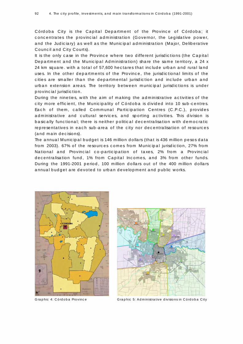
4. The city profile, investments, and main transformations in Córdoba (1991-2001)
92
Córdoba City is the Capital Department of the Province of Córdoba; it concentrates the provincial administration (Governor, the Legislative power, and the Judiciary) as well as the Municipal administration (Major, Deliberative Council and City Courts). It is the only case in the Province where two different jurisdictions (the Capital Department and the Municipal Administration) share the same territory, a 24 x 24 km square. with a total of 57,600 hectares that include urban and rural land uses. In the other departments of the Province, the jurisdictional limits of the cities are smaller than the departmental jurisdiction and include urban and urban extension areas. The territory between municipal jurisdictions is under provincial jurisdiction. During the nineties, with the aim of making the administrative activities of the city more efficient, the Municipality of Córdoba is divided into 10 sub-centres. Each of them, called Communal Participation Centres (C.P.C.), provides administrative and cultural services, and sporting activities. This division is basically functional; there is neither political decentralisation with democratic representatives in each sub-area of the city nor decentralisation of resources (and main decisions). The annual Municipal budget is 146 million dollars (that is 436 million pesos data from 2003). 67% of the resources comes from Municipal jurisdiction, 27% from National and Provincial co-participation of taxes, 2% from a Provincial decentralisation fund, 1% from Capital Incomes, and 3% from other funds. During the 1991-2001 period, 100 million dollars out of the 400 million dollars annual budget are devoted to urban development and public works.
Graphic 4: Córdoba Province Graphic 5: Administrative divisions in Córdoba City

4. The city profile, investments, and main transformations in Córdoba (1991-2001)
93
4.6 URBAN STRUCTURE Access routes to Córdoba and main road system The urban structure of the city is based on its mediterranean position in the national context and the role it plays as a node that communicates other towns in the region and micro region. Different national routes go through the city towards the four cardinal points, so they become the main structural road corridors (Graphic 6). The system of radial road corridors is supplemented by an external ring of quick circular road partially materialised towards the end of the 1990s, as well as by an internal ring made up of main avenues in the central area. The Suquía river (that runs through the city from West to East) and the Cañada stream (which runs South to North and flows into the river) constitute the other axes of road structure
Graphic 6: Main access routes to Córdoba

4. The city profile, investments, and main transformations in Córdoba (1991-2001)
94
Road Network The structure of the road network, conditioned by the metropolitan and regional urban links and the growth pattern of the city, emphasises its radial form. The central area accounts for the greatest amount of commuting and traffic volume. The projects on course in the Municipality aim at favouring transverse connections and at linking disconnected fragments (that appear as a result of the radial conformation of the growth pattern). The city also has a 200-km long network of cycle paths in peripheral areas. The public transport system is comprised of a network of 60 bus lines and 5 trolley lines that runs along the main radial corridors and goes across the city centre in different directions, with only a secondary ring bus line. By the end of 2000, the number of public transport passengers has descended from 1 million to 400 thousand per day, and the car ownership index has increased from 0.91 cars per household in 1991 to 1.21 cars per household in 2001. Although there is a rail line, there is no alternative metro transport system to connect peripheral areas and the micro region. This situation contributes to the traffic congestion towards the city centre and emphasises the radio-concentric design of the network.
Graphic 7: Main Road System

4. The city profile, investments, and main transformations in Córdoba (1991-2001)
95
Graphic 8: Main Transport corridors
Urban areas and land uses The Municipal jurisdiction (57,600 km2) is integrated by urban and rural areas. According to official data and norms, the distribution of uses in the administrative jurisdiction of the Municipality includes 25,438 hectares devoted to urban areas (or future urban developments), 17,000 hectares for rural uses, 8,703 hectares for industrial uses, and 6,461 hectares for open areas. The green area includes two main corridors (a linear park that follows the river and the Cañada stream), main channels for watering, natural areas for preservation, metropolitan and big urban parks, and several urban squares. It represents a total of 1,210 hectares; the index of green area per inhabitant is 9.6 m2.

4. The city profile, investments, and main transformations in Córdoba (1991-2001)
96
Graphic 10: Land uses

4. The city profile, investments, and main transformations in Córdoba (1991-2001)
97
Summary of the historical development The pattern of urban structure of the current city is based on the forms of growth and land uses that have been produced in time. In general terms, different periods are identified in the process of urban growth: -The first period is from the foundation of the city until the end of 19th century, when the city is contained inside natural limits (the river, the Cañada stream); today this is the central area. For almost three centuries, the city grows by in-filling the layout of the colonial grid. (The first graphic shows the urban area in 1927.) - The second period is from the end of the 19th century up to 1940, when the city expands exceeding those natural limits and incorporating small settlements in the borders. Although it preserves a compact structure, the process of expansion of high-income sectors (towards the northeast axis) begins. It embraces what today is the intermediate city area, including the most traditional neighbourhoods that expand in all directions based on the colonial grid pattern. - The third period from 1940 to 1965, coincides with the industrialisation stage and an explosive demographic city-growth as consequence of rural-urban migration. In this period, the city expands fundamentally towards the periphery, and the central are begins a process of densification. In this time, serious deficits in terms of infrastructure provision and access to urban services begin to impact living conditions in the city periphery. The main weaknesses of the urban model are result of explosive growth in this period. Among them are:1 the trend to land opening even when there is no effective occupation of such land, a dispersed land use pattern as consequence of a high speculative land market, and no effective regulation; land parcelling without the corresponding infrastructure provision; and a low density extensive growth pattern fostered by plots in ownership to individual housing. The same process continues up to the 1980s, when a deceleration of population growth takes place due to an economic crisis and the control of urban extension through the 1985 establishment Graphic 9: Urban Growth

4. The city profile, investments, and main transformations in Córdoba (1991-2001)
98
of norms that regulate land use and land annexation. Since this time, the city experiences a progressive reduction of densities that decrease from central area to the periphery. According to official data (2001) gross density is 50.5 inhabitants per hectares. In terms of urban form, morphology, and urban character, the city is divided into three main sectors: Central area, Intermediate city area and Peripheral area. -The central area includes the historical centre and main architectural buildings (including the Jesuit Buildings declared World Heritage by the UNESCO). It concentrates the highest building density, combining sectors under renovation and densification processes with others of great vitality (including formal and informal activities), and sectors with obsolescence and deteriorated buildings. Commercial, governmental, institutional, cultural, and educational functions are carried out in this area reinforcing its centrality. It presents the highest land market values. -The intermediate area presents middle values in terms of population density and building intensity. Constituted by different traditional neighbourhoods, each one with its own identity (and sub centres, main buildings, a square, a market, a cinema), this area presents a homogeneous residential tissue and environmental qualities. According to its urban character, it is a renovation area. The structure is based on corridors of higher density (where the commercial and services activities are located) and residential areas of lower height between them. -The periphery is constituted by extensions that develop during the industrialisation period due to an explosive growth that doubles the population in 20 years. Unlike the other areas, it is constituted mainly through parcelling, land division, and spontaneous buildings following the main road corridors in a context of weak regulation. It presents the lower densities and vacant urban Photos 4,5,6: Central, Intermediate and peripheral areas

4. The city profile, investments, and main transformations in Córdoba (1991-2001)
99
land as consequence of the process of land annexation mainly guided by speculation criteria. In terms of urban character is an area for consolidation or extension through low or middle-low building densities. Residential areas (mainly those located in the outer periphery) reveal deep differences from neighbourhoods of the intermediate city –in terms of identity, centrality, level of services provision, (including only basic infrastructure in many cases) - and some of them located without spatial integration to the existing city. By 2003, the city has 376 neighbourhoods and 35 illegal or irregular settlements. Infrastructure networks The running water network covers 93% of the population, natural gas network covers 91%, and electricity a total of 99.5%. 80% of the streets are asphalted and telephony network covered the 78% of the population. The main deficit is presented in terms of sewage, which only covers 42% of the population and 9.8% of the city-area, including central and inner locations. This way, the chances to grow through densification are reduced. In the last decades, as result of high densification, some central sectors present deficits due to the collapsed sewage network.
Graphic 11: Sewage Plan

4. The city profile, investments, and main transformations in Córdoba (1991-2001)
100
4.7 SOCIAL PROFILE By 2001, the unemployment index reaches 16.5%. According to official data (National Census 2001), there are 326,498 unemployed persons in the city. The population under poverty line rises to 505,532 and the population that lives in absolute poverty (Unsatisfied Basic Needs) amounts to 155,319 people (12.9%). Income distribution in the city is highly unequal; the lowest four deciles capture 16.3% of the total income, while the highest two deciles capture 48% of it. The average annual growth rate in the city is 0.87%, and in the Province it is 0.96%2. Life expectancy for men is 67.4 years (1991) and 74.5 years for women (1991). In the case of Córdoba City, households integrated by one person increases from 12% to 16% in the 1991-2001period; while the family units integrated by 5 or more members fall from 31.3% to 26.4% of the total population in 2001. Households integrated by 2, 3, or 4 persons continue to be the greatest part without significant changes in the period (from 56.7% in 1991 to 57.6% in 2001). On the whole, family units of up to 2 members represent 34%, that is to say, 1/3 of the total households, while family units integrated by more than 2 members represent the remaining 2/3. This presents a demographic situation quite different from that in developed countries (as it is the case in The Netherlands, where households integrated by one or two persons turn out to be 2/3 of the population).
4.8 INVESTMENTS AND MAIN TRANSFORMATIONS IN CÓRDOBA 1991-2001 A favourable national context for economic opening During the 1990s, Argentina is one of the most favourable countries for foreign investment. As ECLAC (2001:17, 60) mentions, the privatisation of state assets, the economic convertibility (to control the inflationary process from the previous decade), and the commercial integration with Brazil (within the framework of Mercosur) present a fertile scenario to attract foreign capitals. The context of economic and political reforms facilitates the performance of international companies in several fields formerly in the hands of the State. Transnational corporations in Argentina focus on services and infrastructure provision; the privatisation of public services like telecommunications and electricity, public petrol companies, and commerce and financial services open a variety of different economic activities for foreign capital. Transnational companies are the most dynamic agents in the process of the Argentinean economic restructuring characterised by the purchase of the biggest domestic companies by foreign capitals and the improvement of some

4. The city profile, investments, and main transformations in Córdoba (1991-2001)
101
services that are privatised. The sectoral foreign direct investment in the country focuses on electricity and gas distribution, petrol, and the extraction of natural resources. The expansion of foreign capital concentrates on telecommunications, commercial activities (mainly through the concentration on international chains), and financial services due to the expansion of international banks, retirement funds, and insurance. It grows until 1999 and begins to reverse in 2000, when it diminishes 50% with regard to the previous year. By 2001, this trend accentuates even more, showing recession and higher economic and social uncertainty in the country (Graphic 12). Economic transformations impact on the city space, on the expansion and modernisation of services and communications infrastructure, and on new headquarters of corporate buildings.
Graphic 12: Foreign Investments in Argentina. Source: ECLAC (2001:61)
Sectoral destination of foreign investment in Córdoba One of the most significant features of the process of global economic restructuring is the increasing divergence in the rhythms of growth between countries and cities. In the case of Argentina, when comparing foreign direct investments, there is a huge divergence in terms of the concentration of foreign capitals in the capital city and intermediate cities. For example, in the 1990-2000 decade, the metropolitan region of Buenos Aires concentrates 35% of national population and 59.8% of the total direct private investments in the country (national and foreign), which accentuates its primacy in the national urban system. In the

4. The city profile, investments, and main transformations in Córdoba (1991-2001)
102
Province of Córdoba, the private investment is significantly smaller; even when it occupies the second position, it represents 11.9% of the total in the country. In Córdoba City, the sectoral destination of investment in 1990-19993 (estimated at 11.446 million dollars) is oriented towards the automobile industry (28%); big vehicle companies located in Córdoba4 invest 3.195 million dollars in industrial development; destination of investment towards other industries (food and beverages) is 11%; 10% towards financial services (banks and Insurance companies)5; 15.8% to other services; 8% (899 million dollars) to commerce; 11% (107 million dollars) to building and dwelling industry; and 16% to other items. The transformation of the traditional role of the city in the national urban system due to the rise in interchange flows with MERCOSUR guides the improvement of infrastructure, road networks, and regional mobility. The upgrading of infrastructure includes interventions at different scales; the most significant focus on the privatisation, service concession, and the expansion of the telecommunications sector. Among the services that are privatised are telephony, television, gas distribution, companies for the transmission of data and signs, drinking water treatment and distribution. In a period of economic dynamism, privatised service companies carry out important investments that improve the city competitiveness. The access routes to Córdoba (under the jurisdiction of the Provincial Government) are given in concession to private companies. The concession includes nine road corridors and the main external city-ring.6 The investment to improve regional mobility is estimated at 325 million dollars (in the 1997-2000 period) and is to be recovered by toll payment. The issue is to facilitate quick traffic flows towards national and international points and also to favour metropolitan links between peripheral sectors. It demands not only private but also public investments; the Municipality has to improve road accesses in the main urban corridors and to provide pluvial drainage systems. This way, the external city ring planned in the 1960s as a limit of urban extension, becomes in this period the main road system to connect the metropolitan agglomeration.7 The Municipal Public investment in urban development To increase efficiency and urban productivity, the municipality develops important investments and works. Global investment is estimated at 437 million dollars in the 1994-1998 period, reaching 50% of this value (218 million dollars) in new public works. They focus on the following issues: -The functional characteristics of road networks are optimised looking for to achieve a polycentric urban model. The main road works are located in intermediate and peripheral areas following a radio-concentric system to improve accessibility and urban mobility.8 -Environmental quality, new urban parks, drainage system extension, public space enhancement, and improvements on architectural patrimony are some of the main axis of urban development.

4. The city profile, investments, and main transformations in Córdoba (1991-2001)
103
-The promotion of a strategy of administrative decentralisation on the part of local authorities. Centres to promote the participation of the community (CPC) are built on main road corridors to perform administrative and cultural functions.9 The objective is to reinforce identity and centrality on peripheral sectors by providing service centres and, in this way, collaborating to de-concentrate functions in the central area. Spatial Changes (the effects on the urban form) The effects of macro economic forces in Córdoba are associated with private investments flows that take place in this period. The economic opening and a favourable context to foreign investment introduce transformations and reshape the city structure. Urban development policies and public investments carried out by the Municipality have as main concern the improvement of urban productivity and city competitiveness. Until the 1990s, Córdoba is a mono centric city structured around radial connections, identifying as main elements the central core, the corridors (where secondary and tertiary activities tend to be decentralised towards intermediate city areas), and a mono functional residential periphery. By the end of the decade, the city tends to form a polycentric urban structure as a result of the main investment of foreign companies (Graphics 13 and 14). The modernisation of telecommunication infrastructure and urban service provision; the improvements in regional accessibility and intra-urban road connections; the decentralisation of administrative functions, and the decentralisation and concentration of commercial activities in big centres in the periphery are the most significant spatial changes. (Before the nineties, 70% of the sales are distributed among small markets, by the end of the nineties, foreign chains concentrate 57% of the total, impacting on the commercial activity, the daily movements of the population, and the economic background.) The development of real estate large urban projects focus on commercial, retail, cultural, and residential activities, bringing a new character to the urban periphery and transforming the functional dynamics in a process of urban decentralisation and re-centralisation. The emergence of new centralities in the city periphery has contributed to the decentralisation of urban functions. The increase in car ownership and the improvements in urban connectivity have impacted on commercial developments and gated communities, contributing to the development of an expansive and diffuse growth pattern. The modernisation of the CBD, due to the new headquarters of foreign corporations and banks and multifamily buildings, takes place together with the expansion of new centralities on the main road corridors. It seems that a new complex relation between the multifaceted central areas and a periphery with multiple centres with generalised mobility represent the conditions of the urban structure of the globalisation period that is oriented by the dominance of international services and financial capitals.10

4. The city profile, investments, and main transformations in Córdoba (1991-2001)
104
Graphic 13: The monocentric city
Graphic 14: Towards urban decentralisation
4. The city profile, investments, and main transformations in Córdoba (1991-2001)
105
Simultaneously, with the decentralisation of functions and the improvement in road accessibility, there is a process of dispersion of residential areas and suburbanisation though real estate market operations of huge scale, mainly through the development of urban fragments. The new residential type is characterised by its dispersion, autonomy, and sectors of private use at great scale. The new forms of space production in a context of accentuated suburbanisation are based on the articulation of private investments areas, constituting one of the distinctive features of the process of spatial restructuring during globalisation.III The spatial change interacts with other processes (of political, social, and economic character), intensifying the traditional socio-spatial segregation in the urban structure. The features of growth emphasise a polarised and segregated metropolitan structure, where social stratification is expressed in the territory.
4.9 DISTRIBUTION OF REAL ESTATE INVESTMENTS IN THE CITY The distribution of real estate investment in Córdoba City in the 1991-2001 period is as follows:11 -Single houses: 32%, mainly through the sprawl of gated communities. Multi house buildings: 25%; located in central areas through densification processes. -Shops: 17%; including big commercial malls and large urban projects developed by international companies. -Others: 16%; new international hotels, intelligent office buildings in downtown city area. -Industry: 10% The impact of suburban gated communities Real estate housing developments (gated communities) accompany the economic expansion that takes place during this period. Between 1991 and 2001, a total of 8,262 plots (including Córdoba City and metropolitan area) are incorporated to the residential supply. The estimated investment represents around 368 million dollars in m2 of urban land -calculated on the basis of the average market prices of urbanised plots. The information is provided by developers during April 2001 and varies according to the level of consolidation of each private neighbourhood. It refers only to the plot value; it does not include the value of the houses because this data is not available. III Cicolella, P. (1999:8)

4. The city profile, investments, and main transformations in Córdoba (1991-2001)
106
Location Type Investment in new
urban land annexed (Estimated In Million U$ Dollars)
Percentage sold (%)
Occupation percentage (%)
Gated communities (High-income level)
156.68 71.16% 55.23% CÓRDOBA CITY
Gated neighbourhoods (Medium-income level
96.388 22.78% 12.78%
Gated communities 38.4 50.51% 14.80% METROPOLITAN AREA Gated neighbourhoods 76.12 44.64% 14.88%
TOTAL
367.58 43.86% 25.39%
Table 2: Real estate investments in gated communities in Córdoba (1991-2001) Own elaboration. Source: report carried out in the course of this research.
The investments in commercial and service activities, road infrastructure, public works in urban development, the real estate investment and, specifically, the new gated communities built in Córdoba reach a significant value and produce important economic effects at the local level.
4.10 CONCLUDING REMARKS The main strength of the city derives from its geographical position and a diversified service supply of high complexity in the central area of the country. It has a diversified economy oriented to exports that concentrate 53% of the Gross Domestic Product of the Province. The city centre maintains symbolic functions and it presents the highest densities and a mixture of activities. In the 1991-1999 period, the Strategic Development Plan of the city is formulated. Its aim is to make Córdoba a competitive city, taking advantage of its location, natural environment, and human and institutional resources that are recognised in national and international circles. The goal is to stimulate economic development. The projects formulated respond to demands regarding urban competitiveness and productivity, introducing transformations in the city. The interventions carried out in this period aim at improving urban infrastructure and services. They are focused on the requirements made by economic agents looking for to attract investments to the city. Public works promote the modernisation of the urban structure. They look for to overcome the weaknesses derived from the process of historical growth; that is to say, the marked centrality of the city reinforced by radial axes of movement, the deficits in drainage and sewer system networks, and the lack of public

4. The city profile, investments, and main transformations in Córdoba (1991-2001)
107
equipment and green area in peripheral sectors. The municipality in that period is seeking to provide services in peripheral areas in an attempt to cover the deficits derived from urban growth and to balance the main concentration of activities in the central area. The main axes of intervention have great impact on sprawl processes: improvements on accessibility (transport oriented projects) and the strategy of decentralisation. As a result, the relocation of services and commercial activities (initiated by the private sector via the creation of large commercial complexes in the periphery) and public works, the urban structure tends to form a polycentric city. Undoubtedly, the nineties is a fertile period for economic investments. The sprawl of gated communities –which means the dispersion of residential areas- is the main spatial change in the city structure. Together with the expansion of the urbanisation, a strong process of social dualism, high rates of unemployment, and the increase of urban poverty take place. The next chapter analyses the sprawl process and land annexations in an attempt to understand them not only as by-products of the voluntary choice of the elites but also as the impossibility of a great part of the population to choose a better urban location.
Notes 1 Source: “Bases para un diagnóstico” (2000:7) Córdoba Municipality. 2 Source. Statistics Bulletin N.18 (2003) Córdoba Province. 3 Source: Córdoba Chamber of Commerce, Economic and Financial Research Institute. Balance de la Economía Argentina, pp. 326. Production and Service Statistics Guide 1998-1999. Córdoba Municipality. 4 Fiat Auto Argentina, General Motors, Iveco Argentina, Chrysler and Renault Argentina. Source: Municipalidad de Córdoba (1998b:39). 5 By 1999 there were 41 banks and 40 insurance companies in Córdoba City 6 The longitude of the net is 400 Km and approximately 70.000 vehicles circulate per day. It is important to mention that complementary road works are financed with local funds. 7 The provision of electricity is the only service in charge of a provincial company. The networks for water provision, sewage treatment, l ighting of public spaces, pluvial drainage system, and the maintenance of urban streets are in charge of the Municipality. 8 Road works include 16 bridges, 2 road interchanges, and the extension of several avenues (as the riverside road), cycle paths, and important complementary works of pluvial drainage system, relocation of slum population, and new green areas. 9 Each building is about between 2,400 to 2,800 square meters and was built with local funds. The total investment is estimated at $15,700,000 mill ion dollars 10 This section has been partially published in Carmona M. et.al (eds) Globalization Urban Form and Governance. Globalization and the Return of Big Plans Book 7. DPU Science 2003. The Netherlands. In developed countries (specifically in the case of the USA), the decentralisation of the industrial production and employment outside the limits of the city (in the outlying rings) attracts new

4. The city profile, investments, and main transformations in Córdoba (1991-2001)
108
residents and form urban areas (outer cities). In this case, and contrary to sprawl, there was not a primary homogeneous white elite seeking exclusive residential areas but the working class seeking for better jobs. These planned residential developments follow the industrial location and show a social pattern much more mixed in comparison to the traditional suburbs. (Soja 2000: 241) 11 Estimated at 899 mill ions dollars. Source: Service and Production Statistics Guide. (2000:61) Córdoba Municipality.

5. THE PROCESS OF URBAN SPRAWL IN CÓRDOBA (1991-2001) CHAPTER V 5.1 Introduction 5.2 Demographic dynamic in Great Córdoba as a context The lack of legal instruments to promote unified urban policies in Great Córdoba 5.3 Population Growth in Córdoba Municipality (intra-spatial dimension) Urban sectors that increase or decrease their population in the period
Analysis by sectors (urban fractions) Central area Intermediate city area City periphery: Urban sprawl in the administrative area of the Municipality
5.4 Urban area annexed (1991-2001) 5.5 Land market supply 5.6 Concluding Remarks

5. The process of urban sprawl in Córdoba 1991-2001
110
5.1 INTRODUCTION The purpose of this chapter is to clarify the first hypothesis, which states that: “In a context of high social inequity, urban sprawl reinforces segregation and increases spatial inequalities.” To expand on this hypothesis, I will refer to Subproblem 1 (See point 1.3 above) that proposes the question: “To what extent are the process of urban sprawl, segregation, and fragmentation taking place in Córdoba Municipality in the 1990s?” This subproblem is divided into three main axes of analysis: (1) urban sprawl (developed in Chapter 5), (2) segregation (Chapter 6), and (3) fragmentation (Chapter 7). The latter chapter also integrates the topics discussed in the previous chapters into a general conclusion. The analysis of urban sprawl will particularly consider land annexations that take place inside the Municipality area. Even when annexation is the most common method by which a city acquires new territory, the case of Córdoba exhibits some particular characteristics in comparison to other Argentinean cities. The municipality has an area of 57.000 km2 under its administration, but it cannot expand its boundaries since they coincide with the political limits of the Capital Department of the Province. According to political and legal tools in Córdoba, no municipality can expand its limits beyond those of the departmental jurisdiction. Inside the administrative boundaries of the municipality there is much vacant land; some devoted to rural uses in the agricultural Green Belt and some underdeveloped or vacant urban land located inside the city-area. In sections with low population density, the city can house new population by in-fill development and by expanding urban land uses to rural areas. This means that even when it is not possible to expand the administrative boundaries of the municipality, it is possible to annex land from rural to urban uses, as well as to growth through densification. The aim of this chapter is to show how this process takes place during the 1991-2001 period. It also examines, in a comparative way, the rates of population growth in different city-areas in order to identify urban growth dynamics, densities, and sectors with an increase or decrease in population during such period. This analysis is based on the assumption that those areas with an increase in population generate a positive urban climate, while those that lose their population initiate a process of decline and stagnation. Towards the northwest corridor, the city exhibits a physical continuity with the adjacent towns, giving rise to the Great Córdoba Area. The urban sprawl process crosses the boundaries of Córdoba municipality and a greater dynamic in terms of demographic growth may be noticed in those places. The fragmentation of the local government into different municipalities seems to be the main obstacle in promoting a unified urban policy, in avoiding territorial fragmentation, and in diminishing segregation. Even when there are institutional and technical limitations to incorporating the analysis of urban sprawl processes in these suburbs, some data has been

5. The process of urban sprawl in Córdoba 1991-2001
111
introduced in order to provide an overview of the situation in the metropolitan area or Great Córdoba. However, the focus of analysis of this chapter will be the process of urban sprawl in the administrative area of Córdoba Municipality.
5.2 DEMOGRAPHIC DYNAMIC IN GREAT CÓRDOBA AS A CONTEXT This section introduces some data on population growth in Great Córdoba agglomeration. According to the Instituto Nacional de Estadísticas y Censos (INDEC, the National Census and Statistics Institute), Great Córdoba comprises the built-up area of the city and adjacent satellite towns, which reveals continuity in the urban form and functional relations with the central city. This demographic area is composed of different municipalities such as Córdoba, Villa Allende, Saldán, Unquillo, Mendiolaza, Río Ceballos, La Calera and Juárez Celman, and it includes two provincial departments: Capital and Colón. Even when it is not possible to apply the concept of Córdoba metropolitan area because this jurisdiction is not institutionalised in terms of political action, some data on demographic growth have been introduced as a context.
These data indicate that since 1970, demographic growth in the small towns surrounding Córdoba is higher than in the central city. This trend accentuates during the 1980s and 1990s. The demographic dynamic indicates a population decline in the central city (negative growth) during the 1991-2001 decade in comparison to the dynamic in small towns in Great Córdoba; therefore, a tendency of centrifugal migration is being consolidated (see Table 1 above). During the 1960s, due to industrialisation and rural-urban migration, the average annual intercensal growth rate in Córdoba City reaches 3.18%. In the
Equivalent annual growth rate1 # City Departmental Jurisdiction
inhabitants (Census 2001) 1970
1980 1980 1991
1991 2001
1 Córdoba Capital 1,284,582 2.16 1.57 0.87 2 Villa Allende Colón 21,528 3.19 2.86 2.81 3 Saldán Colón 2,197 -4.41 1.16 1.54 4 Unquillo Colón 15,587 3.01 2.81 2.74 5 Mendiolaza Colón 4,215 7.06 2.42 9.61 6 Río Ceballos Colón 16,406 2.22 2.65 2.36 7 La Calera Colón 24,727 8.38 4.52 3.6 8 Juárez
Celman Colón 3,966 5.71 6.30 10.61
9 Malvinas Colón 8,625 2.84 10.8 4.89
Table 3: Evolution of growth rate in Great Córdoba agglomeration (expressed per 100 inhabitants). Own elaboration. Source: Census and Statistics Office. Córdoba Province Government.
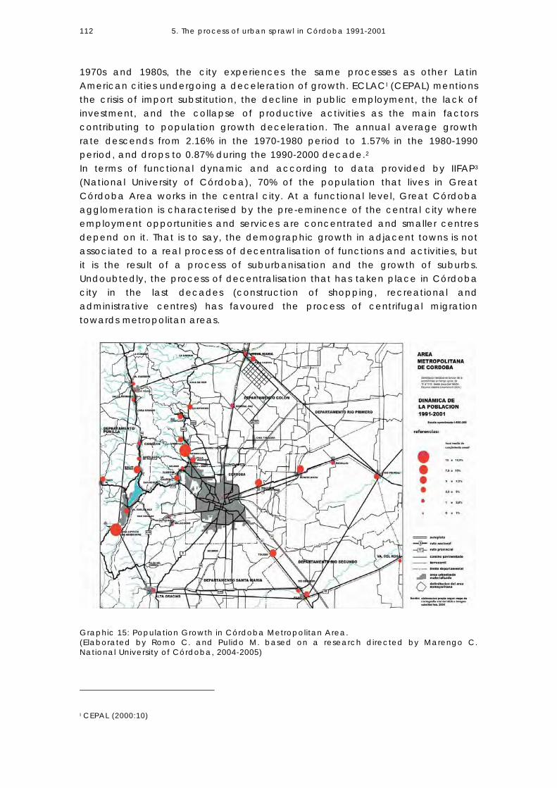
5. The process of urban sprawl in Córdoba 1991-2001
112
1970s and 1980s, the city experiences the same processes as other Latin American cities undergoing a deceleration of growth. ECLACI (CEPAL) mentions the crisis of import substitution, the decline in public employment, the lack of investment, and the collapse of productive activities as the main factors contributing to population growth deceleration. The annual average growth rate descends from 2.16% in the 1970-1980 period to 1.57% in the 1980-1990 period, and drops to 0.87% during the 1990-2000 decade.2 In terms of functional dynamic and according to data provided by IIFAP3 (National University of Córdoba), 70% of the population that lives in Great Córdoba Area works in the central city. At a functional level, Great Córdoba agglomeration is characterised by the pre-eminence of the central city where employment opportunities and services are concentrated and smaller centres depend on it. That is to say, the demographic growth in adjacent towns is not associated to a real process of decentralisation of functions and activities, but it is the result of a process of suburbanisation and the growth of suburbs. Undoubtedly, the process of decentralisation that has taken place in Córdoba city in the last decades (construction of shopping, recreational and administrative centres) has favoured the process of centrifugal migration towards metropolitan areas.
I CEPAL (2000:10)
Graphic 15: Population Growth in Córdoba Metropolitan Area. (Elaborated by Romo C. and Pulido M. based on a research directed by Marengo C. National University of Córdoba, 2004-2005)
5. The process of urban sprawl in Córdoba 1991-2001
113
The lack of legal instruments to promote unified urban policies in Great Córdoba The demographic and functional dynamics of Great Córdoba acquires new interest during the 1991-2001 period as a consequence of real estate developments oriented towards large-scale gated communities projects. However, legal and political limitations seem to be the major obstacle to promoting the integration of local governments in Córdoba metropolitan area. In 1987, and in accordance with decentralisation policies, the Provincial Constitution of Córdoba is introduced, which recognises the political, economic, administrative, financial, and institutional autonomy of Municipalities, and it states that their administrative jurisdiction includes the area where municipal services are provided.4 In 1991, the 8102 Municipal Organic Law is passed; it states that each municipality has to delimit its own administrative jurisdiction (i.e. its urban ratio) as long as it does not exceed the departmental limits. The jurisdictional limit includes (1) the area where services are totally or partially provided by the municipality (urban areas), (2) the areas for future city expansion (underdeveloped land), and (3) rural use areas over which the municipality exercises power but only up to where they border on similar areas belonging to other municipalities or near-by communes.5 After ten years from the passing of the Law, many Municipalities in Great Córdoba still have to delimit their territorial jurisdictions.6 For instance, towards the northwest side of Great Córdoba area, Córdoba, Villa Allende, and Juárez Celman Municipalities have delimited their administrative jurisdiction and urban limits. Other municipalities such as La Calera, Malagueño, and Malvinas Argentinas only have a zoning plan; their urban jurisdictions still have not been approved by the Legislature, according to the requirements set by the Provincial Law7. Lastly, the Municipalities of Saldán, Unquillo, and Mendiolaza do not even have an urban plan for their areas (see Graphic 16 below). It is clear that decentralisation policies have an unequal impact on Great Córdoba agglomeration. Small towns lacking technical support or political capacities are incapable of solving a complex problem such as the layout of municipal boundaries. It is important to mention that not always do municipalities are contiguous to other municipalities; in some cases, municipal jurisdiction adjoins rural areas that belong to the departmental jurisdiction. The lack of definition of urban jurisdictions in some municipalities plus the absence of a unified territorial policy at metropolitan scale opens up the possibility of locating real estate developments outside the municipal boundaries. The restrictions on service extensions seem not to be a limit to sprawling, even when these real-state developments are located in departmental jurisdictions where urban controls and requirements are less strict. At present, a project under study by the Provincial Government aims at expanding the administrative boundaries of municipalities. The project looks for to divide the departmental jurisdiction between the municipalities of each department. This initiative would provide continuity between the borders of the

5. The process of urban sprawl in Córdoba 1991-2001
114
different municipalities and would give them control over the departmental rural area. This way, it could be possible to avoid the establishment of residential real estate developments in rural areas that are now under provincial jurisdiction. It is widely documented in urban researchII that fragmentation into several municipal governments promotes competition among towns and fosters expansion and segregation. The differences in terms of the socio-economic profile of the municipalities and the lack of unified spatial policies tend to reinforce this situation.
The process of centrifugal growth is not only the result of high and middle-income sectors migration that respond to the market supply of new-gated communities, but also the result of low-income sectors migration that cannot II Rusk, D. (1993:33)
Graphic 16: Main conurbation at Great Córdoba (Own elaboration based on information gathered during the research)

5. The process of urban sprawl in Córdoba 1991-2001
115
afford urban land values in the central city. (According to official data, the number of low-income population coming from the central city has increased in metropolitan municipalities.) During the 1991-2001 decade, and due to demographic growth, significant transformations are introduced in land-use patterns. New areas with different socio-economic profile are urbanised reproducing the socio-spatial segmentation observed in Córdoba Municipality. While towns located in the northern corridor expand through gated communities developed by real estate agencies and addressed to high-income sectors, the expansion observed in other municipalities, such as Juárez Celman or Malvinas Argentinas, is the result of a public housing policy, particularly those housing programmes devoted to the clearance of central city slums. In some cases, the relocation of low-income population to these small towns is not supported by an economic transference of resources. The process of centrifugal migration that extends to municipalities in the metropolitan area forces these towns to confront increasing urban problems and fulfil social demands. Some critical questions that require institutional articulation and inter-municipal strategies refer to environmental issues (water provision, sewer networks, landscape preservation), transit and massive transport systems (norms and legislation shared by all the municipalities), the public health care system (where low complexity treatment is provided by the local government and high complexity treatment by the provincial government), and land-use regulations and norms. Great Córdoba agglomeration evidences not only spatial but also political fragmentation. Urban actors continue operating in an isolated way and great differences are appreciated in terms of urban regulations, land values, and the socio-economic profile of the inhabitants in the different localities. The critical issue is the number of local governments having control over planning and zoning decision-making in different urban areas; each municipality develops its own urban policies. Another issue refers to the lack of urban plans to regulate growth and urban activities; few municipalities have regulations on urban growth control and a few others only have partial regulations. This condition facilitates market speculation and plot divisions in areas lacking provision of services. Definitely, the central point is not having a Provincial Law that regulates land uses and spatial growth in the provincial jurisdiction and the integration of urban regulations and norms into a wider legal framework. The challenges in the metropolitan area involve overcoming partial strategies in approaching urban growth processes, integrating planning strategies, promoting unified urban policies, and developing institutional tools to guide metropolitan growth. Unfortunately, these issues are not being considered in the political agenda.

5. The process of urban sprawl in Córdoba 1991-2001
116
5.3 POPULATION GROWTH IN CÓRDOBA MUNICIPALITY (INTRA SPATIAL DIMENSION) A stabilisation of growth may be noted in the period under study. The total population of Córdoba Municipality in 1991 is 1,179,372 inhabitants and 1,284,582 in 2001. Population increases by 105,210 inhabitants in one decade, which is 8.92 % of the 1991 population. In comparing the population housed in different urban areas –Central Area, Intermediate Area, and Peripheral Area- based on an urban structure model defined by the norms, it could be observed that population growth is not homogeneously distributed in the city –while some places attract population other lose it. Urban areas that increase or decrease their population in the period
The analysis of growth by areas reveals the following data: - By 1991, the population of the central area is 64,963 inhabitants, which represents 5.5% of the total population. By 2001, it dwindles to 60,363 inhabitants, 4.69% of the total population; therefore, the area loses around 4,600 inhabitants (7.08% of the area’s population) in one decade. At the same time, gross density in central area decreases from 151 inhabitants p/ha in 1991 to 140 inhabitants p/ha in 2001.8 - The population of the intermediate city is 249,373 inhabitants in 1991 (21.14% of the city’s population), while in 2001 the population is 230,705 inhabitants (17.96% of the total); that is to say, the area loses 18,688 inhabitants (8.06% of the area’s population) during the period. Gross density here decreases from 70 to 64 inhabitants per hectare. - The highest values of population growth are concentrated in the periphery, which presents a smaller consolidation of the urban layout. By 1991, it has
POPULATION
AREAS Inhabitants (1991)
% Inhabitants (2001)
% Difference (Inhabitants)
% (1991-2001)
Central 64,963 5.5 60,363 4.69 - 4,600 (-) 7.08 Intermediate 249,373 21.14 230,705 17.96 - 18,668 (-) 8.06 Periphery 865,036 73.34 993,514 77.34 128,478 (+) 14.85 TOTAL 1,179,372 100 1,284,582 100 105,210 (+) 8.92
Table 4: Evolution of population by urban sectors in Córdoba Municipality (1991-2001 Own elaboration. Source: Census and Statistics Office. Córdoba Province Government.

5. The process of urban sprawl in Córdoba 1991-2001
117
865,036 inhabitants (73.34% of the total population), whereas in 2001 its population is 993,514 inhabitants (77.34% of the total). During the period under analysis, the population increases in 128,478 inhabitants (14.85%). Not only does the periphery have a higher rate of population growth compared to the central and intermediate areas, it also absorbs the intra-urban migration of population. In the 1970s, the population living in peripheral areas represents 52% of the city’s population; by 2001, this value increases to 77.28%.III Gross density in the periphery decreases from 65 inhabitants p/ha in 1991 to 58 in 2001. Analysis by urban sectors (census fractions) The analysis by census fractions9 reveals that population growth is not homogeneously distributed; some city sectors increase while others lose the number of people they house. From a total of 84 census-fractions, 46 sectors increase and 38 lose population in the period (1991-2001). [In order to facilitate the analysis, census-fractions have been grouped into growth intervals: from those that concentrate 1% of population increment (up to 1052 inhabitants) to those that concentrate more than 5% (i.e. 5260 inhabitants)]. The sectors that concentrate the greatest population growth are located in the external ring of the periphery and in one specific sector inside the central area (see Graphic 17 below). The sectors that shrink in terms of the level of population they house are located in consolidated central and intermediate city areas. These urban sectors have greater urban capacity,10 higher levels of infrastructure provision, more services, and relative vicinity to the city centre. The data indicate a process of stagnation and decline of population growth. Even when a process of urban renewal may be observed in some corridors (main city-avenues), these areas do not tend to show a process of urban densification during the period analysed. The northeast sector of the intermediate area (bordering on the central area) reveals the most adverse situation in terms of population loss (see Graphic 18 below).
III Peralta, C.(2003)

5. The process of urban sprawl in Córdoba 1991-2001
118
Table 5: Urban sectors that increase their housed population during the 1991-2001 period. Córdoba city. Own elaboration. Source: Census and Statistics Office. Córdoba Provincial Government
CENSUS FRACTIONS
POPULATION GROWTH (Inhabitants) (1991) (2001)
DIFFERENCE (Inhabitants)
INTERVALS
DIFFERENCE (%)
21 12948 12967 19 0.15 25 13455 13514 59 0.44 18 26353 26429 76 0.29 32 20877 21029 152 0.73 73 871 1129 258 29.62 51 14199 14474 275 1.94 82 1039 1417 378 36.38 16 10579 11044 465 4.40 76 3999 4467 468 11.70 7 11560 12133 573 4.96 80 709 1401 692 97.60 83 497 1251 754 151.71 75 1895 2843 948 50.03 31 17759 18712 953 5.37 74 2062 3101 1039
Increase up to 1% Inhabitants (1052 inhab) 50.39
35 17496 18780 1284 7.34 37 19962 21289 1327 6.65 77 1591 3232 1641 103.14 54 20277 22034 1757 8.66 78 686 2735 2049 298.69 72 14131 16281 2150 15.21 65 1138 3309 2171 190.77 49 18733 20955 2222 11.86 64 10761 13029 2268 21.08 34 23207 25637 2430 10.47
20 23168 25906 2738
Increase From 1 to 3% (1052 to 3156 inhab.) 11.82
43 23835 27037 3202 13.43 69 20152 23543 3391 16.83 60 24809 28440 3631 14.64 53 14501 18544 4043 27.88 15 12214 16432 4218 34.53 66 24119 28747 4628 19.19 45 22940 27722 4782 20.85 79 14917 19784 4867 32.63 61 8597 13540 4943 57.50 71 25599 30720 5121 20.00 44 20526 25651 5125 24.97
55 13443 18585 5142
Increase From 3 to 5% (3156 to 5260 inhab.) 38.25
58 21913 27414 5501 25.10 46 17379 23027 5648 32.50 50 29062 35255 6193 21.31 59 27091 33310 6219 22.96 70 28822 36173 7351 25.50 67 20930 30470 9540 45.58 52 21188 32207 11019 52.01 68 24208 36318 12110
More than 5% (> 5260 inhab.) 50.02
TOTAL 1179372 1284582 105210 8.92

5. The process of urban sprawl in Córdoba 1991-2001
119
CENSUS FRACTIONS
POPULATION GROWTH (Inhabitants) (1991) (2001)
DIFFERENCE (Inhabitants)
INTERVALS
DIFFERENCE (%)
17 15064 11842 -3222 More than 3% -21.39
28 18827 16658 -2169 -11.52 9 11480 9583 -1897 -16.52 40 19927 18193 -1734 -8.70 13 14360 12636 -1724 -12.01 38 11268 9650 -1618 -14.36 11 10883 9314 -1569 -14.42 2 8285 6754 -1531 -18.48 23 15665 14143 -1522 -9.72 30 15489 14019 -1470 -9.49 36 18926 17498 -1428 -7.55 12 11040 9625 -1415 -12.82 8 18747 17388 -1359 -7.25 47 18996 17679 -1317 -6.93 14 8058 6838 -1220 -15.14 6 12196 11029 -1167 -9.57 57 19927 18827 -1100 -5.52 3 7623 6529 -1094 -14.35 24 16870 15794 -1076
Decrease from 1 to 3% (-3156 inhabit) -6.38
29 13110 12063 -1047 -7.99 10 9531 8489 -1042 -10.93 39 15012 14001 -1011 -6.73 1 7433 6499 -934 -12.57 4 6304 5380 -924 -14.66 26 11775 10890 -885 -7.52 27 15098 14216 -882 -5.84 41 11898 11127 -771 -6.48 42 14967 14225 -742 -4.96 22 16561 15982 -579 -3.50 56 14431 13854 -577 -4.00 33 17932 17426 -506 -2.82 48 13217 12808 -409 -3.09 19 19496 19181 -315 -1.62 81 323 185 -138 -42.72 63 924 809 -115 -12.45 5 11424 11360 -64 -0.56 62 50 30 -20 -40.00 84 58 41 -17
Decrease up to 1% (-1052 inhabit) -29.31
TOTAL 1179372 1284582 105210 8.92
Table 6: Sectors that decrease their housed population during the 1991-2001 period. Córdoba city. Own elaboration. Source: Census and Statistics Office. Córdoba Provincial Government.
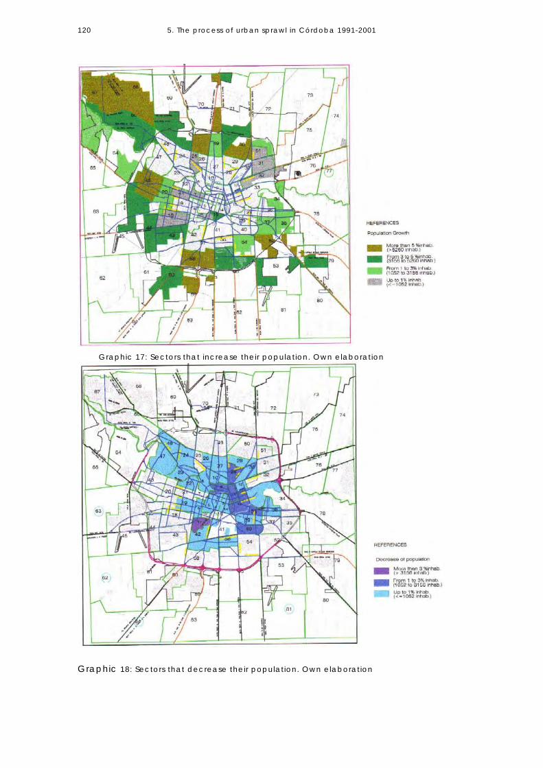
5. The process of urban sprawl in Córdoba 1991-2001
120
Graphic 18: Sectors that decrease their population. Own elaboration
Graphic 17: Sectors that increase their population. Own elaboration

5. The process of urban sprawl in Córdoba 1991-2001
121
Central Area
The extent of the central area is 480 hectares, 460 of which are devoted to urban-land uses.11 People who live in the central area constitute 7.08% of the total city-population. In terms of spatial growth, the central area is integrated by districts in process of deterioration, with a high concentration of activities and people during working hours and virtually uninhabited the rest of the day. It is also integrated by other sectors (located in the south bounds of the central area) in process of urban renewal and whose building and population densities are increasing (see Table 7 below). The analysis by census fractions reveals that 70% of these sectors lose population. Growth is only concentrated on a specific sector, Nueva Córdoba Neighbourhood, which comprises fractions 15, 16, and 41 and embraces 30% of the central area (approximately 100 hectares). This area witnesses a strong process of urban densification, real estate developments, and increasing building densities; for instance, fraction 15 experiences a strong process of growth through densification. Even when the city core concentrates the highest levels of infrastructure, monuments, historical buildings, trade and services, retail activities, etc., many
Photo 7: Central Area of Córdoba – Source: Córdoba Municipality.

5. The process of urban sprawl in Córdoba 1991-2001
122
sectors lose population in the period. Gross residential density decreases from 151 to 140 inhabitants p/ha. (See Graphic 19 below.)
Intermediate city Area
CENSUS FRACTION
POPULATION
AREA (Ha.)
GROSS RESIDENTIAL DENSITY (inhabitants p/ha.)
Year: 1991 2001 1991 2001 1 7433 6499 36 207 181 2 8285 6754 80 104 85 3 7623 6529 64 118 101 4 6304 5380 32 197 168 5 9179 5866 44 208 133 14 8058 6838 64 126 107 15 12214 16432 64 190 255 16 4974 5138 39 128 132 41 893 927 6 138 144 TOTAL 460 64963 60363 430 12 151 140 Table: 7: Population growth and densities in Central Area. Own elaboration. Source: Statistics and Census Office. Córdoba Provincial Government
Photo 8: Inner city areas. Source Córdoba Municipality. (Fractions 16-17)

5. The process of urban sprawl in Córdoba 1991-2001
123
According to urban-norms, the intermediate city area comprises 3,600 hectares. This urban sector is characterised by a strong historical identity and composed of neighbourhoods that have urban identity. It is inhabited by 7.05% of the city-population and its residential morphology shows low buildings and, in some road corridors, an incipient process of urban renewal. The analysis of population growth by census fractions reveals that 84% of the fractions that constitute the intermediate area lose population in the 1991- 2001 period (see Table 8 below). In order to analyse gross densities, residential area has been calculated by graphic analysis, excluding main institutional sectors and green, riverside, and railway areas. Population growth is to be found only in some fractions: fraction 5, 7, 16, which borders on the central area and shows a process of urban renewal; fraction 5, whose gross residential density increases from 50.8 to 123 inhabitants p/ha. in the period and which is the only one where a strong densification process takes place; fraction 25 also presents an increase in population –its gross residential density increases from 93.3 to 98.7 inhabitants p/ha.
Fractions 22, 30 and 12, composed of working class neighbourhoods built at the beginning of the 20th century, are the densest intermediate city areas. Gross residential density in these urban sectors is over 100 inhabitants p/ha. Nonetheless, even these sectors experience a loss in housed population during
CENSUS FRACTION
POPULATION AREA (Ha.)
GROSS RESIDENTIAL DENSITY
Year: 1991 2001 1991 2001 5 2245 5494 44.2 50.8 123 6 12196 11029 112.7 108.2 98 7 11560 12133 87.6 132 138.5 8 18747 17388 183.6 102.1 94.7 9 11480 9583 120 95.6 79.8 10 9531 8489 99.4 95.8 85.4 11 10883 9314 93.7 116 99.4 12 9273 8291 72.4 128 114.5 13 14360 12636 204 70.39 61.9 16 5605 5906 41 136.7 144 17 15064 11842 128.6 117.1 92 19 2285 1139 10.5 217.6 108.4 21 12948 12967 137.2 94.4 94.5 22 16561 15982 137.4 120.5 116.3 25 6978 7387 74.8 93.3 98.7 27 15098 14216 223 67.7 63.7 28 18827 16658 166.7 112.9 99.9 30 15489 14019 137.5 112.6 101.9 32 4224 3765 48.6 86.9 77.5 36 6285 5604 64.7 97.1 86.6 37 1121 1003 7 160 143 38 11268 9650 127.4 88.4 75.74 41 11989 11127 66.9 179.2 166.3 TOTAL 3600 249373 230705 2388.9 104.4 96.57 Table 8: Population Growth in the intermediate city. Own elaboration. Source: Statistics and Census Office. Córdoba Provincial Government.

5. The process of urban sprawl in Córdoba 1991-2001
124
the period under study. A more critical situation takes place in fractions 13, 11, 9 and 28 on the northeast sector; they experience population loss and their gross residential densities show the lowest values. Gross residential density in the area falls from 104.4 to 96.57 inhabitants p/ha. in the period. City Periphery: Urban sprawl in the administrative area of the Municipality
Photo 9: Peripheral Areas. – (North west axis of growth) Source Córdoba Municipality

5. The process of urban sprawl in Córdoba 1991-2001
125
In the 1991-2001 period, the peripheral area of the city increases its population and it also expands its limits. By 2001, 128.596 new inhabitants settle in the city periphery, which represents over 15% of the total population this city-sector has in 1991. The area is divided into 66 census fractions. Whereas 62% of the fractions increases their numbers of inhabitants, 38% loses population. Population growth depicts a centrifugal tendency: fractions located inside the first ring (near the intermediate city area) lose population, while those in the second ring, i.e. the consolidated periphery, concentrate significant values in terms of population growth – from 0.15% to 20%. The furthest peripheral areas (near the external ring road) concentrate the highest values of population growth, rising from 20% to 58% during the period analysed (see Graphic 17 and 18 in page 118). Gross residential densities follow a concentric pattern that decreases towards the external ring, depicting a disperse land use pattern in the city periphery. In the 1991-2001 period, densities decrease from 71 to 61 inhabitants p/ha. Peripheral areas adjacent to the intermediate city (fist peripheral ring) have the highest gross residential densities, from 75 to 100 inhabitants p/ha. Consolidated peripheral sectors, which have higher density values, are integrated by labour neighbourhoods that present smaller land parcelling than other peripheral sectors and more compact buildings. Even when they have higher densities, they lose population during the period. (Consider fractions 12, 30, 26, 19 and 40 as examples.) The second peripheral ring, inside the external ring-avenue, is integrated by areas that show gross residential density, from 50 to 75 inhabitants p/ha. and 25 to 50 inhabitant p/ha. in some sectors. Densities are low, even when these urban sectors experience higher population growth in the period, except for fractions 72 and 50 (inside the main ring, towards the northeast). As the result of public housing neighbourhoods, these areas have gross residential densities from 75 to 100 inhabitants p/ha. The third peripheral ring, which comprises those areas external to the main ring and the northwest axis of development, has the lowest gross residential densities (between 25 and 50 inhabitants p/ha.). The exceptions are fractions 59 and 60 in the south and fraction 70 in the north which have been historically denser and composed of working class neighbourhoods that expanded during the industrialisation period. During the 1991-2001 decade, fractions 64 and 65, which are formerly rural, become populated. Real estate developments introduce new residential typologies and significant changes on land uses. Gated communities own plots bigger than 1500 m2 and private green areas that make up 30% (or over) of the total residential area. This represents a significant increase in comparison to conventional plot divisions where green areas entail 10% of the residential area. In the period, some rural areas13 experience an incipient process of population growth – fraction 78 grows from 686 to 2,735 inhabitants (289%), fraction 83 from 497 to 1,251inhabitants (151%), and fraction 80 from 709 to 1,401 inhabitants (97%).

5. The process of urban sprawl in Córdoba 1991-2001
126
Table 9: Population and Densities in the periphery. Own elaboration.
URBAN AREA Annexed DENSITYAREA FRACTION POPULATION (inhabitants) (ha) Area (inhab/he.)
1991 2001 [1991] [2001] (ha) 1991 200180 709 1401 0 22 22 32 6478 686 2735 79 112 33 9 2470 28822 36173 510 550 40 56 6645 22940 27722 595 637 42 38 4353 14501 18544 416 468 52 35 4076 3999 4467 57 123 66 70 3669 20152 23543 549 700 151 37 3461 8597 13540 139 315 176 62 4352 21188 32207 519 695 177 41 4659 27091 33310 297 531 234 91 63
Periphery 73 871 1129 [2078] 246 246 0.4 4.679 14917 19784 230 507 277 65 3965 1138 3309 233 678 445 5 575 1895 2843 [1504] 468 468 1.3 671 25599 30720 350 647 297 73 4772 14131 16281 171 834 663 82 9564 10761 13029 1013 1280 267 10 1055 13443 18585 543 591 48 25 31
* 12 1767 1334 8 220 16718 26353 26429 385 Area annexed 5906 68 68
* 19 17211 18042 132 (graphic analysis) 130 13720 23168 25906 367 63 7123 15665 14143 260 60 5424 16870 15794 259 65 61
* 25 6477 6127 62 104 9926 11775 10890 107 110 10129 13110 12063 152 86 8030 15489 14019 104 149 13531 17759 18712 253 70 74
* 32 16653 17264 271 61 6433 17932 17426 380 47 4634 23207 25637 400 58 6435 17496 18780 248 71 75
* 36 12641 11894 138 92 86* 37 18841 20286 266 71 76* 39 9656 8918 169 57 53
40 19927 18193 135 148 13542 14967 14225 189 79 7543 23835 27037 533 45 5144 20526 25651 358 57 6746 17379 23027 538 32 4347 18996 17679 446 43 4048 13217 12808 269 49 4849 18733 20955 231 81 9150 29062 35255 422 69 8451 14199 14474 150 95 9754 20277 22034 381 53 5856 14431 13854 170 85 8257 19927 18827 244 82 77
park 58 21913 27414 1010 22 2760 24809 28440 474 11067 52 6062 50 30 [2017] rural 0.02 0.0163 924 809 [1550] militar 0.6 0.566 24119 28747 1010 24 2867 20930 30470 980 21 3168 24208 36318 1160 21 3174 2062 3101 [1302] rural 34 60 9077 1591 3232 [1139] rural 178 1.4 1881 323 185 [1448] rural 0.22 0.1282 1039 1417 [1453] rural 0.73 0.9883 497 1251 [1370] rural 0.36 0.9184 58 41 [1981] rural 0.03 0.02
Peripheral area 14926 20832Urbanized peripheral area 12078 16136
TOTAL Population: 865036 993514 Density: 71 61Population Increased: 128596 inhabitants (15%)

5. The process of urban sprawl in Córdoba 1991-2001
127
Graphic 19: Gross residential Densities in Córdoba (2001) by urban fractions. Own elaboration based on data processed during the research

5. The process of urban sprawl in Córdoba 1991-2001
128
5.4 URBAN AREA ANNEXED (1991-2001)
The administrative area under Municipal jurisdiction is of 57,600 hectares, which is inside Córdoba Capital Department as previously explained. Except for farming uses (rural area), industrial uses, metropolitan parks, main green areas, and military areas, the urban area devoted to residential uses increases from 20,500 to 26,423 hectares in the 1991-2001 period, which amounts to 29% of the area the city has in 1991. This value indicates that the city experiences a process of sprawl and dispersion; an increase in land consumption but demographic growth stagnation (see Graphic 20 below). The total of all areas devoted to residential uses is 26,423 hectares, affected by different types of land use regulations and norms (e.g. gated communities are located in areas that, in normative terms, are rural but are devoted to residential use). This value also includes those irregular (or illegal) settlements developed outside any urban regulation. For this reason, the value obtained through graphic analysis is higher than the official value of 25,438 hectares17 that the Municipality publishes and which includes only residential land-use areas that follow the norms. As from 1985, when the norms set the conditions to extend urban land, the city experiences several land-annexations. By 2001, the urban area expands its boundaries and the availability of vacant land inside the city limits increases from 2,848 hectares (15% of the city area) in 1991 to 4,693 hectares (19% of the total urban area).18 By 1991, vacant land is mainly located inside the city-ring and by 2001, vacant parcels (but only those of 1 hectare or bigger) are located outside the city- IV Iros, G. (1991) V Ibid (1991)
URBAN AREAS 1991 2001 INCREASED
Total area under Municipal administration: 14
57,600 ha.
57,600 ha.
Residential land use areas: a) Main Institutional areas: b) Main green areas: Residential areas (points a) and b) not included)
20,500 ha. 865 ha. 666 ha. 18,986 he (100%)
26,423 ha.15 865 ha. 666 ha. 24,892 he. (100%)
5,923 ha. 28.89% (29%)
Central area: (ha.) 460 460 Intermediate City – area: (ha.)
3,600 3,600
Periphery: (ha) 14,926IV 20,832 5906 ha Vacant land (ha.) 2,848
(15%) 4,693 (ha)16 (19%)
1845 ha
Occupied urban land (ha.) 16,138V (85%)
20,199 (81%)
4061 ha
Gross density 73 inhabitants p/ha 64 inhabitants p/ha Table 10: Distribution of land uses in Córdoba Municipality. (Own elaboration)

5. The process of urban sprawl in Córdoba 1991-2001
129
ring. The annexation of land takes place even when there is urban vacant land available, low-level of consolidation in the urban form in some peripheral sectors and low density (see Graphic 23 below). According to the chances of becoming urbanised, different situations of vacant land arise: 1/3 may be built in a short period of time due to the availability of infrastructure extension; 2/3 of vacant land located in the city edges will take longer to build since it requests larger investments in infrastructure. The annexation of vast sectors to be urbanised without the possibility of providing infrastructure and services in the short term, is evidence for the inability to bear the costs of infrastructure extensions and the absence of interest for these urban areas in the city-edges.

5. The process of urban sprawl in Córdoba 1991-2001
130
Graphic 20: Land Uses and Urban areas 1991
Graphic 21: Land uses and Urban Land in 2001.

5. The process of urban sprawl in Córdoba 1991-2001
131
Until the end of the decade, while the processes of city sprawl increase, population growth-rates decrease significantly. When comparing data taken from the last four census periods -the city population, the annual average intercensal growth rate, and the urban/urbanised area-, it is evident that the city growth follows a more disperse pattern of land use and an extended pattern of growth (see Table 11 above). Even when the average intercensal growth rate decreases, the consumption of urban land increases significantly, from 130 m2 of urban land per inhabitant in 1970 to 205 m2 in 2001. In 1985, urban regulations are passed in order to prevent expansion of human settlements without the corresponding availability of infrastructure services. It is important to mention that these regulations are effective in controlling the process of sprawl during the 1980s. However, by the 1990s, urban land consumption per inhabitant rises. A possible interpretation of this phenomenon bears relationship with an economic reactivation taking place in the country at the beginning of the decade, to public and private investments that facilitate the development of suburban areas, to improvements in mobility, and to a more flexible regulatory approach, among others. These factors produce a more dispersed pattern of growth. However, it is necessary to analyse each situation at different borders in particular since the periphery does not show a homogeneous pattern in terms of densities and land uses.
Graphic 22: Urban area (or area to be urbanised) in 1991 and in 2001
Period Inhabitants Annual Average Intercensal Growth Rate%
Urbanised/urban area (Hectares)
m2 occupied urban area/ Inhabitants
1970 801,771 (1960-1970) 3.18 10,471 130,59 1980 993,055 (1970-1980) 2.16 17,024 171,34 1991 1,179,372 (1980-1991) 1.57 20,500 173,82 2001 1,284,582 (1991-2001) 0.87 26,423 205,69
Table 11: Inhabitants - Urban Area Relation (Own elaboration). Source: Statistics and Census Office. Córdoba Provincial Government. Document: Córdoba Population growth and urban-land extension (1991). Córdoba Municipality.
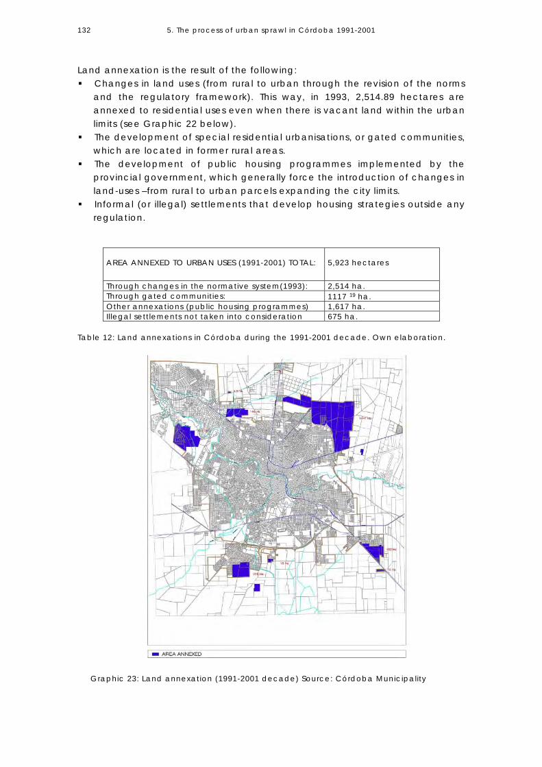
5. The process of urban sprawl in Córdoba 1991-2001
132
Land annexation is the result of the following: Changes in land uses (from rural to urban through the revision of the norms
and the regulatory framework). This way, in 1993, 2,514.89 hectares are annexed to residential uses even when there is vacant land within the urban limits (see Graphic 22 below).
The development of special residential urbanisations, or gated communities, which are located in former rural areas.
The development of public housing programmes implemented by the provincial government, which generally force the introduction of changes in land-uses –from rural to urban parcels expanding the city limits.
Informal (or illegal) settlements that develop housing strategies outside any regulation.
Table 12: Land annexations in Córdoba during the 1991-2001 decade. Own elaboration.
Graphic 23: Land annexation (1991-2001 decade) Source: Córdoba Municipality
AREA ANNEXED TO URBAN USES (1991-2001) TOTAL:
5,923 hectares
Through changes in the normative system(1993): 2,514 ha. Through gated communities: 1117 19 ha. Other annexations (public housing programmes) 1,617 ha. Illegal settlements not taken into consideration 675 ha.

5. The process of urban sprawl in Córdoba 1991-2001
133
5.5 LAND MARKET SUPPLY The spatial extension of Córdoba periphery and the higher rates of demographic growth small towns of Great Córdoba have –compared to the central city– could be related to a greater accessibility to urban land supply in these areas. When analysing the role of the land market in the urban-form of Latin American cities, Jaramillo S. (1997:2) introduces the question of whether land-market could be one of the potential reasons for the socio-spatial patterns of the city (considering that the latter is understood as the result of a certain model of social stratification defined by the possibilities of accessing urban land). In the case of Córdoba, the availability and characteristics of urban land-supply in the market are important indicators to understanding the dynamics of growth by extension. Some significant data reveal that: • 64% of the population is land-owner;
Graphic 24: Vacant urban land. Source: Córdoba Municipality

5. The process of urban sprawl in Córdoba 1991-2001
134
• individual housing with private plots prevails over multifamily or collective housing in social preferences;
• the way to have access to a house is based on progressive building; and • besides its functional value, a house serves as a family-saving. This section incorporates a brief summary of urban land supply based on a research developed in the 2004-2005 period at the National University of CórdobaVI. Some questions related to this issue are: Where does urban land supply take place? What plot prices are offered in the market? What differences are there between urban land values in Córdoba city and those in towns in the metropolitan area? And finally, what is the relationship between urban-land values and society’s possibilities of having access to land? Where does urban land-supply take place? In relation to the process of urban sprawl, lots offered in the market are 75% of the times located in the outlying area of the city. The central area registers 5.37% of the total amount and the intermediate city 19.46%, both percentages related to urban renovation and densification processes.
Percentage of plot-supply in central, intermediate and peripheral areas. Cordoba City. Own elaboration
5,37%19,46%
75,17%
Central area
intermediate area
peripheral area
Most of the plots offered in the peripheral area are located in the north-western quadrant, which concentrates 49% of the total plot-supply. The southwest sector concentrates 34% of the total and a smaller supply is located in the north-eastern and south-eastern quadrants.
VI Marengo, C. (2004-2005)
Graphic 25: Urban-land supply by city areas

5. The process of urban sprawl in Córdoba 1991-2001
135
Urban-Land values in Córdoba City According to densification patterns, building possibilities, and land use regulations, urban land per square meters decreases in value from downtown towards the periphery (see Table 13 below). Strong differences exist among urban-land values depending on whether land is located in the central, intermediate, or outlying area. The former, associated to growth increasing densities, has the highest values. Historically, Córdoba city concentrates many functions in the central area and urban corridors, mainly in the northwest corridor. The comparative advantages these areas have in terms of accessibility, transport, and urban equipment are translated into higher land values.
Graphic 26: Urban land-supply in the city structure. (Elaborated by Romo C. and Pulido M. based on a research directed by Marengo C. National University of Córdoba, 2004-2005)

5. The process of urban sprawl in Córdoba 1991-2001
136
Significant differences also arise when analysing diverse sectors in the peripheral area. While the northwest sector registers an average of $132 per square meter (44 U$/m2), land in the southwest sector has an average value of $98 p/m2 (32 U$p/m2). On the other hand, land in the northeast sector costs $40.97/m2 in average (14 U$/m2), while in the southeast it costs an average of $27.79/m2 (9 U$/m2). The segments having lower land-market prices are used for public housing construction. The dimensions of plot area are bigger in those neighbourhoods towards the northwest sector (800 m2 approximately) than in those towards the southwest, where the average plot area is around 400 m2. The northeast and southeast peripheral sectors do not register a significant plot-supply but huge parcels to be urbanised.
Graphic 27: Urban land-values (per square meter) in Córdoba. 2001. Own elaboration.

5. The process of urban sprawl in Córdoba 1991-2001
137
The strong differences among the many locations in the outlying area manifest a marked socio-economic segmentation. The main differences in plot prices are registered between those plots located next to urban corridors and those located inside or outside the main ring avenue. Although there is a very wide range of prices available (and there are significant differences between the maximum and minimum prices among urban sectors), land values tend to reinforce the socio-economic segmentation in the urban structure. While analysing land supply regarding plot size dimensions, it is perceived that lots as big as 10.000 m2 or larger constitute only 5% on the total supply. Even when the analysis of urban vacant land (see Graphic 23 below) reveals that there are still many huge parcels inside the city ring limits, the supply of big parcels is located outside it. This situation indicates the high speculative character of a land market that is based on the future replacement of rural use by an urban one and on the stimulation of the extension of growth. -Land supply in the Central Area exhibits a wide range of prices that go from U$1367/m2 (4.100 $/m2) in Nueva Córdoba, which holds high land market expectations, to U$ 192/m2 ($575/m2) towards the west sector of the area, which shows a steady process of urban renewal. [See Graphic 17, Fraction N.15 and Fraction N.6] (The average land price in this area is U$ 554.)
-Land supply in the Intermediate Area also presents a variety of values in the different neighbourhoods. The highest values in General Paz sector are U$288/m2 ($864/m2) and the minimum value is U$27/m2 ($8/1m2) in San Vicente area. (See Graphic 18, Fractions No 11 and 13, whose number of population housed decreases in the period.)(The average land price in this area is U$ 118.) The average plot dimension in central and intermediate areas is around 400 m2. - Land supply in the Periphery presents the maximum value dispersion and also great differences in terms of plot area. Both parameters produce segmentation on the social demand and reinforce certain types of settlements in very high and very low-income areas. (The average land price in this area is U$ 37.)
Villa Belgrano, towards the northwest sector, registers the highest land-values, around U$ 85/m2, and plot dimensions of 1.200 m2. The lower land values in this sector are about U$ 6/m2 with an average plot size of 600 m2. (The average land price in this sector is U$ 44.)
In the southwest sector, the highest land values in Jardines del Jockey and Espinosa neighbourhoods are around U$ 97/m2, and plots dimensions are about 410 m2. The lowest values are offered in Villa El Libertador –U$12/m2 with a plot area of 250 m2. (The average land price in this sector is U$ 32.)
The northeast sector presents low land prices supply and minimum dispersion compared to the sectors analysed. Plots in the outlying areas have an average of U$13/m2 in prices and 325 m2 in dimensions.
The southeast sector has the lowest average land prices –U$ 9/m2. Big plots to be urbanised located outside of the ring avenue integrate the

5. The process of urban sprawl in Córdoba 1991-2001
138
land supply. There are no available vacant parcels to access land through urban consolidation process.
Urban land supply in Great Córdoba towns The comparison of land supply in Córdoba city and to that in towns in Great Córdoba shows significant differences in average prices. Somehow, it corroborates the fact that higher rates of population growth in metropolitan areas are related to land access because of its lower costs. This condition (greater possibilities of accessing urban land) is reinforced by lower tax pressure, lower urban life costs, and improvements in micro-regional accessibility, which could contribute to explaining the process of sprawl. The average value of land-supply in Córdoba city totally surpasses those in the metropolitan area. The highest values of land in the latter are less than 25% of the average value of urban land in Córdoba city. The average plot dimension in metropolitan area is about 250 m2. Inexpensive land supply in small towns near the central city and fewer requirements in terms of infrastructure provision (in comparison to requirements and urban regulations in Córdoba Municipality) contribute to suburban expansion.
Graphic 28: Land-supply average price in Córdoba and Great Córdoba per square meter (in pesos) Year 2001. Own elaboration
$ 38
,79
$ 18
,45
$ 27
,50 $
76,2
2
$ 18
,16
$ 9,
00
$ 21
,54 $
75,0
6
$ 17
,19
$ 22
,00
$ 14
,68
$ 20
,00
$ 10
,88
$ 17
,64
$ 11
,76
$ 80
,76
$ 33
3,85
$ 0,00
$ 50,00
$ 100,00
$ 150,00
$ 200,00
$ 250,00
$ 300,00
$ 350,00
$ 400,00
Cór
doba
Cap
ital
Car
los
Paz
Men
diol
aza
Río
Ceb
allo
s
Sal
dán
Vill
a A
llend
e
Unq
uillo
Fald
a D
el C
arm
en
Mal
ague
ño
La C
aler
a
San
ta A
na
San
ta M
aria
Pun
Alta
Gra
cia
Mal
vina
s A
rgen
tinas
Bia
let M
assé
Río
Seg
undo
Sal
sipu
edes
Localities

5. The process of urban sprawl in Córdoba 1991-2001
139
Table 13: Land-supply average price in different urban areas – Own elaboration.
Graphic 29: Land-supply in Córdoba and Metropolitan area 2001. Own elaboration.
LOCALITIES
LAND-OFFER AVERAGE PRICE (U$/m2)
PERCENTAGE OF VALUES IN CÓRDOBA CITY (%)
Córdoba City $ 111 100 %
Carlos Paz $ 27 24.19
Mendiolaza $ 13 11.61
Río Ceballos $ 6 5.52
Saldán $ 9 8.23
Villa Allende $ 25 22.83
Unquillo $ 6 5.42
Falda Del Carmen $ 3 2.69
Malagueño $ 7 6.41
La Calera $ 25 22.48
Santa Ana $ 6 5.14
Santa María Punilla $ 7.3 6.58
Alta Gracia $ 5 4.39
Malvinas Argentinas $ 6.6 5.99
Bialet Massé $ 10.88 3.25
Río Segundo $ 3.6 5.28
Salsipuedes $ 4 3.52 Córdoba Metropolitan area (without central city excluded) $ 19.3

5. The process of urban sprawl in Córdoba 1991-2001
140
Relationship between urban land values and average family income by deciles
Land supply in Córdoba city presents very distinct characteristic; plots register high values in central and intermediate areas due to urban renewal processes. In the periphery, plot supply addressed to high and middle high-income sectors is located preferably on the northwest axis of expansion. Even when the values per square meter are not so high compared to other sectors, they end up having very high plot-prices due to plot dimension. Low-value land supply is not significant in Córdoba city in comparison to towns in the metropolitan area. Those plots located in the furthest outlying sectors are still inaccessible for the first four deciles (the poorest).
5.6 CONCLUDING REMARKS The growth that Córdoba city experiences over the 1991-2001 period is clearly characterised by urban sprawl. During such time, while urban land increases 29%, its population grows 8.92%; that is to say, the rhythm of land annexation is 3.2 times faster than the rhythm of population growth. In that decade, Córdoba extends its urban area following a centrifugal growth tendency. It is a highly elastic urban structure (Rusk, 1995) that can grow through densification, consolidation, and extension (annexation) of urban land.20 Although some specific sectors in central, intermediate, and even in the
INCOME (data from 1999) (U$ dollars)
AVERAGE LAND PRICE (U$ by m2) Central Area: U$ 554 Intermediate Area: U$ 118 Periphery: U$ 37 PERIPHERAL AREAS with:
DECILES Number
From To
Persons per Households
Middle family Income (U$ dollars per month)
Very low Land values (5-15 U$/m2)
Middle Land Values (26-60 U$/m2)
High Land Values 80-+U$/m2
1 3 69 5.68 236 2 70 101 4.49 393 3 104 148 4.24 532 4 150 181 3.65 589 5 183 229 2.92 602 6 229 284 3.47 882 7 286 350 3.17 992 8 360 465 2.83 1153 9 467 650 2.59 1404 10 652 3000 2.37 2447
PLOT PRICE (250m2) 5x250= 1.250 U$ 15x250= 3.750 U$
PLOT PRICE (250 m2) (600 m2) 40x250= 10.000 40x600= 24.000 U$
PLOT PRICE (1500 m2) 80x1500= 120.000 U$
Table 14: Impact of Urban land cost (in U$/m2) on an average family income per month. Source: Permanent Household Survey (1999). Córdoba Province. Own elaboration.

5. The process of urban sprawl in Córdoba 1991-2001
141
peripheral areas grow through densification (upwards), the population tends to get dispersed, creating a pattern of low gross residential density growth. The rates of growth are higher in peripheral areas in comparison to those in central-consolidated areas.21 Great disparities in the rates of population growth among urban sectors create intra-urban differences. Those with higher rates have a different business and community climate as well as urban vitality from those areas that do not increase in population and which are prone to stagnation and decline. When analysing population distribution and its urban location, it is observed that the most consolidated areas in the city (centre and intermediate) show a tendency towards population loss, while less consolidated areas in the periphery increase their number of inhabitants in the 1991-2001 period. Spatial expansion and the higher demographic growth that take place in the periphery are the result of two process: the in-filling development of vacant plots urbanised in previous decades, and the new demands on land-supply promoted by real estate corporations as well as public housing developments. Both economic actors promote new modalities of land access through large-scale operations of managerial character (private neighbourhoods, gated communities, new neighbourhood-cities) that request large parcels of land to be urbanised. Growth through extension (annexation) and the in-filling of vacant land prevail over growth through densification. Even the periphery, which is the only urban sector that increases population in the period, shrinks in terms of gross residential density. The difference among urban fractions in terms of growth-rhythm is related to the possibilities of accessing urban vacant land; fractions with urban vacant land grow faster than those evidencing greater urban capacity or building compactness. Even when the periphery prevails in the quantity of inhabitants in comparison to the central and intermediate area, gross residential density decreases in the period. This happens despite the fact that one of the objectives of urban policy is to achieve a polycentric and integrated city structure. Peripheral areas have low (fewer than 50 inhabitants per hectare) and very low densities (fewer than 25 inhabitants per hectare). Peripheral sectors having higher density and urban capacity lose population, whereas those with less urban capacity increase population, although they present low gross residential density due to land annexation in their borders. Population growth in the urban periphery could be explained as a process of migration of many families towards the outskirts. In all the cases, the common characteristic of the areas is vacant urban land, low level of consolidation, and the possibilities of expanding urban land-uses through annexation of rural plots. Rural areas also evidence an incipient process of urban migration in a context where labour dependence is not directed towards the primary productive areas but to the service sector.

5. The process of urban sprawl in Córdoba 1991-2001
142
The dynamics of growth and population-location outlines queries on the sustainability of growth pattern. These transformations not only have an impact on the mobility and daily commuting, but also contain a contradiction in the process of land-occupation: central and intermediate locations having accessibility, infrastructure, urban identity, and centrality, among other characteristics, cannot succeed in urban renewal and densification (except for some already mentioned specific sectors) and become less attractive to generate residential demand. Meanwhile peripheral areas housed population, following a low density pattern. The deep inequality of the Argentinean society and the widening of the income-gap22 that take place during the 90s reduce the possibilities of accessing urban-land and housing for a great majority of the population.23 It result in two processes: the expulsion of population towards low-value areas (increasing segregation) and the annexation of land to provide low-value plots in peripheral areas. It means that a wide sector of population can only have access to low-price lots located in outlying areas or are forced to move towards satellites towns of Córdoba metropolitan area, where land–values are lower and the possibilities of land-access are bigger (are more favourable) for this demand sector. Somehow, this explains why in Córdoba city the most external census fractions are those that house bigger population growth in the period analysed. The highest amount of lots and vacant land in these areas -that present low-level of urbanisation and low level of urban services and land-value- impel processes of growth through extension over growth through densification. Some considerations related to urban policy refer to: 1. The lack of a unified territorial policy in Córdoba metropolitan area to guide spatial growth towards urban efficiency, social mixture, and appropriate densities. This higher accessibility to land supply (due to lower taxes, minimum requirements on infrastructure provision, more simple and expeditious urban administration from local authorities willing to capture a solvent demand in their communities, among others) is promoting sprawl and reinforcing the disperse pattern of land uses. 2. In the case of Córdoba Municipality, with its unlimited possibilities of expansion as there are no natural barriers to prevent it, urban policy is ineffective in guiding growth. Urban sprawl takes place even when there are urban vacant land available and low gross densities in many urban areas. Those areas with relative advantages in terms of urban location do not densify, they loose population: the increasing income gap and poverty force population to move towards peripheral locations. The extent of residential interventions is another key factor. When real estate operations increase, the demand for land to be urbanised is modified. Different from the 1980s urbanisations that keep a relative continuity in the physical structure, urbanisations from the 1990s demand large plots of land and instil the
5. The process of urban sprawl in Córdoba 1991-2001
143
annexation of rural fractions even when there is no continuity with the current urban form. 3. The need for planning population growth and housing availability based on the knowledge of demographic, physical, and economic dynamics manifested in the different urban sectors. This means considering not only the extension of physical growth but also the need for densifying and renewing certain urban sectors.
Notes 1 Although the temporal dimension of the thesis focus on the 1990s, it is considered useful to include previous periods to understand the demographic dynamic. 2 Rusk, D. (1993:75) states that there is no suburbanisation if the central city houses more than 50% of the total metropolitan area population. This situation does not take place in the case of Córdoba (in comparison to North American suburbanisation) even when small towns in Great Córdoba grow faster than the central city. 3 IIFAP: Instituto de Investigación y Formación en Administración Pública (Research and Educational Institute for Public Administration) at the National University of Córdoba. 4 The different localities in the provincial territory are classified into communes, municipalities, and cities. Localities with fewer than 2.000 inhabitants are communes, the ones with over 2.000 inhabitants are municipalities, and those having over 10.000 inhabitants are cities; therefore, they have the capacity to pass their own Municipal Organic Law. Communes and municipalities are subject to the 8102 Municipal Organic Law enacted in 1991. 5 It is important to mention that the municipalities’ struggle for land is greater than the communes’, which only compete over urban zones or areas for future expansion where they provide services. In the rural area, a municipality exerts control (or police control in morality, health, and security matters), but when it comes to subdividing land, it does not have a competition. This territory is regulated by the 4146 Provincial Law that polices the subdivision of land with the purpose of establishing or amplifying population centres. 6 Interview carried out during this research to Ing. Moré from the Property Registry Office in Córdoba Province. 7 In order for municipalities and their territorial struggle to be recognised, the province Executive Power sets forth the following requirements: carrying out a census, creating a descriptive statement of the urban layout and its corresponding blueprint, presenting an urban development plan and writing a report on the feasibility of service provision. It is also established that urban common land must be approved by the Provincial Law. (Previously, it was approved by a municipal ordinance, then taken to the Provincial Cadastre, and approved by the Executive Power.) 8 The area under consideration is of 460 hectares. Córdoba Municipality (2001:11) 9 By 2001, Córdoba city is divided into 84 census fractions. 10 Urban capacity refers to “estimated potential capacity for new housing within the main urban area.” 11 Source: Córdoba Municipality (2001) 12 The area under study is of 430 hectares; this area is determined upon a graphic analysis, excluding rail and riverside areas. Gross residential density includes residential, commercial, recreational, and cultural land uses; main institutional and urban green areas have also been excluded. 13 A rural area implies those sectors that are mainly devoted to farming and constitute the Green Belt of the city. Rural fractions present low population (no more than 2000 inhabitants in 1991), greater land extensions, and a disperse land use pattern. 14 Córdoba has 524 km2 under local administration while Buenos Aires has 200 km2. 15 Own elaboration based on graphical analysis and crossed data. Source: Córdoba Municipality Urban Department Digital Maps (2001) 16 Data provided by the Municipality. Urban Vacant Land Study. Urban Department 1998.

5. The process of urban sprawl in Córdoba 1991-2001
144
17 Source: Document: “Córdoba en su situación actual” (2001:11) Córdoba Municipality. 18 Data from a study on Vacant Land in Córdoba City developed by the Municipality. 19 See Table 15. 20 Urbanised areas are those likely to house population; farming areas, industrial areas and urban parks are excluded. 21 This tendency has been historically present due to inadequate urban policies in central and intermediate city areas, among many other reasons. 22 According to CEPAL (2005) the average income per inhabitant of the upper decile (10% wealthy) is 20 times higher than that of the four lowest deciles (40% poor). From a total of 18 countries, seven of them (including Argentina) experience this situation. 23 According to official data in 2003, urban poverty in Córdoba reaches 52,5% of the population.
6. SEGREGATION IN CÓRDOBA (1991-2001) CHAPTER VI 6.1 Introduction 6.2 Segregation in Córdoba Municipality
Is Córdoba a segregated city? Urban poverty: analysis by measuring unsatisfied basic needs
6.3 Concluding Remarks

6. Segregation in Córdoba 1991-2001
146
6.1 INTRODUCTION The aim of this chapter is to clarify the first hypothesis, which states that: “In a context of high social-inequity, urban sprawl reinforces segregation and increases spatial inequalities.” To expand on this hypothesis, I have analysed empirical data in Chapter V in order to provide an answer to the extent of the process of sprawl taking place in Córdoba Municipality in the 1990s. This chapter develops the second part of Subproblem 1 (see point 1.3 above) that questions the extent of segregation in Córdoba Municipality during the 1990s. The analysis of segregation looks for to provide an answer to previous questions, and also to determine if Córdoba is a segregated city and if changes can be observed in terms of social segregation during the 1991- 2001 decade. Moreover, it aims at finding out where the most homogeneous city-sectors in terms of the socio-economic profile of the population are located and the places where people settle in the urban structure. As described by many researchers, segregation is one of the most complex issues in social-urban research. As it integrates different dimensions of the social reality (economic, cultural, political, and spatial), it is common to confuse the ontological difference among the various dimensions of the social word with the epistemological one,I i.e. the essential phenomena (social, cultural, economic, political) with their visible manifestation (the space). If such is the case, the spatial dimension could be understood only as the expression of the phenomena, which postulates a symmetric relationship between social inequity and residential segregation. In this work, I assume as postulate that the spatial dimension interacts with society; consequently, it could not be simply understood as an external sign. I look for to break the direct association between social inequality and segregation, trying to explain the existing links between segregation and other processes that could be intensifying or diminishing this association, such as urban land developments. This chapter analyses the socio-economic segmentation of the city in two different years, 1991 and 2001, following the methodology described in 1.5 Research Methodology - Subproblem 1. The results of Córdoba Municipality research at the scale of census fractions are mapped; then a comparison between city maps from both years is made in order to provide a clear picture of the evolution of different city areas in terms of the socio-economic mixture of the population. Subsequently, this chapter goes deeper, analysing the spatial location of urban poverty and examining where the areas that concentrate population with unsatisfied basic needs are. The identification of these areas is the starting point to plan a spatial policy. I agree with the concept that “proper spatial policy can prevent inexpensive city districts deteriorating and pockets of inequality developing. That means continuing to
I Sabatini, F. (2004:277)

6. Segregation in Córdoba 1991-2001
147
pursue a policy focused on housing differentiation according to price and quality, both in existing cities and in new residential districts. This also serves to benefit the social integration of citizens.”1 Finally, the concluding remarks summarise the main issues developed in this chapter.
6.2 SEGREGATION IN CÓRDOBA MUNICIPALITY Is Córdoba a segregated city? The empirical model of analysis is based on deviation, since it is considered that segregation is intensified when deviation in the sub units of analysis increases. In this case, when deviation on a sub-unit of analysis reaches 100%, there is a completely segregated area because there is no mixture among the attributes in the different territorial sub units. On the other hand, when deviation is 0%, there is no segregation because there is a heterogeneous distribution of the population's attributes among the different sub-units of analysis exhibiting the same proportion as the total city-average. Segregation analysis is based on the educational level of the heads of households; it includes two dichotomous variables: basic education (low income sectors) and higher education (high income sectors). By 1991, the number of heads of households that complete their basic education is 136,964, which represents 47.94% of the total. In relation to higher education, there are 42,356 heads of households, 14.84% of the city’s total. In 2001, an increase in the educational level of the population is observed; values regarding basic education decrease to 125,009 (34.77%), while those related to further education increase to 61,661 (17.15%). The average years of study increases from 8.89 in 1991 to 9.64 years in 2001.2
HEAD OF HOUSEHOLD 1991 % 2001 %
BASIC EDUCATION 136,964 47.94% 125,009 34.77% HIGHER EDUCATION 42,356 14.84% 61,661 17.15% 179,320 186,670 TOTAL HEADS OF HOUSEHOLDS:
285,691
100%
359,526
100%
Table 15: Educational level of Heads of Households in Córdoba 1991-2001. Source: National Census Data, 1991-2001. Own elaboration.
The analysis by census fractions shows significant differences in terms of the socio–economic profile and the number of population housed. The average deviation of each unit of analysis expresses differences between the diverse city areas.

6. Segregation in Córdoba 1991-2001
148
To facilitate the interpretation, results have been grouped into 5 intervals reflecting homogeneous conditions (see Table 16 and 17, and Graphics 30 and 31 below). 1. -The first interval incorporates all urban sectors that do not exhibit significant values of standard deviation. It includes those values from 0%-1% (heterogeneous distribution in terms of the socio-economic profile of the population) to values having a maximum of 10 % of deviation, i.e. those values around the average.3 This interval is considered having a heterogeneous distribution and consequently a low-segregation level. When deviation values are near cero, the concentration of either poor or rich population segments is relatively low. Fractions number 18, 25 and 58, whose deviation value is 0.01 (1%), fractions 29 and 40, having a deviation of 0.02 (2%), fractions 20, 38 and 39 (deviation 0.03 = 3%) fraction 8 (deviation 0.05 = 5%) and fractions 27 and 42 (deviation 0.08 = 8), among others, are included in this interval. In 1991, 35% of census fractions belong to this interval, which means that they have low segregation level. They are located in the first ring of the peripheral area, inside the limits of the external ring road (see table 16 and Graphic 30 below). 2. -The second interval integrates those urban sectors with moderate segregation. Deviations values go from 11% to 20% around the average. Two opposed categories are identified in the analysis: (1) fractions whose deviations are over the average, signalling urban sectors with an incidence of high-income population, and (2) fractions whose deviation is below the average, indicating the prevalence of low-income sectors. Both sectors have different spatial locations in the city structure. In the first interval, sectors are located next to the axis of high-income expansion and in the second one, they are integrating peripheral neighbourhoods next to the city-borders. It is important to mention that in 1991, low-income areas show conditions of moderate segregation not surpassing in any case a maximum deviation of 0.20 (i.e. 20% of poor population). (Consider fraction 51, with a deviation of 0.15, or fraction 53, with a deviation of 0.18 as an example.) 3. -The third interval is composed of high-segregated urban sectors, showing less socio-economic mixture and more social homogeneity. In this case, deviations are between 21% and 30% of the average. It includes those fractions integrated by high-income sectors and located in he main axis of development (fractions number 7, 9, 13, 14, 23 and 66) and some other fractions integrated by low-income sectors (fractions 62 and 84) located in rural areas having few inhabitants. By 2001, highly segregated sectors grow: fractions 9, 13, 14, 23 integrated by high-income sectors incorporate fractions 10 and 16 near the central area. Those urban sectors that are characterised by a moderate segregation and low-income population's prevalence in 1991 (i.e. census fractions with deviations between 11% and 20% below the average value) increase from 2 in 1991 (fractions 62 and 84) to 18 in 2001. As an example, fraction 34, with a deviation of 0.19 in 1991, changes to 0.26 in 2001; fraction 53, with a deviation of 0.18, grows to 0.25 in 2001, and fraction 52 moves from 0.14 to 0.20. A similar situation takes place in fractions 35, 44, 45, 59, 60, 72, 74, 75, 77, 78, 79, 80, 81, 82, 83. Most of them are located towards the southern

6. Segregation in Córdoba 1991-2001
149
peripheral areas; this indicates homogeneous areas of socio-economic profile in opposed urban locations. The furthest external ring in the periphery houses the poorest population. A nearly total concentration of poor population may be observed in some rural fractions; for example, fractions 77 or 80 reach maximum values of deviation (0.28) in 2001. 4. -The fourth interval integrates those areas that are over 30% of the average value, and depicts very high-segregated areas. These values refer to the concentration of high-income population located in the central area and in some extensions of central area –to the south and the northwest axis of expansion. In 1991, the highest segregation belongs to fractions 47 and 48 (first suburban expansions in the fifties) with deviations of 0.44 and 0.37; fractions 1, 2, 3, 4, 5 (central area), 15 and 41 (expansion of the central area) with deviations over 30% of the average deviation values.

6. Segregation in Córdoba 1991-2001
150
Table 16: Socio-economic segmentation in Córdoba 1991 through the analysis of heads of households’ educational level. Own elaboration. Source: National Census Data.
Census Basic Higher Total Years of Years of Variation DeviationFraction Education Education head of Educ. Educ. (1991)
households (avrg.by fraction.)Total 136,964 42,356 179,320 8.89 0.035 0.19
1 330 931 1,261 8.89 12.91 0.192 0.442 465 816 1,281 8.89 12.10 0.122 0.353 469 667 1,136 8.89 11.70 0.094 0.314 247 694 941 8.89 12.90 0.191 0.445 554 1,213 1,767 8.89 12.49 0.154 0.396 1,096 779 1,875 8.89 10.32 0.024 0.167 728 872 1,600 8.89 11.36 0.073 0.278 1,953 791 2,744 8.89 9.31 0.002 0.059 948 947 1,895 8.89 11.00 0.053 0.2310 924 582 1,506 8.89 10.09 0.017 0.1311 1,177 664 1,841 8.89 9.89 0.012 0.1112 1,168 552 1,720 8.89 9.57 0.005 0.0713 1,083 1,207 2,290 8.89 11.22 0.064 0.2514 535 563 1,098 8.89 11.10 0.058 0.2415 445 1,254 1,699 8.89 12.90 0.192 0.4416 796 704 1,500 8.89 10.75 0.041 0.2017 1,860 334 2,194 8.89 8.22 0.005 0.0718 2,926 983 3,909 8.89 9.01 0.000 0.0119 2,051 908 2,959 8.89 9.45 0.004 0.0620 2,791 719 3,510 8.89 8.64 0.001 0.0321 1,322 712 2,034 8.89 9.80 0.010 0.1022 2,559 328 2,887 8.89 7.91 0.011 0.1123 1,195 1,217 2,412 8.89 11.04 0.055 0.2324 1,534 1,049 2,583 8.89 10.25 0.022 0.1525 1,661 492 2,153 8.89 8.83 0.000 0.0126 1,657 217 1,874 8.89 7.93 0.011 0.1127 1,537 750 2,287 8.89 9.62 0.006 0.0828 2,929 384 3,313 8.89 7.93 0.011 0.1129 1,582 419 2,001 8.89 8.68 0.001 0.0230 2,283 280 2,563 8.89 7.87 0.012 0.1131 2,587 253 2,840 8.89 7.71 0.017 0.1332 3,064 346 3,410 8.89 7.81 0.014 0.1233 2,601 361 2,962 8.89 7.98 0.010 0.1034 3,652 70 3,722 8.89 7.15 0.036 0.1935 2,729 168 2,897 8.89 7.46 0.024 0.1636 2,579 467 3,046 8.89 8.23 0.005 0.0737 2,758 420 3,178 8.89 8.06 0.008 0.0938 1,396 363 1,759 8.89 8.65 0.001 0.0339 1,721 654 2,375 8.89 9.20 0.001 0.0340 2,450 834 3,284 8.89 9.03 0.000 0.0241 646 1,065 1,711 8.89 11.98 0.114 0.3442 1,593 786 2,379 8.89 9.64 0.007 0.0843 2,055 1,032 3,087 8.89 9.67 0.007 0.0944 3,144 106 3,250 8.89 7.26 0.032 0.1845 2,909 143 3,052 8.89 7.37 0.027 0.1746 2,204 352 2,556 8.89 8.10 0.007 0.0947 736 2,148 2,884 8.89 12.96 0.197 0.4448 646 1,276 1,922 8.89 12.31 0.139 0.3749 2,733 299 3,032 8.89 7.79 0.014 0.1250 4,516 232 4,748 8.89 7.39 0.027 0.1651 2,201 161 2,362 8.89 7.55 0.022 0.1552 2,298 185 2,483 8.89 7.60 0.020 0.1453 2,334 76 2,410 8.89 7.25 0.032 0.1854 2,405 398 2,803 8.89 8.14 0.007 0.0855 1,305 504 1,809 8.89 9.23 0.001 0.0456 1,531 688 2,219 8.89 9.48 0.004 0.0657 1,922 915 2,837 8.89 9.58 0.006 0.0858 2,459 694 3,153 8.89 8.76 0.000 0.0159 4,062 246 4,308 8.89 7.46 0.024 0.1660 3,542 217 3,759 8.89 7.46 0.024 0.1661 1,056 99 1,155 8.89 7.69 0.017 0.1362 10 0 10 8.89 7.00 0.043 0.2163 42 7 49 8.89 8.14 0.007 0.0864 895 357 1,252 8.89 9.28 0.002 0.0465 80 65 145 8.89 10.59 0.034 0.1966 1,689 1,792 3,481 8.89 11.12 0.059 0.2467 2,722 315 3,037 8.89 7.83 0.013 0.1268 3,252 242 3,494 8.89 7.55 0.021 0.1569 1,958 742 2,700 8.89 9.20 0.001 0.0370 3,572 665 4,237 8.89 8.26 0.005 0.0771 3,423 310 3,733 8.89 7.66 0.018 0.1372 2,323 48 2,371 8.89 7.16 0.036 0.1973 173 10 183 8.89 7.44 0.025 0.1674 355 5 360 8.89 7.11 0.038 0.1975 330 14 344 8.89 7.33 0.029 0.1776 489 74 563 8.89 8.05 0.008 0.0977 258 2 260 8.89 7.06 0.040 0.2078 117 2 119 8.89 7.13 0.037 0.1979 2,171 109 2,280 8.89 7.38 0.027 0.1680 126 3 129 8.89 7.19 0.035 0.1981 54 3 57 8.89 7.42 0.026 0.1682 192 4 196 8.89 7.16 0.035 0.1983 85 1 86 8.89 7.09 0.038 0.2084 9 0 9 8.89 7.00 0.043 0.21
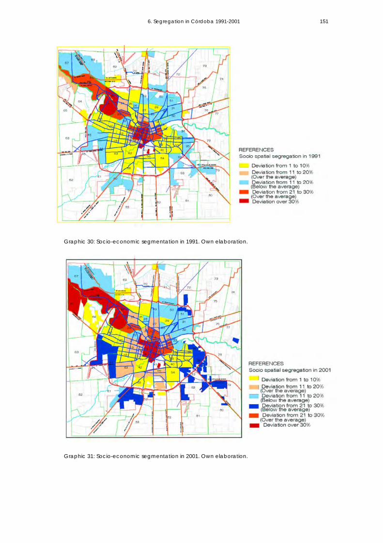
6. Segregation in Córdoba 1991-2001
151
Graphic 30: Socio-economic segmentation in 1991. Own elaboration.
Graphic 31: Socio-economic segmentation in 2001. Own elaboration.

6. Segregation in Córdoba 1991-2001
152
Table 17: Socio-economic segmentation in Córdoba 2001 through the analysis of heads of households’ educational level. Own elaboration. Source National Census Data.
Census Basic Higher Total Heads Years of Years of Variation DeviationFraction Education Education of Households Education Educ. (2001)
(avrg.by fraction)Total 125,009 61,661 186,670 9.64 0.053 0.23
1 201 1139 1,340 9.64 13.80 0.206 0.452 278 876 1,154 9.64 13.07 0.140 0.373 287 696 983 9.64 12.66 0.109 0.334 132 674 806 9.64 13.69 0.195 0.445 359 1534 1,893 9.64 13.48 0.176 0.426 777 1004 1,781 9.64 11.51 0.042 0.207 447 1403 1,850 9.64 13.07 0.140 0.378 1299 1073 2,372 9.64 10.62 0.011 0.119 549 1109 1,658 9.64 12.35 0.087 0.3010 537 767 1,304 9.64 11.71 0.051 0.2311 717 808 1,525 9.64 11.24 0.030 0.1712 757 685 1,442 9.64 10.80 0.016 0.1313 722 1456 2,178 9.64 12.35 0.087 0.3014 352 599 951 9.64 12.04 0.068 0.2615 288 1873 2,161 9.64 13.93 0.219 0.4716 453 1017 1,470 9.64 12.53 0.100 0.3217 1246 469 1,715 9.64 9.19 0.002 0.0518 2374 1333 3,707 9.64 9.88 0.001 0.0319 1442 1451 2,893 9.64 11.01 0.022 0.1520 2426 1173 3,599 9.64 9.61 0.000 0.0021 962 1010 1,972 9.64 11.10 0.025 0.1622 1832 452 2,284 9.64 8.58 0.013 0.1223 780 1595 2,375 9.64 12.37 0.089 0.3024 1156 1321 2,477 9.64 11.27 0.031 0.1825 1332 721 2,053 9.64 9.81 0.000 0.0226 1260 324 1,584 9.64 8.64 0.012 0.1127 1127 1025 2,152 9.64 10.81 0.016 0.1328 2047 515 2,562 9.64 8.61 0.013 0.1129 1208 608 1,816 9.64 9.68 0.000 0.0030 1747 393 2,140 9.64 8.47 0.016 0.1331 2208 481 2,689 9.64 8.43 0.017 0.1332 2551 497 3,048 9.64 8.30 0.021 0.1533 2144 509 2,653 9.64 8.53 0.015 0.1234 3713 134 3,847 9.64 7.28 0.067 0.2635 2447 255 2,702 9.64 7.75 0.042 0.2136 1934 564 2,498 9.64 8.81 0.008 0.0937 2489 668 3,157 9.64 8.69 0.011 0.1038 963 437 1,400 9.64 9.50 0.000 0.0239 1319 767 2,086 9.64 9.94 0.001 0.0340 1861 1083 2,944 9.64 9.94 0.001 0.0341 269 1306 1,575 9.64 13.63 0.190 0.4442 1309 908 2,217 9.64 10.28 0.005 0.0743 1833 1672 3,505 9.64 10.82 0.016 0.1344 3382 214 3,596 9.64 7.48 0.056 0.2445 3400 312 3,712 9.64 7.67 0.046 0.2146 2491 788 3,279 9.64 8.92 0.006 0.0847 332 2753 3,085 9.64 14.14 0.241 0.4948 405 1711 2,116 9.64 13.47 0.174 0.4249 2460 539 2,999 9.64 8.44 0.017 0.1350 4609 548 5,157 9.64 7.85 0.038 0.2051 1915 261 2,176 9.64 7.96 0.034 0.1852 3904 418 4,322 9.64 7.77 0.042 0.2053 2650 120 2,770 9.64 7.35 0.063 0.2554 2055 793 2,848 9.64 9.23 0.002 0.0555 1498 1018 2,516 9.64 10.24 0.004 0.0656 1105 1008 2,113 9.64 10.82 0.016 0.1357 1517 1261 2,778 9.64 10.63 0.012 0.1158 2405 1398 3,803 9.64 9.94 0.001 0.0359 4414 317 4,731 9.64 7.54 0.053 0.2360 3539 368 3,907 9.64 7.75 0.042 0.2161 1530 188 1,718 9.64 7.88 0.037 0.1962 5 2 7 9.64 9.29 0.002 0.0463 23 7 30 9.64 8.87 0.007 0.0864 911 679 1,590 9.64 10.42 0.007 0.0865 62 508 570 9.64 14.13 0.240 0.4966 1274 3245 4,519 9.64 12.74 0.115 0.3467 3278 824 4,102 9.64 8.61 0.013 0.1168 4166 611 4,777 9.64 8.02 0.031 0.1869 1969 1233 3,202 9.64 10.08 0.002 0.0570 3902 1093 4,995 9.64 8.75 0.009 0.1071 3691 513 4,204 9.64 7.98 0.033 0.1872 2236 155 2,391 9.64 7.52 0.054 0.2373 187 24 211 9.64 7.91 0.036 0.1974 485 15 500 9.64 7.24 0.069 0.2675 403 25 428 9.64 7.47 0.056 0.2476 502 89 591 9.64 8.20 0.025 0.1677 474 3 477 9.64 7.05 0.080 0.2878 401 7 408 9.64 7.14 0.075 0.2779 2612 202 2,814 9.64 7.57 0.051 0.2380 239 2 241 9.64 7.07 0.079 0.2881 35 2 37 9.64 7.43 0.058 0.2482 207 15 222 9.64 7.54 0.053 0.2383 197 7 204 9.64 7.27 0.067 0.2684 5 1 6 9.64 8.33 0.020 0.14

6. Segregation in Córdoba 1991-2001
153
By 2001, very high segregated areas incorporate fractions 7, 16, 47, 48, 65 and 66. Fractions 65 and 66 add new areas of high-income concentration towards the northwest side of the city. Deviations that ascend to 0.19 and 0.24 in 1991 shift to 0.49 and 0.34 respectively in 2001, evidencing a strong process of wealth concentration in outlying expansion sectors. Fractions 16 and 7, with deviation values of 0.20 and 0.27 in 1991, intensify towards 0.32 and 0.37 in 2001, expanding the concentration of professional sectors next to the central area. To sum up, during the decade the city extends as segregation intensifies and social heterogeneity diminishes. Areas with low segregation -those with more social mixture- decrease significantly in the city. In 1991, 35% of census fractions show social mixture, while in 2001, they decrease to 23%; highly segregated areas (including those with deviations over 30% of the average) expand as well as those urban sectors with moderate segregation in the previous period. Urban poverty: analysis by measuring unsatisfied basic needs Urban population with unsatisfied basic needs decreases from 163,986 inhabitants in 1991 to 155,319 inhabitants in 2001 in Córdoba Municipality. Official Data indicate that in a context of strong social dualism, as it is the case of Argentina, structural poverty (determined through the measurement of unsatisfied basic needs) decreases while poverty (determined through poverty line) expands in the country. In order to understand these processes, it is important to mention that social policy in the country is focused on structural poverty even when one of the most significant consequences of its economic crisis has been the emergence of the “new poor”; that is, a large segment of the middle class sector that falls into poverty.
Córdoba Total population
Population with Unsatisfied Basic Needs (UBN)
Total Percentage
1991 1.179.372 163.986 13.63% 2001 1.284.582 155.319 12.10%
Table 18: Population with Unsatisfied Basic Needs. Own elaboration. Source: National Census of Population and Housing, 1991-2001. Statistics Department, Córdoba Province.
The spatial analysis of the population with Unsatisfied Basic Needs (UBN) considers the variance4 as the main variable to explain an uneven distribution. As the main concern is to identify areas with extreme poverty concentration in Córdoba Municipality, only those census fractions showing UBN values over the average city distribution are included. Fractions whose values are below the city average are not considered in this analysis. Nonetheless, segregation could exist at a smaller scale of analysis.5 Four intervals are identified: -Low segregation scenario (that includes variance values between 1-10), -Moderate segregation scenario (that includes variance values between 11-20), -High segregation scenario (with variance values between 21- 30), and -Very high segregation scenario (with variance values over 30).

6. Segregation in Córdoba 1991-2001
154
In the 1991-2001 decade, asymmetries on income distribution become intense. Poverty conditions increase along with the intensification of socio-spatial segmentation in the city structure, particularly in the periphery. By the end of the period analysed, the average-income gap between the highest and the lowest population deciles in Córdoba rises to 1:19. 6 This social process finds a spatial expression, as to mention: 1 –In Córdoba Municipality there is an increase in poverty concentration in some problematic areas. Existing shanty towns increase their number of population housed and new shanty towns or squatter settlements emerge in fiscal vacant-land. (According to official data, in 1991 there are 83 shanty towns housing 35.723 inhabitants; by the year 2001 there are 114 shanty towns housing 100.000 inhabitants.) 2 –As a consequence of social crisis, the growth of urban poverty and the impossibility of accessing the formal land market for large population sectors, informal settlements appear in the periphery (up to the year 1990, there are no illegal settlements in the city). In the 1991-2001 decade, 109.25 hectares of land not complying with legal conditions are identified as informal settlements. This means the impossibility of having access to infrastructure, services provision, and urban mobility. 3 –A new spatial segregation type identified as "functional" takes place in the outskirts as result of a housing policy implementation –public as well as private- which translates into mono-functional areas, a low density pattern of land use, unmixed housing types, and no social mixture.
Graphic 32: Urban sectors that concentrate population with Unsatisfied Basic Needs (2001). Own elaboration.

6. Segregation in Córdoba 1991-2001
155
Table 19: Unsatisfied Basic Needs by Census Fractions. Córdoba, 1991-2001. Own elaboration.
Census Pop. with Average Variation Incidence Pob.with Average Variation IncidenceFraction UBN(1991) 1991 on Total UBN(2001) 2001 on Total
163919 1951 20.09 (1991) 155,319 1849 25.77 (2001)1 327 1951 16.09 1.24 62 1849 20.56 0.832 552 1951 11.94 0.71 379 1849 13.91 0.563 752 1951 8.77 0.52 447 1849 12.66 0.514 201 1951 18.68 1.11 62 1849 20.56 0.835 877 1951 7.04 0.42 412 1849 13.30 0.546 1183 1951 3.60 4.28 685 1849 8.72 0.357 1277 1951 2.77 0.16 918 1849 5.58 0.238 1588 1951 0.80 0.05 1,008 1849 4.55 0.189 555 1951 11.89 0.70 305 1849 15.35 0.6210 761 1951 8.64 0.51 596 1849 10.11 0.4111 1069 1951 4.75 0.28 830 1849 6.69 0.2712 512 1951 12.63 0.75 365 1849 14.18 0.5713 494 1951 12.95 0.77 281 1849 15.83 0.6414 919 1951 6.50 0.38 646 1849 9.32 0.3815 672 1951 9.98 0.59 487 1849 11.94 0.4816 1052 1951 4.93 0.29 618 1849 9.76 0.3917 2580 1951 2.41 0.14 1,375 1849 1.45 0.0618 2276 1951 0.64 0.04 2,010 1849 0.17 0.0119 1177 1951 3.65 0.22 823 1849 6.78 0.2720 2949 1951 6.08 0.36 2,546 1849 3.13 0.1321 757 1951 8.70 0.52 713 1849 8.31 0.3422 2416 1951 1.32 0.08 1,904 1849 0.02 0.0023 345 1951 15.73 1.21 231 1849 16.86 0.6824 872 1951 7.10 0.55 563 1849 10.65 0.4325 1004 1951 5.47 0.42 787 1849 7.26 0.2926 1164 1951 3.78 0.29 724 1849 8.15 0.3327 743 1951 8.90 0.68 648 1849 9.29 0.3728 1822 1951 0.10 0.01 1,498 1849 0.79 0.0329 716 1951 9.30 0.71 507 1849 11.60 0.4730 1414 1951 1.76 0.14 1,118 1849 3.44 0.1431 1553 1951 0.97 0.07 1,413 1849 1.22 0.0532 3037 1951 7.19 0.55 3,278 1849 13.15 0.5333 3908 1951 23.36 1.79 3,584 1849 19.38 0.7834 6832 1951 145.34 11.16 6,461 1849 136.95 5.5335 3101 1951 8.07 0.62 2,347 1849 1.60 0.0636 2296 1951 0.73 0.06 1,878 1849 0.01 0.0037 1879 1951 0.03 0.00 2,559 1849 3.25 0.1338 1896 1951 0.02 0.00 970 1849 4.97 0.2039 1060 1951 4.84 0.37 924 1849 5.51 0.2240 1568 1951 0.89 0.07 1,407 1849 1.26 0.0541 1293 1951 2.64 0.20 344 1849 14.58 0.5942 2434 1951 1.42 0.11 2,229 1849 0.93 0.0443 1889 1951 0.02 0.00 1,112 1849 3.50 0.1444 5634 1951 82.75 6.36 5,972 1849 109.45 4.4245 6704 1951 137.82 10.59 7,047 1849 173.96 7.0246 3685 1951 18.34 1.41 3,948 1849 28.37 1.1447 1880 1951 0.03 0.00 287 1849 15.71 0.6348 294 1951 16.75 1.29 152 1849 18.54 0.7549 3140 1951 8.62 0.66 2,615 1849 3.78 0.1550 5138 1951 61.96 4.76 5,884 1849 104.82 4.2351 1689 1951 0.42 0.03 1,564 1849 0.52 0.0252 4842 1951 50.99 3.92 5,679 1849 94.44 3.8153 4428 1951 37.43 2.88 4,154 1849 34.21 1.3854 1931 1951 0.00 0.00 1,580 1849 0.47 0.0255 1777 1951 0.18 0.01 1,637 1849 0.29 0.0156 1158 1951 3.84 0.29 691 1849 8.63 0.3557 1266 1951 0.40 0.03 867 1849 6.21 0.2558 2243 1951 0.52 0.04 2,386 1849 1.86 0.0759 7604 1951 194.95 14.97 8,538 1849 288.07 11.6360 4440 1951 37.79 2.90 4,173 1849 34.77 1.4061 1960 1951 0.00 0.00 2,639 1849 4.02 0.1662 4 1951 23.13 1.78 0 1849 22.01 0.8963 38 1951 22.33 1.71 33 1849 21.23 0.8664 1322 1951 2.41 0.19 1,507 1849 0.75 0.0365 179 1951 19.16 1.47 148 1849 18.63 0.7566 1777 1951 0.18 0.01 1,242 1849 2.37 0.1067 4933 1951 54.25 4.17 5,236 1849 73.86 2.9868 7188 1951 167.32 12.85 7,608 1849 213.54 8.6269 2680 1951 3.24 0.25 2,732 1849 5.02 0.2070 5340 1951 70.07 5.38 6,975 1849 169.17 6.8371 4999 1951 56.68 4.35 5,347 1849 78.78 3.1872 3796 1951 20.77 1.60 3,111 1849 10.25 0.4173 187 1951 18.98 1.46 259 1849 16.28 0.6674 467 1951 13.44 1.03 676 1849 8.86 0.3675 536 1951 12.21 0.94 723 1849 8.16 0.3376 427 1951 14.17 1.09 638 1849 9.44 0.3877 734 1951 9.04 0.69 1,381 1849 1.41 0.0678 283 1951 16.97 1.30 1,491 1849 0.83 0.0379 2542 1951 2.13 0.16 2,960 1849 7.95 0.3280 221 1951 18.26 1.40 570 1849 10.53 0.4381 66 1951 21.68 1.67 49 1849 20.86 0.8482 333 1951 15.97 1.23 347 1849 14.52 0.5983 248 1951 17.69 1.36 407 1849 13.39 0.5484 34 1951 22.42 1.72 12 1849 21.73 0.88

6. Segregation in Córdoba 1991-2001
156
Córdoba social-spatial segmentation follows a pattern that characterises the urban structure of Latin American cities; the central area and sectors nearby which constitute the first urban expansions (the traditional city neighborhoods) exhibit low-level of poor population. There is an axis of expansion of high-income sectors (in this case toward the northwest side) with no poverty concentration. Problematic areas are located in the city periphery and are composed of low-income population. The analysis of urban poverty by measuring unsatisfied basic needs shows that the average variance increases from 20.09 in 1991 to 25.77 in 2001. This high dispersion of values indicates low achievement of social mixture and a process of intensification of urban poverty in some city areas. Although the population with UBN decreases in absolute terms in Córdoba Municipality, those areas that have been historically poor increase the number of poor population housed. As to mention, during the period under analysis the areas where segregation increases are the following (see Table 19 and Graphic 32 above): -Fraction 44: where variance increases from 82.75 to 109.45; -Fraction 45: where variance increases from 137 to 173; -Fraction 50: where variance increases from 61 to 104; -Fraction 52 where variance increases from 50 to 94; -Fraction 59 where variance increases from 194 to 288; -Fraction 67 where variance increases from 54 to 73; -Fraction 68: where variance increases from 167 to 213; -Fraction 70: where variance increases from 70 to 169; and -Fraction 71: where variance increases from 56 to 78. The analysis of the distribution of urban poverty considering its location in different urban sectors evidence that in 62.42% of the cases, population with unsatisfied basic needs (96,964 inhabitants) lives in the city-periphery -in the most external areas of expansion where land values are low and so are the level of infrastructure and public services provision. These peripheral areas are important not only in terms of their territorial extension, but also in terms of the population they house. Some examples are:
-The South-east sector (Fractions 34, 35, 37, 52, 53, and 79) houses 24,120 inhabitants with Unsatisfied Basic Needs, which is 15.53% of the total population of the city in 2001;
-The North sector (Fractions 70, 71, 49, and 50) takes in 20,821 inhabitants with UBN (13.40%);
-The West sector (Fractions 44, 45, and 46) gives shelter to 16,967 inhabitants with UBN (10.92%);
-The South-west sector (fractions 59, 60, and 61) has 15,315 inhabitants with UBN, (9.89%);
-The North-west sector (Fractions 67 and 68) houses 12,844 inhabitants with UBN, which is (8.27%); and
-The East sector (Fractions 32 and 33) has 6,862 inhabitants, which represents 4.41% of the total population of the city. In some of these areas, population with UBN surpasses 5.000 inhabitants, as it is the case of Fraction 59, which reaches 8.538 inhabitants under these conditions, or Fraction 45

6. Segregation in Córdoba 1991-2001
157
with 7,047 inhabitants, presenting the highest values of population with unsatisfied basic needs at city scale. If considering the incidence of population with unsatisfied basic needs at the scale of each census fraction, in many cases (e.g. Fractions 68, 33, 34, 53, 59, 44, and 45), this incidence is over 20% of the population. These data are significant if it is considered that the socio-economic profile of the population housed in those areas is of very-low income. The most external areas of the city periphery (some of them highly homogeneous in terms of low income groups) concentrate the poorest settlements. This way, extremely poor groups are located in poverty areas intensifying thus the distance between the opposite social groups in the city and revealing a process of increasing social and spatial dualism in the urban structure between the axis of high-income expansion and the outer periphery.
Urban Location
Census Fraction
Population Population with UBN
(%) Population with UBN in the fraction
(%) Population with UBN over the Total in the city
North-west 67 30,470 5,236 17.4% 68 36,318 7,608 20.9% TOTAL 12,844 8.27 % North 70 36,173 6,975 19.3% 71 30,720 5,347 17.4% 49 20,955 2,615 12.5% 50 35,255 5,884 16.7% TOTAL 20,821 13.40 % East 32 21,029 3,278 15.6% 33 17,426 3,584 20.6% TOTAL 6,862 4.41 % South-east 34 25,637 6,461 25.2% 35 18,780 2,347 12.5% 37 21,289 2,559 12% 52 32,207 5,679 17.6% 53 18,544 4,154 22.4% 79 19,784 2,960 15.0% TOTAL 24,120 15.53 % South-west 61 13,540 2,639 19.5% 60 28,440 4,173 14.7% 59 33,310 8,538 25.6% TOTAL 15,350 9.89 % West 44 25,651 5,972 23.3% 45 27,722 7,047 25.4% 46 23,027 3,948 17.1% TOTAL 16,967 10.92% TOTAL In the urban periphery: 96.964 62.42% Population with UBN
In the city (Census Data 2001):
155.319 100 %
Table 20: Urban sectors that concentrate population with UBN. Own elaboration. Source: Census Data 2001. Statistics Department, Córdoba Province.

6. Segregation in Córdoba 1991-2001
158
The lowest incidence of population with unsatisfied basic needs housed in central and intermediate urban areas in 2001, in comparison to the population living there in 1991, is the result of a housing policy devoted to assist social groups with a subsidy. Since the 1980s, housing policies have contributed to the clearance of slums from central and high-income areas, relocating extreme poor population towards the city borders and providing them with a house in ownership. 7
6.3 CONCLUDING REMARKS Asymmetries in income distribution have an impact on the types of growth and land uses. Córdoba Municipality evidences an increase in segregation at urban scale. By 2001, the city grows while it loses its heterogeneity at the same time; it shows lower achievement of social mixture than in 1991 and an intensification of segregation. This means that the spatial distance between the new urban areas annexed increases as well as the social distance between the different social groups. In the period analysed, the variance (being the level of education the main attribute) raises form 0.035 to 0.053. The gap between high-income and low-income areas also widens, which indicates a greater concentration and homogeneity in both wealthy and poor sectors. The deviation moves from 0.44 to 0.49 in the former sector and from 0.21 to 0.26 in the latter. The intensification of segregation at large scale is related to an extended growth pattern. In the period analysed, segregation intensifies in peripheral areas, increasing the geographical distance between high-income population towards the north side axis and low-income population in the peripheral area, mainly to the south east city sector. The forms of growth reproduce conditions of high spatial inequity; intermediate city areas that have urban facilities, provision of infrastructure, and urban services, and that experience a greater social mixture undergo a process of population loss.8 The relationship between urban sprawl and segregation evidences an increased spatial and social distance in the process of growth and the reinforcement of areas socially homogeneous in terms of socio-economic profile. The following chapter introduces the question: “To what extend are the forms of urban sprawl and segregation in the city reinforced by the residential developments promoted by private or public agents in the 1991-2001 period? Considering Jaramillo’s hypothesis (1997:2) that the particular forms of segregation in Latin American cities should be explained through the analysis of urban land market and the possibilities different social groups have to choose a certain urban location, the analysis carried out in the following chapter allows us to determine whether the new residential developments in Córdoba Municipality have contributed to social mixture in the city.
6. Segregation in Córdoba 1991-2001
159
Notes 1 Ministry of Housing, Spatial Planning and the Environment. National Spatial Planning Agency. The Netherlands ‘Making Space, Sharing Space. Fifth National Policy Document on Spatial Planning 2000/2020. p.13. The document estates that “(s)patial policy has little direct influence on this disparity or spatial segregation, as people decide from themselves where they would like to live and whether or not they would like to live in a neighbourhood where others with the same background live, but a proper spatial policy can prevent inexpensive city districts deteriorating and pockets of inequality developing”. <http://www.sharedspaces.nl/docs/internationaal/vijfdenota_engels.pdf.> 2Years are calculated on a 7-year basis for basic education plus 8-year basis for higher-education. Important reforms take place in the period: basic education is mandatory for 10 years instead of 7. 3 This means that if the average years of study in 1991 is 8.89, this interval integrates fractions from 7.98 to 9.80 years of study. 4 The variation that each one of the sub territorial units presents regarding the average distribution in the city in terms of population having Unsatisfied Basic Needs. 5 An analysis based on census ratios may reveal a scale of segregation in some areas that at city scale of analysis present social mixture. 6 Data provided by the Statistics Department of Córdoba Province. Source: Permanent Dwelling Survey. May 1999. The average income for the first decile is U$156 and for the last one is U$3027. 7 Housing policy to subsidise sectors impelled in the 1980s is centred in a type of programme that relocates slum population. The need of providing dwelling to poor social sectors is also the result of the need to free lands that should be affected to public interest works. 8 Segregation patterns reflect important differences from urban expansion in North American cities; segregated areas do not present contrasts between the central area and the suburbs, but between an axis and outlying sectors.
7. MAIN TRANSFORMATIONS IN THE CITY-BORDERS: urban fragmentation CHAPTER VII 7.1 Winners and losers: spatial fragmentation in Córdoba (1991-2001) 7.2 Types of residential interventions in the city periphery 7.3 Real Estate developments (gated communities) 7.4 Housing policy for subsidised sectors The Community Enablement policy component
Description of interventions Why do these areas become urban fragments?
7.5 Concluding Remarks on spatial fragmentation 7.6 The relationship between sprawl, segregation, and urban fragmentation

7. Main transformations in the city borders: urban fragmentation 162
7.1 WINNERS AND LOSERS: SPATIAL FRAGMENTATION IN CORDOBA (1991- 2001) In the analysis of restructuring processes that take place in the metropolitan areas in developing countries, De MattosI points out that economic liberalisation has opened the way for the implementation of a strictly capitalist logic in the production and reproduction of the metropolitan space, 1 since it allows for de-regulated operations of two types of social strategies that have contributed to the metropolitan restructuring in Latin American cities. That is to say, the most solvent social sector and also the most vulnerable sector -real estate business and family strategies-2 have intensified suburbanisation and segregation by introducing the development of new residential fragments in the city borders. Urban fragmentation is understood as the evolution to a more complex pattern of segregation (Castells, 1995; Marcuse, 1997; Jaramillo, 1997), which creates barriers, limits, and controlled access to isolated specific residential areas acquired by homogeneous social groups. It is also explained as the result of a new spatial model (the network city) where land uses are reconfigured according to the complementarities and synergies they generate. The emergence of enclave spaces and their physical disconnection from problematic areas are common features. The major causes of urban fragmentation include multi-variables and factors –economic, technological, political, and social. During the 1990s, the Argentinean society experiences a process of dualism: a middle-class splintering and a simultaneous process of positive and negative impacts on cultural unity and social mobility.II New poor and also new rich become the new segments of the middle class, but having habits and placing requirements qualitatively different from the preceding middle class sector’s. Social researchersIII mention that this social fracture discourages the forms of sociability that are on the base of the democratic culture and that find their way of expression in the open city. The previous patterns of social integration –mainly through public space and public education– begin to replicate in a new form. The models of private urbanisations (and also the private facilities provided: schools, green areas, exclusive recreational forms, etc.) widen the gap between low and high middle-class sectors. Residential enclaves can be understood as the result of new forms of social relationships, life styles, individualism, personal preferences, and requirementss
I De Mattos, C. (1998 b:746) II Svampa, M. (2000: 34-40) refers to this process in her article “Clases medias, cuestión social y nuevos marcos de sociabilidad” (Middle class, the social question and new social frameworks) Revista de la Cultura Year XXIII Issue # 67, August, Buenos Aires. III Ibid (2000:40)

7. Main transformations in the city borders: urban fragmentation 163
on security. As the social gap widens, urban fragmentation reinforces inequalities in the pattern of growth: while high-income social sectors have the possibility to avoid negative externalities derived from growth (congestion, pollution, noise, etc.), the urban poor get fixed to poverty areas, in some cases far away from the consolidated city. This chapter focuses on the new residential interventions that encourage the most significant spatial transformations in the form of dwelling production in Córdoba Municipality during the 1991-2001 period: the promotion of new residential patterns by private developers (gated neighbourhoods) and also the promotion of housing complexes through housing policies implemented by the Provincial State for very low income sectors (wholly subsidised population). Both situations take place in the city periphery and exemplify spatial fragmentation. The objective of this chapter is to compare both extremes of planned residential forms to make evident how the social gap reflects on spatial forms. In the case of high–income enclaves (globally integrated by communications and mobility networks), physical limits have a defensive character; in the case of poverty areas, the actual distance is an ideological but real barrier, i.e. a limit to urban integration. In this context, we question whether: (1) both types of residential strategies contribute to intensifying urban sprawl and segregation through the development of urban fragments; and if (2) public housing policy contributes to attenuating urban fragmentation. This chapter develops the third part of Subproblem 1 (“To what extent are the process of urban sprawl, segregation, and fragmentation taking place in Córdoba Municipality in the 1990s?) that deals with spatial fragmentation. It also integrates the analysis of urban sprawl, segregation, and urban fragmentation (developed in Chapters 5, 6 and 7 respectively) in order to explain Hypothesis 1, which states that “In a context of high social-inequity, urban sprawl reinforces segregation and increases spatial inequalities.”
7.2 TYPES OF RESIDENTIAL INTERVENTIONS IN THE CITY PERIPHERY (1991-2001) Table 21 introduces the distribution of the population growth in the periphery according to different housing alternatives as a general context. Table 4 (in Chapter 5) reveals that the highest values of population growth in the period (1991-2001) are concentrated in the city periphery. During the analysed period the population increased in 128,478 inhabitants. The empirical analysis summarised in Table 21 provides a general data to estimate the distribution of the population growth-increases in different types of residential alternatives according to its social profile.

7. Main transformations in the city borders: urban fragmentation 164
It is evident the increased concentration of poverty stricken areas and the creation of new shantytowns, indicating more difficulties regarding the general population’s access to the formal land market. (Informal or Illegal settlements)
# DIFFERENT DWELLING ALTERNATIVES (According to the social profile of the demand)
ESTIMATED POPULATION (inhabitants)
PERCENTAGE (population growth )
1 Real State developments (Gated communities)
21,243 16,53
2 Subsidise Housing 25,500 19.85 3 Informal / Illegal Settlements 43,000 33.46 4 Housing Complexes or Individual Dwellings as
result of Public-Private, individual or collective initiatives. (Sectors with some payment capacity)
38,735 30.16
TOTAL (Increment of population in the periphery) 128,478 100.00 Table 21: Percentage of population growth housed in different dwelling alternatives in the city periphery. Based on official data from Córdoba Municipality (2001). Own elaboration. One of the main features of the different types of residential interventions (excluding residential blocks of flats) built in Córdoba in the 1991-2001 period is that 98.23% of them are located in the city periphery. According to official documents (Córdoba Municipality, 2000), since 1985, time when norms to control urban expansion are passed, all urban land extension is carried out through massive housing plans that include parcelling, infrastructure provision -the urbanisation of land- and the building of houses. Up to that time, the city periphery has been extending through housing complexes developed by private or public initiatives, which are integrated by multifamily buildings or detached houses. These neighbourhoods are open and partially integrated in the urban form. The types of residential interventions found in the city periphery are the following:
URBAN LOCATION TYPE AREA ANNEXED (Ha.)
NUMBER OF INTERVENTIONS North-
West North-East
South-West
South-East
1-Real Estate developments (Gated Communities)
1,117 33 70% - 18% 12%
2-Housing complexes (Public/Private initiatives)
1,077 269 36% 18% 30% 16%
3- Subsidised housing
540 80 20% 22% 17% 41%
TOTAL 2,734 382 --- --- --- --- Table 22: Types of Residential Interventions in the city periphery. Based on official data from Córdoba Municipality (2001). Own elaboration. As from 1991, two types of residential urbanisations are introduced: Real estate developments (gated communities) and housing plans for subsidised social sectors (very low-income sectors). The differences between this and previous housing interventions derive from the urban norms and land regulations that are passed according to the social profile of the population.

7. Main transformations in the city borders: urban fragmentation 165
The impact of the different types in terms of urban area annexed and urban location is summarised in Table 21. The area annexed due to residential interventions grows to 2,734 hectares that is 67.32% of the total area (4,061 ha) annexed in the period (Table 10: Distribution of land uses in Córdoba Municipality). The production of new residential areas has a significant impact in terms of urban sprawl. Urban growth is mainly promoted by the annexation and incorporation of new land in the city borders. The location of the different residential types intensifies the socio-spatial segmentation of the city. It may be observed that the expansion of high-income population is towards the north-axis, while the location of subsidised housing types is towards the southeast sector of the periphery. The following paragraphs describe the new residential developments, real estate developments (Gated Communities), and Subsidised Housing neighbourhoods built during the period under analysis and which exemplify spatial fragmentation.
7.3 REAL ESTATE DEVELOPMENTS (GATED COMMUNITIES) Real estate develops a new model of urbanisation identified in Argentina as “countries” (because it refers to its countryside location) or gated neighbourhoods. Controlled access, permanent surveillance, exclusivity, and a homogeneous social profile reinforce the characteristics of these spatially fragmented areas.IV The impact of such phenomena is the following: -AREA ANNEXED: In the 1991-2001 period, 33 urbanisations are developed in Córdoba city and its metropolitan area, which constitutes an supply of 8,588 plots. In Córdoba city the expansion includes 1,116.8 hectares, i.e. 5.52%3 of the total urbanised area of the city -an estimated average density of 6 lots per hectare.4 -MAGNITUDE: The magnitude of the phenomenon of new suburban gated urbanisations is evident when seen in terms of the number of plots. If taking into account all planned interventions located in the city periphery, they represent 24% of the total plot supply in the period analysed. Even when the number of plots included in each intervention varies, 48.27% of the cases are comprised of more than 150 plots. This means significant impacts in terms of urban fragmentation and social segregation. -TYPES: From the analysis of the market, gated communities can be classified into three groups: (1) special urbanisations, (2) gated neighbourhoods, and (3) gated neighbourhoods that include housing units. The scale of interventions in
IV Partially published in Marengo, Cecilia, (2001:171-187)

7. Main transformations in the city borders: urban fragmentation 166
terms of the number of plots, plot-dimensions, the type of services provided, and social facilities available is the main parameter to segment the residential model. A great diversity is observed in terms of sport facilities as well as in the quantity and quality of open green areas in the different types of urbanisations. The differences are also expressed in term of monthly-costs and plot-prices in the real estate market. For example, the highest segments in the social pyramid are those “countries” having golf courts, clubhouses, swimming pools, horse clubs, and other specific places for practising sports. In such places, monthly maintenance costs are around U$360 (270 Euros) and plot values fluctuate between U$70,000 and U$100,000 [75.000 Euros] (The value of houses are estimated at 750.000 Euros data from 2001). The base of the pyramid (addressed to high middle-income sectors) includes gated neighbourhoods that only share permanent surveillance costs and maintenance of open green spaces. In such places, monthly costs are about U$80 and the value of plots in the real estate market goes from U$15,000 to U$ 36,000 [27.000 Euros] depending on their dimensions (data from 2001). -PLOT DIMENSIONS: Real estate market developments introduce qualitatively different patterns in terms of urban design. The traditional land-plot division (based on the colonial Spanish grid) that guides the forms of expansion during the industrialisation period shifts to organic design forms. The most significant characteristic is the increase in plot dimensions: plots not smaller than 1,000 m2 inside the main ring and 1,500 m2 outside it. The average plot dimension in the city is around 250 m2; in high-income (open) neighbourhoods, it is between 600 and 800 m2. The average plot dimension registered in “countries” (gated communities for very-high income sectors) is 1,478 m2 (it varies from 1,000 m2 to 2,500 m2). Gated neighbourhoods (created to cater for the middle–income population) show a wide range of plot dimensions. The average plot is 910 m2 (it varies from 400 m2 to 3,000 m2, depending on the characteristic of the urban area). Developments that include the most plots in both countries and gated neighbours for middle income social-sectors are located at the city’s edges. -URBAN LOCATION: Real estate developments are located towards the northwest high-income axis of expansion. Among location factors are the attractiveness of the place, its accessibility, its natural landscape, its social and physical environment, and its proximity to service centres. The availability of huge rural parcels having the potential for being urbanised by real estate developers seems to be the most important condition (see Graphic 33 below). The characteristic of contiguity typical of the 1980s metropolitan expansion gives place to a heterogeneous pattern of growth that develops according to the location of private investments. Some city sectors are favoured while others -with decreasing attractiveness- are left aside in terms of real estate developments, which tend to introduce alterations and imbalances among city-sectors. The pattern of growth that extends from the central area to the low density periphery incorporates the extension of urban fragments developed by private investments, increasing thus urban segregation and introducing physical differentiations (barriers and walled city-areas) to reinforce the

7. Main transformations in the city borders: urban fragmentation 167
disconnection of the new “value-added” areas, their individuals and business from the “low-value” contiguous areas.V As Silvestri and Gorelik (2000) analyse in the case of Buenos Aires, the previous expansive cycle of growth is characterised by the inclusive layout of public investment developed by the State (starting at the end of the 20th century) and the expansion of residential market through low-scale operations. During that moment, suburban expansion is based on the grid as the urban pattern and distinguished by detached houses as the main element constituting a neighbourhood. In the 1990s, and under the stimulus of private agents, economic opening, and weaknesses of public policies to guide the processes on course, a new pattern of growth is introduced. The same identifies “the promotion of private enclaves instead of the traditional and inclusive layout based on the grid, the dispersal generalisation of systems in the city-territory, the increasing private services offered to middle and high sectors in front of the deterioration of universal and public compensations, and (in some cases) the conversion of public space into the object of private business.”VI The main dimensions of Real Estate developments are summarised in Table 23 and Table 24. Real Estate Developments Córdoba City Metropolitan area
only Interventions 33 urbanisations 24 9 New urbanised area 1,777 hectares 1,116.80 hectares 660 hectares
Countries 818.8 ha. 148 ha Gated Neighbourhoods 281 ha. 512 ha.
Types
Gated Neighbourhoods with house
17.20 ha. ----
Number of lots Estimated: 8,588 6,248 2,315 Countries 2,890 467 Gated Neighbourhoods 3,160 1,848
Type
Gated Neighbourhoods. with house
223 -------
Representation according to size Fewer than 50 plots 24.13 % Between 50 and 100 plots 10.36% Between 100 and 150 plots 17.24 % More than 150 plots 48.27%
Northwest 70% 27.58% Northeast Southwest 18% 3.47%
Urban Location 70 % to the Northwest side Southeast 12%
Table 23: Main dimensions of real estate developments in the metropolitan region of Córdoba (1991-2001). Own elaboration. Source: report compiled during research.
V Burgess, R. (2004:256) VI Silvestre, G., Gorelik, A. (2000)
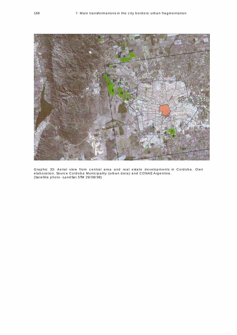
7. Main transformations in the city borders: urban fragmentation 168
Graphic 33: Aerial view from central area and real estate developments in Cordoba. Own elaboration. Source Cordoba Municipality (urban data) and CONAE Argentina. (Satellite photo -LandSat 5TM 29/08/98)
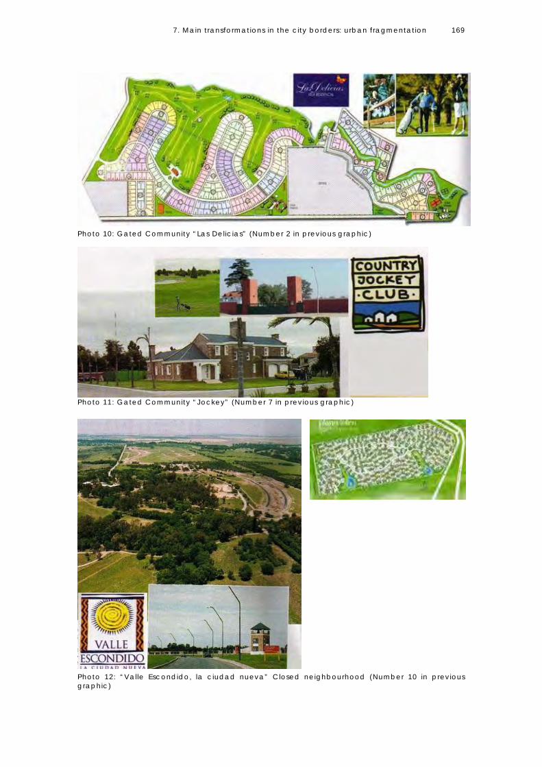
7. Main transformations in the city borders: urban fragmentation 169
Photo 10: Gated Community “Las Delicias” (Number 2 in previous graphic)
Photo 11: Gated Community “Jockey” (Number 7 in previous graphic)
Photo 12: “Valle Escondido, la ciudad nueva” Closed neighbourhood (Number 10 in previous graphic)

7. Main transformations in the city borders: urban fragmentation 170
REAL ESTATE DEVELOPMENTS (GATED COMMUNITIES 1991-2001) IN CÓRDOBA CITY AND METROPOLITAN AREA # NAME YEAR AREA (HA.) TOTAL PLOTS AVERAGE PLOT
AREA(M2)
1 Lomas de la Carolina
1994 147 535 1,500
2 Las Delicias 1991 139 324 1,600 3 Altos Chateau 1998 56 250 1,750 4 Costa Verde 1997 71 40 1,000 5 Barrancas 1995 10 57 1,020 6 Ranch Country 1997 6 30 1,010 7 Jockey Club 1994 119 494 1,030 8 Fortín del Pozo 1993 49 113 2,150 9 El Bosque 1995 135 397 1,500 10 Valle Escondido 1997 194 2500 700 11 La Reserva 1997 32 265 880 12 Tejas del Sur 1992 19 250 400 13 Quintas de la Recta 1998 10 100 650 14 Barrancas Villa R.I. 1998 5.7 31 700 15 Barrancas del Sur 1997 7.5 45 1,000 16 San Alfonso 1998 12 107 500 17 Cinco Lomas 2000 60 250 1,200 18 Cuatro Hojas 1997 88 429 1,800 19 San Isidro 1998 150 807 900 20 Chacras de la Villa 1998 120 527 2,000 21 La Herradura 1995 35 150 2,100 22 La Paloma 1996 22 120 1,500 23 Corral de Barrancas 1999 135 137 4,000-20,000 24 Campos del Virrey 2000 50 106 3,000-10,000 25 Complejo de la
Recta 1997 19 1,500
26 Valle del Oeste 2000 2.5 34 427 27 El Molino 1997 1 19 600 28 Prados de la Villa 1999 11 170 400 29 Portales del Sur 2000 2.87 60 30 Los Algarrobos 1997 8 30 (estimated) 1,500 31 Camino a Alta
Gracia 1997 17.5 80 (est.) 1,500
32 La Candelaria 1999 28.3 130 (est.) 1,500 33 Camino a San
Carlos 1998 19 85 (est.) 1,500
Table 24: Description of Real Estate developments. Own Elaboration.

7. Main transformations in the city borders: urban fragmentation 171
Graphic 34: Real Estate developments in Córdoba and Metropolitan Area. Source Municipality of Córdoba.
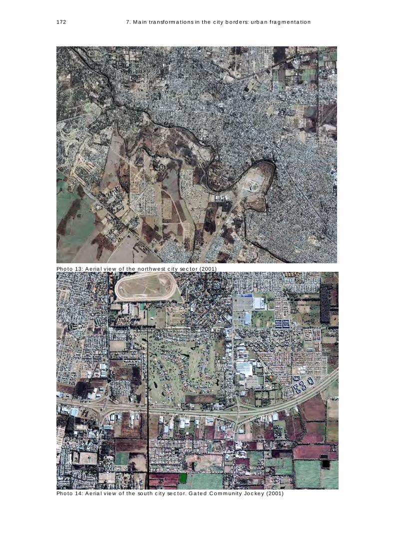
7. Main transformations in the city borders: urban fragmentation 172
Photo 13: Aerial view of the northwest city sector (2001)
Photo 14: Aerial view of the south city sector. Gated Community Jockey (2001)
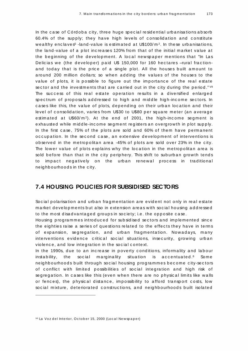
7. Main transformations in the city borders: urban fragmentation 173
In the case of Córdoba city, three huge special residential urbanisations absorb 60.4% of the supply; they have high levels of consolidation and constitute wealthy enclaves5 -land-value is estimated at U$100/m2. In these urbanisations, the land-value of a plot increases 120% from that of the initial market value at the beginning of the development. A local newspaper mentions that "In Las Delicias we (the developer) paid U$ 150,000 for 160 hectares –rural fraction- and today that is the price of a single plot. All the houses built amount to around 200 million dollars; so when adding the values of the houses to the value of plots, it is possible to figure out the importance of the real estate sector and the investments that are carried out in the city during the period.”VII The success of this real estate operation results in a diversified enlarged spectrum of proposals addressed to high and middle high-income sectors. In cases like this, the value of plots, depending on their urban location and their level of consolidation, varies from U$30 to U$80 per square meter (an average estimated at U$60/m2). At the end of 2001, the high-income segment is exhausted while middle-income segment registers an overgrowth in plot supply. In the first case, 75% of the plots are sold and 60% of them have permanent occupation. In the second case, an extensive development of interventions is observed in the metropolitan area -45% of plots are sold over 23% in the city. The lower value of plots explains why the location in the metropolitan area is sold before than that in the city periphery. This shift to suburban growth tends to impact negatively on the urban renewal process in traditional neighbourhoods in the city.
7.4 HOUSING POLICIES FOR SUBSIDISED SECTORS Social polarisation and urban fragmentation are evident not only in real estate market developments but also in extension areas with social housing addressed to the most disadvantaged groups in society; i.e. the opposite case. Housing programmes introduced for subsidised sectors and implemented since the eighties raise a series of questions related to the effects they have in terms of expansion, segregation, and urban fragmentation. Nowadays, many interventions evidence critical social situations, insecurity, growing urban violence, and low integration in the social context. In the 1990s, due to an increase in poverty conditions, informality and labour instability, the social marginality situation is accentuated.6 Some neighbourhoods built through social housing programmes become city-sectors of conflict with limited possibilities of social integration and high risk of segregation. In cases like this (even when there are no physical limits like walls or fences), the physical distance, impossibility to afford transport costs, low social mixture, deteriorated constructions, and neighbourhoods built isolated
VII La Voz del Interior, October 15, 2000 (Local Newspaper)
7. Main transformations in the city borders: urban fragmentation 174
from the urban layout are the main factors of urban fragmentation. Lower-income sectors relocated in the city borders have to face unemployment and the loss of labour networks because they cannot afford transportation costs. Also their chances to have access to education, health, urban facilities and services are reduced.7 The Community Enablement policy component Since 1991, important transformations are performed in housing policy in Argentina, guided to the decentralisation of resources, the diversification of programmes, the growing consensus to improve efficiency and effectiveness, as well as the need to include social actors (community participation) in project implementation. From 1992 to 1999, Córdoba undergoes an innovative experience in the political organisational field as well as in the social-political field; this experience is called “Mesa de Concertación de Políticas Sociales” (MCPS which is a Negotiating Table where Social Policies are agreed upon different actors). Basically, under this mechanism the beneficiaries themselves, through their social organisations (Community Based Organisations) and with the technical support of NGOs, present their requirements for improvements in their living conditions to the government. The participants in this experience mention that consensus and negotiation facilitate the implementation of social policies because they articulate the different interests of the actors involved (Government, CBOs and NGOs) and overcome traditional political practices (clientism) in the implementation of social policies for the most vulnerable sectors. The constitutive agreement for the formalisation of the partnership process is the drawing up of a budget, which is to be provided by the State. Decision-making on the funds is to be taken on the basis of action programmes and priorities presented by the community representatives. Community leaders mention that the developed projects demonstrate the validity of organisational work, and their achievements bear testimony of the poor sectors’ capacity to improve their housing conditions. The importance of this experience emerges from the analysis of projects and the amount of funds that are provided by the government. As an example, during the 1992-1995 period, this Negotiating Table manages to obtain 10% of the total funds the provincial government allocates to Social Policies. These funds operate as an Open Fund for Social Investment; while most projects are mainly centred in Housing, including land access, community equipment, building of housing units, infrastructure provision, and technical support, others deal with health, nutritional emergency, housing improvement, and temporary employment issues, among others. A social movement supports this experience. Housing policy is focused on social sectors below poverty line living in slums. Due to social pressures, a more flexible approach to urban norms is introduced and some requirements on land urbanisation are left aside (this topic will be
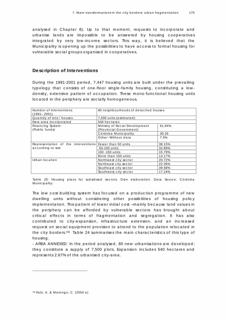
7. Main transformations in the city borders: urban fragmentation 175
analysed in Chapter 8). Up to that moment, requests to incorporate and urbanise lands are impossible to be answered by housing cooperatives integrated by very low-income sectors. This way, it is believed that the Municipality is opening up the possibilities to have access to formal housing for vulnerable social groups organised in cooperatives. Description of Interventions During the 1991-2001 period, 7,447 housing units are built under the prevailing typology that consists of one-floor single-family housing, constituting a low-density, extensive pattern of occupation. These mono-functional housing units located in the periphery are socially homogeneous. Number of Interventions (1991– 2001)
80 neighbourhoods of detached houses
Quantity of lots / houses 7,500 units (estimated) New area incorporated 540 hectares
Ministry of Social Development (Provincial Government)
61.84%
Córdoba Municipality 30.26
Financing System (Public funds)
Other: Without data 7.9%
Fewer than 50 units 38.15% 50-100 units 32.89% 100 -150 units 15.79%
Representation of the interventions according to size
More than 150 units 13.17% Northwest city sector 20.72% Northeast city sector 22.36% Southeast city sector 39.68%
Urban location
Southwest city sector 17.24% Table 25: Housing plans for subsidised sectors. Own elaboration. Data Source: Córdoba Municipality. The low cost-building system has focused on a production programme of new dwelling units without considering other possibilities of housing policy implementation. This pattern of lower initial cost –mainly because land values in the periphery can be afforded by vulnerable sectors- has brought about critical effects in terms of fragmentation and segregation. It has also contributed to city-expansion, infrastructure extension, and an increased request on social equipment provision to attend to the population relocated in the city borders.VIII Table 24 summarises the main characteristics of this type of housing. - AREA ANNEXED: In the period analysed, 80 new urbanisations are developed; they constitute a supply of 7,500 plots. Expansion includes 540 hectares and represents 2.67% of the urbanised city-area.
VIII Falú, A. & Marengo, C. (2004 a)

7. Main transformations in the city borders: urban fragmentation 176
- PROJECT SIZE: Interventions include fewer than 50 units8 in 38.15% of the cases. Although the scale of interventions is small, which could facilitate integration, their location increases urban segregation. After 10 years, this occupational type allows for identifying peripheral urban sectors constituted as a result of this housing policy implementation (northeast and southeast border). - PLOT DIMENSIONS: Housing schemes for subsidised groups are located in areas for future expansion and follow a small parcelling pattern: 160 m2 for individual dwelling (the minimum plot size in the city). In consequence, situations of relatively small parcelling are presented in peripheral urban extensions. The estimated land-price of a 160 m2 plot goes from U$800 to U$2,400 (U$ dollars) and a plot around 200 m2 costs between U$1,000 and U$3,000. -URBAN LOCATION: 40% of interventions are concentrated on the south east-city sector. The location of housing developments reinforces segregation; areas having high levels of low-income population also see the implementation of subsidising projects. Graphic 35: Subsidised housing in Córdoba. Own elaboration. Source: Córdoba Municipality.

7. Main transformations in the city borders: urban fragmentation 177
Photo 15: Aerial view of subsidised housing and the city (2004)
Photo 16: Aerial view of subsidised housing in the south west area (2004)

7. Main transformations in the city borders: urban fragmentation 178
Photo 17: Aerial view of subsidised housing outside the city ring
Photo 18: Aerial view of subsidised housing and the urban context

7. Main transformations in the city borders: urban fragmentation 179
Photo 19 and 20: Subsidised housing. Source: Iros 1991
Photo 21: aerial view of subsidised housing. Source Iros: 1991
Graphic 36: Typologies of Subsidised Housing. Source: Urban Development Office (1999) Cordoba Municipality.

7. Main transformations in the city borders: urban fragmentation 180
Why do these areas become urban fragments? The economic segmentation of the city is explained by the possibilities of having access to urban land and certain location by the different sectors of the population. In the analysed decade, the intensification of social segregation and a process of dualism of the social structure take place (Chapter 6). Residential extensions located in the city borders show different characteristics from the industrialisation period. In high-income areas, limits reinforce segregation patterns (traditionally based on urban land values) and delimit urban fragments because of the incorporation of walls and limits that define socially homogeneous areas. The areas where subsidised housing projects are located also expand constituting urban fragments. In these places, there are no physical limits (walls or limits in the boundaries) but social barriers that contribute to the relocated population's isolation. The results of empirical researchIX carried out in these areas give evidence of the critical situation of the population's isolation that leads to: -The rupture of the networks of subsistence as a consequence of being located in the periphery, the big distances from the city centre or areas that facilitated informal activities, and the difficulty (or impossibility) to bear the costs of urban mobility. -The difficulty to integrate social networks in the new location due to the constant tension among groups having different backgrounds, situation that impacts on the possibilities of finding work. -The impossibility to reproduce subsistence strategies in the new location (informal activities) due to a homogeneous social environment (precisely the lack of socio-economic mixture). -The lack of employment opportunities in the new location. The physical isolation from the consolidated city and the limitations on urban mobility reinforce conditions of urban marginality. -The increasing cost of the typical basket of goods and services they have to bear. An increase on the cost of food since it has to be purchased in the same neighbourhood, absence of alternative stores, and the payment of services (water and electricity) and transport. In a context of insufficient revenues, it implies more dependence on state aid programmes. -Difficulties of community integration in the new social organisation due to the crossed interests among the groups that integrate the new neighbourhood.
IX Marengo, C. (1999)

7. Main transformations in the city borders: urban fragmentation 181
In brief, these types of programmes implemented in the urban borders and adopted for a very low-income population facilitate the legal access to housing and the improvement in housing conditions. However, they have significant effects on the population's living conditions. The distant location implies not only economic costs but also loss of employment opportunities (in the formal and informal market), the rupture of social nets, difficulties in the social organisational processes for the community, and great difficulties to gain access to urban services and facilities. Despite the fact that these policies represent an improvement in the quality of life for the population living in extreme poverty, the sensation of feeling safe caused by having access to formal housing and by improvements in housing conditions comes hand in hand with a perception of vulnerability rooted in the physical isolation derived from the urban location of these houses. Income distribution gives some idea about the scale of social dichotomies. According to the Permanent Household Survey, the lowest segment of the population of the city (40%) receives only 16.3% of the total income, while the top segment (20%) receives more than 48% of the total income (Data from 2001).9 Poverty urban fragments in the city borders become evident while analysing the impact on mobility and urban costs for the population housed (Table 26).
Income (data from 1999) (U$ dollars)
Impact on mobility (1.6 U$ dollars) (1 person per house X 2 trips)
Deciles Number
From To
People per Household
Middle-income family (U$ dollars per month)
Per month (30 trips)
% of Family Income
1 3 69 5.68 236 48 20.34 2 70 101 4.49 393 48 12.21 3 104 148 4.24 532 48 9.02 4 150 181 3.65 589 48 8.14 5 183 229 2.92 602 48 7.97 6 229 284 3.47 882 48 5.44 7 286 350 3.17 992 48 4.83 8 360 465 2.83 1153 48 4.16 9 467 650 2.59 1404 48 3.41 10 652 3000 2.37 2447 48 1.96 Table 26 : Impact of mobility cost on a middle-income family. Permanent Household Survey, May 1999. Córdoba Province. Source: Research directed by Falu Ana (1999). Own elaboration based on data processed during the research.
The calculated impact of mobility costs on the average family-income by population deciles considers only one-person’s mobility and two trips a day using public transport system (bus). It is important to see the impact that mobility costs have on the lower deciles (1-4) considered below poverty line according to official data. In the case of the first decile, it ascends to 20% of the family income (by the time of this elaboration a U$600 family income is considered below poverty line). The same source labels as households below poverty indigence line those with an income per capita below U$ 206 (the population in deciles 1-4).

7. Main transformations in the city borders: urban fragmentation 182
It is important to mention the impact of focused policies implemented in the city since 2001, specifically in terms of public housing, that provide for the construction of 12,000 housing units and are accompanied by the provision of urban facilities in “neighbourhood-cities” situated in the periphery. However, while analysing the socio-economic sustainability of these areas, they duplicate the same segregation conditions as those presented in the 1990s decade. For example, only 35% of the population can afford the costs of water and electricity services even when there is a social tariff.X In social terms, the consolidation of the economic recovery after the crisis in December 2001 -the most critical crisis in the country’s history- results in the redefinition of the middle class. By 2006, EPH data show that unemployment descends to 10.4%, which is significant considering the levels reached during 2001 when the crisis totalled 18% of the population. The redefinition of the Argentinean middle class already begins to take shape as a consequence of the structural adjustment policies and opening of the economy during the 1990s. Following the so-called ‘lost decade of the eighties’, the nineties reveal the highest levels of social polarisation and unemployment, a growth in the population living below poverty line, and the decline of middle-income sectors into a category called the “new poor” .10 The subsequent recovery is marked by a redefinition of this population group. The symbolic consumption behaviour and life standards, as well as values and social capital of these new poor, are constructed in a very different way from the new socio-economic situation that faced them. Although part of the middle sector picks up consumption habits again, others are unable to meet the costs of a typical basket of goods and services for this social sector. (Estimated at $1,850 pesos (equivalent to $US620). In terms of poverty, indicators show a decrease in the rates, which during the first quarter of 2003 reaches 43% of all homes in the Great Córdoba urban sprawl, a rate that subsequently lowers to 22.2% in the second quarter of 2006. The number of indigent homes is reduced from 19.9 to 11.6 during the same period.11
7.5 CONCLUDING REMARKS The dual city is explained as the need to differentiate between the territories acquired by different social sectors (Castells, 1995:308). This way, the concept of spatial fragmentation is explained as the evolution to more complex segregation patterns. Córdoba, as other cities in Latin AmericaXI, experiences as the main transformations in the period (1991-2001) the building of wealthy
X Montoya, O. (2006) XI Lungo (2001) mentions San Salvador, and Sabattini (1997) analyses Santiago de Chile.

7. Main transformations in the city borders: urban fragmentation 183
and poor enclaves that sprawl to new fragmented areas as well as the increasing physical distance among them. In the 1991-2001 period, the city experiences a strong process of urban fragmentation. It grows expanding residential areas in the borders, intensifying segregation processes (at macro level) and producing areas spatially fragmented. The wealthy enclaves in the city periphery are the result of real-state strategies addressed to high-income sectors while the ghettos are the result of a housing system implementation addressed to the poorest social sectors. Urban fragmentation has been explained as the need to reinforce segmentation via a land-market that incorporates walls or other means of spatial enclosure (observed in gated communities and neighbourhoods). On extreme poverty conditions, fragmentation is understood as the moving of poor population towards not favoured urban areas, worthless in the market. The dichotomies arise while comparing both types of urban fragments, i.e. while analysing the social fracture in the space, which brings about the question of how to achieve a more integrated city without creating spatial fragments so different in terms of socio-economic conditions and ways of life. As to mention, the differences in terms of plot dimensions, plot prices, the evolution of plot prices, densities, and green recreational areas are the following: • Plot dimensions: the relation between the average plot dimension in
subsidised projects and in gated communities is 1-9 (160 m2/1500 m2) • Urban land price: the relation between both extremes is 1-8 (urban land is
around U$10/m2 in subsidised sectors and about U$80/m2 in gated communities.
• Plot value: the relation is 1-75 (a plot in a gated community is around U$120.000 and about U$1.600 in the opposite case).
• The evolution of plot value in gated communities is between 40% and 120% over the initial market price while the evolution of plot values in neighbourhoods built under subsidising projects show no increment in the plot price in the period.12
• Densities: In the case of gated communities13 gross density is 3.6 inhabitants/ha., while in a subsidised housing project it is 56 inhabitants/ha.
• Access to green and recreational areas: gated communities have a minimum of 30% of green areas while subsidised units have a minimum of 10% of green recreational areas.
7.6 THE RELATIONSHIP BETWEEN SPRAWL, SEGREGATION AND URBAN FRAGMENTATION The empirical analysis has proved hypothesis 1: “In a context of high social inequity urban sprawl reinforces segregation and increases spatial inequalities.” In the last decade of the 20th century Córdoba City sprawls.

7. Main transformations in the city borders: urban fragmentation 184
Even when there is availability of vacant-land inside the city limits and possibilities to growth through densification, it expands to peripheral areas evidencing low-density land use patterns. The forms of growth increase land consumption. The contradiction is that those city sectors that have high building capacity and advantages in terms of urban facilities, centrality, accessibility, employment opportunities, etc., present a loss of population; while peripheral areas that have availability of vacant land or possibilities to annex land, increase the population they house. Growth is accompanied by strong segregation trends. Considering residential segregation as the physical distance between people of different social categories and a question of isolation between groups that spatial distance contributes to intensify, the new residential forms built in the city periphery (specially real estate market interventions and subsidised housing developments built in the decade) reinforce segregation. Residential dispersion promoted through large-scale real estate developments impacts on the magnification of the physical distance between high and low-income groups. Spatial enclosure seems to be one of the main features in the transformation of growth-patterns. On the other hand, the relocation of the poor in the city periphery contributes to the social homogenisation of the space at large scale. The lack of social/functional mixture in housing developments contributes to intensifying the urban fragmentation of the city periphery. There are many reasons why high-income sectors prefer suburban private developments, among them there are better environmental qualities than in the consolidated city, a perception of security, a natural environment for kids, big plots, new forms of sociability and a homogeneous social context which tends to replace the traditional frameworks of social integration based on public space and public education. There are also many factors to explain why poor neighbourhoods expand in the urban periphery, among them are the restructuring on employment due to international trends, the dualism of the Argentinean society, the widening of income gaps, and a smaller State intervention in urban development. Segregation is reinforced due to the new forms of dwelling production. The morphological rupture of the previous residential patterns (from the neighbourhood to the gated community) is explained in terms of structural inflections and changes in the forms of real estate market operations. The concentration of capital (which means the whole process in hands of real estate development companies) and a more flexible regulation approach to urban growth facilitate the expansion of new forms of residential spatial production through large-scale operations. New exclusion mechanisms such as walls, barriers and plot dimensions, tend to preserve social milieu and land – values resulting in large urban fragments socially homogeneous. These types of operations (that obtain high profitability of land-prices) promote the residential dispersion of the elites, reinforcing (in
7. Main transformations in the city borders: urban fragmentation 185
the case of Córdoba) location trends next to the high-income cone of expansion. Land market dynamics seem to be the main processes that reinforce urban sprawl and segregation. In a context where the gap between the average household income and land prices increases the forms of growth and moves social homogenisation to the city borders, low-income population is forced to move away from better equipped areas (central area and intermediate) while high-income population concentrates on new residential enclaves in the periphery. By this way, and in a context of high-income disparities, land market dynamics exclude lower income population form better city areas. The type of social housing policy in Córdoba (addressed to extremely poor sectors) is not able to overcome this process and instead it intensifies the isolation of disadvantaged groups in poor and segregated areas. As Rusk (1999:23) mentions: “The most effective assistance for the poor is not providing them with social housing and shelter but surrounding them with communities of growing educational and economic opportunity.” The relationship among sprawl, segregation and urban fragmentation evidence an increased spatial and social distance in the process of growth and the reinforcement of urban exclusion processes: the elites following auto-exclusion patterns and the poor suffering from clear disadvantages in the forms of collective consumption and in their possibilities to access services and urban facilities. Urban sectors able to capture the expansion of high-income population are favoured. The expansion of residential areas goes on with private services provision, commercial and retail facilities, private education institutions, etc.; while the expansion of low-income population, in many cases through subsidising housing interventions, requires public investments to provide services (transport), infrastructure extension and urban equipment. If less segregation leads to more economic prosperity and wide income disparities often lead to rising social cost (Rosemann 1999:36), the forms of growth observed in Córdoba Municipality lead to increasing concentration of social problems at some city-borders (where the population gets anchored) and, simultaneously, they allow high-income social sectors to avoid negative externalities derived from urban growth. This way, the forms of growth do not contribute to achieving a more integrated city; on the contrary, urban sprawl tends to intensify and to reinforce social inequality, and this condition represents a high risk in terms of urban sustainability. The social conditions in the city periphery (with 50% of population below poverty line in 2001) reveal a complex scenario in terms of urban planning. Is it possible to achieve a more integrated city in a context of increasing income-gap and high social inequity, as it is the case of Argentina? To what extend are public policies effective in counteracting the negative externalities of growth? To what extend could public housing system be integrated in planning city growth?
7. Main transformations in the city borders: urban fragmentation 186
In the following chapter, I will introduce the links between urban sprawl, segregation, fragmentation and planning. Many researchers have stated that the liberalisation of land markets (Jaramillo1997, Sabatini 1997, De Mattos 1998) has contributed to the increase in segregation. I will assume the postulate that suburbanisation is the consequence of more flexible urban norms applied to urban land extension devoted to opposed social actors: the real estate market and public housing policy (especially the type of delivery system oriented to the supply side). The question is to what extent could planning become an effective tool to attenuate the differences introduced by the model? And what type of planning instruments could be applied in this case to diminish the inequities presented in the forms of growth?
Notes 1 According to Lungo (2001:18), there are three types of urban interventions related to the emergence of new spatial segregation forms: large urban projects, shopping centres and gated communities. 2 Family strategies refer to il legal or informal settlements usually located in the city periphery. 3 Calculated according to data provided in Table 10: Distribution of land uses in Córdoba Municipality (20,199 hectares of urbanised land). 4 The city-layout based on the Spanish grid could include among 40 plots per ha. 5 A local newspaper mentions that in Córdoba city ABC1 social segment (the segment with the highest income and consumption) represents 12% of the population (estimated at 44,000 households) whose average income is around U$ 5,300 (€ 4,000). It represents 51% of the total income of the city. Source: La Voz del Interior, August 12, 2001 6 Among the reasons that contribute to poverty expansion in the nineties is the evolution of the activity level that affects labour markets and the changes in the sectoral and occupational composition of employment. Recession causes the destruction of workstations in the industrial sector that are replaced by less stable and worse remunerated employment in construction, trade and personal services, characterized by their high informality and low payment. Source: Córdoba Chamber of Commerce 2000:370 7 Data obtained from an empirical research based on the case of “El Pocito” slum re-located in 1997 by the provincial government. Marengo, Cecilia (1999) National Council for Scientific Research and Technology (CONICET) Argentina and Córdoba National University. 8 Houses with 2 bedrooms are around 40 m2 and those with 3 bedrooms are about 60 m2. In the latter case, the final cost is estimated at U$10,000. The Provincial government finances the land and housing, while the local government provides the infrastructure. In the period under analysis, a new programme type is observed (Program P17), which incorporates the national government's resources to finance housing building and technical assistance. The production is defined as ‘mixed’, since it is carried out by the beneficiaries themselves (as a temporary employment that benefits the community) and in collaboration with companies when a part under construction is more complex. 9 According to the 2001 Census, the population with Unsatisfied Basic Needs (structural poor) rises to 155,319 inhabitants (12.9%); however, if we consider the population below poverty line, the total is 505,532 people, which means 39.35% of the population (data from the second semester).

7. Main transformations in the city borders: urban fragmentation 187
10 In Argentina, “new poor” is assigned to the segment of the population under a prolonged process of impoverishment that has resulted in low-mid incomes sectors slipping into a situation of poverty that, given the difficulties in the labour market, becomes a permanent state. This sector shares the same deprivations as the structural poor but not the same history. Alberto Minujin, “En la Rodada” [“In a rut”] in Minujin A. Beccaria, Bustelo L. Feijoo M Cuesta Abajo. Los nuevos pobres: efectos de la crisis en la sociedad argentina. [The new poor: effects of the crisis on the Argentinean society] Ed. UNICEF – Losada, Buenos Aires, 1992. 11 Source: Observatorio Urbano de la Ciudad de Córdoba, Based on data provided by the Permanent Dwelling Survey, INDEC [Córdoba City Urban Observatory, EPH – INDEC data base]. 12 The value of urban land (to be urbanised) is around 10 U$/rm2 (the same value in 1997 and 2001) 13 Gated Communities: La Carolina and El Bosque, (Fraction 65 – Ratio 04) Area: 270.85 hectares Inhabitants: 976 (Data 2001 Census). The subsidised project (no. 495 – Fraction 52 Ratio 18) Civil Association Vi-Pro has an area of 21.96 hectares and 1,240 inhabitants according to the 2001 Census.

8. SPATIAL PLANNING. DICHOTOMIES IN A CONTEXT OF SOCIAL INEQUITY CHAPTER VIII
8.1 Introduction 8.2 Spatial Strategies to guide urban growth: a critical review of the ideas developed in Córdoba 8.3 From Urban Policy to contain growth to a more flexible approach to growth
Development of residential projects in the city periphery: changes in the normative framework Planning regulations for gated communities Planning regulations for subsidised housing
8.4 Sprawl and Planning: structural factors New residential areas as a result of changes in land-uses Divorce between spatial planning and the social housing system Location of social housing and strong social segregation trends The effects of urban sprawl on some public services provided by the community Effects of land annexations on land-values
8.5 Concluding remarks
8. Spatial planning: dichotomies in a context of social inequity 190
8.1 INTRODUCTION The aim of this chapter is to develop the second hypothesis, which refers to whether spatial planning can be effective in guiding urban growth towards socio-spatial equity objectives (see Subproblem 2, Chapter 1). The second hypothesis states that: To guide urban growth towards socio-spatial equity objectives, spatial planning should overcome functional approaches (land-use zoning) and include instruments to capture and redistribute the urban plus values derived from urban growth. The first part of this chapter provides a critical review of the spatial strategies proposed to orient urban growth in the local arena. It examines the main points of the spatial model and identifies the weakness of the urban structure resulting from urban growth as well as the main objectives of the planning instruments proposed in different periods, particularly regarding the urban expansion that takes place in the 1990s under the influence of neoliberalism. In the second place, it describes the changes introduced in the normative framework during the 1990s. The analysis considers in particular the specific norms that have been developed to respond to opposed social-demand sectors (gated communities and subsidised social housing) that have produced new residential areas in the city outskirts. The objective of this chapter is to evaluate the effects derived from a more flexible approach to urban growth. It introduces the question whether regulations, while there are specifics requirements for each social actor (and type of intervention), contribute to validating the social fracture in the space. In the third place, this chapter explains why planning “through zoning” reinforces a capitalistic logic in the development of new residential areas. It also identifies the main factors that restrict the possibilities of planning towards socio-spatial equity objectives in the case of Córdoba Municipality. It reveals that the new residential areas built in the city periphery during the nineties are the result of changes in land uses rather than the result of planning. It also analyses the effects derived from the divorce between urban development and housing policy, and the consequences of sectoral planning approaches in some public services such as transport. It looks for to explain how the changes in land uses, while not considering instruments to capture the added values derived from urbanisation processes, reinforce conditions of spatial inequity, promoting sprawl and segregation. Finally, the concluding remarks summarise the structural limitations of planning in the case of Córdoba Municipality. The divorce between urban planning and social housing, the political weakness of the Municipality to formulate and implement a land-policy guided towards socio-spatial equity objectives, the divorce between technical planning departments, and the administrative jurisdictions that intervene in the city-space are exemplified as main factors influencing planning decisions. The following chapter develops possible strategic lines of intervention to overcome the limitations previously mentioned.

8. Spatial planning: dichotomies in a context of social inequity 191
8.2 SPATIAL STRATEGIES TO GUIDE URBAN GROWTH: A CRITICAL REVIEW OF THE IDEAS DEVELOPED IN CÓRDOBA Urban planning in Córdoba begins at the end of the 1950s. The first plans to regulate sprawl are formulated to respond to the growth experienced during the import substitution period, when the metal-mechanical industry and rural–urban migration cause the extension of the urban form. The spatial strategy in that moment is based on the theory of growth via concentric rings, following the process of land-occupation. The main throughway is supposed to be structured on the basis of radial displacements of successive rings, from the central area to the periphery. During the 1970s, with the crisis of the metal-mechanical industry, the city’s functions become more diversified (industrial, commercial, service centre, political, administrative, and educational pole, among others). A series of planning instruments are adopted, and although they are partial, their objective is to regulate spontaneous growth and correct imbalances in land uses. Until that moment, the city has grown in a non-planned way, leaving vacant land within its boundaries, by introducing new areas to be urbanised along routes of regional access and by permitting a high dispersion of the urban form. Land value speculation results in offers for land that exceeds demand, and in the annexation of new areas.
Spatial strategies in the Seventies Urban diagnostic studies developed in 1973 propose different alternatives for the future development of the city, with the intention of substantially transforming the tendencies of growth. In that moment, planning follows a tendency commonly used in developing countries:I a strong regulatory intervention to control growth and the development of plans that attempt to regulate land use, infrastructure, and transportation systems. Theoretical alternativesII put forward to guide urban growth (see Figure 1.2) are evaluated based on the agreement to preserve a rational use of infrastructure and are also examined on the basis of the differential impacts they could have in terms of infrastructure extension costs. The objective of such studies is to provide a general analytic framework that could be used to evaluate the comparative advantages of extending the city in one way or another.III Urban technicians and planners observe that the key factor that should guide land-incorporation ought to derive from the costs of extending basic and complementary infrastructure. Consequently, topographical, technological, or structural factors that would imply additional costs are deeply analysed and evaluated. During this period, the private sector does not participate in the provision of basic services (i.e. water supply, sewer system, and pluvial drainages) or complementary infrastructure (i.e. roads, gas, and electricity); instead, those functions are the State’s responsibility. Planning tries to control sprawl through zoning regulations
I Burgess, Carmona, and Kolstee. (1997:111) II Cordoba Municipality. Bases para un diagnostico (2000) III Ramos, J. (1997)
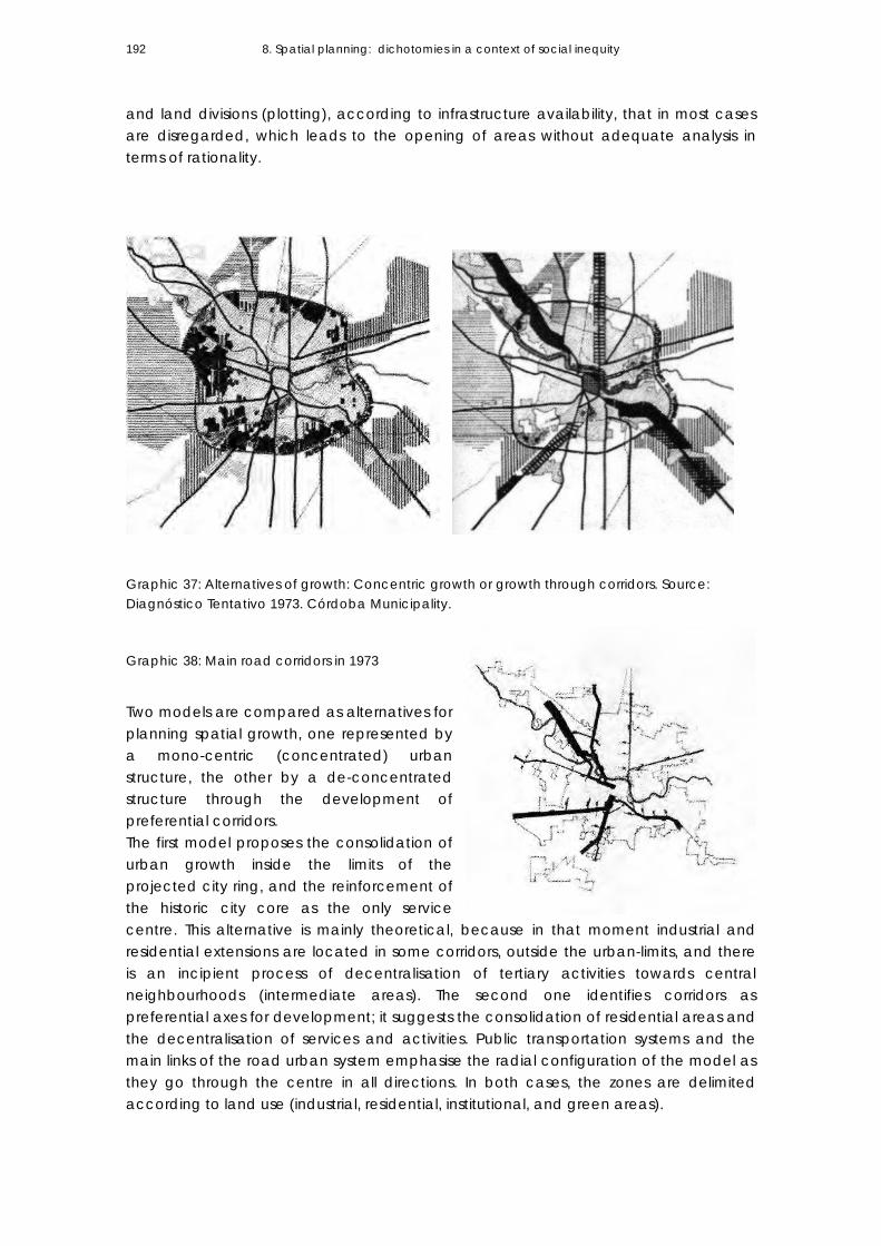
8. Spatial planning: dichotomies in a context of social inequity 192
and land divisions (plotting), according to infrastructure availability, that in most cases are disregarded, which leads to the opening of areas without adequate analysis in terms of rationality.
Graphic 37: Alternatives of growth: Concentric growth or growth through corridors. Source: Diagnóstico Tentativo 1973. Córdoba Municipality.
Graphic 38: Main road corridors in 1973
Two models are compared as alternatives for planning spatial growth, one represented by a mono-centric (concentrated) urban structure, the other by a de-concentrated structure through the development of preferential corridors. The first model proposes the consolidation of urban growth inside the limits of the projected city ring, and the reinforcement of the historic city core as the only service centre. This alternative is mainly theoretical, because in that moment industrial and residential extensions are located in some corridors, outside the urban-limits, and there is an incipient process of decentralisation of tertiary activities towards central neighbourhoods (intermediate areas). The second one identifies corridors as preferential axes for development; it suggests the consolidation of residential areas and the decentralisation of services and activities. Public transportation systems and the main links of the road urban system emphasise the radial configuration of the model as they go through the centre in all directions. In both cases, the zones are delimited according to land use (industrial, residential, institutional, and green areas).
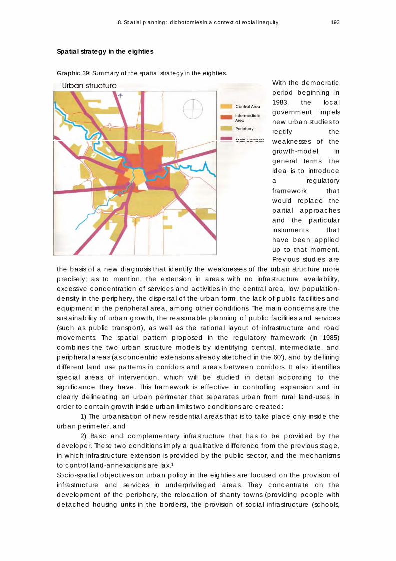
8. Spatial planning: dichotomies in a context of social inequity 193
Spatial strategy in the eighties Graphic 39: Summary of the spatial strategy in the eighties.
With the democratic period beginning in 1983, the local government impels new urban studies to rectify the weaknesses of the growth-model. In general terms, the idea is to introduce a regulatory framework that would replace the partial approaches and the particular instruments that have been applied up to that moment. Previous studies are
the basis of a new diagnosis that identify the weaknesses of the urban structure more precisely; as to mention, the extension in areas with no infrastructure availability, excessive concentration of services and activities in the central area, low population-density in the periphery, the dispersal of the urban form, the lack of public facilities and equipment in the peripheral area, among other conditions. The main concerns are the sustainability of urban growth, the reasonable planning of public facilities and services (such as public transport), as well as the rational layout of infrastructure and road movements. The spatial pattern proposed in the regulatory framework (in 1985) combines the two urban structure models by identifying central, intermediate, and peripheral areas (as concentric extensions already sketched in the 60'), and by defining different land use patterns in corridors and areas between corridors. It also identifies special areas of intervention, which will be studied in detail according to the significance they have. This framework is effective in controlling expansion and in clearly delineating an urban perimeter that separates urban from rural land-uses. In order to contain growth inside urban limits two conditions are created:
1) The urbanisation of new residential areas that is to take place only inside the urban perimeter, and
2) Basic and complementary infrastructure that has to be provided by the developer. These two conditions imply a qualitative difference from the previous stage, in which infrastructure extension is provided by the public sector, and the mechanisms to control land-annexations are lax.1 Socio-spatial objectives on urban policy in the eighties are focused on the provision of infrastructure and services in underprivileged areas. They concentrate on the development of the periphery, the relocation of shanty towns (providing people with detached housing units in the borders), the provision of social infrastructure (schools,
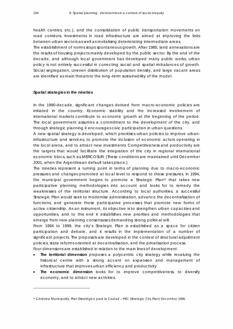
8. Spatial planning: dichotomies in a context of social inequity 194
health centres, etc.), and the consolidation of public transportation movements on road corridors. Investments in road infrastructure are aimed at improving the links between urban sectors as well as revitalising deteriorating intermediate areas. The establishment of norms stops spontaneous growth. After 1985, land annexations are the results of housing projects mainly developed by the public sector. By the end of the decade, and although local government has developed many public works, urban policy is not entirely successful in correcting social and spatial imbalances of growth. Social segregation, uneven distribution of population density, and large vacant areas are identified as main threats to the long–term sustainability of the model.
Spatial strategies in the nineties In the 1990-decade, significant changes derived from macro-economic policies are initiated in the country. Economic stability and the increased involvement of international markets contribute to economic growth at the beginning of the period. The local government assumes a commitment to the development of the city, and through strategic planning it encourages civic participation in urban questions. A new spatial strategy is developed, which prioritises urban policies to improve urban-infrastructure and services, to promote the inclusion of economic actors operating in the local arena, and to attract new investments. Competitiveness and productivity are the targets that would facilitate the integration of the city in regional international economic blocs, such as MERCOSUR. (These conditions are maintained until December 2001, when the Argentinean default takes place.) The nineties represent a turning point in terms of planning due to macro-economic pressures and changes promoted at local level to respond to these pressures. In 1994, the municipal government begins to promote a Strategic PlanIV that takes new participative planning methodologies into account and looks for to remedy the weaknesses of the territorial structure. According to local authorities, a successful Strategic Plan would seek to modernise administration, advance the decentralisation of functions, and generate those participative processes that promote new forms of active citizenship. As an instrument, its objective is to strengthen urban capacities and opportunities, and to this end it establishes new priorities and methodologies that emerge from new planning consensuses demanding strong political will. From 1994 to 1999, the city’s Strategic Plan is established as a space for citizen participation and debate, and it results in the implementation of a number of significant projects. The proposals are developed in the context of structural adjustment policies, state reforms oriented at decentralisation, and the privatisation process. Four dimensions are established in relation to the main lines of development: • The territorial dimension proposes a polycentric city strategy while revaluing the
historical centre with a strong accent on expansion and management of infrastructure that improves urban efficiency and productivity.
• The economic dimension looks for to improve competitiveness, to diversify economy, and to attract new activities.
IV Córdoba Municipality, Plan Estratégico para la Ciudad – PEC (Strategic City Plan) December 1996

8. Spatial planning: dichotomies in a context of social inequity 195
• The environmental dimension seeks to deal with the effects of pollution, to safeguard resources, and to modify society’s rules of conduct.
• The social dimension prioritises the use of integral policies to assist sectors with unsatisfied basic needs (UBN).V
A spatial polycentric strategy is developed; it combines decentralisation with expanded concentration through corridors of growth. To materialise this idea, and to contribute to the periphery identity, the local government decentralises municipal administrative functions and services to sub centres known as C.P.C. (Communal Participation Centres). Public and private investments that take place during this period become the dynamic elements in the city-periphery. The most important project focuses on the improvement of road infrastructure and services in the city periphery. Urban-regional mobility generates the development of mega commercial centres and gated-communities towards peripheral neighbourhoods that have remained depressed in previous periods due to the lack of basic services and accessibility. Privatisation expands the covered areas of services (water treatment and distribution, fixed line telephony, gas).
Graphic 40: Synthesis of the spatial strategy in the nineties.
V Ibid (1996:60)

8. Spatial planning: dichotomies in a context of social inequity 196
It is evident that the economic growth that takes place at the beginning of the decade gives urban development a new momentum, although urban policentrality as a spatial strategy associated with urban expansion has still not been materialised up to the present day. The new sub-centres do not multiply the links inside the urban structure; they neither develop urban mobility networks nor introduce more intensive land-uses (in terms of gross densities) so as to contribute to the cohesion of peripheral sectors. Public investments continue having the previous decade orientation, i.e. attention to the lack of public facilities, and attempts to structure peripheral areas, and in this way, tending to reverse the consequences of urban-growth present since the import-substitution period.2 The economic dynamism that marks the beginning of the decade co-exists with the intensification of socio-spatial segmentation (as analysed in Chapter 6). Public Housing policy remains oriented to the relocation of shanty towns leaving vacant land available in consolidated-city areas and providing people with subsidised home in ownership in the urban peripheries. In any case, during this period the intermediate areas are not able to retain population and investment (as analysed in Chapter 5). In the case of Córdoba, it is evident that the spatial strategies and planning instruments proposed in every period are determined by growth; instead of foreseeing future tendencies, they have tried to lessen the negative effects of sprawl present since the import-substitution period. Although fragmentation can be reduced through effective urban policy, this seems not to be the case of Córdoba city. The dimension of the social-integration of growth is relegated in the 1991-2001 period; the main objective of planning is to develop the economic potential of the city. It is important not to overlook the existing urban fragmentation, and to review the impact and externalities of the new centralities promoted in the city. Likewise, a critical perspective must be adopted, accompanied by proposals that allow for advancements in the reconstruction of both the physical and social fabric. This calls for an integral action that contemplates both neglected urban territories and neglected social sectors. It seems that public policies aimed at social equity are by themselves not enough to recognise that the so-called “trickle-down effect” expected from private investments has not occurred, and inequality has grown between the rich and the poor. VI
8.3 FROM URBAN POLICY TO CONTAIN GROWTH TO A MORE FLEXIBLE APPROACH TO GROWTH
Development of residential projects in the city periphery: changes in the normative framework The urban planning norms currently in force are established in 1985. Their central goal is to avoid the parcelling and future residential expansion in areas lacking infrastructure VI Falú, A. & Marengo, C. (2007)

8. Spatial planning: dichotomies in a context of social inequity 197
availability. They also intend to encourage the use of the existent infrastructure and the avoidance of speculative excesses and urban expansion towards rural or industrial areas3. In an attempt to regulate urban growth, the norms are aimed at promoting the occupation of several urban holes, and they bind developers to provide basic infrastructure (or to extend it when necessary). The most significant features of the regulations emphasise (1) the need to preserve the layout of roads so as to avoid the interruption of the urban grid in urbanised areas, (2) the reservation of 15% of the plot area for green spaces and equipment, and (3) the transfer of responsibility for infrastructure provision to the developer (water provision, electricity, public light, planting of trees, pavement, drainages, and sewers networks). It is important to mention that the local government is in charge of maintenance costs. Different occupation dwellings are regulated for the central, intermediate, and peripheral city-areas. The regulation encourages the allocation of social housing in the city periphery, aiming at consolidating vacant land inside the city ring; and in order to optimise infrastructure provision, this legislation provides for medium density building. In the 1990s, social dualism correlates with spatial development. New residential demands reveal the necessity to revise the regulations in force4 and to bring about changes in the normative framework. Different norms are introduced to meet the demands of real estate developers, and also to take account of the situation of the most vulnerable social sectors. The aim is to attract private investors and companies, and also to improve social housing production to attend to the requirements of poor communities. Some requirements to urbanised land previously defined in the regulatory framework of the eighties are reviewed. Specific land-uses patterns and infrastructure requirements are defined to attend to the demands introduced by gated communities and social housing, evidencing strong differences in the requirements for each type of social demand.
Planning regulations for gated communities Special residential urbanisations -gated communities called “countries” in Argentina- are regulated by ordinance 8606/91. The main differences from previous norms on urban development (ordinance 8060/85 and 8256/85) refer to the following: -Property and dimensions of common green areas: In the case of gated communities, the minimum of green area required (for recreational use) is 30% of the total plot area, while in traditional neighbourhoods the minimum required is 15% (10% used as green area and 5% reserved for future urban equipment). In both cases, green-areas are of public domain; in the case of gated communities, the Municipality gives exclusive use-right to the entity administering the special residential urbanisation. This way, the local government has the prerogative to override the exclusive use-right and is able to open those spaces to public use if the administration fails in the management of the private neighbourhood. Given the magnitude of these types of interventions, open areas have a significant importance as a green reserve in the urban context.5 -Location requirements:

8. Spatial planning: dichotomies in a context of social inequity 198
Gated communities have as a sole restriction to location the existence of activities incompatible with residential use (noxious or dangerous activities). They can be located in urban or rural areas as long as they do not mean a barrier to the main road system, or interfere in the connections between urban sectors, pluvial drainage networks, or main urban axes. They have to preserve the environmental qualities of the place (landscape), which is also important as a market strategy. The absence of location-restrictions in such an extensive territory under municipal administration (512 km2) shows a pattern of growth based on accessibility conditions, landscape qualities, and the profitability of the investment. The availability of services and infrastructure is of secondary importance (as the developers bear the costs privately); the fundamental variables are metropolitan accessibility, landscape qualities, and proximity to peripheral service centres. Traditional parcelling, on the contrary, should be placed in areas designated as being for residential use, and located inside limits defined by the norms. -Scale and plot size: Urban regulation fixes a maximum of an area to be urbanised through special residential urbanisations: 50 hectares outside the city ring and 15 hectares inside it. The aim is to decrease the impact of high-scale interventions in the city-structure. It also fixes a minimum of a plot area to be urbanised: 1,500 m2 for those developments located outside the city ring, and 1.000 m2 for those inside it. However, due to the pressure of private developers, this condition becomes flexible, since there are gated communities bigger than 100 hectares located inside as well as outside the city ring. When analysing the total area incorporated through the development of gated communities (in the 1991-2001 period), it is observed that 83% of initially farming/rural area shift to residential use. The annexation of rural area to be urbanised takes place even when there is vacant urban land6 inside the urban perimeter destined to residential use. When analysing the location of gated communities, it is observed that those developments that include more plots are located in far away areas. The availability of rural land that can be urbanised and the absence of restrictions for them to be incorporated as urban land make this type of land potentially viable for the development of gated communities.
INCIDENCE OF GATED COMMUNITIES IN THE PROCESS OF
URBAN EXPANSION
AREA
(Hectares)
%
Total of Private Urbanisations (gated communities) in Córdoba City 1,117 100%
Located in areas of rural use 934 83%
Consolidation of vacant land inside the urban perimeter 64 6.35%
Consolidation of special areas inside the urban perimeter (7) 119 10.65%
Table 27: Land annexation of Gated Communities. Own elaboration. (1991-2001)

8. Spatial planning: dichotomies in a context of social inequity 199
By 2005, changes in the regulatory framework in force (Ordinance 8606/91) are introduced due to the trend observed in the city: low density and dispersed expansion with increasing land-consumption, fundamentally promoted by developments of the real estate market. They look for to promote a new approach to the balance between population and territory and to encourage a rational use of land. Technical planning departments at the Municipality identify the following as the main negative externalities of urban sprawl: -Extension of residential zones in areas of agricultural exploitation that imply health risks for people (when being exposed to agricultural chemicals). -Real estate pressure on productive lands that have water infrastructure with the resulting reduction in the cultivated area. -Speculative interests and manipulation of the demand of lands for informal sectors that imply greater pressure "to regularise" illegal or informal settlements. -Difficulty and high costs of infrastructure and urban services extension (streets, transport, security, health, education, water, drainages, electricity, etc.) for dispersed residential areas and disjointed extensions; and high social, environmental, and economic cost for the city. -A low-population density trend that works against the possibilities for accumulating critical mass that allows structural problems to be solved, such as transport and sewers. Changes in the norms look for to diminish the urban sprawl promoted by real estate developments (special residential urbanisations and rural urbanisations as well7), to preserve agricultural areas inside the administrative limits of the Municipality, and to alleviate the negative effects derived from incompatible land-uses. The main objectives are: - To restrict the occupation of productive lands (the farming green belt of the city), avoiding special residential urbanisations (gated communities). - To establish conditions to rural plot divisions, reducing the number of houses in each plot, discouraging the division for residential use, with no infrastructure provision. - To restrict the place for special residential urbanisations mainly in rural-use areas in order to minimize environmental pollution derived from rural activities. - To delay the extension of the urban area in the northeast city-sector to preserve agricultural land under irrigation. After ten years of having changed land-uses (from rural to urban) in this city sector, it is observed that severe restrictions in terms of infrastructure extension have blocked its urbanisation. - To recognise and to formalise consolidated urbanisations derived from unplanned situations. - To regulate the transitional area between urban and rural land-uses, and to regulate all agricultural activity inside the administrative limits of the Municipality. In the case of special residential urbanisation, norms and regulations introduce limitations to place them in the rural–productive areas of the city green belt. Simultaneously, the maximum plot area to be urbanised (outside and inside the main city ring) is flexibly previewing that the initial dimensions (50 hectares if it is outside the city ring and 15 hectares if it is inside) may be 20% or 30% bigger.

8. Spatial planning: dichotomies in a context of social inequity 200
Planning regulations for subsidsed housing In 1994, changes in land use regulations are introduced so as deal with the argument that poor communities are not able to reach the same standards on infrastructure requirements as real estate developers. The aim is to provide more flexible conditions on urban development, especially for projects for subsidised housing, because in order to facilitate social access to land and housing, it seems necessary to lower infrastructure costs. Through Decree 25/1994 (Ordinance 8060/85), the local government looks for to give an answer to subsidised housing programmes built through community-base organisations (CBO), with the technical support of non-governmental organisations, and financed with provincial or national government funds. (The same beneficiaries organise into cooperatives to build dwellings.) The following conditions are changed: -Infrastructure requirements: The norms require minimum supplies on infrastructure provision: the developer has to provide water and electricity networks, road construction, public street lighting, and a project for pluvial drainage. The non-exigency to provide pavement and pluvial-drainage works is the main difference with previous norms. -Location requirement: The projects should be located in areas destined for residential use. Even when there are no requirements in terms of location in the norms, this housing type is conditioned by land-market values and the maximum prices that would be financed with public funds. While analysing why social housing expand the city, it is evident that land-value has a central significance; however, this aspect is closely related to other features. To understand why subsidised housing contributes to an extensive and low-density growth pattern, it is worth mentioning some characteristics of housing policy in Argentina. -As YujnovskyVII points out, housing policy is centred on the concept of lack of housing stock, and in consequence, the need to built new dwellings prevails over any other type of programmes. This means standardising household’s demands against new housing units, which has derived in the prevalence of new dwellings (and house in ownership) over any other type of programme in the country. -The cost of public housing production: Lumi S.,VIII who researches on public housing production costs, has found out that the incidence of land value varies between 2.5% and 25% of the total investment, depending on urban locality and density. In the case of public housing implemented in Córdoba, the percentage of land-cost on the final investment accepted by public institutions should not overpass 10% of the investment. The periphery offers wide areas to be urbanised at low price. Because of its low initial cost, they constitute the only accessible supplyfor poor communities. -Plot size: VII Yujnovsky, O. (1994) VIII Limi, S. (1989:264)

8. Spatial planning: dichotomies in a context of social inequity 201
The norms have no requirements in terms of the scale of the programmes. In general, subsidised housings are of low density (around 50 to 75 inhabitants per hectare). It follows a pattern of detached (single or twin) houses, with direct access from public streets, constituting extended residential areas and increasing the incidence of land-cost over the total investment. Housing policy addressed to the poorest sectors avoids collective dwelling projects, because it is not customary for this social sector to share space and live together in a community. Regulations have reduced the minimum plot division from 250 m2 (the minimum required in previous periods) to 160 m2. The aim is to decrease the cost of urban land and infrastructure extension through smaller parcelling while preserving individual plot for each household. [As to mention, lower land values in the city periphery are between U$s5 to U$s15 per square meter. A plot around 160 m2 costs between U$s800 and U$s2,400 dollars, and a plot of 200 m2 is around U$s1,000 and U$s3,000 dollars.] Summarising: The processes of restructuring city-space impelled by private investment, the new physical-spatial form of the city borders, and the growing fragmentation on territory depict a new complex scenario in terms of planning. The production of large–scale residential areas is developed in a context of partial answers and sectoral approaches. When setting specific requirements for each social actor, regulations contribute to validating the social fracture on the urban space. The vision of city development as a whole is relegated while facilitating the annexation of land to develop residential interventions planned as mono functional areas with no social or spatial mixture. Fragmentation is the result of inadequate planning decisions, in the development of residential areas, that are unable to narrow the social gap that the model widens.
8.4 SPRAWL AND PLANNING: structural factors Empirical analysis has shown that in the 1991-2001 period, Córdoba grows through extension and increases urban-land consumption. As mentioned in Chapter 5 (point 5.6), the rhythm of land annexation is 3.2 times greater than the rhythm of population’s growth. The relation between urban-land and inhabitants increases from 173.82 m2/inhabitants in 1991, to 205.69 m2/inhabitants in 2001. The population tends to disperse evidencing a pattern of growth characterised by low gross residential densities. In the case of Córdoba Municipality, complex factors interact in the explanation of the structural limitations of planning towards socio-spatial equity objectives and rational land-consumption. I will refer to some critical issues arising from the interviews conducted during the research, and which involve urban planners and local authorities at the Municipality; technicians form NGOs and professionals of the Housing Department at the Provincial Government. The research shows that spatial planning in the case of Córdoba Municipality is crossed by critical questions, for instance:
8. Spatial planning: dichotomies in a context of social inequity 202
-The new residential areas annexed are the result of changes in land-use regulations rather than the result of planning. -The divorce between planning and the public housing system reinforces sprawl and segregation. -The increase on residential segregation is the result of the lack of a proper spatial policy focused on housing differentiation in a context of strong segregation trends. -Sectoral planning (instead of an integrated planning approach) impacts on the sharing of the costs and benefits derived from urbanisation processes. As a result, the whole society has to bear the costs derived from negative externalities. -A high speculative land market supports urban sprawl. By not considering instruments to share the costs and benefits of urbanisation processes, planning is reinforcing a capitalistic logic and spatial inequity.
1. New residential areas as result of changes in land-uses According to technicians and urban planners from Córdoba Municipality, since the establishment of the norms (in 1985), new lands annexations in Córdoba Municipality are the results of public social housing;IX a situation that continues up to the present time. Since the 1990s, other social actors are incorporated in the process of urban land extension: Real estate developers (who build gated communities in the city periphery), and illegal settlements.8 The contradictions between planning and sprawl are evident in that the new residential areas annexed in the period (1991-2001) are the result of the pressure of social actors to introduce changes in land-use regulations in force, rather than the result of planning. While analysing the changes in land uses in the city outskirts since 1991 and up to now, a common feature observed is that Public Social Housing impels this process.9 The high land-prices of urban vacant plots in consolidated city-areas force the allocation of social housing towards the city outskirts. Usually, housing institutions (of the Provincial Government) purchase rural plots, and pressure local authorities to introduce changes in land uses. (In such cases, an argument is that the cost of infrastructure extension of the projects is in any case provided by housing institutions.) As a consequence, new extension areas are incorporated -some of them discontinuous from the urban grid- reinforcing urban sprawl and not contributing to urban efficiency. (See Graphic 41, 42, and Photo 23 that refer to this situation towards the north-east city sector; Graphics 43, 44, and Photo 24 refer to this situation towards the south-east city sector; and Graphics 45, 46, and Photo 25 refer this situation towards the south-west city sector.)
IX . Arch. Carlos Gomez, Director of the Urbanism Department at Córdoba Municipality. 1983-1995

8. Spatial planning: dichotomies in a context of social inequity 203
Graphic 41: Changes introduced in land-use regulations (1991-2001). North-east city sector.
Graphic 42: The urban location of social housing in the north-east city sector.

8. Spatial planning: dichotomies in a context of social inequity 204
Photo 23: Aerial view of the north-east city sector.

8. Spatial planning: dichotomies in a context of social inequity 205
Graphic 43: Changes introduced in land-use regulations (1991-2001). South-east city sector.
Graphic 44: The urban location of social housing in the south-east city sector.

8. Spatial planning: dichotomies in a context of social inequity 206
Photo 24: Aerial view of the south-east city sector.
Photo 25: Aerial view of the south-west city sector.

8. Spatial planning: dichotomies in a context of social inequity 207
Graphic 45: Changes introduced in land-use regulations (1991-2001). South-west city sector.
Graphic 46: The urban location of social housing in the south-west city sector.

8. Spatial planning: dichotomies in a context of social inequity 208
Illegal settlements located in rural areas force local authorities to introduce changes in land-use regulations. Unplanned settlements (located in areas lacking the conditions to be urbanised, and sometimes as a result of illegal plot divisions) increase in number during the analysed period. The community of the settlement exerts social pressure when they demand access to urban infrastructure and services (water, electricity, public transport) to the local authorities. To solve a social problem, these settlements are generally annexed as urban areas, reinforcing sprawling. It is evident that informality is not considered in spatial planning; moreover, there is a lack of spatial policy to attend to this social problem.
Graphic 47: Illegal settlement Nuestro Hogar III. Photo 26 (2004).
Real estate developments (gated communities) also introduce changes in land use when shifts from rural to urban use are brought about. However, unlike social housing, they do not impose changes in current regulation, but have a specific normative framework. The absence of normative restrictions in terms of urban location (during the 1991-2001 period) allows real estate developments to be settled following the “Rules of the Game” of the land-market. The norms have introduced restrictions on the scale of the projects (maximum number of plots), with the purpose of reducing the effect of these developments on the urban structure. However, real estate developers, through (economic) pressures, are granted excemptions from paying, which modify the scale of the projects (by changing either the plot area or the maximum number of plots allowed in each development). The pursue of economic profitability prevails over the planner’s objectives to diminish segregation and urban fragmentation.
2. Divorce between spatial planning and the social housing system The divorce between planning and the social housing system10 is another structural factor to understand why the city growth through fragments and why the land price mechanism seems to be the main factor in social-spatial city-articulation. It also explains the effects of the land market on the physical dimension of growth, and the limitations to achieve an integral planning vision regarding the city-spatial model.

8. Spatial planning: dichotomies in a context of social inequity 209
Social housing system is a way of accessing dwelling without considering the effects on the city development; this divorce reinforces sprawl and segregation. This divorce becomes more evident when there are political interests among the different technical planning departments (belonging to provincial or local government) that operate in the same urban space. (The Municipal administrative jurisdiction of Córdoba city also corresponds to the Capital Department of Córdoba Province; consequently, the city is the site of local and provincial government.) The provincial government carries out the implementation of housing policy and intervenes in key aspects of city-development; e.g. the allocation of housing resources (types of projects and typologies), decisions in terms of the location of housing plans (dwellings), and the purchase of land to be urbanised though social housing. Although the location of housing programmes should have the approval of technical planning departments at the Municipality, they have weak capacity to guide the processes, since it is the Provincial authorities -according to their own political objectives- who allocate these resources. (If the context is unfavourable, the resources could be allocated to another city.) This way, political matters have a bearing on urban development matters, as it is the case of the decisions made on housing policy implementation. Technical departments of the Provincial government buy the land, and finance the building of dwellings and infrastructure extension. After the houses are allocated, the municipality has to provide public services (transport, street lighting, maintenance of public green areas, refuse collection, etc.) An example of this divorce is observed while analysing the mechanism of land-acquisition for subsidised housing projects. In some cases, it is based on the purchase of rural plots, which demand changes in land-use regulations to be incorporated to residential use. The Deliberating Council of the Municipality decides on the reassignment of zoning. The political pressures derived from the implementation of housing policy by the provincial government influence these decisions.
3. Location of social housing and strong social segregation trends Subsidised housing policies implemented in the nineties are focused on very poor population (those with unsatisfied basic needs). The strong limitations on the maximum land-values allowed restrict plot purchasing to far away locations of very low land-values. In some cases, the decision to execute housing plans for very low-income population in the urban borders is the result of strong segregation trends. Rejection by people of those neighbourhoods where there is availability of vacant land force plans to be carried out in peripheral areas. It is usually considered that subsidised housing should be located next to other neighbourhoods with the same socio-economic profile (in this case, of very low-income), where the future inhabitants are supposed to have social acceptance. As the projects are not socially mixed, segregation is reinforced.

8. Spatial planning: dichotomies in a context of social inequity 210
The increase in residential segregation is the result of the lack of housing differentiation and the lack of an appropriate policy that promotes spatial and social mixture in a context of strong segregation trends. (Graphic 48)
Graphic 48: The location of subsidised housing developed in the 1990s. Source: Córdoba Municipality.
Post evaluation analysis (1997) of the relocation of the slum Villa El Pocito X is a good example of this situation. 11 The Güemes Cooperative –one of the social organisations of the slum- accepts to buy land in the urban periphery because of a strong social pressure that impedes access to urban locations in close proximity to the original slum
X Marengo, C. (1999)
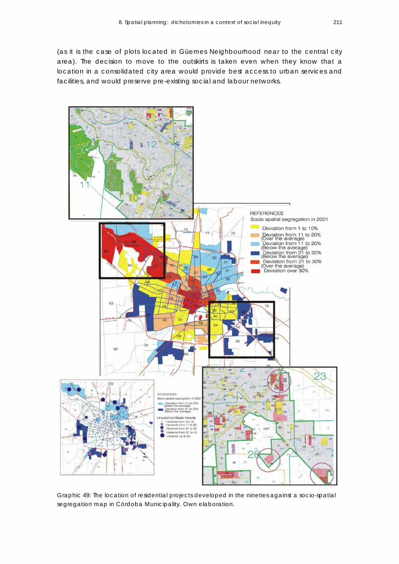
8. Spatial planning: dichotomies in a context of social inequity 211
(as it is the case of plots located in Güemes Neighbourhood near to the central city area). The decision to move to the outskirts is taken even when they know that a location in a consolidated city area would provide best access to urban services and facilities, and would preserve pre-existing social and labour networks.
Graphic 49: The location of residential projects developed in the nineties against a socio-spatial segregation map in Córdoba Municipality. Own elaboration.

8. Spatial planning: dichotomies in a context of social inequity 212
Interviews carried out in the course of this research reveal that, in this case, land-value is not the factor that limits the purchase of land in a peripheral location, but social rejection. Inhabitants in the already consolidated neighbourhoods express their rejection through public manifestations in the city, and force the El Pocito’s inhabitants to accept a more distant and outlying location, where other housing plans for population with similar socio-economic profile are already built. 12 This way, the allocation of subsidised social housing intensifies the process of social segregation at urban scale; when introducing very poor population in urban areas that present this socio-economic profile, it contributes to the social homogenisation of the space (Graphic 45). Technicians from NGOs interviewed during this research13 mention that –in this case- there is no political decision from the government that would help the process of land purchase, and that would promote a process of social acceptance. They assert that political decisions would contribute to social integration and would avoid the fragmentation of social and labour networks. Post evaluation analysis of the relocation of six different slums14 in a new city-neighbourhood called “Ciudad de mis sueños” (My dream city) reveals the same situation.15 In this case, the isolation of the population in peripheral fragments, and strong segregation trends towards the inhabitants of the slums, restrict the possibilities for accessing the labour market even when the working opportunities are in the same city area. In this case, the development of a new city-neighbourhood with no social mixture is a strong barrier to improving their living conditions.16 The location of social housing units as isolated fragments in the city periphery is the result of the absence of intervening political decisions that would diminish socio-economic residential segregation processes in the area. On the other hand, it is the result of technical decisions not oriented towards promoting social and spatial mixture in public housing units.17
4. The effects of urban sprawl on some public services provided by the community The fourth issue to explain why spatial planning has not succeeded in orienting growth towards socio-spatial equity objectives refers to the fragmentation on policy implementation between the technical departments at the municipality. The effects derived from sectoral planning (instead of integrated planning approaches) impact on the sharing of the costs and benefits derived from urbanisation processes, showing that in most cases the whole society has to bear the costs derived from negative externalities. To exemplify this, I will refer to the effects of urban sprawl on some services, particularly on public transport system in two periods: 1) in the 1980s, when spatial planning looks for to contain growth inside the city-ring limits, and 2) in the 1990s, when a more flexible approach to urban growth is introduced.

8. Spatial planning: dichotomies in a context of social inequity 213
During the eighties, spatial planning, public transport system, and the location of social housing are based on an urban development policy that looks for to consolidate growth inside the external city ring. The planning of public transport intends to achieve an economic balance among the areas to be assigned to each private company in charge of providing the services. The goal is to guarantee a good service for the community, and a simultaneous economic profitability for the companies. It is relevant to mention that public-transport service18does not receive any type of state subsidy. A balanced system of transports is promoted, self-financed by economic stability. Areas densely populated follow the design of the routes. In this sense, there is a technical-political commitment made by the local government not to authorise the location of new neighbourhoods in areas where there is not enough population density to guarantee an urban transportation route. Public transport service is one of the requirements that intervenes in the feasibility of locating the new residential developments. 19 In that moment, urbanisation and vacant-urban land are concentrated inside the external ring. Only three densely urban-areas are located outside this limit.20 The origin-destination of the trips is from the periphery to the centre (Graphic 50). The balance in the system is based on the idea of “corridors of services." Initially, 9 radial corridors going through the centre and run by three private transport companies are designed. The design of the routes compensates the internal imbalances derived from dissimilar population-densities and the different socio-economic profile of the population in the various areas; i.e. each corridor of service combines areas with 7 passengers per Km. and others with 2.5 passengers per Km. The success of the policy implemented in that moment is the result of a proper regulation, with strong municipal control over the service supplied and urban-policy incententions to occupy vacant land. The municipality is committed to provide a system that would not be have unproductive kilometres so as to avoid residential locations outside the external city-ring. On the other hand, in those corridors with smaller population density (and consequently, smaller profitability for the company), premium taxes are applied to vacant-land. The objective is to promote the urbanisation of big plots and to reduce urban-land speculation. Corridor Colón is shown as an example of this successful policy. By the end of the eighties, it has little occupation and big vacant plots; its route has to go all the way down to “Don Bosco” neighborhood, at the other end of the corridor. By 2001, a significant amount of vacant land along the route has already been occupied (Photo 27). During the nineties, the search of a balance between the extension of growth and the provision of services that guided the urban policy in the previous decade is abandoned. Unemployment problems and the social crisis affect the transport system. New licensees for taxis and remiss are granted, which impacts on urban mobility. Differential bus services are laid on not based on the corridor concept but rather on the offers of different groups (they could even be external to the company to which the transport-corridor has been assigned).

8. Spatial planning: dichotomies in a context of social inequity 214
Graphic 50: Public Transport Corridors in the 1980s. Source: Córdoba Municipality (1991).
Photo 27: Colón corridor in 1990.
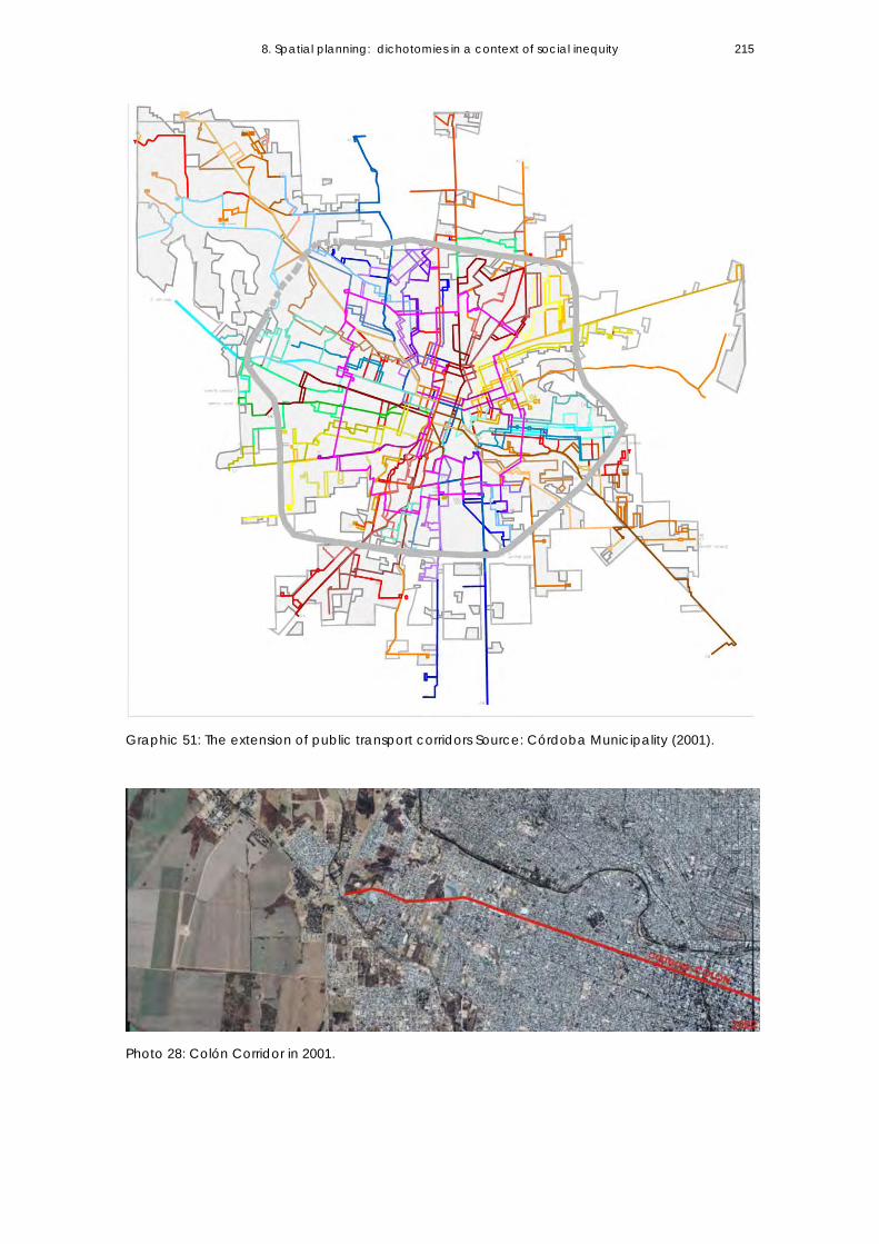
8. Spatial planning: dichotomies in a context of social inequity 215
Graphic 51: The extension of public transport corridors Source: Córdoba Municipality (2001).
Photo 28: Colón Corridor in 2001.

8. Spatial planning: dichotomies in a context of social inequity 216
Public transportation system contracts (between the Municipality and the companies that provide the service) are deferred until the elected mayor takes office (towards ends of 1999). This situation impacts on the commitments assumed in the previous period. The conditions to provide the service are different, but there is not a new regulatory framework to guarantee the previous agreements, only a temporary extension of the contracts. The multiple instances of spatial planning that intervene in urban development operate separately, and impacts on the public transport system. The main change to previous period is that the provision of public transport to approve the settling of a new urbanisation is no longer required. This condition becomes critic once the inhabitants are installed and they begin to demand the service to the municipality. The routes are extended and this situation impacts on the static net, that is to say, the distance travelled by each transport line keeping the same ticket-price. As transport is a public service, the local authorities consider that it should provide it for everyone. As the Municipality has the obligation to guarantee accessibility for all the inhabitants, it forces the companies to extend their routes to the furthest populated areas, even when it impacts on the economic balance of the transport corridor. The companies make up for their loss of profits by lengthening the frequencies of buses and the routes (In this case, it was a political commitment not to increase the ticket price). Intermediate city areas are the most affected sectors, because the passengers have to wait longer and buses are crowded. Towards the beginnings of 2001, the situation becomes critic. The demands on the extension of public transport service is present not only in those new neighbourhoods materialised through public housing programmes (12.000 dwellings built by the provincial government outside the external city-ring), but also in private neighbourhoods promoted by real estate developers (gated communities) initially approved as neighbourhoods without public transport service. As they have private transport services at a high cost, they demand the municipality the extension of transport corridors. Today (and contrary to a policy that looked for the economic balance between the served areas and the profitability of the companies), the public transport has a strong component of state subsidy (fuel subsidy, subsidies to buy the units that each company has), and 1/3 of the corridors in charge of a municipal company are completely subsidised. Sectoral approaches on spatial planning reinforce imbalances. The lack of an integrated planning approach between housing policy and transport policy reinforces sprawl and socio-spatial inequity. Once a transport corridor has been expanded towards the furthest areas, landowner pressure local authorities to obtain changes in land uses, (from rural to residential) and the areas (between the consolidated city and the isolated extensions) begin to be urbanised. This form of growth -through dispersed fragments- makes the economic balance of a public service initially planned as self-financed and for areas with convenient population densities more and more difficult to achieve. This way, the service is increasingly dependent on state subsidies.

8. Spatial planning: dichotomies in a context of social inequity 217
Some matter pending are the necessity to go through the model currently in force, in which everybody has to pay the same amount for a bus ticket regardless the distance covered. The service paid in proportion to the distance travelled would allow for the urban development of some city sectors, and the provision of the service only to dense areas so as not to extend it in order to attend to spontaneous development. On the other hand, it would be convenient to carry out in-depth studies on the economic impact on urban transport.
5. The effects of changes in land-uses on land-values The interventions of the State in urban development impact on the structure of land prices when land-uses are changed, increase the building capacity of plots, or make investments in public infrastructure. In Argentina, landowners benefit exclusively from the increases on land-values derived from changes in land-uses. In reference to this issue, Clickevsky (2002:19) mentions the importance that Property Rights (included in the Constitution and in the Civil Code of the country) have to all social sectors. Property is considered a form of personal wealth and security. The importance that a property has in terms of security is evident while analysing that a high percentage of the population in the country owns land (including the different sub-markets). According to the Permanent Dwelling Survey (2001), 64% of the population in Great Córdoba is landowner, and 23% tenant. Argentinean society believes that the process of land valorisation derived from urban development is a landowner’s private benefit. There is a cultural factor that refers to inflationary processes that characterise the domestic economy during successive periods, and that may provide an answer to why the main social aspiration is to buy a plot. Land is the only asset that does not depreciate in time, and that becomes a family savings. Informality and labour precariousness derives in the progressive building of a house. This situation impacts on the extension of urban agglomerations, which means great lot divisions (in different sub-markets), and also explains why the development of dwelling in property prevails over rental dwelling. Even the most vulnerable social sectors that can only have access to very low land values plots aspire to have a detached house. This interpretation is associated with the way the city expands during the industrialisation period: incorporating rural land to urban development even when it does not have the necessary infrastructure. In the case of Córdoba city, the expansion that takes place during this period benefits landowners, who profit from the unearned increment of land generated from the shift from rural to urban land use and from the absence of requirements in the provision of basic infrastructure during the division of land into lots. The previous mentioned shortfalls in planning have an impact on urban policies implemented since the 1980s, which are centred on the provision of infrastructure (water, electricity, sewers, etc.) and services (schools, clinics, police posts, etc.) to attend to the imbalances of urban growth in the periphery. This situation lasts until 1985, when norms on Plot Division, Use and

8. Spatial planning: dichotomies in a context of social inequity 218
Occupation are introduced. These norms state that land developers have to provide basic infrastructure. During the 1990s, significant changes take place in the forms of expansion and in the social actors carrying out housing projects. Demands for annexing urban land grow significantly not only as a result of global forces, but as a combination of an emerging dual social structure and the need to provide a solution to an increasing poverty. It can be stated that the market forces are predominant over the processes that promote the development of new urbanisations. - In the case of public housing production: When the States locates a housing plan in the periphery (usually in previously rural areas or unconsolidated urban extensions), or in a sector disconnected from the existing network, it adds value to that location. On the other hand, the State rises land value expectations for those plots located between the new housing programmes and the consolidated urban sector. Location of housing projects is conditional on the limitations derived from the maximum incidence of land-prices over the total investment that public housing institutions are able to pay in the market. As time goes by, housing developments are located further and further, in far away locations where land values are low. This way, social housing production, instead of functioning as a tool for redistribution and narrowing of social gaps, tends to reproduce conditions of spatial inequity derived from a high speculative land-market. The lack of a public land reserve for the development of social housing leads the very same State (which adds value to the land during the urbanisation process) to pay higher prices when it wants to acquire land for future housing projects. - In the case of real estate developments: The case of Córdoba faces the lack of fiscal or compensatory tools to capture the urban added values generated through the changes in land-uses. It also presents distortions on fiscal instruments to attenuate land-speculation and the absence of policies to capture vacant land. This paradigmatic case is present in “Las Delicias” gated community (which concentrates the wealthiest segment of the local society) where real estate developers bought a 139-hectare field at U$150.000 dollars; they urbanised it, obtaining 324 lots, and today each lot is worth U$150.000 dollars. The total amount for the houses built is around 200 million dollars, and the municipal taxes they have to pay (after 10 years since the starting of the development) correspond to a great rural fraction. After ten years, the municipal contribution of a plot in a gated community is lower than the contribution fixed for a 300m2 lot located in a low-middle income neighbourhood. A high speculative land market supports sprawl. The forms of expansion express inequity because of the private appropriation of benefits that are socially produced. Urban sprawl is associated with a high speculative land-market that benefits landowners and reinforces spatial inequity. While instruments to share the costs and benefits derived from the urbanisation process are not being considered, planning is reinforcing a capitalistic logic and spatial inequity.
8. Spatial planning: dichotomies in a context of social inequity 219
8.5 CONCLUDING REMARKS The critical analysis of the spatial strategies of planning to orient growth in Córdoba Municipality since the import substitution period has demonstrated that urban planning has not played an active role, only a supporting one while trying to overcome the negative externalities derived from sprawl in the different periods. In the nineties, urban policy is focused on urban competitiveness. The State’s logic is to promote the free market initiative to attract investment to the urban space. Flexibility in the regulation of urban growth reflects, to an extent, the necessity to remove the main constraints to urban growth. This flexibility must be understood within the framework of more general consensuses that question the excessive regulations on land use and that look for to remove those obstacles hampering the development of projects promoted by the private initiative. The case of Córdoba gives evidence that the free market initiative by itself does not remedy the negative externalities derived from urban growth. Spatial planning oriented to make same regulations more flexible (in order to promote the development of economic actors in the city-territory) does not consider the possible effects in terms of sprawl, segregation, and urban-fragmentation. This analysis demonstrates that these postulates are inefficient in advancing social integration processes or diminishing segregation in the space, and that they have resulted in very strong polarisation among urban sectors. The significant real estate increase in value of housing developments promoted by the private sector and the problems of housing programmes to have access to better urban locations give evidence of these processes. New regulations do not consider instruments that allow for the redistribution of the added value derived from urban development. They bring residential initiatives to fruition (meeting the demands of opposed social sectors) without taking into consideration (in contrast) instruments that alleviate the effects of a highly speculative land market. Urban development, in this case, is the result a fragmented way of carrying out isolated initiatives, considering only their profitability. The strategic planning launched in Córdoba during the 1990s promotes flexible and proactive strategies in urban development. However, new consensuses have not been effective in overcoming structural limitations on spatial planning such as: 1-The divorce between technical departments of planning and the administrative jurisdictions that intervene in the city space. The lack of coordination between the local and provincial levels that operate on the urban space and not enough integration among metropolitan municipalities and the capital city in urban growth planning impede the development of policies of intervention to diminish sprawl and segregation. The improvements on urban-regional mobility and the development of road infrastructure take place without considering land use planning in those areas, evidencing the disconnection between the planning of land uses and the development of regional infrastructure.

8. Spatial planning: dichotomies in a context of social inequity 220
2-The divorce between planning and the social housing system. Spatial planning does not integrate social housing policy. The interference of political matters is translated into the lack of coordination in urban development at the different state levels (the municipality devices spatial planning and the provincial government implements housing policies). The provincial government intervention in urban development matters that should be dealt with by the municipality affects decisions made about the location of housing programmes, the typology of projects, the scale of intervention, and the allocation of social housing resources (some key aspects for urban development). Although social housing projects must have a feasible location (later to be approved by the local government), the municipality has little capacity to orient the current processes in pursuit of a certain urban policy objective (for example, diminishing segregation and promoting a greater efficiency of the existing urban capacity). 3- Another limitation derives from the sectoral view that precedes in urban growth planning (zonal planning based on land-use regulations). It is translated into the lack of coordination of the actions to be taken during planning: provision of public transport, extension of networks and infrastructure, provision of basic equipment, extension of public services, etc. Land annexation demand for new locations is significantly growing. Consequently, technical planning departments must face increasing pressures to annex land to new urbanisations even when they know that there is a growing economic weakness to provide services and maintenance in the future settlements. The acceleration of private investments and the stagnation of the levels of public investment (networks, equipment, and services) will, in the long term, translate into a decrease en the quality of life in the urban periphery. 4-The political weakness of the municipality to formulate and implement land-policy towards socio spatial equity objectives. The Municipality does not take concrete actions in the urban land market (e.g. fiscal instruments to attenuate land-speculation, policies to capture vacant land, or incentives to promote the consolidation and density of certain social sectors). Vacant land policy only assigns uses and regulates the location of urban activities without considering applying instrument that could facilitate the redistribution of the added values derived from urban growth. Because of this, it is inefficient in attenuating land speculation processes, and market logic prevails in the process of growth. An unresolved challenge is to regain the strategic vision in planning through the promotion of participation processes aimed at achieving greater equity in urban development, to overcome sectoral approaches and develop an holistic planning vision, to define land-uses and simultaneously incorporate sectoral policies, and to root spatial planning in the processes that shape reality (spatial, social, economic, and political processes), are objectives unlikely to be achieved due to the current technical-political conditions of the Municipality.

8. Spatial planning: dichotomies in a context of social inequity 221
Notes 1 According to empirical analysis (see Table 11, Chapter 5), the relationship between urban areas and inhabitants is 171 m2/inhabitants in 1980. By 1990, it is 173 m2/inhabitants, evidencing how a more regulated context is able stop urban sprawl. 2 Burgess and Carmona (1997:120) mention that the focus of urban strategies in developing countries under a neoliberal policy is the urban periphery. 3 On that occasion, and as a consequence of the speculative expansion developed in the period of import substitution (from the ‘50s to the ‘80s), wide urban sectors lack the provision of minimum infrastructure and social equipment. 4 Land division (and parcelling) is regulated by ordinance 8060/85. Land uses and building capacity are regulated by ordinance 8256/85. 5 A transgression of the norms is observed in those neighbourhoods that respond to traditional parcelling, but have a controlled perimeter, restrictions on access, shared streets, and green areas (although their inhabitants are in charge of maintenance and security). In this case, this market strategy is facilitated due to sluggish controls of the public authority. 6 It reaches 19% of the total urban area, which is 4,693 ha. 7 Rural urbanisations refer to a new modality impelled by real estate and based on rural parcelling (plots of 5.000 hectares) which allows for the building of two houses. In this case, the plot is not destined to agricultural activities but to residential use. The market strategy offers “a natural environment,” and as they are placed in rural areas, they do not have to provide to urban services or infrastructure. 8 In the period under analysis, real estate developments extend 1,117 hectares, public social housing incorporates 1,617 hectares to residential use, and illegal settlements include 675 hectares (Table 12, point 5.4). 9 In the case of Córdoba Municipality, social housing is implemented by the technical departments of the provincial government. 10 Since 1991, when housing policy was decentralised in Argentina, Technical Housing Departments of Córdoba Province have received funds to put social housing projects into effect. In some cases, programmes are co-financed by the Province and the Municipalities. Usually, Municipalities provide the land and the Province builds the houses and provides infrastructure. The case of Córdoba Municipality is different from others in the Province, because it has not developed an active role in implementing social housing. The dwellings built by the Municipality in the analysed decade are the result of the need to relocate population as a consequence of public works (for example, improvements in road infrastructure). 11 The “Villa el Pocito” slum, originally located in the central area of Córdoba and moved towards the city outskirts in 1995, is a paradigmatic case of relocation of a slum integrated by 166 households. The housing policy was financed with provincial funds and coordinated by local NGOs and the Community leaders on behalf of cooperatives. Even when inhabitants had the right to stay in the place where they had lived for over 30 years (according to a legal instrument given by the Provincial Government in 1973), the community decided to move towards the periphery. 12 In this case, one condition that the public housing authorities imposed was that the new settlement had to be accepted by society in the area where it was to be located. 13 Technicians interviewed are from the Serviphroh NGO; they have implemented several social projects in the community, and have been working with social leaders for several years. 14 The relocated slums were La Maternidad, Los Mandrakes, Villa de Vagones del Ferrocarril, Familias dispersas, Los 40 Guasos, and Guinazú Sur. A Total of 565 families were relocated. 15 The research refers to the post-graduate thesis: “Quality of life in a neighbourhood of relocated population in Córdoba periphery” developed by M.Sc. architect Olga Lucía Montoy and Co-directed by Cecilia Marengo. National University of Córdoba, 2006. 16 The program is a response to a flood emergency that took place between 1999 and 2000 in Córdoba city and the localities of Villa Allende and Saldán, and that affected illegall settlements on the river banks. It was also implemented for those beneficiaries victims of natural disasters, undergoing critical environmental situations.

8. Spatial planning: dichotomies in a context of social inequity 222
It supposes an investment of 300 million dollars, 225 million financed with a loan from the Inter-American Development Bank- IDB, and the rest financed by the Province, which buys the lands and provides infrastructure. Some of the new neighbourhoods integrated by several groups of population from different slums have been named: Ciudad Evita (574 dwellings), Ciudad de mis Sueños (565 dwellings), Ciudad Obispo Angelelli (564 dwellings), Ciuadad de los Niños (412 dwellings), and 29 de Mayo (480 dwellings). 17 This condition is reinforced as from 2001, when the building of “ciudades-barrios” (neighbourhood-cities) destined to the relocation of people living in slums takes place. To date, the new social housing programmes being implemented reinforce the homogeneous profile in the constitution of the population receiving a house, and propose housing plans for the middle-class as a way of differentiating them from housing plans for the poor. 18 “The Municipality didn't subsidise the transport; it developed the infrastructure (mobility and accessibility) so that the system could be profitable, responding this way to the economic and social necessity of the service.” said arch. Mario De Dio from the Technical team of the Direction of Transports of Córdoba, Córdoba Municipality (2006) Interviews carried out in the course of the research. (My translation) 19 "Every time that a new neighbourhood was to be developed, its construction was authorised as long as there was transport to the area. If there was no transport, but the neighbourhood was very big, the costs of extending public transport service were analysed." From an interview carried out during the research to a technical team from the Direction of Transport of Córdoba, Córdoba Municipality (2006). (My translation) 20 “Inaudi” and “Don Bosco” neighbourhoods are the result of public of housing developments, and “Guiñazú” neighbourhood, towards the north, is developed starting from a railroad station.

9. STRATEGIC LINES OF INTERVENTION CHAPTER IX 9.1 Introduction 9.2 Strategic lines of intervention From urban planning to regional planning From sectoral planning to integrated planning A shift from zoning to strategic planning From top-down policies to the co-production of city planning 9.3 Possible instruments to be applied to remove socio-spatial inequalities in the process of growth Land policy: changing the role and instruments Challenges on Housing policy approaches toward spatial equity 9.4 Final remarks

9. Strategic Lines of Intervention
224
9.1 INTRODUCTION This empirical analysis has demonstrated that the free market initiative itself does not remedy the negative externalities derived from urban sprawl (Chapter 8). In contexts of high social inequality, a more flexible approach to urban regulations and a smaller intervention of the State in urban development (neo-liberal paradigm) do not contribute to the attenuation of social segregation processes nor to the redistribution of the unearned increment of land values derived from urban development. Structural limitations on planning in the case of Córdoba Municipality refer to the fragmentation of planning decisions, the divorce between urban development and the social housing system, and the lack of instruments to discourage land-speculation and to redistribute the costs and benefits derived from urban development. The aim of this chapter is to provide an answer to the question: To what extend may effective planning contribute to orienting urban growth towards objectives based on the principles of integration? (Integration meaning removing socio-spatial inequalities in the process of sprawl, segregation, and fragmentation.) (Subproblem 3) This chapter develops the third hypothesis, which states that “In a context of high social polarisation, planning priorities should be oriented to long-term strategic approaches in order to regulate the operation of market forces towards equity objectives.” Feasible solutions to tackle critical questions derived from urban extension processes developed in the precedent chapters are identified, and strategic lines of intervention that should attenuate the negative externalities of growth are discussed. This critical confrontation about the way planning is implemented in Córdoba Municipality as well as this research show that weaknesses involve not only technical matters, but also political issues that criss-cross all planning decisions. Possible strategies to achieve an integrated planning vision (developed in this chapter) involve several issues and refer to different scales of intervention in the urban space. To mention one, the metropolitan scale –even when it is analysed as a context within the framework of this thesis- is introduced in order to explain the institutional fragmentation at regional level. There is a need to develop a regional framework so as to integrate planning decisions among the different Municipalities. The discussion about the feasibility and the different alternatives to coordinate planning decisions is presented, together with the conditions of the political context. Some guidelines about essential changes to be introduced in planning decision processes in order to avoid fragmentation during spatial development are proposed. Finally, the land policy issue is introduced, and some measures to rule out urban land speculation are discussed. The development of workable instruments to capture the increase in urban-land values derived from urban development seems to be the first step in planning towards equity objectives in the case of Córdoba.

9. Strategic Lines of Intervention
225
9.2 Strategic lines of intervention From urban planning to regional planning to overcome fragmentation at regional level During the 1991-2001 period, Córdoba city grows beyond the limits of the municipality. It can be verified that the localities integrating the metropolitan area show higher population growth rates than the central city. At the same time, plots of land in these areas are of significant lower values, which allows people to have greater access to them. Nevertheless, urban growth in these places incorporates varied functional and socio-economic patterns and reproduces the socio-spatial segregation seen in the periphery of Córdoba municipality. This means that a greater urban growth in localities in the metropolitan area is not only the result of people who choose the suburbs to live (those of high and very high income), but also of people (the urban poor) who are forced to move out of the central city to localities having greater chances of access to land and a lower cost of living. Since the 1980s, many attempts have been made to coordinate intervention policies at regional level. The need to address basic matters as the disposal of urban waste, drainage basins, land use, transport, etc. is already recognised in that decade. As they constitute a system of towns functionally integrated but lacking institutional tools to facilitate a joint governmental administration, conflicts among the different jurisdictions are not uncommon in the service provision, infrastructure, and urban equipping areas. At the same time, asymmetries regarding the advantages and disadvantages presented by the different municipalities in terms of activities and house location become more accentuated.1 The feasibility to develop a regional urban plan centres upon the discussion over the type of political organisation (or institutional agreements) needed to implement unified urban policies. There is a need to develop a regional framework, to integrate planning decisions between the different Municipalities, and also to decide on land-use in those areas that are not included in the administrative jurisdiction of the Municipalities (i.e. areas under provincial jurisdiction). Up to the year 2007, there are no technical organisations in Córdoba province dealing with planning at a regional scale. However, previous studies show the advantages of an inter-municipal administration model (i.e. based on an agreement among Municipalities) over a supra-municipal administration model2 (i.e. a unified metropolitan government). The benefits obtained from the implementation of such a model derive from the pre-existent political context in Córdoba, i.e. the significance of self-governing municipalities and a constitutional support bring the chance for town councils to enter into agreements so as to build inter-municipal organisations of joint administration,3 in opposition to what a unified metropolitan government might mean, the latter with neither historical nor institutional precedent in the region. In December 2004, Law No 9206 is passed (Organic Law for the Regionalisation of the province of Córdoba). This law provides a legal framework for the development of policies of regional scope through the establishment of regional communities and new

9. Strategic Lines of Intervention
226
geographical areas for the implementation of unified territorial policies.4 Article 10 specifically states that one of the Regional Communities’ functions is to design a regional plan and to detect priorities for the development of the region.5 Undoubtedly, the sanction of this legal instrument is a step forward in the drawing up of policies looking for to overcome the existing fragmentation between municipalities and the provincial government in their ways of planning and managing territory. Proposals aiming at this should: -Promote the establishment of Technical Organisations for Planning at a regional level that show continuance regardless elections or the political situation. State Policies should provide an additional budget and a legal framework for them to function. -Define regional plans and development projects on the basis of their characteristics and the activities that can be decentralised to the different localities integrating Córdoba Metropolitan Region. To date, there exists no definition of what the regional areas and the roles played by the different urban centres would be.6 -Identify the Regional Communities that would surround Great Córdoba on the basis of the differences among them. -Suggest particular developmental strategies and ways to define a more organised and autonomous growth of regional identities, incorporating new activities and promoting the location of jobs in the metropolitan area. Officials, provincial and municipal technicians, and academics interviewed in the course of this research7 agree that the adoption of unified developmental policies in the metropolitan area has not been possible due to unwillingness of politicians to coordinate work, and they point out that there exists proven technical capability and clear diagnoses showing existing deficiencies. The success in overcoming fragmentation, unifying intervention strategies in the territory, and moving towards a metropolitan institutionalisation is conditional on the abandonment of practices of political power accumulation. On the one hand, municipalities define policies in their territories making use of their autonomy and are reluctant to join other municipalities in metropolitan matters because these are outside their range of power accumulation (they are reluctant to join the municipality of the capital city because it carries heavier political weight). On the other hand, municipalities coordinate directly with the provincial government, which is the one that has the capacity to allot resources and is able to directly intervene in the municipal area. From this standpoint, the area of metropolitan administration becomes irrelevant since it does not contribute to the accumulation of political benefits.8 From sectoral planning to integrated planning To overcome this sectoral planning vision and to advance towards a more integrated planning approach, it is necessary for political decision-makers to have enough capacity to promote equity conditions in urban development. It becomes necessary to have political and technical leadership that can confront the growing complexity of urban problems, balancing economic growth with social development.

9. Strategic Lines of Intervention
227
It also demands a different approach to the urban growth question. In order to achieve social equality, which implies having universal accessibility to spatial quality in the consolidated city and the sprawling periphery, it is necessary to: reconsider that urban sprawl should not be unrestricted; encourage urban density processes in areas that already have the facilities to house more population; provide houses and work places by transforming existing built-up areas; and promote better spatial quality conditions and social mixture in new residential areas by means of discouraging mono functional extensions in the periphery. In the case of Córdoba Municipality, empirical evidence has demonstrated that the sectoral application of policies and the lack of coordination among the technical departments to determine the feasibility of a new urban location during decision making processes promote urban sprawl and intensify inequalities. The internal working organisation in urban development areas show significant dissociations between the planning areas functioning as autonomous units (in land-use control, public works, transport, networks and infrastructure, environment, etc.) and those in charge of the different areas (politicians) unwilling to establish links.9 To overcome fragmentation of planning decisions applied in the same administrative unit implies the re-organisation of the way spatial planning is developed in Córdoba Municipality and proposing new approaches to future developments. A step forward regarding this issue would be to create project teams composed of technicians from the different areas in order to plan new urban extensions employing an interdisciplinary approach. (The Dutch case is an example: Projects Groups of Master Plans is integrated by delegates from different areas (and activities) to avoid decision fragmentation.)
A shift from zoning to strategic planning Planning concepts and the way policy is implemented Since the enactment of the code on urban development in 1985, expressed in the main ordinances about land division, occupation, and use, urban planning in Córdoba has mostly had a regulatory vision that controls urban growth processes on the basis of a static pattern. Additionally, this approach has had a long existence in time (about 20 years) without any modification being made, partly because of its extensive development that covers all the areas of the city. Present conditions demand not only an updating of regulations, but also a change in the planning perception, approach, and methodology (which in turn would facilitate this updating of current regulations). A shift from zoning (based on land-use regulations) to strategic planning seems to be necessary as a response to the uncertainty and the changing conditions derived from the economic context. Planning becomes more flexible because it implements some initial decisions and allows other decisions to be made depending on the evolution of urban processes. Even though strategic planning methodologies promoted during the 1994-1999 period are making progress on identifying dimensions (territorial, social, economic, and

9. Strategic Lines of Intervention
228
environmental) for urban development intervention and are promoting urban projects on scale, they are not able to reduce socio-spatial inequalities, or be ahead of a type of urban growth in which the market gets the profits of large investments in infrastructure (avenues, parks, urban infrastructure, etc.) developed by the public sector, and demands greater building capacity of the plot than those envisaged by law. Today, there should be strategically planned solutions for current problems; for example, the regulation of green reserves and social housing location so as to avoid pushing population to the borders, the completion of great scale road infrastructure projects, etc. Regarding this issue, a matter pending is the formulation of a Comprehensive Plan which defines general lines of intervention for the city as a whole and which specifically incorporates the development of Planning Units at a smaller scale (neighbourhoods, homogeneous areas, and city sectors with a particular identity, among other possible concepts). This way, an idea of flexibility is incorporated in planning; medium and long-term objectives are defined; and different strategic projects in urban sectors can be promoted following an order of priorities. These projects, being based on an image-objective of the area, would incorporate not only physical-spatial principles of urban intervention, but a series of instruments and tools that would make the achievement of certain socio-spatial goals possible. According to the type of strategy, tax benefits can be calculated, (affecting for example, building rights, mains connection rights, local property tax, etc.), or compensations (oriented towards a greater socio-spatial equality in urban growth) should be demanded to private investors. This way, local governments, while recognising some priority and even emergency situations, may promote some initiatives in some sectors and postpone others, it may be a neighbourhood, a shantytown, or an urban sector, for example, as different areas for planning. This would be a strategy likely to search for balance. The State, as a promoter of such balance, has the role of redistributing resources, and may contribute (if it assimilates the concept of equilibrium) to social sustainability in urban growth. From top-down policies to the co-production of city planning Given that the city is the co-production of society, development cannot be defined only by the state, that is to say, by means of top-down policies. When intervention is intended at city scale, some agreements can be reached through institutional representation and the participation of social organisations. (At present, there are public hearing mechanisms and citizen’s forums to channel social participation in urban development aspects.) However, and according to what can be inferred from the interviews with municipal officials and technicians, it is very hard to get the real participation of the inhabitants at a scale of city general planning. Participation is not only a matter of technical planners who take Strategic Plans ahead but rather it crosses political questions. The new competitions that should assume the municipalities (due to the descentralisation of policies) in many cases do not go accompanied by the transfers of resources, neither of the necessary understanding of

9. Strategic Lines of Intervention
229
the whole society of the importance of participation in the collective construction of local development. Strategic and participative planning looks for to embrace all actors of social reality, however not all have equal representation weight. In consequence the process of negotiation of interests (tensions and conflicts) in which strategic plans are developed, it is not exempt of inequalities in the possibilities social actors have to demand and achieve urban development objectives. The heterogeneous participation of civil-society, the unequal representation of institutions in local forums and the uneven capacity social actors have to be involved in decision-making processes are obstacles that may accentuate differences in achieving urban development goal. In this context planning is balancing between the requierements of most dynamic social sectors and simultaneously the neeeds of most vulnerable ones. The success of strategic planning in based on the knowledge of local reality. Uncentanty and sucesive crisis that local government face and dynamic scenarions in economic, political or social fields; delay the implementation of the consensus and agreements achieved through participatory planning approaches as well as the materialization of projets. The development of planning units at a smaller scale (specific urban projects) would offer the opportunity of attracting a bigger participation of those inhabitants directly affected in the project area (neighbourhood or urban sector), reflecting their expectations, interests, and concerns. On the basis of general guidelines for city intervention, municipal technical teams and community representative members can define interventions for these areas (urban development criteria to be applied, activities that need to be promoted, etc.) that would be planned in agreement. Political decisions are the starting point to give impetus to planning processes and to promote actions in the urban space which have social consensus.
9.3 Possible instruments to be applied to remove socio-spatial inequalities in the process of growth Land policy: changing the role and instruments Actions on land face several problems that have been shown during the development of this thesis. Some of them are: -the availability of vacant land to be urbanised that grows as new stretches of land are incorporated; -the low density of some peripheral sectors and the consequent rise in infrastructure and service provision costs;

9. Strategic Lines of Intervention
230
-difficulties for population in the lower deciles and even for middle income sectors to have access to land, and the relative accessibility to land supply in localities in the metropolitan area in comparison with that in Córdoba Municipality; -the increase in value of urban developments as consequence of real estate market operations; -the private capture of the unearned increment of land values derived from urban development; and -the lack of accessibility to land by social housing operations that end up being set in inexpensive plots of land in the periphery (promoting greater urban extension), among other issues. These questions indicate that in order to achieve the goal of reducing inequality in urban development, it is necessary for the Municipality to assign a new role to the land-use policy: a shift from a policy based on regulation and land-use control to one that looks for to regulate land market forces (from a Regulatory to a Pro-Active Role). Policies currently in force stipulate land use, parcelling, and occupation conditions, considering first and foremost functional (land-use compatibility) and formal (type of building, height, resulting volume) criteria, but not taking into account the economic criteria resulting from the increase in land value. Consequently, it is necessary to move from a regulatory urban development to an operational one. In face of the restrictions of a planning based on norms and regulations, new strategies and a pro-active Municipal vision should be incorporated so as to achieve certain goals on urban development policy (to consolidate given urban sectors, to have areas with greater density by promoting renewal processes, to promote a mixture of land uses, to avoid socially or spatially homogeneous areas, etc.), in some cases, by means of developing strategic urban projects. 10 There is a need to define a policy concerning public land belonging to the National or Provincial State that could be transferred to the Municipality. The feasibility of promoting projects is to a great extent conditional on the Municipality’s possibility of owning land. These would be strategic actions to be defined in planning so as to achieve certain urban objectives. A pro-active approach in urban development calls for different actions aiming at evenly distributing urban development costs and benefits. To conduct private investment following a criterion that allows some kind of move towards concrete actions for the benefit of the local community demands a greater integration of varied urban tools (urban plans, urban projects, rules and regulations) by strategically dealing with urban processes. From this perspective, a land market regulation policy links together different actions or policies that have a bearing on the process of valorisation or that are oriented towards reducing socio-spatial inequalities: on the one hand, fiscal policies (cadastre updating and revaluation, implementation of tax policy means) and regulatory policies (recovery of unproductive land, definition of urban development rights, etc.); on the other hand, the capture of the unearned increment of land values, regularisation policies (dealing with informal settlements), infrastructure investment policies, etc.

9. Strategic Lines of Intervention
231
Even if there exists a range of instruments that could be applied in the case of Córdoba, the chances for the Municipality to assume a new role is conditional on (or restricted by) the political decisions and social consensus that would let these issues be incorporated in the collective thinking. This means, to raise awareness in political decision making levels where taking actions on urban land in order to attenuate strong socio-spatial inequality processes is not yet perceived as necessary.11 Somehow, the emphasis of pending matters is placed on governability or political institutionalisation aspects rather than on specific technical aspects. At present, the Deliberative Council is considering the possibility of awarding compensation for the increase in value (added-value transfer) derived from changes in rules and regulations, changes in land use, intensification of land use, improvements in the building capacity indexes, etc. To the present day, compensation only includes extraordinary situations that fall within the limits set by the regulations in force.12 The compensation obtained could be assigned to provide legal land access (to illegal settlements), social housing investment, land, or the financing of particular public works in the city.13 Officials interviewed consider this instrument important since it is the first time that the Municipality imposes some requirements on private investors, and they estimate that this will pave the way for the undertaking of more integrated actions in the future. They all agree on the need to set up a regulatory framework in which the type of compensation to be granted is established –in face of market demands that exceed the building capacity of plots or induce changes in land use–, since it is not possible to make investors voluntarily supply some contribution to the city when they expect to get the approval of extraordinary situations or exceptions to the regulations in force. On the other hand, any demand that technical planning departments make –that in another context could be carried out in a framework of negotiation of interests– is seen as a regulation’s restriction, or interpreted as arbitrariness from the planning technical departments that would be stopping free market initiatives in the development of real estate projects.14 Since it is a problem of social awareness (values), specific regulatory instruments are required so as to be able to demand private investors some kind of urban compensation. Hence the importance that technicians attach to this new instrument that, though partial, looks for a quantification of such compensation. It means an occasion to transfer resources (transferring value to the land) in a context where the Municipality has limited economic capacity (resources) to finance some public works in the city. This instrument, combining the same idea of transferring the unearned increment of land values, could also be applied to gated communities. The Municipality could request private developers, for example, to compensate for the use of 15% of green land granted to this type of development with the creation of public green spaces in those sectors lacking it. Any action oriented to the redistribution of the costs and benefits of urban development towards objectives of greater socio-spatial equality (and looking for to attenuate land-speculation processes or to achieve greater transparency in the way

9. Strategic Lines of Intervention
232
the land market works) requires a governmental action that regains a vision based on the social function of land property. Such action, even though it is recognised in the National Constitution and in the Constitution of the Province of Córdoba,15 is in fact pushed into the background by the market forces, the significance of private property rights, and the weakening/flexibilisation of regulations promoted by neoliberal approaches.16 Challenges on Housing policy approaches toward spatial equity Strategies that could be applied to remedy the negative externalities derived from urban growth processes (segregation and sprawl) entail changes in housing policy, which raises the question of the different types of problems that involve and criss-cross political and technical aspects.
• The first problem has to do with the need for agreement between the different state levels on housing policy implementation to avoid fragmentation in the way policy is put into operation, and to support objectives on land policy.
Empirical evidence shows that even if housing policy in Argentina becomes decentralised as from 1991 (from national to provincial to municipal government), this cannot be verified in the case of Córdoba Municipality. Decision making on housing policy stays in the sphere of the provincial government (which decides upon its implementation: sectors towards which it is oriented, types of programmes, where to set up these programmes, etc.). A reason for this refers to matters that have to do with conflicts mayors have had with governors (and vice versa). A hypothesis alludes to the significance of Córdoba Municipality whose (electoral) population carries the most weight; consequently, the mayor of the capital city has a distinct political weight from those of the other municipalities, which makes him (or her) a competitor for the governor. In this superimposition, political power accumulation processes (political-electoral benefits) are evident even if both jurisdictions belong to the same political party.17 On the other hand, since the establishment of the Dirección de Hábitat (Habitat Office) in 1994, the Municipality has not assumed a leading role in the implementation (and decentralisation) of housing policy -it has only dedicated itself to re-housing population when it is necessary to clear squatted land to carry out public works. An underlying issue is poverty, which is not assumed as a State policy by the Municipality. This issue has always been addressed by the social areas of the provincial government, including habitat programmes. Political power conflicts determine the implementation of housing programmes internationally financed but put into effect through the province.18 When these housing programmes are implemented, the Municipality only plays a controlling role –verifying if regulations are complied with, if programmes are placed within the law, if infrastructure provision requirements are met– pushing into the background the possibility of combining housing policy objectives with urban development objectives.
9. Strategic Lines of Intervention
233
In order to overcome the divorce between urban policy (spatial planning) and housing policy in city development, it is necessary for the Municipality to implement housing policies following spatial planning goals and objectives.
• Another pending matter is related to the processes of growth of the informal city and the need to develop policies to prevent irregular or illegal settlements in the urban borders.
In planning, there is no provision of the problem of informal settlements; regulations currently in force regulate access to land through formal processes. (In this sense, Ordinance 8060, for example, in its section on Social plots, considers the concept of housing plans. This means that it is not possible to legally approve the division of land until houses have been built. This way, it denies the progressive construction of dwellings and the implementation of constructive participatory processes -which are also prolonged in time- developed by social organisations that deal with the problems of the most vulnerable sectors.) It is important to realise the need to incorporate the informal sector of society -which has no possibilities to access land or the housing market- in planning decisions; to include these issues in the public agenda and develop programmes for land and housing access in order to address this situation; to develop a strategy to regulate access to land and services and make new areas ready for occupation following a territorial integration logic; and to incorporate poverty and informal settlement issues in urban development. A new approach to these problems would prevent the multiplication of cases of land-access in the informal market and would anticipate negative effects in terms of urban extension, social segregation, and spatial fragmentation. To the present day, the Municipality has not developed planning strategies oriented towards preventing growth of the informal city. Actions undertaken are oriented towards the legal regularisation of land (once the occupation has taken place) or towards placing population in new housing complexes; they do not provide for the development of a policy on land access, with an supply proportionate to what this sector of demand can afford. Even when the Organic Charter19 empowers the Municipality to promote, plan, and implement housing policies (within the framework of urban and social plans) to coordinate programmes,20 and to plan and implement tools that make it possible to have lands (for the execution of urban plans, programmes, and projects), the Municipality does not have an active role en the development of housing policy. The Municipality’s police power is diminished; consequently, it is not possible to control the development of the informal city. Limitations also refer to: the political context (already pointed out) in which the planning of Córdoba is developed; struggles for power among the different state levels; and the existing fragmentation among planning areas of the municipality. Although economic resources could be transferred from the Nation or the Province to the Municipality, there is an underlying struggle for power in the transfer of competences in housing issues which delays the implementation of comprehensive policies aimed at meeting an ever growing social demand. The lack of own resources to carry out actions regarding this issue is
9. Strategic Lines of Intervention
234
attributable not only to technical and institutional questions, but mainly to political ones.
• The third issue refers to how to overcome social segregation and spatial fragmentation and orient growth towards socio-spatial objectives.
The increase in social segregation and the materialisation of residential enclaves recorded in the process of sprawl in Córdoba during the 1990s demand new strategies on housing policy. Such strategies refer to physical-spatial planning matters and also to the economic-financial means of sectors demanding houses. At present, only 11% of the economically active population in the city of Córdoba meets the conditions to have access to housing loans.21 Even if the real estate market has recovered from the 2001 currency devaluation, the amounts given through loans have a smaller purchasing power and a much more restricted access for population. This means that it is necessary to create new financial facilities to maximise the possibilities of access for middle-income sectors, and to narrow the gap between house prices and wages and salaries. This necessarily demands the implementation of economic-financial measures and strategies on the part of the State.22 Among the necessary measures to reduce socio-spatial differences and orient growth processes towards greater equality are the following: -Measures related to Urban Land.
1. A change in the conditions of land-access looking for to promote “urbanity” and preventing extensions in the periphery that respond to the market’s search for profits.
2. The design of instruments to facilitate access to land in social housing programmes aimed at various sectors of demand.
3. The need for the Municipality to create land reserves that could attenuate the high speculation in the land market.
4. The introduction of land regulations that make it possible to capture part of the unearned increment of land values generated during urban development and to redistribute it among housing social policies (whether keeping a percentage of urbanised land for social housing operations or setting a percentage over the building capacity of the area allotted to this type of programmes, like in the case of Spain, for example, that fixes 30% for social housing.)
5. Regulations on public land (belonging to either the National, Provincial, or Municipal government) to prevent public land from being transferred to the private real estate market, and to facilitate the allocation of social housing or urban equipping.
-Measures related to housing policy objectives:
1. A new type of social housing that generates social integration and a mixed pattern integrating different social profiles, varied qualities and dwelling types. (E.g. Holland establishes a percentage for social housing that should be integrated in new developments.)

9. Strategic Lines of Intervention
235
2. The need to discuss the urban location of projects following urban and social objectives, mixed social profiles, re-densification or infill development, among other objectives.
3. The avoidance of placing housing complexes in sectors protected from urban development, that promote permanent changes in land-use zoning, and that result in greater urban extension.
4. Measures to promote infill development and favour urban densification in urban sectors that are being consolidated (over monofunctional extensions in the periphery).
5. Measures oriented to positively discriminating already urbanised areas through urban regeneration, the renewal of some city areas, housing programmes, etc.
6. The development of a housing policy to the middle social class (not present in policies implemented during the period under analysis which exclusively focus on the vulnerable sectors) that allows for improvements in building stardards and location, promoting greater urban space quality.
7. The development of measures that integrate low-middle class households (through individual subsidise or by analysing the possibilities of a rented system instead of delivering houses in ownership) so they can have access to better urban locations.
8. The revision of the scale of programmes that correspond to a logic of business profitability rather than greater social integration objectives.
9.4 Final remarks In this globalisation period, the new strategic role that cities assume as driving forces for development has oriented urban development towards improving productivity and removing restrictions to promote the free market initiative, giving place to advances in accessibility and mobility, and to a redefinition of land-use following transformations. Córdoba is one of the first citites to implement innovative planning strategies in the 1990s; however, this research shows that such strategies have not been effective in counteracting sprawl or attenuating residential segregation and spatial fragmentation conditions in a context of wide social gaps. The spatial configuration of the city represents the problems derived from the growing gap between the different levels of public investment with regard to the extension of growth and the increase in poverty conditions, which shows the need to reorient public investment objectives towards social integration. The dissociation in which housing policies operate regarding urban developmant objectives and their focus on the most vulnerable sectors are the main obstacles of a policy that could facilitate socio-spatial integration conditions and attenuate urban fragmentation. Reflecting the neoliberal orientation, the public sector does not directly intervene in urban development processes; it only intervenes through rules and regulations to orient the private sector intervention. This role, in the case of Córdoba Municipality, has proven not to be enough to discourage land speculation or to attenuate socio-spatial segregation processes. It is necessary for the Municipality to assume a pro-active role,

9. Strategic Lines of Intervention
236
intervening in the materialisation of public works and, at the same time, implementing tools that allow for the achievement of social objectives in urban development in order to reach conditions of growth with equity. In face of a scattered city, a new focus on planning is required: one that promotes the creation of areas of integration (in political, spatial, and social aspects) and that integrates the economic dimension of urban development. An effective regulation (oriented towards attenuating functional and social segregation processes) must be oriented to promoting a mixture of land uses and activities, and counteracting low density sprawl with greater intensity in land-use (redefining occupation densities according to the context, transformations in urban infrastructure, and the urban development model). Land-use regulations combined with tax policies can orient growth towards urban development objectives aimed at achieving greater equity and discouraging land market speculation. The redistribution of the unearned increment of land values is a tool in this sense. An effective land policy is needed, one that promotes better urban efficiency, that consolidates areas of urban quality, and that facilitates land access to those social groups that demand the State’s attention to their situation. This is also the starting point of a housing policy that promotes urban consolidation over peripheral extension and that attenuates the socio-spatial inequality derived from urban sprawl. In a society with wide income gaps, to apply a tax system or a cost adjustment system in service rates -so costs are met by those who expand- could reinforce inequality, bearing in mind that there is an ever growing social demand that does not agree to minimal urban conditions and is pushed out of the existing city. A new role is needed on the part of the State, which can make the costs derived from excessive expansion visible and encourage society to get involved in discussions on its implicit negative externalities.
Notes 1 These questions have been thoroughly studied by Tecco Claudio and Fernandez Silvana in “Sobre la necesidad de una gestión urbana asociada entre municipios que conforman la Región Metropolitana de Córdoba,” Tecco (2005) (compilers). Córdoba Metropolitan Region (RMC): a study on the urban system and its linking to the Southern Cone city network. IIFAP, Córdoba, pp. 89-110. 2 “The inter-municipal model consists in making voluntary agreements among local governments (while keeping their autonomy). The greatest flexibility of the inter-municipal alternative over the supra-municipal model is an advantage, since functional spaces change quicker than institutional ones. The supra-municipal model entails the creation of a metropolitan government with direct political legitimacy and full autonomy (institutional, political, administrative, economic, and financial) and with which pre-existent local institutions coordinate.” Tecco, C. (2005:97-98) IIFAP, National University of Córdoba. (My translation) 3 The 1987 Provincial Constitution, with regard to municipal autonomy (Article 180), states that: “This constitution recognises the existence of the Municipality as a natural community based on coexistence, and
9. Strategic Lines of Intervention
237
it guarantees the municipal system based on its political, administrative, economic, financial, and institutional autonomy. Municipalities are independent from any other power in the exercise of their powers, in accordance with this Constitution and the laws introduced therefore”. In connection with Inter-municipal Agreements (Article 190), it states that: “Municipalities can enter into agreements among themselves, and establish inter-municipal organisations for the provision of services, the execution of public work, technical and financial cooperation, or activities of common interest of its competence. They can enter into agreements with the Province, the Federal Government, or decentralised organisations for the coordinated exercise of concurrent powers and common interests.” (my translation) 4 At first, regional territorial limits are set following the departmental ones (Article 1). However, an exemption mechanism is established, which makes this condition more flexible (Article 4) based on the geographical, economical, and developmental characteristics of a particular area, the characteristics of the population, communication possibilities, etc. It is possible for several Regional Communities to exist in the same Department; municipalities and communes of neighbouring Departments may integrate the same Regional Community; and a municipality or a commune may belong to more than one Regional Community. 5 Functions, powers, and competence. Article 10. -Regional Community’s functions, powers, and competence are the following: e) To plan and develop the Region, to execute plans and projects for such purpose, to control the territory, to control the upkeep of road links, to control water resources, to control the protection of the environment, to execute construction works, and to provide services that go beyond municipal or communal area and that affect or are of interest to the Region or an area within it; f) To develop a regional plan indicating the Region’s priorities, which should be presented annually for the consideration of the Provincial Government. 6 Córdoba Metropolitan area covers a territorial radius of 50 km and about 40 functionally integrated communes and municipalities of different sizes. 7 Conclusions and lines of interventions summarised in this chapter are the result of interviews conducted to municipal and provincial officials, technicians, specialists, and academics who have particularly examined one (or several) aspects related to the extension of urban growth. Interviews were conducted to the following people: Architect Rosa Harari, Undersecretary of Territorial Planning at Córdoba Municipality. Architect Guillermo Irós, Urban Development Secretary at Córdoba Municipality (1983-1989) Architect Oscar Diaz, Urban Planning Deputy Director (1989-1999) and Deputy Director of Urban Development Control (2003-2007) Architect Graciella Llinás, Director of the Instituto Provincial de la Vivienda (Housing Provincial Institute) (1991-1995) Architect Mario Forné, Director of a Master course on Housing Management and Development at the National University of Córdoba. Licenciado (Bachelor) Marco Galán, Director of Hábitat Social-Ministerio de la Solidaridad (Social Housing Programmes – Ministry of Social Affairs) of the Province of Córdoba. Licenciado (Bachelor) Claudio Tecco, Director of the Instituto de Investigación, Formación y Administración Pública – IIFAP (Research, Training and Public Administration Institute) at the Nacional University of Córdoba. Architect Eduardo Reese, Professor at General Sarmiento University (Buenos Aires – Argentina) Dr. Marta Faur, Provincial Officer (1995-1999) Architect Gustavo Rebord, Municipal Technical Team for the Regularisation of Illegal Settlements (2003-2007) 8 Tecco, C. (2005) and Pirez, P. (2004) have made progress in identifying what the problems for a metropolitan administration in the cases of Córdoba and Buenos Aires are. 9 This internal fracture in which a sectoral approach prevails over an integrated approach to planning, added to matters of political leadership, has impeded this Comprehensive Plan to be fulfilled, a question considered a priority since the end of 2004. 10Having an entrepreneurial role, the Municipality could encourage investments by administrating public land and promoting the development of new projects, and get the profits in order to reinvest them in other projects. In Holland, for example, the Municipality of Amsterdam has money to invest on specific projects. 11 In Córdoba, for example, a careful proposal to revaluate land-values was made, and it was open to discussion during the years 2004-2005, but there was no political will to implement it. This is an issue that technicians interviewed consider a fundamental starting point for other policies that imply capturing land or redistributing the unearned increment of it.

9. Strategic Lines of Intervention
238
12 The situation met at the beginning of 2007 derives from the private sector’s demands for constructions to be higher than the maximum height established by law, especially because of the creation of blocks of flats that boosts the real estate market. 13 For example, to create a trust fund for big projects to contribute to the construction of a sewage treatment plant. 14 A case mentioned is the improbable urban development investments that real estate developers would be ready to supply as compensation in exchange of greater building capacity of the plot (and profitability) for a certain project. 15 A property social function is established in the Argentinean legislation, in the 1949 Constitution (Article 38) as well as in the 1994 Constitutional Reform (Article 75, subsection 22). The first establishes that: “Private property has a social function and, consequently, will be bound by the obligations stipulated by the law for common good purposes,” while the latter adheres to international treaties such as the Inter-American Convention on Human Rights –OEA – San José de Costa Rica – 1969, which establishes that: "Every person has the right to the use and enjoyment of his property. The law may subordinate such use and enjoyment in the interest of society.” (Article 21) The Constitution of the Province of Córdoba, in its Article 58, refers to the social value of dwellings. It establishes as housing policy principles: 1°. To use land rationally and maintain life quality, following the general interest and the community’s cultural and regional models. 2° To prevent speculation. 3° To aid families with no means of support to facilitate acquiring a house in ownership. 16 There is consensus among academics and municipal officials that property right is not absolute. In the Constitution and International Treaties, collective interest prevails over the individual one, and the right to build (materialise a certain development potential value) is exercised at the moment a project is presented before the municipal technical departments (not before). 17 The one who carries out the building work is the one that gets the political benefits. 18 Among them is the Programa de Mejoramiento de Barrios – PROMEBA (Neighbourhood Improvement Programme), the Inter-American Development Bank (IDB), and programmes having national and provincial funds. In the case of other municipalities in the province of Córdoba, it has been possible to link urban planning, housing problems, and urban poverty by means of these programmes. 19 Passed in 1995. Specifically Article 27, subsections 8 and 9 . 20 In conjunction with the Nation, Province, and other public and private organisations. 21 Data from the Instituto de Investigaciones Económicas de la Bolsa de Comercio de Córdoba (Economic Research Institute of the Commodity Exchange in Córdoba), on the basis of the 2006 Córdoba Permanent Dwelling Survey referring to those whose home income is between 1500 and 2000 pesos (u$500 and u$700 a month). 78% of the population in employment gets less than u$500 a month; consequently, they do not get access to loans from private banks. Meanwhile 11% receives over u$700 a month, so they can solve this access problem on their own. 22 A measure could be to facilitate access to loans to middle income sectors.

Bibliography Arraigada, C. (2000, October). Pobreza en América Latina: nuevos escenarios y
desafíos de políticas para el hábitat urbano. Serie Medio Ambiente y Desarrollo, No. 27. Santiago de Chile: CEPAL.
Beck, U. (2000). What is globalization? (Patrick Camiller Trans.) Great Britain: MPG Books. Polity.
Beck, U. (2002). Libertad o capitalismo. (Bernando Moreno Castillo Trans.) Buenos Aires: Paidós.
Borja, J. & Castells, M. (2000). Local y Global: La gestión de las ciudades en la era de la información. México: Taurus.
Burgess, R. (2004). Good neighbour, Bad neighbour, No neighbour: The debate on urban fragmentation. In Proceedings of 8th International Conference of ALFA – Ibis Network Shanghai Meeting. Globalization and Large Urban Projects in 25 Cities. (23– 24 November 2004) p. 251. Shangai.
Burgess, R., Carmona, M., & Kolstee T. (1997). The challenge of sustainable cities. Neoliberalism and urban strategies in developing countries. London: Zed Books.
Castells, M. (1995). La ciudad informacional. Tecnologías de la información, reestructuración económica y el proceso urbano regional. Madrid: Alianza.
Castells, M. (1990). Estrategias de desarrollo metropolitano en las grandes ciudades españolas: la articulación entre crecimiento económico y calidad de vida. In Borja, J., Castells, M., Dorado, R., & Quintana, I. (Eds.) Las grandes ciudades en la década de los noventa. Madrid: Sistema.
Carmona, M. (2004). Globalización, Planificación Estratégica y los Grandes Proyectos Urbanos. Viejas contradicciones y nuevos paradigmas. (mimeo).
Carmona, M. (2003). Grandes Proyectos Urbanos: El marco Macroeconómico y los objetivos. In Carmona, M. (Ed.) Globalización Forma Urbana y Gobernabilidad. La dimensión Regional y los Grandes proyectos urbanos. No. 8, pp.43-60. Universidad de Valparaíso, Universidad Tecnológica de Delft Holanda.
Carmona, M, ed. (2002). Globalization, Urban Form & Governance. Book 6. The Netherlands: Delft University Press.
Carmona, M. & Burgess, R. (2001). Strategic Planning and Urban Projects. Responses to Globalization from 15 cities. Transformations 4. The Netherlands: Delft University Press.
Carmona, M. (2000). Regional dimension of compact city debate: Latin America. In Jenks and Burgess (Eds.), Compact Cities: Sustainable urban form for Developing countries (pp. 53-62). London: Spon Press.
Catenazzi, A. & Reese, E. (1998). La construcción de estrategias de desarrollo local en las ciudades argentinas. Análisis sobre los nuevos escenarios y sus implicancias en la planificación participativa. Alcances y limitaciones en experiencias argentinas. Based on the document: Catenazzi, A. &

Bibliography
246
Reese, E. Equidad e integración social como condición del desarrollo. El Plan Estratégico en el ámbito local (Argentina). El Desarrollo Urbano en el Mediterráneo. La Planificación Estratégica como forma de Gestión Urbana. España: Proyecto MSP (Mediterranean Strategic Planning)-Programa ECOS-OUVERTURE (Co-misión Europea, DGXVI/DG1A)-Mancomunitat de Municipis del Area Metropolitana de Barcelona.
CEPAL. (2005, April). Panorama social de América Latina 2004. (pp. 88-94). Santiago de Chile: Publicación de Naciones Unidas.
CEPAL. (2001). La inversión extranjera en América Latina y el Caribe. Publicación de Naciones Unidas. (May 2002).
CEPAL. (2001, May). Urbanización y evolución de la población urbana de América Latina 1950-1990. No. 33, Special Edition. Santiago de Chile: CELADE, División de Población.
CEPAL. (2000, September 28). De la urbanización acelerada a la consolidación de los asentamientos humanos en América Latina y el Caribe: El espacio regional. Santiago de Chile.
Ciccolella, P. (1999, December). Globalización y Dualización en la Región metropolitana de Buenos Aires. Grandes inversiones y reestructuración socio territorial en los años noventa. Revista EUR, Vol. 25, No. 76, pp. 5-28. Santiago de Chile.
Clichevsky, N. (2002). Tierra vacante en ciudades latinoamericanas (Ed.). Cambridge, Massachussets: Lincoln Institute of Land Policy.
Clichevsky, N. (2001). La captación de plusvalías urbanas en la Argentina: ¿futuros instrumentos de equidad social? In Smolka, M. and Furtado, F. (Eds.) Recuperación de plusvalías en América Latina. Alternativas para el desarrollo urbano. (pp 1-35). Lincoln Institute of Land policy and Instituto de Postgrado e Investigación Pontificia Universidad Católica de Chile. Lincoln Institute of Land Policy. EURE Libros.
Clichevsky, N. (2000, October). Informalidad y segregación urbana en América Latina. Una aproximación. Serie Medio Ambiente y Desarrollo, No. 28. Santiago de Chile: CEPAL, División de Medio Ambiente y Asentamientos Humanos.
Cohen, E. & Franco, R. (1992, August). Racionalizando la política social: evaluación y viabilidad. Revista de la CEPAL, No. 47, pp. 177-186.
Cuenya, B. (2003). Las teorías sobre la nueva política urbana y los grandes proyectos en la era de la globalización. Reflexiones a partir de la experiencia de la Ciudad de Buenos Aires. In Carmona, M. (Ed.). Globalización Forma Urbana y Gobernabilidad. La dimensión Regional y los grandes proyectos urbanos, Nro. 8, pp. 101-116. Universidad de Valparaíso, Universidad Tecnológica de Delft Holanda.
De Matteis, G. (1998). Suburbanización y periurbanización. Ciudades anglosajonas y ciudades latinas. In Monclús, F. J. La ciudad dispersa Suburbanización y nuevas periferias (pp. 17-34). Barcelona, España: Edición Centro de Cultura Contemporánea.
De Mattos Carlos, A. (2001, May). Metropolización y suburbanización. Revista EURE, Vol. 27, No. 80. Santiago de Chile.

Bibliography
247
<http://www.scielo.cl/scielo.php?script=sci_arttext&pid=S0250-71612001008000001&Ing=es&nrm=iso>
De Mattos Carlos, A. (1999, December). Santiago de Chile, globalización y expansión metropolitana: lo que existía sigue existiendo. Revista EURE, Vol. 25, No. 76, pp. 29-58. Santiago de Chile.
De Mattos Carlos, A. (1998a). Reestructuración Crecimiento y expansión metropolitana en las economías emergentes latinoamericanas. In Economía Sociedad y Territorio, Vol 1, No. 4, pp. 723-754 (1988).
De Mattos, C. et al. (1998b). Globalización y territorio Impactos y perspectivas. Pontificia Universidad Católica de Chile, Instituto de Estudios Urbanos, Fondo de cultura económica.
Dirección de Estadística de la Provincia de Córdoba. (2003, December) Boletín Estadístico de la Provincia de Córdoba. Year 2, No. 18.
Dunning, J. (1997). In Regions, Globalization and the Knowledge-based Economy. Oxford University Press 2000. 7th June, 2007. <http://books.google.com/books?hl=es&lr=&id=zlhR6-egSHcC&oi=fnd&pg=PR8&dq=Dunning,+1997+economic+globalization&ots=71k8my76vQ&sig=rc2J9Ahh5WyIbLBDSyt1cEz5T70#PPA7,M1>
Falú, A. & Marengo, C. (2004a, October). La formación universitaria en temas de hábitat: la complejidad de las dimensiones intervinientes. Revista Vivienda Popular, No. 14. Universidad de la República, Facultad de Arquitectura.
Falú, A. & Marengo, C. (2004b). Las Políticas urbanas: desafíos y contradicciones. Torres Ribeiro, A.C. (compiler) El Rostro Urbano de América Latina (pp. 211-226). Argentina: CLACSO (Consejo Latinoamericano de Ciencias Sociales) - Colección Grupos de Trabajo - Red de Desarrollo urbano.
Falú, A. & Marengo, C. (2004c). Transformaciones urbanas: estrategias y desafíos desde la gestión local. In Cuenya, B. and Fidel, C & Herzer, H.(coords.) Fragmentos Sociales, Problemas urbanos de la Argentina (pp. 133-149). Buenos Aires: Siglo XXI Editores Argentina.
Falú, A. & Marengo, C. (2007). Córdoba. In Globalisation and Large urban projects, the response of 25 cities. Carmona Marisa (Ed.) (in press)
Furtado, F. (2000, May). Repensando las políticas de captura de plusvalías para América Latina. In Land Lines, Newsletter of the Lincoln Institute of Land Policy, Vol. 12, No. 3.
Franco, R. (1996, April). Los paradigmas de la política social en América Latina. Revista de la CEPAL, pp. 9-22.
Firestone, D. (2001). 90’s Suburbs of West and South: denser in one, sprawling in other. The New York Times. 17th April, 2000. <http//:www.sprawlcity.org/news/01-0417.html> 07 June 2007
Foglia, M. (1998). Reflexiones sobre los procesos históricos de ocupación del territorio. Teorías y Modelos. Córdoba: FAUD – Universidad Nacional de Córdoba.
Gilbert, G. (1998). The Latin American city. Nottingham, U.K.: Russell Press.
Bibliography
248
Goldsmith, W. (1997, November/December). The Metropolis and Globalization, The dialectics of racial discrimination, deregulation and urban form. American Behavioral Scientist, Vol 41, No. 3, pp. 299-310.
Greenstein, R. ; Sabatini, F., & Smolka, M. (2000, November). Segregación espacial urbana: fuerzas, consecuencias y respuestas normativas. Land Lines, Vol. 12, No. 6.
Gutierrez, R. (1983). Arquitectura y Urbanismo en Iberoanérica (p. 776). Madrid: Ediciones Cátedra.
Hall, P. (1988). Cities of tomorrow: an intellectual history of urban planning and design in the twentieth century. Updated edition. Oxford: Blackwell Publishers Ltd.
Harvey, D. (1989). The urban experience. U.K.: Basil Blackwell. Harvey, D. (1998). La condición del la posmodernidad. Investigación sobre los
orígenes del cambio cultural. Chap. 4. Posmodernismo en la ciudad: arquitectura y diseño urbano. Buenos Aires: Amorrortu Editores.
Hiernaux-Nicolás, D. (1999, December). Los frutos amargos de la globalización: expansión y reestructuración metropolitana en la Ciudad de México. Revista EURE, Vol. 25, No. 76, pp. 57-78. Santiago de Chile.
Hungtington, S. (1993, summer). The Clash of Civilizations? Foreign Affairs. 12th June 2007 < http://www.foreignaffairs.org/19930601faessay5188/samuel-p-huntington/the-clash-of-civilizations.html>
IIFAP-Universidad Nacional de Córdoba (2005). Región Metropolitana de Córdoba (RMC): un estudio del sistema urbano y de su articulación a la red de ciudades del Cono Sur. Dirección Tecco, C. & Bressan, J. C. Córdoba.
Irós, G. (1991). Desarrollo Urbano reflexiones y acciones. Municipalidad de Córdoba.
Instituto de Investigaciones económicas. (2001). El balance de la economía Argentina. Un enfoque regional (p. 442). Córdoba, Argentina: Bolsa de Comercio de Córdoba.
Janoschka, M. (2002, December). El modelo de la ciudad latinoamericana: fragmentación y privatización. Revista EURE, Vol. 28, No. 85, pp. 11-29. Santiago de Chile.
Jaramillo, S. (1997). El papel del mercado del suelo en la configuración física de las ciudades latinoamericanas. Paper presented in the Seminar Urban Land Markets in Latinamerica. San Slavador: Lincoln Institute of Land Policy.
Jordan, R. & Simeón, D. (Comp.) (1998, June). Ciudades intermedias de America Latina y al Caribe: propuestas para la gestión urbana. Ministero Degli Affari Esteri. Cooperazione Italiana LC/L117. CEPAL.
Lichfield, N. (1990). Las políticas de suelo para las regiones metropolitanas. In Borja, J., Castells, M., Dorado, R., Quintana, I. (Eds.) Las grandes ciudades en la década de los noventa. Madrid: Sistema.
Lungo, M. (2001. March). Expansión urbana y regulación del suelo en América Latina. (Original title: Urban sprawl and land regulation in Latin America) Land Lines Newsletter. <www.clacso/espand/html/biblioteca/fbiblioteca.html>
Bibliography
249
Lumi, S. Capítulo II, Hacia una política habitacional. In Isuani, E. et al. (1989). Estado democrático y política social I (p. 264). Buenos Aires: Eudeba.
Mac Donald, J., Otava, F., Simeón, D., & Lizuka, M. (1998). Desarrollo sustentable de los asentamientos humanos: logros y desafíos de las políticas habitacionales y urbanas en América Latina y el Caribe. Serie Medio Ambiente y Desarrollo, No. 7. Santiago de Chile: CEPAL
Mac Donald, J., & Simeoni, D. (1999, December). Consensos Urbanos. Aportes del Plan de Acción Regional de América Latina y el Caribe sobre Asentamientos Humanos. Serie Medio Ambiente y Desarrollo, No. 21. CEPAL ECLAC, Naciones Unidas.
Mac Donald, J., Otava, F., Simioni D., & lizuka, M. (1998). Desarrollo sustentable de los asentamientos humanos: logros y desafíos de las políticas habitacionales y urbanas en América Latina y el Caribe. Serie Medio Ambiente y Desarrollo, No.7. Santiago de Chile: CEPAL.
Mangada, E. (1990). Las políticas de suelo: control de la especulación y dinamismo económico. In Borja, J., Castells, M., Dorado, R., Quintana, I. (Eds.). Las grandes ciudades en la década de los noventa. Madrid: Sistema.
Marcuse, P. (1997, November/December). The ghetto of exclusion and the fortified enclave. New patterns in the United States. American Behavioral Scientist, Vol. 41, No.3, pp. 311-326.
Marcuse, P. & Van Kempen, R. (2000). Globalizing Cities. A new spatial order? Oxford: Blackwell Publishers.
Marengo, C. (1999). Las políticas habitacionales y otras de impacto social en Córdoba Estudio de caso: La relocalización de la Villa El Pocito. (Public housing policy and other policies of social impact in Córdoba. The relocation of “El Pocito” Slum.) CONICET [Scientific Research Council of Argentine] and the National University of Córdoba. Director: Ana Falú (mimeo).
Marengo, C. (2004-2005). La oferta de suelo urbano en Córdoba: mercado inmobiliario, posibilidades de expansión y perspectivas futuras de crecimiento. (Urban land offer in Córdoba: real estate market, expansion possibilities, and future perspectives of growth). Secretaría de Ciencia y Tecnología (Science and Technology Office), National University of Córdoba.
Ministry of Housing, Spatial Planning and the Environment. National Spatial Planning Agency. (2001, June)Making Space, Sharing space. Fifth National Policy Document on Spatial Planning 2000 / 2020.
Pradilla Cobos, E. (1997, April). Regiones o territorios, totalidad y fragmentos: reflexiones sobre el estado de la teoría regional urbana. Revista EUR, Vol. 22, No. 68, pp. 45-56.
Masciardri, V. (2002, June). Tendencias recientes en la constitución y disolución de las uniones en Argentina. Notas de Población, No. 74, pp. 53-110. CEPAL.
Mertins, G. (2000). Ciudades medianas en América Latina: Criterios indicadores y el intento de un modelo de su diferenciación socio-espacial y

Bibliography
250
funcional. Revista Espacio y Desarrollo, No. 12. Pontificia Universidad Católica del Perú.
Minujin, A. (1992). En la Rodada (In a rut).In Minujin, A., Beccaria, Bustelo, L., Feijoo, M. Cuesta Abajo. Los nuevos pobres: efectos de la crisis en la sociedad argentina. [The new poor: effects of the crisis on the Argentinean society]. Buenos Aires: UNICEF – Losada.
Montoya, O. (2006). Post graduate Thesis: Calidad de vida en un barrio de poblacion relocalizada en la periferia de Córdoba, Estudio de caso: “Ciudad de mis sueños.” (Quality of life in a neighbourhood of relocated population in Córdoba periphery, a case study). Director: Prof Mario Forne, Co-Director: Arch Cecilia Marengo. National University of Córdoba.
Morales Schechinger, C. (2003, September). La imposición a la propiedad en el financiamiento a las ciudades frente a la globalización. II Seminario Internacional sobre Impuesto predial, el catastro y contribuciones alternativas para el financiamiento urbano. Hacia la innovación hacendaria municipal. Guadalajara, Jalisco México: Universidad de México. (mimeo) Como parte de la investigación: La rentas del suelo, las finanzas urbanas y el municipio mexicano.
Municipalidad de Córdoba. (1985). Ordinance 8060/85 and 8256/85. Municipalidad de Córdoba. (1993). Córdoba, crecimiento poblacional y
Extensión de tierra urbana. Dirección de Planeamiento Urbano. Municipalidad de Córdoba. (1996). Plan estratégico de la Ciudad PEC. Municipalidad de Córdoba. (1998). Estudio sobre tierra urbana vacante (Urban
vacant land study). Dirección de Urbanismo. Municipalidad de Córdoba. (2000). Bases para un diagnóstico. IPUCOR. Municipalidad de Córdoba. (2001). Córdoba en su situación actual. Municipalidad de Córdoba. (2204). Guía Estadística de Córdoba. Oduwaye, L. (2006). Effects of Globalization on Cities in Developing Countries.
Nigeria: Department of Urban and Regional Planning, Faculty of Environmental Sciences. <www.krepublishers.com/.../JSS-12-3-199-205-2006-326-Oduwaye-L/JSS-12-3-199-205-2006-326-Oduwaye-L-Text.pdf>
Peralta, C. (2003). Urbanización y redistribución espacial de la población de la Provincia de Córdoba. VII Jornadas de estudio de población. Aepa (mimeo).
Pradilla Cobos, E. (1997, April). Regiones o territorios, totalidad y fragmentos: reflexiones críticas sobre el estado de la teoría regional urbana. Revista EURE, Vol. 22, No. 68, pp. 45-56.
Provincial Constitution. (1987).Córdoba. Pirez, P. (2004). Instituciones políticas y gestión urbana en el área metropolitana
de Buenos Aires. Cuadernos PROLAM/USP, Year 3, Vol. 2. Sao Paulo. Ramos, J. (1985). Planificación urbana y regional. Teoría y Práctica. Córdoba:
Facultad de Arquitectura y Urbanismo, Universidad Nacional de Córdoba.
Reese, E. (2006, August). Transformaciones urbanas recientes. La nueva fase de la reestructuración. Características de la gestión del suelo urbano.

Bibliography
251
Seminario de Maestría en Gestión y Desarrollo Habitacional. Córdoba. UNC, Facultad de Arquitectura, Urbanismo y Diseño. (mimeo).
Rodríguez, J., & Villa, M. Distribución Espacial De La Población, Urbanización Y Ciudades Intermedias: Hechos En Su Contexto. In Jordan, R. and Simeón, D. (Comp.) (1998, June). Ciudades intermedias de America Latina y al Caribe: propuestas para la gestión urbana. Ministero Degli Affari Esteri. Cooperazione Italiana LC/L117, CEPAL.
Rodríguez Vignoli, J. (2001, August). Segregación residencial socio económica: ¿Qué es?, ¿Cómo se mide? ¿Que está pasando? ¿Importa? Serie Población y Desarrollo, No. 16. Proyecto Regional de Población CELADE-FNUAP. Santiago de Chile: CEPAL.
Rojas, F., & Smolka, M. (1998, March). New Columbian Law Implements Value Capture. Land Lines, Vol. 10, No. 2.
Rosemann, J. (1999). Lessons from America, Cities without suburbs. In Planning Metropolis. Urban growth and social patterns (pp. 34-47). Amsterdam: Deltametropool.
Rusk, D. (1999). Urban growth. Conversations on urban policy: the USA and the Netherland. In Planning Metropolis. Urban growth and social patterns (pp. 7-32). Amsterdam: Deltametropool.
Rusk, D. (1993). Cities without suburbs. Washington: Woodrow Wilson Center Press.
Sabatini, F. (2004). Medición de la segregación residencial: reflexiones metodológicas desde la ciudad latinoamericana. In Cáceres, G. and Sabatini, F. (Eds.) Barrios Cerrados en Santiago de Chile entre la exclusión y la integración residencial. (pp. 277-307). Lincoln Institute of Land Ppolicy & Pontificia Universidad Católica de Chile.
Sabatini, F. (1998, September). Reforma de los mercados de suelo en Santiago, Chile: efectos sobre los precios de la tierra y la segregación espacial. In Documentos del Instituto de Esudios Urbanos, Serie Azul, No. 24, p.17. Pontificia Universidad Católica de Chile.
Sklair, L.. (2001). The transnational capitalist class. Blackwell Publishing. 10th June, 2007. < http://books.google.com/books?hl=en&lr=&id=AhERHMzaCr0C&oi=fnd&pg=PR8&dq=%22Sklair%22+%22The+Transnational+Capitalist+Class%22+&ots=MY3CTfby_y&sig=9aPPKOEtVcZtE2SWeZavzYKKXlY#PPA34,M1>
Sassen, S. (1998). Ciudades en la economía global: enfoques teóricos y metodológicos. Revista EUR, Vol. 24, No. 71, pp. 5-25. Santiago de Chile.
Sassen, S. (1999). La ciudad Global. Nueva York, Londres, Tokio. Buenos Aires: Universidad de Buenos Aires, Eudeba.
Sassen, S. (2002). (Ed.) Global networks Linked cities. New Cork: Routledge. Silvestre, G., & Gorelik, A. (2000). Ciudad y Cultura urbana 1976-1999. El fin de la
expansión. In Romero J.L and Romero L.A., Buenos Aires. Historia de Cuatro siglos. Buenos Aires: Editorial Altamira.
Soja, E. (2000). Postmetropolis Critical studies of Cities and Regions. USA: Blackwell Publishing.

Bibliography
252
Smolka, M., & Amborski, D. (2003, December). Recuperación de plusvalías para el desarrollo urbano: una comparación interamericana. Revista EURE, Vol. 29, No. 88, pp. 55-77. Chile.
Smolka, M., & Furtado, F. (2001). (Eds.) Recuperación de Plusvalías en América Latina. Alternativas para el desarrollo urbano Instituto de Postgrado e Investigación, Pontificia Universidad Católica de Chile, Pontificia Universidad Católica de Chile, Lincoln Institute of Land Policy. Eure Libros.
Smolka, M., & Sabatini, F. (2000, January). El debate sobre la liberalización del mercado de suelo en Chile. Land Lines.
Svampa, M. (2000, August). Cases medias, cuestión social y nuevos marcos de sociabilidad. Revista de la Cultura, Year 23, No. 67, pp. 34-40. Buenos Aires.
Tecco, C. (2000, June 23). Gran Córdoba, un gigante que desborda sin control (Great Cordoba, a giant that overflows without control). La Voz del Interior. Córdoba.
Tecco, C, & Fernández, S. (2005). Sobre la necesidad de una gestión urbana asociada entre municipios que conforman la Región Metropolitana de Córdoba. In Tecco, C. (comp.) Región metropolitana de Córdoba (RMC): un estudio del sistema urbano y de su articulación a la red de ciudades del Cono Sur. (pp. 89-110). Córdoba: IIFAP.
Torrado, S. (2003). La dinámica familiar de la Argentina en Crisis 1976-2000. (mimeo). Buenos Aires: CONICET-Catedra de Demografia Social, Universidad de Buenos Aires.
Torrado, S. (2003). Historia de la familia en la Argentina moderna (1870-2000). Buenos Aires: Ediciones de la Flor.
Treber, S. (2003). La distribución del ingreso y el déficit en viviendas. La polarización de la pirámide distribucional aleja la posibilidad de acceder a una vivienda digna. Proceedings Primeras Jornadas Técnico Científicas Interdisciplinarias. FAUD - UNC.
Toledo, S. (1992). Urban infrastructure, Privatization and Public Regulation: Limits of the market. In Carmona, M., Urban restructuring and deregulations in Latin America. The Netherlands: Delft University of Technology.
Vapñarsky, C. (1995, July). Primacía y macrocefalía en la Argentina: la transformación del sistema de asentamiento humano desde 1950. Desarrollo Económico, Revista de Ciencias Sociales, Vol. 35, No. 138, pp. 227-253. Buenos Aires: Instituto de Desarrollo Económico y Social.
Veiga, D. (2004). Desigualdades sociales y fragmentación urbana: obstáculos para una ciudad democrática. In Torres Roberiro, A.C. (comp), El rostro urbano de América Latina (pp. 193-210). Buenos Aires: CLACSO, GT, Desarrollo Urbano.
Yujnovsky, O. (1984). Claves políticas del problema habitacional en Argentina. Buenos Aires: Grupo Editor Latinoamericano.
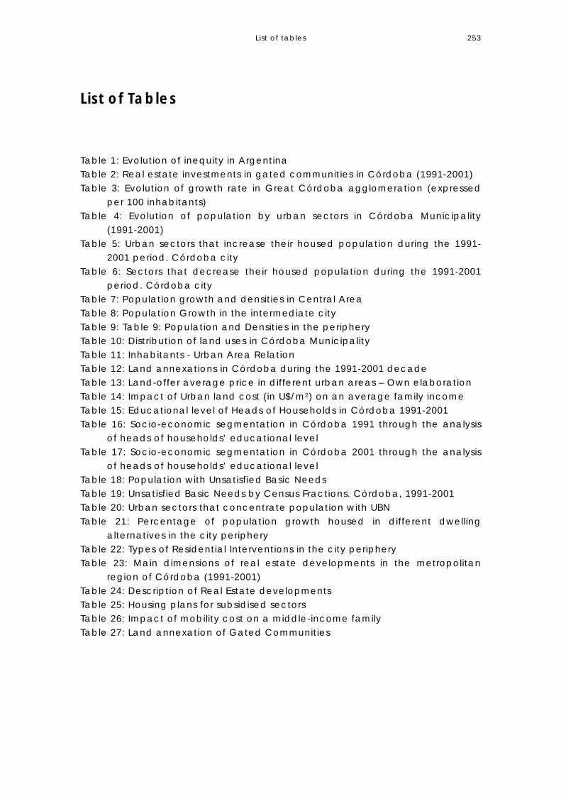
List of tables 253
List of Tables Table 1: Evolution of inequity in Argentina Table 2: Real estate investments in gated communities in Córdoba (1991-2001) Table 3: Evolution of growth rate in Great Córdoba agglomeration (expressed
per 100 inhabitants) Table 4: Evolution of population by urban sectors in Córdoba Municipality
(1991-2001) Table 5: Urban sectors that increase their housed population during the 1991-
2001 period. Córdoba city Table 6: Sectors that decrease their housed population during the 1991-2001
period. Córdoba city Table 7: Population growth and densities in Central Area Table 8: Population Growth in the intermediate city Table 9: Table 9: Population and Densities in the periphery Table 10: Distribution of land uses in Córdoba Municipality Table 11: Inhabitants - Urban Area Relation Table 12: Land annexations in Córdoba during the 1991-2001 decade Table 13: Land-offer average price in different urban areas – Own elaboration Table 14: Impact of Urban land cost (in U$/m2) on an average family income Table 15: Educational level of Heads of Households in Córdoba 1991-2001 Table 16: Socio-economic segmentation in Córdoba 1991 through the analysis
of heads of households’ educational level Table 17: Socio-economic segmentation in Córdoba 2001 through the analysis
of heads of households’ educational level Table 18: Population with Unsatisfied Basic Needs Table 19: Unsatisfied Basic Needs by Census Fractions. Córdoba, 1991-2001 Table 20: Urban sectors that concentrate population with UBN Table 21: Percentage of population growth housed in different dwelling
alternatives in the city periphery Table 22: Types of Residential Interventions in the city periphery Table 23: Main dimensions of real estate developments in the metropolitan
region of Córdoba (1991-2001) Table 24: Description of Real Estate developments Table 25: Housing plans for subsidised sectors Table 26: Impact of mobility cost on a middle-income family Table 27: Land annexation of Gated Communities

List of Graphics 255
List of Graphics Graphic 1: Argentina in the south cone Graphic 2: Córdoba in the central region of Argentina Graphic 3: The colonial city grid Graphic 4: Córdoba Province Graphic 5: Administrative divisions in Córdoba City Graphic 6: Main access routes to Córdoba Graphic 7: Main Road System Graphic 8: Main Transport corridors Graphic 9: Land uses Graphic 10: Urban Growth Graphic 11: Sewage Plan Graphic 12: Foreign Investments in Argentina. Source: ECLAC (2001:61) Graphic 13: The monocentric city Graphic 14: Towards urban decentralisation Graphic 15: Population Growth in Córdoba Metropolitan Area Graphic 16: Main conurbation at Great Córdoba Graphic 17: Sectors that increase their population Graphic 18: Sectors that decrease their population Graphic 19: Gross residential Densities in Córdoba (2001) by urban fractions Graphic 20: Land Uses and Urban areas 1991 Graphic 21: Land uses and Urban Land in 2001 Graphic 22: Urban area (or area to be urbanised) in 1991 and in 2001 Graphic 23: Land annexation (1991-2001 decade) Graphic 24: Vacant urban land Graphic 25: Urban-land supply by city areas Graphic 26: Urban land-supply in the city structure Graphic 27: Urban land-values (per square meter) in Córdoba (2001) Graphic 28: Land-supply average price in Córdoba and Great Córdoba per
square meter (in pesos). Year 2001 Graphic 29: Land-supply in Córdoba and Metropolitan area 2001 Graphic 30: Socio-economic segmentation in 1991 Graphic 31: Socio-economic segmentation in 2001 Graphic 32: Urban sectors that concentrate population with Unsatisfied Basic
Needs (2001). Graphic 33: Aerial view from central area and real estate developments in
Cordoba Graphic 34: Real Estate developments in Córdoba and Metropolitan Area Graphic 35: Subsidised housing in Córdoba Graphic 36: Typologies of Subsidised Housing Graphic 37: Alternatives of growth: Concentric growth or growth through
corridors Graphic 38: Main road corridors in 1973 Graphic 39: Summary of the spatial strategy in the eighties

List of Graphics 256
Graphic 40: Synthesis of the spatial strategy in the nineties Graphic 41: Changes introduced in land-use regulations (1991-2001). North-east
city sector Graphic 42: The urban location of social housing in the north-east city sector Graphic 43: Changes introduced in land-use regulations (1991-2001). South-east
city sector Graphic 44: The urban location of social housing in the south-east city sector Graphic 45: Changes introduced in land-use regulations (1991-2001). South-
west city sector Graphic 46: The urban location of social housing in the south-west city sector Graphic 47: Illegal settlement Nuestro Hogar III Graphic 48: The location of subsidised housing developed in the 1990s Graphic 49: The location of residential projects developed in the nineties
against a socio-spatial segregation map in Córdoba Municipality Graphic 50: Public Transport Corridors in the 1980s Graphic 51: The extension of public transport corridors

List of Photos 257
List of Photos Photo 1: Historic Cabildo (Town Council) Photo 2: The Jesuit Block Photo 3: Cathedral, Cabildo and Main Plaza Photo 4: Central area Photo 5: Intermediate area Photo 6: Peripheral area Photo 7: Central Area of Córdoba – Source: Córdoba Municipality Photo 8: Inner city areas. Source Córdoba Municipality. (Fractions 16-17) Photo 9: Peripheral Areas. – (North west axis of growth) Source Córdoba Municipality Photo 10: Gated Community “Las Delicias” Photo 11: Gated Community “Jockey” Photo 12: “Valle Escondido, la ciudad nueva” Closed neighbourhood Photo 13: Aerial view of the northwest city sector (2001) Photo 14: Aerial view of the south city sector. Gated Community Jockey (2001) Photo 15: Aerial view of subsidised housing and the city (2004) Photo 16: Aerial view of subsidised housing in the south west area (2004) Photo 17: Aerial view of subsidised housing outside the city ring Photo 18: Aerial view of subsidised housing and the urban context Photo 19: Subsidised housing. Source: Iros 1991 Photo 20: Subsidised housing. Source Iros 1991 Photo 21: aerial view of subsidised housing. Source Iros: 1991 Photo 23: Aerial view of the north-east city sector Photo 24: Aerial view of the south-east city sector Photo 25: Aerial view of the south-west city sector Photo 26: Illegal settlement Nuestro Hogar III (2004) Photo 27: Colón corridor in 1990 Photo 28: Colón Corridor in 2001.

Dutch Summary
239
10. DUTCH SUMMARY: SAMENVATTING In dit proefschrift wordt de rol van de staat bij de ruimtelijke organisatie van de op één na grootste stad van Argentinië geanalyseerd. In de ontwikkelingsperiode die de regio en het land meer dan een eeuw lang hebben ondergaan, is er sprake geweest van een cyclische beweging: weg van de markt en naar meer staat. De specifieke aandacht van het onderzoek gaat uit naar de analyse van de perifere gebieden die sinds de periode van modernisering de plaats zijn geweest waar het minder bevoorrechte deel van de bevolking zich heeft gevestigd. De veranderingen in de rol van de staat en het belang dat marktwerking heeft gehad voor economische en stedelijke groei in de verschillende ontwikkelingsfasen, hebben bijgedragen aan de constructie van uiteenlopende visies op de stad, de regio en de relaties tussen stadsdelen, vooral tussen het centrum en de periferie, sinds planning werd geïntroduceerd in het eerste kwart van de twintigste eeuw. Het lijkt dat er opnieuw voorwaarden zijn ontstaan om de veronderstelling in twijfel te trekken dat alleen marktmechanismen de juiste prikkels zouden kunnen bieden om de private sector te stimuleren een breed pakket goederen en diensten te verschaffen voor de gehele bevolking, zoals aan het begin van de eeuw werd gedacht. In Argentinië en specifiek in Córdoba wordt het mislukken van de marktgeoriënteerde strategie uit de afgelopen twintig jaar gezien als verband houdend met de situatie van oligopolie die is gecreëerd, met de ongelijke concurrentie en het blijven bestaan van asymmetrieën, voortkomend uit de modernisering- en ontwikkelingsfase die eraan vooraf is gegaan. Dit alles heeft bijgedragen aan een verergering van de maatschappelijke en ruimtelijke versnippering, die ironisch genoeg de voordelen op het gebied van mobiliteit en verbindingen, bereikt dankzij de grote investeringen in infrastructuurprojecten om transport en communicatie te verbeteren en dankzij de gerealiseerde sociale huisvestingsprojecten, in de weg staat. Wat duidelijk is geworden is dat ‘planning’, ontstaan als de mogelijkheid om ontwikkeling te sturen richting bepaalde maatschappelijke en milieudoelstellingen, opnieuw moet worden bekeken en aangepast aan de nieuwe omstandigheden die globalisering met zich mee heeft gebracht. Het is inderdaad zo dat verschillende ‘ontwikkelingsmodellen’, verbonden aan enkele fundamentele en universele waarden, mettertijd zijn doorgevoerd. Het formuleren van modellen, beleid en programma’s met die principes en waarden roept normatieve vragen op. Van invloed hierop zijn maatschappelijke doelstellingen en politieke keuzes in een veranderend kader van handelende partijen en belanghebbenden en veranderende interactie tussen krachten op nationaal en internationaal niveau. Het empirisch onderzoek concentreert zich op de periode 1991-2001 die duidelijk wordt gekenmerkt door stedelijke uitbreiding. De diepe

Dutch Summary
240
ongelijkheid van de Argentijnse samenleving en de groter geworden inkomenskloof, gevolgen van de geïmplementeerde ontwikkelingsstrategie, verlaagde de kans op toegang tot stadsgrond, huisvesting en mobiliteit voor bijna de helft van de stedelijke bevolking. De complexe situatie die werd gecreëerd kan in ruimtelijke termen ruwweg worden gekarakteriseerd als samengesteld uit twee simultane processen: het verdrijven van de arme bevolking richting gebieden met lage waarde en de annexatie van land in perifere sectoren voor hoge inkomens en daaraan gerelateerde grondbestemmingen. Tegen 2001 groeit de stad terwijl zij haar heterogeniteit en relatieve sociale menging verliest, vergeleken met 1991. De stedelijke uitbreiding wordt verklaard door uiteenlopende feiten die verband houden met economische en culturele globalisering, hoewel deze ook wel wordt gerelateerd aan de deregulering van land- en stadsontwikkeling. In deze periode is de dynamiek van de landmarkt bedroevend. De eerste hypothese verwijst naar de manier waarop stadsuitbreiding bijdraagt aan segregatie. In het laatste decennium is het uitbreidingsproces gestimuleerd door twee soorten interventies: werkzaamheden van projectontwikkelaars en gigantische gesubsidieerde sociale woningbouwprogramma’s voor de arme bevolking. Uitbreiding wordt verder bevorderd door middel van nieuwe mogelijkheden voor de hoger inkomens in de buitenwijken en is de enige optie voor kwetsbare sectoren die zich geen woningen in de bestaande stadsdelen kunnen veroorloven. In een nauwelijks gereguleerde context produceert (en reproduceert) de vrije markt de differentiatie van woongebieden en accentueert daarmee sociale en ruimtelijke segregatie. De tweede hypothese verwijst naar ruimtelijke planning en de mogelijkheid om stedelijke groei effectief te sturen richting sociaalruimtelijke gelijkheidsdoelstellingen in een context van minder staatsinmenging en ongereguleerde stedelijke ontwikkeling. Gedetailleerde analyse van de onderzoekscasussen levert argumenten op om de stelling te ontwikkelen. Het toont aan dat stedelijke planning een andere rol heeft aangenomen op het gebied van stedelijke planning: van een actieve rol, waarbij getracht wordt de met groei gepaard gaande sociale en ruimtelijke problemen het hoofd te bieden, naar een rol als bemiddelaar van stedelijke markten en om die reden een laissez-faire rol aannemend op het gebied van stedelijke groei. De casus Córdoba levert toont aan dat het vrije marktinitiatief de met stedelijke groei gepaard gaande negatieve externe effecten niet kan verhelpen. De strategische planning die in de jaren negentig is gestart, stimuleerde ‘flexibele en proactieve strategieën’ voor stedelijke planning. In de proefschrift wordt echter bewezen dat deze niet doeltreffend waren wat betreft het opheffen van structurele beperkingen voor ruimtelijke planning. De oorzaken van deze beperkingen waren: de versplintering over planningsbesluiten, de scheiding tussen planning en het systeem van

Dutch Summary
241
sociale huisvesting, het gebrek aan instrumenten om onder andere grondspeculatie te ontmoedigen. Daarentegen hebben de bij de flexibele en proactieve strategieën gebruikte instrumenten uitbreiding, segregatie en stedelijke versnippering bevorderd, hetgeen heeft geresulteerd in een zeer sterke maatschappelijke polarisatie. De conclusies tonen aan dat in omstandigheden van grote maatschappelijke ongelijkheid een flexibele benadering van stedelijke reguleringen en beperkte staatsinterventie niet bijdragen aan een vermindering van de maatschappelijke segregatie noch aan de herverdeling van positieve waarden die stedelijke ontwikkeling met zich meebrengt. Staatsinterventie in de herverdeling van kosten en baten van stedelijke groei is noodzakelijk, indien de doelstelling luidt vermindering van de diepgewortelde omstandigheden van sociaalruimtelijke ongelijkheid. Oplossing van dit probleem zou echter niet alleen draaien om technische aspecten van ruimtelijke planning, maar ook om de maatschappelijke en politieke context waarin dergelijke planning wordt geïmplementeerd. Tot slot levert het laatste deel van het onderzoek een antwoord op de vraag in welke mate effectieve planning kan bijdragen aan het sturen van stedelijke groei richting doelstellingen die gebaseerd zijn op de principes van integratie. In dit opzicht zien we dat voor planning een sterke kloof tussen theorie en praktijk geldt. In de proefschrift wordt aangetoond hoe dit zich ontwikkelt in de gemeente Córdoba. De kritieke confrontatie over de manier waarop planning wordt geïmplementeerd laat zien dat de zwakke punten niet alleen te maken hebben met technische zaken, maar ook met politieke kwesties die in alle planningsbesluiten verweven zitten. Er is een nieuwe rol nodig van de kant van de staat die de kosten als gevolg van excessieve expansie zichtbaar kan maken en de samenleving kan stimuleren om betrokken te raken bij discussies over de impliciete negatieve externe effecten. Dit is een uitdaging wat betreft de ontwikkeling van nieuwe theoretische benaderingen en ook wat betreft het ontwerp van ruimtelijk beleid dat nieuwe instrumenten voor politieke acties bevat die een bijdrage kunnen leveren aan het overwinnen van stedelijk dualisme, aan het verminderen van maatschappelijke polarisatie en aan het sturen van marktwerking richting sociaalruimtelijke integratie.
English Summary
242
SUMMARY This thesis analyses the role of state in the organization of space in a secondary city in Argentina. There has been a cyclical move from more market and for more state, according to the development period the region and the country have gone on for more than a century. The particular interest of the research is the analysis of the peripheral areas which has been, since the modernization period, the place where disadvantage population have been settling on. The changes in the role of the state and the importance that market forces have had for economic and urban growth in the different development phases have contributed to built diverse visions of the city, the region and the relationships between parts, specially between the centre and the periphery since planning was introduced in the first quart of the XX century. It seems that once again conditions have arouse to put in doubt the assumption that only market pricing mechanisms could provide the right incentives and will encourage the private sector provision of a wide range of urban goods and services for the whole needed population as was thought in the beginning of the century. In Argentina and specifically in Cordoba the failure of the market oriented strategy of the past two decades is here recognised as linked to the condition of oligopolies that has been created, the uneven competition and the persistence of asymmetries resulting from the modernization development phase that have precede. All these has contributed to worsen the social and spatial fragmentation ironically hindering mobility and connectivity gains of the large investments on infrastructure projects to improve transport and communication and social housing projects that has been built. What has become true is that ‘planning’ which was born as the feasibility to guide development towards certain social and environmental objectives need to be reassert and to be adapted to the new conditions created by globalization. It has became true that different ‘development models’ has followed through time related to some fundamental and universal values. The articulation of models, policies and programs with those principles and values are normative questions and subjected to social determination and political choice in a changing framework of actors and stakeholders and changing national and international power interaction. The empirical development of this research concentrates to the 1991-2001 period which is clearly characterised by urban sprawl. The deep inequality of the Argentinean society and the widening of the income-gap that took place as result of the development strategy that was implemented reduced the possibilities of accessing urban-land, housing and mobility for almost one half of the city population. The complex situation that was created can be roughly characterised in spatial terms of being constituted by two simultaneous processes: the expulsion of poor

English Summary
243
population towards low value-areas and the annexation of land in peripheral sectors for high incomes and related land functions. By 2001 the city grows while it loses its heterogeneity and the relative social mixture as compared with 1991. The urban sprawl is explained from a diversity of facts associated with economic and cultural globalisation, although also is related to the deregulation of land and urban development. In this period the dynamics of land-market is appalling. The first hypothesis refers to the way Sprawl contributes to segregation. In the last decade the process of sprawl has been impelled by two types of interventions: the operations of real-state developers and massive social housing subsidised programmes for poor population. Sprawl is enhanced through new opportunities for the higher incomes in the suburbs and the only option for vulnerable sectors that are unable to afford locations in the consolidated city-areas. In a barely regulated context, free market produces (and reproduces) residential differentiation accentuating social and spatial segregation. The second hypothesis refers to spatial planning and it feasibility to effectively guiding urban growth towards socio-spatial equity objectives in a context of reduced state and unregulated urban development. The detailed analysis of the study-cases provides arguments to develop the thesis. It demonstrates that urban planning has been shifting roles regarding urban development, from an active role trying to overcome the social and spatial problems derived from growth to being a facilitator of urban markets and therefore assuming a laisse-faire role regarding city growth. The case of Córdoba gives evidence that the free market initiative by itself does not remedy the negative externalities derived from urban growth. The strategic planning launched during the 1990s did promote “flexible and proactive strategies’ in urban planning. However, the thesis proves that this where not effective in overcoming structural limitations on spatial planning. The causes of these limitations where: the fragmentation on planning decision; the divorce between planning and the social housing system; the lack of instruments to discourage land-speculation among others. The instruments used by the flexible and proactive strategies on the contrary enhanced sprawl, segregation, and urban-fragmentation that have resulted in very strong social polarisation. The conclusions demonstrate that in contexts of high social inequalities, a flexible approach to urban regulations and limited intervention of the State do not contribute to the attenuation of social segregation nor to the redistribution of plus values derived from urban development. The intervention of the State in the redistribution of costs and benefits derived from urban growth is necessary if the objective is to attenuate deep conditions of socio-spatial inequity. However, overcoming this problem

English Summary
244
would entail not only spatial planning technical aspects, but also the social and political context in which such planning is implemented. Finally, the last part of thesis provides an answer to the question: To what extend may effective planning contribute to orienting urban growth towards objectives based on the principles of integration? In this respect we recognise that planning evidence a strong disconnection between theory and reality. The thesis demonstrates how this is happening in Córdoba Municipality. The critical confrontation about the way planning is implemented show that the weaknesses involve not only technical matters, but also political issues that criss-cross all planning decisions. A new role is needed on the part of the State, which can make the costs derived from excessive expansion visible and encourage society to get involved in discussions on its implicit negative externalities. This is a challenge in terms of the development of new theoretical approaches and also in the design of spatial policy that includes new instruments for political actions that may contribute to overcome urban dualism, attenuate social polarization and drive market forces towards spatial equity.
Related Documents