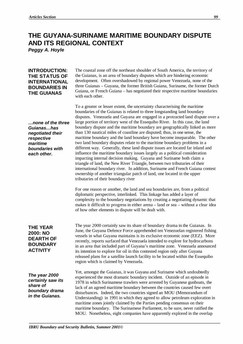
Articles Section 99 IBRU Boundary and Security Bulletin, Summer 2001© The coastal zone off the northeast shoulder of South America, the territory of the Guianas, is an area of boundary disputes which are hindering economic development. Often overshadowed by regional power Venezuela, none of the three Guianas – Guyana, the former British Guiana, Suriname, the former Dutch Guiana, or French Guiana – has negotiated their respective maritime boundaries with each other. To a greater or lesser extent, the uncertainty characterising the maritime boundaries of the Guianas is related to three longstanding land boundary disputes. Venezuela and Guyana are engaged in a protracted land dispute over a large portion of territory west of the Essequibo River. In this case, the land boundary dispute and the maritime boundary are geographically linked as more than 130 nautical miles of coastline are disputed; thus, in one sense, the maritime boundary and the land boundary have become inseparable. The other two land boundary disputes relate to the maritime boundary problems in a different way. Generally, these land dispute issues are located far inland and influence the maritime boundary issues largely as a political consideration impacting internal decision making. Guyana and Suriname both claim a triangle of land, the New River Triangle, between two tributaries of their international boundary river. In addition, Suriname and French Guiana contest ownership of another triangular patch of land, one located in the upper tributaries of their boundary river For one reason or another, the land and sea boundaries are, from a political diplomatic perspective, interlinked. This linkage has added a layer of complexity to the boundary negotiations by creating a negotiating dynamic that makes it difficult to progress in either arena – land or sea – without a clear idea of how other elements in dispute will be dealt with. The year 2000 certainly saw its share of boundary drama in the Guianas. In June, the Guyana Defence Force apprehended ten Venezuelan registered fishing vessels in what Guyana maintains is its exclusive economic zone (EEZ). More recently, reports surfaced that Venezuela intended to explore for hydrocarbons in an area that included part of Guyana’s maritime zone. Venezuela announced its intention to explore for oil in this contested region only after Guyana released plans for a satellite launch facility to be located within the Essequibo region which is claimed by Venezuela. Yet, amongst the Guianas, it was Guyana and Suriname which undoubtedly experienced the most dramatic boundary incident. Outside of an episode in 1978 in which Surinamese trawlers were arrested by Guyanese gunboats, the lack of an agreed maritime boundary between the countries caused few overt disturbances. Indeed, the two countries signed an MOU (Memorandum of Understanding) in 1991 in which they agreed to allow petroleum exploration in maritime zones jointly claimed by the Parties pending consensus on their maritime boundary. The Surinamese Parliament, to be sure, never ratified the MOU. Nonetheless, eight companies have apparently explored in the overlap THE GUYANA-SURINAME MARITIME BOUNDARY DISPUTE AND ITS REGIONAL CONTEXT Peggy A. Hoyle INTRODUCTION: THE STATUS OF INTERNATIONAL BOUNDARIES IN THE GUIANAS THE YEAR 2000: NO DEARTH OF BOUNDARY ACTIVITY …none of the three Guianas…has negotiated their respective maritime boundaries with each other. The year 2000 certainly saw its share of boundary drama in the Guianas.

Welcome message from author
This document is posted to help you gain knowledge. Please leave a comment to let me know what you think about it! Share it to your friends and learn new things together.
Transcript
Articles Section 99
IBRU Boundary and Security Bulletin, Summer 2001©
The coastal zone off the northeast shoulder of South America, the territory of the Guianas, is an area of boundary disputes which are hindering economic development. Often overshadowed by regional power Venezuela, none of the three Guianas – Guyana, the former British Guiana, Suriname, the former Dutch Guiana, or French Guiana – has negotiated their respective maritime boundaries with each other. To a greater or lesser extent, the uncertainty characterising the maritime boundaries of the Guianas is related to three longstanding land boundary disputes. Venezuela and Guyana are engaged in a protracted land dispute over a large portion of territory west of the Essequibo River. In this case, the land boundary dispute and the maritime boundary are geographically linked as more than 130 nautical miles of coastline are disputed; thus, in one sense, the maritime boundary and the land boundary have become inseparable. The other two land boundary disputes relate to the maritime boundary problems in a different way. Generally, these land dispute issues are located far inland and influence the maritime boundary issues largely as a political consideration impacting internal decision making. Guyana and Suriname both claim a triangle of land, the New River Triangle, between two tributaries of their international boundary river. In addition, Suriname and French Guiana contest ownership of another triangular patch of land, one located in the upper tributaries of their boundary river For one reason or another, the land and sea boundaries are, from a political diplomatic perspective, interlinked. This linkage has added a layer of complexity to the boundary negotiations by creating a negotiating dynamic that makes it difficult to progress in either arena – land or sea – without a clear idea of how other elements in dispute will be dealt with. The year 2000 certainly saw its share of boundary drama in the Guianas. In June, the Guyana Defence Force apprehended ten Venezuelan registered fishing vessels in what Guyana maintains is its exclusive economic zone (EEZ). More recently, reports surfaced that Venezuela intended to explore for hydrocarbons in an area that included part of Guyana’s maritime zone. Venezuela announced its intention to explore for oil in this contested region only after Guyana released plans for a satellite launch facility to be located within the Essequibo region which is claimed by Venezuela. Yet, amongst the Guianas, it was Guyana and Suriname which undoubtedly experienced the most dramatic boundary incident. Outside of an episode in 1978 in which Surinamese trawlers were arrested by Guyanese gunboats, the lack of an agreed maritime boundary between the countries caused few overt disturbances. Indeed, the two countries signed an MOU (Memorandum of Understanding) in 1991 in which they agreed to allow petroleum exploration in maritime zones jointly claimed by the Parties pending consensus on their maritime boundary. The Surinamese Parliament, to be sure, never ratified the MOU. Nonetheless, eight companies have apparently explored in the overlap
THE GUYANA-SURINAME MARITIME BOUNDARY DISPUTE AND ITS REGIONAL CONTEXT Peggy A. Hoyle
INTRODUCTION: THE STATUS OF INTERNATIONAL BOUNDARIES IN THE GUIANAS
THE YEAR 2000: NO DEARTH OF BOUNDARY ACTIVITY
…none of the three Guianas…has negotiated their respective maritime boundaries with each other.
The year 2000 certainly saw its share of boundary drama in the Guianas.
100 Articles Section
IBRU Boundary and Security Bulletin, Summer 2001©
under licenses granted by Guyana, including Exxon, Shell and the Maxus/Repsol/AGIP/ENI consortium. Last summer, nonetheless, the matter of their unresolved maritime boundary came to a head when Surinamese gunboats evicted a CGX oil company rig operating under a Guyanese concession in what Guyana claims is its EEZ. The incident led to a series of fruitless border discussions between the two countries. Guyana had hoped that the 1991 MOU, which called for both Parties to respect concession licenses granted in mutually claimed areas, would serve as the basis for any negotiations. Guyana’s proposals, moreover, included an offer for the countries to share concession earnings in the area of overlap. Suriname, however, stood firm in its demand that Guyana revoke CGX’s license. The dispute was ultimately referred to The Caribbean Community (CARICOM), of which both countries are members, but, not surprisingly, CARICOM’s intervention failed to resolve the matter. Prior to the eviction of the CGX oil rig, the Surinamese Government had sent Guyana a Note Verbale expressing its concern that the CGX rig was operating in Surinamese waters. The Note Verbale articulated the Surinamese position that the Guyanese-Surinamese maritime boundary originates at a point on the west bank of the Corentyne River (5°59’ 53.8”N, 57°08’ 51.5”W) and extends seaward at 10º east of true north. The Note further stated that it was Suriname’s “conviction” that the Corentyne River, running along the international boundary, is completely within Surinamese territory and that all activities on the river correspondingly fall within Surinamese jurisdiction. The government of Guyana responded that any exploration activities carried out by CGX had been conducted within Guyanese territory. Guyanese maritime

Articles Section 101
IBRU Boundary and Security Bulletin, Summer 2001©
territory, the Government of Guyana explained, is marked by a median line extending from the coast seaward at approximately 33º east of true north. With respect to the Corentyne, the government of Guyana considered the Corentyne to be a “border river” bearing all the international law characteristics attendant to such a status. Considering that the Guyana-Suriname maritime boundary is now front page news and, as a result, might have the impetus to be the first of the maritime boundaries in the Guianas to be settled, it is worth examining the origin of the

102 Articles Section
IBRU Boundary and Security Bulletin, Summer 2001©
Guyanese and Surinamese maritime boundary positions. Simply put, what is the story of the Guyana-Suriname maritime boundary? The story of the Guyana-Suriname maritime boundary is such that one might be tempted to entitle it “Opportunity Lost.” Essentially, there are four basic components to the Guyana-Suriname maritime boundary over which the colonial powers, Britain, in the case of Guyana (then British Guiana) and the Netherlands, in the case of Suriname, negotiated:
1) the Corentyne River which affects the point where the land boundary meets the sea – the land boundary terminus;
2) the territorial sea boundary; and, 3) the continental shelf. The fourth component was actually part of the
land boundary, specifically the southern portion of the land boundary – far inland – called the New River Triangle.
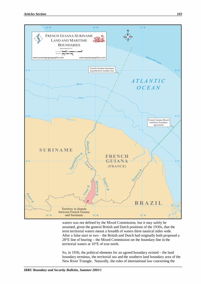
At several critical points in time, one or more of the maritime boundary components appeared to enjoy consensus, but each time, as the story goes, the opportunity to conclude some part of the maritime boundary was lost, because of a lack of consensus on other parts of the puzzle. The first critical point in time was 1936. Back in the late 1920s, reports that oil had been discovered east of the Corentyne River forced the British and the Dutch to address the question of the precise location of the boundary on the upper portion of their boundary river, the Corentyne. The Dutch had long advanced the west bank of the Corentyne as the international boundary which effectively rendered the Corentyne a ‘Dutch’ river. The British, on the other hand, ascribed to the more traditional thalweg1 boundary and did not want to set any precedents by allowing one power, the Dutch, full control over a boundary river. In 1936, the British and Dutch assembled a Mixed Commission to demarcate the land boundary terminus. At approximately the same time, another British-Dutch Mixed Commission was sent to determine the boundary in the New River Triangle area. The Mixed Commission charged with identifying the land boundary terminus fixed it on the west bank of the Corentyne River, rendering control over the Corentyne to the Dutch. Why would the British Commissioner agree to such an arrangement? This was because the British expected the Dutch to see things their way with respect to the Mixed Commission in the New River Triangle. The issue in the New River Triangle was whether the Kutari River or the New River, both tributaries of the Corentyne, would serve as the boundary river in the South. The British and Dutch had long agreed that the Kutari River, the main tributary, would be an appropriate boundary, that is, until the Dutch actually visited the area. From that visit in 1926, the Dutch concluded that the New River was, in fact, the main tributary. Importantly, the impact of changing the international boundary from the Kutari River to the New River was the allocation of 6,000 square miles of land, the New River Triangle, to the Surinamese side of the border. Thus, the British were willing to allow the Dutch to control the Corentyne in the upper reaches as long as the Dutch agreed that the New River Triangle was British territory. And, in 1936, the Dutch were willing to do so. The 1936 Mixed Commission for the land boundary terminus also delimited what were referred to as the “territorial waters.” The extent of the territorial
THE GUYANA-SURINAME BOUNDARY STORY
…each time,…the opportunity to conclude some part of the maritime boundary was lost, because of a lack of consensus on other parts of the puzzle.
Articles Section 103
IBRU Boundary and Security Bulletin, Summer 2001©
waters was not defined by the Mixed Commission, but it may safely be assumed, given the general British and Dutch positions of the 1930s, that the term territorial waters meant a breadth of waters three nautical miles wide. After a false start or two – the British and Dutch had originally both proposed a 28°E line of bearing – the Mixed Commission set the boundary line in the territorial waters at 10°E of true north. So, in 1936, the political elements for an agreed boundary existed – the land boundary terminus, the territorial sea and the southern land boundary area of the New River Triangle. Naturally, the rules of international law concerning the

104 Articles Section
IBRU Boundary and Security Bulletin, Summer 2001©
continental shelf did not exist in 1936; it was not a ripe legal concept until after World War II. Perhaps if World War II had not intervened, the Dutch and British would have formalised this arrangement. It is known, for instance, that the British proposed such a boundary treaty in 1939, but it was not acted upon before the war. Today, Suriname and Guyana adopt different elements from that “almost” arrangement. Suriname points to the Mixed Commission demarcation in support of its claim to complete sovereignty over the Corentyne and to a 10°E maritime boundary through the territorial waters, which Guyana rejects. Guyana on the other hand finds support for its claim to the New River Triangle in the work of the Mixed Commission. The Second World War ensued and the British and Dutch were distracted by other issues. By the 1950s, it looked again as if some consensus could be reached, at least on the newest issue – that of the continental shelf. At this time, the great oil adventure was really taking off. The British Guiana Government had already issued two licenses for companies to explore off its coast. The concerned Dutch approached the British to delimit the continental shelf. Both the Dutch and the British seemed to agree that the continental shelf should be delimited in accordance with the equidistance principles outlined in the newly adopted 1958 Convention on the Continental Shelf. Yet again there was no formal agreement. The Dutch, anxious to conclude the deal, wanted to do so via an Exchange of Notes. The British, it seems, viewed the Dutch anxiety as an opportunity to finally conclude a treaty embracing all the other boundary components. So, having eschewed the Exchange of Notes idea, the British, already working on a boundary treaty draft, included a continental shelf delimitation provision therein and sent it off to the Dutch in 1961. The period from 1961-1962 marked the last two opportunities for the colonial powers to reach a maritime boundary agreement. The 1961 British boundary treaty proposal forwarded to the Dutch included 1) Dutch sovereignty over the Corentyne; 2) a 10°E line dividing the territorial sea; and 3) a British controlled New River Triangle, all three of which enjoyed previous agreement arising out of the 1936 work of the two Commissions. Beyond the three-mile territorial sea, the British provided for a median line division of the continental shelf which purportedly the Dutch wanted. In a turnabout, however, the Dutch Government responded to the British proposal not with a signature but with its own draft treaty. Upon presenting its treaty proposal in 1962, the Dutch Government explained that it had reviewed the matter in its entirety and had decided to accept the thalweg of the Corentyne as the boundary. The Dutch designated in their treaty proposal that “the frontier shall follow a line with a true bearing of ten degrees north from the end of the thalweg .” The turnabout by the Dutch in favour of a thalweg river boundary can be explained in part by the “land boundary” component: The New River Triangle. The Dutch naturally were not willing to accede to the traditional British thalweg position out of magnanimity; rather, they expected something in return. The Dutch expected the British to agree to recognise Dutch control over the New River Triangle. Thus, while there had been windows of opportunity to achieve some kind of agreement (at least in dealing with part of the overall problem) in 1936, the 1950s and 1961, by the 1962 Dutch counterproposal, it appeared that the colonial powers were back to the drawing board.
Sadly, such was the state of affairs that they left to Guyana and Suriname. As discussed, Suriname relies on the 1936 Mixed Commission to support Surinamese control of the Corentyne River and a 10°E maritime boundary through the entirety of its maritime territory. Guyana, on the other hand, relies upon the Dutch Government’s 1962 acceptance of the thalweg as evidence that
The period from 1961-1962 marked the last two opportunities for the colonial powers to reach a maritime boundary agreement.
By the 1950s… the great oil adventurewas really taking off.

Articles Section 105
IBRU Boundary and Security Bulletin, Summer 2001©
Dutch sovereignty over the Corentyne was never finally agreed upon by the colonial powers. In addition, considering that only a three-mile territorial sea was contemplated in the 1930s, Guyana cannot accept Suriname’s contention that the 1936 10°E line was intended to cover the Parties’ EEZs today. It makes no sense to Guyana why the Dutch would have approached the British to conclude a continental shelf agreement in the 1950s if the 10°E line addressed the entire maritime boundary as the Surinamese assert.

106 Articles Section
IBRU Boundary and Security Bulletin, Summer 2001©
There is support for the proposition that from 1931 to 1962 both the British and Dutch Governments recognised Dutch control of the Corentyne River. However, by 1962 Dutch sovereignty over the boundary river was rebutted by the Dutch themselves in their treaty proposal advancing a thalweg boundary. Even though the British had at one time claimed a thalweg boundary, the Parties never reached an international agreement with regard to this land boundary terminus issue. While the 1936 Mixed Commission findings provide evidence relevant to the demarcation of the land boundary terminus and the delimitation of the territorial sea, it is a leap to argue, as Suriname does, that maritime zones beyond the territorial sea, such as the contiguous zone, exclusive economic zone or continental shelf, were dictated by the 1936 Mixed Commission determination. International courts and tribunals have refused to interpret maritime boundary treaties to encompass maritime zones not recognised by international law or the Parties at the time. Consequently, Suriname’s argument that the 10ºE line established by the Mixed Commission covers the entire maritime boundary between Guyana and Suriname will be difficult to support. As to the continental shelf, both the British and the Dutch did recognise equidistance principles with respect to the continental shelf. The record, moreover, advances the notion that both Parties agreed that a median line boundary through the continental shelf should control. Of course, considering the variety of manifestations for an equidistance based line, agreement in principle does not constitute an international maritime boundary agreement. In short, additional support and reasoning, such as international law and practice, would be required before an international tribunal would impose a median line boundary. As discussed earlier, in addition to their boundary disputes with each other, neither Guyana nor Suriname has established definitive maritime or land boundaries with its neighbours. Guyana is involved in both maritime and land boundary disputes with Venezuela. Suriname, likewise, has unresolved maritime and land boundary issues with its neighbour, French Guiana. The legacy of the colonial boundary game in this region is that there is a negotiating relationship between the land and sea boundaries. Of late, consideration has been given to instituting a separate mechanism within CARICOM to deal with border problems amongst the Guianas and in the Caribbean. A regional mechanism to address boundary issues makes sense in theory, since the boundary difficulties, especially the maritime boundaries, are shaped by their regional context. To be sure, the Brazil-French Guiana maritime boundary, marking the southern extent, and the Venezuela-Trinidad and Tobago maritime boundary, marking the northern extent, essentially define the playing field for the remainder of the maritime delimitation activity among the Guianas. Generally speaking, if an equidistance line were employed between the Guianas, none of the three would be disadvantaged in relation to the others. Venezuela, however, would be disadvantaged in that it would lack access to the outer edge of its 200-nautical mile EEZ. Yet, the theory that an international body, such as CARICOM, could tackle these kinds of disputes has not been borne out in practice. Take UN mediation for example. The Venezuela-Guyana dispute has been subject to mediation under the auspices of the Secretary-General of the UN since Guyana’s independence, and this boundary is far from resolved. Granted, UN mediation may have prevented a war, but it did not lead to a permanent solution to the
SOLUTIONS: ONE PERSPECTIVE
…both the British and the Dutch did recognise equidistance principles with respect to the continental shelf.
…agreement in principle does not constitute an international maritime boundary agreement.
THE EFFICACY OF THE GUYANESE AND SURINAMESE POSITIONS

Articles Section 107
IBRU Boundary and Security Bulletin, Summer 2001©
problem – just a quieter status quo. Much as countries do not like to hear it, often their best bet for relatively quick, real, permanent solutions is a dispute resolution mechanism such as arbitration or the International Court of Justice. The recent Eritrea-Yemen arbitration is a perfect case in point. Eritrea and Yemen came close to war over island sovereignty disputes and an unresolved maritime boundary in 1995. Once they agreed to arbitrate, the entire matter was resolved in three years and the Parties have not only abided by the arbitrators’ decision, but now enjoy normal relations. While the territorial and maritime boundary dispute between Qatar and Bahrain walked through the dispute resolution process at a much slower pace (due in large part to ancillary jurisdictional and evidentiary issues), the International Court of Justice just produced a disposition for the island and maritime territory at issue which both States have accepted. 1 A principle, traditionally applied to river boundaries, referring to a division
along the deepest part of the deepest navigable channel.
Dr Peggy Hoyle isan attorney in the international boundary disputes practice of the law firm of LeBoeuf, Lamb, Greene & MacRae in Washington D.C. This article was originally presented at an international conference ‘Analysing International Border Disputes’ 15-16 May 2001 organised by Global Business Network Maps supplied by Sovereign Geographic, Inc. and Equator Graphics, Inc. who provide boundary consultation and cartographic services for government and industry clients worldwide.
Related Documents