159 Alternative Trajectories in Bronze Age Landscapes and the ‘Failure’ to Enclose: A Case Study from the Middle Dunajec Valley Tobias L. Kienlin – Marta Korczyńska – Klaus Cappenberg Abstract: Drawing on current archaeological work in the surroundings of the Bronze Age hilltop-settlement of Janowice on the middle part of the Dunajec valley in this paper we want to highlight some shortcomings in the traditional modelling of Bronze Age landscapes. Instead of focusing on political power and the control of trade and exchange along the Dunajec valley, it is asked in what other sense the hilltop-settlement of Janowice with its long history of occupation from broadly the Middle Bronze Age to the Early Iron Age could have been ‘central’ for the development of this micro-region. GIS applications are used to integrate the spatial data obtained and to improve our understanding of local environment, choices of site location and subsistence economy. In a wider perspective, attention is drawn to the variability in Bronze Age landscapes – even along the course of the same river valley. In broadly the same cultural and natural setting there were different ‘solutions’ or strategies available to communities in order to cope with external restraints and cultural notions how social life should be organised. The development of these communities was contingent upon numerous factors beyond even the most sophisticated attempt at geographical modelling. In consequence, we must not mistake any notions we may hold on the development of Bronze Age society for a model of general applicability. Keywords: Lesser Poland, Dunajec river, Bronze Age land use, landscape archaeology, settlement archaeology, Geographical Infor- mation System, interpretation Introduction In much Bronze Age research emphasis is put on the emergence of social differentiation and political inequality. The resulting picture is one of increasing social complexity – perceived from the top and equating complexity with hierarchies and political power. At best attention is drawn to occasional evidence of instability. However, the overall direction is clear, and the evidence, mainly from graves and settlements, is studied in an attempt to establish how far on its way to a perceived aim of social stratification the group in question had proceeded (cf. Kienlin 2012a). We tend to share a top-down perspective and an overriding interest in political hierarchies – be it in terms of elites required to organise and control collective work or in terms of inequality and unequal access to knowledge, power or resources. Undue emphasis is thereby put on the evolution of hierarchies, stability and longevity of social inequality. Apart from confusing economic success and political power, this conceals the more basic principles according to which the communities under consideration were organised. Methodological sophistication is directed towards differential access to power and wealth. Yet it is only underlying evolutionist assumptions that have us believe that the patterning observed indeed refers to ranking. Often, the consequence is a neglect of the obvious – tribal societies and segmentary systems that persisted far into the Iron Ages in large parts of central and south- eastern Europe. Moreover, there is often a discrepancy between the attempt to meet expectations derived from the Bronze Age ‘narrative’ and the data at hand. This leaves other aspects of the groups in question unilluminated, and we tend to focus on situations seemingly in accordance with our notion of Bronze Age social evolution, when in fact there is a more diverse and potentially more interesting reality out there. The interest taken by much Bronze Age settlement archaeology in fortified ‘central’ places and ‘proto-urban’ sites is, of course, a prominent example. The emerging picture is one of an acropolis protected from conquest by impressive fortifications, accomodating elites and attached craft production; with a suburbium accomodating the commoners and drawing surplus product from surrounding open settlements under their political control. Quite different types of sites, then, such as the tell settlements of the Carpathian Basin or the hilltop forts from different regions and periods of the Bronze Age are perceived in terms of ‘political economies’, social differentiation and the emergence of political rule. 1 The question of their demarcation narrows down to the apparent necessity for Bronze Age elites and aristocracy to guard their wealth against aggression (specifically from the notorious Bronze Age male warrior). The sometimes massive fortifications are fascinating in terms of the workforce mobilised for their construction and the powerful statement they seemingly provide of social and political inequality. This is most marked, of course, the deeper and wider the fortifications 1 E.g. Chropovský/Herrmann 1982; Belardelli/Peroni 1996; Earle 2002; Gancarski 2002; Czebreszuk/Müller 2004; Kristiansen/Larsson 2005; Gancarski 2006; Czebreszuk/Kadrow/Müller 2008; Earle/ Kristiansen 2010; Müller/Czebreszuk/Kneisel 2010; Gogâltan 2010; Németi/Molnár 2012; Jaeger/Czebreszuk/Fischl 2012. Archaeopress Open Access Settlement, Communication and Exchange around the Western Carpathians edited by T. L. Kienlin et al. pages 159-200 Copyright Archaeopress and the Authors 2014

Welcome message from author
This document is posted to help you gain knowledge. Please leave a comment to let me know what you think about it! Share it to your friends and learn new things together.
Transcript
159
Alternative Trajectories in Bronze Age Landscapes and the ‘Failure’ to Enclose:
A Case Study from the Middle Dunajec Valley
Tobias L. Kienlin – Marta Korczyńska – Klaus Cappenberg
Abstract: Drawing on current archaeological work in the surroundings of the Bronze Age hilltop-settlement of Janowice on the middle part of the Dunajec valley in this paper we want to highlight some shortcomings in the traditional modelling of Bronze Age landscapes. Instead of focusing on political power and the control of trade and exchange along the Dunajec valley, it is asked in what other sense the hilltop-settlement of Janowice with its long history of occupation from broadly the Middle Bronze Age to the Early Iron Age could have been ‘central’ for the development of this micro-region. GIS applications are used to integrate the spatial data obtained and to improve our understanding of local environment, choices of site location and subsistence economy. In a wider perspective, attention is drawn to the variability in Bronze Age landscapes – even along the course of the same river valley. In broadly the same cultural and natural setting there were different ‘solutions’ or strategies available to communities in order to cope with external restraints and cultural notions how social life should be organised. The development of these communities was contingent upon numerous factors beyond even the most sophisticated attempt at geographical modelling. In consequence, we must not mistake any notions we may hold on the development of Bronze Age society for a model of general applicability.
Keywords: Lesser Poland, Dunajec river, Bronze Age land use, landscape archaeology, settlement archaeology, Geographical Infor-mation System, interpretation
Introduction
In much Bronze Age research emphasis is put on the emergence of social differentiation and political inequality. The resulting picture is one of increasing social complexity – perceived from the top and equating complexity with hierarchies and political power. At best attention is drawn to occasional evidence of instability. However, the overall direction is clear, and the evidence, mainly from graves and settlements, is studied in an attempt to establish how far on its way to a perceived aim of social stratification the group in question had proceeded (cf. Kienlin 2012a). We tend to share a top-down perspective and an overriding interest in political hierarchies – be it in terms of elites required to organise and control collective work or in terms of inequality and unequal access to knowledge, power or resources.
Undue emphasis is thereby put on the evolution of hierarchies, stability and longevity of social inequality. Apart from confusing economic success and political power, this conceals the more basic principles according to which the communities under consideration were organised. Methodological sophistication is directed towards differential access to power and wealth. Yet it is only underlying evolutionist assumptions that have us believe that the patterning observed indeed refers to ranking. Often, the consequence is a neglect of the obvious – tribal societies and segmentary systems that persisted far into the Iron Ages in large parts of central and south-eastern Europe. Moreover, there is often a discrepancy between the attempt to meet expectations derived from the
Bronze Age ‘narrative’ and the data at hand. This leaves other aspects of the groups in question unilluminated, and we tend to focus on situations seemingly in accordance with our notion of Bronze Age social evolution, when in fact there is a more diverse and potentially more interesting reality out there.
The interest taken by much Bronze Age settlement archaeology in fortified ‘central’ places and ‘proto-urban’ sites is, of course, a prominent example. The emerging picture is one of an acropolis protected from conquest by impressive fortifications, accomodating elites and attached craft production; with a suburbium accomodating the commoners and drawing surplus product from surrounding open settlements under their political control. Quite different types of sites, then, such as the tell settlements of the Carpathian Basin or the hilltop forts from different regions and periods of the Bronze Age are perceived in terms of ‘political economies’, social differentiation and the emergence of political rule.1 The question of their demarcation narrows down to the apparent necessity for Bronze Age elites and aristocracy to guard their wealth against aggression (specifically from the notorious Bronze Age male warrior). The sometimes massive fortifications are fascinating in terms of the workforce mobilised for their construction and the powerful statement they seemingly provide of social and political inequality. This is most marked, of course, the deeper and wider the fortifications 1 E.g. Chropovský/Herrmann 1982; Belardelli/Peroni 1996; Earle 2002; Gancarski 2002; Czebreszuk/Müller 2004; Kristiansen/Larsson 2005; Gancarski 2006; Czebreszuk/Kadrow/Müller 2008; Earle/Kristiansen 2010; Müller/Czebreszuk/Kneisel 2010; Gogâltan 2010; Németi/Molnár 2012; Jaeger/Czebreszuk/Fischl 2012.
Archae
opress Open Acce
ss
Settlement, Communication and Exchange around the Western Carpathians edited by T. L. Kienlin et al. pages 159-200
Copyright Archaeopress and the Authors 2014
160
Settlement, Communication and Exchange around the Western Carpathians
are – not to mention the problematic evidence of stone built walls presumably derived from Mycenaean origins.2
By having us ask down-to-earth questions like how many inhabitants a site should have or how large its territory should be to qualify as a (proto-) urban centre, this approach tends to conceal that the use of the ultimately Near Eastern derived notion of ‘palaces’ or ‘urbanity’ as such involves acceptance of some kind of core and periphery model.3 World-view is involved then, and prehistoric Europe is seen to develop along broadly the same lines previously taken by the ancient Near East or the Aegean Bronze Age. Although European communities and elites never quite reached the core area’s scale and splendour, structural similarity is assumed when in fact there were different trajectories and fundamental differences in social and cultural development.
Of course, there are nuances to the traditional picture, broadly corresponding to different ‘schools’ of archaeological thought. Bronze Age research is not monolithic.4 Yet, the overall picture given, for example, in a popular handbook of Bronze Age Europe (Kristiansen/Larsson 2005) is a fairly typical, albeit extreme example of the approach challenged here.5 It is coherent in a way that is suggestive of world-view involved. And it is easy to provide numerous other examples, past and present, that the Bronze Age ‘narrative’ in fact has an influence on the perception of the evidence. Fortified sites, social differentiation and political control are assumed rather than convincingly demonstrated, when the evidence at hand is in fact multi-faceted. There is much regional variation, and simplified models that opt for a very specific model of Bronze Age settlement hierarchies and ‘political economies’ will not take us far.
Bronze Age settlement in the Dunajec valley: Comments on interpretation
Let us consider, by way of example, the Bronze Age situation in the Dunajec valley. The river Dunajec runs north from the Polish western Carpathians towards to Wisła, and in its middle part – in the Zakliczyn basin and the adjacent parts of the Rożnów and Wiśnicz foothills – for some years
2 The classic example here is, of course, Spišský Štvrtok and the postulated Mycenaean origins of its stone-built fortification; see, for example, Vladár (1973: 273–293; 1975; 1977: 186). This is often quoted and the corresponding figures reproduced (e.g. Gogâltan 2010: 36–37, fig. 18), of course, but the evidence is controversial and the wall may prove to be of Iron Age date (Jaeger 2011: 132–137). Similarly, the often quoted rectangular ‘proto-urban’ layout of the Otomani-Füzesabony site of Košice-Barca is not well documented and probably the result of the combination of two distinct settlement phases in the published plan (Točik 1994; David 1998: 245–246).3 For a critical assessment see, for example, Kohl (1987; 2011), Stein (1999; 2002), Kümmel (2001), Harding (2013), Galaty/Tomas/Parkinson (in press) and Kienlin/Fischl/Marta (in press). 4 For a more differentiated approach see, for example, Jockenhövel (1990), Harding (2000; 2006b), Bartelheim (2007), Bartelheim/Stäuble (2009) and Fokkens/Harding (2013).5 For a critical assessment of this work, the problems it poses both on the empirical side and on the theoretical one see, for example, Harding (2006a; 2013), Nordquist/Whittaker (2007) and Galaty/Tomas/Parkinson (in press).
now has been subject to intensive archaeological research (Figure 1).6 A map taken from the comprehensive study by M. Przybyła (2009) nicely illustrates how, from the 1930s onwards, historical and archaeological interest in this area focused on medieval hillforts and sites in an elevated position above the Dunajec valley (Figure 2; cf. Poleski 2004). Prominent among these are, of course, Zawada Lanckorońska in the middle section of the Dunajec valley and a greater number of sites further south such as Naszacowice, Marcinkowice and Maszkowice, pow. Nowy Sącz (cf. Przybyła 2009, 201–224). Such locations would have provided their inhabitants a commanding view over the Dunajec valley, and vice versa they would potentially have offered an impressive and striking aspect when seen from the river valley below.
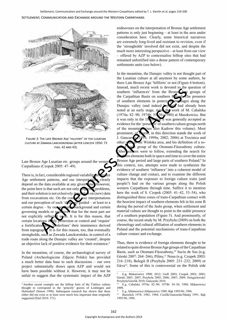
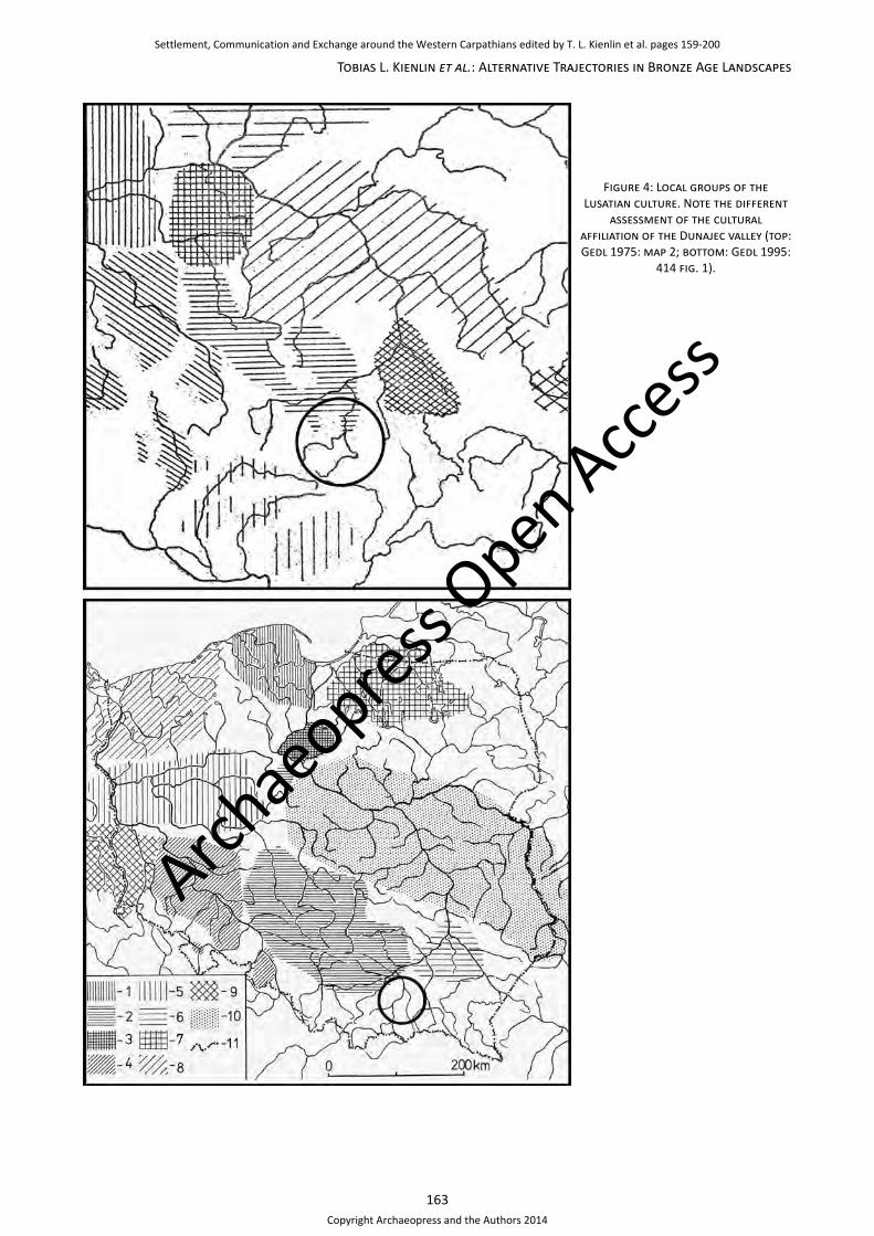
Given their exposed topographic situation, when Bronze Age finds became known from such locations, their interpretation was closely modelled on the medieval and early modern situation: Along the Dunajec valley in historical times there ran an important trade route that was controlled by a series of castles (e.g. in Czchów). Hence, it was obvious to early research that the same already had applied to fortified Bronze Age sites in the area. For example, the hilltop settlement of Zawada Lanckorońska, situated in an elevated position on the western side of the Dunajec valley, was reconstructed as a ‘hillfort’ of the Late Bronze Age Lusatian culture (Figure 3). With its impressive bi-partide fortification the site even made its way into international handbooks of Bronze Age Europe (Leńczyk 1950: 73, 78–82; Coles/Harding 1979: 348–349 fig. 123). In a similar vein, M. Gedl (1975) in an earlier version of his distribution map showing the various local groups of the Lusatian culture assigned the Dunajec valley to the Upper Silesia-Lesser Poland group, an extension to the distribution of this group apparently ‘communicating’ south (Figure 4 top). Correspondingly, Bronze Age trade in amber, copper and tin, or finished metal objects between northern Europe and the Carpathian Basin along the Dunajec and Poprad valleys has been postulated by numerous authors (see also Blajer this volume).7
In the meantime modern excavations have shown that the remains of the impressive fortifications at Zawada Lanckorońska are medieval, and, if at all, the Bronze Age settlement at this place was ‘fortified’ with a fence only (Bąk 1995/96: 51–52, 79, 83–84; Poleski 2004: 348, 372). In a wider perspective, the existence of ‘castles’ or fortified sites in the eastern part of the Polish Lusatian culture is called into question (e.g. Gedl 1998; Czopek 2005: 47; cf. Przybyła/Blajer 2008: 118–123). Further west or south, on the other hand, for example in northern Slowakia, there is good evidence of this type of settlement (e.g. Furmánek/Veliačik/Vladár 1999: 120–124). It has been suggested therefore that the presence or absence of fortified sites may be a feature that allows to distinguish the various
6 See Kienlin/Valde-Nowak (2008; 2009), Kienlin et al. (2010; 2011; 2013) and Korczyńska et al. (2012).7 E.g. Cabalska 1974a: 86; 1974b: 56; 1980: 65; Bukowski 1980: 332; Makarowicz 1999: 232, 244; Górski 2007: 274.
Archae
opress Open Acce
ss
Settlement, Communication and Exchange around the Western Carpathians edited by T. L. Kienlin et al. pages 159-200
Copyright Archaeopress and the Authors 2014

161
Tobias L. Kienlin et al.: Alternative Trajectories in Bronze Age Landscapes
Figure 1: Map indicating the position of the study area along the middle course of the Dunajec river and on the adjacent parts of the Rożnów and Wiśnicz foothills.
0 30 km
Maszkowice 2-Chełmiec
Marcinkowice 4
Stary Sącz
Maszkowice 6
1
2
3
4
5
6
7
89
10
11
12
13
Figure 2: Bronze Age sites along the Dunajec valley. 1. Chełm – 2. Chełmiec – 3. Czchów – 4.
Dąbrowa – 5. Gwoździec – 6. Łoniowa – 7. Marcinkowice – 8. Maszkowice – 9. Naszacowice – 10. Nowy Sącz-Biegonice – 11. Stary Sącz – 12. Wielka Wieś – 13. Zawada Lanckorońska (after
Przybyła 2009: 231 fig. 69).
Archae
opress Open Acce
ss
Settlement, Communication and Exchange around the Western Carpathians edited by T. L. Kienlin et al. pages 159-200
Copyright Archaeopress and the Authors 2014
162
Settlement, Communication and Exchange around the Western Carpathians
endeavours on the interpretation of Bronze Age settlement patterns is only just beginning – at least in the area under consideration here. Clearly, some historical narratives are extremely long-lived and resistant to revision, even if the ‘strongholds’ involved did not exist, and despite the much more interesting perspective – at least from our view – offered by AZP to contextualise hilltop sites that had remained unfortified into a dense pattern of contemporary settlements units (see below).
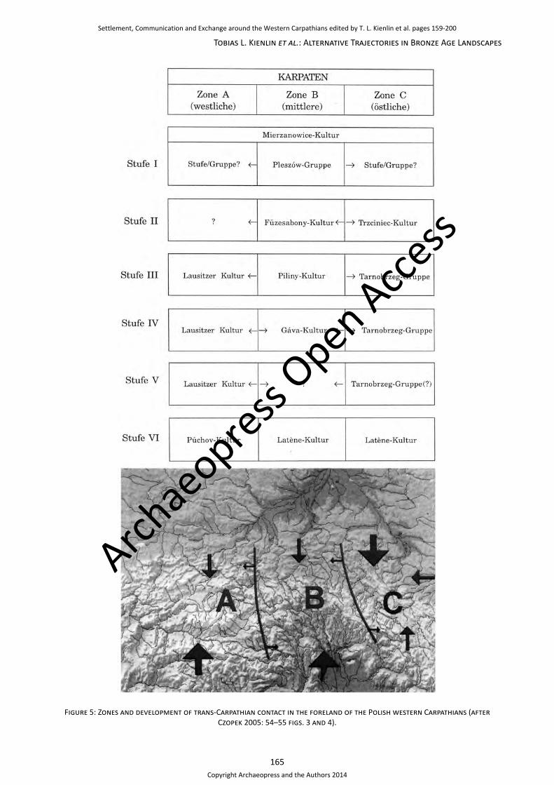
In the meantime, the Dunajec valley is not thought part of the Lusatian culture at all anymore by some authors, be there Late Bronze Age ‘hillforts’ or not (Figure 4 bottom). Instead, much recent work is devoted to the question of southern ‘influences’ from the Bronze Age groups of the Carpathian Basin on southern Poland. The presence of southern elements in pottery assemblages along the Dunajec valley (and indeed beyond) had already been noted at an early stage, mind the work of M. Cabalska (1974a: 82–90; 1974b: 55–56; 1980) at Maszkowice. But it was only in the 1990s that it was generally accepted as evidence for the ‘presence’ of southern culture groups north of the mountains (see also Kadrow this volume). Most prominent, of course, in this direction stands the work of J. Gancarski (1994; 1999a; 2002; 2006) at Trzcinica and other sites in the Wisłoka area, and his definition of a so-called Jasło group of the Otomani-Füzesabony culture. Other authors were to follow, extending the search for southern elements both in space and time to cover the entire Bronze Age period and large parts of southern Poland.9 In this context, too, attempts were made to synthesize the evidence of southern ‘influence’ into a coherent model of culture change and contact, and to examine the different impacts that the exposure to foreign culture traits (and people?) had on the various groups along the Polish western Carpathians through time. Suffice it to mention here the work of S. Czopek (2005: 41–42, 53–54), who distinguished three zones of trans-Carpathian contact with the heaviest impact of southern elements felt in his zone B during the period of the Jasło group, when settlement and material culture are thought to point to the stable presence of a southern population (Figure 5). And prominently, of course, the recent study by M. Przybyła (2009) on both the chronology and cultural affiliation of southern elements in Poland and the potential mechanisms of trans-Carpathian culture contact and exchange.
Thus, there is evidence of foreign elements thought to be related to quite diverse Bronze Age groups of the Carpathian Basin, such as Otomani-Füzesabony,10 Suciu de Sus (e.g. Górski 2007: 264–266), Piliny,11 Noua (e.g. Czopek 2003: 216–218), Belegiš II (Przybyła 2005: 231–232; 2009) or Gáva12. Some of this is controversial on the Polish side
9 E.g. Makarowicz 1999; 2012; Gedl 2003; Czopek 2003; 2005; Górski 2003; 2007; Przybyła 2005; 2006; 2007; 2009; Dzięgielewski/Przybyła/Gawlik 2010; Gancarski 2010.10 E.g. Cabalska 1974a: 82–90; 1974b: 54–56; 1980; Makarowicz 1999.11 E.g. Abłamowicz/Abłamowicz 1989; Bąk 1995/96; 1996.12 Bazielich 1978; 1982; 1984; Cieślik/Gancarski/Madej 1991; Bąk 1995/96; 1996.
Figure 3: The Late Bronze Age ‘hillfort’ of the Lusatian culture at Zawada Lanckorońska (after Lenczyk 1950: 73
figs. 42 and 43).
Late Bronze Age Lusatian etc. groups around the western Carpathians (Czopek 2005: 47–49).
There is, in fact, considerable regional variability in Bronze Age settlement patterns, and our interpretations clearly depend on the data available at any given time. However, the point here is that such are not only empirical problems, and their solution is not exlusively dependent on (new) data from excavations etc. On the contrary, our interpretations and our perception of such ‘data’ are guided – at least to a certain degree – by our academic background and certain governing models or narratives that for the most part are not explicitly reflected upon. It is for this reason, that certain locations imply protection or control and ‘require’ a fortification that ‘underlines’ their imminence derived from topography. It is for this reason, too, that eventually strongholds, such as Zawada Lanckorońska, in control of a trade route along the Dunajec valley are ‘created’, despite an objective lack of positive evidence for their existence.8
In the meantime, of course, the archaeological survey of Poland (Archeologiczne Zdjęcie Polski) has provided a much better data base to such discussions – our own project substantially draws upon AZP and would not have been possible without it. However, it may not be unfair to suggest that the systematic impact of the AZP
8 Another recent example are the hilltop forts of the Únětice culture thought to correspond to the ‘princely’ graves of Leubingen and Helmsdorf (Simon 1990). Subsequent research has shown that these either did not exist or at least were much less important than originally suggested (Ettel 2010: 371).
Archae
opress Open Acce
ss
Settlement, Communication and Exchange around the Western Carpathians edited by T. L. Kienlin et al. pages 159-200
Copyright Archaeopress and the Authors 2014
163
Tobias L. Kienlin et al.: Alternative Trajectories in Bronze Age Landscapes
Figure 4: Local groups of the Lusatian culture. Note the different
assessment of the cultural affiliation of the Dunajec valley (top: Gedl 1975: map 2; bottom: Gedl 1995:
414 fig. 1).
Archae
opress Open Acce
ss
Settlement, Communication and Exchange around the Western Carpathians edited by T. L. Kienlin et al. pages 159-200
Copyright Archaeopress and the Authors 2014
164
Settlement, Communication and Exchange around the Western Carpathians
(e.g. Gáva vs. Belegiš II), but more importantly, we should bear in mind that local sequences in the supposed area of origin – in the Carpathian basin – are complex as well. Opinions there differ widely on questions of chronology and culture definition – all the more so, since there are different schools of archaeological research in the modern countries of this area. Often there is disagreement on the definition of these ‘cultures’ and their precise boundaries in space and time. Corresponding discussions centre on the question of continuous development, i.e. the ‘genetic’ derivation of a new ‘culture’ from its predecessor, versus foreign ‘influences’ or migration to account for new traits; on the interpretation of changes in a given culture’s territorial extent through time (= diffusion? conquest/migration?); and on the coexistence of different pottery styles (culture traits) in the same layer of a tell (= contact/exchange? presence of different people?). To name just two of the more prominent examples, such discussions in the past arose with regard to the Late Bronze Age Gáva ‘culture’ or rather style,13 or the near endless Ottomány/Gyulavarsánd, Otomani I–III and Otomani-Füzesabony debate.14
In fact, the younger part of the Early Bronze Age (EBA II–III) and the subsequent Middle Bronze Age (Hungarian terminology) of the Carpathian Basin is noticeable for its diversity of regional archaeological ‘cultures’ as defined by their distinctive pottery styles, burial customs and settlement patterns. In the sequence of many tells there is change in material culture – mainly in pottery style – that is traditionally thought to indicate the presence of a new archaeological culture (e.g. Bóna 1992). However, it is entirely unclear what this means in ‘ethnic’ terms etc. Much of this debate takes us back to 19th and early 20th century culture historical archaeology. There are related problems of interpretation, of course, north of the mountains (see, for example, Czopek/Trybała-Zawiślak 2009). Therefore, we should avoid debates on culture contact in so far as they contribute to such a turn backwards to historical concepts in the interpretation of archaeological data that has a quality different from being a marker of ‘ethnicity’ etc.
Instead, the approach suggested here will focus on the systematic analysis of settlement patterns on a regional scale, for in this field, too, the debate on southern influences has left its mark. At Trzcinica, clearly, there is a strong southern element. It is beyond the scope of the present paper if in fact there was a nicely bounded foreign Otomani-Füzesabony community in this area, or if we rather see fluid transitions between the Jasło group and its ‘local’ neighbours. Either way, an important question to ponder on in future is, if and precisely how contact and communication as proven by certain elements of material culture translate into local ‘identities’ and eventually result in the archaeological impression of alterity and foreign
13 E.g. Kemenczei 1982; 1984: 58–86; Pare 1998: 406–422; Pankau 2004: 27–42; Przybyła 2009: 102–109; Bader 2012.14 E.g. Tasić 1984; Bóna 1992: 16–17, 21, 29–32; Bader 1998; Thomas 2008: 286–289, 292–294; Németi/Molnár 2012: 10–13.
presence. Are such processes consciously driven forward and directional, as implied by the widespread interest in ‘amber routes’ etc. along which Otomani communities may have ‘expanded’ north?15 Or do settlement patterns predominantly ‘organise’ in a non-linear fashion and in accordance with the needs of local subsistence economy, population numbers or carrying capacity etc.? And if so, is it possible that any overlying patterning that implies directionality is only secondary and dependent on natural courses like rivers or restraints like mountains that direct movement?
Outside the Jasło group in spatial terms, as well as before and after it, in any case we lack evidence of a closed territory under predominant southern influence. It is here, in particular, that normative concepts of culture groups and southern influence tend to distort our perception of the evidence. As a result, regional variability is neglected, and the different trajectories open to the communites in question tend to be ignored. S. Czopek (2005: 41–42, 53–54), for example, makes it quite clear that beyond the Jasło group trans-Carpathian influence declines. Yet, his zone B extends to the Dunajec valley (Figure 5), and it is such representations that we want to draw attention to and deconstruct. For, while on the face of it the mapping shown just seems to allow for the presence of Otomani-Füzesabony traits at Maszkowice, it in fact detracts attention from regional variability – both on the macro- and on the micro-scale. It conceals that our data for the various regions drawn together widely differ in quality.
For example, little still is known in terms of settlement patterns outside the vicinity of the larger river valleys that extend into the hilly flanks of the Polish Carpathians.16 Hence, it is not really sure, if Czopek’s (2005: 41, 53) zone B has any match on the ground in terms of settlement structure and/or southern elements of material culture all the way between the Dunajec valley in the west and the Jasło group in the east. Maszkowice itself has recently been shown to have been most likely enclosed during Early to Middle Bronze Age times (Przybyła/Skoneczna 2011: 14–19, 31–35; cf. Przybyła et al. 2012), and it may or may not have been in control of a trade route along the Dunajec valley as postulated earlier. But systematic settlement archaeology in its surroundings is in its beginnings (Przybyła et al. 2012: 252–262; see Przybyła/Skoneczna this volume), so the role of this site is still not sufficiently understood against a local background. In the Carpathian Basin itself, there is currently a debate on the role of fortified Bronze Age (tell) sites (cf. Kienlin 2012b; Kienlin/Fischl/Marta in press). Their centrality in political or economic terms is questioned, for example, for the Hatvan and Füzesabony times settlement systems in the Borsod plain and Hernad valley (Fischl/Kienlin 2013; 15 See, for example, Czebreszuk (2011), Przybyła/Skoneczna (2011: 6), Jaeger (2012: 172–173), Makarowicz (2012) and Ernée (2012). See also O’Shea (2011) and Kiss (2011: esp. 231–233) on the development of exchange networks during the Bronze Age of the Carpathian Basin.16 See, however, of course the pioneering work by Przybyła/Blajer (e.g. 2008) further east between the Wisłok and San rivers, and that by Chorąży/Chorąży (e.g. 2012) in the western Beskid mountains.
Archae
opress Open Acce
ss
Settlement, Communication and Exchange around the Western Carpathians edited by T. L. Kienlin et al. pages 159-200
Copyright Archaeopress and the Authors 2014
165
Tobias L. Kienlin et al.: Alternative Trajectories in Bronze Age Landscapes
Figure 5: Zones and development of trans-Carpathian contact in the foreland of the Polish western Carpathians (after Czopek 2005: 54–55 figs. 3 and 4).
Archae
opress Open Acce
ss
Settlement, Communication and Exchange around the Western Carpathians edited by T. L. Kienlin et al. pages 159-200
Copyright Archaeopress and the Authors 2014
166
Settlement, Communication and Exchange around the Western Carpathians
Fischl/Kienlin/Seres 2012; see Fischl et al. this volume). All the more so we should be careful with notions of centrality and control excercised over their surroundings for places like Maszkowice (and maybe even Trzcinica ...), situated in an entirely different topopgraphic setting and on the periphery of Otomani-Füzesabony in whatever definition.
Finally, southern influences of this early horizon and younger ones attributable to broadly ‘Gáva’ times are also found further north along the Dunajec valley and beyond (see above). In the Zakliczyn basin, in particular, on the middle course of the Dunajec, recent excavations and intensive survey activity provide evidence of quite different local trajectories and principles of settlement organisation. At a distance of just about 60km the communities in the microregions of Zakliczyn and Maszkowice can be shown to have taken divergent trajectories, despite similar cultural affiliations and southern elements in their pottery assemblages. Different organising principles were at work in the spatial organisation of their settlements, although they developed from a similar cultural background and potentially were integrated in the same far-ranging communication networks.
The settlement ‘clusters’ of Janowice/Wróblowice and Zawada Lanckorońska
Given this state of research, our project aims to improve the knowledge of such local trajectories and – by way of example – strengthen the interest taken in the local background to the all-embracing Bronze Age ‘narratives’ that have been criticized above. The goal is a complete verification by intensive surface survey, geophysical prospection and targeted excavations on both sides of the middle course of the Dunajec of Bronze Age sites previously recorded by AZP (Figure 6).17 Thus, information on the lifespan of individual sites, their relative chronological position vis-à-vis each other, their character in terms of the size of the settled area and potentially their different structure and function in a contemporaneous settlement system becomes available. Consequently, we will first provide a short introduction to the settlement history and the spatial organisation of Bronze Age sites along the middle course of the Dunajec river. In particular, we will focus on the Zakliczyn basin and its surroundings with the sites of Janowice, neighbouring Wróblowice and Zawada Lanckorońska that feature prominent in distinct clusters of Bronze Age sites along the Dunajec valley (see also Kienlin et al. 2010; 2011; 2013; Korczyńska et al. 2012).
Generally speaking, (Late) Bronze Age settlements in our study area tend to concentrate in distinct settlement ‘clusters’ along the Dunajec valley (Figure 7). The alluvial
17 The AZP survey in our study area has been carried out by A. Cetera, E. Dworaczyński, J. Okoński and A. Szpunar in 1988–1994. In the meantime this data can be supplemented by our survey work on numerous sites in the area (see Figure 6) and excavations carried out 2006–2013 that allow a more detail chronological assessment of the settlements examined and their size etc.
soils in the immediate flood plain of the Dunajec river are avoided, but unlike previous Neolithic occupation (see Valde-Nowak this volume), apart from sites situated in higher locations on the hills accompanying the Dunajec Bronze Age settlement clearly extends onto lower altitudes as well (compare Kienlin et al. 2010: 210 fig. 26 and 212 fig. 29).18
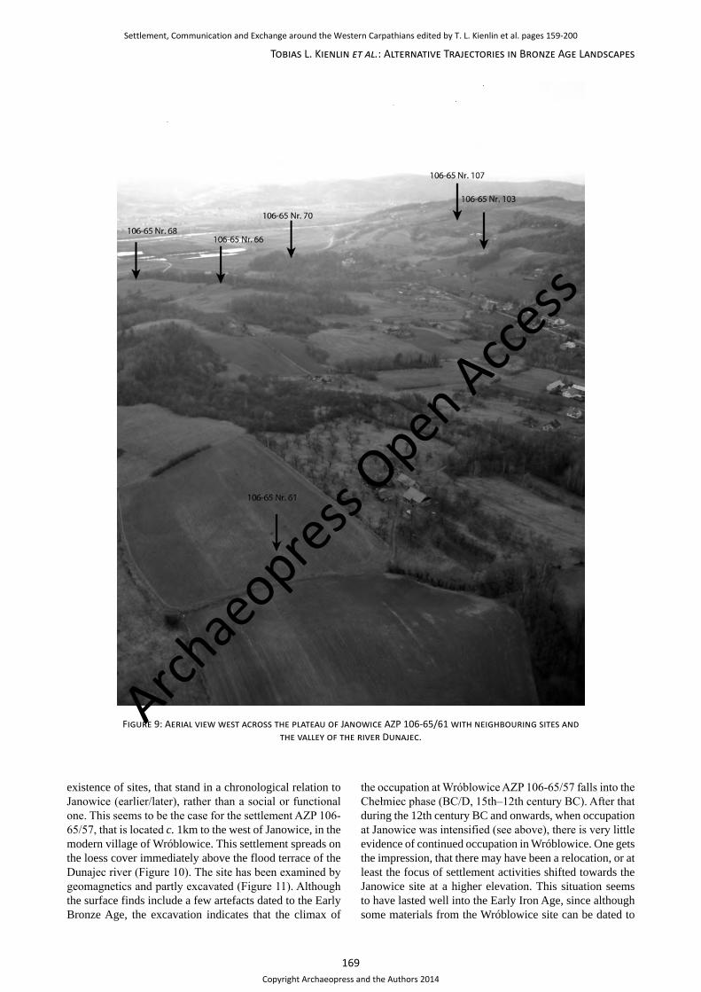
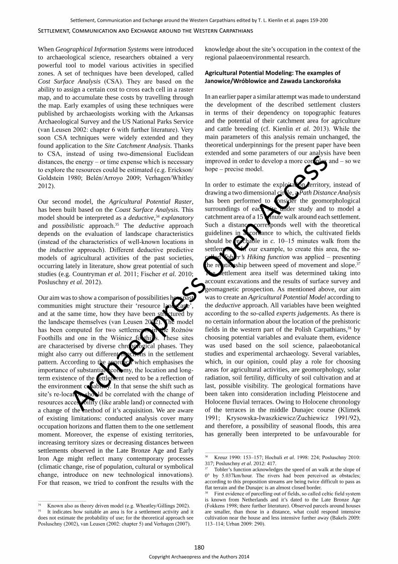
Among the several clusters of Bronze Age sites mentioned, for the time being we are best informed about the situation in the surroundings of cluster ‘E’ (Figure 7), that is situated above the Dunajec valley on the promontory of the Rożnów foothills north of Zakliczyn. It is possible that this cluster focused on the hilltop settlement of Janowice AZP 106-65/61 that – alongside a number of adjacent sites – has been in the centre of our research and excavations in the area for some years now.
It should be noted right from the start, that it is not supposed here, that the site of Janowice AZP 106-65/61 ‘dominated’ its ‘own’ cluster or even its wider surroundings in economic or political terms. Nor do we suggest this complex of sites is in any way special among the other Bronze Age settlement clusters of the middle Dunajec valley. So far, we simply do not know if any other site was ‘central’ to one of the other clusters in the way we suggest for AZP 106-65/61, or alternatively if their organising principle was likeness of their component settlement units instead. But, emphatically, the ‘centrality’ we suggest for the long-lived site AZP 106-65/61 would have been one of greater tradition and its potential role as a focus of local identity, and not one of domination or the mobilisation of economic surplus or control.
The hilltop site of Janowice (gm. Pleśna) was first discovered in 1989 during the AZP survey. The great archaeological potential of the site was noted then, but no systematic archaeological research was undertaken until the beginning of our project work that started in 2006. In the meantime, we were able to survey most of the promontory or hilltop plateau on which the settlement is located by geomagnetic survey, carry out a systematic surface survey on all accessible fields and uncover settlement remains in several excavations of different size (Figure 8). Our work confirms the great potential of AZP 106-65/61 for archaeological research and – by and large – the good preservation of its settlement remains.
The settlement is located on the NW to SE orientated plateau of the promontory between the Zakliczyn basin in the south and the northern valley of the village of Janowice (Figure 9). From the geophysical survey it is evident, that settlement remains draw close to the northwestern tip of the spur on the one side. In the southwest they extend onto the passage between the promontory and the backward hills or mountains (Figure 8). The settled area is located on a slightly declining slope and is exposed to the southwest;
18 The implications of this long-term trend in preferred settlement location will be discussed in the concluding section of this paper.
Archae
opress Open Acce
ss
Settlement, Communication and Exchange around the Western Carpathians edited by T. L. Kienlin et al. pages 159-200
Copyright Archaeopress and the Authors 2014

167
Tobias L. Kienlin et al.: Alternative Trajectories in Bronze Age Landscapes
it is at least 900m long in NW to SE direction, i.e. the settlement extended along the plateau for a considerable distance, and some 100–150m wide as one crosses the hilltop on which it is situated in north-south direction. Judging by the magnetogram and our excavations, in the area so defined there are more or less well preserved settlement remains in form of general settlement pits for storage and/or refuse, post-holes corresponding to houses or above ground storage facilities, some hearths or ovens and potential pit houses that were possibly used for activities such as weaving.
Since not all archaeological features excavated had previously been visible in the magnetometer data, it is currently unclear whether some zones, that are largely devoid of magnetic anomalies, actually point to a lack of settlement remains and the existence of unsettled zones on the plateau. If so, it is possible, that there are some areas along the promontory that were more closely settled than others, and we see evidence of some distinct clusters of houses that may – depending on chronology – correspond to distinct households loosely scattered along the plateau. So far there is evidence of Early Bronze Age occupation from one pit only with Mierzanowice culture pottery and a corresponding radiocarbon date. Continuous settlement seems to have started only somewhat later: possibly at the very beginning of the Late Bronze Age (BC/D, 15th–
12th century BC, phase Chełmiec), but it is likely, that occupation only reached a certain intensity from phase Marcinkowice 4, i.e. BD/HaA onwards and lasted well into the Early Iron Age (12th–5th century BC) (Kienlin et al. 2010; 2013; Korczyńska et al. 2012).
Hence, according to both the pottery sequence and the radiocarbon dates AZP 106-65/61 has a tradition of continuous settlement for several hundred years during the Late Bronze Age and the Early Iron Age. This should not be taken to imply a substantial number of houses co-existing at any given time or an imposing aspect of what probably was a loose group of households interspersed with plots for horticulture and/or livestock keeping. But it certainly implies that there was tradition and potentially an awareness of the greater antiquity and pre-eminence of those households and kinship groups in residence on AZP 106-65/61, when compared to neighbouring smaller sites that were less long-lived and apparently saw a more frequent relocation.19
If Janowice AZP 106-65/61 was ‘central’ in the way outlined above to a number other sites in cluster ‘E’ (Figure 7), that coexisted for a certain period of time, there are also indications of temporal succession, i.e. the 19 See the concluding section of this paper for a discussion of this notion of ‘centrality’.
Figure 6: Map illustrating the current state of the survey work along the middle course of the Dunajec river valley.
Archae
opress Open Acce
ss
Settlement, Communication and Exchange around the Western Carpathians edited by T. L. Kienlin et al. pages 159-200
Copyright Archaeopress and the Authors 2014

168
Settlement, Communication and Exchange around the Western Carpathians
Figure 8: Greyscale plot of the magnetometer survey and location
of the excavations carried out on the hilltop settlement of Janowice AZP 106-
65/61.
Figure 7: ‘Clusters’ of Late Bronze Age sites along the middle part of the Dunajec
valley based on AZP and ongoing survey work.
Archae
opress Open Acce
ss
Settlement, Communication and Exchange around the Western Carpathians edited by T. L. Kienlin et al. pages 159-200
Copyright Archaeopress and the Authors 2014
169
Tobias L. Kienlin et al.: Alternative Trajectories in Bronze Age Landscapes
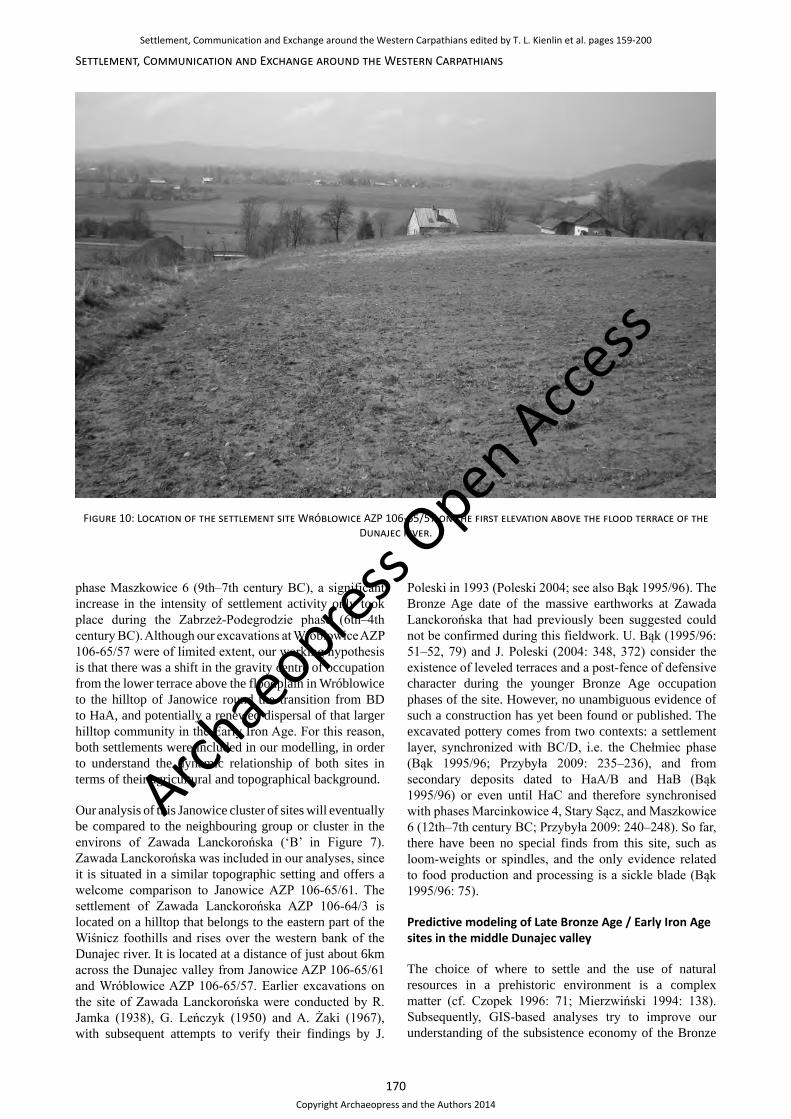
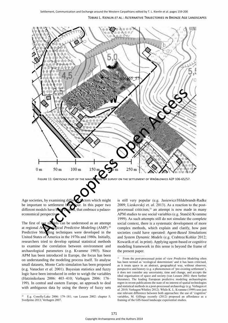
existence of sites, that stand in a chronological relation to Janowice (earlier/later), rather than a social or functional one. This seems to be the case for the settlement AZP 106-65/57, that is located c. 1km to the west of Janowice, in the modern village of Wróblowice. This settlement spreads on the loess cover immediately above the flood terrace of the Dunajec river (Figure 10). The site has been examined by geomagnetics and partly excavated (Figure 11). Although the surface finds include a few artefacts dated to the Early Bronze Age, the excavation indicates that the climax of
the occupation at Wróblowice AZP 106-65/57 falls into the Chełmiec phase (BC/D, 15th–12th century BC). After that during the 12th century BC and onwards, when occupation at Janowice was intensified (see above), there is very little evidence of continued occupation in Wróblowice. One gets the impression, that there may have been a relocation, or at least the focus of settlement activities shifted towards the Janowice site at a higher elevation. This situation seems to have lasted well into the Early Iron Age, since although some materials from the Wróblowice site can be dated to
Figure 9: Aerial view west across the plateau of Janowice AZP 106-65/61 with neighbouring sites and the valley of the river Dunajec.
Archae
opress Open Acce
ss
Settlement, Communication and Exchange around the Western Carpathians edited by T. L. Kienlin et al. pages 159-200
Copyright Archaeopress and the Authors 2014
170
Settlement, Communication and Exchange around the Western Carpathians
phase Maszkowice 6 (9th–7th century BC), a significant increase in the intensity of settlement activity only took place during the Zabrzeż-Podegrodzie phase (6th–4th century BC). Although our excavations at Wróblowice AZP 106-65/57 were of limited extent, our working hypothesis is that there was a shift in the gravity centre of occupation from the lower terrace above the floodplain in Wróblowice to the hilltop of Janowice round the transition from BD to HaA, and potentially a renewed dispersal of that larger hilltop community in the Early Iron Age. For this reason, both settlements were included in our modelling, in order to understand the dynamic relationship of both sites in terms of their agricultural and topographical background.
Our analysis of this Janowice cluster of sites will eventually be compared to the neighbouring group or cluster in the environs of Zawada Lanckorońska (‘B’ in Figure 7). Zawada Lanckorońska was included in our analyses, since it is situated in a similar topographic setting and offers a welcome comparison to Janowice AZP 106-65/61. The settlement of Zawada Lanckorońska AZP 106-64/3 is located on a hilltop that belongs to the eastern part of the Wiśnicz foothills and rises over the western bank of the Dunajec river. It is located at a distance of just about 6km across the Dunajec valley from Janowice AZP 106-65/61 and Wróblowice AZP 106-65/57. Earlier excavations on the site of Zawada Lanckorońska were conducted by R. Jamka (1938), G. Leńczyk (1950) and A. Żaki (1967), with subsequent attempts to verify their findings by J.
Poleski in 1993 (Poleski 2004; see also Bąk 1995/96). The Bronze Age date of the massive earthworks at Zawada Lanckorońska that had previously been suggested could not be confirmed during this fieldwork. U. Bąk (1995/96: 51–52, 79) and J. Poleski (2004: 348, 372) consider the existence of leveled terraces and a post-fence of defensive character during the younger Bronze Age occupation phases of the site. However, no unambiguous evidence of such a construction has yet been found or published. The excavated pottery comes from two contexts: a settlement layer, synchronized with BC/D, i.e. the Chełmiec phase (Bąk 1995/96; Przybyła 2009: 235–236), and from secondary deposits dated to HaA/B and HaB (Bąk 1995/96) or even until HaC and therefore synchronised with phases Marcinkowice 4, Stary Sącz, and Maszkowice 6 (12th–7th century BC; Przybyła 2009: 240–248). So far, there have been no special finds from this site, such as loom-weights or spindles, and the only evidence related to food production and processing is a sickle blade (Bąk 1995/96: 75).
Predictive modeling of Late Bronze Age / Early Iron Age sites in the middle Dunajec valley
The choice of where to settle and the use of natural resources in a prehistoric environment is a complex matter (cf. Czopek 1996: 71; Mierzwiński 1994: 138). Subsequently, GIS-based analyses try to improve our understanding of the subsistence economy of the Bronze
Figure 10: Location of the settlement site Wróblowice AZP 106-65/57 on the first elevation above the flood terrace of the Dunajec river.
Archae
opress Open Acce
ss
Settlement, Communication and Exchange around the Western Carpathians edited by T. L. Kienlin et al. pages 159-200
Copyright Archaeopress and the Authors 2014
171
Tobias L. Kienlin et al.: Alternative Trajectories in Bronze Age Landscapes
Age societies, by examining different factors which might be important to settlement behaviour. In this paper two different models have been created, that embrace a palaeo-economical perspective.
The first of our models can be understood as an attempt at regional Archaeological Predictive Modeling (AMP).20 Predictive Modeling techniques were developed in the United States of America in the 1970s and 1980s. Initially, researchers tried to develop optimal statistical methods to examine the correlation between environment and archaeological parameters (e.g. Kvamme 1985). Since APM has been introduced in Europe, the focus has been on understanding the modeling process itself. To analyse small datasets, Monte Carlo simulation has been proposed (e.g. Vanacker et al. 2001). Bayesian statistics and fuzzy logic have been introduced in order to weigh the variables (Hatzinikolaou 2006: 403–410; Verhagen 2006: 176–199). In central and eastern Europe, an approach to deal with ambiguous data by using the theory of fuzzy sets
20 E.g. Conolly/Lake 2006: 179–181; van Leusen 2002: chapter 5; Svedjemo 2013; Verhagen 2007.
is still very popular (e.g. Jasiewicz/Hildebrandt-Radke 2009; Lieskovský et. al. 2013). As a reaction to the post-processual criticism,21 an attempt is now made in many APM studies to use social variables (e.g. Stančič/Kvamme 1999). As such attempts still do not simulate the complete social context, there is a systematic development of more complex methods, which explain and clarify, how past societies could have operated: Agent-Based Simulations and System Dynamic Models (e.g. Crabtree/Kohler 2012; Kowarik et al. in print). Applying agent-based or cognitive modeling framework in this sense is beyond the frame of the present paper. 21 From the post-processual point of view Predictive Modeling often has been termed as ‘ecological determinism’ and it has been criticised, as it treats space in an abstract, geographical way, without observer, perspective and history (e.g. a phenomenon of ‘pre-existing settlement’), it does not consider any uncertainty, time and change, and accepts the ideal organisation of space and society (van Leusen 2002: there further literature). The leading European predictive modeling archaeologists regret in recent publications the state of no interest of spatial technologies and statistical methods in a post-processual archaeology (e.g. Verhagen et al. 2010; Verhagen/Whitley 2012). While K. L. Kvamme (1999) sees just one relevant difference between both approaches: the use of ‘cognitive’ variables, M. Gillings recently (2012) proposed an affordance as a framing of the GIS-based landscape experiential studies.
Figure 11: Greyscale plot of the magnetometer survey on the settlement of Wróblowice AZP 106-65/57.
Archae
opress Open Acce
ss
Settlement, Communication and Exchange around the Western Carpathians edited by T. L. Kienlin et al. pages 159-200
Copyright Archaeopress and the Authors 2014

172
Settlement, Communication and Exchange around the Western Carpathians
In our Late Bronze Age/Early Iron Age Sites Predictive Model we have two rather simple aims. The first aim was to examine whether certain combinations of landscape features were attractive to settlement activity. We have tried to identify those factors, which had an impact on the site location and it has been examined if different functions of the sites in the settlement system can be assumed. Predicting undiscovered site locations is an additional goal or side-effect of this approach.
There have been used such variables as: altitude, slope, solar radiation, access to the water, average precipitation, amplitude of annual temperature, soil type and as a social component possible visibility. All of them have been evaluated in an inductive approach.22 This kind of evaluation is based on mutual relations of already known archaeological sites and specific landscape attributes. The prediction of new sites relies on finding landscape parts which have similar parameters. As already mentioned, our model might be used to estimate the probability of the presence of new sites in our study region and is therefore determined as a correlative one (van Leusen 2002). In that sense it might support and verify analyses such as the Kernel Density, based on which settlement micro-regions (clusters) have already been distinguished (Kienlin et al. 2010). Additionally, the constructed model should be interpreted as probabylistic.
The choice of the variables were based on subsistence economy. The altitude and slope obviously couldn’t straightforward influence the sites’ location choice, however both variables reflect a topographical position. The location of sites at specific types of relief might be culturally determined (see e.g. shifting the location of the Trzciniec culture settlements in the younger phase from the basis to the hilltops of the loess capes of Rzeszów foothills; Przybyła/Blajer 2008: 67). Water supply might have been a matter of considerable importance for settlement foundation. Since we have no information about the prehistoric hydrological network, a Flow accumulation analysis was developed. It refers to a potential hydrological situation generated from the Digital Elevation Model (DEM).23 As climate might impact on settlement location, two variables reflecting climatic information were taken into account. One of them is the annual rainfall (precipitation). The other is the amplitude of annual temperatures.24 As garden cultivation of leguminosae and some sort of cereals might take place in close proximity to the households (e.g. Bakels 2009: 113–114; Urban 2009: 290), soil type (or rather soil fertility) and solar radiation in the direct neighbourhood of the settlements could play a fundamental role. The solar radiation raster has been computed based on the DEM.25 Soil types have been
22 Known also as data driven model (e.g. Wheatley/Gillings 2002).23 Numeryczny Model Terenu, Urząd Marszałkowski Województwa Małopolskiego 2010, due the nature of being an irregular grid, the cells have been interpolated to 21m in size.24 WordClim 1.3 Data set – Global Climate Data.25 The solar radiation raster has been calculated by SAGA software. The direct radiation has been computed. This variable shall be used alternatively instead of the aspect. The aspect factor is scaled differently
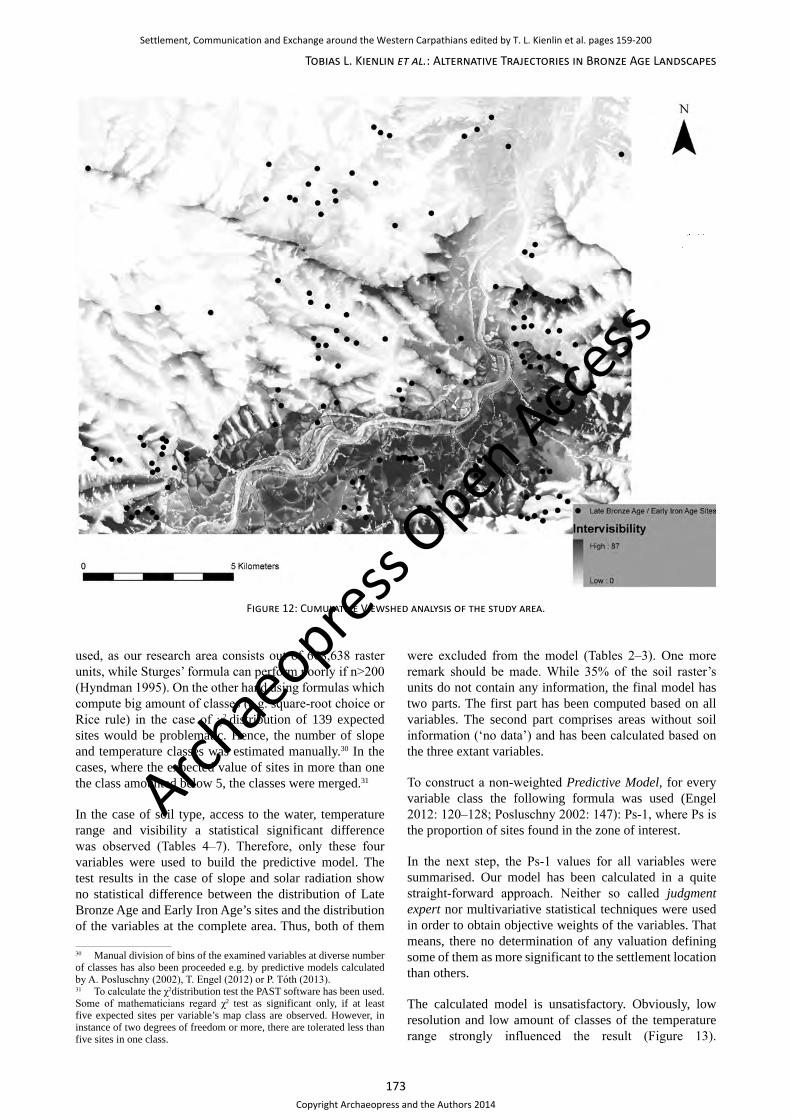
distinguished based on modern soil-agricultural maps.26 To compute the visibility, the cumulative Viewshed variable has been implemented (Wheatley/Gillings 2002: 201–214). This analysis is based on all Late Bronze Age and Early Iron Age sites in the research area.27 In the course of this analysis, it was noticed, that sites located in the central part of our study area are visible by a high amount of other sites. This could emphasise the meaning of this variable (Figure 12). On the other hand this observation exposes a geostatistical distribution problem: it is more probable that sites centred in the study area have a higher level of intervisibility than those, which are located in the outer parts of the examined zone. In order to solve this problem, further viewshed examinations in this research area require a greater amount of surrounding sites.
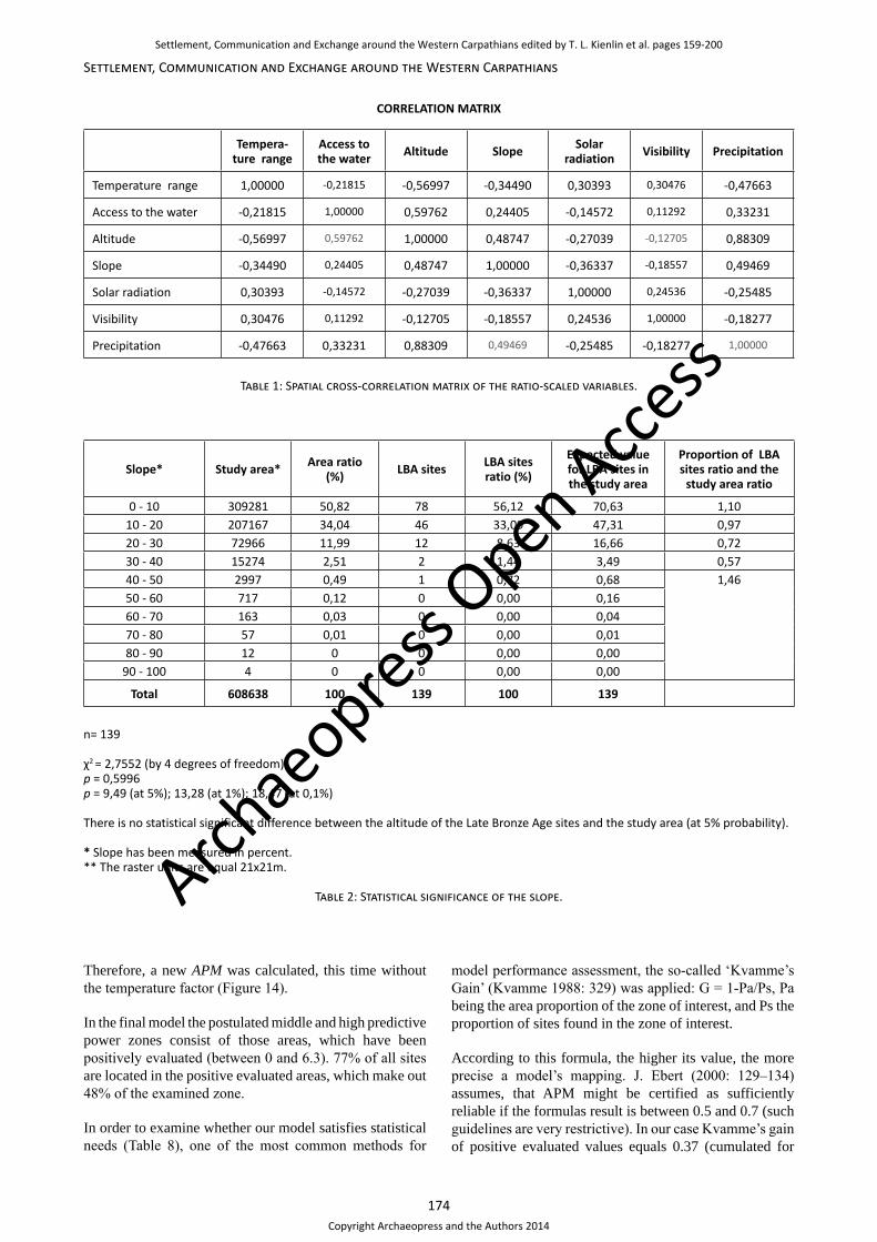
The first step in calculating our model was to carry out a spatial cross-correlation matrix (part of Principal Component Analysis), to check which variable might have played the biggest role and to exclude those of them which strongly correlate with each other.28 Only ratio-scaled data such as temperature amplitude, access to the water, altitude, solar radiation, average precipitation and visibility have been taken into consideration. To proceed with this analysis, all data was standardized, based on following formula: raster(x)-raster(mean) / raster(std).
Table 1 shows only very weak negative correlation between temperature and access to the water, as well as temperature and slope. Also, a weak positive correlation between temperature and solar radiation, temperature and visibility, access to the water and slope was observed. Such results allow using all of them in the model. Altitude strongly correlates with four other variables and precipitation with three variables. Due to that observation both variables were excluded from further analysis and were not used to build the model. Such procedure eliminates potential autocorrelation.29 The only non-ratio-scaled data – the soil type raster – has not been generated out of DEM, so it shouldn’t significantly correlate with other variables.
Next, a χ2 test was performed to check how well the observed distribution of sites fit in relation to the distribution of raster cells in all examined areas for each of the non-correlating variables (Tables 2–7).
To compute the χ2 distribution, all variables have been divided into classes. Sturges’ formula, which calculates the bin sizes out of the range of the data, has not been
to all other variables and is therefore to be exchanged with solar radiation, which is scaled metrically as the rest. Solar radiation can be used as proxy data for aspect, e.g. south orientated hilltops have higher values of radiation than north ones. The insolation has been calculated from the middle point of investigation zone (49˚ 52ˊ 60˝). The used Solar Constant is equal to 1367 W/m2; the insolation raster is measured in kWh/m2.26 Mapa glebowo-rolnicza 1:5000, Urząd Marszałkowski Województwa Małopolskiego 2010.27 One should mention, that we have used the simple viewshed for this analysis, not the banded one (e.g. Higuchi 1983).28 PCA – analysis has been performed by using ArcGIS software.29 The resulting correlation is explainable as slope and the access to water model have been produced out of the altitude model (DEM).
Archae
opress Open Acce
ss
Settlement, Communication and Exchange around the Western Carpathians edited by T. L. Kienlin et al. pages 159-200
Copyright Archaeopress and the Authors 2014
173
Tobias L. Kienlin et al.: Alternative Trajectories in Bronze Age Landscapes
used, as our research area consists out of 608,638 raster units, while Sturges’ formula can perform poorly if n>200 (Hyndman 1995). On the other hand using formulas which compute big amount of classes (e.g. square-root choice or Rice rule) in the case of χ2 distribution of 139 expected sites would be problematic. Hence, the number of slope and temperature classes was estimated manually.30 In the cases, where the expected value of sites in more than one the class amounted below 5, the classes were merged.31
In the case of soil type, access to the water, temperature range and visibility a statistical significant difference was observed (Tables 4–7). Therefore, only these four variables were used to build the predictive model. The test results in the case of slope and solar radiation show no statistical difference between the distribution of Late Bronze Age and Early Iron Age’s sites and the distribution of the variables at the complete area. Thus, both of them
30 Manual division of bins of the examined variables at diverse number of classes has also been proceeded e.g. by predictive models calculated by A. Posluschny (2002), T. Engel (2012) or P. Tóth (2013).31 To calculate the χ2distribution test the PAST software has been used. Some of mathematicians regard χ2 test as significant only, if at least five expected sites per variable’s map class are observed. However, in instance of two degrees of freedom or more, there are tolerated less than five sites in one class.
were excluded from the model (Tables 2–3). One more remark should be made. While 35% of the soil raster’s units do not contain any information, the final model has two parts. The first part has been computed based on all variables. The second part comprises areas without soil information (‘no data’) and has been calculated based on the three extant variables.
To construct a non-weighted Predictive Model, for every variable class the following formula was used (Engel 2012: 120–128; Posluschny 2002: 147): Ps-1, where Ps is the proportion of sites found in the zone of interest.
In the next step, the Ps-1 values for all variables were summarised. Our model has been calculated in a quite straight-forward approach. Neither so called judgment expert nor multivariative statistical techniques were used in order to obtain objective weights of the variables. That means, there no determination of any valuation defining some of them as more significant to the settlement location than others.
The calculated model is unsatisfactory. Obviously, low resolution and low amount of classes of the temperature range strongly influenced the result (Figure 13).
Figure 12: Cumulative Viewshed analysis of the study area.
Archae
opress Open Acce
ss
Settlement, Communication and Exchange around the Western Carpathians edited by T. L. Kienlin et al. pages 159-200
Copyright Archaeopress and the Authors 2014
174
Settlement, Communication and Exchange around the Western Carpathians
CORRELATION MATRIX
Tempera-ture range
Access to the water Altitude Slope Solar
radiation Visibility Precipitation
Temperature range 1,00000 -0,21815 -0,56997 -0,34490 0,30393 0,30476 -0,47663
Access to the water -0,21815 1,00000 0,59762 0,24405 -0,14572 0,11292 0,33231
Altitude -0,56997 0,59762 1,00000 0,48747 -0,27039 -0,12705 0,88309
Slope -0,34490 0,24405 0,48747 1,00000 -0,36337 -0,18557 0,49469
Solar radiation 0,30393 -0,14572 -0,27039 -0,36337 1,00000 0,24536 -0,25485
Visibility 0,30476 0,11292 -0,12705 -0,18557 0,24536 1,00000 -0,18277
Precipitation -0,47663 0,33231 0,88309 0,49469 -0,25485 -0,18277 1,00000
Table 1: Spatial cross-correlation matrix of the ratio-scaled variables.
Slope* Study area* Area ratio (%) LBA sites LBA sites
ratio (%)
Expected value for LBA sites in the study area
Proportion of LBA sites ratio and the
study area ratio
0 - 10 309281 50,82 78 56,12 70,63 1,1010 - 20 207167 34,04 46 33,09 47,31 0,9720 - 30 72966 11,99 12 8,63 16,66 0,7230 - 40 15274 2,51 2 1,44 3,49 0,5740 - 50 2997 0,49 1 0,72 0,68 1,4650 - 60 717 0,12 0 0,00 0,1660 - 70 163 0,03 0 0,00 0,0470 - 80 57 0,01 0 0,00 0,0180 - 90 12 0 0 0,00 0,00
90 - 100 4 0 0 0,00 0,00
Total 608638 100 139 100 139
n= 139
χ2 = 2,7552 (by 4 degrees of freedom)p = 0,5996p = 9,49 (at 5%); 13,28 (at 1%); 18,47 (at 0,1%)
There is no statistical significant difference between the altitude of the Late Bronze Age sites and the study area (at 5% probability).
* Slope has been measured in percent.** The raster units are equal 21x21m.
Table 2: Statistical significance of the slope.
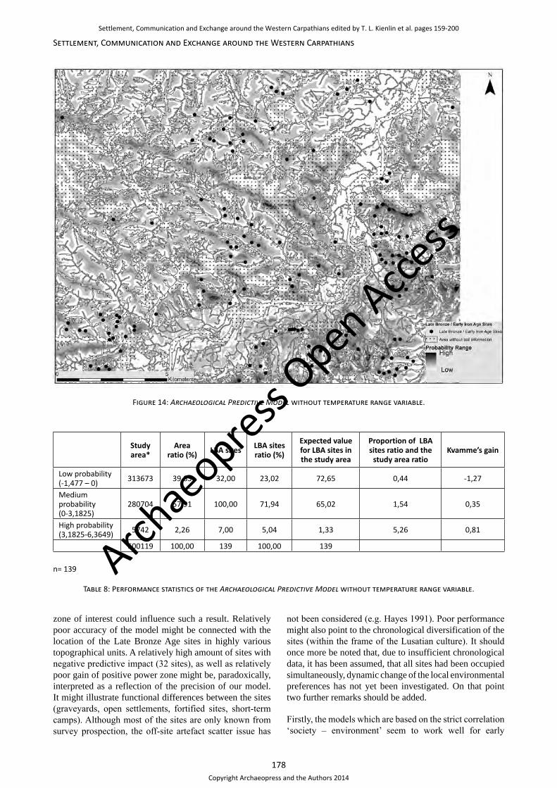
Therefore, a new APM was calculated, this time without the temperature factor (Figure 14).
In the final model the postulated middle and high predictive power zones consist of those areas, which have been positively evaluated (between 0 and 6.3). 77% of all sites are located in the positive evaluated areas, which make out 48% of the examined zone.
In order to examine whether our model satisfies statistical needs (Table 8), one of the most common methods for
model performance assessment, the so-called ‘Kvamme’s Gain’ (Kvamme 1988: 329) was applied: G = 1-Pa/Ps, Pa being the area proportion of the zone of interest, and Ps the proportion of sites found in the zone of interest.
According to this formula, the higher its value, the more precise a model’s mapping. J. Ebert (2000: 129–134) assumes, that APM might be certified as sufficiently reliable if the formulas result is between 0.5 and 0.7 (such guidelines are very restrictive). In our case Kvamme’s gain of positive evaluated values equals 0.37 (cumulated for
Archae
opress Open Acce
ss
Settlement, Communication and Exchange around the Western Carpathians edited by T. L. Kienlin et al. pages 159-200
Copyright Archaeopress and the Authors 2014

175
Tobias L. Kienlin et al.: Alternative Trajectories in Bronze Age Landscapes
Solar radiation* Study area**
Area ratio (%) LBA sites LBA sites
ratio (%)
Expected value for LBA sites in the study area
Proportion of LBA sites ratio and the
study area ratio
0 - 252 626 0,10 0 0 0,14 1,35252 - 505 304 0,05 0 0 0,07505 - 757 1595 0,26 0 0 0,36
757 - 1010 6469 1,06 2 1,44 1,481010 - 1263 20589 3,38 6 4,32 4,70 1,281263 - 1515 34510 5,67 4 2,88 7,88 0,511515 - 1768 46107 7,58 6 4,32 10,53 0,571768 - 2020 66311 10,89 18 12,95 15,14 1,192020 - 2273 89913 14,77 23 16,55 20,53 1,122273 - 2525 88767 14,58 31 22,30 20,27 1,532525 - 2778 86449 14,20 18 12,95 19,74 0,912778 - 3030 166998 27,44 31 22,30 38,14 0,81
Total 608638 100 139 100 139
n= 139
χ2 = 12,978 (by 11 degrees of freedom)p = 0,29475p = 19,68 (at 5%); 24,72 (at 1%); 31,26 (at 0,1%)
There is no statistical significant difference between the solar radiation of the Late Bronze Age sites and the study area (at 5% probability).
* The isolation raster is equal 1 kWh/m2.** The raster units are equal 21x21m.
Table 3: Statistical significance of the solar radiation.
Soil type Study area* area ratio(%) LBA sites LBA sites
ratio (%)
Expected value for LBA sites int the study area
Proportion of LBA sites ratio and the
study area ratio
Fluvisols 99571 24,10 8 6,06 31,81 0,25Podsols 132864 32,17 56 42,42 42,46 1,32
Cambisols 178193 43,14 68 51,51 56,95 1,19Gleysols 1401 0,34 0 0 0,45 0
Chernozems 1038 0,25 0 0 0,33
Total 413067 100 132 100 132
n= 132 (7 sites are located in no data zones)
χ2 = 25,072 (by 3 degrees of freedom)p = 0,000014917p = 7,81 (at 5 %); 11,34 (at 1 %); 16,27 (at 0,1 %)
There is a statistical significant difference between location of the Late Bronze Age sites at specific soil types and the study area (at 0,1% probability).
* The raster units are equal 21x21m.
Table 4: Statistical significance of the soil types.
Archae
opress Open Acce
ss
Settlement, Communication and Exchange around the Western Carpathians edited by T. L. Kienlin et al. pages 159-200
Copyright Archaeopress and the Authors 2014

176
Settlement, Communication and Exchange around the Western Carpathians
Access to the water*
Study area**
Area ratio (%) LBA sites LBA sites
ratio (%)
Expected value for LBA sites in the study area
Proportion of LBA sites ratio and the
study area ratio
0 - 2 440104 77,84 93 66,90 108,20 0,862 - 4 102101 18,06 34 24,46 25,10 1,35
4 - 6 22005 3,89 11 7,91 5,41 2,036 - 8 1166 0,21 1 0,72 0,29 3,49
Total 565376 100 139 100 139
n= 139
χ2 = 12,835 (by 3 degrees of freedom)p = 0,0050076p = 7,81 (at 5 %); 11,34 (at 1 %); 16,27 (at 0,1 %)
There is a statistical significant difference between the solar radiation of the Late Bronze Age sites and the study area (at 1% probability).
* Access to the water has been measured in minutes.* The raster units are equal 21x21m.
Table 5: Statistical significance of the accessibility to the water.
Temperature range*
Study area**
Area ratio (%) LBA sites LBA sites
ratio (%)
Expected value for LBA sites in the study area
Proportion of LBA sites ratio and the
study area ratio
8,8-8,9 18673 3,07 0 0 4,26 09,1-9,2 402712 66,17 16 11,51 91,97 0,179,2-9,3 187253 30,77 123 88,49 42,76 2,88
Total 608638 100 139 100 139
n= 139
χ2 = 217,46 (by 2 degrees of freedom)p = 6,0242E-48p = 5,99 (at 5%); 9,21 (at 1%); 13,81 (at 0,1%)
There is a statistical significant difference between the solar radiation of the Late Bronze Age sites and the study area (at 0,1% probability).
* Temperature range has been measured in ºC.** The raster units are equal 21x21m.
Table 6: Statistical significance of the temperature range.
the areas with middle and high predictive impact). Such gain does not fulfill Ebert’s requirement. Accuracy and precision can also be determined per zone, as an indication of the performance of each individual class (Verhagen 2007: 119). The zone of the medium predictive power is not accurate enough and consists of too many sites (Kvamme’s gain 0.35). On the other hand, the high power class is well usable. It is quite precise and accurate (Kvamme’s gain equals 0.81). Therefore, our model is worth improving for future studies. In future the model should be tested in order to choose where to put class boundaries (for the problem of model’s testing and optimizing methods see: Verhagen
2008: 287–291). Moreover, for comparative reasons, a weighted model should be constructed.
The area with very high predictive impact is located along the Dunajec, mostly on the eastern side of the river. The tendentious lower predictive power of the Wiśnicz foothills (with the exception of a narrow, longitudinal zone in the middle part of the map) could be connected with different orology at the Wiśnicz foothills and Rożnów foothills and shouldn’t necessarily be connected with diverse types of settlement behaviour in this zone. Also, the smaller density of Lusatian sites in the north-western part of the
Archae
opress Open Acce
ss
Settlement, Communication and Exchange around the Western Carpathians edited by T. L. Kienlin et al. pages 159-200
Copyright Archaeopress and the Authors 2014
177
Tobias L. Kienlin et al.: Alternative Trajectories in Bronze Age Landscapes
Visibility Study area* Area ratio (%) LBA sites LBA sites
ratio (%)
Expected value for LBA sites in the study area
Proportion of LBA sites ratio and the
study area ratio
0 - 12 442426 72,68 67 48,20 101,03 0,6612 - 25 89467 14,70 28 20,14 20,43 1,3725 - 37 57786 9,50 29 20,86 13,20 2,2037 - 50 15675 2,58 12 8,63 3,58 3,3550 - 62 2882 0,47 3 2,16 0,66 4,5662 - 75 325 0,05 0 0 0,0775 - 87 77 0,01 0 0 0,02
Total 608638 100 139 100 139
n= 139
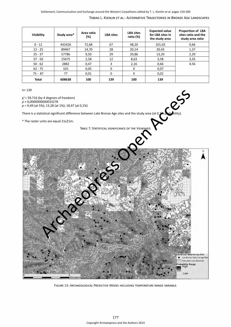
χ2 = 59,716 (by 4 degrees of freedom)p = 0,0000000000033278p = 9,49 (at 5%); 13,28 (at 1%); 18,47 (at 0,1%)
There is a statistical significant difference between Late Bronze Age sites and the study area (at 0,1% probability).
* The raster units are equal 21x21m.
Table 7: Statistical significance of the Viewshed.
Figure 13: Archaeological Predictive Model including temperature range variable.
Archae
opress Open Acce
ss
Settlement, Communication and Exchange around the Western Carpathians edited by T. L. Kienlin et al. pages 159-200
Copyright Archaeopress and the Authors 2014
178
Settlement, Communication and Exchange around the Western Carpathians
Figure 14: Archaeological Predictive Model without temperature range variable.
zone of interest could influence such a result. Relatively poor accuracy of the model might be connected with the location of the Late Bronze Age sites in highly various topographical units. A relatively high amount of sites with negative predictive impact (32 sites), as well as relatively poor gain of positive power zone might be, paradoxically, interpreted as a reflection of the precision of our model. It might illustrate functional differences between the sites (graveyards, open settlements, fortified sites, short-term camps). Although most of the sites are only known from survey prospection, the off-site artefact scatter issue has
not been considered (e.g. Hayes 1991). Poor performance might also point to the chronological diversification of the sites (within the frame of the Lusatian culture). It should once more be noted that, due to insufficient chronological data, it has been assumed, that all sites had been occupied simultaneously, dynamic change of the local environmental preferences has not yet been investigated. On that point two further remarks should be added.
Firstly, the models which are based on the strict correlation ‘society – environment’ seem to work well for early
Study area*
Area ratio (%) LBA sites LBA sites
ratio (%)
Expected value for LBA sites in the study area
Proportion of LBA sites ratio and the
study area ratioKvamme’s gain
Low probability (-1,477 – 0) 313673 39,83 32,00 23,02 72,65 0,44 -1,27
Medium probability(0-3,1825)
280704 57,91 100,00 71,94 65,02 1,54 0,35
High probability (3,1825-6,3649) 5742 2,26 7,00 5,04 1,33 5,26 0,81
600119 100,00 139 100,00 139
n= 139
Table 8: Performance statistics of the Archaeological Predictive Model without temperature range variable.
Archae
opress Open Acce
ss
Settlement, Communication and Exchange around the Western Carpathians edited by T. L. Kienlin et al. pages 159-200
Copyright Archaeopress and the Authors 2014

179
Tobias L. Kienlin et al.: Alternative Trajectories in Bronze Age Landscapes
farming communities (for LBK see e.g. Engel 2012; Tóth 2013).32 Results of such analyses in the case of the societies of the Late Bronze Age and Early Iron Age should be interpreted very carefully. According to M. S. Przybyła (2010a: 272) the settlement pattern of the Tarnobrzeg group of the Lusatian culture (in the area of the San Basin) should be understood as a direct result of an environmental adaptation and attachment to the agricultural attempt. In this sense, Late Bronze Age structures in south-eastern Poland would still be socially marked as ‘Neolithic’. The building of stabile settlement structures is shown in this approach as a derivative process. We agree generally with adapting this model to the area of the middle Dunajec valley. In south-eastern Poland during the Late Bronze Age the micro-regions are traditionally regarded as almost constant structures, but in the western part of the Polish Carpathians some indices of local settlement dynamics are noticeable. In that light, postulated settlement and cultural continuity between BB2 and Early Iron Age (Przybyła 2009: 146) should be considered as a generalisation. New settlements are established in the 12th century BC, e.g. in Wojnicz, site 48 (Dzięgielewski 2010a), Zakliczyn (AZP 107-63/8), or Naszacowice (chronology after Przybyła 2009), as well as graveyards, like the one in Gwoździec (Szpunar/Szpunar 2003; Przybyła 2009). It is therefore possible that we are dealing with an echo of the substantial change of the settlement pattern and pottery stylistic, observed contemporarily in the western part of the Polish Carpathians (Przybyła 2010b).
Secondly, as a consequence of former Neolithic agriculture activity in the Bronze Age, some environmental changes might have been noticed (observed e.g. at the pollen diagrams). Such a situation might have affected the subsistence economy. Because of limited spatial palaeoecological data such changes could not be taken into account in our models.
Despite those weaknesses, our model might be useful to illustrate research gaps in the analysed prehistoric settlement structures and point to potential settlement areas, which have not being examined yet by the traditional way of field prospection. If to compare Predictive Modeling results with Kernel Density Analysis of the Late Bronze Age sites (Kienlin et al. 2010: fig. 29), the distribution of clusters east of the Dunajec (Figure 7) is similar to the distribution of areas with high predictive power (Figure 14). That confirms, in principle, the environmental determination of settlement complexes in this zone. Observed, however, are some none-site zones, which in our model are highly evaluated (e.g. area eastern from Janowice-Wróblowice cluster). Even if we postulate improvement of our model, some of those areas might be in future investigated in the way of field prospection in order to prove the predictions degree in practice.
32 Even if in both papers could be observed very strong tendency of clustering almost all settlements in small areas at the bright river valleys, while the complete study area included also many bright no sites zones, characterised by very different relief and altitude (e.g. mountains).
Agricultural potential model as an example of localized site catchment analysis
Predictive modeling, as described above, shows that a correlation between site location and environmental factors and resources should be acknowledged. In the next paragraphs we will make an attempt to prove, if on the way of deductive approach it could be possible to model and compare potential activity zones of prehistoric settlements. We will proceed on the example of the land cultivation – an activity indispensable to the community’s existence. Palaeo-economical approach has a very long tradition in archaeology. The economical aspect of the activities of prehistoric societies had already been taken into consideration in the late 1960s. At that time a model was postulated, that has concentrated on the effort made to explore natural resources (Zipf 1965; Jarman 1972). According to this theory, while the distance from a settlement rises the efficiency to explore resources sinks. From the very beginning the most controversial problem consisted in the optimum of setting the norms to the impact variables of the site exploration territory (Higgis/Vita-Finzi 1972; Binford 1982). It had been assumed, that the rationalisation of the economic activities should be depending on the environmental factors, as well as the subsistence economy, transport’s possibilities and the population’s size (Jarman 1972; Higgis/Vita-Finzi 1972; Binford 1982). As most ‘rational’ for agricultural and pastoral activities an area has been proposed within a radius of 1km from the settlement and in many subsequent studies it has been often applied.33 An efficiency border has been set at the distance of 5km from the site (Vita-Finzi/Higgs 1970; Hodder/Orton 1976: 230). In the case of hunting and gathering activities, such a border had been estimated at 10km radius from the settlement (Jarman 1972; Bakels 1978; Binford 1982). Those distances are synchronized with 15 minutes, one hour and two hours of walk. In that way the theoretical foundations of the so-called Site Catchment Analysis approach were built. In other words, this approach relies on deriving a territory (catchment) belonging to a site by applying some geographical rule (like distance) and to analyse the properties of the catchment area, usually to see what economic benefits (e.g. agricultural yields) the exploration of the zone of interest would bring. The Exploration Territory model was often discussed. It has been demanded, that the profit’s degree and the economical potential of the researched environmental area should be described with an awareness of a macro-regional context. Also the possibility of activity zones’ diversification in relation to various resources has been noticed (Kobyliński 1986: 20). The terrain topography is another point of significance in the foothills’ region (e.g. Valde-Nowak 2001: 174–177). Soil properties play an important role for agriculture activities as well (Saile 1997).
33 Chisholm 1968; applied e.g. by Dębiec et al. 2005; Dębiec 2006; Kadrow 1990; Kruk et al. 1996; Zych 2005.
Archae
opress Open Acce
ss
Settlement, Communication and Exchange around the Western Carpathians edited by T. L. Kienlin et al. pages 159-200
Copyright Archaeopress and the Authors 2014
180
Settlement, Communication and Exchange around the Western Carpathians
When Geographical Information Systems were introduced to archaeological science, researchers obtained a very powerful tool to model various activities in specified zones. A set of techniques have been developed, called Cost Surface Analysis (CSA). They are based on the ability to assign a certain cost to cross each cell in a raster map, and to accumulate these costs by travelling through the map. Early examples of using these techniques were published by archaeologists working with the Arkansas Archaeological Survey and the US National Parks Service (van Leusen 2002: chapter 6 with further literature). Very soon CSA techniques were widely extended and they found application to the Site Catchment Analysis. Thanks to CSA, instead of using two-dimensional Euclidean distances, the energy – or time expense which is necessary to explore the resources could be estimated (e.g. Erickson/Goldstein 1980; Belén/Arroyo 2009; Verhagen/Whitley 2012).
Our second model, the Agricultural Potential Raster, has been built based on the Coast Surface Analysis. This model should be interpreted as a deductive,34 explanatory and possibilistic approach.35 The deductive approach depends on the evaluation of landscape characteristics (instead of the characteristics of well-known locations in the inductive approach). Different deductive predictive models of agricultural activities of the past societies, occurring lately in literature, show great potential of such studies (e.g. Countryman et al. 2011; Fischer et al. 2010; Posluschny et al. 2012).
Our aim was to show a comparison of possibilities how past communities might structure their ‘resource landscape’, and at the same time, how they have been structured by the landscape themselves (van Leusen 2002). The model has been computed for two settlements in the Rożnów Foothills and one in the Wiśnicz foothills. These sites are characterised by diverse chronological phases. They might also carry out different functions in the settlement pattern. According to the approach which emphasises the importance of substantial economy, the location and long-term existence of the settlement need to be a reflection of the environment capability. In that sense the shift such as site’s re-location should be correlated with the change of resources accessibility (like arable land) or connected with a change of the method of it’s acquisition. We are aware of existing limitations: conducted analysis cover many occupation horizons and flatten them to the one settlement moment. Moreover, the expense of existing territories, increasing territory sizes or decreasing distances between settlements observed in the Late Bronze Age and Early Iron Age might reflect many contemporary processes (climatic change, rise of population, cultural or symbolical change, introduce on new technological innovations). For that reason, we tried to confront the results with the
34 Known also as theory driven model (e.g. Wheatley/Gillings 2002).35 It indicates how suitable an area is for a settlement activity and it does not estimate the probability of use; for the theoretical approach see Posluschny (2002), van Leusen (2002: chapter 5) and Verhagen (2007).
knowledge about the site’s occupation in the context of the regional palaeoenvironmental research.
Agricultural Potential Modeling: The examples of Janowice/Wróblowice and Zawada Lanckorońska
In an earlier paper a similar attempt was made to understand the development of the described settlement clusters in terms of their dependency on topographic features and the potential of their catchment area for agriculture and cattle breeding (cf. Kienlin et al. 2013). While the main parameters of this analysis remain unchanged, the theoretical underpinnings for the present paper have been extended and some parameters of our analysis have been improved in order to develop a more complex and – so we hope – precise model.
In order to estimate the exploitation territory, instead of drawing a two dimensional circle, a Path Distance Analysis has been performed to consider the geomorphological surroundings of each site under study and to model a catchment area of a 15 minute walk around each settlement. Such a distance corresponds well with the theoretical guidelines in accordance to which, the cultivated fields should be reachable in c. 10–15 minutes walk from the settlement.36 In our example, to create this area, the so-called Tobler’s Hiking function was applied – presenting the relationship between speed of movement and slope.37 The settlement area itself was determined taking into account excavations and the results of surface survey and geomagnetic prospection. As mentioned above, our aim was to create an Agricultural Potential Model according to the deductive approach. All variables have been weighted according to the so-called experts judgements. As there is no certain information about the location of the prehistoric fields in the western part of the Polish Carpathians,38 by choosing potential variables and evaluate them, evidence was used based on the soil science, palaeobotanical studies and experimental archaeology. Several variables, which, in our opinion, could play a role for choosing areas for agricultural activities, are geomorphology, solar radiation, soil fertility, difficulty of soil cultivation and at last, possible visibility. The geological formations have been taken into consideration including Pleistocene and Holocene fluvial terraces. Owing to Holocene chronology of the terraces in the middle Dunajec course (Klimek 1991; Krysowska-Iwaszkiewicz/Zuchiewicz 1991/92), and therefore, a possibility of seasonal floods, this area has generally been interpreted to be unfavourable for
36 Kreuz 1990: 153–157; Hochuli et al. 1998: 224; Posluschny 2010: 317; Posluschny et al. 2012: 417.37 Tobler’s function acknowledges the speed of an walk at the slope of 0° by 5.037km/hour. The rivers had been perceived as obstacles; according to this proposition streams are being twice difficult to pass as flat terrain and the Dunajec is an almost closed border.38 First evidence of parcelling out of fields, so called celtic field system is known from Netherlands and it’s dated to the Late Bronze Age (Fokkens 1998; there further literature). Observed parcels around houses are smaller, than those in a distance, what could respond intensive cultivation near the house and less intensive further away (Bakels 2009: 113–114; Urban 2009: 290).
Archae
opress Open Acce
ss
Settlement, Communication and Exchange around the Western Carpathians edited by T. L. Kienlin et al. pages 159-200
Copyright Archaeopress and the Authors 2014

181
Tobias L. Kienlin et al.: Alternative Trajectories in Bronze Age Landscapes
agriculture39 However, since there are a few sites on the low-lying terrace terrain, an additional analysis, the Topographic Wetness Index (Sørensen et al. 2006) has been calculated.40 This parameter marks out the spatial distribution and determines a value of a wetness degree on a surface. As a result it could be observed, that all sites reside at the areas with low TWI values. In the next step, all areas of the Dunajec terraces, which were characterised by high index values were interpreted as exposed to potential flooding and excluded from next analysis (cf. Kienlin et al. 2013).41 Additionally, also slopes over 12° at the loess lidded areas and over 15° in the case of other soils were excluded from potential agricultural activity.42 Then the Topographical Position Index (TPI) was also added to the calculated raster. This parameter enables creating geomorphological units based on DEM in order to calculate six terrain forms.43 The second examined variable was the difficulty of soil cultivation. Gentle slopes and the parts of the terrace, which theoretically are not susceptible to floods, were evaluated, based on slopes and types of soil.44 Subsequently, the direct solar radiation variable (the formula has been computed for nowadays’ vegetation period of the research area, from 28th of March
39 It should be noticed here, that the Late Bronze Age and Early Iron Age Poland was influenced by Subboreal 2 and Subatlantic 1 climatic phases. According to latest studies during the Subboreal 2 the climate was generally warm and humid, there are however some atlantic and continental intervals observed – in those ranges was partly warmer and dryer (1025–975 BC) or warmer and damper (1625–1475 BC; 1300–1275 BC) as today (Starkel et al. 2013: 11–12, fig. 2). Additionally, climatic crisis in Europa in the middle of the 12th century BC, connected with eruption of volcano Hekla 3 (e.g. Falkenstein 1997; Przybyła 2006) is observed at the tree rings of the subfossil black oaks in the Lesser Poland (Krąpiec 1998). At the beginning of Subatlatic 1 period (c. 900 BC) Poland was by cooler and humid climate influenced (Starkel et al. 2013), the next warm phase came however in the younger stages of this period (compare Dzięgielewski 2012 and Starkel et al. 2013). The nearest profiles according the flood phases are known from the valleys of Biała Dunajcowa and Uszwica (Gębica/Wojtal 2011). At the profile located in the modern village Tchów have been observed alluvial sediments, which based on radiocarbon dates could be generally connected with the Early Iron Age (800–480 BC).40 It should be withall noticed, that during the verification survey the Late Bronze Age chronology of a sites AZP 106-65/42 and AZP 106-65/20 couldn’t be unambiguously confirmed. The excavations at the settlement AZP 106-65/30 documented the Early Roman Period chronology of this site.41 This aspect is in the literature extensively discussed. In some studies cultivation of cereals (Rembisz et al. 2009: 119) or leguminous plants (Czopek 1996: 107; Rydzewski 1982: 322;) at the lower terraces is acceptable in the context of the Late Bronze Age agriculture. On the other hand, the higher location of fields is wide evaluated as particular convenient (Bakels 2009: 113; Michalski 1991: 39–40).42 The water erosion takes place at the slopes over 3°, and it rises very rapidly on 10–12°. Because of that, slopes over 15° (in the case of the loess soils over 12°) are contemporary almost unexceptionally excluded from tillage activities (e.g. Józefaciuk/Józefaciuk 1992: 6–8; 1999: tab.1). Direct translation of modern agricultural guidelines for the prehistoric agriculture might be controversial and discussed, however, such conduct might already been observed in the recent studies of Fischer et al. (2010: 197) and Posluschny (2010: 317). Additionally, it should be remarked, that difficulty to plough at steep slopes could also be a signify matter, as there are evidences of using the plough in the Late Bronze Age (see: Urban 2009 with further literature).43 There has been the J. Jenness (2012) algorithm applied. The TPI values have been, based on location of up to now discovered Late Bronze Age settlements evaluated: 1 – valleys floors, 3 – lower slopes, 2 – gentle slopes, 0 –steep slopes, 0 – upper slopes, 3 – ridges, peaks.44 To mark difficulty of cultivation at the sloping terrain, the evaluation of a slope grade has been by the soil type influenced, according to the table used for contemporary agricultural activities (after T. Salata,
until the 5th of November) was calculated. This factor was included, because crop cultivation is traditionally connected with the well-lit areas.45 Soil fertility46 might play a role, as palaeobotanical research at the Late Bronze Age settlements proves, observed cereals might grow on relative opulent habitats (Bakels 2009: 113; Lityńska -Zając 2005: 159, 274 for further literature). Finally, the visibility (viewshed) from potential settlement area, as a social variable of possible protection of property (in this case potential parcels) was taken into consideration. Although the viewshed analysis has not been banded, the size of examined catchment areas determines so called short-distance view in the definition of T. Higuchi (1983: 13–14).
Based on expert judgement all non-ratio scaled variables were evaluated on the ordinal rating scale (van Leusen 2002: chapter 5: 14–15). Because the variables were evaluated in varying classes range, all values were standardised. At the final step, all raster cells were summed together.
The site of Janowice has the largest catchment zone of the investigated sites (430ha). The exploitation zone consists of a wide fertile area around the site itself and quite many shredded ones, located mostly to the south-west and north-east of the site, altogether 181ha evaluated between 0 and 9 points (Figure 15). Also the catchment area of Path Distance at Wróblowice is quite big – 286ha. The exploitation zone consists of quite many arable areas. They are located mostly at direct surroundings of the site, at the parts of a Holocene flood terrace with a low TWI index47 and at the south-eastern parts of the catchment zone, altogether 202.5ha with values between 0 and 24 points (Figure 16). Remarkably, despite of the deductive approach, all sites dated to the Late Bronze Age or Early Iron Age in the Janowice/Wróblowice cluster capture mainly well evaluated zones. This underlines the importance of environmental variables for these communities. It is possible, that the surrounding sites had auxiliary character, that they were short-lived and either more mobile (from almost all of them only few pottery
data from a script for a course of the Environmental Protection at the Agricultural University of Cracow). The raster cells have been evaluated from 0 to 7. The evaluation of the raster units with ‘no determined soil type’ data had rest on the most common soil type cells, observed in each altitude class of our interest zone.45 For botanical conditions see e.g. Nowak (2009: 89), for experimental archaeology examination e.g. Reynolds (1990: tab. 5). The solar radiation factor has been by SAGA GIS calculated. The isolation has been from the middle point of investigation zone calculated (49˚ 52ˊ 60˝). The computing occurred with the Solar Constant equal 1367W/m2, while isolation raster is equal 1kWh/m2.46 The evaluation of soils has been made based on modern soil-agricultural maps; no palaeopedological investigations have been carried out. By that fact, the evaluation of fertility need to be interpret as a very basic estimation. Intentionally, no modern classification of Poland’s arable land has been used (so called ‘klasy bonitacyjne’), thence that classification relate inter alia on the contemporary soil properties, which could be as well very different form prehistoric state as modern soil profiles, while the relict soils might be under contemporary accumulations buried (Bednarek 2007; Verhagen 2007: 195–200). The basic fertility of soil types have been weighted from 0 to 4, based on, among other, publications of Uziak/Klimowicz (2002) and Paluszek (2011).47 However, as already has been mentioned, cultivation at the Holocene terrace is the matter of argument.
Archae
opress Open Acce
ss
Settlement, Communication and Exchange around the Western Carpathians edited by T. L. Kienlin et al. pages 159-200
Copyright Archaeopress and the Authors 2014
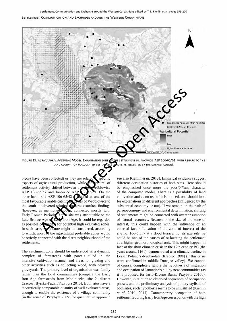
182
Settlement, Communication and Exchange around the Western Carpathians
pieces have been collected) or they are related to specific aspects of agricultural production, while the ‘centre’ of settlement activity shifted between the sites Wróblowice AZP 106-65/57 and Janowice AZP 106-65/61. On the other hand, site AZP 106-65/42 – located at one of the most favourable arable catchment zones of Wróblowice to the south – delivered relative numerous surface findings (however, as mentioned above, connected mostly with Early Roman Period). If this site was attributable to the Late Bronze Age or Early Iron Age, it could be regarded as possible competitor for potential high evaluated zones. In such case, the picture might be considered, according to which, most of the agricultural profitable zones would be strictly connected with the direct neighbourhood of the settlements.
The catchment zone should be understood as a dynamic complex of farmsteads with parcels tilled in the intensive cultivation manner and areas for grazing and other activities such as collecting wood, with adjacent graveyards. The primary level of organisation was family rather than the local communities (compare the Early Iron Age farmsteads from Modlniczka, site 2, district Cracow; Byrska-Fudali/Przybyła 2013). Both sites have a theoretically comparable quantity of well evaluated areas, enough to enable the existence of a village community (in the sense of Przybyła 2009; for quantitative approach
see also Kienlin et al. 2013). Empirical evidences suggest different occupation histories of both sites. Here should be emphasised once more the possibilistic character of the computed model. There is a possibility of land cultivation and as no use of it is noticed, one should look for explanations in different approaches (influenced by the substantial economy or not). If we remain on the path of palaeoeconomy and environmental determination, shifting of settlements might be connected with overconsumption of natural resources. Because of the size of the zone of interest, this could happen with the influence of an external factor. Location of the zone of interest of the site no. 106-65/57 at a flood terrace, not its size inter se could be one of the causes of re-locating the settlement at a higher geomorphological unit. This might happen in face of the short climatic crisis in the 12th century BC (the years around 1161), demonstrated as a climatic decline in Lesser Poland’s dendro-data (Krąpiec 1998) (if this crisis were confirmed in middle Dunajec valley). We cannot, of course, completely ignore the hypothesis of migration and occupation of Janowice’s hill by new communities (as it is proposed for Jasło-Krosno Basin; Przybyła 2010b). However, in relation to observed sequences of occupation phases, and the preliminary analysis of pottery stylistic of both sites, such hypothesis seems to be unjustified (Kienlin et al. 2010; 2013). Contemporary occupation of both settlements during Early Iron Age corresponds with the high
Figure 15: Agricultural Potential Model. Exploitation zone of the settlement in Janowice (AZP 106-65/61) with regard to the land cultivation (calculated best arable land is represented by the darkest color).
Archae
opress Open Acce
ss
Settlement, Communication and Exchange around the Western Carpathians edited by T. L. Kienlin et al. pages 159-200
Copyright Archaeopress and the Authors 2014

183
Tobias L. Kienlin et al.: Alternative Trajectories in Bronze Age Landscapes
impact of their agricultural potential raster. In this sense our model expresses economical viability of the process, even if it does not justify it or even it does not give a direct explanation of it’s nature. The split of the settlements at the 9th–5th century BC (especially the phase of HaD visible in the ceramic material from Wróblowice) could be connected with period Subatlantic 1 and explained by looking about new arable areas. At the transition phase (900 BC) a short rise of humidity has been observed. Period Subatlantic 1 (900–400 BC) was characterised by the cooler oscillation, proceeding a warmer phase (Starkel et al. 2013: fig. 2, tab. 1). K. Dzięgielewski (2012) specifies, referring to the dendrological premises from the archaeological site in Podłęże (Lesser Poland), the warming phase to the range 650–400 BC (HaD). The C14 dates of the flooding phase of Biała river at the profile from Tchów (18km east from Wróblowice) is laying at the Hallstatt plateau and due to its very wide range (800–480 BC) cannot be useful (Gębica/Wojtal 2011). Another possible cause of the observed phenomena, the rise of population, finds support at the anthropological analysis based on the Late Bronze Age/Early Iron Age graveyards in the south of Poland (Czopek 2006: 119–121). For the area at the Sandomierz Upland W. Rajpold (2013) proposed an estimation model , according to which rapid population growth of the Tarnobrzeg group of the Lusatian culture during at the beginning of Early Iron Age is connected with participation of the ‘foreign’
substract (the Pomerian culture). We find no sufficient premises to acknowledge analogical processes, as no clear indications can be confirmed (e.g. ‘foreign’ pottery sets). That is why the mass migration – an alternative cause have been preliminary declined. From the palaeoecomonical point of view both causes (change of climatic conditions, population rise) could exist together and are much at the same outcome: bigger, or more scattered communities need more territory. As intensification achieved a crucial point, there is a need to extensive the cultivation and therefore to look for new arable areas. And such potential economically attractive areas are present at both catchment zones.
Analogical settlement dynamic processes might be also observed at the other areas in the region of the western part of Polish Carpathians. Approximate occupation phases sequence to Wróblowice might be also observed at the settlement in Wierzchosławice, site 15 (Miraś/Oleszczak in this volume). Two graveyards at Chełmiec, the older connected with Piliny Culture and the younger synchronized with the Early Iron Age (Abłamowicz/Abłamowicz 1989) are remarkable as well. Grounding the settlement in Wojnicz, site 48 in Ha A and shifting the location to Wojnicz, site 18 at the Early Iron Age (Dzięgielewski 2010a; 2010b) might be interpret as a parallel process.
Figure 16: Agricultural Potential Model. Exploitation zone of the settlement in Wróblowice (AZP 106-65/57) with regard to the land cultivation (calculated best arable land is represented by the darkest color).
Archae
opress Open Acce
ss
Settlement, Communication and Exchange around the Western Carpathians edited by T. L. Kienlin et al. pages 159-200
Copyright Archaeopress and the Authors 2014
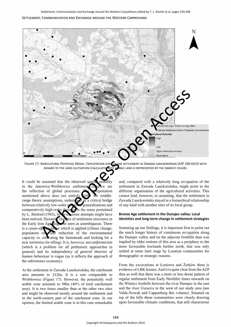
184
Settlement, Communication and Exchange around the Western Carpathians
It could be assumed that the observed spatial mobility in the Janowice-Wróblowice settlement complex are the reflection of global processes. The interpretation mentioned above does not entirely fulfill the middle-range theory assumptions, understood as a critical bridge between relatively low-order empirical generalisations and comparatively high-order theories in the sense postulated by L. Binford (1982), however some attempts might have been noticed. Dynamic changes of settlement structures in the Early Iron Age might be seen as unambiguous. There is a cause-effect scheme which is applied (climax change, population rise and reduction of the environmental capacity vs. relocating the farmsteads and looking for a new territories for tilling). It is, however, not uniformarian (which is a problem for all prehistoric approaches in general) and its independency of general theories of human behaviour is vague (as it reflects the approach of the subsistence economy).
At the settlement in Zawada Lanckorońska, the catchment area amounts to 212ha. It is a size comparable to Wróblowice (Figure 17). However, the potentially well arable zone amounts to 98ha (46% of total catchement area). It is two times smaller than at the other two sites and might be observed mostly around the settlement and in the north-eastern part of the catchment zone. In our opinion, the limited arable zone is in this case remarkable
and, compared with a relatively long occupation of the settlement in Zawada Lanckorońska, might point to the different organisation of the agricultural activities. This cannot lead, however, to assuming, that the settlement in Zawada Lanckorońska stayed in a hierarchical relationship of any kind with another sites of its local group.
Bronze Age settlement in the Dunajec valley: Local identities and long-term change in settlement strategies
Summing up our findings, it is important first to point out the much longer history of continuous occupation along the Dunajec valley and on the adjacent foothills than was implied by older notions of this area as a periphery to the more favourable lowlands further north, that was only settled at some later stage by Lusatian communities for demographic or strategic reasons.
From the excavations at Łoniowa and Żerków there is evidence of LBK houses. And it is quite clear from the AZP data as well that there was a more or less dense pattern of regular settlement from Early Neolithic times onwards on the Wiśnicz foothills between the river Dunajec in the east and the river Uszwica in the west of our study area (see Valde-Nowak and Cappenberg this volume). Situated on top of the hills these communities were clearly drawing upon favourable climatic conditions, that still characterise
Figure 17: Agricultural Potential Model. Exploitation zone of the settlement in Zawada Lanckorońska (AZP 106-64/3) with regard to the land cultivation (calculated best arable land is represented by the darkest color).
Archae
opress Open Acce
ss
Settlement, Communication and Exchange around the Western Carpathians edited by T. L. Kienlin et al. pages 159-200
Copyright Archaeopress and the Authors 2014
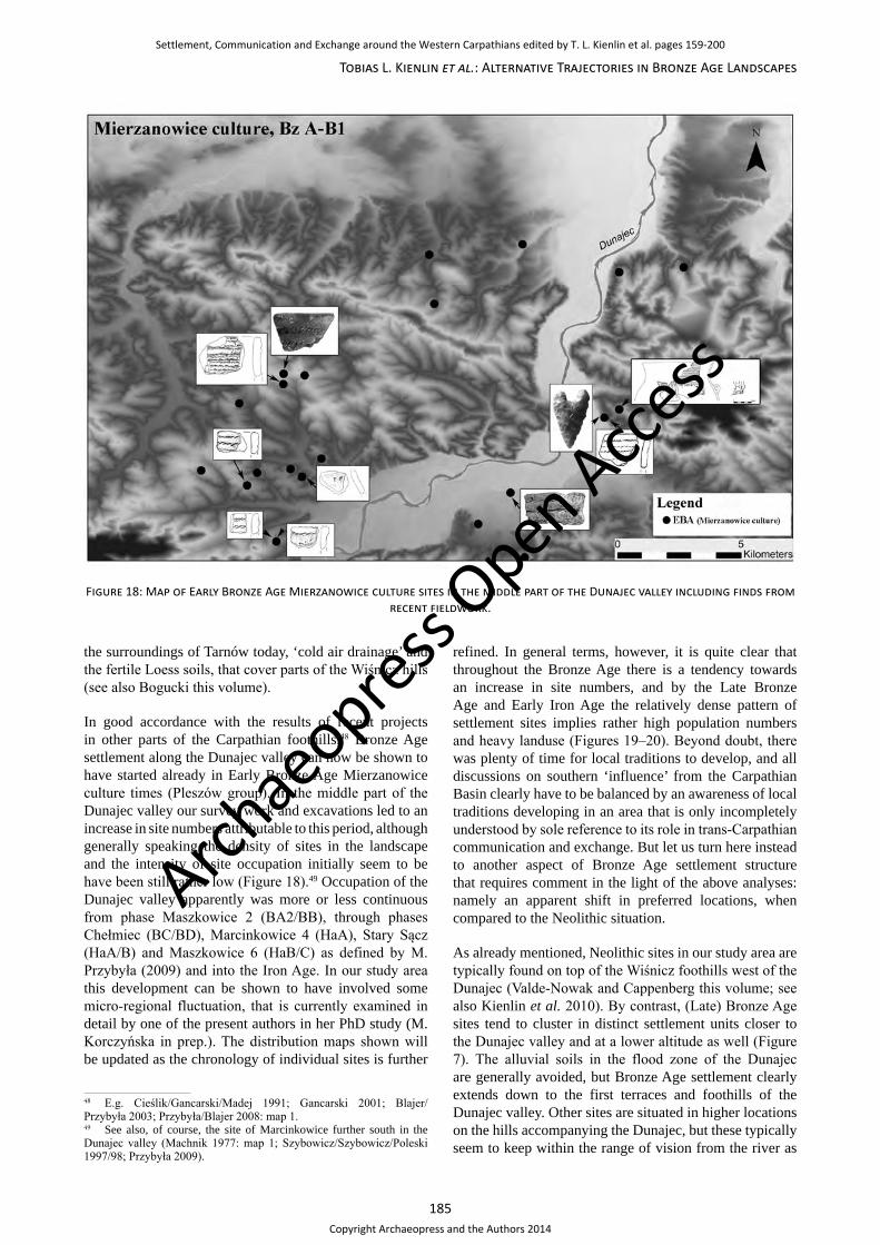
185
Tobias L. Kienlin et al.: Alternative Trajectories in Bronze Age Landscapes
the surroundings of Tarnów today, ‘cold air drainage’ and the fertile Loess soils, that cover parts of the Wiśnicz hills (see also Bogucki this volume).
In good accordance with the results of recent projects in other parts of the Carpathian foothills,48 Bronze Age settlement along the Dunajec valley can now be shown to have started already in Early Bronze Age Mierzanowice culture times (Pleszów group). In the middle part of the Dunajec valley our survey work and excavations led to an increase in site numbers attributable to this period, although generally speaking the density of sites in the landscape and the intensity of site occupation initially seem to be have been still rather low (Figure 18).49 Occupation of the Dunajec valley apparently was more or less continuous from phase Maszkowice 2 (BA2/BB), through phases Chełmiec (BC/BD), Marcinkowice 4 (HaA), Stary Sącz (HaA/B) and Maszkowice 6 (HaB/C) as defined by M. Przybyła (2009) and into the Iron Age. In our study area this development can be shown to have involved some micro-regional fluctuation, that is currently examined in detail by one of the present authors in her PhD study (M. Korczyńska in prep.). The distribution maps shown will be updated as the chronology of individual sites is further
48 E.g. Cieślik/Gancarski/Madej 1991; Gancarski 2001; Blajer/Przybyła 2003; Przybyła/Blajer 2008: map 1.49 See also, of course, the site of Marcinkowice further south in the Dunajec valley (Machnik 1977: map 1; Szybowicz/Szybowicz/Poleski 1997/98; Przybyła 2009).
refined. In general terms, however, it is quite clear that throughout the Bronze Age there is a tendency towards an increase in site numbers, and by the Late Bronze Age and Early Iron Age the relatively dense pattern of settlement sites implies rather high population numbers and heavy landuse (Figures 19–20). Beyond doubt, there was plenty of time for local traditions to develop, and all discussions on southern ‘influence’ from the Carpathian Basin clearly have to be balanced by an awareness of local traditions developing in an area that is only incompletely understood by sole reference to its role in trans-Carpathian communication and exchange. But let us turn here instead to another aspect of Bronze Age settlement structure that requires comment in the light of the above analyses: namely an apparent shift in preferred locations, when compared to the Neolithic situation.
As already mentioned, Neolithic sites in our study area are typically found on top of the Wiśnicz foothills west of the Dunajec (Valde-Nowak and Cappenberg this volume; see also Kienlin et al. 2010). By contrast, (Late) Bronze Age sites tend to cluster in distinct settlement units closer to the Dunajec valley and at a lower altitude as well (Figure 7). The alluvial soils in the flood zone of the Dunajec are generally avoided, but Bronze Age settlement clearly extends down to the first terraces and foothills of the Dunajec valley. Other sites are situated in higher locations on the hills accompanying the Dunajec, but these typically seem to keep within the range of vision from the river as
Figure 18: Map of Early Bronze Age Mierzanowice culture sites in the middle part of the Dunajec valley including finds from recent fieldwork.
Archae
opress Open Acce
ss
Settlement, Communication and Exchange around the Western Carpathians edited by T. L. Kienlin et al. pages 159-200
Copyright Archaeopress and the Authors 2014
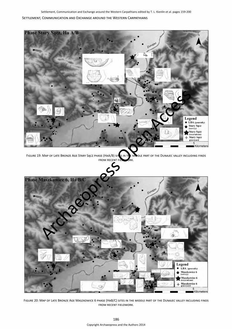
186
Settlement, Communication and Exchange around the Western Carpathians
Figure 20: Map of Late Bronze Age Maszkowice 6 phase (HaB/C) sites in the middle part of the Dunajec valley including finds from recent fieldwork.
Figure 19: Map of Late Bronze Age Stary Sącz phase (HaA/B) sites in the middle part of the Dunajec valley including finds from recent fieldwork.
Archae
opress Open Acce
ss
Settlement, Communication and Exchange around the Western Carpathians edited by T. L. Kienlin et al. pages 159-200
Copyright Archaeopress and the Authors 2014

187
Tobias L. Kienlin et al.: Alternative Trajectories in Bronze Age Landscapes
well. In a long-term perspective, therefore, there are clear trends and changes in preferred settlement location.
It is obvious, that this pattern lends itself to the above discussed narratives: With its predominant orientation towards the Dunajec valley, Bronze Age settlement seemingly confirms notions on the importance of long-distance trade and its control by local communities (or rather: by local elites) situated in favourable locations such as nodal points in the landscape or along river valleys etc. (see introduction to this paper). The spatial organisation of Neolithic communities, on the other hand, would typically be expected to follow considerations referring to favourable soils or climatic conditions instead, i.e. the choice of settlement location is thought to depend mainly on factors related to agriculture and animal husbandry.
Now, instead of opposing Neolithic subsistence economy and Bronze Age trade and exchange, the above analyses clearly point to the overriding importance of favourable soil types, exposure and availability of arable land for the location of the Bronze Age sites examined. It is certainly possible that the Dunajec offered additional opportunities for communication and exchange, but this would also have applied for Neolithic communities on the adjacent hills that got hold of flint raw material from abroad (see Valde-Nowak this volume), and vice versa environmental parameters can be shown to have been of prime importance for Bronze Age communities as well. The overall situation in our study area can therefore be taken to imply a more nuanced picture, and it certainly underlines the necessity of a differentiated approach to Bronze Age settlement patterns (see also Kienlin/Valde-Nowak 2008; Kienlin et al. 2010).
According to M. Lityńska-Zając (2005: 277) during the Late Bronze Age in general there is evidence of a diversification in subsistence strategies and more intensive patterns of land use. From the palaeobotanical research carried out by M. Lityńska-Zając, M. Moskal-del Hoyo and K. Cywa (this volume) on plant remains from our excavations on the Bronze Age sites of Janowice (AZP 106-65/61) and Wróblowice (AZP 106-65/57), there is certainly evidence for such a development, since the number of domesticated and wild plant species used increased in comparison to the Neolithic. Unfortunately, due to the specific soil conditions the preservation of bones is poor on our sites. So it is mainly by reference to adjacent areas that an increasing significance of animal husbandry can be suggested. Such archaeozoological studies convincingly point to the great importance of cattle, a somewhat lower significance of sheep/goat and the comparatively slight role of pig in the Late Bronze Age and Early Iron Age (Piątkowska-Małecka/Gręzak 2007: 135; Zielińska 2009; Gocman/Pieńkos 2012).
Summarising these lines of evidence, it is apparent that the shift observed from locations preferred during the Neolithic to those of the (Late) Bronze Age may well reflect a more extensive pattern of land use and/or an increase in
the significance of herding and animal husbandry. Such change in site location and subsistence strategies may correspond to climatic factors (see above). Additionally, it may relate to broader cultural notions of how to live, but it must certainly not be reduced to the single factor ‘control of trade’ along the Dunajec. For the analyses discussed in the preceeding paragraphs provide positive evidence that the Bronze Age choice of settlement locations, too, followed considerations related to subsistence economy and favourable conditions for agriculture and lifestock breeding. This tradition may have been different from the previous Neolithic one. Nonetheless, it had an important role to play in the formation of the Bronze Age landscape, and landuse and agriculture were of prime importance for the spatial arrangement of sites. There is a clear preference for locations exposed to the south and southwest, and obviously it was important to have sufficient arable land of high quality at one’s disposal. We are talking about small-scale villages or rather hamlets situated in favourable topographic and ecological positions that were home to a population drawing largely on agriculture and livestock breeding – different from the Neolithic, but not in the sense of significant qualitative differences in the social organisation of these communities.
The reason why Janowice AZP 106-65/61 attained greater continuity than other sites in ‘its’ cluster was probably its large catchment area of 430ha and an equally large zone of altogether 181ha of favourable arable land that supported diversified subsistence strategies of a growing community. The choice of a hilltop location in this case was apparently a consequence of advantageous microclimatic conditions such as cold-air drainage, that had already favoured Neolithic settlement west of the Dunajec river (see Bogucki and Valde-Nowak this volume) and the potential for agriculture and livestock breeding on the plateau itself and in its upland hinterland, not one of ‘control’ of trade or ‘power’ exercised throughout this section of the Dunajec valley.
As such the growth of Janowice AZP 106-65/61 may have been the result of, or at least it may have been accelerated by people relocating from neighbouring sites such as Wróblowice AZP 106-65/57 (see above), that generally have smaller catchment areas. Meanwhile, other sites of this kind continued to coexist with the hilltop settlement of Janowice or where newly founded during its existence. However, such processes have to be understood not only in environmental and economic terms, since, for example, the catchment area of Wróblowice is also quite large (286ha, with an arable zone of variable quality of even 202.5ha) and may well have supported an ongoing occupation of this zone. So apparently it was not just need that drove people to relocate but a variety of ‘soft’ factors and considerations that remain without the scope of archaeological insight. In the case of Janowice and Wróblowice this may have involved more favourable climatic conditions of living at a higher elevation rather than on the first terrace just above the floodplain as well as more intagible notions of joining a growing and apparently ‘successful’ community etc.
Archae
opress Open Acce
ss
Settlement, Communication and Exchange around the Western Carpathians edited by T. L. Kienlin et al. pages 159-200
Copyright Archaeopress and the Authors 2014
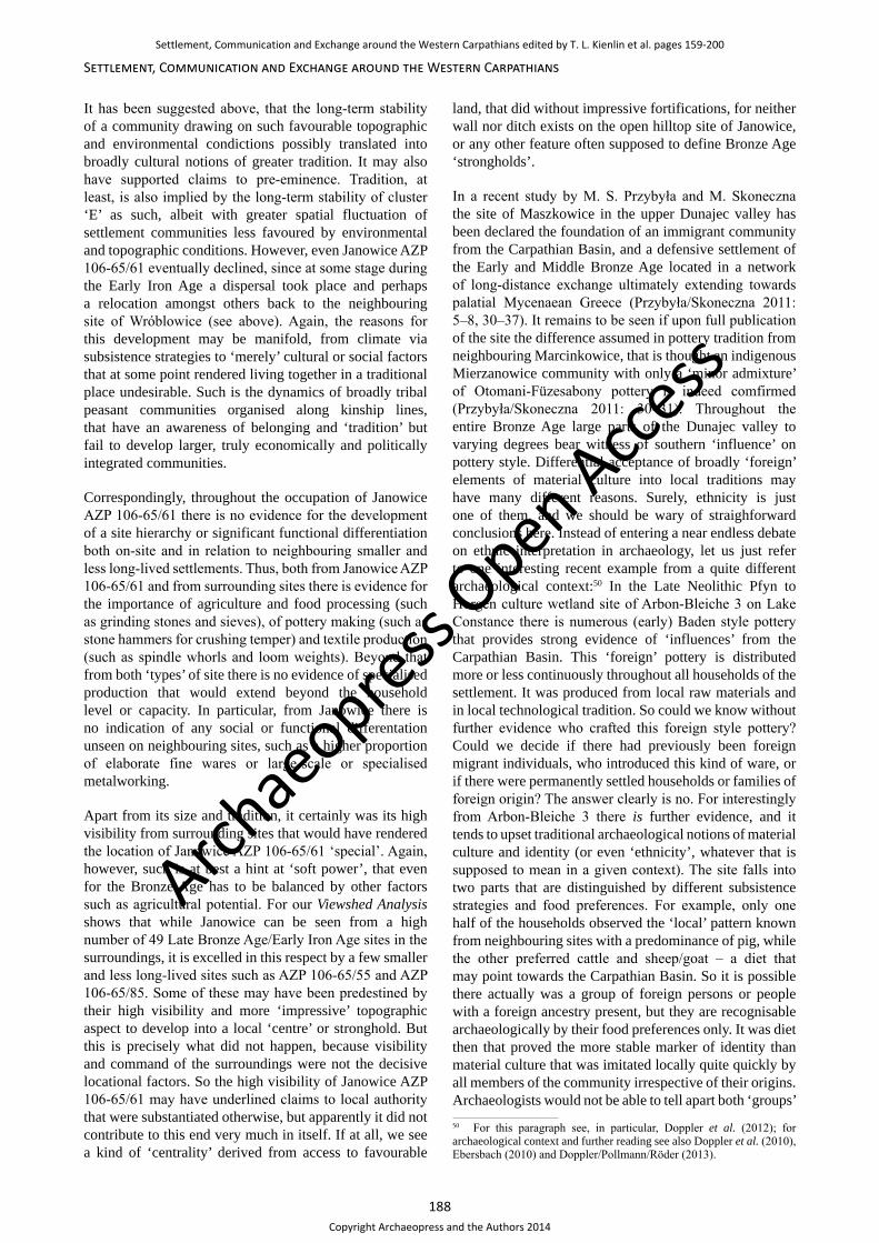
188
Settlement, Communication and Exchange around the Western Carpathians
It has been suggested above, that the long-term stability of a community drawing on such favourable topographic and environmental condictions possibly translated into broadly cultural notions of greater tradition. It may also have supported claims to pre-eminence. Tradition, at least, is also implied by the long-term stability of cluster ‘E’ as such, albeit with greater spatial fluctuation of settlement communities less favoured by environmental and topographic conditions. However, even Janowice AZP 106-65/61 eventually declined, since at some stage during the Early Iron Age a dispersal took place and perhaps a relocation amongst others back to the neighbouring site of Wróblowice (see above). Again, the reasons for this development may be manifold, from climate via subsistence strategies to ‘merely’ cultural or social factors that at some point rendered living together in a traditional place undesirable. Such is the dynamics of broadly tribal peasant communities organised along kinship lines, that have an awareness of belonging and ‘tradition’ but fail to develop larger, truly economically and politically integrated communities.
Correspondingly, throughout the occupation of Janowice AZP 106-65/61 there is no evidence for the development of a site hierarchy or significant functional differentiation both on-site and in relation to neighbouring smaller and less long-lived settlements. Thus, both from Janowice AZP 106-65/61 and from surrounding sites there is evidence for the importance of agriculture and food processing (such as grinding stones and sieves), of pottery making (such as stone hammers for crushing temper) and textile production (such as spindle whorls and loom weights). Beyond that from both ‘types’ of site there is no evidence of specialised production that would extend beyond the household level or capacity. In particular, from Janowice there is no indication of any social or functional differentation unseen on neighbouring sites, such as a higher proportion of elaborate fine wares or large-scale or specialised metalworking.
Apart from its size and tradition, it certainly was its high visibility from surrounding sites that would have rendered the location of Janowice AZP 106-65/61 ‘special’. Again, however, such is at best a hint at ‘soft power’, that even for the Bronze Age has to be balanced by other factors such as agricultural potential. For our Viewshed Analysis shows that while Janowice can be seen from a high number of 49 Late Bronze Age/Early Iron Age sites in the surroundings, it is excelled in this respect by a few smaller and less long-lived sites such as AZP 106-65/55 and AZP 106-65/85. Some of these may have been predestined by their high visibility and more ‘impressive’ topographic aspect to develop into a local ‘centre’ or stronghold. But this is precisely what did not happen, because visibility and command of the surroundings were not the decisive locational factors. So the high visibility of Janowice AZP 106-65/61 may have underlined claims to local authority that were substantiated otherwise, but apparently it did not contribute to this end very much in itself. If at all, we see a kind of ‘centrality’ derived from access to favourable
land, that did without impressive fortifications, for neither wall nor ditch exists on the open hilltop site of Janowice, or any other feature often supposed to define Bronze Age ‘strongholds’.
In a recent study by M. S. Przybyła and M. Skoneczna the site of Maszkowice in the upper Dunajec valley has been declared the foundation of an immigrant community from the Carpathian Basin, and a defensive settlement of the Early and Middle Bronze Age located in a network of long-distance exchange ultimately extending towards palatial Mycenaean Greece (Przybyła/Skoneczna 2011: 5–8, 30–37). It remains to be seen if upon full publication of the site the difference assumed in pottery tradition from neighbouring Marcinkowice, that is thought an indigenous Mierzanowice community with only a ‘minor admixture’ of Otomani-Füzesabony pottery is indeed comfirmed (Przybyła/Skoneczna 2011: 30–31). Throughout the entire Bronze Age large parts of the Dunajec valley to varying degrees bear witness of southern ‘influence’ on pottery style. Differential acceptance of broadly ‘foreign’ elements of material culture into local traditions may have many different reasons. Surely, ethnicity is just one of them, and we should be wary of straighforward conclusions here. Instead of entering a near endless debate on ethnic interpretation in archaeology, let us just refer to one interesting recent example from a quite different archaeological context:50 In the Late Neolithic Pfyn to Horgen culture wetland site of Arbon-Bleiche 3 on Lake Constance there is numerous (early) Baden style pottery that provides strong evidence of ‘influences’ from the Carpathian Basin. This ‘foreign’ pottery is distributed more or less continuously throughout all households of the settlement. It was produced from local raw materials and in local technological tradition. So could we know without further evidence who crafted this foreign style pottery? Could we decide if there had previously been foreign migrant individuals, who introduced this kind of ware, or if there were permanently settled households or families of foreign origin? The answer clearly is no. For interestingly from Arbon-Bleiche 3 there is further evidence, and it tends to upset traditional archaeological notions of material culture and identity (or even ‘ethnicity’, whatever that is supposed to mean in a given context). The site falls into two parts that are distinguished by different subsistence strategies and food preferences. For example, only one half of the households observed the ‘local’ pattern known from neighbouring sites with a predominance of pig, while the other preferred cattle and sheep/goat – a diet that may point towards the Carpathian Basin. So it is possible there actually was a group of foreign persons or people with a foreign ancestry present, but they are recognisable archaeologically by their food preferences only. It was diet then that proved the more stable marker of identity than material culture that was imitated locally quite quickly by all members of the community irrespective of their origins. Archaeologists would not be able to tell apart both ‘groups’ 50 For this paragraph see, in particular, Doppler et al. (2012); for archaeological context and further reading see also Doppler et al. (2010), Ebersbach (2010) and Doppler/Pollmann/Röder (2013).
Archae
opress Open Acce
ss
Settlement, Communication and Exchange around the Western Carpathians edited by T. L. Kienlin et al. pages 159-200
Copyright Archaeopress and the Authors 2014

189
Tobias L. Kienlin et al.: Alternative Trajectories in Bronze Age Landscapes
of people on the basis of the pots they were producing. The marker of identity was exactly the kind of evidence we do not normally have in this high quality from archaeological sites outside wetland habitats, i.e. animals bones preserved and attribuable to specific houses or household units.
There are other problematic issues as well, for example, the comparison of what may have been a retaining wall for the terrace required to settle any larger part of the Maszkowice hilltop rather than a proper fortification with quite different ‘analogies’ such as Bartholomäberg in the Alps (e.g. Krause 2005), Spišský Štvrtok (see above), B. Hänsel’s (e.g. 2002) ‘proto-urban’ centres along the Adriatic and ultimately Mycenae (Przybyła/Skoneczna 2011: 31–35).51 But let us have a look instead at a recent turn in the interpretation of Maszkowice: for rather than taking any more interest in ‘[...] the inhabitants of the Maszkowice settlement [who] actively participated in the exchange of goods between the “north” and “south” of Central Europe for nearly 400 years [...]’ (Przybyła/Skoneczna 2011: 38), soon after there is an interpretative shift towards the economic potential of the surroundings of Maszkowice, that is now understood to be the crucial factor for the choice of the site’s location (Przybyła et al. 2012).
In a meticulous analysis of factors such as soil quality, topography and (micro-) climate it is shown that the promontory of Maszkowice in its wider surroundings actually offers the best potential to support what is now thought a rather small agricultural community by a mixed strategy of agriculture and lifestock breeding (Przybyła et al. 2012: 252–262). The choice of a naturally defended location situated on a rather steep hilltop and the early existence of what is thought to be a fortification wall, on the other hand, is explained by latent pressure on limited natural resources and endemic aggression or ‘warfare’ in such situations, that would have favoured attempts to increase group size, derived for example from the terrassing and embankment of the hill at a later stage of the site’s existence, and defence strategies such as the erection of an enclosing wall (Przybyła/Skoneczna 2011: fig. 20; Przybyła et al. 2012: 246–252, 262–264).
This approach via environmental conditions, the importance attributed to subsistence economy and the model, that is derived for the Maszkowice community, is beyond traditional notions of such sites as a home to local elites dominating their surroundings in economic and political terms and deriving additional power and prestige from long-distance trade via the Dunajec valley. It is very
51 See also above on the uses of core and periphery models in Bronze Age archaeology (cf. Harding 2013); in this context the reference to a clay anthropomorphic figurine from Maszkowice as an indicator of shared ‘customs and beliefs’ ultimately derived from the Mycenaean Bronze Age (Przybyła/Skoneczna 2011: 35–37, figs. 19 and 20) is yet another example of the decontextualisation of foreign elements (if so at all) in such discussions. Symbolically charged objects do not remain unaffected in their specific meaning and potential to be drawn upon in local discourse when transfered from ‘core’ to ‘periphery’. The impact of foreign derived material culture, if any, on local systems needs to be carefully considered not taken for given.
much in line, on the other hand, with the approach and the argument developed here (see Kienlin et al. 2010; 2011; 2013; Korczyńska et al. 2012).
On may add, perhaps, from a theoretical perspective, that conflict in segmentary systems not only arises from competition over limited resources, but is inherent in the nested, modular structure of such non-hierarchical societies with people involved and cooperating in various groupings of different scale that are adapted to and directed towards specific types of collective interests – for example, reproductive, subsistence and defence groups (Roscoe 2009: 75, 89). Conflict may also arise then, for example, from multiple involvement and outcome intended (e.g. cooperation in terms of defence but rivalry with regard to reproduction). It can be mediated, however, by ‘social signalling’; that is by reverting to ‘symbolic’ or ‘ritualised’ fighting to communicate strength and settle dispute by assessing the likely outcome of actual violence (Roscoe 2009: 72, 89–90).
Clearly, the supposed fortification at Maszkowice would seem to fit in here. There are two problems, however, with this kind of approach, that must be taken into consideration: namely neglect of variability, both on the anthropological and on the archaeological side.52 First, we have to be aware that the importance of warfare in New Guinean society, from which much of this theorising is ultimately derived (see, for example, Przybyła et al. 2012: 251), may limit the applicability of such models to European prehistory. Here the same holds true for our reading of anthropology, what has been said above with regard to archaeology (cf. Kienlin 2012a): Variability must not be covered up by a priori decisions and models applied without true fit to the data. Thus, as already mentioned, pressure on natural resources is just on possible source of conflict, and – the other way round – much aggression that may arise for various reasons is actually resolved by social mechanisms other than fighting.53 Among these, ‘conspicuous construction’ (i.e., for example, the erection of a massive wall) is but one form of social signalling; others are mechanisms like ‘conspicuous distribution’ (e.g. feasting) or ‘conspicuous performance’ (e.g. ceremonial acts with elaborately choreographed singing and dancing), that are less well visible archaeologically (Roscoe 2009: 95–101; see also Hayden 2001; Dietler 2001). In much of our anthropological reading we tend to neglect the group-oriented nature of such activities and the wide range of potential ‘participants’ from individuals to subgroups or groups (Roscoe 2009: 95–99). The focus is on their importance for the resolution of conflict and/or the emergence and reproduction of political leadership, when in fact they may also serve to promote intra-group solidarity, establish alliances and allow inter-group cooperation as well as competition (Hayden 2001: 35–42, 44–45, 53–59; Dietler 2001: 68–80).
52 E.g. Przybyła et al. (2012: 263) who clearly seek to develop an ‘universal interpretative model’.53 As opposed to the notion of presumably almost ubiquitous inter-group aggression (Przybyła et al. 2012: 251–252, 262).
Archae
opress Open Acce
ss
Settlement, Communication and Exchange around the Western Carpathians edited by T. L. Kienlin et al. pages 159-200
Copyright Archaeopress and the Authors 2014
190
Settlement, Communication and Exchange around the Western Carpathians
Such feasting may, of course, have been going on at Janowice AZP 106-65/61. For this reason, we have advocated above an interpretation of the Janowice site as a focus of local identities, that we feel is in accordance both with our archaeological data and our reading of anthropology (see also Kienlin 2012a). Accordingly, Janowice AZP 106-65/61 would have developed in its specific topographic setting due to broadly economic concerns (catchment area, soil, climate etc.). However, with time this growing open hilltop settlement came to be a nodal point in the landscape and the potential focus for a wider set of practices to negotiate and organise the social.
This leads on to our second criticism of the Maszkowice model proposed by Przybyła et al. (2012), that is neglect of variability on the archaeological side. It is possible that at Maszkowice conflict over limited resources set a premium on group size, integration and (if so) demarcation. Our own analyses could support such a view, since calculated according to our parameters outlined above the settlement of Maszkowice has a catchment area of just 122.6ha and a favourable arable zone of 105ha,54 which is much lower than the values calculated for Janowice (catchment area: 430ha; arable zone 181ha; see above).
However, since we are dealing with man and culture there is no such simple linear relation. As a result, even within the same micro-regions as well as along the same river valley, we encounter quite different trajectories: Zawada Lanckorońska has a catchment area of 212ha, not that much below neighbouring Wróblowice (286ha), but its potentially arable zone is much smaller and comprises only 98ha (compared to 202.5ha for Wróblowice). Yet, despite its limited arable zone, Zawada Lanckorońska was occupied for a relatively long period of time. It apparently achieved a certain tradition, which was not the case at Wróblowice in direct neighbourhood and ‘confrontation’ with the more ‘promising’ site of Janowice – most likely both in topographic and cultural terms (see above). Compared to Maszkowice (122.6ha), on the other hand, Zawada Lanckorońska has a larger catchment area (212ha), but both sites have rather similar stretches of potentially favourable arable land at their disposal (Maszkowice: 105ha; Zawada Lanckorońska: 98ha). Yet, unlike Maszkowice at Zawada Lanckorońska such limited agricultural resources and potential conflict with prosperous sites just on the opposite site of the Dunajec valley did not need to be or could not be solved by social signaling and fortification.
In broadly the same cultural and natural setting there were different ‘solutions’ or strategies available to communities in order to cope with external restraints and cultural notions how social life should be organised. The development of these communities was contingent upon numerous factors beyond even the most sophisticated attempt at geographical modelling. Consequently, we must certainly 54 We are indebted to M. Przybyła for providing us with the raw data and maps to calculate these figures for comparison with our sites in the middle Dunajec valley.
not mistake any notions we may hold on the development of Bronze Age society for a model of general applicability.
Acknowledgements
We would like to express our great appreciation to Dr. Marcin Przybyła and Dr. Phillip Verhagen for their valuable and constructive comments on a draft of this paper. We also thank Dr. Magdalena Moskal-del Hoyo for her suggestions during development of this article. All remaining errors are our own.
Addresses
Tobias L. Kienlin Institut für Ur- und Frühgeschichte,Universität zu KölnWeyertal 125 50923 Köln, [email protected]
Marta Korczyńskaul. Mazowiecka 53/1130-019 Kraków, Poland [email protected]
Klaus Cappenberg Professur für Ur- und Frühgeschichte Universität Leipzig Ritterstraße 1404109 Leipzig, [email protected]
References
Abłamowicz/Abłamowicz 1989 R. Abłamowicz/D. Abłamowicz, Badania wykopaliskowe przeprowadzone w roku 1984 na cmentarzysku ciałopalnym w Chełmcu, województwo nowosądeckie, stanowisko 2. Acta Archaeologica Carpathica 28, 1989, 199–212.
Bader 1998 T. Bader, Bemerkungen zur Bronzezeit im Karpatenbecken. Otomani/Füzesabony-Komplex. Jahresschrift für mitteldeutsche Vorgeschichte 80, 1998, 43–108.
Bader 2012 T. Bader, Bemerkungen über die Gáva Kultur. Geschichte und Stand der Forschung. Ein Überblick. In: L. Marta (ed.), The Gáva Culture in the Tisa Plain and Transylvania. Symposium Satu Mare 17–18 June 2011. Satu Mare: Editura Muzeului Sătmărean 2012, 7–22.
Bąk 1995/96 U. Bąk, Zabytki prahistoryczne z badań wykopaliskowych przeprowadzonych w 1993 roku w Zawadzie Lanckorońskiej, woj. Tarnów, stan. 1 „Zamczysko”. Acta Archaeologica Carpathica 33, 1995/96, 51–84.
Bąk 1996 U. Bąk, Elementy zakarpackie w ceramice z Zawady Lanckorońskiej, woj. Tarnów, stan. 1 – „Zamczysko“. Badania 1993. In: J. Chochorowski
Archae
opress Open Acce
ss
Settlement, Communication and Exchange around the Western Carpathians edited by T. L. Kienlin et al. pages 159-200
Copyright Archaeopress and the Authors 2014
191
Tobias L. Kienlin et al.: Alternative Trajectories in Bronze Age Landscapes
(ed.), Problemy epoki brązu i wczesnej epoki żelaza w Europie Środkowej. Księga jubileuszowa poświęcona Markowi Gedlowi. Probleme der Bronze- und der frühen Eisenzeit in Mitteleuropa. Festsschrift für Marek Gedl zum 60. Geburtstag. Kraków: Oficyna Cracovia 1996, 67–81.
Bakels 1978 C. C. Bakels, Four Linearbandkeramik settlements and their environment: a palaeoecological study of Sittard, Stein, Elsloo and Hienheim. Analacta Praehistorica Leidensia 11. Leiden: Leiden University 1978.
Bakels 2009 C. C. Bakels, The Western European Loess Belt. Agrarian History, 5300 BC–AD 1000. Leiden: Axel Springer 2009.
Bartelheim 2007 M. Bartelheim, Die Rolle der Metallurgie in vorgeschichtlichen Gesellschaften. Sozioökonomische und kulturhistorische Aspekte der Ressourcennutzung. Ein Vergleich zwischen Andalusien, Zypern und dem Nordalpenraum. Forschungen zur Archäometrie und Altertumswissenschaft 2. Rahden/Westf.: VML 2007.
Bartelheim/Stäuble 2009 M. Bartelheim/H. Stäuble (eds.), Die wirtschaftlichen Grundlagen der Bronzezeit Europas. The Economic Foundations of the European Bronze Age. Forschungen zur Archäometrie und Altertumswissenschaft 4. Rahden/Westf.: VML 2009.
Bazielich 1978 M. Bazielich, Elementy kultury Gava z osady kultury łużyckiej w Nowej Hucie-Pleszowie, stan. 17. Elements of the Gava Culture from a Lusatian Culture Settlement at Nowa Huta-Pleszów, Site 17. Archeologia Polski 23, 1978, 307–354.
Bazielich 1982 M. Bazielich, Zagadnienie występowania elementów kultury Gava w okolicach Krakowa oraz jej oddziaływań na grupę tarnobrzeską kultury łużyckiej. Zur Frage des Vorkommens von Elementen der Gáva-Kultur in der Umgebung von Kraków. In: M. Gedl (ed.), Południowa strefa kultury łużyckiej i powiązania tej kultury z południem. Südzone der Lausitzer Kultur und die Verbindungen dieser Kultur mit dem Süden. Kraków: Instytut Archeologii Uniwersytetu Jagiellońskiego w Krakowie 1982, 287–297.
Bazielich 1984 M. Bazielich, Elementy kultury Gáva w rejonie Krakowa-Nowej Huty. Archeologia Polski 29, 1984, 317–349.
Bednarek 2007 R. Bednarek, Znaczenie studiów paleopedologicznych w archeologii środowiskowej. Paleopedological studies significance in enviromental archaeology. In: M. Makohonienko/D. Makowiecki/Z. Kurnatowska (eds.), Studia interdyscyplinarne nad środowiskiem i kulturą w Polsce. Środowisko – Człowiek – Cywilizacja, tom 1. Seria wydawnicza Stowarzyszenia Archeologii Środowiskowej. Poznań: Stowarzyszenie Archeologii Środowiskowej 2007, 71–91.
Belardelli/Peroni 1996 C. Belardelli/R. Peroni (eds.), The Bronze Age in Europe and the Mediterranean. XIII International Congress of Prehistoric and Protohistoric Sciences Forlì (Italia) 8/14 September 1996. Colloquia 11. Forlì: Abaco 1996.
Belén/Arroyo 2009 A. Belén/M. Arroyo, The use of optimal foraging theory to estimate Late Glacial site
catchment areas from a central place: The case of eastern Cantabria, Spain. Journal of Anthropological Archaeology 28, 2009, 27–36.
Binford 1982 L. R. Binford, The Archaeolgy of Place. Journal of Anthropological Archaeology 1, 1982, 5–31.
Blajer/Przybyła 2003 W. Blajer/M. S. Przybyła, Ze studiów nad strukturami osadniczymi epoki brązu i wczesnej epoki żelaza w zachodniej części Podgórza Rzeszowskiego. Aus den Studien zu den Siedlungsstrukturen der Bronze- und der frühen Eisenzeit im westlichen Teil des Rzeszów-Vorgebirges. In: J. Gancarski (ed.), Epoka brązu i wczesna epoka żelaza w Karpatach polskich. Krosno: Muzeum Podkarpackie 2003, 257–302.
Bogaard 2004 A. Bogaard, The Nature of early farming in Central and South-East Europe. Documenta Praehistorica 31, 2004, 49–58.
Bóna 1992 I. Bóna, Bronzezeitliche Tell-Kulturen in Ungarn. In: W. Meier-Arendt (ed.), Bronzezeit in Ungarn. Forschungen in Tell-Siedlungen an Donau und Theiss. Frankfurt a. M.: Museum für Vor- und Frühgeschichte 1992, 9–39.
Bukowski 1980 Z. Bukowski, W sprawie wczesnych faz epoki brązu w południowej strefie Polski. Zum Problem früher Phasen der Bronzezeit in der südlichen Zone Polens. Archeologia Polski 25, 1980, 281–334.
Byrska-Fudali/Przybyła 2012 M. Byrska-Fudali/M. M. Przybyła, Badania ratownicze na stanowisku 2 w Modlniczce, gm Wielka Wieś. In: S. Kadrow (ed.), Raport 2007–2008. Warszawa: Narodowy Instytut Dziedzictwa 2012, 509–553.
Cabalska 1974a M. Cabalska, Die Problematik der ältesten, mit Buckelornamenten verzierten Keramik aus dem Gebiete Kleinpolens, unter Berücksichtigung des Materials aus Maszkowice, Kreis Nowy Sącz. Zeszyty naukowe Uniwersytetu Jagiellońskiego 352 / Prace Archeologiczne 18, 1974, 57–92.
Cabalska 1974b M. Cabalska, Z badań nad problematyką najstarszej ceramiki zdobionej ornamentem guzowym z terenu polski południowej w świetle materiałów z Maszkowic, pow. Nowy Sącz. Aus Forschungen in der Problematik der ältesten, mit Buckelornament verzierten Keramik aus Polen im Lichte der Funde aus Maszkowice, Bezirk Nowy Sącz. Slovenská Archeológia 22, 1974, 39–71.
Cabalska 1980 M. Cabalska, Związki między kulturą Otomani a kulturą trzciniecką. Beziehungen der Otomani-Kultur zur Trzciniec-Kultur. Archeologia Polski 24, 1980, 53–65.
Chisholm 1968 M. M. Chisholm, Rural Settlement and Land Use: An Essay in Location. London: Hutchinson 1968.
Chorąży/Chorąży 2012 B. Chorąży/B. Chorąży, Uwagi o osadnictwie zachodniego Beskidu między Beczwą a Sołą w młodszej epoce brązu i wczesnej epoce żelaza. In: W. Blajer (ed.), Peregrinationes Archaeologicae in Asia et Europa Joanni Chochorowski Dedicatae. Kraków: Instytut Archeologii Uniwersytetu Jagiellońskiego 2012, 169–182.
Archae
opress Open Acce
ss
Settlement, Communication and Exchange around the Western Carpathians edited by T. L. Kienlin et al. pages 159-200
Copyright Archaeopress and the Authors 2014
192
Settlement, Communication and Exchange around the Western Carpathians
Chropovský/Herrmann 1982 B. Chropovský/J. Herrmann (eds.), Beiträge zum bronzezeitlichen Burgenbau in Mitteleuropa. Berlin/Nitra: Archeologický Ustav Slovenskej Akadémie Vied 1982.
Cieślik/Gancarski/Madej 1991 J. Cieślik/J. Gancarski/P. Madej, Sprawozdanie z badań sondażowych osady z epoki brązu w Nienaszowie, gm. Nowy Żmigród, woj. krośnieńskie. Acta Archaeologica Carpathica 30, 1991, 223–235.
Coles/Harding 1979 J. M. Coles/A. F. Harding, The Bronze Age in Europe. An Introduction to the Prehistory of Europe c. 2000–700 BC. London: Methuen 1979.
Conolly/Lake 2006 J. Conolly/M. Lake, Geographical information systems in archaeology. Cambridge: Cambridge University Press 2006.
Countryman/Carrier/Kane 2011 J. Countryman/S. Carrier/S. Kane, Predictive Modelling: a Case Study of Agricultural Terraces at Monte Pallano (Abruzzo, Italy). In: M. Zhou/I. Romanowska/Z. Wu/P. Xu/P. Verhagen (eds.), Revive the Past. Proceeding of the 39th Conference on Computer Applications and Quantitative Methods in Archaeology, Beijing, 12–16 April 2011. Amsterdam: Pallas Publications 2012, 307–317.
Crabtree/Kohler 2012 S. A. Crabtree/T. A. Kohler (eds.), Modelling Across Millennia: Interdisciplinary Paths to Ancient socio-ecological Systems. Ecological Modeling 241, 2012, 1–64.
Czebreszuk 2011 J. Czebreszuk, Bursztyn w kulturze mykeńskiej. Poznań: Wydawnictwo Poznańskie 2011.
Czebreszuk/Kadrow/Müller 2008 J. Czebreszuk/S. Kadrow/J. Müller (eds.), Defensive Structures from Central Europe to the Aegean in the 3rd and 2nd millennia BC. Studien zur Archäologie in Ostmitteleuropa 5. Poznań: Wydawnictwo Poznańskie 2008.
Czebreszuk/Müller 2004 J. Czebreszuk/J. Müller (eds.), Bruszczewo I. Ausgrabungen und Forschungen in einer prähistorischen Siedlungskammer Großpolens. Forschungsstand – Erste Ergebnisse – Das östliche Feuchtbodenareal. Studien zur Archäologie in Ostmitteleuropa 2. Rahden/Westf.: VML 2004.
Czekaj-Zastawny 2008 A. Czekaj-Zastawny, Osadnictwo społeczności kultury ceramiki wstęgowej rytej w dorzeczu górnej Wisły. Kraków: Wydawnictwo Instytutu Archeologii i Etnologii Polskiej Akademii Nauk 2008.
Czopek 1996 S. Czopek, Grupa tarnobrzeska nad środkowym Sanem i dolnym Wisłokiem. Studium osadniczo-kulturowe. Rzeszów: Muzeum Okręgowe w Rzeszowie 1996.
Czopek 2003 S. Czopek, Między południem a wschodem – importy i naśladownictwa ceramiki w materiałach grupy tarnobrzeskiej. Between South and East: Ceramic Imports and Imitations in the Tarnobrzeg Group Materials. In: J. Gancarski (ed.), Epoka brązu i wczesna epoka żelaza w Karpatach polskich. Krosno: Muzeum Podkarpackie w Krośnie 2003, 215–238.
Czopek 2005 S. Czopek, Zur kulturgeschichtlichen Sonderstellung der polnischen Karpatenzone in der Bronze- und frühen Eisenzeit. Acta Archaeologica Carpathica 40, 2005, 39–61.
Czopek 2006 S. Czopek, Czas użytkowania cmentarzysk tarnobrzeskiej kultury łużyckiej – możliwości interpretacyjne i uwagi dyskusyjne. Gräberfelder der Tarnobrzeg-Gruppe und ihre Nutzungszeit – Interpretationmögichkeiten und Diskusionbeiträge. Analecta Archaeologica Ressoviensia 1, 2006, 101–132.
Czopek 2009 S. Czopek, Aktualne problemy w badaniach tarnobrzeskiej kultury łużyckiej. Aktuelle Frage in der Forschungen der Tarnobrzeg-Lausitzer Kultur. In: S. Czopek/K. Trybała-Zawiślak (eds.), Tarnobrzeska Kultura Łużycka – źródła i interpretacje. Rzeszów: Fundacja Rzeszowskiego Ośrodka Archeologicznego 2009, 15–32.
Czopek/ Trybała-Zawiślak 2009 S. Czopek/K. Trybała-Zawiślak (eds.), Tarnobrzeska kultura Łużycka – źródła i interpretacje. Rzeszów: Fundacja Rzeszowskiego Ośrodka Archeologicznego 2009.
David 1998 W. David, Zum Ende der bronzezeitlichen Tellsiedlungen im Karpatenbecken. In: H. Küster/A. Lang/P. Schauer (eds.), Archäologische Forschungen in urgeschichtlichen Siedlungslandschaften. Festschrift für Georg Kossack zum 75. Geburtstag. Regensburger Beiträge zur Prähistorischen Archäologie 5. Regensburg: Universitätsverlag Regensburg 1998, 231–267.
Dębiec 2006 M. Dębiec, Terytorium eksplorowane przez ludność osady kultury ceramiki wstęgowej rytej w Łańcucie, stan. 3, woj. podkarpackie. Territory Utilized by the People of Linear Band Pottery Culture in Łańcut, Site 3, Podkarpackie Province. Analecta Archaeologica Ressoviensa 1, 2006, 29–62.
Dębiec/ Dzbyński/Pelisiak 2005 M. Dębiec/A. Dzbyński/A. Pelisiak, Terytorium eksploatowane przez osadę KCWR w Zwięczycy na tle podobnych badań w innych regionach. In: M. Kuraś (ed.), Archeologia Kotliny Sandomierskiej. Rocznik Muzeum Regionalnego w Stalowej Woli numer 4 monograficzny. Stalowa Wola: Muzeum Regionalne w Stalowej Woli 2005, 215–228.
Dietler 2001 M. Dietler, Theorizing the Feast. Rituals of Consumption, Commensal Politics, and Power in African Contexts. In: M. Dietler/B. Hayden (eds.), Feasts. Archaeological and Ethnographic Perspectives on Food, Politics, and Power. Washington: Smithsonian Institution Press 2001, 65–114.
Doppler et al. 2010 Th. Doppler/S. Pichler/S. Jacomet/J. Schibler/B. Röder, Archäobiologie als sozialgeschichtliche Informationsquelle: ein bislang vernachlässigtes Forschungspotential. In: E. Claßen/Th. Doppler/B. Ramminger (eds.), Familie – Verwandtschaft – Sozialstrukturen: Sozialarchäologische Forschungen zu neolithischen Befunden. Fokus Jungsteinzeit. Berichte der AG Neolithikum 1. Kerpen-Loogh: Welt und Erde Verlag 2010, 119–139.
Doppler et al. 2012 Th. Doppler/S. Pichler/B. Röder/J. Schibler, All in Good Tradition? Some Thoughts on Cultural Markers in a Late Neolithic Lakeside Dwelling from Switzerland. In: M. S. Midgley/J. Sanders (eds.), Lake Dwellings after Robert Munro. Leiden: Sidestone Press 2012, 93–112.
Archae
opress Open Acce
ss
Settlement, Communication and Exchange around the Western Carpathians edited by T. L. Kienlin et al. pages 159-200
Copyright Archaeopress and the Authors 2014

193
Tobias L. Kienlin et al.: Alternative Trajectories in Bronze Age Landscapes
Doppler/Pollmann/Röder 2013 Th. Doppler/B. Pollmann/B. Röder, Considerations about Possible Household Activities in the Neolithic Lakeside Settlement Arbon-Bleiche 3, Switzerland – a Preliminary Approach. In: M. Madella/G. Kovács/B. Kulcsarne-Berzsenyi/I. Briz i Godino (eds.), The Archaeology of Household. Oxford: Oxbow 2013, 118–130.
Dzięgielewski 2010a K. Dzięgielewski, Osada z młodszej i późnej epoki brązu na stanowisku 48 w Wojniczu, pow. Tarnów. In: J. Chochorowski (ed.), Wojnicz 18 i 48, powiat Tarnów. Osady z epoki brązu, żelaza i średniowiecza. Via Archaeologica. Źródła z badań wykopaliskowych na trasie autostrady A4 w Małopolsce. Kraków: Krakowski zespół do badań autostrad 2010, 55–99.
Dzięgielewski 2010b K. Dzięgielewski, Osada z wczesnej epoki żelaza na stanowisku 18 w Wojniczu, pow. Tarnów. In: J. Chochorowski (ed.), Wojnicz 18 i 48, powiat Tarnów. Osady z epoki brązu, żelaza i średniowiecza. Via Archaeologica. Źródła z badań wykopaliskowych na trasie autostrady A4 w Małopolsce. Kraków: Krakowski zespół do badań autostrad 2010, 55–116.
Dzięgielewski 2012 K. Dzięgielewski, Problemy synchronizacji danych paleoklimatycznych i archeologicznych na przykładzie tzw. wahnięcia subatlantyckiego. Problems of paleoclimatic and archaeological data synchronization as exemplified by the Subatlantic abrupt climatic shift. In: W. Blajer (ed.), Peregrinationes archaeologicae in Asia et Europa Joanni Chochorowski Dedicatae, Kraków: Wydawnictwo Profil-Archeo/Instytut Archeologii Uniwersytetu Jagiellońskiego 2012, 109–120.
Dzięgielewski/Przybyła/Gawlik 2010 K. Dzięgielewski/M. S. Przybyła/A. Gawlik (eds.), Migration in Bronze and Early Iron Age Europe. Kraków: Księgarnia Akademicka 2010.
Earle 2002 T. Earle, Bronze Age Economics. The Beginnings of Political Economies. Boulder: Westview 2002.
Earle/Kristiansen 2010 T. Earle/K. Kristiansen (eds.), Organizing Bronze Age Societies. The Mediterranean, Central Europe and Scandinavia Compared. Cambridge: Cambridge University Press 2010.
Ebersbach 2010 R. Ebersbach, Seeufersiedlungen und Architektursoziologie – ein Anwendungsversuch. In: P. Trebsche/N. Müller-Scheeßel/S. Reinhold (eds.), Der gebaute Raum. Bausteine einer Architektursoziologie vormoderner Gesellschaften. Münster: Waxmann 2010, 193–212.
Ebert 2000 J. I. Ebert, The state of the art in “inductive” predictive modeling: seven big mistakes (and lots of smaller ones). In: K. Wescott/R. J. Brandon (eds.), Practical applications of GIS for archaeologists. A predictive modeling kit. New York: Taylor & Francis 2000, 129–134.
Engel 2012 T. Engel, GIS-basierte Auswertung altneolithischer Besiedlungsstrukturen am Beispiel der Landkreise Limburg-Weilburg und Rheingau-Taunus. Unpublished M.Sc. thesis, Mainz 2012.
Environmental Systems Research Institute 1998 Environmental Systems Research Institute, ESRI Shapefile Technical Description. <http://www.esri.com/library/whitepapers/pdfs/shapefile.pdf, update 11th March 2012.
Erickson/Goldstein 1980 J. Erickson/R. Goldstein, Work Space: a New Approach to the Analysis of Energy Expenditure within Site Catchments. In: F. Findlow/J. Erickson (eds.), Catchment Analysis: Essays on Prehistoric Resource Space. Los Angeles: University of California 1980, 21–30.
Ernée 2012 M. Ernée, Jantar v české únětické kulture – k počátkům jantarové stezky. Bernstein in der böhmischen Aunjetitz-Kultur – zu den Anfängen der Bernsteinstrasse. Památky Archeologické 103, 2012, 71–172.
Ettel 2010 P. Ettel, Die frühbronzezeitlichen Höhensiedlungen in Mitteldeutschland und Mitteleuropa – Stand der Forschung. In: H. Meller/F. Bertemes (eds.), Der Griff nach den Sternen. Wie Europas Eliten zu Macht und Reichtum kamen. Halle: Landesamt für Denkmalpflege und Archäologie Sachsen-Anhalt 2010, 351–380.
Falkenstein 1997 F. Falkenstein, Eine Katastrophen-Theorie zum Beginn der Urnenfelderkultur. In: C. Becker/M. L. Dunkelmenn/C. Metzner-Nebelsick/H. Peter Röckner/M. Roeder/B. Teržan (eds.), Chronos. Beiträge zur prähistorischen Archäologie zwischen Nord- und Südosteuropa. Festschrift für Bernhard Hänsel. Espelkamp: VML 1997, 549–561.
Fischer et al. 2010 E. Fischer/M. Rösch/M. Sillmann/O. Ehrmann/H. Liese-Kleiber/R. Voigt/A. Stobbe/A. J. Kalis/E. Stephan/K. Schatz/A. Posluschny, Landnutzung im Umkreis der Zentralorte Asperg, Heuneburg und Ipf. Archäobotanische und archäozoologische Untersuchungen und Modellberechnungen zum Ertragspotential von Ackerbau und Viehhaltung. In: D. Krausse (ed.), ‚Fürstensitze‘ und Zentralorte der frühen Kelten. Abschlusskolloquium des DFG Schwerpunktprogramms 1171 in Stuttgart, 12–15 Oktober 2009, Teil II. Stuttgart: Konrad Theiss Verlag 2010, 195–265.
Fischl/Kienlin 2013 K. P. Fischl/T. L. Kienlin, Results of a Systematic Survey Programme on the Hatvan Sites of Emőd-Nagyhalom and Tard-Tatárdomb in Northern Hungary. Acta Archaeologica Academiae Scientiarum Hungaricae 64, 2013, 5–32.
Fischl/Kienlin/Seres 2012 K. P. Fischl/T. L. Kienlin/N. Seres, Bronzezeitliche (RBA1-2) Siedlungsforschungen auf der Borsoder Ebene und im Bükk-Gebirge. Überblick und neue Ergebnisse. A Herman Ottó Múzeum Évkönyve 51, 2012, 23–43.
Fokkens/Harding 2013 H. Fokkens/A. Harding (eds.), The Oxford Handbook of the European Bronze Age. Oxford: Oxford University Press 2013.
Furmánek/Veliacik/Vladár 1999 V. Furmánek/L. Veliacik/J. Vladár, Die Bronzezeit im slowakischen Raum. Prähistorische Archäologie in Südosteuropa 15. Rahden/Westf.: VML 1999.
Archae
opress Open Acce
ss
Settlement, Communication and Exchange around the Western Carpathians edited by T. L. Kienlin et al. pages 159-200
Copyright Archaeopress and the Authors 2014

194
Settlement, Communication and Exchange around the Western Carpathians
Galaty/Tomas/Parkinson in press M. L. Galaty/H. Tomas/W. A. Parkinson, Fabricating Bronze Age Elites: From the Aegean to the Adriatic and Back Again. In: B. Knapp/P. van Dommelen (eds.), Cambridge Handbook of the Mediterranean World in the Bronze-Iron Ages. Cambridge: Cambridge University Press in press.
Gancarski 1994 J. Gancarski, Pogranicze kultury trzcinieckiej i Otomani-Füzesabony – grupa jasielska. Das Grenzgebiet der Trzciniec- und Otomani-Füzesabony-Kultur – die Jasło-Gruppe. In: Problemy kultury trzcinieckiej. Rzeszów: Muzeum Okręgowe w Rzeszowie 1994, 75–104.
Gancarski 1999a J. Gancarski, Wehranlage vom Beginn der Bronzezeit in Trzcinica, Gde. Jasło. In: Kultura Otomani-Füzesabony – rozwój, chronologia, gospodarka. Materiały z konferencji archeologicznej Dukla, 27–28.11.1997. Krosno: Muzeum Okręgowe w Krośnie 1999, 131–144.
Gancarski 1999b J. Gancarski, Chronologia grupy pleszowskiej kultury mierzanowickiej i kultury Otomani-Füzesabony w Polsce na podstawie wyników badań wykopaliskowych osad w Trzcinicy i Jaśle. Chronologie der Pleszów-Gruppe der Mierzanowice Kultur und Otomani-Füzesabony Kultur in Polen aufgrund der Ergebnisse von Ausgrabungsforschungen der Siedlung in Trzcinica und Jasło. In: Kultura Otomani-Füzesabony – rozwój, chronologia, gospodarka. Materiały z konferencji archeologicznej Dukla, 27–28.11.1997. Krosno: Muzeum Okręgowe w Krośnie 1999, 145–180.
Gancarski 2001 J. Gancarski (ed.), Neolit i początki epoki brązu w Karpatach polskich. Krosno: Muzeum Podkarpackie 2001.
Gancarski 2002 J. Gancarski (ed.), Między Mykenami a Bałtykiem. Kultura Otomani-Füzesabony. Between Mycenae and the Baltic Sea. The Otomani-Füzesabony Culture. Krosno: Muzeum Podkarpackie 2002.
Gancarski 2006 J. Gancarski, Trzcinica – Karpacka Troja. Krosno: Muzeum Podkarpackie 2006.
Gancarski 2010 J. Gancarski (ed.), Transkarpackie kontakty kulturowe w epoce kamienia, brązu i wczesnej epoce żelaza. Krosno: Muzeum Podkarpackie 2010.
Gębica/Wojtal 2011 P. Gębica/G. Wojtal, Młodoholoceńska akumulacja i fazy powodzi w małych dolnach na brzegu Karpat. Annales Universiteatis Mariae Curie-Skłodowska 66, 2011, 63–75.
Gedl 1975 M. Gedl, Kultura łużycka. Kraków: Uniwersytet Jagielloński 1975.
Gedl 1998 M. Gedl, Młodsza epoka brązu we wschodniej części polskich Karpat. Die jüngere Bronzezeit im Ostteil der polnischen Karpaten. Kraków: Oficyna Cracovia 1998.
Gedl 2003 M. Gedl, Początki kultury łużyckiej w zachodniej części polskich Karpat. The Beginnings of the Lusatian Culture in the Western Part of the Polish Carpathians. In: J. Gancarski (ed.), Epoka brązu i wczesna epoka żelaza w Karpatach polskich. Krosno: Muzeum Podkarpackie w Krośnie 2003, 379–395.
German 1992 K. German, Typy środowiska przyrodniczego w zachodniej części Pogórza Karpackiego. Rozpr. Hab. UJ 246. Kraków 1992.
Gillings 2012 M. Gillings, Landscape Phenomenology, GIS and the Role of Affordance. Journal of Archaelogical Method and Theory 19, 2012, 601–611.
Gocman/Pieńkos 2012 U. Gocman/I. Pieńkos, Gospodarka hodowlana na terenie wielokulturowej osady w Zagórzycach, gm. Kazimierza Wielka (od III okresu epoki brązu do wczesnego okresu wpływów rzymskich). In: W. Blajer (ed.), Peregrinationes Archaeologicae in Asia et Europa Joanni Chochorowski Dedicatae. Kraków: Wydawnictwo Profil-Archeo/Instytut Archeologii Uniwersytetu Jagiellońskiego 2012, 349–358.
Gogâltan 2010 F. Gogâltan, Die Tells und der Urbanisierungsprozess. In: B. Horejs/T. L. Kienlin (eds.), Siedlung und Handwerk – Studien zu sozialen Kontexten in der Bronzezeit. Universitätsforschungen zur prähistorischen Archäologie 194. Bonn: Habelt 2010, 13–46.
Górski 2003 J. Górski, Uwagi o datowaniu i kontekście znalezisk ceramiki o „cechach południowych“ w strefie zasięgu kultury trzcienieckiej. Some Remarks on Dating in the Context of Ceramic Finds with „Southern Characteristics“ in the Trzcieniec Culture Area. In: J. Gancarski (ed.), Epoka brązu i wczesna epoka żelaza w Karpatach polskich. Krosno: Muzeum Podkarpackie w Krośnie 2003, 89–137.
Górski 2007 J. Górski, Powiązania kultury trzcinieckiej z obszaru lessów podkrakowskich z innymi terenami w świetle analizy ceramiki. Die Beziehungen der Trzciniec-Kultur aus dem Lößgebiet in der Krakauer Umgebung zu den anderen Territorien im Lichte einer Analyse von Keramik. In: J. Chochorowski (ed.), Studia nad epoką brązu i wczesną epoką żelaza w Europie. Kraków: Wydawnictwo Uniwersytetu Jagiellońskiego 2007, 253–274.
Hänsel 2002 B. Hänsel, Stationen der Bronzezeit zwischen Griechenland und Mitteleuropa. Bericht der Römisch-Germanischen Kommission 83, 2002, 69–97.
Harding 2000 A. F. Harding, European Societies in the Bronze Age. Cambridge: Cambridge University Press 2000.
Harding 2006a A. Harding, Facts and Fantasies from the Bronze Age. Antiquity 80, 2006, 463–465.
Harding 2006b A. Harding, Enclosing and Excluding in Bronze Age Europe. In: A. Harding/S. Sievers/N. Venclová (eds.), Enclosing the Past: Inside and Outside in Prehistory. Sheffield Archaeological Monographs 15. Sheffield: J. R. Collis Publications 2006, 97–115.
Harding 2013 A. Harding, World Systems, Cores, and Peripheries in Prehistoric Europe. European Journal of Archaeology 16, 2013, 378–400.
Hatzinikolaou 2006 E. G. Hatzinikolao, Quantitative Methods in Archaeological Prediction: From Binary to Fuzzy Logic. In: M. W. Mehrer/K. L. Wescott, GIS and Archaeological Site Location Modeling. Boca Raton: Taylor & Francis 2006, 403–410.
Archae
opress Open Acce
ss
Settlement, Communication and Exchange around the Western Carpathians edited by T. L. Kienlin et al. pages 159-200
Copyright Archaeopress and the Authors 2014
195
Tobias L. Kienlin et al.: Alternative Trajectories in Bronze Age Landscapes
Hayden 2001 B. Hayden, Fabulous Feasts. A Prolegomenon to the Importance of Feasting. In: M. Dietler/B. Hayden (eds.), Feasts. Archaeological and Ethnographic Perspectives on Food, Politics, and Power. Washington: Smithsonian Institution Press 2001, 23–64.
Hayes 1991 P. P. Hayes, Models for the distribution of pottery around former agricultural settlements. In: A. J. Schofield (ed.), Interpreting artefact scatters. Contributions to the ploughzone, Oxbow. Monograph 4. Oxford: Oxbow Books 1991, 39–57.
Henneberg et al. 1975 M. Henneberg/J. Ostoja-Zagórski/J. Piontek/J. Strzałko, Główne założenia teoretyczno-metodyczne oraz możliwości badań biologii populacji pradziejowych w Europie Środkowej. Przegląd archeologiczny 23, 1975, 187–231.
Higgs/Vita-Finzi 1972 E. S. Higgs/C. Vita-Finzi, Prehistoric Economies: A territorial Approach. In: E. S. Higgs (ed.), Papers in Economic Prehistory. Cambridge: Cambridge University Press 1972, 26–37.
Higuchi 1983 T. Higuchi, Visual and spatial structure of landscapes. Cambridge: MIT Press 1983.
Hochuli/Niffeler/Rychner 1998 St. Hochuli/U. Niffeler/V. Rychner (eds.), Die Schweiz vom Paläolithikum bis zum Mittelalter 3 (SPM III). Bronzezeit. Basel: Schweizerische Gesellschaft für Ur- und Frühgeschichte 1998.
Hodder/Orton 1976 I. Hodder/C. Orton, Spatial Analyses in archaeology. Cambridge: Cambridge University Press 1976.
Hyndman 1995 R. J. Hyndman, The problem with Sturges’ rule for constructing histograms. http://www.robjhyndman.com/papers/sturges.pdf, published 15 July 1995, uploaded 12th July 2008.
Jaeger 2011 M. Jaeger, Central European Societies of Fortified Settlements in the First Half of the 2nd Millennium BC. Comparative Study of Trial Areas. PhD thesis, Institute of Prehistory, Adam Mickiewicz University Poznań. Poznań: Adam Mickiewicz University 2011.
Jaeger 2012 M. Jaeger, Kościan Group of Únětice Culture and Fortified Settlement in Bruszczewo. Their Role in Micro- and Macro-regional Exchange. In: M. Jaeger/J. Czebreszuk/K. P. Fischl (eds.), Enclosed Space – Open Society. Contact and Exchange in the Context of Bronze Age Fortified Settlements in Central Europe. Studien zur Archäologie in Ostmitteleuropa 9. Poznań: Bogucki Wydawnictwo Naukowe 2012, 167–176.
Jaeger/Czebreszuk/Fischl 2012 M. Jaeger/J. Czebreszuk/K. P. Fischl (eds.), Enclosed Space – Open Society. Contact and Exchange in the Context of Bronze Age Fortified Settlements in Central Europe. Studien zur Archäologie in Ostmitteleuropa 9. Poznań: Bogucki Wydawnictwo Naukowe 2012.
Jamka 1938 R. Jamka, Sprawozdanie z badań wykopaliskowych na “Mieścisku” w Zawadzie Lanckorońskiej pow. Brzesko. Sprawozdania z posiedzeń i czynności Polskiej Akademii Umiejętności 43, 1938, 340–342.
Jarman 1972 M. R. Jarman, A Territorial Model for Archaeology: A Behavioral and Geographic Approach. In: D. L. Clarke (ed.), Models in Archaeology. London: Methuen 1972, 705–733.
Jarman et al. 1972 M. R. Jarman/C. Vita-Finzi/E. S. Higgs, Site catchment analysis in archaeology. In: P. J. Ucko/R. Tringham/G. W. Dimbleby (eds.), Man, Settlement and Urbanism. London: Duckworth 1972, 61–66.
Jasiewicz /Hildebrandt-Radke 2009 J. Jasiewicz/I. Hildebrandt-Radke, Using multivariate statistics and fuzzy logic system to analyse settlement preferences in lowland areas of the temperate zone: an example from the Polish Lowlands. Journal of Archaeological Science 36, 2009, 2096–210.
Jennes 2012 J. Jenness, Land Facet Corridor Designer. http://www.jennessent.com/arcgis/land_facets.htm, update 12th March 2012.
Jockenhövel 1990 A. Jockenhövel, Bronzezeitlicher Burgenbau in Mitteleuropa. Untersuchungen zur Struktur frühmetallzeitlicher Gesellschaften. In: Orientalisch-ägäische Einflüsse in der europäischen Bronzezeit. Ergebnisse eines Kolloquiums. Römisch-Germanisches Zentralmuseum Monographien 15. Bonn: Habelt 1990, 209–228.
Józefaciuk/Józefaciuk 1992 A. Józefaciuk/Cz. Józefaciuk, Zarys morfogenetycznej klasyfikacji gleb. Pamiętnik Puławski 101 (supplement), 1992, 50–71.
Józefaciuk/Józefaciuk 1999 A. Józefaciuk/Cz. Józefaciuk, Ochrona gruntów przed erozją. Puławy: Wydawnictwo IUNG 1999.
Kadrow 1990 S. Kadrow, The Rzeszów Settlement Microregion in Neolithic. Rzeszowski mikroregion osadniczy w neolicie. Acta Archaeologica Carpathica 29, 1990, 33–70.
Kemenczei 1982 T. Kemenczei, Die Gáva-Kultur. In: M. Gedl (ed.), Południowa strefa kultury łużyckiej i powiązania tej kultury z południem. Südzone der Lausitzer Kultur und die Verbindungen dieser Kultur mit dem Süden. Kraków: Instytut Archeologii Uniwersytetu Jagiellońskiego w Krakowie 1982, 275–285.
Kemenczei 1984 T. Kemenczei, Die Spätbronzezeit Nordostungarns. Archaeologia Hungarica 51. Budapest: Akadémiai Kiadó 1984.
Kienlin 2012a T. L. Kienlin, Beyond Elites: An Introduction. In: T. L. Kienlin/A. Zimmermann (eds.), Beyond Elites. Alternatives to Hierarchical Systems in Modelling Social Formations. International Conference at the Ruhr-Universität Bochum, Germany, October 22–24, 2009. Universitätsforschungen zur prähistorischen Archäologie 215. Bonn: Habelt 2012, 15–32.
Kienlin 2012b T. L. Kienlin, Patterns of Change, or: Perceptions Deceived? Comments on the Interpretation of Late Neolithic and Bronze Age Tell Settlement in the Carpathian Basin. In: T. L. Kienlin/A. Zimmermann (eds.), Beyond Elites. Alternatives to Hierarchical Systems in Modelling Social Formations. International Conference at the Ruhr-Universität Bochum, Germany, October 22–24, 2009. Universitätsforschungen zur
Archae
opress Open Acce
ss
Settlement, Communication and Exchange around the Western Carpathians edited by T. L. Kienlin et al. pages 159-200
Copyright Archaeopress and the Authors 2014

196
Settlement, Communication and Exchange around the Western Carpathians
prähistorischen Archäologie 215. Bonn: Habelt 2012, 251–310.
Kienlin et al. 2010 T. L. Kienlin/K. Cappenberg/M. M. Korczyńska/M. S. Przybyła/P. Valde-Nowak, Peripherie oder Kommunikationsraum? Siedlungsarchäologische Untersuchungen im Vorfeld der polnischen Westkarpaten (Wiśnicz-Hügelland und mittleres Dunajectal, Kleinpolen). In: B. Horejs/T. L. Kienlin (eds.), Siedlung und Handwerk – Studien zu sozialen Kontexten in der Bronzezeit. Universitätsforschungen zur prähistorischen Archäologie 194. Bonn: Habelt 2010, 191–267.
Kienlin et al. 2011 Tobias L. Kienlin/Klaus Cappenberg/Marta M. Korczyńska/Jakob Ociepka, Vorläufiger Bericht über die Prospektionsarbeiten der Jahre 2010 und 2011 im Umfeld der Höhensiedlung von Janowice (AZP 106-65 Nr. 61) im mittleren Dunajectal, Kleinpolen. Recherches Archéologiques NS 3, 2011, 113-141.
Kienlin et al. 2013 T. L. Kienlin/K. Cappenberg/M. M. Korczyńska, Überlegungen zu den spätbronze- und früheisenzeitlichen Landnutzungsstrategien im mittleren Dunajectal, Kleinpolen. In: G. Kalaitzoglou/G. Lüdorf (eds.), Petasos. Festschrift für Hans Lohmann. Mittelmeerstudien 2. Paderborn: Wilhelm Fink 2013, 319–332.
Kienlin/Fischl/Marta in press T. L. Kienlin/K. P. Fischl/L. Marta, Exploring Divergent Trajectories in Bronze Age Landscapes: Tell Settlement in the Hungarian Borsod Plain and the Romanian Ier Valley. In: G. Kulcsár/V. Kiss/V. Szeverényi/T. Earle (eds.), Landscapes of Complexity in Bronze Age Central Europe. EAA Pilsen 2013.
Kienlin/Valde-Nowak 2008 T. L. Kienlin/P. Valde-Nowak, Untersuchungen zur bronzezeitlichen Besiedlung im Bereich des mittleren Dunajectals (Wiśnicz-Hügelland, Kleinpolen). Prähistorische Zeitschrift 83, 2008, 189–221.
Kienlin/Valde-Nowak 2009 T. L. Kienlin/P. Valde-Nowak, Bronzezeitliches Siedlungswesen im Vorfeld der polnischen Westkarpaten: Geomagnetische Untersuchungen und Geländebegehungen im Bereich des Dunajectals. Recherches Archéologiques NS 1, 2009, 49–71.
Kiss 2011 V. Kiss, The Role of the Danube in the Early and Middle Bronze Age of the Carpathian Basin. In: Gy. Kovács/G. Kulcsár (eds.), Ten Thousand Years Along the Middle Danube. Life and Early Communities from Prehistory to History. Varia Archaeologica Hungarica 26. Budapest: Archaeolingua 2011, 211–239.
Klimek 1991 R. Klimek, Utwory czwartorzędowe doliny Dunajca między Biskupicami Melsztyńskimi a Zgłobicami. Unpublished M.Sc. thesis. Kraków: Instytut Nauk Geologicznych Uniwersytetu Jagiellońskiego 1991.
Kobyliński 1986 Z. Kobyliński, Koncepcja „Terytorium eksploatowanego przez osadę” w archeologii brztzjskiej i jej implikacje badawcze. Concept of a „Site exploration territory” in the British archaeology and its research implications. Archeologia Polski 31, 1986, 7–30.
Kohl 1987 Ph. Kohl, The Ancient Economy, Transferable Technologies and the Bronze Age World-System: A View from the Northeastern Frontier of the Ancient Near East. In: M. Rowlands/M. Larsen/K. Kristiansen (eds.), Centre and Periphery in the Ancient World. New Directions in Archaeology. Cambridge: Cambridge University Press 1987, 13–24.
Kohl 2011 Ph. L. Kohl, World-Systems and Modelling Macro-Historical Processes in Later Prehistory: an Examination of Old and a Search for New Perspectives. In: T. C. Wilkinson/S. Sherratt/J. Bennet (eds.), Interweaving Worlds. Systemic Interactions in Eurasia, 7th to 1st Millennia BC. Oxford: Oxbow 2011, 77–86.
Kondracki 2009 J. Kondracki, Geografia regionalna Polski (third edition). Warszawa: Wydawnictwo Naukowe PWN 2009.
Korczyńska et al. 2012 M. M. Korczyńska/K. Cappenberg/T. L. Kienlin/J. Ociepka, Vorläufige Resultate und methodische Überlegungen zu der Prospektion bronzezeitlicher Fundstellen im mittleren Dunajectal. In: W. Blajer (ed.) Peregrinationes Archaeologicae in Asia et Europa Joanni Chochorowski Dedicatae. Kraków: Wydawnictwo Profil-Archeo/Instytut Archeologii Uniwersytetu Jagiellońskiego 2012, 269–283.
Korczyńska in prep. M. Korczyńska, Die bronzezeitliche Besiedlung im mittleren Dunajecbereich im Lichte der AZP-Daten und ergänzender Untersuchungen. PhD thesis University of Cologne in preparation.
Kowarik/Reschreiter/Wurzer 2012 K. Kowarik/H. Reschreiter/G. P. X Wurzer, Modelling Prehistoric Mining. Vienna: Vienna Conference of Mathematical Modelling, February 15–17. Vienna 2012.
Krąpiec 1998 M. Krąpiec, Oak Dendrochronology of the Neoholocene in Poland. Folia Quaternaria 69, 1998, 5–133.
Krause 2005 R. Krause, Bronzezeitliche Burgen in den Alpen. Befestigte Siedlungen der frühen bis mittleren Bronzezeit. In: B. Horejs/R. Jung/E. Kaiser/B. Teržan (eds.), Interpretationsraum Bronzezeit. Bernhard Hänsel von seinen Schülern gewidmet. Universitätsforschungen zur prähistorischen Archäologie 121. Bonn: Habelt 2005, 389–413.
Kreuz 1990 A. M. Kreuz, Die Ersten Bauern Mitteleuropas – Eine archäobotanische Untersuchung zu Umwelt und Landwirtschaft der Ältesten Bandkeramik. Annalecta Prehistorica Leidensia 23. Leiden: Leiden University 1990.
Kristiansen/Larsson 2005 K. Kristiansen/T. B. Larsson, The Rise of Bronze Age Society. Travels, Transmissions and Transformations. Cambridge: Cambridge University Press 2005.
Kruk et al. 1996 J. Kruk/S. Milisauskas/S. W. Aleksandrowicz/Z. Śnieszko, Osadnictwo i zmiany środowiska naturalnego wyżyn lessowych. Studium archeologiczne i paleograficzne nad neolitem w dorzeczu Nidzicy. Enviromental changes ad settlement on the Loeass Uploands. An arachaeological and paleographical study on the Neolithic in the Nidzica
Archae
opress Open Acce
ss
Settlement, Communication and Exchange around the Western Carpathians edited by T. L. Kienlin et al. pages 159-200
Copyright Archaeopress and the Authors 2014
197
Tobias L. Kienlin et al.: Alternative Trajectories in Bronze Age Landscapes
Basin. Kraków: Wydawnictwo Instytutu Archeologii i Etnologii Polskiej Akademii Nauk 1996.
Krysowska-Iwaszkiewicz/Zuchiewicz 1991/92 M. Krysowska-Iwaszkiewicz/W. Zuchiewicz, Slopewash deposits of the Zakliczyn Depression, West Carpathians: sedimentological and mineralogical aspects. Studia Geomorphologica Carpatho-Balcanica 25/26, 1991/92, 55–89.
Kümmel 2001 Ch. Kümmel, Frühe Weltsysteme. Zentrum und Peripherie-Modelle in der Archäologie. Tübinger Texte 4. Rahden/Westf.: VML 2001.
Kvamme 1985 K. L. Kvamme, Determining empirical relationships between the natural environment and prehistoric site location: a hunter-gatherer example. In: C. Carr (ed.), For Concordance in archaeological Analysis. Bridging Data Structure, Qantative Technique and Theory. Kansas City: Westport Publishers 1985, 208–238.
Kvamme 1988 K. L. Kvamme, Development and Testing of Quantitative Models. In: W. J. Judge/L. Sebastian/J. H. Altschul (eds.), Quantifying the present and predicting the past. Theory, method, and application of archaeological predictive modeling. Denver: US Department of the Interior Bureau of Land Management Service Center 1988, 325–428.
Kvamme 1999 K. L. Kvamme, Recent Directions and Developments in Geographical Information Systems. Journal of Archaeological Research 7, 1999, 153–201.
Leńczyk 1950 G. Leńczyk, Prasłowiański gród nad Dunajem w Zawadzie Lanckorońskiej. Prace Prehistoryczne 4. Kraków: Polska Akademia Umiejętności 1950.
Lieskovský et al. 2013 T. Lieskovský/R. Ďuračiová/L. Karell, Selected Mathematical Principles of Archaeological Predictive Models Creation and Validation in the GIS Environment, Interdisciplinaria archaeologica. Natural Sciences in Archaeology 4 (2), 2012, http://www.iansa.eu/papers/IANSA-2013-02-lieskovsky_onlinefirst.pdf, uploaded 23th Dezember 2013.
Lityńska-Zając 2005 M. Lityńska-Zając, Chwasty w uprawach roślinnych w pradziejach i wczesnym średniowieczu. Warszawa: Wydawnictwo Instytutu Archeologii i Etnologii Polskiej Akademii Nauk 2005.
Machnik 1977 J. Machnik, Frühbronzezeit Polens. Übersicht über die Kulturen und Kulturgruppen. Prace Komisji Archeologicznej Kraków 15. Wroclaw: Zaklad Narodowy Imienia Ossolinskich 1977.
Makarowicz 1999 P. Makarowicz, The Problem of Reception of Otomani Culture Patterns on the Polish Lowlands. In: Kultura Otomani-Füzesabony – rozwój, chronologia, gospodarka. Materiały z konferencji archeologicznej Dukla, 27–28.11.1997. Krosno: Muzeum Okręgowe w Krośnie 1999, 231–247.
Makarowicz 2012 P. Makarowicz, Zwischen baltischen Bernstein und transylvanischem Gold. Der Trzciniec-Kulturkreis – nordöstlicher Partner der Otomani/Füzesabony-Kultur. In: M. Jaeger/J. Czebreszuk/K. P. Fischl (eds.), Enclosed Space – Open Society. Contact and Exchange in the Context of Bronze Age Fortified Settlements in Central Europe. Studien zur Archäologie
in Ostmitteleuropa 9. Poznań: Bogucki Wydawnictwo Naukowe 2012, 177–214.
Mapa glebowo-rolnicza 1:5000 Soil-agricultural Map Lesser Poland 1:5000. Urząd Marszałkowski Województwa Małopolskiego 2010.
Mapa topograficzna 1:10000 Topographical Map 1:10000. Polskie Przedsiębiorstwo Geodezyjno-Kartograficzne 1992.
Michalski 1991 J. Michalski, Gospodarcze aspekty rozwoju plemion małopolskich od III okresu epoki brązu od początków okresu lateńskiego. Światowit 38, 1991, 19–61.
Mierzwiński 1994 A. Mierzwiński, Przemiany osadnicze ludności kultury łużyckiej na Śląsku. Wrocław: Instytut Historii Kultury Materialnej Polskiej Akademii Nauk 1994.
Mierzwiński 1994 A. Mierzwiński, Przemiany osadnicze ludności kultury łużyckiej na Śląsku, Wrocław: Instytut Historii Kultury Materialnej Polskiej Akademii Nauk 1994.
Müller/Czebreszuk/Kneisel 2010 J. Müller/J. Czebreszuk/J. Kneisel (eds.), Bruszczewo II. Ausgrabungen und Forschungen in einer prähistorischen Siedlungskammer Großpolens. Studien zur Archäologie in Ostmitteleuropa 6.1/2. Bonn: Habelt 2010.
Németi/Molnár 2012 J. Németi/Zs. Molnár, Bronzkori hatalmi központok Északnyugat-Erdélyben: A Nagykároly-Bobáld-tell. Szeged: University of Szeged 2012.
Nordquist/Whittaker 2007 G. Nordquist/H. Whittaker, Comments on Kristian Kristiansen and Thomas B. Larsson (2005): The Rise of Bronze Age Society. Travels, Transmissions and Transformations. Cambridge University Press, Cambridge. Norwegian Archaeological Review 40, 2007, 75–84.
Nowak 2009 M. Nowak, Drugi etap neolityzacji ziem polskich. Kraków: Wydawnictwo Księgarnia Akademicka 2009.
Numeryczny Model Terenu Digital Elevation Model Lesser Poland. Urząd Marszałkowski Województwa Małopolskiego 2010.
O’Shea 2011 J. M. O’Shea, A River Runs Through It: Landscape and the Evolution of Bronze Age Networks in the Carpathian Basin. Journal of World Prehistory 24, 2011, 161–174.
Paluszek 2011 J. Paluszek, Kryteria oceny jakości fizycznej gleb uprawnych Polski. Criteria of evaluation of physical quality of polish arable soils. Acta Agrophisica 191. Lublin: Instytut Agrofizyki im. Bohdana Dobrzańskiego Polskiej Akademii Nauk 2011.
Pankau 2004 C. Pankau, Die älterhallstattzeitliche Keramik aus Mediaş/Siebenbürgen. Universitätsforschungen zur prähistorischen Archäologie 109. Bonn: Habelt 2004.
Pare 1998 Ch. F. E. Pare, Beiträge zum Übergang von der Bronze- zur Eisenzeit in Mitteleuropa. Teil 1: Grundzüge der Chronologie im östlichen Mitteleuropa (11.–8. Jahrhundert v. Chr.). Jahrbuch des Römisch-Germanischen Zentralmuseums Mainz 45, 1998, 293–433.
Archae
opress Open Acce
ss
Settlement, Communication and Exchange around the Western Carpathians edited by T. L. Kienlin et al. pages 159-200
Copyright Archaeopress and the Authors 2014
198
Settlement, Communication and Exchange around the Western Carpathians
Perhagen/Whitley 2012 P. Verhagen/T. G. Whitley, Integrating Archaeological Theory and Predictive Modeling: a Live Report from the Scene. Journal of Archaelogical Method and Theory 19, 2012, 49–100.
Piątkowska-Małecka/Gręzak 2011 J. Piątkowska-Małecka/A. Gręzak, Gospodarka zwierztami ludności kultury łużyckiej na ziemiach polskich. Animal economy of the people of lausatian culture on the polish territory. In: M. Makohonienko/D. Makowiecki/Z. Kurnatowska (eds.), Studia interdyscyplinarne nad środowiskiem i kulturą w Polsce. Środowisko – Człowiek – Cywilizacja, vol. 1. Poznań: Bogucki Wydawnictwo Naukowe 2007, 129–137.
Poleski 2004 J. Poleski, Wczesnośredniowieczne grody w dorzeczu Dunajca. Kraków: Wydawnictwo Księgarnia Akademicka 2004.
Posluschny 2002 A. G. Posluschny, Die hallstattzeitliche Besiedlung im Maindreieck. GIS-gestützte Fundstellenanalysen. BAR International Series 1077. Oxford: Archeopress 2002.
Posluschny 2010 A. G. Posluschny, Over the hills and far away? – Cost Surface Based Models of Prehistoric Settlement Hinterlands. In: B. Frischer/J. Webb Crawford/D. Koller (eds.), Making History Interactive. Computer Applications and Quantitative Methods in Archaeology (CAA). Proceedings of the 37th International Conference, Williamsburg/VA, United States of America, March 22–26, 2009. BAR International Series 2079. Oxford: Archeopress 2010, 313–319.
Posluschny et al. 2012 G. Posluschny/E. Fischer/M. Rösch/K. Schatz/E. Stephan/A. Stobbe, Modelling the agricultural Potential of Early Iron Age settlement hinterland areas in southern Germany. In: S. J. Kluiving/E. B. Guttmann-Bond (eds.), Landscape Archaeology between Art and Science. From a Multi- to an Interdisciplinary Approach. Amsterdam: Amsterdam University Press 2012, 413–428.
Przybyła 2005 M. S. Przybyła, Die spätbronzezeitlichen Inventare mit kannelierter Keramik in westlichem Kleinpolen und ihre Verbindungen mit südlichem Teil des Karpatenbeckens. Slovenská Archeológia 53, 2005, 219–236.
Przybyła 2006 M. S. Przybyła, Mittel und Südosteuropa in der zweiten Hälfte des 12. Jh. v. Chr. – die Klimakrise von 1159–1141 und deren Wiederspiegelung im Fundmaterial. Sprawozdania Archeologiczne 58, 2006, 104–174.
Przybyła 2007 M. S. Przybyła, Początki późnej epoki brązu w dorzeczach Sanu i Cisy – chronologia, obraz kulturowy i transkarpackie powiązania. Die Anfänge der Spätbronzezeit im San- und Theiß-Raum – Chronologie, Kulturbild und transkarpatische Beziehungen. In: J. Chochorowski (ed.), Studia nad epoką brązu i wczesną epoką żelaza w Europie. Kraków: Wydawnictwo Uniwersytetu Jagiellońskiego 2007, 571–640.
Przybyła 2009 M. S. Przybyła, Intercultural Contacts in the Western Carpathian Area at the Turn of the 2nd and 1st Millennium BC. Warszawa: National Centre of Culture 2009.
Przybyła 2010a M.S. Przybyła, Die Siedlungsstrukturen als Quelle zur Gesellschaftsentwicklung in der Bronzezeit im nördlichen Vorfeld der Karpaten – ausgewählte Fragen und Beispiele. In: B. Horejs/T. L. Kienlin (eds.), Siedlung und Handwerk – Studien zu sozialen Kontexten in der Bronzezeit. Universitätsforschungen zur prähistorischen Archäologie 194. Bonn: Habelt 2010, 191–267.
Przybyła 2010b M. S. Przybyła, Pottery Analyses at the Basis of s Studying Migrations, The case of a Danubian Pottery Groups from the End of 2nd Millenium BC. In: K. Dzięgieleski/M. S. Przybyłą/A. Gawlik (eds.), Migration in Bronze and Iron Age Europe. Kraków: Wydawnictwo Księgarnia Akademicka 2010, 87–105.
Przybyła et al. 2012 M. S. Przybyła/M. Skoneczna/A. Vitoš, Interregional Contacts or Local Adaptation? Studies on the Defensive Settlement from the Bronze and Early Iron Age in Maszkowice (Western Carpathians). In: M. Jaeger/J. Czebreszuk/K. P. Fischl (eds.), Enclosed Space – Open Society. Contact and Exchange in the Context of Bronze Age Fortified Settlements in Central Europe. Studien zur Archäologie in Ostmitteleuropa 9. Poznań: Bogucki Wydawnictwo Naukowe 2012, 227–275.
Przybyła/Blajer 2008 M. S. Przybyła/W. Blajer, Struktury osadnicze w epoce brązu i wczesnej epoce żelaza na obszarze podkarpackiej wysoczyznylessowej między Wisłokiem i Sanem. Siedlungsstrukturen in der Bronze- und der frühen Eisenzeit im Bereich der vorkarpatischen Lößhochebene zwischen Wisłok und San. Kraków: Wydawnictwo Uniwersytuetu Jagiellońskiego 2008.
Przybyła/Skoneczna 2011 M. S. Przybyła/M. Skoneczna, The Fortified Settlement from the Early and Middle Bronze Age at Maszkowice, Nowy Sącz district (Western Carpathians). Preliminary Results of Studies Conducted in the Years 2009–2012. Recherches Archéologiques N.S. 3, 2011, 5–66.
Rajpold 2013 W. Rajpold, Przemiany ludnościowe zachodzące od środkowego okresu epoki brązu do początków epoki żelaza w tarnobrzesko-koprzywnickim regionie osadniczym. Materiały i Sprawozdania Rzeszowskiego Ośrodka Archeologicznego 34, 2013, 35–50.
Rembisz et al. 2009 A. Rembisz/J. Gackowski/D. Makowiecki/M. Markiewicz/M. Polcyn, Ślady gospodarki roślinno-zwierzęcej ludności kultury łużyckich pól popielnicowych z osady w Rudzie, gmina Grudziądz, północna Polska. In: L. Domańska/P. Kittel/J. Forysiak (eds.), Środowiskowe uwarunkowania lokalizacji osadnictwa. Środowisko – Człowiek – Cywilizacja, vol. 2. Poznań: Bogucki Wydawnictwo Naukowe 2009, 109–122.
Reynolds 2010 P. J. Reynolds, Ernteerträge der prähistorischen Getreiden Emmer und Dinkel – ,,die ungünstige Wahl”. Archäologische Informationen 13, 1990, 61–72.
Roscoe 2009 P. Roscoe, Social Signaling and the Organization of Small-Scale Society: The Case of Contact Era New Guinea. Journal of Archaeological Method and Theory 16, 2009, 69–116.
Archae
opress Open Acce
ss
Settlement, Communication and Exchange around the Western Carpathians edited by T. L. Kienlin et al. pages 159-200
Copyright Archaeopress and the Authors 2014

199
Tobias L. Kienlin et al.: Alternative Trajectories in Bronze Age Landscapes
Rydzewski 1982 J. Rydzewski, Liczebność grupy ludzkiej a możliwości produkcyjne środowiska naturalnego na przykładzie zespołu osadniczego kultury łużyckiej w Wawrzeńczycch, woj. Krakowskie. Die zahlenmässige Stärke der Menschengrupe und der Produktionmöglichkeit der Umwelt am Beispiel des Siedlungkomplexes der Lausitzer Kultur in Wawrzeńczyce, woj. Kraków. In: M. Gedl (ed.), Południowa strefa kultury łużyckiej i powiązania tej kultury z południem. Südzone der Lausitzer Kultur und die Verbindungen dieser Kultur mit dem Süden. Materiały z konferencji, która odbyła się w Krakowie, Nowej Hucie i Nowym Sączu w dniach 11 do 14 IV 1978. Kraków/Przemyśl: Instytut Archeologii Uniwersytetu Jagiellońskiego w Krakowie/Polskie Towarzystwo Archeologiczne i Numizmatyczne, oddział w Nowej Hucie/Muzeum Archeologiczne w Krakowie/Muzeum Okręgowe w Przemyślu 1982, 319–332.
Rydzewski 1983 J. Rydzewski, Przemiany w zaiedleniu zachodniomałopolskic wyżyn lessowych w czasach od kultury łużyckiej do kultury przeworskiej. In: Przemiany ludnościowe i kulturowe I tysiąclecia p.n.e. na ziemiach polskich między Odrą a Dnieprem. Materiały z polsko-radzieckiego sympozjum paleodemograficznego Warszawa 6–9 grudnia 1977. Wrocław: Polska Akademia Nauk 1983, 213–240.
Rydzewski 1986 J. Rydzewski, Przemiany stref zasiedlenia na wyżynach lessowych zachodnich małopolski w epoce brązu i żelaza. Changes in settlement patterns on the loess uploands in western Little Poland in the Bronze Age and Iron Ages. Archaeologia Polski 31, 1986, 125–194.
Saile 1997 T. Saile, Lanschaftsarchäologie in der nördlichen Wetterau (Hessen): Umfeödanalysen mit einem Geographischen Informationsystem (GIS). Archäologisches Korrespondenzblatt 27, 1997, 221–232.
Salata 2013 T. Salata, http://matrix.ar.krakow.pl/~tsalata/zpg/zmpred.php?akcja=trudnosc_uprawy_roli, uploaded 3th February 2013.
Simon 1990 K. Simon, Höhensiedlungen der älteren Bronzezeit im Elbsaalegebiet. Jahresschrift für mitteldeutsche Vorgeschichte 73, 1990, 287–330.
Sørensen et al. 2005 R. Sørensen/U. Zinko/J. Seibert, On the calculation of the topographic wetness index: evaluation of different methods based on field observations. Hydrology and Earth System Sciences 10, 2006, 101–112.
Stančič/Kvamme 1999 Z. Stančič /K. L. Kvamme, Settlement Pattern Modelling through Boolean Overlays of Social and Environmental Variables. In: J. A. Barcel/I. Briz/A. Vila (eds.), New Techniques for Old Times – CAA98. Computer Applications and Quantitative Methods in Archaeology. BAR International Series 757. Oxford: Archeopress 1999, 231–237.
Starkel et al. 2013 L. Starkel/D. J. Machczyńska/M. Krąpiec/W. Margielewski/D. Nalepka/A. Pazdur, Progress In The Holocene Chrono-Climatostratigraphy of Polish Territory. Geochronometria 40, 2013, 1–21.
Stein 1999 G. J. Stein, Rethinking World-Systems. Diasporas, Colonies, and Interaction in Uruk Mesopotamia. Tucson: University of Arizona Press 1999.
Stein 2002 G. J. Stein, From Passive Periphery to Active Agents: Emerging Perspectives in the Archaeology of Interregional Interaction. American Anthropologist 104, 2002, 903–916.
Strzałko/Ostoja-Zagórski 1995 J. Strzałko/J. Ostoja-Zagórski, Ekologia populacji ludzkich. Środowisko człowieka w pradziejach. Poznań: Wydawnictwo Naukowe UAM 1995.
Svedjemo 2013 G. Svedjemo, Predictive Model on Iron Age Settlements on Gotland 200–600 AD. An overview of Predictive Modelling in Archaeology with an implementation of logistic regression analysis, http://www.hgo.diva-portal.org, uploaded 15th July 2013.
Szpunar/Szpunar 2003 A. Szpunar/ B. Szpunar, Cmentarzysko w Gwoźdźcu, gm. Zakliczyn, stan. 9 i Bruśniku, gm. Ciężkowice, stan. 1, woj. Małopolskie. In: J. Gancarski (ed.), Epoka brązu i wczesna epoka żelaza w Karpatach polskich. Krosno: Muzeum Podkarpackie w Krośnie 2003, 477–509.
Szybowicz/Szybowicz/Poleski 1997/98 A. Szybowicz/B. Szybowicz/J. Poleski, Wczesnośredniowieczne grodzisko w Marcinkowicach. Die frühmittelalterliche Burg in Marcinkowice. Acta Archaeologica Carpathica 34, 1997/98, 77–92.
Tasić 1984 N. Tasić (ed.), Kulturen der Frühbronzezeit des Karpatenbeckens und Nordbalkans. Beograd: Balkanološki Institut Sanu 1984.
Thomas 2008 M. Thomas, Studien zu Chronologie und Totenritual der Otomani-Füzesabony-Kultur. Saarbrücker Beiträge zur Altertumskunde 86. Bonn: Habelt 2008.
Tobler 2012 W. Tobler, Three Presentations on Geographical Analysis and Modeling, http://www.ncgia.ucsb.edu/Publications/Tech_Reports/93/93-1.PDF, uploaded 11th March 2012.
Točik 1994 A. Točik, Poznámky k problematike opevneného sídliska otomanskej kultúry v Barci pri Košiciach. Študijne Zvesti Archeologického Ústavu SAV 30, 1994, 59–65.
Tóth 2013 P. Tóth, Sídelné stratégie kultúry s lineárnou keramikou na Pohroni. In: I. Cheben/M. Soják (eds.), Otázky Neolitu a Eneolitu Našich Krajín – 2010 Zborník referátov z 29. pracovného stretnutia bádateľov prevýskum neolitu a eneolitu Čiech, Moravy a Slovenska Vršatecké Podhradie, 27. – 30. 9. 2010. Archeologica Slovaca Monograpfiae 15. Nitra: Archeologický ústaw SAV 2013, 329–346.
Urban 2009 J. Urban, Uwagi na temat uprawy roli w tarnobrzeskiej kulturze łużyckiej na podstawie materiałów z Polski południowo-wschodniej. Bemerkungen über die Rolle des Ackerbaus in der Tarnobrzeg-Lausitzer Kultur, aufgrund der Materialien aus Südostpolen. In: S. Czopek/K. Trybała-Zawiślak (eds.), Tarnobrzeska Kultura Łużycka – źródła i interpretacje. Rzeszów: Uniwersytet Archeologii Uniwersytetu Rzeszowskiego/Mitel 2009, 289–302
Archae
opress Open Acce
ss
Settlement, Communication and Exchange around the Western Carpathians edited by T. L. Kienlin et al. pages 159-200
Copyright Archaeopress and the Authors 2014

200
Settlement, Communication and Exchange around the Western Carpathians
Uziak/Klimowicz 2002 S. Uziak/Z. Klimowicz, Elementy geografii gleb i gleboznawstwa. Lublin: Wydawnictwo Uniwersytetu Marii Curie-Skłodowskiej 2002.
Valde-Nowak 2001 P. W. Valde Nowak, Neolit obszarów górskich. Refleksja geograficzno-przyrodnicza. In: J. K. Kozłowski/E. Neustupný (eds.), Archeologia przestrzeni. Metody i wyniki badań struktur osadniczych w dorzeczach górnej Łaby i Wisły. Kraków: Polska Akademia Umiejętności 2001, 169–181.
van Leusen 2002 P. M. van Leusen, Pattern to Process. Methodological Investigations into the Formation and Interpretation of Spatial Patterns in Archaeological Landscapes. PhD thesis Groningen University, 2002, <http://irs.ub.rug.nl/ppn/239009177>.
Vanacker et al. 2001 V. Vanacker/G. Govers/P. van Peer/C. Verbeek/J. Desmet/J. Reyniers, Using Monte Carlo Simulation for the Environmental Analysis of Small Archaeologic Datasets, with the Mesolithic in Northeast Belgium as a Case Study. Journal of Archaeological Science 28, 2001, 661–669.
Verhagen 2006 P. Verhagen, Quantifying the Qualified: The Use of Multicriteria Methods and Bayesian Statistics for the Development of Archaeological Predictive Models. In: M. W. Mehrer/K. L. Wescott (eds.), GIS and Archaeological Site Location Modeling. Boca Raton: Taylor & Francis 2006, 176–199.
Verhagen 2007 P. Verhagen, Case Studies in Archaeological Predictive Modeling. Leiden: Leiden University Press 2007.
Verhagen 2008 P. Verhagen, Testing Archaeological Predictive Models: A Rough Guide. In: A. Posluschny/K. Lambers/I. Herzog (eds.), Layers of Perception. Proceedings of the 35th International Conference on Computer Applications and Quantitative Methods in Archaeology (CAA). Berlin, Germany, April 2–6, 2007. Kolloquien zur Vor- und Frühgeschichte 10. Bonn: Habelt 2008, 285–291.
Verhagen et al. 2010 P. Verhagen/H. Kamermans/P. M. van Leusen/B. Djucke, New developments in archaeological predictive modeling. In: T. Bloemers/H. Kars/A. G. van der Valk (eds.), The Cultural Landscape and the Heritage Paradox: Protection and Development of the Dutch Archaeological-Historical Landscape and Its European Dimension. Amsterdam: Amsterdam University Press 2010, 429–442.
Vita-Finzi/Higgis 1970 C. Vita-Finzi/E. S. Higgis, Prehistorie Economy in the Mount Cannel Area of Palestine: Site Catchment Analysis. Proceedings of the Prehistoric Society 36, 1970, 1–37.
Vladár 1973 J. Vladár, Osteuropäische und mediterrane Einflüsse im Gebiet der Slowakei während der Bronzezeit. Slovenská Archeológia 21, 1973, 253–357.
Vladár 1975 J. Vladár, Spišský Štvrtok. Befestigte Siedlung der Otomani-Kultur. Nitra 1975.
Vladár 1977 J. Vladár, Zur Problematik der befestigten Siedlungen der ausgehenden älteren Bronzezeit in der Slowakei. In: O.-H. Frey (ed.), Festschrift zum 50jährigen Bestehen des Vorgeschichtlichen Seminars Marburg. Marburger Studien zur Vor- und Frühgeschichte 1. Gladenbach: Kempkes 1977, 175–192.
von Mieg 1779–1783a F. von Mieg, Josephinische Landesaufnahme von Galizien und Lodomerien. Blatt 56. (1779 – 1783).
von Mieg 1779–1783b F. von Mieg, Josephinische Landesaufnahme von Galizien und Lodomerien. Blatt 57. (1779 – 1783).
Wheatley/Gillings 2013 D. Wheatley/M. Gillings, Spatial technology and archaeology. The archaeological applications of GIS (New York 2002), http://www.worldclim.org/, uploaded 15th November 2013.
WordClim 1.3 Data set – Global Climate Data. http://www.worldclim.org/formats, uploaded 18th July 2013.
Żaki 1967 A. Żaki, Karpacka Ekspedycja Archeologiczna w Larlach 1965–66. Acta Archaeologica Carpathica 9, 1967, 147–148.
Zielińska 2009 U. Zielińska , Bone material from the Lusatian culture settlement in Witów. Recherches Archeologiques N.S. 1, 2009, 101–108.
Zielińska 2009 U. Zielińska, Bone material from the Lusatian culture settlement in Witów. Recherches Archeologiques N. S. 1, 2009, 101–108.
Zipf 1965 G. K. Zipf, Human Behavior and the Principle of Least Effort (new edition). New York: Hafner 1965.
Zych 2005 R. Zych, Kultura pucharów lejkowatych w Kotlinie Sandomierskiej. Terytorium eksploatowane przez osadę. In: M. Kuraś (ed.), Archeologia Kotliny Sandomierskiej. Rocznik Muzeum Regionalnego w Stalowej Woli, vol. 4. Stalowa Wola: Muzeum Regionalne w Stalowej Woli 2005, 229–240.Arch
aeopress
Open Access
Settlement, Communication and Exchange around the Western Carpathians edited by T. L. Kienlin et al. pages 159-200
Copyright Archaeopress and the Authors 2014
Related Documents