South Ayrshire Council South Ayrshire Corridor Study Appraisal of Transport Interventions from Future Residential Land Release December 2008

Welcome message from author
This document is posted to help you gain knowledge. Please leave a comment to let me know what you think about it! Share it to your friends and learn new things together.
Transcript
South Ayrshire Council South Ayrshire Corridor Study Appraisal of Transport Interventions from Future Residential Land Release
December 2008
���������������
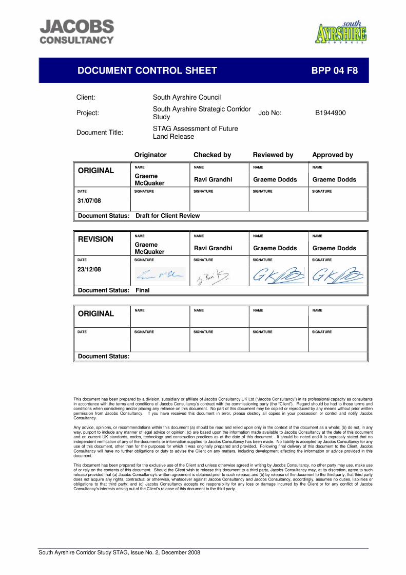
South Ayrshire Corridor Study STAG, Issue No. 2, December 2008
DOCUMENT CONTROL SHEET BPP 04 F8
Client: South Ayrshire Council
Project: South Ayrshire Strategic Corridor Study Job No: B1944900
Document Title: STAG Assessment of Future Land Release
Originator Checked by Reviewed by Approved by
NAME NAME NAME NAME ORIGINAL Graeme McQuaker Ravi Grandhi Graeme Dodds Graeme Dodds
DATE SIGNATURE SIGNATURE SIGNATURE SIGNATURE
31/07/08
Document Status: Draft for Client Review
NAME NAME NAME NAME REVISION Graeme McQuaker Ravi Grandhi Graeme Dodds Graeme Dodds
DATE SIGNATURE SIGNATURE SIGNATURE SIGNATURE
23/12/08
Document Status: Final
NAME NAME NAME NAME ORIGINAL
DATE SIGNATURE SIGNATURE SIGNATURE SIGNATURE
Document Status:
This document has been prepared by a division, subsidiary or affiliate of Jacobs Consultancy UK Ltd (“Jacobs Consultancy”) in its professional capacity as consultants in accordance with the terms and conditions of Jacobs Consultancy’s contract with the commissioning party (the “Client”). Regard should be had to those terms and conditions when considering and/or placing any reliance on this document. No part of this document may be copied or reproduced by any means without prior written permission from Jacobs Consultancy. If you have received this document in error, please destroy all copies in your possession or control and notify Jacobs Consultancy. Any advice, opinions, or recommendations within this document (a) should be read and relied upon only in the context of the document as a whole; (b) do not, in any way, purport to include any manner of legal advice or opinion; (c) are based upon the information made available to Jacobs Consultancy at the date of this document and on current UK standards, codes, technology and construction practices as at the date of this document. It should be noted and it is expressly stated that no independent verification of any of the documents or information supplied to Jacobs Consultancy has been made. No liability is accepted by Jacobs Consultancy for any use of this document, other than for the purposes for which it was originally prepared and provided. Following final delivery of this document to the Client, Jacobs Consultancy will have no further obligations or duty to advise the Client on any matters, including development affecting the information or advice provided in this document. This document has been prepared for the exclusive use of the Client and unless otherwise agreed in writing by Jacobs Consultancy, no other party may use, make use of or rely on the contents of this document. Should the Client wish to release this document to a third party, Jacobs Consultancy may, at its discretion, agree to such release provided that (a) Jacobs Consultancy’s written agreement is obtained prior to such release; and (b) by release of the document to the third party, that third party does not acquire any rights, contractual or otherwise, whatsoever against Jacobs Consultancy and Jacobs Consultancy, accordingly, assumes no duties, liabilities or obligations to that third party; and (c) Jacobs Consultancy accepts no responsibility for any loss or damage incurred by the Client or for any conflict of Jacobs Consultancy’s interests arising out of the Client's release of this document to the third party.
South Ayrshire Corridor Study STAG, Issue No. 2, December 2008
CONTENTS
1 INTRODUCTION AND PURPOSE 1
2 BACKGROUND 3
3 TRANSPORT NETWORK 5
4 LOCAL PLAN HOUSING ALLOCATIONS 12
5 CONSULTATION 18
6 PROBLEMS, CAUSES, CONSTRAINTS AND OPPORTUNITIES 19
7 REVIEW OF ISSUES 22
8 PLANNING OBJECTIVES 24
9 OPTIONS 30
10 OPTION SIFTING 39
11 PART 1 APPRAISAL 55
12 PART 2 APPRAISAL 60
13 COST TO GOVERNMENT 67
14 RISK AND UNCERTAINTY 69
15 MONITORING PLAN 70
16 EVALUATION PLAN 71
17 CONCLUSIONS 72
FIGURES 74
APPENDIX A - OUTPUTS FROM WORKSHOP 86
APPENDIX B - PART 1 APPRAISAL SUMMARY TABLES 87
APPENDIX C - PART 2 APPRAISAL SUMMARY TABLES 135
APPENDIX D – SUMMARY OF JOURNEY TIMES 190
South Ayrshire Corridor Study STAG, Issue No. 2, December 2008 Page 1 of 195
1 INTRODUCTION AND PURPOSE
1.1 Introduction
Jacobs Consultancy was commissioned by South Ayrshire Council (SAC) to undertake an assessment of strategic transport impacts, in the Ayr Core Area, resulting from the housing requirements of the Ayrshire Joint Structure Plan (AJSP) which was approved in November 2007. This assessment has been carried out in accordance with the Scottish Transport Appraisal Guidance (STAG) and provides:
• a review of the current situation; • identification of problems and their causes; • identification of constraints and opportunities; • development of objectives; and • development and assessment of interventions.
1.2 Purpose
The Scottish Ministers, as part of their statutory adoption of the Ayrshire Joint Structure Plan, requested the addition of a clause in order to apply Scottish Planning Policy (SPP) 17 – Planning for Transport. The clause has been included in the approved plan as TRANS 1 (G) under the Land Use and Transportation section. This section of the Structure Plan states: “Co-ordinated planning of land use and transport can reduce the need to travel and encourage modal shift. To facilitate this it is essential that transport is considered comprehensively and from the outset as part of the land-use development process.”
Policy TRANS 1(G) states: “A transport appraisal process, which may include traffic modelling, is undertaken in accord with SPP17 and results incorporated if necessary into the implementation of this plan and local development plans prepared under the Planning etc. (Scotland) Act 2006. Transport Scotland shall be consulted on the scope and content of the appraisal.” In addition, SAC, within their current adopted local plan (2008) had identified an area at South East (SE) Ayr as a significant future housing land release area dependent on the outcome of the AJSP, which has since identified SE Ayr as a strategic expansion location of 2,700 houses between 2005 and 2025. Due to its status within the SAC Local Plan, significant work has already been carried out to develop proposals for SE Ayr. The developments at SE Ayr are therefore likely to be the subject of an outline planning application in the short term and the impacts of this development in relation to the overall Structure Plan allocations require to be understood. The purpose of this project is therefore to determine the transport implications of the housing requirements identified in the AJSP for the Ayr Core Area and establish and appraise potential strategic interventions. This will be achieved through the completion of a STAG assessment of interventions on the transport network which will be supported by micro-simulation modelling of the road network and interventions using the Paramics software package. The corridor study will examine the strategic transport network around Ayr and Prestwick including the A77 (T) from Dutch House Roundabout to Doonholm Road and the A78 (T) from Dutch House to Monktonhill Roundabout, the rail line north and south from Ayr and strategic bus services. The Structure Plan housing allocations could also
South Ayrshire Corridor Study STAG, Issue No. 2, December 2008 Page 2 of 195
potentially be located in some of the smaller settlements accessed from the A77. The extent of the Corridor Study area is shown in Figure 1.1 below.
Figure 1.1 Corridor Study Area.
1.3 Project Objectives
In order to fulfil the purpose of the project, two main project objectives have been established. These are:
• To inform the development of the land release strategy and identify the strategic transport infrastructure and services necessary to support the effective and sustainable delivery of the Structure Plan housing and employment requirements for the Ayr Core Area up to 2025; and
• To identify an effective means of delivering strategic transport infrastructure and
services, taking account of the need to capture contributions from potential developments.
© Crown Copyright. South Ayrshire Council, 100020765
South Ayrshire Corridor Study STAG, Issue No. 2, December 2008 Page 3 of 195
2 BACKGROUND
2.1 Overview
South Ayrshire is located on the West Coast of Scotland to the South West of Glasgow. South Ayrshire covers an area of 1,222 sq km and has a resident population of 111,7001. The population of South Ayrshire in 2024 is projected to be 2.5% less than 2004. This is compared to a Scotland wide population decrease of 0.2%2. The AJSP however, provides for considerable growth, with 9,400 new houses within the Ayr Core Area up to 2025. Within South Ayrshire, the towns of Ayr, Prestwick and Troon account for approximately 70% of the population. Table 2.1 Population of Main Settlements in South Ayrshire Town Population Ayr 46,100 Prestwick 14,800 Troon 14,400 Girvan 6,900 Maybole 4,700 Dundonald 2,600 Coylton 2,700 Mossblown 2,000
Source: General Register for Scotland
As the largest town in South Ayrshire, Ayr is the origin or destination of a significant proportion of the trips in the area. The town is also a public transport hub for the area with most bus services originating in Ayr. Ayr is linked to the main rail network with regular services to Glasgow and less frequent services to Kilmarnock, Girvan and Stranraer. Glasgow Prestwick Airport (GPA) is located in South Ayrshire and is becoming increasingly popular with the rise in affordable air travel and experienced almost 2.4m passengers in 2006. The airport has its own railway station which is served by Ayr to Glasgow trains. Car ownership is relatively high with 71% of residents in South Ayrshire have access to at least one car, compared to a Scottish average of 66%3. 2.2 Employment
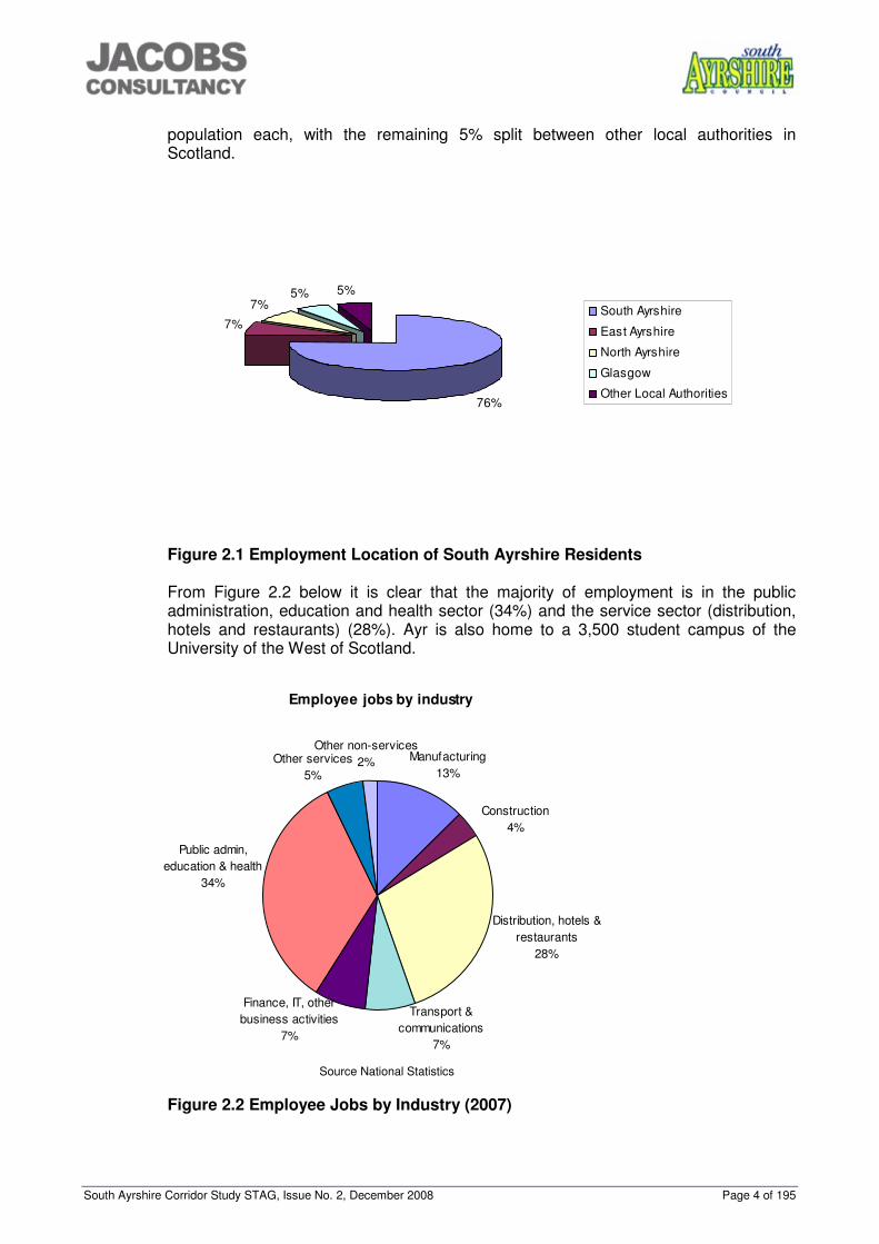
Around 76% of the total working age population between the ages of 16 and 74 are employed, which is consistent with the average for Scotland as a whole. Unemployment levels in South Ayrshire are 5.2%, slightly higher than the Scottish average of 5%4. The average weekly income levels for South Ayrshire are £474.50 which is £33.50 (7.5%) higher than the Scottish average5. Figure 2.1 below shows that the majority of South Ayrshire residents (76%) who are in employment are employed within the South Ayrshire area. The other Ayrshire authorities and Glasgow provide employment for a further 5%-7% of the South Ayrshire
1 General Register for Scotland mid – 2006 population estimates. 2 General Register for Scotland 2004 based population projections 3 Scotlands Census 2001 – www.scol.gov.uk Table KS17 4 Office of National Statistics – Labour Market Profile – South Ayrshire 5 Office of National Statistics – Labour Market Profile – South Ayrshire
South Ayrshire Corridor Study STAG, Issue No. 2, December 2008 Page 4 of 195
population each, with the remaining 5% split between other local authorities in Scotland.
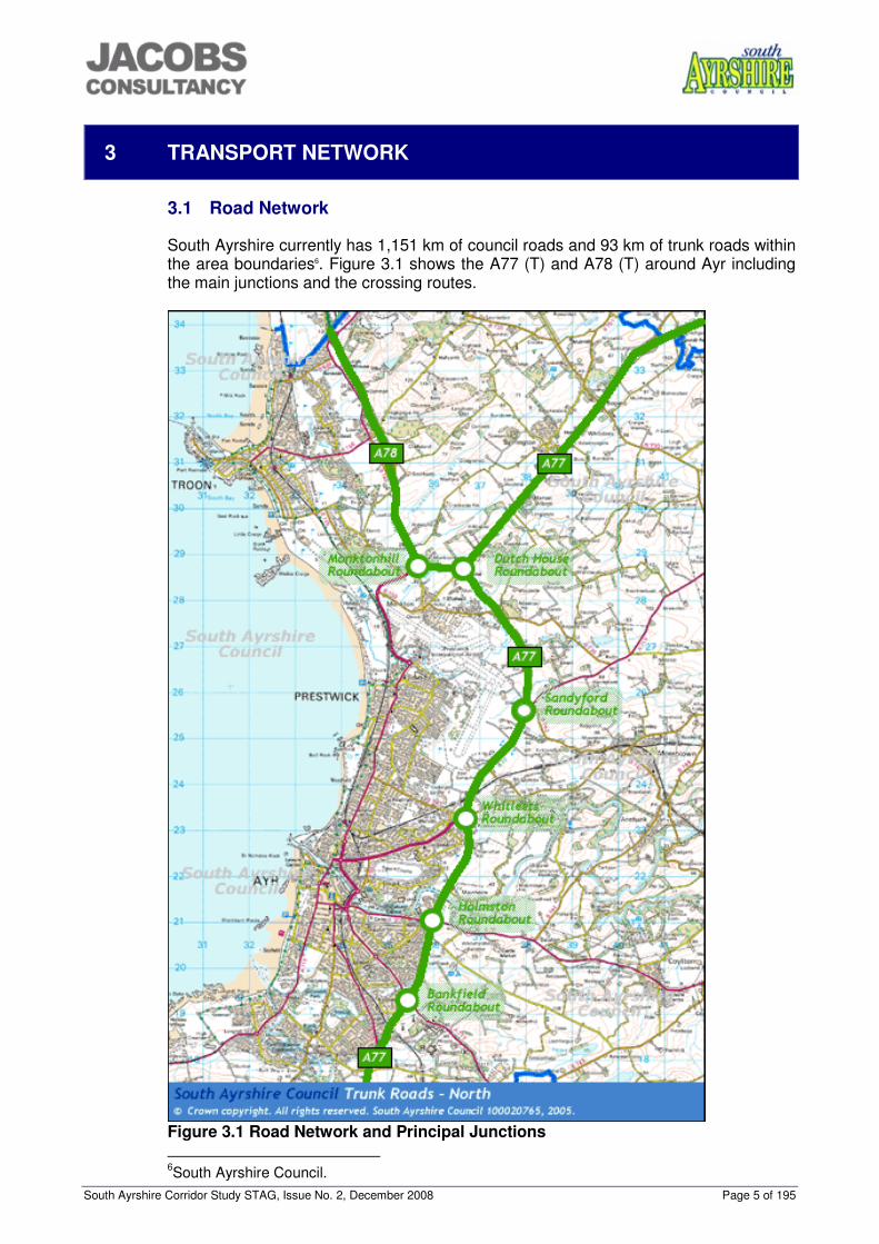
Figure 2.1 Employment Location of South Ayrshire Residents From Figure 2.2 below it is clear that the majority of employment is in the public administration, education and health sector (34%) and the service sector (distribution, hotels and restaurants) (28%). Ayr is also home to a 3,500 student campus of the University of the West of Scotland.
Employee jobs by industry
Other non-services2%Other services
5%
Public admin, education & health
34%
Finance, IT, other business activities
7%
Transport & communications
7%
Manufacturing13%
Construction4%
Distribution, hotels & restaurants
28%
Source National Statistics
Figure 2.2 Employee Jobs by Industry (2007)
76%
7%
7%5% 5%
South Ayrshire
East Ayrshire
North Ayrshire
Glasgow
Other Local Authorities
South Ayrshire Corridor Study STAG, Issue No. 2, December 2008 Page 5 of 195
3 TRANSPORT NETWORK
3.1 Road Network
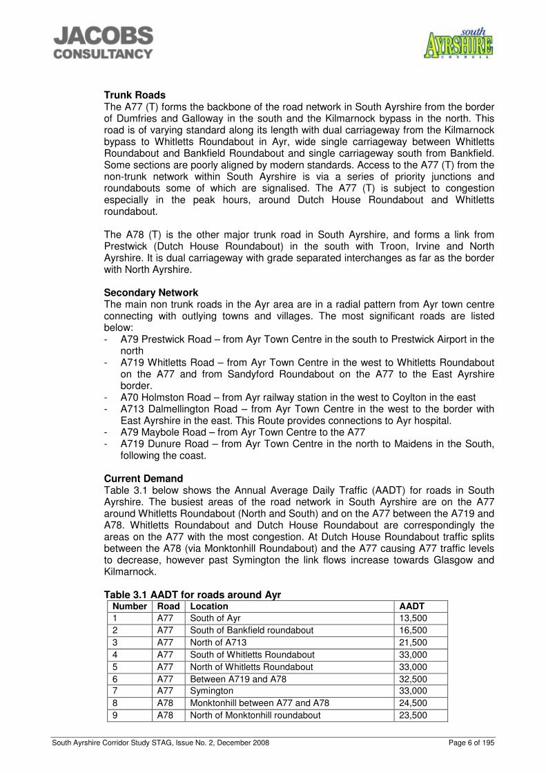
South Ayrshire currently has 1,151 km of council roads and 93 km of trunk roads within the area boundaries6. Figure 3.1 shows the A77 (T) and A78 (T) around Ayr including the main junctions and the crossing routes.
Figure 3.1 Road Network and Principal Junctions 6South Ayrshire Council.
South Ayrshire Corridor Study STAG, Issue No. 2, December 2008 Page 6 of 195
Trunk Roads The A77 (T) forms the backbone of the road network in South Ayrshire from the border of Dumfries and Galloway in the south and the Kilmarnock bypass in the north. This road is of varying standard along its length with dual carriageway from the Kilmarnock bypass to Whitletts Roundabout in Ayr, wide single carriageway between Whitletts Roundabout and Bankfield Roundabout and single carriageway south from Bankfield. Some sections are poorly aligned by modern standards. Access to the A77 (T) from the non-trunk network within South Ayrshire is via a series of priority junctions and roundabouts some of which are signalised. The A77 (T) is subject to congestion especially in the peak hours, around Dutch House Roundabout and Whitletts roundabout. The A78 (T) is the other major trunk road in South Ayrshire, and forms a link from Prestwick (Dutch House Roundabout) in the south with Troon, Irvine and North Ayrshire. It is dual carriageway with grade separated interchanges as far as the border with North Ayrshire. Secondary Network The main non trunk roads in the Ayr area are in a radial pattern from Ayr town centre connecting with outlying towns and villages. The most significant roads are listed below: - A79 Prestwick Road – from Ayr Town Centre in the south to Prestwick Airport in the
north - A719 Whitletts Road – from Ayr Town Centre in the west to Whitletts Roundabout
on the A77 and from Sandyford Roundabout on the A77 to the East Ayrshire border.
- A70 Holmston Road – from Ayr railway station in the west to Coylton in the east - A713 Dalmellington Road – from Ayr Town Centre in the west to the border with
East Ayrshire in the east. This Route provides connections to Ayr hospital. - A79 Maybole Road – from Ayr Town Centre to the A77 - A719 Dunure Road – from Ayr Town Centre in the north to Maidens in the South,
following the coast. Current Demand Table 3.1 below shows the Annual Average Daily Traffic (AADT) for roads in South Ayrshire. The busiest areas of the road network in South Ayrshire are on the A77 around Whitletts Roundabout (North and South) and on the A77 between the A719 and A78. Whitletts Roundabout and Dutch House Roundabout are correspondingly the areas on the A77 with the most congestion. At Dutch House Roundabout traffic splits between the A78 (via Monktonhill Roundabout) and the A77 causing A77 traffic levels to decrease, however past Symington the link flows increase towards Glasgow and Kilmarnock. Table 3.1 AADT for roads around Ayr
Number Road Location AADT 1 A77 South of Ayr 13,500 2 A77 South of Bankfield roundabout 16,500 3 A77 North of A713 21,500 4 A77 South of Whitletts Roundabout 33,000 5 A77 North of Whitletts Roundabout 33,000 6 A77 Between A719 and A78 32,500 7 A77 Symington 33,000 8 A78 Monktonhill between A77 and A78 24,500 9 A78 North of Monktonhill roundabout 23,500
South Ayrshire Corridor Study STAG, Issue No. 2, December 2008 Page 7 of 195
10 A78 Loans 19,500 11 A713 Castlehill/Dalmellington Road 12,500 12 A719 Whitletts Road 18,500 13 A79 Prestwick Road 21,500
Source Transport Scotland.
The routes into Ayr experience congestion, especially at peak times. The routes most affected are Prestwick Road, Whitletts Road and Holmston Road. Congestion on these routes and within the town centre also affects journey times and journey time reliability of bus services. Access within Ayr is affected by a shortage of crossing points over the River Ayr. There are currently three vehicle crossing points, two in the town and one on the A77 to the east of the town. There are similar issues within the town relating to crossing points associated with the railway network. Freight The Ports of Ayr and Troon and Prestwick Airport are important generators of road freight traffic in South Ayrshire. A significant amount of timber is transported along the road network especially in rural areas. Table 3.2 below shows the origin and destination of freight in the county. Table 3.2 Road Freight to and from South Ayrshire
Freight to South Ayrshire
Freight From South Ayrshire
Thousand Tonnes 4,300 4,730 South Ayrshire 27.6% 25.1% Rest of Ayrshire 15.3% 51.1% Dumfries & Galloway 16.8% 3.0% Edinburgh, Lothians and Borders 0.5% 1.0%
Lanarkshire 5.6% 4.5% North of Scotland and Isles 3.2% 0.9% Tayside, Central and Fife 17.5% 4.1% West of Scotland 6.3% 5.3% Rest of UK 7.2% 5.0%
Source: DfT 2005 3.2 Rail Network
Summary of Route Rail Services in South Ayrshire are operated by First Scotrail subject to grant support. Stations within South Ayrshire are located at Barassie, Troon, Glasgow Prestwick Airport (GPA), Prestwick, Newton-On-Ayr, Ayr, Maybole and Girvan. The track between Ayr and Glasgow Central is double track and overhead electrification was added in the mid 1980’s. There is currently a half hourly service on this route with additional peak services. Beyond Ayr to Girvan and Stranraer the services are less frequent, the rolling stock is diesel powered and the line is single track with passing points. Passenger Services The Ayr to Glasgow train service provides a viable alternative to the private vehicle and is popular for those commuting into Glasgow. Large numbers of passengers to/from GPA also utilise services throughout the day. As a result the line often experiences congestion especially in the peak hours. At present, many of the stations between Ayr and Glasgow can only accommodate 6 carriages due to the length of platforms. Likewise, there are capacity constraints on the network between Paisley Gilmour Street and Glasgow Central. Additional capacity between Paisley and Glasgow is expected to become available with the development of the Glasgow Airport Rail Link which is due
South Ayrshire Corridor Study STAG, Issue No. 2, December 2008 Page 8 of 195
to be completed in 2010 but platform capacity at Glasgow Central remains a major constraint. Network Rail’s Route Utilisation Strategy (RUS) for Scotland has determined average load factors for peak trains into Glasgow. This is shown in the tables below for the AM peak of 07.00-09.59 and the High Peak of 08.00-08.59. Table 3.3 shows the current situation as reaching saturation in the high peak and Table 3.4 shows forecast loading factors of 94% in 2011 and exceeding 100% by 20267 but the Network Rail Strategic Business Plan published in April 2008 details the AM peak load factor in 2008 as already having reached 94%. Table 3.3 2004/2005 AM Peak and High Peak Load Factors. Table 3.4 2026 Predicted AM Load Factors
Service Group Base 2011 2016 2026
South West Electrics into Glasgow Central 87% 94% 97% 106%
Table 3.5 below shows the total number of rail passengers travelling through South Ayrshire Railway Stations and the growth experienced in recent years. Ayr Station is now the 8th busiest in Scotland with around 1.4 million journeys a year8. All stations have experienced considerable passenger growth largely due to increased commuters and increased congestion on the roads into Glasgow. Reliability of the railways has increased in this period making the train an appealing alternative to the private vehicle. Table 3.5 Total Number of Rail Passengers travelling through South Ayrshire’s railway stations
2002/2003 2004/2005 2005/2006 2006/2007
Growth experienced between 2002/03 and 20006/07
Percentage Growth
Ayr 1,153,600 1,256,500 1,365,500 1,417,100 +263,500 23% Newton-on-Ayr 26,900 31,200 36,000 36,800 +9,900 37% Prestwick Town 219,200 254,000 280100 282,100 +62,900 29% Prestwick International Airport 69,100 87,300 95,300 113,700 +44,600 65% Troon 467,500 509,300 539,200 561,800 +94,300 20% Barassie 98,900 106,700 110,800 115,700 +16,800 17% Maybole 40,800 48,900 50,100 50,300 +9,500 23% Girvan 96,500 99,200 106,400 104,100 +7,600 8% Total 2,172,500 2,393,100 2,583,400 2,681,600 +509,100 23%
Source: LENNON Data Note that this table combines both entries and exists from stations to give total figure. 7 Network Rail Scotland Route Utilisation Study 2007 Working Paper Base year and predicted rail demand 8 Office of Rail Regulation Station Usage Statistics 2005/2006
Service Group
AM Peak Load Factor (Average weekday
Passengers)
AM High Peak Load Factor (Average
weekday Passengers) South West Electrics into Glasgow Central
84% (5920) 94% (3420)
South Ayrshire Corridor Study STAG, Issue No. 2, December 2008 Page 9 of 195
Transport Scotland’s ‘Scotlands Railways’, 2006 document highlights medium term interventions for Ayrshire rail services of:
• “Lengthen trains to Ayrshire, including to Prestwick Airport”; and • “Operate an additional hourly service on the Ayr route”.
Network Rail’s ‘Route Utilisation Strategy Scotland, 2007’ document highlights a medium term strategy (2009-2014) on Ayrshire services: “To facilitate the extension of trains beyond the current six coach maximum, platform extensions on the Ayrshire and Inverclyde corridors would be required”. The document also details a strategy for the longer term (2014-2019): “Given the projected growth in freight and passenger traffic, provision of further additional capacity between Glasgow and Ayrshire needs to be considered and developed.” The Scottish Ministers’ High Level Output Specification (HLOS) of July 2007 set out the framework to permit 8-car trains on the Ayrshire routes with the capability to stop at all stations. A contract for the provision of 130 new rail carriages was announced by the Scottish Government in July 2008. These new trains will be introduced by December 2010 providing extra capacity on the Glasgow to Ayrshire and Inverclyde lines running initially in 4 car and 7 car formations. The railway station in Ayr is located approximately 1km from the bus station reducing effective integration between public transport modes. Most of the railway stations in South Ayrshire have car parking facilities and taxi ranks as detailed in Table 3.6. There are capacity issues associated with car parking facilities at some of the train stations in particular Ayr. Table 3.6 Facilities provided at Train Stations in South Ayrshire.
Station Staffed? Toilets? Car Park? Cycle racks?
Taxi rank?
Glasgow Central �� �� Multistorey X ��
Barassie X X 14 Spaces For 5 bikes X Troon �� �� 141
Spaces 10 racks 4 Lockers
��
Prestwick International
X Airport Airport Airport Airport
Prestwick �� �� 104 Spaces
5 racks 4 Lockers
��
Newton-On-Ayr X X X 3 Racks X Ayr �� �� 191
Spaces 6 racks
6 lockers ��
Maybole X X 6 Spaces 5 Racks 4 Lockers
X
Girvan � * �� 18 Spaces 5 Racks 4 Lockers
X
Source: Network Rail * Part time
Freight Rail freight in South Ayrshire comprises mainly of coal from open cast mines in East Ayrshire and imported coal through the Port of Hunterston being transported to power stations in Scotland and England. In addition The Port of Ayr handles rail freight traffic including sand imported for glassmaking in North Ayrshire and cement which is exported to Ireland. Fuel for GPA is also transported by rail.
South Ayrshire Corridor Study STAG, Issue No. 2, December 2008 Page 10 of 195
3.3 Bus Network
The majority of bus services are operated by Stagecoach West Scotland. Funding is provided by South Ayrshire Council through SPT for those services that would be uneconomical to run, for example rural services. The bus services in the Core Ayr Area of South Ayrshire are summarised in Figure 3.2.
Bus services generally operate from Ayr on radial routes to the outlying towns and villages, such as Cumnock, Maybole, Mossblown and Girvan. The frequency of these services varies from every 15 mins to 1 service a day depending on the level of demand on the route. Buses to Ayr Hospital and Cumnock from Ayr have the highest demand and so are the most frequent with buses every 15-20 mins during the week. Vehicles on the Girvan services were recently replaced with modern accessible buses in a partnership venture between Stagecoach and SPT. Ayr has an extensive network of town services that also operate from the town centre to outer areas of the town and Prestwick. These services have a frequency of 15 – 60 mins Monday to Saturday and generally hourly on Sundays. The majority of the local services are operated by low-floor accessible vehicles. Longer distance services operate from Ayr to Glasgow, Greenock, Kilmarnock and Hamilton. The X77 to Glasgow is the most popular and has a frequency of 30 mins Monday to Saturday and hourly on Sundays. Due to the high numbers of commuters from Ayr to Glasgow the frequency triples during peak hours to 6 buses an hour. This service is worked by high capacity double deck coaches which are route branded for the service. GPA is well served by both local and longer distance buses. There are 12 buses an hour during weekdays from Ayr to Prestwick Airport. In addition to those services from Ayr, Dundonald and Troon are also served by buses to Irvine, Kilmarnock and a peak hour service to Glasgow. There is also a local service within Troon and Barassie.
South Ayrshire Corridor Study STAG, Issue No. 2, December 2008 Page 11 of 195
Figure 3.2 Bus Routes within Core Ayr Area
South Ayrshire Corridor Study STAG, Issue No. 2, December 2008 Page 12 of 195
4 LOCAL PLAN HOUSING ALLOCATIONS
4.1 Current Local Plan Allocations
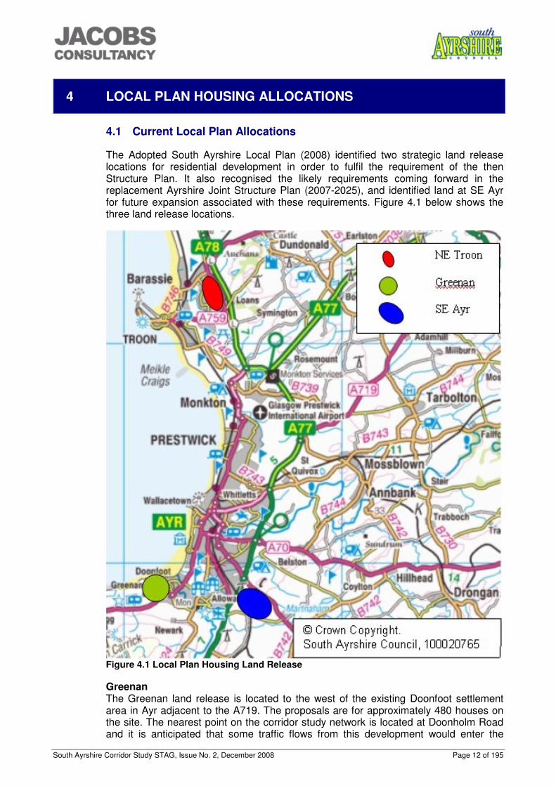
The Adopted South Ayrshire Local Plan (2008) identified two strategic land release locations for residential development in order to fulfil the requirement of the then Structure Plan. It also recognised the likely requirements coming forward in the replacement Ayrshire Joint Structure Plan (2007-2025), and identified land at SE Ayr for future expansion associated with these requirements. Figure 4.1 below shows the three land release locations.
Figure 4.1 Local Plan Housing Land Release Greenan The Greenan land release is located to the west of the existing Doonfoot settlement area in Ayr adjacent to the A719. The proposals are for approximately 480 houses on the site. The nearest point on the corridor study network is located at Doonholm Road and it is anticipated that some traffic flows from this development would enter the
South Ayrshire Corridor Study STAG, Issue No. 2, December 2008 Page 13 of 195
corridor study network at this location. These flows are quantified as 12 vehicles entering and 3 vehicles leaving the network in the AM peak and 6 vehicles entering and 7 vehicles leaving the network in the PM peak. North East Troon The North East Troon land release is located to the east of the existing residential developments and extends to the B746 Kilmarnock Road and the A759. The proposals are for approximately 600 houses on the site. Some traffic flows from this development would enter the corridor study network at Monktonhill Roundabout. These flows are quantified as 31 vehicles entering and 3 vehicles leaving the network in the AM peak and 3 vehicles entering and 15 vehicles leaving the network in the PM peak. SE Ayr The South East Ayr development is to be built on land to the South East of Ayr, outwith the A77 bypass limits and close to the grounds of Ailsa and Ayr Hospitals. The land is part of a strategic release set out in the AJSP and South Ayrshire’s Adopted Local Plan (2008). The development will consist of around 2,500 houses, a business park, a primary school and a rail halt transport interchange. There are three proposed accesses to the development, the Corton Zone will access directly from the A77 via a four arm roundabout at Maybole Road and the other two accesses will be onto the A713. There are plans to upgrade the A713 to dual carriageway between Bankfield Roundabout and the first access point to facilitate the SE Ayr development.
The Transport Assessment for the South East Ayr Development, compiled by Dougall Baillie Associates, calculated the number of trips associated with the new development. For the residential element a trip rate of 1.02 person trips / dwelling is assumed Table 4.1 below details the trip estimations for the residential element of the development. Table 4.1 SE Ayr Residential Trip Estimations Residential Outbound Trips (AM) Walk Cycle Bus Train Car Vehicles 2550 total trips 286 primary school 93 14 43 0 132 195 adults accompanying primary 46 0 17 0 132 132 214 secondary school 21 11 86 0 96 96 adults accompanying secondary 0 0 0 0 96 96 1846 work/study trips 111 92 295 1347 1055 Total 271 117 441 1803 1283 The inbound AM trips were estimated as 36% of the outbound trips resulting in 381 car trips. Evening inbound trips were estimated as 90% of morning outbound trips (950 car trips) and evening outbound trips were estimated as approximately 52% of morning outbound trips (550 car trips). For the employment element of the site, a trip rate of 2.74 trips per 100m2 is assumed. The total trips for the employment element are summarised in Table 4.2 below. Table 4.2 SE Ayr Employment Trip Estimations
Walk Cycle Bus Train Car Vehicles Employment Element Inbound Trips (AM)
775 trips 47 39 124 566 442
South Ayrshire Corridor Study STAG, Issue No. 2, December 2008 Page 14 of 195
Walk Cycle Bus Train Car Vehicles Employment Element Outbound Trips (AM)
142 trips 9 7 23 104 81 Employment Element Inbound Trips (PM)
142 trips 9 7 23 104 81 Employment Element Outbound Trips (PM)
666 trips 40 34 107 486 380 Trip rates and total estimated trips for the retail and leisure elements of the site are detailed in Table 4.3 below. Table 4.3 SE Ayr Retail/Leisure Elements Trip Estimations Land Use Trip Rates
In/Out AM Peak
Vehicle Trips In/Out
AM Peak
Trip Rates In/Out
PM Peak
Vehicle Trips In/Out
PM Peak 60 Bed Hotel 0.31 / 0.23 19 / 14 0.36 / 0.20 22 / 12 Local Food Retailer 2.70 / 1.85 54 / 37 7.59 / 7.38 152 / 148 Leisure Park 0 / 0 0 / 0 30.96 / 40.19 31 / 40 Total 110 / 51 205 / 200
It should be noted that for assessment as part of the corridor study, the primary school trips in the residential element have been omitted since these are expected to be wholly within the SE Ayr site. Vehicle trips from the SE Ayr development will enter the corridor study network from two approaches. The first is from the A713 at Bankfield Roundabout and the second is via a proposed new roundabout on the A77 at Corton. The flows entering the network at these locations are summarised in Table 4.4 below. Table 4.4 SE Ayr Flows Entering the Network Approach/Junction AM entering
the network AM leaving the network
PM entering the network
PM leaving the network
A713 Bankfield Roundabout
836 377 394 672
Corton (New Roundabout)
519 681 716 551
The potential to incorporate a new rail halt, transport interchange and Park and Ride, within the South East Ayr development has been identified. The rail line from Ayr to Stranraer currently runs through the development site and therefore there is the opportunity to improve public transport facilities to the site. The transport interchange and Park-&-Ride would allow integrated onward travel from the train station. It is also hoped that drivers from the A77 would park at SE Ayr and catch the train/bus into the centre of Ayr to reduce the congestion experienced in the town centre. The TA has also identified the provision of a direct bus service between Ayr town centre and SE Ayr development operating at 15 minute intervals. 4.2 Future Potential Allocations
While it was intended from the earliest stages that the study would offer a comprehensive review of options for all transport modes, it was recognized that any development aspirations in South Ayrshire would inevitably result in an increase in vehicle traffic on the A77 road corridor, both along the A77 and across it. These vehicle impacts will depend upon the scale and locations of future developments identified in
South Ayrshire Corridor Study STAG, Issue No. 2, December 2008 Page 15 of 195
the Structure Plan allocations, and on the effectiveness of non-car-based transport interventions. Earlier transportation assessment work in respect of the existing local plan allocations, in particular South East Ayr, had identified the likely scope of road improvements to cater for that development alone. That earlier TA work had been carried out on a junction-by-junction analysis, and took no account of any interaction between successive junctions. Those earlier results formed the basis for a pragmatic judgment that, notwithstanding the promotion of public transport throughout the area, substantial road corridors were likely to be required to accommodate the greater traffic generation of any likely Structure Plan allocation. In those circumstances, the interaction between junctions and the operation of road links themselves, were considered likely to assume greater significance than for a single development. It was therefore decided that a single corridor model should be developed using the Paramics microsimulation modelling software, to facilitate a comparable assessment of the three possible development scenarios, under a common framework. South Ayrshire Council had already developed a Paramics model of Ayr, and it was decided that this could be updated and re-calibrated in respect of the A77 corridor, using traffic survey information collected more recently for the South East Ayr development. The process of building and calibrating the model, and the subsequent testing of development options and road-based interventions, are summarised later in this report. The first study objective is “to inform the development of the land release strategy and identify the strategic transport infrastructure and services necessary to support the effective and sustainable delivery of the Structure Plan housing and employment requirements for the Ayr Core Area up to 2025”.In order to provide a basis for testing, and to understand strategic impacts of differential spatial strategies, SAC has identified three potential scenarios for the distribution of the remaining housing requirements of the AJSP to be assessed alongside the impacts of the local plan allocations, in particular the SE Ayr development. These scenarios are being considered on a ‘without prejudice’ basis and are indicative of broad strategies. Estimated trips from these areas were calculated using the trip rates that had been agreed for the SE Ayr development. The trip distributions were calculated for each site using the agreed distributions for SE Ayr, NE Troon or a combination of both depending on the location of the proposed housing allocation. The calculated trips along with the trips from the local plan allocations form the basis of the travel demand to be accommodated on the transport network. The three scenarios are detailed below and in the attached Figures 4.1-4.3: Scenario 1 Table 4.5 below shows the proposed distribution of housing allocations in Scenario 1, their location, the distribution used and the estimated number of trips generated. The majority of the development is focused on Ayr with continued expansion to the East of the A77. Prestwick and Troon also have significant developments proposed and the remainder of the allocations are dispersed between the smaller settlements in the area.
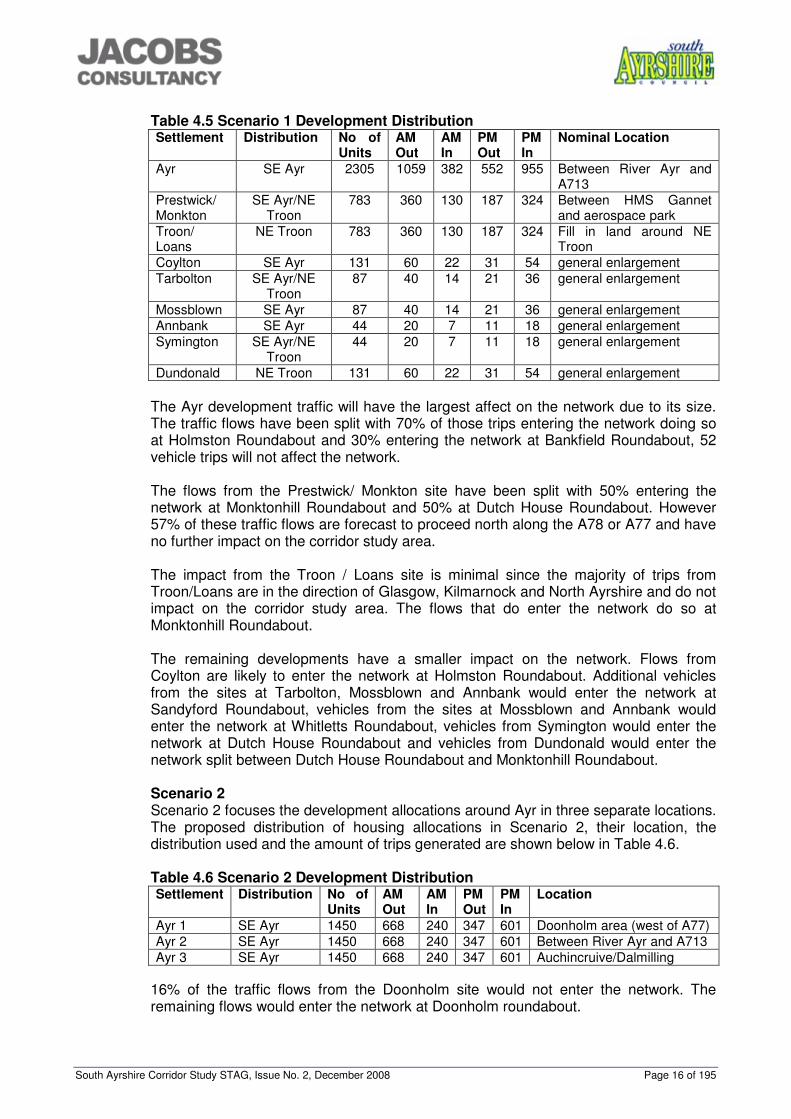
South Ayrshire Corridor Study STAG, Issue No. 2, December 2008 Page 16 of 195
Table 4.5 Scenario 1 Development Distribution Settlement Distribution No of
Units AM Out
AM In
PM Out
PM In
Nominal Location
Ayr SE Ayr 2305 1059 382 552 955 Between River Ayr and A713
Prestwick/ Monkton
SE Ayr/NE Troon
783 360 130 187 324 Between HMS Gannet and aerospace park
Troon/ Loans
NE Troon 783 360 130 187 324 Fill in land around NE Troon
Coylton SE Ayr 131 60 22 31 54 general enlargement Tarbolton SE Ayr/NE
Troon 87 40 14 21 36 general enlargement
Mossblown SE Ayr 87 40 14 21 36 general enlargement Annbank SE Ayr 44 20 7 11 18 general enlargement Symington SE Ayr/NE
Troon 44 20 7 11 18 general enlargement
Dundonald NE Troon 131 60 22 31 54 general enlargement
The Ayr development traffic will have the largest affect on the network due to its size. The traffic flows have been split with 70% of those trips entering the network doing so at Holmston Roundabout and 30% entering the network at Bankfield Roundabout, 52 vehicle trips will not affect the network. The flows from the Prestwick/ Monkton site have been split with 50% entering the network at Monktonhill Roundabout and 50% at Dutch House Roundabout. However 57% of these traffic flows are forecast to proceed north along the A78 or A77 and have no further impact on the corridor study area. The impact from the Troon / Loans site is minimal since the majority of trips from Troon/Loans are in the direction of Glasgow, Kilmarnock and North Ayrshire and do not impact on the corridor study area. The flows that do enter the network do so at Monktonhill Roundabout. The remaining developments have a smaller impact on the network. Flows from Coylton are likely to enter the network at Holmston Roundabout. Additional vehicles from the sites at Tarbolton, Mossblown and Annbank would enter the network at Sandyford Roundabout, vehicles from the sites at Mossblown and Annbank would enter the network at Whitletts Roundabout, vehicles from Symington would enter the network at Dutch House Roundabout and vehicles from Dundonald would enter the network split between Dutch House Roundabout and Monktonhill Roundabout. Scenario 2 Scenario 2 focuses the development allocations around Ayr in three separate locations. The proposed distribution of housing allocations in Scenario 2, their location, the distribution used and the amount of trips generated are shown below in Table 4.6.
Table 4.6 Scenario 2 Development Distribution Settlement Distribution No of
Units AM Out
AM In
PM Out
PM In
Location
Ayr 1 SE Ayr 1450 668 240 347 601 Doonholm area (west of A77) Ayr 2 SE Ayr 1450 668 240 347 601 Between River Ayr and A713 Ayr 3 SE Ayr 1450 668 240 347 601 Auchincruive/Dalmilling
16% of the traffic flows from the Doonholm site would not enter the network. The remaining flows would enter the network at Doonholm roundabout.
South Ayrshire Corridor Study STAG, Issue No. 2, December 2008 Page 17 of 195
The Ayr 2 development will be in the same location as the Ayr development in Scenario 1 with the flows entering the network split 70% at Holmston Roundabout and 30% at Bankfield Roundabout. The majority of the traffic flows from the Auchincruive/Dalmilling site would enter the network at Whitletts Roundabout. Only around 3% of the flows do not enter the network. Scenario 3 Scenario 3 is similar to Scenario 1 in the locations planned for development with slightly less dispersion of the smaller allocations. The proposed distribution of housing allocations in Scenario 3, their location, the distribution used and the amount of trips generated are shown below in Table 4.7.
Table 4.7 Scenario 3 Development Distribution Settlement Distribution No of
Units AM Out
AM In
PM Out
PM In
Location
Ayr SE Ayr 2305 1061
382 552 955 Between River Ayr and A713
Troon/ Loans
NE Troon 783 360 130 187 324 Fill in land around NE Troon
Monkton SE AYR/NE Troon
783 360 130 187 324 Between HMS Gannet and aerospace park
Coylton SE Ayr 200 92 33 48 83 general enlargement Mossblown/Annbank
SE Ayr 235 108 39 56 97 general enlargement
Tarbolton Se Ayr/NE Troon
148 68 25 35 61 general enlargement
Symington Se Ayr/NE Troon
87 40 14 21 36 general enlargement
Dundonald NE Troon 200 92 33 48 83 general enlargement
The traffic flows in Scenario 3 have been assigned to the network in the same proportions as Scenario 1. Public Transport Trips Similar methods were used to establish a potential base number of bus and rail trips for each scenario to other local authority areas. A summary of the calculated base trips to East Ayrshire, North Ayrshire and Glasgow, which were identified as the main strategic destinations, is detailed below in Table 4.8. Table 4.8 Base Public Transport Trips Scenario 1 Scenario 2 Scenario 3 Destination AM
Out AM In
PM Out
PM In
AM Out
AM In
PM Out
PM In
AM Out
AM In
PM Out
PM In
Bus 57 10 15 26 61 22 31 54 62 22 32 56 East Ayrshire Rail 6 13 18 31 7 2 3 6 7 2 4 6
Bus 56 20 29 50 26 9 13 23 61 22 31 54 North Ayrshire Rail 52 19 27 46 24 9 12 21 56 20 29 50
Bus 17 6 9 16 18 7 10 16 19 7 10 17 Glasgow Rail 33 12 17 30 35 13 18 32 36 13 19 32
South Ayrshire Corridor Study STAG, Issue No. 2, December 2008 Page 18 of 195
5 CONSULTATION
Consultation with various parties has taken place throughout this process. A workshop was held on 18th March 2008 attended by representatives of:
• Stagecoach West Scotland; • NHS Ayrshire and Arran; • Cala Homes; • DBA (for the SE Ayr Consortium); • Transport Scotland; • JMP (for Transport Scotland); • Network Rail; • Jacobs Consultancy (for South Ayrshire Council); • South Ayrshire Council; • WSP (for the SE Ayr Consortium); and • URS (for NHS Ayrshire and Arran).
The workshop discussed problems, causes, constrains and opportunities and drafted initial objectives and potential schemes which are detailed in Appendix A. The project was then taken forward by a steering group comprising representatives from:
• Transport Scotland; • Cala Homes; • Geddes Consulting (on behalf of the SE Ayr Consortium); and • South Ayrshire Council; • Jacobs Consultancy (on behalf of SAC); • JMP Consulting (on behalf of Transport Scotland); • Dougall Baillie, and GK-TC (modelling work on behalf of SAC); and • WSP (on behalf of the SE Ayr Consortium).
The Steering Group was supported by regular technical group meetings which were attended by representatives of:
• Jacobs Consultancy (on behalf of SAC); • JMP Consulting (on behalf of Transport Scotland); • Dougall Baillie and GK-TC (modelling work on behalf of SAC); and • WSP (on behalf of the SE Ayr Consortium).
Separate discussions have also taken place with the major bus operator in the area, Stagecoach West Scotland.
South Ayrshire Corridor Study STAG, Issue No. 2, December 2008 Page 19 of 195
6 PROBLEMS, CAUSES, CONSTRAINTS AND OPPORTUNITIES
The workshop, along with input from the steering group and technical group, established the existing and potential future problems on the strategic transport network. In order to provide some context for the study, an analysis of these problems and their causes, taking into account the existing and potential future land release allocations, has been undertaken together with a review of the potential constraints and opportunities to understand how the transport network performs. Table 6.1 below details the problems, causes, constraints and opportunities on the transport network.
South Ayrshire Corridor Study STAG, Issue No. 2, December 2008 Page 20 of 195
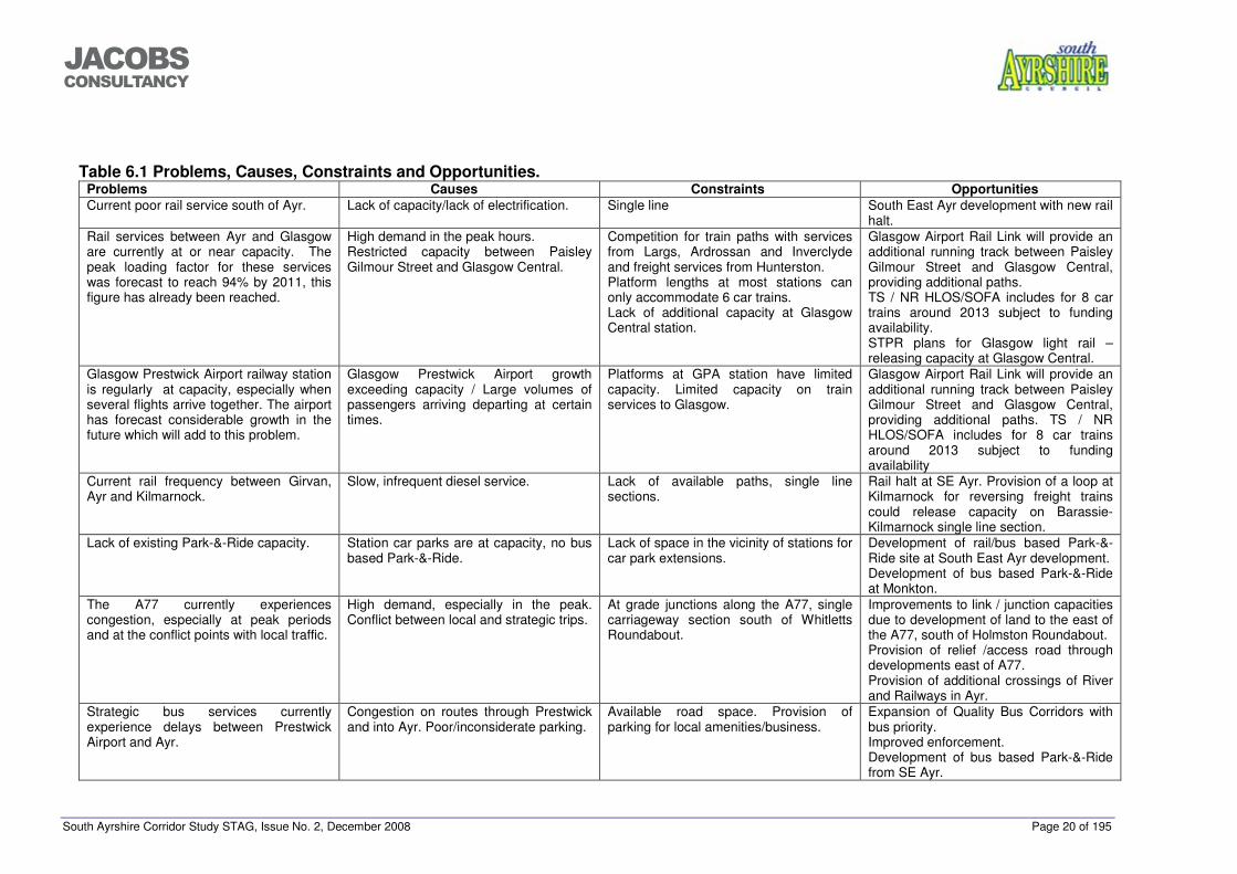
���������������
Table 6.1 Problems, Causes, Constraints and Opportunities. Problems Causes Constraints Opportunities Current poor rail service south of Ayr. Lack of capacity/lack of electrification. Single line South East Ayr development with new rail
halt. Rail services between Ayr and Glasgow are currently at or near capacity. The peak loading factor for these services was forecast to reach 94% by 2011, this figure has already been reached.
High demand in the peak hours. Restricted capacity between Paisley Gilmour Street and Glasgow Central.
Competition for train paths with services from Largs, Ardrossan and Inverclyde and freight services from Hunterston. Platform lengths at most stations can only accommodate 6 car trains. Lack of additional capacity at Glasgow Central station.
Glasgow Airport Rail Link will provide an additional running track between Paisley Gilmour Street and Glasgow Central, providing additional paths. TS / NR HLOS/SOFA includes for 8 car trains around 2013 subject to funding availability. STPR plans for Glasgow light rail – releasing capacity at Glasgow Central.
Glasgow Prestwick Airport railway station is regularly at capacity, especially when several flights arrive together. The airport has forecast considerable growth in the future which will add to this problem.
Glasgow Prestwick Airport growth exceeding capacity / Large volumes of passengers arriving departing at certain times.
Platforms at GPA station have limited capacity. Limited capacity on train services to Glasgow.
Glasgow Airport Rail Link will provide an additional running track between Paisley Gilmour Street and Glasgow Central, providing additional paths. TS / NR HLOS/SOFA includes for 8 car trains around 2013 subject to funding availability
Current rail frequency between Girvan, Ayr and Kilmarnock.
Slow, infrequent diesel service. Lack of available paths, single line sections.
Rail halt at SE Ayr. Provision of a loop at Kilmarnock for reversing freight trains could release capacity on Barassie-Kilmarnock single line section.
Lack of existing Park-&-Ride capacity. Station car parks are at capacity, no bus based Park-&-Ride.
Lack of space in the vicinity of stations for car park extensions.
Development of rail/bus based Park-&-Ride site at South East Ayr development. Development of bus based Park-&-Ride at Monkton.
The A77 currently experiences congestion, especially at peak periods and at the conflict points with local traffic.
High demand, especially in the peak. Conflict between local and strategic trips.
At grade junctions along the A77, single carriageway section south of Whitletts Roundabout.
Improvements to link / junction capacities due to development of land to the east of the A77, south of Holmston Roundabout. Provision of relief /access road through developments east of A77. Provision of additional crossings of River and Railways in Ayr.
Strategic bus services currently experience delays between Prestwick Airport and Ayr.
Congestion on routes through Prestwick and into Ayr. Poor/inconsiderate parking.
Available road space. Provision of parking for local amenities/business.
Expansion of Quality Bus Corridors with bus priority. Improved enforcement. Development of bus based Park-&-Ride from SE Ayr.
South Ayrshire Corridor Study STAG, Issue No. 2, December 2008 Page 21 of 195
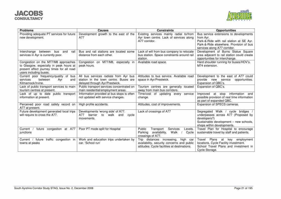
���������������
Problems Causes Constraints Opportunities Providing adequate PT services for future new development.
Development growth to the east of the A77
Existing services mainly radial to/from Ayr town centre. Lack of services along A77 corridor.
Bus service extensions to developments from Ayr. Park-&-Ride with rail station at SE Ayr. Park-&-Ride elsewhere. Provision of bus services along A77 corridor.
Interchange between bus and rail services in Ayr is currently poor.
Bus and rail stations are located some distance from each other.
Lack of will from bus company to relocate bus station. Space constraints around rail station.
Development of Burns Statue Square area adjacent to rail station could create opportunities for interchange.
Congestion on the M77/M8 approaches to Glasgow, especially in peak hours at present affect journey times for all road users including buses.
Congestion on M77/M8, especially in peak hours.
Available road space. Hard shoulder running for buses/HOV’s. M74 extension.
Current poor frequency/quality of bus services between Ayr and Kilmarnock/Irvine.
All bus services radiate from Ayr bus station in the town centre. Buses are delayed through Ayr/Prestwick.
Attitudes to bus service. Available road space in Ayr/Prestwick.
Development to the east of A77 could provide new service opportunities. Expansion of QBC’s.
Lack of public transport services to main tourism centres at present.
Public transport services concentrated on main residential/employment areas.
Tourism centres are generally located away from main bus corridors.
Expansion of QBC’s.
Lack of up to date public transport information at present.
Information provided at bus stops is often not updated with service changes.
Time/cost of updating every service change.
Improved at stop information and possible provision of real time information as part of expanded QBC.
Perceived poor road safety record on A77 at present.
High profile accidents. Attitudes, cost of improvements. Expansion of SPECS cameras.
Future development generated local trips will require to cross the A77.
Developments ‘wrong side’ of A77. A77 barrier to walk and cycle movements.
Lack of crossings of A77 Segregated Walk / cycle bridges / underpasses across A77 (Proposed by developers?) Sustainable development – new schools, shops within developments.
Current / future congestion at A77 junctions
Poor PT mode split for Hospital Public Transport Services Levels. Parking availability, Walk / Cycle crossings of A77.
Travel Plan for Hospital to encourage sustainable travel by staff and patients.
Current / future traffic congestion in towns at peaks
Work and education trips undertaken by car. ‘School run’
Trip distances increasing, high car availability, security concerns and public attitudes. Cycle facilities at destinations.
Travel Plans at key employment locations. Cycle Facility investment. School Travel Plans and investment in Cycle Storage.
South Ayrshire Corridor Study STAG, Issue No. 2, December 2008 Page 22 of 174
���������������
7 REVIEW OF ISSUES
7.1 Introduction
Having reviewed the operation of the strategic transport network around Ayr and the potential impacts from the AJSP housing allocations, this chapter reviews the issues raised. 7.2 Rail Services
The current rail service between Ayr and Glasgow suffers from capacity and overcrowding issues especially at peak times. High volumes of passengers also use the service from GPA, adding to the capacity issues. The Scottish Government has recently announced the procurement of new longer trains for the Ayrshire rail services which will increase capacity on the routes. The Glasgow Airport Rail Link, will also introduce additional line capacity on the congested section between Paisley Gilmour Street and Glasgow Central giving the potential for additional services from Ayrshire to be operated. The service south of Ayr is infrequent and slow compared to the electric service. The route between Ayr and Girvan is single track, further restricting potential improvements. 7.3 Bus Services
Bus services around Ayr generally operate on radial routes into the town centre. There is a frequent express commuter service to Glasgow using the M77, however links to North Ayrshire and East Ayrshire are generally poorer. Journey times on services to Glasgow are affected by congestion on the northern part of the M77 and the M8 especially in peak hours. Journey times on many services are also affected by congestion between Prestwick and Ayr. 7.4 Road Network
The A77 (T) around Ayr suffers from congestion, especially through the at grade junctions where there is conflict between strategic and local traffic. Road traffic heading for Glasgow and further afield is also affected by congestion on the northern parts of the M77 and on the M8 through Glasgow. Within Ayr, congestion occurs on several routes into the town and between Ayr and Prestwick, especially at peak times. A small number of high profile accidents has led to a perception that the A77 (T) has a poor safety record. 7.5 Park-&-Ride
At present, the only Park-&-Ride facilities within the study area are within station car parks which are operating at capacity. There are no formal bus based Park-&-Ride facilities, however recent studies have shown that several parking areas between Ayr and Prestwick are being used by passengers on the X77 bus service. 7.6 Other Public Transport Issues
South Ayrshire has a significant tourist industry, however public transport access to the main tourism centres, especially linking to the strategic transport network, is often poor.

South Ayrshire Corridor Study STAG, Issue No. 2, December 2008 Page 23 of 174
���������������
In addition, the availability of real time information on public transport services in the area is currently limited and other information, e.g. timetables at bus stops is often out of date.
South Ayrshire Corridor Study STAG, Issue No. 2, December 2008 Page 24 of 174
���������������
8 PLANNING OBJECTIVES
8.1 Introduction
The planning objectives for this study have been developed in accordance with the following key principles:
• Objectives should express the outcomes sought as opposed to any of the activities planned to achieve them; and
• The formation of the objectives should take full cognisance of a thorough investigation of the root causes of identified problems
The objectives have also been developed with consideration of the STAG criteria of:
• Economic; • Environmental; • Safety; • Integration; and • Accessibility and social inclusion.
8.2 STAG Planning Objectives
Discussions at the initial workshop in March 2008 resulted in eleven initial objectives for further discussion using the above criteria. These objectives were:
• To provide strategic transport infrastructure and services to support the effective and sustainable delivery of the Structure Plan housing requirements up to 2025;
• To provide local transport infrastructure and services to support the effective and sustainable delivery of the Structure Plan housing requirements up to 2025;
• Maximising sustainable transport mode shift; • Ensuring transport system (PT, Cycle and car) produces access for all to all
services and places (fits needs of commuting); • To promote more healthy and environmentally sustainable transport; • To support sustainable economic growth in corridors; • Seamless journey chains; • To increase PT mode share in the corridor (thru PT competitiveness, reliability,
perceptions); • To provide a package of measure to support the effective delivery of the
Structure Plan housing requirements; • To provide access to a choice of modes for trips that use the corridor; and • To provide an effective mean of apportioning the cost of delivering strategic
transport infrastructure and services amongst future developments.
These objectives were developed into the two project objectives that were set out in Section 1.3 and four planning objectives based on the principles of maintaining strategic focus and linking simplifying the original list into a more manageable number without degrading the reasoning contained therein. The four planning objectives are: Objective 1: To provide effective access to a choice of modes for strategic trips
to/from the proposed development locations on the corridor; Objective 2: To facilitate economic growth and the effective delivery of the Structure
Plan housing and employment requirements up to 2025;
South Ayrshire Corridor Study STAG, Issue No. 2, December 2008 Page 25 of 174
���������������
Objective 3: To increase the mode share of public transport for existing strategic trips and trips generated to/from the proposed development locations; and
Objective 4: To minimise the impact of the Structure Plan delivery on the effective operation of the A77 trunk road for trips between Glasgow and Southwest Scotland and intermediate locations.
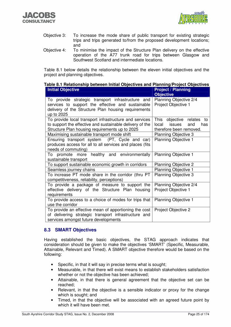
Table 8.1 below details the relationship between the eleven initial objectives and the project and planning objectives. Table 8.1 Relationship between Initial Objectives and Planning/Project Objectives
Initial Objective Project / Planning Objective
To provide strategic transport infrastructure and services to support the effective and sustainable delivery of the Structure Plan housing requirements up to 2025
Planning Objective 2/4 Project Objective 1
To provide local transport infrastructure and services to support the effective and sustainable delivery of the Structure Plan housing requirements up to 2025
This objective relates to local issues and has therefore been removed.
Maximising sustainable transport mode shift Planning Objective 3 Ensuring transport system (PT, Cycle and car) produces access for all to all services and places (fits needs of commuting)
Planning Objective 1
To promote more healthy and environmentally sustainable transport
Planning Objective 1
To support sustainable economic growth in corridors Planning Objective 2 Seamless journey chains Planning Objective 1 To increase PT mode share in the corridor (thru PT competitiveness, reliability, perceptions)
Planning Objective 3
To provide a package of measure to support the effective delivery of the Structure Plan housing requirements
Planning Objective 2/4 Project Objective 1
To provide access to a choice of modes for trips that use the corridor
Planning Objective 1
To provide an effective mean of apportioning the cost of delivering strategic transport infrastructure and services amongst future developments
Project Objective 2
8.3 SMART Objectives
Having established the basic objectives, the STAG approach indicates that consideration should be given to make the objectives ‘SMART’ (Specific, Measurable, Attainable, Relevant and Timed). A SMART objective therefore would be based on the following:
• Specific, in that it will say in precise terms what is sought; • Measurable, in that there will exist means to establish stakeholders satisfaction
whether or not the objective has been achieved; • Attainable, in that there is general agreement that the objective set can be
reached; • Relevant, in that the objective is a sensible indicator or proxy for the change
which is sought; and • Timed, in that the objective will be associated with an agreed future point by
which it will have been met.
South Ayrshire Corridor Study STAG, Issue No. 2, December 2008 Page 26 of 174
���������������
Having considered the objectives that have been set, and the type of issues that are being considered within this report, the following observations are made. Objective 1 This objective is tasked at providing adequate infrastructure and services are put in place to serve the proposed development locations. It is considered that it is difficult to ‘smarten’ this objective. Objective 2 The first part of this objective by its nature is a wide scope objective that is tasked with linking the importance of an effective transport network to the growth of the economy in South Ayrshire. It is considered that it is difficult to ‘smarten’ this but that it should be altered to reflect the role of the transport network and should be capable of measurement through standard techniques and data that is already collected and published. The second part of this objective is measurable on the delivery of the requirements of the Structure Plan within the set timescale. Objective 3 This objective has a dual role in promoting modal shift for existing trips and achieving a high public transport mode share for development trips. It is considered that targets for public transport mode share can be given in term of shift (for existing trips) and in terms of a percentage split target for new trips. Objective 4 This objective could be made more specific by referring to Transport Scotland’s requirement for development impacts on the network to be mitigated in order to provide a minimum no-net detriment effect. This would be measured using journey time around the urban area, i.e. Doonfoot in the south to Bogend Toll in the north and vice versa. This objective is arguably the most measurable as it recognises the need to provide measures to mitigate additional flows. The Paramics model has been used to measure the impacts on the network with a variety of interventions in place and can be used to measure journey times between set locations. It has been highlighted that this study has a significant level of unknown elements. As a result of this, there is a limit to the amount of ‘smartening’ that can be applied to the objectives. Recent work on the Strategic Transport Projects Review for Transport Scotland has also recognised this. 8.4 Revised Objectives
The objectives have therefore been reviewed and ‘smartened’ up resulting in the following revised objectives: Objective 1: To provide effective access to a choice of modes for strategic trips
to/from the proposed development locations on the corridor; Objective 2: To provide the transport infrastructure and services required to facilitate
economic growth and the effective delivery of the Structure Plan housing and employment requirements up to 2025;
Objective 3: To increase the mode share of public transport for existing strategic trips by 10% and trips generated to/from the proposed development locations (20% public transport modal share); and
South Ayrshire Corridor Study STAG, Issue No. 2, December 2008 Page 27 of 174
���������������
Objective 4: To minimise the impact of the Structure Plan delivery on the effective operation of the A77 trunk road for trips between Glasgow and Southwest Scotland and intermediate locations by providing interventions that produce a ‘no net-detriment’ effect in terms of journey time around the urban area of Ayr.
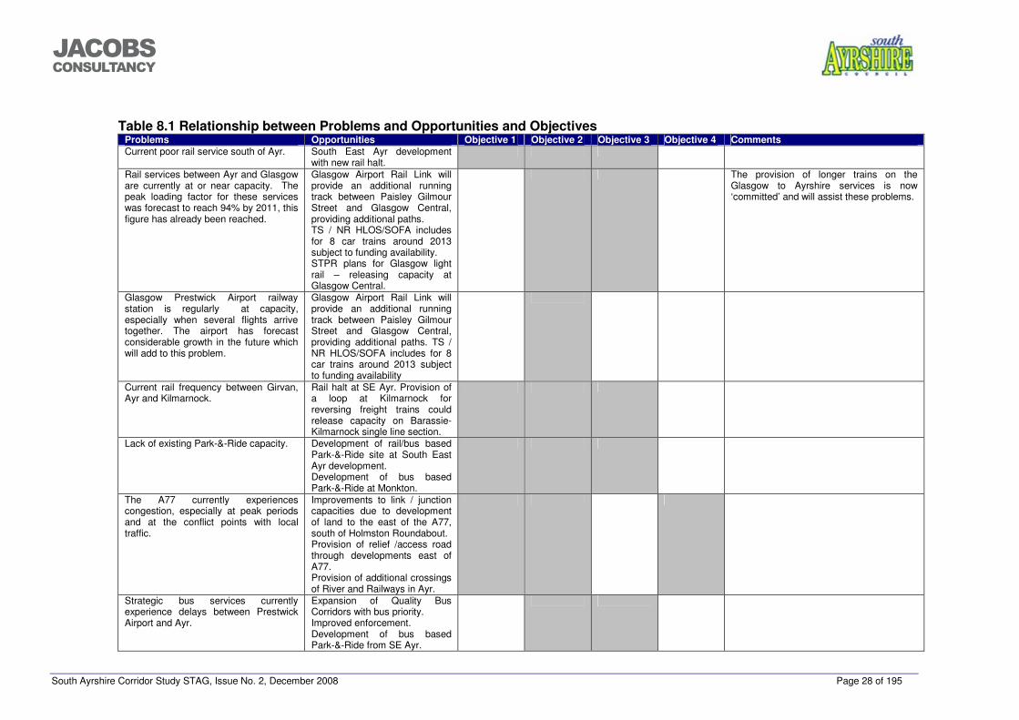
The target of 20% public transport modal share in Objective 3 has been determined by analysing the existing level of public transport modal share for strategic trips, current local, regional and national policy and public transport trip rates determined for the SE Ayr development. The 20% level provides a target that is stringent but achievable. Table 8.1 below shows the relationship between the previously determined problems and opportunities against the revised objectives.
South Ayrshire Corridor Study STAG, Issue No. 2, December 2008 Page 28 of 195
���������������
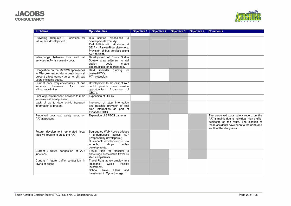
Table 8.1 Relationship between Problems and Opportunities and Objectives
Problems Opportunities Objective 1 Objective 2 Objective 3 Objective 4 Comments Current poor rail service south of Ayr. South East Ayr development
with new rail halt.
Rail services between Ayr and Glasgow are currently at or near capacity. The peak loading factor for these services was forecast to reach 94% by 2011, this figure has already been reached.
Glasgow Airport Rail Link will provide an additional running track between Paisley Gilmour Street and Glasgow Central, providing additional paths. TS / NR HLOS/SOFA includes for 8 car trains around 2013 subject to funding availability. STPR plans for Glasgow light rail – releasing capacity at Glasgow Central.
The provision of longer trains on the Glasgow to Ayrshire services is now ‘committed’ and will assist these problems.
Glasgow Prestwick Airport railway station is regularly at capacity, especially when several flights arrive together. The airport has forecast considerable growth in the future which will add to this problem.
Glasgow Airport Rail Link will provide an additional running track between Paisley Gilmour Street and Glasgow Central, providing additional paths. TS / NR HLOS/SOFA includes for 8 car trains around 2013 subject to funding availability
Current rail frequency between Girvan, Ayr and Kilmarnock.
Rail halt at SE Ayr. Provision of a loop at Kilmarnock for reversing freight trains could release capacity on Barassie-Kilmarnock single line section.
Lack of existing Park-&-Ride capacity. Development of rail/bus based Park-&-Ride site at South East Ayr development. Development of bus based Park-&-Ride at Monkton.
The A77 currently experiences congestion, especially at peak periods and at the conflict points with local traffic.
Improvements to link / junction capacities due to development of land to the east of the A77, south of Holmston Roundabout. Provision of relief /access road through developments east of A77. Provision of additional crossings of River and Railways in Ayr.
Strategic bus services currently experience delays between Prestwick Airport and Ayr.
Expansion of Quality Bus Corridors with bus priority. Improved enforcement. Development of bus based Park-&-Ride from SE Ayr.
South Ayrshire Corridor Study STAG, Issue No. 2, December 2008 Page 29 of 195
���������������
Problems Opportunities Objective 1 Objective 2 Objective 3 Objective 4 Comments
Providing adequate PT services for future new development.
Bus service extensions to developments from Ayr. Park-&-Ride with rail station at SE Ayr. Park-&-Ride elsewhere. Provision of bus services along A77 corridor.
Interchange between bus and rail services in Ayr is currently poor.
Development of Burns Statue Square area adjacent to rail station could create opportunities for interchange.
Congestion on the M77/M8 approaches to Glasgow, especially in peak hours at present affect journey times for all road users including buses.
Hard shoulder running for buses/HOV’s. M74 extension.
Current poor frequency/quality of bus services between Ayr and Kilmarnock/Irvine.
Development to the east of A77 could provide new service opportunities. Expansion of QBC’s.
Lack of public transport services to main tourism centres at present.
Expansion of QBC’s.
Lack of up to date public transport information at present.
Improved at stop information and possible provision of real time information as part of expanded QBC.
Perceived poor road safety record on A77 at present.
Expansion of SPECS cameras. The perceived poor safety record on the A77 is mainly due to individual ‘high profile’ accidents on the route. The location of these accidents have been to the north and south of the study area.
Future development generated local trips will require to cross the A77.
Segregated Walk / cycle bridges / underpasses across A77 (Proposed by developers?) Sustainable development – new schools, shops within developments.
Current / future congestion at A77 junctions
Travel Plan for Hospital to encourage sustainable travel by staff and patients.
Current / future traffic congestion in towns at peaks
Travel Plans at key employment locations. Cycle Facility investment. School Travel Plans and investment in Cycle Storage.
South Ayrshire Corridor Study STAG, Issue No. 2, December 2008 Page 30 of 195
���������������
9 OPTIONS
9.1 Option Generation
A number of options were identified in the study process to target resolution of the planning objectives. Due to the nature of the study, looking at the strategic transport network, options have been identified for all modes used for strategic journeys. A Do-Minimum option has also been identified for option appraisal purposes. The road based options have been developed using the Paramics transport model as detailed below. 9.2 Road Option Generation
As set out earlier in this report, the Paramics microsimulation software permits the examination of traffic movements over an entire network. While individual junctions can be examined in detail if necessary, the interaction between those junctions can also be considered. This means, for example, that, where queues from one junction reach back and affect the operation of a second junction, the model will reflect that overall condition, whereas single junction modelling will not. South Ayrshire Council had previously commissioned a Paramics model for the town of Ayr. It was noted, however, that the traffic surveys used to develop that model were now out of date, because significant development had taken place, particularly around Whitletts roundabout, while the roundabout itself had since been signalized to reduce previous queues and delays. As a consequence, traffic volumes and patterns of distribution were likely to have changed since development of that first model. That model also included much of the main road network within Ayr and Prestwick. For the purpose of the current exercise, that local road network did not require examination. In any event, there was insufficient survey data available to facilitate proper calibration and validation of the complex urban network. The model network was therefore simplified to the A77 corridor itself, and the roads which join or cross it within the study area, i.e. (starting from the south):
• Doonholm Road / Corton Road; • Maybole Road; • Dalmellington Road; • Holmston Road; • Whitletts roundabout; • Sandyford roundabout; and • Dutch House Roundabout.
To take account of junction interaction, the previous network was extended to
include: • The A78 to Monktonhill roundabout; and • The A77 northwards to Bogend Toll.
The previous Paramics zone system was then similarly simplified so that trips would enter and leave the network at the appropriate junctions along the corridor. Traffic survey information had been collected along the A77 corridor in January 2007 in connection with the Transportation Assessment for the South East Ayr developments. In addition to traffic counts, these surveys also included queue length
South Ayrshire Corridor Study STAG, Issue No. 2, December 2008 Page 31 of 195
���������������
information. This information was then incorporated into the Paramics model, which was then fully calibrated in accordance with the requirements of the Design Manual for Roads and Bridges, to ensure that modelled traffic flows conditions properly reflected those observed during the surveys. The model was then adjusted from January (when the surveys were carried out) to a typical month. Examination of Automatic Traffic Counter data collected along the corridor established that January was approximately 5% lower than an annual average. The Paramics traffic flow matrices were factored up by that amount, and the results re-examined and considered to better reflect “typical” traffic conditions. This adjusted base model was then used as a basis for scheme testing. It should be noted that the Paramics model is not based on a single busy hour, but includes the periods leading up to the peak and after, so that the network properly reflects peak traffic conditions, and that network statistics, used for the comparison of network interventions, include all traffic, queues etc already on the network at the start of the actual peak hour. Testing of Development Scenarios The vehicle trips arising from each development scenario were calculated as set out in Section 4.2, and assigned to the Paramics road network as zone to zone trip matrices. This element of the study set out to identify interventions necessary to address constraints on the road network. In that context, an incremental approach was adopted, identifying the principal areas of constraint where queues first started to form, and examining how those capacity problems could best be addressed. During this process, it was important to bear in mind that, as the most critical congestion stress points were addressed, traffic was thereby released from a queue state to reach other points of the network, exacerbating any difficulties at adjacent junctions. An important first step, therefore, in a STAG-based process was to run the model and examine the development of queues etc for each development scenario in both the morning and evening peak periods. This identified the impact of the potential Structure Plan allocation on the existing road network. In examining the three scenarios, it was notable that, overall, there was little difference between them, in terms of road network performance. All three scenarios led to early development of queues and delays on the corridor, any differences being confined only to the order in which junctions were affected as those queues developed. It was evident that queues developed very quickly at key stress points at Whitletts and Holmston, spreading along the A77 to affect adjacent junctions, so that by 8:30am in all 3 scenarios, traffic was barely moving at all along the whole length of the A77 from Doonfoot to Monktonhill, with substantial queues off the limits of the modelled network. Two principal points were evident at this stage:
• Some form of intervention was likely to be necessary at all of the junctions modelled, from Monktonhill to Bankfield (Dalmellington Road) with the exception of Sandyford Roundabout; and
• Any overall differences between scenarios were likely to be marginal, although there would be more noticeable local differences at the points where development traffic is first loaded on to the modelled network.
South Ayrshire Corridor Study STAG, Issue No. 2, December 2008 Page 32 of 195
���������������
It was therefore decided, within the Technical Group, that the scheme testing would focus on one scenario, to economise on modelling time, but that the final package would then be examined for all three scenarios to establish sensitivity to possible changes in strategic development allocations. Monktonhill Roundabout. Although not situated on the A77 and therefore not, strictly speaking, part of the A77 corridor study brief this junction was included principally because it affects, and is affected by, the operation of Dutch House Roundabout to the east. The package proposed at Dutch House was observed to remove queuing between the two junctions, so that the operation of Monktonhill is substantially improved. There is evidence, however, of uneven queuing, with southbound queues forming on the A78. There is forecast to be minimal queuing on other approaches, however, and it is anticipated that the installation of traffic signals at this junction would address any residual queuing that remains after Dutch House is signalised. Dutch House Roundabout With any of the development scenarios added to the existing base road network, the approach queues are forecast to develop on the A78 eastbound approach in the morning peak hour, backing up to Monktonhill and causing that junction to lock, with consequential queues forming on all approaches. Queues on the A77 approaches to Dutch House also build rabidly. As a first step, the model examined the installation of traffic signals on the roundabout, but this was found to be insufficient to cater for development traffic demand. An enlarged roundabout was then appraised, still under traffic signal control, and although this operated better than signalization alone, there were still queues and delays evident on some approaches. Grade separation of the A77 approaches was considered, and although this is relatively simple for southbound traffic (being in effect a dedicated left turn) it would require considerable land and the expense of overbridges to accommodate the northbound A77 movement. Detailed testing established that a dedicated left turn slip road, moved back from the existing segregated left turn lane, allowed for a wider approach to the roundabout for traffic turning right or ahead from the north. This is sufficient to relieve the queue on that approach. The final intervention package here, therefore, assumes that the roundabout is enlarged to permit wider approaches, and has traffic signals installed, supplemented by a left turn slip road for traffic from the north to continue south on the A77. Whitletts Roundabout It was evident from the outset that Whitletts roundabout represented a key network stress point on the road network. It carries not only traffic to and from the A77 trunk road, but a substantial traffic flow across the trunk road, to and from Ayr. Recent improvements, to enlarge and signalize the roundabout, have resulted in a
South Ayrshire Corridor Study STAG, Issue No. 2, December 2008 Page 33 of 195
���������������
noticeable improvement in capacity, but this is insufficient to accommodate the Structure Plan allocations (whichever scenario is assumed). It is considered that signalisation has optimized the capacity of the existing road layout, and there is little to be gained from further enlargement of the roundabout. It was agreed that the next logical step for improvement at Whitletts is full grade separation. Accordingly, the junction was re-modelled by removing the A77 through traffic on to an overbridge, and the introduction of new slip roads to form a full grade separated interchange. It should be noted that the model is intended to examine the principle of grade separation: it is not necessary, at this stage, to examine how such an improvement might be designed in detail. Thus, although the existing roundabout may have to be remodelled to accommodate the necessary slip roads etc, at this stage the existing layout was retained, and the traffic signal timings re-optimised to take account of the removal of the A77 north-south traffic flow. Subsequent tests showed that the removal of this constraint resulted in the arrival of more traffic at Dutch House, going northwards, and at Holmston and Bankfield, going south. Holmston Roundabout Similar to Whitletts, Holmston roundabout caters not only for traffic to or from the A77 trunk road, as there is also a substantial traffic flow east-west along the A70, to and from Ayr. Operation of the existing roundabout is affected by the proximity of the existing traffic signals at Hillfoot Road, which can cause queues back on to the roundabout, especially in the morning peak hour, and thereby affect the operation of the roundabout even for traffic movement not going to and from Ayr. Because of the balance of through flows and turning flows, it was concluded following some preliminary testing that enlarging and/or signalising the roundabout did not offer adequate mitigation to accommodate likely development traffic flows. With this in mind, a move to grade separation was considered. Although, generally, land take was not considered to be a constraint throughout the identification of solutions, it was noted in this case that there are a number of private dwellings in the vicinity of the south-west and north-west corners of the junction. It is considered that a compact grade-separated solution can fit within the available land, without affecting private dwellings. Scheme testing identified that the slip roads should be controlled by new traffic signals on the A70, linked to the existing signals at Hillfoot Road, to minimise the formation of internal queues. This option was observed to accommodate future development flows with minimal queues and delays. Bankfield Roundabout Bankfield Roundabout is rectangular in shape, with straight edges joined by radii at each approach entry. It has been designed in accordance with older design standards than those which apply now, in the Design Manual for Roads and Bridges.
South Ayrshire Corridor Study STAG, Issue No. 2, December 2008 Page 34 of 195
���������������
A traffic signal solution was identified for this junction, that would involve widening of the circulating carriageway by reducing the size of the central island, and thereby making the roundabout more “round” than it is at present. The approaches to the roundabout would also be widened and signalised. Finally, a dedicated left turn slip is proposed from the A77 from the north, eastwards on to Dalmellington Road. This eases access into that road, which leads to the hospital, and so provides a quicker route for emergency vehicles. A77 Whitletts to Holmston This section of the A77 is effectively a single lane southbound, apart from a two-lane section for traffic leaving Whitletts. Northbound, there is a two-lane section leaving Holmston, then the road reduces to a single lane before widening again to two lanes on the approach to Whitletts. Model testing identified that the development options would result in an increase in traffic flows on this route section, such that it would no longer operate satisfactorily as a single lane. The tests therefore investigated the upgrading of this route section to dual carriageway. An additional test was carried out to estimate the extent by which development traffic would have to reduce, if the route was to continue to operate reasonably well as a single carriageway, as it is now. Incremental reductions in development traffic identified a reduction of 30% from the initial modelled development flows would be necessary. That 30% reduction could be achieved either through more intensive public transport interventions, or by limiting development to 70% of the anticipated total, until the route upgrading is carried out.
9.3 Options
The full list of options was developed from the modelling process and the formalisation of ideas proposed by stakeholders at the original workshop meeting. The complete list of options is detailed below: 9.3.1 Option 1 – Do-Minimum
It is a requirement of the STAG process that the performance of improvement options should be appraised against a do-minimum scenario. This option would involve maintaining the transport network and implementing any interventions that have policy and funding approval.
9.3.2 Option 2 – Extend existing Ayr rail service to SE Ayr.
This option would involve electrification of the rail line between Ayr Townhead and SE Ayr and the provision of turnback facilities and a rail halt at SE Ayr or Dalrymple to enable the current Glasgow to Ayr electric service to be extended to SE Ayr. 9.3.3 Option 3 – Increase rail frequency to 4 trains per hour.
This option would involve increasing the frequency of the rail service between Glasgow and Ayr from two trains per hour to four trains per hour. This would require additional rolling stock and would be dependent on additional capacity between
South Ayrshire Corridor Study STAG, Issue No. 2, December 2008 Page 35 of 195
���������������
Paisley Gilmour Street and Glasgow Central as a result of the Glasgow Airport Rail Link. 9.3.4 Option 4 – Increase the frequency of the diesel service.
This option would involve the provision of additional diesel services between Ayr and Girvan and a rail halt at SE Ayr. These services would call additionally at SE Ayr. This would require additional rolling stock and passing loops. 9.3.5 Option 5 – Relocate Townhead Sidings.
Townhead Sidings, used for cleaning and washing trains, are located immediately to the south of Ayr Railway Station on the line towards Dalrymple junction as shown in Figure 9.1. The sidings are located close to the town centre close to an area proposed for re-development as part of the Ayr Renaissance project. Sale of this land would be liable to generate considerable capital. If Townhead Sidings were re-located it is reasonable to assume that the new location would be to the south of Ayr which would require an extension of the existing electrification to this location. This would increase the viability of Option 2 and Option 6 by providing a significant element of the infrastructure required. 9.3.6 Option 6 – Electrification to Girvan.
This option would involve the provision of electrification between Ayr Townhead and Girvan and a rail halt at SE Ayr, enabling some of the existing electric services to be extended to Girvan and serve SE Ayr. This would require substantial infrastructure investment and additional electric rolling stock. 9.3.7 Option 7 - New rail stations.
This option would involve the development of new rail stations at Heathfield, St Quivox and Mossblown on the Ayr to Mauchline line, Belmont and SE Ayr on the Ayr to Maybole line and Prestwick St Nicholas and Monkton (Parkway) on the Ayr to Glasgow route. This would require the provision of station facilities, alteration of stopping patterns of existing services and introduction of new services on the Mauchline line which is currently used for freight only.
9.3.8 Option 8 - High frequency bus services between Ayr and
Irvine/Kilmarnock with some serving the future developments.
This option would increase the frequency of services between Ayr and Irvine/Kilmarnock and route some services via the potential development sites on the A77 corridor. This would require the provision of additional vehicles, drivers and information. 9.3.9 Option 9 - Quality Bus Corridor (QBC) / local bus network
expansion.
Within Ayr, several routes have been upgraded to Quality Bus Corridors. This option would expand the Quality Bus Corridor network within Ayr and expand the existing local bus network to serve the development sites. This may involve the extension of routes, diversion of routes and possibly increasing the frequency of some routes. This would require the provision of bus priority infrastructure on the corridors and improvements to the service provision with additional vehicles, drivers and information.
South Ayrshire Corridor Study STAG, Issue No. 2, December 2008 Page 36 of 195
���������������
9.3.10 Option 10 - Designed busway QBCs with bus shuttle services in new developments.
This option would involve the provision of a north to south Quality Bus Corridor through the development sites running parallel to the A77 to provide effective bus penetration through the development sites. Bus shuttle services would be operated along this corridor linking the developments directly with Park-&-Ride sites, railway stations and other facilities. The provision of the QBC would be stipulated as a requirement during formation of a masterplan for any of the sites and would require the provision of separate road space for bus use, the provision of vehicles, drivers and information for the new service. Access to the Park-&-Ride facility on the SE Ayr site would be provided using shared road space. The indicative location of the busway is shown in Figure 11.3 however, the location and length of the busway would be dependent on the final location of land releases. 9.3.11 Option 11 - Improved Glasgow express bus service.
This option would involve improving the Glasgow express bus service, which runs from Ayr to Glasgow with some services starting at SE Ayr and serving the developments along the A77 corridor. This would require additional vehicles, drivers and information along with infrastructure through the developments to accommodate the bus services. 9.3.12 Option 12 - Enforcement of bus priority.
This option would involve the enforcement of existing and proposed bus priority using camera technology and policing. Enforcement of these measures is currently the responsibility of the police; however, decriminalisation of parking would move some responsibility to the local authority. This option would require co-operation from the police and the provision of camera detection systems. 9.3.13 Option 13 - Dedicated bus station at Glasgow Prestwick Airport.
This option would involve the construction of a bus station to serve GPA giving effective interchange with the airport and the airport railway station. This would require the conversion of some existing car parking areas and construction of the bus station. 9.3.14 Option 14 - Road package scenario 1.
This option would involve signalisation of Monktonhill Roundabout, signalisation and provision of a filter lane on Dutch House Roundabout, grade separation of Whitletts Roundabout, compact grade separation of Holmston Roundabout and enlargement and signalisation of Bankfield Roundabout with the provision of a dedicated left turn slip road. The carriageway between Whitletts Roundabout and the River Ayr would be upgraded to dual carriageway and the River Ayr crossing would be upgraded to a three lane crossing with the third lane utilised for peak hour traffic in either direction. 9.3.15 Option 15 - Road package scenario 2.
This option would be similar to option 4a except the dual carriageway provision would extend from Whitletts Roundabout to Holmston Roundabout including a new bridge over the River Ayr.
South Ayrshire Corridor Study STAG, Issue No. 2, December 2008 Page 37 of 195
���������������
9.3.16 Option 16 – SE Ayr bus Park-&-Ride intercept.
This option would involve the development of a Park-&-Ride facility, served by bus services at SE Ayr to capture trips from the A713 and A77 south of Ayr. This would require the construction of car parking provision and penetration by bus services. 9.3.17 Option 17 – Rail Park-&-Ride.
This option would involve the provision of additional Park-&-Ride facilities at existing stations. This would require the construction of additional car parking spaces that may necessitate decked car packs and/or additional land purchase. 9.3.18 Option 18 – Bus Park-&-Ride.
This option would involve the provision of a bus based Park-&-Ride facility near Dutch House Roundabout to capture inbound trips to Ayr and outbound trips to North Ayrshire, East Ayrshire, Glasgow and Lanarkshire. This would require the provision of car parking, effective linkage to the strategic road network and bus service provision to a variety of locations.
9.3.19 Option 19 – Integrated public transport to tourism centres.
This option would involve the provision of public transport services linking main strategic transport centres with the main tourism centres. This would require additional services to be provided. 9.3.20 Option 20 – Public transport re-timetable based on needs.
This option would involve a complete recast of the existing public transport timetable based on travel needs rather than historical service patterns. This would require considerable public consultation and co-operation from the transport operators. 9.3.21 Option 21 – Real-time information.
This option would involve the provision of real-time information on main bus routes and at main transport interchanges. This would require the provision of infrastructure and vehicles capable of transmitting real-time data. 9.3.22 Option 22 - Public transport safety and security improvements.
This option would involve the provision of improved safety and security features at public transport facilities and on public transport journeys. This would require additional infrastructure such as CCTV or lighting and possibly increased staffing presence. 9.3.23 Option 23 - Integrated ticketing
This option would provide integrated ticketing between all public transport modes using a smartcard (or similar) system. This would require ticketing facilities to be upgraded at all public transport ticket issuing locations including buses and ticket offices.
South Ayrshire Corridor Study STAG, Issue No. 2, December 2008 Page 38 of 195
���������������
9.3.24 Option 24 - Rail and bus access to ports
This option would provide improved access by public transport to ports, especially Troon. This would require the provision of bus services linking Troon town centre and Railway Station with the port.
9.3.25 Option 25 - SMARTER choices travel planning / Real Travel Plans /
Joint Action Group (Community Plan)
Smarter choices are techniques for influencing people's travel behaviour towards more sustainable options such as encouraging school, workplace and individualised travel planning. They also seek to improve public transport and marketing services such as travel awareness campaigns, setting up websites for car share schemes, supporting car clubs and encouraging teleworking. This would be complimented by the development of real travel plans and a Joint Action Group.
9.3.26 Option 26 - Information / promotion
This option would involve the provision of information and the promotion of public transport options.
9.3.27 Option 27 - Improved cycle routes and facilities (segregated journey)
This option would involve the provision of segregated cycle routes to/from the new developments linking into the strategic transport network at main passenger hubs. This would involve the development of segregated cycle routes, the provision of signage and information and the provision of cycle storage facilities at the main passenger hubs.
9.3.28 Option 28 - Health promotion linkage
This option would involve linking the use of public transport and more sustainable modes to the health benefits. This would involve co-operation with the local health promotion department.
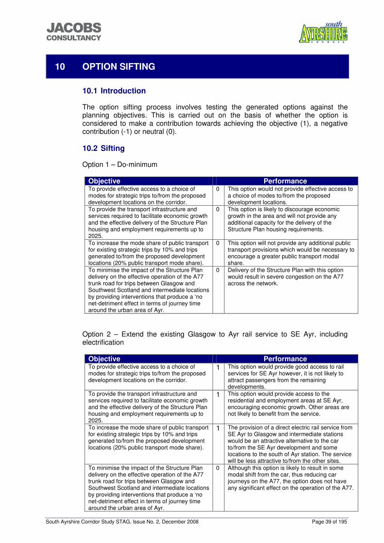
South Ayrshire Corridor Study STAG, Issue No. 2, December 2008 Page 39 of 195
���������������
10 OPTION SIFTING
10.1 Introduction
The option sifting process involves testing the generated options against the planning objectives. This is carried out on the basis of whether the option is considered to make a contribution towards achieving the objective (1), a negative contribution (-1) or neutral (0). 10.2 Sifting
Option 1 – Do-minimum
Objective Performance To provide effective access to a choice of modes for strategic trips to/from the proposed development locations on the corridor.
0 This option would not provide effective access to a choice of modes to/from the proposed development locations.
To provide the transport infrastructure and services required to facilitate economic growth and the effective delivery of the Structure Plan housing and employment requirements up to 2025.
0 This option is likely to discourage economic growth in the area and will not provide any additional capacity for the delivery of the Structure Plan housing requirements.
To increase the mode share of public transport for existing strategic trips by 10% and trips generated to/from the proposed development locations (20% public transport mode share).
0
This option will not provide any additional public transport provisions which would be necessary to encourage a greater public transport modal share.
To minimise the impact of the Structure Plan delivery on the effective operation of the A77 trunk road for trips between Glasgow and Southwest Scotland and intermediate locations by providing interventions that produce a ‘no net-detriment effect in terms of journey time around the urban area of Ayr.
0 Delivery of the Structure Plan with this option would result in severe congestion on the A77 across the network.
Option 2 – Extend the existing Glasgow to Ayr rail service to SE Ayr, including electrification
Objective Performance To provide effective access to a choice of modes for strategic trips to/from the proposed development locations on the corridor.
1 This option would provide good access to rail services for SE Ayr however, it is not likely to attract passengers from the remaining developments.
To provide the transport infrastructure and services required to facilitate economic growth and the effective delivery of the Structure Plan housing and employment requirements up to 2025.
1 This option would provide access to the residential and employment areas at SE Ayr, encouraging economic growth. Other areas are not likely to benefit from the service.
To increase the mode share of public transport for existing strategic trips by 10% and trips generated to/from the proposed development locations (20% public transport mode share).
1
The provision of a direct electric rail service from SE Ayr to Glasgow and intermediate stations would be an attractive alternative to the car to/from the SE Ayr development and some locations to the south of Ayr station. The service will be less attractive to/from the other sites.
To minimise the impact of the Structure Plan delivery on the effective operation of the A77 trunk road for trips between Glasgow and Southwest Scotland and intermediate locations by providing interventions that produce a ‘no net-detriment effect in terms of journey time around the urban area of Ayr.
0 Although this option is likely to result in some modal shift from the car, thus reducing car journeys on the A77, the option does not have any significant effect on the operation of the A77.
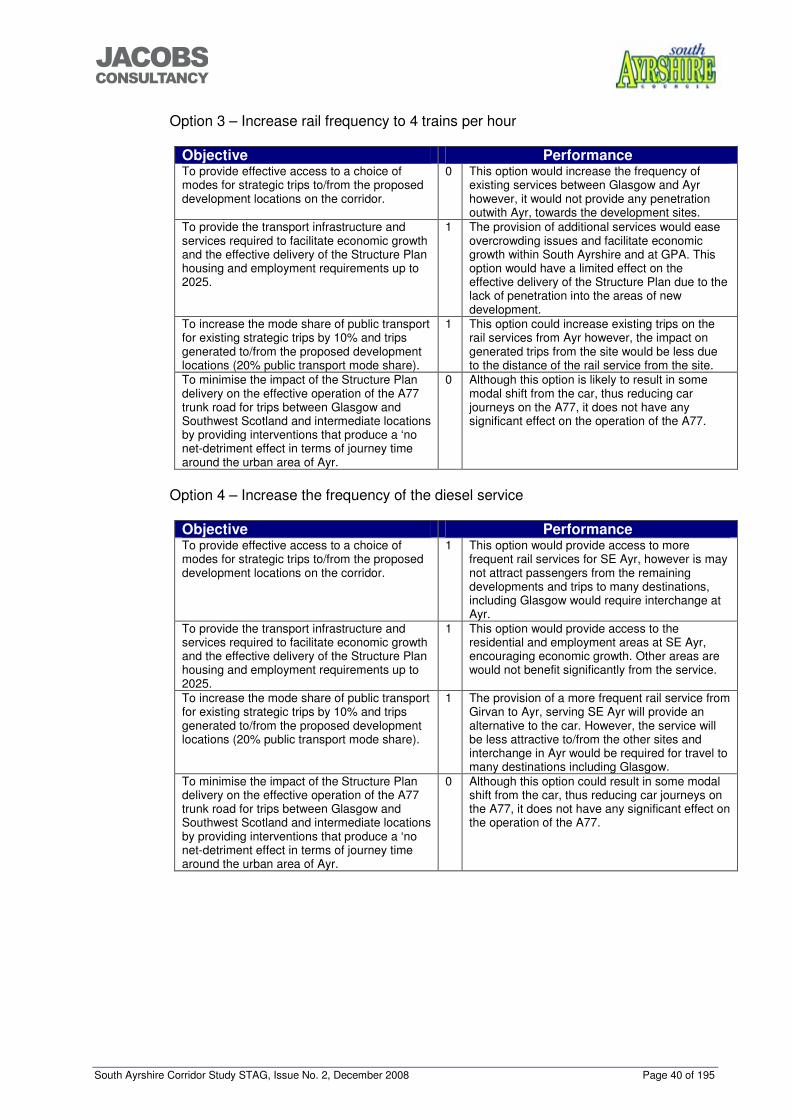
South Ayrshire Corridor Study STAG, Issue No. 2, December 2008 Page 40 of 195
���������������
Option 3 – Increase rail frequency to 4 trains per hour
Objective Performance To provide effective access to a choice of modes for strategic trips to/from the proposed development locations on the corridor.
0 This option would increase the frequency of existing services between Glasgow and Ayr however, it would not provide any penetration outwith Ayr, towards the development sites.
To provide the transport infrastructure and services required to facilitate economic growth and the effective delivery of the Structure Plan housing and employment requirements up to 2025.
1 The provision of additional services would ease overcrowding issues and facilitate economic growth within South Ayrshire and at GPA. This option would have a limited effect on the effective delivery of the Structure Plan due to the lack of penetration into the areas of new development.
To increase the mode share of public transport for existing strategic trips by 10% and trips generated to/from the proposed development locations (20% public transport mode share).
1 This option could increase existing trips on the rail services from Ayr however, the impact on generated trips from the site would be less due to the distance of the rail service from the site.
To minimise the impact of the Structure Plan delivery on the effective operation of the A77 trunk road for trips between Glasgow and Southwest Scotland and intermediate locations by providing interventions that produce a ‘no net-detriment effect in terms of journey time around the urban area of Ayr.
0 Although this option is likely to result in some modal shift from the car, thus reducing car journeys on the A77, it does not have any significant effect on the operation of the A77.
Option 4 – Increase the frequency of the diesel service
Objective Performance To provide effective access to a choice of modes for strategic trips to/from the proposed development locations on the corridor.
1 This option would provide access to more frequent rail services for SE Ayr, however is may not attract passengers from the remaining developments and trips to many destinations, including Glasgow would require interchange at Ayr.
To provide the transport infrastructure and services required to facilitate economic growth and the effective delivery of the Structure Plan housing and employment requirements up to 2025.
1 This option would provide access to the residential and employment areas at SE Ayr, encouraging economic growth. Other areas are would not benefit significantly from the service.
To increase the mode share of public transport for existing strategic trips by 10% and trips generated to/from the proposed development locations (20% public transport mode share).
1
The provision of a more frequent rail service from Girvan to Ayr, serving SE Ayr will provide an alternative to the car. However, the service will be less attractive to/from the other sites and interchange in Ayr would be required for travel to many destinations including Glasgow.
To minimise the impact of the Structure Plan delivery on the effective operation of the A77 trunk road for trips between Glasgow and Southwest Scotland and intermediate locations by providing interventions that produce a ‘no net-detriment effect in terms of journey time around the urban area of Ayr.
0 Although this option could result in some modal shift from the car, thus reducing car journeys on the A77, it does not have any significant effect on the operation of the A77.
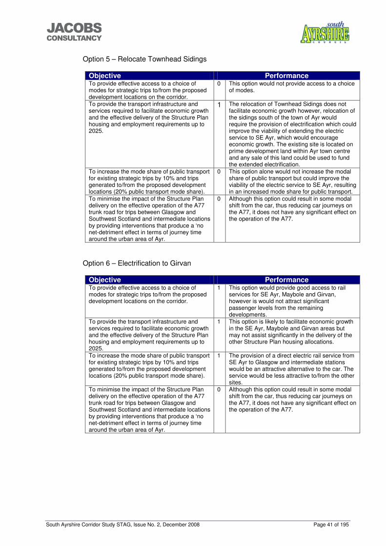
South Ayrshire Corridor Study STAG, Issue No. 2, December 2008 Page 41 of 195
���������������
Option 5 – Relocate Townhead Sidings
Objective Performance To provide effective access to a choice of modes for strategic trips to/from the proposed development locations on the corridor.
0 This option would not provide access to a choice of modes.
To provide the transport infrastructure and services required to facilitate economic growth and the effective delivery of the Structure Plan housing and employment requirements up to 2025.
1
The relocation of Townhead Sidings does not facilitate economic growth however, relocation of the sidings south of the town of Ayr would require the provision of electrification which could improve the viability of extending the electric service to SE Ayr, which would encourage economic growth. The existing site is located on prime development land within Ayr town centre and any sale of this land could be used to fund the extended electrification.
To increase the mode share of public transport for existing strategic trips by 10% and trips generated to/from the proposed development locations (20% public transport mode share).
0 This option alone would not increase the modal share of public transport but could improve the viability of the electric service to SE Ayr, resulting in an increased mode share for public transport.
To minimise the impact of the Structure Plan delivery on the effective operation of the A77 trunk road for trips between Glasgow and Southwest Scotland and intermediate locations by providing interventions that produce a ‘no net-detriment effect in terms of journey time around the urban area of Ayr.
0 Although this option could result in some modal shift from the car, thus reducing car journeys on the A77, it does not have any significant effect on the operation of the A77.
Option 6 – Electrification to Girvan
Objective Performance To provide effective access to a choice of modes for strategic trips to/from the proposed development locations on the corridor.
1 This option would provide good access to rail services for SE Ayr, Maybole and Girvan, however is would not attract significant passenger levels from the remaining developments.
To provide the transport infrastructure and services required to facilitate economic growth and the effective delivery of the Structure Plan housing and employment requirements up to 2025.
1 This option is likely to facilitate economic growth in the SE Ayr, Maybole and Girvan areas but may not assist significantly in the delivery of the other Structure Plan housing allocations.
To increase the mode share of public transport for existing strategic trips by 10% and trips generated to/from the proposed development locations (20% public transport mode share).
1 The provision of a direct electric rail service from SE Ayr to Glasgow and intermediate stations would be an attractive alternative to the car. The service would be less attractive to/from the other sites.
To minimise the impact of the Structure Plan delivery on the effective operation of the A77 trunk road for trips between Glasgow and Southwest Scotland and intermediate locations by providing interventions that produce a ‘no net-detriment effect in terms of journey time around the urban area of Ayr.
0 Although this option could result in some modal shift from the car, thus reducing car journeys on the A77, it does not have any significant effect on the operation of the A77.
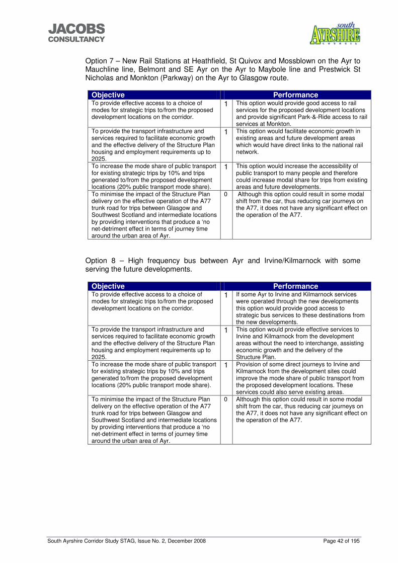
South Ayrshire Corridor Study STAG, Issue No. 2, December 2008 Page 42 of 195
���������������
Option 7 – New Rail Stations at Heathfield, St Quivox and Mossblown on the Ayr to Mauchline line, Belmont and SE Ayr on the Ayr to Maybole line and Prestwick St Nicholas and Monkton (Parkway) on the Ayr to Glasgow route.
Objective Performance To provide effective access to a choice of modes for strategic trips to/from the proposed development locations on the corridor.
1
This option would provide good access to rail services for the proposed development locations and provide significant Park-&-Ride access to rail services at Monkton.
To provide the transport infrastructure and services required to facilitate economic growth and the effective delivery of the Structure Plan housing and employment requirements up to 2025.
1
This option would facilitate economic growth in existing areas and future development areas which would have direct links to the national rail network.
To increase the mode share of public transport for existing strategic trips by 10% and trips generated to/from the proposed development locations (20% public transport mode share).
1
This option would increase the accessibility of public transport to many people and therefore could increase modal share for trips from existing areas and future developments.
To minimise the impact of the Structure Plan delivery on the effective operation of the A77 trunk road for trips between Glasgow and Southwest Scotland and intermediate locations by providing interventions that produce a ‘no net-detriment effect in terms of journey time around the urban area of Ayr.
0 Although this option could result in some modal shift from the car, thus reducing car journeys on the A77, it does not have any significant effect on the operation of the A77.
Option 8 – High frequency bus between Ayr and Irvine/Kilmarnock with some serving the future developments.
Objective Performance To provide effective access to a choice of modes for strategic trips to/from the proposed development locations on the corridor.
1
If some Ayr to Irvine and Kilmarnock services were operated through the new developments this option would provide good access to strategic bus services to these destinations from the new developments.
To provide the transport infrastructure and services required to facilitate economic growth and the effective delivery of the Structure Plan housing and employment requirements up to 2025.
1
This option would provide effective services to Irvine and Kilmarnock from the development areas without the need to interchange, assisting economic growth and the delivery of the Structure Plan.
To increase the mode share of public transport for existing strategic trips by 10% and trips generated to/from the proposed development locations (20% public transport mode share).
1
Provision of some direct journeys to Irvine and Kilmarnock from the development sites could improve the mode share of public transport from the proposed development locations. These services could also serve existing areas.
To minimise the impact of the Structure Plan delivery on the effective operation of the A77 trunk road for trips between Glasgow and Southwest Scotland and intermediate locations by providing interventions that produce a ‘no net-detriment effect in terms of journey time around the urban area of Ayr.
0 Although this option could result in some modal shift from the car, thus reducing car journeys on the A77, it does not have any significant effect on the operation of the A77.
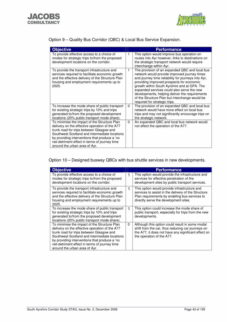
South Ayrshire Corridor Study STAG, Issue No. 2, December 2008 Page 43 of 195
���������������
Option 9 – Quality Bus Corridor (QBC) & Local Bus Service Expansion.
Objective Performance To provide effective access to a choice of modes for strategic trips to/from the proposed development locations on the corridor.
1
This option would improve bus operation on routes into Ayr however, links to destinations on the strategic transport network would require interchange within Ayr.
To provide the transport infrastructure and services required to facilitate economic growth and the effective delivery of the Structure Plan housing and employment requirements up to 2025.
1 The provision of an expanded QBC and local bus network would provide improved journey times and journey time reliability for journeys into Ayr, providing improved prospects for economic growth within South Ayrshire and at GPA. The expanded services could also serve the new developments, helping deliver the requirements of the Structure Plan but interchange would be required for strategic trips.
To increase the mode share of public transport for existing strategic trips by 10% and trips generated to/from the proposed development locations (20% public transport mode share).
0 The provision of an expanded QBC and local bus network would have more effect on local bus trips and may not significantly encourage trips on the strategic network.
To minimise the impact of the Structure Plan delivery on the effective operation of the A77 trunk road for trips between Glasgow and Southwest Scotland and intermediate locations by providing interventions that produce a ‘no net-detriment effect in terms of journey time around the urban area of Ayr.
0 An expanded QBC and local bus network would not affect the operation of the A77.
Option 10 – Designed busway QBCs with bus shuttle services in new developments.
Objective Performance To provide effective access to a choice of modes for strategic trips to/from the proposed development locations on the corridor.
1
This option would provide the infrastructure and services for effective penetration of the development sites by public transport services.
To provide the transport infrastructure and services required to facilitate economic growth and the effective delivery of the Structure Plan housing and employment requirements up to 2025.
1 This option would provide infrastructure and services to assist in the delivery of the Structure Plan requirements by enabling bus services to directly serve the development sites.
To increase the mode share of public transport for existing strategic trips by 10% and trips generated to/from the proposed development locations (20% public transport mode share).
1 This option could increase the mode share of public transport, especially for trips from the new developments.
To minimise the impact of the Structure Plan delivery on the effective operation of the A77 trunk road for trips between Glasgow and Southwest Scotland and intermediate locations by providing interventions that produce a ‘no net-detriment effect in terms of journey time around the urban area of Ayr.
0 Although this option could result in some modal shift from the car, thus reducing car journeys on the A77, it does not have any significant effect on the operation of the A77.

South Ayrshire Corridor Study STAG, Issue No. 2, December 2008 Page 44 of 195
���������������
Option 11 – Improved express bus service to Glasgow.
Objective Performance To provide effective access to a choice of modes for strategic trips to/from the proposed development locations on the corridor.
1 If some Glasgow services were operated through the new developments this option would provide good access to strategic bus services destined for Glasgow from the new developments.
To provide the transport infrastructure and services required to facilitate economic growth and the effective delivery of the Structure Plan housing and employment requirements up to 2025.
1 This option would provide an effective service to Glasgow from the development areas without the need to interchange, assisting economic growth and the delivery of the Structure Plan.
To increase the mode share of public transport for existing strategic trips by 10% and trips generated to/from the proposed development locations (20% public transport mode share).
1 Extension of some Glasgow express journeys to the development sites and along the A77 could improve the mode share of public transport from the proposed development locations. They could also serve existing areas.
To minimise the impact of the Structure Plan delivery on the effective operation of the A77 trunk road for trips between Glasgow and Southwest Scotland and intermediate locations by providing interventions that produce a ‘no net-detriment effect in terms of journey time around the urban area of Ayr
0 Although this option could result in some modal shift from the car, thus reducing car journeys on the A77, it does not have any significant effect on the operation of the A77.
Option 12 – Enforcement of bus priority
Objective Performance To provide effective access to a choice of modes for strategic trips to/from the proposed development locations on the corridor.
0 This option will not affect the choice of modes for strategic trips to/from the development locations.
To provide the transport infrastructure and services required to facilitate economic growth and the effective delivery of the Structure Plan housing and employment requirements up to 2025.
1 This option could assist in the provision of effective bus priority measures into Ayr, assisting economic growth. It may not however, have any significant impact on the delivery of the Structure Plan requirements
To increase the mode share of public transport for existing strategic trips by 10% and trips generated to/from the proposed development locations (20% public transport mode share).
1 This option could reduce frustrating delays experienced by existing and potential public transport users. It however, would not affect strategic trips.
To minimise the impact of the Structure Plan delivery on the effective operation of the A77 trunk road for trips between Glasgow and Southwest Scotland and intermediate locations by providing interventions that produce a ‘no net-detriment effect in terms of journey time around the urban area of Ayr
0 This option would not affect the operation of the A77.
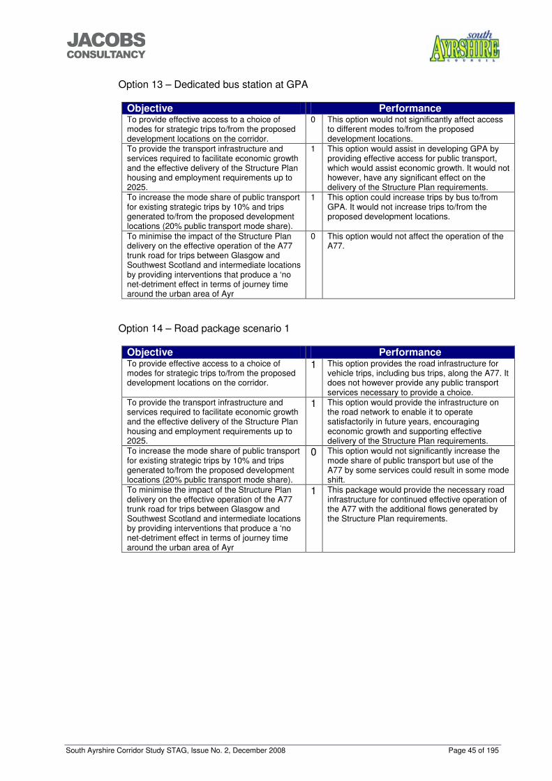
South Ayrshire Corridor Study STAG, Issue No. 2, December 2008 Page 45 of 195
���������������
Option 13 – Dedicated bus station at GPA
Objective Performance To provide effective access to a choice of modes for strategic trips to/from the proposed development locations on the corridor.
0 This option would not significantly affect access to different modes to/from the proposed development locations.
To provide the transport infrastructure and services required to facilitate economic growth and the effective delivery of the Structure Plan housing and employment requirements up to 2025.
1 This option would assist in developing GPA by providing effective access for public transport, which would assist economic growth. It would not however, have any significant effect on the delivery of the Structure Plan requirements.
To increase the mode share of public transport for existing strategic trips by 10% and trips generated to/from the proposed development locations (20% public transport mode share).
1 This option could increase trips by bus to/from GPA. It would not increase trips to/from the proposed development locations.
To minimise the impact of the Structure Plan delivery on the effective operation of the A77 trunk road for trips between Glasgow and Southwest Scotland and intermediate locations by providing interventions that produce a ‘no net-detriment effect in terms of journey time around the urban area of Ayr
0 This option would not affect the operation of the A77.
Option 14 – Road package scenario 1
Objective Performance To provide effective access to a choice of modes for strategic trips to/from the proposed development locations on the corridor.
1 This option provides the road infrastructure for vehicle trips, including bus trips, along the A77. It does not however provide any public transport services necessary to provide a choice.
To provide the transport infrastructure and services required to facilitate economic growth and the effective delivery of the Structure Plan housing and employment requirements up to 2025.
1 This option would provide the infrastructure on the road network to enable it to operate satisfactorily in future years, encouraging economic growth and supporting effective delivery of the Structure Plan requirements.
To increase the mode share of public transport for existing strategic trips by 10% and trips generated to/from the proposed development locations (20% public transport mode share).
0 This option would not significantly increase the mode share of public transport but use of the A77 by some services could result in some mode shift.
To minimise the impact of the Structure Plan delivery on the effective operation of the A77 trunk road for trips between Glasgow and Southwest Scotland and intermediate locations by providing interventions that produce a ‘no net-detriment effect in terms of journey time around the urban area of Ayr
1 This package would provide the necessary road infrastructure for continued effective operation of the A77 with the additional flows generated by the Structure Plan requirements.
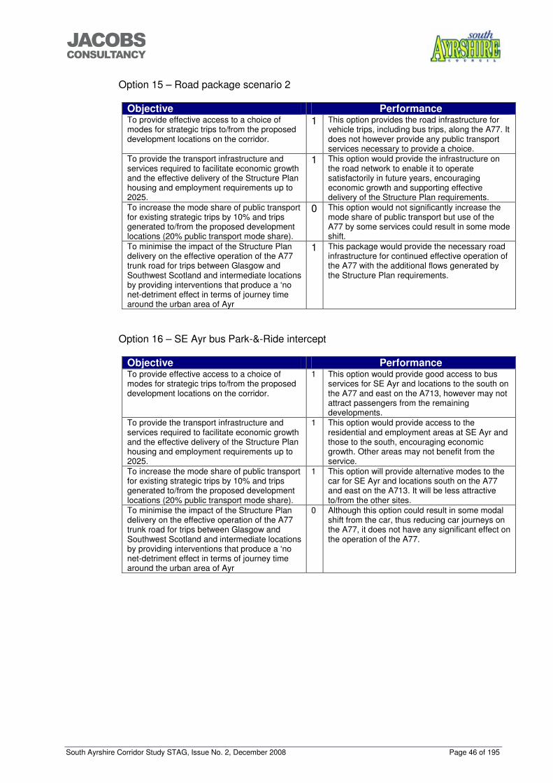
South Ayrshire Corridor Study STAG, Issue No. 2, December 2008 Page 46 of 195
���������������
Option 15 – Road package scenario 2
Objective Performance To provide effective access to a choice of modes for strategic trips to/from the proposed development locations on the corridor.
1 This option provides the road infrastructure for vehicle trips, including bus trips, along the A77. It does not however provide any public transport services necessary to provide a choice.
To provide the transport infrastructure and services required to facilitate economic growth and the effective delivery of the Structure Plan housing and employment requirements up to 2025.
1 This option would provide the infrastructure on the road network to enable it to operate satisfactorily in future years, encouraging economic growth and supporting effective delivery of the Structure Plan requirements.
To increase the mode share of public transport for existing strategic trips by 10% and trips generated to/from the proposed development locations (20% public transport mode share).
0 This option would not significantly increase the mode share of public transport but use of the A77 by some services could result in some mode shift.
To minimise the impact of the Structure Plan delivery on the effective operation of the A77 trunk road for trips between Glasgow and Southwest Scotland and intermediate locations by providing interventions that produce a ‘no net-detriment effect in terms of journey time around the urban area of Ayr
1 This package would provide the necessary road infrastructure for continued effective operation of the A77 with the additional flows generated by the Structure Plan requirements.
Option 16 – SE Ayr bus Park-&-Ride intercept
Objective Performance To provide effective access to a choice of modes for strategic trips to/from the proposed development locations on the corridor.
1 This option would provide good access to bus services for SE Ayr and locations to the south on the A77 and east on the A713, however may not attract passengers from the remaining developments.
To provide the transport infrastructure and services required to facilitate economic growth and the effective delivery of the Structure Plan housing and employment requirements up to 2025.
1 This option would provide access to the residential and employment areas at SE Ayr and those to the south, encouraging economic growth. Other areas may not benefit from the service.
To increase the mode share of public transport for existing strategic trips by 10% and trips generated to/from the proposed development locations (20% public transport mode share).
1 This option will provide alternative modes to the car for SE Ayr and locations south on the A77 and east on the A713. It will be less attractive to/from the other sites.
To minimise the impact of the Structure Plan delivery on the effective operation of the A77 trunk road for trips between Glasgow and Southwest Scotland and intermediate locations by providing interventions that produce a ‘no net-detriment effect in terms of journey time around the urban area of Ayr
0 Although this option could result in some modal shift from the car, thus reducing car journeys on the A77, it does not have any significant effect on the operation of the A77.
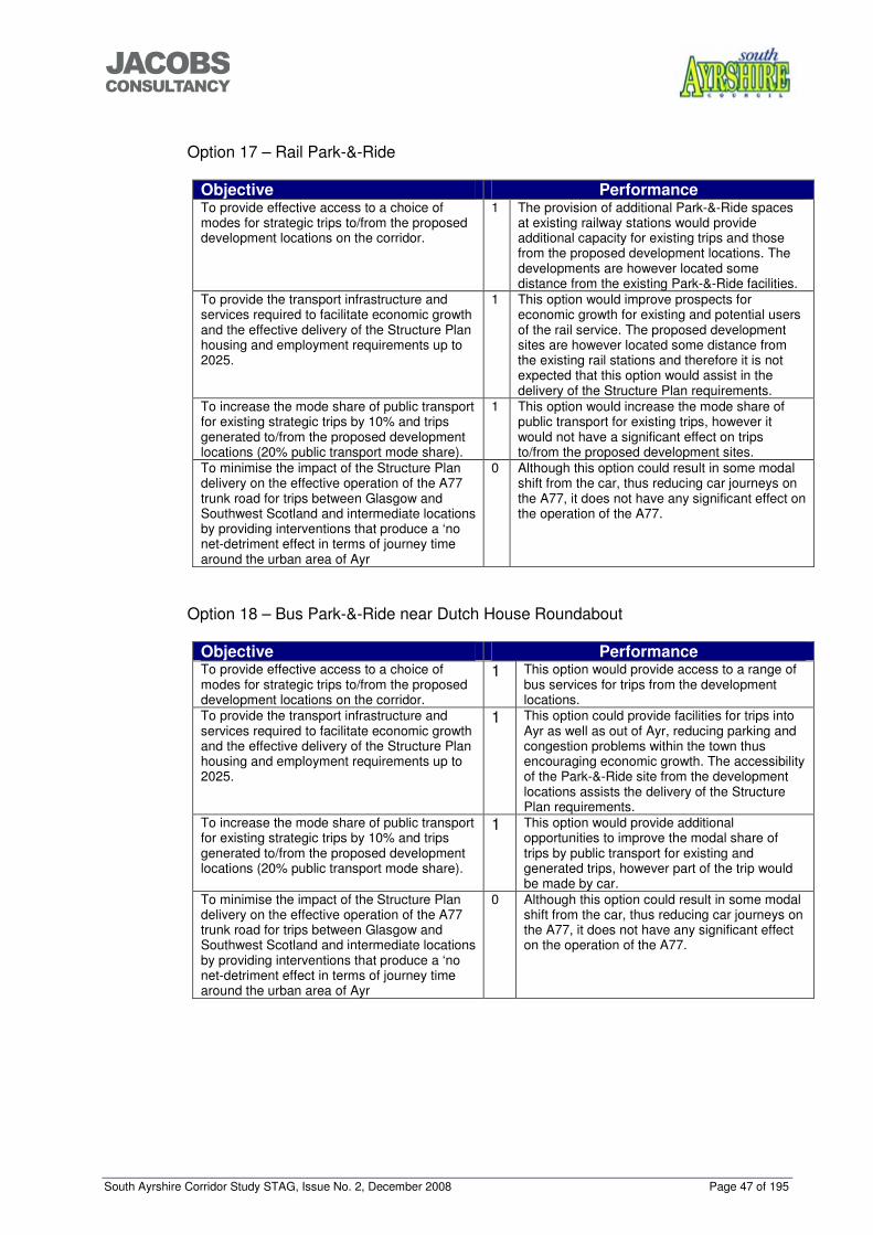
South Ayrshire Corridor Study STAG, Issue No. 2, December 2008 Page 47 of 195
���������������
Option 17 – Rail Park-&-Ride
Objective Performance To provide effective access to a choice of modes for strategic trips to/from the proposed development locations on the corridor.
1 The provision of additional Park-&-Ride spaces at existing railway stations would provide additional capacity for existing trips and those from the proposed development locations. The developments are however located some distance from the existing Park-&-Ride facilities.
To provide the transport infrastructure and services required to facilitate economic growth and the effective delivery of the Structure Plan housing and employment requirements up to 2025.
1 This option would improve prospects for economic growth for existing and potential users of the rail service. The proposed development sites are however located some distance from the existing rail stations and therefore it is not expected that this option would assist in the delivery of the Structure Plan requirements.
To increase the mode share of public transport for existing strategic trips by 10% and trips generated to/from the proposed development locations (20% public transport mode share).
1 This option would increase the mode share of public transport for existing trips, however it would not have a significant effect on trips to/from the proposed development sites.
To minimise the impact of the Structure Plan delivery on the effective operation of the A77 trunk road for trips between Glasgow and Southwest Scotland and intermediate locations by providing interventions that produce a ‘no net-detriment effect in terms of journey time around the urban area of Ayr
0 Although this option could result in some modal shift from the car, thus reducing car journeys on the A77, it does not have any significant effect on the operation of the A77.
Option 18 – Bus Park-&-Ride near Dutch House Roundabout
Objective Performance To provide effective access to a choice of modes for strategic trips to/from the proposed development locations on the corridor.
1 This option would provide access to a range of bus services for trips from the development locations.
To provide the transport infrastructure and services required to facilitate economic growth and the effective delivery of the Structure Plan housing and employment requirements up to 2025.
1 This option could provide facilities for trips into Ayr as well as out of Ayr, reducing parking and congestion problems within the town thus encouraging economic growth. The accessibility of the Park-&-Ride site from the development locations assists the delivery of the Structure Plan requirements.
To increase the mode share of public transport for existing strategic trips by 10% and trips generated to/from the proposed development locations (20% public transport mode share).
1
This option would provide additional opportunities to improve the modal share of trips by public transport for existing and generated trips, however part of the trip would be made by car.
To minimise the impact of the Structure Plan delivery on the effective operation of the A77 trunk road for trips between Glasgow and Southwest Scotland and intermediate locations by providing interventions that produce a ‘no net-detriment effect in terms of journey time around the urban area of Ayr
0 Although this option could result in some modal shift from the car, thus reducing car journeys on the A77, it does not have any significant effect on the operation of the A77.
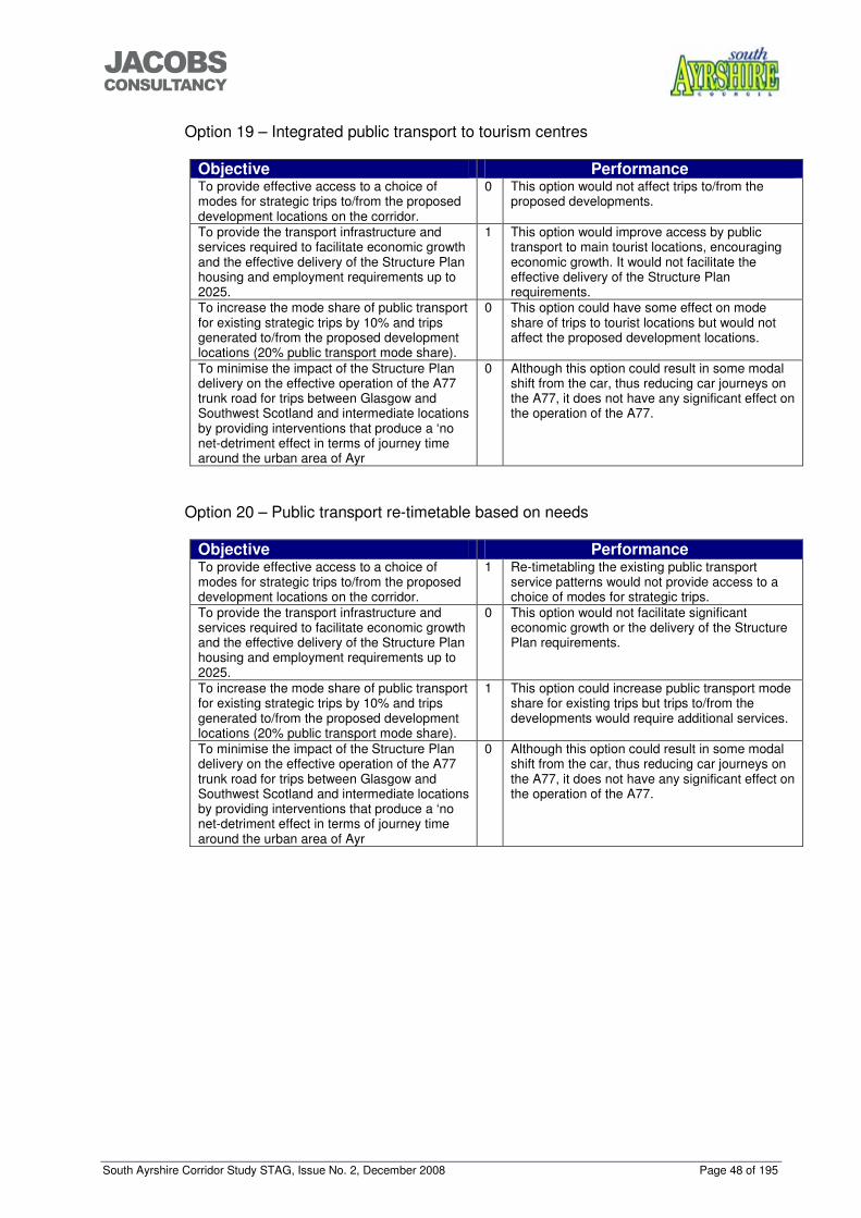
South Ayrshire Corridor Study STAG, Issue No. 2, December 2008 Page 48 of 195
���������������
Option 19 – Integrated public transport to tourism centres
Objective Performance To provide effective access to a choice of modes for strategic trips to/from the proposed development locations on the corridor.
0 This option would not affect trips to/from the proposed developments.
To provide the transport infrastructure and services required to facilitate economic growth and the effective delivery of the Structure Plan housing and employment requirements up to 2025.
1 This option would improve access by public transport to main tourist locations, encouraging economic growth. It would not facilitate the effective delivery of the Structure Plan requirements.
To increase the mode share of public transport for existing strategic trips by 10% and trips generated to/from the proposed development locations (20% public transport mode share).
0 This option could have some effect on mode share of trips to tourist locations but would not affect the proposed development locations.
To minimise the impact of the Structure Plan delivery on the effective operation of the A77 trunk road for trips between Glasgow and Southwest Scotland and intermediate locations by providing interventions that produce a ‘no net-detriment effect in terms of journey time around the urban area of Ayr
0 Although this option could result in some modal shift from the car, thus reducing car journeys on the A77, it does not have any significant effect on the operation of the A77.
Option 20 – Public transport re-timetable based on needs
Objective Performance To provide effective access to a choice of modes for strategic trips to/from the proposed development locations on the corridor.
1 Re-timetabling the existing public transport service patterns would not provide access to a choice of modes for strategic trips.
To provide the transport infrastructure and services required to facilitate economic growth and the effective delivery of the Structure Plan housing and employment requirements up to 2025.
0 This option would not facilitate significant economic growth or the delivery of the Structure Plan requirements.
To increase the mode share of public transport for existing strategic trips by 10% and trips generated to/from the proposed development locations (20% public transport mode share).
1 This option could increase public transport mode share for existing trips but trips to/from the developments would require additional services.
To minimise the impact of the Structure Plan delivery on the effective operation of the A77 trunk road for trips between Glasgow and Southwest Scotland and intermediate locations by providing interventions that produce a ‘no net-detriment effect in terms of journey time around the urban area of Ayr
0 Although this option could result in some modal shift from the car, thus reducing car journeys on the A77, it does not have any significant effect on the operation of the A77.
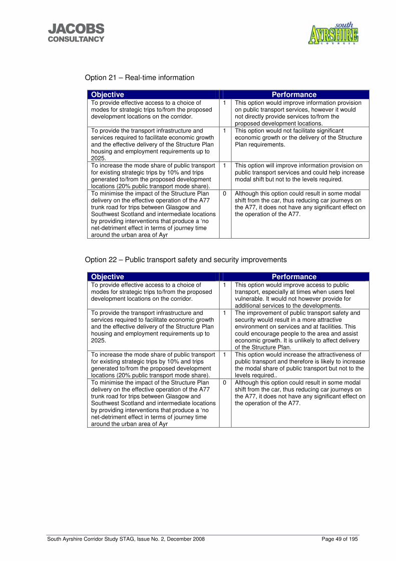
South Ayrshire Corridor Study STAG, Issue No. 2, December 2008 Page 49 of 195
���������������
Option 21 – Real-time information
Objective Performance To provide effective access to a choice of modes for strategic trips to/from the proposed development locations on the corridor.
1 This option would improve information provision on public transport services, however it would not directly provide services to/from the proposed development locations.
To provide the transport infrastructure and services required to facilitate economic growth and the effective delivery of the Structure Plan housing and employment requirements up to 2025.
1 This option would not facilitate significant economic growth or the delivery of the Structure Plan requirements.
To increase the mode share of public transport for existing strategic trips by 10% and trips generated to/from the proposed development locations (20% public transport mode share).
1 This option will improve information provision on public transport services and could help increase modal shift but not to the levels required.
To minimise the impact of the Structure Plan delivery on the effective operation of the A77 trunk road for trips between Glasgow and Southwest Scotland and intermediate locations by providing interventions that produce a ‘no net-detriment effect in terms of journey time around the urban area of Ayr
0 Although this option could result in some modal shift from the car, thus reducing car journeys on the A77, it does not have any significant effect on the operation of the A77.
Option 22 – Public transport safety and security improvements
Objective Performance To provide effective access to a choice of modes for strategic trips to/from the proposed development locations on the corridor.
1 This option would improve access to public transport, especially at times when users feel vulnerable. It would not however provide for additional services to the developments.
To provide the transport infrastructure and services required to facilitate economic growth and the effective delivery of the Structure Plan housing and employment requirements up to 2025.
1 The improvement of public transport safety and security would result in a more attractive environment on services and at facilities. This could encourage people to the area and assist economic growth. It is unlikely to affect delivery of the Structure Plan.
To increase the mode share of public transport for existing strategic trips by 10% and trips generated to/from the proposed development locations (20% public transport mode share).
1 This option would increase the attractiveness of public transport and therefore is likely to increase the modal share of public transport but not to the levels required..
To minimise the impact of the Structure Plan delivery on the effective operation of the A77 trunk road for trips between Glasgow and Southwest Scotland and intermediate locations by providing interventions that produce a ‘no net-detriment effect in terms of journey time around the urban area of Ayr
0 Although this option could result in some modal shift from the car, thus reducing car journeys on the A77, it does not have any significant effect on the operation of the A77.
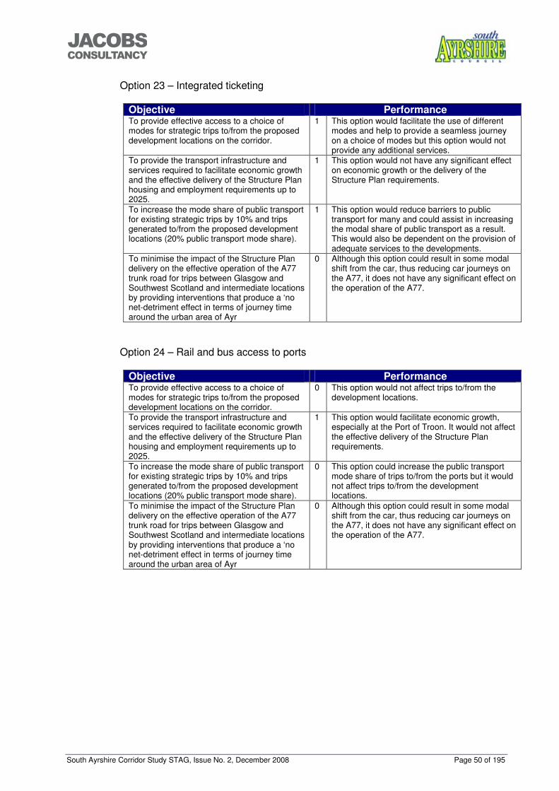
South Ayrshire Corridor Study STAG, Issue No. 2, December 2008 Page 50 of 195
���������������
Option 23 – Integrated ticketing
Objective Performance To provide effective access to a choice of modes for strategic trips to/from the proposed development locations on the corridor.
1 This option would facilitate the use of different modes and help to provide a seamless journey on a choice of modes but this option would not provide any additional services.
To provide the transport infrastructure and services required to facilitate economic growth and the effective delivery of the Structure Plan housing and employment requirements up to 2025.
1 This option would not have any significant effect on economic growth or the delivery of the Structure Plan requirements.
To increase the mode share of public transport for existing strategic trips by 10% and trips generated to/from the proposed development locations (20% public transport mode share).
1
This option would reduce barriers to public transport for many and could assist in increasing the modal share of public transport as a result. This would also be dependent on the provision of adequate services to the developments.
To minimise the impact of the Structure Plan delivery on the effective operation of the A77 trunk road for trips between Glasgow and Southwest Scotland and intermediate locations by providing interventions that produce a ‘no net-detriment effect in terms of journey time around the urban area of Ayr
0 Although this option could result in some modal shift from the car, thus reducing car journeys on the A77, it does not have any significant effect on the operation of the A77.
Option 24 – Rail and bus access to ports
Objective Performance To provide effective access to a choice of modes for strategic trips to/from the proposed development locations on the corridor.
0 This option would not affect trips to/from the development locations.
To provide the transport infrastructure and services required to facilitate economic growth and the effective delivery of the Structure Plan housing and employment requirements up to 2025.
1 This option would facilitate economic growth, especially at the Port of Troon. It would not affect the effective delivery of the Structure Plan requirements.
To increase the mode share of public transport for existing strategic trips by 10% and trips generated to/from the proposed development locations (20% public transport mode share).
0 This option could increase the public transport mode share of trips to/from the ports but it would not affect trips to/from the development locations.
To minimise the impact of the Structure Plan delivery on the effective operation of the A77 trunk road for trips between Glasgow and Southwest Scotland and intermediate locations by providing interventions that produce a ‘no net-detriment effect in terms of journey time around the urban area of Ayr
0 Although this option could result in some modal shift from the car, thus reducing car journeys on the A77, it does not have any significant effect on the operation of the A77.
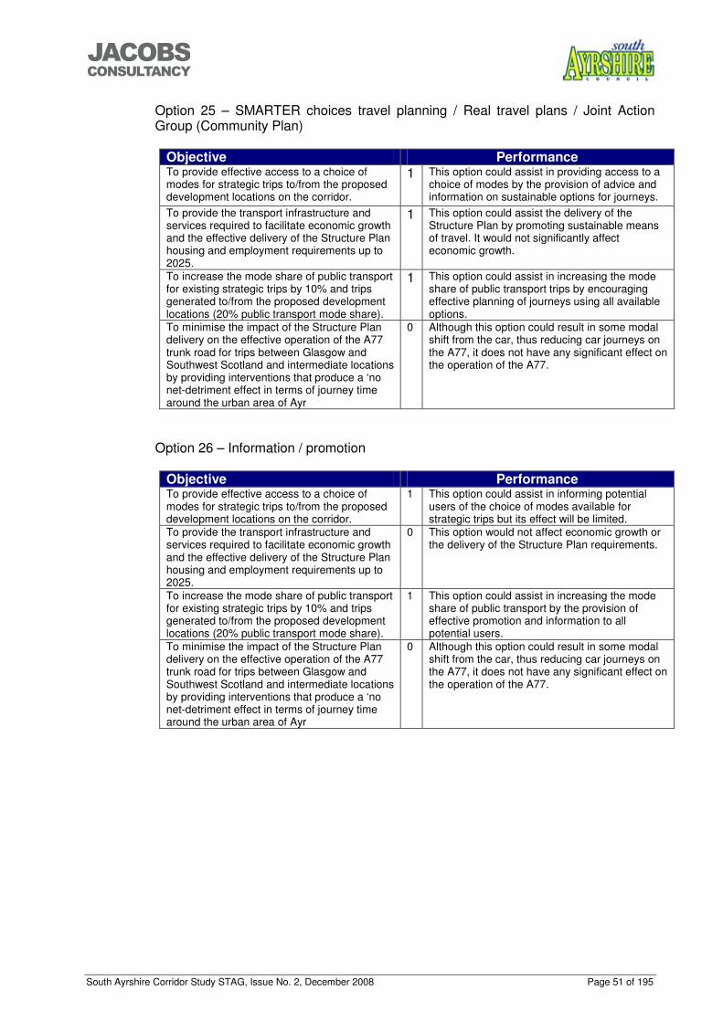
South Ayrshire Corridor Study STAG, Issue No. 2, December 2008 Page 51 of 195
���������������
Option 25 – SMARTER choices travel planning / Real travel plans / Joint Action Group (Community Plan)
Objective Performance To provide effective access to a choice of modes for strategic trips to/from the proposed development locations on the corridor.
1
This option could assist in providing access to a choice of modes by the provision of advice and information on sustainable options for journeys.
To provide the transport infrastructure and services required to facilitate economic growth and the effective delivery of the Structure Plan housing and employment requirements up to 2025.
1
This option could assist the delivery of the Structure Plan by promoting sustainable means of travel. It would not significantly affect economic growth.
To increase the mode share of public transport for existing strategic trips by 10% and trips generated to/from the proposed development locations (20% public transport mode share).
1
This option could assist in increasing the mode share of public transport trips by encouraging effective planning of journeys using all available options.
To minimise the impact of the Structure Plan delivery on the effective operation of the A77 trunk road for trips between Glasgow and Southwest Scotland and intermediate locations by providing interventions that produce a ‘no net-detriment effect in terms of journey time around the urban area of Ayr
0 Although this option could result in some modal shift from the car, thus reducing car journeys on the A77, it does not have any significant effect on the operation of the A77.
Option 26 – Information / promotion
Objective Performance To provide effective access to a choice of modes for strategic trips to/from the proposed development locations on the corridor.
1 This option could assist in informing potential users of the choice of modes available for strategic trips but its effect will be limited.
To provide the transport infrastructure and services required to facilitate economic growth and the effective delivery of the Structure Plan housing and employment requirements up to 2025.
0 This option would not affect economic growth or the delivery of the Structure Plan requirements.
To increase the mode share of public transport for existing strategic trips by 10% and trips generated to/from the proposed development locations (20% public transport mode share).
1 This option could assist in increasing the mode share of public transport by the provision of effective promotion and information to all potential users.
To minimise the impact of the Structure Plan delivery on the effective operation of the A77 trunk road for trips between Glasgow and Southwest Scotland and intermediate locations by providing interventions that produce a ‘no net-detriment effect in terms of journey time around the urban area of Ayr
0 Although this option could result in some modal shift from the car, thus reducing car journeys on the A77, it does not have any significant effect on the operation of the A77.
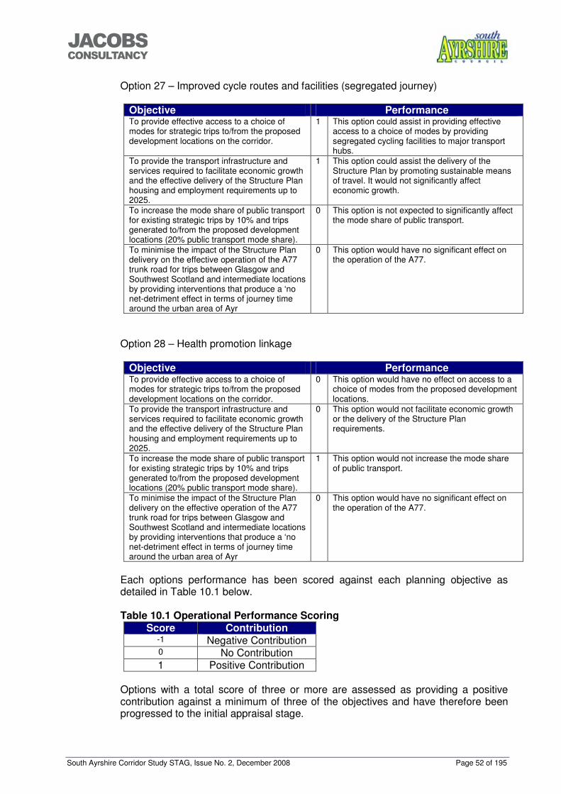
South Ayrshire Corridor Study STAG, Issue No. 2, December 2008 Page 52 of 195
���������������
Option 27 – Improved cycle routes and facilities (segregated journey)
Objective Performance To provide effective access to a choice of modes for strategic trips to/from the proposed development locations on the corridor.
1 This option could assist in providing effective access to a choice of modes by providing segregated cycling facilities to major transport hubs.
To provide the transport infrastructure and services required to facilitate economic growth and the effective delivery of the Structure Plan housing and employment requirements up to 2025.
1 This option could assist the delivery of the Structure Plan by promoting sustainable means of travel. It would not significantly affect economic growth.
To increase the mode share of public transport for existing strategic trips by 10% and trips generated to/from the proposed development locations (20% public transport mode share).
0 This option is not expected to significantly affect the mode share of public transport.
To minimise the impact of the Structure Plan delivery on the effective operation of the A77 trunk road for trips between Glasgow and Southwest Scotland and intermediate locations by providing interventions that produce a ‘no net-detriment effect in terms of journey time around the urban area of Ayr
0 This option would have no significant effect on the operation of the A77.
Option 28 – Health promotion linkage
Objective Performance To provide effective access to a choice of modes for strategic trips to/from the proposed development locations on the corridor.
0 This option would have no effect on access to a choice of modes from the proposed development locations.
To provide the transport infrastructure and services required to facilitate economic growth and the effective delivery of the Structure Plan housing and employment requirements up to 2025.
0 This option would not facilitate economic growth or the delivery of the Structure Plan requirements.
To increase the mode share of public transport for existing strategic trips by 10% and trips generated to/from the proposed development locations (20% public transport mode share).
1 This option would not increase the mode share of public transport.
To minimise the impact of the Structure Plan delivery on the effective operation of the A77 trunk road for trips between Glasgow and Southwest Scotland and intermediate locations by providing interventions that produce a ‘no net-detriment effect in terms of journey time around the urban area of Ayr
0 This option would have no significant effect on the operation of the A77.
Each options performance has been scored against each planning objective as detailed in Table 10.1 below. Table 10.1 Operational Performance Scoring
Score Contribution -1 Negative Contribution 0 No Contribution 1 Positive Contribution
Options with a total score of three or more are assessed as providing a positive contribution against a minimum of three of the objectives and have therefore been progressed to the initial appraisal stage.
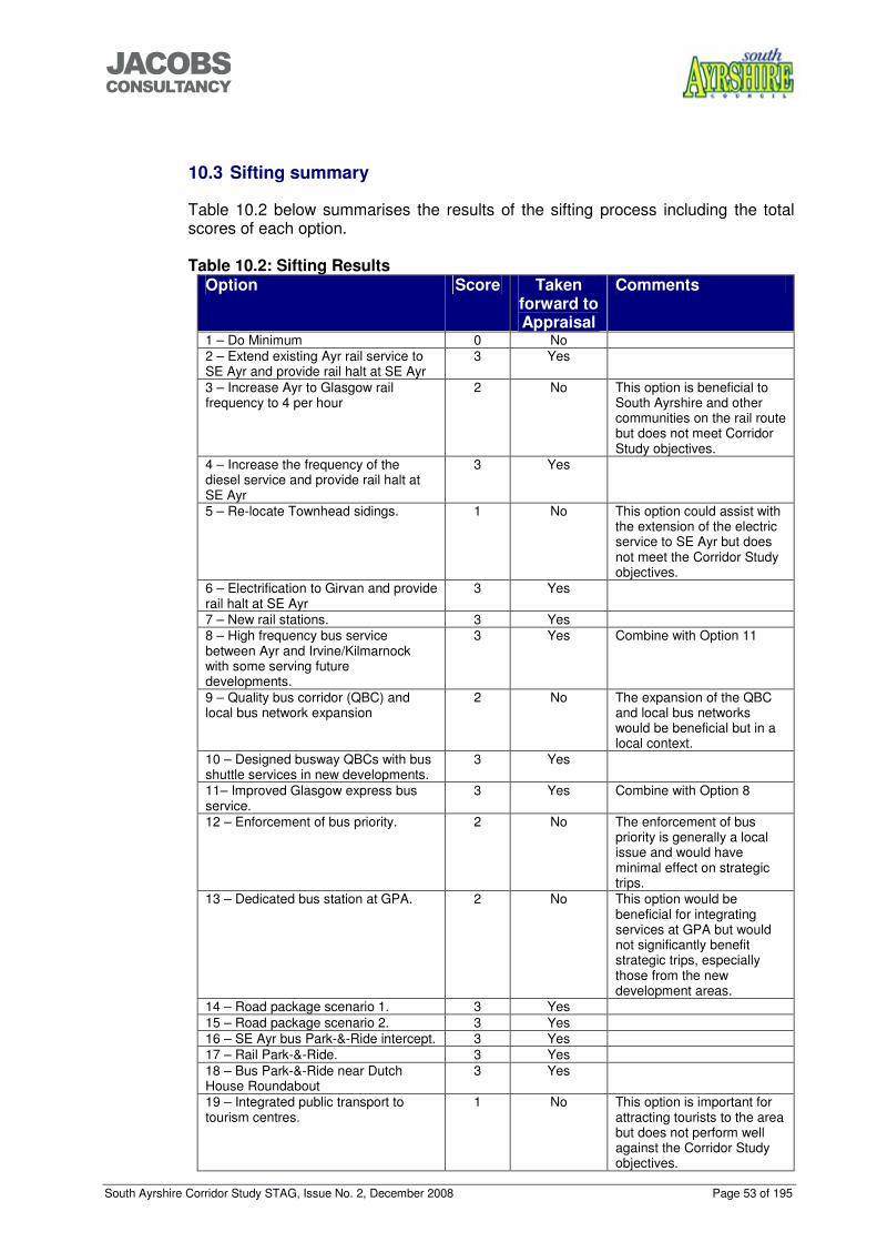
South Ayrshire Corridor Study STAG, Issue No. 2, December 2008 Page 53 of 195
���������������
10.3 Sifting summary
Table 10.2 below summarises the results of the sifting process including the total scores of each option. Table 10.2: Sifting Results
Option Score Taken forward to Appraisal
Comments
1 – Do Minimum 0 No 2 – Extend existing Ayr rail service to SE Ayr and provide rail halt at SE Ayr
3 Yes
3 – Increase Ayr to Glasgow rail frequency to 4 per hour
2 No This option is beneficial to South Ayrshire and other communities on the rail route but does not meet Corridor Study objectives.
4 – Increase the frequency of the diesel service and provide rail halt at SE Ayr
3 Yes
5 – Re-locate Townhead sidings. 1 No This option could assist with the extension of the electric service to SE Ayr but does not meet the Corridor Study objectives.
6 – Electrification to Girvan and provide rail halt at SE Ayr
3 Yes
7 – New rail stations. 3 Yes 8 – High frequency bus service between Ayr and Irvine/Kilmarnock with some serving future developments.
3 Yes Combine with Option 11
9 – Quality bus corridor (QBC) and local bus network expansion
2 No The expansion of the QBC and local bus networks would be beneficial but in a local context.
10 – Designed busway QBCs with bus shuttle services in new developments.
3 Yes
11– Improved Glasgow express bus service.
3 Yes Combine with Option 8
12 – Enforcement of bus priority. 2 No The enforcement of bus priority is generally a local issue and would have minimal effect on strategic trips.
13 – Dedicated bus station at GPA. 2 No This option would be beneficial for integrating services at GPA but would not significantly benefit strategic trips, especially those from the new development areas.
14 – Road package scenario 1. 3 Yes 15 – Road package scenario 2. 3 Yes 16 – SE Ayr bus Park-&-Ride intercept. 3 Yes 17 – Rail Park-&-Ride. 3 Yes 18 – Bus Park-&-Ride near Dutch House Roundabout
3 Yes
19 – Integrated public transport to tourism centres.
1 No This option is important for attracting tourists to the area but does not perform well against the Corridor Study objectives.
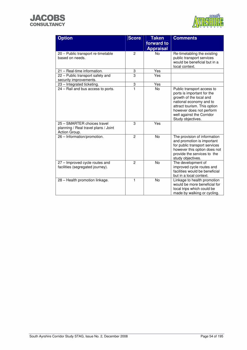
South Ayrshire Corridor Study STAG, Issue No. 2, December 2008 Page 54 of 195
���������������
Option Score Taken forward to Appraisal
Comments
20 – Public transport re-timetable based on needs.
2 No Re-timetabling the existing public transport services would be beneficial but in a local context.
21 – Real-time information. 3 Yes 22 – Public transport safety and security improvements.
3 Yes
23 – Integrated ticketing. 3 Yes 24 – Rail and bus access to ports. 1 No Public transport access to
ports is important for the growth of the local and national economy and to attract tourism. This option however does not perform well against the Corridor Study objectives.
25 – SMARTER choices travel planning / Real travel plans / Joint Action Group.
3 Yes
26 – Information/promotion. 2 No The provision of information and promotion is important for public transport services however this option does not provide the services to the study objectives.
27 – Improved cycle routes and facilities (segregated journey).
2 No The development of improved cycle routes and facilities would be beneficial but in a local context.
28 – Health promotion linkage. 1 No Linkage to health promotion would be more beneficial for local trips which could be made by walking or cycling.
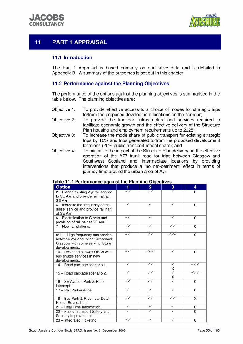
South Ayrshire Corridor Study STAG, Issue No. 2, December 2008 Page 55 of 195
���������������
11 PART 1 APPRAISAL
11.1 Introduction
The Part 1 Appraisal is based primarily on qualitative data and is detailed in Appendix B. A summary of the outcomes is set out in this chapter. 11.2 Performance against the Planning Objectives
The performance of the options against the planning objectives is summarised in the table below. The planning objectives are: Objective 1: To provide effective access to a choice of modes for strategic trips
to/from the proposed development locations on the corridor; Objective 2: To provide the transport infrastructure and services required to
facilitate economic growth and the effective delivery of the Structure Plan housing and employment requirements up to 2025;
Objective 3: To increase the mode share of public transport for existing strategic trips by 10% and trips generated to/from the proposed development locations (20% public transport modal share); and
Objective 4: To minimise the impact of the Structure Plan delivery on the effective operation of the A77 trunk road for trips between Glasgow and Southwest Scotland and intermediate locations by providing interventions that produce a ‘no net-detriment’ effect in terms of journey time around the urban area of Ayr.
Table 11.1 Performance against the Planning Objectives
Option 1 2 3 4 2 – Extend existing Ayr rail service to SE Ayr and provide rail halt at SE Ayr
��
��
�
0
4 – Increase the frequency of the diesel service and provide rail halt at SE Ayr
�
�
�
0
6 – Electrification to Girvan and provision of rail halt at SE Ayr
�� �
�
0
7 – New rail stations. �� �
�� 0
8/11 – High frequency bus service between Ayr and Irvine/Kilmarnock Glasgow with some serving future developments.
��
��
��� 0
10 – Designed busway QBCs with bus shuttle services in new developments.
��
��� �
0
14 – Road package scenario 1. �
��
� X
���
15 – Road package scenario 2. �
��
� X
���
16 – SE Ayr bus Park-&-Ride intercept.
��
��
�
0
17 – Rail Park-&-Ride. �
�
�
0
18 – Bus Park-&-Ride near Dutch House Roundabout.
��
�� ��
X
21 – Real Time Information. � � � 0 22 – Public Transport Safety and Security Improvements
� � � 0
23 – Integrated Ticketing �� � � 0
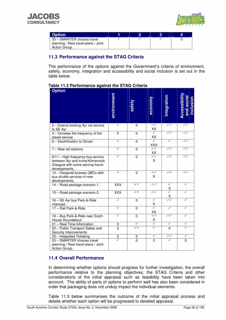
South Ayrshire Corridor Study STAG, Issue No. 2, December 2008 Page 56 of 195
���������������
Option 1 2 3 4 25 – SMARTER choices travel planning / Real travel plans / Joint Action Group.
�
�
�
0
11.3 Performance against the STAG Criteria
The performance of the options against the Government’s criteria of environment, safety, economy, integration and accessibility and social inclusion is set out in the table below. Table 11.2 Performance against the STAG Criteria
Option
envi
ronm
ent
safe
ty
econ
omy
inte
grat
ion
Acc
essi
bilit
y an
d so
cial
in
clus
ion
2 – Extend existing Ayr rail service to SE Ayr
�
0 �� XX
��
��
4 – Increase the frequency of the diesel service
X 0 � XX
��
��
6 – Electrification to Girvan. �
0 � XXX
�
��
7 – New rail stations. �
0 �� XX
��
��
8/11 – High frequency bus service between Ayr and Irvine/Kilmarnock Glasgow with some serving future developments.
�
0 �� X
��
��
10 – Designed busway QBCs with bus shuttle services in new developments.
�
0 �� X
��
��
14 – Road package scenario 1. XXX �� �� � X
�
15 – Road package scenario 2. XXX �� �� � X
�
16 – SE Ayr bus Park-&-Ride intercept.
�
0 � X
�� �
17 – Rail Park-&-Ride. �
0 � XX
�
�
18 – Bus Park-&-Ride near Dutch House Roundabout
�
0 �� X
��
�
21 – Real Time Information. 0 � � � � 22 – Public Transport Safety and Security Improvements
0 �� � 0 �
23 – Integrated Ticketing 0 0 � �� � 25 – SMARTER choices travel planning / Real travel plans / Joint Action Group.
�
0 0 �
0
11.4 Overall Performance
In determining whether options should progress for further investigation, the overall performance relative to the planning objectives, the STAG Criteria and other considerations of the initial appraisal such as feasibility have been taken into account. The ability of parts of options to perform well has also been considered in order that packaging does not unduly impact the individual elements. Table 11.3 below summarises the outcome of the initial appraisal process and details whether each option will be progressed to detailed appraisal.
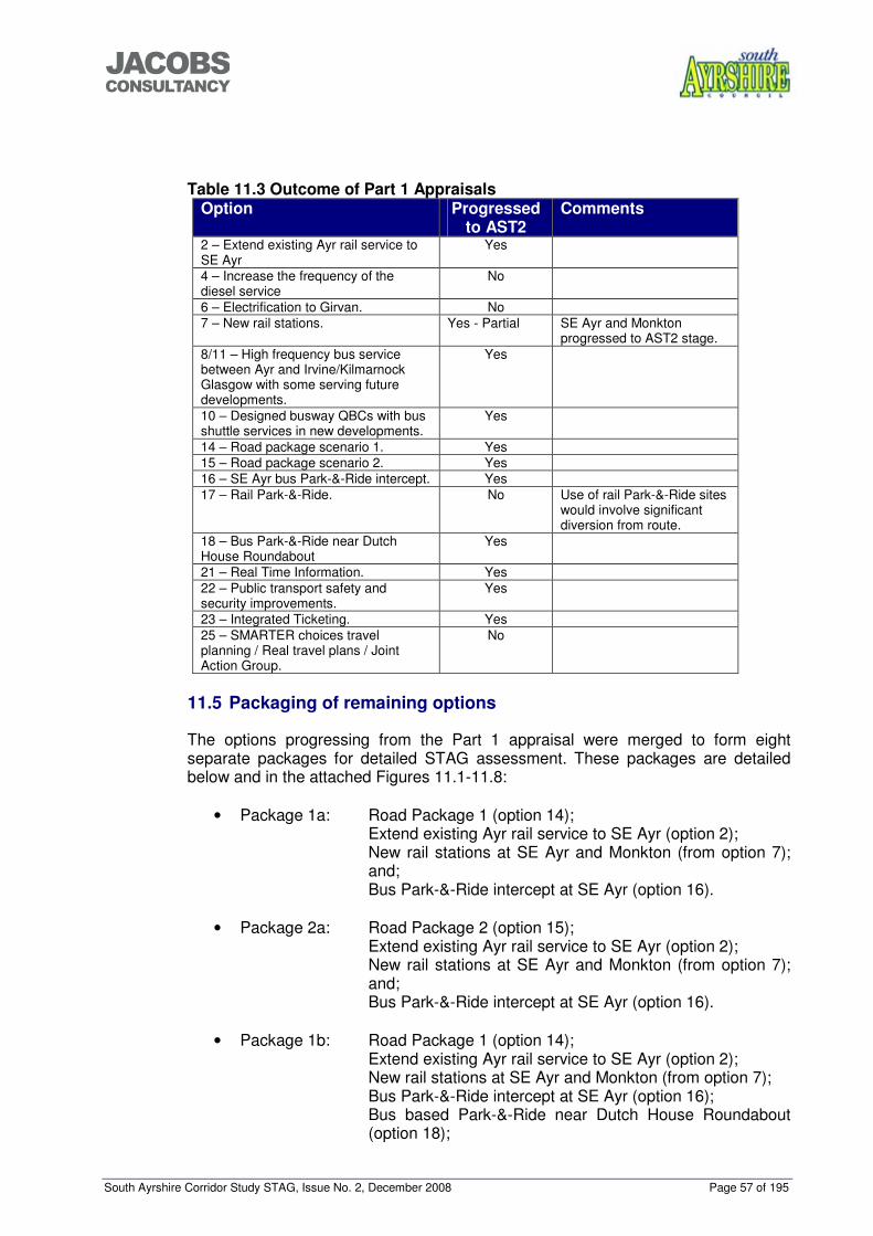
South Ayrshire Corridor Study STAG, Issue No. 2, December 2008 Page 57 of 195
���������������
Table 11.3 Outcome of Part 1 Appraisals
Option Progressed to AST2
Comments
2 – Extend existing Ayr rail service to SE Ayr
Yes
4 – Increase the frequency of the diesel service
No
6 – Electrification to Girvan. No 7 – New rail stations. Yes - Partial SE Ayr and Monkton
progressed to AST2 stage. 8/11 – High frequency bus service between Ayr and Irvine/Kilmarnock Glasgow with some serving future developments.
Yes
10 – Designed busway QBCs with bus shuttle services in new developments.
Yes
14 – Road package scenario 1. Yes 15 – Road package scenario 2. Yes 16 – SE Ayr bus Park-&-Ride intercept. Yes 17 – Rail Park-&-Ride. No Use of rail Park-&-Ride sites
would involve significant diversion from route.
18 – Bus Park-&-Ride near Dutch House Roundabout
Yes
21 – Real Time Information. Yes 22 – Public transport safety and security improvements.
Yes
23 – Integrated Ticketing. Yes 25 – SMARTER choices travel planning / Real travel plans / Joint Action Group.
No
11.5 Packaging of remaining options
The options progressing from the Part 1 appraisal were merged to form eight separate packages for detailed STAG assessment. These packages are detailed below and in the attached Figures 11.1-11.8:
• Package 1a: Road Package 1 (option 14); Extend existing Ayr rail service to SE Ayr (option 2); New rail stations at SE Ayr and Monkton (from option 7); and; Bus Park-&-Ride intercept at SE Ayr (option 16).
• Package 2a: Road Package 2 (option 15); Extend existing Ayr rail service to SE Ayr (option 2); New rail stations at SE Ayr and Monkton (from option 7); and; Bus Park-&-Ride intercept at SE Ayr (option 16).
• Package 1b: Road Package 1 (option 14);
Extend existing Ayr rail service to SE Ayr (option 2); New rail stations at SE Ayr and Monkton (from option 7); Bus Park-&-Ride intercept at SE Ayr (option 16); Bus based Park-&-Ride near Dutch House Roundabout (option 18);
South Ayrshire Corridor Study STAG, Issue No. 2, December 2008 Page 58 of 195
���������������
High frequency bus service between Ayr and Irvine/Kilmarnock/Glasgow with some serving future developments (option 8/11); and Designed busway QBCs with bus shuttle services in new developments (option 10).
• Package 2b: Road Package 2 (option 15);
Extend existing Ayr rail service to SE Ayr (option 2); New rail stations at SE Ayr and Monkton (from option 7); Bus Park-&-Ride intercept at SE Ayr (option 16); Bus based Park-&-Ride near Dutch House Roundabout (option 18); High frequency bus service between Ayr and Irvine/Kilmarnock/Glasgow with some serving future developments (option 8/11); and Designed busway QBCs with bus shuttle services in new developments (option 10).
• Package 1c: Road Package 1 (option 14);
Extend existing Ayr rail service to SE Ayr (option 2); New rail stations at SE Ayr and Monkton (from option 7); Bus Park-&-Ride intercept at SE Ayr (option 16); Designed busway QBCs with bus shuttle services in new developments (option 10); and Bus based Park-&-Ride near Dutch House Roundabout (option 18).
• Package 2c: Road Package 2 (option 15);
Extend existing Ayr rail service to SE Ayr (option 2); New rail stations at SE Ayr and Monkton (from option 7); Bus Park-&-Ride intercept at SE Ayr (option 16); Designed busway QBCs with bus shuttle services in new developments (option 10); and Bus based Park-&-Ride near Dutch House Roundabout (option 18).
• Package 1d: Road Package 1 (option 14); High frequency bus service between Ayr and Irvine/Kilmarnock/Glasgow with some serving future developments (option 8/11); Designed busway QBCs with bus shuttle services in new developments (option 10); and Bus based Park-&-Ride near Dutch House Roundabout (option 18).
• Package 2d: Road Package 2 (option 15); High frequency bus service between Ayr and Irvine/Kilmarnock/Glasgow with some serving future developments (option 8/11); Designed busway QBCs with bus shuttle services in new developments (option 10); and Bus based Park-&-Ride near Dutch House Roundabout (option 18).
• Package 1e: Road Package 1 (option 14);
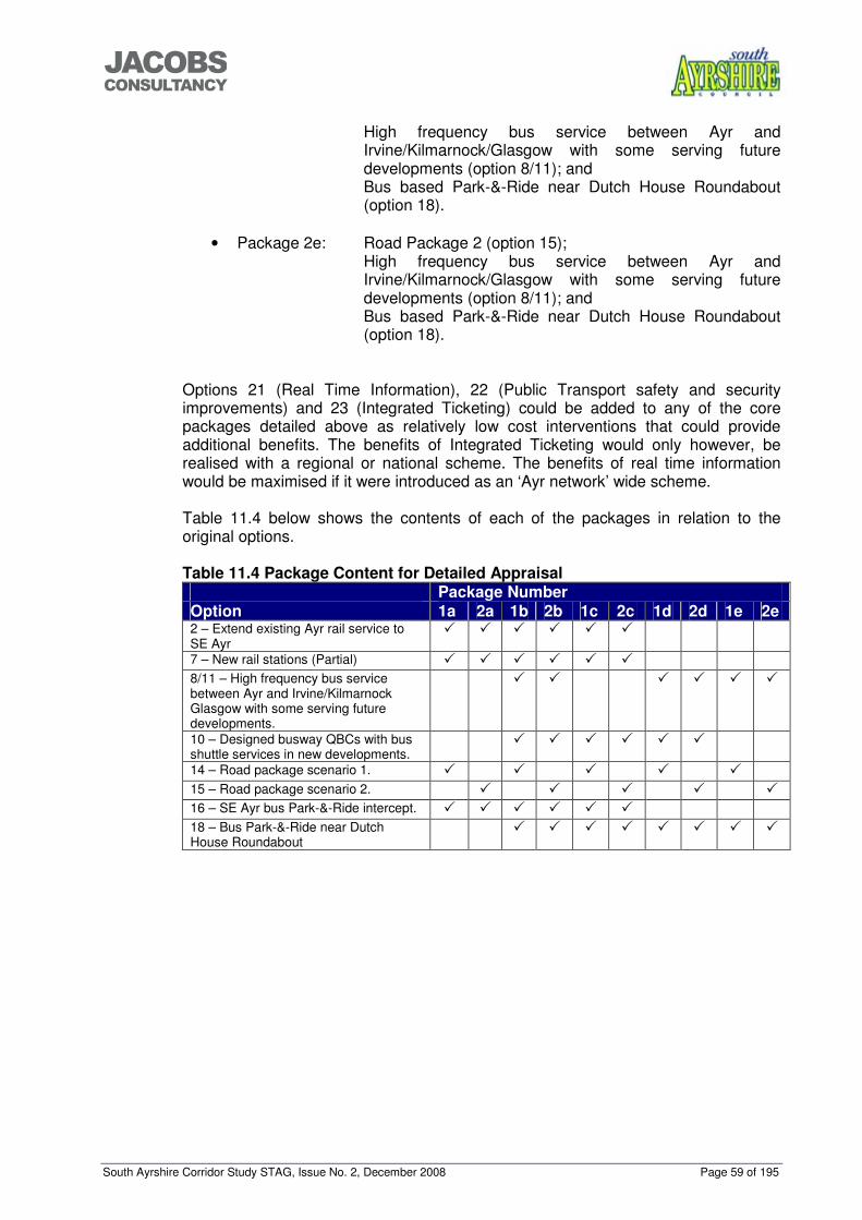
South Ayrshire Corridor Study STAG, Issue No. 2, December 2008 Page 59 of 195
���������������
High frequency bus service between Ayr and Irvine/Kilmarnock/Glasgow with some serving future developments (option 8/11); and Bus based Park-&-Ride near Dutch House Roundabout (option 18).
• Package 2e: Road Package 2 (option 15); High frequency bus service between Ayr and Irvine/Kilmarnock/Glasgow with some serving future developments (option 8/11); and Bus based Park-&-Ride near Dutch House Roundabout (option 18).
Options 21 (Real Time Information), 22 (Public Transport safety and security improvements) and 23 (Integrated Ticketing) could be added to any of the core packages detailed above as relatively low cost interventions that could provide additional benefits. The benefits of Integrated Ticketing would only however, be realised with a regional or national scheme. The benefits of real time information would be maximised if it were introduced as an ‘Ayr network’ wide scheme. Table 11.4 below shows the contents of each of the packages in relation to the original options. Table 11.4 Package Content for Detailed Appraisal Package Number Option 1a 2a 1b 2b 1c 2c 1d 2d 1e 2e 2 – Extend existing Ayr rail service to SE Ayr
� � � � � �
7 – New rail stations (Partial) � � � � � � 8/11 – High frequency bus service between Ayr and Irvine/Kilmarnock Glasgow with some serving future developments.
� � � � � �
10 – Designed busway QBCs with bus shuttle services in new developments.
� � � � � �
14 – Road package scenario 1. � � � � � 15 – Road package scenario 2. � � � � � 16 – SE Ayr bus Park-&-Ride intercept. � � � � � � 18 – Bus Park-&-Ride near Dutch House Roundabout
� � � � � � � �
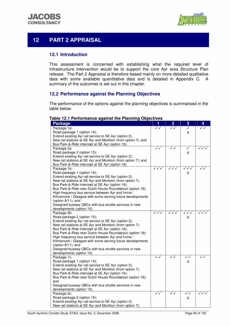
South Ayrshire Corridor Study STAG, Issue No. 2, December 2008 Page 60 of 195
���������������
12 PART 2 APPRAISAL
12.1 Introduction
This assessment is concerned with establishing what the required level of infrastructure intervention would be to support the core Ayr area Structure Plan release. The Part 2 Appraisal is therefore based mainly on more detailed qualitative data with some available quantitative data and is detailed in Appendix C. A summary of the outcomes is set out in this chapter. 12.2 Performance against the Planning Objectives
The performance of the options against the planning objectives is summarised in the table below. Table 12.1 Performance against the Planning Objectives
Package 1 2 3 4 Package 1a: Road package 1 (option 14); Extend existing Ayr rail service to SE Ayr (option 2); New rail stations at SE Ayr and Monkton (from option 7); and Bus Park-&-Ride intercept at SE Ayr (option 16).
�� �� � X
��
Package 2a: Road package 2 (option 15); Extend existing Ayr rail service to SE Ayr (option 2); New rail stations at SE Ayr and Monkton (from option 7); and Bus Park-&-Ride intercept at SE Ayr (option 16).
�� �� � X
���
Package 1b: Road package 1 (option 14); Extend existing Ayr rail service to SE Ayr (option 2); New rail stations at SE Ayr and Monkton (from option 7); Bus Park-&-Ride intercept at SE Ayr (option 16); Bus Park-&-Ride near Dutch House Roundabout (option 18); High frequency bus service between Ayr and Irvine / Kilmarnock / Glasgow with some serving future developments (option 8/11); and Designed busway QBCs with bus shuttle services in new developments (option 10).
��� ��� ��� X
��
Package 2b: Road package 2 (option 15); Extend existing Ayr rail service to SE Ayr (option 2); New rail stations at SE Ayr and Monkton (from option 7); Bus Park-&-Ride intercept at SE Ayr (option 16); Bus Park-&-Ride near Dutch House Roundabout (option 18); High frequency bus service between Ayr and Irvine / Kilmarnock / Glasgow with some serving future developments (option 8/11); and Designed busway QBCs with bus shuttle services in new developments (option 10).
��� ��� ��� X
���
Package 1c: Road package 1 (option 14); Extend existing Ayr rail service to SE Ayr (option 2); New rail stations at SE Ayr and Monkton (from option 7); Bus Park-&-Ride intercept at SE Ayr (option 16); Bus Park-&-Ride near Dutch House Roundabout (option 18); and Designed busway QBCs with bus shuttle services in new developments (option 10).
�� �� �� X
��
Package 2c: Road package 2 (option 15); Extend existing Ayr rail service to SE Ayr (option 2); New rail stations at SE Ayr and Monkton (from option 7);
�� �� �� X
���
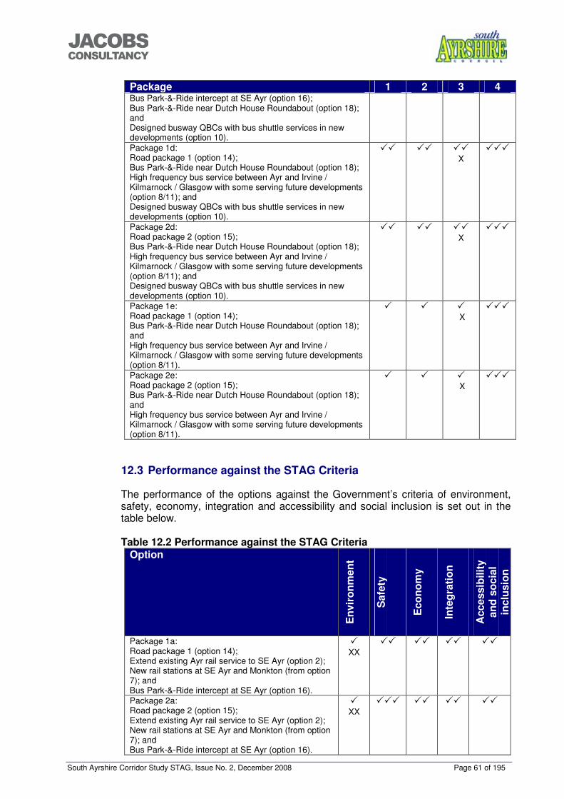
South Ayrshire Corridor Study STAG, Issue No. 2, December 2008 Page 61 of 195
���������������
Package 1 2 3 4 Bus Park-&-Ride intercept at SE Ayr (option 16); Bus Park-&-Ride near Dutch House Roundabout (option 18); and Designed busway QBCs with bus shuttle services in new developments (option 10). Package 1d: Road package 1 (option 14); Bus Park-&-Ride near Dutch House Roundabout (option 18); High frequency bus service between Ayr and Irvine / Kilmarnock / Glasgow with some serving future developments (option 8/11); and Designed busway QBCs with bus shuttle services in new developments (option 10).
�� �� �� X
���
Package 2d: Road package 2 (option 15); Bus Park-&-Ride near Dutch House Roundabout (option 18); High frequency bus service between Ayr and Irvine / Kilmarnock / Glasgow with some serving future developments (option 8/11); and Designed busway QBCs with bus shuttle services in new developments (option 10).
�� �� �� X
���
Package 1e: Road package 1 (option 14); Bus Park-&-Ride near Dutch House Roundabout (option 18); and High frequency bus service between Ayr and Irvine / Kilmarnock / Glasgow with some serving future developments (option 8/11).
� � � X
���
Package 2e: Road package 2 (option 15); Bus Park-&-Ride near Dutch House Roundabout (option 18); and High frequency bus service between Ayr and Irvine / Kilmarnock / Glasgow with some serving future developments (option 8/11).
� � � X
���
12.3 Performance against the STAG Criteria
The performance of the options against the Government’s criteria of environment, safety, economy, integration and accessibility and social inclusion is set out in the table below. Table 12.2 Performance against the STAG Criteria
Option
Env
iron
men
t
Saf
ety
Eco
nom
y
Inte
grat
ion
Acc
essi
bilit
y an
d so
cial
in
clus
ion
Package 1a: Road package 1 (option 14); Extend existing Ayr rail service to SE Ayr (option 2); New rail stations at SE Ayr and Monkton (from option 7); and Bus Park-&-Ride intercept at SE Ayr (option 16).
� XX
�� �� �� ��
Package 2a: Road package 2 (option 15); Extend existing Ayr rail service to SE Ayr (option 2); New rail stations at SE Ayr and Monkton (from option 7); and Bus Park-&-Ride intercept at SE Ayr (option 16).
� XX
��� �� �� ��
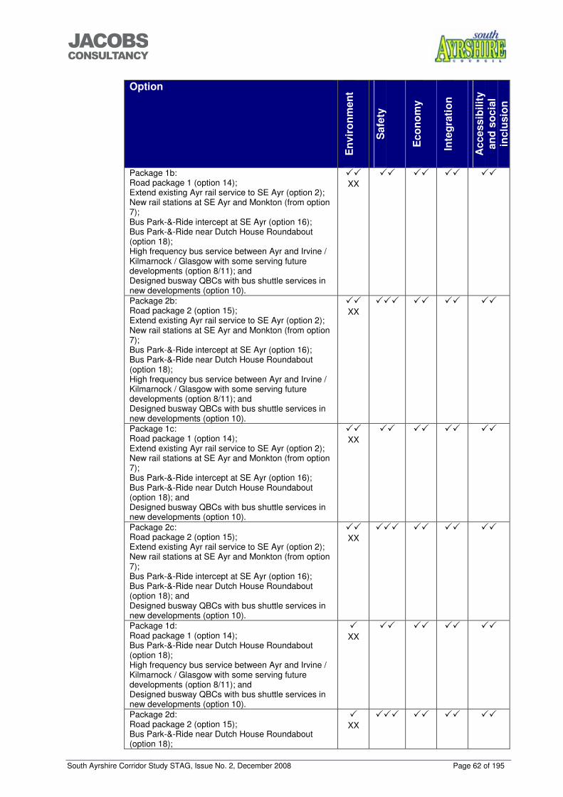
South Ayrshire Corridor Study STAG, Issue No. 2, December 2008 Page 62 of 195
���������������
Option
Env
iron
men
t
Saf
ety
Eco
nom
y
Inte
grat
ion
Acc
essi
bilit
y an
d so
cial
in
clus
ion
Package 1b: Road package 1 (option 14); Extend existing Ayr rail service to SE Ayr (option 2); New rail stations at SE Ayr and Monkton (from option 7); Bus Park-&-Ride intercept at SE Ayr (option 16); Bus Park-&-Ride near Dutch House Roundabout (option 18); High frequency bus service between Ayr and Irvine / Kilmarnock / Glasgow with some serving future developments (option 8/11); and Designed busway QBCs with bus shuttle services in new developments (option 10).
�� XX
�� �� �� ��
Package 2b: Road package 2 (option 15); Extend existing Ayr rail service to SE Ayr (option 2); New rail stations at SE Ayr and Monkton (from option 7); Bus Park-&-Ride intercept at SE Ayr (option 16); Bus Park-&-Ride near Dutch House Roundabout (option 18); High frequency bus service between Ayr and Irvine / Kilmarnock / Glasgow with some serving future developments (option 8/11); and Designed busway QBCs with bus shuttle services in new developments (option 10).
�� XX
��� �� �� ��
Package 1c: Road package 1 (option 14); Extend existing Ayr rail service to SE Ayr (option 2); New rail stations at SE Ayr and Monkton (from option 7); Bus Park-&-Ride intercept at SE Ayr (option 16); Bus Park-&-Ride near Dutch House Roundabout (option 18); and Designed busway QBCs with bus shuttle services in new developments (option 10).
�� XX
�� �� �� ��
Package 2c: Road package 2 (option 15); Extend existing Ayr rail service to SE Ayr (option 2); New rail stations at SE Ayr and Monkton (from option 7); Bus Park-&-Ride intercept at SE Ayr (option 16); Bus Park-&-Ride near Dutch House Roundabout (option 18); and Designed busway QBCs with bus shuttle services in new developments (option 10).
�� XX
��� �� �� ��
Package 1d: Road package 1 (option 14); Bus Park-&-Ride near Dutch House Roundabout (option 18); High frequency bus service between Ayr and Irvine / Kilmarnock / Glasgow with some serving future developments (option 8/11); and Designed busway QBCs with bus shuttle services in new developments (option 10).
� XX
�� �� �� ��
Package 2d: Road package 2 (option 15); Bus Park-&-Ride near Dutch House Roundabout (option 18);
� XX
��� �� �� ��
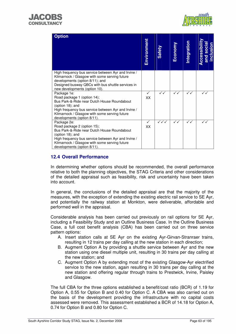
South Ayrshire Corridor Study STAG, Issue No. 2, December 2008 Page 63 of 195
���������������
Option
Env
iron
men
t
Saf
ety
Eco
nom
y
Inte
grat
ion
Acc
essi
bilit
y an
d so
cial
in
clus
ion
High frequency bus service between Ayr and Irvine / Kilmarnock / Glasgow with some serving future developments (option 8/11); and Designed busway QBCs with bus shuttle services in new developments (option 10). Package 1e: Road package 1 (option 14); Bus Park-&-Ride near Dutch House Roundabout (option 18); and High frequency bus service between Ayr and Irvine / Kilmarnock / Glasgow with some serving future developments (option 8/11).
� XX
�� �� �� ��
Package 2e: Road package 2 (option 15); Bus Park-&-Ride near Dutch House Roundabout (option 18); and High frequency bus service between Ayr and Irvine / Kilmarnock / Glasgow with some serving future developments (option 8/11).
� XX
��� �� �� ��
12.4 Overall Performance
In determining whether options should be recommended, the overall performance relative to both the planning objectives, the STAG Criteria and other considerations of the detailed appraisal such as feasibility, risk and uncertainty have been taken into account. In general, the conclusions of the detailed appraisal are that the majority of the measures, with the exception of extending the existing electric rail service to SE Ayr, and potentially the railway station at Monkton, were deliverable, affordable and performed well in the appraisal. Considerable analysis has been carried out previously on rail options for SE Ayr, including a Feasibility Study and an Outline Business Case. In the Outline Business Case, a full cost benefit analysis (CBA) has been carried out on three service pattern options:
A. Insert station calls at SE Ayr on the existing Ayr-Girvan-Stranraer trains, resulting in 12 trains per day calling at the new station in each direction;
B. Augment Option A by providing a shuttle service between Ayr and the new station using one diesel multiple unit, resulting in 30 trains per day calling at the new station; and
C. Augment Option A by extending most of the existing Glasgow-Ayr electrified service to the new station, again resulting in 30 trains per day calling at the new station and offering regular through trains to Prestwick, Irvine, Paisley and Glasgow.
The full CBA for the three options established a benefit/cost ratio (BCR) of 1.19 for Option A, 0.55 for Option B and 0.40 for Option C. A CBA was also carried out on the basis of the development providing the infrastructure with no capital costs assessed were removed. This assessment established a BCR of 14.18 for Option A, 0.74 for Option B and 0.80 for Option C.
South Ayrshire Corridor Study STAG, Issue No. 2, December 2008 Page 64 of 195
���������������
Extension of the electric service to SE Ayr does not, therefore present value for money at present. The viability of extending the existing electric services to SE Ayr may however, change in the future with any requirements to re-locate Townhead Sidings in Ayr. Re-location of this facility could result in electrification being provided to the south of Ayr and enable the electric service to be extended to SE Ayr at an affordable cost. The deliverability of the rail station at Monkton, has considerable uncertainty attached to it due to HMRI and Network Rail requirements and the distance between this location and the existing stations at Prestwick Airport and Prestwick Town. Development of this proposal would require extensive detailed feasibility and appraisal work, as has taken place for SE Ayr, to determine the viability of the proposals. This option is potentially not viable with the existing service pattern between Ayr and Glasgow since it would add another stop close to the existing ones resulting in increased journey times. The area at Monkton could however, initially function as a Park-&-Ride site served by local/strategic bus services with longer term aspirations for the development of the rail station serving the Park-&-Ride if plans for service patterns to be increased are realised and the station proposals become viable. A recent report for Darlington Borough Council provides some detail on the potential modal shift that could be captured from Park-&-Ride sites. It states “Cambridge and Belfast, which have successful Park-&-Ride schemes have an intercept rate of around 15% whereas in York it is up to 25%”9. A 2003 report for the Scottish Government highlights that “Park-&-Ride schemes are particularly popular with motorists by reducing the need to drive through congested areas. However the design of the schemes, and in particular the location of the ‘park’ areas, is critical if they are to achieve a net reduction in car kilometres.”10 The Park-&-Ride site at Monkton would be effective in capturing existing trips from Ayr and Prestwick but its location would reduce the impact it had on any development along the A77 corridor and in the settlements accessed from the A77. The other potential Park-&-Ride site to the north of Ayr and Prestwick, located in the vicinity of Dutch House Roundabout would however, be ideally located to capture trips from the north into Ayr and from the south (including the potential future development sites) to destinations in the north including Glasgow, Kilmarnock, Irvine and Lanarkshire. The Park-&-Ride sites have the potential to serve trips into Ayr and out of Ayr to strategic destinations although bus and Park-&-Ride trips to Glasgow would become considerably more attractive if bus journeys were given priority at the northern end of the M77. Considering the impact on the different areas, the SE Ayr site has good access to the rail network and therefore rail options perform well for this development and the surrounding area. This is especially noticeable as the SE Ayr station would provide access to Ayr, Ailsa and Carrick Glen Hospitals with significant demand for travel from hospital users throughout the day. This mode however, has limited impact on the other potential land release locations. Potential future developments located along the A77 corridor further north are served better by a busway through the developments with the provision of strategic bus services to a variety of locations in the peak hours and feeder services outwith
9 Darlington Park and Ride Feasibility Study, July, 2008. 10 Barriers to Modal Shift, Report by Derek Haldane Consultancy for the Scottish Government, 2003.
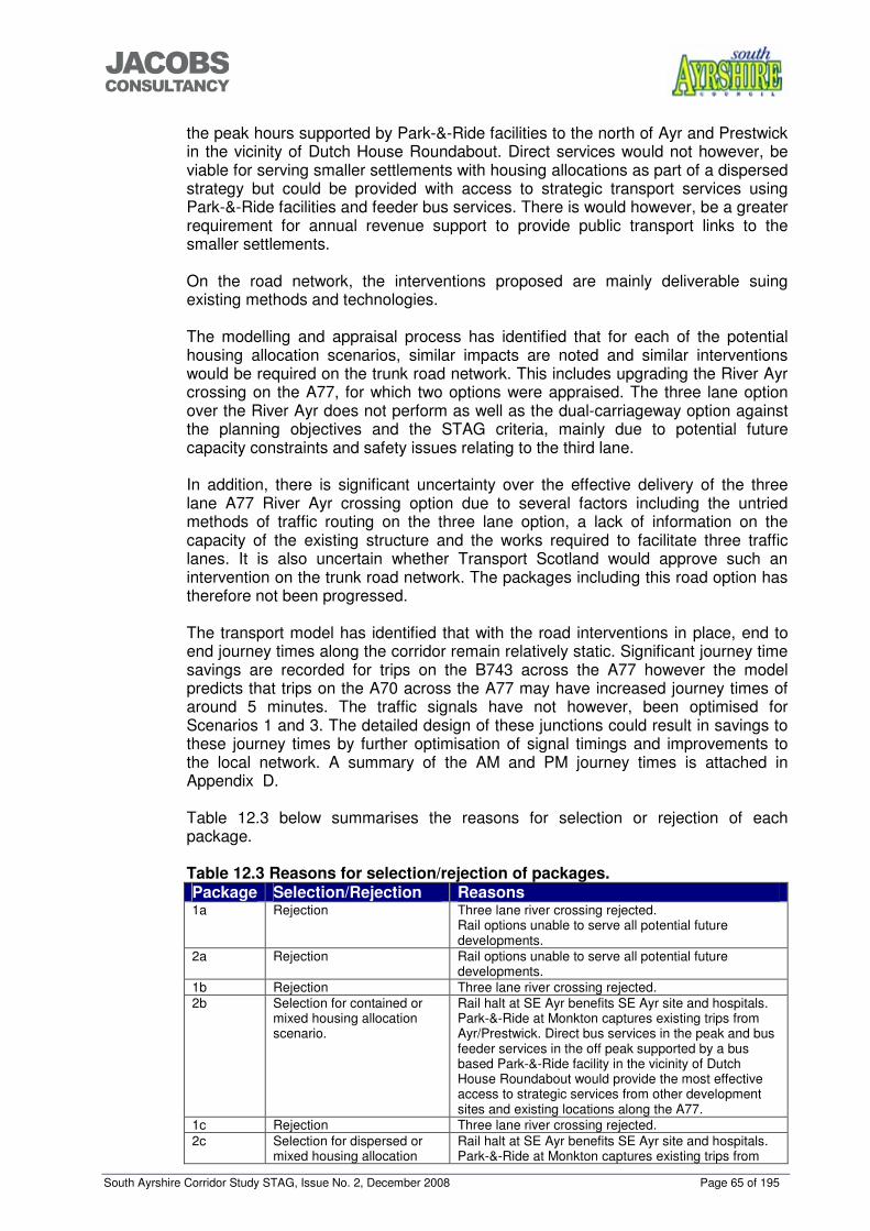
South Ayrshire Corridor Study STAG, Issue No. 2, December 2008 Page 65 of 195
���������������
the peak hours supported by Park-&-Ride facilities to the north of Ayr and Prestwick in the vicinity of Dutch House Roundabout. Direct services would not however, be viable for serving smaller settlements with housing allocations as part of a dispersed strategy but could be provided with access to strategic transport services using Park-&-Ride facilities and feeder bus services. There is would however, be a greater requirement for annual revenue support to provide public transport links to the smaller settlements. On the road network, the interventions proposed are mainly deliverable suing existing methods and technologies. The modelling and appraisal process has identified that for each of the potential housing allocation scenarios, similar impacts are noted and similar interventions would be required on the trunk road network. This includes upgrading the River Ayr crossing on the A77, for which two options were appraised. The three lane option over the River Ayr does not perform as well as the dual-carriageway option against the planning objectives and the STAG criteria, mainly due to potential future capacity constraints and safety issues relating to the third lane. In addition, there is significant uncertainty over the effective delivery of the three lane A77 River Ayr crossing option due to several factors including the untried methods of traffic routing on the three lane option, a lack of information on the capacity of the existing structure and the works required to facilitate three traffic lanes. It is also uncertain whether Transport Scotland would approve such an intervention on the trunk road network. The packages including this road option has therefore not been progressed. The transport model has identified that with the road interventions in place, end to end journey times along the corridor remain relatively static. Significant journey time savings are recorded for trips on the B743 across the A77 however the model predicts that trips on the A70 across the A77 may have increased journey times of around 5 minutes. The traffic signals have not however, been optimised for Scenarios 1 and 3. The detailed design of these junctions could result in savings to these journey times by further optimisation of signal timings and improvements to the local network. A summary of the AM and PM journey times is attached in Appendix D.
Table 12.3 below summarises the reasons for selection or rejection of each package.
Table 12.3 Reasons for selection/rejection of packages. Package Selection/Rejection Reasons 1a Rejection Three lane river crossing rejected.
Rail options unable to serve all potential future developments.
2a Rejection Rail options unable to serve all potential future developments.
1b Rejection Three lane river crossing rejected. 2b Selection for contained or
mixed housing allocation scenario.
Rail halt at SE Ayr benefits SE Ayr site and hospitals. Park-&-Ride at Monkton captures existing trips from Ayr/Prestwick. Direct bus services in the peak and bus feeder services in the off peak supported by a bus based Park-&-Ride facility in the vicinity of Dutch House Roundabout would provide the most effective access to strategic services from other development sites and existing locations along the A77.
1c Rejection Three lane river crossing rejected. 2c Selection for dispersed or
mixed housing allocation Rail halt at SE Ayr benefits SE Ayr site and hospitals. Park-&-Ride at Monkton captures existing trips from
South Ayrshire Corridor Study STAG, Issue No. 2, December 2008 Page 66 of 195
���������������
Package Selection/Rejection Reasons scenario. Ayr/Prestwick. Bus feeder services and Park-&-Ride in
the vicinity of Dutch House Roundabout provide most effective access to strategic services from other development sites and existing locations along the A77.
1d Rejection Three lane river crossing rejected. SE Ayr and hospitals are better served by package including rail measures.
2d Rejection SE Ayr and hospitals are better served by package including rail measures.
1e Rejection Three lane river crossing rejected. SE Ayr and hospitals are better served by package including rail measures. Better penetration of development sites by bus services with QBC Busways.
2e Rejection SE Ayr and hospitals are better served by package including rail measures. Better penetration of development sites with QBC Busways.
Table 12.3 above shows that for a contained housing scenario, the recommended package of measures is:
• Package 2b: Road Package 2 (option 15); Extend existing Ayr rail service to SE Ayr (option 2); New rail stations at Monkton (longer term) and SE Ayr (from option 7); Bus Park-&-Ride intercept at SE Ayr (option 16); Bus based Park-&-Ride near Dutch House Roundabout (option 18); High frequency bus service between Ayr and Irvine/Kilmarnock/Glasgow with some serving future developments (option 8/11); and Designed busway QBCs with bus shuttle services in new developments (option 10).
The recommended package for a dispersed housing scenario is:
• Package 2c: Road Package 2 (option 15);
Extend existing Ayr rail service to SE Ayr (option 2); New rail stations at Monkton (longer term) and SE Ayr (from option 7); Bus Park-&-Ride intercept at SE Ayr (option 16); Designed busway QBCs with bus shuttle services in new developments (option 10); and Bus based Park-&-Ride near Dutch House Roundabout (option 18).
The mixed housing land release scenario could be served by either of the above packages, depending on the level of housing allocated to areas close to the A77.
South Ayrshire Corridor Study STAG, Issue No. 2, December 2008 Page 67 of 195
���������������
13 COST TO GOVERNMENT
The potential cost to Government cannot be confirmed at this stage. There is likely to be a significant level of developer contribution made available as a result of the Structure Plan allocations, however this is dependent on effective delivery of the Structure Plan requirements. In addition, significant elements of the packages would be required before all of the housing allocations were developed. The estimated cost of each of the elements contained within the packages are detailed in Table 13.1 below. Figures exclude VAT, optimism bias has been added at a rate of 45% for road schemes and 66% for rail schemes. Table 13.1 Intervention Costs. Intervention Estimated cost including optimism bias Road Package 1 Monktonhill Roundabout (signalisation) Dutch House Roundabout (signalisation and filter lane) Bankfield Roundabout (widening, signalisation and filter lane) Dual Whitletts to Holmston including River Ayr crossing, grade separation of Whitletts Roundabout and compact grade separation of Holmston Roundabout. Total
<£2million <2million <2million £50-£75million £50-£80million (Q2, 2008)
Road Package 2 Potential saving over package 1 but unable to determine without detailed analysis of existing bridge deck.
Extension of electrified rail service to SE Ayr
Capital cost: £10-20million. Annual operating cost: £600,000 (Q2, 2004)
SE Ayr Rail Halt and Park-&-Ride Capital cost: £5-10 million (Cost of Park-&-Ride car park contained within development plans) Annual operating cost:£20,000 (Q2, 2004)
Monkton Rail Halt and Park-&-Ride
Capital cost: £10-20 million. Annual operating cost: £20,000 (Q2, 2004)
Monkton Park-&-Ride without rail halt
Capital cost:£2-£5 million. Annual operating cost: £20,000 (Q1, 2001)
Bus based Park-&-Ride (near Dutch House Roundabout)
Capital cost: £2-£5 million. Annual operating cost: £20,000 (Q1, 2001)
15 minute frequency feeder bus services
Annual operating subsidy of £80,000
Peak hour Glasgow bus service Annual operating subsidy of £20,000 Peak hour Irvine bus service Annual operating subsidy of £20,000 Peak hour Kilmarnock bus service Annual operating subsidy of £20,000 QBC Busway through development sites.
This intervention would form part of the road development within the housing sites and would therefore have no additional costs.
South Ayrshire Corridor Study STAG, Issue No. 2, December 2008 Page 68 of 195
���������������
The total cost of each of the packages, including optimism bias, is therefore summarised in Table 13.2 below. The cost of extending the electrification to SE Ayr has not been included since this intervention has been demonstrated not to provide value for money. Table 13.2 Summary of Cost Estimates Package Number
Estimated Cost
1 Capital cost: £75-£130million. Annual operating cost: £40,000
2 Potential saving over Package 1. This could be confirmed following a review of the existing bridge deck.
3 Capital cost: £75-135million. Annual operating cost: £180,000
4 Potential saving over Package 3. This could be confirmed following a review of the existing bridge deck.
5 Capital cost: £75million – £135million. Annual operating cost: £120,000
6 Potential saving over Package 5. This could be confirmed following a review of the existing bridge deck.
7 Capital cost: £52million – £85million. Annual operating cost: £140,000.
8 Potential saving over Package 7. This could be confirmed following a review of the existing bridge deck.
South Ayrshire Corridor Study STAG, Issue No. 2, December 2008 Page 69 of 195
���������������
14 RISK AND UNCERTAINTY
The STAG Guidance states: “In appraisals there is always some difference between what is expected, and what eventually happens, because of biases unwittingly inherent in the appraisal, and risks and uncertainties that materialise. As a result, it is important to identify and mitigate risks, and make allowances for Optimism Bias.” Considering the ten packages for assessment, all of them will have a certain degree of risk due to the infrastructure construction required in each one. The location of the future housing land releases to meet the requirements of the Ayrshire Joint Structure Plan are not known at this stage with the exception of the SE Ayr allocation. The outcome of this assessment will feed into the Local Plan process to determine the location of future land releases but the level of interventions required and the timing of when they are required cannot be determined conclusively until this process is complete. Additionally, the availability of land to accommodate the required infrastructure is not known. Some interventions could be incorporated into land releases but others will require the purchase of additional land and may require compulsory purchase orders. Funding and delivery of the preferred packages is also dependent on successful delivery of the Ayrshire Joint Structure Plan requirements up to 2025 in order to provide the anticipated developer contributions. However, delivery of the Structure Plan requirements is also dependent on the provision of a package of measures ensuring effective road and public transport infrastructure and services to support the housing allocations. The rail packages will be especially risk averse due to HMRI and Network Rail requirements. Considerable work has been completed with regard to the station at SE Ayr. The potential station at Monkton however, has considerable uncertainty attached to it due to a lack of detailed assessment work having been carried out to date on the feasibility of the proposals. The three lane A77 River Ayr crossing option has significant uncertainty due to several factors including the untried methods of traffic routing on the three lane option and a lack of information on the capacity of the existing structure and the works required to facilitate three traffic lanes. It is also uncertain whether Transport Scotland would approve such an intervention on the trunk road network.
South Ayrshire Corridor Study STAG, Issue No. 2, December 2008 Page 70 of 195
���������������
15 MONITORING PLAN
The proposals from this study will be monitored as part of ongoing updates of the Joint Ayrshire Structure Plan and South Ayrshire Local Plan. The strategic nature of this study is likely to require monitoring using census data or input from updates of the Scottish Household Survey.
South Ayrshire Corridor Study STAG, Issue No. 2, December 2008 Page 71 of 195
���������������
16 EVALUATION PLAN
This study will be evaluated as part of the review process of the Ayrshire Joint Structure Plan and South Ayrshire Local Plan and will inform the Local Transport Strategy.
South Ayrshire Corridor Study STAG, Issue No. 2, December 2008 Page 72 of 195
���������������
17 CONCLUSIONS
17.1 Objectives
This appraisal has been carried out using planning objectives that have been developed following an initial workshop with stakeholders and a subsequent analysis of the problems, causes, constraints and opportunities that exist on the strategic transport network around the Ayr Core Area at present and potentially in the future. Additionally, two study objectives were set out at the start of this document:
• To inform the development of the land release strategy and identify the strategic transport infrastructure and services necessary to support the effective and sustainable delivery of the Structure Plan housing and employment requirements for the Ayr Core Area up to 2025; and
• To identify an effective means of delivering strategic transport infrastructure and services, taking account of the need to capture contributions from potential developments.
17.2 Analysis and Options
The analysis has considered options to provide improved strategic transport infrastructure and services for road, rail, bus and Park-&-Ride. An initial sift of options based on the planning objectives focussed further analysis on improving strategic trips using a variety of modes which enabled a selection of options to be taken through initial appraisal and the successful interventions to be packaged for detailed appraisal. 17.3 Outcome
The results of the appraisal process have established several conclusions: 1. The rail line which penetrates the SE Ayr site could provide good access to the
strategic rail network for users from the site and areas to the south and east of the site. The presence of the three hospitals within the catchment of the rail halt also increases the potential to capture trips, including significant off-peak traffic;
2. Extension of the existing electric rail service to SE Ayr does not represent good value for money at present, however any requirement to relocate Townhead sidings in Ayr could increase the viability of extending the electric service to SE Ayr;
3. A rail station at Monkton with Park-&-Ride facilities could provide benefits for existing trips from Prestwick and Ayr but due to its location it is unlikely to have a significant effect on trips from the development sites. The deliverability of this station is however, extremely uncertain and would require considerable additional investigations and appraisal into its feasibility. The site could still operate as a bus based Park-&-Ride site serving Prestwick and Ayr with rail connections coming later;
4. A combination of bus services and Park-&-Ride interventions provide the best option for providing access to strategic public transport services from other future developments. The preferred options do however, differ depending on the housing release scenario adopted;
5. Whatever housing release scenario is taken forward by South Ayrshire Council, the required package of measure on the trunk road network would remain the same. The Paramics modelling has established that an upgraded crossing of the River Ayr would be required with 70% of the development delivered. A three lane option for this crossing has been considered but this option has safety
South Ayrshire Corridor Study STAG, Issue No. 2, December 2008 Page 73 of 195
���������������
issues and it is uncertain if this it be deliverable. The dual carriageway option has therefore been taken forward.
Therefore, from the conclusions above, a package of measures including elements of all modes would be required to support the effective and sustainable delivery of the Structure Plan requirements. The elements of the package are dependent on the housing release scenario that is adopted by the Council. However, for each of the scenarios, a core package of interventions would be required. This core package consists of:
• The road intervention package; • Provision of a rail halt with Park-&-Ride facilities at SE Ayr; • Park-&-Ride facilities near Dutch House Roundabout and at Monkton, with
connection to the rail network at Monkton if feasible; and • Provision of feeder bus services from the development sites linking into the
strategic public transport network at the Park-&-Ride sites.
Additional interventions that would compliment the core package if a contained housing release scenario were adopted would be:
• Provision of QBC busways through the development sites; and • Direct peak hour bus services to Glasgow, Irvine and Kilmarnock.
All of these packages could be complimented by the development of Real Time Information, Public Transport Safety and Security Improvements and Integrated Ticketing. The delivery of the Structure Plan requirements for housing and employment in the Ayr Core Area would provide considerable capital from developer contributions towards the delivery of the proposed improvements required on the strategic transport network. Funding from developer contributions would be collected by South Ayrshire Council and passed to Transport Scotland, with responsibility for the delivery of the interventions. The outcome of this study will feed into the Council’s decision making process for identification of future land releases, the Local Plan and Local Transport Strategy and it will also feed back to future modelling and analysis as part of the development of the Ayrshire Joint Structure Plan.
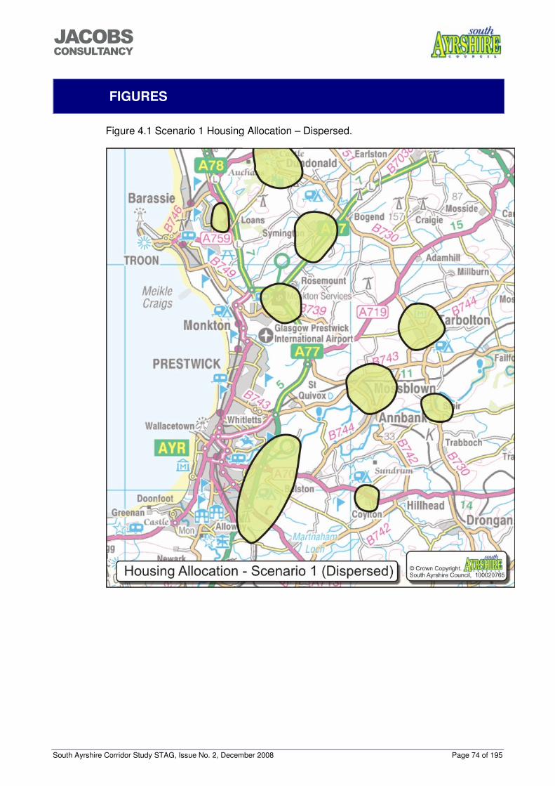
South Ayrshire Corridor Study STAG, Issue No. 2, December 2008 Page 74 of 195
���������������
FIGURES
Figure 4.1 Scenario 1 Housing Allocation – Dispersed.
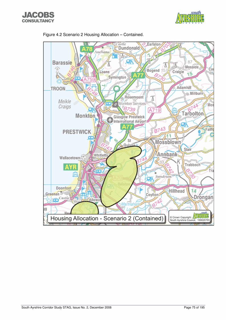
South Ayrshire Corridor Study STAG, Issue No. 2, December 2008 Page 75 of 195
���������������
Figure 4.2 Scenario 2 Housing Allocation – Contained.
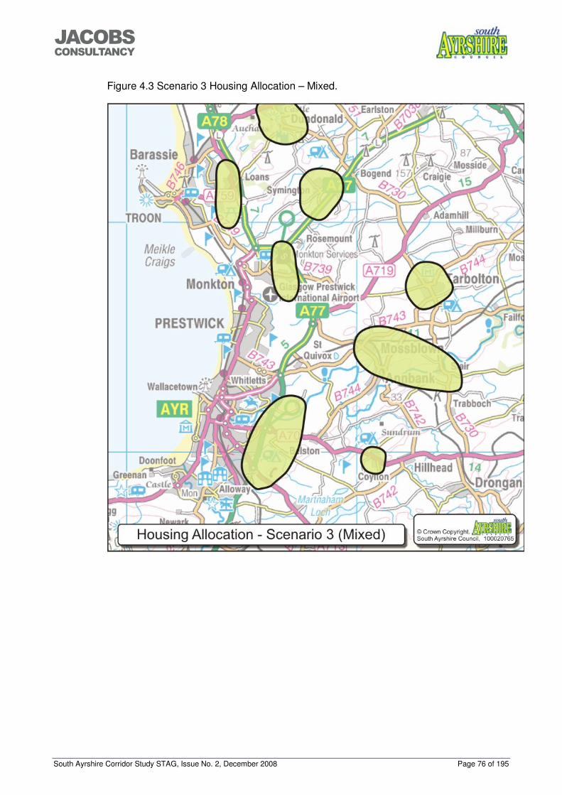
South Ayrshire Corridor Study STAG, Issue No. 2, December 2008 Page 76 of 195
���������������
Figure 4.3 Scenario 3 Housing Allocation – Mixed.
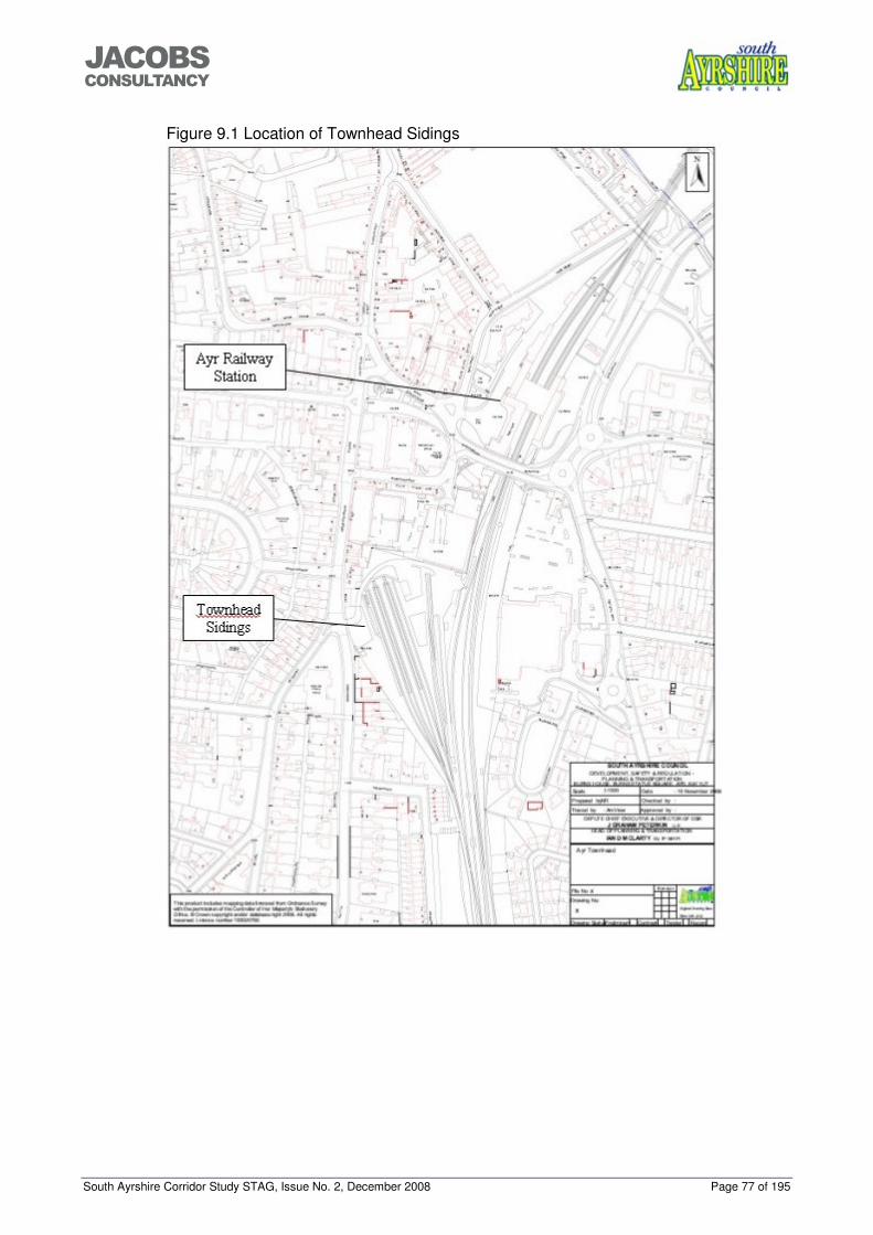
South Ayrshire Corridor Study STAG, Issue No. 2, December 2008 Page 77 of 195
���������������
Figure 9.1 Location of Townhead Sidings
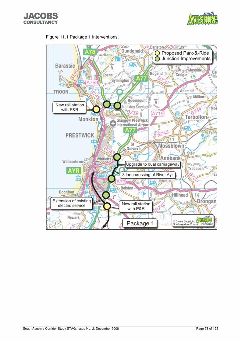
South Ayrshire Corridor Study STAG, Issue No. 2, December 2008 Page 78 of 195
���������������
Figure 11.1 Package 1 Interventions.
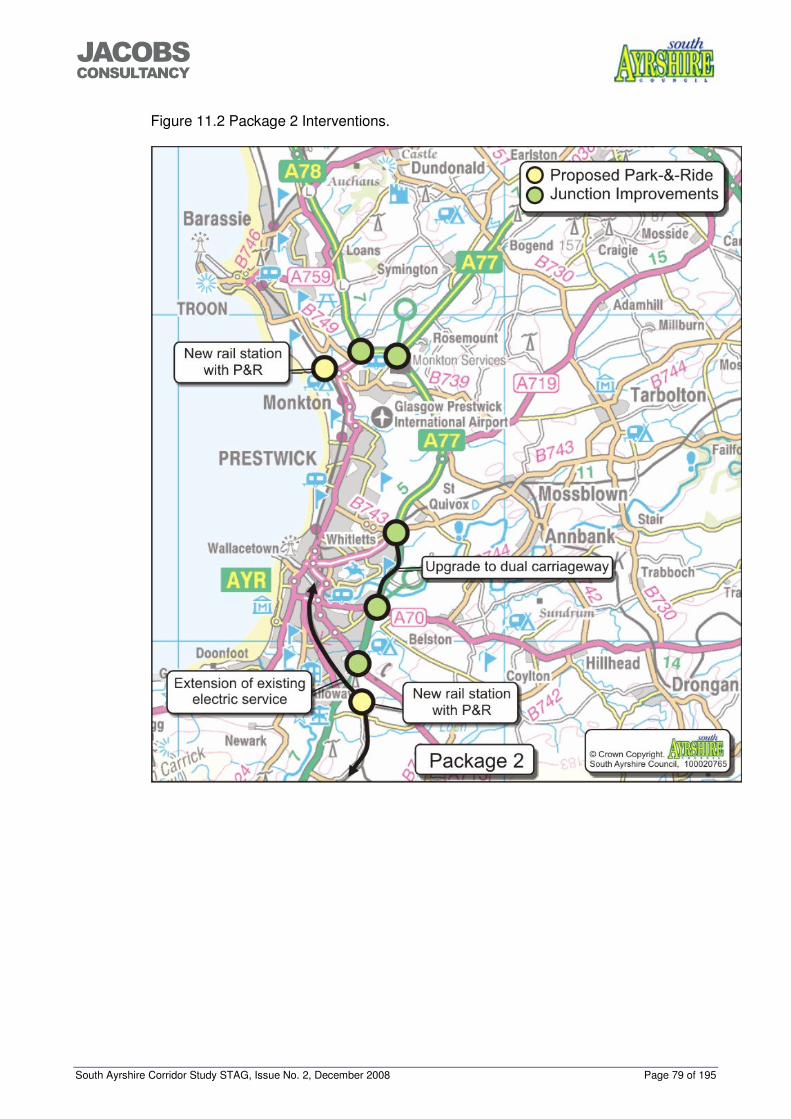
South Ayrshire Corridor Study STAG, Issue No. 2, December 2008 Page 79 of 195
���������������
Figure 11.2 Package 2 Interventions.
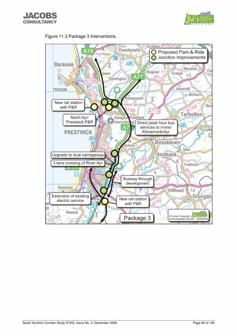
South Ayrshire Corridor Study STAG, Issue No. 2, December 2008 Page 80 of 195
���������������
Figure 11.3 Package 3 Interventions.
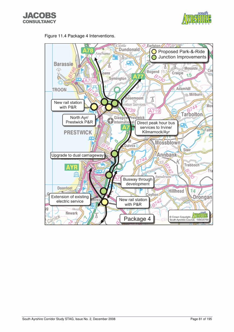
South Ayrshire Corridor Study STAG, Issue No. 2, December 2008 Page 81 of 195
���������������
Figure 11.4 Package 4 Interventions.
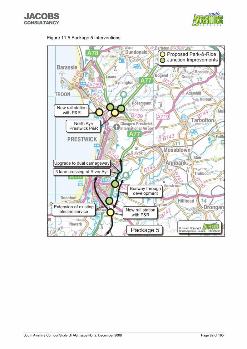
South Ayrshire Corridor Study STAG, Issue No. 2, December 2008 Page 82 of 195
���������������
Figure 11.5 Package 5 Interventions.
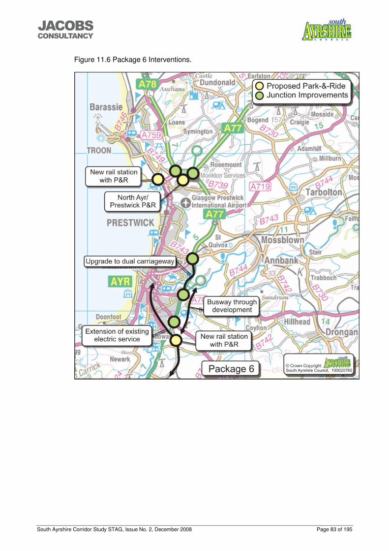
South Ayrshire Corridor Study STAG, Issue No. 2, December 2008 Page 83 of 195
���������������
Figure 11.6 Package 6 Interventions.
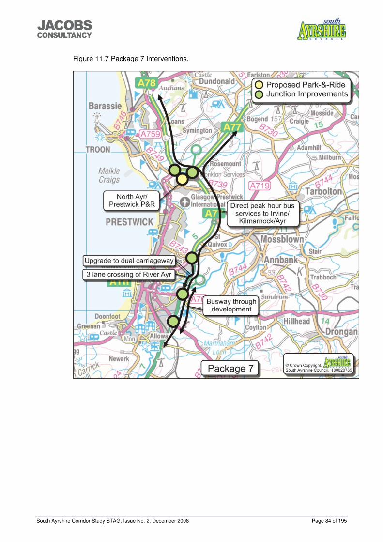
South Ayrshire Corridor Study STAG, Issue No. 2, December 2008 Page 84 of 195
���������������
Figure 11.7 Package 7 Interventions.

South Ayrshire Corridor Study STAG, Issue No. 2, December 2008 Page 85 of 195
���������������
Figure 11.8 Package 8 Interventions.

South Ayrshire Corridor Study STAG, Issue No. 2, December 2008 Page 86 of 195
���������������
APPENDIX A - OUTPUTS FROM WORKSHOP
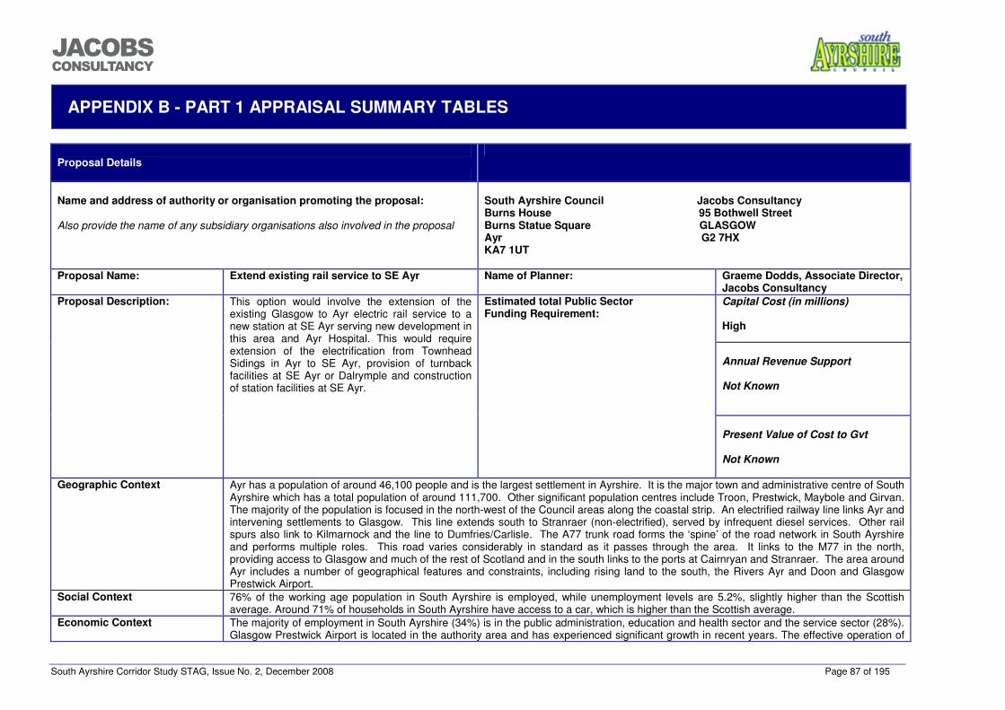
South Ayrshire Corridor Study STAG, Issue No. 2, December 2008 Page 87 of 195
���������������
APPENDIX B - PART 1 APPRAISAL SUMMARY TABLES
Proposal Details
Name and address of authority or organisation promoting the proposal:
Also provide the name of any subsidiary organisations also involved in the proposal
South Ayrshire Council Jacobs Consultancy Burns House 95 Bothwell Street Burns Statue Square GLASGOW Ayr G2 7HX KA7 1UT
Proposal Name: Extend existing rail service to SE Ayr Name of Planner: Graeme Dodds, Associate Director,
Jacobs Consultancy Capital Cost (in millions)
High
Annual Revenue Support
Not Known
Proposal Description: This option would involve the extension of the existing Glasgow to Ayr electric rail service to a new station at SE Ayr serving new development in this area and Ayr Hospital. This would require extension of the electrification from Townhead Sidings in Ayr to SE Ayr, provision of turnback facilities at SE Ayr or Dalrymple and construction of station facilities at SE Ayr.
Estimated total Public Sector Funding Requirement:
Present Value of Cost to Gvt
Not Known
Geographic Context Ayr has a population of around 46,100 people and is the largest settlement in Ayrshire. It is the major town and administrative centre of South
Ayrshire which has a total population of around 111,700. Other significant population centres include Troon, Prestwick, Maybole and Girvan. The majority of the population is focused in the north-west of the Council areas along the coastal strip. An electrified railway line links Ayr and intervening settlements to Glasgow. This line extends south to Stranraer (non-electrified), served by infrequent diesel services. Other rail spurs also link to Kilmarnock and the line to Dumfries/Carlisle. The A77 trunk road forms the ‘spine’ of the road network in South Ayrshire and performs multiple roles. This road varies considerably in standard as it passes through the area. It links to the M77 in the north, providing access to Glasgow and much of the rest of Scotland and in the south links to the ports at Cairnryan and Stranraer. The area around Ayr includes a number of geographical features and constraints, including rising land to the south, the Rivers Ayr and Doon and Glasgow Prestwick Airport.
Social Context 76% of the working age population in South Ayrshire is employed, while unemployment levels are 5.2%, slightly higher than the Scottish average. Around 71% of households in South Ayrshire have access to a car, which is higher than the Scottish average.
Economic Context The majority of employment in South Ayrshire (34%) is in the public administration, education and health sector and the service sector (28%). Glasgow Prestwick Airport is located in the authority area and has experienced significant growth in recent years. The effective operation of
South Ayrshire Corridor Study STAG, Issue No. 2, December 2008 Page 88 of 195
���������������
the strategic transport network around the Ayr Core Area is important for the development of the economy in the area.
Planning Objectives Objective Performance To provide effective access to a choice of modes for strategic trips to/from the proposed development locations on the corridor.
Moderate Benefit This option could provide access to rail services for users to/from the SE Ayr development and locations to the south and east. This option may not provide as effective access to other potential developments located to the north of the SE Ayr site and within other settlements since this would require a considerable diversion to access this service.
To provide the transport infrastructure and services required to facilitate economic growth and the effective delivery of the Structure Plan housing and employment requirements up to 2025.
Moderate Benefit This option could facilitate economic growth within the SE Ayr development and the surrounding area but may not have a beneficial effect on economic growth in other areas. It could also enable effective delivery of the housing and employment allocation at SE Ayr but would not facilitate delivery of other Structure Plan allocations.
To increase the mode share of public transport for existing strategic trips by 10% and trips generated to/from the proposed development locations (20% public transport modal share).
Minor Benefit This option could increase the mode share of public transport trips for users in SE Ayr and locations to the south and east by providing a service from outwith Ayr town centre to Glasgow and intermediate stations. This option will not provide significant increased mode share of public transport to other development locations due to their distance from the potential SE Ayr service.
To minimise the impact of the Structure Plan delivery on the effective operation of the A77 trunk road for trips between Glasgow and Southwest Scotland and intermediate locations by providing interventions that produce a ‘no net-detriment’ effect in terms of journey time around the urban area of Ayr.
Neutral Although this option could result in some modal shift to public transport, the effect on the road network would not be significant.
South Ayrshire Corridor Study STAG, Issue No. 2, December 2008 Page 89 of 195
���������������
STAG Criteria Environment Minor Benefit This proposal has been assessed as having an overall minor positive impact on the environment. The
provision of an electrified rail service between Ayr and Girvan is envisaged to contribute towards a reduction in PM10, NO2 and CO2 emissions in comparison with levels emitted from diesel engines currently in use. In addition, encouraging modal shift through the provision of a new station and rail service is envisaged to contribute towards a reduction in CO2 emissions and an improvement in local air quality. The electrification also has the potential to contribute to a reduction in noise levels in comparison to those emitted from diesel trains. The electrification could however result in minor adverse impacts on visual amenity as a result of the overhead lines associated with the electrification and it is also possible that there will be minor adverse impacts on protected species, woodland and any related species as a result of constructing turn back facilities at SE Ayr and the electrification of the rail between Ayr and SE Ayr. There is also the potential for construction activities associated with turn back facilities to have an adverse impact on minor burns within the vicinity in the absence of mitigation. The infrastructure associated with the station at SE Ayr is assumed to already be a component of the development proposals in SE Ayr and therefore potential impacts associated with this development have not been assessed.
Safety Neutral Although this option could produce some modal shift from the car, the impact on traffic volumes on the strategic network would be minimal and therefore any reductions in accident rates would also be minimal. No effect is anticipated on security on public transport services.
Economy Moderate Benefit / Moderate Negative Impact
Transport Economic Efficiency: This option would increase the availability of the electric rail service to a wider area. It would also provide an effective service to the residential and employment developments in the SE Ayr site. The extended service could operate using existing layover time in Ayr and would not increase journey times for existing users. The high capital costs relative to the benefits would be significant. Wider Economic Benefits: This would give improved public transport access to an area that is planned to have residential, employment and community facilities, enhancing their ability to interact. Economic Activity and Location Impacts: This option could have considerable benefits for the local economy around SE Ayr by providing links to the proposed residential and employment developments and to Ayr Hospital.
Integration Moderate Benefit Transport Integration: This option will improve integration with other modes of transport with links to local bus services in Ayr. Transport and Land Use Integration: This option would provide links to strategic bus services for trips from the potential future development locations. Policy Integration: The adopted South Ayrshire Local Plan also encourages the provision of a rail service to Ayr Hospital and SE Ayr within Policy SERV6. The option aligns with land use policies in the Ayrshire Joint Structure Plan and the Adopted South Ayrshire Local Plan and is consistent with local, regional and national policies of siting developments close to available rail services.
Accessibility and Social Inclusion Moderate Benefit Community Accessibility: This option would improve the public transport network coverage for users from SE Ayr and areas to the south and east of Ayr and improve access to Ayr Hospital. Comparative Accessibility: No significant issues identified.
South Ayrshire Corridor Study STAG, Issue No. 2, December 2008 Page 90 of 195
���������������
Implementability Appraisal Feasibility This option would be constructed using existing methods and no significant technical issues would be envisaged. The operation
of the service could be achieved by utilising the current layover time of the existing service in Ayr. Affordability This option would have a high capital cost associated with the extension of electrification to SE Ayr. Public Acceptability Public acceptability of the extension of the electric rail service to SE Ayr would be expected to be favourable. There may
however be some adverse reactions from residents close to the line with any increase in rail traffic.
Rational for selection or rejection of proposal This option would provide an effective rail service for journeys from SE Ayr and location to the south and east. The option performs well against two of the planning objectives and most of the STAG criteria. It is therefore recommended that this option is taken forward to detailed appraisal.
South Ayrshire Corridor Study STAG, Issue No. 2, December 2008 Page 91 of 195
���������������
Proposal Details
Name and address of authority or organisation promoting the proposal:
Also provide the name of any subsidiary organisations also involved in the proposal
South Ayrshire Council Jacobs Consultancy Burns House 95 Bothwell Street Burns Statue Square GLASGOW Ayr G2 7HX KA7 1UT
Proposal Name: Increase the frequency of the diesel service Name of Planner: Graeme Dodds, Associate Director,
Jacobs Consultancy Capital Cost (in millions)
High
Annual Revenue Support
Not Known
Proposal Description: This option would involve increasing the frequency of the Ayr to Girvan diesel rail services to a minimum of an hourly service with all services calling at a new SE Ayr station. This would require the provision of a passing loop between Ayr and Girvan to accommodate the additional services.
Estimated total Public Sector Funding Requirement:
Present Value of Cost to Gvt
Not Known
Geographic Context Ayr has a population of around 46,100 people and is the largest settlement in Ayrshire. It is the major town and administrative centre of South
Ayrshire which has a total population of around 111,700. Other significant population centres include Troon, Prestwick, Maybole and Girvan. The majority of the population is focused in the north-west of the Council areas along the coastal strip. An electrified railway line links Ayr and intervening settlements to Glasgow. This line extends south to Stranraer (non-electrified), served by infrequent diesel services. Other rail spurs also link to Kilmarnock and the line to Dumfries/Carlisle. The A77 trunk road forms the ‘spine’ of the road network in South Ayrshire and performs multiple roles. This road varies considerably in standard as it passes through the area. It links to the M77 in the north, providing access to Glasgow and much of the rest of Scotland and in the south links to the ports at Cairnryan and Stranraer. The area around Ayr includes a number of geographical features and constraints, including rising land to the south, the Rivers Ayr and Doon and Glasgow Prestwick Airport.
Social Context 76% of the working age population in South Ayrshire is employed, while unemployment levels are 5.2%, slightly higher than the Scottish average. Around 71% of households in South Ayrshire have access to a car, which is higher than the Scottish average.
Economic Context The majority of employment in South Ayrshire (34%) is in the public administration, education and health sector and the service sector (28%). Glasgow Prestwick Airport is located in the authority area and has experienced significant growth in recent years. The effective operation of the strategic transport network around the Ayr Core Area is important for the development of the economy in the area.
South Ayrshire Corridor Study STAG, Issue No. 2, December 2008 Page 92 of 195
���������������
Planning Objectives Objective Performance To provide effective access to a choice of road and public transport modes for strategic trips to/from the proposed development locations on the corridor.
Minor Benefit This option could provide improved access to rail services for users at the SE Ayr development and locations to the south and east; however interchange would be required in Ayr for the main destinations to the north. This option may not provide as effective access to the other potential developments located to the north of the SE Ayr site and in the smaller settlements since use of this service would require a considerable diversion.
To provide the transport infrastructure and services required to facilitate economic growth and the effective delivery of the Structure Plan housing and employment requirements up to 2025.
Minor Benefit This option could facilitate economic growth within the SE Ayr development and the surrounding area but may not have a beneficial effect on economic growth in other areas. It could also enable effective delivery of the housing and employment allocation at SE Ayr but would not facilitate delivery of other Structure Plan allocations.
To increase the mode share of public transport for existing strategic trips by 10% and trips generated to/from the proposed development locations (20% public transport modal share).
Minor Benefit This option could increase the mode share of public transport trips for users in SE Ayr and locations to the south and east by providing a service from SE Ayr; however interchange may be required for stations to Glasgow and intermediate stations. This option would not provide a significantly increased mode share of public transport to other development locations due to their distance from the rail line.
To minimise the impact of the Structure Plan delivery on the effective operation of the A77 trunk road for trips between Glasgow and Southwest Scotland and intermediate locations by providing interventions that produce a ‘no net-detriment’ effect in terms of journey time around the urban area of Ayr.
Neutral Although this option could result in some modal shift to public transport, the effect on the road network would not be significant.
STAG Criteria Environment Minor Negative
Impact This proposal has been assessed as having an overall minor negative impact on the environment. The passing loop required within this proposal is envisaged to have an adverse effect on the landscape as it is likely to be constructed within a regionally designated Scenic Area. However the effects are envisaged to be minor as the rail line already exists in this area. In addition the provision of a passing loop has the potential for adverse impacts on water quality, biodiversity and habitats and cultural heritage, however as the location of this is uncertain at present the impact cannot be determined. In terms of cultural heritage, these could comprise effects on a number of Listed Buildings, SMs, and Archaeological Consultation Triggers close to the rail line between Ayr and Girvan as well as one Historic Garden and Designed Landscape. There is also the potential for adverse impacts on areas of Long Established and Ancient Woodland and other biodiversity interests situated close to the railway line. The rail line crosses the Class A River Doon, and runs close to the Class A Water of Girvan, and the passing loop has the potential to adversely affect these water bodies. The infrastructure associated with the station at SE Ayr is assumed to already be a component of the development proposals in SE Ayr and therefore potential impacts associated with this development have not been assessed.
Safety Neutral Although this option could produce some modal shift from the car, the impact on traffic volumes on the strategic network would be minimal and therefore any reductions in accident rates would also be minimal. No effect is anticipated on security on public transport services.
Economy Minor Benefit / Moderate
Transport Economic Efficiency: This option would provide a rail service to the residential and employment developments in the SE Ayr site, however there would be a requirement to interchange for strategic trips to
South Ayrshire Corridor Study STAG, Issue No. 2, December 2008 Page 93 of 195
���������������
Negative Impact stations between Troon and Glasgow. The increased services would require additional rolling stock and infrastructure and could increase journey times for existing users. This would negatively impact the benefit to cost ratio. Wider Economic Benefits: This would give improved public transport access to an area that is planned to have residential, employment and community facilities, enhancing their ability to interact. Economic Activity and Location Impacts: This option could have benefits for the economy of SE Ayr, Maybole and Girvan.
Integration Moderate Benefit Transport Integration: This option will improve integration with other modes of transport with links to local bus services and other rail services in Ayr. Transport and Land Use Integration: This option would provide links to strategic rail services for trips from some of the potential future development locations. Policy Integration: The adopted South Ayrshire Local Plan encourages the provision of a rail service to Ayr Hospital and SE Ayr within Policy SERV6.
Accessibility and Social Inclusion Moderate Benefit Community Accessibility: This option would improve the public transport network coverage for users from SE Ayr and areas to the south and east of Ayr and improve access to Ayr Hospital. Comparative Accessibility: There would be benefits to accessibility improvements for those living in more isolated parts of the area.
Implementability Appraisal Feasibility This option would involve increasing the frequency of an existing service but would require the provision of a passing loop
between Ayr and Girvan. Proven technology would be utilised throughout. Affordability This option would have a high capital cost associated with the requirement for a passing loop and additional rolling stock. Public Acceptability Public acceptability of the increased service between Ayr and Girvan would be expected to be favourable. There may however
be some adverse reactions from residents close to the line with any increase in rail traffic.
Rational for selection or rejection of proposal This option would provide a higher frequency service for SE Ayr and areas to the south and east. Strategic trips for stations towards Glasgow would however, still require to interchange in Ayr on many services. This option returns only minor benefits against the planning objectives but performs better against two of the STAG criteria. The capital cost of this option would be relatively high due to the need to provide a passing loop and additional rolling stock. The areas that would benefit from this option are also limited. It is therefore recommended that this option is not taken forward to a detailed appraisal.
South Ayrshire Corridor Study STAG, Issue No. 2, December 2008 Page 94 of 195
���������������
Proposal Details
Name and address of authority or organisation promoting the proposal:
Also provide the name of any subsidiary organisations also involved in the proposal
South Ayrshire Council Jacobs Consultancy Burns House 95 Bothwell Street Burns Statue Square GLASGOW Ayr G2 7HX KA7 1UT
Proposal Name: Electrification to Girvan Name of Planner: Graeme Dodds, Associate Director,
Jacobs Consultancy Capital Cost (in millions)
High
Annual Revenue Support
Not Known
Proposal Description: Provision of electrification between Townhead Sidings, Ayr and Girvan, mostly single track but with double track sections between Townhead Sidings, Ayr and Dalrymple Junction and at Girvan.
Estimated total Public Sector Funding Requirement:
Present Value of Cost to Gvt
Not Known
Geographic Context Ayr has a population of around 46,100 people and is the largest settlement in Ayrshire. It is the major town and administrative centre of South
Ayrshire which has a total population of around 111,700. Other significant population centres include Troon, Prestwick, Maybole and Girvan. The majority of the population is focused in the north-west of the Council areas along the coastal strip. An electrified railway line links Ayr and intervening settlements to Glasgow. This line extends south to Stranraer (non-electrified), served by infrequent diesel services. Other rail spurs also link to Kilmarnock and the line to Dumfries/Carlisle. The A77 trunk road forms the ‘spine’ of the road network in South Ayrshire and performs multiple roles. This road varies considerably in standard as it passes through the area. It links to the M77 in the north, providing access to Glasgow and much of the rest of Scotland and in the south links to the ports at Cairnryan and Stranraer. The area around Ayr includes a number of geographical features and constraints, including rising land to the south, the Rivers Ayr and Doon and Glasgow Prestwick Airport.
Social Context 76% of the working age population in South Ayrshire is employed, while unemployment levels are 5.2%, slightly higher than the Scottish average. Around 71% of households in South Ayrshire have access to a car, which is higher than the Scottish average.
Economic Context The majority of employment in South Ayrshire (34%) is in the public administration, education and health sector and the service sector (28%). Glasgow Prestwick Airport is located in the authority area and has experienced significant growth in recent years. The effective operation of the strategic transport network around the Ayr Core Area is important for the development of the economy in the area.
South Ayrshire Corridor Study STAG, Issue No. 2, December 2008 Page 95 of 195
���������������
Planning Objectives Objective Performance To provide effective access to a choice of road and public transport modes for strategic trips to/from the proposed development locations on the corridor.
Moderate Benefit This option could provide access to electric rail services for users at the SE Ayr development and locations to the south and east, including Maybole and Girvan. This option may not provide as effective access to the other potential developments located to the north of the SE Ayr site since use of this service would require a considerable diversion.
To provide the transport infrastructure and services required to facilitate economic growth and the effective delivery of the Structure Plan housing and employment requirements up to 2025.
Minor Benefit This option could facilitate economic growth within the SE Ayr development and the surrounding area and within Maybole and Girvan but may not have a beneficial effect on economic growth in other areas. It could also enable effective delivery of the housing and employment allocation at SE Ayr but would not facilitate delivery of other Structure Plan allocations.
To increase the mode share of public transport for existing strategic trips by 10% and trips generated to/from the proposed development locations (20% public transport modal share).
Minor Benefit This option could increase the mode share of public transport trips for users in SE Ayr and locations to the south and east, especially Maybole and Girvan, by providing a service from outwith Ayr town centre to Glasgow and intermediate stations. This option will not provide significant increased mode share of public transport to other development locations due to their distance from the potential SE Ayr service.
To minimise the impact of the Structure Plan delivery on the effective operation of the A77 trunk road for trips between Glasgow and Southwest Scotland and intermediate locations by providing interventions that produce a ‘no net-detriment’ effect in terms of journey time around the urban area of Ayr.
Neutral Although this option could result in some modal shift to public transport, the effect on the road network would not be significant.
STAG Criteria Environment Minor Benefit This proposal has been assessed as having an overall minor positive impact on the environment. The
provision of an electrified rail service between Ayr and Girvan is envisaged to contribute towards a reduction in PM10, NO2 and CO2 emissions in comparison with levels emitted from diesel engines. The electrification also has the potential to contribute to a reduction in noise levels when compared to diesel trains. The electrification does however result in minor adverse impacts on landscape and visual amenity as a result of the overhead lines associated with the electrification, particularly as the rail line runs through two regionally designated Scenic Areas. A passing loop may also be required somewhere between Dalrymple Junction (around Ayr Hospital) and Kilkerran (where there is an existing loop) if services are to be enhanced. As a result of this impacts on biodiversity, water and cultural heritage have been assessed as uncertain with the potential for adverse impacts on these parameters if the passing loop is implemented. In terms of cultural heritage, this is because there are a number of Listed Buildings, SMs and Archaeological Consultation Triggers close to the rail line between Ayr and Girvan. There is also one Historic Garden and Designed Landscape close to the rail line that has the potential to be affected. In terms of biodiversity, there is the potential for areas of Long Established and Ancient Woodland situated close to the railway line and for other biodiversity interests to be adversely affected as a result of land take required for construction of the passing loop. The rail line also crosses the Class A River Doon, the Class A Water of Girvan, and there is the potential to adversely affect these water bodies in the absence of appropriate mitigation.
Safety Neutral Although this option could produce some modal shift from the car, the impact on traffic volumes on the strategic network would be minimal and therefore any reductions in accident rates would also be minimal. No effect is anticipated on security on public transport services.
South Ayrshire Corridor Study STAG, Issue No. 2, December 2008 Page 96 of 195
���������������
Economy Minor Benefit / Major Negative Impact
Transport Economic Efficiency: This option would provide improved access to public transport services into Ayr and beyond for rail users from Girvan and Maybole but would require further infrastructure to enable an enhanced service to be operated. The costs of this infrastructure would be significant and additional rolling stock is likely to be required as service extension would not be within the limits of the current turnaround time. This would only return limited benefits for a high level of investment. Wider Economic Benefits: This would give improved public transport access to an area that is planned to have residential, employment and community facilities, enhancing their ability to interact. Economic Activity and Location Impacts: This option would enhance the service provided to SE Ayr, and encourage the development of residential and employment facilities at this location.
Integration Minor Benefit Transport Integration: This option would not provide any additional services and therefore would not affect transport integration. Transport and Land Use Integration: This option would improve the quality of service to the proposed development at SE Ayr. Policy Integration: This option would align with local, regional and national policies on attracting more trips onto rail services.
Accessibility and Social Inclusion Moderate Benefit Community Accessibility: This option would improve the public transport network coverage for users from SE Ayr and areas to the south and east of Ayr and improve access to Ayr Hospital. Comparative Accessibility: There would be benefits to accessibility improvements for those living in more isolated parts of the area.
Implementability Appraisal Feasibility This option would be constructed using existing methods and no technical issues would be envisaged. The operation of the
service would require additional electric units. Any service frequency improvements would be constrained by the single track layout or would require additional passing loops.
Affordability This option would have a significant capital cost related to the provision of electrification and additional rolling stock. Additional benefits of electrification south of the SE Ayr development would be minimal without additional infrastructure improvements to enable increased services frequencies to operate. These infrastructure improvements would however require considerable additional funding.
Public Acceptability Public acceptability of the extension of the electric rail service to SE Ayr would be expected to be favourable. There may however be some adverse reactions from people concerned about the negative visual impact of the electrification masts.
Rational for selection or rejection of proposal Delivery of this option would be high cost with minimal additional benefits beyond SE Ayr. The single track layout between Dalrymple Junction and Girvan would restrict the service frequency that could be provided. Further infrastructure improvements would be required in order to increase service frequency. The performance of this option against the planning objectives and STAG criteria is mixed however; the scheme would have a considerable capital cost and the benefits of extending the service beyond SE Ayr would be limited. It is therefore recommended that this option should not proceed to detailed appraisal as it does not offer significantly greater benefits than extending the existing electric service to SE Ayr.
South Ayrshire Corridor Study STAG, Issue No. 2, December 2008 Page 97 of 195
���������������
Proposal Details
Name and address of authority or organisation promoting the proposal:
Also provide the name of any subsidiary organisations also involved in the proposal
South Ayrshire Council Jacobs Consultancy Burns House 95 Bothwell Street Burns Statue Square GLASGOW Ayr G2 7HX KA7 1UT
Proposal Name: New rail stations Name of Planner: Graeme Dodds, Associate Director,
Jacobs Consultancy Capital Cost (in millions)
High
Annual Revenue Support
Not Known
Proposal Description: Provision of new rail stations at SE Ayr and Belmont on the Ayr to Maybole line, at Mossblown, St Quivox and Heathfield on the Mauchline freight line and at Prestwick St Nicholas and Monkton (Parkway) on the Ayr to Glasgow line. This option would require the provision of new services between Ayr and Mossblown and altered stopping patterns on Ayr to Girvan and Ayr to Glasgow services.
Estimated total Public Sector Funding Requirement:
Present Value of Cost to Gvt
Not Known
Geographic Context Ayr has a population of around 46,100 people and is the largest settlement in Ayrshire. It is the major town and administrative centre of South
Ayrshire which has a total population of around 111,700. Other significant population centres include Troon, Prestwick, Maybole and Girvan. The majority of the population is focused in the north-west of the Council areas along the coastal strip. An electrified railway line links Ayr and intervening settlements to Glasgow. This line extends south to Stranraer (non-electrified), served by infrequent diesel services. Other rail spurs also link to Kilmarnock and the line to Dumfries/Carlisle. The A77 trunk road forms the ‘spine’ of the road network in South Ayrshire and performs multiple roles. This road varies considerably in standard as it passes through the area. It links to the M77 in the north, providing access to Glasgow and much of the rest of Scotland and in the south links to the ports at Cairnryan and Stranraer. The area around Ayr includes a number of geographical features and constraints, including rising land to the south, the Rivers Ayr and Doon and Glasgow Prestwick Airport.
Social Context 76% of the working age population in South Ayrshire is employed, while unemployment levels are 5.2%, slightly higher than the Scottish average. Around 71% of households in South Ayrshire have access to a car, which is higher than the Scottish average.
Economic Context The majority of employment in South Ayrshire (34%) is in the public administration, education and health sector and the service sector (28%). Glasgow Prestwick Airport is located in the authority area and has experienced significant growth in recent years. The effective operation of the strategic transport network around the Ayr Core Area is important for the development of the economy in the area.
South Ayrshire Corridor Study STAG, Issue No. 2, December 2008 Page 98 of 195
���������������
Planning Objectives Objective Performance To provide effective access to a choice of modes for strategic trips to/from the proposed development locations on the corridor.
Moderate Benefit
The provision of railway stations at Mossblown, SE Ayr and St Quivox would provide access to the rail network for some of the potential development locations. The stations at Belmont, St Quivox, Heathfield, Prestwick St Nicholas and Monkton however are likely to be some distance from the potential development locations. Monkton does have the potential to serve some future developments as a Park-&-Ride facility. Interchange may be required in Ayr however for trips to Glasgow and intermediate stations from stations on the Maybole and Mauchline lines.
To provide the transport infrastructure and services required to facilitate economic growth and the effective delivery of the Structure Plan housing and employment requirements up to 2025.
Minor Benefit The provision of additional railway stations will improve access to the rail network for several areas, assisting economic growth and the effective delivery of the Structure Plan requirements. The services from several stations would however require interchange in Ayr for travel to Glasgow and intermediate stations. The stations at Belmont, St Quivox, Heathfield and Prestwick St Nicholas are likely to be some distance from the potential development locations. The proposed station at SE Ayr would also provide improved access to Ayr and Ailsa Hospitals.
To increase the mode share of public transport for existing strategic trips by 10% and trips generated to/from the proposed development locations (20% public transport modal share).
Moderate Benefit
This option would provide access to rail services for several areas, helping to increase the mode share of existing trips and development trips. The requirement to interchange in Ayr for trips to Glasgow from some of the new station locations could reduce the attractiveness of the services and hence the potential mode share increase of public transport.
To minimise the impact of the Structure Plan delivery on the effective operation of the A77 trunk road for trips between Glasgow and Southwest Scotland and intermediate locations by providing interventions that produce a ‘no net-detriment’ effect in terms of journey time around the urban area of Ayr.
Neutral Although this option could result in some modal shift to public transport, the effect on the road network would not be significant.
STAG Criteria Environment Minor Benefit This proposal has been assessed as having an overall minor positive impact on the environment. The
provision of a number of new rail stations, within and surrounding Ayr and Prestwick, is envisaged to encourage a modal shift by providing new access to rail services. This has the potential to contribute to a reduction in CO2 emissions and improvements to local air quality if modal shift from car to rail is encouraged. No impacts on geology, landscape, visual amenity, agriculture and soils and cultural heritage are envisaged. Minor adverse effects of this proposal are associated with noise, biodiversity and water. There is the potential for short term minor adverse noise impacts on residential properties and recreational facilities adjacent to the rail line during construction and negligible impacts during operation. At Monkton (Parkway) there is the potential for impacts to occur on the Troon Golf Links and Foreshore biological SSSI due to the construction of the new rail station. The proposal could result in habitat loss during construction works and there is also the potential for disturbance impacts during construction and operation. In addition there is the potential for minor short term adverse impacts on the water quality of burns during construction and operation of the new stations at Monkton (Parkway) and Belmont.
Safety Neutral Although this option could produce some modal shift from the car, the impact on traffic volumes on the strategic network would be minimal and therefore any reductions in accident rates would also be minimal. No effect is anticipated on security on public transport services.
Economy Moderate Benefit / Transport Economic Efficiency: This option could improve journey times and the reliability of journey times
South Ayrshire Corridor Study STAG, Issue No. 2, December 2008 Page 99 of 195
���������������
Moderate Negative Impact
for users of the new stations. However, increased journey times would be experienced by existing users where services exist and additional station stops may make the service less attractive. A number of potential locations would also require a bespoke service. This, together with the required infrastructure would have a significantly negative impact on the benefit to cost ratio. Wider Economic Benefits: No significant WEBs have been identified for this intervention. Economic Activity and Location Impacts: The development area at SE Ayr and other potential development areas would benefit from the provision of stations at SE Ayr, St Quivox, Monkton and Mossblown, however, the potential stations at St Quivox and Monkton would be located some distance from the future potential development sites, reducing their effectiveness.
Integration Moderate Benefit Transport Integration: This option will improve integration with other services and modes of transport with links to other rail services and local/strategic bus services in Ayr. Transport and Land Use Integration: This option provides new railway stations that are located close to potential future development areas at SE Ayr and Mossblown. The potential stations at Monkton and St Quivox would be less effective however, due to their distance from the potential future development sites. The stations at Belmont, Prestwick St Nicholas and Heathfield would be some distance from any future development site. Policy Integration: This option aligns with rail investment policy TRANS2b in the Ayrshire Joint Structure Plan which states “The three Ayrshire Councils shall work in partnership with relevant transport bodies and in the context of Scotland’s Railways to: identify, safeguard and promote new rail station locations particularly as an integral part of new developments” The Adopted South Ayrshire Local Plan in policy SERV6 states “The Council will promote and encourage greater use and expansion of the existing rail network, especially where this includes the provision of rail halt facilities to serve: a) Ayr Hospital and b) The Heathfield area, Ayr”.
Accessibility and Social Inclusion Moderate Benefit Community Accessibility: This option would improve the public transport network coverage for users from SE Ayr and areas to the south and east of Ayr, improve access to Ayr Hospital and Mossblown, St Quivox, Heathfield, Belmont, Prestwick St Nicholas and Monkton. Comparative Accessibility: There would be benefits to accessibility improvements for those living in more isolated parts of the area.
Implementability Appraisal Feasibility This option would be constructed using existing methods and no technical issues would be envisaged. The operation of the
service to Mossblown would however require the provision of train paths on a busy freight line and re-instatement of the chord from Blackhouse Junction and Hawkhill Junction to allow direct access to Ayr from this line. The other stations would require alterations to the stopping patterns of Ayr to Girvan and Ayr to Glasgow services with an associated increase in journey times. A lack of suitable locations for a station at Belmont would result in the station being located further east, bringing it closer to the SE Ayr proposals and therefore reducing the viability of this location.
Affordability This option would have considerable capital cost to construct and operate all of the new stations and provide new infrastructure and services to Mossblown.
Public Acceptability Public opinion from potential users of the new stations would be positive, however existing users of the services could incur increased journey times due to the additional stops and could therefore be less favourable to the proposals. Residents near to the new station sites may also raise concerns.
South Ayrshire Corridor Study STAG, Issue No. 2, December 2008 Page 100 of 195
���������������
Rational for selection or rejection of proposal Some elements of this option perform better than others against the planning objectives and STAG criteria. The stations at SE Ayr and Belmont could be served by the existing pattern of Ayr to Girvan services. The station at SE Ayr could be constructed as part of the development, however Belmont would require the acquisition of suitable land and may be more difficult to deliver at a suitable location. Stations at Prestwick St Nicholas and Monkton would not have any anticipated construction issues, however these locations are on the busy Glasgow to Ayr service and any additional stations would be detrimental to existing service users. The remaining stations at Heathfield, St Quivox and Mossblown are located on the freight line between Newton-on-Ayr and Mauchline. This line provides a very important connection to the south for coal traffic and is therefore likely to present considerable capacity issues for the development of a passenger service. In addition, the line does not have direct connections to Ayr, since the required side of the triangle junction was removed some years ago. In order to serve these stations therefore, this line would require to be re-instated. The location of the St Quivox, Heathfield and Prestwick St Nicholas options are some distance from any proposed future development sites and therefore may not be effective at attracting trips from these locations. It is therefore recommended that the provision of stations at SE Ayr on the Maybole line, and Monkton on the Ayr to Glasgow line are progressed to detailed appraisal. The other stations, at Belmont, Prestwick St Nicholas, Heathfield, St Quivox and Mossblown should not progress to detailed appraisal.
South Ayrshire Corridor Study STAG, Issue No. 2, December 2008 Page 101 of 195
���������������
Proposal Details
Name and address of authority or organisation promoting the proposal:
Also provide the name of any subsidiary organisations also involved in the proposal
South Ayrshire Council Jacobs Consultancy Burns House 95 Bothwell Street Burns Statue Square GLASGOW Ayr G2 7HX KA7 1UT
Proposal Name: Bus services to Irvine, Kilmarnock and
Glasgow Name of Planner: Graeme Dodds, Associate Director,
Jacobs Consultancy Capital Cost (in millions)
Not Known
Annual Revenue Support
Medium
Proposal Description: The express bus service between Ayr and Glasgow via the M77 has proved extremely popular. The existing service however runs from Ayr bus station through Prestwick to the A77 with some journeys starting/finishing at Doonfoot. Existing services also operate to Irvine and Kilmarnock from Ayr bus station. This proposal would provide additional journeys to Irvine, Kilmarnock and Glasgow starting from SE Ayr and serving other future development sites.
Estimated total Public Sector Funding Requirement:
Present Value of Cost to Gvt
Not Known
Geographic Context Ayr has a population of around 46,100 people and is the largest settlement in Ayrshire. It is the major town and administrative centre of South
Ayrshire which has a total population of around 111,700. Other significant population centres include Troon, Prestwick, Maybole and Girvan. The majority of the population is focused in the north-west of the Council areas along the coastal strip. An electrified railway line links Ayr and intervening settlements to Glasgow. This line extends south to Stranraer (non-electrified), served by infrequent diesel services. Other rail spurs also link to Kilmarnock and the line to Dumfries/Carlisle. The A77 trunk road forms the ‘spine’ of the road network in South Ayrshire and performs multiple roles. This road varies considerably in standard as it passes through the area. It links to the M77 in the north, providing access to Glasgow and much of the rest of Scotland and in the south links to the ports at Cairnryan and Stranraer. The area around Ayr includes a number of geographical features and constraints, including rising land to the south, the Rivers Ayr and Doon and Glasgow Prestwick Airport.
Social Context 76% of the working age population in South Ayrshire is employed, while unemployment levels are 5.2%, slightly higher than the Scottish average. Around 71% of households in South Ayrshire have access to a car, which is higher than the Scottish average.
Economic Context The majority of employment in South Ayrshire (34%) is in the public administration, education and health sector and the service sector (28%). Glasgow Prestwick Airport is located in the authority area and has experienced significant growth in recent years. The effective operation of the strategic transport network around the Ayr Core Area is important for the development of the economy in the area.
South Ayrshire Corridor Study STAG, Issue No. 2, December 2008 Page 102 of 195
���������������
Planning Objectives Objective Performance To provide effective access to a choice of road and public transport modes for strategic trips to/from the proposed development locations on the corridor.
Moderate Benefit
The provision of an express bus service from the potential development sites running parallel to the A77 could provide effective strategic links to Glasgow, Irvine and Kilmarnock from these developments.
To provide the transport infrastructure and services required to facilitate economic growth and the effective delivery of the Structure Plan housing and employment requirements up to 2025.
Moderate Benefit
This option would provide effective penetration of the development sites along the A77 corridor by direct services to Glasgow, Kilmarnock and Irvine providing for effective delivery of the housing and employment requirements of the Structure Plan and helping to facilitate economic growth.
To increase the mode share of public transport for existing strategic trips by 10% and trips generated to/from the proposed development locations (20% public transport modal share).
Major Benefit This option could increase the mode share of public transport for trips to Glasgow, Irvine and Kilmarnock, the main destinations of strategic trips.
To minimise the impact of the Structure Plan delivery on the effective operation of the A77 trunk road for trips between Glasgow and Southwest Scotland and intermediate locations by providing interventions that produce a ‘no net-detriment’ effect in terms of journey time around the urban area of Ayr.
Neutral Although this option could result in some modal shift to public transport, the effect on the road network would not be significant.
STAG Criteria Environment Minor Benefit This proposal has been assessed as having an overall minor positive effect. The anticipated modal shift
encouraged through increased bus services is envisaged to contribute towards a reduction in CO2 emissions and vehicle related emissions. In addition the bus services will utilise existing roads and are not envisaged to adversely affect noise sensitive receptors, water quality, geology, biodiversity and habitats, landscape, visual amenity, agriculture and soils and cultural heritage.
Safety Neutral Although this option could produce some modal shift from the car, the impact on traffic volumes on the strategic network would be minimal and therefore any reductions in accident rates would also be minimal. No effect is anticipated on security on public transport services.
Economy Moderate Benefit / Minor Negative Impact
Transport Economic Efficiency: This option would provide access to bus services to Glasgow, Kilmarnock and Irvine throughout the development sites. This option would involve the provision of new bus services and therefore would not have any effect on existing users. There would be capital and revenue costs associated with the provision of vehicles and the operation of the service. Peak demand is likely to mean that services would be well used during this part of the day, but not as well used outside of peak periods, negatively impacting the cost benefit ratio. Wider Economic Benefits: Providing new public transport corridors and more intensively linking the core
South Ayrshire Corridor Study STAG, Issue No. 2, December 2008 Page 103 of 195
���������������
area of the Structure Plan is likely to have some positive impacts. Economic Activity and Location Impacts: This option would assist in the viability of the future developments, hence assisting in the growth of the economy of South Ayrshire.
Integration Moderate Benefit Transport Integration: This option would provide direct services to Glasgow, Kilmarnock and Irvine. It would not provide integration with other services in South Ayrshire. Transport and Land Use Integration: This option would have considerable benefits to the integration of transport and land use since the services would penetrate the future development sites and provide services to a range of strategic destinations. Policy Integration: This option aligns with local, regional and national policies encouraging modal shift and the provision of good public transport links to/from new developments. The Ayrshire Joint Structure Plan in policy TRANS1 states: “The three Ayrshire Councils shall ensure that all significant new trip generating development is closely linked to existing and proposed walking, cycling and public transport networks.”
Accessibility and Social Inclusion Moderate Benefit Community Accessibility: This option would improve the public transport network improvements within the core area of Ayr, Irvine and Kilmarnock, allowing improved access to services. Comparative Accessibility: No significant issues have been identified.
Implementability Appraisal Feasibility This option would involve the provision of bus services and would utilise proven technology. Effectiveness would however be
dependent on the provision of infrastructure within the future developments. Affordability The development of this option could be completed as part of the development sites and could be subsidised as part of the
requirements of the developments. The viability of these services could be increased by serving a future Park-&-Ride facility, located to the north of Ayr and Prestwick.
Public Acceptability Since this option would be developed as part of the overall development, it is not anticipated that there would be any specific issues with it.
Rational for selection or rejection of proposal This option would provide bus services linking the future development sites directly with Glasgow, Kilmarnock and Irvine. This would provide a public transport alternative for a large percentage of strategic trips. This option performs well against the planning objectives and the STAG criteria. The effectiveness of this option would be increased by the provision of adequate infrastructure within the future developments to facilitate effective penetration of services. The viability would also be improved by additionally serving a future Park-&-Ride facility to the north of Ayr/Prestwick. It is therefore recommended that this option should be taken forward to a detailed appraisal stage.
South Ayrshire Corridor Study STAG, Issue No. 2, December 2008 Page 104 of 195
���������������
Proposal Details
Name and address of authority or organisation promoting the proposal:
Also provide the name of any subsidiary organisations also involved in the proposal
South Ayrshire Council Jacobs Consultancy Burns House 95 Bothwell Street Burns Statue Square GLASGOW Ayr G2 7HX KA7 1UT
Proposal Name: Designed busway QBCs with bus shuttle
services in new developments Name of Planner: Graeme Dodds, Associate Director,
Jacobs Consultancy Capital Cost (in millions)
Low
Annual Revenue Support
Low
Proposal Description: Provision of a mainly segregated busway through the developments along the A77 providing a north to south route with bus shuttle services through the developments providing access to Park-&-Ride sites, railway stations and other facilities.
Estimated total Public Sector Funding Requirement:
Present Value of Cost to Gvt
Not Known
Geographic Context Ayr has a population of around 46,100 people and is the largest settlement in Ayrshire. It is the major town and administrative centre of South
Ayrshire which has a total population of around 111,700. Other significant population centres include Troon, Prestwick, Maybole and Girvan. The majority of the population is focused in the north-west of the Council areas along the coastal strip. An electrified railway line links Ayr and intervening settlements to Glasgow. This line extends south to Stranraer (non-electrified), served by infrequent diesel services. Other rail spurs also link to Kilmarnock and the line to Dumfries/Carlisle. The A77 trunk road forms the ‘spine’ of the road network in South Ayrshire and performs multiple roles. This road varies considerably in standard as it passes through the area. It links to the M77 in the north, providing access to Glasgow and much of the rest of Scotland and in the south links to the ports at Cairnryan and Stranraer. The area around Ayr includes a number of geographical features and constraints, including rising land to the south, the Rivers Ayr and Doon and Glasgow Prestwick Airport.
Social Context 76% of the working age population in South Ayrshire is employed, while unemployment levels are 5.2%, slightly higher than the Scottish average. Around 71% of households in South Ayrshire have access to a car, which is higher than the Scottish average.
Economic Context The majority of employment in South Ayrshire (34%) is in the public administration, education and health sector and the service sector (28%). Glasgow Prestwick Airport is located in the authority area and has experienced significant growth in recent years. The effective operation of the strategic transport network around the Ayr Core Area is important for the development of the economy in the area.
South Ayrshire Corridor Study STAG, Issue No. 2, December 2008 Page 105 of 195
���������������
Planning Objectives Objective Performance To provide effective access to a choice of road and public transport modes for strategic trips to/from the proposed development locations on the corridor.
Moderate Benefit
The provision of a busway with bus shuttle services through the potential future development sites running parallel to the A77 would provide an effective route and services penetrating future potential developments and providing links to main strategic transport hubs and other facilities. Strategic trips would however require to interchange at one of the transport hubs.
To provide the transport infrastructure and services required to facilitate economic growth and the effective delivery of the Structure Plan housing and employment requirements up to 2025.
Major Benefit This option would provide effective penetration of the development sites along the A77 corridor by public transport with direct links to strategic rail/bus services, providing for effective delivery of the housing and employment requirements of the Structure Plan and helping to facilitate economic growth.
To increase the mode share of public transport for existing strategic trips by 10% and trips generated to/from the proposed development locations (20% public transport modal share).
Minor Benefit This option would provide infrastructure and bus shuttle services through the future development locations. This would result in public transport penetration to the developments but it is unlikely to affect existing trips. Onward travel on strategic trips would also require interchange at one of the transport hubs.
To minimise the impact of the Structure Plan delivery on the effective operation of the A77 trunk road for trips between Glasgow and Southwest Scotland and intermediate locations by providing interventions that produce a ‘no net-detriment’ effect in terms of journey time around the urban area of Ayr.
Neutral Although this option could result in some modal shift to public transport, the effect on the road network would not be significant.
STAG Criteria Environment Minor Benefit This proposal has been assessed as having an overall minor positive impact on the environment. The
provision of a busway providing linkages to other public transport is envisaged to encourage greater use of these services, providing an alternative to the private car. The introduction of the new busway could therefore contribute towards an minor reduction in CO2 emissions and a minor improvement to local air quality. The infrastructure associated with this package is assumed to already be a component of the development proposals to the east of the A77 and therefore potential impacts associated with the construction of the busway have not been assessed. As a result no impacts on water quality, geology, biodiversity and habitats, landscape, visual amenity, agriculture and soils and cultural heritage have been identified.
Safety Neutral Although this option could produce some modal shift from the car, the impact on traffic volumes on the strategic network would be minimal and therefore any reductions in accident rates would also be minimal. No effect is anticipated on security on public transport services.
Economy Moderate Benefit / Minor Negative Impact
Transport Economic Efficiency: This option would provide the infrastructure for buses to penetrate the developments and feeder services linking the developments to major transport hubs. This would provide faster journeys than existing public transport journeys from these areas which require interchange in Ayr. There would be capital and revenue costs associated with the provision of vehicles and the operation of the service. Peak demand is likely to mean that services would be well used during this part of the day, but not as well used outside of peak periods, negatively impacting the cost benefit ratio. Wider Economic Benefits: These would be limited although the provision of a new transport corridor could stimulate development.
South Ayrshire Corridor Study STAG, Issue No. 2, December 2008 Page 106 of 195
���������������
Economic Activity and Location Impacts: This option would assist in the viability of the future developments, assisting to grow the economy of South Ayrshire. This option would provide access to bus services throughout the development sites and bus feeder services top the main transport hubs.
Integration Moderate Benefit Transport Integration: The provision of a busway through the future development sites and shuttle services to transport hubs could result in improved integration with other transport services. Transport and Land Use Integration: This proposal would provide good integration with land use planning by providing infrastructure for the effective movement of bus services through the development sites. Policy Integration: This option aligns with local, regional and national policies encouraging modal shift and the provision of good public transport links to/from new developments. The Ayrshire Joint Structure Plan in policy TRANS1 states: “The three Ayrshire Councils shall ensure that all significant new trip generating development is closely linked to existing and proposed walking, cycling and public transport networks.”
Accessibility and Social Inclusion Moderate Benefit Community Accessibility: This option would provide the infrastructure and services linking into the strategic transport network for access to a wide variety of destinations. Comparative Accessibility: No significant issues have been identified.
Implementability Appraisal Feasibility This option would be constructed using existing methods and no technical issues would be envisaged. The busway could be
designed into the masterplanning of the developments along the A77 corridor from an early stage. Affordability The development of this option could be completed as part of the development sites. The bus shuttle services would be
expected to be subsidised by the developers for a number of years. Public Acceptability Since this would be developed as part of the overall development, it is not anticipated that there would be any specific issues
with the proposals.
Rational for selection or rejection of proposal This option would provide the infrastructure and bus feeder services for access to strategic transport services from the future development sites. It would provide effective penetration of the developments by bus services and enable unimpeded movement of these services along the length of the potential development locations. The design of this option could be taken forward as part of the masterplanning of the development sites from the start. Use of the services would however, require interchange for strategic trips. This option performs well against the planning objectives and the STAG criteria. It is therefore recommended that this option is taken forward to detailed appraisal stage.
South Ayrshire Corridor Study STAG, Issue No. 2, December 2008 Page 107 of 195
���������������
Proposal Details
Name and address of authority or organisation promoting the proposal:
Also provide the name of any subsidiary organisations also involved in the proposal
South Ayrshire Council Jacobs Consultancy Burns House 95 Bothwell Street Burns Statue Square GLASGOW Ayr G2 7HX KA7 1UT
Proposal Name: Road Package: Scenario 1 Name of Planner: Graeme Dodds, Associate Director,
Jacobs Consultancy Capital Cost (in millions)
High
Annual Revenue Support
Not Known
Proposal Description: This package would involve improvements to the A77 around Ayr consisting of:
• Signalisation of Monktonhill Roundabout; • Signalisation and provision of filter lane
on Dutch House Roundabout; • Grade separation and amendment of
existing signals on Whitletts Roundabout; • Grade separation of Holmston
Roundabout; and • Dualling the A77 between Whitletts
Roundabout and the River Ayr crossing • Alteration of the existing River Ayr
crossing to provide three lanes with the third lane used for peak flows in each direction.
• Provision of a separate pedestrian crossing of the River Ayr replacing facilities on the existing road bridge.
• Alterations, signalisation and provision of a filter lane on Bankfield Roundabout.
Estimated total Public Sector Funding Requirement:
Present Value of Cost to Gvt
Not Known
Geographic Context Ayr has a population of around 46,100 people and is the largest settlement in Ayrshire. It is the major town and administrative centre of South Ayrshire which has a total population of around 111,700. Other significant population centres include Troon, Prestwick, Maybole and Girvan. The majority of the population is focused in the north-west of the Council areas along the coastal strip. An electrified railway line links Ayr and intervening settlements to Glasgow. This line extends south to Stranraer (non-electrified), served by infrequent diesel services. Other rail spurs also link to Kilmarnock and the line to Dumfries/Carlisle. The A77 trunk road forms the ‘spine’ of the road network in South Ayrshire and performs multiple roles. This road varies considerably in standard as it passes through the area. It links to the M77 in the north, providing access to Glasgow and much of the rest of Scotland and in the south links to the ports at Cairnryan and Stranraer. The area around Ayr includes a number of geographical features and constraints, including rising land to the south, the Rivers Ayr and Doon and Glasgow Prestwick Airport.
Social Context 76% of the working age population in South Ayrshire is employed, while unemployment levels are 5.2%, slightly higher than the Scottish
South Ayrshire Corridor Study STAG, Issue No. 2, December 2008 Page 108 of 195
���������������
average. Around 71% of households in South Ayrshire have access to a car, which is higher than the Scottish average. Economic Context The majority of employment in South Ayrshire (34%) is in the public administration, education and health sector and the service sector (28%).
Glasgow Prestwick Airport is located in the authority area and has experienced significant growth in recent years. The effective operation of the strategic transport network around the Ayr Core Area is important for the development of the economy in the area.
Planning Objectives Objective Performance To provide effective access to a choice of road and public transport modes for strategic trips to/from the proposed development locations on the corridor.
Minor Benefit This option would provide effective road access to the proposed development locations and provide the infrastructure for effective strategic public transport services to be operated over it. It would not however, provide access to public transport services for users in the future developments.
To provide the transport infrastructure and services required to facilitate economic growth and the effective delivery of the Structure Plan housing and employment requirements up to 2025.
Moderate Benefit
This option would provide improvements to the strategic road network to facilitate growth and facilitate additional trips associated with the Structure Plan requirements. This option however, does not provide public transport provision to the future development locations.
To increase the mode share of public transport for existing strategic trips by 10% and trips generated to/from the proposed development locations (20% public transport modal share).
Minor Benefit / Minor Negative Impact
This option could have a negative impact on the mode share of public transport since it would provide a more attractive journey for car users. However, it would also facilitate the effective provision of public transport services along the A77 to the future development sites.
To minimise the impact of the Structure Plan delivery on the effective operation of the A77 trunk road for trips between Glasgow and Southwest Scotland and intermediate locations by providing interventions that produce a ‘no net-detriment’ effect in terms of journey time around the urban area of Ayr.
Major Benefit This option would provide the interventions required to maintain the effective operation of the A77 trunk route, benefiting existing users and future potential users from the developments and maintaining the important links to South Ayrshire and beyond, especially to the Loch Ryan ports.
STAG Criteria Environment Major Negative
Impact This proposal has been assessed as having an overall major adverse impact. These impacts are associated with the land take required to dual a section of the A77 (of approximately 2km), the widening of the existing bridge over the River Ayr and grade separations of junctions. The bridge widening has the potential for major adverse impacts on the water quality of the Class A River Ayr during construction and operation without appropriate mitigation. There is the potential for moderate adverse impacts on biodiversity and habitats, associated with the land take required. The bridge widening is also envisaged to have an adverse impact on the wildlife corridor and habitats/species in the vicinity particularly during construction. Minor adverse impacts are envisaged on a further six parameters; noise, CO2 emissions, landscape, visual amenity, agriculture and soils and cultural heritage due to the construction and operation of the road and bridge upgrade. In terms of noise there is the potential for minor negative impacts on properties adjacent to the A77 at Holmston and to the south of Whitletts Roundabout as a result of road construction activities and from faster moving vehicles during operation. Faster moving vehicles also have the potential to have minor adverse effects on CO2 emissions. The land take associated with the dualling
South Ayrshire Corridor Study STAG, Issue No. 2, December 2008 Page 109 of 195
���������������
has the potential for minor adverse effects on agricultural land and cultural heritage. For the latter, there are Archaeological Consultation Triggers at two locations, at Holmston Roundabout and adjacent to the A77 to the south of the River Ayr, that could be affected. The dualling and bridge widening along the A77 are envisaged to have a minor adverse impact on the landscape. It is also anticipated that the dualling will have a minor adverse impact on visual amenity for views from residential properties and from the Scenic Area to the east of the A7. No impacts on and geology are envisaged.
Safety Moderate Benefit There is a need to drive down accident and severity levels. The existing route on the A77 between Whitletts Roundabout and Holmston Roundabout is mainly rural typical single carriageway. Upgrading this route from single to dual carriageway between Whitletts Roundabout and the River Ayr could reduce the accident rate by over 30%, based on national rates for these road types. Accident severity is expected to increase with higher speeds on the proposed dual carriageway section but overall safety improvements are expected. The three lane crossing of the River Ayr however, with the third lane used for peak directional flows could cause some driver confusion and result in increased safety issues. Grade separation of Whitletts Roundabout and Holmston Roundabout would reduce the conflict between vehicles and could reduce the accident rates as a result. National statistics indicate that grade separation of this section of the trunk road network could reduce the accident rate by approximately 40%.
Economy Moderate Benefit Transport Economic Efficiency: Grade separation of the two junctions on the A77 would reduce journey times and improve journey time reliability on the A77 and the conflicting routes. Provision of a dual carriageway between Whitletts Roundabout and the River Ayr and a three lane section over the River Ayr would reduce congestion therefore improving journey times and journey time reliability. There would be a significant cost associated with these works, but journey time savings would be substantial. Wider Economic Benefits: The provision of a significantly improved trunk road route is likely to have wider benefits in terms of the Ayrshire core area. Economic Activity and Location Impacts: The impacts of upgrading the route are potentially significant for all sectors and settlements served by the A77. The improvements on the route would support potential future development sites which feed onto the A77 network.
Integration Minor Benefit / Minor Negative Impact
Transport Integration: This intervention is not likely to have any effect on transport integration. Transport and Land Use Integration: Provision of the dual carriageway section and the grade separated junction would support future development sites in the area. Policy Integration: This option is in line with the Ayrshire Joint Structure Plan policy TRANS3b which states “The three Ayrshire Councils shall work in partnership with relevant transport bodies to give priority to the study and if appropriate the promotion and development of improvements to the A77 between Kilmarnock and Stranraer.”. This option could however have a negative effect on road traffic reduction policies.
Accessibility and Social Inclusion Minor Benefit Community Accessibility: This package would mainly affect strategic trips on the A77 but will also have benefits for the local community in Ayr and for trips on routes crossing the A77 at Whitletts and Holmston Roundabouts. Comparative Accessibility: The focus on road based trips will be of greater benefit to those with access to a car.
Implementability Appraisal Feasibility In addition to land requirements, the only significant technical issues affecting this option would be the provision of a three lane
section of road over the River Ayr. This would include a lane which could be used for either direction depending on the peak flow.
Affordability This option would involve considerable construction of structures and additional road space.
South Ayrshire Corridor Study STAG, Issue No. 2, December 2008 Page 110 of 195
���������������
Public Acceptability Measures that provide improved journeys on the A77 are likely to be widely accepted. There may however be some negative public opinion from the environmental impact of the option.
Rational for selection or rejection of proposal The grade separation of Whitletts and Holmston Roundabouts would remove the conflict between local and strategic traffic and reduce journey times on the route. Upgrading the A77 to dual carriageway from Whitletts Roundabout to the River Ayr and to three lanes over the River Ayr would provide additional capacity for the expansion of the Ayr Core Area. Potential adverse impacts due to a forecast rise in emissions and other environmental issues including water, soils /geology, cultural heritage sites and landscape. Overall however, this option performs well against the planning objectives and some of the STAG criteria and it is recommended that this option is taken forward to detailed appraisal.
South Ayrshire Corridor Study STAG, Issue No. 2, December 2008 Page 111 of 195
���������������
Proposal Details
Name and address of authority or organisation promoting the proposal:
Also provide the name of any subsidiary organisations also involved in the proposal
South Ayrshire Council Jacobs Consultancy Burns House 95 Bothwell Street Burns Statue Square GLASGOW Ayr G2 7HX KA7 1UT
Proposal Name: Road Package: Scenario 2 Name of Planner: Graeme Dodds, Associate Director,
Jacobs Consultancy Capital Cost (in millions)
High
Annual Revenue Support
Not Known
Proposal Description: This package would involve improvements to the A77 around Ayr consisting of:
• Signalisation of Monktonhill Roundabout; • Signalisation of Dutch House
Roundabout; • Grade separation of Whitletts
Roundabout; • Compact grade separation of Holmston
Roundabout; and • Dualling the A77 between Whitletts
Roundabout and Holmston Roundabout including a new bridge over the River Ayr.
• Alteration, signalisation and provision of a filter lane on Bankfield Roundabout.
Estimated total Public Sector Funding Requirement:
Present Value of Cost to Gvt
Not Known
Geographic Context Ayr has a population of around 46,100 people and is the largest settlement in Ayrshire. It is the major town and administrative centre of South Ayrshire which has a total population of around 111,700. Other significant population centres include Troon, Prestwick, Maybole and Girvan. The majority of the population is focused in the north-west of the Council areas along the coastal strip. An electrified railway line links Ayr and intervening settlements to Glasgow. This line extends south to Stranraer (non-electrified), served by infrequent diesel services. Other rail spurs also link to Kilmarnock and the line to Dumfries/Carlisle. The A77 trunk road forms the ‘spine’ of the road network in South Ayrshire and performs multiple roles. This road varies considerably in standard as it passes through the area. It links to the M77 in the north, providing access to Glasgow and much of the rest of Scotland and in the south links to the ports at Cairnryan and Stranraer. The area around Ayr includes a number of geographical features and constraints, including rising land to the south, the Rivers Ayr and Doon and Glasgow Prestwick Airport.
Social Context 76% of the working age population in South Ayrshire is employed, while unemployment levels are 5.2%, slightly higher than the Scottish average. Around 71% of households in South Ayrshire have access to a car, which is higher than the Scottish average.
Economic Context The majority of employment in South Ayrshire (34%) is in the public administration, education and health sector and the service sector (28%). Glasgow Prestwick Airport is located in the authority area and has experienced significant growth in recent years. The effective operation of the strategic transport network around the Ayr Core Area is important for the development of the economy in the area.
Planning Objectives
South Ayrshire Corridor Study STAG, Issue No. 2, December 2008 Page 112 of 195
���������������
Objective Performance To provide effective access to a choice of road and public transport modes for strategic trips to/from the proposed development locations on the corridor.
Minor Benefit This option would provide effective road access to the proposed development locations and provide the infrastructure for effective strategic public transport services to be operated over it. It would not however, provide access to public transport services for users in the future developments.
To provide the transport infrastructure and services required to facilitate economic growth and the effective delivery of the Structure Plan housing and employment requirements up to 2025.
Moderate Benefit
This option would provide improvements to the strategic road network to facilitate growth and facilitate additional trips associated with the Structure Plan requirements. This option however, does not provide public transport provision to the future development locations.
To increase the mode share of public transport for existing strategic trips by 10% and trips generated to/from the proposed development locations (20% public transport modal share).
Minor Benefit / Minor Negative Impact
This option could have a negative impact on the mode share of public transport since it would provide a more attractive journey for car users. However, it would also facilitate the effective provision of public transport services along the A77 to the future development sites.
To minimise the impact of the Structure Plan delivery on the effective operation of the A77 trunk road for trips between Glasgow and Southwest Scotland and intermediate locations by providing interventions that produce a ‘no net-detriment’ effect in terms of journey time around the urban area of Ayr.
Major Benefit This option would provide the interventions required to maintain the effective operation of the A77 trunk route, benefiting existing users and future potential users from the developments and maintaining the important links to South Ayrshire and beyond, especially to the Loch Ryan ports.
STAG Criteria Environment Major Negative
Impact This proposal has been assessed as having an overall major adverse impact. These impacts are associated with the land take required to dual a section of the A77 (of approximately 2.5km), the construction of a new bridge over the River Ayr and the grade separation of junctions. The new bridge has the potential for major adverse impacts on the water quality of the Class A River Ayr during construction and operation without appropriate mitigation. There is the potential for moderate adverse impacts on biodiversity and habitats, associated with the land take required. The new bridge is also envisaged to have an adverse impact on the wildlife corridor and habitats/species in the vicinity particularly during construction and there is the potential for moderate adverse impacts on biodiversity and habitats associated with land take required to dual the section of the A77. Moderate adverse impacts are envisaged on landscape and visual amenity as a result of the dualling and new bridge. There is also the potential for minor adverse impacts on noise, CO2 emissions, agriculture and soils and cultural heritage due to the construction and operation of the road and bridge upgrade. In terms of noise there is the potential for minor negative impacts on properties adjacent to the A77 at Holmston and to the south of Whitletts Roundabout as a result faster moving vehicles. Faster moving vehicles also have the potential to have minor adverse effects on CO2 emissions. The land take associated with the dualling has the potential for minor adverse effects on agricultural land and also on cultural heritage as there are Archaeological Consultation Triggers at two locations, at Holmston Roundabout and adjacent to the A77 to the south of the River Ayr, that have the potential to be affected. No impacts on geology are envisaged.
Safety Moderate Benefit There is a need to drive down accident and severity levels. The existing route on the A77 between Whitletts Roundabout and Holmston Roundabout is mainly rural typical single carriageway. Upgrading this route from single to dual carriageway could reduce the accident rate by over 30%, based on national rates for these
South Ayrshire Corridor Study STAG, Issue No. 2, December 2008 Page 113 of 195
���������������
road types. Accident severity is expected to increase with higher speeds on the proposed dual carriageway section but overall safety improvements are expected. Grade separation of Whitletts Roundabout and Holmston Roundabout would reduce the conflict between vehicles and could reduce the accident rates as a result. National statistics indicate that grade separation of this section of the trunk road network could reduce the accident rate by approximately 40%.
Economy Moderate Benefit Transport Economic Efficiency: Grade separation of the two junctions on the A77 would reduce journey times and improve journey time reliability on the A77 and the conflicting routes. Provision of a dual carriageway between Whitletts Roundabout and the Holmston Roundabout would reduce congestion therefore improving journey times and journey time reliability. There would be a significant cost associated with these works, but journey time savings would be substantial. Wider Economic Benefits: The provision of a significantly improved trunk road route is likely to have wider benefits in terms of the Ayrshire core area. Economic Activity and Location Impacts: The impacts of upgrading the route are potentially significant for all sectors and settlements served by the A77. The improvements on the route would support potential future development sites which feed onto the A77 network.
Integration Minor Benefit / Minor Negative Impact
Transport Integration: This intervention is not likely to have any effect on transport integration. Transport and Land Use Integration: Provision of the dual carriageway section and the grade separated junction would support future development sites in the area. Policy Integration: This option is in line with the Ayrshire Joint Structure Plan policy TRANS3b which states “The three Ayrshire Councils shall work in partnership with relevant transport bodies to give priority to the study and if appropriate the promotion and development of improvements to the A77 between Kilmarnock and Stranraer.”. This option could however have a negative effect on road traffic reduction policies.
Accessibility and Social Inclusion Minor Benefit Community Accessibility: This package would mainly affect strategic trips on the A77 but will also have benefits for the local community in Ayr and for trips on routes crossing the A77 at Whitletts and Holmston Roundabouts. Comparative Accessibility: The focus on road based trips will be of greater benefit to those with access to a car.
Implementability Appraisal Feasibility In addition to land requirements, the only significant technical issues affecting this option would be the development of a new
bridge over the River Ayr. This would however, use existing technology and work practices. Affordability This option would involve considerable construction of structures and additional road space. Public Acceptability Measures that provide improved journeys on the A77 are likely to be widely accepted. There may however be some negative
public opinion from the environmental impact of the option.
Rational for selection or rejection of proposal The grade separation of Whitletts and Holmston Roundabouts would remove the conflict between local and strategic traffic and reduce journey times on the route. Upgrading the A77 to dual carriageway from Whitletts Roundabout to Holmston Roundabout would provide additional capacity for the expansion of the Ayr Core Area. Potential adverse impacts due to a forecast rise in emissions and other environmental issues including water, soils /geology, cultural heritage sites and landscape. Overall however, this option performs well against the planning objectives and some of the STAG criteria and it is recommended that this option is taken forward to detailed appraisal.

South Ayrshire Corridor Study STAG, Issue No. 2, December 2008 Page 114 of 195
���������������
Proposal Details
Name and address of authority or organisation promoting the proposal:
Also provide the name of any subsidiary organisations also involved in the proposal
South Ayrshire Council Jacobs Consultancy Burns House 95 Bothwell Street Burns Statue Square GLASGOW Ayr G2 7HX KA7 1UT
Proposal Name: SE Ayr bus/rail intercept Name of Planner: Graeme Dodds, Associate Director,
Jacobs Consultancy Capital Cost (in millions)
High
Annual Revenue Support
Not Known
Proposal Description: Provision of a rail halt on the Ayr to Girvan line with Park-&-Ride facilities for the rail service and bus services to capture trips from the A77 to the south and the A713 to the east.
Estimated total Public Sector Funding Requirement:
Present Value of Cost to Gvt
Not Known
Geographic Context Ayr has a population of around 46,100 people and is the largest settlement in Ayrshire. It is the major town and administrative centre of South
Ayrshire which has a total population of around 111,700. Other significant population centres include Troon, Prestwick, Maybole and Girvan. The majority of the population is focused in the north-west of the Council areas along the coastal strip. An electrified railway line links Ayr and intervening settlements to Glasgow. This line extends south to Stranraer (non-electrified), served by infrequent diesel services. Other rail spurs also link to Kilmarnock and the line to Dumfries/Carlisle. The A77 trunk road forms the ‘spine’ of the road network in South Ayrshire and performs multiple roles. This road varies considerably in standard as it passes through the area. It links to the M77 in the north, providing access to Glasgow and much of the rest of Scotland and in the south links to the ports at Cairnryan and Stranraer. The area around Ayr includes a number of geographical features and constraints, including rising land to the south, the Rivers Ayr and Doon and Glasgow Prestwick Airport.
Social Context 76% of the working age population in South Ayrshire is employed, while unemployment levels are 5.2%, slightly higher than the Scottish average. Around 71% of households in South Ayrshire have access to a car, which is higher than the Scottish average.
Economic Context The majority of employment in South Ayrshire (34%) is in the public administration, education and health sector and the service sector (28%). Glasgow Prestwick Airport is located in the authority area and has experienced significant growth in recent years. The effective operation of the strategic transport network around the Ayr Core Area is important for the development of the economy in the area.
South Ayrshire Corridor Study STAG, Issue No. 2, December 2008 Page 115 of 195
���������������
Planning Objectives Objective Performance To provide effective access to a choice of road and public transport modes for strategic trips to/from the proposed development locations on the corridor.
Moderate Benefit
The provision of a rail/bus Park-&-Ride facility could provide access to rail and bus services for users at the SE Ayr development and locations to the south and east, however interchange would be required in Ayr for the main destinations to the north. This option may not provide as effective access to the other potential future developments located to the north of the SE Ayr site since use of this service would require a considerable diversion.
To provide the transport infrastructure and services required to facilitate economic growth and the effective delivery of the Structure Plan housing and employment requirements up to 2025.
Moderate Benefit
This option could facilitate economic growth within the SE Ayr development and the surrounding area but may not have a beneficial effect on economic growth in other areas. It could also enable effective delivery of the housing and employment allocation at SE Ayr but would not facilitate delivery of other Structure Plan allocations.
To increase the mode share of public transport for existing strategic trips by 10% and trips generated to/from the proposed development locations (20% public transport modal share).
Minor Benefit This option could increase the mode share of public transport trips for users in SE Ayr and locations to the south and east by providing a service from SE Ayr, however interchange may be required for stations to Glasgow and intermediate stations making the service less attractive. This option will not provide significant increased mode share of public transport to other development locations due to their distance from the potential SE Ayr service.
To minimise the impact of the Structure Plan delivery on the effective operation of the A77 trunk road for trips between Glasgow and Southwest Scotland and intermediate locations by providing interventions that produce a ‘no net-detriment’ effect in terms of journey time around the urban area of Ayr.
Neutral Although this option could result in some modal shift to public transport, the effect on the road network would not be significant.
STAG Criteria
Environment Minor Benefit This proposal has been assessed as having an overall minor positive impact on the environment. The provision of park-&-ride facilities, bus and rail links and linkages to other public transport at SE Ayr will encourage greater use of these services, providing an alternative to the private car which, in comparison, could contribute towards an minor reduction in CO2 emissions and a minor improvement to local air quality. The infrastructure associated with this package is assumed to already be a component of the development proposals in SE Ayr and therefore potential impacts associated with these developments have not been assessed. As a result no impacts on water quality, geology, biodiversity and habitats, landscape, visual amenity, agriculture and soils and cultural heritage have been identified.
Safety Neutral Although this option could produce some modal shift from the car, the impact on traffic volumes on the strategic network would be minimal and therefore any reductions in accident rates would also be minimal. No effect is anticipated on security on public transport services.
Economy Minor Benefit / Minor Negative Impact
Transport Economic Efficiency: This option may provide access to public transport services at SE Ayr instead of travelling into Ayr for some users. There are not expected to be any significant journey time savings. The cost of the new facility and servicing relative to the potential benefits is likely to be high. Wider Economic Benefits: This would give improved public transport access to an area that is planned to have residential, employment and community facilities, enhancing their ability to interact.
South Ayrshire Corridor Study STAG, Issue No. 2, December 2008 Page 116 of 195
���������������
Economic Activity and Location Impacts: The development area at SE Ayr would benefit from the provision of a Park-&-Ride facility within the development. Further development to the south and east of this location could also benefit from the facility. It would not however be likely to benefit any potential future development to the north of the SE Ayr site.
Integration Moderate Benefit Transport Integration: This option would integrate car travel with bus and rail services. Transport and Land Use Integration: Land Use Integration would be achieved at SE Ayr, however integration with land use at the other potential future developments to the north of SE Ayr would not occur. Policy Integration: This option aligns with land use policy TRANS4c in the Ayrshire Joint Structure Plan which states “The three Ayrshire Councils shall work in partnership with relevant transport bodies and in the context of Scotland’s Railways to: identify, develop and promote new and enhanced Park-&-Ride facilities”. “The Adopted South Ayrshire Local Plan in policy SERV6 states “The Council will encourage the expansion and use of the public transport network, and in particular will favourably view the provision of a Park-&-Ride facility to serve Ayr/Prestwick”.
Accessibility and Social Inclusion Minor Benefit Community Accessibility: This option would provide increased accessibility for trips from SE Ayr and areas to the south and east, including the hospitals but would not affect trips from the other potential development sites. Comparative Accessibility: No significant issues have been identified.
Implementability Appraisal Feasibility This option would utilise proven technology. Affordability The completion of this option could be completed as part of the SE Ayr development and could be subsidised as part of the
requirements of the development. Public Acceptability Since this would be developed as part of the overall development, it is not anticipated that there would be any specific issues
with the proposals.
Rational for selection or rejection of proposal This option could provide benefits for trips from SE Ayr and areas to the south and east, providing access to public transport services without the need to access the centre of Ayr. The proposals could be developed as part of the SE Ayr development. This proposal would also improve the accessibility of Ayr and Ailsa Hospitals. It is therefore recommended that this proposal is taken forward to the detailed appraisal stage.

South Ayrshire Corridor Study STAG, Issue No. 2, December 2008 Page 117 of 195
���������������
Proposal Details
Name and address of authority or organisation promoting the proposal:
Also provide the name of any subsidiary organisations also involved in the proposal
South Ayrshire Council Jacobs Consultancy Burns House 95 Bothwell Street Burns Statue Square GLASGOW Ayr G2 7HX KA7 1UT
Proposal Name: Rail Park-&-Ride Name of Planner: Graeme Dodds, Associate Director,
Jacobs Consultancy Capital Cost (in millions)
Medium/High
Annual Revenue Support
Not Known
Proposal Description: This proposal would develop Park-&-Ride facilities at Ayr, Prestwick, Troon and Barassie stations to provide additional capacity. This may require additional land purchase or the construction of decked car parking.
Estimated total Public Sector Funding Requirement:
Present Value of Cost to Gvt
Not Known
Geographic Context Ayr has a population of around 46,100 people and is the largest settlement in Ayrshire. It is the major town and administrative centre of South
Ayrshire which has a total population of around 111,700. Other significant population centres include Troon, Prestwick, Maybole and Girvan. The majority of the population is focused in the north-west of the Council areas along the coastal strip. An electrified railway line links Ayr and intervening settlements to Glasgow. This line extends south to Stranraer (non-electrified), served by infrequent diesel services. Other rail spurs also link to Kilmarnock and the line to Dumfries/Carlisle. The A77 trunk road forms the ‘spine’ of the road network in South Ayrshire and performs multiple roles. This road varies considerably in standard as it passes through the area. It links to the M77 in the north, providing access to Glasgow and much of the rest of Scotland and in the south links to the ports at Cairnryan and Stranraer. The area around Ayr includes a number of geographical features and constraints, including rising land to the south, the Rivers Ayr and Doon and Glasgow Prestwick Airport.
Social Context 76% of the working age population in South Ayrshire is employed, while unemployment levels are 5.2%, slightly higher than the Scottish average. Around 71% of households in South Ayrshire have access to a car, which is higher than the Scottish average.
Economic Context The majority of employment in South Ayrshire (34%) is in the public administration, education and health sector and the service sector (28%). Glasgow Prestwick Airport is located in the authority area and has experienced significant growth in recent years. The effective operation of the strategic transport network around the Ayr Core Area is important for the development of the economy in the area.
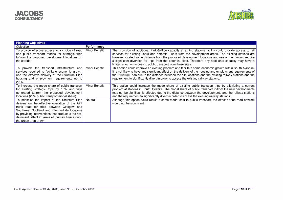
South Ayrshire Corridor Study STAG, Issue No. 2, December 2008 Page 118 of 195
���������������
Planning Objectives Objective Performance To provide effective access to a choice of road and public transport modes for strategic trips to/from the proposed development locations on the corridor.
Minor Benefit The provision of additional Park-&-Ride capacity at exiting stations facility could provide access to rail services for existing users and potential users from the development areas. The existing stations are however located some distance from the proposed development locations and use of them would require a significant diversion for trips from the potential sites. Therefore any additional capacity may have a limited effect on access to public transport from these sites.
To provide the transport infrastructure and services required to facilitate economic growth and the effective delivery of the Structure Plan housing and employment requirements up to 2025.
Minor Benefit This option could improve an existing problem and facilitate some economic growth within South Ayrshire. It is not likely to have any significant effect on the delivery of the housing and employment requirements of the Structure Plan due to the distance between the site locations and the existing railway stations and the requirement to significantly divert in order to access the existing railway stations.
To increase the mode share of public transport for existing strategic trips by 10% and trips generated to/from the proposed development locations (20% public transport modal share).
Minor Benefit This option could increase the mode share of existing public transport trips by alleviating a current problem at stations in South Ayrshire. The modal share of public transport to/from the new developments may not be significantly affected due to the distance between the developments and the railway stations and the requirement to significantly divert in order to access the existing railway stations.
To minimise the impact of the Structure Plan delivery on the effective operation of the A77 trunk road for trips between Glasgow and Southwest Scotland and intermediate locations by providing interventions that produce a ‘no net-detriment’ effect in terms of journey time around the urban area of Ayr.
Neutral Although this option could result in some modal shift to public transport, the effect on the road network would not be significant.
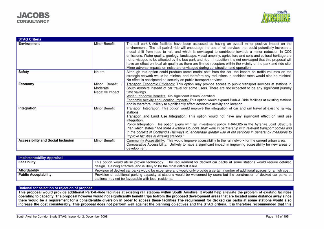
South Ayrshire Corridor Study STAG, Issue No. 2, December 2008 Page 119 of 195
���������������
STAG Criteria Environment Minor Benefit The rail park-&-ride facilities have been assessed as having an overall minor positive impact on the
environment. The rail park-&-ride will encourage the use of rail services that could potentially increase a modal shift from road to rail, and which is envisaged to contribute towards a minor reduction in CO2 emissions. Water quality, geology, landscape, visual amenity, agriculture and soils and cultural heritage are not envisaged to be affected by the bus park and ride. In addition it is not envisaged that this proposal will have an effect on local air quality as there are limited receptors within the vicinity of the park and ride site. Minor adverse impacts on noise are envisaged during construction and operation.
Safety Neutral Although this option could produce some modal shift from the car, the impact on traffic volumes on the strategic network would be minimal and therefore any reductions in accident rates would also be minimal. No effect is anticipated on security on public transport services.
Economy Minor Benefit / Moderate Negative Impact
Transport Economic Efficiency: This option may provide access to public transport services at stations in South Ayrshire instead of car travel for some users. There are not expected to be any significant journey time savings. Wider Economic Benefits: No significant issues identified. Economic Activity and Location Impacts: This option would expand Park-&-Ride facilities at existing stations and is therefore unlikely to significantly affect economic activity and location.
Integration Minor Benefit Transport Integration: This option would improve the integration of car and rail travel at existing railway stations. Transport and Land Use Integration: This option would not have any significant effect on land use integration. Policy Integration: This option aligns with rail investment policy TRANS2b in the Ayrshire Joint Structure Plan which states “The three Ayrshire Councils shall work in partnership with relevant transport bodies and in the context of Scotland’s Railways to: encourage greater use of rail services in general by measures to improve facilities at existing stations.”
Accessibility and Social Inclusion Minor Benefit Community Accessibility: This would improve accessibility to the rail network for the current urban area. Comparative Accessibility: Unlikely to have a significant impact in improving accessibility for new areas of development.
Implementability Appraisal Feasibility This option would utilise proven technology. The requirement for decked car packs at some stations would require detailed
design. Gaining effective land is likely to be the most difficult issue. Affordability Provision of decked car parks would be expensive and would only provide a certain number of additional spaces for a high cost. Public Acceptability Provision of additional parking capacity at stations would be welcomed by users but the construction of decked car parks at
stations may not be favourable with local residents.
Rational for selection or rejection of proposal This proposal would provide additional Park-&-Ride facilities at existing rail stations within South Ayrshire. It would help alleviate the problem of existing facilities operating to capacity. The proposal however would not significantly benefit trips to/from the proposed development areas that are located some distance away since there would be a requirement for a considerable diversion in order to access these facilities The requirement for decked car parks at some stations would also increase the cost considerably. This proposal does not perform well against the planning objectives and the STAG criteria. It is therefore recommended that this
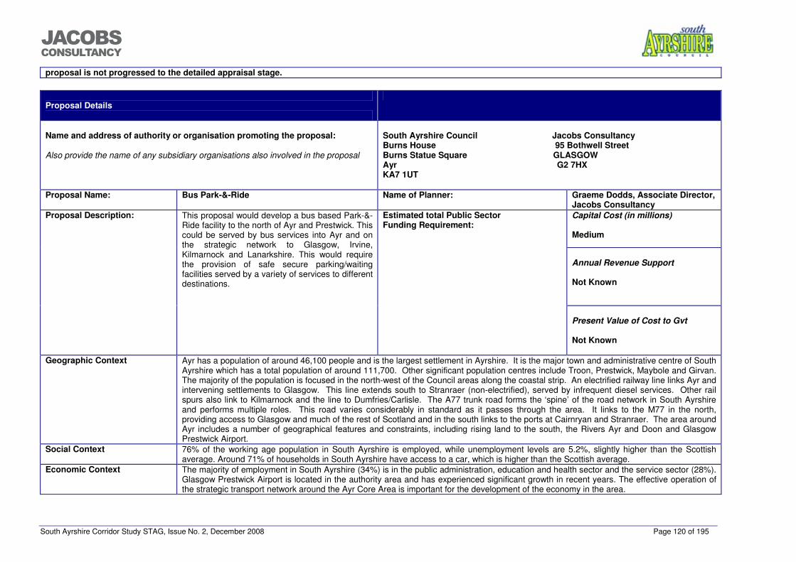
South Ayrshire Corridor Study STAG, Issue No. 2, December 2008 Page 120 of 195
���������������
proposal is not progressed to the detailed appraisal stage.
Proposal Details
Name and address of authority or organisation promoting the proposal:
Also provide the name of any subsidiary organisations also involved in the proposal
South Ayrshire Council Jacobs Consultancy Burns House 95 Bothwell Street Burns Statue Square GLASGOW Ayr G2 7HX KA7 1UT
Proposal Name: Bus Park-&-Ride Name of Planner: Graeme Dodds, Associate Director,
Jacobs Consultancy Capital Cost (in millions)
Medium
Annual Revenue Support
Not Known
Proposal Description: This proposal would develop a bus based Park-&-Ride facility to the north of Ayr and Prestwick. This could be served by bus services into Ayr and on the strategic network to Glasgow, Irvine, Kilmarnock and Lanarkshire. This would require the provision of safe secure parking/waiting facilities served by a variety of services to different destinations.
Estimated total Public Sector Funding Requirement:
Present Value of Cost to Gvt
Not Known
Geographic Context Ayr has a population of around 46,100 people and is the largest settlement in Ayrshire. It is the major town and administrative centre of South
Ayrshire which has a total population of around 111,700. Other significant population centres include Troon, Prestwick, Maybole and Girvan. The majority of the population is focused in the north-west of the Council areas along the coastal strip. An electrified railway line links Ayr and intervening settlements to Glasgow. This line extends south to Stranraer (non-electrified), served by infrequent diesel services. Other rail spurs also link to Kilmarnock and the line to Dumfries/Carlisle. The A77 trunk road forms the ‘spine’ of the road network in South Ayrshire and performs multiple roles. This road varies considerably in standard as it passes through the area. It links to the M77 in the north, providing access to Glasgow and much of the rest of Scotland and in the south links to the ports at Cairnryan and Stranraer. The area around Ayr includes a number of geographical features and constraints, including rising land to the south, the Rivers Ayr and Doon and Glasgow Prestwick Airport.
Social Context 76% of the working age population in South Ayrshire is employed, while unemployment levels are 5.2%, slightly higher than the Scottish average. Around 71% of households in South Ayrshire have access to a car, which is higher than the Scottish average.
Economic Context The majority of employment in South Ayrshire (34%) is in the public administration, education and health sector and the service sector (28%). Glasgow Prestwick Airport is located in the authority area and has experienced significant growth in recent years. The effective operation of the strategic transport network around the Ayr Core Area is important for the development of the economy in the area.
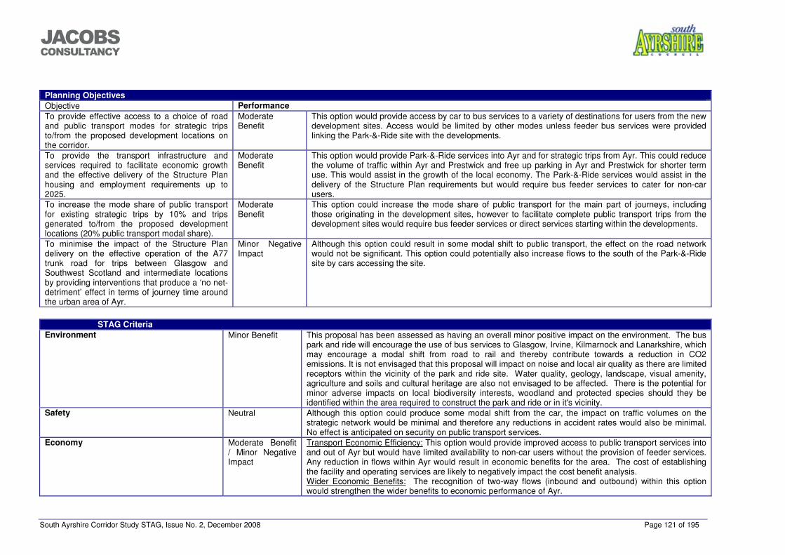
South Ayrshire Corridor Study STAG, Issue No. 2, December 2008 Page 121 of 195
���������������
Planning Objectives Objective Performance To provide effective access to a choice of road and public transport modes for strategic trips to/from the proposed development locations on the corridor.
Moderate Benefit
This option would provide access by car to bus services to a variety of destinations for users from the new development sites. Access would be limited by other modes unless feeder bus services were provided linking the Park-&-Ride site with the developments.
To provide the transport infrastructure and services required to facilitate economic growth and the effective delivery of the Structure Plan housing and employment requirements up to 2025.
Moderate Benefit
This option would provide Park-&-Ride services into Ayr and for strategic trips from Ayr. This could reduce the volume of traffic within Ayr and Prestwick and free up parking in Ayr and Prestwick for shorter term use. This would assist in the growth of the local economy. The Park-&-Ride services would assist in the delivery of the Structure Plan requirements but would require bus feeder services to cater for non-car users.
To increase the mode share of public transport for existing strategic trips by 10% and trips generated to/from the proposed development locations (20% public transport modal share).
Moderate Benefit
This option could increase the mode share of public transport for the main part of journeys, including those originating in the development sites, however to facilitate complete public transport trips from the development sites would require bus feeder services or direct services starting within the developments.
To minimise the impact of the Structure Plan delivery on the effective operation of the A77 trunk road for trips between Glasgow and Southwest Scotland and intermediate locations by providing interventions that produce a ‘no net-detriment’ effect in terms of journey time around the urban area of Ayr.
Minor Negative Impact
Although this option could result in some modal shift to public transport, the effect on the road network would not be significant. This option could potentially also increase flows to the south of the Park-&-Ride site by cars accessing the site.
STAG Criteria
Environment Minor Benefit This proposal has been assessed as having an overall minor positive impact on the environment. The bus park and ride will encourage the use of bus services to Glasgow, Irvine, Kilmarnock and Lanarkshire, which may encourage a modal shift from road to rail and thereby contribute towards a reduction in CO2 emissions. It is not envisaged that this proposal will impact on noise and local air quality as there are limited receptors within the vicinity of the park and ride site. Water quality, geology, landscape, visual amenity, agriculture and soils and cultural heritage are also not envisaged to be affected. There is the potential for minor adverse impacts on local biodiversity interests, woodland and protected species should they be identified within the area required to construct the park and ride or in it's vicinity.
Safety Neutral Although this option could produce some modal shift from the car, the impact on traffic volumes on the strategic network would be minimal and therefore any reductions in accident rates would also be minimal. No effect is anticipated on security on public transport services.
Economy Moderate Benefit / Minor Negative Impact
Transport Economic Efficiency: This option would provide improved access to public transport services into and out of Ayr but would have limited availability to non-car users without the provision of feeder services. Any reduction in flows within Ayr would result in economic benefits for the area. The cost of establishing the facility and operating services are likely to negatively impact the cost benefit analysis. Wider Economic Benefits: The recognition of two-way flows (inbound and outbound) within this option would strengthen the wider benefits to economic performance of Ayr.
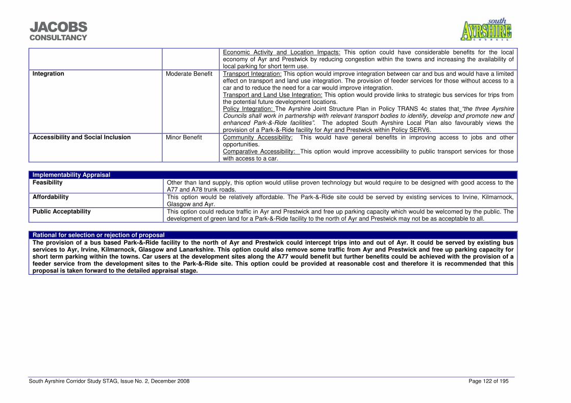
South Ayrshire Corridor Study STAG, Issue No. 2, December 2008 Page 122 of 195
���������������
Economic Activity and Location Impacts: This option could have considerable benefits for the local economy of Ayr and Prestwick by reducing congestion within the towns and increasing the availability of local parking for short term use.
Integration Moderate Benefit Transport Integration: This option would improve integration between car and bus and would have a limited effect on transport and land use integration. The provision of feeder services for those without access to a car and to reduce the need for a car would improve integration. Transport and Land Use Integration: This option would provide links to strategic bus services for trips from the potential future development locations. Policy Integration: The Ayrshire Joint Structure Plan in Policy TRANS 4c states that “the three Ayrshire Councils shall work in partnership with relevant transport bodies to identify, develop and promote new and enhanced Park-&-Ride facilities”. The adopted South Ayrshire Local Plan also favourably views the provision of a Park-&-Ride facility for Ayr and Prestwick within Policy SERV6.
Accessibility and Social Inclusion Minor Benefit Community Accessibility: This would have general benefits in improving access to jobs and other opportunities. Comparative Accessibility: This option would improve accessibility to public transport services for those with access to a car.
Implementability Appraisal Feasibility Other than land supply, this option would utilise proven technology but would require to be designed with good access to the
A77 and A78 trunk roads. Affordability This option would be relatively affordable. The Park-&-Ride site could be served by existing services to Irvine, Kilmarnock,
Glasgow and Ayr. Public Acceptability This option could reduce traffic in Ayr and Prestwick and free up parking capacity which would be welcomed by the public. The
development of green land for a Park-&-Ride facility to the north of Ayr and Prestwick may not be as acceptable to all.
Rational for selection or rejection of proposal The provision of a bus based Park-&-Ride facility to the north of Ayr and Prestwick could intercept trips into and out of Ayr. It could be served by existing bus services to Ayr, Irvine, Kilmarnock, Glasgow and Lanarkshire. This option could also remove some traffic from Ayr and Prestwick and free up parking capacity for short term parking within the towns. Car users at the development sites along the A77 would benefit but further benefits could be achieved with the provision of a feeder service from the development sites to the Park-&-Ride site. This option could be provided at reasonable cost and therefore it is recommended that this proposal is taken forward to the detailed appraisal stage.
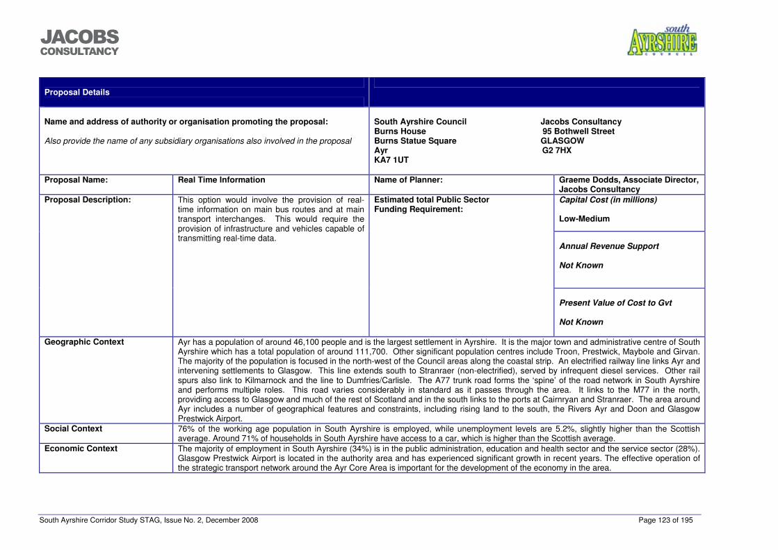
South Ayrshire Corridor Study STAG, Issue No. 2, December 2008 Page 123 of 195
���������������
Proposal Details
Name and address of authority or organisation promoting the proposal:
Also provide the name of any subsidiary organisations also involved in the proposal
South Ayrshire Council Jacobs Consultancy Burns House 95 Bothwell Street Burns Statue Square GLASGOW Ayr G2 7HX KA7 1UT
Proposal Name: Real Time Information Name of Planner: Graeme Dodds, Associate Director,
Jacobs Consultancy Capital Cost (in millions)
Low-Medium
Annual Revenue Support
Not Known
Proposal Description: This option would involve the provision of real-time information on main bus routes and at main transport interchanges. This would require the provision of infrastructure and vehicles capable of transmitting real-time data.
Estimated total Public Sector Funding Requirement:
Present Value of Cost to Gvt
Not Known
Geographic Context Ayr has a population of around 46,100 people and is the largest settlement in Ayrshire. It is the major town and administrative centre of South
Ayrshire which has a total population of around 111,700. Other significant population centres include Troon, Prestwick, Maybole and Girvan. The majority of the population is focused in the north-west of the Council areas along the coastal strip. An electrified railway line links Ayr and intervening settlements to Glasgow. This line extends south to Stranraer (non-electrified), served by infrequent diesel services. Other rail spurs also link to Kilmarnock and the line to Dumfries/Carlisle. The A77 trunk road forms the ‘spine’ of the road network in South Ayrshire and performs multiple roles. This road varies considerably in standard as it passes through the area. It links to the M77 in the north, providing access to Glasgow and much of the rest of Scotland and in the south links to the ports at Cairnryan and Stranraer. The area around Ayr includes a number of geographical features and constraints, including rising land to the south, the Rivers Ayr and Doon and Glasgow Prestwick Airport.
Social Context 76% of the working age population in South Ayrshire is employed, while unemployment levels are 5.2%, slightly higher than the Scottish average. Around 71% of households in South Ayrshire have access to a car, which is higher than the Scottish average.
Economic Context The majority of employment in South Ayrshire (34%) is in the public administration, education and health sector and the service sector (28%). Glasgow Prestwick Airport is located in the authority area and has experienced significant growth in recent years. The effective operation of the strategic transport network around the Ayr Core Area is important for the development of the economy in the area.
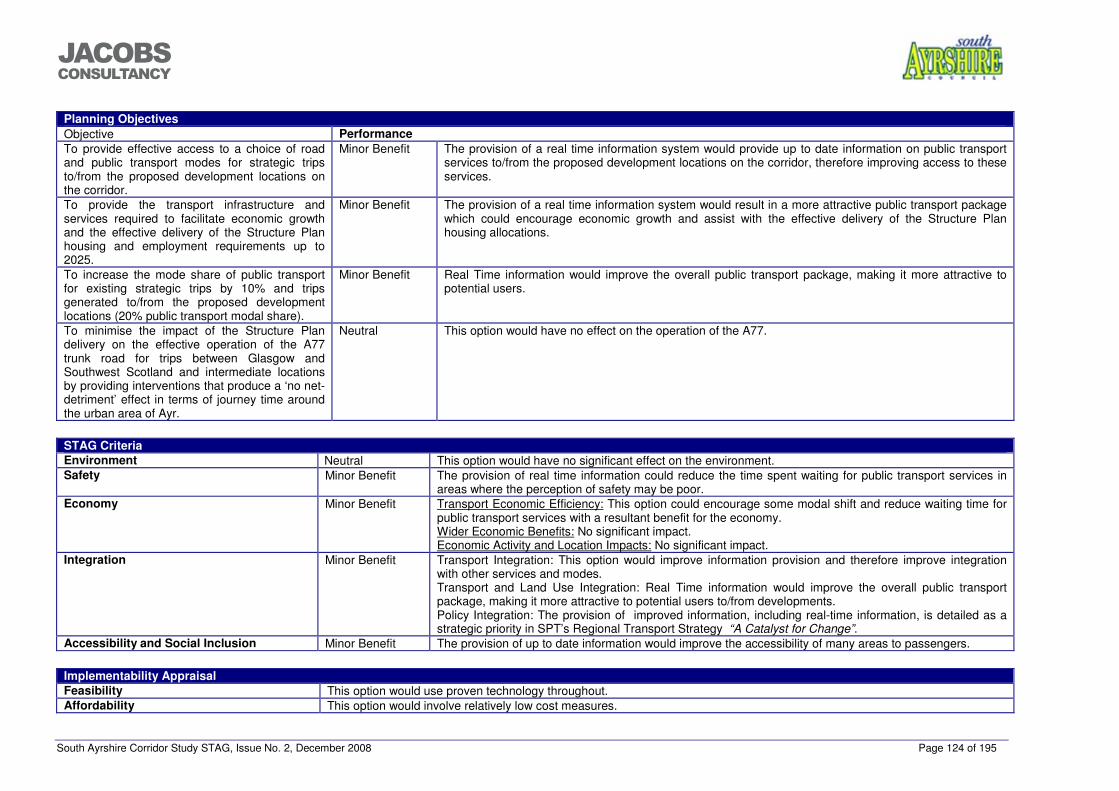
South Ayrshire Corridor Study STAG, Issue No. 2, December 2008 Page 124 of 195
���������������
Planning Objectives Objective Performance To provide effective access to a choice of road and public transport modes for strategic trips to/from the proposed development locations on the corridor.
Minor Benefit The provision of a real time information system would provide up to date information on public transport services to/from the proposed development locations on the corridor, therefore improving access to these services.
To provide the transport infrastructure and services required to facilitate economic growth and the effective delivery of the Structure Plan housing and employment requirements up to 2025.
Minor Benefit The provision of a real time information system would result in a more attractive public transport package which could encourage economic growth and assist with the effective delivery of the Structure Plan housing allocations.
To increase the mode share of public transport for existing strategic trips by 10% and trips generated to/from the proposed development locations (20% public transport modal share).
Minor Benefit Real Time information would improve the overall public transport package, making it more attractive to potential users.
To minimise the impact of the Structure Plan delivery on the effective operation of the A77 trunk road for trips between Glasgow and Southwest Scotland and intermediate locations by providing interventions that produce a ‘no net-detriment’ effect in terms of journey time around the urban area of Ayr.
Neutral This option would have no effect on the operation of the A77.
STAG Criteria Environment Neutral This option would have no significant effect on the environment. Safety Minor Benefit The provision of real time information could reduce the time spent waiting for public transport services in
areas where the perception of safety may be poor. Economy Minor Benefit Transport Economic Efficiency: This option could encourage some modal shift and reduce waiting time for
public transport services with a resultant benefit for the economy. Wider Economic Benefits: No significant impact. Economic Activity and Location Impacts: No significant impact.
Integration Minor Benefit Transport Integration: This option would improve information provision and therefore improve integration with other services and modes. Transport and Land Use Integration: Real Time information would improve the overall public transport package, making it more attractive to potential users to/from developments. Policy Integration: The provision of improved information, including real-time information, is detailed as a strategic priority in SPT’s Regional Transport Strategy “A Catalyst for Change”.
Accessibility and Social Inclusion Minor Benefit The provision of up to date information would improve the accessibility of many areas to passengers.
Implementability Appraisal Feasibility This option would use proven technology throughout. Affordability This option would involve relatively low cost measures.
South Ayrshire Corridor Study STAG, Issue No. 2, December 2008 Page 125 of 195
���������������
Public Acceptability This option is not in the public domain but positive public opinion would be anticipated.
Rational for selection or rejection of proposal As a stand-alone intervention, this option does not perform particularly well against the planning objectives or STAG criteria. This option could however, supplement other measures, to provide additional benefits, at a relatively low cost. It is therefore recommended that this option is taken forward to the detailed appraisal stage.

South Ayrshire Corridor Study STAG, Issue No. 2, December 2008 Page 126 of 195
���������������
Proposal Details
Name and address of authority or organisation promoting the proposal:
Also provide the name of any subsidiary organisations also involved in the proposal
South Ayrshire Council Jacobs Consultancy Burns House 95 Bothwell Street Burns Statue Square GLASGOW Ayr G2 7HX KA7 1UT
Proposal Name: Public Transport Safety and Security
Improvements Name of Planner: Graeme Dodds, Associate Director,
Jacobs Consultancy Capital Cost (in millions)
Low-Medium
Annual Revenue Support
Not Known
Proposal Description: This option would involve increased safety and security improvements on the public transport network including increased CCTV and lighting and improved staffing levels at main rail and bus stations.
Estimated total Public Sector Funding Requirement:
Present Value of Cost to Gvt
Not Known
Geographic Context Ayr has a population of around 46,100 people and is the largest settlement in Ayrshire. It is the major town and administrative centre of South
Ayrshire which has a total population of around 111,700. Other significant population centres include Troon, Prestwick, Maybole and Girvan. The majority of the population is focused in the north-west of the Council areas along the coastal strip. An electrified railway line links Ayr and intervening settlements to Glasgow. This line extends south to Stranraer (non-electrified), served by infrequent diesel services. Other rail spurs also link to Kilmarnock and the line to Dumfries/Carlisle. The A77 trunk road forms the ‘spine’ of the road network in South Ayrshire and performs multiple roles. This road varies considerably in standard as it passes through the area. It links to the M77 in the north, providing access to Glasgow and much of the rest of Scotland and in the south links to the ports at Cairnryan and Stranraer. The area around Ayr includes a number of geographical features and constraints, including rising land to the south, the Rivers Ayr and Doon and Glasgow Prestwick Airport.
Social Context 76% of the working age population in South Ayrshire is employed, while unemployment levels are 5.2%, slightly higher than the Scottish average. Around 71% of households in South Ayrshire have access to a car, which is higher than the Scottish average.
Economic Context The majority of employment in South Ayrshire (34%) is in the public administration, education and health sector and the service sector (28%). Glasgow Prestwick Airport is located in the authority area and has experienced significant growth in recent years. The effective operation of the strategic transport network around the Ayr Core Area is important for the development of the economy in the area.
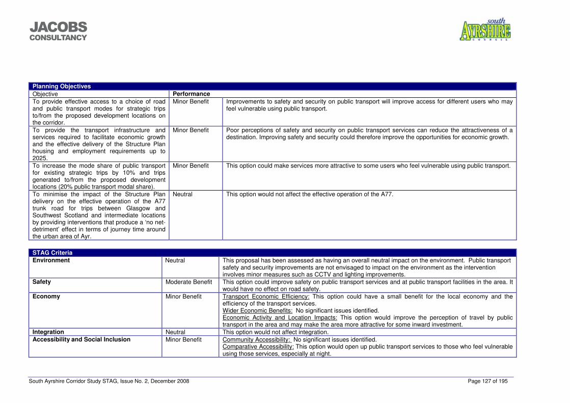
South Ayrshire Corridor Study STAG, Issue No. 2, December 2008 Page 127 of 195
���������������
Planning Objectives Objective Performance To provide effective access to a choice of road and public transport modes for strategic trips to/from the proposed development locations on the corridor.
Minor Benefit Improvements to safety and security on public transport will improve access for different users who may feel vulnerable using public transport.
To provide the transport infrastructure and services required to facilitate economic growth and the effective delivery of the Structure Plan housing and employment requirements up to 2025.
Minor Benefit Poor perceptions of safety and security on public transport services can reduce the attractiveness of a destination. Improving safety and security could therefore improve the opportunities for economic growth.
To increase the mode share of public transport for existing strategic trips by 10% and trips generated to/from the proposed development locations (20% public transport modal share).
Minor Benefit This option could make services more attractive to some users who feel vulnerable using public transport.
To minimise the impact of the Structure Plan delivery on the effective operation of the A77 trunk road for trips between Glasgow and Southwest Scotland and intermediate locations by providing interventions that produce a ‘no net-detriment’ effect in terms of journey time around the urban area of Ayr.
Neutral This option would not affect the effective operation of the A77.
STAG Criteria Environment Neutral This proposal has been assessed as having an overall neutral impact on the environment. Public transport
safety and security improvements are not envisaged to impact on the environment as the intervention involves minor measures such as CCTV and lighting improvements.
Safety Moderate Benefit This option could improve safety on public transport services and at public transport facilities in the area. It would have no effect on road safety.
Economy Minor Benefit Transport Economic Efficiency: This option could have a small benefit for the local economy and the efficiency of the transport services. Wider Economic Benefits: No significant issues identified. Economic Activity and Location Impacts: This option would improve the perception of travel by public transport in the area and may make the area more attractive for some inward investment.
Integration Neutral This option would not affect integration. Accessibility and Social Inclusion Minor Benefit Community Accessibility: No significant issues identified.
Comparative Accessibility: This option would open up public transport services to those who feel vulnerable using those services, especially at night.
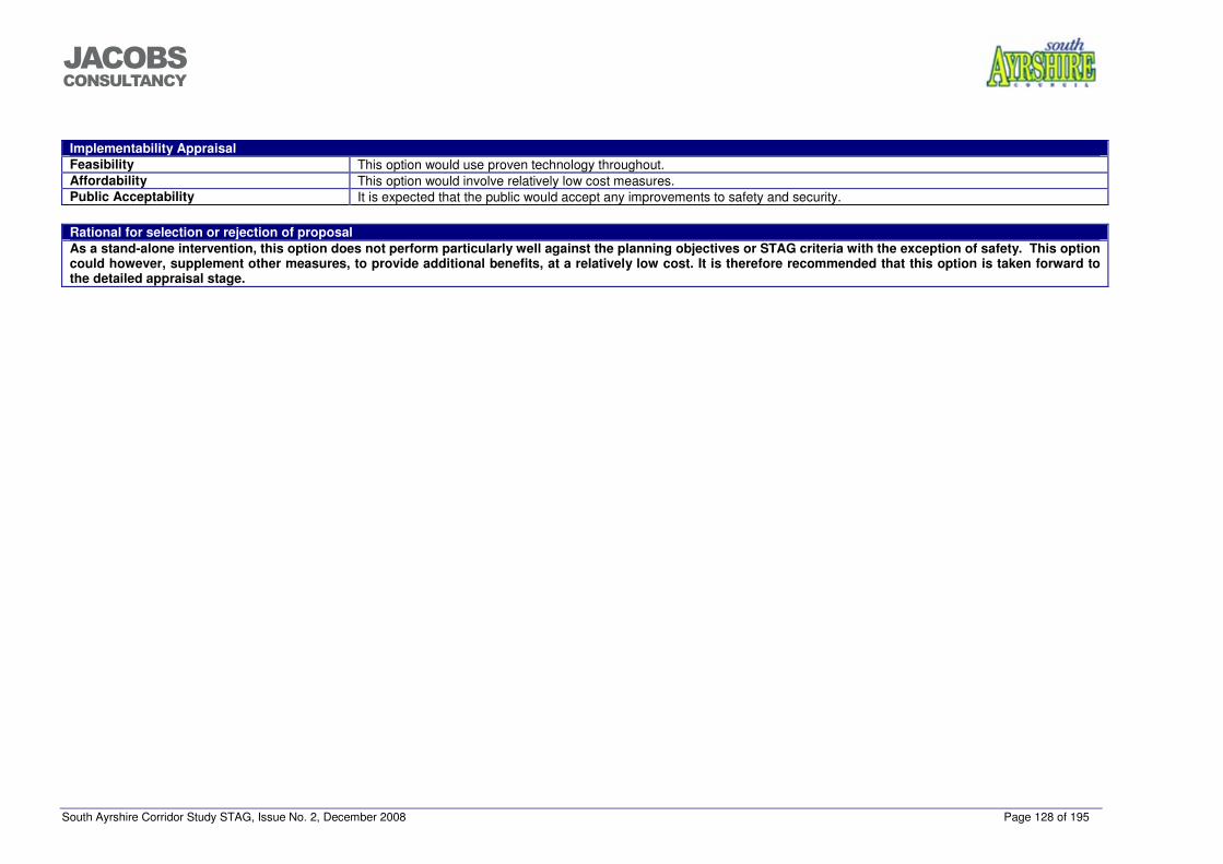
South Ayrshire Corridor Study STAG, Issue No. 2, December 2008 Page 128 of 195
���������������
Implementability Appraisal Feasibility This option would use proven technology throughout. Affordability This option would involve relatively low cost measures. Public Acceptability It is expected that the public would accept any improvements to safety and security.
Rational for selection or rejection of proposal As a stand-alone intervention, this option does not perform particularly well against the planning objectives or STAG criteria with the exception of safety. This option could however, supplement other measures, to provide additional benefits, at a relatively low cost. It is therefore recommended that this option is taken forward to the detailed appraisal stage.
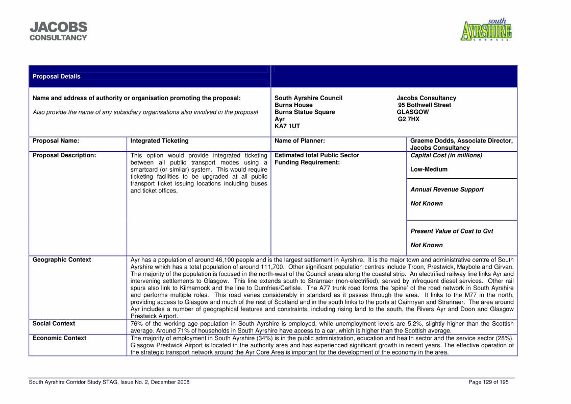
South Ayrshire Corridor Study STAG, Issue No. 2, December 2008 Page 129 of 195
���������������
Proposal Details
Name and address of authority or organisation promoting the proposal:
Also provide the name of any subsidiary organisations also involved in the proposal
South Ayrshire Council Jacobs Consultancy Burns House 95 Bothwell Street Burns Statue Square GLASGOW Ayr G2 7HX KA7 1UT
Proposal Name: Integrated Ticketing Name of Planner: Graeme Dodds, Associate Director,
Jacobs Consultancy Capital Cost (in millions)
Low-Medium
Annual Revenue Support
Not Known
Proposal Description: This option would provide integrated ticketing between all public transport modes using a smartcard (or similar) system. This would require ticketing facilities to be upgraded at all public transport ticket issuing locations including buses and ticket offices.
Estimated total Public Sector Funding Requirement:
Present Value of Cost to Gvt
Not Known
Geographic Context Ayr has a population of around 46,100 people and is the largest settlement in Ayrshire. It is the major town and administrative centre of South
Ayrshire which has a total population of around 111,700. Other significant population centres include Troon, Prestwick, Maybole and Girvan. The majority of the population is focused in the north-west of the Council areas along the coastal strip. An electrified railway line links Ayr and intervening settlements to Glasgow. This line extends south to Stranraer (non-electrified), served by infrequent diesel services. Other rail spurs also link to Kilmarnock and the line to Dumfries/Carlisle. The A77 trunk road forms the ‘spine’ of the road network in South Ayrshire and performs multiple roles. This road varies considerably in standard as it passes through the area. It links to the M77 in the north, providing access to Glasgow and much of the rest of Scotland and in the south links to the ports at Cairnryan and Stranraer. The area around Ayr includes a number of geographical features and constraints, including rising land to the south, the Rivers Ayr and Doon and Glasgow Prestwick Airport.
Social Context 76% of the working age population in South Ayrshire is employed, while unemployment levels are 5.2%, slightly higher than the Scottish average. Around 71% of households in South Ayrshire have access to a car, which is higher than the Scottish average.
Economic Context The majority of employment in South Ayrshire (34%) is in the public administration, education and health sector and the service sector (28%). Glasgow Prestwick Airport is located in the authority area and has experienced significant growth in recent years. The effective operation of the strategic transport network around the Ayr Core Area is important for the development of the economy in the area.
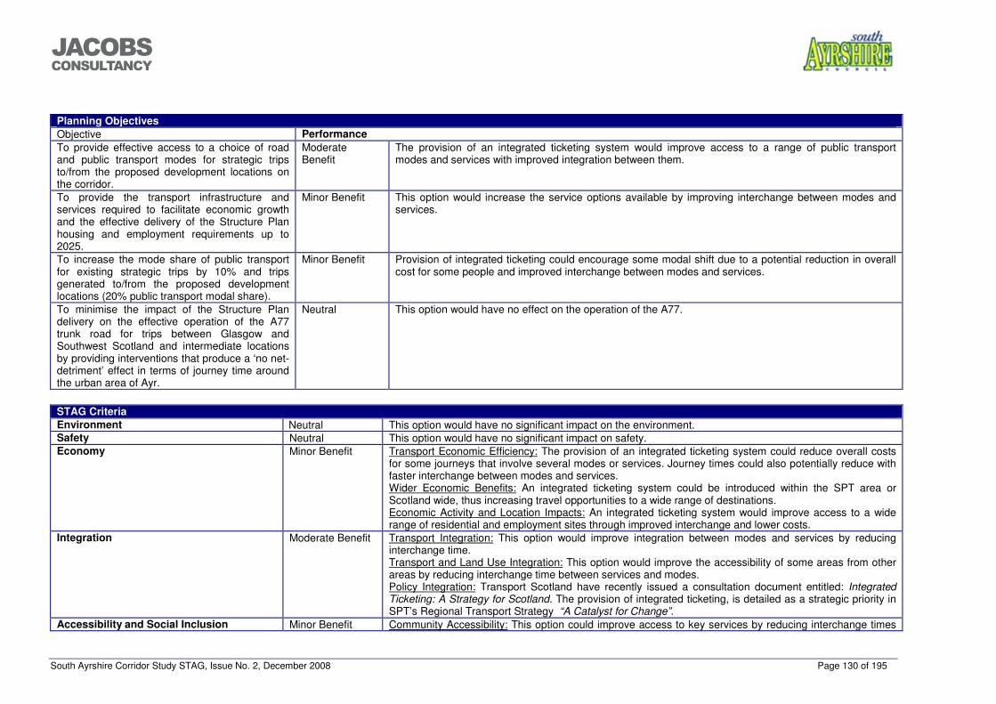
South Ayrshire Corridor Study STAG, Issue No. 2, December 2008 Page 130 of 195
���������������
Planning Objectives Objective Performance To provide effective access to a choice of road and public transport modes for strategic trips to/from the proposed development locations on the corridor.
Moderate Benefit
The provision of an integrated ticketing system would improve access to a range of public transport modes and services with improved integration between them.
To provide the transport infrastructure and services required to facilitate economic growth and the effective delivery of the Structure Plan housing and employment requirements up to 2025.
Minor Benefit This option would increase the service options available by improving interchange between modes and services.
To increase the mode share of public transport for existing strategic trips by 10% and trips generated to/from the proposed development locations (20% public transport modal share).
Minor Benefit Provision of integrated ticketing could encourage some modal shift due to a potential reduction in overall cost for some people and improved interchange between modes and services.
To minimise the impact of the Structure Plan delivery on the effective operation of the A77 trunk road for trips between Glasgow and Southwest Scotland and intermediate locations by providing interventions that produce a ‘no net-detriment’ effect in terms of journey time around the urban area of Ayr.
Neutral This option would have no effect on the operation of the A77.
STAG Criteria Environment Neutral This option would have no significant impact on the environment. Safety Neutral This option would have no significant impact on safety. Economy Minor Benefit Transport Economic Efficiency: The provision of an integrated ticketing system could reduce overall costs
for some journeys that involve several modes or services. Journey times could also potentially reduce with faster interchange between modes and services. Wider Economic Benefits: An integrated ticketing system could be introduced within the SPT area or Scotland wide, thus increasing travel opportunities to a wide range of destinations. Economic Activity and Location Impacts: An integrated ticketing system would improve access to a wide range of residential and employment sites through improved interchange and lower costs.
Integration Moderate Benefit Transport Integration: This option would improve integration between modes and services by reducing interchange time. Transport and Land Use Integration: This option would improve the accessibility of some areas from other areas by reducing interchange time between services and modes. Policy Integration: Transport Scotland have recently issued a consultation document entitled: Integrated Ticketing: A Strategy for Scotland. The provision of integrated ticketing, is detailed as a strategic priority in SPT’s Regional Transport Strategy “A Catalyst for Change”.
Accessibility and Social Inclusion Minor Benefit Community Accessibility: This option could improve access to key services by reducing interchange times
South Ayrshire Corridor Study STAG, Issue No. 2, December 2008 Page 131 of 195
���������������
and costs for using more than one service or mode. Comparative Accessibility: This option would generally benefit those people who require to use more than one mode or service to complete their journey.
Implementability Appraisal Feasibility This option would use proven technology throughout. It would be more effective if introduced at a local or national level. Affordability This option would involve relatively low cost measures. Public Acceptability This option is not in the public domain however, support from the public would be expected for it.
Rational for selection or rejection of proposal As a stand-alone intervention, this option does not perform particularly well against the planning objectives or STAG criteria with the exception of integration. This option could however, supplement other measures, to provide additional benefits, at a relatively low cost. This option would only really be effective if implemented at a regional or national level. It is therefore recommended that this option is taken forward to the detailed appraisal stage.
Proposal Details
Name and address of authority or organisation promoting the proposal:
South Ayrshire Council Jacobs Consultancy
South Ayrshire Corridor Study STAG, Issue No. 2, December 2008 Page 132 of 195
���������������
Also provide the name of any subsidiary organisations also involved in the proposal
Burns House 95 Bothwell Street Burns Statue Square GLASGOW Ayr G2 7HX KA7 1UT
Proposal Name: SMARTER choices travel planning / Real travel
plans / Joint Action Group. Name of Planner: Graeme Dodds, Associate Director,
Jacobs Consultancy Capital Cost (in millions)
Low
Annual Revenue Support
Not Known
Proposal Description: This option would involve influencing people’s travel behaviour towards more sustainable options for journeys to work, school and other trips. This would involve improving public transport and marketing services such as travel awareness campaigns, setting up websites for car share schemes, supporting car clubs and encouraging teleworking. This would be supported by the development of real travel plans for new developments and the support of a Joint Action Group with members from various community organizations.
Estimated total Public Sector Funding Requirement:
Present Value of Cost to Gvt
Not Known
Geographic Context Ayr has a population of around 46,100 people and is the largest settlement in Ayrshire. It is the major town and administrative centre of South
Ayrshire which has a total population of around 111,700. Other significant population centres include Troon, Prestwick, Maybole and Girvan. The majority of the population is focused in the north-west of the Council areas along the coastal strip. An electrified railway line links Ayr and intervening settlements to Glasgow. This line extends south to Stranraer (non-electrified), served by infrequent diesel services. Other rail spurs also link to Kilmarnock and the line to Dumfries/Carlisle. The A77 trunk road forms the ‘spine’ of the road network in South Ayrshire and performs multiple roles. This road varies considerably in standard as it passes through the area. It links to the M77 in the north, providing access to Glasgow and much of the rest of Scotland and in the south links to the ports at Cairnryan and Stranraer. The area around Ayr includes a number of geographical features and constraints, including rising land to the south, the Rivers Ayr and Doon and Glasgow Prestwick Airport.
Social Context 76% of the working age population in South Ayrshire is employed, while unemployment levels are 5.2%, slightly higher than the Scottish average. Around 71% of households in South Ayrshire have access to a car, which is higher than the Scottish average.
Economic Context The majority of employment in South Ayrshire (34%) is in the public administration, education and health sector and the service sector (28%). Glasgow Prestwick Airport is located in the authority area and has experienced significant growth in recent years. The effective operation of the strategic transport network around the Ayr Core Area is important for the development of the economy in the area.
Planning Objectives
South Ayrshire Corridor Study STAG, Issue No. 2, December 2008 Page 133 of 195
���������������
Objective Performance To provide effective access to a choice of road and public transport modes for strategic trips to/from the proposed development locations on the corridor.
Minor Benefit This option would provide information and encouragement to influence user choices with regard to mode choice. It would not however, provide access to any additional choice of modes and would rely on the provision of additional services.
To provide the transport infrastructure and services required to facilitate economic growth and the effective delivery of the Structure Plan housing and employment requirements up to 2025.
Minor Benefit This option would have minor implications for economic growth and the delivery of the Structure Plan but is however, unlikely to be effective without additional measures to deliver services.
To increase the mode share of public transport for existing strategic trips by 10% and trips generated to/from the proposed development locations (20% public transport modal share).
Minor Benefit This option would encourage users to consider all options for their journeys. It would not however provide physical alternatives for these journeys.
To minimise the impact of the Structure Plan delivery on the effective operation of the A77 trunk road for trips between Glasgow and Southwest Scotland and intermediate locations by providing interventions that produce a ‘no net-detriment’ effect in terms of journey time around the urban area of Ayr.
Neutral This option is not likely to have any significant effect on the operation of the A77 around the urban area of Ayr.
STAG Criteria Environment Minor Benefit This proposal has been assessed as having an overall minor positive impact on the environment. Travel
planning is envisaged to encourage a modal shift to public transport as well as encouraging car sharing
South Ayrshire Corridor Study STAG, Issue No. 2, December 2008 Page 134 of 195
���������������
with the potential to contribute towards a reduction in CO2 and other vehicle related emissions. Safety Neutral Although this option could produce some modal shift from the car, the impact on traffic volumes on the
strategic network would be minimal and therefore any reductions in accident rates would also be minimal. No effect is anticipated on security on public transport services.
Economy Neutral Transport Economic Efficiency: The effects of this option on TEE would be minimal and would be dependent on the provision of adequate services. Wider Economic Benefits: No significant issues identified. Economic Activity and Location Impacts: No Impact.
Integration Minor Benefit Transport Integration: The provision of information on the options available may have a slightly beneficial effect on transport integration. Transport and Land Use Integration: No Impact. Policy Integration: This option is supported by the South Ayrshire Adopted Local Plan Strategic Policy SERV5 which states “The Council will seek to ensure that land uses generating high density travel demands are supported by green transport plans”.
Accessibility and Social Inclusion Neutral No significant impact.
Implementability Appraisal Feasibility The majority of this intervention could be delivered within travel plans submitted as part of developments. The co-ordination of a
Joint Action Group would require co-operation and co-ordination of various organisations. Affordability This would be a relatively low cost intervention. Public Acceptability The provision of information to influence people travel behaviour is expected to be widely welcomed by the public.
Rational for selection or rejection of proposal Although this option may influence some travel behaviour and encourage some modal shift, it performs poorly against the planning objectives and the STAG criteria, especially with regards to strategic trips. It is therefore recommended that this option is not taken forward to detailed appraisal.
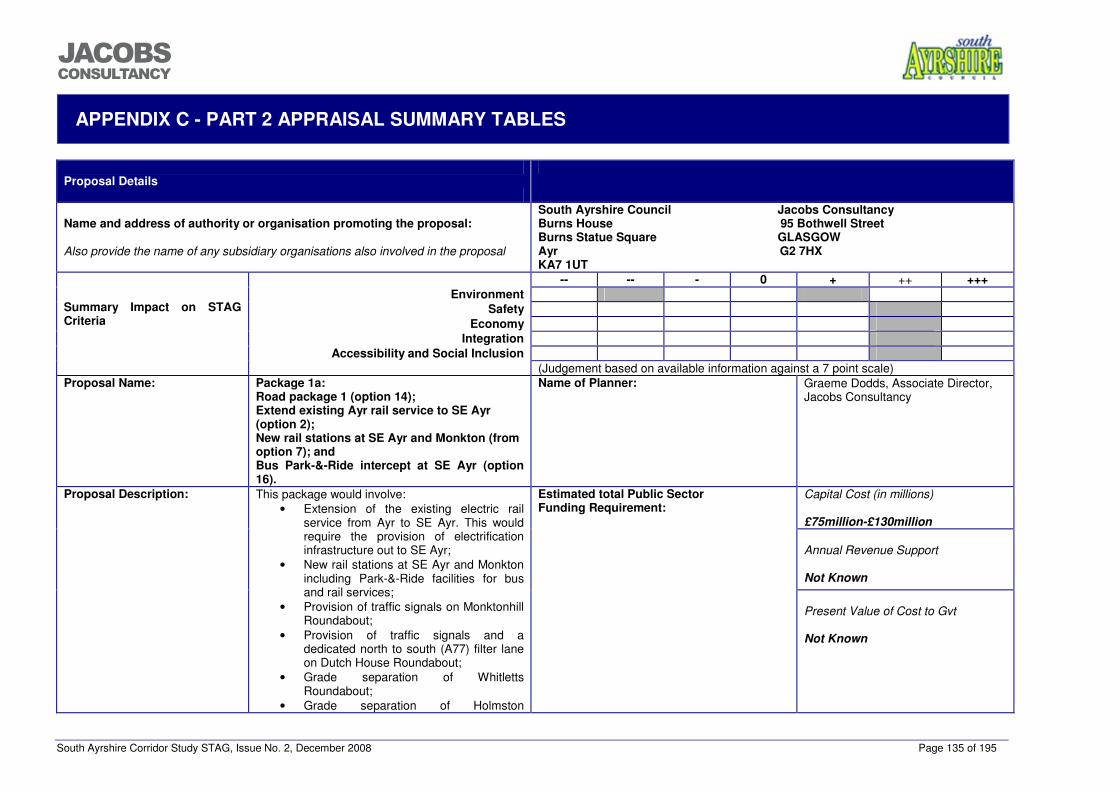
South Ayrshire Corridor Study STAG, Issue No. 2, December 2008 Page 135 of 195
���������������
APPENDIX C - PART 2 APPRAISAL SUMMARY TABLES
Proposal Details
Name and address of authority or organisation promoting the proposal:
Also provide the name of any subsidiary organisations also involved in the proposal
South Ayrshire Council Jacobs Consultancy Burns House 95 Bothwell Street Burns Statue Square GLASGOW Ayr G2 7HX KA7 1UT
-- -- - 0 + ++ +++ Environment
Safety Economy
Integration Accessibility and Social Inclusion
Summary Impact on STAG Criteria
(Judgement based on available information against a 7 point scale) Proposal Name: Package 1a:
Road package 1 (option 14); Extend existing Ayr rail service to SE Ayr (option 2); New rail stations at SE Ayr and Monkton (from option 7); and Bus Park-&-Ride intercept at SE Ayr (option 16).
Name of Planner: Graeme Dodds, Associate Director, Jacobs Consultancy
Capital Cost (in millions) £75million-£130million
Annual Revenue Support
Not Known
Proposal Description: This package would involve: • Extension of the existing electric rail
service from Ayr to SE Ayr. This would require the provision of electrification infrastructure out to SE Ayr;
• New rail stations at SE Ayr and Monkton including Park-&-Ride facilities for bus and rail services;
• Provision of traffic signals on Monktonhill Roundabout;
• Provision of traffic signals and a dedicated north to south (A77) filter lane on Dutch House Roundabout;
• Grade separation of Whitletts Roundabout;
• Grade separation of Holmston
Estimated total Public Sector Funding Requirement:
Present Value of Cost to Gvt
Not Known
South Ayrshire Corridor Study STAG, Issue No. 2, December 2008 Page 136 of 195
���������������
Roundabout; • Improvements to Bankfield Roundabout
including reconstruction, provision of signals and a dedicated north to east (A77 to A713) filter lane; and
• Upgrade the A77 carriageway between Whitletts Roundabout and the River Ayr crossing to dual carriageway with a three lane crossing of the River Ayr. This would require upgrading of the existing bridge deck, the provision of a separate footbridge and ITS for a third bi-directional lane.
Geographic Context Ayr has a population of around 46,000 people and is the largest settlement in Ayrshire. It is the major town and administrative centre of South Ayrshire which has a total population of around 112,000. Other significant population centres include Troon, Prestwick, Maybole and Girvan. The majority of the population is focused in the north-west of the Council areas along the coastal strip. An electrified railway line links Ayr and intervening settlements to Glasgow. This line extends south to Stranraer (non-electrified), served by infrequent diesel services. Other rail spurs also link to Kilmarnock and the line to Dumfries/Carlisle. The A77 trunk road forms the ‘spine’ of the road network in South Ayrshire and performs multiple roles. This road varies considerably in standard as it passes through the area. It links to the M77 in the north, providing access to Glasgow and much of the rest of Scotland and in the south links to the ports at Cairnryan and Stranraer. The area around Ayr includes a number of geographical features and constraints, including rising land to the south, the Rivers Ayr and Doon and Glasgow Prestwick Airport.
Social Context 76% of the working age population in South Ayrshire is employed, while unemployment levels are 5.2%, slightly higher than the Scottish average. Around 71% of households in South Ayrshire have access to a car, which is higher than the Scottish average but typical of settlements outwith the main cities.
Economic Context The majority of employment in South Ayrshire (34%) is in the public administration, education and health sector and the service sector (28%). Glasgow Prestwick Airport is located in the authority area and has experienced significant growth in recent years. The effective operation of the strategic transport network around the Ayr Core Area is critical to the development of the economy in the area and effective delivery of the Structure Plan requirements.
Summary - Rational for rejection The rail/Park-&-Ride proposals at SE Ayr would have significant benefits for the SE Ayr development and trips from the south and east which could be captured by the Park-&-Ride facility. Other potential future development locations would not however, be effectively served by the facilities and services at this location. In addition, although the extension of the electric service to SE Ayr would provide considerable benefits for public transport trips from SE Ayr and those using the Park-&-Ride facility, the significant capital cost of this element of the package would far outweigh any benefits received (BCR 0.4 from South East Ayr Rail Halt Outline Business Case). The provision of a rail halt with the existing rail services would be more feasible (BCR of 1.19 from South East Ayr Rail Halt Outline Business Case). The Park-&-Ride facility at Monkton would benefit existing trips by providing additional Park-&-Ride capacity for rail and bus trips, however it would have a limited effect on the potential future development locations. The road provisions within this package accommodate the potential future development in all land release scenarios. The three lane section over the River Ayr could however, constrain future growth on the strategic road network and would provide reduced safety benefits compared to the provision of a dual carriageway section over the River Ayr. Overall, this package would facilitate the delivery of the Structure Plan requirements in part but would not provide as significant benefits as other packages against the objectives. This package has therefore been rejected.
South Ayrshire Corridor Study STAG, Issue No. 2, December 2008 Page 137 of 195
���������������
Planning Objectives Objective Performance To provide effective access to a choice of road and public transport modes for strategic trips to/from the proposed development locations on the corridor
Moderate Benefit
This option could provide access to rail services for users to/from the SE Ayr development and locations to the south and east. The facilities at SE Ayr would not however provide effective access to potential developments located to the north of the SE Ayr site and within other settlements as this would require a considerable diversion to access services from this location. The provision of a Park-&-Ride facility for bus and rail services at Monkton could provide access to the rail network and strategic bus services from existing areas in Prestwick and Ayr and from other future development sites, access would however be limited for non-car users.
To provide the transport infrastructure and services required to facilitate economic growth and the effective delivery of the Structure Plan housing and employment requirements up to 2025.
Moderate Benefit
The extension of the Ayr to Glasgow electric service and the provision of station and Park-&-Ride facilities at SE Ayr could facilitate economic growth and the effective delivery of the Structure Plan requirements within the SE Ayr development and the surrounding area. The provision of a Park-&-Ride facility at Monkton giving access to Ayr-Glasgow rail services and strategic bus services could encourage economic growth in other areas including future development sites, however, the location of the Park-&-Ride facility and the reliance on a car to access it from most areas may limit the effect it has on the delivery of the housing growth requirements of the Structure Plan. Improvements to the strategic road network would however facilitate growth and additional trips associated with the Structure Plan requirements.
To increase the mode share of public transport for existing strategic trips by 10% and trips generated to/from the proposed development locations (20% public transport modal share)
Minor Benefit / Minor Negative Impact
The road elements of this package could have a negative impact on the mode share of public transport since it would provide a more attractive journey for car users, however it would also facilitate the effective provision of public transport services along the A77 to the future development sites. The Park-&-Ride facility and enhanced service to SE Ayr could increase the mode share of public transport trips for users in SE Ayr and locations to the south and east by providing a service from outwith Ayr town centre to Glasgow and intermediate stations. The provision of a Park-&-Ride facility at Monkton may encourage an increase in mode share for existing trips by providing additional Park-&-Ride capacity for Ayr and Prestwick but the mode share of public transport from the future development locations may be limited due to the requirement to access the station by car from the development and its relative distance from the corridor.
To minimise the impact of the Structure Plan delivery on the effective operation of the A77 trunk road for trips between Glasgow and Southwest Scotland and intermediate locations by providing interventions that produce a ‘no net-detriment’ effect in terms of journey time around the urban area of Ayr.
Moderate Benefit
This option would provide the interventions required to maintain the effective operation of the A77 trunk route, benefiting existing users and future potential users from the developments and maintaining the important links to South Ayrshire and beyond particularly between the central belt and the Loch Ryan ports of Cairnryan and Stranraer. The three lane section of carriageway over the River Ayr would however, restrict capacity for growth in the future.
Implementability Appraisal Technical The main engineering issues would involve altering the existing crossing of the River Ayr to accommodate three lanes, the
provision of a pedestrian bridge over the river and grade separation of Holmston and Whitletts Roundabouts. The provision of a three lane section of roadway over the River Ayr with the direction of travel on the third lane dependent on peak hour flows would require the use of technology and methods not used previously in Scotland. This intervention would require considerable signing and ITS for effective operation. The construction of new stations and provision of electrification on the rail network would be subject to assessment and approval by Network Rail and Her Majesty’s Railway Inspectorate (HMRI), however it is expected that this would be delivered through best practice.
South Ayrshire Corridor Study STAG, Issue No. 2, December 2008 Page 138 of 195
���������������
Operational The effective operation of the three lane section would require significant ITS infrastructure. Financial The total capital cost of this package would be £67million-£98million. Although this package has a high capital cost, it is
anticipated that there would be considerable developer contributions made available from the housing releases associated with the Structure Plan, including funding of the options that are located within the developments. The capital cost of electrification to SE Ayr is however, unlikely to be funded. This position may alter in the future if the relocation of Townhead Sidings is proposed.
Public The Park-&-Ride proposals at SE Ayr are part of a current planning application for the site. The extended electric service was also part of the Local Plan Inquiry and therefore is in the public domain. The potential Park-&-Ride site at Monkton and the road interventions have not been made public.
STAG Criteria Environment Minor Benefit /
Moderate Negative Impact
Noise and Vibration: Minor negative short and long term impact anticipated: short term relating to the construction noise and vibration impacting local residential properties, recreational facilities and biodiversity. Long term impact relating to the operational noise of the infrastructure impacting sensitive receptors (residential properties). Global Air Quality – CO2: Minor positive long term impact as improved public transport and accessibility will encourage greater use of these sustainable transport options resulting in an overall reduction in CO2 emissions. Local Air Quality – PM10 and NO2: Overall minor positive impact as the long term effects are positive for the environment. Park & Ride and New rail stations facilities will contribute towards reduction in vehicle emissions resulting in an overall improvement in the local air quality. Improved accessible infrastructure will ease congestion on the A77 and will also contribute to a lower CO2 emission. Water Quality, Drainage and Flood Defence: Potential major negative impact due to the short term impacts during construction of the railway stations. Major impacts may occur on the River Ayr’s water quality during the widening of the bridge crossing. There is a possibility that drainage from the stations may impact the two local burns. It should be noted that, according to SEPA flood map (2008), there is a 0.5% risk of river flooding at the site of the bridge and duelling of A77: a considerable area to the north of Holmston roundabout and to both the south and north of the proposed new bridge over river Ayr would be flooded in a one in 200 year flood event. Geology: Overall Neutral impact as no geological SSSI sites will be affected during/after the construction of project. Biodiversity: Potential moderate negative impact on Troon Golf Links and Foreshore biological SSSI due to habitat loss and pollution arising from the construction and operation phases of the duelling of the A77, the bridge widening process and grade separation. Negative long term effects also exist as the Park & Ride system has the potential to affect the local biodiversity habitats. Visual Amenity: Potential minor negative short and long term impact on visual amenity associated mainly with construction and operational phases of the duelling of the A77, bridge widening and presence of overhead electrified railway lines. However it is only expected to be a minor negative as the bridge already exists. Agriculture and Soils: Potential minor negative impact due to loss of Class 3 Agricultural Land from land-take caused by dualling of the A77; plus risk from potentially contaminated run off to grazing land from works during construction and operation. Plans for the bus P&R should be monitored to determine the accurate amount of Class 3 Agricultural Land required. Cultural Heritage: Potential minor negative impact on recorded sites of archaeological significance near
South Ayrshire Corridor Study STAG, Issue No. 2, December 2008 Page 139 of 195
���������������
Holmston Roundabout during construction and operational phases. Consultation triggers include: a site composed of a series of linear cropmark features (NS32SE); and the site of discovery of a Neolithic flanged axe head at former buildings associated with “Over Mills” (NS3621) (Pastmap, 2008). Landscape: Minor negative synergistic impact is anticipated on the landscape from this package of measures. Short term visual impact could arise from construction activities. There is potential for long term impact created by the widening of the bridge, which could have adverse effects on landscape to the east of the A77, but because the bridge structure is already in place, it is deemed to be a minor impact.
Safety Moderate Benefit Safety: Upgrading the route from Whitletts Roundabout to the River Ayr from single to dual carriageway could reduce the accident rate by over 30%, based on national rates for these road types. The three lane section over the River Ayr with the third lane being used by inbound traffic in the AM peak and outbound traffic in the PM peak would not produce the same level of safety benefits as the complete dual carriageway provision from Whitletts Roundabout to Holmston Roundabout. Grade separation of Whitletts Roundabout and Holmston Roundabout would reduce the conflict between vehicles and could reduce the accident rates. National statistics indicate that grade separation of this section of the trunk road network could reduce the accident rate by up to 40%. Improving access to rail services from SE Ayr and Monkton to Glasgow and intermediate stations would result in some modal shift from car to train that could contribute to reduction of vehicle trips on the network and fewer accidents, although this is only expected to produce a marginal benefit. Security: These proposals would not have any significant effect on public transport security however, the Park-&-Ride facilities would be constructed with a variety of security measures.
Economy Moderate Benefit Transport Economic Efficiency: The transport model predicts a minor change in the end to end corridor journey time and trips across the A77 on the A713. The model also predicts a reduction in journey times for trips across the A77 on the B743 and an increase in journey times for trips across the A77 on the A70. Access to the rail network at SE Ayr and Monkton could provide journey times to Glasgow and intermediate stations that are competitive with car journeys, especially in the future as greater levels of congestion both on the network around Ayr and towards Glasgow affect the reliability of car journey times. It would also extend the availability of the electric rail service to a wider area. The extended service could operate using existing layover time in Ayr and would not increase journey times for existing users. The high capital costs relative to the benefits for the extension of the electric service would be significant (BCR of 0.4 from South East Ayr Rail Halt Outline Business Case). Wider Economic Benefits: Providing no improvement on the network would result in a constraint on strategic trips including through trips between the Central belt and the Loch Ryan ports at Stranraer and Cairnryan. Economic Activity and Location Impacts: Provision of the road interventions would assist in the future development of areas beside the A77 and in smaller settlements accessed from the A77. The introduction of a rail halt and Park-&-Ride facility at SE Ayr providing access to rail services would increase the attractiveness of the residential and business developments within this site. Provision of a suitable package of measures is critical to the supporting and growing the economies of Ayr and South Ayrshire and encouraging investment and job creation. Without providing the required improvements, growth would be constrained resulting in undeliverable Structure Plan requirements.
Integration Moderate Benefit Transport Integration: This package would improve integration with other local and strategic bus services within Ayr for trips from SE Ayr and would improve integration between car trips and public transport, particularly at the Park-&-Ride sites. Transport and Land-use Integration: Provision of the road interventions in this package could provide the
South Ayrshire Corridor Study STAG, Issue No. 2, December 2008 Page 140 of 195
���������������
infrastructure to support the effective development of residential land release sites in the area. The proposals at SE Ayr provide rail access to the proposed residential, business and retail elements of the development. The proposals at Monkton would provide a Park-&-Ride facility with access to strategic rail and bus services accessible from the other potential future development sites. Policy Integration: This package supports the Ayrshire Joint Structure Plan policy TRANS3b which states “The three Ayrshire Councils shall work in partnership with relevant transport bodies to give priority to the study and if appropriate the promotion and development of improvements to the A77 between Kilmarnock and Stranraer”. This package could however have a negative effect on road traffic reduction policies. The adopted South Ayrshire Local Plan encourages the provision of a rail service to Ayr Hospital and SE Ayr within Policy SERV6. This package also aligns with land use policies in the Ayrshire Joint Structure Plan and is consistent with local, regional and national policies of siting developments close to available rail services.
Accessibility and Social Inclusion Moderate Benefit Community Accessibility: This package would improve accessibility to Ayr, Ailsa and Carrick Glen Hospitals and other areas to the east of the A77. The road interventions would mainly affect strategic trips on the A77 but will also have benefits for the local community in Ayr and for trips on routes crossing the A77 at Whitletts, Holmston and Bankfield Roundabouts. Comparative Accessibility: The road based interventions and Park-&-Ride provisions will be of greater benefit to those with access to a car.
South Ayrshire Corridor Study STAG, Issue No. 2, December 2008 Page 141 of 195
���������������
Proposal Details
Name and address of authority or organisation promoting the proposal:
Also provide the name of any subsidiary organisations also involved in the proposal
South Ayrshire Council Jacobs Consultancy Burns House 95 Bothwell Street Burns Statue Square GLASGOW Ayr G2 7HX KA7 1UT
-- -- - 0 + ++ +++ Environment
Safety Economy
Integration Accessibility and Social Inclusion
Summary Impact on STAG Criteria
(Judgement based on available information against a 7 point scale) Proposal Name: Package 2a:
Road package 2 (option 15); Extend existing Ayr rail service to SE Ayr (option 2); New rail stations at SE Ayr and Monkton (from option 7); and Bus Park-&-Ride intercept at SE Ayr (option 16).
Name of Planner: Graeme Dodds, Associate Director, Jacobs Consultancy
Capital Cost (in millions) £75million-£130million
Annual Revenue Support
Not Known
Proposal Description: This package is the same as Package 1a with the exception of dualling the A77 which extends from Whitletts Roundabout to Holmston Roundabout including the River Ayr crossing in this package.
Estimated total Public Sector Funding Requirement:
Present Value of Cost to Gvt
Not Known
Geographic Context Ayr has a population of around 46,000 people and is the largest settlement in Ayrshire. It is the major town and administrative centre of South Ayrshire which has a total population of around 112,000. Other significant population centres include Troon, Prestwick, Maybole and Girvan. The majority of the population is focused in the north-west of the Council areas along the coastal strip. An electrified railway line links Ayr and intervening settlements to Glasgow. This line extends south to Stranraer (non-electrified), served by infrequent diesel services. Other rail spurs also link to Kilmarnock and the line to Dumfries/Carlisle. The A77 trunk road forms the ‘spine’ of the road network in South Ayrshire and performs multiple roles. This road varies considerably in standard as it passes through the area. It links to the M77 in the north, providing access to Glasgow and much of the rest of Scotland and in the south links to the ports at Cairnryan and Stranraer. The area around Ayr includes a number of geographical features and constraints, including rising land to the south, the Rivers Ayr and Doon and Glasgow Prestwick Airport.
South Ayrshire Corridor Study STAG, Issue No. 2, December 2008 Page 142 of 195
���������������
Social Context 76% of the working age population in South Ayrshire is employed, while unemployment levels are 5.2%, slightly higher than the Scottish average. Around 71% of households in South Ayrshire have access to a car, which is higher than the Scottish average but typical of settlements outwith the main cities.
Economic Context The majority of employment in South Ayrshire (34%) is in the public administration, education and health sector and the service sector (28%). Glasgow Prestwick Airport is located in the authority area and has experienced significant growth in recent years. The effective operation of the strategic transport network around the Ayr Core Area is critical to the development of the economy in the area and effective delivery of the Stucture Plan requirements.
Summary - Rational for selection or rejection of proposal The benefits and issues with this package are similar to Package 1 but the package performs slightly better overall due to the removal of the constraint and safety issues with the three lane section of carriageway over the River Ayr. However, overall this package would also only facilitate the effective delivery of the Structure Plan requirements in part and has therefore been rejected.
Planning Objectives Objective Performance To provide effective access to a choice of road and public transport modes for strategic trips to/from the proposed development locations on the corridor
Moderate Benefit
This option would provide road access to the proposed development locations and provide the infrastructure for effective strategic public transport services to a portion of the development locations. This option could provide access to rail services for users to/from the SE Ayr development and locations to the south and east. The facilities at SE Ayr would not however provide effective access to potential developments located to the north of the SE Ayr site and within other settlements as this would require a considerable diversion to access services from this location. The provision of a Park-&-Ride facility for bus and rail services at Monkton could provide access to the rail network and strategic bus services from existing areas in Prestwick and Ayr and from other future development sites, access would however be limited for non-car users.
To provide the transport infrastructure and services required to facilitate economic growth and the effective delivery of the Structure Plan housing and employment requirements up to 2025.
Moderate Benefit
This option would provide improvements to the strategic road network to facilitate growth and a portion of the additional trips associated with the Structure Plan requirements. The extension of the Ayr to Glasgow electric service and the provision of station and Park-&-Ride facilities at SE Ayr could facilitate economic growth and the effective delivery of the Structure Plan requirements within the SE Ayr development and the surrounding area. The provision of a Park-&-Ride facility at Monkton giving access to Ayr to Glasgow rail services and strategic bus services could encourage economic growth in other areas including future development sites, however, the location of the Park-&-Ride facility and the reliance on a car to access it from most areas may limit the effect it has on the effective delivery of the Structure Plan requirements.
To increase the mode share of public transport for existing strategic trips by 10% and trips generated to/from the proposed development locations (20% public transport modal share)
Minor Benefit / Minor negative Impact
The road elements of this package could have a negative impact on the mode share of public transport since it would provide a more attractive journey for car users, however it would also facilitate the effective provision of public transport services along the A77 to the future development sites. The Park-&-Ride facility and enhanced service to SE Ayr could increase the mode share of public transport trips for users in SE Ayr and locations to the south and east by providing a service from outwith Ayr town centre to Glasgow and intermediate stations. The provision of a Park-&-Ride facility at Monkton may encourage an increase in mode share for existing trips by providing additional Park-&-Ride capacity for Ayr and Prestwick but the mode share of public transport from the future development locations may be limited due to the requirement to access the station by car from the development and its relative distance from the corridor.
South Ayrshire Corridor Study STAG, Issue No. 2, December 2008 Page 143 of 195
���������������
To minimise the impact of the Structure Plan delivery on the effective operation of the A77 trunk road for trips between Glasgow and Southwest Scotland and intermediate locations by providing interventions that produce a ‘no net-detriment’ effect in terms of journey time around the urban area of Ayr.
Major Benefit This option would provide the interventions required to maintain the effective operation of the A77 trunk route, benefiting existing users and future potential users from the developments and maintaining the important links to South Ayrshire and beyond particularly between the central belt and the Loch Ryan ports of Cairnryan and Stranraer.
Implementability Appraisal Technical The main engineering issues would involve the provision of a new crossing of the River Ayr to accommodate a dual carriageway
and grade separation of Holmston and Whitletts Roundabouts, however all interventions are expected to use proven methods and technologies. The construction of new stations and provision of electrification on the rail network would be subject to assessment and approval by network rail and Her Majesty’s Railway Inspectorate (HMRI), however it is expected that this would be delivered through best practice.
Operational There have been no significant operational issues identified in this package. Financial The total capital cost of this package would be £67million-£98million. Although this package has a high capital cost, it is
anticipated that there would be considerable developer contributions made available from the housing releases associated with the Structure Plan, including funding of the options that are located within the developments. The capital cost of electrification to SE Ayr is however, unlikely to be funded. This position may alter in the future if the relocation of Townhead Sidings is proposed.
Public The Park-&-Ride proposals at SE Ayr are part of a current planning application for the site. The extended electric service was also part of the Local Plan Inquiry and therefore is in the public domain. The potential Park-&-Ride site at Monkton and the road interventions have not been made public.
STAG Criteria Environment Minor Benefit /
Moderate Negative Impact
Noise and Vibration: Overall minor negative short and long term impacts anticipated. Short term relate to the construction process impacting upon local receptors namely residential properties and recreational facilities. Long term relate to the operational noise of the infrastructure impacting upon potential sensitive receptors (especially residential properties). Vibrations from the construction of proposed new bridge may affect salmon migration. Global Air Quality – CO2: Minor positive as the long term impacts will be beneficial to the environment and reduced congestion. Given effective marketing, the implementation of this package could result in significant modal shift from single occupancy car travel to greater utilisation of efficient and attractive public transport options. Improved public transport and accessibility will encourage greater use of these services resulting in an overall reduction in CO2 emissions. Local Air Quality – PM10 and NO2: Overall minor positive as the long term effects are positive for the environment. Park & Ride and new rail stations facilities will contribute towards reduction in vehicle emissions resulting in an overall improvement in the local air quality. Improved accessible infrastructure will ease congestion on the A77 and will also contribute to a lower CO2 emission.
Water Quality, Drainage and Flood Defence: Potential major negative impact of pollution of surface water bodies from silt / sediment erosion, run-off water and other pollutants resulting from construction of new bridge and railway stations, grade separation and poor attention to drainage, during construction and operation phases, on both short and long term basis. There is a possibility that (foul) drainage from the new
South Ayrshire Corridor Study STAG, Issue No. 2, December 2008 Page 144 of 195
���������������
stations may adversely impact the water quality in local burns. It should be noted that, according to SEPA flood map (2008), there is a 0.5% risk of river flooding at the site of construction: a considerable area to the north of Holmston roundabout and to the south and north of the proposed new bridge over river Ayr would be flooded in a one in 200 year flood event. Geology: Negligible / neutral impact due to absence of geological SSSIs in area. Biodiversity: Potential moderate negative impact on biodiversity due to habitat loss (SSSI) and pollution arising from the construction and operation phases of the duelling of the A77, the bridge construction process, grade separation and construction of the new rail station at Monkton. The short term effects have the propensity to adversely impact an SSSI due to habitat loss. Negative long term effects also exist as the Park & Ride system has the potential to affect the local biodiversity habitats. The development of a new bridge crossing has a possible long term impact of affecting the wildlife corridor near the River Ayr, examples include migrating fish - Salmon. Vibrations from the bridge construction may disrupt their reproduction cycle. Visual Amenity: Moderate negative as the long term impacts relate to visual impact created by the construction of a new bridge which is envisaged to have an adverse impact on the residential properties. Agriculture and Soils: Potential minor negative impact due to loss of Class 3 Agricultural Land from land take caused by dualling of the A77; and risk from contaminated run off to land from works during construction and operation. Plans for the bus P&R should be monitored to determine the accurate amount of Class 3 Agricultural Land required. Cultural Heritage: Potential minor negative impact on recorded sites of archaeological significance near Holmston Roundabout during construction and operational phases. Consultation triggers include: a site composed of a series of linear cropmark features (NS32SE); and the site of discovery of a Neolithic flanged axe head at former buildings associated with “Over Mills” (NS3621) (Pastmap, 2008). Landscape: Minor negative synergistic impact is anticipated on the landscape from this package of measures. Short term adverse visual impact could arise due to construction activities. Depending upon dimensions of new bridge, there could be a long term impact which could have adverse effects on landscape to the east of the A77. However, as the location of the new bridge structure already sites the existing bridge, and provided the new bridge is of similar dimensions to existing one, the landscape impact is deemed to be minor.
Safety Major Benefit Upgrading the route from Whitletts Roundabout to Holmston Roundabout from single to dual carriageway could reduce the accident rate by over 30%, based on national rates for these road types. Grade separation of Whitletts Roundabout and Holmston Roundabout would reduce the conflict between vehicles and could reduce the accident rates. National statistics indicate that grade separation of this section of the trunk road network could reduce the accident rate by up to 40%. Improving access to rail services from SE Ayr and Monkton to Glasgow and intermediate stations would result in some modal shift from car to train that could contribute to reduction of vehicle trips on the network and fewer accidents, although this is only expected to produce a marginal benefit. Security: These proposals would not have any significant effect on public transport security however, the Park-&-Ride facilities would be constructed with a variety of security measures.
Economy Moderate Benefit Transport Economic Efficiency: The transport model predicts a minor change in the end to end corridor journey time and trips across the A77 on the A713. The model also predicts a reduction in journey times for trips across the A77 on the B743 and an increase in journey times for trips across the A77 on the A70. Access to the rail network at SE Ayr and Monkton could provide journey times to Glasgow and intermediate stations that are competitive with car journeys, especially in the future as greater levels of congestion both
South Ayrshire Corridor Study STAG, Issue No. 2, December 2008 Page 145 of 195
���������������
on the network around Ayr and towards Glasgow affect the reliability of car journey times. It would also extend the availability of the electric rail service to a wider area. The extended service could operate using existing layover time in Ayr and would not increase journey times for existing users. The high capital costs relative to the benefits for the extension of the electric service would be significant (BCR of 0.4 from South East Ayr Rail Halt Outline Business Case). Wider Economic Benefits: Providing no improvement on the network would result in a constraint on strategic trips including through trips between the Central belt and the Loch Ryan ports at Stranraer and Cairnryan. Economic Activity and Location Impacts: Provision of the road interventions would assist in the future development of areas beside the A77 and in smaller settlements accessed from the A77. The introduction of a rail halt and Park-&-Ride facility at SE Ayr providing access to rail services would increase the attractiveness of the residential and business developments within this site. Provision of a suitable package of measures is critical to the supporting and growing the economies of Ayr and South Ayrshire and encouraging investment and job creation. Without providing the required improvements, growth would be constrained resulting in undeliverable Structure Plan requirements.
Integration Moderate Benefit Transport Integration: This package would improve integration with other local and strategic bus services within Ayr for trips from SE Ayr and would improve integration between car trips and public transport, particularly at the Park-&-Ride sites. Transport and Land-use Integration: Provision of the road interventions in this package could provide the infrastructure to support the effective development of residential land release sites in the area. The proposals at SE Ayr provide rail access to the proposed residential, business and retail elements of the development. The proposals at Monkton would provide a Park-&-Ride facility with access to strategic rail and bus services accessible from the other potential future development sites. Policy Integration: This package supports the Ayrshire Joint Structure Plan policy TRANS3b which states “The three Ayrshire Councils shall work in partnership with relevant transport bodies to give priority to the study and if appropriate the promotion and development of improvements to the A77 between Kilmarnock and Stranraer”. This package could however have a negative effect on road traffic reduction policies. The adopted South Ayrshire Local Plan encourages the provision of a rail service to Ayr Hospital and SE Ayr within Policy SERV6. This package also aligns with land use policies in the Ayrshire Joint Structure Plan and is consistent with local, regional and national policies of siting developments close to available rail services.
Accessibility and Social Inclusion Moderate Benefit Community Accessibility: This package would improve accessibility to Ayr, Ailsa and Carrick Glen Hospitals and other areas to the east of the A77. The road interventions would mainly affect strategic trips on the A77 but will also have benefits for the local community in Ayr and for trips on routes crossing the A77 at Whitletts, Holmston and Bankfield Roundabouts. Comparative Accessibility: The road based interventions and Park-&-Ride provisions will be of greater benefit to those with access to a car.
South Ayrshire Corridor Study STAG, Issue No. 2, December 2008 Page 146 of 195
���������������
Proposal Details
Name and address of authority or organisation promoting the proposal:
Also provide the name of any subsidiary organisations also involved in the proposal
South Ayrshire Council Jacobs Consultancy Burns House 95 Bothwell Street Burns Statue Square GLASGOW Ayr G2 7HX KA7 1UT
-- -- - 0 + ++ +++ Environment
Safety Economy
Integration Accessibility and Social Inclusion
Summary Impact on STAG Criteria
(Judgement based on available information against a 7 point scale) Proposal Name: Package 1b:
Road package 1 (option 14); Extend existing Ayr rail service to SE Ayr (option 2); New rail stations at SE Ayr and Monkton (from option 7); Bus Park-&-Ride intercept at SE Ayr (option 16); Bus Park-&-Ride near Dutch House Roundabout (option 18); High frequency bus service between Ayr and Irvine/Kilmarnock/Glasgow with some serving future developments (option 8/11); and Designed busway QBCs with bus shuttle services in new developments (option 10).
Name of Planner: Graeme Dodds, Associate Director, Jacobs Consultancy
Capital Cost (in millions) £75million-£135million
Annual Revenue Support
Not Known
Proposal Description: This package is the same as Package 1a with the addition of:
• High frequency bus service between Ayr and Irvine/Kilmarnock/Glasgow with some serving future developments;
• Bus based Park-&-Ride near Dutch House Roundabout; and
• Designed busway QBCs with bus shuttle services in new developments.
Estimated total Public Sector Funding Requirement:
Present Value of Cost to Gvt
Not Known
Geographic Context Ayr has a population of around 46,100 people and is the largest settlement in Ayrshire. It is the major town and administrative centre of South
South Ayrshire Corridor Study STAG, Issue No. 2, December 2008 Page 147 of 195
���������������
Ayrshire which has a total population of around 111,700. Other significant population centres include Troon, Prestwick, Maybole and Girvan. The majority of the population is focused in the north-west of the Council areas along the coastal strip. An electrified railway line links Ayr and intervening settlements to Glasgow. This line extends south to Stranraer (non-electrified), served by infrequent diesel services. Other rail spurs also link to Kilmarnock and the line to Dumfries/Carlisle. The A77 trunk road forms the ‘spine’ of the road network in South Ayrshire and performs multiple roles. This road varies considerably in standard as it passes through the area. It links to the M77 in the north, providing access to Glasgow and much of the rest of Scotland and in the south links to the ports at Cairnryan and Stranraer. The area around Ayr includes a number of geographical features and constraints, including rising land to the south, the Rivers Ayr and Doon and Glasgow Prestwick Airport.
Social Context 76% of the working age population in South Ayrshire is employed, while unemployment levels are 5.2%, slightly higher than the Scottish average. Around 71% of households in South Ayrshire have access to a car, which is higher than the Scottish average.
Economic Context The majority of employment in South Ayrshire (34%) is in the public administration, education and health sector and the service sector (28%). Glasgow Prestwick Airport is located in the authority area and has experienced significant growth in recent years. The effective operation of the strategic transport network around the Ayr Core Area is important for the development of the economy in the area.
Summary - Rational for selection or rejection of proposal The road provisions within this package accommodate the potential future development in all scenarios. The three lane section over the River Ayr could however, constrain future growth on the strategic road network and would provide reduced safety benefits compared to the provision of a dual carriageway section over the River Ayr. The rail/Park-&-Ride proposals at SE Ayr would have significant benefits for the SE Ayr development and trips from the south and east which could be captured by the Park-&-Ride facility. Other potential future development locations would not however, be effectively served by the facilities and services at this location. In addition, although the extension of the electric service to SE Ayr would provide considerable benefits for public transport trips from SE Ayr and those using the Park-&-Ride facility, the significant capital cost of this element of the package would far outweigh any benefits received (BCR 0.4 from South East Ayr Rail Halt Outline Business Case). The BCR for providing a rail halt at SE Ayr with the existing service levels is 1.19. The Park-&-Ride facilities at Monkton and near Dutch House Roundabout would benefit existing trips and trips from the potential future development locations, providing effective access to the strategic bus and rail network. The provision of peak hour strategic bus services penetrating the development sites and feeder bus services during off-peak periods would eliminate the need for a car to access the strategic public transport services. The direct bus services are however, not likely to be viable for a dispersed scenario of housing allocation. Overall, this package would facilitate the effect delivery of the Structure Plan requirements by providing effective access to road and public transport services from the potential future development sites. The three lane section on the A77 over the River Ayr does however, present considerable safety concerns with the potential for driver confusion.
Planning Objectives Objective Performance To provide effective access to a choice of road and public transport modes for strategic trips to/from the proposed development locations on the corridor
Major Benefit This package would provide effective access to a choice of road and public transport modes from the potential future development sites. The rail facilities at SE Ayr would serve the SE Ayr site and areas to the south and east, however would not have a significant impact on trips from other potential development locations. The provision of direct bus services which could penetrate the development sites using the QBC busway through the sites, and the provision of Park-&-Ride facilities at Monkton and near Dutch House Roundabout would provide effective access to strategic public transport services for most sites. The effectiveness of elements of this package would be dependent on the locations of the future developments. Direct bus services are unlikely to be viable for a dispersed development scenario or the contained scenario outwith the peak hours but Park-&-Ride facilities with feeder bus services would provide effective alternatives to access to the strategic public transport network for these locations/times.
To provide the transport infrastructure and services required to facilitate economic
Major Benefit This option would provide improvements to the strategic road and public transport network which would facilitate growth and facilitate additional trips associated with the Structure Plan requirements.
South Ayrshire Corridor Study STAG, Issue No. 2, December 2008 Page 148 of 195
���������������
growth and the effective delivery of the Structure Plan housing and employment requirements up to 2025.
The extension of the Ayr to Glasgow electric service and the provision of station and Park-&-Ride facilities at SE Ayr could facilitate economic growth and the effective delivery of the Structure Plan requirements within the SE Ayr development and the surrounding area. The provision of a Park-&-Ride facility at Monkton giving access to Ayr to Glasgow rail services and strategic bus services could encourage economic growth in other areas including future development sites, however, the location of the Park-&-Ride facility and the need for a car to access it from most areas may limit the effect it has. The provision of direct bus services to strategic locations and bus based Park-&-Ride connected to the developments by feeder services would encourage effective delivery of the Structure Plan.
To increase the mode share of public transport for existing strategic trips by 10% and trips generated to/from the proposed development locations (20% public transport modal share)
Major Benefit / Minor Negative Impact
The road elements of this package could have a negative impact on the mode share of public transport since it would provide a more attractive journey for car users. However, it would also facilitate the effective provision of public transport services along the A77 to the future development sites. The Park-&-Ride facility and enhanced service to SE Ayr could increase the mode share of public transport trips for users in SE Ayr and locations to the south and east by providing a service from outwith Ayr town centre to Glasgow and intermediate stations. The provision of a Park-&-Ride facility at Monkton may encourage an increase in mode share for existing trips by providing additional Park-&-Ride capacity for Ayr and Prestwick. The provision of direct bus services to strategic destinations and feeder bus services to the Park-&-Ride sites which effectively penetrate the developments using the busway could encourage a high public transport mode share from the developments. These services are only likely to affect the mode share of existing trips at the Park-&-Ride facilities.
To minimise the impact of the Structure Plan delivery on the effective operation of the A77 trunk road for trips between Glasgow and Southwest Scotland and intermediate locations by providing interventions that produce a ‘no net-detriment’ effect in terms of journey time around the urban area of Ayr.
Moderate Benefit
This option would provide the interventions required to maintain the effective operation of the A77 trunk route, benefiting existing users and future potential users from the developments and maintaining the important links to South Ayrshire and beyond, especially to the Loch Ryan ports. The three lane section of carriageway over the River Ayr may however, restrict capacity for growth in the future and may result in safety concerns from driver confusion.
Implementability Appraisal Technical The main engineering issues would involve altering the existing crossing of the River Ayr to accommodate three lanes, the
provision of a pedestrian bridge over the river and grade separation of Holmston and Whitletts Roundabouts. The provision of a three lane section of roadway over the River Ayr with the direction of travel on the third lane dependent on peak hour flows would require the use of technology and methods not used previously in Scotland. This intervention would require considerable signing and ITS for effective operation. The construction of new stations and provision of electrification on the rail network would be subject to assessment and approval by Network Rail and Her Majesty’s Railway Inspectorate (HMRI).
Operational The effective operation of the three lane section would require significant ITS infrastructure. Financial The total capital cost of this package would be £70million-£102million. Although this package has a high capital cost, it is
anticipated that there would be considerable developer contributions made available from the housing releases associated with the Structure Plan, including funding of the options that are located within the developments. The provision of feeder/direct bus services may require an annual operating subsidy however, the feasibility of the peak hour direct services would be increased with passengers uplifted at the Park-&-Ride facilities. The capital cost of electrification to SE Ayr is however, unlikely to be funded. This position may alter in the future if the relocation of Townhead Sidings is proposed.
Public The Park-&-Ride proposals at SE Ayr are part of a current planning application for the site. The extended electric service was also part of the Local Plan Inquiry and therefore is in the public domain. The potential Park-&-Ride site at Monkton and the other
South Ayrshire Corridor Study STAG, Issue No. 2, December 2008 Page 149 of 195
���������������
bus and road interventions have not been made public.
STAG Criteria Environment Moderate Benefit
/ Moderate Negative Impact
Noise and Vibration: Minor negative short and long term impact anticipated: short term relating to the construction noise and vibrations impacting local residential properties, recreational facilities and biodiversity. Long term impact relating to the operational noise of the infrastructure impacting sensitive receptors (residential properties). Global Air Quality – CO2: Long term moderate positive synergistic impact - this package of measures provides and improves upon new and existing sustainable transport infrastructure in the area. Given effective marketing, the implementation of this package could result in significant modal shift from single occupancy car travel to greater utilisation of efficient and attractive public transport options. This will result in reduced single occupancy car travel with reduced congestion and associated CO2 emissions. Local Air Quality – PM10 and NO2: Long term major positive synergistic impact - this package of measures provides and improves upon new and existing sustainable transport infrastructure in the area. Given effective marketing, the implementation of this package could result in significant modal shift from single occupancy car travel to greater utilisation of efficient and attractive public transport options. This will result in reduced single occupancy car travel with reduced congestion and associated emissions that would otherwise adversely affect local air quality. Water Quality, Drainage and Flood Defence: Potential major negative impact of pollution of surface water bodies from silt / sediment erosion, run-off water and other pollutants resulting from bridge widening process, grade separation and poor attention to drainage during construction and operation phases, on both short and long term basis. It should be noted that, according to SEPA flood map (2008), there is a 0.5% risk of river flooding at the site of the bridge and duelling of A77: a considerable area to the north of Holmston roundabout and to both the south and north of the proposed new bridge over river Ayr would be flooded in a one in 200 year flood event. Geology: Negligible / neutral impact due to absence of geological SSSIs in area. Biodiversity: Potential moderate negative impact on biodiversity resulting primarily from habitat loss and pollution arising from the construction and operation phases of the duelling of the A77, the bridge widening process, grade separation and construction of the new rail station at Monkton. Visual Amenity: Potential minor negative short and long term impact on visual amenity associated mainly with construction and operational phases of the duelling of the A77, bridge widening and presence of overhead electrified railway lines. However, impact anticipated to be minor negative as the bridge already exists. Agriculture and Soils: Potential minor negative impact due to loss of Class 3 Agricultural Land from land take caused by dualling of the A77; and risk from contaminated run off to land from works during construction and operation. Plans for the bus P&R should be monitored to determine the amount of Class 3 Agricultural Land required. Cultural Heritage: Potential minor negative impact on recorded sites of archaeological significance near Holmston Roundabout during construction and operational phases. Consultation triggers include: a site composed of a series of linear cropmark features (NS32SE); and the site of discovery of a Neolithic flanged axe head at former buildings associated with “Over Mills” (NS3621) (Pastmap, 2008). Landscape: Minor negative synergistic impact is anticipated on the landscape from this package of measures. Short term visual impact could arise from construction activities. There is potential for long term
South Ayrshire Corridor Study STAG, Issue No. 2, December 2008 Page 150 of 195
���������������
impact created by the widening of the bridge, which could have adverse effects on landscape to the east of the A77, but because the bridge structure is already in place, it is deemed to be a minor impact.
Safety Moderate Benefit Safety: There is a need to drive down accident and severity levels. The existing route on the A77 between Whitletts Roundabout and Holmston Roundabout is mainly rural typical single carriageway. Upgrading this route from single to dual carriageway to the River Ayr crossing could reduce the accident rate by over 30%, based on national rates for these road types. The three lane section over the River Ayr with the third lane being used by inbound traffic in the AM peak and outbound traffic in the PM peak would not produce the same level of safety benefits as the complete dual carriageway provision from Whitletts Roundabout to Holmston Roundabout. Accident severity is expected to increase with higher speeds on the proposed dual carriageway section but overall safety improvements are expected. Grade separation of Whitletts Roundabout and Holmston Roundabout would reduce the conflict between vehicles and could reduce the accident rates as a result. National statistics indicate that grade separation of this section of the trunk road network could reduce the accident rate by approximately 40%. Improving access to rail services from SE Ayr and Monkton to Glasgow and intermediate stations and providing access to strategic bus services would result in some modal shift from car to bus/train that could contribute to reduction of vehicle trips on the network and fewer accidents, although this is only expected to produce a minor benefit. Security: These proposals would not have any significant effect on public transport security however, the Park-&-Ride facilities would be constructed with a variety of security measures.
Economy Moderate Benefit Transport Economic Efficiency: The transport model predicts a minor change in the end to end corridor journey time and trips across the A77 on the A713. The model also predicts a reduction in journey times for trips across the A77 on the B743 and an increase in journey times for trips across the A77 on the A70. Access to the rail network at SE Ayr and Monkton could provide journey times to Glasgow and intermediate stations that are competitive with car journeys, especially in the future as greater levels of congestion both on the network around Ayr and towards Glasgow affect the reliability of car journey times. It would also extend the availability of the electric rail service to a wider area. The extended service could operate using existing layover time in Ayr and would not increase journey times for existing users however, the high capital costs relative to the benefits for the extension of the electric service would be significant. The direct bus services would provide a journey time saving between SE Ayr and Glasgow of around 25 minutes in comparison to an existing journey from Ayr Hospital to Glasgow which requires interchange in Ayr. Similar journey time savings would be achieved for trips on direct bus services to Irvine and Kilmarnock. Outwith peak hours, use of a bus shuttle service with interchange onto the strategic bus/rail network at the Park-&-Ride sites would still achieve journey time savings of around 15 minutes. Wider Economic Benefits: The development of the A77 would provide some benefit to the Loch Ryan ports at Stranraer and Cairnryan. Economic Activity and Location Impacts: Provision of the road interventions would assist in the future development of areas beside the A77. The introduction of railway stations, Park-&-Ride facilities and access to strategic bus services would increase the attractiveness of the residential and business developments within SE Ayr and the potential future development locations, however the rail facilities at SE Ayr would only significantly benefit the SE Ayr site and areas to the south and east.
Integration Moderate Benefit Transport Integration: This package will improve integration with local and strategic bus services within Ayr for trips from SE Ayr and will improve integration between car/feeder bus trips and strategic bus and rail services at the Park-&-Ride sites. Transport and Land-use Integration: Provision of the road interventions in this package could provide
South Ayrshire Corridor Study STAG, Issue No. 2, December 2008 Page 151 of 195
���������������
infrastructure to support the effective development of residential land release sites in the area. The proposals at SE Ayr provide rail access to the proposed residential, business and retail elements of the development. The proposals at Monkton and near Dutch House Roundabout would provide a Park-&-Ride facility with access to strategic rail and bus services accessible from the other potential future development sites via car or feeder bus services. Peak hour direct bus services to strategic destinations would also benefit land use. Policy Integration: This option is in line with the Ayrshire Joint Structure Plan policy TRANS3b which states “The three Ayrshire Councils shall work in partnership with relevant transport bodies to give priority to the study and if appropriate the promotion and development of improvements to the A77 between Kilmarnock and Stranraer.” This option could however have a negative effect on road traffic reduction policies. The adopted South Ayrshire Local Plan encourages the provision of a rail service to Ayr Hospital and SE Ayr within Policy SERV6. This package also aligns with land use policies in the Ayrshire Joint Structure Plan and is consistent with local, regional and national policies of siting developments close to available rail services.
Accessibility and Social Inclusion Moderate Benefit Community Accessibility: This package would improve accessibility to Ayr, Ailsa and Carrick Glen Hospitals and other areas to the east of the A77. The road interventions would mainly affect strategic trips on the A77 but will also have benefits for the local community in Ayr and for trips on routes crossing the A77 at Whitletts, Holmston and Bankfield Roundabouts. Comparative Accessibility: The road based interventions and Park-&-Ride provisions will be of greater benefit to those with access to a car.
South Ayrshire Corridor Study STAG, Issue No. 2, December 2008 Page 152 of 195
���������������
Proposal Details
Name and address of authority or organisation promoting the proposal:
Also provide the name of any subsidiary organisations also involved in the proposal
South Ayrshire Council Jacobs Consultancy Burns House 95 Bothwell Street Burns Statue Square GLASGOW Ayr G2 7HX KA7 1UT
-- -- - 0 + ++ +++ Environment
Safety Economy
Integration Accessibility and Social Inclusion
Summary Impact on STAG Criteria
(Judgement based on available information against a 7 point scale) Proposal Name: Package 2b:
Road package 2 (option 15); Extend existing Ayr rail service to SE Ayr (option 2); New rail stations at SE Ayr and Monkton (from option 7); Bus Park-&-Ride intercept at SE Ayr (option 16); Bus Park-&-Ride near Dutch House Roundabout (option 18); High frequency bus service between Ayr and Irvine/Kilmarnock/Glasgow with some serving future developments (option 8/11); and Designed busway QBCs with bus shuttle services in new developments (option 10).
Name of Planner: Graeme Dodds, Associate Director, Jacobs Consultancy
Capital Cost (in millions) £75million-£135million
Annual Revenue Support
Not Known
Proposal Description: This package is the same as Package 2a with the addition of:
• High frequency bus service between Ayr and Irvine/Kilmarnock/Glasgow with some serving future developments;
• Bus based Park-&-Ride near Dutch House Roundabout; and
• Designed busway QBCs with bus shuttle services in new developments.
Estimated total Public Sector Funding Requirement:
Present Value of Cost to Gvt
Not Known
Geographic Context Ayr has a population of around 46,100 people and is the largest settlement in Ayrshire. It is the major town and administrative centre of South Ayrshire which has a total population of around 111,700. Other significant population centres include Troon, Prestwick, Maybole and Girvan.
South Ayrshire Corridor Study STAG, Issue No. 2, December 2008 Page 153 of 195
���������������
The majority of the population is focused in the north-west of the Council areas along the coastal strip. An electrified railway line links Ayr and intervening settlements to Glasgow. This line extends south to Stranraer (non-electrified), served by infrequent diesel services. Other rail spurs also link to Kilmarnock and the line to Dumfries/Carlisle. The A77 trunk road forms the ‘spine’ of the road network in South Ayrshire and performs multiple roles. This road varies considerably in standard as it passes through the area. It links to the M77 in the north, providing access to Glasgow and much of the rest of Scotland and in the south links to the ports at Cairnryan and Stranraer. The area around Ayr includes a number of geographical features and constraints, including rising land to the south, the Rivers Ayr and Doon and Glasgow Prestwick Airport.
Social Context 76% of the working age population in South Ayrshire is employed, while unemployment levels are 5.2%, slightly higher than the Scottish average. Around 71% of households in South Ayrshire have access to a car, which is higher than the Scottish average.
Economic Context The majority of employment in South Ayrshire (34%) is in the public administration, education and health sector and the service sector (28%). Glasgow Prestwick Airport is located in the authority area and has experienced significant growth in recent years. The effective operation of the strategic transport network around the Ayr Core Area is important for the development of the economy in the area.
Summary - Rational for selection or rejection of proposal The road provisions within this package accommodate the potential future development in all scenarios. The rail/Park-&-Ride proposals at SE Ayr would have significant benefits for the SE Ayr development and trips from the south and east which could be captured by the Park-&-Ride facility. Other potential future development locations would not however, be effectively served by the facilities and services at this location. In addition, although the extension of the electric service to SE Ayr would provide considerable benefits for public transport trips from SE Ayr and those using the Park-&-Ride facility, the significant capital cost of this element of the package would far outweigh any benefits received (BCR 0.4 from South East Ayr Rail Halt Outline Business Case). The BCR for providing a rail halt at SE Ayr with the existing service levels is 1.19. The Park-&-Ride facilities at Monkton and near Dutch House Roundabout would benefit existing trips and trips from the potential future development locations, providing effective access to the strategic bus and rail network. The provision of peak hour strategic bus services penetrating the development sites and feeder bus services during off-peak periods would eliminate the need for a car to access the strategic public transport services. Overall, this package would facilitate the effect delivery of the Structure Plan requirements by providing effective access to road and public transport services from the potential future development sites. The direct bus services are however, not likely to be viable for a dispersed scenario of housing allocation.
Planning Objectives Objective Performance To provide effective access to a choice of road and public transport modes for strategic trips to/from the proposed development locations on the corridor
Major Benefit This package would provide effective access to a choice of road and public transport modes from the potential future development sites. The rail facilities at SE Ayr would serve the SE Ayr site and areas to the south and east, however would not have a significant impact on trips from other potential development locations. The provision of feeder bus services to the strategic transport network which could penetrate the development sites using the QBC busway through the sites and the provision of Park-&-Ride facilities at Monkton and near Dutch House Roundabout would provide effective access to strategic public transport services for most sites.
To provide the transport infrastructure and services required to facilitate economic growth and the effective delivery of the Structure Plan housing and employment requirements up to 2025.
Major Benefit This option would provide improvements to the strategic road and public transport network which would facilitate growth and facilitate additional trips associated with the Structure Plan requirements. The extension of the Ayr to Glasgow electric service and the provision of station and Park-&-Ride facilities at SE Ayr could facilitate economic growth and the effective delivery of the Structure Plan requirements within the SE Ayr development and the surrounding area. The provision of Park-&-Ride facilities at Monkton and North Ayr/Prestwick giving access to strategic bus/rail rail services could encourage economic growth in other areas including future development sites. The developments would also be served by peak hour direct bus services to strategic destinations.
To increase the mode share of public Major Benefit / The road elements of this package could have a negative impact on the mode share of public transport
South Ayrshire Corridor Study STAG, Issue No. 2, December 2008 Page 154 of 195
���������������
transport for existing strategic trips by 10% and trips generated to/from the proposed development locations (20% public transport modal share)
Minor Negative Impact
since it would provide a more attractive journey for car users. However, it would also facilitate the effective provision of public transport services along the A77 to the future development sites. The Park-&-Ride facility and enhanced service to SE Ayr could increase the mode share of public transport trips for users in SE Ayr and locations to the south and east by providing a service from outwith Ayr town centre to Glasgow and intermediate stations. The provision of Park-&-Ride facilities at Monkton and near Dutch House Roundabout may encourage an increase in mode share for existing trips and trips from some future developments by providing additional Park-&-Ride capacity and access to strategic public transport services.
To minimise the impact of the Structure Plan delivery on the effective operation of the A77 trunk road for trips between Glasgow and Southwest Scotland and intermediate locations by providing interventions that produce a ‘no net-detriment’ effect in terms of journey time around the urban area of Ayr.
Major Benefit This option would provide the interventions required to maintain the effective operation of the A77 trunk route, benefiting existing users and future potential users from the developments and maintaining the important links to South Ayrshire and beyond, especially to the Loch Ryan ports.
Implementability Appraisal Technical The main engineering issues would involve the provision of a new crossing of the River Ayr to accommodate a dual carriageway
and grade separation of Holmston and Whitletts Roundabouts, however all interventions are expected to use proven methods and technologies. The construction of new stations and provision of electrification on the rail network would be subject to assessment and approval by network rail and Her Majesty’s Railway Inspectorate (HMRI).
Operational There have been no significant operational issues identified in this package. Financial The total capital cost of this package would be £70million-£102million. Although this package has a high capital cost, it is
anticipated that there would be considerable developer contributions made available from the housing releases associated with the Structure Plan, including funding of the options that are located within the developments. The provision of feeder/direct bus services may require an annual operating subsidy however, the feasibility of the peak hour direct services would be increased with passengers uplifted at the Park-&-Ride facilities. The capital cost of electrification to SE Ayr is however, unlikely to be funded. This position may alter in the future if the relocation of Townhead Sidings is proposed.
Public The Park-&-Ride proposals at SE Ayr are part of a current planning application for the site. The extended electric service was also part of the Local Plan Inquiry and therefore is in the public domain. The potential Park-&-Ride site at Monkton and the road interventions have not been made public.
STAG Criteria Environment Moderate Benefit
/ Moderate Negative Impact
Noise and Vibration: Overall minor negative short and long term impacts anticipated. Short term relate to the construction process impacting upon local properties and recreational facilities. Long term relate to the operational noise of the infrastructure impacting upon potential sensitive receptors (residential properties). Vibrations from the construction of proposed new bridge may affect salmon migration. Global Air Quality – CO2: Long term moderate positive synergistic impact - this package of measures provides and improves upon new and existing sustainable transport infrastructure in the area to provide improved accessibility. Given effective marketing, the implementation of this package could result in reduced congestion and significant modal shift from single occupancy car travel to greater utilisation of efficient and attractive public transport options. Improved public transport and accessibility will result in
South Ayrshire Corridor Study STAG, Issue No. 2, December 2008 Page 155 of 195
���������������
reduced single occupancy car travel with reduced associated CO2 emissions. Local Air Quality – PM10 and NO2: Long term major positive synergistic impact - this package of measures including Park & Ride and new rail stations facilities provides and improves upon new and existing sustainable transport infrastructure in the area. Given effective marketing, the implementation of this package could result in significant modal shift from single occupancy car travel to greater utilisation of efficient and attractive public transport options. This will result in reduced single occupancy car travel with reduced congestion and associated emissions that would otherwise adversely affect local air quality. Water Quality, Drainage and Flood Defence: Potential major negative impact of pollution of surface water bodies from silt / sediment erosion, run-off water and other pollutants resulting from bridge construction process, grade separation and poor attention to drainage during construction and operation phases, on both short and long term basis. It should be noted that, according to SEPA flood map (2008), there is a 0.5% risk of river flooding at the site of construction: a considerable area to the north of Holmston roundabout and to the south and north of the proposed new bridge over river Ayr would be flooded in a one in 200 year flood event. Geology: Negligible / neutral impact due to absence of geological SSSIs in area. Biodiversity: Potential moderate negative impact on biodiversity resulting primarily from habitat loss and pollution arising from the construction and operation phases of the duelling of the A77, the bridge construction process, grade separation and construction of the new rail station at Monkton. The short term effects have the propensity to adversely impact an SSSI due to habitat loss. Negative long term effects also exist as the Park & Ride system has the potential to affect the local biodiversity habitats. The development of a new bridge crossing has a possible long term impact of affecting the wildlife corridor near the River Ayr, examples include migrating fish - Salmon. Vibrations from the bridge construction could disrupt reproduction / migration cycle. Visual Amenity: Potential moderate negative short and long term impact on visual amenity associated mainly with construction and operational phases of the duelling of the A77, bridge construction and presence of overhead electrified railway lines. Agriculture and Soils: Potential minor negative impact due to loss of Class 3 Agricultural Land from land take caused by dualling of the A77; and risk from contaminated run off to land from works during construction and operation. Plans for the bus P&R should be monitored to determine the accurate amount of Class 3 Agricultural Land required. Cultural Heritage: Potential minor negative impact on recorded sites of archaeological significance near Holmston Roundabout during construction and operational phases. Consultation triggers include: a site composed of a series of linear cropmark features (NS32SE); and the site of discovery of a Neolithic flanged axe head at former buildings associated with “Over Mills” (NS3621) (Pastmap, 2008). Landscape: Minor negative synergistic impact is anticipated on the landscape from this package of measures. Short term adverse visual impact could arise due to construction activities. There could be a long term impact created by new bridge, which could have adverse effects on landscape to the east of the A77. However, as the location of the new bridge structure already sites the existing bridge, and provided the new bridge is of similar dimensions to existing one, the landscape impact is deemed to be minor.
Safety Major Benefit Safety: There is a need to drive down accident and severity levels. The existing route on the A77 between Whitletts Roundabout and Holmston Roundabout is mainly rural typical single carriageway. Upgrading this route from single to dual carriageway could reduce the accident rate by over 30%, based on national rates for these road types. Accident severity is expected to increase with higher speeds on the proposed dual carriageway section but overall safety improvements are expected. Grade separation of Whitletts
South Ayrshire Corridor Study STAG, Issue No. 2, December 2008 Page 156 of 195
���������������
Roundabout and Holmston Roundabout would reduce the conflict between vehicles and could reduce the accident rates as a result. National statistics indicate that grade separation of this section of the trunk road network could reduce the accident rate by approximately 40%. Improving access to rail services from SE Ayr and Monkton to Glasgow and intermediate stations and providing access to strategic bus services would result in some modal shift from car to bus/train that could contribute to reduction of vehicle trips on the network and fewer accidents, although this is only expected to produce a minor benefit. Security: These proposals would not have any significant effect on public transport security however, the Park-&-Ride facilities would be constructed with a variety of security measures.
Economy Moderate Benefit Transport Economic Efficiency: The transport model predicts a minor change in the end to end corridor journey time and trips across the A77 on the A713. The model also predicts a reduction in journey times for trips across the A77 on the B743 and an increase in journey times for trips across the A77 on the A70. Access to the rail network at SE Ayr and Monkton could provide journey times to Glasgow and intermediate stations that are competitive with car journeys, especially in the future as greater levels of congestion both on the network around Ayr and towards Glasgow affect the reliability of car journey times. It would also extend the availability of the electric rail service to a wider area. The extended service could operate using existing layover time in Ayr and would not increase journey times for existing users. However, the high capital costs relative to the benefits for the extension of the electric service would be significant. The direct bus services would provide a journey time saving between SE Ayr and Glasgow of around 25 minutes in comparison to an existing journey from Ayr Hospital to Glasgow which requires interchange in Ayr. Similar journey time savings would be achieved for trips on direct bus services to Irvine and Kilmarnock. Outwith peak hours, use of a bus shuttle service with interchange onto the strategic bus/rail network at the Park-&-Ride sites would still achieve journey time savings of around 15 minutes. Wider Economic Benefits: The development of the A77 would have some benefit to the Loch Ryan ports at Stranraer and Cairnryan. Economic Activity and Location Impacts: Provision of the road interventions would assist in the future development of areas beside the A77. The introduction of railway stations, Park-&-Ride facilities and access to strategic bus services would increase the attractiveness of the residential and business developments within SE Ayr and the potential future development locations, however the rail facilities at SE Ayr would only significantly benefit the SE Ayr site and areas to the south and east.
Integration Moderate Benefit Transport Integration: This package will improve integration with local and strategic bus services within Ayr for trips from SE Ayr and will improve integration between car/feeder bus trips and strategic bus and rail services at the Park-&-Ride sites. Transport and Land-use Integration: Provision of the road interventions in this package could provide the infrastructure to support the effective development of the residential land release sites in the area. The proposals at SE Ayr provide effective rail access to the proposed residential, business and retail elements of the development. The proposals at Monkton and near Dutch House Roundabout would provide a Park-&-Ride facility with access to strategic rail and bus services accessible from the other potential future development sites via car or feeder bus services. Peak hour direct bus services to strategic destinations would also benefit land use. Policy Integration: This option is in line with the Ayrshire Joint Structure Plan policy TRANS3b which states “The three Ayrshire Councils shall work in partnership with relevant transport bodies to give priority to the study and if appropriate the promotion and development of improvements to the A77 between Kilmarnock and Stranraer.” This option could however have a negative effect on road traffic reduction policies. The
South Ayrshire Corridor Study STAG, Issue No. 2, December 2008 Page 157 of 195
���������������
adopted South Ayrshire Local Plan encourages the provision of a rail service to Ayr Hospital and SE Ayr within Policy SERV6. This package also aligns with land use policies in the Ayrshire Joint Structure Plan and is consistent with local, regional and national policies of siting developments close to available rail services.
Accessibility and Social Inclusion Moderate Benefit Community Accessibility: This package would improve accessibility to Ayr, Ailsa and Carrick Glen Hospitals and other areas to the east of the A77. The road interventions would mainly affect strategic trips on the A77 but will also have benefits for the local community in Ayr and for trips on routes crossing the A77 at Whitletts, Holmston and Bankfield Roundabouts. Comparative Accessibility: The road based interventions and Park-&-Ride provisions will be of greater benefit to those with access to a car.
South Ayrshire Corridor Study STAG, Issue No. 2, December 2008 Page 158 of 195
���������������
Proposal Details
Name and address of authority or organisation promoting the proposal:
Also provide the name of any subsidiary organisations also involved in the proposal
South Ayrshire Council Jacobs Consultancy Burns House 95 Bothwell Street Burns Statue Square GLASGOW Ayr G2 7HX KA7 1UT
-- -- - 0 + ++ +++ Environment
Safety Economy
Integration Accessibility and Social Inclusion
Summary Impact on STAG Criteria
(Judgement based on available information against a 7 point scale) Proposal Name: Package 1c:
Road package 1 (option 14); Extend existing Ayr rail service to SE Ayr (option 2); New rail stations at SE Ayr and Monkton (from option 7); Bus Park-&-Ride intercept at SE Ayr (option 16); Bus Park-&-Ride near Dutch House Roundabout (option 18); and Designed busway QBCs with bus shuttle services in new developments (option 10).
Name of Planner: Graeme Dodds, Associate Director, Jacobs Consultancy
Capital Cost (in millions) £75million-£135million
Annual Revenue Support
Not Known
Proposal Description: This package is the same as Package 1b but with no direct peak hour bus services.
Estimated total Public Sector Funding Requirement:
Present Value of Cost to Gvt
Not Known
Geographic Context Ayr has a population of around 46,100 people and is the largest settlement in Ayrshire. It is the major town and administrative centre of South Ayrshire which has a total population of around 111,700. Other significant population centres include Troon, Prestwick, Maybole and Girvan. The majority of the population is focused in the north-west of the Council areas along the coastal strip. An electrified railway line links Ayr and intervening settlements to Glasgow. This line extends south to Stranraer (non-electrified), served by infrequent diesel services. Other rail spurs also link to Kilmarnock and the line to Dumfries/Carlisle. The A77 trunk road forms the ‘spine’ of the road network in South Ayrshire
South Ayrshire Corridor Study STAG, Issue No. 2, December 2008 Page 159 of 195
���������������
and performs multiple roles. This road varies considerably in standard as it passes through the area. It links to the M77 in the north, providing access to Glasgow and much of the rest of Scotland and in the south links to the ports at Cairnryan and Stranraer. The area around Ayr includes a number of geographical features and constraints, including rising land to the south, the Rivers Ayr and Doon and Glasgow Prestwick Airport.
Social Context 76% of the working age population in South Ayrshire is employed, while unemployment levels are 5.2%, slightly higher than the Scottish average. Around 71% of households in South Ayrshire have access to a car, which is higher than the Scottish average.
Economic Context The majority of employment in South Ayrshire (34%) is in the public administration, education and health sector and the service sector (28%). Glasgow Prestwick Airport is located in the authority area and has experienced significant growth in recent years. The effective operation of the strategic transport network around the Ayr Core Area is important for the development of the economy in the area.
Summary - Rational for selection or rejection of proposal The road provisions within this package accommodate the potential future development in all scenarios. The three lane section over the River Ayr could however, constrain future growth on the strategic road network and would provide reduced safety benefits compared to the provision of a dual carriageway section over the River Ayr. The rail/Park-&-Ride proposals at SE Ayr would have significant benefits for the SE Ayr development and trips from the south and east which could be captured by the Park-&-Ride facility. Other potential future development locations would not however, be effectively served by the facilities and services at this location. In addition, although the extension of the electric service to SE Ayr would provide considerable benefits for public transport trips from SE Ayr and those using the Park-&-Ride facility, the significant capital cost of this element of the package would far outweigh any benefits received (BCR 0.4 from South East Ayr Rail Halt Outline Business Case). The BCR for providing a rail halt at SE Ayr with the existing service levels is 1.19. The Park-&-Ride facilities at Monkton and near Dutch House Roundabout would benefit existing trips and trips from the potential future development locations, providing effective access to the strategic bus and rail network. The provision of feeder bus services penetrating the development sites would eliminate the need for a car to access the strategic public transport services however, interchange would be required at the Park-&-Ride sites to access strategic public transport trips. Overall, this package would facilitate the effect delivery of the Structure Plan requirements by providing effective access to road and public transport services from the potential future development sites. The three lane section on the A77 over the River Ayr does however, present considerable safety concerns with the potential for driver confusion.
Planning Objectives Objective Performance To provide effective access to a choice of road and public transport modes for strategic trips to/from the proposed development locations on the corridor
Moderate Benefit
This package would provide effective access to a choice of road and public transport modes from the potential future development sites. The rail facilities at SE Ayr would serve the SE Ayr site and areas to the south and east, however would not have a significant impact on trips from other potential development locations. The provision of feeder bus services to the strategic transport network which could penetrate the development sites using the QBC busway through the sites and the provision of Park-&-Ride facilities at Monkton and near Dutch House Roundabout would provide effective access to strategic public transport services for the potential future developments. The use of feeder bus services would however necessitate interchange at the Park-&-Ride sites for trips to strategic destinations.
To provide the transport infrastructure and services required to facilitate economic growth and the effective delivery of the Structure Plan housing and employment requirements up to 2025.
Moderate Benefit
This option would provide improvements to the strategic road and public transport network which would facilitate growth and facilitate additional trips associated with the Structure Plan requirements. The extension of the Ayr to Glasgow electric service and the provision of station and Park-&-Ride facilities at SE Ayr could facilitate economic growth and the effective delivery of the Structure Plan requirements within the SE Ayr development and the surrounding area. The provision of a Park-&-Ride facility at Monkton giving access to Ayr to Glasgow rail services and strategic bus services could encourage economic growth in other areas including future development sites, however, the location of the Park-&-Ride facility and the need to interchange from car or feeder bus onto strategic bus/rail services may limit the effect on effective delivery of the Structure Plan.
South Ayrshire Corridor Study STAG, Issue No. 2, December 2008 Page 160 of 195
���������������
To increase the mode share of public transport for existing strategic trips by 10% and trips generated to/from the proposed development locations (20% public transport modal share)
Moderate Benefit / Minor Negative Impact
The road elements of this package could have a negative impact on the mode share of public transport since it would provide a more attractive journey for car users. However, it would also facilitate the effective provision of public transport services along the A77 to the future development sites. The Park-&-Ride facility and enhanced service to SE Ayr could increase the mode share of public transport trips for users in SE Ayr and locations to the south and east by providing a service from outwith Ayr town centre to Glasgow and intermediate stations. The provision of Park-&-Ride facilities at Monkton and near Dutch House Roundabout may encourage an increase in mode share for existing trips and trips from some future developments by providing additional Park-&-Ride capacity and access to strategic public transport services. This package would however require interchange from car or feeder bus service onto strategic public transport services for trips to strategic destinations using public transport.
To minimise the impact of the Structure Plan delivery on the effective operation of the A77 trunk road for trips between Glasgow and Southwest Scotland and intermediate locations by providing interventions that produce a ‘no net-detriment’ effect in terms of journey time around the urban area of Ayr.
Moderate Benefit
This option would provide the interventions required to maintain the effective operation of the A77 trunk route, benefiting existing users and future potential users from the developments and maintaining the important links to South Ayrshire and beyond, especially to the Loch Ryan ports. The three lane section of carriageway over the River Ayr may however, restrict capacity for growth in the future.
Implementability Appraisal Technical The main engineering issues would involve altering the existing crossing of the River Ayr to accommodate three lanes, the
provision of a pedestrian bridge over the river and grade separation of Holmston and Whitletts Roundabouts. The provision of a three lane section of roadway over the River Ayr with the direction of travel on the third lane dependent on peak hour flows would require the use of technology and methods not used previously in Scotland. This intervention would require considerable signing and ITS for effective operation. The construction of new stations and provision of electrification on the rail network would be subject to assessment and approval by Network Rail and Her Majesty’s Railway Inspectorate (HMRI).
Operational The effective operation of the three lane section would require significant ITS infrastructure. Financial The total capital cost of this package would be £70million-£102million. Although this package has a high capital cost, it is
anticipated that there would be considerable developer contributions made available from the housing releases associated with the Structure Plan, including funding of the options that are located within the developments. The provision of feeder bus services may require an annual operating subsidy. The capital cost of electrification to SE Ayr is however, unlikely to be funded. This position may alter in the future if the relocation of Townhead Sidings is proposed.
Public The Park-&-Ride proposals at SE Ayr are part of a current planning application for the site. The extended electric service was also part of the Local Plan Inquiry and therefore is in the public domain. The potential Park-&-Ride site at Monkton and the other bus and road interventions have not been made public.
STAG Criteria Environment Moderate Benefit
/ Moderate Negative Impact
Noise and Vibration: Minor negative short and long term impact anticipated: short term relating to the construction noise and vibrations impacting local residential properties, recreational facilities and biodiversity. Long term impact relating to the operational noise of the infrastructure impacting sensitive receptors (residential properties). Global Air Quality – CO2: Long term minor positive synergistic impact - this package of measures provides and improves upon new and existing sustainable transport infrastructure in the area despite lack of high
South Ayrshire Corridor Study STAG, Issue No. 2, December 2008 Page 161 of 195
���������������
frequency bus service between Ayr and Irvine / Kilmarnock / Glasgow. Given effective marketing to promote bus park and ride and rail to car options, this package could result in significant modal shift from single occupancy car travel to greater utilisation of efficient and attractive public transport options. This will result in reduced single occupancy car travel with reduced congestion and associated CO2 emissions. Local Air Quality – PM10 and NO2: Long term moderate positive synergistic impact - this package of measures provides and improves upon new and existing sustainable transport infrastructure in the area, despite lack of high frequency bus service between Ayr and Irvine / Kilmarnock / Glasgow. Given effective marketing to promote bus park and ride and rail to car options, the implementation of this package could result in significant modal shift from single occupancy car travel to greater utilisation of efficient and attractive public transport options. This will result in reduced single occupancy car travel with reduced congestion and associated emissions that would otherwise adversely affect local air quality. Water Quality, Drainage and Flood Defence: Potential major negative impact of pollution of surface water bodies from silt / sediment erosion, run-off water and other pollutants resulting from bridge widening process, grade separation and poor attention to drainage during construction and operation phases, on both short and long term basis. It should be noted that, according to SEPA flood map (2008), there is a 0.5% risk of river flooding at the site of the bridge and duelling of A77: a considerable area to the north of Holmston roundabout and to both the south and north of the proposed new bridge over river Ayr would be flooded in a one in 200 year flood event. Geology: Negligible / neutral impact due to absence of geological SSSIs in area. Biodiversity: Potential moderate negative impact on biodiversity resulting primarily from habitat loss and pollution arising from the construction and operation phases of the duelling of the A77, the bridge widening process, grade separation and construction of the new rail station at Monkton. Visual Amenity: Potential minor negative short and long term impact on visual amenity associated mainly with construction and operational phases of the duelling of the A77, bridge widening and presence of overhead electrified railway lines. However, impact anticipated to be minor negative as the bridge already exists. Agriculture and Soils: Potential minor negative impact due to loss of Class 3 Agricultural Land from land take caused by dualling of the A77; and risk from contaminated run off to land from works during construction and operation. Plans for the bus P&R should be monitored to determine the amount of Class 3 Agricultural Land required. Cultural Heritage: Potential minor negative impact on recorded sites of archaeological significance near Holmston Roundabout during construction and operational phases. Consultation triggers include: a site composed of a series of linear cropmark features (NS32SE); and the site of discovery of a Neolithic flanged axe head at former buildings associated with “Over Mills” (NS3621) (Pastmap, 2008). Landscape: Minor negative synergistic impact is anticipated on the landscape from this package of measures. Short term visual impact could arise from construction activities. There is potential for long term impact created by the widening of the bridge, which could have adverse effects on landscape to the east of the A77, but because the bridge structure is already in place, it is deemed to be a minor impact.
Safety Moderate Benefit Safety: There is a need to drive down accident and severity levels. The existing route on the A77 between Whitletts Roundabout and Holmston Roundabout is mainly rural typical single carriageway. Upgrading this route from single to dual carriageway could reduce the accident rate by over 30%, based on national rates for these road types. The three lane section over the River Ayr with the third lane being used by inbound
South Ayrshire Corridor Study STAG, Issue No. 2, December 2008 Page 162 of 195
���������������
traffic in the AM peak and outbound traffic in the PM peak would not produce the same level of safety benefits as the complete dual carriageway provision from Whitletts Roundabout to Holmston Roundabout. Accident severity is expected to increase with higher speeds on the proposed dual carriageway section but overall safety improvements are expected. Grade separation of Whitletts Roundabout and Holmston Roundabout would reduce the conflict between vehicles and could reduce the accident rates as a result. National statistics indicate that grade separation of this section of the trunk road network could reduce the accident rate by approximately 40%. Improving access to rail services from SE Ayr and Monkton to Glasgow and intermediate stations and providing access to strategic bus services would result in some modal shift from car to bus/train that could contribute to reduction of vehicle trips on the network and fewer accidents, although this is only expected to produce a minor benefit. Security: These proposals would not have any significant effect on public transport security however, the Park-&-Ride facilities would be constructed with a variety of security measures.
Economy Moderate Benefit Transport Economic Efficiency: The transport model predicts a minor change in the end to end corridor journey time and trips across the A77 on the A713. The model also predicts a reduction in journey times for trips across the A77 on the B743 and an increase in journey times for trips across the A77 on the A70. Access to the rail network at SE Ayr and Monkton could provide journey times to Glasgow and intermediate stations that are competitive with car journeys, especially in the future as greater levels of congestion both on the network around Ayr and towards Glasgow affect the reliability of car journey times. It would also extend the availability of the electric rail service to a wider area. The extended service could operate using existing layover time in Ayr and would not increase journey times for existing users however, the high capital costs relative to the benefits for the extension of the electric rail service would be significant. The direct bus services would provide a journey time saving between SE Ayr and Glasgow of around 25 minutes in comparison to an existing journey from Ayr Hospital to Glasgow which requires interchange in Ayr. Similar journey time savings would be achieved for trips on direct bus services to Irvine and Kilmarnock. Outwith peak hours, use of a bus shuttle service and interchange to the strategic bus/rail network at the Park-&-Ride sites would still achieve journey time savings of around 15 minutes. Wider Economic Benefits: The development of the A77 would provide some benefit to the Loch Ryan ports at Stranraer and Cairnryan. Economic Activity and Location Impacts: Provision of the road interventions would assist in the future development of areas beside the A77 and in smaller settlements accessed from the A77. The introduction of railway stations, Park-&-Ride facilities and access to strategic bus services would increase the attractiveness of the residential and business developments within SE Ayr and the potential future development locations, however the rail facilities at SE Ayr would only significantly benefit the SE Ayr site and areas to the south and east.
Integration Moderate Benefit Transport Integration: This package will improve integration with local and strategic bus services within Ayr for trips from SE Ayr and will improve integration between car/feeder bus trips and strategic bus and rail services at the Park-&-Ride sites. Transport and Land-use Integration: Provision of the road interventions in this package could provide infrastructure to support the effective development of residential land release sites in the area. The proposals at SE Ayr provide rail access to the proposed residential, business and retail elements of the development. The proposals at Monkton and near Dutch House Roundabout would provide a Park-&-Ride facility with access to strategic rail and bus services accessible from the other potential future development sites via car or feeder bus services. Peak hour direct bus services to strategic destinations would also
South Ayrshire Corridor Study STAG, Issue No. 2, December 2008 Page 163 of 195
���������������
benefit land use. Policy Integration: This option is in line with the Ayrshire Joint Structure Plan policy TRANS3b which states “The three Ayrshire Councils shall work in partnership with relevant transport bodies to give priority to the study and if appropriate the promotion and development of improvements to the A77 between Kilmarnock and Stranraer.” This option could however have a negative effect on road traffic reduction policies. The adopted South Ayrshire Local Plan encourages the provision of a rail service to Ayr Hospital and SE Ayr within Policy SERV6. This package also aligns with land use policies in the Ayrshire Joint Structure Plan and is consistent with local, regional and national policies of siting developments close to available rail services.
Accessibility and Social Inclusion Moderate Benefit Community Accessibility: This package would improve accessibility to Ayr, Ailsa and Carrick Glen Hospitals and other areas to the east of the A77. The road interventions would mainly affect strategic trips on the A77 but will also have benefits for the local community in Ayr and for trips on routes crossing the A77 at Whitletts, Holmston and Bankfield Roundabouts. Comparative Accessibility: The road based interventions and Park-&-Ride provisions will be of greater benefit to those with access to a car.
South Ayrshire Corridor Study STAG, Issue No. 2, December 2008 Page 164 of 195
���������������
Proposal Details
Name and address of authority or organisation promoting the proposal:
Also provide the name of any subsidiary organisations also involved in the proposal
South Ayrshire Council Jacobs Consultancy Burns House 95 Bothwell Street Burns Statue Square GLASGOW Ayr G2 7HX KA7 1UT
-- -- - 0 + ++ +++ Environment
Safety Economy
Integration Accessibility and Social Inclusion
Summary Impact on STAG Criteria
(Judgement based on available information against a 7 point scale) Proposal Name: Package 2c:
Road package 2 (option 15); Extend existing Ayr rail service to SE Ayr (option 2); New rail stations at SE Ayr and Monkton (from option 7); Bus Park-&-Ride intercept at SE Ayr (option 16); Bus Park-&-Ride near Dutch House Roundabout (option 18); and Designed busway QBCs with bus shuttle services in new developments (option 10).
Name of Planner: Graeme Dodds, Associate Director, Jacobs Consultancy
Capital Cost (in millions) £75million-£135million
Proposal Description: This package is the same as Package 2b but with no direct peak hour bus services.
Estimated total Public Sector Funding Requirement:
Annual Revenue Support
Not Known
South Ayrshire Corridor Study STAG, Issue No. 2, December 2008 Page 165 of 195
���������������
Present Value of Cost to Gvt
Not Known
Geographic Context Ayr has a population of around 46,100 people and is the largest settlement in Ayrshire. It is the major town and administrative centre of South Ayrshire which has a total population of around 111,700. Other significant population centres include Troon, Prestwick, Maybole and Girvan. The majority of the population is focused in the north-west of the Council areas along the coastal strip. An electrified railway line links Ayr and intervening settlements to Glasgow. This line extends south to Stranraer (non-electrified), served by infrequent diesel services. Other rail spurs also link to Kilmarnock and the line to Dumfries/Carlisle. The A77 trunk road forms the ‘spine’ of the road network in South Ayrshire and performs multiple roles. This road varies considerably in standard as it passes through the area. It links to the M77 in the north, providing access to Glasgow and much of the rest of Scotland and in the south links to the ports at Cairnryan and Stranraer. The area around Ayr includes a number of geographical features and constraints, including rising land to the south, the Rivers Ayr and Doon and Glasgow Prestwick Airport.
Social Context 76% of the working age population in South Ayrshire is employed, while unemployment levels are 5.2%, slightly higher than the Scottish average. Around 71% of households in South Ayrshire have access to a car, which is higher than the Scottish average.
Economic Context The majority of employment in South Ayrshire (34%) is in the public administration, education and health sector and the service sector (28%). Glasgow Prestwick Airport is located in the authority area and has experienced significant growth in recent years. The effective operation of the strategic transport network around the Ayr Core Area is important for the development of the economy in the area.
Summary - Rational for selection or rejection of proposal The road provisions within this package accommodate the potential future development in all scenarios. The rail/Park-&-Ride proposals at SE Ayr would have significant benefits for the SE Ayr development and trips from the south and east which could be captured by the Park-&-Ride facility. Other potential future development locations would not however, be effectively served by the facilities and services at this location. In addition, although the extension of the electric service to SE Ayr would provide considerable benefits for public transport trips from SE Ayr and those using the Park-&-Ride facility, the significant capital cost of this element of the package would far outweigh any benefits received (BCR 0.4 from South East Ayr Rail Halt Outline Business Case). The BCR for providing a rail halt at SE Ayr with the existing service levels is 1.19. The Park-&-Ride facilities at Monkton and near Dutch House Roundabout would benefit existing trips and trips from the potential future development locations, providing effective access to the strategic bus and rail network. The provision of feeder bus services penetrating the development sites would eliminate the need for a car to access the strategic public transport services however, these services would require interchange at the Park-&-Ride sites to access the strategic public transport services. Overall, this package would facilitate the effect delivery of the Structure Plan requirements by providing effective access to road and public transport services from the potential future development sites.
Planning Objectives Objective Performance To provide effective access to a choice of road and public transport modes for strategic trips to/from the proposed development locations on the corridor
Moderate Benefit
This package would provide effective access to a choice of road and public transport modes from the potential future development sites. The rail facilities at SE Ayr would serve the SE Ayr site and areas to the south and east, however would not have a significant impact on trips from other potential development locations. The provision of feeder bus services to the strategic transport network which could penetrate the development sites using the QBC busway through the sites and the provision of Park-&-Ride facilities at Monkton and near Dutch House Roundabout would provide effective access to strategic public transport services for the potential future developments. The use of feeder bus services would however necessitate interchange at the Park-&-Ride sites for trips to strategic destinations.
To provide the transport infrastructure and services required to facilitate economic
Moderate Benefit
This option would provide improvements to the strategic road and public transport network which would facilitate growth and facilitate additional trips associated with the Structure Plan requirements.
South Ayrshire Corridor Study STAG, Issue No. 2, December 2008 Page 166 of 195
���������������
growth and the effective delivery of the Structure Plan housing and employment requirements up to 2025.
The extension of the Ayr to Glasgow electric service and the provision of station and Park-&-Ride facilities at SE Ayr could facilitate economic growth and the effective delivery of the Structure Plan requirements within the SE Ayr development and the surrounding area. The provision of a Park-&-Ride facility at Monkton giving access to Ayr to Glasgow rail services and strategic bus services could encourage economic growth in other areas including future development sites, however, the location of the Park-&-Ride facility and the need to interchange from car or feeder bus onto strategic bus/rail services may limit the effect on effective delivery of the Structure Plan.
To increase the mode share of public transport for existing strategic trips by 10% and trips generated to/from the proposed development locations (20% public transport modal share)
Moderate Benefit / Minor Negative Impact
The road elements of this package could have a negative impact on the mode share of public transport since it would provide a more attractive journey for car users. However, it would also facilitate the effective provision of public transport services along the A77 to the future development sites. The Park-&-Ride facility and enhanced service to SE Ayr could increase the mode share of public transport trips for users in SE Ayr and locations to the south and east by providing a service from outwith Ayr town centre to Glasgow and intermediate stations. The provision of Park-&-Ride facilities at Monkton and near Dutch House Roundabout may encourage an increase in mode share for existing trips and trips from some future developments by providing additional Park-&-Ride capacity and access to strategic public transport services. This package would however require interchange from car or feeder bus service onto strategic public transport services for trips to strategic destinations using public transport.
To minimise the impact of the Structure Plan delivery on the effective operation of the A77 trunk road for trips between Glasgow and Southwest Scotland and intermediate locations by providing interventions that produce a ‘no net-detriment’ effect in terms of journey time around the urban area of Ayr.
Major Benefit This option would provide the interventions required to maintain the effective operation of the A77 trunk route, benefiting existing users and future potential users from the developments and maintaining the important links to South Ayrshire and beyond, especially to the Loch Ryan ports.
Implementability Appraisal Technical The main engineering issues would involve the provision of a new crossing of the River Ayr to accommodate a dual carriageway
and grade separation of Holmston and Whitletts Roundabouts, however all interventions are expected to use proven methods and technologies. The construction of new stations and provision of electrification on the rail network would be subject to assessment and approval by network rail and Her Majesty’s Railway Inspectorate (HMRI).
Operational There have been no significant operational issues identified in this package. Financial The total capital cost of this package would be £70million-£102million. Although this package has a high capital cost, it is
anticipated that there would be considerable developer contributions made available from the housing releases associated with the Structure Plan, including funding of the options that are located within the developments. The provision of feeder bus services may require an annual operating subsidy. The capital cost of electrification to SE Ayr is however, unlikely to be funded. This position may alter in the future if the relocation of Townhead Sidings is proposed.
Public The SE Ayr development has been made public but the remaining elements of this package have not. It is considered that these proposals would, in general, be acceptable.
STAG Criteria Environment Moderate Benefit
/ Moderate Noise and Vibration: Overall minor negative short and long term impacts anticipated. Short term relate to the construction process impacting upon local properties and recreational facilities. Long term relate to the
South Ayrshire Corridor Study STAG, Issue No. 2, December 2008 Page 167 of 195
���������������
Negative Impact operational noise of the infrastructure impacting upon potential sensitive receptors (residential properties). Vibrations from the construction of proposed new bridge may affect salmon migration. Global Air Quality – CO2: Long term minor positive synergistic impact - this package of measures provides and improves upon new and existing sustainable transport infrastructure in the area to provide improved accessibility. Given effective marketing, the implementation of this package could result in reduced congestion and significant modal shift from single occupancy car travel to greater utilisation of efficient and attractive public transport options. Improved public transport and accessibility will result in reduced single occupancy car travel with reduced associated CO2 emissions. Local Air Quality – PM10 and NO2: Long term moderate positive synergistic impact - this package of measures including Park & Ride and new rail stations facilities provides and improves upon new and existing sustainable transport infrastructure in the area. Given effective marketing, the implementation of this package could result in significant modal shift from single occupancy car travel to greater utilisation of efficient and attractive public transport options. This will result in reduced single occupancy car travel with reduced congestion and associated emissions that would otherwise adversely affect local air quality. Water Quality, Drainage and Flood Defence: Potential major negative impact of pollution of surface water bodies from silt / sediment erosion, run-off water and other pollutants resulting from bridge construction process, grade separation and poor attention to drainage during construction and operation phases, on both short and long term basis. It should be noted that, according to SEPA flood map (2008), there is a 0.5% risk of river flooding at the site of construction: a considerable area to the north of Holmston roundabout and to the south and north of the proposed new bridge over river Ayr would be flooded in a one in 200 year flood event. Geology: Negligible / neutral impact due to absence of geological SSSIs in area. Biodiversity: Potential moderate negative impact on biodiversity resulting primarily from habitat loss and pollution arising from the construction and operation phases of the duelling of the A77, the bridge construction process, grade separation and construction of the new rail station at Monkton. The short term effects have the propensity to adversely impact an SSSI due to habitat loss. Negative long term effects also exist as the Park & Ride system has the potential to affect the local biodiversity habitats. The development of a new bridge crossing has a possible long term impact of affecting the wildlife corridor near the River Ayr, examples include migrating fish - Salmon. Vibrations from the bridge construction could disrupt reproduction / migration cycle. Visual Amenity: Potential moderate negative short and long term impact on visual amenity associated mainly with construction and operational phases of the duelling of the A77, bridge construction and presence of overhead electrified railway lines. Agriculture and Soils: Potential minor negative impact due to loss of Class 3 Agricultural Land from land take caused by dualling of the A77; and risk from contaminated run off to land from works during construction and operation. Plans for the bus P&R should be monitored to determine the accurate amount of Class 3 Agricultural Land required. Cultural Heritage: Potential minor negative impact on recorded sites of archaeological significance near Holmston Roundabout during construction and operational phases. Consultation triggers include: a site composed of a series of linear cropmark features (NS32SE); and the site of discovery of a Neolithic flanged axe head at former buildings associated with “Over Mills” (NS3621) (Pastmap, 2008). Landscape: Minor negative synergistic impact is anticipated on the landscape from this package of measures. Short term adverse visual impact could arise due to construction activities. There could be a long term impact created by new bridge, which could have adverse effects on landscape to the east of the A77. However, as the location of the new bridge structure already sites the existing bridge, and provided

South Ayrshire Corridor Study STAG, Issue No. 2, December 2008 Page 168 of 195
���������������
the new bridge is of similar dimensions to existing one, the landscape impact is deemed to be minor. Safety Major Benefit Safety: There is a need to drive down accident and severity levels. The existing route on the A77 between
Whitletts Roundabout and Holmston Roundabout is mainly rural typical single carriageway. Upgrading this route from single to dual carriageway could reduce the accident rate by over 30%, based on national rates for these road types. Accident severity is expected to increase with higher speeds on the proposed dual carriageway section but overall safety improvements are expected. Grade separation of Whitletts Roundabout and Holmston Roundabout would reduce the conflict between vehicles and could reduce the accident rates as a result. National statistics indicate that grade separation of this section of the trunk road network could reduce the accident rate by approximately 40%. Improving access to rail services from SE Ayr and Monkton to Glasgow and intermediate stations and providing access to strategic bus services would result in some modal shift from car to bus/train that could contribute to reduction of vehicle trips on the network and fewer accidents, although this is only expected to produce a minor benefit. Security: These proposals would not have any significant effect on public transport security however, Park-&-Ride facilities would be constructed with a variety of security measures.
Economy Moderate Benefit Transport Economic Efficiency: The transport model predicts a minor change in the end to end corridor journey time and trips across the A77 on the A713. The model also predicts a reduction in journey times for trips across the A77 on the B743 and an increase in journey times for trips across the A77 on the A70. Access to the rail network at SE Ayr and Monkton could provide journey times to Glasgow and intermediate stations that are competitive with car journeys, especially in the future as greater levels of congestion both on the network around Ayr and towards Glasgow affect the reliability of car journey times. It would also extend the availability of the electric rail service to a wider area. The extended service could operate using existing layover time in Ayr and would not increase journey times for existing users. However, the high capital costs relative to the benefits of the extension of the electric service would be significant. The direct bus services would provide a journey time saving between SE Ayr and Glasgow of around 25 minutes in comparison to an existing journey from Ayr Hospital to Glasgow which requires interchange in Ayr. Similar journey time savings would be achieved for trips on direct bus services to Irvine and Kilmarnock. Outwith peak hours, use of a bus shuttle service and interchange to the strategic bus/rail network at the Park-&-Ride sites would still achieve journey time savings of around 15 minutes. Wider Economic Benefits: The development of the A77 would provide some benefit to the Loch Ryan ports at Stranraer and Cairnryan. Economic Activity and Location Impacts: Provision of the road interventions would assist in the future development of areas beside the A77 and in smaller settlements accessed from the A77. The introduction of railway stations, Park-&-Ride facilities and access to strategic bus services would increase the attractiveness of the residential and business developments within SE Ayr and the potential future development locations, however the rail facilities at SE Ayr would only significantly benefit the SE Ayr site and areas to the south and east.
Integration Moderate Benefit Transport Integration: This package will improve integration with local and strategic bus services within Ayr for trips from SE Ayr and will improve integration between car/feeder bus trips and strategic bus and rail services at the Park-&-Ride sites. Transport and Land-use Integration: Provision of the road interventions in this package could provide infrastructure to support the effective development of residential land release sites in the area. The proposals at SE Ayr provide rail access to the proposed residential, business and retail elements of the development. The proposals at Monkton and near Dutch House Roundabout would provide a Park-&-Ride
South Ayrshire Corridor Study STAG, Issue No. 2, December 2008 Page 169 of 195
���������������
facility with access to strategic rail and bus services accessible from the other potential future development sites via car or feeder bus services. Peak hour direct bus services to strategic destinations would also benefit land use. Policy Integration: This option is in line with the Ayrshire Joint Structure Plan policy TRANS3b which states “The three Ayrshire Councils shall work in partnership with relevant transport bodies to give priority to the study and if appropriate the promotion and development of improvements to the A77 between Kilmarnock and Stranraer.” This option could however have a negative effect on road traffic reduction policies. The adopted South Ayrshire Local Plan encourages the provision of a rail service to Ayr Hospital and SE Ayr within Policy SERV6. This package also aligns with land use policies in the Ayrshire Joint Structure Plan and is consistent with local, regional and national policies of siting developments close to available rail services.
Accessibility and Social Inclusion Moderate Benefit Community Accessibility: This package would improve accessibility to Ayr, Ailsa and Carrick Glen Hospitals and other areas to the east of the A77. The road interventions would mainly affect strategic trips on the A77 but will also have benefits for the local community in Ayr and for trips on routes crossing the A77 at Whitletts, Holmston and Bankfield Roundabouts. Comparative Accessibility: The road based interventions and Park-&-Ride provisions will be of greater benefit to those with access to a car.
South Ayrshire Corridor Study STAG, Issue No. 2, December 2008 Page 170 of 195
���������������
Proposal Details
Name and address of authority or organisation promoting the proposal:
Also provide the name of any subsidiary organisations also involved in the proposal
South Ayrshire Council Jacobs Consultancy Burns House 95 Bothwell Street Burns Statue Square GLASGOW Ayr G2 7HX KA7 1UT
-- -- - 0 + ++ +++ Environment
Safety Economy
Integration Accessibility and Social Inclusion
Summary Impact on STAG Criteria
(Judgement based on available information against a 7 point scale) Proposal Name: Package 1d:
Road package 1 (option 14); High frequency bus service between Ayr and Irvine/Kilmarnock/Glasgow with some serving future developments (option 8/11); Designed busway QBCs with bus shuttle services in new developments (option 10); and Bus Park-&-Ride near Dutch House Roundabout (option 18).
Name of Planner: Graeme Dodds, Associate Director, Jacobs Consultancy
Capital Cost (in millions) £52million-£85million
Annual Revenue Support
Not Known
Proposal Description: This package is the same as Package 1b but with no new rail stations/services and no rail based Park-&-Ride facilities.
Estimated total Public Sector Funding Requirement:
Present Value of Cost to Gvt
Not Known
Geographic Context Ayr has a population of around 46,000 people and is the largest settlement in Ayrshire. It is the major town and administrative centre of South Ayrshire which has a total population of around 112,000. Other significant population centres include Troon, Prestwick, Maybole and Girvan. The majority of the population is focused in the north-west of the Council areas along the coastal strip. An electrified railway line links Ayr and intervening settlements to Glasgow. This line extends south to Stranraer (non-electrified), served by infrequent diesel services. Other rail spurs also link to Kilmarnock and the line to Dumfries/Carlisle. The A77 trunk road forms the ‘spine’ of the road network in South Ayrshire and performs multiple roles. This road varies considerably in standard as it passes through the area. It links to the M77 in the north, providing access to Glasgow and much of the rest of Scotland and in the south links to the ports at Cairnryan and Stranraer. The area around Ayr includes a number of geographical features and constraints, including rising land to the south, the Rivers Ayr and Doon and Glasgow
South Ayrshire Corridor Study STAG, Issue No. 2, December 2008 Page 171 of 195
���������������
Prestwick Airport. Social Context 76% of the working age population in South Ayrshire is employed, while unemployment levels are 5.2%, slightly higher than the Scottish
average. Around 71% of households in South Ayrshire have access to a car, which is higher than the Scottish average but typical of settlements outwith the main cities.
Economic Context The majority of employment in South Ayrshire (34%) is in the public administration, education and health sector and the service sector (28%). Glasgow Prestwick Airport is located in the authority area and has experienced significant growth in recent years. The effective operation of the strategic transport network around the Ayr Core Area is critical to the development of the economy in the area and effective delivery of the Stucture Plan requirements.
Summary - Rational for selection or rejection of proposal The provision of direct peak hour bus services and off-peak feeder services would provide effective public transport options for strategic trips from the development locations, especially in the peak. Trips to the SE Ayr site and to/from Ayr Hospital would however, not significantly benefit from these services, since many journeys to the hospital are off peak. It is considered that travel to the hospital and SE Ayr would be served better by the rail option which penetrates the site. The costs of providing the bus interventions will vary according to the housing land release scenario adopted; a more contained scenario would enable direct strategic services to be more viable and feeder services from dispersed locations may require more financial support for a longer period of time. The road provisions within this package accommodate the potential future development in all land release scenarios. The three lane section over the River Ayr could however, constrain future growth on the strategic road network and would provide reduced safety benefits compared to the provision of a dual carriageway section over the River Ayr. Overall, this package performs well against the planning objectives and the STAG criteria and would facilitate the delivery of the Structure Plan requirements in part but would not provide as significant benefits as other packages against the objectives. This package has therefore been rejected.
Planning Objectives Objective Performance To provide effective access to a choice of road and public transport modes for strategic trips to/from the proposed development locations on the corridor
Moderate Benefit
This option would provide road access to the proposed development locations and provide the infrastructure for effective strategic public transport services to a portion of the development locations. The provision of direct bus services which could penetrate the development sites using the QBC busway through the sites, and the provision of Park-&-Ride facilities near Dutch House Roundabout would provide effective access to strategic public transport services for most sites. The effectiveness of elements of this package would be dependent on the locations of the future developments. Direct bus services are unlikely to be viable for a dispersed development scenario or the contained scenario outwith the peak hours but Park-&-Ride facilities with feeder bus services would provide effective alternatives to access to the strategic public transport network for these locations/times.
To provide the transport infrastructure and services required to facilitate economic growth and the effective delivery of the Structure Plan housing and employment requirements up to 2025.
Moderate Benefit
This option would provide improvements to the strategic road network to facilitate growth and some additional trips associated with the Structure Plan requirements. The provision of a Park-&-Ride facility near Dutch House Roundabout giving access to strategic bus services could encourage economic growth in other areas including future development sites, however, the need to interchange from car or feeder bus onto strategic bus services may limit the effect on effective delivery of the Structure Plan. The Park-&-Ride facility and feeder bus services may not provide significant improvements for off peak journeys to Ayr Hospital, compare to the rail halt option.
To increase the mode share of public transport for existing strategic trips by 10% and trips generated to/from the proposed development locations (20% public transport modal share)
Moderate Benefit / Minor Negative Impact
The road elements of this package could have a negative impact on the mode share of public transport since it would provide a more attractive journey for car users, however it would also facilitate the effective provision of public transport services along the A77 to the future development sites. The provision of Park-&-Ride facilities near Dutch House Roundabout may encourage an increase in mode share for existing trips and trips from some future developments by providing additional Park-&-Ride
South Ayrshire Corridor Study STAG, Issue No. 2, December 2008 Page 172 of 195
���������������
capacity and access to strategic public transport services. This package would however require interchange from car or feeder bus service, outwith peak hours, onto public transport services for trips to strategic destinations using public transport.
To minimise the impact of the Structure Plan delivery on the effective operation of the A77 trunk road for trips between Glasgow and Southwest Scotland and intermediate locations by providing interventions that produce a ‘no net-detriment’ effect in terms of journey time around the urban area of Ayr.
Major Benefit This option would provide the interventions required to maintain the effective operation of the A77 trunk route, benefiting existing users and future potential users from the developments and maintaining the important links to South Ayrshire and beyond particularly between the central belt and the Loch Ryan ports of Cairnryan and Stranraer. The three lane section of carriageway over the River Ayr would however, restrict capacity for growth in the future.
Implementability Appraisal Technical The main engineering issues would involve altering the existing crossing of the River Ayr to accommodate three lanes, the
provision of a pedestrian bridge over the river and grade separation of Holmston and Whitletts Roundabouts. The provision of a three lane section of roadway over the River Ayr with the direction of travel on the third lane dependent on peak hour flows would require the use of technology and methods not used previously in Scotland. This intervention would require considerable signing and ITS for effective operation.
Operational The effective operation of the three lane section would require significant ITS infrastructure. Financial The total capital cost of this package would be £55million-£82 million. Although this package has a high capital cost, it is
anticipated that there would be considerable developer contributions made available from the housing releases associated with the Structure Plan, including funding of the options that are located within the developments.
Public The potential Park-&-Ride sites, bus interventions and road interventions have not been made public.
STAG Criteria Environment Minor Benefit /
Moderate Negative Impact
Noise and Vibration: Overall minor negative short and long term impacts anticipated. Short term relate to the construction process impacting upon local properties and recreational facilities. Long term relate to the operational noise of the infrastructure impacting upon potential sensitive receptors (residential properties). Vibrations from the construction of proposed new bridge may affect salmon migration. Global Air Quality – CO2: Long term minor positive synergistic impact - this package of measures provides and improves upon new and existing sustainable transport infrastructure in the area to provide improved accessibility. Given effective marketing, the implementation of this package could result in reduced congestion and significant modal shift from single occupancy car travel to greater utilisation of efficient and attractive public transport options. Improved public transport and accessibility will result in reduced single occupancy car travel with reduced associated CO2 emissions. Local Air Quality – PM10 and NO2: Long term moderate positive synergistic impact - this package of measures including Park & Ride facilities provides and improves upon new and existing sustainable transport infrastructure in the area. Given effective marketing, the implementation of this package could result in significant modal shift from single occupancy car travel to greater utilisation of efficient and attractive public transport options. This will result in reduced single occupancy car travel with reduced congestion and associated emissions that would otherwise adversely affect local air quality. Water Quality, Drainage and Flood Defence: Potential major negative impact of pollution of surface water bodies from silt / sediment erosion, run-off water and other pollutants resulting from bridge construction process, grade separation and poor attention to drainage during construction and operation phases, on
South Ayrshire Corridor Study STAG, Issue No. 2, December 2008 Page 173 of 195
���������������
both short and long term basis. It should be noted that, according to SEPA flood map (2008), there is a 0.5% risk of river flooding at the site of construction: a considerable area to the north of Holmston roundabout and to the south and north of the proposed new bridge over river Ayr would be flooded in a one in 200 year flood event. Geology: Negligible / neutral impact due to absence of geological SSSIs in area. Biodiversity: Potential moderate negative impact on biodiversity resulting primarily from habitat loss and pollution arising from the construction and operation phases of the duelling of the A77, the bridge construction process and grade separation. The short term effects have the propensity to adversely impact an SSSI due to habitat loss. Negative long term effects also exist as the Park & Ride system has the potential to affect the local biodiversity habitats. The development of a new bridge crossing has a possible long term impact of affecting the wildlife corridor near the River Ayr, examples include migrating fish - Salmon. Vibrations from the bridge construction could disrupt reproduction / migration cycle. Visual Amenity: Potential moderate negative short and long term impact on visual amenity associated mainly with construction and operational phases of the dualling of the A77and bridge construction. Agriculture and Soils: Potential minor negative impact due to loss of Class 3 Agricultural Land from land take caused by dualling of the A77; and risk from contaminated run off to land from works during construction and operation. Plans for the bus P&R should be monitored to determine the accurate amount of Class 3 Agricultural Land required. Cultural Heritage: Potential minor negative impact on recorded sites of archaeological significance near Holmston Roundabout during construction and operational phases. Consultation triggers include: a site composed of a series of linear cropmark features (NS32SE); and the site of discovery of a Neolithic flanged axe head at former buildings associated with “Over Mills” (NS3621) (Pastmap, 2008). Landscape: Minor negative synergistic impact is anticipated on the landscape from this package of measures. Short term adverse visual impact could arise due to construction activities. There could be a long term impact created by new bridge, which could have adverse effects on landscape to the east of the A77. However, as the location of the new bridge structure already sites the existing bridge, and provided the new bridge is of similar dimensions to existing one, the landscape impact is deemed to be minor.
Safety Moderate Benefit Safety: Upgrading the route from Whitletts Roundabout to the River Ayr from single to dual carriageway could reduce the accident rate by over 30%, based on national rates for these road types. The three lane section over the River Ayr with the third lane being used by inbound traffic in the AM peak and outbound traffic in the PM peak would not produce the same level of safety benefits as the complete dual carriageway provision from Whitletts Roundabout to Holmston Roundabout. Grade separation of Whitletts Roundabout and Holmston Roundabout would reduce the conflict between vehicles and could reduce the accident rates. National statistics indicate that grade separation of this section of the trunk road network could reduce the accident rate by up to 40%. Improving access to bus services from the development sites to strategic destinations would result in some modal shift from car to train that could contribute to reduction of vehicle trips on the network and fewer accidents, although this is only expected to produce a marginal benefit. Security: These proposals would not have any significant effect on public transport security however, the Park-&-Ride facilities would be constructed with a variety of security measures.
Economy Moderate Benefit Transport Economic Efficiency: The transport model predicts a minor change in the end to end corridor journey time and trips across the A77 on the A713. The model also predicts a reduction in journey times for trips across the A77 on the B743 and an increase in journey times for trips across the A77 on the A70. The direct bus services would provide a journey time saving between SE Ayr and Glasgow of around 25
South Ayrshire Corridor Study STAG, Issue No. 2, December 2008 Page 174 of 195
���������������
minutes in comparison to an existing journey from Ayr Hospital to Glasgow which requires interchange in Ayr. Similar journey time savings would be achieved for trips on direct bus services to Irvine and Kilmarnock. Outwith peak hours, use of a bus shuttle service and interchange to the strategic bus/rail network at the Park-&-Ride sites would still achieve journey time savings of around 15 minutes. Wider Economic Benefits: Providing no improvement on the network would result in a constraint on strategic trips including through trips between the Central belt and the Loch Ryan ports at Stranraer and Cairnryan. Economic Activity and Location Impacts: Provision of the road interventions would assist in the future development of areas beside the A77 and in smaller settlements accessed from the A77. The introduction Park-&-Ride facilities and access to strategic bus services would increase the attractiveness of the residential and business developments within SE Ayr and the potential future development locations, however the Park-&-Ride facility and feeder bus services may not provide significant improvements for off peak journeys to Ayr Hospital, compare to the rail halt option. Provision of a suitable package of measures is critical to the supporting and growing the economies of Ayr and South Ayrshire and encouraging investment and job creation. Without providing the required improvements, growth would be constrained resulting in undeliverable Structure Plan requirements.
Integration Moderate Benefit Transport Integration: This package would improve integration between car trips/feeder bus services and strategic public transport, particularly at the Park-&-Ride sites. Transport and Land-use Integration: Provision of the road interventions in this package could provide the infrastructure to support the effective development of residential land release sites in the area. The provision of direct bus services in peak hours and feeder bus services to Park-&-Ride facilities near Dutch House Roundabout would enhance developments but would have a limited effect on a dispersed housing allocation scenario. The feeder bus services and Park-&-Ride sites may also have a limited effect on trips to/from Ayr Hospital. Policy Integration: This package supports the Ayrshire Joint Structure Plan policy TRANS3b which states “The three Ayrshire Councils shall work in partnership with relevant transport bodies to give priority to the study and if appropriate the promotion and development of improvements to the A77 between Kilmarnock and Stranraer”. This package could however have a negative effect on road traffic reduction policies.
Accessibility and Social Inclusion Moderate Benefit Community Accessibility: This package could improve accessibility to Ayr, Ailsa and Carrick Glen Hospitals and other areas to the east of the A77 but the rail option may serve the hospitals more effectively. The road interventions would mainly affect strategic trips on the A77 but will also have benefits for the local community in Ayr and for trips on routes crossing the A77 at Whitletts, Holmston and Bankfield Roundabouts. Comparative Accessibility: The road based interventions and Park-&-Ride provisions will be of greater benefit to those with access to a car.
South Ayrshire Corridor Study STAG, Issue No. 2, December 2008 Page 175 of 195
���������������
Proposal Details
Name and address of authority or organisation promoting the proposal:
Also provide the name of any subsidiary organisations also involved in the proposal
South Ayrshire Council Jacobs Consultancy Burns House 95 Bothwell Street Burns Statue Square GLASGOW Ayr G2 7HX KA7 1UT
-- -- - 0 + ++ +++ Environment
Safety Economy
Integration Accessibility and Social Inclusion
Summary Impact on STAG Criteria
(Judgement based on available information against a 7 point scale) Proposal Name: Package 2d:
Road package 2 (option 15); High frequency bus service between Ayr and Irvine/Kilmarnock/Glasgow with some serving future developments (option 8/11); Designed busway QBCs with bus shuttle services in new developments (option 10); and Bus Park-&-Ride near Dutch House Roundabout (option 18).
Name of Planner: Graeme Dodds, Associate Director, Jacobs Consultancy
Capital Cost (in millions) £52million-£85million
Annual Revenue Support
Not Known
Proposal Description: This package is the same as Package 2b but with no new rail stations/services and no rail based Park-&-Ride facilities.
Estimated total Public Sector Funding Requirement:
Present Value of Cost to Gvt
Not Known
Geographic Context Ayr has a population of around 46,000 people and is the largest settlement in Ayrshire. It is the major town and administrative centre of South Ayrshire which has a total population of around 112,000. Other significant population centres include Troon, Prestwick, Maybole and Girvan. The majority of the population is focused in the north-west of the Council areas along the coastal strip. An electrified railway line links Ayr and intervening settlements to Glasgow. This line extends south to Stranraer (non-electrified), served by infrequent diesel services. Other rail
South Ayrshire Corridor Study STAG, Issue No. 2, December 2008 Page 176 of 195
���������������
spurs also link to Kilmarnock and the line to Dumfries/Carlisle. The A77 trunk road forms the ‘spine’ of the road network in South Ayrshire and performs multiple roles. This road varies considerably in standard as it passes through the area. It links to the M77 in the north, providing access to Glasgow and much of the rest of Scotland and in the south links to the ports at Cairnryan and Stranraer. The area around Ayr includes a number of geographical features and constraints, including rising land to the south, the Rivers Ayr and Doon and Glasgow Prestwick Airport.
Social Context 76% of the working age population in South Ayrshire is employed, while unemployment levels are 5.2%, slightly higher than the Scottish average. Around 71% of households in South Ayrshire have access to a car, which is higher than the Scottish average but typical of settlements outwith the main cities.
Economic Context The majority of employment in South Ayrshire (34%) is in the public administration, education and health sector and the service sector (28%). Glasgow Prestwick Airport is located in the authority area and has experienced significant growth in recent years. The effective operation of the strategic transport network around the Ayr Core Area is critical to the development of the economy in the area and effective delivery of the Stucture Plan requirements.
Summary - Rational for selection or rejection of proposal The provision of direct peak hour bus services and off-peak feeder services would provide effective public transport options for strategic trips from the development locations, especially in the peak. Trips to the SE Ayr site and to/from Ayr Hospital would however, not significantly benefit from these services, since many journeys to the hospital are off peak. It is considered that travel to the hospital and SE Ayr would be served better by the rail option which penetrates the site. The costs of providing the bus interventions will vary according to the housing land release scenario adopted; a more contained scenario would enable direct strategic services to be more viable and feeder services from dispersed locations may require more financial support for a longer period of time. The road provisions within this package accommodate the potential future development in all land release scenarios. Overall, this package performs well against the planning objectives and the STAG criteria and would facilitate the delivery of the Structure Plan requirements in part but would not provide as significant benefits as other packages against the objectives. This package has therefore been rejected.
Planning Objectives Objective Performance To provide effective access to a choice of road and public transport modes for strategic trips to/from the proposed development locations on the corridor
Moderate Benefit
This option would provide road access to the proposed development locations and provide the infrastructure for effective strategic public transport services to a portion of the development locations. The provision of direct bus services which could penetrate the development sites using the QBC busway through the sites, and the provision of Park-&-Ride facilities near Dutch House Roundabout would provide effective access to strategic public transport services for most sites. The effectiveness of elements of this package would be dependent on the locations of the future developments. Direct bus services are unlikely to be viable for a dispersed development scenario or the contained scenario outwith the peak hours but Park-&-Ride facilities with feeder bus services would provide effective alternatives to access to the strategic public transport network for these locations/times.
To provide the transport infrastructure and services required to facilitate economic growth and the effective delivery of the Structure Plan housing and employment requirements up to 2025.
Moderate Benefit
This option would provide improvements to the strategic road network to facilitate growth and some additional trips associated with the Structure Plan requirements. The provision of a Park-&-Ride facility near Dutch House Roundabout giving access to strategic bus services could encourage economic growth in other areas including future development sites, however, the need to interchange from car or feeder bus onto strategic bus services may limit the effect on effective delivery of the Structure Plan. The Park-&-Ride facility and feeder bus services may not provide significant improvements for off peak journeys to Ayr Hospital, compare to the rail halt option.
To increase the mode share of public transport for existing strategic trips by 10%
Moderate Benefit / Minor
The road elements of this package could have a negative impact on the mode share of public transport since it would provide a more attractive journey for car users, however it would also facilitate the effective
South Ayrshire Corridor Study STAG, Issue No. 2, December 2008 Page 177 of 195
���������������
and trips generated to/from the proposed development locations (20% public transport modal share)
Negative Impact
provision of public transport services along the A77 to the future development sites. The provision of Park-&-Ride facilities near Dutch House Roundabout may encourage an increase in mode share for existing trips and trips from some future developments by providing additional Park-&-Ride capacity and access to strategic public transport services. This package would however require interchange from car or feeder bus service, outwith peak hours, onto public transport services for trips to strategic destinations using public transport.
To minimise the impact of the Structure Plan delivery on the effective operation of the A77 trunk road for trips between Glasgow and Southwest Scotland and intermediate locations by providing interventions that produce a ‘no net-detriment’ effect in terms of journey time around the urban area of Ayr.
Major Benefit This option would provide the interventions required to maintain the effective operation of the A77 trunk route, benefiting existing users and future potential users from the developments and maintaining the important links to South Ayrshire and beyond particularly between the central belt and the Loch Ryan ports of Cairnryan and Stranraer.
Implementability Appraisal Technical The main engineering issues would involve altering the existing crossing of the River Ayr to accommodate a dual carriageway,
and grade separation of Holmston and Whitletts Roundabouts. Operational There have been no significant operational issues identified in this package. Financial The total capital cost of this package would be £55million-£82million. Although this package has a high capital cost, it is
anticipated that there would be considerable developer contributions made available from the housing releases associated with the Structure Plan, including funding of the options that are located within the developments.
Public The potential Park-&-Ride sites, revised bus services and the road interventions have not been made public.
STAG Criteria Environment Minor Benefit /
Moderate Negative Impact
Noise and Vibration: Overall minor negative short and long term impacts anticipated. Short term relate to the construction process impacting upon local properties and recreational facilities. Long term relate to the operational noise of the infrastructure impacting upon potential sensitive receptors (residential properties). Vibrations from the construction of proposed new bridge may affect salmon migration. Global Air Quality – CO2: Long term minor positive synergistic impact - this package of measures provides and improves upon new and existing sustainable transport infrastructure in the area to provide improved accessibility. Given effective marketing, the implementation of this package could result in reduced congestion and significant modal shift from single occupancy car travel to greater utilisation of efficient and attractive public transport options. Improved public transport and accessibility will result in reduced single occupancy car travel with reduced associated CO2 emissions. Local Air Quality – PM10 and NO2: Long term moderate positive synergistic impact - this package of measures including Park & Ride facilities provides and improves upon new and existing sustainable transport infrastructure in the area. Given effective marketing, the implementation of this package could result in significant modal shift from single occupancy car travel to greater utilisation of efficient and attractive public transport options. This will result in reduced single occupancy car travel with reduced congestion and associated emissions that would otherwise adversely affect local air quality. Water Quality, Drainage and Flood Defence: Potential major negative impact of pollution of surface water bodies from silt / sediment erosion, run-off water and other pollutants resulting from bridge construction
South Ayrshire Corridor Study STAG, Issue No. 2, December 2008 Page 178 of 195
���������������
process, grade separation and poor attention to drainage during construction and operation phases, on both short and long term basis. It should be noted that, according to SEPA flood map (2008), there is a 0.5% risk of river flooding at the site of construction: a considerable area to the north of Holmston roundabout and to the south and north of the proposed new bridge over river Ayr would be flooded in a one in 200 year flood event. Geology: Negligible / neutral impact due to absence of geological SSSIs in area. Biodiversity: Potential moderate negative impact on biodiversity resulting primarily from habitat loss and pollution arising from the construction and operation phases of the duelling of the A77, the bridge construction process and grade separation. The short term effects have the propensity to adversely impact an SSSI due to habitat loss. Negative long term effects also exist as the Park & Ride system has the potential to affect the local biodiversity habitats. The development of a new bridge crossing has a possible long term impact of affecting the wildlife corridor near the River Ayr, examples include migrating fish - Salmon. Vibrations from the bridge construction could disrupt reproduction / migration cycle. Visual Amenity: Potential moderate negative short and long term impact on visual amenity associated mainly with construction and operational phases of the dualling of the A77and bridge construction. Agriculture and Soils: Potential minor negative impact due to loss of Class 3 Agricultural Land from land take caused by dualling of the A77; and risk from contaminated run off to land from works during construction and operation. Plans for the bus P&R should be monitored to determine the accurate amount of Class 3 Agricultural Land required. Cultural Heritage: Potential minor negative impact on recorded sites of archaeological significance near Holmston Roundabout during construction and operational phases. Consultation triggers include: a site composed of a series of linear cropmark features (NS32SE); and the site of discovery of a Neolithic flanged axe head at former buildings associated with “Over Mills” (NS3621) (Pastmap, 2008). Landscape: Minor negative synergistic impact is anticipated on the landscape from this package of measures. Short term adverse visual impact could arise due to construction activities. There could be a long term impact created by new bridge, which could have adverse effects on landscape to the east of the A77. However, as the location of the new bridge structure already sites the existing bridge, and provided the new bridge is of similar dimensions to existing one, the landscape impact is deemed to be minor.
Safety Major Benefit Safety: Upgrading the route from Whitletts Roundabout to Holmston Roundabout from single to dual carriageway could reduce the accident rate by over 30%, based on national rates for these road types. Grade separation of Whitletts Roundabout and Holmston Roundabout would reduce the conflict between vehicles and could reduce the accident rates. National statistics indicate that grade separation of this section of the trunk road network could reduce the accident rate by up to 40%. Improving access to bus services from the development sites to strategic destinations would result in some modal shift from car to train that could contribute to reduction of vehicle trips on the network and fewer accidents, although this is only expected to produce a marginal benefit. Security: These proposals would not have any significant effect on public transport security however, the Park-&-Ride facilities would be constructed with a variety of security measures.
Economy Moderate Benefit Transport Economic Efficiency: The transport model predicts a minor change in the end to end corridor journey time and trips across the A77 on the A713. The model also predicts a reduction in journey times for trips across the A77 on the B743 and an increase in journey times for trips across the A77 on the A70. The direct bus services would provide a journey time saving between SE Ayr and Glasgow of around 25 minutes in comparison to an existing journey from Ayr Hospital to Glasgow which requires interchange in Ayr. Similar journey time savings would be achieved for trips on direct bus services to Irvine and
South Ayrshire Corridor Study STAG, Issue No. 2, December 2008 Page 179 of 195
���������������
Kilmarnock. Outwith peak hours, use of a bus shuttle service and interchange to the strategic bus/rail network at the Park-&-Ride sites would still achieve journey time savings of around 15 minutes. Wider Economic Benefits: Providing no improvement on the network would result in a constraint on strategic trips including through trips between the Central belt and the Loch Ryan ports at Stranraer and Cairnryan. Economic Activity and Location Impacts: Provision of the road interventions would assist in the future development of areas beside the A77 and in smaller settlements accessed from the A77. The introduction Park-&-Ride facilities and access to strategic bus services would increase the attractiveness of the residential and business developments within SE Ayr and the potential future development locations, however the Park-&-Ride facility and feeder bus services may not provide significant improvements for off peak journeys to Ayr Hospital, compare to the rail halt option. Provision of a suitable package of measures is critical to the supporting and growing the economies of Ayr and South Ayrshire and encouraging investment and job creation. Without providing the required improvements, growth would be constrained resulting in undeliverable Structure Plan requirements.
Integration Moderate Benefit Transport Integration: This package would improve integration between car trips/feeder bus services and strategic public transport, particularly at the Park-&-Ride sites. Transport and Land-use Integration: Provision of the road interventions in this package could provide the infrastructure to support the effective development of residential land release sites in the area. The provision of direct bus services in peak hours and feeder bus services to Park-&-Ride facilities near Dutch House Roundabout would enhance developments but would have a limited effect on a dispersed housing allocation scenario. The feeder bus services and Park-&-Ride sites may also have a limited effect on trips to/from Ayr Hospital. Policy Integration: This package supports the Ayrshire Joint Structure Plan policy TRANS3b which states “The three Ayrshire Councils shall work in partnership with relevant transport bodies to give priority to the study and if appropriate the promotion and development of improvements to the A77 between Kilmarnock and Stranraer”. This package could however have a negative effect on road traffic reduction policies.
Accessibility and Social Inclusion Moderate Benefit Community Accessibility: This package could improve accessibility to Ayr, Ailsa and Carrick Glen Hospitals and other areas to the east of the A77 but the rail option may serve the hospitals more effectively. The road interventions would mainly affect strategic trips on the A77 but will also have benefits for the local community in Ayr and for trips on routes crossing the A77 at Whitletts, Holmston and Bankfield Roundabouts. Comparative Accessibility: The road based interventions and Park-&-Ride provisions will be of greater benefit to those with access to a car.
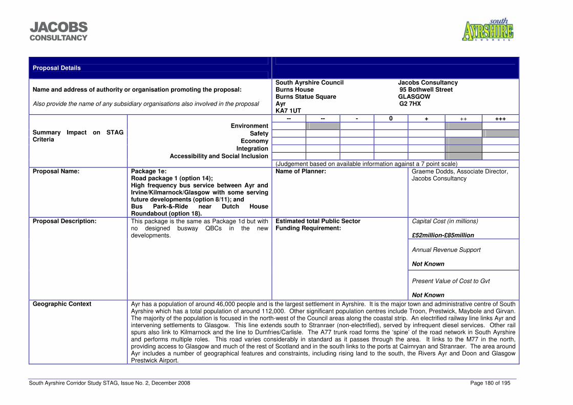
South Ayrshire Corridor Study STAG, Issue No. 2, December 2008 Page 180 of 195
���������������
Proposal Details
Name and address of authority or organisation promoting the proposal:
Also provide the name of any subsidiary organisations also involved in the proposal
South Ayrshire Council Jacobs Consultancy Burns House 95 Bothwell Street Burns Statue Square GLASGOW Ayr G2 7HX KA7 1UT
-- -- - 0 + ++ +++ Environment
Safety Economy
Integration Accessibility and Social Inclusion
Summary Impact on STAG Criteria
(Judgement based on available information against a 7 point scale) Proposal Name: Package 1e:
Road package 1 (option 14); High frequency bus service between Ayr and Irvine/Kilmarnock/Glasgow with some serving future developments (option 8/11); and Bus Park-&-Ride near Dutch House Roundabout (option 18).
Name of Planner: Graeme Dodds, Associate Director, Jacobs Consultancy
Capital Cost (in millions) £52million-£85million
Annual Revenue Support
Not Known
Proposal Description: This package is the same as Package 1d but with no designed busway QBCs in the new developments.
Estimated total Public Sector Funding Requirement:
Present Value of Cost to Gvt
Not Known
Geographic Context Ayr has a population of around 46,000 people and is the largest settlement in Ayrshire. It is the major town and administrative centre of South Ayrshire which has a total population of around 112,000. Other significant population centres include Troon, Prestwick, Maybole and Girvan. The majority of the population is focused in the north-west of the Council areas along the coastal strip. An electrified railway line links Ayr and intervening settlements to Glasgow. This line extends south to Stranraer (non-electrified), served by infrequent diesel services. Other rail spurs also link to Kilmarnock and the line to Dumfries/Carlisle. The A77 trunk road forms the ‘spine’ of the road network in South Ayrshire and performs multiple roles. This road varies considerably in standard as it passes through the area. It links to the M77 in the north, providing access to Glasgow and much of the rest of Scotland and in the south links to the ports at Cairnryan and Stranraer. The area around Ayr includes a number of geographical features and constraints, including rising land to the south, the Rivers Ayr and Doon and Glasgow Prestwick Airport.
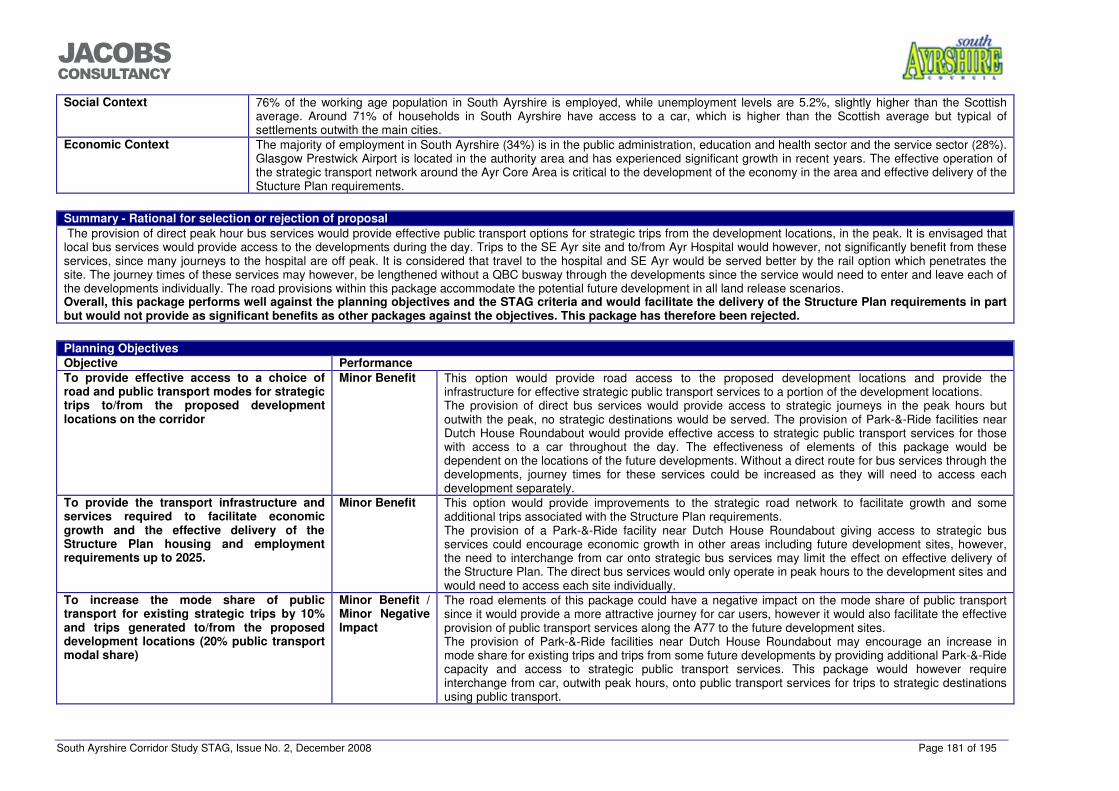
South Ayrshire Corridor Study STAG, Issue No. 2, December 2008 Page 181 of 195
���������������
Social Context 76% of the working age population in South Ayrshire is employed, while unemployment levels are 5.2%, slightly higher than the Scottish average. Around 71% of households in South Ayrshire have access to a car, which is higher than the Scottish average but typical of settlements outwith the main cities.
Economic Context The majority of employment in South Ayrshire (34%) is in the public administration, education and health sector and the service sector (28%). Glasgow Prestwick Airport is located in the authority area and has experienced significant growth in recent years. The effective operation of the strategic transport network around the Ayr Core Area is critical to the development of the economy in the area and effective delivery of the Stucture Plan requirements.
Summary - Rational for selection or rejection of proposal The provision of direct peak hour bus services would provide effective public transport options for strategic trips from the development locations, in the peak. It is envisaged that local bus services would provide access to the developments during the day. Trips to the SE Ayr site and to/from Ayr Hospital would however, not significantly benefit from these services, since many journeys to the hospital are off peak. It is considered that travel to the hospital and SE Ayr would be served better by the rail option which penetrates the site. The journey times of these services may however, be lengthened without a QBC busway through the developments since the service would need to enter and leave each of the developments individually. The road provisions within this package accommodate the potential future development in all land release scenarios. Overall, this package performs well against the planning objectives and the STAG criteria and would facilitate the delivery of the Structure Plan requirements in part but would not provide as significant benefits as other packages against the objectives. This package has therefore been rejected.
Planning Objectives Objective Performance To provide effective access to a choice of road and public transport modes for strategic trips to/from the proposed development locations on the corridor
Minor Benefit This option would provide road access to the proposed development locations and provide the infrastructure for effective strategic public transport services to a portion of the development locations. The provision of direct bus services would provide access to strategic journeys in the peak hours but outwith the peak, no strategic destinations would be served. The provision of Park-&-Ride facilities near Dutch House Roundabout would provide effective access to strategic public transport services for those with access to a car throughout the day. The effectiveness of elements of this package would be dependent on the locations of the future developments. Without a direct route for bus services through the developments, journey times for these services could be increased as they will need to access each development separately.
To provide the transport infrastructure and services required to facilitate economic growth and the effective delivery of the Structure Plan housing and employment requirements up to 2025.
Minor Benefit This option would provide improvements to the strategic road network to facilitate growth and some additional trips associated with the Structure Plan requirements. The provision of a Park-&-Ride facility near Dutch House Roundabout giving access to strategic bus services could encourage economic growth in other areas including future development sites, however, the need to interchange from car onto strategic bus services may limit the effect on effective delivery of the Structure Plan. The direct bus services would only operate in peak hours to the development sites and would need to access each site individually.
To increase the mode share of public transport for existing strategic trips by 10% and trips generated to/from the proposed development locations (20% public transport modal share)
Minor Benefit / Minor Negative Impact
The road elements of this package could have a negative impact on the mode share of public transport since it would provide a more attractive journey for car users, however it would also facilitate the effective provision of public transport services along the A77 to the future development sites. The provision of Park-&-Ride facilities near Dutch House Roundabout may encourage an increase in mode share for existing trips and trips from some future developments by providing additional Park-&-Ride capacity and access to strategic public transport services. This package would however require interchange from car, outwith peak hours, onto public transport services for trips to strategic destinations using public transport.
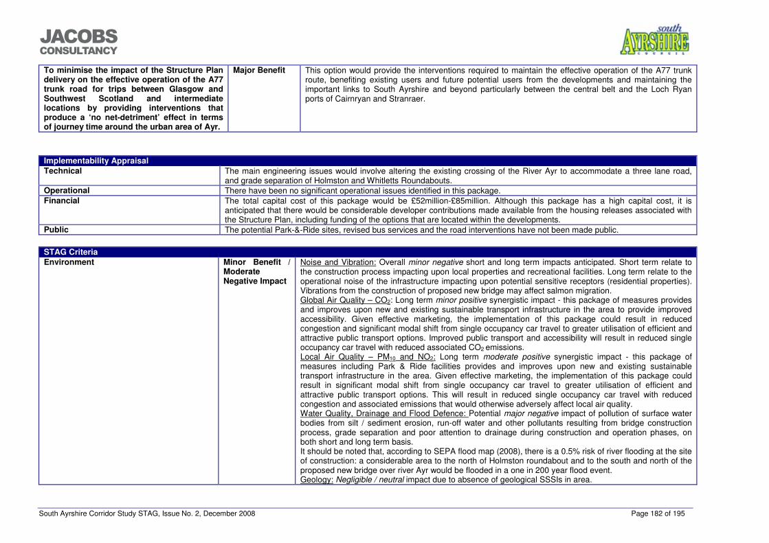
South Ayrshire Corridor Study STAG, Issue No. 2, December 2008 Page 182 of 195
���������������
To minimise the impact of the Structure Plan delivery on the effective operation of the A77 trunk road for trips between Glasgow and Southwest Scotland and intermediate locations by providing interventions that produce a ‘no net-detriment’ effect in terms of journey time around the urban area of Ayr.
Major Benefit This option would provide the interventions required to maintain the effective operation of the A77 trunk route, benefiting existing users and future potential users from the developments and maintaining the important links to South Ayrshire and beyond particularly between the central belt and the Loch Ryan ports of Cairnryan and Stranraer.
Implementability Appraisal Technical The main engineering issues would involve altering the existing crossing of the River Ayr to accommodate a three lane road,
and grade separation of Holmston and Whitletts Roundabouts. Operational There have been no significant operational issues identified in this package. Financial The total capital cost of this package would be £52million-£85million. Although this package has a high capital cost, it is
anticipated that there would be considerable developer contributions made available from the housing releases associated with the Structure Plan, including funding of the options that are located within the developments.
Public The potential Park-&-Ride sites, revised bus services and the road interventions have not been made public.
STAG Criteria Environment Minor Benefit /
Moderate Negative Impact
Noise and Vibration: Overall minor negative short and long term impacts anticipated. Short term relate to the construction process impacting upon local properties and recreational facilities. Long term relate to the operational noise of the infrastructure impacting upon potential sensitive receptors (residential properties). Vibrations from the construction of proposed new bridge may affect salmon migration. Global Air Quality – CO2: Long term minor positive synergistic impact - this package of measures provides and improves upon new and existing sustainable transport infrastructure in the area to provide improved accessibility. Given effective marketing, the implementation of this package could result in reduced congestion and significant modal shift from single occupancy car travel to greater utilisation of efficient and attractive public transport options. Improved public transport and accessibility will result in reduced single occupancy car travel with reduced associated CO2 emissions. Local Air Quality – PM10 and NO2: Long term moderate positive synergistic impact - this package of measures including Park & Ride facilities provides and improves upon new and existing sustainable transport infrastructure in the area. Given effective marketing, the implementation of this package could result in significant modal shift from single occupancy car travel to greater utilisation of efficient and attractive public transport options. This will result in reduced single occupancy car travel with reduced congestion and associated emissions that would otherwise adversely affect local air quality. Water Quality, Drainage and Flood Defence: Potential major negative impact of pollution of surface water bodies from silt / sediment erosion, run-off water and other pollutants resulting from bridge construction process, grade separation and poor attention to drainage during construction and operation phases, on both short and long term basis. It should be noted that, according to SEPA flood map (2008), there is a 0.5% risk of river flooding at the site of construction: a considerable area to the north of Holmston roundabout and to the south and north of the proposed new bridge over river Ayr would be flooded in a one in 200 year flood event. Geology: Negligible / neutral impact due to absence of geological SSSIs in area.
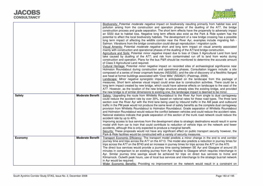
South Ayrshire Corridor Study STAG, Issue No. 2, December 2008 Page 183 of 195
���������������
Biodiversity: Potential moderate negative impact on biodiversity resulting primarily from habitat loss and pollution arising from the construction and operation phases of the duelling of the A77, the bridge construction process and grade separation. The short term effects have the propensity to adversely impact an SSSI due to habitat loss. Negative long term effects also exist as the Park & Ride system has the potential to affect the local biodiversity habitats. The development of a new bridge crossing has a possible long term impact of affecting the wildlife corridor near the River Ayr, examples include migrating fish - Salmon. Vibrations from the bridge construction could disrupt reproduction / migration cycle. Visual Amenity: Potential moderate negative short and long term impact on visual amenity associated mainly with construction and operational phases of the dualling of the A77and bridge construction. Agriculture and Soils: Potential minor negative impact due to loss of Class 3 Agricultural Land from land take caused by dualling of the A77; and risk from contaminated run off to land from works during construction and operation. Plans for the bus P&R should be monitored to determine the accurate amount of Class 3 Agricultural Land required. Cultural Heritage: Potential minor negative impact on recorded sites of archaeological significance near Holmston Roundabout during construction and operational phases. Consultation triggers include: a site composed of a series of linear cropmark features (NS32SE); and the site of discovery of a Neolithic flanged axe head at former buildings associated with “Over Mills” (NS3621) (Pastmap, 2008). Landscape: Minor negative synergistic impact is anticipated on the landscape from this package of measures. Short term adverse visual impact could arise due to construction activities. There could be a long term impact created by new bridge, which could have adverse effects on landscape to the east of the A77. However, as the location of the new bridge structure already sites the existing bridge, and provided the new bridge is of similar dimensions to existing one, the landscape impact is deemed to be minor.
Safety Moderate Benefit Safety: Upgrading the route from Whitletts Roundabout to the River Ayr from single to dual carriageway could reduce the accident rate by over 30%, based on national rates for these road types. The three lane section over the River Ayr with the third lane being used by inbound traffic in the AM peak and outbound traffic in the PM peak would not produce the same level of safety benefits as the complete dual carriageway provision from Whitletts Roundabout to Holmston Roundabout. Grade separation of Whitletts Roundabout and Holmston Roundabout would reduce the conflict between vehicles and could reduce the accident rates. National statistics indicate that grade separation of this section of the trunk road network could reduce the accident rate by up to 40%. Improving access to bus services from the development sites to strategic destinations would result in some modal shift from car to train that could contribute to reduction of vehicle trips on the network and fewer accidents, although this is only expected to produce a marginal benefit. Security: These proposals would not have any significant effect on public transport security however, the Park-&-Ride facilities would be constructed with a variety of security measures.
Economy Moderate Benefit Transport Economic Efficiency: The transport model predicts a minor change in the end to end corridor journey time and trips across the A77 on the A713. The model also predicts a reduction in journey times for trips across the A77 on the B743 and an increase in journey times for trips across the A77 on the A70. The direct bus services would provide a journey time saving between SE Ayr and Glasgow of around 25 minutes in comparison to an existing journey from Ayr Hospital to Glasgow which requires interchange in Ayr. Similar journey time savings would be achieved for trips on direct bus services to Irvine and Kilmarnock. Outwith peak hours, use of local bus services and interchange to the strategic bus/rail network in Ayr would be required. Wider Economic Benefits: Providing no improvement on the network would result in a constraint on
South Ayrshire Corridor Study STAG, Issue No. 2, December 2008 Page 184 of 195
���������������
strategic trips including through trips between the Central belt and the Loch Ryan ports at Stranraer and Cairnryan. Economic Activity and Location Impacts: Provision of the road interventions would assist in the future development of areas beside the A77 and in smaller settlements accessed from the A77. The introduction Park-&-Ride facilities and access to strategic bus services would increase the attractiveness of the residential and business developments within SE Ayr and the potential future development locations, however the Park-&-Ride facility may not provide significant improvements for off peak journeys to Ayr Hospital, compare to the rail halt option. Provision of a suitable package of measures is critical to the supporting and growing the economies of Ayr and South Ayrshire and encouraging investment and job creation. Without providing the required improvements, growth would be constrained resulting in undeliverable Structure Plan requirements.
Integration Moderate Benefit Transport Integration: This package would improve integration between car trips services and strategic public transport, particularly at the Park-&-Ride sites. Transport and Land-use Integration: Provision of the road interventions in this package could provide the infrastructure to support the effective development of residential land release sites in the area. The provision of direct bus services in peak hours and Park-&-Ride facilities near Dutch House Roundabout would enhance developments but would have a limited effect on a dispersed housing allocation scenario. The Park-&-Ride sites may also have a limited effect on trips to/from Ayr Hospital. Policy Integration: This package supports the Ayrshire Joint Structure Plan policy TRANS3b which states “The three Ayrshire Councils shall work in partnership with relevant transport bodies to give priority to the study and if appropriate the promotion and development of improvements to the A77 between Kilmarnock and Stranraer”. This package could however have a negative effect on road traffic reduction policies.
Accessibility and Social Inclusion Moderate Benefit Community Accessibility: This package could improve accessibility to Ayr, Ailsa and Carrick Glen Hospitals and other areas to the east of the A77 but the rail option may serve the hospitals more effectively. The road interventions would mainly affect strategic trips on the A77 but will also have benefits for the local community in Ayr and for trips on routes crossing the A77 at Whitletts, Holmston and Bankfield Roundabouts. Comparative Accessibility: The road based interventions and Park-&-Ride provisions will be of greater benefit to those with access to a car.
South Ayrshire Corridor Study STAG, Issue No. 2, December 2008 Page 185 of 195
���������������
Proposal Details
Name and address of authority or organisation promoting the proposal:
Also provide the name of any subsidiary organisations also involved in the proposal
South Ayrshire Council Jacobs Consultancy Burns House 95 Bothwell Street Burns Statue Square GLASGOW Ayr G2 7HX KA7 1UT
-- -- - 0 + ++ +++ Environment
Safety Economy
Integration Accessibility and Social Inclusion
Summary Impact on STAG Criteria
(Judgement based on available information against a 7 point scale) Proposal Name: Package 2e:
Road package 2 (option 15); High frequency bus service between Ayr and Irvine/Kilmarnock/Glasgow with some serving future developments (option 8/11); and Bus Park-&-Ride near Dutch House Roundabout (option 18).
Name of Planner: Graeme Dodds, Associate Director, Jacobs Consultancy
Capital Cost (in millions) £52million-£85million
Annual Revenue Support
Not Known
Proposal Description: This package is the same as Package 2d but with no designed busway QBCs in the new developments.
Estimated total Public Sector Funding Requirement:
Present Value of Cost to Gvt
Not Known
Geographic Context Ayr has a population of around 46,000 people and is the largest settlement in Ayrshire. It is the major town and administrative centre of South Ayrshire which has a total population of around 112,000. Other significant population centres include Troon, Prestwick, Maybole and Girvan. The majority of the population is focused in the north-west of the Council areas along the coastal strip. An electrified railway line links Ayr and intervening settlements to Glasgow. This line extends south to Stranraer (non-electrified), served by infrequent diesel services. Other rail spurs also link to Kilmarnock and the line to Dumfries/Carlisle. The A77 trunk road forms the ‘spine’ of the road network in South Ayrshire and performs multiple roles. This road varies considerably in standard as it passes through the area. It links to the M77 in the north, providing access to Glasgow and much of the rest of Scotland and in the south links to the ports at Cairnryan and Stranraer. The area around Ayr includes a number of geographical features and constraints, including rising land to the south, the Rivers Ayr and Doon and Glasgow
South Ayrshire Corridor Study STAG, Issue No. 2, December 2008 Page 186 of 195
���������������
Prestwick Airport. Social Context 76% of the working age population in South Ayrshire is employed, while unemployment levels are 5.2%, slightly higher than the Scottish
average. Around 71% of households in South Ayrshire have access to a car, which is higher than the Scottish average but typical of settlements outwith the main cities.
Economic Context The majority of employment in South Ayrshire (34%) is in the public administration, education and health sector and the service sector (28%). Glasgow Prestwick Airport is located in the authority area and has experienced significant growth in recent years. The effective operation of the strategic transport network around the Ayr Core Area is critical to the development of the economy in the area and effective delivery of the Stucture Plan requirements.
Summary - Rational for selection or rejection of proposal The provision of direct peak hour bus services would provide effective public transport options for strategic trips from the development locations, in the peak. It is envisaged that local bus services would provide access to the developments during the day. Trips to the SE Ayr site and to/from Ayr Hospital would however, not significantly benefit from these services, since many journeys to the hospital are off peak. It is considered that travel to the hospital and SE Ayr would be served better by the rail option which penetrates the site. The journey times of these services may however, be lengthened without a QBC busway through the developments since the service would need to enter and leave each of the developments individually. The road provisions within this package accommodate the potential future development in all land release scenarios. Overall, this package performs well against the planning objectives and the STAG criteria and would facilitate the delivery of the Structure Plan requirements in part but would not provide as significant benefits as other packages against the objectives. This package has therefore been rejected.
Planning Objectives Objective Performance To provide effective access to a choice of road and public transport modes for strategic trips to/from the proposed development locations on the corridor
Minor Benefit This option would provide road access to the proposed development locations and provide the infrastructure for effective strategic public transport services to a portion of the development locations. The provision of direct bus services would provide access to strategic journeys in the peak hours but outwith the peak, no strategic destinations would be served. The provision of Park-&-Ride facilities near Dutch House Roundabout would provide effective access to strategic public transport services for those with access to a car throughout the day. The effectiveness of elements of this package would be dependent on the locations of the future developments. Without a direct route for bus services through the developments, journey times for these services could be increased as they will need to access each development separately.
To provide the transport infrastructure and services required to facilitate economic growth and the effective delivery of the Structure Plan housing and employment requirements up to 2025.
Minor Benefit This option would provide improvements to the strategic road network to facilitate growth and some additional trips associated with the Structure Plan requirements. The provision of a Park-&-Ride facility near Dutch House Roundabout giving access to strategic bus services could encourage economic growth in other areas including future development sites, however, the need to interchange from car onto strategic bus services may limit the effect on effective delivery of the Structure Plan. The direct bus services would only operate in peak hours to the development sites and would need to access each site individually.
To increase the mode share of public transport for existing strategic trips by 10% and trips generated to/from the proposed development locations (20% public transport modal share)
Minor Benefit / Minor Negative Impact
The road elements of this package could have a negative impact on the mode share of public transport since it would provide a more attractive journey for car users, however it would also facilitate the effective provision of public transport services along the A77 to the future development sites. The provision of Park-&-Ride facilities near Dutch House Roundabout may encourage an increase in mode share for existing trips and trips from some future developments by providing additional Park-&-Ride capacity and access to strategic public transport services. This package would however require interchange from car, outwith peak hours, onto public transport services for trips to strategic destinations
South Ayrshire Corridor Study STAG, Issue No. 2, December 2008 Page 187 of 195
���������������
using public transport. To minimise the impact of the Structure Plan delivery on the effective operation of the A77 trunk road for trips between Glasgow and Southwest Scotland and intermediate locations by providing interventions that produce a ‘no net-detriment’ effect in terms of journey time around the urban area of Ayr.
Major Benefit This option would provide the interventions required to maintain the effective operation of the A77 trunk route, benefiting existing users and future potential users from the developments and maintaining the important links to South Ayrshire and beyond particularly between the central belt and the Loch Ryan ports of Cairnryan and Stranraer.
Implementability Appraisal Technical The main engineering issues would involve altering the existing crossing of the River Ayr to accommodate a dual carriageway,
and grade separation of Holmston and Whitletts Roundabouts. Operational There have been no significant operational issues identified in this package. Financial The total capital cost of this package would be £52million-£85million. Although this package has a high capital cost, it is
anticipated that there would be considerable developer contributions made available from the housing releases associated with the Structure Plan, including funding of the options that are located within the developments.
Public The potential Park-&-Ride sites, revised bus services and the road interventions have not been made public.
STAG Criteria Environment Minor Benefit /
Moderate Negative Impact
Noise and Vibration: Overall minor negative short and long term impacts anticipated. Short term relate to the construction process impacting upon local properties and recreational facilities. Long term relate to the operational noise of the infrastructure impacting upon potential sensitive receptors (residential properties). Vibrations from the construction of proposed new bridge may affect salmon migration. Global Air Quality – CO2: Long term minor positive synergistic impact - this package of measures provides and improves upon new and existing sustainable transport infrastructure in the area to provide improved accessibility. Given effective marketing, the implementation of this package could result in reduced congestion and significant modal shift from single occupancy car travel to greater utilisation of efficient and attractive public transport options. Improved public transport and accessibility will result in reduced single occupancy car travel with reduced associated CO2 emissions. Local Air Quality – PM10 and NO2: Long term moderate positive synergistic impact - this package of measures including Park & Ride facilities provides and improves upon new and existing sustainable transport infrastructure in the area. Given effective marketing, the implementation of this package could result in significant modal shift from single occupancy car travel to greater utilisation of efficient and attractive public transport options. This will result in reduced single occupancy car travel with reduced congestion and associated emissions that would otherwise adversely affect local air quality. Water Quality, Drainage and Flood Defence: Potential major negative impact of pollution of surface water bodies from silt / sediment erosion, run-off water and other pollutants resulting from bridge construction process, grade separation and poor attention to drainage during construction and operation phases, on both short and long term basis. It should be noted that, according to SEPA flood map (2008), there is a 0.5% risk of river flooding at the site of construction: a considerable area to the north of Holmston roundabout and to the south and north of the proposed new bridge over river Ayr would be flooded in a one in 200 year flood event.
South Ayrshire Corridor Study STAG, Issue No. 2, December 2008 Page 188 of 195
���������������
STAG Criteria Geology: Negligible / neutral impact due to absence of geological SSSIs in area. Biodiversity: Potential moderate negative impact on biodiversity resulting primarily from habitat loss and pollution arising from the construction and operation phases of the duelling of the A77, the bridge construction process and grade separation. The short term effects have the propensity to adversely impact an SSSI due to habitat loss. Negative long term effects also exist as the Park & Ride system has the potential to affect the local biodiversity habitats. The development of a new bridge crossing has a possible long term impact of affecting the wildlife corridor near the River Ayr, examples include migrating fish - Salmon. Vibrations from the bridge construction could disrupt reproduction / migration cycle. Visual Amenity: Potential moderate negative short and long term impact on visual amenity associated mainly with construction and operational phases of the dualling of the A77and bridge construction. Agriculture and Soils: Potential minor negative impact due to loss of Class 3 Agricultural Land from land take caused by dualling of the A77; and risk from contaminated run off to land from works during construction and operation. Plans for the bus P&R should be monitored to determine the accurate amount of Class 3 Agricultural Land required. Cultural Heritage: Potential minor negative impact on recorded sites of archaeological significance near Holmston Roundabout during construction and operational phases. Consultation triggers include: a site composed of a series of linear cropmark features (NS32SE); and the site of discovery of a Neolithic flanged axe head at former buildings associated with “Over Mills” (NS3621) (Pastmap, 2008). Landscape: Minor negative synergistic impact is anticipated on the landscape from this package of measures. Short term adverse visual impact could arise due to construction activities. There could be a long term impact created by new bridge, which could have adverse effects on landscape to the east of the A77. However, as the location of the new bridge structure already sites the existing bridge, and provided the new bridge is of similar dimensions to existing one, the landscape impact is deemed to be minor.
Safety Major Benefit Safety: Upgrading the route from Whitletts Roundabout to Holmston Roundabout from single to dual carriageway could reduce the accident rate by over 30%, based on national rates for these road types. Grade separation of Whitletts Roundabout and Holmston Roundabout would reduce the conflict between vehicles and could reduce the accident rates. National statistics indicate that grade separation of this section of the trunk road network could reduce the accident rate by up to 40%. Improving access to bus services from the development sites to strategic destinations would result in some modal shift from car to train that could contribute to reduction of vehicle trips on the network and fewer accidents, although this is only expected to produce a marginal benefit. Security: These proposals would not have any significant effect on public transport security however, the Park-&-Ride facilities would be constructed with a variety of security measures.
Economy Moderate Benefit Transport Economic Efficiency: The transport model predicts a minor change in the end to end corridor journey time and trips across the A77 on the A713. The model also predicts a reduction in journey times for trips across the A77 on the B743 and an increase in journey times for trips across the A77 on the A70. The direct bus services would provide a journey time saving between SE Ayr and Glasgow of around 25 minutes in comparison to an existing journey from Ayr Hospital to Glasgow which requires interchange in Ayr. Similar journey time savings would be achieved for trips on direct bus services to Irvine and Kilmarnock. Outwith peak hours, use of local bus services and interchange to the strategic bus/rail network in Ayr would be required. Wider Economic Benefits: Providing no improvement on the network would result in a constraint on strategic trips including through trips between the Central belt and the Loch Ryan ports at Stranraer and
South Ayrshire Corridor Study STAG, Issue No. 2, December 2008 Page 189 of 195
���������������
STAG Criteria Cairnryan. Economic Activity and Location Impacts: Provision of the road interventions would assist in the future development of areas beside the A77 and in smaller settlements accessed from the A77. The introduction Park-&-Ride facilities and access to strategic bus services would increase the attractiveness of the residential and business developments within SE Ayr and the potential future development locations, however the Park-&-Ride facility may not provide significant improvements for off peak journeys to Ayr Hospital, compare to the rail halt option. Provision of a suitable package of measures is critical to the supporting and growing the economies of Ayr and South Ayrshire and encouraging investment and job creation. Without providing the required improvements, growth would be constrained resulting in undeliverable Structure Plan requirements.
Integration Moderate Benefit Transport Integration: This package would improve integration between car trips services and strategic public transport, particularly at the Park-&-Ride sites. Transport and Land-use Integration: Provision of the road interventions in this package could provide the infrastructure to support the effective development of residential land release sites in the area. The provision of direct bus services in peak hours and Park-&-Ride facilities near Dutch House Roundabout would enhance developments but would have a limited effect on a dispersed housing allocation scenario. The Park-&-Ride sites may also have a limited effect on trips to/from Ayr Hospital. Policy Integration: This package supports the Ayrshire Joint Structure Plan policy TRANS3b which states “The three Ayrshire Councils shall work in partnership with relevant transport bodies to give priority to the study and if appropriate the promotion and development of improvements to the A77 between Kilmarnock and Stranraer”. This package could however have a negative effect on road traffic reduction policies.
Accessibility and Social Inclusion Moderate Benefit Community Accessibility: This package could improve accessibility to Ayr, Ailsa and Carrick Glen Hospitals and other areas to the east of the A77 but the rail option may serve the hospitals more effectively. The road interventions would mainly affect strategic trips on the A77 but will also have benefits for the local community in Ayr and for trips on routes crossing the A77 at Whitletts, Holmston and Bankfield Roundabouts. Comparative Accessibility: The road based interventions and Park-&-Ride provisions will be of greater benefit to those with access to a car.

South Ayrshire Corridor Study STAG, Issue No. 2, December 2008 Page 190 of 195
���������������
APPENDIX D – SUMMARY OF JOURNEY TIMES
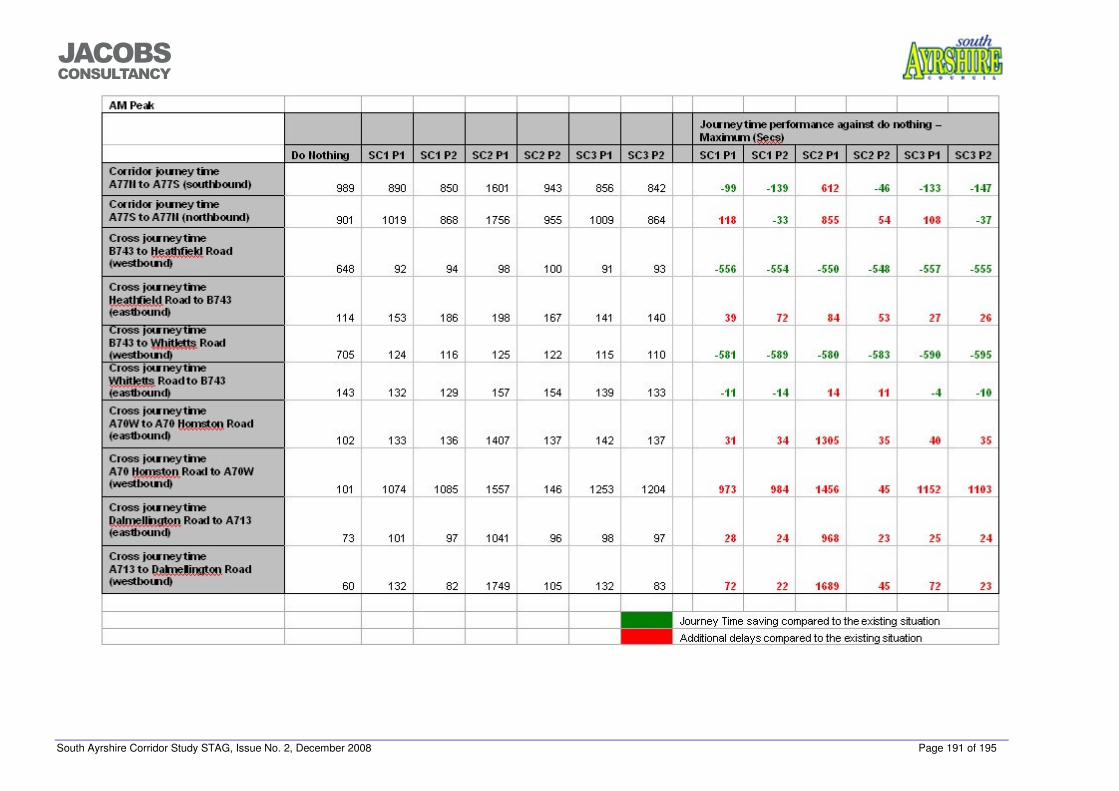
South Ayrshire Corridor Study STAG, Issue No. 2, December 2008 Page 191 of 195
���������������
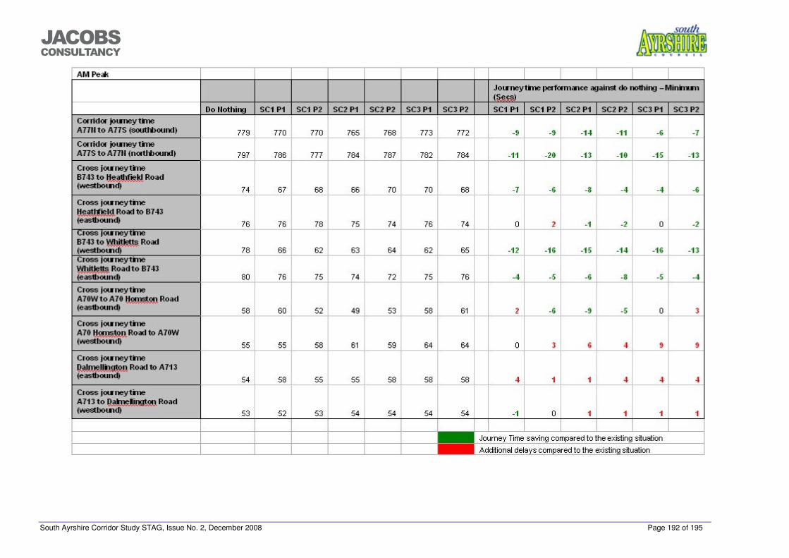
South Ayrshire Corridor Study STAG, Issue No. 2, December 2008 Page 192 of 195
���������������
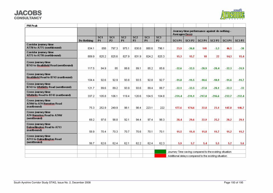
South Ayrshire Corridor Study STAG, Issue No. 2, December 2008 Page 193 of 195
���������������
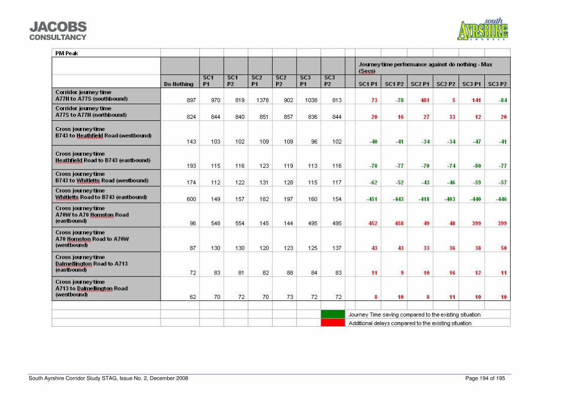
South Ayrshire Corridor Study STAG, Issue No. 2, December 2008 Page 194 of 195
���������������
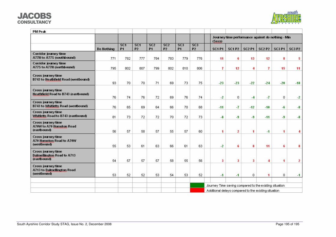
South Ayrshire Corridor Study STAG, Issue No. 2, December 2008 Page 195 of 195
���������������
Related Documents