HUMAN GEOGRAPHIES – Journal of Studies and Research in Human Geography 8.1 (2014) 17–26. ISSN-print: 1843–6587/$–see back cover; ISSN-online: 2067–2284–open access www.humangeographies.org.ro (c) Human Geographies —Journal of Studies and Research in Human Geography (c) The authors REGIONAL DIVERSITY AND DEVELOPMENT BETWEEN THE SOUTHERN PROVINCES OF PAKISTAN: A PRINCIPAL COMPONENT ANALYSIS Khalida Mahmood a *, Razzaq Ahmed b a Department of Geography, University of Karachi, Karachi, Pakistan b Department of Geography, Federal Urdu University of Arts, Science and Technology, Gulshan Campus, Karachi, Pakistan Abstract: Economic development is an important consideration for a country like Pakistan, especially for the southern provinces; Sindh and Balochistan. Unequal economic development in these southern provinces creates regional disparities. These regional disparities enhance significant political and social issues like rural poverty and uneven economic growth. During the last several decades these provinces have been facing increasing problems of regional inequalities in economic development. Hence it is necessary to investigate the problem areas with poor use of resources by advance statistical tech- niques like Principal Component Analysis. The results will pin point those areas where development activity and planning can be directed towards improving economic infrastructure and prosperity of the people. The broad objective of economic development is to balance the inherent land resources and optimization of resource use towards achievements of produc- tivity over a long period. Key words: Development variable, Economic development, Principal component analysis, Regional disparity, Rural poverty, Southern provinces. Article Info: Manuscript Received: April 29, 2013; Revised: November 28, 2013; Accepted: May 25, 2014; Online: May 31, 2014. Introduction Sindh and Balochistan are important provinces, rep- resenting southern Pakistan have a considerable physical and environmental variety. The landscape varies from the rugged mountain ranges of the west- ern margins of the Indus plain and the interior of Balochistan, to the fluvial morphology of Lower Indus basin, whereas the eastern desert fringe is occupied by the sand dunes. Climatically, it is mostly arid and semi-arid with summer monsoon rains in Sindh and winter rains in Balochistan. The large diversity in the surface configuration, climate, mineral wealth, soil and irrigation facilities creates a marked difference between these provinces. The wide difference is also reflected by the distribu- tion of population densities. The central and south- ern areas of Sindh dominate the scene, where vast alluvial fertile land, an elaborate canal irrigation sys- tem, wide agricultural tracts and industrial complexes make it the most productive part of the southern Pakistan. The areas of Balochistan by contrast are relatively depressed except a limited pocket of Quetta (Ahmed and Mahmood, 2007). By considering the above realities an attempt has been made to investi- gate the uneven economic growth in southern Paki- stan, utilizing multivariate technique. For this pur- pose a number of variables that cover various aspects of the economy have been selected. The selection has been done from diverse secondary sources (popula- tion and agricultural census reports and meteorologi- cal data etc.). The primary data for Normalized Dif- ference Vegetation Index (NDVI) is generated from coarse resolution satellite imageries. Significance of the Study Large inter-regional disparities in welfare and living conditions may become an important obstacle for development, which may stimulate social tensions (Quadrado, Heijman and Folmer, 2001). Sindh and Balochistan have wide regional disparities both in terms of physical and human setting, increasing rural poverty and lack of basic amenities for the majority of * Corresponding author: Address: Department of Geography, University of Karachi, Karachi, Pakistan Telephone: 0092-335-2111558 Email: [email protected] doi:10.5719/hgeo.2014.81.17

Welcome message from author
This document is posted to help you gain knowledge. Please leave a comment to let me know what you think about it! Share it to your friends and learn new things together.
Transcript

HUMAN GEOGRAPHIES – Journal of Studies and Research in Human Geography
8.1 (2014) 17–26. ISSN-print: 1843–6587/$–see back cover; ISSN-online: 2067–2284–open access
www.humangeographies.org.ro
(c) Human Geographies —Journal of Studies and Research in Human Geography (c) The authors
REGIONAL DIVERSITY AND DEVELOPMENT BETWEEN THE SOUTHERN PROVINCES OF PAKISTAN: A PRINCIPAL COMPONENT ANALYSIS
Khalida Mahmooda*, Razzaq Ahmedb
a Department of Geography, University of Karachi, Karachi, Pakistan
b Department of Geography, Federal Urdu University of Arts, Science and Technology, Gulshan Campus, Karachi, Pakistan
Abstract: Economic development is an important consideration for a country like Pakistan, especially for the southern provinces; Sindh and Balochistan. Unequal economic development in these southern provinces creates regional disparities. These regional disparities enhance significant political and social issues like rural poverty and uneven economic growth. During the last several decades these provinces have been facing increasing problems of regional inequalities in economic development. Hence it is necessary to investigate the problem areas with poor use of resources by advance statistical tech-niques like Principal Component Analysis. The results will pin point those areas where development activity and planning can be directed towards improving economic infrastructure and prosperity of the people. The broad objective of economic development is to balance the inherent land resources and optimization of resource use towards achievements of produc-tivity over a long period. Key words: Development variable, Economic development, Principal component analysis, Regional disparity, Rural
poverty, Southern provinces. Article Info: Manuscript Received: April 29, 2013; Revised: November 28, 2013; Accepted: May 25, 2014; Online: May 31, 2014.
Introduction Sindh and Balochistan are important provinces, rep-resenting southern Pakistan have a considerable physical and environmental variety. The landscape varies from the rugged mountain ranges of the west-ern margins of the Indus plain and the interior of Balochistan, to the fluvial morphology of Lower Indus basin, whereas the eastern desert fringe is occupied by the sand dunes. Climatically, it is mostly arid and semi-arid with summer monsoon rains in Sindh and winter rains in Balochistan.
The large diversity in the surface configuration, climate, mineral wealth, soil and irrigation facilities creates a marked difference between these provinces. The wide difference is also reflected by the distribu-tion of population densities. The central and south-ern areas of Sindh dominate the scene, where vast alluvial fertile land, an elaborate canal irrigation sys-tem, wide agricultural tracts and industrial complexes
make it the most productive part of the southern Pakistan. The areas of Balochistan by contrast are relatively depressed except a limited pocket of Quetta (Ahmed and Mahmood, 2007). By considering the above realities an attempt has been made to investi-gate the uneven economic growth in southern Paki-stan, utilizing multivariate technique. For this pur-pose a number of variables that cover various aspects of the economy have been selected. The selection has been done from diverse secondary sources (popula-tion and agricultural census reports and meteorologi-cal data etc.). The primary data for Normalized Dif-ference Vegetation Index (NDVI) is generated from coarse resolution satellite imageries. Significance of the Study Large inter-regional disparities in welfare and living conditions may become an important obstacle for development, which may stimulate social tensions (Quadrado, Heijman and Folmer, 2001). Sindh and Balochistan have wide regional disparities both in terms of physical and human setting, increasing rural poverty and lack of basic amenities for the majority of
* Corresponding author:
Address: Department of Geography, University of Karachi,
Karachi, Pakistan
Telephone: 0092-335-2111558
Email: [email protected]
doi:10.5719/hgeo.2014.81.17

KHALIDA MAHMOOD, RAZZAQ AHMED
HUMAN GEOGRAPHIES—Journal of Studies and Research in Human Geography 8.1 (2014) 17–26 18
population [3]. Such dissimilarities give rise to varia-tions in administrative problems and make it neces-sary that the principal areas of settlement and eco-nomic development be distinguished from the total area of Sindh and Balochistan. In addition, a further classification of such area into various levels of inten-sity will be useful refinement, especially for our deci-sion-makers and planners for policy implementation.
While there is no easy solution to such problems, a first step can be taken by recognizing the need for conscious regional planning as an integral part of Sindh and Balochistan’s economic and social plan-ning. The concern of the present research is to pro-vide solution to the problem of wide regional dispari-ties in term of restriction of large size of provincial metropolis and solution for reducing urban rural inequality. It is revealed from the existing literature that no systematic work has been done for investigat-ing the economic inequality in the whole region. It is, therefore, necessary to highlight the causes of the regional disparity.
Hence the main objectives of this study are the identification of regional disparities using social, political and geographical variables, identification of the depressed areas where levels of economic devel-opment are extremely poor and to bring out the fac-tors which are responsible for such poverty. Further have also been discussed suggestions to solve the problems of the regional disparity.
Study Area
Sindh is flanked by the Arabian Sea and the Rann of Kutch in the south. There are four major relief ele-ments: Khirthar range and the Sindh Kohistan in the west, the Thar Desert in the east and the Indus valley lying in-between the hills and the desert (Pithawalla, 1976). Khirthar range marks the boundary between the province of Sindh and Balochistan. The Indus valley has been divided into western and eastern sec-tions by river Indus. The low-lying plains south of Thatta are identified as the old Indus Delta (Rahman, 1975) (Figure 1).
East of the Indus, there are two limestone ridges. The larger of these extends southward for about 40 miles from Rohri. It consists of nearly horizontal numulitic limestone scarped on the western side at a height of about 200 feet above the plain. The other one, in the south is known as Ganjo Takkar. It is on the northern most hill of this ridge where the city of Hyderabad, the second largest city of Sindh is locat-ed. Some other smaller detached hills occur in the old delta area, significant among which are the Makli Hills and Pir Patho in Thatta district. Isolated hills of granite rising to 1,169 feet above sea level are found on the northern edge of the Rann of Kutch in Nagar Parkar area of the Tharparkar district.
Figure 1. Sindh-Balochistan – Physical map
These are known as Kalinjhar hills. River Indus is
the most important single feature that dominates the province of Sindh.
Balochistan is the largest province of Pakistan in terms of area, covering 347,190 sq. km. occupying nearly 44% of its landmass, located in southwestern half of the country. It is a land of contrasts. Bare, barren and rugged mountains hedge in green valleys dotted with bountiful orchards. Vast deserts give way to verdant oasis, immense coastline teeming with marine life and mangrove. The altitude also ranges widely from places, which are at sea level, or even below the sea level to the Khilafat peak Harnai valley. Ziarat district, the highest point in the province rises to a height of 11,507 feet above sea level.
The geographical location gives Balochistan a unique geo-political significance has been further augmented by the need and interest of the land-locked Central Asian States for an opening to the sea. The Makran Coastal Highway and the Gwadar Deep-sea Port are Pakistan response to these imperatives of regional politics and economy of Central Asian States. The Makran coast lies in front of the Straits of Hor-muz, which is an important route of the oil tankers bound for Japan, North America and Europe enroute to the Persian Gulf. Research Design The research is based on districts as a viable regional unit. This is the third order of the administrative hierarchy of the country, after province and divisions.
REGIONAL DIVERSITY AND DEVELOPMENT BETWEEN THE SOUTHERN PROVINCES OF PAKISTAN
HUMAN GEOGRAPHIES— Journal of Studies and Research in Human Geography 8.1 (2014) 17–26 19
The development scenario will cover both urban and rural areas because development is not an isolated process. District has been chosen as the unit of study because it already exists as a political and administra-tive unit and contains a sufficient mix of urban and rural characteristics to allow the creation of linkages (Zafar, 1990). It is also a functional unit and is suffi-ciently large in terms of both area and population and possesses physical and human resources.
Like other South Asian countries district is im-portant because it forms the base for the whole ad-ministrative set up in the country (Joshi, 1938). Dis-tricts performs a number of rural and urban functions in Pakistan as they exist a wide physical and econom-ic diversity like any other developing state as in India or developed states like U.K or Canada (Thinker, 1963).
The district has a number of characteristics which makes its selection suitable as a planning unit. Not only it already exists as a political and administrative unit but most data are available at this level. It can be further divided into smaller divisions to obtain the objectives of planning and development. The district is sufficiently large in terms of both area and popula-tion to make it functional. It contains both urban and rural localities and a number of resources like land,
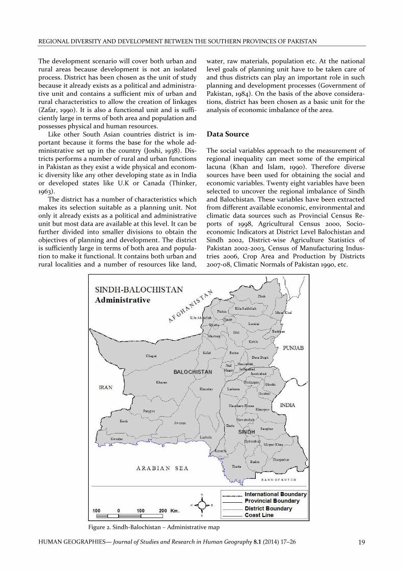
water, raw materials, population etc. At the national level goals of planning unit have to be taken care of and thus districts can play an important role in such planning and development processes (Government of Pakistan, 1984). On the basis of the above considera-tions, district has been chosen as a basic unit for the analysis of economic imbalance of the area. Data Source The social variables approach to the measurement of regional inequality can meet some of the empirical lacuna (Khan and Islam, 1990). Therefore diverse sources have been used for obtaining the social and economic variables. Twenty eight variables have been selected to uncover the regional imbalance of Sindh and Balochistan. These variables have been extracted from different available economic, environmental and climatic data sources such as Provincial Census Re-ports of 1998, Agricultural Census 2000, Socio-economic Indicators at District Level Balochistan and Sindh 2002, District-wise Agriculture Statistics of Pakistan 2002-2003, Census of Manufacturing Indus-tries 2006, Crop Area and Production by Districts 2007-08, Climatic Normals of Pakistan 1990, etc.
Figure 2. Sindh-Balochistan – Administrative map

KHALIDA MAHMOOD, RAZZAQ AHMED
HUMAN GEOGRAPHIES—Journal of Studies and Research in Human Geography 8.1 (2014) 17–26 20
To obtain NDVI of the study area two sets (1997
and 2007) of NOAA images have been used. During
the last several years 1997 was the driest year while in
2007 normal amount of rain occurred. Each year four
images have been selected by considering the crop
calendar such as March which is a harvesting season
of rabi (winter) crop, June pre monsoon and sowing
time of kharif (summer), September post monsoon
and harvesting month of kharif (summer) and De-
cember which is sowing period of rabi (winter) crop.
Since NDVI is a pixel based values to convert it into
block based data the zonal statistics command of GIS
software ArcGIS has been employed (Lo, 1998).
The entire analysis of the regional inequalities and
development pattern of Sindh and Balochistan was
done using the computer software SPSS 14 for reduc-
ing the multisectoral dataset, PCA has been em-
ployed. Weighted component score is used as an
index for ranking districts on the basis of the general
characteristics of variable set (Thompson, 1962; Ah-
mad, 1965; Defo, 1996; Soares, Marques and Monteiro,
2003; Mahmood and Ahmed, 2006; Campo, Monteiro
and Soares, 2008). PCA has been employed for 24
districts of Sindh and Balochistan. Karachi division
has been taken as a single unit because of its role as
the largest urban center of southern provinces of
Pakistan (Figure 2).
Results and Discussions
Although the number of variables used in this study
are not very large but these have been able to capture
the overall development pattern in the districts of
Sindh and Balochistan. Development is a multi-
dimensional phenomenon which involves a complex
interaction between political, social, cultural and
economic factors. The ultimate goal of development
is improvement in quality of life of the people and in
the enhancement of productive capacity. For this
purpose, it is necessary to quantify levels of availabil-
ity of social, economic and physical infrastructure,
which makes a place attractive for living.
a. The Variables
Development is a multifaceted phenomenon involv-
ing an integration of multiple factors. The basic ob-
jectives of development are enhancing the prosperity
of people and increasing the productive potential of
areas. It is necessary to measure various levels of the
availability of socio-economic, agro-ecological and
physical infrastructure in various districts of southern
Pakistan which make this study meaningful and
comprehensive.
The data for this study consist of observations
from a number of different sources (such as censuses
of population, agriculture, manufacturing and satel-
lite images of NOAA) on 28 variables in 42 districts
(16 district of Sindh and 26 districts of Baluchistan)
classified under the following sub-headings : I. Agriculture 1. Cultivated area (% of total area) 2. Intensity of land use 3. Intensity of cropping 4. Orchid yield per hector 5. Irrigated area total per 1000 acres of cropped area 6. Tractors per 1000 acres of cropped area 7. Fertilizer consumption per 1000 acres of cropped area II. Population / migration 8. Urban population (%) 9. Population potential (000) 10. Immigration (%) III. Income and wealth 11. Cash value of crop output per rural population 12. Manufacturing value added per urban population 13. Bank branches per 100,000 population IV. Labor force 14. Industrial labor force 15. Non agricultural labor force 16. Unemployment ratio (%) V. Education 17. Literacy ratio (%) 18. Primary enrolment (%) 19. Secondary enrolment (%) 20. Female to male literacy ratio VI. Environment 21. Normalized Difference Vegetation Index (NDVI) 22. Forest area (%) VII. Transportation and communication 23. Roads per 100 sq. km. 24. PTCL telephone connection per1000 population VIII. Climate 25. Mean annual temperature 26. Total annual rainfall 27. Total winter rainfall 28. Total summer rainfall
The choice of these variables in presenting the so-cio-economic, environmental and climatic profile of each district is solely determined by data availability constraints. The time reference point of most of these variables is the last available published census of population.
REGIONAL DIVERSITY AND DEVELOPMENT BETWEEN THE SOUTHERN PROVINCES OF PAKISTAN
HUMAN GEOGRAPHIES— Journal of Studies and Research in Human Geography 8.1 (2014) 17–26 21
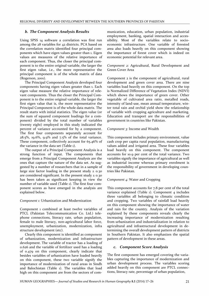
b. The Component Analysis Results Using SPSS 14 software a correlation was first run among the 28 variables for 42 districts. PCA based on the correlation matrix identified four principal com-ponents which have eigen values greater than 1. Eigen values are measures of the relative importance of each component. Thus, the closer the principal com-ponent is to the entire original variable, the larger the first eigen value, i.e., the more representative the principal component is of the whole matrix of data (Rogerson, 2001).
The Principal Component Analysis developed four components having eigen values greater than 1. Each eigen value measure the relative importance of rele-vant components. Thus the closer the Principal Com-ponent is to the entire original variable, the larger the first eigen value that is, the more representative the Principal Component is of the whole data matrix. The result starts with initial statistics. The eigen value (or the sum of squared component loadings for a com-ponent) divided by the total number of variables (twenty eight) employed in this study indicated the percent of variance accounted for by a component. The first four components separately account for 28.5%, 19.6%, 9.9% and 7.5% of the total variance. These component, collectively account for 65.46% of the variance in the data set (Table 1).
The output of a Principal Component Analysis is a strong function of input. The components that emerge from a Principal Component Analysis are the ones that capture the nature of the data set. As sug-gested by a number of researchers that in a sample of large size factor loading in the present study ± 0.30 are considered significant. In the present study ± 0.30 has been taken as significant keeping in view the number of variable used (Table 1). The first four com-ponent scores as have emerged in the analysis are explained below. Component 1: Urbanization and Modernization Component 1 combined at least twelve variables of PTCL (Pakistan Telecommunication Co. Ltd.) tele-phone connections, literacy rate, urban population, female to male literacy, non-agricultural labor force, unemployment, urbanization, modernization, infra structure development (etc).
Clearly this component is identified as component of urbanization, modernization and infrastructure development. The variable of tractor has a loading of 0.626 and the variable of fertilizer used has a loading of 0.479 on this component, clearly indicate that besides variables of urbanization have loaded heavily on this component, these two variable signify the importance of modernization of rural areas in Sindh and Balochistan (Table 1). The variables that load high on this component are from the sectors of com-
munication, education, urban population, industrial employment, banking, spatial interaction and acces-sibility. Most of the variables relate to socio-economic infrastructure. One variable of forested area also loads heavily on this component showing the importance of forest cover which is indeed on economic potential for relevant area. Component 2: Agricultural, Rural Development and Green Cover Area Component 2 is the component of agricultural, rural development and green cover area. There are nine variables load heavily on this component. On the top is Normalized Difference of Vegetation Index (NDVI) which shows the importance of green cover. Other vegetable of cultivated area ratio, metalled roads, intensity of land-use, mean annual temperature, win-ter total rain and orchid yield show the relationship of variable with cropping agriculture and marketing. Education and transport are the responsibilities of government in countries like Pakistan. Component 3: Income and Wealth This component includes primary environment, value cash crop per capita rural population, manufacturing values added and irrigated area. These four variables load heavily on this component. The component accounts for 10.9 per cent of the total variance. Two variables signify the importance of agricultural as well as industrial income whereas primary enrolment is the responsibility of government in developing coun-tries like Pakistan. Component 4: Water and Cropping This component accounts for 7.8 per cent of the total variance explained (Table 1). Component 4 includes three variables all belonging to climatic condition and cropping. Two variables of rainfall load heavily on this component showing the importance of water and rain for the country. Analysis of the variation explained by these components reveals clearly the increasing importance of modernization resulting from urbanization and industrialization in relation to agricultural and infrastructural development in de-termining the overall development pattern of districts in Southern Pakistan. It also emphasizes the spatial pattern of development in these areas.
c. Component Score Analysis
The first component has emerged covering the varia-bles capturing the importance of modernization and urban development process. The variables scoring added heavily on this component are PTCL connec-tions, literacy rate, percentage of urban population,

KHALIDA MAHMOOD, RAZZAQ AHMED
HUMAN GEOGRAPHIES—Journal of Studies and Research in Human Geography 8.1 (2014) 17–26 22
female to male literacy ratio, percentage of non-agricultural labor force, immigrants number of bank branches, percent industrial labor force, tractor (per 1000 population), population potential, forest area percentage and fertilizer. Component Score 1 The first component has been defined as the compo-nent of modernization resulting from industrializa-tion and urbanization, captures 28 per cent of the total variance in the data set. Districts like Karachi,
Quetta both being provincial head quarters have top ranking on first component. Higher level of develop-ment is associated with a higher component score. Whereas Hyderabad, Sukkur have also obtained high scores because of the lead in industrial and urban development.
Moderate scores have been obtained by Ziarat, Gwadar, Lasbela Chaghai, Dadu, Kachi, Larkana, Na-wabshah, Mirpur Khas, Sibi, Sanghar, and Khairpur. Lower levels in development have been found in Pan-jgur, Shikarpur and rest the districts of Sindh and Balochistan (Figure 3).
Table 1: Rotated Component Matrix
Variables Component
1 2 3 4 Component Name
PTCL Tel. connection / 1000 pop. 0.943 0.032 0.114 -0.086 Urbanization and Modernization
Litracy rate % 0.894 0.326 0.091 -0.133
Urban population % 0.893 0.095 -0.197 -0.035
Female to male literacy % 0.874 0.192 -0.095 -0.085
Non-agriculture labour force 0.815 -0.172 0.150 -0.063
Immigrants % 0.802 -0.015 -0.190 0.354
Bank branch / 100,000 pop. 0.793 -0.002 0.466 -0.180
% of Urban Industrial labour force 0.691 0.244 -0.427 0.269
Tractor / 1000 acres 0.626 -0.190 -0.079 0.481
Population potential 0.610 0.401 -0.295 0.501
Forest area % 0.520 -0.025 0.440 0.201
Fertilizer 0.479 -0.155 0.322 -0.219
NDVI -0.029 0.887 -0.076 0.097
Agricultural, Rural Development and Green Cover
Cultivated area% -0.069 0.862 -0.037 -0.100
Unemployment ratio -0.192 -0.840 -0.068 -0.048
Metalled road / 100 sq.km. 0.284 0.839 -0.051 -0.075
Higher Secondary enrolment % 0.397 0.774 -0.091 -0.172
Intensity of landuse -0.130 0.703 0.232 0.202
Mean Annual Temperature 0.004 0.682 -0.527 -0.150
Winter total rain 0.044 -0.676 0.521 0.072
Orchid yield per hector -0.044 0.397 0.151 -0.037
Primary enrolment 0.056 0.157 0.790 -0.073 Income and Wealth
Value of cash crop / rural population -0.096 0.102 0.725 0.042
Manufacturing value added 0.144 0.122 -0.386 -0.067
Irrigated Area / 1000 of cropped -0.102 -0.020 -0.191 0.008
Summer total rain -0.076 0.208 -0.096 0.794 Water and Cropping
Total rain -0.104 -0.359 0.285 0.749
Intensity of cropping -0.027 0.147 -0.152 -0.190
Eigen value 7.967 5.479 2.768 2.115
% of variance 28.454 19.567 9.886 7.555
Cumulative % 28.454 48.021 57.907 65.461
Extraction Method: Principal Component Analysis. Rotation Method: Varimax with Kaiser Normalization.

REGIONAL DIVERSITY AND DEVELOPMENT BETWEEN THE SOUTHERN PROVINCES OF PAKISTAN
HUMAN GEOGRAPHIES— Journal of Studies and Research in Human Geography 8.1 (2014) 17–26 23
Component Score 2 Component Score 2 is the component of agriculture and rural infrastructure development. Districts scor-ing high on this component are Naushero Feroz, Hy-derabad, Shikarpur, Nawabshah, Jafarabad, Larkana, Mirpurkhas, Jecobabad and Khairpur have 1 or above scores. Those falling in moderate levels of rural de-velopment are Sanghar, Sukkur, Ghotki, Badin, Na-sirabad. Whereas majority of the districts of Balochi-stan fall into the category of very low development level of rural areas (Figure 4). Districts scoring high
on this component are those with considerable share in cash crops e.g. rice, sugarcane etc. Component Score 3 Component score 3 emerges as component of income and wealth. This component explains 3.01 per cent of total variance in the data set. This includes variables of values of cash crop per capital rural population, manufacturing value added. Primary enrolment is also an important variable reflecting government’s responsibility in imparting primary education in de-veloping countries like Pakistan.
Figure 3. Sindh-Balochistan – Component score 1 Figure 4. Sindh-Balochistan – Component score 2
Figure 5. Sindh-Balochistan – Component score 3 Figure 6. Sindh-Balochistan – Component score 4
KHALIDA MAHMOOD, RAZZAQ AHMED
HUMAN GEOGRAPHIES—Journal of Studies and Research in Human Geography 8.1 (2014) 17–26 24
Though manufacturing value added has a loading
of 0.386 and irrigated area variable has very insignifi-
cant loading 0.191. Districts with high scores on these
components are Ziarat, Quetta, Mastung and Loralai
(Figure 5). Districts with moderate level of compo-
nent score 3 are Pishin, Barkhan, Kech, Kalat, Killa
Abdullah, Nawshero Feroz, Killa Saifullah, Sukkur,
Zhob etc. Districts with very low component score 3
are Lasbela, Dadu, Thatta, Kharan and Karachi is at
the tail end of the ranking.
Component Score 4
This component has been identified as reflecting the
component of climatic elements. This component
explains 7.87 per cent of the total variance of the data
set. Summer rain and total rainfall are the main vari-
ables loaded heavily on this component. Those dis-
tricts have obtained high score which receive both
total and summer rainfall. Karachi, Dera Bugti,
Kohlu, Loralai, and Barkhan have high scores on this
component. Moderate scores were obtained by Musa
Khel, Tharparkar, Zhob, Ziarat etc. Low scores were
obtained by Kech, Quetta and Gawadar etc. (Figure
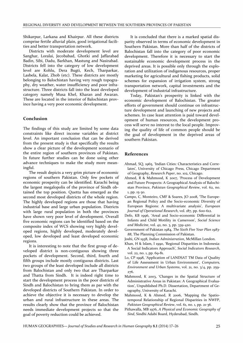
6). Weighted Component Scores In order to obtain a composite index Weighted Com-ponent Scores (WCS) were computed by combining component score 1, 2, 3 and 4. These are total score giving an overall composite index for all individual 42 districts. Table 2 reveals the top and bottom ten ranked districts obtained by WCS. All these districts have been grouped into five categories for capturing the very high development level, high development
level, moderate development level, low development level and very low development level (Figure 7).
Both the administrative head quarters of Sindh and Balochistan (Karachi and Quetta) have obtained top first and second ranking respectively. Ziarat and Hyderabad secured third and forth position and fall-ing into very high development level. It is interesting that Ziarat stands at third position in terms of WCS because of forest cover and fruit orchids. In Ziarat orchids can further be planned for better economic prospects of the province and country. High devel-opment level category includes seven districts namely Sukkur, Nawshero Feroz, Nawabshah, Mirpur Khas
Figure 7. Sindh-Balochistan – Weighted Component score
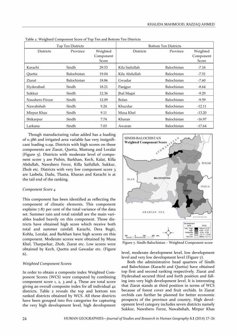
Table 2: Table 2. Weighted Component Score of Top Ten and Bottom Ten Districts
Top Ten Districts Bottom Ten Districts
Districts Province Weighted
Component
Score
Districts Province Weighted
Component
Score
Karachi Sindh 29.53 Kila Saifullah Balochistan -7.16
Quetta Balochistan 19.04 Kila Abdullah Balochistan -7.51
Ziarat Balochistan 18.86 Gwadar Balochistan -7.60
Hyderabad Sindh 18.21 Panjgur Balochistan -8.64
Sukkur Sindh 12.36 Jhal Magsi Balochistan -9.29
Naushero Firoze Sindh 12.09 Bolan Balochistan -9.59
Nawabshah Sindh 9.24 Khuzdar Balochistan -12.11
Mirpur Khas Sindh 9.11 Musa Khel Balochistan -13.20
Shikarpur Sindh 7.74 Kharan Balochistan -16.97
Larkana Sindh 7.03 Awaran Balochistan -17.64
REGIONAL DIVERSITY AND DEVELOPMENT BETWEEN THE SOUTHERN PROVINCES OF PAKISTAN
HUMAN GEOGRAPHIES— Journal of Studies and Research in Human Geography 8.1 (2014) 17–26 25
Shikarpur, Larkana and Khairpur. All these districts comprise fertile alluvial plain, good irrigational facili-ties and better transportation network.
Districts with moderate development level are Sanghar, Loralai, Jecobabad, Ghotki and Jaffarabad Badin, Sibi, Dadu, Barkhan, Mastung and Nasirabad. Districts fell into the category of low development level are Kohlu, Dera Bugti, Kech, Tharparkar, Lasbela, Kalat, Zhob (etc). These districts are mostly belonging to Balochistan having very rough topogra-phy, dry weather, water insufficiency and poor infra-structure. Three districts fall into the least developed category namely Musa Khel, Kharan and Awaran. These are located in the interior of Balochistan prov-ince having a very poor economic development. Conclusion The findings of this study are limited by some data constraints like direct income variables at district level. An important conclusion that can be derived from the present study is that specifically the results show a clear picture of the development scenario of the entire region of southern provinces of Pakistan. In future further studies can be done using other advance techniques to make the study more mean-ingful.
The result depicts a very grim picture of economic regions of southern Pakistan. Only few pockets of economic prosperity can be identified. Karachi being the largest megalopolis of the province of Sindh ob-tained the top position. Quetta has emerged as the second most developed districts of the whole region. The highly developed regions are those that having industrial base and large urban population. Districts with large rural population in both the provinces have shown very poor level of development. Overall five economic regions can be identified based on the composite index of WCS showing very highly devel-oped regions, highly developed, moderately devel-oped, low developed and least developed economic regions.
It is interesting to note that the first group of de-veloped district is non-contiguous showing three pockets of development. Second, third, fourth and fifth groups include mostly contiguous districts. Last two groups of the least developed include all districts from Balochistan and only two that are Tharparkar and Thatta from Sindh. It is indeed right time to start the development process in the poor districts of Sindh and Balochistan to bring them as par with the developed districts of Southern Pakistan. In order to achieve the objective it is necessary to develop the urban and rural infrastructure in these areas. The results clearly show that the province of Balochistan needs immediate development projects so that the goal of poverty reduction could be achieved.
It is concluded that there is a marked spatial dis-parity observed in terms of economic development in Southern Pakistan. More than half of the districts of Balochistan fall into the category of poor economic development. Therefore it is necessary to start the sustainable economic development process in the deprived areas. It is possible only through the explo-ration and utilization of indigenous resources, proper marketing for agricultural and fishing products, solid schemes for expansion of irrigation system, strong transportation network, capital investments and the development of industrial infrastructure.
Today, Pakistan’s prosperity is linked with the economic development of Balochistan. The greater efforts of government should continue on infrastruc-ture development and launching of new projects and schemes. In case least attention is paid toward devel-opment of human resources, the development pro-cess will serve no interest to the local people. Improv-ing the quality of life of common people should be the goal of development in the deprived areas of southern Pakistan. References Ahmad, SQ, 1965, ‘Indian Cities: Characteristics and Corre-
lates’, University of Chicago Press, Chicago Department
of Geography, Research Paper, no. 102, Chicago.
Ahmed, R & Mahmood, K 2007, ‘Process of Development
and Future Prospects: A Geographical Analysis of Balochi-
stan Province, Pakistan Geographical Review, vol. 62, no.
1, pp. 15-30.
Campo, C, Monteiro, CMF & Soares, JO 2008, ‘The Europe-
an Regional Policy and the Socio-economic Diversity of
European Regions: A multivariate analysis’, European
Journal of Operational Research, vol. 187, pp. 600-612.
Defo, KB 1996, ‘Areal and Socio-economic Differential in
Infants and Child Motility in Cameroon’, Social Science
and Medicine, vol. 42, no. 3, pp. 339-420.
Government of Pakistan 1984, The Sixth Five Year Plan 1983-
88, The Planning Commission of Pakistan.
Joshi, GN 1938, Indian Administration, McMillan London.
Khan, H & Islam, I 1990, ‘Regional Disparities in Indonesia:
A Social Indicators Approach’, Social Indicators Research,
vol. 22, no. 1, pp. 69-81.
Lo, CP 1998, ‘Application of LANDSAT TM Data of Quality
of Life Assessment in Urban Environment’, Computers,
Environment and Urban Systems, vol. 21, no. 3/4, pp. 259-
276.
Mahmood, K 2003, ‘Changes in the Spatial Structure of
Administrative Areas in Pakistan: A Geographical Evalua-
tion’, Unpublished Ph.D. Dissertation, Department of Ge-
ography, University of Karachi.
Mahmood, K & Ahmed, R 2006, ‘Mapping the Spatio-
temporal Relationship of Regional Disparities in NWFP,
Pakistan Geographical Review, vol. 61, no. 1, pp. 21-36.
Pithawalla, MB 1976, A Physical and Economic Geography of
Sind, Sindhi Adabi Board, Hyderabad, Sindh.

KHALIDA MAHMOOD, RAZZAQ AHMED
HUMAN GEOGRAPHIES—Journal of Studies and Research in Human Geography 8.1 (2014) 17–26 26
Quadrado, L, Heijman, W & Folmer, H 2001, ‘Multidimen-
sional Analysis of Regional Inequality: The case of Hunga-
ry’, Social Indicators Research, vol. 56, no. 1, pp 21-42.
Rahman, M 1975, Geography of Sind Province, Pakistan,
Oxford University Press, Karachi.
Rogerson, PA 2001, Statistical Methods for Geography, Sage
Publication, London.
Soares, JO, Marques, MML & Monteiro, CMF 2003, ‘A Mul-
tivariate Methodology to Uncover Regional Disparity: A
contribution to improve European Union and govern-
mental decisions, European Journal of Operational Re-
search, vol. 145, pp. 121-135.
Thinker, CH 1963, ‘The Village in the Framework of Devel-
opment’, in R, Braibanti & JJ, Spengler (eds.) Administra-
tion and Economic Development in India, Duke University
Press, Durham.
Thompson, JH et al. 1962, ‘Toward a Geography of Econom-
ic Health: The Case of New York State’, Annals Associa-
tion of American Geographers, vol. 52, pp. 1-20.
Zafar, F 1990, ‘Development Planning in Pakistan: A Re-
gional Framework’, Geographical Paper, vol. 1, pp. 9-17.
Related Documents