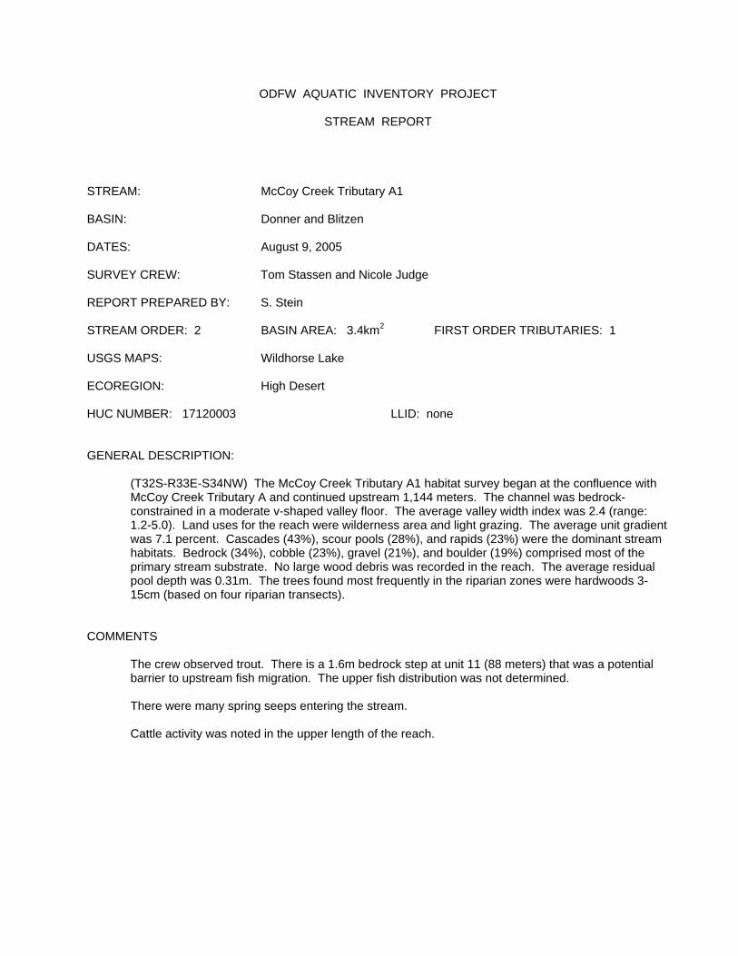
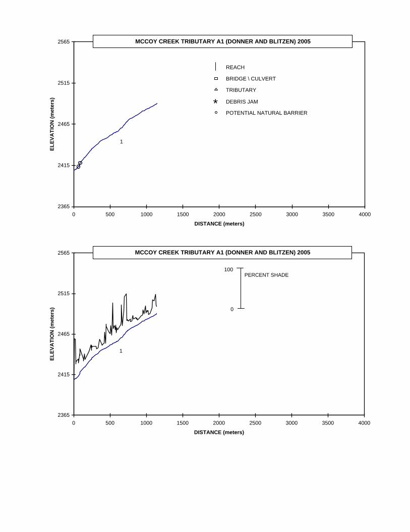
ODFW AQUATIC INVENTORY PROJECT STREAM REPORT STREAM: McCoy Creek Tributary A1 BASIN: Donner and Blitzen DATES: August 9, 2005 SURVEY CREW: Tom Stassen and Nicole Judge REPORT PREPARED BY: S. Stein STREAM ORDER: 2 BASIN AREA: 3.4km 2 FIRST ORDER TRIBUTARIES: 1 USGS MAPS: Wildhorse Lake ECOREGION: High Desert HUC NUMBER: 17120003 LLID: none GENERAL DESCRIPTION: (T32S-R33E-S34NW) The McCoy Creek Tributary A1 habitat survey began at the confluence with McCoy Creek Tributary A and continued upstream 1,144 meters. The channel was bedrock- constrained in a moderate v-shaped valley floor. The average valley width index was 2.4 (range: 1.2-5.0). Land uses for the reach were wilderness area and light grazing. The average unit gradient was 7.1 percent. Cascades (43%), scour pools (28%), and rapids (23%) were the dominant stream habitats. Bedrock (34%), cobble (23%), gravel (21%), and boulder (19%) comprised most of the primary stream substrate. No large wood debris was recorded in the reach. The average residual pool depth was 0.31m. The trees found most frequently in the riparian zones were hardwoods 3- 15cm (based on four riparian transects). COMMENTS The crew observed trout. There is a 1.6m bedrock step at unit 11 (88 meters) that was a potential barrier to upstream fish migration. The upper fish distribution was not determined. There were many spring seeps entering the stream. Cattle activity was noted in the upper length of the reach.

Welcome message from author
This document is posted to help you gain knowledge. Please leave a comment to let me know what you think about it! Share it to your friends and learn new things together.
Transcript
ODFW AQUATIC INVENTORY PROJECT
STREAM REPORT STREAM: McCoy Creek Tributary A1 BASIN: Donner and Blitzen DATES: August 9, 2005 SURVEY CREW: Tom Stassen and Nicole Judge REPORT PREPARED BY: S. Stein STREAM ORDER: 2 BASIN AREA: 3.4km2 FIRST ORDER TRIBUTARIES: 1 USGS MAPS: Wildhorse Lake ECOREGION: High Desert HUC NUMBER: 17120003 LLID: none GENERAL DESCRIPTION: (T32S-R33E-S34NW) The McCoy Creek Tributary A1 habitat survey began at the confluence with
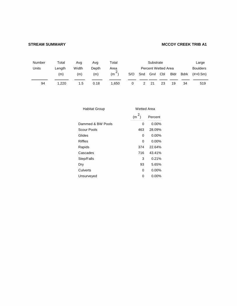
McCoy Creek Tributary A and continued upstream 1,144 meters. The channel was bedrock-constrained in a moderate v-shaped valley floor. The average valley width index was 2.4 (range: 1.2-5.0). Land uses for the reach were wilderness area and light grazing. The average unit gradient was 7.1 percent. Cascades (43%), scour pools (28%), and rapids (23%) were the dominant stream habitats. Bedrock (34%), cobble (23%), gravel (21%), and boulder (19%) comprised most of the primary stream substrate. No large wood debris was recorded in the reach. The average residual pool depth was 0.31m. The trees found most frequently in the riparian zones were hardwoods 3-15cm (based on four riparian transects).
COMMENTS The crew observed trout. There is a 1.6m bedrock step at unit 11 (88 meters) that was a potential
barrier to upstream fish migration. The upper fish distribution was not determined.
There were many spring seeps entering the stream. Cattle activity was noted in the upper length of the reach.
2365
2415
2465
2515
2565
0 500 1000 1500 2000 2500 3000 3500 4000
DISTANCE (meters)
ELEV
ATI
ON
(met
ers)
REACH
BRIDGE \ CULVERT
TRIBUTARY
DEBRIS JAM
POTENTIAL NATURAL BARRIER
MCCOY CREEK TRIBUTARY A1 (DONNER AND BLITZEN) 2005
1
*
2365
2415
2465
2515
2565
0 500 1000 1500 2000 2500 3000 3500 4000
DISTANCE (meters)
ELEV
ATI
ON
(met
ers)
MCCOY CREEK TRIBUTARY A1 (DONNER AND BLITZEN) 2005
1
0
100PERCENT SHADE
2365
2415
2465
2515
2565
0 500 1000 1500 2000 2500 3000 3500 4000
DISTANCE (meters)
ELEV
ATI
ON
(met
ers)
MCCOY CREEK TRIBUTARY A1 (DONNER AND BLITZEN) 2005
1
0
100PERCENT SILT AND ORGANICS
2365
2415
2465
2515
2565
0 500 1000 1500 2000 2500 3000 3500 4000
DISTANCE (meters)
ELEV
ATI
ON
(met
ers)
MCCOY CREEK TRIBUTARY A1 (DONNER AND BLITZEN) 2005
1
0
100PERCENT SILT, ORGANICS, AND SAND
2365
2415
2465
2515
2565
0 500 1000 1500 2000 2500 3000 3500 4000
DISTANCE (meters)
ELEV
ATI
ON
(met
ers)
MCCOY CREEK TRIBUTARY A1 (DONNER AND BLITZEN) 2005
1
0
100PERCENT GRAVEL
2365
2415
2465
2515
2565
0 500 1000 1500 2000 2500 3000 3500 4000
DISTANCE (meters)
ELEV
ATI
ON
(met
ers)
MCCOY CREEK TRIBUTARY A1 (DONNER AND BLITZEN) 2005
1
0
100PERCENT BEDROCK

2365
2415
2465
2515
2565
0 500 1000 1500 2000 2500 3000 3500 4000
DISTANCE (meters)
ELEV
ATI
ON
(met
ers)
MCCOY CREEK TRIBUTARY A1 (DONNER AND BLITZEN) 2005
1
0
100NUMBER OF BOULDERS (running average per 100 m.)
2365
2415
2465
2515
2565
0 500 1000 1500 2000 2500 3000 3500 4000
DISTANCE (meters)
ELEV
ATI
ON
(met
ers)
MCCOY CREEK TRIBUTARY A1 (DONNER AND BLITZEN) 2005
1
1
0POOLS GREATER THAN OR EQUAL TO 0.5 METER DEEP
DEPTH (meters)

2365
2415
2465
2515
2565
0 500 1000 1500 2000 2500 3000 3500 4000
DISTANCE (meters)
ELEV
ATI
ON
(met
ers)
MCCOY CREEK TRIBUTARY A1 (DONNER AND BLITZEN) 2005
1
0
100PIECES OF LARGE WOOD
2365
2415
2465
2515
2565
0 500 1000 1500 2000 2500 3000 3500 4000
DISTANCE (meters)
ELEV
ATI
ON
(met
ers)
MCCOY CREEK TRIBUTARY A1 (DONNER AND BLITZEN) 2005
1
0
100VOLUME OF LARGE WOOD (cubic meters)

2365
2415
2465
2515
2565
0 500 1000 1500 2000 2500 3000 3500 4000
DISTANCE (meters)
ELEV
ATI
ON
(met
ers)
MCCOY CREEK TRIBUTARY A1 (DONNER AND BLITZEN) 2005
1
THERE WERE NO KEYPIECES OF LARGE WOOD
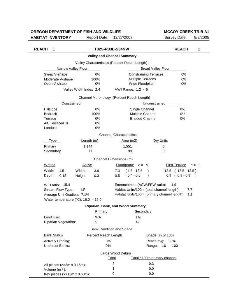
OREGON DEPARTMENT OF FISH AND WILDLIFEHABITAT INVENTORY Survey Date: 8/8/2005Report Date: 12/27/2007
MCCOY CREEK TRIB A1
REACH 1 REACH 1T32S-R33E-S34NWValley and Channel Summary
Narrow Valley Floor Broad Valley Floor Valley Characteristics (Percent Reach Length)
Steep V-shapeModerate V-shapeOpen V-shape
Constraining TerracesMultiple TerracesWide Floodplain
Valley Width Index
Channel Morphology (Percent Reach Length)
Hillslope
Constrained Unconstrained
BedrockTerraceAlt. Terrace/HillLanduse
Single ChannelMultiple ChannelBraided Channel
Channel Characteristics
Type Length (m) Area (m2) Dry Units
PrimarySecondary
Channel Dimensions (m)Wetted Active Floodprone First Terrace
Width:Depth:
Width:Height:
W:D ratio: Entrenchment (ACW:FPW ratio):Stream Flow Type:Average Unit Gradient:
Habitat Units/100m (total channel length):
0%0%
0%100%
0%
0%0%0%
0%100%
0%
0%0%0%
2.4 VWI Range: 1.2 - 5
77 9903
1,144 1,551
1.50.18
3.90.3
7.30.5
13.50.9
15.4 1.9LF7.1%
7.7
Riparian, Bank, and Wood SummaryPrimary Secondary
Land Use:Riparian Vegetation:
WAS
LGG
Bank Condition and Shade
Bank Status Percent Reach Length Shade (% of 180)
Reach avg:Undercut Banks:
Large Wood DebrisTotal Total / 100m primary channel
All pieces (>=3m x 0.15m):Volume (m ):Key pieces (>=12m x 0.60m):
310
0.30.00.0
3%0%
33%Actively Eroding:
16.0 16.0Water temperature (°C): -
10Range: 100 -
3
9n = 1n =
( 4.5 - 13.5( 0.4 - 0.6
( 13.5 - 13.5( 0.9 - 0.9
))
))
8.2Habitat Units/100m (primary channel length):
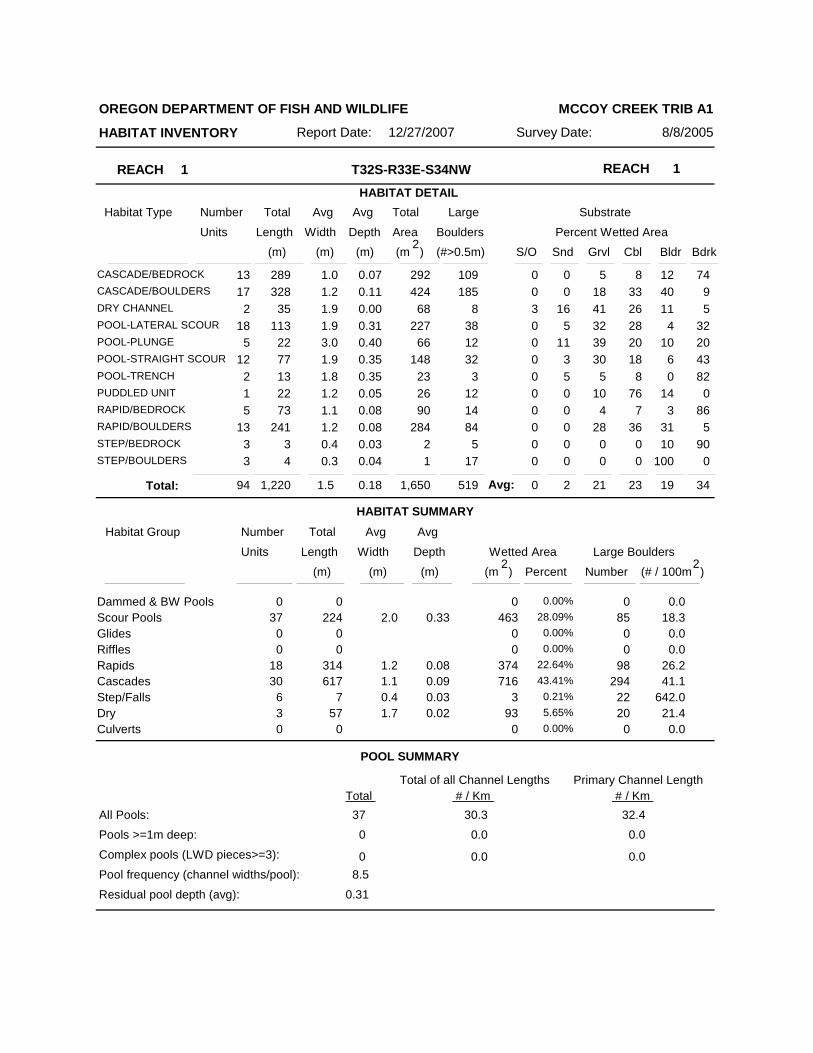
REACH 1 REACH 1T32S-R33E-S34NWHABITAT DETAIL
Habitat Type Number Total Avg Total Large Substrate
Percent Wetted Area Units Length Width
Avg
Depth Area Boulders (m) (m) (m) (m )2 (#>0.5m) S/O Snd Grvl Cbl Bldr Bdrk
OREGON DEPARTMENT OF FISH AND WILDLIFE
HABITAT INVENTORY Survey Date: 8/8/2005Report Date: 12/27/2007
MCCOY CREEK TRIB A1
13CASCADE/BEDROCK 289 1.0 0.07 292 109 0 0 5 8 12 7417CASCADE/BOULDERS 328 1.2 0.11 424 185 0 0 18 33 40 9
2DRY CHANNEL 35 1.9 0.00 68 8 3 16 41 26 11 518POOL-LATERAL SCOUR 113 1.9 0.31 227 38 0 5 32 28 4 32
5POOL-PLUNGE 22 3.0 0.40 66 12 0 11 39 20 10 2012POOL-STRAIGHT SCOUR 77 1.9 0.35 148 32 0 3 30 18 6 43
2POOL-TRENCH 13 1.8 0.35 23 3 0 5 5 8 0 821PUDDLED UNIT 22 1.2 0.05 26 12 0 0 10 76 14 05RAPID/BEDROCK 73 1.1 0.08 90 14 0 0 4 7 3 86
13RAPID/BOULDERS 241 1.2 0.08 284 84 0 0 28 36 31 53STEP/BEDROCK 3 0.4 0.03 2 5 0 0 0 0 10 903STEP/BOULDERS 4 0.3 0.04 1 17 0 0 0 0 100 0
HABITAT SUMMARY
POOL SUMMARY
94 1,220 1.5 0.18 1,650 519 0 2 21 23 19 34Total:
Habitat Group Number Total Avg
Wetted Area Large Boulders Units Length Width
Avg
Depth
Number (m) (m) (m) )2
(# / 100mPercent
Scour PoolsGlidesRifflesRapidsCascadesStep/FallsDry
Dammed & BW Pools 000 0.00%463224 2.0 0.3337 28.09%
000 0.00%000 0.00%
374314 1.2 0.0818 22.64%716617 1.1 0.0930 43.41%
37 0.4 0.036 0.21%
Culverts9357 1.7 0.023 5.65%
000 0.00%
085
00
98294
2220
0
0.0
0.00.0
41.1642.0
21.40.0
Total Total of all Channel Lengths
All Pools:Pools >=1m deep:
Complex pools (LWD pieces>=3):
Pool frequency (channel widths/pool):
37
Residual pool depth (avg):
30.3
0.31
8.5
0
0
0.0
0.0
(m )2
26.2
18.3
Avg:
32.40.0
0.0
# / Km Primary Channel Length
# / Km
Number Total Avg Total Large Substrate Percent Wetted Area Units Length Width
AvgDepth Area Boulders
(m) (m) (m) (m )2
(#>0.5m)S/O Snd Grvl Cbl Bldr Bdrk
STREAM SUMMARY MCCOY CREEK TRIB A1
Scour Pools
Glides
Riffles
Rapids
Cascades
Step/FallsDry
Dammed & BW Pools
Culverts
Wetted Area
Percent
0 0.00%463 28.09%
0 0.00%
0 0.00%
374 22.64%
716 43.41%
3 0.21%93 5.65%
0 0.00%
Habitat Group
(m )2
94 1,220 1.5 0.18 1,650 5190 2 21 23 19 34
Unsurveyed 0 0.00%
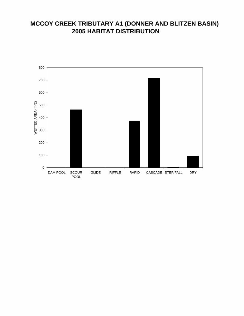
MCCOY CREEK TRIBUTARY A1 (DONNER AND BLITZEN BASIN)2005 HABITAT DISTRIBUTION
0
100
200
300
400
500
600
700
800
DAM POOL SCOURPOOL
GLIDE RIFFLE RAPID CASCADE STEP/FALL DRY
WET
TED
AR
EA (m
^2)

Summary of Riparian Zone (0-30m) transects
Total hardwoods/1000Total conifers/1000 ftTotal conifers >20" dbh/1000 ftTotal conifers >35" dbh/1000 ft
Average number of trees in a 5-meter wide band
Canopy closure and ground cover
Predominant landform in each zone
Zone 1 Zone 2 Zone 3 Zones 1-30-10 meters 10 - 20 meters 20 - 30 meters 0-30 meters
Conifer Hardwood Conifer Hardwood Conifer Hardwood Conifer HardwoodDiameterclass (cm)
3-15cm15-30cm30-50cm50-90cm>90cm
Total/100m2
Zone 1 Zone 2 Zone 30-10 meters 10 - 20 meters 20 - 30 meters
Zone 1 Zone 2 Zone 30-10 meters 10 - 20 meters 20 - 30 meters
Canopy closureShrub coverGrass/forb cover
HillslopeHigh terraceLow terraceFloodplainWetland/meadowStream channelRoadbed/RailroadRiprap
Surface slope (%)
4
732000
0.00.00.00.0
0.0
0.0
1.50.30.00.0
1.8
0.0
0.00.00.00.00.0
3.50.30.00.00.0
0.00.00.00.00.0
6.50.00.00.00.0
0.00.00.00.0
0.0
0.0
11.50.50.00.0
4.0
0.0
73932
113444
115343
1000000000
1000000000
1000000000
29 18 10
0.0 3.8 0.0 6.5
(%) (%)(%)
(%) (%)(%)
RIPARIAN ZONE VEGETATION SUMMARYREACH 1 REACH 1
OREGON DEPARTMENT OF FISH AND WILDLIFE
HABITAT INVENTORY Report Date:
MCCOY CREEK TRIB A1
12/27/2007 Survey Date: 8/9/2005

Summary of Riparian Zone (0-30m) for all reaches transects
Total hardwoods/1000Total conifers/1000 ftTotal conifers >20" dbh/1000 ftTotal conifers >35" dbh/1000 ft
4
732000
Zones 1-30-30 meters
Conifer Hardwood
0.00.00.00.00.0
11.50.50.00.00.0
Diameterclass (cm)
3-15cm15-30cm30-50cm50-90cm>90cm
Average number of trees in a 5-m wide band
OREGON DEPARTMENT OF FISH AND WILDLIFE
HABITAT INVENTORY - RIPARIAN SURVEY
MCCOY CREEK TRIB A1
8/9/2005
Summary of riparian zone (0-100 feet) extrapolated to 1,000 feet along stream

8/9/2005Survey Date:12/27/2007
Reach 1 1
HABITAT INVENTORY
MCCOY CREEK TRIB A1
Report Date:
RIPARIAN ZONE VEGETATIONReach
OREGON DEPARTMENT OF FISH AND WILDLIFE
Slope Canopy ShrubSurfaceZoneSideUnit
Cover (percent)
Grass 3-15 15-30 30-50 50-90 >90
Diameter class (cm)
Notes
7 LF 1 HS 52 30 40 60
6 1
11T 0367705 4730881
Conifer
Hardwood7 LF 2 HS 35 55 40 60
4 1
Conifer
Hardwood7 LF 3 HS 20 35 70 30
10
Conifer
Hardwood7 RT 1 HS 45 10 30 10 Conifer
Hardwood7 RT 2 HS 5 0 25 25 Conifer
Hardwood7 RT 3 HS 7 0 10 90 Conifer
Hardwood29 LF 1 HS 7 0 30 10 11T 0367911
4730648Conifer
Hardwood29 LF 2 HS 21 0 10 20 Conifer
Hardwood29 LF 3 HS 14 0 90 10 Conifer
Hardwood29 RT 1 HS 10 0 10 85 Conifer
Hardwood29 RT 2 HS 5 0 0 100 Conifer
Hardwood29 RT 3 HS 1 0 0 95 Conifer
Hardwood59 LF 1 HS 55 0 60 10 11T 0368147
4730717Conifer
Hardwood59 LF 2 HS 20 0 80 10 Conifer
Hardwood59 LF 3 HS 7 0 80 10 Conifer
Hardwood59 RT 1 HS 30 5 70 20 Conifer
Hardwood59 RT 2 HS 25 0 30 70 Conifer
Hardwood59 RT 3 HS 5 40 50 30
13
Conifer
Hardwood89 LF 1 HS 25 5 60 25 11T 0368433
4730844Conifer
Hardwood

89 LF 2 HS 3 0 75 10 Conifer
Hardwood89 LF 3 HS 3 0 90 10 Conifer
Hardwood89 RT 1 HS 10 5 10 35 Conifer
Hardwood89 RT 2 HS 30 35 15 60
10
Conifer
Hardwood89 RT 3 HS 25 15 35 65
3
Conifer
Hardwood

MCCOY CREEK TRIBUTARY A1 2005 COMMENT SUMMARY
REACH UNIT# TYPE CHAN DIST.(m) COMMENTS NOTE_ESTIMATOR NOTE_NUMERATOR
1 1 RR 01 6 START SURVEY T IS 16 AT 18401 5 SB 00 30 H IS .61 6 LP 00 35 TROUT1 7 CB 00 64 PN 2 TROUT1 10 PP 00 88 2 TROUT1 11 SR 00 88 PN H IS 1.61 15 LP 00 156 /SS1 20 SR 00 244 H IS .81 24 CR 00 311 /SS1 31 RB 00 416 SS/1 32 CB 00 429 /SS1 33 SP 00 441 /SS CATTLE ACTIVITY1 34 CB 00 445 /SS1 35 SP 00 449 /SS1 44 CB 00 559 /SS1 50 SB 00 593 H IS .351 54 SB 00 655 H IS .4 T IS 17 13301 62 SR 00 748 H IS 1.21 73 CR 00 871 SS/ T IS 5.5 AT SEEP1 75 RR 00 904 /SS1 79 RB 00 963 CATTLE ACTIVITY CATTLE ACTIVITY1 83 RB 00 1007 VWI IS 41 88 DC 02 CATTLE ACTIVITY1 93 TP 00 1134 T IS 17 AT 15301 94 CB 00 1144 END AT /TJ END AT TJ NEAR HEADWATERS
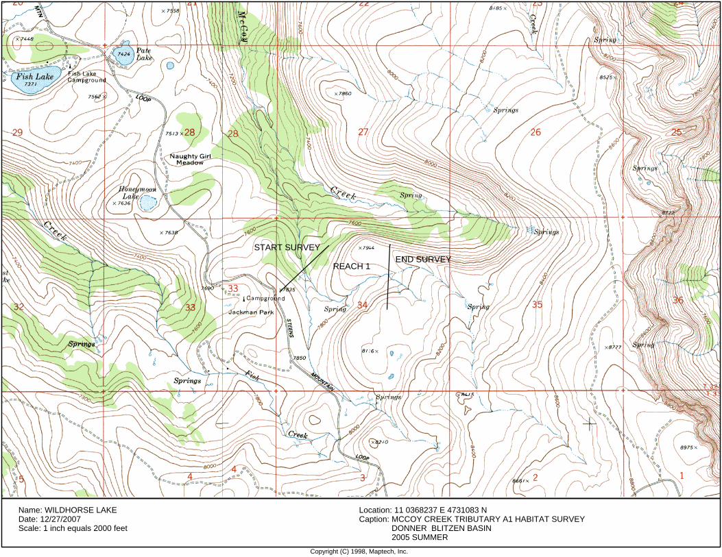
Copyright (C) 1998, Maptech, Inc.
Name: WILDHORSE LAKEDate: 12/27/2007Scale: 1 inch equals 2000 feet
Location: 11 0368237 E 4731083 NCaption: MCCOY CREEK TRIBUTARY A1 HABITAT SURVEY
DONNER BLITZEN BASIN2005 SUMMER
START SURVEYEND SURVEY
REACH 1
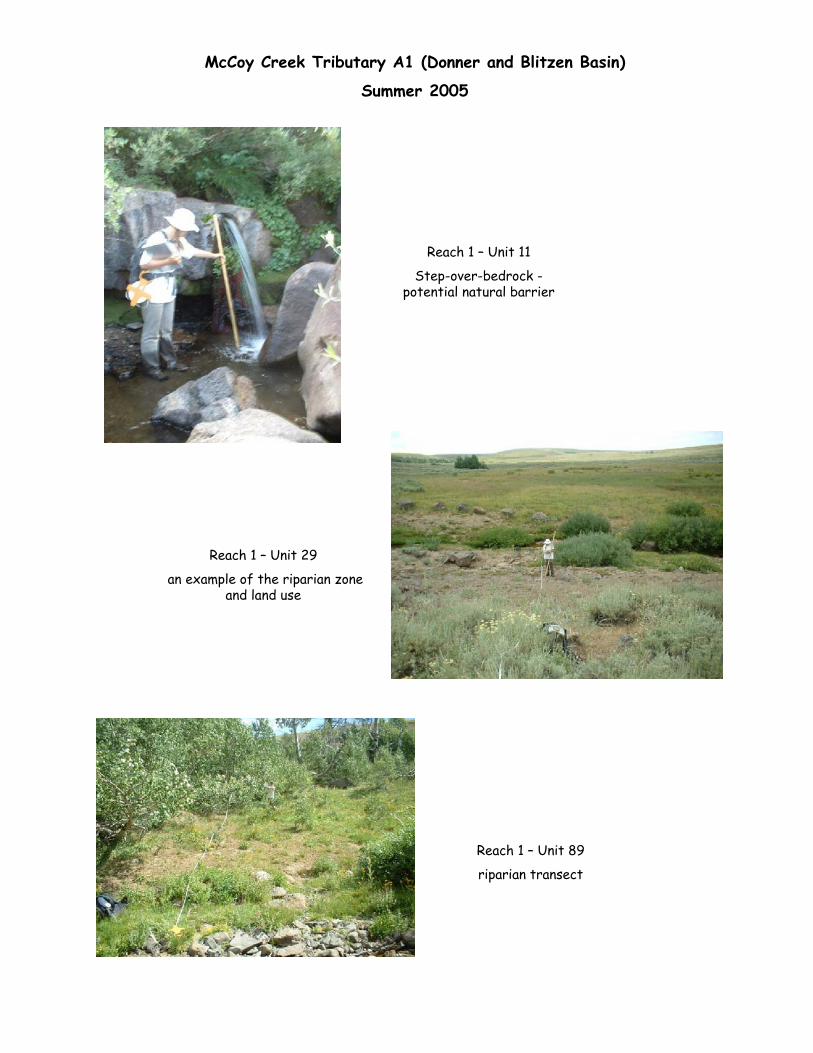
McCoy Creek Tributary A1 (Donner and Blitzen Basin)
Summer 2005
Reach 1 – Unit 11
Step-over-bedrock -potential natural barrier
Reach 1 – Unit 29
an example of the riparian zone and land use
Reach 1 – Unit 89
riparian transect
Related Documents