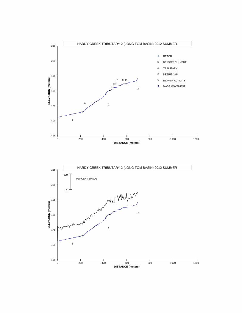
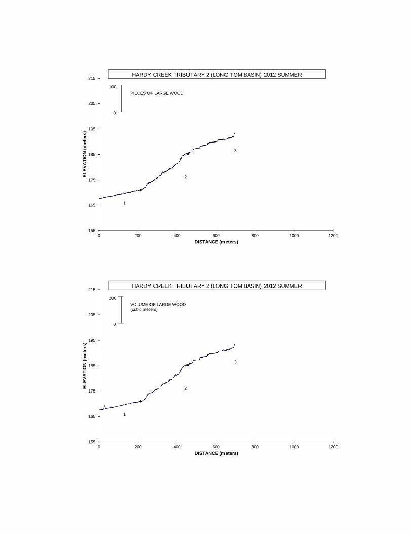
ODFW AQUATIC INVENTORY PROJECT STREAM REPORT STREAM: Hardy Creek Tributary 2 LLID: none BASIN: Long Tom River HUC NUMBER: 17090003 DATES: September 18-19, 2012 SURVEY CREW: Frank Zomer, Maya Rommwatt, Lora Tennant, Jackie Hancock, Peggy Kavanagh REPORT PREPARED BY: Peggy Kavanagh USGS MAPS: Noti ECOREGION: Willamette Valley Plain and Foothills BASIN AREA: 1.39km 2 FIRST ORDER TRIBUTARIES: 3 STREAM ORDER: 2 GENERAL DESCRIPTION: The Hardy Creek Tributary 2 habitat survey began at the confluence of Hardy Creek and ended approximately 693 meters upstream. Three reaches were designated based on changes land use and surveyor composition. Constraining high terraces characterized the valley. The land uses were timber harvest, young trees (3-15cm dbh), second-growth timber (15-30cm dbh), and large timber (30-50cm dbh). The stream habitat was composed mostly of scour pool and riffles. The substrate was primarily gravel and fine sediment. The trees observed most frequently in the riparian transect were hardwoods 3-15cm dbh. Conifer and hardwood trees in all size classes (3-90cm dbh) were recorded. Large wood volume ranged from 10.7-19.5m 3 /100m. REACH DESCRIPTIONS: Reach 1: (T18S-R06W-S17NE) Length 214 meters. Reach 1 began at the junction with Hardy Creek and ended approximately 30 meters downstream from a tributary junction. The reach ended due to a change in the crew composition. The stream channel was constrained by terraces in a broad valley. The average valley width index was 13.7 (range: 7.0-20.0). The land use was large timber. The average gradient was 1.6 percent. Scour pool (65%) was the dominant stream habitat. The substrate was mostly sand (39%) and gravel (44%). Eighty- five percent of the reach had actively eroding banks. The average residual pool depth was 0.24 meters. The trees found in the riparian zone were hardwoods 30-50cm and conifers 30-90cm dbh (based on two riparian transects). Large wood volume was 16.3m 3 /100m. Reach 2: (T18S-R06W-S17NE) Length 241 meters. Reach 2 extended to a land use change. The stream channel was constrained by alternating hillslopes and terraces in a broad valley. The average valley width index was 13.6 (range: 3.0-20.0). There were 16 meters of secondary channel habitat. The land uses were second-growth timber and large timber. The average gradient was 5.9 percent. Scour pool (62%) dominated the stream habitat. The substrate was mostly gravel (62%) and fine sediment (30%). Thirty-eight percent of the reach length had actively eroding banks. The average residual pool depth was 0.18 meters. The trees found most frequently in the riparian zone were hardwoods 3-15cm dbh (based on two riparian transects). Conifers and hardwoods 3-90cm dbh were present. Large wood volume was 19.5m 3 /100m.

Welcome message from author
This document is posted to help you gain knowledge. Please leave a comment to let me know what you think about it! Share it to your friends and learn new things together.
Transcript
ODFW AQUATIC INVENTORY PROJECT STREAM REPORT
STREAM: Hardy Creek Tributary 2 LLID: none BASIN: Long Tom River HUC NUMBER: 17090003 DATES: September 18-19, 2012 SURVEY CREW: Frank Zomer, Maya Rommwatt, Lora Tennant, Jackie Hancock, Peggy Kavanagh REPORT PREPARED BY: Peggy Kavanagh USGS MAPS: Noti ECOREGION: Willamette Valley Plain and Foothills BASIN AREA: 1.39km2 FIRST ORDER TRIBUTARIES: 3 STREAM ORDER: 2 GENERAL DESCRIPTION: The Hardy Creek Tributary 2 habitat survey began at the confluence of Hardy Creek and ended approximately 693 meters upstream. Three reaches were designated based on changes land use and surveyor composition. Constraining high terraces characterized the valley. The land uses were timber harvest, young trees (3-15cm dbh), second-growth timber (15-30cm dbh), and large timber (30-50cm dbh). The stream habitat was composed mostly of scour pool and riffles. The substrate was primarily gravel and fine sediment. The trees observed most frequently in the riparian transect were hardwoods 3-15cm dbh. Conifer and hardwood trees in all size classes (3-90cm dbh) were recorded. Large wood volume ranged from 10.7-19.5m3/100m. REACH DESCRIPTIONS: Reach 1: (T18S-R06W-S17NE) Length 214 meters. Reach 1 began at the junction with Hardy Creek
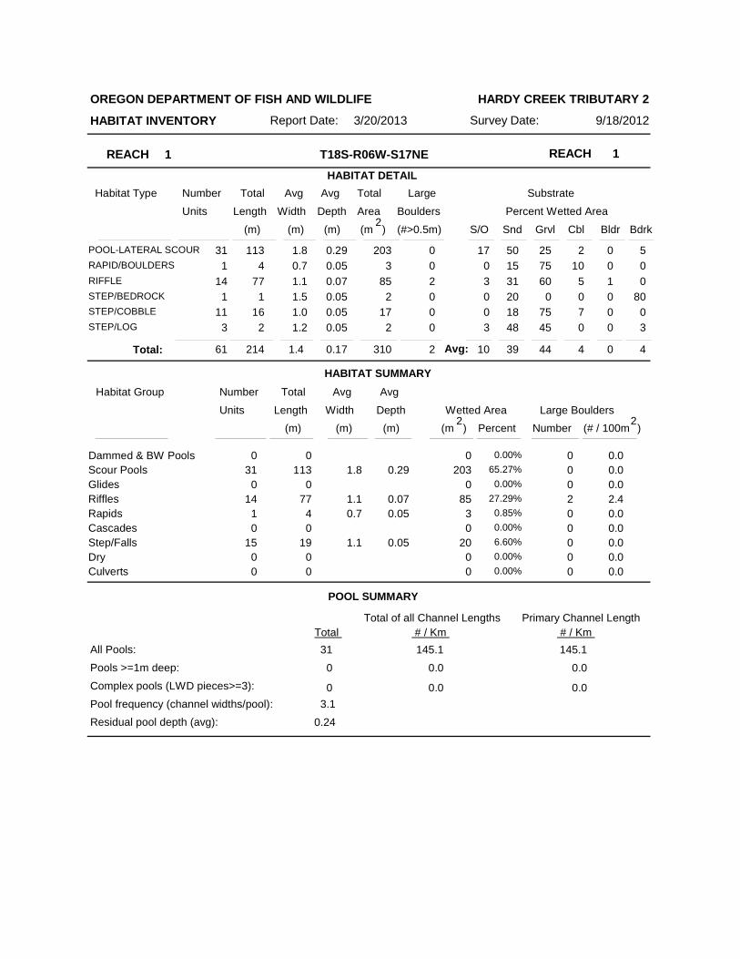
and ended approximately 30 meters downstream from a tributary junction. The reach ended due to a change in the crew composition. The stream channel was constrained by terraces in a broad valley. The average valley width index was 13.7 (range: 7.0-20.0). The land use was large timber. The average gradient was 1.6 percent. Scour pool (65%) was the dominant stream habitat. The substrate was mostly sand (39%) and gravel (44%). Eighty-five percent of the reach had actively eroding banks. The average residual pool depth was 0.24 meters. The trees found in the riparian zone were hardwoods 30-50cm and conifers 30-90cm dbh (based on two riparian transects). Large wood volume was 16.3m3/100m.
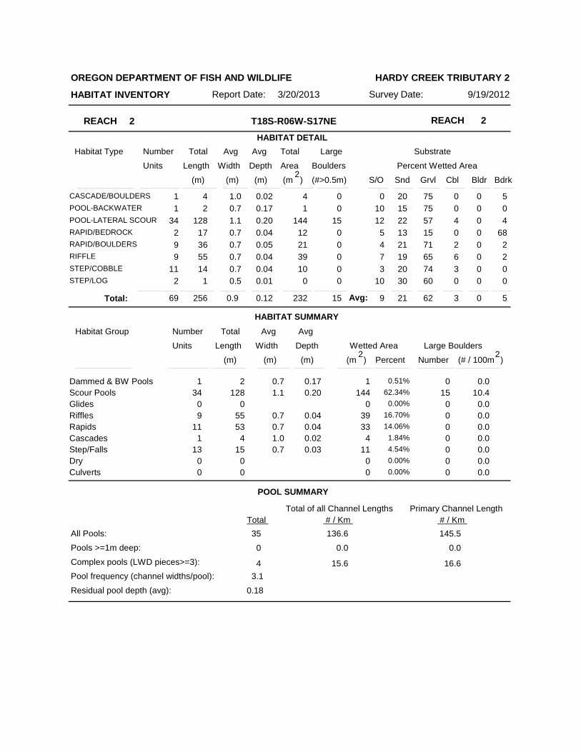
Reach 2: (T18S-R06W-S17NE) Length 241 meters. Reach 2 extended to a land use change. The
stream channel was constrained by alternating hillslopes and terraces in a broad valley. The average valley width index was 13.6 (range: 3.0-20.0). There were 16 meters of secondary channel habitat. The land uses were second-growth timber and large timber. The average gradient was 5.9 percent. Scour pool (62%) dominated the stream habitat. The substrate was mostly gravel (62%) and fine sediment (30%). Thirty-eight percent of the reach length had actively eroding banks. The average residual pool depth was 0.18 meters. The trees found most frequently in the riparian zone were hardwoods 3-15cm dbh (based on two riparian transects). Conifers and hardwoods 3-90cm dbh were present. Large wood volume was 19.5m3/100m.
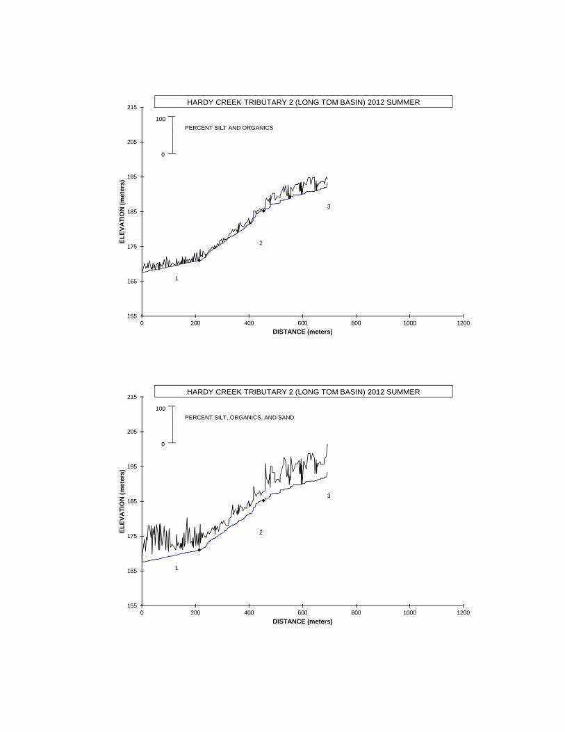
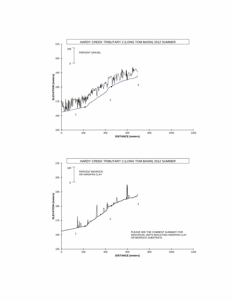
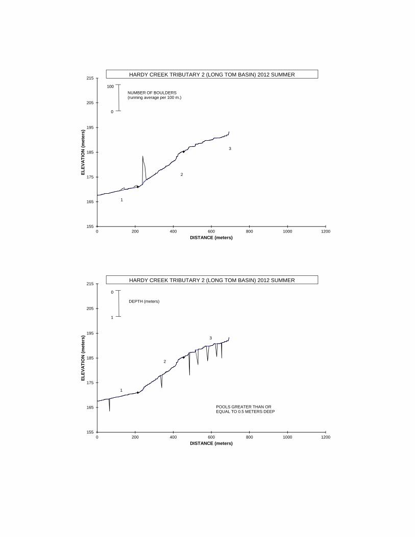
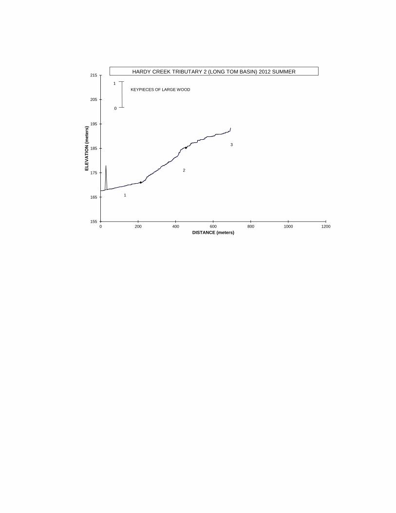
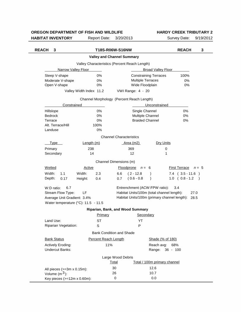
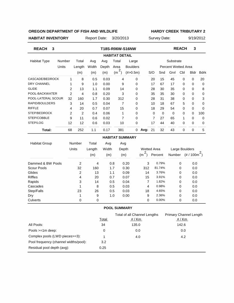
Reach 3: (T18S-R06W-S16NW) Length 238 meters. Reach 3 began at a change in land use and ended due to dry stream bed and evidence of bear. The stream channel was constrained by alternating hillslopes and terraces in a broad valley. The average valley width index was 11.2 (range: 4.0-20.0). There were 14 meters of secondary channel habitat. The land uses were second-growth timber and young trees. The average gradient was 3.4 percent. The stream habitat was predominantly scour pool (82%). The substrate was a predominantly gravel (43%) with fine sediment (53%). Eleven percent of the reach length was actively eroding. The residual pool depth was 0.25 meters. The trees found most frequently in the riparian zone were conifers 30-50cm dbh (based on two riparian transects). Conifers and hardwoods 3-50cm dbh were observed. Large wood volume was 10.7m3/100m.
COMMENT SUMMARY
No fish were observed during the survey. A fish presence/absence survey was not conducted. No barriers were noted in the surveyed segment. Wildlife observations included beaver activity (chewed sticks – old and new), woodpecker, deer tracks, bird, Pacific giant salamander, kinglets, and bear, elk, and raccoon prints. Hardpan clay was noted during the survey, in the creek and on the adjacent landforms. See the Comment Summary for individual units with hardpan clay. Part of Reach 3 meandered through alder trees, and finding the channel was difficult. There were some dead conifers, old beaver activity. The upper part of the reach had the essence of a beaver pond reverting to stream channel.
155
165
175
185
195
205
215
0 200 400 600 800 1000 1200
EL
EV
AT
ION
(m
eter
s)
DISTANCE (meters)
REACH
BRIDGE \ CULVERT
TRIBUTARY
DEBRIS JAM
BEAVER ACTIVITY
HARDY CREEK TRIBUTARY 2 (LONG TOM BASIN) 2012 SUMMER
1
2
3MASS MOVEMENT
155
165
175
185
195
205
215
0 200 400 600 800 1000 1200
EL
EV
AT
ION
(m
eter
s)
DISTANCE (meters)
HARDY CREEK TRIBUTARY 2 (LONG TOM BASIN) 2012 SUMMER
1
2
3
0
100
PERCENT SHADE
155
165
175
185
195
205
215
0 200 400 600 800 1000 1200
EL
EV
AT
ION
(m
eter
s)
DISTANCE (meters)
HARDY CREEK TRIBUTARY 2 (LONG TOM BASIN) 2012 SUMMER
1
2
3
0
100
PERCENT SILT AND ORGANICS
155
165
175
185
195
205
215
0 200 400 600 800 1000 1200
EL
EV
AT
ION
(m
eter
s)
DISTANCE (meters)
HARDY CREEK TRIBUTARY 2 (LONG TOM BASIN) 2012 SUMMER
1
2
3
0
100
PERCENT SILT, ORGANICS, AND SAND
155
165
175
185
195
205
215
0 200 400 600 800 1000 1200
EL
EV
AT
ION
(m
eter
s)
DISTANCE (meters)
HARDY CREEK TRIBUTARY 2 (LONG TOM BASIN) 2012 SUMMER
1
2
3
0
100
PERCENT GRAVEL
155
165
175
185
195
205
215
0 200 400 600 800 1000 1200
EL
EV
AT
ION
(m
eter
s)
DISTANCE (meters)
HARDY CREEK TRIBUTARY 2 (LONG TOM BASIN) 2012 SUMMER
1
2
3
0
100
PERCENT BEDROCK OR HARDPAN CLAY
PLEASE SEE THE COMMENT SUMMARY FOR INDIIVIDUAL UNITS INDICATING HARDPAN CLAY OR BEDROCK SUBSTRATE
155
165
175
185
195
205
215
0 200 400 600 800 1000 1200
EL
EV
AT
ION
(m
eter
s)
DISTANCE (meters)
HARDY CREEK TRIBUTARY 2 (LONG TOM BASIN) 2012 SUMMER
1
2
3
0
100
NUMBER OF BOULDERS(running average per 100 m.)
155
165
175
185
195
205
215
0 200 400 600 800 1000 1200
EL
EV
AT
ION
(m
eter
s)
DISTANCE (meters)
HARDY CREEK TRIBUTARY 2 (LONG TOM BASIN) 2012 SUMMER
1
2
3
1
0
POOLS GREATER THAN OR EQUAL TO 0.5 METERS DEEP
DEPTH (meters)
155
165
175
185
195
205
215
0 200 400 600 800 1000 1200
EL
EV
AT
ION
(m
eter
s)
DISTANCE (meters)
HARDY CREEK TRIBUTARY 2 (LONG TOM BASIN) 2012 SUMMER
1
2
3
0
100
PIECES OF LARGE WOOD
155
165
175
185
195
205
215
0 200 400 600 800 1000 1200
EL
EV
AT
ION
(m
eter
s)
DISTANCE (meters)
HARDY CREEK TRIBUTARY 2 (LONG TOM BASIN) 2012 SUMMER
1
2
3
0
100
VOLUME OF LARGE WOOD(cubic meters)
155
165
175
185
195
205
215
0 200 400 600 800 1000 1200
EL
EV
AT
ION
(m
eter
s)
DISTANCE (meters)
HARDY CREEK TRIBUTARY 2 (LONG TOM BASIN) 2012 SUMMER
1
2
3
0
1
KEYPIECES OF LARGE WOOD

OREGON DEPARTMENT OF FISH AND WILDLIFE
HABITAT INVENTORY Survey Date: 9/18/2012Report Date: 3/20/2013
HARDY CREEK TRIBUTARY 2
REACH 1 REACH 1T18S-R06W-S17NE
Valley and Channel Summary
Narrow Valley Floor Broad Valley Floor
Valley Characteristics (Percent Reach Length)
Steep V-shape
Moderate V-shapeOpen V-shape
Constraining TerracesMultiple TerracesWide Floodplain
Valley Width Index
Channel Morphology (Percent Reach Length)
Hillslope
Constrained Unconstrained
BedrockTerraceAlt. Terrace/HillLanduse
Single ChannelMultiple ChannelBraided Channel
Channel Characteristics
Type Length (m) Area (m2) Dry Units
PrimarySecondary
Channel Dimensions (m)
Wetted Active Floodprone First Terrace
Width:Depth:
Width:
Height:
W:D ratio: Entrenchment (ACW:FPW ratio):
Stream Flow Type:
Average Unit Gradient:
Habitat Units/100m (total channel length):
0%0%
0%0%
100%
0%0%0%
0%
0%0%
100%
0%0%
13.7 VWI Range: 7 - 20
0 000
214 310
1.4
0.17
2.3
0.1
2.6
0.2
3.20.7
22.5 1.1
LF
1.6%
28.6
Riparian, Bank, and Wood Summary
Primary Secondary
Land Use:Riparian Vegetation:
LT
M50 S
Bank Condition and Shade
Bank Status Percent Reach Length Shade (% of 180)
Reach avg:Undercut Banks:
Large Wood DebrisTotal Total / 100m primary channel
All pieces (>=3m x 0.15m):Volume (m ):Key pieces (>=12m x 0.60m):
34
35
1
15.9
16.3
0.5
85%3%
83%Actively Eroding:
11.0 11.0Water temperature (°C): -
69Range: 97 -
3
6n = 6n =
( 1.3 - 4.4( 0.2 - 0.2
( 1.8 - 5.2( 0.5 - 0.9
))
))
28.6Habitat Units/100m (primary channel length):

OREGON DEPARTMENT OF FISH AND WILDLIFE
HABITAT INVENTORY Survey Date: 9/19/2012Report Date: 3/20/2013
HARDY CREEK TRIBUTARY 2
REACH 2 REACH 2T18S-R06W-S17NE
Valley and Channel Summary
Narrow Valley Floor Broad Valley Floor
Valley Characteristics (Percent Reach Length)
Steep V-shape
Moderate V-shapeOpen V-shape
Constraining TerracesMultiple TerracesWide Floodplain
Valley Width Index
Channel Morphology (Percent Reach Length)
Hillslope
Constrained Unconstrained
BedrockTerraceAlt. Terrace/HillLanduse
Single ChannelMultiple ChannelBraided Channel
Channel Characteristics
Type Length (m) Area (m2) Dry Units
PrimarySecondary
Channel Dimensions (m)
Wetted Active Floodprone First Terrace
Width:Depth:
Width:
Height:
W:D ratio: Entrenchment (ACW:FPW ratio):
Stream Flow Type:
Average Unit Gradient:
Habitat Units/100m (total channel length):
100%0%
0%0%0%
0%0%0%
0%
0%0%
100%
0%0%
13.6 VWI Range: 3 - 20
16 500
241 226
0.9
0.12
2.4
0.4
5.6
0.8
6.41.2
6.2 2.4
LF
5.9%
26.9
Riparian, Bank, and Wood Summary
Primary Secondary
Land Use:Riparian Vegetation:
ST
S
LT
P
Bank Condition and Shade
Bank Status Percent Reach Length Shade (% of 180)
Reach avg:Undercut Banks:
Large Wood DebrisTotal Total / 100m primary channel
All pieces (>=3m x 0.15m):Volume (m ):Key pieces (>=12m x 0.60m):
75
47
0
31.2
19.5
0.0
38%1%
88%Actively Eroding:
11.5 11.5Water temperature (°C): -
78Range: 100 -
3
7n = 7n =
( 2.4 - 9.3( 0.7 - 0.9
( 2.8 - 10.8( 0.85 - 2.5
))
))
28.7Habitat Units/100m (primary channel length):
OREGON DEPARTMENT OF FISH AND WILDLIFE
HABITAT INVENTORY Survey Date: 9/19/2012Report Date: 3/20/2013
HARDY CREEK TRIBUTARY 2
REACH 3 REACH 3T18S-R06W-S16NW
Valley and Channel Summary
Narrow Valley Floor Broad Valley Floor
Valley Characteristics (Percent Reach Length)
Steep V-shape
Moderate V-shapeOpen V-shape
Constraining TerracesMultiple TerracesWide Floodplain
Valley Width Index
Channel Morphology (Percent Reach Length)
Hillslope
Constrained Unconstrained
BedrockTerraceAlt. Terrace/HillLanduse
Single ChannelMultiple ChannelBraided Channel
Channel Characteristics
Type Length (m) Area (m2) Dry Units
PrimarySecondary
Channel Dimensions (m)
Wetted Active Floodprone First Terrace
Width:Depth:
Width:
Height:
W:D ratio: Entrenchment (ACW:FPW ratio):
Stream Flow Type:
Average Unit Gradient:
Habitat Units/100m (total channel length):
100%0%
0%0%0%
0%0%0%
0%
0%0%
100%
0%0%
11.2 VWI Range: 4 - 20
14 1201
238 369
1.1
0.17
2.3
0.4
6.6
0.7
7.41.0
6.7 3.4
LF
3.4%
27.0
Riparian, Bank, and Wood Summary
Primary Secondary
Land Use:Riparian Vegetation:
ST
S
YT
P
Bank Condition and Shade
Bank Status Percent Reach Length Shade (% of 180)
Reach avg:Undercut Banks:
Large Wood DebrisTotal Total / 100m primary channel
All pieces (>=3m x 0.15m):Volume (m ):Key pieces (>=12m x 0.60m):
30
26
0
12.6
10.7
0.0
11% 68%Actively Eroding:
11.5 11.5Water temperature (°C): -
36Range: 100 -
3
6n = 5n =
( 2 - 12.8( 0.6 - 0.8
( 3.5 - 11.6( 0.8 - 1.2
))
))
28.5Habitat Units/100m (primary channel length):
REACH 1 REACH 1T18S-R06W-S17NE
HABITAT DETAIL
Habitat Type Number Total Avg Total Large Substrate
Percent Wetted Area Units Length Width
Avg
Depth Area Boulders
(m) (m) (m) (m )2
(#>0.5m) S/O Snd Grvl Cbl Bldr Bdrk
OREGON DEPARTMENT OF FISH AND WILDLIFE
HABITAT INVENTORY Survey Date: 9/18/2012Report Date: 3/20/2013
HARDY CREEK TRIBUTARY 2
31POOL-LATERAL SCOUR 113 1.8 0.29 203 0 17 50 25 2 0 5
1RAPID/BOULDERS 4 0.7 0.05 3 0 0 15 75 10 0 0
14RIFFLE 77 1.1 0.07 85 2 3 31 60 5 1 0
1STEP/BEDROCK 1 1.5 0.05 2 0 0 20 0 0 0 80
11STEP/COBBLE 16 1.0 0.05 17 0 0 18 75 7 0 0
3STEP/LOG 2 1.2 0.05 2 0 3 48 45 0 0 3
HABITAT SUMMARY
POOL SUMMARY
61 214 1.4 0.17 310 2 10 39 44 4 0 4Total:
Habitat Group Number Total Avg
Wetted Area Large Boulders Units Length Width
Avg
Depth
Number (m) (m) (m) )2
(# / 100mPercent
Scour PoolsGlidesRifflesRapidsCascadesStep/FallsDry
Dammed & BW Pools 000 0.00%
203113 1.8 0.2931 65.27%
000 0.00%
8577 1.1 0.0714 27.29%
34 0.7 0.051 0.85%
000 0.00%
2019 1.1 0.0515 6.60%
Culverts000 0.00%
000 0.00%
000200000
0.0
0.02.4
0.00.00.00.0
Total Total of all Channel Lengths
All Pools:
Pools >=1m deep:
Complex pools (LWD pieces>=3):
Pool frequency (channel widths/pool):
31
Residual pool depth (avg):
145.1
0.24
3.1
0
0
0.0
0.0
(m )2
0.0
0.0
Avg:
145.1
0.0
0.0
# / Km Primary Channel Length
# / Km
REACH 2 REACH 2T18S-R06W-S17NE
HABITAT DETAIL
Habitat Type Number Total Avg Total Large Substrate
Percent Wetted Area Units Length Width
Avg
Depth Area Boulders
(m) (m) (m) (m )2
(#>0.5m) S/O Snd Grvl Cbl Bldr Bdrk
OREGON DEPARTMENT OF FISH AND WILDLIFE
HABITAT INVENTORY Survey Date: 9/19/2012Report Date: 3/20/2013
HARDY CREEK TRIBUTARY 2
1CASCADE/BOULDERS 4 1.0 0.02 4 0 0 20 75 0 0 5
1POOL-BACKWATER 2 0.7 0.17 1 0 10 15 75 0 0 0
34POOL-LATERAL SCOUR 128 1.1 0.20 144 15 12 22 57 4 0 4
2RAPID/BEDROCK 17 0.7 0.04 12 0 5 13 15 0 0 68
9RAPID/BOULDERS 36 0.7 0.05 21 0 4 21 71 2 0 2
9RIFFLE 55 0.7 0.04 39 0 7 19 65 6 0 2
11STEP/COBBLE 14 0.7 0.04 10 0 3 20 74 3 0 0
2STEP/LOG 1 0.5 0.01 0 0 10 30 60 0 0 0
HABITAT SUMMARY
POOL SUMMARY
69 256 0.9 0.12 232 15 9 21 62 3 0 5Total:
Habitat Group Number Total Avg
Wetted Area Large Boulders Units Length Width
Avg
Depth
Number (m) (m) (m) )2
(# / 100mPercent
Scour PoolsGlidesRifflesRapidsCascadesStep/FallsDry
Dammed & BW Pools 12 0.7 0.171 0.51%
144128 1.1 0.2034 62.34%
000 0.00%
3955 0.7 0.049 16.70%
3353 0.7 0.0411 14.06%
44 1.0 0.021 1.84%
1115 0.7 0.0313 4.54%
Culverts000 0.00%
000 0.00%
015
0000000
0.0
0.00.0
0.00.00.00.0
Total Total of all Channel Lengths
All Pools:
Pools >=1m deep:
Complex pools (LWD pieces>=3):
Pool frequency (channel widths/pool):
35
Residual pool depth (avg):
136.6
0.18
3.1
0
4
0.0
15.6
(m )2
0.0
10.4
Avg:
145.5
0.0
16.6
# / Km Primary Channel Length
# / Km
REACH 3 REACH 3T18S-R06W-S16NW
HABITAT DETAIL
Habitat Type Number Total Avg Total Large Substrate
Percent Wetted Area Units Length Width
Avg
Depth Area Boulders
(m) (m) (m) (m )2
(#>0.5m) S/O Snd Grvl Cbl Bldr Bdrk
OREGON DEPARTMENT OF FISH AND WILDLIFE
HABITAT INVENTORY Survey Date: 9/19/2012Report Date: 3/20/2013
HARDY CREEK TRIBUTARY 2
1CASCADE/BEDROCK 8 0.5 0.03 4 0 20 15 45 0 0 20
1DRY CHANNEL 9 1.0 0.00 9 0 17 67 17 0 0 0
2GLIDE 13 1.1 0.09 14 0 28 30 35 0 0 8
2POOL-BACKWATER 4 0.8 0.20 3 0 35 35 30 0 0 0
32POOL-LATERAL SCOUR 160 1.7 0.30 312 0 28 31 38 0 0 3
3RAPID/BOULDERS 14 0.5 0.04 7 0 10 18 67 5 0 0
4RIFFLE 20 0.7 0.07 15 0 18 29 54 0 0 0
2STEP/BEDROCK 2 0.4 0.06 1 0 0 0 0 0 0 100
9STEP/COBBLE 11 0.6 0.02 7 0 7 27 65 1 0 0
12STEP/LOG 12 0.6 0.03 10 0 17 44 40 0 0 0
HABITAT SUMMARY
POOL SUMMARY
68 252 1.1 0.17 381 0 21 32 43 0 0 5Total:
Habitat Group Number Total Avg
Wetted Area Large Boulders Units Length Width
Avg
Depth
Number (m) (m) (m) )2
(# / 100mPercent
Scour PoolsGlidesRifflesRapidsCascadesStep/FallsDry
Dammed & BW Pools 34 0.8 0.202 0.79%
312160 1.7 0.3032 81.74%
1413 1.1 0.092 3.76%
1520 0.7 0.074 3.91%
714 0.5 0.043 1.82%
48 0.5 0.031 0.98%
1826 0.5 0.0323 4.65%
Culverts99 1.0 0.001 2.36%
000 0.00%
000000000
0.0
0.00.0
0.00.00.00.0
Total Total of all Channel Lengths
All Pools:
Pools >=1m deep:
Complex pools (LWD pieces>=3):
Pool frequency (channel widths/pool):
34
Residual pool depth (avg):
135.0
0.25
3.2
0
1
0.0
4.0
(m )2
0.0
0.0
Avg:
142.6
0.0
4.2
# / Km Primary Channel Length
# / Km
Number Total Avg Total Large Substrate
Percent Wetted Area Units Length Width
Avg
Depth Area Boulders
(m) (m) (m) (m )2
(#>0.5m)S/O Snd Grvl Cbl Bldr Bdrk
STREAM SUMMARY HARDY CREEK TRIBUTARY 2
Scour Pools
Glides
Riffles
Rapids
Cascades
Step/Falls
Dry
Dammed & BW Pools
Culverts
Wetted Area
Percent
4 0.45%
658 71.34%
14 1.55%
138 14.98%
42 4.56%
8 0.87%
49 5.28%
9 0.98%
0 0.00%
Habitat Group
(m )2
198 722 1.1 0.15 923 1713 30 50 2 0 5
Unsurveyed 0 0.00%
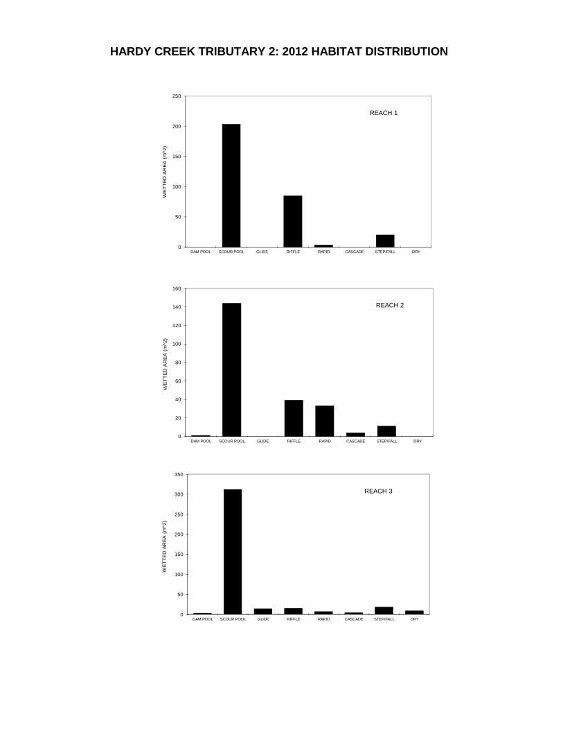
HARDY CREEK TRIBUTARY 2: 2012 HABITAT DISTRIBUTION
0
50
100
150
200
250
DAM POOL SCOUR POOL GLIDE RIFFLE RAPID CASCADE STEP/FALL DRY
WE
TT
ED
AR
EA
(m
^2)
REACH 1
0
20
40
60
80
100
120
140
160
DAM POOL SCOUR POOL GLIDE RIFFLE RAPID CASCADE STEP/FALL DRY
WE
TT
ED
AR
EA
(m
^2)
REACH 2
0
50
100
150
200
250
300
350
DAM POOL SCOUR POOL GLIDE RIFFLE RAPID CASCADE STEP/FALL DRY
WE
TT
ED
AR
EA
(m
^2)
REACH 3
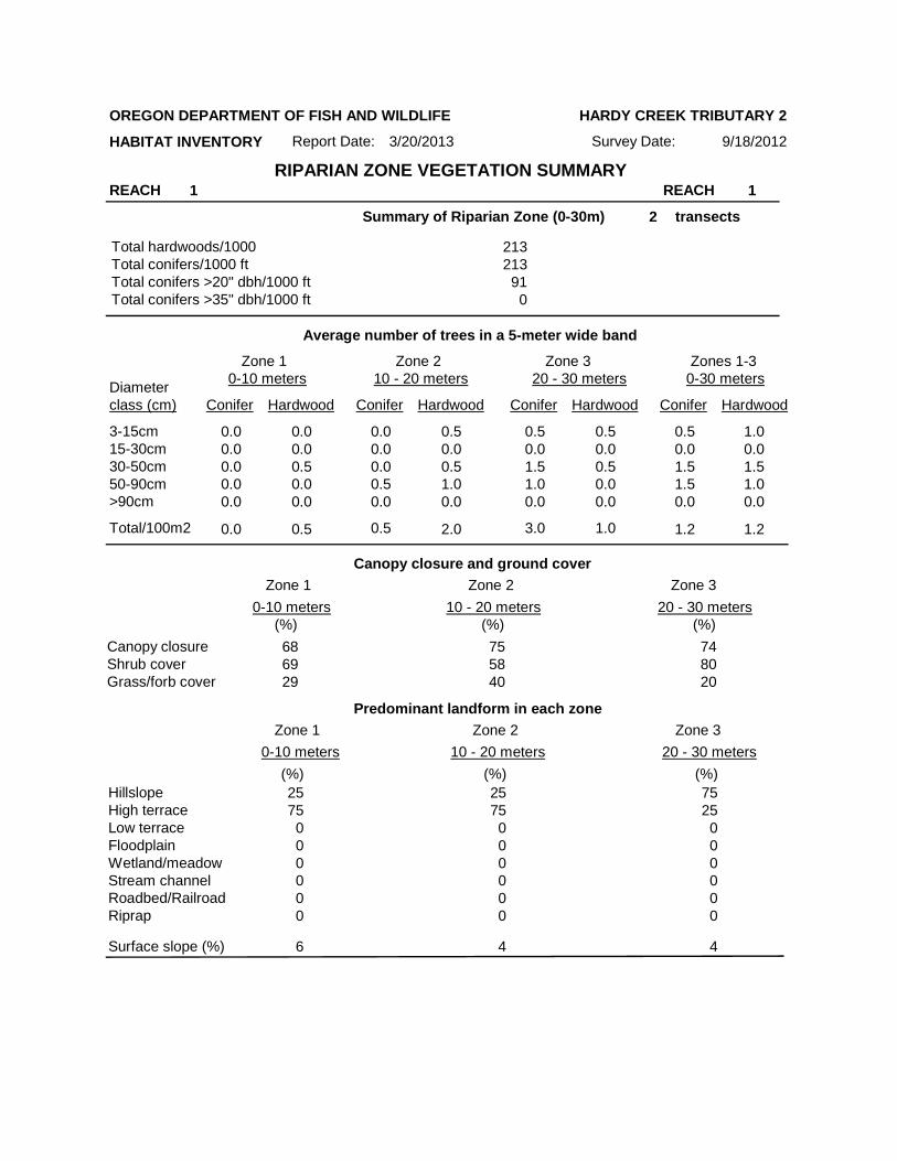
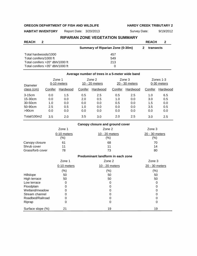
Summary of Riparian Zone (0-30m) transects
Total hardwoods/1000Total conifers/1000 ftTotal conifers >20" dbh/1000 ftTotal conifers >35" dbh/1000 ft
Average number of trees in a 5-meter wide band
Canopy closure and ground cover
Predominant landform in each zone
Zone 1 Zone 2 Zone 3 Zones 1-30-10 meters 10 - 20 meters 20 - 30 meters 0-30 meters
Conifer Hardwood Conifer Hardwood Conifer Hardwood Conifer HardwoodDiameterclass (cm)
3-15cm15-30cm30-50cm50-90cm>90cm
Total/100m2
Zone 1 Zone 2 Zone 3
0-10 meters 10 - 20 meters 20 - 30 meters
Zone 1 Zone 2 Zone 3
0-10 meters 10 - 20 meters 20 - 30 meters
Canopy closureShrub coverGrass/forb cover
HillslopeHigh terraceLow terraceFloodplainWetland/meadowStream channelRoadbed/RailroadRiprap
Surface slope (%)
2
213213910
0.00.00.00.0
0.0
0.0
0.00.00.50.0
0.5
0.0
0.00.00.00.50.0
0.50.00.51.00.0
0.50.01.51.00.0
0.50.00.50.00.0
0.50.01.51.5
1.2
0.0
1.00.01.51.0
1.2
0.0
686929
755840
748020
2575000000
2575000000
7525000000
6 4 4
0.5 2.0 3.0 1.0
(%) (%)(%)
(%) (%)(%)
RIPARIAN ZONE VEGETATION SUMMARYREACH 1 REACH 1
OREGON DEPARTMENT OF FISH AND WILDLIFE
HABITAT INVENTORY Report Date:
HARDY CREEK TRIBUTARY 2
3/20/2013 Survey Date: 9/18/2012
Summary of Riparian Zone (0-30m) transects
Total hardwoods/1000Total conifers/1000 ftTotal conifers >20" dbh/1000 ftTotal conifers >35" dbh/1000 ft
Average number of trees in a 5-meter wide band
Canopy closure and ground cover
Predominant landform in each zone
Zone 1 Zone 2 Zone 3 Zones 1-30-10 meters 10 - 20 meters 20 - 30 meters 0-30 meters
Conifer Hardwood Conifer Hardwood Conifer Hardwood Conifer HardwoodDiameterclass (cm)
3-15cm15-30cm30-50cm50-90cm>90cm
Total/100m2
Zone 1 Zone 2 Zone 3
0-10 meters 10 - 20 meters 20 - 30 meters
Zone 1 Zone 2 Zone 3
0-10 meters 10 - 20 meters 20 - 30 meters
Canopy closureShrub coverGrass/forb cover
HillslopeHigh terraceLow terraceFloodplainWetland/meadowStream channelRoadbed/RailroadRiprap
Surface slope (%)
2
457549213
0
0.00.01.02.5
3.5
0.0
1.50.00.00.5
2.0
0.0
0.52.00.01.00.0
2.50.50.00.00.0
0.51.00.50.00.0
2.50.00.00.00.0
1.03.01.53.5
3.0
0.0
6.50.50.00.5
2.5
0.0
611178
681173
701480
5050000000
5050000000
5050000000
21 19 19
3.5 3.0 2.0 2.5
(%) (%)(%)
(%) (%)(%)
RIPARIAN ZONE VEGETATION SUMMARYREACH 2 REACH 2
OREGON DEPARTMENT OF FISH AND WILDLIFE
HABITAT INVENTORY Report Date:
HARDY CREEK TRIBUTARY 2
3/20/2013 Survey Date: 9/19/2012

Summary of Riparian Zone (0-30m) transects
Total hardwoods/1000Total conifers/1000 ftTotal conifers >20" dbh/1000 ftTotal conifers >35" dbh/1000 ft
Average number of trees in a 5-meter wide band
Canopy closure and ground cover
Predominant landform in each zone
Zone 1 Zone 2 Zone 3 Zones 1-30-10 meters 10 - 20 meters 20 - 30 meters 0-30 meters
Conifer Hardwood Conifer Hardwood Conifer Hardwood Conifer HardwoodDiameterclass (cm)
3-15cm15-30cm30-50cm50-90cm>90cm
Total/100m2
Zone 1 Zone 2 Zone 3
0-10 meters 10 - 20 meters 20 - 30 meters
Zone 1 Zone 2 Zone 3
0-10 meters 10 - 20 meters 20 - 30 meters
Canopy closureShrub coverGrass/forb cover
HillslopeHigh terraceLow terraceFloodplainWetland/meadowStream channelRoadbed/RailroadRiprap
Surface slope (%)
2
366945
00
0.50.02.00.0
2.5
0.0
0.00.00.50.0
0.5
0.0
0.02.54.00.00.0
1.01.00.00.00.0
0.02.04.50.00.0
1.51.50.50.00.0
0.54.510.50.0
5.2
0.0
2.52.51.00.0
2.0
0.0
161378
431453
661548
0500
500000
5050000000
1000000000
0 10 28
6.5 2.0 6.5 3.5
(%) (%)(%)
(%) (%)(%)
RIPARIAN ZONE VEGETATION SUMMARYREACH 3 REACH 3
OREGON DEPARTMENT OF FISH AND WILDLIFE
HABITAT INVENTORY Report Date:
HARDY CREEK TRIBUTARY 2
3/20/2013 Survey Date: 9/19/2012
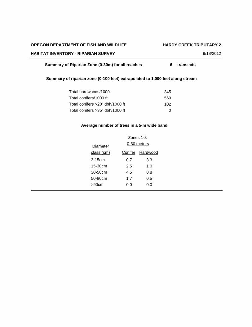
Summary of Riparian Zone (0-30m) for all reaches transects
Total hardwoods/1000
Total conifers/1000 ft
Total conifers >20" dbh/1000 ft
Total conifers >35" dbh/1000 ft
6
345
569
102
0
Zones 1-3
0-30 meters
Conifer Hardwood
0.7
2.5
4.5
1.7
0.0
3.3
1.0
0.8
0.5
0.0
Diameter
class (cm)
3-15cm
15-30cm
30-50cm
50-90cm
>90cm
Average number of trees in a 5-m wide band
OREGON DEPARTMENT OF FISH AND WILDLIFE
HABITAT INVENTORY - RIPARIAN SURVEY
HARDY CREEK TRIBUTARY 2
9/18/2012
Summary of riparian zone (0-100 feet) extrapolated to 1,000 feet along stream
9/18/2012Survey Date:3/20/2013
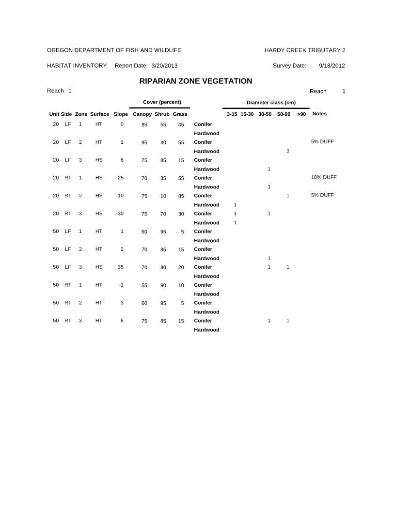
Reach 1 1
HABITAT INVENTORY
HARDY CREEK TRIBUTARY 2
Report Date:
RIPARIAN ZONE VEGETATIONReach
OREGON DEPARTMENT OF FISH AND WILDLIFE
Slope Canopy ShrubSurfaceZoneSideUnit
Cover (percent)
Grass 3-15 15-30 30-50 50-90 >90
Diameter class (cm)
Notes
20 LF 1 HT 0 85 55 45 Conifer
Hardwood
20 LF 2 HT 1 95 40 55
2
5% DUFFConifer
Hardwood
20 LF 3 HS 6 75 85 15
1
Conifer
Hardwood
20 RT 1 HS 25 70 35 55
1
10% DUFFConifer
Hardwood
20 RT 2 HS 10 75 10 85 1
1
5% DUFFConifer
Hardwood
20 RT 3 HS -30 75 70 30 1 1
1
Conifer
Hardwood
50 LF 1 HT 1 60 95 5 Conifer
Hardwood
50 LF 2 HT 2 70 85 15
1
Conifer
Hardwood
50 LF 3 HS 35 70 80 20 1 1Conifer
Hardwood
50 RT 1 HT -1 55 90 10 Conifer
Hardwood
50 RT 2 HT 3 60 95 5 Conifer
Hardwood
50 RT 3 HT 6 75 85 15 1 1Conifer
Hardwood
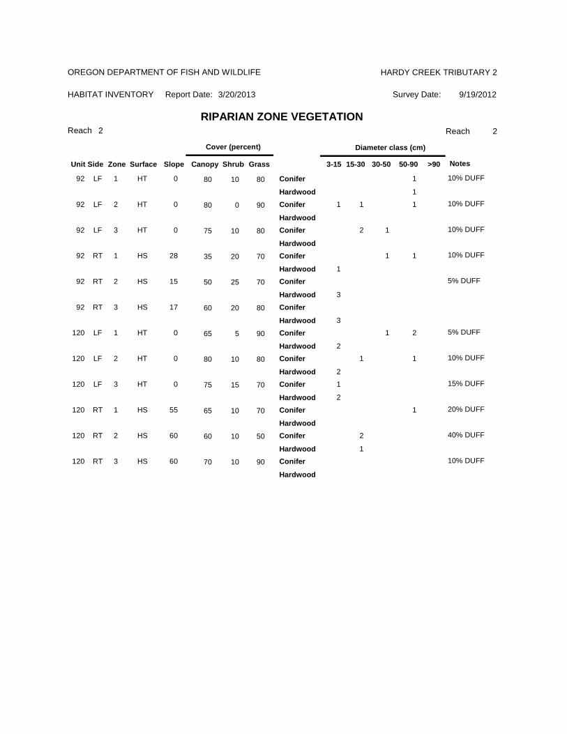
9/19/2012Survey Date:3/20/2013
Reach 2 2
HABITAT INVENTORY
HARDY CREEK TRIBUTARY 2
Report Date:
RIPARIAN ZONE VEGETATIONReach
OREGON DEPARTMENT OF FISH AND WILDLIFE
Slope Canopy ShrubSurfaceZoneSideUnit
Cover (percent)
Grass 3-15 15-30 30-50 50-90 >90
Diameter class (cm)
Notes
92 LF 1 HT 0 80 10 80 1
1
10% DUFFConifer
Hardwood
92 LF 2 HT 0 80 0 90 1 1 1 10% DUFFConifer
Hardwood
92 LF 3 HT 0 75 10 80 2 1 10% DUFFConifer
Hardwood
92 RT 1 HS 28 35 20 70 1 1
1
10% DUFFConifer
Hardwood
92 RT 2 HS 15 50 25 70
3
5% DUFFConifer
Hardwood
92 RT 3 HS 17 60 20 80
3
Conifer
Hardwood
120 LF 1 HT 0 65 5 90 1 2
2
5% DUFFConifer
Hardwood
120 LF 2 HT 0 80 10 80 1 1
2
10% DUFFConifer
Hardwood
120 LF 3 HT 0 75 15 70 1
2
15% DUFFConifer
Hardwood
120 RT 1 HS 55 65 10 70 1 20% DUFFConifer
Hardwood
120 RT 2 HS 60 60 10 50 2
1
40% DUFFConifer
Hardwood
120 RT 3 HS 60 70 10 90 10% DUFFConifer
Hardwood
9/19/2012Survey Date:3/20/2013
Reach 3 3
HABITAT INVENTORY
HARDY CREEK TRIBUTARY 2
Report Date:
RIPARIAN ZONE VEGETATIONReach
OREGON DEPARTMENT OF FISH AND WILDLIFE
Slope Canopy ShrubSurfaceZoneSideUnit
Cover (percent)
Grass 3-15 15-30 30-50 50-90 >90
Diameter class (cm)
Notes
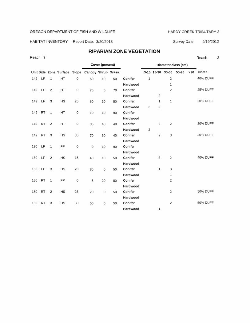
149 LF 1 HT 0 50 10 50 1 2
1
40% DUFFConifer
Hardwood
149 LF 2 HT 0 75 5 70 2
2
25% DUFFConifer
Hardwood
149 LF 3 HS 25 60 30 50 1 1
3 2
20% DUFFConifer
Hardwood
149 RT 1 HT 0 10 10 90 Conifer
Hardwood
149 RT 2 HT 0 35 40 40 2 2
2
20% DUFFConifer
Hardwood
149 RT 3 HS 35 70 30 40 2 3 30% DUFFConifer
Hardwood
180 LF 1 FP 0 0 10 90 Conifer
Hardwood
180 LF 2 HS 15 40 10 50 3 2 40% DUFFConifer
Hardwood
180 LF 3 HS 20 85 0 50 1 3
1
Conifer
Hardwood
180 RT 1 FP 0 5 20 80 2Conifer
Hardwood
180 RT 2 HS 25 20 0 50 2 50% DUFFConifer
Hardwood
180 RT 3 HS 30 50 0 50 2
1
50% DUFFConifer
Hardwood
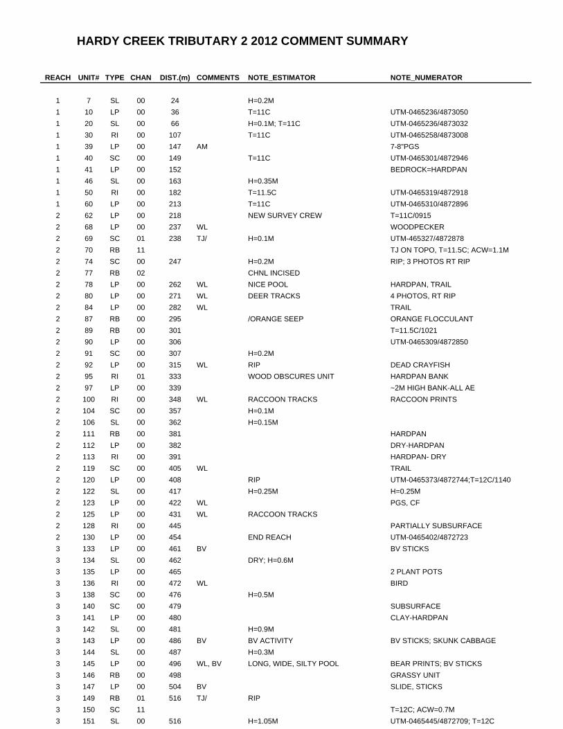
HARDY CREEK TRIBUTARY 2 2012 COMMENT SUMMARY
REACH UNIT# TYPE CHAN DIST.(m) COMMENTS NOTE_ESTIMATOR NOTE_NUMERATOR
1 7 SL 00 24 H=0.2M
1 10 LP 00 36 T=11C UTM-0465236/4873050
1 20 SL 00 66 H=0.1M; T=11C UTM-0465236/4873032
1 30 RI 00 107 T=11C UTM-0465258/4873008
1 39 LP 00 147 AM 7-8"PGS
1 40 SC 00 149 T=11C UTM-0465301/4872946
1 41 LP 00 152 BEDROCK=HARDPAN
1 46 SL 00 163 H=0.35M
1 50 RI 00 182 T=11.5C UTM-0465319/4872918
1 60 LP 00 213 T=11C UTM-0465310/4872896
2 62 LP 00 218 NEW SURVEY CREW T=11C/0915
2 68 LP 00 237 WL WOODPECKER
2 69 SC 01 238 TJ/ H=0.1M UTM-465327/4872878
2 70 RB 11 TJ ON TOPO, T=11.5C; ACW=1.1M
2 74 SC 00 247 H=0.2M RIP; 3 PHOTOS RT RIP
2 77 RB 02 CHNL INCISED
2 78 LP 00 262 WL NICE POOL HARDPAN, TRAIL
2 80 LP 00 271 WL DEER TRACKS 4 PHOTOS, RT RIP
2 84 LP 00 282 WL TRAIL
2 87 RB 00 295 /ORANGE SEEP ORANGE FLOCCULANT
2 89 RB 00 301 T=11.5C/1021
2 90 LP 00 306 UTM-0465309/4872850
2 91 SC 00 307 H=0.2M
2 92 LP 00 315 WL RIP DEAD CRAYFISH
2 95 RI 01 333 WOOD OBSCURES UNIT HARDPAN BANK
2 97 LP 00 339 ~2M HIGH BANK-ALL AE
2 100 RI 00 348 WL RACCOON TRACKS RACCOON PRINTS
2 104 SC 00 357 H=0.1M
2 106 SL 00 362 H=0.15M
2 111 RB 00 381 HARDPAN
2 112 LP 00 382 DRY-HARDPAN
2 113 RI 00 391 HARDPAN- DRY
2 119 SC 00 405 WL TRAIL
2 120 LP 00 408 RIP UTM-0465373/4872744;T=12C/1140
2 122 SL 00 417 H=0.25M H=0.25M
2 123 LP 00 422 WL PGS, CF
2 125 LP 00 431 WL RACCOON TRACKS
2 128 RI 00 445 PARTIALLY SUBSURFACE
2 130 LP 00 454 END REACH UTM-0465402/4872723
3 133 LP 00 461 BV BV STICKS
3 134 SL 00 462 DRY; H=0.6M
3 135 LP 00 465 2 PLANT POTS
3 136 RI 00 472 WL BIRD
3 138 SC 00 476 H=0.5M
3 140 SC 00 479 SUBSURFACE
3 141 LP 00 480 CLAY-HARDPAN
3 142 SL 00 481 H=0.9M
3 143 LP 00 486 BV BV ACTIVITY BV STICKS; SKUNK CABBAGE
3 144 SL 00 487 H=0.3M
3 145 LP 00 496 WL, BV LONG, WIDE, SILTY POOL BEAR PRINTS; BV STICKS
3 146 RB 00 498 GRASSY UNIT
3 147 LP 00 504 BV SLIDE, STICKS
3 149 RB 01 516 TJ/ RIP
3 150 SC 11 T=12C; ACW=0.7M
3 151 SL 00 516 H=1.05M UTM-0465445/4872709; T=12C
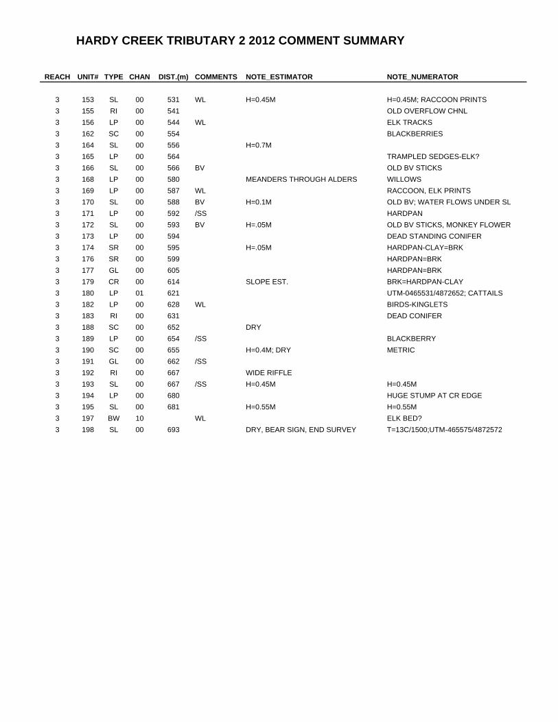
HARDY CREEK TRIBUTARY 2 2012 COMMENT SUMMARY
REACH UNIT# TYPE CHAN DIST.(m) COMMENTS NOTE_ESTIMATOR NOTE_NUMERATOR
3 153 SL 00 531 WL H=0.45M H=0.45M; RACCOON PRINTS
3 155 RI 00 541 OLD OVERFLOW CHNL
3 156 LP 00 544 WL ELK TRACKS
3 162 SC 00 554 BLACKBERRIES
3 164 SL 00 556 H=0.7M
3 165 LP 00 564 TRAMPLED SEDGES-ELK?
3 166 SL 00 566 BV OLD BV STICKS
3 168 LP 00 580 MEANDERS THROUGH ALDERS WILLOWS
3 169 LP 00 587 WL RACCOON, ELK PRINTS
3 170 SL 00 588 BV H=0.1M OLD BV; WATER FLOWS UNDER SL
3 171 LP 00 592 /SS HARDPAN
3 172 SL 00 593 BV H=.05M OLD BV STICKS, MONKEY FLOWER
3 173 LP 00 594 DEAD STANDING CONIFER
3 174 SR 00 595 H=.05M HARDPAN-CLAY=BRK
3 176 SR 00 599 HARDPAN=BRK
3 177 GL 00 605 HARDPAN=BRK
3 179 CR 00 614 SLOPE EST. BRK=HARDPAN-CLAY
3 180 LP 01 621 UTM-0465531/4872652; CATTAILS
3 182 LP 00 628 WL BIRDS-KINGLETS
3 183 RI 00 631 DEAD CONIFER
3 188 SC 00 652 DRY
3 189 LP 00 654 /SS BLACKBERRY
3 190 SC 00 655 H=0.4M; DRY METRIC
3 191 GL 00 662 /SS
3 192 RI 00 667 WIDE RIFFLE
3 193 SL 00 667 /SS H=0.45M H=0.45M
3 194 LP 00 680 HUGE STUMP AT CR EDGE
3 195 SL 00 681 H=0.55M H=0.55M
3 197 BW 10 WL ELK BED?
3 198 SL 00 693 DRY, BEAR SIGN, END SURVEY T=13C/1500;UTM-465575/4872572
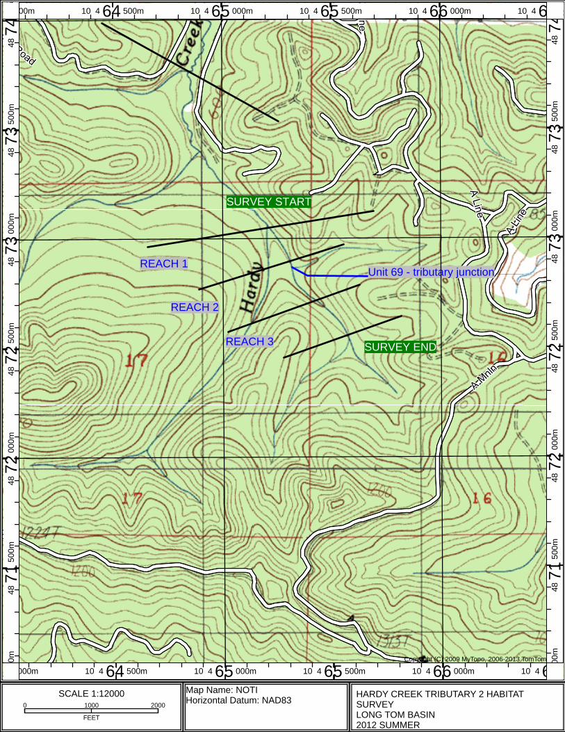
SURVEY START
Unit 69 - tributary junction
SURVEY END
REACH 2
REACH 1
REACH 3
Copyright (C) 2009 MyTopo, 2006-2013 TomTom
00m 10 4 64 500m 10 4 65 000m 10 4 65 500m 10 4 66 000m 10 4 6
000m 10 4 64 500m 10 4 65 000m 10 4 65 500m 10 4 66 000m 10 4 6
00m
48 7
1 50
0m48
72
000m
48 7
2 50
0m48
73
000m
48 7
3 50
0m48
74
0m48
71
500m
48 7
2 00
0m48
72
500m
48 7
3 00
0m48
73
500m
48 7
4
SCALE 1:120000 1000 2000
FEET
Map Name: NOTIHorizontal Datum: NAD83
HARDY CREEK TRIBUTARY 2 HABITAT SURVEYLONG TOM BASIN2012 SUMMER
Related Documents