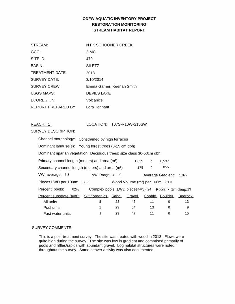
ODFW AQUATIC INVENTORY PROJECT RESTORATION MONITORING N FK SCHOONER CREEK SITE ID: 470 GCG: 2-MC SURVEY DATE: 3/10/2014 STREAM: STREAM HABITAT REPORT BASIN: TREATMENT DATE: SURVEY CREW: REPORT PREPARED BY: USGS MAPS: ECOREGION: SURVEY DESCRIPTION: SURVEY COMMENTS: SILETZ Emma Garner, Keenan Smith DEVILS LAKE Volcanics Lora Tennant Primary channel length (meters) and area (m²): VWI average: Average Gradient: Wood Volume (m³) per 100m: Pieces LWD per 100m: Dominant landuse(s): Dominant riparian vegetation: Secondary channel length (meters) and area (m²) 1,039 6,537 279 855 6.3 VWI Range: 4 - 9 1.0% 61.3 33.6 : : Percent pools: Complex pools (LWD pieces>=3): Pools >=1m deep:13 Constrained by high terraces Channel morphology: Young forest trees (3-15 cm dbh) Deciduous trees: size class 30-50cm dbh Percent substrate (avg): Silt / organics Sand Gravel Cobble Boulder Bedrock 8 23 46 11 0 13 All units 1 23 54 13 0 9 Pool units 3 23 47 11 0 15 Fast water units 62% 24 This is a post-treatment survey. The site was treated with wood in 2013. Flows were quite high during the survey. The site was low in gradient and comprised primarily of pools and riffles/rapids with abundant gravel. Log habitat structures were noted throughout the survey. Some beaver activity was also documented. 2013 REACH: 1 __________ LOCATION: T07S-R10W-S15SW

Welcome message from author
This document is posted to help you gain knowledge. Please leave a comment to let me know what you think about it! Share it to your friends and learn new things together.
Transcript
ODFW AQUATIC INVENTORY PROJECT
RESTORATION MONITORING
N FK SCHOONER CREEK
SITE ID: 470
GCG: 2-MC
SURVEY DATE: 3/10/2014
STREAM:
STREAM HABITAT REPORT
BASIN:
TREATMENT DATE:
SURVEY CREW:
REPORT PREPARED BY:
USGS MAPS:
ECOREGION:
SURVEY DESCRIPTION:
SURVEY COMMENTS:
SILETZ
Emma Garner, Keenan Smith
DEVILS LAKE
Volcanics
Lora Tennant
Primary channel length (meters) and area (m²):
VWI average: Average Gradient:
Wood Volume (m³) per 100m:Pieces LWD per 100m:
Dominant landuse(s):
Dominant riparian vegetation:
Secondary channel length (meters) and area (m²)
1,039 6,537
279 855
6.3 VWI Range: 4 - 9 1.0%
61.333.6
:
:
Percent pools: Complex pools (LWD pieces>=3): Pools >=1m deep:13
Constrained by high terracesChannel morphology:
Young forest trees (3-15 cm dbh)
Deciduous trees: size class 30-50cm dbh
Percent substrate (avg): Silt / organics Sand Gravel Cobble Boulder Bedrock
8 23 46 11 0 13All units
1 23 54 13 0 9Pool units
3 23 47 11 0 15Fast water units
62% 24
This is a post-treatment survey. The site was treated with wood in 2013. Flows were quite high during the survey. The site was low in gradient and comprised primarily of pools and riffles/rapids with abundant gravel. Log habitat structures were noted throughout the survey. Some beaver activity was also documented.
2013
REACH: 1__________ LOCATION: T07S-R10W-S15SW
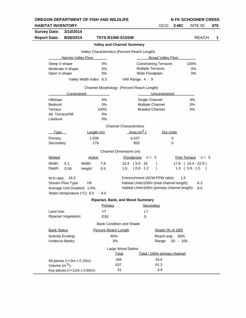
OREGON DEPARTMENT OF FISH AND WILDLIFE
HABITAT INVENTORY
Report Date: 8/26/2014
N FK SCHOONER CREEK
REACH 1T07S-R10W-S15SW
SITE ID: 470GCG: 2-MC
Survey Date: 3/10/2014
Valley and Channel Summary
Narrow Valley Floor Broad Valley Floor
Valley Characteristics (Percent Reach Length)
Steep V-shape
Moderate V-shape
Open V-shape
Constraining Terraces
Multiple Terraces
Wide Floodplain
Valley Width Index
Channel Morphology (Percent Reach Length)
Hillslope
Constrained Unconstrained
Bedrock
Terrace
Alt. Terrace/Hill
Landuse
Single Channel
Multiple Channel
Braided Channel
Channel Characteristics
Type Length (m) Area (m ) Dry Units
Primary
Secondary
Channel Dimensions (m)
Wetted Active Floodprone First Terrace
Width:
Depth:
Width:
Height:
W:D ratio: Entrenchment (ACW:FPW ratio):
Stream Flow Type:
Average Unit Gradient:
Habitat Units/100m (total channel length):
0%
0%
0%
0%
100%
0%
0%
0%
0%
0%
0%
100%
0%
0%
6.3 VWI Range: 4 - 9
279 855
0
0
1,039 6,537
5.1
0.56
7.8
0.5
12.4
1.0
17.8
1.3
16.3 1.6
HF
1.0%
6.3
Riparian, Bank, and Wood Summary
Primary Secondary
Land Use:
Riparian Vegetation:
YT
D30
LT
S
Bank Condition and Shade
Bank Status Percent Reach Length Shade (% of 180)
Reach avg:
Undercut Banks:
Large Wood Debris
Total Total / 100m primary channel
All pieces (>=3m x 0.15m):
Volume (m ):
Key pieces (>=12m x 0.60m):
349
637
51
33.6
61.3
4.9
60%
3%
83%Actively Eroding:
9.0 9.0Water temperature (°C): -
50Range: 100 -
3
5n = 5n =
( 9.6 - 16
( 0.8 - 1.2
( 14.4 - 22.9
( 0.9 - 1.5
)
)
)
)
8.0Habitat Units/100m (primary channel length):
2
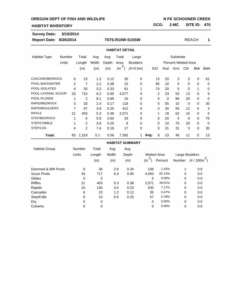
HABITAT DETAIL
Habitat Type Number Total Avg Total Large Substrate
Percent Wetted Area Units Length Width
Avg
Depth Area Boulders
(m) (m) (m) (m )2
(#>0.5m) S/O Snd Grvl Cbl Bldr Bdrk
REACH 1T07S-R10W-S15SW
HABITAT INVENTORY
Report Date: 8/26/2014
OREGON DEPT OF FISH AND WILDLIFE N FK SCHOONER CREEK
GCG: 2-MC SITE ID: 470
Survey Date: 3/10/2014
6CASCADE/BEDROCK 23 1.2 0.12 35 0 13 20 3 3 0 61
2POOL-BACKWATER 7 2.2 0.38 15 0 85 10 5 0 0 0
4POOL-ISOLATED 30 3.2 0.33 91 1 74 20 5 0 1 0
33POOL-LATERAL SCOUR 715 6.2 0.95 4,577 0 2 23 53 13 0 9
1POOL-PLUNGE 2 8.1 0.85 16 0 0 0 80 20 0 0
3RAPID/BEDROCK 33 2.4 0.17 118 0 5 55 10 0 0 30
7RAPID/BOULDERS 97 3.8 0.25 412 0 0 30 55 12 0 3
21RIFFLE 403 5.3 0.38 2,071 0 1 18 62 15 0 5
1STEP/BEDROCK 6 5.8 0.60 33 0 0 20 5 0 0 75
1STEP/COBBLE 2 3.8 0.25 8 0 0 10 70 20 0 0
4STEP/LOG 2 7.4 0.16 17 0 3 31 31 5 0 30
HABITAT SUMMARY
83 1,319 5.1 0.56 7,392 1 8 23 46 11 0 13Total:
Habitat Group Number Total Avg
Wetted Area Large Boulders Units Length Width
Avg
Depth
Number (m) (m) (m) )2
(# / 100mPercent
Scour Pools
Glides
Riffles
Rapids
Cascades
Step/Falls
Dry
Dammed & BW Pools 10636 2.9 0.346 1.43%
4,593717 6.3 0.9534 62.14%
000 0.00%
2,071403 5.3 0.3821 28.01%
530130 3.4 0.2310 7.17%
3523 1.2 0.126 0.47%
5710 6.5 0.256 0.78%
Culverts
000 0.00%
000 0.00%
1
0
0
0
0
0
0
0
0
0.9
0.0
0.0
0.0
0.0
0.0
0.0
(m )2
0.0
0.0
Avg:
REACH 1T07S-R10W-S15SW
HABITAT INVENTORY
Report Date: 8/26/2014
OREGON DEPT OF FISH AND WILDLIFE N FK SCHOONER CREEK
GCG: 2-MC SITE ID: 470
Survey Date: 3/10/2014
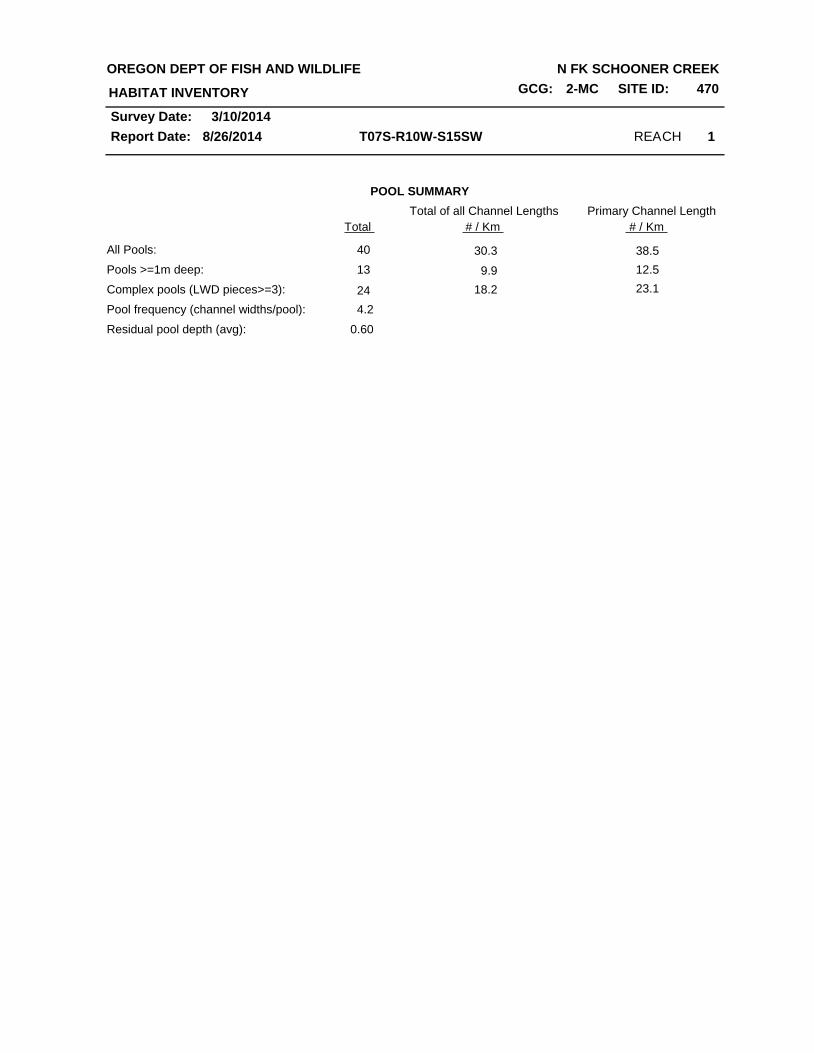
POOL SUMMARY
Total
All Pools:
Pools >=1m deep:
Complex pools (LWD pieces>=3):
Pool frequency (channel widths/pool):
40
Residual pool depth (avg): 0.60
4.2
13
24
Total of all Channel Lengths
30.3
9.9
18.2
38.5
12.5
23.1
# / Km
Primary Channel Length
# / Km

Summary of Riparian Zone (0-30m) transects
Total hardwoods/1000 ft
Total conifers/1000 ft
Total conifers >20" dbh/1000 ft
Total conifers >35" dbh/1000 ft
Average number of trees in a 5-meter wide band
Canopy closure and ground cover
Predominant landform in each zone
Zone 1 Zone 2 Zone 3 Zones 1-3
0-10 meters 10 - 20 meters 20 - 30 meters 0-30 meters
Conifer Hardwood Conifer Hardwood Conifer Hardwood Conifer Hardwood
Diameter
class (cm)
3-15cm
15-30cm
30-50cm
50-90cm
>90cm
Total/100m
Zone 1 Zone 2 Zone 3
0-10 meters 10 - 20 meters 20 - 30 meters
Zone 1 Zone 2 Zone 3
0-10 meters 10 - 20 meters 20 - 30 meters
Canopy closure
Shrub cover
Grass/forb cover
Hillslope
High terrace
Low terrace
Floodplain
Wetland/meadow
Stream channel
Roadbed/Railroad
Riprap
Surface slope (%)
3
325
142
0
0
0.0
0.0
0.0
0.0
0.0
0.0
1.0
0.0
0.0
0.3
1.3
0.0
0.0
0.0
0.7
0.0
0.0
0.0
1.0
1.3
0.3
0.0
0.0
0.3
1.3
0.0
0.0
0.0
0.3
1.0
0.0
0.0
0.0
0.3
2.0
0.0
0.8
0.0
1.0
1.3
2.3
0.7
1.8
0.0
69
36
40
88
45
8
87
23
22
17
83
0
0
0
0
0
0
50
33
0
0
0
17
0
0
83
0
0
0
0
17
0
0
9 23 30
0.7 2.7 1.7 1.3
(%) (%)(%)
(%) (%)(%)
RIPARIAN ZONE VEGETATION SUMMARY REACH 1
OREGON DEPARTMENT OF FISH AND WILDLIFE
HABITAT INVENTORY
Report Date:
N FK SCHOONER CREEK
8/26/2014
Survey Date: 3/5/2014
GCG: 2-MC SITE ID: 470
2

Summary of Riparian Zone (0-30m) for all reaches transects
Total hardwoods/1000 ft
Total conifers/1000 ft
Total conifers >20" dbh/1000 ft
Total conifers >35" dbh/1000 ft
3
325
142
0
0
Zones 1-3
0-30 meters
Conifer Hardwood
0.0
0.3
2.0
0.0
0.0
1.0
1.3
2.3
0.7
0.0
Diameter
class (cm)
3-15cm
15-30cm
30-50cm
50-90cm
>90cm
Average number of trees in a 5-m wide band
OREGON DEPARTMENT OF FISH AND WILDLIFE
HABITAT INVENTORY - RIPARIAN SURVEY
N FK SCHOONER CREEK
3/5/2014
Summary of riparian zone (0-100 feet) extrapolated to 1,000 feet along stream
GCG: 2-MC SITE ID: 470

3/5/2014Survey Date:
8/26/2014
Reach 1 1
HABITAT INVENTORY
Report Date:
RIPARIAN ZONE VEGETATION
Reach
Slope Canopy ShrubSurfaceZoneSideUnit
Cover (percent)
Grass 3-15 15-30 30-50 50-90 >90
Diameter class (cm)
Notes
OREGON DEPT OF FISH AND WILDLIFE N FK SCHOONER CREEK
SITE ID: 470GCG: 2-MC
22 LF 1 HT 0 30 5 95 Conifer
Hardwood
22 LF 2 HS 30 60 30 10 1
1
60% DUFFConifer
Hardwood
22 LF 3 HS 7 100 5 20 4
1
75% DUFFConifer
Hardwood
22 RT 1 HT 0 75 90 5 Conifer
Hardwood
22 RT 2 HT 0 95 90 0
2
10% DUFFConifer
Hardwood
22 RT 3 HS 45 95 70 10
1
20% DUFFConifer
Hardwood
38 LF 1 HT 0 10 60 30 10% DUFFConifer
Hardwood
38 LF 2 HS 27 80 75 20 1
1
10% DUFFConifer
Hardwood
38 LF 3 HS 15 90 5 70 1 25% DUFFConifer
Hardwood
38 RT 1 HT 0 100 20 10
1
70% DUFF; 4M LT
Conifer
Hardwood
38 RT 2 HT 0 100 50 0
2 1
50% DUFFConifer
Hardwood
38 RT 3 HS 50 90 40 10
1 1
50% DUFFConifer
Hardwood
58 LF 1 HT 0 100 10 90
2
Conifer
Hardwood
58 LF 2 SC 0 90 5 5
1
90% GRV; CR MEANDERS
Conifer
Hardwood
58 LF 3 SC 0 60 5 0 95% GRV; CR MEANDERS
Conifer
Hardwood
58 RT 1 HS 56 100 30 10
1
60% DUFFConifer
Hardwood
58 RT 2 HS 82 100 20 10 70% DUFFConifer
Hardwood
58 RT 3 HS 65 85 10 20 70% DUFFConifer
Hardwood

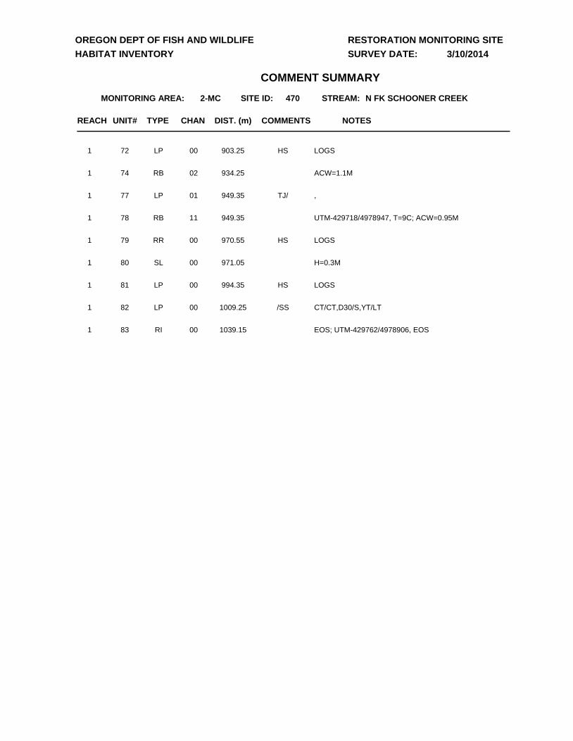
UNIT# TYPE CHAN DIST. (m) NOTES
2-MC 470 N FK SCHOONER CREEK
COMMENTS
MONITORING AREA: SITE ID:
OREGON DEPT OF FISH AND WILDLIFE
HABITAT INVENTORY
RESTORATION MONITORING SITE
SURVEY DATE:
STREAM:
COMMENT SUMMARY
3/10/2014
REACH
1 RI 00 19.5 UTM-428969/4979032, T=9C1
2 LP 00 28.9 UTM-429000/49790381
3 RI 00 43.3 CT/CT,D30/S,MT, LOGS, DEEP WATER POCKETSHS1
4 LP 00 53.1 LOGSHS1
5 RI 01 68.1 TJ/1
6 CR 11 68.1 TRIB UTM-429025/4979076, T=10C; ACW=7.5M1
7 IP 10 68.1 IP BTWN CHNLS1
9 LP 02 85.4 LOGSHS1
11 LP 00 136.2 GAME TRAILWL1
12 RB 00 150.4 DEEP WATER POCKETS1
13 LP 01 160.7 /TJ1
14 CR 11 160.7 UTM-429120/4979077, T=10C; ACW=1.45M1
15 SL 00 161.55 H=1.0M, LOGSHS1
16 LP 01 213.05 LOGSHS,TJ/1
17 RI 11 213.05 UTM-429105/4979103, T=11C; ACW=1.10M1
21 RI 00 258.55 CT/CT,D30/S,YT/MT, DEEP WATER POCKETS1
22 LP 00 273.25 UTM-429189/49791431
23 RI 00 289.65 LOGS, GAME TRAILHS,WL1
24 LP 00 306.05 LOGSHS1
25 LP 00 327.35 INACTIVE LANDSLIDE/LI1
28 RI 00 413.85 LOGSHS1
29 LP 01 429.05 LOGS, /SSHS,TJ/TJ1
30 RR 11 429.05 UTM-429321/4979148, T=10C; ACW=0.75M1
31 CR 11 429.05 UTM-429324/4979164-SEP TJ FROM U30, T=10C; ACW=0.75M
1

UNIT# TYPE CHAN DIST. (m) NOTES
2-MC 470 N FK SCHOONER CREEK
COMMENTS
MONITORING AREA: SITE ID:
OREGON DEPT OF FISH AND WILDLIFE
HABITAT INVENTORY
RESTORATION MONITORING SITE
SURVEY DATE:
STREAM:
COMMENT SUMMARY
3/10/2014
REACH
32 LP 00 447.25 STOPPED DUE TO TURBIDITY, LOGS, T=9CHS1
33 RI 00 457.45 GAME TRAILSWL1
35 LP 01 554.05 BV CHEWSBV,TJ/1
36 RB 11 554.05 UTM-429386/4979193, T=9C; ACW=1.65M1
38 RI 00 566.45 UTM-429438/4979074, BV CHEWSBV1
39 LP 00 589.45 CA/CT,D30/C50,YT/LT, LOGS, BV CHEWHS,BV1
40 RI 00 602.95 LOGSHS1
43 LP 02 653.85 /SS1
44 SL 02 653.85 H=0.15M1
46 RR 02 653.85 /SS1
48 RI 02 653.85 /SS1
49 LP 02 653.85 LOGS/SS,HS1
53 SL 02 653.85 H=0.35MSS/1
54 RI 01 679.95 GAME TRAILWL1
56 LP 01 725.45 BV CHEWBV,/SS1
57 IP 10 725.45 CA/CT,D30/S,YT/LT1
58 RI 00 732.85 UTM-429567/4979000, BV CHEWBV1
59 LP 01 746.35 TRIB ENTERS FROM 2 SEP CHNLS, LOGS; BV CHEW/TJ,HS,BV1
60 CR 11 746.35 UTM-429566/4978996, HARDPAN; T=9C; ACW=0.8M1
61 CR 11 746.35 UTM-429566/4978994, HARDPAN; T=9C; ACW=0.75M1
62 LP 01 777.35 LOGSHS,/TJ1
63 RB 11 777.35 UTM-429589/4979027, T=9C; ACW=4.0M1
65 LP 01 800.95 LOGSHS1
67 RI 02 833.55 0.6M DEEP POCKET1
68 RB 00 842.85 LOGS; 0.5M DEEP POCKETHS1
UNIT# TYPE CHAN DIST. (m) NOTES
2-MC 470 N FK SCHOONER CREEK
COMMENTS
MONITORING AREA: SITE ID:
OREGON DEPT OF FISH AND WILDLIFE
HABITAT INVENTORY
RESTORATION MONITORING SITE
SURVEY DATE:
STREAM:
COMMENT SUMMARY
3/10/2014
REACH
72 LP 00 903.25 LOGSHS1
74 RB 02 934.25 ACW=1.1M1
77 LP 01 949.35 ,TJ/1
78 RB 11 949.35 UTM-429718/4978947, T=9C; ACW=0.95M1
79 RR 00 970.55 LOGSHS1
80 SL 00 971.05 H=0.3M1
81 LP 00 994.35 LOGSHS1
82 LP 00 1009.25 CT/CT,D30/S,YT/LT/SS1
83 RI 00 1039.15 EOS; UTM-429762/4978906, EOS1

2-MC 470 NF Schooner Creek (Siletz) - 2014 Winter Restoration Survey
Unit 1 – start of survey looking downstream
Unit 1 – metric 1 looking upstream at natural and
placed wood
Unit 80 – placed habitat logs and natural
recruitment
Unit 81 – placed habitat logs
Unit 83 – end of survey looking downstream
Unit 83 – end of survey looking upstream

D
D
D
D
DD
D
D
D
D
D
D
D
D
D
D
D
D
D
DD
D
D
D
D
#*
#*470
470
428000.000000
428000.000000
428500.000000
428500.000000
429000.000000
429000.000000
429500.000000
429500.000000
430000.000000
430000.000000
430500.000000
430500.000000
431000.000000
431000.0000004976
500.00
0000
4976
500.00
0000
4977
000.00
0000
4977
000.00
0000
4977
500.00
0000
4977
500.00
0000
4978
000.00
0000
4978
000.00
0000
4978
500.00
0000
4978
500.00
0000
4979
000.00
0000
4979
000.00
0000
4979
500.00
0000
4979
500.00
0000
4980
000.00
0000
4980
000.00
0000
4980
500.00
0000
4980
500.00
0000
0 0.5 10.25Kilometers
#* Restoration Start
#* Restoration End
D Potential Barrier
Site ID: 470Stream: NF SCHOONER CREEKT07S-R10W-S15SWUSGS Map: DEVILS LAKEBasin: SILETZ µ
Related Documents