CONTAINS PRIVILEGED INFORMATION – DO NOT RELEASE 210 Lonsdale Avenue Pawtucket, RI 02860 Tel: 401.728.8780 Fax: 401.728.8784 www.palinc.com Submitted to: Archaeological Overview Survey - Addendum #1 to Technical Report New Jersey-New York Expansion Project Staten Island, New York February 9, 2011 FERC Docket No. CP11-56-000 PAL No. 2367.02 Spectra Energy Transmission, LLC 150 Warren Street Jersey City, New Jersey 07304 Spectra Energy Corp (Spectra Energy) is proposing to expand its pipeline systems in the New Jersey-New York region to meet the immediate and future demand for natural gas in the largest United States metropolitan area. To accomplish this, Spectra Energy pipeline companies, Texas Eastern Transmission, LP (Texas Eastern) and Algonquin Gas Transmission, LLC (Algonquin) are seeking a Certificate of Public Convenience and Necessity (Certificate) from the Federal Energy Regulatory Commission (FERC) pursuant to Section 7(c) of the Natural Gas Act (NGA) authorizing the construction and operation of the New Jersey-New York Expansion Project (NJ-NY Project) located in New Jersey, New York, and Connecticut. The NJ-NY Project will create a new transportation path for 800,000 decatherms per day (Dth/d) of natural gas from multiple receipt points on the Spectra Energy systems to new delivery points in New Jersey and New York. Project Changes since the December 2010 Filing This document represents an addendum to the technical report for the archaeological overview survey completed for the NJ-NY Expansion Project (Elquist et al. 2010). Since filing the formal Certificate application, Texas Eastern has incorporated one route change (Route Variation 50) into the current pipeline in the New York portion of the Project area after further consultation with property owners and other stakeholders (Figure 1). The route variation is described below with its corresponding mile post (MP) locations. MP 4.07R – MP 4.90R - Route Variation 50 This route variation is approximately 0.83 miles in length, deviates from the originally proposed NJ-NY Expansion pipeline right-of-way (ROW) at MP 4.07R, and rejoins the ROW at MP 4.90R. This route variation was incorporated in the preferred pipeline alignment to satisfy concerns expressed by the Port Authority of New York and New Jersey (Port Authority) relating to the potential conflicts with the Goethals Bridge and its planned relocation. Route Variation 50 involves a slight modification to the planned 42-inch Goethals Bridge horizontal directional drill (HDD) location, including the pipeline pullback area, to avoid the proposed bridge footings for the new Goethals Bridge.

Welcome message from author
This document is posted to help you gain knowledge. Please leave a comment to let me know what you think about it! Share it to your friends and learn new things together.
Transcript
CONTAINS PRIVILEGED INFORMATION – DO NOT RELEASE
210 Lonsdale Avenue Pawtucket, RI 02860 Tel: 401.728.8780 Fax: 401.728.8784 www.palinc.com
Submitted to:
Archaeological Overview Survey - Addendum #1 to Technical Report
New Jersey-New York Expansion Project
Staten Island, New York
February 9, 2011FERC Docket No. CP11-56-000
PAL No. 2367.02
Spectra Energy Transmission, LLC 150 Warren Street Jersey City, New Jersey 07304
Spectra Energy Corp (Spectra Energy) is proposing to expand its pipeline systems in the New Jersey-New York region to meet the immediate and future demand for natural gas in the largest United States metropolitan area. To accomplish this, Spectra Energy pipeline companies, Texas Eastern Transmission, LP (Texas Eastern) and Algonquin Gas Transmission, LLC (Algonquin) are seeking a Certificate of Public Convenience and Necessity (Certificate) from the Federal Energy Regulatory Commission (FERC) pursuant to Section 7(c) of the Natural Gas Act (NGA) authorizing the construction and operation of the New Jersey-New York Expansion Project (NJ-NY Project) located in New Jersey, New York, and Connecticut. The NJ-NY Project will create a new transportation path for 800,000 decatherms per day (Dth/d) of natural gas from multiple receipt points on the Spectra Energy systems to new delivery points in New Jersey and New York. Project Changes since the December 2010 Filing This document represents an addendum to the technical report for the archaeological overview survey completed for the NJ-NY Expansion Project (Elquist et al. 2010). Since filing the formal Certificate application, Texas Eastern has incorporated one route change (Route Variation 50) into the current pipeline in the New York portion of the Project area after further consultation with property owners and other stakeholders (Figure 1). The route variation is described below with its corresponding mile post (MP) locations. MP 4.07R – MP 4.90R - Route Variation 50 This route variation is approximately 0.83 miles in length, deviates from the originally proposed NJ-NY Expansion pipeline right-of-way (ROW) at MP 4.07R, and rejoins the ROW at MP 4.90R. This route variation was incorporated in the preferred pipeline alignment to satisfy concerns expressed by the Port Authority of New York and New Jersey (Port Authority) relating to the potential conflicts with the Goethals Bridge and its planned relocation. Route Variation 50 involves a slight modification to the planned 42-inch Goethals Bridge horizontal directional drill (HDD) location, including the pipeline pullback area, to avoid the proposed bridge footings for the new Goethals Bridge.
Technical Memorandum New Jersey-New York Expansion Project Archaeological Overview Survey page 2 of 8
CONTAINS PRIVILEGED INFORMATION – DO NOT RELEASE
The primary advantages of this route variation are that it will continue to accommodate the landowner’s request to minimize the establishment of new pipeline ROW on Port Authority property and avoid conflicts with the planned Goethals Bridge relocation. Route Variation 50 also allows Texas Eastern to set up the HDD work area further from its existing facilities at M&R Station 058, providing for a much safer work zone. As a result, the HDD realignment will require a reconfiguration of the proposed facilities at existing M&R Station 058. The HDD exit hole will remain on property owned by Texas Eastern and will be located in an area that is currently undeveloped. Additional tree clearing will be required; however, no additional wetland or water body impacts will occur. This addendum presents the results of the archaeological overview survey for the above-described Route Variation 50 and makes management recommendations for any necessary additional archaeological investigations. The methodology and sensitivity model utilized for the overview survey of this Project change is the same as outlined in Archaeological Overview Survey, Texas Eastern Transmission, LP, New Jersey-New York Expansion Project, FERC Docket #CP11-56-000, Staten Island, Manhattan, and Ramapo, New York (Elquist et al. 2010). Results of the Archaeological Overview Survey Elements of Route Variation 50 include an HDD, and a section of pipeline slated for open cut construction (Figures 2 through 5). The HDD extends between an entry point located in a vacant wooded area north of Goethals Road North and an exit point located just south of Lambert Avenue (see Figure 2 thru 4). This same wooded area contains additional temporary workspace adjacent to and east of existing M&R Station 058 (see Figure 4). From south to north, the HDD crosses wetlands and Old Place Creek, continuing north under Western Avenue, the Goethals Bridge roads (I-278 north and southbound), and Goethals Road North (formerly Washington Avenue) into the vacant wooded area east of the existing Texas Eastern M&R Station 058. From here, the open cut portion of the pipeline runs west onto the lot containing the existing M&R Station 058 facilities before turning north and paralleling Western Avenue and entering wetlands associated with Bridge Creek. In addition to the vacant woods and Bridge Creek wetlands, current conditions along the Project APE consist of tidal marsh at and south of Old Place Creek with raised dirt roads including Lambert Avenue situated at the south end. The area north of Old Place Creek contains paved roadways (Goethals Road North and Western Avenue), and a paved and graded dirt and gravel area associated with M&R 058. The route traverses what was historically tidal marsh south of Old Place Creek before traversing an area of dry raised land north of the creek according to nineteenth century maps (Hassler 1845; USGS 1891). Soils along the Project route at and south of Old Place Creek are mapped as Ipswich-Pawcatuck-Matunuck mucky peats, and those north of the creek are mapped as Pavement and Buildings, wet substratum-Laguardia-Ebbets complex (NRCS 2005). The latter soils consist of a mixture of natural soil materials and construction debris over tidal marsh with up to 80 percent pavement and buildings covering the surface. Previously Identified Archaeological Sites There are no known archaeological sites along the portion of the Project route south of Old Place Creek. One recorded pre-contact archaeological site, the Old Place Site (A085-01-0134 and A085-01-2366), is within or adjacent to the pipeline route north of Old Place Creek. Initially reported by
Technical Memorandum New Jersey-New York Expansion Project Archaeological Overview Survey page 3 of 8
CONTAINS PRIVILEGED INFORMATION – DO NOT RELEASE
Skinner (1909a), and subsequently investigated by both avocational and professional archaeologists in the 1960s and 1980s (HAA 2002; Payne and Baumgardt 1986; Ritchie and Funk 1971) the Old Place Site has yielded evidence of Archaic, Woodland and Contact period components. Despite impacts by historic development and pot-hunting, a previous cultural resource investigation recommended the site as potentially significant (Payne and Baumgardt 1986:III-3). Exact boundaries of the Old Place Site are uncertain, but it is reportedly located along a large area on a strip of dry land bounded by marsh in the immediate vicinity of Western Avenue between Old Place Creek to the south and the Staten Island rail line to the north. Available documents suggest that finds definitively from the site to date have all been recovered west of Western Avenue, although a previous archaeological assessment depicts the bounds of the Old Place Site as extending well east of Western Avenue as indicated by a Skinner map (HAA 1995), and Skinner’s artifact collection notes variably refer to finds in the area as being from “Old Place,” “Old Place Neck,” or “Tunissen’s Neck” (Skinner 1898–1909), and the “Neck” landform does continue east of Western Avenue. Post-contact sites recorded along or in the immediate vicinity of the pipeline route include seven house and outbuilding sites on the west side of Western Avenue identified during the 1986 Howland Hook Marine Terminal survey (Payne and Baumgardt 1986). These sites include several loci consisting of domestic and other associated structures ranging in date from the seventeenth through the twentieth centuries (A0815-01-2371, A085-01-2372, A085-01-2373, A085-01-2374, A085-01-2367, A085-01-2368, and A085-01-2369). One site of particular note is Tunissen’s 1680 Domestic Structure Site (A085-01-2374) situated along the northwest corner of Western Avenue and what is now Goethals Road North approximately 300 feet west of the Project area according to Payne and Baumgardt’s map (1986). This area is documented as being part of a colonial land patent belonging to John Tunissen, a Dutch settler who settled the area ca. 1680 (Skene 1907). The first structure depicted in this vicinity consists of the Tunissen house on maps dating to the Revolutionary War period, after which numerous farmsteads were present along Old Place Road up to the late nineteenth or early twentieth centuries (Beers 1874; Bromley 1917; McMillen 1933 [1776-1783]). Present-day Goethals Bridge Road approximates the route of Old Place Road at this location. The Tunissen house was also used as a meetinghouse during the eighteenth and nineteenth centuries and possibly earlier. All of the residential sites identified during the Howland Hook Marine Terminal survey were recommended as potentially significant archaeological resources (Payne and Baumgardt 1986:III-3), which would make them potentially National Register eligible, although the current status of these sites is not known. Given their location west of Western Avenue, the current Project route is not expected to impact these sites. In his report on the Old Place Site, Skinner also noted that Euro-American burials had been found near the former residence of the Reverend James Kinney immediately west of Western Avenue (Skinner 1909:9). The Howland Hook Marine Terminal Expansion indicates the former Kinney residence, dating to 1885, was located on the west side of Western Avenue between the Staten Island Rail Road to the north and the Coca-Cola property to the south (Payne and Baumgardt 1986). This would place the location of the residence and nearby reported Euro-American burials (documented as Site A085-01-2375) northwest of the northern most end of Route Variation 50 on the opposite side of Western Avenue (see Figure 5). The general area of the Kinney house (no longer standing), was also the location of a series of Revolutionary War period skirmishes in 1777 and a British fortification or picket line. The picket

Technical Memorandum New Jersey-New York Expansion Project Archaeological Overview Survey page 4 of 8
CONTAINS PRIVILEGED INFORMATION – DO NOT RELEASE
line was located near the “Burnt House” thought to refer to the old John Tunissen House located near the intersection of what is now Western Avenue and Goethals Bridge Road North (Washington Avenue), and earthworks were reportedly constructed on the Kinney property (Payne and Baumgardt 1986:I-35 and III-4). It is believed that the burials on the former Kinney property may represent Hessian casualties from the Revolutionary War skirmish that took place here, though Payne and Baumgardt conclude that Skinner’s report implies that there were “non-white” human remains as well (1986:III-3). However, Skinner (1909:9) does not specifically mention that Native American burials were encountered. Previous test pit excavations undertaken on the former Kinney property revealed fill deposits to 3 ft containing modern refuse and nineteenth- and twentieth-century artifacts possibly associated with occupation of the Kinney House Site (Payne and Baumgardt 1986). No human remains were encountered, but the investigators concluded that human and cultural remains affiliated with the Old Place Site and activity at the Kinney property could be potentially present below the fill deposits (Payne and Baumgardt 1986:II-19). As such, the site was considered potentially significant (Payne and Baumgardt 1986:III-4), which would make it potentially National Register eligible although the current status of the site is not known.
Review of Historic Maps Like the originally proposed route, a review of historical maps indicate that no pre-twentieth century improvements were present along Route Variation 50 south of Old Place Creek (Beers 1874; Dripps 1872; Hassler 1845; Walling 1860; USGS 1891). Sanborn maps (1937, 1950, 1962, 1977, 1981, 1983, 1986, 1987, 1988, 1989, 1990, 1992, 1993, 1994, and 1995) indicate that the area was owned by Gulf Oil Corporation and had been gridded into “blocks” delineated by roads by 1937. The only twentieth century improvements associated with the Gulf oil refinery complex in proximity to the route were the construction of a cluster of above ground storage tanks (ASTs) located east of the pipeline centerline, the footprint of which are still visible on Project alignment sheets (see Figure 2). These ASTs are present on the 1937 and 1950 Sanborns, but are no longer visible on the successive 1962 Sanborn map. For the portion of Route Variation 50 north of Old Place Creek, historic maps indicate the presence of nearby structures (Beers 1874; Dripps 1872; Hassler 1845; Walling 1860). The Beers (1874) and Dripps (1872) maps show that the Project route traverses a lot owned by J. Carpenter that includes a residential structure. The structure no longer appears on the 1917 Bromley map, and by this time the land was owned by Thos. E. Greacen. A colonial tidal mill was also reportedly constructed in the Project vicinity along Old Place Creek on the south side of Old Place Road. The later Old Place Mill was constructed in 1803 at the site of the former tidal mill. By 1872 it was being used as a “Flouring Mill” under the operation of J. Carpenter whose residence was on the other side of the road (Beers 1874; Dripps 1872). The Old Place Mill apparently burned down in 1896 (HAA 1995), although other sources indicate that it burned down in 1898 (Morris 1900). It does not appear on the 1917 (Bromley) atlas map. The J. Carpenter house and mill structures appear to be within or in immediate proximity to the current Project route (Figure 6). Other than the construction of the existing natural gas facility (M&R 058) present by 1950, and the elevated Goethal’s Bridge roadways, there are no documented twentieth-century developments in the vicinity of the Project APE north of Old Place Creek (Sanborn 1937, 1950, 1962, 1977, 1981, 1983, 1986, 1987, 1988, 1989, 1990, 1992, 1993, 1994, 1995).

Technical Memorandum New Jersey-New York Expansion Project Archaeological Overview Survey page 5 of 8
CONTAINS PRIVILEGED INFORMATION – DO NOT RELEASE
Previous Archaeological Investigations Previous subsurface archaeological investigations for the Goethals Bridge Replacement Project overlap Route Variation 50 in two places (see Figure 4). A single transect of test pits placed between the elevated Goethals Bridge roadway to the north and Western Avenue to the south (see Figure 4) produced post-contact materials from disturbed contexts, and an argillite biface reduction flake (Berger 2007:55). The isolated argillite flake was recovered from a test pit located approximately 35 to 40 feet east of the pipeline centerline. Isolated deposits of jasper, chert, argillite chipping debris were also recovered some 200 feet east of the southeast corner of the proposed additional temporary workspace along the north side of Goethals Road North, and were considered as likely associated with the Old Place Site (Berger 2007:83). The subsurface testing along the north side of Goethals Road North consisted of a single transect of test pits located parallel to and approximately 50 feet north of Goethals Road North, placing it along the south edge of the newly proposed additional temporary workspace east of existing M&R Station 058 (see Figure 4). This transect also overlaps with the area of the J. Carpenter House depicted on historic maps (Beers 1874; Dripps 1872; see Figure 6). Test pits along this transect in the immediate vicinity of the Project area and J. Carpenter house produced eighteenth through early twentieth century post-contact domestic materials including whiteware, redware, bottle glass, nails and broad/crown glass (Berger 2007:Appendix CC). None of the above described finds were considered significant archaeological resources, though the author’s indicate that the finds of pre-contact materials could indicate the presence of more substantial deposits nearby (Berger 2007:83-84). Disturbance Assessment Sources of disturbance south of Old Place Creek include likely infilling of the tidal marsh, and artificial channelization in the wetlands along abutting Old Place Creek. Sources of disturbance to the north include the construction of the Goethals Bridge and Western Avenue roadways, and construction and grading associated with the existing Texas Eastern M&R 058 station facilities. In addition an unidentified utility line is present within the Goethal’s Road North road bed (see Figure 4). Although disturbance has occurred and fill has been deposited along the Project pipeline route, previous subsurface investigations north of Old Place Creek demonstrate that intact soils are likely present within the portion of the Project APE that occupies the wooded vacant area. The single transect of test pits from the Goethals Bridge Replacement survey in this area just north of and paralleling Goethals Bridge Road North contained intact, sandy natural soils with little or no evidence of fill or disturbed deposits (Berger 2007:66 and Appendix CB). Archaeological Sensitivity Assessment Previous investigations and assessments have characterized the vicinity as having low to high sensitivity for both pre- and post-contact resources (Boesch 1994; HAA 1995; Berger 2007). Based on the current documentary and cartographic review and the presence of the previously recorded Old Place Site, the area is considered to be highly sensitive for pre-contact resources should intact sediments be present within the Project pipeline route. South of present-day Goethals Bridge Road, expected types of resources could range from isolated finds to campsite remains all predating marine transgression of the area. North of this road expected resource types could consist of
Technical Memorandum New Jersey-New York Expansion Project Archaeological Overview Survey page 6 of 8
CONTAINS PRIVILEGED INFORMATION – DO NOT RELEASE
components associated with the Old Place Site dating between the Early Archaic and contact periods. The portion of the pipeline route south of Western Avenue is considered to have low to no sensitivity for post-contact resources in the marshlands, while the portion of the pipeline north of the road is considered moderately sensitive for post-contact resources that could consist of remains associated with Revolutionary War period skirmish and burials and/or the Reverend Kinney property, the former Old Place Mill, and the house site along Old Place Road historically affiliated with J. Carpenter. The nearby Tunissen 1680 Domestic Structure Site (A085-01-2374) may also lie within or adjacent to the Project, but it is expected that this site more likely lies beyond the Project APE some 300 feet to the west. Recommendations The majority of the HDD portion of Route Variation 50 will be of sufficient depth (30 to 60 or more ft) that any sediments beneath the fill and marsh deposits that have the potential to contain pre-contact and post-contact period archaeological deposits including recorded sites will not be impacted (see Figure 2). However, the entry and exit points of the HDD may impact archaeologically sensitive artifact bearing sediments at shallower depths. Therefore, additional investigations in the form of soil borings are recommended for the HDD exit point south of Lambert Avenue. Soil borings are also recommended for the open cut portion of the pipeline route outside of the vacant wooded area between STA 252+65.1 and STA 258+47.5 at MP 4.90R. The soil borings will be used to determine the presence and depth of ground disturbance, fill, or marsh deposits, and of any sediments potentially containing pre-contact and post-contact period resources within or below these deposits. The portion of the Project APE contained within the vacant wooded lot contains the HDD entry point, a section of pipeline route and additional temporary workspace east of existing M&R Station 058. Previous subsurface testing along the south edge of this area (see Figure 4) revealed intact sediments with no overburden of fill or other disturbed sediments, and an isolated find of pre-contact material possibly suggestive of more substantial deposits nearby (Berger 2007). Additionally, the portion of the vacant wooded area to the north of the previously tested area appears to be on a low rise or knoll at a higher elevation. Therefore it is recommended that the vacant wooded portion of the project APE undergo additional investigations in the form of archaeological hand testing. Route Variation 50 also includes a workspace for pull back south of Lambert Avenue and the HDD exit point (see Figure 3). Only minimal surface impacts to the filled wetland area containing the pull back area are proposed and no further investigations are recommended. References The Louis Berger Group, Inc. (Berger) 2007 Goethals Bridge Replacement, Richmond County, New York and The City of
Elizabeth, Union County, New Jersey, Phase I Archaeological Report. Prepared by The Louis Berger Group, Inc., East Orange, NJ. Prepared for The United States Coast Guard. Report on File at NY State Historic Preservation Office, Waterford, NY.
Technical Memorandum New Jersey-New York Expansion Project Archaeological Overview Survey page 7 of 8
CONTAINS PRIVILEGED INFORMATION – DO NOT RELEASE
Boesch, Eugene J. 1994 Archaeological Evaluation and Sensitivity Assessment of Staten Island, New York.
Prepared for the New York City Landmarks Preservation Commission, New York, NY. Report on File at NY State Historic Preservation Office, Waterford, NY.
Elquist, Ora, Suzanne Cherau, Nichole Gillis, and Gregory R. Dubell 2010 Archaeological Overview Survey, Texas Eastern Transmission, LP, New Jersey-New
York Expansion Project, FERC Docket #CP11-___-000, Staten Island, Manhattan, and Ramapo, New York. PAL Report No. 2367.01B submitted to Spectra Energy Transmission, LLC, Jersey City, NJ.
Hartgen Archaeological Associates, Inc. (HAA) 1995 Report of Archaeological Potential, Goethals Bridge Expansion, Staten Island
Bridges Program, Richmond County, New York and Union County, New Jersey. Prepared by Hartgen Archaeological Associates, Inc., Troy, NY. Submitted to Parsons Brinckerhoff, New York, NY.
2002 Phase IA Literature Review and Archeological Sensitivity Assessment, Cross
Harbor Freight Movement Project, Port Ivory Yard, Arlington Yard, Eleven Railroad Crossings and Proposed Tunnel, Staten Island, Richmond County, New York. Prepared by Hartgen Associates, Inc., Rensselaer, NY. Prepared for Allee King Rosen and Fleming, Inc., New York, NY.
Morris, Ira K. 1900 Morris’s Memorial History of Staten Island, New York. Vol. II. The Winthrop
Press, New York, NY. Natural Resources Conservation Service (NRCS) 2005 New York City Reconnaissance Soil Survey. United States Department of
Agriculture, Natural Resources Conservation Service, Staten Island, NY. Payne, Ted M., and Kenneth Baumgardt 1986 Howland Hook Marine Terminal Expansion Cultural Resources Reconnaissance.
Prepared by MAAR Associates, Inc., Newark, DE. Prepared for International Technologies, Edison, NJ.
Ritchie, William A., and Robert E. Funk 1971 Evidence for Early Archaic Occupations on Staten Island. Pennsylvania
Archaeologist. 41:45–59. Skinner, Alanson 1898–1909 Catalogue of the Skinner Collection of Staten Island. Compilation of original notes
by Alanson Skinner. Division of Anthropology Archives, American Museum of Natural History, New York, NY.
1909 The Lenape Indians of Staten Island. In The Indians of Greater New York and the
Lower Hudson. Anthropological Papers of the American Museum of Natural History, Vol. III (Clark Wissler, ed.). Hudson-Fulton Publication, New York, NY.

Technical Memorandum New Jersey-New York Expansion Project Archaeological Overview Survey page 8 of 8
CONTAINS PRIVILEGED INFORMATION – DO NOT RELEASE
Maps Beers, J.B. 1874 Atlas of Staten Island, Richmond County, New York. J.B. Beers and Company,
New York, NY. Bromley, G.W. 1917 Atlas of Richmond County, New York. G.W. Bromley and Company, New York,
NY. Dripps, Matthew 1972 Map of Staten Island (Richmond County), New York. M. Dripps, New York, NY. Hassler, F.R. 1845 Map of New York Bay and Harbor and the environs. U.S. Coast Survey,
Washington, D.C. McMillen, Loring 1933 A Map of Staten Island During the Revolution 1776-1783, compiled from the
following maps and from other sources: The Taylor and Kinner Map 1781; the Hessian Map ca. 1777; Plan No. 31 du Camp Anglo-Hessois dans Staten Island de 1780 a 1783. Electronic Document, http://www.bklyn-genealogy-info.com/Map/S.I.Revolution.html, accessed July 1, 2010.
Sanborn Map Company 1937 Insurance Maps of New York, Richmond Boro. Sanborn Map Co., New York, NY. 1950-1996 Insurance Maps of New York, Richmond Boro. Updated to 1996. Sanborn Map Co.,
New York, NY. Skene, Frederick 1907 Map of Staten Island, Richmond County, N.Y. Showing colonial land patents from
1668-1712. United States Geological Survey (USGS) 1891 Staten Island, New York quadrangle sheet. United States Geological Survey,
Washington, D.C. Walling, H.F. 1860 Map of the City of New-York and its Environs. S.D. Tilden, New York, NY.

Figure 1. Location of the NJ-NY Project area, showing the location of the Project change on the Elizabeth and ArthurKill, NJ, USGS topographic quadrangles, 7.5 minute series.

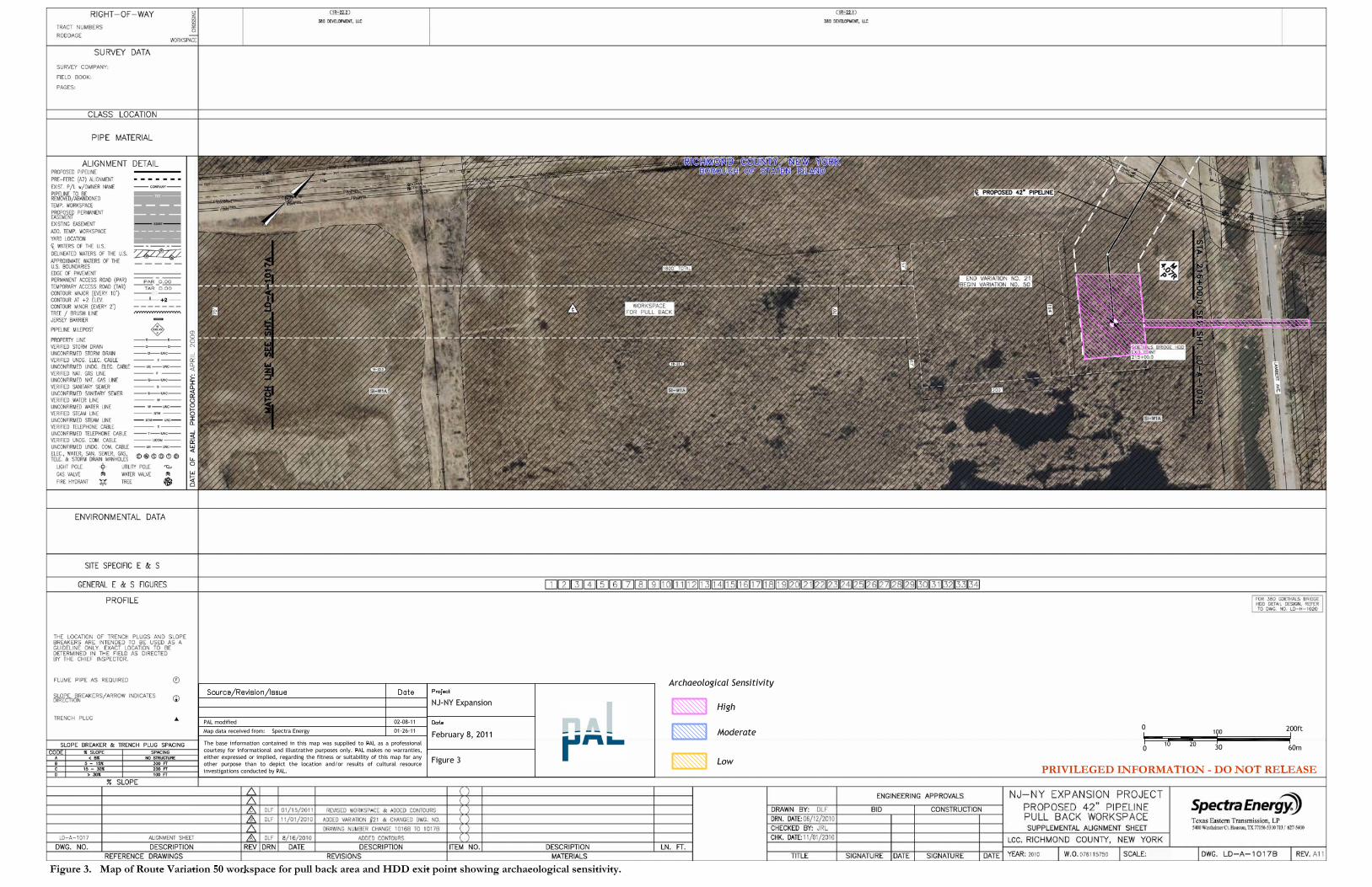


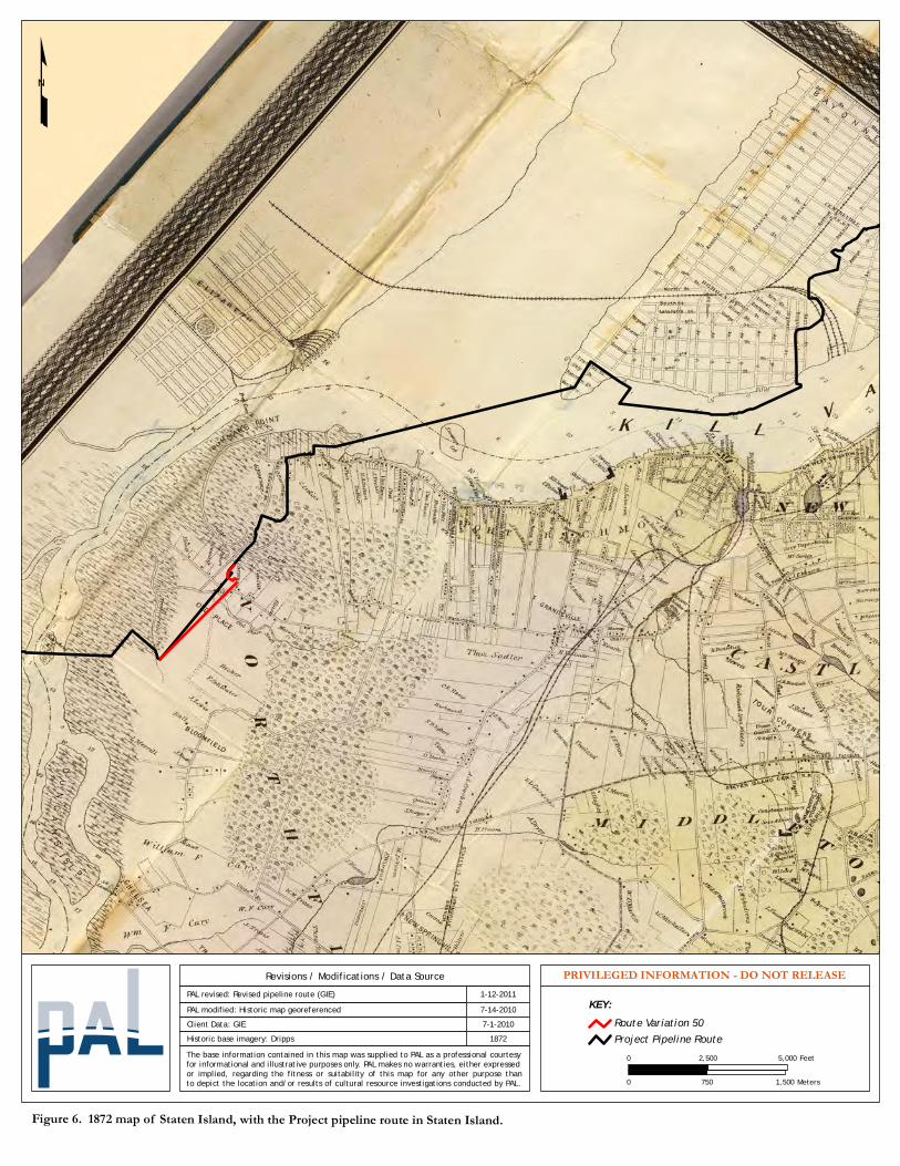
Figure 6. 1872 map of Staten Island, with the Project pipeline route in Staten Island.
Historic base imagery: DrippsClient Data: GIE
Revisions / Modifications / Data Source
1872The base information contained in this map was supplied to PAL as a professional courtesyfor informational and illustrative purposes only. PAL makes no warranties, either expressedor implied, regarding the fitness or suitability of this map for any other purpose thanto depict the location and/or results of cultural resource investigations conducted by PAL.
7-1-2010
PAL revised: Revised pipeline route (GIE)7-14-2010PAL modified: Historic map georeferenced
PRIVILEGED INFORMATION - DO NOT RELEASE
0 5,0002,500 Feet
0 1,500750 Meters
1-12-2011KEY:
Route Variation 50Project Pipeline Route
Related Documents