Phase 1B Archaeological Testing Report PS 51/ 44th Street and Eleventh Avenue Block 1073, Lot 1 (Part) Manhattan, New York County, New York Prepared for: The School Construction Authority 30-30 Thomson Avenue Long Island City, NY 11101 Prepared by: AKRF, Inc. 440 Park Avenue South New York, New York 10016 September 2009

Welcome message from author
This document is posted to help you gain knowledge. Please leave a comment to let me know what you think about it! Share it to your friends and learn new things together.
Transcript

Phase 1B Archaeological Testing Report
PS 51/
44th Street and Eleventh Avenue
Block 1073, Lot 1 (Part)
Manhattan, New York County, New York
Prepared for:
The School Construction Authority
30-30 Thomson Avenue
Long Island City, NY 11101
Prepared by:
AKRF, Inc.
440 Park Avenue South
New York, New York 10016
September 2009

PS 51/44th Street and Eleventh Avenue—Phase 1B Archaeological Testing Report
AKRF, Inc. i September, 2009
Management Summary
SHPO Project Review Number: 09PR00143
CEQR Number: 09HPD022M
Involved Agencies: New York School Construction Authority
Phase of Survey: Phase 1B Field Testing
Project Location: Block 1073, Lot 1 (part) New York, New York
Minor Civil Division: 06101
County: New York County
Location Information:
Survey Area Length: Approximately 100 feet
Survey Area Width: Approximately 100 feet
Number of Acres Surveyed: 0.022
USGS 7.5 Minute Quadrangle Map: Central Park
Report Authors: Elizabeth D. Meade, RPA
A. Michael Pappalardo, RPA
Date of Report: September 2009

PS 51/44th Street and Eleventh Avenue—Phase 1B Archaeological Testing Report
AKRF, Inc. ii September 2009
Table of Contents
A: Introduction and Methodology ............................................................................................................. 1
B: Environmental and Historical Contexts .............................................................................................. 3
C: Results of Field Testing ......................................................................................................................... 4
D: Conclusions ............................................................................................................................................. 6
References .................................................................................................................................................... 7
List of Figures
Figure 1: Project Location: USGS Map, Central Park Quadrangle
Figure 2: Project Site Boundaries.
Figure 3: Plan Drawing of P.S. 51 Property Showing Testing Locations
Figure 4: Trench 1: West Wall Profile
Figure 5: Trench 1 Photographs
Figure 6a: Plan Drawing of Trench 2
Figure 6b: Trench 2: East Wall Profile
Figure 7: Trench 2 Photographs
Figure 8: Trench 3: North Wall Profile
Figure 9: Trench 3 Photographs
Figure 10: Trench 4: West Wall Profile
Figure 11: Trench 4: Photographs
PS 51/44th Street and Eleventh Avenue—Phase 1B Archaeological Testing Report
AKRF, Inc. 1 September 2009
A. INTRODUCTION AND METHODOLOGY
PROJECT OVERVIEW
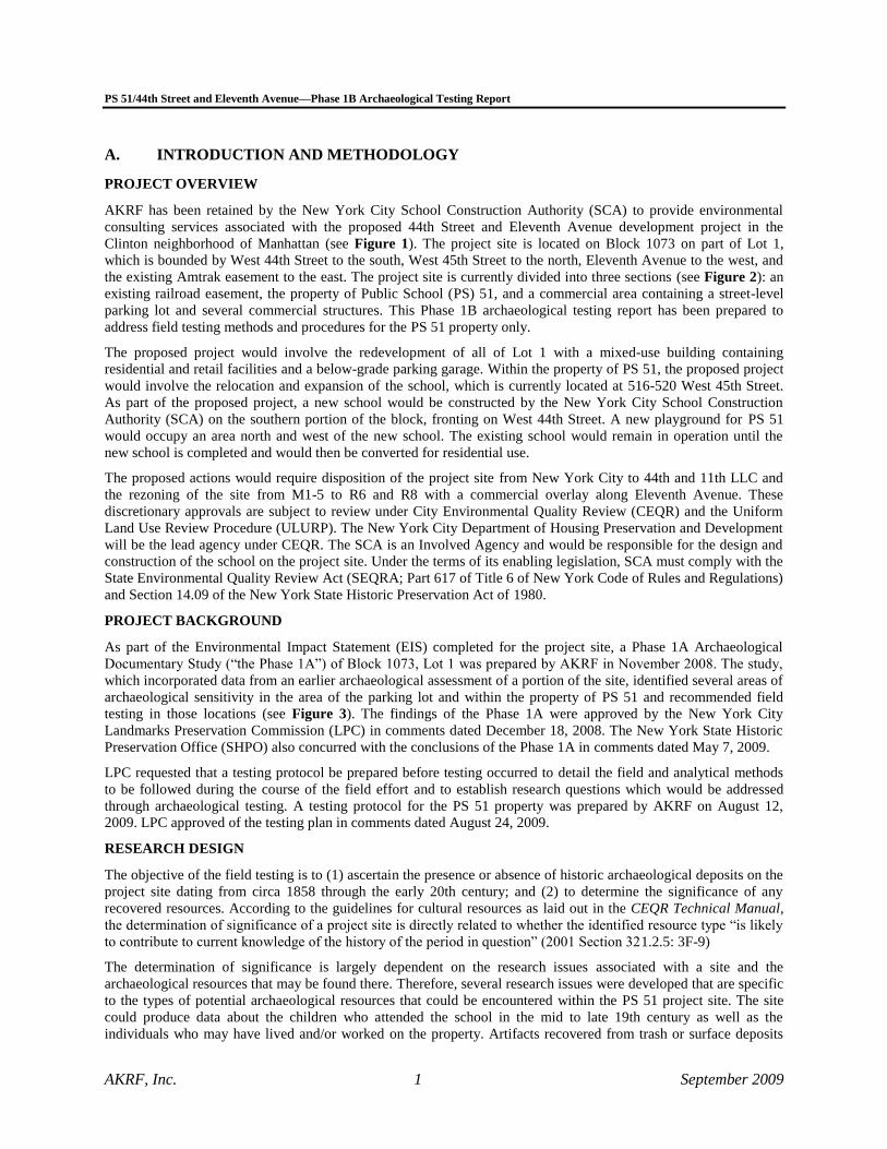
AKRF has been retained by the New York City School Construction Authority (SCA) to provide environmental
consulting services associated with the proposed 44th Street and Eleventh Avenue development project in the
Clinton neighborhood of Manhattan (see Figure 1). The project site is located on Block 1073 on part of Lot 1,
which is bounded by West 44th Street to the south, West 45th Street to the north, Eleventh Avenue to the west, and
the existing Amtrak easement to the east. The project site is currently divided into three sections (see Figure 2): an
existing railroad easement, the property of Public School (PS) 51, and a commercial area containing a street-level
parking lot and several commercial structures. This Phase 1B archaeological testing report has been prepared to
address field testing methods and procedures for the PS 51 property only.
The proposed project would involve the redevelopment of all of Lot 1 with a mixed-use building containing
residential and retail facilities and a below-grade parking garage. Within the property of PS 51, the proposed project
would involve the relocation and expansion of the school, which is currently located at 516-520 West 45th Street.
As part of the proposed project, a new school would be constructed by the New York City School Construction
Authority (SCA) on the southern portion of the block, fronting on West 44th Street. A new playground for PS 51
would occupy an area north and west of the new school. The existing school would remain in operation until the
new school is completed and would then be converted for residential use.
The proposed actions would require disposition of the project site from New York City to 44th and 11th LLC and
the rezoning of the site from M1-5 to R6 and R8 with a commercial overlay along Eleventh Avenue. These
discretionary approvals are subject to review under City Environmental Quality Review (CEQR) and the Uniform
Land Use Review Procedure (ULURP). The New York City Department of Housing Preservation and Development
will be the lead agency under CEQR. The SCA is an Involved Agency and would be responsible for the design and
construction of the school on the project site. Under the terms of its enabling legislation, SCA must comply with the
State Environmental Quality Review Act (SEQRA; Part 617 of Title 6 of New York Code of Rules and Regulations)
and Section 14.09 of the New York State Historic Preservation Act of 1980.
PROJECT BACKGROUND
As part of the Environmental Impact Statement (EIS) completed for the project site, a Phase 1A Archaeological
Documentary Study (“the Phase 1A”) of Block 1073, Lot 1 was prepared by AKRF in November 2008. The study,
which incorporated data from an earlier archaeological assessment of a portion of the site, identified several areas of
archaeological sensitivity in the area of the parking lot and within the property of PS 51 and recommended field
testing in those locations (see Figure 3). The findings of the Phase 1A were approved by the New York City
Landmarks Preservation Commission (LPC) in comments dated December 18, 2008. The New York State Historic
Preservation Office (SHPO) also concurred with the conclusions of the Phase 1A in comments dated May 7, 2009.
LPC requested that a testing protocol be prepared before testing occurred to detail the field and analytical methods
to be followed during the course of the field effort and to establish research questions which would be addressed
through archaeological testing. A testing protocol for the PS 51 property was prepared by AKRF on August 12,
2009. LPC approved of the testing plan in comments dated August 24, 2009.
RESEARCH DESIGN
The objective of the field testing is to (1) ascertain the presence or absence of historic archaeological deposits on the
project site dating from circa 1858 through the early 20th century; and (2) to determine the significance of any
recovered resources. According to the guidelines for cultural resources as laid out in the CEQR Technical Manual,
the determination of significance of a project site is directly related to whether the identified resource type “is likely
to contribute to current knowledge of the history of the period in question” (2001 Section 321.2.5: 3F-9)
The determination of significance is largely dependent on the research issues associated with a site and the
archaeological resources that may be found there. Therefore, several research issues were developed that are specific
to the types of potential archaeological resources that could be encountered within the PS 51 project site. The site
could produce data about the children who attended the school in the mid to late 19th century as well as the
individuals who may have lived and/or worked on the property. Artifacts recovered from trash or surface deposits

PS 51/44th Street and Eleventh Avenue—Phase 1B Archaeological Testing Report
AKRF, Inc. 2 September 2009
can provide insight into consumption patterns which are strongly influenced by socioeconomic status, occupation,
household composition, and ethnicity. What a person buys and/or uses on a routine basis is behavior that reflects the
multiple components of that individual’s life. Information that could be gathered from a schoolyard could be used to
make generalizations about what life was like for children living in the neighborhood during the second half of the
19th century including what they ate, how they learned, and what toys they played with. This information could be
compared and contrasted with data associated with similar populations elsewhere in the city. Therefore, the Phase
1B archaeological testing of the PS 51 property was designed to recover the types of archaeological resources that
would enable archaeologists to answer these types of research questions.
FIELD METHODOLOGY
As stated in the CEQR Technical Manual, although a documentary study determines archaeological potential, “the
resources the site actually contains cannot be known until the site is physically tested” (2001 Section 513.1: 3F-16).
Therefore, the Phase 1B fieldwork completed on the PS 51 property was designed to determine the presence or
absence of archaeological resources in potentially sensitive areas identified in the Phase 1A. Subsurface testing
within the PS 51 project site was conducted within three of the school’s four former side and rear yards (see Figure
3). Due to the presence of a jungle gym and play area with a rubber mat floor that was bolted to the asphalt, no
testing was completed in the location of the school’s eastern side yard and instead an additional trench was
excavated in the rear yard of the former convent/dwelling to the east of the school.
The subsurface testing consisted of mechanically excavated backhoe trenches. The backhoe was used to remove
asphalt and disturbed soils. Archaeologists monitored trench excavation for archaeological features or intact ground
surfaces and examined the excavated materials for artifacts. As only disturbed soils were identified during
mechanical testing, additional hand excavation was deemed unnecessary.
The field testing was completed in compliance with the guidelines established by the New York Archaeological
Council (NYAC, 2000), LPC (2002), and SHPO (2005). Artifacts were recorded in field notes and placed in labeled
plastic bags. All fieldwork was documented through notes, photographs, and drawings. All artifacts recovered
during field testing were processed in AKRF’s archaeology laboratory. The small number of collected artifacts were
washed with a mild, non-ionic detergent using soft-bristle brushes and were then air-dried on racks.
B. ENVIRONMENTAL AND HISTORICAL CONTEXTS
TOPOGRAPHICAL SETTING
The island of Manhattan is found within a geographic bedrock region known as the Manhattan Prong of the New
England (Upland) Physiographic Province. The vicinity of the project area is composed mostly of metamorphic rock
known as Manhattan Schist (Reeds 1925). Bedrock is relatively shallow in the vicinity of the project site. Historic tax
assessments refer to several historic properties within the project site along Eleventh Avenue as “rock” and shallow
bedrock is visible in the railroad right-of-way at the eastern end of the project site (AKRF 2008). The 1865 Viele map
(Figure 3) depicts large hills with possible bedrock outcrops near the western end of the project site (the areas identified
as “rock” in tax assessments). Finally, shallow bedrock is visible along the walls of the adjacent railroad right-of-way.
The project site is characterized by urban soils with more than 80 percent of the surface covered by impervious
pavement and buildings (New York City Soil Survey Staff 2005). The soils are made up of glacial till with 0 to 5
percent slopes (ibid).
PROJECT SITE HISTORY
The complete background history of the project site was outlined in the 2008 Phase 1A Documentary Study and is
summarized below.
PRECONTACT CONTEXT
The precontact sensitivity of project sites in the New York City is generally evaluated by their proximity to high
ground (but not exceeding 30 percent slopes), fresh water courses, well-drained soils, and previously identified
precontact archaeological sites. The project site was to the north of the Great Kill, a large marshy confluence where
several small streams converged and emptied into the Hudson River. The Great Kill and the marshland that bordered
it would have provided a wide variety of resources for Native Americans to exploit. Although no previously

PS 51/44th Street and Eleventh Avenue—Phase 1B Archaeological Testing Report
AKRF, Inc. 3 September 2009
identified Native American sites have been identified in the vicinity of the project site, its proximity to running
water courses, sources of fresh water, and elevated hills, would have made it ideal for short-term hunting and
processing locations and camp grounds.
However, precontact archaeological sites are generally shallowly buried, usually within 5 feet of the original ground
surface. Therefore, the preparation of the lot for the construction of the original school building and the construction
of the building’s foundation walls, utility lines, subsurface tunnels, etc. as well as the demolition of the school and
its conversion into a parking lot/playground likely generated disturbance of any precontact archaeological resources
that may have been located there at one time. Therefore, the PS 51 project site was determined to have low
sensitivity for precontact archaeological resources.
HISTORIC CONTEXT
The PS 51 property currently includes an existing school on the northern side of the property and a paved
playground to the south. As described in the Phase 1A study, the property was historically divided into numerous
lots. An earlier school was constructed circa 1858 on the southern portion of the current school property,
approximately one year after the installation of sewer lines in West 44th Street. The original school building was H-
shaped although it was continuously expanded throughout the 19th century. In the late 1870s the school purchased
and expanded onto an additional lot to the east that had been occupied by a structure formerly used as a convent and
a store selling various items such as curled hair and sisal. Documentary evidence shows that the school’s janitors
lived on the school property in apartments located within the original school building.
By the early 1890s, the increasing neighborhood population forced the school to purchase lots to the north so that
the school could be expanded further. The northern half of the school property was purchased at this time and the
existing PS 51 was constructed soon after. These lots were formerly occupied by the coal sheds of an adjacent iron
foundry. There does not appear to have ever been any residential occupation of these lots. The two buildings were
connected via a bridge and a subsurface tunnel.1
The original structure remained on the school property until the mid-20th century, when it was demolished and
converted into a playground and parking lot. Although the original school building was expanded several times, the
school’s side yards were never developed. The areas to the rear (north) of the original school building’s northern
wings were also never developed with structures with basements. Building plans of similar schools built in New
York City in the 1850s identify those areas as the locations of the school’s water closets.
With respect to historic period archaeological resources, based on the lack of residential occupation and the
construction of the school after the installation of water and sewer networks in the area, the Phase 1A determined
that it was not likely that domestic shaft features such as privies, cisterns, and wells would be located within the PS
51 property. However, it was determined possible that surficial deposits associated with the children who attended
the school could be located in the open yard areas on east and west of the original school. Therefore, the side and
rear yards of the original PS 51 were determined to have moderate sensitivity for historic period archaeological
resources.
C. RESULTS OF FIELD TESTING
Fieldwork was conducted in early September 2009 by a crew of two archaeologists, a backhoe operator, and several
individuals in charge of cutting asphalt and site maintenance. Fieldwork consisted of the excavation of four backhoe
trenches (Trenches 1 through 4) and resulted in the recovery of a small number of historic and modern artifacts
collected from the excavated soils.
1 The subsurface tunnel connecting the two buildings was located near the northwest corner of the original school
structure. The existence of the tunnel was discovered after the completion of the Phase 1A and was partially
located in the area originally identified as sensitive for archaeological resources in the Phase 1A. Therefore, the
area of sensitivity as identified on Figure 3 in this report has eliminated the location of the tunnel as a sensitive
area.

PS 51/44th Street and Eleventh Avenue—Phase 1B Archaeological Testing Report
AKRF, Inc. 4 September 2009
TRENCH 1
Trench 1 was oriented from west to east and was excavated in the location of the original school’s western side yard.
The southwest corner of this trench was 42.5 feet north of the fence lining the southern end of the property and 2.5
feet east of the cement wall lining the western side of the property. The trench measured 15 feet in length and 6 feet
in width. A small concrete foundation was located along the northern side of this trench which supported a fence
separating three parking spaces from the remainder of the playground area. The profile of the western wall of the
trench was mapped and is included as Figure 4.
Immediately below the asphalt (which was 2 inches in thickness) was a layer of asphalt bedding composed mostly of
crushed gravel. Below the asphalt bedding were two layers of sandy fill; the upper layer extending between
approximately 8 and 16 to 20 inches below grade and the lower layer extending to depths of 25 to 34 inches below
grade. These loose fill levels were yellow brown and dark yellow brown and contained a large amount of rock, brick
debris, and artifacts (see Figure 5). The artifacts found in the fill levels represented a mix of 19th and 20th century
items, including whiteware chamber pot fragments, bottle glass, ceramic floor tiles, construction debris, candy bar
wrappers, oyster and quahog shells, animal bone, a clay pipe bowl, clay pipe stems, and a plastic ketchup packet.
The artifacts also included a rim fragment of a stoneware vessel with a brown interior slip that was stamped:
…LIAM BOGGS & CO
…SHINGTON ST NY
Historic directories show that William Boggs was a tobacconist who maintained a store at 247 and/or 249
Washington Street between at least 1851 and 1867.
Two stamped bricks were also identified in the upper fill layers of Trench 1. The first was stamped “SSBCO,”
referring to the Sutton & Suderly Brick Company based in Coeyman’s Landing, near Albany, New York (Ries
1900). The other brick was fragmented and stamped “…RKWAY.”
Below the upper fill levels was a layer of coarse, sandy fill which was discontinuous in the trench’s south wall. This
level contained fewer artifacts and was visibly disturbed by large pipes, including a 6-inch pipe that ran southwest-
northeast through the western portion of the trench and was located approximately 3 feet 7 inches below ground
surface within the south wall. The artifacts in this level included several whiteware fragments—some were
undecorated while others had blue transfer prints and one a hand-painted blue fleur-de-lis pattern—several pieces of
broken animal bone, a clay pipe stem, and construction rubble.
Below the coarse fill layer was a level of sandy fill that was situated directly atop the schist bedrock, the top of
which was exposed at approximately 4 feet 5 inches below grade. Few artifacts were present in this level and those
recovered included porcelain dish fragments and a stoneware vessel fragment.
No artifacts clearly associated with the school or its students were recovered.
TRENCH 2
North-south oriented Trench 2 was excavated in the northwestern rear yard of the original school building. It was
thought that the school’s water closets may have been located in this area. A large shipping container occupied much
of the area identified as potentially sensitive in the Phase 1A. Trench 2 was opened immediately east of the
container, and its west side was 20.5 feet east of the cement and brick wall lining the western side of the property
and immediately south of the wall lining the northern side. The trench measured 15 feet in length and 6 feet in width
(see Figure 3). A plan drawing of this trench and a profile drawing of its eastern wall are included as Figures 6A
and 6B.
Historic maps depict a 1-story (without basement) structure in this area that was built many years after the original
school was constructed. A tunnel was also constructed after the original school was built to connect the existing PS
51 with the original building to the south. This tunnel was presumed to have been located to the east of the area of
sensitivity.
A concrete foundation wall was identified along the eastern wall of the trench approximately 1 foot below grade.
This wall was separated from the asphalt by an approximately 8-inch layer of sandy fill. This fill level contained
brick rubble and rocks as well as some artifacts (see Figure 7). The artifacts were a mix of 19th and 20th century

PS 51/44th Street and Eleventh Avenue—Phase 1B Archaeological Testing Report
AKRF, Inc. 5 September 2009
items, including green glass machine-made bottle necks and body fragments, a green glass fragment with the
remnants of an enameled label, a stoneware fragment, a piece of whiteware with a blue transfer print, and a circa
1982 mini beer bottle embossed with the Anheuser-Busch logo.
Similar artifacts were recovered from a second fill level from the western side of the trench, west of the foundation
wall. This sandy silt fill layer was also filled with brick rubble and contained at least three pipes, one which
appeared to have been a drain connection and one that was identified by on-site contractors as an electrical line. The
fill in this area included floor tiles still cemented together and large porcelain fragments, suggesting that this area
was redeveloped as a bathroom in later years, likely disturbing the entire area and removing any trace of the water
closets which may have been located there at one time. A slate fragment was recovered from the eastern wall of the
trench from a depth of approximately 5.5 feet below ground surface, although it is not clear if it was associated with
the original school or if it was used as construction material or if it was simply naturally occurring.
Below the fill/rubble level were several closely packed layers of natural clays and sands. These layers were situated
directly on top of the bedrock, which was identified at a depth of approximately 5 feet below ground surface. The
bedrock in this area was not the same schist seem in Trench 1. No artifacts clearly associated with the school or its
students were recovered.
TRENCH 3
Trench 3 was excavated in the former rear yard of the structure located at 515 West 44th Street, a former convent,
dwelling, and store which was later connected as a wing of the original school. A 4-story addition to the main
dwelling was located in the area surrounding Trench 3, which measured approximately 6 feet by 8 feet. A profile
drawing of the northern wall of Trench 3 is included as Figure 8.
The original foundation walls of the structure that was situated on this lot were visible in Trench 3. These foundation
walls were made of brick laid on top of large boulders. The surviving portion of the brick wall consisted of three
courses of brick with thick concrete mortar that appeared to be constructed directly on top of the large boulders.
Natural sand deposits were identified below the boulders.
Few artifacts were located within this trench (see Figure 9). From the fill levels above the brick foundation wall,
several pieces of whiteware were recovered—most were undecorated but one had a blue transfer print—as well as a
broken animal bone and a piece of clear glass. The fill level present below the brick wall included a broken quahog
shell, a rusted nail, undecorated whiteware, a piece of whiteware with a hand painted floral pattern, and a piece of
dipped whiteware with a blue and brown motif. In addition, a piece of an ironstone saucer with a blue transfer print
was also recovered from Trench 3. The ironstone fragment included a portion of a maker’s mark on the back; a
phoenix with the word “SIAM” written underneath. The pattern and mark are consistent with English potter Joseph
Clementson’s Siam pattern. Clementson’s pottery was open between 1839 and 1864 (Birks n.d.).
No artifacts clearly associated with the school or its students were recovered.
TRENCH 4
North-south oriented Trench 4 was located within with northeastern rear yard of the original school and measured 15
feet by 6 feet. A profile drawing of the western wall of Trench 4 is included as Figure 10.
In this area, the asphalt measured 4 inches in thickness. Below that was a layer of very dark grayish brown fill. This
layer was succeeded by several layers of mottled fill containing brick and rock inclusions and layers of natural sands
and clay directly over bedrock. The bedrock was decomposing and very shallow in the eastern portion of this trench,
located at approximately 21 inches below ground surface. The remnants of a brick wall with concrete mortar and a
concrete pad were located in the northeast corner of the trench. It was not clear if this wall was in situ or if it had
been knocked into its current location during the demolition of the school.
A small number of artifacts were recovered from this trench. In the top 1 to 2 feet of fill, artifacts included broken
undecorated whiteware fragments, a fragment of redware, an animal bone, an oyster shell fragment, and two
embossed pieces of clear glass (one with a star pattern and one with unidentifiable letters). The artifacts from the top
fill levels also included a ceramic smoking pipe bowl in the form of a hand holding a beer stein. Portions of the pipe
still retain the original silver paint that once covered it. The fill from approximately 3 to 4 feet below grade
contained the same types of artifacts: whiteware fragments and the clear glass with the star pattern, as well as

PS 51/44th Street and Eleventh Avenue—Phase 1B Archaeological Testing Report
AKRF, Inc. 6 September 2009
ceramic floor tiles (see Figure 11). No artifacts clearly associated with the school or the activities of its students
were recovered.
D. CONCLUSIONS
None of the four excavated trenches presented any evidence associated with the original PS 51 building that
formerly stood on the southern half of the property. It appears that the school’s rear and side yards were heavily
disturbed during the construction of the school and installation of pipes and utility lines and again during the mid-
20th century demolition of the school and the construction of the existing playground. Historic fill may have been
introduced or redeposited throughout the site during construction/demolition. All of the artifacts recovered during
Phase 1B testing appear to have come from these fill levels. It does not appear that any intact archaeological
resources are present on the PS 51 property. Therefore, no further archaeological work is recommended for the site.

PS 51/44th Street and Eleventh Avenue—Phase 1B Archaeological Testing Report
AKRF, Inc. 7 September 2009
References
AKRF, Inc.
2008 Archaeological Documentary: 44th Street and Eleventh Avenue, Block 1073, lot 1, Manhattan,
New York County, New York. Prepared for the Gotham Organization, New York, New York,
November 2008.
Birks, Steve
n.d. “A to Z of Stoke-on-Trent Potters: J. Clementson.” Accessed September 25, 2009:
http://www.thepotteries.org/allpotters/272.htm
New York City Soil Survey Staff
2005 New York City Reconnaissance Soil Survey. United States Department of Agriculture,
Natural Resources Conservation Service, Staten Island, New York.
Reeds, Chester A.
1925 The Geology of New York City and Vicinity. New York: The American Museum of Natural
History Guide Leaflet No. 56.
Ries, Dr. Heinrich
1900 “Clays of New York.” Bulletin of the New York State Museum 7(35): 705. Albany: University of
the State of New York.
Viele, Egbert Ludovicus
1865 Sanitary & Topographical Map of the City and Island of New York. New York: Ferd. Mayer &
Co.

PROJECT SITE
RAILROAD EASEMENT
W. 45TH ST.W. 44TH ST.
9.30
.09
N
Project Site LocationUSGS Maps, Central Park, Jersey City,
Brooklyn and Weehawken QuadranglesFigure 1
SCALE
0 2000 FEET
P.S. 51/WEST 44TH STREET AND ELEVENTH AVENUE
Project Site Boundary

W. 47TH ST.
W. 46TH ST.
W. 45TH ST.
W. 44TH ST.
W. 43RD ST.
Project Site BoundariesFigure 2
N
SCALE
0 200 400 FEET
9.25
.09
P.S. 51/WEST 44TH STREET AND ELEVENTH AVENUE
P.S. 51 Property
44th Street and Eleventh Avenue Project Site
Railroad Easement

PLAY AREAWITH MAT FLOOR
BASKETBALL HOOP
TRENCH 2
TRENCH 1
SHIPPINGCONTAINER
TRENCH 4
EXISTING SCHOOL(P.S. 51)
W. 45TH ST.
W. 44TH ST.
TRENCH 3
Plan Drawing of P.S. 51 PropertyShowing Testing Locations
Figure 3
SCALE
0 50 FEET
N
9.30
.09
Areas identified as sensitive in the Phase 1A
Trench
Tree
Bench
P.S. 51/WEST 44TH STREET AND ELEVENTH AVENUE
Project Site Boundary
Study Area Boundary (400-Foot Perimeter)
Photograph View Directionand Reference Number

Asphalt layer
Crushed Gravel
Asphalt bedding; 10yr 3/2 very dark grayish brown
Medium sandy fill; 10yr 4/6 dark yellowish brownsand with rock and brick
Dense, very fine silty sand fill; 10yr 5/6 very dark brown, some rocks
Coarse fill, possibly redeposited weathered/ crushed schist with large rocks and boulders; 10yr dark grayish brown.
Very clean fine - medium sand fill; 10yr 5/4 yellowish brown with exposed bedrock
End of Excavation
Ground surface
36” east of brick wall
NOTE: Drawing begins at northwestern corner of trench, 36” east of brick wall
FEE
T
0
1
2
3
Trench 1: West Wall ProfileFigure 4
9.30
.09
SCALE
0 1 2 FEET
P.S. 51/WEST 44TH STREET AND ELEVENTH AVENUE

9.30.09
Trench 1Photographs
Figure 5
2Representative artifact sample from Trench 1
1Trench 1, West Wall Profile. Trowel is resting on exposed schist bedrock

Foun
datio
n w
all
Distance toWestern Wall
20.5’
Cement Wall
4” Pipe
17.5”
30.5”
9”
48”
18”
60”
Area excavatedto bedrock
6” Pipe
3” Electrical pipe
Drain connection
Plan Drawing of Trench 2Figure 6a
Depth below ground surface17.5”
N9.30
.09
SCALE
0 2 4 FEET
P.S. 51/WEST 44TH STREET AND ELEVENTH AVENUE

Asphalt
Bedrock
Sandy fill with brick and rock;10yr 4/2 dark grayish brown
Concrete foundation wall
Sand and silt with brick bubble;10yr 4/3
Numerous thin layers of natural sands and clays:a) sand; 7.5yr 5/6, strong brownb) clay; 7.5yr 4/4, brown with decomposing bedrockc) sand; 10yr 6/4 light yellowish brown, with decomposing bedrockd) very compact sand with gravel; 7.5yr 5/4 brown; situated on top of bedrock
End of Excavation
NOTE: Drawing begins 2’4” south of trench’s north wall
0
1
2
3
4
5
6
9.30.09
Trench 2: East Wall ProfileFigure 6b
SCALE
0 1 2 FEET
P.S. 51/WEST 44TH STREET AND ELEVENTH AVENUE

9.30.09
Trench 2Photographs
Figure 7a
2Trench 2, Eastern Wall
Location of Trench 2, looking north 1
Concrete Foundation Wall
Pipe
Pipe

9.30.09
Trench 2Photographs
Figure 7b
4Slate Fragment recovered from Trench 2, approximately 5.5 feet below ground surface
3Representative artifacts from Sand Fill level, Trench 2

Asphalt layer
Ground surface
Compact silty sand fill with gravel; 10yr 4/3 brown
Mixed fill anddemolition debrisBrick rubble
Concrete and rubble
Boulder
Boulder
Boulder
Boulder (schist)
Natural sands; 10yr 5/6 yellow brown
Bricks
FEE
T
0
1
2
3
4
NOTE: Drawing begins 1 foot east of Trench’s western wall
9.30.09
Trench 3, North Wall ProfileFigure 8
SCALE
0 1 2 FEET
P.S. 51/WEST 44TH STREET AND ELEVENTH AVENUE

9.30.09
Trench 3Photographs
Figure 9
2Representative Sample of artifacts recovered from Trench 3. Ceramic fragment at bottom right is from a saucer with J. Clementson’s “Siam” pattern transfer print
1Trench 3, north wall profile. Note brick wall and boulder foundation

FEE
T
0
1
2
3
Asphalt layer
10yr 3/2 very dark grayish brown
Fill; mottled colors with brick and rock inclusionsFill; mottled brown colors
Fine compact silty sand with some clay;10yr 4/3 - 10yr 5/6, browns and yellows browns
Decomposing bedrock
End of excavation End of excavation
Ground surface
Trench 4: West Wall ProfileFigure 10
9.30.09
SCALE
0 1 2 FEET
P.S. 51/WEST 44TH STREET AND ELEVENTH AVENUE
Project Site Boundary
Study Area Boundary (400-Foot Perimeter)
Photograph View Directionand Reference Number

9.30.09
Trench 4Photographs
1Trench 4 location, looking northeast; note brick wall remnant in northeast corner of trench
2Trench 4, west wall profile
Figure 11a

9.30.09
Trench 4Photographs
Figure 11b
3Representative artifact sample from Trench 4; note ceramic pipe bowl in lower left corner
Related Documents