Phase 1A Archaeological Documentary Study Camelot Counseling Center Block 955, Lot 1 (part) Borough of Staten Island, Richmond County, New York Prepared for: New York State Office of Alcoholism and Substance Abuse Services 1450 Western Avenue Albany, New York 12203 and The Dormitory Authority of the State of New York One Penn Plaza, 52nd Floor New York, New York 10119 Prepared by: AKRF, Inc. 440 Park Avenue South New York, New York 10016 November 2008

Welcome message from author
This document is posted to help you gain knowledge. Please leave a comment to let me know what you think about it! Share it to your friends and learn new things together.
Transcript
Phase 1A Archaeological Documentary Study
Camelot Counseling Center
Block 955, Lot 1 (part)
Borough of Staten Island, Richmond County, New York
Prepared for:
New York State Office of Alcoholism and Substance Abuse Services
1450 Western Avenue
Albany, New York 12203
and
The Dormitory Authority of the State of New York One Penn Plaza, 52nd Floor
New York, New York 10119
Prepared by:
AKRF, Inc.
440 Park Avenue South
New York, New York 10016
November 2008

Management Summary
SHPO Project Review Number: 08PR02480
Involved State and Federal Agencies: New York State Office of Alcoholism and Substance Abuse Services (OASAS) and the Dormitory Authority of the State of New York (DASNY)
Phase of Survey: Phase 1A Documentary Study
Location: 460 Brielle Avenue, Staten Island, New York
Minor Civil Division: Staten Island Block 955, Lot 1 (part)
County: Richmond County
Survey Area Length: 310 feet
Survey Area Width: 350 feet
Number of Acres Surveyed: 2.5 acres
USGS 7.5 Minute Quadrangle Map: Arthur Kill
Report Author: Elizabeth D. Meade, RPA
Date of Report: November, 2008

TOC-1
Table of Contents
1: Introduction and Methodology
A. Project Overview ............................................................................................................................................. 1
B. Research Goals and Methodology ................................................................................................................... 1
2: Environmental Setting
A. Geology and Topography ................................................................................................................................ 3
B. Hydrology ....................................................................................................................................................... 3
C. Soils ................................................................................................................................................................. 4
D. Paleoenvironment ............................................................................................................................................ 5
E. Current Conditions .......................................................................................................................................... 5
F. Previous Cultural Resources Studies ............................................................................................................... 5
3: Precontact Period
A. Introduction ..................................................................................................................................................... 7
B. Paleo-Indian Period (11,000-10,000 BP) ........................................................................................................ 7
C. Archaic Period (10,000-2,700 BP) .................................................................................................................. 7
D. Woodland Period (2,700 BP-AD 1500) .......................................................................................................... 8
E. Contact Period (AD 1500-1700) ..................................................................................................................... 9
F. Previously Identified Native American Archaeological Sites ....................................................................... 10
4: The Historic Period
A. Staten Island Historic Context ....................................................................................................................... 11
B. History of the Project Site ............................................................................................................................. 12
C. Utilities in the Project Area ........................................................................................................................... 14
5: Conclusions, and Recommendations
A. Sensitivity Assessment .................................................................................................................................. 15
B. Recommendations ......................................................................................................................................... 17
6: References
7: Figures and Photographs
8: Appendices

TOC-2
List of Appendices
Appendix A: Deeds, Block 955, Lot 1
Appendix B: Summary of Census Research
Appendix C: Historic Directories
List of Figures
Figure 1: Project Location and Locations of Native American Archaeological Sites; United States Geological Survey (USGS) Maps, Arthur Kill and the Narrows Quadrangles.
Figure 2: Project site map showing camera angles for site photographs.
Figure 3: Site Plan and proposed Areas of Disturbance.
Figure 4: Atlas of Staten Island. F.W. Beers, 1874.
Figure 5: Borough of Richmond Topographical Survey, 1911.
Figure 6: Areas of Archaeological Sensitivity.
List of Photographs
See Figure 2 for Camera Angles
Photograph 1: The Group Building, looking south across front lawn and driveway.
Photograph 2: Northern façade of west wing of Group Building showing catch basin in foreground.
Photograph 3: South wing of Group Building looking west with transformer station and seating area in foreground.
Photograph 4: Northeastern portion of Group Building.
Photograph 5: Parking area on western side of Group Building, looking northeast.
1
Chapter 1: Introduction and Methodology
A. PROJECT OVERVIEW
AKRF, Inc. has been retained by the Dormitory Authority of the State of New York (DASNY) to prepare an Environmental Assessment Statement (EAS) in connection with the proposed development on the property of the Seaview Hospital in Staten Island (see Figures 1 and 2). DASNY has received a request from the New York State Office of Alcoholism and Substance Abuse Services (OASAS) for environmental management support on the proposed project. OASAS’s client is Camelot Counseling Centers, Inc., a voluntary agency that operates a variety of social service facilities and programs in Staten Island. The proposed project would involve the renovation and conversion of the existing “Group Building” at 460 Brielle Avenue (Block 955, Lot 1) from an outpatient mental health center serving approximately 180 clients to a 45-bed inpatient substance abuse facility for adolescent boys administered by Camelot Counseling Services. Because OASAS, a state agency, will provide funding for the proposed project, the proposed project is subject to review under the State Environmental Quality Review Act (SEQRA). OASAS will serve as lead agency during the environmental review process.
The proposed project would involve excavation in several portions of the project site (see Figure 3). To the north of the Group Building, a new parking lot would be constructed in the location of an existing asphalt-paved driveway and grassy lawn. New light poles and an associated feeder line would be installed in this area which could result in disturbance of approximately 4 feet. The construction of the parking lot would also require grading which would require excavation of approximately 1 to 2 feet in various locations. A new stormwater drainage system would be constructed to the west of the proposed parking lot which would include an inlet, seepage pit/drywell system, storm pipes, and a riprap overflow area. An existing electrical transformer located near the southeast corner of the building would be located to the western site and would be connected with a new electric feeder line. Near the southwest corner of the building, a new loading and delivery area with new footings for a loading dock would be constructed. Finally, throughout the property, new curbs, benches, and other small improvements would be made.
B. RESEARCH GOALS AND METHODOLOGY
The goal of this Phase 1A Archaeological Documentary Study is to determine the likelihood that potential archaeological resources have survived the destructive forces of time, including the construction of domestic and industrial structures in the area. The study has been designed to satisfy the requirements of the New York City Landmarks Preservation Commission (LPC) and it follows the guidelines of the New York Archaeological Council (NYAC). The study documents the history of the proposed project site as well as its potential to yield archaeological resources including both precontact and historic cultural remains. In addition, it also documents the current conditions of the project site and previous cultural resource investigations which have taken place in the vicinity of the project site.
Research was completed to establish a chronology of the project site’s development and to identify any individuals who may have owned, worked, and resided within it. Historic deeds were reviewed to identify the owners of the project site from the 17th century to the present (Appendix A). Census records dating between 1790 and 1930 were reviewed in an attempt to identify those individuals (Appendix B). Census records that pre-date 18711 do not include street addresses and most do not include street names. Therefore, one cannot identify with complete certainty the residents of any one particular property. Similarly, historic directories are valuable sources of information which can identify the residents of individual properties. However, most directories are organized by name and are not usually organized by address (with the exception of some street directories, such as the 1851
1 The 1870 census was taken twice in several areas, including New York City. The first enumeration of the census
was completed in July 1870 and the second enumeration of the 1870 census was taken in January 1871 at the request of many individuals who feared that urban populations were under-represented in censuses. The second enumeration is the first census to include street addresses for each family and is therefore a more accurate reference in the search for the residents of a particular property.

Camelot Counseling Center—Phase 1A Archaeological Documentary Study
2
Doggett directory which has been transcribed in Appendix C). There are several historic directories which have been digitized and can therefore be searched by address rather than name. These directories were reviewed as part of this documentary study. Finally, historic tax assessment ledgers were reviewed to identify the owners (and in some cases, the occupants) of the historic properties located within the APE (Appendix D). When possible, the names of the owners were cross-referenced with census records and historic directories.
In addition, as part of the background research for this Archaeological Documentary Study, various primary and secondary resources were analyzed including historic maps and atlases, historic photographs, newspaper articles, local histories, and building records. These published and unpublished resources were consulted at various repositories, including the Main Research Branch of the New York Public Library, the Richmond County Clerk, the New York Department of Buildings website, the Department of Environmental Protection’s Staten Island Bureau of Water and Sewer Operations, the Richmond County Topographical Bureau, the local history department of the Saint George branch of the New York Public Library, and the history archives of the Staten Island Institute of Arts and Sciences. On-line textual archives such as Google Books and the Internet Archive Open Access Texts were also accessed.
3
Chapter 2: Environmental and Physical Settings
A. GEOLOGY AND TOPOGRAPHY
The geographic province in which the project area is situated is known as the Atlantic Coastal Plain (Isachsen et al 2000). The Atlantic Coastal Plain is composed of unconsolidated glacial sediments and the only location within the plain where bedrock is actually exposed is in Staten Island (NYSOFT 2004). The vicinity of the project area is characterized by Harbor Hill Moraine, a sedimentary rock dating to the Pleistocene (approximately 1.6 million to 10,000 years before present [BP]) while older Raritan formation sedimentary and Serpentine igneous rocks are located immediately to the north (Reeds 1925).
The island’s physical setting was shaped by massive glaciers of up to 1,000 feet thick that retreated from the area towards the end of the Pleistocene. There were four major glaciations which began approximately 17,000 years ago and lasted until roughly 12,000 years ago when the Wisconsin period—the last glacial period—came to an end. During the Wisconsin ice age, a glacial moraine traveled southwest across Staten Island, resulting in the separation of the Atlantic Coastal Plain from the remainder of Staten Island, which is characterized by hard bedrock rather than glacial deposits (Reeds 1925).
The glacial movements also brought about the creation of hundreds of sand hills, or kames, throughout the New York City region, some of which reached heights of more than one hundred feet. These hills were contrasted by many small streams, rivers, and lakes that were fed by the glacial runoff. Some historic maps of Staten Island depict a large hill, identified on the 1874 Beers map (Figure 4) as “Ocean Hill,”1 in the vicinity of the project site. Late 19th and early 20th century maps do not depict this hill as it is seen on some of the older maps, although they do depict a steep slope to the south. A deep ravine was located to the east of the project site, in the vicinity of modern Manor Road, was known as “Blood Root Valley” (Morris 1898).
The Borough of Richmond Topographical Survey, created in 1911 (Figure 5) shows that the project site was formerly located between approximately 275 and 293 feet above the Richmond Borough datum, which is approximately 278.192 295.192 feet above sea level. In some locations these elevations have remained relatively similar, although in other locations fill has been added to level out the slope of the hill. Current topographic information (see Figure 3) shows that in general, the area to the northeast of the existing building at 460 Brielle Avenue appears relatively unchanged while the areas to the south of the building appear to have been covered with approximately 4 feet of fill in some locations and the area to the northwest of the building has been covered with approximately 3.8 feet of fill.
B. HYDROLOGY
The 1911 topographic survey depicts several small ponds in the vicinity of the project site; the closest was approximately 700 feet to the southwest. Only one pond, to the northwest of the project site, is depicted on the 1874 Beers and 1891 Bien and Vermule maps, so it is possible that some of the ponds depicted on the 1911 map were man-made. The map also shows several swamps to the south of modern Rockland Avenue (then known as Saw Mill Road). These swampy areas were fed by small streams, one of which terminated approximately 1,000 feet to the southeast of the project site. A stream known as Dead Man’s Creek ran through Blood Root Valley to the east of the project site (Davis 1896). The stream was often dry during the summer months and drained into a saw mill pond located to the south (Davis 1892). Finally a “big spring” was located on the former property of the Frech family, to the southeast of the project site (property is visible on the 1874 Beers atlas, Figure 4). The spring was allegedly 19 feet in diameter and was thought to be the largest on Staten Island (Leng and Davis 1930).
1 Other sources suggest that a hill to the northeast of the project site was known as Ocean Hill, as well.

Camelot Counseling Center—Phase 1A Archaeological Documentary Study
4
C. SOILS
Three soil complexes, all unique to Staten Island, are predominant in the vicinity of the Seaview Hospital property, the Wethersfield-Foresthills-Pavement & Buildings complex, in the location of the Seaview Hospital itself, the Wethersfield-Ludlow-Wilbraham complex, near the northeast corner of Brielle and Rockland Avenues, and the Wethersfield-Ludlow complex, on the eastern side of the grounds (New York City Soil Survey Staff 2005). The Wethersfield-Foresthills complex is typical in areas that “have been partially filled for cemeteries and residential use” and 15 to 49 percent of which are typically covered by pavement or buildings (ibid: 20). The Wethersfield-Ludlow complex is typically found in undisturbed areas, as is the Wethersfield-Ludlow-Wilbraham complex, which is found in nearly level to gently sloping areas that area mostly wooded (ibid). All three soils complexes are formed in red till. The individual soil types that make up these complexes are described in greater detail in Table 1, below.
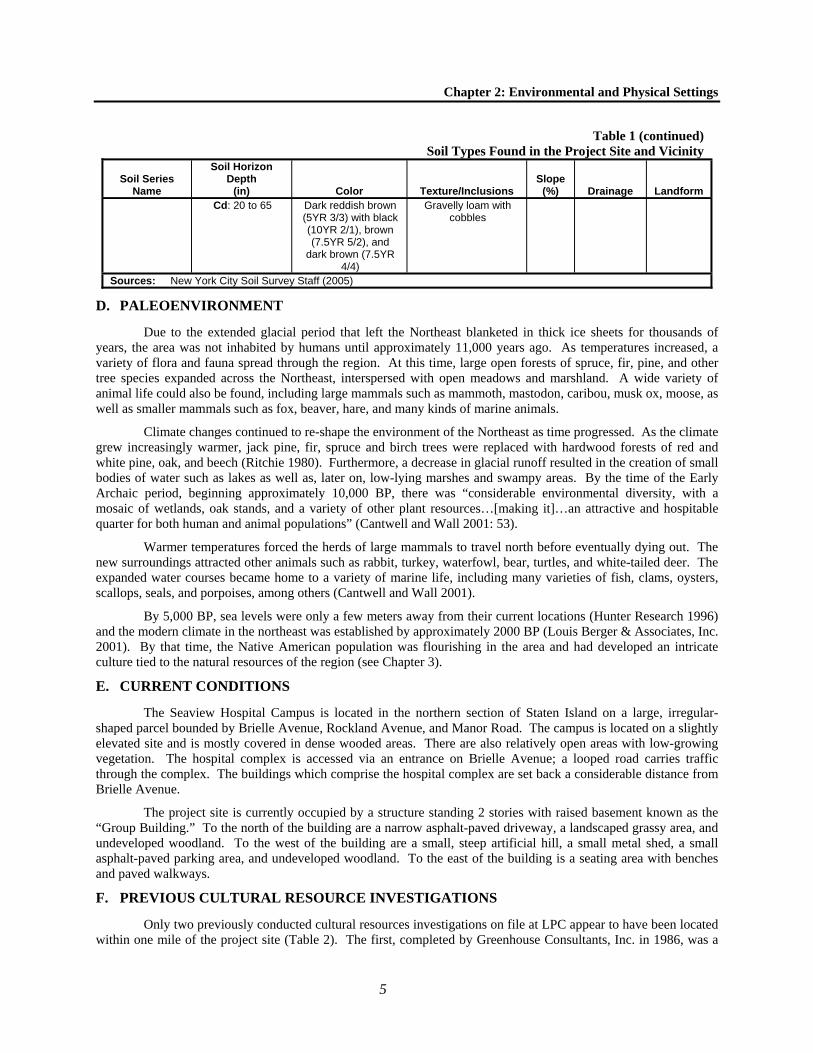
Table 1Soil Types Found in the Project Site and Vicinity
Soil Series Name
Soil Horizon Depth
(in) Color Texture/Inclusions Slope
(%) Drainage Landform Foresthills A: 0 to 2 Very Dark Grayish
Brown (10YR3/2) Loam with gravel, cobbles, stones
0 to 8 Well drained
Anthro-pogenic urban fill
plains Bw: 2 to 15 Brown (7.5YR4/4)
Yellowish red (5YR4/6)
Black (10YR2/1)
Loam with gravel and cobbles
Ab: 15 to 17 Black (10YR2/1) Loam with gravel and cobbles
BAb: 17 to 28 Brown (7.5YR4/3) Loam with gravel and cobbles
Bwb: 28 to 42 Reddish brown (5YR4/4)
Loam with gravel and cobbles
Cd: 42 to 60 Yellowish red (5YR4/6)
Loam with gravel and cobbles
Ludlow Ap: 0 to 8 Dark brown (7.5YR 3/2)
Silty loam with gravel 15 to 50
Moderately well
drained
Till plains, hills, and moraines Bw1: 8 to 20 Reddish brown
(5YR 4/4) Silty loam with gravel
Bw2: 20 to 26 Dark reddish brown (5YR 3/4)
with pinkish gray (5YR 6/2) and
strong brown (7.5YR 5/8)
Silty loam
Cd: 26 to 65 Dark reddish brown (2.5YR 3/4)
Gravelly loam
Wethersfield A: 0 to 3 Dark brown (7.5YR 3/2)
Loam with gravel 0 to 50
Well drained
Till plains, hills, and moraines Bw1: 3 to 13 Reddish brown
(5YR 4/4) Loam with gravel
Bw2: 13 to 27 Dark reddish brown (5YR 3/3)
Gravelly loam with cobbles
Cd: 27 to 65 Reddish brown (2.5YR 4/4)
Gravelly loam with cobbles
Wilbraham A: 0 to 4 Very dark gray (10YR 3/1)
Silty loam 0 to 8 Poorly drained
Low positions on till plains, hills, and moraines
Bw1: 4 to 8 Dark reddish brown (5YR 3/3) with
pinkish gray (7.5YR 6/2)
Silty loam with gravel
Bw2: 8 to 20 Reddish brown (5YR 4/4) with
reddish gray (5YR 5/2)
Silty loam with gravel
Chapter 2: Environmental and Physical Settings
5
Table 1 (continued)Soil Types Found in the Project Site and Vicinity
Soil Series Name
Soil Horizon Depth
(in) Color Texture/Inclusions Slope
(%) Drainage Landform Cd: 20 to 65 Dark reddish brown
(5YR 3/3) with black (10YR 2/1), brown (7.5YR 5/2), and
dark brown (7.5YR 4/4)
Gravelly loam with cobbles
Sources: New York City Soil Survey Staff (2005)
D. PALEOENVIRONMENT
Due to the extended glacial period that left the Northeast blanketed in thick ice sheets for thousands of years, the area was not inhabited by humans until approximately 11,000 years ago. As temperatures increased, a variety of flora and fauna spread through the region. At this time, large open forests of spruce, fir, pine, and other tree species expanded across the Northeast, interspersed with open meadows and marshland. A wide variety of animal life could also be found, including large mammals such as mammoth, mastodon, caribou, musk ox, moose, as well as smaller mammals such as fox, beaver, hare, and many kinds of marine animals.
Climate changes continued to re-shape the environment of the Northeast as time progressed. As the climate grew increasingly warmer, jack pine, fir, spruce and birch trees were replaced with hardwood forests of red and white pine, oak, and beech (Ritchie 1980). Furthermore, a decrease in glacial runoff resulted in the creation of small bodies of water such as lakes as well as, later on, low-lying marshes and swampy areas. By the time of the Early Archaic period, beginning approximately 10,000 BP, there was “considerable environmental diversity, with a mosaic of wetlands, oak stands, and a variety of other plant resources…[making it]…an attractive and hospitable quarter for both human and animal populations” (Cantwell and Wall 2001: 53).
Warmer temperatures forced the herds of large mammals to travel north before eventually dying out. The new surroundings attracted other animals such as rabbit, turkey, waterfowl, bear, turtles, and white-tailed deer. The expanded water courses became home to a variety of marine life, including many varieties of fish, clams, oysters, scallops, seals, and porpoises, among others (Cantwell and Wall 2001).
By 5,000 BP, sea levels were only a few meters away from their current locations (Hunter Research 1996) and the modern climate in the northeast was established by approximately 2000 BP (Louis Berger & Associates, Inc. 2001). By that time, the Native American population was flourishing in the area and had developed an intricate culture tied to the natural resources of the region (see Chapter 3).
E. CURRENT CONDITIONS
The Seaview Hospital Campus is located in the northern section of Staten Island on a large, irregular-shaped parcel bounded by Brielle Avenue, Rockland Avenue, and Manor Road. The campus is located on a slightly elevated site and is mostly covered in dense wooded areas. There are also relatively open areas with low-growing vegetation. The hospital complex is accessed via an entrance on Brielle Avenue; a looped road carries traffic through the complex. The buildings which comprise the hospital complex are set back a considerable distance from Brielle Avenue.
The project site is currently occupied by a structure standing 2 stories with raised basement known as the “Group Building.” To the north of the building are a narrow asphalt-paved driveway, a landscaped grassy area, and undeveloped woodland. To the west of the building are a small, steep artificial hill, a small metal shed, a small asphalt-paved parking area, and undeveloped woodland. To the east of the building is a seating area with benches and paved walkways.
F. PREVIOUS CULTURAL RESOURCE INVESTIGATIONS
Only two previously conducted cultural resources investigations on file at LPC appear to have been located within one mile of the project site (Table 2). The first, completed by Greenhouse Consultants, Inc. in 1986, was a

Camelot Counseling Center—Phase 1A Archaeological Documentary Study
6
Phase 1A archaeological documentary study of the New York City Farm Colony property, located to the west of the project site on the opposite side of Brielle Avenue. The other, completed in 2002 by Greenhouse Consultants, Inc., was a Phase 1A study of an area within the northern part of the Seaview Hospital property. Both reports identified potential sensitivity for archaeological resources relating to historic farmsteads formerly located in the area. In addition, both reports concluded that as a result of the area’s original topographic setting, both project sites were not likely to be sensitive for precontact archaeological resources. In a predictive model produced for LPC in 1994, archaeologist Eugene Boesch identified the Farm Colony and Seaview Hospital properties as areas of high potential for archaeological resources associated with the Native American occupation of the area. Finally, the Group Building is located within the boundaries of the New York Farm Colony-Seaview Hospital Historic District, an LPC-designated historic district, and is also located within the boundaries of the Seaview Hospital Historic District, which is listed on the State and National Registers of Historic Places (“S/NR”).
Table 2Previous Cultural Resources Investigations Within 1 Mile of the Project Area
Project Name Location Findings Reference
New York City Farm Colony
Phase 1A Documentary
Study
New York City Farm Colony property, opposite the project
site near the northwest corner of Rockland and
Brielle Avenues
Identified three potential areas of sensitivity for historic period archaeological resources,
including the original Farm Colony Potter’s Field, a complex of buildings associated with
the beginnings of the Farm Colony, and a pre-Revolutionary farmstead. Recommended
Phase 1B testing in those areas.
Greenhouse Consultants, Inc.
1986
Seaview Hospital;
Northern Parcel
Northwestern portion of Seaview Hospital property
(Block 955, Lot 1), approximately 1,000 feet north of the project site.
Portions of the project area determined sensitive for historic period archaeological
resources associated with 18th to 19th century farmsteads. Phase 1B testing recommended.
Greenhouse Consultants, Inc.
2002
7
Chapter 3: Precontact Period
A. INTRODUCTION
Archaeologists have divided the time between the arrival of the first humans in northeastern North America and the arrival of Europeans more than 10,000 years later into three periods: Paleo-Indian (11,000-10,000 BP), Archaic (10,000-2,700 BP), and Woodland (2,700 BP–AD 1500). These divisions are based on certain changes in environmental conditions, technological advancements, and cultural adaptations, which are observable in the archaeological record.
B. PALEO-INDIAN PERIOD (11,000-10,000 BP)
As mentioned in Chapter 2, human populations did not inhabit the Northeast until the glaciers retreated some 11,000 years ago. These new occupants included Native American populations referred to by archaeologists as Paleo-Indians, the forbearers of the Delaware—also called the Lenape Indians—who would inhabit the land in later years.
The Paleo-Indians most likely exploited all the different resources provided by their environment. It has been suggested that they did not only actively hunt the large mammals that roamed about the region (mammoths, mastodons, etc.), but they also hunted and trapped smaller animals and supplemented their diet with fish and gathered plants (Cantwell and Wall 2001).
There was a very distinct Paleo-Indian style of lithic technology, typified by fluted points. These were elaborately detailed stone points that would have been used for a variety of functions, most notably for hunting. They were often made of high-quality imported chert, but were also known to have been crafted from local materials. Other stone tools manufactured at this time included knives, scrapers, drills, and gravers. Wood, ivory, and other materials were also used for the manufacture of composite tools, such as hunting spears.
Archaeological evidence suggests that the Paleo-Indians were likely highly mobile hunters and gatherers. They appear to have lived in small groups of fewer than 50 individuals (Dincauze 2000) and did not maintain permanent campsites. In addition, most of the Paleo-Indian sites that have been investigated were located near water sources.
It is because of the close proximity of Paleo-Indian sites to the coastline that so few of them have been preserved in the New York City area. As the glaciers continued to melt, sea levels rose and much of what was once adjacent to the water line became submerged. In fact, only one Paleo-Indian site has been discovered in the entire New York City area—that of Port Mobil, on Staten Island. This location has yielded nothing more than a collection of fluted points and other stone tools characteristic of the period.
C. ARCHAIC PERIOD (10,000-2,700 BP)
The Archaic period has been sub-divided into three chronological segments, based on trends identified in the archaeological record which reflect not only the ecological transformations that occurred during this period, but the cultural changes as well. These have been termed the Early Archaic (10,000–8,000 BP), the Middle Archaic (8,000–6,000 BP) and the Late Archaic (6,000–2,700 BP) (Cantwell and Wall 2001). The Late Archaic is sometimes further divided to include the Terminal Archaic (3,000-2,700 BP).
The aforementioned environmental transformations included a continued post-glacial warming trend, the extension of hardwood forests, and a decrease in glacial runoff which resulted in the creation of lakes and other small bodies of water. There was a subsequent migration of new animal and plant species into the area, while the herds of large mammals traveled north, eventually dying out. The new surroundings attracted smaller animals, such as rabbit, turkey, waterfowl, and white-tailed deer.
As the Archaic period progressed and the number of plant and animal species inhabiting the area increased, the size of the human population did as well. In general, archaeological research has shown that Archaic Native American sites were most often located near water sources. The abundance of food resources which arose during

Camelot Counseling Center—Phase 1A Archaeological Documentary Study
8
this period allowed the Archaic Native Americans to occupy individual sites on a permanent or semi-permanent basis, unlike their nomadic Paleo-Indian predecessors. These individuals migrated on a seasonal basis within specific territories and consistently returned to and reoccupied the same sites.
The arrival of new food sources allowed the human population to expand their subsistence strategies and at the same time forced them to develop different technologies that would allow such resources to be exploited. Perhaps the most important of these developments was the advent of fishing technology, which occurred during the Middle Archaic in response to an increasing dependence on the area’s marine resources. The new technology included hooks and stone net sinkers. In addition, the influx of nut- and seed-bearing foliage resulted in the development of stone mortars and pestles in addition to stone axes used to process plant material.
In order to successfully hunt the smaller game animals that had established themselves in the region, narrower spear points and knives were manufactured, along with weighted spear throwers. Domestic technology was advanced at the same time, with the development of a wider variety of hide scrapers and, later in the period, the introduction of bowls made from steatite or soapstone. Tools continued to be crafted in part from foreign lithic materials, indicating that there was consistent trade among Native American groups from various regions in North America throughout the Archaic period.
Rising sea levels coupled with the dominance of coniferous forests created a habitat that was ill-fitted to human habitation (Boesch 1994). Few Early Archaic sites have been identified in New York City. Most of those that have been identified are located on Staten Island; including Ward’s Point, Richmond Hill, the H. F. Hollowell site, and the Old Place site. Sites such as Ward’s Point—a domestic habitation location which due to lowered sea levels was originally inland—tend to be deep and stratified and have yielded stone tools related to cooking, woodworking, and hide processing. Many years of constant Native American occupation caused the artifacts to be deeply buried under more recent debris deposits (Cantwell and Wall 2001). However, at the Old Place Site, the only artifacts which were discovered—stone tool assemblages—were found at relatively shallow depths of around 42 inches (3½ feet) (Ritchie 1980).
There are also few Middle Archaic sites in the region. The majority of these tend to consist of large shell middens, which are often found near major water courses such as the Hudson River, although stone points have also been found in such locations. These sites were in great danger of obliteration because of their proximity to the shrinking coastlines.
Unlike the Early and Middle periods, several Late Archaic sites have been found in the New York City area. Two notable sites, Tubby Hook and Inwood, are located at the northern end of the island of Manhattan. Both sites contain large shell middens, while the Inwood site also features rock shelters that were inhabited by Archaic populations. Both sites were continuously occupied for several thousand years.
In addition, many Terminal Archaic sites from all across the city have provided examples of the Orient culture, which is characterized by its long fishtail stone points and soapstone bowls. Although there are extremely elaborate burial sites attributed to the Orient culture on eastern Long Island, none have been identified in the immediate vicinity of New York City.
D. WOODLAND PERIOD (2,700 BP-AD 1500)
The Woodland period represents a cultural revolution of sorts for the Northeast. During this time, Native Americans began to alter their way of life, focusing on a settled, agricultural lifestyle rather than one of nomadic hunting and gathering. Social rituals begin to become visible in the archaeological record at this time. There have been many elaborate human and canine burial sites identified from this period. The first evidence of smoking has also been found—stone pipes have been uncovered at Woodland sites—and it was at this time that pottery began to be produced.
In general, there was a greater emphasis placed on composite tools during the Woodland period. While stone scrapers, knives, and hammerstones were still in use, there was an increased use of bone, shell, and wood in tool making. Furthermore, the development of bows and arrows revolutionized hunting practices. Many tools were still made from imported materials, indicating that the trade networks established earlier were still being maintained (Cantwell and Wall 2001).

Chapter 3: Precontact Period
9
Pottery was introduced into Native American society early in the Woodland period and by the time of European contact in the 1500s, well-crafted and elaborately decorated pottery was being manufactured. Like the Archaic period, the Woodland has been divided into Early, Middle, and Late sections, which differ mostly based on the style of pottery which was produced at that time. Woodland pottery had simple beginnings; the first examples were coil pots with pointed bases, which were made with grit temper. These were replaced during the Middle Woodland period by shell-tempered vessels bearing a variety of stamped and imprinted decorations. As the period drew to a close, the decorative aspect of the pottery was further augmented with the addition of intricate ornamental rims (Louis Berger Group 2004).
Woodland-era sites across North America indicate that there was an overall shift toward full-time agriculture and permanently settled villages. Archaic sites in New York City, however, suggest that the Native Americans there continued to hunt and forage on a part-time basis. This was most likely due to the incredibly diverse environmental niches that could be found across the region throughout the Woodland period (Cantwell and Wall 2001, Grumet 1995). Nevertheless, Woodland societies were considerably more sedentary than were their predecessors and there was some farming of maize, beans, squash, and tobacco. The development of pottery, increasingly complex burial sites, and the presence of domesticated dogs are all consistent with sedentary societies, which have a close association with a particular territory or piece of land.
E. CONTACT PERIOD (AD 1500-1700)
The Woodland period ended with the arrival of the first Europeans in the early 1500s. At that time, a division of the Munsee Indians known as the Raritan occupied southern Staten Island (Bolton 1975). They entered the area towards the end of the Woodland period (Boesch 1994). They referred to Staten Island as “Aquehonga Manacknong,” possibly meaning “haunted woods,” “bushnet fishing place,” or “the high bank fort place” (Grumet 1981: 2). The name may have also referred to the village settlement at Ward’s Point (Ibid). In land transactions with the Europeans, the island was also referred to as “Matawucks” and “Eghquaous” (Boesch 1994).
In 1524, Giovanni de Verazzano became the first European to view New York. However, Henry Hudson’s expedition to New York in 1609 marked the true beginning of European occupation in the area. Hudson is rumored to have stopped at a spring, now known as Hudson’s Spring, located near the corner of modern Vanderbilt Avenue and Shore Road, just a short distance southeast of the project area (Davis 1896). Hudson’s arrival also marked the beginning of violent encounters with the Native Americans as well. Shortly after Hudson’s men explored Staten Island, a skirmish ensued with the local Indians, resulting in the death of one of Husdon’s crewmen.
Because of this incident, the Native Americans of Staten Island were extremely wary of Europeans. They even set up look-outs on tall hills in an effort to spot approaching ships so as to prevent such vessels from landing (Historical Records Survey 1942: xii). Although the land had been “sold” to the Europeans in 1630 (Grumet 1981), it was not until 1638 that a successful European colony, that of Olde Dorpe, could be established on the island relationship of settlement to ape. Violence between the Native Americans and the Europeans would cause this village to be burned down and rebuilt several times throughout the contact period.
With the introduction of European culture into the indigenous society, the way of life once maintained by the Native Americans was thoroughly and rapidly altered. European guns, cloth, kettles, glass beads, and alcohol soon became incorporated into the Native American economy. The Native Americans began to suffer from the side-effects of European colonization: disease, alcoholism, and warfare. As land in other parts of New York City was sold off to the Europeans, many displaced Native Americans relocated to Staten Island to the point where “the Raritan consisted of a heterogonous assortment” of Native Americans from all over the New York metropolitan area (Grumet 1981: 45).
Native Americans at first maintained the village sites they had established near water sources. As their trade with European settlers intensified, they became increasingly sedentary. However, as the European population grew and required more land, the relationship between the two groups turned sour. Fierce wars broke out between the Dutch and the Indians. This was most intense during the early 1640s when Dutch Director-General William Kieft ordered many ferocious and unprovoked attacks on the Native population. While the Kieft war ended with a treaty signed in 1645, the Raritans did not agree to peace until 1649 (Grumet 1981).
Camelot Counseling Center—Phase 1A Archaeological Documentary Study
10
The warfare was somewhat abated when Kieft was replaced by Peter Stuyvesant, who brought some stability to the area. However, the “Peach War” of 1655 caused more inter-cultural violence on Staten Island. After that war ended, the land was re-sold to the Dutch in 1657. The Native Americans were no match for the growing numbers of armed European settlers, and the natives agreed to sell what was left of their land on Staten Island in 1670, although some Native American villages remained until the early 20th century (Grumet 1981). In the land transaction recorded in 1670, the Native Americans sold all of their holdings on Staten Island in exchange for “four hundred fathom of wampum, thirty match coats, eight coats of dozens made up, thirty shirts, thirty kettles, twenty gunnes, a ffirkin of powder, sixty barres of lead, thirty axes, thirty howes, [and] fifty knives” (Bolton 1975: 73).
There are several Contact period archaeological sites that have been identified in New York City, including the aforementioned Ward’s Point site on Staten Island (Grumet 1995).
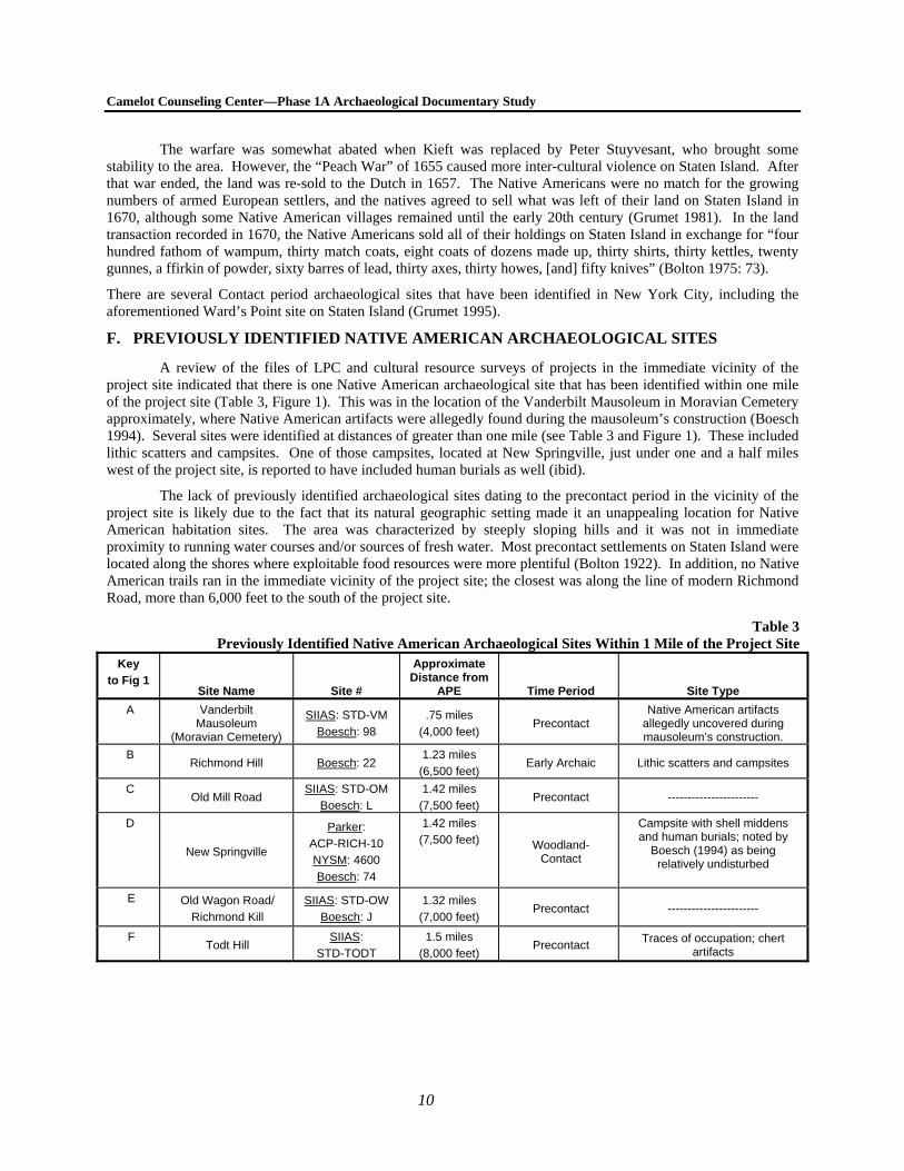
F. PREVIOUSLY IDENTIFIED NATIVE AMERICAN ARCHAEOLOGICAL SITES
A review of the files of LPC and cultural resource surveys of projects in the immediate vicinity of the project site indicated that there is one Native American archaeological site that has been identified within one mile of the project site (Table 3, Figure 1). This was in the location of the Vanderbilt Mausoleum in Moravian Cemetery approximately, where Native American artifacts were allegedly found during the mausoleum’s construction (Boesch 1994). Several sites were identified at distances of greater than one mile (see Table 3 and Figure 1). These included lithic scatters and campsites. One of those campsites, located at New Springville, just under one and a half miles west of the project site, is reported to have included human burials as well (ibid).
The lack of previously identified archaeological sites dating to the precontact period in the vicinity of the project site is likely due to the fact that its natural geographic setting made it an unappealing location for Native American habitation sites. The area was characterized by steeply sloping hills and it was not in immediate proximity to running water courses and/or sources of fresh water. Most precontact settlements on Staten Island were located along the shores where exploitable food resources were more plentiful (Bolton 1922). In addition, no Native American trails ran in the immediate vicinity of the project site; the closest was along the line of modern Richmond Road, more than 6,000 feet to the south of the project site.
Table 3Previously Identified Native American Archaeological Sites Within 1 Mile of the Project Site
Key
to Fig 1 Site Name Site #
Approximate Distance from
APE Time Period Site Type
A Vanderbilt Mausoleum
(Moravian Cemetery)
SIIAS: STD-VM
Boesch: 98
.75 miles
(4,000 feet) Precontact
Native American artifacts allegedly uncovered during mausoleum’s construction.
B Richmond Hill Boesch: 22
1.23 miles
(6,500 feet) Early Archaic Lithic scatters and campsites
C Old Mill Road
SIIAS: STD-OM
Boesch: L
1.42 miles
(7,500 feet) Precontact -----------------------
D
New Springville
Parker:
ACP-RICH-10
NYSM: 4600
Boesch: 74
1.42 miles
(7,500 feet) Woodland-Contact
Campsite with shell middens and human burials; noted by
Boesch (1994) as being relatively undisturbed
E Old Wagon Road/
Richmond Kill
SIIAS: STD-OW
Boesch: J
1.32 miles
(7,000 feet) Precontact -----------------------
F Todt Hill
SIIAS:
STD-TODT
1.5 miles
(8,000 feet) Precontact
Traces of occupation; chert artifacts

11
Chapter 4: The Historic Period
A. STATEN ISLAND HISTORIC CONTEXT
As discussed in Chapter 3¸ bad relations between the Dutch and the Native Americans had prevented the formation of a successful European settlement on Staten Island until the late 1630s. Even afterwards, peaceful relations between the two groups were not established until after the British had seized the colony in 1664. A large English population grew all throughout New Netherlands, and soon they outnumbered the Dutch, making it easy for them to seize the colony in 1664. Although the Dutch were able to re-take the colony, now known as New York, in 1673, they traded it back in 1674 for “the far more lucrative colony of Surinam” (Cantwell and Wall 2001: 181). New York would remain under British control for the next hundred years.
The exodus of the bulk of the Native American population beginning in 1670 made it easier for Staten Island to become a thriving part of the New York economy. Rumors of the island having been won for New York from New Jersey by Captain Christopher Billopp in a sailboat race are most likely false and there is no evidence to suggest that Staten Island was never considered to be a part of the New York colony (Botkin 1956). Without a substantial Indian presence, there were no longer any obstacles blocking the settlement of the island and Richmond County was officially established in 1683.
Under British rule, Staten Island’s open farmland and vast coastline became essential for the production of agricultural products and collection of marine resources for export the city. The colony’s progress was both halted and facilitated in the mid-18th century during the French and Indian War, which concluded in 1763. Although the region experienced the economic side effects of being at war, thousands of British armed forces were stationed throughout the New York City area, bringing money to the region while at the same time increasing its population. During this time, New Yorkers were not completely loyal to the English crown and goods were secretly (and illegally) traded to French colonies via Staten Island’s more secluded ports (Burrows and Wallace 1999).
Despite their treacherous conduct during the French and Indian War, most colonial New Yorkers remained loyal to the British during the Revolutionary War. Staten Island proved to be a key asset during the latter confrontation. In 1776, unsuccessful peace negotiations were held at Captain Billopp’s former house (now known as the “Conference House”) at the southern tip of Staten Island. The British continued to use Staten Island as a rudimentary home base due to its strategic location (Historical Records Survey 1942). It was sufficiently close to both New York and New Jersey that British soldiers could easily be dispatched in the event of an impending battle. And, reminiscent of the activities of the Raritan Indians, the island’s tall hills provided views essential to tracking ships approaching the city. However, the British troops stationed in New York City caused a great deal of trouble by burning farms and homes and stealing from private citizens. This resulted in horrible and brutal living conditions for many of Staten Island’s civilians.
Despite New York City’s loyalty to the British during the war, after the American victory the conversion to the new American government was relatively smooth. Land which had been previously owned by British loyalists was divided and sold, which brought about a surge in population and development in the outer boroughs, a trend which continued through the 19th century. In 1788, the island was officially divided into four townships, Castleton, Northfield, Southfield, and Westfield. A fifth town, Middletown, was established in 1860 from portions of Southfield and Castleton. The boundary between Middletown and Northfield, which encompassed the northwestern quadrant of Staten Island, is depicted on most 19th century maps as modern Forest Hill Road, to the west of the project site. However, some maps suggest that the boundary lay at modern Brielle Avenue. Historic records most often refer to the project site as being in Middletown, although some may refer to it as Northfield.
In the early 19th century, Staten Island’s population continued to grow. Between 1840 and 1880, the population of Staten Island nearly quadrupled. This surge was caused in part by the increasing population density in Manhattan, which drove many people to the outer boroughs. The region’s prosperity caused the counties in the New York City region to become increasingly codependent, both economically and culturally. It was therefore suggested that the counties around New York Harbor be consolidated under the name New York City. Although there was
Camelot Counseling Center—Phase 1A Archaeological Documentary Study
12
some resistance from some Staten Island residents, it officially became a borough of New York City on New Year’s Day, 1898.
Staten Island’s geographical isolation also made it an ideal location for many municipal institutions including hospitals, retirement homes for mariners and seamen, and other institutions aimed at helping the less fortunate. One such institution was the New York City Farm Colony, organized as the Richmond County Poor House Farm in 1829 on the western side of Brielle Avenue, opposite the project site, as part of a campaign to provide work and shelter for impoverished people. In 1902 it was reorganized as the New York City Farm Colony. The land for Seaview Hospital, considered ideal for a hospital because of its elevation, extensive woodlands, and isolation from nearby development, was purchased in 1905. Seaview Hospital was then established to address the growing epidemic of tuberculosis which affected the City at that time. The Group Building was constructed in 1917 from plans by Edward P. Stevens and Renwick, Aspinall & Tucker as part of a second building campaign intended to expand Seaview Hospital. The Group Building was originally designed as a recreational space for male patients. The east wing was converted to a synagogue for Jewish patients at Seaview Hospital in 1929.
As part of the city proper, Staten Island flourished throughout the 20th century. Increased mass transit connected all the boroughs and allowed more people to live outside of Manhattan while still having access to the city’s varied resources. The remainder of the 20th century saw continued growth and increasing population density throughout Staten Island.
B. THE HISTORY OF THE PROJECT SITE
After the acquisition of Staten Island from the Native Americans at the end of the 17th century, the British government began to grant large land patents to individuals to encourage the settlement of the island. The Skene map depicting those grants shows that the project site was included within an enormous tract of land granted to John Palmer in 1684 (although it was not confirmed until 1687). Palmer was a High Sheriff and a justice in Staten Island at the end of the 17th century. Shortly after receiving his grant, which was known as the “Lordshippe or mannor of Cassiltowne,” Palmer granted it back to Governor Thomas Dongan (Leng and Davis 1930). The area then became known as “Dongan’s Manor,” for which Manor Road was named (Morris 1898).
No maps from the early and mid-18th century include enough detail to identify any structures which may have been located within the project site, and it is likely that it was used as farmland or remained undeveloped during that time. Loring McMillen’s map depicting Staten Island at the time of the Revolutionary War shows that several farmsteads had been established within the Seaview Hospital property by the end of the 18th century. However, these were all located along Brielle and Rockland Avenues; none were located in the interior of the property near the project site. By 1838 the neighborhood had become known as Egbertville, after the Egbert family which had owned a great deal of land in the area and for whom Egbert Avenue, now Manor Road, was named (Morris 1898).
The project site remained undeveloped by 1844, at which time a coastal survey of Staten Island and the New York Harbor was published. Dripps’ 1850 map of Staten Island also depicts the project area as vacant, showing only a grove of trees in that part of what is now the Seaview Hospital property. The property’s chain of ownership during the early 19th century is unclear until 1846. In 1844, the property was part of a larger estate that was confiscated by the town. Historic deeds suggest that the land had been the property of Stephen Wood who had purchased the land from Austin Barton, however, no deeds recording a transaction between the two men could be located. In 1846, the Master in Chancery sold the land at public auction to John J. Palmer, “special receiver.” Palmer’s relationship, if any existed, with the John Palmer who had owned the property in the late 17th century is unclear. In 1847, Palmer sold the 80 acre property (with a portion reserved for the construction of a public road) to George P. Osgood, a farmer who lived in Southfield, Staten Island. In 1851, Osgood sold a portion of the larger farm to Margaret T. Bechtel, the wife of George Jonas Bechtel, the former mayor of the German city of Bremen and a foreign consul in New York City (Leng and Davis 1930).
The Bechtel family appears to be the first to actually live on or near the project site. James Butler’s 1853 map of Staten Island depicts a structure in the vicinity of the project site which is identified it as the property of G.J. Bechtel. The deed recording Mrs. Bechtel’s purchase of the land lists her as a resident of Brooklyn. However, the family was recorded in the 1850 census as residents of the town of Northfield on Staten Island. That census shows that they resided in the same household (or at least on the same property) as the family of Edward Unkart, a German
Chapter 4: Historic Period
13
merchant who owned several tracts of land near the project site in the mid-19th century.1 Therefore, the Bechtel family may have been living on or near the project site by that time. The census describes George J. Bechtel, Sr, as a German merchant who lived with his New York-born wife, Margaret, and their 6 children, 4 of whom were born in Germany and the other 2 in New York.
The Bechtel home in the vicinity of the project site is again depicted on an 1866 coastal survey, although the name of the owner and/or occupant is not provided. However, Dripps’ (largely inaccurate) 1872 map of Staten Island continues to list Bechtel as the owner. The map also depicts the property as surrounded by a wooded meadow. The 1860 and 1870 censuses confirm that the Bechtel family continued to reside in Staten Island in the vicinity of the farm colony. However, in historic directories from the 1860s and early 1870s, George J. Bechtel, Sr., is listed as a resident of Brooklyn. Furthermore, when Margaret Bechtel sold the property in 1873, she was also listed as a Brooklyn resident. Therefore, it appears that their Staten Island property in which the project site is situated was used as a summer home or a country estate and it was by chance that they happened to be staying there at the time the 1860 and 1870 censuses were taken. It was very common in the mid-19th century for Manhattan-based merchants to maintain residences in Middletown (Tudor 1862).
1860 census lists the family, which now included 7 children, as residents of Middletown. The 1870 census, however, shows that George J. Bechtel, Jr.—who, like his father, had been born in Bremen, Germany—had established his own household with his wife and children. His father, listed as J.J. Bechtel, was listed in the census as a resident of Northfield and on the census ledgers his name was in close proximity to those individuals who resided at the Farm Colony. George J. Bechtel, Jr, however, was listed as a resident of Middletown. As described earlier, in the early 1870s, the boundary between Northfield and Middletown was to the west of the project site along modern Forest Hill Road. Therefore the project site would have been situated within Middletown. An 1872 directory shows that while George J. Bechtel, Sr., continued to reside in Brooklyn, his son had moved to Staten Island. It is therefore possible that George J. Bechtel, Jr., had taken up full-time residence in the home in the vicinity of the project site while his parents had purchased a separate vacation home. In their work, Staten Island and its People, Leng and Davis (1930) state that George J. Bechtel, Jr., maintained a winter home in Brooklyn as well as a summer home on Staten Island for many years. The latter was notable for being filled with valuable antiques and for having been visited by many important dignitaries, such as Abraham Lincoln. Because Lincoln was killed in 1865, it is possible that the summer home to which Leng and Davis refer was the one located near the project site. It is also possible that the reference actually describes George J. Bechtel, Sr., who as a former mayor of Bremen would have had numerous political and social connections.
In 1873, Margaret Bechtel sold the property to Anna Helene Schmidt, the wife of Charles F. Schmidt. Charles F. Schmidt was the head of Charles F. Schmidt & Peters, and with his partner, Carl Peters, imported fine wines and champagnes into the United States. Schmidt was a business associate of George J. Bechtel, Jr and his firm was most notable for being the only distributor of Veuve Clicquot champagne in North America (Leng and Davis 1930). Schmidt was listed as the owner of the estate on the 1874 Beers atlas of Staten Island. That map is the first to depict the building’s footprint and shows that the home was encircled by a driveway which had two long branches that led out to modern Brielle Avenue, then known as Manor Road (not to be confused with modern Manor Road, which is to the east of the project site along the road formerly known as Egbert Avenue). Charles F. Schmidt is consistently shown as the owner of the property on all subsequent late-19th century atlases. The 1898 Robinson atlas labels the property “Ocean Hill View” and shows that 2 barns or stables were also on the property. They were located to the northwest of the main home and well outside the boundaries of the project site.
Although the deed recording Schmidt’s purchase of the property refers to them as living in Middletown, numerous historic directories dating to the 1870s, 1880s, and 1890s, the period of time when Schmidt owned the property in which the project site is located, show that Schmidt worked in lower Manhattan (at 24 Beaver Street) and lived in Brooklyn. Therefore, it appears that, like Bechtel, Schmidt may have kept the Staten Island property for use as a country estate or he may have rented the property to another family. Schmidt could not be located as a
1 The Unkart and Bechtel families may have been interrelated, as several of the Bechtel children had the middle initial “U,” likely standing for
Unkart, and the 1850 census also shows that the household also included members of the Dreyer family; Dreyer was Margaret Bechtel’s maiden name (Leng and Davis 1930). In addition, the Manhattan-based importing firm of Unkart and Dreyer was listed in an 1834 directory as was the importing firm of Bechtel and Dreyer in 1841.

Camelot Counseling Center—Phase 1A Archaeological Documentary Study
14
resident of the state of New York in any census records dating to 1880 or 1900. The 1900 census did include a 17-year old Iowa-born electrician named Charles Schmidt who resided on Manor Road (Brielle Avenue) in Staten Island, however, it is unclear if this was the son of Charles Schmidt or simply someone with the same name. That Charles Smith resided in the same home as a man named George Smith. Directories from the late-1800s show that two plumbers named George and August Schmidt lived on Manor Road In addition, although a woman named Anna Schmidt is listed as the widow of a man named Charles in directories starting in 1889, the Charles F. Schmidt who owned the Staten Island estate lived through the end of the 20th century, indicating that there were at least two couples named Charles and Anna Schmidt residing in New York City in the late-19th century.
Charles F. Schmidt of 24 Beaver Street was granted at least two passports in 1893 and 1896 granting him to travel to his home country of Germany. The passports provide a great deal of information about Schmidt, and they show he had been born in Bremen (the same town as George J. Bechtel) in 1832 and that he emigrated to the United States in 1856 and became a citizen in 1880. The passports also mention that he resided in New York and Brooklyn, but do not include Staten Island as a place of residence. Finally, the passports also suggest that he traveled to Germany for long periods of time, possibly up to a year, which may have been why he was not included in many census records. His son, Charles F. Schmidt, Jr., was also a merchant who worked at 24 Beaver Street and who traveled to Germany for long periods of time, with his wife, Ella.
In December 1905 (though the deed was not recorded until January 1906), Charles and Anna Schmidt sold the property to the City of New York. The deed recording the sale states that the Schmidts were residents of Manhattan. The city had begun construction of the Seaview Hospital on the adjacent property that year. The 1907 Robinson atlas is one of the last to depict the former Bechtel/Schmidt house in the vicinity of the project site. The map, which attributes the property to “the City of New York/New York City Farm Colony,” shows the main house as well as the two barns/stables to the northwest, but no longer depicts the large driveways that formerly led to them. However, the 1911 Topographic survey of Richmond County (Figure 5) shows that the dirt-roads that acted as driveways were still in place. The 1911 map is the last to depict the Bechtel/Schmidt home, which appears to have been demolished before 1917.
Seaview Hospital formally opened in 1913. In the years that immediately followed, the hospital quickly grew and additional land in the vicinity was purchased and more buildings were constructed on the campus. In 1917, the Group Building was constructed to provide a recreational space for male patients. Although it was not yet finished, the building was included on the 1917 Sanborn map. The map, which included a depiction of the building based on plans, identified it as a 2-story (with basement) structure that contained workshops, recreation rooms, and offices, and which stood between the Male tuberculosis pavilions and the main hospital. The building also held craft shops and the hospital’s barber shop (Matteo 2005).
The 1937 Sanborn map reflects the continued growth of the hospital campus, and shows many additional buildings that had been constructed near the Group Building. The map also suggests that the group building may have been altered to add a 3rd story to the rear of the building, although because the 1917 map was based solely on plans, it is possible that this was part of the original construction. The 1937 map also reflects the conversion of the east wing of the building into a synagogue, which occurred in 1929, and the addition of a library and dormitory. No changes appear to the building or its surrounding property on any subsequent maps continuing through the present day.
C. UTILITIES IN THE PROJECT AREA
SEWER
Records on file at the Staten Island office of the Department of Environmental Protection Bureau of Water and Sewer Operations (DEP) show that there are no municipal sewers running through the streets adjacent to the project site. However, DEP records did include some sewer connection information that showed that the “Seaview Isolation Hospital” on the east side of Brielle Avenue had some sort of sewer connection by 1928. In addition, a Phase I Environmental Site Assessment (ESA) prepared for the site by EcolSciences, Inc. in January 2008 states that the Group Building is connected to municipal sewer networks. Finally, site plans provided by Posen (see Figure 3) show that an 8-inch sanitary sewer connects the southern end of the building to sewer lines located within the streetbed adjacent to the southern end of the project site.

Chapter 4: Historic Period
15
However, there is no evidence which can confirm if and/or when the former Bechtel/Schmidt home was connected to sewer lines. Therefore, it is likely that the residents of the buildings within the project site would have relied on the use of domestic shaft features (such as privies, cisterns, and wells) for water gathering and sanitary purposes beginning in the early 1850s and lasting possibly as late as 1905.
In general, privies were located at a distance from both the house and the street, for the purposes of privacy and sanitation (Wheeler 2000). In New York City, privies have been found at depths of up to 13 feet (Cantwell and Wall 2001). For convenience, cisterns and wells would have been located closer to the home than privies. Cisterns are usually located up to 10 feet below the ground surface while wells would be dug to the water table (Cantwell and Wall 2001). However, given the small size of the rear yards of the lots within the project area, if shaft features were utilized, they may have been much closer to the house on the property.
WATER
The earliest water connection information on file at DEP shows that a building within Block 955 on the east side of Rockland Avenue north of Manor Road was connected to municipal water lines as early as 1917. The 1917 Sanborn map shows that the main hospital buildings to the north of the project site were connected to municipal water lines, so it is likely that the Group building would also have been connected to water lines at that time. Current Sanborn maps show that the southern end of the building is connected to water lines that connect to larger lines located within the streetbed of the road to the east of the project site. The site plans provided by Posen do not depict water lines, although they do appear to show at least one fire hydrant located near the southeastern corner of the building.
GAS, ELECTRIC, AND OTHER UTILITIES
EcolSciences’ 2008 ESA identified a 2,000-gallon fuel oil tank to the south of the western wing of the Group Building. Site plans show that a gas line runs to the north of the building. Multiple electrical lines run through the property, including one that runs near the existing gas line to the north of the building. Finally, the plans show that several manholes are located throughout the property.

16
Chapter 5: Conclusions and Recommendations
A. SENSITIVITY ASSESSMENT
As part of the background research for this Phase 1A Archaeological Documentary Study, various primary and secondary resources were analyzed, including historic maps and atlases, historic deeds, historic photographs, newspaper articles, local histories, census records, and historic directories. The information provided by these sources was analyzed to reach the following conclusions.
DISTURBANCE ASSESSMENT
Comparisons of current topographic information with that seen on the historic 1911 topographic survey of the project site show that the landscape to the south and west of the Group Building has been modified and between three and five feet of fill have been added in those areas. It is likely that during the construction of the Group Building in 1917, the soils removed during the basement excavation were used to level the slope to the south and west of the building. The construction of the Group Building would also have generated substantial disturbance in the southern portion of the project site.
Several paved areas and walkways, including the parking lot near the southwestern side of the building and the driveway to the northeast of the building could have generated some disturbance, probably to a depth of approximately 1 to 1.5 feet. The installation of water and sewer connections to the south of the building could likely have resulted in disturbance to depths of approximately 5 feet or more. Finally, the installation of gas and electric lines to the north and east of the building could have generated disturbance of 2 to 3 feet in depth in certain locations.
PRECONTACT SENSITIVITY ASSESSMENT
The precontact sensitivity of project sites in the New York City area are generally evaluated by their elevation (but not exceeding 30 percent slopes), proximity to fresh water courses and coastal areas, the presence of well-drained soils, and their distance to previously identified precontact archaeological sites. Although the project site was located on a tall hill, the terrain was not level. In addition, the project site is situated in an area that is more than 3.5 miles from the coastline and at distances of approximately 1500 feet from nearby water courses (brooks and streams to the south and east). It is therefore unlikely that Native American habitation, hunting, or camping sites would have been located there as such sites would be expected closer to bodies of water. Therefore, the project site is determined to have low sensitivity for precontact archaeological resources.
HISTORIC SENSITIVITY ASSESSMENT
Throughout the historic period only one building was located within the boundaries of the project area between circa 1852 and 1917. It appears that this building was used as a country estate by George J. Bechtel, Sr., although his son, George J. Bechtel, Jr., may have lived there with his family year-round in the late 1860s and early 1870s. After the Bechtel family, the property was owned by Charles F. Schmidt, who may have used the property as a country estate or may have rented it out. Because there is no documented evidence of that house ever having been connected to sewer and water lines, it is likely that domestic shaft features such as privies, cisterns, and wells would have been used by the Bechtel and/or Schmidt families for sanitation and water gathering. Cisterns and wells would be expected to be in close proximity to the house and privies would not be expected to be more than 100 feet from the dwelling. Therefore, the only portion of the project area that is considered to be sensitive for historic period archaeological resources is in the northeastern part of the site, in the vicinity of the proposed parking lot. There has been a minimal amount of documented disturbance in this area and it is therefore considered to have moderate to high potential for the recovery of historic period archaeological resources including domestic shaft
Chapter 5: Conclusions and Recommendations
17
features, surficial household trash deposits, and structural remnants (see Figure 6 for areas of archaeological sensitivity).
B. RECOMMENDATIONS
As described above, the project site is considered to have low potential for precontact period archaeological deposits. No further study, research, or testing is recommended to evaluate the potential for precontact period archaeological resources within the project site.
A moderate to high potential for the existence of subsurface historic period archaeological resources on the project site has been identified in the location of the proposed parking lot. The resources which may exist within the APE could include domestic shaft features and structural remnants relating to the 19th century occupation of the site as well as household trash deposits. Domestic shaft features were often used for the disposal of household waste and are often found to contain historic artifacts that can provide information about a household’s consumption patterns. Such artifacts could provide new information about the mid- to late-19th century residents of this section of Staten Island. The household that occupied the project site included the families of wealthy German and German-American merchants who may not have resided on the property full-time.
Artifacts recovered from shaft features or other trash deposits can provide insight into consumption patterns, which are strongly influenced by socioeconomic status, occupation, household composition, and ethnicity. What a person buys and/or uses on a routine basis is behavior that reflects the multiple components of that individual’s life. Archaeological evidence from the former house lots may provide information on how socioeconomic status has influenced consumer choice behavior. This information could be compared and contrasted with data associated with similar populations elsewhere in the city.
Further investigation in the form of Phase 1B archaeological testing is recommended the northeastern section of the project site in order to further assess the site’s potential to yield archaeological resources. A sensitivity map has been prepared to indicate those areas for which further investigation is recommended (see Figure 6). It is recommended that testing be completed before the start of construction of the proposed project. In advance of testing, an archaeological testing protocol should be prepared in consultation with LPC.
18
References
Ancestry.com. 2007 U.S. Passport Applications, 1795-1925 [database on-line]. Provo, UT, USA: The Generations
Network, Inc. Beers, F.W. 1874 Atlas of Staten Island, Richmond County, New York, from official records and surveys. New
York: J.B. Beers & co. Bien, J.R. and C.C. Vermule 1891 Atlas of the Metropolitan District and Adjacent County comprising the Counties of New York,
Kings, Richmond, Westchester, and part of Queens in the State of New York. New York: Julius Bien & Co.
Boesch, Eugene 1994 Archaeological Evaluation and Sensitivity Assessment of Staten Island, New York. For: LPC. Bolton, Reginald Pelham 1922 “Indian Paths in the Great Metropolis.” In Indian Notes and Monographs. Miscellaneous #22.
New York: Museum of the American Indian, Heye foundation. 1934 Indian life of long ago in the city of New York. New York: J. Graham. 1975 New York City in Indian Possession. Museum of the American Indian, Heye Foundation, New
York. Borough of Richmond Topographical Survey 1911 On file at the Richmond County Topographical Bureau. Botkin, B.A. 1956 New York City Folklore. New York: Random House. Burrows, Edwin G. and Mike Wallace 1999 Gotham. New York: Oxford University Press. Butler, James 1853 The Map of Staten Island, or Richmond County, New York. In the Collection of the Staten Island Institute of Arts and Sciences. Cantwell, Anne-Marie and Diana diZerega Wall 2001 Unearthing Gotham: The Archaeology of New York City. New Haven: Yale University Press. Davis, William T. 1892 Days Afield on Staten Island. Staten Island, New York: published by the author. 1896 “Staten Island Nicknames: ye olde names and nicknames (with map by Charles W. Leng).”
Proceedings of the Natural Science Association of Staten Island 5 (5). Dincauze, Dena F. 2000 “The Earliest Americans: The Northeast.” Common Ground: Archaeology and Ethnography in
Public Interest. Washington, D.C.: National Park Service (NPS).
Camelot Counseling Center—Phase 1A Archaeological Documentary Study
19
Dripps, Matthew 1850 Map of Staten Island, New York on file at the archives of the Staten Island Institute of Arts and
Sciences. 1872 Map of Staten Island (Richmond Co.) N.Y.; Cities of Bayonne & Perth Amboy; Village of
Woodbridge, N.J. Shewing Topography, Farms, Shore Soundings. New York: M. Dripps. EcolSciences, Inc. 2008 Phase I Environmental Site Assessment Asbestos Bulk Survey and Lead Based Paint Screening for
Seaview Hospital Group Building; 460 Brielle Avenue Borough of Staten Island, City of New York, Richmond County, New York. For: Posen Architects, LLC, West Orange, New Jersey.
Greenhouse Consultants, Inc. 1986 The New York City Farm Colony Report. For: AKRF, Inc. New York, NY. 2002 Archaeological and Historical Sensitivity Evaluation: Seaview Hospital, Northern Parcel; Staten
Island, New York. For: Buckhurst, Fish & Jaquemart, Inc. New York, NY. Grumet, Robert S. 1981 Native American Place Names in New York City. New York: Museum of the City of New York. 1995 Historic Contact. Norman, OK: University of Oklahoma Press. Historical Records Survey, Service Division, Work Projects Administration 1942 The earliest volume of Staten Island records, 1678-1813. New York: The Survey. Hunter Research 1996 A Phase 1B Archaeological Survey of the Arthur Kill Factory Outlet Center, Staten Island,
Borough of Richmond, County of Richmond, New York City, New York [CEQR 95-DCP-058R]. For Bellemead Development Corporation, Roseland, New Jersey.
Isachsen, Y.W., E. Landing, J.M. Lauber, L.V. Rickard, W.B.Rogers, editors. 2000 Geology of New York: A Simplified Account. Second Edition. New York: New York State
Museum Educational Leaflet 28. Leng, Charles W. and William T. Davis 1930 Staten Island and its People: A History 1609-1929. (5 Volumes) New York: Lewis Historical
Publication Company, Inc. Louis Berger and Associates, Inc. 2001 Cultural Resource Assessment: Proposed NYCT Department of Buses Storage and Maintenance
Facility: Arthur Kill Road, Staten Island, New York. For: New York City Transit, New York, New York.
Matteo, Thomas 2005 Seaview and the Farm Colony: Staten Island’s First Historic District. Staten Island, New York:
Seaview Historic Foundation. McMillen, Loring 1933 A Map of Staten Island During the Revolution, 1775-1783. From: http://www.bklyn-genealogy-info.com/Map/S.I.Revolution.html Morris, Ira K. 1898 Morris’s Memorial History of Staten Island, New York. New York: Memorial Publishing.

Camelot Counseling Center—Phase 1A Archaeological Documentary Study
20
New York City Soil Survey Staff 2005 New York City Reconnaissance Soil Survey. United States Department of Agriculture, Natural
Resources Conservation Service, Staten Island, New York. New York State Office for Technology [NYSOFT] 2004 Draft Generic Environmental Impact Statement (DGEIS) New York Statewide Wireless Network
(SWN). Prepared by Deorsetz Stinziano Gilberti Heintz and Smith, P.C., Spectra Environmental Group, Inc., and CASmith, LLC., New York.
Reeds, Chester A. 1925 The Geology of New York City and Vicinity. New York: The American Museum of Natural
History Guide Leaflet Series No. 56. Ritchie, William A. 1980 The Archaeology of New York State: Revised Edition. Harrison, New York: Harbor Hill
Books. Sanborn Map Company 1917 Borough of Richmond Insurance Map: Staten Island. New York: Sanborn Map Co. 1937 Insurance Maps of Borough of Richmond; New York City; Staten Island. New York: Sanborn
Map Co. 1951 Insurance Maps of Borough of Richmond; New York City; Staten Island. New York: Sanborn
Map Co. 2006 Insurance Maps of Borough of Richmond; New York City; Staten Island. New York: Sanborn
Map Co. Skene, Frederick 1907 Map of Land Grants or Patents on Staten Island, 1688-1672. On file at the archives of the Staten
Island Institute of Arts and Sciences. Tudor, Henry 1862 Richmond County Register. New York: Henry E. Tudor. On file at the archives of the Staten
Island Institute of Arts and Sciences. United States of America, Bureau of the Census 1790-1930 United States Federal Census. Washington, D.C.: National Archives and Records Administration.
Database on-line at http://www.ancestry.com United States Geological Survey 1981a USGS Digital Raster Graphic (DRG) Quadrangle: Arthur Kill. 1981b USGS Digital Raster Graphic (DRG) Quadrangle: The Narrows. Wheeler, Kathleen 2000 “Theoretical and Methodological Considerations for Excavating Privies.” Historical Archaeology
34 (1): 3-19.

Figures
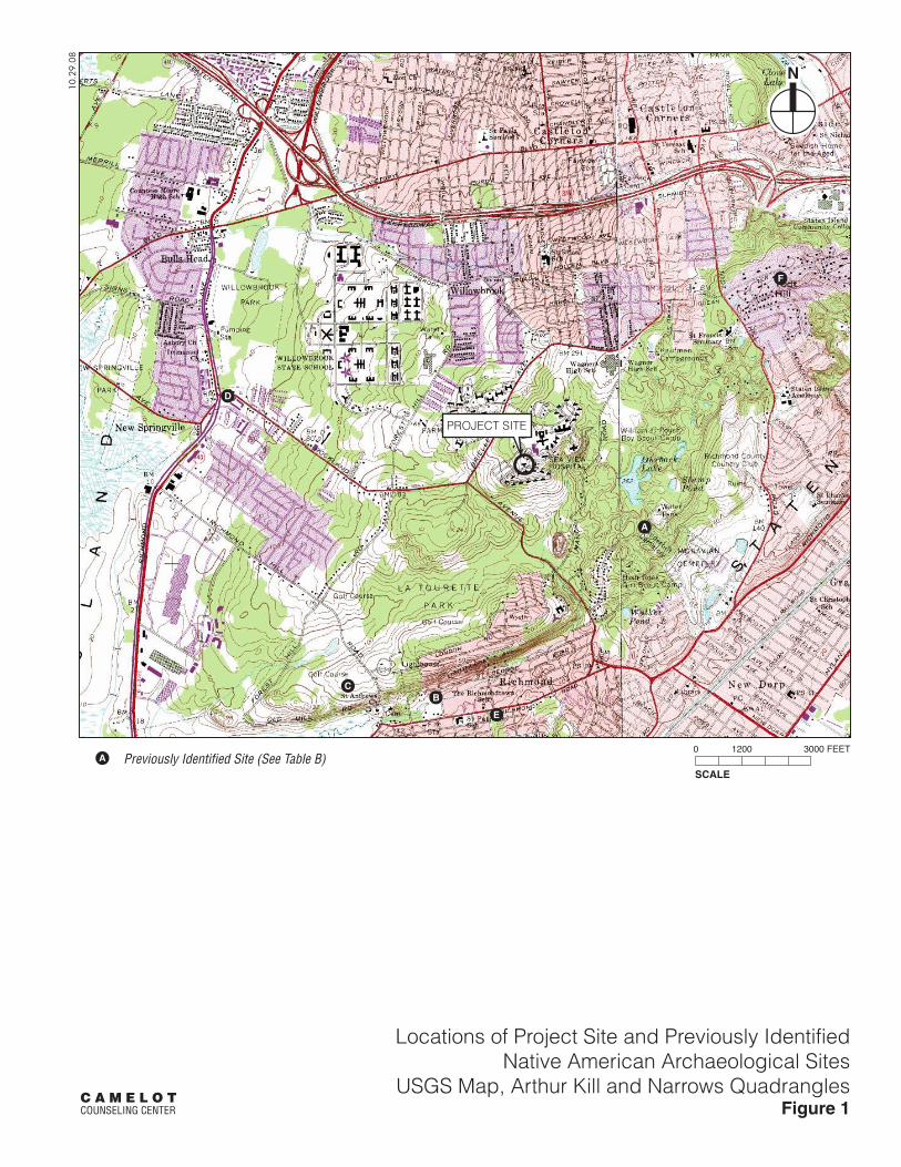
PROJECT SITE
A
BC
D
E
F
SCALE
0 1200 3000 FEET
10.2
9.08
Locations of Project Site and Previously IdentifiedNative American Archaeological Sites
USGS Map, Arthur Kill and Narrows QuadranglesFigure 1
C A M E L O T COUNSELING CENTER
Previously Identified Site (See Table B)A

2
3
1
4
5
N
10.2
2.08
Sanborn MapFigure 2
C A M E L O T COUNSELING CENTER
Project Site Boundary
Photograph View Direction and Reference NumberSCALE
0 200 400 FEET
1

8 SPACES @ 9' X 18'
@ 8' X 18'
24.0
0'
1 SPACE
33.20'
32.00'
106.6
5'
27.4
0'
8 SPACES @ 9' X 18'
PROPOSEDCONCRETE CURB
RELOCATE EXISTINGLIGHT POLE
(TYP.)
EXISTING PAVEDLOADING AREA TO REMAIN
EXISTING LOADING DOCKTO BE REPLACED
EXISTING TRANSFORMERTO BE REMOVED
PROPOSED ADAACCESSIBLE ENTRY
REPLACE EXISTING BENCHWITH NEW BENCH(SEE DETAIL)
PROPOSED ADA CURBRAMP AND SIGNAGE
PROPOSEDSTRIPING (TYP.) PROPOSED ADA
CURB RAMP
FOOTINGS FOR NEW LOADINGDOCK 1.5' x 1.5' x 3.0'
NEW A/C CONDENSERUNITS WITH CONCRETE PAD6.0' x 3.0' x 3.0'
CONNECT TO EXISTINGELECTRIC FEED
PROPOSED GRANITEBLOCK CURB (TYP.)
PROPOSEDCONCRETE APRON
(SEE DETAIL)
1
2
3
4
5
6
N
10.2
9.08
C A M E L O T COUNSELING CENTER
Site Plan andProposed Areas of Disturbance
Figure 3
SCALE
0 50 FEET
Excavation for concrete pad, new oil tanks, chiller, new transformer, approximately 3 feet deep
New electric feeder line, 4 feet deep
Proposed drywells, 4 feet deep
Replacement of existing loading dock, 3 feet deep for new footings
Excavation for new parking lot, 1-2.5 feet deep
New elevator shaft, approximately 8 feet deep
Proposed Areas of Disturbance
1
2
3
4
5
6

Approximate Locationof Project Site
10.29.08
Atlas of Staten IslandF.W. Beers, 1874
Figure 4C A M E L O T COUNSELING CENTER
Not to Scale
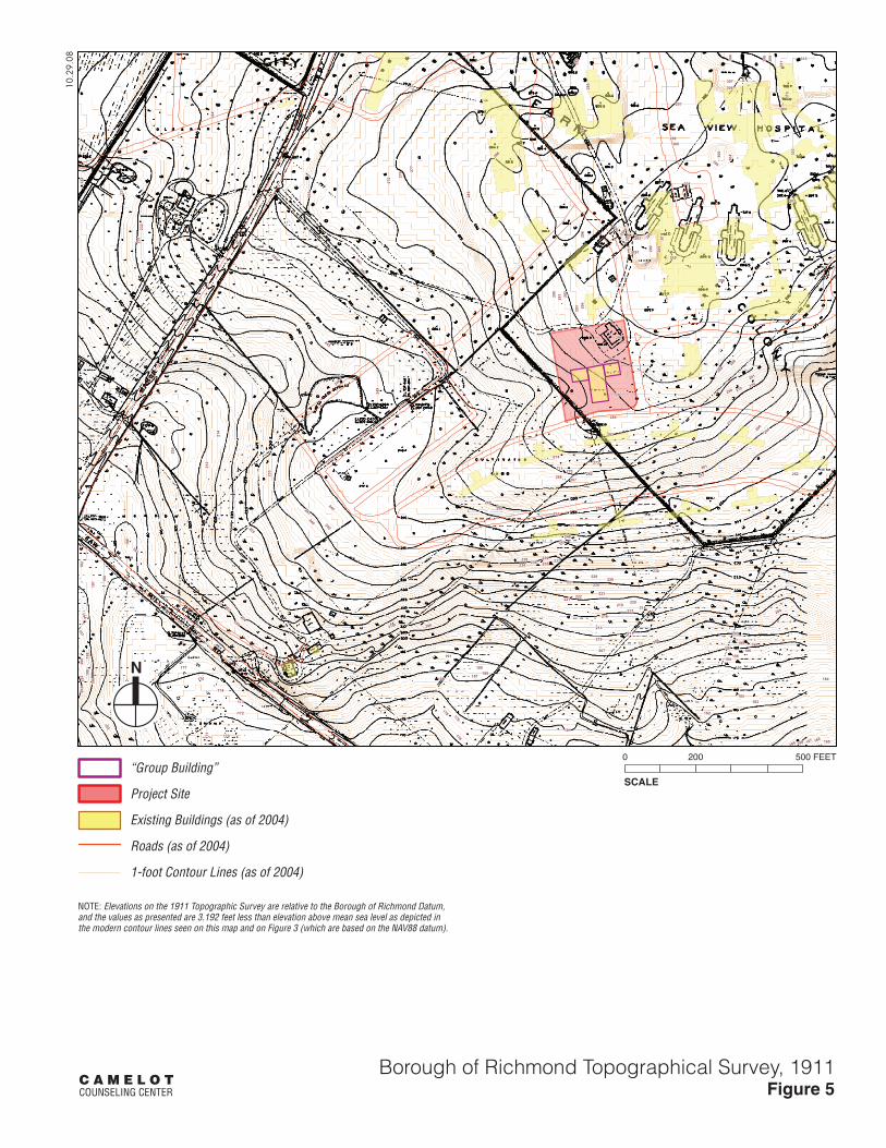
226
225
224
223
227228
229230
222221
211
220
231
219
232
218
233
217216
215
214
213
234
212
210
209
208
235
207
206
205
236
204
203
202
237
201
200
199197
198196
195194
193
192
238 239
191
240
241
242
243
244
245
246
190
189188
247
187186
248
185
249
184
250
183
182
181
180
251
179
252
178
253
254
255256
257
258
259
260
261
262
263
264
265
266
267268
269270
271
272
273274
275 27
6 277
278279
280
281
282
283
284
285
286
287
288
289
290
177
291 29
2
176
293 29
4
175
174
295
173
296
172
297
171
298
299300
301
302
303
304
305
17030
6
307
308
309
310
311
169 168 167
312
166 165164 163
199
305
200
191
192
302
295
292
306
284
231
204197
285
196
293
303
198
304
201
187
270
292
290
296
195
194
291
193
186
294
202
294
304
162
227
205 203
SCALE
0 200 500 FEET
10.2
9.08
Borough of Richmond Topographical Survey, 1911Figure 5
C A M E L O T COUNSELING CENTER
“Group Building”
Project Site
Existing Buildings (as of 2004)
Roads (as of 2004)
1-foot Contour Lines (as of 2004)
NOTE: Elevations on the 1911 Topographic Survey are relative to the Borough of Richmond Datum,and the values as presented are 3.192 feet less than elevation above mean sea level as depicted inthe modern contour lines seen on this map and on Figure 3 (which are based on the NAV88 datum).

8 SPACES @ 9' X 18'
@ 8' X 18'
24.0
0'
1 SPACE
33.20'
32.00'
106.6
5'
27.4
0'
8 SPACES @ 9' X 18'
PROPOSEDCONCRETE CURB
RELOCATE EXISTINGLIGHT POLE
(TYP.)
EXISTING PAVEDLOADING AREA TO REMAIN
EXISTING LOADING DOCKTO BE REPLACED
EXISTING TRANSFORMERTO BE REMOVED
PROPOSED ADAACCESSIBLE ENTRY
REPLACE EXISTING BENCHWITH NEW BENCH(SEE DETAIL)
PROPOSED ADA CURBRAMP AND SIGNAGE
PROPOSEDSTRIPING (TYP.) PROPOSED ADA
CURB RAMP
FOOTINGS FOR NEW LOADINGDOCK 1.5' x 1.5' x 3.0'
NEW A/C CONDENSERUNITS WITH CONCRETE PAD6.0' x 3.0' x 3.0'
CONNECT TO EXISTINGELECTRIC FEED
PROPOSED GRANITEBLOCK CURB (TYP.)
PROPOSEDCONCRETE APRON
(SEE DETAIL)
N
10.2
9.08
C A M E L O T COUNSELING CENTER
Areas of Archaeological SensitivityFigure 6
SCALE
0 50 FEETAreas of Archaeological Sensitivity

Photographs (see Figure 2 for angles and reference numbers)
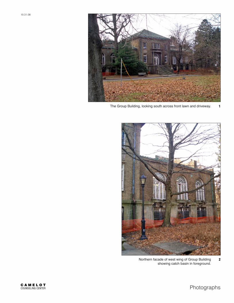
C A M E L O TCOUNSELING CENTER
10.31.08
Photographs
Northern facade of west wing of Group Building showing catch basin in foreground.
The Group Building, looking south across front lawn and driveway.
2
1

C A M E L O TCOUNSELING CENTER
10.31.08
Photographs
Eastern wing of the Group Building, looking southwest.
South wing of Group Building, looking west with transformer station and seating area on foreground.
4
3

C A M E L O TCOUNSELING CENTER
10.31.08
Photographs
Parking area on western side of Group Building, looking northeast. 5

Appendices
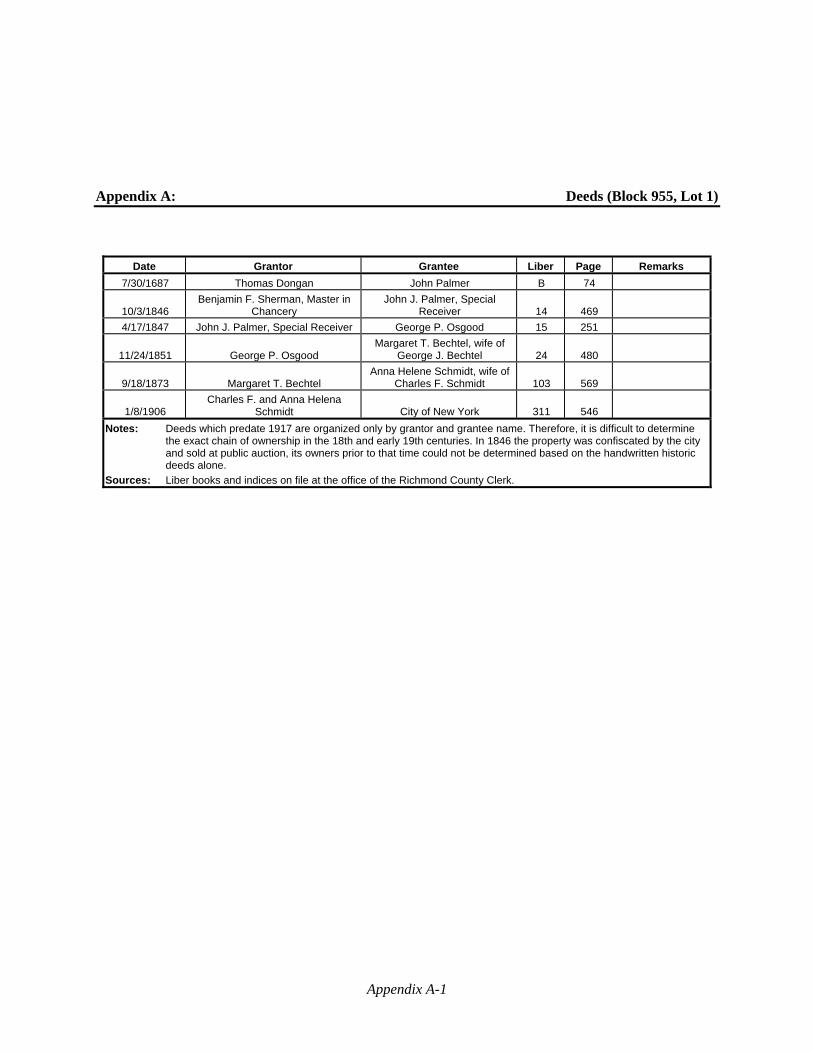
Appendix A-1
Appendix A: Deeds (Block 955, Lot 1)
Date Grantor Grantee Liber Page Remarks
7/30/1687 Thomas Dongan John Palmer B 74
10/3/1846 Benjamin F. Sherman, Master in
Chancery John J. Palmer, Special
Receiver 14 469
4/17/1847 John J. Palmer, Special Receiver George P. Osgood 15 251
11/24/1851 George P. Osgood Margaret T. Bechtel, wife of
George J. Bechtel 24 480
9/18/1873 Margaret T. Bechtel Anna Helene Schmidt, wife of
Charles F. Schmidt 103 569
1/8/1906 Charles F. and Anna Helena
Schmidt City of New York 311 546
Notes: Deeds which predate 1917 are organized only by grantor and grantee name. Therefore, it is difficult to determine the exact chain of ownership in the 18th and early 19th centuries. In 1846 the property was confiscated by the city and sold at public auction, its owners prior to that time could not be determined based on the handwritten historic deeds alone.
Sources: Liber books and indices on file at the office of the Richmond County Clerk.

Appendix B-1
Appendix B: Summary of Census Research
Year Home* Name Age Occupation Place of Birth
1850 Northfield,
Staten Island
Edward Unkart 42 Merchant Germany Eliza Unkart 40 Germany
George J. Bechtel 36 Merchant Germany Henry Haidman 25 Farmer Germany
George J. Bechtel 9 Germany Edward Bechtel 8 New York
Margaret Bechtel 5 Germany Elinor Bechtel 2 Germany Eliza Bechtel 5m New York
Edmund Bechtel 13 Germany Dores Schmidt 26 Germany Ann Schmidt 25 Germany Anna Zandt 18 Germany
Jazina Van Hogan 24 Germany Mary Van Hogan 30 Ireland
Mrs. Lang 65 Germany Mike Dryer 72 Germany
Charles Dryer 36 Laborer Germany Michael Dryer 36 Laborer Germany
Margaret Bechtel 33 New York
1860 Middletown, Staten Island
George J. Bechtel 47 Merchant Bremen Margaret Bechtel 41 New York George J. Bechtel 19 Clerk New York Edward Bechtel 18 Clerk New York
Margaret Bechtel 14 New York Helena Bechtel 12 New York Eliza Bechtel 10 New York
Charles Bechtel 8 New York Alice Bechtel 4 New York
Ann Mullis 34 Hanover Harriet Meyer 22 Bremen
Maria Schneider 23 Hesse Darmstadt
1870
Northfield, Staten Island (near Farm
Colony)
J.J. Bechtel (sic) 56 Commercial Merchant Bremen Margaret Bechtel 50 Keeping House New York
Edward U. Bechtel 27 New York Eliza U. Bechtel 20 At Home New York
Charles H. Bechtel 18 At Home New York Johanna A. Bechtel 13 New York
Middletown, Staten Island
George Bechtel 28 Importer of Woods New York Sophia Bechtel 23 New York Annie Bechtel 4 New York
Margaret Bechtel 2 New York Louis Mack 22 Broker New York
Charles Dyker 30 Broker Switzerland Margaret Henneka 32 Servant Hesse Darmstadt
Anna Schmaler 20 Servant Hesse Darmstadt 1900 Manor Road,
Ward 2, Staten Island
Mary Bradley 47 (widow) Germany George Schmidt 29 Carpenter New York Charles Schmidt 17 Electrician Iowa
Notes: *Census records for this area do not include house numbers and prior to 1900 do not include street names.

Appendix C-1
Appendix C: Historic Directories
Directory Year (Location) Name Occupation
Business or Primary Address
Home Address (if specified)
1834 (New York City)
Unkart & Dreyer importers 98 William -------------------
1841 (New York City)
Bechtel (George J.) & Dreyer (John H., jr.)
importers 8 Beaver -------------------
1853 (New York City)
Bechtel, George J. Foreign Consul, Brunswick
17 S. William -------------------
1854 (New York City)
Bechtel, George Jonas importer 175 William and 53 Stone
Brooklyn
1857 (New York City)
Bechtel, George Jonas imp. 175 William and 53 Stone
78 Clinton, Brooklyn
1863 (New York City)
Bechtel, George J. Imp. 22 S. William 78 Clinton, Brooklyn
1864 (New York City)
Bechtel, George J. Foreign Consul, Brunswick
22 S. William -------------------
1865 (New York City)
Bechtel, George J. Imp. 22 S. William 78 Clinton, Brooklyn
1868 (New York City)
Bechtel, George J. mer. & consul 22 S. William Bechtel, George J., jr. mer. 22 S. William 78 Clinton, Brooklyn
1871 (New York City)
Bechtel, George J. importer 22 S. William 78 Clinton, Brooklyn Schmidt, Charles F. importer of wines,
brandies, &c 20 Beaver 313 Henry,
Brooklyn 1872
(New York City) Bechtel, George J. mer. & consul 23 S. William 190 W. Baltic,
Brooklyn Bechtel, George J., jr. mer. 23 S. William Staten Island
1878 (Brooklyn)
Schmidt, Charles F. merchant New York 467 Henry, Brooklyn
1879 (Brooklyn)
Schmidt, Charles F. wine mer. New York 467 Henry, Brooklyn
1882-1883; 1884
(Staten Island)
Bechtel, George J. broker (Prod Ex NY) ------------------- Vanderbilt av c Cross
(Castleton, Staten Island)
1888-1889 (Brooklyn)
Schmidt, Charles F. merchant New York 146 Joralemon Street
1889-1890 (Brooklyn)
Schmidt, Anna widow, Charles ------------------- 213 Meserole
1889 (New York City)
Schmidt, Charles F. wines 24 Beaver 146 Joralemon, Brooklyn & treas. 211 Canal
Schmidt, Charles F. & Peters wines 24 Beaver 1890
(New York City) Peters, Carl Otto wines 24 Beaver 52 E. 64th
Schmidt, Charles F. wines 24 Beaver 146 Joralemon Street, Brooklyn & treas (sic) 205 Canal
Schmidt, Charles F. & Peters wines 24 Beaver ------------------- 1893-1894
(Staten Island) Bechtel, George J. wines Vanderbilt av and
Cross St -------------------
Schmidt, August plumber Manor Road, Castleton Corners
post office
-------------------
Schmidt, George plumber Manor Road, Castleton Corners
post office
-------------------
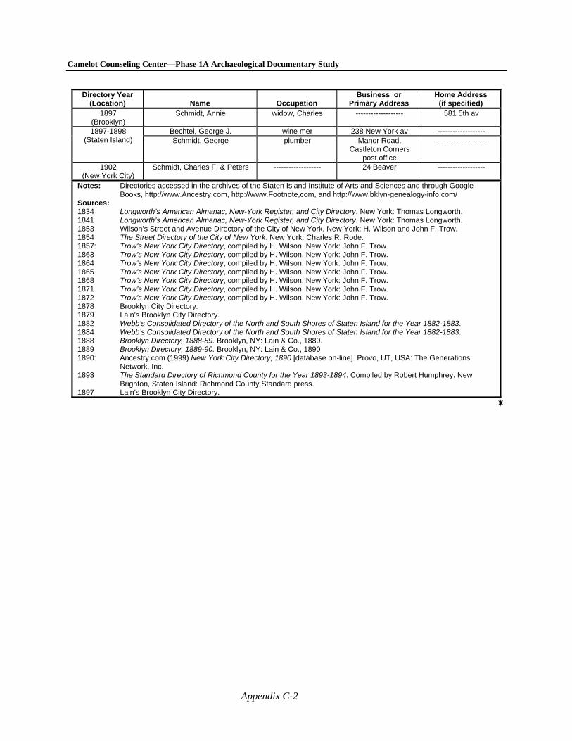
Camelot Counseling Center—Phase 1A Archaeological Documentary Study
Appendix C-2
Directory Year (Location) Name Occupation
Business or Primary Address
Home Address (if specified)
1897 (Brooklyn)
Schmidt, Annie widow, Charles ------------------- 581 5th av
1897-1898 (Staten Island)
Bechtel, George J. wine mer 238 New York av ------------------- Schmidt, George plumber Manor Road,
Castleton Corners post office
-------------------
1902 (New York City)
Schmidt, Charles F. & Peters ------------------- 24 Beaver -------------------
Notes: Directories accessed in the archives of the Staten Island Institute of Arts and Sciences and through Google Books, http://www.Ancestry.com, http://www.Footnote,com, and http://www.bklyn-genealogy-info.com/
Sources: 1834 Longworth’s American Almanac, New-York Register, and City Directory. New York: Thomas Longworth. 1841 Longworth’s American Almanac, New-York Register, and City Directory. New York: Thomas Longworth. 1853 Wilson’s Street and Avenue Directory of the City of New York. New York: H. Wilson and John F. Trow. 1854 The Street Directory of the City of New York. New York: Charles R. Rode. 1857: Trow’s New York City Directory, compiled by H. Wilson. New York: John F. Trow. 1863 Trow’s New York City Directory, compiled by H. Wilson. New York: John F. Trow. 1864 Trow’s New York City Directory, compiled by H. Wilson. New York: John F. Trow. 1865 Trow’s New York City Directory, compiled by H. Wilson. New York: John F. Trow. 1868 Trow’s New York City Directory, compiled by H. Wilson. New York: John F. Trow. 1871 Trow’s New York City Directory, compiled by H. Wilson. New York: John F. Trow. 1872 Trow’s New York City Directory, compiled by H. Wilson. New York: John F. Trow. 1878 Brooklyn City Directory. 1879 Lain’s Brooklyn City Directory. 1882 Webb’s Consolidated Directory of the North and South Shores of Staten Island for the Year 1882-1883. 1884 Webb’s Consolidated Directory of the North and South Shores of Staten Island for the Year 1882-1883. 1888 Brooklyn Directory, 1888-89. Brooklyn, NY: Lain & Co., 1889. 1889 Brooklyn Directory, 1889-90. Brooklyn, NY: Lain & Co., 1890 1890: Ancestry.com (1999) New York City Directory, 1890 [database on-line]. Provo, UT, USA: The Generations
Network, Inc. 1893 The Standard Directory of Richmond County for the Year 1893-1894. Compiled by Robert Humphrey. New
Brighton, Staten Island: Richmond County Standard press. 1897 Lain’s Brooklyn City Directory.
Related Documents