Northern North Atlantic Sea Level in CMIP5 Climate Models: Evaluation of Mean State, Variability, and Trends against Altimetric Observations KRISTIN RICHTER, a JAN EVEN ØIE NILSEN, b ROSHIN P. RAJ, b INGO BETHKE, c JOHNNY A. JOHANNESSEN, b,d AIMÉE B. A. SLANGEN, e,f AND BEN MARZEION g a Institute of Atmospheric and Cryospheric Sciences, University of Innsbruck, Innsbruck, Austria b Nansen Environmental and Remote Sensing Center, Bjerknes Centre for Climate Research, Bergen, Norway c Uni Research Climate, Bjerknes Centre for Climate Research, Bergen, Norway d Geophysical Institute, Bergen, Norway e Department of Estuarine and Delta Systems, Royal Netherlands Institute for Sea Research (NIOZ), Yerseke, Netherlands f Utrecht University, Yerseke, Netherlands g Institute of Geography, University of Bremen, Bremen, Germany (Manuscript received 12 May 2017, in final form 11 August 2017) ABSTRACT The northern North Atlantic comprises a dynamically complex area with distinct topographic features, making it challenging to model oceanic features with global climate models. As climate models form the basis for assessment reports of future regional sea level rise, model evaluation is important. In this study, the representation of regional sea level in this area is evaluated in 18 climate models that contributed to phase 5 of the Coupled Model Intercomparison Project. Modeled regional dynamic height is compared to observations from an altimetry-based record over the period 1993–2012 in terms of mean dynamic topography, interannual variability, and linear trend patterns. As models are expected to reproduce the location and magnitude but not the timing of internal variability, the observations are compared to the full 150-yr historical simulations using 20-yr time slices. This approach allows one to examine modeled natural variability versus observed changes and to assess whether a forced signal is detectable over the 20-yr record or whether the observed changes can be explained by internal variability. The models perform well with respect to mean dynamic topography. However, model performances degrade when interannual variability and linear trend patterns are considered. The modeled regionwide average steric and dynamic sea level rise is larger than estimated from observations, and the marked observed increase in the subpolar gyre is not consistent with a forced response but rather a result of internal variability. Using a simple weighting scheme, it is shown that the results can be used to reduce uncertainties in sea level projections. 1. Introduction Global sea level is rising and will continue to do so in the future. Regional sea level changes have a direct impact on infrastructure, population, and coastal ecosystems. Yet, regional sea level changes deviate largely from the global mean, and their simulation requires complex and com- putationally expensive atmosphere–ocean global climate models (AOGCMs) that form the basis for the projection of regional sea level changes (Church et al. 2013). Quantifying future regional sea level change and its impacts is pivotal for coastal communities in order to adapt to rising sea levels. Because of the presence of un- forced internal variability, climate model projections be- come increasingly more uncertain when going to smaller spatial and temporal scales as the dominating processes become more complex and the need for simplifying pa- rameterizations due to computational constraints impede Supplemental information related to this paper is available at the Journals Online website: https://doi.org/10.1175/JCLI-D-17- 0310.s1. Corresponding author: Kristin Richter, [email protected]. at Denotes content that is immediately available upon publica- tion as open access. This article is licensed under a Creative Commons Attribution 4.0 license (http://creativecommons. org/licenses/by/4.0/). 1DECEMBER 2017 RICHTER ET AL. 9383 DOI: 10.1175/JCLI-D-17-0310.1 Ó 2017 American Meteorological Society

Welcome message from author
This document is posted to help you gain knowledge. Please leave a comment to let me know what you think about it! Share it to your friends and learn new things together.
Transcript
Northern North Atlantic Sea Level in CMIP5 Climate Models: Evaluation ofMean State, Variability, and Trends against Altimetric Observations
KRISTIN RICHTER,a JAN EVEN ØIE NILSEN,b ROSHIN P. RAJ,b INGO BETHKE,c
JOHNNY A. JOHANNESSEN,b,d AIMÉE B. A. SLANGEN,e,f AND BEN MARZEIONg
a Institute of Atmospheric and Cryospheric Sciences, University of Innsbruck, Innsbruck, AustriabNansen Environmental and Remote Sensing Center, Bjerknes Centre for Climate Research, Bergen, Norway
cUni Research Climate, Bjerknes Centre for Climate Research, Bergen, NorwaydGeophysical Institute, Bergen, Norway
eDepartment of Estuarine and Delta Systems, Royal Netherlands Institute for Sea Research (NIOZ), Yerseke, NetherlandsfUtrecht University, Yerseke, Netherlands
g Institute of Geography, University of Bremen, Bremen, Germany
(Manuscript received 12 May 2017, in final form 11 August 2017)
ABSTRACT
The northern North Atlantic comprises a dynamically complex area with distinct topographic features,
making it challenging to model oceanic features with global climate models. As climate models form the basis
for assessment reports of future regional sea level rise, model evaluation is important. In this study, the
representation of regional sea level in this area is evaluated in 18 climatemodels that contributed to phase 5 of
the Coupled Model Intercomparison Project. Modeled regional dynamic height is compared to observations
from an altimetry-based record over the period 1993–2012 in terms of mean dynamic topography, interannual
variability, and linear trend patterns.Asmodels are expected to reproduce the location andmagnitude but not
the timing of internal variability, the observations are compared to the full 150-yr historical simulations using
20-yr time slices. This approach allows one to examine modeled natural variability versus observed changes
and to assess whether a forced signal is detectable over the 20-yr record or whether the observed changes can
be explained by internal variability. The models perform well with respect to mean dynamic topography.
However, model performances degradewhen interannual variability and linear trend patterns are considered.
Themodeled regionwide average steric and dynamic sea level rise is larger than estimated from observations,
and the marked observed increase in the subpolar gyre is not consistent with a forced response but rather a
result of internal variability. Using a simple weighting scheme, it is shown that the results can be used to
reduce uncertainties in sea level projections.
1. Introduction
Global sea level is rising andwill continue to do so in the
future. Regional sea level changes have a direct impact on
infrastructure, population, and coastal ecosystems. Yet,
regional sea level changes deviate largely from the global
mean, and their simulation requires complex and com-
putationally expensive atmosphere–ocean global climate
models (AOGCMs) that form the basis for the projection
of regional sea level changes (Church et al. 2013).
Quantifying future regional sea level change and its
impacts is pivotal for coastal communities in order to
adapt to rising sea levels. Because of the presence of un-
forced internal variability, climate model projections be-
come increasingly more uncertain when going to smaller
spatial and temporal scales as the dominating processes
become more complex and the need for simplifying pa-
rameterizations due to computational constraints impedeSupplemental information related to this paper is available at
the Journals Online website: https://doi.org/10.1175/JCLI-D-17-
0310.s1.
Corresponding author: Kristin Richter, [email protected].
at
Denotes content that is immediately available upon publica-
tion as open access.
This article is licensed under a Creative Commons
Attribution 4.0 license (http://creativecommons.
org/licenses/by/4.0/).
1 DECEMBER 2017 R I CHTER ET AL . 9383
DOI: 10.1175/JCLI-D-17-0310.1
� 2017 American Meteorological Society
the accurate representation of local processes. It is
therefore important to evaluate the performance of
models on a regional scale with available observations.
For the dynamic sea level contribution to sea level
changes, Landerer et al. (2014) evaluated the perfor-
mance of climate model simulations for the global ocean
with a focus on the Southern Ocean and equatorial re-
gions where biases of the mean state were largest. In
particular, because of large observed rates of sea level
rise, the tropical Pacific Ocean has received considerable
attention (e.g., Meyssignac et al. 2012; Palanisamy et al.
2015) compared to other regions such as the northern
North Atlantic. We plan to direct our attention to the
latter region for several reasons: 1) the sea level in the
Atlantic subpolar gyre has been rising over the altimetric
record (e.g., Häkkinen et al. 2013), which is associated
with a weakening of the gyre circulation; 2) the Nordic
seas and subpolar North Atlantic are surrounded by gla-
ciated landmasses and, through gravitational adjustment,
regional sea level trends are expected to be affected by
changes in land-based icemasses in a way that counteracts
the global mean effect; 3) the additional freshwater input
to the ocean is suspected to already have an impact on
ocean dynamics (Rahmstorf et al. 2015), although recent
research shows that the impact of meltwater runoff is
still small (Böning et al. 2016); and 4) freshwater input is
not yet routinely implemented in AOGCMs used for cli-
mate projections. Given these potential weaknesses,
and the fact that the region is surrounded by densely
populated coasts where the models form the basis for
numerous national assessment reports (e.g., Simpson et al.
2015; Grinsted et al. 2015), it is particularly important to
evaluate the models here. For the Norwegian coast,
AOGCMs have been evaluated earlier (Simpson et al.
2014); however, for the abovementioned reasons, we wish
to focus on the whole northern North Atlantic region.
Recent studies attempted to quantify the magnitude
of internal variability in climate model simulations in
order to assess the time of emergence of an externally
forced signal in regional sea level (Lyu et al. 2014;
Richter and Marzeion 2014; Bilbao et al. 2015). Richter
and Marzeion (2014) found that it takes at least 30 years
in the area of interest for an externally forced signal to
emerge from the noise when considering a period
starting in 1990 (the approximate advent of satellite al-
timetry). Furthermore, from an observational point,
Dangendorf et al. (2014b) found that sea level data from
tide gauges exhibit significant decadal and multidecadal
correlations independent of any systematic rise. It is
therefore not clear whether a forced signal in sea level is
already detectable in the northern North Atlantic and
Nordic seas or whether observed changes over the alti-
metric period are caused by internal variability.
Global observational coverage is available for the past
few decades (1993–2012 is used in this study). As models
are expected to reproduce the locations and magni-
tudes but not the timing of internal variability, the ob-
servations have to be compared to the full historical
simulations (1850–2012) of sea level. In this way, it can
be assessed whether a forced signal is already detectable
(i.e., the observed changes are reproduced by all models
in the observational period), whether the observed
changes show similarity with modeled internal vari-
ability (i.e., the observed changes are reproduced in
random 20-yr periods), andwhether themodels are at all
able to simulate variability similar to the observed.
We will focus on the northern North Atlantic region
and address the following questions: Is the mean dy-
namic topography correctly simulated? Is themagnitude
and location of observed sea level variability repro-
duced? Are observed sea level trends consistent with
modeled trends over the same period (and therefore
forced) or more likely due to internal variability? In
section 2 we describe the model data as well as the ob-
servations and explain how we will compare the two
datasets in order to evaluate the simulated sea level. The
results are presented in section 3 for the three variables
that are being investigated, namely, mean dynamic to-
pography, regional interannual sea level variability, and
regional linear sea level trends. The results are discussed
in section 4, followed by the conclusions in section 5.
2. Data and methods
a. CMIP5 model output
We use output from 18 climate models (Table S1 in
the supplemental material) participating in phase 5 of
the Coupled Model Intercomparison Project (CMIP5;
Taylor et al. 2012) to compare modeled sea level with
observations with respect to the mean state, interannual
variability, and linear trend patterns. The first re-
alization of eachmodel (r1i1p1) is used.We combine the
sea level above the geoid (‘‘zos’’ in CMIP5 terminology)
with the global mean (thermo)steric sea level change
(‘‘zostoga’’ or ‘‘zossga’’). Most but not all of the models
conserve volume rather than mass, that is, a net increase
in seawater temperature does not necessarily lead to a
global mean sea level rise in zos in these models. This
effect is instead computed from the density fields and
represented by zossga or zostoga. For consistency, we
therefore remove the global mean from the spatial fields
of zos at every time step prior to adding the global mean
steric change. The resulting variable comprises the re-
gional dynamic and steric sea level change as well as the
global mean steric change.
9384 JOURNAL OF CL IMATE VOLUME 30

The historical simulations used include all known cli-
mate forcings (Slangen et al. 2015). With some excep-
tions, they cover the period 1850–2005. They are
extended up to 2012 using the representative concentra-
tion pathway 4.5 (RCP4.5) scenario (Van Vuuren et al.
2011). However, the choice of scenario is not critical over
this short period as the scenarios only start to diverge in
the second half of the twenty-first century. The climate
drift (long-term trends in the absence of an external
forcing; Sen Gupta et al. 2013) is accounted for by re-
moving the linear trend found in the control simulations
for all variables. Since we are eventually interested in
multidecadal variability, annual data are computed.
The grid size of the models varies widely in the area
(Table S1), from the comparatively dense grid of 0.98 3 0.58(longitude 3 latitude) or finer for the MPI-ESM-LR,
CCSM4, and NorESM models to the coarser grid of
2.58 3 1.28 for the CMCC-CMS model. (Expansions of
acronyms are available online at http://www.ametsoc.
org/PubsAcronymList.) For model-observation inter-
comparison, the processed data are regridded to a reg-
ular grid of 18 3 18.
b. Sea level anomalies andmean dynamic topographyfrom observations
Sea surface height (SSH) is defined as the height of the
ocean surface above the reference ellipsoid while sea
level anomalies are the deviations of the instantaneous
SSH from a reference mean sea surface (MSS). In this
study, we use sea level anomalies to investigate vari-
ability and trends (and refer to it as sea level). Monthly
fields of sea level for the period 1993–2012 are obtained
from the European Space Agency (ESA) Climate
Change Initiative (CCI) project (ESA-CCI; Ablain et al.
2015, 2017). Annual means for the 20-yr time period are
then calculated from the monthly data.
Through geostrophy the ocean surface circulation re-
lates to the oceans mean dynamic topography (MDT),
which yields the long-term average strength of the ocean
currents (e.g., Knudsen et al. 2011). The precise knowledge
of the geoid height, together with MSS, known within
centimeter accuracy (Schaeffer et al. 2012), enables us to
compute the MDT of the ocean using (e.g., Raj 2017):
MDT5MSS2 geoid. (1)
The geoid is the equipotential surface of Earth’s
gravity field. More accurately, it is the sea surface in the
absence of winds, tides, and currents, only influenced by
gravity (e.g., Raj 2017). The Gravity Field and Steady-
State Ocean Circulation Explorer (GOCE) High-Level
Processing Facility (HPF) models Earth’s geopotential
as a truncated spherical harmonic expansion in the
spectral domain (Bruinsma et al. 2014). Using the gravity
field coefficients from the level-2 global gravity models
provided by HPF, the geoid height can be determined as
detailed in previous studies (e.g., Johannessen et al. 2003;
Jin et al. 2014; Raj 2017). In our study, we use theGOCE
user toolbox (GUT; Benveniste et al. 2007) to estimate the
geoid height from the gravity models and the National
Space Institute of the Technical University of Denmark
(DTU Space) 2013 (DTU13)MSSmodel (Andersen et al.
2015) to computeMDT.Even though conceptually simple,
the computation of MDT needs to satisfy important a
priori conditions (Benveniste et al. 2007): both the geoid
height and theMSS used should be referenced to the same
reference ellipsoid and estimated on the same tide system.
The reference ellipsoid, a sphere flattened at its pole, is an
arbitrary reference surface that is a raw approximation of
Earth’s shape. Here, similar to theDTU13MSS, the geoid
height is estimated in the mean tide system relative to the
TOPEX ellipsoid. The TOPEX ellipsoid is the first-order
definition of the nonspherical shape of the Earth as an
ellipsoid of revolution with an equatorial radius of
6378.1363km and a flattening coefficient of 1/298.257
(Tapley et al. 1994). In the mean tide system, the effects of
the permanent tides are included in the definition of the
geoid in contrast to the zero tide system where they are
excluded. Further, the noise in the MDT due to in-
consistencies in the resolution of MSS and geoid is re-
moved by a Gaussian filter (90km).
Both maps of sea level and mean dynamic topogra-
phy, initially on a 0.258 3 0.258 grid, have been re-
mapped to a 18 3 18 grid for comparison with the model
data (section 2a). Since MDT is the sea surface relative
to the geoid, and the climate models have no geoid, the
observed MDT is comparable to the modeled mean sea
surface.
c. Contribution from land-based ice and GIA
The research area (Fig. 1) is surrounded by (partly)
ice-covered land and therefore located in the near-field
of potential land-ice changes. The mass exchange be-
tween land and ocean affects the gravitational field, that
is, the geoid, and thus the shape of the sea surface. The
effect on regional sea level gradients is largest close to
changing land ice (e.g., Mitrovica et al. 2001). In addi-
tion, the altimetry-based sea level observations include
the change of the geoid due to the ongoing response of
the viscoelastic Earth to the last deglaciation [glacial
isostatic adjustment (GIA); Tamisiea 2011]. The CMIP5
models are neither coupled to land-ice models nor do
they have geoids that could change, and sea level
changes originating from past as well as present changes
in land ice have to be removed from the observations
prior to comparing observed and modeled trends.
1 DECEMBER 2017 R I CHTER ET AL . 9385

The glacier mass change over the observational period
is obtained by forcing the glacier model of Marzeion et al.
(2012) with temperature and precipitation from gridded
climate observations [Climatic Research Unit (CRU)
time series; Newet al. 2002]. Reconstructions of themodel
over the twentieth century were shown to be consistent
with other reconstructive methods based on observations
of glacier length change, mass balance observations, and
remotely sensed estimates (Marzeion et al. 2015). The
contributions from the Greenland and Antarctic ice
sheets are taken from Shepherd et al. (2012). The data
include both the contribution from surface mass balance
changes as well as dynamical changes of the ice.
To translate the land-ice changes into absolute regional
sea level changes, the corresponding fingerprints have
been computed by assuming themelt of a uniform ice layer
over the glaciated area (e.g., Riva et al. 2010; Slangen et al.
2012, 2014; Perrette et al. 2013) and by computing the in-
duced sea level change after solving the sea level equation
(Farrell and Clark 1976) using a pseudospectral approach
(Mitrovica and Peltier 1991), including the rotational
feedback (Milne and Mitrovica 1998), on a compressible
elastic Earth (Dziewonski and Anderson 1981).
To account for the geoid-related signal due to GIA
from the sea level observation, we use the correction from
the ICE-5GGIAmodel as provided by Peltier (2004).1As
we are interested in absolute sea level changes, only the
rate of change of the geoid is used.
Figure 2a shows the observed 1993–2012 sea level
trends in the region. The average trend over the region is
2.35mmyr21, less than the global average of 3.16 60.5mmyr21 (Ablain et al. 2015). Sea level change is
positive except east and southwest of Svalbard and in a
very localized area south of the Iceland Basin. The rise is
largest in the subpolar gyre and, to a lesser degree, along
the European coast. The contribution from changing
glaciers and ice sheets to absolute sea level over the
same period (Fig. 2b) is characterized by a sea level
decrease around Svalbard and Greenland in accordance
with the loss of land ice in these regions. However,
compared to observed sea level, changing land ice con-
tributes little to the spatial variability of observed trends
whereas the average sea level change over the area due
to changes in land ice is significant, contributing 0.49
(glaciers) and 0.43mmyr21 (ice sheets), respectively, to
the observed regionwide average trend (Fig. S2 in the
supplemental material). The same is true for the geoid-
related GIA contribution: it contains little spatial vari-
ability compared to the observed trend pattern while the
corresponding regionwide average presents a signifi-
cant, notably negative, contribution of 20.31mmyr21
(Fig. 2c).
To assess the impact of land-ice melting on regional
sea level trends, we removed the contribution from
glaciers and ice sheets as well as from GIA from the
observed sea level prior to computing linear trends. The
result is a reduced regionwide average trend of
1.75mmyr21, with few changes in the regional trend
pattern (cf. Figs. 2a,d). The pattern is still dominated by
the stronger sea level rise in the subpolar gyre around
the southern tip of Greenland. The negative trend
FIG. 1. The northern North Atlantic and the Nordic seas. Schematic surface currents are
based on literature (see Furevik and Nilsen 2005). Gray lines represent the 1000-, 2000-, and
3000-m isobaths. (NAC is North Atlantic Current, and SPG is subpolar gyre.)
1 Dataset available from http://www.atmosp.physics.utoronto.
ca/;peltier/datasets/GRID/dGeoid250.1grid.ICE5Gv1.3_VM2_
L90_2012.nc.
9386 JOURNAL OF CL IMATE VOLUME 30

southwest of Svalbard is slightly enhanced while the sea
level rise on the Norwegian shelf, and therefore the
across-shelf gradient, is reduced. To be consistent with
the models, we use these trends (presented in Fig. 2d) in
our trend analysis (section 3c).
d. Methods
The sea level observations from satellite altimetry
used in this study span the period 1993–2012. From this
20-yr record of annual means, we calculate maps of
sea level variability (in terms of temporal standard
deviation) and linear sea level trends. These maps, to-
gether with maps of MDT, are used for the model–
observation analysis. The model simulations cover the
period 1850–2012. To account for the random phases of
internal variability in the models, we slide a 20-yr win-
dow over the annual data and compute maps of MDT,
sea level variability, and linear trends for each 20-yr
period, thus giving us a total of 143 maps per model per
variable, available for comparison with the observa-
tions. Linear trends are removed from every 20-yr pe-
riod prior to calculating variability.
To assess the model performance, we use basic sta-
tistical measures: modeled and observed fields are
compared by computing the area-weighted pattern
correlation coefficients (PCCs) and root-mean-square
errors (RMSEs) between modeled and observed maps.
In this case, the PCC is the equivalent to the correlation
coefficient between two time series, with the only dif-
ference being that the correlation is computed between
corresponding locations instead of corresponding points
in time (Thomson and Emery 2001). Prior to computing
PCCs and RMSEs, the regionwide average is subtracted
from all maps. That is, we compute centered statistics to
assess the similarity between observed and modeled
regional anomalies (e.g., Santer et al. 1995). Note that
PCCs are not sensitive to errors in the amplitudes in the
modeled patterns. These errors are reflected in the
RMSEs. Centered statistics are insensitive to the re-
gionwide average. This is of particular importance for
the comparison of observed and modeled trends. In line
with the global mean, we expect simulated regionwide
average trends to be small in the beginning of the his-
torical record and grow increasingly more positive
throughout the modeled period considered here (1850–
2012). To take this fact into account, we will also report
the total RMSE (RMSE without removing the region-
wide average) when presenting results of the trend
analysis.
As mentioned, we account for the different phases of
internal variability in models and observations by com-
paring the observations with modeled fields from all
20-yr windows. Since, on a time scale of only two de-
cades, internal variability is expected to be strong in
FIG. 2. (a) Observed trends from satellite altimetry during 1993–2012, (b) contribution from glaciers and ice
sheets, and (c) contribution from the geoid-related component ofGIA. (d) Trends in sea level corrected for land-ice
contributions and GIA. The numbers above each map represent the regionwide average and root-mean-square,
respectively.
1 DECEMBER 2017 R I CHTER ET AL . 9387

both models and observations, we anticipate some var-
iability in the PCCs and RMSEs as we slide the window
across the model record. The approach presents us with
several possibilities to compute multimodel means:
(i) by taking the mean over the observational period
(1993–2012); (ii) by selecting, for each model, the period
with maximum PCC with the observed field and taking
themean over thesemodel maps (max corr); or (iii) as in
(ii), but for periods of minimumRMSE (min RMSE). In
the following, we will present results for ensemble
means computed followingmethod (i) and (ii), as results
for ensemble (iii) are similar to those of ensemble
(ii). Note that multimodel means are formed by first
computing maps of MDT, variability, and linear trends
for each model, and subsequently averaging over these
fields. In the same manner as for individual maps (by
computing PCCs and RMSEs), we compare the three
different ensemble means with observations. This en-
ables us to assess whether the observed regional trend
patterns are due to internal variability or externally
forced. In the latter case, we expect a good agreement
not only between models and observations but also be-
tween the individual models over the observational pe-
riod (1993–2012).
3. Results
a. Mean dynamic topography
The mean dynamic topography determines the sur-
face circulation of the oceans and is thus crucial not only
for heat and salt transport, but also directly for sea
level changes, particularly along the margins of the
oceans. Observation-based MDT is shown in Fig. 3a
with the regionwide average removed for easier com-
parison with modeled MDT. The cyclonic circulation in
the Nordic seas is visible by local minima in the basins of
the Nordic seas and elevated MDT along the sur-
rounding coasts of Greenland and northern Europe.
The even more pronounced and larger minimum
south of Greenland represents the subpolar gyre. The
North Atlantic Current, the inflow to theNordic seas, and
the Norwegian Atlantic Current are represented by the
northwest–southeastward sea level gradient in the south-
eastern half of themap, in particular along the continental
slope (see Fig. 1).
Figure 4 shows the RMSE of the MDT fields for
each model and the PCC for the observational period
together with the corresponding ranges that repre-
sent the spread of RMSE and PCC over all 20-yr pe-
riods. The PCCs are large (around 0.9) for seven models
with corresponding lowRMSEs (;0.1m). These models
capture the western extent of the subpolar gyre cor-
rectly (Fig. S2). Models with PCC , 0.6 (GFDL-
ESM2G,MRI-CGCM3, and BCC_CSM1.1) and amean
RMSE . 0.15m do not simulate the characteristic sea
level minimum corresponding to the subpolar gyre at all.
The MDT minimum in the Nordic seas is present in
all models except for one (INM-CM4.0), although the
FIG. 3. MDT from (a) observations and (b) multimodel mean for the observational period. The PCC between those fields is also shown.
(c) Ensemble mean of differences between models and observations for the observational period. Black, gray, and white contours in
(b) and (c) represent signal-to-noise ratio of 1, 1.5, and 2, respectively, defined as the ratio of ensemble mean and ensemble standard
deviation of the regional anomalies. The numbers above each map represent the regionwide average and root-mean-square, respectively.
FIG. 4. Results of model–observation comparison ofMDT:mean
RMSE over all 20-yr periods from 1850 to 2012 (bars) with
minimum–maximum range (black error bars) as well as RMSE
over observational period (black dots) for each model. The
equivalent is shown for the PCCs (red error bars and dots). Also
shown are theRMSEs and PCCs for the three differentmultimodel
means over the observational period, over modeled maps of min-
imum RMSE, and over modeled maps of maximum PCC
(section 2d).
9388 JOURNAL OF CL IMATE VOLUME 30

strength and location vary. The spatial variability of
the multimodel mean over the observational period
(Fig. 3b) is slightly smaller than the observed variability.
The ensemble mean difference between modeled and
observed MDT over the observational period is shown
in Fig. 3c. The most pronounced feature is a systematic
underestimation of the strength of the subpolar gyre in
the Labrador Sea. There is also a significant lack of re-
gional details in the North Atlantic Current in the
Norwegian Sea.
Generally, the lower the PCC is, the higher the RMSE
is (Fig. 4). The RMSE is of the same order of magnitude
as found in Landerer et al. (2014) for the entire world
ocean over the period 1993–2002. The spread of RMSEs
and PCCs derived from all available 20-yr periods is
small for most models, indicating that internal variabil-
ity has little effect on modeled MDT patterns. The ex-
ception is GFDL-ESM2G, where the RMSE increases
gradually and the PCC decreases gradually throughout
the historical simulation (not shown). PCCs are highest
(.0.9) with corresponding low RMSEs for the multi-
model mean. This applies to any 20-yr period over which
MDT is calculated: the observational period, the period
ofminimumRMSE, and the period of maximum pattern
correlation (Fig. 4).
b. Variability
The observed interannual sea level variability
(Fig. 5a) exhibits local maxima in the Lofoten Basin, as
well as in the Iceland Basin and Irminger Sea at the
eastern rim of the subpolar gyre. In contrast, observed
interannual variability is weak in the western branch of
the subpolar gyre and on the shallow European shelf
from the British Isles along the Norwegian coast up to
the entrance to the Barents Sea. In the coastal areas of
the North Sea, however, variability is stronger.
Models are designed to reproduce the main climate
modes in terms of amplitude and location. However, the
phase and timing of simulated variability is not necessarily
the same as that of the observed variability. Therefore, we
do not expect the models to reproduce the observed
variability over the observational period, and the RMSEs
and the PCCs are expected to vary when comparing all
available modeled 20-yr periods with the observations.
This is indeed the case (Fig. 6). The range of PCCs ismuch
larger than the equivalent range for the MDT (Fig. 4).
RMSEs are on the order of 1–2 cm, with some models
showing a spread as large as 1 cm. The PCCs are low
(between 20.1 and 0.5), and some models display both
negative and positive correlation coefficients. The PCCs
for the observational period are not systematically in the
higher end of the range, indicating that the observed
variability is not in phase with the variability in the forced
simulations and thus indeed unforced. In the same way as
for MDT, the ensemble means of variability for the ob-
servational period and periods of minimum RMSE and
maximum PCC, respectively, show smaller RMSEs and
larger PCCs than any of the individual models.
Figure 5b shows the modeled variability as the mul-
timodel mean over the periods of maximum pattern
correlation of the individual models. These periods are
FIG. 5. Sea level variability from (a) observations and (b) multimodel mean over the periods of maximum pattern correlation. The PCC
between those fields is also shown. (c)Difference ofmodeled and observed variability averaged over all models for the period ofmaximum
pattern correlation. The mean difference has been removed and only anomalies are shown. Black, gray, and white contours represent
signal-to-noise ratio of 1, 1.5, and 2, respectively, defined as the ratio of ensemble mean and ensemble standard deviation of the regional
anomalies. The numbers above each map represent the regionwide average and root-mean-square, respectively.
FIG. 6. As in Fig. 4, but for results of model–observation compar-
ison of sea level variability.
1 DECEMBER 2017 R I CHTER ET AL . 9389

different for each model as the internal variability is
random and not in phase between the individual models.
The mean difference averaged over all models is 0.21 cm
(not included in Fig. 5c), indicating that models over-
estimate the variability in this region. The multimodel
mean variability shows enhanced variability away from
the coasts in accordance with the observations (Figs. 5a,b).
However, the pattern is very smooth and does not
reproduce the finer spatial features. This is partly due to
the ensemble averaging: when looking at individual
models (Fig. S3 in the supplemental material) local de-
tails like the enhanced variability in the central Nordic
seas are evident in most models (except IPSL-CM5A-
MR). The strength and location of these details, how-
ever, differ from model to model.
The relatively good statistical performance of the
ensemble mean as shown in Fig. 6 is therefore due to
smoothing of local features, and the performance comes
from good reproduction of large-scale features. However,
a systematic underestimation of variability in the Lofoten
Basin is identified, as well as an overestimation of the
strength of the variability in the southern Iceland Basin
(Fig. 5c, at lower right). In the remaining areas, no sys-
tematic differences are found.
c. Linear trends
As mentioned, we use the altimetric sea level cor-
rected for contributions from land ice (Figs. 2d and 7a)
in the following trend analysis. Linear trends in sea level
over the observational period may be unforced, that is,
due to internal variability only; externally forced (nat-
ural or anthropogenic); or a combination of both. To
account for the presence of unforced trends, we apply
the same procedure as for the investigation of variability
and compare the observed trends with trends from all
20-yr periods available in the models.
Statistical parameters from the observation–model
comparison of trend anomalies are shown in Fig. 8. The
PCCs for trends span an even wider range (from20.45 to
0.45) than for variability (cf. Fig. 6), as is to be expected.
For most models, PCCs are symmetric around zero.
Notable exceptions are GFDL-ESM2G and IPSL-
CM5A-MR, with maximum positive PCCs much larger
than absolute negative PCCs. The RMSEs are on the
order of the observed mean sea level rise itself or higher.
For the ensemble means, RMSEs are smaller than for
the individual models. For the ensemble mean over the
periods of minimum RMSE and maximum pattern cor-
relation, the PCCs exceed 0.6 (0.18 for observational
period), indicating that the observed trend pattern is at
least partly simulated at some point in time by some of
the models. It is also noteworthy that PCCs are not
largest and RMSEs not smallest over the observational
period (red and black dots in Fig. 8, respectively), hinting
toward the importance of internal variability. Note that
the RMSE is not the total RMSE but the RMSE of the
fields with the regionwide average trend removed. That
is, we compare observed and modeled trend anomalies.
This way, we account only for spatial variability and not
for biases in the regionwide average trend. This is im-
portant as the modeled trends, and therefore the total
FIG. 7. Linear sea level trends over the observational period from (a) observations (as in Fig. 2d) and (b) multimodel mean of modeled
trends. The PCC between those fields is also shown. (c) Multimodel mean of the differences between modeled and observed trend
anomalies for the observational period. The regionwide average difference that has been removed (as we look at anomalies) is
0.82mmyr21. Black, gray, and white contours represent signal-to-noise ratio of 1, 1.5, and 2, respectively, defined as the ratio of ensemble
mean and ensemble standard deviation of the regional maps. The numbers above each map represent the regionwide average and root-
mean-square, respectively.
FIG. 8. As in Fig. 4, but for results of model–observation compar-
ison of trends.
9390 JOURNAL OF CL IMATE VOLUME 30

RMSE, are strongly affected by the global average sea
level rise. As we expect the observed trends to be at least
partly affected by internal variability and therefore cor-
respond to any modeled time period with potentially
lower global sea level rise, it is important to take this into
account.
The modeled average sea level trends for the obser-
vational period range from 0.12 (MRI-CGCM3) to
4.97mmyr21 (BCC_CSM1.1; Fig. S4 in the supple-
mental material) with a multimodel mean of 2.26 61.23mmyr21 (one standard deviation), which is larger
than the observed average trend of 1.75mmyr21. The
ensemble mean of modeled regional trends over the
observational period is shown in Fig. 7b. Compared to
the observations (Fig. 7a), the simulated spatial vari-
ability is small (0.84 versus 1.48mmyr21). The marked
sea level rise in the subpolar gyre that dominates the
observed trends is not simulated at all. This indicates
that it is a manifestation of internal variability, the re-
sponse to an external forcing that is not included in the
models, or processes that are not properly represented
or resolved. Instead, a negative trend in the central
North Atlantic is simulated that is also present in the
observations but has a signal-to-noise ratio of less than 1.
The sea level rise along the shallow shelf areas and west
of Greenland is systematic across the models (high
signal-to-noise ratio), indicating that it may be a forced
signal. However, it should be noted that the relatively
high signal-to-noise ratio shown in Fig. 7b is due to the
regionwide average sea level trend. Once this trend
is removed and only anomalies are considered, the
signal-to-noise ratio is less than 1 in the entire area
(not shown).
To assess whether the models systematically over- or
underestimate observed trends, we compute the multi-
model mean of the differences between modeled and
observed trend anomalies for the observational period
(Fig. 7c). The regionwide averagedifference is 0.51mmyr21,
reflecting the overestimation of the sea level rise in the
region by the models. The differences shown in Fig. 7c
resemble the spatial pattern of the observed trend
anomalies (Fig. 7a), and indeed the PCC between the two
fields is 20.86.
Compared to the observed trends, the modeled trend
field is rather smooth.While a large grid size contributes
to a smoother result, this also indicates that the modeled
trend anomalies during this period are offsetting each
other partially in the ensemble mean and are therefore
induced by internal variability rather than forced. This is
confirmed when looking at individual models (Fig. S4).
While all models simulate a regionwide average sea
level rise, the spatial patterns are very different. From
this, we conclude that the observed regional sea level
trend pattern results from internal variability while the
regionwide average positive sea level change is externally
forced.
To investigate whether internal variability as simu-
lated by the models reproduces the observed spatial
trend pattern, we turn again to the pattern correlation
analysis and select, for eachmodel, the 20-yr period with
the maximum pattern correlation. The results are shown
in Fig. S5 of the supplemental material for each model,
and themultimodelmean is presented in Fig. 9b. Indeed,
the multimodel mean now displays positive trends in
the region of the subpolar gyre with a relatively high
signal-to-noise ratio. The PCC of the ensemble mean
with the observed anomalies is 0.66. The regionwide
average of the multimodel mean (subtracted in Fig. 9b)
is 1.32mmyr21, indicating that the periods of maximum
pattern correlation occur at times of lower regionwide
sea level rise in the majority of the models. The re-
gionwide average sea level trend for individual models
ranges from 20.68mmyr21 for HadGEM2-ES (period
of maximum pattern correlation: 1954–73) to 4.45mmyr21
for GFDL-ESM2M (1981–2000).
For the period of maximum PCC, the multimodel
mean difference (Fig. 9c) between modeled and ob-
served anomalies is less systematic than the differences
FIG. 9. Linear sea level trend anomalies (relative to regionwide average) from (a) observations and (b) ensemble mean over periods of
maximum pattern correlation. The PCC between those fields is also shown. (c) The multimodel mean of the differences between models
and observations. Black, gray, and white contours represent signal-to-noise ratio of 1, 1.5, and 2, respectively, defined as the ratio of
ensemble mean and ensemble standard deviation of the regional maps. The numbers above each map represent the regionwide average
and root-mean-square, respectively.
1 DECEMBER 2017 R I CHTER ET AL . 9391

for the observed period (Fig. 7c) with a lower corre-
sponding PCC of 20.62. It appears that a part of the
observed signal can be identified as an internal signal.
In the next step, we combine the forced signal that
appears to consist of a regionwide sea level rise (Fig. 7b)
with the signal that originates from internal variability
(Fig. 9b) to obtain the full signal (Fig. 10b). The PCC
with the observations is 0.61. The approach implicitly
assumes the perfect cancellation of internal variability
during the observational period, which cannot be ex-
pected to be entirely true due to the different repre-
sentation of internal variability in themodels in terms of
strength, location, and frequency. The anomalously
high sea level rise in the subpolar gyre is well captured,
as is the sea level rise along the east coast of Greenland.
The regional pattern of the differences between mod-
eled and observed trend anomalies has a very low
signal-to-noise ratio (PCC of 20.42 with observations),
except in the Davis Strait, where the models appear to
systematically overestimate the change in sea level
(Fig. 10c).
4. Discussion
We have assessed the representation of simulated sea
level in terms of its mean state (MDT), interannual
variability, and linear trends in 18 CMIP5 climate
models by comparing the model output with observa-
tions from satellite altimetry. As the altimetric record
covers only 20 years, a time span on which internal
variability dominates over externally forced signals
(Richter and Marzeion 2014), the observations were
compared to the entire model record (1850–2012) using
20-yr time slices.
A summary of the statistical results with respect to
multimodel means is shown in Table 1 and for individual
models in Fig. 11. While the multimodel means repre-
sent the observed MDT rather well (PCC . 0.9), the
multimodel mean performance degrades with respect to
regional interannual variability and trends. This is also
true for individual models: the PCCs for MDT can ex-
ceed 0.9 for some models, while the maximum PCC is
below 0.6 for linear trends and variability.
With the exception of GFDL-ESM2G, the model
performance with respect to MDT depends only a little
on the chosen period (small spread in RMSE and cor-
relations in Fig. 4), indicating that internal variability
has little influence on MDT in a 20-yr period and is of
the same order of magnitude as intermodel differences.
The most striking intermodel differences are the simu-
lation of the location, strength, and shape of the sea level
minimum associated with the subpolar gyre and to some
degree the Nordic seas minimum (Fig. S2). Shortcom-
ings in the representation of open ocean circulation can
be expected to have consequences for the ability to
simulate relevant regional coastal sea level, since it is
the transport of steric anomalies toward the shelves and
the dynamics of the slope currents that constitute the
FIG. 10. Linear trends in sea level from (a) observations (as in Fig. 2d) and (b) combined modeled signal from the observational period
(Fig. 7b) and periods of maximum pattern correlation (Fig. 9b). The PCC between those fields is also shown. (c) The multimodel mean
differences with observations. Black, gray, and white contours represent signal-to-noise ratio of 1, 1.5, and 2, respectively, defined as the
ratio of ensemble mean and ensemble standard deviation of regional anomalies. The numbers above each map represent the regionwide
average and root-mean-square, respectively.
TABLE 1. PCCs andRMSEs between observations and different ensemblemeans: observational period 1993–2012, periods ofmaximum
pattern correlation (maxcorr), and for trends in periods of maximum pattern correlation plus observational period (maxcorr2012). For
variability and trends, the total RMSE (regionwide average included) is shown in the bottom row.
MDT (m) Variability (cm) Linear trends (mmyr21)
1993–2012 Maxcorr 1993–2012 Maxcorr 1993–2012 Maxcorr Maxcorr2012
PCC 0.92 0.95 0.53 0.66 0.18 0.66 0.61
RMSE 0.073 0.065 0.76 0.68 1.63 1.19 1.40
Total — — 0.78 0.69 1.69 2.14 1.48
9392 JOURNAL OF CL IMATE VOLUME 30

regional steric/dynamic contribution to coastal sea level
change and variability.
The larger range in PCCs for variability (Fig. 5) as
compared to MDT reflects the importance of internal
variability in the area. The finer details (e.g., in the
Lofoten Basin and the areas east and west of Reykjanes
Ridge) are not captured by the models. When looking at
individual models, variability is strikingly overestimated
by some models in large parts of the region. A more
detailed analysis is necessary to reveal the reasons for
the under- or overestimation of interannual variability
(i.e., steric vs dynamic changes).
Unsurprisingly, we found that linear 20-yr trends are
heavily impacted by internal variability and no forced
pattern of regional sea level trend could be detected
over the observational period, supporting previous
studies (Richter et al. 2017). According to our results,
the observed increase in sea level in the subpolar gyre
appears to be induced by internal variability. This is in
line with the results ofHäkkinen et al. (2013), who foundthat the increase is part of Atlantic multidecadal vari-
ability mainly forced by wind stress changes. Climate
modes involving atmospheric circulation (such as the
North Atlantic meridional dipole) have been shown to
govern variability in both on-shelf sea level (Richter
et al. 2012a; Calafat et al. 2012; Dangendorf et al. 2014a;
Chafik et al. 2017) and ocean circulation (e.g., Nilsen
et al. 2003; Sandø et al. 2012; Richter et al. 2012b) in the
North Atlantic, on time scales from months to decades.
Although considered part of natural variability, spa-
tial shifts and changes in these modes (Ulbrich and
Christoph 1999) may lead to significant sea level
changes, especially along the coasts (Chafik et al. 2017).
A recent study by Becker et al. (2016) compared long-
term correlation in sea level as observed by century-long
tide gauge records with simulated nearby sea level from
FIG. 11. Taylor diagrams to summarize the performance of individual models with respect to (a) MDT (obser-
vational period), (b) variability (maximumPCC), and (c) linear trends (maximumPCC). The dashed arcs represent
the RMSE. Standard deviation and RMSE are standardized with the respective observed spatial standard de-
viation. The respective multimodel mean and the observations as well as the multimodel mean based on selection
(w1) and weighting (w2) are also shown.
1 DECEMBER 2017 R I CHTER ET AL . 9393
climate models and found that the models over-
estimated long-term trends at the North Atlantic coasts
as induced by internal variability. Here, we found no
evidence of an overestimation of 20-yr trends, but our
approach is not perfectly suited to detect such a misfit.
Note also that we are focusing on larger spatial scales
and the open oceans to shed light on the model perfor-
mance in the regions from where long-term sea level
changes are likely to originate. For a more thorough
assessment of both variability and trends, and to disen-
tangle the steric and dynamic contribution, we would
need to produce a steric estimate from both models and
observations. This is, however, out of the scope of
this study.
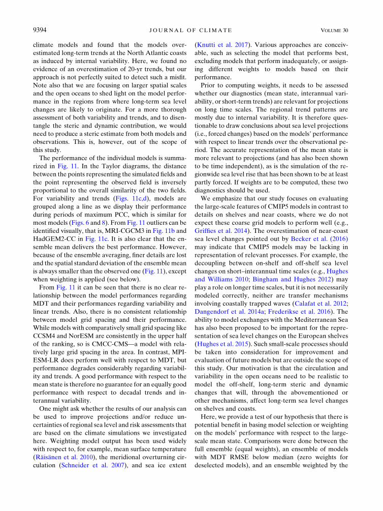
The performance of the individual models is summa-
rized in Fig. 11. In the Taylor diagrams, the distance
between the points representing the simulated fields and
the point representing the observed field is inversely
proportional to the overall similarity of the two fields.
For variability and trends (Figs. 11c,d), models are
grouped along a line as we display their performance
during periods of maximum PCC, which is similar for
most models (Figs. 6 and 8). From Fig. 11 outliers can be
identified visually, that is, MRI-CGCM3 in Fig. 11b and
HadGEM2-CC in Fig. 11c. It is also clear that the en-
semble mean delivers the best performance. However,
because of the ensemble averaging, finer details are lost
and the spatial standard deviation of the ensemble mean
is always smaller than the observed one (Fig. 11), except
when weighting is applied (see below).
From Fig. 11 it can be seen that there is no clear re-
lationship between the model performances regarding
MDT and their performances regarding variability and
linear trends. Also, there is no consistent relationship
between model grid spacing and their performance.
While models with comparatively small grid spacing like
CCSM4 and NorESM are consistently in the upper half
of the ranking, so is CMCC-CMS—a model with rela-
tively large grid spacing in the area. In contrast, MPI-
ESM-LR does perform well with respect to MDT, but
performance degrades considerably regarding variabil-
ity and trends. A good performance with respect to the
mean state is therefore no guarantee for an equally good
performance with respect to decadal trends and in-
terannual variability.
One might ask whether the results of our analysis can
be used to improve projections and/or reduce un-
certainties of regional sea level and risk assessments that
are based on the climate simulations we investigated
here. Weighting model output has been used widely
with respect to, for example, mean surface temperature
(Räisänen et al. 2010), the meridional overturning cir-
culation (Schneider et al. 2007), and sea ice extent
(Knutti et al. 2017). Various approaches are conceiv-
able, such as selecting the model that performs best,
excluding models that perform inadequately, or assign-
ing different weights to models based on their
performance.
Prior to computing weights, it needs to be assessed
whether our diagnostics (mean state, interannual vari-
ability, or short-term trends) are relevant for projections
on long time scales. The regional trend patterns are
mostly due to internal variability. It is therefore ques-
tionable to draw conclusions about sea level projections
(i.e., forced changes) based on the models’ performance
with respect to linear trends over the observational pe-
riod. The accurate representation of the mean state is
more relevant to projections (and has also been shown
to be time independent), as is the simulation of the re-
gionwide sea level rise that has been shown to be at least
partly forced. If weights are to be computed, these two
diagnostics should be used.
We emphasize that our study focuses on evaluating
the large-scale features of CMIP5 models in contrast to
details on shelves and near coasts, where we do not
expect these coarse grid models to perform well (e.g.,
Griffies et al. 2014). The overestimation of near-coast
sea level changes pointed out by Becker et al. (2016)
may indicate that CMIP5 models may be lacking in
representation of relevant processes. For example, the
decoupling between on-shelf and off-shelf sea level
changes on short–interannual time scales (e.g., Hughes
and Williams 2010; Bingham and Hughes 2012) may
play a role on longer time scales, but it is not necessarily
modeled correctly, neither are transfer mechanisms
involving coastally trapped waves (Calafat et al. 2012;
Dangendorf et al. 2014a; Frederikse et al. 2016). The
ability to model exchanges with the Mediterranean Sea
has also been proposed to be important for the repre-
sentation of sea level changes on the European shelves
(Hughes et al. 2015). Such small-scale processes should
be taken into consideration for improvement and
evaluation of future models but are outside the scope of
this study. Our motivation is that the circulation and
variability in the open oceans need to be realistic to
model the off-shelf, long-term steric and dynamic
changes that will, through the abovementioned or
other mechanisms, affect long-term sea level changes
on shelves and coasts.
Here, we provide a test of our hypothesis that there is
potential benefit in basing model selection or weighting
on the models’ performance with respect to the large-
scale mean state. Comparisons were done between the
full ensemble (equal weights), an ensemble of models
with MDT RMSE below median (zero weights for
deselected models), and an ensemble weighted by the
9394 JOURNAL OF CL IMATE VOLUME 30

inverse of the MDT RMSE. The according weights are
presented in Table S2, and the skill of the modified
multimodel means is included in Fig. 11. The perfor-
mance of the ensemble mean MDT improves only
marginally with the selection and weighting (Fig. 11a
and Fig. S6 in the supplemental material), as the full
ensemble already performed reasonably. However, the
strength and shape of the subpolar gyre becomes more
realistic with selection, but not with weighting. As ex-
pected, the performance with respect to trends and
variability does not improve with weighting or selecting,
but it does not deteriorate either (see also Figs. S7 and
S8 in the supplemental material).
More importantly, compared to using the full en-
semble, selecting models leads to a reduction in spread
of regional sea level ensemble projections along the
coastlines. A similar spread reduction is not apparent in
our weighted results (Figs. 12d–f). These results indicate
that climate model performance with respect to simu-
lating coastal sea level change should be assessed by
their oceanwide circulation and that selection should be
considered a liable option. This also underlines that
climatemodels need to be investigated further regarding
their steric and dynamic features and performance,
preferably on longer time scales as well.
5. Conclusions
We decomposed annually averaged sea level in the
northern North Atlantic and Nordic seas over a 20-yr
period into a mean state, linear trends, and residual in-
terannual variability to evaluate the performance of
climate models that are routinely used to project the
steric/dynamic component of future sea level changes
against altimetric observations.
We demonstrated that models are in general capable
of capturing the main features of observed sea level
changes if internal variability is taken into account. Our
study shows that the observed linear trend pattern over
the period 1993–2012 is likely dominated by internal
variability, whereas the mean state pattern is rather in-
sensitive to which 20-yr period is chosen. While no
forced signal could be detected in the regional trend
patterns, the observed regionwide average sea level rise
during the observational period (1993–2012) appears to
be partly forced.
According to our results, the ensemble mean out-
performs every single model, in line with what has been
shown in other studies (e.g., Yin et al. 2010; Simpson
et al. 2014). Risk assessments are, however, not only
interested in the most likely projection, but also the
uncertainty range around it. Our results also highlight
that the multimodel projection spread of regional
coastal sea level change can be reduced by selecting
models based on their ability to simulate the mean dy-
namic topography over the entire ocean region in
question. This highlights the general importance of a
realistic mean state representation as the most impor-
tant feature of ocean models in order to be suitable for
sea level projections.
Our selection–weighting approach is rather ad hoc
and simple and, as such, is subject to certain caveats
(e.g., we are not considering intermodel dependencies).
Sea level changes as investigated here are the result of
FIG. 12. Multimodel mean of sea level change from 1986–2005 to 2081–2100 (RCP4.5) with (a) no weighting (i.e., equal weights), (b) a
subselection of models with MDT RMSE smaller than median, and (c) models weighted with inverse of MDT RMSE. (d)–(f) The re-
spective ensemble standard deviation (also weighted when appropriate). The numbers on top of each map indicate the regionwide
average.
1 DECEMBER 2017 R I CHTER ET AL . 9395

several processes (air–sea heat exchange, redistribution
of heat and freshwater in the ocean, and dynamic
changes) and, in line with Knutti et al. (2017), several
variables (e.g., ocean temperature and salinity) and di-
agnostics (e.g., stratification) should be analyzed in
conjunction in order to assign sensible weights to
each model.
Acknowledgments. This work was funded by the
Austrian Science Fund (FP253620) and supported by
the Austrian Ministry of Science BMWF as part of the
UniInfrastrukturprogramm of the Focal Point Scientific
Computing at the University of Innsbruck. Support was
also provided by the Centre for ClimateDynamics at the
Bjerknes Centre, through the project iNcREASE. The
work is also partly supported by the ESA-CCI Sea Level
project funded under the ESRIN Contract 4000109872/
13/1-NB and by the Copernicus Arctic MFC project.
This paper has further profited from the outcome of
work with the ISSI international team on Contemporary
Regional and Global Sea-Level Rise: Assessment of
Satellite and In-Situ Observations and Climate Models
(www.issibern.ch). We acknowledge the World Climate
Research Programme’s Working Group on Coupled
Modelling, which is responsible for CMIP5, and we
thank the climate modeling groups (listed in Table S1 of
this paper) for producing and making available their
model output.
REFERENCES
Ablain, M., and Coauthors, 2015: Improved sea level record over
the satellite altimetry era (1993–2010) from the Climate
Change Initiative project. Ocean Sci., 11, 67–82, doi:10.5194/
os-11-67-2015.
——, J. Legeais, P. Prandi, M. Marcos, L. Fenoglio-Marc,
H. Dieng, J. Benveniste, and A. Cazenave, 2017: Satellite
altimetry-based sea level at global and regional scales. Surv.
Geophys., 38, 7–31, doi:10.1007/s10712-016-9389-8.
Andersen, O., P. Knudsen, and L. Stenseng, 2015: The DTU13
MSS (mean sea surface) and MDT (mean dynamic topogra-
phy) from 20 years of satellite altimetry. IGFS 2014: Pro-
ceedings of the 3rd International Gravity Field Service, S. Jin
and R. Barzaghi, Eds., IAG Symposia, Vol. 144, Springer,
111–121, doi:10.1007/1345_2015_182.
Becker, M., M. Karpytchev, M. Marcos, S. Jevrejeva, and
S. Lennartz-Sassinek, 2016: Do climate models reproduce
complexity of observed sea level changes?Geophys. Res. Lett.,
43, 5176–5184, doi:10.1002/2016GL068971.
Benveniste, J., and P. Knutsen, and the GUTS Team, 2007: The
GOCE User Toolbox. Proc. 3rd International GOCE User
Workshop, SP-627, Frascati, Italy, European Space Agency,
265–268.
Bilbao, R. A., J. M. Gregory, and N. Bouttes, 2015: Analysis of the
regional pattern of sea level change due to ocean dynamics
and density change for 1993–2099 in observations and CMIP5
AOGCMs. Climate Dyn., 45, 2647–2666, doi:10.1007/
s00382-015-2499-z.
Bingham, R., and C. Hughes, 2012: Local diagnostics to estimate
density-induced sea level variations over topography and
along coastlines. J. Geophys. Res., 117, C01013, doi:10.1029/
2011JC007276.
Böning, C. W., E. Behrens, A. Biastoch, K. Getzlaff, and J. L.
Bamber, 2016: Emerging impact of Greenland meltwater on
deepwater formation in the North Atlantic Ocean. Nat. Geo-
sci., 9, 523–527, doi:10.1038/ngeo2740.
Bruinsma, S. L., C. Förste, O. Abrikosov, J.-M. Lemoine, J.-C.
Marty, S. Mulet, M.-H. Rio, and S. Bonvalot, 2014: ESA’s
satellite-only gravity field model via the direct approach based
on all GOCE data. Geophys. Res. Lett., 41, 7508–7514,
doi:10.1002/2014GL062045.
Calafat, F., D. Chambers, and M. Tsimplis, 2012: Mechanisms of
decadal sea level variability in the eastern North Atlantic and
the Mediterranean Sea. J. Geophys. Res., 117, C09022,
doi:10.1029/2012JC008285.
Chafik, L., J. E. Ø. Nilsen, and S. Dangendorf, 2017: Impact of
North Atlantic teleconnection patterns on Northern Euro-
pean sea level. J. Mar. Sci. Eng., 5, 43, doi:10.3390/
jmse5030043.
Church, J. A., and Coauthors, 2013: Sea level change. Climate
Change 2013: The Physical Science Basis, T. F. Stocker et al.,
Eds., Cambridge University Press, 1137–1216.
Dangendorf, S., F. M. Calafat, A. Arns, T. Wahl, I. D. Haigh, and
J. Jensen, 2014a: Mean sea level variability in the North Sea:
Processes and implications. J. Geophys. Res. Oceans, 119,
6820–6841, doi:10.1002/2014JC009901.
——, D. Rybski, C. Mudersbach, A. Müller, E. Kaufmann,
E. Zorita, and J. Jensen, 2014b: Evidence for long-term
memory in sea level. Geophys. Res. Lett., 41, 5530–5537,
doi:10.1002/2014GL060538.
Dziewonski, A., and D. Anderson, 1981: Preliminary reference
Earth model. Phys. Earth Planet. Inter., 25, 297–356,
doi:10.1016/0031-9201(81)90046-7.
Farrell, W., and J. Clark, 1976: On postglacial sea level. Geo-
phys. J. Int., 46, 647–667, doi:10.1111/j.1365-246X.1976.
tb01252.x.
Frederikse, T., R. Riva, M. Kleinherenbrink, Y. Wada, M. Broeke,
and B. Marzeion, 2016: Closing the sea level budget on a re-
gional scale: Trends and variability on the Northwestern
European continental shelf. Geophys. Res. Lett., 43, 10 864–
10 872, doi:10.1002/2016GL070750.
Furevik, T., and J. E. O. Nilsen, 2005: Large-scale atmospheric
circulation variability and its impacts on the Nordic seas ocean
climate—A review. The Nordic seas: An Integrated Perspec-
tive, Geophys. Monogr., Vol. 158, Amer. Geophys. Union,
105–136, doi:10.1029/158GM09.
Griffies, S. M., and Coauthors, 2014: An assessment of global and
regional sea level for years 1993–2007 in a suite of interannual
CORE-II simulations. Ocean Modell., 78, 35–89, doi:10.1016/
j.ocemod.2014.03.004.
Grinsted, A., S. Jevrejeva, R. E. Riva, and D. Dahl-Jensen, 2015:
Sea level rise projections for northern Europe under RCP8.5.
Climate Res., 64, 15–23, doi:10.3354/cr01309.
Häkkinen, S., P. B. Rhines, and D. L. Worthen, 2013: Northern
North Atlantic sea surface height and ocean heat content
variability. J. Geophys. Res. Oceans, 118, 3670–3678,
doi:10.1002/jgrc.20268.
Hughes, C. W., and S. D. Williams, 2010: The color of sea level:
Importance of spatial variations in spectral shape for assessing
the significance of trends. J. Geophys. Res., 115, C10048,
doi:10.1029/2010JC006102.
9396 JOURNAL OF CL IMATE VOLUME 30

——, R. J. Bingham, V. Roussenov, J. Williams, and P. L.
Woodworth, 2015: The effect of Mediterranean exchange flow
on European time mean sea level. Geophys. Res. Lett., 42,
466–474, doi:10.1002/2014GL062654.
Jin, S., G. Feng, and O. Andersen, 2014: Errors of mean dy-
namic topography and geostrophic current estimates in
China’s marginal seas from GOCE and satellite altime-
try. J. Atmos. Oceanic Technol., 31, 2544–2555, doi:10.1175/
JTECH-D-13-00243.1.
Johannessen, J. A., and Coauthors, 2003: The European Gravity
Field and Steady-State Ocean Circulation Explorer satellite
mission: Its impact on geophysics. Surv. Geophys., 24, 339–
386, doi:10.1023/B:GEOP.0000004264.04667.5e.
Knudsen, P., R. Bingham, O. Andersen, and M.-H. Rio, 2011: A
global mean dynamic topography and ocean circulation esti-
mation using a preliminaryGOCE gravity model. J. Geod., 85,
861–879, doi:10.1007/s00190-011-0485-8.
Knutti, R., J. Sedlá�cek, B. M. Sanderson, R. Lorenz, E. M. Fischer,
and V. Eyring, 2017: A climate model projection weighting
scheme accounting for performance and interdependence.Geo-
phys. Res. Lett., 44, 1909–1918, doi:10.1002/2016GL072012.
Landerer, F. W., P. J. Gleckler, and T. Lee, 2014: Evaluation of
CMIP5 dynamic sea surface height multi-model simulations
against satellite observations. Climate Dyn., 43, 1271–1283,
doi:10.1007/s00382-013-1939-x.
Lyu, K., X. Zhang, J. A. Church, A. B. Slangen, and J. Hu, 2014:
Time of emergence for regional sea-level change.Nat. Climate
Change, 4, 1006–1010, doi:10.1038/nclimate2397.
Marzeion, B., A. H. Jarosch, and M. Hofer, 2012: Past and future
sea-level change from the surface mass balance of glaciers.
Cryosphere, 6, 1295–1322, doi:10.5194/tc-6-1295-2012.
——, P. W. Leclercq, J. G. Cogley, and A. H. Jarosch, 2015: Brief
communication: Global reconstructions of glacier mass
change during the 20th century are consistent. Cryosphere, 9,
2399–2404, doi:10.5194/tc-9-2399-2015.
Meyssignac, B., D. Salas y Melia, M. Becker, W. Llovel, and
A. Cazenave, 2012: Tropical Pacific spatial trend patterns in
observed sea level: Internal variability and/or anthropogenic
signature? Climate Past, 8, 787–802, doi:10.5194/cp-8-787-2012.
Milne, G., and J. Mitrovica, 1998: Postglacial sea-level change on a
rotating Earth. Geophys. J. Int., 133, 1–19, doi:10.1046/
j.1365-246X.1998.1331455.x.
Mitrovica, J., andW. Peltier, 1991: On postglacial geoid subsidence
over the equatorial oceans. J. Geophys. Res., 96, 20 053–
20 071, doi:10.1029/91JB01284.
Mitrovica, J. X., M. E. Tamisiea, J. L. Davis, andG. A.Milne, 2001:
Recent mass balance of polar ice sheets inferred from patterns
of global sea-level change. Nature, 409, 1026–1029, doi:10.1038/
35059054.
New, M., D. Lister, M. Hulme, and I. Makin, 2002: A high-
resolution data set of surface climate over global land areas.
Climate Res., 21, 1–25, doi:10.3354/cr021001.Nilsen, J. E. O., Y. Gao, H. Drange, T. Furevik, and M. Bentsen,
2003: Simulated North Atlantic-Nordic seas water mass ex-
changes in an isopycnic coordinate OGCM. Geophys. Res.
Lett., 30, 1536, doi:10.1029/2002GL016597.
Palanisamy, H., B. Meyssignac, A. Cazenave, and T. Delcroix,
2015: Is anthropogenic sea level fingerprint already detectable
in the Pacific Ocean? Environ. Res. Lett., 10, 084024,
doi:10.1088/1748-9326/10/8/084024.
Peltier, W. R., 2004: Global glacial isostasy and the surface of the
ice-age Earth: The ICE-5G (VM2) model and GRACE.
Annu. Rev. Earth Planet. Sci., 32, 111–149, doi:10.1146/
annurev.earth.32.082503.144359.
Perrette,M., F. Landerer, R. Riva, K. Frieler, andM.Meinshausen,
2013: A scaling approach to project regional sea level rise and
its uncertainties. Earth Syst. Dyn., 4, 11–29, doi:10.5194/
esd-4-11-2013.
Rahmstorf, S., G. Feulner, M. E. Mann, A. Robinson,
S. Rutherford, and E. J. Schaffernicht, 2015: Exceptional
twentieth-century slowdown in Atlantic Ocean overturning
circulation. Nat. Climate Change, 5, 475–480, doi:10.1038/
nclimate2554.
Räisänen, J., L. Ruokolainen, and J. Ylhäisi, 2010: Weighting
of model results for improving best estimates of climate
change. Climate Dyn., 35, 407–422, doi:10.1007/
s00382-009-0659-8.
Raj, R. P., 2017: Surface velocity estimates of the north IndianOcean
from satellite gravity and altimeter missions. Int. J. Remote
Sens., 38, 296–313, doi:10.1080/01431161.2016.1266106.
Richter, K., and B. Marzeion, 2014: Earliest local emergence of
forced dynamic and steric sea-level trends in climate models.
Environ. Res. Lett., 9, 114009, doi:10.1088/1748-9326/9/11/
114009.
——, J. E. Ø. Nilsen, and H. Drange, 2012a: Contributions to sea
level variability along the Norwegian coast for 1960–2010.
J. Geophys. Res., 117, C05038, doi:10.1029/2011JC007826.——,O. Segtnan, and T. Furevik, 2012b: Variability of the Atlantic
inflow to the Nordic seas and its causes inferred from obser-
vations of sea surface height. J. Geophys. Res., 117, C04004,
doi:10.1029/2011JC007719.
——, B. Marzeion, and R. Riva, 2017: The effect of spatial aver-
aging and glacier melt on detecting a forced signal in regional
sea level. Environ. Res. Lett., 12, 034004, doi:10.1088/
1748-9326/aa5967.
Riva, R. E.M., J. L. Bamber, D. A. Lavallée, and B.Wouters, 2010:
Sea-level fingerprint of continental water and ice mass change
from GRACE. Geophys. Res. Lett., 37, L19605, doi:10.1029/
2010GL044770.
Sandø, A., J. Nilsen, T. Eldevik, and M. Bentsen, 2012:
Mechanisms for variable North Atlantic–Nordic seas
exchanges. J. Geophys. Res., 117, C12006, doi:10.1029/
2012JC008177.
Santer, B. D., K. E. Taylor, T. M. L. Wigley, J. E. Penner, P. D.
Jones, and U. Cubasch, 1995: Towards the detection and at-
tribution of an anthropogenic effect on climate. Climate Dyn.,
12, 77–100, doi:10.1007/BF00223722.
Schaeffer, P., Y. Faugére, J. F. Legeais, A. Ollivier, T. Guinle, and
N. Picot, 2012: The CNES_CLS11 global mean sea surface
computed from 16 years of satellite altimeter data. Mar.
Geod., 35, 3–19, doi:10.1080/01490419.2012.718231.Schneider, B., M. Latif, and A. Schmittner, 2007: Evaluation of
different methods to assess model projections of the future
evolution of the Atlantic meridional overturning circulation.
J. Climate, 20, 2121–2132, doi:10.1175/JCLI4128.1.
Sen Gupta, A., N. C. Jourdain, J. N. Brown, and D. Monselesan,
2013: Climate drift in the CMIP5 models. J. Climate, 26, 8597–
8615, doi:10.1175/JCLI-D-12-00521.1.
Shepherd, A., and Coauthors, 2012: A reconciled estimate of ice-
sheet mass balance. Science, 338, 1183–1189, doi:10.1126/
science.1228102.
Simpson, M. J. R., K. Breili, and H. P. Kierulf, 2014: Estimates of
twenty-first century sea-level changes for Norway. Climate
Dyn., 42, 1405–1424, doi:10.1007/s00382-013-1900-z.
1 DECEMBER 2017 R I CHTER ET AL . 9397

——, and Coauthors, 2015: Sea level change for Norway: Past
and present observations and projections to 2100. NCCS
Rep. 1/2015, Norwegian Centre for Climate Services, 156 pp.,
http://www.miljodirektoratet.no/Documents/publikasjoner/
M405/M405.pdf.
Slangen, A., C. Katsman, R. van de Wal, L. Vermeersen, and
R. Riva, 2012: Towards regional projections of twenty-first
century sea-level change based on IPCC-SRES scenarios.
Climate Dyn., 38, 1191–1209, doi:10.1007/s00382-011-1057-6.
——, M. Carson, C. Katsman, R. van de Wal, A. Köhl,L. Vermeersen, and D. Stammer, 2014: Projecting twenty-first
century regional sea-level changes.Climatic Change, 124, 317–332, doi:10.1007/s10584-014-1080-9.
——, J. A. Church, X. Zhang, and D. P. Monselesan, 2015: The sea
level response to external forcings in historical simulations of
CMIP5 climate models. J. Climate, 28, 8521–8539, doi:10.1175/
JCLI-D-15-0376.1.
Tamisiea, M. E., 2011: Ongoing glacial isostatic contributions to
observations of sea level change. Geophys. J. Int., 186, 1036–1044, doi:10.1111/j.1365-246X.2011.05116.x.
Tapley, B. D., and Coauthors, 1994: Precision orbit determination
for TOPEX/POSEIDON. J. Geophys. Res. Oceans, 99,
24 383–24 404, doi:10.1029/94JC01645.
Taylor, K., R. Stouffer, andG.Meehl, 2012:An overviewof CMIP5
and the experiment design. Bull. Amer. Meteor. Soc., 93, 485–
498, doi:10.1175/BAMS-D-11-00094.1.
Thomson, R. E., and W. J. Emery, 2001:Data Analysis Methods in
Physical Oceanography. Elsevier, 654 pp.
Ulbrich, U., and M. Christoph, 1999: A shift of the NAO and in-
creasing storm track activity over Europe due to anthropo-
genic greenhouse gas forcing. Climate Dyn., 15, 551–559,
doi:10.1007/s003820050299.
Van Vuuren, D., and Coauthors, 2011: The representative
concentration pathways: An overview. Climatic Change, 109,
5–31, doi:10.1007/s10584-011-0148-z.
Yin, J. J., S. M. Griffies, and R. J. Stouffer, 2010: Spatial
variability of sea level rise in twenty-first century
projections. J. Climate, 23, 4585–4607, doi:10.1175/
2010JCLI3533.1.
9398 JOURNAL OF CL IMATE VOLUME 30
Related Documents