USMC U.S. Marine Corps USMC Mountain Warfare Operations DISTRIBUTION STATEMENT A: Approved for public release; distribution is unlimited. PCN 147 000003 00 MCTP 12-10A (Formerly MCWP 3-35.1)

Welcome message from author
This document is posted to help you gain knowledge. Please leave a comment to let me know what you think about it! Share it to your friends and learn new things together.
Transcript
USMC
U.S. Marine Corps
USMC
Mountain Warfare Operations
DISTRIBUTION STATEMENT A: Approved for public release; distribution is unlimited.
PCN 147 000003 00
MCTP 12-10A(Formerly MCWP 3-35.1)
DEPARTMENT OF THE NAVYHeadquarters United States Marine Corps
Washington, D.C. 20350-3000
4 April 2018
CHANGE 1 to MCTP 12-10AMountain Warfare Operations
1. This publication has been edited to ensure gender neutrality of all applicable and appropriate terms, except those terms governed by higher authority. No other content has been affected.
2. File this transmittal sheet in the front of this publication.
Reviewed and approved this date.
BY DIRECTION OF THE COMMANDANT OF THE MARINE CORPS
ROBERT S. WALSHLieutenant General, U.S. Marine Corps
Deputy Commandant for Combat Development and Integration
Publication Control Numbers:Publication: 147 000003 00Change: 147 000003 01

CD&I (C 116)
2 May 2016
ERRATUM
to
MCWP 3-35.1
MOUNTAIN WARFARE OPERATIONS
1. Change all instances of MCWP 3-35.1, Mountain Warfare Operations, to MCTP 12-10A,
Mountain Warfare Operations.
2. Change PCN 143 000174 00 to PCN 147 000003 00
3. File this transmittal sheet in the front of this publication.
PCN 147 000003 80
DEPARTMENT OF THE NAVYHeadquarters United States Marine Corps
Washington, D.C. 20380-1775
28 February 2014
FOREWORD
Marine Corps Warfighting Publication (MCWP) 3-35.1 Mountain Warfare Operations, isa reference for all unit commanders and their staffs (trained or untrained in mountain war-fare) and all leaders from the company level through regiment or brigade for use in opera-tions that occur in mountainous terrain, snow, or cold weather. This publication isdesigned to be used with Marine Corps Reference Publication (MCRP) 3-35.1A, SmallUnit Leader’s Guide to Mountain Warfare Operations; MCRP 3-35.1B, MountainLeader’s Guide to Winter Operations; MCRP 3-35.1C, Mountain Leader’s Guide toMountain Warfare Operations; and MCRP 3-35.1D, Cold Region Operations. These pub-lications cover a broad range of unit planning considerations that can be used across arange of military operations. This publication references formal individual and collectivemountain warfare training programs available within the Department of Defense.
Because of the rapid turnover in personnel, operating tempo, multitude of training com-mitments, and constraint of training resources for these environments, the Marine CorpsMountain Warfare Training Center cannot train all Marines. Therefore, this publica-tion—used in conjunction with MCRP 3-35.1A, MCRP 3-35.1B, MCRP 3-35.1C, andMCRP 3-35.1D—identifies the skills that Marines need to be successful in mountain-ous, snow, or cold weather environments. During combat, these publications provideMarines with the doctrinal references they need to augment the instruction they receivefrom their unit’s qualified mountain leaders.
The Marine Corps doctrinal proponent for mountain and cold regions operations is theMarine Corps Mountain Warfare Training Center (MCMWTC), Bridgeport, California.Contact MCMWTC, Operations and Training for further information.
This publication supersedes Fleet Marine Force Manual (FMFM) 7-29, Mountain Opera-tions, dated January 1980; FMFM 7-21, Tactical Fundamentals for Cold Weather Opera-tions, dated September 1992; and FMFM 7-22, Tactical Fundamentals for Aviation inCold Weather Operations, dated May 1991.
Reviewed and approved this date.
BY DIRECTION OF THE COMMANDANT OF THE MARINE CORPS
K. J. GLUECK, JR.Lieutenant General, U.S. Marine Corps
Deputy Commandant for Combat Development and Integration

Publication Control Number: 143 000174 00
DISTRIBUTION STATEMENT A: Approved for public release; distribution is unlimited.

Mountain Warfare Operations __________________________________________________________________________________ iii
TABLE OF CONTENTS
Chapter 1. Overview
Historical Perspective . . . . . . . . . . . . . . . . . . . . . . . . . . . . . . . . . . . . . . . . . . 1-1Present Imperative for Mountain Doctrine . . . . . . . . . . . . . . . . . . . . . . . . . . 1-2The World’s Mountainous Regions . . . . . . . . . . . . . . . . . . . . . . . . . . . . . . . 1-3
Mountainous Terrain . . . . . . . . . . . . . . . . . . . . . . . . . . . . . . . . . . . . . . 1-4Glaciers . . . . . . . . . . . . . . . . . . . . . . . . . . . . . . . . . . . . . . . . . . . . . . . . . 1-5Mountain Classifications . . . . . . . . . . . . . . . . . . . . . . . . . . . . . . . . . . . 1-5
Weather. . . . . . . . . . . . . . . . . . . . . . . . . . . . . . . . . . . . . . . . . . . . . . . . . . . . . 1-6Climate Influences . . . . . . . . . . . . . . . . . . . . . . . . . . . . . . . . . . . . . . . . 1-7Temperature . . . . . . . . . . . . . . . . . . . . . . . . . . . . . . . . . . . . . . . . . . . . . 1-7Wind . . . . . . . . . . . . . . . . . . . . . . . . . . . . . . . . . . . . . . . . . . . . . . . . . . . 1-7Precipitation . . . . . . . . . . . . . . . . . . . . . . . . . . . . . . . . . . . . . . . . . . . . . 1-8Fog . . . . . . . . . . . . . . . . . . . . . . . . . . . . . . . . . . . . . . . . . . . . . . . . . . . . 1-9
Chapter 2. Operations
Planning Considerations . . . . . . . . . . . . . . . . . . . . . . . . . . . . . . . . . . . . . . . . 2-1Command and Control Considerations. . . . . . . . . . . . . . . . . . . . . . . . . . . . . 2-2
Leadership . . . . . . . . . . . . . . . . . . . . . . . . . . . . . . . . . . . . . . . . . . . . . . 2-2Command Posts . . . . . . . . . . . . . . . . . . . . . . . . . . . . . . . . . . . . . . . . . . 2-3
Offensive Operations . . . . . . . . . . . . . . . . . . . . . . . . . . . . . . . . . . . . . . . . . . 2-3Types of Offensive Operations. . . . . . . . . . . . . . . . . . . . . . . . . . . . . . . 2-4Forms of Offensive Maneuver . . . . . . . . . . . . . . . . . . . . . . . . . . . . . . . 2-6
Defensive Operations . . . . . . . . . . . . . . . . . . . . . . . . . . . . . . . . . . . . . . . . . . 2-8Mobile Defense. . . . . . . . . . . . . . . . . . . . . . . . . . . . . . . . . . . . . . . . . . 2-10Position Defense . . . . . . . . . . . . . . . . . . . . . . . . . . . . . . . . . . . . . . . . . 2-11Retrograde . . . . . . . . . . . . . . . . . . . . . . . . . . . . . . . . . . . . . . . . . . . . . 2-12
Stability Operations . . . . . . . . . . . . . . . . . . . . . . . . . . . . . . . . . . . . . . . . . . 2-12Civil Considerations . . . . . . . . . . . . . . . . . . . . . . . . . . . . . . . . . . . . . . 2-12District Stability Framework . . . . . . . . . . . . . . . . . . . . . . . . . . . . . . . 2-13
Operational Advantages and Disadvantages . . . . . . . . . . . . . . . . . . . . . . . 2-14Planning and Intelligence Preparation of the Battlespace . . . . . . . . . . . . . 2-15
Chapter 3. Intelligence
Planning . . . . . . . . . . . . . . . . . . . . . . . . . . . . . . . . . . . . . . . . . . . . . . . . . . . . 3-1Collection . . . . . . . . . . . . . . . . . . . . . . . . . . . . . . . . . . . . . . . . . . . . . . . . . . . 3-2Human Environment. . . . . . . . . . . . . . . . . . . . . . . . . . . . . . . . . . . . . . . . . . . 3-2Irregular Warfare Considerations . . . . . . . . . . . . . . . . . . . . . . . . . . . . . . . . . 3-3Reconnaissance and Surveillance . . . . . . . . . . . . . . . . . . . . . . . . . . . . . . . . . 3-4
Operational Considerations . . . . . . . . . . . . . . . . . . . . . . . . . . . . . . . . . 3-5Reconnaissance in Force . . . . . . . . . . . . . . . . . . . . . . . . . . . . . . . . . . . 3-5
iv _____________________________________________________________________________________________________ MCWP 3-35.1
Engineer Reconnaissance . . . . . . . . . . . . . . . . . . . . . . . . . . . . . . . . . . . 3-6Chemical, Biological, Radiological, Nuclear, and High-Yield
Explosives Reconnaissance. . . . . . . . . . . . . . . . . . . . . . . . . . . . . . 3-6Air and Overhead Reconnaissance . . . . . . . . . . . . . . . . . . . . . . . . . . . . 3-6Signals Intelligence . . . . . . . . . . . . . . . . . . . . . . . . . . . . . . . . . . . . . . . . 3-7Human Intelligence . . . . . . . . . . . . . . . . . . . . . . . . . . . . . . . . . . . . . . . . 3-7Geospatial Intelligence . . . . . . . . . . . . . . . . . . . . . . . . . . . . . . . . . . . . . 3-7Ground/Long-Range Surveillance . . . . . . . . . . . . . . . . . . . . . . . . . . . . 3-8Mountain Pickets. . . . . . . . . . . . . . . . . . . . . . . . . . . . . . . . . . . . . . . . . . 3-8
Chapter 4. Maneuver and Movement
Air Movement . . . . . . . . . . . . . . . . . . . . . . . . . . . . . . . . . . . . . . . . . . . . . . . . 4-1Mounted Movement . . . . . . . . . . . . . . . . . . . . . . . . . . . . . . . . . . . . . . . . . . . 4-1
Driving . . . . . . . . . . . . . . . . . . . . . . . . . . . . . . . . . . . . . . . . . . . . . . . . . 4-2Convoy Planning. . . . . . . . . . . . . . . . . . . . . . . . . . . . . . . . . . . . . . . . . . 4-2Mines and Improvised Explosive Devices . . . . . . . . . . . . . . . . . . . . . . 4-3
Dismounted Movement. . . . . . . . . . . . . . . . . . . . . . . . . . . . . . . . . . . . . . . . . 4-3Route Planning . . . . . . . . . . . . . . . . . . . . . . . . . . . . . . . . . . . . . . . . . . . 4-4Individual Loads . . . . . . . . . . . . . . . . . . . . . . . . . . . . . . . . . . . . . . . . . . 4-5Terrain Analysis . . . . . . . . . . . . . . . . . . . . . . . . . . . . . . . . . . . . . . . . . . 4-5Mountain Streams and Fords . . . . . . . . . . . . . . . . . . . . . . . . . . . . . . . . 4-5Casualty Evacuation . . . . . . . . . . . . . . . . . . . . . . . . . . . . . . . . . . . . . . . 4-6General Considerations . . . . . . . . . . . . . . . . . . . . . . . . . . . . . . . . . . . . . 4-6
Chapter 5. Engineering
Organization . . . . . . . . . . . . . . . . . . . . . . . . . . . . . . . . . . . . . . . . . . . . . . . . . 5-1Task Organization . . . . . . . . . . . . . . . . . . . . . . . . . . . . . . . . . . . . . . . . . 5-1Joint Engineer Support Elements . . . . . . . . . . . . . . . . . . . . . . . . . . . . . 5-1
Mobility. . . . . . . . . . . . . . . . . . . . . . . . . . . . . . . . . . . . . . . . . . . . . . . . . . . . . 5-2Gap Crossing. . . . . . . . . . . . . . . . . . . . . . . . . . . . . . . . . . . . . . . . . . . . . 5-2Counter-Improvised Explosive Device/Mine Operations. . . . . . . . . . . 5-3Engineer Reconnaissance . . . . . . . . . . . . . . . . . . . . . . . . . . . . . . . . . . . 5-4
Countermobility . . . . . . . . . . . . . . . . . . . . . . . . . . . . . . . . . . . . . . . . . . . . . . 5-5Obstacles . . . . . . . . . . . . . . . . . . . . . . . . . . . . . . . . . . . . . . . . . . . . . . . . 5-5Mines. . . . . . . . . . . . . . . . . . . . . . . . . . . . . . . . . . . . . . . . . . . . . . . . . . . 5-6Avalanches . . . . . . . . . . . . . . . . . . . . . . . . . . . . . . . . . . . . . . . . . . . . . . 5-6
Survivability . . . . . . . . . . . . . . . . . . . . . . . . . . . . . . . . . . . . . . . . . . . . . . . . . 5-6Elevation of Forward Operating Bases/Combat Outposts in
Relation to Surrounding Terrain . . . . . . . . . . . . . . . . . . . . . . . . . . 5-6Overhead Cover . . . . . . . . . . . . . . . . . . . . . . . . . . . . . . . . . . . . . . . . . . 5-6Forward Operating Base Site Selection . . . . . . . . . . . . . . . . . . . . . . . . 5-7Snow Removal/Drainage . . . . . . . . . . . . . . . . . . . . . . . . . . . . . . . . . . . 5-7
General Engineering . . . . . . . . . . . . . . . . . . . . . . . . . . . . . . . . . . . . . . . . . . . 5-7Horizontal Construction . . . . . . . . . . . . . . . . . . . . . . . . . . . . . . . . . . . . 5-7Vertical Construction . . . . . . . . . . . . . . . . . . . . . . . . . . . . . . . . . . . . . . 5-8Utilities . . . . . . . . . . . . . . . . . . . . . . . . . . . . . . . . . . . . . . . . . . . . . . . . . 5-9
Mountain Warfare Operations ___________________________________________________________________________________ v
Heavy Equipment . . . . . . . . . . . . . . . . . . . . . . . . . . . . . . . . . . . . . . . . 5-10Underground Construction and Confined Spaces . . . . . . . . . . . . . . . 5-11
Chapter 6. Logistics and Sustainment
General Planning Considerations . . . . . . . . . . . . . . . . . . . . . . . . . . . . . . . . . 6-1Logistic Support Concept . . . . . . . . . . . . . . . . . . . . . . . . . . . . . . . . . . . 6-1Logistic Cross-Training . . . . . . . . . . . . . . . . . . . . . . . . . . . . . . . . . . . . 6-2Interoperability . . . . . . . . . . . . . . . . . . . . . . . . . . . . . . . . . . . . . . . . . . . 6-2Sustainment Challenges . . . . . . . . . . . . . . . . . . . . . . . . . . . . . . . . . . . . 6-2Waste Management . . . . . . . . . . . . . . . . . . . . . . . . . . . . . . . . . . . . . . . 6-3Supplies and Equipment Accountability . . . . . . . . . . . . . . . . . . . . . . . 6-3Route Security . . . . . . . . . . . . . . . . . . . . . . . . . . . . . . . . . . . . . . . . . . . 6-3Aviation Support. . . . . . . . . . . . . . . . . . . . . . . . . . . . . . . . . . . . . . . . . . 6-4Winterization . . . . . . . . . . . . . . . . . . . . . . . . . . . . . . . . . . . . . . . . . . . . 6-4
Supply . . . . . . . . . . . . . . . . . . . . . . . . . . . . . . . . . . . . . . . . . . . . . . . . . . . . . . 6-4Food and Water (Class I) . . . . . . . . . . . . . . . . . . . . . . . . . . . . . . . . . . . 6-4Clothing, Individual Equipment, and Tents (Class II) . . . . . . . . . . . . . 6-6Petroleum, Oils, and Lubricants (Class III) . . . . . . . . . . . . . . . . . . . . . 6-7Other Supplies . . . . . . . . . . . . . . . . . . . . . . . . . . . . . . . . . . . . . . . . . . . 6-7
Vehicle and Equipment Operator Considerations . . . . . . . . . . . . . . . . . . . . 6-9Vehicle Loading . . . . . . . . . . . . . . . . . . . . . . . . . . . . . . . . . . . . . . . . . . 6-9Vehicle Operation. . . . . . . . . . . . . . . . . . . . . . . . . . . . . . . . . . . . . . . . . 6-9Vehicle Rollover. . . . . . . . . . . . . . . . . . . . . . . . . . . . . . . . . . . . . . . . . 6-10Vehicle Recovery . . . . . . . . . . . . . . . . . . . . . . . . . . . . . . . . . . . . . . . . 6-10
Vehicle Maintenance . . . . . . . . . . . . . . . . . . . . . . . . . . . . . . . . . . . . . . . . . 6-10Maintenance Personnel. . . . . . . . . . . . . . . . . . . . . . . . . . . . . . . . . . . . 6-10Preventive Maintenance and Repair . . . . . . . . . . . . . . . . . . . . . . . . . . 6-11Field Maintenance . . . . . . . . . . . . . . . . . . . . . . . . . . . . . . . . . . . . . . . 6-11
Distribution and Transportation . . . . . . . . . . . . . . . . . . . . . . . . . . . . . . . . . 6-11Ground Distribution . . . . . . . . . . . . . . . . . . . . . . . . . . . . . . . . . . . . . . 6-12River Distribution . . . . . . . . . . . . . . . . . . . . . . . . . . . . . . . . . . . . . . . . 6-14Air Distribution. . . . . . . . . . . . . . . . . . . . . . . . . . . . . . . . . . . . . . . . . . 6-14
Medical Support Considerations . . . . . . . . . . . . . . . . . . . . . . . . . . . . . . . . 6-16Casualty Collection and Evacuation. . . . . . . . . . . . . . . . . . . . . . . . . . 6-16Medical Evacuation . . . . . . . . . . . . . . . . . . . . . . . . . . . . . . . . . . . . . . 6-17
Acclimatization. . . . . . . . . . . . . . . . . . . . . . . . . . . . . . . . . . . . . . . . . . . . . . 6-17
Chapter 7. Aviation
Antiair Warfare. . . . . . . . . . . . . . . . . . . . . . . . . . . . . . . . . . . . . . . . . . . . . . . 7-1Planning Considerations . . . . . . . . . . . . . . . . . . . . . . . . . . . . . . . . . . . . 7-1Unique Capabilities and Limitations of Marine Corps Low
Altitude Air Defense. . . . . . . . . . . . . . . . . . . . . . . . . . . . . . . . . . . 7-2Suppression of Enemy Air Defenses and Air-to-Air
Planning Considerations . . . . . . . . . . . . . . . . . . . . . . . . . . . . . . . . 7-3Training Considerations . . . . . . . . . . . . . . . . . . . . . . . . . . . . . . . . . . . . 7-3
vi _____________________________________________________________________________________________________ MCWP 3-35.1
Air Reconnaissance. . . . . . . . . . . . . . . . . . . . . . . . . . . . . . . . . . . . . . . . . . . . 7-3Attack Reconnaissance Helicopter Operations . . . . . . . . . . . . . . . . . . . 7-3Unmanned Aircraft Systems . . . . . . . . . . . . . . . . . . . . . . . . . . . . . . . . . 7-4
Assault Support . . . . . . . . . . . . . . . . . . . . . . . . . . . . . . . . . . . . . . . . . . . . . . . 7-6Air Delivery . . . . . . . . . . . . . . . . . . . . . . . . . . . . . . . . . . . . . . . . . . . . . 7-6Combat Search and Rescue and Tactical Recovery of Aircraft
and Personnel . . . . . . . . . . . . . . . . . . . . . . . . . . . . . . . . . . . . . . . . 7-7Medical, Casualty, and Air Evacuations . . . . . . . . . . . . . . . . . . . . . . . . 7-7Combat Assault Transport . . . . . . . . . . . . . . . . . . . . . . . . . . . . . . . . . . 7-8Airborne Command and Control. . . . . . . . . . . . . . . . . . . . . . . . . . . . . . 7-8Battlefield Illumination . . . . . . . . . . . . . . . . . . . . . . . . . . . . . . . . . . . . . 7-8Landing Zone Considerations . . . . . . . . . . . . . . . . . . . . . . . . . . . . . . . . 7-9Snow-Covered Terrain . . . . . . . . . . . . . . . . . . . . . . . . . . . . . . . . . . . . . 7-9Air-Ground Integration and Training Considerations. . . . . . . . . . . . . 7-10
Marine Corps-Specific Control of Aircraft and Missiles . . . . . . . . . . . . . . 7-10Marine Air Command and Control System Considerations . . . . . . . . 7-10Tactical Air Operations Center Considerations . . . . . . . . . . . . . . . . . 7-12Joint/Coalition Theater Command and Control Architecture . . . . . . . 7-13
Electronic Warfare . . . . . . . . . . . . . . . . . . . . . . . . . . . . . . . . . . . . . . . . . . . 7-13Weather and Terrain . . . . . . . . . . . . . . . . . . . . . . . . . . . . . . . . . . . . . . 7-13Time On Station . . . . . . . . . . . . . . . . . . . . . . . . . . . . . . . . . . . . . . . . . 7-13Electronic Attack. . . . . . . . . . . . . . . . . . . . . . . . . . . . . . . . . . . . . . . . . 7-13Electronic Warfare Support . . . . . . . . . . . . . . . . . . . . . . . . . . . . . . . . 7-14Electronic Protect . . . . . . . . . . . . . . . . . . . . . . . . . . . . . . . . . . . . . . . . 7-14Training Considerations . . . . . . . . . . . . . . . . . . . . . . . . . . . . . . . . . . . 7-14
Offensive Air Support . . . . . . . . . . . . . . . . . . . . . . . . . . . . . . . . . . . . . . . . . 7-15Planning Considerations . . . . . . . . . . . . . . . . . . . . . . . . . . . . . . . . . . . 7-15Ordnance Versus Fuel . . . . . . . . . . . . . . . . . . . . . . . . . . . . . . . . . . . . . 7-15Forward Operating Base and Forward Arming and Refueling
Point Locations . . . . . . . . . . . . . . . . . . . . . . . . . . . . . . . . . . . . . . 7-15Ordnance Selection . . . . . . . . . . . . . . . . . . . . . . . . . . . . . . . . . . . . . . . 7-15Reduced Power Available . . . . . . . . . . . . . . . . . . . . . . . . . . . . . . . . . . 7-16Geometry of Fires . . . . . . . . . . . . . . . . . . . . . . . . . . . . . . . . . . . . . . . . 7-16Weather . . . . . . . . . . . . . . . . . . . . . . . . . . . . . . . . . . . . . . . . . . . . . . . . 7-16Deep Air Support . . . . . . . . . . . . . . . . . . . . . . . . . . . . . . . . . . . . . . . . 7-16Training Considerations . . . . . . . . . . . . . . . . . . . . . . . . . . . . . . . . . . . 7-16
Aviation Ground Support . . . . . . . . . . . . . . . . . . . . . . . . . . . . . . . . . . . . . . 7-17Planning Considerations . . . . . . . . . . . . . . . . . . . . . . . . . . . . . . . . . . . 7-17Forward Arming and Refueling Points . . . . . . . . . . . . . . . . . . . . . . . . 7-17Forward Operating Base Locations. . . . . . . . . . . . . . . . . . . . . . . . . . . 7-17
Aviation Logistic Support in a Mountainous Environment . . . . . . . . . . . . 7-17Planning Considerations . . . . . . . . . . . . . . . . . . . . . . . . . . . . . . . . . . . 7-17Material Storage and Handling Considerations . . . . . . . . . . . . . . . . . 7-18Training Considerations . . . . . . . . . . . . . . . . . . . . . . . . . . . . . . . . . . . 7-19
Mountain Warfare Operations __________________________________________________________________________________ vii
Chapter 8. Fires
Organization for Artillery . . . . . . . . . . . . . . . . . . . . . . . . . . . . . . . . . . . . . . . 8-1Movement and Positioning . . . . . . . . . . . . . . . . . . . . . . . . . . . . . . . . . . . . . . 8-2
Reconnaissance, Selection, and Occupation of a Position . . . . . . . . . . 8-2Movement . . . . . . . . . . . . . . . . . . . . . . . . . . . . . . . . . . . . . . . . . . . . . . . 8-2Air Movement. . . . . . . . . . . . . . . . . . . . . . . . . . . . . . . . . . . . . . . . . . . . 8-2Position Selection . . . . . . . . . . . . . . . . . . . . . . . . . . . . . . . . . . . . . . . . . 8-2Multiple Launch Rocket System M270A1 and High Mobility
Artillery Rocket System M142 Position Considerations . . . . . . . 8-3Acquisition and Observation . . . . . . . . . . . . . . . . . . . . . . . . . . . . . . . . . . . . 8-3
Radar Considerations . . . . . . . . . . . . . . . . . . . . . . . . . . . . . . . . . . . . . . 8-3Observer Considerations. . . . . . . . . . . . . . . . . . . . . . . . . . . . . . . . . . . . 8-4Use of Laser Range Finders and Laser Designators for
Laser-Guided Munitions. . . . . . . . . . . . . . . . . . . . . . . . . . . . . . . . 8-5Survey and Meteorology . . . . . . . . . . . . . . . . . . . . . . . . . . . . . . . . . . . . . . . 8-6
Survey in Mountains. . . . . . . . . . . . . . . . . . . . . . . . . . . . . . . . . . . . . . . 8-6Global Positioning System Limitations and Considerations . . . . . . . . 8-6Meteorological Message Space and Time Validity . . . . . . . . . . . . . . . 8-6
Targeting. . . . . . . . . . . . . . . . . . . . . . . . . . . . . . . . . . . . . . . . . . . . . . . . . . . . 8-6Munitions . . . . . . . . . . . . . . . . . . . . . . . . . . . . . . . . . . . . . . . . . . . . . . . . . . . 8-7
High Explosive Munitions . . . . . . . . . . . . . . . . . . . . . . . . . . . . . . . . . . 8-7Smoke and Obscurants . . . . . . . . . . . . . . . . . . . . . . . . . . . . . . . . . . . . . 8-7High-Angle Fire . . . . . . . . . . . . . . . . . . . . . . . . . . . . . . . . . . . . . . . . . . 8-8Thermobaric Weapons . . . . . . . . . . . . . . . . . . . . . . . . . . . . . . . . . . . . . 8-8
Mortars . . . . . . . . . . . . . . . . . . . . . . . . . . . . . . . . . . . . . . . . . . . . . . . . . . . . . 8-8Air Support . . . . . . . . . . . . . . . . . . . . . . . . . . . . . . . . . . . . . . . . . . . . . . . . . . 8-9Naval Surface Fires. . . . . . . . . . . . . . . . . . . . . . . . . . . . . . . . . . . . . . . . . . . 8-10Nonlethal Fires . . . . . . . . . . . . . . . . . . . . . . . . . . . . . . . . . . . . . . . . . . . . . . 8-10
Information Operations. . . . . . . . . . . . . . . . . . . . . . . . . . . . . . . . . . . . 8-10Deception . . . . . . . . . . . . . . . . . . . . . . . . . . . . . . . . . . . . . . . . . . . . . . 8-11
Fire Support Coordination Measures . . . . . . . . . . . . . . . . . . . . . . . . . . . . . 8-11Artillery Logistics. . . . . . . . . . . . . . . . . . . . . . . . . . . . . . . . . . . . . . . . . . . . 8-11
Chapter 9. Communications
Planning Considerations . . . . . . . . . . . . . . . . . . . . . . . . . . . . . . . . . . . . . . . . 9-1Requirements Identification . . . . . . . . . . . . . . . . . . . . . . . . . . . . . . . . . . . . . 9-1Communications Systems Comparison . . . . . . . . . . . . . . . . . . . . . . . . . . . . 9-1
Single-Channel Radio. . . . . . . . . . . . . . . . . . . . . . . . . . . . . . . . . . . . . . 9-1High Frequency . . . . . . . . . . . . . . . . . . . . . . . . . . . . . . . . . . . . . . . . . . 9-2Very High Frequency . . . . . . . . . . . . . . . . . . . . . . . . . . . . . . . . . . . . . . 9-2Ultra High Frequency . . . . . . . . . . . . . . . . . . . . . . . . . . . . . . . . . . . . . . 9-2Tactical Satellite Radio. . . . . . . . . . . . . . . . . . . . . . . . . . . . . . . . . . . . . 9-4Commercial Satellite Terminals . . . . . . . . . . . . . . . . . . . . . . . . . . . . . . 9-4
viii ____________________________________________________________________________________________________ MCWP 3-35.1
Special Purpose Systems. . . . . . . . . . . . . . . . . . . . . . . . . . . . . . . . . . . . 9-4Multichannel Radios . . . . . . . . . . . . . . . . . . . . . . . . . . . . . . . . . . . . . . . 9-4Enhanced Position Location Reporting System . . . . . . . . . . . . . . . . . . 9-5Blue Force Tracking . . . . . . . . . . . . . . . . . . . . . . . . . . . . . . . . . . . . . . . 9-5Cell Phones . . . . . . . . . . . . . . . . . . . . . . . . . . . . . . . . . . . . . . . . . . . . . . 9-5
Chapter 10. Training Considerations
Military Mountaineering Skill Sets. . . . . . . . . . . . . . . . . . . . . . . . . . . . . . . 10-1Level I: Tactical Rope Suspension Technician (Marine Corps)/
Basic Mountaineer (Army) . . . . . . . . . . . . . . . . . . . . . . . . . . . . . 10-2Level II: Assault Climber (Marine Corps)/Advanced
Mountaineer (Army) . . . . . . . . . . . . . . . . . . . . . . . . . . . . . . . . . . 10-3Level III: Mountain Leader. . . . . . . . . . . . . . . . . . . . . . . . . . . . . . . . . 10-3Additional Knowledge and Skills . . . . . . . . . . . . . . . . . . . . . . . . . . . . 10-3
Marine Corps Mountain Warfare Training Center . . . . . . . . . . . . . . . . . . . 10-4Collective Training . . . . . . . . . . . . . . . . . . . . . . . . . . . . . . . . . . . . . . . 10-4Individual Training . . . . . . . . . . . . . . . . . . . . . . . . . . . . . . . . . . . . . . . 10-5
Army Training. . . . . . . . . . . . . . . . . . . . . . . . . . . . . . . . . . . . . . . . . . . . . . . 10-6Northern Warfare Training Center . . . . . . . . . . . . . . . . . . . . . . . . . . . 10-6Mountain Warfare School . . . . . . . . . . . . . . . . . . . . . . . . . . . . . . . . . . 10-6Special Forces Command Mountaineering Warfare
Training Detachment. . . . . . . . . . . . . . . . . . . . . . . . . . . . . . . . . . 10-7Navy Sea-Air-Land Team Cold Weather Maritime Course . . . . . . . . . . . . 10-7Army National Guard High Altitude Aviation Training Site . . . . . . . . . . . 10-7Interagency Training . . . . . . . . . . . . . . . . . . . . . . . . . . . . . . . . . . . . . . . . . . 10-7Coalition Training in Mountain Warfare . . . . . . . . . . . . . . . . . . . . . . . . . . 10-7Training Charts . . . . . . . . . . . . . . . . . . . . . . . . . . . . . . . . . . . . . . . . . . . . . . 10-7
Appendices
A Altitude and Environmental Hazards . . . . . . . . . . . . . . . . . . . . . . . . . A-1B Mountain Weather Data . . . . . . . . . . . . . . . . . . . . . . . . . . . . . . . . . . . B-1C Unmanned Aircraft System Information. . . . . . . . . . . . . . . . . . . . . . . C-1
Glossary
References and Related Publications
CHAPTER 1OVERVIEW
Mountains establish both formal and informalboundaries and form barriers. When conflictserupt in these rugged areas, commanders are pre-sented with unique operational challenges: moun-tainous terrain, snow, and cold weather. Since theMarine Corps is an expeditionary force designedto fight anywhere in the world, it must projectforce rapidly, sustain itself, and accomplish mis-sions in such conditions as well as across therange of military operations and in every climeand place.
The Marine air-ground task force (MAGTF) sat-isfies these rapid deployment requirements. Asthese units train, they must prepare themselvesfor most contingencies and the unique challengesthat each contingency may bring. In order for theunit to succeed, commanders and leaders mustaddress environmental challenges and obtain therequisite skill, special equipment, and trainingrequired for the success of their units.
Historical Perspective
History is replete with examples of competent mil-itary forces becoming exhausted, defeated, andsometimes destroyed by a much smaller adversarybecause that adversary proved more skillful inmountainous terrain and the harsh weather thatoften accompanies it. The historical lessonslearned and the development of functional princi-ples based on these lessons should guide futurepreparation and training. A historical study ofmountain operations shows that the key to successis maintaining contact with the enemy while pre-serving one’s own combat effectiveness. Such suc-cess requires good command, control, andcommunications as well as mobility and logisticsin an environment, which, by its nature, inhibits allthese; therefore, an understanding and respect for
the environment, accompanied by realistic train-ing under similar environmental conditions, is aprerequisite to success.
World War II provided powerful examples thatreinforce the need to properly prepare units formountain operations. For example, the 1939–1940Winter War in Finland illustrates how a well-pre-pared, small, elite force could dominate a muchlarger, general-purpose force. Although the Sovietsenjoyed a 40 to 1 superiority in personnel, 20 to 1superiority in aircraft, and a 100 to 1 superiority intanks and artillery, the Finns were better preparedto operate in snow-covered terrain. The Finns’ability to adapt to the environment allowed them touse the mobility offered by skis and the cover andconcealment of mountain forests to decimate theroad-bound, Soviet logistic infrastructure. As aresult, the Soviet’s supply system completelybroke down and they were unable to maintainoperational-level mobility. Lacking food, winterclothing, and shelter, the harsh winter environ-ment ultimately took its toll on the Russian sol-diers and they simply froze to death.
After attempts to capture Bologna failed duringthe winter of 1944–45, allied commandersfocused on the possibility of wide sweepingmovements aimed at encircling Bologna and allGerman forces in the region. The plan used theArmy’s 10th Mountain Division to capture aseries of mountain peaks and ridges that domi-nated a 10-mile section of main routes leadingfrom Pistoia through the northern Apennines. Inorder to surprise the Germans, the 10th MountainDivision’s assault teams climbed the 1,500-footcliff in the dead of night—hammering pitons intothe rock, attaching links to them, and fasteningropes to the links—to move themselves to the top.They attacked the German defensive positions,achieving complete surprise. German counterat-tacks were repulsed and the division’s left flank
1-2 ____________________________________________________________________________________________________ MCWP 3-35.1
was secured on Riva Ridge, opening the way forthe rest of the division to accomplish its mission.
Even though US forces achieved successes inmountainous areas during World War II, theywere woefully unprepared to tackle the extremeconditions they faced in the mountains during theKorean War. Many of the Marines who suc-cumbed to the extreme conditions of Korea werehardened combat veterans of World War II, yetthe lack of extreme cold weather equipment andspecialized training exacted a heavy toll on USforces. For example, although the Marines’breakout from encirclement at the Chosin Reser-voir is heroic, more than half of its 6,818 nonbat-tle casualties resulted from frostbite and otherpreventable cold weather injuries.
Present Imperative for Mountain Doctrine
Both past and modern history illustrates the needfor the Marine Corps to focus on mountain doc-trine and training when preparing to conduct
expeditionary operations in mountainous environ-ments. While a mountainous environment is chal-lenging, expeditionary forces can operateeffectively with proper training, equipment, andorganization. Marines must learn the tactics, tech-niques, and procedures (TTP) required to con-duct mountain operations in mountainous terrainto be best prepared.
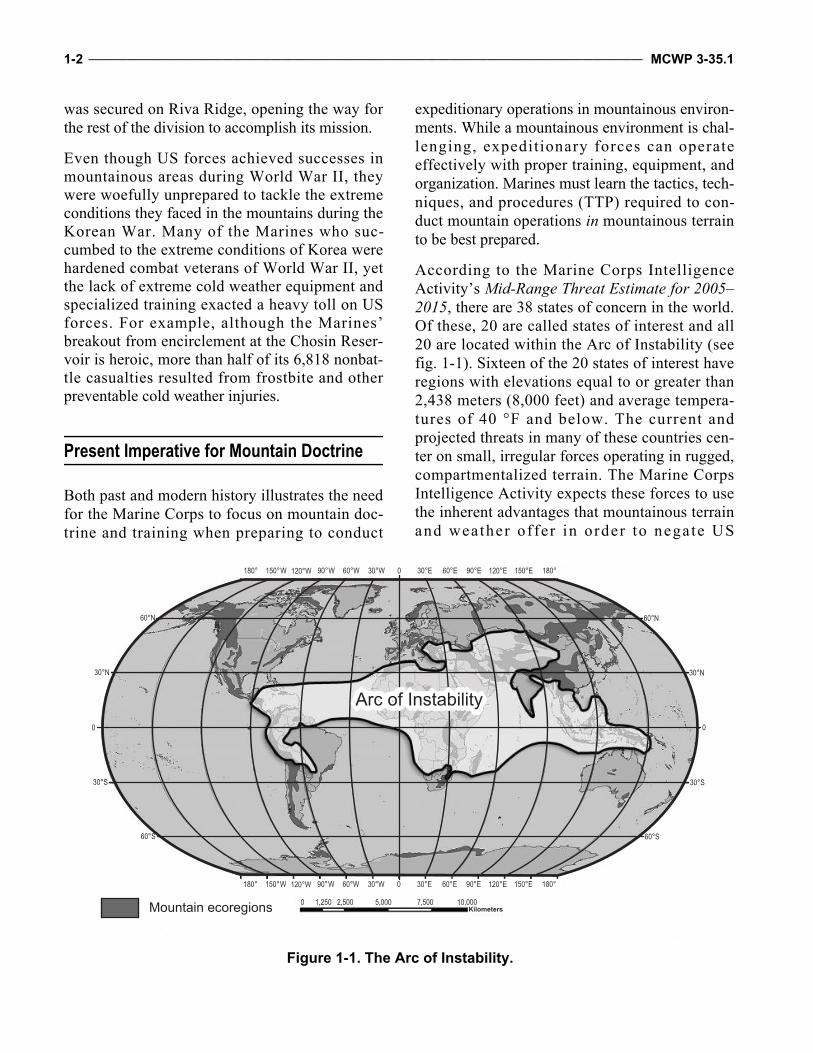
According to the Marine Corps IntelligenceActivity’s Mid-Range Threat Estimate for 2005–2015, there are 38 states of concern in the world.Of these, 20 are called states of interest and all20 are located within the Arc of Instability (seefig. 1-1). Sixteen of the 20 states of interest haveregions with elevations equal to or greater than2,438 meters (8,000 feet) and average tempera-tures of 40 °F and below. The current andprojected threats in many of these countries cen-ter on small, irregular forces operating in rugged,compartmentalized terrain. The Marine CorpsIntelligence Activity expects these forces to usethe inherent advantages that mountainous terrainand weather of fer in order to negate US
Mountain ecoregions
60°N
60°S
30°N
30°S
0
60°N
60°S
30°N
30°S
0
0 1,250 2,500 5,000 7,500 10,000Kilometers
Arc of Instability
Figure 1-1. The Arc of Instability.
Mountain Warfare Operations _________________________________________________________________________________ 1-3
technological advantages in intelligence, surveil-lance, reconnaissance (ISR), and firepower.Therefore, the ability to fight both large- andsmall-scale contingencies against conventionaland irregular, nonstate actors is paramount.
The World’s Mountainous Regions
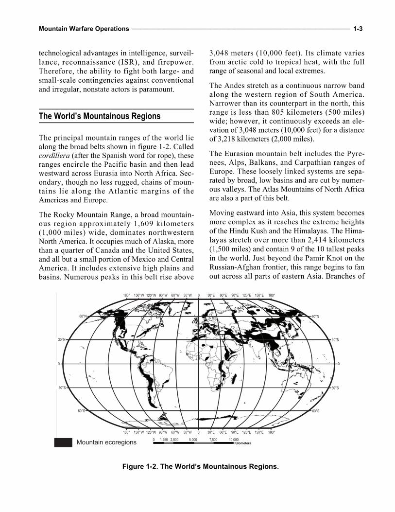
The principal mountain ranges of the world liealong the broad belts shown in figure 1-2. Calledcordillera (after the Spanish word for rope), theseranges encircle the Pacific basin and then leadwestward across Eurasia into North Africa. Sec-ondary, though no less rugged, chains of moun-tains lie along the Atlantic margins of theAmericas and Europe.
The Rocky Mountain Range, a broad mountain-ous region approximately 1,609 kilometers(1,000 miles) wide, dominates northwesternNorth America. It occupies much of Alaska, morethan a quarter of Canada and the United States,and all but a small portion of Mexico and CentralAmerica. It includes extensive high plains andbasins. Numerous peaks in this belt rise above
3,048 meters (10,000 feet). Its climate variesfrom arctic cold to tropical heat, with the fullrange of seasonal and local extremes.
The Andes stretch as a continuous narrow bandalong the western region of South America.Narrower than its counterpart in the north, thisrange is less than 805 kilometers (500 miles)wide; however, it continuously exceeds an ele-vation of 3,048 meters (10,000 feet) for a distanceof 3,218 kilometers (2,000 miles).
The Eurasian mountain belt includes the Pyre-nees, Alps, Balkans, and Carpathian ranges ofEurope. These loosely linked systems are sepa-rated by broad, low basins and are cut by numer-ous valleys. The Atlas Mountains of North Africaare also a part of this belt.
Moving eastward into Asia, this system becomesmore complex as it reaches the extreme heightsof the Hindu Kush and the Himalayas. The Hima-layas stretch over more than 2,414 kilometers(1,500 miles) and contain 9 of the 10 tallest peaksin the world. Just beyond the Pamir Knot on theRussian-Afghan frontier, this range begins to fanout across all parts of eastern Asia. Branches of
Mountain ecoregions
60°N
60°S
30°N
30°S
0
60°N
60°S
30°N
30°S
0
0 1,250 2,500 5,000 7,500 10,000Kilometers
Figure 1-2. The World’s Mountainous Regions.
1-4 ____________________________________________________________________________________________________ MCWP 3-35.1
this belt continue south along the rugged islandchains to New Zealand and northeast through theBering Sea to Alaska.
Different mountain chains can have differenttypes of climates. Some chains are located in drydesert regions with temperatures ranging fromextreme heat in the summer to extreme cold inthe winter. In tropical regions, small to mediummountains are covered in lush jungles with deepravines that flood during the rainy season. Tem-peratures in these areas typically remain warmand humid year-round. Many of the mountains inCentral America and many mountainous regionsin Africa and South America that are locatedclose to the equator have these types of character-istics. Conversely, high mountains in temperateclimates have sparse vegetation at elevationsabove 3,505 meters (11,500 feet) and tempera-tures can drop below freezing in winter. Somemountainous regions have a variety of environ-ments, such as in Afghanistan where units haveencountered several different mountainous envi-ronments within the same area of operations.
Mountainous Terrain
Mountains may rise abruptly from the plains toform a giant barrier or ascend gradually as aseries of parallel ridges extending unbroken forgreat distances. They may consist of varyingcombinations of isolated peaks, rounded crests,eroded ridges, and high plains and may be cut byvalleys, gorges, and deep ravines. High, rockycrags with glaciated peaks and year-round snowcover exist in mountain ranges at most latitudesalong the western portion of the Americas and inAsia. Regardless of their appearance, rugged ter-rain is common among all types of mountains.
Mountain slopes generally vary between 15 and45 degrees. Cliffs and other rocky precipices maybe near vertical or even overhanging. Aside fromobvious rock formations and other local vegeta-tion characteristics, slope surfaces are usually
firm earth or grass. Grassy slopes may includegrassy clumps known as tussocks; short alpinegrasses; or tundra, which is more common athigher elevations and latitudes. Many slopes willbe scattered with rocky debris deposited from thehigher peaks and ridges. Extensive rock or boul-der fields are known as talus; slopes covered withsmaller rocks, usually fist-sized or smaller, arecalled scree fields. Slopes covered in talus oftenprove to be a relatively easy ascent route. On theother hand, climbing a scree slope can beextremely difficult because the small rocks tendto loosen easily and give way; however, this char-acteristic often makes scree fields excellentdescent routes. Before attempting to descendscree slopes, commanders should carefully ana-lyze the potential for creating dangerous rockfalland take necessary avoidance measures.
In winter and at higher elevations throughout theyear, snow may blanket slopes, creating an envi-ronment with its own distinct effects. Some snowconditions can aid travel by covering rough ter-rain with a consistent surface. Deep snow, how-ever, greatly impedes movement and requiresMarines to be well trained in using snowshoes,skis, and over-the-snow vehicles. Steep, snow-covered terrain presents the risk of snow ava-lanches as well. Snow can seriously threaten per-sonnel not properly trained and equipped formovement under such conditions. Avalancheshave taken the lives of more personnel engagedin mountain warfare than all other terrain haz-ards combined.
Commanders operating in the arctic and subarc-tic mountain regions, as well as the upper eleva-tions of the world’s high mountains, may beconfronted with vast glaciated areas. Valleys inthese areas are frequently buried under massiveglaciers and present additional hazards, such ashidden crevices and ice and snow avalanches.The mountain slopes of these peaks are often gla-ciated, with their surfaces generally composed ofvarying combinations of rock, snow, and ice.
Mountain Warfare Operations _________________________________________________________________________________ 1-5
Although glaciers have their own peculiar haz-ards requiring special training and equipment,dismounted movement over valley glaciers isoften the safest route through these areas.
Different rock types, soil composition, and slopetypes will affect how forces are employed. Forexample, granite produces fewer rock falls, butits jagged edges make pulling rope and raisingequipment more difficult. Granite is abrasiveand increases the danger of ropes or accessorycords being cut. An in-depth analysis of individ-ual factors that will affect operations in moun-tainous environments can be found in ArmyTraining Circular (TC) 3-97.61, Military Moun-taineering, and Marine Corps reference publica-tion (MCRP) 3-35.1C, Mountain Leader’sGuide to Mountain Warfare Operations.
See appendix A for a discussion of altitude andenvironmental hazards in mountains. This appen-dix will provide detailed information on environ-mental threats unique to mountains.
Glaciers
Glaciers are rivers of ice and rocks that slowlymove down mountains. They are formed whenthe rate of snowfall or other types of precipita-tion exceeds the rate of melting in summermonths. After accumulations over hundreds ofyears, the snow compresses into ice that canrange from 10 to several hundred feet thick. Gla-ciers can be small and only cover a portion of amountain or they can be massive with a series ofglaciers covering a mountain range. Dismountedmovement across glaciers is often dangerous dueto icy conditions, landslides, ice falls, and deepcrevasses that often crisscross glaciers. Troopsshould reference TC 3-97.61 and MCRP 3-35.1Cfor movement considerations over glaciers. Gla-ciers are a good supply of water for units onpatrol. Units can purify water and reduce the needfor aerial or ground resupply.
Mountain Classifications
Mountain environments are difficult to classify.Soi l composi t ion, surface configurat ion,elevation, latitude, and climatic patterns deter-mine the specific characteristics of each majormountain range. When alerted to the potentialrequirement to conduct mountain operations,commanders must carefully analyze each ofthese characteristics for the specific mountainregion in which their forces will operate. Gene-rally, however, mountains are classified ordescribed according to their elevation. For mili-tary purposes, mountains may be classifiedaccording to operational terrain levels and dis-mounted mobility and skill requirements.
Elevation
Mountains are commonly classified according toelevation, which is the height of the immediateterrain above sea level, using the followingdescriptors:
Very high—greater than 3,048 meters (10,000feet).
High—1,829 to 3,048 meters (6,000 to 10,000feet).
Moderately high—914 to 1,829 meters (3,000to 6,000 feet).
Moderately low—305 to 914 meters (1,000 to3,000 feet).
Low—152 to 305 meters (500 to 1,000 feet). Very low—less than 152 meters (500 feet).
In general, low mountains have an elevation of305 to 914 meters (1,000 to 3,000 feet) with sum-mits usually below the timberline. High moun-tains usually exceed 914 meters (3,000 feet) andare characterized by barren alpine zones abovethe timberline. Glaciers and perennial snow coverare common in high mountains and usually pres-ent commanders with more obstacles and haz-ards to movement than do low mountains.
1-6 ____________________________________________________________________________________________________ MCWP 3-35.1
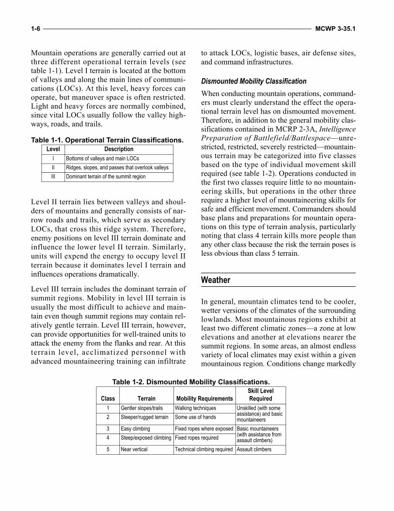
Mountain operations are generally carried out atthree different operational terrain levels (seetable 1-1). Level I terrain is located at the bottomof valleys and along the main lines of communi-cations (LOCs). At this level, heavy forces canoperate, but maneuver space is often restricted.Light and heavy forces are normally combined,since vital LOCs usually follow the valley high-ways, roads, and trails.
Level II terrain lies between valleys and shoul-ders of mountains and generally consists of nar-row roads and trails, which serve as secondaryLOCs, that cross this ridge system. Therefore,enemy positions on level III terrain dominate andinfluence the lower level II terrain. Similarly,units will expend the energy to occupy level IIterrain because it dominates level I terrain andinfluences operations dramatically.
Level III terrain includes the dominant terrain ofsummit regions. Mobility in level III terrain isusually the most difficult to achieve and main-tain even though summit regions may contain rel-atively gentle terrain. Level III terrain, however,can provide opportunities for well-trained units toattack the enemy from the flanks and rear. At thisterrain level, acclimatized personnel withadvanced mountaineering training can infiltrate
to attack LOCs, logistic bases, air defense sites,and command infrastructures.
Dismounted Mobility Classification
When conducting mountain operations, command-ers must clearly understand the effect the opera-tional terrain level has on dismounted movement.Therefore, in addition to the general mobility clas-sifications contained in MCRP 2-3A, IntelligencePreparation of Battlefield/Battlespace—unre-stricted, restricted, severely restricted—mountain-ous terrain may be categorized into five classesbased on the type of individual movement skillrequired (see table 1-2). Operations conducted inthe first two classes require little to no mountain-eering skills, but operations in the other threerequire a higher level of mountaineering skills forsafe and efficient movement. Commanders shouldbase plans and preparations for mountain opera-tions on this type of terrain analysis, particularlynoting that class 4 terrain kills more people thanany other class because the risk the terrain poses isless obvious than class 5 terrain.
Weather
In general, mountain climates tend to be cooler,wetter versions of the climates of the surroundinglowlands. Most mountainous regions exhibit atleast two different climatic zones—a zone at lowelevations and another at elevations nearer thesummit regions. In some areas, an almost endlessvariety of local climates may exist within a givenmountainous region. Conditions change markedly
Table 1-1. Operational Terrain Classifications.Level Description
I Bottoms of valleys and main LOCs
II Ridges, slopes, and passes that overlook valleys
III Dominant terrain of the summit region
Table 1-2. Dismounted Mobility Classifications.
Class Terrain Mobility RequirementsSkill Level Required
1 Gentler slopes/trails Walking techniques Unskilled (with some assistance) and basic mountaineers2 Steeper/rugged terrain Some use of hands
3 Easy climbing Fixed ropes where exposed Basic mountaineers (with assistance from assault climbers)4 Steep/exposed climbing Fixed ropes required
5 Near vertical Technical climbing required Assault climbers
Mountain Warfare Operations _________________________________________________________________________________ 1-7
with elevation, latitude, and exposure to atmo-spheric winds and air masses. The climatic pat-terns of two ranges located at the same latitude andin the same proximity may differ radically due toall of these individual factors. These different pat-terns of weather are known as microclimatization.
Major mountain ranges force air masses andstorm systems to drop significant amounts of rainand snow on the windward side of the range. Asair masses pass over mountains, the leewardslopes receive far less precipitation than thewindward slopes. It is not uncommon for the cli-mate on the windward side of a mountain rangeto be humid and the climate on the leeward sidearid. This phenomenon affects both coastal andinland mountains. The deepest winter snowpackswill almost always be found on the windwardside of mountain ranges. As a result, vegetationand forest characteristics may be markedly differ-ent between these two areas. Prevailing windsand storm patterns normally determine the sever-ity of these effects.
Mountain weather can be erratic, varying fromcalm to strong winds and from relative warmth toextreme cold within a short time or a minor shiftin locality. The severity and variance of theweather require personnel to be prepared for alter-nating periods of heat and cold, as well as condi-tions ranging from dry to extremely wet. At higherelevations, noticeable temperature differences mayexist between sunny and shady areas or betweenareas exposed to wind and those protected from it.This greatly increases every Marine’s clothingload and a unit’s overall logistical requirements.For a more detailed listing of mountain weatherconsiderations, see appendix B.
Climate Influences
Like most other landforms, oceans influencemountain climates. Mountain ranges in closeproximity to oceans and other large bodies ofwater usually exhibit a maritime climate. Mari-time climates generally produce milder tempera-tures and much larger amounts of rain and snow.
Their relatively mild winters produce heavysnowfalls, while their summer temperaturesrarely get excessively hot.
Mountains farther inland usually display a morecontinental climate. Winters in this type of cli-mate are often bitterly cold, while summers canbe extremely hot. Annual rainfall and snowfall inthese inland areas are far less than in a maritimeclimate and may be quite scarce for long periods.Relatively shallow snowpacks are normal duringa continental climate’s winter season.
Temperature
Normally, personnel encounter a temperaturedrop of 3 to 5 °F per 305-meter (1,000-foot) gainin elevation. At high elevations, there may be dif-ferences of 40 to 50 °F between the temperaturein the sun and that in the shade, which is similarin magnitude to the day-to-night temperaturefluctuations experienced in some deserts. Besidespermitting rapid heating, the clear air at high alti-tudes also results in rapid cooling at night. Conse-quently, temperatures rise swiftly after sunriseand drop quickly after sunset. Much of the chilledair drains downward so that the differencesbetween day and night temperatures are greater invalleys than on slopes. Refer to MCRP 3-35.1D,Cold Region Operations, for more considerationsfor cold temperatures and weather phenomena.
Wind
Wind in a mountainous environment has the fol-lowing characteristics:
In high mountains, the ridges and passes areseldom calm, while strong winds in protectedvalleys are rare.
Normally, wind velocity increases with altitudeand is intensified by mountainous terrain.
Valley breezes moving up-slope are more com-mon in the morning, while descending moun-tain breezes are more common in the evening.
Wind speed increases when winds are forcedover ridges and peaks (orographic uplift), or
1-8 ____________________________________________________________________________________________________ MCWP 3-35.1
when they funnel through narrowing mountainvalleys, passes, and canyons (venturi effect).
Wind may blow with great force on an exposedmountainside or summit.
As wind speed doubles, its force on an objectnearly quadruples.
Mountain winds cause rapid temperature changesand may result in blowing snow, sand, or debristhat can impair movement and observation. Com-manders should routinely consider the combinedcooling effect of ambient temperature and wind(windchill) experienced by their personnel (seetemperature categories in app. B).
At higher elevations, air is considerably dryerthan air at sea level. Due to this increased dry-ness, personnel must increase their fluid intake byapproximately one-third. In this environment,equipment will not rust as quickly and organicmatter will decompose more slowly.
Precipitation
The rapid rise of air masses over mountainscreates distinct local weather patterns. A moun-tainous environment has the following effect onprecipitation:
Precipitation increases with elevation andoccurs more often on the windward side thanon the leeward side of ranges.
Maximum cloudiness and precipitation gener-ally occur near 1,829 meters (6,000 feet) eleva-tion in the middle latitudes and at lower levelsin the higher latitudes.
Usually, a heavily wooded belt marks the zoneof maximum precipitation.
Common types of mountain precipitation in-clude rain and snow, thunderstorms, and travel-ing storms.
Rain and Snow
Both rain and snow are common in mountainousregions. Rain presents the same challenges as atlower elevations, but snow has a more significantinfluence on all operations. Depending on thespecific region, snow may occur at any time dur-ing the year at elevations above 1,521 meters(5,000 feet). Heavy snowfall greatly increasesavalanche hazards and can force changes to pre-viously selected movement routes. In certainregions, the intensity of snowfall may delaymajor operations for several months. Dry, flat riv-erbeds may initially seem to be excellent loca-tions for assembly areas and support activities;however, heavy rains and rapidly thawing snowand ice may create flash floods many milesdownstream from the actual location of the rainor snow.
Thunderstorms
Although thunderstorms are local and usually lastonly a short time, they can impede mountainoperations. Interior ranges with continental cli-mates are more conducive to thunderstorms thancoastal ranges with maritime climates. In alpinezones, driving snow and sudden wind squallsoften accompany thunderstorms. Ridges andpeaks become focal points for lightning strikes,which occur most often in the summer. Althoughstatistics do not show lightning to be a majormountaineering hazard, it should not be ignoredand Marines should take normal precautions,such as avoiding summits and ridges, water,antennas, and contact with metal objects.
Traveling Storms
Storms resulting from widespread atmosphericdisturbances involve strong winds and heavy pre-cipitation and are the most severe weather condi-tion that occurs in the mountains. If Marines
Mountain Warfare Operations _________________________________________________________________________________ 1-9
encounter a traveling storm in alpine zones dur-ing winter, they should expect low temperatures,high winds, and blinding snow. These conditionsmay persist longer than in the surrounding lowlying areas.
Fog
The effects of fog in mountains are much thesame as in other terrain; however, because of the
topography, fog occurs more frequently in themountains. The high incidence of fog makes it asignificant planning consideration because itrestricts visibility and observation, which compli-cates reconnaissance and surveillance. Fog, how-ever, may help facilitate clandestine operations,such as infiltration. Routes in areas with a highoccurrence of fog may need to be marked andcharted to facilitate passage.

1-10 ___________________________________________________________________________________________________ MCWP 3-35.1
This Page Intentionally Left Blank
CHAPTER 2OPERATIONS
Mountain operations are normally characterizedby a series of separately fought battles for thecontrol of key terrain, such as population centers,dominating ridges and heights, and other poten-tial avenues of approach. As a result, mountainoperations in the operational environment gener-ally require smaller unit tactics of squad-, pla-toon-, and company-level organizations. Due tothe nature of the environment and the extrememental and physical challenges associated withoperating in the mountains, the need for detailedplanning is essential. Risk management is an inte-gral part of planning and must take place at allphases of every operation. Planning for mountainoperations must be based on sound mission,enemy, terrain and weather, troops and supportavailable-time available (METT-T) analysis ofthe specific operational environment. The factorsof METT-T provide the standard methodologyfor identifying both threats and hazards, which isthe first step in the risk management process (seeMarine Corps Institute Publication ORM 1-0,Operational Risk Management).
Planning Considerations
Forces must plan for and be able to operate forextended periods of time as independent, smallunits. For this reason, commanders and plannersshould use the information in this chapter in con-junction with Army Tactics, Techniques, andProcedures (ATTP) 3-21.50, Infantry Small-UnitMountain Operations, and MCRP 3-35.1A, SmallUnit Leader’s Guide to Mountain Warfare Oper-ations. Due to the challenging human and physi-cal environment and an elusive, adaptive, andcomplex enemy, operating forces must—
Operate independent of forward operatingbases (FOBs).
Avoid an overreliance on motorized and mech-anized assets.
Balance force protection requirements with theneed to operate and live among the population.
The nature of operating and maneuvering in amountainous environment requires centralizedplanning and decentralized execution. The disper-sion of forces is useful when conducting offen-sive, defensive, and stability operations in themountains. The role of the elements of the taskforce in mountain operations remains unchanged,although the techniques for accomplishing themission may vary considerably. Ground combatelement (GCE) units are usually organized intohighly mobile, self-sustained tactical groupingswith only those weapons and equipment suited tothe mission. This decentralization allows forgreater flexibility and responsiveness across theoperational environment. In mountainous envi-ronments, battalion-size units can increase thenumber of maneuver units available by reorganiz-ing available units; for example, forming fourunits from the battalions’ three table of organiza-tion rifle companies will enhance the battalion’sability to cover more terrain.
While this technique is useful in a compartmen-talized mountainous environment, this unortho-dox approach of breaking down existing unitsinto smaller units to compensate for environmen-tal challenges requires units to be previouslytrained on this method of task organization. Italso requires more detailed planning and rehears-als. Maneuver commanders and planners must beaware of potential equipment constraints, reduc-tion in unit cohesion, and command and controlissues. Equipment issues will arise since existingunits will be fragmented to create additionalunits. Unit cohesion may suffer as personnel fromexisting units are split and reintegrated to create
2-2 ____________________________________________________________________________________________________ MCWP 3-35.1
new units. Command and control may suffer sig-nificant impact due to the increased complica-tions of having more moving pieces in the area ofoperations and relying on junior officers and non-commissioned officers (NCOs) to lead new units.
The principles of patrolling do not change in amountainous environment (see Marine CorpsWarfighting Publicat ion [MCWP] 3-11.3,Scouting and Patrolling; ATTP 3-21.50; andMCRP 3-35.1B, Mountain Leader’s Guide toWinter Operations.)
Command and Control Considerations
The environmental factors associated with moun-tain operations offer unique command and con-trol challenges. The compartmentalized terrain,expansive areas of operations, and severe envi-ronmental conditions limit communications sys-tems and challenge command and control efforts.Large operating areas and the need to employsmall unit tactics require commanders to decen-tralize and disperse their forces. In order to effec-tively command and control dispersed forces,commanders must rely on decentralized execu-tion, which is enabled by centralized planning,mission orders, and commander’s intent. Com-manders must resist the micromanagement ofsubordinate leaders that modern communicationsassets enable. Effective integration of risk man-agement is critical at each level of command inall phases of mountain operations to identify andmitigate hazards in order to enhance mission suc-cess. The following considerations apply to com-mand and control during mountain operations:
Warning orders that allow subordinates ampletime to prepare and plan for operations.
Mission orders that empower subordinates andpromote freedom of action.
Commander’s intent that clearly articulates thedesired purpose.
Command relationships that are clearly under-stood and facilitate the exercise of initiative bysubordinates (unity of command where possi-ble, unity of effort where it is not).
Standing operating procedures that are under-stood and applied across the command toassure TTP excellence.
Mobile reserves or reaction forces that aretrained to move quickly across rough compart-mentalized terrain with tailored loads.
Leadership
To help ease their anxiety in combat, troops musthave confidence in their leaders. This confidencemay diminish rapidly unless leaders demonstratethe ability to lead over formidable terrain andunder the most difficult weather conditions.Superficial knowledge of mountain warfare andignorance or underestimation of mountain haz-ards and environmental effects may result in mis-sion failure and the unnecessary loss of life.
Effective leadership in mountain operations com-bines sound judgment with a thorough under-standing of the characteristics of mountainousenvironments. Commanders must first developflexible and adaptable leadership throughout thechain of command. They must then be able tounderstand and exploit the operational and tacti-cal implications of mountainous environmentsand their effect on personnel, equipment, andweapons. The keys to meeting this challenge areproper training and operational experience in themountains, which requires leaders to understandthe need for specialized clothing, equipment, andtraining. Commanders must recognize the impor-tance of small unit leaders in preventing environ-mental injuries and illnesses. To fight effectively,leaders creatively exploit the opportunitiesoffered by the mountainous environment whileminimizing the adverse effects it can have ontheir operations. Commanders must manage risksto their forces to accomplish the mission and takecare of their Marines.
Mountain Warfare Operations _________________________________________________________________________________ 2-3
Command Posts
Effective command and control of the commandpost requires it to remain functional despite dif-ficulties associated with the environment, suchas cold temperatures, high winds, and the effectsof altitude.
DisplacementDisplacing the command post will take more timedue to the effects of the environment and the ter-rain itself. Displacement exercises are critical.Future command post locations must be identi-fied quickly and reconnoitered to ensure they willfunction effectively.
Headquarters should configure their commandposts in echelons with redundant and overlap-ping capabilities. Such configuration usuallycomprises a forward, main, and rear commandpost, assuming enough equipment and personnelexist to support all three. Each echelon has a pri-mary and secondary command and controlresponsibility. For example, the main commandpost may have primary responsibility for logisticoperations and movement control while the for-ward command post has responsibility formaneuvering forces and coordinating fire sup-port. The main command post may have the sec-ondary responsibility of monitoring those tacticalcommunications nets associated with maneuver-ing forces and coordinating fires support so that itcan assume command in the event the forwardcommand post needs to displace or loses the abil-ity to command and control. By organizing head-quarters into a forward, main, and rear and byassigning primary and alternate command andcontrol responsibilities to each echelon, head-quarters can exercise command and control whiledisplacing echelons.
Normally, the commander will position himself/herself with the forward command element tohave the best situational awareness of the battle-field. During displacement, the commander willnormally pass control to the main command post
until the forward command post can re-estab-lish reliable communications.
Watch PersonnelBecause a mountainous environment quickly sapsstrength and energy, a three-watch system is rec-ommended for command posts operating underharsh, mountain conditions. Headquarters person-nel augmentation is essential to provide extrawatchstanders, to assist command post displace-ments, and to provide more depth for securitypersonnel. In many cases, command posts willneed to provide for their own defense, especiallywhen conducting displacement operations. Multi-ple command post configurations (forward, main,jump) should be rehearsed in hardstand, tentage,and mobile forms. Their displacement should alsobe rehearsed.
Offensive Operations
Offensive operations in the mountains varydepending on the degree of restrictions dictatedby mountains of different heights and character.Conventional mountain operations are generallyconducted to gain control of key or decisive ter-rain. Key terrain includes LOCs, mountainpasses, ridges, and chokepoints. Every attemptmust be made to attack from higher elevations tolower elevations to conserve troop energy,increase movement speed, and have superiorobservation and fields of fire. Frontal attacksagainst defended heights have little chance ofsuccess. Attacks are usually made along theflanks and to the rear of the enemy. Conse-quently, flanking attacks and envelopments arethe preferred form of maneuver.
A well-trained force using mobility skills thatmitigate the effects of the mountainous environ-ment can achieve surprise by infiltrating andattacking the enemy’s rear or attacking duringperiods of limited visibility, such as night, rain, or
2-4 ____________________________________________________________________________________________________ MCWP 3-35.1
snow. Marines can use helicopters and their tech-nical mountaineering skills to conduct decisiveoperations throughout the area of operations.
The mountainous terrain increases the threat toconcentrated formations. Usually, it is difficult tocoordinate all forces by time and location so theycan rapidly support each other and achievemassed effects. The compartmented terrain sepa-rates adjacent units, which precludes mutual sup-port and may adversely af fect support ingdistances. Therefore, it is critical to anticipate theconcentration of forces and fires before the battlebegins to achieve effective synchronization.
The length of the preparatory phase is typicallylonger in a mountainous environment. Offen-sive action against a well-defended enemy mustbe based on thorough reconnaissance and or-derly preparation. When planning, commandersmust take advantage of the weaknesses found inthe enemy’s defenses. A large number of recon-naissance assets and additional time may beneeded to determine the strength of enemy posi-tions and to identify favorable routes to andbeyond the objective.
Difficult approach routes should be marked andprepared for safe passage. Easily traversedslopes, broad hills, plateaus, and valley floors aswell as mountainous terrain with well-developedroad and transportation nets create opportunitiesfor the force to deploy in breadth. High rangeswith ridges and crests leading to the objectiverequire organization in depth with extendedLOCs. Units should always attempt to have over-watch when moving in the mountains. Travelingoverwatch is the preferred technique when pre-paring for the offense.
In trackless, mountainous terrain, company-sizedunits usually conduct attacks. If the area assignedto a battalion permits, companies should approachthe objective separately on multiple routes, nevermoving without overwatch on adjacent highground. In restrictive terrain, adequate maneuver
space may not always be available and severalunits may be required to move along the sameavenue of approach. It may even be necessary toconduct shaping operations to seize terrain thatdominates movement routes.
Types of Offensive Operations
The types of offensive operations are movement tocontact, attack, and exploitation and pursuit. Theyare addressed in the following subparagraphs.
Movement to ContactMovement to contact operations in the moun-tains are more vulnerable to attack and ambush.Limited mobility and dependence on restrictiveLOCs limit deployment of the force from move-ment formations. Plans and movement formationsshould be based on maintaining flexibility andproviding continuous security.
During a movement to contact, the advanceguard advances in column, moving continuouslyor by bounds until it makes contact. Whilerequiring less physical exertion, movement alongthe topographical crest of a ridgeline increasesthe possibility of enemy observation and shouldnormally be avoided. Given adequate conceal-ment, this exposure may be reduced by movingalong the military crest. Ridgelines and crests canoften provide a tactical advantage to the forcethat controls them by allowing rapid movementfrom one terrain compartment to another andaffording excellent observation. In all cases,commanders must address the control or clear-ance of ridgelines that dominate their plannedavenues of approach.
The main body should never be committed tocanalizing terrain before forward elements haveadvanced far enough to ensure that the mainbody will not become encircled—a critical fac-tor when employing mixed heavy and lightforces that have sharp differences in operationaltempo. Combat service support (CSS) units mustbe decentralized and readily available to sustain
Mountain Warfare Operations _________________________________________________________________________________ 2-5
the combat elements. Major terrain compart-ments may physically separate maneuver unitsmoving as part of a larger force. Continuousreconnaissance to the front and flank security isessential to prevent the enemy from infiltratingthe gaps between units.
As the enemy situation becomes better known,commanders may shorten the distance betweenelements to decrease reaction time or they maybegin to deploy in preparation for the attack. Lat-eral movement between adjacent columns is fre-quently difficult or impossible; however, everyattempt should be made to maintain at least visualcontact. Connecting files or mountain pickets areeffective for lateral connection. Commandersmust emphasize the use of checkpoint reporting,contact patrols, and phased operations to coordi-nate and control the movement of the overallforce. Control measures should not be so numer-ous as to impede operations and stifle initiative.Proper control ensures that units and fires aremutually supporting, objectives are correctlyidentified, and units are in position to attack. Per-manent occupation of key terrain is unrealistic;therefore, engagements occur repeatedly on thesame pieces of terrain. Commanders should planto control those historic points whenever operat-ing within their vicinity. Fixing and finishing theenemy is often accomplished by direct and indi-rect fire, respectively, in mountainous terrain.
AttackSpeed, flexibility, and surprise, normally advan-tages enjoyed by the attacker, are limited byrestrictive terrain and the defender’s increasedability to see and acquire targets at greater dis-tances. These limitations make it difficult for unitsabove the company team level to conduct hastyattacks against prepared positions. Additional timeshould be allocated to conduct deliberate planningfor fire support coordination, route selection, andcommand and control coordination.
Planning an Attack. When planning and con-ducting attacks, commanders should recognize
that the enemy will generally seek to control thevalleys and trail networks, including adjacentslopes and high ground. The enemy will attemptto engage the attacker in the valleys and lowground with flanking fires and artillery, often in adirect fire mode. Commanders must analyze theterrain to determine not only how the enemy willorganize their defensive positions, but also howthe terrain might contribute to the enemy’s abil-ity to counterattack. As friendly forces attempt todeploy for the attack, the enemy, using theiradvance knowledge of the terrain and preparedroutes, may maneuver forces to counterattackfrom the flank or rear.
Terrain. All terrain features that can be occupiedby even a small enemy force should be secured.In many instances, overwatch positions may notbe readily available within the range or capabilityof organic weapons. Infiltration, technical climb-ing, and extensive breaching may be required toposition weapons to support the assault. On manyoccasions, artillery support, especially in highmountains, may not be available. Commandersmust identify fire support requirements and allo-cate fires based on the ability to support andavailable ammunition. Because resupply may belimited and extremely difficult, they may need toplace restrictions on the amount of ammunitionexpended on specific targets. Dominating terrainmay give a commander great situational aware-ness, while being beyond the range of fires, suchas the enemy used during Operation Anaconda inthe Arma Mountains of Afghanistan.
Obstacles. Breaching obstacles and preparingbypass routes that allow the assault force to moveinto the defensive position must be an integralpart of the commander’s plan. In rugged terrain,manmade obstacles that are covered by fire createa particularly dangerous and formidable barrier.Command and control of breaching operationsare more difficult than in open terrain and mobil-ity support is extensive if the obstacle cannot bereduced. Assaults in mountainous terrain almost
2-6 ____________________________________________________________________________________________________ MCWP 3-35.1
always involve preparing routes that allow theassault force to rapidly move over difficult natu-ral obstacles and into the objectives.
Raid and Ambush. The restrictive terrain ofmountainous areas also affords increased oppor-tunities to conduct raids and ambushes. Theseoperations should take advantage of limited visi-bility and terrain that the enemy may considerimpassable. In steep terrain, movement timeincreases significantly and only light equipmentcan be taken. The force should use special climb-ing techniques to negotiate the difficult routesduring limited visibility. Commanders must care-fully consider the routes and methods used forextraction to ensure that the combat force doesnot become isolated after executing the mission.They can ensure a successful operation by avoid-ing detection through proper movement tech-niques and by skillfully using natural cover andconcealment. It may be necessary to repositionsome indirect fire support assets to cover deadspace or use attack helicopters and close air sup-port (CAS). The ambush or raid commander mustknow in advance if supporting fires cannot coverhis/her routes to and from the objective.
Demonstrations and Feints. Because maneuverspace is usually limited or confined and restrictsthe number of avenues of approach for heavierforces, deception plays an important part in themountain battle. To mislead the enemy regard-ing friendly intentions, capabilities, and objec-tives, commanders should plan systematicmeasures of deception.
Exploitation and PursuitIn a mountainous environment, exploitation andpursuit operations must be conducted discrimi-nately and the commander must always preparefor success. A battalion may exploit its own suc-cess to a limited extent, but it normally partici-pates in the exploitation as part of a larger force.Air assault and attack helicopter units can be usedto augment exploitation and pursuit operations.
The exploiting commander must compensate forthe ground mobility restrictions imposed by ter-rain and weather. Speed can be achieved best byisolating enemy positions with the smallest forcepossible. Engineer support should be well for-ward with the necessary equipment to enablecombat personnel to maintain momentum andavoid delay by enemy obstacles. The commandermust be careful to prevent overextending eitherthe exploiting force or its sustaining logistics. Awithdrawing force can establish numerous delay-ing and firing positions on heights, quickly dissi-pating the combat power of the exploiting force.
Forms of Offensive Maneuver
The forms of offensive maneuver are common toall environments, including mountainous terrain,and only such considerations for mountain opera-tions are addressed in the following subpara-graphs. While frequently used in combination,each form of maneuver attacks the enemy in a dif-ferent way and some pose different challenges tothe commander when attacking in the mountains.
Frontal AttackThe frontal attack is an offensive maneuver inwhich the main action is directed against the frontof the enemy forces. It is used to rapidly overrunor destroy a weak enemy force or fix a force inplace to support a flanking attack or envelop-ment. Aviation forces and supporting arms shouldbe used to create gaps in the enemy’s front or toprevent or delay enemy reinforcements fromreaching the front lines. The frontal attack is gen-erally the least preferred form of maneuverbecause it strikes the enemy where they are thestrongest. Frontal attacks in hilly or mountainousareas, even when supported by heavy direct andindirect fires, have a limited chance of success.Mountainous terrain adds to the relative combatpower of the defender, requiring that the ratio ofattacking forces exceeds three to one, such as inmilitary operations on urban terrain.
Mountain Warfare Operations _________________________________________________________________________________ 2-7
Flanking Attacks, Envelopments, and Turning MovementsFlanking attacks, envelopments, and turningmovements are used extensively in mountainoperations. These techniques are a superior formof offensive maneuver used by the attacker tobypass the enemy’s principal defensive posi-tions. These forms of maneuver seek to avoid theenemy’s strength and attack where the enemy isweakest or unprepared. The enemy’s defensivepositions may be bypassed using ground, air, orvertical envelopment. When conducting dis-mounted movements, the corridors through whichthe maneuver elements travel are key consider-ations. Commanders should place considerableemphasis on the use of mountain pickets to act asconnecting files and overwatch as maneuverforces move across the valley floor in order toachieve surprise. The ability of forces to success-fully execute flanking attacks, envelopments, andturning movements is enhanced by employingorganizational mountaineers, airborne insertions,and air assaults.
InfiltrationInfiltration is frequently used in the mountains.The difficult terrain and recurring periods of lim-ited visibility allow for undetected movement.Infiltration in a mountainous environment is usedto shape the battlefield by attacking enemy posi-tions from the flank or the rear, securing key ter-rain in suppor t of decisive operations, ordisrupting enemy sustainment operations. Infil-tration is normally conducted using one of threetechniques—movement in small groups alongone axis, movement in one group, or movementin small groups along several routes at the sametime. Regardless of the technique used, units con-duct tactical movement and employ noise andlight discipline while leveraging existing/avail-able natural concealment to reduce the chance ofenemy contact.
Movement in Small Groups Along One Axis.When moving in small groups along one axis, all
members of the force use the best route. Smallgroups are harder to detect, are easier to control,and do not compromise the total force if detected.This technique is time consuming, requires anincreased number of guides and lead climbingteams, and requires an assembly area or linkuppoint prior to conducting the decisive action. Therisk of enemy detection and of follow on groupsbeing ambushed is greater.
Movement in One Group Along One Axis. Theenemy can more easily detect movement of onelarge group along a single axis of advance. If theforce is detected, the overall mission may beendangered. This technique, however, does notrequire reassembling the force prior to going intothe attack. Since everyone uses the same route,navigation is easier and the requirement forguides and lead climbing teams is reduced. Alarge force can fight out of a dangerous situationmore easily than a small one. This technique alsominimizes coordination problems among infiltrat-ing units.
Movement in Small Groups Along MultipleAxes. Movement in small groups along severalaxes avoids putting the total force in danger andmakes them less likely to be seen. It forces theenemy to react in many locations and makes itharder for them to determine the size of theforce or its mission. The challenges associatedwith this technique include reassembly of theforce, command and control, sustainment, andthe need f o r more s pec i a l i zed t r a in ing ,equipment, and personnel.
PenetrationMountainous terrain normally makes penetra-tions extremely dangerous due to the difficulty ofconcentrating overwhelming combat power at thearea of penetration. Due to mobility restrictions,it is also difficult to develop and maintain themomentum required to move through the point ofpenetration. The area of penetration is vulnerableto flank attack, especially in mountainous terrain.
2-8 ____________________________________________________________________________________________________ MCWP 3-35.1
A penetration may be useful when attacking anenemy that is widely dispersed or overextendedin their defense. Flank defensive positions mustbe eliminated before the initial breach of enemypositions. Successful penetrations require sur-prise, security, and covered and concealed terrainat selected breach points.
Defensive Operations
The immediate objective of a mountainousdefense is to deny the enemy access to key terrainthat helps them conduct further operations. There-fore, it is necessary to defend in terrain thatrestricts and contains the enemy as well as to con-trol the high ground that dominates this terrain.The terrain provides the defender with cover, con-cealment, and camouflage that can deceive theenemy regarding the strength and dispositions offriendly forces. The defender should know the ter-rain, control the heights, fortify positions, siteweapons in advance, stockpile supplies, and pre-pare lateral trail networks to allow for mobility.
Restrictive terrain inherent to mountainous areasis one of the primary advantages of the defenderbecause it interferes with the attacker’s synchroni-zation, canalizes the attacker’s movement, andimpedes the attacker’s ability to maneuver. Tocapitalize on this advantage, commanders shouldcarefully analyze the vertical and horizontal com-ponents of terrain from both friendly and enemyviewpoints.
While a screening force is usually considered tobe the preferred form of security in rugged ter-rain, all forms of security operations (screen,guard, and cover) may be employed. The follow-ing points should be considered when conductingsecurity operations:
Forces available for security operations. Ability to maintain a mobility advantage. Size of the security area and the number of
avenues of approach. Likelihood of enemy action.
Size of the expected enemy force. Amount of early warning and reaction time
needed.
A screening force provides early warning to theprotected force and is usually an economy-of-force measure. The compartmented nature ofmountainous terrain can lead to gaps and exposedflanks. The rugged terrain also restricts move-ment of both friendly and enemy forces. In theseinstances, commanders may choose to use mini-mum combat power to observe, identify, andreport enemy actions at these locations andengage and destroy enemy reconnaissance withinthe screening force’s capability. The screeningforce can avoid being decisively engaged bywithdrawing into restrictive terrain.
In mountainous terrain, the screening forceshould adjust to the enemy advance and continueto screen as far forward as possible, even thoughelements of the force may have to withdraw.Retention of selected forward positions mayallow surveillance and targeting forward of thearea of operations, upsetting the enemy’s coordi-nation. By allowing the enemy to bypass advancepositions, the screening force can facilitate acounterattack since it can observe and access theflanks and rear of the attacking forces.
If a significant enemy force is expected or a sig-nificant amount of time and space is required,commanders may employ a guard or coveringforce. Security forces that can maintain a mobil-ity advantage over the enemy can effectivelydelay and counterattack the enemy force. Theappropriate use of a guard or covering force pro-vides greater depth in the security area.
Defending forces must prevent enemy infiltra-tion by carefully positioning observation postsand conducting continuous patrols and ambushes.Reconnaissance patrols may rely heavily on tech-nical climbing skills. Ground surveillance radarand ground sensors can be used to add greaterdepth to the defense.
Mountain Warfare Operations _________________________________________________________________________________ 2-9
Motti TacticsMotti tactics demonstrate how forces can exploit superior mobility skills and knowledge of both snow-covered andmountainous terrain and the environment to defeat an enemy that is road bound. The Motti is a double envelopmentmaneuver, using the ability of light troops to travel over rough ground to encircle and cut off road-bound enemy forces.Forces with superior mobility can easily immobilize a larger enemy force. Motti tactics were used extensively by Fin-land’s forces in the Russo-Finnish War of 1939–1940. This tactic was extremely effective against many of the mecha-nized units of the Soviet Army that were restricted to the long and narrow forest roads. Due to their poor training andlimited mobility, the Russian forces remained road bound and vulnerable to the more mobile and highly trained Finnishunits. Unlike the mechanized Russian units, the Finnish troops moved quickly through the forests on skis to break thearmored columns into small chunks, such as by felling trees along the road. Once a large column was split up intosmaller units, the Finns attacked the isolated Soviet units. By cutting Soviet columns into smaller groups and thenencircling them with light, mobile forces, the Finnish army was able to overwhelm a much larger force. Generally, a force using Motti tactics avoids becoming decisively engaged. It disrupts the enemy’s supply lines, deniesthem warmth and shelter, infiltrates their bivouacs, and destroys their rear areas to the point where they must remainin a high state of alert. These attacks, in combination with the environment, help to destroy the enemy’s will to fight.Commanders should not only develop a thorough understanding of how to apply these tactics, but also understand theconditions that may leave their own forces vulnerable to their use. Motti tactics generally follow the sequence of— Locating and fixing the enemy. Isolating the enemy. Attacking to defeat or destroy the enemy.Reconnaissance is conducted to locate an enemy force moving in or toward an area that will restrict their movementsto roads, trails, or linear terrain. Once identified, the force must be fixed so that it presents a linear target along the axisof advance to which it is bound by using obstacles and a series of squad- and platoon-sized ambushes and raids.Obstacles may be natural (snow, crevices, deep mud, steep terrain, and water obstacles) or manmade (mines, land-slides, avalanches, or destroyed bridges).The ambushes and raids not only fix the enemy, ambushes and raids also disturb the enemy’s composure, create an airof uncertainty, and prevent uninterrupted sleep and rest. Attacking units attack the enemy from the high ground. Theymake maximum use of night vision devices as well as the difficult restrictive terrain. They avoid enemy security andinterdict the enemy’s operations. As a further result of these actions, the enemy is compelled to use more forces onsecurity tasks. Unless the enemy can be easily defeated or destroyed, the attacking force rapidly withdraws after forcingthe enemy to deploy. In general, this series of attacks confuses the enemy as to the attacking unit’s exact location andintent and slows the enemy’s decisionmaking cycle so that the enemy reacts ineffectively to subsequent operations.The attacking force then isolates the enemy into smaller groups. Once isolated, the attacking force maneuvers toenvelop and attacks to defeat or destroy the isolated elements. As the enemy becomes exhausted in an effort to breakout, the attacking force may regroup and repeat the sequence. It is imperative that the attacking force seal off the enemy,keep avenues of approach closed, and not ignore the threat to its flanks, which may increase as the attack progresses.Overall, Motti tactics wear the enemy down to a point where the enemy is vulnerable to more direct attacks or to thepoint where it is no longer beneficial or feasible to continue operations in the area. Motti tactics employed alone onlyprove decisive over a long period of time, depending on the enemy’s capabilities, strength, and resolve. Based onMETT-T, friendly forces must normally increase the operation’s tempo to gain a quick, decisive outcome. Still, this tac-tic may complement other more direct offensive operations in support of the overall plan. In sum, forces can use Motti tactics when they— Have superior technical mobility skills necessary to negotiate Class 4 and 5 terrain. Are able to operate effectively in a noncontiguous area of operations with limited support and despite temperature
extremes and inclement mountain weather. Are able to navigate in high, mountainous terrain, dense vegetation, darkness, storms, and fog while making good
use of available cover and concealment. Maintain the element of surprise.Forces are vulnerable to Motti tactics when they— Operate within noncontiguous areas of operations. Have limited mobility skills, restricting their movements to roads, trails, and Class 1 and 2 terrain. Have inadequate reconnaissance and security.
2-10 ___________________________________________________________________________________________________ MCWP 3-35.1
Defensive positions along ridges or on dominat-ing heights should include both forward andreverse slopes to add greater depth and security.Fighting positions and observation posts shouldbe echeloned vertically as well as in depth. Whendefending a mountain valley, forces should estab-lish fighting positions that are located on adja-cent heights and in depth to permit covering thevalley with interlocking fires. Defensive positionsmust be anchored to restrictive terrain or adja-cent defensive forces to prevent enemy infiltra-tion or envelopment. In wooded terrain, defensivepositions may be organized on the forward edgeof the woods, as well as on commanding heights.Obstacles should be widely employed to slow orstop enemy movement.
Mountain warfare demands that forces defendaggressively. Defending units must infiltrateenemy units and attack headquarters, supplylines, and rear areas. Small patrols and observa-tion posts should be deployed well forward todirect artillery fire and attack aircraft on targetsof opportunity and to conduct personnel and anti-armor ambushes. Operations should be con-ducted to force the enemy to deploy additionalassets and to disrupt preparations.
Commanders may need to rely on their reserve asthe principal means of restoring a defense’s integ-rity or exploiting opportunities through offensiveaction. Because of the difficulties of movement,small reserves may be located near primary defen-sive positions, ready for immediate counterattack.This type of small, responsive counterattack maybe much more effective than a large-scale, majorcounterattack. Large, centrally-placed counterat-tack forces are normally unable to intervene intime unless the terrain permits mounted movementor sufficient helicopter lift assets are committed tothe reserve force or made rapidly available.Reserves should be mobile enough to react toenemy action in any portion of the perimeter. Lessmobile reserves are positioned to block the mostdangerous avenues of approach and are assignedon-order positions on other critical avenues.
Sharply compartmented terrain may require thecreation of more than one reserve.
To minimize the vulnerability of sustainingoperations, sustainment resources must be dis-persed, redundant, and as far from enemyapproaches as possible. Because of limited spaceavailable in rear areas, the commander must care-fully select and locate positions for CSS/sus-tainment unit activities. These positions are likelyto be confined to small valleys. A perimeterdefense is planned for each operating base withinthe defensive area. Defensive positions should beselected on the dominating high ground. Sensors,observation posts, and radars are used to coveravenues of approach and gaps between positions.More information on perimeter defense isavailable in ATTP 3-21.50; MCRP 3-35.1A; andFM 3-90, Tactics.
There are three fundamental types of defense:mobile, position, and retrograde.
Mobile Defense
In a mobile defense, the defender withholds alarge portion of available forces for use as a strik-ing force in a counterattack. Mobile de-fensesrequire enough depth to let enemy forces advanceinto a position that exposes them to counterat-tack. The defense separates attacking forces fromtheir support and disrupts the enemy’s commandand control. As enemy forces extend themselvesin the defended area and lose momentum andorganization, the defender surprises and over-whelms them with a powerful counterattack. Thecounterattack focuses on destroying the attackingforce by permitting the enemy to advance into aposition that exposes them to counterattack andenvelopment. The commander commits the mini-mum possible combat power to his/her fixingforce that conducts shaping operations in order tocontrol the depth and breadth of the enemy’sadvance. The fixing force also retains the terrainrequired to facilitate the striking force’s decisivecounterattack.
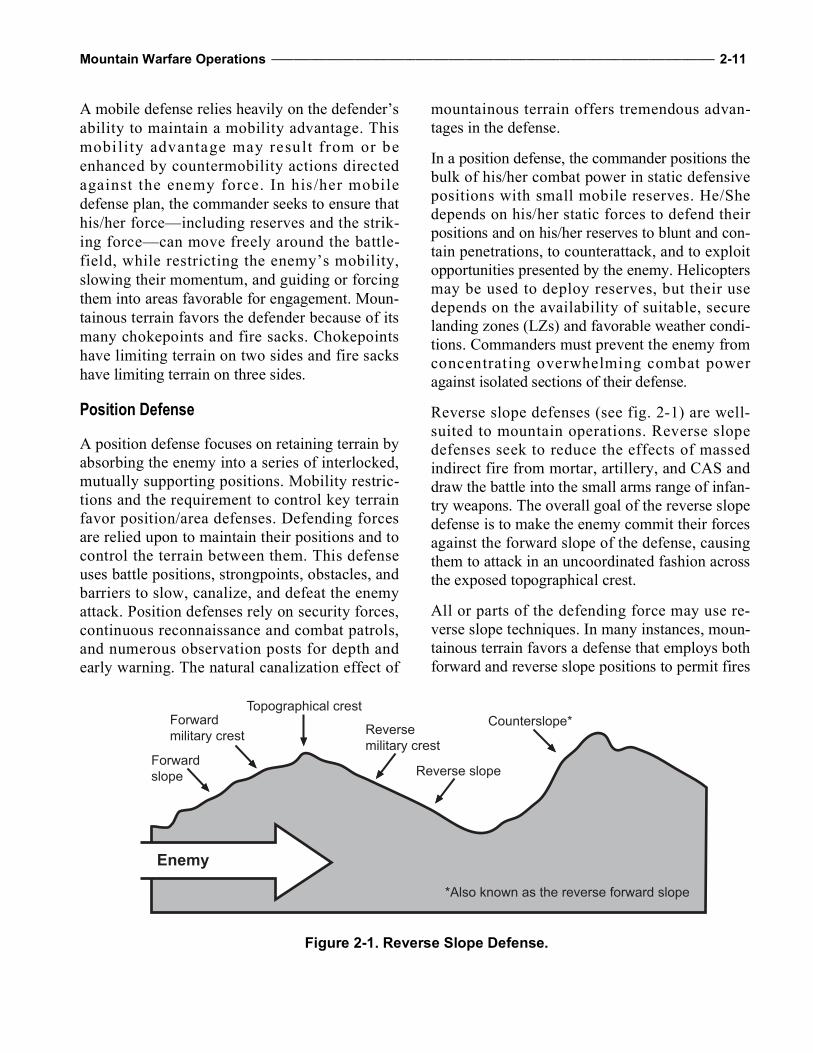
Mountain Warfare Operations ________________________________________________________________________________ 2-11
A mobile defense relies heavily on the defender’sability to maintain a mobility advantage. Thismobi lity advantage may result from or beenhanced by countermobility actions directedagainst the enemy force. In his/her mobiledefense plan, the commander seeks to ensure thathis/her force—including reserves and the strik-ing force—can move freely around the battle-field, while restricting the enemy’s mobility,slowing their momentum, and guiding or forcingthem into areas favorable for engagement. Moun-tainous terrain favors the defender because of itsmany chokepoints and fire sacks. Chokepointshave limiting terrain on two sides and fire sackshave limiting terrain on three sides.
Position Defense
A position defense focuses on retaining terrain byabsorbing the enemy into a series of interlocked,mutually supporting positions. Mobility restric-tions and the requirement to control key terrainfavor position/area defenses. Defending forcesare relied upon to maintain their positions and tocontrol the terrain between them. This defenseuses battle positions, strongpoints, obstacles, andbarriers to slow, canalize, and defeat the enemyattack. Position defenses rely on security forces,continuous reconnaissance and combat patrols,and numerous observation posts for depth andearly warning. The natural canalization effect of
mountainous terrain offers tremendous advan-tages in the defense.
In a position defense, the commander positions thebulk of his/her combat power in static defensivepositions with small mobile reserves. He/Shedepends on his/her static forces to defend theirpositions and on his/her reserves to blunt and con-tain penetrations, to counterattack, and to exploitopportunities presented by the enemy. Helicoptersmay be used to deploy reserves, but their usedepends on the availability of suitable, securelanding zones (LZs) and favorable weather condi-tions. Commanders must prevent the enemy fromconcentrating overwhelming combat poweragainst isolated sections of their defense.
Reverse slope defenses (see fig. 2-1) are well-suited to mountain operations. Reverse slopedefenses seek to reduce the effects of massedindirect fire from mortar, artillery, and CAS anddraw the battle into the small arms range of infan-try weapons. The overall goal of the reverse slopedefense is to make the enemy commit their forcesagainst the forward slope of the defense, causingthem to attack in an uncoordinated fashion acrossthe exposed topographical crest.
All or parts of the defending force may use re-verse slope techniques. In many instances, moun-tainous terrain favors a defense that employs bothforward and reverse slope positions to permit fires
Forward military crest
Forward slope
Topographical crest
Reverse military crest
Reverse slope
Counterslope*
*Also known as the reverse forward slope
Enemy
Figure 2-1. Reverse Slope Defense.
2-12 ___________________________________________________________________________________________________ MCWP 3-35.1
on enemy approaches around and over the crestand on the forward slope of adjacent terrain fea-tures. Key enablers to this type of defense are—
Mutually supporting covered and concealedpositions.
Numerous natural and manmade obstacles. The ability to bring fire from all available
weapons onto the crest. A strong and mobile counterattack force.
The reverse slope defense is organized so that themain defensive positions are masked from enemyobservation and direct fire by the topographicalcrest. It extends rearward from the crest only tothe maximum effective range of small arms fire.Observation and fires are maintained over theentire forward slope as long as possible to con-tinue to destroy advancing enemy forces and pre-vent them from effectively massing for a finalassault. A successful reverse slope defense isbased on denying the topographical crest to theenemy, either by fire or by physical occupation.Although the crest may not be occupied instrength, control of the crest by fire is essentialfor success.
Retrograde
Retrograde operations in the mountains requirefewer assets to delay an advancing enemy.Numerous positions may exist where elements assmall as a machine gun or sniper team can sig-nificantly delay a large force. When conductingretrograde operations in mountainous terrain, thefriendly force must—
Make maximum use of and reinforce existingobstacles.
Conduct detailed reconnaissance of routes torearward positions. Routes of withdrawal arenot as numerous in mountainous terrain andoften do not intersect as they do on flat terrain.These factors complicate subsequent linkupoperations and necessitate meticulous planning.
Protect the flanks and rear to prevent encircle-ment, particularly by air assault.
Stability Operations
Cultural understanding is fundamental to planningstability operations in the mountains. Althoughchallenging in the mountains, commanders candevelop situational understanding by circulatingthroughout their operational areas as often as pos-sible, talking with their Marines, making observa-tions, and communicating with the local populaceand other actors operating in the area. These activ-ities will aid Marine forces in overcoming localsuspicion of outsiders and establishing the per-sonal bonds of trust with local leaders.
Civil Considerations
Generally, civilian population centers will belocated at the lower elevations of Level I close tosources of water and along major LOCs. Refu-gees and displaced civilians may increase con-gestion on the already limited road and trailnetworks normally found in mountainous environ-ments, further complicating maneuver and sus-tainment operations.
Commanders must also consider the impact ofoperations on the often limited civilian resourcesavailable in the mountains. The wisdom of usinglocal resources to lighten in theater supply require-ments must be balanced with the impact on civil-ians and their local economy. While the purchaseof goods and services from the local economy isgenerally welcomed, it may serve to inflate pricesand make it impossible for local civilians to pur-chase their own scarce and needed supplies.
In mountainous regions, commanders often en-counter a populace of diverse political and ethnicorientation that may support, oppose, or be ambiv-alent to US operations or the presence of USforces. Depending on friendly force objectives,commanders may conduct public relations, civilaffairs, humanitarian assistance, and militaryinformation support operations to influence per-ceptions and attitudes of neutral or uncommittedparties. Even if commanders choose not to commit
Mountain Warfare Operations ________________________________________________________________________________ 2-13
resources to enlist civilian sympathy and support,they must still adjust their operations to minimizedamage and loss of life to innocent civilians.Homogeneous mountain communities are suscep-tible to greater influence from external forces/fac-tors than the more heterogeneous communitiesfound in less compartmented terrain.
Due to the restrictive nature of the terrain, moun-tain communities may quickly become safehavens for enemy activity and bases of support.Where combat typically focuses on the defeat ordestruction of an enemy force, the focus of stabil-ity operations is the populace.
District Stability Framework
Successful stability operations are predicated onidentifying and reducing the causes of instabilityand re-establishing or building community andstate capacity to diminish, manage, or preventfuture instability. The District Stability Frame-work (DSF) is a tool that can be effectively usedto assess the causes of instability in an isolatedmountain community.
The DSF was developed by the United StatesAgency for International Development and hasbeen successfully used in various theaters toidentify, prioritize, and target the causes of insta-bility in a measurable and immediately accessi-ble way. Since it makes maximum use of assetsin the field and measures the effectiveness ofactivities over time and across multiple unit rota-tions, it is an important tool for conducting stabi-lization operations. The DSF is based on thefollowing four tenets:
Instability results when the factors fosteringinstability overwhelm the ability of the hostnation to mitigate these factors.
Assessment is necessary for targeted and stra-tegic engagement.
The population is the best source for identify-ing the causes of instability.
Measures of effectiveness are the only truemeasure of success.
The DSF consistently maintains focus on thelocal populace. Organizations using the tacticalconflict assessment and planning framework fol-low a continuous cycle of see-understand-act-measure. The DSF includes four distinct, butinterrelated, activities—
Situational awareness. Analysis. Design. Monitoring and evaluation.
Situational AwarenessSituational awareness of the causes of instabilitywithin an operational area is a four-step process—
Identify stability and instability. Understand the cultural environment. Apply instability and stability dynamics. Understand perception dynamics.
The following four questions of the tactical con-flict survey are very useful when drawing criticalinformation from the local populace:
Has the population of the village changed inthe last 12 months?
What are the greatest problems facing the vil-lage?
Who do you believe can resolve problems? What should be done first to help the village?
Targeted interviews should be conducted withkey local stakeholders, such as traditional leaders,government officials, business leaders, and prom-inent citizens.
AnalysisDuring analysis, the information gained throughsituational awareness is compiled in a graphicaldisplay to help identify the main concerns of thepopulation and to serve as a reference point fortargeted questioning. The DSF data is combinedwith input from other staff sections and othersources of information, such as intergovernmentalorganizations, nongovernmental organizations,
2-14 ___________________________________________________________________________________________________ MCWP 3-35.1
and private sector entities. All this input is used tocreate a prioritized list of the causes of instabilityand sources of resiliency that guide the conduct ofstability operations.
DesignThe design effort is informed by analysis. Theresults of which are used to create a tactical sta-bility matrix for each of the causes of instability.After identifying the causes of instability andsources of resiliency, a program of activities isdesigned to address them. Three key factorsguide program design to ensure program activi-ties accomplish the following:
Increase support for the host-nation government. Decrease support for antigovernment or insur-
gent elements. Build host-nation capacity and capability
across each of the stability sectors.
The tactical stability matrix and program activi-ties form the basis for planning within an opera-tional area. The plan targets the least stable areasand ensures instability is contained. It is nestedwithin the higher headquarters plan and detailshow specific stability tasks will be integrated andsynchronized at the tactical level. The DSF datais collated at each echelon to develop or validateassessments performed by subordinate elements.
Monitoring and EvaluationThe DSF provides a comprehensive means ofevaluating success in addressing the sources ofinstability. Through monitoring measures ofeffectiveness, analysts gauge progress towardimproving stability while diminishing the sourcesof instability. Monitoring measures of effective-ness and overall stability—the key component ofthe DSF process—are vital to evaluating the suc-cess of program activities in changing the state ofthe operational environment envisioned duringthe design effort.
While evaluation is critical to measuring theeffectiveness of activities in fostering stability, italso helps to ensure that the views of the popula-tion are tracked, compared, measured, and dis-played over t ime. Since these results areobjective, they cannot be altered by intervieweror analyst bias, creating a continuous narrativethat significantly increases situational awareness.For more information on stability operations seeFM 3-07, Stability Operations; United StatesAgency for International Development; andMCWP 3-33.5, Counterinsurgency.
Operational Advantages and Disadvantages
The forms of maneuver and types of offensiveoperations will not change for mountainous envi-ronments; however, there are unique elements thatmust be considered before conducting offensiveoperations. Like all other environments, one of theprimary advantages of conducting offensive oper-ations is that the attacker can choose when andhow to attack. This point is emphasized even fur-ther in the mountains due to the many avenues ofapproach to a tactical objective, limited groundLOCs the defender has to rely upon for sustain-ment, and the difficulty the defender faces in con-structing defensive positions.
Despite these offensive advantages, the aggressoris usually at a disadvantage in the mountainsbecause the mountainous terrain favors defensiveoperations. The primary advantage to the defenderin mountainous terrain is the ability to choosedefensive positions that will canalize offensiveforces, denying the attacking force the ability tomaneuver effectively. If the defender controls theheights, observation will preclude the attackingforce from achieving surprise. Both observationand canalization will give the defender theopportunity to mass fires in order to defeat ordestroy the enemy; however, if the attacking forceis highly trained and able to negotiate the
Mountain Warfare Operations ________________________________________________________________________________ 2-15
complicated mountainous terrain, the advantagesthe defender gained will be nullified.
Conducting stability operations in mountain pop-ulation centers establishes conditions that enablethe efforts of the other instruments of nationaland international power. By providing the requi-site security and control to stabilize an opera-tional area, those efforts build a foundation fortransitioning to civilian control and, eventually,to the host nation. Military forces operating inthis environment seek to establish or restore basicsustainable civil functions and protect them untila civil authority or the host nation is capable ofproviding these services for the local populace. Inmany cases, the restrictive terrain and culturalbarriers found in isolated mountain communitieswill prevent the host nation from fulfilling itsrole. Military forces may be called upon to sig-nificantly increase their role to include providingthe basic civil functions of government. Thisslow development process of government recon-struction and stabilization may become frustrat-ing and d if f icul t to manage as un i ts andcommanders cycle through deployments tomountainous operational environments. Integrat-ing the planning efforts of all the agencies andorganizations involved in a stability operation isessential to long-term peace.
Planning and Intelligence Preparation of the Battlespace
Existing intelligence processes will be used inmountainous environments. Marines should refer-ence MCRP 2-3A for further details on determin-ing environmental effects, identifying hazards,and managing risks in an area of operations.
Intelligence preparation of the battlespace (IPB) isdesigned to support threat-based risk assessmentsby identifying opportunities and constraints in thebattlespace for both enemy and friendly forces. Itis a dynamic staff process critical to identifyingenemy threat—one of the factors in METT-T—and mission variables and assists commanders intheir decisionmaking process.
The Marine Corps uses operational risk manage-ment as its primary decisionmaking process tomitigate risks associated with any hazard thatmay injure or kill personnel, damage or destroyequipment, or otherwise impact mission effec-tiveness. For the Marine Corps, risk managementis an ongoing process that continues from missionto mission. Within the mission, leaders mustknow when the process begins and who hasresponsibility. Such knowledge must be integralto the military decision.

2-16 ___________________________________________________________________________________________________ MCWP 3-35.1
This Page Intentionally Left Blank
CHAPTER 3INTELLIGENCE
This chapter discusses specific effects of moun-tainous environments on intelligence operationsby concentrating on two areas of the intelligenceprocess—plan and collect. The Marine intelli-gence cycle discusses plan and collect activities.These activities are impacted by mountainousenvironments, such as when the environment lim-its communication. Mountain operations alsopresent unique challenges in waging irregularwarfare due to the compartmentalized terrain.Intelligence references include—
FM 3-55, Information Collection, which dis-cusses ISR measures.
Army ATTP 2-01, Planning Requirements andAssessing Collection , for more specificsregarding ISR synchronization.
MCWP 2-2, MAGTF Intelligence Collection.
The Marine Corps uses the generic term ISRassets for all units, personnel, and equipment thatconduct ISR activities. Therefore, in order tomaintain ease of reading and limit redundancythroughout the rest of this publication, the termISR assets will be used.
Planning
Generating intelligence knowledge begins beforethe mission is received and provides the relevantknowledge required regarding the operationalenvironment for the conduct of operations. It isthe foundation for performing IPB and problemframing. Its primary products are the initial datafiles and the intelligence survey. To generate
intelligence knowledge, planners must conductthe following tasks:
Develop the foundation to define threat charac-teristics.
Obtain detailed terrain information and intelli-gence.
Obtain detailed weather and weather effectsinformation and intelligence.
Obtain detailed civil considerations informa-tion and intelligence.
Complete studies.
The results of each of the first four tasks are trans-lated into a database or data files based on thecommander’s guidance to support the commander(see FM 2-0, Intelligence, and MCWP 2-1, Intelli-gence Operations, for more details).
Planning is conducted to identify intelligencerequirements, plan intelligence operations, andsupport the formulation of the commander’s esti-mate of the situation. In this phase, intelligencegaps are identified and collection is planned tosatisfy those intelligence gaps. The effects ofharsh weather and compartmented terrain makeaccuracy and efficiency in the planning anddirection phase critical to intelligence operationsin mountainous environments. Planners mustalso note that caves will be used extensively inmountainous environments and should refer toATTP 3-21.50 and MCRP 3-35.1C.
The ISR plan faces numerous challenges and cantake much longer to execute because of poor traf-ficability, severe weather conditions, and the rug-ged nature of the topography. Caves, overhangs,
3-2 ____________________________________________________________________________________________________ MCWP 3-35.1
crevices, gorges, boulders, and crags all affordexcellent cover and concealment for the enemy.These unique terrain conditions pose multipleproblems for ground commanders and their staffsin maneuver and security. High altitudes andextreme weather conditions impact negatively onthe ability of aerial platforms and all types ofimaging systems. As a result, commanders andtheir staffs must allow significantly more time forreconnaissance and surveillance in this unforgiv-ing environment. Emphasis must be placed onconfirming data collected from sensors and ter-rain analysis tools. These tools provide intelli-gence personnel with valuable data, but that datacan lack sufficient detail. Mountain weather phe-nomena are localized, which increases therequirement for meteorological (MET) teams.Due to the decentralized nature of mountain oper-ations, MET teams need to be pushed down to thebattalion level if assets are available. Intelligencepersonnel cannot rely on regional forecasts whenconducting planning.
The relative inaccessibility of most mountainousterrain places severe demands on the maneuver-ability of troops. In this environment, the use ofISR assets to verify trafficability, identify routesthat support the movement of dismounted andmounted elements, and maintain friendly situa-tional understanding for commanders and theirstaffs can be critical to the success of an opera-tion. Constant surveillance of the limited routesand avenues may contribute greatly to situationalawareness. While the ideal solution is to main-tain constant surveillance in a mountainous envi-ronment, leaders must realize that doing so willconsume significant resources, which couldimpact the number of available named areas ofinterest that can be monitored. Even if no intelli-gence is gathered while surveying an area ofinterest, there is a greater chance of operationalsuccess if maneuver forces know that enemyforces have not been operating in the battlespace.
Combat in mountainous environments also pres-ents commanders and their staffs with the chal-lenges of locating and defeating an enemy who
may be arrayed in multiple tiers along the slopesof key terrain, such as a critical mountain pass,dominating height, gorge, or trail. Since therestrictive terrain often does not support massingcombat power against decisive points, command-ers and their staffs need to use the ISR plan to pre-cisely focus the maneuver assets and fire support.
Collection
Collection, complicated by a mountainous envi-ronment, consists of the activities of organic,attached, and supporting ISR assets to gather newdata and deliver it to the appropriate processingor production agency. Though all ISR assets canbe hindered by weather/terrain, troops can consultintelligence personnel for ISR capabilities andlimitations, if necessary. An example of such datais presented in appendix C. Usually, however,intelligence personnel will conduct ISR synchro-nization to assist the operations personnel withthe production of the ISR annex for the opera-tions order. The ISR plan outlines the collectioneffort in response to the commander’s criticalinformation requirements.
Human Environment
Mountain populations exhibit certain traits thatwill significantly impact operations. While therewill be variations depending on the location ofthe operation, case studies have revealed somegeneralizations that distinguish mountain popula-tions from other populations. These variationsinclude the following traits:
Independent. Enhanced loyalty to their group. Homogeneous. Tribal/clannish. Increased emphasis on religion. Less economically developed than more acces-
sible areas. Lacking formal education.
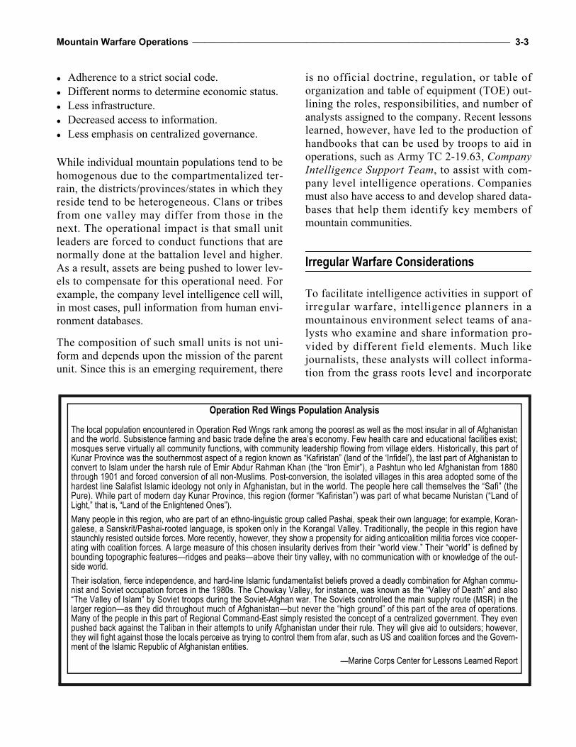
Mountain Warfare Operations _________________________________________________________________________________ 3-3
Adherence to a strict social code. Different norms to determine economic status. Less infrastructure. Decreased access to information. Less emphasis on centralized governance.
While individual mountain populations tend to behomogenous due to the compartmentalized ter-rain, the districts/provinces/states in which theyreside tend to be heterogeneous. Clans or tribesfrom one valley may differ from those in thenext. The operational impact is that small unitleaders are forced to conduct functions that arenormally done at the battalion level and higher.As a result, assets are being pushed to lower lev-els to compensate for this operational need. Forexample, the company level intelligence cell will,in most cases, pull information from human envi-ronment databases.
The composition of such small units is not uni-form and depends upon the mission of the parentunit. Since this is an emerging requirement, there
is no official doctrine, regulation, or table oforganization and table of equipment (TOE) out-lining the roles, responsibilities, and number ofanalysts assigned to the company. Recent lessonslearned, however, have led to the production ofhandbooks that can be used by troops to aid inoperations, such as Army TC 2-19.63, CompanyIntelligence Support Team, to assist with com-pany level intelligence operations. Companiesmust also have access to and develop shared data-bases that help them identify key members ofmountain communities.
Irregular Warfare Considerations
To facilitate intelligence activities in support ofirregular warfare, intelligence planners in amountainous environment select teams of ana-lysts who examine and share information pro-vided by different field elements. Much likejournalists, these analysts will collect informa-tion from the grass roots level and incorporate
Operation Red Wings Population Analysis
The local population encountered in Operation Red Wings rank among the poorest as well as the most insular in all of Afghanistanand the world. Subsistence farming and basic trade define the area’s economy. Few health care and educational facilities exist;mosques serve virtually all community functions, with community leadership flowing from village elders. Historically, this part ofKunar Province was the southernmost aspect of a region known as “Kafiristan” (land of the ‘Infidel’), the last part of Afghanistan toconvert to Islam under the harsh rule of Emir Abdur Rahman Khan (the “Iron Emir”), a Pashtun who led Afghanistan from 1880through 1901 and forced conversion of all non-Muslims. Post-conversion, the isolated villages in this area adopted some of thehardest line Salafist Islamic ideology not only in Afghanistan, but in the world. The people here call themselves the “Safi” (thePure). While part of modern day Kunar Province, this region (former “Kafiristan”) was part of what became Nuristan (“Land ofLight,” that is, “Land of the Enlightened Ones”).
Many people in this region, who are part of an ethno-linguistic group called Pashai, speak their own language; for example, Koran-galese, a Sanskrit/Pashai-rooted language, is spoken only in the Korangal Valley. Traditionally, the people in this region havestaunchly resisted outside forces. More recently, however, they show a propensity for aiding anticoalition militia forces vice cooper-ating with coalition forces. A large measure of this chosen insularity derives from their “world view.” Their “world” is defined bybounding topographic features—ridges and peaks—above their tiny valley, with no communication with or knowledge of the out-side world.
Their isolation, fierce independence, and hard-line Islamic fundamentalist beliefs proved a deadly combination for Afghan commu-nist and Soviet occupation forces in the 1980s. The Chowkay Valley, for instance, was known as the “Valley of Death” and also“The Valley of Islam” by Soviet troops during the Soviet-Afghan war. The Soviets controlled the main supply route (MSR) in thelarger region—as they did throughout much of Afghanistan—but never the “high ground” of this part of the area of operations.Many of the people in this part of Regional Command-East simply resisted the concept of a centralized government. They evenpushed back against the Taliban in their attempts to unify Afghanistan under their rule. They will give aid to outsiders; however,they will fight against those the locals perceive as trying to control them from afar, such as US and coalition forces and the Govern-ment of the Islamic Republic of Afghanistan entities.
—Marine Corps Center for Lessons Learned Report
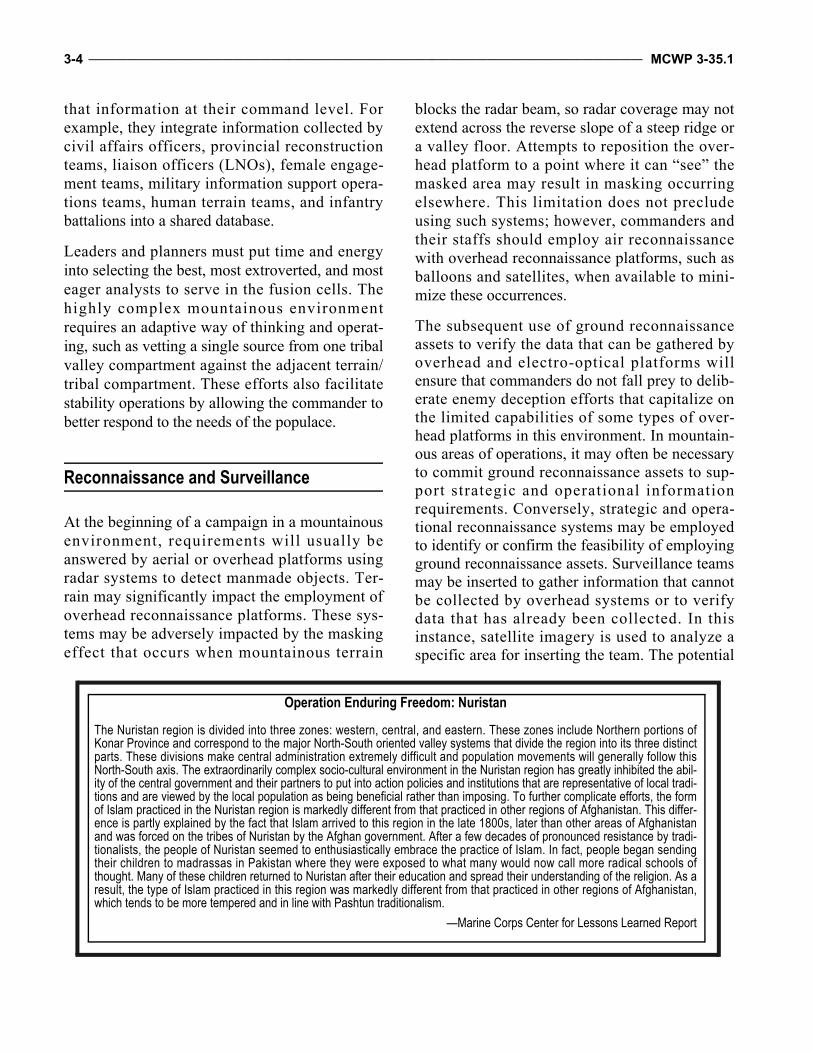
3-4 ____________________________________________________________________________________________________ MCWP 3-35.1
that information at their command level. Forexample, they integrate information collected bycivil affairs officers, provincial reconstructionteams, liaison officers (LNOs), female engage-ment teams, military information support opera-tions teams, human terrain teams, and infantrybattalions into a shared database.
Leaders and planners must put time and energyinto selecting the best, most extroverted, and mosteager analysts to serve in the fusion cells. Thehighly complex mountainous environmentrequires an adaptive way of thinking and operat-ing, such as vetting a single source from one tribalvalley compartment against the adjacent terrain/tribal compartment. These efforts also facilitatestability operations by allowing the commander tobetter respond to the needs of the populace.
Reconnaissance and Surveillance
At the beginning of a campaign in a mountainousenvironment, requirements will usually beanswered by aerial or overhead platforms usingradar systems to detect manmade objects. Ter-rain may significantly impact the employment ofoverhead reconnaissance platforms. These sys-tems may be adversely impacted by the maskingeffect that occurs when mountainous terrain
blocks the radar beam, so radar coverage may notextend across the reverse slope of a steep ridge ora valley floor. Attempts to reposition the over-head platform to a point where it can “see” themasked area may result in masking occurringelsewhere. This limitation does not precludeusing such systems; however, commanders andtheir staffs should employ air reconnaissancewith overhead reconnaissance platforms, such asballoons and satellites, when available to mini-mize these occurrences.
The subsequent use of ground reconnaissanceassets to verify the data that can be gathered byoverhead and electro-optical platforms willensure that commanders do not fall prey to delib-erate enemy deception efforts that capitalize onthe limited capabilities of some types of over-head platforms in this environment. In mountain-ous areas of operations, it may often be necessaryto commit ground reconnaissance assets to sup-port strategic and operational informationrequirements. Conversely, strategic and opera-tional reconnaissance systems may be employedto identify or confirm the feasibility of employingground reconnaissance assets. Surveillance teamsmay be inserted to gather information that cannotbe collected by overhead systems or to verifydata that has already been collected. In thisinstance, satellite imagery is used to analyze aspecific area for inserting the team. The potential
Operation Enduring Freedom: Nuristan
The Nuristan region is divided into three zones: western, central, and eastern. These zones include Northern portions ofKonar Province and correspond to the major North-South oriented valley systems that divide the region into its three distinctparts. These divisions make central administration extremely difficult and population movements will generally follow thisNorth-South axis. The extraordinarily complex socio-cultural environment in the Nuristan region has greatly inhibited the abil-ity of the central government and their partners to put into action policies and institutions that are representative of local tradi-tions and are viewed by the local population as being beneficial rather than imposing. To further complicate efforts, the formof Islam practiced in the Nuristan region is markedly different from that practiced in other regions of Afghanistan. This differ-ence is partly explained by the fact that Islam arrived to this region in the late 1800s, later than other areas of Afghanistanand was forced on the tribes of Nuristan by the Afghan government. After a few decades of pronounced resistance by tradi-tionalists, the people of Nuristan seemed to enthusiastically embrace the practice of Islam. In fact, people began sendingtheir children to madrassas in Pakistan where they were exposed to what many would now call more radical schools ofthought. Many of these children returned to Nuristan after their education and spread their understanding of the religion. As aresult, the type of Islam practiced in this region was markedly different from that practiced in other regions of Afghanistan,which tends to be more tempered and in line with Pashtun traditionalism.
—Marine Corps Center for Lessons Learned Report
Mountain Warfare Operations _________________________________________________________________________________ 3-5
hide positions for the teams are identified usingimagery and, terrain and weather permitting, veri-fied by unmanned aircraft systems (UASs).
On harsh mountainous terrain, ground recon-naissance operations are often conducted dis-mounted. Commanders and their staffs mustassess the slower rate of ground reconnaissanceelements to determine its impact on the entirereconnaissance and collection process. Theymust develop plans that account for this slowerrate and initiate reconnaissance as early as possi-ble to provide additional time for movement (seechap. 4 for movement planning tools). Com-manders may also need to allocate more forces,including combat forces, to conduct reconnais-sance, surveillance, or limited objective attacks togain needed intelligence. Based upon METT-T,commanders may need to prioritize collectionassets, accept risk, and continue with less infor-mation than from their initial reconnaissanceefforts. In these cases, they must use formationsand schemes of maneuver that provide maxi-mum security and flexibility, to include robustsecurity formations, and allow for the develop-ment of the situation once in contact.
Although reconnaissance patrols should nor-mally use the heights to observe the enemy, theymay need to send small reconnaissance teamsinto valleys or along the low ground to gain suit-able vantage points, conduct countersurveillance(as mountain villages often serve as a network ofinformants on friendly movements), or physi-cally examine routes that will be used by mecha-nized or motorized forces. In mountainousenvironments, reconnaissance elements are oftentasked to determine—
The enemy’s primary and alternate LOCs. Locations and directions from which the
enemy can attack or counterattack. Heights that allow the enemy to observe the
various sectors of terrain. Suitable observation posts for forward observers. Portions of the route that provide covert
movement.
Level of mountaineering skill required to nego-tiate routes (dismounted mobility classifica-tion) and sections of the route that requirespecific mountaineering equipment, tools, orfacilities (e.g., bivouac sites, tents, and huts) aswell as mountaineering installations (e.g., fixedropes or raising/lowering systems).
Trafficability of existing trails and routes tosupport sustained military movement require-ments and an engineer estimate of the effortrequired to improve/maintain this capacity.
Location of enemy obstacles/barriers, includingminefields, and feasibility of breach or bypass.
Bypass routes. Potential airborne and air assault drop zones
and/or pickup zones (PZs) and aircraft land-ing areas.
Location of locally available engineer re-sources, such as construction materials, borrowpits, water, and construction equipment.
Operational Considerations
Snow can pose a serious threat to Marine Corpsunits not properly trained and equipped formovement under such conditions: avalancheshave taken the lives of more troops engaged inmountain warfare than all other terrain hazardscombined. Reconnaissance units must do a thor-ough reconnaissance of the battlespace to deter-mine areas where avalanches and rockslides aremost prevalent and most likely to hinder mobil-ity. This information should be included in theirreconnaissance overlays in order to generate afull picture for the commander (see chap. 5 formitigation procedures).
Reconnaissance in Force
The compartmented geography and inherentmobility restrictions of mountainous terrain posesignificant risk for reconnaissance in force opera-tions. Since the terrain normally allows enemyunits to defend along a much broader front withfewer forces, a reconnaissance in force may be
3-6 ____________________________________________________________________________________________________ MCWP 3-35.1
conducted as a series of smaller attacks to deter-mine the enemy situation at selected points. Com-manders and their staffs should carefully considermobility restrictions that may affect plans forwithdrawal or exploitation. They should alsoposition small reconnaissance elements or em-ploy surveillance systems throughout the threatarea of operations to gauge the enemy’s reactionto friendly reconnaissance in force operations andalert the force to possible enemy counterattacks.In the mountains, the risk of having at least a por-tion of the force cut off and isolated is extremelyhigh. Mobile reserves and preplanned fires mustbe available to reduce the risk, decrease the vul-nerability of the force, and exploit any success asit develops.
Engineer Reconnaissance
Engineer reconnaissance assumes greater signifi-cance in a mountainous environment to ensurethat supporting engineers are properly task-orga-nized and have specialized equipment to quicklyovercome natural and reinforcing obstacles. En-gineer reconnaissance teams conduct the follow-ing functions:
Assessing the resources required for clearingobstacles on precipitous slopes.
Constructing crossing sites at fast-movingstreams and rivers.
Improving and repairing roads, erecting fortifi-cations, and establishing barriers during theconduct of defensive operations.
Integrating themselves into all mountain recon-naissance operations, since the restrictive ter-rain promotes the widespread employment ofpoint obstacles.
Additional information on engineer reconnais-sance can be found in MCWP 3-17.4, EngineerReconnaissance. In some regions, maps may beunsuitable for tactical planning due to inaccura-cies, limited detail, and inadequate coverage. Inthese areas, engineer reconnaissance should pre-cede, but not delay, operations. Because rugged
mountainous terrain makes ground reconnaissancetime consuming and dangerous, a combination ofground and aerial or overhead platforms should beused for engineer reconnaissance. Data on the ter-rain, vegetation, and soil composition, combinedwith aerial photographs and multispectral imag-ery, enable engineer terrain intelligence teams toprovide detailed information that may be unavail-able from other sources.
Chemical, Biological, Radiological, Nuclear, and High-Yield Explosives Reconnaissance
The mountainous environment presents uniquechallenges when conducting CBRNE [chemical,biological, radiological, nuclear, and high-yieldexplosives] reconnaissance. See MCWP 3-37.4,Multi-Service Tactics, Techniques, and Proce-dures for Chemical, Biological, Radiological,and Nuclear Reconnaissance and Surveillance,and MCRP 4-11.1F, Multiservice Tactics, Tech-niques, and Procedures for Health Service Sup-port in a Chemical, Biological, Radiological, andNuclear Environment, for information that can beuseful in conducting such reconnaissance.
Air and Overhead Reconnaissance
During all but the most adverse weather condi-tions, air or overhead reconnaissance may be thebest means to gather information and cover largeareas that are difficult for ground units to traverseor observe. Airborne standoff intelligence-collec-tion devices, such as side-looking radar, provideexcellent terrain and target isolation imagery. Mis-sions must be planned to ensure that critical areasare not masked by terrain or other environmentalconditions. Additionally, air or overhead photo-graphs may compensate for inadequate maps andprovide the level of detail needed to plan opera-tions. Infrared imagery and camouflage detectionfilm can be used to determine precise locations ofenemy positions, even at night. Furthermore, heli-copters, such as the AH-64 and OH-58D, can pro-vide commanders and their staffs with critical dayor night video reconnaissance using television orforward-looking infrared.

Mountain Warfare Operations _________________________________________________________________________________ 3-7
The UAS flight patterns may be adversely affectedby mountainous terrain. Line of sight (LOS) com-mand links may limit UASs from flying into val-leys, which also limits signals collection or electro-optical resolution. They may require much higheroperating elevations to maintain positive commandand control, use satellite-based command links, oroperate in autonomous mode more often.
Radar shadowing is a phenomenon in which adistortion occurs in a radar return image when theangle of an observed object, such as a mountainside, is steeper than the sensor depression angle.This occurrence may cause ghost images or dis-torted images in mountainous terrain. Command-ers and intelligence officers should consideremploying manned or unmanned systems thatemploy nonradar sensors to minimize suchimages. Overhead systems that employ electro-optical or infrared sensors may realize greatersuccess than radar systems when weather condi-tions facilitate their use. The subsequent employ-ment of ISR assets to verify data provided byoverhead sensors helps ensure that the com-mander does not fall victim to deception targetedagainst specific overhead sensors.
Signals Intelligence
Weather and compartmented terrain reduces theeffectiveness of signals intelligence (SIGINT)assets, but mountainous terrain presents a specialchallenge to SIGINT collection. Mountain min-eral deposits can create dead zones for frequencymodulation communications, making the use ofSIGINT collection pointless. Extreme changes inelevation create radio frequency blind spots,known as terrain masking. This terrain maskingof radio f requency s ignals wi l l , in manyinstances, become the determining factor for theemployment and placement of SIGINT collec-tion assets. Higher elevations provide better areacoverage for radio frequency signals; however,weather conditions rapidly deteriorate as eleva-tion increases, limiting effective deployment ofSIGINT collection teams to higher ground. Inorder to maintain effective SIGINT collection
operations, a balance must be struck between theadversary’s location and communications capa-bilities and that of the SIGINT collection team.Effective and accurate IPB is critical to ensuringoptimal SIGINT collection. For more elaborationon SIGINT impacts, see MCWP 2-2.
Human Intelligence
Terrain and weather will slow the mobility of allpersonnel on the ground, including human intelli-gence (HUMINT) collectors. Also, disparate pop-ulations and their sometimes long-term isolationmay result in language barriers. A limited supplyof interpreters and linguists will likely limit theHUMINT collection efforts; moreover, in manyareas of the world, different groups of mountaininhabitants speak languages or dialects differentfrom the rest of the country and even the rest ofthe area. This variety of languages and dialects,coupled with a likely distrust of outsiders canmake HUMINT collection extremely challenging.
Ground reconnaissance assets will be a keysource to enable HUMINT operations. Any infor-mation or activity that ground reconnaissanceunits observe must be reported up through thechain of command. Only trained and certifiedHUMINT collectors are authorized to collectinformation. Frequent periods of low visibility,severe weather, and compartmented terrain willimpact the range and observation capabilities ofthese assets. See FM 2-22.3, Human IntelligenceCollector Operations, for further details.
Geospatial Intelligence
Weather and terrain also limit the collection ofimagery. Terrain masking will preclude imagerycollection from national collection assets at someangles. Precipitation, icing, and winds will limit/preclude the employment of UASs and mannedreconnaissance aircraft. Such operations mayalso be impacted by rapidly changing weather.Long-endurance UAS operations will requirecareful planning for dramatic changes in weatherover the course of a mission. Additionally,
3-8 ____________________________________________________________________________________________________ MCWP 3-35.1
mountainous regions often experience extremelyhigh wind velocities. Smaller UAS platformsmay be unable to fly or may be lost due to vio-lent winds experienced at higher altitudes. Fog,cloud cover, and precipitation also limit theeffectiveness of electro-optical and infrared sen-sors and degrade the quality of imagery col-lected. Careful calculation of weather and terraineffects and a focused and efficient collection planhelp to mitigate these limitations.
Geospatial information and services consider-ations can be found in MCWP 2-26, GeospatialInformation and Intelligence. Such consider-ations are useful for examining unique naturalaspects of the terrain that affect all types of oper-ations in a mountainous environment. For exam-ple, geospatial information and services canmodel rock types and analyze the amount ofwater a given rock type can provide, which willimpact sustainment and stability operations.However, commands that direct a thorough engi-neer reconnaissance/engineer battlefield assess-ment will significantly increase the fidelity ofinformation available within GIS media.
Ground/Long-Range Surveillance
In the mountains, surveillance of vulnerableflanks and gaps between units is accomplishedprimarily through well-positioned observationposts. These observation posts are normallyinserted by helicopter and manned by smallelements equipped with sensors, enhancedelectro-optical devices, and appropriate com-munications. Commanders and their staffs mustdevelop adequate plans that address not onlytheir insertion, but also their sustainment andultimate extraction. The considerations ofMETT-T may dictate that commanders providemore personnel and assets than they would tooperations in other types of terrain to adequatelyconduct surveillance missions. Commanders andtheir staffs must also ensure that surveillanceoperations are fully integrated with recon-naissance efforts in order to provide adequatecoverage of the area of operations.
Long-range surveillance units and snipers trainedin mountain operations also contribute to surveil-lance missions and benefit from the restrictiveterrain and excellent LOS. Overhead platformsand attack reconnaissance helicopters may alsobe used for surveillance missions of limited dura-tion (see MCWP 3-26, Air Reconnaissance);however, weather may impede air operations,decrease visibility for both air and ground ele-ments, and reduce the ability of ground surveil-lance elements to remain hidden for prolongedperiods without adequate logistical support. Ter-rain may mask overhead surveillance platforms.
Mountain Pickets
The Marine Corps has historically used mountainpickets in mountainous environments. Mountainpickets are usually dismounted, but may consistof either mounted or dismounted elements.Mounted maneuver elements should use scouts asforward reconnaissance elements. These elementsshould be small, light, mobile units that conductroute reconnaissance for the main body. In addi-tion to a route reconnaissance, these elementsshould establish security at danger areas by secur-ing the high ground and establishing mountainpickets. The use of pickets will decrease thespeed at which a unit can move due to the diffi-culty of moving along the top of ridgelines. Char-acteristics of mountain pickets are to—
Provide flank security for the main body. Provide surveillance of adjacent compartments. Provide observed fires into and across adja-
cent compartments. Serve as a relay for voice communications. Serve as connecting files in offensive operations. Be either static or mobile along tops of ridge-
lines. Patrol for periods of 3 to 14 days. Be acclimatized and in a high state of physical
fitness and have any specialized equipmentneeded to move across the specific ridge com-plex, such as crampons, ice axes, and ropes.
CHAPTER 4MANEUVER AND MOVEMENT
Maneuver in mountainous terrain is inherentlydifficult. The complex and compartmentalizedterrain, time of year, weather, and adversaryinfluence maneuver/movement and maneuver inthe mountains. Detailed planning, specializedequipment and training, and strong leadership arerequired for successful operations. Low tempera-tures, reduced visibility, snow and ice, avalanchehazards, rock fall hazards, and an adversary whois familiar with fighting in the mountains all com-bine to make the mountains one of the most chal-lenging environments for military operations.Further maneuver considerations that are uniqueto the different types of operations can be foundin chapter 3.
Air Movement
Aviation is well suited for conducting operationsin a mountainous environment. Assault supportaircraft are essential to rapid movement of forcesand equipment in the mountains; however, com-manders must be continuously mindful of theeffects of weather and elevation on the employ-ment of assault support aircraft. Assault supportaircraft can provide the commander with tremen-dous maneuver capabilities, enabling him/her toconcentrate combat power quickly and decisively.However, any operation that depends primarily oncontinuous aviation support to succeed is ex-tremely risky. High elevations and rapidly chang-ing weather, common to mountainous regions, arerestrictive to aviation operations and make avail-ability of aviation support unpredictable. Higheraltitudes restrict helicopter lift capabilities anddecrease aircraft payloads. Commanders must befamiliar with the conditions that limit the effective-ness of aviation during mountain operations. Amore detailed discussion can be found in chapter 7.
Mounted Movement
Mechanized and motorized operations in com-plex and compartmentalized terrain are severelyhampered by terrain, infrastructure, and weather.Narrow roads and movement corridors will limitvehicle traffic to predictable patterns. While sim-plifying traffic control, maneuvering and recover-ing vehicles will be problematic.
Terrain and weather may limit the type of vehi-cles that can travel on certain roads, especiallyduring inclement weather conditions. Roads thatare wide enough for high mobility multi-purposewheeled vehicle (HMMWVs) may not supportlarger wheeled vehicles (e.g., MRAP [mine resis-tant ambush protected]) or mechanized vehicles(e.g., tanks, armored personnel carriers, oramphibious assault vehicles). Where practicable,movement planners should ensure turnaroundpoints are constructed in support of groundLOCs. Fuel consumption for vehicles alsoincreases due to the effects of road slope/grade.
Precipitation (snow and rain) will hamper themobility of both mechanized and motorizedassets. For example, roads close to rivers canflood during spring when snowpacks start to meltat higher elevations. The seasonal impact onvehicle movement must always be consideredwhen planning convoys in complex terrain.
Generally, mountainous terrain above the valleyfloor will severely limit movement of wheeledvehicles and is too restricted for tracked vehicles.Trafficable terrain, such as roads and trails, tend tocontour along rugged terrain features, whichmakes mounted movement vulnerable to am-bushes and attack aircraft. Recovery vehicles mustalways accompany mounted forces in moun-tainous terrain to rapidly remove disabled vehicles
4-2 ____________________________________________________________________________________________________ MCWP 3-35.1
from the limited and narrow road networks. Seechapter 6 for vehicle recovery information.
Tanks and other armored vehicles, such as infan-try fighting vehicles, are generally limited tomovement in valleys and existing trail networksat lower elevations. Even at lower elevations,roads and trails may require extensive engineerwork to allow tracked vehicle usage. In mountainoperations, there is an operational need for an up-armored, over-the-snow vehicle similar to thesmall unit support vehicle (SUSV).
Due to terrain limitations, tracked vehicles willrarely accompany dismounted infantry in theassault. Tanks, infantry fighting vehicles, andcavalry fighting vehicles can assist forces con-ducting dismounted movement by occupyingsupport by fire positions and by using their fire-power to isolate objectives. If employed aboveLevel I terrain, mechanized vehicles can decen-tralize and operate as smaller units, but theyshould always be complemented by dismountedforces. Mechanized vehicles are more vulnerablein mountainous terrain because they are suscepti-ble to attack from higher elevations and unable toelevate their weapon systems sufficiently to re-turn fire.
The lower atmospheric pressure at higher ele-vations considerably increases the evaporation ofwater in batteries and vehicle cooling systemsand impairs cylinder breathing. Consequently,vehicles expend more fuel and lubricant and ex-perience engine power reductions by 4 to 6 per-cent for every 1,000-meter increase in elevationabove sea level. As a result, mileage and loadcarrying capacity is reduced during operations.Consequently, the need for fuel and oil increasesapproximately 30 to 40 percent. Additionalmovement considerations are discussed inMCRP 3-35.1D.
Driving
Inexperienced drivers should not be permitted todrive in mountainous environments until theyhave had adequate training. Rollover battle drills
must be rehearsed as roads tend to have verysteep dropoffs. During predeployment training,drivers should conduct rough terrain driving toprepare them for the rigors of driving in complex,compartmentalized terrain. Drivers must becomeskilled at driving in reverse on narrow mountainpasses: if the road only allows for one way traf-fic and drivers encounter oncoming traffic, thenone of the parties will have to back up to a spotthat will allow passage.
Convoy Planning
To facilitate convoy planning, planners shouldconduct a physical network analysis. The physi-cal network analysis should encompass roads,bridges, obstacles, population centers, and poten-tial danger areas. Due to the complex nature ofmountainous terrain, assets other than maps anddated imagery should be used. Roads that appearviable on maps may be impassable during certaintimes of the year. Additional convoy planningconsiderations include—
Type and maximum number of vehicles thatthe road network can support, including eachroute’s throughput.
Requirement for new road construction or roadimprovements.
Classification of bridges. Likely locations for vehicle rollovers. Rapid analysis of existing roads for bottle-
necks, deployment areas, passing places, andturnarounds for various vehicles. There is arequirement for early location and marking ofbottlenecks, deployment areas, passing places,and turnarounds for various types of transport.Alternative routes must be identified and allo-cated as soon as possible.
Selection, whenever possible, of at least tworoutes; one for vehicle traffic and the other fortroops on foot, animal transport, and refugees.If possible, additional separate routes forwheeled and tracked vehicles should also beallocated, particularly if the latter are likely todamage the surface.
Mountain Warfare Operations__________________________________________________________________________________ 4-3
Classification of routes as one- or two-way anddevelopment of schedules for the use of one-way routes.
Placement of signs, if the tactical situation per-mits, for both day and night moves on difficultand dangerous routes.
Good communications, especially betweenstart and finish points, on congested portions ofthe route and at any passing points.
Dedicated organization to rapidly clear obsta-cles caused by enemy action, the elements, orbroken-down vehicles.
Plans for integrated route clearance operationsto be executed prior to convoy movement alongdesignated routes.
Most mountainous areas of the world have unim-proved roads that are not suitable for heavy tacti-cal vehicles. In such areas, existing roads andtrails are few and primitive and cross-countrymovement is particularly challenging. Highwaysusually run along features that have steep slopeson either side, making them vulnerable to attack.Rivers may become major obstacles because ofrapid currents, broken banks, rocky bottoms, andthe lack of bridges. Landslides and avalanches,natural as well as manmade, may also pose seri-ous obstacles to vehicle movement. In late winteror early spring, mud becomes a big issue androads can become flooded as snow begins tomelt. The runoff from melting snows in thespring and torrential rains in the summer or fallcan wash away roads and flood low ground. Inthe face of numerous dangers, all vehicles musthave survival equipment for all personnel.
Mines and Improvised Explosive Devices
Limited ingress and egress routes in mountainvalleys and villages aid in the enemy’s ability toambush and attack mounted convoys. Thecomplexity of the terrain surrounding navigableroads coupled with the ability of the enemy to usethis terrain to employ mines or improvised ex-plosive devices (IEDs) can have a devastatingeffect on ground forces. When conducting convoyand route clearance operations, a detailed assess-ment of the road, terrain, and enemy threat musttake place to determine potential mine/IED loca-tions. Likely locations of mines/IEDs includechokepoints, compartmented terrain, and restrictedroads. Using host-nation route clearance units isrecommended, if available. Additionally, com-manders can mitigate enemy obstacle emplace-ment (reseeding mines) by providing overwatch(pickets) to the MSR/alternate supply route orcritical ground LOCs areas, such as bridges ortunnels. More information pertaining to routeclearance and obstacle reduction is found inMCWP 3-17.8, Combined Arms Mobi l i tyOperations , and MCRP 3-17.2D, ExplosiveHazards Operations.
Dismounted Movement
Dismounted movement is often extremely slowand arduous and may require highly skilledmountaineering teams to secure the advance. Forexample, movement in Level II terrain maydictate that elements secure the high ground inLevel III terrain. As with any type of movement,
Operation Enduring Freedom: Vehicle Mobility in Nuristan
During Operation Enduring Freedom (OEF), a Marine Corps task force operated in the Nuristan and Konar regions ofAfghanistan at an average altitude of 2,438 meters (8,000 feet). More than 75 percent of the MSR in the area of operationswere unimproved surfaces that were impassable to tactical vehicles larger than a HMMWV. Additionally, not all MSR andsecondary roads extended into all the mountains or valleys where the forces were operating.
—Marine Corps Center for Lessons Learned Report
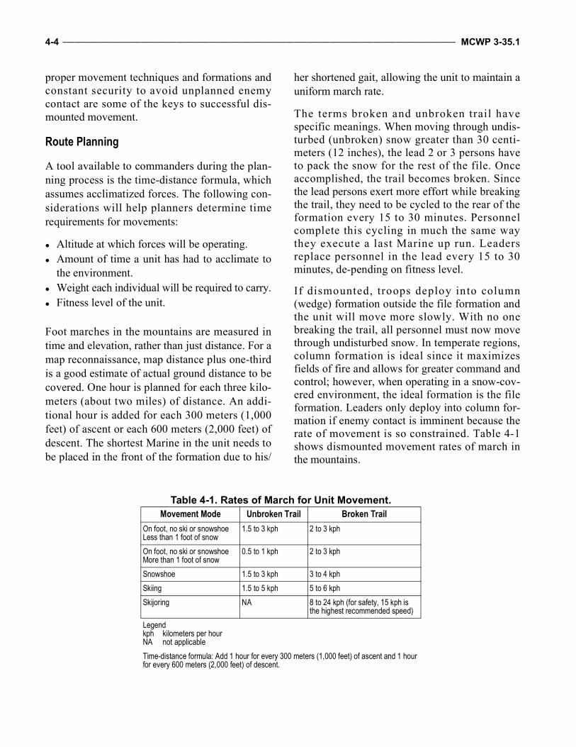
4-4 ____________________________________________________________________________________________________ MCWP 3-35.1
proper movement techniques and formations andconstant security to avoid unplanned enemycontact are some of the keys to successful dis-mounted movement.
Route Planning
A tool available to commanders during the plan-ning process is the time-distance formula, whichassumes acclimatized forces. The following con-siderations will help planners determine timerequirements for movements:
Altitude at which forces will be operating. Amount of time a unit has had to acclimate to
the environment. Weight each individual will be required to carry. Fitness level of the unit.
Foot marches in the mountains are measured intime and elevation, rather than just distance. For amap reconnaissance, map distance plus one-thirdis a good estimate of actual ground distance to becovered. One hour is planned for each three kilo-meters (about two miles) of distance. An addi-tional hour is added for each 300 meters (1,000feet) of ascent or each 600 meters (2,000 feet) ofdescent. The shortest Marine in the unit needs tobe placed in the front of the formation due to his/
her shortened gait, allowing the unit to maintain auniform march rate.
The terms broken and unbroken trail havespecific meanings. When moving through undis-turbed (unbroken) snow greater than 30 centi-meters (12 inches), the lead 2 or 3 persons haveto pack the snow for the rest of the file. Onceaccomplished, the trail becomes broken. Sincethe lead persons exert more effort while breakingthe trail, they need to be cycled to the rear of theformation every 15 to 30 minutes. Personnelcomplete this cycling in much the same waythey execute a last Marine up run. Leadersreplace personnel in the lead every 15 to 30minutes, de-pending on fitness level.
If dismounted, troops deploy into column(wedge) formation outside the file formation andthe unit will move more slowly. With no onebreaking the trail, all personnel must now movethrough undisturbed snow. In temperate regions,column formation is ideal since it maximizesfields of fire and allows for greater command andcontrol; however, when operating in a snow-cov-ered environment, the ideal formation is the fileformation. Leaders only deploy into column for-mation if enemy contact is imminent because therate of movement is so constrained. Table 4-1shows dismounted movement rates of march inthe mountains.
Table 4-1. Rates of March for Unit Movement.Movement Mode Unbroken Trail Broken Trail
On foot, no ski or snowshoe Less than 1 foot of snow
1.5 to 3 kph 2 to 3 kph
On foot, no ski or snowshoe More than 1 foot of snow
0.5 to 1 kph 2 to 3 kph
Snowshoe 1.5 to 3 kph 3 to 4 kphSkiing 1.5 to 5 kph 5 to 6 kphSkijoring NA 8 to 24 kph (for safety, 15 kph is
the highest recommended speed)Legendkph kilometers per hourNA not applicableTime-distance formula: Add 1 hour for every 300 meters (1,000 feet) of ascent and 1 hour for every 600 meters (2,000 feet) of descent.
Mountain Warfare Operations__________________________________________________________________________________ 4-5
Commanders cannot permit straggling or devia-tions from the selected route. Every aspect ofmarch discipline must be rigorously enforced tokeep a column closed. To prevent an accordioneffect, unit members must allow enough distancebetween themselves to climb without causing thefollowing individual to change pace. In moun-tainous terrain, a slow, steady pace is preferred tomore rapid movement with frequent halts.
Commanders must incorporate scheduled rest haltsinto movement plans based on distance and avail-ability of covered and concealed positions. As ageneral rule, units should stop and rest for 5 min-utes after 25 minutes moving. If possible, com-manders should not conduct rest halts during steepascents or descents. At the start of a march, every-one should dress lightly so that they begin themarch cool. A short halt should be taken to adjustclothing and equipment after the first 15 minutesof movement.
In glacial areas, the principal dangers and obsta-cles to movement are crevasses and snow and iceavalanches. Exposure to the hazards of glaciatedmountains increases at the company-level andabove; hence, movement should be limited to sep-arate platoons and lower levels. When moving onglaciers, an advance element should be used. Theadvance element identifies the best routes ofadvance, marks the trail, and provides directionsand distances for follow-on units. A marked trail isespecially important during inclement weather andlow visibility and provides a route for retrograde.Commanders must carefully weigh the advan-tages of a marked route against the possibility ofambush and the loss of surprise.
Individual Loads
Economizing the individual combat load is es-sential for conducting dismounted operations inthe mountains. In steep terrain at elevationsabove 1,524 meters (5,000 feet), individual loadsmay need to be reduced by 50 percent. Forexample, water purification and the amount ofbulky ammunition, such as pyrotechnics, must be
considered. First class lightweight assault packs,however, are vital. Leaders at all levels mustensure they review and modify existing unitpacking lists and standing operating procedureswhen conducting dismounted operations inmountainous terrain. Consider using the memoryaid DROP—
Decide mobility levels. Reduce unnecessary equipment. Organize resupply methods. Police the ranks and conduct inspections.
Terrain Analysis
Unlike flat terrain on which the quickest wayfrom point A to point B may be a straight line,moving in a straight line on mountainous terrainis often more difficult and time consuming. Con-siderations for route planning include—
Physical network analysis. Contouring to prevent forces from gaining or
losing elevation unnecessarily. Obstacles, such as population centers, rivers,
and bridges.
Mountain Streams and Fords
Stream and river crossing operations are difficultand are usually accomplished by expedientmeans. Bridging operations in mountainous ter-rain are normally limited to spanning short gapsand reinforcing existing bridges by using prefab-ricated materials and fixed spans from floatingbridge equipment. However, standard design orimprovised suspension bridges may still beneeded for longer spans. Because existing bridgesmay have low vehicle load classifications, stan-dard fixed tactical bridges and bridging materialsshould be on hand to quickly reinforce or replacethem. In extremely rough terrain, cableways andtramways may be constructed to move light loadsand personnel across gorges and up and downsteep slopes.
4-6 ____________________________________________________________________________________________________ MCWP 3-35.1
Swift WaterOperations conducted in mountainous terrainmay often require crossing swift flowing rivers orstreams. Such crossings should not be takenlightly. The force of the flowing water may beextremely great and is most often underestimated.All rivers and streams are obstacles to movement.They should be treated as danger areas andavoided, if possible. Not all mountain rivers orstreams will be fordable. If a water obstacle is toowide, swift, or deep, then an alternate routeshould be used or the crossing will require majorbridging by engineers. It may require the use ofrafts or boats. Reconnaissance of questionablecrossing sites is essential.
Map, photo, and air reconnaissance of the routemay not always reveal where water obstaclesexist. In a swamp, for example, unfordablesloughs may not show on the map and they maybe concealed from aerial observation by a can-opy of vegetation. Whenever a unit may cross awater obstacle, its commander must plan sometype of crossing capability.
FordsA ford is a location in a water barrier where thecurrent, bottom, and approaches allow person-nel, vehicles, and other equipment to cross andremain in contact with the bottom during cross-ing. Fords are classified according to their cross-ing potential (or trafficability) for pedestrians orvehicles. Fordable depths for vehicular trafficcan be increased by suitable waterproofing andadding deep-water fording kits. These kits per-mit fording depths up to an average of 4.3 meters(14 feet). Vehicle technical manuals provide fur-ther fording information.
Reconnaissance of potential fording sites is criticaland should include the soil composition of theapproaches and the current’s speed. Approachesmay be paved or covered with mat or trackway,but they are usually unimproved. The compositionand the slope of the approaches to a ford should becarefully noted to determine the trafficability after
fording vehicles saturate the surface material of theapproaches. The velocity of the water and thepresence of debris are used to determine the effect,if any, on the ford’s condition. Currents are cate-gorized as—
Swift (more than 1.5 meters [5 feet] per second). Moderate (1 to 1.5 meters [3 to 5 feet] per sec-
ond). Slow (less than 1 meter [3 feet] per second).
The ford’s stream-bottom composition largelydetermines its trafficability. It is important todetermine whether the bottom is composed ofsand, gravel, silt, clay, or rock and in what pro-portions. For more information see FM 3-34.170,Engineer Reconnaissance.
Casualty Evacuation
Evacuation of casualties in the mountains isresource intensive in manpower, equipment, andtime. Planned routes should identify casualty col-lection points that are accessible to multipletransportation assets, if possible. Units must con-sider how they will move casualties in the eventthat vehicles or aircraft will not be available dueto terrain and weather restrictions. Personnelshould be trained in rough terrain evacuationtechniques prior to deployment, to include rais-ing, lowering, and nonstandard casualty evacua-tion (CASEVAC) platforms. Leaders should planand rehearse contingencies for mounted, dis-mounted, and aviation evacuations. Realistictime-distance analysis must be conducted toensure proper allocation of assets and to maxi-mize casualty survivability. Units should considerpushing medical assets to lower echelons toreduce CASEVAC requirements. Chapter 6 pro-vides more information.
General Considerations
Mountainous environments will limit mobility, theuse of mutually supporting large forces, and thefull use of sophisticated weapons and equipment.These limitations mitigate many of the strengths
Mountain Warfare Operations__________________________________________________________________________________ 4-7
US military forces bring to the fight; however,they benefit the indigenous adversaries whoselesser sophistication better suits the environment.
Mountain operations will restrict ground and airmovement of units. Movement requires carefulplanning and execution with the understandingthat distance over arduous terrain can be as diffi-cult to overcome as the adversary. Marine forcesmust adapt their standing operating procedures
and develop innovative TTP in order to success-fully accomplish the mission.
The ability to move requires the proper integrationand use of all appropriate resources, including air-craft, wheeled and tracked vehicles, watercraft,porters, pack animals, and individual means. Suc-cessful negotiation of the terrain and overcomingthe effects of the environment will depend on spe-cialized mountain training and proper equipment.

4-8 ____________________________________________________________________________________________________ MCWP 3-35.1
This Page Intentionally Left Blank
CHAPTER 5ENGINEERING
As with all operations conducted in mountainousterrain, engineering operations require morepreparation, resources, and time in the mountainsthan in any other environment. Steep elevationchanges, extreme weather, unmoving rock, andlack of oxygen at high altitude all present chal-lenges for the engineer that can only be overcomeby proper planning. The other warfighting func-tions—effective communications, sustainment,fires, and maneuver with traditional methods—that enable the engineer to accomplish his/hermission will also be hindered by the inherent dif-ficulty of mountain operations. Marines shouldreference MCWP 3-17.7, General Engineering,for additional information regarding general engi-neering in all environments.
Organization
Only through an in-depth IPB, a thorough ISRplan, and an in-depth analysis can units overcomethe difficulties associated with mountain opera-tions; moreover, Marine Corps engineers executea thorough engineer battlefield assessment. Thereis no formula for success in the mountains, asevery valley over the next ridgeline will presentnew challenges that will require new solutions.But through analysis, effective task organization,and the proper allocation of resources, MarineCorps engineers can adapt to those challenges.
Task Organization
Mobility in the mountainous environment isextremely limited, requiring extensive shapingoperations. The sheer quantity of earth move-ment and horizontal construction hours involvedin providing mobility in offensive operationsrequires a focused effort from all engineering ele-ments. The inherent separation of areas of
responsibility for the different engineering ele-ments based on subordinate command elementmission-essential tasks within units can result in aseparation of resources to support varyingrequirements with varying priorities. In order tomaximize the allocation of engineering resourcesto the highest priority tasks and to prevent lowproductivity from any engineering element, com-manders must be prepared to detach all horizontalconstruction engineering elements from subordi-nate commands and combine them to create aseparate element.
Joint Engineer Support Elements
The difficulties presented by the mountainousenvironment can only be effectively mitigated bythe combined effort of all engineer elements inthe area of operations. The Marine Corps has lim-ited heavy engineering assets with which toaccomplish complex large-scale engineering mis-sions, making aggressive liaison with joint ele-ments vital to the procurement of criticalengineering capabilities and support that may beorganic to the other Services.
Naval Construction Force Joint Publication (JP) 3-34, Joint Engineer Oper-ations, describes the basis for naval constructionforce (NCF) support to the operational forces(MCWP 4-11.5, Seabee Operations in theMAGTF). In addition to or coincident with com-ponent missions specified by the commander, theNavy provides general engineering support toMAGTFs. This support consists of NCF unitsunder the operational control of a MAGTF. TheseNCF units are necessary to reinforce and augmentthe MAGTF’s limited engineering capability.They are integral to the organization of theMAGTF and ensure immediate and effective de-livery of CSS tasks.

5-2 ____________________________________________________________________________________________________ MCWP 3-35.1
Rapid Engineer Deployable Heavy Operational Repair Squadron Engineer The rapid engineer deployable heavy operationalrepair squadron engineer (known as RED HORSE)is a US Air Force unit with the mission of assess-ing, planning, and establishing contingency facili-ties/infrastructure to support contingencyoperations and combat missions. In short, REDHORSE constructs facilities and infrastructure tosupport Air Force operations.
Prime Base Engineer Emergency Force The mission of prime base engineer emergencyforce (known as Prime BEEF) is to provide civilengineer support for the beddown of personnel andaircraft. In other words, Prime BEEF provides util-ities and civil engineer support to improve andmaintain existing infrastructure to support air andspace expeditionary task force operations.
Mobility
During mountain operations where limited mobil-ity exists, it is critical that units maintain securityand control of available road/transportation net-works, including securing key bridges, fords,crossing sites, intersections, and other vulnerablechokepoints. These locations must be protectedagainst enemy air, obstacle, and ground threats;however, commanders must carefully balancetheir available combat power between protectingtheir freedom of mobility and allocating forces tocritical close combat operations. Effective riskanalysis and decisions are essential. Route clear-ance operations, patrols, traffic control points, andother security operations aid commanders insecuring routes. During offensive operations,commanders may need to commit forces to seizekey terrain and routes that afford their forcesgreater mobility and tactical options against theenemy. Engineer support in front of convoys andcombat formations is often necessary to clear andreduce obstacles, such as washouts, craters, mines,landslides, avalanches, and snow and ice in coldermountainous regions. Reducing obstacles is more
difficult in mountainous areas because of reducedmaneuver space, lack of heavy equipment, and anincreased competition for engineer support. Mine-fields should normally be breached, since bypass-ing properly sited obstacles is often impossible.
Gap Crossing
Stream and river crossing operations are difficultand often must be accomplished by expedientmeans. Bridging operations in mountainous ter-rain are normally limited to spanning short gapsand reinforcing existing bridges by using prefabri-cated materials and fixed spans from floatingbridge equipment. Nonstandard bridging tech-niques may be necessary, as well as fording tech-niques where possible. During the spring and earlysummer months, snow melt will cause previouslypassable gap crossings to become untenable. Alter-nate routes must be identified to ensure mobility.
Limited Assembly/Construction AreaDue to the narrow road systems and the limitedradius of curves typically found in mountainousenvironments, possible locations for gap crossingare severely limited and crossing locations maybe located further from the objective. Setting upstaging areas, equipment parks, and assemblyareas may not be possible near the gap crossinglocation due to limited open space in the vicinityof the gap. These factors will influence both theemployment of the medium girder bridge and theimproved ribbon bridge. Properly conductedengineer reconnaissance/IPBs will effectivelyidentify the best locations for gap crossings.
Dry GapsAreas that have been identified as dry gaps duringthe initial engineer reconnaissance may becomewet gaps overnight. The same could happen withwet gaps becoming dry gaps in the summer. Usingavailable intelligence and geospatial and historicMET methods, engineers must identify historicalhigh water marks during the reconnaissance inorder to predict the potential rise in water levelduring the wet seasons.
Mountain Warfare Operations__________________________________________________________________________________ 5-3
Nonstandard BridgingThe mountainous terrain will often hinder theemployment of standard Marine Corps bridgingassets, so engineer elements must be prepared touse nonstandard bridging techniques, such asrope, cable, or suspension bridges, to ensuremobility to both mounted and dismounted maneu-ver forces.
Ice CrossingDuring cold weather operations, frozen water-ways, such as lakes, streams, or rivers, can beused by friendly forces for mounted or dis-mounted movement depending on the thicknessand condition of the ice. See MCRP 3-35.1D formore information.
Counter-Improvised Explosive Device/Mine Operations
In a mountainous environment, the terrain favorsthe enemy’s use of mines and IEDs as standaloneweapons and in the initiation of ambushes. In themountains, using mechanical mine plows androllers or other standard route clearance vehicles,such as the vehicle mounted mine detection sys-tem (Husky) and mine protected clearance vehi-cle (Buffalo), is frequently impossible due to thelack of roads and trails and the low classificationof those that do exist.
Commanders should employ mounted anddismounted counter-radio-control led IEDelectronic warfare systems to the greatest extentpossible to counter radio-controlled/detonatedIEDs. When on foot pa trol , breaching orbypassing mines and IEDs may be required. Theuse of robots or demolitions is often required andpreferred. Commanders must exercise extremecaution when employing demolitions in thevicinity of snow- and rock-covered slopes be-cause they can cause dangerous rockslides,avalanches, and secondary fragmentation. Moreinformation on breaching operations and requiredsynchronization can be found in MCWP 3-17.8.
Countermine tasks in this environment are alsoaffected by the temperature. Marines should referto MCRP 3-35.1D for further information. Minesplaced in snow cover can be plowed away toclear a route. Detonation and breaching can bemore difficult due to freezing temperatures,frozen ground, and concealment of the snowcover (see FM 5-102, Countermobility).
Snow-Laid MinesEnemy forces can easily emplace antipersonneland antivehicular mines and IEDs in snowy ter-rain. However, if the mines become covered by acouple feet of snow and the snowpack hardens,the mines will be ineffective until the snow melts.The existence of snowy or inclement weatherconditions on routinely used pedestrian or vehic-ular route scan have a negative impact on theeffectiveness of route clearance equipment. Lead-ers must ensure they leverage all doctrinal andtechnological TTP advantages to develop aneffective route clearance strategy that assuresmobility in all ground cover. This situation pres-ents the possibility that routinely used paths orroutes during the winter may contain minesunderneath the snowpack. All snow-coveredroutes considered cleared during the winter mustbe cleared again once snow begins to melt.
Route Sweep FormationsDuring fair weather mountain operations, tacticalmobility teams may be task-organized andemployed in front of convoys or combat forma-tions to perform contiguous and/or combat routeclearance operations as well as limited routerepair and nonexplosive obstacle removal, suchas rocks, snow, and downed trees. As opposed toformations in other terrain, route clearance for-mations in the mountains push the flanks up thehillside to fulfill the role of mountain pickets/overwatch and to uncover potential radio-con-trolled IED trigger person. In many cases, flankson one side of the formation may be removed ifthe slope drops off in a steep decline.
5-4 ____________________________________________________________________________________________________ MCWP 3-35.1
Metal DetectorsDismounted engineers with mine and/or metaldetectors will remain a requirement on the currentbattlefield to perform dismounted sweeps in orderto deny the enemy the intended effects of their useof mine and/or IED warfare. Commanders mustunderstand the physical and psychological toll thatperforming dismounted sweep operations willtake on Marines operating in a mountainous envi-ronment. Marines of all other military occupa-tional specialties (MOSs) must be cross trained onthe use of metal detectors as a force multiplier.
Technological ConsiderationsExtreme cold weather, snow, and highly mineral-ized soils found in the mountains will haveadverse effects on mine and metal detectors. Lead-ers must conduct pre-operational checks and test-ing in a secure area prior to deploying detectionteams. Counter-IED technology, such as roboticplatforms that use LOS remote control interfaces,must also receive pre-operational checks prior todeployment in adverse terrain and snowpackedconditions. Mine detection systems, whether vehi-cle mounted or handheld, that use ground-pene-trating radar technology may be adversely affectedby snow- and water-covered surfaces. Thecounter-radio-controlled IED electronic warfaresystems that use LOS may be hindered by theeffects of mountainous terrain and weather.
Engineer Reconnaissance
In preparation for operations, the development ofthe engineer battlefield assessment, including IPB,mobility, and combined obstacles and ambushsites overlays, may be the most important task thatthe MAGTF can perform in the mountains. Accu-rate and detailed reports will provide all maneuverelement commanders with the critical informationnecessary for proper operational planning.
Engineer reconnaissance assumes greater sig-nificance in a mountainous environment in orderto ensure supporting engineers are properly task-organized with specialized equipment for quickly
overcoming natural and reinforced obstacles.Engineer reconnaissance teams assess theresources required for clearing obstacles on pre-cipitous slopes, constructing crossing sites at fast-moving streams and rivers, improving andrepairing roads, erecting fortifications, and estab-lishing barriers during the conduct of defensiveoperations. Since the restrictive terrain promotesthe widespread employment of point obstacles,engineer elements should be integrated into allmountain reconnaissance operations.
In some regions, maps may be unsuitable for tac-tical planning due to inaccuracies, limited detail,and inadequate coverage. In these areas, engineerreconnaissance should precede, but not delay,operations. Because rugged mountainous terrainmakes ground reconnaissance time consumingand dangerous, a combination of ground andaerial or overhead platforms should be used forthe engineer reconnaissance effort. Data on theterrain, vegetation, and soil composition, com-bined with aerial photographs and multispectralimagery, allow engineer terrain intelligenceteams to provide detailed information that may beunavailable from other sources.
Route SelectionWaterways, such as rivers and lakes, can be ob-stacles during the spring and summer months butcan become trafficable and an asset during thewinter months. Full use of all intelligence avail-able through map, ground, and air reconnais-sance is necessary for proper route selection.Route selection criteria will vary by season.Regardless of the season, the need for roads willnot be eliminated by over-the-snow vehicles.
Engineer Ground ReconnaissanceEngineer reconnaissance includes observation ofsoil, snow cover, vegetation, ground water, sur-face water, ice thickness, road surface conditions,and sources of local construction materials as wellas the conditions of alternate routes. The purposeof this reconnaissance is to verify all informationpreviously collected; check all possible routes for
Mountain Warfare Operations__________________________________________________________________________________ 5-5
natural and manmade obstacles, such as avalanchedebris, mines, and ice obstacles; and select thebest site or route to accomplish the mission.
Snow and IceAs much data and information regarding snowfalland ice growth as possible should be collected inthe area of operations. Both are equally import-ant and can be used as an advantage or canbecome a disadvantage to friendly forces. Assnow accumulates, it reduces the mobility of bothMarines and machine. Heavy accumulation ofsnow can result in avalanches, so engineers mustbe aware of the slope angles and aspects thatfavor avalanches in their area of operations. Thisawareness enables the commander to use the fol-lowing forces of nature to his/her advantage:
Fresh water freezes at 32 °F and salt waterfreezes at 28 °F.
Ice is relatively strong and has a varyingdegree of toughness and high bearing power.
As temperatures drop, the strength increasesrapidly from the freezing point to about 0 °F.
From this temperature, the strength of iceremains fairly constant despite lowering tem-peratures.
More information is available in MCRP 3-35.1D.
Countermobility
During mountain operations where limitedmobility exists, it is relatively easy to conductcountermobility.
Obstacles
Obvious natural obstacles include deep defiles,cliffs, rivers, landslides, avalanches, crevices, andscree slopes, as well as the physical terrain of themountains themselves. Obstacles vary in theireffect on different forces. Commanders must eval-uate the terrain from both the enemy and friendlyforce perspective. They must look specifically at
the degree to which obstacles restrict operationsand at the ability of each force to exploit the tacti-cal opportunities that exist when obstacles areemployed. Manmade obstacles used with restric-tive terrain and observed indirect fire are ex-tremely effective in the mountains; however, theirconstruction is very costly in terms of time, mate-riel, transportation assets, and labor. Command-ers must know the location, extent, and strength ofobstacles so that they can be incorporated intotheir scheme of maneuver. Commanders shouldallot more time for personnel to construct obsta-cles in cold weather due to the restriction of addi-tional clothing and equipment. When developingbarrier obstacle plans, they must consider whateffect changes in weather will have on the plan.For example, if temperatures increase signifi-cantly, many areas that were solid ground maybecome untrafficable, such as rivers and lakes.Conversely, if temperatures fall, causing riversand lakes to freeze, these areas may become newavenues of approach for the enemy. Conse-quently, these areas should be covered by a com-bination of observation and direct and indirect fireweapons, to include demolitions.
The engineer should never fail to use the naturalobstacles that the environment offers. Icy slopesand fallen trees can disrupt and channel troopmovements. Leeward slopes with heavy depositsof snow can be rigged with explosives in order tocatch enemy forces in the avalanche runout zone.Barbed wire and concertina are still effective onsnow. It is easy to create effective obstructions inmountains by cratering roads, fully or partiallydestroying bridges, or inducing rockslides andavalanches. Units can emplace antitank mine-fields (family of scatterable mines) effectively tocanalize the enemy, deny terrain, or supportdefensive positions. Commanders should remem-ber that clearing or reducing these same obstaclesmay be extremely difficult and a hindrance tofuture operations. Using reserve and situationalobstacles, lanes and gaps, and plans to rapidlyreduce friendly obstacles must be an integral partof all defensive operations. Commanders mustalso consider the enemy’s ability to create similar
5-6 ____________________________________________________________________________________________________ MCWP 3-35.1
obstacles and minefields when developingcourses of action that hinge on speed of move-ment or a particular avenue of approach.
Mines
Personnel should refer to MCRP 3-35.1D forconsiderations regarding the employment ofmines in cold weather.
Avalanches
Avalanches occur in nature when snow loadsexceed the strength of the snowpack structure.Artificial loads, such as explosive detonations,can be applied to the snowpack in order to artifi-cially trigger an avalanche. Artificial avalanchetriggers allow engineers to cause avalanches at aspecific time when it is safe or most advanta-geous for friendly forces to hinder enemy forcemovement. The use of demolition charges orartillery air munitions is one method of applyingstress to the snowpack’s instability. Explosivesdo not provide the same loading of stress onto thesnowpack as other control trigger mechanisms,but they may be ideal for some snowpack condi-tions. The range of terrain types as well as theoperational requirements necessitates the use ofvarious delivery methods to optimize the effec-tiveness of the explosives. The explosives deliv-ery methods employed in a control area arechosen on the basis of the general terrain, snow-pack, effectiveness, operational necessity andpotential for noncombatant casualties, anddestruction of civilian property and infrastructure.
In order to mitigate the threat of avalanches androckslides to friendly forces, noncombatants, anddestruction of civilian property and infrastructure,the MAGTF has several methods to artificiallytrigger the event when it is safe. Engineers canplace demolition charges on the snowpack or useindirect fire or direct fire with explosive projec-tiles to trigger the event. Indirect fire allows theMAGTF to control the time of the event from asafe distance without the burden of movement.They plan to trigger close enough to offensiveoperations that time is available to clear routes,
yet not allow for the threat potential to rebuild. Instability operations, planners must mitigate theavalanche threat regularly for all LOCs. Smallpatrols in unfamiliar areas should carry mortarsystems in order to mitigate any suspicious slopesthat they might encounter from a safe distance.
Survivability
The ability to dig survivability positions into aslope increases the amount of usable terrain,increases survivability of the positions, and saveson time and money for force protection. Engi-neer units should task-organize and deploy withthe proper resources to cut into the hillsides sosurvivability positions can be placed into themountain instead of building on top of them.Such operations will require extensive use ofheavy equipment and demolitions.
Elevation of Forward Operating Bases/Combat Outposts in Relation to Surrounding Terrain
When planning to establish a fixed site, the posi-tion and angle of the enemy’s fire plays a signifi-cant role in choosing the site location. Whoevermaintains the high ground has an advantage offire and cover, so defensive positions should beelevated. Placing fixed sites on peaks or ridgesshould be avoided because it makes the site vul-nerable to fire from 360 degrees. Ideally, sitesshould be located on the military crest of thereverse slope with observation posts on both themilitary crest of the forward slope and surround-ing key terrain. As time permits, positions shouldbe camouflaged and/or concealed and dummypositions established.
Overhead Cover
Mountains will almost always present the enemywith the opportunity to shoot at the friendly basefrom an elevated position, so most rounds willimpact on the top of structures. Overhead covershould be heavily reinforced and maintained,requiring increased structural support in loadbearing walls and roof supports.
Mountain Warfare Operations__________________________________________________________________________________ 5-7
Forward Operating Base Site Selection
The trend for most bases is to locate them whereit is convenient for logistics, command and con-trol, and mobility, which is most likely next to alocal MSR. In the mountains, MSRs tend to fol-low river valleys. Such routes present an issuewhen the river valley floods in the spring andwashes out the entire MSR and parts of the localpopulation center. Bases must be established highenough off the flood plain to avoid being dam-aged by the spring snow melt and should have alocal MSR that is also clear from the flood plain.
Snow Removal/Drainage
The FOB construction in high altitude areas mustbe planned with space for snow removal. A loca-tion must be identified for storing snow piles andthese locations must have adequate drainage toremove the snow melt from the FOB.
General Engineering
General engineering involves activities that iden-tify, design, construct, lease, and provide facili-ties. Characterized by high standards of design,planning, and construction, general engineeringin mountainous terrain must be carefully consid-ered due to extreme temperatures, altitudes, anddifficulty of terrain. If feasible, constructionshould be undertaken when little or no frost is onthe ground; often, if the permafrost is too thick, itcan make it impossible to dig. Construction oper-ations in mountainous terrain are extremely slow,time consuming, and complicated by the lack oflocal material, heavy equipment operation diffi-culties, and enemy defensive activities. Due tothe uneven terrain, surveyors must be employedto help ensure the best structural integrity of theconstruction project. Local materials, if avail-able, should be used for construction purposes tohelp with stability operations and to help alleviatethe strain on overburdened transportation and avi-ation assets.
Horizontal Construction
The most noticeable challenge in the mountains isthe lack of road networks and railroads. Both arepractically nonexistent, making road constructiona major operation. Heavy equipment and combatengineer operators exposed to the elements rapidlybecome fatigued and require regular relief aftershort periods. Continuous operations, except forshort, periodic stops for operator checks and mini-mum equipment maintenance, prevent equipmentfrom freezing. Cross-country movement of unitswithout engineer support is extremely difficult.
RoadsFor the most part, creating new road systems inmountainous regions is impractical because of thelarge amount of rock excavation required. Fur-ther, in winter months, rock excavation will benearly impossible with the use of only heavyequipment. Therefore, roadwork is generally lim-ited to the existing roads and trails, which oftenrequire extensive construction, improvement,maintenance, and repair to withstand the increasedmilitary traffic and severe weather conditions. Incertain mountainous areas, materials may be diffi-cult to obtain locally and it may be impossible tomake full use of conventional heavy engineerequipment for road and bridge construction orrepair. In such cases, large numbers of engineersare required and units must rely heavily on handlabor, light equipment, and demolitions.
Secondary RoadsSecondary roads and trails should be steadilyimproved to accommodate wheeled and trackedvehicles and, eventually, heavier vehicles. Theirselection depends on necessity and the speed withwhich the routes can be put into service. Abnor-mal gradients on roads may be necessary toensure that construction keeps pace with tacticaloperations. Side hill cuts are the rule and the samecontour line is followed to avoid excessive fills orbridging. When terrain permits, turnouts shouldbe constructed in order to mitigate traffic conges-tion on single-lane roads or trails. Drainage
5-8 ____________________________________________________________________________________________________ MCWP 3-35.1
requirements must be considered in detail becauseof the effects of abnormally steep slopes, damag-ing thaws, and heavy rains.
Landing ZonesEngineers must be prepared to consider LZs foraviation assets. Drainage is an important factor inselecting an airfield site and planning the con-struction. Engineers should be aware of the fol-lowing features related to drainage in order toensure a successful LZ design:
Sites should be selected in areas where cuts orthe placement of base-course fills will notintercept or block obvious existing naturaldrainage ways.
Areas with fine-textured, frost-susceptible soilsshould be avoided.
Soil stabilization and dust abatement must beunderstood.
An LZ should normally be on the windwardside of mountain ridges or peaks to ensure areasonably smooth air flow; however, in for-ward areas, concealment from the enemyobservation is a more important factor inselecting a site. These sites should be wellclear of structures and vegetation, which arevulnerable to helicopter rotor downwash, par-ticularly in confined spaces.
An LZ should be as level as possible and maynot be on a slope exceeding 7 degrees in mostsituations. Aircrews that experience difficultylanding due to extreme slope angles in LZsmay request to reposition to a less drasticslope angle for operations. On slopes greaterthan 7 degrees, a helicopter cannot land; how-ever, if rotors are clear of obstructions, theymay be able to load and unload in a low hover.
Snow-covered LZs can be effectively markedwith colored dye, timber “letters,” or smoke,but they should be camouflaged with moresnow when not in use.
In soft snow, a suitable reference point, such as avehicle, should be available to the pilot to avoid
disorientation in recirculating snow duringdescent. Stamping snow to form LZs is danger-ous because compacted snow forms a crust whenfrozen, which the powerful downdraft of largehelicopters breaks up causing a foreign objectdamage hazard. As with soft snow, some form ofreference is desirable and, if time permits, thearea should be damped with water or other dustabatement material. Helicopter-blown sand or iceis a hazard to Marines and weapons, particularlyoptics. Furthermore, downwash in freezing con-ditions can cause frostbite to exposed skin.
An LZ should be relatively clear of fine dirt orsand, which often develops on spaces frequentlytrafficked by personnel and heavy vehicles. Fine,soft dirt can become deep on a relatively flat LZand may cause brownout conditions for landingand departing aircraft. This situation may becomeeven more dangerous with the addition of con-fined approach and departure paths due to sur-rounding steep terrain. When possible, LZsshould have an adequate system in place toreduce the amount of dust prior to aircraft arriv-ing. Crushed rock, matting pads, large amounts ofwater sprayed on the LZ, glue-/grease-based dustabatement products, and commercial productsapproved by aviation leadership are all viablemethods of preventing pilot disorientation due towhiteout/brownout incidents.
Vertical Construction
Field construction time and the difficulty of con-ventional engineer work are magnified in moun-tain operations. Environmental characteristicsthat complicate engineer tasks are permafrost,extreme and rapid changes in temperature, wind,moisture, snow, ice storms, and flooding.Although standard construction principles remainthe same in mountainous environments, someconsiderations must be given to constructionduring times of heavy snowfall.
The standard pitch of the roof (4:12 pitch [4 inchesof rise over 12 inches of run]) is sufficient forsnow to slide off; however, corrugated steel must
Mountain Warfare Operations__________________________________________________________________________________ 5-9
be used atop plywood in order to allow the snowto slide off more freely. Ceilings need to be sealedin order to prevent dripping into structures.
For wood frame construction, all material designrequirements for structures without a snow loadshould be increased to the next standard materialsize. For example, a building with 2-inch by 4-inchstuds without a snow load should be designed with2-inch by 6-inch studs for use in an environmentwith a snow load. If material of a greater size is notavailable, on-center spacing for both studs andtrusses can be decreased to accommodate theincreased weight due to snow load.
Utilities
Electrical and water equipment have associatedwinter kits. It is imperative that these winter kitsare deployed with the gear in order to enable thegear to work under extremely cold conditions.Further considerations must be given to the alti-tude change for output of equipment. Also, whenemplacing utility equipment, the operator mustensure that the equipment is on as level terrain aspossible (not to exceed a 15 percent gradient) andthe equipment is placed on any insulating mate-rial to keep it from freezing to the ground.
Tactical ElectricalGenerator sets can start and operate at tempera-tures as low as -25 °F without a winterization kit.With a winterization kit, generators can operate attemperatures as low as -50 °F and can be storedin temperatures no colder than -60 °F. It isrecommended that winterization kits be installedprior to deployment. Generators must be allowedto rise to normal operating temperature beforeapplying a load to reduce the possibility of enginedamage. When the ambient temperature is lowerthan -25 °F, most engines require preheatingbefore they are started. The engine type deter-mines the method used. The two basic types ofcooling systems used on power-generatingequipment are air cooled and liquid cooled. A
blowtorch is used to preheat most air-cooledengines. Most liquid-cooled engines are equippedwith a winterization kit that contains a preheater.The respective generator’s technical manual forpreheating and cold weather starting operatinginstructions is a good reference.
Special care must be taken when emplacing andusing field wiring harness kits. Typically, inextreme weather conditions, a lower Americanwire gauge is needed. If temperatures drop tobelow -32 °F, a 12-gauge American wire will notbe able to withstand the weather. Wires willbecome brittle and need to be covered with ther-mal protectors. At the same time, if wire is bur-ied, it needs to be below the permafrost layer,which can be up to 3 feet (1 meter) in some areas,or the gauge needs to be low enough to be able towithstand the extreme temperatures.
Generator sets are rated based on sea level alti-tude. The rating of the set may decrease as thealtitude increases. Information about operatingequipment at high altitudes is usually printed onthe data plate. The kilowatt rating may bereduced at high altitudes, depending on the typeof engine used to drive the generator. Refer to theappropriate technical manual for information foreach model of generator set. As a general rule, agenerator will lose 3.5 percent of its power forevery 300 meters (1,000 feet) over 1,219 meters(4,000 feet) that it ascends.
Cold weather maintenance must be done on allelectrical systems. In all generators, the antifreezesolution must be able to protect the equipment atthe lowest temperature expected. Also, the batter-ies will need to be fully charged to prevent freez-ing. In some cases, ice fog, which is caused byengine exhaust in very cold climates (-25 °F andbelow), may occur. To eliminate ice fog, a tubeshould be placed on the exhaust pipes and cov-ered with a tarpaulin to diffuse the exhaust in thesnow. Lastly, prior to operating the equipment,ice, snow, moisture, and other foreign materialshould be removed from the generator set.
5-10 ___________________________________________________________________________________________________ MCWP 3-35.1
Potable WaterMajor sources of water supply, in order of effi-ciency and economy, are—
Drawing water from under rivers or lakes. Melting ice or snow. Drilling wells.
More information on water usage requirementscan be found in chapter 6.
The Tactical Water Purification System can oper-ate down to 32 °F without the winter kit anddown to -25 °F with it; however, heated sheltersare often necessary for operating water purifica-tion equipment in order to prevent the inner pipesfrom freezing when not purifying water. Whentemperatures go below 32 °F, water purificationpersonnel can have difficulty operating and main-taining their equipment. Constant winterizing anduse of the water heaters are required to preventfreezing. Winterizing, however, is not always fea-sible. Surface water in winter must be pumpedfrom beneath an ice layer. To prevent freezing, itmay be necessary to preheat the water duringoperations and keep it heated until it is issued,which may require additional heaters.
The water site selection can be tricky in mountain-ous terrain. The water site needs to be on highporous ground, reasonably level, and well drainedto prevent water from impeding resupply opera-tions. During the winter in cold regions, reconnais-sance teams should use ice augers to determine icethickness on a potential water source. The teamshould also measure the depth of water under theice at several spots because of the variations in thebeds of shallow streams and rivers in mountain-ous regions. Once a site has been selected, shapedcharges are far superior to hand tools for cuttingholes through thick ice to prepare a water hole.
Maintenance of the water distribution systemsmust be considered. In very cold weather, it maybe necessary to periodically drain the raw waterpump and the raw water hoses and bring them intoa warm shelter so they do not freeze. Frazil ice isthe slushy ice that forms as the water travels in
turbulent unfrozen sections of a river. If frazil iceis present at the water supply hole, the ice filtershould be used to keep the frazil ice from beingsucked into the raw water pump and freezing.
Higher altitudes require adjustments in planningfactors (see chap. 6). For example, the watertreatment chemicals react differently at ex-tremely low temperatures: at 32 °F, chlorine re-quires twice as much contact time to properlydisinfect water. It is recommended that individ-ual Marines carry individual water purificationsystems and supplementary iodine tablets inorder to purify water for personal consumption.Further information on potable water in coldweather and mountain water operations is foundin MCRP 3-35.1D and FM 10-52, Water Supplyin Theaters of Operations.
FuelMountain operations challenge the storage anddistribution of fuel. Cold weather operationsrequire increased testing, recirculation, equip-ment maintenance, and fuel usage due to extendedequipment operation requirements. Ground opera-tions may increase fuel consumption rates of indi-vidual vehicles by 30 to 40 percent, requiringmore fuel filtering and distribution. Depending onthe temperature, adding icing inhibitors to fuelmay be necessary. Diesel fuel will reach its freez-ing point and begin to gel at around 15 °F; where-as, jet fuel has a much lower freezing point ofaround -51 °F. Fuel additives are available to de-crease the possibility of fuel gelling (MilitaryDetail [MIL-DTL] Specification 85470, Inhibi-tor, Icing, Fuel System, High Flash, North Atlan-tic Treaty Organization Code Number S-1745).Although fuels do not completely freeze, they willbe the same temperature as the air. To preventfrostbite, fuel handlers must always wear glovesdesigned for handling petroleum products whenworking with fuels.
Heavy Equipment
Engineer equipment use in mountainous environ-ments does not change drastically from its use in
Mountain Warfare Operations_________________________________________________________________________________ 5-11
other regions; however, there are considerationsthat must be made when planning engineer equip-ment operations.
Hard StartingDiesel engines, found on all engineer equipment,will be prone to hard starting. Some are equippedwith engine block heaters to help alleviate thisproblem. Commanders must plan on increased fuelconsumption if vehicles are to remain runningduring extreme cold in order to counter cold sink.
Tire ChainsWhen conducting heavy equipment operations insnow, tire chains will increase mobility and makematerial handling operations safer.
Snow RemovalFront end loaders and road graders make excel-lent snow removal tools, but road edges, espe-cially drainage ditches, should be marked toavoid accidents. When removing snow, operatorsmust be cautious so as not to break through thesoil permafrost layer to prevent muddy condi-tions. Bulldozers do not make good snowremoval tools for FOB operations. The amount ofmechanical damage to the ground surface gener-ally outweighs the reduced time for removal.Commanders must weigh the use of bulldozersfor snow removal outside of the FOB against thedamage to road surfaces that can be caused. Theymust exercise extreme caution when orderingheavy equipment operations in deep snow or ice,since both tracked and wheeled vehicles areprone to sliding on ice. Since rollover conditions
are increased when operating on uneven snow-packs, operators must be cautious of varyingsnowpack and snow stability.
Excavation and EarthmovingMountain soil conditions are prohibitive to exca-vation and earthmoving operations due to theamount of subsurface rock. During extreme coldweather conditions, excavation and earthmovingoperations will be additionally hindered by thepermafrost layer. If excavation and earthmovingoperations are to take place, commanders mustplan for increased time and equipment repairparts, especially cutting edges, cutting blades, andhydraulic systems.
Underground Construction and Confined Spaces
Mountains often present natural and manmadecave complexes that make convenient weaponcaches and rally points. The dynamic nature ofearth movement and the threats associated withconfined spaces make underground areas ex-tremely dangerous. As a result, they should beavoided unless absolutely necessary. Manmadecaves and underground shafts should be avoidedat all costs; if weapons or enemy forces are sus-pected of occupying manmade undergroundspaces, an attempt should be made to coerce theenemy to come out of them before using demoli-tions to destroy the cave portal. Units deployingto any terrain that supports underground spacesshould equip their maneuver elements with gasdetectors capable of identifying oxygen and car-bon monoxide levels.

5-12 ___________________________________________________________________________________________________ MCWP 3-35.1
This Page Intentionally Left Blank
CHAPTER 6LOGISTICS AND SUSTAINMENT
General Planning Considerations
Planning considerations for logistics and sus-tainment begin with the concept of logisticsupport. Other considerations include cross-training and interoperability, waste management,accountability, security, aviation support, andseasonal challenges.
Logistic Support Concept
Due to the increase in time associated with mov-ing at high altitude, logistic support should beforward positioned as close to the supported unitas possible. The FOBs will likely be supported byintermediate support bases and main supply hubs.During OEF, for example, Jalalabad Airfield inAfghanistan was established so supplies could bepositioned forward of the main supply hubs atBagram Airfield and Kandahar Airfield.
Logistic Support ElementsIn mountain operations, logistic units may need tobe task-organized and attached to combat units inorder to support widely-dispersed forces. Infantrybattalions operating in mountainous areas maydisperse into company- or platoon-sized elementsthat operate from FOBs and combat outposts(COPs). Each support element should include per-
sonnel, such as winter mountain leaders, who haveexpertise in route planning and movement tech-niques. Logistic support elements may provide con-tainer delivery system (CDS) recovery, slingoperations, helicopter LZ coordination, convoyescort, health services, motor transport, materialhandling, supply, maintenance, vehicle recovery,and field feeding. In addition to these multi-Ser-vice functions, the Marine Corps also requires theirlogistical elements to fulfill detainee operations,embarkation, and general engineering functions.
Intermediate Staging Bases Operating farther back in intermediate stagingbases (ISBs), logisticians will employ convoysand aerial drops to deliver critical and sensitivematerials and supplies. Logistic organizations atan ISB should assume that key support personnelwill be on duty 24 hours a day, 7 days a week.The following minimum tasks should be locatedat an ISB: Class I, III, V, and VIII commodityoversight; mortuary affairs; parachute rigging;sustainment electronic maintenance; and trans-portation movement coordination.
Liaison OfficersSupported units should maintain an LNO at thelogistic operations center. Additionally, ServiceLNOs should be maintained with the theater of
Distributed Operations in Operation Enduring FreedomDuring OEF, many battalion, regiment, and brigade areas of operations were extraordinarily large. For example, whiledeployed to Regional Command East, the area of operations for 1st Battalion, 3d Marines was approximately the size ofMaryland. The battalion dispersed into six, company-sized FOBs, which were separated by as much as a 4- to 6-hour drive.Squads and platoons conducted operations outside the FOBs for up to a week at a time. At times, resupply was sporadic, soeach forward-based element required considerable self-sustainment, which was facilitated by logistic support teams assignedto each FOB.
—Marine Corps Center for Lessons Learned Report
6-2 ____________________________________________________________________________________________________ MCWP 3-35.1
operation support organizations and other higherlevel joint commands. They are needed when re-supplying along ring routes to ensure suppliesbeing distributed to units operating in the moun-tains are properly prioritized.
Logistic Cross-Training
During mountain operations when units oftenoperate outside of the range of immediate exter-nal support, personnel will likely need to becross-trained in many functional areas, includinglogistics. The institution of combat lifesavertraining for nonmedical personnel is one exam-ple of successful implementation of this concept.Potential areas for logistical skills cross-traininginclude CASEVAC, utilities, maintenance, foodservice, and air delivery recovery. For example,in an environment where IED attacks are preva-lent, vehicle recovery crews may need to be ableto conduct firefighting, CASEVAC, search andrecovery of human remains, and sanitization ofblast sites and equipment. More information onmortuary affairs is available in FM 4-20.64, Mor-tuary Affairs Operations.
Interoperability
Joint operations in mountainous terrain requireinteroperability among the Services. For exam-ple, when 1st Bat ta l ion, 3d Mar ines wasdeployed in the mountains of Afghanistan, alllogistical support for the battalion (except Marine
Corps-unique items) came from the Army. Unitsoperating in the mountains may be required torely on other Service, coalition, and/or host-nation support for extended periods. Supportbetween adjacent units from different Services orcountry origin is frequently necessary duringmountain operations. Logistics service providersshould be prepared to affect cross-Servicingagreements to procure sustainment from adja-cent units from different Services in order to mit-igate periods of unreliable sustainment. TheMAGTF must have a plan to coordinate multiplecontingency contracting actions.
Sustainment Challenges
Logistic planners must accept that time and dis-tance will be at least doubled by the environ-ment. In some areas, terrain is so restrictive thatonly air or foot movement is possible. Three kilo-meters (2 miles) on the map may actually requirenearly 10 kilometers (6 miles) of foot movementdue to the switchbacks of trails, high elevation,and weather. Taking shortcuts and unnecessaryrisks typically delays movement and compro-mises the safety of logistic efforts.
When operating in remote mountainous areas,units must be prepared for extended periods with-out resupply. They may need to maintain two tothree times the anticipated requirement for sup-plies or adopt innovative methods to overcomeshortfalls. In mountain operations, units should
Supporting Marine Corps Embedded Training Teams in Operation Enduring FreedomTo logistically support Marine Corps embedded training teams (ETTs) in Afghanistan, United States Marine Corps Forces,Central Command (MARFORCENT) established a memorandum of agreement with the Army. The only supplies and equip-ment MARFORCENT provided to the ETTs were Marine Corps-specific Class II (clothing and individual equipment) andClass VII (major end items). Class II support often required phone calls to Kuwait, Bahrain, Tampa, and an ETT’s homestation. Class VII resupply, such as battle-damaged vehicle replacement, was handled by MARFORCENT in Kuwait, whichworked the theater of operation transportation network to transport replacement items to Bagram Airfield. From Bagram Air-field, delivery waited until opportune lift on the ring route was available. Alternatively, ETTs would road-march items if aconvoy was available. Host-nation trucks were employed at times, but the trucks lacked security and pilferage rates werehigh. By mid-2008, MARFORCENT had established a liaison team of six Marines at Bagram Airfield, headed by a fieldgrade supply officer, to coordinate with the 101st and 82d Airborne Division staffs. This team supported seven ETTs (com-prising 150 personnel) throughout Regional Command-East.
—Marine Corps Center for Lessons Learned Report
Mountain Warfare Operations _________________________________________________________________________________ 6-3
plan for 10 to 20 percent loss of supplies for thefollowing reasons:
Damage often occurs during air delivery. Host-nation trucks can easily get damaged while
traversing rough roads over long distances. Pack animals carrying supplies over treacher-
ous mountain trails can easily be lost. Due to less open space to store supplies, enemy
indirect fire often has a greater effect than itwould if supplies were properly dispersed.
Packaged supplies can easily break open or getburied under snowstorms and avalanches.
Pilferage is common.
Units operating in mountainous terrain may needto rely on innovative and unorthodox methods oflogistic support. For example, units might need tomake use of captured enemy supplies and equip-ment. They might need to rely on locals whoknow the terrain or “piggyback” on a coalitionpartner’s assets. Army and Marine maintenancepersonnel may be tasked to repair host nationmilitary or civilian equipment. The use of hiddensupply caches may need to be implemented.
Waste Management
Considerations must also be made regarding wastemanagement operations, including solid waste ortrash, human waste, medical waste, food waste,and hazardous material disposal, and the impact itcan have on the fitness of the mountain force and
the local nationals. If not part of the planning pro-cess, waste management could rapidly become aserious problem. More information can be foundin MCIP 4-11.01, Waste Management forDeployed Forces; MCWP 4-11.1, Health ServiceSupport Operations; MCRP 4-11.8A, MarineCorps Field Feeding Program; and ATTP 4-02,Army Health System.
Supplies and Equipment Accountability
In mountain operations, supplies and equipmentaccountability can be extremely difficult becauseequipment originates from numerous sources.Units and equipment spread out across multipleremote FOBs adds to the challenge. Supply per-sonnel must be aware of unit movements,changeovers in unit leadership, and equipmenttransfer between FOBs. Units should follow cur-rent regulations and command policies and proce-dures for equipment accountability.
Route Security
In mountain operations, the enemy will targetlogistic units and will seek to interdict resupplyoperations. Enemy units will infiltrate and seizekey terrain that dominates supply routes in aneffort to disrupt and isolate units from logisticalsupport. In mountain operations, there is no reararea. Logistical units operating outside of friendlyconfines must maintain a combat-oriented mindset,such as vehicle-mounted resupply units that con-duct combat patrols instead of convoy operations.
Resupply in Operation Enduring Freedom for 2d Battalion, 3d MarinesThe 2d Battalion, 3d Marines faced severe logistic challenges during OEF. In their area of operations in Afghanistan’s northeast-ern mountains, resupply of basic supplies, vehicle maintenance, and medical evacuation were challenging. Helicopter supportwas limited due to the enemy’s antiair capabilities and the severe relief, so helicopter resupply was usually infeasible. The pri-mary methods of resupply were through CDS airdrops or through tactical or contracted civilian vehicles. For CDS airdrops, therequest process and coordination with both the Army support cell at Bagram Airfield and Air Force planners involved a great dealof refinement and practice. Procedures for coordinating communications, signaling, and final clearance were detailed and strictlyadhered to. Once supplies were on the ground, severe elevation changes and switchback mountain trails made the movement ofsupplies extremely challenging and usually required either a host-nation truck or pack mules. Additionally, when a CDS droplanded well off target, the supplies were sometimes looted by local villagers before the Marines could reach them. Often, therecovery of supplies required too much energy and resources to make retrieving them worth the effort.
—Marine Corps Center for Lessons Learned Report
6-4 ____________________________________________________________________________________________________ MCWP 3-35.1
A combination of patrolling and air reconnais-sance is the best means for providing route secu-rity. Observation posts on dominant terrain alongsupply routes are also essential for early warningof enemy infiltration into rear areas. Checkpointsbetween bases should be established to increaseroute security and enable trucks to deliver sup-plies without interference from the enemy. Pa-trols must be continuously alert for ambush andthey must be skilled at locating and identifyingmines; moreover, immediate action drills must beemphasized in training. Route clearance must beconducted at irregular intervals to verify the sta-tus of roads and prevent enemy infiltration. Forexample, the route clearing process in OEF was,first, for a route clearance request to be submit-ted, and then for the combat logistic patrol toattempt to travel the route shortly after the routewas cleared. Experience showed, however, thatthe route clearance package may not occur on acertain date and at a certain time. Finally, move-ment of supplies at night may reduce vulnerabil-ity to enemy attack, but night marches presentother hazards due to the difficult terrain and re-quire daylight reconnaissance, careful routepreparations, and guides.
Aviation Support
Wide variations in climate and frequent and sud-den changes of weather will preclude continuousaviation support, especially during the winterwhen mountain passes are regularly impassabledue to low ceilings and poor visibility. Rapidweather changes often do not allow for aircraft toreach casualties; therefore, alternative modes ofevacuation must be planned in this environment.
The reduced hours of daylight consistent withmountain arctic or subarctic winter operations maydictate a greater need for artificial lighting, or agreater reliance on night vision devices, as the tac-tical situation permits. The provision of the addi-tional lighting must be planned for in the logisticconcept of operations. For example, sufficientlighting equipment must be available to furnishadequate illumination for maintenance services.
Conversely, the extended daylight during summerrequires important operational adjustments.
Winterization
Equipment and facilities may need to be winter-ized in mountain operations. For example, heatedbuildings, shelters, or tents with wood flooringare required for maintenance in cold weather.Winterization can be a significant operation thatrequires extensive advance planning in preparingfacilities and equipment. Material and equipmentneed to be ordered well in advance of the winteri-zation date. Contracts may need to be negotiatedwith host-nation providers for facilities, genera-tors, and other winterization-related items andservices. Delays in delivery of long lead-timeitems, such as lumber, may require extendingwinterization target dates. Competing construc-tion projects may stress engineer and logisticalassets. These challenges highlight an importantpoint: staff responsibilities must be synchronizedso that winterization is viewed as a force-widemission, not just a task for engineers.
Supply
Logistics and sustainment require the consider-ation of several types of supplies. Chief amongthose are personal nourishment, protection, andequipment items.
Food and Water (Class I)
Mountain operations, particularly in extremelycold weather, increase Class I item consumptionand energy requirements by as much as 50 per-cent. The average person’s caloric need mayincrease to 6,000 or more calories per day;despite the greater caloric requirement, high alti-tude reduces the appetite. If a reduced appetite isallowed to result in decreased consumption, theeffect can reduce morale and fighting capabilitiesand make personnel more susceptible to moun-tain-related illnesses. For example, some person-nel conducting dismounted operations during
Mountain Warfare Operations _________________________________________________________________________________ 6-5
OEF lost 20 to 40 pounds during deployment andat least one was evacuated due to malnutritionand severe (60 pound) weight loss. Refer toappendix A for risks related to dehydration.
The standard meal, ready to eat (MRE) containsinsufficient calories and nutrition for mountainoperations; whereas, the meal, cold weatherration is more suitable for the environment, if suf-ficient water is available. If possible, fresh fruitand vegetables should be provided as well. Themeal, cold weather ration contains 1,540-caloriemenu bags. At high altitudes with extreme cold,an individual will need to consume three menubags per day. Each case contains 12 meal bags,weighs approximately 15 pounds, and measuresapproximately 1.02 cubic feet.
The MRE ration may also be used for high alti-tude and cold climates; however, the MREsinclude components that contain liquid that canfreeze during extreme cold weather operations ifthese items are not kept warm, such as by carry-ing them inside the clothing. Each MRE contains1,250 calories. At high altitudes, an individualwould need to consume more than the standardthree MREs per day to meet energy demands.Each case contains 12 meals, weighs approxi-mately 22 pounds, and measures 1.02 cubic feet.
The First Strike Ration (FSR) may be a betteroption for use in high altitudes where tempera-tures typically remain above freezing. The FSRhas already been used by units operating at highaltitude up to about 2,438 to 3,048 meters (8,000to 10,000 feet) without issue. The FSR does notcontain an individual heater and some items maynot be palatable if frozen. The FSR includesliquid-containing components that can freezeduring extreme cold weather operations if notkept warm, such as by carrying them inside theclothing. The FSR contains 2,850 calories in oneration. It is meant to be used in mobile andcombat-intensive scenarios where eating on themove or out of hand is required. At high altitudes,eating small, frequent meals and consuming morefluids is advised. The FSR ration contains more
fluid beverage bases to increase consumption ofwater and easy-to-eat snacks. The FSR ration ismeant to be used for three days or fewer at a timedue to the limited menu and limited caloriccontent. To meet increased calorie needs whileoperating at high altitude, the FSR will needsupplemental items, such as fruit, vegetables, andmilk, or the addition of one MRE to increasecalories and menu variety. When compared withthree MREs, the one day FSR subsistence weighs50 percent less and takes up half the space. TheFSR is similar in weight to three meals, coldweather but does not require rehydration.
Units that employ pack animals must account fortheir feed as well. For planning purposes, packanimals require two percent of body weight indry weight of feed per day, although individualanimals will vary in their need. As the tempera-ture drops below freezing, animals will require anadditional 1 percent of feed for each degree oftemperature change.
Water requirements—its production, resupply,storage, and consumption—are often the mostsignificant logistical challenge to extended moun-tain operations. Leaders should enforce an in-crease in water consumption for two days prior toan operation. When operating at altitude, it maybe difficult to manpack enough water to sustain aunit for more than a day. Marines equipped withlightweight water purification equipment andsquad stoves will be able to easily deal with theissues of procuring water. Dismounted patrolsshould plan for daily resupply of water, if possi-ble. In low mountains, leaders should plan oneach individual consuming 4 quarts of water perday when stationary and up to 8 quarts per daywhen moving. In high mountains, planners shouldincrease these planning factors by about 2 quartsper individual.
In high mountains, where subfreezing tempera-tures persist year round, water may be extremelydifficult to find unless Marines are equipped witha stove to melt snow or ice. Logistic planners andoperators should explore multiple methods of
6-6 ____________________________________________________________________________________________________ MCWP 3-35.1
water delivery to ensure water needs are beingmet. If available, units must rely on naturalsources of water to reduce the logistic burden. Itis important to remember that sterilization isalways necessary no matter how clean mountainwater may appear (see chap. 5). Individuals musttake regionally appropriate prophylaxis medica-tions as an additional precaution against food andwaterborne illnesses. If clean snow is available, itcan be melted for drinking and heated or steril-ized using small squad stoves and cook sets.Clean snow is defined as snow that is undisturbedand fresh snowfall that is uncontaminated by ani-mal waste or debris. As each gallon of waterweighs approximately 8 pounds, carrying a smallwater filter or pump or stove and cook set forextended operation can be a weight saver, despitethe added weight of fuel for the stove. EachMarine will require approximately 6 ounces ofstove fuel per day to boil water and prepare food.
Measures, such as placing canteens or other per-sonal water storage containers inside clothingwhere they can be warmed by body heat, shouldbe taken to protect water containers from freezingin cold weather. Plastic water cans may break iffilled at extreme temperatures; hence, when inuse, cans should be kept partially full and turnedupside down.
Beyond individual consumption requirements,water will also be required for personal hygiene,vehicle maintenance, medical care, and packanimals; however, priorities must be set forwater consumption and conservation in all areaswill be at a premium. For example, in the moun-tains, it may be necessary to avoid cleaning theexterior of vehicles, except for windows and theundercarriage. More information can be foundin FM 10-52.
Clothing, Individual Equipment, and Tents (Class II)
In cold weather, preferred clothing consists ofloose-fitting layers and insulated, polypropyleneclothing that does not allow perspiration to
accumulate close to the body. Fleece caps andjackets offer warmth without weight/bulk. Coldweather boots must also be issued in a mountain/cold weather environment. While personnel are instatic positions, they should either wear overbootsfor warmth or stand on insulating material.Insulating material can be a pine bough or a flatpiece of wood. If personnel use improper or wornclothing for even a short time, the chance ofdeveloping cold-related injuries increases sig-nificantly. Clothing should be fire retardant, ifpossible, although fire retardant clothing may notbe available due to the transition from nonfireretardant clothing. Due to the rugged nature ofthe terrain, there will be an increased need toreplace lost or damaged individual clothing andequipment. Boots, which should be replacedevery three months; jackets; and gloves in parti-cular will wear out quickly. In operational plan-ning, sufficient clothing overages should beconsidered and clothing stocks should be built upprior to deployment.
In cold weather, special equipment requirementsinclude snowshoes, boot crampons, avalanchecord, ski wax, candles, axes, shovels, matches,100 percent ultraviolet protection glacier glasses,sunscreen, special fuel containers, tire chains, andwinterization kits. A more comprehensive list canbe found in MCRP 3-35.1A or ATTP 3-21.50.
Prefabricated, synthetic dome tents are useful incold, mountainous environments. Tents must beeasy to carry and assemble at high elevations andeasily retrievable from deep layers of snow. Tentsmust also be able to withstand the weight of snowand be equipped with winterization kits, such asroll out flooring and insulation. At a minimum,leaders should plan for sufficient tentage to sup-port command and control, health services support,maintenance, supply, food service, and hygiene.
In cold weather, tent heaters and stoves in billet-ing and storage areas are recommended. Heatedtents will be required for storage of some classesof supply items. Refrigerator boxes may beturned off and used to keep supplies warm. Some
Mountain Warfare Operations _________________________________________________________________________________ 6-7
units may prefer to use multifuel backpackerstoves; however, at high elevations, multifuelcook stoves will operate at a lower efficiency.
In cold weather, all batteries provide less power,so a greater quantity of batteries or more fre-quent charging of batteries is required. Coldweather batteries are recommended, if available.Dry batteries must be stored at temperaturesabove 10 °F and must be warmed gradually,either with body or vehicle heat, before use. Insubzero weather, additional battery chargers mustbe on hand to meet heavy requirements for bat-tery maintenance. Battery stocks should bereplenished often, paying particular attention toitems with unique proprietary batteries. Also, per-sonnel must avoid relying on Service-specificitems that require batteries not carried by the the-ater-level sustainment organization. In warmweather where solar energy conditions permit,leaders should plan for employing renewableenergy harvesting systems, such as portable solarpanel-based technologies, as an alternative to car-rying excessive batteries. Regardless of weatherconditions, commanders must implement aneffective battery disposal plan for unserviceablebattery items.
Petroleum, Oils, and Lubricants (Class III)
In steep-sloped mountains, vehicle fuel consump-tion may increase by 30 to 40 percent. As vehi-cles ascend, the amount of oxygen available isreduced and the engine efficiency drops. On aver-age, vehicles lose 20 to 25 percent of their ratedcarrying capacity; however, overall fuel con-sumption for the unit may decrease because oflower vehicle movement. Heavy reliance on avia-tion assets for resupply and movement increasesaviation fuel requirements. Units that operate incold weather need to plan for multiple fuel useand storage. Fuel points must supply units withrefined or white gasoline that is specifically pro-duced for pressurized stoves. Special fuels maybe needed if using host-nation equipment. Indi-viduals may need to carry special fuel for per-sonal or squad stoves. Some fuels may need
additives to prevent freezing and gelling. In arcticconditions, fuel spilled on flesh can cause instantfrostbite if the proper gloves are not worn.
Multiviscosity oil (15W-40) is recommended formost vehicles in cold weather. Use of 15W-40 willpreclude a need for frequent oil changes in anenvironment with a great variance in temperature.Vehicles should be changed to multiviscosity oilbefore embarkation. In sustained extreme coldconditions, 10W oil will be required.
Cold weather mountain operations may requirearctic engine oil, a synthetic SW-20 lubricantused for temperatures down to -65 °F. Arcticengine oil is approved for engines, power steeringsystems, hydraulic systems, and both manual andautomatic transmissions. For all weapon sys-tems, lubricant, arctic weather should be usedbelow -10 °F.
When units are widely-dispersed, FOBs may beable to store only a limited quantity of fuel, whichcan limit operations when circumstances preventtimely resupply. Increased quantities of light-weight, portable fuel storage containers may beneeded. Up to twice the normal number of fuelcans may be required if transporting fuel to vehi-cles, rather than bringing vehicles to the refuelingpoint. Adequate quantities of 5-gallon cans, noz-zles, and 1-quart fuel bottles must be available.When vehicles; generators; and petroleum, oils,and lubricants containers are brought into warmstorage from the cold, fuel tanks/containersshould be filled at least three-quarters full to pre-vent condensation. Some classes of supply willrequire heated tents for storage during certaintimes of year or above certain altitudes. Autho-rized fuel planners should plan for proper trans-port, distribution, and storage of such fuels asJP8, packaged white gas, or K1 and gauge fueldistribution according to anticipated demand andenvironmental conditions.
Other Supplies
Other supplies required for logistics and sustain-ment include ammunition, major end items, and
6-8 ____________________________________________________________________________________________________ MCWP 3-35.1
medical supplies. Spare parts and supplies fornonmilitary programs should also be considered(see chap. 5).
Ammunition (Class V)Planners should expect increased consumption ofindirect fire ammunition because of dead space,deep snow, and other effects of mountainous ter-rain. Preparing ammunition dumps is more diffi-cult due to freezing and mud. Special storage forammunition is not required, but it should bestored in its original containers. Ammunition willnormally be transported by air from intermediatesupport bases to forward deployed units.
Personal Demand Items (Class VI)The availability of personal demand items (e.g.,sundry packages, personal health, comfort, andpost exchange items) is closely tied to troop moralein mountainous operating environments. Care mustbe taken to avoid stocking Class VI items that havethe potential to freeze in cold weather or deterio-rate in excessively hot weather. For a more detaileddiscussion on Class VI, see MCWP 4-11.8, Ser-vices In An Expeditionary Environment.
Major End Items (Class VII)Resupply of battle damaged major end items is asignificant challenge in mountain operations.Movement of deadline equipment may clog nar-row supply routes. There will be an increaseddemand for power generators, heaters, and roughterrain loaders with a snow removal capability.Forward-based units desiring to stay lean may notbe able to stock many spare end items. Whenequipment is destroyed or damaged beyondrepair, the only course of action may be to waitfor redistribution.
Medical Supplies (Class VIII Including Medical Repair Parts) High consumption rates for medical suppliesshould be anticipated. Solid medications and
freeze-dried material instead of liquids can be usedwhen building the list of authorized medicalstocks to minimize freezing, storing, and handlingproblems. Refrigerated and heated storage areas,such as warming tents, vehicles, and containers,are required for storing liquid medications andpacked red blood cells or fresh whole blood thathas been collected and processed on an emergencybasis in theater (see FM 4-02.1, Army MedicalLogistics, and MCWP 4-11.1). Perishable materi-als must be packaged and marked for special han-dling. Procedures must be established andfollowed for special handling requirements forClass VIII material from embarkation to its finaldestination. There will also be an increasedrequirement for lip balm, cough syrup, and decon-gestants. More information is presented in thischapter under Medical Support Considerations.
Repair Parts (Class IX)Due to the increased stress on vehicle parts andadverse effects of cold weather, a unit may needto increase its Class IX block by up to 300 per-cent. Repair parts blocks for motor transport andengineering equipment should be increased, espe-cially for parts that are susceptible to cold tem-peratures. Examples of these parts includestarters, generators, alternators, and glow plugs.There will be an increased reliance on secondaryrepairable, component repairs, and selective com-ponent exchanges. Like other items, obtainingparts for specialized equipment can take pro-longed periods in mountain operations.
Material to Support Nonmilitary Programs (Class X)In mountain operations, the same protective mea-sures and commodities necessary to protectfriendly forces are also needed for enemy prison-ers of war, indigenous inhabitants, and refugees.Commanders should be sure to expedite detainedpersonnel quickly to the rear closer to such secu-rity areas as those sponsored by the host nation, anongovernmental organization, or the Joint ForceCommand. Considerable effort and expenditure
Mountain Warfare Operations _________________________________________________________________________________ 6-9
may be necessary to provide for native inhabitantsand refugees taken into custody. Secure storage,transportation, accounting, and delivery of human-itarian supplies must be planned. Distribution ofsuch supplies to the local populace can affect mis-sion accomplishment as significantly as the sup-port of kinetic mountain operations.
Vehicle and Equipment Operator Considerations
In high mountain operations, equipment must beprepared for cold weather prior to arriving in thetheater of operation. Most vehicles are designed tooperate in temperate climates and must undergowinterization to function properly in the cold. Coldweather kits are necessary for every vehicle andshould minimally include tire chains for allwheels, tire chain repair kit, deicer, nonfreezewindshield wiper fluid, scrapers, tow bars orstraps, extra chock blocks, and plastic or canvas tocover windshields to reduce buildup of ice or frost.The following subparagraphs discuss broad princi-ples that apply to all vehicles. For specific infor-mation on pieces of equipment, the user mustalways refer to the appropriate technical manual.
Vehicle Loading
When loading materiel in any form of transportfor delivery to an area of operations, items of lowpriority should be loaded first. Those high prior-ity items required first at the destination shouldbe loaded last. Experience has shown that thisprinciple is especially important in mountainoperations. A vehicle load standing operatingprocedure should be established to ensure thatrecovery equipment, first aid materials, and bat-tle damage assessment and repair equipment areplaced on top or immediately accessible whenvehicles are loaded. Due to the reduced vehicle-carrying capacity in mountain operations, per-sonal items must be kept to a minimum and roadand bridge limitations must be considered.
Vehicle Operation
Vehicle operation will be more difficult in therough terrain and colder temperatures associatedwith mountain operations. Driver training is criti-cal, particularly at night. Also, training isrequired in rough terrain and fording. Groundguides should be used when navigating sharpbends and turns and especially when pulling tothe side of the road. Braking distance is gener-ally doubled and increases with the amount ofweight being carried.
Every vehicle should have a complete, service-able set of chains for all wheels. Because chainsbreak frequently, chain repair kits should also becarried. All licensed operators should know howto properly put chains on their vehicles. Addi-tional chains are required for trailers and towedartillery pieces. Chock blocks should be usedinstead of emergency brakes when parking, sinceemergency brakes can easily freeze when set. Airtanks should be drained when parking a vehicleto prevent condensation from freezing.
All operators must be aware of the dangers thatdrainage ditches and soft shoulders present inmost areas where heavy snowfall is expected.These areas are used to help drainage and canbecome easy traps for vehicles that stray tooclose to the side of the road. Although snowstakes are good indications of where the road is,they can often lead drivers too close to the side ofthe road and into a ditch. Whenever parking incold, wet conditions, some kind of dunnage, suchas tree branches, wood, or MRE boxes, should beused to park on to prevent tires from freezing toground. If tires become frozen to the ground,antifreeze or fuel may have to be used to freethem. Always park where a vehicle can be easilytowed and where slave receptacles are withineasy reach.
Special considerations must be given to keepingengines warm and out of the weather or startedregularly—at least every 3 to 4 hours. Vehicles

6-10 ___________________________________________________________________________________________________ MCWP 3-35.1
should be run for at least 10 minutes or untilnormal operating temperature is reached withthe air cocks open to prevent them from freez-ing. The valves should be closed once the vehi-cle is shut down, but never all at the same time.A rotating system must be established when avehicle is used to start another before it is shutdown. Vehicles have to be operated continu-ously when weather is at or below -25 °F. Per-sonnel must not be allowed to sleep under or invehicles and must remain vigilant for vehicledeficiencies that might expose personnel to car-bon monoxide poisoning.
Vehicle Rollover
A primary cause of death and serious injury inmountain operations is vehicular rollover acci-dents. Rollover drills must be rehearsed usingegress trainers, if available, and equipment mustbe tied down in vehicles.
Vehicle Recovery
Mountainous terrain is hard on vehicles and whena vehicle breaks down, recovery is also difficult.Recovery capabilities will be adversely affectedby heavy snow, extensive muskeg (bog-like)areas, unpredictable weather, and a limited roadnetwork. When these conditions occur, recoveryalternatives include attempting to fix the vehiclewith a contact team, towing it to a vehicle collec-tion point, extracting it by heavy lift aviationasset, or destroying it in place. More informationcan be found in MCRP 4-11.4A, Recovery andBattle Damage Assessment and Repair.
Recovery and on site repair by forward contactteams is preferred, if possible. In recovery opera-tions, lightweight tow bars are useful, but maybecome a liability if used improperly. A mini-mum of two tow bars should be carried in everycombat patrol. Vehicles with winches are essen-tial. Unit vehicles can generally accomplish tow-ing; however, wreckers or tank retrievers, ifavailable, are more appropriate, since chains andcables can easily break loose and allow the dis-abled vehicle to slide.
Personnel must be trained to recover vehiclesthemselves in mountainous terrain because awrecker may be unable to reach the recovery site.Training for mountain operations should includevehicle recovery missions that use real world sce-narios, such as simulated IED-/mine-damagedvehicles with different levels of catastrophicdestruction, and allow for the evaluation ofappropriate recovery assets selected as well as forthe actual recovery mission to take place.
Vehicle Maintenance
In mountain operations, vehicle maintenance isinherently difficult because units are almostinvariably forced to drive heavily-laden vehiclesover uneven terrain. Road networks in the moun-tains are unforgiving on motorized equipment.Rocks, ever-present dust, shifts from desert heatto arctic cold, and dramatic gradient changes cantake a significant toll on military motorizedequipment. Overall, maintenance failures may farexceed losses due to combat.
Maintenance Personnel
Additional mechanics will likely be needed tosupport dispersed operations in the mountains.At least one mechanic should be at every FOB,with two or three mechanics preferred. The abi-lity to drop an engine at a distant FOB is animmeasurable combat multiplier. By teachingoperators the next level of maintenance (super-vised by a company mechanic), units can free upthe mechanics for larger, more complicated jobs.Although enemy ambushes on main and/oralternate supply routes can inflict high numbersof casualties, mechanics should be assigned tocombat logistics patrols and convoys withmaintenance and/or recovery assets. Generalsupport maintenance sections need to be rein-forced with extra mechanics. In the mountains,companies should have access to individualoperator-/crew- and field-level maintenancecapability. Battalions should have individual
Mountain Warfare Operations ________________________________________________________________________________ 6-11
operator-/crew-, field-, and sustainment-levelmaintenance capability. Further clarification onthe levels of maintenance can be found inMCWP 4-11.4, Maintenance Operations.
Preventive Maintenance and Repair
Preventive maintenance is crucial in mountain-ous terrain and cold weather: vehicle operatorsmust be well-trained in maintenance and drivingtechniques and suitable cleaning solvents andlubricants need to be available and appropriate tothe weather and terrain. Units may have to adjustthe preventive maintenance checks and servicesprocess to focus on items that are most suscepti-ble to breaking in the mountains, such asHMMWV half-shaft bolts, alternator brackets,and fluid levels. For vehicles operating in roughterrain, the maintenance service interval mayneed to be reduced. For example, during OEF, themaintenance interval for up-armored HMMWVsoperating in the mountains was reduced from6,000 miles to 3,000 miles.
Field Maintenance
In mountain operations, leaders need to balanceoperating tempo with sufficient time for propermaintenance. The ability to maintain vehiclesdirectly correlates to a unit’s ability to conductoperations. Commanders should consider alter-nating between motorized operations and heli-borne and/or foot-mobile operations to allowvehicle maintenance teams time to make repairs.They should also set aside at least one day formaintenance each week. Heavy field maintenanceis not always possible at forward-deployed loca-tions, some items will need to be evacuated backto larger, more capable logistics hubs.
The increased weight of sandbags, bolt-on armor,and other counter-IED protective measures onvehicles will stress the shocks, springs, and struts,leading to a dramatic increase in damaged pitmanarms, tie-rods, and half-shafts. Commanders mustmake appropriate risk management decisions,since counter-IED safety measures also increase
the risk to operators and crew due to rollover. Thisthreat is multiplied in mountainous terrain.
Proper maintenance on springs and shocks is crit-ical to combat the high rate of front-end failure.Torque wrench tightening of all bolts on the sus-pension is needed regularly. Because transmis-sions will break down due to the combination ofadded weight and dramatic gradient changes,training on transmission troubleshooting shouldbe provided to all maintenance teams.
Cold weather has a significant effect on vehiclemaintenance operations as well. For more infor-mation, see MCWP 4-11.9, Ammunition Logis-tics, and FM 9-207, Operations and Maintenanceof Ordnance Materiel in Cold Weather.
Distribution and Transportation
Conventional distribution methods are chal-lenged in the mountains, so redundant methods ofdistribution must always be planned. Distribu-tion will consist of a combination of methods:airdrops, assault support, tactical vehicles, packmules, and porters. Since ground transportation ispreferred for distributing food, water, fuel, andconstruction material, units should be task-orga-nized with additional motorized assets, specifi-cally trucks. Such organization reserves morerotary- and fixed-wing assets for higher-valuesupplies, such as ammunition, major end items,and medical supplies.
In mountain operations, the biggest distributionchallenge is in transporting supplies across thoselast few miles to the FOB. Whereas supplies canbe transported hundreds of miles to an ISB withinhours or days, it may take as much or longer tomove supplies much shorter distances from anISB to the FOB. At higher altitudes, pack animalsare the preferred means of transport. At altitudeswhere even pack animals cannot go, porters ormilitary personnel must. While prepackagedloads are preferred at higher echelons, loads may
6-12 ___________________________________________________________________________________________________ MCWP 3-35.1
need to be broken up and distributed amongMarines and animals at the lowest echelons.
Ground Distribution
Methods of transportation vary in a mountainousor cold weather environment. They include avariety of vehicles, animals, and human-pow-ered methods.
Military VehiclesThe use of small cargo vehicles with improvedcross-country mobility is paramount to sustain-ing units at high altitudes. For example, a vehiclethat has been frequently used in recent mountainoperations is the Canadian SUSV, also known asthe BV 206. These SUSVs are specially designedfor restrictive terrain, can operate in snow up to1.2 meters (4 feet), and can drive over any roadwith packed snow. In snow, tracked, over-the-snow vehicles are invariably required for move-ment off roads and may also be necessary onroads in icy conditions. All-terrain vehicles arehighly mobile, but may be of limited utility dueto the lack of protection against enemy fires orexplosive/nonexplosive obstacles.
The HMMWV is a useful vehicle in mountainoperations. The highback HMMWVs may be theonly troop-carrying vehicle that can negotiatesome of the terrain encountered. A full platoonwith attachments may be transported by fourhighback HMMWVs on a mission. Six to eightHMMWVs can be used to support two platoonswith attachments. Demand for and heavy use ofthe highback HMMWVs makes maintenance
difficult, so having more of them available permitsrotation of vehicles in use for maintenance.
The medium tactical vehicle replacement (MarineCorps 7-ton truck) can be useful in mountainoperations; however, the vehicle capacity inrough terrain at high altitude is reduced by half.The Logistics Vehicle System is useful in moder-ate terrain, but has a limited off-road capability insnow and mountainous terrain. Amphibiousassault vehicles can be used in fjords, at fords, onplowed roads, and, to a limited extent, in cross-country movement.
Host-Nation VehiclesHost-nation trucks are a major source of grounddistribution in mountain operations. For routineresupply of nonsensitive items, contracting for useof host-nation trucks can be essential to conservingcombat power dedicated to the fight. Roads mayonly be able to support local trucks until engineerefforts widen and improve roads. Host-nationtrucks can be configured for dry, refrigerated, andliquid cargo. For example, a fuel bladder may beplaced on the bed of a host-nation pick-up truck orsmall truck to haul Class III supplies.
Host-nation trucks, however, do have such short-comings as the following:
Host-nation drivers may not move into high-riskareas without security and they may be particu-lar about driving in certain weather conditions.
Timelines for delivery are unpredictable anddrivers will frequently take a circuitous routeto their destination to visit family, avoid enemycontact, or make other deliveries.
Operation Enduring Freedom: 1st Brigade Combat Team ExperienceFor the 1/82 Brigade Combat Team (BCT) in OEF, a combination of CDS drops, pack animals, and rented Hilux trucks(4-wheel drive and pick-up trucks) were used to resupply the task force. Pack animals and Hilux trucks were used incombination. While all MSRs and secondary roads did not extend into the high ground, some secondary roads allowedfor Hilux trucks to access the valley floor. Once the trucks traversed the valley floor, the pack animals pushed suppliesfrom the valley floor to high ground with a few escort personnel required. Pack animals and Hilux trucks were rentedfrom local host-nation sources in the area of operations.
—Marine Corps Center for Lessons Learned Report
Mountain Warfare Operations ________________________________________________________________________________ 6-13
Loads are often pilfered. Local trucks may not be properly maintained
and may require frequent towing.
Movement coordinators for the MAGTF/logis-tics combat element working with host-nationtrucks need to verify that these vehicles are main-tained, loaded, fueled, and manned properly. Agood relationship with the host-nation truck pro-vider is essential to optimizing transportationcapacity. Additionally, service providers shouldleverage other Service line haul capacity (consis-tent with United States Code, Title 10, ArmedForces) to meet sustainment gaps for transporta-tion support.
Pack AnimalsPack animals, such as mules and donkeys, are anessential distribution method in mountainous ter-rain. For load planning purposes, mules can carry200 pounds depending on the terrain and altitude.Donkeys, on the other hand, can only carry about65 pounds. As a general rule, pack animals carryup to 25 percent of their body weight. Whilemules can travel 20 miles per day under moderateconditions, they may make only 8 to 10 miles perday in severely rugged terrain. Crude or impro-vised pack equipment, unconditioned animals, andthe general lack of knowledge in the elementaryprinciples of animal management and pack trans-portation tend to make the use of pack transporta-tion difficult, costly, and potentially problematicto mission accomplishment. These animals requirecare, attention, and training; planners mustaccount for the weight and bulk of food and waterrequired daily and the handlers required.
Animals are conspicuous, vulnerable, and can benoisy. Caring for animals takes time to learn asdoes preparing and tying on loads. Ad hoc ani-mal transport units may be formed using locallyobtained animals, with or without local han-dlers, and any personnel who have experiencewith animals. For units planning to operate in
the mountains, a pack animal training course isrecommended. See FM 3-05.213, Special ForcesUse of Pack Animals, and MCRP 3-35.1C formore information.
PortersUnits operating in the mountains may need tohire local porters who have developed enduranceand are accustomed to breathing thin air to trans-port equipment and supplies by foot. Porters willusually be employed to move supplies to a certainpoint prior to handing them over for unit move-ment to the furthermost dangerous forward posi-tions. The disadvantages of hiring local porters isthat they may be reluctant to work too far awayfrom their homes and villages. For force protec-tion/security planning purposes, commandersshould provide escort to porters in order to pro-tect them from enemy fire, indirect fire, andCBRN weapons effects. When calculating thenumber of porters required for a particular opera-tion, the following factors must be considered:
Distance of movement. Terrain, including height above sea level. Type of porter available. Availability of water. Size, shape, and weight of the loads. Location of an area suitable for offloading
supplies. Escort.
Military Personnel (Manpacking)Any combination of resupply usually includesmanpacking supplies to forward positions. Per-sonnel are often required to carry awkward loads,including cans of kerosene, rations, and buildingmaterials for bunkers. Commanders must developpriorities, accept risk, and require the combat forceto carry only the bare essentials needed for its ownsupport. Any excess equipment and supplies willreduce the efficiency of their personnel. Non-essential equipment should be identified, collected,and stored until it is needed. In situations when
6-14 ___________________________________________________________________________________________________ MCWP 3-35.1
there are conflicts between the weight ofammunition and weapons, experience has shownthat it is better to carry more ammunition andfewer weapons.
Training must emphasize foot marching over dif-ficult terrain with heavy loads. In cold weather,movement should be conducted at a slow pace,depending upon the fitness level of the individ-ual, to avoid sweating and cold weather injuries.
River Distribution
Troops analyze terrain to determine if resupply byriver is possible. Boats, ferries, and rafts may beemployed up, down, or across rivers. While it mayseem counterintuitive, it is possible to raft againstthe current and move into mountains—an optionexplored in Russian doctrine. If the river typeallows, this method will mitigate the limitations ofaviation assets in a mountainous environment andmay release them for other missions. For example,during the Soviet-Afghan war, it would take anMI-8 MTV transport helicopter 340 to 580 flights,depending on altitude, range, and temperature, totransport the same amount of material as a 58-raftRussian model boat company.
Air Distribution
In mountain operations, aviation assets should bemaximized to deliver supplies directly to units.Aerial resupply may consist of parachute drop,free drop, or assault support asset (such as theMV-22 Osprey helicopter) delivery. During OEF,units operating in the mountains relied heavily onaerial resupply. During Operation Mountain Lionin Afghanistan, almost all resupply was con-ducted by helicopters and CDS drops for 5 weeks.
Inclement weather is a significant threat to aerialresupply. The operating environment must bepermissive from the point of origin to the point ofdelivery to accomplish the mission. Fog, cloudcover, sudden storms, icing, and unpredictable aircurrents can quickly shut down air support.Higher elevations also decrease overall aircraftlift capabilities. For example, in the MarineCorps, a general rule used by most commandersand planners is that most helicopters cannot haulloads above 3,048 meters (10,000 feet). Tempera-ture and density altitude can restrict an aircrew’sability to carry loads and high mountain weatherconditions frequently shut down flying for days.Air distribution may be cancelled due to theinability to observe the ground or to navigatethrough the mountains. Mountain terrain mayalso interfere with air-to-ground and air-to-aircommunication. Aviation assets may choose tofollow the terrain features of the mountains, add-ing predictability to their approaches and increas-ing the risk to the crew.
As a general rule, Army rotary-wing assets cancarry heavier loads and travel to higher ele-vations than their Marine Corps counterparts.The aircrew determines loading and altituderestrictions. Mountainous terrain can sometimesinterfere with communication, but satellite com-munications (SATCOM) and friendly forcetracking have increasingly added to the capacityfor aircrews and ground forces to communicate.Aircrews choose the routes best suited for theirmissions and may opt for high altitude operationsin areas of relatively low antiaircraft artilleryand/or manportable air defense system threat.
Air distribution in the mountains requires de-tailed planning, effective liaison, and a habitual
Air Distribution in Operation Enduring FreedomDue to heavy snow, ground units were unable to ford the Peshe River in the eastern mountains of Afghanistan during OEF.Subsequently, for the first few months while no bridge existed, the only way to transport supplies across the river was byair support. At one point, Army aviation assets sling-loaded and transported 20 Marine Corps HMMWVs across the river. Ittook 4 months to construct a bridge across the river and establish a ground-based LOC.
—Marine Corps Center for Lessons Learned Report
Mountain Warfare Operations ________________________________________________________________________________ 6-15
relationship between the aviation crew and theground unit. Suitable drop zones in the mountainswill be difficult to find and, if close to the enemy,will likely be covered by mortar and small-armsfire. Aviation assets must be able to safely hoverover the drop zone while supplies are distributed.Support personnel should be well-trained insling-load operations and supplies must be pack-aged to be immediately manportable.
Ring RoutesAir transportation using a ring route might be theonly way to move among various outlying basesin an area of operations. During combat opera-tions, one ring route of regular scheduled rotary-wing assets may depart from a large, centrally-located airfield, which may be the primary meansto deliver Class V items, personnel, and mail,especially to FOBs. Prioritization of suppliesusing ring routes must be done with caution toprevent backlogs. Due to weather, ring routeflights may often change, sometimes beingdelayed by a week or more. Distribution plannersmust submit air mission requests to ensure air-craft are scheduled. Ring routes are determinedby schedule and sequence.
Container Distribution System DropsIn mountain operations, air distribution by CDS isfrequently used, but is a challenging and man-power-intensive operation. Use of CDS involvesdetailed drop zone coordination. It requires landing
support teams trained in the recovery of air-dropped supplies and in using sling loads. Whenusing CDS, planners should expect significant loadattrition (the Marine Corps considers that one-thirdloss is a good planning factor) even with seasonedcrews. Sleds are useful in recovering CDS in thehigh mountains. Material handling equipment maybe required at the drop zones and/or LZs. In allcases, aircrews will advise supported ground unitsto determine limitations.
Low-Cost Low-Altitude Delivery SystemThe low-cost low-altitude delivery system can beused in mountain operations and has been a verysuccessful asset when high risks prevent groundresupply options. These systems have the follow-ing characteristics:
They might be restricted to day use. The typical load is 500 pounds or less when
using one parachute, but up to three para-chutes can be used for heavier loads.
There is no rigger requirement. Each parachute system costs less than $100 and
is a throwaway item.
Speedball TechniqueSpeedballs are a field expedient technique usingduffle bags or similarly-sized containers withresupply items and releasing them out the door ofhovering aircraft. Items could include cold weatherclothing, rations, or ammunition.
Container Distribution System Operations in Operation Enduring FreedomDuring OEF, CDS drops were conducted by C-130s originating out of Bagram Airfield. Each drop consisted of up to12 bundles of supplies that would support two rifle companies for 2 days with Class I and batteries. To arrange adrop, the receiving unit submitted a joint mission request to air mobility division (AMD) tactics at Bagram through thebrigade administration and logistic operations center. The receiving unit would submit an 8-digit grid location alongwith imagery of each drop zone to AMD. The receiving unit selected at least three drop zones to account for bothenemy activity and rugged terrain that hindered movements. The AMD reviewed each proposed drop zone and eitherapproved it or requested that the unit move the location to an area that AMD felt was more suitable for a successfuldrop. Ultimately, AMD would maintain final approval and the brigade administration and logistic operations centerwould conduct direct coordination with AMD and the aircrews. Intense planning for accurate drops was a must. Due tothe extreme nature of the terrain, a delivery that is only about 200 meters (650 feet) from the intended location mightresult in the loss of more than half the bundles or a recovery time of several hours.
—Marine Corps Center for Lessons Learned Report
6-16 ___________________________________________________________________________________________________ MCWP 3-35.1
Medical Support Considerations
In a cold, mountainous environment, personalhygiene will be more difficult to maintain due tolimited water and the inconvenience of bathing.The potential for the spread of infectious dis-eases is increased by condensed living spacesshared by multiple individuals. Field hygiene andsanitation must be emphasized. Personnel shouldalso use sunscreen and sunglasses to preventsevere sunburns, which are possible at high alti-tude or in snow-covered environments.
For small unit operations with widely-dispersedforces, all personnel must be well-trained in com-bat lifesaver and CASEVAC procedures, includ-ing the following:
Self and buddy aid, advanced first aid, andfield sanitation.
The self-application of tourniquets or pressurebandages to control bleeding that may be lifethreatening.
The use and capabilities of the CASEVAC bagand poleless litter, including combat lifesaverand higher levels of first responder care.
The ability to transmit a 9-line medical evacua-tion (MEDEVAC) request and setup of a heli-copter LZ.
Each squad (but preferably each fire team) shouldhave at least one trained combat lifesaver to aug-ment the squad’s corpsman or combat medic.Also, MEDEVAC crew chiefs should be combatlifesavers in order to assist, if time and the mis-sion allow, during flight operations. Corpsmenshould be EMT [emergency medical technician]qualified. Given the distances involved, en routepatient care is vital. Corpsmen should have livetissue training, such as that offered in the civilianOperational and Emergency Medical Skillscourse. Medical providers should be trained indiagnosing and treating low orthopedic and lowback injuries. Corpsmen trained in providing spi-nal and muscular manipulation can apply theseskills to prevent back injuries.
Medical personnel have some unique trainingrequirements for mountain operations. Hoist oper-ations should be a planning consideration formedical units operating in mountainous areas.Prior to deployment, units should receive trainingon how to hoist or drop patients. They should befamiliar with high, steep angle rescue and theequipment used in hoist operations, preferablyusing actual air platforms in rugged terrain. Allmedical personnel must be trained prior to deploy-ment on air CASEVAC and equipment used inhoist operations, preferably using actual air plat-forms in rugged terrain. Mountain operationsrequire evacuation teams, preferably Level 2mountaineers, who have the capability to reach,stabilize, and evacuate casualties in the steepestterrain. All personnel should be trained to con-duct less technical, steep-slope evacuations.
Casualty Collection and Evacuation
Casualty evacuation is the movement of casual-ties aboard nonmedical vehicles or aircraft. Casu-alties transported in this manner may not receiveproper en route medical care or be transported tothe appropriate medical treatment facility toaddress the patient’s medical condition. Whenpossible, nonmedical vehicles should have a com-bat medic or combat lifesaver on board. On non-medical aircraft, sufficient space may not beavailable to permit a caregiver to accompany thecasualties; moreover, the type of en route moni-toring or medical care and/or first aid providedmay also be limited. Casualty evacuation shouldonly be used in extreme emergencies or when theMEDEVAC system is overwhelmed.
Mountain operations present numerous challengesfor casualty collection and evacuation. Leadersshould consider the following when planningmountain operations:
Difficulty associated with accessing casualtiesin rugged terrain.
The increased need for technical mountaineer-ing skills for CASEVAC.
Mountain Warfare Operations ________________________________________________________________________________ 6-17
Proximity of expert medical help. Longer periods of wait time for CASEVACs. Prior to evacuation, injured and immobilized
patients are at the greatest risk of cold injury andthey must be well insulated during transport.
Evacuating the wounded from mountainousareas normally requires a larger number ofmedical personnel and litter bearers than onflat terrain. Soviet experience in the mountainsof Afghanistan proved that 13 to 15 peoplemight be involved in carrying one patient.
Tough, physical casualty handling should beconducted in every training event.
Each unit should have a detailed CASEVAC planthat is repeatedly rehearsed. Each FOB must haveground evacuation assets and a dedicated secu-rity element. The security element should be oncall and familiar with primary and alternateroutes to higher roles of care (roles 2 and 3).Commanders must clearly consider what levels ofrisk they are prepared to accept to air evacuatepatients using nonmedical aircraft.
Medical Evacuation
A MEDEVAC is performed by dedicated, stan-dardized MEDEVAC platforms (ground and airambulance platforms), with medical professionalswho provide the timely, efficient movement anden route care of the wounded, injured, or ill per-sons from the battlefield and/or other locations tothe supporting medical treatment facilities. AirMEDEVAC of seriously wounded personnel isthe preferred method in mountain operations.Positioning aviation assets forward on the battle-field is critical to supporting such operations;however, during periods of decreased visibilityand high winds, these assets may not be able tofly and/or land in extreme mountainous terrain.Hoist operations are inherently dangerous andcan result in fatalities if preventive measures arenot considered. Personnel need training prior todeployment on MEDEVAC procedures and theequipment used in hoist operations.
Acclimatization
Regardless of an individual’s standard of physicalfitness, all personnel must acclimate in order tobe effective and to prevent associated altitudeinjuries. Acclimatization achieves maximumphysical and mental performance and minimizesthe threat of altitude-related illness. Mountainwarfare training is not a substitute for the accli-matization process, but it does provide personnelwith an appreciation for the challenges of surviv-ing and fighting in a mountainous environment.
Acclimatization is required before undertakingextensive military operations. Even the mostphysically fit Marines experience physiologicaland psychological degradation when thrust intohigh elevations. Time must be allocated for ac-climatization, conditioning, and training. Thereis no shortcut for the acclimatization process andany attempt to trim or bypass the process willresult in injuries. Commanders should seeMCRP 3-02A, Marine Physical ReadinessTraining for Combat, to build physical fitnessplans that will help prepare personnel for opera-tions at altitude.
For most troops at high (2,438 to 3,962 meters[8,000 to 13,000 feet]) to very high (3,962 to5,486 meters [13,000 to 18,000 feet]) altitudes,70 to 80 percent of the respiratory component ofacclimatization occurs in 7 to 10 days, and 80 to90 percent of overall acclimatization is generallyaccomplished within 2 weeks to 1 month. Maxi-mum acclimatization may take months to years.Acclimatization cannot be accelerated; sometroops acclimate more rapidly than others and afew may not acclimate at all. There is no reliableway to identify those who cannot acclimateexcept by their experience during previous alti-tude exposures. When brought to lower altitudes,all personnel will lose their acclimatization in amatter of days.
To acclimate troops in high mountains, use one oftwo methods: staged ascent or graded ascent. In a
6-18 ___________________________________________________________________________________________________ MCWP 3-35.1
staged ascent, troops ascend to a moderate alti-tude (2,438 to 3,962 meters [8,000 to 13,000 feet])and remain there for 4 days or more to acclimatebefore ascending higher. When possible, troopsshould make several stops during the ascent toallow for increased acclimatization. A gradedascent limits the daily altitude gain to allow par-tial acclimatization. The altitude at which troopssleep is critical to acclimatization—work high,
sleep low is a rule of thumb (e.g., sleep 1,000 feetlower than the working elevation.) Once they haveascended to 2,438 meters (8,000 feet), troopsshould gain no more than 300 meters (984 feet)of sleeping altitude each day. This process sig-nificantly reduces high-altitude illnesses. A com-bination of staged ascent and graded ascent is thesafest and most effective method to prevent high-altitude illnesses.
CHAPTER 7AVIATION
This chapter covers the functions of military avia-tion in support of mountain operations. The basicfunctions of Marine aviation do not change whenoperating in complex and compartmentalized ter-rain, high altitude, and cold/all weather condi-tions. However, there are unique considerationsand limitations associated with some of thesefunctions when operating in these conditions, allof which are found in mountainous environments.Many of the limitations to these functions can beminimized or mitigated through understandingthe planning and training considerations for theaviation combat element (ACE).
In general, aviation operations will require addi-tional time, planning, equipment, and personnel inorder to operate successfully in this environment.The ACE must strive to affect the mission in allweather conditions and all environments. Moun-tain weather conditions that can limit or groundsome aviation assets are clouds, fog, heavy rain,and whiteout. Icing presents a problem to aircraftthat do not have anti-icing equipment. Aircraftwith those capabilities are capable of safe instru-ment flight into clouds or visible moisture whenthe temperature is below freezing; however, theirability to influence and support the ground schemeof maneuver may be limited. The weather andenvironment can also greatly affect ground main-tenance. The climate history of the operationalarea should be studied to determine the probablefrequency and duration of weather conditions thatwill limit or preclude flight operations and thesupport ground units can expect from them.
Aviation units should be deployed to best sup-port the troops on the ground. Unlike many otherenvironments, mountainous environments requirethe MAGTF commander, ground task force com-mander, or joint task force commander to use dis-persed operations to effectively support their
ground troops. The objective is to have aviationforces available to the dispersed units for plan-ning and execution on short notice so they canquickly react to intelligence and support ongoingground operations. Dispersed operations impartincreased risks for the ACE commanders as it ismore difficult to provide supply/resupply, a fullecheloned maintenance capability, fuel, forwarddeployed ordnance, command and control, andsecurity when aviation units are not centrallylocated with these support functions. For theground commander, this environment imposesdifficulties in surface transportation, which cre-ates an increased demand for aviation support.The delicate balance among such factors requirescareful planning and a solid understanding of avi-ation capabilities among the Services.
The paragraphs in this chapter discuss some of themost important planning considerations for each ofthe six functions of aviation plus ground and logis-tic support. Understanding these considerationsand applying them in combat will help the com-mander and his/her staff achieve mission success.
Antiair Warfare
Planning Considerations
Severely compartmentalized terrain presents anumber of unique challenges to ground-based airdefense assets. Primary among these challengesare communications, mobility, logistics, cueing,and tactical employment.
CommunicationsMountainous terrain severely precludes the use ofvery high frequency (VHF) radio assets except inshort-range, LOS situations. The nature of low
7-2 ____________________________________________________________________________________________________ MCWP 3-35.1
altitude air defense (LAAD) or short-range airdefense unit employment is such that the tacticaldispersion of surface-to-air missile teams, sec-tions, platoons, and batteries will render VHFcommunications unreliable. Solutions that can befielded within the battalion include SATCOMassets and high frequency (HF) radio assets. Inaddition to organic communications assets,LAAD or short-range air defense planners shouldexplore the possibility of nonorganic communica-tions support, such as the use of an airborne com-munications relay, if such assets are operatingwithin the area of operations.
MobilityGiven that typical air defense operations aremotorized, mountainous terrain will limit themobility of the teams. Foot-mobile, LAAD teamscan carry a limited number of missiles and batter-ies and a limited amount of communicationsequipment, food, and water. It is difficult for adismounted LAAD unit to execute sustainedoperations. Options for the LAAD planner toconsider include inserting helicopter/tilt-rotorteams if the assets are available or dispersing dis-mounted teams from a rally point or points thatare accessible by vehicle. The most constrictingterrain may require the use of pack mules.
LogisticsMobility constraints affect not only the air defenseteams, but also their logistic support. Plannersanticipate that the ability for vehicles to supportresupply efforts will be limited so they shouldexplore the use of helicopters, airdrops, and packmules to sustain the force. Creative resupplyoptions, using gas station or tailgate logistics or acombination of the two, based on METT-T andspace and logistics should be considered.
Cueing and Tactical DeploymentCompartmentalized terrain impacts air defenseunit employment and the ability to receiveelectronic early warning and cueing from
ground-based radar assets. The terrain will limitwhat ground-based radars can see and can limitcommunications with the identification/engage-ment authority, extending the amount of time togain approval authority to prosecute a threat (killchain). Air defense planners should attempt todecentralize identification and engagementauthority to the lowest level possible given rulesof engagement and mission constraints. Plannersshould coordinate with airborne early warningplatforms to maximize the amount of cueing thatteams can receive.
Unique Capabilities and Limitations of Marine Corps Low Altitude Air Defense
The current air defense weapon within the MarineCorps LAAD battalion is the Stinger missile, ashoulder-fired, fire and forget missile. Althoughearly warning and cueing from ground-based orairborne radars can help the gunner locate a poten-tial threat quickly, the Stinger does not depend oncueing to fire, which makes it a very effective andhighly mobile weapon platform. One disadvan-tage the LAAD team faces in the mountains is theenemy’s ability to mask its terrain, which chal-lenges the gunner’s ability to see and engage thetarget. Additionally, down-angle shots against air-craft that have background clutter may reduce theprobability of a successful engagement.
When tactically employing a LAAD unit inmountainous terrain, general support missions arepreferred over direct support missions. Directsupport missions, such as air defense of a maneu-vering infantry unit, will likely lead to teamsemployed in locations with limited fields of fireand reduce the time available for gunners toengage enemy aircraft. However, some missions,such as air assault missions, are effective directsupport missions in the mountains because theyare generally isolated and provide mobility to theteams being inserted. General support missions,on the other hand, allow the LAAD unit to maxi-mize the advantages of the terrain and minimizethe disadvantages. Planners should seek to
Mountain Warfare Operations _________________________________________________________________________________ 7-3
employ the units based on terrain and likelyenemy avenues of approach. High vantage pointswith excellent visibility and fields of fire aboundin the mountains; hence, teams can be placed toprovide overlapping, mutually supporting fireover likely enemy avenues of approach within theunit’s area of operations. Planners should keep inmind that employing in this manner may requireteams to locate in remote, austere locations,increasing the need for security to protect themfrom ground attack and their logistical footprint.
Suppression of Enemy Air Defenses and Air-to-Air Planning Considerations
Aircraft performance may be degraded whenattacking surface-to-air threats in high altitudeenvironments, since height above target mayaffect fuzing and ordnance delivery. Geometry ofattack and weather are also considerations in thisenvironment. Detecting air-to-air threats, ground-controlled intercepts, and overall radar coveragewill be affected by mountainous terrain becauseof the numerous radar blind zones caused by themountains. A good IPB can map these blindzones and limit these effects.
Training Considerations
When preparing to operate in mountainous envi-ronments, air defense units need to focus theirtraining efforts specifically on the area of opera-tions. Every effort should be made to conductmountain warfare training, to include survival,first aid, rope skills, climbing, mountain commu-nications, and mule packing. Depending on thearea of operations, cold weather mountain train-ing, to include cross-country and alpine skiing,may also be appropriate.
Air Reconnaissance
While some aircraft have air reconnaissance astheir primary mission, all aircraft, regardless of
type or mission, can provide valuable intelligenceand conduct air reconnaissance as a secondary orconcurrent mission. Reconnaissance is mostsuccessful only if ground and aviation units com-municate and exchange information. Priorcoordination and participation in mission plan-ning can alert pilots to look for critical intelli-gence information that is helpful to the maneuverforces. It is also important that ground personnelor LNOs participate in mission debriefs wheneverpossible to extract critical information about theenemy terrain or weather and to insure thisinformation is passed to the units who need it.
Aircraft specifically designed for the reconnais-sance mission may be available to ground forces,providing real-time information to the groundforce commander. Thermal imaging, forward-looking infrared, and day-time television record-ing provide commanders and Marines with anaccurate depiction of what aircrews are seeingand how it may affect their operations. The mostwidely used air reconnaissance platforms inmountain operations are rotary-wing aviationand UASs.
Attack Reconnaissance Helicopter Operations
The use of rotary-wing aircraft to conduct recon-naissance operations enables the ground forces tohave additional maneuver and effect. Rotary-wing assets can be either planned, in the case ofan air mission request, or unplanned, such as anestablished quick reaction force. These plat-forms can also provide mobile and stationarysecurity coverage for ground forces during oper-ations as a screening force, providing groundforces with reaction time and maneuver space onthe battlefield.
Given the compartmentalized nature of moun-tainous terrain, the ACE may choose to divideattack reconnaissance aircraft and lift and cargohelicopters into smaller maneuver elements thatare part of an aviation task force to provide theground force commander with a wide range ofaviation support options.
7-4 ____________________________________________________________________________________________________ MCWP 3-35.1
Unmanned Aircraft Systems
The addition of UASs to the piloted capabilitiesincreases the reconnaissance capability of forcesin the mountains. These aircraft are generallyassigned the following tasks in all environments:
Conduct air reconnaissance. Analyze and synthesize information. Control indirect fire. Conduct terminal guidance operations.
Planners must make some special consider-ations in mountainous environments regardingUAS planning, hub and spoke operations, andfires integration, which are discussed in the fol-lowing subparagraphs.
Unmanned Aircraft System Planning Considerations, Capabilities, and Limitations in MountainsTerminal guidance operations are those actionsthat provide electronic, mechanical, voice, orvisual communication to approaching aircraftand/or weapons regarding a specific target loca-tion (not to be confused with terminal attack con-trol). Additionally, deployed unmanned aircraftsquadrons may also be tasked to conduct radioretransmission for a supported unit. Radioretransmission allows the UAS crew to communi-cate with ground forces using the aircraft. TheUAS may also be configured to be used only bythe supported ground element to overcome envi-ronmental limitations in the mountains for inter-nal unit communication.
Mountain operations using UASs are affectedby several unique planning considerations (seeapp. C). More information on UAS consider-ations can be found in MCRP 3-42.1A, Multi-Service Tactics, Techniques, and Procedures forUnmanned Aircraft Systems (UAS). The follow-ing are the most important UAS considerationsin a mountainous environment:
Altitude, air density, and temperature; for exam-ple, the RQ-7B Shadow cannot be commandedabove 4,572 meters (15,000 feet) or operate intemperatures below -4 °F or above 122 °F.
Aircraft icing at the operating flight altitude,icing is often more prominent at higher moun-tain elevations.
Communication restraints are caused by moun-tainous terrain and LOS constraints between theunmanned aircraft and the controlling station.
High winds typical of mountainous terrain areoften channeled through valleys and mountainpasses. Smaller unmanned aircraft are gener-ally more affected by severe weather than theirmanned counterparts. High winds, turbulence,and wind shear will negatively affect the flightprofile of unmanned aircraft. It can cause theaircraft to make wider turns, rapidly changealtitude, cause erratic flight, or cause a depar-ture from the controlled flight.
Climb and descent rates of most types ofunmanned aircraft are affected by the higherelevations. Planners must account for longerlaunch and recovery times for their aircraft,especially when supporting the acquisition oftime-sensitive targets.
Due to the higher elevation, the recommendedunmanned aircraft flight profile may not be themost efficient for its payload.
Rotary- and fixed-wing aircrews, UAS operators,and command and control operators and/or con-trollers must be extra vigilant when integratingunmanned aircraft into the airspace control plandue to the restrictive flight environment andnumerous obstacles and/or hazards to flight inmountainous terrain. Congested airspace sur-rounding FOB airfields and canalizing terrain cancause flight paths to encroach and may cause mid-air collisions. Aircrews must be provided withcurrent UAS restricted operations zone informa-tion as they check in with individual units uponcrossing unit boundaries. Constant attentiveness toairspace tasking orders, airspace control measures,
Mountain Warfare Operations _________________________________________________________________________________ 7-5
immediate restricted operations zones, and civil-ian helicopter and fixed-wing aircraft traffic canprevent catastrophic consequences.
Marine Corps “Hub and Spoke” Operations The UAS scheme of maneuver will be dictated bythe mountainous terrain and inherent LOS limita-tions. Hub and spoke or handoff operations,which can extend the coverage area of a singleUAS, can be used in this environment. For exam-ple, crews for a medium-sized tactical UAS canlaunch and recover from a central hub or launchand recovery location and electronically passcontrol of the unmanned aircraft and its payloadto other UAS control locations (spokes) near thedesired operational area. The hub retains respon-sibility for mission tasking and maintenance ofthe unmanned aircraft. The spoke, or receivingcontrol station, is responsible for mission execu-tion and tactical employment according to thesupported unit’s requirements, which allows unitsto overcome UAS LOS limitations presented byhigh terrain, great distances, or large areas ofresponsibility, such as those encountered inAfghanistan. A single, centrally-located UASunit may service several areas of operationssimultaneously, depending on availability of per-sonnel and equipment.
For Marine Corps personnel, positioning spokeswith operators and a ground control station at ornear the supported commander’s command postcan enhance the responsiveness of the intelli-gence production process. Spokes may belocated with COPs or with various fires andmaneuver units. Hub and spoke operationsdepend on effective coordination between per-sonnel at the hub and those at the spokes to con-duct the handoff of unmanned aircraft. The UASunits must rely on timing and procedural controlor employ radios, landlines, and secure local areanetworks to communicate between the hub andoutlying spokes during unmanned aircraft hand-offs (see fig. 7-1 on page 7-6).
Fires IntegrationPlanners for UASs must stress the capabilities oftheir system in integrating fires (aviation and sur-face-to-surface) within the objective area. Move-ment within mountainous terrain is difficult andtime consuming; however, UASs can assist for-ward observers, rotary-wing aircrews, and for-ward air controllers (FACs) in observing targetsand calling for artillery fire, to include Excaliburand/or HIMARS [High Mobility Artillery RocketSystem] fires from a remote location instead offrom an observer near the target area. Command-ers of UASs are qualified to conduct call for fire;they can use the ground control station’s videodisplay to locate targets and request fires from thefire support system by radio or some other digitalmeans. Those unmanned aircraft equipped with alaser target designator can deliver precision firesby designating the locations of the target for laser-guided weapons, while some larger unmanned air-craft carry their own weapons. The UAS video canbe fed directly to the fire support coordinator, jointfires observer, air officer, FAC and/or joint termi-nal attack controller (JTAC), or attack reconnais-sance helicopter aircrew through numerous digitalmethods. For example, Marines use the One Sys-tem Remote Video Terminal or Remote OpticalVideo Enhanced Receiver. Marine unmannedaerial vehicle squadron combat operations centerscan be physically located with the fire supportcoordination center, while the UAS control sta-tion can be located forward with the supportedunit’s combat operations center as a spoke.
Coordination between armed helicopter aircrewsor armed UAS controllers can enable a coopera-tive engagement between the two systems, duringwhich UASs enabled with armament or a laserdesignator can fire or designate reconnaissanceaircraft for attack. Such engagements requiredirect communication between the UAS observerand/or controller and the aircrews. This methodmay also be known as manned and unmannedteaming, or MUM-T, which helps to overcomesome of the LOS limitations, ensures the infor-mation gets to the people who need it most, and
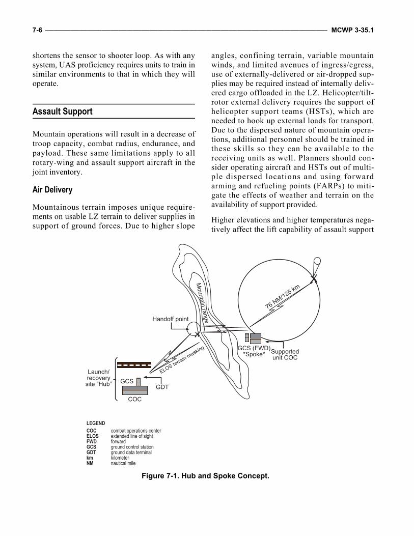
7-6 ____________________________________________________________________________________________________ MCWP 3-35.1
shortens the sensor to shooter loop. As with anysystem, UAS proficiency requires units to train insimilar environments to that in which they willoperate.
Assault Support
Mountain operations will result in a decrease oftroop capacity, combat radius, endurance, andpayload. These same limitations apply to allrotary-wing and assault support aircraft in thejoint inventory.
Air Delivery
Mountainous terrain imposes unique require-ments on usable LZ terrain to deliver supplies insupport of ground forces. Due to higher slope
angles, confining terrain, variable mountainwinds, and limited avenues of ingress/egress,use of externally-delivered or air-dropped sup-plies may be required instead of internally deliv-ered cargo offloaded in the LZ. Helicopter/tilt-rotor external delivery requires the support ofhelicopter support teams (HSTs), which areneeded to hook up external loads for transport.Due to the dispersed nature of mountain opera-tions, additional personnel should be trained inthese skills so they can be available to thereceiving units as well. Planners should con-sider operating aircraft and HSTs out of multi-ple dispersed locations and using forwardarming and refueling points (FARPs) to miti-gate the effects of weather and terrain on theavailability of support provided.
Higher elevations and higher temperatures nega-tively affect the lift capability of assault support
Handoff point
Supportedunit COC
GCS (FWD)*Spoke*
GDTGCS
COC
Launch/recoverysite “Hub”
LEGENDCOC combat operations centerELOS extended line of sightFWD forwardGCS ground control stationGDT ground data terminalkm kilometerNM nautical mile
Figure 7-1. Hub and Spoke Concept.
Mountain Warfare Operations _________________________________________________________________________________ 7-7
aircraft. Due consideration should be given to thelocation of the PZ and drop zone, the weight ofthe load(s) to be inserted/extracted, and the timerequired to transit to/from the location. Moreassault support aircraft will be required to deliversupplies in the mountains due to the higher alti-tude’s effects on aircraft performance; moreover,if more assets are not available, then a largernumber of sorties will be required to accomplishthe same tasking.
While external air deliveries place supplies and/or logistics in a precise drop location, air deliv-ery by air-drop loads allows assault support assetsto remain in flight during the drop, which, inmost cases, allows a larger and/or heavier load tobe delivered and decreases the vulnerability ofthe aircraft to indirect fires during the deliveryprocess. Precise coordination between air deliv-ery aircraft and supported ground assets isrequired to ensure that dropped loads fall in thecorrect locations. Due to the variable nature ofmountain winds and the confining nature of ter-rain, air delivery by air-dropping may spreaddropped supplies over a larger area and is usuallynot the preferred method.
Combat Search and Rescue and Tactical Recovery of Aircraft and Personnel
Both combat search and rescue and tacticalrecovery of aircraft and personnel missionsrequire pre-established criteria for the launch ofassets. These missions involve a coordinatedeffort among several organizations, all of whichare challenged by the mountainous terrain, dis-persed forces, and weather. Such challengesinclude communications, isolated personneldetection, lift, and time on station (TOS) capabil-ity of helicopters used to conduct the rescue and/or recovery.
Personnel recovery is defined as the sum ofmilitary, diplomatic, and civil efforts to affect therecovery and return of US military, Department ofDefense (DOD) civilians, DOD contractor
personnel, or other personnel, as determined bythe Secretary of Defense, who are isolated,missing, detained, or captured in an operationalenvironment. The effects of weather on isolatedpersonnel and their ability to endure the conditionsuntil recovery forces can locate, authenticate, andrecover them should be analyzed. Pilots and crewsmust be trained to survive in harsh conditions andsurvival kits should be prepared accordingly. Highmountain winds and limited LZs may inhibit therecovery forces’ ability to land close to the iso-lated personnel and/or aircraft, further delaying therecovery effort and limiting the TOS available forsupporting aircraft. Lastly, weather will affect theresponsiveness of recovery aircraft and mayimpede the recovery force from reaching isolatedpersonnel should the supporting assets be opera-ting from dispersed locations and/or conductingoperations spanning impassable mountainousterrain that has been closed by weather.
Terrain will almost certainly hamper communi-cation between the rescued individuals and theforces trying to locate them because of LOScommunication restrictions, so planners shouldconsider using over-the-horizon communica-tions capabilities. Aerial relays, SATCOM, andother techniques will have to be employed bycommunications planners to locate and commu-nicate with aer ial and downed personnel .Detailed information on the planning and execu-tion of tactical aircraft and personnel recoverycan be found in FM 3-04.513, Aircraft Recov-ery Operations, and FM 3-50.1, Army Person-nel Recovery, respectively.
Medical, Casualty, and Air Evacuations
As with any assault consideration, the effects ofmountainous terrain on the responsiveness andcapabilities of aviation assets supporting a medi-cal, casualty, or any air evacuation will be affectedby supportability of LZ terrain and the TOS and/orlift capability of supporting assets. The need todeliver patients to appropriate medical facilities as
7-8 ____________________________________________________________________________________________________ MCWP 3-35.1
fast as possible (commonly referred to as thegolden hour) motivates rescuers to use the fastestaircraft available unless they must evacuate largenumbers of personnel. In offensive operationsconducted over complex terrain, assault supportability to transport injured personnel to the appro-priate level of care may be limited by weather,which increases the risk and decreases the chanceof survival for critically injured patients. To miti-gate these risks, planners may have to disperse air-craft and position them closer to the operatingforces or establish medical care facilities fartherforward to cut down the travel time. If larger forceextraction is required, heavy lift assault supportassets at higher altitude often offers the quickestmeans to move forces to safety. Planners shouldconsider using intermediate shuttle LZs to facili-tate hasty extractions.
Combat Assault Transport
High altitude assault operations, to include aerialresupply, are restricted due to the combinedeffects of canalizing terrain and mountainweather. At higher elevations, zone size, slope,and suitability for large-scale assault supportlandings must be tempered with the desire torapidly bui ld combat power up in the LZ.Assault support aircraft planners require detailedanalysis of the LZ suitability, the forecastedweather, the anticipated loads (passengers andcargo), and the requirements for transit and loi-ter in the objective area. Based on the impact ofthe weather at higher elevations and the limitsimposed by aircraft performance and aircrew,dispersed operations will likely be required tofacilitate timely support for the ground unit.Commanders must recognize that timely sup-port depends on aircraft availability and thelocation of supporting assets. Cold weather,mountainous terrain, and dispersed operationswill hamper security, maintenance, and logisticsupport, which will adversely affect aircraftavailability in support of the ground scheme ofmaneuver. Further information regarding the
planning for and execution of air assaults isfound in MCWP 3-24, Assault Support.
Airborne Command and Control
Weather permitting, commanders should considerthe use of organic and joint airborne commandand control capabilities to mitigate the effects oflimited LOS communications in mountainous ter-rain. Rotary-wing platforms, such as the MarineUH-1Y, give the commander the ability to useLOS communications with aviation and groundforces and to land directly in an LZ to build thecommander’s situational awareness or communi-cate directly with forces on the ground.
A Marine Corps organic aviation platform capa-ble of providing limited command and controlcapability is the MV-22. Although the communi-cations capability and visibility inherent in theUH-1Y are more limited in the MV-22, this plat-form does offer the commander the ability torefuel in flight, extending the available TOS.Much like the MV-22, the Marine KC-130 canprovide the commander the ability for extendedoverhead operations and communications withoutthe need to land in the vicinity of the operatingforces. In addition, there are numerous other jointairborne command and control capabilities thatcan increase situational awareness and mitigate theeffects of terrain. Commanders and their staffsshould request the use of these assets through nor-mal joint tactical airstrike request procedures toaugment their own capabilities and mitigate theeffects of weather and terrain in the mountains.
Battlefield Illumination
In order to maintain situational awareness forMarines being transported, assault support assetsshould plan for battlefield illumination in amountainous environment. While conducting lowlight operations, battlefield illumination will helpto mitigate the effects of brownout and/or white-out landings. In low light environments, properplanning of the objective area geometry, com-bined with the coordination of assets to employ
Mountain Warfare Operations _________________________________________________________________________________ 7-9
battlefield illumination, will enhance the capabil-ity of assault support assets to accomplish themission more effectively. Though battlefield illu-mination does not turn low light into high light,planners should consider employing both overtand covert illumination in a theater of operation.Battlefield illumination should be requested inadvance and made available to conduct suchoperations; however, if all personnel have nightvision goggles, then battlefield illuminationwould be superfluous and counterproductive.
Landing Zone Considerations
Special considerations must be made when choos-ing and/or evaluating an LZ for operations inmountainous terrain. The effects of high altitudeon assault support aircraft include decreased hoverpower, decreased forward airspeed limits, suscep-tibility to blade stall, vortex ring state, anddecreased maneuverability. Planners, workingwith aviation leadership familiar with the area ofoperations, should evaluate landing sites, consid-ering LZ size and suitability for the mission. Avia-tion requirements for altitude, prevailing winds orweather, and safe approach and departure pathsmay further limit the selection of certain LZ and/or PZ sites, but aviators endeavor to meet theneeds of ground forces within those limitations.Together, ground forces and aviators should selectLZs that will be frequently used as part of routineair movements, such as FOBs and COPs. Thesesites should be well marked and, if available,lighted by either visible or infrared position lights.Portable systems can be acquired through militarysupply and can decrease the overall risk associ-ated with confined or low light LZ operations,especially when aircrews may be operating fre-quently under night vision systems. Landing zonesthat will be used only once for assault operationsshould be carefully chosen with input from the air-crews that will be performing the air assault.
Further considerations include the height and sizeof obstacles, slope, suitability, topography, winddirection, demarcation line, turbulence, null
areas, escape/departure routes, dropoff, waveoff,elevation, density altitude, and power availableversus power required. As assault support perfor-mance decreases, the transition period becomesmore critical, approaches must be shallower, andtransitions must be gradual. As the height ofobstacles increases, larger LZs are required tofacilitate appropriate approach angles and/orspeeds and aviation planners should be consultedto ensure that the LZ meets their approach crite-ria. Additionally, planners must consider thenumber of aircraft that are required to land inorder to support operations. Although prevailingwinds should be a key factor for landing direc-tion, terrain produces local wind effects thatcould also be dangerous during landing or take-off from the LZ. Further guidance on effective airassault mission planning and LZ and/or PZ selec-tion criteria can be found in ATTP 3-18.12, AirAssault Operations, and in FM 3-21.38, Path-finder Operations.
Snow-Covered Terrain
Brownout and whiteout can cause spatial disori-entation. Winter operations in mountains bringrecurring snowfalls that are characterized bydeep, dry, powder-like snow, particularly in veryhigh elevations. Viable whiteout mitigation plansare mandatory in these conditions. The proce-dures for landing in snow-covered terrain aresimilar to desert landing approaches and shouldbe briefed before execution. Aircrews shouldmake situational calls to facilitate referencedlandings by pilots. Recommended waveoff cuesshould be briefed to ensure a safe, controlledapproach into a high altitude, snow-covered land-ing. The aircrew should consider terrain beneaththe surface of the snow to ensure safe touchdownof landing aircraft. To assist with the landing site,the landing points should be marked with anobject that contrasts with the snow to provide areference for depth perception. The aircrew mustalso consider a slow release of power in settlingthe landing aircraft to ensure stability of the land-ing gear on unknown, snow-covered terrain.
7-10 ___________________________________________________________________________________________________ MCWP 3-35.1
Air-Ground Integration and Training Considerations
Training specific for a mountainous environmentmay be required, depending on the proposedoperational environment and aircrew proficiencyand familiarization with their supported groundunit. Overall, mountainous terrain does notadversely affect the manner in which assault sup-port aircraft conduct basic training to supportoperations; however, commanders should focustraining toward preflight planning in high alti-tudes with an emphasis on fuel planning, weightand power available, and blade stall consider-ations. Mountain flying requires close attention toaircraft and engine performance throughout mis-sion planning and its impact on flight; however,the terminal operations of landing and takeoff dif-fer little from confined area landing training thatis accomplished regularly as part of unit workups.Crews need a thorough understanding of their air-crafts’ capabilities, especially density altitude andits effects on performance.
When possible, aircrews should train with theirsupported ground unit prior to deployment, ensur-ing a thorough understanding of ground forceTTP and operations. Such training allows groundforces to become familiar with various aircraftemployment methods and aircrews to understandhow they will be employed during combat opera-tions. Aviation forces support ground operations.
Marine Corps-Specific Control of Aircraft and Missiles
The following subparagraphs focus on MarineCorps command and control of aircraft and mis-siles. While the discussions center on Marine avi-ation command and control organizations, theprinciples discussed are applicable to all aviationcommand and control organizations.
Marine Air Command and Control System Considerations
The MAGTF’s command and control is pro-vided by the Marine Air Command and ControlSystem (MACCS). In mountainous environ-ments, MACCS units will be geographically sep-arated by great distances in order to bettersupport the commander. For example, Marinemobile air traffic teams may be pushed out toaustere sites to provide tower control to transitingaircraft. Liaison teams may need to be pushedout to the GCE to provide situational awarenessabout aircraft transiting to and from its area ofoperations. Due to the terrain, the MACCS mustrely on numerous agencies and possibly on jointand coalition units to facilitate control of theMAGTF’s airspace. Airborne extensions ofMACCS, such as tactical air controller (air-borne) and assault support controller (airborne),may be necessary; moreover, MACCS plannersmust consider gaps in coverage due to limitedTOS. Aircraft and any special hardware requiredfor the mission must also be anticipated prior tothe execution of any missions. If the MACCSrequires airborne extensions, its exact role andresponsibilities should be proliferated by the tac-tical air command center (TACC) to the rest ofthe MACCS to ensure that all MACCS agenciesand their extensions have well-defined commandrelationships and proper delegations of author-ity. Figure 7-2 shows how the MACCS woulddeploy to support aviation operations.
Changes to Standard OrganizationEvery MACCS agency is task-organized to sup-port the MAGTF at all levels; however, in moun-tain operations, many MACCS agencies willsupport the MAGTF at much lower levels thanthey are normally tasked to support. This situa-tion could create additional manpower require-ments that must be considered during the
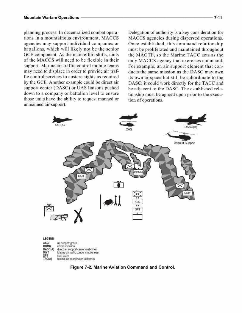
Mountain Warfare Operations ________________________________________________________________________________ 7-11
planning process. In decentralized combat opera-tions in a mountainous environment, MACCSagencies may support individual companies orbattalions, which will likely not be the seniorGCE component. As the main effort shifts, unitsof the MACCS will need to be flexible in theirsupport. Marine air traffic control mobile teamsmay need to displace in order to provide air traf-fic control services to austere sights as requiredby the GCE. Another example could be direct airsupport center (DASC) or UAS liaisons pusheddown to a company or battalion level to ensurethose units have the ability to request manned orunmanned air support.
Delegation of authority is a key consideration forMACCS agencies during dispersed operations.Once established, this command relationshipmust be proliferated and maintained throughoutthe MAGTF, so the Marine TACC acts as theonly MACCS agency that exercises command.For example, an air support element that con-ducts the same mission as the DASC may ownits own airspace but still be subordinate to theDASC; it could work directly for the TACC andbe adjacent to the DASC. The established rela-tionship must be agreed upon prior to the execu-tion of operations.
CASTAC(A)
Assault Support
DASC(A)
COMMMMT
MMT
SPT
ASG
LEGENDASG air support groupCOMM communicationDASC(A) direct air support center (airborne)MMT Marine air traffic control mobile teamSPT spot teamTAC(A) tactical air coordinator (airborne)
Figure 7-2. Marine Aviation Command and Control.
7-12 ___________________________________________________________________________________________________ MCWP 3-35.1
Additional Equipment and PersonnelThe requirement for additional SATCOM gearand dedicated nets must also be planned. Addi-tionally, HF communications are necessary tocommunicate with other MACCS agencies andGCE command and control nodes. Multichannelcommunications may not be able to support dataconnectivity due to LOS constraints; therefore,HF and SATCOM must be used to achieve datafunctionality. Since all MACCS units could faceadditional personnel requirements in the event ofdispersed operations, they may also need to tasksmall unit leaders as direct liaisons to GCE andother ACE units, depending on the level of sup-port required by the GCE. The qualifications ofthese personnel may vary greatly and couldrequire additional training with the units they aresupporting prior to deployment. Also, due to theadditional SATCOM and HF single-channelcommunications requirements, personnel that aresent to austere sites must understand the opera-tion of these types of communications. Securityat these austere sites will also be a factor.
Training ConsiderationsThe MACCS units should continue to train totheir output standards regardless of the opera-tional environment; however, it is imperative thatcommanders provide their intent as well asupdated mission-essential tasks that may bettersuit operations in a mountainous environment.The MACCS agencies should also include train-ing on current beyond-LOS capabilities becauseof the communication constraints in a mountain-ous environment. Wing communication squad-ron Marines would likely be required to set uprelay sites within the compartmentalized terrainto provide LOS communications. These Marinesshould train to this task at the appropriate venue.
Tactical Air Operations Center Considerations
The tactical air operations center (TAOC) pro-vides surveillance, traffic, and positive radar con-trol services to the MAGTF. Employment of the
TAOC, a task-organized early warning and con-trol (EW/C) site, or an early warning site inmountainous terrain presents certain limitations.Radars are an LOS means for detecting and con-trolling aircraft. Mountainous terrain greatly lim-its LOS to ground-based radars, which limits theability of radar to identify, acquire, and track air-craft; positively control them; or cue other airdefense resources to a threat. To mitigate limitedground-based radar coverage, planners may con-sider augmenting it with an airborne radar plat-form, such as the E-3 AWACS [AirborneWarning and Control System] or E-2 Hawkeye,using data links to share the air picture.
Further limitations exist with radio communica-tion. Most aircraft controlled by a TAOC and/orEW/C site use ultrahigh frequency (UHF) radios,which also have LOS limitations. Aircraft can becontrolled procedurally if SATCOM or radiorelay is available. See MCWP 3-25, Control ofAircraft and Missiles.
Mountains provide challenges to logistic opera-tions and terrain presents issues with employingand supporting TAOC and/or EW/C sites. Thesesites have a large logistic resupply requirementthat must be vehicle transported though transpor-tation can be severely limited on unimprovedroads. All TAOC equipment, radars, and opera-tions modules require level ground, which is nottypically found in compartmentalized terrain, sostaffs must plan to have engineers availableduring set up.
In air-to-air operations, positive identification andcontrol is required to successfully support theengagement of fighter aircraft against airbornethreats. A TAOC or EW/C site employed inmountainous terrain would not likely be able toexecute this mission set, so an airborne radar andcontrolling agency would be required to takethese missions.
Overcoming mountainous terrain for the TAOCand/or EW/C site would require smaller, moremobile, self-sustaining ground-based systemsthat can employ multiple radars over the terrain
Mountain Warfare Operations ________________________________________________________________________________ 7-13
to cover gaps. Data links currently available inthese sites would be used to fuse the air pictureby SATCOM.
Joint/Coalition Theater Command and Control Architecture
Joint and coalition command and control archi-tecture will center on the theater air-ground sys-tem. Each Service and coalition member has itsown unique contribution to this system—theMAGTF has the MACCS. The roles and respon-sibilities of each Service and its respective agen-cies will vary; however, the senior agency istypically the air operations center. The air opera-tions center may be joint or coalition, dependingon the type of operational environment. Moreinformation on joint/coalition command and con-trol architecture is available in JP 3-30, Com-mand and Control for Joint Air Operations. Thejoint theater command and control architecturewill not significantly change for operations inmountainous environments.
Electronic Warfare
The mission of the Marine tactical electronic war-fare squadrons (VMAQs) (EA-6B) and other Ser-vices’ electronic warfare units is to provideelectronic warfare support to designated forces.Aviation electronic warfare units conduct tacticaljamming to prevent, delay, or disrupt the enemy’sability to use early warning, acquisition, fire ormissile control, counterbattery, and battlefieldsurveillance systems. Tactical jamming alsodenies/degrades enemy communications capabili-ties. A more detailed discussion of their capabili-ties and employment considerations can be foundin MCWP 3-40.5, Electronic Warfare.
Weather and Terrain
The EA-6B Prowler is a subsonic, all-weather,carrier-capable aircraft. Weather/terrain affectEA-6B operations by limiting its takeoff andlanding options. In mountainous terrain, however,
it is necessary for electronic warfare planners tostudy the terrain carefully to determine how itimpacts the effects of enemy radar coverage,communication capability, and friendly electronicwarfare assets. This study begins with the intelli-gence section’s IPB, which should be updated asnew information becomes available from groundreports and other sources.
Time On Station
Aircraft TOS is a significant consideration whenplanning electronic warfare fires, which includeantiradiation missiles and radar and/or communi-cations jamming, in any environment. In general,airborne electronic attack assets will be tasked bythe combined forces air component commanderas a theater asset, which may impact the MAGTFcommander’s priority for this asset. The Prowleris a combined forces air component commanderasset, so it may not be collocated with theMAGTF, which may affect planning or TOS con-siderations. Airborne electronic attack should bedelivered at a critical time against a criticalenemy electronic system, such as fire control netsduring an enemy attack, air defense systemsduring friendly offensive air operations, and com-mand and control communications for the con-trol of the movement or commitment of reserves.While these factors apply in any environment, thedispersed nature of mountain operations compli-cates them. Air officers need to be familiar withelectronic warfare capabilities and work withother staff members to ensure communicationlinks or liaisons provide redundant ways to coor-dinate the proper use of these assets.
Electronic Attack
Though electronic attack operations should bepreplanned, they may be conducted in response tothe immediate tactical situation. These unplannedoperations are especially difficult because of thecentralized control of the asset and the communi-cations challenges associated with mountain op-erations. Commanders should not count on elec-tronic attack support in the mountains unless they
7-14 ___________________________________________________________________________________________________ MCWP 3-35.1
are the main effort and they have put a great dealof planning effort into ensuring that changes atthe tactical level will not affect other operations.If commanders choose to use electromagneticjamming, they must carefully weigh the opera-tional requirement against the rules of engage-ment, the effects on friendly systems, and the lossof enemy information otherwise gained bySIGINT and/or electronic warfare support. Deg-radation of some friendly communications mayhave to be accepted in order to effectivelyemploy jamming. Mountain operations can workto an advantage in that mountains can help elec-tronic warfare units target one area while shield-ing friendly forces on the other side of themountain from the effects of the electronic war-fare attack. A good IPB that incorporates theenemy electronic order of battle (EOB) is criticalto success. More information about amplitudemodulation control authority and propagationeffects of airborne electronic attack can be foundin MCWP 3-40.5.
Electronic Warfare Support
Intelligence feeds electronic warfare support bymaking accurate EOB and/or threat characteris-tics information available in order to accuratelyprogram electronic warfare support equipment.Alternatively, electronic warfare support feedsintelligence through electronic warfare supportsystems that collect information. That informa-tion can then be rapidly disseminated as a threatwarning or be passed to intelligence productionand analysis elements for further processing.Electronic warfare support provides immediatethreat recognition and a source of information forimmediate decisions involving electronic attack.To best meet immediate tactical requirements,electronic warfare support information used inimmediate threat recognition is rapidly dissemi-nated without in-depth processing.
Organic to all VMAQs is the technical control andanalysis center (TCAC). The mission of theTCAC is to provide semiautomated SIGINT pro-cessing, analysis, reporting, and electronic warfare
support to the MAGTF. The system correlates theEA-6B mission data with other sources of elec-tronic intelligence, electronic warfare support, andEOB and/or threat characteristics information toprovide support to the MAGTF during operationsafloat and at FOBs. The resulting product is acomprehensive EOB, which provides intelligenceand situational awareness information critical tothe mission planning of Marine, joint, and coali-tion operations. The challenge that the mountainspose to this system is how to push information tothe many dispersed FOBs that may need it. TheTCAC must aggressively push this information toall elements of the MAGTF and it is the responsi-bility of the subordinate elements to ensure theyplan for redundant means to disseminate thisinformation down to the tactical units that need it.This situation also applies to joint assets.
Electronic Protect
Electronic protect is the subdivision of electronicwarfare and involves actions taken to protect per-sonnel, facilities, and equipment from any effectsof friendly or enemy use of the electromagneticspectrum that degrade, neutralize, or destroyfriendly combat capability. Examples includespectrum management, electromagnetic harden-ing, emission control, and use of wartime reservemodes. There are no special considerations formountain operations; however, units should usemountains to shield them from the enemy’s elec-tronic warfare capability and should consider theEOB and battlefield geometry when establishingcommunication sites and command posts when-ever possible.
Training Considerations
Mountainous terrain has limited impact to elec-tronic warfare operations. As such, commandersshould focus training toward the mission skillsthat support the Marine Corps tasks for VMAQ.Electronic warfare operations and training shouldbe tailored to the expected threat in the area ofinterest, whether traditional or nontraditional,
Mountain Warfare Operations ________________________________________________________________________________ 7-15
rather than the expected terrain. Commandersmust consider the effects of terrain as well as theother elements of METT-T in developing theirtraining plans.
Offensive Air Support
Planning Considerations
While TTP for most offensive air support plat-forms will remain the same, some platforms,especially rotary-wing aircraft, will experiencethe following limitations in mountainous envi-ronments, especially high mountains, due to alti-tude restrictions:
All Marine Corps rotary-wing aircraft arerestricted to less than 3,048 meters (10,000 feet)pressure altitude due to lack of supplementaloxygen systems and pressurized cabins.
According to Army Regulation 95-1, FlightRegulations, Army rotary-wing aircraft that areunpressurized may operate to: 3,048 meters (10,000 feet) for up to 1 hour,
after which oxygen is needed. 3,650 meters (12,000 feet) for up to 30 min-
utes, after which oxygen is needed. 4,267 meters (14,000 feet) and above, oxy-
gen must be used.
The LOS challenges associated with communica-tions in a mountainous environment apply to theterminal control of attack aircraft as well. Anunderstanding of communications paths is essen-tial in order to provide timely, effective fires inrugged mountains. Consideration of the usage ofother radio relay and digital CAS platforms cangreatly enhance communication between theJTAC and/or FAC and attacking aircraft.
Ordnance Versus Fuel
The more ordnance an aircraft carries, the less fuelcan be carried, decreasing TOS. The TOS requiredby the commander may affect weapons load out
and selection. While higher elevations may bene-fit fixed-wing aircraft fuel burn and TOS, theynegatively affect rotary-wing operations. The thin-ner air at higher elevations affects rotary-wingpower management and can limit the ability tohover in certain conditions, necessitating rollingtakeoffs or landings on large, improved surfacesand shallower than normal approach and depar-ture paths.
Forward Operating Base and Forward Arming and Refueling Point Locations
The FARPs locations in higher altitudes mayaffect how much fuel or ordnance an aircraft canreload. An aircraft that arms and fuels at lowerelevations will provide a different capability thanan aircraft arming and fueling at a higher eleva-tion. Planners must be aware that loading up withthe same amount of ordnance and fuel may not bepossible, which is a significant planning factorwhen developing supportability timelines as itwill affect TOS for all CAS and rotary-wing air-craft. These issues should also be consideredwhen planning FOB and/or FARP locations.Prior coordination with the ACE enable groundforces to extract information about FARP capa-bilities and limitations prior to FARP emplace-ment at various FOBs and the required supportpackage needed. Further information on FARPplanning and FARP operations is found inMCWP 3-21.1, Aviation Ground Support. Avia-tion III and/or V platoons can be limited onequipment and personnel and can often exceedtheir operating capacity if too many FARPs areemplaced with too few personnel staffing them.Ground forces may have to assist FARP opera-tions to maintain continuous and close aviationsupport for certain periods of time.
Ordnance Selection
Target type, composition, location, risk estimatedistance, and collateral damage estimate will driveordnance selection. Terrain will also impact ord-nance fuzing and/or explosive effects. Planners
7-16 ___________________________________________________________________________________________________ MCWP 3-35.1
must understand how to employ certain aerialweapons in mountainous and snow-covered ter-rain and the capabilities and limitations of attackaircraft. The terrain and the mission requirementswill directly influence the munitions selected andthe fuzing used. When employing laser-guidedweapons, lower than typical cloud layers andheavy mountain fog can have a negative effect onthe ability to laser designate a specific target.Depending on whether the target is located in acave, on the side of a mountain, or in the middleof a valley, the effects of laser energy should beplanned. Risk estimate distances may be reducedby the effects of surrounding terrain, allowing theuse of larger munitions in close proximity offriendly forces—a significant advantage in com-partmentalized terrain.
Reduced Power Available
During operations at high altitude, rotary-wingaircraft can experience significantly differentflight characteristics than at sea level. The mostsignificant among the differences is a limitationof power available due to the general aerodynam-ics of rotor systems. Whether these limitationsare felt in less lift, reduced tail rotor authority, theinability to recover quickly from a dive, or thereduced ordnance and fuel combinations avail-able to planners, the challenges are significantand must be accurately and continually planned.Planners must update supported units on whatthey can expect during different times of year andin different environmental conditions of heat,humidity, and altitude.
Geometry of Fires
The GCE scheme of maneuver, enemy position,environment, and terrain are all factors whendetermining attack geometry; however, specialattention must be paid to CAS in mountainous ter-rain, which becomes more significant when inte-grating fires in a combined arms scenario. Reverseslope, terrain features, type of weapon, aircrafttype, and attack profiles are all factors for consid-eration while employing fires. The terrain may
restrict the marking platform, the terminal control-ler, and/or attacking aircraft’s sight to the target.The enemy has a significant advantage in themountains, because they are in a position to useterrain to effectively counterattack CAS aircraft.
Weather
Weather conditions in the mountains will havethe same effect on aviation assets as they do inflat terrain. Overreliance on aviation assets mayrender a force susceptible to the uncertainties ofweather. Winds, cloud deck, visibility, and tem-perature must be considered because they canaffect the type of supporting CAS aircraft andordnance employed. Conditions will also affectthe accuracy of certain weapon systems as wellas the delivery profile of the attacking aircraft.Knowing capabilities of CAS aircraft will help tosuccessfully prosecute targets despite a deterio-rating weather condition. Differences in the wayCAS aircraft are affected must be understood byplanners: fixed-wing aircraft may be unable tosee the target or use specific weapons due toquickly materializing cloud layers, while rotary-wing aircraft may not have the ability to climbhigh enough to safely avoid mountainous terraindue to altitude limitations and lack of supple-mental oxygen.
Deep Air Support
Deep air support is not considerably affected bythis environment. However, limitations created byweather patterns and winds must be considered.
Training Considerations
Training requirements are outlined in aircrafts’training and readiness manuals and should berelied upon for the accomplishment of full spec-trum missions, to include offensive air support.Continual training and skill refinement is neces-sary to overcome the difficulties associated withaviation operations in a mountainous and highaltitude environment. This environment requires
Mountain Warfare Operations ________________________________________________________________________________ 7-17
achieving and maintaining a high degree of air-crew proficiency.
Aviation Ground Support
Planning Considerations
An effective aviation ground support deploymentcapability enables the ACE to establish and main-tain a viable expeditionary force. The Marinewing support squadron must be capable of de-ploying under a variety of conditions and config-urations. Considerations for fixed-wing aircraftshould be made when operating in a mountainousenvironment. Normal runway lengths of 2,438 to3,048 meters (8,000 to 10,000 feet) can be re-duced with the addition of arresting gear and thereduction of fuel and ordnance loads.
Forward Arming and Refueling Points
The FARP provides the fuel and ordnance neces-sary for highly mobile and flexible helicopter,tilt-rotor, and fixed-wing operations. The size ofthe FARP varies with the mission and the numberof aircraft to be serviced. Normally, FARPs aretemporary, transitory facilities established for aspecific mission and duration. The scope of flightoperations in the FARP area should include indi-vidual aircraft or aircraft sections or divisionsrequiring ordnance and refueling. The locationand size of the LZ remain the same for mountain-ous and/or cold environments; however, weatherconsiderations impact FARP operations. Deepsnow could cause an aircraft landing gear to sink,greatly reducing the rotor ground clearance andincreasing the hazards to personnel operating inand around the FARP.
There are several hazards to consider during air-craft arming and refueling operations in a moun-ta inous environment with snow. A majorconcern is eliminating sources of ignitions andcontrolling vapor generation. One of the primarysources of ignition is static electricity. Deepsnow retards the grounding of aircraft, which
could generate enough static electricity to ignitefuel vapors. The storage of ordnance is also aconcern. Terrain should be used when possibleto satisfy the safe storage of explosives andquantity distance separation requirements. Anaviator must certify the FARP using a FARPchecklist (see FM 3-04.104) prior to the FARPbeing available for refuel and rearm.
Forward Operating Base Locations
Airfield size, approach and departure paths, andsecurity for the forward aviation sites are thesame for normal operations. If an airfield that canbe used by the ACE does not already exist, thereare various options available to the ACE to buildone. Unimproved surfaces will be engineered toallow for safe continuous flight operations. Vary-ing types of expeditionary airfield systems pro-vide fully portable options that range fromindividual AM-2 landing pads to a full 8,000-footrunway with taxiways and parking areas. Thesesystems can include tactical air traffic servicespackages that provide both airfield control andradar guidance as needed. For Marine Corpsunits, assets and equipment required to build anairfield can require support from all MAGTF ele-ments if needs exceed the capabilities of a Marinewing support squadron. When deployed, theseservices allow for a safe, all-weather launch andrecovery capability.
Aviation Logistic Support in a Mountainous Environment
Planning Considerations
As with all air operations, planning for mountainwarfare should be no different with regard to itsaviation logistical support process. Aviationlogistic success is based on having a centralizedlocation for the distribution and/or repair ofcomponents for its supported dispersed units.These concepts are set forth in MCWP 3-21.2,Aviation Logistics. More maintenance support

7-18 ___________________________________________________________________________________________________ MCWP 3-35.1
personnel may be necessary, depending on thenumber of dispersed units in the area of operations,the size of the area of operations, and number ofaircraft at each dispersed site. Also, since a limitednumber of intermediate-level Marine aviationlogistics squadron (MALS) Marines are located ata dispersed site, more supplies, equipment, andpersonnel (all requiring support) are necessary.With the current Marine aviation logistics supportprogram and maritime prepositioning ships, aMALS has the ability to support any type ofaircraft composition for the MAGTF ACE. Majorplanning considerations for these dispersed op-erations are:
Availability of intermediate and higher levelsof maintenance and equipment.
Intermediate-level technicians (National De-fense Industries).
Inspections cycles. Ground support equipment. Calibration. Survey equipment. Cold weather effects on equipment.
The following problems result from the increasedmaintenance and continuous operation of equip-ment at low temperatures and higher altitudes:
Thickening of oils at low temperatures impairsstarting and operating most equipment. Coversfor equipment on aircraft should be used toprotect it from the elements. When possible,aircraft should be removed from the elementsand maintenance should be conducted in tem-porary hangar structures.
Maintenance time factors may increase in areasof extreme cold.
Aircraft mechanics are hampered by heavywinter clothing and gloves. When the tacticalsituation permits, shelters or warming tentsshould be provided for personnel performingmaintenance. Proper clothing is necessary forall personnel and survival kits tailored to theenvironment must be carried on all flights.
Preventive maintenance on all equipment ismore critical in cold weather environmentsassociated with operations in the mountains.
Parts availability and differing levels of main-tenance will vary based on location and dis-tance from the aircraft wing.
Units may go through far more consumablesbecause equipment and vehicles may have tobe started often or run continuously in order tomitigate the effects of extreme cold weather.
Resupply must also be planned.
Material Storage and Handling Considerations
Cold weather and snow has significant effects onall types of supplies. Personnel operating inthese conditions must undergo special training towork effectively.
Effects on Supply Operations from Snow Fall and Snow CoverMajor snowfall and snow cover can significantlyreduce a unit’s logistic mobility in both improvedand unimproved road surfaces when usingvehicles not designed or equipped to operate insnowy conditions. Most MALS vehicles are com-mercially acquired, two-wheel drive, subcompactutility all-terrain vehicles or flat bed commercialtrucks that are not well suited for severe weatheroperations. Tactical vehicles must be assigned oravailable to transport material, equipment, orpersonnel. Snow tires, chains, and tow chainsshould be available and used as needed. Twelveinches of snow normally stops movement of two-whee led commercia l veh icles ; 36 inchesnormally stops all wheeled vehicle movement.All-wheel or 4-wheel drive vehicles with lowground pressures are best for moving over snow-covered or muddy terrain.
Effects on Material and Equipment from Extreme ColdExtreme cold can significantly slow material han-dling and maintenance activities by numbing
Mountain Warfare Operations ________________________________________________________________________________ 7-19
exposed skin, such as the face and hands. Activi-ties that normally require only minutes in temper-ate weather may require hours in extreme cold.Movement by foot or vehicle over snowy and icysurfaces is slower and poses a high risk of injuryto personnel and damage to equipment. Subfreez-ing temperatures result in freezing water in watertanks, waterlines, and equipment exposed to snowand water penetration. Because water expandswhen frozen and metals and plastics become brit-tle in subzero temperatures, standing water inequipment may freeze and damage components inareas with close tolerances and no room toexpand. Additionally, metals contract at lowertemperatures and expand at higher temperatures.Consideration must be given to guard componentsand equipment against improper clearances thatcan lead to binding or excessive looseness whenexposed to subfreezing temperatures.
Commanders and logisticians must make everyeffort to winterize vehicles and equipment withcold weather lubricants and antifreeze liquids.Equipment should be kept free of snow and waterto prevent the effects of freezing water by keep-ing equipment running or placing impermeablecovers on it when in storage or not in use. Mate-rial handling and storage personnel should beprovided with suitable head gear and gloves tominimize the effects of severe cold weather.
Effects on Metals from Extreme ColdMetals become brittle and subject to failure insevere cold temperatures. Storage, handling, anduse of equipment that contains dissimilar metalsthat are bolted together or are in constant frictionare most at risk for failure during transportation,handling, or when placed into operation follow-ing long periods of exposure to subfreezing tem-peratures. In cold weather, special care should betaken to protect equipment from excessive shock,so mechanical components should be allowed toslowly warm up before being started.
Effects on Rubber and Plastics from Extreme ColdRubber and plastic gradually stiffen, but retain alarge part of their elasticity until reaching extremecold temperatures, normally below -20 °F, atwhich rubber loses its elasticity and becomes brit-tle. For example, fuel hoses may crack whenallowed to crystallize from cold weather exposureor may break if bent when frozen. Aircraft tiresbecome rigid in cold weather, causing flat spots onparts that come in contact with the ground. Insevere cold temperatures, sidewalls become brittleand crack. Every effort should be made to mini-mize the length of time that material constructedprimarily from rubber and plastic is exposed toextreme cold temperatures.
Training Considerations
Maintenance and logistical personnel must trainfor this environment and plan for additionalrequirements before deploying to mountainousregions. The most effective training programincludes hands on and real time environmentaland survival training for the individual Marinefollowed by supporting actual aircraft in the envi-ronment to which they will deploy. Marines mustunderstand all the factors affecting the aircraft,tools, equipment, vehicles, support gear, andthemselves in order to keep airplanes flying. TheMALS Marines will likely be responsible fortheir own force protection and security whenoperating in remote regions while supporting avi-ation operations. Training for this mission shouldinclude fire team and squad tactics and an under-standing of quick reaction forces and supportingfires from higher headquarters. Communicationsequipment, weapons, and ammunition tailored tothe operating area will be required.
To be truly effective in mountain warfare, theMAGTF and BCT must understand the limitationsimposed by the effects of this environment on thefighting ground force and aviation elements. Whilethe terrain, altitude, and weather impact certainoperations, the basic tenets of military aviation

7-20 ___________________________________________________________________________________________________ MCWP 3-35.1
support the mission of the Marine regardless of thelocation in which he/she is fighting. The inherentskills and knowledge of ACE operators ensures thesuccessful integration between ACE units insupport of the MAGTF or BCT commander’s
overall mission. Since successful planning willresult in the mitigated effects of high altitude andextreme weather, ACE planners should be usedextensively to ensure that support for the Marine isbeing sourced appropriately.
CHAPTER 8 FIRES
Combat operations in mountainous areas arecharacterized by many of the same challengesfound in cold regions—rugged, compartmentedterrain with steep slopes and treacherous mobil-ity; however, mountain weather may range fromextreme cold with ice and snow in winter toextreme heat in some areas during the summer.Extreme terrain and weather can pose significantproblems and are important planning consider-ations for both maneuver and fire support opera-tions. Since, in many cases, the terrain favors thedefender who tries to control the heights, offen-sive operations are usually battles for this key ter-rain or the chokepoints they control in thevalleys. Consequently, dismounted infantry andairmobile operations are most suitable for thistype of terrain, especially if they are properlysupported by fires. For example, it is important toposition mortars and artillery in defilade toincrease their survivability; yet, such terrain isoften subject to snowslides, rockslides, or ava-lanches, which can fall on their positions withdevastating results. Intelligence estimates shouldidentify defilade positions that pose the leastamount of risk of such hazards.
Of course, these same types of positions aresought by enemy units and that is why observedindirect fires are so crucial to success in this envi-ronment. Indirect fires can impede the enemy’smobility or destroy positions, giving maneuverelements time to close with and destroy theenemy. While the basic tactical principles forartillery remain valid in mountains, they are sub-ject to the limitations imposed by the terrain andweather addressed in this chapter. Unless other-wise noted, the principles outlined in this chapterapply to mortars as well as artillery.
Organization for Artillery
To mitigate some of the limitations in the moun-tains and in order to better support isolatedmaneuver units, the artillery battery can be bro-ken down into smaller platoons than what iscalled for in the unit’s TOE. This organizationdoes allow support of maneuver units across vastdistances, but it strains its personnel and equip-ment. Despite these constraints, these smaller gunplatoons can operate independent of the battery,while retaining the capability to mass fires as abattery depending on the distance. Platoons canalso operate from FOBs or COPs in support ofmissions, but ammunition could be limited due tologistic requirements.
Although the use of smaller gun platoons mayeffectively support the commander in a dispersedenvironment, such dispersal complicates his/herability to mass fires, lead, and sustain each pla-toon. He/She must depend on officers and seniorand junior NCOs capable of operating inde-pendently and sometimes performing dutiesabove their TOE rank structure. The requirementfor specialized logistics, security, communica-tions, computers, and vehicles for each platoonposition may require a significant increase in per-sonnel, exceeding a battery’s authorized TOE. Asa result, proper allocation of resources based onpredeployment mission planning is essential.
The structure of the artillery battalions will dic-tate how they can be divided into two-gun pla-toons. For example, heavy BCTs and infantryBCTs have a fires battalion with two, eight-gunbatteries, while Stryker BCTs have three, six-gunbatteries. Currently, artillery TOEs do not supporttwo-gun platoons from the standpoint of fire
8-2 ____________________________________________________________________________________________________ MCWP 3-35.1
direction center (FDC) communications equip-ment, computers, or personnel. To meet this chal-lenge, units may have to either cross-trainpersonnel and request additional equipment oroperate with reduced personnel at all FDCs anddivert communications and computers from othersections. Such a plan detracts from missionaccomplishment by the sections from which theequipment and/or personnel are taken.
Movement and Positioning
Reconnaissance, Selection, and Occupation of a Position
The reconnaissance (the examination of the terrainto determine its suitability for use in accompli-shing the mission), selection, and occupation of aposition are critical to mission accomplishment.Rugged terrain and reduced mobility increase thereliance on field artillery fire support; however,the employment and positioning of field artillerysystems may be severely impacted by the extremedifficulty of ground mobility in mountainous ter-rain. The battery leadership must analyze theroutes to be used by the unit assets and the timeand distance required to make the move. Theability to move one firing platoon while keeping asecond platoon fire capable is critical to platoon-based operations in support of dispersed maneuverunits. Moving the battery over long, difficultroutes requires well planned, coordinated move-ment orders and unit standing operating proce-dures (see MCWP 3-16.3, Tactics, Techniques,and Procedures for the Field Artillery CannonBattery). Clearance of near and intervening crestsis always a factor in selecting firing positions.
Movement
The effects of the weather on the terrain to becrossed must be analyzed to facilitate rapidmovement. Weather affects visibility (fog, haze)and trafficability (ice, rain-softened ground).Ground movement of field artillery is often
limited to traveling on the existing road and trailnetworks and positioning in their immediatevicinity. Air movement of towed field artillery ispossible with fixed- or rotary-wing aircraft; there-fore, gun crews should be proficient usingequipment-rigging techniques and air assaultprocedures and should possess ample sling-loadequipment. Field artillery emplaced by helicopternormally requires continued airlift for subsequentdisplacement and ammunition resupply and oftennecessitates substantial engineer support.
Air Movement
Towed field artillery may require forward dis-placement of gun sections by helicopter to pro-vide forward troops the necessary support.Additionally, this provision requires MarineCorps HSTs to facilitate a battery’s firing capa-bility using air movement operations.
Position Selection
Normally, field artillery is employed far enoughto the rear to take advantage of increased anglesof fall. Flat areas, such as dry riverbeds, villagesand/or towns, and farmland, can usually accom-modate firing units; however, these positionspresent particular problems in the mountains forthe following reasons:
Dry riverbeds are hazardous because of thedanger of flash flooding.
Towns and villages usually have adequate flatareas, such as parks, schoolyards, and playingfields, but they are relatively scarce and ofteneasily targeted by the enemy.
Farmland is often difficult to negotiate fromspring to fall. In the winter, if the ground is fro-zen, farmland may provide good firing positions;however, frozen ground may cause difficultyemplacing spades, base plates, and trails.
Consequently, good artillery positions that havebeen selected for cover, flash defilade, andaccessibility to road nets and LZs are difficult to
Mountain Warfare Operations__________________________________________________________________________________ 8-3
find and their relative scarcity makes it easier forthe enemy to target probable locations. Com-manders must ensure that positions on dominantterrain provide adequate defilade. Positions oncommanding terrain are preferable to low groundpositions because there is—
A reduced number of missions requiring high-angle fires.
A reduced amount of dead space in the targetarea.
Less exposure to small arms fire from sur-rounding heights.
Less chance of being struck by rockslides oravalanches.
Some weapons may be moved forward to pro-vide long-range interdiction fires or, in extremecases, direct fires to engage a road-bound enemyin mountain passes or along valley floors.Because of rugged terrain, higher angles of fire,and reduced ranges, it is generally necessary todisplace artillery more frequently in mountainsthan on level terrain to provide continuous sup-port. Additionally, even when maneuver units arenot dispersed, artillery commanders may often beforced to employ field artillery in a decentralizedmanner or disperse it in multiple locations in thesame general area because of the limited spacefor gun positions. Security must be provided foreach gun location.
Multiple Launch Rocket System M270A1 and High Mobility Artillery Rocket System M142 Position Considerations
While mountains can mask all types of firingunits, they present special challenges and limita-tions to rocket-fired munitions. Dead space is thearea that is masked behind a crest and cannot beattacked by rockets from particular firing posi-tions. Masks are terrain features that have enoughaltitude to potentially interfere with the trajectoryof the rocket or missile. There are two categoriesof masks—immediate and downrange. Immediatemasks are within 1,981 meters (6,500 feet) of a
launcher firing point and are measured and inputto the launcher fire control system by individualsection chiefs. Downrange masks are beyond1,981 meters (6,500 feet) and are measured andinput into the advanced field artillery tactical datasystem’s fire direction system by the platoonleader and/or battery operations officer in accor-dance with unit operating procedures.
Downrange masks are measured and appliedusing crest clearance tables and automateddownrange mask checks. Both M270A1- andM142-equipped units in mountainous terrainmust be familiar with these tables, which allowleaders to establish minimum planning rangesbeyond a crest for launchers in a specific firingarea. Proper use of these tables will ensure rock-ets will clear the crest and not detonate prema-turely. It will also help to identify the dead spacethat must be covered by other indirect fire weap-ons, such as mortars, or by aviation or direct fireweapons placed behind the intervening slopes.
Acquisition and Observation
Radar Considerations
Because of high-angle fire requirements, radar canbe effective against enemy indirect fire systems ifproperly emplaced; however, terrain masking candiminish the radar’s LOS and degrade its effec-tiveness if it is not properly emplaced. Sites shouldbe selected on prominent terrain to obtain the low-est possible screening crest, but it is often difficultto obtain a low and consistent screening crest inmountainous terrain. Too low a screening crestdrives the search beam into the ground; too high ascreening crest allows the enemy to fire under thebeam and avoid detection.
In mountainous terrain, selecting general posi-tion areas to take full advantage of the radarrange and capabilities is difficult. Helicopterassists are often required to move radar teams to
8-4 ____________________________________________________________________________________________________ MCWP 3-35.1
optimal locations. Very often the positions thatprovide the best LOS for acquisition provide theleast concealment and survivability, so propercamouflage techniques are critical for survival.Additionally, the heavy rain and snow oftenfound in the mountains can degrade the capabili-ties of radar by decreasing the probability oflocation (see MCRP 3-16.1A, Tactics, Tech-niques, and Procedures for Field Artillery Tar-get Acquisition, for additional information onradar positioning).
When positioning weapons-locating radars, com-manders should also consider the following:
Although time consuming to create, visibilitydiagrams are extremely useful in determiningthe probability of acquiring targets within theradar’s search sectors.
To limit search areas, radars should focus onterrain that can be occupied by artillery andmortars.
Accurate survey control is essential because ofthe extreme elevation variations in mountain-ous terrain. Helicopters may be useful in per-forming survey by use of the Position andAzimuth Determining System. If possible, dig-ital radar maps may be used to minimize thetime required for height correction of theweapon system. Digital maps allow the Fire-finder systems to initially locate weapon sys-tems to within 250 meters (820 feet), whichenables the radar operator to make only fewvisual elevation adjustments to accuratelylocate the weapon system.
Prediction is computed at the radar’s elevation;therefore, excessive errors in the prediction canbe expected.
Radars in the same area that face one anotherand radiate at the same time can cause interfer-ence and emissions burnout, resulting in equip-ment failure. If radars must face one another toaccomplish the mission, commanders mustcoordinate with each other to ensure that theydo not radiate at the same time.
Computing track volume may become a criticaltask in determining the radar’s effectiveness fora proposed position (see MCRP 3-16.1A forcomputations).
Units will need to rely more on shelling reportsto determine enemy firing locations, so prede-ployment training must ensure all units meetminimum standards for this skill.
Observer Considerations
High-angle fire is used for firing into or out ofdeep defilade, such as that found in heavilywooded, mountainous, and urban areas. It is alsoused to fire over high terrain features near friendlytroops. The observer may request high-angle firebased on terrain analysis in the target area. Thefire direction officer may also order high-anglefire on the basis of a terrain analysis from the fir-ing unit position to the target area. The primarycharacteristic of high-angle fire is that an increasein elevation causes a decrease in range.
Because high-angle fire involves large quadrantelevations and long times of flight, it will not beas responsive as low-angle fire to the immediateneeds of a maneuver force. In addition, trajecto-ries will also be more vulnerable to enemy detec-tion. The long time of flight and the steep terrainmake it difficult for the observer to identify his/her round. Corrections may change drasticallyfrom round to round because spotting roundsoften get lost in defilade positions. To help theobserver, FDC personnel announce the time offlight in the message to observer and SPLASH 5seconds before each round impacts (see MCWP3-16.4, Tactics, Techniques and Procedures forthe Field Artillery Manual Cannon Gunnery).
Note: SPLASH is a proword transmitted tothe observer 5 seconds before the estimatedimpact of a volley or round of artillery, mor-tar, or naval gun-fire.
To prevent fratricide, noncombatant casualties,and destruction of civilian property and infra-structure, field artillery fires in mountains will be
Mountain Warfare Operations__________________________________________________________________________________ 8-5
observed, especially close support and defensivefires. Unobserved fires are generally more unreli-able in mountains because of poor maps, rapidlychanging MET conditions and elevation changes.A good FDC can overcome some of the chal-lenges of weather and high-angle fires throughtraining and by capturing timely and accurateMET data.
Elevated points, such as crests and trees, are oftenused for observation posts. Landmarks and prom-inent terrain features should be avoided as theseare probably targeted. When selecting an obser-vation post, the observer must consider the char-acteristics of forward slope (military crest) versusreverse slope positioning.
Advantages of the forward slope position include—
The view of the front and flanks is better. Fires impacting on the topographic crest will
not neutralize the position. The hillside provides background, which aids
in concealment.
Disadvantages of the forward slope position areas follows:
Difficulty in occupying during daytime with-out disclosing the position.
Radio communications may be difficult andrequire remoting radios to the reverse slope.
Cover from direct fire may not be available.
The advantages of a reverse slope position are—
It may be occupied in daylight. Greater freedom of movement is possible. Communications installation, maintenance,
and concealment are easier. Protection from direct fire is available.
Disadvantages of the reverse slope position are—
The field of view to the front is limited. Enemy fire adjusted onto the topographic crest
may neutralize the observation post.
Low clouds or fog may require moving the obser-vation post to preplanned emplacements at lowerelevations. Observers must be prepared to per-form assault climbing to reach the most advanta-geous observation site. Commanders may useaerial observers or UASs to detect long-range tar-gets and complement forward observers byadjusting fires beyond terrain masks, in deepdefilade, and on reverse slopes. Commandersmay also consider the use of long-range tele-scopic cameras for use in observation; however,in extremely high mountains, air observers maybe confined to valleys and lower altitudes due toaltitude limitations on different types of aircraft.Observing fires in mountains is difficult becausethe area being observed is three dimensional rela-tive to other types of terrain. As such, the ob-server may encounter increased difficulties indetermining accurate target location (to includealtitude). Additionally, subsequent correctionsmay appear more exaggerated, particularly asangle T increases. In most cases, increased accu-racy comes with experience and training gainedfrom operating in mountains before deployments.
Use of Laser Range Finders and Laser Designators for Laser-Guided Munitions
Use of laser range finders and laser-guided weap-ons in the mountains also demands increasedemphasis on training and observation techniques.Laser target ranging and designation systems helpto overcome difficulties in range estimation byproviding accurate directional distance and verti-cal angle information for use in locating enemytargets; however, when using a laser designator,an observer should consider LOS with the targetand cloud height. While laser-guided munitions(artillery, mortar, or air delivered) self-correct inflight, the ability to correct the trajectory is basedupon the seeker head acquiring the target in suffi-cient time to make the correction. Cloud ceilingsthat are too low will not allow laser-guided muni-tions enough time to lock on and maneuver to thetarget. Global Positioning System (GPS)-aidedmunitions can overcome this limitation as they donot rely on reflected laser energy.

8-6 ____________________________________________________________________________________________________ MCWP 3-35.1
Survey and Meteorology
Survey in Mountains
Survey operations are always critical and those inmountainous environments are no exception; how-ever, there may be times in the mountains whennormal survey operations are not possible due tothe terrain, electrical interference, limited equip-ment, or equipment failure. When these hindrancesoccur, units can use the trigonometric functions tocompute a traverse method or the triangulationmethods that are explained in MCWP 3-16.7,Marine Artillery Survey Operations. The triangula-tion method is ideally suited for rough mountain-ous terrain when other methods are impractical. Itemploys oblique triangular figures and enables thesurveyor to cross obstacles and long distances.While this method is time consuming and requirescareful planning and extensive reconnaissance, it isnonetheless effective and can help ensure accuratefires even in the mountains.
Global Positioning System Limitations and Considerations
Global Positioning System receivers rely on elec-tronic LOS with satellites. Initially, they searchand select satellites that are 10 degrees or moreabove the true horizon. Mountains, mountain for-ests, or deep canyons may mask the signal. Ifusable satellites cannot be detected, operatorsmay have to move to higher ground to get betterLOS to the satellites and use more traditionaltechniques in order to survey firing positions.Additionally, the operating temperature of theGPS is -4 °F to +158 °F. Many mountain tem-peratures are much colder, so the GPS receiversmust be protected by carrying them inside one’sclothing or in a heated vehicle and using an auxil-iary antenna system.
Meteorological Message Space and Time Validity
The accuracy of a MET message may decreaseas the distance and time from the MET soundingsite increases. Local topography has a pro-nounced effect on the distance that MET datacan be reasonably extended. In mountainous ter-rain, distinct variations of wind and tempera-tures occur over short distances. Normally, METmessages for artillery are considered valid up to20 kilometers (about 12 miles) from the balloonrelease point; however, the validity distancedecreases proportionally with the roughness ofthe terrain. As a result, MET messages for artil-lery are only considered valid up to 10 kilome-ters (about 6 miles) from the balloon releasepoint in mountainous terrain, which can lead toincreased targeting error and should be consid-ered when firing in close proximity to friendly orcivilian positions in mountains.
Targeting
Because of the decentralized nature of mountainoperations, targets warranting massed fires maybe fewer than those in open terrain; however,narrow defiles used as routes of supply, advance,or withdrawal by the enemy are potentially highpayoff targets for interdiction fires or largemassed fires. Large masses of snow or rocksabove enemy positions and along MSRs are alsogood targets because they can be converted intohighly destructive rockslides and avalanches thatmay deny the enemy the use of roads and trailsand destroy elements in defilade. In the moun-tains, suppression of enemy air defenses takes onadded importance because of the increaseddependence on all types of aircraft. Command-ers and their staffs should carefully reviewMCWP 3-16, Fire Support Coordination in the
Mountain Warfare Operations__________________________________________________________________________________ 8-7
Ground Combat Element, for a clear understand-ing of the targeting methodology. Such knowl-edge and that of the capabilities and limitationsof target acquisition and attack systems in amountainous environment is crucial to the syn-chronization of all available combat power. Toprovide accurate and timely delivery of artilleryfires in mountainous terrain, commanders mustconsider the following:
High angles of elevation and increased time offlight for rounds to impact.
Targets on reverse slopes, which are more dif-ficult to engage than targets on flat ground orrising slopes and require more ammunition forthe same coverage.
Increased amounts of dead space unreachableby artillery fires.
Intervening crests that require detailed mapanalysis.
When the five requirements for accurate pre-dicted fire (target location and size, firing unitlocation, weapons and ammunition information,MET information, and computational procedures)are not achievable, registration on numerouscheckpoints becomes essential because of thelarge variance in elevation (see MCWP 3-16.4 formore detailed information).
Munitions
Terrain and weather also affect the use of fieldartillery munitions. When evaluating the use oflethal or nonlethal fires, commanders must care-fully weigh the operational requirements againstthe rules of engagement. Considerations formountain employment of high explosive muni-tions, smoke and obscurants, high-angle fire, andthermobaric weapons are discussed in the follow-ing subparagraphs.
High Explosive Munitions
High explosive munitions include point-detonat-ing fuzes, variable/electronic time fuzes, mechan-ical time super quick (MTSQ) fuzes, andmechanical time-only fuzes.
Impact fuze, high explosive shells are very effec-tive on rocky ground, scattering stones and splin-tering rocks, which themselves become missiles.However, deep snow that is often found in highmountains during the winter months reducestheir bursting radius, making them approximately40 percent less effective. Also, the rugged natureof the terrain may afford added protection fordefending forces; therefore, larger quantities ofhigh explosives may be required to achieve thesame desired effects against enemy defensivepositions than in other types of terrain.
Variable time or electronic time fuzes should beused in deep snow conditions and are particularlyeffective against troops on reverse slopes. TheMTSQ fuzes are typically not used in high-angle,high explosive fire due to an increased height ofburst probable error. There are some older MTSQfuzes (M564 and M548) that may prematurely det-onate when fired during times of precipitation.Base ejection rounds (such as illumination) usingmechanical time-only fuzes are less affected byheight of burst probable errors than are high explo-sive rounds fuzed with MTSQ fuzes. For example,if a high explosive projectile armed with a vari-able time fuze and set with a time less than theminimum safe time is to be fired over marshy orwet terrain, water, ice, or snow, then the averageheight of burst will increase. The vertical clearancemust be significantly increased (see MCWP 3-16.4and MCWP 3-16.3).
Smoke and Obscurants
Smoke operations in mountainous areas are chal-lenging due to the terrain and wind. Inadequate
8-8 ____________________________________________________________________________________________________ MCWP 3-35.1
roads enhance the military value of existing roads,mountain valleys, and passes and add importanceto the high ground that dominates the other terrain.Planners can use smoke and flame systems to denythe enemy observation of friendly positions, sup-ply routes, and entrenchments and degrade theirability to cross through tight, high passes toengage friendly forces with direct and indirectfires. White phosphorous should be used cau-tiously in snow cover. Pieces of white phospho-rous may burn for up to four days if covered bysnow as it ignites only after being exposed to air.Thermally-induced slope winds that occurthroughout the day and night increase the diffi-culty of establishing and maintaining smoke oper-ations, except in medium- to large-sized valleys.Wind currents, eddies, and turbulence in moun-tainous terrain must be continuously studied andobserved. Forward observers who understandthese local weather patterns can skillfully exploitthem and enhance smoke operations rather thanhave them deterred by the weather. Smoke screensmay be of limited use due to enemy air observa-tion, to include UASs, and observation by enemyforces located on high ground.
High-Angle Fire
High-angle trajectory, often required in moun-tainous environments, has two inherent character-istics that affect munitions selection—a steepangle of fall and a large height of burst probableerror for MTSQ fuzes. The steep angle of fallmeans the projectile is almost vertical as itapproaches the ground. When the high explosiveprojectile bursts, the side spray contains most ofthe fragmentation. Since the projectile is nearlyvertical, side spray occurs in all directions and isnearly parallel to the ground; hence, high explo-sive shells with quick fuzes or variable time fuzesare very effective when fired at high angles. Onthe contrary, large probable error in height ofburst makes the use of mechanical time fuzesimpractical in high-angle fire.
Thermobaric Weapons
Thermobaric weapons are useful in mountainousenvironments due to their destructive capabilitywhen employed against tunnels, caves, and iso-lated terrain compartments. The shockwave andoverpressure created by these weapons createcasualties in confined spaces. This effect is idealif units are tasked with clearing confined areas,such as caves. Thermobaric weapons have beenused in the cave networks of Afghanistan withpositive results. In the past, clearing cave net-works has caused numerous casualties, so com-manders and their staffs should consider theseweapons for this type of mission. These weaponsare restricted due to their destructive capabilitiesand they require extensive planning time toacquire release authority from higher echelons.
Mortars
Mortars are essential during mountain opera-tions. Their high angle of fire and high rate of fireare suited to supporting dispersed forces. Mor-tars can deliver fires on reverse slopes, into deadspace, and over intermediate crests. Like fieldartillery, rock fragments caused by the impact ofmortar rounds may cause additional casualties ordamage. Suitable mortar firing positions can stillbe a challenge to find, but are often easier to findthan artillery positions. By design, mortars mustbe emplaced closer to the supported unit thanartillery due to their limited maximum range.
Mortars come in three different configurations—60 mm, 81 mm, or 120 mm. The 60-mm mortarsare usually carried on dismounted movementsdue to their light weight and mobility. Mortarsprovide smaller units with an organic fires capa-bility when conducting independent operationsand can be used to pin down an enemy, to escapefrom an ambush, to maneuver on the enemy, or toallow time for other firing assets to acquire thetarget. While it is possible to carry 81-mm and
Mountain Warfare Operations__________________________________________________________________________________ 8-9
120-mm mortars on dismounted movements, it isnot desirable to do so in rugged mountainous ter-rain. The increased weight of the 81-mm and120-mm mortar rounds severely hampers move-ment that is already slow due to the constraints ofthe mountainous environment. Planners mustconsider that small units will also be forced tosacrifice carrying other heavier items, such asJavelins, AT4s, additional ammunition for crew-served weapons, and fewer mortar rounds if theycarry larger mortar systems. If possible, largermortar systems should be placed at COPs orFOBs for use, which is often the only way toensure there are tactically significant quantities ofammunition available.
During movement to contact or other offensiveoperations, larger mortars should be transportedalong valley roads and trails to provide continu-ous fire support coverage to the lighter dis-mounted units in the higher rugged terrain.Continuous coverage can be achieved by splittingunits into sections and conducting bounding tech-niques to ensure at least one section is alwaysready to fire. See MCWP 3-15.2, Tactical Employ-ment of Mortars, for additional information onemploying mortars in mountainous environments.
Air Support
Because the terrain compels the enemy to con-centrate their forces along roads, valleys, reverseslopes, and deep defilades, CAS is very effec-tive; however, the terrain restricts the attackdirection of the CAS strikes. The enemy also con-ducts an IPB to determine the likely direction ofthe CAS strikes and will weight their air defensesalong those routes. The fire support officer mustaggressively identify the enemy air defense sys-tems and target them to enhance the survivabilityof the CAS assets.
Air interdiction and CAS operations can be par-ticularly effective in mountains, since enemy
mobility is also restricted by terrain. The forwardair controllers (airborne) (FACs[A]) and CASpilots can be used as valuable sources of informa-tion and can find and designate targets that maybe masked from direct ground observation. Vehi-cles and personnel are particularly vulnerable toeffective air attack when moving along narrowmountain roads. Precision-guided munitions,such as laser-guided bombs, can quickly destroybridges and tunnels and, under proper conditions,cause landslides and avalanches that close routesor collapse on both stationary and advancingenemy forces. Precision-guided munitions andfuel-air explosives can also destroy or neutralizewel l-protected point targets, such as caveentrances and enemy forces in defilade.
Low ceilings, fog, and storms common to moun-tain regions may degrade air support operations.Despite these challenges, GPS-capable aircraftand air-delivered weapons can negate many of theprevious limitations caused by weather. Terraincanalizes low-altitude air avenues of approach,which limits ingress and egress routes and avail-able attack options and increases aircraft vulnera-bility to enemy air defense systems. Potentialtargets can hide in the crevices of cliffs, the nichesof mountain slopes, and on gorge floors; hence,pilots may be able to detect the enemy only atshort distances, requiring pilots to swing aroundfor a second run on the target and giving theenemy more time to disperse and seek bettercover. Additionally, accuracy may be degradeddue to the need for pilots to divert more of theirattention to flying while executing their attack.
Planning considerations for CAS and close com-bat attack (CCA) are discussed in MCRP 3-16.6A,JFIRE Multi-Service Tactics, Techniques, andProcedures for the Joint Application of Fire-power. While CAS is a joint concept, CCA is usedexclusively by the Army and is defined as a coor-dinated attack against targets that are in closeproximity to friendly forces.
8-10 ___________________________________________________________________________________________________ MCWP 3-35.1
While CAS and CCA are similar, there are differ-ences to explore. The first is the two manners inwhich support is requested: CAS is requested in astandardized 9-l ine format, while CCA isreported according to a 5-line format. Second,CCA enables aircrews, having received the brieffrom ground forces, to retain the freedom tomaneuver as needed to engage targets. Third, dueto enhanced situational awareness from aircrews,positive terminal control from the ground forcesor certified controllers are not required. Bothmethods should consider the joint nature of thecontemporary operational environment. In moun-tainous terrain, the use of a CCA enables groundforces to provide information on the engagementto Army attack reconnaissance helicopters with-out limiting the direction of engagement, whichallows aircrews to use the canalizing terrain andselect more advantageous attack methods todestroy enemy targets.
In addition, CAS is requested by using FACs orJTAC. Both are certified Service members who,from a forward position, direct the action ofcombat aircraft engaged in CAS and other of-fensive air operations. A FAC(A) is a specifi-cally-trained and qualified aviation officer whoexercises control from the air of aircraft andindirect fires engaged in CAS of ground troops.According to MCRP 3-16.6A, a certified andqualified JTAC or FAC(A) will be recognizedacross DOD as capable and authorized to performterminal attack control.
A joint fires observer is a certified and qualifiedService member who can request, adjust, andcontrol surface-to-surface fires; provide targetinginformation in support of type 2 and type 3 CASterminal attack controls; and perform autono-mous terminal guidance operations in accor-dance with MCRP 3-16.6A and JP 3-09.3, CloseAir Support. While not as highly trained as aJTAC, FAC, or FAC(A), more individuals can betrained as a joint fires observer. The joint firesobserver adds warfighting capability, but does notcircumvent or nullify the need for a qualifiedJTAC, FAC, or FAC(A) during CAS operations.With JTACs, joint fires observers assist ground
commanders with the timely synchronization andresponsive execution of all joint fires and effectsat the tactical level.
Naval Surface Fires
As demonstrated in the Pacific Campaign ofWorld War II , naval sur face f i res can beemployed in mountainous terrain; however, theopportunity to use such fires is limited. Theissues of trajectory and intervening crests alongthe gun-target line often make its employmentdifficult in mountainous terrain. Conventionalnaval surface fires typically have a low angle offire and a flat trajectory. Though the position ofthe naval vessel in relation to the target willdetermine the gun-target line and the accessibilityof the target by conventional naval surface fires,operational level planners should not forget thecapability that naval-launched, precision-guidedmunitions can bring to the battlefield. Cruise mis-siles launched from naval vessels can engage tar-gets deep inland with devastating accuracy andare not subject to the same limitations as conven-tional naval fires.
Nonlethal Fires
Nonlethal fires are an important part of any arse-nal and can be effective across the range of mili-tary operations in mountainous environments. Aswith lethal fires, the desired effects of nonlethalfires can be limited by the terrain due to mobilityrestrictions and the fact that physical geographicfeatures can create sub-environments where thesame nonlethal fires may have entirely differenteffects. Marines must be creative and utilize othernonlethal capabilities when interaction with thelocal populace is hindered by terrain or weather.
Information Operations
Information operations are defined as the integra-tion, coordination, and synchronization of all
Mountain Warfare Operations_________________________________________________________________________________ 8-11
actions taken in the information environment toaffect a target audience’s behavior in order to cre-ate an operational advantage for the commander.In many cases, traditional information-relatedcapabilities, such as print and broadcast media,will prove less effective in the execution of infor-mation operations because many mountain com-munities have low literacy rates and do not haveaccess to modern communication technologies.Personnel who engage in information operationscan overcome such challenges by offering lowtechnology solutions, such as the distribution ofhand-cranked radios.
Deception
Deception is a capability in the form of a plan-ning process that focuses actions to deliberatelymislead adversary military decisionmakers (ortarget audiences) as to friendly military capabili-ties, intentions, and operations with the intent ofenticing or inciting a specific behavior in the bat-tlespace that will provide the commander orMAGTF an operational advantage. One exampleis the use of mock radar systems in addition tothe actual radar system. This deception preventsthe enemy from knowing the actual location offriendly radar systems and, most importantly,from knowing the direction of radar observation.
Fire Support Coordination Measures
The information contained in MCRP 3-16.6A isapplicable to any environment; however, themountains often necessitate changes to standingoperating procedures. The Marine Corps normally
conducts fire support coordination at the battalionlevel and higher. The distances and dispersednature of the fight in mountainous environmentsoften requires smaller units to control and clearfires within their areas of operations and compa-nies to receive some of the same equipment andpersonnel that is normally only found in battalionand larger organizations. Recommended methodsto achieve this organization are to—
Establish clear boundaries and simple directfire control measures.
Establish appropriate fire support coordinationmeasures.
Recommend appropriate airspace coordinatingmeasures.
Artillery Logistics
Artillery requires a substantial logistic effort tosupply and maintain itself on the battlefield.Mountainous terrain requires that artillery per-form many high-angle missions and missionsusing propellant charges at maximum capabil-ity. Such artillery use causes premature failureof the howitzers and an increased maintenanceeffort to remain mission capable. In a mountain-ous environment, logistic support becomes verydifficult and requires unique solutions due to theterrain limitations.
Helium and nitrogen management is vital inmountainous terrain. Helium is used by METteams to gather updated weather data for firingunits. Meteorological support can only extend upto 10 kilometers (about 6 miles) from the releasepoint in mountainous terrain. In order to provide
Radio in a BoxThe radio in a box is a 250-watt personal radio powered by a hand crank. The advantage to this system is that it is nottechnologically complicated and is easily used by the listener. The employment of a radio in a box was considered to beone of the most effective means of communicating with the local population in Afghanistan because the local populationhas an adult illiteracy rate of more than 70 percent.
—Marine Corps Center for Lessons Learned Report
8-12 ___________________________________________________________________________________________________ MCWP 3-35.1
accurate MET support throughout the battlefield,the MET teams and their helium must be posi-tioned and frequently resupplied in numerouslocations across vast distances. As a result,logistical resupply of helium becomes moreimportant and more difficult in mountainous ter-rain. Similarly, nitrogen resupply is essential inmaintaining firing capability among artilleryunits. The amount of nitrogen used in howitzerrecoil systems, how much is on hand in a givencountry, where it is located, and how to transportit to the area of operations are all logistical con-siderations when managing artillery operationsin this environment.
Energy management and ammunition manage-ment are also other important issues of consider-ation for the artillery community in mountainoperations. Many of these issues are covered in
detail in chapter 6 of this publication or inMCRP 3-35.1D for the effects of cold weatheron artillery ammunition.
Fires are one of the strongest enablers for com-manders and planners in mountainous environ-ments. Effective use of lethal fi res helpscompensate for the long ranges and large amountof dead space that is found in mountainous envi-ronments. Commanders can, if necessary, breakdown batteries from their traditional modifiedTOE with proper preparation and training. Therewill be a heavy reliance on air support. Command-ers and planners should train all personnel on CASprocedures and, if possible, train unit personnel tobecome joint fires observers. Effective nonlethalfires and information operations will build goodwill with the public and facilitate operations of alltypes in the mountainous environment.
CHAPTER 9COMMUNICATIONS
Planning Considerations
The MAGTFs are rarely employed indepen-dently; they are likely operating within a largerforce or coalition. Every effort should be made tomaintain the integrity of these organizations tomaximize their inherent synergies, such as theirrobust joint, interoperable communication net-work that enables operational adaptability ofcommand and control system capabilities. Themountainous environment poses unique chal-lenges when trying to employ communicationsequipment. The following are communicationsplanning considerations:
Widely distributed units, such as companiesand platoons, will require the same communi-cations capabilities and decisionmakingauthorities that are traditionally found at battal-ion or higher levels.
Units must develop core communications com-petencies with a variety of communicationsequipment and/or systems down to the lowestechelons of command possible.
Commands must develop the leadership anddecisionmaking skills of junior leaders.
Command and control architectures requireredundancy and must account for the effects ofthe operational environment.
Installation time of communication nodes inmountainous areas can double, depending onthe terrain and the weather.
Command and control plans for communica-tions nodes should accommodate expansion asmore equipment and personnel arrive and morecapability is required.
The communications priority should be single-channel radio (SCR) and SATCOM, since theywill be the primary command and control linksfor headquarters.
Requirements Identification
Each organization has its own unique require-ments for command and control. The mission,area of operations, terrain, and weather will dic-tate the radio nets, local area networks, and spe-cial purpose systems required. Expeditionaryunits coming from the sea will initially rely heav-ily on long haul, wideband communications untilcommand and control transitions ashore. Onceashore, networks will expand as more units andcapabilities are added. Units expand their com-mand and control network from one that reliesprimarily on tactical radios to one that consists ofa combination of radios and local area networks.A fully implemented command and control archi-tecture integrates four different types of commu-nications and information networks known as thetactical data network. See table 9-1on page 9-2for communications planning requirements.
Communications Systems Comparison
Eleven methods of communications are avail-able for use. The following subparagraphs andtable 9-2, on page 9-3, discuss the advantagesand limitations of each.
Single-Channel Radio
The SCR equipment includes radios that operate inthe UHF tactical satellite (TACSAT), UHF, HF,and VHF bands that can provide secure voice andlimited data communications capability (transferrates are limited by bandwidth constraints).
Retransmission of tactical communications is oneof the most effective means of mitigating the defi-ciencies of VHF and UHF communications. As aresult, retransmission requires focused and detailed
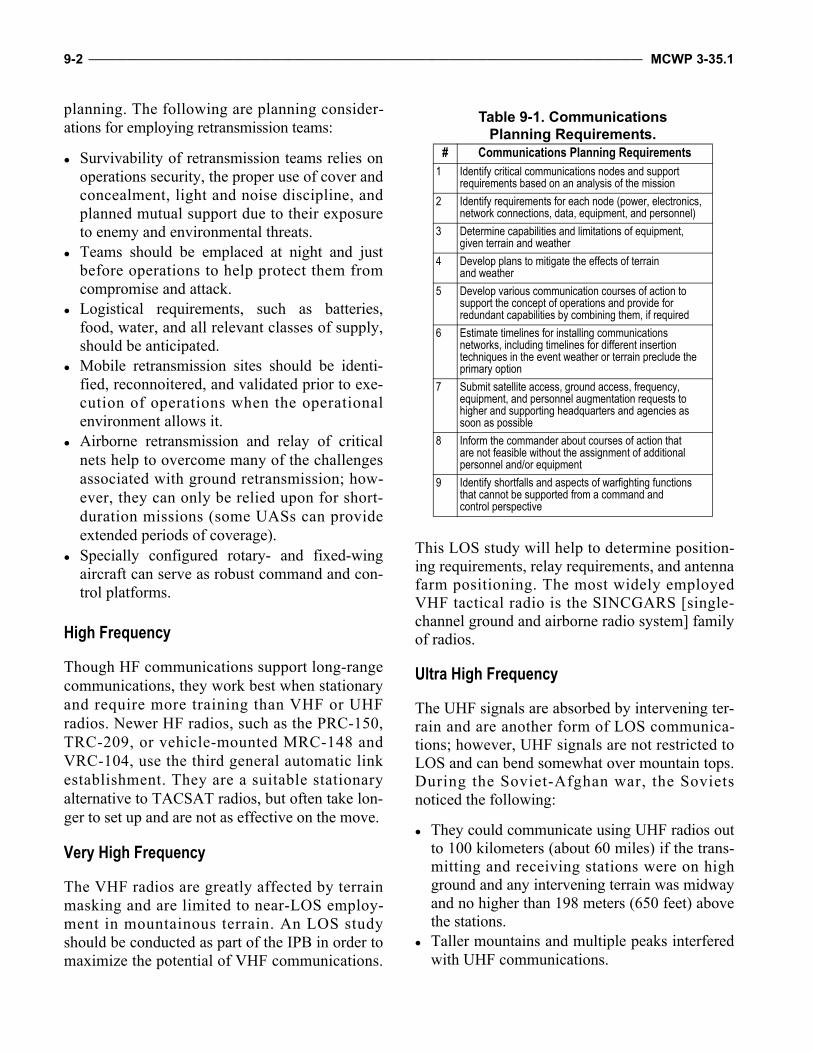
9-2 ____________________________________________________________________________________________________ MCWP 3-35.1
planning. The following are planning consider-ations for employing retransmission teams:
Survivability of retransmission teams relies onoperations security, the proper use of cover andconcealment, light and noise discipline, andplanned mutual support due to their exposureto enemy and environmental threats.
Teams should be emplaced at night and justbefore operations to help protect them fromcompromise and attack.
Logistical requirements, such as batteries,food, water, and all relevant classes of supply,should be anticipated.
Mobile retransmission sites should be identi-fied, reconnoitered, and validated prior to exe-cution of operations when the operationalenvironment allows it.
Airborne retransmission and relay of criticalnets help to overcome many of the challengesassociated with ground retransmission; how-ever, they can only be relied upon for short-duration missions (some UASs can provideextended periods of coverage).
Specially configured rotary- and fixed-wingaircraft can serve as robust command and con-trol platforms.
High Frequency
Though HF communications support long-rangecommunications, they work best when stationaryand require more training than VHF or UHFradios. Newer HF radios, such as the PRC-150,TRC-209, or vehicle-mounted MRC-148 andVRC-104, use the third general automatic linkestablishment. They are a suitable stationaryalternative to TACSAT radios, but often take lon-ger to set up and are not as effective on the move.
Very High Frequency
The VHF radios are greatly affected by terrainmasking and are limited to near-LOS employ-ment in mountainous terrain. An LOS studyshould be conducted as part of the IPB in order tomaximize the potential of VHF communications.
This LOS study will help to determine position-ing requirements, relay requirements, and antennafarm positioning. The most widely employedVHF tactical radio is the SINCGARS [single-channel ground and airborne radio system] familyof radios.
Ultra High Frequency
The UHF signals are absorbed by intervening ter-rain and are another form of LOS communica-tions; however, UHF signals are not restricted toLOS and can bend somewhat over mountain tops.During the Soviet-Afghan war, the Sovietsnoticed the following:
They could communicate using UHF radios outto 100 kilometers (about 60 miles) if the trans-mitting and receiving stations were on highground and any intervening terrain was midwayand no higher than 198 meters (650 feet) abovethe stations.
Taller mountains and multiple peaks interferedwith UHF communications.
Table 9-1. Communications Planning Requirements.
# Communications Planning Requirements1 Identify critical communications nodes and support
requirements based on an analysis of the mission
2 Identify requirements for each node (power, electronics, network connections, data, equipment, and personnel)
3 Determine capabilities and limitations of equipment, given terrain and weather
4 Develop plans to mitigate the effects of terrain and weather
5 Develop various communication courses of action to support the concept of operations and provide for redundant capabilities by combining them, if required
6 Estimate timelines for installing communications networks, including timelines for different insertion techniques in the event weather or terrain preclude the primary option
7 Submit satellite access, ground access, frequency, equipment, and personnel augmentation requests to higher and supporting headquarters and agencies as soon as possible
8 Inform the commander about courses of action that are not feasible without the assignment of additional personnel and/or equipment
9 Identify shortfalls and aspects of warfighting functions that cannot be supported from a command and control perspective
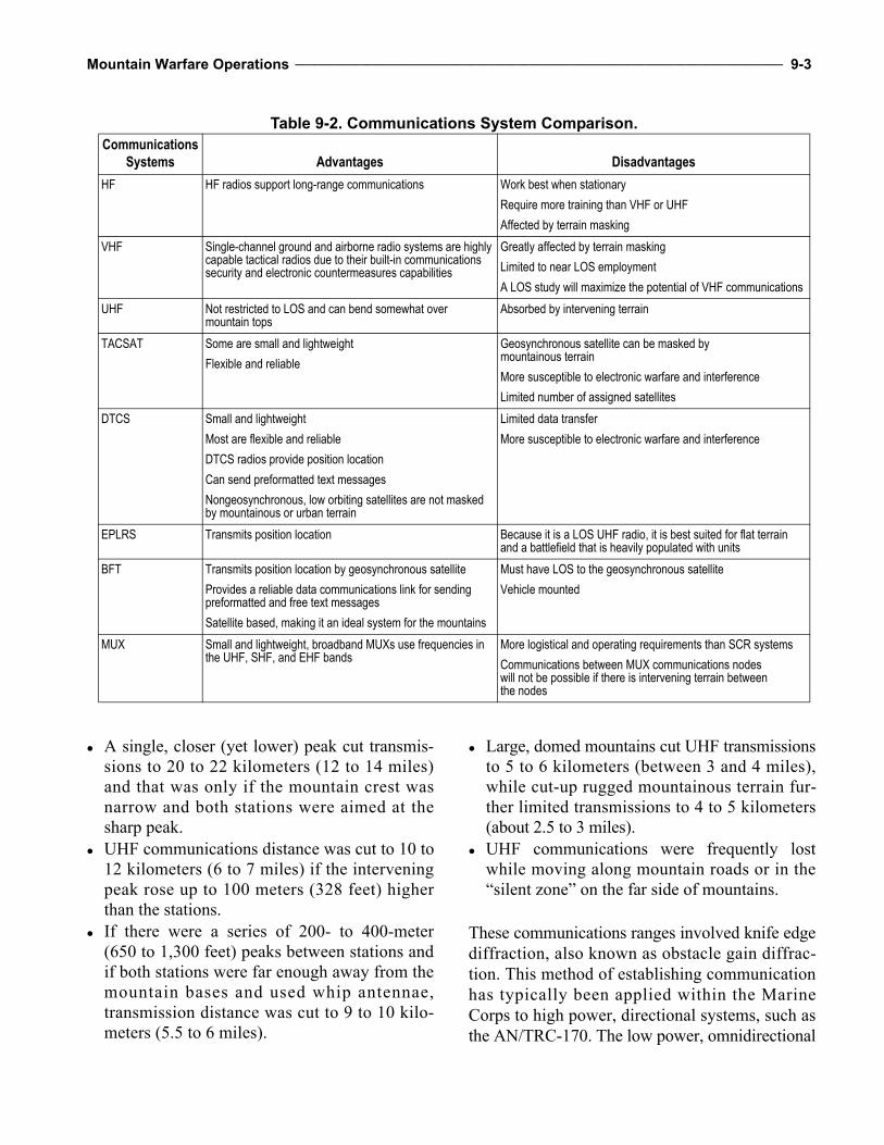
Mountain Warfare Operations _________________________________________________________________________________ 9-3
A single, closer (yet lower) peak cut transmis-sions to 20 to 22 kilometers (12 to 14 miles)and that was only if the mountain crest wasnarrow and both stations were aimed at thesharp peak.
UHF communications distance was cut to 10 to12 kilometers (6 to 7 miles) if the interveningpeak rose up to 100 meters (328 feet) higherthan the stations.
If there were a series of 200- to 400-meter(650 to 1,300 feet) peaks between stations andif both stations were far enough away from themountain bases and used whip antennae,transmission distance was cut to 9 to 10 kilo-meters (5.5 to 6 miles).
Large, domed mountains cut UHF transmissionsto 5 to 6 kilometers (between 3 and 4 miles),while cut-up rugged mountainous terrain fur-ther limited transmissions to 4 to 5 kilometers(about 2.5 to 3 miles).
UHF communications were frequently lostwhile moving along mountain roads or in the“silent zone” on the far side of mountains.
These communications ranges involved knife edgediffraction, also known as obstacle gain diffrac-tion. This method of establishing communicationhas typically been applied within the MarineCorps to high power, directional systems, such asthe AN/TRC-170. The low power, omnidirectional
Table 9-2. Communications System Comparison.Communications
Systems Advantages Disadvantages
HF HF radios support long-range communications Work best when stationary
Require more training than VHF or UHF
Affected by terrain masking
VHF Single-channel ground and airborne radio systems are highly capable tactical radios due to their built-in communications security and electronic countermeasures capabilities
Greatly affected by terrain masking
Limited to near LOS employment
A LOS study will maximize the potential of VHF communications
UHF Not restricted to LOS and can bend somewhat over mountain tops
Absorbed by intervening terrain
TACSAT Some are small and lightweight
Flexible and reliable
Geosynchronous satellite can be masked by mountainous terrain
More susceptible to electronic warfare and interference
Limited number of assigned satellites
DTCS Small and lightweight
Most are flexible and reliable
DTCS radios provide position location
Can send preformatted text messages
Nongeosynchronous, low orbiting satellites are not masked by mountainous or urban terrain
Limited data transfer
More susceptible to electronic warfare and interference
EPLRS Transmits position location Because it is a LOS UHF radio, it is best suited for flat terrain and a battlefield that is heavily populated with units
BFT Transmits position location by geosynchronous satellite
Provides a reliable data communications link for sending preformatted and free text messages
Satellite based, making it an ideal system for the mountains
Must have LOS to the geosynchronous satellite
Vehicle mounted
MUX Small and lightweight, broadband MUXs use frequencies in the UHF, SHF, and EHF bands
More logistical and operating requirements than SCR systems
Communications between MUX communications nodes will not be possible if there is intervening terrain between the nodes
9-4 ____________________________________________________________________________________________________ MCWP 3-35.1
UHF systems employed by Marines are not likelyto experience such types of radio links.
Measures to improve UHF communications inthe mountains include the following:
Select communications sites that have a narrowsingle mountain crest between them. Aim thetransmissions at the highest peak. Keep thesites away from the mountain base.
Deploy radios away from the mountain base toa distance at least equal to the distance of theslope between the base and mountain crest.
Deploy radios to commanding heights toimprove their LOS to the top of the interven-ing mountain.
Deploy radios where they can communicateover a single mountain rather than a series ofpeaks and defiles.
When confronted with a large, domed moun-tain, deploy the radios away from the base ofthe mountain and on high ground.
Tactical Satellite Radio
The radio of choice in the mountains is theTACSAT, also known as SATCOM, radio. Itcombines mobility, flexibility, and ease ofoperation with unlimited range. The PRC-117,PRC-148, PRC-152, VRC-110, and VRC-111 areall capable of transmitting SATCOM, UHF, andVHF voice or data and are suitable for base ormobile communications in the mountains.Though flexible and reliable in the mountains,TACSAT radios are more susceptible to elec-tronic warfare and interference, channels areusually limited, and the radios have limited capa-bility to support data transfer.
Commercial Satellite Terminals
Commercial satellite terminals with appropriatecommunications security modules can be usedto provide reliable worldwide voice and datacommunications. These devices provide a first-in, redundant, and amplifying capability toTACSAT or SCR.
Special Purpose Systems
Special purpose communications systems supportspecific functions, such as position location, navi-gation, and intelligence dissemination. There aremany types of special purpose systems in theMarine Corps inventory and many more are avail-able when operating as part of a joint task force.Marines must be able to employ these systems toleverage the significant capabilities they repre-sent. For example, the Distributed Tactical Com-munications System (DTCS) is an extension of“Netted Iridium,” push-to-talk communicationscapability. The DTCS can provide over-the-hori-zon, on-the-move, beyond-LOS netted voice anddata communications over the Iridium network.
Multichannel Radios
Broadband multichannel radios (MUXs) use fre-quencies in the UHF, SHF [super high fre-quency], and EHF [extremely high frequency]bands. The demands of operating along these fre-quency bands as well as performing multiplexingfunctions require complex and relatively largepieces of equipment. The MUX systems, there-fore, have considerably more logistical and oper-at ing requirements than SCR systems. Inaddition, they have a requirement to transmit andreceive a tightly-focused beam of radio energy,which is not practical for units on the move. Forsustained operations in mountains, ground relaystations or “RIPER” nets can be established torelay large amounts of data. Planners should con-sider the following MUX characteristics:
MUX equipment is limited to LOS and, insome cases, a very low takeoff angle.
Compartmentalized, mountainous terrain willrequire more nodes and larger packages.
Communications between MUX communica-tions nodes will not be possible if there is inter-vening terrain between the nodes.
MUX repeater sites can enable command andcontrol in the mountains. Repeaters need to beplaced near or on the top of ridges or peaks.
Mountain Warfare Operations _________________________________________________________________________________ 9-5
Wind speeds on top of ridges and peaks oftenexceed the operational tolerances of MUXantennas, requiring the antennas be taken downduring inclement weather.
Satellite terminals, such as the Support WideArea Network system and the Secure MobileAnti-Jam Reliable Tactical Terminal, alongwith older systems, such as the TSC-85 andTSC-93, provide a method of switchedconnectivity in addition to MUX that oftenmakes them preferred over MUX in a moun-tainous environment.
Enhanced Position Location Reporting System
Because it is an LOS UHF radio, the enhancedposition location reporting system (EPLRS) is bestsuited for flat terrain and a battlefield that is heav-ily populated with units. The system has limiteduse in dispersed rugged mountainous terrain as aposition reporting system because of the LOSissues. Like any LOS system, it must have anunobstructed view to receive signals. A thorough
terrain study and detailed planning is required tomake EPLRS work in mountainous terrain.
Blue Force Tracking
Blue force tracking (BFT) provides a reliable datacommunications link for sending preformattedand free text messages. Because BFT uses satel-lites vice ground radio relays, it is an ideal systemfor mountainous environments, such as inAfghanistan. Unlike the EPLRS, which is limitedby the LOS, BFT provides continuous coveragedespite the terrain and number of users on thebattlefield. It provides a near real-time feed to thecommon operational picture and is a highly reli-able means of text communication between dis-persed units.
Cell Phones
The proliferation and common use of cell phonesmay provide opportunities to exploit operationalsecurity issues, particularly as relay towers and/orusage expand in the future.

9-6 ____________________________________________________________________________________________________ MCWP 3-35.1
This Page Intentionally Left Blank
CHAPTER 10TRAINING CONSIDERATIONS
Fighting on steep slopes and at an altitude willdramatically alter such things as marksmanshipand movement techniques and, unless plannersunderstand and compensate for these differences,these changes can render units that are consideredwell-trained at sea level into a liability in themountains. Therefore, Marine Corps units shouldfocus on basic individual skills and on collectivetraining in a mountainous environment to over-come the challenges that this environment pres-ents. While the specialized technical skills thatare highlighted in Army and Marine Corps doc-trine (e.g., TC 3-97.61, MCRP 3-35.1B, andMCRP 3-35.1C) are useful, these specialized skillsets will only be needed by a few troops, such asmountain leaders and assault climbers, withineach unit. Information is provided in this chapteron all mountain warfare training in the DOD forunderstanding in joint mountain operations.
The high interaction and interoperability betweenthe Army and Marine Corps in the operationalenvironment adds additional importance to esta-blishing common training standards and programs.Currently, the Marine Corps is the only Servicewith a standardized training list that addresses bothindividual and collective tasks that are needed inthe mountains. The Marine Corps mountain war-fare training curriculum is based on Navy/MarineCorps Departmental Publication (NAVMC)3500.70A, Mountain Warfare Operations Training
and Readiness Manual, that focuses on the fol-lowing fundamentals:
Employ specialized mountain/cold weatherclothing and equipment.
Survive in a mountain/cold weather environ-ment.
Mitigate the effects the mountain/cold weatherenvironment exerts on operations.
Individual and collective unit mountain and/orcold weather training is essential prior to con-ducting operations in these environments. Com-manders will make every effort to maximize thetraining capabilities of the Marine Corps Moun-tain Warfare Training Center (MCMWTC) inorder to enhance the units’ warfighting capabilityin these challenging environments.
Military Mountaineering Skill Sets
The Army and Marine Corps recognize three levelsof military mountaineering skill sets. Figure 10-1,on page 10-2, highlights the method the Army’sNorthern Warfare Training Center (NWTC) andArmy Mountain Warfare School (AMWS) use totrain Soldiers for mountainous environments andbuild the requisite skill sets in units so an insti-tutional memory can be maintained.
The Need for Specialized TrainingDuring World War II, the German Army raised an entire corps of elite mountain troops called gebirgs jaeger (mountainhunter). Although not all of these troops were used in the mountains, they demonstrated superior abilities in almost alltheaters of operation in which they were used. The German Fifth Gebirgs Division marched more than 248 miles, crossedmountain passes above 6,500 feet, and secured well-entrenched defenses on the Mestksas Line. Other gebirgs jaegercaptured most of the Caucasus mountain region in the summer of 1942.
—Military Review, Mountain Warfare
10-2 ___________________________________________________________________________________________________ MCWP 3-35.1
Note: Army Special Operations ForcesMountaineering Operations Training Task inUnited States Army, Special OperationsCommand (USASOC) Regulation 350-12,Special Operations Forces Mountaineering,refers to Level I as being highest in theUSASOC. The USASOC levels of training arereversed compared with conventional units.
Level I: Tactical Rope Suspension Technician (Marine Corps)/Basic Mountaineer (Army)
The tactical rope suspension technician (TRST)/basic mountaineer, a graduate of a TRST or basicmountaineering course, should learn the funda-mental travel and climbing skills necessary tomove safely and efficiently in mountainous ter-rain. These Marines should be comfortable func-tioning in this environment and, under the
supervision of qualified mountain leaders orassault climbers, can assist in the rigging and useof all basic rope installations. On technically dif-ficult terrain, the TRST/basic mountaineer shouldbe capable of performing duties as the “fol-lower” or “second” on a roped climbing team andshould be well trained in using all basic rope sys-tems. They may provide limited assistance to per-sonnel unskilled in mountaineering techniques.Particularly adept Marines may be selected to bemembers of special purpose teams led and super-vised by mountain leaders or assault climbers/advanced mountaineers. At a minimum, TRST/basic mountaineers should possess the followingmountain-specific knowledge and skills:
Characteristics of the mountainous environ-ment (summer and winter).
Mountaineering safety.
Recommended Individual Military Mountaineering Training StrategyCombat effects of the environment Leverage environment against enemy
Base Level Level I Level II Level IIIOrientation
Mountain Warfare Orientation Course
No qualification
BasicBasic MilitaryMountaineer
AdvancedAdvanced
Mountaineer(Assault Climber)
MasterMountain Guide
(CertifiedMountaineering
Instructor)
Who: all unit personnelCapability: basic mobility skills and understanding of the fundamentals for operating in a mountain-ous region
Training time: 4-5 daysTraining provider:Formal Mountain Schools or Mobile Training TeamAMWSNWTCUnit Military Mountaineer
Who: 1-2 per platoonCapability: basic technical skills; trainer of soldiers and leaders in basic mobility skills and assists in planning mountain operations
Training time: 15 daysTraining provider:Formal Mountain Schools AMWSNWTC
Who: 2 per battalionCapability: advanced technical skills; advisor to commander; unit trainer and planner of mountain sustainment training and operations
Training time: 15 daysTraining provider:Formal Mountain Schools AMWSNWTCMCMWTC
Who: 1 per brigadeCapability: advanced technical skills and experience; advisor to commander; unit trainer and planner of mountain sustainment training and operations
Training time: 2+ yearsFully qualified current or former Military MountaineeringInstructor
BasicUnit operational capability
Soldier, leaders, planners trainedCapability built and applied
AdvancedUnit operational capabilityAdvanced technical skills
Capability built and applied
BasicUnit
Capability
AdvancedUnit
Capability
Figure 10-1. Army Mountain Training Strategy.
Mountain Warfare Operations ________________________________________________________________________________ 10-3
Individual cold weather clothing and equip-ment use, care, and packing.
Basic mountaineering equipment care and use. Mountain bivouac techniques. Mountain communications. Mountain travel and walking techniques. Hazard recognition and route selection. Mountain navigation. Basic MEDEVAC. Rope management and knots. Natural anchors. Familiarization with artificial anchors. Belay and rappel techniques. Fixed ropes (lines) usage. Rock climbing fundamentals. Rope bridges and lowering systems. Individual movement on snow and ice. Mountain stream crossings (to include water
survival techniques). First aid for mountain illnesses and injuries.
Note: Level I-qualified personnel should beidentified and prepared to serve as assistantinstructors to train unqualified personnel inbasic mountaineering skills. All high-risktraining must be conducted under the super-vision of qualified level II or III personnel.
Level II: Assault Climber (Marine Corps)/Advanced Mountaineer (Army)
Assault climbers and/or advanced mountaineersare responsible for the rigging, inspection, use,and operation of all basic rope systems. They aretrained in additional rope management, knottying, belay, rappel techniques, and the use ofspecialized mountaineering equipment. Assaultclimbers and/or advanced mountaineers are capa-ble of rigging complex, multipoint anchors, andhigh-angle raising and/or lowering systems.Level II qualification is required to supervise allhigh-risk training associated with level I. At aminimum, assault climbers should possess thefollowing additional knowledge and skills:
Using specialized mountaineering equipment. Performing multipitch climbing on rock.
Leading on class 4 and 5 terrain. Conducting multipitch rappelling. Establishing and operating hauling systems. Establishing fixed ropes with or without inter-
mediate anchors. Moving on moderate angle snow and ice. Establishing evacuation systems and perform-
ing high-angle rescue.
Level III: Mountain Leader
Mountain leaders possess all the skills of theassault climber and have extensive practicalexperience in a variety of mountainous environ-ments in both winter and summer conditions.Level III mountaineers should have well devel-oped hazard evaluation and safe route-findingskills over all types of mountainous terrain.Mountain leaders are best qualified to advisecommanders on all aspects of mountain opera-tions, particularly the preparation and leadershiprequired to move units over technically difficult,hazardous, or exposed terrain. The mountainleader is the highest level of qualification and isthe principle trainer for conducting mountainoperations. Level III qualification is required tosupervise all high-risk training associated withlevel II. Instructor experience at a military moun-tain warfare training center or as a member of aspecial operations forces mountain team is criti-cal to acquiring level III qualification.
Additional Knowledge and Skills
At a minimum, mountain leaders should possessthe following additional knowledge and skills:
Preparing route, movement, bivouac, and oper-ational risk management.
Recognizing and evaluating peculiar terrain,weather, and hazards.
Performing avalanche hazard evaluation andmitigation.
Organizing and leading avalanche rescue oper-ations.
Planning and supervising roped movementtechniques on steep snow and ice.
10-4 ___________________________________________________________________________________________________ MCWP 3-35.1
Conducting glacier travel and crevasse rescue. Conducting ski instruction. Planning and conducting skiborne patrols in
class 3 and 4 terrain. Using winter shelters and survival techniques. Conducting multipitch climbing on mixed ter-
rain (rock, snow, and ice). Leading units over technically difficult, haz-
ardous, or exposed terrain in winter and sum-mer conditions.
Advising commanders and staff during plan-ning on mountain warfare considerations acrossall warfighting functions.
Marine Corps Mountain Warfare Training Center
Training at MCMWTC should be conducted priorto deploying to a mountainous and/or coldweather operational environment. Training shouldreplicate the high altitude, mountainous, and coldweather conditions associated with the opera-tional environment. At the MCMWTC, training isconducted at both the individual and unit level.The individual training by formal school coursesis considered an integral part of unit training andshould be scheduled 1 to 3 months before unittraining and deployment.
Collective Training
The established collective training exercise iscalled Mountain Exercise. It is designed and cus-tomized to train all elements of the MAGTF and isnormally divided into three phases—pre-environ-mental, environmental, and mission rehearsal. Sit-uations will arise when units are deployed to amountainous area of operations without prior train-ing. The unit should use their mountain leaders toschedule, prepare, organize, and conduct in the-ater training. This usually takes 2 to 3 weeks and isaccomplished concurrent with acclimatization. If
the unit does not have mountain leaders, mobiletraining teams can be requested from MCMWTC.The suggested training is not meant to be all in-clusive; rather, it is a guide that commanders mayuse to develop a customized mountain warfaretraining package.
Phase 1: Pre-environmental TrainingPre-environmental training (PET) is conductedover 3 to 5 days, preferably before a unit deploysto a mountainous environment (upon initialarrival, if necessary). It includes individual entry-level training using the 2000-level tasks fromNAVMC 3500.70A. This phase encompassesenvironmental considerations, hazards and mitiga-tion, the use of specialized clothing and equip-ment, and historical lessons learned. Refreshertraining prior to any significant change in altitude,topography, and/or temperature is recommended.
Phase II: Environmental TrainingThis training is conducted over 7 to 11 days at theoperational altitude and/or climate. This phasefocuses on collective 3000- to 6000-level eventsfrom NAVMC 3500.70A. Emphasis is initiallyplaced on survival, movement, and fighting skills,then environmental considerations for TTP aretaught at the small unit and company levels. Unitsfire organic weapons and practice MOS skills inthe environment. If required, phase II incorporatesenhanced 2000-level mobility training events. Thistraining may include advanced mountain and over-the-snow mobility training, driver training, medi-cal training, and animal packing.
Phase III: Marine Expeditionary Brigade/Marine Expeditionary Unit Mission Rehearsal ExerciseThis training is conducted over 4 to 5 days. Thefinal phase is to exercise the entire MAGTF on6000- to 9000- level t asks f rom NAVMC3500.70A. The following exercises test MAGTFdi s per s ed ope r a t i o ns i n comp lex , c om-partmental ized, mountainous ter rain that
Mountain Warfare Operations ________________________________________________________________________________ 10-5
replicates elevations and climates found in theoperational environment:
The command element tests its ability to effec-tively plan, command, and control the conductof anticipated dispersed mission profiles acrossall elements of the MAGTF.
The GCE tests its ability to shoot, move, andcommunicate.
The ACE conducts air missions; maintenanceof aircraft; logistic support; LZ use at high alti-tude, on ridgelines, and/or in snow; and theestablishment of FARPs.
The logistics combat element tests its ability toprovide CSS to the MAGTF that is focused onthe use of CASEVAC/MEDEVAC, aerial re-supply, and ground resupply over restricted ter-rain using animals or over-the-snow vehicles.
Individual Training
Individuals may be specially trained for one ormore of the functions discussed in the follow-ing subparagraphs.
Tactical Rope Suspension TechniciansA TRST is a Marine trained in the skills neces-sary to establish all rope systems used in tacticaloperations, which include high tension ropeinstallations, rappelling, water obstacle crossing,fixed ropes on steep earth, balance climbing, andtop roping. A TRST can also serve as a number 2climber to the lead climber (assault climber). ATRST, who is an NCO or above, is certified as arappel master to conduct rappelling operations ona tower. A TRST is the minimum certification forNCOs and above to conduct TRST training onvertical to near vertical terrain for rappelling, toproping, and fixed ropes. Two TRSTs per riflesquad are recommended.
Assault ClimbersAn assault climber is a TRST-qualified Marinewho receives additional training and is certified
to lead climbs on vertical to near vertical terrain.Two per platoon (with six TRSTs) are recom-mended to enhance the vertical obstacle maneu-ver capabilities of the unit.
Urban Assault ClimberUrban assault climbers are TRST-qualifiedMarines who are trained and certified to leadclimbs on vertical to near vertical urban obstacles.
Scout SkierScout skiers are scouts and reconnaissanceMarines who are trained and qualify as militaryskiers. They possess the skill to negotiate arduoussnow-covered and avalanche-prone terrain onskis and are skilled in basic tracking/counter-tracking, avalanche assessment, and avoidance.Reconnaissance, scout snipers, and other desig-nated scouts (one platoon per rifle company orone company per battalion) should receive thisadvanced, over-the-snow mobility training.
Mountain and/or Cold Weather Medical TrainingSome corpsmen, doctors, and medics receivetraining in mountain, cold weather, and/or alti-tude-related environmental illnesses and casualtyhandling. Four per company are recommendedfor each seasonal skill set.
Animal PackingAnimal packers are trained to care for, pack, andlead pack animals through arduous and ofteninaccessible terrain in order to conduct resupply,transport crew-served weapons, and handleCASEVAC. Four per platoon are recommended.
Mountain CommunicatorsMountain communicators are communicationspersonnel who have been trained in radiocommunications in complex, compartmen-talized, mountainous terrain. Four per companyare recommended.
10-6 ___________________________________________________________________________________________________ MCWP 3-35.1
Mountain Scout SnipersMountain scout snipers are snipers who receiveadditional training in high-angle marksman-ship, stalking, tracking, and countertracking insnow-covered and rock-covered terrain. Thesespecial skills are required in order to executelong-range reconnaissance and surveillancepatrols in high altitude, complex, compartmen-talized, mountainous terrain. Four per scoutsniper platoon are recommended.
Mountain Operations Staff PlannersThese planners are staff personnel who have beenspecifically trained in the considerations for plan-ning mountain warfare operations across the sixwarfighting functions and aviation planning usingthe Marine Corps Planning Process. This courseis recommended for battalion level and higherstaff planners.
Mountain Machine GunnersThese personnel are machine gunners who havelearned TTP used in highly compartmented,mountainous terrain, both mounted and dis-mounted. Training includes machine gun employ-ment in talus, deep snow, and ice; high-anglefiring; defilade firing; and ridgeline and cross-compartment movement.
Mountain Leader (Company Grade Officers and Staff Noncommissioned Officers)The mountain leaders’ current training is dividedby season. A completely trained mountain leaderhas attended both the summer and winter moun-tain leader courses. The summer trained mountainleader is a qualified TRST and an assault climber.He/She is also skilled in alpine movement andglacier travel. The winter mountain leader is ascout skier and certified as a military skier. He/Sheis skilled in all aspects of warfighting in a cold-weather and snow-covered environment. Theprimary role of the mountain leader is to train,advise, and plan company- and platoon-leveldispersed operations in those parts of complex,compartmentalized terrain that would otherwise be
inaccessible to the unit commander. Mountainleaders have the knowledge and skills to operate inall types of mountainous terrain and weatherconditions (high to very high altitude; wet and/ordry and/or extreme cold; rock-/snow-/ice-coveredslopes to vertical). Recommendations are two perinfantry company, two per scout sniper platoon,th ree per reconna i ssance company for areconnaissance battalion, and two per team forUnited States Marine Corps Forces, SpecialOperations Command.
Army Training
Northern Warfare Training Center
The Army NWTC is located at Ft. Wainwright,Fairbanks, Alaska, and features the—
Basic Military Mountaineer—15-day course(summer only).
Assault Climber Course—15 days (summeronly, basic is prerequisite).
Cold Weather Orientation Course—4 daycourse.
Cold Weather Leaders Course—13-day course.
Mountain Warfare School
The AMWS is located at Camp Ethan Allen, Jeri-cho, Vermont, and features the—
Basic Military Mountaineer, Summer—14-daycourse, 5 per season.
Basic Military Mountaineer, Winter—14-daycourse, 3 per season.
Advanced Military Mountaineer Course,Summer—14 days (basic is prerequisite), 2per season.
Advanced Military Mountaineer Course,Winter—14 days (basic is prerequisite), 1 perseason.
Mountain Marksmen-Sniper (see Army Train-ing Requirements and Resources System formore detail on course schedule and availability).
Mountain Warfare Operations ________________________________________________________________________________ 10-7
Rough Terrain Evacuation (see Army TrainingRequirements and Resources System for moredetail on course schedule and availability).
Mountain Leader Orientation Course—7 days,three per year.
Special Forces Command Mountaineering Warfare Training Detachment
This training is located at Ft. Carson, ColoradoSprings, Colorado, and features the—
Senior Mountaineering Course—6 weeks. Master Mountaineering Course—3 weeks.
Navy Sea-Air-Land Team Cold Weather Maritime Course
The SEAL [sea-air-land] team cold weather train-ing is located at Kodiak, Alaska. It is a 28-daycourse covering basic cold weather survival, navi-gation and/or movements, and cold water training.
Army National Guard High Altitude Aviation Training Site
The Army National Guard school for high alti-tude training of rotary-wing pilots is located inGypsum, Colorado, and is 7 days long. Flying isconducted at elevations ranging from 1,981 to4,267 meters (6,500 to 14,000 feet).
Interagency Training
Department of State training with provisionalreconstruction team counterinsurgency operations
focuses on scenarios that show ways each agencycan benefit the other’s mission.
Coalition Training in Mountain Warfare
Coalition countries that are mountainous oftenhave training courses, but few are taught inEnglish. These courses can expand the base ofknowledge and experience of Marines, but are nota substitute for standardized Marine Corps moun-tain warfare training. The language of instructionshould be verified prior to training. Coalition exer-cises in mountainous terrain in Norway and Slove-nia are the best means to mutually exchange TTP:
Norway: the Marine Corps is provided annualquotas to the Allied Officers Winter WarfareCourse (5 weeks long) and the Commander’sWinter Warfare Course (10 days long).
Slovenia: Slovenian Armed Forces MountainWarfare School is a training opportunity forUnited States European Command and specialoperations forces units. The course mirrorsAMWS courses and is 15 days long.
Exchange programs exist in mountain warfare thatare concentrated on the northern North AtlanticTreaty Organization requirement (British, Dutch,and Norwegian). The experience gained fromthese programs applies to all mountain warfareenvironments as well as to interoperability.
Training Charts
Tables 10-1 through 10-4, on pages 10-8 and10-9, break down the available instruction byindividual, collective, and aviation summer andcold weather training.
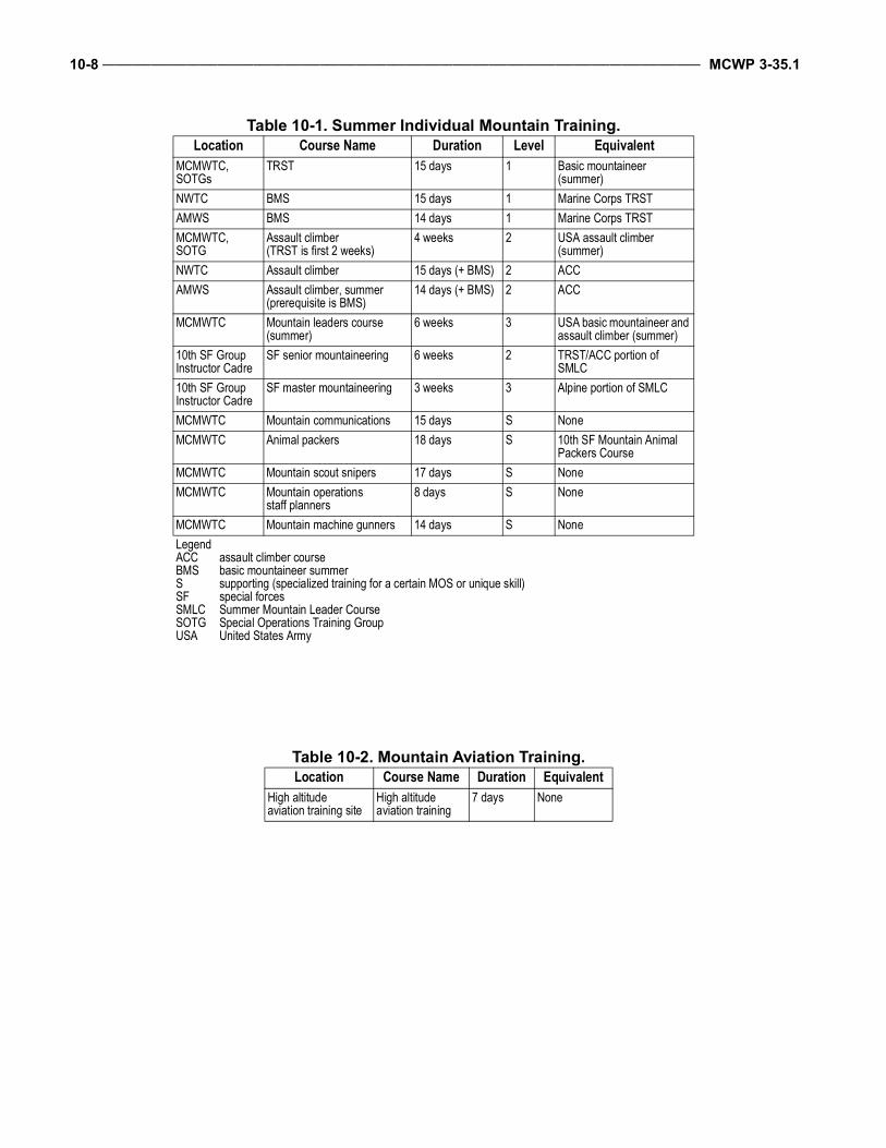
10-8 ___________________________________________________________________________________________________ MCWP 3-35.1
Table 10-1. Summer Individual Mountain Training.Location Course Name Duration Level Equivalent
MCMWTC,SOTGs
TRST 15 days 1 Basic mountaineer (summer)
NWTC BMS 15 days 1 Marine Corps TRSTAMWS BMS 14 days 1 Marine Corps TRSTMCMWTC, SOTG
Assault climber(TRST is first 2 weeks)
4 weeks 2 USA assault climber (summer)
NWTC Assault climber 15 days (+ BMS) 2 ACCAMWS Assault climber, summer
(prerequisite is BMS)14 days (+ BMS) 2 ACC
MCMWTC Mountain leaders course (summer)
6 weeks 3 USA basic mountaineer and assault climber (summer)
10th SF Group Instructor Cadre
SF senior mountaineering 6 weeks 2 TRST/ACC portion of SMLC
10th SF Group Instructor Cadre
SF master mountaineering 3 weeks 3 Alpine portion of SMLC
MCMWTC Mountain communications 15 days S NoneMCMWTC Animal packers 18 days S 10th SF Mountain Animal
Packers CourseMCMWTC Mountain scout snipers 17 days S NoneMCMWTC Mountain operations
staff planners8 days S None
MCMWTC Mountain machine gunners 14 days S NoneLegendACCBMSSSFSMLCSOTGUSA
assault climber coursebasic mountaineer summersupporting (specialized training for a certain MOS or unique skill)special forcesSummer Mountain Leader CourseSpecial Operations Training GroupUnited States Army
Table 10-2. Mountain Aviation Training.Location Course Name Duration Equivalent
High altitude aviation training site
High altitude aviation training
7 days None
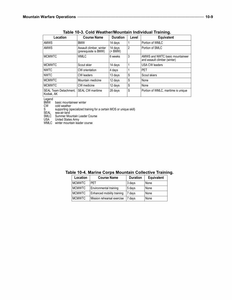
Mountain Warfare Operations ________________________________________________________________________________ 10-9
Table 10-3. Cold Weather/Mountain Individual Training.Location Course Name Duration Level Equivalent
AMWS BMW 14 days 1 Portion of WMLCAMWS Assault climber, winter
(prerequisite is BMW)14 days (+ BMW)
2 Portion of SMLC
MCMWTC WMLC 6 weeks 3 AMWS and NWTC basic mountaineer and assault climber (winter)
MCMWTC Scout skier 14 days 1 USA CW leadersNWTC CW orientation 4 days 1 PETNWTC CW leaders 13 days S Scout skiersMCMWTC Mountain medicine 12 days S NoneMCMWTC CW medicine 12 days S NoneSEAL Team Detachment, Kodiak, AK
SEAL CW maritime 28 days S Portion of WMLC, maritime is unique
LegendBMWCWSSEALSMLCUSAWMLC
basic mountaineer wintercold weathersupporting (specialized training for a certain MOS or unique skill)sea-air-land Summer Mountain Leader CourseUnited States Armywinter mountain leader course
Table 10-4. Marine Corps Mountain Collective Training.Location Course Name Duration Equivalent
MCMWTC PET 3 days NoneMCMWTC Environmental training 5 days NoneMCMWTC Enhanced mobility training 7 days NoneMCMWTC Mission rehearsal exercise 7 days None

10-10 _________________________________________________________________________________________________ MCWP 3-35.1
This Page Intentionally Left Blank
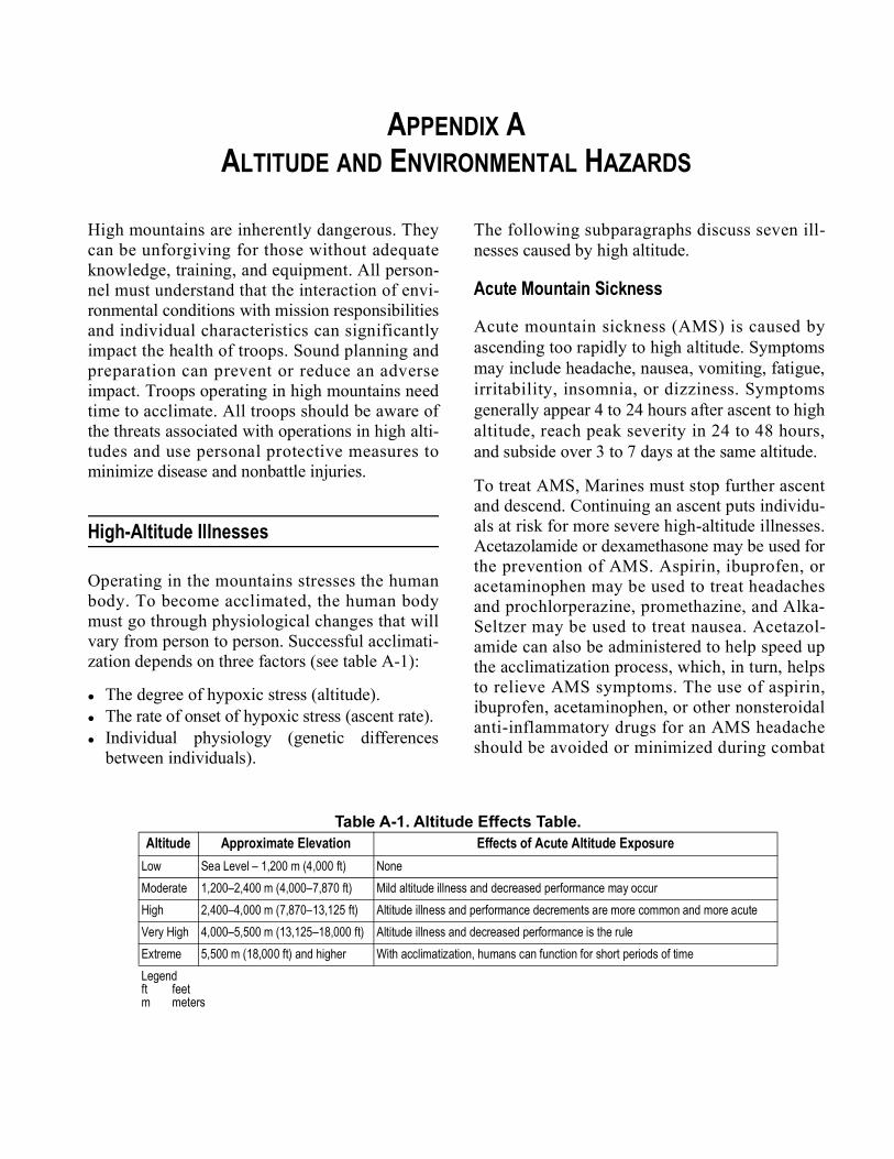
APPENDIX AALTITUDE AND ENVIRONMENTAL HAZARDS
High mountains are inherently dangerous. Theycan be unforgiving for those without adequateknowledge, training, and equipment. All person-nel must understand that the interaction of envi-ronmental conditions with mission responsibilitiesand individual characteristics can significantlyimpact the health of troops. Sound planning andpreparation can prevent or reduce an adverseimpact. Troops operating in high mountains needtime to acclimate. All troops should be aware ofthe threats associated with operations in high alti-tudes and use personal protective measures tominimize disease and nonbattle injuries.
High-Altitude Illnesses
Operating in the mountains stresses the humanbody. To become acclimated, the human bodymust go through physiological changes that willvary from person to person. Successful acclimati-zation depends on three factors (see table A-1):
The degree of hypoxic stress (altitude). The rate of onset of hypoxic stress (ascent rate). Individual physiology (genetic differences
between individuals).
The following subparagraphs discuss seven ill-nesses caused by high altitude.
Acute Mountain Sickness
Acute mountain sickness (AMS) is caused byascending too rapidly to high altitude. Symptomsmay include headache, nausea, vomiting, fatigue,irritability, insomnia, or dizziness. Symptomsgenerally appear 4 to 24 hours after ascent to highaltitude, reach peak severity in 24 to 48 hours,and subside over 3 to 7 days at the same altitude.
To treat AMS, Marines must stop further ascentand descend. Continuing an ascent puts individu-als at risk for more severe high-altitude illnesses.Acetazolamide or dexamethasone may be used forthe prevention of AMS. Aspirin, ibuprofen, oracetaminophen may be used to treat headachesand prochlorperazine, promethazine, and Alka-Seltzer may be used to treat nausea. Acetazol-amide can also be administered to help speed upthe acclimatization process, which, in turn, helpsto relieve AMS symptoms. The use of aspirin,ibuprofen, acetaminophen, or other nonsteroidalanti-inflammatory drugs for an AMS headacheshould be avoided or minimized during combat
Table A-1. Altitude Effects Table.Altitude Approximate Elevation Effects of Acute Altitude Exposure
Low Sea Level – 1,200 m (4,000 ft) NoneModerate 1,200–2,400 m (4,000–7,870 ft) Mild altitude illness and decreased performance may occurHigh 2,400–4,000 m (7,870–13,125 ft) Altitude illness and performance decrements are more common and more acuteVery High 4,000–5,500 m (13,125–18,000 ft) Altitude illness and decreased performance is the ruleExtreme 5,500 m (18,000 ft) and higher With acclimatization, humans can function for short periods of timeLegendft feetm meters
A-2 ___________________________________________________________________________________________________ MCWP 3-35.1
operations because of their detrimental effect onblood coagulation. Acute mountain sickness alonedoes not mean that descent is absolutely neces-sary. Stopping the ascent to rest and acclimatize tothe same altitude will resolve AMS in 3 days orless (in most individuals)—the best option incases of mild AMS. Medical therapy is crucialwhen descent is not possible. Use of any medica-tion should be discussed with a physician.
Once symptoms have gone away, troops canresume gradual ascent. Those who continue toshow signs of AMS must be observed for develop-ment of high altitude pulmonary edema (HAPE)or high altitude cerebral edema (HACE), both ofwhich could be fatal.
All troops are susceptible to high altitude illness.A staged or graded ascent, or movement to alower altitude, can prevent AMS. Limited evi-dence suggests that a high carbohydrate diet, suchas whole grains, vegetables, peas and beans, pota-toes, fruits, honey, and refined sugar, can alsoreduce AMS symptoms.
High Altitude Pulmonary Edema
High altitude pulmonary edema occurs whenindividuals ascend too rapidly to high altitude orascend too rapidly from a high to a higher alti-tude. High altitude pulmonary edema normallybegins within 24 to 72 hours after rapid ascent to2,438 meters (8,000 feet) or more. Symptomsinclude coughing, noisy breathing, wheezing,gurgling in the airway, difficulty breathing whenat rest, and deteriorated behavioral status, such asconfusion or vivid hallucinations. High altitudepulmonary edema occurs in 2 to 15 percent ofpeople brought rapidly to altitudes above 2,438meters (8,000 feet).
Troops experiencing AMS who are not treatedand continue to ascend to higher altitudes are atsignificant risk for HAPE. If untreated, HAPEcan be fatal within 6 to 12 hours. It is the mostcommon cause of death among altitude-relatedillnesses. Preventive measures include stagedand graded ascent, proper acclimatization,
sleeping at the lowest altitude possible, avoidingcold exposure, and avoiding strenuous exertionuntil acclimated.
Immediate descent is the best treatment forHAPE. If available, a hyperbaric chamber, suchas the Gamow Bag (a portable hyperbaricchamber weighing 14 pounds), can take a patientfrom 4,267 to 2,134 meters (14,000 to 7,000 feet)in 4 to 6 hours if evacuation to lower altitudes isnot possible. Operated by a foot pump, the bag ispressurized to an internal pressure of 2 poundsper square inch.
High Altitude Cerebral Edema
High altitude cerebral edema is the most severeillness associated with high altitudes. Individualswith HACE frequently have HAPE. As withother high altitude illnesses, HACE is caused byascending too rapidly without proper acclimatiza-tion. Troops experiencing AMS should be closelymonitored for the development of HACE. Troopswith AMS who continue ascending are consid-ered to be at high risk for HACE.
In general, HACE occurs later than AMS orHAPE. If untreated, HACE can progress to comain 12 hours and death within 24 hours. In someinstances, death has occurred in less than 12 hours.The average onset time of symptoms followingascent is 5 days with a range of 1 to 13 days.
Symptoms of HACE often resemble AMS(severe headache, nausea, vomiting, and extremelethargy); however, a more visible indicator for
CAUTION
The preferred step in treating any highaltitude illness is to evacuate affectedindividuals to a lower altitude. Underno circumstances should anyone withsevere AMS symptoms or suspectedHAPE or HACE be allowed to con-tinue their ascent.
Mountain Warfare Operations _________________________________________________________________________________ A-3
the onset of HACE is a swaying upper body,especially when walking. Early behavioral deteri-oration may include confusion, disorientation,and inability to speak coherently. Marines mayappear withdrawn or demonstrate behavior gener-ally associated with fatigue or anxiety.
Preventive measures for HACE are the same asfor AMS and HAPE. Those with symptoms ofHACE should be evacuated immediately. Treat-ment of HACE is immediate descent at first signof symptoms, such as swaying upper body andchange in behavioral status. Decadron and oxy-gen are used to treat HACE. If available, ahyperbaric chamber (such as a Gamow Bag) canbe used to stabilize patients if evacuation to loweraltitudes is not possible, but should NOT be usedas a substitute for descent.
High Altitude Systemic Edema
High altitude systemic edema is the swelling oftissue and joint discomfort that may occur due torapid ascent. Persons with high altitude systemicedema may not exhibit any other symptoms ofhigh altitude sickness.
High Altitude Retinal Hemorrhaging
High altitude retinal hemorrhaging only occurs atextremely high altitudes (almost always foundabove 4,572 meters or 15,000 feet). Signs canonly be seen with an ophthalmoscope. Vision canbe blurred in severe cases.
Subacute Mountain Sickness
Subacute mountain sickness occurs in some peopleduring prolonged deployments (weeks to months)to elevations above 3,474 meters (11,400 feet).Symptoms include sleep disturbance, loss ofappetite, weight loss, and fatigue. This conditionreflects a failure to acclimate adequately.
Poor Wound Healing
Poor wound healing may occur at higher eleva-tions and results from lowered immune functions.
Injuries, such as burns or cuts, may requiredescent for effective treatment and healing.
Environmental Threats
The following subparagraphs address conditionsthat are not unique to mountainous environmentsbut commonly occur at high elevations.
Nonbattle Injuries
Exhaustion, dehydration, lower limb orthopedicinjuries, lower back injuries, frostbite, diarrhea,malaria, and weight loss are the most commonnonbattle-related injuries in the mountains.Hypoxia, an inadequacy in the oxygen reachingthe body’s tissues, and cold can impair judgmentand physical performance, resulting in a greaterrisk of injury while operating in rugged terrain.
Cold Injuries
Once a Service member has acclimated to alti-tude, cold injuries are generally the greatestthreat. Frequent mountain winds may prove dan-gerous due to windchill effects. Because hypoxia-induced psychological effects can result in poorjudgment and decisionmaking, a higher inci-dence of cold injuries should be anticipated. Pre-ventive measures for cold injuries includecommand emphasis on maintaining nutrition,drinking plenty of fluids, and dressing in layers.
Heat Injuries
Standard heat injuries, such as heat cramps, heatexhaustion, and heat stroke, can occur in themountains. They occur during movements, espe-cially upslope with heavy loads or at high altitudewith heavy loads. Personal protection equipmentcan restrict evaporation of sweat (body cooling)and also cause heat injuries. Commanders need tobalance the load, personal protection equipment,and pace with the altitude and degree of slope.
A-4 ___________________________________________________________________________________________________ MCWP 3-35.1
Injuries Caused by Sunlight
The potential for solar radiation injuries caused bysunlight increases at high altitudes due to higherultraviolet radiation in the thinner atmosphere andthe reflection of light on snow and rock surfaces.Solar radiation injuries will occur with less expo-sure at high altitude than at low altitude andinclude sunburn and snow blindness.
Sunburn Sunburn is more likely to occur on partly cloudyor overcast days when troops are unaware of thethreat and fail to take appropriate precautions.Applying sun block (at least 15 SPF [sun protec-tion factor]) to all exposed skin helps to preventsunburn. Some medications, such as acetazol-amide, increase the danger of sunburn.
Snow BlindnessSnow blindness results from ultraviolet lightabsorption by the external parts of the eyes, suchas the eyelids and cornea. Initially, there is nosensation, other than brightness, as a warning thateye damage is occurring. Sunburn-like damagecan occur in a matter of hours. Sunglasses or gog-gles with ultraviolet protection will prevent snowblindness. Sunglasses with side protectors arerecommended. In the event of lost or damagedsunglasses, emergency goggles can be made bycutting slits in dark fabric or tape folded backonto itself.
Treatment for snow blindness includes coveringthe eyes with a dark cloth if the casualty is notneeded to perform the mission. The cloth will pre-vent light from reaching the eyes and it will helpto keep the casualty from moving his/her eyes,which could result in additional pain. A muslinbandage may be folded into a cravat and used tokeep the cloth in place or the cravat may be usedas a blindfold. Do not put ointment in the eye.
Terrain Injuries
Troops should be aware of the dangers of highaltitude, including snow avalanches and rock
falls. Poor judgment at high altitude increases therisk of injury. The potential for being struck bylightning is also increased at higher altitudes,especially in areas above the tree line. Protectivemeasures include taking shelter in solid-roofedstructures or vehicles; laying in depressions, suchas creek beds; and avoiding tall structures orlarge metal objects.
Carbon Monoxide Poisoning
Carbon monoxide poisoning is a frequent haz-ard. Heavier than oxygen, carbon monoxide set-tles in the bottom of tents and enclosures. Tentventilation should be at the lowest point in thetent to ensure carbon monoxide is able to escape.The following can lead to increased carbon mon-oxide levels:
Inefficient fuel combustion. Combustion heaters and engines in enclosed,
poorly ventilated spaces. Cigarette smoking.
Preventive measures include ensuring that troopsdo not sleep in vehicles with the engine running,ensuring heaters and stoves work properly, andensuring tents have adequate ventilation.
Infectious Diseases
Although there is generally a reduced threat ofdisease at higher elevations, troops should takeprecautions to avoid diseases caused by insects,plants, and animals and diseases transmitted per-son to person.
At moderate to high altitudes, insect-borne disease(from mosquitoes, ticks, and flies) is common. Insome areas, malaria-bearing mosquitoes live ashigh as 1,828 meters (6,000 feet). The threat ofdiseases transmitted from person to person isincreased at higher, cold climates because troopswill spend more time inside tents and huddling tostay warm. Crowding and poor ventilation in tentsand other shelters increase dissemination of respi-ratory infections. The influenza (flu) vaccinationis a preventive measure.
Mountain Warfare Operations _________________________________________________________________________________ A-5
High Altitude Operational Impacts
The effects of altitude on the mind and body im-pact operations in several ways.
Reduced Physical Performance
Hypobaric hypoxia causes a reduction in physi-cal performance. Personnel cannot maintain thesame physical performance at high altitude thatthey can at low altitude, regardless of their fitnesslevel. Measures to prevent disease and injuryinclude acclimatization, adjusting work rates andload carriage, planning frequent rests during workand exercise, and planning and performing physi-cal training programs at altitude.
Psychological Effects
Altitude exposure may result in changes in vision,taste, mood, and personality. These effects aredirectly related to altitude and are common above3,048 meters (10,000 feet). Some effects occurearly and are temporary, while others may persistafter acclimatization or even for a period of timeafter descent.
Vision
Vision is generally the sense most affected byaltitude exposure. Dark adaptation is signifi-cantly reduced, affecting personnel as low as2,438 meters (7,900 feet) and can affect militaryoperations at high altitude.
Behavioral Effects
Behavioral effects are most noticeable at veryhigh and extreme altitudes and they includedecreased perception, memory, judgment, andattention. To compensate for loss of functionalability, leaders should allow extra time to accom-plish tasks.
Alterations in mood and personality traits arecommon during high altitude exposures. Withinhours of ascent, many individuals may experienceeuphoria (joy/excitement) that is likely to be
accompanied by errors in judgment that may leadto mistakes and accidents. Use of the buddy sys-tem during this early exposure time helps to iden-tify troops who may be more severely affected.Troops may become irritable, quarrelsome, anx-ious, apathetic, or listless. These mood changesreach a peak after 18 to 24 hours of altitude expo-sure and recede to normal after 48 hours at alti-tudes up to 4,724 meters (15,400 feet). Buildingesprit de corps and unit cohesion before deploy-ment and reinforcing them during deploymentwill help minimize the impact of mood swings.
Sleep Disturbances
High altitude can have significant effects on abil-ity to sleep. The most prominent effects are fre-quent per iods of apnea (a br ie f pause inbreathing) and fragmented sleep. Sleep distur-bances occur in everyone above 3,048 meters(10,000 feet).
Reports of “not being able to sleep” and “awakehalf the night” are common and may also contrib-ute to mood changes and daytime drowsiness.These effects have been reported at elevations aslow as 1,524 meters (5,000 feet) and are verycommon at higher altitudes.
During cold weather operations eating a snackbefore bedtime is also helpful. Snacking beforebedtime will help keep Marines warmer duringsleep which prevents shivering and allows forsounder, more restful sleep. Ensuring adequateinsulation when sleeping is also important as thebody’s core temperature decreases naturallyduring sleep.
Acetazolamide has been found to improve sleepquality at high altitudes and reduce AMS andother altitude illnesses. Sleeping pills and othermedications that promote sleep or drowsinessshould be taken only with medical supervision.
Dehydration
Dehydration is a very common condition at highaltitude. Perspiration, vomiting, decreased thirst
A-6 ___________________________________________________________________________________________________ MCWP 3-35.1
sensation (hypoxia-induced), underconsumptionof calories, and increased energy needs due toexertion increase the risk of dehydration. Routineactivities and chores performed at high altitudes—even common activities, such as walking—requireincreased exertion.
Dehydration increases the likelihood of hot andcold weather injuries, altitude illness, anddecreased physical capabilities. Many symptomsof dehydration and HACE are similar.
Troops can prevent dehydration at high altitudes byconsuming at least 3 to 4 quarts of water (includingwater consumed in food) or other noncaffeinatedfluids per day and 6 to 8 quarts during coldweather. Individuals can drink a variety of fluids,such as juice or sports drinks, as each is an equallyeffective aid in rehydration. At high altitudes orcold weather, thirst is not an adequate warning ofdehydration. Commanders must monitor troops toensure they drink enough fluids and do not becomedehydrated (see Technical Bulletin Medical 505,Altitude Acclimatization and Illness Management,and 508, Prevention and Management of Cold-Weather Injuries, for more information).
Nutrition
Poor nutrition contributes to illness or injury,decreased performance, poor morale, andsusceptibility to cold injuries. Influences thatimpact nutrition at high elevations include a dulledtaste sensation (making food undesirable), nausea,lack of energy, or lack of motivation to prepare or
eat meals. Poor eating habits (lack of fruits andvegetables or eating only a few MRE ration com-ponents) and dehydration may also lead to con-stipation or aggravation of hemorrhoids.
Troops can reduce the effects of poor nutrition athigh elevations by increasing their consumptionrates. Rations should be supplemented and fre-quent snacking encouraged. High carbohydratesnacks are recommended since they are easilycarried and require no preparation. TechnicalBulletins Medical 505 and 508 also have moreinformation on the importance of proper nutri-tion in the prevention of cold weather injuries.
Toxins
Other products that can seriously impact militaryoperations include tobacco, alcohol, and caffeine.Tobacco smoke interferes with oxygen delivery byreducing the blood’s oxygen-carrying capacities.Tobacco smoke in close, confined spacesincreases the amounts of carbon monoxide. Theirritant effect of tobacco smoke may produce anarrowing of airways that interferes with optimalair movement. Smoking can effectively raise the“physiological altitude” as much as several thou-sand feet. Alcohol impairs judgment and percep-tion, depresses respiration, causes dehydration,and increases susceptibility to cold injury. Caf-feine from coffee and other sources may improvephysical and mental performance; however, it alsocauses increased urination (leading to dehydra-tion) and should be consumed in moderation.
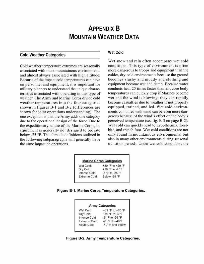
APPENDIX BMOUNTAIN WEATHER DATA
Cold Weather Categories
Cold weather temperature extremes are seasonallyassociated with most mountainous environmentsand almost always associated with high altitude.Because of the impact cold temperatures can haveon personnel and equipment, it is important formilitary planners to understand the unique charac-teristics associated with operating in this type ofweather. The Army and Marine Corps divide coldweather temperatures into the four categoriesshown in figures B-1 and B-2 (differences areshown for joint operations understanding). Theone exception is that the Army adds one categorydue to the operational design of the force. Due tothe expeditionary nature of the Marine Corps, itsequipment is generally not designed to operatebelow -25 °F. The climatic definitions outlined inthe following subparagraphs will generally havethe same impact on operations.
Wet Cold
Wet snow and rain often accompany wet coldconditions. This type of environment is oftenmore dangerous to troops and equipment than thecolder, dry cold environments because the groundbecomes slushy and muddy and clothing andequipment become wet and damp. Because waterconducts heat 25 times faster than air, core bodytemperatures can quickly drop if Marines becomewet and the wind is blowing; they can rapidlybecome casualties due to weather if not properlyequipped, trained, and led. Wet cold environ-ments combined with wind can be even more dan-gerous because of the wind’s effect on the body’sperceived temperature (see fig. B-3 on page B-2).Wet cold can quickly lead to hypothermia, frost-bite, and trench foot. Wet cold conditions are notonly found in mountainous environments, butalso in many other environments during seasonaltransition periods. Under wet cold conditions, the
Marine Corps CategoriesWet Cold: +39 °F to +20 °FDry Cold: +19 °F to -4 °FIntense Cold: -5 °F to -25 °FExtreme Cold: Below -25 °F
Figure B-1. Marine Corps Temperature Categories.
Army CategoriesWet Cold: +39 °F to +20 °FDry Cold: +19 °F to -4 °FIntense Cold: -5 °F to -25 °FExtreme Cold: -25 °F to -40°FAcute Cold: -40 °F and below
Figure B-2. Army Temperature Categories.
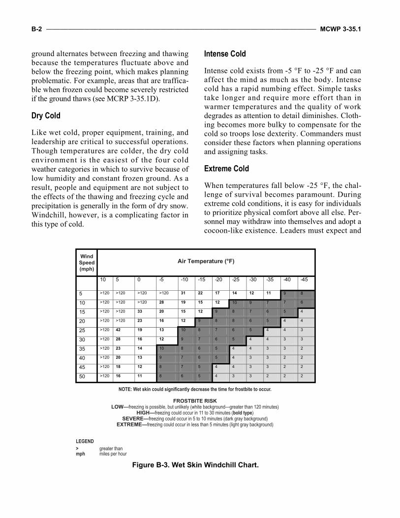
B-2 ___________________________________________________________________________________________________ MCWP 3-35.1
ground alternates between freezing and thawingbecause the temperatures fluctuate above andbelow the freezing point, which makes planningproblematic. For example, areas that are traffica-ble when frozen could become severely restrictedif the ground thaws (see MCRP 3-35.1D).
Dry Cold
Like wet cold, proper equipment, training, andleadership are critical to successful operations.Though temperatures are colder, the dry coldenvironment is the easiest of the four coldweather categories in which to survive because oflow humidity and constant frozen ground. As aresult, people and equipment are not subject tothe effects of the thawing and freezing cycle andprecipitation is generally in the form of dry snow.Windchill, however, is a complicating factor inthis type of cold.
Intense Cold
Intense cold exists from -5 °F to -25 °F and canaffect the mind as much as the body. Intensecold has a rapid numbing effect. Simple taskstake longer and require more effort than inwarmer temperatures and the quality of workdegrades as attention to detail diminishes. Cloth-ing becomes more bulky to compensate for thecold so troops lose dexterity. Commanders mustconsider these factors when planning operationsand assigning tasks.
Extreme Cold
When temperatures fall below -25 °F, the chal-lenge of survival becomes paramount. Duringextreme cold conditions, it is easy for individualsto prioritize physical comfort above all else. Per-sonnel may withdraw into themselves and adopt acocoon-like existence. Leaders must expect and
Air Temperature (°F)
10 5 0 -5 -10 -15 -20 -25 -30 -35 -40 -45
5 >120 >120 >120 >120 31 22 17 14 12 11 9 8
10 >120 >120 >120 28 19 15 12 10 9 7 7 6
15 >120 >120 33 20 15 12 9 8 7 6 5 4
20 >120 >120 23 16 12 9 8 8 6 5 4 4
25 >120 42 19 13 10 8 7 6 5 4 4 3
30 >120 28 16 12 9 7 6 5 4 4 3 3
35 >120 23 14 10 8 6 5 4 4 3 3 2
40 >120 20 13 9 7 6 5 4 3 3 2 2
45 >120 18 12 8 7 5 4 4 3 3 2 2
50 >120 16 11 8 6 5 4 3 3 2 2 2
WindSpeed(mph)
NOTE: Wet skin could significantly decrease the time for frostbite to occur.
FROSTBITE RISKLOW—freezing is possible, but unlikely (white background—greater than 120 minutes)
HIGH—freezing could occur in 11 to 30 minutes (bold type)SEVERE—freezing could occur in 5 to 10 minutes (dark gray background)
EXTREME—freezing could occur in less than 5 minutes (light gray background)
LEGEND> greater thanmph miles per hour
Figure B-3. Wet Skin Windchill Chart.
Mountain Warfare Operations _________________________________________________________________________________ B-3
plan for weapons, vehicles, and munitions to failin this environment. Most military equipment istested and required to perform only at tempera-tures above -25 °F. As in other categories, leader-ship, training, and specialized equipment iscritical to operate successfully.
Acute Cold
Commanders and planners are warned that opera-tions below -40 °F are extremely hazardous. Unitsmust be extensively trained before undertaking anoperation in these temperature extremes.
Precipitation
Mountain precipitation is a result of several fac-tors, the most important being humidity and airflow. It is important for military planners andleaders at all levels to understand the causes ofprecipitation in mountains and why precipitationrates vary. Precipitation results from cloud forma-tions that, when accompanied by a drop in baro-metric pressure, are the best indicators ofapproaching adverse weather. Planners need tounderstand how clouds form and why precipita-tion occurs in order to predict mountain weatherand its effect on operations. Before understandingclouds, however, a few MET concepts must beexplained: humidity, air movement, cloud forma-tion, and atmospheric pressure.
Humidity
Humidity is the amount of moisture in the air.The amount of moisture air can hold is propor-tional to its temperature: the warmer the tempera-t u r e , t he mor e wa t e r t h e a i r ca n h o ld .Accordingly, cold air holds less moisture thanwarm air. Air is considered to be at its saturationpoint when it has 100 percent relative humidity.When air that is saturated is cooled, the moistureis released in various forms, such as clouds, rain,dew, snow, sleet, and fog. The temperature at
which this occurs is called the condensation(dew) point. The dew point varies depending onthe amount of moisture in the air at the time itbegins to cool. Air that contains a lot of mois-ture, or high humidity, can reach its dew pointwhen the temperature cools to 68 °F. However invery dry environments, condensation may notoccur until the temperature drops to 32 °F.
Air Movement
There are three ways that air can be lifted andcooled beyond its dew point—orographic uplift,convection, and frontal lifting. Mountain envi-ronments often experience some or all three,which contributes to the unpredictability ofmountain weather:
Orographic UpliftThis phenomenon happens when an air mass ispushed up and over a mass of higher ground,such as a mountain. Due to the increase in alti-tude, the air cools until it reaches its condensationpoint. The result is precipitation. This type of lift-ing and cooling is the most common type inmountainous environments. In large mountain-ous areas where there are prevailing winds, theside of the mountain facing the wind often expe-riences high levels of precipitation while thebackside of the mountain is drier because theclouds release their moisture before reaching thetop and the air warms as it rolls down the oppo-site side. This weather also occurs even in warmweather mountainous areas. For example, thewindward side of the Hawaiian Islands experi-ences a lot of rain, but the leeward side is com-paratively dry and warm.
Convection EffectsConvection is normally a summer effect due tothe sun’s heat reradiating off of the earth’s sur-face and causing air currents to push straight upand lift air to its condensation point.
B-4 ___________________________________________________________________________________________________ MCWP 3-35.1
Frontal LiftingFrontal lifting occurs when two air masses of dif-ferent temperature and moisture content collide.The resultant phenomena are known as fronts.Since the air masses will not mix, the warmer airis forced aloft; from there it is cooled until itreaches its condensation point.
Cloud Formations
Any time air is cooled below its saturation point,clouds are formed. Being able to identify cloudsand understand how they are formed helps to pre-dict weather changes, which is important to thosewho are planning or executing mountain opera-tions. Clouds can be described and classified byheight, by appearance, or by the amount of areacovered (vertically or horizontally). Meteorolo-gists recognize many different types of clouds.Cirrus, stratus, and cumulus are the most usefulto military planners.
Cirrus clouds are formed of ice crystals at veryhigh altitudes (usually 6,096 to 10,668 meters or20,000 to 35,000 feet) but are thin, featheryclouds at the mid-altitudes. These clouds gener-ally point in the direction of the air movement attheir elevation and can provide up to 24 hourswarning of approaching bad weather. Frail, scat-tered types, such as “mare tails” or dense cirruslayers are a sign of fair weather, but predict thearrival of precipitation and a front.
Stratus clouds are formed at low and mid alti-tudes when a layer of moist air is cooled belowits saturation point. Stratus clouds lie mostly inhorizontal layers or sheets that resist verticaldevelopment. The word “stratus” is derived fromthe Latin word for “layer.” A stratus cloud ischaracteristically uniform and resembles fog. Ithas a uniform base and a dull, gray appearance.Stratus clouds appear heavy and will occasion-ally produce fine drizzle or very light snow withfog. Because there is little or no vertical move-ment in stratus clouds, they usually do not pro-duce heavy precipitation.
Cumulus clouds are formed from rising air cur-rents and are prevalent in unstable air that favorsvertical development. These currents of air cre-ate cumuliform clouds that give them a piled orbunched up appearance, looking similar to cottonballs. Within the cumulus family there are threedifferent types that help to forecast the weather:
Cumulus are fair weather clouds, but should beobserved for possible growth into toweringcumulus and cumulonimbus.
Towering cumulus clouds are characterized byvertical development. Their vertical lifting iscaused by some type of lifting action; forexample, during summer afternoons whenwind is forced to rise up the slope of a moun-tain or the lifting action that may be present ina frontal system. The towering cumulus has apuffy, cauliflower-shaped appearance.
Cumulonimbus clouds are characterized in thesame manner as the towering cumulus, formingthe familiar thunderhead that produces thunder-storm activity. These clouds are characterizedby violent updrafts that carry the cloud tops toextremely high elevations. Tornadoes, hail, andsevere rainstorms are all products of this typeof cloud. At the top of the cloud, a flat anvil-shaped form appears as the thunderstormbegins to dissipate.
Atmospheric Pressure
Besides cloud formations, changes in weatherare also indicated by changes in atmospheric(barometric) pressure. Decreasing pressure nor-mally indicates deteriorating weather, whileincreasing pressure usually indicates improvingor good weather.
Wind
Mountains greatly affect the flow of air andamplify wind speed. Generally, valley winds onsouth-facing slopes (north-facing slopes in thesouthern hemisphere) change direction at
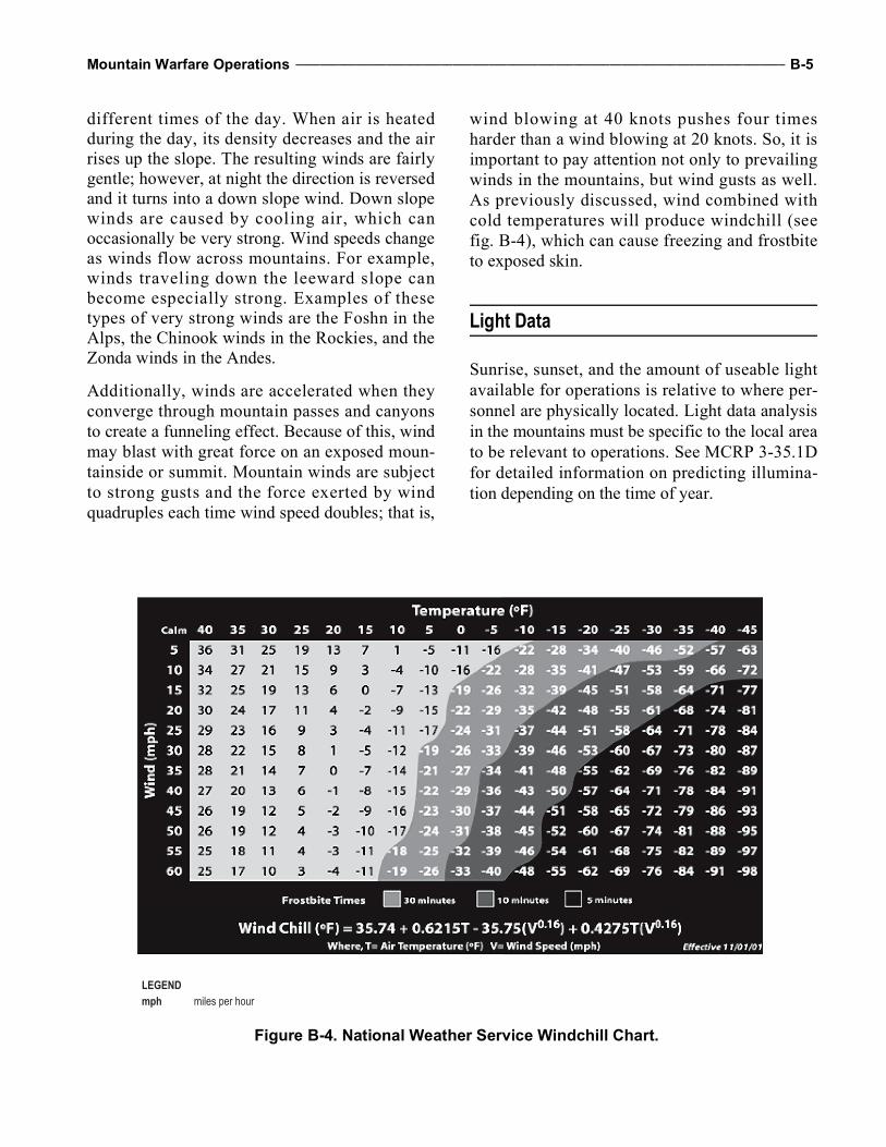
Mountain Warfare Operations _________________________________________________________________________________ B-5
different times of the day. When air is heatedduring the day, its density decreases and the airrises up the slope. The resulting winds are fairlygentle; however, at night the direction is reversedand it turns into a down slope wind. Down slopewinds are caused by cooling air, which canoccasionally be very strong. Wind speeds changeas winds flow across mountains. For example,winds traveling down the leeward slope canbecome especially strong. Examples of thesetypes of very strong winds are the Foshn in theAlps, the Chinook winds in the Rockies, and theZonda winds in the Andes.
Additionally, winds are accelerated when theyconverge through mountain passes and canyonsto create a funneling effect. Because of this, windmay blast with great force on an exposed moun-tainside or summit. Mountain winds are subjectto strong gusts and the force exerted by windquadruples each time wind speed doubles; that is,
wind blowing at 40 knots pushes four timesharder than a wind blowing at 20 knots. So, it isimportant to pay attention not only to prevailingwinds in the mountains, but wind gusts as well.As previously discussed, wind combined withcold temperatures will produce windchill (seefig. B-4), which can cause freezing and frostbiteto exposed skin.
Light Data
Sunrise, sunset, and the amount of useable lightavailable for operations is relative to where per-sonnel are physically located. Light data analysisin the mountains must be specific to the local areato be relevant to operations. See MCRP 3-35.1Dfor detailed information on predicting illumina-tion depending on the time of year.
LEGENDmph miles per hour
Figure B-4. National Weather Service Windchill Chart.
B-6 ___________________________________________________________________________________________________ MCWP 3-35.1
Mountain Weather Hazards
Mountains create many natural hazards due totheir slope and elevation. The following subpara-graphs discuss landslides, avalanches, lightningstrikes, flooding, and extreme cold weather.While there are other numerous hazards, thesehazards can cause a catastrophic mission failure.By identifying these hazards, planners and lead-ers can mitigate these risks through compositerisk management.
Landslides and Rockfalls
Landslides are caused by disturbances in the nat-ural stability of a slope. While they are not ascommon or dangerous as avalanches, they cause25 to 50 deaths per year in the United States.Sometimes called mudslides, they usually accom-pany heavy rains or follow droughts, earthquakes,volcanic eruptions, or large explosions. Theyoccur when water rapidly accumulates in theground and results in a surge of water-saturatedrock, earth, and debris. They usually start onsteep slopes and have been known to bury entirevillages. Rockfalls are not landslides, but theycan be dangerous nonetheless. They usually occurin the springtime when the freeze-thaw action ismost prevalent. This action causes boulders androcks to dislodge and tumble down hills or cliffs.Rockfalls can block routes, injure personnel, anddamage vehicles that are traveling below them.Engineers should conduct route reconnaissancealong steep mountain trails that are cut into thesides of cliffs because these trails are often sus-ceptible to rockfalls. In addition, because manymountain trails are often designed for foot or ani-mal traffic, they may have unstable edges that cangive way under heavy vehicle traffic, causing arockfall or even a landslide of its own.
Avalanches
Avalanches are similar to landslides; however,they occur on snow-covered mountains when theweight of the snow exceeds the cohesive forces
that hold the snow in place. Like landslides, pre-existing terrain conditions (slope characteristicsand lack of ground cover) and weather (prevail-ing winds and snow type) combine with a trigger,which is often human activity, to cause ava-lanches. Military leaders should take advantage ofavalanche maps and advice from local inhabitantsand be trained to recognize and avoid avalanchedanger areas whenever possible.
The following slope characteristics are usuallykey factors in determining the likelihood of ava-lanche danger:
Slope angle. Slopes as gentle as 15 degrees haveavalanched; however, most avalanches occur onslopes between 30 degrees and 45 degrees. Veryfew avalanches occur on slopes that are above60 degrees, because such slopes are too steep toaccumulate significant amounts of snow.
Slope profile. Dangerous slab avalanches aremore likely to occur on convex slopes, butoccasionally occur on concave slopes.
Slope aspect. Snow on north-facing slopes ismore likely to slide in midwinter while snowon south-facing slopes is most dangerous inthe spring and on sunny, warm days. Wind-ward slopes are generally more stable thanleeward slopes.
Ground cover. Rough terrain and terrain withmore vegetation is more stable than smooth ter-rain. Avalanches are more likely on grassyslopes or scree because the snowpack doesn’thave any natural anchors to which it can adhere.
The weather is also a significant factor in deter-mining the risk of avalanche in the following ways:
Temperature. In low temperatures, settlementand adhesion occur slowly. Avalanches duringextreme cold weather usually occur during orimmediately following a storm. When tempera-ture is just below freezing, the snowpack stabi-lizes quickly. At temperatures above freezing,especially if the temperature rises quickly, thepotential for avalanche is high. Storms with arise in temperature can deposit dry snow early,which bonds poorly with the heavier snow
Mountain Warfare Operations _________________________________________________________________________________ B-7
deposited later. As a result, most avalanchesoccur during the warmer midday.
Precipitation. About 90 percent of avalanchesoccur during or within 24 hours of a snowstorm.Additionally, the rate at which snow falls isimportant. High rates of snowfall (2.5 centime-ters [1 inch] or more per hour), especially whenaccompanied by wind, are usually associatedwith periods of avalanche activity. Rain after asnow fall increases the weight of snow andtends to weaken the snowpack, increasing thelikelihood of an avalanche.
Wind. In sustained winds of 15 miles per houror greater, snow builds up in wind slabs on theleeward side slopes, which is why avalanchesare more prone on the leeward slope than thewindward slope.
Most victims trigger the avalanche that buriesthem. Generally, it is the additional weight ofpersonnel or vehicles that triggers an avalanche.In some cases, triggers can be manmade noise orvibrations from vehicles, low-flying helicopters,firing, or explosions.
Lightning Strikes
Lightning strikes frequently in the mountains dueto rapidly changing and often violent weather pat-terns. Lightning kills more people in the UnitedStates than any other weather phenomenon and itis especially deadly in mountains. Lightning nat-urally seeks a path to high points and prominentfeatures, so mountain peaks are prime targets.During thunderstorms, personnel should avoidmountain ridges, isolated trees, crests, peaks, androck needles. Also, because lightning flowsaround and through objects like water, personnelshould avoid gullies, washes, shallow depres-sions, shallow overhangs, and all bodies of water.
Flooding
During the seasonal runoff, mountain-fed riverscan become extremely hazardous and rain at highelevations in snow-covered mountains can causeflash flooding. Many dry riverbeds also becomehazardous and are at risk to flash flood.
Extreme Cold Weather
Extreme cold weather may overwhelm forcesthat are unprepared. See MCRP 3-35.1D for in-formation on the following unique weather phe-nomena that can affect military operations inextreme cold environments:
Ice fog. Blizzards. Whiteout. Grayout. Temperature inversion.
Mountain Weather Effects on Operations
Weather and visibility conditions in the mountain-ous regions of the world may create unprece-dented advantages and disadvantages forcombatants. To fight effectively, the commandermust acquire accurate weather information abouthis/her area of operations. Terrain has a dominanteffect on local climate and weather patterns in themountains. Mountainous areas are subject to fre-quent and rapid changes of weather, including fog,strong winds, extreme heat, cold, and heavy rainor snow. As a result, many forecasts that describeweather over large areas of terrain are inherentlyinaccurate. Commanders must be able to developlocal, terrain-based forecasts by combining avail-able forecasts with field observations (local tem-perature, wind, precipitation, cloud patterns,barometric pressure, and surrounding terrain).Forecasting mountain weather from the fieldimproves accuracy and enhances the ability toexploit opportunities offered by the weather, whileminimizing its adverse effects. Table B-1, on pageB-8, highlights the effects of weather in the moun-tains versus in flat terrain. Weather conditions inthe mountains will have a significant impact on allmilitary operations (see tables B-2 through B-9 onpages B-8 through B-13). The impact of weatheron specific types of operations is highlighted inMCWP 3-35.7, MAGTF Meteorological andOceanographic Support.
B-8 ___________________________________________________________________________________________________ MCWP 3-35.1
Table B-1. Weather Effects.Weather
ConditionFlat to Moderate Terrain Effects Added Mountain Effects
Sunshine SunburnSnow blindnessTemperature differences between sun and shade
Increased risk of sunburn and snow blindnessSevere, unexpected temperature variations between sun and shadeAvalanches
Wind Windchill Increased risk and severity of windchillBlowing debris or driven snow causing reduced visibilityAvalanches
Rain Reduced visibilityCooler temperatures
LandslidesFlash floodsAvalanches
Snow Cold weather injuriesReduced mobility and visibilitySnow blindnessBlowing snow
Increased risk and severity of common effectsAvalanches
Storms Rain/snowReduced visibilityLightning
Extended duration and intensity greatly affecting visibility and mobilityExtremely high windsAvalanches
Fog Reduced mobility/visibility Increased frequency and durationCloudiness Reduced visibility Greatly decreased visibility at higher elevations
Table B-2. Weather Effects on Intelligence Operations.Element Critical Value Impact
Ceiling—cloud and sky cover < 200 ft Engagement range< 1,000 ft Aerial observation
Surface visibility at the following wavelengths: 1.06 m, 3–5 m, 8–12 m
< 1 mi Determination of enemy’s ability to conceal actionsLocation and identification of targets
Wind (surface) > 60 kt Equipment damagePrecipitation > 0.1 in/h liquid Audio sensors and radar effectiveness
> 0.5 in/h liquid Speed of personnel and equipment movement> 2 in within a 12-h period Speed of personnel and equipment movement
Trafficability and storage of equipmentSnow depth and cover > 6 in TrafficabilityThunderstorms and lightning Any occurrence within 3 mi Troop and equipment safety
False alarms and false readingsTemperature (surface) > 122 °F
< -58 °FEmplacement site selection
Temperature (ground) < 32 °F Trafficability assessmentWet bulb globe temperature > 85 °F Troop safetyEM propagation Subrefraction and
superrefractionDucting of radar transmission and returns
Effective illumination <0.0011 lux Target acquisitionRiver stage and current strength > 6-ft depth Enemy’s ability to cross rivers or streamsLegendEM electromagnetic ft feeth hour(s)in inchesin/h inches per hourkt knots
m metersmi miles> greater than< less than< less than or equal to
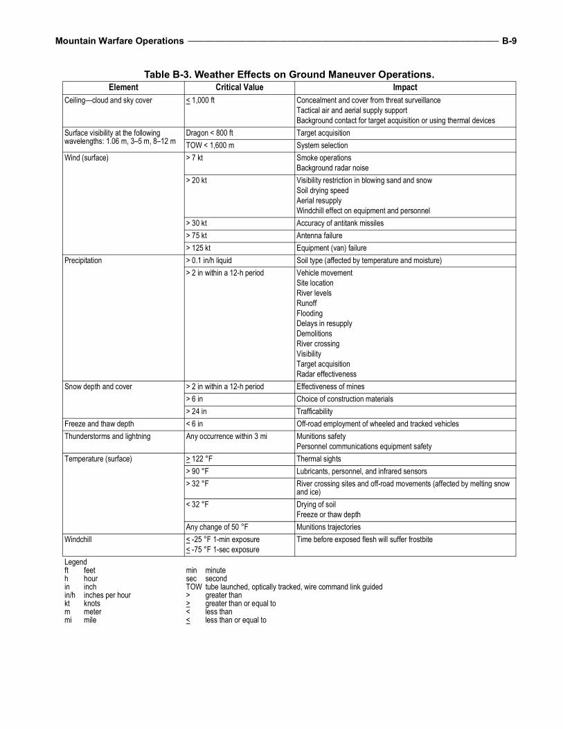
Mountain Warfare Operations _________________________________________________________________________________ B-9
Table B-3. Weather Effects on Ground Maneuver Operations.Element Critical Value Impact
Ceiling—cloud and sky cover < 1,000 ft Concealment and cover from threat surveillanceTactical air and aerial supply supportBackground contact for target acquisition or using thermal devices
Surface visibility at the following wavelengths: 1.06 m, 3–5 m, 8–12 m
Dragon < 800 ft Target acquisitionTOW < 1,600 m System selection
Wind (surface) > 7 kt Smoke operationsBackground radar noise
> 20 kt Visibility restriction in blowing sand and snowSoil drying speedAerial resupplyWindchill effect on equipment and personnel
> 30 kt Accuracy of antitank missiles> 75 kt Antenna failure> 125 kt Equipment (van) failure
Precipitation > 0.1 in/h liquid Soil type (affected by temperature and moisture)> 2 in within a 12-h period Vehicle movement
Site locationRiver levelsRunoffFloodingDelays in resupplyDemolitionsRiver crossingVisibilityTarget acquisitionRadar effectiveness
Snow depth and cover > 2 in within a 12-h period Effectiveness of mines> 6 in Choice of construction materials> 24 in Trafficability
Freeze and thaw depth < 6 in Off-road employment of wheeled and tracked vehiclesThunderstorms and lightning Any occurrence within 3 mi Munitions safety
Personnel communications equipment safetyTemperature (surface) > 122 °F Thermal sights
> 90 °F Lubricants, personnel, and infrared sensors> 32 °F River crossing sites and off-road movements (affected by melting snow
and ice)< 32 °F Drying of soil
Freeze or thaw depthAny change of 50 °F Munitions trajectories
Windchill < -25 °F 1-min exposure< -75 °F 1-sec exposure
Time before exposed flesh will suffer frostbite
Legendft feeth hourin inchin/h inches per hourkt knotsm metermi mile
min minutesec secondTOW tube launched, optically tracked, wire command link guided> greater than> greater than or equal to< less than< less than or equal to
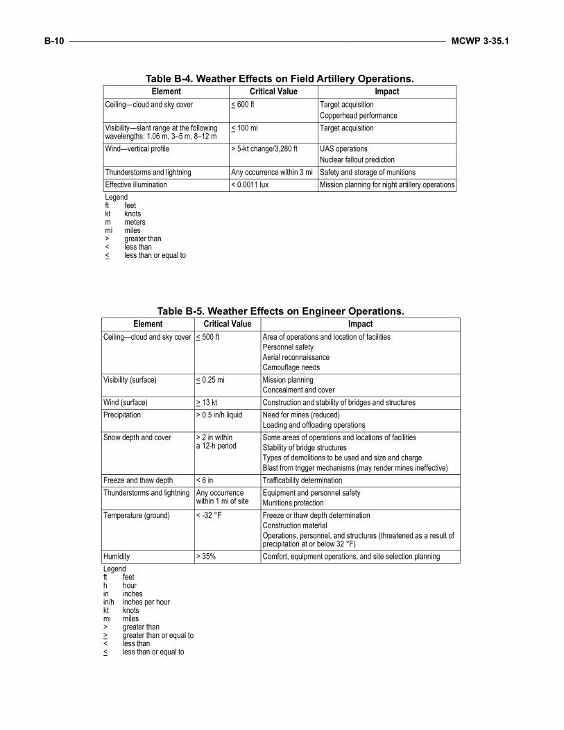
B-10 __________________________________________________________________________________________________ MCWP 3-35.1
Table B-4. Weather Effects on Field Artillery Operations.Element Critical Value Impact
Ceiling—cloud and sky cover < 600 ft Target acquisitionCopperhead performance
Visibility—slant range at the following wavelengths: 1.06 m, 3–5 m, 8–12 m
< 100 mi Target acquisition
Wind—vertical profile > 5-kt change/3,280 ft UAS operationsNuclear fallout prediction
Thunderstorms and lightning Any occurrence within 3 mi Safety and storage of munitionsEffective illumination < 0.0011 lux Mission planning for night artillery operationsLegendft feetkt knotsm metersmi miles> greater than< less than< less than or equal to
Table B-5. Weather Effects on Engineer Operations.Element Critical Value Impact
Ceiling—cloud and sky cover < 500 ft Area of operations and location of facilitiesPersonnel safetyAerial reconnaissanceCamouflage needs
Visibility (surface) < 0.25 mi Mission planningConcealment and cover
Wind (surface) > 13 kt Construction and stability of bridges and structuresPrecipitation > 0.5 in/h liquid Need for mines (reduced)
Loading and offloading operationsSnow depth and cover > 2 in within
a 12-h periodSome areas of operations and locations of facilitiesStability of bridge structuresTypes of demolitions to be used and size and chargeBlast from trigger mechanisms (may render mines ineffective)
Freeze and thaw depth < 6 in Trafficability determinationThunderstorms and lightning Any occurrence
within 1 mi of siteEquipment and personnel safetyMunitions protection
Temperature (ground) < -32 °F Freeze or thaw depth determinationConstruction materialOperations, personnel, and structures (threatened as a result of precipitation at or below 32 °F)
Humidity > 35% Comfort, equipment operations, and site selection planningLegendft feeth hour in inchesin/h inches per hourkt knotsmi miles> greater than> greater than or equal to< less than< less than or equal to
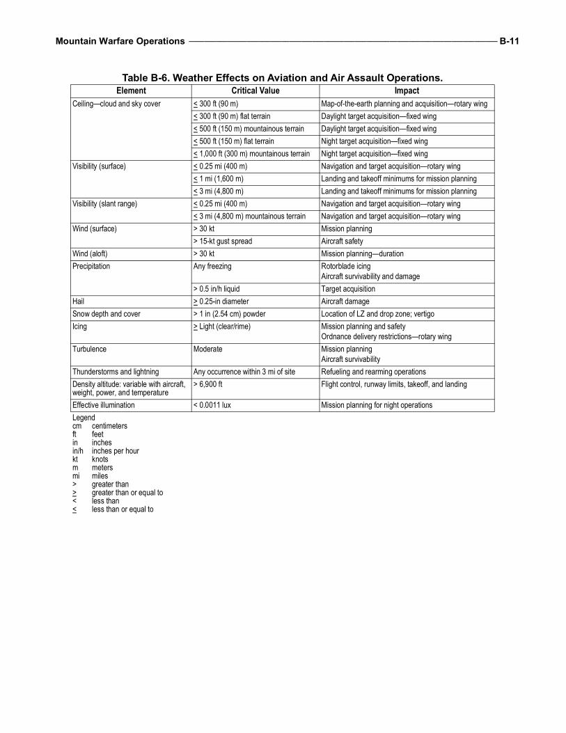
Mountain Warfare Operations ________________________________________________________________________________ B-11
Table B-6. Weather Effects on Aviation and Air Assault Operations.Element Critical Value Impact
Ceiling—cloud and sky cover < 300 ft (90 m) Map-of-the-earth planning and acquisition—rotary wing< 300 ft (90 m) flat terrain Daylight target acquisition—fixed wing< 500 ft (150 m) mountainous terrain Daylight target acquisition—fixed wing< 500 ft (150 m) flat terrain Night target acquisition—fixed wing< 1,000 ft (300 m) mountainous terrain Night target acquisition—fixed wing
Visibility (surface) < 0.25 mi (400 m) Navigation and target acquisition—rotary wing< 1 mi (1,600 m) Landing and takeoff minimums for mission planning< 3 mi (4,800 m) Landing and takeoff minimums for mission planning
Visibility (slant range) < 0.25 mi (400 m) Navigation and target acquisition—rotary wing< 3 mi (4,800 m) mountainous terrain Navigation and target acquisition—rotary wing
Wind (surface) > 30 kt Mission planning> 15-kt gust spread Aircraft safety
Wind (aloft) > 30 kt Mission planning—durationPrecipitation Any freezing Rotorblade icing
Aircraft survivability and damage> 0.5 in/h liquid Target acquisition
Hail > 0.25-in diameter Aircraft damageSnow depth and cover > 1 in (2.54 cm) powder Location of LZ and drop zone; vertigoIcing > Light (clear/rime) Mission planning and safety
Ordnance delivery restrictions—rotary wingTurbulence Moderate Mission planning
Aircraft survivabilityThunderstorms and lightning Any occurrence within 3 mi of site Refueling and rearming operationsDensity altitude: variable with aircraft, weight, power, and temperature
> 6,900 ft Flight control, runway limits, takeoff, and landing
Effective illumination < 0.0011 lux Mission planning for night operationsLegendcm centimetersft feetin inchesin/h inches per hourkt knotsm metersmi miles> greater than> greater than or equal to< less than< less than or equal to
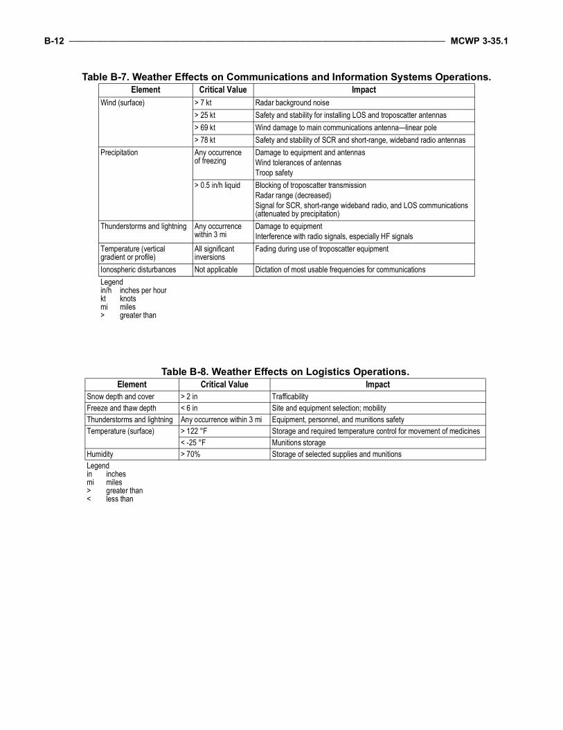
B-12 __________________________________________________________________________________________________ MCWP 3-35.1
Table B-7. Weather Effects on Communications and Information Systems Operations.Element Critical Value Impact
Wind (surface) > 7 kt Radar background noise> 25 kt Safety and stability for installing LOS and troposcatter antennas> 69 kt Wind damage to main communications antenna—linear pole> 78 kt Safety and stability of SCR and short-range, wideband radio antennas
Precipitation Any occurrence of freezing
Damage to equipment and antennasWind tolerances of antennasTroop safety
> 0.5 in/h liquid Blocking of troposcatter transmissionRadar range (decreased)Signal for SCR, short-range wideband radio, and LOS communications (attenuated by precipitation)
Thunderstorms and lightning Any occurrence within 3 mi
Damage to equipmentInterference with radio signals, especially HF signals
Temperature (vertical gradient or profile)
All significant inversions
Fading during use of troposcatter equipment
Ionospheric disturbances Not applicable Dictation of most usable frequencies for communicationsLegendin/h inches per hourkt knotsmi miles> greater than
Table B-8. Weather Effects on Logistics Operations.Element Critical Value Impact
Snow depth and cover > 2 in TrafficabilityFreeze and thaw depth < 6 in Site and equipment selection; mobilityThunderstorms and lightning Any occurrence within 3 mi Equipment, personnel, and munitions safetyTemperature (surface) > 122 °F Storage and required temperature control for movement of medicines
< -25 °F Munitions storageHumidity > 70% Storage of selected supplies and munitionsLegendin inchesmi miles> greater than< less than
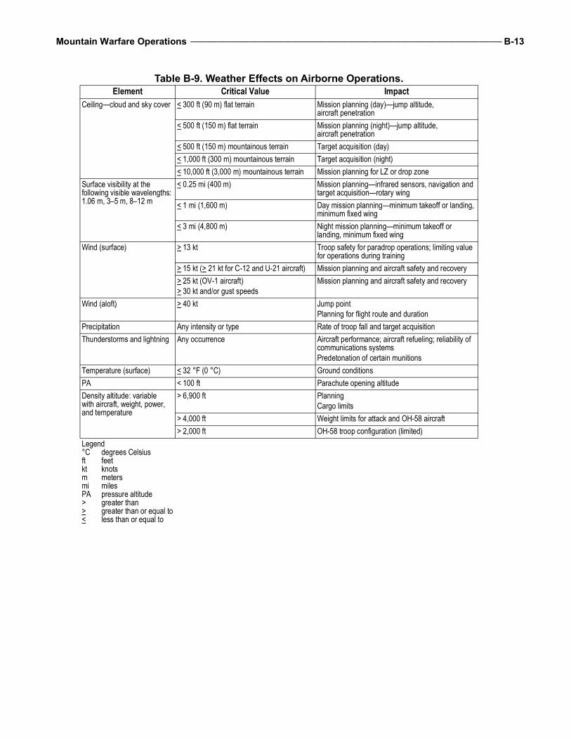
Mountain Warfare Operations ________________________________________________________________________________ B-13
Table B-9. Weather Effects on Airborne Operations.Element Critical Value Impact
Ceiling—cloud and sky cover < 300 ft (90 m) flat terrain Mission planning (day)—jump altitude, aircraft penetration
< 500 ft (150 m) flat terrain Mission planning (night)—jump altitude, aircraft penetration
< 500 ft (150 m) mountainous terrain Target acquisition (day)< 1,000 ft (300 m) mountainous terrain Target acquisition (night)< 10,000 ft (3,000 m) mountainous terrain Mission planning for LZ or drop zone
Surface visibility at the following visible wavelengths: 1.06 m, 3–5 m, 8–12 m
< 0.25 mi (400 m) Mission planning—infrared sensors, navigation and target acquisition—rotary wing
< 1 mi (1,600 m) Day mission planning—minimum takeoff or landing, minimum fixed wing
< 3 mi (4,800 m) Night mission planning—minimum takeoff or landing, minimum fixed wing
Wind (surface) > 13 kt Troop safety for paradrop operations; limiting value for operations during training
> 15 kt (> 21 kt for C-12 and U-21 aircraft) Mission planning and aircraft safety and recovery> 25 kt (OV-1 aircraft)> 30 kt and/or gust speeds
Mission planning and aircraft safety and recovery
Wind (aloft) > 40 kt Jump pointPlanning for flight route and duration
Precipitation Any intensity or type Rate of troop fall and target acquisitionThunderstorms and lightning Any occurrence Aircraft performance; aircraft refueling; reliability of
communications systemsPredetonation of certain munitions
Temperature (surface) < 32 °F (0 °C) Ground conditionsPA < 100 ft Parachute opening altitudeDensity altitude: variable with aircraft, weight, power, and temperature
> 6,900 ft PlanningCargo limits
> 4,000 ft Weight limits for attack and OH-58 aircraft> 2,000 ft OH-58 troop configuration (limited)
Legend°C degrees Celsiusft feetkt knotsm metersmi milesPA pressure altitude> greater than> greater than or equal to< less than or equal to

B-14 __________________________________________________________________________________________________ MCWP 3-35.1
This Page Intentionally Left Blank
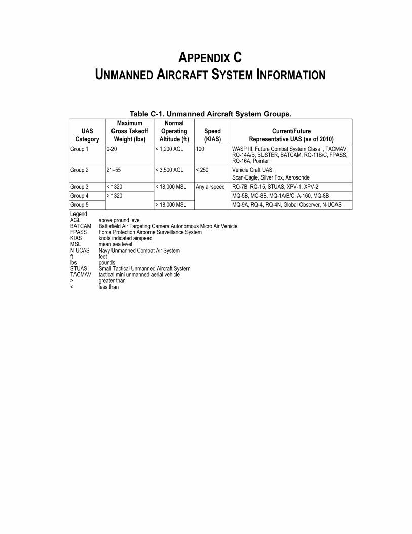
APPENDIX CUNMANNED AIRCRAFT SYSTEM INFORMATION
Table C-1. Unmanned Aircraft System Groups.
UASCategory
Maximum Gross Takeoff Weight (lbs)
Normal Operating
Altitude (ft)Speed (KIAS)
Current/Future Representative UAS (as of 2010)
Group 1 0-20 < 1,200 AGL 100 WASP III, Future Combat System Class I, TACMAV RQ-14A/B, BUSTER, BATCAM, RQ-11B/C, FPASS, RQ-16A, Pointer
Group 2 21–55 < 3,500 AGL < 250 Vehicle Craft UAS, Scan-Eagle, Silver Fox, Aerosonde
Group 3 < 1320 < 18,000 MSL Any airspeed RQ-7B, RQ-15, STUAS, XPV-1, XPV-2
Group 4 > 1320 MQ-5B, MQ-8B, MQ-1A/B/C, A-160, MQ-8B
Group 5 > 18,000 MSL MQ-9A, RQ-4, RQ-4N, Global Observer, N-UCAS
LegendAGLBATCAMFPASSKIASMSLN-UCASftlbsSTUASTACMAV><
above ground levelBattlefield Air Targeting Camera Autonomous Micro Air VehicleForce Protection Airborne Surveillance Systemknots indicated airspeed mean sea levelNavy Unmanned Combat Air SystemfeetpoundsSmall Tactical Unmanned Aircraft Systemtactical mini unmanned aerial vehiclegreater thanless than

C-2 ___________________________________________________________________________________________________ MCWP 3-35.1
This Page Intentionally Left Blank
GLOSSARY
SECTION I. ACRONYMS AND ABBREVIATIONS
ACE . . . . . . .aviation combat element (MAGTF)AMD . . . . . . . . . . . . . . . . . . .air mobility divisionAMS . . . . . . . . . . . . . . . .acute mountain sicknessAMWS . . . . . . . Army Mountain Warfare SchoolATTP . . . . . . . . . . . . . . . . . . . . . . . Army tactics,
techniques, and procedures
BCT. . . . . . . . . . . . . . . . . . . brigade combat teamBFT . . . . . . . . . . . . . . . . . . . . . blue force tracking
CAS. . . . . . . . . . . . . . . . . . . . . . . close air supportCASEVAC . . . . . . . . . . . . . . casualty evacuationCCA . . . . . . . . . . . . . . . . . . . close combat attackCDS. . . . . . . . . . . . . . . container delivery systemCOP. . . . . . . . . . . . . . . . . . . . . . . . combat outpostCSS . . . . . . . . . . . . . . . . . combat service support
DASC . . . . . . . . . . . . . . . direct air support centerDOD . . . . . . . . . . . . . . . . Department of DefenseDSF . . . . . . . . . . . . . District Stability FrameworkDTCS . . . . . . . . . . . . . . . . . . Distributed Tactical
Communications System
EOB . . . . . . . . . . . . . . . electronic order of battleEPLRS . . . . . . . . . . . . . . . . . . .enhanced position
location reporting systemETT . . . . . . . . . . . . . . . . .embedded training teamEW/C . . . . . . . . . . . . . early warning and control
°F. . . . . . . . . . . . . . . . . . . . . . . degrees FahrenheitFAC. . . . . . . . . . . . . . . . . . . forward air controllerFAC(A) . . . . . . . forward air controller (airborne)FARP . . . . . . forward arming and refueling pointFDC. . . . . . . . . . . . . . . . . . . . fire direction centerFM. . . . . . . . . . . . . . . . . . . . field manual (Army)FOB. . . . . . . . . . . . . . . . . .forward operating baseFSR . . . . . . . . . . . . . . . . . . . . . First Strike Ration
GCE . . . . . . . ground combat element (MAGTF)GPS . . . . . . . . . . . . . .Global Positioning System
HACE . . . . . . . . . . . high altitude cerebral edemaHAPE . . . . . . . . . high altitude pulmonary edema
HF . . . . . . . . . . . . . . . . . . . . . . . . . high frequencyHMMWV . . . . . . . . . . . . . . . . . . . . high mobility
multipurpose wheeled vehicleHST. . . . . . . . . . . . . . . . . helicopter support teamHUMINT . . . . . . . . . . . . . . . . human intelligence
IED . . . . . . . . . . . . . improvised explosive deviceIPB . . . . . . . . . . . . . . . . . intelligence preparation
of the battlespaceISB . . . . . . . . . . . . . . . . intermediate staging baseISR . . . . . . . . . . . . . . . .intelligence, surveillance,
and reconnaissance
JP. . . . . . . . . . . . . . . . . . . . . . . . . joint publicationJTAC. . . . . . . . . . . joint terminal attack controller
LAAD . . . . . . . . . . . . . . . low altitude air defenseLNO . . . . . . . . . . . . . . . . . . . . . . . . liaison officerLOC . . . . . . . . . . . . . . . . line of communicationsLOS. . . . . . . . . . . . . . . . . . . . . . . . . . line of sightLZ . . . . . . . . . . . . . . . . . . . . . . . . . . . landing zone
MACCS . . . . . . . . . . . . . . . Marine air commandand control system
MAGTF . . . . . . . . . Marine air-ground task forceMALS . . . . . . . . . . . . . . . . . . . . . Marine aviation
logistics squadronMARFORCENT . . . . United States Marine Corps
Forces, Central CommandMCMWTC . . . . . . . . . . .Marine Corps Mountain
Warfare Training CenterMCRP . . . . . . . . . . . . . . . . . . . . . . . Marine Corps
reference publicationMCWP . . . . . . . . . . . . . . . . . . . . . . Marine Corps
warfighting publicationMEDEVAC. . . . . . . . . . . . . . .medical evacuationMET . . . . . . . . . . . . . . . . . . . . . . . meteorologicalMETT-T . . . . . . . . . . mission, enemy, terrain and
weather, troops and supportavailable-time available
mm . . . . . . . . . . . . . . . . . . . . . . . . . . . .millimeterMOS . . . . . . . . . . military occupational specialtyMRE . . . . . . . . . . . . . . . . . . . . . meal, ready to eatMSR . . . . . . . . . . . . . . . . . . . . .main supply route
Glossary-2 ___________________________________________________________________________________________ MCWP 3-35.1
MTSQ . . . . . . . . . . . mechanical time super quickMUX . . . . . . . . . . . . . . . . . . . . multichannel radio
NAVMC . . . . . . . . . . . . . . . . Navy/Marine Corps departmental publication
NCF. . . . . . . . . . . . . . . . .naval construction forceNCO . . . . . . . . . . . . . . .noncommissioned officerNWTC. . . . . . . . . . . . . . . . . . . . Northern Warfare
Training Center (Army)
OEF. . . . . . . . . . . . Operation Enduring Freedom
PET . . . . . . . . . . . . . . .pre-environmental trainingPZ . . . . . . . . . . . . . . . . . . . . . . . . . . . pickup zone
SATCOM . . . . . . . . . . . satellite communicationsSCR. . . . . . . . . . . . . . . . . . . . single-channel radioSIGINT . . . . . . . . . . . . . . . . . .signals intelligenceSUSV . . . . . . . . . . . . . small unit support vehicle
TACC . . . . . . . . . . . . tactical air command centerTACSAT. . . . . . . . . . . . . . . . . . . .tactical satelliteTAOC . . . . . . . . . . . tactical air operations centerTC . . . . . . . . . . . . . . . . . . . . . . . . training circularTCAC . . . . . technical control and analysis centerTOE. . . . . . . . . . . . . . . . . . . . . table of equipmentTOS. . . . . . . . . . . . . . . . . . . . . . . . time on stationTRST. . . . . . . tactical rope suspension technicianTTP . . . . . . . . tactics, techniques, and procedures
UAS . . . . . . . . . . . . . . unmanned aircraft systemUHF . . . . . . . . . . . . . . . . . . . ultrahigh frequencyUS . . . . . . . . . . . . . . . . . . . . . . . . . . United StatesUSASOC. . . . . . . . . . . . . . . .United States Army,
Special Operations Command
VHF . . . . . . . . . . . . . . . . . . . very high frequencyVMAQ . . . . . . . . . . . . . . . . . . . . . Marine tactical
electronic warfare squadron
Mountain Warfare Operations ________________________________________________________________________ Glossary-3
SECTION II. TERMS AND DEFINITIONS
combat service support—The essential capabili-ties, functions, activities, and tasks necessary tosustain all elements of operating forces in theaterat all levels of war. Within the national andtheater logistic systems, it includes but is notlimited to that support rendered by service forcesin ensuring the aspects of supply, maintenance,transportation, health services, and other servicesrequired by aviation and ground combat troops topermit those units to accomplish their missions incombat. Combat service support encompassesthose activities at all levels of war that producesustainment to all operating forces on the battle-field. Also called CSS. (JP 1-02)
defensive operations—Operations conducted todefeat an enemy attack, gain time, economizeforces, and develop conditions favorable to offen-sive and stability operations. The three types ofdefensive maneuver are position, mobile, andretrograde. (MCRP 5-12C)
logistics—1. The science of planning and execut-ing the movement and support of forces. 2. Allactivities required to move and sustain military
forces. Logistics is one of the six warfightingfunctions. (MCRP 5-12C)
maneuver—The movement of forces for thepurpose of gaining an advantage over the enemy.Maneuver is one of the six warfighting functions.(MCRP 5-12C)
offensive operations—Operations conducted totake the initiative from the enemy, gain freedomof action, and generate effects to achieve objec-tives. The four types of offensive operations aremovement to contact, attack, exploitation, andpursuit. (MCRP 5-12C)
stability operations—An overarching term en-compassing various military missions, tasks, andactivities conducted outside the United States incoordination with other instruments of nationalpower to maintain or reestablish a safe and secureenvironment, provide essential government ser-vices, emergency infrastructure reconstruction,and humanitarian relief. (JP 1-02)
tempo—The relative speed and rhythm of mili-tary operations over time with respect to theenemy. (MCRP 5-12C)

Glossary-4 ___________________________________________________________________________________________ MCWP 3-35.1
This Page Intentionally Left Blank
REFERENCES AND RELATED PUBLICATIONS
Federal Publications
United States Code, Title 10, Armed Forces
Department of Defense Issuance
Military Detail [MIL-DTL] Specification 85470B Inhibitor, Icing, Fuel System, High Flash (NATO Code Number S-1745)
Joint Publication (JP)
1-02 Department of Defense Dictionary of Military and Associated Terms3-09.3 Close Air Support 3-30 Command and Control for Joint Air Operations 3-34 Joint Engineer Operations
Navy/Marine Corps Departmental Publications (NAVMC)
3500.70A Mountain Warfare Operations Training and Readiness Manual
Army Publications
Army Field Manuals (FMs)2-0 Intelligence2-19.4 Brigade Combat Team Intelligence Operations2-22.3 Human Intelligence Collector Operations3-04.111 Aviation Brigades3-04.126 Attack Reconnaissance Helicopter Operations3-04.155 Army Unmanned Aircraft System Operations3-04.513 Aircraft Recovery Operations3-05.213 Special Forces Use of Pack Animals3-07 Stability Operations3-14 Space in Support of Army Operations3-21.8 The Infantry Rifle Platoon and Squad3-21.38 Pathfinder Operations3-34.170 Engineer Reconnaissance3-50.1 Army Personnel Recovery3-55 Information Collection3-60 The Targeting Process3-90 Tactics4-02.1 Army Medical Logistics4-20.64 Mortuary Affairs Operations5-19 Composite Risk Management5-102 Countermobility
References-2 ________________________________________________________________________________________ MCWP 3-35.1
6-2 Tactics, Techniques, and Procedures for Field Artillery Survey7-22 Army Physical Readiness Training9-207 Operations and Maintenance of Ordnance Materiel in Cold Weather10-52 Water Supply in Theaters of Operations34-81 Weather Support for Army Tactical Operations
Army Regulation (AR)95-1 Flight Regulations
Army Techniques Publication (ATP) 3-04.94 Army Techniques Publication for Forward Arming and Refueling Points
Army Tactics, Techniques, and Procedures (ATTP)2-01 Planning Requirements and Assessing Collection3-18.12 Air Assault Operations3-21.50 Infantry Small-Unit Mountain Operations3-34.80 Geospatial Engineering4-02 Army Health System
Army Training Circulars (TCs)2-19.63 Company Intelligence Support Team3-97.61 Military Mountaineering
Technical Bulletins Medical505 Altitude Acclimatization and Illness Management508 Prevention and Management of Cold-Weather Injuries
United States Army, Special Operations Command (USASOC) Regulation350-12 Special Operations Forces Mountaineering
Marine Corps Publications
Marine Corps Warfighting Publications (MCWPs)2-1 Intelligence Operations2-2 MAGTF Intelligence Collection2-26 Geographic Intelligence (under development as Geospatial Information and
Intelligence, number remains the same)3-11.3 Scouting and Patrolling3-15.2 Tactical Employment of Mortars (under development, supersedes Fleet
Marine Force Manual [FMFM] 6-19, Tactical Employment of Mortars)3-16 Fire Support Coordination in the Ground Combat Element3-16.3 Tactics, Techniques, and Procedures for the Field Artillery Cannon Battery3-16.4 Tactics, Techniques, and Procedures for the Field Artillery Manual
Cannon Gunnery 3-16.7 Marine Artillery Survey Operations 3-17.4 Engineer Reconnaissance 3-17.7 General Engineering3-17.8 Combined Arms Mobility Operations 3-21.1 Aviation Ground Support
Mountain Warfare Operations ______________________________________________________________________ References-3
3-21.2 Aviation Logistics3-24 Assault Support3-25 Control of Aircraft and Missiles3-26 Air Reconnaissance3-33.5 Counterinsurgency3-35.7 MAGTF Meteorological and Oceanographic Support3-37.4 Multi-Service Tactics, Techniques, and Procedures for Chemical, Biological,
Radiological, and Nuclear Reconnaissance and Surveillance3-40.5 Electronic Warfare4-11.1 Health Service Support Operations4-11.4 Maintenance Operations4-11.5 Seabee Operations in the MAGTF4-11.8 Services In An Expeditionary Environment (under development)4-11.9 Ammunition Logistics
Marine Corps Reference Publications (MCRPs)2-3A Intelligence Preparation of the Battlefield/Battlespace3-02A Marine Physical Readiness Training for Combat 3-16.1A Tactics, Techniques, and Procedures for Field Artillery Target Acquisition3-16.6A JFIRE Multi-Service Tactics, Techniques, and Procedures for the Joint
Application of Firepower3-17.2D Explosive Hazards Operations3-35.1A Small-Unit Leader’s Guide to Cold Weather Operations (under development
as Small Unit Leader’s Guide to Mountain Warfare Operations, number remains the same)
3-35.1B Instructor’s Guide to Combat Skiing (under development as Mountain Leader’s Guide to Winter Operations, number remains the same)
3-35.1C Mountain Leader’s Guide to Mountain Warfare Operations (under development)
3-35.1D Cold Region Operations3-42.1A Multi-Service Tactics, Techniques, and Procedures for Unmanned Aircraft
Systems (UAS)4-11.1F Multiservice Tactics, Techniques, and Procedures for Health Service Support
in a Chemical, Biological, Radiological, and Nuclear Environment4-11.4A Recovery and Battle Damage Assessment and Repair4-11.8A Marine Corps Field Feeding Program5-12C Marine Corps Supplement to the Department of Defense Dictionary of
Military and Associated Terms
Marine Corps Interim Publication (MCIP)4-11.01 Waste Management for Deployed Forces
MiscellaneousMarine Corps Institute Publication. ORM 1-0, Operational Risk Management.
Marine Corps Center for Lessons Learned Reports
Marine Corps Intelligence Activity (MCIA) Mid-Range Threat Estimate for 2005–2015
References-4 ________________________________________________________________________________________ MCWP 3-35.1
Miscellaneous
2010 Quadrennial Defense Review
Malik, Muhammad Asim, Major, Pakistan Army. Mountain Warfare—The Need for Specialized Training, Military Review. September–October 2004.
MMM, Manual of Military Mountaineering (British Royal Marine)
UD 6-81E, A Guide to Cold Weather Operations (Norwegian Army)
To Our Readers
Changes: Readers of this publication are encouraged to submit suggestions andchanges to Doctrine Branch via e-mail: [email protected].
Suggestions and changes must include the following information:
• Location of changePublication number and titleCurrent page numberParagraph number (if applicable)Line numberFigure or table number (if applicable)
• Nature of changeAddition/deletion of textProposed new text
Additional copies: If this publication is not an electronic only distribution, a printedcopy may be obtained from Marine Corps Logistics Base, Albany, GA 31704-5001,by following the instructions in MCBul 5600, Marine Corps Doctrinal PublicationsStatus. An electronic copy may be obtained from the United States Marine CorpsDoctrine web page:https://homeport.usmc.mil/sites/mcdoctrine/SitePages/Home.aspx
Related Documents