MAP PROJECTIONS It is impossible to represent Earth surface onto a flat surface without distortion!!! Since we cannot carry a globe into the field, we need to figure out how to represent the curved surface on a flat piece of paper.

MAP PROJECTIONS It is impossible to represent Earth surface onto a flat surface without distortion!!! Since we cannot carry a globe into the field, we.
Dec 29, 2015
Welcome message from author
This document is posted to help you gain knowledge. Please leave a comment to let me know what you think about it! Share it to your friends and learn new things together.
Transcript

MAP PROJECTIONS
It is impossible to represent Earth surface onto a flat surface without distortion!!!
Since we cannot carry a globe into the field, we need to figure out how to represent the curved surface on a flat piece of paper.

MAP PROJECTIONS
PRINCIPAL PROJECTIONS
Azimuthal
CYLINDRICAL PROJECTION
Areas close to the Equator present very little distortion
The closer to the poles the more distortion the map presents
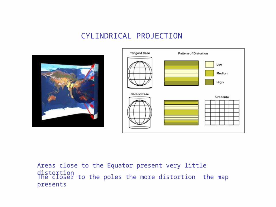
CILINDRICAL:
Mercator projection:

CONIC PROJECTION AZIMUTHAL PROJECTION
PROPERTIES OF MAP PROJECTIONS
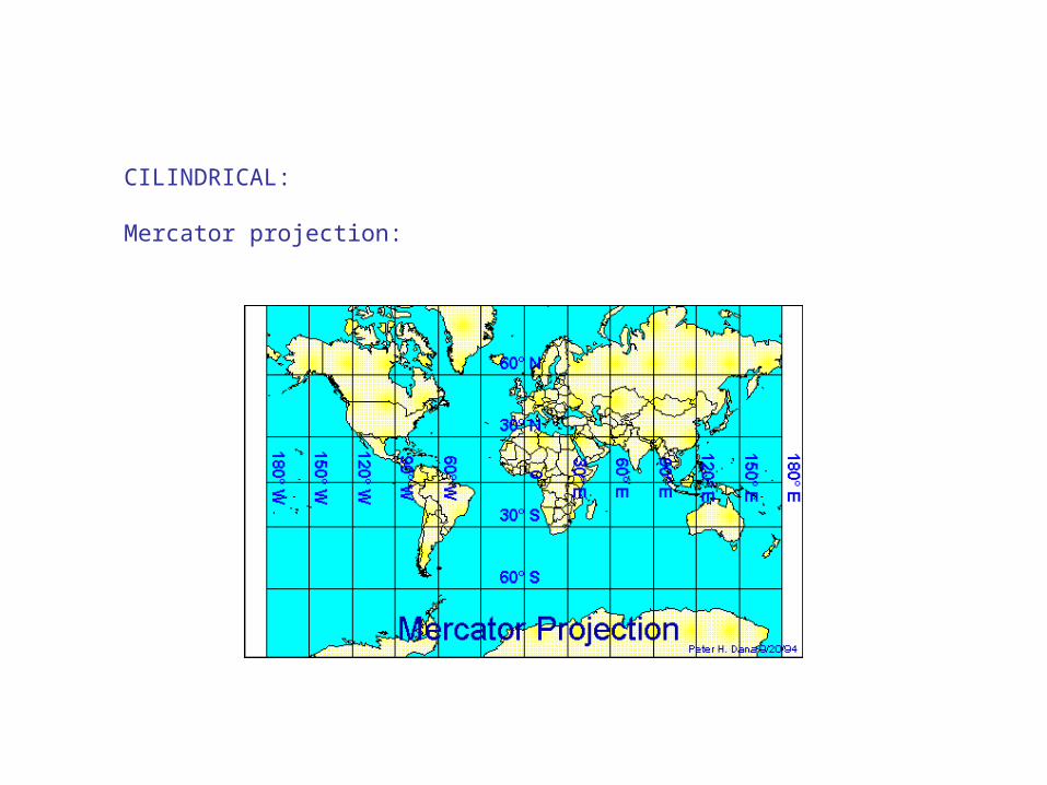
Conformal: when the direction is maintained at any point on the map. Shape is preserved locally
Equal-area: all mapped areas have the same proportional relationship to the areas on the Earth
Mercator Projection (conformal)
Lambers equal-area conic projection
Which map should we use to analyze and compare snow regions?
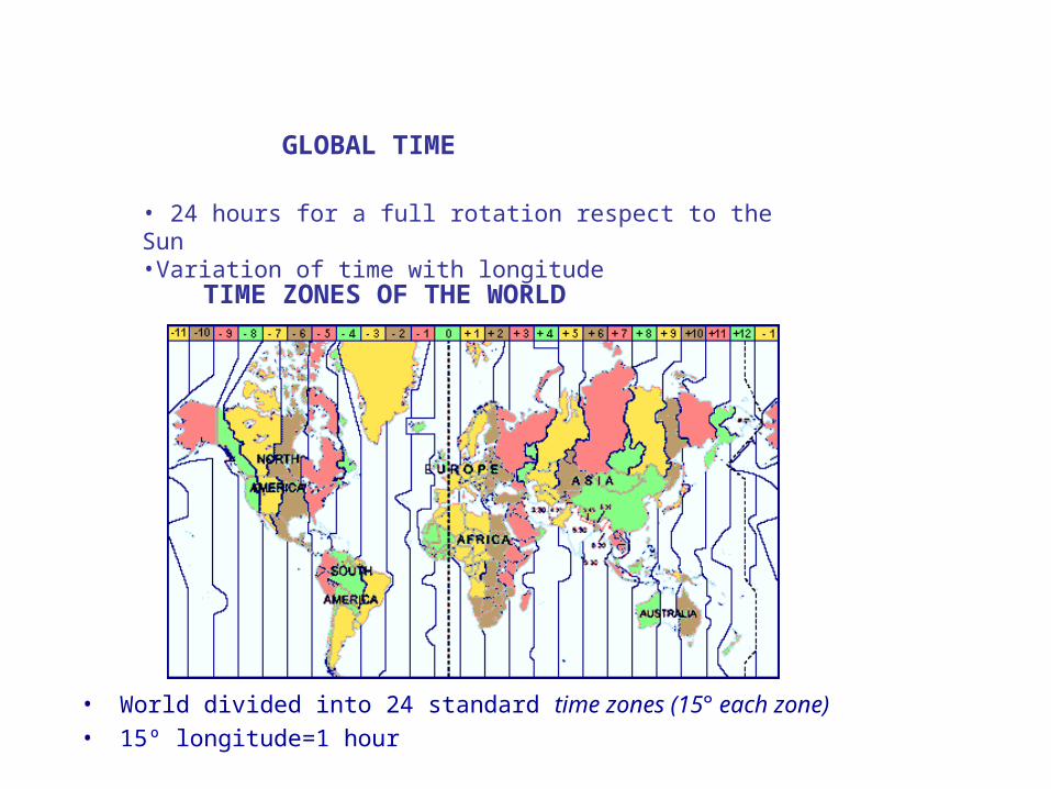
GLOBAL TIME
• 24 hours for a full rotation respect to the Sun•Variation of time with longitude
TIME ZONES OF THE WORLD
• World divided into 24 standard time zones (15° each zone)• 15º longitude=1 hour

INTERNATIONAL DATE LINE
• The 180° meridian is used as International Date Line to set 1 day (advance or back) in the calendar•If you travel westward: advance one day•If travel eastward: set calendar back by a day

• Primary standard meridian is the Greenwich Meridian (Prime Meridian, 0º longitude)
• Global time is called Greenwich Mean Time or GMT
• Examples: Tuesday 3am in Spain is ___________ in Newark,DE
Saturday 10 am in California is ______ in China
TIME ZONES OF THE WORLD
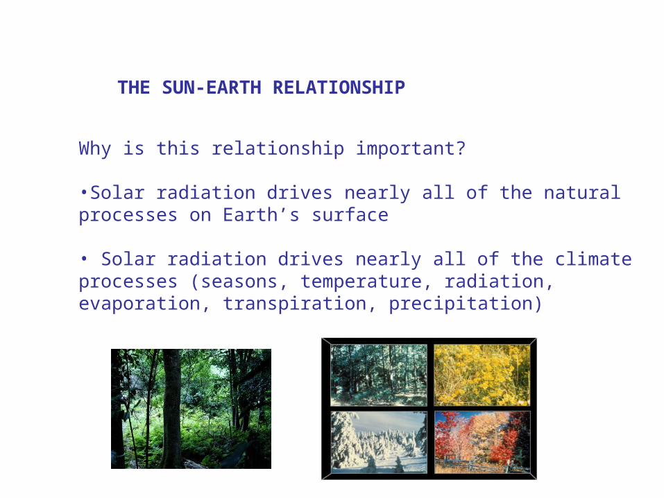
THE SUN-EARTH RELATIONSHIP
Why is this relationship important?
•Solar radiation drives nearly all of the natural processes on Earth’s surface
• Solar radiation drives nearly all of the climate processes (seasons, temperature, radiation, evaporation, transpiration, precipitation)

THE SUN-EARTH RELATIONSHIP
EARTH REVOLUTION AROUND THE SUN
Does it mean that in January we’ll have more temperature?
January 3
July 4

THE TILT OF THE EARTH’S AXIS
The Earth is tilted at anangle of 23.5°
THE SUN-EARTH RELATIONSHIP
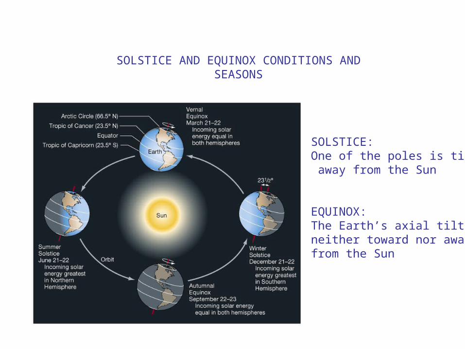
SOLSTICE AND EQUINOX CONDITIONS AND SEASONS
SOLSTICE: One of the poles is tilted away from the Sun
EQUINOX:The Earth’s axial tilt is neither toward nor away from the Sun

SOLSTICE CONDITIONS
One of the poles is tilted away from the Sun
• Observe the circle of illumination at different latitudes: because the tilt toward the Sun, we only have equal halves in Equator.
JUN 21-22 DEC 21-22
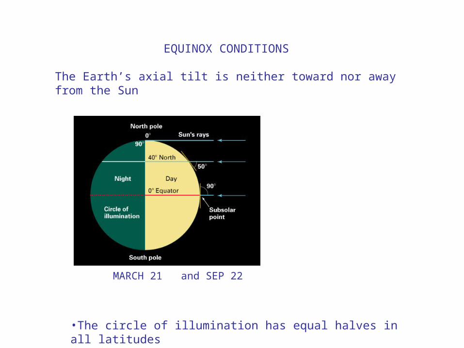
EQUINOX CONDITIONS
The Earth’s axial tilt is neither toward nor away from the Sun
•The circle of illumination has equal halves in all latitudes
MARCH 21 and SEP 22


THE SUN-EARTH RELATIONSHIP
Location with 12 hours of day and 12 hours of night along all year?Location with 24 hours of night on June 21st?Location with 12 hours of day and 12 hours of night on September 23rd?Location with 24 hours of light on June 21st?Location with 24 hours of night on December 21st?

INSOLATION AND SUN ANGLE
The angle of the Sun’s rays determines the intensity of insolation on the ground
This is controlled by the latitude of the location and the time of the year.

The same amount of energy over different areas wintertime
INSOLATION AND SUN ANGLE

WORLD LATITUDE ZONES
EQUATORIAL: Malasya
Min: 72.4 FMax: 89 F
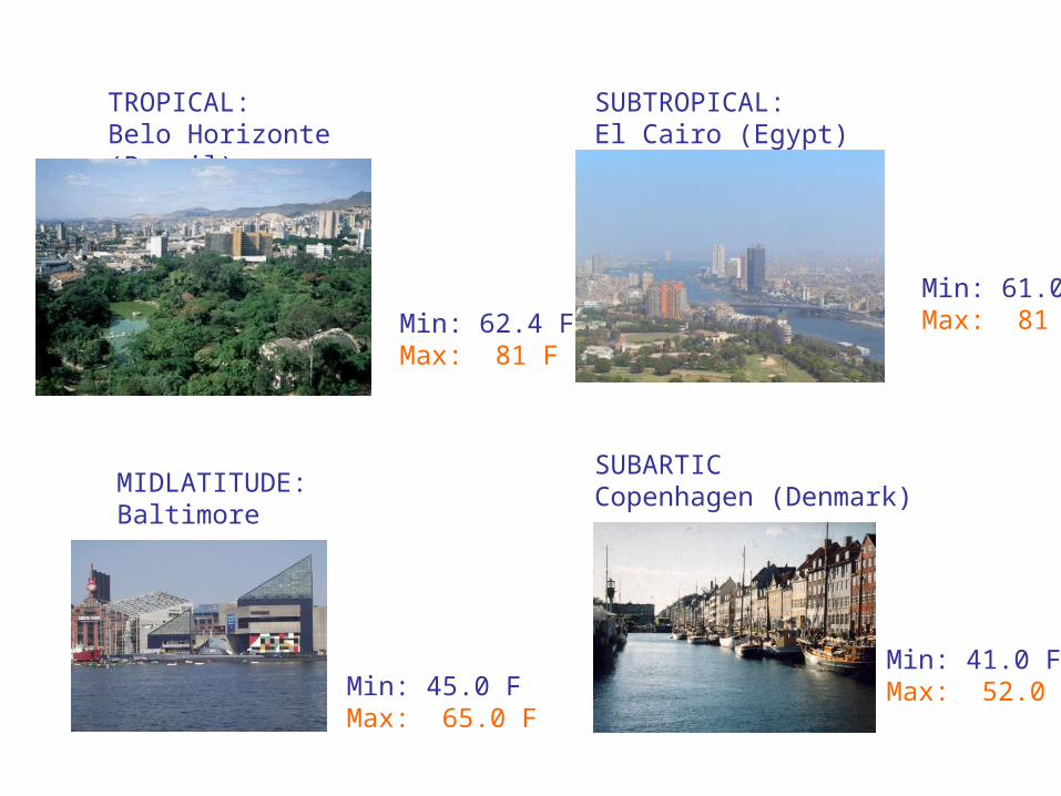
TROPICAL:Belo Horizonte (Brazil)
Min: 62.4 FMax: 81 F
SUBTROPICAL:El Cairo (Egypt)
Min: 61.0 FMax: 81 F
MIDLATITUDE:Baltimore
Min: 45.0 FMax: 65.0 F
SUBARTICCopenhagen (Denmark)
Min: 41.0 FMax: 52.0 F
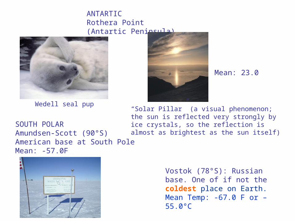
ANTARTICRothera Point (Antartic Peninsula)
Mean: 23.0
“Solar Pillar” (a visual phenomenon; the sun is reflected very strongly by ice crystals, so the reflection is almost as brightest as the sun itself)
SOUTH POLARAmundsen-Scott (90°S)American base at South PoleMean: -57.0F
Vostok (78°S): Russian base. One of if not the coldest place on Earth. Mean Temp: -67.0 F or –55.0°C
Wedell seal pup
Related Documents