1 LOUISIANA DEPARTMENT OF WILDLIFE & FISHERIES OFFICE OF FISHERIES INLAND FISHERIES SECTION PART VI -A WATERBODY MANAGEMENT PLAN SERIES CHICOT LAKE LAKE HISTORY & MANAGEMENT ISSUES

Welcome message from author
This document is posted to help you gain knowledge. Please leave a comment to let me know what you think about it! Share it to your friends and learn new things together.
Transcript

1
LOUISIANA DEPARTMENT OF
WILDLIFE & FISHERIES
OFFICE OF FISHERIES
INLAND FISHERIES SECTION
PART VI -A
WATERBODY MANAGEMENT PLAN SERIES
CHICOT LAKE
LAKE HISTORY & MANAGEMENT ISSUES

2
CHRONOLOGY
July 2010- Prepared by
Jody David, Biologist Manager, District 6
June 2013 – update by
Jody David, Biologist Manager, District 6
March 2015 – updated by
Jody David, Biologist Manager, District 6
May 2016 – updated by
Jody David, Biologist Manager, District 6
June 2017 – updated by
Jody David, Biologist Manager, District 6
The Remainder of this page left intentionally blank.
3
Table of Contents
LAKE HISTORY .......................................................................................................................5
GENERAL INFORMATION .......................................................................................................... 5 Date reservoir formed ..................................................................................................................... 5 Impoundment .................................................................................................................................. 5 Size .................................................................................................................................................. 5 Watershed ........................................................................................................................................ 5 Pool stage ........................................................................................................................................ 5 Parish/s located................................................................................................................................ 5 Drawdown description .................................................................................................................... 5 Who controls ................................................................................................................................... 6
LAKE AUTHORITY ........................................................................................................................ 6 ACCESS ............................................................................................................................................. 6
Boat docks ....................................................................................................................................... 6 Piers ................................................................................................................................................. 6 Reefs ................................................................................................................................................ 7
SHORELINE DEVELOPMENT ..................................................................................................... 8 State/National Parks ........................................................................................................................ 8 Shoreline development by landowners ........................................................................................... 8
PHYSICAL DESCRIPTION OF THE WATER BODY ............................................................... 8 Shoreline length .............................................................................................................................. 9 Timber type ..................................................................................................................................... 9 Average depth ................................................................................................................................. 9 Maximum depth .............................................................................................................................. 9 Natural seasonal water fluctuation .................................................................................................. 9
EVENTS / PROBLEMS ................................................................................................................... 9 MANAGEMENT ISSUES .............................................................................................................. 10
Aquatic Vegetation ........................................................................................................................ 10 Plant growth projections for summer 2017: .................................................................................. 12 Aquatic Vegetation Type map ...................................................................................................... 13 Biomass ......................................................................................................................................... 13 Treatment history by year available .............................................................................................. 13 Biological ...................................................................................................................................... 13 Chemical ....................................................................................................................................... 13
HISTORY OF REGULATIONS ................................................................................................... 14 Recreational................................................................................................................................... 14 Commercial ................................................................................................................................... 15
DRAWDOWN HISTORY .............................................................................................................. 15 Drawdown date ............................................................................................................................. 15 Who operated structure ................................................................................................................. 17
FISH KILLS / DISEASE HISTORY ............................................................................................. 17 CONTAMINANTS / POLLUTION .............................................................................................. 17
Water quality ................................................................................................................................. 17
4
BIOLOGICAL ................................................................................................................................ 18 Fish sampling history .................................................................................................................... 18 Gear ............................................................................................................................................... 18 Lake records .................................................................................................................................. 19 Stocking ........................................................................................................................................ 19 Species profile ............................................................................................................................... 20 Genetics ......................................................................................................................................... 23 Threatened/endangered/exotic species .......................................................................................... 24 Creel .............................................................................................................................................. 24
HYDROLOGICAL CHANGES .................................................................................................... 25 Water use ....................................................................................................................................... 25
APPENDIX I - .......................................................................................................................... 26
APPENDIX II ........................................................................................................................... 27
5
LAKE HISTORY
GENERAL INFORMATION
Date reservoir formed
Work on the lake site began in 1938 with partial clearing of the lake bottom, building of service
roads and bridges, and construction of a one-mile levee and concrete spillway along the
northeast boundary of the State Park. The lake was impounded in the late winter of 1942 by
closing the dam alongside the spillway across Chicot Bayou, south of St. Landry, LA. A
drawdown structure and system of drainage channels were constructed in 1963. In 1985, it
was determined that the original floodgate structure needed to be replaced. In late 1985, the
lake was drained to the main channel. The original spillway and floodgate was demolished.
Construction of the new spillway and floodgate began in 1986. The spillway construction
project was complete in December of 1987 and lake was allowed to refill.
Impoundment
Owners – Louisiana State Parks
Purposes for creation – Recreational Activities (fishing, boating, site seeing) On July 6, 1936,
House Bill 338 was passed by the Louisiana Legislature which authorized and directed the
State Parks Commission to purchase a site for development of a state park in Evangeline
Parish: (Chicot State Park). The legislature would appropriate $25,000 for the purchase of
not less than a 4,000 acre park site, including all of Chicot Lake.
Size
1,642 acres
Watershed
Watershed size is approximately 24,000 acres
Watershed ratio is 14:1
Land cover in the watershed is composed of rolling upland forest hills (pine/hardwood).
There is little or no agricultural run-off.
Pool stage
46.2’ above mean sea level (MSL)
Parish/s located
Located 7 miles north of Ville Platte, Louisiana in Evangeline Parish on Hwy 3042.
(Latitude – 300 47’ 27’’ N Longitude – 920 16’ 13’’ W)
Drawdown description

6
There is a 200-foot spillway with 3 gates used to conduct drawdowns.
Spillway – 200 ft.
Gate size – 3-4 ft. x 4 ft. openings
Number of gates - 3
Condition –Good
Flow rate – Two gates opened 24 inches each can drop the lake 4 inches per day.
Sluiceway location – N/A
Sluiceway opening - N/A
Condition – N/A
Flow rate – N/A
Who controls
Louisiana Department of Transportation and Development (DOTD)
LAKE AUTHORITY
Louisiana State Parks owns and operates Chicot State Park
Louisiana Department of Wildlife & Fisheries (LDWF) manages the fish population in
Chicot Lake which lies entirely within the park
LDWF - Opelousas, LA (337) 948–0255
Authorization
Louisiana State Parks – Chicot State Park (337) 363 – 2403 or: http://www.crt.state.la.us/parks/
Anyone fishing on OSP property must adhere to all state and federal laws and criteria regarding
fresh and/or salt water fishing. The taking of fish by nets, traps or any means other than hook
or line is prohibited at any and all sites, except for management purposes as authorized by
special permit.: AUTHORITY NOTE: Promulgated in accordance with R.S. 56:1681-1690
and R.S. 36:204.
ACCESS
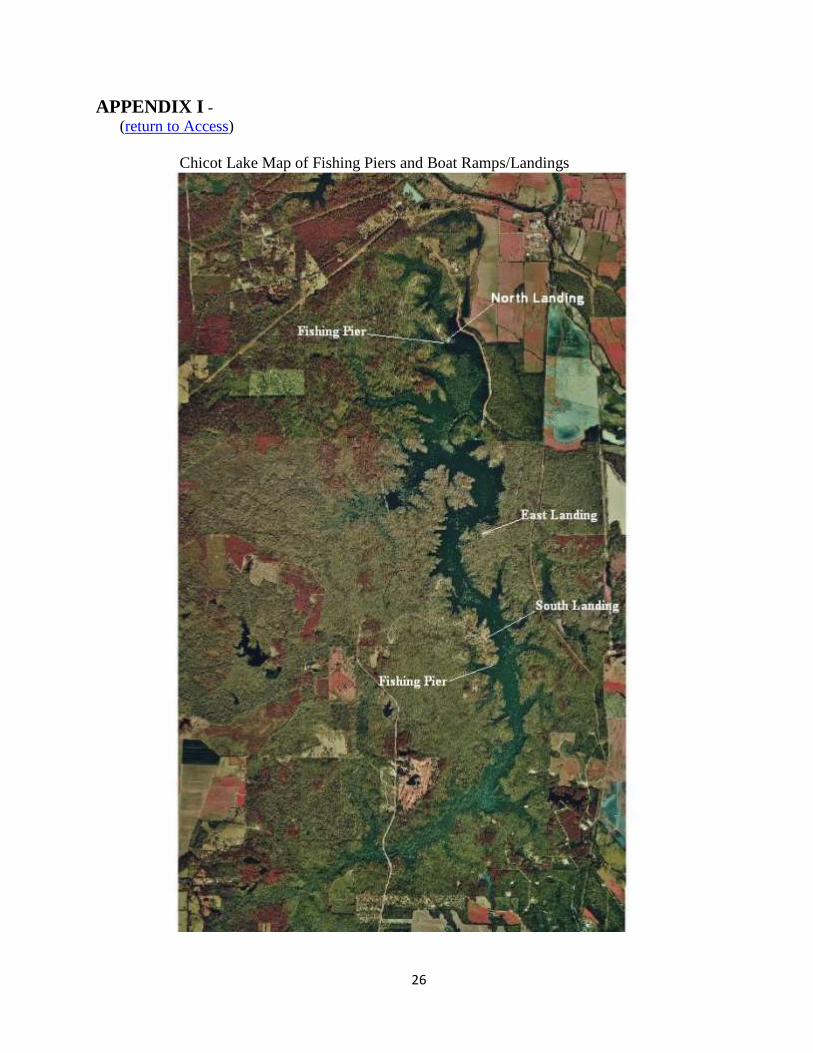
Locations of boat ramps and fishing piers are indicated on the maps located in Appendix I.
Boat docks
Adjacent to 3 boat ramps, all within the state park
Piers
Two four hundred foot fishing piers are available. Artificial reef structures and gravel beds
have been constructed adjacent to the piers to attract sport fishes, thereby potentially increasing
angler success.
7
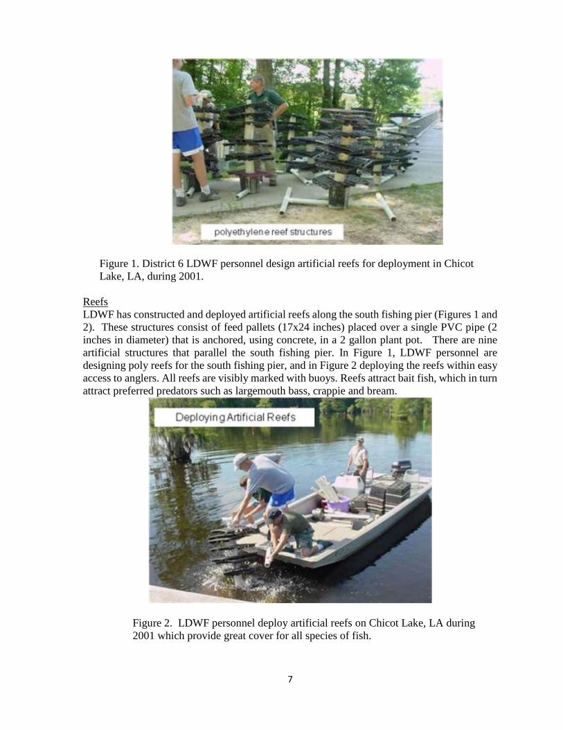
Figure 1. District 6 LDWF personnel design artificial reefs for deployment in Chicot
Lake, LA, during 2001.
Reefs
LDWF has constructed and deployed artificial reefs along the south fishing pier (Figures 1 and
2). These structures consist of feed pallets (17x24 inches) placed over a single PVC pipe (2
inches in diameter) that is anchored, using concrete, in a 2 gallon plant pot. There are nine
artificial structures that parallel the south fishing pier. In Figure 1, LDWF personnel are
designing poly reefs for the south fishing pier, and in Figure 2 deploying the reefs within easy
access to anglers. All reefs are visibly marked with buoys. Reefs attract bait fish, which in turn
attract preferred predators such as largemouth bass, crappie and bream.
Figure 2. LDWF personnel deploy artificial reefs on Chicot Lake, LA during
2001 which provide great cover for all species of fish.

8
Figure 3. LDWF personnel placing sand and gravel beds near a fishing pier on Chicot
Lake, LA, during 2001.
In Figure 3, LDWF personnel wash sand and gravel onto the bottom of Chicot Lake next to
the south fishing pier for the purpose of creating spawning habitat for sunfishes. The sand and
gravel bed is approximately 4 to 6 inches in depth along both sides of the fishing pier. The
bream in Chicot Lake spawn normally around the middle of April, depending on water
conditions and temperature. However, spawning may continue into late summer. This will
allow visitors to the Chicot State Park the opportunity to catch and harvest sunfish.
SHORELINE DEVELOPMENT
State/National Parks
Chicot State Park is approximately 6,000 acres. Chicot Lake lies entirely within the
boundaries of the Chicot State Park. http://www.crt.state.la.us/parks/
Shoreline development by landowners
There is no privately owned shoreline adjacent to Chicot Lake.
PHYSICAL DESCRIPTION OF THE WATER BODY
Before impoundment, Chicot Lake was a cypress-tupelo swamp bordered by upland hardwood
forest. After impoundment, cypress decreased in density in the deeper water, but increased
abundance in the shallow littoral zone. Permanently flooded upland tree species died, creating
9
complex cover in the form of stumps and logs throughout the lake. A few bottomland
hardwoods have survived in shallow water. A main channel runs through the center of the lake
averaging 14 –16 feet deep. The fingers or coves off of the channel average 5 – 7 feet deep at
pool stage. Numerous stumps, logs and submerged vegetation make up the majority of
complex cover.
Shoreline length
32 miles of shoreline
Timber type
Cypress/tupelo
Average depth
7 feet
Maximum depth
16 feet
Natural seasonal water fluctuation
Water level fluctuation is typically about 1 –2 feet.
EVENTS / PROBLEMS
A drawdown program began on the lake in 1945 in an effort to combat the rapid spread of
aquatic vegetation. The program was not successful because insufficient drainage allowed
water to be trapped in the numerous wooded bays. The lake was drained in 1963 and a channel
dredged to facilitate better drainage during fall drawdown periods. Restocking was conducted
1963-1964.
In 1985, it was determined that the original floodgate structure needed to be replaced. The
lake was drained, and the spillway and floodgate were demolished. The spillway construction
project was complete in December 1987, and the lake was allowed to refill. Restocking was
initiated in 1988.
In 1988, measures intended to improve the Chicot Lake bass population were initiated,
including the introduction of Florida largemouth bass (FLMB) and implementation of a 14
inch minimum length limit (MLL). In April 1989, a 16 inch MLL was implemented to continue
protection of a strong year class. In April 1991, a 14 – 17 inch protected slot limit was
implemented to establish a quality bass fishery.
10
In 1993, a restriction for Chicot Lake was adopted that restricts the use of yo-yos to the period
from November 1 – March 1. Associated restrictions limited the number of yo-yos to 24 per
boat, and required each yo-yo to be tagged with:
the name of the responsible party
the registration number of the boat
the date and time the yo-yo was set
The restriction also required yo-yos to be attended and re-tagged at least every 48 hours.
In December of 2011, a new yo-yo restriction was adopted. Yo-yo’s can be fished from
January 1 – December 31 of each year. Associated restrictions limited the number of yo-yo’s
to 50 per fishermen and required each yo-yo to be tagged with:
the name of owner or user
the address of owner or user
the phone number of owner or user
The restriction also required yo-yo’s to be re-baited at least once every 24 hours.
As of January 1, 2013, restrictions on yo-yos in Chicot Lake are:
No more than 50 yo-yos or trigger devices, shall be allowed per person
Each yo-yo or trigger device shall be clearly tagged with the name, address and
telephone number of the owner or user.
All fish or any other animals caught or hooked, shall be immediately removed the
device.
Each yo-yo or trigger device must be re-baited at least once every 24 hours.
No yo-yo or trigger device shall be attached to any metallic object.
A population assessment of the largemouth bass fishery was conducted from 2010-2012 to
evaluate the long-standing, protected slot limit regulation. The assessment showed that this
regulation did not accomplish the intended goal of providing increased catches of larger
quality-size bass. As a result of the evaluation, the 14-17 inch protected slot limit on
largemouth bass was removed on April 20, 2014.
MANAGEMENT ISSUES
Aquatic Vegetation
Since impoundment, Chicot Lake has had an overabundance of submerged aquatic vegetation.
Main species include coontail (Ceratophyllum demersum), fanwort (Cabomba caroliniana),
American lotus (Nelumbo lutea), and invasive species including water hyacinth (Eichhornia
crassipes) and hydrilla (Hydrilla verticillata). Control efforts for water hyacinth include
applications of the herbicide 2,4-D (di-chlorophenoxy acetic acid). Sonar (fluridone) has been
used for hydrilla control. Drawdowns are also used to control submerged vegetation.
11
In 2013, foliar herbicide applications were made to control nuisance plants such as water
hyacinth, alligator weed and common salvinia. A total of 224 gallons were used to control 596
acres of vegetation. To control water hyacinth, 2,4-D was applied at a rate of 0.5 gallons per
acre. Alligator weed was controlled with Imazapyr (0.5 gal/acre) and Inergy surfactant (0.25
gal/acre). A mixture of diquat (0.25 gal/acre) and glyphosate (0.75 gal/acre) with Aqua King
Plus (0.25 gal/acre) and Air Cover (12 oz/acre) surfactants was used to control common
salvinia.
In October of 2013, 600 triploid grass carp (TGC) were released in Chicot Lake. Triploid grass
carp are sterile and are effective in the control of hydrilla when stocked in appropriate numbers
and contained within the waterbody. The stocking rate was 3 fish per vegetated acre. To
reduce potential loss through predation, the minimum size for the stocked TGC was 12 inches
in length.
A 3 foot drawdown in the fall of 2013 helped reduce aquatic plant coverage in Chicot Lake.
The control structure was opened on September 11, 2013 to allow dewatering at a rate of 3
inches per day. The control structure was closed on September 19, 2013 when water levels
reached three feet below pool stage.
In 2014, foliar herbicide applications were made on nuisance plants such as water hyacinth and
common salvinia in Chicot Lake. A total of 41 gallons were used to control 58 acres of
vegetation. A mixture of diquat (0.25 gal/acre) and glyphosate (0.75 gal/acre) with Aqua King
Plus (0.25 gal/acre) and Air Cover (12 oz/acre) surfactants was used to control common
salvinia and water hyacinth. Diquat (0.75 gal/acre) and glyphosate (0.75 gal/acre) were applied
to control common salvinia and water hyacinth.
In May of 2014, an in-water herbicide treatment was made using granular fluridone near the
north fishing pier in Chicot Lake to control hydrilla growth. This growth was hindering fishing
opportunities from the pier. Twenty acres of hydrilla were treated near the north fishing pier
with 120 pounds of Sonar Q & Sonar PR granular herbicide. Results from this application were
minimal as hydrilla continued to be present after the application.
A 3 foot drawdown in the fall of 2014 continued to help minimize the submerged aquatic plant
growth in Chicot Lake. The control structure was opened on September 2, 2014 to allow
dewatering at a rate of 3 inches per day. The control structure was closed on September 10,
2014 when water levels reached three feet below pool stage.
In 2015, foliar herbicide applications were made on nuisance aquatic plants such as water
hyacinth, giant salvinia and common salvinia. A total of 52 gallons were used to control 63
acres of vegetation. Diquat (0.75 gal/acre) and glyphosate (0.75 gal/acre) were applied to
control common/giant salvinia and water hyacinth. * Giant salvinia was discovered in the lake
in the fall of 2015.
In May of 2015, an Aquathol K herbicide treatment was applied near the north fishing pier in
Chicot Lake to control hydrilla growth. This growth was hindering fishing opportunities from
the pier. Approximately 10 acres of hydrilla were treated near the north end fishing pier with
12
45 gallons of Aquathol K herbicide. Results from this application were minimal as hydrilla
continued to be present after the application.
A three foot drawdown of Chicot Lake in the fall of 2015 has continued to help minimize the
submerged aquatic plant growth. The control structure was opened on September 8th, 2015 to
allow dewatering at a rate of approximately three inches per day. The control structure was
closed on September 15th 2015 when water levels reached three feet below pool stage.
In 2016, foliar herbicide applications were made on nuisance plants such as water hyacinth,
American lotus, giant salvinia and common salvinia in Chicot Lake. A total of 264 gallons
were used to control 354 acres of vegetation. 2,4-D (0.5 gal/acre) was applied to control water
hyacinth and American lotus. Diquat (0.75 gal/acre) and glyphosate (0.75 gal/acre) were
applied to control common/giant salvinia and water hyacinth.
In April of 2016, a Sonar PR and Q treatment was applied near the north fishing pier in Chicot
Lake to control hydrilla growth. This growth was hindering fishing opportunities from the pier.
Approximately 15 acres of hydrilla were treated near the north fishing pier with 180 pounds of
Sonar PR and 200 pounds of Sonar Q. Results from this application were minimal as hydrilla
continued to be present after the application.
The annual three-foot drawdown scheduled in the fall was extended to approximately a six-
foot drawdown due to needed repairs to the bridge that crosses the Walker Branch. LDOTD
made the repairs once the water receded from that area. The control structures were opened on
September 12th 2016 to allow dewatering at a rate of 2-3 inches per day. The control structures
were closed on October 3rd 2016 and all boating activity was prohibited due to unsafe boating
access.
Nuisance Aquatic Vegetation Problems:
Plant growth projections for summer 2016:
Hydrilla - up to 150 acres on the north end of the lake
Other submerged vegetation (coontail, fanwort and naiad) – 350 acres
Water hyacinth, pennywort & American lotus - up to 125 acres located throughout the lake
Common salvinia - up to 150 acres located mainly on the south end of the lake
Giant salvinia – up to 200 acres located mainly on the north end of the lake
Plant growth projections for summer 2017:
Hydrilla - up to 130 acres on the north end of the lake
Other submerged vegetation (coontail, fanwort and naiad) – 250 acres
Water hyacinth, pennywort & American lotus - 100 acres located throughout the lake
Common salvinia - 150 acres located mainly on the south end of the lake
Giant salvinia – up to 300 acres located mainly on the north end of the lake
13
Aquatic Vegetation Type map
Aquatic vegetative type mapping has been conducted since 1985. Years in which sampling
occurred was 1989, 2003, 2004, 2005, 2006, 2007, 2008, and 2009 which are included in the
Chicot Lake MP-C archive. The recent type maps for 2014, 2015 and 2016 are included in
APPENDIX II.
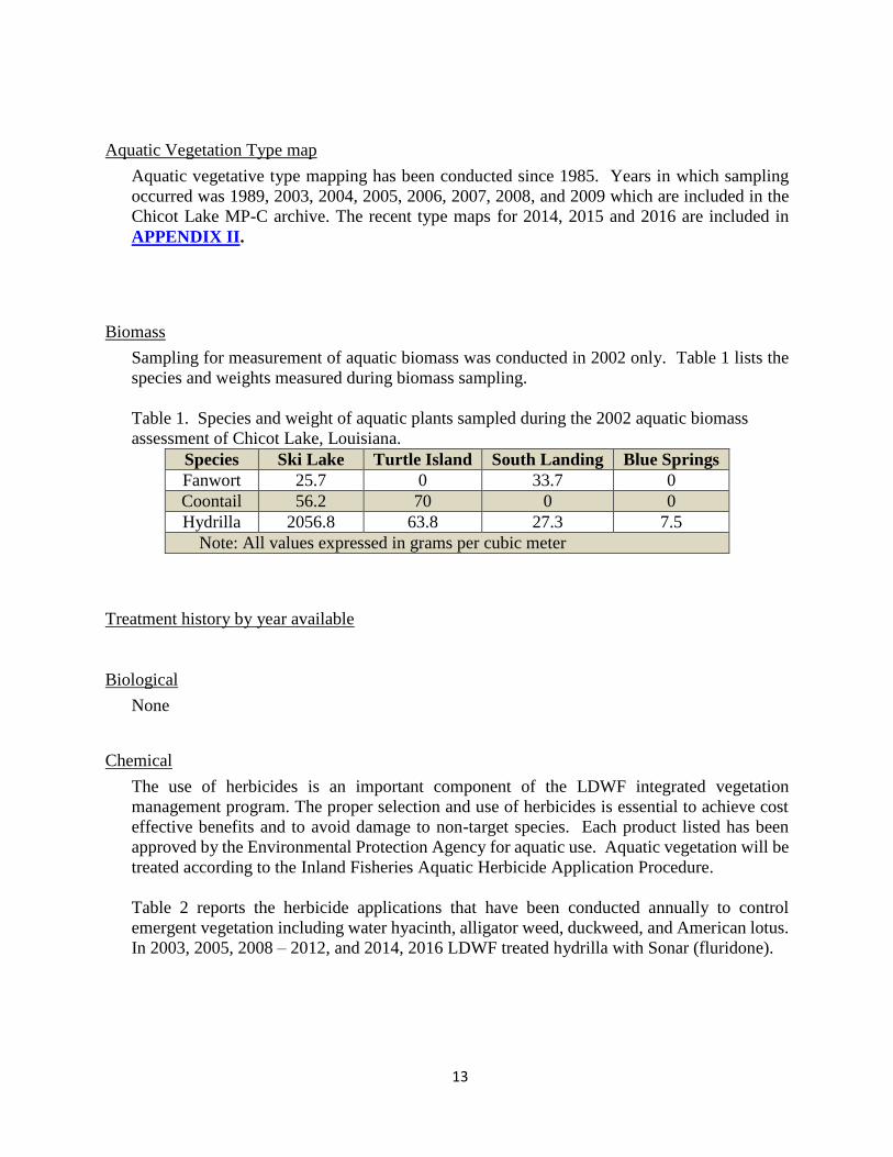
Biomass
Sampling for measurement of aquatic biomass was conducted in 2002 only. Table 1 lists the
species and weights measured during biomass sampling.
Table 1. Species and weight of aquatic plants sampled during the 2002 aquatic biomass
assessment of Chicot Lake, Louisiana.
Species Ski Lake Turtle Island South Landing Blue Springs
Fanwort 25.7 0 33.7 0
Coontail 56.2 70 0 0
Hydrilla 2056.8 63.8 27.3 7.5
Note: All values expressed in grams per cubic meter
Treatment history by year available
Biological
None
Chemical
The use of herbicides is an important component of the LDWF integrated vegetation
management program. The proper selection and use of herbicides is essential to achieve cost
effective benefits and to avoid damage to non-target species. Each product listed has been
approved by the Environmental Protection Agency for aquatic use. Aquatic vegetation will be
treated according to the Inland Fisheries Aquatic Herbicide Application Procedure.
Table 2 reports the herbicide applications that have been conducted annually to control
emergent vegetation including water hyacinth, alligator weed, duckweed, and American lotus.
In 2003, 2005, 2008 – 2012, and 2014, 2016 LDWF treated hydrilla with Sonar (fluridone).

14
Table 2. Herbicide applications conducted in Chicot Lake, Louisiana, from 1989 – 2016.
Chicot Lake Herbicide Applications
Year Gallons Pounds Acres Vegetation
1989 750 1000 Willow trees[Rodeo (Aerial application )]
2003 2980 402 Hydrilla (Sonar Treatment north end of lake)
2005 55 2980 512 Hyacinth/Hydrilla (Sonar Treatment in north
end)
2006 137 188 hyacinth/duckweed/alligator weed
2007 279 375 hyacinth/Am. Lotus/duckweed/C. salvinia
2008 511 4980 1,495 Hydrilla (Sonar treatment north end of lake)
hyacinth/Am. Lotus/duckweed/C. Salvinia
2009 643 827 Duckweed/common salvinia/hyacinth/alligator
weed
2010 135 4,870 632 Duckweed & Hydrilla (SONAR treatment)
2011 95 680 1,076
Hyacinth/Alligator weed
Salvinia/Primrose/Pennywort/Frog’s bit/Cut
Grass & Hydrilla (SONAR treatment)
2012 335 680 977
Hyacinth/Alligator weed/C. Salvinia/
Primrose/Pennywort/cutgrass/duckweed &
Hydrilla (SONAR treatment)
2013 158 298 Hyacinth/Alligator weed/Common salvinia
2014 46 120 94 Hyacinth/Alligator weed/Common salvinia &
Hydrilla (SONAR treatment)
2015 97 73 Hyacinth/Common & Giant salvinia
Hydrilla (Aquathol K)
2016 265 200 368 Am. Lotus/Hyacinth/Common & giant salvinia
Hydrilla & fanwort (SONAR)
HISTORY OF REGULATIONS
Recreational
Louisiana statewide recreational fishing regulations were in effect for Chicot Lake until 1988,
when 14” minimum length limit (MLL) and 10 fish daily creel limit were implemented for
black bass. The regulations were designed to increase abundance of quality-size bass by
protecting a strong 1988 year class. Post implementation sampling was conducted to determine
the effects of size restrictions for bass in Chicot Lake.
In 1990, a 16” MLL with a 5 fish creel was implemented for black bass to continue to protect
the strong 1988 year class.
In 1991, a protected slot limit of 14-17” with an 8 fish daily creel was implemented to protect
2–4 year old fish and allow fishermen to harvest quality-size largemouth bass. No more than
4 bass were allowed in the daily creel over 17” in total length.
In 2014, largemouth bass regulations were changed. As of April 20, 2014, the protected slot
limit for largemouth bass was removed from Chicot Lake. A 10 fish daily creel with no MLL
is the current regulation.
15
Additional regulations specific to Chicot Lake were implemented in 1993, 2011 and 2012
which pertain to the use of yo-yos. Yo-yo regulations and all other statewide recreational
harvest regulations may be viewed at the following link:
http://www.wlf.louisiana.gov/fishing/regulations
Commercial
Commercial fishing is legally prohibited in Chicot Lake. However, because large rough fish
species can limit the production and survival of sport fish, a controlled commercial harvest of
buffalo was implemented in 1967, 1968, 1970 and 1980. Rotenone samples taken by LDWF
in 1968 and 1980 averaged 94 and 250 pounds/acre of buffalo fish respectively.
Total pounds harvested in 1968 – 67,897 lbs.
Total pounds harvested in 1980 – 31,404 lbs.
No harvest data is available for 1967 and 1970.
During the drawdown period of 1985-1987, the existing fish population was eradicated with
rotenone, an FDA approved fish toxicant. Re-establishment of commercial species including
buffalo and common carp has not been documented to date.
Louisiana commercial fishing regulations may be viewed at the following link:
http://www.wlf.louisiana.gov/fishing/regulations
DRAWDOWN HISTORY
Chicot Lake became infested with submerged aquatic plants almost immediately after
impoundment. A lake drawdown was conducted in 1945 in an effort to combat the problem.
This first drawdown was ineffective because water was unable to drain properly. In 1963, a
channel was constructed to better facilitate drainage. Since that time, Chicot Lake has been
lowered regularly for control of aquatic vegetation.
Drawdown date
There have been a total of 25 Chicot Lake drawdowns for control of submerged aquatic
vegetation (Table 3). Drawdowns were all conducted from September – December
(Fall/Winter). Partial drawdowns (2 feet below pool stage) were conducted in May/June of
2003, 2005, 2008, 2010, 2011 and 2012 to help facilitate application of the herbicide, Sonar
for hydrilla control.
As indicated in Table 3, drawdowns have been an important tool in managing aquatic
vegetation in Chicot Lake. From 1962 - 1992, native submerged vegetation was the primary
target for control. In 1996, hydrilla was discovered. From 1996 – 2016, drawdowns and
herbicide applications have been used in combination to control the spread of the invasive
species, hydrilla.

16
Table 3. Drawdowns conducted on Chicot Lake, Louisiana by year from 1962 – 2016.
YEAR PURPOSE FISHING
CLOSURE
DEPTH
(ft) % EXPOSED
FISH
KILL
1962 Control of native submerged
vegetation No 4-5 35 No
1965 Control of native submerged
vegetation No 4-5 35 No
1966 Control of native submerged
vegetation No 4-5 35 No
1967 Control of native submerged
vegetation No 4-5 35 No
1968 Control of native submerged
vegetation No 4-5 35 No
1969 Control of native submerged
vegetation No 4-5 35 No
1970 Control of native submerged
vegetation No 4-5 35 No
1972 Control of native submerged
vegetation No 4-5 35 No
1974 Control of native submerged
vegetation No 4-5 35 No
1977 Control of native submerged
vegetation No 4-5 35 No
1979 Control of native submerged
vegetation No 4-5 35 No
1984 Spillway reconstruction No 10-12 90 No
1992 Control of native submerged
vegetation Yes 7 60 No
1996 Hydrilla control Yes 7 60 Yes
1997 Hydrilla control Yes 7 60 Yes
2001 Hydrilla control No 3-5 40 No
2003 * Hydrilla control No 2 15 No
2005 * Hydrilla control No 2 15 No
2008 * Hydrilla control No 2 15 No
2010* Hydrilla control No 2 15 No
2011* Hydrilla control No 2 15 No
2012* Hydrilla control No 2 15 No
2013 Control all submerged
vegetation No 3 15 No
2014 Control all submerged
vegetation No 3 15 No
2015 Control all submerged
vegetation No 3 15 No
2016 Control all submerged
vegetation & bridge repairs Yes 6 50 No
*Partial drawdowns for hydrilla control

17
Who operated structure
Louisiana Department of Transportation & Development
FISH KILLS / DISEASE HISTORY
Fish kills occurred during the 1996 and 1997 drawdowns, but were limited to the north end of
lake. The drawdowns began the 1st of August and extended through the end of November.
These fish kills occurred when water levels receded below 7 feet. The lake bottom was
completely exposed with the exception of the main channel. High water temperatures and
subsequent low dissolved oxygen levels were determined to be the cause of the die-off.
In 2003, a sample of 30 largemouth bass was tested for Largemouth Bass Virus (LMBV). No
fish were found to be positive for the virus.
CONTAMINANTS / POLLUTION
Water quality
Water quality parameters measured at the surface and near the bottom during each standardized
fisheries sample include temperature, dissolved oxygen, pH, and conductivity.
The following Fish Consumption Advisory (Figure 4) was issued for Chicot Lake, Louisiana
May 23, 2003. This advisory is still in effect: http://new.dhh.louisiana.gov/index.cfm/page/902

18
Figure 4. Fish consumption advisory notice issued for Chicot Lake, May 29, 2003
by DHH, DEQ, and DWF for bowfin, Amia calva.
BIOLOGICAL
Fish sampling history
From the 1960’s through the early 1980’s, biomass sampling (rotenone) was the standard fish
population assessment sampling methodology. From the mid- 1980’s to present, other
techniques including electrofishing, creel surveys, gillnets, biomass (rotenone), haul seine, and
water quality sampling have provided the necessary fisheries data related to the management
of Chicot Lake.
Note: All standardized sampling data collected by Inland Fisheries from 1965 through present
are stored digitally. Data collected prior to 1965 is in the form of paper documents or reports
on file in the LDWF District 6 Office in Opelousas.
Gear
Biomass (rotenone) samples: Consist of one acre block-off net samples (3-4) between the
months of May through September. The standard rotenone application rate is three pints of
5% active emulsified rotenone/acre-foot.
Biomass sampling was the most common fish sampling tool on Chicot Lake until 1988. Since
that time, other sampling techniques, including electrofishing, creel surveys, and seine
sampling were utilized.
Electrofishing utilizes a Smith-Root pulsator and generator which discharge a controlled
electrical current into the water from a specially outfitted boat. This equipment temporarily
stuns and surfaces fish. Fish are dipped from the water, measured, weighed. Sampled fish are
returned to the water unless internal body structures are necessary for lab analysis.
Table 4. Historical, current and proposed fisheries sampling for Chicot Lake, Louisiana.

19
Chicot Lake Sampling
Year Sampling Method
1955, 1958, 1967, 1968, 1969, 1970,
1971, 1975, 1976, 1977, 1978, 1980,
1981, 1982
Biomass Fish Sampling (rotenone)
1988 Electrofish, creel survey
1989 Electrofish, seine, Biomass, creel survey
1990 Electrofish, seine, gill nets, Biomass, creel survey
1991 Electrofish, gill nets, Biomass, creel survey, LMB genetics, aquatic type maps
1992 Electrofish,, gill nets, creel survey
1993 Electrofish, seine, frame nets, gill nets
1994 Electrofish, seine, gill nets, Biomass, LMB genetics, aquatic type maps
1995 Electrofish, seine, LMB genetics
1996 Electrofish, seine, gill nets, Biomass, creel survey, drawdown
1997 Electrofish, seine, gill nets, drawdown, LMB genetics
1998 Creel survey
2000 Electrofish, seine, frame nets, hoop nets
2001 Electrofish, seine, gill nets, LMB genetics
2002 Electrofish, seine, gill nets, frame nets, creel survey, aquatic type maps
2003 Electrofish, seine, gill nets, drawdown
2004 Electrofish, seine, gill net, LMB genetics
2005 Electrofishing, gill nets, seine, lead nets, aquatic type maps, drawdown
2006 Electrofishing, seine, creel survey, aquatic type maps
2007 Electrofishing, gill nets, LMB genetics and age & growth
2008 Electrofishing, rotenone, lead nets, aquatic type maps, drawdown, LMB genetics
2009 Electrofishing, gill nets, seine, aquatic type maps
2010 Electrofishing, LMB population assessment, aquatic type map, creel survey
2011 Electrofishing, LMB population assessment, aquatic type map, seine samples
2012 Electrofishing, LMB population assessment, aquatic type map, gill nets
2013 Electrofishing, seine, gill nets, aquatic type map, drawdown
2014 Electrofishing, lead nets, aquatic type map, drawdown, gill nets
2015 Drawdown, aquatic type map
2016 Electrofishing, drawdown, aquatic type map
2017 Electrofishing, , aquatic type map, water quality, gill nets
2018 Aquatic type map
2019 Electrofishing, drawdown, LMB population assessment, aquatic type map, gill nets
2020 Electrofishing, LMB population assessment, creel survey
2021 Electrofishing, LMB population assessment, aquatic type map, gill nets
Lake records
From informal records maintained by LDWF fisheries biologists, the largest bass caught in
Chicot Lake weighed 13.63 pounds (caught 1994).
Stocking
Table 5. Fish stocking history by year and by species for Chicot Lake, Louisiana from 1988
to 2016.

20
YEAR FLORIDA
BASS
CHANNEL
CATFISH
BLUE
CATFISH
THREADFIN
SHAD BLUEGILL
Triploid
Grass
Carp
1988 342,668 10,000
1989 150,000
1990 127,564 1,500
1991 132,619 2,500
1992 107,221 5,000
1993 80,595
1994 85,250
1995 153,475 28,185
1996 18,792
1997 19,178 115,000
1998 55,800 22,000
1999 152,872 6,303 6,365 2,120
2000 87,891
2001 89,568
2002 73,322
2003 83,989
2004 80,748
2005 84,310
2006 82,425
2007 84,192
2008 79,596
2009 86,241
2010 75,529
2011 72,331
2012 66,940
2013 17,232 600
2014 *252,474
2015 12,944 84,437
2016 14,643 27,432
Totals 2,767,409 171,488 16,365 120,869 2,120 600
*In 2014, FLMB fry (224,400) were stocked along with the 28,074 two inch fingerlings.
The majority of all largemouth bass stocked into Chicot Lake were fingerlings approximately
1- 2 inches in total length. All largemouth bass were released throughout the lake in various
types of habitat, such as thick vegetation and complex woody cover.
Species profile
Table 6. Fish species collected by LDWF or are known to occur in the Bayou Chicot
Watershed.
LIST OF INDIGENOUS FRESHWATER FISHES KNOWN FROM THE CHICOT
BAYOU WATERSHED

21
Lamprey Family, PETROMYZONTIDAE
Southern brook lamprey, Ichthyomyzon gagei Hubbs and Trautman
Gar Family, LEPISOSTEIDAE
Spotted gar, Lepisosteus oculatus (Winchell)
Shortnose gar, Lepisosteus platostomus Rafinesque
Bowfin Family, AMIIDAE
Bowfin, Amia calva Linnaeus
Freshwater Eel Family, ANGUILLIDAE
American eel, Anguilla rostrata (Lesueur)
Herring Family, CLUPEIDAE
Gizzard shad, Dorosoma cepedianum (Lesueur)
Threadfin shad, Dorosoma petenense (Günther)
Minnow Family, CYPRINIDAE
Blacktail shiner, Cyprinella venusta (Girard)
Red shiner, Cyprinella lutrensis (Baird and Girard)
Common Carp, Cyprinus carpio Linnaeus
Cypress minnow, Hybognathus hayi Jordan
Mississippi silvery minnow, Hybognathus nuchalis Agassiz
Striped shiner, Luxilus chrysocephalus Rafinesque
Redfin shiner, Lythrurus umbratilis (Girard)
Shoal chub, Macrhybopsis aestivalis (Girard)
Golden shiner, Notemigonus crysoleucas (Mitchill)
Bigeye chub, Notropis amblops (Rafinesque)
Emerald shiner, Notropis atherinoides Rafinesque
Blackspot shiner, Notropis atrocaudalis Evermann
Iron-colored shiner, Notropis chalybaeus (Cope)
Bluehead shiner, Notropis hubbsi Bailey and Robison
Silverband shiner, Notropis shumardi (Girard)
Weed shiner, Notropis texanus (Girard)
Mimic shiner, Notropis volucellus (Cope)
Bluenose shiner, Notropis welaka Evermann and Kendall
Pugnose minnow, Notropis emiliae Hay
Bullhead minnow, Pimephales vigilax (Baird and Girard)
Sucker Family, CATOSTOMIDAE
Lake chubsucker, Erimyzon sucetta (Lacépède)
Bigmouth buffalo, Ictiobus cyprinellus (Valenciennes)
Freshwater Catfish Family, ICTALURIDAE
Black bullhead, Ameiurus melas (Rafinesque)
22
Yellow bullhead, Ameiurus natalis (Lesueur)
Blue catfish, Ictalurus furcatus (Lesueur)
Channel catfish, Ictalurus punctatus (Rafinesque)
Black madtom, Noturus funebris (Gilbert and Swain)
Tadpole madtom, Noturus gyrinus (Mitchill)
Flathead catfish, Pylodictis olivaris (Rafinesque)
Pike Family, ESOCIDAE
Chain pickerel, Esox niger Lesueur
Pirate Perch Family, APHREDODERIDAE
Pirate perch, Aphredoderus sayanus (Gilliams)
Killifish Family, CYPRINODONTIDAE
Golden topminnow, Fundulus chrysotus (Günther)
Starhead topminnow, Fundulus nottii (Agassiz)
Blackstripe topminnow, Fundulus notatus (Rafinesque)
Blackspotted topminnow, Fundulus olivaceus (Storer)
Livebearer Family, POECILIIDAE
Western mosquitofish, Gambusia affinis (Baird and Girard)
Least killifish, Heterandria formosa Agassiz
Sailfin molly, Poecilia latipinna (Lesueur)
Silverside Family, ATHERINIDAE
Brook silverside, Labidesthes sicculus (Cope)
Inland silverside, Menidia beryllina (Cope)
Sunfish Family, CENTRARCHIDAE
Flier, Centrarchus macropterus (Lacépède)
Banded pygmy sunfish, Elassoma zonatum Jordan
Green sunfish, Lepomis cyanellus Rafinesque
Warmouth, Lepomis gulosus (Cuvier)
Orangespotted sunfish, Lepomis humilis (Girard)
Bluegill, Lepomis macrochirus (Rafinesque)
Dollar sunfish, Lepomis marginatus (Holbrook)
Longear sunfish, Lepomis megalotis (Rafinesque)
Redear sunfish, Lepomis microlophus (Günther)
Spotted sunfish, Lepomis punctatus (Valenciennes)
Bantam sunfish, Lepomis symmetricus Forbes
Florida largemouth bass, Micropterus floridanus Kassler et al.
Northern largemouth bass, Micropterus salmoides salmoides (Lacépède)
White crappie, Pomoxis annularis Rafinesque
Black crappie, Pomoxis nigromaculatus (Lesueur)
Perch Family, PERCIDAE
23
Scaly sand darter, Ammocrypta vivax Hay
Bluntnose darter, Etheostoma chlorosomum (Hay)
Creole darter, Etheostoma collettei Birdsong and Knapp
Swamp darter, Etheostoma fusiforme (Girard)
Slough darter, Etheostoma gracile (Girard)
Cypress darter, Etheostoma proeliare (Hay)
Speckled darter, Etheostoma stigmaeum (Jordan)
Redfin darter, Etheostoma whipplei (Girard)
Logperch, Percina caprodes (Rafinesque)
Blackside darter, Percina maculata (Girard)
Dusky darter, Percina sciera (Swain)
Saddleback darter, Percina vigil (Jordan and Gilbert)
Drum Family, SCIAENIDAE
Freshwater drum, Aplodinotus grunniens Rafinesque
___________________________________________________________________________
Nomenclature and phylogenetic order follows Nelson, et al. 2004. Common and Scientific
Names of Fishes from the United States, Canada, and Mexico, 6th Edition. American Fisheries
Society Special Publication 29. 386 pp. Exceptions are noted.
Genetics
Largemouth bass are collected during fall electrofishing samples and tested for the Florida
genome. Five bass per inch group are taken from the sample and brought back to the district
office. Total length and weight are recorded for each specimen. Otoliths and livers are
removed for age/growth and genetic analysis. Liver tissues are delivered to the LSU genetics
laboratory for electrophoresis analyses. Samples were tested for the Florida genome from 1990
– 2012 (Table 7).

24
Table 7. Largemouth bass genetics results for Chicot Lake, LA, 1988 – 2012.
YEAR FLMB
STOCKED
GENETIC SAMPLING RESULTS
N NLMB FLMB FX
TOTAL
FLORIDA
INFLUENCE
1988 342,668
1989 150,000
1990 127,564 37 82% 02% 16% 18%
1991 132,619
1992 107,221
1993 80,595
1994 85,250 52 56% 19% 25% 44%
1995 153,475 51 56% 15% 29% 44%
1996 18,792
1997 19,178 152 54% 15% 31% 46%
1998 55,800 35 83% 0% 17% 17%
1999 152,872 33 58% 6% 36% 42%
2000 87,891
2001 89,568 29 52% 3% 45% 48%
2002 73,322
2003 83,989
2004 80,748 33 76% 16% 8% 24%
2005 84,310
2006 82,425
2007 84,192 57 44% 2% 54% 56%
2009 86,241 51 56% 38% 6% 42%
2010 75,529 141 62% 11% 27% 39%
2011 72,331 156 70% 8% 22% 30%
2012 66,940 128 70% 6% 24% 30%
Threatened/endangered/exotic species
No threatened or endangered species have been documented in Chicot Lake to date.
Creel
Creel surveys were conducted in 1989-1992, 1996, 1998, 2002, 2006 and 2010. The angler
survey method used is a dockside (access point) survey of completed fishing trips.

25
HYDROLOGICAL CHANGES
Chicot Lake was impounded in the late winter of 1942 by closing the dam alongside the
spillway across Chicot Bayou, south of St. Landry, Louisiana. A drawdown structure and
system of drainage channels were constructed in 1963. In 1985, it was determined that the
original floodgate structure needed to be replaced. The lake was drained and the original
spillway and floodgate was demolished. Construction of the new spillway and floodgate began
in 1986. The spillway construction project was completed and Chicot Lake was allowed to
refill in December 1987.
Water use
Hunting
No
Skiing
No
Scuba Diving
No
Swimming
No
Irrigation
No
26
APPENDIX I -
(return to Access)
Chicot Lake Map of Fishing Piers and Boat Ramps/Landings

27
APPENDIX II
(return to typemap)
Chicot Lake Vegetation Type Map
Aquatic Vegetation Survey of Chicot Lake 7/29/14
Personnel: J. David, M. Plonsky
Report by: M. Plonsky
The north area of Chicot Lake in the vicinity of the North boat launch, spillway levee from
the north boat launch to the spillway structure, center portion of ski-lake and north fishing pier
continued to be plagued by Hydrilla verticillata. A significant amount of American Lotus also
exists within this area. These areas were treated with a limited amount of fluridone pellets in April
of 2014. On the date of this survey, a slight reduction in hydrilla was seen within the treated areas.
The lotus stand was just as thick as it was last year at the time of survey. The cold winter of 2013
appears to have had little effect upon the lotus. Six hundred grass carp were stocked into Chicot
Lake at the north boat launch in October of 2013. The problem areas of hydrilla in Chicot Lake do
not appear to have grown in aerial coverage with little to no hydrilla experienced outside of this
defined vicinity. Conservation Cove, Turtle Island Cove and Walker’s Branch were free of hydrilla
infestations. An increase of native submerged vegetation was found in areas bordering the hydrilla
laden area. Submerged vegetation seen occupying these areas were coontail and fanwort. No
bladderwort was observed. Proceeding south out of the north flats, hydrilla occurrence diminished
quickly except for a small patch in the area of the lake near the spillway. No hydrilla was observed
south of Area 2 boat launch.
A significant amount of water primrose, alligator weed, swamp smartweed and taro
continued to exist upon the shallow spoil bank area of the mid lake locations between Area 2 boat
launch and the south boat launch. This vegetation had been treated twice with glyphosate during
the spring and summer and appeared to be under control. Not all of this vegetation was eradicated
since it is a popular fishing location and does provide successful fish cover. This area requires
continual upkeep but, has proven manageable so far.
Primrose, taro and alligator weed were also found in moderate to heavy amounts on the
western bank of the spoil mounds separating Turtle Island Cove from the spillway canal. This area
has had continual maintenance by the herbicide spray crew, receiving treatments a couple of times
per year, but has proven to be manageable and does offer good crappie fishing opportunities.
Minimal amounts of primrose and alligator weed were seen in the terminal south end of Chicot
Lake.
Little to no common salvinia was observed. What was seen was a light fringe of common
salvinia throughout the lake, with no specific location holding large amounts. Salvinia was seen
beneath the clumps of giant cutgrass found on many of the bank points of the lake. The cutgrass
appears to have thinned some due to this past year’s very cold winter weather with most clumps
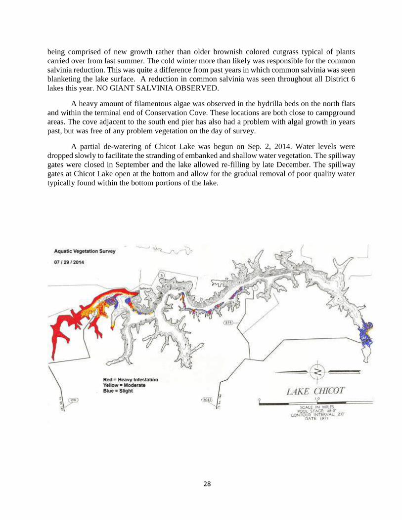
28
being comprised of new growth rather than older brownish colored cutgrass typical of plants
carried over from last summer. The cold winter more than likely was responsible for the common
salvinia reduction. This was quite a difference from past years in which common salvinia was seen
blanketing the lake surface. A reduction in common salvinia was seen throughout all District 6
lakes this year. NO GIANT SALVINIA OBSERVED.
A heavy amount of filamentous algae was observed in the hydrilla beds on the north flats
and within the terminal end of Conservation Cove. These locations are both close to campground
areas. The cove adjacent to the south end pier has also had a problem with algal growth in years
past, but was free of any problem vegetation on the day of survey.
A partial de-watering of Chicot Lake was begun on Sep. 2, 2014. Water levels were
dropped slowly to facilitate the stranding of embanked and shallow water vegetation. The spillway
gates were closed in September and the lake allowed re-filling by late December. The spillway
gates at Chicot Lake open at the bottom and allow for the gradual removal of poor quality water
typically found within the bottom portions of the lake.

29
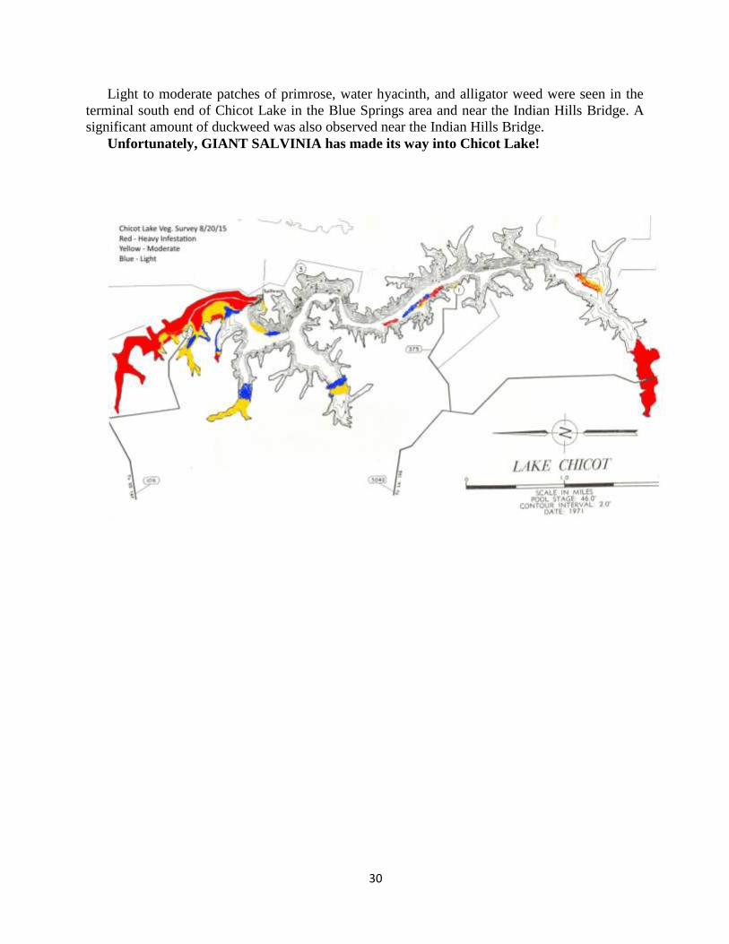
Chicot Lake Aquatic Vegetation Survey August 20, 2015
Personnel; B. Launey, P. Allemand
A survey of aquatic vegetation conducted on Chicot Lake revealed a moderate to heavy
infestation of vegetation on the north end and southern tip of the lake. A very light infestation was
observed in the remainder of the system. Water level in the lake on the day of the survey was five
inches below pool.
The north area of Chicot lake in the vicinity of the north boat launch, spillway structure, center
portion of Ski Lake, and north fishing pier flats continue to be heavily infested with submerged
vegetation consisting of hydrilla (Hydrilla verticillata), fanwort (Cabomba caroliniana), coontail
(Ceratophyllum demersum), and light patches of bladderwort (Utricularia spp.). Some light to
moderate areas of filamentous algae were also observed in this area. A significant amount of
American lotus (Nelumbo lutea) also exists from the spillway structure to the flats near the north
boat launch.
Light to moderate amounts of submerged vegetation, hydrilla, fanwort, water milfoil
(Myriophyllum verticillata), and coontail, were observed in Conservation Cove and in the wooded
area just north of the mouth of Conservation Cove. A light fringe of common salvinia (Salvinia
minima), water hyacinth (Eichhornia crassipes), and alligator weed (Alternanthera philoxeroides)
was seen in Conservation Cove. The shallow end of the cove was heavily infested with aquatic
vegetation. A significant amount of common salvinia with very light patches of Giant Salvinia was
observed in the wooded area. Giant salvinia was also seen in the vegetative fringe of Conservation
Cove. This is the first discovery of giant salvinia in Chicot Lake to this date.
Turtle Island Cove and Walker’s Branch contained light amounts of hydrilla, fanwort and
coontail. A moderate amount of submerged vegetation and filamentous algae was observed in the
open water area near the bridge in Walker’s Branch. The predominant submerged species found
in this area were fanwort and coontail. No bladderwort was observed. Primrose, taro (Colocasia
esculenta) and alligator weed were also found in moderate to heavy amounts on the western bank
of the spoil mounds separating Turtle Island Cove from the spillway canal (boat channel). This
area near the spoil mounds is lightly treated annually. Being this is a popular fishing location, not
all of this vegetation is eradicated. It provides fish cover and increases fishing success.
As you move south towards the vicinity of the Area 2 boat launch, the occurrence of submerged
vegetation quickly diminishes. Very light patches of submerged vegetation were only observed in
the shallow terminal ends of some small coves off the main lake. Area 2 boat launch was mostly
free of vegetation with only light patches of hydrilla being visible. No hydrilla was observed south
of the Area 2 boat launch except for a light fringe near the south boat launch. Light to moderate
patches of common salvinia were also seen near the south boat launch.
A moderate amount of water primrose (Ludwigia spp.), alligator weed, swamp smartweed
(Polygonum hydropiperoides) and taro continue to exist upon the shallow spoil bank area of the
mid lake between Area 2 boat launch and the south boat launch. This vegetation is also lightly
treated annually to keep it under control. Not all of this vegetation is eradicated since it is a popular
fishing location and does provide fish habitat.
30
Light to moderate patches of primrose, water hyacinth, and alligator weed were seen in the
terminal south end of Chicot Lake in the Blue Springs area and near the Indian Hills Bridge. A
significant amount of duckweed was also observed near the Indian Hills Bridge.
Unfortunately, GIANT SALVINIA has made its way into Chicot Lake!
31
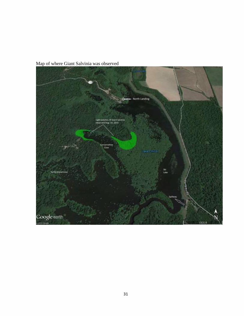
Map of where Giant Salvinia was observed
32
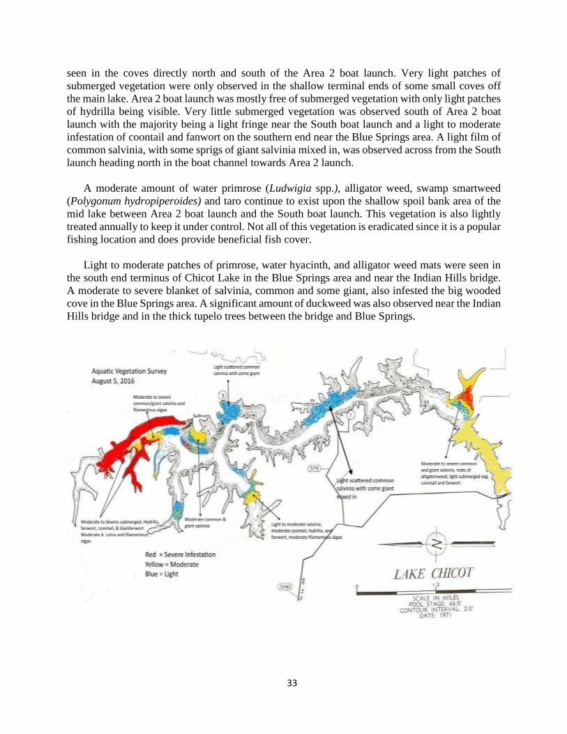
Chicot Lake Aquatic Vegetation Survey August 5, 2016
Personnel: B. Launey, J. David
Report by: B. Launey
A survey of aquatic vegetation conducted on Chicot Lake revealed a moderate to heavy
infestation of vegetation on the north end and southern tip of the lake. A very light infestation was
observed in the remainder of the system. Water level in the lake on the day of the survey was
approx. 7 inches below pool.
The north area of Chicot lake in the vicinity of the North boat launch, spillway structure, center
portion of ski lake, and north fishing pier flats continue to be heavily infested with submerged
vegetation consisting of hydrilla (Hydrilla verticillata), fanwort (Cabomba caroliniana), coontail
(Ceratophyllum demersum), and light patches of bladderwort (Utricularia spp.). Some light to
moderate areas of filamentous algae were also observed in this area. A significant amount of
American lotus (Nelumbo lutea) also exists from the spillway structure to the flats near the north
boat launch. The spread of giant salvinia has yet to infest the majority of the system, with a
moderate to severe infestation being contained in the wooded area between the north fishing pier
and Conservation cove. Monthly herbicide applications are being conducted to prevent an
infestation of giant salvinia throughout the system.
Light to moderate amounts of submerged vegetation, hydrilla, fanwort, water milfoil
(Myriophyllum verticillatum), and coontail, were observed in Conservation cove and in the
wooded area just north of the mouth of Conservation cove. A light vegetative fringe of common
salvinia (Salvinia minima), giant salvinia, water hyacinth (Eichhornia crassipes), and alligator
weed (Alternanthera philoxeroides) was seen in Conservation cove. The shallow end of the cove
had a light to moderate infestation of aquatic vegetation consisting of filamentous algae, fanwort,
coontail, and some hydrilla. A light amount of common salvinia with very light patches of Giant
Salvinia was observed in the wooded area.
Turtle Island cove and Walker’s branch contain light amounts of hydrilla, fanwort and coontail.
A moderate amount of submerged vegetation and filamentous algae was observed in the open
water area near the bridge in Walker’s branch. Dominate submerged species found in this area
were fanwort and coontail. No bladderwort observed. Primrose, taro (Colocasia esculenta),
salvinia, and alligator weed are also found in moderate to heavy amounts on the western bank of
the spoil mounds separating Turtle Island cove from the spillway canal (boat channel). This area
near the spoil mounds is lightly treated annually with herbicides. Being this is a popular fishing
location, not all of the vegetation is purposely eradicated. It provides fish cover and fishing
opportunity.
Moving south towards the vicinity of the Area 2 boat launch the occurrence of submerged
vegetation quickly diminishes. Light patches of salvinia, mostly common and some giant, were
33
seen in the coves directly north and south of the Area 2 boat launch. Very light patches of
submerged vegetation were only observed in the shallow terminal ends of some small coves off
the main lake. Area 2 boat launch was mostly free of submerged vegetation with only light patches
of hydrilla being visible. Very little submerged vegetation was observed south of Area 2 boat
launch with the majority being a light fringe near the South boat launch and a light to moderate
infestation of coontail and fanwort on the southern end near the Blue Springs area. A light film of
common salvinia, with some sprigs of giant salvinia mixed in, was observed across from the South
launch heading north in the boat channel towards Area 2 launch.
A moderate amount of water primrose (Ludwigia spp.), alligator weed, swamp smartweed
(Polygonum hydropiperoides) and taro continue to exist upon the shallow spoil bank area of the
mid lake between Area 2 boat launch and the South boat launch. This vegetation is also lightly
treated annually to keep it under control. Not all of this vegetation is eradicated since it is a popular
fishing location and does provide beneficial fish cover.
Light to moderate patches of primrose, water hyacinth, and alligator weed mats were seen in
the south end terminus of Chicot Lake in the Blue Springs area and near the Indian Hills bridge.
A moderate to severe blanket of salvinia, common and some giant, also infested the big wooded
cove in the Blue Springs area. A significant amount of duckweed was also observed near the Indian
Hills bridge and in the thick tupelo trees between the bridge and Blue Springs.

34
Aerial photo of Chicot Lake during drawdown – October 2016.
Related Documents