The Chicot Aquifer and the I-49 Connector Project A Primer

Welcome message from author
This document is posted to help you gain knowledge. Please leave a comment to let me know what you think about it! Share it to your friends and learn new things together.
Transcript
The Chicot Aquifer and the I-49 Connector Project
A Primer
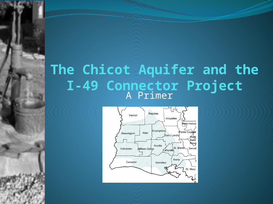
What is an Aquifer?
An Aquifer is Not An Underground Lake or
River
An aquifer is a geological structure of sand and rock that is saturated with water and permeable enough for water to readily flow through it.
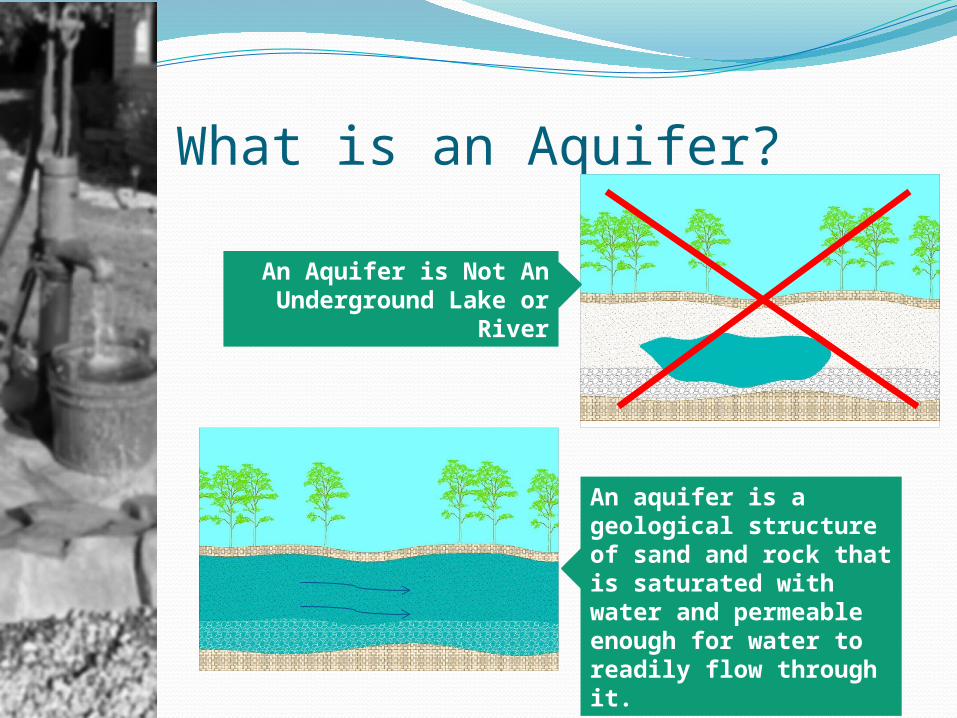
General Types of AquifersUnconfined aquifers are those into which water seeps from the ground surface directly above the aquifer.
http://techalive.mtu.edu/meec/module04/Basics3.htm
Confined aquifers are those in which an upper layer exists that inhibits water from seeping into the aquifer from the ground surface located directly above. Instead, water seeps into confined aquifers from farther away where the impermeable layer doesn't exist. Faults and other naturally occurring irregularities in the upper confining unit can allow for localized seepage into the aquifer.
UnsaturatedZone
Water Table
SaturatedZone
UnconfinedAquifer
Bedrock or Other Impermeable Layer
Well
RechargeArea
Water Table
Water Rises in WellTo This Level Water Freely Flows
From the TopOf This Well
Upper ConfiningLayer
PerchedWater
Lower Confining Layer(Bedrock or Other Impermeable Layer)
Confined Aquifer
(Under Pressure)
Water in Well Will OnlyRise to the Level in the Aquifer
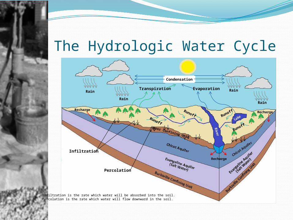
The Hydrologic Water Cycle
Rain
Rain
Rain
Rain
Runoff
Runoff
Runoff
Runoff
Infiltration
Percolation
Infiltration is the rate which water will be absorbed into the soil.Percolation is the rate which water will flow downward in the soil.
EvaporationTranspiration
RechargeRecharge
Upper Confining Unit
Condensation
Recharge
Chicot Aquifer In Louisiana
Atchafalaya Basin
Chicot Aquifer
Recharge Area
Map Derived from:Department of The InteriorU.S. Geological SurveyWater Resources InvestigationsReport 86-4348 Sheet 1 of 2
Some Recharge
FromAtchafalaya
Basin
The Chicot Aquifer is Extremely
Important to South and Southwest Louisiana
• “Sole Source” Aquifer• The only or primary source of drinking water for the entire area
• The Chicot Aquifer Covers approximately 9,000 Square Miles• The Chicot Aquifer is a Confined Aquifer• The primary recharge
areas are in the northern area of the aquifer (Rapides, Evangeline, Allen Vernon, and Beauregard Parishes) and some recharge comes from the Atchafalaya Basin.
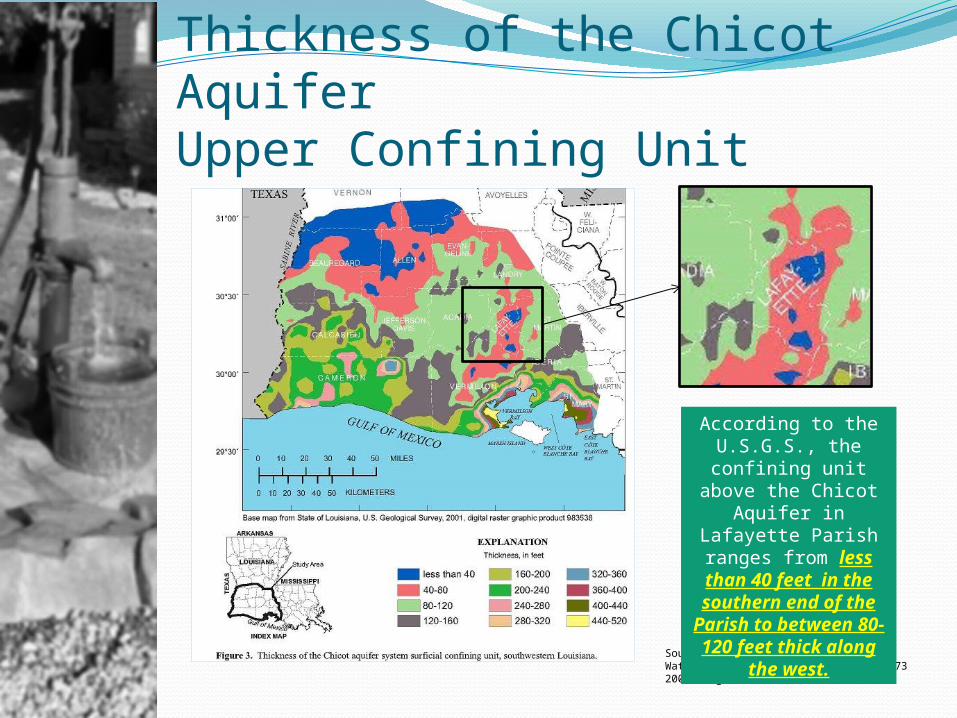
Thickness of the Chicot AquiferUpper Confining Unit
Source: U.S. Geological SurveyWater Resources Technical Report No 732004, Page 10
According to the U.S.G.S., the
confining unit above the Chicot Aquifer in Lafayette Parish ranges from less than 40 feet in
the southern end of the Parish to between 80- 120 feet thick along
the west.
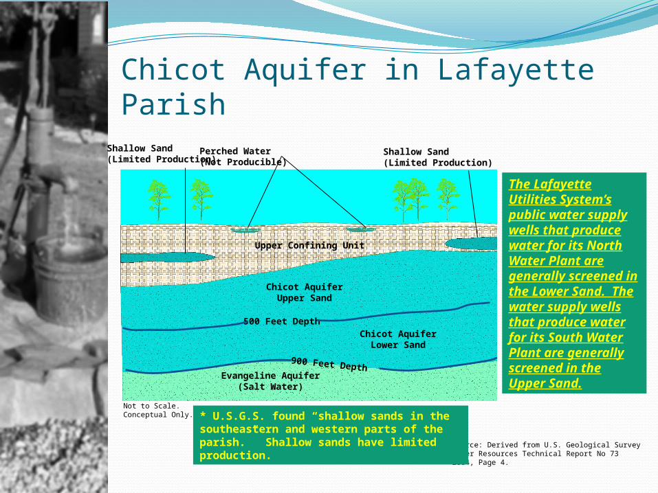
Chicot Aquifer in Lafayette ParishPerched Water(Not Producible)
Upper Confining Unit
500 Feet Depth
Chicot AquiferUpper Sand
Chicot AquiferLower Sand
900 Feet DepthEvangeline Aquifer
(Salt Water)
Source: Derived from U.S. Geological SurveyWater Resources Technical Report No 732004, Page 4.
* U.S.G.S. found “shallow sands in the southeastern and western parts of the parish.” Shallow sands have limited production.
The Lafayette Utilities System’s public water supply wells that produce water for its North Water Plant are generally screened in the Lower Sand. The water supply wells that produce water for its South Water Plant are generally screened in the Upper Sand.
Not to Scale. Conceptual Only.
Shallow Sand(Limited Production)
Shallow Sand(Limited Production)
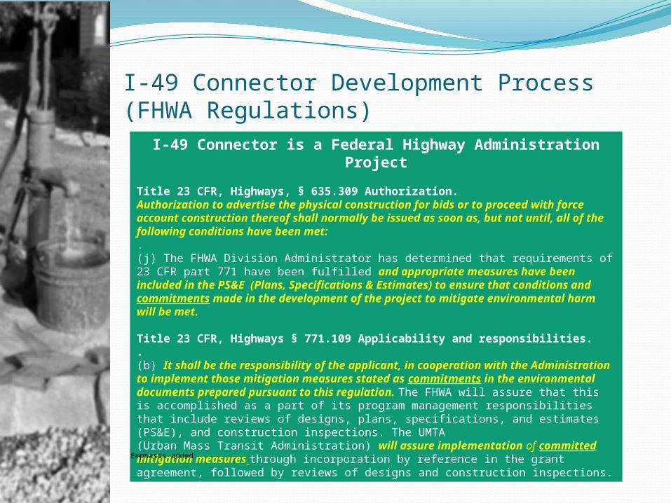
I-49 Connector Development Process(FHWA Regulations)
I-49 Connector is a Federal Highway Administration Project
Title 23 CFR, Highways, § 635.309 Authorization.Authorization to advertise the physical construction for bids or to proceed with force account construction thereof shall normally be issued as soon as, but not until, all of the following conditions have been met:.(j) The FHWA Division Administrator has determined that requirements of 23 CFR part 771 have been fulfilled and appropriate measures have been included in the PS&E (Plans, Specifications & Estimates) to ensure that conditions and commitments made in the development of the project to mitigate environmental harm will be met.
Title 23 CFR, Highways § 771.109 Applicability and responsibilities..(b) It shall be the responsibility of the applicant, in cooperation with the Administration to implement those mitigation measures stated as commitments in the environmental documents prepared pursuant to this regulation. The FHWA will assure that this is accomplished as a part of its program management responsibilities that include reviews of designs, plans, specifications, and estimates (PS&E), and construction inspections. The UMTA (Urban Mass Transit Administration) will assure implementation of committed mitigation measures through incorporation by reference in the grant agreement, followed by reviews of designs and construction inspections.
Emphasis added.
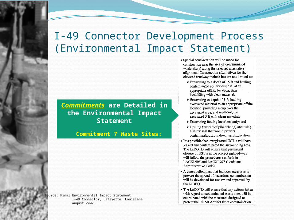
I-49 Connector Development Process(Environmental Impact Statement)
Commitments are Detailed in the Environmental Impact
Statement
Commitment 7 Waste Sites:
Source: Final Environmental Impact Statement I-49 Connector, Lafayette, Louisiana August 2002.

I-49 Connector Development Process(Environmental Impact Statement)
Commitments are Detailed in the Environmental Impact
Statement
Commitment 9 Chicot Aquifer:
Source: Final Environmental Impact Statement I-49 Connector, Lafayette, Louisiana August 2002.
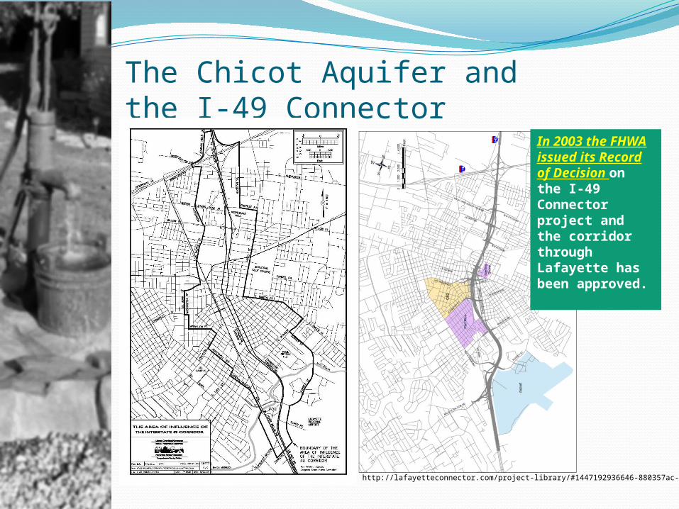
The Chicot Aquifer and the I-49 Connector
Source: http://lafayetteconnector.com/project-library/#1447192936646-880357ac-d953
In 2003 the FHWA issued its Record of Decision on the I-49 Connector project and the corridor through Lafayette has been approved.
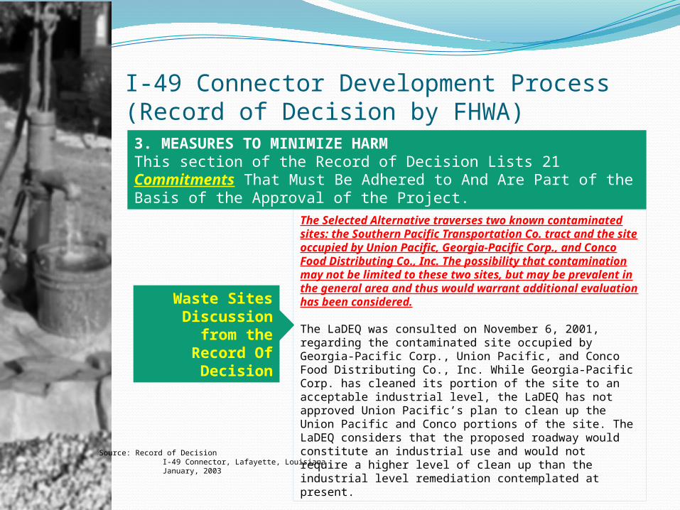
I-49 Connector Development Process(Record of Decision by FHWA)3. MEASURES TO MINIMIZE HARMThis section of the Record of Decision Lists 21 Commitments That Must Be Adhered to And Are Part of the Basis of the Approval of the Project.
Source: Record of Decision I-49 Connector, Lafayette, Louisiana January, 2003
The Selected Alternative traverses two known contaminated sites: the Southern Pacific Transportation Co. tract and the site occupied by Union Pacific, Georgia-Pacific Corp., and Conco Food Distributing Co., Inc. The possibility that contamination may not be limited to these two sites, but may be prevalent in the general area and thus would warrant additional evaluation has been considered.
The LaDEQ was consulted on November 6, 2001, regarding the contaminated site occupied by Georgia-Pacific Corp., Union Pacific, and Conco Food Distributing Co., Inc. While Georgia-Pacific Corp. has cleaned its portion of the site to an acceptable industrial level, the LaDEQ has not approved Union Pacific’s plan to clean up the Union Pacific and Conco portions of the site. The LaDEQ considers that the proposed roadway would constitute an industrial use and would not require a higher level of clean up than the industrial level remediation contemplated at present.
Waste Sites Discussion
from the Record Of
Decision
I-49 Connector Development Process(Record of Decision by FHWA)
Source: Record of Decision I-49 Connector, Lafayette, Louisiana January, 2003
Special consideration will be made for construction near the area of contaminated waste site(s) along the Selected Alternative alignment. Construction alternatives for the elevated roadway include but are not limited to:• Excavating to a depth of 15 ft and hauling contaminated soil for disposal at an appropriate offsite location, then backfilling with clean material;• Excavating to depth of 5 ft, hauling excavated material to an appropriate offsite location, providing a cap over the excavated area, and replacing the excavated 5 ft with clean material;• Excavating footing locations only; and • Drilling (instead of pile driving) and using a slurry seal that would prevent contamination from downward migration.
It is possible that unregistered USTs will have leaked and contaminated the surrounding area. The LaDOTD will ensure that permanent closure of USTs in the project right-of-way will follow the procedures set forth in LACXI.905 and LACXI.907 (Louisiana Administrative Code). A construction plan that includes measures to prevent the spread of hazardous contamination will be developed for review and approval by the LaDEQ. LaDOTD will ensure that any actions taken with regard to contaminated waste sites will be coordinated with the measures designed to protect the Chicot Aquifer from contamination.
Waste Sites Commitments from the Record Of
Decision
I-49 Connector Development Process(Record of Decision by FHWA)
Source: Record of Decision I-49 Connector , Lafayette, Louisiana January, 2003
All of the alternatives considered for the project corridor are underlain by the sole source Chicot Aquifer, which covers a large area of south Louisiana. Each of the alternatives considered necessarily would employ construction techniques that would prevent any contamination of the aquifer. Pile driving or excavation operations, with the potential to puncture the existing, confining claybed, are the most significant project components with regard to potential contamination of the Chicot Aquifer from hazardous waste. Hazardous waste sites have been documented to exist in the project corridor and hazardous material could be allowed to enter the aquifer if documented and/or currently unknown contaminated areas are excavated and the confining clay layer is punctured creating a point of recharge. None of the alternatives would impact primary recharge areas of the Chicot Aquifer, which are located in Beauregard, Allen, and Evangeline Parishes.Construction impacts to the Chicot Aquifer would be dependent of the depth to the water bearing strata of sand and gravel underlying the Selected Alternative. Utilizing idealized geologic sections prepared by the United States Geological Survey, none of the alternatives would be anticipated to impact the Chicot Aquifer. This determination is further substantiated by recent construction of the University Avenue underpass at the Union Pacific Railroad. This project included a railroad bridge on piles and excavation for the roadway underpass, neither of which penetrated the aquifer. Avoidance of impacts to the Chicot Aquifer, which is a sole source aquifer, will continue to be coordinated with the EPA and LaDEQ as the I-49 Connector projects continues to develop.
Chicot Aquifer
Discussion from the
Record Of Decision
I-49 Connector Development Process(Record of Decision by FHWA)
Source: Record of Decision I-49 Connector , Lafayette, Louisiana January, 2003
The potential for contamination through ground water/surface waterinterchange will be minimized through special design techniques and planreview procedures that continue to involve the EPA, LaDEQ, and otherappropriate agencies. Through such coordination, adequate safeguards willbe instituted to assure compliance with state and federal regulations.The actual aquifer layer will be identified at the time of the design phasewhen borings are obtained for design purposes. Design measures andconstruction techniques will be utilized to guard against contamination of theaquifer. See Section 3.7 of this ROD (Wastes Sites).During the construction phase of the project, close coordination with LaDEQ and EPA will be maintained to assure that adequate protection ismaintained for the Chicot Aquifer.
Chicot Aquifer
Commitment from the Record Of
Decision
LaDOTD and LaDEQ WorkingTogether On Highway Projects
Source: http://www.i10lakecharles.com/ , LaDEQ presentation to Lake Charles MPO Transportation Committee May 2015 and discussions with LaDEQ personnel.
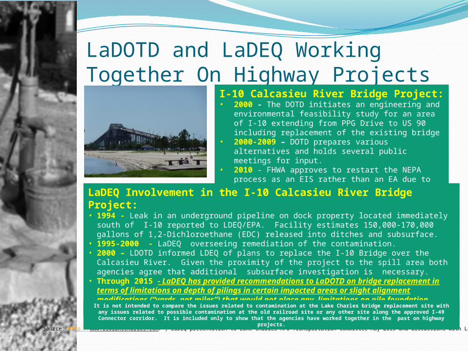
I-10 Calcasieu River Bridge Project:• 2000 - The DOTD initiates an engineering and
environmental feasibility study for an area of I-10 extending from PPG Drive to US 90 including replacement of the existing bridge
• 2000-2009 – DOTD prepares various alternatives and holds several public meetings for input.
• 2010 - FHWA approves to restart the NEPA process as an EIS rather than an EA due to the discovery of hazardous contamination.
LaDEQ Involvement in the I-10 Calcasieu River Bridge Project:• 1994 - Leak in an underground pipeline on dock property located immediately south of
I-10 reported to LDEQ/EPA. Facility estimates 150,000-170,000 gallons of 1,2-Dichloroethane (EDC) released into ditches and subsurface.
• 1995-2000 - LaDEQ overseeing remediation of the contamination.• 2000 – LDOTD informed LDEQ of plans to replace the I-10 Bridge over the Calcasieu
River. Given the proximity of the project to the spill area both agencies agree that additional subsurface investigation is necessary.
• Through 2015 - LaDEQ has provided recommendations to LaDOTD on bridge replacement in terms of limitations on depth of pilings in certain impacted areas or slight alignment modifications (“yards, not miles”) that would not place any limitations on pile foundation construction.It is not intended to compare the issues related to contamination at the Lake Charles bridge replacement site with any
issues related to possible contamination at the old railroad site or any other site along the approved I-49 Connector corridor. It is included only to show that the agencies have worked together in the past on highway projects.
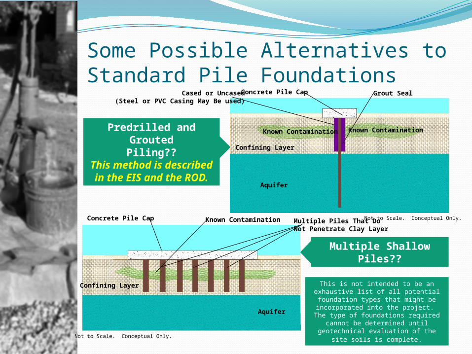
Some Possible Alternatives to Standard Pile Foundations
Predrilled and GroutedPiling??
This method is described in the EIS
and the ROD.
Concrete Pile CapCased or Uncased(Steel or PVC Casing May Be used)
Grout Seal
Not to Scale. Conceptual Only.
Known Contamination Known Contamination
Multiple ShallowPiles??
Concrete Pile Cap Multiple Piles That DoNot Penetrate Clay Layer
This is not intended to be an exhaustive list of all potential foundation types that might be incorporated into the project. The type of foundations required cannot
be determined until geotechnical evaluation of the site soils is complete.
Confining Layer
Aquifer
Aquifer
Confining Layer
Known Contamination
Not to Scale. Conceptual Only.
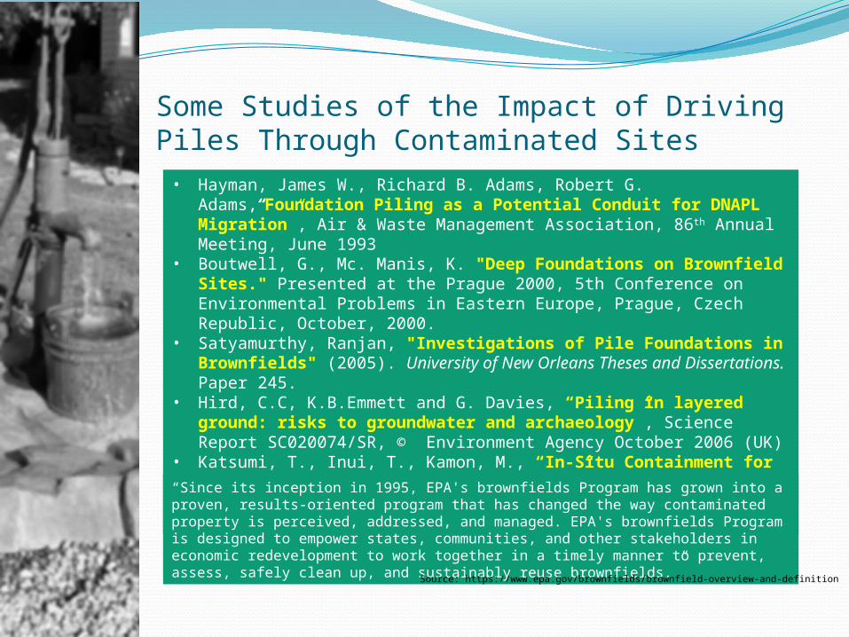
Some Studies of the Impact of Driving Piles Through Contaminated Sites• Hayman, James W., Richard B. Adams, Robert G. Adams,“Foundation
Piling as a Potential Conduit for DNAPL Migration”, Air & Waste Management Association, 86th Annual Meeting, June 1993
• Boutwell, G., Mc. Manis, K. "Deep Foundations on Brownfield Sites." Presented at the Prague 2000, 5th Conference on Environmental Problems in Eastern Europe, Prague, Czech Republic, October, 2000.
• Satyamurthy, Ranjan, "Investigations of Pile Foundations in Brownfields" (2005). University of New Orleans Theses and Dissertations. Paper 245.
• Hird, C.C, K.B.Emmett and G. Davies, “Piling in layered ground: risks to groundwater and archaeology”, Science Report SC020074/SR, © Environment Agency October 2006 (UK)
• Katsumi, T., Inui, T., Kamon, M., “In-Situ Containment for Waste Landfill and Contaminated Sites”, Proceedings of International Symposium on Geoenvironmental Engineering, ISGE2009 “Since its inception in 1995, EPA's brownfields Program has grown into a proven,
results-oriented program that has changed the way contaminated property is perceived, addressed, and managed. EPA's brownfields Program is designed to empower states, communities, and other stakeholders in economic redevelopment to work together in a timely manner to prevent, assess, safely clean up, and sustainably reuse brownfields.” Source: https://www.epa.gov/brownfields/brownfield-overview-and-definition
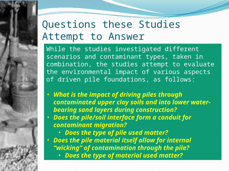
Questions these StudiesAttempt to Answer
While the studies investigated different scenarios and contaminant types, taken in combination, the studies attempt to evaluate the environmental impact of various aspects of driven pile foundations, as follows:
• What is the impact of driving piles through contaminated upper clay soils and into lower water-bearing sand layers during construction?
• Does the pile/soil interface form a conduit for contaminant migration?• Does the type of pile used matter?
• Does the pile material itself allow for internal “wicking” of contamination through the pile?• Does the type of material used matter?
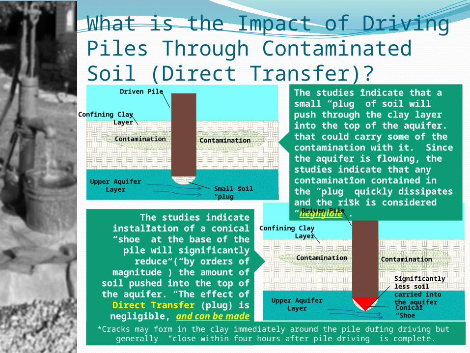
What is the Impact of Driving Piles Through Contaminated Soil (Direct Transfer)?
The studies indicate that a small “plug” of soil will push through the clay layer into the top of the aquifer. that could carry some of the contamination with it. Since the aquifer is flowing, the studies indicate that any contamination contained in the “plug” quickly dissipates and the risk is considered “negligible”.The studies indicate
installation of a conical “shoe” at the base of the pile will
significantly reduce (“by orders of magnitude”) the
amount of soil pushed into the top of the aquifer. “The effect
of Direct Transfer (plug) is negligible, and can be made
virtually undetectable by using pointed pile tips.”
Driven Pile
Confining ClayLayer
Contamination Contamination
Upper AquiferLayer Small soil “plug”
Driven Pile
Confining ClayLayer
Contamination Contamination
Upper AquiferLayer Conical “Shoe”
Significantly less soil carried into the aquifer
*Cracks may form in the clay immediately around the pile during driving but generally “close within four hours after pile driving” is complete.
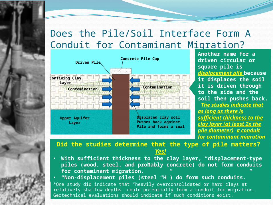
Does the Pile/Soil Interface Form A Conduit for Contaminant Migration?
Another name for a driven circular or square pile is displacement pile because it displaces the soil it is driven through to the side and the soil then pushes back. The studies indicate that as long as there is sufficient thickness to the clay layer (at least 2x the pile diameter) a conduit for contaminant migration was not created.
Did the studies determine that the type of pile matters? Yes!
• With sufficient thickness to the clay layer, “displacement-type piles (wood, steel, and probably concrete) do not form conduits for contaminant migration.”
• “Non-displacement piles (steel “H”) do form such conduits.”
Driven Pile
Confining ClayLayer
Contamination Contamination
Upper AquiferLayer
Concrete Pile Cap
Displaced clay soilPushes back against Pile and forms a seal
*One study did indicate that “heavily overconsolidated or hard clays at relatively shallow depths” could potentially form a conduit for migration. Geotechnical evaluations should indicate if such conditions exist.
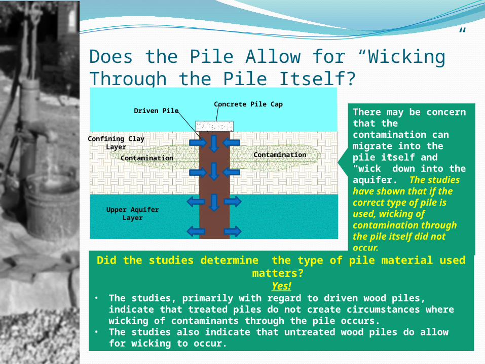
Does the Pile Allow for “Wicking” Through the Pile Itself?
There may be concern that the contamination can migrate into the pile itself and “wick” down into the aquifer. The studies have shown that if the correct type of pile is used, wicking of contamination through the pile itself did not occur.
Did the studies determine the type of pile material used matters?
Yes!• The studies, primarily with regard to driven wood piles, indicate
that treated piles do not create circumstances where wicking of contaminants through the pile occurs.
• The studies also indicate that untreated wood piles do allow for wicking to occur.
Driven Pile
Confining ClayLayer
Contamination Contamination
Upper AquiferLayer
Concrete Pile Cap
Considerations for the I-49 Connector Project
In order to minimize potential impacts to the Chicot Aquifer from sites known to have some level of contamination in the upper clay soils:• During CSS and Actual Engineering Design - Close
coordination between the stakeholders, design engineers, the LaDOTD, the LaDEQ and USEPA. • Select and design foundations that are not only
structurally appropriate but also minimize potential adverse impact on the aquifer.
• During Construction – Establish appropriate Quality Assurance/Quality Control mechanisms in the construction contract that emphasize the need for and reasoning behind those QA/QC mechanisms. “Ignorance of the need for these procedures may lead to omissions” during construction.
Westcott, F.J., C M B Lean & M L Cunningham “Piling and Penetrative Ground Improvement Methodson Land Affected by Contamination: Guidance on Pollution PreventionNational Groundwater & Contaminated Land Centre report NC/99/73, May 2001 (UK)
Related Documents