Location Based Services & Mobile GIS/Cartography Barend Köbben International Institute for Geo-Information Science and Earth Observation (ITC)

Welcome message from author
This document is posted to help you gain knowledge. Please leave a comment to let me know what you think about it! Share it to your friends and learn new things together.
Transcript

Location Based Services & Mobile Cartography 1
Location Based Services &
Mobile GIS/Cartography
Barend Köbben
International Institute for Geo-Information Science and Earth
Observation(ITC)

Location Based Services & Mobile Cartography 2
BUZZWORDS:mobile cartography ~ WebGIS ~Webcartography ~ telecartography
~ Location Based services~ distributed GISwireless web ~
wireless information devicessmartphones ~ PDA’s ~ PocketPC’s
“Where will it end…?”

Location Based Services & Mobile Cartography 3
“…CUE TOM CRUISE...!”
[‘Minority Report’ - Steven Spielberg, 2002]
Washington 2039:
John Andertonon the run for the ‘pre-crime’ police…

Location Based Services & Mobile Cartography 4
ALL ELEMENTS ALREADY EXIST...
1. Positioning – localising
Localising of person / device by the network• biometry (iris-scanner / fingerprint)• magnetic (smart-cards, smart-keys)• radiometric (transponders / GSM cell-timing)
Location Service

Location Based Services & Mobile Cartography 5
ALL ELEMENTS ALREADY EXIST...
1. Positioning – localising
Positioning by device (using network)• feedback of network-positioning (eg. by SMS)• Global Positioning Systems• Inertial Navigation Systems• GSM / UMTS self-positioning
positioning

Location Based Services & Mobile Cartography 6
ALL ELEMENTS ALREADY EXIST...
2. Location aware GIS• distributed data + applications • locations of services, objects and persons
3. Location based services• matched to combination of person+position

Location Based Services & Mobile Cartography 7
ALL ELEMENTS ALREADY EXIST...
4. Mobile information devices (MIDs)
• graphic and alfanumerical display• simple user interface• portable

Location Based Services & Mobile Cartography 8
ALL ELEMENTS ALREADY EXIST...
5. wireless connections between the parts
• between MIDs and network (WIDs or using phone)• between MIDs themselves (IR, bluetooth)• between MID and user (speach, 3D-gloves)

Location Based Services & Mobile Cartography 9
ALL ELEMENTS ALREADY EXIST...
Many working examples are ‘out there’eg.:• Bata Positioning System• Wireless Campus LBS• GeoTracing• …many more…

Location Based Services & Mobile Cartography 10
Bata Positioning System
developed by 4 students (UT & Hogeschool Utrecht)
combines mobile telephony (GSM), GPS and Internet
developed for the world’s biggest relay race De Batavierenrace(Nijmegen-Enschede)
enables tracking of position of run live on the internet
http://www.batalive.nl/

Location Based Services & Mobile Cartography 11
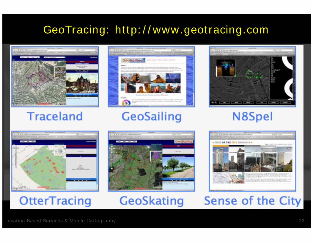
GeoTracing
"Classic GIS": WHAT+WHERE• maps with features
GeoTracing: WHAT+WHERE+WHO+WHEN• user-centric, time-based layers• allow "Digital geo-story telling”
GeoTracing applications allow users to • track and share their movements• users can enter
• impressions/annotations in the form of media• features like Points of Interest
• viewed in real-time on a (Google) Map

Location Based Services & Mobile Cartography 12
GeoTracing: ‘mash-up’ technology
Put together in a pragmatic wayExisting webservices (Google maps)Combined with own work
• Java based
Browser technology• AJAX paradigm
Location Based Services & Mobile Cartography 13
GeoTracing: http://www.geotracing.com

Location Based Services & Mobile Cartography 14
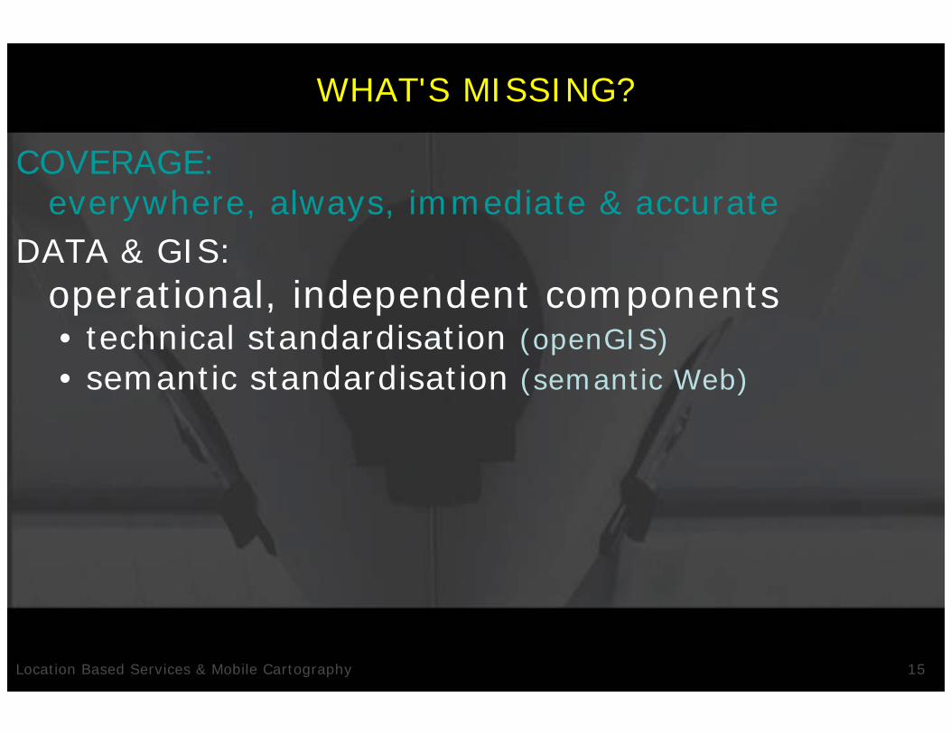
WHAT'S MISSING?
COVERAGE:everywhere, always, immediate & accurate• position with quality (indoors and outdoors)
• connection with capacity (GPRS, UMTS)
Location Based Services & Mobile Cartography 15
WHAT'S MISSING?
COVERAGE: everywhere, always, immediate & accurate
DATA & GIS:operational, independent components• technical standardisation (openGIS)• semantic standardisation (semantic Web)

Location Based Services & Mobile Cartography 16
WHAT'S MISSING?
COVERAGE: everywhere, always, immediate & accurate
DATA & GIS:operational, independent components
MARKET:proven ‘business-models’• ‘killer-app’ ‘the sms of lbs’
• integration in accepted services I-mode DoCoMo ☺

Location Based Services & Mobile Cartography 17
WHAT'S MISSING?
COVERAGE: everywhere, always, immediate & accurate
DATA & GIS:operational, independent components
MARKET:proven ‘business-models’
KNOWLEDGE:mobile cartography• cartographic design for MIDs• user aspects of MIDs

Location Based Services & Mobile Cartography 18
MOBILE CARTOGRAPHY
adapt design to circumstances:• small screen
160x160 (WAP) – 208-320 (GPRS) - 240x320 (PDA)
• low resolution• limited colours
b&w (WAP) – 16bit (PDA)
• small files• limited interaction
numerical pad (WAP) – touchscreen (PDA)

Location Based Services & Mobile Cartography 19
MOBILE CARTOGRAPHY
solutions are being developed:• server-side technology• adaptive user interfaces +
intelligent, adaptive generalisation
• adaptation to person• adaptation to usage (user tasks)• adaptation to time/date• adaptation to bandwidth
…and of course always to location!

Location Based Services & Mobile Cartography 20
ADAPTIVE INTERFACES & GENERALISATION
• adaptation to person• adaptation to usage (user tasks)• adaptation to time/date• adaptation to bandwidth
navigation “maps” [Kolbe] “ego-maps” generalisation [Reichenbacher et al.]
planning-objects(eg. towers, main roads)
objects for context/overview(eg. hills, ringroad)
reference-objecten(eg. houses, streetnames)

Location Based Services & Mobile Cartography 21
ADAPTIVE INTERFACES & GENERALISATION
• adaptation to person• adaptation to usage (user tasks)• adaptation to time/date• adaptation to bandwidth
Tourist Compass EnschedeGiMoDig project[Sarjakoski et al.]

Location Based Services & Mobile Cartography 22
MOBILE CARTOGRAPHY
solutions are being developed:• server-side technology• adaptive user interfaces +
intelligent, adaptive generalisation• vector formats, standardised and optimised for
MIDs & Web(eg. SVG Basic & SVG Tiny)

Location Based Services & Mobile Cartography 23
HOW DOES IT END?
Mobile cartography, LBS, distributed GIS, probably are common practice long before 2039…

Location Based Services & Mobile Cartography 24
HOW DOES IT END?
Mobile cartography, LBS, distributed GIS, probably are common practice long before 2039…
…and for John Anderton…?
Related Documents