GIS provides a context, an information resource, and an environment for geo- graphical thinking and research . . . [GIS] is open rather than closed [and] can accommodate pluralistic research styles. 1 All theory . . . is gray. In mapmaking, good results are more important than theo- retical knowledge. A useful map can only be produced by a meticulously careful process of design and the most precise reproduction. 2 [O]ur most recent examples show that paradigms provide scientists not only with a map but also with some of the directions essential for map-making. 3 0. Introduction Geographic Information Science (GIS) is a scientific inter-discipline aiming to discover patterns in, and produce visual displays of, spatial data. Businesses use GIS to determine where to open new stores, and GIS helps conservation biologists identify field study locations with relatively little anthropogenic influence. 4 GIS products include topographic and thematic maps of the Earth’s surface, climate maps, and spatially referenced demographic graphs and charts. The annual global GIS market (approximately $10 billion 5 ) is of the same order of magnitude as CERN’s total budget to date (approximately $13 billion 6 ), which it is only an order of magnitude less than the annual biotechnology global market. In addition to its social, political, and economic importance, GIS is worthwhile to explore in its own right due to its methodological richness, and because it is an instructive ana- logue to other sciences. The lack of attention to the sciences of GIS and cartography by the history and philosophy of science (HPS), science and technology studies (STS), and related fields – though not geography or sociology – clearly merits rem- edy. This chapter works towards a philosophy of GIS and cartography, or PGISC. PGISC fits well in this volume on rethinking natural kinds in light of scientific practices. Collecting and collating geographical data, building geographical data- bases, and engaging in spatial analysis, visualization, and map-making all require organizing, typologizing, and classifying geographic space, objects, relations, and processes. I focus on the use of natural kinds in data modeling and map generali- zation practices, showing how practices of making and using kinds are contextual, fallible, plural, and purposive. The rich family of kinds involved in these activities are here baptized mapping kinds. 13 Mapping kinds in GIS and cartography Rasmus Grønfeldt Winther Natural Kinds and Classification in Scientific Practice, edited by Catherine Kendig, Taylor & Francis Group, 2015. ProQuest Ebook Central, http://ebookcentral.proquest.com/lib/ucsc/detail.action?docID=4217943. Created from ucsc on 2018-04-10 04:42:46. Copyright © 2015. Taylor & Francis Group. All rights reserved.

Welcome message from author
This document is posted to help you gain knowledge. Please leave a comment to let me know what you think about it! Share it to your friends and learn new things together.
Transcript
GIS provides a context, an information resource, and an environment for geo-graphical thinking and research . . . [GIS] is open rather than closed [and] can accommodate pluralistic research styles.1
All theory . . . is gray. In mapmaking, good results are more important than theo-retical knowledge. A useful map can only be produced by a meticulously careful process of design and the most precise reproduction.2
[O]ur most recent examples show that paradigms provide scientists not only with a map but also with some of the directions essential for map-making.3
0. IntroductionGeographic Information Science (GIS) is a scientific inter-discipline aiming to discover patterns in, and produce visual displays of, spatial data. Businesses use GIS to determine where to open new stores, and GIS helps conservation biologists identify field study locations with relatively little anthropogenic influence.4 GIS products include topographic and thematic maps of the Earth’s surface, climate maps, and spatially referenced demographic graphs and charts. The annual global GIS market (approximately $10 billion5) is of the same order of magnitude as CERN’s total budget to date (approximately $13 billion6), which it is only an order of magnitude less than the annual biotechnology global market. In addition to its social, political, and economic importance, GIS is worthwhile to explore in its own right due to its methodological richness, and because it is an instructive ana-logue to other sciences. The lack of attention to the sciences of GIS and cartography by the history and philosophy of science (HPS), science and technology studies (STS), and related fields – though not geography or sociology – clearly merits rem-edy. This chapter works towards a philosophy of GIS and cartography, or PGISC.
PGISC fits well in this volume on rethinking natural kinds in light of scientific practices. Collecting and collating geographical data, building geographical data-bases, and engaging in spatial analysis, visualization, and map-making all require organizing, typologizing, and classifying geographic space, objects, relations, and processes. I focus on the use of natural kinds in data modeling and map generali-zation practices, showing how practices of making and using kinds are contextual, fallible, plural, and purposive. The rich family of kinds involved in these activities are here baptized mapping kinds.
13 Mapping kinds in GIS and cartography
Rasmus Grønfeldt Winther
Natural Kinds and Classification in Scientific Practice, edited by Catherine Kendig, Taylor & Francis Group, 2015. ProQuest Ebook Central, http://ebookcentral.proquest.com/lib/ucsc/detail.action?docID=4217943.Created from ucsc on 2018-04-10 04:42:46.
Cop
yrig
ht ©
201
5. T
aylo
r &
Fra
ncis
Gro
up. A
ll rig
hts
rese
rved
.

198 Rasmus Grønfeldt Winther
Mapping kinds are only one aspect of PGISC. Philosophical concerns of real-ism, representation, explanation, reduction, and theory structure can also be expanded and reconstructed through an analysis of GIS. For instance, attention to GIS practices helps enrich and clarify ongoing philosophical debates about, for example, (i) metrology and the nature of data; (ii) modeling, abstraction, and idealization in science; and (iii) the role of visualization in science. Moreover, products of these fields of inquiry, such as maps, are analogues to other scientific products, such as theories (e.g., “a scientific theory is a map of the world”). In short, PGISC can inform philosophy of science as well as GIS and cartography.
The epigraphs capture this chapter’s argumentative spread. The first makes explicit the functionality and promise of GIS as a science. Oppenshaw’s hope can be generalized to philosophical analysis, for which GIS can become an analyti-cal exemplar. Imhof defends a practice-based and pragmatic view – rather than a theory-centric semantic or syntactic one – on cartography and science. Indeed, substituting “model” for “map” shows that results rather than knowledge are con-sidered crucial; design and reproduction balance. Finally, the map analogy is used in perhaps the most influential philosophy of science book of the twentieth cen-tury, Kuhn’s The Structure of Scientific Revolutions. This serves as one example of the map analogy’s ubiquity in philosophical analyses of science.7
The chapter is organized as follows. The first section reviews GIS, while the second turns to practices of data modeling and map generalization and to the plurality of mapping kinds. Other important practices and kinds involved in GIS and cartography are set aside. That is, surveying and census practices, visuali-zation and spatial analysis, and so forth, must await future exploration from a PGISC perspective. Consonant with the themes of this anthology, the third sec-tion explores philosophical antecedents of natural kinds, consistent with mapping kinds: “plural” kinds (e.g., John Dupré, Nelson Goodman, and Muhammad Kha-lidi), “inferential” kinds (e.g., W.V.O. Quine, Ingo Brigandt, and Alan Love), and “reconstructing” kinds (e.g., John Dewey and Ian Hacking).
1.0. Central issues of GISIn order to explain the content and methodology of GIS, an analysis of the central issues, a highly abbreviated history, a plurality of definitions, and the epistemic-technological structure of GIS are reviewed. GIS might be to HPS and STS what fruit flies were to the Morgan laboratory at Columbia University in the early twentieth century. According to Ronald Abler’s report of the National Science Foundation’s National Center for Geographic Information and Analysis (NCGIA), the five “priority issues” of GIS are:
1 New modes and methods of spatial analysis.2 A general theory of spatial relationships.3 Artificial intelligence and expert systems in GIS.4 Visualization.5 Social, economic, and institutional issues.8
Natural Kinds and Classification in Scientific Practice, edited by Catherine Kendig, Taylor & Francis Group, 2015. ProQuest Ebook Central, http://ebookcentral.proquest.com/lib/ucsc/detail.action?docID=4217943.Created from ucsc on 2018-04-10 04:42:46.
Cop
yrig
ht ©
201
5. T
aylo
r &
Fra
ncis
Gro
up. A
ll rig
hts
rese
rved
.
Mapping kinds in GIS 199
A few years later, influential GIS researcher Michael F. Goodchild presented another list of “key issues” for GIS:
1 Data collection and measurement.2 Data capture.3 Spatial statistics.4 Data modeling and theories of spatial data.5 Data structures, algorithms, and processes.6 Display.7 Analytical tools.8 Institutional, managerial, and ethical issues.9
These lists present snapshots of the empirical, computational, visual, cognitive, social, and ethical concerns of GIS researchers. The territory for PGISC is a rug-ged landscape, with a broad range of interdisciplinary issues.
1.1. An abbreviated history
As Nicholas Chrisman observes, GIS is an outcome of WWII operations research that “helped bring the computer into nearly every part of modern life.” Chris-man takes the “systems concept” as a natural source for conceiving GIS “as a series of procedures . . . lead[ing] from input to output.” GIS was typically pre-sented as a scientific process moving “from data sources through processing to displays”.10 As an inter-discipline or trading zone,11 GIS combines computer science with geography, cartography, cognitive science, statistics, and sociol-ogy. Thus, other historical influences must be tracked. For instance, Chrisman’s analysis can be complemented in several ways: by the concept of “information”, pertinent to computer science and Shannon’s information theory, as well as to car-tography;12 by recalling the quantitative revolution in geography during the 1960s and 1970s;13 and by not ignoring the cartographic communication paradigm, dominant particularly in the 1970s and 1980s.14 Undoubtedly, the quantitative revolution in geography and the communication paradigm of cartography – while today critiqued by Critical GIS15 and by semiotic and cognitive analyses of map symbolization and design16 – remain vital sources of GIS.
The 1991 publication of Maguire, Goodchild, and Rhind17 marked the appear-ance of “the first solid support for the claim that GIS is entering into a new phase and approaching the possibility of creating a separate discipline”.18 Whereas Open-shaw19 defends GIS (see epigraph), Pickles20 critiques GIS’s role in the “surveillant society”. The GIS wars were afoot, with “empiricist”, “positivist”, and “technicist” GIS defenders on one side, and “critical theory”, “post-structuralist”, and “relativist” critics of GIS on the other.21 By the turn of the millennium, a reconstructed “critical GIS” emerged, aware of the benefits and wary of the risks of GIS. Even so, tensions between technoscientific and critical social theory perspectives remain alive.22
The histories found in the work of Crampton, Chrisman, Goodchild, Pickles, Schuurman, and D. R. Fraser Taylor have tended to be linear historiographies.23
Natural Kinds and Classification in Scientific Practice, edited by Catherine Kendig, Taylor & Francis Group, 2015. ProQuest Ebook Central, http://ebookcentral.proquest.com/lib/ucsc/detail.action?docID=4217943.Created from ucsc on 2018-04-10 04:42:46.
Cop
yrig
ht ©
201
5. T
aylo
r &
Fra
ncis
Gro
up. A
ll rig
hts
rese
rved
.

200 Rasmus Grønfeldt Winther
Alternative narratives and pieces contributing to a fuller history of GIS may still be found. This is a promising avenue for younger historians interested in being among the first to detail the story of a socially, ethically, and economically rel-evant science. Given that many major players remain alive, an interview-based history is still possible.
1.2. Definitions
Definitions involve background assumptions and a point of view. Chrisman24 identifies three approaches in which definitions of GIS are embedded: (i) the systems flow approach of operations research and of information theory (e.g., senders and encoders, receivers and decoders), (ii) a content approach emphasizing maps, and (iii) a toolkit approach focusing on the specific technol-ogies available (e.g., GIS versus CAD versus DBMS)25. First, a paradigmatic systems flow definition mirrors the linearity of the information communication process:
GIS [is] a system for capturing, storing, checking, manipulating, analysing and displaying data which are spatially referenced to the Earth.26
This definition emphasizes the flow of information. The data of GIS are intrin-sically spatially referenced,27 which is required for other measured features (e.g., height, population density) to be meaningful. Second, a content approach “defines the GIS by what it contains, either as a special case of more general infor-mation systems or as an amalgamation of more specific uses”.28 Chrisman locates the following definition in a forestry journal:
A form of MIS [Management Information System] that allows map display of the general information.29
Of course, many proponents of GIS in the early 1990s would have critiqued such map-centrism.30 A death of the map was afoot.31 For instance, Waldo Tobler identi-fies the “flat earth syndrome”32 and calls for a “global spatial analysis”. He urges listeners and readers to “forget about working on maps”,33 admitting that “map projections, my specialty, are now obsolete”.34 Finally, a contemporary characteri-zation of GIS exemplifies the toolkit approach:
A geographic information system (GIS) integrates hardware, software, and data for capturing, managing, analyzing, and displaying all forms of geo-graphically referenced information.35
Combined especially with the earlier (1997) definition of GIS presented in Chris-man,36 it becomes evident that the focus of the Environmental Systems Research Institute (ESRI) is on the various software packages and hardware devices consti-tutive of GIS activities. It is unsurprising that a firm developing and selling these
Natural Kinds and Classification in Scientific Practice, edited by Catherine Kendig, Taylor & Francis Group, 2015. ProQuest Ebook Central, http://ebookcentral.proquest.com/lib/ucsc/detail.action?docID=4217943.Created from ucsc on 2018-04-10 04:42:46.
Cop
yrig
ht ©
201
5. T
aylo
r &
Fra
ncis
Gro
up. A
ll rig
hts
rese
rved
.
Mapping kinds in GIS 201
products would characterize GIS in this way. While initially resisting definitions of GIS, Chrisman eventually produced his own reduced definition:
Geographic Information System (GIS) – Organized activity by which people measure and represent geographic phenomena then transform these represen-tations into other forms while interacting with social structures.37
This definition was developed in the context of a “nested ring” structure of GIS, where “each ring encapsulates the more technical decisions inside, mobilizing them in a more complex structure”.38 Accordingly, “measurement and repre-sentation” were prior to, and embedded in, “transformations and operations” of various sorts (e.g., spatial analysis, visualizations), which, in turn, were prior to, and embedded in, “social, cultural, and institutional context[s]”. These defini-tions point to the trading zone of disciplines and research questions involved in GIS. Given the differences of perspective among these definitions, the need for a PGISC seems evident.
1.3. The epistemic-technological structure of GIS
Data collection and collation, database management, map generalization, visu-alization, and spatial analysis are central inferential and automated processes of GIS. Questions regarding the relative roles of human and computer persist.39 For instance, in contrasting “artificial” and “amplified” intelligence, Weibel walks a middle path between analog and digital cartography.40 Weibel identifies advan-tages to amplified intelligence, including that “[k]nowledge is contributed by human experts in a direct way”, and “[i]t leaves creativity with the user to devote attention to interesting aspects of map production”.41 Two decades later, we are still far from fully automated map production systems. AI continues, in many ways, to be a dream.42 But the symbiotic relation between humans and computers is clearly strong as indicated by the related fields of AI, machine learning, and human-computer Interaction (HCI), and any PGISC must address these.
GIS’s relation to cartography is complex.43 Nadine Schuurman plausibly detects a “switching from a map to model-oriented approach to generalization”.44 In North America, the “culture of cartography” had been dominant, while “Europeans had developed a landscape model [the database] that is based on derived data”.45 The key shift was from earlier work “with mental models of maps” to committing to “the database” as generative of “information and map objects”.46 Schuurman highlights Brassel and Weibel47 as instrumental to this shift. Brassel and Weibel characterize generalization “as an intellectual process, [which] structures experi-enced reality into a number of individual entities, then selects important entities and represents them in a new form”.48 They distinguish two kinds of “objectives for spatial modeling” corresponding to two kinds of generalization: (i) “spa-tial modeling for the purposes of data compaction, spatial analysis and the like [. . . i.e.,] statistical generalization” and (ii) “cartographic generalization,” which, “in contrast, aims to modify local structure and is non-statistical”.49 By identifying a
Natural Kinds and Classification in Scientific Practice, edited by Catherine Kendig, Taylor & Francis Group, 2015. ProQuest Ebook Central, http://ebookcentral.proquest.com/lib/ucsc/detail.action?docID=4217943.Created from ucsc on 2018-04-10 04:42:46.
Cop
yrig
ht ©
201
5. T
aylo
r &
Fra
ncis
Gro
up. A
ll rig
hts
rese
rved
.
202 Rasmus Grønfeldt Winther
broader set of generalization types beyond mere visual display and map-making, Brassel and Weibel prompted the emerging GIS community to move past the map and cartography. Modeling, broadly construed, rather than map-making and map-use, became central to GIS.
GIS’s interdisciplinarity and rich epistemic-technological structure make it a promising land for philosophers exploring scientific modeling and visualization, cognition and HCI, and the social and ethical impact of science. As a case study of philosophical issues in GIS, the next section turns to kind-making.
2.0. Mapping kinds: data modeling and map generalizationRich geographic features and processes collected and collated through various technologies (e.g., theodolite, GPS) must be structured into databases for further analysis and map-making. That is, a physical ontology is discovered and con-structed in practices of data modeling.50 Moreover, map-making itself involves (automated or conscious) inferential processes of abstraction and generalization. It is to these purposive processes that I now turn.
2.1. Data modeling
GIS models and maps rely on geographic information organized into kinds, cap-tured in databases. Goodchild follows computer science in defining data models thus: “the set of rules used to create a representation of information, in the form of discrete entities and the relationships between them”.51 Up until the mid-1990s, two “models of the world”52 – that is, two physical ontologies – dominated GIS data modeling: raster and vector. Whereas the first organizes the world into a Cartesian grid, the second carves up the world into mutually exclusive and col-lectively exhaustive irregular polygons, such as census or cadastral units. Each has advantages and disadvantages concerning ease of data collection, error pro-clivity (e.g., locational, ecological fallacy, and the “modifiable areal unit prob-lem, MAUP)”, computational efficiency, and appropriateness.53 As Tomlin quips, “Yes, raster is faster, but raster is vaster, and vector just seems more correcter”.54 Because of their fundamentality in space-carving, Cartesian pixels or vector poly-gons can be baptized calibrating kinds.
These two inter-translatable geometry-based models of the world serve as the unifying matrix on which a complex array of geographic features is captured. That is, data of various sorts are linked to point locations (raster view) or to polygons (vector view).55 Geographic data can be stored in tables with location or polygons as rows and features as columns.56 Cartographically, the data can also be repre-sented in distinct “map layers”, each of which is framed via pixels (or polygons). Each map layer captures a small number of predicates (e.g., population density) income.57 The topographic (“general image of the Earth’s surface”58) or thematic (e.g., population density, crime rate, income, etc.) features represented on each data table column or map layer, or both, can be termed feature kinds. The map analogy comes to the fore here because every scientific paradigm, theory or model must take some stance towards the calibration (i.e., form) of its data, and the
Natural Kinds and Classification in Scientific Practice, edited by Catherine Kendig, Taylor & Francis Group, 2015. ProQuest Ebook Central, http://ebookcentral.proquest.com/lib/ucsc/detail.action?docID=4217943.Created from ucsc on 2018-04-10 04:42:46.
Cop
yrig
ht ©
201
5. T
aylo
r &
Fra
ncis
Gro
up. A
ll rig
hts
rese
rved
.

Mapping kinds in GIS 203
features (i.e., content) the paradigm, theory, or model wishes to capture in data models. A physical ontology has to be articulated. Calibrating and feature kinds were the form and content of early GIS data models.
The concepts and language of GIS evolved in concert with technological inno-vations stemming from computer science. The calibrating kinds of the vector view (i.e., polygons) were sometimes referred to as “objects”.59 This manner of kind-ing space was associated with a discontinuous and individual-based perspec-tive on the world, as opposed to the “field” view of continuous and homogenous rasters. But eventually it was recognized that both pixel and polygon calibrating kinds are “geometry-centric”,60 and today both are often referred to as “fields”.61 In contrast, object kinds constitute a fundamentally different manner of represent-ing geographic information. These are not spatial vectors such as census units or states or countries – the “objects” of yesteryear. They are individual kinds of things such as “oil wells, soil bodies, stream catchments, and aircraft flight paths”.62 Object kinds in GIS originated in object-oriented programming.63 In contrast to geometry-centric data modeling modes permitting neither empty space nor pixel nor polygon overlap, GIS data models based on object kinds insist on emptiness and overlap. Via encapsulation, inheritance, and polymorphism,64 object-oriented programming permits significant flexibility and structural capacity in working with object kind data models.65 Today, objects are distinguished from fields, and object kinds emerging from programming systems in the 1990s assist in making new data model types.
Further questions regarding path-dependency and the biases, heuristics, and judgments associated with practices of data encoding (e.g., which kind of data model – field or object – is chosen for a particular purpose?) and data manage-ment (e.g., inter-operability and translatability among data models66 and multiple representation databases67) remain promising areas for future PGISC exploration.
2.2. Map generalization, in general
Map generalization in the broadest terms involves transforming and selecting kinds.68 For example, smoothing lines and aggregating buildings (represented either as calibrating/feature kinds or object kinds) are examples of transform-ing single kinds. Eliminating entire classes of kinds or dissolving out an area are examples of selecting different kinds. Töpfer and Pillewizer succinctly describe “cartographic generalisation” as “the reduction of the amount of information which can be shown on a map in relation to reduction of scale”.69 Perhaps the first to have analyzed map generalization was Max Eckert in the early twentieth century.70 Wright identified “simplification and amplification” as the key gen-eralization moves.71 While holding that “no rules can be given for generaliza-tion,” Raisz posited three aspects of generalization called “combine”, “omit”, and “simplify”.72 Robinson and Sale influentially recognized four “elements of car-tographic generalization”, namely, simplification, symbolization, classification, and induction. These elements are subject to “controls” such as the objective, the scale, and the quality of data.73 Especially in the last 20 years, cartographic generalization has become automated. Today, “elements” roughly correspond to
Natural Kinds and Classification in Scientific Practice, edited by Catherine Kendig, Taylor & Francis Group, 2015. ProQuest Ebook Central, http://ebookcentral.proquest.com/lib/ucsc/detail.action?docID=4217943.Created from ucsc on 2018-04-10 04:42:46.
Cop
yrig
ht ©
201
5. T
aylo
r &
Fra
ncis
Gro
up. A
ll rig
hts
rese
rved
.
204 Rasmus Grønfeldt Winther
“operators” of “spatial and attribute transformations”74 and “algorithms”,75 while “controls” map onto “geometric conditions” and “transformation controls”76 and “constraints”.77 A more branching narrative of the development of map generali-zation may be required.78
2.3. Manual map generalization
Similarly to any scientific abstraction, map generalization must take functional context seriously. Indeed, the Swiss Society of Cartography’s classic analysis of cartographic generalization starts with the “need for a map”79. The “aim” of the map grows out of this need. Only once scale, source, legibility conditions, and revision have been specified, given the need and aim, can the conceptual and graphical aspects of the map be determined and implemented. A functionalist top-down approach to map generalization is here suggested. Map-making is a function of map use, which itself involves descriptive and prescriptive purposes.80 The Swiss Society of Cartography writes,
Cartographic generalization requires prior knowledge of the essence and the function of the map. Consequently we first of all have to ask ourselves about the purpose of the map, the extent of its information contents and also about the requirements of the map user regarding the power of expression of a map type desired for a specific purpose.81
Purpose and use play center stage here.82 Their verbatim citation from Imhof’s Kartographische Geländedarstellung bolsters the functionalist – rather than syn-tactic or formalist – vision:
The objective of generalization is the highest accuracy possible in accordance with the map scale, good geometric informative power, good characterisa-tion of the elements and forms, the greatest possible similarity to nature in the forms and colours, clarity [of meaning] and good legibility, simplicity and explicitness of the graphical expression and coordination of the different elements.83
The map must fit the purpose. Map generalization must start from map need (com-pare epigraph). Following the map analogy, Imhof’s pragmatic view of carto-graphic representation could certainly be generalized to other forms of scientific representation, outside of cartography and GIS.84
2.4. Digital map generalization pluralism in GISA significant interpretative problem in the history and prehistory of GIS is that it remains unclear whether digital85 and digital generalization86 are continuous with earlier analog cartography and manual generalization.87 After all, pre-GIS
Natural Kinds and Classification in Scientific Practice, edited by Catherine Kendig, Taylor & Francis Group, 2015. ProQuest Ebook Central, http://ebookcentral.proquest.com/lib/ucsc/detail.action?docID=4217943.Created from ucsc on 2018-04-10 04:42:46.
Cop
yrig
ht ©
201
5. T
aylo
r &
Fra
ncis
Gro
up. A
ll rig
hts
rese
rved
.
Mapping kinds in GIS 205
cartography required significant human aesthetic and judgment components88 and was “labor-intensive”, “subjective”, and “holistic” in contrast to automated, “con-sistent”, and “much like the finite logic of a serial computer”.89 Thus, whether concepts such as “simplification” or “classification” share meanings and imply the same visualization consequences today and yesterday remains unclear.
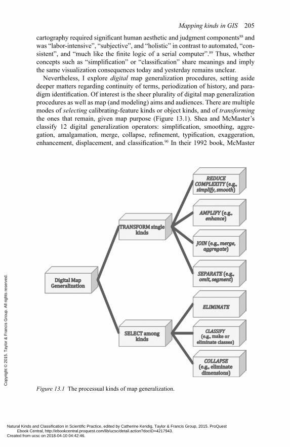
Nevertheless, I explore digital map generalization procedures, setting aside deeper matters regarding continuity of terms, periodization of history, and para-digm identification. Of interest is the sheer plurality of digital map generalization procedures as well as map (and modeling) aims and audiences. There are multiple modes of selecting calibrating-feature kinds or object kinds, and of transforming the ones that remain, given map purpose (Figure 13.1). Shea and McMaster’s classify 12 digital generalization operators: simplification, smoothing, aggre-gation, amalgamation, merge, collapse, refinement, typification, exaggeration, enhancement, displacement, and classification.90 In their 1992 book, McMaster
Figure 13.1 The processual kinds of map generalization.
Natural Kinds and Classification in Scientific Practice, edited by Catherine Kendig, Taylor & Francis Group, 2015. ProQuest Ebook Central, http://ebookcentral.proquest.com/lib/ucsc/detail.action?docID=4217943.Created from ucsc on 2018-04-10 04:42:46.
Cop
yrig
ht ©
201
5. T
aylo
r &
Fra
ncis
Gro
up. A
ll rig
hts
rese
rved
.

206 Rasmus Grønfeldt Winther
and Shea remove typification as a spatial transformation and add symbolization, classifying it with classification as attribute transformations.
Consider simplification and smoothing. Simplification is the retention of the fewest number of data points or features necessary to accurately represent a single kind of object. As an example, the Douglas-Peucker algorithm keeps only those coordinate points of a line that exceed a predefined tolerance, and thereby pro-duces a piecewise “zig-zag” from a meandering line (e.g., representing a river or road). This zig-zag retains the essential properties of the original line. Smoothing involves diminishing deviations and perturbations from general trends, given a particular number of data points or features. For instance, consider transforming an irregular quadrilateral to a square. While McMaster and Shea’s classification is fairly comprehensive, important generalization procedures are missing, including dissolution, segmentation, and selection.91 In fact, there is no single agreed-upon classification or model of or map generalization.92 Algorithmic implementation, conceptual model of map generalization adhered to, and background knowledge and objectives influence each creator’s classification and model.
As one way of classifying map generalization (alternatively: abstraction, ide-alization) procedures, we can organize them into inferential processes that either transform or select among the kinds given by the data models (Figure 13.1). Intuitively complementary processes of REDUCE and AMPLIFY, JOIN and SEPARATE are part of an overarching framework of seven basic processual kinds within which the rich variety of approximately 20 map generalization procedures gleaned from multiple sources could be placed. Under my analy-sis, map generalization kinds individuate inferential or automated processes, rather than objects or individuals. Even if the three-layer classification embod-ied in Figure 13.1 turns out to be neither collectively exhaustive nor mutually exclusive, the fundamental distinction between transforming single kinds and selecting among kinds, and the basic seven processual kinds93 of generalization procedures, provide partial insight into the logic and goals behind map generali-zation.94 Each processual kind can be implemented computationally in various ways.95 Moreover, the individuation criteria of the lowest-level processual kinds (e.g., smoothing and simplification) have to do with similarity of computational result rather than with static feature similarity. Finally, holistic cognitive, com-municative, and aesthetic considerations of information visualization must also be addressed philosophically in trying to understand how and why these proces-sual kinds can and should interact in producing visual maps.96 PGISC explores the pragmatics of modeling and visualization.
In summary, in digital map generalization, the calibrating-feature kinds or object kinds present in data models are transformed or selected, or both, to pro-duce a simplified, abstracted, and idealized map representing certain aspects of complex geographic reality, in light of map purposes. Philosophical considera-tions regarding kinds-in-practice (e.g., calibrating kinds and feature kinds) and kinds-of-practice (e.g., processual kinds) can be of benefit to GIS and philosophy alike. GIS is an exemplar97 whose pragmatic orientation can be extended, via the map analogy, to many other sciences.
Natural Kinds and Classification in Scientific Practice, edited by Catherine Kendig, Taylor & Francis Group, 2015. ProQuest Ebook Central, http://ebookcentral.proquest.com/lib/ucsc/detail.action?docID=4217943.Created from ucsc on 2018-04-10 04:42:46.
Cop
yrig
ht ©
201
5. T
aylo
r &
Fra
ncis
Gro
up. A
ll rig
hts
rese
rved
.
Mapping kinds in GIS 207
3.0. Towards a philosophy of mapping kindsRecall that the overarching aim of this chapter is to motivate a PGISC. In this final section, a précis is provided of why GIS is a particularly instructive locus for exploring, and perhaps helping reconstruct philosophy. Three overarching philo-sophical perspectives on kinds help place mapping kinds in perspective.
First, a number of philosophers of science analyze pluralisms of kinds and clas-sifications. Under this view, there is no single, ideal, and eternal hierarchical clas-sification of kinds of objects. For instance, Nelson Goodman prefers to speak of “relevant” rather than “natural” kinds in part because the latter “suggests some absolute categorical or psychological priority, while the kinds in question are rather habitual or traditional or devised for a new purpose”.98 Moreover, Dupré’s “pro-miscuous realism” argues for the interest-relativity of abstracting kinds. Dupré observes,
Is the kind of pluralism I have been advocating consistent with a realistic atti-tude to the various kinds, and even individuals, that I have discussed? There are a number of pluralistic possibilities that I have defended, but none, as far as I can see, forces one to abandon realism. . . . Provided realism is separated from certain essentialist theses, I see little more reason why the possibility of distinct and perhaps overlapping kinds should threaten the reality of those kinds.99
Similarly, Khalidi notes,
The idea that there are crosscutting taxonomies is closely related to the view that scientific classification is interest relative. If classification is always rela-tive to certain interests, we would expect some taxonomies to reorganize some of the same entities in different ways without displacing existing ones.100
As examples of this plural kinds argument, recall field versus object views on geographic space. Depending on a variety of goals and technical realities, either of these two inter-translatable kind-ings of space can be adopted. Of course, the plurality of inferential processes of map generalization – which may or may not be practiced together – can also be conceived within a plural kinds framework.
A related strategy for understanding kinds philosophically is an approach that focuses on the role of kinds in scientific inference. While he thinks that mature sci-ence can and will do without natural kind terms, W.V.O. Quine also believes that “some such notion [of kind], some similarity sense, was seen to be crucial to all learning, and central in particular to the processes of inductive generalization and prediction which are the very life of science”.101 Indeed, Quine holds that kinds are “functionally relevant groupings in nature” whose recognition permits our induc-tions to “tend to come out right”.102 That is, kinds ground fallible inductive infer-ences and predictions, so essential to scientific projects including those of GIS and cartography. Brigandt and Love take this epistemic understanding of kind terms further. Brigandt wishes to bracket the search for “a unique metaphysical account of
Natural Kinds and Classification in Scientific Practice, edited by Catherine Kendig, Taylor & Francis Group, 2015. ProQuest Ebook Central, http://ebookcentral.proquest.com/lib/ucsc/detail.action?docID=4217943.Created from ucsc on 2018-04-10 04:42:46.
Cop
yrig
ht ©
201
5. T
aylo
r &
Fra
ncis
Gro
up. A
ll rig
hts
rese
rved
.

208 Rasmus Grønfeldt Winther
‘natural’ kind,” calling instead for “the epistemological study of how different natural kind concepts are employed in scientific reasoning”.103 Love interprets typology and natural kinds as involved in “representational reasoning” and “explan-atory reasoning”.104 The move from a metaphysical to an epistemic analysis of kinds – already instituted by Quine (and Goodman) – is welcome in a philosophical field emphasizing essences, rigid designators, counterfactually supported universal non–ceteris paribus laws, and other elements of the abstract, theory-centric “book of the world”.105 Certainly PGISC requires understanding how a variety of mapping kinds are involved in scientific inference.
Finally, a rather different approach is to leave the concept behind altogether, either via utter rejection or systematic reconstruction. Upon providing an erudite discussion of the natural kind tradition, Hacking concludes with this paragraph:
Although one may judge that some classifications are more natural than oth-ers, there is neither a precise nor a vague class of classifications that may use-fully be called the class of natural kinds. A stipulative definition, that picks out some precise or fuzzy class and defines it as the class of natural kinds, serves no purpose, given that there are so many competing visions of what the natural kinds are. In short, despite the honourable tradition of kinds and natu-ral kinds that reaches back to 1840, there is no such thing as a natural kind.106
Wishing less to banish kinds from science and more to reconstruct them, John Dewey elucidates the standard view of species in classic and medieval thought thus:
. . . [J]ust as we naturally arrange plants and animals into series, ranks and grades, from the lowest to the highest, so with all things in the universe. The distinct classes to which things belong by their very nature form a hierarchi-cal order. There are castes in nature. The universe is constituted on an aristo-cratic, one can truly say a feudal, plan.107
Dewey resisted the standard view of natural kinds, inherited from the Greeks, and itself inflected by Greek sociopolitical context. Instead, Dewey presents an analysis of kinds (and classes and universals) as fallible and context-specific hypotheses permitting us to address problematic situations effectively. Consider this passage from Quest for Certainty:
The object is an abstraction, but unless it is hypostatized it is not a vicious abstraction. It designates selected relations of things which, with respect to their mode of operation, are constant within the limits practically important. . . . It marks an ordering and organizing of responses in a single focused way in virtue of which the original blur is definitized and rendered significant.108
Depending on the project or inquiry, a certain object will be classed and indi-viduated as a certain kind. Dewey is applying his “reconstruction of philosophy”
Natural Kinds and Classification in Scientific Practice, edited by Catherine Kendig, Taylor & Francis Group, 2015. ProQuest Ebook Central, http://ebookcentral.proquest.com/lib/ucsc/detail.action?docID=4217943.Created from ucsc on 2018-04-10 04:42:46.
Cop
yrig
ht ©
201
5. T
aylo
r &
Fra
ncis
Gro
up. A
ll rig
hts
rese
rved
.
Mapping kinds in GIS 209
program of (i) understanding concepts and kinds as tools, (ii) insisting that the function of philosophy is criticism, and (iii) viewing abstraction and analysis as embedded in larger wholes of social, communicative, and material needs and practices.109 GIS and cartography provide excellent scenarios of reconstructed kinds negotiating theory and practice, and realism and constructivism.
Mapping kinds can be understood from various philosophical perspectives, including “pluralism kinds” “scientific inference kinds”, and “reconstructive kinds”. These are not mutually exclusive. Moreover, my investigation the analysis of mapping kinds presented encourages their adoption, and the concomitant deemphasis of more standard essentialist perspectives on natural kinds.
4.0. ConclusionGIS and cartography suggest that kinds are simultaneously discovered and con-structed. Geographic features, processes, and objects are of course real. Yet, we must structure them in our data models and, subsequently, select and transform them in our maps. Realism and (social) constructivism are hence not exclusive in this field.110 Moreover, kind-ing inferential processes – mediated by technology, cognition, and communication – force the questioning of a strong theory versus practice dichotomy. Kinds are no longer purely theoretical concepts serving as little little mirrors of nature. Instead, they are shaped by design principles, communica-tive context, and local aims and norms. Kinds can be both about objects and pro-cesses. Not just static essences, kinds emerge from processes in the world, in our minds, and in our technologies and societies. PGISC suggests the possibility that realism versus constructivism and theory versus practice should not be deemed two absolute binaries. Further development of PGISC will permit reflection on natural kinds, as well as other standard philosophical concerns, from a Pragmatic View perspective.111 Such a practice-turn view is detail based and relevance ori-ented, with a deflationary and reconstructive approach to metaphysics.
GIS and its related disciplines of geography and cartography provides a model system for philosophy of science as well as for HPS, STS, history of science, and sociology of science. GIS is a young field, approximately 25 years old, and rela-tively small in size.112 It is clearly interdisciplinary, involving a range of expertises, technologies, practices, and aims and values, as well as a variety of styles, par-adigms, and models.113 Interestingly, many GIS and cartography scholars are already philosophically reflective about conceptual, methodological, and theoreti-cal matters. It would be a pity, if not socially and intellectually irresponsible, not to further develop PGISC, in both its analytic and “continental” varieties.
AcknowledgementsThanks to Doc Edge, Katie Kendig, Sergio Martínez, Mette Smølz Skau, and Nathan Strait for encouragement and feedback on this book chapter. Michael Goodchild and Robert Weibel kindly responded to reprint requests. Cory Knud-son, Lucas McGranahan, and Jan Mihal provided research support.
Natural Kinds and Classification in Scientific Practice, edited by Catherine Kendig, Taylor & Francis Group, 2015. ProQuest Ebook Central, http://ebookcentral.proquest.com/lib/ucsc/detail.action?docID=4217943.Created from ucsc on 2018-04-10 04:42:46.
Cop
yrig
ht ©
201
5. T
aylo
r &
Fra
ncis
Gro
up. A
ll rig
hts
rese
rved
.

210 Rasmus Grønfeldt Winther
Notes1 Openshaw, S. (1991) ‘Commentary: A View on the GIS Crisis in Geography, or, Using
GIS to Put Humpty-Dumpty Back Together Again’, Environment and Planning A, 23, pp. 621–628, p. 627.
2 Imhof, E. (2013/1965) Kartographische Geländedarstellung. Berlin: De Gruyter. Reprinted as Imhof, E. Cartographic Relief Presentation. Redlands, CA: ESRI Press, p. 86.
3 Kuhn, T. (1970) The Structure of Scientific Revolutions. (2nd edition) Chicago: Uni-versity of Chicago Press, p. 109.
4 Mitchell, A. (1999) The ESRI Guide to GIS Analysis – Vol 1: Geographic Patterns & Relationships. Redlands, CA: ESRI Press; and, Chrisman, N. (2002) Exploring Geo-graphic Information Systems. New York: John Wiley & Sons.
5 While non-trivial to determine, one report by Global Industry Analysts, Inc. predicts that the global GIS market will reach $10.6 billion by 2015 (http://www.strategyr.com/Geographic_Information_Systems_GIS_Industry_Market_Report.asp) [accessed 11 November 2014], with another report by TechNavio calculating and forecasting a com-pound annual growth rate (CAGR) of roughly 10% (http://www.businesswire.com/news/home/20110318005466/en/Research-Markets-Global-Geographic-Information-Systems-Market#.UuVIJGTTk18) [accessed 11 November 2014]. It remains unclear how and whether these reports incorporate lost revenue via illegal pirating, or unreported revenue via clandestine purchases (e.g., by the CIA, NSA), of GIS software and hardware.
6 See: Knapp, A. (2012) ‘How Much Does It Cost to Find a Higgs Boson?’ Forbes, July 5, 2012, at: http://www.forbes.com/sites/alexknapp/2012/07/05/how-much-does-it-cost-to-find-a-higgs-boson/ [accessed 11 November 2014].
7 Winther, R. G. (under contract) When Maps Become the World: Abstraction and Anal-ogy in Philosophy of Science. Chicago: University of Chicago Press, at: http://ihr.ucsc.edu/when-maps-become-the-world/. See also: Robinson, A. H. and Petchenik, B. B. (1976) The Nature of Maps: Essays toward Understanding Maps and Mapping. Chi-cago: University of Chicago Press; and, Board, C. (1967) ‘Maps as Models’, In: Chor-ley, R. J. and Haggett, P. (eds.) Models in Geography. London: Methuen & Co. Ltd., pp. 671–725.
8 Abler, R. F. (1987) ‘The National Science Foundation National Center for Geographic Information and Analysis’, International Journal of Geographical Information Sys-tems, 1:4, pp. 303–326, p. 304.
9 Goodchild, M. F. (1992) ‘Geographical Information Science’, International Journal of Geographical Information Sciences, 6:1, pp. 31–45, pp. 34–40.
10 Chrisman, N. (1999) ‘What Does ‘GIS’ Mean?’ Transactions in GIS, 3, pp. 175–186, p. 178.
11 Galison, P. (1997) Image and Logic: A Material Culture of Microphysics. Chicago: University of Chicago Press; and, Winther, R. G. (2014a) ‘Evo-Devo as a Trading Zone’, In: Love, A. (ed.), Conceptual Change in Biology: Scientific and Philosophical Perspectives on Evolution and Development. Berlin: Springer, pp. 459–482.
12 See: Koláčný, A. (1969) ‘Cartographic Information – a Fundamental Concept and Term in Modern Cartography’, The Cartographic Journal, 6, pp. 47–49; and, Chris-man, N., Exploring Geographic Information Systems.
13 See: Tobler, W. (1989) ‘Numerical Map Generalization’, Cartographica, 26:1, Mono-graph 40, pp. 9–25. Originally informally published in 1966 as a discussion paper of the Michigan Inter-University Community of Mathematical Geographers. Also: Har-vey, D. (1969) Explanation in Geography. New York: St. Martin’s Press.
14 See: Ratajski, L. (1972) ‘Cartology’, Geographia Polonica, 21, pp. 63–78. See also: MacEachren, A. (1995) How Maps Work: Representation, Visualization, and Design. New York: Guilford Press, pp. 8–9.
Natural Kinds and Classification in Scientific Practice, edited by Catherine Kendig, Taylor & Francis Group, 2015. ProQuest Ebook Central, http://ebookcentral.proquest.com/lib/ucsc/detail.action?docID=4217943.Created from ucsc on 2018-04-10 04:42:46.
Cop
yrig
ht ©
201
5. T
aylo
r &
Fra
ncis
Gro
up. A
ll rig
hts
rese
rved
.
Mapping kinds in GIS 211
15 See: Crampton, J. W. (2010) Mapping: A Critical Introduction to Cartography and GIS. Chichester, UK: Wiley-Blackwell.
16 MacEachren, A., How Maps Work.17 Maguire, D. J., Goodchild, M. F. and Rhind, D. W. (eds.) (1991) Geographical Infor-
mation Systems: Principles and Applications, Vols. 1 and 2. Harlow, UK: Longman Scientific & Technical.
18 Pickles, J. (1995) ‘Representations in an Electronic Age: Geography, GIS, and Democ-racy’, In: Pickles, J. (ed.) Ground Truth: The Social Implications of Geographic Infor-mation Systems. New York: Guilford Press, pp. 1–30, p. 12.
19 Openshaw, S., ‘Commentary: A View on the GIS Crisis in Geography’.20 Pickles, J. (1991) ‘Geography, GIS, and the Surveillant Society’, In: Frazier, J. W.,
Epstein, B. J., Schoolmaster III, F. A. and Moon, H. E. (eds.) Papers and Proceedings of the Applied Geography Conferences, Vol. 14. Kent, OH: Applied Geography Con-ferences, Inc., pp. 80–91.
21 See: Pickles, J. (ed.) (1995a) Ground Truth: The Social Implications of Geographic Information Systems. New York: Guilford Press; Schuurman, N. (1999) ‘Reconciling Social Constructivism and Realism in GIS’, ACME: An International E-Journal for Critical Geographies, 1:1, pp. 73–90; Schuurman, N. (2004) GIS: A Short Introduc-tion. Malden, MA: Blackwell Publishing; Crampton, J. M., Mapping: A Critical Intro-duction to Cartography and GIS.
22 Kwan, M. (2002) ‘Is GIS for Women? Reflections on the Critical Discourse in the 1990s’, Gender, Place & Culture: A Journal of Feminist Geography, 9:3, pp. 271–9 Pavlovskaya, M. (2006) ‘Theorizing with GIS: A Tool for Critical Geographies?’ Envi-ronment and Planning A, 38, pp. 2003–2020; Crampton, J. W., Mapping: A Critical Introduction to Cartography and GIS.
23 Roger Tomlinson’s and Lee Pratt’s roles in forming the Canada Geographic Informa-tion System will be part of such a history, as will Howard Fisher’s Harvard Laboratory for Computer Graphics and Spatial Analysis – see: Chrisman, N. (2006) Charting the Unknown: How Computer Mapping at Harvard Became GIS. Redlands, CA: ESRI Press. Coppock and Rhind provide an instructive diagram of the “companies, govern-ment agencies, universities, etc.” – that is, places – where “ideas or concept, often embodied in a software package or database” were developed; lines in their diagram indicate “direct or indirect migration or influence”; Coppock, J. T. and Rhind, D. W. (1991) ‘The History of GIS’, In: Maguire, D. J., Goodchild, M. F. and Rhind, D. W. (eds.) Geographical Information Systems: Principles and Applications – Vol. 1: Prin-ciples. Harlow, UK: Longman Scientific & Technical, pp. 21–43, p. 24.
24 Chrisman, N., ‘What Does ‘GIS’ Mean?’.25 Cowen, D. J. (1988) ‘GIS versus CAD versus DBMS: What are the Differences?’,
Photogrammetric Engineering and Remote Sensing, 54, pp. 1551–1555; see also: Maguire, D. J., ‘An Overview and Definition of GIS’, pp. 9–20.
26 Department of the Environment (1987) Handling Geographic Information. London: Her Majesty’s Stationery Office, p. 132. Cited in Chrisman, ‘What Does ‘GIS’ Mean?’ p. 178.
27 Haining, R. (2003) Spatial Data Analysis: Theory and Practice. Cambridge UK: Cam-bridge University Press; Tomlin, C. D. (2013) GIS and Cartographic Modeling. (2nd edition) Redlands, CA: ESRI Press, p. 26.
28 Chrisman, N., ‘What Does ‘GIS’ Mean?’ p. 179.29 Devine, H. A. and Field, R. C. (1986) ‘The Gist of GIS’, Journal of Forestry, 8,
pp. 17–22, p. 18. Cited at ibid., p. 179.30 Couclelis, H. (1992a) ‘People Manipulate Objects (but Cultivate Fields): Beyond the
Raster-Vector Debate in GIS’, In: Frank, A. U., Campari, I. and Formentini, U. (eds.) Theories and Methods of Spatial-Temporal Reasoning in Geographic Space. Berlin: Springer, pp. 65–77. See also: Goodchild, M. F., ‘Geographical Information Science’;
Natural Kinds and Classification in Scientific Practice, edited by Catherine Kendig, Taylor & Francis Group, 2015. ProQuest Ebook Central, http://ebookcentral.proquest.com/lib/ucsc/detail.action?docID=4217943.Created from ucsc on 2018-04-10 04:42:46.
Cop
yrig
ht ©
201
5. T
aylo
r &
Fra
ncis
Gro
up. A
ll rig
hts
rese
rved
.
212 Rasmus Grønfeldt Winther
Tobler, W. (2002) ‘Global Spatial Analysis’, Computers, Environment and Urban Sys-tems, 26, pp. 493–500.
31 Schuurman, N., GIS: A Short Introduction; Winther, When Maps Become the World.32 Tobler, W., ‘Global Spatial Analysis’, p. 493.33 Tobler, W., ‘Global Spatial Analysis’, p. 496.34 Tobler, W., ‘Global Spatial Analysis’, p. 497.35 From the ESRI website, http://www.esri.com/what-is-gis/overview#overview_panel
[accessed 26 January 2014]. Also found here, with attribution to ESRI: http://www.bouldercounty.org/dept/adminservices/pages/bouldercountygis.aspx [accessed 25 Octo-ber 2015]. ESRI (Environmental Systems Research Institute) was founded in 1969 by Jack Dangermond, a current billionaire. This is the same year that he earned his master’s degree from Harvard’s Graduate School of Design, where Dangermond had worked in Howard Fisher’s lab. ESRI is the single biggest seller of GIS products on the market today.
36 Chrisman, N., ‘What Does ‘GIS’ Mean?, pp. 180–181.37 Chrisman, N., ‘What Does ‘GIS’ Mean?’ pp. 183–185.38 Chrisman, N., ‘What Does ‘GIS’ Mean?’ p. 184.39 Taylor, D. R. F. (1991) ‘Geographic Information Systems: The Microcomputer and
Modern Cartography’, In: Taylor, D. R. F. (ed.) Geographic Information Systems: The Microcomputer and Modern Cartography. Oxford, UK: Pergamon Press, pp. 1–20; Longley, P. A., Goodchild, M. F., Maguire, D. J. and Rhind, D. W. (2011) Geographic Information Systems & Science. (3rd edition) Hoboken, NJ: John Wiley & Sons Inc.
40 Weibel, R. (1991) ‘Amplified Intelligence and Rule-Based Systems’, In: Buttenfield, B. P. and McMaster, R. B. (eds.) Map Generalization: Making Rules for Knowledge Representation. Essex, UK: Longman Scientific & Technical, pp. 172–186. See distinc-tion in Robinson, A. H., Morrison, J. L., Muehrcke, P. C., Kimerling, A. J., and Guptill, S. C. (1995) Elements of Cartography. (6th edition) New York: John Wiley & Sons.
41 Weibel, R., ‘Amplified Intelligence and Rule-Based Systems’, p. 185.42 Ekbia, H. (2008) Artificial Dreams: The Quest for Non-Biological Intelligence. Cam-
bridge: Cambridge University Press.43 See: Visvalingam, M. (1989) ‘Cartography, GIS and Maps in Perspective’, The Carto-
graphic Journal, 26:1, pp. 26–32; Winther, R. G., When Maps Become the World.44 Schuurman, N., ‘Reconciling Social Constructivism and Realism in GIS’, p. 83.45 Ibid, p. 83.46 Schuurman, N., GIS: A Short Introduction, pp. 48–49.47 Brassel, K. E., and Weibel, R. (1988) ‘A Review and Conceptual Framework of Auto-
mated Map Generalization’, International Journal of Geographical Information Sci-ences, 2:3, pp. 229–244.
48 Brassel, K. E., and Weibel, R., ‘A Review and Conceptual Framework of Automated Map Generalization’, pp. 230–231.
49 Brassel, K. E., and Weibel, R., ‘A Review and Conceptual Framework of Automated Map Generalization’, p. 232; also see their Figure 2, p. 233.
50 See: Galton, A. (2000) Qualitative Spatial Change. Oxford: Oxford University Press; Peuquet, D. J. (2002) Representations of Space and Time. New York: Guilford Press; Goodchild, M. F. (2004) ‘GIScience, Geography, Form, and Process’, Annals of the Association of American Geographers, 94:4, pp. 709–714.
51 Goodchild, M. F. (1995) ‘Geographical Information Systems and Geographic Research’, In: Pickles, J. (ed.) Ground Truth: The Social Implications of Geographic Information Systems, New York: The Guilford Press, pp. 31–50, p. 36. See also: Sup-pes, P. (1962) ‘Models of Data’, In: Nagel, E., Suppes, P. and Tarski, A. (eds.) Logic, Methodology, and Philosophy of Science: Proceedings of the 1960 International Con-gress. Stanford: Stanford University Press.
52 Mitchell, A., The ESRI Guide to GIS Analysis, p. 14. See also: Schuurman, N., GIS: A Short Introduction.
Natural Kinds and Classification in Scientific Practice, edited by Catherine Kendig, Taylor & Francis Group, 2015. ProQuest Ebook Central, http://ebookcentral.proquest.com/lib/ucsc/detail.action?docID=4217943.Created from ucsc on 2018-04-10 04:42:46.
Cop
yrig
ht ©
201
5. T
aylo
r &
Fra
ncis
Gro
up. A
ll rig
hts
rese
rved
.

Mapping kinds in GIS 213
53 Goodchild, M. F. (1989) ‘Modeling Error in Objects and Fields’, In: Goodchild, M. F. and S. Gopal, The Accuracy of Spatial Databases. London: Taylor and Francis, pp. 107–113; Haining, R., Spatial Data Analysis: Theory and Practice; Schuurman, N., GIS: A Short Introduction; Longley, P. A., Goodchild, M. F., Maguire, D. J. and Rhind, D. W., Geographic Information Systems & Science.
54 Tomlin, C. D., GIS and Cartographic Modeling, p. 26.55 More precisely, the term “vector” stems from the fact that geographic polygons consist
of a series of lines each of which has magnitude and direction. Vector geometrization in general involves categorizing two-dimensional space in irregular ways, classify-ing points, lines or areas (Goodchild, M. F. (1989), ‘Modeling Error in Objects and Fields’, p. 107; Monmonier, M. and McMaster, R. B. (1992) ‘The Sequential Effects of Geometric Operators in Cartographic Line Generalization’, International Yearbook of Cartography, 30, pp. 93–108, Figure 1 p. 94; Longley, P. A., Goodchild, M. F., Magu-ire, D. J. and Rhind, D. W. (2011), Geographic Information Systems & Science, p. 214 and p. 221).
56 Brassel, K. E. and Weibel, R., ‘A Review and Conceptual Framework of Automated Map Generalization’; Haining, R., Spatial Data Analysis: Theory and Practice.
57 The map layer perspective on storing cartographic information leads to “club sand-wich” (Couclelis, H., ‘People Manipulate Objects (but Cultivate Fields)’, p. 65) or “layer-cake” (Schuurman, N., GIS: A Short Introduction, p. 36) caricatures of GIS.
58 Kraak, M. J. and Ormeling, F. (2011) Cartography: Visualization of Spatial Data. (3rd edition) New York: Guilford Press, p. 42.
59 Goodchild, M. F., ‘Modeling Error in Objects and Fields’; Couclelis, H., ‘People Manipulate Objects (but Cultivate Fields)’; Haining, R., Spatial Data Analysis: Theory and Practice.
60 Longley, P. A., Goodchild, M. F., Maguire, D. J. and Rhind, D. W., Geographic Infor-mation Systems & Science, p. 221.
61 Schuurman, N., GIS: A Short Introduction, pp. 31–40; Longley, P. A., Goodchild, M. F., Maguire, D. J. and Rhind, D. W., Geographic Information Systems & Science.
62 Longley, P. A., Goodchild, M. F., Maguire, D. J. and Rhind, D. W., Geographic Infor-mation Systems & Science, p. 222.
63 Goodchild, M. F., ‘Geographical Information Systems and Geographic Research’, pp. 38–39; Chrisman, N., Exploring Geographic Information Systems, pp. 83–5; Schu-urman, N., GIS: A Short Introduction, p. 36.
64 Telegraphically: “Encapsulation describes the fact that each object packages together a description of its state and behavior.” “Inheritance is the ability to reuse some or all of the characteristics of one object in another object.” “Polymorphism describes the process whereby each object has its own specific implementation for operations like draw, create, and delete.” Longley, P. A., Goodchild, M. F., Maguire, D. J. and Rhind, D. W., Geographic Information Systems & Science, p. 222.
65 Longley, P. A., Goodchild, M. F., Maguire, D. J. and Rhind, D. W., Geographic Infor-mation Systems & Science, p. 222. Object kinds are considered “ontologies” by some (for example, Agarwal, P. (2005) ‘Ontological Considerations in GISscience’, Interna-tional Journal of Geographical Information Systems, 19:5, pp. 501–536) who turn to work by Barry Smith and his collaborators (for example, Smith, B. and Mark, D. M. (2001) ‘Geographical Categories: An Ontological Investigation’, International Jour-nal of Geographical Information Systems, 15:7, pp. 591–612). However, the object kinds of object-oriented programming and those of “ontologies” have distinct histori-cal trajectories and distinct individuation criteria.
66 Tomlin, C. D., GIS and Cartographic Modeling.67 Sarjakoski, L. T. (2007) ‘Conceptual Models of Generalisation and Multiple Represen-
tation’, In: Mackaness, W. A. Ruas, A. and Sarjakoski, L. T. (eds.) Generalisation of Geographic Information: Cartographic Modelling and Applications. Oxford: Elsevier, pp. 11–35.
Natural Kinds and Classification in Scientific Practice, edited by Catherine Kendig, Taylor & Francis Group, 2015. ProQuest Ebook Central, http://ebookcentral.proquest.com/lib/ucsc/detail.action?docID=4217943.Created from ucsc on 2018-04-10 04:42:46.
Cop
yrig
ht ©
201
5. T
aylo
r &
Fra
ncis
Gro
up. A
ll rig
hts
rese
rved
.

214 Rasmus Grønfeldt Winther
68 On the biological distinction between transformation of individuals (qua single kinds) and selection of individuals (qua distinct kinds) within populations, see Levins, R. and Lewontin, R. (1985) The Dialectical Biologist. Cambridge, MA: Harvard University Press, pp. 85–86.
69 Töpfer, F. and Pillewizer, W., with notes by Maling, D. H. (1966) ‘The Principles of Selection, a Means of Cartographic Generalisation’, The Cartographic Journal, 3:1, pp. 10–16, p. 10.
70 Eckert, M. (1908) ‘On the Nature of Maps and Map Logic’, Bulletin of the American Geographical Society, 40:6, pp. 344–351; Regnauld, N. and McMaster, R. B. (2007) ‘A Synoptic View of Generalisation Operators’, In: Mackaness, W. A. Ruas, A. and Sarjakoski, L. T. (eds.) Generalisation of Geographic Information: Cartographic Mod-elling and Applications. Oxford: Elsevier, pp. 37–66, p. 37.
71 Wright, J. K. (1942) ‘Map Makers are Human: Comments on the Subjective in Maps’, Geographical Review, 32:1, pp. 527–544, pp. 531–3.
72 Raisz, E. (1962) Principles of Cartography. New York: McGraw Hill, p. 38.73 Robinson, A. H. and Sale, R. D. (1969) Elements of Cartography. (3rd edition) New
York: John Wiley & Sons, p. 52.74 McMaster, R. B. and Shea, K. S. (1989) ‘Cartographic Generalization in a Digital Envi-
ronment: When and How to Generalize’, In: AUTO-CARTO 9, Ninth International Symposium on Computer-Assisted Cartography. Baltimore, MD: AUTO-CARTO 9, pp. 56–67; McMaster, R. B. and Shea, K. S., (1992) Generalization in Digital Cartog-raphy. Washington, DC: Association of American Geographers.
75 See: Harrie, L. and Weibel, L. (2007) ‘Modelling the Overall Process of Generalisation’, In:. Mackaness, W. A, Ruas, A. and Sarjakoski, L. T. (eds.) Generalisation of Geographic Information: Cartographic Modelling and Applications. Oxford: Elsevier, pp. 67–87.
76 McMaster, R. B., and Shea, K. S., Generalization in Digital Cartography.77 Harrie, L. and Weibel, L., ‘Modelling the Overall Process of Generalisation’.78 McMaster, R. B., and Shea, K. S., Generalization in Digital Cartography, pp. 17–19;
Schuurman, N. GIS: A Short Introduction, pp. 43–49. See: Crampton, J. W., Mapping: A Critical Introduction to Cartography and GIS for a pluralist history.
79 See flow diagram on p. 16 of Swiss Society of Cartography, Cartographic Generalisa-tion: Topographic Maps (Zürich: SGK-Publikationen, 1977, 2nd edition).
80 Crain, I. K. and MacDonald, C. L. (1984) ‘From Land Inventory to Land Manage-ment’, Cartographica, 21, pp. 40–46; Berry, J. K. (1987) ‘A Mathematical Structure for Analyzing Maps’, Environmental Management, 11:3, pp. 317–325.
81 Swiss Society of Cartography (1977) Cartographic Generalisation: Topographic Maps. (2nd edition) Zürich: SGK-Publikationen, p. 5.
82 See also: Muehrcke, P. C (1972) Thematic Cartography. Washington, DC: Association of American Geographers, Resource paper no. 19, Commission on College Geogra-phy; and Muehrcke, P. C. and Muehrcke, J. O. (1998) Map Use: Reading, Analysis and Interpretation. (4th edition) Redlands, CA: ESRI Press for a functionalist approach to what Phillip Muehrcke has consistently called “map abstraction.”
83 Imhof cited in Swiss Society of Cartography, Cartogdraphic Generalisation: Topo-graphic Maps, p. 12. Imhof, E., Kartographische Geländedarstellung, p. 100. Brackets are added from the English translation: Imhof, E., Cartographic Relief Presentation, p. 86. The Swiss Society of Cartography omit the last phrase: “and finally, summariz-ing all these qualities, a beauty peculiar to the map itself.” Imhof, E., Cartographic Relief Presentation, p. 86.
84 On the pragmatics of modeling see, for example, Winther, R. G. (2012a) ‘Math-ematical Modeling in Biology: Philosophy and Pragmatics’, Frontiers in Plant Evolution and Development, at: http://www.frontiersin.org/Plant_Evolution_and_Development/10.3389/fpls.2012.00102/full; and, Winther, Rasmus Grønfeldt, “The Structure of Scientific Theories”, The Stanford Encyclopedia of Philosophy (Fall 2015
Natural Kinds and Classification in Scientific Practice, edited by Catherine Kendig, Taylor & Francis Group, 2015. ProQuest Ebook Central, http://ebookcentral.proquest.com/lib/ucsc/detail.action?docID=4217943.Created from ucsc on 2018-04-10 04:42:46.
Cop
yrig
ht ©
201
5. T
aylo
r &
Fra
ncis
Gro
up. A
ll rig
hts
rese
rved
.

Mapping kinds in GIS 215
Edition), Edward N. Zalta (ed.), URL = <http://plato.stanford.edu/archives/fall2015/entries/structure-scientific-theories/>.
85 Robinson, A. H., Morrison, J. L., Muehrcke, P. C., Kimerling, A. J., and Guptill, S. C., Elements of Cartography.
86 McMaster, R. B., and Shea, K. S., Generalization in Digital Cartography.87 Returning to Brassel, K. E., and Weibel, R., ‘A Review and Conceptual Framework of
Automated Map Generalization’, this discussion concerns cartographic generalisation rather than statistical or modeling generalisation.
88 Wright, J. K., ‘Map Makers are Human’; and Steward, H. J. (1974) Cartographic Gen-eralisation: Some Concepts and Explanation. Monograph 10 in the Cartographica series. Toronto: University of Toronto Press.
89 McMaster and Shea, Generalization in Digital Cartography, p. 2.90 McMaster, R. B., and Shea, K. S., ‘Cartographic Generalization in a Digital Environ-
ment: When and How to Generalize’. See also: Winther, R. G., When Maps Become the World.
91 See: Monmonier, M. (1996) How to Lie with Maps. (2nd edition) Chicago: University of Chicago Press, p. 29.
92 See: Ratajski, L., ‘Cartology’; Brassel, K. E., and Weibel, R., ‘A Review and Con-ceptual Framework of Automated Map Generalization’; McMaster, R. B., and Shea, K. S., Generalization in Digital Cartography; Kilpeläinen, T. (2000) ‘Maintenance of Multiple Representation Databases for Topographic Data’, The Cartographic Journal, 37, pp. 101–107.
93 Processual kinds are investigated in the biological sciences in Winther, R. G. (2006a) ‘Parts and Theories in Compositional Biology’, Biology and Philosophy, 21, pp. 471–499; and, Winther, R. G. (2011) ‘Part-Whole Science’, Synthese, 178, pp. 397–427.
94 Like other sciences, the plurality of generalization procedures results in tensions requiring negotiation (see, for example, Muehrcke, P. C., Thematic Cartography; Swiss Society of Cartography, Cartographic Generalisation: Topographic Maps; McMaster, R. B., and Shea, K. S., Generalization in Digital Cartography; Weibel, R., Keller, S. and Reichenbacher, T. (1995) ‘Overcoming the Knowledge Acquisition Bottleneck in Map Generalization: The Role of Interactive Systems and Computational Intelligence’, Lecture Notes in Computer Science (COSIT ’95, Vol. 988). Berlin: Springer-Verlag, pp. 139–156; Monmonier, M., How to Lie with Maps). First, trade-offs are inevitable: Levins, R. (1966) ‘The Strategy of Model Building in Population Biology’, American Scientist, 54, pp. 421–431; Winther, R. G. (2006b) ‘On the Dangers of Making Scien-tific Models Ontologically Independent: Taking Richard Levins’ Warnings Seriously’, Biology and Philosophy, 21, pp. 703–724; Winther, R. G., ‘Mathematical Modeling in Biology: Philosophy and Pragmatics’; Weisberg, M. (2013) Simulation and Similar-ity: Using Models to Understand the World. New York: Oxford University Press). For instance, displacing objects could problematize their smoothing. Second, generaliza-tion procedure application is not commutative. Different map products result from different series of operator applications (Monmonier, M. and McMaster, R.B., ‘The Sequential Effects of Geometric Operators in Cartographic Line Generalization’). Abstraction comes at a price.
95 See: Cantwell Smith, B. (1996) On the Origin of Objects. Cambridge, MA: MIT Press.
96 Bertin, J. (1967/1983) Semiology of Graphics: Diagrams, Networks, Maps. Translated by W. J. Berg. Madison: University of Wisconsin Press; Swiss Society of Cartography, Cartographic Generalisation: Topographic Maps; Ware, C. (2013) Information Visu-alization: Perception for Design. Waltham: Morgan Kaufmann.
97 Kuhn, T., The Structure of Scientific Revolutions.98 Goodman, N. (1978) Ways of Worldmaking. Hassocks: The Harvester Press, p. 10.
Natural Kinds and Classification in Scientific Practice, edited by Catherine Kendig, Taylor & Francis Group, 2015. ProQuest Ebook Central, http://ebookcentral.proquest.com/lib/ucsc/detail.action?docID=4217943.Created from ucsc on 2018-04-10 04:42:46.
Cop
yrig
ht ©
201
5. T
aylo
r &
Fra
ncis
Gro
up. A
ll rig
hts
rese
rved
.
216 Rasmus Grønfeldt Winther
99 Dupré, J. (1993) The Disorder of Things: Metaphysical Foundations of the Disunity of Science. Cambridge, MA: Harvard University Press, p. 57.
100 Khalidi, M. A. (1998) ‘Natural Kinds and Crosscutting Categories’, Journal of Phi-losophy, 95, pp. 33–50, p. 42.
101 Quine, W.V.O. (1969) ‘Natural Kinds’, Ontological Relativity and Other Essays. New York: Columbia University Press, pp. 114–138, p. 133.
102 Ibid, p. 126.103 Brigandt, I. (2009) ‘Natural Kinds in Evolution and Systematics: Metaphysical and
Epistemological Considerations’, Acta Biotheoretica, 57:1, pp. 77–97, p. 78.104 Love, A. (2009) ‘Typology Reconfigured: From the Metaphysics of Essentialism to
the Epistemology of Representation’, Acta Biotheoretica, 57:1, pp. 51–75, p. 52 ff.105 But see: Campbell, J. K., O’Rourke, M. and Slater, M. H. (2011) Carving Nature at Its
Joints: Natural Kinds in Metaphysics and Science. Cambridge, MA: MIT Press.106 Hacking, I. (2007) ‘Natural Kinds: Rosy Dawn, Scholastic Twilight’, Royal Institute
of Philosophy Supplements, 61, pp. 203–239, pp. 238–239.107 Dewey, J. (1982/1920) Reconstruction in Philosophy, Vol. 12. In: Boydston, J. A.
(ed.) The Middle Works of John Dewey, 1899–1924. Carbondale: Southern Illinois University Press, pp. 77–201, p. 113.
108 Dewey, J. (1984/1929) The Quest for Certainty, Vol. 4. In: Boydston, J. A. (ed.) The Later Works of John Dewey, 1925–1953. Carbondale: Southern Illinois University Press, p. 190.
109 See: Winther, R. G. (2014b) ‘James and Dewey on Abstraction’, Pluralist, 9:2, pp. 1–28.
110 See Sismondo, S. (1998) ‘The Mapping Metaphor in Philosophy of Science’, Cogito, 12:1, pp. 41–50; Schuurman, N., ‘Reconciling Social Constructivism and Realism in GIS’; Sismondo, S. and Chrisman, N. (2001) ‘Deflationary Metaphysics and the Natures of Maps’, Philosophy of Science, 68, pp. S38–S49; and, Dodge, M., Kitchin, R., and Perkins, C. (eds.) (2009) Rethinking Maps: New Frontiers in Cartographic Theory. London: Routledge.
111 Winther, R. G., ‘The Structure of Scientific Theories’.112 One of the most important conferences, GIScience, (Michael Goodchild in personal
communication, 20 January 2014) “regularly brings together more than 200 inter-national participants from academia, industry, and government organizations.” At: http://www.giscience.org/ [accessed 10 February 2014].
113 Winther, R. G. (2012b) ‘Interweaving Categories: Styles, Paradigms, and Models’, Studies in History and Philosophy of Science – Part A, 43, pp. 628–639; and, Win-ther, R. G., When Maps Become the World.
Natural Kinds and Classification in Scientific Practice, edited by Catherine Kendig, Taylor & Francis Group, 2015. ProQuest Ebook Central, http://ebookcentral.proquest.com/lib/ucsc/detail.action?docID=4217943.Created from ucsc on 2018-04-10 04:42:46.
Cop
yrig
ht ©
201
5. T
aylo
r &
Fra
ncis
Gro
up. A
ll rig
hts
rese
rved
.
Related Documents