© Crown copyright Met Office Land-surface activities at the Met Office Gabriel Rooney, Martin Best, Keir Bovis, Brett Candy, John Edwards, Samantha Pullen Helsinki, September 2012

Welcome message from author
This document is posted to help you gain knowledge. Please leave a comment to let me know what you think about it! Share it to your friends and learn new things together.
Transcript

© Crown copyright Met Office
Land-surface activities at the Met Office Gabriel Rooney, Martin Best, Keir Bovis, Brett Candy, John Edwards, Samantha Pullen
Helsinki, September 2012
© Crown copyright Met Office
contents
• land-surface strategy
• Global Atmosphere / Global Land
• FLake
• snow modelling
• snow analysis
• land-surface assimilation

© Crown copyright Met Office
land-surface strategy, 2011-2015 Prioritisation of activities
© Crown copyright Met Office
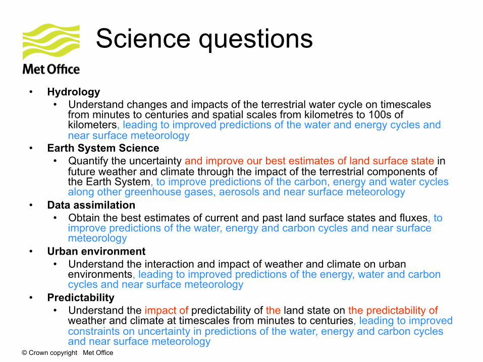
Science questions
• Hydrology • Understand changes and impacts of the terrestrial water cycle on timescales
from minutes to centuries and spatial scales from kilometres to 100s of kilometers, leading to improved predictions of the water and energy cycles and near surface meteorology
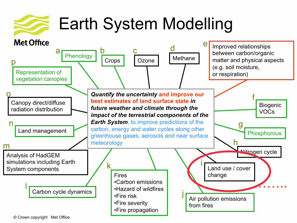
• Earth System Science • Quantify the uncertainty and improve our best estimates of land surface state in
future weather and climate through the impact of the terrestrial components of the Earth System, to improve predictions of the carbon, energy and water cycles along other greenhouse gases, aerosols and near surface meteorology
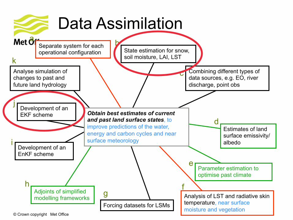
• Data assimilation • Obtain the best estimates of current and past land surface states and fluxes, to
improve predictions of the water, energy and carbon cycles and near surface meteorology
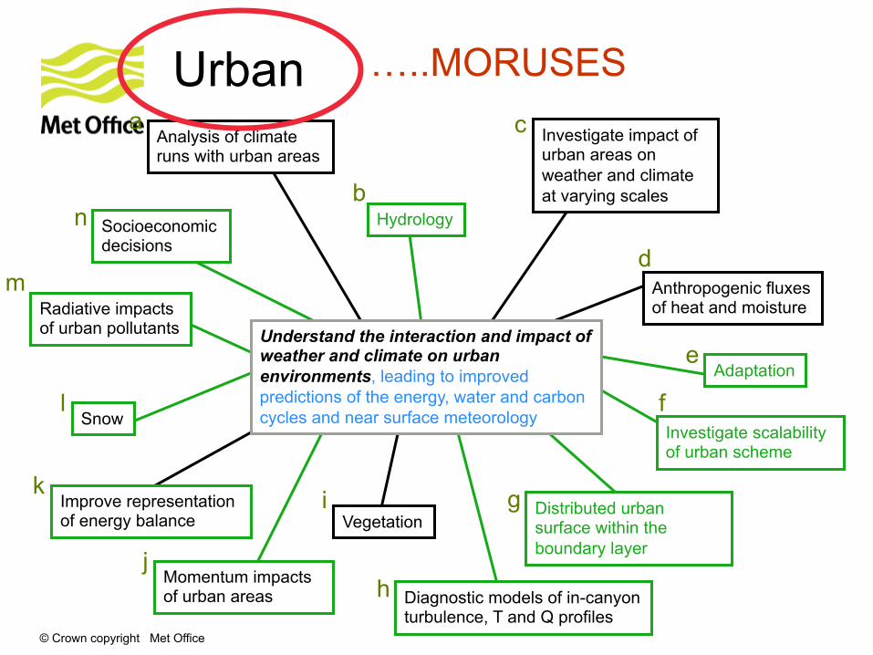
• Urban environment • Understand the interaction and impact of weather and climate on urban
environments, leading to improved predictions of the energy, water and carbon cycles and near surface meteorology
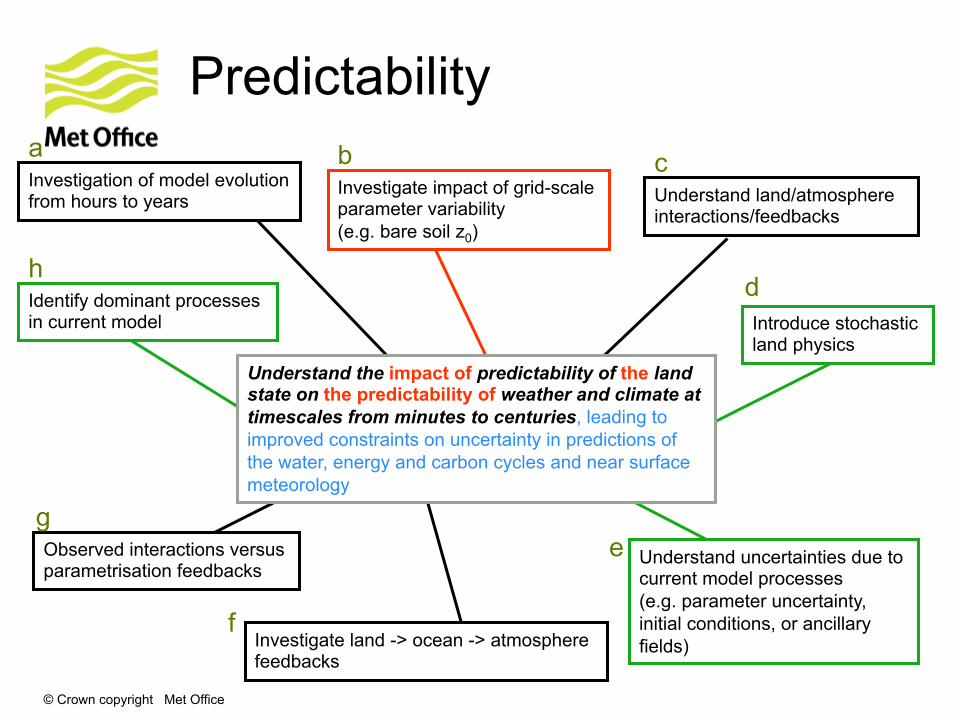
• Predictability • Understand the impact of predictability of the land state on the predictability of
weather and climate at timescales from minutes to centuries, leading to improved constraints on uncertainty in predictions of the water, energy and carbon cycles and near surface meteorology
© Crown copyright Met Office
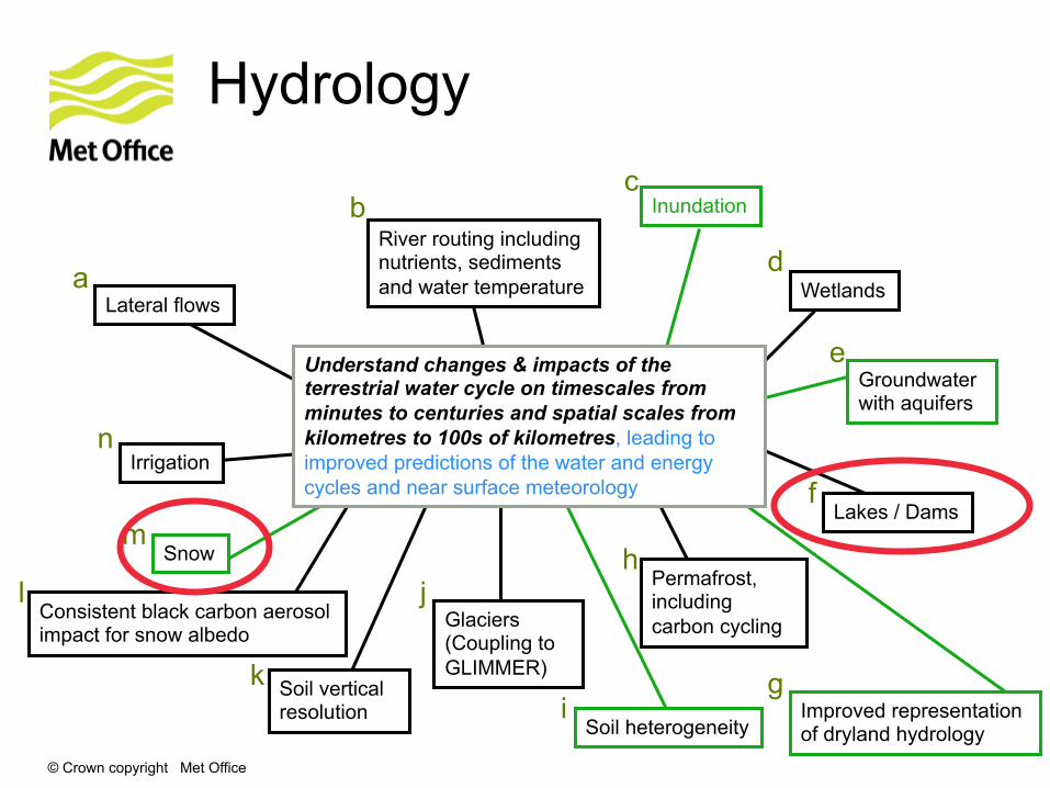
Hydrology
Glaciers (Coupling to GLIMMER)
Lateral flows
River routing including nutrients, sediments and water temperature
Inundation
Irrigation
Lakes / Dams
Snow
Groundwater with aquifers
Permafrost, including carbon cycling
Understand changes & impacts of the terrestrial water cycle on timescales from minutes to centuries and spatial scales from kilometres to 100s of kilometres, leading to improved predictions of the water and energy cycles and near surface meteorology
Soil heterogeneity
Soil vertical resolution
Wetlands
Improved representation of dryland hydrology
Consistent black carbon aerosol impact for snow albedo
b c
d
e
f
g i
h j
k
l
n
m
a
© Crown copyright Met Office
Earth System Modelling
Land use / cover change
Ozone
Carbon cycle dynamics
Phenology
Quantify the uncertainty and improve our best estimates of land surface state in future weather and climate through the impact of the terrestrial components of the Earth System, to improve predictions of the carbon, energy and water cycles along other greenhouse gases, aerosols and near surface meteorology
Canopy direct/diffuse radiation distribution
Crops
Fires • Carbon emissions • Hazard of wildfires • Fire risk • Fire severity • Fire propagation
Land management
Methane
Biogenic VOCs
Phosphorous
Nitrogen cycle Analysis of HadGEM simulations including Earth System components
Air pollution emissions from fires
Improved relationships between carbon/organic matter and physical aspects (e.g. soil moisture, or respiration)
a b c d e
f
g
i
h
j
k
l
n
m
o
Representation of vegetation canopies
p
……..
© Crown copyright Met Office
Data Assimilation
Development of an EKF scheme
Adjoints of simplified modelling frameworks
State estimation for snow, soil moisture, LAI, LST
Parameter estimation to optimise past climate
Combining different types of data sources, e.g. EO, river discharge, point obs
Obtain best estimates of current and past land surface states, to improve predictions of the water, energy and carbon cycles and near surface meteorology
Estimates of land surface emissivity/albedo
Development of an EnKF scheme
Forcing datasets for LSMs Analysis of LST and radiative skin temperature, near surface moisture and vegetation
Separate system for each operational configuration
a b
c
d
e
f g
i
h
j
Analyse simulation of changes to past and future land hydrology
k
© Crown copyright Met Office
Urban
Improve representation of energy balance
Socioeconomic decisions
Hydrology
Snow
Anthropogenic fluxes of heat and moisture
Adaptation
Vegetation Distributed urban surface within the boundary layer
Understand the interaction and impact of weather and climate on urban environments, leading to improved predictions of the energy, water and carbon cycles and near surface meteorology
Analysis of climate runs with urban areas
Investigate impact of urban areas on weather and climate at varying scales
Momentum impacts of urban areas
Investigate scalability of urban scheme
Radiative impacts of urban pollutants
Diagnostic models of in-canyon turbulence, T and Q profiles
a
b
c
d
e
f
g i
h j
k
l
n
m
…..MORUSES
© Crown copyright Met Office
Predictability
Investigation of model evolution from hours to years Understand land/atmosphere
interactions/feedbacks
Observed interactions versus parametrisation feedbacks
Understand the impact of predictability of the land state on the predictability of weather and climate at timescales from minutes to centuries, leading to improved constraints on uncertainty in predictions of the water, energy and carbon cycles and near surface meteorology
Investigate impact of grid-scale parameter variability (e.g. bare soil z0)
Identify dominant processes in current model Introduce stochastic
land physics
a b c
d
e
f
g
h
Investigate land -> ocean -> atmosphere feedbacks
Understand uncertainties due to current model processes (e.g. parameter uncertainty, initial conditions, or ancillary fields)

© Crown copyright Met Office
Global Land configuration
GL4
• Global atmospheric configuration (GA) developed annually as common basis for NWP and climate
• GA3: Walters et al., GMD (2011)
• Global land (GL) developed on same annual cycle
• Most recent version GA/GL4.0
• Operational NWP configuration slightly different from GA, but longer-term aim is to implement GA operationally shortly after definition.
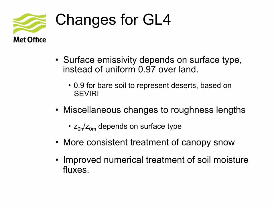
Changes for GL4
• Surface emissivity depends on surface type, instead of uniform 0.97 over land.
• 0.9 for bare soil to represent deserts, based on SEVIRI
• Miscellaneous changes to roughness lengths
• z0h/z0m depends on surface type
• More consistent treatment of canopy snow
• Improved numerical treatment of soil moisture fluxes.

© Crown copyright Met Office
FLake
© Crown copyright Met Office
code repositories
• UM, JULES, FLake are now in separate code repositories • code and changesets from each repository are used to build executable • FLake code is used unmodified • FLake is not distributed by the Met Office
© Crown copyright Met Office
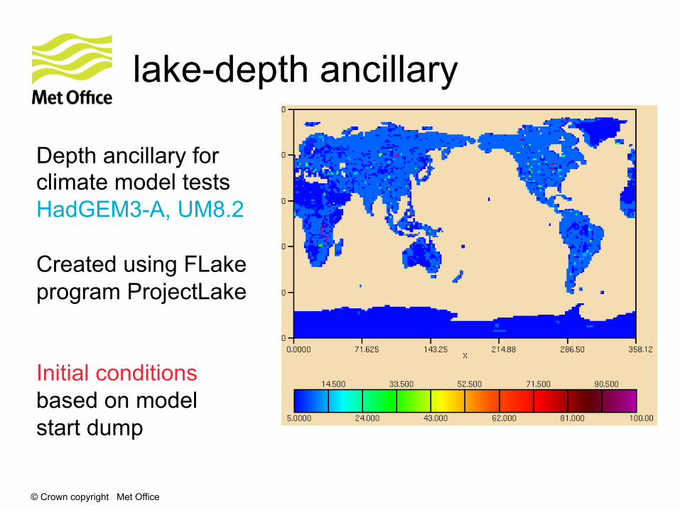
lake-depth ancillary
Depth ancillary for climate model tests HadGEM3-A, UM8.2 Created using FLake program ProjectLake Initial conditions based on model start dump
© Crown copyright Met Office
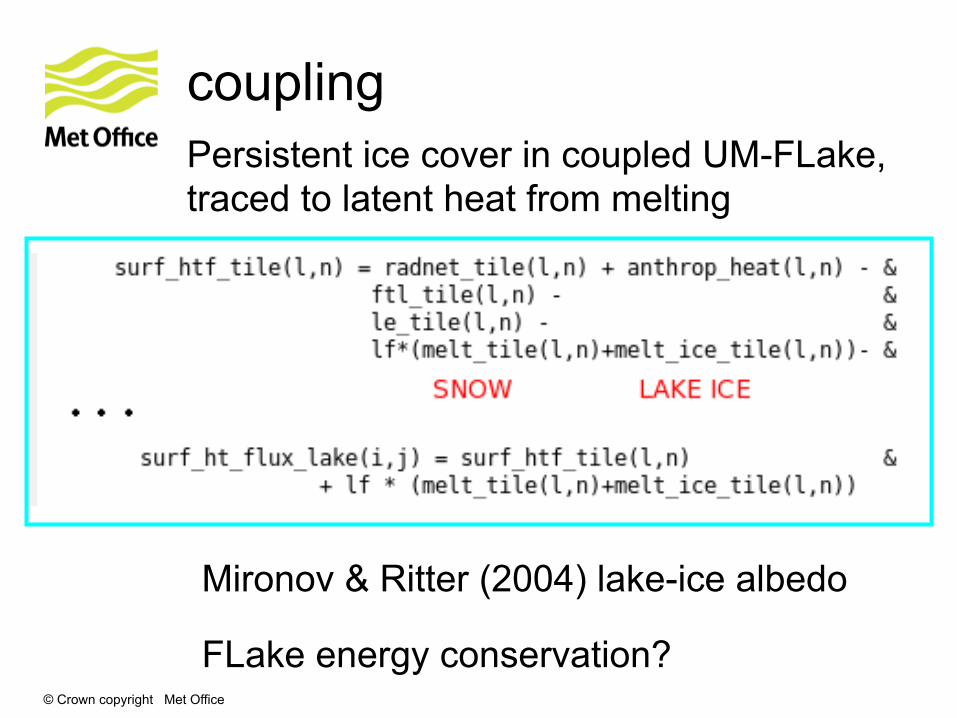
coupling Persistent ice cover in coupled UM-FLake, traced to latent heat from melting
Mironov & Ritter (2004) lake-ice albedo FLake energy conservation?
© Crown copyright Met Office
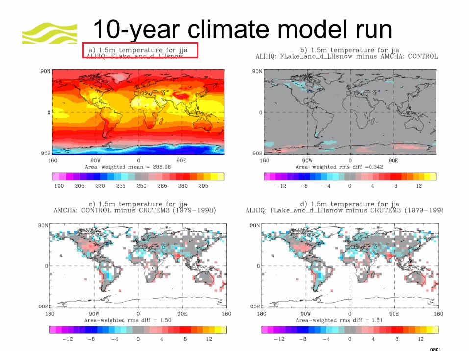
10-year climate model run
© Crown copyright Met Office
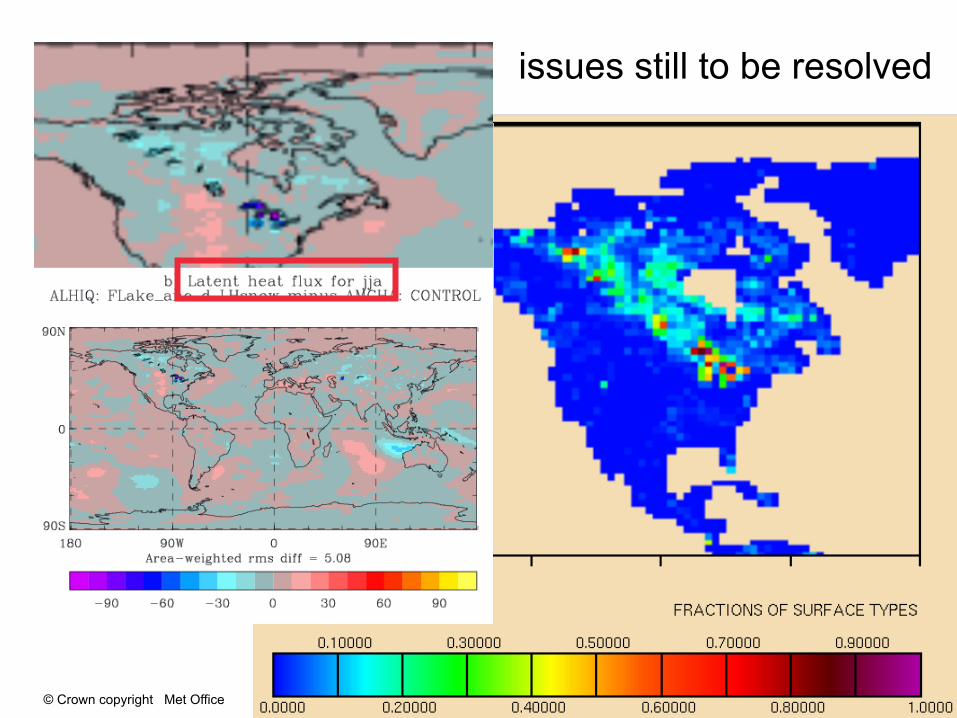
issues still to be resolved
© Crown copyright Met Office
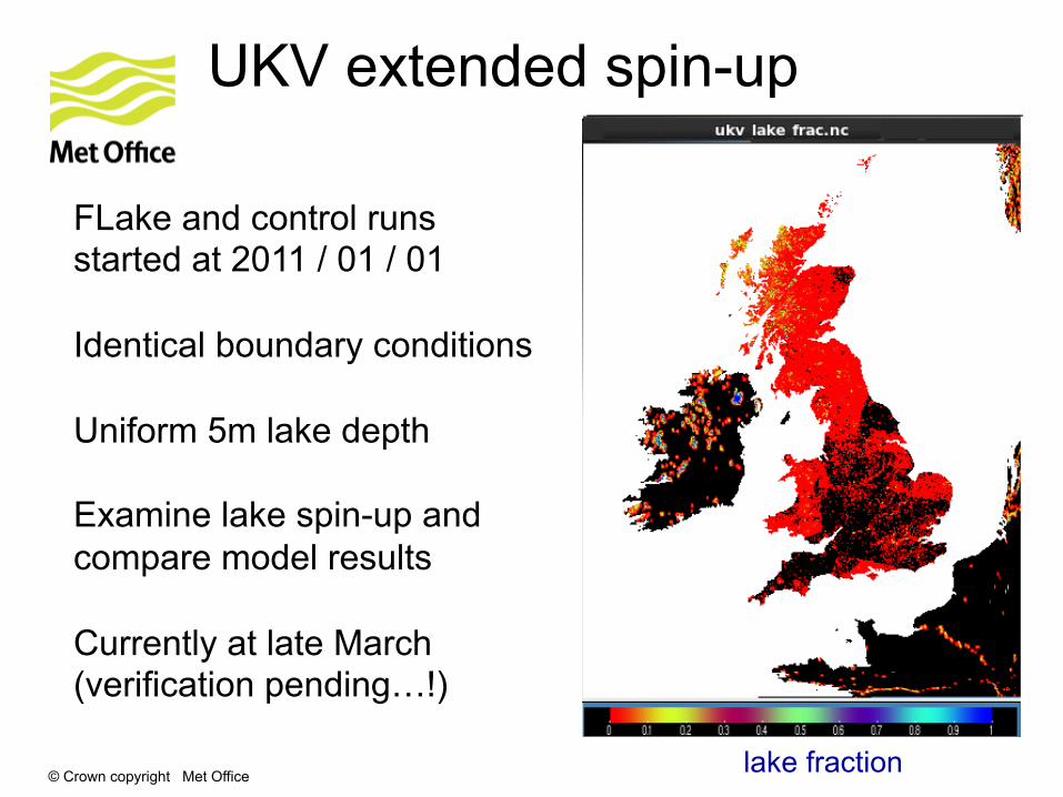
UKV extended spin-up
FLake and control runs started at 2011 / 01 / 01 Identical boundary conditions Uniform 5m lake depth Examine lake spin-up and compare model results Currently at late March (verification pending…!)
lake fraction
© Crown copyright Met Office
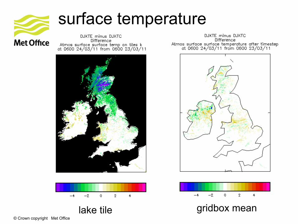
surface temperature
lake tile gridbox mean
© Crown copyright Met Office
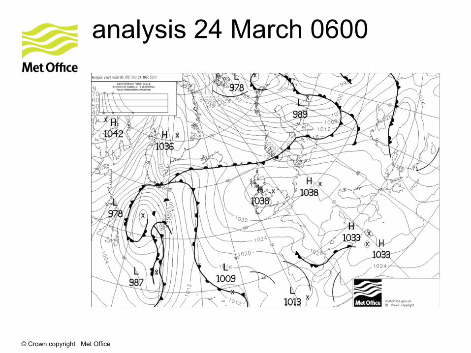
analysis 24 March 0600
© Crown copyright Met Office
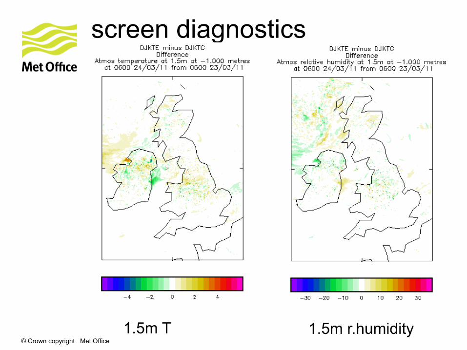
screen diagnostics
1.5m T 1.5m r.humidity

© Crown copyright Met Office
relative humidity field
© Crown copyright Met Office
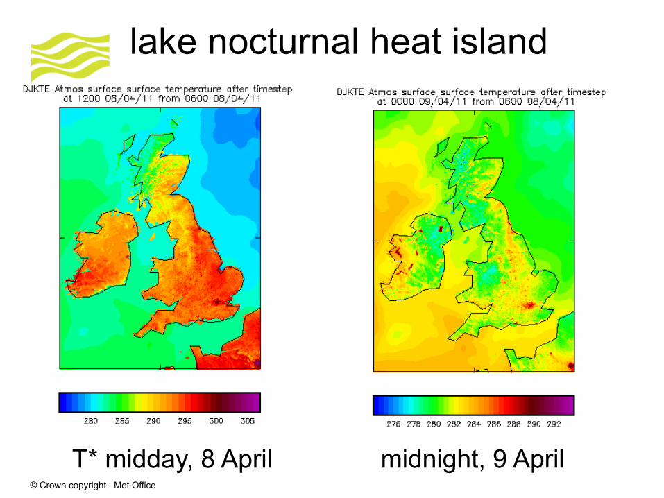
lake nocturnal heat island
T* midday, 8 April midnight, 9 April
© Crown copyright Met Office
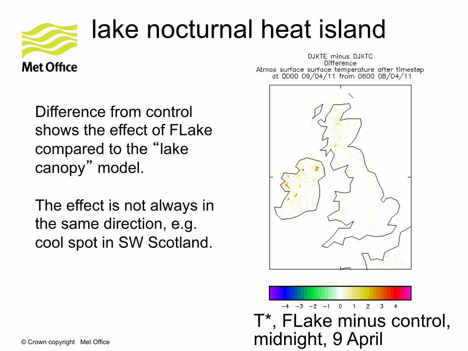
lake nocturnal heat island
T*, FLake minus control, midnight, 9 April
Difference from control shows the effect of FLake compared to the “lake canopy” model. The effect is not always in the same direction, e.g. cool spot in SW Scotland.

© Crown copyright Met Office
snow modelling
zero-layer snow scheme
• Snow currently lumped in with first soil layer – zero-layer model
• Loses heat too rapidly after sharp falls in air temperature, so forecasting problems with warm biases.
• Poor simulation of permafrost
multilayer snow scheme
• Multilayer scheme developed by Richard Essery at Edinburgh University
• Explicit representation of snow pack (standard choice 3 layers)
• Variable snow density
• Compaction
• Separate liquid and frozen content
• Being assessed at Met Office and at Norwegian Meteorological Institute
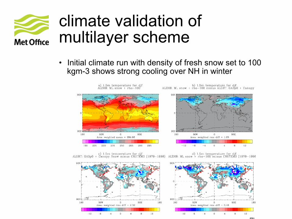
climate validation of multilayer scheme • Initial climate run with density of fresh snow set to 100
kgm-3 shows strong cooling over NH in winter
mitigation
• Enhancements introduced
• Thermal metamorphism
• Conduction through air in snow pack
• Conductivity now based on Colonne et al. (2011) instead of Yen (1981)
• Infiltration of rain into snow
• Albedo (still under development)
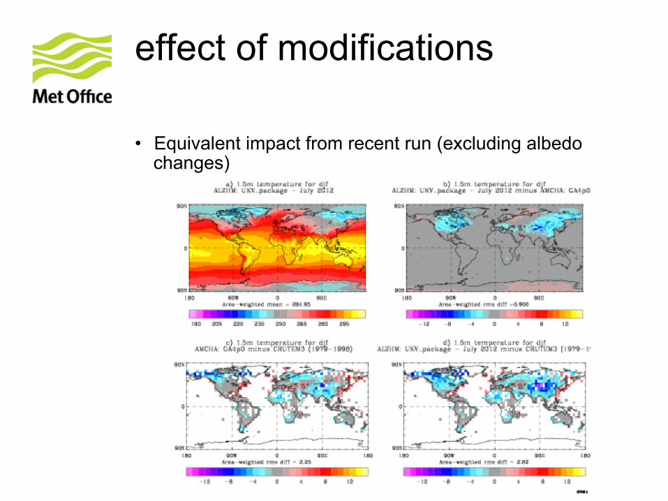
effect of modifications
• Equivalent impact from recent run (excluding albedo changes)
Outlook
• Recent enhancements mitigate cold bias, but further work needed -- albedo
• Temperature is very sensitive to snow density – influence of conductivity
• Need for accurate initialization of density complicates testing in global NWP
• 1.5 km UK model shows evidence of excessive snowfall in convective situations
• Excessive snow depth and cold temperatures

© Crown copyright Met Office
snow analysis
Snow analysis implementation
• Observational snow data first used in Met Office NWP with introduction of snow analysis in 2008
• Uses NOAA/NESDIS IMS daily NH snow cover product
• Updates model snow amount field where model and obs disagree on presence of snow
• Snow added by calculating fractional cover from IMS product and using a relation between fractional cover and SWE to calculate amount of snow to add
• snow analysis has led to improved analysed snow field, in terms of presence/non-presence of snow
• Some evidence of improvements in surface/low level T and RH, especially where snow is predominantly removed by the analysis.
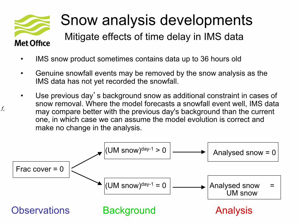
• IMS snow product sometimes contains data up to 36 hours old
• Genuine snowfall events may be removed by the snow analysis as the IMS data has not yet recorded the snowfall.
• Use previous day’s background snow as additional constraint in cases of snow removal. Where the model forecasts a snowfall event well, IMS data may compare better with the previous day's background than the current one, in which case we can assume the model evolution is correct and make no change in the analysis.
Snow analysis developments Mitigate effects of time delay in IMS data
cf= 0.0
cf= 0.0
Analysed snow = 0
(UM snow)day-1 = 0 Analysed snow = UM snow
Frac cover = 0
(UM snow)day-1 > 0
Observations Background Analysis
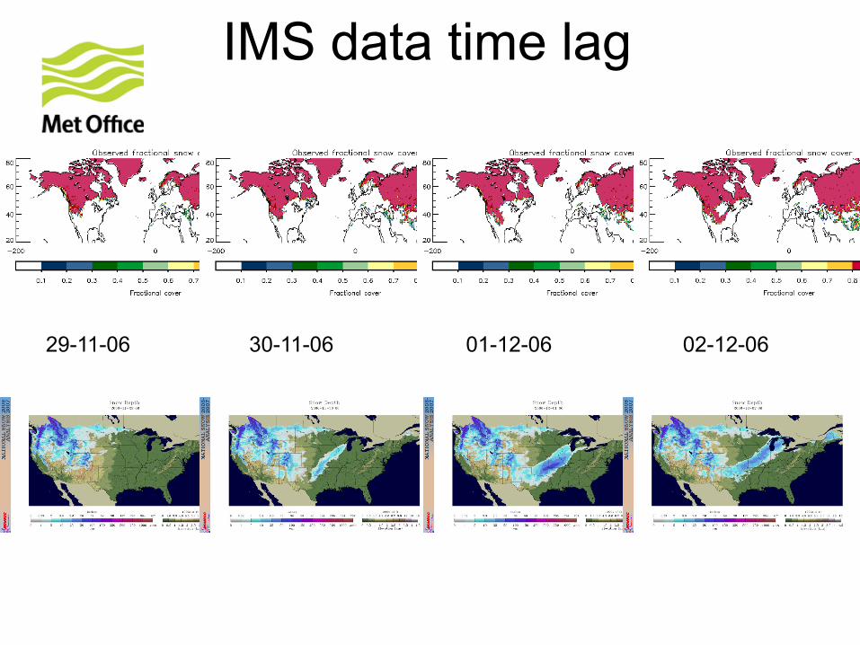
IMS data time lag
1-12-06
30-11-06
02-12-06 01-12-06 30-11-06 29-11-06
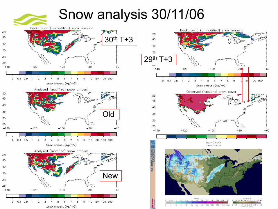
Snow analysis 30/11/06
30th T+3
Old
29th T+3
New
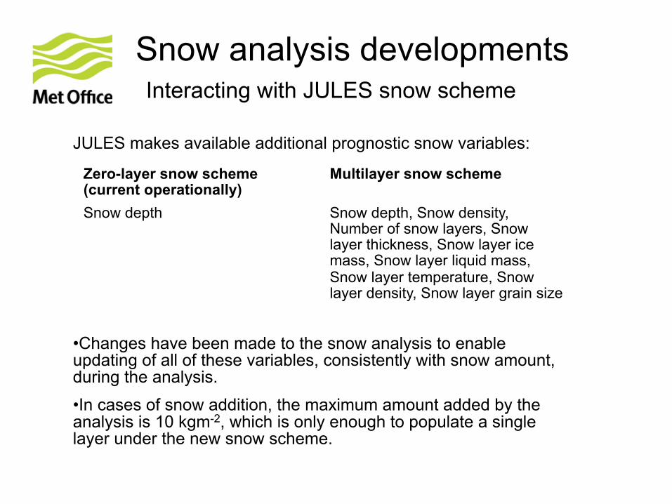
Snow analysis developments Interacting with JULES snow scheme
JULES makes available additional prognostic snow variables:
Zero-layer snow scheme (current operationally)
Multilayer snow scheme
Snow depth Snow depth, Snow density, Number of snow layers, Snow layer thickness, Snow layer ice mass, Snow layer liquid mass, Snow layer temperature, Snow layer density, Snow layer grain size
• Changes have been made to the snow analysis to enable updating of all of these variables, consistently with snow amount, during the analysis. • In cases of snow addition, the maximum amount added by the analysis is 10 kgm-2, which is only enough to populate a single layer under the new snow scheme.
Plans for snow assimilation
• Looking at options for snow assimilation in UK model
• UK NWP model should not use IMS data alone (time delay issues), but could combine IMS with other obs (e.g. SYNOPS snow depth, LandSAF snow cover).
• Developing daily UK snow cover from SEVIRI, aggregated from existing 15-minute snow mask, for use in nowcasting system to remove spurious radar snowfall.
• Further snow assimilation in global NWP model
• Use SYNOP snow depth and any additional snow gauge obs available, in addition to IMS, eventually in EKF system
• Consider use of LandSAF snow cover product when available globally

© Crown copyright Met Office
land-surface assimilation
© Crown copyright Met Office
Assimilation of ASCAT soil wetness: nudging
• Since July 2010, assimilation of ASCAT observations of soil wetness has been undertaken in the operational Global model.
• A computationally cheap nudging scheme is used to assimilate the ASCAT volumetric surface soil moisture working alongside the nudging scheme.
• Trials of the ASCAT nudging scheme showed a positive impact on forecasts of screen temperature and humidity for the tropics, north America and Australia.
© Crown copyright Met Office
EKF land-surface DA: motivation
• Improve propagation of surface information to deeper layers
• Introduce multivariate increments • Cater for complex indirect satellite measurements • Analysis variable priorities: soil moisture, soil temp, snow
depth, albedo, LAI • Contain computational cost • Run uncoupled from NWP model with driving data for years
© Crown copyright Met Office
EKF land-surface DA: background
• Propose replacement that uses existing observations in an Extended Kalman Filter (EKF) to produce analyses of soil and skin temperature, in addition to soil moisture.
• In the Met Office implementation of the EKF, the Jacobians, which provide the key link between the observation space and model space within the EKF, are computed via successive runs of JULES, the UK's land surface exchange model.
• The analysis scheme has been devised without any assumptions about the grid, and so has the potential to be used in regional modelling and for seasonal forecasting.
© Crown copyright Met Office
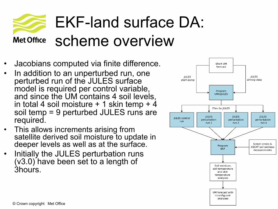
EKF-land surface DA: scheme overview
• Jacobians computed via finite difference. • In addition to an unperturbed run, one
perturbed run of the JULES surface model is required per control variable, and since the UM contains 4 soil levels, in total 4 soil moisture + 1 skin temp + 4 soil temp = 9 perturbed JULES runs are required.
• This allows increments arising from satellite derived soil moisture to update in deeper levels as well as at the surface.
• Initially the JULES perturbation runs (v3.0) have been set to a length of 3hours.
© Crown copyright Met Office
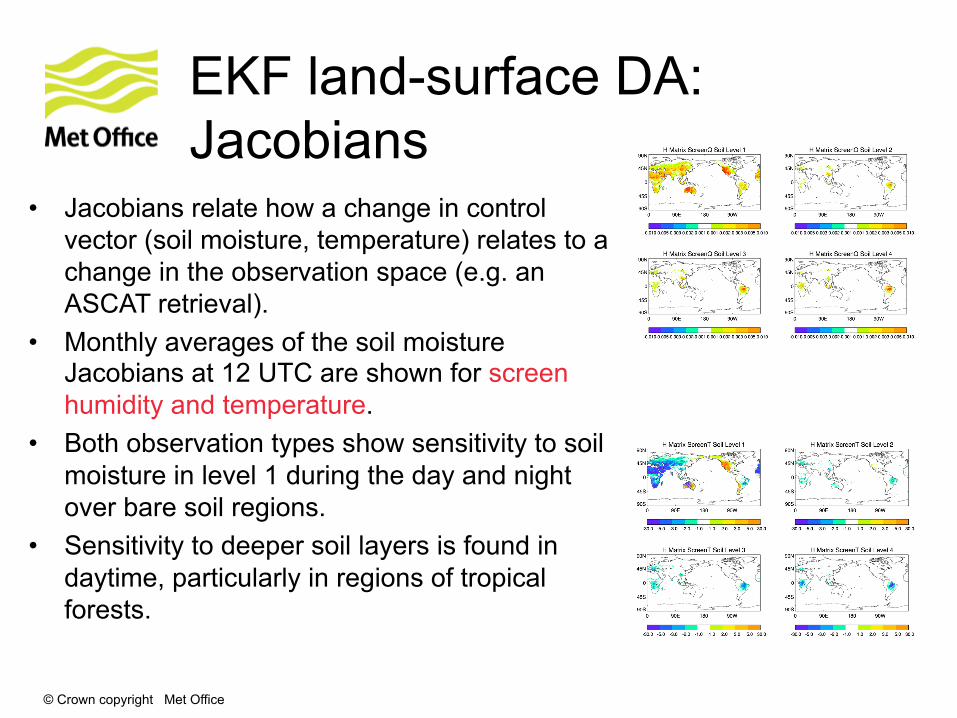
EKF land-surface DA: Jacobians
• Jacobians relate how a change in control vector (soil moisture, temperature) relates to a change in the observation space (e.g. an ASCAT retrieval).
• Monthly averages of the soil moisture Jacobians at 12 UTC are shown for screen humidity and temperature.
• Both observation types show sensitivity to soil moisture in level 1 during the day and night over bare soil regions.
• Sensitivity to deeper soil layers is found in daytime, particularly in regions of tropical forests.
© Crown copyright Met Office
Soil moisture content analysis: future work
• Seasonal NWP atmospheric trial to evaluate the impact of EKF.
• Operational implementation of planned for April 2013. • Preparation for MetOP-B ASCAT assessment. • Use of additional observations in soil moisture analysis:
• LST from geostationary and polar orbiting satellites. • SMOS data being received routinely from ESA.
• Following operational implementation of EKF land surface DA scheme, future work will investigate the use of an Ensemble Kalman Filter (EnKF) based scheme.
• Explore the use of EKF in convective scale models.
© Crown copyright Met Office
Conclusions
• Some surface activities have been presented
• Annual configuration cycle aims to unify modelling approach
• Work priorities are evolving
• JULES
• Met Office workhorse
• community model
• Still plenty to do…

© Crown copyright Met Office
Questions and answers
Related Documents