CENTRAL GROUND WATER BOARD MINISTRY OF WATER RESOURCES GOVERNMENT OF INDIA GROUND WATER BROCHURE KRISHNA DISTRICT, ANDHRA PRADESH SOUTHERN REGION HYDERABAD September 2013 For Official Use Only

Welcome message from author
This document is posted to help you gain knowledge. Please leave a comment to let me know what you think about it! Share it to your friends and learn new things together.
Transcript

CENTRAL GROUND WATER BOARD MINISTRY OF WATER RESOURCES
GOVERNMENT OF INDIA
GROUND WATER BROCHURE KRISHNA DISTRICT, ANDHRA PRADESH
SOUTHERN REGION HYDERABAD
September 2013
For Official Use Only
CENTRAL GROUND WATER BOARD MINISTRY OF WATER RESOURCES
GOVERNMENT OF INDIA
GROUND WATER BROCHURE KRISHNA DISTRICT, ANDHRA PRADESH
(AAP-2012-13)
BY
DR. V.S.R. KRISHNA SCIENTIST-B
SOUTHERN REGION BHUJAL BHAWAN, GSI Post, Bandlaguda NH.IV, FARIDABAD -121001 Hyderabad-500068 HARYANA, INDIA Andhra Pradesh Tel: 0129-2418518 Tel: 040-24225201 Gram: Bhumijal Gram: Antarjal

GROUND WATER BROCHURE
KRISHNA DISTRICT, ANDHRA PRADESH
CONTENTS
S.No CHAPTER
District at a Glance
1 Introduction
2 Rainfall & Climate
3 Geomorphology & Soil Types
4 Ground Water Scenario
5 Ground Water Management Strategy
6 Ground Water Related Issues and Problems
7 Recommendations
Acknowledgements

KRISHNA DISTRICT AT A GLANCE
1. GENERAL INFORMATION Geographical Area : 8797 sq. km Administrative Divisions District HQ : Machilipatnam Mandals : 50 Towns : 6 Villages : 1005 Population : 4529009 (2011 census) Average Annual Rainfall : 1011 mm Annual Rainfall (2012) : 1510 mm 2. GEOMORPHOLOGY Major Physiographic Units : Pediplains, Alluvial plains and Coastal plains Major Drainage : Krishna, Muniyeru, Tammileru & Budameru 3. LAND USE (ha) 2012 Forest Area : 76186 Net Area Sown : 510655 Cultivable waste : 25694 4. SOIL TYPE Red loamy soils, Sandy soils, Black soils 5. IRRIGATION BY DIFFERENT SOURCES (ha) Dug Wells : 7800 Tube wells/ Bore wells : 86000 Tanks : 9900 Canals : 314200 Other Sources : 3200 Net Irrigated Area : 302400 6. GROUND WATER MONITORING WELLS Dug Wells : 28 Piezometers : 4 7. GEOLOGICAL FORMATIONS Recent : Alluvium Tertiary : Sandstones Pre-Cambrian : Limestone Quartzite

Phyllite Shale Archaean : Granitic Gneiss Charnockite Khondalite 8. Hydrogeology Water Bearing Formations : Hard Rock : Gneiss, Charnockite, Khondalite & Metasediments Soft Rock : Sandstones & Alluvium Pre-monsoon : 1.52 to 11.20 m bgl Depth to Water Level (May, 2012) Post-monsoon : 0.21 to 9.06 m bgl Depth to Water Level (Nov., 2012) 9. GROUND WATER EXPLORATION (CGWB) Wells Drilled : 38 Depth Range : 140 to 600 m Discharge : <1 to 51 lps Transmissivity : 2.5 to 5560 m2/day 10. GROUND WATER QUALITY In general, the quality is good and suitable for drinking and irrigation purposes, except in the southern part of the deltaic area. 11. DYNAMIC GROUND WATER RESOURCES Total Recharge : 1825.42 MCM Total Draft : 547.98 MCM Projected Demand (2025) : 166.23 MCM for Domestic & Industrial Uses Stage of GW development : 33 % 12. GROUND WATER CONTROL & REGULATION Over Exploited Mandals : 2 Semi-Critical Mandals : Nil Notified Mandals : Nil 13. GROUND WATER PROBLEMS AND ISSUES Salinity and water logging are the major problems in the deltaic aquifers.


GROUND WATER BROCHURE KRISHNA DISTRICT, ANDHRA PRADESH
1.0 Introduction Krishna district is one of the 9 coastal districts of Andhra Pradesh and agriculturally it is an important district. The district has a coastline of 88 km. It is endowed by good rainfall and surface water. The district lies between North latitude of 15° 43’ and 17° 10’ and East longitudes of 80° 00’ and 81° 33’ with an aerial extent of 8797 km2. It is bounded by the Bay of Bengal on the southeast, West Godavari district on the East, Khammam district on the North and Guntur & Nalgonda districts on the West. Howrah – Chennai broad gauge railway line and NH-5 are passing through the district. In addition to the surface transport the district has aerodrome at Gannavaram and sea port at Machilipatnam. Machilipatnam town is the district’s headquarters. The district is divided into four revenue divisions’ viz., Machilipatnam (Bandar), Vijayawada, Gudivada and Nuzivid. Further these revenue divisions are divided into 50 revenue mandals (Fig. 1).

There are 6 towns 1005 villages in the district. As per the 2001 census the
population of the district is 41,87,841. The urban population of the district is
13,43,447 whereas rural population constitutes 28,44,394. The decennial
growth rate from 1991 to 2001 is 13.19 percent. The density of population of
the district is 480 persons per sq. km.
1.1 Drainage
The Krishna is the major river which drains the district, it is perennial in
nature and flows along the western boundary of the district. South of
Avanigadda the river bifurcates into four branches before it debouches into
the Bay of Bengal. The other important rivers flowing in the district are
Muniyeru, Tammileru and Budameru. The general drainage pattern is
dendritic to sub-dendritic. The drainage density is high in consolidated
formations, low in semi-consolidated formations, whereas in alluvial areas the
density is meager. Kolleru lake is located between Krishna and Godavari delta
and spans into two districts - Krishna and West Godavari. It is the largest
freshwater lake in Asia.The lake serves as a natural flood-balancing reservoir
for these two rivers. The lake is fed directly by water from the seasonal
Budameru and Tammileru rivers, and is connected to the Krishna and
Godavari systems by over 68 inflowing drains and channels. The lake is an
important habitat for an estimated 20 million resident and migratory birds. It is
known the world over for the famous Kolleru Bird Sanctuary.
1.2 Irrigation
The district is served with both surface and ground water irrigation
sources. Major and medium irrigation projects exist in the district. The total net
area irrigated is 323240 ha (2012) by means of all sources of irrigation
available in the district. The gross area irrigated through the surface water
irrigation projects is of 230336 ha in the district. Irrigation in the district is
mainly from the network of canals in the delta area fed by the Krishna river.
East main canal of Prakasam (Krishna) Barrage irrigates entire delta area
through a network of its three canals viz., Eluru canal, Ryves canal and
Bandar canal. The registerd ayacut under irrigation project of Krishna
Barriage, Nagarjuna Sagar, Paleru, Muniyeru and Tammileru is around
274800 ha, 103600 ha, 6300 ha, 6600 ha and 500 ha respectively. The area
irrigated through canals is 219428 ha and irrigation through other sources is
11826 ha. 59824 ha area is irrigated through tube wells and dug wells.

1.3 CGWB activities
The Central Ground Water Board took up long term hydrogeological
studies since 1969 with the establishment of Network Hydrograph Stations in various hydrogeological environments as a part of the all India programme and presently there are 32 (28 dug wells and 4 piezometers) such hydrograph stations in the district. The systematic hydrogeological surveys were carried out during 1960 – 1990. Ground water management surveys and Geophysical surveys were carried out in various parts of the district during 1997-2003. As a part of ground water exploration programme Geophysical surveys were carried out during 1977-1993. Ground water exploratory drilling programme was taken up during 1958 – 1981 in the district in both hard rock and soft rock areas, and has drilled 38 exploratory wells to evaluate the aquifer properties of deeper aquifers. Under Hydrology Project 11 piezometers were constructed. Conjunctive utilisation studies of the deltaic canal systems were carried out during 1978-85. Urban Hydrogeological investigations were carried out during 2000-01 in Vijayawada urban area.
2.0 Rainfall & Climate The climate of the district is moderate and characterized by tropical rainy climate with aggressive summer. The period from December to middle of February is generally the season of fine weather. The summer season is from March to May. This is followed by monsoon period from June to September, the post monsoon from October to December and the winter season from January to February.
The average annual rainfall of the district is 1011.2 mm, which ranges from nil rainfall in January and March to 216.8 mm in July. The mean seasonal rainfall distribution is 700 mm in southwest monsoon (June-September), 241 mm in northeast monsoon ( Oct-Dec), 6.3 mm rainfall in Winter (Jan-Feb) and 64 mm in summer (March – May). The percentage distribution of rainfall, season-wise, is 69.25% in southwest monsoon, 23.82 % in northeast monsoon, 0.62 percentage in winter and 6.31 % in summer (Fig. 2). In general, the amount of rainfall increases from west to east. The mean daily maximum temperature in the district is about 38°C in May and the mean daily minimum temperature is about 20°C in December/ January. Temperature in the district begins to rise from the middle of February till May. With the onset of southwest monsoon in June, the temperature decreases to about 20°C and is more or less uniform during the monsoon period. The relative humidity in the district is of the order of 80% in the mornings throughout the year, whereas in the evenings the relative humidity varies from about 70 to more than 80%. The annual rainfall during 2012 is 1510mm.
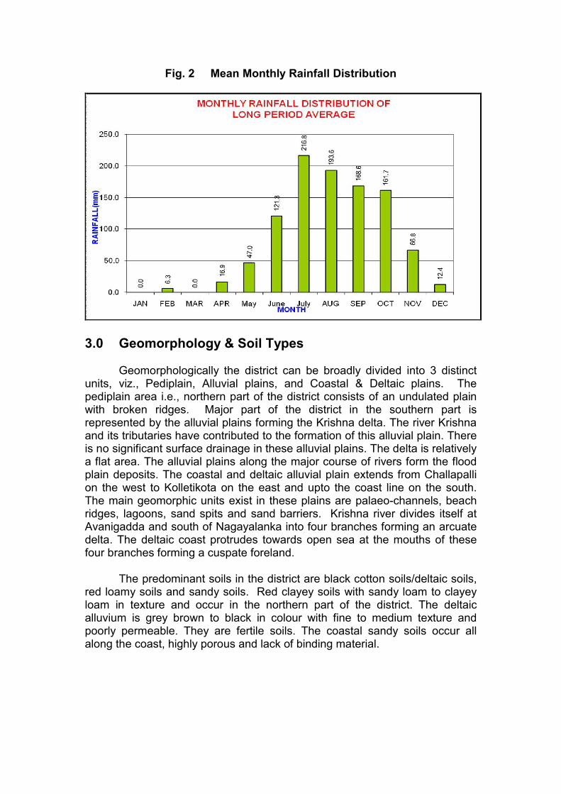
Fig. 2 Mean Monthly Rainfall Distribution
3.0 Geomorphology & Soil Types Geomorphologically the district can be broadly divided into 3 distinct units, viz., Pediplain, Alluvial plains, and Coastal & Deltaic plains. The pediplain area i.e., northern part of the district consists of an undulated plain with broken ridges. Major part of the district in the southern part is represented by the alluvial plains forming the Krishna delta. The river Krishna and its tributaries have contributed to the formation of this alluvial plain. There is no significant surface drainage in these alluvial plains. The delta is relatively a flat area. The alluvial plains along the major course of rivers form the flood plain deposits. The coastal and deltaic alluvial plain extends from Challapalli on the west to Kolletikota on the east and upto the coast line on the south. The main geomorphic units exist in these plains are palaeo-channels, beach ridges, lagoons, sand spits and sand barriers. Krishna river divides itself at Avanigadda and south of Nagayalanka into four branches forming an arcuate delta. The deltaic coast protrudes towards open sea at the mouths of these four branches forming a cuspate foreland.
The predominant soils in the district are black cotton soils/deltaic soils,
red loamy soils and sandy soils. Red clayey soils with sandy loam to clayey loam in texture and occur in the northern part of the district. The deltaic alluvium is grey brown to black in colour with fine to medium texture and poorly permeable. They are fertile soils. The coastal sandy soils occur all along the coast, highly porous and lack of binding material.

4.0 Ground Water Scenario 4.1 Hydrogeology
The district is underlain by variety of geological formations comprising
from the oldest Archaeans to Recent Alluvium. Hydrogeologically these formations are classified as consolidated (Hard), semi-consolidated (Soft) and unconsolidated (Soft) formations. The consolidated formations include crystallines (khondalites, charnockites and granitic gneisses) and metasediments (Limestones, shales, phyllites and quartzites) of Archaean and Pre-cambrian periods respectively. The semi consolidated formations are represented by Tertiary formations (Rajahmundry & Gollapalli sandstones) and unconsolidated formations comprise deltaic alluvial deposits of Quaternary period. Prominent lineaments are trending in NE-SW, NW-SE and NNE-SSW direction (Fig. 3).

Consolidated formations occur in the northern part of the district. Among consolidated formations occurrence of metasediments is restricted to NW part of the district i.e., in parts of Jaggayyapeta, Penuganchiprolu, Nandigama and Chandralapadu mandals. Semiconsolidated formations occur in the northeastern part of the district and its extension is limited to small area i.e., in parts of Musunuru, Nuzividu, Bapulapadu and Gannavaram mandals. Unconsolidated formations occur in the southern part of the district i.e., in the delta area. Ground water occurs in all most all geological formations and its potential depends upon the nature of geological formations, geographical setup, incidence of rainfall, recharge and other hydrogeological characters of the aquifer.
In consolidated formations ground water occurs under unconfined to
semiconfined conditions. Ground water is developed in these formations by dug wells, dug cum bore wells and bore wells tapping weathered and fractured zones. The yields are in the range of 20 to 70 m3/day. The occurrence of fractures in the crystalline formations is limited down to 30 to 40 m bgl and occasionally extends down to 70 - 100 m bgl. The bore wells constructed in the crystalline formations generally tap the weathered and fractured zones. The yields of the bore wells generally range between 80 to 400 m3/day. The higher yields are limited to the available thickness of fractured and jointed zones. In the metasediments the yields are very limited and are in the range of 10 to 80 m3/day. Higher yields occur in limestone formations.
Ground water in semi-consolidated formations occurs under
unconfined to confined conditions. Ground water is developed in these formations by dug cum tube wells and tube wells. These formations are potential aquifers. The yields of the dug cum tube wells are in the range of 30 to 45 m3/day. Granularity of the sandstone bed is the deciding factor of the yield potential as the higher yields are recorded in the Rajahmundry sandstones tapping coarse sandstone beds. The yields of the tube wells in Gollapalli sandstones and Rajahmundry sandstones are in the range of 60 to 200 m3/day and 600 1500 m3/day respectively. The deltaic area is underlain by alluvium of recent age consisting of varying proportions of clay, silt, sand and gravel. The thickness of alluvium ranges from few meters to about 600 m followed by tertiary formations. In deltaic area ground water occurrence is controlled by landforms. In deltaic area also a lot of heterogenity in hydrogeological conditions exist both spatially and vertically. Fresh water is generally limited to shallow to moderate depths only, whereas in the southern part of the delta it occurs as pockets and lenses. Deep aquifers are generally saline. Palaeochannels are favourable locations for fresh water aquifers. Ground water occurs under phreatic to confined conditions and is developed through shallow dug wells, filter point wells and shallow tube wells. The depth of dug wells ranges from about 2 to 7 m, while the depth of filter point wells varies from 5 to 13 m and the depth of tube wells varies from 40 to 80 m. The yields generally range in this aquifer between 250 to 400 m3/day. Occasionally high yields upto 15 lps exist in the palaeochannels. The transmissivity value of the aquifer in the semi & unconsolidated formations varies from 2.5 to 5560 m2/day.
Water Level Scenario
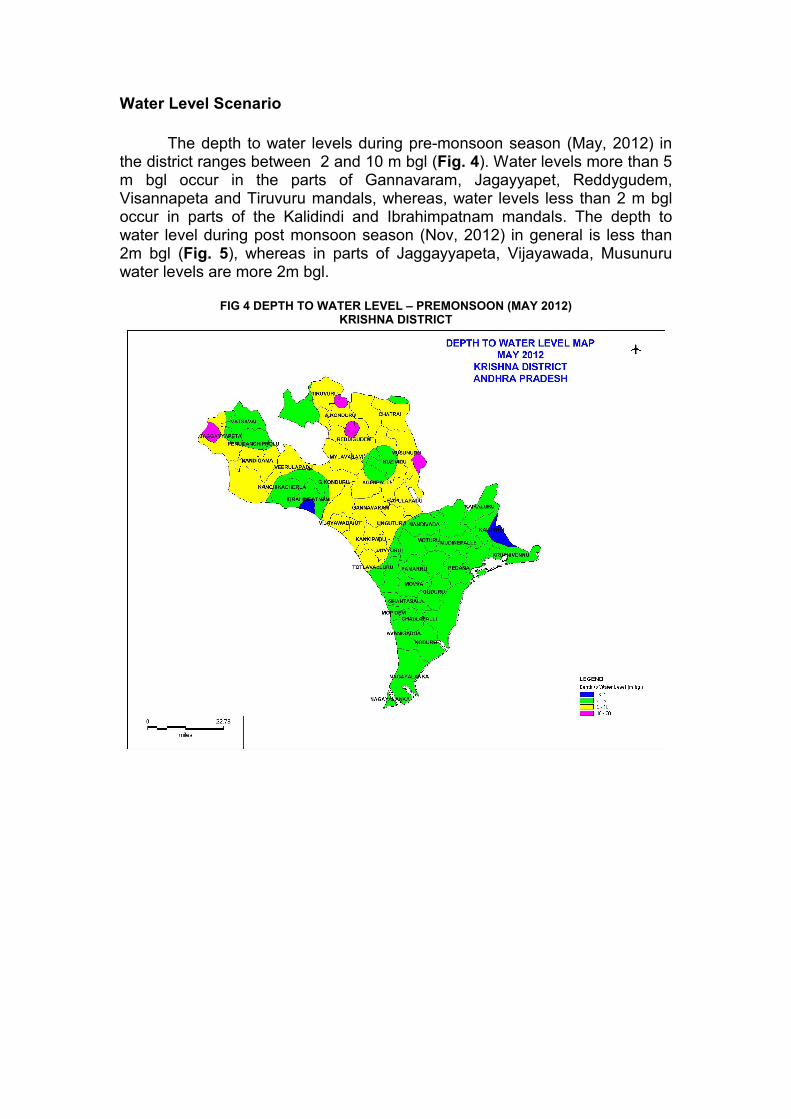
The depth to water levels during pre-monsoon season (May, 2012) in
the district ranges between 2 and 10 m bgl (Fig. 4). Water levels more than 5 m bgl occur in the parts of Gannavaram, Jagayyapet, Reddygudem, Visannapeta and Tiruvuru mandals, whereas, water levels less than 2 m bgl occur in parts of the Kalidindi and Ibrahimpatnam mandals. The depth to water level during post monsoon season (Nov, 2012) in general is less than 2m bgl (Fig. 5), whereas in parts of Jaggayyapeta, Vijayawada, Musunuru water levels are more 2m bgl.
FIG 4 DEPTH TO WATER LEVEL – PREMONSOON (MAY 2012)
KRISHNA DISTRICT
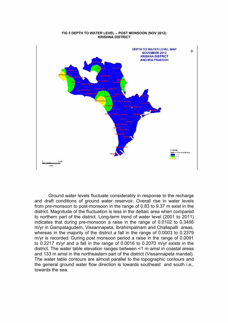
FIG 5 DEPTH TO WATER LEVEL – POST MONSOON (NOV 2012)
KRISHNA DISTRICT
Ground water levels fluctuate considerably in response to the recharge
and draft conditions of ground water reservoir. Overall rise in water levels from pre-monsoon to post-monsoon in the range of 0.83 to 9.37 m exist in the district. Magnitude of the fluctuation is less in the deltaic area when compared to northern part of the district. Long-term trend of water level (2001 to 2011) indicates that during pre-monsoon a raise in the range of 0.0102 to 0.3456 m/yr in Gampalagudem, Vissannapeta, Ibrahimpatnam and Challapalli areas, whereas in the majority of the district a fall in the range of 0.0003 to 0.2379 m/yr is recorded. During post monsoon period a raise in the range of 0.0091 to 0.2217 m/yr and a fall in the range of 0.0016 to 0.2070 m/yr exists in the district. The water table elevation ranges between <1 m amsl in coastal areas and 133 m amsl in the northeastern part of the district (Vissannapeta mandal). The water table contours are almost parallel to the topographic contours and the general ground water flow direction is towards southeast and south i.e., towards the sea.
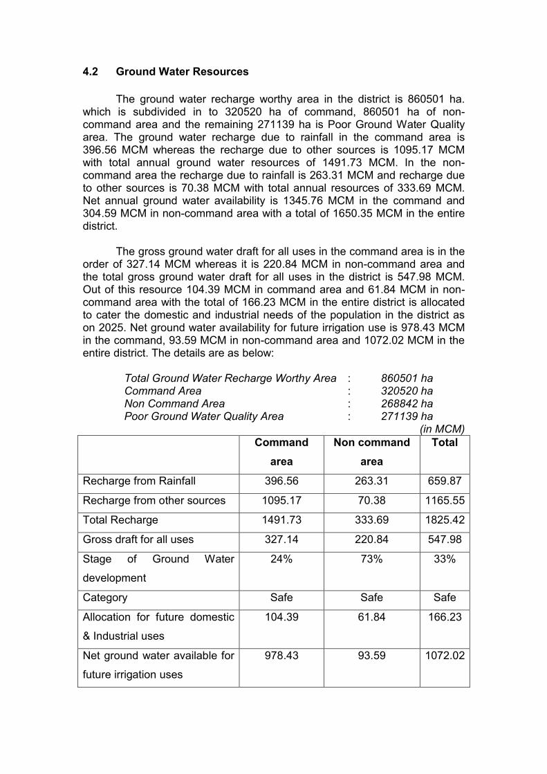
4.2 Ground Water Resources
The ground water recharge worthy area in the district is 860501 ha.
which is subdivided in to 320520 ha of command, 860501 ha of non-command area and the remaining 271139 ha is Poor Ground Water Quality area. The ground water recharge due to rainfall in the command area is 396.56 MCM whereas the recharge due to other sources is 1095.17 MCM with total annual ground water resources of 1491.73 MCM. In the non-command area the recharge due to rainfall is 263.31 MCM and recharge due to other sources is 70.38 MCM with total annual resources of 333.69 MCM. Net annual ground water availability is 1345.76 MCM in the command and 304.59 MCM in non-command area with a total of 1650.35 MCM in the entire district. The gross ground water draft for all uses in the command area is in the order of 327.14 MCM whereas it is 220.84 MCM in non-command area and the total gross ground water draft for all uses in the district is 547.98 MCM. Out of this resource 104.39 MCM in command area and 61.84 MCM in non-command area with the total of 166.23 MCM in the entire district is allocated to cater the domestic and industrial needs of the population in the district as on 2025. Net ground water availability for future irrigation use is 978.43 MCM in the command, 93.59 MCM in non-command area and 1072.02 MCM in the entire district. The details are as below:
Total Ground Water Recharge Worthy Area : 860501 ha Command Area : 320520 ha Non Command Area : 268842 ha Poor Ground Water Quality Area : 271139 ha
(in MCM) Command
area
Non command
area
Total
Recharge from Rainfall 396.56 263.31 659.87
Recharge from other sources 1095.17 70.38 1165.55
Total Recharge 1491.73 333.69 1825.42
Gross draft for all uses 327.14 220.84 547.98
Stage of Ground Water
development
24% 73% 33%
Category Safe Safe Safe
Allocation for future domestic
& Industrial uses
104.39 61.84 166.23
Net ground water available for
future irrigation uses
978.43 93.59 1072.02
Ground water resources for each mandal are presented in Table – 1.
Table : 1 DYNAMIC GROUND WATER RESOURCES - KRISHNA DISTRICT
(ham)
Sl.
N
o.
Mandal
Sub-U
nit
Tota
l Annua
l Gro
und W
ate
r R
ech
arg
e
Pro
visi
on for
Natu
ral
Dis
charg
es
Net A
nnual G
round
Wate
r A
vaila
bili
ty
Exi
stin
g g
ross
gro
und
wate
r dra
ft for
all
use
s
Pro
visi
on for
dom
est
ic a
nd
indust
ria
l require
ment su
pp
ly to
2025
Net gro
und w
ate
r ava
ilabili
ty
for
futu
re ir
rigation d
eve
lopm
ent
Sta
ge
of gro
und w
ate
r develo
p-
ment
Cate
gory
1 2 3 4 5 6 7 8 9 10 11
1 A.Kondur Command
1528 153 1375 600 319 775 44 Safe
N.C 1143 114 1029 681 278 348 66 Safe
Poor 0 0 0 0 0 0 0
Total 2671 267 2404 1281 597 1123 53 Safe
2 Agiripalli Command 0 0 0 0 0 0 0
N.C 2504 250 2254 1503 600 751 67 Safe
Poor 0 0 0 0 0 0 0
Total 2504 250 2254 1503 600 751 67 Safe
3 Avanigad Command
3902 390 3512 521 148 2907 15 Safe
N.C 0 0 0 0 0 0 0
Poor 0 0 0 0 0 0 0
Total 3902 390 3512 521 148 2907 15 Safe
4 Bantumilli Command
0 0 0 0 0 0 0 Poor
N.C 0 0 0 0 0 0 0
Poor 7520 752 6768 6 0 0 0
Total
0 0 0 0 0 0 0 Poor
5 Bapulapa Command
7369 737 6632 589 190 5943 9 Safe
N.C
1551 155 1396 1436 79 0 103 Over
Exploited
Poor 0 0 0 0 0 0 0 Total 8920 892 8028 2025 269 5943 25 Safe
6 Challapall Command
5716 572 5144 1721 500 3423 33 Safe
N.C 0 0 0 0 0 0 0
Poor 0 0 0 0 0 0 0
Total 5716 572 5144 1721 500 3423 33 Safe
7 Chandarl
Command
3176 317 2859 552 249 2307 19 Safe
N.C 1104 54 1050 481 272 569 46 Safe
Poor 0 0 0 0 0 0 0
Total 4280 371 3909 1033 521 2876 26 Safe
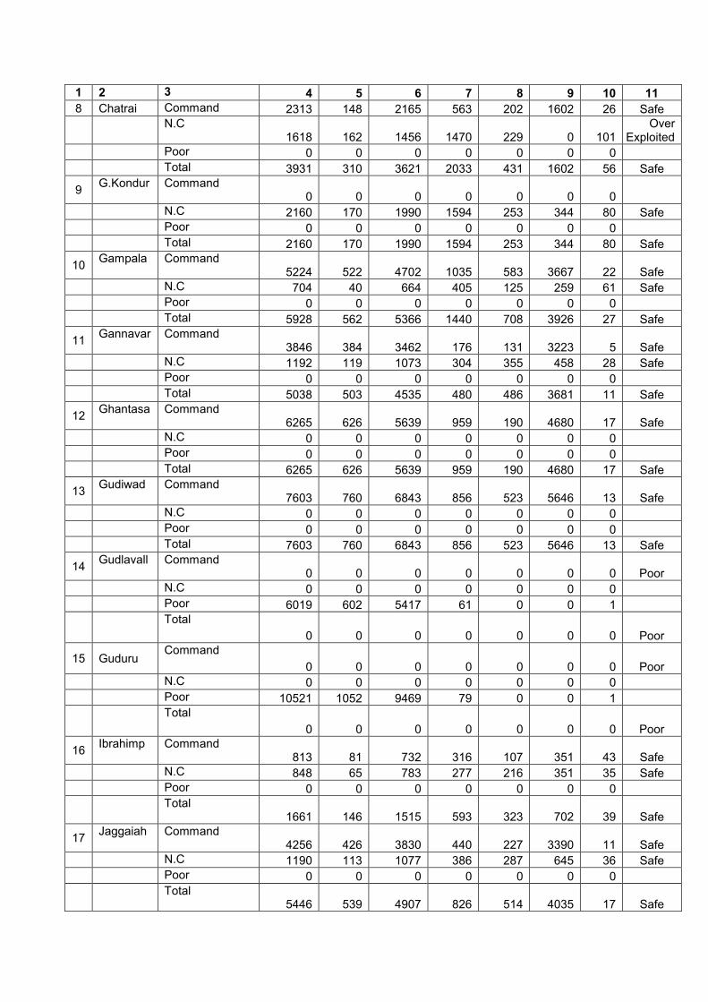
1 2 3 4 5 6 7 8 9 10 11
8 Chatrai Command 2313 148 2165 563 202 1602 26 Safe
N.C
1618 162 1456 1470 229 0 101 Over
Exploited
Poor 0 0 0 0 0 0 0
Total 3931 310 3621 2033 431 1602 56 Safe
9 G.Kondur Command
0 0 0 0 0 0 0
N.C 2160 170 1990 1594 253 344 80 Safe
Poor 0 0 0 0 0 0 0
Total 2160 170 1990 1594 253 344 80 Safe
10 Gampala
gudem Command
5224 522 4702 1035 583 3667 22 Safe
N.C 704 40 664 405 125 259 61 Safe
Poor 0 0 0 0 0 0 0
Total 5928 562 5366 1440 708 3926 27 Safe
11 Gannavar Command
3846 384 3462 176 131 3223 5 Safe
N.C 1192 119 1073 304 355 458 28 Safe
Poor 0 0 0 0 0 0 0
Total 5038 503 4535 480 486 3681 11 Safe
12 Ghantasa Command
6265 626 5639 959 190 4680 17 Safe
N.C 0 0 0 0 0 0 0
Poor 0 0 0 0 0 0 0
Total 6265 626 5639 959 190 4680 17 Safe
13 Gudiwad Command
7603 760 6843 856 523 5646 13 Safe
N.C 0 0 0 0 0 0 0
Poor 0 0 0 0 0 0 0
Total 7603 760 6843 856 523 5646 13 Safe
14 Gudlavall Command
0 0 0 0 0 0 0 Poor
N.C 0 0 0 0 0 0 0
Poor 6019 602 5417 61 0 0 1
Total
0 0 0 0 0 0 0 Poor
15 Guduru Command
0 0 0 0 0 0 0 Poor
N.C 0 0 0 0 0 0 0
Poor 10521 1052 9469 79 0 0 1
Total
0 0 0 0 0 0 0 Poor
16 Ibrahimp
Command
813 81 732 316 107 351 43 Safe
N.C 848 65 783 277 216 351 35 Safe
Poor 0 0 0 0 0 0 0
Total 1661 146 1515 593 323 702 39 Safe
17 Jaggaiah Command
4256 426 3830 440 227 3390 11 Safe
N.C 1190 113 1077 386 287 645 36 Safe
Poor 0 0 0 0 0 0 0
Total 5446 539 4907 826 514 4035 17 Safe
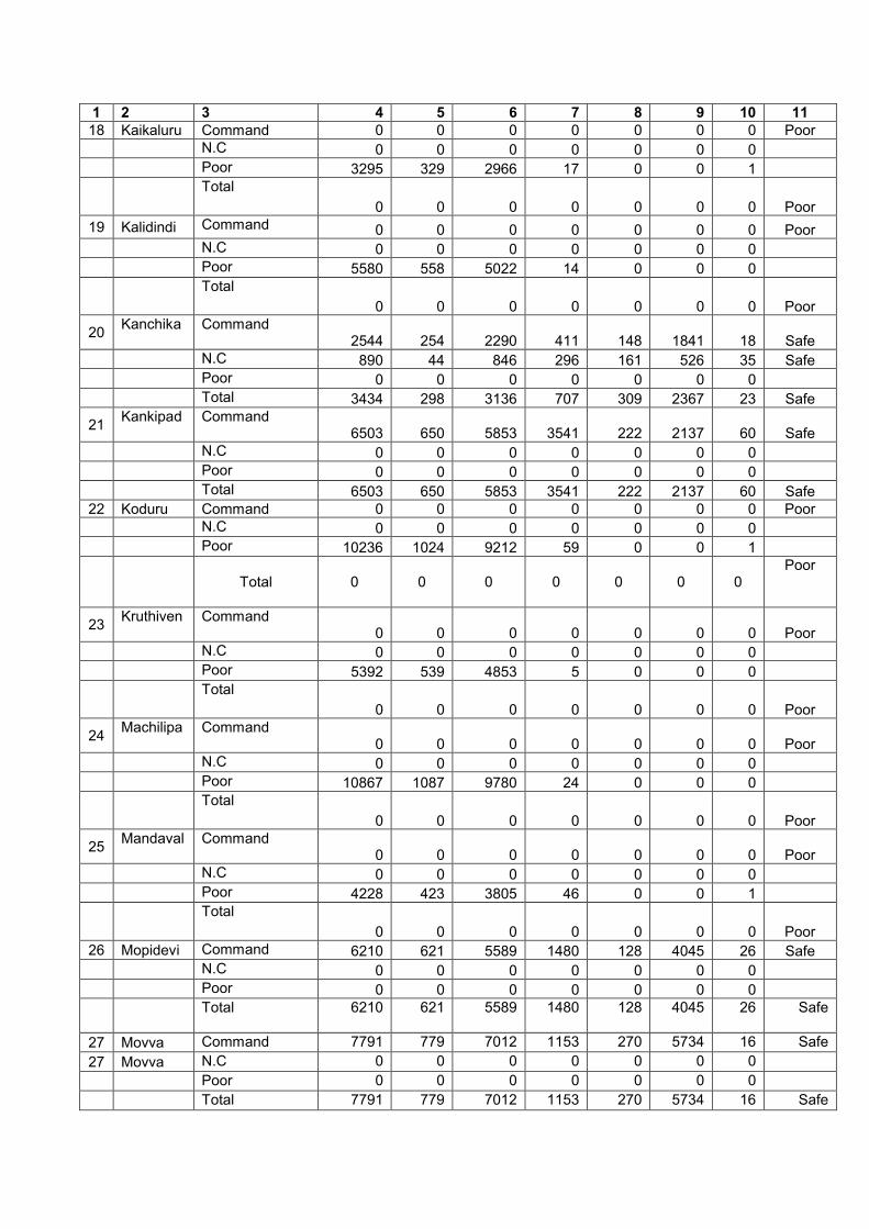
1 2 3 4 5 6 7 8 9 10 11 18 Kaikaluru Command 0 0 0 0 0 0 0 Poor
N.C 0 0 0 0 0 0 0
Poor 3295 329 2966 17 0 0 1
Total
0 0 0 0 0 0 0 Poor
19 Kalidindi Command 0 0 0 0 0 0 0 Poor
N.C 0 0 0 0 0 0 0
Poor 5580 558 5022 14 0 0 0
Total
0 0 0 0 0 0 0 Poor
20 Kanchika
Command
2544 254 2290 411 148 1841 18 Safe
N.C 890 44 846 296 161 526 35 Safe
Poor 0 0 0 0 0 0 0
Total 3434 298 3136 707 309 2367 23 Safe
21 Kankipad Command
6503 650 5853 3541 222 2137 60 Safe
N.C 0 0 0 0 0 0 0
Poor 0 0 0 0 0 0 0
Total 6503 650 5853 3541 222 2137 60 Safe 22 Koduru Command 0 0 0 0 0 0 0 Poor
N.C 0 0 0 0 0 0 0
Poor 10236 1024 9212 59 0 0 1
Total 0 0 0 0 0 0 0
Poor
23 Kruthiven Command
0 0 0 0 0 0 0 Poor
N.C 0 0 0 0 0 0 0
Poor 5392 539 4853 5 0 0 0
Total
0 0 0 0 0 0 0 Poor
24 Machilipa Command
0 0 0 0 0 0 0 Poor
N.C 0 0 0 0 0 0 0
Poor 10867 1087 9780 24 0 0 0
Total
0 0 0 0 0 0 0 Poor
25 Mandaval Command
0 0 0 0 0 0 0 Poor
N.C 0 0 0 0 0 0 0
Poor 4228 423 3805 46 0 0 1
Total
0 0 0 0 0 0 0 Poor
26 Mopidevi Command 6210 621 5589 1480 128 4045 26 Safe
N.C 0 0 0 0 0 0 0
Poor 0 0 0 0 0 0 0
Total
6210 621 5589 1480 128 4045 26 Safe
27 Movva Command 7791 779 7012 1153 270 5734 16 Safe
27 Movva N.C 0 0 0 0 0 0 0
Poor 0 0 0 0 0 0 0
Total 7791 779 7012 1153 270 5734 16 Safe

1 2 3 4 5 6 7 8 9 10 11
28 Mudinepa Command
0 0 0 0 0 0 0 Poor
N.C 0 0 0 0 0 0 0
Poor 10632 1063 9569 26 0 0 0
Total
0 0 0 0 0 0 0
Poor
1 2 3 4 5 6 7 8 9 10 11
29 Musunur Command
0 0 0 0 0 0 0
N.C
3680 368 3312 4901 209 0 148 Over
Exploited
Poor 0 0 0 0 0 0 0
Total
3680 368 3312 4901 209 0 148 Over
Exploited
30 Mylavara Command 0 0 0 0 0 0 0
N.C 2171 217 1954 1387 459 567 71 Safe
Poor 0 0 0 0 0 0 0
Total 2171 217 1954 1387 459 567 71 Safe 31 Nagayala Command 0 0 0 0 0 0 0 Poor
N.C 0 0 0 0 0 0 0
Poor 11454 1145 10309 3 0 0 0
Total
0 0 0 0 0 0 0 Poor
32 Nandiga Command
2563 257 2306 329 274 1883 14 Safe
N.C 1284 85 1199 384 210 810 32 Safe
Poor 0 0 0 0 0 0 0
Total 3847 342 3505 713 484 2693 20 Safe
33 Nandiwa Command
0 0 0 0 0 0 0 Poor
N.C 0 0 0 0 0 0 0
Poor 8050 805 7245 77 0 0 1
Total
0 0 0 0 0 0 0 Poor
34 Nuzvid Command 0 0 0 0 0 0 0
N.C
3645 364 3281 3466 1302 0 106 Over
Exploited
Poor 0 0 0 0 0 0 0
Total
3645 364 3281 3466 1302 0 106 Over
Exploited
35 Pamarru Command 6973 697 6276 679 208 5420 11 Safe
N.C 0 0 0 0 0 0 0
Poor 0 0 0 0 0 0 0
Total 6973 697 6276 679 208 5420 11 Safe 36 Pamidimk Command 4822 482 4340 896 197 3393 21 Safe
N.C 0 0 0 0 0 0 0
Poor 0 0 0 0 0 0 0
Total 4822 482 4340 896 197 3393 21 Safe 37 Pedana Command 0 0 0 0 0 0 0 Poor
N.C 0 0 0 0 0 0 0
Poor 10330 1033 9297 64 0 0 1
Total
0 0 0 0 0 0 0 Poor
1 2 3 4 5 6 7 8 9 10 11
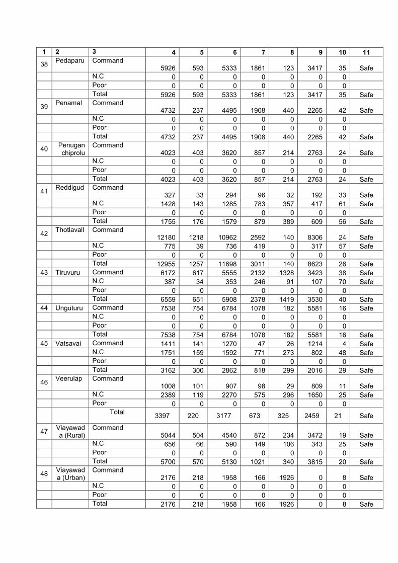
38 Pedaparu Command
5926 593 5333 1861 123 3417 35 Safe
N.C 0 0 0 0 0 0 0
Poor 0 0 0 0 0 0 0
Total 5926 593 5333 1861 123 3417 35 Safe
39 Penamal Command
4732 237 4495 1908 440 2265 42 Safe
N.C 0 0 0 0 0 0 0
Poor 0 0 0 0 0 0 0
Total 4732 237 4495 1908 440 2265 42 Safe
40 Penuganchiprolu
Command 4023 403 3620 857 214 2763 24 Safe
N.C 0 0 0 0 0 0 0
Poor 0 0 0 0 0 0 0
Total 4023 403 3620 857 214 2763 24 Safe
41 Reddigud Command
327 33 294 96 32 192 33 Safe
N.C 1428 143 1285 783 357 417 61 Safe
Poor 0 0 0 0 0 0 0
Total 1755 176 1579 879 389 609 56 Safe
42 Thotlavall Command
12180 1218 10962 2592 140 8306 24 Safe
N.C 775 39 736 419 0 317 57 Safe
Poor 0 0 0 0 0 0 0
Total 12955 1257 11698 3011 140 8623 26 Safe
43 Tiruvuru Command 6172 617 5555 2132 1328 3423 38 Safe
N.C 387 34 353 246 91 107 70 Safe
Poor 0 0 0 0 0 0 0
Total 6559 651 5908 2378 1419 3530 40 Safe
44 Unguturu Command 7538 754 6784 1078 182 5581 16 Safe
N.C 0 0 0 0 0 0 0
Poor 0 0 0 0 0 0 0
Total 7538 754 6784 1078 182 5581 16 Safe
45 Vatsavai Command 1411 141 1270 47 26 1214 4 Safe
N.C 1751 159 1592 771 273 802 48 Safe
Poor 0 0 0 0 0 0 0
Total 3162 300 2862 818 299 2016 29 Safe
46 Veerulap Command
1008 101 907 98 29 809 11 Safe
N.C 2389 119 2270 575 296 1650 25 Safe
Poor 0 0 0 0 0 0 0
Total
3397 220 3177 673 325 2459 21 Safe
47 Viayawada (Rural)
Command 5044 504 4540 872 234 3472 19 Safe
N.C 656 66 590 149 106 343 25 Safe
Poor 0 0 0 0 0 0 0
Total 5700 570 5130 1021 340 3815 20 Safe
48 Viayawada (Urban)
Command 2176 218 1958 166 1926 0 8 Safe
N.C 0 0 0 0 0 0 0
Poor 0 0 0 0 0 0 0
Total 2176 218 1958 166 1926 0 8 Safe

1 2 3 4 5 6 7 8 9 10 11
49 Vissanna Command
3310 331 2979 1641 471 1265 55 Safe
N.C 299 30 269 170 26 95 63 Safe
Poor 0 0 0 0 0 0 0
Total 3609 361 3248 1811 497 1360 56 Safe
50 Vuyyuru Command 5909 591 5318 2549 478 2769 48 Safe
N.C 0 0 0 0 0 0 0
Poor 0 0 0 0 0 0 0
Total 5909 591 5318 2549 478 2769 48 Safe
District -
Command 149173 14597 134576 32714 10439 97843 24
N.C 33369 2910 30459 22084 6184 9359 73
Poor 104124 10412 93712 481 0 0 1
Total (Excluding PQ) 182542 17507 165035 54798 16623
107202 33
The net availability of ground water in the district varies from 15.15 MCM in Ibrahimpatnam mandal to 116.98 MCM in Thotlavalluru mandal. Gross ground water draft for all uses varies from 1.66 MCM in Vijayawada(U) Mandal to 49.01 MCM in Musunuru mandal. The stage of ground water development is as low as 8% in Vijayawada(U) mandal and as high as 148% in Musunuru Mandal. All the mandals in the district are categorised as safe except Musunuru and Nuzividu mandals, which are categorized as over exploited mandals. (Fig. 6).
4.3 Ground Water Quality
The quality of ground water is as important as quantity. Ground water
from shallow as well as deeper aquifers occurring in the northern parts of the district underlained by consolidated and semi-consolidated formations is generally good. The type of water is mainly Ca-Mg-Na--SO4-HCO3 type. In general ground water is suitable for domestic, industrial and irrigation purposes, except at Kanchikacherla, Vissannapeta and Gampalagudem areas, where EC values are more than permissible limit exist.
In the deltaic area i.e., southern part of the district, the quality of ground
water deteriorates from north to south. All along the coast both shallow and deeper aquifers are saline. Away from the coast fresh water in the aquifers is limited to very shallow to moderate depths. Deeper aquifers are invariably saline. Shallow aquifers exhibit wide range of quality variations due to deltaic nature of the deposits and drainage conditions. Quality of water from the palaeochannels is comparatively good. In general the type of water varies from Ca-Mg-Na-HCO3-SO4 in the north to Na-K-Cl-SO4 in the south. Overall the ground water from shallow aquifers is suitable for domestic and irrigation purposes, except at Unguturu, Pamarru, Mudinepalli and Kaikaluru areas and the areas immediately adjoining the coast falling in Krutivennu, Bantumilli, Pedana, Machilipatnam, Krutivennu, Koduru, Nagayalanka, Avanigadda, Challapalli and Guduru mandals, where values of EC and some of the chemical constituents are more than permissible limits. This salinity in these areas may be due to the palaeo coast line which was passing through Nandivada, Gudivada, Pamarru, Movva, Ghantasala, Challapalli and Avanigadda mandals in the geologic past. However, in these mandals limited potable ground water zones do exist, but they may not sustain for heavy withdrawals.
Arsenic and Fluoride contents in the ground water are within the
permissible limits. Nitrate enrichment (more than permissible limit) is high at isolated places in A.Konduru, Tiruvuru, Gampalagudem, Kanchikacherla, Nuzividu, Gudivada, Gannavaram, Machlipatnam, Bantumilli areas due to localised pollution. Ground water from these areas can be used for other than drinking purposes.
4.4 Status of Ground Water Development
The assessment of ground water resources in the district has brought to light the wide scope for utilising the ground water resources to boost the irrigation. Ground water is one of the most important and essential commodities for agricultural development and thus the judicious and scientific management of the resource is essential. It is therefore, imperative that wells have to be designed and spaced properly for meeting the irrigation water requirements of the district. In the consolidated formations at present dug wells of 4 to 6m diameter with depths of 5 to 15 m exists. In the unconsolidated formations with 2 to 3m diameter in the depth range of 2 to 7 m are prevalent in the district. In unconsolidated formations, wells are either

stone or brick lined (masonry lined) and RCC rings are lowered upto sufficient depths. Ground water in the district is also developed through bore wells of 250 to 380 mm diameter with casing upto 10 to 15 m deep and are drilled down to 40 to 60m depth in consolidated formations. Similarly tube wells in semi-consolidated formations are with 380mm diameter is drilled down to depths of about 150 m, tapping 30 to 40m saturated aquifer material. And also filter point wells of 254 mm diameter are driven down to a depth ranging between 7 to 15 m in the deltaic alluvium areas wherever the potential zones available beyond 5m. In the consolidated and semi-consolidated formations ground water is also developed through dug cum bore/tube wells as the dug wells are being dried up or not getting sufficient yields. The depth of inwells of these structures ranges from 40 to 60 m and 30 to 100 m in consolidated and semi-consolidated formations respectively.
Ground water irrigation in the district is not extensive and accounts only 29% of the gross irrigation of the district. A total number of 16976 dug wells and 16340 bore/tube wells are functioning in the district. A total area of 93800 ha is irrigated through ground water, of which 7800 ha with dug well sources and 860 sq.kms by bore/tube wells.
Urban water supply to Vijayawada, Gudivada, Machilipatnam and Pedana is from Krishna river and its canal system, for Jaggayyapeta from Paleru river. The requirement for Nuzividu town is being met mostly by ground water. The rural water supply in the district is through both surface and ground water. A total number of 217 open wells, 10000 bore/tube wells, 1040 protected water schemes and 236 other sources are meeting the drinking water requirements of the rural population.
5.0 Ground Water Management Strategy 5.1 Ground Water Development
The scope for further development of ground water in the district varies
widely from place to place and from mandal to mandal. Hence scientific and judicious development and management of available water resource will contribute to the overall planned development and improving the economy of the district. There is a huge scope for further development of ground water resources in order to bring more areas under irrigation in the district. Present irrigation is confined to 65% of the net sown area. Hence a balance of 35% area is devoid of irrigation facilities. Though surface water is abundant, during summer season its availability is very less due to swift nature of streams and rivers. The district is underlained by hard (Consolidated formations) and soft (semi-consolidated & unconsolidated formations) formations, therefore DTH rigs and DR rigs respectively suggested for deployment. In the deltaic area the ground water is supplementary source for irrigation requirements in few mandals. The ground water development in the deltaic area is to be carried out judiciously by installing low capacity pumps as the fresh water zones are limited and also to minimise salinity problems. In order to monitor the advancement of fresh water/saline water interface towards inland in due
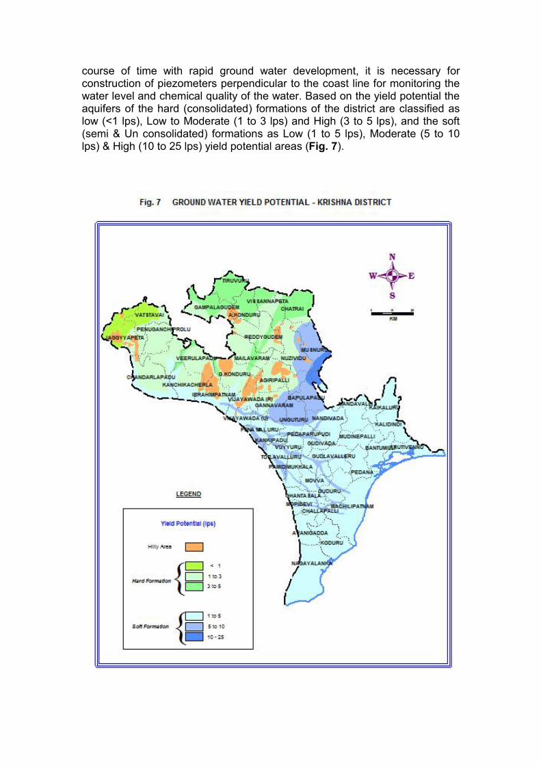
course of time with rapid ground water development, it is necessary for construction of piezometers perpendicular to the coast line for monitoring the water level and chemical quality of the water. Based on the yield potential the aquifers of the hard (consolidated) formations of the district are classified as low (<1 lps), Low to Moderate (1 to 3 lps) and High (3 to 5 lps), and the soft (semi & Un consolidated) formations as Low (1 to 5 lps), Moderate (5 to 10 lps) & High (10 to 25 lps) yield potential areas (Fig. 7).

5.2 Water Conservation and Artificial Recharge
Construction of artificial recharge structures like check-dams, contour
trenches, percolation tanks and water conservation structures like sub-surface dykes are feasible in the areas where water levels are declining and considerable exploitation of ground water resources is taking place viz. Bapulapadu, Chatrai, Musunuru, and Nuzividu mandals. In the deltaic area artificial recharge schemes have to be implemented to avoid further deterioration of quality of ground water. Roof top Rainwater Harvesting is to be implemented in the urban areas wherever deepening of water levels is taking place.
6.0 Ground Water Related Issues and Problems
Coastal salinity and water logging are the major problems in the deltaic area of the district. In the deltaic area the fresh to brackish/ saline ground water occur in hydraulic contact with fresh ground water. The quality of ground water varies widely from place to place even within short distances and the deeper aquifers are invariably saline. The salinity of ground water is caused mainly due to depositional environment and other factors like geomorphic landform, water logging conditions, sluggish nature in ground water movement, excess use of fertilizers and unregulated growth of aquaculture in the coastal area which also play an important role. The most of the command area in the delta is either water logged or seasonally water logged. The intensive irrigation, near flat topography, low ground water development, poor drainage and clayey soils are the factors responsible for the water logging conditions. Localized Nitrate pollution is another problem in the district, which is due to excess use of fertilizers, urban sewerage and improper drainage system.
7.0 Recommendations
Ground water should be judiciously exploited in the shallow fresh water aquifers of deltaic area without disturbing the fresh/saline water interface.
In the limited fresh ground water potential areas, modern irrigation
methods like drip and sprinkler irrigation should be adopted to increase the command area of the well.
The aqua culture development should be restricted to areas close to
the coast only. The practice of converting agricultural lands in the inland areas should be stopped to avoid the pollution of fresh water aquifers.

Conjunctive use of surface and ground water needs to be planned in the command area, particularly in the deltaic area, to prevent the adverse effects of the water logging conditions and to improve or to avoid further deterioration of quality of ground water.
Artificial recharge measures should be adopted in the urban areas, in
the deltaic area and areas with considerable exploitation of ground water for improving the ground water situation.
A multi-sectorial approach is needed to study the ground water
development, augmentation and management perspective. Therefore, all the aspects related to ground water, involvement of NGOs and mass awareness campaigns will play an important role in conserving and developing the precious fresh ground water resources.
ACKNOWLEDGEMENTS
Thanks are due to the Chief Planning Officer, Krishna District, Machilipatnam, to the Dy. Director, State Ground Water Department, Vijayawada and to other State Government Authorities for providing necessary data.
Related Documents