GRAVITY SURVAY AT SEA This is a continuation of the report of gravity surveys at sea by the Hydrographic and Oceanographic Department. The results of three cruises , Northeast offing of Izu-Oshima, Offing of Wakasa Wan and Kikai- Caldera surveyed in 2006-2008 are presented in this report. Key words: marine gravity survey 1. Surveys The Hydrographic and Oceanographic Department (JHOD) has carried out gravity surveys at sea by using the sea surface gravity meters, KSS-30 or KSS-31(Bodenseewerk), on board the survey vessels, the Meiyo, and the Shoyo. The gravity meters are composed of the sensor, stabilized platform and data handling subsystems. KSS-30 and KSS-31 measures the gravity by means of the zero method using the balance between gravity and electro-magnetic forces. The change of electric current, which balances the gravity change, is filtered in time domain and then converted into frequency variation. A brief explanation of the gravity meter is described in No. 19 of this publication series (Ueda, et al., 1985). ; 2. Reduction The KSS-30 and KSS-31 gravity meter is calibrated in advance of each cruise using a LaCoste & Romberg gravity meter. A gravity value of 979,778.272 mGal (JGSN75) at the gravity station of the Hydrographic Department (JHD-G 0 ) is adopted as the reference value for calibrations. The gravity value at pier for the Meiyo is reduced to 979,770.36 mGal and the Shoyo reduced to 979,767.66 mGal on the base of the value at JHD-G 0 . The corrections of Eotvos and drift effect are applied to measure gravity values. (a) Free-air gravity anomaly, Δg 0 , is calculated by the following equation, Δg 0 = g 0 + 0.87 - γ (mGal), where g 0 is the corrected gravity value, 0.87 (mGal) is an atmospheric correction at sea level and γ is the normal gravity value based on the Geodetic Reference System 1980 given by the formula: γ = 978.03267715[ 1 + 0.005279041sin 2 φ + 0.0000232718sin 4 φ+ 0.0000001262sin 6 φ + 0.0000000007sin 8 φ ] (Gal) where φ is the latitude of the reference point. (b) Bouguer gravity anomaly, Δg 1 is calculated by the following equation, ΔB = 2πG (ρ c -ρ w ) × d (mGal) + ρ c T c ‐ρ w T w , where d is depth in meter, T c is terrain correction value for the earth’s crust, T w terrain correction value for the sea water, G = 6.673 x 10 -8 (cm 3 /g.sec 2 ), ρ c = 2.67(g/ cm 3 ) and ρ w = 1.03 (g/ cm 3 ) whence the Bouguer anomaly is calculated by Δg 1 =Δg 0 +ΔB . The reduction and compilation of four cruises in Table 2 have been completed, and the details of those surveys are shown in this table.

Welcome message from author
This document is posted to help you gain knowledge. Please leave a comment to let me know what you think about it! Share it to your friends and learn new things together.
Transcript

GRAVITY SURVAY AT SEA
This is a continuation of the report of gravity surveys at sea by the Hydrographic and Oceanographic
Department. The results of three cruises , Northeast offing of Izu-Oshima, Offing of Wakasa Wan and Kikai-
Caldera surveyed in 2006-2008 are presented in this report.
Key words: marine gravity survey
1. Surveys
The Hydrographic and Oceanographic Department (JHOD) has carried out gravity surveys at sea by using
the sea surface gravity meters, KSS-30 or KSS-31(Bodenseewerk), on board the survey vessels, the Meiyo, and the
Shoyo. The gravity meters are composed of the sensor, stabilized platform and data handling subsystems.
KSS-30 and KSS-31 measures the gravity by means of the zero method using the balance between gravity
and electro-magnetic forces. The change of electric current, which balances the gravity change, is filtered in time
domain and then converted into frequency variation. A brief explanation of the gravity meter is described in No. 19
of this publication series (Ueda, et al., 1985). ;
2. Reduction
The KSS-30 and KSS-31 gravity meter is calibrated in advance of each cruise using a LaCoste & Romberg
gravity meter. A gravity value of 979,778.272 mGal (JGSN75) at the gravity station of the Hydrographic
Department (JHD-G0) is adopted as the reference value for calibrations. The gravity value at pier for the Meiyo is
reduced to 979,770.36 mGal and the Shoyo reduced to 979,767.66 mGal on the base of the value at JHD-G0. The
corrections of Eotvos and drift effect are applied to measure gravity values.
(a) Free-air gravity anomaly, Δg0, is calculated by the following equation,
Δg0 = g0 + 0.87 - γ (mGal),
where g0 is the corrected gravity value, 0.87 (mGal) is an atmospheric correction at sea level and γ is the normal gravity value based on the Geodetic Reference System 1980 given by the formula:
γ = 978.03267715[ 1 + 0.005279041sin2φ + 0.0000232718sin4φ+ 0.0000001262sin6φ +
0.0000000007sin8φ ] (Gal)
where φ is the latitude of the reference point.
(b) Bouguer gravity anomaly, Δg1 is calculated by the following equation,
ΔB = 2πG (ρc-ρw ) × d (mGal) + ρcTc‐ρwTw,
where d is depth in meter, Tc is terrain correction value for the earth’s crust, Tw terrain correction value for the sea
water, G = 6.673 x 10⁻⁸ (cm
3 /g.sec
2 ), ρc = 2.67(g/ cm
3 ) and ρw = 1.03 (g/ cm
3 ) whence the Bouguer anomaly is
calculated by
Δg1 =Δg0 +ΔB .
The reduction and compilation of four cruises in Table 2 have been completed, and the details of those
surveys are shown in this table.

Gravity Survey at Sea
3. Results of gravity survey
Free-air gravity anomaly maps and Bouguer gravity anomaly maps are shown in Figure 1 to 5. The free-air
gravity anomaly and associated data have been compiled on digital media with relevant information and are
available on request.
The data format and other information concerning the gravity data file of JHDGF should be referred to
Ganeko and Koyama(1981).
This report was written by S.Kato and K.Koyama, Geodesy and Geophysics Office.
References
Ganeko, Y., Koyama, K. 1981: Report of Hydrographic Researches, No. 16, p. 103.
Ueda, Y., Harada, Y., Hiraiwa, T. 1985: Data report of Hydrogr.Obs,Series of astronomy and Geophi., No. 19, p. 99.
Ueda, Y., Harada, Y., Hiraiwa, T., Horii, R. 1986: ibid., No. 20, p. 90.
The results of gravity surveys at the sea surface for the preceding years are found in the back numbers of
this publication series listed in Table 1.

Gravity Survey at Sea
Table 1. The list of back numbers of this publication series
Cruise index Data Report of Hydrographic Observation,
Series of Astronomy and Geodesy
65TEST
Tokuhiro, A., 1966, No.1, p.43.
Tokuhiro, A., 1967, No.2, p.29.
Sugimoto, K., Yanagi, T., 1968, No.3, p.22.
68TK Takemura, T., Yanagi, T., Ganeko, Y., 1969, No.4, p.13.
68AK Takemura, T., Yanagi, T., Ganeko, Y., 1970, No.5, p.33.
68NI Takemura, T., Yanagi, T., Ganeko, Y., 1971, No.6, p.19.
70IR Takemura, T., Yanagi, T., Tomioka, Y., 1972, No.7, p.23.
70SN Takemura, T., Yanagi, T., Nisiya, S., 1974, No.8, p.29.
71SN Takemura, T., Yanagi, T., Tomioka, Y., 1975, No.9, p.42.
72HU Yanagi, T., Tomioka, Y., Katsuno, K., 1976, No.10, p.49.
72KU,72HI,72HD, 73HK,73KG,73MI Yanagi, T., Tomioka, Y., Katsuno, K., 1977, No.11, p.76.
73KO,74NG,74TR 74KG,76IK Yanagi, T., Kubo, K., 1978, No.12, p.55.
75OK,75YM Yanagi, T., Matumoto, K., Nisisita, A., 1979, No.13, p.48.
75BO,75SI,76OK,76MK Ganeko, Y., Yanagi, T., Nisisita, A., 1980, No.14, p.59.
76IK,77JO,78JO Ganeko, Y., Harada, Y., Komatu, Y., 1981, No.15, p.44.
80KT,80IS-A,80IS-B Ganeko, Y., Harada, Y., Komatu, Y., 1982, No.16, p.64.
81IO,81YK Ganeko, Y., Harada, Y., Koyama, K., Futinoue, S., 1983, No.17,
p.88.
82SN,82AM Ganeko, Y., Harada, Y., Koyama, K., Hiraiwa, T., 1984, No.18,
p.85.
83SN,83NT,83HN Ueda, Y., Harada, Y., Hiraiwa, T., 1985, No.19, p.99.
84HN,85TH,85IS Ueda, Y., Harada, Y., Horii, R., Hiraiwa, T., 1986, No.20, p.90.
84ST,85BM,85TB Ueda, Y., Asao, T., Hiraiwa, T., 1987, No.21, p.122.
84SM,85SB,85BT,86IZ Ueda, Y., Nakagawa, H., Onodera, K., Nagaya, Y., 1988, No.22,
p.36.
85TR,86TR,86BK Yanagi, T., Onodera, K., Ito, H., Kato, T., 1989, No.23, p.34.
87HT,87TT,88SN Yanagi, T., Mihara, S., Yamano, H., 1990, No.24, p.63.
88WP,88ST Yanagi, T., Mihara, S., Yamano, H., 1991, No.25, p.40.
90ST Ono, F., Mihara, S., Okumura, M., 1992, No.26, p.44.

Gravity Survey at Sea
Cruise index Data Report of Hydrographic Observation,
Series of Astronomy and Geodesy
91BEPPU,91UN-T ,91UN-S,91MI Ono, F., Mihara, S., Kato, T., Usijima, M., 1993, No.27, p.44.
91ZN,91BO,92NI Ono, F., Kato, T., Usijima, M., 1994, No.28, p.52.
91MF,92EN,92IZ,93KO,93HY,93TO,94EN
94IR Kato, T., Usijima, M., Tugawa, T., 1995, No29, p.64.
94NI,94AY Okumura, M., Toyama, S., 1997, No31, p.70.
94ENB,95IS,95AM,96TS Okumura, M., Toyama, S., 1998, No32.
98KI,98MI,98IZ Suzuki,A.,Sakamoto,H., 1999, No33.
99FU,99NI Suzuki,A.,Sakamoto,H., 2000, No34.
98MY,99MY,98IZ,99FU,00MI Kato, T.,Suzuki,A.,2001, No35.
96SR,96RO,97TM,00BU Kato, T.,2002, No36.
95ISE,98NI,99NI,01NI,01HI,02NI Kato, T.,2003, No37.
02-03KIF, 03KIT,00-01-03SI,04WAK Onodera, K.,Koyama,K.,Kon,T., 2004, No38

Gravity Survey at Sea
Table 2. Detailed information on the compiled sea gravity surveys
Cruise index OS06 WA07
KC06
KC07
KC08
Area Northeast offing of
Izu-Oshima Offing of Wakasa Wan Kikai Caldera
Period Jul, 2006 May-Jun, 2007
Jan-Feb, 2006
Aug, 2007
May-Jun, 2008
Vessel Meiyo Meiyo Meiyo
Gravimeter KSS-30 KSS-30 KSS-30
Positioning Integrated
Navigation System
Integrated
Navigation System
Integrated
Navigation System
Survey speed 9~10 knot 10~11 knot 10 knot
Survey line
spacing 0.5 N.M. NW-SE 2 N.M. W-E 0.5 N.M. W-E
Observation
interval 5sec 5sec 5sec
Drift +0.2mGal/month +0.1mGal/month
+0.2mGal/month
+0.1mGal/month
+1.2mGal/month
Mean of
cross
difference
±0.7mGal
±0.5mGal ±0.5mGal
Free air
Anomaly map Figure 1 Figure 3 Figure 4
Bouguer
Anomaly map Figure 2 Figure 5
Scale of
original chart 1:125,000 1:500,000 1:150,000
Map
projection TM TM TM

Gravity Survey at Sea
Fig.1 Free-air gravity anomaly map in Northeast offing of Izu-Oshima.

Gravity Survey at Sea
Fig.2 Bouguer gravity anomaly map in Northeast offing of Izu-Oshima.

Gravity Survey at Sea
Fig.3 Free-air gravity anomaly map offing of Wakasa Wan.
Gravity Survey at Sea
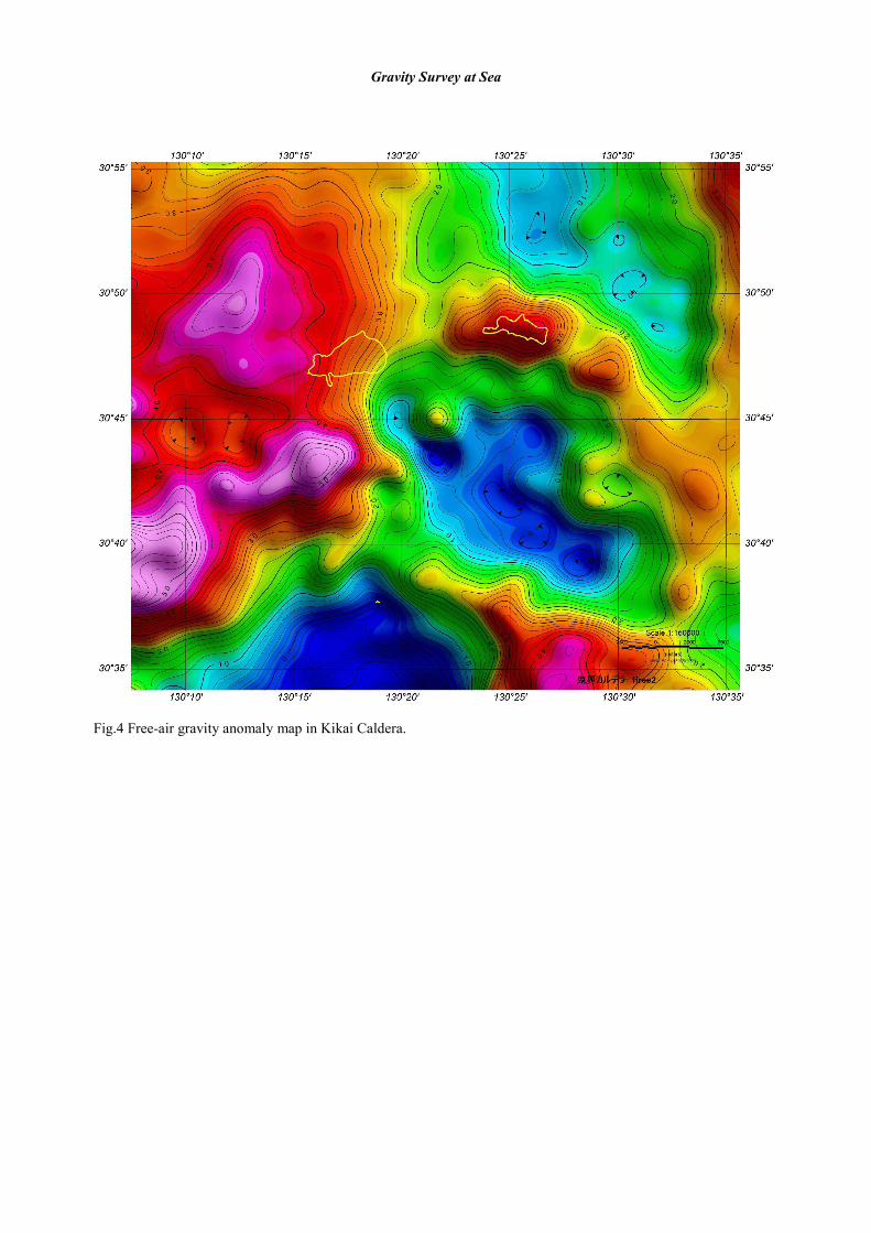
Fig.4 Free-air gravity anomaly map in Kikai Caldera.

Gravity Survey at Sea
Fig.5 Bouguer gravity anomaly map in Kikai Caldera.
Related Documents