Weeki Wachee River Governing Board Meeting Agenda and Meeting Information December 16, 2008 9:00 a.m. District Headquarters 2379 Broad Street • Brooksville, Florida (352) 796-7211 • 1-800-423-1476

Welcome message from author
This document is posted to help you gain knowledge. Please leave a comment to let me know what you think about it! Share it to your friends and learn new things together.
Transcript
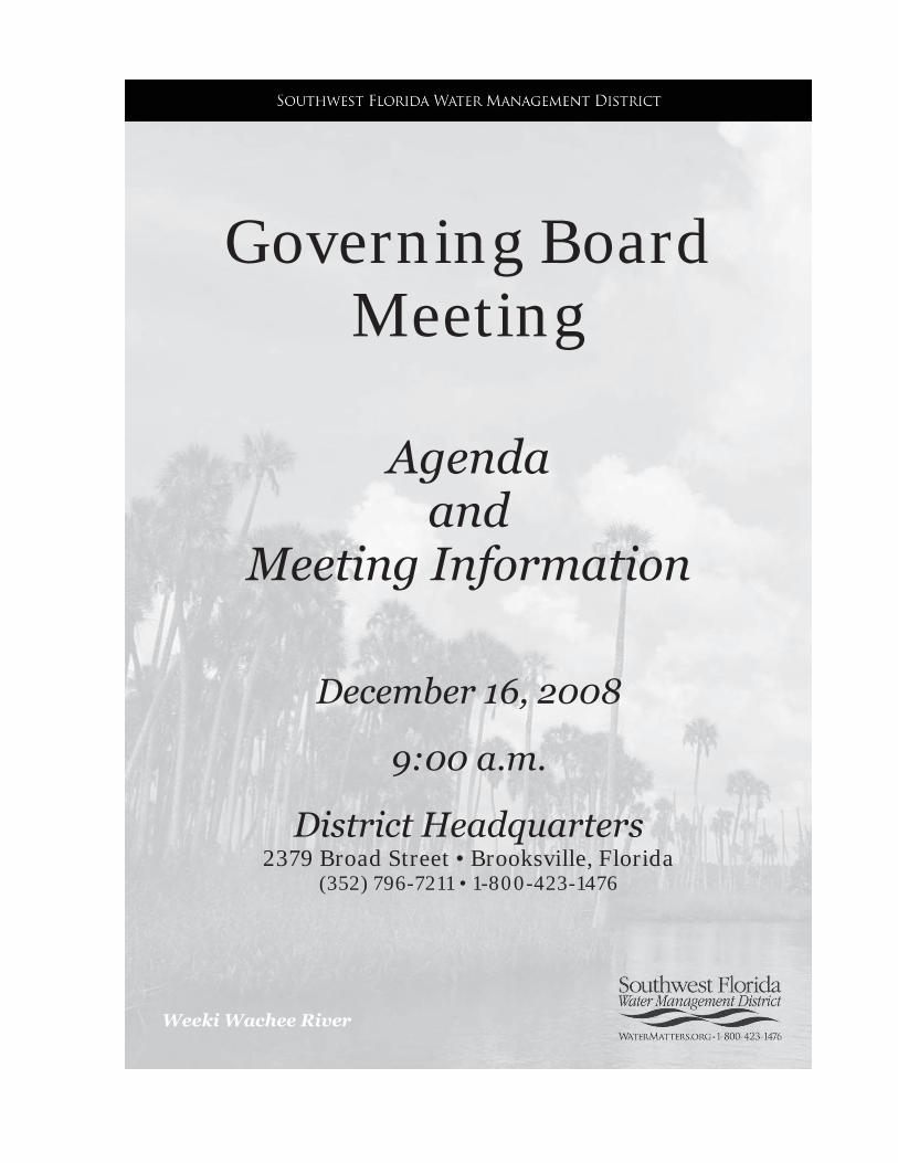
Weeki Wachee River
Governing Board Meeting
Agenda and
Meeting Information
December 16, 2008
9:00 a.m.
District Headquarters 2379 Broad Street • Brooksville, Florida
(352) 796-7211 • 1-800-423-1476

2379 Broad Street, Brooksville, Florida 34604-6899
(352) 796-7211 or 1-800-423-1476 (FL only)
TDD only 1-800-231-6103 (FL only)
On the Internet at: WaterMatters.org
An Equal
Opportunity Employer
y status. This pation, employment, or treatment in its programs or activities. Anyone requiring reasonable accommodations as provided for in the Americans with Disabilities Act should contact the General Services Department at (352) 796-7211 or 1-800-423-1476 (FL only), extension 4527, TDD only 1-800-231-6103 (FL only).
MEE
TIN
G N
OTI
CE
AGENDA
GOVERNING BOARD MEETING
All meetings are open to the public.
Viewing of the Board meeting is available at each of the District offices. Public input will be taken only at the Brooksville office. Public input for issues not listed on the published agenda will be heard
shortly after the meeting begins.
Unless specifically stated, scheduled items will not be heard at a time certain.
At the discretion of the Board, items may be taken out of order
to accommodate the needs of the Board and the public.
The meeting will recess for lunch and a briefing session with senior staff at a time to be announced
The current Governing Board agenda and minutes of previous meetings
are on the District's web site: www.WaterMatters.org
9:00 A.M. CONVENE MEETING OF THE GOVERNING BOARD AND PUBLIC HEARING
(TAB A)
1. Call to Order 2. Pledge of Allegiance and Invocation 3. Additions/Deletions to Agenda 4. Employee Recognition 5. Public Input for Issues Not Listed on the Published Agenda

SWFWMD GOVERNING BOARD AGENDA - 2 - DECEMBER 16, 2008 CONSENT AGENDA (TAB B) All matters listed under the Consent Agenda are considered routine and action will be taken by one motion, second of the motion and approval by the Board. If discussion is requested by a Board member, that item(s) will be deleted from the Consent Agenda and moved to the appropriate Committee or Report for consideration. Regulation Committee -- Environmental Resource Permits 6. ERP No. 43034196.000 - Legacy Lake Borrow Pit Charlotte County 7. ERP No. 43013044.006 - FDOT - SR 35 (US 17) from DeSoto County Line to SW Collins
DeSoto County 8. ERP No. 43020690.009 - FDOT - I-4/Lee Roy Selmon Expressway Interchange (South of
7th Avenue) Hillsborough County 9. ERP No. 44030783.001 - Bayou Pass Phase 3 (DENIAL) Hillsborough County 10. ERP No. 43001436.040 - On Top of the World - South Branch Marion County 11. ERP No. 43015544.003 - Gulf Landings Boat Docks, Tracts 40B, 40C and 50C Pasco County 12. ERP No. 43027830.001 - Main Street Landing Boat Docks Pasco County 13. ERP No. 43033500.001 - FDOT-SR 39 (Buchman Hwy) at Hillsborough River - Temporary
Detour Bridge Pasco County 14. ERP No. 43031900.002 - EVWR/CSXT Rail Terminal Facility Polk County 15. ERP No. 43032386.000 - Dawn View Estates Polk County 16. ERP No. 43033931.000 - Ridgeview Place (DENIAL) Polk County Regulation Committee -- Water Use Permits 17. WUP No. 20006765.010 - L. D. Hancock Marital Trust/Hancock Grove DeSoto County 18. WUP No. 20003837.011 - Falkner Farms/Falkner Farms Manatee County 19. WUP No. 20002981.015 - City of Clearwater Pinellas County 20. WUP No. 20004912.007 - City of Lakeland Polk County 21. WUP No. 20005393.008 - City of Venice Sarasota County Regulation Committee -- Other 22. Approve Exchange of Conservation Easement Areas Lake Jovita East Pointe Townhomes
Pasco County 23. Approve for Adoption Final Changes to Amendments to 40D-1.659 and 40D-2.091, Florida
Administrative Code (F.A.C.), to Incorporate Changes to Chapters 5 and 6 of the Basis of Review in Response to the Joint Administrative Procedures Committee
24. Electrical Power Plant Site Certification SWFWMD Agency Report on Progress Energy Florida Levy Nuclear Units 1 & 2 Main Site and Associated Facilities Levy County
Resource Management Committee 25. Approve Initiation of Rulemaking to Amend 40D-8.624, F.A.C., to Add Minimum and Guidance
Levels for Lake Anoka in Highlands County 26. Approve Initiation of Rulemaking to Amend 40D-8.041, F.A.C., to Establish Minimum Flows for
Weeki Wachee River System 27. Authorize Submission of the Preliminary Flood Insurance Rate Maps for the Oman Quarry/Indian
Creek, Powell, and Blue Sink Watersheds to the Federal Emergency Management Agency 28. Appraisals and Purchase/Sale Agreement Lake Hancock Project, SWF Parcel No. 20-503-151 29. Temporary Construction Easement to Florida Department of Transportation for State Road 39
Hillsborough River Corridor, SWF Parcel Number 13-444-109X 30. Supplemental Utility Easement to Progress Energy Florida, Inc. for Additional Service to the
Withlacoochee River Electric Cooperative Tampa Downs Substation Cypress Creek Preserve, SWF Parcel Number 13-500-390X
31. Facilitating Agricultural Resource Management Systems (FARMS) Program a. FLM, Inc. Prairie River Ranch Grove Phase II DeSoto County b. CFI USA, Inc. Venus II Grove Manatee County Finance & Administration Committee 32. Board Travel 33. Budget Transfer Report 34. District Strategic Systems Network and Server Upgrades
SWFWMD GOVERNING BOARD AGENDA - 3 - DECEMBER 16, 2008
t 35. Consent Order WUP No. 208639.010 - Timber Pines Community Association, Inc.
Hernando County 36. Initiation of Litigation Surface Water Activity - Edward A. Mariani Manatee County 37. Initiation of Litigation Surface Water Activity - Lexington Homes, Inc. (North Green Estates and
South Green Estates) Hillsborough County 38. Initiation of Litigation ERP No. 46029649.001- Memorial Townhomes, LLC (Memorial
Townhomes) Hillsborough County 39. Initiation of Litigation ERP No. 44007115.006 - Regency Oaks Preserve, Inc. Manatee County 40. Settlement Agreement Lance H. Ham et al. v. City of Plant City, Hillsborough County, and
SWFWMD, 13th Judicial Circuit Case No. 05-CA-9419 Hillsborough County
41. Approval of Minutes November 18, 2008 Governing Board Meeting RESOURCE MANAGEMENT COMMITTEE (TAB C) Discussion Items 42. Consent Item(s) Moved for Discussion 43. Hydrologic Conditions Status Report 44. Review of Analytical Process for Water Shortage Actions and Public Dissemination of Information 45. Long-Range Water Supply and Water Resource Development Funding Plan Update Submit & File Reports None Routine Reports 46. Florida Forever Funding 47. Minimum Flows and Levels 48. Structure Operations 49. Watershed Management Program and Federal Emergency Management Agency Map Modernization 50. Significant Water Supply and Resource Development Projects REGULATION COMMITTEE (TAB D) Discussion Items 51. Consent Item(s) Moved for Discussion 52. Approve for Adoption Proposed Amendments to Chapter 40D-22, F.A.C., Year-Round Water
Conservation Measures, In Accordance with Interdistrict Consistency Initiative 53. Implementation of Water Shortage Order No. SWF 08-044 Modified Phase III Extreme Water
Shortage Declaration 54. Approve for Adoption Proposed Amendments to Sections 1.7.23, 3.2.7 and 3.3.1.5 of the
Environmental Resource Permit (ERP) Basis of Review (BOR) as well as Appendix 5 of the ERP BOR to Maintain Protection for the Bald Eagle
Submit & File Reports None Routine Reports 55. Southern Water Use Caution Area Quantities 56. Water Production Summary 57. Public Supply Benchmarks 58. Overpumpage Report 59. Resource Regulation Significant Initiatives OUTREACH & PLANNING COMMITTEE (TAB E) Discussion Items 60. Merger of the Northwest Hillsborough and Hillsborough River Basins 61. 62. Legislative Update Submit & File Reports None

SWFWMD GOVERNING BOARD AGENDA - 4 - DECEMBER 16, 2008 Routine Reports 63. Comprehensive Plan Amendment and Related Reviews 64. Development of Regional Impact Activities 65. Speakers Bureau 66. Significant Activities FINANCE & ADMINISTRATION COMMITTEE (TAB F) Discussion Items 67. Consent Item(s) Moved for Discussion 68. Fiscal Year 2010 Budget Development Process 69. Strategic Systems and Water Management Information System Initiative Semi-Annual Update Submit & File Reports None Routine Reports 70. Treasurer's Report, Payment Register, and Contingency Reserves 71. Management Services Significant Activities GENERAL COUNSEL S REPORT (TAB G) Discussion Items 72. Consent Item(s) Moved for Discussion 73. Final Order Blanco v. NNP-Bexley, Ltd. and SWFWMD, DOAH Case No. 08-1972
Pasco County Submit & File Reports None Routine Reports 74. Litigation Report 75. Rulemaking Update REPORTS (TAB H) 76. Environmental Advisory Committee Liaison Report 77. Basin Board Land Resources Committee Liaison Report 78. 79. a. Performance Evaluations of the Executive Director and Inspector General
RECESS PUBLIC HEARING
ANNOUNCEMENTS
Governing Board Meeting and Workshop Schedule: Joint Workshop of the Governing Board and Tampa Bay Water Tarpon Springs ....................................................... January 26, 2009 Meeting Tarpon Springs/Brooksville ..................................................... January 26-27, 2009 Meeting Brooksville .................................................................................. February 24, 2009 Joint Workshop of the Governing Board and Withlacoochee Regional Water Supply Authority Wildwood ............................................. March 30, 2009 Meeting Brooksville ...................................................................................... March 31, 2009 Basin Board Meeting Schedule:
Northwest Hillsborough Tampa .............................................................. December 9, 2008 Hillsborough River Tampa ........................................................................ February 3, 2009 Pinellas-Anclote River New Port Richey ................................................... February 4, 2009 Alafia River Tampa ................................................................................... February 5, 2009 Northwest Hillsborough Tampa ................................................................ February 5, 2009 Peace River Lakeland .............................................................................. February 6, 2009

SWFWMD GOVERNING BOARD AGENDA - 5 - DECEMBER 16, 2008
Manasota Sarasota .................................................................................. February 11, 2009 Coastal Rivers Brooksville ........................................................................ February 12, 2009 Withlacoochee River Brooksville .............................................................. February 12, 2009
Advisory Committee Meeting Schedule:
Industrial Tampa ....................................................................................... January 6, 2009 Public Supply Tampa ................................................................................ January 6, 2009 Well Drillers Tampa ................................................................................... January 14, 2009 Green Industry Tampa ............................................................................. February 26, 2009 Agricultural Tampa ................................................................................... February 26, 2009 Environmental Tampa .................................................................................. March 9, 2009
ADJOURNMENT The Governing Board may take action on any matter on the printed agenda including such items listed as reports, discussions, or program presentations. The Governing Board may make changes to the printed agenda only for good cause as determined by the Chair, and stated in the record. If a party decides to appeal any decision made by the Board with respect to any matter considered at a hearing or these meetings, that party will need a record of the proceedings, and for such purpose that party may need to ensure that a verbatim record of the proceedings is made, which record includes the testimony and evidence upon which the appeal is to be based. If you wish to address the Board concerning any item listed on the agenda or an issue that does not appear on the agenda, please fill out a speaker's card at the reception desk in the lobby and give it to the recording secretary. Your card will be provided to the Chair who will call on you at the appropriate time during the meeting. When addressing the Board, please step to the podium, adjust the microphone for your comfort, and state your name for the record. Comments will be limited to three minutes per speaker. In appropriate circumstances, the Chair may grant exceptions to the three-minute limit. The Board will accept and consider written comments from any person if those comments are submitted to the District at
Southwest Florida Water Management District 2379 Broad Street
Brooksville, Florida 34604-6899 The comments should identify the number of the item on the agenda and the date of the meeting. Any written comments received after the Board meeting will be retained in the file as a public record.
Revised 10/10/2008
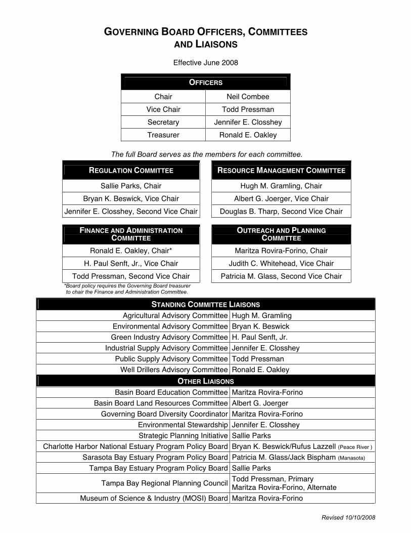
GOVERNING BOARD OFFICERS, COMMITTEESAND LIAISONS
Effective June 2008
OFFICERS
Chair Neil Combee
Vice Chair Todd Pressman
Secretary Jennifer E. Closshey
Treasurer Ronald E. Oakley
The full Board serves as the members for each committee.
REGULATION COMMITTEE RESOURCE MANAGEMENT COMMITTEE
Sallie Parks, Chair Hugh M. Gramling, Chair
Bryan K. Beswick, Vice Chair Albert G. Joerger, Vice Chair
Jennifer E. Closshey, Second Vice Chair Douglas B. Tharp, Second Vice Chair
FINANCE AND ADMINISTRATIONCOMMITTEE
OUTREACH AND PLANNINGCOMMITTEE
Ronald E. Oakley, Chair* Maritza Rovira-Forino, Chair
H. Paul Senft, Jr., Vice Chair Judith C. Whitehead, Vice Chair
Todd Pressman, Second Vice Chair Patricia M. Glass, Second Vice Chair *Board policy requires the Governing Board treasurer to chair the Finance and Administration Committee.
STANDING COMMITTEE LIAISONS
Agricultural Advisory Committee Hugh M. Gramling
Environmental Advisory Committee Bryan K. Beswick
Green Industry Advisory Committee H. Paul Senft, Jr.
Industrial Supply Advisory Committee Jennifer E. Closshey
Public Supply Advisory Committee Todd Pressman
Well Drillers Advisory Committee Ronald E. Oakley
OTHER LIAISONS
Basin Board Education Committee Maritza Rovira-Forino
Basin Board Land Resources Committee Albert G. Joerger
Governing Board Diversity Coordinator Maritza Rovira-Forino
Environmental Stewardship Jennifer E. Closshey
Strategic Planning Initiative Sallie Parks
Charlotte Harbor National Estuary Program Policy Board Bryan K. Beswick/Rufus Lazzell (Peace River )
Sarasota Bay Estuary Program Policy Board Patricia M. Glass/Jack Bispham (Manasota)
Tampa Bay Estuary Program Policy Board Sallie Parks
Tampa Bay Regional Planning Council Todd Pressman, Primary Maritza Rovira-Forino, Alternate
Museum of Science & Industry (MOSI) Board Maritza Rovira-Forino
Governing Board Meeting December 16, 2008
9:00 a.m.
CONVENE MEETING OF THE GOVERNING BOARD
AND PUBLIC HEARING
1. Call to Order ....................................................................................................................... 2
2. Pledge of Allegiance and Invocation .................................................................................. 2
3. Additions/Deletions to Agenda ........................................................................................... 2
4. Employee Recognition ....................................................................................................... 3
5. Public Input for Issues Not Listed on the Published Agenda ............................................. 5
.

Items 1 - 3
Governing Board Meeting December 16, 2008
1. Call to Order
The Board Chair calls the meeting to order. The Board Secretary confirms that a quorum is present. The Board Chair then opens the public hearing.
Anyone wishing to address the Governing Board concerning any item listed on the agenda or any item that does not appear on the agenda should fill out and submit a speaker's card. Comments will be limited to three minutes per speaker, and, when appropriate, exceptions to the three-minute limit may be granted by the Chair. Several individuals wishing to speak on the same issue/topic should designate a spokesperson.
2. Pledge of Allegiance and Invocation
The Board Chair leads the Pledge of Allegiance to the Flag of the United States of America. Mr. Bilenky offers the invocation.
3. Additions/Deletions to Agenda
According to Section 120.525(2), Florida Statutes, additions to the published agenda will only be made for "good cause" as determined by the "person designated to preside." The items that have been added to the agenda were received by the District after publication of the regular agenda. The Board was provided with the information filed and the District staff's analyses of these matters. Staff has determined that action must be taken on these items prior to the next Board meeting.
Therefore, it is the District staff's recommendation that good cause has been demonstrated and should be considered during the Governing Board's meeting.
Staff Recommendation:
Approval of the recommended additions and deletions to the published agenda.
Presenter: David L. Moore, Executive Director
2

Item 4
Governing Board Meeting December 16, 2008
A. Employee Recognition
The District's employees are its most valuable resource. We are pleased and proud that the average tenure of all employees at the District is 12 years, and that we are able to retain such remarkable talent. Each year, many District employees reach significant longevity milestones in their service to the District and many reach momentous milestones, which make them eligible for retirement. The District as a whole, as well as each employee’s department, acknowledges and celebrates these milestones/retirements and the tremendous individual contributions they represent to the achievement of the District’s mission.
At the Governing Board meeting, Executive Director David Moore will make presentations to the Board for all employees who have achieved milestones of 20 years or greater and those retiring from the District, to specially acknowledge and commend the contributions of these individuals. Mr. Moore will also welcome new members of management and recognize Shining Star Winners.
This item provides the Board with the opportunity to personally recognize and thank our dedicated employees who have reached five-year increments in service to the District and those employees who have completed at least 30 years of employment in the Florida Retirement System and are retiring from the District. We have eight employees that have achieved longevity milestones for the period of December 1 to December 31, 2008 and three retirees.
Employee Recognition – Service/Retirement
Milestone Employee Name Title Department OfficeLocation
Judith Montemurro Enterprise Arch. Res. Spec. Information Resources BrooksvilleFritz Musselmann Director Land Resources BrooksvilleRetirementDenise Tenuto Environmental Coordinator Resource Projects Brooksville
35 Years None for this meeting
30 Years LuAnne Stout Administrative Coordinator Executive Brooksville
25 Years None for this meeting
Margit Crowell Senior Hydrologist Operations Brooksville August Fox Senior Land Mgt. Specialist Land Resources Brooksville Lisa Henningsen Staff Environmental Scientist Resource Projects Brooksville 20 Years
Steve Saxon Field Technician Supervisor Operations Brooksville
10 Years Silas Rooker Tradesworker General Services Tampa
15 Years None for this meeting
Martha Butterworth Permit Data Analyst Perf. Management Office Brooksville5 Years Audra Owens-Powell Sr. Human Resources Spec. Human Resources Brooksville
3

Item 4
B. New Members of Management
The District also welcomes and congratulates new members of its management team and provides the Board the opportunity to welcome these new members of management. We have one new manager to be recognized.
Employee Recognition – New Document Services Manager
Employee Name Title Department Office
Location
New Hire Earl Rich Document Services Manager General Services Brooksville
C. Shining Star Recognition Program
The Shining Star recognition program, a program developed by the Employee Committee, acknowledges employees who go above and beyond their duties at the District by volunteering personal time or donating money to benefit their community. This recognition program is a way for the District to say thank you for their commitment and for making the community a brighter place.
One Shining Star Award winner is chosen each quarter from nominations submitted by their co-workers. Winners receive a commemorative certificate, lapel pin, a $15.00 gift certificate from Applebee’s Restaurant, and are featured on the Employee Committees intranet Star Walk page.
The following staff member was our Shining Star recipient for October - December 2008:
Lisann Morris - Every Saturday for three years now, Lisann Morris and her husband have volunteered at the Florida Aquarium. Lisann has given over 500 hours of her time to the Aquarium's Husbandry Department, specifically in the Wetland and Sea Hunt Areas. Lisann prepares all the food for the wetland birds and animals. Each week she cleans out the cage for the resident Blue Jays, named Zucchini and Cucumber. Lisann also helps out in the Sea Hunt area by preparing the food for the Aquarium's fish, including the Bonnet Head Shark named Rays. She also changes the water in the tanks. For Lisann, the best part of volunteering is working with her two favorite animals: Lexie, the Pelican, and Tako, the Pacific Octopus. Recently, Lisann was nominated by the Florida Aquarium for the Volunteer of the Year Award.
Besides her work at the Aquarium, Lisann participated in the three-day walk-a-thon for the Susan Komen Foundation – Breast Cancer Cure which began on October 31, 2008. The 60-mile walk entailed 20 miles a day over three consecutive days.
Even though Lisann does not hold a formal social position at the District, she is always trying to arrange birthday parties and welcome events for her fellow employees. She has a great sense of humor, and her laughter warms up the office hallways every day. Lisann is truly a shining star.
Staff Recommendation:
This item is presented for the Board’s information, and no action is required.
Presenter: David L. Moore, Executive Director
4

Item 5
Governing Board Meeting December 16, 2008
Public Input for Issues Not Listed on the Published Agenda
At this time, the Board will hear public input for issues not listed on the published agenda.
5
Governing Board Meeting December 16, 2008
Consent Agenda
All matters listed under the Consent Agenda are considered routine and action will be taken by one motion, second of the motion and approval by the Board. If discussion is requested by a Board member, that item(s) will be deleted from the Consent Agenda and moved to the appropriate Committee or Report for consideration.
Regulation Committee -- Environmental Resource Permits 6. ERP No. 43034196.000 - Legacy Lake Borrow Pit – Charlotte County ......................... 3 7. ERP No. 43013044.006 - FDOT - SR 35 (US 17) from DeSoto County Line to
SW Collins – DeSoto County ................................................ 8 8. ERP No. 43020690.009 - FDOT - I-4/Lee Roy Selmon Expressway Interchange
(South of 7th Avenue) – Hillsborough County ........................ 20 9. ERP No. 44030783.001 - Bayou Pass Phase 3 (DENIAL) – Hillsborough County ......... 26 10. ERP No. 43001436.040 - On Top of the World - South Branch – Marion County ......... 29 11. ERP No. 43015544.003 - Gulf Landings Boat Docks, Tracts 40B, 40C and 50C –
Pasco County ........................................................................ 34 12. ERP No. 43027830.001 - Main Street Landing Boat Docks – Pasco County ................ 41 13. ERP No. 43033500.001 - FDOT-SR 39 (Buchman Hwy) at Hillsborough River -
Temporary Detour Bridge – Pasco County ........................... 49 14. ERP No. 43031900.002 - EVWR/CSXT Rail Terminal Facility – Polk County ............... 56 15. ERP No. 43032386.000 - Dawn View Estates – Polk County ........................................ 63 16. ERP No. 43033931.000 - Ridgeview Place (DENIAL) – Polk County ............................. 69
Regulation Committee -- Water Use Permits 17. WUP No. 20006765.010 - L. D. Hancock Marital Trust/Hancock Grove –
DeSoto County ...................................................................... 80 18. WUP No. 20003837.011 - Falkner Farms/Falkner Farms – Manatee County ................ 91 19. WUP No. 20002981.015 - City of Clearwater – Pinellas County ..................................... 102 20. WUP No. 20004912.007 - City of Lakeland – Polk County ............................................. 123 21. WUP No. 20005393.008 - City of Venice – Sarasota County ......................................... 147
Regulation Committee -- Other 22. Approve Exchange of Conservation Easement Areas – Lake Jovita East Pointe
Townhomes – Pasco County ............................................................................................ 171 23. Approve for Adoption Final Changes to Amendments to 40D-1.659 and 40D-2.091,
Florida Administrative Code (F.A.C.), to Incorporate Changes to Chapters 5 and 6 of the Basis of Review in Response to the Joint Administrative Procedures Committee ......................................................................................................................... 172
24. Electrical Power Plant Site Certification – SWFWMD Agency Report on Progress Energy Florida – Levy Nuclear Units 1 & 2 – Main Site and Associated Facilities – Levy County ...................................................................................................................... 179
Resource Management Committee 25. Approve Initiation of Rulemaking to Amend 40D-8.624, F.A.C., to Add Minimum
and Guidance Levels for Lake Anoka in Highlands County .............................................. 200 26. Approve Initiation of Rulemaking to Amend 40D-8.041, F.A.C., to Establish
Minimum Flows for Weeki Wachee River System ............................................................ 206 27. Authorize Submission of the Preliminary Flood Insurance Rate Maps for
the Oman Quarry/Indian Creek, Powell, and Blue Sink Watersheds to the Federal Emergency Management Agency ........................................................................ 210
28. Appraisals and Purchase/Sale Agreement – Lake Hancock Project, SWF Parcel No. 20-503-151 ................................................................................................................. 215
29. Temporary Construction Easement to Florida Department of Transportation for State Road 39 – Hillsborough River Corridor, SWF Parcel Number 13-444-109X ........... 220
30. Supplemental Utility Easement to Progress Energy Florida, Inc. for Additional Service to the Withlacoochee River Electric Cooperative Tampa Downs Substation – Cypress Creek Preserve, SWF Parcel Number 13-500-390X ..................... 222
31. Facilitating Agricultural Resource Management Systems (FARMS) Program a. FLM, Inc. Prairie River Ranch Grove Phase II – DeSoto County ................................ 224 b. CFI USA, Inc. Venus II Grove – Manatee County ....................................................... 227
Finance & Administration Committee 32. Board Travel ...................................................................................................................... 230 33. Budget Transfer Report ..................................................................................................... 231 34. District Strategic Systems Network and Server Upgrades................................................. 234
General Counsel’s Report 35. Consent Order – WUP No. 208639.010 - Timber Pines Community Association,
Inc. – Hernando County .................................................................................................... 235 36. Initiation of Litigation – Surface Water Activity - Edward A. Mariani –
Manatee County ................................................................................................................ 236 37. Initiation of Litigation – Surface Water Activity - Lexington Homes, Inc.
(North Green Estates and South Green Estates) – Hillsborough County ......................... 237 38. Initiation of Litigation – ERP No. 46029649.001- Memorial Townhomes, LLC
(Memorial Townhomes) – Hillsborough County ................................................................ 239 39. Initiation of Litigation – ERP No. 44007115.006 - Regency Oaks Preserve, Inc. –
Manatee County ................................................................................................................ 240 40. Settlement Agreement – Lance H. Ham et al. v. City of Plant City, Hillsborough
County, and SWFWMD, 13th Judicial Circuit Case No. 05-CA-9419 – Hillsborough County .......................................................................................................... 241
Executive Director’s Report 41. Approval of Minutes – November 18, 2008 Governing Board Meeting ............................. 242
2
CONSENT ITEM 7
3

CONSENT ITEM 7 Default Date: January 13, 2009
SOUTHWEST FLORIDA WATER MANAGEMENT DISTRICTENVIRONMENTAL RESOURCEINDIVIDUAL CONSTRUCTION
PERMIT NO. 43034196.000
Expiration Date: December 16, 2013 PERMIT ISSUE DATE: December 16, 2008
This permit is issued under the provisions of Chapter 373, Florida Statutes, (F.S.), and the Rules contained in Chapters 40D-4 and 40, Florida Administrative Code, (F.A.C.). The permit authorizes the Permittee to proceed with the construction of a surface water management system in accordance with the information outlined herein and shown by the application, approved drawings, plans, specifications, and other documents, attached hereto and kept on file at the Southwest Florida Water Management District (District). Unless otherwise stated by permit specific condition, permit issuance constitutes certification of compliance with state water quality standards under Section 401 of the Clean Water Act, 33 U.S.C. 1341. All construction, operation and maintenance of the surface water management system authorized by this permit shall occur in compliance with Florida Statutes and Administrative Code and the conditions of this permit.
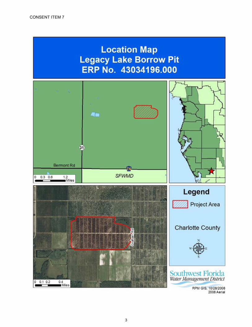
PROJECT NAME: Legacy Lake Borrow Pit
GRANTED TO: H2ONC, LLC10101 Mallory Parkway EastSt. James City, FL 33956
ABSTRACT: This permit authorizes the construction of a surface water management system to serve a 261.19-acre borrow pit excavation project known as Legacy Lake Borrow Pit. The project is located approximately two miles north of Bermont Road (CR 74) and approximately two miles east of SR 31, in Charlotte County. Information regarding the surface water management system, 100-year floodplain, wetlands and/or surface waters is stated below and on the permitted construction drawings for the project.
OP. & MAINT. ENTITY: H2ONC, LLC
COUNTY: Charlotte
SEC/TWP/RGE: 21/40S/26E
TOTAL ACRES OWNEDOR UNDER CONTROL: 318.78
PROJECT SIZE: 261.19 Acres
LAND USE: Mining
DATE APPLICATION FILED: June 3, 2008
AMENDED DATE: N/A
4
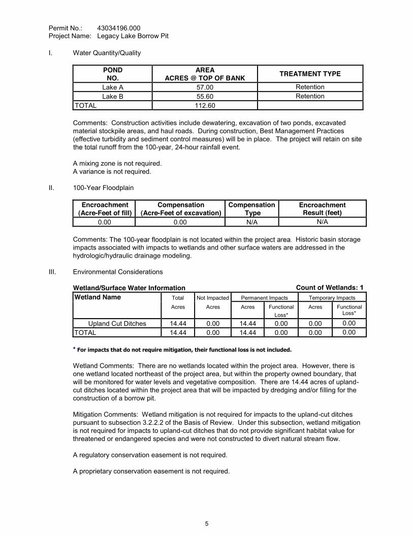
Permit No.: 43034196.000Project Name: Legacy Lake Borrow Pit
I. Water Quantity/Quality
PONDNO.
AREAACRES @ TOP OF BANK
TREATMENT TYPE
Lake A 57.00 RetentionLake B 55.60 Retention
TOTAL 112.60
Comments: Construction activities include dewatering, excavation of two ponds, excavated material stockpile areas, and haul roads. During construction, Best Management Practices (effective turbidity and sediment control measures) will be in place.
rainfall event.
A mixing zone is not required.A variance is not required.
II. 100-Year Floodplain
Encroachment(Acre-Feet of fill)
Compensation(Acre-Feet of excavation)
CompensationType
EncroachmentResult (feet)
0.00 0.00 N/A N/A
Comments: Historic basin storage impacts associated with impacts to wetlands and other surface waters are addressed in the hydrologic/hydraulic drainage modeling.
III. Environmental Considerations
Wetland/Surface Water Information Count of Wetlands:Wetland Name Total Not Impacted Permanent Impacts Temporary Impacts
Acres Acres Acres FunctionalLoss*
Acres FunctionalLoss*
Upland Cut Ditches 14.44 0.00 14.44 0.00 0.00 0.00TOTAL 14.44 0.00 14.44 0.00 0.00 0.00
* For impacts that do not require mitigation, their functional loss is not included.
Wetland Comments: There are no wetlands located within the project area. However, there is one wetland located northeast of the project area, but within the property owned boundary, that will be monitored for water levels and vegetative composition. There are 14.44 acres of upland-cut ditches located within the project area that will be impacted by dredging and/or filling for the construction of a borrow pit.
Mitigation Comments: Wetland mitigation is not required for impacts to the upland-cut ditches pursuant to subsection 3.2.2.2 of the Basis of Review. Under this subsection, wetland mitigation is not required for impacts to upland-cut ditches that do not provide significant habitat value for threatened or endangered species and were not constructed to divert natural stream flow.
A regulatory conservation easement is not required.
A proprietary conservation easement is not required.
5
Permit No.: 43034196.000Project Name: Legacy Lake Borrow Pit
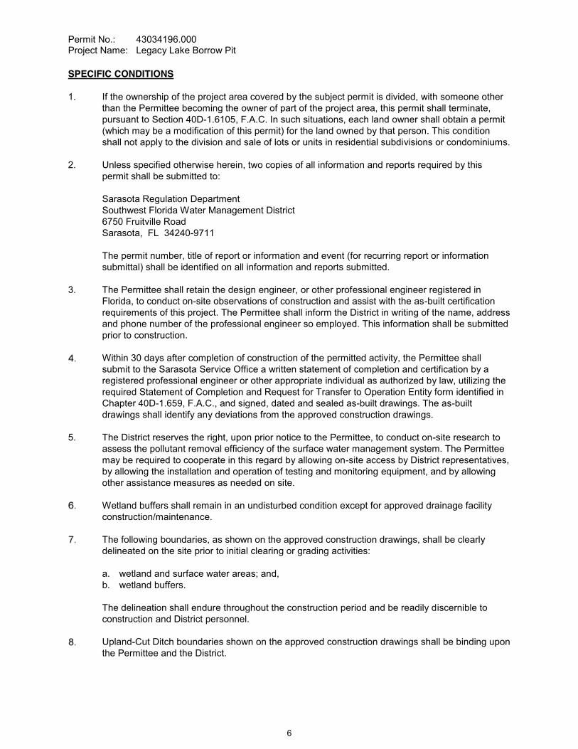
SPECIFIC CONDITIONS
1. If the ownership of the project area covered by the subject permit is divided, with someone other than the Permittee becoming the owner of part of the project area, this permit shall terminate, pursuant to Section 40D-1.6105, F.A.C. In such situations, each land owner shall obtain a permit (which may be a modification of this permit) for the land owned by that person. This condition shall not apply to the division and sale of lots or units in residential subdivisions or condominiums.
2. Unless specified otherwise herein, two copies of all information and reports required by this permit shall be submitted to:
Sarasota Regulation DepartmentSouthwest Florida Water Management District6750 Fruitville RoadSarasota, FL 34240-9711
The permit number, title of report or information and event (for recurring report or information submittal) shall be identified on all information and reports submitted.
3. The Permittee shall retain the design engineer, or other professional engineer registered in Florida, to conduct on-site observations of construction and assist with the as-built certification requirements of this project. The Permittee shall inform the District in writing of the name, address and phone number of the professional engineer so employed. This information shall be submitted prior to construction.
Within 30 days after completion of construction of the permitted activity, the Permittee shall submit to the Sarasota Service Office a written statement of completion and certification by a registered professional engineer or other appropriate individual as authorized by law, utilizing the required Statement of Completion and Request for Transfer to Operation Entity form identified in Chapter 40D-1.659, F.A.C., and signed, dated and sealed as-built drawings. The as-built drawings shall identify any deviations from the approved construction drawings.
5. The District reserves the right, upon prior notice to the Permittee, to conduct on-site research to assess the pollutant removal efficiency of the surface water management system. The Permittee may be required to cooperate in this regard by allowing on-site access by District representatives, by allowing the installation and operation of testing and monitoring equipment, and by allowing other assistance measures as needed on site.
Wetland buffers shall remain in an undisturbed condition except for approved drainage facility construction/maintenance.
The following boundaries, as shown on the approved construction drawings, shall be clearly delineated on the site prior to initial clearing or grading activities:
a. wetland and surface water areas; and, b. wetland buffers.
The delineation shall endure throughout the construction period and be readily discernible to construction and District personnel.
Upland-Cut Ditch boundaries shown on the approved construction drawings shall be binding upon the Permittee and the District.
6

Permit No.: 43034196.000Project Name: Legacy Lake Borrow Pit
9. The operation and maintenance entity shall submit inspection reports in the form required by the District, in accordance with the following schedule.For systems utilizing retention or wet detention, the inspections shall be performed two (2) years after operation is authorized and every two (2) years thereafter.
This time it is determined by the District that the Conditions for Issuance of Permits in Rules 40D-4.301 and 40D-4.302, F.A.C., have not been met, upon written notice by the District, the Permittee shall obtain a permit modification and perform any construction necessary thereunder to correct any deficiencies in the system design or construction to meet District rule criteria. The Permittee is advised that the correction of deficiencies may require re-construction of the surface water management system and/or mitigation areas.
Existing wells located within the footprint of the borrow pits must be properly plugged and abandoned by a licensed well contractor and a completion report submitted to the District, prior to initiation of construction.
Wetland monitoring shall occur in accordance with the monitoring plan described on Page No. 17 of the report received from Southern Biomes on October 15, 2008. Monitoring reports shall be submitted to the District annually.
GENERAL CONDITIONS
1. The general conditions attached hereto as Exhibit "A" are hereby incorporated into this permit by reference and the Permittee shall comply with them.
____________________________________________Authorized Signature
7

CONSENT ITEM 8
8
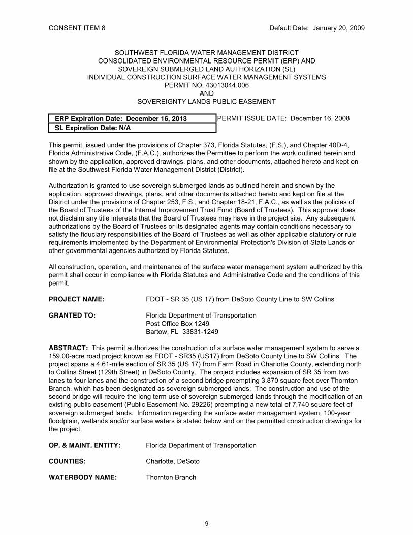
CONSENT ITEM 8 Default Date: January 20, 2009
SOUTHWEST FLORIDA WATER MANAGEMENT DISTRICTCONSOLIDATED ENVIRONMENTAL RESOURCE PERMIT (ERP) AND
SOVEREIGN SUBMERGED LAND AUTHORIZATION (SL)INDIVIDUAL CONSTRUCTION SURFACE WATER MANAGEMENT SYSTEMS
PERMIT NO. 43013044.006AND
SOVEREIGNTY LANDS PUBLIC EASEMENT
ERP Expiration Date: December 16, 2013 PERMIT ISSUE DATE: December 16, 2008SL Expiration Date: N/A
This permit, issued under the provisions of Chapter 373, Florida Statutes, (F.S.), and Chapter 40D-4,Florida Administrative Code, (F.A.C.), authorizes the Permittee to perform the work outlined herein and shown by the application, approved drawings, plans, and other documents, attached hereto and kept on file at the Southwest Florida Water Management District (District).
Authorization is granted to use sovereign submerged lands as outlined herein and shown by the application, approved drawings, plans, and other documents attached hereto and kept on file at the District under the provisions of Chapter 253, F.S., and Chapter 18-21, F.A.C., as well as the policies of the Board of Trustees of the Internal Improvement Trust Fund (Board of Trustees). This approval does not disclaim any title interests that the Board of Trustees may have in the project site. Any subsequent authorizations by the Board of Trustees or its designated agents may contain conditions necessary to satisfy the fiduciary responsibilities of the Board of Trustees as well as other applicable statutory or rule requirements implemented by the Department of Environmental Protection's Division of State Lands or other governmental agencies authorized by Florida Statutes.
All construction, operation, and maintenance of the surface water management system authorized by this permit shall occur in compliance with Florida Statutes and Administrative Code and the conditions of this permit.
PROJECT NAME: FDOT - SR 35 (US 17) from DeSoto County Line to SW Collins
GRANTED TO: Florida Department of TransportationPost Office Box 1249Bartow, FL 33831-1249
ABSTRACT: This permit authorizes the construction of a surface water management system to serve a 159.00-acre road project known as FDOT - SR35 (US17) from DeSoto County Line to SW Collins. The project spans a 4.61-mile section of SR 35 (US 17) from Farm Road in Charlotte County, extending north to Collins Street (129th Street) in DeSoto County. The project includes expansion of SR 35 from two lanes to four lanes and the construction of a second bridge preempting 3,870 square feet over Thornton Branch, which has been designated as sovereign submerged lands. The construction and use of the second bridge will require the long term use of sovereign submerged lands through the modification of an existing public easement (Public Easement No. 29226) preempting a new total of 7,740 square feet of sovereign submerged lands. Information regarding the surface water management system, 100-year floodplain, wetlands and/or surface waters is stated below and on the permitted construction drawings for the project.
OP. & MAINT. ENTITY: Florida Department of Transportation
COUNTIES: Charlotte, DeSoto
WATERBODY NAME: Thornton Branch
9
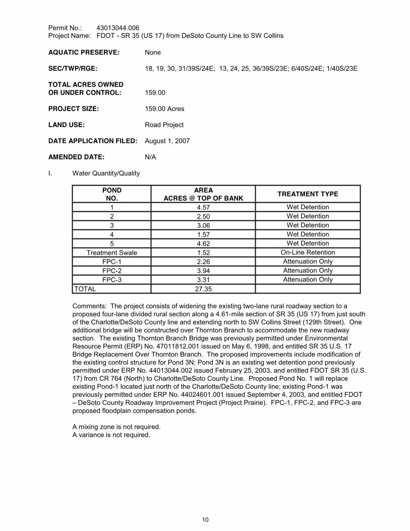
Permit No.: 43013044.006Project Name: FDOT - SR 35 (US 17) from DeSoto County Line to SW Collins
AQUATIC PRESERVE: None
SEC/TWP/RGE: 18, 19, 30, 31/39S/24E; 13, 24, 25, 36/39S/23E; 6/40S/24E; 1/40S/23E
TOTAL ACRES OWNEDOR UNDER CONTROL: 159.00
PROJECT SIZE: 159.00 Acres
LAND USE: Road Project
DATE APPLICATION FILED: August 1, 2007
AMENDED DATE: N/A
I. Water Quantity/Quality
PONDNO.
AREAACRES @ TOP OF BANK
TREATMENT TYPE
1 4.57 Wet Detention2 2.50 Wet Detention3 3.06 Wet Detention4 1.57 Wet Detention5 4.62 Wet Detention
Treatment Swale 1.52 On-Line RetentionFPC-1 2.26 Attenuation OnlyFPC-2 3.94 Attenuation OnlyFPC-3 3.31 Attenuation Only
TOTAL 27.35
Comments: The project consists of widening the existing two-lane rural roadway section to a proposed four-lane divided rural section along a 4.61-mile section of SR 35 (US 17) from just south of the Charlotte/DeSoto County line and extending north to SW Collins Street (129th Street). One additional bridge will be constructed over Thornton Branch to accommodate the new roadway section. The existing Thornton Branch Bridge was previously permitted under Environmental Resource Permit (ERP) No. 47011812.001 issued on May 6, 1998, and entitled SR 35 U.S. 17 Bridge Replacement Over Thornton Branch. The proposed improvements include modification of the existing control structure for Pond 3N; Pond 3N is an existing wet detention pond previously permitted under ERP No. 44013044.002 issued February 25, 2003, and entitled FDOT SR 35 (U.S. 17) from CR 764 (North) to Charlotte/DeSoto County Line. Proposed Pond No. 1 will replace existing Pond-1 located just north of the Charlotte/DeSoto County line; existing Pond-1 was previously permitted under ERP No. 44024601.001 issued September 4, 2003, and entitled FDOT
DeSoto County Roadway Improvement Project (Project Prairie). FPC-1, FPC-2, and FPC-3 are proposed floodplain compensation ponds.
A mixing zone is not required.A variance is not required.
10

Permit No.: 43013044.006Project Name: FDOT - SR 35 (US 17) from DeSoto County Line to SW Collins
II. 100-Year Floodplain
Encroachment(Acre-Feet of fill)
Compensation(Acre-Feet of excavation)
CompensationType*
EncroachmentResult (feet)
12.12 19.36 EE 0.00
EE = Equivalent Excavation to offset project filling per Section 4.4 of the District's Basis of Review
Comments: According to FEMA floodplain determinations, portions of the project lie within Flood Zone A. Historic basin storage impacts associated with impacts to onsite wetlands and other surface waters are included in the hydrologic/hydraulic drainage modeling.
III. Environmental Considerations
Wetland/Other Surface Water Information Count: 32Wetland/Other Surface Water Name Total Not Impacted Permanent Impacts Temporary Impacts
Acres Acres Acres FunctionalLoss*
Acres FunctionalLoss*
SW 1 0.39 0.14 0.25 0.00 0.00 0.00SW 10 0.01 0.00 0.01 0.00 0.00 0.00SW 11 0.03 0.00 0.03 0.00 0.00 0.00SW 12 0.03 0.00 0.03 0.00 0.00 0.00SW 13 0.04 0.00 0.04 0.00 0.00 0.00SW 14 0.01 0.00 0.01 0.00 0.00 0.00SW 15 0.04 0.00 0.04 0.00 0.00 0.00SW 1A 0.21 0.00 0.21 0.00 0.00 0.00SW 1B 0.05 0.00 0.05 0.00 0.00 0.00SW 1W 0.17 0.00 0.17 0.00 0.00 0.00SW 2 0.48 0.00 0.48 0.00 0.00 0.00
SW 2W 0.04 0.00 0.04 0.00 0.00 0.00SW 3 2.39 0.00 2.39 0.00 0.00 0.00SW 4 0.05 0.00 0.05 0.00 0.00 0.00SW 5 0.01 0.00 0.01 0.00 0.00 0.00SW 8 0.18 0.00 0.18 0.00 0.00 0.00SW 9 0.02 0.00 0.02 0.00 0.00 0.00
Wetland 1 & 1W 0.85 0.00 0.85 0.48 0.00 0.00Wetland 2 0.97 0.00 0.97 0.52 0.00 0.00
Wetland 2C/ 9W 0.02 0.00 0.02 0.00 0.00 0.00Wetland 2W 0.02 0.00 0.02 0.00 0.00 0.00Wetland 3 0.04 0.00 0.04 0.00 0.00 0.00Wetland 5 0.40 0.00 0.40 0.23 0.00 0.00Wetland 7 0.11 0.00 0.11 0.00 0.00 0.00
Wetland 7A 0.77 0.00 0.77 0.40 0.00 0.00
11
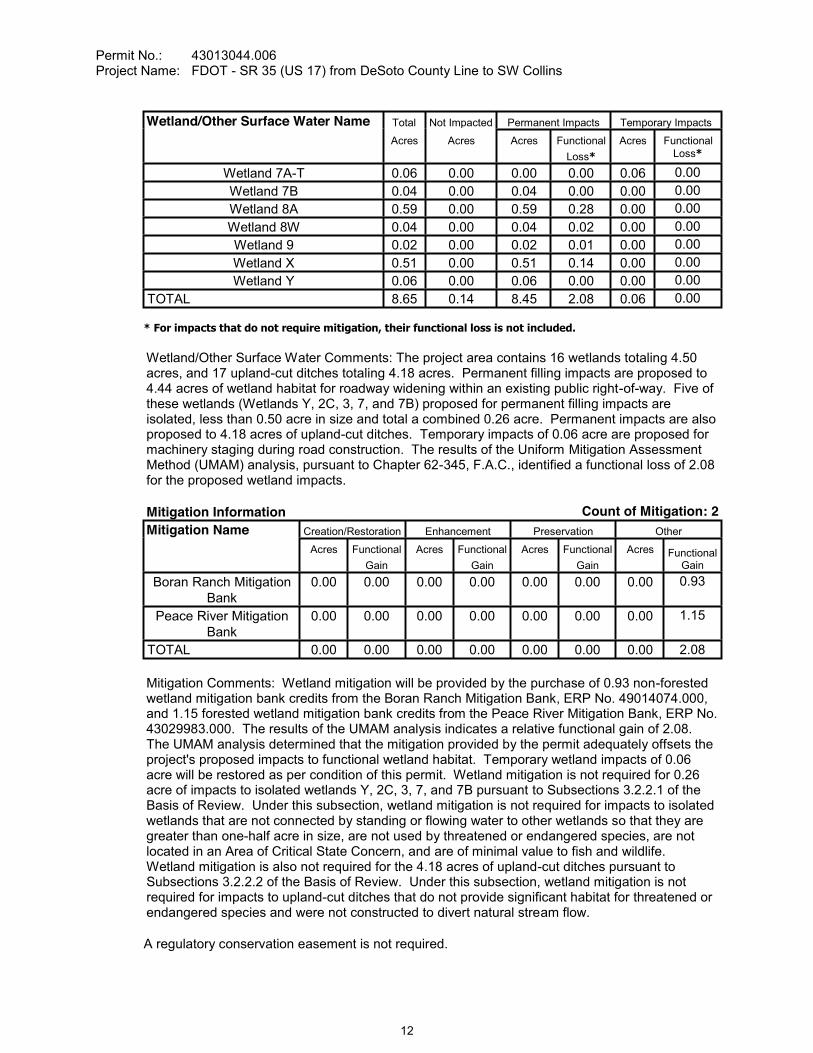
Permit No.: 43013044.006Project Name: FDOT - SR 35 (US 17) from DeSoto County Line to SW Collins
Wetland/Other Surface Water Name Total Not Impacted Permanent Impacts Temporary Impacts
Acres Acres Acres FunctionalLoss*
Acres FunctionalLoss*
Wetland 7A-T 0.06 0.00 0.00 0.00 0.06 0.00Wetland 7B 0.04 0.00 0.04 0.00 0.00 0.00Wetland 8A 0.59 0.00 0.59 0.28 0.00 0.00Wetland 8W 0.04 0.00 0.04 0.02 0.00 0.00Wetland 9 0.02 0.00 0.02 0.01 0.00 0.00Wetland X 0.51 0.00 0.51 0.14 0.00 0.00Wetland Y 0.06 0.00 0.06 0.00 0.00 0.00
TOTAL 8.65 0.14 8.45 2.08 0.06 0.00
* For impacts that do not require mitigation, their functional loss is not included.
Wetland/Other Surface Water Comments: The project area contains 16 wetlands totaling 4.50 acres, and 17 upland-cut ditches totaling 4.18 acres. Permanent filling impacts are proposed to 4.44 acres of wetland habitat for roadway widening within an existing public right-of-way. Five of these wetlands (Wetlands Y, 2C, 3, 7, and 7B) proposed for permanent filling impacts are isolated, less than 0.50 acre in size and total a combined 0.26 acre. Permanent impacts are also proposed to 4.18 acres of upland-cut ditches. Temporary impacts of 0.06 acre are proposed for machinery staging during road construction. The results of the Uniform Mitigation Assessment Method (UMAM) analysis, pursuant to Chapter 62-345, F.A.C., identified a functional loss of 2.08 for the proposed wetland impacts.
Mitigation Information Count of Mitigation: 2Mitigation Name Creation/Restoration Enhancement Preservation Other
Acres Functional Gain
Acres Functional Gain
Acres Functional Gain
Acres Functional Gain
Boran Ranch Mitigation Bank
0.00 0.00 0.00 0.00 0.00 0.00 0.00 0.93
Peace River Mitigation Bank
0.00 0.00 0.00 0.00 0.00 0.00 0.00 1.15
TOTAL 0.00 0.00 0.00 0.00 0.00 0.00 0.00 2.08
Mitigation Comments: Wetland mitigation will be provided by the purchase of 0.93 non-forested wetland mitigation bank credits from the Boran Ranch Mitigation Bank, ERP No. 49014074.000, and 1.15 forested wetland mitigation bank credits from the Peace River Mitigation Bank, ERP No. 43029983.000. The results of the UMAM analysis indicates a relative functional gain of 2.08. The UMAM analysis determined that the mitigation provided by the permit adequately offsets the project's proposed impacts to functional wetland habitat. Temporary wetland impacts of 0.06 acre will be restored as per condition of this permit. Wetland mitigation is not required for 0.26 acre of impacts to isolated wetlands Y, 2C, 3, 7, and 7B pursuant to Subsections 3.2.2.1 of the Basis of Review. Under this subsection, wetland mitigation is not required for impacts to isolated wetlands that are not connected by standing or flowing water to other wetlands so that they are greater than one-half acre in size, are not used by threatened or endangered species, are not located in an Area of Critical State Concern, and are of minimal value to fish and wildlife. Wetland mitigation is also not required for the 4.18 acres of upland-cut ditches pursuant to Subsections 3.2.2.2 of the Basis of Review. Under this subsection, wetland mitigation is not required for impacts to upland-cut ditches that do not provide significant habitat for threatened or endangered species and were not constructed to divert natural stream flow.
A regulatory conservation easement is not required.
12

Permit No.: 43013044.006Project Name: FDOT - SR 35 (US 17) from DeSoto County Line to SW Collins
IV. Sovereign Submerged Lands.
ACTIVITY PREEMPTED AREA DREDGED NO. OF SLIPSBridge Construction 7,740 square feet -0- cubic yards N/A
TOTAL 7,740 square feet -0- cubic yards N/A
Shoreline Length: There is a total of 520 linear feet of shoreline located within the Thornton Branch right-of-way. Currently, SR 35 crosses state sovereign submerged lands (SSL) of Thornton Branch by way of a single, two-lane bridge. This two-lane bridge over Thornton Branch has an existing SSL proprietary public easement (No. 29226) comprising a total of 36,969 square feet with an existing pre-empted area of 3,870 square feet for the two-lane bridge crossing. This Consolidated ERP
. The existing single, two-lane bridge comprising 3,870 square feet of SSL will be replaced and service south bound traffic, while this new two-lane bridge to be constructed will comprise another 3,870 square feet and service northbound traffic. The new pre-emption area for four lanes will comprise a total of 7,740 square feet. The construction of the new two-lane bridge will be located along the east side the existing bridge.
A proprietary conservation easement is not required.
SPECIFIC CONDITIONS
1. If the ownership of the project area covered by the subject permit is divided, with someone other than the Permittee becoming the owner of part of the project area, this permit shall terminate, pursuant to Section 40D-1.6105, F.A.C. In such situations, each land owner shall obtain a permit (which may be a modification of this permit) for the land owned by that person. This condition shall not apply to the division and sale of lots or units in residential subdivisions or condominiums.
2. Unless specified otherwise herein, two copies of all information and reports required by this permit shall be submitted to:
Sarasota Regulation DepartmentSouthwest Florida Water Management District6750 Fruitville RoadSarasota, FL 34240-9711
The permit number, title of report or information and event (for recurring report or information submittal) shall be identified on all information and reports submitted.
3. The Permittee shall retain the design engineer, or other professional engineer registered in Florida, to conduct on-site observations of construction and assist with the as-built certification requirements of this project. The Permittee shall inform the District in writing of the name, address and phone number of the professional engineer so employed. This information shall be submitted prior to construction.
Within 30 days after completion of construction of the permitted activity, the Permittee shall submit to the Sarasota Service Office a written statement of completion and certification by a registeredprofessional engineer or other appropriate individual as authorized by law, utilizing the required Statement of Completion and Request for Transfer to Operation Entity form identified in Chapter 40D-1.659, F.A.C., and signed, dated and sealed as-built drawings. The as-built drawings shall identify any deviations from the approved construction drawings.
13
Permit No.: 43013044.006Project Name: FDOT - SR 35 (US 17) from DeSoto County Line to SW Collins
5. The District reserves the right, upon prior notice to the Permittee, to conduct on-site research to assess the pollutant removal efficiency of the surface water management system. The Permittee may be required to cooperate in this regard by allowing on-site access by District representatives, by allowing the installation and operation of testing and monitoring equipment, and by allowing other assistance measures as needed on site.
6. The Permittee shall monitor and maintain the wetland mitigation areas until the criteria set forth in the Wetland Mitigation Success Criteria Conditions above are met. The Permittee shall perform corrective actions identified by the District if the District identifies a wetland mitigation deficiency.
7. The Permittee shall undertake required maintenance activities within the wetland mitigation areas as needed at any time between mitigation area construction and termination of monitoring, with the exception of the final year. Maintenance shall include the manual removal of all nuisance and exotic species, with sufficient frequency that their combined coverage at no time exceeds the Wetland Mitigation Success Criteria Conditions above. Herbicides shall not be used without the prior written approval of the District.
8. The construction of all wetland impacts and wetland mitigation shall be supervised by a qualified environmental scientist/specialist/consultant. The Permittee shall identify, in writing, the environmental professional retained for construction oversight prior to initial clearing and grading activities.
Wetland buffers shall remain in an undisturbed condition except for approved drainage facility construction/maintenance.
The following boundaries, as shown on the approved construction drawings, shall be clearly delineated on the site prior to initial clearing or grading activities:
a. wetland and surface water areas; b. wetland buffers; and, c. limits of approved wetland impacts.
The delineation shall endure throughout the construction period and be readily discernible to construction and District personnel.
Wetlands X, Y, 1, 1W, 2, 2W, 2C, 3, 5, 7, 7A, 7B, 8A, 8W, 9 and 9W and Surface Waters SW1A, SW1B, SW1, SW1W, SW2, SW2W, SW3, SW4, SW5, SW8, SW9, SW10, SW11, SW12, SW13,SW14 and SW15 boundaries shown on the approved construction drawings shall be binding upon the Permittee and the District.
12. All construction is prohibited within the permitted project area until the Permittee acquires legal ownership or legal control of the project area as delineated in the permitted construction drawings.
13. The Permittee, the Florida Department of Transportation, shall submit to the District a site-specific plan for erosion and sediment control best management practices, pursuant to Section 104, FDOT Standard Specifications for Road and Bridge Construction. The plan shall include a dewatering plan with sediment sump sizing calculations, pump locations, pump capacities, as well as discharge points, demonstrating that no adverse water quality/quantity impacts will result from the dewatering activities. The Construction Surface Water Management Plan shall be signed by the Permittee, and signed/sealed by a Florida Professional Engineer, pursuant to Section 2.8.4 of the ERP Basis of Review. The Permittee shall submit this plan and receive District approval prior to construction commencement.
14
Permit No.: 43013044.006Project Name: FDOT - SR 35 (US 17) from DeSoto County Line to SW Collins
14. The operation and maintenance entity shall submit inspection reports in the form required by the District, in accordance with the following schedule.
For systems utilizing retention or wet detention, the inspections shall be performed two (2) years after operation is authorized and every two (2) years thereafter.
15. The removal of littoral shelf vegetation (including cattails) from wet detention ponds is prohibited unless otherwise approved by the District. Removal includes dredging, the application of herbicide, cutting, and the introduction of grass carp. Any questions regarding authorized activities within the wet detention ponds shall be addressed to the District's Surface Water Regulation Manager, Sarasota Service Office.
16. For dry bottom retention systems, the retention areas shall become dry within 72 hours after a rainfall event. If a retention area is regularly wet, this situation shall be deemed to be a violation of this permit.
17. The Special Ditch and Ponds 1, 2, 3, 4, 5, FPC-1, FPC-2 and FPC-3 will require impervious liners. The Permittee shall have a Professional Geotechnical Engineer provide written certification to the District that the selected liners are appropriate for the type and design approved in this permit. The Permittee shall also ensure that all liner installations are supervised by a licensed Professional Geotechnical Engineer who shall assure compliance with the liner manufacturer's specifications for liner installation requirements.
18. The Statement of Completion and as-built drawings for the project shall include a signed/sealed certification from the Geotechnical Engineer who supervised the liner installations, as required in Specific Condition No. 17 above. The certification shall include the as-built details of the special ditch and ponds, including dimensions, as well as top and bottom elevations of the liners.
19. The District, upon prior notice to the Permittee, may conduct on-site inspections to assess the effectiveness of the erosion control barriers and other measures employed to prevent violations of state water quality standards and avoid downstream impacts. Such barriers or other measures should control discharges, erosion, and sediment transport during construction and thereafter. The District will also determine any potential environmental problems that may develop as a result of leaving or removing the barriers and other measures during construction or after construction of the project has been completed. The Permittee must provide any remedial measures that are needed.
This permit is issued based uponit is determined by the District that the Conditions for Issuance of Permits in Rules 40D-4.301 and 40D-4.302, F.A.C., have not been met, upon written notice by the District, the Permittee shall obtain a permit modification and perform any construction necessary thereunder to correct any deficiencies in the system design or construction to meet District rule criteria. The Permittee is advised that the correction of deficiencies may require re-construction of the surface water management system and/or mitigation areas.
21. The project proposes construction of works that are located in areas of hazardous waste contamination, as designated by the Florida Department of Environmental Protection (FDEP). Construction is prohibited in the project area until the Permittee obtains written documentation from the FDEP clearly showing that the project can be constructed without causing or contributing to violations of State water quality standards. The Permittee shall provide such written documentation from the FDEP to the District, prior to initiating any construction in the project area.
15
Permit No.: 43013044.006Project Name: FDOT - SR 35 (US 17) from DeSoto County Line to SW Collins
22. Pursuant to Rule 40D-4.381(1)(p), F.A.C., should the FDEP or any other regulatory agency require changes to the permitted system, the Permittee shall be required to notify the District in writing of the changes prior to implementation so that a determination can be made whether a permit modification of this permit is required.
23. The Permittee shall ensure that prior to the construction of wetland impacts, a Modification Short Form to the Boran Ranch Mitigation Bank (ERP No. 49014074.000) shall be submitted to the District for the withdrawal of 0.93 non-forested wetland credits, and from the Peace River Mitigation Bank (ERP No. 43029983.000) for 1.15 forested wetland credits, for FDOT - SR 35 From DeSoto County Line to SW Collins. The modification short form request shall reference the project name, FDOT - SR 35 From DeSoto County Line to SW Collins, (ERP No. 43013044.006), and the 2.08 credits to be withdrawn. Failure to submit these modification short forms requesting a credit withdrawal from the banks prior to the commencement of wetland impacts shall be a violation of this permit.
24. The District has requested that the Department of Environmental Protection's Recurring Revenue Section of the Bureau of Land Administration prepare the Public Easement instrument. Construction on sovereign submerged lands shall not begin until this instrument has been executedto the satisfaction of the District.
Monitoring for turbidity as measured in Nephelometric Turbidity Units (NTUs) shall be conducted for the duration of construction activities. Sampling will commence 24 hours before initiation of construction activities and continue at four hour intervals during construction, according to the approved water quality monitoring plan received on October 10, 2008 by Kissinger Campo & Associates Corp. Turbidity monitoring reports will be submitted on a weekly basis to the District's Sarasota Regulation Department Surface Water Regulation Manager and/or Environmental Manager during relevant construction activities.
a. A minimum of four sampling sites will be established. The first located 50 feet downstream , the second located at the point of origin for turbidity, and the third located on the line equidistant between the first two locations. These sites shall be established on a transect extending down-current from the source,
b. Water samples will be collected from surface level, mid-depth and one foot above the surface bottom. In water, which is less than three feet deep, mid-depth samples are sufficient;
c. The background sites will be collected at two locations marked by temporary stakes and shall be maintained for the duration of the sampling program. These sites cannot be changed without specific written authorization from the District's Sarasota Regulation Department; and,
16

Permit No.: 43013044.006Project Name: FDOT - SR 35 (US 17) from DeSoto County Line to SW Collins
d. If any violations of state water quality standards for turbidity occur, all dredging/filling activities will cease immediately. The violation will be reported to the District. The violation report will include the description of the corrective actions taken or proposed to be taken. a copy of all monitoring data sheets which indicate violations will be forwarded immediately to the District. Operations shall not resume until a compliance inspection by District personnel has been conducted and a set of samples has been taken which shows that the water meets the standards.
27. All samples will be collected with a Kemmerer, VanDorn or similar sampler, which is designated to collect in situ water samples. Samples must be maintained at four degree Celsius and allowed to warm to ambient temperatures before analyses. Samples must be analyzed within 24 hours of collection time. The following information must be recorded for each sample taken in a Monitoring Report:
a. Site number; b. Dates and time of day when sample was collected; c. Total depth and sample depth; d. Antecedent weather conditions, including wind direction and velocity; and, e. Water stage and/or flow direction.
28. In addition to the above mentioned, each Turbidity Monitoring Report must include the following:
a. A statement of methodology including types of sampling equipment and analytical instrumentation, preservation, and handling;
b. Permit number; c. A map indicating numbered locations of all sampling sites; d. Copies of the Quality Assurance/Quality Control log; and,e. A statement by the Quality Control officer as to the authenticity of the data.
29. All turbidity monitoring reports shall be submitted to the Sarasota Regulation Department of the District, attention Environmental Manager within seven days of sample collection. All correspondence should include the Permittee name and permit number. Failure to submit reports in a timely manner constitutes a violation of the permit and may be grounds for revocation.
30. The following QA/QC protocol is required for each sample collected:
a. All turbidity analysis shall be performed on instruments that can perform Nephelometric measurements;
b. The instrument must be calibrated each morning and each time the instrument is turned on, and recalibrated every four hours thereafter;
c. Calibrations must be performed against a blank, and at least one formalin or gel-type standard. The standard value should be in the same range as the sample readings;
d. All calibration procedures must be recorded in a permanent log book, and copies must be submitted with the data; and,
e. Date and time of collection, date and time of analyses, warm-up time, and the name of the analyst must be included in the log.
31. When a turbidity violation is found, construction operations may not resume until a set of samples has been taken which demonstrates that water quality standards designated above are no longer exceeded. Interim samples taken following the violation shall be taken in the same manner as the routine monitoring and the same locations. If samples demonstrate the water quality standards specified above for turbidity are still being violated, sampling shall continue at two-hour intervals until the interim samples demonstrate that no violation is occurring. The District's Sarasota Regulation Department Surface Water Regulation Manager and/or Environmental
17

Permit No.: 43013044.006Project Name: FDOT - SR 35 (US 17) from DeSoto County Line to SW Collins
Manager shall be contacted initially upon water quality sampling standards being violated. Failure to report violations or to follow correct procedures before resuming work will constitute grounds for revocation of the District permit and may also render the Permittee subject to enforcement action.
GENERAL CONDITIONS
1. The general conditions attached hereto as Exhibit "A" are hereby incorporated into this permit by reference and the Permittee shall comply with them.
PROPRIETARY GENERAL CONDITIONS
1. The general conditions attached hereto as Exhibit "B" are hereby incorporated by reference and the Permittee shall comply with them.
____________________________________________Authorized Signature
18
Permit No.: 43013044.006Project Name: FDOT - SR 35 (US 17) from DeSoto County Line to SW Collins
EXHIBIT "B"
1. Authorizations are valid only for the specified activity or use. Any unauthorized deviation from the specified activity or use and the conditions for undertaking that activity or use shall constitute a violation. Violation of the authorization shall result in suspension or revocation of the grantee's use of the sovereignty submerged land unless cured to the satisfaction of the Board
2. Authorizations convey no title to sovereignty submerged land or water column, nor do they constitute recognition or acknowledgment of any others person's title to such land or water.
3. Authorizations may be modified, suspended or revoked in accordance with their terms or the remedies provided in Sections 253.04 and 258.46F.S., F.S., or Chapter 18-14, F.A.C.
4. Structures or activities shall be constructed and used to avoid or minimize adverse impacts to sovereignty submerged lands and resources.
5. Construction, use or operation of the structure or activity shall not adversely affect any species which is endangered, threatened or of special concern, as listed in Rules 68A-27.003, 68A-27.004 and 68A-27.005, F.A.C.
6. Structures or activities shall not unreasonably interfere with riparian rights. When a court of competent jurisdiction determines that riparian rights have been unlawfully affected, the structure or activity shall be modified in accordance with the court's decision.
7. Structures or activities shall not create a navigational hazard.
8. Structures shall be maintained in a functional condition and shall be repaired or removed if they become dilapidated to such an extent that they are no longer functional. This shall not be construed to prohibit the repair or replacement subject to the provisions of Rule 18-21.005, F.A.C., within one year, of a structure damaged in a discrete event such as a storm, flood, accident or fire.
9. Structures or activities shall be constructed, operated and maintained solely for water dependent purposes, or for non-water dependent activities authorized under paragraph 18-21.004(1)(f), F.A.C., or any other applicable law.
19
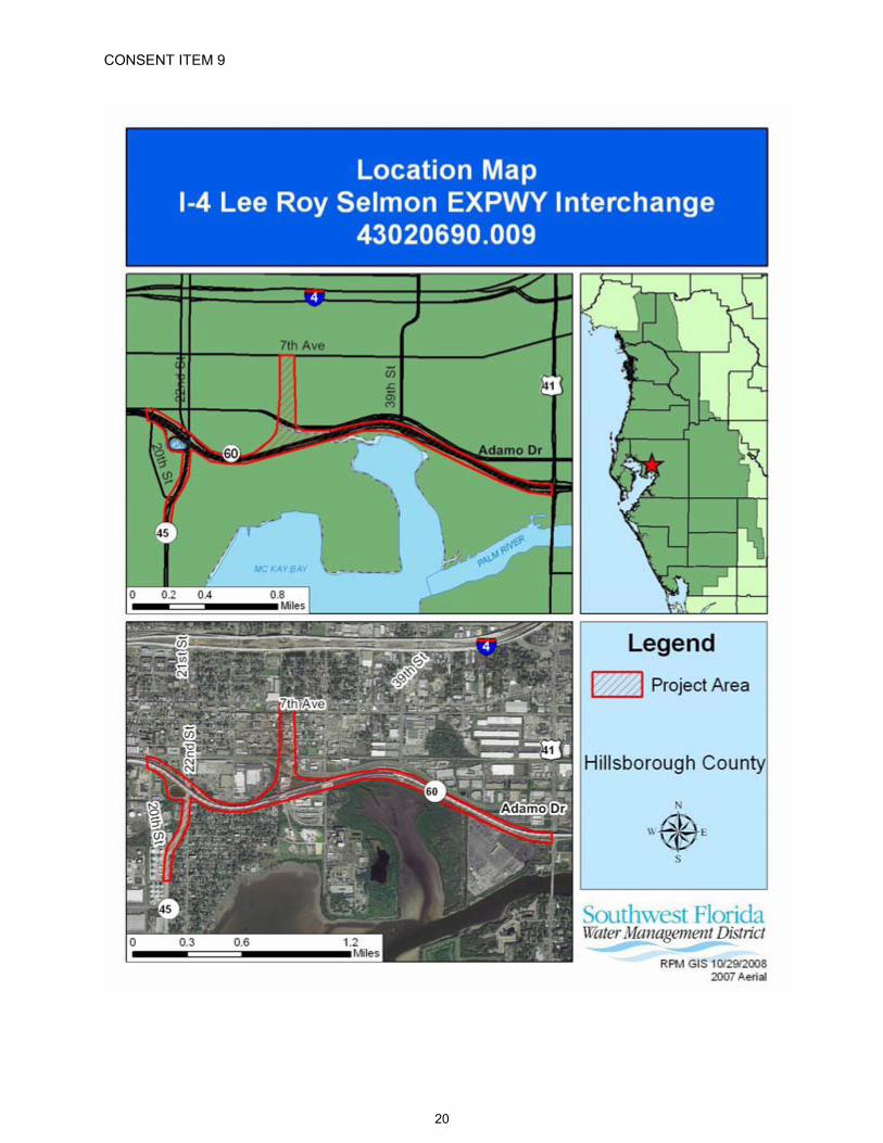
CONSENT ITEM 9
20

CONSENT ITEM 9 Default Date: January 15, 2009
SOUTHWEST FLORIDA WATER MANAGEMENT DISTRICTENVIRONMENTAL RESOURCE
INDIVIDUAL CONSTRUCTION MODIFICATIONPERMIT NO. 43020690.009
Expiration Date: December 16, 2013 PERMIT ISSUE DATE: December 16, 2008
This permit is issued under the provisions of Chapter 373, Florida Statutes, (F.S.), and the Rules contained in Chapters 40D-4 and 40, Florida Administrative Code, (F.A.C.). The permit authorizes the Permittee to proceed with the construction of a surface water management system in accordance with the information outlined herein and shown by the application, approved drawings, plans, specifications, and other documents, attached hereto and kept on file at the Southwest Florida Water Management District (District). Unless otherwise stated by permit specific condition, permit issuance constitutes certification of compliance with state water quality standards under Section 401 of the Clean Water Act, 33 U.S.C. 1341. All construction, operation and maintenance of the surface water management system authorized by this permit shall occur in compliance with Florida Statutes and Administrative Code and the conditions of this permit.
PROJECT NAME: FDOT - I-4/Lee Roy Selmon Expressway Interchange (South of 7th Avenue)
GRANTED TO: Florida Department of Transportation, District VII11201 North McKinley DriveTampa, FL 33612-6403
ABSTRACT: This permit authorization is for the construction of a surface water management system to serve the southern portion of the connector roadway between State Road 400 (I-4) and the Lee Roy Selmon Crosstown Expressway. This permit modifies existing Environmental Resource Permit (ERP) No. 44020690.007 for the northern portion of the connector road and also modifies and overlaps portions of the Crosstown "Reversible Lanes" project, permitted under ERP No. 43019654.001. The proposed elevated roadway will tie into, and necessitate widening and other improvements, to the existing Expressway. The western limits of the project is just west of State Road 45 (22nd Street) and the eastern limit is U.S. Highway 41 (50th Street). Widening to add one additional eastbound lane and one additional westbound lane to the Expressway is proposed. Widening to accommodate ramp tie-ins and auxiliary lanes is also proposed. The construction will also include a shared-use path along the north shore of McKay Bay, from 34th Street to 50th Street, to provide safe pedestrian and bicycle access between these two roadways.
The western portion of the proposed project drains to an existing undersized outfall that discharges to Ybor Channel. The proposed surface water management system for this portion of the project will provide water quantity attenuation for a 25-year/24-hour design storm event. The remainder of the proposed project will drain to McKay Bay or to tidal waters directly connected to McKay Bay and will not require water quantity attenuation. Water quality treatment for the new directly connected impervious areas (DCIA) will be provided in eleven proposed wet detention ponds.
There are 9.41 acres of wetlands and upland cut surface waters within the project area. The proposed road project will result in 4.12 acres of permanent wetland impacts and 2.30 acres of temporary wetland impacts. The wetland impacts were reviewed utilizing the Unified Mitigation Assessment Methodology (UMAM). Mitigation is being provided in accordance with Chapter 373.4137, (F.S.), to offset the loss of 3.97 functional wetland units for the wetland impacts for this road project.
21

Permit No.: 43020690.009Project Name: FDOT - I-4/Lee Roy Selmon Expressway Interchange (South of 7th Avenue)
OP. & MAINT. ENTITY: Florida Department of Transportation, District VIICOUNTY: Hillsborough
SEC/TWP/RGE: 16, 17, 18, 19, 20, 21/29S/19E
TOTAL ACRES OWNEDOR UNDER CONTROL: 158.43
PROJECT SIZE: 158.43 Acres
LAND USE: Road Project
DATE APPLICATION FILED: May 13, 2008
AMENDED DATE: N/A
I. Water Quantity/Quality
PONDNO.
AREAACRES @ TOP OF BANK
TREATMENT TYPE
SMF-C-1 0.37 Wet DetentionSMF-C-2 1.07 Wet DetentionSMF-D-1 1.54 Wet DetentionSMF-D-2 0.89 Wet DetentionSMF-E-1 2.84 Wet DetentionSMF-E-3 0.95 Wet DetentionSMF-F-1 1.73 Wet DetentionSMF-G-3 1.15 Wet DetentionSMF-H-1 1.29 Wet DetentionSMF-I-1 0.68 Wet Detention
SMF-RL-X-1 1.22 Wet DetentionTOTAL 13.73
Comments: The construction of this project will modify three existing ponds permitted under ERP No. 43019654.001. Existing "Pond 4A" will be eliminated and the water quality treatment functions will be replaced in proposed Pond SMF-E-3. A new outfall control structure for Existing "Pond 4-D" will be constructed to provide water quality treatment by wet detention and existing "Pond K" will be re-graded and modified into proposed Pond SMF-RL-X-1.
A mixing zone is not required.A variance is not required.
II. 100-Year Floodplain
Encroachment(Acre-Feet of fill)
Compensation(Acre-Feet of excavation)
CompensationType
EncroachmentResult (feet)
0.00 0.00 N/A N/A
22
Permit No.: 43020690.009Project Name: FDOT - I-4/Lee Roy Selmon Expressway Interchange (South of 7th Avenue)
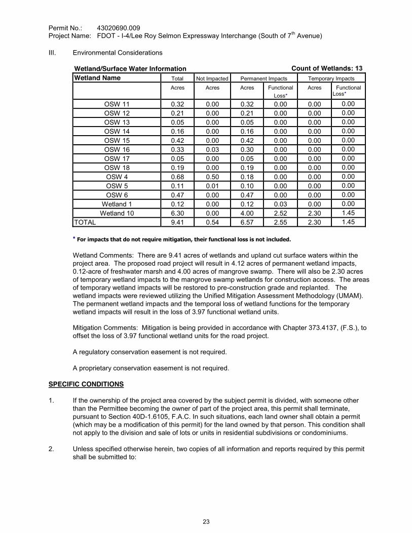
III. Environmental Considerations
Wetland/Surface Water Information Count of Wetlands:Wetland Name Total Not Impacted Permanent Impacts Temporary Impacts
Acres Acres Acres FunctionalLoss*
Acres FunctionalLoss*
OSW 11 0.32 0.00 0.32 0.00 0.00 0.00OSW 12 0.21 0.00 0.21 0.00 0.00 0.00OSW 13 0.05 0.00 0.05 0.00 0.00 0.00OSW 14 0.16 0.00 0.16 0.00 0.00 0.00OSW 15 0.42 0.00 0.42 0.00 0.00 0.00OSW 16 0.33 0.03 0.30 0.00 0.00 0.00OSW 17 0.05 0.00 0.05 0.00 0.00 0.00OSW 18 0.19 0.00 0.19 0.00 0.00 0.00OSW 4 0.68 0.50 0.18 0.00 0.00 0.00OSW 5 0.11 0.01 0.10 0.00 0.00 0.00OSW 6 0.47 0.00 0.47 0.00 0.00 0.00
Wetland 1 0.12 0.00 0.12 0.03 0.00 0.00Wetland 10 6.30 0.00 4.00 2.52 2.30 1.45
TOTAL 9.41 0.54 6.57 2.55 2.30 1.45
* For impacts that do not require mitigation, their functional loss is not included.
Wetland Comments: There are 9.41 acres of wetlands and upland cut surface waters within the project area. The proposed road project will result in 4.12 acres of permanent wetland impacts, 0.12-acre of freshwater marsh and 4.00 acres of mangrove swamp. There will also be 2.30 acres of temporary wetland impacts to the mangrove swamp wetlands for construction access. The areas of temporary wetland impacts will be restored to pre-construction grade and replanted. The wetland impacts were reviewed utilizing the Unified Mitigation Assessment Methodology (UMAM). The permanent wetland impacts and the temporal loss of wetland functions for the temporary wetland impacts will result in the loss of 3.97 functional wetland units.
Mitigation Comments: Mitigation is being provided in accordance with Chapter 373.4137, (F.S.), to offset the loss of 3.97 functional wetland units for the road project.
A regulatory conservation easement is not required.
A proprietary conservation easement is not required.
SPECIFIC CONDITIONS
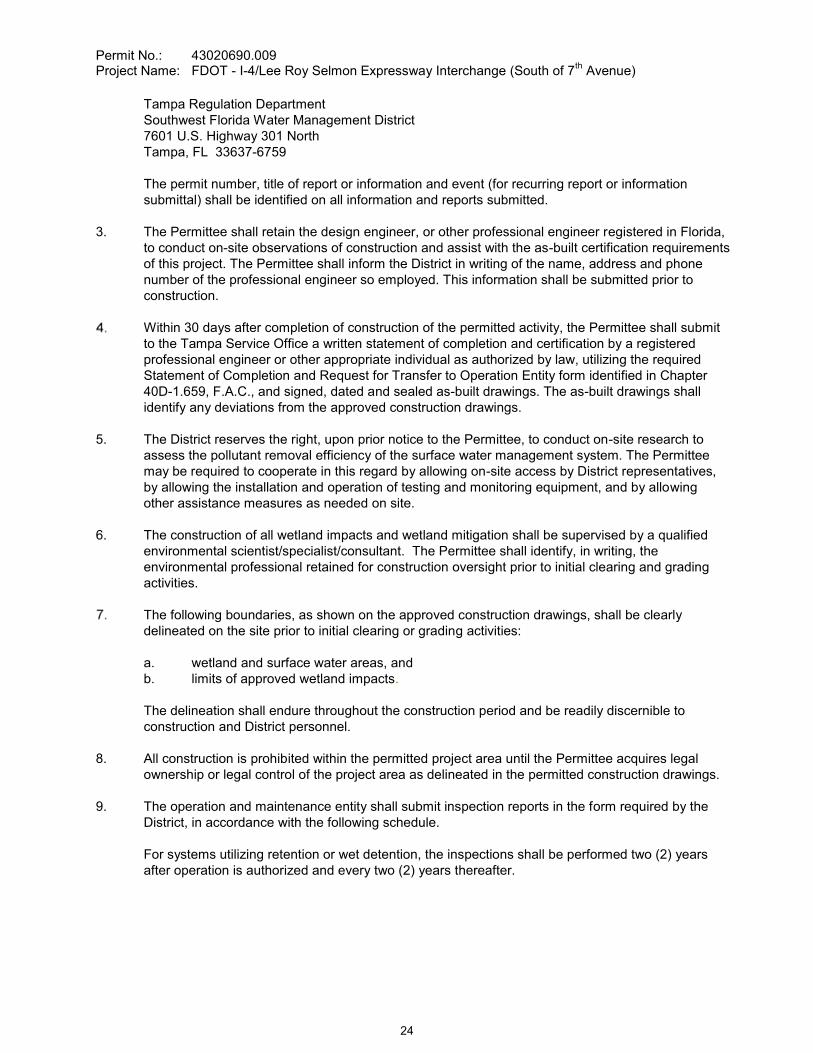
1. If the ownership of the project area covered by the subject permit is divided, with someone other than the Permittee becoming the owner of part of the project area, this permit shall terminate, pursuant to Section 40D-1.6105, F.A.C. In such situations, each land owner shall obtain a permit (which may be a modification of this permit) for the land owned by that person. This condition shall not apply to the division and sale of lots or units in residential subdivisions or condominiums.
2. Unless specified otherwise herein, two copies of all information and reports required by this permit shall be submitted to:
23
Permit No.: 43020690.009Project Name: FDOT - I-4/Lee Roy Selmon Expressway Interchange (South of 7th Avenue)
Tampa Regulation DepartmentSouthwest Florida Water Management District7601 U.S. Highway 301 NorthTampa, FL 33637-6759
The permit number, title of report or information and event (for recurring report or information submittal) shall be identified on all information and reports submitted.
3. The Permittee shall retain the design engineer, or other professional engineer registered in Florida, to conduct on-site observations of construction and assist with the as-built certification requirements of this project. The Permittee shall inform the District in writing of the name, address and phone number of the professional engineer so employed. This information shall be submitted prior to construction.
Within 30 days after completion of construction of the permitted activity, the Permittee shall submit to the Tampa Service Office a written statement of completion and certification by a registered professional engineer or other appropriate individual as authorized by law, utilizing the required Statement of Completion and Request for Transfer to Operation Entity form identified in Chapter 40D-1.659, F.A.C., and signed, dated and sealed as-built drawings. The as-built drawings shall identify any deviations from the approved construction drawings.
5. The District reserves the right, upon prior notice to the Permittee, to conduct on-site research to assess the pollutant removal efficiency of the surface water management system. The Permittee may be required to cooperate in this regard by allowing on-site access by District representatives, by allowing the installation and operation of testing and monitoring equipment, and by allowing other assistance measures as needed on site.
6. The construction of all wetland impacts and wetland mitigation shall be supervised by a qualified environmental scientist/specialist/consultant. The Permittee shall identify, in writing, the environmental professional retained for construction oversight prior to initial clearing and grading activities.
The following boundaries, as shown on the approved construction drawings, shall be clearly delineated on the site prior to initial clearing or grading activities:
a. wetland and surface water areas, andb. limits of approved wetland impacts.
The delineation shall endure throughout the construction period and be readily discernible to construction and District personnel.
8. All construction is prohibited within the permitted project area until the Permittee acquires legal ownership or legal control of the project area as delineated in the permitted construction drawings.
9. The operation and maintenance entity shall submit inspection reports in the form required by the District, in accordance with the following schedule.
For systems utilizing retention or wet detention, the inspections shall be performed two (2) years after operation is authorized and every two (2) years thereafter.
24
Permit No.: 43020690.009Project Name: FDOT - I-4/Lee Roy Selmon Expressway Interchange (South of 7th Avenue)
10. The removal of littoral shelf vegetation (including cattails) from wet detention ponds is prohibited unless otherwise approved by the District. Removal includes dredging, the application of herbicide, cutting, and the introduction of grass carp. Any questions regarding authorized activities within the wet detention ponds shall be addressed to the District's Surface Water Regulation Manager, Tampa Service Office.
This modification, Construction Permit No. 43020690.009, amends the previously issued Construction Permit Nos. 44020690.007 and 43019654.001, and adds conditions. All other original permit conditions remain in effect.
12. During the construction period, the Permittee's Professional Engineer shall conduct an on-site inspection to verify that the impervious liner has been constructed as permitted.
13. The District, upon prior notice to the Permittee, may conduct on-site inspections to assess the effectiveness of the erosion control barriers and other measures employed to prevent violations of state water quality standards and avoid downstream impacts. Such barriers or other measures should control discharges, erosion, and sediment transport during construction and thereafter. The District will also determine any potential environmental problems that may develop as a result of leaving or removing the barriers and other measures during construction or after construction of the project has been completed. The Permittee must provide any remedial measures that are needed.
This permit is issued basit is determined by the District that the Conditions for Issuance of Permits in Rules 40D-4.301 and 40D-4.302, F.A.C., have not been met, upon written notice by the District, the Permittee shall obtain a permit modification and perform any construction necessary thereunder to correct any deficiencies in the system design or construction to meet District rule criteria. The Permittee is advised that the correction of deficiencies may require re-construction of the surface water management system and/or mitigation areas.
15. The construction of the permitted activity shall not commence until related Construction Permit No. 43019654.001 is transferred to the Operation Phase, in accordance with Chapter 40D-4.341, F.A.C.
GENERAL CONDITIONS
1. The general conditions attached hereto as Exhibit "A" are hereby incorporated into this permit by reference and the Permittee shall comply with them.
____________________________________________Authorized Signature
25
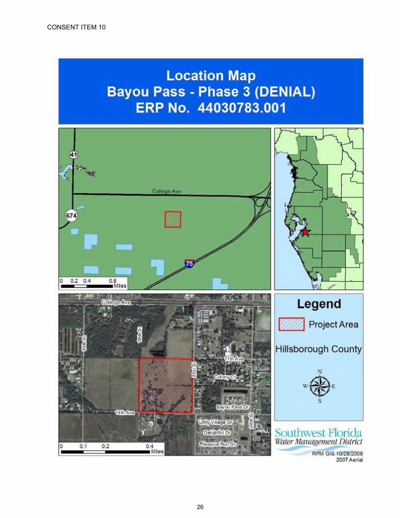
CONSENT ITEM 10
26

CONSENT ITEM 10 Default Date: N/A
SOUTHWEST FLORIDA WATER MANAGEMENT DISTRICTENVIRONMENTAL RESOURCE GENERAL CONSTRUCTION
DENIAL OF GENERAL CONSTRUCTIONPERMIT APPLICATION NO. 44030783.001
DATE OF DENIAL: December 16, 2008
Staff recommends denial of this application for permit due to lack of completeness, in accordance with District Rule 40D-1.1020 and Rule 40D-40.302, Florida Administrative Code, (F.A.C.).
PROJECT NAME: Bayou Pass - Phase 3
OWNER/APPLICANT: Florida Home Partnership, Inc.Post Office Box 771Ruskin, FL 33575
ABSTRACT: The proposed project is a 170-lot single-family residential subdivision and the associated internal roadways and surface water management system (SWMS). The proposed project also includes the construction of offsite roadway improvements in adjacent Hillsborough County rights-of-way. The project is located at the northwest corner of 14th Avenue Southeast and 21st Street Southeast, near Ruskin. The Applicant has not responded to the District's Clarification of Received Information letter dated November 1, 2007.
Application Submitted July 24, 2007Request for Additional Information (RAI) letter sent August 22, 2007Time Extension approved to October 21, 2007Response to RAI letter received October 5, 2007Clarification of Received Information letter sent November 1, 2007Four Time Extensions approved to June 18, 2008Applicant contacted by telephone September 29, 2008Notification of Incomplete Application sent September 29, 2008
COUNTY: Hillsborough
SEC/TWP/RGE: 09/32S/19E
TOTAL ACRES OWNED: 44.28
PROJECT SIZE: 44.28 Acres
LAND USE: Single-family Residential
DATE APPLICATION FILED: July 24, 2007
AMENDED DATE: N/A
The following are reasons for denial:
Technical and Legal Information:
1. Reasonable assurance was not provided to demonstrate that the proposed project will not impact and cause a net encroachment into the 100-year floodplain and historic basin storage. [Rules 40D-4.302(1) and 40D-4.301(1)(c), F.A.C.]
27

Permit No.: 44030783.001Project Name: Bayou Pass - Phase 3 (DENIAL)
2. The plans are incomplete and inconsistent with the drainage calculations. [Rules 40D-4.112(2) and 40D-4.101(1)(c), F.A.C.]
3. The Applicant did not provide copies of a drainage easement required for the construction and maintenance of a proposed offsite stormwater pond. [rules 40D-4.112(2), 40D-4.101(1)(e), and 40D-4.101(2), F.A.C.]
28
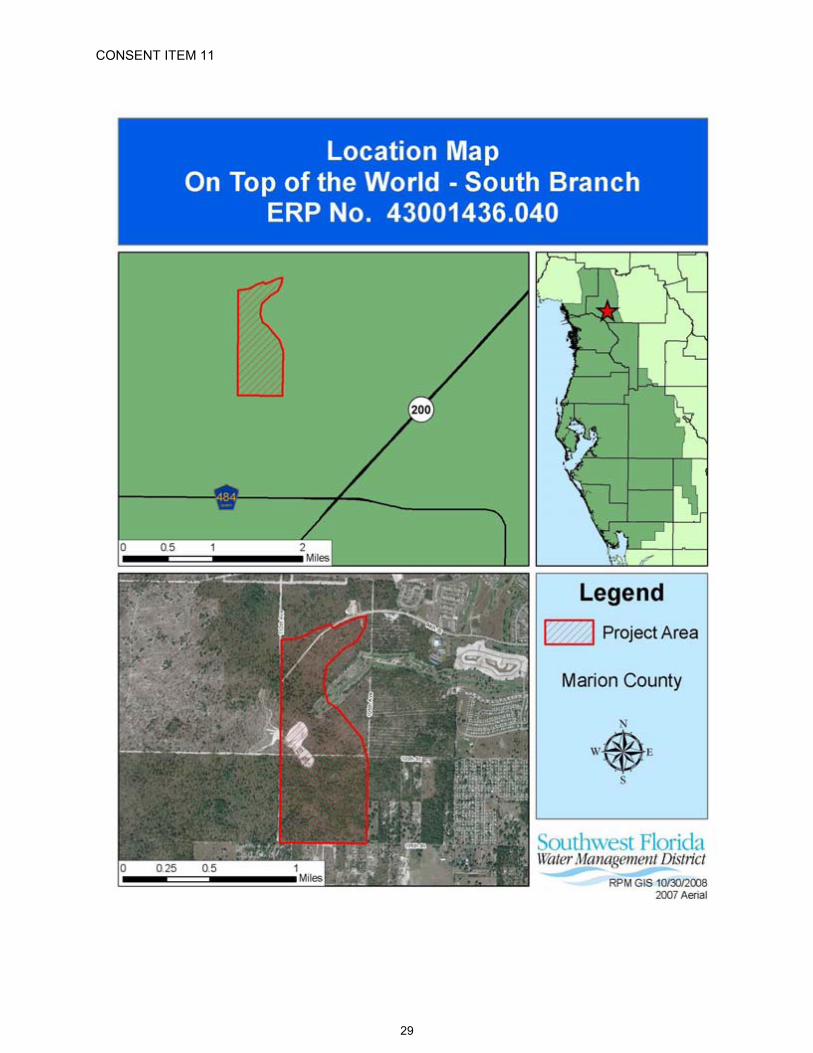
CONSENT ITEM 11
29

CONSENT ITEM 11 Default Date: December 24, 2008
SOUTHWEST FLORIDA WATER MANAGEMENT DISTRICTENVIRONMENTAL RESOURCEINDIVIDUAL CONSTRUCTION
PERMIT NO. 43001436.040
Expiration Date: December 16, 2013 PERMIT ISSUE DATE: December 16, 2008
This permit is issued under the provisions of Chapter 373, Florida Statutes, (F.S.), and the Rules contained in Chapters 40D-4 and 40, Florida Administrative Code, (F.A.C.). The permit authorizes the Permittee to proceed with the construction of a surface water management system in accordance with the information outlined herein and shown by the application, approved drawings, plans, specifications, and other documents, attached hereto and kept on file at the Southwest Florida Water Management District (District). Unless otherwise stated by permit specific condition, permit issuance constitutes certification of compliance with state water quality standards under Section 401 of the Clean Water Act, 33 U.S.C. 1341. All construction, operation and maintenance of the surface water management system authorized by this permit shall occur in compliance with Florida Statutes and Administrative Code and the conditions of this permit.
PROJECT NAME: On Top of the World - South Branch
GRANTED TO: On Top of the World Communities, Inc.8447 Southwest 99th Street RoadOcala, FL 34481
ABSTRACT: This permit is for grading and construction of new surface water management systems to serve the future 316.90-acre residential and commercial development. The project site is located north of CR 484 and west of SR 200 within the On Top of the World Development in Marion County, Florida. Adjacent properties include grading associated with Terralea (Environmental Resource Permit [ERP] No. 43001436.038) to the north, Crescent Ridge ll (ERP No. 44001436.033) to the east, and SW 105th Street (ERP No. 44029098.000) to the south. Information regarding the surface water management system is contained in the tables below.
OP. & MAINT. ENTITY: On Top of the World Communities, Inc.
COUNTY: Marion
SEC/TWP/RGE: 22,27/16S/20E
TOTAL ACRES OWNEDOR UNDER CONTROL: 6,090.00
PROJECT SIZE: 316.90 Acres
LAND USE: Residential
DATE APPLICATION FILED: July 29, 2008
AMENDED DATE: August 7, 2008
30

Permit No.: 43001436.040Project Name: On Top of the World - South Branch
I. Water Quantity/Quality
PONDNO.
AREAACRES @ TOP OF BANK
TREATMENT TYPE
10 4.11 On-line Retention20 2.22 On-line Retention30 3.53 On-line Retention40 8.06 On-line Retention50 3.95 On-line Retention60 2.66 On-line Retention70 3.58 On-line Retention80 3.48 On-line Retention85 1.07 On-line Retention90 5.09 On-line Retention100 3.10 On-line Retention110 7.31 On-line Retention
120/140 2.21 On-line Retention130 1.76 On-line Retention
OS90 0.19 On-line RetentionOS95 0.41 On-line Retention
TOTAL 52.73
A mixing zone is not required.A variance is not required.
II. 100-Year Floodplain
Encroachment(Acre-Feet of fill)
Compensation(Acre-Feet of excavation)
CompensationType*
EncroachmentResult**(feet)
0.00 0.00 NE X Depth N/A
*Codes [ X ] for the type or method of compensation provided are as follows:NE = No EncroachmentMI = Minimal Impact based on modeling of existing stages vs. post-project encroachment.N/A = Not Applicable
**Depth of change in flood stage (level) over existing receiving water stage resulting from floodplain encroachment caused by a project that claims MI type of compensation.
III. Environmental Considerations
No wetlands or other surface waters exist within the project area.
A regulatory conservation easement is not required.
A proprietary conservation easement is not required.
31
Permit No.: 43001436.040Project Name: On Top of the World - South Branch
SPECIFIC CONDITIONS
1. If the ownership of the project area covered by the subject permit is divided, with someone other than the Permittee becoming the owner of part of the project area, this permit shall terminate, pursuant to Section 40D-1.6105, F.A.C. In such situations, each land owner shall obtain a permit (which may be a modification of this permit) for the land owned by that person. This condition shall not apply to the division and sale of lots or units in residential subdivisions or condominiums.
2. Unless specified otherwise herein, two copies of all information and reports required by this permit shall be submitted to:
Brooksville Regulation DepartmentSouthwest Florida Water Management District2379 Broad StreetBrooksville, FL 34604-6899
The permit number, title of report or information and event (for recurring report or information submittal) shall be identified on all information and reports submitted.
3. The Permittee shall retain the design engineer, or other professional engineer registered in Florida, to conduct on-site observations of construction and assist with the as-built certification requirements of this project. The Permittee shall inform the District in writing of the name, address and phone number of the professional engineer so employed. This information shall be submitted prior to construction.
Within 30 days after completion of construction of the permitted activity, the Permittee shall submit to the Brooksville Service Office a written statement of completion and certification by a registered professional engineer or other appropriate individual as authorized by law, utilizing the required Statement of Completion and Request for Transfer to Operation Entity form identified in Chapter 40D-1.659, F.A.C., and signed, dated and sealed as-built drawings. The as-built drawings shall identify any deviations from the approved construction drawings.
5. The District reserves the right, upon prior notice to the Permittee, to conduct on-site research to assess the pollutant removal efficiency of the surface water management system. The Permittee may be required to cooperate in this regard by allowing on-site access by District representatives, by allowing the installation and operation of testing and monitoring equipment, and by allowing other assistance measures as needed on site.
6. The operation and maintenance entity shall submit inspection reports in the form required by the District, in accordance with the following schedule.
For systems utilizing retention or wet detention, the inspections shall be performed two (2) years after operation is authorized and every two (2) years thereafter.
7. The Permittee shall notify the District at least 48 hours prior to the maximum excavation of each retention/detention pond and must notify the District upon the completion of each retention/detention pond.
8. If limestone bedrock is encountered during construction of the surface water management system, the District must be notified and construction in the affected area shall cease.
32
Permit No.: 43001436.040Project Name: On Top of the World - South Branch
9. The Permittee shall notify the District of any sinkhole development in the surface water management system within 48 hours of discovery and must submit a detailed sinkhole evaluation and repair plan for approval by the District within 30 days of discovery.
10. The District, upon prior notice to the Permittee, may conduct on-site inspections to assess the effectiveness of the erosion control barriers and other measures employed to prevent violations of state water quality standards and avoid downstream impacts. Such barriers or other measures should control discharges, erosion, and sediment transport during construction and thereafter. The District will also determine any potential environmental problems that may develop as a result of leaving or removing the barriers and other measures during construction or after construction of the project has been completed. The Permittee must provide any remedial measures that are needed.
This permit is issued based upon the design it is determined by the District that the Conditions for Issuance of Permits in Rules 40D-4.301 and 40D-4.302, F.A.C., have not been met, upon written notice by the District, the Permittee shall obtaina permit modification and perform any construction necessary thereunder to correct any deficiencies in the system design or construction to meet District rule criteria. The Permittee is advised that the correction of deficiencies may require re-construction of the surface water management system and/or mitigation areas.
12. Additional permitting will be required for future development within the project area.
GENERAL CONDITIONS
1. The general conditions attached hereto as Exhibit "A" are hereby incorporated into this permit by reference and the Permittee shall comply with them.
____________________________________________Authorized Signature
33

CONSENT ITEM 12
34

CONSENT ITEM 12 Default Date: January 8, 2009
SOUTHWEST FLORIDA WATER MANAGEMENT DISTRICTENVIRONMENTAL RESOURCEINDIVIDUAL CONSTRUCTION
PERMIT NO. 43015544.003
Expiration Date: December 16, 2013 PERMIT ISSUE DATE: December 16, 2008
This permit is issued under the provisions of Chapter 373, Florida Statutes, (F.S.), and the Rules contained in Chapters 40D-4 and 40, Florida Administrative Code, (F.A.C.). The permit authorizes the Permittee to proceed with the construction of a surface water management system in accordance with the information outlined herein and shown by the application, approved drawings, plans, specifications, and other documents, attached hereto and kept on file at the Southwest Florida Water Management District (District). Unless otherwise stated by permit specific condition, permit issuance constitutes certification of compliance with state water quality standards under Section 401 of the Clean Water Act, 33 U.S.C. 1341. All construction, operation and maintenance of the surface water management system authorized by this permit shall occur in compliance with Florida Statutes and Administrative Code and the conditions of this permit.
PROJECT NAME: Gulf Landings Boat Docks, Tracts 40B, 40C and 50C
GRANTED TO: Gulf Landings Development Corporation5245 US Highway 19New Port Richey, FL 34652
ABSTRACT: This permit is for the construction of a 2.08-acre project area consisting of 105 boat slips and private boat dock facility for local residents of Gulf Landings Development. The project site is located on the Cross Bayou, approximately two miles west of Cross Bayou Boulevard and US 19, in western Pasco County.
OP. & MAINT. ENTITY: Gulf Landings Development Corporation
COUNTY: Pasco
SEC/TWP/RGE: 7/26S/16E
TOTAL ACRES OWNEDOR UNDER CONTROL: 49.43
PROJECT SIZE: 2.08 Acres
LAND USE: Residential
DATE APPLICATION FILED: November 26, 2007
AMENDED DATE: N/A
35
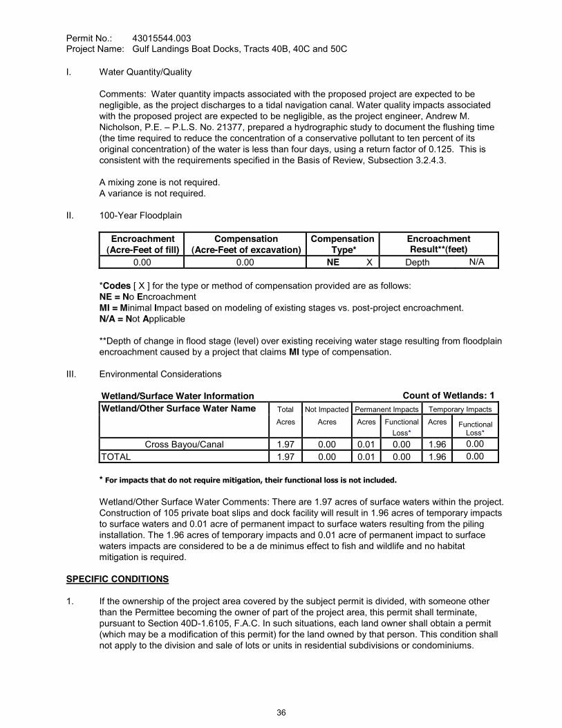
Permit No.: 43015544.003Project Name: Gulf Landings Boat Docks, Tracts 40B, 40C and 50C
I. Water Quantity/Quality
Comments: Water quantity impacts associated with the proposed project are expected to be negligible, as the project discharges to a tidal navigation canal. Water quality impacts associated with the proposed project are expected to be negligible, as the project engineer, Andrew M. Nicholson, P.E. P.L.S. No. 21377, prepared a hydrographic study to document the flushing time (the time required to reduce the concentration of a conservative pollutant to ten percent of its original concentration) of the water is less than four days, using a return factor of 0.125. This is consistent with the requirements specified in the Basis of Review, Subsection 3.2.4.3.
A mixing zone is not required.A variance is not required.
II. 100-Year Floodplain
Encroachment(Acre-Feet of fill)
Compensation(Acre-Feet of excavation)
CompensationType*
EncroachmentResult**(feet)
0.00 0.00 NE X Depth N/A
*Codes [ X ] for the type or method of compensation provided are as follows:NE = No EncroachmentMI = Minimal Impact based on modeling of existing stages vs. post-project encroachment.N/A = Not Applicable
**Depth of change in flood stage (level) over existing receiving water stage resulting from floodplain encroachment caused by a project that claims MI type of compensation.
III. Environmental Considerations
Wetland/Surface Water Information Count of Wetlands:Wetland/Other Surface Water Name Total Not Impacted Permanent Impacts Temporary Impacts
Acres Acres Acres FunctionalLoss*
Acres FunctionalLoss*
Cross Bayou/Canal 1.97 0.00 0.01 0.00 1.96 0.00TOTAL 1.97 0.00 0.01 0.00 1.96 0.00
* For impacts that do not require mitigation, their functional loss is not included.
Wetland/Other Surface Water Comments: There are 1.97 acres of surface waters within the project. Construction of 105 private boat slips and dock facility will result in 1.96 acres of temporary impacts to surface waters and 0.01 acre of permanent impact to surface waters resulting from the piling installation. The 1.96 acres of temporary impacts and 0.01 acre of permanent impact to surface waters impacts are considered to be a de minimus effect to fish and wildlife and no habitat mitigation is required.
SPECIFIC CONDITIONS
1. If the ownership of the project area covered by the subject permit is divided, with someone other than the Permittee becoming the owner of part of the project area, this permit shall terminate, pursuant to Section 40D-1.6105, F.A.C. In such situations, each land owner shall obtain a permit (which may be a modification of this permit) for the land owned by that person. This condition shall not apply to the division and sale of lots or units in residential subdivisions or condominiums.
36

Permit No.: 43015544.003Project Name: Gulf Landings Boat Docks, Tracts 40B, 40C and 50C
2. Unless specified otherwise herein, two copies of all information and reports required by this permit shall be submitted to:
Brooksville Regulation DepartmentSouthwest Florida Water Management District2379 Broad StreetBrooksville, FL 34604-6899
The permit number, title of report or information and event (for recurring report or information submittal) shall be identified on all information and reports submitted.
3. The Permittee shall retain the design engineer, or other professional engineer registered in Florida, to conduct on-site observations of construction and assist with the as-built certification requirements of this project. The Permittee shall inform the District in writing of the name, address and phone number of the professional engineer so employed. This information shall be submitted prior to construction.
Within 30 days after completion of construction of the permitted activity, the Permittee shall submit to the Brooksville Service Office a written statement of completion and certification by a registered professional engineer or other appropriate individual as authorized by law, utilizing the required Statement of Completion and Request for Transfer to Operation Entity form identified in Chapter 40D-1.659, F.A.C., and signed, dated and sealed as-built drawings. The as-built drawings shall identify any deviations from the approved construction drawings.
5. The District reserves the right, upon prior notice to the Permittee, to conduct on-site research to assess the pollutant removal efficiency of the surface water management system. The Permittee may be required to cooperate in this regard by allowing on-site access by District representatives, by allowing the installation and operation of testing and monitoring equipment, and by allowing other assistance measures as needed on site.
The following boundaries, as shown on the approved construction drawings, shall be clearly delineated on the site prior to initial clearing or grading activities:
surface water areaslimits of approved surface water impacts
The delineation shall endure throughout the construction period and be readily discernible to construction and District personnel.
Surface water boundaries shown on the approved construction drawings shall be binding upon the Permittee and the District.
8. The following language shall be included as part of the deed restrictions for each lot:
"No owner of property within the subdivision may construct or maintain any building, residence, or structure, or undertake or perform any activity in the wetlands, wetland mitigation areas, buffer areas, upland conservation areas and drainage easements described in the approved permit and recorded plat of the subdivision, unless prior approval is received from the Southwest Florida Water Management District, Brooksville Regulation Department."
37
Permit No.: 43015544.003Project Name: Gulf Landings Boat Docks, Tracts 40B, 40C and 50C
Rights-of-way and easement locations necessary to construct, operate and maintain all facilities, which constitute the permitted surface water management system (including all wetlands and wetland buffers), shall be shown on the final plat recorded in the County Public Records. Documentation of this plat recording shall be submitted to the District with the Statement of Completion and Request for Transfer to Operation Entity Form, and prior to beneficial occupancy or use of the site.
10. Copies of the following documents in final form, as appropriate for the project, shall be submitted to the Brooksville Regulation Department:
a. homeowners, property owners, master association or condominium association articles of incorporation, and
b. declaration of protective covenants, deed restrictions or declaration of condominium.
The Permittee shall submit these documents either: (1) within 180 days after beginning construction or with the Statement of Completion and as-built construction plans if construction is completedprior to 180 days, or (2) prior to any lot or unit sales within the project served by the surface water management system, whichever occurs first.
11. The following language shall be included as part of the deed restrictions for each lot:
"Each property owner within the subdivision at the time of construction of a building, residence, or structure shall comply with the construction plans for the surface water management system approved and on file with the Southwest Florida Water Management District."
12. If limestone bedrock is encountered during construction of the surface water management system, the District must be notified and construction in the affected area shall cease.
13. The Permittee shall notify the District of any sinkhole development in the surface water management system within 48 hours of discovery and must submit a detailed sinkhole evaluation and repair plan for approval by the District within 30 days of discovery.
14. The District, upon prior notice to the Permittee, may conduct on-site inspections to assess the effectiveness of the erosion control barriers and other measures employed to prevent violations of state water quality standards and avoid downstream impacts. Such barriers or other measures should control discharges, erosion, and sediment transport during construction and thereafter. The District will also determine any potential environmental problems that may develop as a result of leaving or removing the barriers and other measures during construction or after construction of the project has been completed. The Permittee must provide any remedial measures that are needed.
it is determined by the District that the Conditions for Issuance of Permits in Rules 40D-4.301 and 40D-4.302, F.A.C., have not been met, upon written notice by the District, the Permittee shall obtain a permit modification and perform any construction necessary thereunder to correct any deficiencies in the system design or construction to meet District rule criteria. The Permittee is advised that the correction of deficiencies may require re-construction of the surface water management system and/or mitigation areas.
16. The Standard Manatee Conditions for In-Water Work (revision 2005) shall be followed by the Permittee for all in-water activity as indicated below:
38

Permit No.: 43015544.003Project Name: Gulf Landings Boat Docks, Tracts 40B, 40C and 50C
A. All personnel associated with the project shall be instructed about the presence of manatees and manatee speed zones, and the need to avoid collisions with and injury to manatees. The permittee shall advise all construction personnel that there are civil and criminal penalties for harming, harassing, or killing manatees which are protected under the Marine Mammal Protection Act, the Endangered Species Act, and the Florida Manatee Sanctuary Act.
B.at all times while in the immediate area and while in water where the draft of the vessel provides less than a four-foot clearance from the bottom. All vessels will follow routes of deep water whenever possible.
C. Siltation or turbidity barriers shall be made of material in which manatees cannot become entangled, shall be properly secured, and shall be regularly monitored to avoid manatee entanglement or entrapment. Barriers must not impede manatee movement.
D. All on-site project personnel are responsible for observing water-related activities for the presence of manatee(s). All in-water operations, including vessels, must be shutdown if a manatee(s) comes within 50 feet of the operation. Activities will not resume until the manatee(s) has moved beyond the 50-foot radius of the project operation, or until 30 minutes elapses if the manatee(s) has not reappeared within 50 feet of the operation. Animals must not be herded away or harassed into leaving.
E. Any collision with or injury to a manatee shall be reported immediately to the FWC Hotline at 1-888-404-FWCC. Collision and/or injury should also be reported to the U.S. Fish and Wildlife Service in Jacksonville (1-904-232-2580) for north Florida or Vero Beach (1-561-562-3909) for south Florida.
F. Temporary signs concerning manatees shall be posted prior to and during all in-water project activities. All signs are to be removed by the permittee upon completion of the project. Awareness signs that have already been approved for this use by the Florida Fish and Wildlife Conservation Commission (FWC) must be used. One sign measuring at least 3 ft. by 4 ft. which reads Caution: Manatee Area must be posted. A second sign measuring at least 8-the shut down of in-water operations must be posted in a location prominently visible to all personnel engaged in water-related activities.
17. The Permittee shall develop and implement a Florida Fish and Wildlife Conservation Commission (FWC)-approved marina educational program prior to slip occupancy. The Permittee shall developthis educational program with the assistance of FWC, and FWC shall approve this education plan prior to its implementation. The program may include (at a minimum) the posting of permanent manatee educational signs and the display of brochures in a prominent location. This educational program must be maintained for the life of the facility. Marina educational program guidelines can be found at http://myfwc.com/manatee/signs/Educationplan.pdf, or can be obtained from FWC. Contact the Florida Fish and Wildlife Conservation Commission, Imperiled Species Management Section at: 620 South Meridian Street, 6A, Tallahassee, Florida 32399-1600 (telephone 850/922-4330 or [email protected]).
39

Permit No.: 43015544.003Project Name: Gulf Landings Boat Docks, Tracts 40B, 40C and 50C
GENERAL CONDITIONS
1. The general conditions attached hereto as Exhibit "A" are hereby incorporated into this permit by reference and the Permittee shall comply with them.
____________________________________________Authorized Signature
40

CONSENT ITEM 13
41

CONSENT ITEM 13 Default Date: December 17, 2008
SOUTHWEST FLORIDA WATER MANAGEMENT DISTRICTCONSOLIDATED ENVIRONMENTAL RESOURCE PERMIT (ERP) AND
SOVEREIGN SUBMERGED LAND AUTHORIZATION (SL)INDIVIDUAL CONSTRUCTION SURFACE WATER MANAGEMENT SYSTEMS
PERMIT NO. 43027830.001AND
SOVEREIGNTY LANDS STANDARD LEASE
ERP Expiration Date: December 16, 2013 PERMIT ISSUE DATE: December 16, 2008SL Expiration Date: N/A
This permit, issued under the provisions of Chapter 373, Florida Statutes, (F.S.), and Chapter 40D-4,Florida Administrative Code, (F.A.C.), authorizes the Permittee to perform the work outlined herein and shown by the application, approved drawings, plans, and other documents, attached hereto and kept on file at the Southwest Florida Water Management District (District).
Authorization is granted to use sovereign submerged lands as outlined herein and shown by the application, approved drawings, plans, and other documents attached hereto and kept on file at the District under the provisions of Chapter 253, F.S., and Chapter 18-21, F.A.C., as well as the policies of the Board of Trustees of the Internal Improvement Trust Fund (Board of Trustees). This approval does not disclaim any title interests that the Board of Trustees may have in the project site. Any subsequent authorizations by the Board of Trustees or its designated agents may contain conditions necessary to satisfy the fiduciary responsibilities of the Board of Trustees as well as other applicable statutory or rule requirements implemented by the Department of Environmental Protection's Division of State Lands or other governmental agencies authorized by Florida Statutes.
All construction, operation, and maintenance of the surface water management system authorized by this permit shall occur in compliance with Florida Statutes and Administrative Code and the conditions of this permit.
PROJECT NAME: Main Street Landing Boat Docks
GRANTED TO: Main Street Landing, LLPPO Box 2900Gainesville, FL 32602
ABSTRACT: This project authorizes the construction of a 26-slip docking facility on the Pithlachascotee River to serve Main Street Landings, a multi-family residential/commercial development, previously approved under Environmental Resource Permit No. 44027830.000. The project is located on the west bank of the Pithlachascotee River, directly south of the Main Street Bridge, in the City of New Port Richey in Pasco County. The docks will be operated and maintained by the Permittee. The docking facility will require a proprietary standard lease preempting 11,326 square feet of sovereign submerged lands within the Pithlachascotee River.
OP. & MAINT. ENTITY: Main Street Landing, LLP
COUNTY: Pasco
WATERBODY NAME: Pithlachascotee River
AQUATIC PRESERVE: N/A
42
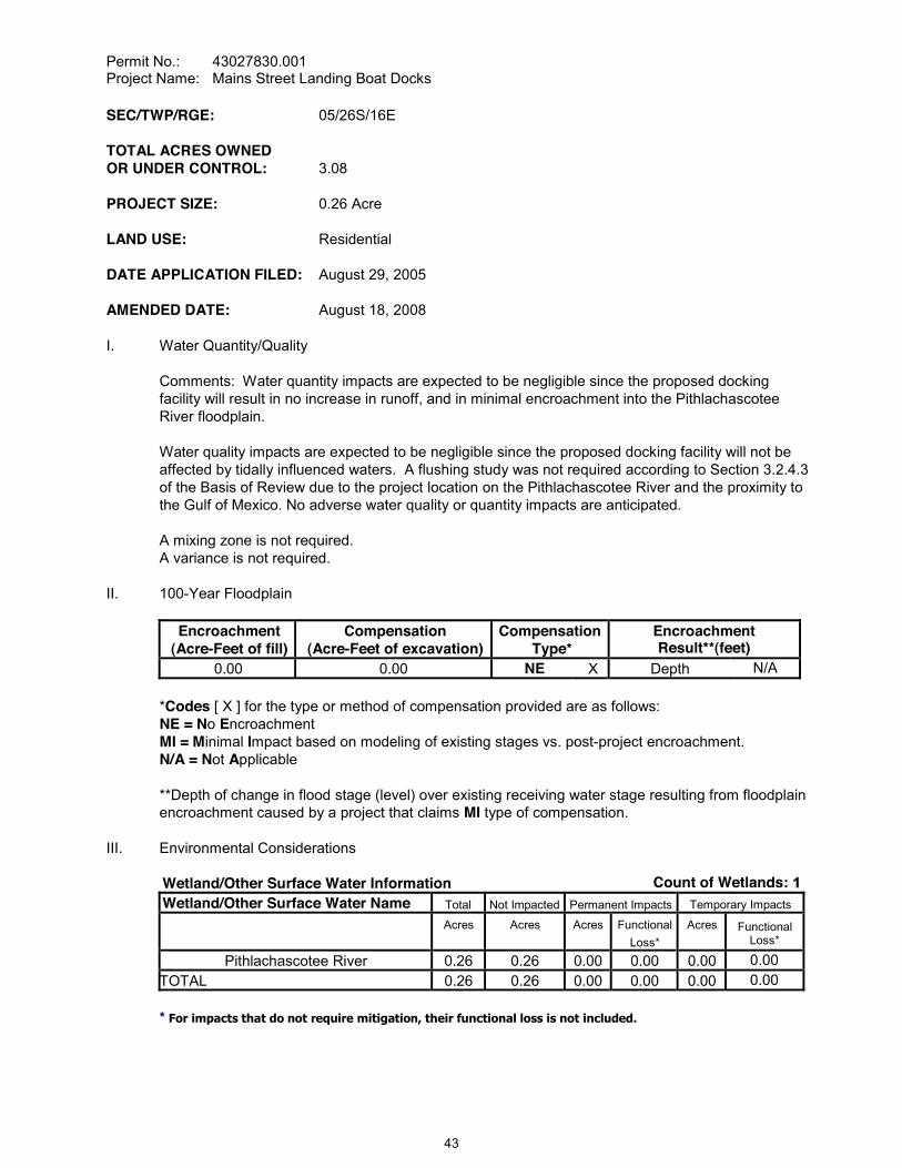
Permit No.: 43027830.001Project Name: Mains Street Landing Boat Docks
SEC/TWP/RGE: 05/26S/16E
TOTAL ACRES OWNEDOR UNDER CONTROL: 3.08
PROJECT SIZE: 0.26 Acre
LAND USE: Residential
DATE APPLICATION FILED: August 29, 2005
AMENDED DATE: August 18, 2008
I. Water Quantity/Quality
Comments: Water quantity impacts are expected to be negligible since the proposed docking facility will result in no increase in runoff, and in minimal encroachment into the Pithlachascotee River floodplain.
Water quality impacts are expected to be negligible since the proposed docking facility will not be affected by tidally influenced waters. A flushing study was not required according to Section 3.2.4.3 of the Basis of Review due to the project location on the Pithlachascotee River and the proximity to the Gulf of Mexico. No adverse water quality or quantity impacts are anticipated.
A mixing zone is not required.A variance is not required.
II. 100-Year Floodplain
Encroachment(Acre-Feet of fill)
Compensation(Acre-Feet of excavation)
CompensationType*
EncroachmentResult**(feet)
0.00 0.00 NE X Depth N/A
*Codes [ X ] for the type or method of compensation provided are as follows:NE = No EncroachmentMI = Minimal Impact based on modeling of existing stages vs. post-project encroachment.N/A = Not Applicable
**Depth of change in flood stage (level) over existing receiving water stage resulting from floodplain encroachment caused by a project that claims MI type of compensation.
III. Environmental Considerations
Wetland/Other Surface Water Information Count of Wetlands:Wetland/Other Surface Water Name Total Not Impacted Permanent Impacts Temporary Impacts
Acres Acres Acres FunctionalLoss*
Acres FunctionalLoss*
Pithlachascotee River 0.26 0.26 0.00 0.00 0.00 0.00TOTAL 0.26 0.26 0.00 0.00 0.00 0.00
* For impacts that do not require mitigation, their functional loss is not included.
43
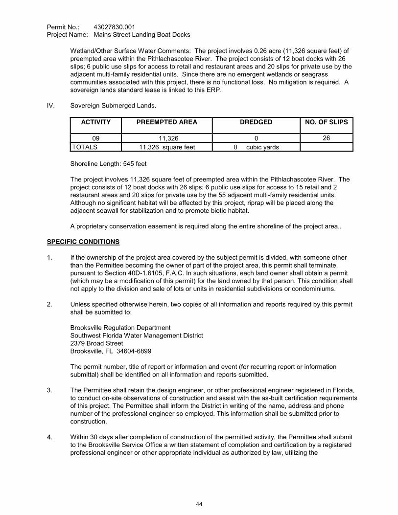
Permit No.: 43027830.001Project Name: Mains Street Landing Boat Docks
Wetland/Other Surface Water Comments: The project involves 0.26 acre (11,326 square feet) of preempted area within the Pithlachascotee River. The project consists of 12 boat docks with 26 slips; 6 public use slips for access to retail and restaurant areas and 20 slips for private use by the adjacent multi-family residential units. Since there are no emergent wetlands or seagrass communities associated with this project, there is no functional loss. No mitigation is required. A sovereign lands standard lease is linked to this ERP.
IV. Sovereign Submerged Lands.
ACTIVITY PREEMPTED AREA DREDGED NO. OF SLIPS
09 11,326 0 26TOTALS 11,326 square feet 0 cubic yards
Shoreline Length: 545 feet
The project involves 11,326 square feet of preempted area within the Pithlachascotee River. The project consists of 12 boat docks with 26 slips; 6 public use slips for access to 15 retail and 2 restaurant areas and 20 slips for private use by the 55 adjacent multi-family residential units. Although no significant habitat will be affected by this project, riprap will be placed along the adjacent seawall for stabilization and to promote biotic habitat.
A proprietary conservation easement is required along the entire shoreline of the project area..
SPECIFIC CONDITIONS
1. If the ownership of the project area covered by the subject permit is divided, with someone other than the Permittee becoming the owner of part of the project area, this permit shall terminate, pursuant to Section 40D-1.6105, F.A.C. In such situations, each land owner shall obtain a permit (which may be a modification of this permit) for the land owned by that person. This condition shall not apply to the division and sale of lots or units in residential subdivisions or condominiums.
2. Unless specified otherwise herein, two copies of all information and reports required by this permitshall be submitted to:
Brooksville Regulation DepartmentSouthwest Florida Water Management District2379 Broad StreetBrooksville, FL 34604-6899
The permit number, title of report or information and event (for recurring report or information submittal) shall be identified on all information and reports submitted.
3. The Permittee shall retain the design engineer, or other professional engineer registered in Florida, to conduct on-site observations of construction and assist with the as-built certification requirements of this project. The Permittee shall inform the District in writing of the name, address and phone number of the professional engineer so employed. This information shall be submitted prior to construction.
Within 30 days after completion of construction of the permitted activity, the Permittee shall submit to the Brooksville Service Office a written statement of completion and certification by a registered professional engineer or other appropriate individual as authorized by law, utilizing the
44
Permit No.: 43027830.001Project Name: Mains Street Landing Boat Docks
required Statement of Completion and Request for Transfer to Operation Entity form identified in Chapter 40D-1.659, F.A.C., and signed, dated and sealed as-built drawings. The as-built drawings shall identify any deviations from the approved construction drawings.
5. The District reserves the right, upon prior notice to the Permittee, to conduct on-site research to assess the pollutant removal efficiency of the surface water management system. The Permittee may be required to cooperate in this regard by allowing on-site access by District representatives, by allowing the installation and operation of testing and monitoring equipment, and by allowing other assistance measures as needed on site.
6. The construction of all wetland impacts and wetland mitigation shall be supervised by a qualified environmental scientist/specialist/consultant. The Permittee shall identify, in writing, the environmental professional retained for construction oversight prior to initial clearing and grading activities.
The following boundaries, as shown on the approved construction drawings, shall be clearly delineated on the site prior to initial clearing or grading activities:
wetland and surface water areas
The delineation shall endure throughout the construction period and be readily discernible to construction and District personnel.
All wetland boundaries shown on the approved construction drawings shall be binding upon the Permittee and the District.
Rights-of-way and easement locations necessary to construct, operate and maintain all facilities, which constitute the permitted surface water management system (including all wetlands and wetland buffers), shall be shown on the final plat recorded in the County Public Records. Documentation of this plat recording shall be submitted to the District with the Statement of Completion and Request for Transfer to Operation Entity Form, and prior to beneficial occupancy or use of the site.
10. Copies of the following documents in final form, as appropriate for the project, shall be submitted to the Brooksville Regulation Department:
a. homeowners, property owners, master association or condominium association articles of incorporation, and
b. declaration of protective covenants, deed restrictions or declaration of condominium.
The Permittee shall submit these documents either: (1) within 180 days after beginning construction or with the Statement of Completion and as-built construction plans if construction is completed prior to 180 days, or (2) prior to any lot or unit sales within the project served by the surface water management system, whichever occurs first.
11. The following language shall be included as part of the deed restrictions for each lot:
"Each property owner within the subdivision at the time of construction of a building, residence, or structure shall comply with the construction plans for the surface water management system approved and on file with the Southwest Florida Water Management District."
12. If limestone bedrock is encountered during construction of the surface water management system, the District must be notified and construction in the affected area shall cease.
45
Permit No.: 43027830.001Project Name: Mains Street Landing Boat Docks
13. The Permittee shall notify the District of any sinkhole development in the surface water management system within 48 hours of discovery and must submit a detailed sinkhole evaluation and repair plan for approval by the District within 30 days of discovery.
14. The District, upon prior notice to the Permittee, may conduct on-site inspections to assess the effectiveness of the erosion control barriers and other measures employed to prevent violations of state water quality standards and avoid downstream impacts. Such barriers or other measures should control discharges, erosion, and sediment transport during construction and thereafter. The District will also determine any potential environmental problems that may develop as a result of leaving or removing the barriers and other measures during construction or after construction of the project has been completed. The Permittee must provide any remedial measures that are needed.
it is determined by the District that the Conditions for Issuance of Permits in Rules 40D-4.301 and 40D-4.302, F.A.C., have not been met, upon written notice by the District, the Permittee shall obtain a permit modification and perform any construction necessary thereunder to correct any deficiencies in the system design or construction to meet District rule criteria. The Permittee is advised that the correction of deficiencies may require re-construction of the surface water management system and/or mitigation areas.
16. The Permittee / Lessee shall submit an original copy of the proprietary conservation easement as recorded in the County Public Records within 180 days of issuance of the Environmental Resource Permit to the Lessor and the District. The conservation easement shall identify the State of Florida, Board of Trustees of the Internal Improvement Trust Fund as grantee and shall cover a 10-foot linear strip of land along the entire shoreline located landward of, and including, the seawall. The Permittee shall receive approval from the Department of Environmental Protection, acting on behalf of the Board of Trustees, for any proposal to modify the conservation easement prior to conducting any activity prohibited by the terms of the conservation easement. The terms of the final conservation easement shall be consistent with those in the draft provided to the District on April 5, 2007.
17. The Florida Fish and Wildlife Conservation Commission's Standard Manatee Conditions for In-Water Work (revision 2005) shall be followed for all in-water activity. A copy of these conditions is attached to this permit.
18. Within 30 days prior to slip occupancy, the Permittee shall install permanent educational manatee signs in accordance with Florida Fish and Wildlife Conservation Commission (FWC) guidelines, including FWC approval for the number, type, and location of signs. Permittee agrees to replace the signs in the event the signs fade, become damaged or outdated, and maintain these signs for the life of the facility. The guidelines for installation can be found at http://www.myfwc.com/manatee/signs/, or can be obtained by contacting the Florida Fish and Wildlife Conservation Commission, Imperiled Species Management Section at: 620 South Meridian Street, 6A, Tallahassee, Florida 32399-1600 (telephone 850/922-4330).
19. The District has requested that the Department of Environmental Protection's Recurring Revenue Section of the Bureau of Land Administration prepare the Standard Lease instrument. Construction on sovereign submerged lands shall not begin until this instrument has been executed to the satisfaction of the District.
20. Waterborne craft moored along the south and east portions of the docking facility, on either a temporary or permanent basis, shall not exceed 24 feet in length. These vessels shall be moored parallel to the main access pier.
46

Permit No.: 43027830.001Project Name: Mains Street Landing Boat Docks
GENERAL CONDITIONS
1. The general conditions attached hereto as Exhibit "A" are hereby incorporated into this permit by reference and the Permittee shall comply with them.
PROPRIETARY GENERAL CONDITIONS
1. The general conditions attached hereto as Exhibit "B" are hereby incorporated by reference and the Permittee shall comply with them.
____________________________________________Authorized Signature
47
Permit No.: 43027830.001Project Name: Mains Street Landing Boat Docks
EXHIBIT "B"
1. Authorizations are valid only for the specified activity or use. Any unauthorized deviation from the specified activity or use and the conditions for undertaking that activity or use shall constitute a violation. Violation of the authorization shall result in suspension or revocation of the grantee's use of the sovereignty submerged land unless cured to the satisfaction of the Board
2. Authorizations convey no title to sovereignty submerged land or water column, nor do they constitute recognition or acknowledgment of any others person's title to such land or water.
3. Authorizations may be modified, suspended or revoked in accordance with their terms or the remedies provided in Sections 253.04 and 258.46F.S., F.S., or Chapter 18-14, F.A.C.
4. Structures or activities shall be constructed and used to avoid or minimize adverse impacts to sovereignty submerged lands and resources.
5. Construction, use or operation of the structure or activity shall not adversely affect any species which is endangered, threatened or of special concern, as listed in Rules 68A-27.003, 68A-27.004 and 68A-27.005, F.A.C.
6. Structures or activities shall not unreasonably interfere with riparian rights. When a court of competent jurisdiction determines that riparian rights have been unlawfully affected, the structure or activity shall be modified in accordance with the court's decision.
7. Structures or activities shall not create a navigational hazard.
8. Structures shall be maintained in a functional condition and shall be repaired or removed if they become dilapidated to such an extent that they are no longer functional. This shall not be construed to prohibit the repair or replacement subject to the provisions of Rule 18-21.005, F.A.C., within one year, of a structure damaged in a discrete event such as a storm, flood, accident or fire.
9. Structures or activities shall be constructed, operated and maintained solely for water dependent purposes, or for non-water dependent activities authorized under paragraph 18-21.004(1)(f), F.A.C., or any other applicable law.
48

CONSENT ITEM 14
49

CONSENT ITEM 14 Default Date: February 4, 2009
SOUTHWEST FLORIDA WATER MANAGEMENT DISTRICTCONSOLIDATED ENVIRONMENTAL RESOURCE PERMIT (ERP) AND
SOVEREIGN SUBMERGED LAND AUTHORIZATION (SL)INDIVIDUAL CONSTRUCTION SURFACE WATER MANAGEMENT SYSTEMS
PERMIT NO. 43033500.001AND
SOVEREIGNTY LANDS TEMP. LETTER OF CONSENT
ERP Expiration Date: December 16, 2013 PERMIT ISSUE DATE: December 16, 2008SL Expiration Date: N/A
This permit, issued under the provisions of Chapter 373, Florida Statutes, (F.S.), and Chapter 40D-4,Florida Administrative Code, (F.A.C.), authorizes the Permittee to perform the work outlined herein and shown by the application, approved drawings, plans, and other documents, attached hereto and kept on file at the Southwest Florida Water Management District (District).
Authorization is granted to use sovereign submerged lands as outlined herein and shown by the application, approved drawings, plans, and other documents attached hereto and kept on file at the District under the provisions of Chapter 253, F.S., and Chapter 18-21, F.A.C., as well as the policies of the Board of Trustees of the Internal Improvement Trust Fund (Board of Trustees). This approval does not disclaim any title interests that the Board of Trustees may have in the project site. Any subsequent authorizations by the Board of Trustees or its designated agents may contain conditions necessary to satisfy the fiduciary responsibilities of the Board of Trustees as well as other applicable statutory or rule requirements implemented by the Department of Environmental Protection's Division of State Lands or other governmental agencies authorized by Florida Statutes.
All construction, operation, and maintenance of the surface water management system authorized by this permit shall occur in compliance with Florida Statutes and Administrative Code and the conditions of this permit.
PROJECT NAME: FDOT - SR 39 (Buchman Highway) at Hillsborough River - Temporary Detour Bridge
GRANTED TO: Florida Department of Transportation, District VII11201 North McKinley DriveTampa, FL 33612-6403
ABSTRACT: This permit is for the construction of a surface water management system to serve a 4.24-acre temporary detour bridge. The project site is located just west of the existing SR 39 (Buchman Highway) bridge approximately one mile south of the intersection of SR 39 and Chancey Road in Pasco County. Any water quality impacts from this bridge are expected to be de minimus and temporary as the detour bridge will be removed once the construction of the replacement bridge on SR 39, permitted under ERP No. 47033500.000, is completed, thus a Sovereignty Lands Temporary Letter of Consent has been authorized. Information regarding the surface water management system and wetlands is contained within the tables below.
OP. & MAINT. ENTITY: Florida Department of Transportation, District VII
COUNTY: Pasco
WATERBODY NAME: Hillsborough River
50

Permit No.: 43033500.001Project Name: FDOT - SR 39 (Buchman Highway) at Hillsborough River -Temporary Detour Bridge
AQUATIC PRESERVE: N/A
SEC/TWP/RGE: 25/26S/21E
TOTAL ACRES OWNEDOR UNDER CONTROL: 4.24
PROJECT SIZE: 4.24 Acres
LAND USE: Road Project
DATE APPLICATION FILED: August 1, 2008
AMENDED DATE: N/A
I. Water Quantity/Quality
Comments: Any water quality impacts from this bridge are expected to be de minimus and temporary as the detour bridge will be removed once the construction of the replacement bridge on SR 39, permitted under ERP 47033500.000, is complete. The engineer of record Megan Arasteh, Florida PE No. 49110, has provided engineering calculations and drawings that indicate no adverse on- or off-site impacts are expected as a result of the proposed development.
A mixing zone is not required.A variance is not required.
II. 100-Year Floodplain
Encroachment(Acre-Feet of fill)
Compensation(Acre-Feet of excavation)
CompensationType*
EncroachmentResult**(feet)
0.00 0.00 NE X Depth N/A
*Codes [ X ] for the type or method of compensation provided are as follows:NE = No EncroachmentMI = Minimal Impact based on modeling of existing stages vs. post-project encroachment.N/A = Not Applicable
**Depth of change in flood stage (level) over existing receiving water stage resulting from floodplain encroachment caused by a project that claims MI type of compensation.
III. Environmental Considerations
Wetland/Surface Water Information Count of Wetlands:Wetland Name Total Not Impacted Permanent Impacts Temporary Impacts
Acres Acres Acres FunctionalLoss*
Acres FunctionalLoss*
OSW 0.16 0.00 0.00 0.00 0.16 0.00Wetland 1 1.02 0.36 0.366 0.53 0.00 0.00Wetland 3 2.17 1.16 1.01 0.81 0.00 0.00
TOTAL 3.35 1.52 1.67 1.34 0.16 0.00* For impacts that do not require mitigation, their functional loss is not included.
51
Permit No.: 43033500.001Project Name: FDOT - SR 39 (Buchman Highway) at Hillsborough River -Temporary Detour Bridge
Wetland Comments: There are 3.35 acres of wetlands and surface waters within the project area. Project construction will result in permanent impacts to 1.67 acres of forested wetlands resulting in a Functional Loss of 1.34 units. Project construction will also result in 0.16 acre of temporary surface water impacts.
Mitigation Comments: Mitigation for the permanent impact to 1.67 acres of wetlands associated with this FDOT project (FM 4089321) shall be provided as identified in the 2008 FDOT Mitigation Program (Chapter 373.4137, Florida Statues) and is described in the Southwest Florida Water Management District's "FDOT Mitigation Plan" dated January 29, 2008. Mitigation to offset impacts to 1.67 acres of wetlands is provided within the Colt Creek State Park (SW-84). Since the 0.16 acre temporarily impacted surface water area does not provide habitat for threatened or endangered species and is considered de minimus, mitigation is not required according to 3.2.2.2of the Basis of Review. However, the temporarily impacted area will be regraded and replanted, but ongoing monitoring and maintenance will not be required.
IV. Sovereign Submerged Lands.
ACTIVITY PREEMPTED AREA DREDGED NO. OF SLIPS05 4,791.60 0.00 0
TOTAL 4,791.60 square feet 0.00 cubic yards
Shoreline Length: 200 feet
A Sovereignty Lands Temporary Letter of Consent has been authorized for the detour bridge, which will be removed once the construction of the replacement bridge on SR 39 has been completed.
SPECIFIC CONDITIONS
1. If the ownership of the project area covered by the subject permit is divided, with someone other than the Permittee becoming the owner of part of the project area, this permit shall terminate, pursuant to Section 40D-1.6105, F.A.C. In such situations, each land owner shall obtain a permit (which may be a modification of this permit) for the land owned by that person. This condition shall not apply to the division and sale of lots or units in residential subdivisions or condominiums.
2. Unless specified otherwise herein, two copies of all information and reports required by this permit shall be submitted to:
Brooksville Regulation DepartmentSouthwest Florida Water Management District2379 Broad StreetBrooksville, FL 34604-6899
The permit number, title of report or information and event (for recurring report or information submittal) shall be identified on all information and reports submitted.
3. The Permittee shall retain the design engineer, or other professional engineer registered in Florida, to conduct on-site observations of construction and assist with the as-built certification requirements of this project. The Permittee shall inform the District in writing of the name, address and phone number of the professional engineer so employed. This information shall be submitted prior to construction.
52
Permit No.: 43033500.001Project Name: FDOT - SR 39 (Buchman Highway) at Hillsborough River -Temporary Detour Bridge
Within 30 days after completion of construction of the permitted activity, the Permittee shall submit to the Brooksville Service Office a written statement of completion and certification by a registered professional engineer or other appropriate individual as authorized by law, utilizing the required Statement of Completion and Request for Transfer to Operation Entity form identified in Chapter 40D-1.659, F.A.C., and signed, dated and sealed as-built drawings. The as-built drawings shall identify any deviations from the approved construction drawings.
5. The District reserves the right, upon prior notice to the Permittee, to conduct on-site research to assess the pollutant removal efficiency of the surface water management system. The Permittee may be required to cooperate in this regard by allowing on-site access by District representatives, by allowing the installation and operation of testing and monitoring equipment, and by allowing other assistance measures as needed on site.
6. The construction of all wetland impacts and wetland mitigation shall be supervised by a qualified environmental scientist/specialist/consultant. The Permittee shall identify, in writing, the environmental professional retained for construction oversight prior to initial clearing and grading activities.
The following boundaries, as shown on the approved construction drawings, shall be clearly delineated on the site prior to initial clearing or grading activities:
limits of approved wetland impacts
The delineation shall endure throughout the construction period and be readily discernible to construction and District personnel.
Wetland boundaries shown on the approved construction drawings shall be binding upon the Permittee and the District.
9. All construction is prohibited within the permitted project area until the Permittee acquires legal ownership or legal control of the project area as delineated in the permitted construction drawings.
10. The Permittee, the Florida Department of Transportation, shall submit to the District a site-specific plan for erosion and sediment control best management practices, pursuant to Section 104, FDOT Standard Specifications for Road and Bridge Construction. The Permittee shall submit this plan and receive District approval prior to construction commencement.
11. If limestone bedrock is encountered during construction of the surface water management system, the District must be notified and construction in the affected area shall cease.
12. The Permittee shall notify the District of any sinkhole development in the surface water management system within 48 hours of discovery and must submit a detailed sinkhole evaluation and repair plan for approval by the District within 30 days of discovery.
13. The District, upon prior notice to the Permittee, may conduct on-site inspections to assess the effectiveness of the erosion control barriers and other measures employed to prevent violations of state water quality standards and avoid downstream impacts. Such barriers or other measures should control discharges, erosion, and sediment transport during construction and thereafter. The District will also determine any potential environmental problems that may develop as a result of leaving or removing the barriers and other measures during construction or after construction of the project has been completed. The Permittee must provide any remedial measures that are needed.
53
Permit No.: 43033500.001Project Name: FDOT - SR 39 (Buchman Highway) at Hillsborough River -Temporary Detour Bridge
This permit is iit is determined by the District that the Conditions for Issuance of Permits in Rules 40D-4.301 and 40D-4.302, F.A.C., have not been met, upon written notice by the District, the Permittee shall obtain a permit modification and perform any construction necessary thereunder to correct any deficiencies in the system design or construction to meet District rule criteria. The Permittee is advised that the correction of deficiencies may require re-construction of the surface water management system and/or mitigation areas.
15. The Permittee shall regrade and replant the temporary bridge impacts as shown in Sheets 91-98 of the approved construction plans.
GENERAL CONDITIONS
1. The general conditions attached hereto as Exhibit "A" are hereby incorporated into this permit by reference and the Permittee shall comply with them.
PROPRIETARY GENERAL CONDITIONS
1. The general conditions attached hereto as Exhibit "B" are hereby incorporated by reference and the Permittee shall comply with them.
____________________________________________Authorized Signature
54
Permit No.: 43033500.001Project Name: FDOT - SR 39 (Buchman Highway) at Hillsborough River -Temporary Detour Bridge
EXHIBIT "B"
1. Authorizations are valid only for the specified activity or use. Any unauthorized deviation from the specified activity or use and the conditions for undertaking that activity or use shall constitute a violation. Violation of the authorization shall result in suspension or revocation of the grantee's use of the sovereignty submerged land unless cured to the satisfaction of the Board
2. Authorizations convey no title to sovereignty submerged land or water column, nor do they constitute recognition or acknowledgment of any others person's title to such land or water.
3. Authorizations may be modified, suspended or revoked in accordance with their terms or the remedies provided in Sections 253.04 and 258.46F.S., F.S., or Chapter 18-14, F.A.C.
4. Structures or activities shall be constructed and used to avoid or minimize adverse impacts to sovereignty submerged lands and resources.
5. Construction, use or operation of the structure or activity shall not adversely affect any species which is endangered, threatened or of special concern, as listed in Rules 68A-27.003, 68A-27.004 and 68A-27.005, F.A.C.
6. Structures or activities shall not unreasonably interfere with riparian rights. When a court of competent jurisdiction determines that riparian rights have been unlawfully affected, the structure or activity shall be modified in accordance with the court's decision.
7. Structures or activities shall not create a navigational hazard.
8. Structures shall be maintained in a functional condition and shall be repaired or removed if they become dilapidated to such an extent that they are no longer functional. This shall not be construed to prohibit the repair or replacement subject to the provisions of Rule 18-21.005, F.A.C., within one year, of a structure damaged in a discrete event such as a storm, flood, accident or fire.
9. Structures or activities shall be constructed, operated and maintained solely for water dependent purposes, or for non-water dependent activities authorized under paragraph 18-21.004(1)(f), F.A.C., or any other applicable law.
55

CONSENT ITEM 15
56
CONSENT ITEM 15 Default Date: February 6, 2009
SOUTHWEST FLORIDA WATER MANAGEMENT DISTRICTENVIRONMENTAL RESOURCEINDIVIDUAL CONSTRUCTION
PERMIT NO. 43031900.002
Expiration Date: December 16, 2013 PERMIT ISSUE DATE: December 16, 2008
This permit is issued under the provisions of Chapter 373, Florida Statutes, (F.S.), and the Rules contained in Chapters 40D-4 and 40, Florida Administrative Code, (F.A.C.). The permit authorizes the Permittee to proceed with the construction of a surface water management system in accordance with the information outlined herein and shown by the application, approved drawings, plans, specifications, and other documents, attached hereto and kept on file at the Southwest Florida Water Management District (District). Unless otherwise stated by permit specific condition, permit issuance constitutes certification of compliance with state water quality standards under Section 401 of the Clean Water Act, 33 U.S.C. 1341. All construction, operation and maintenance of the surface water management system authorized by this permit shall occur in compliance with Florida Statutes and Administrative Code and the conditions of this permit.
PROJECT NAME: EVWR/CSXT/Winter Haven - Rail Terminal Facility
GRANTED TO:
ABSTRACT: This permit authorization is for the construction of a new surface water management system to serve a 388.26-acre industrial project as named above and as shown on the approved construction plans. The proposed project includes a rail terminal facility and the addition of a parallel sideline track along approximately seven miles of existing railroad line. The project site is located to the southwest of and along the existing CSX Transportation railroad line between State Road 60 and U. S. Highway 17 in Polk County. Information regarding the surface water management systems, 100-year floodplain, and wetlands is contained within the tables and comments below.
OP. & MAINT. ENTITY: Evansville Western Railway, Inc.
COUNTY: Polk
SEC/TWP/RGE: 4,5,9,15,16,22,23,25,26,27,36/29S/26E; 1/30S/26E
TOTAL ACRES OWNEDOR UNDER CONTROL: 388.26
PROJECT SIZE: 388.26 Acres
LAND USE: Industrial
57

Permit No.: 43031900.002Project Name: EVWR/CSXT/Winter Haven - Rail Terminal Facility
DATE APPLICATION FILED: May 28, 2008
AMENDED DATE: N/A
I. Water Quantity/Quality
PONDNO.
AREAACRES @ TOP OF BANK
TREATMENT TYPE
N-1 0.13 RetentionN-2 0.13 RetentionN-3 0.16 RetentionN-4 0.24 RetentionN-5 0.64 RetentionN-6 0.12 RetentionN-7 0.19 RetentionS-1 0.09 RetentionS-2 0.12 RetentionS-3 0.17 RetentionS-4 0.40 RetentionS-5 0.65 RetentionS-6 0.20 RetentionS-7 0.19 RetentionS-8 0.66 RetentionS-9 0.14 Retention
1 South 5.40 Wet Detention2 South 3.77 Wet Detention3 South 3.81 Wet Detention4 South 4.09 Wet Detention
3 5.19 Wet DetentionNorth 26.88 Wet Detention
TOTAL 53.37
A mixing zone is not required.A variance is not required.
II. 100-Year Floodplain
Encroachment(Acre-Feet of fill)
Compensation(Acre-Feet of excavation)
CompensationType*
EncroachmentResult**(feet)
2.34 2.36 EE X Depth N/A
*Codes [ X ] for the type or method of compensation provided are as follows:EE = Equivalent Excavation to offset project filling per Section 4.4 of the District's Basis of Review;N/A = Not Applicable
**Depth of change in flood stage (level) over existing receiving water stage resulting from floodplain encroachment caused by a project that claims MI type of compensation.
58

Permit No.: 43031900.002Project Name: EVWR/CSXT/Winter Haven - Rail Terminal Facility
III. Environmental Considerations
Wetland/Surface Water Information Count of Wetlands:Wetland Name Total Not Impacted Permanent Impacts Temporary Impacts
Acres Acres Acres FunctionalLoss*
Acres FunctionalLoss*
RR Wetland A 0.23 0.23 0.00 0.00 0.00 0.00RR Wetland 1-F 0.30 0.00 0.30 0.11 0.00 0.00
RR Wetland 1 A-F 0.02 0.00 0.02 0.01 0.00 0.00RR Wetland 1 W-F 1.54 0.00 1.54 0.57 0.00 0.00RR Wetland I E-F 1.90 0.00 1.90 0.70 0.00 0.00RR Wetland 9 B-F 1.57 0.00 1.57 0.52 0.00 0.00RR Wetland 20-F 0.02 0.00 0.02 0.00 0.00 0.00
RR Wetland 21 W-F 0.35 0.00 0.35 0.14 0.00 0.00RR Wetland 21 E-F 0.20 0.00 0.20 0.09 0.00 0.00RR Wetland 22 A-F 0.06 0.00 0.06 0.02 0.00 0.00RR Wetland 22 B-F 0.48 0.00 0.48 0.13 0.00 0.00RR Wetland 22 C-F 0.54 0.00 0.54 0.14 0.00 0.00
FF Wetland 23-F 0.25 0.00 0.25 0.09 0.00 0.00TF Wetland 1 N-H 0.94 0.00 0.94 0.19 0.00 0.00TF Wetland 1 S-F 7.71 0.00 7.71 2.31 0.00 0.00TF Wetland 3 B-H 3.52 0.00 3.52 0.94 0.00 0.00TF Wetland 9 A-H 1.35 0.00 1.35 0.36 0.00 0.00TF Wetland 9 B-F 24.43 0.00 24.43 11.41 0.00 0.00TF Wetland 10-H 1.61 0.00 1.61 0.54 0.00 0.00TF Wetland 11-H 0.13 0.00 0.13 0.00 0.00 0.00TF Wetland 12-F 0.85 0.00 0.85 0.20 0.00 0.00AE SW 3A- DMW 0.81 0.00 0.81 0.27 0.00 0.00
AE SW 9-DMU 0.17 0.00 0.17 0.00 0.00 0.00TF SW 1-DMU 0.14 0.00 0.14 0.00 0.00 0.00TF SW 2- DMU 0.16 0.00 0.16 0.00 0.00 0.00
TF SW 3A- DMU 3.47 0.00 3.47 0.00 0.00 0.00TF SW 4-DMU 2.37 0.00 2.37 0.00 0.00 0.00
TOTAL 55.12 0.00 54.89 18.74 0.00 0.00
* For impacts that do not require mitigation, their functional loss is not included.
Wetland Comments: The project area includes 55.12 acres of wetlands consisting of 0.23 acre of streams and waterways (RR Wetland A), 40.22 acres of forested wetlands (RR Wetland 1-F, RR Wetland 1 A-F, RR Wetland W-F, RR 1 E-F, RR Wetland 9 B-F, RR Wetland 20-F, RR Wetland 21 W-F, RR Wetland 21 E-F, RR Wetland 22 A-F, RR Wetland 22 B-F, RR Wetland 22 C-F, TF 23-F, TF Wetland S-F, TF Wetland 9 B-F, TF Wetland 12-F), 7.55 acres of herbaceous wetlands (TF Wetland 1 N-H, TF Wetland 3 B-H, TF Wetland 9 A-H, TF Wetland 10-H, TF Wetland 11-H), 6.31 acres of upland cut ditches (AE SW 3A- DMW, TF SW 1-DMU, TF SW 2- DMU, TF SW 3A-SMU, TF SW 4-DMU), and 0.81 acre of wetland cut ditch (AE SW 3A-DMW). Permanent impacts are proposed to 40.22 acres of forested wetlands, 7.55 acres of herbaceous wetlands, 6.31 acres of upland cut ditches, and 0.81 acre of wetland cut ditch No impacts to RR Wetland A are proposed.
59
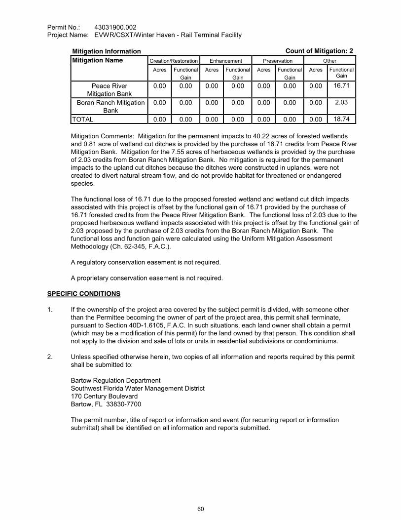
Permit No.: 43031900.002Project Name: EVWR/CSXT/Winter Haven - Rail Terminal Facility
Mitigation Information Count of Mitigation:Mitigation Name Creation/Restoration Enhancement Preservation Other
Acres Functional Gain
Acres Functional Gain
Acres Functional Gain
Acres Functional Gain
Peace RiverMitigation Bank
0.00 0.00 0.00 0.00 0.00 0.00 0.00 16.71
Boran Ranch Mitigation Bank
0.00 0.00 0.00 0.00 0.00 0.00 0.00 2.03
TOTAL 0.00 0.00 0.00 0.00 0.00 0.00 0.00 18.74
Mitigation Comments: Mitigation for the permanent impacts to 40.22 acres of forested wetlands and 0.81 acre of wetland cut ditches is provided by the purchase of 16.71 credits from Peace River Mitigation Bank. Mitigation for the 7.55 acres of herbaceous wetlands is provided by the purchase of 2.03 credits from Boran Ranch Mitigation Bank. No mitigation is required for the permanent impacts to the upland cut ditches because the ditches were constructed in uplands, were not created to divert natural stream flow, and do not provide habitat for threatened or endangered species.
The functional loss of 16.71 due to the proposed forested wetland and wetland cut ditch impacts associated with this project is offset by the functional gain of 16.71 provided by the purchase of 16.71 forested credits from the Peace River Mitigation Bank. The functional loss of 2.03 due to the proposed herbaceous wetland impacts associated with this project is offset by the functional gain of 2.03 proposed by the purchase of 2.03 credits from the Boran Ranch Mitigation Bank. The functional loss and function gain were calculated using the Uniform Mitigation Assessment Methodology (Ch. 62-345, F.A.C.).
A regulatory conservation easement is not required.
A proprietary conservation easement is not required.
SPECIFIC CONDITIONS
1. If the ownership of the project area covered by the subject permit is divided, with someone other than the Permittee becoming the owner of part of the project area, this permit shall terminate, pursuant to Section 40D-1.6105, F.A.C. In such situations, each land owner shall obtain a permit (which may be a modification of this permit) for the land owned by that person. This condition shall not apply to the division and sale of lots or units in residential subdivisions or condominiums.
2. Unless specified otherwise herein, two copies of all information and reports required by this permit shall be submitted to:
Bartow Regulation DepartmentSouthwest Florida Water Management District170 Century BoulevardBartow, FL 33830-7700
The permit number, title of report or information and event (for recurring report or information submittal) shall be identified on all information and reports submitted.
60

Permit No.: 43031900.002Project Name: EVWR/CSXT/Winter Haven - Rail Terminal Facility
3. The Permittee shall retain the design engineer, or other professional engineer registered in Florida, to conduct on-site observations of construction and assist with the as-built certification requirements of this project. The Permittee shall inform the District in writing of the name, address and phone number of the professional engineer so employed. This information shall be submitted prior to construction.
Within 30 days after completion of construction of the permitted activity, the Permittee shall submit to the Bartow Service Office a written statement of completion and certification by a registered professional engineer or other appropriate individual as authorized by law, utilizing the required Statement of Completion and Request for Transfer to Operation Entity form identified in Chapter 40D-1.659, F.A.C., and signed, dated and sealed as-built drawings. The as-built drawings shall identify any deviations from the approved construction drawings.
5. The District reserves the right, upon prior notice to the Permittee, to conduct on-site research to assess the pollutant removal efficiency of the surface water management system. The Permittee may be required to cooperate in this regard by allowing on-site access by District representatives, by allowing the installation and operation of testing and monitoring equipment, and by allowing other assistance measures as needed on site.
6. The operation and maintenance entity shall submit inspection reports in the form required by the District, in accordance with the following schedule.
For systems utilizing retention or wet detention, the inspections shall be performed two (2) years after operation is authorized and every two (2) years thereafter.
7. The removal of littoral shelf vegetation (including cattails) from wet detention ponds is prohibited unless otherwise approved by the District. Removal includes dredging, the application of herbicide, cutting, and the introduction of grass carp. Any questions regarding authorized activities within the wet detention ponds shall be addressed to the District's Surface Water Regulation Manager, Bartow Service Office.
8. For dry bottom retention systems, the retention areas shall become dry within 72 hours after a rainfall event. If a retention area is regularly wet, this situation shall be deemed to be a violation of this permit.
9. The Permittee shall notify the District of any sinkhole development in the surface water management system within 48 hours of discovery and must submit a detailed sinkhole evaluationand repair plan for approval by the District within 30 days of discovery.
it is determined by the District that the Conditions for Issuance of Permits in Rules 40D-4.301 and 40D-4.302, F.A.C., have not been met, upon written notice by the District, the Permittee shall obtain a permit modification and perform any construction necessary thereunder to correct any deficiencies in the system design or construction to meet District rule criteria. The Permittee is advised that the correction of deficiencies may require re-construction of the surface water management system and/or mitigation areas.
The Permittee shall, prior to any herbaceous wetland impacts, provide to the District documentation of the purchase of 2.03 herbaceous mitigation credits from the Boran Ranch Mitigation Bank. That documentation shall be in the form of a Modification by Letter of Permit 49026121.000, issued to the Boran Ranch Miledger.
61
Permit No.: 43031900.002Project Name: EVWR/CSXT/Winter Haven - Rail Terminal Facility
The Permittee shall, prior to any forested wetland impacts, provide to the District documentation of the purchase of 16.71 forested mitigation credits from the Peace River Mitigation Bank. That documentation shall be in the form of a Modification by Letter of Permit 43029983.000, issued to
ledger.
GENERAL CONDITIONS
1. The general conditions attached hereto as Exhibit "A" are hereby incorporated into this permit by reference and the Permittee shall comply with them.
____________________________________________Authorized Signature
62
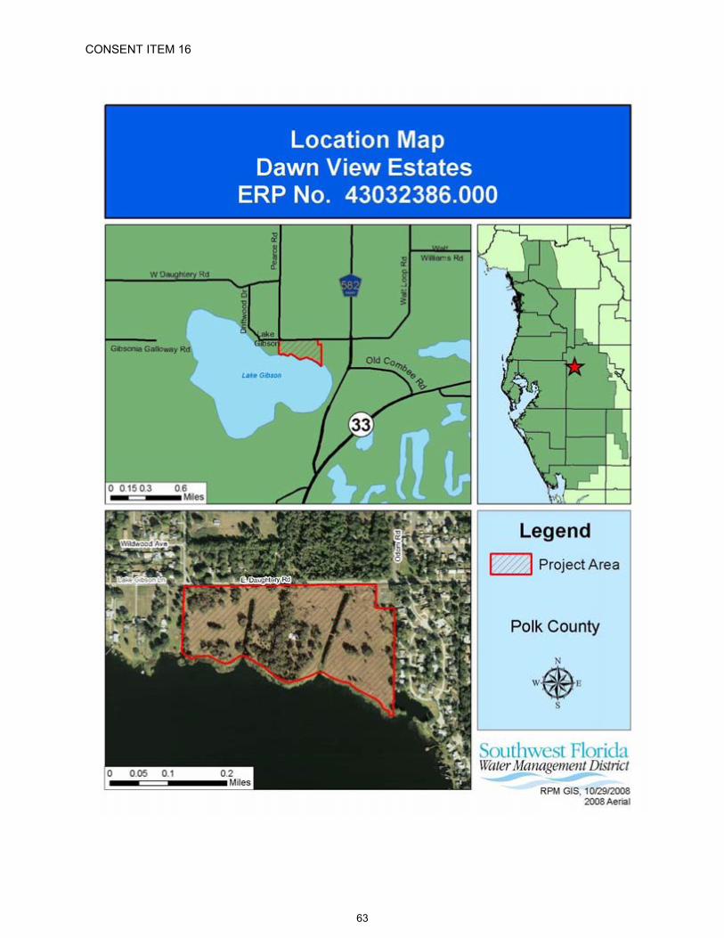
CONSENT ITEM 16
63
CONSENT ITEM 16 Default Date: December 24, 2008
SOUTHWEST FLORIDA WATER MANAGEMENT DISTRICTENVIRONMENTAL RESOURCEINDIVIDUAL CONSTRUCTION
PERMIT NO. 43032386.000
Expiration Date: December 16, 2013 PERMIT ISSUE DATE: December 16, 2008
This permit is issued under the provisions of Chapter 373, Florida Statutes, (F.S.), and the Rules contained in Chapters 40D-4 and 40, Florida Administrative Code, (F.A.C.). The permit authorizes the Permittee to proceed with the construction of a surface water management system in accordance with the information outlined herein and shown by the application, approved drawings, plans, specifications, and other documents, attached hereto and kept on file at the Southwest Florida Water Management District (District). Unless otherwise stated by permit specific condition, permit issuance constitutes certification of compliance with state water quality standards under Section 401 of the Clean Water Act, 33 U.S.C. 1341. All construction, operation and maintenance of the surface water management system authorized by this permit shall occur in compliance with Florida Statutes and Administrative Code and the conditions of this permit.
PROJECT NAME: Dawn View Estates
GRANTED TO: BDG Polk Lake Gibson, L.L.C.500 South Dixie Highway, Suite 220Coral Gables, FL 33146
ABSTRACT: This permit authorization is for the construction of a new surface water management system serving a 56.62-acre, 48-lot single-family residential subdivision, as named above and as shown on the approved construction plans. The project site is located on the south side of East Daughtery Road,approximately one-half mile west of its intersection with Socrum Loop Road, in Polk County. Information regarding the surface water management system, 100-year floodplain, and wetlands is contained within the tables and comments below.
OP. & MAINT. ENTITY: Lake Gibson Homeowners' Association, Inc.
COUNTY: Polk
SEC/TWP/RGE: 30/27S/24E
TOTAL ACRES OWNEDOR UNDER CONTROL: 56.62
PROJECT SIZE: 56.62 Acres
LAND USE: Residential
DATE APPLICATION FILED: January 25, 2007
AMENDED DATE: October 10, 2007
64

Permit No.: 43032386.000Project Name: Dawn View Estates
I. Water Quantity/Quality
PONDNO.
AREAACRES @ TOP OF BANK
TREATMENT TYPE
10 1.12 Wet Detention20 1.25 Wet Detention30 0.98 Wet Detention
TOTAL 3.35
A mixing zone is not required.A variance is not required.
II. 100-Year Floodplain
Encroachment(Acre-Feet of fill)
Compensation(Acre-Feet of excavation)
CompensationType*
EncroachmentResult**(feet)
0.56 2.35 EE X Depth N/A
*Codes [ X ] for the type or method of compensation provided are as follows:EE = Equivalent Excavation to offset project filling per Section 4.4 of the District's Basis of Review;N/A = Not Applicable
**Depth of change in flood stage (level) over existing receiving water stage resulting from floodplain encroachment caused by a project that claims MI type of compensation.
III. Environmental Considerations
Wetland/Surface Water Information Count of Wetlands:Wetland Name Total Not Impacted Permanent Impacts Temporary Impacts
Acres Acres Acres FunctionalLoss*
Acres FunctionalLoss*
Wetland A 4.03 4.03 0.00 0.00 0.00 0.00Wetland B/D 0.25 0.00 0.25 0.00 0.00 0.00Wetland C 0.01 0.00 0.01 0.00 0.00 0.00Wetland E 0.06 0.00 0.06 0.00 0.00 0.00Wetland M 0.26 0.00 0.26 0.00 0.00 0.00Cow Pond 0.32 0.00 0.32 0.00 0.00 0.00Fish Pond 0.35 0.00 0.35 0.00 0.00 0.00
SW-1 0.71 0.00 0.71 0.00 0.00 0.00SW-2 1.06 0.00 1.06 0.00 0.00 0.00SW-3 0.19 0.19 0.00 0.00 0.00 0.00
TOTAL 7.24 4.22 3.02 0.00 0.00 0.00
* For impacts that do not require mitigation, their functional loss is not included.
Wetland Comments: The project area includes 7.24 acres of wetlands and surface waters consisting of 4.03 acres of lake fringe wetlands and open water known as Lake Gibson (Wetland A), 0.58 acre of herbaceous wetlands (Wetland B/D, Wetland C, Wetland E, Wetland M), 0.67 acre of upland cut ponds (Cow Pond and Fish Pond), 1.77 acres of man-made canals (SW-1 and SW-2), and 0.19 acre of an upland cut ditch (SW-3). Permanent impacts are proposed to 0.58 acre
65

Permit No.: 43032386.000Project Name: Dawn View Estates
of isolated, less-than one half acre herbaceous wetlands (Wetland B/D, Wetland C, Wetland E, and Wetland M), 0.67 acre of upland cut ponds (Cow Pond and Fish Pond), and 1.77 acres of man-made canals (SW-1 and SW-2).
Mitigation Comments: Mitigation for permanent impacts to 0.58 acre of herbaceous wetlands is not required because the wetlands are isolated, less than one-half acre in size, not used by threatened or endangered species, not located in an Area of Critical State Concern, and are of minimal value to fish and wildlife, pursuant to Subsection 3.2.2.1 of the District's Basis of Review. Mitigation for permanent impacts to 0.67 acre of upland cut ponds is not required because the ponds were constructed in uplands, are wholly owned, less than 1.0 acre in area and do not provide significant habitat for threatened or endangered species. Mitigation for permanent impacts to 1.77 acres of man-made canals is not required because the functional loss was deemed insignificant.
A regulatory conservation easement is not required.
A proprietary conservation easement is not required.
SPECIFIC CONDITIONS
1. If the ownership of the project area covered by the subject permit is divided, with someone other than the Permittee becoming the owner of part of the project area, this permit shall terminate, pursuant to Section 40D-1.6105, F.A.C. In such situations, each land owner shall obtain a permit (which may be a modification of this permit) for the land owned by that person. This condition shall not apply to the division and sale of lots or units in residential subdivisions or condominiums.
2. Unless specified otherwise herein, two copies of all information and reports required by this permit shall be submitted to:
Bartow Regulation DepartmentSouthwest Florida Water Management District170 Century BoulevardBartow, FL 33830-7700
The permit number, title of report or information and event (for recurring report or information submittal) shall be identified on all information and reports submitted.
3. The Permittee shall retain the design engineer, or other professional engineer registered in Florida, to conduct on-site observations of construction and assist with the as-built certification requirements of this project. The Permittee shall inform the District in writing of the name, address and phone number of the professional engineer so employed. This information shall be submitted prior to construction.
Within 30 days after completion of construction of the permitted activity, the Permittee shall submit to the Bartow Service Office a written statement of completion and certification by a registered professional engineer or other appropriate individual as authorized by law, utilizing the required Statement of Completion and Request for Transfer to Operation Entity form identified in Chapter 40D-1.659, F.A.C., and signed, dated and sealed as-built drawings. The as-built drawings shall identify any deviations from the approved construction drawings.
66
Permit No.: 43032386.000Project Name: Dawn View Estates
5. The District reserves the right, upon prior notice to the Permittee, to conduct on-site research to assess the pollutant removal efficiency of the surface water management system. The Permittee may be required to cooperate in this regard by allowing on-site access by District representatives, by allowing the installation and operation of testing and monitoring equipment, and by allowingother assistance measures as needed on site.
The following boundaries, as shown on the approved construction drawings, shall be clearly delineated on the site prior to initial clearing or grading activities:
wetland and surface water areaslimits of approved wetland impacts
The delineation shall endure throughout the construction period and be readily discernible to construction and District personnel.
Rights-of-way and easement locations necessary to construct, operate and maintain all facilities, which constitute the permitted surface water management system, shall be shown on the final plat recorded in the County Public Records. Documentation of this plat recording shall be submitted to the District with the Statement of Completion and Request for Transfer to Operation Entity Form, and prior to beneficial occupancy or use of the site. The plat shall include the locations and limits of the following:
all wetlands100-yr floodplain areasfloodplain compensation areas
8. Copies of the following documents in final form, as appropriate for the project, shall be submitted to the Bartow Regulation Department:
a. homeowners, property owners, master association or condominium association articles of incorporation, and
b. declaration of protective covenants, deed restrictions or declaration of condominium.
The Permittee shall submit these documents either: (1) within 180 days after beginning construction or with the Statement of Completion and as-built construction plans if construction is completed prior to 180 days, or (2) prior to any lot or unit sales within the project served by the surface water management system, whichever occurs first.
9. The following language shall be included as part of the deed restrictions for each lot:
"Each property owner within the subdivision at the time of construction of a building, residence, or structure shall comply with the construction plans for the surface water management system approved and on file with the Southwest Florida Water Management District."
10. The operation and maintenance entity shall submit inspection reports in the form required by the District, in accordance with the following schedule.
For systems utilizing retention or wet detention, the inspections shall be performed two (2) years after operation is authorized and every two (2) years thereafter.
67

Permit No.: 43032386.000Project Name: Dawn View Estates
11. The removal of littoral shelf vegetation (including cattails) from wet detention ponds is prohibited unless otherwise approved by the District. Removal includes dredging, the application of herbicide, cutting, and the introduction of grass carp. Any questions regarding authorized activities within the wet detention ponds shall be addressed to the District's Surface Water Regulation Manager, Bartow Service Office.
12. The Permittee shall notify the District of any sinkhole development in the surface water management system within 48 hours of discovery and must submit a detailed sinkhole evaluation and repair plan for approval by the District within 30 days of discovery.
Thiit is determined by the District that the Conditions for Issuance of Permits in Rules 40D-4.301 and 40D-4.302, F.A.C., have not been met, upon written notice by the District, the Permittee shall obtain a permit modification and perform any construction necessary thereunder to correct any deficiencies in the system design or construction to meet District rule criteria. The Permittee is advised that the correction of deficiencies may require re-construction of the surface water management system and/or mitigation areas.
The following language shall be included as part of the deed restrictions for each lot:
t of private ownership of the adjacent uplands extends only to the sovereign submerged lands boundary of Lake Gibson, unless ownership of the sovereign lands has been conveyed by the Board of Trustees of the Internal Improvement Trust Fund of the State of approximates that sovereign submerged lands boundary, was determined for Lake Gibson by the
The following language shall be included as part of the deed restrictions for each lot:
herbaceous aquatic plants and semiwoody herbaceous plants, such as shrub species and willow,
are exempt pursuant to Rule 40D-4.051(12)(c), Florida Administrative Code. Otherwise, no owner of property within the subdivision may construct or maintain any building, residence, or structure, or undertake or perform any activity in the wetlands, buffer areas, and drainage easements described in the approved permit and recorded plat of the subdivision, unless prior approval is received from the Southwest Florida Water Management District, Bartow Service Office. This restriction includes, but is not limited to the construction of seawalls, upland retaining walls, and the placement of rip-rap or other shoreline reinforcements. Future changes to the referenced statute and rule shall be
GENERAL CONDITIONS
1. The general conditions attached hereto as Exhibit "A" are hereby incorporated into this permit by reference and the Permittee shall comply with them.
____________________________________________Authorized Signature
68
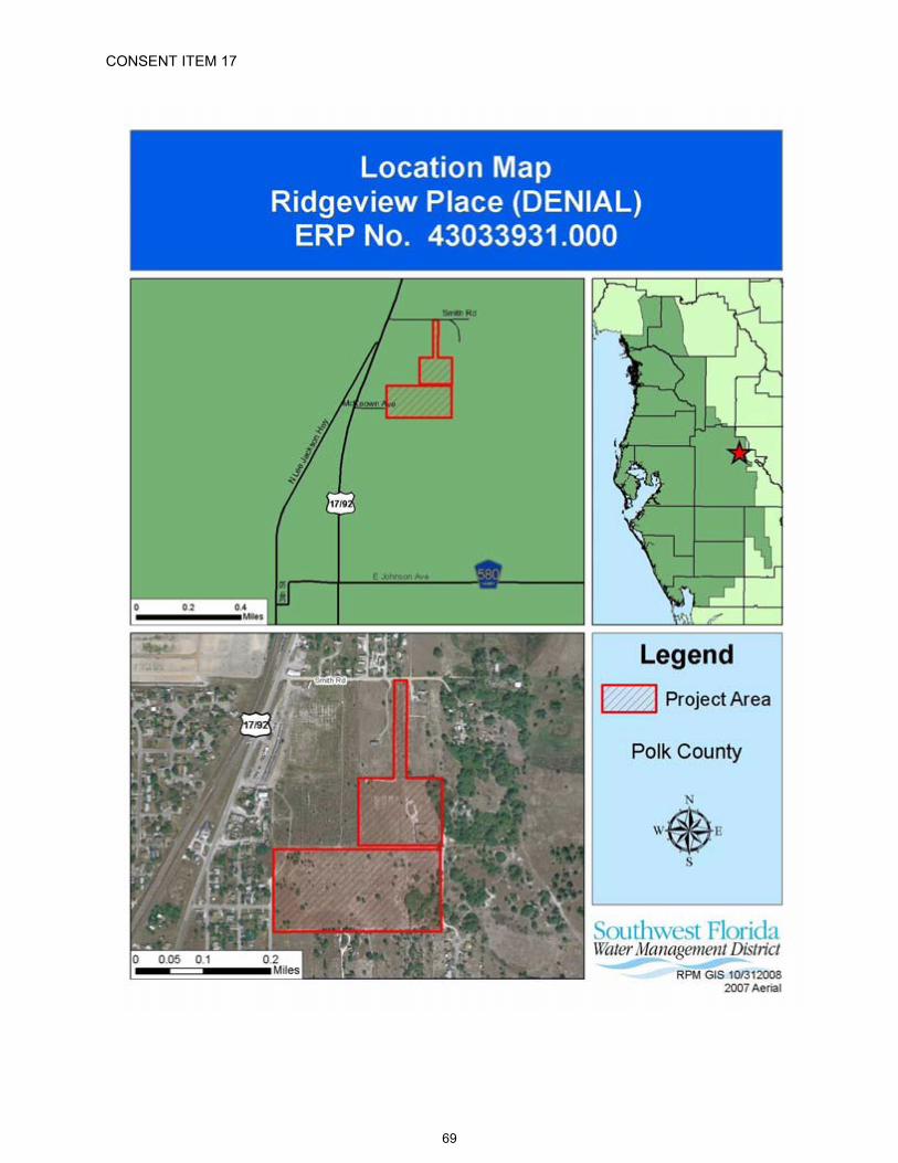
CONSENT ITEM 17
69

CONSENT ITEM 17 Default Date: N/A
SOUTHWEST FLORIDA WATER MANAGEMENT DISTRICTENVIRONMENTAL RESOURCE INDIVIDUAL CONSTRUCTION
DENIAL OF INDIVIDUAL CONSTRUCTIONPERMIT APPLICATION NO. 43033931.000
DATE OF DENIAL: December 16, 2008
Staff recommends denial of this application for permit due to lack of completeness, in accordance with District Rule 40D-1.1020 , Rule 40D-4.301 and 4.302, Florida Administrative Code, (F.A.C.).
PROJECT NAME: Ridgeview Place
OWNER/APPLICANT: Brown Wood Enterprises, Inc.4034 The FenwayMulberry, FL 33860
ABSTRACT: This permit application is for the construction of a new surface water management system serving a 28.24-acre single-family residential subdivision project. The project site is located to the south of Smith Road approximately 900 feet east of U.S. Highway 17-92, partially in the city of Haines City, Polk County.
COUNTY: Polk
SEC/TWP/RGE: 21/27S/27E
TOTAL ACRES OWNED: 30.00
PROJECT SIZE: 28.24 Acres
LAND USE: Residential
DATE APPLICATION FILED: February 22, 2008
AMENDED DATE: N/A
APPLICATION REVIEW TIMELINE:
February 22, 2008 Application ReceivedMarch 21, 2008 Request for Additional Information letter sentMay 7, 2008 Notification of Incomplete Application letter sentJune 25, 2008 Additional Information ReceivedJuly 24, 2008 Clarification of Received Information letter sentSeptember 15, 2008 Notification of Incomplete Application letter sent
The following are reasons for denial:
ADMINISTRATIVE:
1. Reasons for Denial:
July 24, 2008. In accordance with Rule 40D-1.1020, F.A.C., if the additional information is not
70

Permit No.: 43033931.000Project Name: Ridgeview Place (DENIAL)
supplied within 30 days after notice by the District, the application will be denied for lack of completeness.
Explanation of Changes Necessary to Address Reasons for Denial:
Provide the information requested in the District's Clarification of Received Information letter dated July 24, 2008.
ENVIRONMENTAL CONSIDERATIONS:
2. The applicant did not submit the wetland tables. Refer to Rule 40D-4.301(1), F.A.C.
The applicant did not provide reasonable assurance that the construction and operation of the proposed project would not result in adverse secondary impacts to adjacent wetlands and surface waters. Refer to Section 3.2.7 of the District's Basis of Review.
Explanation of Changes Necessary to Address Reasons for Denial:
Provide the wetland tables.
Provide reasonable assurance that the proposed project will not result in adverse secondary impacts to adjacent wetlands and surface waters (e.g., providing a cul-de-sac for Amanda Lane or by addressing reduction and elimination of impacts to the adjacent wetland and providing appropriate wetland mitigation).
PLANS:
3. Reasons for Denial:
The applicant did not provide a certified survey or other means of accurately reproducing the limits of all approved wetland limits within the project area. The exhibit used to show the wetland boundary should show all coordinate points within the delineation. Refer to Section E, Part C.5 of the Environmental Resource Permit (ERP) Application. The wetland boundary line table on Sheet 3 of the construction plans appears to be for the wetland buffer, and not the wetland boundary.
The applicant did not clearly identify and label the wetland boundaries for all wetlands located within the project area on all plan view drawings. Refer to Section E, Part C.5 of the ERP Application.
The applicant did not remove any wetland boundary delineation located outside of the project boundary from the construction plans. Refer to Section E, Part C.5 of the ERP Application.
The applicant did not clearly define the upland buffer adjacent to the on-site wetlands on all of the plan view drawings. Refer to Section E, part C.8 of the ERP Application.
The applicant did not delineate on the construction plans, with sufficient supporting topographical information, the post-development on-site and off-site contributing drainage basin areas discharging to the proposed pond. Refer to Section E, Part C.9 of the ERP Application.
The surface water management system shown on the construction drawings is not entirely located within right-of-ways or easements reserved for water management purposes. Refer to Section E, Part C.14 of the ERP Application.
71
Permit No.: 43033931.000Project Name: Ridgeview Place (DENIAL)
Explanation of Changes Necessary to Address Reasons for Denial:
Provide a certified survey or other means of accurately reproducing the limits of all approved wetland limits within the project area.
Clearly label and identify the wetland boundaries for all wetlands located within the project area on all plan view drawings.
Remove any wetland boundary determination outside of the project area on all plan view drawings.
Clearly define the upland buffer adjacent to on-site wetlands on all plan view drawings.
Provide revised construction drawings on which all aspects of the surface water managementsystem are included within areas clearly and permanently set aside by recorded legal documents (deeds, plats, etc.) so that they cannot be encroached upon.
WATER QUALITY:
4. Reason for Denial:
The applicant has not provided reasonable assurance that the surface water management system will meet the conditions specified in Rules 40D-4.301 and 40D-4.302, F.A.C. The project does not meet Rule 40D- 4.301(1)(e), F.A.C. This condition for issuance indicates that in order to obtain a permit, the applicant must assure that the construction, alteration, operation, maintenance, removal or abandonment of a surface water management system will not adversely affect the quality of receiving waters such that the water quality standards set forth in Chapters 62-4, 62-302, 62-520, 62-522 and 62-550, F.A.C., including any anti-degradation provisions of paragraphs 62-4.242(1)(a) and (b), Subsections 62-4.242(2) and (3), and Rule 62-302.300, F.A.C., and any special standards for Outstanding Florida Waters and Outstanding National Resource Waters set forth in Subsections 62-4.242(2) and (3), F.A.C., will be violated. In accordance with Rule 40D-4.301(3), F.A.C., the standards and criteria contained in the District's B.O.R., adopted by reference in Rule 40D-4.091, F.A.C., shall determine whether the reasonable assurances required by Rules 40D-4.301(1) and 40D-4.302, F.A.C., have been provided.
The applicant has proposed the use of an underground exfiltration system for the treatment of stormwater runoff. Subsection 5.7.d of the District's Basis of Review (B.O.R.) indicates that underground exfiltration systems should not be proposed for projects to be operated by entities other than single owners or entities with full time maintenance staffs. The applicant has indicated that the City of Haines City has agreed to act as the operation and maintenance entity for the system in perpetuity. The applicant has not provided written verification of this agreement.
Explanation of Changes Necessary to Address Reasons for Denial:
Provide a water quality treatment system design for which the proposed subdivision homeowners association is an acceptable operation and maintenance entity or provide proof that the City of Haines City is willing to be responsible for the operation and maintenance of the proposed system in perpetuity.
72
Permit No.: 43033931.000Project Name: Ridgeview Place (DENIAL)
WATER QUANTITY:
5. Reason for Denial:
The applicant has not provided reasonable assurance that the surface water management system will meet the conditions specified in Rules 40D-4.301 and 40D-4.302, F.A.C. The project does not meet Rules 40D- 4.301(1)(a), (b), (c), and (i), F.A.C. These conditions for issuance indicate that in order to obtain a permit, the applicant must assure that the construction, alteration, operation, maintenance, removal or abandonment of a surface water management system will not cause adverse water quantity impacts to receiving waters and adjacent lands; will not cause adverse flooding to on-site or off-site property; will not cause adverse impacts to existing surface water storage and conveyance capabilities; and is capable, based on generally accepted engineering and scientific principles, of being effectively performed and of functioning as proposed. In accordance with Rule 40D-4.301(3), F.A.C., the standards and criteria contained in the District's B.O.R., adopted by reference in Rule 40D-4.091, F.A.C., shall determine whether the reasonable assurances required by Rules 40D-4.301(1) and 40D-4.302, F.A.C., have been provided.
The proposed project appears to be located within a hydrologically closed basin. The proposed underground exfiltration system does not provide the required retention volume for the post-development less pre-development runoff volume from the 24-hour, 100-year rainfall event. Refer to Subsection 4.2.c of the District's B.O.R.
The applicant has not demonstrated that runoff from the off-site up-gradient areas to the northwest will be accommodated without adversely altering the time, stage, point, or manner of discharge or dispersion and without degrading water quality. Refer to Section 4.8 of the District's B.O.R.
It appears that the same basin area was not used for the pre- and post-development stormwater runoff calculations. Based on the drainage calculations provided, it appears that the combined area of Basin Nos. 10 and 20 in the pre-development analysis is 39.17 acres and the total runoff area is 41.84 acres in the post-development analysis. The pre- vs. post-development comparison must be based on the same basin acreages. Refer to Subsection 4.2.a of the District's B.O.R.
Explanation of Changes Necessary to Address Reasons for Denial:
B.O.R.
Demonstrate, in accordance with Sectibe made to allow drainage from off-site up gradient areas to down gradient areas without adversely altering the time, stage, volume, point or manner of discharge or dispersion and without degrading water quality.
Provide a discharge rate comparison that is based on the same basin acreages in the pre- and post-development conditions.
OPERATION MAINTENANCE AND LEGAL DOCUMENTATION:
6. Reason for Denial:
The applicant did not provide Articles of Incorporation with the homeowners association documents. Refer to Subsections 2.6.2.2.1 and 4 of the District's B.O.R.
The Declaration of Covenants provided are missing items a, b, c, d, g, h, I, j, and k as identified in Subsection 2.6.2.2.5 of the District's B.O.R.
73

Permit No.: 43033931.000Project Name: Ridgeview Place (DENIAL)
Explanation of Changes Necessary to Address Reasons for Denial:
Provide the requested Articles of Incorporation for the homeowners association.
Provide the revised Declaration of Covenants as requested.
74

The following General Conditions are included on all Environmental Resource Permits issued pursuant to 40D-4 and 40D-40, Florida Administrative Code.
75
EXHIBIT "A"
1. All activities shall be implemented as set forth in the plans, specifications and performance criteria as approved by this permit. Any deviation from the permitted activity and the conditions for undertaking that activity shall constitute a violation of this permit.
2. This permit or a copy thereof, complete with all conditions, attachments, exhibits, and modifications, shall be kept at the work site of the permitted activity. The complete permit shall be available for review at the work site upon request by District staff. The permittee shall require the contractor to review the complete permit prior to commencement of the activity authorized by this permit.
3. For general permits authorizing incidental site activities, the following limiting general conditions shall also apply:
a. If the decision to issue the associated individual permit is not final within 90 days of issuance of the incidental site activities permit, the site must be restored by the permittee within 90 days after notification by the District. Restoration must be completed by re-contouring the disturbed site to previous grades and slopes re-establishing and maintaining suitable vegetation and erosion control to provide stabilized hydraulic conditions. The period for completing restoration may be extended if requested by the permittee and determined by the District to be warranted due to adverse weather conditions or other good cause. In addition, the permittee shall institute stabilization measures for erosion and sediment control as soon as practicable, but in no case more than 7 days after notification by the District.
b. The incidental site activities are commenced at the permittee's own risk. The Governing Board will not consider the monetary costs associated with the incidental site activities or any potential restoration costs in making its decision to approve or deny the individual environmental resource permit application. Issuance of this permit shall not in any way be construed as commitment to issue the associated individual environmental resource permit.
4. Activities approved by this permit shall be conducted in a manner which does not cause violations of state water quality standards. The permittee shall implement best management practices for erosion and a pollution control to prevent violation of state water quality standards. Temporary erosion control shall be implemented prior to and during construction, and permanent control measures shall be completed within 7 days of any construction activity. Turbidity barriers shall be installed and maintained at all locations where the possibility of transferring suspended solids into the receiving waterbody exists due to the permitted work. Turbidity barriers shall remain in place at all locations until construction is completed and soils are stabilized and vegetation has been established. Thereafter the permittee shall be responsible for the removal of the barriers. The permittee shall correct any erosion or shoaling that causes adverse impacts to the water resources.
5. Water quality data for the water discharged from the permittee's property or into the surface waters of the state shall be submitted to the District as required by the permit. Analyses shall be performed according to procedures outlined in the current edition of Standard Methods for the Examination of Water and Wastewater by the American Public Health Association or Methods for Chemical Analyses of Water and Wastes by the U.S. Environmental Protection Agency. If water
76
quality data are required, the permittee shall provide data as required on volumes of water discharged, including total volume discharged during the days of sampling and total monthly volume discharged from the property or into surface waters of the state.
6. District staff must be notified in advance of any proposed construction dewatering. If thedewatering activity is likely to result in offsite discharge or sediment transport into wetlands or surface waters, a written dewatering plan must either have been submitted and approved with the permit application or submitted to the District as a permit prior to the dewatering event as a permit modification. A water use permit may be required prior to any use exceeding the thresholds in Chapter 40D-2, F.A.C.
7. Stabilization measures shall be initiated for erosion and sediment control on disturbed areas as soon as practicable in portions of the site where construction activities have temporarily or permanently ceased, but in no case more than 7 days after the construction activity in that portion of the site has temporarily or permanently ceased.
8. Off-site discharges during construction and development shall be made only through the facilities authorized by this permit. Water discharged from the project shall be through structures having a mechanism suitable for regulating upstream stages. Stages may be subject to operating schedules satisfactory to the District.
9. The permittee shall complete construction of all aspects of the surface water management system, including wetland compensation (grading, mulching, planting), water quality treatment features, and discharge control facilities prior to beneficial occupancy or use of the development being served by this system.
10. The following shall be properly abandoned and/or removed in accordance with the applicable regulations:
a. Any existing wells in the path of construction shall be properly plugged and abandoned by a licensed well contractor.
b. Any existing septic tanks on site shall be abandoned at the beginning of construction.c. Any existing fuel storage tanks and fuel pumps shall be removed at the beginning of
construction.
11. All surface water management systems shall be operated to conserve water in order to maintain environmental quality and resource protection; to increase the efficiency of transport, application and use; to decrease waste; to minimize unnatural runoff from the property and to minimize dewatering of offsite property.
12. At least 48 hours prior to commencement of activity authorized by this permit, the permittee shall submit to the District a written notification of commencement indicating the actual start date and the expected completion date.
13. Each phase or independent portion of the permitted system must be completed in accordance with the permitted plans and permit conditions prior to the occupation of the site or operation of site infrastructure located within the area served by that portion or phase of the system. Each phase or independent portion of the system must be completed in accordance with the permitted plans and permit conditions prior to transfer of responsibility for operation and maintenance of that phase or portion of the system to a local government or other responsible entity.
77

14. Within 30 days after completion of construction of the permitted activity, the permittee shall submit a written statement of completion and certification by a registered professional engineer or other appropriate individual as authorized by law, utilizing the required Statement of Completion and Request for Transfer to Operation Entity form identified in Chapter 40D-1, F.A.C. Additionally, if deviation from the approved drawings are discovered during the certification process the certification must be accompanied by a copy of the approved permit drawings with deviations noted.
15. This permit is valid only for the specific processes, operations and designs indicated on the approved drawings or exhibits submitted in support of the permit application. Any substantial deviation from the approved drawings, exhibits, specifications or permit conditions, including construction within the total land area but outside the approved project areas, may constitute grounds for revocation or enforcement action by the District, unless a modification has been applied for and approved. Examples of substantial deviations include excavation of ponds, ditches or sump areas deeper than shown on the approved plans.
16. The operation phase of this permit shall not become effective until the permittee has complied with the requirements of the conditions herein, the District determines the system to be in compliance with the permitted plans, and the entity approved by the District accepts responsibility for operation and maintenance of the system. The permit may not be transferred to the operation and maintenance entity approved by the District until the operation phase of the permit becomes effective. Following inspection and approval of the permitted system by the District, the permittee shall request transfer of the permit to the responsible operation and maintenance entity approved by the District, if different from the permittee. Until a transfer is approved by the District, the permittee shall be liable for compliance with the terms of the permit.
17. Should any other regulatory agency require changes to the permitted system, the District shall be notified of the changes prior to implementation so that a determination can be made whether a permit modification is required.
18. This permit does not eliminate the necessity to obtain any required federal, state, local and special District authorizations including a determination of the proposed activities' compliance with the applicable comprehensive plan prior to the start of any activity approved by this permit.
19. This permit does not convey to the permittee or create in the permittee any property right, or any interest in real property, nor does it authorize any entrance upon or activities on property which is not owned or controlled by the permittee, or convey any rights or privileges other than those specified in the permit and Chapter 40D-4 or Chapter 40D-40, F.A.C.
20. The permittee shall hold and save the District harmless from any and all damages, claims, or liabilities which may arise by reason of the activities authorized by the permit or any use of the permitted system.
21. Any delineation of the extent of a wetland or other surface water submitted as part of the permit application, including plans or other supporting documentation, shall not be considered binding unless a specific condition of this permit or a formal determination under section 373.421(2), F.S., provides otherwise.
22. The permittee shall notify the District in writing within 30 days of any sale, conveyance, or other transfer of ownership or control of the permitted system or the real property at which the permitted system is located. All transfers of ownership or transfers of a permit are subject to the requirements of Rule 40D-4.351, F.A.C. The permittee transferring the permit shall remain liable for any corrective actions that may be required as a result of any permit violations prior to such sale, conveyance or other transfer.
78
23. Upon reasonable notice to the permittee, District authorized staff with proper identification shall have permission to enter, inspect, sample and test the system to insure conformity with District rules, regulations and conditions of the permits.
24. If historical or archaeological artifacts are discovered at any time on the project site, the permittee shall immediately notify the District and the Florida Department of State, Division of Historical Resources.
25. The permittee shall immediately notify the District in writing of any previously submitted information that is later discovered to be inaccurate.
79
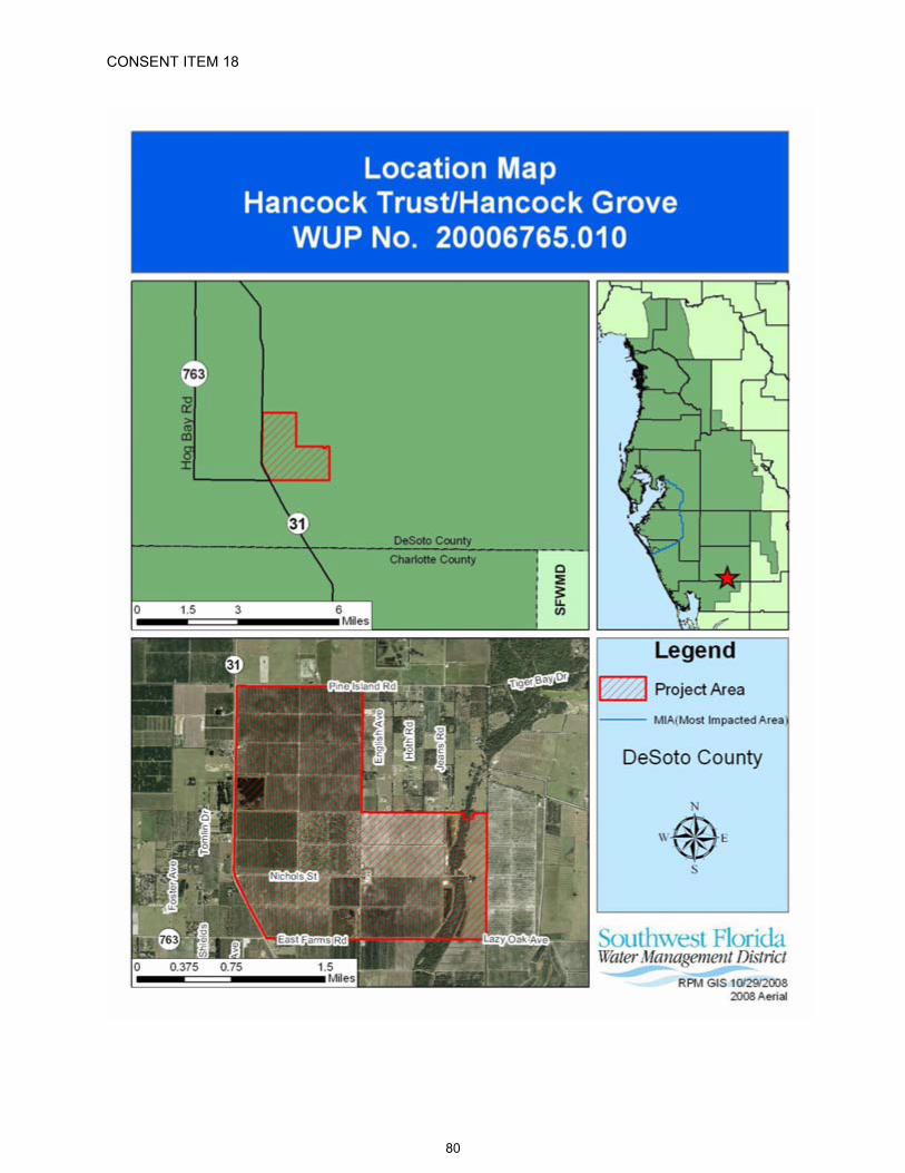
CONSENT ITEM 18
80

CONSENT ITEM 18 Default Date: December 16, 2008
SOUTHWEST FLORIDA WATER MANAGEMENT DISTRICTWATER USEINDIVIDUAL
PERMIT NO. 20006765.010
EXPIRATION DATE: December 16, 2028 PERMIT ISSUE DATE: December 16, 2008
The Permittee is responsible for submitting an application to renew this permit no sooner than one year prior to the expiration date, and no later than the end of the last business day before the expiration date, whether or not the Permittee receives prior notification by mail. Failure to submit a renewal application prior to the expiration date and continuing to withdraw water after the expiration date is a violation of Chapter 373, Florida Statutes, and Chapter 40D-2, Florida Administrative Code, and may result in a monetary penalty and/or loss of the right to use the water. Issuance of a renewal of this permit is contingent upon District approval.
TYPE OF APPLICATION: Renewal
GRANTED TO: L.D. Hancock Marital TrustPost Office Box 3112Tupelo, MS 38803
PROJECT NAME: Hancock Grove
WATER USE CAUTION AREA: Southern
PROPERTY LOCATION: 1,878 owned acres in DeSoto County, immediately northeast of State Highway 31 at County Road 763.
ABSTRACT: This is a renewal of an existing agricultural water use permit with an increase in quantities. Approximately three quarters of the irrigation demand will be met through the use of surface water.
This renewal authorizes a standard annual average daily quantity of 1,312,700 gpd and a peak month quantity of 8,914,600 gpd.
Special conditions include those that require the Permittee to submit required reports, record and report monthly meter readings, provide location data for new withdrawals, cap any withdrawals not in use, adhere to irrigation allotments and conservation practices, notify if loss of AWS occurs, report crop protection quantities, submit annual crop reports, implement Best Management Practices to reduce or eliminate agricultural runoff to the Shell and Prairie Creek watersheds, use AWS when available and standby groundwater quantities when not, document and report any exceedance of the annual average quantity, comply with recovery strategies within the SWUCA, and submit compliance reports every 5 years.
CHANGES FROM PRIOR PERMIT: The standard annual average quantity increases by 60,700 gpd; the drought annual average quantity increases by 247,300 gpd; the peak month quantity increases by 94,600 gpd; and the crop protection quantity increases by 6,137,500 gpd. The changes in the standard annual average, drought annual average, peak month, and crop protection quantities were calculated using the District's agricultural water use calculation program, AGMOD.
81

Permit No.: 20006765.010Project Name: L.D. Hancock Marital Trust / Hancock Grove
PERMIT INFORMATION
PREVIOUSLY PERMITTED
(2006 2008) GPD
REQUESTED(2028) GPD
AUTHORIZED(2028) GPD
ANNUAL AVERAGE 1 1,252,000 1,252,000 1,312,700Ground Water 1,252,000 802,200 342,200Surface Water 0 450,000 970,500
ALTERNATIVE WATER SUPPLY 2
(annual average) NA NA NAReclaimed Water 3 0 0 0Captured Stormwater NA NA NA
DROUGHT ANNUAL AVERAGE 4 1,634,800 1,634,800 1,882,100Ground Water 1,634,800 1,047,900 490,600Surface Water 0 586,900 1,391,500
WATER CONSERVATION CREDITS 5
(gallons) 25,888,895 25,888,895 69,646,805 Ground Water 25,888,895 16,594,782 18,177,816Surface Water 0 9,294,113 51,468,989
PEAK MONTH 6 8,820,000 8,820,000 8,914,600Ground Water 8,820,000 5,653,600 2,323,900Surface Water 0 3,166,400 6,590,700
CROP PROTECTION 7 26,880,000 26,880,000 33,017,500Ground Water 26,880,000 17,230,100 8,607,100Surface Water 0 9,649,900 24,410,400
1 Annual average quantities are the total gallons needed for one average rainfall year divided by 365 days.2 Alternative Water Supply are sources of water other than historic natural sources. Ground water is not an
Alternative Water Supply.3 Reclaimed Water is not included in permit totals.4 Drought Annual Average quantities are given to supplement rainfall during years when less than average rain falls,
divided by 365 days. It is also the upper limit of permitted quantities when the Permittee is using Water Conservation Credits.
5 Water Conservation Credits are total gallons available for use when more than the standard annual average quantity is needed for irrigation. The credits can only be used on the crop for which the credits were given initially or on which they were earned, up to the Drought Annual Average limit.
6 Peak Month quantities are the total gallons needed for the highest water-use month divided by the number of days in that month.
7 Crop Protection quantities are the total gallons needed for one day for frost and freeze protection.
WATER DEMANDANNUAL AVERAGE VALUES
PREVIOUSLY PERMITTED(2006 2008)
PROJECTED(2028)
AUTHORIZED(2028)
Citrus 1,252,000 gpd 1,252,000 gpd 1,312,700 gpdIrrigated Acres 1,319 1,319 1,476 Standard Irrigation Rate (in./ac./yr.) 12.76 12.76 11.95Drought Irrigation Rate (in./ac./yr.) 16.66 16.66 17.14
82
Permit No.: 20006765.010Project Name: L.D. Hancock Marital Trust / Hancock Grove
SPECIAL CONDITIONS:
All conditions referring to approval by the Regulation Department Director, Resource Regulation, shall refer to the Director, Sarasota Regulation Department, Resource Regulation.
All reports and data required by conditions of the permit shall be submitted to the District according to the due dates contained in the specific condition. If the report or data is received on or before the tenth day of the month following data collection, it shall be deemed as a timely submittal. The
eports online. To set up an account, the Permittee can address the request to [email protected]. All mailed reports and data are to be sent to:
Permit Data Section, Regulation Performance Management DepartmentSouthwest Florida Water Management District2379 Broad StreetBrooksville, Florida 34604-6899
Submission of plans and reports: Unless submitted online or otherwise indicated in the special condition, the original and two copies of each plan and report, such as conservation plans, environmental analyses, aquifer test results, per capita annual reports, etc. are required.
Submission of data: Unless otherwise indicated in the special condition, an original (no copies) is required for data submittals such as crop report forms, meter readings and/or pumpage, rainfall, water level evapotranspiration, or water quality data.
The Permittee shall meter withdrawals from surface waters and/or the ground water resources, and meter readings from each withdrawal facility shall be recorded on a monthly basis within the last week of the month. The meter readings shall be reported to the Permit Data Section, Regulation Performance Management Department on or before the tenth day of the following month. District-supplied scanning forms shall be used to submit the meter readings unless another arrangement for submission of this data has been approved by the District. The following withdrawal facilities shall be metered:
A. Standby withdrawal facilities (those that are on standby as backup for alternative water supplies), District ID Nos.7, 8 and 10, Permittee ID Nos.7, 8 and 10, shall be metered upon permit issuance.
B. Withdrawal facilities that are not yet constructed, District ID Nos. 23, 24, 25, 26, 27 and 28,Permittee ID Nos. 23, 24, 25, 26, 27 and 28 shall be metered within 90 days of completion of construction of the withdrawal.
C. Existing permitted withdrawal facilities shall continue to be metered with non-resettable, totalizing flow meters or other flow measuring devices as approved by the Regulation Department Director, District ID Nos. 5, 11, 13, 15, 18, 19, 21 and 22, Permittee ID Nos. 5, 11, 13, 15, 18, 19, 21 and 22.
The meters shall adhere to the following descriptions and shall be installed or maintained as follows:
A. The meters shall be non-resettable, totalizing flow meters that have a totalizer of sufficient magnitude to retain total gallon data for a minimum of the three highest consecutive months permitted quantities. If other measuring devices are proposed, prior to installation, approval shall be obtained in writing from the Regulation Department Director.
B. The Permittee shall report non-use on all metered standby withdrawal facilities on the scanning form or approved alternative reporting method.
83
Permit No.: 20006765.010Project Name: L.D. Hancock Marital Trust / Hancock Grove
C. If a metered withdrawal facility is not used during any given month, the meter report shall be submitted to the District indicating the same meter reading as was submitted the previous month.
D. The flow meters or other approved devices shall have and maintain an accuracy within five percent of the actual flow as installed.
E. Accuracy testing requirements: 1. For newly metered withdrawal points, the flow meter installation shall be designed
for inline field access for meter accuracy testing. 2. The meter shall be tested for accuracy on-site, as installed, every five years
beginning from the date of its installation for new meters or from the date of initial issuance of this permit containing the metering condition with an accuracy test requirement for existing meters.
3. The testing frequency will be decreased if the Permittee demonstrates to the satisfaction of the District that a longer period of time for testing is warranted.
4. The test will be accepted by the District only if performed by a person knowledgeable in the testing equipment used.
5. If the actual flow is found to be greater than 5% different from the measured flow, within 30 days, the Permittee shall have the meter re-calibrated, repaired, or replaced, whichever is necessary. Documentation of the test and a certificate of re-calibration, if applicable, shall be submitted within 30 days of each test or re-calibration.
F.accurate flow to the specifications above, or it shall be installed in a straight length of pipe where there is at least an upstream length equal to ten (10) times the outside pipe diameter and a downstream length equal to two (2) times the outside pipe diameter. Where there is not at least a length of ten diameters upstream available, flow straightening vanes shall be used in the upstream line.
G. Broken or malfunctioning meter:1. If the meter or other flow measuring device malfunctions or breaks, the Permittee
shall notify the District within 15 days of discovering the malfunction or breakage.2. The meter must be replaced with a repaired or new meter, subject to the same
specifications given above, within 30 days of the discovery. 3. If the meter is removed from the withdrawal point for any other reason, it shall be
replaced with another meter having the same specifications given above, or the meter shall be reinstalled within 30 days of its removal from the withdrawal. In either event, a fully functioning meter shall not be off the withdrawal point for more than 60 consecutive days.
H. While the meter is not functioning correctly, the Permittee shall keep track of the total amount of time the withdrawal point was used for each month and multiply those minutes times the pump capacity (in gallons per minute) for total gallons. The estimate of the number of gallons used each month during that period shall be submitted on District scanning forms and noted as estimated per instructions on the form. If the data is submitted by another approved method, the fact that it is estimated must be indicated. The reason for the necessity to estimate pumpage shall be reported with the estimate.
I. In the event a new meter is installed to replace a broken meter, it and its installation shall meet the specifications of this condition. The permittee shall notify the District of the replacement with the first submittal of meter readings from the new meter.
Any wells not in use, and in which pumping equipment is not installed shall be capped or valved in a water tight manner in accordance with Subsection 62-532.500(3)(a)(4), F.A.C.
84

Permit No.: 20006765.010Project Name: L.D. Hancock Marital Trust / Hancock Grove
By January 1, 2014, the Permittee shall submit to the Permit Data Section, Regulation Performance Management Department, the specific location of District ID Nos. 23, 24, 25, 26, 27 and 28, Permittee ID Nos. 23, 24, 25, 26, 27 and 28, on an original blue line aerial with a minimum scale of 1" = 800' or by latitude/longitude.
Within 90 days of the replacement of any or all withdrawal quantities from ground water or surface water bodies with an Alternative Water Supply, the Permittee shall apply to modify this permit to reflect incorporation of the alternative source of water to replace permitted quantities in equal amounts. The replaced water shall be put on standby and may be used in the event that some or all of the alternative source is not available.
The Permittee shall:
A. Incorporate best water management practices, specifically including but not limited to irrigation practices, as recommended for the permitted activities in reports and publications by the IFAS.
B. Limit daytime irrigation to the greatest extent practicable to reduce losses from evaporation. Daytime irrigation for purposes of system maintenance, control of heat stress, crop protection, plant establishment, or for other reasons which require daytime irrigation are permissible; but should be limited to the minimum amount necessary as indicated by best management practices.
C. Implement a leak detection and repair program as an element of an ongoing system maintenance program. This program shall include a system-wide inspection at least once per year.
D. Evaluate the feasibility of improving the efficiency of the current irrigation system or converting to a more efficient system. This condition includes implementation of the improvements or conversion when determined to be operationally and economically feasible.
If the Alternative Water Supply (AWS) becomes unavailable, insufficient or unsuitable for a duration greater than 30 days, the Permittee shall notify the District in writing within 45 days of the first day the AWS became unavailable, insufficient or unsuitable. The notification must continue to be submitted monthly for each subsequent 30-day period, for up to one year from the date of first loss, insufficiency, or unsuitability. From the date of first loss and while the AWS delivery remains unavailable, insufficient or unsuitable, the Permittee is authorized to withdraw the standby quantities on standby to meet the authorized use. The combined use AWS quantities (if any) and withdrawn standby quantities shall not exceed the permitted quantities or an authorized irrigation allocation rate. If the loss of the AWS exceeds one year, upon request of the Permittee, the District shall issue a Letter of Modification to reinstate the standby quantities as active quantities, subject to all requirements of Rule 40D-2.331(2), F.A.C.
Compliance with the allocated standard annual average quantity and drought annual average quantities is based on a rolling 12-month calculation where the current pumpage is added to the pumpage for the previous 11 months, and the total is then divided by the number of days in those 12 months for gallons per day. If the Permittee exceeds the allocated standard annual average quantity or drought annual average quantities during any month, within 30 days the Permittee must submit a report to the District that includes reasons why the allocated quantities were exceeded, efforts already taken to attempt meeting the allocated quantities, and a plan to bring the permit into compliance. Reports for Permittees not achieving the allocated quantities are subject to District approval. Justification for exceeding the allocated quantities does not constitute a waiver of the District's authority to enforce the terms and conditions of the permit.
85

Permit No.: 20006765.010Project Name: L.D. Hancock Marital Trust / Hancock Grove
Permittees whose maximum daily permitted water use is 1,000,000 gpd or more shall document and report on District forms, the beginning and ending hours and dates of operation of each withdrawal source used for the protection of crops from frost or freeze damage. The report shall include the gallons per day pumped from each withdrawal source based on irrigation system capacity, or if available, totalizing flow meter readings. This report shall be submitted by the 10th day of the month following irrigation for crop protection. The crop protection daily quantities specified in this permit are solely for the purpose of crop protection, and do not apply to routine irrigation practices. Irrigation for crop protection shall not exceed the crop protection daily quantity listed on the permit and shall not cause water to go to waste.
Even if your maximum daily permitted water use is less than 1,000,000 gpd, please be aware that it is in your best interest to document this usage as described above so that quantities pumped for crop protection can be excluded from the compliance calculation of your annual average use and in the determination of credit amounts.
This Permit is located within the Southern Water Use Caution Area (SWUCA). Pursuant to Section 373.0421, Florida Statutes, the SWUCA is subject to a minimum flows and levels recovery strategy, which became effective on January 1, 2007. The Governing Board may amend the recovery strategy, including amending applicable water use permitting rules based on an annual assessment of water resource criteria, cumulative water withdrawal impacts, and on a recurring five-year evaluation of the status of the recovery strategy up to the year 2025 as described in Chapter 40D-80, Florida Administrative Code. This Permit is subject to modification to comply with new rules.
The Permittee shall not exceed the quantity determined by multiplying the total irrigated acres by the total allocated acre-inches per irrigated acre per season for each crop type. For all crops except citrus, an irrigated acre, hereafter referred to as "acre," is defined as the gross acreage under cultivation, including areas used for water conveyance such as ditches, but excluding uncultivated areas such as wetlands, retention ponds, and perimeter drainage ditches. For citrus, an irrigated acre is based on 74% shaded area, equivalent to 89.4% of the gross acreage minus uncultivated areas such as wetlands, retention ponds, and perimeter drainage ditches.
An Applicant or Permittee within the Southern Water Use Caution Area may obtain the total allocated acre-inches per acre per season for their crops, plants, soil types, planting dates, and length of growing season by completing the "Irrigation Water Allotment Form" and submitting it to the District. The District will complete and return the form with the calculated total allocated acre-inches and water conserving credit per acre per season per crop, if applicable, based on the information provided. The "Irrigation Water Allotment Form" is available upon request.
The Permittee shall record the following information on the appropriate "Irrigation Water Use Form", provided by the District, for each permitted irrigation withdrawal:
A. Items (1) through (7) for seasonal crops (example: vegetables) and nurseries; B. Items (1) through (4) and item (7) for annual crops and plants (example: citrus, pasture,
lawn and landscape); C. Items (1) through (4) and item (8) for golf courses (annual);
The list of items are:1) Crop type;2) Monthly irrigated acres per crop for seasonal crops; annual irrigated acres for
annual crops (Citrus growers, give total acres; the District will calculate "shaded area" for the groves.)
3) The dominant soil type per crop or the number of acres per crop on that dominant soil type;
4) Irrigation methods;
86

Permit No.: 20006765.010Project Name: L.D. Hancock Marital Trust / Hancock Grove
5) Planting dates (the date the plants are actually placed in the beds, not the date the field is prepared);
6) Season length (in days);7) Crop protection quantities (total gallons); and8) Number of acres of tees and greens.
D. Additionally, if used, the following shall be documented separately:1) Beginning and ending dates of irrigation for field preparation/crop establishment
and supplemental irrigation;2) Beginning and ending hour and date of each use of quantities for crop protection;3) Non-irrigation use from irrigation well: Quantities from the withdrawals listed on
these forms that were for other uses not related to irrigation demand. Such uses may include filling of spray tanks, livestock needs, and cleaning equipment and facilities.
4) Use of tailwater recovery.
This information shall be submitted to the Permit Data Section, Regulation Performance Management Department, for irrigation activity during the previous season or year on the appropriate District form according to the following schedule:
Irrigation Water Use Form No. Form Title Submit ByWUP-10 Form 46.20-010 (10/01) Annual Crops March 1
A. Shell and Prairie Creek Watersheds The District has determined that direct and indirect run-off of irrigation water into Shell Creek and Prairie Creek have contributed to water quality degradation in a Class I waterway that serves as a public supply source for an existing legal water user, the City of Punta Gorda. Degradation of the City's reservoir has occurred to such an extent that the concentration of several constituents has exceeded secondary drinking water standards in the past. To avoid further degradation of the reservoir and to improve water quality, such that it is consistent with Class I water quality standards, the Permittee shall continue to improve the management of irrigation water by reducing or eliminating off-site discharge of lower quality irrigation water. At the time of issuance of this permit the District is addressing off-site discharge and attempting to resolve the aforementioned adverse impacts through cooperative and collaborative measures with Permittees, changes in irrigation management practices, and other methods. If the effectiveness of these measures is determined to be insufficient to resolve these adverse impacts and irrigation management practices on this site appear to contribute to these continued impacts, the District may seek to modify this permit in accordance with applicable law.
B. Best Management PracticesThis specific permit is issued with the understanding that the Permittee shall implement Best Management Practices (BMPs), which will result in elimination of off-site discharge of lower quality irrigation water to the greatest extent practicable. This is required to avoid contribution by this permitted site to the water quality degradation within the Shell Creek and Prairie Creek watersheds, and to assist in improvement in water quality of the City of Punta Gorda's Shell Creek Reservoir.
14. A. Five-Year Alternative Water Supply/Compliance ReportsBy January 1, 2014 with follow-up reports due January 1, 2019 and January 1, 2024, the Permittee shall submit reports for approval by the Sarasota Regulation Department Director, that demonstrates reasonable assurance that the permitted withdrawals and use of water continue to meet the conditions for permit issuance set forth in Rule 40D-2 and the Basis of Review for Water Use Permits. Specifically, the reports shall address the
87
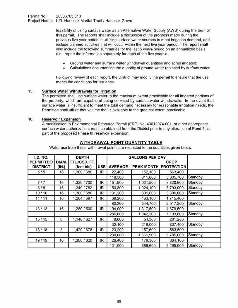
Permit No.: 20006765.010Project Name: L.D. Hancock Marital Trust / Hancock Grove
feasibility of using surface water as an Alternative Water Supply (AWS) during the term of this permit. The reports shall include a discussion of the progress made during the previous five year period in utilizing surface water sources to meet irrigation demand, and include planned activities that will occur within the next five year period. The report shall also include the following summaries for the last 5 years period on an annualized basis (i.e., report the information separately for each of the five years):
Ground water and surface water withdrawal quantities and acres irrigated;Calculations documenting the quantity of ground water replaced by surface water.
Following review of each report, the District may modify the permit to ensure that the use meets the conditions for issuance.
15. Surface Water Withdrawals for IrrigationThe permittee shall use surface water to the maximum extent practicable for all irrigated portions of the property, which are capable of being serviced by surface water withdrawals. In the event that surface water is insufficient to meet the total demand necessary for reasonable irrigation needs, the Permittee shall utilize that volume that is available to the greatest extent practicable.
16. Reservoir ExpansionA modification to Environmental Resource Permit (ERP) No. 43012074.001, or other appropriate surface water authorization, must be obtained from the District prior to any alteration of Pond 4 as part of the proposed Phase III reservoir expansion.
WITHDRAWAL POINT QUANTITY TABLEWater use from these withdrawal points are restricted to the quantities given below:
I.D. NO.PERMITTEE/
DISTRICTDIAM.(IN.)
DEPTHTTL./CSD. FT.
(feet bls) USE
GALLONS PER DAY CROP
AVERAGE PEAK MONTH PROTECTION5 / 5 16 1,300 / 680 IR 22,400 152,100 563,400
119,500 811,600 3,005,700 Standby7 / 7 16 1,330 / 700 IR 151,900 1,031,500 3,820,600 Standby8 / 8 16 1,340 / 782 IR 150,800 1,024,100 3,793,000 Standby
10 / 10 16 1,300 / 680 IR 131,200 891,000 3,300,000 Standby11 / 11 16 1,204 / 697 IR 68,200 463,100 1,715,400
80,200 544,700 2,017,200 Standby13 / 13 16 1,280 / 500 IR 194,000 1,317,500 4,879,500
286,000 1,942,200 7,193,600 Standby15 / 15 8 1,146 / 627 IR 8,000 54,300 201,200
32,100 218,000 807,400 Standby18 / 18 8 1,420 / 678 IR 23,200 157,600 583,500
230,000 1,561,900 5,785,000 Standby19 / 19 16 1,300 / 620 IR 26,400 179,300 664,100
131,000 889,600 3,295,000 Standby
88

Permit No.: 20006765.010Project Name: L.D. Hancock Marital Trust / Hancock Grove
I.D. NO.PERMITTEE/
DISTRICTDIAM.(IN.)
DEPTHTTL./CSD. FT.
(feet bls) USE
GALLONS PER DAY CROP
AVERAGE PEAK MONTH PROTECTION21 / 21 12 N/A / N/A IR 188,700 1,281,200 4,745,000 Unnamed Pond22 / 22 12 N/A / N/A IR 188,600 1,281,100 4,745,000 Unnamed Pond23 / 23 12 N/A / N/A IR 122,500 831,900 3,081,200 Unnamed Pond24 / 24 12 N/A / N/A IR 122,500 831,900 3,081,100 Unnamed Pond25 / 25 12 N/A / N/A IR 87,100 591,200 2,189,600 Unnamed Pond26 / 26 12 N/A / N/A IR 87,000 591,100 2,189,500 Unnamed Pond27 / 27 12 N/A / N/A IR 87,100 591,200 2,189,500 Unnamed Pond28 / 28 12 N/A / N/A IR 87,000 591,100 2,189,500 Unnamed Pond
IR = Irrigation
WITHDRAWAL POINT LOCATION TABLE
DISTRICTI.D. NO. LATITUDE/LONGITUDE SECTION/TOWNSHIP/RANGE
5 270429.20/814728.36 23/39/257 270521.68/814710.82 14/38/258 270521.76/814726.72 14/39/2510 270456.32/814727.26 14/39/2511 270456.53/814657.84 14/39/2513 270427.49/814624.12 24/39/2515 270407.22/814727.55 23/39/2518 270411.49/814657.27 23/39/2519 270400.02/814727.29 23/39/2521 270427.22/814604.25 24/39/2522 270427.07/814604.25 24/39/2523 270358.36/814656.25 23/39/2524 270355.24/814656.22 23/39/2525 270454.52/814737.08 14/39/2526 270454.51/814730.76 14/39/2527 270441.32/814738.73 14/39/2528 270441.22/814731.54 14/39/25
89

Permit No.: 20006765.010Project Name: L.D. Hancock Marital Trust / Hancock Grove
STANDARD CONDITIONS:
The Permittee shall comply with the Standard Conditions attached hereto, incorporated herein by reference as Exhibit "A" and made a part hereof.
___________________________________________Authorized SignatureSOUTHWEST FLORIDA WATER MANAGEMENT DISTRICT
This permit, issued under the provision of Chapter 373, Florida Statutes and Florida Administrative Code 40D-2, authorizes the Permittee to withdraw the quantities outlined above, and may require various activities to be performed by the Permittee as described in the permit, including the Special Conditions. This permit does not convey to the Permittee any property rights or privileges other than those specified herein, nor relieve the Permittee from complying with any applicable local government, state, or federal law, rule, or ordinance.
90
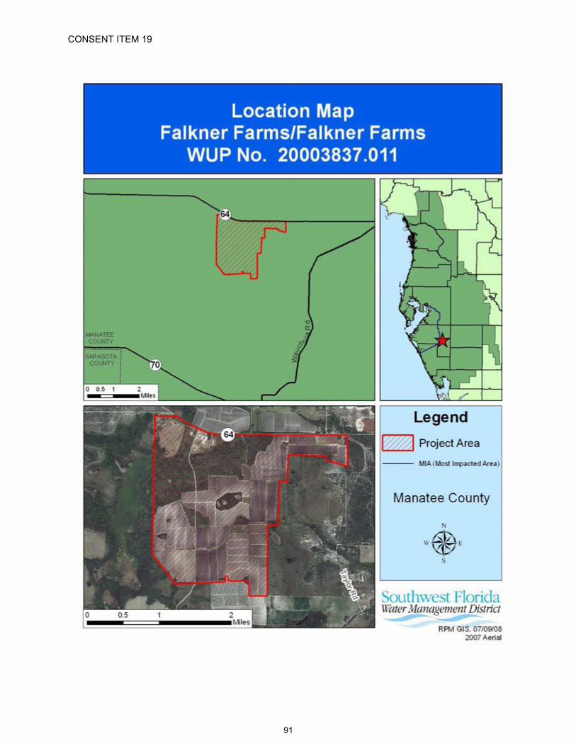
CONSENT ITEM 19
91

CONSENT ITEM 19 Default Date: January 5, 2009
SOUTHWEST FLORIDA WATER MANAGEMENT DISTRICTWATER USEINDIVIDUAL
PERMIT NO. 20003837.011
EXPIRATION DATE: December 16, 2014 PERMIT ISSUE DATE: December 16, 2008
The Permittee is responsible for submitting an application to renew this permit no sooner than one year prior to the expiration date, and no later than the end of the last business day before the expiration date, whether or not the Permittee receives prior notification by mail. Failure to submit a renewal application prior to the expiration date and continuing to withdraw water after the expiration date is a violation of Chapter373, Florida Statutes, and Chapter 40D-2, Florida Administrative Code, and may result in a monetary penalty and/or loss of the right to use the water. Issuance of a renewal of this permit is contingent upon District approval.
TYPE OF APPLICATION: Renewal
GRANTED TO: Falkner Farms35100 State Road 64 EastMyakka City, FL 34251
PROJECT NAME: Falkner Farms
WATER USE CAUTION AREA: Southern
PROPERTY LOCATION: 2,395 owned acres in Manatee County, approximately 3.5 miles west of the intersection of State Road 64 and Myakka Wauchula Road.
ABSTRACT: This is a renewal of an existing agricultural water use permit with a change in permitted quantities due to the combining of WUP No. 20010599.0010 into this permit, for the irrigation of 1,100 acres of spring tomatoes and 1,275 acres of fall peppers. The combined permitted quantities for this renewal are a standard annual average of 4,232,000 gallons per day (gpd), a drought annual average of 4,232,000 gpd and a peak month of 8,537,900 gpd.
Special conditions include those that require the Permittee to maintain existing meters, record and report meter readings monthly, cap withdrawals not in use, address utilization of alternative water supplies (AWS) and modify the permit to incorporate AWS when it is obtained, continue to implement irrigation conservation measures, comply with irrigation allotments, submit annual irrigation water use reports, install and utilize real-time irrigation control systems, eliminate off-site discharge through Best Management Practices, document and submit a report if the standard annual average or drought annual average daily quantities have been exceeded and comply with minimum flows and levels recovery strategy within the SWUCA.
CHANGES FROM PRIOR PERMIT: The standard annual average quantity and the drought annual average quantity are increased by 1,734,900 gpd and the peak month quantity increases by 3,665,900 gpd. The changes in the standard annual average, drought annual average and peak month quantities are due to combining of WUP No. 20010599.010 into this permit and do not reflect an overall change in permitted quantities.
92
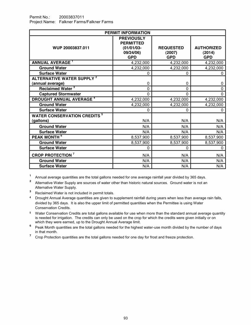
Permit No.: 20003837011Project Name: Falkner Farms/Falkner Farms
PERMIT INFORMATION
WUP 20003837.011
PREVIOUSLY PERMITTED
(01/01/03-09/24/06)
GPD
REQUESTED(2007) GPD
AUTHORIZED(2014) GPD
ANNUAL AVERAGE 1 4,232,000 4,232,000 4,232,000 Ground Water 4,232,000 4,232,000 4,232,000 Surface Water 0 0 0
ALTERNATIVE WATER SUPPLY 2
(annual average) 0 0 0Reclaimed Water 3 0 0 0Captured Stormwater 0 0 0
DROUGHT ANNUAL AVERAGE 4 4,232,000 4,232,000 4,232,000 Ground Water 4,232,000 4,232,000 4,232,000 Surface Water 0 0 0
WATER CONSERVATION CREDITS 5
(gallons) N/A N/A N/AGround Water N/A N/A N/ASurface Water N/A N/A N/A
PEAK MONTH 6 8,537,900 8,537,900 8,537,900 Ground Water 8,537,900 8,537,900 8,537,900 Surface Water 0 0 0
CROP PROTECTION 7 N/A N/A N/AGround Water N/A N/A N/ASurface Water N/A N/A N/A
1 Annual average quantities are the total gallons needed for one average rainfall year divided by 365 days.2 Alternative Water Supply are sources of water other than historic natural sources. Ground water is not an
Alternative Water Supply.3 Reclaimed Water is not included in permit totals.4 Drought Annual Average quantities are given to supplement rainfall during years when less than average rain falls,
divided by 365 days. It is also the upper limit of permitted quantities when the Permittee is using Water Conservation Credits.
5 Water Conservation Credits are total gallons available for use when more than the standard annual average quantity is needed for irrigation. The credits can only be used on the crop for which the credits were given initially or on which they were earned, up to the Drought Annual Average limit.
6 Peak Month quantities are the total gallons needed for the highest water-use month divided by the number of days in that month.
7 Crop Protection quantities are the total gallons needed for one day for frost and freeze protection.
93

Permit No.: 20003837011Project Name: Falkner Farms/Falkner Farms
WATER DEMANDANNUAL AVERAGE VALUES
PREVIOUSLY PERMITTED
(01/01/03-09/23/07)
REQUESTED(2007)
AUTHORIZED(2014)
Spring Tomatoes (gpd) N/A 2,256,200 2,256,200Irrigated Area (acres) N/A 1100 1100 Standard Irrigation Rate (in./ac./yr.) N/A 27.6 27.6Drought Irrigation Rate (in./ac./yr.) N/A 27.6 27.6
Spring Peppers (gpd) 880,000 N/A N/AIrrigated Area (acres) 908 N/A N/AStandard Irrigation Rate (in./ac./yr.) 13.0 N/A N/ADrought Irrigation Rate (in./ac./yr.) 13.0 N/A N/A
Fall Peppers (gpd) 990,000 1,945,800 1,945,800Irrigated Area (acres) 650 1275 1275Standard Irrigation Rate (in./ac./yr.) 20.5 20.5 20.5Drought Irrigation Rate (in./ac./yr.) 20.5 20.5 20.5
Spring Cucumbers (gpd) 1,350,000 N/A N/AIrrigated Area (acres) 908 N/A N/AStandard Irrigation Rate (in./ac./yr.) 20.0 N/A N/ADrought Irrigation Rate (in./ac./yr.) 20.0 N/A N/A
Fall Cucumbers (gpd) 982,000 N/A N/AIrrigated Area (acres) 908 N/A N/AStandard Irrigation Rate (in./ac./yr.) 14.5 N/A N/ADrought Irrigation Rate (in./ac./yr.) 14.5 N/A N/A
Other Uses (gpd) 30,000 30,000 30,000
SPECIAL CONDITIONS:
All conditions referring to approval by the Regulation Department Director, Resource Regulation, shall refer to the Director, Sarasota Regulation Department, Resource Regulation.
All reports and data required by conditions of the permit shall be submitted to the District according to the due dates contained in the specific condition. If the report or data is received on or before the tenth day of the month following data collection, it shall be deemed as a timely submittal. The
account, the Permittee can address the request to [email protected]. All mailed reports and data are to be sent to:
Permit Data Section, Regulation Performance Management DepartmentSouthwest Florida Water Management District2379 Broad StreetBrooksville, Florida 34604-6899
Submission of plans and reports: Unless submitted online or otherwise indicated in the special condition, the original and two copies of each plan and report, such as conservation plans, environmental analyses, aquifer test results, per capita annual reports, etc. are required.
Submission of data: Unless otherwise indicated in the special condition, an original (no copies) is required for data submittals such as crop report forms, meter readings and/or pumpage, rainfall, water level evapotranspiration, or water quality data.
94

Permit No.: 20003837011Project Name: Falkner Farms/Falkner Farms
The Permittee shall investigate the feasibility of using reclaimed water as a water source and submit a report describing the feasibility to the Permit Data Section, Regulation Performance Management Department, by June 1, 2013. The report shall contain an analysis of reclaimedwater sources for the area, including the relative location of these sources to the Permittee's property, the quantity of reclaimed water available, the projected date of availability, costs associated with obtaining the reclaimed water, and an implementation schedule for reuse, if feasible. Infeasibility shall be supported with a detailed explanation.
The Permittee shall meter withdrawals from surface waters and/or the ground water resources, and meter readings from each withdrawal facility shall be recorded on a monthly basis within the last week of the month. The meter readings shall be reported to the Permit Data Section, Regulation Performance Management Department on or before the tenth day of the following month. District-supplied scanning forms shall be used to submit the meter readings unless another arrangement for submission of this data has been approved by the District. The following withdrawal facilities shall be metered:
Existing permitted withdrawal facilities shall continue to be metered with non-resettable, totalizing flow meters or other flow measuring devices as approved by the Regulation Department Director, District ID Nos.1, 2, 3, 7, 8, 10, 11, 12, 13, 14, 15, 16, 17 and 19, Permittee ID Nos.2, 1, 3A, 4, 5, 7, 8, 9, 10, 11, 12, 13, 14 and 16.
The meters shall adhere to the following descriptions and shall be installed or maintained as follows:
A. The meters shall be non-resettable, totalizing flow meters that have a totalizer of sufficient magnitude to retain total gallon data for a minimum of the three highest consecutive months permitted quantities. If other measuring devices are proposed, prior to installation, approval shall be obtained in writing from the Regulation Department Director.
B. The Permittee shall report non-use on all metered standby withdrawal facilities on the scanning form or approved alternative reporting method.
C. If a metered withdrawal facility is not used during any given month, the meter report shall be submitted to the District indicating the same meter reading as was submitted the previous month.
D. The flow meters or other approved devices shall have and maintain an accuracy within five percent of the actual flow as installed.
E. Accuracy testing requirements: 1. For newly metered withdrawal points, the flow meter installation shall be designed
for inline field access for meter accuracy testing. 2. The meter shall be tested for accuracy on-site, as installed, every five years
beginning from the date of its installation for new meters or from the date of initial issuance of this permit containing the metering condition with an accuracy test requirement for existing meters.
3. The testing frequency will be decreased if the Permittee demonstrates to the satisfaction of the District that a longer period of time for testing is warranted.
4. The test will be accepted by the District only if performed by a person knowledgeable in the testing equipment used.
5. If the actual flow is found to be greater than 5% different from the measured flow, within 30 days, the Permittee shall have the meter re-calibrated, repaired, or replaced, whichever is necessary. Documentation of the test and a certificate of re-calibration, if applicable, shall be submitted within 30 days of each test or re-calibration.
95
Permit No.: 20003837011Project Name: Falkner Farms/Falkner Farms
F. Theaccurate flow to the specifications above, or it shall be installed in a straight length of pipe where there is at least an upstream length equal to ten (10) times the outside pipe diameter and a downstream length equal to two (2) times the outside pipe diameter. Where there is not at least a length of ten diameters upstream available, flow straightening vanes shall be used in the upstream line.
G. Broken or malfunctioning meter:1. If the meter or other flow measuring device malfunctions or breaks, the Permittee
shall notify the District within 15 days of discovering the malfunction or breakage.2. The meter must be replaced with a repaired or new meter, subject to the same
specifications given above, within 30 days of the discovery. 3. If the meter is removed from the withdrawal point for any other reason, it shall be
replaced with another meter having the same specifications given above, or the meter shall be reinstalled within 30 days of its removal from the withdrawal. In either event, a fully functioning meter shall not be off the withdrawal point for more than 60 consecutive days.
H. While the meter is not functioning correctly, the Permittee shall keep track of the total amount of time the withdrawal point was used for each month and multiply those minutes times the pump capacity (in gallons per minute) for total gallons. The estimate of the number of gallons used each month during that period shall be submitted on District scanning forms and noted as estimated per instructions on the form. If the data is submitted by another approved method, the fact that it is estimated must be indicated. The reason for the necessity to estimate pumpage shall be reported with the estimate.
I. In the event a new meter is installed to replace a broken meter, it and its installation shall meet the specifications of this condition. The permittee shall notify the District of the replacement with the first submittal of meter readings from the new meter.
Any wells not in use, and in which pumping equipment is not installed shall be capped or valved in a water tight manner in accordance with Subsection 62-532.500(3)(a)(4), F.A.C.
The Permittee shall geophysically (caliper) or video log District ID Nos. 9, 15, 17 and19, Permittee ID Nos.6, 12, 14 and 16, if the pump assembly is removed for maintenance or replacement within the term of this permit. If the Permittee does not have to remove the pump assembly during the term of this permit, he or she shall notify the District in writing upon submittal of their application to renew their water use permit (WUP). Such notification will not prejudice the Permittee's application. The District does not require the Permittee to remove the well assembly for the single purpose of logging the well.
The geophysical or video log must clearly show the diameter and total depth of each well, and the casing depth and casing continuity in each well. If a video log is made of the well, it shall clearly show the WUP number, Permittee name, and well identification number on the tape itself. One copy of the log shall be submitted to the District within 30 days of the logging event. Upon sufficient notice (approximately two to three weeks), the District can caliper log the wells at no cost to the Permittee; however, the Permittee shall remove the pump assembly at their own cost and prior to the arrival of the District logging vehicle on location.
Until such time as the logging is performed, the District shall continue to assess withdrawal impacts, and credit existing use per aquifer based on the assumption that multiple aquifers are open in the well bore. If an analysis of the log with respect to geology or hydrogeology is made, the report must be signed and sealed by a Professional Geologist who is registered and in good standing with the Florida Department of Professional Regulation.
96
Permit No.: 20003837011Project Name: Falkner Farms/Falkner Farms
Within 90 days of the replacement of any or all withdrawal quantities from ground water or surface water bodies with an Alternative Water Supply, the Permittee shall apply to modify this permit to reflect incorporation of the alternative source of water to replace permitted quantities in equal amounts. The replaced water shall be put on standby and may be used in the event that some or all of the alternative source is not available.
The Permittee shall:
A. Incorporate best water management practices, specifically including but not limited to irrigation practices, as recommended for the permitted activities in reports and publications by the IFAS.
B. Limit daytime irrigation to the greatest extent practicable to reduce losses from evaporation. Daytime irrigation for purposes of system maintenance, control of heat stress, crop protection, plant establishment, or for other reasons which require daytime irrigation are permissible; but should be limited to the minimum amount necessary as indicated by best management practices.
C. Implement a leak detection and repair program as an element of an ongoing system maintenance program. This program shall include a system-wide inspection at least once per year.
D. Evaluate the feasibility of improving the efficiency of the current irrigation system or converting to a more efficient system. This condition includes implementation of the improvements or conversion when determined to be operationally and economically feasible.
Upon verbal or written notice from an alternative water supply provider that delivery of all or part of the alternative water supply is to permanently cease, the Permittee shall submit information to the District explaining the reasons for the cessation. If the cessation was not caused by actions of the Permittee and is beyond the control of the Permittee, the Permittee may apply for a letter modification to reinstate use of permitted standby quantities.
If the Alternative Water Supply (AWS) becomes unavailable, insufficient or unsuitable for a duration greater than 30 days, the Permittee shall notify the District in writing within 45 days of the first day the AWS became unavailable, insufficient or unsuitable. The notification must continue to be submitted monthly for each subsequent 30-day period, for up to one year from the date of first loss, insufficiency, or unsuitability. From the date of first loss and while the AWS delivery remains unavailable, insufficient or unsuitable, the Permittee is authorized to withdraw the standby quantities on standby to meet the authorized use. The combined use AWS quantities (if any) and withdrawn standby quantities shall not exceed the permitted quantities or an authorized irrigation allocation rate. If the loss of the AWS exceeds one year, upon request of the Permittee, the District shall issue a Letter of Modification to reinstate the standby quantities as active quantities, subject to all requirements of Rule 40D-2.331(2), F.A.C.
Compliance with the allocated standard annual average quantity and drought annual average quantities is based on a rolling 12-month calculation where the current pumpage is added to thepumpage for the previous 11 months, and the total is then divided by the number of days in those 12 months for gallons per day. If the Permittee exceeds the allocated standard annual average quantity or drought annual average quantities during any month, within 30 days the Permittee must submit a report to the District that includes reasons why the allocated quantities were exceeded, efforts already taken to attempt meeting the allocated quantities, and a plan to bring the permit into compliance. Reports for Permittees not achieving the allocated quantities are subject to District approval. Justification for exceeding the allocated quantities does not constitute a waiver of the District's authority to enforce the terms and conditions of the permit.
97
Permit No.: 20003837011Project Name: Falkner Farms/Falkner Farms
This Permit is located within the Southern Water Use Caution Area (SWUCA). Pursuant to Section 373.0421, Florida Statutes, the SWUCA is subject to a minimum flows and levels recovery strategy, which became effective on January 1, 2007. The Governing Board may amend the recovery strategy, including amending applicable water use permitting rules based on an annual assessment of water resource criteria, cumulative water withdrawal impacts, and on a recurring five-year evaluation of the status of the recovery strategy up to the year 2025 as described in Chapter 40D-80, Florida Administrative Code. This Permit is subject to modification to comply with new rules.
The Permittee shall not exceed the quantity determined by multiplying the total irrigated acres by the total allocated acre-inches per irrigated acre per season for each crop type. For all crops except citrus, an irrigated acre, hereafter referred to as "acre," is defined as the gross acreage under cultivation, including areas used for water conveyance such as ditches, but excluding uncultivated areas such as wetlands, retention ponds, and perimeter drainage ditches. For citrus, an irrigated acre is based on 74% shaded area, equivalent to 89.4% of the gross acreage minus uncultivated areas such as wetlands, retention ponds, and perimeter drainage ditches.
An Applicant or Permittee within the Southern Water Use Caution Area may obtain the total allocated acre-inches per acre per season for their crops, plants, soil types, planting dates, and length of growing season by completing the "Irrigation Water Allotment Form" and submitting it to the District. The District will complete and return the form with the calculated total allocated acre-inches and water conserving credit per acre per season per crop, if applicable, based on the information provided. The "Irrigation Water Allotment Form" is available upon request.
The Permittee shall record the following information on the appropriate "Irrigation Water Use Form", provided by the District, for each permitted irrigation withdrawal:
A. Items (1) through (7) for seasonal crops (example: vegetables) and nurseries; B. Items (1) through (4) and item (7) for annual crops and plants (example: citrus, pasture,
lawn and landscape); C. Items (1) through (4) and item (8) for golf courses (annual);
The list of items are:1) Crop type;2) Monthly irrigated acres per crop for seasonal crops; annual irrigated acres for
annual crops (Citrus growers, give total acres; the District will calculate "shaded area" for the groves.)
3) The dominant soil type per crop or the number of acres per crop on that dominant soil type;
4) Irrigation methods;5) Planting dates (the date the plants are actually placed in the beds, not the date the
field is prepared);6) Season length (in days);7) Crop protection quantities (total gallons); and8) Number of acres of tees and greens.
D. Additionally, if used, the following shall be documented separately:1) Beginning and ending dates of irrigation for field preparation/crop establishment
and supplemental irrigation;2) Beginning and ending hour and date of each use of quantities for crop protection;3) Non-irrigation use from irrigation well: Quantities from the withdrawals listed on
these forms that were for other uses not related to irrigation demand. Such uses may include filling of spray tanks, livestock needs, and cleaning equipment and facilities.
4) Use of tailwater recovery.
98
Permit No.: 20003837011Project Name: Falkner Farms/Falkner Farms
This information shall be submitted to the Permit Data Section, Regulation Performance Management Department, for irrigation activity during the previous season or year on the appropriate District form according to the following schedule:
Irrigation Water Use Form No. Form Title Submit ByWUP-12 Form 46.20-012 (10/01) Winter and Spring Seasonal September 1WUP-13 Form 46.20-013 (10/01) Summer and Fall Seasonal February 1
By December 01, 2012, the Permittee shall submit a detailed study regarding the feasibility of utilizing a tailwater recovery system on the property for the purposes of irrigation. The report shall address and include:
A. Economic factors, water quality, the total quantity of tailwater available, and other associated considerations; and
B. An implementation schedule for the tailwater reuse, if such use is determined by the Permittee and the District to be feasible.
If the use of a tailwater recovery system is found not to be feasible, information detailing why such an operation is not feasible will be included.
If the use of a tailwater recovery system for irrigation purposes is determined to be feasible by the Permittee and the District, the Permittee shall submit an implementation plan to the Permit Data Section, Regulation Performance Management Department, for review and approval, within 30 days after the feasibility report is approved in writing by the Regulation Department Director, Resource Regulation. The District will require the construction and implementation of the approved tailwater recovery system into the Permittee's irrigation operation within a period of time agreed upon by the District and the Permittee. A modification of the Water Use Permit may be required by the District after approval of the implementation plan.
15. By June 1, 2009 the Permittee shall complete installation of the Irrigation Control System Plan,described in the October 29, 2008, Attachment No. 1 supplemental information submitted to the District to support the WUP application. The goal of the irrigation control system is to maximize irrigation water conservation, eliminate offsite discharge of irrigation water, and to ensure no adverse impacts to environmental systems or land uses through the use of an innovative, real-time irrigation control system.
16. If the irrigation management measures of the Irrigation Control System Plan are found by the District to be inadequate in reducing and/or eliminating offsite discharge of irrigation water to the greatest extent practicable, the Permittee shall provide the District with an alternative Conservation and Irrigation Management Plan (the Plan) within 60 days of such determination. The Plan shall detail all design components, including specific locations, construction details, intercepted irrigation areas, and an operational water balance. The Plan shall also provide Best Management Practices to be employed by the Permittee to prevent adverse impacts to environmental systems and offsite land uses through the implementation of the Plan. Upon approval of the Plan, the Permittee must implement the Plan within 120 days of such approval.
99
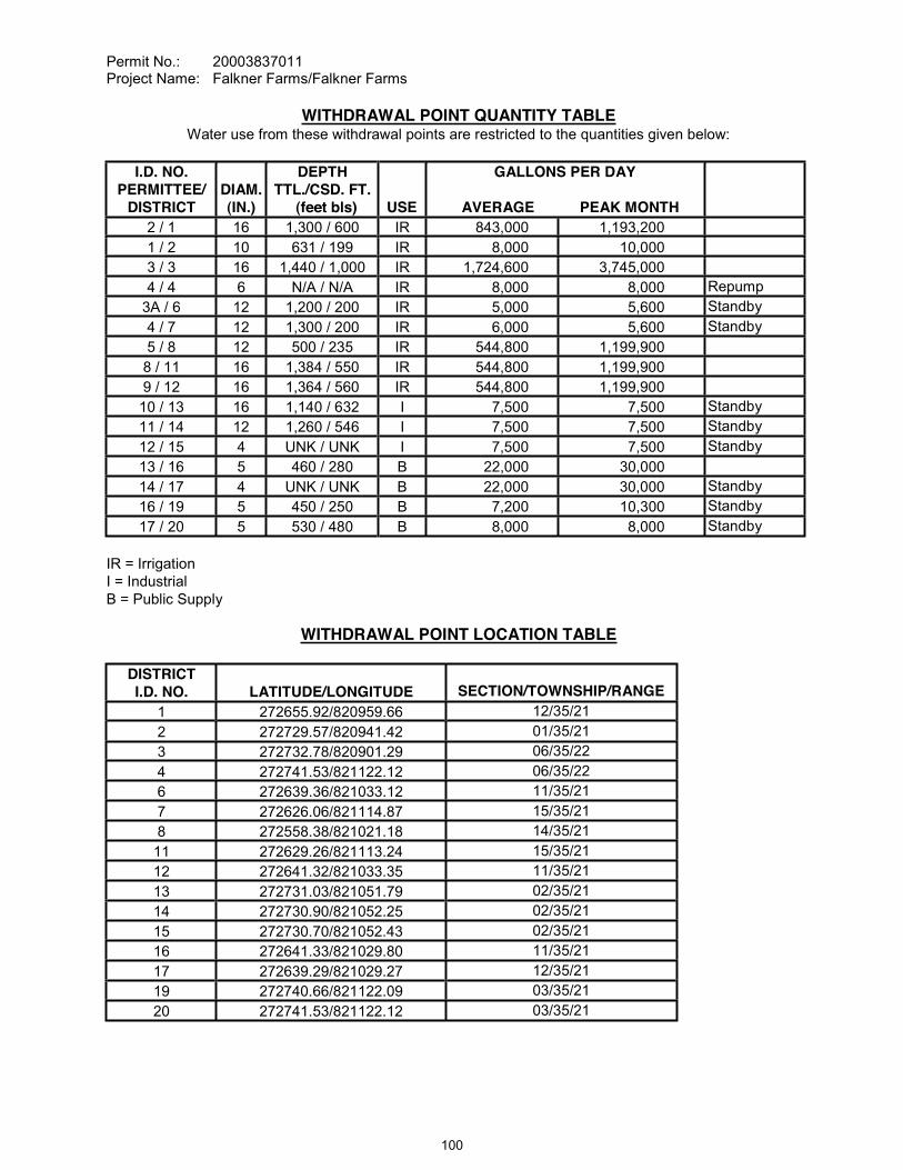
Permit No.: 20003837011Project Name: Falkner Farms/Falkner Farms
WITHDRAWAL POINT QUANTITY TABLEWater use from these withdrawal points are restricted to the quantities given below:
I.D. NO.PERMITTEE/
DISTRICTDIAM.(IN.)
DEPTHTTL./CSD. FT.
(feet bls) USE
GALLONS PER DAY
AVERAGE PEAK MONTH 2 / 1 16 1,300 / 600 IR 843,000 1,193,2001 / 2 10 631 / 199 IR 8,000 10,0003 / 3 16 1,440 / 1,000 IR 1,724,600 3,745,0004 / 4 6 N/A / N/A IR 8,000 8,000 Repump
3A / 6 12 1,200 / 200 IR 5,000 5,600 Standby4 / 7 12 1,300 / 200 IR 6,000 5,600 Standby5 / 8 12 500 / 235 IR 544,800 1,199,9008 / 11 16 1,384 / 550 IR 544,800 1,199,9009 / 12 16 1,364 / 560 IR 544,800 1,199,90010 / 13 16 1,140 / 632 I 7,500 7,500 Standby11 / 14 12 1,260 / 546 I 7,500 7,500 Standby12 / 15 4 UNK / UNK I 7,500 7,500 Standby13 / 16 5 460 / 280 B 22,000 30,00014 / 17 4 UNK / UNK B 22,000 30,000 Standby16 / 19 5 450 / 250 B 7,200 10,300 Standby17 / 20 5 530 / 480 B 8,000 8,000 Standby
IR = IrrigationI = IndustrialB = Public Supply
WITHDRAWAL POINT LOCATION TABLE
DISTRICTI.D. NO. LATITUDE/LONGITUDE SECTION/TOWNSHIP/RANGE
1 272655.92/820959.66 12/35/212 272729.57/820941.42 01/35/213 272732.78/820901.29 06/35/224 272741.53/821122.12 06/35/226 272639.36/821033.12 11/35/217 272626.06/821114.87 15/35/218 272558.38/821021.18 14/35/2111 272629.26/821113.24 15/35/2112 272641.32/821033.35 11/35/2113 272731.03/821051.79 02/35/2114 272730.90/821052.25 02/35/2115 272730.70/821052.43 02/35/2116 272641.33/821029.80 11/35/2117 272639.29/821029.27 12/35/2119 272740.66/821122.09 03/35/2120 272741.53/821122.12 03/35/21
100

Permit No.: 20003837011Project Name: Falkner Farms/Falkner Farms
STANDARD CONDITIONS:
The Permittee shall comply with the Standard Conditions attached hereto, incorporated herein by reference as Exhibit "A" and made a part hereof.
___________________________________________Authorized SignatureSOUTHWEST FLORIDA WATER MANAGEMENT DISTRICT
This permit, issued under the provision of Chapter 373, Florida Statutes and Florida Administrative Code 40D-2, authorizes the Permittee to withdraw the quantities outlined above, and may require various activities to be performed by the Permittee as described in the permit, including the Special Conditions. This permit does not convey to the Permittee any property rights or privileges other than those specified herein, nor relieve the Permittee from complying with any applicable local government, state, or federal law, rule, or ordinance.
101
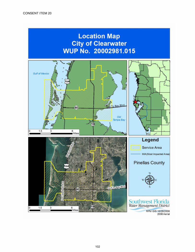
CONSENT ITEM 20
102
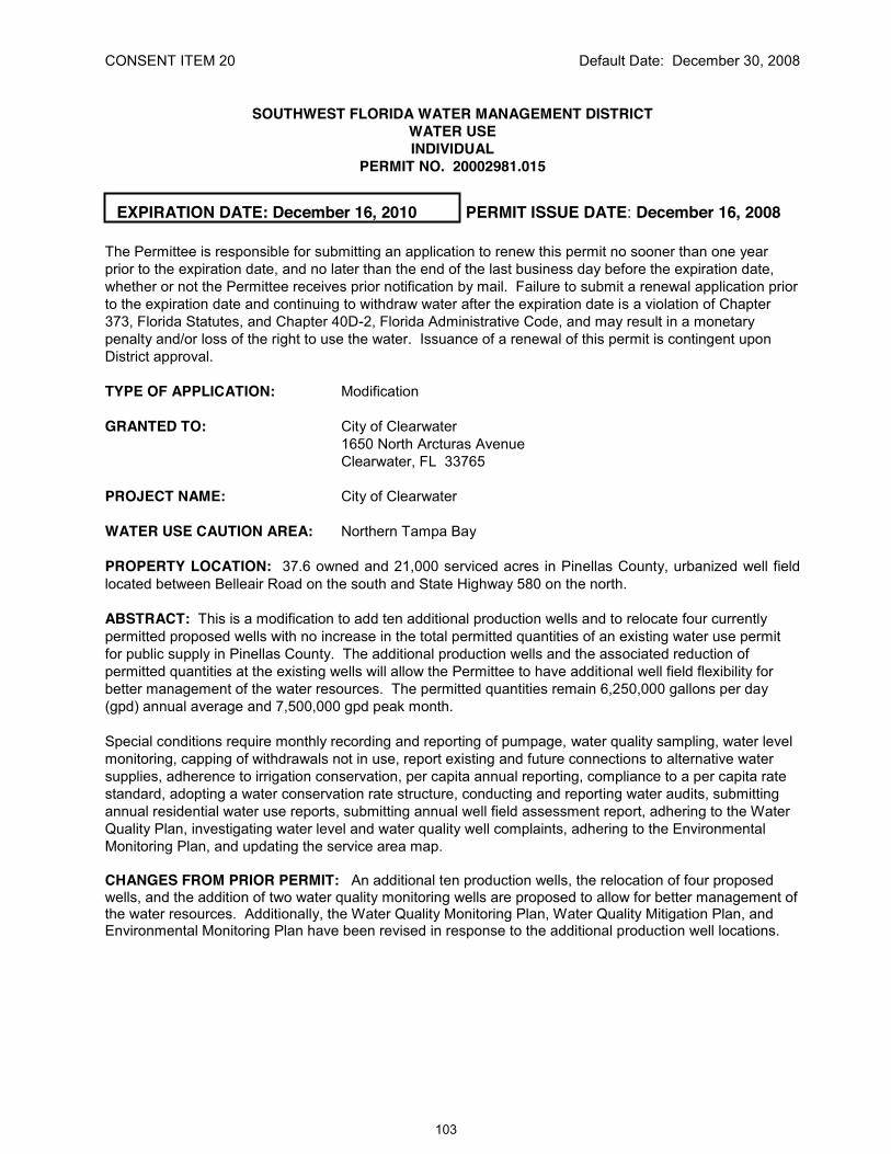
CONSENT ITEM 20 Default Date: December 30, 2008
SOUTHWEST FLORIDA WATER MANAGEMENT DISTRICTWATER USEINDIVIDUAL
PERMIT NO. 20002981.015
EXPIRATION DATE: December 16, 2010 PERMIT ISSUE DATE: December 16, 2008
The Permittee is responsible for submitting an application to renew this permit no sooner than one year prior to the expiration date, and no later than the end of the last business day before the expiration date, whether or not the Permittee receives prior notification by mail. Failure to submit a renewal application prior to the expiration date and continuing to withdraw water after the expiration date is a violation of Chapter 373, Florida Statutes, and Chapter 40D-2, Florida Administrative Code, and may result in a monetary penalty and/or loss of the right to use the water. Issuance of a renewal of this permit is contingent upon District approval.
TYPE OF APPLICATION: Modification
GRANTED TO: City of Clearwater1650 North Arcturas AvenueClearwater, FL 33765
PROJECT NAME: City of Clearwater
WATER USE CAUTION AREA: Northern Tampa Bay
PROPERTY LOCATION: 37.6 owned and 21,000 serviced acres in Pinellas County, urbanized well field located between Belleair Road on the south and State Highway 580 on the north.
ABSTRACT: This is a modification to add ten additional production wells and to relocate four currently permitted proposed wells with no increase in the total permitted quantities of an existing water use permit for public supply in Pinellas County. The additional production wells and the associated reduction of permitted quantities at the existing wells will allow the Permittee to have additional well field flexibility for better management of the water resources. The permitted quantities remain 6,250,000 gallons per day (gpd) annual average and 7,500,000 gpd peak month.
Special conditions require monthly recording and reporting of pumpage, water quality sampling, water level monitoring, capping of withdrawals not in use, report existing and future connections to alternative water supplies, adherence to irrigation conservation, per capita annual reporting, compliance to a per capita rate standard, adopting a water conservation rate structure, conducting and reporting water audits, submitting annual residential water use reports, submitting annual well field assessment report, adhering to the Water Quality Plan, investigating water level and water quality well complaints, adhering to the Environmental Monitoring Plan, and updating the service area map.
CHANGES FROM PRIOR PERMIT: An additional ten production wells, the relocation of four proposed wells, and the addition of two water quality monitoring wells are proposed to allow for better management of the water resources. Additionally, the Water Quality Monitoring Plan, Water Quality Mitigation Plan, and Environmental Monitoring Plan have been revised in response to the additional production well locations.
103

Permit No.: 20002981.015Project Name: City of Clearwater
Permit InformationPreviously Permitted
2001Requested
2010Authorized
2010
ANNUAL AVERAGE1 (gpd) 6,250,000 6,250 ,000 6,250,000Ground Water (gpd) 6,250,000 6,250,000 6,250,000Surface Water (gpd) 0 0 0
PEAK MONTH2 (gpd) 7,500,000 7,500,000 7,500,000Ground Water (gpd) 7,500,000 7.500,000 7,500,000Surface Water (gpd) 0 0 0
1 Annual Average is the total gallons in a year divided by 365 days per year2 Peak Month is the total gallons in the highest water-use month divided by the number of days in that month
1 Water Use Caution Areas Only2 Northern Tampa Bay Water Use Caution Area Only
Water Demand
Most Recently Submitted Data
(2007)Basis For Request
(2010)Authorized
(2010)Population Served 151,768 152,444 152,444Pumpage 3,489,238 6,250,000 6,250,000Imports (gpd) 9,167,338 6,097,964 6,097,964Exports (gpd) 0 0 0Treatment Losses (gpd) 430,000 435,000 435,000Gross Use (gpd) 12,226,000 12,347,964 12,347,964Gross Per Capita (gpd/person) 81 81 81
ADJUSTMENTSSignificant Uses1 (gpd) 653,100 653,100 653,100Environmental Mitigation1 (gpd) 0 0 0Reclaimed Water Credits2 1,588,800 1,588,800 1,588,800Desalination Credits 2 0 0 0
Adjusted gross per capita (gpd/person) 66 66 66Residential use (gpd) 7,968,306 8,004,810 8,004,810Residential per capita (gpd/person) 52 53 53Unaccounted water use (gpd) 761,493 761,493 761,493OTHER USES 3,496,201 3,496,201 3,496,201
104
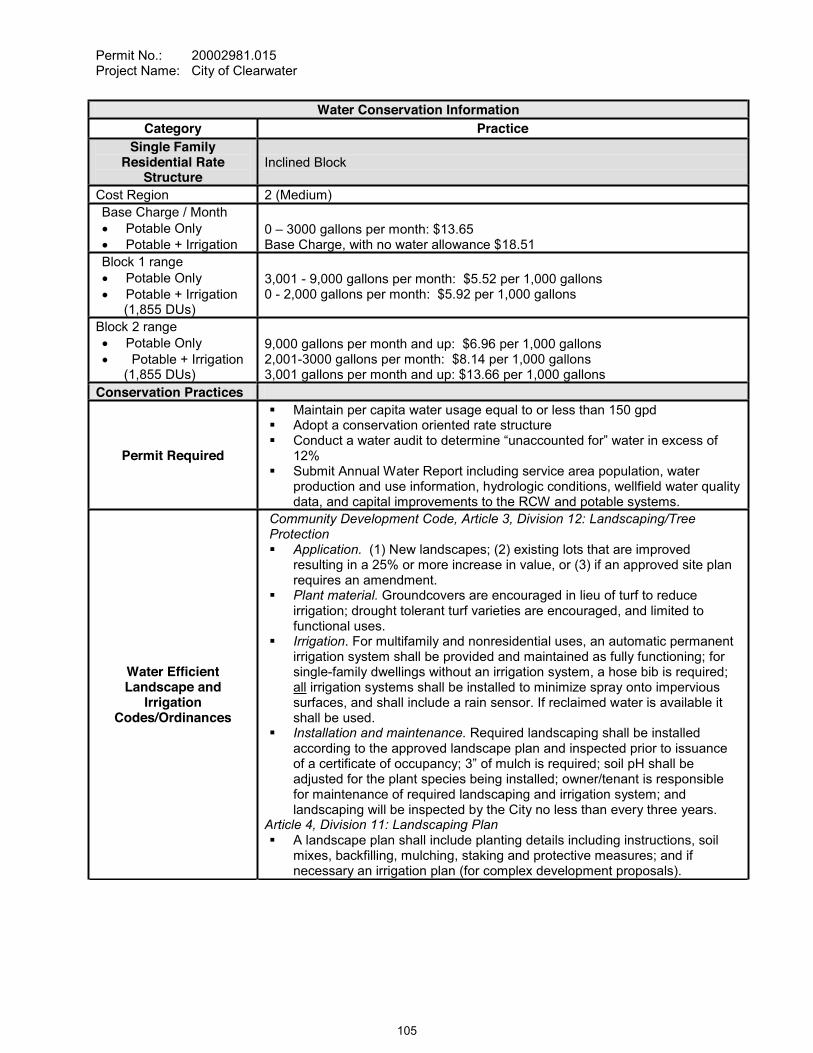
Permit No.: 20002981.015Project Name: City of Clearwater
Water Conservation Information Category Practice
Single FamilyResidential Rate
StructureInclined Block
Cost Region 2 (Medium)Base Charge / Month
Potable OnlyPotable + Irrigation
0 3000 gallons per month: $13.65Base Charge, with no water allowance $18.51
Block 1 range Potable OnlyPotable + Irrigation (1,855 DUs)
3,001 - 9,000 gallons per month: $5.52 per 1,000 gallons0 - 2,000 gallons per month: $5.92 per 1,000 gallons
Block 2 range Potable OnlyPotable + Irrigation
(1,855 DUs)
9,000 gallons per month and up: $6.96 per 1,000 gallons2,001-3000 gallons per month: $8.14 per 1,000 gallons3,001 gallons per month and up: $13.66 per 1,000 gallons
Conservation Practices
Permit Required
Maintain per capita water usage equal to or less than 150 gpdAdopt a conservation oriented rate structure
12%Submit Annual Water Report including service area population, water production and use information, hydrologic conditions, wellfield water quality data, and capital improvements to the RCW and potable systems.
Water Efficient Landscape and
Irrigation Codes/Ordinances
Community Development Code, Article 3, Division 12: Landscaping/Tree Protection
Application. (1) New landscapes; (2) existing lots that are improved resulting in a 25% or more increase in value, or (3) if an approved site plan requires an amendment.Plant material. Groundcovers are encouraged in lieu of turf to reduce irrigation; drought tolerant turf varieties are encouraged, and limited to functional uses.Irrigation. For multifamily and nonresidential uses, an automatic permanent irrigation system shall be provided and maintained as fully functioning; for single-family dwellings without an irrigation system, a hose bib is required; all irrigation systems shall be installed to minimize spray onto impervious surfaces, and shall include a rain sensor. If reclaimed water is available it shall be used.Installation and maintenance. Required landscaping shall be installed according to the approved landscape plan and inspected prior to issuance
adjusted for the plant species being installed; owner/tenant is responsible for maintenance of required landscaping and irrigation system; and landscaping will be inspected by the City no less than every three years.
Article 4, Division 11: Landscaping PlanA landscape plan shall include planting details including instructions, soil mixes, backfilling, mulching, staking and protective measures; and if necessary an irrigation plan (for complex development proposals).
105

Permit No.: 20002981.015Project Name: City of Clearwater
RECLAIMED WATER
CURRENT1
(2007)PROJECTED
(2010)3
Total wastewater flow (gpd) 13,487,000 14,120,000Reclaimed water available (gpd) 13,487,000 14,120,000Reclaimed water utilization (gpd) 3,500,000 7,490,000Beneficially used (gpd) 2 3,500,000 7,490,000Reclaimed water disposal (gpd) 9,987,000 6,630,000Potable quality water offset (gpd) 2,150,000 4,490,000Percent of potable quality water offset (%) 18% 36%Reclaimed water offset efficiency (%) 64% 60%
1 Florida Department of Environmental Protection Annual Report, (2007, Draft).2 Recharge Infiltration Basins are excluded from the FDEP report for this item.3 Regional Water Supply Plan (SWFWMD, 2006).
Water Conservation Information Category Practice
Public Information and Education Programs
Conservation information available online at: http://www.myclearwater.com/gov/depts/pwa/public_utils/divisions/water/conservation/index.asp
School education program for fifth grade science classes, including a water conservation kit for students and post program evaluation.
District water conservation publications distributed to the public Water conservation tips provided twice per year to customers in water bill.
106
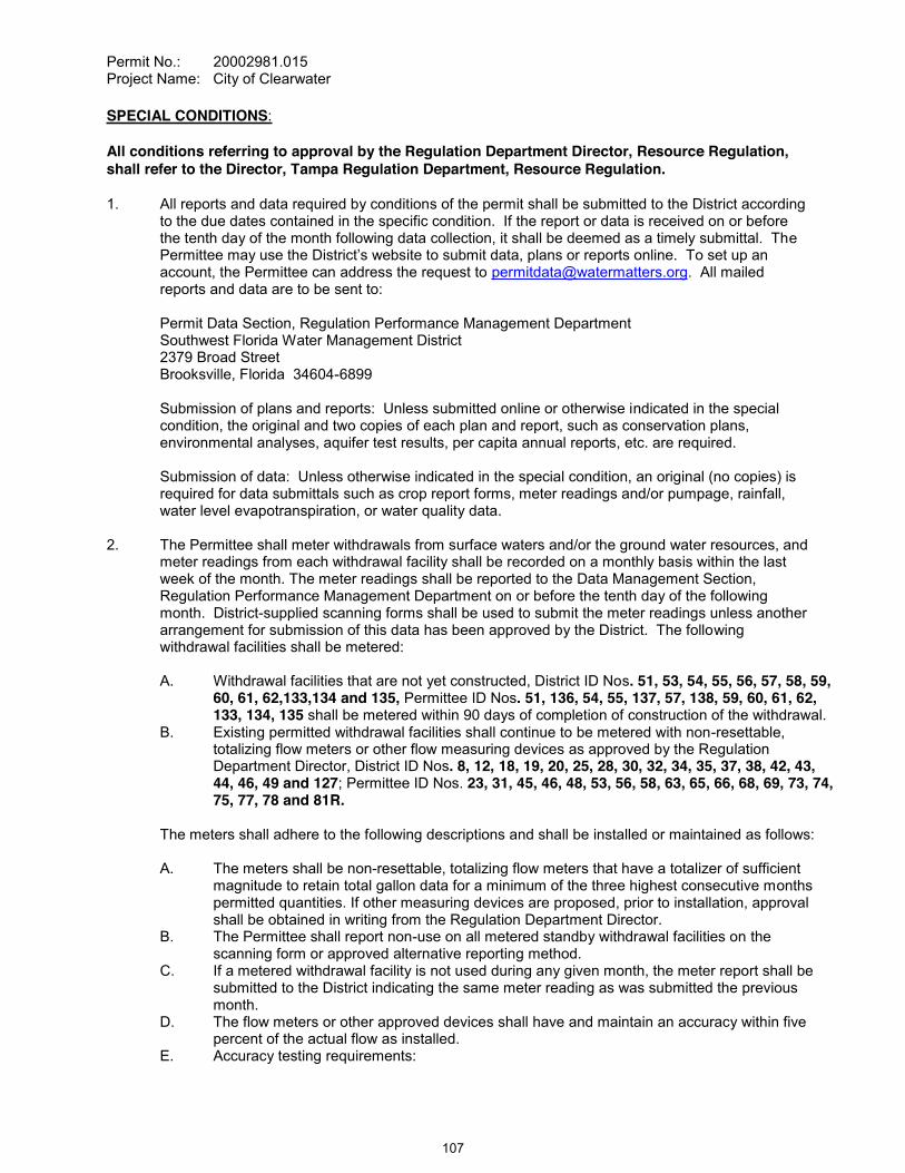
Permit No.: 20002981.015Project Name: City of Clearwater
SPECIAL CONDITIONS:
All conditions referring to approval by the Regulation Department Director, Resource Regulation, shall refer to the Director, Tampa Regulation Department, Resource Regulation.
1. All reports and data required by conditions of the permit shall be submitted to the District according to the due dates contained in the specific condition. If the report or data is received on or before the tenth day of the month following data collection, it shall be deemed as a timely submittal. The
account, the Permittee can address the request to [email protected]. All mailed reports and data are to be sent to:
Permit Data Section, Regulation Performance Management DepartmentSouthwest Florida Water Management District2379 Broad StreetBrooksville, Florida 34604-6899
Submission of plans and reports: Unless submitted online or otherwise indicated in the special condition, the original and two copies of each plan and report, such as conservation plans, environmental analyses, aquifer test results, per capita annual reports, etc. are required.
Submission of data: Unless otherwise indicated in the special condition, an original (no copies) is required for data submittals such as crop report forms, meter readings and/or pumpage, rainfall, water level evapotranspiration, or water quality data.
2. The Permittee shall meter withdrawals from surface waters and/or the ground water resources, and meter readings from each withdrawal facility shall be recorded on a monthly basis within the last week of the month. The meter readings shall be reported to the Data Management Section, Regulation Performance Management Department on or before the tenth day of the following month. District-supplied scanning forms shall be used to submit the meter readings unless another arrangement for submission of this data has been approved by the District. The following withdrawal facilities shall be metered:
A. Withdrawal facilities that are not yet constructed, District ID Nos. 51, 53, 54, 55, 56, 57, 58, 59, 60, 61, 62,133,134 and 135, Permittee ID Nos. 51, 136, 54, 55, 137, 57, 138, 59, 60, 61, 62, 133, 134, 135 shall be metered within 90 days of completion of construction of the withdrawal.
B. Existing permitted withdrawal facilities shall continue to be metered with non-resettable, totalizing flow meters or other flow measuring devices as approved by the Regulation Department Director, District ID Nos. 8, 12, 18, 19, 20, 25, 28, 30, 32, 34, 35, 37, 38, 42, 43, 44, 46, 49 and 127; Permittee ID Nos. 23, 31, 45, 46, 48, 53, 56, 58, 63, 65, 66, 68, 69, 73, 74, 75, 77, 78 and 81R.
The meters shall adhere to the following descriptions and shall be installed or maintained as follows:
A. The meters shall be non-resettable, totalizing flow meters that have a totalizer of sufficient magnitude to retain total gallon data for a minimum of the three highest consecutive months permitted quantities. If other measuring devices are proposed, prior to installation, approval shall be obtained in writing from the Regulation Department Director.
B. The Permittee shall report non-use on all metered standby withdrawal facilities on the scanning form or approved alternative reporting method.
C. If a metered withdrawal facility is not used during any given month, the meter report shall be submitted to the District indicating the same meter reading as was submitted the previous month.
D. The flow meters or other approved devices shall have and maintain an accuracy within five percent of the actual flow as installed.
E. Accuracy testing requirements:
107
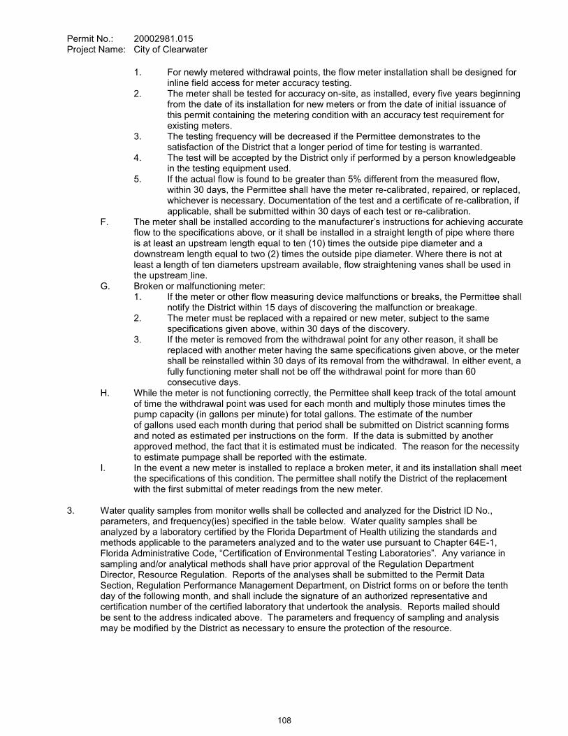
Permit No.: 20002981.015Project Name: City of Clearwater
1. For newly metered withdrawal points, the flow meter installation shall be designed for inline field access for meter accuracy testing.
2. The meter shall be tested for accuracy on-site, as installed, every five years beginning from the date of its installation for new meters or from the date of initial issuance of this permit containing the metering condition with an accuracy test requirement for existing meters.
3. The testing frequency will be decreased if the Permittee demonstrates to the satisfaction of the District that a longer period of time for testing is warranted.
4. The test will be accepted by the District only if performed by a person knowledgeable in the testing equipment used.
5. If the actual flow is found to be greater than 5% different from the measured flow, within 30 days, the Permittee shall have the meter re-calibrated, repaired, or replaced, whichever is necessary. Documentation of the test and a certificate of re-calibration, if applicable, shall be submitted within 30 days of each test or re-calibration.
F. The meter shall be installed according to the manufactflow to the specifications above, or it shall be installed in a straight length of pipe where there is at least an upstream length equal to ten (10) times the outside pipe diameter and a downstream length equal to two (2) times the outside pipe diameter. Where there is not at least a length of ten diameters upstream available, flow straightening vanes shall be used in the upstream line.
G. Broken or malfunctioning meter:1. If the meter or other flow measuring device malfunctions or breaks, the Permittee shall
notify the District within 15 days of discovering the malfunction or breakage.2. The meter must be replaced with a repaired or new meter, subject to the same
specifications given above, within 30 days of the discovery. 3. If the meter is removed from the withdrawal point for any other reason, it shall be
replaced with another meter having the same specifications given above, or the meter shall be reinstalled within 30 days of its removal from the withdrawal. In either event, a fully functioning meter shall not be off the withdrawal point for more than 60 consecutive days.
H. While the meter is not functioning correctly, the Permittee shall keep track of the total amount of time the withdrawal point was used for each month and multiply those minutes times the pump capacity (in gallons per minute) for total gallons. The estimate of the number of gallons used each month during that period shall be submitted on District scanning forms and noted as estimated per instructions on the form. If the data is submitted by another approved method, the fact that it is estimated must be indicated. The reason for the necessity to estimate pumpage shall be reported with the estimate.
I. In the event a new meter is installed to replace a broken meter, it and its installation shall meet the specifications of this condition. The permittee shall notify the District of the replacement with the first submittal of meter readings from the new meter.
3. Water quality samples from monitor wells shall be collected and analyzed for the District ID No., parameters, and frequency(ies) specified in the table below. Water quality samples shall be analyzed by a laboratory certified by the Florida Department of Health utilizing the standards and methods applicable to the parameters analyzed and to the water use pursuant to Chapter 64E-1,
sampling and/or analytical methods shall have prior approval of the Regulation Department Director, Resource Regulation. Reports of the analyses shall be submitted to the Permit Data Section, Regulation Performance Management Department, on District forms on or before the tenth day of the following month, and shall include the signature of an authorized representative and certification number of the certified laboratory that undertook the analysis. Reports mailed should be sent to the address indicated above. The parameters and frequency of sampling and analysis may be modified by the District as necessary to ensure the protection of the resource.
108
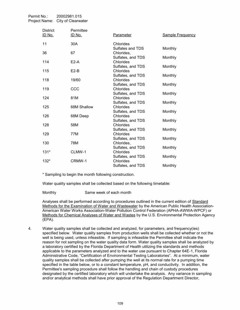
Permit No.: 20002981.015Project Name: City of Clearwater
District PermitteeID No. ID No. Parameter Sample Frequency
11 30A ChloridesSulfates and TDS Monthly
36 67 Chlorides, Sulfates, and TDS Monthly
114 E2-A ChloridesSulfates, and TDS Monthly
115 E2-B ChloridesSulfates, and TDS Monthly
118 19/60 ChloridesSulfates, and TDS Monthly
119 CCC ChloridesSulfates, and TDS Monthly
124 81M ChloridesSulfates, and TDS Monthly
125 68M Shallow ChloridesSulfates, and TDS Monthly
126 68M Deep ChloridesSulfates, and TDS Monthly
128 58M ChloridesSulfates, and TDS Monthly
129 77M ChloridesSulfates, and TDS Monthly
130 78M Chlorides,Sulfates, and TDS Monthly
131* CLMW-1 ChloridesSulfates, and TDS Monthly
132* CRMW-1 ChloridesSulfates, and TDS Monthly
* Sampling to begin the month following construction.
Water quality samples shall be collected based on the following timetable:
Monthly Same week of each month
Analyses shall be performed according to procedures outlined in the current edition of Standard Methods for the Examination of Water and Wastewater by the American Public Health Association-American Water Works Association-Water Pollution Control Federation (APHA-AWWA-WPCF) or Methods for Chemical Analyses of Water and Wastes by the U.S. Environmental Protection Agency (EPA).
4. Water quality samples shall be collected and analyzed, for parameters, and frequency(ies) specified below. Water quality samples from production wells shall be collected whether or not the well is being used, unless infeasible. If sampling is infeasible the Permittee shall indicate the reason for not sampling on the water quality data form. Water quality samples shall be analyzed by a laboratory certified by the Florida Department of Health utilizing the standards and methods applicable to the parameters analyzed and to the water use pursuant to Chapter 64E-1, Florida
quality samples shall be collected after pumping the well at its normal rate for a pumping time specified in the table below, or to a constant temperature, pH, and conductivity. In addition, the Permittee's sampling procedure shall follow the handling and chain of custody procedures designated by the certified laboratory which will undertake the analysis. Any variance in sampling and/or analytical methods shall have prior approval of the Regulation Department Director,
109
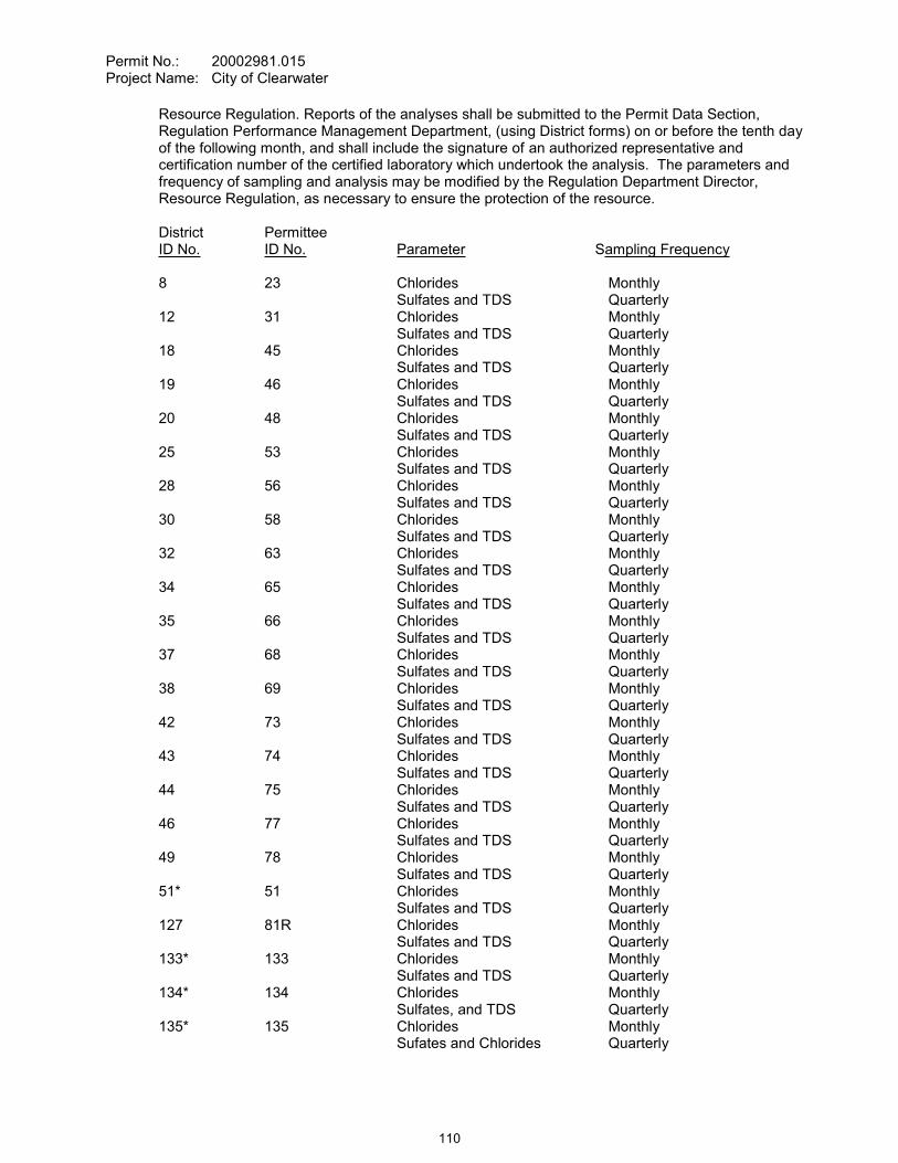
Permit No.: 20002981.015Project Name: City of Clearwater
Resource Regulation. Reports of the analyses shall be submitted to the Permit Data Section, Regulation Performance Management Department, (using District forms) on or before the tenth day of the following month, and shall include the signature of an authorized representative and certification number of the certified laboratory which undertook the analysis. The parameters and frequency of sampling and analysis may be modified by the Regulation Department Director, Resource Regulation, as necessary to ensure the protection of the resource.
District PermitteeID No. ID No. Parameter Sampling Frequency
8 23 Chlorides MonthlySulfates and TDS Quarterly
12 31 Chlorides MonthlySulfates and TDS Quarterly
18 45 Chlorides MonthlySulfates and TDS Quarterly
19 46 Chlorides MonthlySulfates and TDS Quarterly
20 48 Chlorides MonthlySulfates and TDS Quarterly
25 53 Chlorides MonthlySulfates and TDS Quarterly
28 56 Chlorides MonthlySulfates and TDS Quarterly
30 58 Chlorides MonthlySulfates and TDS Quarterly
32 63 Chlorides MonthlySulfates and TDS Quarterly
34 65 Chlorides MonthlySulfates and TDS Quarterly
35 66 Chlorides MonthlySulfates and TDS Quarterly
37 68 Chlorides MonthlySulfates and TDS Quarterly
38 69 Chlorides MonthlySulfates and TDS Quarterly
42 73 Chlorides MonthlySulfates and TDS Quarterly
43 74 Chlorides MonthlySulfates and TDS Quarterly
44 75 Chlorides MonthlySulfates and TDS Quarterly
46 77 Chlorides MonthlySulfates and TDS Quarterly
49 78 Chlorides MonthlySulfates and TDS Quarterly
51* 51 Chlorides MonthlySulfates and TDS Quarterly
127 81R Chlorides MonthlySulfates and TDS Quarterly
133* 133 Chlorides MonthlySulfates and TDS Quarterly
134* 134 Chlorides MonthlySulfates, and TDS Quarterly
135* 135 Chlorides MonthlySufates and Chlorides Quarterly
110

Permit No.: 20002981.015Project Name: City of Clearwater
* Sampling to begin the month following well construction.
Water quality samples shall be collected based on the following timetable:
Monthly Same week of each monthQuarterly Same week of months specified
Analyses shall be performed according to procedures outlined in the current edition of Standard Methods for the Examination of Water and Wastewater by the American Public Health Association-American Water Works Association-Water Pollution Control Federation (APHA-AWWA-WPCF) or Methods for Chemical Analyses of Water and Wastes by the U.S. Environmental Protection Agency (EPA).
5. The Permittee shall monitor water levels at the well locations and frequencies specified below. The frequency of the monitoring may be modified by the District, as necessary to ensure the protection of the resource.
District PermitteeID No. ID No. Parameter Sample Frequency36 67 Water levels Monthly114 E2-A Water levels Monthly115 E2-B Water levels Monthly116 CAP A water levels Monthly117 CAP B Water levels Monthly118 19/60 Water levels Monthly119 CCC Water levels Monthly124 81M Water levels Monthly125 68M Shallow Water levels Monthly126 68M Deep Water levels Monthly128 58M Water levels Monthly129 77M Water levels Monthly130 78M Water levels Monthly
6. At such time as the chloride concentration in any water sample reaches the designated Action Levels designated below, the Permittee shall take appropriate action to reduce concentrations to below those set for the particular well. These measures may include, but shall not necessarily be limited to those listed in the City off Clearwater Well Field Water Quality Action Plan submitted on September 9, 2008, in support of the permit modification application. Sample concentration readings in excess of the concentrations designated below may occur, provided long-term upward trends or other significant water quality changes do not occur. If the District determines that long-term upward trends or other significant water quality changes are occurring, the District may reconsider the quantities permitted.
ChlorideDistrict Permittee ActionID No. ID No. Level (mg/l)
11 30A 250114 E2-A 350115 E2-B 300118 19/60 250119 CCC 250125 68M Shallow 250126 68M Deep 350128 58M 250129 77M 350130 78M 250
111
Permit No.: 20002981.015Project Name: City of Clearwater
Subsequent to permit issuance, the Permittee may request in writing, a review of the water quality concentration limits by the Regulation Department Director, Resource Regulation, on the basis that the limits are not feasible to attain. Prior to the request for concentration limits review, the Permittee shall document in writing to the District that all feasible wellfield management measures have been explored within reasonable limits to attain compliance with the concentration limits specified in this permit. The Permittee's written request for review of the limits must include a proposal (well by well) of the lowest feasible concentration limits (based on a review of observed field data) to the Director for consideration. This proposal shall include predictions of changes to the location of the saltwater interface, both laterally and vertically, which may result from the proposed increased limits. If the Director accepts, in writing, that the Permittee has explored all feasible wellfield management measures within reasonable limits, that the Permittee cannot attain compliance with the concentration limits, and increasing the limits will not cause adverse impacts, the Director may consider modifying concentration limits for each well. If new limits are specified by the District, these shall supersede the limits listed in this permit.
Bi-Annual Water Quality Conditions ReportChloride concentration data from the City's production and monitor wells will be evaluated on a bi-annual basis. The results will be summarized in bi-annual reports to the District with the first report due April 1, 2009. Statistical analysis of chloride concentration, water level, and production data will be conducted to verify trends. If upward chloride trends are identified then the appropriate actions in the July 15, 2008 City of Clearwater Water Quality Action Plan will be implemented.
7. By November 28, 2010, the Permittee shall submit a summary of water quality data collected under this permit. After review of this information, the District shall set chloride Action Levels for District ID Nos. 131 and 132, Permittee ID Nos. CLMW-1 and CRMW-1. The Permittee shall be notified in writing by the Regulation Department Director, Resource Regulation, of the concentration limits which have been set. At such time as the concentration in any water sample reaches or exceeds the designated concentration limits, the Permittee shall take appropriate action to reduce concentrations to below those set for the particular well. If the District determines that long-term upward trends or other significant water quality changes are occurring, the District may reconsider the quantities permitted.
8. The District reserves the right to set chloride, sulfate, and/or total dissolved solids concentration limits on any production well in the future, based on data collected and after a sufficient data base has been established to determine limits. These limits shall be required after discussions with the Permittee. At such time as the concentration in any water sample reaches or exceeds the designated concentration limits, the Permittee shall take appropriate action to reduce concentrations to below those set for the particular well. If the District determines that long-term upward trends or other significant water quality changes are occurring, the District may reconsider the quantities permitted.
9. The Permittee shall prepare a comprehensive and concise annual report describing the operation of the withdrawal facilities and an assessment of the water resources and environmental systems. An assessment of the water resources and environmental systems of the wellfield area is required for all sections listed below. This report shall concisely summarize the elements listed below, with emphasis on the interactions between these elements, where appropriate. Data sources shall be referenced, but no raw data shall be included in the report. Only essential text, graphs, and tables should be included in the report. Six copies of the report shall be submitted to the Permit Data Section, Regulation Performance Management Department, by April 1of each year. The report shall cover the preceding water year period from October 1 to September 30. The specific elements of this report are listed below:
A. Water UseAny changes to the service area boundaries shall be described in the text and plotted on a map. The Permittee shall submit a report detailing:
112

Permit No.: 20002981.015Project Name: City of Clearwater
1. The population served;2. Significant deducted uses, the associated quantity, and conservation measures
applied to these uses;3. Total withdrawals;4. Treatment losses.5. Environmental mitigation quantities.6. Sources and quantities of incoming and outgoing transfers of water and wholesale
purchases and sales of water, with quantities determined at the supplier's departure point.
B. Hydrologic and Environmental ConditionsData collected through Condition Nos. 2, 3, 4, 5, 6 and 7 of this permit shall be used to determine the effects of pumpage at the wellfield on the following:
1. movement of the fresh/saltwater interface;2. surficial aquifer water levels;3. potentiometric surface levels;4. lake levels;5. stream discharge; and6. wetlands vegetation.
Statistical trend analysis, such as double-mass curve analysis, multiple linear regression, time series analysis and factor analysis shall be performed to analyze the interactions of rainfall and pumpage on movement of the fresh/saltwater interface, surficial water levels, potentiometric surface levels in the semi-confined aquifers, lake and wetland water levels, stream discharge, treefalls per unit area, rate of soil subsidence, and evidence of vegetational succession, uplands vegetation and wetlands vegetation. Data shall be obtained through field measurements and aerial photo interpretation. A brief summary of any recommended changes to the monitoring requirements shall be provided.
C. Investigation of ComplaintsA summary of the investigations of complaints and mitigation activities related to the withdrawals, for the annual reporting periods shall be provided. This summary shall include:
1. Number and type of complaints;2. Number and type of mitigation activity(ies);3. Number and type of complaints which did not require mitigation activity; and4. Total cost of all mitigation activity.
D. Environmental MitigationA summary of any environmental mitigation that was determined to be necessary due to withdrawals shall be provided.
E. Status of Well Construction and FacilitiesA summary of the status of construction of all production and monitor wells, transmission mains, and the pump station shall be provided. This shall include anticipated completion dates for construction of these facilities, as well as anticipated or actual dates for initiation of their use. The requirement shall end after the annual report which specifies that all wells, transmission mains, and the pump station are in operation.
F. Conditions Affecting Continued OperationFor the annual reporting period, conditions affecting the continued operation or retirement of each county or municipally owned well shall be documented. The reasons for continued use, significant increases or reductions in use, or retirement of a well shall be provided.
113
Permit No.: 20002981.015Project Name: City of Clearwater
Any action taken on retired wells during the annual reporting period shall be summarized in the annual report.
10. The Permittee shall have a per capita water rate equal to or less than 150 gpd, and this standard shall remain in effect until modified by rule.
By April 1 of each year for the preceding calendar year or fiscal year (October 1 through September 30), the Permittee shall submit a report detailing:
A. The population served;B. Significant deducted uses, the associated quantity, and conservation measures applied to
these uses;C. Total withdrawals;D. Treatment losses.E. Environmental mitigation quantities.F. Sources and quantities of incoming and outgoing transfers of water and wholesale
purchases and sales of water, with quantities determined at the supplier's departure point.G. Documentation of reuse and desalination credits, if taken.
If for some reason, the Permittee does not achieve the specified per capita rate, the report shall document why the rate and requirements were not achievable, measures taken to attempt meeting them, and a plan to bring the permit into compliance. This report is subject to District approval. If the report is not approved, the Permittee is in violation of the Water Use Permit.
The District will evaluate information submitted by Permittees who do not achieve these requirements to determine whether the lack of achievement is justifiable and a variance is warranted. Permittees may justify lack of achievement by documenting unusual water needs, such as larger-than-average lot sizes with greater water irrigation needs than normal-sized lots. However, even with such documented justification, phased reductions in water use shall be required unless the District determines that water usage was reasonable under the circumstances reported and that further reductions are not feasible. For such Permittees, on a case-by-case basis, individual water conservation requirements may be developed. Per capita rate requirements may be adjusted upward or downward through rulemaking and will become requirements.
11. The Permittee shall adopt a water conserving rate structure within one year of permit issuance.Within 18 months of the permit issuance, the Permittee shall submit a report on the rate structure that includes but is not limited to a description of the structure, how each component is designed to promote water conservation among the Permittees customers, and how it is expected to reduce the Permittee's gross per capita water use. After the first report submitted, a update on the rate structure and a summary of its effectiveness shall be included with the Annual Report by April 1 of each year.
12. By April 1 of each year, the Permittee shall submit a residential water use report for the preceding calendar year or fiscal year (October 1, through September 30), detailing:
A. The number of single family dwelling units served and their total water use,B. The number of multi-family dwelling units served and their total water use,C. The number of mobile homes served and their total water use.
Where separate indoor and outdoor meters exist, residential water use quantities shall include both the indoor and outdoor water uses associated with the dwelling units, including irrigation water.
13. By January 1 of each year for the preceding calendar year or fiscal year (October 1 through September 30), the Permittee shall submit a report detailing:
114
Permit No.: 20002981.015Project Name: City of Clearwater
A. Quantity of total reclaimed water provided by the Permittee for reuse on both a total annual average daily and monthly basis;
B. For all individual customer reuse connections with line sizes of 4 inches or greater, list:
1. account name and address;2. location of connections by latitude - longitude;3. line size;4. meter (yes or no); and5. metered quantities, if metered.
14. A. Environmental Monitoring
1. Data CollectionThe Permittee shall maintain and monitor the environmental monitoring sites included in the report entitled Amendment to the City of Clearwater Environmental Management Plan dated September 2008. Any ecological data collection sites which have not been surveyed to National Geodetic Vertical Datum (NGVD) at the time of permit issuance shall be surveyed by July 30, 2009.
All Water levels for monitor wells and staff gauges shall be referenced to NGVD, reported in a form acceptable to the District and provided to the District in the Wetland Environmental Monitoring Report due on April 1st of each year. Changes to the methodology, extent, or frequency of monitoring at any of these sites may be modified by the Regulation Department Director, Resource Regulation, as necessary to ensure the protection of the resources.
2. Annual and Interpretive ReportsThe Permittee shall submit an annual environmental monitoring data summary by April 1st of each year for the preceding water year (October 1 - September 30).The summary shall include all raw data, essential graphs, tables, and text, with little or no interpretive discussion. Monitoring progress at each site shall be summarized in the annual report, as specified below. The Permittee shall submit three copies of Wetland Environmental Monitoring Report interpretive reports over the term of the permit by April 1st of each year and one six months prior to the expiration date of this permit. Interpretive reports of wellfield environmental conditions shall incorporate all environmental monitoring sites used for the wellfield. The reports shall investigate relationships between water level fluctuations, wellfield pumpage, atmospheric conditions, and drainage factors related to the environmental condition of the wetlands in the vicinity of the wellfield. Pumpage data, wetland, water level data collected from each aquifer for the wellfield and for the region, and environmental parameters collected at the wellfield and in the region shall be used for the interpretive report results.
3. Latitude/Longitude Locations for Environmental SitesBy April 1, 2010, the Permittee shall provide the location of each staff gauge and monitor well identified in the Amendment to the City of Clearwater Environmental Management Plan dated September 2008. The Permittee shall also provide a table which correlates the Permittee Identification Number and latitude/longitude location for each qualitative and quantitative monitoring site.
A. Environmental Mitigation PlanIf adverse environmental impacts due to pumpage are detected, the Permittee shall undertake mitigation to alleviate the impacts.
115

Permit No.: 20002981.015Project Name: City of Clearwater
B. Annual ReportA summary report of surface water conditions, environmental conditions that have occurred during the annual reporting period shall be summarized in the annual report.
15. The Permittee is encouraged to demonstrate that beneficial reuse of treated effluent is maximized so that 50% or more of the total annual treated effluent flow is beneficially reused. The calculation of the percentage beneficially reused will be based on the Permittee's waste water treatment plants that have a capacity of 0.5 million gallons per day or greater. Beneficial reuse includes:
A. Landscape irrigation of golf courses, playing fields, cemeteries, parks, playgrounds, school yards, retail nurseries and commercial, industrial and residential properties.
B.flowers", sod farms and improved pastures.
C. Ground water recharge where such recharge results in environmental or water supply benefit.
D. Industrial uses for cooling water, process water and wash waters.E. Wetlands restoration.F. Fire protection.G. Environmental enhancement, including discharges to surface waters to replace
withdrawals.Other useful purposes accepted by the District or allowed under a DEP permit pursuant to Chapter 62-610, F.A.C.
16. The Permittee shall investigate withdrawal related water quality well complaints associated with the City of Clearwater's wellfield. The complaint handling/mitigation procedure shall be as follows:
A. Within 48 hours of complaint receipt by the Permittee, the Permittee shall perform a preliminary investigation and determine whether the Permittee's withdrawals may have caused the problem.
B. If this preliminary assessment indicates that the Permittee may be responsible, the Permittee shall, within 72 hours of complaint receipt, supply the complainant with any necessary drinking water.
C. If the detailed investigation confirms that the complainant's problem was caused by the Permittee's withdrawals, the permittee shall act in accordance with the procedures mandated by the City of Clearwater Well Mitigation Plan (Ordinance 7764-07, Division 4, January 18, 2006) and the City of Clearwater Wellfield Water Quality Well Impact Mitigation Plan.
D. If the resulting investigation determines that the Permittee was not responsible for the well problem, the Permittee shall document the reasons for this determination.
E. The Permittee shall file a report of the complaint, the findings of facts, appropriate technical data, and any mitigating action taken or to be taken by the Permittee, to the Regulation Department Director, Resource Regulation, for review and approval within 20 days of the receipt of any complaint. The report shall include:
1. The name and address of each complainant;2. The date and nature of the complaint;3. A summary of the Permittee's investigation;4. A summary of the Permittee's determination, including details of any mitigation
activities; and5. Cost of mitigation activity for each complaint.
A copy of the report shall also be sent to the complainant within 20 days of complaint receipt.
17. The Permittee shall investigate withdrawal related water level well complaints associated with the City of Clearwater's wellfield. The complaint handling/mitigation procedure shall be as follows:
116
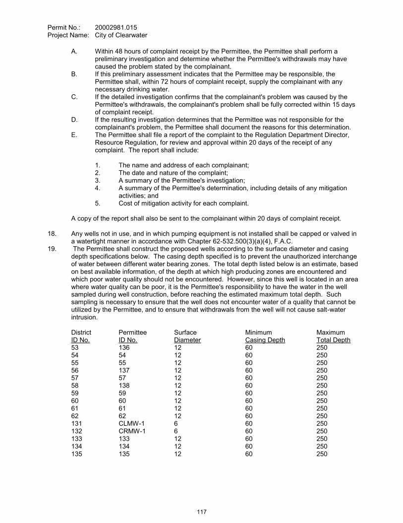
Permit No.: 20002981.015Project Name: City of Clearwater
A. Within 48 hours of complaint receipt by the Permittee, the Permittee shall perform a preliminary investigation and determine whether the Permittee's withdrawals may have caused the problem stated by the complainant.
B. If this preliminary assessment indicates that the Permittee may be responsible, the Permittee shall, within 72 hours of complaint receipt, supply the complainant with any necessary drinking water.
C. If the detailed investigation confirms that the complainant's problem was caused by the Permittee's withdrawals, the complainant's problem shall be fully corrected within 15 days of complaint receipt.
D. If the resulting investigation determines that the Permittee was not responsible for thecomplainant's problem, the Permittee shall document the reasons for this determination.
E. The Permittee shall file a report of the complaint to the Regulation Department Director, Resource Regulation, for review and approval within 20 days of the receipt of any complaint. The report shall include:
1. The name and address of each complainant;2. The date and nature of the complaint;3. A summary of the Permittee's investigation;4. A summary of the Permittee's determination, including details of any mitigation
activities; and5. Cost of mitigation activity for each complaint.
A copy of the report shall also be sent to the complainant within 20 days of complaint receipt.
18. Any wells not in use, and in which pumping equipment is not installed shall be capped or valved in a watertight manner in accordance with Chapter 62-532.500(3)(a)(4), F.A.C.
19. The Permittee shall construct the proposed wells according to the surface diameter and casing depth specifications below. The casing depth specified is to prevent the unauthorized interchange of water between different water bearing zones. The total depth listed below is an estimate, based on best available information, of the depth at which high producing zones are encountered and which poor water quality should not be encountered. However, since this well is located in an area where water quality can be poor, it is the Permittee's responsibility to have the water in the well sampled during well construction, before reaching the estimated maximum total depth. Such sampling is necessary to ensure that the well does not encounter water of a quality that cannot be utilized by the Permittee, and to ensure that withdrawals from the well will not cause salt-water intrusion.
District Permittee Surface Minimum MaximumID No. ID No. Diameter Casing Depth Total Depth53 136 12 60 25054 54 12 60 25055 55 12 60 25056 137 12 60 25057 57 12 60 25058 138 12 60 25059 59 12 60 25060 60 12 60 25061 61 12 60 25062 62 12 60 250131 CLMW-1 6 60 250132 CRMW-1 6 60 250133 133 12 60 250134 134 12 60 250135 135 12 60 250
117

Permit No.: 20002981.015Project Name: City of Clearwater
a. The casing shall be continuous from land surface to the minimum depth stated above.b. All well casing (including liners and/or pipe) must be sealed to the depth specified above.c. The proposed wells shall be constructed of materials that are resistant to degradation of the
casing/grout due to interaction with the water of lesser quality. A minimum grout thickness of two (2) inches is required on wells four (4) inches or more in diameter.
d. A minimum of twenty (20) feet overlap and two (2) centralizers is required for Public Supply wells, and all wells six (6) inches or more in diameter.
e. The finished well casing depth shall not vary from these specifications by greater than ten (10) percent unless advance approval is granted by the Regulation Department Director, Resource Regulation, or the Supervisor of the Well Construction Permitting Section in Brooksville.
f. The finished well total depth shall not exceed the suggested maximum total depth by greater than ten (10) percent unless advance approval is granted by the Regulation Department Director, Resource Regulation, or the Supervisor of the Well Construction Permitting Section in Brooksville.
g. Advance approval from the Regulation Department Director, Resource Regulation, is necessary should the Permittee propose to change the well location or casing diameter.
20. The average day, peak monthly, and maximum daily, if applicable, quantities for District ID Nos. 8,12, 18, 19, 20, 25, 28, 30, 32, 34, 35, 37, 38, 42, 43, 44, 46, 49, 51, 53, 54, 55, 56, 57, 58, 59, 60, 61, 62, 127, 133,134 and 135, Permittee ID Nos. 23, 31, 45, 46, 48, 53, 56, 58, 63, 65, 66, 68, 69, 73, 74, 75, 77, 78, 51, 136, 54, 55, 137, 57, 138, 59, 60, 61, 62, 81R, 133, 134 and 135 above in the production withdrawal table are estimates based on historic and/or projected distribution of pumpage, and are for water use inventory and impact analysis purposes. The quantities listed in the table for these individual sources are not intended to dictate the distribution of pumpage from permitted sources. The Permittee may make adjustments in pumpage distribution as necessary but no greater than the flexibility quantities reflected by the permit, so long as adverse environmental impacts do not result and other conditions of this Permit are complied with. In all cases, the total average annual daily withdrawal and the total peak monthly daily withdrawal are limited to the quantities set forth above.
21. Compliance with the allocated standard annual average quantity and drought annual average quantities is based on a rolling 12-month calculation where the current pumpage is added to the pumpage for the previous 11 months, and the total is then divided by the number of days in those 12 months for gallons per day. If the Permittee exceeds the allocated standard annual average quantity or drought annual average quantities during any month, within 30 days the Permittee must submit a report to the District that includes reasons why the allocated quantities were exceeded, efforts already taken to attempt meeting the allocated quantities, and a plan to bring the permit into compliance. Reports for Permittees not achieving the allocated quantities are subject to District approval. Justification for exceeding the allocated quantities does not constitute a waiver of the District's authority to enforce the terms and conditions of the permit.
118

Permit No.: 20002981.015Project Name: City of Clearwater
WITHDRAWAL POINT QUANTITY TABLEWater use from these withdrawal points are restricted to the quantities given below:
I.D. NO.PERMITTEE/
DISTRICTDIAM.(IN.)
DEPTHTTL./CSD.FT.
(feet bls) USE
GALLONS PER DAY
AVERAGE PEAK MONTH23 / 8 10 157 / 65 B 488,000 633,800
880,000 1,056,000 Withdrawal Flexibility31 / 12 10 152 / 70 B 264,000 316,900
500,000 540,000 Withdrawal Flexibility45 / 18 10 198 / 67 B 151,400 181,700
400,000 425,000 Withdrawal Flexibility46 / 19 10 195 / 64 B 230,100 276,700
400,000 405,000 Withdrawal Flexibility48 / 20 10 250 / 67 B 264,000 316,900
450,000 540,000 Withdrawal Flexibility53 / 25 12 170 / 74 B 200,200 125,900
200,000 250,000 Withdrawal Flexibility56 / 28 12 199 / 88 B 123,200 147,900
240,000 250,000 Withdrawal Flexibility58 / 30 12 276 / 91 B 102,100 122,500
205,000 220,000 Withdrawal Flexibility63 / 32 12 220 / 74 B 105,600 126,700
210,000 245,000 Withdrawal Flexibility65 / 34 12 300 / 65 B 132,000 158,400
331,200 397,500 Withdrawal Flexibility66 / 35 12 224 / 78 B 114 400 137,300
260,000 275,000 Withdrawal Flexibility68 / 37 12 182 / 90 B 176,000 211,200
300,000 360,000 Withdrawal Flexibility69 / 38 12 305 / 100 B 123,200 147,900
255,000 275,000 Withdrawal Flexibility73 / 42 12 201 / 83 B 211,200 253,500
360,000 432,000 Withdrawal Flexibility74 / 43 12 185 / 83 B 228,800 274,600
450,000 540,000 Withdrawal Flexibility75 / 44 12 114 / 87 B 474,000 633,700
880,000 1,056,000 Withdrawal Flexibility77 / 46 12 280 / 111 B 221,800 266,200
450,000 540,000 Withdrawal Flexibility78 / 49 14 150 / 65 B 264,000 316,900
450,000 500,000 Withdrawal Flexibility51/ 51 12 150 / 75 B 154,000 184,800
288,000 345,600 Withdrawal Flexibility
119
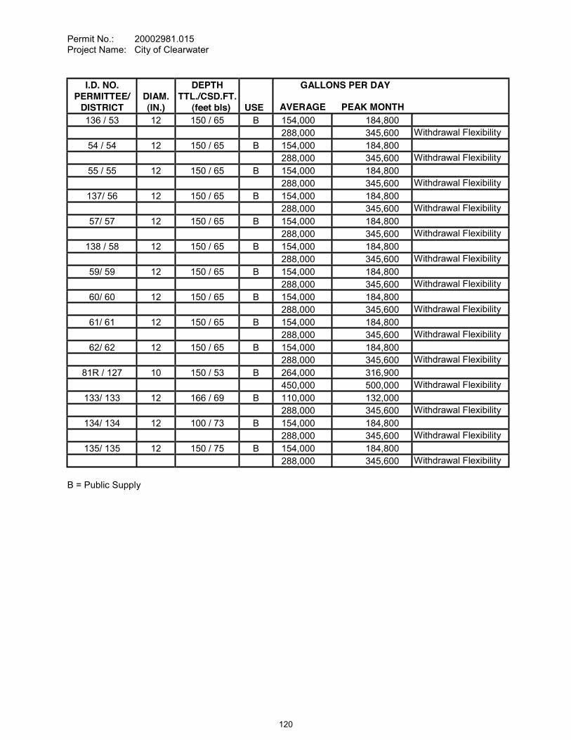
Permit No.: 20002981.015Project Name: City of Clearwater
I.D. NO.PERMITTEE/
DISTRICTDIAM.(IN.)
DEPTHTTL./CSD.FT.
(feet bls) USE
GALLONS PER DAY
AVERAGE PEAK MONTH136 / 53 12 150 / 65 B 154,000 184,800
288,000 345,600 Withdrawal Flexibility54 / 54 12 150 / 65 B 154,000 184,800
288,000 345,600 Withdrawal Flexibility55 / 55 12 150 / 65 B 154,000 184,800
288,000 345,600 Withdrawal Flexibility137/ 56 12 150 / 65 B 154,000 184,800
288,000 345,600 Withdrawal Flexibility57/ 57 12 150 / 65 B 154,000 184,800
288,000 345,600 Withdrawal Flexibility138 / 58 12 150 / 65 B 154,000 184,800
288,000 345,600 Withdrawal Flexibility59/ 59 12 150 / 65 B 154,000 184,800
288,000 345,600 Withdrawal Flexibility60/ 60 12 150 / 65 B 154,000 184,800
288,000 345,600 Withdrawal Flexibility61/ 61 12 150 / 65 B 154,000 184,800
288,000 345,600 Withdrawal Flexibility62/ 62 12 150 / 65 B 154,000 184,800
288,000 345,600 Withdrawal Flexibility81R / 127 10 150 / 53 B 264,000 316,900
450,000 500,000 Withdrawal Flexibility133/ 133 12 166 / 69 B 110,000 132,000
288,000 345,600 Withdrawal Flexibility134/ 134 12 100 / 73 B 154,000 184,800
288,000 345,600 Withdrawal Flexibility135/ 135 12 150 / 75 B 154,000 184,800
288,000 345,600 Withdrawal Flexibility
B = Public Supply
120
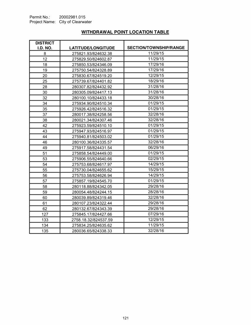
Permit No.: 20002981.015Project Name: City of Clearwater
WITHDRAWAL POINT LOCATION TABLE
DISTRICTI.D. NO. LATITUDE/LONGITUDE SECTION/TOWNSHIP/RANGE
8 275821.93/824632.38 11/29/1512 275829.50/824602.87 11/29/1518 275850.53/824346.09 17/29/1619 275750.54/824328.89 17/29/1620 275830.67/824519.20 12/29/1525 275739.67/824401.82 18/29/1628 280307.82/824432.92 31/28/1630 280305.09/824417.13 31/28/1632 280100.10/824433.18 30/28/1634 275934.90/824510.34 01/29/1535 275926.42/824516.32 01/29/1537 280017.38/824258.56 32/28/1638 280021.34/824307.46 32/28/1642 275923.59/824510.10 01/29/1543 275947.93/824516.97 01/29/1544 275940.81/824503.02 01/29/1546 280100.36/824335.57 32/28/1649 275917.58/824431.54 06/29/1651 275858.54/824449.00 01/29/1553 275906.55/824640.66 02/29/1554 275753.68/824617.97 14/29/1555 275730.04/824655.62 15/29/1556 275753.58/824626.94 14/29/1557 275857.19/824545.70 01/29/1558 280118.88/824342.05 29/28/1659 280054.48/824244.15 28/28/1660 280039.89/824319.46 32/28/1661 280107.23/824322.44 29/28/1662 280132.67/824343.39 29/28/16127 275845.17/824427.66 07/29/16133 2758.18.32/824537.59 12/29/15134 275834.25/824635.62 11/29/15135 280036.65/824338.33 32/28/16
121
Permit No.: 20002981.015Project Name: City of Clearwater
STANDARD CONDITIONS:
The Permittee shall comply with the Standard Conditions attached hereto, incorporated herein by reference as Exhibit "A" and made a part hereof.
___________________________________________Authorized SignatureSOUTHWEST FLORIDA WATER MANAGEMENT DISTRICT
This permit, issued under the provision of Chapter 373, Florida Statutes and Florida Administrative Code 40D-2, authorizes the Permittee to withdraw the quantities outlined above, and may require various activities to be performed by the Permittee as described in the permit, including the Special Conditions. This permit does not convey to the Permittee any property rights or privileges other than those specified herein, nor relieve the Permittee from complying with any applicable local government, state, or federal law, rule, or ordinance.
122

CONSENT ITEM 21
123
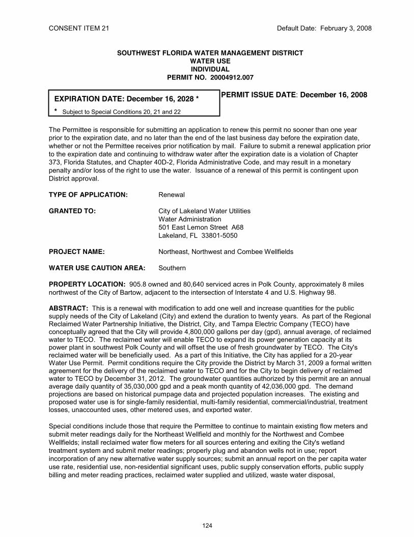
CONSENT ITEM 21 Default Date: February 3, 2008
SOUTHWEST FLORIDA WATER MANAGEMENT DISTRICTWATER USEINDIVIDUAL
PERMIT NO. 20004912.007
EXPIRATION DATE: December 16, 2028 *
* Subject to Special Conditions 20, 21 and 22
PERMIT ISSUE DATE: December 16, 2008
The Permittee is responsible for submitting an application to renew this permit no sooner than one year prior to the expiration date, and no later than the end of the last business day before the expiration date, whether or not the Permittee receives prior notification by mail. Failure to submit a renewal application prior to the expiration date and continuing to withdraw water after the expiration date is a violation of Chapter 373, Florida Statutes, and Chapter 40D-2, Florida Administrative Code, and may result in a monetary penalty and/or loss of the right to use the water. Issuance of a renewal of this permit is contingent upon District approval.
TYPE OF APPLICATION: Renewal
GRANTED TO: City of Lakeland Water UtilitiesWater Administration501 East Lemon Street A68Lakeland, FL 33801-5050
PROJECT NAME: Northeast, Northwest and Combee Wellfields
WATER USE CAUTION AREA: Southern
PROPERTY LOCATION: 905.8 owned and 80,640 serviced acres in Polk County, approximately 8 miles northwest of the City of Bartow, adjacent to the intersection of Interstate 4 and U.S. Highway 98.
ABSTRACT: This is a renewal with modification to add one well and increase quantities for the public supply needs of the City of Lakeland (City) and extend the duration to twenty years. As part of the Regional Reclaimed Water Partnership Initiative, the District, City, and Tampa Electric Company (TECO) have conceptually agreed that the City will provide 4,800,000 gallons per day (gpd), annual average, of reclaimed water to TECO. The reclaimed water will enable TECO to expand its power generation capacity at its power plant in southwest Polk County and will offset the use of fresh groundwater by TECO. The City's reclaimed water will be beneficially used. As a part of this Initiative, the City has applied for a 20-year Water Use Permit. Permit conditions require the City provide the District by March 31, 2009 a formal written agreement for the delivery of the reclaimed water to TECO and for the City to begin delivery of reclaimedwater to TECO by December 31, 2012. The groundwater quantities authorized by this permit are an annual average daily quantity of 35,030,000 gpd and a peak month quantity of 42,036,000 gpd. The demand projections are based on historical pumpage data and projected population increases. The existing and proposed water use is for single-family residential, multi-family residential, commercial/industrial, treatment losses, unaccounted uses, other metered uses, and exported water.
Special conditions include those that require the Permittee to continue to maintain existing flow meters and submit meter readings daily for the Northeast Wellfield and monthly for the Northwest and Combee Wellfields; install reclaimed water flow meters for all sources entering and exiting the City's wetland treatment system and submit meter readings; properly plug and abandon wells not in use; report incorporation of any new alternative water supply sources; submit an annual report on the per capita water use rate, residential use, non-residential significant uses, public supply conservation efforts, public supply billing and meter reading practices, reclaimed water supplied and utilized, waste water disposal,
124

Permit No.: 20004912.007Project Name: City of Lakeland
and adhere to the stipulated per capita water use rate; adhere to pumpage distribution flexibility limits; construct the remaining portion of the Environmental Monitoring Plan (EMP) and adjust pumpage quantities per EMP findings; maintain facility quantity compliance; investigate withdrawal-related water resource and well-interference complaints; submit five year compliance reports; comply with date specific delivery of reclaimed water; agree to reduce quantities and permit term if reclaimed water is not beneficially used; and adhere to EMP requirements for proposed monitoring at Tenoroc.
CHANGES FROM PRIOR PERMIT: This renewal with modification increases the total annual average quantity from 30,200,000 gpd to 35,030,000 gpd (increase of 4,830,000 gpd), and the peak month quantity from 36,240,000 gpd to 42,036,000 gpd (increase of 5,796,000 gpd). The increases are due to changing the permit expiration date from 2013 to 2028 and the resulting increased population served from 188,386 residents in 2013 to 235,182 residents in 2028.
Permit Information
Previously Permitted 2008 - 2014
Requested2028
Authorized2028
ANNUAL AVERAGE1 (gpd) 30,200,000 35,030,000 35,030,000 *Ground Water (gpd) 30,200,000 35,030,000 35,030,000 *Surface Water (gpd) 0 0 0 *
PEAK MONTH2 (gpd) 36,240,000 42,036,000 42,036,000 *Ground Water (gpd) 36,240,000 42,036,000 42,036,000 *Surface Water (gpd) 0 0 0 *
1 Annual Average is the total gallons in a year divided by 365 days per year2 Peak Month is the total gallons in the highest water-use month divided by the number of days in that month.* Subject to Special Conditions 20, 21 and 22
SPECIAL CONDITIONS:
All conditions referring to approval by the Regulation Department Director, Resource Regulation, shall refer to the Director, Bartow Regulation Department, Resource Regulation.
1. Unless otherwise provided, all conditions referring to approval by the District shall mean approval in writing by the Regulation Director, Bartow Regulation Department.
2. INDIVIDUAL WITHDRAWAL PUMPAGE FLEXIBILITYThe peak month and annual average quantities for the individual withdrawal points at the Lakeland Northwest Wellfield (LNWWF), Combee Wellfield (CW) and Lakeland Northeast Wellfield (LNEWF) facilities are set forth in the Withdrawal Permit Quantity Table. The annual average and peak month quantities per well reflect the distribution of withdrawals within each facility. However, the Permittee is not limited to this distribution of withdrawals. The Permittee may make adjustments in the annual average and peak month pumping distribution by well as necessary, up to an annual average of 28.03 mgd and peak month of 33.6 mgd at the LNWWF, 3.0 mgd annual average and 3.6 mgd peak month at CW, and 4.0 mgd annual average and 4.8 mgd peak month at the LNEWF.
The ability to adjust withdrawals is authorized so long as unacceptable adverse impacts to water resources, environmental systems, off-site land uses, and existing legal users do not result and provided adjustments do not conflict with other terms and conditions of this permit.
125
Permit No.: 20004912.007Project Name: City of Lakeland
3. SUBMISSION OF DATA AND REPORTSA. The Permittee shall provide the District with 3 copies of the data reports required by these
Special Conditions. All reports of data required by this permit shall be submitted to the District on or before the 10th day of the month following data collection and shall be addressed to:
Permits Data Section, Regulation Performance Management Dept.Southwest Florida Water Management District2379 Broad StreetBrooksville, Florida 34609-6899
B. For other reports or plans, unless otherwise indicated, the Permittee shall provide to the District 1 original, 2 unbound copies, and 1 copy in District acceptable digital format. Unless otherwise specified, all reports required to be submitted annually by the Permitteeto the District pursuant to one or more of the conditions of this permit shall be submitted as part of the Annual Report required by this permit.
C. All data and reports shall be submitted in writing and in digital format compatible with District operating systems.
4. ENVIRONMENTAL MONITORING AND MANAGEMENT ASSESSMENT A. Environmental Monitoring and Management Plan (EMMP)
An EMMP is attached to this permit as Exhibit B, and is incorporated here by reference. The goal of the EMMP is to address how environmental conditions in the vicinity of the Permittee's wellfields and between the wellfields will be monitored, how unacceptable adverse impacts will be identified, and how unacceptable adverse impacts causedspecifically by permittees actual withdrawals will be mitigated by the Permittee. Additionally, as part of the EMMP, Permittee shall implement its Wetland Improvement Plan and shall obtain the necessary environmental resource permit required to do so. During the permit term, the Permittee may submit, subject to approval by the Regulation Director, Bartow Regulation Department, a proposal to enhance or revise the EMMP.
5. RECLAIMED WATER USE A. By April 1, 2010 the Permittee shall provide a comprehensive study of reuse opportunities
encompassing the Permittee's water, wastewater, and electrical utilities systems, for any reclaimed water not beneficially reused. The study shall include quantities of reuse available, schedule for implementation, construction, and operation and maintenance costs.The study shall also include the following:
1. use of a reverse osmosis/brine concentrator (or other technology) to treat the reuse stream from the power plant for conductivity to eliminate the need to blend/dilute the water to meet the water quality standards of the Permittee's National Pollution Discharge Elimination System (NPDES) permit and increase the amount of reuse water available; and
2. discharge quantities and elimination/reduction of those discharge quantities to the wetland treatment system and beneficial use of the quantities being discharged; and
126
Permit No.: 20004912.007Project Name: City of Lakeland
3. beneficial use of water being discharged through the NPDES discharge point after it has been through the wetland treatment system. This analysis shall also include all water quality parameters of the reuse water as it is being discharged at the NPDES discharge point and at the downstream end of the wetland treatment system.
B. In the event the Permittee proposes a power plant expansion, in coordination with the Site Certification Application submitted to the Department of Environmental Protection, the Permittee shall provide to the District a comprehensive study for implementation of reuse water from the Permittee's water, wastewater, and electrical utilities systems for use in the Permitte .
C. No earlier than July 1, 2018, the Permittee shall initiate a separate comprehensive study to aggressively pursue reuse opportunities for new development in the Permittee's service area. The completed study will be -year compliance report (due March 15, 2019) and shall include a detailed description of the existing reclaimed water utilization for the power plants operations, dilution procedures and wetland maintenance practices, and an explanation indicating how a new or improved water treatment system may allow for additional water to be made available for the
implementation, and construction and operation and maintenance costs.
If the use of this water is determined by the Permittee to be infeasible, or if all quantities are otherwise being beneficially reused, then detailed documentation shall be provided in support of this conclusion. If the Permittee does not meet the requirements of Special Condition Nos. 20 and 21, quantities are modified consistent with Special Condition Nos. 20 and 21, and the study shall be submitted with the Application for renewal.
6. ALTERNATIVE WATER SUPPLY / RECLAIMED REPORTINGThe Permittee shall provide the District with the locations (latitude-longitude) of any alternative water supply sources within 30 days of the source becoming available. The Permittee shall meter, record, and report alternative water supply (AWS) quantities received and used from each
-pump surface water withdrawal point from any storage facility. The meters shall be read on a monthly basis within the last week of each month and be reported to the Permits Data Section, Regulation Performance Management Dept. on or before the tenth day of the following month. The Permittee shall use District-supplied scanning forms, unless another arrangement for submission of this data has been approved by the District.
For current and future reuse connections, the Permittee shall provide the following in the Annual Report:A. The quantity of total reclaimed water provided by each wastewater treatment facility for
reuse on both a total annual average daily and monthly basis;B. For all individual customer reuse connections with line sizes of 4-inches or greater, a listing
of:1. account name and address;2. location of connections by latitude - longitude;3. line size;4. meter (yes or no); and5. metered quantities, if metered.
C. The annual average daily quantities, monthly quantities, locations, and methods of disposal for effluent that is not reused, including that effluent released through the NPDES discharge point to the wetland treatment system connected to the Alafia River.
127

Permit No.: 20004912.007Project Name: City of Lakeland
D. A map or plan depicting the area of reuse service including any areas projected to be added within the next year, if known and if quantities are available.
7. FLOW METER READINGS AND MAINTENANCEThe Permittee shall meter withdrawals from surface waters and/or the ground water resources, and meter readings from each withdrawal facility shall be recorded on a monthly basis within the last week of the month. The meter readings shall be reported to the Permits Data Section, Regulation Performance Management Dept. on or before the tenth day of the following month. District-supplied scanning forms shall be used to submit the meter readings unless another arrangement for submission of this data has been approved by the District. The following withdrawal facilities shall be metered:
A. Existing permitted withdrawal facilities shall continue to be metered with non-resettable, totalizing flow meters or other flow measuring devices as approved by the Regulation Department Director, District ID Nos.10, 29, 35, 36, 37, 38, 39, 40, 41, 42, 43, 44, 45, 52, 53, 54, and 55, Permittee ID Nos. NW-13, NW-11, NW-1, NW-2, NW-3, NW-4, NW-5, NW-6, NW-7, NW-8, NW-9, NW-10, NW-12, NE-2, NE-3, NE-4, and NE-5.
B. Previously un-metered existing withdrawal facilities, District ID No. 51 and 80, Permittee ID No. NE-1 and CW-1 shall be metered upon activation of the withdrawal facility.
The meters shall adhere to the following descriptions and shall be installed or maintained as follows:
A. The meters shall be non-resettable, totalizing flow meters that have a totalizer of sufficient magnitude to retain total gallon data for a minimum of the three highest consecutive months permitted quantities. If other measuring devices are proposed, prior to installation, approval shall be obtained in writing from the Regulation Department Director.
B. The Permittee shall report non-use on all metered standby withdrawal facilities on the scanning form or approved alternative reporting method.
C. If a metered withdrawal facility is not used during any given month, the meter report shall be submitted to the District indicating the same meter reading as was submitted the previous month.
D. The flow meters or other approved devices shall have and maintain an accuracy within five percent of the actual flow as installed.
E. Accuracy testing requirements: 1. For newly metered withdrawal points, the flow meter installation shall be designed for
inline field access for meter accuracy testing. 2. The meter shall be tested for accuracy on-site, as installed, every five years beginning
from the date of its installation for new meters or from the date of initial issuance of this permit containing the metering condition with an accuracy test requirement for existing meters.
3. The testing frequency will be decreased if the Permittee demonstrates to the satisfaction of the District that a longer period of time for testing is warranted.
4. The test will be accepted by the District only if performed by a person knowledgeable in the testing equipment used.
5. If the actual flow is found to be greater than 5% different from the measured flow, within 30 days, the Permittee shall have the meter re-calibrated, repaired, or replaced, whichever is necessary. Documentation of the test and a certificate of re-calibration, if applicable, shall be submitted within 30 days of each test or re-calibration.
F. urate flow to the specifications above, or it shall be installed in a straight length of pipe where there is at least an upstream length equal to ten (10) times the outside pipe diameter and a downstream length equal to two (2) times the outside pipe diameter. Where there is not at least a length of ten diameters upstream available, flow straightening vanes shall be used in the upstream line.
128

Permit No.: 20004912.007Project Name: City of Lakeland
G. Broken or malfunctioning meter:1. If the meter or other flow measuring device malfunctions or breaks, the Permittee shall
notify the District within 15 days of discovering the malfunction or breakage.2. The meter must be replaced with a repaired or new meter, subject to the same
specifications given above, within 30 days of the discovery. 3. If the meter is removed from the withdrawal point for any other reason, it shall be
replaced with another meter having the same specifications given above, or the meter shall be reinstalled within 30 days of its removal from the withdrawal. In either event, a fully functioning meter shall not be off the withdrawal point for more than 60 consecutive days.
H. While the meter is not functioning correctly, the Permittee shall keep track of the total amount of time the withdrawal point was used for each month and multiply those minutes times the pump capacity (in gallons per minute) for total gallons. The estimate of the number of gallons used each month during that period shall be submitted on District scanning forms and noted as estimated per instructions on the form. If the data is submitted by another approved method, the fact that it is estimated must be indicated. The reason for the necessity to estimate pumpage shall be reported with the estimate.
I. In the event a new meter is installed to replace a broken meter, it and its installation shall meet the specifications of this condition. The permittee shall notify the District of the replacement with the first submittal of meter readings from the new meter.
8. WATER QUANTITY, ATMOSPHERIC AND HYDROLOGIC MONITORINGA. Details of monitoring requirements for water quantity, atmospheric and hydrologic
monitoring are contained in Exhibit B to the EMMP. Any changes or adjustments to the monitoring requirements are subject to District approval and may be made as necessary to provide for continued or more effective monitoring of the water quantity, atmospheric and hydrologic conditions associated with this permit. The District shall make monitoring requirement changes / adjustments after consultation with the Permittee, and shall be confirmed by written approval from the District accompanied by replacement addendum to identify the current monitoring requirements. Nothing in this permit shall be construed to limit the authority or obligation of the District to require changes or additions to monitoring requirements as necessary to ensure the protection of the resource.
1. SCADA-EQUIPPED FACILITIESFor all wells and wellfields equipped with SCADA (Supervisory Control and Data Acquisition) the Permittee shall maintain the following for each withdrawal point: one venturi-type flow meter or other approved flow metering device, one non-resettable totalizing recording device at the well site, one remote transmitter unit that transfers the recorded flow data by telemetry to the remote SCADA master station. The SCADA master station flow data shall be recorded on a monthly basis, for each withdrawal point and the total wellfield withdrawal. For all SCADA-equipped withdrawal points, the non-resettable totalizing recording device at each withdrawal point shall be recorded as indicated in Special Condition No. 7 and reported in the Annual Report with a comparison to the SCADA-retrieved cumulative flow for each withdrawal point. If and when any facility becomes equipped with SCADA, the provisions of this paragraph shall apply.
2. TOTAL WELLFIELD PUMPAGEFor all facilities, the sum of the individual well meters shall be used as the primary data source for determining total wellfield pumpage. For facilities that have master meters, the Permittee shall cross-check monthly pumpage by comparing master meter quantities with the sum of the individual withdrawal points, and report the percent discrepancy with the monthly pumping report.
129
Permit No.: 20004912.007Project Name: City of Lakeland
3. ANNUAL REPORT REGARDING FLOW METERSA Section shall be prepared and included in the Annual Report summarizing activities conducted under the Meter Calibration, Testing, and Maintenance Program to maintain accuracy of withdrawal metering. For all SCADA-equipped withdrawal points, the non-resettable totalizing recording device at each withdrawal point shall be recorded as indicated in Special Condition No. 7, and reported in the Annual Report with a comparison to the SCADA-retrieved cumulative flow for each withdrawal point. For facilities that have master meters, the Permittee shall present the results of the monthly comparison of the master meter quantities with the sum of the individual withdrawal points. For all facilities lacking the means for cross-checking of withdrawal metering, the Permittee shall develop a means to cross-check within one year of the first Annual Report. The Annual Report shall also present a comparison of total withdrawals from all facilities with the total amounts of water delivered, including environmental augmentation.
B. ATMOSPHERIC MONITORING
1. RAINFALLThe Permittee shall install and/or maintain rain gages as indicated in Exhibit B tothe EMMP, Table 2 A. and B. Total daily rainfall shall be recorded at each station and submitted to the Permits Data Section, Regulation Performance Management Dept. (using District forms) on or before the 10th day of the following month. The reporting period for these data shall begin on the 1st day of each month and end on the last day of each month.
2. EVAPORATIONThe Permittee shall install and maintain continuous recording evaporation pans as identified in Exhibit B to the EMMP, Table 2. B. Total daily evaporation shall be recorded and submitted to the District, in a form acceptable to the District, by the 10th day of the following month. The reporting period for these data shall begin on the 1st day of each month and end on the last day of each month.
In the event that superior alternative methods for measurement of evaporation and/or evapotranspiration become available, (satellite derived solar radiation data -PET data), the Permittee may request to adopt the new method of data collection subject to District review and approval.
C. SURFACE WATER AND WETLAND LEVELS
1. EXISTING SITESThe Permittee shall maintain and monitor District-approved staff gauges and piezometers as specified in Exhibit B to the EMMP, Table 3, and referenced in Exhibit B, EMMP.
2. ADDITIONAL SITESWithin 90 days of permit issuance, the Permittee shall have installed a District-approved staff gauge and shall report measurements of lake water levels at the locations specified in Exhibit B to the EMMP, Table 3. The staff gauge shall be surveyed and referenced to the NGVD, and a copy of the survey including location and latitude and longitude shall be submitted with the third water level data report. All staff gages shall be scaled in one-tenth foot increments and shall be sized and placed so as to be clearly visible from an easily accessible point of land. Should water levels recede so as not to allow the gauge to be read, the Permittee shall properly install and survey an additional staff gauge within 30 days of such an
130

Permit No.: 20004912.007Project Name: City of Lakeland
occurrence. If other lakes or water bodies are added to the monitoring network, the Permittee shall notify the District whereupon this special condition may be modified.
3. MONITORING AND REPORTINGWater level measurements shall take place twice monthly, with measurements for a given point occurring during the same weeks of each month. Water levels shall be reported to the Permits Data Section, Regulation Performance Management Dept. (using District forms) on or before the 10th day of the following month. All water level measurement sites shall be surveyed, within 30 days of issuance of this permit and all measured water levels reported relative to NGVD. Monitored surface water and wetland sites which go dry shall be equipped for measurement of water level recessions to ten feet below ground surface.
4. AQUIFER LEVELSThe Permittee shall monitor water levels in the surficial and Floridan aquifers as specified in Exhibit B to the EMMP, Table 3. Water levels shall be recorded in the wells as indicated below. Reports of the data shall be submitted to the District, in a form acceptable to the District, by the tenth (10th) day of the following month. All data shall be referenced to NGVD. Water levels shall be recorded based on the following timetable of recording frequency:
Recording Frequency Recording Time Continuous Recording Continuous hourly basisTwice Monthly Same weeks of each month
D. REGIONAL HYDROLOGIC MONITORING PROGRAM
of water levels within the areas of the withdrawals addressed under this permit, and effectively
comprehensive network of surficial aquifer monitor wells, Floridan aquifer monitor wells, surface water gages, and measurement of rainfall and evapotranspiration, sufficient to be utilized in hydrologic modeling and analysis of the wellfields. The Permittee and the District shall work together to avoid redundancy of monitoring by eliminating measurement of certain stations.
The Permittee shall submit a report describing the Regional Hydrologic Monitoring Program, within 180 days after the date this permit is issued. The report shall include a map that
pheric and Hydrologic Monitoring Network listed in
sites ROMP 70, ROMP 76, ROMP 87 and ROMP 88. The report shall provide a tabulation of the monitor wells, surface water gages, rainfall and evaporation measurement stations, with location, construction, instrumentation details and monitoring frequencies. The
by this permit, and shall include the period of record water level data, an evaluation of annual and period of record water level trends, and recommendations to increase the effectiveness of the program.
9. INVESTIGATION OF COMPLAINTS The area where the investigation of complaints will be conducted is defined as the Mitigation Area. The Mitigation Area is further defined as the area within the predicted 5 foot drawdown within the
C.
131
Permit No.: 20004912.007Project Name: City of Lakeland
The Permittee shall expeditiously investigate complaints concerning adverse impacts and shall mitigate such adverse impacts in accordance with the following procedures:
A. IMPACTS TO WATER WITHDRAWALSWith respect to complaints regarding an impact to a well or surface water withdrawal, the following requirements apply:
1. Within 24 hours of complaint receipt by the Permittee, the Permittee shall make every reasonable effort to commence a preliminary investigation and determine whether the Permittee's withdrawals may have caused the problem. The preliminary investigation shall include contacting the complainant to determine the
determine the nature of the problem (e.g. loss of water, loss of pressure, water
withdrawal was initiated.
2. If this preliminary assessment indicates that the Permittee may be responsible for a water supply impact which represents a public health and safety problem, the Permittee shall, within 48 hours of complaint receipt, make available to the complainant any water necessary for health and safety purposes, such as drinking water.
3. The Permittee may mitigate the complaint after the preliminary investigation, or conduct a detailed investigation to determine if the Permittee caused the problem. This detailed investigation shall include, but not be limited to, an analysis of water levels and pumpage impacts at the time of the complainant's problem, withdrawal and pump characteristics including depths, capacity, pump curves, and irrigation system requirements. If this detailed investigation confirms that the complainant's problem was caused by the Permittee's withdrawals, the complainant's problem shall be fully corrected. In cases where water is unavailable to the complainant for
corrected as soon as possible, with restoration of essential domestic water supply within 15 days, and fully corrected within 30 days of complaint receipt, unless an extension of time is granted by the District. In cases of complaints where water is available to the complainant for public health and safety purposes, the compmore than 30 days of complaint receipt, unless an extension of time is granted by the District.
4. Full correction shall be restoration of the complainant's water supply to pre-impact condition or better, including the aspects of pressure levels and discharge quantity. Full correction may be accomplished by connecting a complainant to a public supply system.
5. If the resulting investigation determines that the Permittee was not responsible for the complainant's problem, the Permittee shall document the reasons for this determination.
6. The Permittee shall file a monthly report showing the ongoing complaint investigations and new complaints received during the previous month of operation. The monthly report shall be submitted by the 10th day of the month following the reporting period, to the District for review and approval. If there are no complaints or investigations, the Permittee shall not be required to submit a
132
Permit No.: 20004912.007Project Name: City of Lakeland
monthly report. The Permittee shall summarize activities in the Annual Report. The monthly report shall include, but not be limited to:
a. The name and address of each complainant;b. The location of the impacted withdrawal (Q.Q.S.T.R.);c. The date of complaint receipt and nature of the complaint (water level, water
quality);d. The status the Permittee's investigation (mitigate, not mitigate, pending);e. The name of the nearest Permittee facility;f. An explanation of reasons for not mitigating a complaint (pre-existing
problem, not a legal existing user, no problem found, not cause of problem); and
g. Date complaint file closed.
7. For complaints which are determined through a detailed investigation not to be eligible for mitigation, the Permittee shall submit a separate report presenting the findings of facts, all information collected during the investigation, and a summary explaining the Permittee's reasons for this determination. This report shall be submitted with the monthly summary report required above. A copy of the report shall also be sent to the complainant concurrent with the report submitted to the District. Should the District decide that water quality data should be collected for well complaints, or that well water quality complaints should be mitigated under the requirements of this permit, the District shall notify the Permittee of these requirements after consultation and discussion with the Permittee.
8. Only permitted or exempt water uses (legal water withdrawals) which existed prior to the causative facility or increased quantities shall be eligible for mitigation pursuant to the requirements of this permit. In cases where multiple Mitigation Areas overlap a complainant, the Permittee shall use the most recently activated facility and increased quantities in determining the eligibility for mitigation.
9. In instances where a new well is constructed to replace an adversely impacted well, the Permittee shall properly abandon the impacted well in a timely manner in accordance with Department of Environmental Protection and District rules regarding well abandonment, currently Ch. 62-532.500(4), F.A.C., and Ch. 40D-3.531(2), F.A.C., as may be amended.
B. WATER RESOURCE AND LAND USE IMPACTSWith respect to complaints regarding water levels or flows in water bodies such as lakes, wetlands, springs, streams or other watercourses, sinkholes or subsidence, damage to crops and other vegetation, or damage to the habitat of endangered or threatened species, the following requirements apply:
1. The Permittee shall commence an investigation within 72 hours of receipt of the complaint, and file a monthly summary report showing the ongoing complaint investigations and new complaints received during the previous month of operation. The report shall be submitted by the 10th day of the month following the reporting period, to the District for review and approval. The report shall include, but not be limited to:a. The name and address of each complainant;b. The date and nature of the complaint;c. A summary of the Permittee's investigation to date, and, if the investigation
is ongoing, an estimate of the time necessary to complete the investigation;
133
Permit No.: 20004912.007Project Name: City of Lakeland
2. Within 90 days of complaint receipt, the Permittee shall submit a separate report presenting a summary of the Permittee's determinations, including whether the
mitigation activities and an estimate of the time necessary to complete mitigation. A copy of the report shall also be sent to the complainant concurrent with the report submitted to the District. The Permittee shall make all reasonable efforts to expeditiously mitigate problems caused by the withdrawals. Full mitigation must be completed within 180 days from complaint receipt, unless additional time is granted by the District. The standards for environmental mitigation shall be the same as set forth in the EMMP associated with Special Condition No. 4 of this Permit.
C. DISTRICT DIRECTION REGARDING MITIGATIONFailure of the Permittee to carry out mitigation as directed by the District shall be grounds for the District to initiate enforcement action.
10. IDENTIFICATION, CONVERSION AND ABANDONMENT OF WELLSWithin 180 days of permit issuance, the Permittee shall provide a list of all existing wells associated with any facility owned by the Permittee that are not used for production or required to be monitored by this permit. Within 365 days of issuance of the list, such wells shall be properly plugged and abandoned (plugged bottom to top) by a licensed water well contractor in accordance with applicable law under a Well Abandonment Permit issued by the District, unless an extension is provided, or a proposed use of the well is approved, by the District.
11. ANNUAL REPORT
District that describes the operation of the facilities covered under this permit. The Annual Report shall cover the preceding calendar year period from October 1 to September 30. Data sources shall be referenced in the Annual Report, but no raw data shall be included in the report. Only essential text, graphs, and tables should be included in the report. Six copies of the Annual Report shall be submitted to the Permits Data Section, Regulation Performance Management Dept. by April 1 of each year. The Annual Report shall address at least the following:
A. GENERAL INFORMATION AND DATA
Information collected through the following conditions of this permit shall be included in this section of the Annual Report:
Conservation Reporting (Condition No. 17)Meter Calibration, Testing and Maintenance (Condition No. 7)Water quantity and water distribution information (Condition Nos. 3, 7, and 8)
A population estimate for the annual reporting period, which includes only those served by the municipal system within the defined service area, shall be provided and referenced. The quantities of water delivered to and used within the service area over the annual reporting period shall be used with the population estimate to determine a per capita use rate for the period as described in Condition 17. The distribution of water pumped from the facilities covered under this permit shall be summarized for the reporting period. Any changes to the service area boundaries shall be described in the text and plotted on a map.
134

Permit No.: 20004912.007Project Name: City of Lakeland
B. WATER RESOURCES
The Permittee shall provide a comprehensive and concise assessment of the water resources and environmental systems of each of the facilities covered under this permit for all sections listed below. The section of the Wellfields Annual Reports shall concisely summarize the elements listed below, and any other elements within this permit that require annual environmental reporting, with emphasis on the interactions between these elements, where appropriate.
1. HYDROLOGIC AND ENVIRONMENTAL CONDITIONSData collected through the water quantity, rainfall, evaporation, water level, stream flow, and environmental monitoring including, but not limited to the Wetland Assessment Procedure result requirements of this permit shall be summarized and analyzed by the Permittee to determine the effects of rainfall and withdrawals at each wellfield and vicinity. Qualitative, quantitative and, where feasible, statistical trend analyses shall be performed on all monitoring sites to analyze the interactions of rainfall and withdrawals on movement of the surficial aquifer water levels, lake and wetland water levels, wetland hydroperiods (number of days of standing water above ground surface), stream flow, potentiometric surface levels, wetland species composition, and wetland habitat utilization by federal or state listed species. Such analyses shall include period of record data. The District reserves the right to require specific analyses of certain parameters as necessary, after consultation with the Permittee. Data shall be obtained through field measurements or other monitoring methods as approved by the District. Any increasing or decreasing trends in the parameters being tracked should be noted, and potential mitigation outlined. A brief summary of any recommended changes to the monitoring requirements shall also be included.
2. INVESTIGATION OF COMPLAINTSA summary of the investigations of all complaints concerning adverse impacts to
mitigate such adverse impacts, shall be provided for each reporting period. This summary shall include:
a. Number and type of complaints;b. Number and type of mitigation activity(ies); andc. Number and type of complaints which did not require mitigation activity.
C. PUBLIC SUPPLY ANNUAL REPORT
The Permittee shall submit an Annual Report to the District, by April 1 of each year that includes:
1. Service area functional population (FP) served and methodology for determining service area functional population. As of January 1, 2009, for the 2008 calendar year data, the Permittee shall utilize the methodology des
the Basis of Review for Water Use Permit Applications and its applicable appendices Part D of the Basis of Review for Water Use Permit Applications (BOR).
135

Permit No.: 20004912.007Project Name: City of Lakeland
The applicable Worksheets from Part D and supporting documentation for calculations of per capita rates are required.
2. Non-residential significant water use (SU) that complies with criteria listed in Part B, Chapter 3, Section 3.6 of the BOR. All significant uses and associated quantities shall be listed even if not deducted. For those significant uses that are deducted in the calculation of adjusted per capita use, the Permittee shall identify the following:
a. The Type of significant use chosen.b. The name, location and mailing address for each significant use.c. Meter type.d. Use of the watere. Meter readings or other documentation of the annual average quantity
providedf. Conservation plans appropriate to the Type of significant use chosen, and g. Documentation that the conservation plan is being implemented.
3. Total withdrawals (WD). The permittee may use data from a master meter for this item.
4. Treatment losses (TL), including a description of how the losses are calculated.5. District-required environmental mitigation (EM) quantities, including details
concerning the environmental features mitigated and the method of mitigation.6. Imported (IM) and Exported (EX) transfers of bulk water. Include:
a. Monthly and annual average gallons per day with quantities determined at your departure point.
b. Meter type and size.c. Receiver name, mailing address, telephone number, location (latitude and
longitude) of point of receivership.d. The water use permit number for any receiver that has a wholesale water
use permit. e. A description of how recipients of bulk transfers of water or wholesale
purchasers adhere to your water conservation plan if they do not have a water use permit.
7. Calculation of the adjusted per capita rate as follows:WD + IM EX TL SU EM
FP8. Water Rate Structure: A description of the current water rate structure, how it has
promoted water conservation to customers, water use savings due to the water rate structure, and any proposed amendments to the structure that is designed to promote water conservation.
9. Water Conservation: A detailed description of the Permittee's water conservation activities for the previous year as well as a description of ongoing and planned water conservation activities.
10. Unaccounted Water Loss: Annual Average daily quantity of unaccounted water lost and the percentage of unaccounted water lost relative to total withdrawals.
11. Water Audit Updatethat includes but is not limited to a description of all unaccounted water losses, the ongoing leak detection, and meter change-out programs. This summary shall indicate the percentage of unaccounted water losses. If the unaccounted water losses are 12% or more of total withdrawals after subtracting treatment losses, the Permittee shall submit a comprehensive water audit report yearly on or before April 1, which specifically addresses the unaccounted water losses and provides an
136
Permit No.: 20004912.007Project Name: City of Lakeland
implementation schedule for remedial actions to reduce these losses below 12%. The audit shall include, but not be limited to an assessment of unauthorized uses, line flushing, authorized un-metered uses, under-registration of meters, fire flows and leaks. Utilities with large complex water supply systems may conduct the audit in phases, with prior approval by the District. The water audit report shall continue to be submitted annually until the unaccounted water losses are less than 12% of total withdrawals after subtracting treatment loss.
12. Residential Water Use: Total water use information on residential water use (including indoor and outdoor use) for the following categories of residential use. Describe the methodology used to determine the number of residences in each category. Estimates based on meter size will not be accepted.
a. The number of single family units served.b. The number of multi-family units served.c. The number of mobile homes served, unless mobile homes are included in
the number of single-family units.13. Suppliers of Alternative Water Report. The report must document the quantity of
reclaimed water or stormwater supplied as beneficial reuse to residential customers and to bulk customers on both an annual average daily and monthly basis. Include with the report:
a. Meter readings of actual deliveries, but if this is not available, billing information may be submitted if the bill indicates quantities delivered.
b. For all individual customer reuse connections with line sizes of four inches or greater, include:i. Account name and address.ii. Location of connection by latitude-longitude.iii. Line size.iv. If metered:
a. Metered quantities andb. Ownership of the meter.
v. The customer's stated use for the water. vi. Water Use Permit number for those customers having a water use
permit from the District.
14. Disposal: Documentation of quantities of reclaimed water and stormwater disposed, location of disposal site, and manner of disposal.
15. Service Area Map: With every sixth yearly report, a current service area map as described in the Service Area Map Special Condition.
The Permittee may use the Public Supply Surveys to provide the information required by this condition, completing only the parts required by this condition. The survey forms are usually sent to the Permittee by the first week of January of each year, or they may be
further description and assistance with completion of the annual report on the District's website.
D. QUALITY ASSURANCE QUALITY CONTROL (QAQC) ANNUAL REPORTING
The permittee shall provide a comprehensive and concise assessment of the results of implementation and management of the QAQC programs for atmospheric and hydrologic monitoring. The report shall address, at a minimum; compliance with the required QAQC guidelines identified in Part III of the EMMP (Exhibit B) or other District approved QAQC
137
Permit No.: 20004912.007Project Name: City of Lakeland
program, addressing any data acquisition/management issues encountered throughout the year and/or District approved changes to the QAQC program. Also, the Permittee shall describe all measures put into practice to address all QAQC provisions, and the success of those measures.
12. TIME EXTENSIONSUnless specified otherwise, time extensions to condition deadlines will be considered upon written request to the District, provided that the request is made prior to the deadline, the Permittee has demonstrated a good faith effort in meeting the deadline set forth in the condition, and a reasonable modified deadline is proposed by the Permittee.
13. MODIFICATION OR REVOCATION OF PERMIT BY DISTRICT Nothing in this permit is intended, nor shall anything herein be construed, to replace, limit or impair the District's right to modify or revoke this permit in accordance with applicable law.
14. OTHER LIMITATIONS AND REQUIREMENTSThe remedies for violation of this permit are cumulative. Thus, the pursuit of one remedy shall not preclude the pursuit of other remedies provided by this permit or by applicable law. The pursuit of any remedy provided in this permit or by applicable law shall not constitute a forfeiture or waiver of any other remedy. The waiver of one violation shall not be deemed a waiver of any other violation. Forbearance to enforce one or more of the remedies provided by this permit or by applicable law on an event of violation shall not be deemed or construed to constitute a waiver of the right to any remedy for that violation.
15. QUANTITY COMPLIANCECompliance with the allocated standard annual average quantity is based on a rolling 12-month calculation where the current pumpage is added to the pumpage for the previous 11 months, and the total is then divided by the number of days in those 12 months for gallons per day. If the Permittee exceeds the allocated standard annual average quantity during any month, within 30 days the Permittee shall submit a report to the District that includes reasons why the allocated quantities were exceeded, efforts already taken to attempt meeting the allocated quantities, and a plan to bring the permit into compliance.
16. SWUCAThis Permit is located within the Southern Water Use Caution Area for which the Florida Legislature mandated a water resource recovery strategy under Section 373.0421, Florida Statutes. The Minimum Flows and Levels Recovery Strategy, in effect on January 1, 2007, allows for changes by the District Governing Board that will subject this Permit to modification to comply with new rules. The changes will be based on an annual assessment of water resource criteria, cumulative water withdrawal impacts, and on a recurring five-year evaluation of the status of the recovery strategy up to the year 2025.
17. PUBLIC SUPPLY CONSERVATIONAll data required in this condition shall be included within the Annual Report, Condition 11, C, Public Supply Annual Report.
A. Updated Service Area Map The Permittee shall submit an updated service area map with every third Annual Report beginning with the Annual Report due in 2009.
1. The map must adhere to the following guidelines:
138
Permit No.: 20004912.007Project Name: City of Lakeland
a. The service area map shall build upon and clearly show any changes relative to the existing service area map in the District's electronic public supply service area boundary map file. If there are no changes, the Permittee may submit a statement with the Annual Report that there have been no changes to the map in the District map file. The Permittee may contact the District for assistance in accessing this map.
b. If a service area map is not on file in the District's GIS, it may be submitted in paper format or in District-compatible electronic file format. The map must include a north arrow (or show S-T-R lines) and have the scale clearly indicated. If it is not an aerial photographic map, it must include readily recognizable roads or streets and other identifiable landmarks. It must contain a legend to define all symbols used. A paper map must have a minimum scale of 1 inch = 2,000 feet or larger.
c. The map must clearly delineate the current area served, any areas proposed to be served within the permit term, and definable areas within the service area that are not served because the population uses domestic potable wells. If any of these un-served areas are scheduled to be included in the service area within the permit term, documentation such as a capital improvement plan that demonstrates the proposed inclusion is required to be submitted with the updated map.
2. With each service area map submittal, the following information must be included:
a. A current general utility contact person name, title, email address and phone number.
b. A current contact person name, title, email address and phone number whom District staff may call concerning the service area map.
c. The metadata for the map if the map is submitted as an electronic file that is compatible with the District's format.
d. The District permit numbers and Florida Department of Environmental Protection Public Water Supply Identifier (PWSI) numbers and area designation names for each area served by a separate potable water treatment plant, as applicable.
e. A description of routine water transfer interconnections between service areas and other utilities or wholesale suppliers or recipients.
f. The name, phone number, and all District water use permit numbers for each utility that purchases water on a routine basis and the most recent
number, and District water use permit numbers of each utility from whichthat the permittee purchases water on a routine basis and the most recent
B. Per Capita1. The Permittee shall adhere to the per capita requirements below:
a. The adjusted gross per capita (AGPC) daily water use rate shall be no greater than 150 gallons per day (gpd) per person. The Permittee shall calculate the AGPC rate as described in the Annual Report, C Public Supply Annual Report on this permit and shall submit the calculations with the Annual Report by April 1 of each year.
b. If the AGPC rate is greater than 150 gpd per person, the Permittee shall submit a report that documents why this rate was not achieved, measures previously or currently taken to comply with this requirement, and a planthat describes additional measures and implementation dates for those
139
Permit No.: 20004912.007Project Name: City of Lakeland
measures to bring the permit into compliance with the required AGPC. This report shall be submitted with the Annual Report by April 1 for each year the gross per capita rate exceeds 150 gpd per person.
Reports for Permittees not achieving the required adjusted gross per capita rate are subject to District approval. Justification for exceeding the adjusted gross per capita rate does not constitute a waiver of the District's authority to enforce the terms and conditions of the permit.
C. Within 90 days of permit issuance, the Permittee shall develop and implement a Water Conservation Plan (Plan) that includes practices currently employed or planned. For planned components, include an estimated time-frame for implementation for each. The Plan must indicate that technically and economically feasible water conservation opportunities have been or will be employed, such as:
1. Leak detection inside the treatment facilities as well as in transmission lines to reduce unaccounted water losses.
2. Elimination of flat rates for low categories of water use and implementation of a water conserving rate structure for all levels of water use.
3. Water-efficient landscape and irrigation evaluations and rebates.4. Landscape/irrigation ordinance development and implementation.5. Ordinances for individual and similar-group types of non-residential customers,
such as recycling. 6. Providing a lower quality of water for non-potable uses.7. Non-potable irrigation source rebates.8. Informative billing and bill inserts.9 Retrofit Kit Give Away.10. Public information and education sessions.11. High efficiency clothes washer rebates.12. Ultra-low flush toilet rebates.
D. Conservation Rate StructureThe Permittee shall have and maintain a water conservation oriented rate structure.
E. Report Significant Use By April 1 of each year, for the preceding calendar year, the Permittee shall account for all significant water uses separately and submit a report on all significant uses whether or not taken as a deduction from the Per Capita calculation. Significant use is defined as any individual, non-residential customer using 25,000 gallons per day or greater on an annual average basis, or any individual, non-residential customer whose use represents greater than five percent (5%) of the annual average quantity on this permit. Utilities with a large number of commercial accounts which fall below the 25,000 gpd individual significant use threshold may deduct the percentage of commercial use greater than the District-wide average of the three most recent years commercial use, provided that they do not deduct any individual significant uses and that they do not make population adjustments based on commuter population.
The users that are not included in the significant use category are golf courses, multi-family residential accounts classified as commercial by the utility, and irrigation accounts associated with residential accounts. The summary on significant use shall include but not be limited to:
1. Name and address of the significant users, 2. Type of use (e.g., type of industry, or commercial venture);
140
Permit No.: 20004912.007Project Name: City of Lakeland
3. Total annual average quantities provided to each, and 4. Water conservation programs designed specifically for each significant use or type
of significant use.This report may be submitted as an element of the Annual Report.
F. Annual Billing and Meter Reading & Information Provision customer no less frequently
than bi-indicated on each bill. In addition, the Permittee shall provide the following information to all water customers at least once each water year:
1. Rate structure information describing applicable fixed and variable charges rates, minimum quantity charges, block size and pricing, seasonal rates, and applicable months. If billing units are not in gallons, a means to convert the billing units to gallons must be described to the customer with this information.
2. Historical billing period usage averaged over the three previous years for the applicable customer class.
18. FIVE-YEAR COMPLIANCE REPORTThe permittee shall submit a compliance report to the District at 5, 10, and 15 years after permit issuance, ending December 31, 2013, 2018, and 2023. Specifically, the permittee shall submit the reports by March 15, 2014, 2019 and 2024. The compliance report shall contain sufficient information to maintain reasonable assurance that the initial conditions for permit issuance are met. The 5-year compliance report will contain:
a) A summary and analysis of the conclusions reached in each Annual Report for the preceding 5-year period;
b) A summary and analysis of the long-term trends in hydrology;c) A summary and analysis of the long-term trends in population and demand;d) A summary and analysis of the long-term trends in per capita use; ande) A summary and analysis of the long-term trends in wetlands vegetation.
If the data and long-term trends indicate non-compliance with permit conditions or applicable rules, attributable to pumping by the City of Lakeland, the Permittee will identify the actions that will be taken to maintain reasonable assurance of permit condition compliance, including a time schedule for implementation. Such actions and time schedule shall be subject to District approval.
In the event the compliance report reveals adverse impacts or a decline in environmental conditions, the permittee shall provide an updated ground water modeling analysis, along with statistical analyses of water-level and wetland monitoring data collected through the EMMP and permit conditions, demonstrating that the permitted withdrawal does not cause adverse impacts towetlands, springs, and surface waters, or violations of Minimum Flows and Levels.
19. REUSE METERINGThe Permittee shall meter, record, and report reclaimed water quantities delivered through each existing/proposed reclaimed water supply outflow line (the line going to the Polk Power Station
wastewater flows). The meters shall be read on a monthly basis within the last week of each month and be reported to the Permits Data Section, Regulation Performance Management Dept. on or before the tenth day of the following month. The Permittee shall use District-supplied scanning forms, unless another arrangement for submission of this data has been approved by the District.
A. Within 90 days of completion of construction of the reclaimed water delivery system to TECO the Permittee shall meter the AWS outflow line (District ID No. 81, Permittee ID No. 81).
141
Permit No.: 20004912.007Project Name: City of Lakeland
B. Within 90 days of permit issuance, the Permittee shall meter all existing reclaimed water sources (DID Nos. 82 and 83, Permittee ID Nos. Lakeland and Polk County) which
system. C. Any new reclaimed water sources that provide flows which will be available for increased
consumption by existing customers or service for new reclaimed water customers will be metered and reported to the District within 30 days of the service agreements being approved and details of these additional reclaimed water sources will be outlined in all subsequent Annual Water Reports.
The meters shall adhere to the following requirements and shall be installed and maintained as follows:
A. All meters shall be non-resettable, totalizing flow meters that have a totalizer of sufficient magnitude to retain total gallon data for a minimum of the three highest consecutive months permitted quantities. If other measuring devices or other accounting methods are proposed, prior to installation, the Permittee shall submit documentation that the other measuring devices or accounting methods meet the stipulations listed in this condition. Approval for other measuring devices or accounting methods must be obtained in writing from the Regulation Department Director.
B. The flow meters or other approved devices shall have and maintain an accuracy within five percent of the actual flow as installed.
C. Accuracy testing requirements:1. For newly metered AWS outflow lines the flow meter installation shall be designed for
inline field access for meter-accuracy testing. 2. The meter shall be tested for accuracy on-site, as installed, every five years beginning
from the date of its installation for new meters or from the date of initial issuance of this permit containing the metering condition with an accuracy-test requirement for existing meters.
3. The testing frequency will be decreased if the Permittee demonstrates to the satisfaction of the District that a longer period of time for testing is warranted.
4. The test will be accepted by the District only if performed by a person knowledgeable in the test equipment used.
5. If the actual flow is found to be greater than 5% different from the measured flow, within 30 days, the Permittee shall have the meter re-calibrated, repaired, or replaced, whichever is necessary. Documentation of the test and a certificate of re-calibration, if applicable, shall be submitted within 30 days of each test or re-calibration
D. If the alternative accounting method involves a meter belonging to another entity or to the alternative water supply provider, the Permittee shall submit documentation from the owner/supplier that the meter readings continue to be accurate to 5% of the actual flow as installed. Such documentation is subject to approval by the District.
E.flow to the specifications above, or it shall be installed in a straight length of pipe where there is at least an upstream length equal to ten (10) times the outside pipe diameter and a downstream length equal to two (2) times the outside pipe diameter. Where there is not at least a length of ten diameters upstream available, flow straightening vanes shall be used in the upstream line.
F. If a metered AWS outflow lines is not utilized during a given month, the meter report shall be submitted to the District showing the same meter reading that was submitted the previous month.
G. Broken or malfunctioning meter:1. If the meter or other flow measuring device malfunctions or breaks, the Permittee shall
notify the District within 15 days of discovering the malfunction or breakage.2. The meter must be replaced with a repaired or new meter, subject to the same
specifications given above, within 30 days of the discovery. 3. If the meter is removed from the alternative water supply line for any other reason, it
shall be replaced with another meter having the same specifications given above, or the meter shall be reinstalled within 30 days of its removal from the withdrawal. In
142

Permit No.: 20004912.007Project Name: City of Lakeland
either event, a fully functioning meter shall not be off the withdrawal point for more than 60 consecutive days.
H. While the meter is not functioning correctly, the Permittee shall keep track of the total amount of time the withdrawal point was used for each month and multiply those minutes times the pump capacity (in gallons per minute) for total gallons. The estimate of the number of gallons used each month during that period shall be submitted on District scanning forms and noted as estimated per instructions on the form. If the data is submitted by another approved method, the fact that it is estimated must be indicated. The reason for the necessity to estimate pumpage shall be reported with the estimate.
I. In the event a new meter is installed to replace a broken meter, it and its installation shall meet the specifications of this condition. The permittee shall notify the District of the replacement with the first submittal of meter readings from the new meter.
20. RECLAIMED WATER AGREEMENTBy March 31, 2009, the Permittee shall submit to the District a copy of a binding agreement between itself and the owner of the Polk Power Station (TECO) for the delivery of the total reclaimed water flow to TECO years. The reclaimed water flow at TECO's point of service will be 4.8 mgd annual average or greater with consideration that weather and other local conditions may temporarily reduce the flow below 4.8 mgd annual average. At no time will the flow at TECO's point of service be less than 4.0 mgd annual average. Permittee may reduce the annual average quantity of reclaimed water provided to TECO to no less than 4.0 mgd with a five-year advance notice to TECO of the planned reduction in average annual flow. If such agreement is not finalized by March 31, 2009, this permit will
ing Water Use Permit (WUP No. 20004912.006) to 30,200,000 gpd Annual Average and 36,240,000 gpd Peak Month with a permit term ending on March 25, 2014.
21. RECLAIMED WATER DELIVERY REQUIREMENTSThe agreement between the Permittee and TECO will provide for the delivery at TECO's point of service of the total reclaimed water flow from the existing wetland treatment system to meet the
special condition number 20commence no later than December 31, 2012. Permittee may reduce the annual average quantity of reclaimed water provided to TECO to 4.0 mgd with a five-year advance notice to TECO of the planned reduction in average annual flow. In the event Permittee fails to provide reclaimed water service to TECO as described in condition number 20 above by December 31, 2012, this permit will automatically revert to the terms and conditions set for the PerPermit (WUP No. 20004912.006 authorizing 30,200,000 gpd Annual Average and 36,240,000 gpd Peak Month) with a permit term ending on March 25, 2014. In the event the infrastructure is not in place so that reclaimed water can be delivered to TECO by December 31, 2012, Permittee may request an extension of the deadline for delivering reclaimed water for a period not to exceed two years, which the District will grant upon a showing of good cause.
22. CESSATION OF DELIVERY OF RECLAIMED WATER
there is a permanent cessation of reclaimed water in the amount of 4.0 mgd Annual Average use by TECO, this permit will expire 1 year from the datepermanently ceased (or March 25, 2014, whichever is later). Unless otherwise agreed to by the
based upon a linear extwater withdrawals (annual average for the 12 month period preceding the date upon which permanent cessation occurred) as the base quantity from which the projection will be developed.Interruptions in delivery and use resulting from maintenance, repairs and force majeure events shall not be deemed permanent cessation.
143
Permit No.: 20004912.007Project Name: City of Lakeland
23. WELLFIELD PUMPAGE AND OPERATIONThe Permittee shall record monthly total pumpage quantities from each of these Northeast, Northwest, and Combee wellfields. This monthly wellfield pumpage information shall be compiled, along with a summary of the operation schedule for each wellfield, and provided to the District as an addition to the Annual Report required of Special Condition No. 11.
24. COMBEE MONITORINGWithin 120 days of permit issuance, the Permittee shall implement an environmental monitoring plan to provide reasonable assurance that the quantities permitted for withdrawal from the C.W. Combee Treatment Plant location will continue to meet the conditions for issuance. Five monitoring locations will be sampled, analyzed and reported by the City of Lakeland, using the requirements and protocols established in the EMMP previously approved for Permit No. 20004912.006. Data collection and reporting for these additional locations must meet the requirements and protocols of that EMMP unless otherwise indicated below. Sample locations are identified on the map in Exhibit E. Specific details of the Monitoring site locations are identified in the tables in Exhibit B. The Combee environmental monitoring network includes:
DID No. Monitoring Site Measurement FrequencyN/A School Board Wetland A WAP-vegetation Annual151 C.W. Combee Floridan Weekly152 C.W. Combee Surficial Weekly153 Tenoroc Well Floridan Weekly154 School Board Wetland A Surficial (boundary) Weekly155 School Board Wetland A Surficial (center) Weekly156 School Board Wetland A Staff Gage Weekly157 Fish Hook Lake Staff Gage Monthly158 Shop Lake Staff Gage Monthly204 C.W. Combee Evaporation Daily205 C.W. Combee Rainfall Daily
25. Permittee is encouraged to apply for a modification in 2018 to add an additional ten-year duration (to change the expiration date to 2038) to coincide with the 30-year provision of the reclaimed water to TECO reference in Special Condition No. 20, provided that Permittee commits to continue to supply at least 4.0 mgd of reclaimed water to TECO through 2038.
144

Permit No.: 20004912.007Project Name: City of Lakeland
WITHDRAWAL POINT QUANTITY TABLEWater use from these withdrawal points are restricted to the quantities given below:
I.D. NO.PERMITTEE/
DISTRICTDIAM.(IN.)
DEPTHTTL./CSD.FT.
(feet bls) USE
GALLONS PER DAY
AVERAGE PEAK MONTHNW13 / 10 20 790 / 273 B 2,154,600 2,568.800
4,000,000 4,800,000 Withdrawal FlexibilityNW11 / 29 20 642 / 210 B 2,154,600 2,568,800
4,000,000 4,800,000 Withdrawal FlexibilityNW1 / 35 24 700 / 270 B 2,154,600 2,568,800
4,000,000 4,800,000 Withdrawal FlexibilityNW2 / 36 24 700 / 277 B 2,154,600 2,568,800
4,000,000 4,800,000 Withdrawal FlexibilityNW3 / 37 24 726 / 268 B 2,154,600 2,568,800
4,000,000 4,800,000 Withdrawal FlexibilityNW4 / 38 24 855 / 281 B 2,154,600 2,568,800
4,000,000 4,800,000 Withdrawal FlexibilityNW5 / 39 24 609 / 200 B 2,154,600 2,568,800
4,000,000 4,800,000 Withdrawal FlexibilityNW6 / 40 24 737 / 250 B 2,154,600 2,568,800
4,000,000 4,800,000 Withdrawal FlexibilityNW7 / 41 24 791 / 280 B 2,154,600 2,568,800
4,000,000 4,800,000 Withdrawal FlexibilityNW8 / 42 24 763 / 276 B 2,154,600 2,568,800
4,000,000 4,800,000 Withdrawal FlexibilityNW9 / 43 24 700 / 280 B 2,154,600 2,568,800
4,000,000 4,800,000 Withdrawal FlexibilityNW10 / 44 24 1,004 / 250 B 2,154,600 2,568,800
4,000,000 4,800,000 Withdrawal FlexibilityNW12 / 45 24 800 / 200 B 2,154,600 2,568,800
4,000,000 4,800,000 Withdrawal FlexibilityNE1 / 51 16 754 / 121 B 1,200,000 1,440,000
4,000,000 4,800,000 Withdrawal FlexibilityNE2 / 52 16 750 / 100 B 1,200,000 1,440,000
4,000,000 4,800,000 Withdrawal FlexibilityNE3 / 53 16 750 / 100 B 1,200,000 1,440,000
4,000,000 4,800,000 Withdrawal FlexibilityNE4 / 54 16 750 / 100 B 1,200,000 1,440,000
4,000,000 4,800,000 Withdrawal FlexibilityNE5 / 55 16 750 / 100 B 1,200,000 1,440,000
4,000,000 4,800,000 Withdrawal FlexibilityCW-1 / 80 24 581 / 300 B 3,000,000 3,600,000
B = Public Supply
145
Permit No.: 20004912.007Project Name: City of Lakeland
WITHDRAWAL POINT LOCATION TABLE
DISTRICTI.D. NO. LATITUDE/LONGITUDE SECTION/TOWNSHIP/RANGE
10 280345.13/815824.72 12/28/2329 280343.67/815932.47 10/28/2335 280426.43/815904.42 02/28/2336 280432.66/815856.13 02/28/2337 280438.95/815847.05 02/28/2338 280444.71/815839.66 02/28/2339 280448.76/815828.70 02/28/2340 280423.65/815854.38 02/28/2341 280423.62815845.04 02/28/2342 280432.68/815835.07 02/28/2343 280424.61/815827.69 02/28/2344 280413.58/815848.66 02/28/2345 280345.38/815852.26 11/28/2351 280945.84/815318.51 02/27/2452 281010.37/815344.03 03/27/2453 281003.83/815331.03 03/27/2454 280957.68/815319.38 02/27/2455 280947.33/815340.24 03/27/2480 280622.38/815438.27 28/27/24
STANDARD CONDITIONS:
The Permittee shall comply with the Standard Conditions attached hereto, incorporated herein by reference as Exhibit "A" and made a part hereof.
___________________________________________Authorized SignatureSOUTHWEST FLORIDA WATER MANAGEMENT DISTRICT
This permit, issued under the provision of Chapter 373, Florida Statutes and Florida Administrative Code 40D-2, authorizes the Permittee to withdraw the quantities outlined above, and may require various activities to be performed by the Permittee as described in the permit, including the Special Conditions. This permit does not convey to the Permittee any property rights or privileges other than those specified herein, nor relieve the Permittee from complying with any applicable local government, state, or federal law, rule, or ordinance.
146
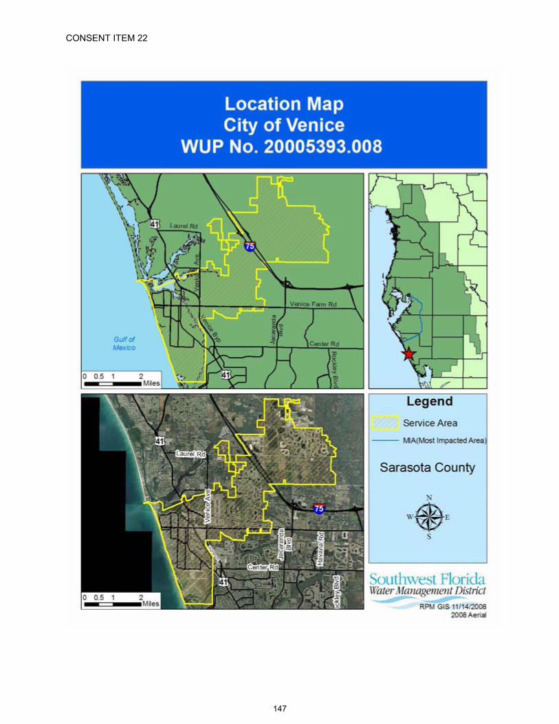
CONSENT ITEM 22
147
CONSENT ITEM 22 Default Date: December 18, 2008
SOUTHWEST FLORIDA WATER MANAGEMENT DISTRICTWATER USEINDIVIDUAL
PERMIT NO. 20005393.008
EXPIRATION DATE: December 16, 2028 PERMIT ISSUE DATE: December 16, 2008
The Permittee is responsible for submitting an application to renew this permit no sooner than one year prior to the expiration date, and no later than the end of the last business day before the expiration date, whether or not the Permittee receives prior notification by mail. Failure to submit a renewal application prior to the expiration date and continuing to withdraw water after the expiration date is a violation of Chapter 373, Florida Statutes, and Chapter 40D-2, Florida Administrative Code, and may result in a monetary penalty and/or loss of the right to use the water. Issuance of a renewal of this permit is contingent upon District approval.
TYPE OF APPLICATION: Renewal
GRANTED TO: City of Venice200 North Warfield AvenueVenice, FL 34292
PROJECT NAME: City of Venice
WATER USE CAUTION AREA: Southern
PROPERTY LOCATION: 162 owned and 8,002 serviced acres in Sarasota County, located within the City of Venice.
ABSTRACT: This is a renewal of an existing public supply permit with no change in quantities. The sole source of water authorized for use by this permit is from brackish groundwater from the Intermediate Aquifer System, an Alternative Water Supply. This renewal authorizes a standard annual average daily quantity of 6,864,000 gpd and a peak month quantity of 8,240,000 gpd.
Special conditions include those that require the Permittee to submit required reports, investigate well complaints, record and report monthly meter readings, monitor water levels and water quality at each wellfield, install production wells as specified and provide location data, cap any withdrawals not in use, plug and abandon designated withdrawal points which are no longer used, maintain a domestic monitor well monitoring network, improve RO efficiency if economically and technically feasible, comply with any future water quality concentration limits set by the District, submit per capita rate reports annually and maintain a rate of less than 150 gpcd, report significant users annually, adopt and report water conserving rate structure, report reuse annually, provide billing and meter reading information to customers annually, document and report any exceedance of the annual average quantity, update service area maps, achieve a minimum 50% beneficial reuse, comply with recovery strategies within the SWUCA, implement a Wellfield Management Plan, operate each wellfield in compliance with designated chloride concentration trigger levels and guidance levels, submit annual reports on wellfield operation, submit water conservation reports every 5 years, and submit compliance reports every 5 years.
CHANGES FROM PRIOR PERMIT:The permit is renewed with a 20-year term, and the addition of Special Conditions requiring 5-year compliance reporting and improved treatment efficiency. There is no change in quantities.
148
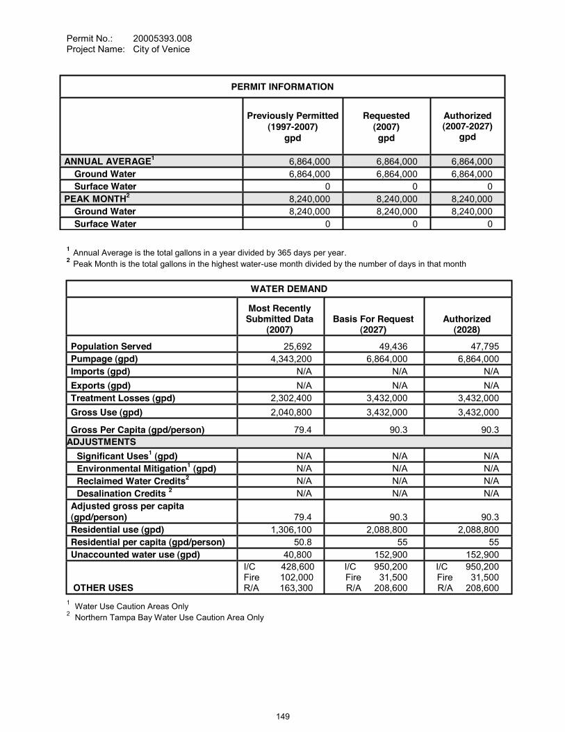
Permit No.: 20005393.008Project Name: City of Venice
1 Annual Average is the total gallons in a year divided by 365 days per year.2 Peak Month is the total gallons in the highest water-use month divided by the number of days in that month
WATER DEMAND
Most Recently Submitted Data
(2007)Basis For Request
(2027)Authorized
(2028)
Population Served 25,692 49,436 47,795Pumpage (gpd) 4,343,200 6,864,000 6,864,000Imports (gpd) N/A N/A N/AExports (gpd) N/A N/A N/ATreatment Losses (gpd) 2,302,400 3,432,000 3,432,000Gross Use (gpd) 2,040,800 3,432,000 3,432,000
Gross Per Capita (gpd/person) 79.4 90.3 90.3ADJUSTMENTS
Significant Uses1 (gpd) N/A N/A N/AEnvironmental Mitigation1 (gpd) N/A N/A N/AReclaimed Water Credits2 N/A N/A N/ADesalination Credits 2 N/A N/A N/A
Adjusted gross per capita (gpd/person) 79.4 90.3 90.3Residential use (gpd) 1,306,100 2,088,800 2,088,800Residential per capita (gpd/person) 50.8 55 55Unaccounted water use (gpd) 40,800 152,900 152,900
OTHER USES
I/C 428,600Fire 102,000R/A 163,300
I/C 950,200Fire 31,500R/A 208,600
I/C 950,200Fire 31,500R/A 208,600
1 Water Use Caution Areas Only2 Northern Tampa Bay Water Use Caution Area Only
PERMIT INFORMATION
Previously Permitted (1997-2007)
gpd
Requested(2007)gpd
Authorized(2007-2027)
gpd
ANNUAL AVERAGE1 6,864,000 6,864,000 6,864,000Ground Water 6,864,000 6,864,000 6,864,000Surface Water 0 0 0
PEAK MONTH2 8,240,000 8,240,000 8,240,000Ground Water 8,240,000 8,240,000 8,240,000Surface Water 0 0 0
149
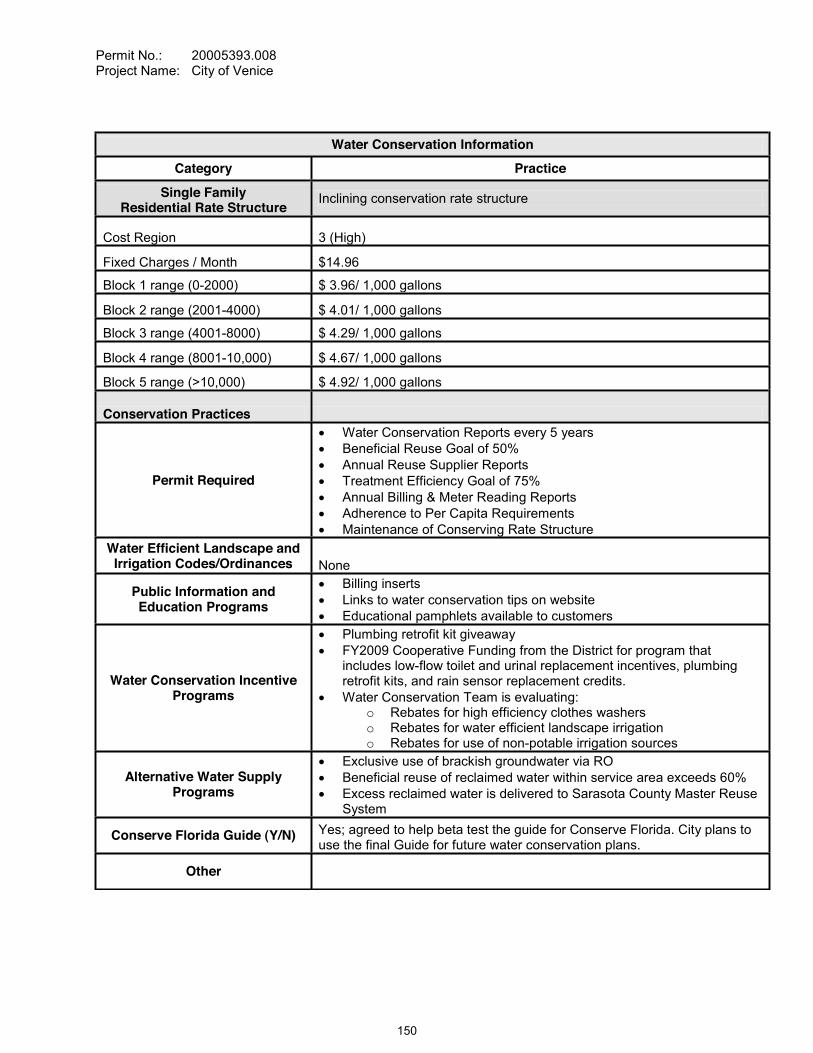
Permit No.: 20005393.008Project Name: City of Venice
Water Conservation Information
Category Practice
Single FamilyResidential Rate Structure
Inclining conservation rate structure
Cost Region 3 (High)
Fixed Charges / Month $14.96
Block 1 range (0-2000) $ 3.96/ 1,000 gallons
Block 2 range (2001-4000) $ 4.01/ 1,000 gallons
Block 3 range (4001-8000) $ 4.29/ 1,000 gallons
Block 4 range (8001-10,000) $ 4.67/ 1,000 gallons
Block 5 range (>10,000) $ 4.92/ 1,000 gallons
Conservation Practices
Permit Required
Water Conservation Reports every 5 yearsBeneficial Reuse Goal of 50%Annual Reuse Supplier ReportsTreatment Efficiency Goal of 75%Annual Billing & Meter Reading ReportsAdherence to Per Capita RequirementsMaintenance of Conserving Rate Structure
Water Efficient Landscape and Irrigation Codes/Ordinances None
Public Information and Education Programs
Billing insertsLinks to water conservation tips on websiteEducational pamphlets available to customers
Water Conservation Incentive Programs
Plumbing retrofit kit giveawayFY2009 Cooperative Funding from the District for program that includes low-flow toilet and urinal replacement incentives, plumbing retrofit kits, and rain sensor replacement credits.Water Conservation Team is evaluating:
o Rebates for high efficiency clothes washerso Rebates for water efficient landscape irrigation o Rebates for use of non-potable irrigation sources
Alternative Water Supply Programs
Exclusive use of brackish groundwater via ROBeneficial reuse of reclaimed water within service area exceeds 60%Excess reclaimed water is delivered to Sarasota County Master Reuse System
Conserve Florida Guide (Y/N) Yes; agreed to help beta test the guide for Conserve Florida. City plans to use the final Guide for future water conservation plans.
Other
150

Permit No.: 20005393.008Project Name: City of Venice
1 Florida Department of Environmental Protection Annual Report, SWFWMD version (SWFWMD, 2007)2 Recharge Infiltration Basins are excluded from the FDEP report for this item.
SPECIAL CONDITIONS:
All conditions referring to approval by the Regulation Department Director, Resource Regulation, shall refer to the Director, Sarasota Regulation Department, Resource Regulation.
SUBMISSION OF REPORTSAll reports and data required by conditions of the permit shall be submitted to the District according to the due dates contained in the specific condition. If the report or data is received on or before the tenth day of the month following data collection, it shall be deemed as a timely submittal. The
orts online. To set up an account, the Permittee can address the request to [email protected]. All mailed reports and data are to be sent to:
RECLAIMED WATERCURRENT1
(2007)PROJECTED
(2028)Total wastewater flow (gpd) 2,980,000 4,110,000Reclaimed water available (gpd) 2,980,000 4,110,000Reclaimed water utilization (gpd) 1,780,000 3,080,000Beneficially used (gpd) 2 1,780,000 3,080,000Reclaimed water disposal (gpd) 1,200,000 1,030,000Potable quality water offset (gpd) 1,360,000 2,310,000Percent of potable quality water offset (gpd) 67% 67%Reclaimed water offset efficiency (%) 76% 75%
151

Permit No.: 20005393.008Project Name: City of Venice
Permit Data Section, Regulation Performance Management DepartmentSouthwest Florida Water Management District2379 Broad StreetBrooksville, Florida 34604-6899
Submission of plans and reports: Unless submitted online or otherwise indicated in the special condition, the original and two copies of each plan and report, such as conservation plans, environmental analyses, aquifer test results, per capita annual reports, etc. are required.
Submission of data: Unless otherwise indicated in the special condition, an original (no copies) is required for data submittals such as crop report forms, meter readings and/or pumpage, rainfall, water level evapotranspiration, or water quality data.
METERING AND PUMPAGE REPORTINGThe Permittee shall meter withdrawals from surface waters and/or the ground water resources, and meter readings from each withdrawal facility shall be recorded on a monthly basis within the last week of the month. The meter readings shall be reported to the Permit Data Section, Regulation Performance Management Department on or before the tenth day of the following month. District-supplied scanning forms shall be used to submit the meter readings unless another arrangement for submission of this data has been approved by the District. The following withdrawal facilities shall be metered:
A. Withdrawal facilities that are not yet constructed, District ID No. 79, Permittee ID No. RO-8E shall be metered within 90 days of completion of construction of the withdrawal.
B. Existing permitted withdrawal facilities shall continue to be metered with non-resettable, totalizing flow meters or other flow measuring devices as approved by the Regulation Department Director, District ID Nos. 33, 34, 35, 49, 50, 51, 52, 54, 55, 56, 51, 65, 77 and 78, Permittee ID Nos.RO-2, RO-3, RO-4, RO-2A, RO-8, RO-7, RO-1E, RO-2E, RO-3E, RO-4E, RO-5E, RO-1A, RO-6E and RO-7E.
The meters shall adhere to the following descriptions and shall be installed or maintained as follows:
A. The meters shall be non-resettable, totalizing flow meters that have a totalizer of sufficient magnitude to retain total gallon data for a minimum of the three highest consecutive months permitted quantities. If other measuring devices are proposed, prior to installation, approval shall be obtained in writing from the Regulation Department Director.
B. The Permittee shall report non-use on all metered standby withdrawal facilities on the scanning form or approved alternative reporting method.
C. If a metered withdrawal facility is not used during any given month, the meter report shall be submitted to the District indicating the same meter reading as was submitted the previous month.
D. The flow meters or other approved devices shall have and maintain an accuracy within five percent of the actual flow as installed.
E. Accuracy testing requirements: 1. For newly metered withdrawal points, the flow meter installation shall be designed
for inline field access for meter accuracy testing. 2. The meter shall be tested for accuracy on-site, as installed, every five years
beginning from the date of its installation for new meters or from the date of initial issuance of this permit containing the metering condition with an accuracy test requirement for existing meters.
3. The testing frequency will be decreased if the Permittee demonstrates to the satisfaction of the District that a longer period of time for testing is warranted.
4. The test will be accepted by the District only if performed by a person
152
Permit No.: 20005393.008Project Name: City of Venice
knowledgeable in the testing equipment used. 5. If the actual flow is found to be greater than 5% different from the measured flow,
within 30 days, the Permittee shall have the meter re-calibrated, repaired, or replaced, whichever is necessary. Documentation of the test and a certificate of re-calibration, if applicable, shall be submitted within 30 days of each test or re-calibration.
F. The meter accurate flow to the specifications above, or it shall be installed in a straight length of pipe where there is at least an upstream length equal to ten (10) times the outside pipe diameter and a downstream length equal to two (2) times the outside pipe diameter. Where there is not at least a length of ten diameters upstream available, flow straightening vanes shall be used in the upstream line.
G. Broken or malfunctioning meter:1. If the meter or other flow measuring device malfunctions or breaks, the Permittee
shall notify the District within 15 days of discovering the malfunction or breakage.2. The meter must be replaced with a repaired or new meter, subject to the same
specifications given above, within 30 days of the discovery. 3. If the meter is removed from the withdrawal point for any other reason, it shall be
replaced with another meter having the same specifications given above, or the meter shall be reinstalled within 30 days of its removal from the withdrawal. In either event, a fully functioning meter shall not be off the withdrawal point for more than 60 consecutive days.
H. While the meter is not functioning correctly, the Permittee shall keep track of the total amount of time the withdrawal point was used for each month and multiply those minutes times the pump capacity (in gallons per minute) for total gallons. The estimate of the number of gallons used each month during that period shall be submitted on District scanning forms and noted as estimated per instructions on the form. If the data is submitted by another approved method, the fact that it is estimated must be indicated. The reason for the necessity to estimate pumpage shall be reported with the estimate.
I. In the event a new meter is installed to replace a broken meter, it and its installation shall meet the specifications of this condition. The permittee shall notify the District of the replacement with the first submittal of meter readings from the new meter.
WATER QUALITY SAMPLING AT PRODUCTION WELLSWater quality samples shall be collected and analyzed, for parameters, and frequency(ies) specified below. Water quality samples from production wells shall be collected whether or not the well is being used, unless infeasible. If sampling is infeasible the Permittee shall indicate the reason for not sampling on the water quality data form. Water quality samples shall be analyzed by a laboratory certified by the Florida Department of Health utilizing the standards and methods applicable to the parameters analyzed and to the water use pursuant to Chapter 64E-1, F.A.C., "Certification of Environmental Testing Laboratories". At a minimum, water quality samples shall be collected after pumping the well at its normal rate for a pumping time specified in the table below, or to a constant temperature, pH, and conductivity. In addition, the Permittee's sampling procedure shall follow the handling and chain of custody procedures designated by the certified laboratory which will undertake the analysis. Any variance in sampling and/or analytical methods shall have prior approval of the Regulation Department Director, Resource Regulation. Reports of the analyses shall be submitted to the Permit Data Section, Regulation Performance Management Department, (using District forms) on or before the tenth day of the following month, and shall include the signature of an authorized representative and certification number of the certified laboratory which undertook the analysis. The parameters and frequency of sampling and analysis may be modified by the Regulation Department Director, Resource Regulation, as necessary to ensure the protection of the resource.
153
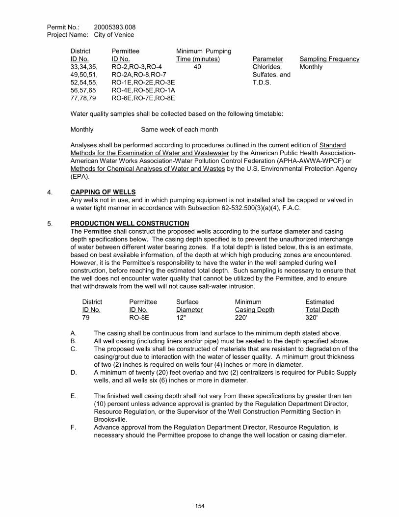
Permit No.: 20005393.008Project Name: City of Venice
District Permittee Minimum PumpingID No. ID No. Time (minutes) Parameter Sampling Frequency33,34,35, RO-2,RO-3,RO-4 40 Chlorides, Monthly49,50,51, RO-2A,RO-8,RO-7 Sulfates, and52,54,55, RO-1E,RO-2E,RO-3E T.D.S.56,57,65 RO-4E,RO-5E,RO-1A77,78,79 RO-6E,RO-7E,RO-8E
Water quality samples shall be collected based on the following timetable:
Monthly Same week of each month
Analyses shall be performed according to procedures outlined in the current edition of Standard Methods for the Examination of Water and Wastewater by the American Public Health Association-American Water Works Association-Water Pollution Control Federation (APHA-AWWA-WPCF) or Methods for Chemical Analyses of Water and Wastes by the U.S. Environmental Protection Agency (EPA).
CAPPING OF WELLSAny wells not in use, and in which pumping equipment is not installed shall be capped or valved in a water tight manner in accordance with Subsection 62-532.500(3)(a)(4), F.A.C.
PRODUCTION WELL CONSTRUCTIONThe Permittee shall construct the proposed wells according to the surface diameter and casing depth specifications below. The casing depth specified is to prevent the unauthorized interchange of water between different water bearing zones. If a total depth is listed below, this is an estimate, based on best available information, of the depth at which high producing zones are encountered. However, it is the Permittee's responsibility to have the water in the well sampled during well construction, before reaching the estimated total depth. Such sampling is necessary to ensure that the well does not encounter water quality that cannot be utilized by the Permittee, and to ensure that withdrawals from the well will not cause salt-water intrusion.
District Permittee Surface Minimum EstimatedID No. ID No. Diameter Casing Depth Total Depth79 RO-8E 12" 220' 320'
A. The casing shall be continuous from land surface to the minimum depth stated above.B. All well casing (including liners and/or pipe) must be sealed to the depth specified above.C. The proposed wells shall be constructed of materials that are resistant to degradation of the
casing/grout due to interaction with the water of lesser quality. A minimum grout thickness of two (2) inches is required on wells four (4) inches or more in diameter.
D. A minimum of twenty (20) feet overlap and two (2) centralizers is required for Public Supply wells, and all wells six (6) inches or more in diameter.
E. The finished well casing depth shall not vary from these specifications by greater than ten (10) percent unless advance approval is granted by the Regulation Department Director, Resource Regulation, or the Supervisor of the Well Construction Permitting Section in Brooksville.
F. Advance approval from the Regulation Department Director, Resource Regulation, is necessary should the Permittee propose to change the well location or casing diameter.
154
Permit No.: 20005393.008Project Name: City of Venice
The Permittee shall submit a copy of the well completion report as filed with choose one:the Environmental Action Commission of Manatee County or Sarasota County Health Department to the District Permit Data Section, Regulation Performance Management Department within 30 days of well completion.
CONCENTRATION LIMITSThe District reserves the right to set Sulfate and TDS concentration limits on any production well in the future, based on data collected and after a sufficient data base has been established to determine limits. These limits shall be required after discussions with the Permittee. At such time as the concentration in any water sample reaches or exceeds the designated concentration limits, the Permittee shall take appropriate action to reduce concentrations to below those set for the particular well. If the District determines that long-term upward trends or other significant water quality changes are occurring, the District may reconsider the quantities permitted.
COMPLIANCE WITH PERMITTED QUANTITIESCompliance with the allocated standard annual average quantity and drought annual average quantities is based on a rolling 12-month calculation where the current pumpage is added to thepumpage for the previous 11 months, and the total is then divided by the number of days in those 12 months for gallons per day. If the Permittee exceeds the allocated standard annual average quantity or drought annual average quantities during any month, within 30 days the Permittee must submit a report to the District that includes reasons why the allocated quantities were exceeded, efforts already taken to attempt meeting the allocated quantities, and a plan to bring the permit into compliance. Reports for Permittees not achieving the allocated quantities are subject to District approval. Justification for exceeding the allocated quantities does not constitute a waiver of the District's authority to enforce the terms and conditions of the permit.
COMPLIANCE WITH SWUCA RECOVERY STRATEGYThis Permit is located within the Southern Water Use Caution Area (SWUCA). Pursuant to Section 373.0421, Florida Statutes, the SWUCA is subject to a minimum flows and levels recovery strategy, which became effective on January 1, 2007. The Governing Board may amend the recovery strategy, including amending applicable water use permitting rules based on an annual assessment of water resource criteria, cumulative water withdrawal impacts, and on a recurring five-year evaluation of the status of the recovery strategy up to the year 2025 as described in Chapter 40D-80, Florida Administrative Code. This Permit is subject to modification to comply with new rules.
PER CAPITA ANNUAL REPORTThe Permittee shall submit an Annual Report to the District, by April 1 of each year, that includes:A. Service area functional population (FP) served and methodology for determining service
area functional population. As of April 1, 2009, for the 2008 calendar year data, the Permitte
Water Use Permit Applications and its applicable appendices Part D of the Basis of Review for Water Use Permit Applications (BOR). The applicable Worksheets from Part D and supporting documentation for calculations of per capita rates are required.
B. Non-residential significant water use (SU) that complies with criteria listed in Part B, Chapter 3, Section 3.6 of the BOR. All significant uses and associated quantities shall be listed even if not deducted. For those significant uses that are deducted in the calculation of adjusted per capita use, the Permittee shall identify the following:1. The Type of significant use chosen.2. The name, location and mailing address for each significant use.3. Meter type.4. Use of the water5. Meter readings or other documentation of the annual average quantity provided
155

Permit No.: 20005393.008Project Name: City of Venice
6. Conservation plans appropriate to the Type of significant use chosen, and 7. Documentation that the conservation plan is being implemented.
C. Total withdrawals (WD). The permittee may use data from a master meter for this item.D. Treatment losses (TL), including a description of how the losses are calculated.E. District-required environmental mitigation (EM) quantities, including details concerning the
environmental features mitigated and the method of mitigation.F. Imported (IM) and Exported (EX) transfers of bulk water. Include:
1. Monthly and annual average gallons per day with quantities determined at your departure point.
2. Meter type and size.3. Receiver name, mailing address, telephone number, location (latitude and
longitude) of point of receivership.4. The water use permit number for any receiver that has a wholesale water use
permit. 5. A description of how recipients of bulk transfers of water or wholesale purchasers
adhere to your water conservation plan if they do not have a water use permit.G. Calculation of the adjusted gross per capita rate as follows:
WD + IM EX TL SU EMFP
H. Water Rate Structure: A description of the current water rate structure, how it has promoted water conservation to customers, water use savings due to the water rate structure, and any proposed amendments to the structure that is designed to promote water conservation.
I. Water Conservation: A detailed description of the Permittee's water conservation activities for the previous year as well as a description of ongoing and planned water conservation activities.
J. Unaccounted Water Loss: Annual Average daily quantity of unaccounted water lost and the percentage of unaccounted water lost relative to total withdrawals.
K. Audit activities that includes but is not limited to a description of all unaccounted water losses, the ongoing leak detection, and meter change-out programs. If the unaccounted water losses are 12% or more of total withdrawals after subtracting treatment losses, the Permittee shall submit a comprehensive water audit report yearly on or before October 1 which specifically addresses the unaccounted water losses and provides an implementation schedule for remedial actions to reduce these losses below 12%. The water audit report shall continue to be submitted annually until the unaccounted water losses are less than 12% of total withdrawals after subtracting treatment loss.
L. Residential Water Use: Total water use information on residential water use (including indoor and outdoor use) for the following categories of residential use. Describe the methodology used to determine the number of residences in each category. Estimates based on meter size will not be accepted.1. The number of single family units served.2. The number of multi-family units served.3. The number of mobile homes served, unless mobile homes are included in the
number of single-family units.M. Suppliers of Alternative Water Report. The report must document the quantity of reclaimed
water or stormwater supplied as beneficial reuse to residential customers and to bulk customers on both an annual average daily and monthly basis. Include with the report:1. Meter readings of actual deliveries, but if this is not available, billing information
may be submitted if the bill indicates quantities delivered.
156
Permit No.: 20005393.008Project Name: City of Venice
2. For all individual customer reuse connections with line sizes of four inches or greater, include:(a) Account name and address.(b) Location of connection by latitude-longitude.(c) Line size.(d) If metered:
i. Metered quantities andii. Ownership of the meter.
(e) The customer's stated use for the water. (f) Water Use Permit number for those customers having a water use permit
from the District.N. Disposal: Documentation of quantities of reclaimed water and stormwater disposed,
location of disposal site, and manner of disposal. O. Service Area Map: With every sixth yearly report, a current service area map as described
in the Service Area Map Special Condition.
The Permittee may use the Public Supply Surveys to provide the information required by this condition, completing only the parts required by this condition. The survey forms are usually sent to the Permittee by the first week of January of each year, or they may be requested or
assistance with completion of the annual report on the District's website.
REUSE SUPPLIER ANNUAL REPORTBy January 1 of each year, for the preceding calendar year or fiscal year (October 1 through September 30), the Permittee shall submit a report detailing:
A. Quantity of total reclaimed water provided by the Permittee for reuse on both a total annual average daily and monthly basis;
B. For all individual customer reuse connections with line sizes of 4 inches or greater, list:
1. account name and address;2. location of connections by latitude - longitude;3. line size;4. meter (yes or no); and5. metered quantities, if metered.
ANNUAL BILLING AND METER READING REPORTThe Permittee shall read each customer's meter and bill the customer no less frequently than bi-monthly (every other month), and the customer's billing period usage shall be indicated on each bill. In addition, the Permittee shall provide the following information to all water customers at least once each calendar year:
A. Rate structure information describing applicable fixed and variable charges rates, minimum quantity charges, block size and pricing, seasonal rates, and applicable months. If billing units are not in gallons, a means to convert the billing units to gallons must be described to the customer with this information.
B. Historical billing period usage averaged over the three previous years for the applicable customer class.
SERVICE AREA MAPThe Permittee shall include an updated service area map with the Annual Report that is due April 1, 2015. The map shall adhere to the following guidelines:
157

Permit No.: 20005393.008Project Name: City of Venice
A. The service area map shall build upon and clearly show any changes relative to the existing service area map in the District's electronic public supply service area boundary map file. If there are no changes, the Permittee may submit a statement with the Annual Report that there have been no changes to the map in the District map file. The Permittee may contact the District for assistance in accessing this map.
B. If a service area map is not on file in the District's GIS, it may be submitted in paper format or in District-compatible electronic file format. The map must include a north arrow (or show S-T-R lines) and have the scale clearly indicated. If it is not an aerial photographic map, it must include readily recognizable roads or streets and other identifiable landmarks. It must contain a legend to define all symbols used. A paper map must have a minimum scale of 1 inch = 2,000 feet or larger.
C. The map must clearly delineate the current area served, any areas proposed to be served within the permit term, and definable areas within the service area that are not served because the population uses domestic potable wells. If any of these un-served areas are scheduled to be included in the service area within the permit term, documentation such as a capital improvement plan that demonstrates the proposed inclusion is required to be submitted with the updated map.
D. With each service area map submittal, the following information must be included:1. A current general utility contact person name, title, email address and phone
number.2. A current contact person name, title, email address and phone number whom
District staff may call concerning the service area map.3. The metadata for the map if the map is submitted as an electronic file that is
compatible with the District's format.4. The District permit numbers and Florida Department of Environmental Protection
Public Water Supply Identifier (PWSI) numbers and area designation names for each area served by a separate potable water treatment plant, as applicable.
5. A description of routine water transfer interconnections between service areas and other utilities or wholesale suppliers or recipients.
6. The name, phone number, and all District water use permit numbers for each utility urchase
quantity in millions of gallons per day.7. The name, phone number, and District water use permit numbers of each utility
from which that the permittee purchases water on a routine basis and the most allons per day.
BENEFICIAL REUSEThe Permittee is encouraged to demonstrate that beneficial reuse of treated effluent is maximized so that 50% or more of the total annual treated effluent flow is beneficially reused. The calculation of the percentage beneficially reused will be based on the Permittee's waste water treatment plants that have a capacity of 0.5 million gallons per day or greater. Beneficial reuse includes:
A. Landscape irrigation of golf courses, playing fields, cemeteries, parks, playgrounds, school yards, retail nurseries and commercial, industrial and residential properties.
B.flowers", sod farms and improved pastures.
C. Ground water recharge where such recharge results in environmental or water supply benefit.
D. Industrial uses for cooling water, process water and wash waters.E. Wetlands restoration.F. Fire protection.G. Environmental enhancement, including discharges to surface waters to replace
withdrawals.
158
Permit No.: 20005393.008Project Name: City of Venice
Other useful purposes accepted by the District or allowed under a DEP permit pursuant to Chapter 62-610, F.A.C.
PER CAPITAThe Permittee shall adhere to the adjusted gross per capita (AGPC) requirements below:
A. The AGPC daily water use rate shall be no greater than 150 gallons per day (gpd) per person. The Permittee shall calculate the AGPC rate as described in the Annual Report Condition on this permit and shall submit the calculations with the Annual Report by April 1 of each year.
B. If the AGPC rate is greater than 150 gpd per person, the Permittee shall submit a report that documents why this rate was exceeded, measures previously or currently taken to reduce their AGPC rate, and a plan that describes additional measures and implementation dates for those measures to bring their AGPC rate to or below 150 gpd per person. This report shall be submitted with the Annual Report by April 1 for each year the AGPC rate exceeds 150 gpd per person.
Reports for Permittees not achieving the required adjusted gross per capita rate are subject to District approval. Justification for exceeding the adjusted gross per capita rate does not constitute a waiver of the District's authority to enforce the terms and conditions of the permit.
WATER CONSERVING RATE STRUCTUREThe Permittee shall continue to have and maintain a water conservation oriented rate structure. A report on the effectiveness of the water conserving rate structure shall be submitted with each Annual Report by April 1 of each year. Changes made to the rate structure since 2004 and changes made during any year afterward and its impact on water conservation shall be included with the report.
16. WELLFIELD MANAGEMENT PLANUpon permit issuance, the Permittee shall implement the Wellfield Management Plan (the Plan) as submitted to the District on November 4, 2008. The Plan is hereby incorporated by reference into this Water Use Permit (WUP). Where the special conditions of the Permit deviate from the Plan, the conditions of this permit shall supersede the Plan. The District reserves the right to require modification of the Plan as necessary to protect the resource. Such modifications will only occur after discussion and consultation with the Permittee. The Permittee may also request modification to the Wellfield Management Plan in writing. Such requested modification shall require written approval from the Sarasota Regulation Department Director. If the District determines that significant adverse impacts are occurring due to withdrawals, the District may reconsider the quantities permitted.
17. WATER CONSERVATION REPORTSBy January 15, 2014 with follow-up reports due January 15, 2019 and January 15, 2024, the Permittee shall submit a report for approval by the Sarasota Regulation Department Director, which addresses the feasibility of implementing water conservation measures during the term of this permit. Conservation measures to be analyzed shall include, but are not necessarily limited to the following:
A. GENERAL CONSERVATION MEASURESPublic education and awareness; alternative sources programs such as, but not limited to reclaimed water, stormwater runoff, etc.; comprehensive plan goals, objectives, and/or policies; adoption and enforcement of water restrictions; building codes and/or ordinances promoting conservation and water audits.
159
Permit No.: 20005393.008Project Name: City of Venice
B. INDOOR CONSERVATION MEASURESResidential water conserving retrofit kits which may include showerheads, toilet tank devices, leak detection programs, faucet aerators, installation instructions, and rebate programs.
C. OUTDOOR CONSERVATION MEASURESIrrigation audits or evaluations of significant irrigation water users, water-efficient landscape and xeriscape ordinances and rebate programs; automatic irrigation system shut-off device ordinance and rebate programs.
The preparation of this report shall be coordinated with the District's Sarasota Water Use Regulation Manager via meeting scheduled to be held at least 60 days prior to report submittal. The report shall include an economic feasibility analysis. It is understood that the District will, as requested by the Permittee, coordinate on and provide technical assistance in preparation of this economic analysis. A reasonable schedule for implementation shall be provided for those conservation measures found by the Permittee, in consultations with the District, to be feasible. For those measures determined infeasible by the Permittee, in consultation with the District, the City shall provide a detailed explanation supporting why the measure is infeasible.
Each report shall also specify conservation measures which have been implemented to date by the City, as well as provide an estimate of water savings experienced as a result of these implemented measures. Methodologies and calculations used to estimate water savings shall also be provided.
18. WELLFIELD ROTATION The Permittee shall undertake wellfield rotation as described in the Plan, and shall incorporate District ID No. 79, Permittee ID No. RO8E, into the Plan upon placing this production well into full service. The Permittee will also continue to evaluate the potential need for dispersion of pumpage to decrease any adverse effects of wellfield pumpage on water quality as identified according to the Wellfield Management Plan. The permittee will also exercise good faith in negotiating additional production well sites on future annexed parcels east of Pinebrook Road for potential wellfield dispersion purposes. The Permittee shall also continue to exercise good faith in negotiating additional monitor well sites on future annexed parcels.
19. DOMESTIC MONITOR WELL MONITORING NETWORKThe Permittee will continue to monitor water quality at the domestic wells identified in the Plan. At a minimum, samples will be collected on an annual basis for laboratory analysis of chlorides, sulfates, and TDS. The information obtained through the domestic monitor well monitoring network shall be used in the event that a water quality related complaint is received by the District or the Permittee, to determine if pumpage from the wellfields is responsible for a change in water quality, or if the Permittee has requested a modification of the chloride concentration trigger levels. Results of the annual sampling of domestic wells shall be included in the Permittee's Wellfield Annual Report (Special Condition 26).
20. WATER LEVEL MONITORING
A. Monitor WellsThe Permittee shall monitor water levels in the monitor wells as specified in the table below. Reports of the data shall be submitted to the Permit Data Section, in a form acceptable to the District on or before the fifteenth (15th) day of the following month. All data shall be referenced to National Geodetic Vertical Datum (NGVD). The frequency of water-level recording may be modified by the Regulation Department Director, as necessary to ensure the protection of the resource.
160

Permit No.: 20005393.008Project Name: City of Venice
District Permittee RecordingID No. ID No. Aquifer Frequency37 RO6 PZ-3/Intermediate Monthly38 38 PZ-2/Intermediate Monthly58 OBW-2 Upper Floridan Monthly60 IM-1 PZ-3/Intermediate Monthly102 Island-1 PZ-2/Intermediate Monthly103 Island-2 PZ-2/Intermediate Monthly104 Island-3-PZ-2 PZ-2/Intermediate Monthly105 Island-3-PZ3 PZ-3/Intermediate Monthly106 AFR-PZ-2 PZ-2/Intermediate Monthly107 AFR-PZ-3 PZ-3/Intermediate Monthly108 EWF-N PZ-2/Intermediate Monthly109 EWF-E PZ-2/Intermediate Monthly111 SG-PZ3B PZ-3/Intermediate Monthly113 SG-PZ1 PZ-1/Intermediate Monthly
Water levels shall be recorded on the same day of each week.
B. Annual ReportWater level data and changes to recording frequency during the annual reporting period shall be summarized in the annual report, as described in the Wellfield Annual Reportcondition of the permit.
21. WATER QUALITY SAMPLING AT MONITOR WELLSWater quality samples from monitor wells shall be collected and analyzed for the District ID No., parameters, and frequency(ies) specified in the table below. Water quality samples shall be analyzed by a laboratory certified by the Florida Department of Health utilizing the standards and methods applicable to the parameters analyzed and to the water use pursuant to Chapter 64E-1,
sampling and/or analytical methods shall have prior approval of the Regulation Department Director, Resource Regulation. Reports of the analyses shall be submitted to the Permit Data Section, Regulation Performance Management Department, on District forms on or before the fifteenth (15th) day of the following month, and shall include the signature of an authorized representative and certification number of the certified laboratory that undertook the analysis. Reports mailed should be sent to the address indicated above. The parameters and frequency of sampling and analysis may be modified by the District as necessary to ensure the protection of the resource.
District PermitteeID No. ID No. Parameter Sample Frequency
37 RO-6 Chlorides, Sulfates, TDS Monthly38 38 Chlorides, Sulfates, TDS Monthly58 OBW-2 Chlorides, Sulfates, TDS Monthly60 IM-1 Chlorides, Sulfates, TDS Monthly102 Island-1 Chlorides, Sulfates, TDS Monthly103 Island-2 Chlorides, Sulfates, TDS Monthly104 Island-3-PZ-2 Chlorides, Sulfates, TDS Monthly105 Island-3-PZ-3 Chlorides, Sulfates, TDS Monthly106 AFR-PZ-2 Chlorides, Sulfates, TDS Monthly107 AFR-PZ-3 Chlorides, Sulfates, TDS Monthly108 EWF-N Chlorides, Sulfates, TDS Monthly109 EWF-E Chlorides, Sulfates, TDS Monthly
161
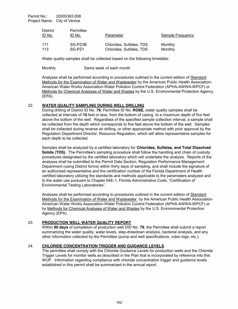
Permit No.: 20005393.008Project Name: City of Venice
District PermitteeID No. ID No. Parameter Sample Frequency
111 SG-PZ3B Chlorides, Sulfates, TDS Monthly113 SG-PZ1 Chlorides, Sulfates, TDS Monthly
Water quality samples shall be collected based on the following timetable:
Monthly Same week of each month
Analyses shall be performed according to procedures outlined in the current edition of Standard Methods for the Examination of Water and Wastewater by the American Public Health Association-American Water Works Association-Water Pollution Control Federation (APHA-AWWA-WPCF) or Methods for Chemical Analyses of Water and Wastes by the U.S. Environmental Protection Agency (EPA).
22. WATER QUALITY SAMPLING DURING WELL DRILLINGDuring drilling of District ID No. 79, Permittee ID No. RO8E, water quality samples shall be collected at intervals of 10 feet or less, from the bottom of casing to a maximum depth of five feet above the bottom of the well. Regardless of the specified sample collection interval, a sample shall be collected from the depth which corresponds to five feet above the bottom of the well. Samples shall be collected during reverse air drilling, or other appropriate method with prior approval by the Regulation Department Director, Resource Regulation, which will allow representative samples for each depth to be collected.
Samples shall be analyzed by a certified laboratory for Chlorides, Sulfates, and Total Dissolved Solids (TDS). The Permittee's sampling procedure shall follow the handling and chain of custody procedures designated by the certified laboratory which will undertake the analysis. Reports of the analyses shall be submitted to the Permit Data Section, Regulation Performance Management Department (using District forms) within thirty days of sampling, and shall include the signature of an authorized representative and the certification number of the Florida Department of Health certified laboratory utilizing the standards and methods applicable to the parameters analyzed and to the water use pursuant to Chapter 64E-
Analyses shall be performed according to procedures outlined in the current edition of Standard Methods for the Examination of Water and Wastewater by the American Public Health Association-American Water Works Association-Water Pollution Control Federation (APHA-AWWA-WPCF) or by Methods for Chemical Analyses of Water and Wastes by the U.S. Environmental Protection Agency (EPA).
23. PRODUCTION WELL WATER QUALITY REPORTWithin 90 days of completion of production well DID No. 79, the Permittee shall submit a report summarizing the water quality, water levels, step-drawdown analysis, bacterial analysis, and any other information collected by the Permittee (pump and well specifications, video logs, etc.).
24. CHLORIDE CONCENTRATION TRIGGER AND GUIDANCE LEVELSThe permittee shall comply with the Chloride Guidance Levels for production wells and the Chloride Trigger Levels for monitor wells as described in the Plan that is incorporated by reference into this WUP. Information regarding compliance with chloride concentration trigger and guidance levels established in this permit shall be summarized in the annual report.
162
Permit No.: 20005393.008Project Name: City of Venice
25. TREATMENT EFFICIENCYBy January 15, 2013, the Permittee shall complete a detailed study for District approval regarding the technical, environmental, and economic, feasibility of increasing current reverse osmosis water treatment efficiency rates (i.e. increased recovery rates). The goal of the study will be to assess the necessary steps, costs, and potential outcomes related to increasing water treatment efficiency to the highest degree feasible, with a target efficiency of 75%, or greater by the end of the permit duration. The study shall include:
A. Review and analysis of source water chemistry and treatment issues such as precipitation of elevated concentrations of calcium carbonate, calcium sulfate, and other elements that could cause irreversible fouling and damage to the membranes.
B. Review and analysis of new membrane separation and other technologies that have emerged since the Permittee last invested in its current water quality treatment system, including the use of improved scale inhibitors and new membrane technologies;
C. Modeling and full scale testing necessary to determine technical feasibility; D.
continue its existing surface water discharge under its current National Pollution Discharge Elimination System (NPDES) permit, or whether a modified NPDES permit could be attained for such discharges.
E. Identification of whether a feasible opportunity exists to dispose of RO concentrate through a deep injection well (in the event that surface discharges would no longer be permittable
partner with other nearby local governments in sharing existing or new deep injection wells. F. An assessment of anticipated infrastructure and labor costs necessary to achieve an
increase in water treatment efficiency and the approximate timeframe required for implementation.
The report will describe and detail pertinent economic, technical and environmental considerations
feasible to increase the water treatment efficiency, the Permittee shall identify the anticipated treatment efficiency rate and provide a proposed schedule for implementation. Should it be concluded, in consultation with District staff, that it is infeasible to increase the water treatment efficiency, the Permittee shall provide updated feasibility reports as described herein by January 15 of 2018, 2023, and at the time of permit renewal in 2028, unless increases in treatment efficiency are implemented which met the intent of this permit condition. Nothing in this condition is intended to preclude the Permittee from requesting District cooperative funding for the feasibility study described above.
26. WELLFIELD ANNUAL REPORTThe Permittee shall prepare a comprehensive but concise annual report on wellfield operation (Annual Report), an assessment of the water resources of the wellfield area based on the subject areas listed below. This report shall concisely summarize the elements listed below, with emphasis on the interactions between these elements, where appropriate. Data sources shall be referenced, but no raw data shall be included in the report. Only essential text, graphs, and tables should be included in the report. Three copies of the report shall be submitted to the Regulation Department Director by April 15 of each year. The report shall cover all activities and conditions pertaining to the City of Venice wellfields and service area for the preceding water year (October 1 to September 30). The specific elements of this report are listed below, but are not limited to:
A. Water UsePumpage quantity and water distribution information collected for the Pumpage Reportingcondition of this permit shall be summarized for the annual reporting period. A population estimate for the annual reporting period, which includes only those served by the municipal system within the service area, shall be provided and referenced. The quantities of water
163
Permit No.: 20005393.008Project Name: City of Venice
shall be used with the population estimate to determine a per capita use for the period. The report should also include information regarding any quantities of water received from
-capita rate shall be calculated as defined in Chapter 40D-2, Water Use Permitting Rules, F.A.C., Basis of Review. Any changes to the service area boundaries shall be described and plotted on a map.
An overview of the wellfield rotation for the previous 12-months (i.e., which wells were used more, which wells were used less, and reasons for doing same, future changes or modifications to the wellfield rotation plan due to the yield from the various wells, future annexation sites, potential future production well sites, etc.).
B. Chloride Concentration Guidance and Trigger LevelsThe Permittee shall summarize compliance with, and any events related to, the chloride concentration guidance and trigger levels components of the Wellfield Management Plan in the annual report.
C. Water Quality SamplingWater quality sampling collected for the Water Quality Sampling condition of this permit shall be summarized for the annual reporting period and the period of record. The report should delineate areas of concern with respect to changing water quality, changes in water quality specifically in zones PZ-2 and PZ-3, any shift in the fresh/saltwater interface (horizontally or vertically), or other trends which have occurred.
D. Domestic MonitoringDomestic water quality monitoring required for the Domestic Monitor Well Monitoring Network condition of this permit shall be summarized for the annual reporting period. The report should delineate areas of concern with respect to any water quality trends identified, any changes with respect to the number or location of wells included within the program, or other information which may be deemed appropriate in order to protect the quality of the resource.
E. Water Level MonitoringWater levels collected for the Water Level Monitoring condition of this permit shall be summarized for the annual reporting period. The report should delineate any areas of concern with respect to water levels within the aquifers monitored, changes in sampling locations, number of wells included in the program, etc., or any other information which may be deemed appropriate in order to protect the resource.
F. Data AnalysesStatistical trend analysis, such as double-mass curve analysis, multiple linear regression, time series analysis, and factor analysis shall be performed for the annual reporting period and the period of record to analyze the interactions of rainfall and pumpage on changes in water quality or water levels. A brief summary of any recommended changes to the monitoring requirements shall be provided.
G. Capital Improvement Program StatusFor the annual reporting period, a summary of completed water supply system improvements shall be provided. In addition, an update to any documented system weaknesses or anticipated system improvements shall be described.
164

Permit No.: 20005393.008Project Name: City of Venice
H. Water Treatment EfficiencyA description of efforts to improve water treatment efficiency shall be included in the Annual Report. This shall include good faith efforts undertaken in its infrastructure planning and implementation efforts. Opportunities during the prior year to replace water treatment-related infrastructure, including items such as change-outs to pressure vessels, piping, racks (skids), and treatment membrane elements shall be discussed.
27. FIVE-YEAR COMPLIANCE REPORTSThe permittee shall submit a compliance report at 5, 10, and 15 years after permit issuance. Specifically, the permittee shall submit the report by January 15, 2014; January 15, 2019, andJanuary 15, 2024. The report must contain sufficient information to demonstrate reasonable assurance that the permitted withdrawals and use of water continue to meet the conditions for permit issuance set forth in Rule 40D-2 and the Basis of Review for Water Use Permits. The compliance report must include:
A. information documenting water demands and updated demand projections demonstrating that allocations from all sources in the permit will continue to be needed for the remainder of the permit duration;
B. documentation verifying that the sources are capable of supplying the needs authorized by this permit without causing harm to water and water-related resources;
C. documentation verifying that use of water is efficient and that the permittee is implementing all feasible water conservation measures;
D. an updated ground water modeling analysis and data analysis demonstrating that the use of groundwater for public supply does not interfere with legal uses existing at the time of permit issuance;
E. an updated ground water modeling analysis, along with statistical analyses of water-level and wetland monitoring data, demonstrating that the use does not cause adverse impacts to wetlands, springs, and surface waters, or violations of MFLs;
F. documentation that ground water withdrawals by the permittee are not causing or contributing to significant saltwater intrusion, including but not limited to review and statistical analyses of groundwater level and water quality data collected by the permittee under this permit;
G. information demonstrating that the lowest quality source of water, including reclaimed water, is being used to meet water demands within the service area;
H. information demonstrating that the Permittee is implementing feasible options to maximize the efficient reuse of reclaimed water to meet irrigation, commercial and industrial needs, by providing it either to utility customers or to other users, including detailed information concerning the status of all existing and proposed reuse projects.
Following review of this report, the District may modify the permit to ensure that the use meets the conditions for issuance.
165

Permit No.: 20005393.008Project Name: City of Venice
WITHDRAWAL POINT QUANTITY TABLEWater use from these withdrawal points is restricted to the quantities given below:
I.D. NO.PERMITTEE/
DISTRICTDIAM.(IN.)
DEPTHTTL./CSD.FT.
(feet bls) USE
GALLONS PER DAY
AVERAGE PEAK MONTHRO-2 / 33 10 385 / 230 B 338,000 405,700
604,800 604,800 Withdrawal FlexibilityRO-3 / 34 10 450 / 230 B 354,100 425,100
633,600 633,600 Withdrawal FlexibilityRO-4 / 35 10 450 / 230 B 362,100 434,700
648,000 648,000 Withdrawal FlexibilityRO-2A / 49 10 450 / 230 B 338,000 405,700
604,800 604,800 Withdrawal FlexibilityRO-8 / 50 12 450 / 230 B 523,000 627,900
936,000 936,000 Withdrawal FlexibilityRO-7 / 51 12 350 / 230 B 442,600 531,300
792,000 792,000 Withdrawal FlexibilityRO-1E / 52 12 405 / 269 B 402,300 483,000
720,000 720,000 Withdrawal FlexibilityRO-2E / 54 12 261 / 207 B 523,000 627,900
936,000 936,000 Withdrawal FlexibilityRO-3E / 55 12 360 / 197 B 523,100 627,900
936,000 936,000 Withdrawal FlexibilityRO-4E / 56 12 320 / 242 B 523,000 627,900
936,000 936,000 Withdrawal FlexibilityRO-5E / 57 12 320 / 228 B 523,100 627,900
936,000 936,000 Withdrawal FlexibilityRO-1A / 65 12 359 / 225 B 442,600 531,300
792,000 792,000 Withdrawal FlexibilityRO-6E / 77 12 320 / 220 B 523,000 627,900
936,000 936,000 Withdrawal FlexibilityRO-7E / 78 12 320 / 220 B 523,100 627,900
936,000 936,000 Withdrawal FlexibilityRO-8E / 79 12 320 / 220 B 523,000 627,900
936,000 936,000 Withdrawal Flexibility
B = Public Supply
166

Permit No.: 20005393.008Project Name: City of Venice
WITHDRAWAL POINT LOCATION TABLE
DISTRICTI.D. NO. LATITUDE/LONGITUDE SECTION/TOWNSHIP/RANGE
33 270610.00/822627.60 07/39/1934 270557.80/822624.30 07/39/1935 270545.60/822617.00 07/39/1949 270604.04/822626.40 07/39/1950 270508.40/822550.10 17/39/1951 270527.60/822604.10 18/39/1952 270644.80/822453.60 04/39/1954 270733.90/822501.40 33/38/1955 270722.70/822433/70 33/38/1956 270724.80/822403.40 33/38/1957 270709.60/822501/40 04/39/1965 270602.50/822617.00 07/39/1977 270636.26/822424.47 04/39/1978 270605.35/822425.56 09/39/1979 270558.04/822527.62 08/39/19
STANDARD CONDITIONS:
The Permittee shall comply with the Standard Conditions attached hereto, incorporated herein by reference as Exhibit "A" and made a part hereof.
___________________________________________Authorized SignatureSOUTHWEST FLORIDA WATER MANAGEMENT DISTRICT
This permit, issued under the provision of Chapter 373, Florida Statutes and Florida Administrative Code 40D-2, authorizes the Permittee to withdraw the quantities outlined above, and may require various activities to be performed by the Permittee as described in the permit, including the Special Conditions. This permit does not convey to the Permittee any property rights or privileges other than those specified herein, nor relieve the Permittee from complying with any applicable local government, state, or federal law, rule, or ordinance.
167

The following Standard Conditions are included on all Water Use Permits issued pursuant to 40D-2, Florida
Administrative Code.
168
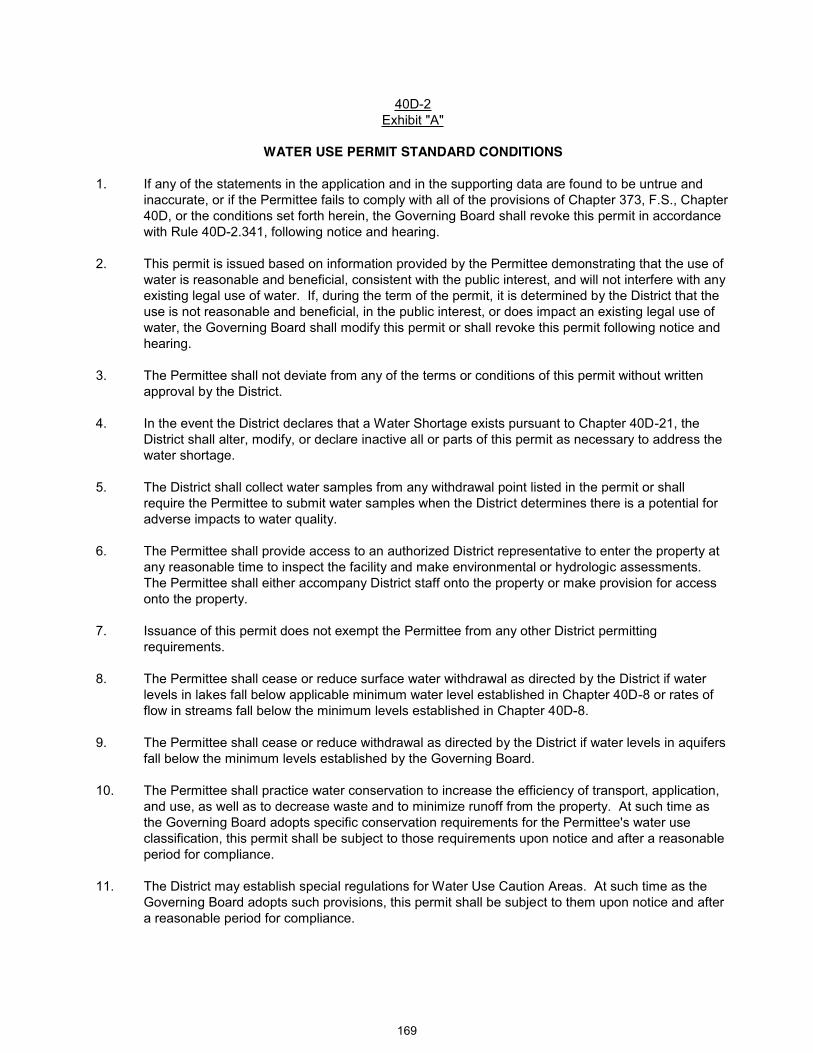
40D-2Exhibit "A"
WATER USE PERMIT STANDARD CONDITIONS
1. If any of the statements in the application and in the supporting data are found to be untrue and inaccurate, or if the Permittee fails to comply with all of the provisions of Chapter 373, F.S., Chapter 40D, or the conditions set forth herein, the Governing Board shall revoke this permit in accordance with Rule 40D-2.341, following notice and hearing.
2. This permit is issued based on information provided by the Permittee demonstrating that the use of water is reasonable and beneficial, consistent with the public interest, and will not interfere with any existing legal use of water. If, during the term of the permit, it is determined by the District that the use is not reasonable and beneficial, in the public interest, or does impact an existing legal use of water, the Governing Board shall modify this permit or shall revoke this permit following notice and hearing.
3. The Permittee shall not deviate from any of the terms or conditions of this permit without written approval by the District.
4. In the event the District declares that a Water Shortage exists pursuant to Chapter 40D-21, the District shall alter, modify, or declare inactive all or parts of this permit as necessary to address the water shortage.
5. The District shall collect water samples from any withdrawal point listed in the permit or shall require the Permittee to submit water samples when the District determines there is a potential for adverse impacts to water quality.
6. The Permittee shall provide access to an authorized District representative to enter the property at any reasonable time to inspect the facility and make environmental or hydrologic assessments. The Permittee shall either accompany District staff onto the property or make provision for access onto the property.
7. Issuance of this permit does not exempt the Permittee from any other District permitting requirements.
8. The Permittee shall cease or reduce surface water withdrawal as directed by the District if water levels in lakes fall below applicable minimum water level established in Chapter 40D-8 or rates of flow in streams fall below the minimum levels established in Chapter 40D-8.
9. The Permittee shall cease or reduce withdrawal as directed by the District if water levels in aquifers fall below the minimum levels established by the Governing Board.
10. The Permittee shall practice water conservation to increase the efficiency of transport, application, and use, as well as to decrease waste and to minimize runoff from the property. At such time as the Governing Board adopts specific conservation requirements for the Permittee's water use classification, this permit shall be subject to those requirements upon notice and after a reasonable period for compliance.
11. The District may establish special regulations for Water Use Caution Areas. At such time as the Governing Board adopts such provisions, this permit shall be subject to them upon notice and after a reasonable period for compliance.
169
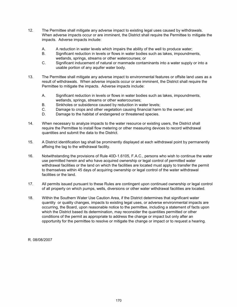
12. The Permittee shall mitigate any adverse impact to existing legal uses caused by withdrawals. When adverse impacts occur or are imminent, the District shall require the Permittee to mitigate the impacts. Adverse impacts include:
A. A reduction in water levels which impairs the ability of the well to produce water;B. Significant reduction in levels or flows in water bodies such as lakes, impoundments,
wetlands, springs, streams or other watercourses; orC. Significant inducement of natural or manmade contaminants into a water supply or into a
usable portion of any aquifer water body.
13. The Permittee shall mitigate any adverse impact to environmental features or offsite land uses as a result of withdrawals. When adverse impacts occur or are imminent, the District shall require the Permittee to mitigate the impacts. Adverse impacts include:
A. Significant reduction in levels or flows in water bodies such as lakes, impoundments, wetlands, springs, streams or other watercourses;
B. Sinkholes or subsidence caused by reduction in water levels;C. Damage to crops and other vegetation causing financial harm to the owner; andD. Damage to the habitat of endangered or threatened species.
14. When necessary to analyze impacts to the water resource or existing users, the District shall require the Permittee to install flow metering or other measuring devices to record withdrawal quantities and submit the data to the District.
15. A District identification tag shall be prominently displayed at each withdrawal point by permanently affixing the tag to the withdrawal facility.
16. Notwithstanding the provisions of Rule 40D-1.6105, F.A.C., persons who wish to continue the water use permitted herein and who have acquired ownership or legal control of permitted water withdrawal facilities or the land on which the facilities are located must apply to transfer the permit to themselves within 45 days of acquiring ownership or legal control of the water withdrawal facilities or the land.
17. All permits issued pursuant to these Rules are contingent upon continued ownership or legal control of all property on which pumps, wells, diversions or other water withdrawal facilities are located.
18. Within the Southern Water Use Caution Area, if the District determines that significant water quantity or quality changes, impacts to existing legal uses, or adverse environmental impacts are occurring, the Board, upon reasonable notice to the permittee, including a statement of facts upon which the District based its determination, may reconsider the quantities permitted or other conditions of the permit as appropriate to address the change or impact but only after an opportunity for the permittee to resolve or mitigate the change or impact or to request a hearing.
R. 08/08/2007
170

Item 22
Consent Agenda December 16, 2008
Regulation Committee -- Other
Approve Exchange of Conservation Easement Areas – Lake Jovita East Pointe Townhomes – Pasco County
The construction of a cul-de-sac, authorized by Environmental Resource Permit (ERP) No. 44013809.028, requires the grading and filling in a 1.10-acre portion of a conservation easement (upland preservation) dedicated to the District through ERP No. 43013809.003 (Lake Jovita Golf and Country Club). A release of this portion of the conservation easement (CE) is necessary for the construction of the northern end of the East Pointe Townhomes parcel. The Permittee has proposed to environmentally compensate for the release by providing roughly two times the ecological value by placing 2.72 acres (1.10 acres uplands, 1.62 acres wetlands) within a CE. District staff has confirmed that the proposed replacement CE is of greater value than the CE area to be released.
Subsection 373.096, F.S. provides that the Governing Board may release any easement, reservation, or right-of-way interests, conveyed to it for which it has not present of apparent future use under terms and conditions determined by the Board. District staff has determined that the environmental and market value of the CE to be received through the proposed mitigation equals or exceeds the value of the interest to be released.
Staff Recommendation:
(1) Authorize the Governing Board to execute the Conservation Easement and Release document to facilitate the transaction; and
(2) Approve the exchange of the CE areas.
Presenter: H. Robert Lue, Director, Brooksville Regulation Department
171
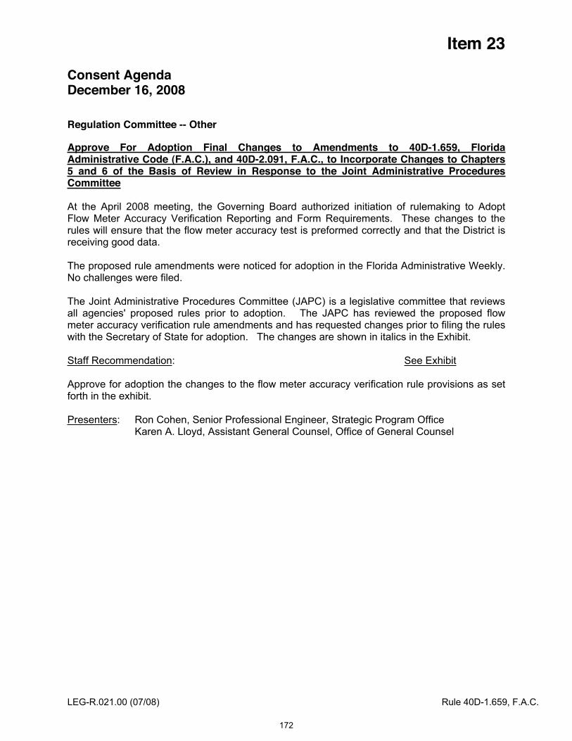
Item 23
Consent Agenda December 16, 2008
Regulation Committee -- Other
Approve For Adoption Final Changes to Amendments to 40D-1.659, Florida Administrative Code (F.A.C.), and 40D-2.091, F.A.C., to Incorporate Changes to Chapters 5 and 6 of the Basis of Review in Response to the Joint Administrative Procedures Committee
At the April 2008 meeting, the Governing Board authorized initiation of rulemaking to Adopt Flow Meter Accuracy Verification Reporting and Form Requirements. These changes to the rules will ensure that the flow meter accuracy test is preformed correctly and that the District is receiving good data.
The proposed rule amendments were noticed for adoption in the Florida Administrative Weekly. No challenges were filed.
The Joint Administrative Procedures Committee (JAPC) is a legislative committee that reviews all agencies' proposed rules prior to adoption. The JAPC has reviewed the proposed flow meter accuracy verification rule amendments and has requested changes prior to filing the rules with the Secretary of State for adoption. The changes are shown in italics in the Exhibit.
Staff Recommendation: See Exhibit
Approve for adoption the changes to the flow meter accuracy verification rule provisions as set forth in the exhibit.
Presenters: Ron Cohen, Senior Professional Engineer, Strategic Program Office Karen A. Lloyd, Assistant General Counsel, Office of General Counsel
LEG-R.021.00 (07/08) Rule 40D-1.659, F.A.C.
172
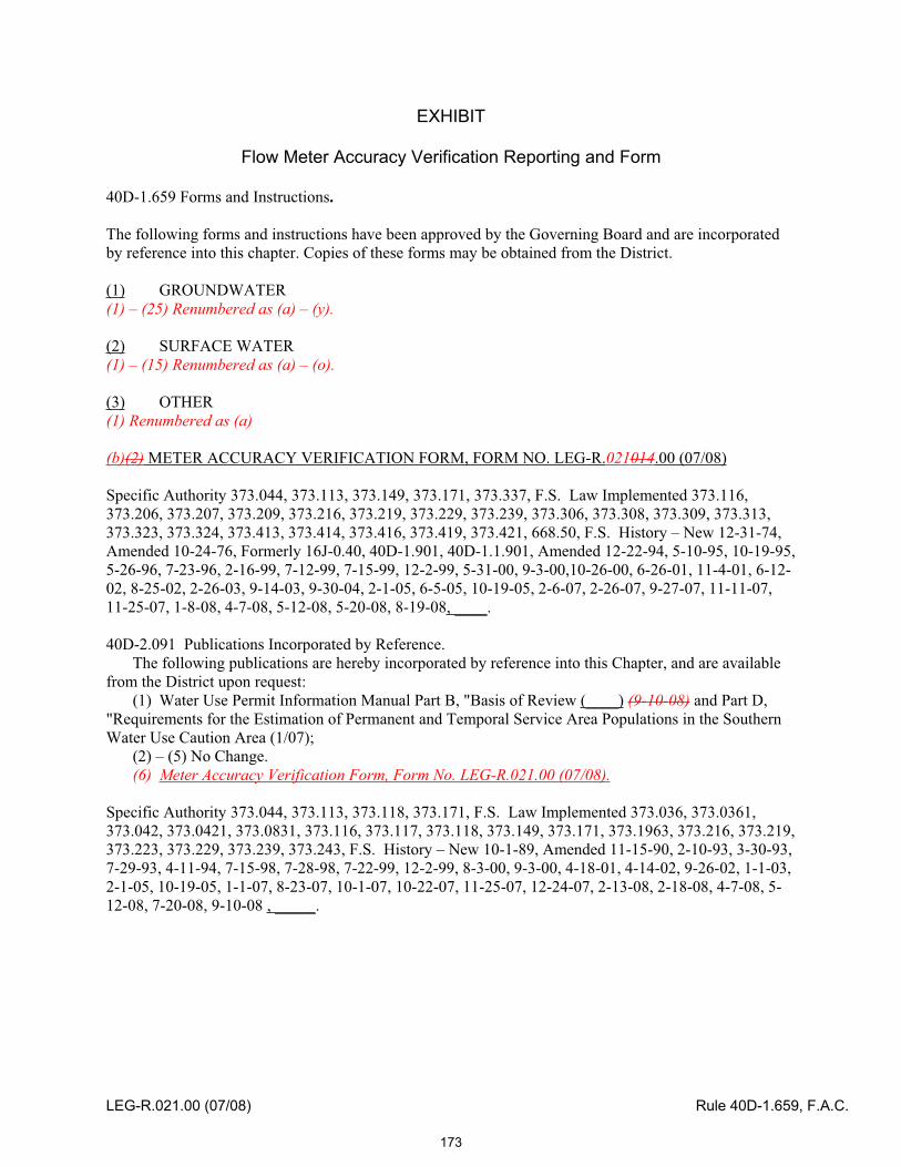
EXHIBIT
Flow Meter Accuracy Verification Reporting and Form
40D-1.659 Forms and Instructions.
The following forms and instructions have been approved by the Governing Board and are incorporated by reference into this chapter. Copies of these forms may be obtained from the District.
(1) GROUNDWATER (1) – (25) Renumbered as (a) – (y).
(2) SURFACE WATER (1) – (15) Renumbered as (a) – (o).
(3) OTHER (1) Renumbered as (a)
(b)(2) METER ACCURACY VERIFICATION FORM, FORM NO. LEG-R.021014.00 (07/08)
Specific Authority 373.044, 373.113, 373.149, 373.171, 373.337, F.S. Law Implemented 373.116, 373.206, 373.207, 373.209, 373.216, 373.219, 373.229, 373.239, 373.306, 373.308, 373.309, 373.313, 373.323, 373.324, 373.413, 373.414, 373.416, 373.419, 373.421, 668.50, F.S. History – New 12-31-74, Amended 10-24-76, Formerly 16J-0.40, 40D-1.901, 40D-1.1.901, Amended 12-22-94, 5-10-95, 10-19-95, 5-26-96, 7-23-96, 2-16-99, 7-12-99, 7-15-99, 12-2-99, 5-31-00, 9-3-00,10-26-00, 6-26-01, 11-4-01, 6-12-02, 8-25-02, 2-26-03, 9-14-03, 9-30-04, 2-1-05, 6-5-05, 10-19-05, 2-6-07, 2-26-07, 9-27-07, 11-11-07, 11-25-07, 1-8-08, 4-7-08, 5-12-08, 5-20-08, 8-19-08, ____.
40D-2.091 Publications Incorporated by Reference. The following publications are hereby incorporated by reference into this Chapter, and are available
from the District upon request: (1) Water Use Permit Information Manual Part B, "Basis of Review (____) (9-10-08) and Part D,
"Requirements for the Estimation of Permanent and Temporal Service Area Populations in the Southern Water Use Caution Area (1/07);
(2) – (5) No Change. (6) Meter Accuracy Verification Form, Form No. LEG-R.021.00 (07/08).
Specific Authority 373.044, 373.113, 373.118, 373.171, F.S. Law Implemented 373.036, 373.0361, 373.042, 373.0421, 373.0831, 373.116, 373.117, 373.118, 373.149, 373.171, 373.1963, 373.216, 373.219, 373.223, 373.229, 373.239, 373.243, F.S. History – New 10-1-89, Amended 11-15-90, 2-10-93, 3-30-93, 7-29-93, 4-11-94, 7-15-98, 7-28-98, 7-22-99, 12-2-99, 8-3-00, 9-3-00, 4-18-01, 4-14-02, 9-26-02, 1-1-03, 2-1-05, 10-19-05, 1-1-07, 8-23-07, 10-1-07, 10-22-07, 11-25-07, 12-24-07, 2-13-08, 2-18-08, 4-7-08, 5-12-08, 7-20-08, 9-10-08 , _____.
LEG-R.021.00 (07/08) Rule 40D-1.659, F.A.C.
173

WATER USE PERMIT INFORMATION MANUAL PART B, BASIS OF REVIEW
Chapter5.0 MONITORING REQUIREMENTS
The following provisions are added to the end of section 5.1. The paragraphs under the heading "Flow Meters" are primarily replicated from Chapter 6, the section titled "PUMPAGE REPORTING, 5. Flow Meters" except as noted through strikeout/underline. Paragraphs that are completely underlined are new:
Flow Meters All required flow meters shall adhere to the following requirements and shall be installed and maintained as follows:
1. All meters shall be non-resettable, totalizing flow meters that have a totalizer of sufficient magnitude to retain total gallon data for a minimum of the three highest consecutive months permitted quantities. If other measuring devices or other alternative accounting methods are proposed, prior to installation, the Permittee shall submit documentation that the other measuring devices or accounting methods meet the accuracy requirement provided below stipulations listed in this condition. If the alternative accounting method involves a meter belonging to another entity or to an alternative water supply provider, the Permittee shall submit documentation from the owner/supplier that the meter readings conform to these meter requirements. Approval for other measuring devices or accounting methods must be obtained in writing from the Regulation Department Director.
a. The flow meter(s) or other approved flow-measuring device(s) shall have and maintain an accuracy within five percent of the actual flow as installed. b. Accuracy testing requirements:
i. For newly metered withdrawal points, tThe flow meter installation -water piping system shall be designed for inline field access for meter accuracy testing. ii. The meter shall be tested for accuracy on-site, as installed, every five years beginning from the date of its installation for new meters or from the date of initial issuance of the this permit condition containing the metering condition with an accuracy-test requirement for existing meters. iii. The testing frequency will be decreased if the Permittee demonstrates to the satisfaction of the District that a longer period of time for testing is warranted. iv. The test will be accepted by the District only if performed by a person certified on knowledgeable in the test equipment used as described in the section entitled Flow Meter Verification, below. v. If the actual flow is found to be greater than 5% different from the measured flow, within 30 days the Permittee shall have the meter re-calibrated, repaired, or replaced, whichever is necessary. Documentation of the test and a certificate of re-calibration, if applicable, shall be submitted within 30 days of each test or re-calibration. 2. The meter shall be installed according to the manufacturer’s instructions for achieving accurate flow to the specifications above, or it shall be installed in a straight length of pipe where there is at least an upstream length equal to ten (10) times the outside pipe diameter and a downstream length equal to two (2) times the outside pipe diameter. Where there is not at least a length of ten diameters upstream available, flow straightening vanes shall be used in the upstream line. Existing systems that would require retrofitting to achieve the above standards will not be required to retrofit provided it is documented on the Meter Accuracy Verification Form, Form No. LEG-R.021.00 (07/08), incorporated herein by reference, that the flow meter is accurately and reliably measuring flow over different flow ranges or for the permanent operating flow. This form can be obtained from the District’s website (www.watermatters.org).
3. If a metered withdrawal point, AWS inflow line or re-pump withdrawal point is not utilized during a given month, the meter report shall be submitted to the District showing the same meter reading that was submitted the previous month.
4. Broken or malfunctioning meter: a. If the meter or other flow-measuring device malfunctions or breaks, the Permittee shall:
a. Notify the District within 15 days of discovering the malfunction or breakage;
LEG-R.021.00 (07/08) Rule 40D-1.659, F.A.C.
174

b. The meter must be rReplaced the broken or malfunctioning meter with a repaired or new meter, subject to the same specifications given above, within 30 days of the discovery; and c. Submit estimates of their pumpage as described below.
c. If the meter is removed from the withdrawal point for any other reason, it shall be replaced with another meter having the same specifications given above, or the meter shall be reinstalled within 30 days of its removal from the withdrawal. In either event, the withdrawal point shall not lack a fully functioning meter shall not be off the withdrawal point for more than 60 consecutive days.
5. While the meter is not functioning correctly off the withdrawal, the Permittee shall estimate their use by multiplying the number of hours the withdrawal point was used during that monthe times the flow capacity of the pump or mainline, whichever is appropriate, or the Permittee may request instructions on how to estimate use from the Permit Data Section document the total amount of time in minutes that the withdrawal point was used for each month and multiply those minutes times the pump capacity (in gallons per minute) for total gallons. The estimate of the number of gallons used each month during that period shall be submitted on District scanning forms and noted as estimated per instructions on the form noted as an estimate when it is submitted to the District. The reason for the necessity to estimate pumpage shall be reported with the estimate.
6. In the event a new meter is installed to replace a broken meter, the meter it and its installation shall meet the specifications of this Chapter condition. The permittee shall notify the District of the replacement with the first submittal of meter readings from the new meter. Transferred from Chapter 6 __-08
Flow Meter Verification
The following requirements pertain to the required flow meter testing:
1.3. The Flow Meter Accuracy Verification Form referenced above under the heading "Flow Meters", Form No. LEG-R.013.00 (07/08) shall be completed and provided to the District for each flow meter tested. This form can be obtained from the District’s website (www.watermatters.org). If the test equipment provides a printout of data that was input, this shall be submitted with the worksheet. The equipment's water temperature shall be set to 72 degrees for ground water, and for other water sources the measured water temperature shall be used.
2. Permittees shall demonstrate that the results of the meter testing are accurate. This demonstration may be met by submitting documentation with the Flow Meter Accuracy Verification Form referenced above under the heading "Flow Meters" that: a. the manufacturer of the test equipment, or an entity approved or authorized by the manufacturer, has trained the operator to use the specific model test equipment used for testing; and, b. includes a date of calibration of the testing equipment within the previous twelve months, and the test lab's National Institute of Standards and Testing (N.I.S.T.) traceability reference number.
1. Operators of meter testing equipment shall hold a valid certificate of competency to operate the type of equipment used. Certification from the test equipment manufacturer, or other recognized training entities will suffice. A copy of this certification shall be provided to the District with the Flow Meter Accuracy Verification Form "Form No. LEG-R.013.00 (07/08).
2. The test equipment shall have been calibrated within the previous twelve months of the submitted test and comply with current National Institute of Standards and Technology (N.I.S.T.) standards. A valid Certificate Of Calibration, showing the date of calibration and N.I.S.T. traceability shall be provided to the District with the Meter Accuracy Verification Forms.
3. The Flow Meter Accuracy Verification Form, Form No. LEG-R.013.00 (07/08) shall be completed and provided to the District for each flow meter tested. This form can be obtained from the District’s website (www.watermatters.org). If the test equipment provides a printout of data that was input, this shall be submitted with the worksheet. The equipment's water temperature shall be set at 72 degrees.
LEG-R.021.00 (07/08) Rule 40D-1.659, F.A.C.
175

34. A diagram showing the precise location on the pipe where the testing equipment was mounted shall be supplied with the form. This diagram shall also show the pump, installed meter, the configuration (with all valves, tees, elbows, and any other possible flow disturbing devices) that exists between the pump and the test location clearly noted with measurements. If flow straightening vanes are utilized, their location(s) shall also be included in the diagram.
4.5. A picture(s) of the test location, including the pump, installed flow meter, and the measuring device, or for sites where the picture does not include all of the items listed above, a picture of the test site with a notation of distances to these items.
5.6. A minimum of two separate timed tests shall be performed for each meter. Each timed test shall consist of measuring flow using the test meter and the installed meter for a minimum of four minutes duration. If the two tests do not yield consistent results, additional tests shall be performed for a minimum of eight minutes or longer per test until consistent results are obtained. If the installed meter has a rate of flow, or large multiplier that does not allow for consistent results to be obtained with four- or eight-minute tests, the duration of the test shall be increased as necessary to obtain accurate and consistent results with respect to the type of flow meter installed. The results of two consistent tests shall be averaged, and the result will be considered the test result for the meter being tested. This result shall be expressed as a plus or minus percent (rounded to the nearest one-tenth percent) accuracy of the installed meter relative to the test meter. The percent accuracy indicates the deviation (if any), of the meter being tested from the test meter.
6.7. Flow meters that fail to meet the District’s accuracy requirements must be repaired or replaced within 30 days. These meters shall be retested after the repair and the results submitted to the District within 30 days of the test. ___-08
LEG-R.021.00 (07/08) Rule 40D-1.659, F.A.C.
176
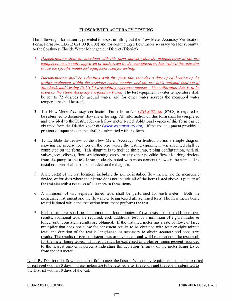
FLOW METER ACCURACY TESTING
The following information is provided to assist in filling out the Flow Meter Accuracy Verification Form, Form No. LEG R.021.00 (07/08) and for conducting a flow meter accuracy test for submittal to the Southwest Florida Water Management District (District).
1. Documentation shall be submitted with this form showing that the manufacturer of the test equipment, or an entity approved or authorized by the manufacturer, has trained the operator to use the specific model test equipment used for testing.
2. Documentation shall be submitted with this form that includes a date of calibration of the testing equipment within the previous twelve months, and the test lab's national Institute of Standards and Testing (N.I.S.T.) traceability reference number. The calibration date is to be listed on the Meter Accuracy Verification Form. The test equipment's water temperature shallbe set to 72 degrees for ground water, and for other water sources the measured water temperature shall be used.
3. The Flow Meter Accuracy Verification Form, Form No. LEG R.021.00 (07/08) is required to be submitted to document flow meter testing. All information on this form shall be completed and provided to the District for each flow meter tested. Additional copies of this form can be obtained from the District’s website (www.watermatters.org). If the test equipment provides a printout of inputted data this shall be submitted with the form.
4. To facilitate the review of the Flow Meter Accuracy Verification Forms a simple diagram showing the precise location on the pipe where the testing equipment was mounted shall be completed on the form. This diagram is to include the pump, piping configuration, with all valves, tees, elbows, flow straightening vanes, or any other possible flow disturbing devices from the pump to the test location clearly noted with measurements between the items. The installed meter shall also be included on the diagram.
5. A picture(s) of the test location, including the pump, installed flow meter, and the measuring device, or for sites where the picture does not include all of the items listed above, a picture of the test site with a notation of distances to these items.
6. A minimum of two separate timed tests shall be performed for each meter. Both the measuring instrument and the flow meter being tested utilize timed tests. The flow meter being tested is timed while the measuring instrument performs the test.
7. Each timed test shall be a minimum of four minutes. If two tests do not yield consistent results, additional tests are required, each additional test for a minimum of eight minutes or longer until consistent results are obtained. If the installed meter has a rate of flow, or large multiplier that does not allow for consistent results to be obtained with four or eight minute tests, the duration of the test is lengthened as necessary to obtain accurate and consistent results. The results of two consistent tests are averaged, and will be considered the test result for the meter being tested. This result shall be expressed as a plus or minus percent (rounded to the nearest one-tenth percent) indicating the deviation (if any), of the meter being tested from the test meter.
Note: By District rule, flow meters that fail to meet the District’s accuracy requirements must be repaired or replaced within 30 days. These meters are to be retested after the repair and the results submitted to the District within 30 days of the test.
LEG-R.021.00 (07/08) Rule 40D-1.659, F.A.C.
177

SWFWMD - FLOW METER ACCURACY VERIFICATION FORM
Permittee: ______________________ WUP No: _________________ District ID: ________ Address: _______________________ City: ___________ St: ___ Zip: _____________ Contact: ______________________ Ph. No: _________________ Cell No: __________
FLOW METER INFORMATION: Manufacturer: ________________Serial No: _________ Size: _______ Type: Saddle Tube Other Reading: ________________ x _____________ Straight Run:___________ Vanes: Yes/No Meter Multiplier PIPE INFORMATION: WALL THICKNESS: Material: __________ O.D. ______ Gauge: __________ Chart: ____________ Schedule/Class: __________ Test Meter: __________ Liner: ____________
FLOW METER TEST METER Elapsed Time
(min) Totalizer Reading
(gal)Total (gpm)
A
Total (gpm)
B
A – B (gpm)
C
Percent Error (C/B)*100
I. _________ II. _________ Total _________
I. _________ II. _________ Total _________
I. _________ II. _________ Total _________
AVERAGE
COMMENTS: Test Site Diagram Email:
County:
(If needed use back of form for diagram)
District Well Tags: Yes / No Tag ID Num: _________________________
Test Meter No: _____________________ Test Meter Calibration Date: ___________
Sound Speed: _____________________
Checked By: ___________________ _ Date: _______________________________
LEG R.021.00 (07/08) Rule 40D-1.659 & 40D-2.091, F.A.C.
LEG-R.021.00 (07/08) Rule 40D-1.659, F.A.C.
178

Item 24
Consent Agenda December 16, 2008
Regulation Committee -- Other
Electrical Power Plant Site Certification – SWFWMD Agency Report on Progress Energy Florida – Levy Nuclear Units 1 & 2 – Main Site and Associated Facilities – Levy County
Progress Energy Florida seeks site certification for its proposed Levy Nuclear Power Plant, Units 1 & 2 (LNP), to be located on a 3,100-acre site in southern Levy County. The proposed LNP will generate approximately 2,200 megawatts of electrical power and transmit that power across approximately 178 miles of proposed transmission lines in Levy, Citrus, Marion, Sumter, Hernando, Hillsborough, Pinellas and Polk Counties. As one of the statutory reviewing agencies, the District is required to review the site certification application and prepare an agency report as to matters within its jurisdiction, including but not limited to the impact of the proposed power plant on water resources, regional water supply planning, and any District-owned lands or works. Site certifications take the place of all other state and local regulatory authorizations, including District-regulated authorizations such as water use permits and environmental resource permits. Agency reports also contain notice of any nonprocedural requirements not specifically listed in the application from which a variance, exemption, or exception is necessary in order for the proposed electrical plant to be certified; a recommendation for approval or denial of the application; and any proposed conditions of certification on matters within the jurisdiction of the reviewing agency.
Electrical power plant site certification applications are filed with the Department of Environmental Protection (DEP) and become administrative proceedings under the jurisdiction of the Division of Administrative Hearings (DOAH). The District's agency report on the transmission line corridor portion of this site certification application was approved by the Governing Board in August 2008 and has been submitted to DEP. Pursuant to the schedule approved by the Administrative Law Judge (ALJ) assigned to this matter, reviewing agencies are required to submit their reports on the main site and associated facilities no later than December 15, 2008. Due to the fact that the Governing Board's December meeting is scheduled for December 16, 2008, by order of the ALJ, the District's deadline for submittal of its agency report is extended to December 17, 2008. The proposed agency report with conditions for certification recommended by staff is included in the Governing Board packet. Upon Governing Board approval, the District's agency report will be submitted to DEP for inclusion in DEP's Staff Analysis Report which contains the recommended conditions proposed by all reviewing agencies including DEP. The DOAH Administrative Hearing on this site certification application is currently scheduled for February 23 – March 20, 2009. The anticipated date for the Siting Board (Governor and cabinet) hearing on certification is August 11, 2009.
The proposed agency report on the main site and associated facilities addresses anticipated water use and sets forth associated conditions necessary to ensure that the water use authorized by the conditions of certification will be a reasonable-beneficial use, will not interfere with any presently existing legal use of water and is consistent with the public interest. (The District's review of this application does not extend to matters encompassed under environmental resource permitting, as review of such permits for power plants is assigned to DEP under the District's Interagency Agreement with DEP.) The primary water use at the LNP site is for steam condenser cooling through two cooling towers. The project is designed to use saline water from the nearby Cross Florida Barge Canal as the source of cooling tower makeup water. A new intake structure will be constructed south of the LNP site and just west of the Inglis Lock, and canal water will be pumped and conveyed to the site through four 54-inch
179
Item 24
diameter underground pipes. Approximately 120 million gallons per day will be withdrawn from the canal for cooling water. Potable water obtained from groundwater wells also will be needed for plant use. Four Floridan aquifer groundwater wells will provide water for fire suppression, potable and sanitary needs, demineralized water and other plant operations. Average daily use of 1.58 million gallons per day (mgd) of groundwater is recommended, with a maximum daily use of 5.8 mgd. As part of the agency report, staff is recommending specific conditions necessary for reasonable assurance that the proposed water use meets and will continue to meet all substantive requirements for District-authorized water use, as the conditions will take the place of a water use permit and will be effective for the life of the facility. Special conditions include requirements for environmental assessment and monitoring, aquifer testing and groundwater impact analysis, and investigation and use of alternative water supplies. Standard conditions typically attached to water use permits are also proposed.
Staff Recommendation: See Exhibit
Approve the agency report and proposed conditions addressing the main site and associated facilities for the Progress Energy Florida Levy County Nuclear Power Plant – Units 1 & 2, to be submitted to the Department of Environmental Protection.
Presenter: Martha A. Moore, Senior Attorney
180

SOUTHWEST FLORIDA WATER MANAGEMENT DISTRICT – AGENCY REPORT
PROGRESS ENERGY FLORIDA, INC.LEVY COUNTY UNITS 1 & 2
SITE CERTIFICATION APPLICATION NO. PA-08-51
STAFF RECOMMENDATION – APPROVAL WITH CONDITIONS
I. PROJECT DESCRIPTION
Progress Energy Florida, Inc. (PEF) proposes to construct and operate a new electrical power generating facility known as the Levy Nuclear Power Plant, Units 1 & 2 (LNP), to be located on a 3,100-acre site in southern Levy County. The proposed LNP will generate approximately 2,200 megawatts (MW) of electrical power which will be distributed through approximately 178 miles of proposed transmission lines in Levy, Citrus, Marion, Sumter, Hernando, Hillsborough, Pinellas and Polk Counties. The plant will use state-of-the-art technology that includes two nominal 1,000 MW nuclear reactor generating units manufactured by Westinghouse Electric Company, LLC. The reactor design is certified by the U.S. Nuclear Regulatory Commission (NRC), and construction and operation of the nuclear reactors must comply with NRC regulations in addition to conditions required for site certification.
This agency report addresses the main site and associated facilities proposed for site certification. The transmission line portion of the application was addressed in a separate District agency report submitted to DEP in August 2008. Associated facilities proposed in the application included construction of a railroad spur, a heavy haul road and a barge slip on the Cross Florida Barge Canal to provide construction access and ongoing material supply access to the LNP site. Proposed to be located in Levy and Marion counties, the railroad spur has since been eliminated by PEF after further determination that rail transport will not be cost effective. The construction of two substations proposed to be located in Sumter and Citrus counties has also been removed from the site certification application and will be addressed through separate permitting applications to the appropriate regulatory agencies at a later date.
Site Description
Situated in the western portion of Levy County, the LNP site is approximately eight miles east of the Gulf of Mexico, three miles north of the Withlacoochee River and near U.S. Highway 19. The area is characterized as a poorly drained, low relief region containing extensive swamps, marches and terraces formed by ancient sea-level high stands. The site lies within the Gulf Coastal Lowlands which are comprised of broad, flat marine erosional plains underlain with karstic limestones covered by thin sand deposits. Extensive site investigation undertaken by PEF revealed no voids located under or immediately adjacent to the proposed nuclear reactor locations. The LNP site
181
2
was formerly used for silviculture and has been impacted by many years of timber planting and harvesting. No streams or ephemeral ditches are identifiable onsite. Pockets of shallow wetlands collect runoff that may discharge as sheet flow during wet periods. There are approximately 1,185 acres of wetlands on the site. Nearby surface waters are designated as Class III freshwater except for the lower reaches of the Withlacoochee River, which are designated both as Class II waters and Outstanding Florida Waters.
Proposed Water Use
The LNP will require water for plant cooling and operational uses. Most of the water to be used at the LNP site will be needed for steam condenser cooling which will take place in two cooling towers; one for each unit. The source for cooling tower makeup water will be surface water withdrawn from the nearby Cross Florida Barge Canal. Approximately 120 million gallons per day (mgd) will be withdrawn from the canal for cooling tower needs. A new intake structure will be constructed on the canal at a site south of the LNP site and downstream from the Inglis Lock. Canal waters from downstream of the Lock to the Gulf are predominately saline. PEF advises that the waters in the canal downstream of the Inglis Lock vary in salinity both seasonally and with tidal influences; however, when the intake is operational, it is anticipated that the makeup waters to the cooling towers will be drawn from shallow nearshore Gulf of Mexico waters. The canal intake structure will withdraw surface water through four 54-inch diameter intake pipelines (two for each nuclear unit) that will convey water to cooling tower basins for use within the cooling towers. Two additional 54-inch diameter pipes will convey discharged cooling water approximately 13 miles to PEF's existing Crystal River Energy Complex discharge canal. Flows will be combined with flows released from the Crystal River Energy Complex and discharged to the Gulf of Mexico. Supply and discharge pipelines will generally be buried to a minimum depth of five feet. Pipelines will cross over the Inglis Lock Bypass Canal on an approximately 33-ft.-wide utility bridge and will cross beneath the Barge Canal bottom.
PEF also proposes to develop an onsite fresh water system that will be supplied by Floridan aquifer groundwater withdrawn from four supply wells. Groundwater will be used for plant operations, fire suppression, potable water needs and demineralized water needs. Demineralized water is processed to remove ionic impurities and dissolved oxygen and is used for plant operations that require pure water. PEF anticipates that when operational, the LNP site will supply potable water to approximately 800 employees and visitors daily. During the construction stage, potable water will be needed for up to 3,500 people anticipated to be onsite. The fire protection system will provide water to points throughout the plant where wet system fire suppression may be required. The fire suppression system is designed to supply water at a flow rate and pressure sufficient to satisfy the demand of automatic sprinkler systems and fire hoses for a minimum of 2 hours. PEF proposes to withdraw 1.58 mgd on an annual average basis and a maximum daily withdrawal of 5.8 mgd for these uses.
182
3
Wastewater (backwash and blowdown) from reactor and plant operations will be treated and discharged to the cooling tower basins for reuse within the cooling towers. Treated sanitary wastewater will also be discharged to the cooling water basins for reuse in the cooling towers. Stormwater from onsite impervious areas will be treated to comply with state water quality regulations and will be managed and discharged in accordance with environmental resource permitting requirements.
The extent of significant construction-related dewatering necessary for the 75-foot deep foundations needed for the nuclear reactors will be determined after design specifications are finalized. PEF proposes to install an impervious diaphragm wall around and below the foundation excavations, to minimize water flow into the construction site. It is anticipated that dewatering at each unit could last as much as two years. Additional construction dewatering will also be necessary in some locations for installation of the pipelines and other linear facilities. Construction-related dewatering activities will be approved by DEP and the District on a post-certification basis after final construction designs are submitted.
Application Review
The LNP site certification application was submitted to DEP on June 2, 2008. District staff submitted comments on the completeness of the main site and associated facilities portion of the application on July 2, 2008. District staff determined that the application as submitted was incomplete for purposes of determining consistency with District substantive permitting requirements. Information requested by the District included additional data supporting the groundwater drawdown impact modeling submitted in support of the application, further analyses of cumulative impacts, additional aquifer transmissivity data, further assessment of environmental impacts to surrounding water resources, exploration of alternative water use, assessment of withdrawal impacts on water quality of the barge canal and associated issues, plans for addressing dewatering activities, water conservation methods and potential impacts to nearby water supply sources such as Lake Rousseau. On July 14, 2008, DEP issued its determination that the application was not complete.
PEF submitted additional information in August 2008. Following meetings involving District staff, PEF and PEF's consultants, modifications were made to the modeling studies. The wellfield initially proposed to be located in the northeast portion of the site, near Goethe State Forest, was relocated to avoid and minimize potential impacts to surface waters, wetlands and adjacent users. PEF now proposes to locate the groundwater wells further south and has submitted additional modeling addressing the relocated wellfield. To ensure sufficient time to address all issues, the District sought an extension of time to submit a second completeness determination, which was granted and extended to September 3, 2008. However, due to issues remaining for the District and other agencies, upon motion by DEP and PEF, reviewing agencies were granted an extension of time to October 28, 2008 to submit their completeness determination, and DEP's deadline for a second completeness determination was extended to October 30, 2008. District staff has determined that the application is now complete for purposes of
183

4
determining appropriate conditions. The District's completeness determination is based upon negotiated conditions that require post-certification submittal of further confirming studies, ongoing environmental monitoring, continued groundwater modeling and impact analysis and assessment and implementation of alternative water supplies, to ensure no adverse impacts will occur and that the water resource will be appropriately conserved and protected over the life of the facility. The District's agency report, including proposed conditions for certification, must be submitted to DEP by December 17, 2008.
II. PROPOSED WATER USE
Following review and discussion with the applicant, District staff recommends authorization for an annual average total of 1.58 mgd of Floridan aquifer groundwater and 5.8 mgd for maximum daily use for process and potable water needs, provided the conditions attached hereto and incorporated herein are applicable to the certification order. To assure that water use associated with plant operations does not cause adverse environmental impacts, conditions proposed by staff include requiring the development and implementation of an environmental monitoring plan to evaluate the relative condition of surface waters and wetlands in areas potentially affected by ground water withdrawals. Monitoring will continue for a minimum of five years after groundwater withdrawals reach 1.25 mgd on an annual average basis. Annual monitoring summaries will be submitted. If, after five years, monitoring demonstrates that no adverse impacts are occurring or predicted, PEF may request that monitoring be discontinued. Conditions also require PEF to investigate the feasibility of developing alternative water supply projects to offset groundwater use. The conditions are structured to require that if ongoing environmental monitoring, aquifer performance testing or groundwater modeling predict or detect adverse environmental impacts, PEF will be required to either mitigate the adverse impacts or implement an approved alternative water supply project.
To confirm Upper Floridan aquifer transmissivity and leakage values used in the groundwater flow model supporting the application, staff is requiring that an aquifer performance testing plan be submitted, approved by the District and implemented within a specified timeframe. Required aquifer performance testing will include step-drawdown tests of all groundwater wells and a multi-well constant-rate test to be performed on two of the wells after all wells are fully developed. If values derived from actual well tests differ significantly from values determined through earlier modeling, PEF will revise its groundwater model to incorporate the aquifer test results and undertake further modeling. Updated modeling results will be used to help determine whether alternative water supply efforts should be implemented. Conditions also require PEF to develop a water conservation plan and a timetable for implementing technically and economically feasible water-conserving measures.
Proposed conditions also address ongoing monitoring and compliance by requiring a full compliance report every five years, to demonstrate continued reasonable assurance that the water use is meeting all of the applicable substantive water use requirements
184
5
set forth in District rules. Groundwater withdrawals will be metered and reported to the District on a monthly basis. Periodic water quality sampling will be implemented to ensure no adverse impacts to water quality. Other standard conditions relating to well construction, mitigation of any adverse impacts to existing legal users or offsite land uses and information reporting are also included.
III. SURFACE WATER MANAGEMENT SYSTEM
Issues and impacts associated with the construction or alteration of surface water management systems as part of this project are being reviewed by DEP. District staff did not include recommendations in this regard.
IV. REGIONAL WATER SUPPLY
The District has not prepared a Regional Water Supply Plan for counties in the Northern Planning Area of the District, which includes Levy County. This is due to the general lack of existing regional impacts to water resources. However, there are smaller scale cumulative effects of withdrawals throughout the region and areas where the rate of growth has accelerated beyond what was previously anticipated to occur that could impact water resources through future ground-water withdrawals. The proposed LNP is not located within an accelerated growth area. Ongoing water supply planning activities in the Northern Planning Area include: 1) comprehensive water supply planning conducted cooperatively by Marion County, the Withlacoochee Regional Water Supply Authority, the District, and the St. John’s River Water Management District (SJRWMD); 2) extensive resource assessments involving the District, the SJRWMD, and the U.S. Geological Survey; 3) an aggressive program to establish minimum flows and levels; 4) the development of a sophisticated ground-water flow model that will be used to determine safe yield; and 5) programs to provide funding and technical assistance for the development of conservation and reclaimed water projects and conservation education programs. Based on the fact that most of the water to be used at the LNP site will be withdrawn from the Cross Florida Barge Canal, which is not a current or planned source of potable water for the region, and that the amount of groundwater to be used will be limited to approximately 1.58 mgd on an annual average basis, District staff anticipates that the regional water supply is adequate to support this use as well as other projects currently planned in the region. The proposed water use does not conflict with or otherwise impact the anticipated plans and water uses proposed by the Withlacoochee River Water Supply Authority.
IV. VARIANCE, EXCEPTION OR EXEMPTIONS
Staff has not identified any District nonprocedural requirements for which a variance, exemption or exception is necessary in order for the proposed main site and associated facilities to be certified.
185
6
IV. STAFF RECOMMENDATION
Staff has determined that this project will meet District substantive requirements for authorized water use, provided that the attached conditions are included in the conditions for certification for the main site and associated facilities. Staff recommends approval and submittal of this agency report to DEP.
REPORT AND CONDITIONS PREPARED BY:
_________________________________ Date:_____________________Bobby Lue DirectorBrooksville Regulation Department
_________________________________ Date:_____________________Paul Williams, P.G. Water Use Manager Brooksville Regulation Department
_________________________________ Date:_____________________Leonard F. Bartos, P.W.S. Environmental Regulation Manager Brooksville Regulation Department
186

SOUTHWEST FLORIDA WATER MANAGEMENT DISTRICT AGENCY REPORT – RECOMMENDED CONDITIONS OF CERTIFICATON PROGRESS ENERGY FLORIDA, INC. – LEVY COUNTY UNITS 1 & 2 SITE CERTIFICATION APPLICATION NO. PA-08-51
GROUNDWATER WITHDRAWAL QUANTITIES AND FACILITIES
District ID/ Owner IDWater Allocation
Average Gallons per Day
Well Casing/DepthFeet STATUS
1/PW-1 395,000 50/200 PROPOSED2/PW-2 395,000 50/200 PROPOSED3/PW-3 395.000 50/200 PROPOSED4/PW-4 395.000 50/200 PROPOSED
TOTAL ALL WELLS 1,580,000
Citation: Sections 373.016, 373.219, 373.223(1), F.S.; Rule 40D-2.301, F.A.C., District Basis of Review (BOR) Sections 3.2, 3.4, 4.1, 4.4, 4.8, 4.10
A. SPECIAL CONDITIONS:
All conditions referring to the District shall mean the
Southwest Florida Water Management District 2379 Broad Street Brooksville, Florida 34604-6899
The term, "Licensee" as used herein, shall refer to Florida Power Corporation dba Progress Energy Florida, Inc.
The conditions of certification as used herein refer to Conditions of Certification proposed for Site Certification Application No. PA-08-51.
SUBMIT REPORTS / DATA
1. All reports and data required by these conditions of certification shall be submitted to the District according to the due dates contained in the specific condition. If the report or data is received on or before the tenth day of the month following data collection, it shall be deemed as a timely submittal. The Licensee may use the District’s website to submit data, plans or reports online. To set up an account, the Licensee can address the request to [email protected]. All mailed reports and data are to be sent to:
Permit Data Section, Regulation Performance Management Department Southwest Florida Water Management District 2379 Broad Street
187

2
Brooksville, Florida 34604-6899
Submission of plans and reports: Unless submitted online or otherwise indicated in the special condition, the original and two copies of each plan and report required herein.
Submission of data: Unless submitted online or otherwise indicated in the special condition, an original (no copies) is required for data submittals such as meter readings and/or pumpage, rainfall, water level, evapotranspiration, or water quality data
2. Within sixty (60) days, the Licensee shall designate one individual responsible for receiving and responding to District notices and correspondence related to these conditions of certification. Notification to the District of the designee, including address and telephone number shall be in written form.
Citation: Sections 373.016, 373.219, 373.236, F.S.; Rules 40D-2.301(1) and 40D-2.381(1), (2) and (4), F.A.C.; BOR Section 6.2
ENVIRONMENTAL IMPACTS, MONITORING AND MITIGATION
3. Environmental Assessment
A. Environmental Monitoring Plan
Licensee shall submit an Environmental Monitoring Plan for District review and approval within 90 days of conditions of certification issuance. The monitoring plan, at a minimum shall utilize the District's Wetland Assessment Procedure to evaluate the relative condition of surface waters and wetlands in areas potentially affected by water withdrawals of Licensee. Upon District approval, the plan shall be implemented and monitoring reports shall be provided in the annual monitoring report required by Condition No. 3 E. After five years of monitoring following groundwater use rising to more than 1.25 million gallons per day (average annual daily withdrawal quantity) from all the wells included in this site certification, the Licensee may request the District release the Licensee from monitoring. If the District concurs with the request, the District will request DEP modify the conditions of certification to remove the monitoring condition.
B. Data Collection
Licensee shall maintain and monitor the environmental monitoring sites included in the approved monitoring plan. Water levels for monitor wells staff gauges, and piezometers for the sites included in the monitoring plan shall be referenced to National Geodetic Vertical Datum (NGVD) and reported in a form acceptable to the District by the 10th day of each month for the preceding month. The time and date that the elevation is taken shall be included. Any changes to the methods or frequency of monitoring for any of these data collection programs must be approved by the District.
C. Staff Gauges
Licensee shall install and thereafter maintain District-approved staff gauges and shall report measurements of water levels, as indicated in the monitoring plan. Water levels shall be recorded and reported to the District on or before the tenth day of the following month. To the maximum extent possible, water levels shall be recorded as indicated in the monitoring plan. The frequency of recording may be modified by the District as necessary to ensure protection of the resource.
188
3
D. Monitoring Wells and Piezometers
Licensee shall monitor water levels in the monitor wells and piezometers as specified in the monitoring plan. Reports of the data shall be submitted to the District in a form acceptable to the District. All data shall be referenced to NGVD. The frequency of water-level recording may be modified by the District as necessary to ensure the protection of the resource.
E. Annual Environmental Monitoring Reports
Licensee shall submit an annual environmental monitoring data summary by January 1st of each year for the preceding water year (October 1 - September 30). The Annual Monitoring Report shall include all raw data, essential graphs, tables, and text. Monitoring progress at each site shall be summarized in the Annual Monitoring Report, as specified below. Licensee shall submit three copies of the Annual Monitoring Report each year. Interpretive reports of environmental conditions shall incorporate all environmental monitoring sites used. The Annual Monitoring Report shall assess relationships between water level fluctuations, well pumpage, atmospheric conditions, and drainage factors related to the environmental condition of the wetlands and surface waters in the vicinity of the conditions of certification area. Pumpage data, wetland, water level data collected from the aquifer and for the region, and environmental parameters collected at the monitoring sites and in the region (SWFWMD data shall be used for information of the region) shall be used for the report results. Statistical trend analysis, such as double-mass curve analysis, multiple linear regression, time series analysis and/or factor analysis shall be performed to analyze the interactions of rainfall and pumpage on surficial water levels, potentiometric levels in the semi-confined aquifers, surface waters, and wetland water levels, rate of soil subsidence, and evidence of vegetational succession. Data shall be obtained through field measurements and aerial photo interpretation. A brief summary of any recommended changes to the monitoring requirements shall be provided. Upon review of those recommended changes, SWFWMD may approve changes to the monitoring requirements under the approved Environmental Monitoring Plan.
Citation: Sections 373.016, 373.219, 373.223(1), F.S.; Rules 40D-2.301(1), 2.381(1), 2.381(4), F.A.C.; BOR Sections 1.5, 4.2, 5.8
ALTERNATIVE WATER SUPPLY IMPLEMENTATION
4. The Licensee shall investigate the development of one or more alternative water supply projects to supply the water supply demands to offset all or a portion of the groundwater allocated by these conditions of certification. Alternative water supplies include seawater desalination, brackish surface or ground water, water that has been reclaimed after one or more uses, stormwater, and any other water supply source designated as non-traditional. If adverse impacts are detected or predicted through the Environmental Monitoring as specified in Condition 3 or through aquifer performance testing or groundwater modeling as specified in Conditions 5 and 6 below, Licensee shall either mitigate such adverse impacts in accordance with a plan submitted by the Licensee and approved by the District or, by selecting and implement an Alternate Water Supply project in accordance with the following schedule.
A. Within 3 years of completion of site aquifer testing specified in condition 5, the Licensee shall submit for District approval, an Alternative Water Supply Plan. The Alternative Water Supply Plan shall evaluate, identify, and propose alternative water supply development of one million five hundred eighty thousand (1,580,000) gallons per day (gpd).
B. Within 4 years of completion of site aquifer testing and modeling specified in condition 5, Licensee shall submit to the District, a preliminary design of the approved alternative water supply project that the Licensee will implement.
189

4
C. Within 3 years of groundwater use rising to more than 1.25 million gallons per day (average annual daily withdrawal quantity) from all the wells included in this site certification, the Licensee shall provide an analysis of environmental conditions as specified in Condition 3 above. The Licensee may ask for a time extension or waiver for implementing the Alternate Water Supply project if the District confirms that adverse environmental impacts have not been detected or are not predicted to occur. The Alternate Water Supply project schedule shall be maintained unless the District confirms that adverse environmental impacts have not been detected or are not predicted to occur. If adverse environmental impacts are occurring or are predicted to occur, the Alternative Water Supply quantity required to be developed will be determined based upon a revised hydrogeologic evaluation performed by the Licensee and accepted by the District.
D. With 4 years of completion of site aquifer testing specified in condition 5, submit to the Florida Department of Environmental Protection and the District, applications for authorization to develop and use 1,580,000 gpd of alternative water sources for the project as appropriate, unless an extension of time or waiver has been granted by the District.
E. Within 4 years of completion of site aquifer testing specified in condition 5, submit to the District an alternative water supply implementation schedule detailing the dates when construction will begin and end, and the date when water will be delivered from the project for use by the Licensee.
F. Compliance with the Alternative Water Supply Implementation Schedule is required by the Licensee, unless extended or otherwise modified in writing by the District. Each year, by March 1, after the water use triggers described above, the Licensee shall submit to the District a status report describing the progress made on the Alternative Water Supply Implementation Schedule, including the specific actions taken to meet the requirements set forth above. If the project has fallen behind schedule, Licensee shall provide just cause for the delay and/or explain how the Licensee will comply with the schedule described herein.
Citation: Sections 373.016, 373.219, 373.223(1), F.S.; Rule 40D-2.301(1); BOR Section 3.1(pending amendment)
AQUIFER TESTING AND GROUNDWATER IMPACT ANALYSIS
5. For the purpose of confirming Upper Floridan transmissivity and leakage values used in Licensee’s groundwater flow model, a step -drawdown test shall be performed on the production wells. A multi-well constant-rate test shall be performed on two of the following production wells: District ID Nos. 1,2, 3, 4, Licensee ID Nos. PW-1, PW-2, PW-3, PW-4, after the wells have been fully developed. Constant-rate multi-well test locations will be based on step-drawdown tests, water quality, and other data submitted to the District prior to the multi-well constant-rate site selections. The constant-rate tests shall be performed in accordance with the specifications in an Aquifer Performance Testing (APT) Plan submitted to and approved by the District. The APT Plan shall be submitted to the District within 90 days of the approval of the conditions of certification. The step-drawdown and constant-rate tests shall be conducted by the Licensee within 6 months of construction of the wells included in the APT Plan and prior to the use of any of the wells for production purposes. All recorded raw data and a full report analyzing the data shall be submitted to the District within ninety (90) days of completion of all the tests.
Citation: Sections 373.016, 373.219, 373.223(1), F.S.; Rule 40D-2.301(1); BOR Sections 1.5, 4.2, 4.5, 4.6, 4.8, 4.13
6. If any of the transmissivity or leakage values derived from either the step-drawdown or the multi-well constant-rate tests referenced in condition 5 above, differ significantly from the values used in the
190
5
groundwater flow model submitted as part of Licensee’s application, the Licensee will revise its submitted Focused Telescoping Mesh Refinement groundwater model of the wellfield area based on the results of the aquifer tests described in Condition No. 5 above. Significantly different transmissivity or leakage values shall mean any well having either a leakage or transmissivity value twenty (20) percent higher or lower than those included in the Licensee’s submitted groundwater flow model. The revised model will include wellfield-specific aquifer properties derived from the aquifer tests described in Condition no. 5, including but not limited to the following: surficial aquifer transmissivity/hydraulic conductivity and thickness, Upper Floridan aquifer thickness and transmissivity/hydraulic conductivity, measured groundwater levels (NGVD) and gradients, aquifer leakage, and aquifer boundary conditions. The revised model must also reflect a groundwater impact analysis including cumulative and incremental analysis to evaluate the pumping effects on other water users, and other analysis to confirm that the withdrawal meets the District's conditions of issuance for water-use permits. The required groundwater modeling and a full report, meeting District modeling guidelines, shall be submitted to the District within one-hundred eighty (180) days of completion of the aquifer tests described in Condition No. 5 above. Upon acceptance of the report by the District, the Licensee will complete any required Alternative Water Supply Implementation Plans as specified above.
Citation: Sections 373.016, 373.219, 373.223(1), F.S.; Rules 40D-2.301(1), 2.381(1), (4); BOR sections 4.2, 5.4, 5.5, 5.6, 5.7
COMPLIANCE REPORTING
7. The Licensee shall submit a compliance report beginning the fifth year after groundwater use rising to at least 1.25 million gallons per day (average annual daily withdrawal quantity) and at 5 year intervals thereafter. The report must contain sufficient information to demonstrate reasonable assurance that the withdrawals and use of water authorized by these conditions of certification continue to meet the substantive requirements set forth in Chapter 40D-2, F.A.C., and the District's Water Use Permit Information Manual Part B, Basis of Review. The compliance report shall include:
A. Information documenting water demands and updated demand projections demonstrating that allocations from all sources in the conditions of certification will continue to be needed for the remainder of the conditions of certification duration;
B. Documentation verifying that the sources are capable of supplying the needs authorized by these conditions of certification without causing harm to water and water-related resources;
C. Documentation verifying that the use of water is efficient and that the Licensee is implementing all feasible water conservation measures;
D. An updated ground water modeling analysis and data analysis demonstrating that the use of groundwater does not interfere with legal uses existing at the time of issuance of the conditions of certification;
E. An updated ground water modeling analysis, along with statistical analyses of water-level and wetland monitoring data, demonstrating that the use does not cause adverse impacts to wetlands, and surface waters, or violations of MFLs;
F. Documentation that ground water withdrawals by the Licensee are not causing or contributing to significant water quality deterioration, including but not limited to review and statistical analyses of groundwater level and water quality data collected by the Licensee under these conditions of certification;
G. Information demonstrating that the lowest quality source of water is being used to meet the water demands.
191
6
Following review of this report and as requested by the District, DEP may modify the conditions of certification to ensure that the use continues to meet the substantive conditions for the consumptive use of water as set forth in Section 373.223, F.S., and Chapter 40D-2, F.A.C.
Citation: Sections 373.016, 373.219, 373.223(1), 373.236, F.S.; Rules 40D-2.301(1), 40D-2.381(1), (4), F.A.C.
PUMPAGE REPORTING
8. Licensee shall meter withdrawals and record meter readings from each withdrawal point and water supply line on a monthly basis within the last week of the month. The meter readings shall be reported to the District on or before the tenth day of the following month. If a metered withdrawal is not utilized during a given month, the meter report shall be submitted to the District indicating the same meter reading as was submitted the previous month.
Licensee shall install meters on District ID Nos. 1, 2, 3, 4, Licensee ID Nos. PW-1, PW-2, PW-3, PW-4, within 90 days of completion of construction of the withdrawal facilities.
All meters shall adhere to the following descriptions and shall be installed and maintained as follows:
A. All meters shall be non-resettable, totalizing flow meters that have a totalizer of sufficient magnitude to retain total gallon data for a minimum of the three highest consecutive months permitted quantities. If other measuring devices or alternative accounting or reporting methods are proposed, prior to installation, the Licensee shall submit documentation that the other measuring devices or accounting methods meet the accuracy requirement provided below. If the alternative accounting method involves a meter belonging to another entity or to an alternative water supply provider, the Licensee shall submit documentation from the owner/supplier that the meter readings conform to these meter requirements. Such documentation is subject to approval by the District. Approval for other measuring devices, accounting methods, or reporting methods must be obtained in writing from the Brooksville Regulation Department Director.
1. The flow meter(s) or other approved flow-measuring device(s) shall have and maintain an accuracy within five percent of the actual flow as installed.
2. Accuracy testing requirements: a. For newly metered withdrawal points, the flow meter installation shall be designed
for inline field access for meter accuracy testing. b. The meter shall be tested for accuracy on-site, as installed, every five years beginning from the date of its installation for new meters or from the date of initial issuance of the permit c. The testing frequency will be decreased if the Licensee demonstrates to the satisfaction of the District that a longer period of time for testing is warranted. d. The test will be accepted by the District only if performed by a person certified on the test equipment used as described in the section entitled Flow Meter Verification, below. e. If the actual flow is found to be greater than 5% different from the measured flow, within 30 days the Licensee shall have the meter re-calibrated, repaired, or replaced, whichever is necessary. Documentation of the test and a certificate of re- calibration, if applicable, shall be submitted within 30 days of each test or re- calibration.
B. The meter shall be installed according to the manufacturer’s instructions for achieving accurate flow to the specifications above, or it shall be installed in a straight length of pipe
192
7
where there is at least an upstream length equal to ten (10) times the outside pipe diameter and a downstream length equal to two (2) times the outside pipe diameter. Where there is not at least a length of ten diameters upstream available, flow straightening vanes shall be used in the upstream line. Existing systems that would require retrofitting to achieve the above standards will not be required to retrofit provided it is documented on the Meter Accuracy Verification Form, Form No. LEG-R.014.00 (07/08) that the flow meter is accurately and reliably measuring flow over different flow ranges or for the permanent operating flow.
C. If a metered withdrawal point, AWS inflow line or re-pump withdrawal point is not utilized during a given month, the meter report shall be submitted to the District showing the same meter reading that was submitted the previous month.
D. Broken or malfunctioning meter:
If the meter or other flow-measuring device malfunctions or breaks, the Licensee shall: 1. Notify the District within 15 days of discovering the malfunction or breakage;
2. Replace the broken or malfunctioning meter with a repaired or new meter, subject to the specifications given above, within 30 days of the discovery; and
3. Submit estimates of their pumpage as described below.
If the meter is removed from the withdrawal point for any other reason, it shall be replaced with another meter having the same specifications given above, or the meter shall be reinstalled within 30 days of its removal from the withdrawal. In either event, the withdrawal point shall not lack a fully functioning meter for more than 60 consecutive days.
E. While the meter is not functioning correctly, the Licensee shall document the total amount of time in minutes that the withdrawal point was used for each month and multiply those minutes times the pump capacity (in gallons per minute) for total gallons. The estimate of the number of gallons used each month during that period shall be submitted on District scanning forms and noted as estimated per instructions on the form. If the data are submitted by another approved method, the fact that it is estimated must be indicated. The reason for the necessity to estimate pumpage shall be reported with the estimate.
F. In the event a new meter is installed to replace a broken meter, the meter and its installation shall meet the specifications of the District. The Licensee shall notify the District of the replacement with the first submittal of meter readings from the new meter.
Citation: Sections 373.016, 373.219, 373.223(1), 373.236, F.S.; Rules 40D-2.301(1),(3), 40D-2.381(1), (4); F.A.C.; BOR 5.1, 6.2
DISTRIBUTION FLEXIBILITY
9. The average day, peak monthly, and maximum daily, if applicable, quantities for District ID No(s) 1, 2, 3, 4, Licensee ID No(s). PW-1, PW-2, PW-3, PW-4. shown above in the production withdrawal table are estimates based on projected distribution of pumpage, and are for water use inventory and impact analysis purposes. The quantities listed in the table for these individual sources are not intended to dictate the distribution of pumpage from the withdrawal sources. The Licensee may make adjustments in pumpage distribution as necessary up to 125 percent on an average basis, up to 125 percent on a peak monthly basis, so long as adverse environmental impacts do not result and other conditions of this certification are complied with. In all cases, the total average annual daily withdrawal and the total peak monthly daily withdrawal are limited to the quantities set forth above.
193
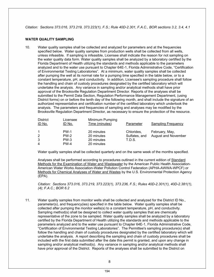
8
Citation: Sections 373.016, 373.219, 373.223(1), F.S.; Rule 40D-2.301, F.A.C., BOR sections 3.2, 3.4, 4.1
WATER QUALITY SAMPLING
10. Water quality samples shall be collected and analyzed for parameters and at the frequencies specified below. Water quality samples from production wells shall be collected from all wells, unless infeasible. If sampling is infeasible, Licensee shall indicate the reason for not sampling on the water quality data form. Water quality samples shall be analyzed by a laboratory certified by the Florida Department of Health utilizing the standards and methods applicable to the parameters analyzed and to the water use pursuant to Chapter 64E-1, Florida Administrative Code, “Certification of Environmental Testing Laboratories”. At a minimum, water quality samples shall be collected after pumping the well at its normal rate for a pumping time specified in the table below, or to a constant temperature, pH, and conductivity. In addition, Licensee's sampling procedure shall follow the handling and chain of custody procedures designated by the certified laboratory which will undertake the analysis. Any variance in sampling and/or analytical methods shall have prior approval of the Brooksville Regulation Department Director. Reports of the analyses shall be submitted to the Permit Data Section, Regulation Performance Management Department, (using District forms) on or before the tenth day of the following month, and shall include the signature of an authorized representative and certification number of the certified laboratory which undertook the analysis. The parameters and frequencies of sampling and analyses may be modified by the Brooksville Regulation Department Director, as necessary to ensure the protection of the resource.
District Licensee Minimum Pumping ID No. ID No. Time (minutes) Parameter Sampling Frequency
1 PW-1 20 minutes Chlorides, February, May,
2 PW-2 20 minutes Sulfates, and August and November 3 PW-3 20 minutes T.D.S.
4 PW-4 20 minutes
Water quality samples shall be collected quarterly and on the same week of the months specified.
Analyses shall be performed according to procedures outlined in the current edition of Standard Methods for the Examination of Water and Wastewater by the American Public Health Association-American Water Works Association-Water Pollution Control Federation (APHA-AWWA-WPCF) or Methods for Chemical Analyses of Water and Wastes by the U.S. Environmental Protection Agency (EPA).
Citation: Sections 373.016, 373.219, 373.223(1), 373.236, F.S.; Rules 40D-2.301(1), 40D-2.381(1), (4); F.A.C.; BOR 6.2
11. Water quality samples from monitor wells shall be collected and analyzed for the District ID No., parameter(s), and frequency(ies) specified in the table below. Water quality samples shall be collected after pumping the monitor wells(s) to a constant temperature, pH, and conductivity. Sampling method(s) shall be designed to collect water quality samples that are chemically representative of the zone to be sampled. Water quality samples shall be analyzed by a laboratory certified by the Florida Department of Health utilizing the standards and methods applicable to the parameters analyzed and to the water use pursuant to Chapter 64E-1, Florida Administrative Code, “Certification of Environmental Testing Laboratories”. The Permittee's sampling procedure(s) shall follow the handling and chain of custody procedures designated by the certified laboratory which will undertake the analysis. A report describing the sampling and chain of custody procedures shall be included with the first data submitted after the date this permit is granted, and upon any change in sampling and/or analytical method(s). Any variance in sampling and/or analytical methods shall have prior approval of the District. Reports of the analyses shall be submitted to the District on
194
9
District forms on or before the tenth day of the following month, and shall include the signature of an authorized representative and certification number of the certified laboratory that undertook the analysis. The parameters and frequency of sampling and analysis may be modified by the District as necessary to ensure the protection of the resource.
District Licensee ID No. ID No. Parameter Sample Frequency
5 TBD Chlorides, May, September 6 TBD Sulfates, and TDS 7 TBD 8 TBD 9 TBD 10 TBD
Water quality samples shall be collected based on the following timetable:
Semi-annually Same week of months specified
Analyses shall be performed according to procedures outlined in the current edition of Standard Methods for the Examination of Water and Wastewater by the American Public Health Association-American Water Works Association-Water Pollution Control Federation (APHA-AWWA-WPCF) or Methods for Chemical Analyses of Water and Wastes by the U.S. Environmental Protection Agency (EPA).
Citation: Sections 373.016, 373.219, 373.223(1), 373.236, F.S.; Rules 40D-2.301(1), 40D-2.381(1), (4); F.A.C.; BOR 6.2
12. The District with DEP's concurrence, reserves the right to set chloride, sulfate or TDS concentration limits on any production well in the future to prevent long-term upward trends or other significant water quality changes from occurring, based on data collected and after a sufficient data base has been established to determine limits. These limits shall be required after discussions with the Licensee. At such time as the concentration in any water sample reaches or exceeds the designated concentration limits, the Licensee shall take appropriate action to reduce concentrations to below those set for the particular well. If the District determines that long-term upward trends or other significant water quality changes are occurring, the District may consult with FDEP to reconsider the quantities included in these conditions of certification.
Citation: Sections 373.016, 373.219, 373.223(1), 373.236, F.S.; Rules 40D-2.301(1), 40D-2.381(1), (4); F.A.C.; BOR 6.2
13. During drilling of District ID Nos. 1, 2, 3, 4, Licensee ID Nos. PW-1, PW-2, PW-3, PW-4, water quality samples shall be collected at intervals of the change of drill rod or 30 feet, which ever is less, from 150 feet to a maximum depth of five feet above the bottom of the well. Regardless of the specified sample collection interval, a sample shall be collected from the depth which corresponds to five feet above the bottom of the well. Samples shall be collected during reverse air drilling, or other appropriate method with prior approval by the District.
Samples shall be analyzed by a certified laboratory for Chloride, Sulfate, and Specific Conductivity. Licensee' sampling procedure shall follow the handling and chain of custody procedures designated by the certified laboratory which will undertake the analysis. Reports of the analyses shall be submitted to the Permit Data Section, Regulation Performance Management Department (using District forms) within thirty days of sampling, and shall include the signature of an authorized representative and the certification number of the Florida Department of Health certified laboratory
195

10
utilizing the standards and methods applicable to the parameters analyzed and to the water use pursuant to Chapter 64E-1, Florida Administrative Code, “Certification of Environmental Testing Laboratories”.
Analyses shall be performed according to procedures outlined in the current edition of Standard Methods for the Examination of Water and Wastewater by the American Public Health Association-American Water Works Association-Water Pollution Control Federation (APHA-AWWA-WPCF) or by Methods for Chemical Analyses of Water and Wastes by the U.S. Environmental Protection Agency (EPA).
Citation: Sections 373.016, 373.219, 373.223(1), 373.236, F.S.; Rules 40D-2.301(1), 40D-2.381(1), (4); F.A.C.; BOR 6.2
14. Monthly water levels for monitor wells for the sites included in the table below shall be referenced to NGVD, and reported in a form acceptable to the District by the tenth day of each month for the preceding month. The time and date that the elevation is taken shall be included. Changes to the methodology, extent, or frequency of monitoring at any of these sites may be modified by the District, as necessary to ensure the protection of the resources.
District Licensee ID No. Site No.
5 TBD 6 TBD 7 TBD 8 TBD 9 TBD 10 TBD
Citation: Sections 373.016, 373.219, 373.223(1), 373.236, F.S.; Rules 40D-2.301(1), 40D-2.381(1), (4); F.A.C.; BOR 6.2
WELLS
15. Well construction permits shall be obtained from the District by the Licensee for all wells to be constructed for this project. Well construction shall conform to requirements set forth in District and DEP rules for well construction.
Citation: Sections 373.016, 373.219, 373.223(1), 373.308, 373.313, F.S.; Rules 40D-2.301(1), 40D-2.381(1), 40D-3.041, F.A.C.; WUP BOR 6.2
16. Wells not in use with no installed pumping equipment shall be capped or valved in a water tight manner in accordance with Rule 62-532.500(3)(a)(4), F.A.C.
Citation: Sections 373.016, 373.219, 373.223(1), 373.308, 373.313, F.S.; Rules 40D-2.301(1), 40D-2.381(1), 40D-3.037, 40D-3.041, 40D-3.521, 62-532.500, F.A.C.
17. Within 90 days of the completion of each proposed well, Licensee shall submit to the District specific capacity (well testing) information from any test performed by the Water Well Contractor or pump installer on the well. This information shall include:
A. Static water level before pumping B. Duration of test pumping C. Gallons per minute pumped D. Final water level measured during pumping
196
11
If step-drawdown tests were performed, the information listed above shall be submitted for each step. A report analyzing the results shall be presented.
Citation: Sections 373.016, 373.219, 373.223(1), F.S.; Rules 40D-2.301(1), 40D-2.381(1), 40D-3.301(2), F.A.C.
18. Within 90 days of construction, Licensee shall submit to the Permit Data Section, Regulation Performance Management Department, the specific locations of District ID Nos. 1, 2, 3, 4, Licensee ID Nos. PW-1, PW-2, PW-3, PW-4, on an original blue line aerial with a minimum scale of one inch equals 800 feet, or by latitude/longitude. Intake and mainline diameters for each of the above pumps shall be reported at the time of location reporting.
Citation: Sections 373.016, 373.219, 373.223(1), F.S.; Rules 40D-2.301(1), 40D-2.381(1), 40D-3.301(2), F.A.C.
19. Within one year of conditions of certification issuance, Licensee shall develop and implement a Water Conservation Plan (Plan) that includes practices currently employed or planned. For planned components, include an estimated time-frame for implementation for each. The Plan must indicate that technically and economically feasible water conservation opportunities have been or will be employed.
Citation: Sections 373.016, 373.219, 373.223(1), F.S.; Rules 40D-2.301(1), 40D-2.381(1), F.A.C.; BOR 3.4 (pending amendment)
20. The lowest quality water source, including reclaimed water, surface water and stormwater, must be used for each consumptive use authorized by these conditions of certification when available, except when Licensee demonstrates that the use of the lower quality water source is determined to be not economically, environmentally, or technologically feasible, in accordance with the District's Water Use Permit Information Manual Part B, Basis of Review, Sections 4.4 and 4.11.
Citation: Sections 373.016, 373.219, 373.223(1), F.S.; Rules 40D-2.301(1), 40D-2.381(1), F.A.C.; BOR 4.4, 4.11
21. Wetlands and other surface waters may not be adversely impacted as a result of the water use authorized by these conditions of certification. If unacceptable adverse impacts occur, the District will request that DEP modify the conditions of certification to curtail or abate the unacceptable adverse impacts, unless the impacts can be mitigated by Licensee.
Citation: Sections 373.016, 373.219, 373.223(1), F.S.; Rules 40D-2.301(1), 40D-2.381(1), F.A.C.; BOR 2.8, 4.2, 4.13, 6.2
22. A construction dewatering plan shall be provided to the District, for approval 6 months prior to the conduct of the dewatering. This plan shall include the details of the dewatering system, discharge quantities and location, a monitoring plan, and other details as appropriate to demonstrate that the dewatering plans meet the Districts Conditions of Issuance as included in 40D-2.301 and comply with all applicable Environmental Resource Permit construction dewatering requirements.
Citation: Sections 373.016, 373.219, 373.223(1), F.S.; Rules 40D-2.301(1), 40D-2.381(1), F.A.C.; BOR Sections 3.5, 5.4, 5.5
197
12
B. STANDARD CONDITIONS:
Licensee shall comply with the following Standard Conditions:
1. If any of the statements in the application and in the supporting data are found to be untrue and inaccurate, or if Licensee fails to comply with all of the provisions of Chapter 373, F.S., Chapter 40D, or the conditions set forth herein, the District shall seek revocation of any conditions of certification.
2. These conditions of certification are imposed based on information provided by Licensee demonstrating that the use of water is reasonable and beneficial, consistent with the public interest, and will not interfere with any existing legal use of water. If, during the term of this certification, it is determined by the District that the use is not reasonable and beneficial, in the public interest, or does impact an existing legal use of water, the District shall seek modification these conditions of certification or revocation of the certification authorized by DEP.
3. Licensee shall not deviate from any of the District- imposed conditions of this certification without written approval by the District.
4. In the event the District declares that a Water Shortage exists pursuant to Chapter 40D-21, Licensee agrees that portions of these conditions of certification shall be modified, or declared inactive as necessary to address the water shortage.
5. The District shall collect water samples from any withdrawal point listed in these conditions of certification or shall require Licensee to submit water samples when the District determines there is a potential for adverse impacts to water quality.
6. Licensee shall provide access to an authorized District representative to enter the property at any reasonable time to inspect the facility and make environmental or hydrologic assessments. Licensee shall either accompany District staff onto the property or make provision for access onto the property.
7. Licensee shall cease or reduce any surface water withdrawals as directed by the District if water levels in surface water fall below applicable minimum water level established in Chapter 40D-8 or rates of flow in streams fall below the minimum levels established in Chapter 40D-8.
8. Licensee shall cease or reduce withdrawals if water levels in aquifers fall below the minimum levels established by the District.
9. Licensee shall practice water conservation to increase the efficiency of transport, application, and use, as well as to decrease waste and to minimize runoff from the property. At such time as the District adopts specific conservation requirements for Licensee's water use classification, these conditions of certification shall be modified accordingly.
10. The District may establish special regulations for Water Use Caution Areas. At such time as the Governing Board adopts such provisions, these conditions of certification shall be subject to them upon notice and after a reasonable period for compliance.
11. Licensee shall mitigate any adverse impact to existing legal uses caused by withdrawals. When adverse impacts occur or are imminent, Licensee shall be required to mitigate the impacts. Adverse impacts include:
A. A reduction in water levels which impairs the ability of the well to produce water; B. Significant reduction in levels or flows in water bodies such as lakes, impoundments,
wetlands, springs, streams or other watercourses; or C. Significant inducement of natural or manmade contaminants into a water supply or into a
usable portion of any aquifer water body.
198
13
12. Licensee shall mitigate any adverse impact to environmental features or offsite land uses as a result of withdrawals. When adverse impacts occur or are imminent, the Licensee shall be required to mitigate the impacts. Adverse impacts include:
A. Significant reduction in levels or flows in water bodies such as lakes, impoundments, wetlands, springs, streams or other watercourses;
B. Sinkholes or subsidence caused by reduction in water levels; C. Damage to crops and other vegetation causing financial harm to the owner; and D. Damage to the habitat of endangered or threatened species.
13. When necessary to analyze impacts to the water resource or existing users, Licensee shall be required to install flow metering or other measuring devices to record withdrawal quantities and submit the data to the District.
14. A District identification tag shall be prominently displayed at each withdrawal point by permanently affixing the tag to the withdrawal facility.
15. Licensee shall notify the District within 30 days of the sale or conveyance of permitted water withdrawal facilities or the land on which the facilities are located.
16. The annual average daily withdrawal quantity is determined by calculating the total quantity of water to be withdrawn over a one year period, divided by 365 days, which results in a gallons per day (gpd) quantity pursuant to Basis of Review, Section 3.2, Permitted Withdrawal Quantities. This is a running 12-month average, whereby each month the annual average daily quantity is recalculated based on the previous 12-month pumpage.
Citation: Sections 373.016, 373.219, 373.223(1), F.S.; Rules 40D-2.301(1), 40D-2.381(1), F.A.C.; BOR Section 6.1
L: \PEF Levy 1 & 2 (DOAH 08-2727 EPP)-2008048\District Agency Reports, Completeness Comments\SWFWMD Final Conditions-Levy Nuclear.docx
199

Item 25
Consent Agenda December 16, 2008
Resource Management Committee
Approve Initiation of Rulemaking to Amend Rule 40D-8.624, Florida Administrative Code, to Add Minimum and Guidance Levels for Lake Anoka in Highlands County
PurposeBoard approval of minimum and guidance levels for Lake Anoka.
Background/History Proposed minimum and guidance levels for Lakes Anoka have been developed using previously peer-reviewed, Governing Board adopted methods. Minimum levels are water levels at which further withdrawals would be significantly harmful to the water resources of the area. Guidance levels are used to describe expected water level fluctuations and serve as advisory information for the District, lakeshore residents and local governments, or to aid in the management of water control structures. A technical document outlining development of the proposed levels has been posted on the District's web site and distributed to interested parties.
A public workshop on the proposed lake levels is scheduled for December 4, 2008 in Sebring. Information obtained as a result of the workshop will be summarized and made available to the Board upon request and, if appropriate, used to modify the proposed levels.
Based on available water level records, the proposed minimum levels for Lake Anoka are being met or are close to being met. In the event that water levels in the lake basin are not fluctuating in compliance with the proposed minimum levels, the recovery strategies outlined in Rule 40D-80.074, Florida Administrative Code (F.A.C.), will apply.
Staff has prepared rule amendments that incorporate the proposed minimum and guidance levels for Lake Anoka into Table 8-2 in Rule 40D-8.624, F.A.C. (see exhibit). The rule amendments also include deletion of currently adopted guidance levels for the lake from Table 8-3 in Rule 40D-8.624, F.A.C.
Staff will be prepared to address any Board concerns regarding the proposed levels or the methods used for their development.
Benefits/CostsAdoption of minimum levels for Lake Anoka will support the District's water supply planning, water use permitting, and environmental resource permitting programs. Adoption of the guidance levels will provide advisory information for construction of lakeshore development and operation of water management structures.
If initiation of rulemaking is approved and no requests for hearing are received, staff will complete the rulemaking process without further Governing Board action.
Staff Recommendation: See Exhibit
Approve initiation of rulemaking to amend Rule 40D-8.624, F.A.C., to delete previously adopted guidance level and add new guidance and minimum levels as shown in the Exhibit.
Presenter: Doug Leeper, Chief Environmental Scientist Resource Projects Department
200
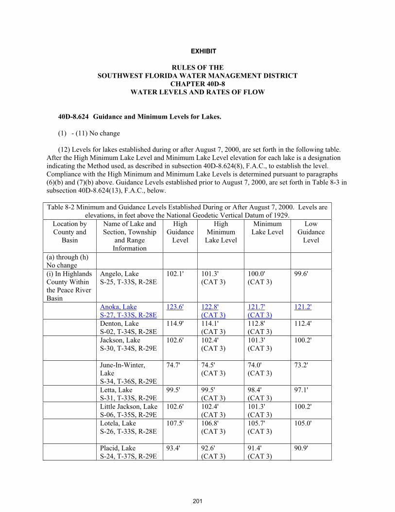
EXHIBIT
RULES OF THE SOUTHWEST FLORIDA WATER MANAGEMENT DISTRICT
CHAPTER 40D-8 WATER LEVELS AND RATES OF FLOW
40D-8.624 Guidance and Minimum Levels for Lakes.
(1) - (11) No change
(12) Levels for lakes established during or after August 7, 2000, are set forth in the following table. After the High Minimum Lake Level and Minimum Lake Level elevation for each lake is a designation indicating the Method used, as described in subsection 40D-8.624(8), F.A.C., to establish the level. Compliance with the High Minimum and Minimum Lake Levels is determined pursuant to paragraphs (6)(b) and (7)(b) above. Guidance Levels established prior to August 7, 2000, are set forth in Table 8-3 in subsection 40D-8.624(13), F.A.C., below.
Table 8-2 Minimum and Guidance Levels Established During or After August 7, 2000. Levels are elevations, in feet above the National Geodetic Vertical Datum of 1929.
Location by County and
Basin
Name of Lake and Section, Township
and Range Information
HighGuidance
Level
HighMinimum
Lake Level
Minimum Lake Level
LowGuidance
Level
(a) through (h) No change (i) In Highlands County Within the Peace River Basin
Angelo, Lake S-25, T-33S, R-28E
102.1' 101.3' (CAT 3)
100.0' (CAT 3)
99.6'
Anoka, LakeS-27, T-33S, R-28E
123.6' 122.8'(CAT 3)
121.7'(CAT 3)
121.2'
Denton, LakeS-02, T-34S, R-28E
114.9' 114.1' (CAT 3)
112.8' (CAT 3)
112.4'
Jackson, LakeS-30, T-34S, R-29E
102.6' 102.4' (CAT 3)
101.3' (CAT 3)
100.2'
June-In-Winter,LakeS-34, T-36S, R-29E
74.7' 74.5' (CAT 3)
74.0' (CAT 3)
73.2'
Letta, LakeS-31, T-33S, R-29E
99.5' 99.5' (CAT 3)
98.4' (CAT 3)
97.1'
Little Jackson, Lake S-06, T-35S, R-29E
102.6' 102.4' (CAT 3)
101.3' (CAT 3)
100.2'
Lotela, LakeS-26, T-33S, R-28E
107.5' 106.8' (CAT 3)
105.7' (CAT 3)
105.0'
Placid, LakeS-24, T-37S, R-29E
93.4' 92.6' (CAT 3)
91.4' (CAT 3)
90.9'
201
Table 8-2 Minimum and Guidance Levels Established During or After August 7, 2000. Levels are elevations, in feet above the National Geodetic Vertical Datum of 1929.
Location by County and
Basin
Name of Lake and Section, Township
and Range Information
HighGuidance
Level
HighMinimum
Lake Level
Minimum Lake Level
LowGuidance
Level
Tulane, LakeS-27, T-33S, R-28E
118.7' 117.9' (CAT 3)
116.6' (CAT 3)
116.2'
Verona, LakeS-23, T-33S, R-28E
118.2' 117.4' (CAT 3)
115.8' (CAT 3)
115.1'
(j) through (cc) No change
Remainder of page left blank intentionally.
202

(13) Guidance Levels established for lakes prior to August 7, 2000, are set forth in the following table:
Table 8-3 Guidance Water Levels adopted prior to August 7, 2000 Location of Impoundment by County and Basin
High Level in Feet Above Mean Sea Level (msl)
Low Level in Feet Above Mean Sea Level (msl)
Extreme Low Level in Feet Above Mean Sea Level (msl)
(a) through (h) No change (i) In Highlands County Within the Peace River BasinLAKESSec. Twsp. Rng. Adelaide, Lake 5, 33S, 28E
106.50' 104.00' 102.50'
Anoka, Lake27, 33S, 28E
124.00' 122.00' 120.00'
Apthhorpe, Lake 18, 36S, 30E
71.50' 68.00' 66.00'
Blue, Lake 30, 36S, 30E
77.50' 75.00' 73.50'
Bonnet, Lake 8, 34S, 29E
90.75' 88.00' 86.00'
Brentwood, Lake 10, 33S, 28E
102.75' 99.50' 98.00'
Buck, Lake 29, 37S, 30E
94.00' 91.50' 89.50'
Byrd, Lake 9, 33S, 28E
108.25' 105.50' 104.00'
Carrie, Lake 21, 36S, 29E
75.50' 73.00' 72.50'
Charlotte, Lake 17, 35S, 29E
93.75' 91.25' 89.75'
Chilton, Lake 7, 33S, 28E
114.00' 111.00' 109.50'
Clay, Lake 29, 36S, 30E
78.75' 76.00' 75.00'
Crews, Lake 32, 36S, 29E
119.50' 117.00' 115.50'
Damon, Lake 3, 33S, 28E
101.00' 98.00' 95.00'
Dinner, Lake 17, 34S, 29E
102.50' 98.50' 97.00'
Francis, Lake 22, 36S, 29E
70.50' 67.50' 66.50'
Glenada, Lake 34, 33S, 28E
120.00' 117.00' 115.50'
Grassy, Lake 17, 37S, 30E
91.50' 88.50' 87.50'
203

Table 8-3 Guidance Water Levels adopted prior to August 7, 2000 Location of Impoundment by County and Basin
High Level in Feet Above Mean Sea Level (msl)
Low Level in Feet Above Mean Sea Level (msl)
Extreme Low Level in Feet Above Mean Sea Level (msl)
Harry, Lake 1, 36S, 29E
67.50' 63.00' 62.00'
Henry, Lake 25, 36S, 29E
75.50' 73.00' 72.50'
Hill, Lake17, 36S, 29E
99.25' 96.00' 94.50'
Huckleberry, Lake 7, 35S, 29E
104.50' 102.00' 101.00'
Huntley, Lake 5, 37S, 30E
83.75' 81.00' 79.50'
Josephine, Lake 32, 35S, 29E
72.50' 69.00' 68.50'
Lake Lachard 36, 36S, 29E
78.50' 76.00' 74.00'
Lelia, Lake 34, 33S, 29E
114.50' 112.50' 110.50'
Little Bonnet, Lake 36, 33S, 28E
100.00' 97.00' 96.00'
Little Red Water, Lake 14, 36S, 29E
103.25' 100.50' 98.50'
Lost, Lake12, 37S, 29E
88.00' 84.00' 82.75'
McCoy, Lake 6, 37S, 30E
87.00' 84.00' 82.00'
Mirror, Lake 7, 37S, 30E
93.50' 90.00' 88.00'
Center Nellie 13, 36S, 29E
71.50' 67.00' 65.00'
Nellie N.W., Lake13, 36S, 29E
71.50' 67.00' 65.00'
Nellie S.E., Lake 13, 36S, 29E
71.50' 67.00' 65.00'
Olivia, Lake 6, 33S, 28E
117.50' 114.50' 113.00'
Pearl, Lake 6, 37S, 30E
87.00' 84.00' 82.00'
Persimmon, Lake10, 36S, 29E
68.25' 65.00' 63.50'
Pioneer, Lake 11, 33S, 28E
108.00' 104.50' 103.00'
Pythias, Lake 2, 33S, 28E
101.00' 98.00' 95.00'
Red Beach Lake 15, 35S, 29E
76.50' 73.75' 72.75'
Red Water Lake 14, 36S, 29E
70.50' 67.50' 66.50'
204
Table 8-3 Guidance Water Levels adopted prior to August 7, 2000 Location of Impoundment by County and Basin
High Level in Feet Above Mean Sea Level (msl)
Low Level in Feet Above Mean Sea Level (msl)
Extreme Low Level in Feet Above Mean Sea Level (msl)
Ruth, Lake 18, 35S, 29E
94.00' 91.50' 90.00'
Saddlebags, Lake 6, 37S, 30E
84.00' 81.00' 79.00'
Sebring, Lake 14, 34S, 28E
107.25' 104.50' 103.00'
Simmons, Lake24, 36S, 29E
72.50' 68.00' 66.50'
Sirena, Lake 1, 37S, 29E
87.00' 84.00' 82.00'
Trout, Lake 34, 32S, 28E
101.00' 98.00' 95.00'
Unnamed Lake (B) 20, 37S, 30E
91.50' 88.50' 87.50'
Unnamed Lake (F) 24, 36S, 29E
78.00' 74.00' 72.00'
Viola, Lake 14, 33S, 28E
109.50' 105.75' 104.00'
Wolf Lake 24, 35S, 28E
92.50' 90.00' 88.00'
(j) through (cc) No change
Specific Authority 373.044, 373.113, 373.171, F.S. Law Implemented 373.036, 373.0361, 373.042, 373.0421, 373.086, F.S. History – New 6-7-78, Amended 1-22-79, 4-27-80, 10-21-80, 12-22-80, 3-23-81, 4-14-81, 6-4-81, 10-15-81, 11-23-81, 1-5-82, 3-11-82, 5-10-82, 7-4-82, 9-2-82, 11-8-82, 1-10-83, 4-3-83, 7-5-83, 9-5-83, 10-16-83, 12-12-83, 5-8-84, 7-8-84, 12-16-84, 2-7-85, 5-13-85, 6-26-85, 11-3-85, 3-5-86, 6-16-86, Formerly 16J-8.678, Amended 9-7-86, 2-12-87, 9-2-87, 2-18-88, 6-27-88, 2-22-89, 3-23-89, 9-26-89, 7-26-90, 10-30-90, 3-3-91, 9-30-91, 10-7-91, 7-26-92, 3-1-93, 5-11-94, 6-6-96, 2-23-97, 8-7-00, 1-8-04, 12-21-04 (13), 12-21-04 (13), 6-5-05, 5-2-06, 1-1-07, 2-12-07, 1-10-08, 2-18-08, 4-7-08, 5-20-08,________.
205

Item 26
Consent Agenda December 16, 2008
Resource Management Committee
Approve Initiation of Rulemaking to Amend Rule 40D-8.041, Florida Administrative Code,to Establish Minimum Flows for the Weeki Wachee River System
PurposeEstablishment of minimum flows for the Weeki Wachee River system, in addition to acceptance of the report dated October 30, 2008 entitled, "Weeki Wachee River System Recommended Minimum Flows and Levels." For purposes of this rule, the Weeki Wachee System includes the watercourse from the Weeki Wachee Spring to the Gulf of Mexico including Twin Dees Spring, Mud River (including Salt Spring) from Mud Spring to the confluence with the Weeki Wachee River and Jenkins Springs and associated spring run.
Background/History Recommended minimum flows for the Weeki Wachee River system and the methodologies used to develop these flow recommendations were presented to the Governing Board at its April 29, 2008 meeting. For development of Minimum Flows and Levels (MFLs) for the Weeki Wachee River system, the District evaluated sixteen habitat and resource metrics for two seasons corresponding to periods of low and high flow periods and determined that 90 percent of the natural flow should be preserved in order to protect the water resources from significant harm. Seasonal differences were minimal and simulated reductions of more than 10 percent of the historical natural flows resulted in greater than a 15 percent loss of habitat or resource. The short-term compliance standard intended to apply upstream or downstream of the gage, is the preservation of 90 percent the natural flow at the U.S. Geological Survey (USGS) Weeki Wachee River near Brooksville gauge (USGS# 02310525). This constitutes a short-term compliance standard for surface water withdrawals and is anticipated to be complied with continuously and evaluated on a daily basis.
Because minimum flows are intended to protect the water resources or ecology of an area and because climatic variation can influence river flow regimes, staff develops long-term compliance standards when setting minimum flows. These standards are hydrologic flow statistics that are expected to occur during long-term periods when short-term compliance standards are being met. The hydrologic statistics, including five-year and ten-year mean and median flows, were determined and identified as long-term compliance standards. The standards are intended to prevent significant harm to the water resources or ecology of the river that may result from water use. Since future structural alterations could potentially affect surface water or groundwater flow characteristics within the watershed and additional information pertaining to minimum flows development may become available, the District is committed to the revision of the proposed levels as necessary.
Following a staff presentation to the Governing Board in April 2008, the draft report of the Weeki Wachee River System Recommended MFL was submitted to an independent, scientific review panel for voluntary peer review. The panel’s mission was to review the validity of the technical approach used by the District to determine the proposed minimum flows. In doing so, the panel considers how well the conclusions in the report are supported by the data, procedures, and analyses that are presented. The Governing Board should give significant weight to the panel’s findings when adopting minimum flows for the Weeki Wachee River System.
206
Item 26
The panel submitted their report to the District in July 2008. Staff presented the peer review findings at the September 2008 meeting of the Resource Management Committee and responded to the peer review report at the October 2008 Committee meeting. In part, the panel wrote, "Overall, the District is to be commended for preparing an excellent report that summarizes a large quantity of data and analyses, produced from many studies, into a document that is coherent and relatively easy to read. The supporting data and information used to develop the proposed MFL is technically sound. As described in the District's report, the data collection methods were appropriate, as were the findings and interpretations made from all analyses reviewed by the Panel."
In summary, staff has finalized the April 2008 draft MFL document by addressing various editorial concerns, making changes recommended by the peer review panel, attaching the peer review panel's report as an appendix, and providing staff's response. This report, now dated October 30, 2008, is available on the District's web site. The proposed rule language for establishment of MFL for Weeki Wachee River System is attached as an exhibit.
Staff Recommendation: See Exhibit & Report
(1) Acceptance of the MFL report entitled, "Weeki Wachee River System Recommended Minimum Flows and Levels" dated October 30, 2008.
(2) Approve Initiation of Rulemaking to Amend Rule 40D-8.041, Florida Administrative Code, to Establish Minimum Flows for the Weeki Wachee River System.
Presenter: Michael G. Heyl, Chief Environmental Scientist, Resource Projects Department
207

EXHIBIT
Amendments toRULE 40D-8.041, F.A.C.
Weeki Wachee River System MFL12-2-08
40D-8.041 Minimum Flows (1)-(10) No change. (11) Minimum Flows for Weeki Wachee River System located within Hernando
County, Florida(a) The Minimum Flows are to ensure that the minimum hydrologic
requirements of the water resources or ecology of the natural systems associated with the Weeki Wachee River System are met. The Minimum Flow for the Weeki Wachee River System is intended to maintain 90% of the natural flow of the Weeki Wachee River System. For purposes of this rule, the Weeki Wachee River System includes the watercourse from the Weeki Wachee Spring to the Gulf of Mexico including Twin Dees Spring, Mud River (including Salt Spring) from Mud Spring to the confluence with the Weeki Wachee River and Jenkins Springs and associated spring run.
(b) The Minimum Flow for the Weeki Wachee River System is 90% of its natural flow. This Minimum Flow is inclusive of spring flow, the freshwater and the estuarine portion of the Weeki Wachee River. (c) The Minimum Flow applies upstream of the USGS Gage No. 02310525 at Weeki Wachee River near Brooksville ("Brooksville Gage") to the Weeki Wachee Spring vent and downstream of the Brooksville Gage to the Gulf of Mexico. The Minimum Flow shall be met continuously and is evaluated on a daily basis. (d) Because climatic variation can influence river flow regimes, five and ten year mean and median standards have been developed and are set forth in Table 8-18 ("Means and Medians") as a tool to assess whether compliance with the Minimum Flow maintains 90% of the natural flow of the Weeki Wachee River System. The Means and Medians are hydrologic statistics that represent flows expected to occur during long-term periods when the Minimum Flows are being met. The Means and Medians are generated from flow records that are representative of a period devoid of significant anthropogenic impacts. TheDistrict will periodically evaluate the Means and Medians. These are evaluated as the mean and medians of annual means and medians, evaluated from January 1 through December 31 of each year. The evaluation is for both the flow at the Brooksville Gage and at the USGS Weeki Wachee Well No.283201082315601. The flow at the Brooksville Gage is evaluated directly against Table 8-18. The well data is converted to flow with the relation Q (cfs) = 47.487 + 12.38 (well level) (ft) and then evaluated against Table 8-18. The Means and Medians were developed using the Minimum Flow and the presumed
208

historic flow records. Therefore, it is expected that the Means and Medians will be met if compliance with the Minimum Flow is maintained. However, since future structural alterations could potentially affect surface water or groundwater flow characteristics within the watershed and additional information pertaining to Minimum Flows development may become available, the District is committed to periodic review and revision of the Minimum Flows, as necessary.
Table 8-18 Five and Ten Year Means and Mediansfor the Weeki Wachee River System
Critierion Minimum Flow (cfs)Minimum 10 Year Moving Average(Based On Annual Average Flows) 141Minimum 10 Year Moving Average(Based On Annual Median Flows) 131Minimum 5 Year Moving Average(Based On Annual Average Flows) 136Minimum 5 Year Moving Average(Based On Annual Median Flows) 128
(e) Water Use Permits issued after [effective date of rule] that authorize surface water withdrawals from, or ground water withdrawals that impact Mud Spring, Salt Spring or Jenkins Spring, shall gauge the flow of the applicable spring and report the flow to the District as provided in the Water Use Permit.
209
Item 27
Consent Agenda December 16, 2008
Resource Management Committee
Authorize Submission of the Preliminary Flood Insurance Rate Maps for the Oman Quarry/Indian Creek, Powell, and Blue Sink Watersheds to the Federal Emergency Management Agency
PurposeThis is an action item to request the Board authorize staff to submit the preliminary Flood Insurance Rate Map (FIRM) panels for the Oman Quarry/Indian Creek, Powell, and Blue Sink watersheds in Hernando County to the Federal Emergency Management Agency (FEMA). The 100-year, one-day rainfall event was used, infiltration was accounted for, and the 2007 topographic information was utilized for each watershed. The watershed models and floodplain information have gone through the District’s process including internal review and external peer review by experienced licensed professional engineers. These watersheds were presented at public workshops held in the District’s Brooksville Headquarters for review and comment. The preliminary floodplain information is ready to be formatted to meet FEMA’s mapping specifications and submitted to FEMA. Following submittal of the preliminary FIRM panels, FEMA will conduct their own technical review, take public input, and allow for a 90-day appeals period during the adoption process. Depending on public input, the FEMA process can take one to two years.
Background/HistoryThe District initiated a partnership with FEMA to modernize Flood Insurance Rate Maps (FIRMs) as part of its Watershed Management Program (WMP). Flood protection and floodplain information has been a priority at the District since the inception of the organization and that priority was renewed following the El Niño weather event in 1997-1998. In addition to studies conducted by the District (primarily through the Basin Boards) and others, information on floodplains (elevations) is available through the FEMA FIRMs. However, many of the existing maps do not accurately represent the flood-prone areas, either because the initial studies were technically limited or the maps are outdated due to significant land use changes since completion. To improve the floodplain information, develop regional scale flood routing models for alternative analysis, and improve local government's understanding of their flood protection level of service, the District reached out to local governments and initiated the WMP in the late '90s.
The District recognized a potential funding partner in FEMA as they had mutual goals to improve the existing FIRMs to better identify risks of flooding within the District. The District and FEMA executed a Cooperating Technical Partners (CTP) Memorandum of Agreement on September 14, 2001, to formalize the relationship. As a CTP, the District is eligible for federal funds to act as FEMA's partner in modernization of the FIRMs. Federal funds have allowed the District and local governments to accomplish significantly more than would otherwise been possible. To date, the District has received approximately $11.2 million in federal funds from FEMA for countywide map modernization projects for Pasco, Sarasota, Hernando, Marion, Polk, Hardee, Desoto, Citrus, Sumter, Levy, and Highlands counties. An additional $0.9 million is expected in future fiscal years for countywide map modernization projects for Manatee County. The Map Modernization Program also includes federal funding for management support. For fiscal year (FY) 2004 through FY2008 the District received $782,860 and could receive an additional $350,000 through FY2012.
210
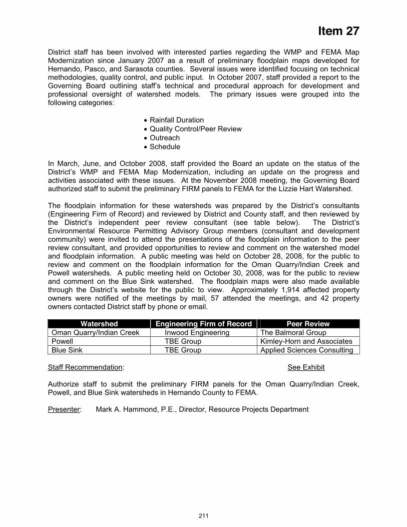
Item 27
District staff has been involved with interested parties regarding the WMP and FEMA Map Modernization since January 2007 as a result of preliminary floodplain maps developed for Hernando, Pasco, and Sarasota counties. Several issues were identified focusing on technical methodologies, quality control, and public input. In October 2007, staff provided a report to the Governing Board outlining staff’s technical and procedural approach for development and professional oversight of watershed models. The primary issues were grouped into the following categories:
Rainfall Duration Quality Control/Peer Review Outreach Schedule
In March, June, and October 2008, staff provided the Board an update on the status of the District’s WMP and FEMA Map Modernization, including an update on the progress and activities associated with these issues. At the November 2008 meeting, the Governing Board authorized staff to submit the preliminary FIRM panels to FEMA for the Lizzie Hart Watershed.
The floodplain information for these watersheds was prepared by the District’s consultants (Engineering Firm of Record) and reviewed by District and County staff, and then reviewed by the District’s independent peer review consultant (see table below). The District’s Environmental Resource Permitting Advisory Group members (consultant and development community) were invited to attend the presentations of the floodplain information to the peer review consultant, and provided opportunities to review and comment on the watershed model and floodplain information. A public meeting was held on October 28, 2008, for the public to review and comment on the floodplain information for the Oman Quarry/Indian Creek and Powell watersheds. A public meeting held on October 30, 2008, was for the public to review and comment on the Blue Sink watershed. The floodplain maps were also made available through the District’s website for the public to view. Approximately 1,914 affected property owners were notified of the meetings by mail, 57 attended the meetings, and 42 property owners contacted District staff by phone or email.
Watershed Engineering Firm of Record Peer Review Oman Quarry/Indian Creek Inwood Engineering The Balmoral Group Powell TBE Group Kimley-Horn and Associates Blue Sink TBE Group Applied Sciences Consulting
Staff Recommendation: See Exhibit
Authorize staff to submit the preliminary FIRM panels for the Oman Quarry/Indian Creek, Powell, and Blue Sink watersheds in Hernando County to FEMA.
Presenter: Mark A. Hammond, P.E., Director, Resource Projects Department
211
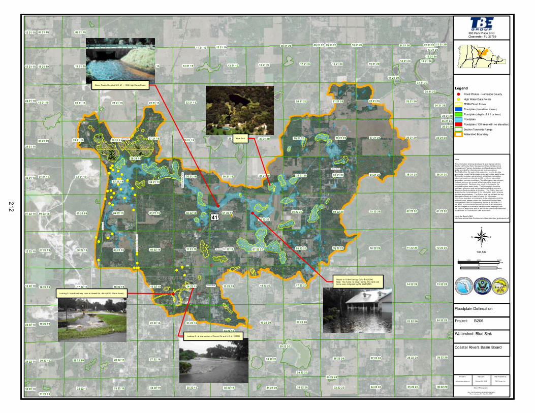
!(!(
!(!(
!(
!(!(!(!(!(!( !(!(!(!(!(!(!(
!(!(
!(!(!(!(!(!(
!(!(!(!(!(!(!(!(
!(!(
!(!(!(!(!(!(!(
!( !(!(!(!(!(!(!(
!(!(!(!( !( !(!(!(!(
!(!(!( !(!(!(!(
!(!(!(!(!(!(!(
!(!(!(!(
!(
!(!(
!(
!(!(
£¤41
13 22 19
30 22 19
18 22 19
19 22 19
16 21 20
07 22 19
25 22 19
21 21 19
06 22 19
15 21 20
17 22 20
30 21 20
32 21 2031 21 19
09 22 20
22 21 19
16 22 20
23 21 1920 21 19
18 21 19
27 21 20
14 22 19
10 22 20
17 21 20
11 22 20
34 21 20
29 21 19
31 21 2032 21 19
29 21 20
24 22 19
35 21 19
21 22 20
18 21 20
35 21 20
29 22 19
12 22 19
26 21 20
33 21 20
17 21 19 16 21 19
22 22 20
28 22 20 26 22 20
09 22 19
15 22 19
22 21 20
23 22 20
08 22 20
03 22 20
08 22 19
15 22 20
03 22 19
20 22 19
26 22 1927 22 19 27 22 20
16 22 19
04 22 19
20 21 20
01 22 19 02 22 20
18 22 20
15 21 19
05 22 19
28 21 20
10 22 19
17 22 19
21 21 20
20 22 20
11 22 19
06 22 20
24 21 19
04 22 20
28 22 19
14 22 20
21 22 19
34 21 19
30 21 19
36 21 19
26 21 19
13 21 19
22 22 19
05 22 20
19 21 20
30 22 20
23 22 19
23 21 20
02 22 19
14 21 19
33 21 19
19 21 19
19 22 20
07 22 20
28 21 19
07 21 19 08 21 19
27 21 19 25 21 19
14 21 20
36 21 20
12 22 20
25 21 20
13 22 20
01 22 20
25 22 20
35 22 20
24 22 20
34 22 2036 22 19 33 22 2035 22 19 32 22 2034 22 19 31 22 20
29 22 20
33 22 19
31 22 19
32 22 19
24 21 20
36 22 20
13 21 20
13 22 18
12 22 18
25 22 18
01 22 18
24 22 18
36 21 18
36 22 18
13 21 18
12 21 18
29 22 20
25 21 18
24 21 18
14 21 20
33 22 20
25 21 20
12 21 19
28 21 19
11 21 1911 21 20
24 21 20
14 21 20
09 21 1909 21 20
24 21 20
23 21 20
13 21 2008 21 20
25 21 20
13 21 20
10 21 20 12 21 2008 21 20
¬
£¤50
£¤98
£¤19
£¤301
£¤41
Legend!(
!(
212
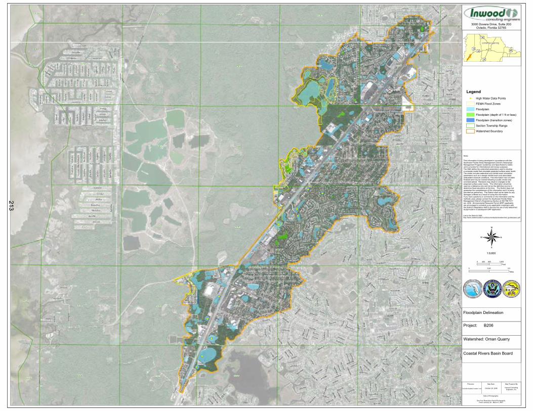
09 23 17
27 23 1728 23 17
22 23 17
16 23 17
21 23 17
15 23 17
08 23 17 10 23 1707 23 17
29 23 1725 23 16
17 23 17
12 23 16
20 23 17
18 23 17
19 23 17
30 23 17
24 23 16
13 23 16
36 23 16 32 23 17 33 23 17 34 23 1731 23 17
26 23 16
14 23 17
23 23 17
26 23 17
11 23 17
03 23 1704 23 1705 23 1706 23 1701 23 16
35 23 1735 23 16
11 23 16
23 23 16
02 23 17
02 23 16
Com
mer
cial
Way
(US1
9)(S
R55)
Shoa
l Lin
e Bo
ulev
ard
(CR5
97)
Spring Hill Drive (CR574)
Toucan Trail
Sealawn Drive
Oso
waw
Bou
leva
rd (
CR
595)
Waterfall Drive
Fore
st Roa
dPinehurst Drive
Har
row
Roa
d
De l
tona
Bou
leva
rd (
CR
5 89)
Gulfview Drive
Grand Club Drive
Forest Oaks Boulevard
Gulf Coast Drive
Holiday Drive
Applegate Drive
Abeline Road
Cobblestone Drive
Alderwood Street
Chaucer Drive
Piper Road
Floral Drive
Flamingo Boulevard
Centerwood Avenue
Meadow Lark
Road
Newmark Street
Aloe Drive
Plum
osa
Stre
et
Lori
Driv
e
Rhanbuoy Road
Hillview Road
Sugarbush Drive
Piedmont Drive
Bay
ridge
Cou
rt
Tranquil Drive
Companero Entra
Tren
ton
Ave
nue
Gasto
n Stre
et
Toledo Road
Suza
nne
Driv
e
Apache Trail
Catalina Street
Wen
dy C
ourt
Ashl
and
Driv
e
Jewfish Drive
Eagle Nest Drive
Newhope Road
Delaware Drive
Hof
fman
Ave
nue
Keye D
rive
Tyler Avenue
Croaker Drive
Tarrytown Drive
Middle
sex D
rive
Skylark Drive
Canterbury Street
Leafy Way Avenue
Lake
In T
he W
oods
Driv
e
Bluefish Drive
Bay
Driv
e
Ivydale Road
Tryon Circle
Indi
an B
ay R
oad
Marina
Way
Treehaven Drive
Cal
ient
a St
reet
Flyway Drive
Ligh
thou
se W
ay
Bre
akw
ater
Bou
leva
rd
Waycross Drive
Edgehill Avenue
Hermosa Boulevard
Kimball C
ourtC
umbe
rland
Lan
e
Arrowhe
ad A
venu
e
Swallow Lane
Clearmeadow Drive
Gra
ndfa
ther
Mou
ntai
n
Pain
ter s
Str
eet
Autu
mn
Road
Coachman
Road
Earlshire Lane
Skyline Court
Balm Street
Tim
ber P
oint
Bou
leva
rd
Airmont Drive
Jamaica Road
Eastbrook Drive
Fairlawn Street
Cobia Drive
Westchester Boulevard
Mead Drive
Pagoda Drive
Paci
fic A
ven u
e
Eric Street
Susa
n Driv
e
Spanish Oak Drive
Baffin C
ircle
Beve
rly C
ourt
Thun
derb
ird A
venu
e
Philatelic Drive
Rosemont Lane
Timbe
r Pin
es B
oulev
ard
Riv
er B
irch
Driv
e
Horse
shoe
Lane
Berkeley Manor Boulevard
Trel
lis A
venu
e
Fireside Street
Sea
Bas
s D
rive
Royal Oak Drive
Wabash Trail
Morris
on W
ay
Sheephead Drive
Millston
e Stre
et
Portland Avenue
Seav
iew D
rive
Apple Orchard Road
Blu
ewat
e r A
venu
e
Triggerfish Drive
Big
Ben
d D
rive
Kass Circle
Kenl
ake
Aven
ue
Alg
ood
Roa
d
Serv
ice R
d 55
71 (
Exul
tant
Driv
e)
Oakrid
ge D
rive
Alley 57400
Landmark Drive
Redwing Drive
Parlo
w Ave
nue
Foun
der R
oad
Rac
hel B
oule
vard
Pilg
rim R
oad
Suw
anne
e R
o ad
Amberjack Drive
Boyce Street
Kelvin Court
Cov
ingt
o n A
ven u
e
Minnow Creek Drive
Wel
sh S
tree
t
Coral Street
Copperfield Road
Greenbrier Court
Tom
ahaw
k Av
enue
Blackhawk Trail
Annapolis Road
Galgano Lane
Holly
hock
Lan
e
Post Court
Brandy Drive
Radford Street
Dia
z C
ourt
Om
aha Circle
Stillwater Avenue
Gal
ahad
Ave
nue
serv
ice
rd, P
rivat
e
Dot
tie C
our t
Jom
el D
rive
Wysocki Court
Bal
lard
Str
eet
Olson
Road
Mal
tby
Ro a
d
Aza
lea
Driv
e
Har
den
Stre
et
Mayhill Court
Dora Street
Lagoon Road
Bar
tlett
Stre
et
Orc
hid
Driv
e
Navajo Trail
Abe
ryls
Str
eet
Gates Circle
Mohawk Trail
Alley 57100
Cessna Drive
Bal
dwin
Str
eet
Plyn
a St
r eet
Tahiti Drive
London Avenue
Sand
ra D
rive
Talbot Circle
Mangrove Drive
Raleigh Street
Merrim
ac Lane
Fremont Lane
Hampshire Avenue
Day Street
Farley Avenue
Shalo
m D
rive
Antilles Lane
Cherokee Trail
Belmont Road
Gar
deni
a D
rive
Killinger Avenue
Lamplighter Street
Panther Drive
Patr
icia
Pla
ce
Buccaneer B
oulevard
Pond
Ci rc
le
Willow
Brook D
rive
Har
grov
e St
reet
Serv
ice
Road
556
2
Saw
Mill
Lan
e
Laur
el A
venu
e
Hib
iscu
s D
rive
Cam
elia
Driv
e
Wind
jammer
Driv
e
Dan River Drive
Fair Oaks Street
Shorecrest Court
Step
hens
Bou
levar
d
Clearfield Avenue
Tam
pico
Tra
il
Ha r
t ley
Ro a
d
Cofield Lane
Lifeboat Lane
Cascade Street
Old Mill Lane
Cavehill Road
Sugarfoot Drive
Ramona Drive
Serv
ice R
oad 5
510
Sylvia Avenue
Oak Tree Lane
Turf Lane
Tedburn Park
Serv
ice R
oad 5
560
Terrace View Lane
Blue Skies Drive
Casa Court
Sea
Gra
pe D
rive
Indi
an R
ock
Cou
rt
William Street
Norbert Street
Shine Lane
Colma S
treet
Bur
nsid
e Pa
rkw
ay
Danw
ood
Driv
e
Cone Shell Drive
Sout
hwes
t Bou
levar
d
McNeal Road
Philadelphia Avenue
Gallup Road
Ros
e A
rbor
Driv
e
Elk
Lane
Dan
delio
n C
ourt
Staghorn Drive
Valiant Avenue
Des
Pre
z C
ourt
Plantation Road
Neda Street
Markham
Avenue
Lodge Circle
Dolin Ave
nue
Everest Street
Albury Avenue
Steward Court
Service
Road 55
81 (B
eryl R
d)
Woodhollow Road
Kimberly
Avenue
Fern
leaf
Driv
eCarlos Court
Sale
m C
ourt
Cranbrook Court
Logan Street
Malone Avenue
Las
Palm
as A
venu
e
Wooden Drive
Blanton Street
Echo Lane
Lily
Driv
e
Embassy Avenue
Gal
lagh
er A
venu
e
Tarpon Boulevard
Merrick Lane
Green Abbey Way
Ansley Street
Traf
alga
r Lan
e
Goodrich Street
Leew
ard
Aven
ue
Ocean Pines Lane
Plumtree Avenue
Ole
ande
r Driv
e
Her
itage
Ave
nue
Cavalier Avenue
Neal L
ane
Gre
envi
ew A
venu
e
Mem
ory
Lane
Savoy Court
Wayside Court
Gul
f Win
ds C
ircle
Acorn C
ircle
Dartmouth Avenue
Marlow
Avenue
Garrison Street
Med
ford
Ave
nue
Brierdale Street
Lindhurst Street
Fields
tone
Lane
Alhambra Court
Southampton Road
Susquehanna Trail
Poin
setti
a D
rive
Shenan
doah Lan
e
Centavo Court
Lord
ings
Lan
e
Fore
st G
lenn
Driv
e
Serv
ice R
oad 5
540
Indian Gulf Lane
Serv
ice R
oad 5
530
Oak
Lak
e D
r ive
Hidden Trail Drive
Hanover C
ourt
Bird
ie L
ane
Shepherd Avenue
Quailwood Lane
Belen Avenue
Broadmoor Lane
Bim
ini D
rive
Harcross Court
Pine Meadows Drive
Bern Lane
Rusk Circle
Gar
ret A
venu
e
Radcliff Street
Bow
ery
Stre
et
Windward Boulevard
Dai
sy D
rive
Pine Dale Court
Botanical Drive
Cra
pe M
yrtle
Driv
e
Hunters Lake Road
Begonia Street
Mill
igan
Str
eet
Fisk
way
Str
eet
Para
dise
Circ
le
Ryan Street
Cedarbrook Lane
Orient Drive
Amy Circle
Halstead Street
Bel
laire
Driv
e
Petit Lane
Harding Avenue
Pebble
Beach
Driv
e
Diagon
al La
ne
Cambridge Street
Nevada Street
Dor
ian
Aven
ue
Della
Cou
rt
Augusta D
rive
Willow
Oak Lane
Danbury Street
Hol
ly S
prin
gs D
rive
Gira
lda
Aven
ue
Myrtlewood Lane
Apric
ot L
ane
Dagmar Avenue
Bin
g Av
enue
Holt Lane
Telford Court
Dalton Street
Jaco
na D
rive
Clipper Court
Gul
fstr
eam
Driv
e
Elder Street
Lugu
stru
m D
rive
Greenleaf Lane
Clovis Lane
Sunf
low
er D
ri ve
Ston
e H
edge
Str
eet
Flex
er D
rive
Nep
tune
Driv
e
Ro y
a l R
i dg e
Dr iv
e
Acad
emy
Aven
ue
Apol
lo L
ane
Bah
ama
Driv
e
Sparkling Waters Way
Lullwater Avenue
Col
umbu
s D
rive
Upland A
venue
Joel Street
Max
wel
l Ave
nue
Wedgewood Drive
Kin
gsto
n D
rive
Fore
st V
illas
Cir c
le
Bridgewater Club Loop
Flou
nder
Driv
e
Jessie Lane
Stra
uss
Stre
et
Bur
mud
a D
rive
Sky Court
Blue Ridge Circle
Dee
r Tra
il La
ne
Malcolm Avenue
Eleanor Street
Cape
Cod
Loo
p
Epic Lane
Mon
ona
Aven
ue
Fairskies Drive
Serv
ice R
oad 5
515
Timberlake Avenue
Mis
sion
Wa y
Driv
e
Win
dota
Ave
nue
Floyd Lan
e
Oak Leaf Lane
Troy
Ave
nue
Pear Lane
Tanawanda Trail
Hiawatha Parkway
Con
cord
Ave
nue
Saw
yer A
venu
e
Giffen Lane
Fourwind Lane
Bis
cayn
e D
rive
Sugar Tree Drive
Bre
wto
n Av
enue
Apple Lane
Forester Way
Ber
kele
y H
eig h
ts A
venu
e
Laurel
Gree
n Drive
Burni
ng Tr
ee L
ane
Sum
mer
cres
t Lan
e
New
bury
Ave
nue
Map
lew
ood
Driv
e
Timber Pines Drive
Rolling Green Drive
Rusty
Oak D
rive
Span
ish
Bay
onet
Driv
e
Kraft Avenue
Dana Avenue
Misty M
eadow C
ourt
Carr
iage
Lan
e
River Country Drive
Pepper Street
Sovereign Way
Carnation Court
Green
dale
Court
Turk
s C
ap D
rive
Inverary Lane
Barlow Court
Tapestry Circle
Naom
i Driv
e
Felton Lane
Prin
ce C
harle
s C
ourt
Mayw
ood Avenue
Hilltop C
ircle
Cro
ss B
ow L
ane
Ch u
rchi
ll W
a y
Scen
ic H
ill D
rive
Andromeda Way
Gerbert Street
Lost Tree Lane
Gibralter Street
Tradewinds Lane
Fria
r Tuc
k La
ne
Portmarnoch Lane
Putters Circle
Ben
t Pin
e C
ourt
Norfolk Avenue
Laurel Oak Drive
Stra
tford
Co u
r t
Scar
let S
age
Driv
e
Durham Street
Silh
ouet
te C
ourt
Summersong Court
Summerwood Court
Cha
mel
eon
Cou
rt
Alc
ove
Aven
ue
Port Court
Year
ling
Aven
ue
Oracle Way
Oak Cluster Circle
Del
eon
Driv
e
English Elm Circle
Spyglass Court
Baywood Forest Circle
Pell Ave
nue
4th
Isle
Driv
e
5th
Isle
Driv
e
8th
Isle
Driv
e
Bassler Street
7th
Isle
Driv
e
6th
Isle
Driv
e
Aro
mat
ic C
ourt
1st I
sle
Driv
e
April Court
New
port
Driv
e
Country Ridge Lane
3rd
Isle
Driv
e
Hai
ti D
rive
Sanibel Drive
San
Juan
Driv
e
Nassau Drive
Bouy Drive
Aspen Court
Josh
ua Court
Sands Court
Trade Court
Reef
Cou
rt
Sher
woo
d Fo
rest
Lan
e
Nolan C
ourt
Raven Street
Ber
kshi
re L
ane
Clay Court
Gage C
ourt
Pinehurst Drive
Toucan Trail
Timber Pines Drive
Sealawn Drive
Tarrytown Drive
New
hope
Roa
d
Autumn Road
Algood Road
Wat
erfa
ll Dr
ive
Treeh
aven
Driv
e
Pine
hur s
t Driv
e
Cessna Drive
Plyn
a St
reet
Bal
lard
St r
eet
Lake In The Woods Drive
Apache Trail
Seav
iew D
rive
Blackhawk Trail
Holiday Drive
Serv
ice R
oad 5
515
Osow
aw B
oulevard (CR
595)
Airm
ont D
rive
Kenl
ake
Aven
ue
Landmark Drive
Ramona Drive
Holiday Drive
Shine Lane
0 0.50.25
Miles
1:9,600
50
98
19301
41
Notes:
3000 Dovera Drive, Suite 200Oviedo, Florida 32765
0 800 1,600400Feet
Project: B206
Watershed: Oman Quarry
PublicMeetingMapTemplate1.mxd Inwood ConsultingEngineers, Inc.
October 28, 2008
One Foot Resolution Aerial PhotographyFlown January 26 - March 5, 2007
Filename: Map Prepared By:Map Date:
Date of Photography:
Coastal Rivers Basin Board
Floodplain Delineation
This information is being developed in accordance with theSouthwest Florida Water Management District's WatershedManagement Program Guidelines and Specifications (G&S) and is provided for informational and review purposes. The G&S define the watershed parameters used to develop a computer model that simulates projected surface water levels. The model includes watershed and rainfall event simulation parameters such as a design rainfall event and associated antecedent moisture conditions. This information has not been finalized and may be revised following a public review and comment period. Revisions may result in changes to the projected surface water levels. This information should be used as a reference only and not as the definitive source todetermine flood elevations at this time. The District does not guarantee the completeness of this information and it is being provided as preliminary. The District shall not be liable for anydamages suffered as a result of using this information. If you have questions or comments on the information and the methods used, please contact the Southwest Florida Water Management District's Engineering Section at 352-796-7211 ext. 4232. Environmental Resource Permit (ERP) applicants are encouraged to schedule a pre-application meeting(s) with the District's Regulatory staff to discuss the use of any watershedstudy/model in a subsequent ERP application.
Link to the District's G&S:http://www.swfwmd.state.fl.us/documents/plans/watershed_guidesspecs.pdf
Hernando County
LegendHigh Water Data Points
FEMA Flood Zones
Floodplain
Floodplain (depth of 1 ft or less)
Floodplain (transition zones)
Section Township Range
Watershed Boundary
213
!(
!(
!(
!(
!(!(
!(
!(
!(!(!(!(!(!(
!(
!(
!(
!(
!(
!(
!(
£¤41
04 23 1905 23 19 03 23 1901 23 18 06 23 19
08 23 19
13 23 18
07 23 19
18 23 19
12 23 18
24 23 18 19 23 19
15 23 19
21 23 19
17 23 19
09 23 19
16 23 19
20 23 19 22 23 19
10 23 19
25 23 18 28 23 1929 23 1930 23 19 27 23 19
02 23 18
11 23 18
23 23 18
14 23 18
23 23 19
14 23 19
11 23 19
26 23 18 26 23 19
02 23 19
¬0 0.50.25
Miles
1:37,717
£¤50
£¤98
£¤19
£¤301
£¤41
Notes:
380 Park Place BlvdClearwater, FL 33759
0 1,500 3,000750Feet
Legend!( Flood Photos - Hernando County
!( High Water Data Points
FEMA Flood Zones
Floodplain (transition zones)
Floodplain (depth of 1 ft or less)
Floodplain
Floodplain (100-Year with no elevation)
Section Township Range
Watershed Boundary
Project: B206
Watershed: Powell
Publ icMeetingMapTemplate.mxd TBE Group, Inc.October 28, 2008
One Foot Resolution Aerial PhotographyFlown January 26 - March 5, 2007
Filename: Map Prepared By:Map Date:
Date of Photography:
Coastal Rivers Basin Board
Floodplain Delineation
This information is being developed in accordance with theSouthwest Florida Water Management District's WatershedManagement Program Guidelines and Specifications (G&S)and is provided for informational and review purposes.The G&S define the watershed parameters used to developa computer model that simulates projected surface water levels.The model includes watershed and rainfall event simulationparameters such as a design rainfall event and associatedantecedent moisture conditions. This information has not beenfinalized and may be revised following a public review andcomment period. Revisions may result in changes to theprojected surface water levels. This information should beused as a reference only and not as the definitive source todetermine flood elevations at this time. The District does notguarantee the completeness of this information and it is beingprovided as preliminary. The District shall not be liable for anydamages suffered as a result of using this information.If you have questions or comments on the information and themethods used, please contact the Southwest Florida WaterManagement Distr ict's Engineering Section at 352-796-7211ext. 4232. Environmental Resource Permit (ERP) applicantsare encouraged to schedule a pre-application meeting(s) withthe District's Regulatory staff to discuss the use of any watershedstudy/model in a subsequent ERP application.
Link to the District's G&S:http: //www.swfwmd.state.f l.us /documents/plans/watershed_guidesspecs.pdf
Lykes house, northwest of U.S. 41 and Powell Road (1960)
U.S. 41 at Powell Road, looking north (1960)U.S. 41 at Powell Road, looking north (1960)
west side of U.S. 41 just north of Hernando Oaks subdivision (2004)
west side of U.S. 41 just north of Hernando Oaks subdivision (2004)
Powell Road
Spring Hill Drive
214

Item 28
Consent Agenda December 16, 2008
Resource Management Committee
Appraisals and Purchase/Sale Agreement - Lake Hancock Project, SWF Parcel No. 20-503-151
PurposeThe purpose of this item is to request the Governing Board approve the purchase of a single-family residence located on a 1.57-acre lot on Jacque Lee Lane which has been negotiated with the owners, Farren and Cynthia Mick, as part of the District’s Lake Hancock Project (Project). With the acquisition of this parcel all of the affected parcels within Jacque Lee Lane have been acquired. A general location map of the parcel in relation to the project (Exhibit 1) and a detailed map of the parcel (Exhibit 2) are included in the board packet as exhibits to this item.
Background/HistoryOn September 25, 2007, the Governing Board authorized the implementation of the Project including acquisition of lands (placing priority emphasis on voluntary acquisitions) necessary for the Project. The Board also approved the use of eminent domain, if necessary, to complete the acquisition process. The Project is a result of the District being required by state law (Section 373.042, Florida Statutes (F.S.) to develop minimum flows and levels (MFL) on priority water bodies and aquifers. The purpose of the MFL is to ensure that adequate flows or levels are maintained to protect the state's water resources. The District has set minimum flows for the upper Peace River including 17 cubic feet per second (cfs) at Bartow, 27 cfs at Fort Meade, and 45 cfs at Zolfo Springs. Flows in the upper Peace River were below the minimum flows at Fort Meade approximately 28 percent of the time during the last 30 years. The District's Southern Water Use Caution Area (SWUCA) Recovery Strategy includes a specific recovery strategy, as required by state law (Section 373.0421, F.S.), for the upper Peace River because the minimum flows are not currently being met.
Ground-water withdrawals in the SWUCA have resulted in declines in aquifer levels throughout the SWUCA and contribute to reduced flows in the upper Peace River. The District determined that it is not feasible to reduce groundwater withdrawals to achieve the minimum flows for the upper Peace River. The Project is critical in the District's strategies for meeting the minimum flows in the upper Peace River. The goal of the Project is to store water by raising the control elevation of the existing outflow structure on Lake Hancock from 98.7 to 100.0 feet and to slowly release water during the dry season to help meet the flow requirements in the upper Peace River. Historically, prior to man-made alterations, the lake level was approximately one to two feet higher than the current operating level. The Project is anticipated to recover up to approximately 50 percent of the minimum flows for the upper Peace River.
Project/Parcel Benefits – In addition to the Project providing up to 50 percent of the minimum flows for the Upper Peace River, the Project will also improve the function of approximately 1,000 acres of wetlands around the lake and preserve approximately 4,800 acres of floodplain. To date, the District has acquired 5,852 acres in fee simple interest and 760 acres via perpetual conservation/inundation easements within the Project. This acquisition could provide additional restoration/mitigation opportunities. The District owns or has an interest in approximately eight and one-half miles of the 11 total miles of affected lake front properties on Lake Hancock. The land and rights acquired since Board approval of the Project were accomplished through 32 transactions, and the remaining acreage is divided between 41 parcels.
Property DescriptionLocation and Access – The property is a 1.57-acre parcel improved with a single-family residence located at 3528 Jacque Lee Lane. The property is located on the east side of the road and has 150 feet of frontage.
215

Item 28
Utilities and/or Improvements – The property has electric and telephone service available and is on a private well and septic system. The improvements consist of a 2,240± square foot two-story, three-bedroom, two and one-half bathroom, concrete block home constructed in 1979. The property was purchased in 1999 for $158,000.
Zoning – The property is zoned A/RR, Agricultural/Residential-Rural by Polk County.
Summary of Appraisals and Value Comparisons -Two appraisals were obtained for the parcel fromWoodman S. Herr, MAI with Herr Valuation Services, Inc. and Nick Mancuso, MAI with Mancuso Appraisal Services, Inc. The appraisals were reviewed by Steven Jamir, MAI of Jamir and Associates. The appraisal reports were prepared in March and April 2008 respectively, with an effective date of March 4, 2008 and meet the necessary legal or District requirements and contain the appraisers' factual data leading to the value conclusion.
Highest and Best Use – The highest and best use, as determined by the appraisers, based on the physically possible, legally permissible and financially feasible uses for this property, would be for single family residential.
The appraisers applied the Sales Comparison Approach (Market Approach) to determine the value of this property. The appraisers relied on recent sales of comparable property in Polk County. The sales were adjusted for differences that included improvement characteristics (garage size) location/access, and physical characteristics including size of house lot and other improvements (outbuildings).
The following is a comparison of the total negotiated purchase price to the appraised values:
NegotiatedAmount
Appraised Value Herr
Appraised Value Mancuso
$485,000 $320,000 $345,000
The property is not listed for sale. An additional $6,000 will be disbursed to the sellers’ counsel, Troiano & Roberts, P.A., for payment or reimbursement of all costs and expenses incurred by the owners or their representatives in connection with the sale of their property, including attorneys fees, appraisals and any other professional services so that the total contract amount will be $491,000. The total acquisition cost of this property also includes consideration of the sellers’ moving expenses and a premium paid for a replacement residence meeting their needs.
Voluntary acquisition avoids the significant expense and investment of staff time that is required when eminent domain proceedings are initiated. In the eminent domain process the District can incur substantial costs in the form of attorney's fees and expert witness fees. Moreover, the District is not only responsible for the costs of its attorneys and experts, but also those costs incurred by the landowner in the condemnation suit.
Purchase Agreement Total contract amount of $491,000. The Purchase and Sale Agreement provides that at closing $485,000 will be disbursed to the sellers and $6,000 will be disbursed to the sellers' counsel, Troiano & Roberts, P.A., for payment or reimbursement of all costs and expenses incurred by the sellers or their representatives in connection with the sale of their property, including attorneys fees, appraisals and any other professional services.
The sellers agreed to deliver marketable title free of all encumbrances objectionable to the District.
An environmental site assessment will be completed prior to closing. The Purchase and Sale Agreement includes a provision to lease the property back to the sellers for a maximum of four months at a rate of $1,500 per month. o If the sellers stay 120 days or less, no rent will be due; or
216

Item 28
o If the sellers stay beyond 120 days, rent is due at the agreed-upon rate for the entire term of their occupancy, including the first 120 days.
Impact If Not Funded/FundingFunds are available from the Governing Board's General Fund Water Supply and Resource Development Reserve for the acquisition/purchase of this parcel. If not funded, the Project cannot be implemented.
Staff Recommendation: See Exhibits
(1) Accept the appraisals; and (2) Approve the Purchase/Sale Agreement.
Presenter: Fritz Musselmann, Director, Land Resources Department
217
SaddleCreek
Phy llisBranch
Peace Creek
Banana Creek
Lake Lena Run
Saddle Creek
Peace
River
P
17
92
98
60
542
540
540A
655
570
Highland City
Lake Hancock
0 1 2
Miles
Lake Hancock
BananaLake
SWF Parcel No.20-503-151
SWFWMD Fee Acquisition
Other Conservation Lands
Proposed SWFWMD EasementAcqusition
Other Publicly Owned Lands
Proposed SWFWMD Fee Acquisition
SWF Parcel No. 20-503-151
SWFWMD Easement
218

219

Item 29
Consent Agenda December 16, 2008
Resource Management Committee
Temporary Construction Easement to Florida Department of Transportation for State Road 39 – Hillsborough River Corridor, SWF Parcel Number 13-444-109X
PurposeTo approve and execute a temporary construction easement to the Florida Department of Transportation for the construction of a temporary road bridge to facilitate repair of the existing S.R. 39 Bridge across the Hillsborough River.
Background and History The Florida Department of Transportation (FDOT) is requesting the District grant a temporary construction easement across 3.5 acres of District property within the Hillsborough River Corridor. A general location map has been provided as an exhibit to this item. FDOT requires the temporary construction easement for a temporary bridge structure that will be used to reroute traffic while structural repairs are made to the existing SR 39 Bridge. The proposed easement is a 100-foot wide strip located along the eastern most portions of the District's lands fronting SR 39. Replacement of this bridge is part of an FDOT initiative to address deterioration of vital infrastructure on the State's Highway System.
The appraised value of the temporary construction easement with a three year term is $3,400. The appraisal has been reviewed and accepted by District staff. The temporary construction easement contains standard language and a condition that requires FDOT to repair or replace five groundwater monitoring wells located near the proposed construction project if they are damaged.
Benefits and Costs The project will repair the structural deterioration of the SR 39 Bridge and provide a safer transportation corridor for vehicles utilizing the public roadway. FDOT will pay $3,400 to the District for the easement and restore the lands when the project is complete.
This item will be included in the Hillsborough River Basin Board's Notebook as an information item.
Staff Recommendation: See Exhibit
Approve the appraised value $3,400, of the easement and convey a Temporary Construction Easement to the Florida Department of Transportation for SWF Parcel No. 13-444-109X.
Presenter: Colleen Kruk, Senior Land Use Specialist, Land Resources Department
220
39
Hill
sbor
ough
River
0 600 1,200
Feet
Hillsborough River CorridorSWF Parcel Number 13-444-109X
Text
SWF Parcel No. 13-444-109X
SWFWMD Fee Acquisition
SWF Parcel No. 13-444-109X
221

Item 30
Consent Agenda December 16, 2008
Resource Management Committee
Supplemental Utility Easement to Progress Energy Florida, Inc. for Additional Service to the Withlacoochee River Electric Cooperative Tampa Downs Substation – Cypress CreekPreserve, SWF Parcel Number 13-500-390X
PurposeTo approve and execute a supplemental utility easement to Progress Energy Florida, Inc. to allow for an upgrade to electrical switching systems that aid in delivering power to the Withlacoochee River Electric Cooperative, Tampa Downs Substation, adjacent to the Cypress Creek Preserve in Pasco County.
Background and History Progress Energy Florida, Inc. (PEF) is requesting the District grant a supplemental utility easement for underground electric service across .28 acres of their existing overhead utility easement on a portion of the Cypress Creek Preserve off of S.R. 54. A general location map has been provided as an exhibit to this item. PEF has an existing 100-foot utility easement across District lands for overhead transmission powerlines. The supplemental utility easement is required to upgrade their electrical switching systems to assist with delivering additional power to Withlacoochee River Electric Company's (WREC) substation. The supplemental utility easement is a 60-foot by 200-foot area that will be contained within the existing 100-foot utility corridor.
PEF has advised the District that there is an urgent need to provide this service to WREC. PEF has agreed to obtain a fair-market value appraisal for the supplemental utility easement. The appraisal has not been completed as of this date. In exchange for expediting this request PEF will compensate the District the appraised value or $1,000, whichever is greater. Staff has prepared a supplemental utility easement for PEF's purpose that includes standard easement conditions and a condition that requires District lands be restored to appropriate grade and elevation upon completion of the construction.
Benefits and Costs The project will allow PEF to provide the necessary electrical upgrades to WREC. PEF will compensate the District the fair market value of the easement and restore the lands when the project is complete.
This item will be included in the Hillsborough River Basin Board's Notebook as an information item.
Staff Recommendation: See Exhibit
Approve conveyance of a Supplemental Utility Easement to Progress Energy Florida, Inc. for SWF Parcel No. 13-500-390X subject to the terms and conditions stated herein.
Presenter: Colleen Kruk, Senior Land Use Specialist, Land Resources Department
222
54
Cypress Creek PreserveSWF Parcel Number 13-500-390X
Text
SWFWMD Fee Acquisition
SWF Parcel No. 13-500-390X
440 0 440220 Feet
223
Item 31.a.
Consent Agenda December 16, 2008
Resource Management Committee
Facilitating Agricultural Resource Management Systems –FLM, Inc. Prairie River Ranch Grove, Phase II – DeSoto County
PurposeTo request approval for a Phase II Facilitating Agricultural Resource Management Systems (FARMS) project with FLM, Inc. at their Prairie River Ranch Grove and approval to reimburse FARMS eligible costs up to a not-to-exceed limit of $330,000 (100 percent of FARMS eligible costs, not to exceed 75 percent of total project costs). Of this amount, $16,650 of the 2005 State Appropriations and $148,350 of the 2009 State Appropriations will be used for one-half of the project, the Governing Board is requested to fund $82,500 and the Peace River Basin Board is requested to fund $82,500. Total project costs are estimated at $440,000.
Background/History The District's FARMS Program, developed by the District and Florida Department of Agriculture and Consumer Services, is a public/private agricultural Best Management Practice (BMP) cost-share reimbursement program. FARMS is intended to expedite the implementation of production-scale agricultural BMPs that provide water resource benefits. Resource benefits of the FARMS Program include reduced Floridan aquifer withdrawals, water quality improvements (both from groundwater and surface water sources) and/or conservation, restoration and augmentation of the area's water resources and ecology. The District's emphasis through the FARMS Program is on reductions in Upper Floridan aquifer withdrawals that will improve ground water conditions as documented in the Southern Water Use Caution Area (SWUCA) recovery strategy. In addition, the District also provides funding for projects that improve water quality affected by the use of mineralized groundwater as documented in the Shell and Prairie Creek Watershed Management Plan – Reasonable Assurance Documentation. Reimbursement cost-share rates are capped at 50 percent for water quantity withdrawal reductions from the Upper Floridan aquifer or water quality improvements realized from decreasing the use of mineralized groundwater, and at 75 percent for both water quantity and water quality improvements. FARMS procedure also allows for a 75 percent reimbursement of eligible costs, rather than 50 percent, when reducing groundwater withdrawals by 15 percent or more from a combination of aquifer producing zones (of which five percent is from the Upper Floridan aquifer) and provides improvements to water quality conditions as a result of reductions in groundwater withdrawals.
FARMS Program staff received a proposal for a Phase II project from FLM, Inc. for their Prairie River Ranch Grove located north of County Road 763 along the west side of State Highway 31, within DeSoto County. The property drains into and is bisected by Hog Bay Slough, a tributary of Joshua Creek. There is an existing FARMS project on the portion of the property north of Hog Bay Slough. The new project will collect and reuse water from the portion of the property south of Hog Bay Slough. The Water Use Permit for this grove authorizes surface water and groundwater withdrawals up to 1,709,400 gallons per day (gpd) for the irrigation of 1,615 acres of citrus. The moving annual average indicates that FLM, Inc. Prairie River Ranch is currently using 87 percent of its permitted quantities and 15 percent of these quantities are from surface water, constructed as a part of the Phase I FARMS project. The site has 15 Upper Floridan wells, eight of which have been back-plugged with District assistance. Water quality has improved, but due to the extreme levels of salinity prior to back-plugging, staff believes the site is highly susceptible to future groundwater degradation. This qualifies the project for a 75 percent cost-share rate. The primary goal of the project is to reduce the withdrawal of mineralized groundwater through the construction and operation of a five acre surface water irrigation reservoir. The reduction in groundwater use will benefit the Joshua Creek Watershed by reducing the quantity of marginal quality groundwater entering the creek. FARMS project
224
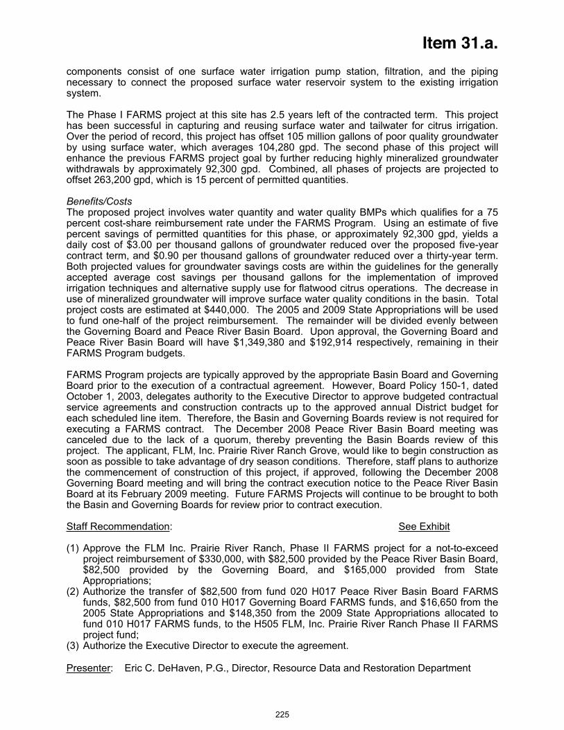
Item 31.a.
y to connect the proposed surface water reservoir system to the existing irrigation ystem.
components consist of one surface water irrigation pump station, filtration, and the piping necessars
The Phase I FARMS project at this site has 2.5 years left of the contracted term. This project has been successful in capturing and reusing surface water and tailwater for citrus irrigation. Over the period of record, this project has offset 105 million gallons of poor quality groundwater by using surface water, which averages 104,280 gpd. The second phase of this project will enhance the previous FARMS project goal by further reducing highly mineralized groundwater withdrawals by approximately 92,300 gpd. Combined, all phases of projects are projected to
ffset 263,200 gpd, which is 15 percent of permitted quantities.
ill have $1,349,380 and $192,914 respectively, remaining in their ARMS Program budgets.
ue to be brought to both e Basin and Governing Boards for review prior to contract execution.
taff Recommendation
o
Benefits/CostsThe proposed project involves water quantity and water quality BMPs which qualifies for a 75 percent cost-share reimbursement rate under the FARMS Program. Using an estimate of five percent savings of permitted quantities for this phase, or approximately 92,300 gpd, yields a daily cost of $3.00 per thousand gallons of groundwater reduced over the proposed five-year contract term, and $0.90 per thousand gallons of groundwater reduced over a thirty-year term. Both projected values for groundwater savings costs are within the guidelines for the generally accepted average cost savings per thousand gallons for the implementation of improved irrigation techniques and alternative supply use for flatwood citrus operations. The decrease in use of mineralized groundwater will improve surface water quality conditions in the basin. Totalproject costs are estimated at $440,000. The 2005 and 2009 State Appropriations will be used to fund one-half of the project reimbursement. The remainder will be divided evenly between the Governing Board and Peace River Basin Board. Upon approval, the Governing Board and Peace River Basin Board wF
FARMS Program projects are typically approved by the appropriate Basin Board and Governing Board prior to the execution of a contractual agreement. However, Board Policy 150-1, dated October 1, 2003, delegates authority to the Executive Director to approve budgeted contractual service agreements and construction contracts up to the approved annual District budget for each scheduled line item. Therefore, the Basin and Governing Boards review is not required for executing a FARMS contract. The December 2008 Peace River Basin Board meeting was canceled due to the lack of a quorum, thereby preventing the Basin Boards review of this project. The applicant, FLM, Inc. Prairie River Ranch Grove, would like to begin construction as soon as possible to take advantage of dry season conditions. Therefore, staff plans to authorize the commencement of construction of this project, if approved, following the December 2008 Governing Board meeting and will bring the contract execution notice to the Peace River Basin Board at its February 2009 meeting. Future FARMS Projects will continth
S : See Exhibit
(1)
ed by the Governing Board, and $165,000 provided from State
(2)
FARMS funds, to the H505 FLM, Inc. Prairie River Ranch Phase II FARMS
) Authorize the Executive Director to execute the agreement.
Presenter
Approve the FLM Inc. Prairie River Ranch, Phase II FARMS project for a not-to-exceed project reimbursement of $330,000, with $82,500 provided by the Peace River Basin Board, $82,500 providAppropriations;Authorize the transfer of $82,500 from fund 020 H017 Peace River Basin Board FARMS funds, $82,500 from fund 010 H017 Governing Board FARMS funds, and $16,650 from the 2005 State Appropriations and $148,350 from the 2009 State Appropriations allocated to fund 010 H017project fund;
(3
: Eric C. DeHaven, P.G., Director, Resource Data and Restoration Department
225
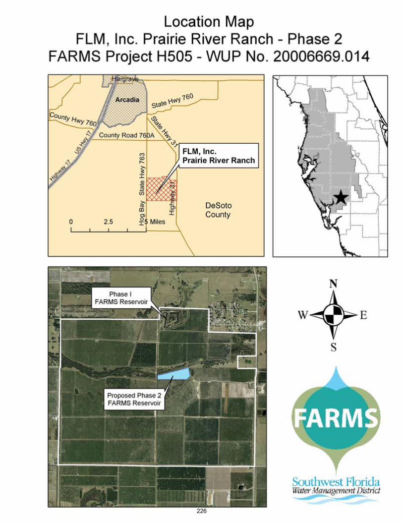
226

Item 31.b.
Consent Agenda December 16, 2008
Resource Management Committee
Facilitating Agricultural Resource Management Systems –CFI USA, Inc. Venus II Grove – Manatee County
PurposeTo request approval for a Facilitating Agricultural Resource Management Systems (FARMS) project with CFI USA, Inc. at their Venus II Grove and approval to reimburse FARMS eligible costs up to a not-to-exceed limit of $150,000 (100 percent of FARMS eligible not to exceed 50 percent of total project costs). Of this amount, $75,000 of the 2005 State Appropriations will be used for one-half of the project, the Governing Board is requested to fund $37,500 and the Manasota Basin Board is requested to fund $37,500. Total project costs are estimated at $350,000.
Background/History The District's FARMS Program, developed by the District and Florida Department of Agriculture and Consumer Services, is a public/private agricultural Best Management Practice (BMP) cost-share reimbursement program. FARMS is intended to expedite the implementation of production-scale agricultural BMPs that provide water resource benefits. Resource benefits of the FARMS Program include reduced Floridan aquifer withdrawals, water quality improvements (both from groundwater and surface water sources) and/or conservation, restoration and augmentation of the area's water resources and ecology. The District's emphasis through the FARMS Program is on reductions in Upper Floridan aquifer withdrawals that will improve ground water conditions as documented in the Southern Water Use Caution Area (SWUCA) recovery strategy. In addition, the District also provides funding for projects that improve water quality affected by the use of mineralized groundwater as documented in the Shell and Prairie Creek Watershed Management Plan – Reasonable Assurance Documentation. Reimbursement cost-share rates are capped at 50 percent for water quantity withdrawal reductions from the Upper Floridan aquifer or water quality improvements realized from decreasing the use of mineralized groundwater, and at 75 percent for both water quantity and water quality improvements. FARMS procedure also allows for a 75 percent reimbursement of eligible costs, rather than 50 percent, when reducing groundwater withdrawals by 15 percent or more from a combination of aquifer producing zones (of which five percent is from the Upper Floridan aquifer) and provides improvements to water quality conditions as a result of reductions in groundwater withdrawals.
FARMS Program staff received a proposal for a project from CFI USA, Inc. for their Venus II Grove located on the south side of County Road 62 east of Duette Road, within Manatee County. The property drains into the east fork of the Manatee River. This project will collect and reuse water from the property and surrounding watershed. The Water Use Permit for this grove authorizes groundwater withdrawals up to 214,400 gallons per day (gpd) for the irrigation of 245 acres of citrus from two Upper Floridan aquifer wells. The moving annual average indicates that CFI USA, Inc. is currently using 216,668 gpd or 101 percent of its permitted quantities, but below the permitted drought quantity of 264,600 gpd. This qualifies the project for a 50 percent cost-share rate. The primary goal of the project is to reduce the withdrawal of groundwater through the construction and operation of a five acre surface water irrigation reservoir. The reduction in groundwater use will benefit the Upper Floridan aquifer system by replacing Upper Floridan withdrawals with recovered tailwater and surface water. FARMS project components
227
Item 31.b.
onsist of one surface water irrigation pump station, filtration, and the piping necessary to ace water reservoir system to the existing irrigation system.
nd anasota Basin Board. Upon approval, the Governing Board and Manasota Basin Board will
asota Basin oard at its February 2009 meeting. Future FARMS Projects will continue to be brought to both
cconnect the surf
Benefits/CostsThe proposed project involves water quantity BMPs which qualifies for a 50 percent cost-share reimbursement rate under the FARMS Program. Using an estimate of 33 percent savings of permitted quantities for this phase, or approximately 70,500 gpd, yields a daily cost of $3.13 per thousand gallons of groundwater reduced over the proposed five-year contract term, and $0.94 per thousand gallons of groundwater reduced over a thirty-year term. Both projected values for groundwater savings costs are within the guidelines for the generally accepted average cost savings per thousand gallons for the implementation of improved irrigation techniques and alternative supply use for flatwood citrus operations. Total project costs are estimated at $350,000. The fiscal year 2005 State Appropriations will be used to fund one-half of the project reimbursement. The remainder will be divided evenly between the Governing Board aMhave $1,311,880 and $1,106,030 respectively, remaining in their FARMS Program budgets.
FARMS Program projects are typically approved by the appropriate Basin Board and Governing Board prior to the execution of a contractual agreement. However, Board Policy 150-1, dated October 1, 2003, delegates authority to the Executive Director to approve budgeted contractual service agreements and construction contracts up to the approved annual District budget for each scheduled line item. Therefore, the Basin and Governing Boards review is not required for executing a FARMS contract. The December 2008 Manasota Basin Board meeting was canceled due to the lack of a quorum, thereby preventing the Basin Boards review of this project. The applicant, CFI USA, Inc. Venus II Grove, would like to begin construction as soon as possible to take advantage of dry season conditions. Therefore, staff plans to authorize the commencement of construction of this project, if approved, following the December 2008 Governing Board meeting and will bring the contract execution notice to the ManBthe Basin and Governing Boards for review prior to contract execution.
Staff Recommendation: See Exhibit
Approve the CFI USA, Inc. Venus II Grove FARMS Project for a not-to-exceed(1) project
(2)ng Board FARMS funds, and $75,000 from the 2005
nds, to the H532 CFI USA, Inc. Venus II Grove FARMS project fund;
Presenter
reimbursement of $150,000, with $37,500 provided by the Manasota Basin Board, $37,500 provided by the Governing Board, and $75,000 provided from State Appropriations; Authorize the transfer of $37,500 from fund 021 H017 Manasota Basin Board FARMS funds, $37,500 from fund 010 H017 GoverniState Appropriations allocated to fund 021 H017 FARMS fu
(3) Authorize the Executive Director to execute the agreement.
: Eric C. DeHaven, P.G., Director, Resource Data and Restoration Department
228

229
Item 32
Consent Agenda December 16, 2008
Finance and Administration Committee
Board Travel
District policy states that in accordance with Chapters 112 and 373, Florida Statutes, travel expenses may be incurred for official District business or for a public purpose beneficial to the District. Travel to any conference or convention requires prior approval.
Within the geographic boundaries of the District, Governing Board members may incur travel expenses to attend Governing and Basin Board meetings or for other purposes beneficial to the District, excluding conferences and conventions. Scheduled travel for Governing Board members outside the District or to attend conferences or conventions requires prior approval through the consent agenda of a regular monthly Governing Board meeting. Non-scheduled travel outside the District or to attend any conference or convention requires prior approval of the Governing Board Chair, or in her absence, the Vice Chair.
As of December 7, 2008, no travel is planned for outside the geographic boundaries of the District.
Staff Recommendation:
No action is required at this time.
Presenter: Lou Kavouras, Deputy Executive Director, Outreach, Planning & Board Services
230
Item 33
Consent Agenda December 16, 2008
Finance and Administration Committee
Budget Transfer Report
PurposeRequest approval of the Budget Transfer Report covering all budget transfers made during the month of November 2008.
Background In accordance with Board Policy No. 130-8, all transfers approved by the Basins, Executive Director and Finance Director under delegated authority are regularly presented to the Finance and Administration Committee for approval on the Consent Agenda at the next scheduled meeting. The exhibit for this item reflects all such transfers executed since the date of the last report for the Committee's approval.
Staff Recommendation: See Exhibit
Request approval of the Budget Transfer Report covering all budget transfers for November 2008.
Presenter: Linda R. Pilcher, Assistant Director, Finance Department
231

SOUTHWEST FLORIDA WATER MANAGEMENT DISTRICTBudget Transfer Report
November 2008
Department / Department /Expenditure Category Expenditure Category
Basin Board ApprovedPeace River Basin:
1 3Resource Data & Restoration 3Resource Data & Restoration 25,617$ 8107 Grant - Agriculture 8107 Grant - Agriculture
2 3Resource Data & Restoration 3Resource Data & Restoration 38,9058107 Grant - Agriculture 8107 Grant - Agriculture
3 5Resource Projects 5Resource Projects 120,3288102 Grant - Water Conservation 8102 Grant - Water Conservation
4 3Resource Data & Restoration 3Resource Data & Restoration 63,9678107 Grant - Agriculture 8107 Grant - Agriculture
Manasota Basin:5 3Resource Data & Restoration 3Resource Data & Restoration 63,750
8107 Grant - Agriculture 8107 Grant - Agriculture
6 3Resource Data & Restoration 3Resource Data & Restoration 32,6258107 Grant - Agriculture 8107 Grant - Agriculture
Total Basin Board Approved 345,192$ Finance Director Approved
1 5Resource Projects 3Resource Data & Restoration 65,000$ 3111 Consultant Services 5201 Parts and Supplies
5208 Lab Charges
2 0Executive 0Human Resources & Risk Mgmt 800 1Finance 4004 Districtwide Training Programs3Resource Data & Restoration4Brooksville Regulation4Tampa Regulation5Resource Projects4003 Travel - Training
3 5Resource Projects 3Resource Data & Restoration 34,761 3111 Consultant Services 5208 Lab Charges
4 0Community & Legislative Affairs 0Community & Legislative Affairs 7,000 3117 Special Events 3117 Special Events
5 3Resource Data & Restoration 3Resource Data & Restoration 33,298 8107 Grant - Agriculture 8107 Grant - Agriculture
ItemNo.
--- TRANSFERRED FROM --- --- TRANSFERRED TO ---TransferAmountReason For Transfer
Transfer of budgeted funds to the appropriate department and expenditure categories for the Tsala Apopka Water Quality Monitoring project.
Transfer of budgeted funds to the appropriate department and expenditure category for lab analysis for the Highlands WMPlan Lake Placid project.
Transfer of budgeted funds to the appropriate project code for the FARMS Sandy Branch Ranch, LLC project.
Transfer of budgeted funds to the appropriate project code for the Facilitating Agricultural Resource Management Systems (FARMS) Royce Ranch Citrus project.
Transfer of budgeted funds to the appropriate project code for the FARMS Blue Fields USA, LLC project.
Transfer of budgeted funds to the appropriate department and expenditure category for Franklin Covey training class.
Transfer of unused budgeted FARMS funds back to the general FARMS budget appropriation to be allocated toward future projects.
Transfer of budgeted funds to the appropriate project code for the 1st Annual State of the Water Resources in West-Central Florida Workshop.
Transfer of budgeted funds to the appropriate project code for the FARMS T.J. Chastain project.
Transfer of budgeted funds to the appropriate project code for the FARMS Old Florida Investments, Inc. project.
Transfer of budgeted funds to the appropriate project code for the City of Winter Haven Northern Reuse Service Area Reclaimed Main Extension project.
232

SOUTHWEST FLORIDA WATER MANAGEMENT DISTRICTBudget Transfer Report
November 2008
Department / Department /Expenditure Category Expenditure Category
ItemNo.
--- TRANSFERRED FROM --- --- TRANSFERRED TO ---TransferAmountReason For Transfer
6 5Resource Projects 7Land Resources 6,000 3111 Consultant Services 3113 Surveying Services
7 4Strategic Program Office 4Brooksville Regulation 284,227 xxxx Various Expenditure Categories 4Tampa Regulation
4Sarasota Regulation5Resource Projects6Operationsxxxx Various Expenditure Categories
Total Finance Director Approved 431,086$
Total Transfers for Governing Board Approval 776,278$
This report identifies transfers made during the month that did not require advance Governing Board approval. These transfers have been approved by either the Basin Boards, Executive Director, or Finance Director consistent with Board Policy 130-8, and arepresented for Governing Board approval on the consent agenda. All Basin transfers are made based on Basin Board authority and are presented to the Governing Board via this report for ratification or approval. Executive Director approved transfers are made for a purpose other than the original budget intent, but are limited to individual transfer amounts of $50,000 or less. Finance Director approved transfers are accounting type transfers with no change to the original budget intent.
Transfer of budgeted funds to the appropriate department and expenditure category for surveying services for the Bystre Lake WMP project.
Transfer of budgeted funds to the appropriate departments for operational and contractual accounts associated with the reorganization of the Resource Regulation Division.
233

Item 34
Finance and Administration Committee December 16, 2008
Consent Item
District Strategic Systems Network and Server Upgrades
PurposeThe purpose of this project is to procure and install required upgrades to the District's strategic systems infrastructure that includes network, storage access and server hardware and the associated software licenses. The strategic systems include the Water Management Information System (WMIS), Land Information Management System (LaRIS), Project Information Management System (PIMS) and Enterprise Content Management System (ECM). These upgrades are consistent with the IRD Five-Year Technology Plan, FY2009-2013.
Background/History The Information Resources Department (IRD) is requesting $240,000 of General Fund contingency funding for this project, which will be reimbursed in full by United States Geological Survey (USGS). These items include the expansion of the existing Oracle database system capacity and associated licenses, Citrix servers supporting ArcGIS and server access to the Storage Area Network (SAN). This increased processing capacity will provide better system access and support the future needs of the District's strategic systems, digital orthophotographs and topographic LiDAR mapping data.
The original network, storage and server procurements were designed to allow for planned, incremental upgrades for projected system requirements. These strategic systems integrate the District’s data, data analyses and modeling resources into the decision making process and then provide this information to staff, other government agencies and the public. Given the current direction of the District's strategic systems and the supporting Geographic Information System (GIS) technology, timely, incremental upgrades are critical to the successful implementation of the District's strategic systems.
Benefits/CostThe proposed project takes advantage of available, project related revenues ($240,000) from a USGS grant to the Mapping and GIS section to accelerate the system capacity expansions needed for the referenced projects. The grant reimburses the District for funds expended on the digital orthophoto program for a total amount of $240,000. These funds ($240,000) will be used to add additional processors and associated software licenses to the Oracle database server, increase the number of Citrix servers supporting ArcGIS, and expand server access to the SAN. This expansion will significantly improve the ability of the District to support both internal and external customers' requirements and reduce District funding requirements by $240,000.
Impact If Not Funded If not funded, the District's strategic systems development and implementation will be slowed, District staff will not have the tools they need as planned and District external customers will not have the benefit of efficient online data entry and retrieval.
Staff Recommendation:
Approve the transfer of $240,000 from General Fund Contingency Reserves to the Information Resources Department for the purchase of identified network and server upgrades that support District strategic systems, digital orthophotographs and topographic LiDAR mapping data.
Presenter: Terry Redman, Information Resources Department Director
234
Item 35
Consent Agenda December 16, 2008
General Counsel’s Report
Consent Order - WUP Nos. 208639.010 – Timber Pines Community Association, Inc. -Hernando County
On June 6, 2000, the District issued Water Use Permit No. 208639.010 (the Permit) to Timber Pines Community Association, Inc. (Timber Pines), authorizing withdrawals of 363,400 gallons per day (gpd) on an annual average basis, and 1,848,700 gpd on a peak month basis for recreation and aesthetic use for golf courses and common areas within its community in western Hernando County.
On July 6, 2007, District staff issued a Notice of Non-compliance to Timber Pines advising that, for the 12 month period ending in May 2007, an average quantity of 563,390 gpd had been withdrawn. This quantity represents an overpumpage amount of 199,990 gpd on an annual average basis, or approximately 55% over the permitted quantity. District staff issued a second Notice of Non-compliance on November 16, 2007.
On June 2, 2008, District staff sent Timber Pines a Notice of Violation and proposed Consent Order to resolve the overpumpage violations. The proposed Consent Order requires Timber Pines to pay a penalty and costs in the amount of $13,710.00. Also, Timber Pines must submit a compliance plan demonstrating how it will remain in compliance with state statutes, District rules and the terms of its permit. Timber Pines has brought its withdrawals within the quantities of the Permit.
The signed Consent Order has been received from Timber Pines.
Staff Recommendation:
Approve the proposed Consent Order and authorize the initiation of litigation against Timber Pines to obtain compliance with the Consent Order.
Presenter: Jack Pepper, Deputy General Counsel
235
Item 36
Consent Agenda December 16, 2008
General Counsel’s Report
Initiation of Litigation – Surface Water Activity – Edward A. Mariani – Manatee County
On May 12, 2005, District staff received a request from an environmental consultant on behalf of Edward A. Mariani ("Mariani") to verify a wetland delineation on an approximately 6.86-acre parcel of real property Mariani owned in Manatee County, Florida (the "Property"). On May 24, 2005, Mariani's environmental consultant contacted District staff via telephone and informed staff that clearing activities had occurred around the perimeter of the wetlands on the Property. On May 26, 2005, District staff conducted a site inspection of the Property along with Mariani's consultant and observed that dredging, filling and clearing activities had occurred within the wetlands on the Property, resulting in impacts to approximately 0.68 acres of a forested wetlands system. Additionally, no turbidity and erosion controls were in place. No ERP had been issued to Mariani authorizing the construction of a surface water management system for the Property. Therefore, on July 5, 2005, District staff sent Mariani a Notice of Unauthorized Construction advising him to obtain an ERP and cease construction immediately.
On December 28, 2005, District staff sent Mariani a Notice of Violation and proposed Consent Order to resolve the violations. The proposed Consent Order required Mariani to obtain an ERP and assessed penalties and costs in the amount of $9,800 as follows:
$1,000 for potential water quality degradation, within the penalty matrix range of $250 - $2,499 for such violations;
$6,120 for 0.68 acres of unauthorized wetlands impacts resulting in a functional loss of 2.04, multiplied by $30,000 for forested wetlands;
$680 for clearing 0.68 acres assessed at $1,000 per acre; and $2,000 for standard District enforcement costs.
The Notice of Violation required Mariani to contact District staff no later than January 11, 2006 to discuss the proposed Consent Order and negotiate a settlement. On June 30, 2006, Mariani sold the Property. On August 22, 2007, the new owner, Morgan Johnson, LLC, submitted an application for an ERP. The District approved that application, which was assigned No. 44033275.000, on September 29, 2008.
On October 23, 2007, District staff sent a second letter and revised Consent Order to Mariani, along with a copy of the December 28, 2005 Notice of Violation. The revised Consent Order imposed the same penalty amounts as the first proposed Consent Order, but eliminated the requirement that Mariani obtain an ERP because he no longer owns the Property and the new owner had applied for an ERP. The letter required Mariani to contact District staff no later than November 6, 2007 to negotiate a Consent Order.
To date, District staff has been unable to successfully negotiate a Consent Order to resolve the violations.
Staff Recommendation:
Authorize the initiation of litigation against Edward A. Mariani and any other appropriate parties to obtain compliance, a monetary penalty, and recovery of District enforcement costs, litigation costs and attorney’s fees.
Presenter: Lisa Pease, Staff Attorney
236
Item 37
Consent Agenda December 16, 2008
General Counsel’s Report
Initiation of Litigation – Surface Water Activity – Lexington Homes, Inc. (North Green Estates and South Green Estates) – Hillsborough County
On November 14, 2005, the District received an Environmental Resource Permit (ERP) application from Lexington Homes, Inc. (Lexington) for the construction of a surface water management system to serve a residential development known as North Green Estates. On June 30, 2006, District staff reported that unauthorized construction activities were occurring at the project site. Three roads had been constructed and paved totaling approximately 0.17 miles in length. Construction had been completed on nine homes. All of these construction activities resulted in approximately 1.24 acres covered in impervious materials at the project site. No erosion or sediment control measures had been put in place at the project site. An ERP had not been issued authorizing construction activities at the project site at the time District staff discovered the paved roads and completed homes. Subsequently, on November 7, 2007, the District issued ERP No. 44031217.000 authorizing the construction of a surface water management system to serve North Green Estates.
A Notice of Unauthorized Construction was issued on July 3, 2006. On October 22, 2007, District staff issued a Notice of Violation and proposed Consent Order to Lexington to address the unauthorized construction activities at North Green Estates. The proposed Consent Order required that an ERP be obtained and assessed penalties and costs totaling $26,600 as follows:
$1,500 – for potential water quality impacts within the penalty matrix range of $250 - $2,499; $1,500 – for potential water quantity impacts within the penalty matrix range of $250 - $2,499; $9,300 – for the covering of 1.24 acres with impervious surface assessed at $7,500 per acre; $12,300 – 100% enhancement for willful violation; and, $2,000 – the standard cost assessment for unauthorized construction.
On June 13, 2006, the District received an ERP application from Lexington for the construction of a surface water management system to serve a residential development known as South Green Estates, which is adjacent to North Green Estates. On June 27, 2006, District staff observed that unauthorized construction activities were occurring at the project site. Four access roads had been paved totaling approximately 0.28 miles in length, resulting in 0.70 acres covered in impervious materials. An ERP had not been issued authorizing construction activities at the time that District staff discovered the paved access roads. Subsequently, on October 4, 2007, the District issued ERP No. 44031225.000 authorizing the construction of a surface water management system to serve South Green Estates.
A Notice of Unauthorized Construction was issued on June 30, 2006. On October 22, 2007, District staff issued a Notice of Violation and proposed Consent Order to Lexington to address the unauthorized construction activities at South Green Estates. The proposed Consent Order assessed penalties and costs totaling $18,500 as follows:
$1,500 – for potential water quality impacts within the penalty matrix range of $250 - $2,499; $1,500 – for potential water quantity impacts within the penalty matrix range of $250 - $2,499; $5,250 – for the covering of 0.7 acres with impervious surface assessed at $7,500 per acre; $8,250 – 100% enhancement for willful violation; and, $2,000 – the standard cost assessment for unauthorized construction.
237

Item 37
Lexington responded to the proposed Consent Orders on January 22, 2008, by proposing that the penalty be reduced to $2,500 each for North and South Green Estates. District staff advised Lexington that the counteroffer was not acceptable, but that another counteroffer would be considered if Lexington proposed one.
On April 1, 2008, District staff received another counteroffer from Lexington which provided a proposed payment of $5,000 for North Green Estates and $4,500 for South Green Estates to settle the matter. Lexington argued that confusion regarding different permit requirements caused several misunderstandings that resulted in construction commencing prior to issuance of the ERPs.
Because it appeared that some of the unauthorized construction occurred as a result of a mistake and was not willful, District staff was willing to reduce the aggravating factor for a willful violation from 100% to 25%. This resulted in a proposed penalty and costs for North Green Estates of $17,375 rather than the $26,600 contained in the October 22, 2007 proposed Consent Order, and for South Green Estates a proposed penalty of $12,313 rather than the $18,500 contained in the October 22, 2007 proposed Consent Order. Accordingly, District staff issued revised proposed Consent Orders on May 23, 2008.
Lexington requested a meeting with District staff to discuss the revised proposed Consent Orders, and subsequently provided a response to the revised proposed Consent Orders on July 18, 2008, in which Lexington proposed to pay a total of $6,375 for North Green Estates and $5,738 for South Green Estates over a period of 12 months to settle the matter. Lexington argued that consideration should be given to the fact that it was willing to obtain ERPs for the projects despite the representations of third parties that ERPs were not needed. As a result, District staff issued revised proposed Consent Orders on October 2, 2008, which provided for the payment of $11,800 in penalties and costs for North Green Estates, and the payment of $7,750 in penalties and costs for South Green Estates.
Lexington contacted District staff by phone and indicated that it does not have the funds to meet the payments required by the revised proposed Consent Orders, and asked if there was any other payment arrangement that could be made. District staff responded to Lexington and indicated that monthly payments of $1,000 could be made until the penalties and costs for both North and South Green Estates are paid in full if the President of Lexington is willing to also be personally responsible for the payment of penalties and costs. Lexington has indicated that it does not believe it can pay the $1,000 per month, and the President of Lexington is not willing to also be personally responsible for the penalties and costs. As a result, as of the date of the preparation of this recap, District staff has not been able to settle this matter and obtain a signed Consent Order.
Staff Recommendation:
Authorize the initiation of litigation against Lexington Homes, Inc. and any other appropriate parties to obtain compliance, a monetary penalty, and recovery of District enforcement costs, court costs, and attorney’s fees.
Presenter: Adrienne E. Vining, Staff Attorney
238

Item 38
Consent Agenda December 16, 2008
General Counsel’s Report
Initiation of Litigation – ERP No. 46029649.001 – Memorial Townhomes, LLC (Memorial Townhomes) – Hillsborough County
On September 27, 2005, the District received Environmental Resource Permit (ERP) Application No. 46029649.000 from Memorial Townhomes, LLC (Owner or Permittee) for the construction of a surface water management system to serve a residential subdivision known as Memorial Townhomes located at the northeast corner of Webb Road and Memorial Highway in Hillsborough County. The construction plans submitted with the ERP application indicated that there was an existing well on the property that would be abandoned by a licensed well contractor. On November 17, 2005, District staff conducted a site inspection and was not able to locate the well that was noted on the plans. On November 21, 2005, District staff was contacted by the engineer of record who indicated that the Owner was going to attempt to locate the well. On December 2, 2005, District staff made another site visit and again could not locate the well. District staff visited the site again on January 18, 2006, and did not see any evidence of the well, but it did appear that some excavation had been done on the property in an attempt to locate the well. On February 9, 2006, District staff spoke with the engineer of record who stated that the well had been located, but that in the process of locating the well the well casing had been pulled out of the ground and was now laying on the ground surface. District staff visited the site that day and discovered 80 feet of two-inch well casing lying on the ground. District staff took photos of the well casing that had been stripped out of the ground. On May 24, 2006, the Owner withdrew ERP Application No. 46029649.000. On July 21, 2006, the Owner resubmitted an ERP application, which was given Application No. 46029649.001. On November 21, 2006, the District issued ERP No. 46029649.001 (Permit) to Permittee. General Condition No. 10a of the Permit requires that any existing wells in the path of construction be properly plugged and abandoned by a licensed well contractor. The Permittee never obtained a Well Construction Permit to abandon the well, and acknowledged that the well casing was stripped from the ground.
Since the well cannot be properly abandoned as the well casing was stripped from the ground, a proposed Consent Order was issued on August 21, 2008, which assessed penalties of $4,000 and costs of $2,700 for a total of $6,700, as follows:
$2,000 – for the failure to properly abandon a two-inch well in the path of construction within the penalty matrix range of $250 - $2,499 for minor construction deviations;
$2,000 – 100% enhancement for willful violation; and, $2,700 – the standard cost assessment for as-built deviations.
As of the date of the preparation of this recap, the Permittee has not responded to the proposed Consent Order.
Staff Recommendation:
Authorize the initiation of litigation against Memorial Townhomes, LLC and any other appropriate parties to obtain compliance, a monetary penalty, and recovery of District enforcement costs, court costs, and attorney’s fees.
Presenter: Adrienne E. Vining, Staff Attorney
239
Item 39
Consent Agenda December 16, 2008
General Counsel’s Report
Initiation of Litigation – ERP No. 44007115.006 – Regency Oaks Preserve, Inc. – Manatee County
The District issued Environmental Resource Permit No. 44007115.006 ("Permit") to Regency Oaks Preserve, Inc. ("Owner") on January 4, 2001, for a residential project known as Regency Oaks Preserve. On January 26, 2004, following receipt of the statement of completion and as-built drawings, District staff conducted an inspection and noted multiple construction deviations. District staff sent Owner letters advising of these deviations on February 26, 2004, September 13, 2004, and December 21, 2004.
District staff issued a Notice of Violation regarding these construction deviations on May 16, 2008. An additional site visit was conducted on July 29, 2008, during which staff observed several outstanding deviations. On September 5, 2008, staff sent Owner a Notice of Violation and proposed Consent Order. The Consent Order required Owner to correct the outstanding deviations or submit an application for permit modification and, upon completion of construction, submit a statement of completion and certified as-built drawings. In addition, the Consent Order assessed the following penalties and costs totaling $11,200:
• $1,000 – for minor construction deviations; • $7,500 – for moderate construction deviations, resulting in 1.0 acre of floodplain
encroachment, an incomplete conveyance structure, and increases to post-development discharge; and $2,700 – the standard cost assessment for as-built deviations.
To date, District staff has been unable to successfully negotiate a Consent Order to resolve the violations and the project remains in noncompliance.
Staff Recommendation:
Authorize the initiation of litigation against Regency Oaks Preserve, Inc. to obtain compliance and to recover an administrative fine/civil penalty for as-built deviations, District enforcement costs, court costs, and attorney's fees.
Presenter: Lisa Pease, Staff Attorney
240

Item 40
Consent Agenda December 16, 2008
General Counsel’s Report
Settlement Agreement -- Lance H. Ham et al. v. City of Plant City, Hillsborough County, and SWFWMD, 13th Judicial Circuit Case No. 05-CA-9419 - Hillsborough County
By amended complaint served on December 13, 2005, plaintiffs Lance Ham, Norma Ham, Lancayle Ham, and Audie Ham ("Plaintiffs") sued SWFWMD, the City of Plant City ("City"), and Hillsborough County ("County") in Hillsborough County circuit court, seeking injunctive relief and monetary damages for inverse condemnation of Plaintiffs' real property located in Plant City, Florida.
Plaintiffs' complaint alleged that SWFWMD engaged in the construction of the McIntosh Park Enhancement Stormwater Treatment Wetland Project ("Project") in 1997 in cooperation with the City and the County. SWFWMD retained PEC Engineering ("PEC") as the engineer for the Project. The complaint alleged that the Project was constructed in two phases, with Phase I completed in or around June 2002, and Phase II completed in 2006. The complaint further alleged that as a result of the design and construction of the Project, the Plaintiffs' property repeatedly flooded and will continue to flood in the future. Plaintiffs claimed damages consisting of $50,000 per acre for approximately 30 acres of their property that they claimed had been taken by inverse condemnation, as well as attorneys' fees, costs, and experts' fees.
The City filed a motion requesting judgment in its favor, but the trial court denied the motion in January 2008. The case was scheduled for trial commencing on June 16, 2008. Following a day-long mediation held on March 26, 2008, the parties agreed to reschedule the trial date in order to further explore settlement possibilities. After another day of mediation on June 18, 2008, the parties reached a settlement in principal under which the defendants and nonparty PEC will pay the Plaintiffs a total of $225,000.00 as follows: SWFWMD will contribute $75,000 towards settlement, the City will contribute $75,000, the County will contribute $50,000, and PEC will contribute $25,000. Under the terms of the Settlement Agreement, none of the defendants admit any fault or liability, and all of the parties will release each other from any and all claims arising out of the Project. The settlement includes a remedy for the alleged flooding, and an environmental resource permit has been issued for implementation of the remedy.
Staff Recommendation:
Approve the proposed Settlement Agreement pursuant to which SWFWMD will contribute $75,000 towards settlement, the City will contribute $75,000, the County will contribute $50,000, and PEC will contribute $25,000.
Presenter: Joseph J. Ward, Assistant General Counsel
241
Item 41
Consent Agenda December 16, 2008
Executive Director’s Report
Approve November 18, 2008 Governing Board Meeting Minutes
Staff Recommendation: See Exhibit
Approve the minutes as presented.
Presenter: David L. Moore, Executive Director
242
MINUTES OF THE MEETING
Governing Board Southwest Florida Water Management District
Tampa, Florida November 18, 2008
The Governing Board of the Southwest Florida Water Management District (SWFWMD) met at 9:00 a.m. on November 18, 2008, at the Tampa Service Office. The following persons were present:
Board Members Present Neil Combee, Chair Todd Pressman, Vice Chair Jennifer E. Closshey, Secretary Ronald E. Oakley, Treasurer Bryan Beswick, Member Patricia M. Glass, Member Hugh Gramling, Member Albert G. Joerger, Member Sallie Parks, Member Maritza Rovira-Forino, Member H. Paul Senft, Member Douglas B. Tharp, Member Judith C. Whitehead, Member
Board Members AbsentNone
Staff Members PresentDavid L. Moore, Executive Director William S. Bilenky, General Counsel Lou Kavouras, Deputy Executive Director Richard S. Owen, Deputy Executive Director Eugene A. Schiller, Deputy Executive Director Bruce C. Wirth, Deputy Executive Director
Recording SecretaryAnnette D. Zielinski, Senior Admin. Assistant
A list of others present who signed the attendance roster is filed in the permanent files of the District. Approved minutes from previous meetings can be found on the District's Web site (www.WaterMatters.org).
Public Hearing
1. Call to OrderVice Chair Pressman called the meeting to order and opened the public hearing for Chair Combee who was detained in traffic at the start of the meeting. Ms. Closshey noted a quorum was present.
2. Pledge of Allegiance and InvocationVice Chair Pressman led the Pledge of Allegiance to the Flag of the United States of America. Mr. Bilenky offered the invocation. (CD 1/Track 01 - 00:00/01:08)
Public HearingVice Chair Pressman noted that this Governing Board meeting was being broadcasted to the Bartow, Brooksville and Sarasota Service Offices using the video conferencing system for the purpose of viewing the Board meeting only. Public input will only be taken at the Tampa office. The Governing Board’s meeting was also recorded for broadcast on government access channels.
Vice Chair Pressman stated that anyone wishing to address the Governing Board concerning any item listed on the agenda or any item that does not appear on the agenda should fill out and submit a speaker's card. To assure that all participants have an opportunity to speak, a member of the public may submit a speaker’s card to comment on one agenda item only during today's meeting. If additional time is needed or if the speaker wishes to address the Board on
243
Minutes of the Meeting November 18, 2008 SWFWMD Governing Board Page 2 of 11
an issue not on today's agenda, a speaker’s card may be submitted for comment at the end of the meeting during "Public Input." Vice Chair Pressman stated that comments would be limited to three minutes per speaker, and, when appropriate, exceptions to the three-minute limit may be granted by the Chair. He also requested that several individuals wishing to speak on the same issue/topic designate a spokesperson.
3. Additions/Deletions to Agenda According to Section 120.525(2), Florida Statutes, additions or deletions to the published
agenda will only be made for "good cause" as determined by the "person designated to preside." Mr. Moore noted the following items were deleted from the agenda after publication of the regular agenda. (CD 1/Track 02 - 00:00/03:19)
Consent Agenda The following items were deleted from consideration:15. ERP No. 49019100.003 - Orange State Residential (DENIAL) – Pasco County 20. ERP No. 44033419.000 - Kirnes Webster Property (DENIAL) – Sumter County 22. WUP No. 20005160.004 - Sandlin Farms – Levy County 28. Appraisal and Purchase/Sale Agreement – Lake Hancock Project, SWF Parcel No. 20-503-170P 32. Settlement Agreement – Lance H. Ham et al. v. City of Plant City, Hillsborough County, and SWFWMD, 13th Judicial Circuit Case No. 05-CA-9419 – Hillsborough County
4. District Recognition – Tampa Bay Partnership Chairman's Cup for Excellence in RegionalismMr. Roy McGraw and Ms. Elisa DeGregorio, Tampa Bay Partnership, presented the Chairman's Cup for Excellence in Regionalism to Mr. David Moore who was honored for his work as a member of the Executive Committee of One Bay. This partnership program has been fundamental to regional success and in particular to formalizing and working toward a cohesive regional vision. One Bay has included extensive public outreach and serves as one of the best examples of public-private collaboration in recent years.
This item was presented for the Board's information, and no action was required. (CD 1/Track 03 - 00:00/04:29)
5. Public Input for Issues Not Listed on the Published AgendaNo person(s) came forward to speak at this time.
Consent AgendaItems 15, 20, 22, 28, and 32 were deleted from consideration. Item 24 was moved from Consent to Regulation Committee Discussion Items.
Regulation Committee -- Environmental Resource Permits 6. ERP No. 43000164.043 - Charlotte County Airport - Piper Road Airport Drainage Plan –
Charlotte County 7. ERP No. 43008323.003 - McGrath Point Estates, Reeves, 4370 Point Court (DENIAL) –
Charlotte County 8. ERP No. 43033205.000 - The Great Loop – Charlotte County 9. ERP No. 43033914.000 - Centralia Acres Subdivision – Hernando County 10. ERP No. 43018888.019 - Waterset, Phase 2A – Hillsborough County 11. ERP No. 43033020.004 - FDOT - I-75 (State Road 93A) North of Bruce B. Downs to
State Road 56 (Mainline Widening) – Hillsborough/Pasco Counties
12. ERP No. 49028320.002 - Newport Isles Development – Manatee County 13. ERP No. 49002364.142 - Trinity Communities - Foxwood – Pasco County 14. ERP No. 43006666.013 - Watergrass - Parcels B5, B6, D, E, F, G and H – Pasco
County15. ERP No. 49019100.003 - Orange State Residential (DENIAL) – Pasco County
244

Minutes of the Meeting November 18, 2008 SWFWMD Governing Board Page 3 of 11
16. ERP No. 43023781.026 - Sunlake Apartments Phase 1 – Pasco County 17. ERP No. 43027329.011 - Traditions - Lake Ruby Pier Modification – Polk County 18. ERP No. 46033269.000 - Perfect Temp, Inc. - Addition (DENIAL) – Polk County 19. ERP No. 43034013.000 - Lanius Warehouse (DENIAL) – Polk County 20. ERP No. 44033419.000 - Kirnes Webster Property (DENIAL) – Sumter CountyRegulation Committee -- Water Use Permits 21. WUP No. 20006841.010 - DeSoto County Utilities, DeSoto Correctional Institute Florida
Civil Commitment Center – DeSoto County 22. WUP No. 20005160.004 - Sandlin Farms – Levy County 23. WUP No. 20012867.005 - Clear Springs Enterprises, LLC/Clear Springs Blueberries I –
Polk County Regulation Committee -- Other 24. Approve Additional Revisions to Proposed Amendments to Chapters 4 and 7 of the
Environmental Resource Permitting Basis of Review Regarding Water Quantity CriteriaThis item was pulled from the Consent Agenda and moved to Regulation Committee Discussion Items.
25. Approve for Adoption Final Changes to Amendments to 40D-2.091, Florida Administrative Code, and Part B, Basis of Review, of the Water Use Permit Information Manual to Expand the Southern Water Use Caution Area Per Capita Requirements Districtwide in Response to the Joint Administrative Procedures Committee; and Submittal of the Statement of Estimated Regulatory CostsStaff recommended to approve for adoption final changes to Amendments to 40D-2.091, Florida Administrative Code, and Part B, Basis of Review, of the Water Use Permit Information Manual to Expand the Southern Water Use Caution Area Per Capita Requirements Districtwide in Response to the Joint Administrative Procedures Committee; and Submittal of the Statement of Estimated Regulatory Costs.
Resource Management Committee 26. Resolution Requesting Encumbrance of Fiscal Year 2009 Budgeted Funds from the
Water Management Lands Trust Fund for Preacquisition; Management, Maintenance and Capital Improvements; and Payments in Lieu of TaxesStaff recommended to approve Resolution Requesting Encumbrance of Fiscal Year 2009 Budgeted Funds from the Water Management Lands Trust Fund for Preacquisition; Management, Maintenance and Capital Improvements; and Payments in Lieu of Taxes in the amount of $28,177,847 and authorize staff to request quarterly reimbursements for the fiscal year not to exceed $28,177,847.
27. Resolution 08-29 to Request Encumbrance of Funds from the Water Management Lands Trust Fund for the Lake Hancock South Saddle Creek Restoration and Water Quality Treatment ProjectStaff recommended to approve Resolution 08-29 to Request Encumbrance of Funds from the Water Management Lands Trust Fund for the Lake Hancock South Saddle Creek Restoration and Water Quality Treatment Project in the amount of $7.5 million.
28. Appraisal and Purchase/Sale Agreement – Lake Hancock Project, SWF Parcel No. 20-503-170P
This item was deleted from consideration. 29. Approve Transfer of Funds for the Urban Lake Rescue Project
Staff recommended to (1) authorize the transfer of $136,916 in the SWIM Fund from the 49th Street Outfall Project (W228) to the Urban Lake Rescue Project (W268), with the project to be funded as follows: $68,458 (50 percent) by State SWIM Funds (Water Management Lands Trust Fund), $20,978 (15 percent) by Hillsborough River Basin, and $47,480 (35 percent) by Northwest Hillsborough Basin; and (2) authorize the Executive Director to execute an amendment to the agreement.
Finance & Administration Committee 30. Board Travel
The following travel outside the geographic boundaries of the District was recommended for approval: Albert Joerger, Maritza Rovira-Forino, Paul Senft and Judy Whitehead to
245
Minutes of the Meeting November 18, 2008 SWFWMD Governing Board Page 4 of 11
attend the December 3-5, 2008 Public Lands Acquisition and Management Conference in Jacksonville.
31. Budget Transfer ReportStaff recommended approval of the Budget Transfer Report covering all budget transfers
for October 2008. General Counsel’s Report 32. Settlement Agreement – Lance H. Ham et al. v. City of Plant City, Hillsborough
County, and SWFWMD, 13th Judicial Circuit Case No. 05-CA-9419 – Hillsborough County
This item was deleted from consideration. 33. Initiation of Litigation – Surface Water Activity – Batista Madonia, Sr. and Evelyn
Madonia – Polk CountyStaff recommended the initiation of litigation against Batista Madonia, Sr. and Evelyn Madonia and any other appropriate parties to obtain compliance, to recover an administrative fine/civil penalty for construction without a permit, and to recover District enforcement costs, court costs and attorney’s fees.
34. Initiation of Litigation – Surface Water Activity – Russell D. Adams, Stephanie R. Adams, Daniel L. Barco and Cynthia D. Barco – Hardee CountyStaff recommended the initiation of litigation against Russell D. Adams, Stephanie R. Adams, Daniel L. Barco and Cynthia D. Barco and any other appropriate parties to obtain compliance, to recover an administrative fine/civil penalty for construction without a permit, and to recover District enforcement costs, court costs and attorney's fees.
Executive Director’s Report 35. Approval of Minutes – October 28, 2008 Governing Board Meeting Staff recommended approval of the minutes as presented.
Following consideration, Ms. Parks moved, seconded by Mr. Oakley, to approve the Consent Agenda as amended. Motion carried unanimously. (CD 1/Track 3 – 04:29/05:29)
Vice Chair Pressman relinquished the gavel to Resource Management Committee Chair Gramling.
Resource Management Committee
Discussion Items 36. Consent Item(s) Moved for Discussion – None
37. Hydrologic Conditions Status ReportMr. Granville Kinsman, Manager, Hydrologic Data Section, presented the information on the general state of the District's hydrologic conditions, by comparing rainfall, surface water, and groundwater levels for the current month to comparable data from the historical record. Provisional regional rainfall totals for the month (as of October 30) were normal in all regions of the District. Provisional streamflow (as of October 27) decreased in all three regions of the District compared to the previous month. Provisional groundwater data (as of October 27) indicate levels in the Floridan/Intermediate aquifer decreased in all three regions of the District compared to the previous month.
Lake levels decreased in the Northern, Tampa Bay and Polk Uplands regions of the District during the month, while they increased in the Lake Wales Ridge region. Average lake levels were below the base of the annual normal range in all regions of the District. Normal lake levels are generally considered to be levels that fall between the minimum low management level and the minimum flood level.
October, the first month of the eight-month dry season, ended with normal precipitation conditions throughout the District. Rainfall during the four-month wet season (June through September) was lower than expected. The 12-month District-wide rainfall deficit increased during October, ending the month approximately 4.7 inches below the long-term
246

Minutes of the Meeting November 18, 2008 SWFWMD Governing Board Page 5 of 11
average. Most hydrologic indicators throughout the District declined during October, with regional lake levels remaining at below-normal conditions, flow on the District's major rivers at near record low levels for this time of the year, and groundwater conditions ranging at below-normal to low-normal conditions. The dry season runs from October through May, and further declines are expected through this period.
The US Drought Monitor (as of October 28) indicates that abnormally dry conditions throughout west-central Florida are expanding and intensifying. National weather forecasts from November through April indicate an area of below-normal rainfall developing to the north of the District and expanding south to encompass the entire District by late winter and early spring.
In summary, the rainfall deficit continues to expand with steady declines in hydrologic indicators. The forecast favors drier-than-normal conditions and seasonal declines are expected to be greater than normal.
This item was presented for the Committee’s information, and no action was required. (CD 1/Track 4 – 00:00/12:17)
(Chair Combee entered the meeting at 9:15 a.m.)
38. Authorize Submission of the Preliminary Flood Insurance Rate Map for the Lizzie Hart Watershed to the Federal Emergency Management AgencyMr. Mark A. Hammond, P.E., Director, Resource Projects Department, said this was an action item to request the Board authorize staff to submit the preliminary Flood Insurance Rate Map (FIRM) for the Lizzie Hart watershed in Hernando County to the Federal Emergency Management Agency (FEMA). The Lizzie Hart watershed model and floodplain information have gone through the District’s process including internal and external peer review by experienced licensed professional engineers. This watershed was also presented at public workshops held in the District’s Brooksville Headquarters for review and comment. The preliminary floodplain information is ready to be formatted to meet FEMA’s mapping specifications and submitted to FEMA. Following submittal of the preliminary FIRM to FEMA, they will conduct their own technical review, take public input, and allow for a 90-day appeals period during the adoption process. Depending on public input, the FEMA process can take one to two years.
Mr. Mark Ellard, P.E., Associate Principal, Inwood Consulting Engineers, reviewed the firm's qualifications and experience in watershed management and stormwater engineering. Mr. Ellard presented the existing FEMA Floodplain which he said was a limited analysis whereby flood zones delineated only included Hernando County and not north into Citrus County. He also presented overhead maps of terrain, land use, and overview soils for the Lizzie Hart Sink. The 2008 Modeled Floodplain was created after Inwood's extensive desktop review, field review, floodplain comparison, model network analysis, and model validation. In conclusion, Mr. Ellard said the preliminary floodplains appear reasonable based on the available data and based on the methodology utilized.
Mr. Jeff Glenn, P.E., Reynolds, Smith, and Hills (RS&H), reviewed the firm's qualifications and experience in water resources. He introduced Mr. Justin Dewey, P.E., who overviewed the five key steps to the peer review process. In conclusion, RS&H said Inwood Consulting Engineers used the best available data; that they used appropriate engineering care and practice to produce reasonable floodplain results; and that model results of Hurricane Frances data matched well with eyewitness accounts provided in the public meeting.
Staff recommended authorization to submit the preliminary FIRM for the Lizzie Hart watershed in Hernando County to the FEMA.
247
Minutes of the Meeting November 18, 2008 SWFWMD Governing Board Page 6 of 11
Board members engaged staff in further discussion of the modeling parameters before voting on the staff recommendation. Mr. Moore reminded the Board the FIRM will be further evaluated and public input will be taken through the FEMA process.
Following consideration, Ms. Whitehead moved, seconded by Ms. Rovira-Forino, to approve the staff recommendation. Motion carried unanimously. (CD 1/Track 5 – 00:00/77:06)
Resource Management Committee Chair Gramling relinquished the gavel to Regulation Committee Chair Parks to hear Item 24 which was pulled from the Consent Agenda for discussion under the Regulation Committee Discussion Items. This item was heard out-of-order to accommodate audience members.
Regulation Committee
Discussion Items 56. Consent Item(s) Moved for Discussion 24. Approve Additional Revisions to Proposed Amendments to Chapters 4 and 7 of
the Environmental Resource Permitting Basis of Review Regarding Water Quantity Criteria
Mr. Owen said he just learned that there are some concerns with the proposed draft rules changes. He recommended that action be postponed so that staff can meet with the concerned parties and return to the Governing Board for approval at a later date.
Regulation Committee Chair Parks heard public comment at this time.
Ms. Judy James, representing Tampa Bay Builders Association, said they would like an opportunity to work with District staff before this item was approved.
Mr. Scott Coulembe, Polk County Builders Association, said they too would like an opportunity to work with District staff on some language clarification before this item is voted on.
Following consideration, Ms. Closshey moved, seconded by Mr. Senft, to approve a continuance on this item allowing staff to work with the public on language clarification. Motion carried unanimously. (CD 1/Track 6 – 00:00/07:08)
Regulation Committee Chair Parks relinquished the gavel to Resource Management Committee Chair Gramling to continue the Resource Management Committee agenda.
39. Regional Reclaimed Water Partnership Initiative – Phase 1Mr. Moore introduced this item and said the Board will hear a presentation regarding the Regional Reclaimed Water Partnership Initiative – Phase 1. The Phase 2 Initiative would probably involve Hillsborough County and Tampa Electric Company (TECO), but could be delayed one or more years. Ms. Alison P. Ramoy, Senior Water Conservation Analyst, Resource Projects Department, said the Governing Board received a revised agreement this morning. She said most of the changes were very minor; she did point out that Exhibit 3.5 stipulates that TECO will maximize the use of reclaimed water to offset groundwater use from existing facilities as well as for their future power generating units
Phase I includes the design and construction of approximately 15 miles of 20-inch to 30-inch reclaimed water transmission main from Lakeland's wastewater effluent wetland treatment system south to TECO's Polk Power Station. This phase also includes the additional treatment and disposal necessary for TECO to use the water for cooling and other operational uses. The additional treatment is expected to consist of filtering and possible reverse osmosis. Disposal will consist of two deep injection wells for concentrate disposal. The District will only participate in the funding of one well, as the other one is for
248
Minutes of the Meeting November 18, 2008 SWFWMD Governing Board Page 7 of 11
backup purposes. Phase I is expected to commence with design beginning by March 15, 2009 and construction completed in 2013.
As reflected in the agreement, the implementation of Phase I will maximize the use of available reclaimed water and eliminate an estimated 5.0 to 6.0 million gallons per day of future potable groundwater withdrawal for the planned power generation expansion. The estimated cost of Phase I of the Regional Reclaimed Water Partnership Initiative is $65,686,800, and the District is being asked to fund $32,843,400. The funding approved in FY2009, includes $8,354,642 from the Governing Board, $1,040,354 from the Alafia River Basin Board, and $521,640 from the Peace River Basin Board. Though the Manasota Basin Board approved $31,250 in FY2009 funding, it will be returned to the Basin Board's budget due to a refinement of the project scope and resulting water resource benefits. An additional $337,500 from the Water Protection and Sustainability Trust Fund and $2,500,000 from the Water Restoration Action Plan Fund has been allocated to this project in FY2009, for a total of $12,754,136 in FY2009 funding.
Staff recommended the Governing Board approve the agreement with the Tampa Electric Company for Phase I of the Regional Reclaimed Water Partnership Initiative for $65,686,800, with the District's share not to exceed $32,843,400; and authorize the Executive Director to execute the agreement.
Following consideration, Mr. Combee moved, seconded by Mr. Senft, to approve the staff recommendation. Motion carried unanimously. (CD 1/Track 7 – 00:00/19:42)
Mr. Wirth updated the Board regarding an aquifer recovery project that CF Industries is undertaking using a sand tailings filter basin. He said the District supported CF Industries' petition to ask the Florida Department of Environmental Protection to waive the mandatory reclamation requiring that the land be put back to its original condition; CF Industries has received the requested waiver. (CD 1/Track 8 – 00:00/02:07)
Ms. Closshey requested an update regarding Tampa Bay Water's desalination facility and the reservoir. Mr. Warren Hogg, Tampa Bay Water, said the reservoir is still in operation and they are still evaluating the reservoir for repairs. The desalination plant is producing 25 mgd currently. (CD 1/Track 9 – 00:00/02:09)
Submit & File Reports – None
Routine ReportsThe following items were provided for the Committee’s information, and no action was required. 40. Florida Forever Funding 41. Minimum Flows and Levels 42. Structure Operations 43. Watershed Management Program and Federal Emergency Management Agency Map
Modernization 44. Significant Water Supply and Resource Development Projects
Resource Management Committee Chair Gramling relinquished the gavel to Chair Combee.
Chair Combee said the Outreach and Planning and Regulation Committees would be heard before the Finance and Administration Committee. Chair Combee relinquished the gavel to Outreach and Planning Committee Chair Rovira-Forino.
249
Minutes of the Meeting November 18, 2008 SWFWMD Governing Board Page 8 of 11
Outreach and Planning Committee
Discussion Items
51. Consider Merging of the Northwest Hillsborough and Hillsborough River Basin BoardsMs. Kavouras said the concept to merge Basin Boards is reviewed from time-to-time. Today, staff is asking the Governing Board to consider merging the Northwest Hillsborough and the Hillsborough River Basins Boards.
The District's Governing Board has the authority to change the boundaries of Basins or create new Basins by resolution Subsection 373.0693(1)(a), Florida Statutes. For over two decades, management studies of the District concluded that the Governing Board should periodically review its Basin Board boundaries to ensure the operations and responsibilities of the District are being discharged in an efficient and effective manner. This past year, both the Senate Committee on Environmental Preservation and Conservation report "Agency Sunset Review of the Water Management Districts" and OPPAGA's Sunset Memorandum on "Governance of Florida's Water Management Districts: Options for Legislative Consideration," suggested that the District's Governing Board consider merging Basin Boards where appropriate. In response to these recommendations, the District undertook a thorough evaluation of opportunities for such mergers and concluded that combining the Northwest Hillsborough and the Hillsborough River Basins should be considered by the Governing Board. While additional consolidation of Basin Boards might be feasible in the future, at this time staff is only suggesting consideration of combining the Northwest Hillsborough and Hillsborough River Basins.
The existing millage rate of the Northwest Hillsborough Basin is 0.2421, and the Hillsborough River Basin millage rate is 0.2547. Staff recommends applying the lower of the two millage rates if the two Basins are combined. The millage rate would take effect Fiscal Year 2010, which begins October 1, 2009, upon adoption by the Board. When combined, all existing projects/programs and their associated budgets will remain as is. Based on current property values, consolidation of the two Basins would result in an anticipated reduction of nearly $600,000 in tax assessments for the nearly 800,000 residents of the existing Hillsborough River Basin. Additionally, merging the two Basins would save money and eliminate duplication of work. At least two thirds of the projects funded by the Northwest Hillsborough Basin Board are co-funded by the Hillsborough River Basin Board. Eliminating this duplication should save about $50,000 annually in staff resources. Staff resources and travel for the administrative aspects of Board support would also be reduced.
Current Basin Board membership on the Northwest Hillsborough Basin Board consists of five positions. Of the five positions, one seat is vacant and two members are serving in expired seats. At a minimum, the two remaining members are recommended to join the current Hillsborough River Basin Board members on the newly combined Basin Board.
Chapter 40D-1, Florida Administrative Code (F.A.C.) contains the legal descriptions for the current Basin boundaries. Rulemaking will need to be initiated to make the necessary adjustments to the boundary legal descriptions upon the Governing Board's decision to merge the two Basins.
Staff requested conceptual approval to merge the Northwest Hillsborough and the Hillsborough River Basins, with the following terms: (1) millage rate of 0.2421 is recommended; (2) currently seated Board members will retain membership; (3) current projects and programs will remain in place; (4) Governing Board approval of a resolution to merge the two Basins will be requested on December 16, 2008; and (5) effective date will be January 1, 2009.
250
Minutes of the Meeting November 18, 2008 SWFWMD Governing Board Page 9 of 11
Committee Chair Rovira-Forino heard public comment at this time.
Mr. Marlin Anderson, representing Sunset Park Homeowners Association, said he was concerned that their taxes will be used to pay for projects that are not located in their area but will benefit those in the Hillsborough River Basin boundary. He said, if this merger moves forward, he hopes that there will be representation from their area.
Ms. Eleanor Montague, representing Sunset Park Homeowners Association, said she thinks the merger is unfair to their citizens and that they need representation to help maintain funds for stormwater projects and protection of estuaries that are located within their area.
Mr. Joe Robinson, Vice Chair, Northwest Hillsborough Basin Board, said he recently learned of this proposed merger. He has asked staff to change today's recommendation to seek conceptual approval so that the community will have ample time to comment on the proposed merger. The Northwest Hillsborough Basin encompasses 72 lakes, coastline, and a portion of the City of Tampa. Mr. Robinson said he believes there are a large number of taxpayers who will demand representation. He said the Basins have different goals that have to be synthesized. Mr. Robinson also wondered what would happen with Board officer positions and reappointments.
Following consideration, Mr. Senft moved, seconded by Mr. Gramling, to approve the staff recommendation. Motion carried unanimously. (CD 1/Track 10 – 00:00/32:07)
Submit & File Reports – None
Routine ReportsThe following items were provided for the Committee’s information, and no action was required. 52. Comprehensive Plan Amendment and Related Reviews 53. Development of Regional Impact Activities 54. Speakers Bureau 55. Significant Activities
Outreach and Planning Committee Chair Rovira-Forino relinquished the gavel to Regulation Committee Chair Parks.
Regulation Committee
Discussion Items
57. Implement Water Shortage Order No. SWF 08-044 – Modified Phase III Extreme Water Shortage DeclarationMr. Owen said this is an informational item to inform the Board about what staff is doing to address the water shortage and water supply situation within the Tampa Bay region. The District has provided drought assistance to Tampa Bay Water in the form of several emergency authorizations to augment its regional supplies. Two of these emergency orders are currently in effect. Executive Director Order No. 08-024, as modified, allows additional withdrawals from the Alafia River when sufficient flows are available. Executive Director Order No. 08-043 allows additional withdrawals from the Tampa Bypass Canal in order to augment the City of Tampa's Hillsborough River Reservoir, postponing the City's need to purchase potable water from Tampa Bay Water.
District staff has also been coordinating extensively with Tampa Bay Water and its six Member Governments regarding other drought response mechanisms. Based on declining hydrologic conditions and concerns about low storage for public supply in the area, the Governing Board decided to issue Modified Phase III restrictions and other
251

Minutes of the Meeting November 18, 2008 SWFWMD Governing Board Page 10 of 11
response mechanisms for select water uses in all incorporated and unincorporated portions of Hillsborough, Pasco and Pinellas counties. Water Shortage Order No. SWF 08-044 essentially modifies the existing water shortage restrictions in those counties, tightening the provisions for fountains and certain lawn and landscape irrigation practices. This Order also requires public suppliers to take additional action. Including increased restriction enforcement; responding to citizen complaints; go directly to issuing citations; and consider waiving enforcement of local codes where in conflict with conservation. This item was provided for the Committee's information, and no action was required. (CD 1/Track 11 – 00:00/20:38)
Submit & File Reports – None
Routine ReportsThe following items were provided for the Committee’s information, and no action was required. 58. Southern Water Use Caution Area Quantities 59. Water Production Summary 60. Public Supply Benchmarks 61. Overpumpage Report 62. Resource Regulation Significant Initiatives
Chair Combee recessed the public hearing for a short lunch break.
Following the lunch break Chair Combee relinquished the gavel to Finance and Administrative Committee Chair Oakley.
Finance and Administration Committee
Discussion Items 45. Consent Item(s) Moved for Discussion – None
46. Office of Inspector General Role and Responsibilities UpdateMr. Kurt P. Fritsch, Inspector General, said during the October Governing Board Meeting, the Board approved the Office of Inspector General’s (OIG’s) FY2009 audit plan and accepted the office's FY2008 annual report. Mr. Fritsch delivered a presentation at today's meeting that explained the audit committee's responsibilities; discussed the Inspector General's role and responsibilities; illustrated Inspector General products, services, and standards; and demonstrated linkage of the approved plan to District strategy.
This item was presented for the Committee’s information, and no action was required. (Track 12 – 00:00/48:42)
47. Strategic Systems and Water Management Information System (WMIS) Initiative Semi-Annual Update
This item was deferred to the December 16, 2008 Governing Board meeting.
Submit & File Report The following item was submitted for the Committee’s information, and no action was required. 48. October 2008 Interim Report on Workforce and Vendor Diversity Mr. Rovira-Forino commended staff on their hard work and diligent efforts to promote
vendor diversity. She said the District surpassed its goal and continued to support small and diverse businesses even during these tough economic times. (Track 13 – 00:00/02:02)
252

Minutes of the Meeting November 18, 2008 SWFWMD Governing Board Page 11 of 11
Routine Reports The following items were provided for the Committee’s information, and no action was required. 49. Treasurer's Report, Payment Register, and Contingency Reserves 50. Management Services Significant Activities
Finance and Administration Chair Oakley relinquished the gavel to Chair Combee.
General Counsel's Report
Discussion Items63. Consent Item(s) Moved for Discussion – None
Submit & File Reports – None
Routine ReportsThe following items were provided for the Committee’s information, and no action was required. 64. Litigation Report Mr. Bilenky said the District sought dismissal of the Crowley Nature Center lawsuit at the
trial level on five grounds. The circuit court dismissed the case with prejudice on one of the five grounds. The District was not comfortable with the way the case was dismissed and it went up on appeal. The appellate court reversed the circuit court decision and remanded the case back to the circuit court. Technical staff members are working to try to resolve the matter out of the court system. (Track 14 – 00:00/02:56)
65. Rulemaking Update
Reports
66. Basin Board Education Committee Liaison Report Ms. Rovira-Forino said the Board has been provided with a written report regarding the
Basin Board Education Committee. She said she attended the Suncoast Earth Force art exhibit on November 13. The event featured student artwork and presentations about Earth Force projects, which benefit the environment. Ms. Rovira-Forino recognized the 11 schools who participated.
67. Executive Director’s Report
Mr. Moore said that he and Mr. Combee attended the October 31, 2008 dedication of the fifth of 16 environmental education centers at the Circle B Bar Ranch in Polk County.
Mr. Moore said staff is anticipating 200 attendees to the State of Water Resources this Friday, November 21, 2008.
68. Chair’s Report Chair Combee said the dedication of the environmental education at Circle B Bar Ranch was a huge success.
Ms. Parks said the Tampa Bay Estuary Program met last week and they passed a model ordinance for residential fertilizing.
There being no further business to come before the Board, Ms. Whitehead moved, seconded by Mr. Oakley, to adjourn the meeting. Motion carried unanimously.
The meeting was adjourned at 1:40 p.m.
The Southwest Florida Water Management District does not discriminate upon the basis of any individual's disability status. This non-discrimination policy involves every aspect of the District's functions including one's access to, participation, employment, or treatment in its programs or activities. Anyone requiring reasonable accommodation, as provided for in the Americans with Disabilities Act, should contact the Executive Department, telephone 1-800-423-1476 (Florida only), extension 4610; TDD ONLY 1-800-231-6108 (Florida only); FAX 352-754-6874.
253

Governing Board Meeting December 16, 2008
Resource Management Committee
Discussion Items
42. Consent Item(s) Moved for Discussion
43. Hydrologic Conditions Status Report ............................................... (15 minutes) .......... 2 (Strategic Plan: Water Supply – Conservation)
44. Review of Analytical Process for Water Shortage Actions and Public Dissemination of Information........................................... (15 minutes) ......... 4
(Strategic Plan: Water Supply – Conservation)
45. Long-Range Water Supply and Water Resource Development Funding Plan Update .................................................. (45 minutes) ......... 8
(Strategic Plan: Mission Support)
Submit & File Reports – None
Routine Reports
46. Florida Forever Funding Status Report ........................................................................... 10
47. Minimum Flows and Levels Status Report ....................................................................... 14
48. Structure Operations Status Report ................................................................................. 18
49. Watershed Management Program and Federal Emergency Management Agency Map Modernization Status Report ................................................. 31
50. Significant Water Supply and Resource Development Projects ...................................... 34

Item 43
Resource Management Committee December 16, 2008
Discussion Item
Hydrologic Conditions Status Report
This routine report provides information on the general state of the District's hydrologic conditions, by comparing rainfall, surface water, and groundwater levels for the current month to comparable data from the historical record. The data shown are typically considered final, fully verified monthly values, but occasionally, due to timing of publication, some data are identified as "provisional," meaning that the values shown are best estimates based on incomplete data. The information presented below is a summary of data presented in much greater detail in the Hydrologic Conditions Report published the week before the Governing Board meeting, which also includes an updated provisional summary of hydrologic conditions as of the date of publication. It is available at http://www.swfwmd.state.fl.us/waterres/hydro/hydro.htm.
RainfallProvisional regional rainfall totals for the month (as of November 23) were below-normal in all regions of the District. The normal range is defined as rainfall totals that fall on or between the 25th to 75th percentiles derived from the historical data for each month The northern region received an average of 0.19 inches of rainfall, equivalent to the third percentile.
The central region received 0.35 inches of rainfall, equivalent to the 15th percentile. The southern region recorded an average of 0.24 inches of rain, equivalent to the fifth percentile.
District-wide, average rainfall was 0.26 inches, equivalent to the 4th percentile.
StreamflowProvisional streamflow (as of November 24) decreased in all three regions of the District compared to the previous month. Streamflow was below-normal in all three regions of the District, based on regional index rivers. Normal streamflow is defined as falling between the 25th
and 75th percentiles. The average streamflow in the Withlacoochee River near Holder in the northern region was in the 8th percentile.
The average streamflow measured in the Hillsborough River near Zephyrhills in the central region was in the 4th percentile.
The average streamflow measured in the Peace River at Arcadia in the southern region was in the 14th percentile.
Groundwater LevelsProvisional groundwater data (as of November 24) indicate levels in the Floridan/Intermediate aquifer decreased and were below the normal range of historic values in all three regions of the District compared to the previous month. Normal groundwater levels are defined as those falling between the 25th and 75th percentiles. The average groundwater level in the northern counties was in the 15th percentile. The average groundwater level in the central counties was in the 17th percentile. The average groundwater level in the southern counties was in the 19th percentile.
2

Item 43
Lake LevelsLake levels decreased in the Northern, Tampa Bay, Polk Uplands and Lake Wales Ridge regions of the District during the month. Average lake levels were below the base of the annual normal range in all regions of the District. Normal lake levels are generally considered to be levels that fall between the minimum low management level and the minimum flood level. Average lake levels in the Tampa Bay region decreased 0.19 foot and were 1.19 feet below
the base of the annual normal range. Average lake levels in the Polk Uplands region decreased 0.09 foot and were 1.36 feet below
the base of the annual normal range. Average lake levels in the Lake Wales Ridge region decreased 0.10 foot and were 3.38 feet
below the base of the annual normal range.
Issues of Significance
The District is now two months into the 8-month dry season (October through May). Provisional rainfall from November 1-23 was significantly below normal and most hydrologic indicators declined during the month. District-wide, a cumulative rainfall deficit of about 4.8 inches exists for the 12-month period ending with November. Regional lake levels and flows on the District's major rivers are extremely impaired, and groundwater levels are below-normal District-wide and declining.
National weather forecasts for December through April indicate below-normal rainfall conditions for the District. Below-normal rainfall will worsen overall hydrologic conditions and increase resource-related impacts during the coming months. Sustained and substantially above-normal rainfall conditions will be needed to overcome current below-normal conditions.
Updated weather forecasts will be available in mid-December. Staff will continue to closely monitor conditions in accordance with the District's updated Water Shortage Plan, including any necessary supplemental analysis of condition data.
Staff Recommendation:
This item is presented for the Committee's information, and no action is required.
Presenter: Granville Kinsman, Manager, Hydrologic Data Section
3
Item 44
Resource Management Committee December 16, 2008
Discussion Item
Review of Analytical Process for Water Shortage Actions and Public Dissemination of Information
PurposeThis is an informational item in response to a previous Board inquiry as to how drought conditions are defined and how water shortage information is communicated to the general public.
Background Each water management district is required by state statutes to have a Water Shortage Plan. This District's plan is included in Chapter 40D-21, Florida Administrative Code. The Water Shortage Plan provides the framework for how the District responds to drought, lingering drought effects, and other water shortage events, such as temporary water supply system limitations. Each response involves either a "Water Shortage Order" that is typically declared by the Governing Board at a regularly scheduled meeting or an "Executive Director Order" (also referred to as an "Emergency Authorization") which can be executed by the Executive Director at any time when conditions warrant immediate action.
The Water Shortage Plan treats individual drought indicators as decision-making tools, not values that automatically trigger a District response, because certain qualitative factors must also be taken into consideration. A formalized analysis process that results in a staff recommendation occurs at least monthly in the absence of a declared Water Shortage event and at least twice monthly during a declared Water Shortage event.
At the September 30, 2008 Governing Board meeting, Board members expressed an interest in better communicating the severity of drought conditions and related water supply system limitations (water shortage) to the general public, including information regarding how the District defines drought conditions and how the District regularly monitors and acts in response to drought-related conditions and other water shortage events. In response, District staff has developed a new graphic that summarizes current water shortage conditions and corresponding District actions. This graphic will be added to the information that is distributed to the general public and news media. Staff has also developed a "Water Shortage Scorecard" in support of the summary graphic that documents the multi-step analytical process that is used to analyze hydrologic data and water shortage information and formulate staff recommendations for District action.
The new Water Shortage Scorecard documents the analysis process that is conducted by staff. First, eight routinely monitored regional and national drought indicators are evaluated using strictly-defined Rule criteria to arrive at a calculated Drought Condition Level. In practice, this quantitative evaluation routinely occurs for each of three geographic regions of the District; however, the same evaluation may be applied to any specific geographic area of interest. The calculated Drought Condition Level corresponds to a preliminary Water Shortage Phase for consideration. Second, staff refines the calculated Drought Condition Level and ties the result to a recommendation for the implementation of a Plan-specified "Phase" (set of restrictions and other response mechanisms). This refinement involves identifying and evaluating additional hydrologic data, water supply system status, and other information referenced in the Rule. Some of this information is not as easily quantified as the Drought Indicators, so the refinement
4

Item 44
involves considerable professional judgment. An interdepartmental staff committee, facilitated by the Demand Management Coordinator, is used solicit this judgment as necessary. Consensus of District staff is used to formulate the final staff recommendation, including the corresponding restrictions and other response mechanisms to be considered for implementation by the Governing Board or Executive Director.
The day of the meeting staff will be reviewing the new Water Shortage Scorecard for one region of the District as well as the new summary graphic. Copies of the scorecard and summary graphic are attached as exhibits to this recap.
Staff Recommendation: See Exhibit
This item is presented for the Committee's information, and no action is required.
Presenters: Michael Holtkamp, Director, Operations Department Michael Molligan, Director, Communications Department
5
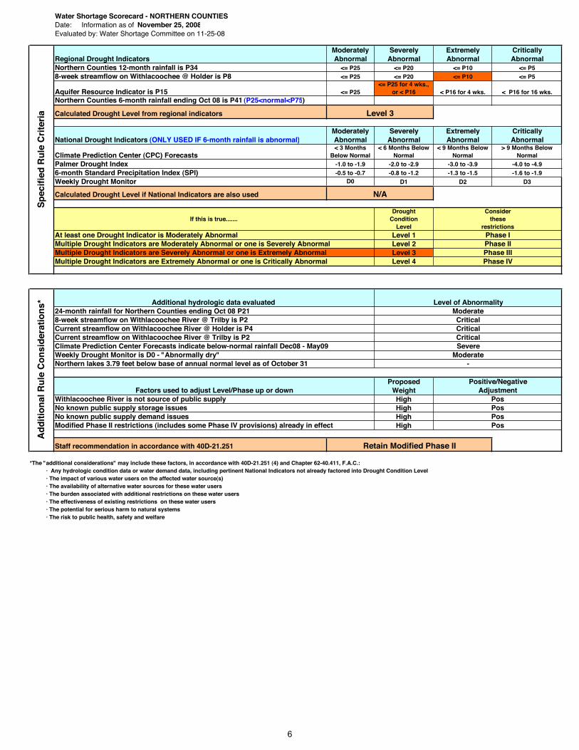
Water Shortage Scorecard - NORTHERN COUNTIESDate: Information as of November 25, 2008Evaluated by: Water Shortage Committee on 11-25-08
Moderately Severely Extremely CriticallyRegional Drought Indicators Abnormal Abnormal Abnormal AbnormalNorthern Counties 12-month rainfall is P34 <= P25 <= P20 <= P10 <= P58-week streamflow on Withlacoochee @ Holder is P8 <= P25 <= P20 <= P10 <= P5
Aquifer Resource Indicator is P15 <= P25<= P25 for 4 wks.,
or < P16 < P16 for 4 wks. < P16 for 16 wks.Northern Counties 6-month rainfall ending Oct 08 is P41 (P25<normal<P75)
Calculated Drought Level from regional indicators
Moderately Severely Extremely CriticallyNational Drought Indicators (ONLY USED IF 6-month rainfall is abnormal) Abnormal Abnormal Abnormal Abnormal
Climate Prediction Center (CPC) Forecasts< 3 Months
Below Normal< 6 Months Below
Normal< 9 Months Below
Normal> 9 Months Below
NormalPalmer Drought Index -1.0 to -1.9 -2.0 to -2.9 -3.0 to -3.9 -4.0 to -4.96-month Standard Precipitation Index (SPI) -0.5 to -0.7 -0.8 to -1.2 -1.3 to -1.5 -1.6 to -1.9Weekly Drought Monitor D0 D1 D2 D3
Calculated Drought Level if National Indicators are also used
DroughtCondition
LevelLevel 1Level 2Level 3Level 4
ProposedWeightHighHighHighHigh
Staff recommendation in accordance with 40D-21.251
*The "additional considerations" may include these factors, in accordance with 40D-21.251 (4) and Chapter 62-40.411, F.A.C.:· Any hydrologic condition data or water demand data, including pertinent National Indicators not already factored into Drought Condition Level · The impact of various water users on the affected water source(s)· The availability of alternative water sources for these water users· The burden associated with additional restrictions on these water users· The effectiveness of existing restrictions on these water users· The potential for serious harm to natural systems· The risk to public health, safety and welfare
Level 3
N/A
At least one Drought Indicator is Moderately AbnormalMultiple Drought Indicators are Moderately Abnormal or one is Severely Abnormal
If this is true.......
Multiple Drought Indicators are Severely Abnormal or one is Extremely AbnormalMultiple Drought Indicators are Extremely Abnormal or one is Critically Abnormal
Phase IPhase IIPhase IIIPhase IV
Considerthese
restrictions
No known public supply storage issuesWithlacoochee River is not source of public supply
Additional hydrologic data evaluated
Pos
24-month rainfall for Northern Counties ending Oct 08 P218-week streamflow on Withlacoochee River @ Trilby is P2Current streamflow on Withlacoochee River @ Holder is P4
PosNo known public supply demand issues PosModified Phase II restrictions (includes some Phase IV provisions) already in effect Pos
Current streamflow on Withlacoochee River @ Trilby is P2
Weekly Drought Monitor is D0 - "Abnormally dry"
CriticalSevere
Moderate-
Sp
ecif
ied
Ru
le C
rite
ria
Positive/Negative
Northern lakes 3.79 feet below base of annual normal level as of October 31
Climate Prediction Center Forecasts indicate below-normal rainfall Dec08 - May09
Ad
dit
ion
al R
ule
Co
nsi
der
atio
ns*
Retain Modified Phase II
Factors used to adjust Level/Phase up or down Adjustment
Level of AbnormalityModerateCriticalCritical
6

WATER SHORTAGE ALERT
Normal
Moderate
Severe
Extreme
Critical
Water resource conditions are normal
Condition of at least one water resource is below normal and may get worse
Conditions of water resources or water supply require additional limitations on nonessential water uses
Conditions of water resources or water supply require strict limitations on nonessential water uses
Conditions of water resources or water supply require suspension of nonessential water uses
L E V Y
M A R I O N
C I T R U S
L A K E
S U M T E R
H E R N A N D O
P A S C O
P I N E L L A S
P O L K
S A R A S O T A
H A R D E E
D E S O T O
C H A R L O T T E
HIG
HL
AN
DS
H I L L S B O R O U G H
M A N A T E E
7

Item 45
Resource Management Committee December 16, 2008
Discussion Item
Long-Range Water Supply and Water Resource Development Funding Plan Update
PurposeThis is an action item to provide policy direction on a five-part motion associated with funding associated with the District's Long-Range Water Supply and Water Resource Development (WSRD) Funding Plan. The motion was made at the October Governing Board meeting at the conclusion of the presentation of Plan.
Background At the October Governing Board meeting, staff presented the annual update of the Plan. The presentation provided an estimated revenue outlook of the Governing Board and eight Basin Boards relative to their ability to meet projected funding requests for alternative water supply and resource development projects through the years 2025. What was presented indicated the Governing Board was well positioned to meet the financial demands through fiscal year 2017. It was pointed out that staff generally focuses on the first five years of the Plan (updated annually) as being the most reliable in terms of program revenues and project expenses. The Plan also indicated that several basins were not well positioned to meet the projected financial demands associated with bringing on alternative sources over the planning horizon of 2025. The Board discussed the assumptions and conclusions of the analysis and approved a five part motion, and requested staff to address it at a future meeting. That motion is as follows:
1. Evaluate and consider changing the percentage of funding between the Governing Board and Basin Boards for WSRD projects. Also consider including in this those shared projects associated with data collection, analysis and recovery related to minimum flows and levels, water supply technical studies and other water supply planning efforts, and other programs.
2. Consider and evaluate having the Governing Board participate in funding programs currently fully funded by the Basin Boards, such as conservation related research.
3. What are the expectations of the Governing Board of those Basin Boards that can't meet expected levels of funding for approved WSRD projects.
4. Look at different ways of evaluating projects and consider having a different percentage of match between the District, as a whole, and a cooperator for all cooperative funding initiative projects based on project priority.
5. Provide an overview of the statutory requirements and legislative intent in setting millage rates for the Governing Board and Basins, as relates to their respective duties and responsibilities directing project funding.
In response to the motion, staff has conducted a comprehensive predictive analysis of the District's service budget through the year 2030. In addition to that, staff re-evaluated the project costs and implementation schedule for those projects currently included in the Plan. There have been several significant changes to the demand projections used in the October presentation as a result of market conditions and refinement of ongoing water supply master plans being conducted by Tampa Bay Water, Peace River/Manasota Regional Water Supply Authority and Polk County. The current data indicates a reduction in the overall alternative source quantities needed over the planning horizon, which we extended to 2030, and an overall shift or delay in bringing those quantities on to the middle and latter years. This latest information is believed to be a more realistic projection of future demands and project needs.
8

Item 45
The staff will provide a recommendation addressing parts 1, 2 and 3 of the motion by summarizing key elements of the budgetary and project analysis and show how these assumptions realign the potential funding vs. estimated project costs (graphs) for the Governing Board and Basins Boards. Part 4 and 5 of the motion are policy and general information related issues and staff will provide necessary backup material.
Staff Recommendation:
(1) Governing Board, based on statutory division of taxing authority, to continue funding major regional water supply and water resource development projects: Governing Board and Basin Boards to continue to provide matching funds to cooperators equal to 50 percent of eligible project costs, subject to funding availability.
District General Fund and Basins to jointly fund the District's 50 percent project cost share on a 50/50 basis, subject to Basin priorities and funding availability.
(2) District's General Fund fund 100 percent of those project costs currently funded in whole or in part by the Basins that are in support of regulatory functions such as data collection, minimum flows and levels, water supply technical studies, water supply planning efforts, water resource programs, and conservation research studies.
Presenters: Gene Schiller, Deputy Executive Director, Management Services Bruce Wirth, Deputy Executive Director, Resource Management Linda Pilcher, Assistant Director, Finance Department Bill Bilenky, General Counsel
9

Item 46
Resource Management Committee December 16, 2008
Routine Report
Florida Forever Funding
PurposeNo Board action is required. This item is submitted for information purposes only.
Background/HistoryAttached for the Board’s use and information is the monthly funding status report for the Florida Forever program. The projects have been categorized as acquisitions or projects for: restoration; capital improvements for restoration; water resource development; and preservation. In addition to Florida Forever funding, staff continues to explore all funding opportunities.
Staff Recommendation: See Exhibit
This item is provided for the Committee’s information, and no action is required.
Presenter: Eric Sutton, Assistant Director, Land Resources Department
10

Southwest Florida Water Management DistrictFlorida Forever Status
Parcel/Project Funds AvailableFla Forever
Category SWUCA Estimated CostFee
AcresLTF
Acres CommentsGoverning
Bd Date
Florida Forever Funds Available -- Inception to Date $ 280,413,581
Includes $13,170,753 from the Water Management Lands Trust Fund, $3,182,719 from the P2000 Trust Fund and $5,310,109 from FDOT mitigation
Completed AcquisitionsPanasoffkee/Outlet Tract - Gibbons (19-441-105) Preservation 74,758 10 Closed 01/18/2001 Annutteliga Hammock (mega parcels) Preservation 205,744 38 Closed between 08/09/2001 and 02/09/2005 - 23 parcelsWeekiwachee Preserve - Wooley (15-773-168) Preservation 869,732 65 Closed 10/04/2001 Weekiwachee Preserve - Jones (15-773-121) Preservation 317,785 54 Closed 10/12/2001 Weekiwachee Preserve - Leahon (15-773-180) Preservation 42,933 49 Closed 03/13/2002 RV Griffin Reserve - Longino (21-599-102C) Preservation 1,188,231 3,802 Closed 07/18/2002 - used P2000 & Florida Forever funds Annutteliga Hammock - Strait (15-228-1204) Preservation 179,200 32 Closed 07/22/2002 Green Swamp - Distefano (10-200-1242) Preservation 1,125 3 Closed 08/09/2002
Tampa Bay - Furtick (21-728-121)Restoration - land acq 830,000 127 Closed 12/30/2002
Prairie/Shell Creek - Burchers (20-649-105) Preservation 254,016 108 Closed 01/16/2003 Prairie/Shell Creek - Leonard (20-649-104) Preservation 85,036 40 Closed 01/16/2003 Alafia River Corridor - Fish Hawk (11-709-131) Preservation 4,800,000 899 Closed 02/06/2003 - used P2000 & Florida Forever funds Myakka River - Eagle Ridge (21-708-126) Preservation 1,670,269 997 Closed 02/07/2003
Lake Pretty - Robinson (14-009-108)Water resource dev - land acq 60,000 3 Closed 03/27/2003
Weekiwachee Preserve - GMB Investments (15-773-183) Preservation 422,000 56 Closed 05/28/2003 - used WMLTF funds
Tampa Bay - Kushmer (11-728-108)Restoration - land acq 82,500 16 Closed 07/18/2003
Tampa Bay - Pine Island (21-728-118)Restoration - land acq 450,000 86 Closed 08/09/2003
Lake Panasoffkee - Beville (19-528-135)Restoration - land acq 1,840,000 525 Closed 09/18/2003 - used WMLTF funds
Lake Panasoffkee - Beville (19-528-135C) Preservation 4,160,000 5,553 Closed 09/18/2003 - used WMLTF fundsAnnutteliga Hammock - 1029 Land Trust (15-228-1207) Preservation 1,087,200 288 Closed 09/24/2003 Pasco 1 - Connerton (15-704-102) Preservation 9,792,677 2,981 507 Closed 09/29/2003 Lake Hancock - Old Florida Plantation (20-502-101)
Water resource dev - land acq 30,500,000 3,535 Closed 11/21/2003
Tampa Bay - TECO (11-728-110)Restoration - land acq 1,713,572 2,347 Closed 12/11/2003
Tampa Bay - Huber (21-728-105)Restoration - land acq 3,287,657 102 Closed 12/18/2003
Panasoffkee/Outlet Tract - Lake Panasoffkee Water Assoc. (19-441-107) Preservation 57,000 6 Closed 08/18/2004
Annutteliga Hammock - Kalathakis (15-228-1268) Preservation 90,000 16 Closed 09/23/2004 Green Swamp - Davis (10-200-1238) Preservation 10,500 25 Closed 10/13/2004 Lake Manatee Lower Watershed - Strickland (21-601-111C) Preservation 225,180 25 Closed 11/16/2004
Tampa Bay - Shell Pit (11-728-109)Restoration - land acq 395,672 147 Closed 12/02/2004
Flying Eagle - Boy Scouts (19-334-133) Preservation 13,500,000 5,484 Closed 12/14/2004 Green Swamp - Beck (10-200-1246) Preservation 11,250 15 Closed 12/14/2004 - used P2000 funds
Lake Hancock - Griffin (20-503-105)Water resource dev - land acq $ 4,900,000 213 Closed 12/30/2004
12/01/2008 Page 1 of 3
11
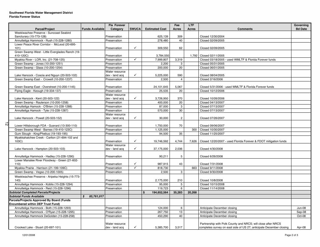
Southwest Florida Water Management DistrictFlorida Forever Status
Parcel/Project Funds AvailableFla Forever
Category SWUCA Estimated CostFee
AcresLTF
Acres CommentsGoverning
Bd DateWeekiwachee Preserve - Suncoast Seabird Sancturary (15-773-128) Preservation 625,139 309 Closed 12/30/2004 Annutteliga Hammock - Rush (15-228-1280) Preservation 278,480 40 Closed 02/09/2005 Lower Peace River Corridor - McLeod (20-695-101) Preservation 309,550 62 Closed 02/09/2005 Green Swamp West - Little Everglades Ranch (19-410-120C) Preservation 3,784,550 1,792 Closed 02/11/2005 Myakka River - LOR, Inc. (21-708-125) Preservation 7,999,807 3,319 Closed 03/18/2005 - used WMLTF & Florida Forever funds Green Swamp - Jones (10-200-1251) Preservation 2,200 3 Closed 05/31/2005 Green Swamp - Glass (10-200-1254) Preservation 200,000 20 Closed 06/01/2005
Lake Hancock - Coscia and Nguyn (20-503-102)Water resource dev - land acq 5,225,000 590 Closed 08/04/2005
Green Swamp East - Crowell (10-200-1237) Preservation 2,500 4 Closed 2/16/2006
Green Swamp East - Overstreet (10-200-1145) Preservation 24,101,645 5,067 Closed 5/31/2006 - used WMLTF & Florida Forever funds Flying Eagle - Keough (19-334-137) Preservation 25,535 20 Closed 10/12/2006
Lake Hancock - Kent (20-503-122)Water resource dev - land acq 3,726,950 370 Closed 10/26/2006
Green Swamp - Raulerson (10-200-1258) Preservation 400,000 20 Closed 04/13/2007 Annutteliga Hamock - O'Brien (15-228-1288) Preservation 87,000 3 Closed 07/13/2007 Annutteliga Hamock - Tyte (15-228-1287) Preservation 570,000 30 Closed 07/13/2007
Lake Hancock - Powell (20-503-152)Water resource dev - land acq 30,000 2 Closed 07/26/2007
Lower Hillsborough FDA - Guerard (13-300-110) Preservation 1,750,000 70 Closed 09/06/2007 Green Swamp West - Barnes (19-410-123C) Preservation 1,125,000 300 Closed 10/30/2007 Gum Slough - King/Phebus (19-193-195) Preservation 94,500 35 Closed 11/25/2007 Myakkahatchee Creek - Carlton (21-694-102 and 103C) Preservation 19,746,592 4,744 7,626 Closed 12/20/2007 - used Florida Forever & FDOT mitigation funds
Lake Hancock - Hampton (20-503-103)Water resource dev - land acq 37,175,000 2,036 Closed 4/30/2008
Annutteliga Hammock - Hadley (15-228-1290) Preservation 90,211 5 Closed 6/26/2008 Lower Manatee River Floodway - Green (21-602-110) Preservation 987,915 43 Closed 7/31/2008 Myakka Prairie - Harrison (21-199-109C) Preservation 818,730 663 Closed 9/11/2008 Green Swamp - Vegso (10-200-1005) Preservation 2,500 3 Closed 9/30/2008
Weekiwachee Preserve - Aripeka Heights (15-773-143) Preservation 2,175,000 210 Closed 10/8/2008 Annutteliga Hammock - Koblis (15-228-1294) Preservation 95,000 5 Closed 10/15/2008 Annutteliga Hammock - Reid (15-228-1296) Preservation 119,723 6 Closed 11/14/2008
Subtotal Completed Parcels/Projects $ 194,652,564 35,283 20,268 Subtotal Funds Available $ 85,761,017 Parcels/Projects Approved By Board (Funds Encumbered within DEP Trust Fund)
Annutteliga Hammock - Both (15-228-1293) Preservation 124,000 6 Anticipate December closing Jun-08Annutteliga Hammock - O'Ryan (15-228-1295) Preservation 267,750 13 Anticipate December closing Sep-08Annutteliga Hammock DeGolden (15-228-258) Preservation 450,290 40 Anticipate December closing Oct-08
Crooked Lake - Stuart (20-697-101)Water resource dev - land acq 5,385,700 3,517
Partnership with Polk County and NRCS; will close after NRCS completes survey on east side of US 27; anticipate December closing Apr-08
12/01/2008 Page 2 of 3
12
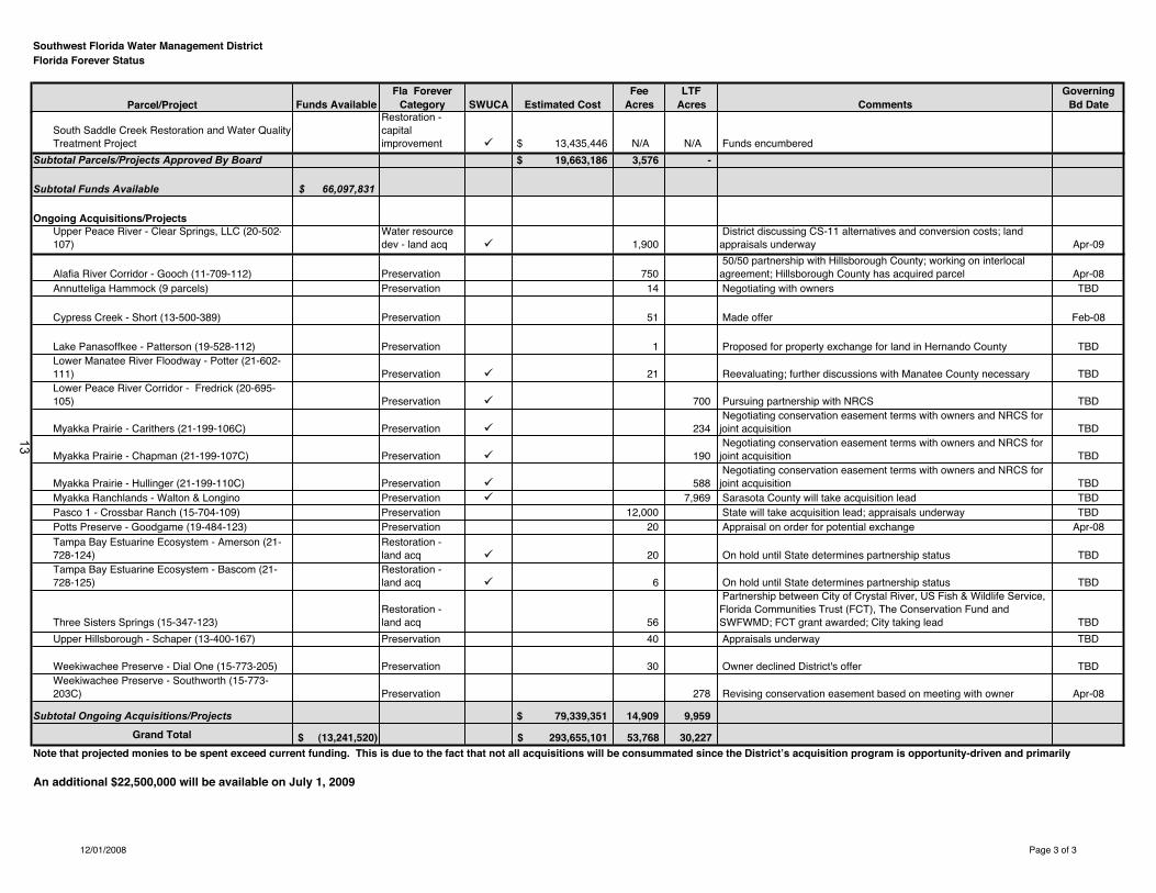
Southwest Florida Water Management DistrictFlorida Forever Status
Parcel/Project Funds AvailableFla Forever
Category SWUCA Estimated CostFee
AcresLTF
Acres CommentsGoverning
Bd Date
South Saddle Creek Restoration and Water Quality Treatment Project
Restoration - capitalimprovement $ 13,435,446 N/A N/A Funds encumbered
Subtotal Parcels/Projects Approved By Board $ 19,663,186 3,576 -
Subtotal Funds Available $ 66,097,831
Ongoing Acquisitions/ProjectsUpper Peace River - Clear Springs, LLC (20-502-107)
Water resource dev - land acq 1,900
District discussing CS-11 alternatives and conversion costs; land appraisals underway Apr-09
Alafia River Corridor - Gooch (11-709-112) Preservation 750 50/50 partnership with Hillsborough County; working on interlocal agreement; Hillsborough County has acquired parcel Apr-08
Annutteliga Hammock (9 parcels) Preservation 14 Negotiating with owners TBD
Cypress Creek - Short (13-500-389) Preservation 51 Made offer Feb-08
Lake Panasoffkee - Patterson (19-528-112) Preservation 1 Proposed for property exchange for land in Hernando County TBDLower Manatee River Floodway - Potter (21-602-111) Preservation 21 Reevaluating; further discussions with Manatee County necessary TBDLower Peace River Corridor - Fredrick (20-695-105) Preservation 700 Pursuing partnership with NRCS TBD
Myakka Prairie - Carithers (21-199-106C) Preservation 234 Negotiating conservation easement terms with owners and NRCS for joint acquisition TBD
Myakka Prairie - Chapman (21-199-107C) Preservation 190 Negotiating conservation easement terms with owners and NRCS for joint acquisition TBD
Myakka Prairie - Hullinger (21-199-110C) Preservation 588 Negotiating conservation easement terms with owners and NRCS for joint acquisition TBD
Myakka Ranchlands - Walton & Longino Preservation 7,969 Sarasota County will take acquisition lead TBDPasco 1 - Crossbar Ranch (15-704-109) Preservation 12,000 State will take acquisition lead; appraisals underway TBDPotts Preserve - Goodgame (19-484-123) Preservation 20 Appraisal on order for potential exchange Apr-08Tampa Bay Estuarine Ecosystem - Amerson (21-728-124)
Restoration - land acq 20 On hold until State determines partnership status TBD
Tampa Bay Estuarine Ecosystem - Bascom (21-728-125)
Restoration - land acq 6 On hold until State determines partnership status TBD
Three Sisters Springs (15-347-123)Restoration - land acq 56
Partnership between City of Crystal River, US Fish & Wildlife Service, Florida Communities Trust (FCT), The Conservation Fund and SWFWMD; FCT grant awarded; City taking lead TBD
Upper Hillsborough - Schaper (13-400-167) Preservation 40 Appraisals underway TBD
Weekiwachee Preserve - Dial One (15-773-205) Preservation 30 Owner declined District's offer TBDWeekiwachee Preserve - Southworth (15-773-203C) Preservation 278 Revising conservation easement based on meeting with owner Apr-08
Subtotal Ongoing Acquisitions/Projects $ 79,339,351 14,909 9,959
Grand Total (13,241,520)$ 293,655,101$ 53,768 30,227
An additional $22,500,000 will be available on July 1, 2009
Note that projected monies to be spent exceed current funding. This is due to the fact that not all acquisitions will be consummated since the District’s acquisition program is opportunity-driven and primarily
12/01/2008 Page 3 of 3
13

Item 47
Resource Management Committee December 16, 2008
Routine Report
Minimum Flows and Levels
District staff continues to work on various phases of Minimum Flows and Levels (MFLs) development for water bodies on the District's MFLs priority list. Attached for the Board's use and information is the current Minimum Flows and Levels Priority List and Schedule – Water body Timelines report that identifies the status of each water body in regard to our five phase process of MFL establishment.
Staff Recommendation: See Exhibit
This item is provided for the Committee's information, and no action is required.
Presenter: Martin H. Kelly, Ph.D., Minimum Flows and Levels Program Director, Resource Projects Department
14

Board Adopted 2009 Priority List Schedule and Timeline Exhibit A
Updated November 21, 2008
RIVERS, SPRINGS and ESTUARIES
Phase 1 Phase 2 Phase 3 Phase 4 Phase 5
Data Collection Data Analysis Rpt to Board / Peer Review Recovery Rule Adoption
& Internal Draft MFL Report Strategy
2008Alafia River System (estuary) completed completed completed Recovery Dec 2008 Buckhorn Spring completed completed completed Recovery Dec 2008 Lithia Spring completed completed completed Recovery Dec 2008
Lower Peace River Estuary completed completed completed for Shell Creek Dec 2008
Weekiwachee River System and Springs completed completed completed / ongoing NA Dec 2008
2009Anclote River System completed Dec 2008 Jan 2009 / Apr 2009 Recovery Aug 2009
Blind Springs Jan 2009 May 2009 Jun 2009 / Sep 2009 TBD Nov 2009
Chassahowitzka River System and Springs completed Jun 2009 Aug 2009 / Nov 2009 TBD Dec 2009
Dona Bay (Cow Pen Slough Canal) completed completed completed / ongoing NA Apr 2009
Homosassa River System and Springs completed Jun 2009 Aug 2009 / Nov 2009 TBD Dec 2009
Little Manatee River System completed May 2009 Jul 2009 / Oct 2009 TBD Nov 2009
Lower Myakka River System completed Dec 2008 Jan 2009 / Apr 2009 TBD Aug 2009
Manatee River System completed May 2009 Jul 2009 / Oct 2009 TBD Nov 2009
Middle and Upper Withlacoochee River System Jan 2009 May 2009 Jul 2009 / Oct 2009 TBD Nov 2009(G reen Swamp)
Rainbow Springs completed May 2009 Jul 2009 / Oct 2009 TBD Nov 2009
2010Crystal River System Jan 2010 May 2010 Jul 2010 / Oct 2010 TBD Nov 2010Kings Bay Spring Jan 2010 May 2010 Jul 2010 / Oct 2010 TBD Nov 2010
Gum Springs Group Jan 2010 May 2010 Jul 2010 / Oct 2010 TBD Nov 2010
Hidden River Springs 1 and 2 Jan 2010 May 2010 Jul 2010 / Oct 2010 TBD Nov 2010
Northern Tampa Bay - Phase II Jan 2010 May 2010 Jul 2010 / Oct 2010 TBD Nov 2010
Pithlachascotee River System Jan 2010 May 2010 Jul 2010 / Oct 2010 TBD Nov 2010
2011Lower Withlacoochee River System Jan 2011 May 2011 Jul 2011 / Oct 2011 TBD Nov 2011
Brooker Creek Jan 2011 May 2011 Jul 2011 / Oct 2011 TBD Nov 2011
Upper Peace River Jan 2011 May 2011 Jul 2011 / Oct 2011 TBD Nov 2011"Middle" and "High" Minimum Flows
2012Charlie Creek (Peace River drainage) Jan 2012 May 2012 Jul 2012 / Oct 2012 TBD Nov 2012Horse Creek (Peace River drainage) Jan 2012 May 2012 Jul 2012 / Oct 2012 TBD Nov 2012
North Prong Alafia River Jan 2012 May 2012 Jul 2012 / Oct 2012 TBD Nov 2012South Prong Alafia River Jan 2012 May 2012 Jul 2012 / Oct 2012 TBD Nov 2012
2013Prairie Creek (Peace River drainage) Jan 2013 May 2013 Jul 2013 / Oct 2013 TBD Nov 2013
Shell Creek (Peace River drainage) Jan 2013 May 2013 Jul 2013 / Oct 2013 TBD Nov 2013
At the Board's direction, staff have added projected dates on which: we expect to have internal draft reports complete, presentation of draft to Board, report of peer review to Board, and return for rule establishment.
* Waterbodies completed through Phase 5 will be removed from this list and added to the Minimum Flows and Levels Established to Date list when the priority list is updated each year.
15
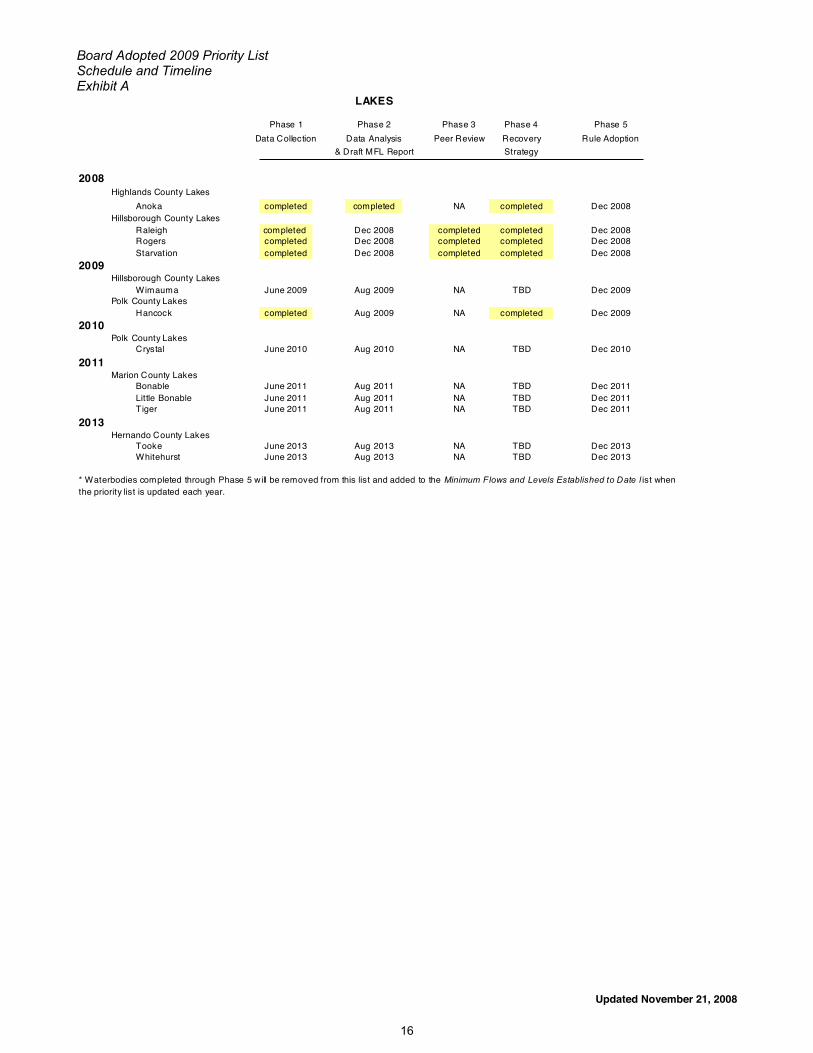
Board Adopted 2009 Priority List Schedule and Timeline Exhibit A
Updated November 21, 2008
LAKES
Phase 1 Phase 2 Phase 3 Phase 4 Phase 5
Data Collection Data Analysis Peer Review Recovery Rule Adoption
& Draft MFL Report Strategy
2008Highlands County Lakes
Anoka completed completed NA completed Dec 2008Hillsborough County Lakes
Raleigh completed Dec 2008 completed completed Dec 2008Rogers completed Dec 2008 completed completed Dec 2008Starvation completed Dec 2008 completed completed Dec 2008
2009Hillsborough County Lakes
Wimauma June 2009 Aug 2009 NA TBD Dec 2009Polk County Lakes
Hancock completed Aug 2009 NA completed Dec 2009
2010Polk County Lakes
Crystal June 2010 Aug 2010 NA TBD Dec 2010
2011Marion County Lakes
Bonable June 2011 Aug 2011 NA TBD Dec 2011Little Bonable June 2011 Aug 2011 NA TBD Dec 2011Tiger June 2011 Aug 2011 NA TBD Dec 2011
2013Hernando County Lakes
Tooke June 2013 Aug 2013 NA TBD Dec 2013Whitehurst June 2013 Aug 2013 NA TBD Dec 2013
* Waterbodies completed through Phase 5 will be removed from this list and added to the Minimum Flows and Levels Established to Date l ist when the priority list is updated each year.
16

Board Adopted 2009 Priority List Schedule and Timeline Exhibit A
Updated November 21, 2008
Minimum Flows and Levels Established to Date
Alafia River (upper freshwater segment)
Braden River
Citrus County Lakes (Ft. Cooper, Tsala Apopka – Floral City, Inverness and Hernando Pools)
Crystal Springs
Hernando County Lakes - Hunters, Lindsey, Mountain, Neff, Spring and Weekiwachee Prairie
Highland County Lakes – Angelo, Denton, Jackson, Little Lake Jackson, June-in-Winter, Letta, Lotela, Placid, Tulane, and Verona
Hillsborough County Lakes – Alice, Allen, Barbara, Bird, Brant, Calm, Charles, Church, Crenshaw, Crescent, Crystal, Cypress, Dan, Deer, Dosson, Echo, Ellen, Fairy [Maurine], Garden, Halfmoon, Harvey, Helen, Hobbs, Horse, Jackson, Juanita, Little Moon, Merrywater, Mound, Platt, Pretty, Rainbow, Reinheimer, Round, Saddleback, Sapphire, Stemper, Strawberry, Sunset, Sunshine, Taylor and Virginia.
Hillsborough River (lower segment)
Hillsborough River (upper segment)
Levy County Lake (Marion)
Northern Tampa Bay - 41 Wetland sites
Northern Tampa Bay – 7 Wells – Floridan Aquifer/Saltwater Intrusion
Pasco County Lakes – Bell, Big Fish, Bird, Buddy, Camp, Clear, Green, Hancock, Iola, Jessamine, King, King (East), Linda, Middle, Moon, Padgett, Parker aka Ann, Pasadena, Pasco, Pierce, unnamed #22 aka Loyce
Peace River (middle segment)
Peace River (upper segment – "low" minimum flows)
Polk County Lakes – Annie, Bonnie, Clinch, Crooked, Dinner, Eagle, Lee, Mabel, McLeod, Parker, Starr, Venus, and Wales
Myakka River (upper freshwater segment)
Sulphur Springs
Sumter County Lakes – Big Gant, Black, Deaton, Miona, Okahumpka and Panasoffkee
SWUCA – Floridan Aquifer
Tampa Bypass Canal
17
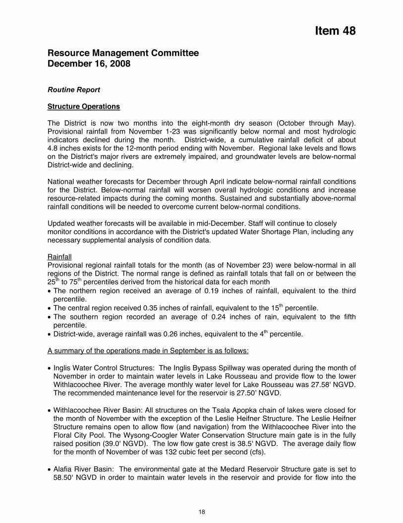
Item 48
Resource Management Committee December 16, 2008
Routine Report
Structure Operations
The District is now two months into the eight-month dry season (October through May). Provisional rainfall from November 1-23 was significantly below normal and most hydrologic indicators declined during the month. District-wide, a cumulative rainfall deficit of about 4.8 inches exists for the 12-month period ending with November. Regional lake levels and flows on the District's major rivers are extremely impaired, and groundwater levels are below-normal District-wide and declining.
National weather forecasts for December through April indicate below-normal rainfall conditions for the District. Below-normal rainfall will worsen overall hydrologic conditions and increase resource-related impacts during the coming months. Sustained and substantially above-normal rainfall conditions will be needed to overcome current below-normal conditions.
Updated weather forecasts will be available in mid-December. Staff will continue to closely monitor conditions in accordance with the District's updated Water Shortage Plan, including any necessary supplemental analysis of condition data.
RainfallProvisional regional rainfall totals for the month (as of November 23) were below-normal in all regions of the District. The normal range is defined as rainfall totals that fall on or between the 25th to 75th percentiles derived from the historical data for each month The northern region received an average of 0.19 inches of rainfall, equivalent to the third percentile.
The central region received 0.35 inches of rainfall, equivalent to the 15th percentile. The southern region recorded an average of 0.24 inches of rain, equivalent to the fifth percentile.
District-wide, average rainfall was 0.26 inches, equivalent to the 4th percentile.
A summary of the operations made in September is as follows:
Inglis Water Control Structures: The Inglis Bypass Spillway was operated during the month of November in order to maintain water levels in Lake Rousseau and provide flow to the lower Withlacoochee River. The average monthly water level for Lake Rousseau was 27.58' NGVD. The recommended maintenance level for the reservoir is 27.50’ NGVD.
Withlacoochee River Basin: All structures on the Tsala Apopka chain of lakes were closed for the month of November with the exception of the Leslie Heifner Structure. The Leslie Heifner Structure remains open to allow flow (and navigation) from the Withlacoochee River into the Floral City Pool. The Wysong-Coogler Water Conservation Structure main gate is in the fully raised position (39.0' NGVD). The low flow gate crest is 38.5' NGVD. The average daily flow for the month of November of was 132 cubic feet per second (cfs).
Alafia River Basin: The environmental gate at the Medard Reservoir Structure gate is set to 58.50' NGVD in order to maintain water levels in the reservoir and provide for flow into the
18

Item 48
Little Alafia River. The average monthly water level for the Medard Reservoir was 58.33'
s operated during the month of November. The average monthly water level for Lake Thonotosassa was 36.0' NGVD compared to the
ctures operated during the month of November. The average monthly water level for Lake Tarpon was 2.83' NGVD compared to
Northwest Hillsborough River Basin: There were no structures operated during the month of
rated during the month of November. The average monthly water level for Lake June-in-Winter was 74.46' NGVD compared to the
ance level of 75.0’ NGVD.
NGVD. The recommended maintenance level for the reservoir is 58.5’ NGVD.
Hillsborough River Basin: There were no structure
recommended maintenance level of 36.5' NGVD.
Pinellas-Anclote River Basin: There were no stru
the recommended maintenance level of 3.2' NGVD.
November.
Peace River Basin: There were no structures ope
recommended mainten
Staff Recommendation: See Exhibit
This item is provided for the Board's information only, and no action is required.
Presenter: Tanase Bude, Manager, Structure Operations Section
19
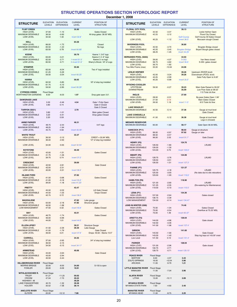
ELEVATION ELEVATION CURRENT POSITION OF ELEVATION ELEVATION CURRENT POSITION OFLEVELS DIFFERENCE LEVEL STRUCTURE LEVELS DIFFERENCE LEVEL STRUCTURE
FLINT CREEK 35.90 FLORAL CITY POOL 39.13HIGH LEVEL 37.00 -1.10 Gates Closed HIGH LEVEL 42.50 -3.37 Leslie Heifner Open
MAXIMUM DESIRABLE 36.50 -0.60 All drop gates: 36.00' MSL MAXIMUM DESIRABLE 42.25 -3.12 Floral City ClosedLOW LEVEL 34.50 1.40 invert 32.9' Golf Course Golf Course All Gates Closed
LOW LEVEL 40.25 -1.12 invert 38.0' Moccasin slough ClosedKELL 64.28
HIGH LEVEL 66.00 -1.72 Closed INVERNESS POOL 36.80MAXIMUM DESIRABLE 65.50 -1.22 No logs HIGH LEVEL 40.50 -3.70 Brogden Bridge closed
LOW LEVEL 63.50 0.78 invert 64.66' MAXIMUM DESIRABLE 40.25 -3.45 Brogden Bridge Bryant Slough gates closedLOW LEVEL 38.25 -1.45 invert 34.25'
KEENE 59.79 Keene 1: 2-6" logsHIGH LEVEL 63.00 -3.21 Keene 2: 2- 6" logs HERNANDO POOL (S353) 34.93
MAXIMUM DESIRABLE 62.50 -2.71 1-invert 61.5' Keene 3: no logs HIGH LEVEL 39.00 -4.07 S-353 Van Ness closedLOW LEVEL 60.50 -0.71 2-invert 61.6' Sherry's Brook: 18" of Logs MAXIMUM DESIRABLE 38.75 -3.82 invert 36.5' S-353 gates closed
LOW LEVEL 36.75 -1.82STEMPER 55.96 Two Mile Prairie (max) 35.00 -10.94 24.06
HIGH LEVEL 62.00 -6.04 Two 4" logs installedMAXIMUM DESIRABLE 61.25 -5.29 LESLIE HEIFNER 39.26 Upstream (RIVER level)
LOW LEVEL 59.50 -3.54 invert 60.25' HIGH LEVEL 42.50 -3.24 39.26 Downstream (POOL level)MAXIMUM DESIRABLE 42.25 -2.99 Gate Fully Open to 9.00'
HANNA 56.65 LOW LEVEL 40.25 -0.99 invert 35.0'HIGH LEVEL 62.50 -5.85 18" of stop log installed
MAXIMUM DESIRABLE 61.75 -5.10 WYSONG-COOGLERLOW LEVEL 59.50 -2.85 invert 60.28' UPSTREAM 39.50 -0.27 39.23 Main Gate Raised to 39.00'
DOWNSTREAM 35.09 Low Flow Gate at 38.52'CYPRESS CREEK Flood Stage 113 Total cfs flow
WORTHINGTON GARDENS 8.00 -6.03 1.97 Drop gate open 3.0'. INGLIS 27.69HIGH LEVEL 28.00 -0.31 By-pass Gates Open 1.90'
SAWGRASS LAKE MAXIMUM DESIRABLE 27.50 0.19 Main Gates ClosedHIGH LEVEL 5.00 -0.46 4.54 Gate 1 Fully Open LOW LEVEL 26.50 1.19 invert 11.3' 613 Total cfs flow LOW LEVEL 3.80 0.74 Gate 2 Closed
Gate 3 Closed LAKE BRADLEYTARPON (S551) 2.79 MAXIMUM DESIRABLE 42.50 -5.14 37.36 Gauge at mud level
HIGH LEVEL 3.80 -1.01 Main gates Closed Gate ClosedMAXIMUM DESIRABLE 3.20 -0.41 Drop gates Closed LAKE CONSUELLA
LOW LEVEL 2.20 0.59 MAXIMUM DESIRABLE 41.50 -5.12 36.38 Gauge at mud levelLogs in (Closed)
ANNE PARKER 46.31 MEDARD RESERVOIRHIGH LEVEL 48.75 -2.44 5-6" logs MAXIMUM DESIRABLE 60.00 -1.83 58.17 Gate Open 58.50 MSL
MAXIMUM DESIRABLE 48.25 -1.94 LOW LEVEL 45.75 0.56 invert 46.40' HANCOCK (P11) 98.03 Gauge at structure
HIGH LEVEL 99.00 -0.97 97.92 Gauge on lakeWHITE TROUT 33.37 MAXIMUM DESIRABLE 98.50 -0.47 HIGH LEVEL 36.50 -3.13 CREST = 33.94' MSL LOW LEVEL 96.00 2.03 invert 91.7' Gate Closed
MAXIMUM DESIRABLE 36.00 -2.63 12" of stop log installedHENRY (P5) 124.70
LOW LEVEL 34.00 -0.63 invert 32.94' HIGH LEVEL 126.50 -1.80 LRLMDMAXIMUM DESIRABLE 126.00 -1.30
KEYSTONE 40.49 LOW LEVEL 124.00 0.70 invert 122.0'HIGH LEVEL 42.00 -1.51 Gates Closed
MAXIMUM DESIRABLE 41.75 -1.26 SMART (P6) 124.99LOW LEVEL 39.75 0.74 invert 37.2' HIGH LEVEL 128.75 -3.76 LRLMD
MAXIMUM DESIRABLE 128.50 -3.51 CRESCENT 39.69 LOW LEVEL 126.50 -1.51 invert 127.2'HIGH LEVEL 42.50 -2.81 Gate Closed
MAXIMUM DESIRABLE 42.00 -2.31 FANNIE (P7) 121.57LOW LEVEL 40.00 -0.31 invert 38.5' HIGH LEVEL 125.75 -4.18 LRLMD
MAXIMUM DESIRABLE 125.50 -3.93 (No data due to site relocation)ISLAND FORD 37.82 LOW LEVEL 123.50 -1.93 invert 119.5'HIGH LEVEL 41.50 -3.68 Gates Closed
MAXIMUM DESIRABLE 41.00 -3.18 invert 35.0' HAMILTON (P8) 118.90LOW LEVEL 39.00 -1.18 crest 41.25' HIGH LEVEL 121.50 -2.60 LRLMD
MAXIMUM DESIRABLE 121.25 -2.35 (De-watering for Maintenance)PRETTY 43.47 LOW LEVEL 119.00 -0.10 invert 110.5'
HIGH LEVEL 45.50 -2.03 Lift Gate ClosedMAXIMUM DESIRABLE 44.50 -1.03 Drops Closed LENA (P1) 134.36
LOW LEVEL 42.75 0.72 invert 38.0' HIGH LEVEL 137.00 -2.64 Gates closedMAXIMUM DESIRABLE 136.75 -2.39
MAGDALENE 47.82 Lake gauge LOW MANAGEMENT 134.50 -0.14 invert 134.47'HIGH LEVEL 50.00 -2.18 47.85 Structure gauge
MAXIMUM DESIRABLE 49.50 -1.68 JUNE-IN-WINTER (G90) 74.46LOW MANAGEMENT 47.50 0.32 invert 45.6' Gates Closed HIGH LEVEL 75.50 -1.04 Gates Closed
MAXIMUM DESIRABLE 75.00 -0.54 Overflow at 75.25' MSLBAY 45.01 LOW LEVEL 73.00 1.46 invert 65.37'
HIGH LEVEL 46.75 -1.74 Gates ClosedMAXIMUM DESIRABLE 46.00 -0.99 ARIETTA (P3) 139.04
LOW LEVEL 44.00 1.01 invert 44.0' HIGH LEVEL 144.00 -4.96 Gate closed MAXIMUM DESIRABLE 142.50 -3.46
ELLEN-LIPSEY 39.21 Structure Gauge LOW LEVEL 141.00 -1.96 invert 137.4'HIGH LEVEL 41.50 -2.29 39.39 Lake Gauge
MAXIMUM DESIRABLE 41.00 -1.79 Gate Closed GIBSON 141.60LOW LEVEL 39.00 0.21 invert 37.6' Drops: 40.62 - Stems 13.5" HIGH LEVEL 143.50 -1.90 Gate Closed
MAXIMUM DESIRABLE 143.00 -1.40 Stop log bays at 143.00' crestCARROLL 34.35 Low Level 141.50 0.10 invert 141.4'
HIGH LEVEL 37.00 -2.65 24" of stop log installedMAXIMUM DESIRABLE 36.50 -2.15 PARKER 128.04
LOW LEVEL 34.50 -0.15 invert 34.17' HIGH LEVEL 131.00 -2.96 Gate closedMAXIMUM DESIRABLE 130.75 -2.71
ARMISTEAD 40.06 LOW LEVEL 128.75 -0.71 invert 129.15'HIGH LEVEL 44.00 -3.94 Gate Closed
MAXIMUM DESIRABLE 43.00 -2.94 PEACE RIVER Flood StageLOW LEVEL 40.50 -0.44 BARTOW 8.00 -4.57 3.43
ZOLFO SPRINGS 16.00 -12.04 3.96HILLSBOROUGH RIVER Flood Stage ARCADIA 11.00 -9.79 1.21
MORRIS BRIDGE 32.00 -8.00 24.00 S-155 is openFOWLER 29.00 -9.09 19.91 LITTLE MANATEE RIVER Flood Stage
WIMAUMA 11.00 -7.04 3.96WITHLACOOCHEE R. Flood Stage
TRILBY 61.27 -11.25 50.02 ALAFIA RIVER Flood StageCROOM 47.94 -7.70 40.24 LITHIA 13.00 -10.11 2.89
HIGHWAY. 48 39.29LAKE PANASOFFKEE 40.70 -1.32 39.38 MYAKKA RIVER Flood Stage
HOLDER 35.52 -7.38 28.14 MYAKKA STATE PARK 7.00 -4.60 2.40
ANCLOTE RIVER Flood Stage MANATEE RIVER Flood StageELFERS 20.00 -12.12 7.88 MYAKKA HEAD 11.00 -8.75 2.25
STRUCTURE OPERATIONS SECTION HYDROLOGIC REPORTDecember 1, 2008
STRUCTURESTRUCTURE
20
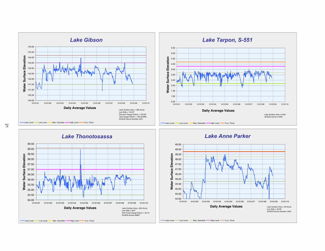
Lake Gibson
140.00
140.50
141.00
141.50
142.00
142.50
143.00
143.50
144.00
144.50
145.00
01/01/01 01/01/02 01/01/03 01/01/04 01/01/05 01/01/06 01/01/07 01/01/08 01/01/09 01/01/10
Daily Average Values
Wat
er S
urf
ace
Ele
vati
on
Lake Level Low Level Max. Desirable High Level 10 yr. Flood
Lake Surface Area = 480 AcresLow Slab = 144.81'Structure Gauge Datum = 100.00'Lake Gauge Datum = 135.00 MSLSCADA Device Number 2427
Lake Tarpon, S-551
0.50
1.00
1.50
2.00
2.50
3.00
3.50
4.00
4.50
5.00
5.50
01/01/01 01/01/02 01/01/03 01/01/04 01/01/05 01/01/06 01/01/07 01/01/08 01/01/09 01/01/10
Daily Average Values
Wat
er S
urf
ace
Ele
vati
on
Lake Level Low Level Max. Desirable High Level 10 yr. Flood
Lake Surface Area =2,534SCADA Device # 6491
Lake Thonotosassa
34.00
34.50
35.00
35.50
36.00
36.50
37.00
37.50
38.00
38.50
39.00
39.50
01/01/01 01/01/02 01/01/03 01/01/04 01/01/05 01/01/06 01/01/07 01/01/08 01/01/09 01/01/10
Daily Average Values
Wat
er S
urf
ace
Ele
vati
on
Lake Level Low Level Max. Desirable High Level 10 yr. Flood
Lake Surface Area = 824 AcresLow Slab = 39.0'Flint Creek Gauge Datum = 32.16SCADA Device #6807
Lake Anne Parker
44.00
44.50
45.00
45.50
46.00
46.50
47.00
47.50
48.00
48.50
49.00
49.50
01/01/01 01/01/02 01/01/03 01/01/04 01/01/05 01/01/06 01/01/07 01/01/08 01/01/09 01/01/10
Daily Average Values
Wat
er S
urf
ace
Ele
vati
on
Lake Level Low Level Max. Desirable High Level 10 yr. Flood
Lake Surface Area = 93 AcresLow Slab = 40.09'SCADA Device Number: 8491
21

Lake Hanna
56.00
56.50
57.00
57.50
58.00
58.50
59.00
59.50
60.00
60.50
61.00
61.50
62.00
62.50
63.00
63.50
01/01/01 01/01/02 01/01/03 01/01/04 01/01/05 01/01/06 01/01/07 01/01/08 01/01/09 01/01/10
Daily Average Values
Wat
er S
urf
ace
Ele
vati
on
Lake Level Low Level Max. Desirable High Level 10 yr. Flood
Lake Surface Area = 29 AcresLow Slab = 63.68'SCADA Device #7531
Lake Keene
57.00
57.50
58.00
58.50
59.00
59.50
60.00
60.50
61.00
61.50
62.00
62.50
63.00
63.50
64.00
01/01/01 01/01/02 01/01/03 01/01/04 01/01/05 01/01/06 01/01/07 01/01/08 01/01/09 01/01/10
Daily Average Values
Wat
er S
urf
ace
Ele
vati
on
Lake Level Low Level Max. Desirable High Level 10 yr. Flood
Lake Surface Area = 31 AcresSCADA Device Number 7631
Lake Kell
62.50
63.00
63.50
64.00
64.50
65.00
65.50
66.00
66.50
67.00
67.50
01/01/01 01/01/02 01/01/03 01/01/04 01/01/05 01/01/06 01/01/07 01/01/08 01/01/09 01/01/10
Daily Average Values
Wat
er S
urf
ace
Ele
vati
on
Level Low Level Max. Desirable High Level 10 Yr. Flood
Lake Surface Area = 31 AcresLow Slab = 68.09'Structure Gauge Datum = 62.95'Lake Gauge Datum = 54.45' MSLSCADA #1981
Lake Stemper
55.00
55.50
56.00
56.50
57.00
57.50
58.00
58.50
59.00
59.50
60.00
60.50
61.00
61.50
62.00
62.50
63.00
01/01/01 01/01/02 01/01/03 01/01/04 01/01/05 01/01/06 01/01/07 01/01/08 01/01/09 01/01/10
Daily Average Values
Wat
er S
urf
ace
Ele
vati
on
Lake Level Low Level Max. Desirable High Level 10 yr. Flood
Lake Surface Area = 58.32 AcresLow Slab = 63.70Lake Gauge Datum = 30.3 MSLSCADA Device # 2067
22

Bay Lake
43.00
43.50
44.00
44.50
45.00
45.50
46.00
46.50
47.00
47.50
48.00
01/01/01 01/01/02 01/01/03 01/01/04 01/01/05 01/01/06 01/01/07 01/01/08 01/01/09 01/01/10
Daily Average Values
Wat
er S
urf
ace
Ele
vati
on
Lake Level Low Level Max. Desireable High Level 10 yr. Flood
Lake Surface area = 37 AcresLow Slab = 47.80'Structure Gauge Datum = Direct Read
Lake auge Datum = Direct ReadSCADA Device Number = 1647
Lake Carroll
32.00
32.50
33.00
33.50
34.00
34.50
35.00
35.50
36.00
36.50
37.00
37.50
38.00
38.50
01/01/01 01/01/02 01/01/03 01/01/04 01/01/05 01/01/06 01/01/07 01/01/08 01/01/09 01/01/10
Daily Average Values
Wat
er S
urf
ace
Ele
vati
on
Lake Level Low Level Max. Desirable High Level 10 yr.Flood
Lake Surface Area = 188 AcresLow Slab = 39.50'Structure Gauge Datum = 31.86'Lake Gauge Datum = 30.0 MSLSCADA Device Number: 2087
Crescent Lake
37.00
37.50
38.00
38.50
39.00
39.50
40.00
40.50
41.00
41.50
42.00
42.50
43.00
43.50
44.00
44.50
01/01/01 01/01/02 01/01/03 01/01/04 01/01/05 01/01/06 01/01/07 01/01/08 01/01/09 01/01/10
Daily Average Values
Wat
er S
urf
ace
Ele
vati
on
Level Low Level Max. Desirable High Level 10 yr. Flood
Lake Surface Area = 50 AcresLow Slab = 44.63'Structure Gauge Datum = Direct ReadLake Gauge Datum = Direct ReadSCADA Device Number = 1667
Lake Island Ford
36.00
36.50
37.00
37.50
38.00
38.50
39.00
39.50
40.00
40.50
41.00
41.50
42.00
42.50
01/01/01 01/01/02 01/01/03 01/01/04 01/01/05 01/01/06 01/01/07 01/01/08 01/01/09 01/01/10
Daily Average Values
Wat
er S
urf
ace
Ele
vati
on
WSE Low Level Max Desirable High Level 10 yr. Flood
Lake Surface Area = 96 AcresLow Slab = 42.64Structure Gauge Datum = 36.54'SCADA Device number = 1621
23

Lake Keystone
38.00
38.50
39.00
39.50
40.00
40.50
41.00
41.50
42.00
42.50
43.00
43.50
01/01/01 01/01/02 01/01/03 01/01/04 01/01/05 01/01/06 01/01/07 01/01/08 01/01/09 01/01/10
Daily Average Values
Wat
er S
urf
ace
Ele
vati
on
Lake Level Low Level Max. Desirable High Level 10 yr. Flood
Lake Surface Area = 388 AcresLow Slab = 43.53'Structure Gauge Datum = Direct ReadLake Gauge Datum = Direct ReadSCADA Device Number: 6161
Lakes Ellen and Lipsey
37.50
38.00
38.50
39.00
39.50
40.00
40.50
41.00
41.50
42.00
42.50
01/01/01 01/01/02 01/01/03 01/01/04 01/01/05 01/01/06 01/01/07 01/01/08 01/01/09 01/01/10
Daily Average Values
Wat
er S
urf
ace
Ele
vati
on
Lipsey WSE Lake Ellen Low Level Max. Desirable Min. Flood
Lake Surface Area = 22 AcresLow Slab = 42.35'SCADA Device Number 1791
Lake Magdalene
45.00
45.50
46.00
46.50
47.00
47.50
48.00
48.50
49.00
49.50
50.00
50.50
51.00
01/01/01 01/01/02 01/01/03 01/01/04 01/01/05 01/01/06 01/01/07 01/01/08 01/01/09 01/01/10
Daily Average Values
Wat
er S
urf
ace
Ele
vati
on
Structure Level Lake Level Low Level Max. Desirable High Level 10 yr. Flood
Lake Surface Area = 232 AcresLow Slab = 51.80'Structure Gauge Datum = 45.52Lake Gauge Datum = 30.0 MSL
Lake Pretty
41.50
42.00
42.50
43.00
43.50
44.00
44.50
45.00
45.50
46.00
46.50
47.00
47.50
01/01/01 01/01/02 01/01/03 01/01/04 01/01/05 01/01/06 01/01/07 01/01/08 01/01/09 01/01/10
Daily Average Values
Wat
er S
urf
ace
Ele
vati
on
Level Low Level Max. Desirable High Level 10 Yr. Flood
Lake Surface Area = 184 Acres(Pretty, Rock, Josephine combined)Low Slab = 47.10'Structure Gauge Datum = 40.00'Lake Gauge Datum = 31.74' MSLSCADA Device #1967
24
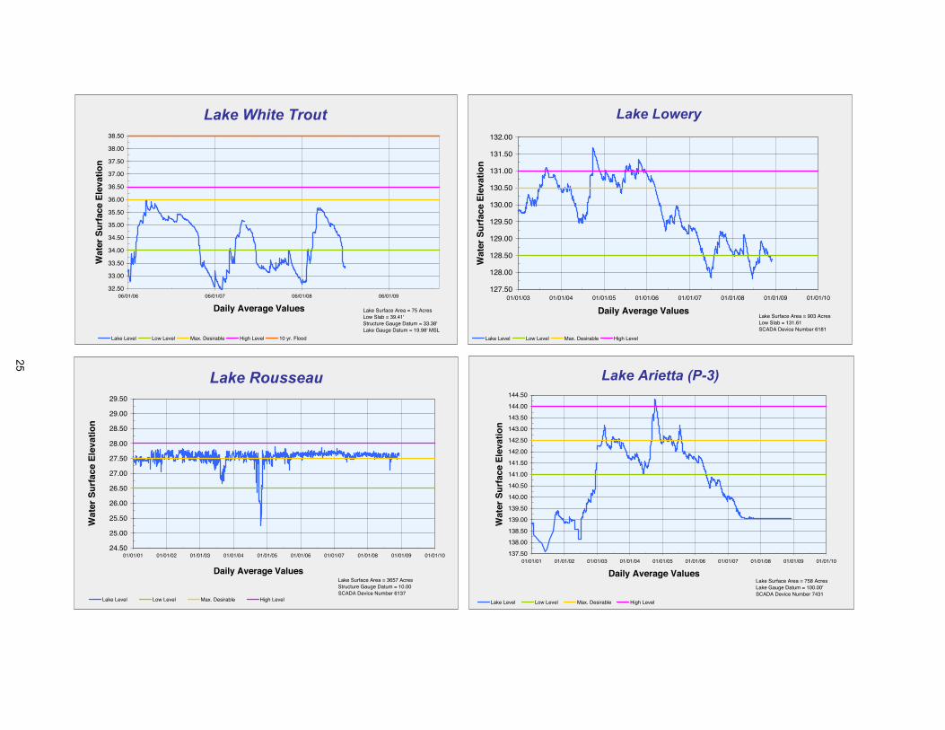
Lake White Trout
32.50
33.00
33.50
34.00
34.50
35.00
35.50
36.00
36.50
37.00
37.50
38.00
38.50
06/01/06 06/01/07 06/01/08 06/01/09
Daily Average Values
Wat
er S
urf
ace
Ele
vati
on
Lake Level Low Level Max. Desirable High Level 10 yr. Flood
Lake Surface Area = 75 AcresLow Slab = 39.41'Structure Gauge Datum = 33.38'Lake Gauge Datum = 19.98' MSL
Lake Lowery
127.50
128.00
128.50
129.00
129.50
130.00
130.50
131.00
131.50
132.00
01/01/03 01/01/04 01/01/05 01/01/06 01/01/07 01/01/08 01/01/09 01/01/10
Daily Average Values
Wat
er S
urf
ace
Ele
vati
on
Lake Level Low Level Max. Desirable High Level
Lake Surface Area = 903 AcresLow Slab = 131.61SCADA Device Number 6181
Lake Rousseau
24.50
25.00
25.50
26.00
26.50
27.00
27.50
28.00
28.50
29.00
29.50
01/01/01 01/01/02 01/01/03 01/01/04 01/01/05 01/01/06 01/01/07 01/01/08 01/01/09 01/01/10
Daily Average Values
Wat
er S
urf
ace
Ele
vati
on
Lake Level Low Level Max. Desirable High Level
Lake Surface Area = 3657 AcresStructure Gauge Datum = 10.00SCADA Device Number 6137
Lake Arietta (P-3)
137.50
138.00
138.50
139.00
139.50
140.00
140.50
141.00
141.50
142.00
142.50
143.00
143.50
144.00
144.50
01/01/01 01/01/02 01/01/03 01/01/04 01/01/05 01/01/06 01/01/07 01/01/08 01/01/09 01/01/10
Daily Average Values
Wat
er S
urf
ace
Ele
vati
on
Lake Level Low Level Max. Desirable High Level
Lake Surface Area = 758 AcresLake Gauge Datum = 100.00'SCADA Device Number 7431
25

Hernando Pool
32.0032.5033.0033.5034.0034.5035.0035.5036.0036.5037.0037.5038.0038.5039.0039.5040.0040.50
01/01/01 01/01/02 01/01/03 01/01/04 01/01/05 01/01/06 01/01/07 01/01/08 01/01/09 01/01/10
Daily Average Values
Wat
er S
urf
ace
Ele
vati
on
Lake Level Low Level Max. Desirable High Level 10 yr. Flood
Lake Surface Area = 6200 AcresLow Slab = 40.47'Structure Gauge Datum = Direct ReadLake Gauge Datum = Direct ReadSCADA # 2047
Inverness Pool
31.5032.0032.5033.0033.5034.0034.5035.0035.5036.0036.5037.0037.5038.0038.5039.0039.5040.0040.5041.0041.5042.00
01/01/01 01/01/02 01/01/03 01/01/04 01/01/05 01/01/06 01/01/07 01/01/08 01/01/09 01/01/10
Daily Average Values
Wat
er S
urf
ace
Ele
vati
on
Level Low Level Max. Desirable High Level 10 Yr. Flood
Lake Surface Area = 8000 AcresLow Slab = 42.54'Structure Gauge Datum = Direct ReadLake Gauge Datum = Direct ReadSCADA # 2027
Leslie Heifner
35.50
36.00
36.50
37.00
37.50
38.00
38.50
39.00
39.50
40.00
40.50
41.00
41.50
42.00
42.50
43.00
01/01/01 01/01/02 01/01/03 01/01/04 01/01/05 01/01/06 01/01/07 01/01/08 01/01/09 01/01/10
Daily Average Values
Wat
er S
urf
ace
Ele
vati
on
Upstream Level Downsream Level Low Level Max.Desirable High Level
Lake Surface Area = 37 AcresLow Slab = 47.80'SCADA Device #6767 & #6766
Floral City Pool
30.5031.0031.5032.0032.5033.0033.5034.0034.5035.0035.5036.0036.5037.0037.5038.0038.5039.0039.5040.0040.5041.0041.5042.0042.5043.0043.50
01/01/01 01/01/02 01/01/03 01/01/04 01/01/05 01/01/06 01/01/07 01/01/08 01/01/09 01/01/10
Daily Average Values
Wat
er S
urf
ace
Ele
vati
on
Level Low Level Max. Desirable High Level 10 Yr. Flood
Lake Surface Area = 9100 AcresLow Slab = 44.10'Structure Gauge Datum = Direct ReadLake Gauge Datum = Direct ReadSCADA #2007
26

Lake Fannie (P-7)
120.00
120.50
121.00
121.50
122.00
122.50
123.00
123.50
124.00
124.50
125.00
125.50
126.00
126.50
127.00
127.50
01/01/01 01/01/02 01/01/03 01/01/04 01/01/05 01/01/06 01/01/07 01/01/08 01/01/09 01/01/10
Daily Average Values
Wat
er S
urf
ace
Ele
vati
on
Lake Level Low Level Max. Desirable High Level 10 Yr. Flood
Lake Surface Area = 833 AcresLow Slab = 127.60'Lake Gauge Datum = 120.36 MSLSCADA Device #2187
Lake Hamilton (P-8)
117.50
118.00
118.50
119.00
119.50
120.00
120.50
121.00
121.50
122.00
122.50
123.00
01/01/01 01/01/02 01/01/03 01/01/04 01/01/05 01/01/06 01/01/07 01/01/08 01/01/09 01/01/10
Daily Average Values
Wat
er S
urf
ace
Ele
vati
on
Lake Level Low Level Max. Desirable High Level 10 Yr. Flood
Lake Surface Area = 2,640 AcresLake Gauge Datum = 115.00'SCADA Device Number = 1747
Lake Hancock (P-11)
95.0095.5096.0096.5097.0097.5098.0098.5099.0099.50
100.00100.50101.00101.50102.00102.50103.00
01/01/01 01/01/02 01/01/03 01/01/04 01/01/05 01/01/06 01/01/07 01/01/08 01/01/09 01/01/10
Daily Average Values
Wat
er S
urf
ace
Ele
vati
on
Gauge at Structure Lake Level Low Level Max Desirable High Level 10 yr. Flood
Lake Surface Area = 4,541 AcresLake Gauge Datum = 92.78' MSLStructure Gauge Datum = 84.08'SCADA Device Number = 1767 & 4087
Lake Henry (P-5)
121.50
122.00
122.50
123.00
123.50
124.00
124.50
125.00
125.50
126.00
126.50
127.00
127.50
128.00
01/01/01 01/01/02 01/01/03 01/01/04 01/01/05 01/01/06 01/01/07 01/01/08 01/01/09 01/01/10
Daily Average Values
Wat
er S
urf
ace
Ele
vati
on
Lake Level Low Level Max. Desirable High Level 10 Yr. Flood
Lake Surface Area = 861 AcresStructure Gauge Datum = 100.00' MSLS.R. Gauge Datum = 120.00' MSLSCADA Device Number 1807
27
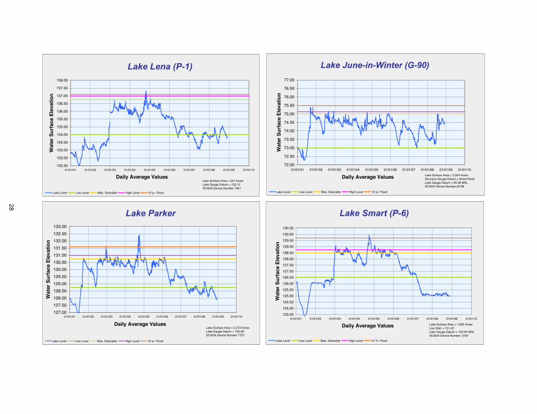
Lake Lena (P-1)
132.50
133.00
133.50
134.00
134.50
135.00
135.50
136.00
136.50
137.00
137.50
138.00
01/01/01 01/01/02 01/01/03 01/01/04 01/01/05 01/01/06 01/01/07 01/01/08 01/01/09 01/01/10
Daily Average Values
Wat
er S
urf
ace
Ele
vati
on
Lake Level Low Level Max. Desirable High Level 10 yr. Flood
Lake Surface Area = 207 AcresLake Gauge Datum = 132.12SCADA Device Number 7451
Lake June-in-Winter (G-90)
72.00
72.50
73.00
73.50
74.00
74.50
75.00
75.50
76.00
76.50
77.00
01/01/01 01/01/02 01/01/03 01/01/04 01/01/05 01/01/06 01/01/07 01/01/08 01/01/09 01/01/10
Daily Average Values
Wat
er S
urf
ace
Ele
vati
on
Lake Level Low Level Max. Desirable High Level 10 yr. Flood
Lake Surface Area = 3,504 AcresStructure Gauge Datum = Direct ReadLake Gauge Datum = 65.38 MSLSCADA Device Number=6136
Lake Parker
127.00
127.50
128.00
128.50
129.00
129.50
130.00
130.50
131.00
131.50
132.00
132.50
133.00
01/01/01 01/01/02 01/01/03 01/01/04 01/01/05 01/01/06 01/01/07 01/01/08 01/01/09 01/01/10
Daily Average Values
Wat
er S
urf
ace
Ele
vati
on
Lake Level Low Level Max. Desirable High Level 10 yr. Flood
Lake Surface Area = 2,272 AcresLake Gauge Datum = 100.00'SCADA Device Number 7721
Lake Smart (P-6)
123.50
124.00
124.50
125.00
125.50
126.00
126.50
127.00
127.50
128.00
128.50
129.00
129.50
130.00
130.50
01/01/01 01/01/02 01/01/03 01/01/04 01/01/05 01/01/06 01/01/07 01/01/08 01/01/09 01/01/10
Daily Average Values
Wat
er S
urf
ace
Ele
vati
on
Lake Level Low Level Max. Desirable High Level 10 Yr. Flood
Lake Surface Area = 1,820 AcresLow Slab = 131.43'Lake Gauge Datum = 120.00' MSLSCADA Device Number: 2167
28

Sawgrass Lake
2.00
3.00
4.00
5.00
6.00
7.00
8.00
9.00
01/01/01 01/01/02 01/01/03 01/01/04 01/01/05 01/01/06 01/01/07 01/01/08 01/01/09 01/01/10
Daily Average Values
Wat
er S
urf
ace
Ele
vati
on
Lake Level Low Level High Level
Lake Surface Area = 21 AcresLow Slab = N/ALake Gauge Datum = Direct ReadSCADA Device Number
Lake Armistead
38.0038.5039.0039.5040.0040.5041.0041.5042.0042.5043.0043.5044.0044.5045.0045.5046.0046.5047.00
01/01/01 01/01/02 01/01/03 01/01/04 01/01/05 01/01/06 01/01/07 01/01/08 01/01/09 01/01/10
Daily Average Values
Wat
er S
urf
ace
Ele
vati
on
Lake Level Low Level Max. Desirable High Level 10 yr. Flood
Lake Surface Area = 35 AcresLow Slab = 45.72'Lake Gauge Datum = Direct ReadSCADA Device Number 7671
Lake Haines
125.00
125.50
126.00
126.50
127.00
127.50
128.00
128.50
129.00
129.50
130.00
01/01/01 01/01/02 01/01/03 01/01/04 01/01/05 01/01/06 01/01/07 01/01/08 01/01/09 01/01/10
Daily Average Values
Wat
er S
urf
ace
Ele
vati
on
Lake Level Low Level Max. Desirable High Level 10 yr. Flood
Lake Surface Area = 716 AcresLow Slab = 131.61'Lake Gauge Datum = 100.00'SCADA Device Number 7571
Medard
57.0
57.5
58.0
58.5
59.0
59.5
60.0
60.5
61.0
61.5
62.0
62.5
63.0
63.5
64.0
64.5
65.0
65.5
01/01/01 01/01/02 01/01/03 01/01/04 01/01/05 01/01/06 01/01/07 01/01/08 01/01/09 01/01/10
Daily Average Values
Wat
er S
urf
ace
Ele
vati
on
Water Level Low Level Max. Desirable High Level 10 Yr. Flood
29
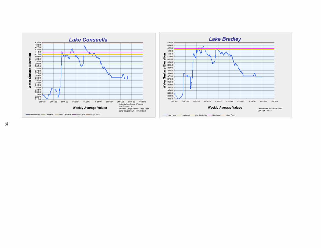
Lake Consuella
31.5032.0032.5033.0033.5034.0034.5035.0035.5036.0036.5037.0037.5038.0038.5039.0039.5040.0040.5041.0041.5042.0042.5043.0043.50
01/01/01 01/01/02 01/01/03 01/01/04 01/01/05 01/01/06 01/01/07 01/01/08 01/01/09 01/01/10
Weekly Average Values
Wat
er S
urf
ace
Ele
vati
on
Water Level Low Level Max. Desirable High Level 10 yr. Flood
Lake Surface Area = 37 AcresLow Slab = 47.80'Structure Gauge Datum = Direct ReadLake Gauge Datum = Direct Read
Lake Bradley
33.5034.0034.5035.0035.5036.0036.5037.0037.5038.0038.5039.0039.5040.0040.5041.0041.5042.0042.5043.0043.50
01/01/01 01/01/02 01/01/03 01/01/04 01/01/05 01/01/06 01/01/07 01/01/08 01/01/09 01/01/10
Weekly Average Values
Wat
er S
urf
ace
Ele
vati
on
Lake Level Low Level Max. Desirable High Level 10 yr. Flood
Lake Surface Area = 590 AcresLow Slab = 44.38'
30

Item 49
Resource Management Committee December 16, 2008
Routine Report
Watershed Management Program and Federal Emergency Management Agency Map Modernization
District staff continues to work on various steps of the District’s Watershed Management Program and Federal Emergency Management Agency Map Modernization. Attached for the Board’s information is the current schedule that identifies the status of each watershed for the topographic information, watershed evaluation, watershed management plan, and Flood Insurance Rate Maps (FIRMs). The list also indicates whether the updated FIRMs will be a redelineation of the existing FIRMs or based on a detailed study.
Staff Recommendation: See Exhibit
This item is provided for the Committee's information, and no action is required.
Presenter: Mark Hammond, Director, Resource Projects Department
31
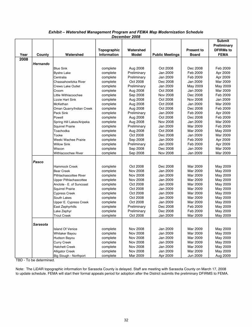
Year County WatershedTopographicInformation
WatershedModel Public Meetings
Present to Board
SubmitPreliminaryDFIRMs to
FEMA2008
HernandoBlue Sink complete Aug 2008 Oct 2008 Dec 2008 Feb 2009Bystre Lake complete Preliminary Jan 2009 Feb 2009 Apr 2009Centralia complete Preliminary Jan 2009 Feb 2009 Apr 2009Chassahowitzka River complete Oct 2008 Dec 2008 Jan 2009 Mar 2009Crews Lake Outlet complete Preliminary Jan 2009 May 2009 May 2009Croom complete Aug 2008 Oct 2008 Jan 2009 Mar 2009Little Withlacoochee complete Sep 2008 Nov 2008 Dec 2008 Feb 2009Lizzie Hart Sink complete Aug 2008 Oct 2008 Nov 2008 Jan 2009McKethan complete Aug 2008 Oct 2008 Jan 2009 Mar 2009Oman Quarry/Indian Creek complete Aug 2008 Oct 2008 Dec 2008 Feb 2009Peck Sink complete Preliminary Jan 2009 Feb 2009 Apr 2009Powell complete Aug 2008 Oct 2008 Dec 2008 Feb 2009Spring Hill Lakes/Aripeka complete Aug 2008 Nov 2008 Jan 2009 Mar 2009Squirrel Prairie complete Preliminary Jan 2009 Mar 2009 Feb 2009Toachodka complete Aug 2008 Oct 2008 Mar 2009 May 2009Tooke complete Oct 2008 Dec 2008 Jan 2009 Mar 2009Weeki Wachee Prairie complete Sep 2008 Jan 2009 Feb 2009 Apr 2009Willow Sink complete Preliminary Jan 2009 Feb 2009 Apr 2009Wiscon complete Sep 2008 Dec 2008 Jan 2009 Mar 2009Withlacoochee River complete Sep 2008 Nov 2008 Jan 2009 Mar 2009
PascoHammock Creek complete Oct 2008 Dec 2008 Mar 2009 May 2009Bear Creek complete Nov 2008 Jan 2009 Mar 2009 May 2009Pithlachascottee River complete Nov 2008 Jan 2009 Mar 2009 May 2009Upper Pithlachascottee complete Nov 2008 Jan 2009 Mar 2009 May 2009Anclote - E. of Suncoast complete Oct 2008 Jan 2009 Mar 2009 May 2009Squirrel Prairie complete Oct 2008 Jan 2009 Mar 2009 May 2009Cypress Creek complete Oct 2008 Jan 2009 Mar 2009 May 2009South Lakes complete Oct 2008 Jan 2009 Mar 2009 May 2009Upper E. Cypress Creek complete Oct 2008 Jan 2009 Mar 2009 May 2009East Zephyrhills complete Preliminary Dec 2008 Feb 2009 May 2009Lake Zephyr complete Preliminary Dec 2008 Feb 2009 May 2009Trout Creek complete Oct 2008 Jan 2009 Mar 2009 May 2009
SarasotaIsland Of Venice complete Nov 2008 Jan 2009 Mar 2009 May 2009Whitaker Bayou complete Nov 2008 Jan 2009 Mar 2009 May 2009Hudson Bayou complete Nov 2008 Jan 2009 Mar 2009 May 2009Curry Creek complete Nov 2008 Jan 2009 Mar 2009 May 2009Hatchett Creek complete Nov 2008 Jan 2009 Mar 2009 May 2009Alligator Creek complete Nov 2008 Jan 2009 Mar 2009 May 2009Big Slough - Northport complete Mar 2009 Apr 2009 Jun 2009 Aug 2009
TBD - To be determined.
Note: The LiDAR topographic information for Sarasota County is delayed. Staff are meeting with Sarasota County on March 17, 2008to update schedule. FEMA will start their formal appeals period for adoption after the District submits the preliminary DFIRMS to FEMA.
December 2008Exhibit – Watershed Management Program and FEMA Map Modernization Schedule
32

Year County WatershedTopographicInformation
WatershedModel Public Meetings
Present to Board
SubmitPreliminaryDFIRMs to
FEMA2009
PolkGator Creek complete Mar 2009 Apr - May 2009 Jun 2009 Sep 2009Saddle Creek complete Mar 2009 Apr - May 2009 Jun 2009 Sep 2009Lake Lulu -PCDC complete Mar 2009 Apr - May 2009 Jun 2009 Sep 2009Lake Hamilton -PCDC complete Mar 2009 Apr - May 2009 Jun 2009 Sep 2009Itchepackesassa Creek complete Mar 2009 Apr - May 2009 Jun 2009 Sep 2009Poley Creek/North Alafia complete Mar 2009 Apr - May 2009 Jun 2009 Sep 2009Peace CreekCanal complete Mar 2009 Apr - May 2009 Jun 2009 Sep 2009Polk City complete Mar 2009 Apr - May 2009 Jun 2009 Sep 2009
DeSotoThornton Branch complete Dec 2008 Mar 2009 Jun 2009 Sep 2009Deep Creek Gully complete Dec 2008 Mar 2009 Jun 2009 Sep 2009
HardeeCity of Wauchula complete Dec 2008 Mar 2009 Jun 2009 Sep 2009Horse Creek complete Dec 2008 Mar 2009 Jun 2009 Sep 2009Alligator Branch complete Dec 2008 Mar 2009 Jun 2009 Sep 2009Thompson Branch complete Dec 2008 Mar 2009 Jun 2009 Sep 2009
HighlandsCarter Creek complete Jun 2009 Oct 2009 Jan 2010 May 2010Avon Park complete Jun 2009 Oct 2009 Jan 2010 May 2010Sebring complete Jun 2009 Oct 2009 Jan 2010 May 2010
CitrusWithlacoochee River complete Feb 2009 Apr 2009 Jun 2009 Dec 2009Crystal River complete Jan 2009 Apr 2009 Jun 2009 Dec 2009Tsala Apopka Outlet complete Feb 2009 Apr 2009 Jun 2009 Dec 2009Shinn Ditch complete Feb 2009 Apr 2009 Jun 2009 Dec 2009Homosassa South Fork complete Feb 2009 Apr 2009 Jun 2009 Dec 2009Leslie Heifner Canal complete Feb 2009 Apr 2009 Jun 2009 Dec 2009Cardinal Lane complete Jan 2009 Apr 2009 Jun 2009 Dec 2009Lake Bradley complete Feb 2009 Apr 2009 Jun 2009 Dec 2009Floral City complete Feb 2009 Apr 2009 Jun 2009 Dec 2009Inverness complete Feb 2009 Apr 2009 Jun 2009 Dec 2009Center Ridge complete Jan 2009 Apr 2009 Jun 2009 Dec 2009Homosassa River - South complete Feb 2009 Apr 2009 Jun 2009 Dec 2009Homosassa River - North complete Feb 2009 Apr 2009 Jun 2009 Dec 2009
SumterBig Prairie complete TBD TBD TBD TBDBushnell complete TBD TBD TBD TBDGant Lake complete TBD TBD TBD TBDJumper Creek Canal complete TBD TBD TBD TBDWebster complete complete TBD TBD TBD
TBD - To be determined.
Note: FEMA will start their formal appeals period for adoption after the District submits the preliminary DFIRMS to FEMA.
Exhibit – Watershed Management Program and FEMA Map Modernization ScheduleDecember 2008
33

Item 50
Resource Management CommitteeDecember 16, 2008
Routine Report
Significant Water Supply and Resource Development Projects
This report provides information on significant Resource Management projects and programs in which the Governing Board participates in funding. The report provides a short status of significant activities associated with the project that have recently occurred or are about to happen. For greater detail, refer to the Project Notes write-ups or request information directly from the project managers.
The District received the Conceptual Environmental Resource Permit (CERP) from the Florida Department of Environmental Protection (FDEP) in June 2007 for the Lake Hancock Lake Level Modification Project with an operating level of up to 100 feet. In September 2007, the Governing Board authorized staff to implement the Lake Hancock Lake Level Modification Project (final design, permitting, and construction) for a lake operating level of 100.0 feet National Geodetic Vertical Datum (NGVD); adopted the Resolution Authorizing Proceedings in Eminent Domain, including a Declaration of Taking; amended the 2007 Update to the Florida Forever Work Plan to include all lands identified as necessary for the Project and designated $41 million in Florida Forever Trust Funds for the Project; and designated and encumbered$79 million in General Fund Water Supply and Resource Development Reserves for the Project. District staff continues to coordinate with affected property owners or their legal counsel.Seventy-three parcels (7,256 acres) were identified as necessary to acquire in fee or a lesser interest in order for the Project to go forward. At the September 2007 Governing Board meeting, the Board instructed staff to exhaust all negotiations prior to filing eminent domain proceedings. The legal description accompanying the resolution authorizing proceedings in eminent domain was based on geographic boundaries delineated by a model, and therefore would require detailed survey work and ground-truthing for negotiations. The survey work and appraisals required for a public works project, such as the Lake Level Project, are some of the most important components of the due diligence process; and depending on the complexity of the parcels/project, they can be some of the most time consuming components. In the case of the Lake Level Project, which will inundate all or portions of parcels permanently or temporarily, a simple boundary survey of a parcel is inadequate. Whether acquiring a parcel in fee or acquiring an easement over a portion or all of a parcel, it is necessary for the District, the owner, the owner's representative, and the appraisers to understand on the ground the pre- and post-effects the project will have on the parcel, including the improvements (house, pool, outbuildings, septic systems, wells, landscaping, etc.). Thus the surveys and the appraisals for the Lake Level Project have been more complex and time consuming than that which are required in the District's traditional voluntary conservation acquisition program. New Activities Since Last Meeting: A meeting with FDEP was held on November 12, 2008, to discuss the permitting approach for the individual projects associated with the CERP. The individual projects include construction of the replacement P-11 Lake Hancock outfall structure, drainage improvements along the Polk County Parkway near Saddle Creek, drainage improvements along Highway 540 in the Jacque Lee Lane area, conveyance improvements on the former Old Florida Plantation and Coscia properties, restoration of Lake Lena Run, construction of the Water Wood/Riverlake stormwater pond, and any other possible improvements requiring an Environmental Resource Permit (ERP) as part of the lake level modification. The District's consultant BCI Engineers and Scientists, Inc., is finalizing the design of the Water Wood/Riverlake stormwater pond, which will be the first individual project as part of the CERP to be submitted to FDEP for an ERP. The District's consultant DMK Associates, Inc., is currently working on the conceptual design of the replacement P-11 Lake Hancock outfall structure,which is scheduled for completion by March 2009. Acquisition status: Of the 73 parcels necessary for the project, 32 parcels containing 6,612.12 acres (including 18 homes) have been
Lake Hancock Lake Level Modification Project
34
Item 50
acquired through the voluntary acquisition process. The remaining acquisitions include a total of 41 parcels containing 301.29 acres. These 41 parcels are comprised of 14 fee acquisition parcels (14 homes) and 27 partial easement acquisitions. District staff have made offers on all fee acquisitions and are continuing the necessary and complex due diligence in order to prepare offers to owners for the partial easements. Staff brought and amended the eminent domain resolution to the Governing Board in October. Nine of the remaining parcels with single-family residences have been given to the District's special counsel who will proceed with offers that willbe made in accordance with Florida Statutes before initiation of litigation. Project Managers: Scott Letasi/Steve Blaschka
At the February 2006 Governing Board meeting, the Board approved the staff recommendation to adopt a 27 percent nitrogen load reduction goal and to utilize wetlands as the primary treatment component. The District's consultant (Parsons) has completed constructability and the initial geotechnical testing at the proposed location of the treatment wetlands and a Basis of Design Report (BODR). The BODR establishes the objectives, data, and assumptions that form the foundation of design (configuration of wetland cells and infrastructure). The current phase includes design, permitting, and additional geotechnical evaluation. The District conducted a plant establishment study to evaluate wetland construction methods, different types of wetland plants, exotic plant control techniques, and water quality trends. Other tasks include habitat enhancement on adjacent, District-owned parcels. The objective of habitat enhancement is to maintain a vegetated corridor along South Saddle Creek for migratory birds. New Activities Since Last Meeting: The District's consultant continued design and permitting tasks, with the 60 percent design plan deliverable and permit application submittal anticipated inFebruary 2009. Geotechnical testing and survey work continued. Additional geotechnical testing was authorized to evaluate a limited area on the east side of the Old Florida Plantation property for structural fill needed for construction. The consultant submitted a draft U.S. Army Corps of Engineers permit application package for review by the District project manager. The objective is to initiate federal permitting in the near future to allow sufficient time for federal review. District and Polk County staff visited the District-owned parcels along South Saddle Creek that are slated for habitat enhancement. The County is interested in providing funding for the habitat enhancement project in order to gain mitigation credit for impacts at the County's landfill. Project Manager: Janie Hagberg
Lake Hancock Outfall Treatment Project
At the February 2006 Governing Board meeting, following the vote on the Lake Hancock Outfall Treatment Project, the Board directed staff to initiate a project for pilot testing of biological water treatment systems. At the May 2006 Governing Board meeting, the Board authorized staff to proceed with the pilot testing of biological water treatment systems and to hire a consultant to assist the District in the pilot testing project. CH2M Hill, Inc., was hired as project consultant and has completed a detailed literature review of periphyton-based biological water treatment systems, an evaluation of potential pilot test sites, project work plan, and project delivery method document. The consultant also assisted in developing a Scope of Work for the Request for Proposal (RFP). The RFP included two alternatives on which vendors bid: (1) study an existing system, and (2) construct a small pilot system. The District felt this approach provided the most cost efficient means of meeting project objectives while also providing vendors some flexibility in ways they can demonstrate the effectiveness of their systems. Proposals were received from two vendors (Genesis Group, LLC, and Hydromentia, Inc.) and were evaluated by the consultant. At its February 2008 meeting, the Governing Board: (1) authorized staff to negotiate an agreement with Hydromentia, Inc., for an enhanced study of their full-scale Taylor Creek facility in the South Florida Water Management District (SFWMD) for an amount not to exceed $400,000, and authorized the Executive Director to sign the agreement; and(2) authorized District staff to negotiate an amendment to the agreement with CH2M Hill, Inc., for an amount not to exceed $300,000 to provide an independent evaluation of Hydromentia's Taylor Creek facility, and authorized the Executive Director to execute the amendment. A Notice of Award was posted on March 17, 2008, indicating the District's intention to award the contract to Hydromentia, Inc. Hydromentia is currently experiencing treatment performance related issues associated with the Taylor Creek facility and has recommended the District not
Pilot Testing Of Biological Treatment Systems
35
Item 50
proceed with the current proposed study until these issues are addressed in order to get an accurate assessment of the technology. On July 1, 2008, Hydromentia submitted four potential approaches to consider for moving forward: (1) immediately initiate evaluation of Taylor Creek facility; (2) assist in identifying potential algae growth inhibitors, then initiate evaluation;(3) postpone evaluation until algal growth problem is resolved; and (4) build a pilot system instead of evaluating Taylor Creek. On July 28, 2008, the District project manager spoke with Hydromentia to discuss the status of the Taylor Creek facility. Hydromentia stated they are cooperating with the Florida Department of Agriculture and Consumer Services (FDACS) and the University of Florida's Institute of Food and Agricultural Services (IFAS) to screen for compounds in Taylor Creek that may be inhibiting the growth of algae at the Taylor Creek facility. District staff and Hydromentia agreed it was best to postpone the evaluation of the treatment technology until the Taylor Creek facility algal growth issues are resolved. Hydromentia agreed to provide the District project manager with regular updates on the status of the facility. New Activities Since Last Meeting: On November 18, 2008, the District project manager received email updates from Hydromentia regarding the status of the Taylor Creekfacility. The pumps for the Taylor Creek facility have been repaired, and the system has been operational during the month of November. Collaboration between Hydromentia, FDACS Bureau of Pesticides, and IFAS to test for compounds that inhibit algal growth continues. Project Manager: Gary Williams
In 2005, the Governing Board and Peace River Basin Board agreed to take on the responsibility to maintain and, where possible, improve the water conveyance/storage capabilities of the Peace Creek Canal. One of the primary tasks includes identification of property ownership in order for the District to obtain the necessary easements over the system. The work directly related to the Peace Creek Canal is part of the larger District effort, which started years earlier with watershed modeling, expanded in 2005; and will develop a watershed management plan that evaluates approximately 13,000 acres of lakes and 13,000 acres of wetland areas for potential surface water storage systems within the Peace Creek Watershed. Two temporary employees were hired for the District Operations Department to assist with the maintenance activities in the canal. New Activities Since Last Meeting: District staff performed aquatic weed control activities within the canal that involved mowing along the side banks, followed by chemical spraying. In some areas, the vegetation in the canal is being physically removed with District equipment. Construction on four sediment removal sites will be completed byDecember 31, 2008. The District is working with the consultant for the design and permitting of four additional sediment removal sites scheduled for completion in Spring 2009. Staff is coordinating with the City of Winter Haven and Polk County to review land use changes and right-of-way use needs for future maintenance. The District's consultant continues to work on the modeling requirements necessary to update the Digital Flood Insurance Rate Maps (DFIRMs) and complete the Watershed Management Plan. Project Manager: Shelley Thornton
Peace Creek Watershed
Watershed Management Program/Federal Emergency
The District initiated a partnership with the Federal Emergency Management Agency (FEMA) to modernize Flood Insurance Rate Maps (FIRMs) as part of its Watershed Management Program (WMP). Flood protection and floodplain information has been a priority at the District since theinception of the organization, and that priority was renewed following the El Niño weather event in 1997-1998. In addition to studies conducted by the District (primarily through the Basin Boards) and others, information on floodplains (elevations) is available through the FEMA FIRMs. However, many of the existing maps do not accurately represent the flood-prone areas, either because the initial studies were technically limited or the maps are outdated due to significant land use changes since completion. To improve the floodplain information, develop regional scale flood routing models for alternative analysis, and improve local government's understanding of their flood protection level of service, the District reached out to local governments and initiated the WMP in the late '90s. Additionally, the District and FEMA executed a Cooperating Technical Partners (CTP) Memorandum of Agreement on September 14, 2001, to formalize the relationship and to improve the existing FIRMs to better identify risks of flooding within the District. As a CTP, the District is eligible for federal funds to
Management Agency Map Modernization
36
Item 50
act as FEMA's partner in modernization of the FIRMs. Federal funds have allowed the District and local governments to accomplish significantly more than would have otherwise been possible. To date, the District has received approximately $11.2 million in federal funds from FEMA for countywide map modernization projects for Pasco, Sarasota, Hernando, Marion, Polk, Hardee, Desoto, Citrus, Sumter, Levy, and Highlands counties. An additional $0.9 million is expected in future fiscal years for countywide map modernization projects for Manatee County. The Map Modernization Program also includes federal funding for management support. For FY2004 through FY2008, the District received $782,860 and could receive an additional $350,000 through FY2012. FEMA began FIRM updates for Hillsborough and Marion counties before the District became a CTP. FEMA issued their letter of determination finalizing the FIRMs for Hillsborough and Marion counties and the FIRMs became effective on August 28, 2008. New Activities Since Last Meeting: The District’s consultants are focusing on watershed models in Hernando, Pasco, and Sarasota counties to address all errors and omissions and to update the watershed models to account for infiltration, and incorporate the latest topographic and other watershed information (to the extent practicable) into the models. District and local government staff met with the District’s consultants in November to discuss schedules, budgets, data collection, infiltration, high water information, and coordination issues. The preliminary floodplains are being submitted by the consultants for initial review by District staff. A public meeting was held on November 12, 2008, for three watersheds in Hernando County. Another public meeting for one watershed in Pasco County is scheduled forDecember 18, 2008, and others are being scheduled. Through November, four public meetings have been held at the District's Brooksville Headquarters for ten watersheds in Hernando County; 7801 property owners were notified, 143 attended the meetings, and 139 called or emailed staff regarding the floodplain information. The Governing Board authorized staff to submit the first preliminary FIRM to FEMA for the Lizzie Hart watershed at its November meeting. The 2007 Light Detection and Ranging (LiDAR) topographic information for Sarasota County was delayed. District staff is coordinating with the County and consultants to evaluate how the delay will affect the schedule for updating the watershed models. Project Manager: Gordon McClung
The Myakka River Watershed Initiative is a comprehensive project that will illustrate the effects of land use conversions and alterations and evaluate best management practices (BMPs) for restoration alternatives. The objective of this initiative is to restore water quality, natural system, and floodplain impacts in the watershed in ways that can also provide a benefit to watersupplies in the Southern Water Use Caution Area (SWUCA). In February 2006, the Governing Board allocated $500,000 to hire a consultant team to perform elements of the Watershed Management Program and for the collection of topographic information in eastern Manatee County using LiDAR mapping technologies. An agreement with the Singhofen & Associates consultant team was executed in December 2006 and a kick-off meeting was held with District staff. The consultant team and staff have held several outreach meetings to discuss the project in detail and solicit stakeholder input on issues and available sources of data. The water budget model was completed and used to compare existing and historic conditions to determine the amount of excess water in the Upper Myakka River Watershed. This information was also provided to the Authority for use in their water supply planning. The draft peer review document on the Upper Myakka Water Budget model was received in July 2008 and the consultant has finalized responses and revisions to the document. A work order for the consultant to evaluateflow reductions to Flatford Swamp and the corresponding changes in the hydroperiod of the swamp was approved September 9, 2008. A project status update was given to FDEP's Myakka River Management Coordinating Council (MRMCC) on September 12, 2008. New Activities Since Last Meeting: A team meeting was held on November 20, 2008, to brainstorm ideas for options to remove excess water from Flatford Swamp. A work order is under development to inventory the hydrologic, hydraulic, and other water resource features of the watershed; identification of additional survey requirements; and the preliminary generation of GIS databases in the Manatee County portion of the watershed and along the main stem of the river through the entire watershed. This work is in preparation for input into the hydraulic model that will be used to evaluate possible flood protection alternatives. The 2007 LiDAR
Myakka River Watershed Initiative
37

Item 50
topographic information for Sarasota County will be used to update the existing Digital Terrain Model. Project Manager: Lisann Morris
System Configuration II Project: The Governing Board approved the agreement with Tampa Bay Water (TBW) for the System Configuration II Project at its February 2007 meeting. The project, when completed in 2011, is expected to provide up to 25 million gallons per day (mgd) of alternative water to the regional system. The estimated total project cost is $254,971,221, with the District committing to half of eligible costs of $232,000,000, which is$116,000,000. The project seeks to increase TBW's overall system capacity by drawing more water from the Hillsborough River during high flows via the Tampa Bypass Canal (TBC), in combination with increasing the allowable percentage of withdrawals from the TBC. The projects are primarily associated with the construction of improvements to the regional systems treatment, transmission, and storage infrastructure. The project agreement was executed May 1, 2007, and TBW received approval of its Water Use Permit in June 2007. The design of the Surface Water Treatment Plant (SWTP) expansion and the four pump station expansion project components is complete and a notice to proceed with construction was issued in May 2008 for the SWTP. The SWTP Expansion will increase the plant's capacity from 66 mgd to a minimum of 99 mgd. The four pump station expansion project components include the Tampa Bypass Canal Pump Station Expansion, Tampa Bay Water Regional High Service Pump Station Expansion, Tampa Bay Water SWTP Repump Station Expansion, and the Cypress Creek Pump Station Expansion. Construction on Phase 1B of the South-Central Hillsborough Infrastructure Project component was completed onJanuary 31, 2008. The purpose of Phase IB is to provide potable water from the regional surface water treatment plant to TBW's Brandon/South Central Hillsborough service area and add yard piping improvements at the Lithia Water Treatment Plant. New Activities Since Last Meeting: Construction continues on Phase II of the South-Central Hillsborough Infrastructure Project. This phase will add disinfection facilities at Well Sites 5 and 7, raw water collection pipelines at the Brandon wells, and convert the Brandon and Brandon South-Central Connection pipelines to potable water supply. Well Site 5 is under construction and scheduled for substantial completion in January 2009. Well Site 7 was fully operational in September 2008 and has remaining punch list items to be completed. The SWTP, which will expand the plant’s capacity to a minimum of 99 mgd, is under construction. The construction on the Chlorine Contact Chamber and Clearwells 3 and 4 are underway. The new Sludge Drying Bed, Pretreatment Pond No. 2, and Pump Station No. 2 were completed and placed into operation. The Tampa Bypass Canal Pump Station expansion, one of four pump station expansion project components, has begun site mobilization. Design is complete for six out of the ten project components and are currently in pre-construction or construction phase. The remaining four projects are in the design phase, with anticipated completion by January 2009. Project Manager: Audrie Goodwin
Tampa Bay Water
Tampa Bay Seawater Desalination Plant: As outlined in the agreement between the District and Tampa Bay Water (TBW) for the seawater desalination facility, 25 percent ($21.25 million) of the $85 million being held by the District is payable upon acceptance of the facility by TBW. Of the remaining 75 percent, 25 percent will be provided to TBW when the plant is operated at a rate of 25 mgd for four consecutive months and the remaining 50 percent ($42.5 million)when the plant operates at an annual average of 12.5 mgd for 12 consecutive months. In addition, TBW will receive the interest accrued on the $85 million, since January 2006, when the plant operates at 20 mgd for 12 consecutive months beginning after the first year of operation and completed no later than December 31, 2010. Following American Water Pridesa's (AWP) completion of the required run-in period and acceptance test, AWP submitted an acceptance test report to TBW on November 27, 2007. After certification of the test results, TBW accepted the facility on December 26, 2007, which is considered the in-service date. The District processed the first 25 percent payment in the amount of $21,250,000 on January 24, 2008. New Activities Since Last Meeting: TBW's Tampa Bay Seawater Desalination Plant produced an average of 20.3 mgd since the plant was accepted on December 26, 2007. The plant produced an average of 19.4 mgd in November 2008. On
38

Item 50
December 26, 2008, TBW is expected to be eligible for the production milestone payment of $42.5 million. Please refer to the Water Production Supply Summary Routine Report, under the Regulation Committee tab, for additional historic pumpage information at the desalination facility. Project Manager: Ken Herd
Reservoir: Final design for the Regional Reservoir Expansion has been completed. In June 2007, the Authority received three bids for the reservoir expansion. The low bid of $64,910,500 was 21 percent higher than the engineer's estimate. The Authority asked the District to provide additional funding for the increased costs and as a result the Peace River and Manasota Basin Boards and the Governing Board approved an additional $3,703,704 in 2008 funding and $7,812,582 in 2009 funding for the reservoir project. The Authority Board approved the reservoir construction contract and issued a notice to proceed. In addition, FDEP and the U.S. Army Corps of Engineers issued the necessary permits to begin construction on the reservoir. New Activities Since Last Meeting: Reservoir construction is underway and considered to be 70 percent complete. The project appears to be on schedule for the March 2010 Final Completion of Construction deadline. In total, 2.8 million yards of fill have been moved. The reservoir embankment is 78 percent complete. When complete, the entire embankment is designed to reach a height of 35 feet. Along the north side of the reservoir, approximately 13,000 feet of high density polyethylene (HDPE) liner was installed. Approximately 12,000 feet of the 13,000 feet of installed HDPE liner has been backfilled and is ready for the installation of the soil cement. Recently installed 60-inch diameter pipe passedpressure testing. The Soil Cement mill was erected in the center of the reservoir and is scheduled for operation in December 2008. Currently, the contractor's methods on the soil cement and underlying drain system is under review. Pile drilling installation to support the three-story outlet tower has commenced. In addition to construction activities, ecological consultants are on site, as needed, for wildlife education, wildlife surveys, stormwater inspections and silt fence inspections.
Peace River/Manasota Regional Water Supply Authority
Facility: Construction of the Facility Expansion Project will occur through three separate contracts. The first contract, completed in May 2007, focused on site preparation. Thesecond contract is for construction of a maintenance building, dewatering facility, filters, storage tanks, thickeners, and chemical feed and disinfection stations. The third contract is for construction of an operations center. In February 2007, the Authority received one bid for Contract 2 for major components of the Facility Expansion. The bid was approximately$17 million over the original engineer's estimate of probable cost. Since receiving the bid, Authority staff and the contractor have negotiated a revised project cost $14 million below the original bid price. The Authority's Board approved the revised cost and authorized staff to enter into an agreement with the contractor in April 2007. Even with the newly negotiated bid price, the overall revised project cost remained $19 million over the original project cost. The Authority requested additional funding as a result of the increased costs and an additional $3,756,693 in 2008 Water Protection and Sustainability Trust Funds and $8,395,505 in 2009District funding were allocated to this project. New Activities Since Last Meeting:Construction continues on the facility and is considered 89 percent complete. The project appears to be on schedule for the March 2010 Final Completion of Construction deadline. Currently, 240 million gallons of water have been treated with portions of the expansion on-line. Instead of the water re-circulating from the expanded facilities to the reservoir, the water is currently serving customers. The major internal mechanisms and drive motors for the remaining two solid contact units are being prepared to be operational in manual mode, and electrical wiring in the conduits continues to be installed. The 1,500 kilowatt generator and 20,000 gallon hyper pneumatic tank were installed. Other ongoing construction activities include preparing the area for site draining and seeding/sodding around the building perimeters. Project Manager: Audrie GoodwinRegional Integrated Loop System Project: Charlotte County, Punta Gorda, and the Authority approved an agreement for the Regional Integrated Loop System Phase 1A. This pipeline creates an interconnect between the Authority and Punta Gorda's Water Treatment Plant (WTP) on Shell Creek while providing Charlotte County with additional opportunities for interconnects into the regional distribution system. Total cost for Phase 1A is estimated at $19,015,000. The District anticipates providing $12,007,500 toward the project, which
39
Item 50
includes $5,000,000 in West-Central Florida Water Restoration Action Plan (WRAP) Funding. The Authority Board approved the work order for Phase 3 of the Regional Loop System and issued a notice to proceed with preliminary engineering. The Phase 3 pipeline would be an extension of the Authority's regional transmission system currently terminating at the Carlton WTP. The first portion of this pipeline, Phase 3A, will provide an additional water delivery point to Sarasota County and the potential for an inter-tie to the City of Venice. The future expansion of Phase 3B would extend to Manatee County and connect to a proposed surface water treatment facility. The Phase 2 pipeline was originally planned to provide aninterconnect between the Authority's Peace River Facility and the City of North Port's WTP. On May 7, 2008, the Authority agreed to suspend the project. Instead of constructing the Phase 2 pipeline along its originally planned route, the City of North Port has proposed a new point of connection on the Authority’s existing 42-inch transmission main, which connects the Authority’s facility to Sarasota County’s Carlton WTP. New Activities Since Last Meeting:The Cooperative Funding Agreements for both Phase 1A and Phase 3A have been executed. A Notice to Proceed with Phase 3A was issued to the Authority on November 10, 2008. Project Manager: John FergusonRegional Water Supply Source Feasibility Study: The Regional Water Supply Source Feasibility Study will evaluate three alternative water supply sources: the Shell Creek, Cow Pen Slough/Dona Bay, and Upper Myakka River systems that were identified in the Authority’s Integrated Regional Water Supply Master Plan (IRWSMP) and Regional System Reliability Model (RSRM). The feasibility study contract was awarded to PBS&J in July 2007. The District entered into a cooperative funding agreement with the Authority for the feasibility study on September 18, 2007. The consultant team submitted the first deliverable onOctober 25, 2007, which summarized and inventoried existing data, relevant technical reports, and models. The Preliminary Alternatives Analysis was presented to the Authority Board at its December 2007 meeting. The analysis identified opportunities for water supply within the three major source areas. The project is anticipated to be completed in December 2008, but a decision on which projects to move forward into preliminary design may take until the first half of 2009. A draft Source Water Feasibility Report was completed in September and discussed at the TAC meeting held October 24. The draft report was presented to the Authority Board at its workshop on November 5, 2008. New Activities Since Last Meeting: Projects have been identified in each source area as well as conjunctive use of groundwater with the proposed surface water sources. Discussion, which started at the November workshop,continued at the December 3, 2008 meeting regarding which projects to move forward to preliminary design. Project Manager: Lisann Morris
The District continues to take an active role in investigating methods for controlling the mobilization of arsenic occurring during Aquifer Storage and Recovery (ASR) activities. Beginning in 2008, the District initiated a pilot project with the City of Bradenton for the design, permitting, and construction of a degasification system to remove dissolved oxygen (DO) from water prior to injection and storage in the aquifer. The project is co-funded by the District, South Florida Water Management District (SFWMD), St. Johns River Water Management District (SJRWMD), the Peace River/Manasota Regional Water Supply Authority, and the City of Bradenton. The pilot project is being performed at the City of Bradenton's ASR site and capable of processing water at 700 gallons per minute (gpm) with 99.96 percent removal of DO. A final report documenting the effectiveness of DO removal will be prepared at the end of the project, which is expected in two years. In addition to the degasification project, the District is working with Polk County, SJRWMD, SFWMD, and the Florida Department of Environmental Protection (FDEP) to address permitting issues associated with arsenic mobilization. Construction of the degasification system was completed in June 2008 and the City’s staff was trained on operation of the equipment. In preliminary testing of the degasification system, the system is performing according to design specifications. New Activities Since Last Meeting: The City has completed and received its Class V permit renewal from FDEP. The first step in the cycle testing program is the recovery of water left behind from previous cycle tests to return the aquifer back to native water quality conditions. This recovery portion of the cycle testing program will be completed by November 25. The first full cycle test with de-oxygenated water is now scheduled to begin on December 1, 2008. The first cycle was originally planned to
Aquifer Storage and Recovery – Arsenic Research
40

Item 50
recharge and recover 160 mg; however, due to the delays caused by equipment malfunction it appears that the first cycle test may be limited to 90-120 mg before the dry season occurs. Preliminary results obtained from water quality sampling during the recharge portion of the test will be available by the end of January 2009. The storage portion of the cycle test will occur over a 60-day period in February and March 2009, and the recovery portion of the test will take place in April, May, and June 2009. Though preliminary results of the test might be available before June 2009, it will likely be the end of July when all the recovery data are available so an assessment of the pilot project can be made. The District has also been working closely with SJRWMD, SFWMD, and FDEP to establish operating standards for ASR cycle tests. Project Manager: Don Ellison
At its August 2007 meeting, the Governing Board established the minimum flow for the Lower Hillsborough River (LHR) by adoption of amendments to Rule 40D-8.041(1), Florida Administrative Code (F.A.C.). As required by statute, if the actual flow of a water course is below the proposed minimum flow or is projected to fall below the proposed minimum flow over the next 20 years, a "recovery strategy" is developed as part of the minimum flow development process. In the case of the LHR, a recovery strategy was needed. The proposed recovery strategy was approved by the Governing Board at its August 2007 meeting and incorporated into Rule 40D-80.073(4), F.A.C. The recovery strategy includes a number of projects to divert water from various sources to help meet the minimum flow. Projects that are planned under the recovery strategy include diversions of water from Sulphur Springs, Blue Sink, the Tampa Bypass Canal (TBC), and Morris Bridge Sink. At its September 2007 meeting, the Board approved the transfer of $1,000,000 from reserves for installation of temporary pumping facilities on the TBC and at the dam on the LHR. Funds will go toward: (1) temporary pumping facilities, (2) consultant to provide more permanent pumping facilities, and (3) consultant to look at the costs and design for moving water from the Morris Bridge Sink to the TBC. Temporary pumps to transfer water from the TBC to the LHR were in place by December 15, 2007, and theDistrict began pumping 11 cfs (7.1 mgd) to the reservoir from the TBC on December 31, 2007. Per the recovery strategy, 75 percent of the 11 cfs (8.2 cfs or 5.3 mgd) transferred to the reservoir is being pumped to the base of the dam. This amount of freshwater in combination with 10 cfs supplied from Sulphur Springs to the base of the dam by the City of Tampa indicates an actual minimum flow of 18.2 cfs (11.8 mgd) or 70 to 80 percent of the proposed minimum flow is now being supplied to the LHR depending on season. New Activities Since Last Meeting: Due to the lowered flows in the upper Hillsborough River, the District is moving water from the lower pool of the TBC to the base of the dam to help meet the minimum flow for the LHR. Likewise, the City of Tampa is supplying water from Sulphur Springs to the base of the dam. Although the District is not obligated to fully implement the Morris Bridge Sink project until October 1, 2012, staff is currently working to expedite this project. The design of the water level monitoring station network for the pump test at the Morris Bridge sink is complete, and the Hydrologic Data Section issued purchase orders to purchase the additional equipment needed to conduct the pump test, which had tentatively been scheduled to begin in late spring 2009.However, this date is being accelerated in order to help augment flows in the Hillsborough River for water supply purposes due to the drought. The pump test would confirm the amount of water that could be pumped from Morris Bridge Sink without adversely affecting adjacent wetland and private properties. Staff has completed a bathymetric survey of the Hillsborough River upstream of the City of Tampa's dam for the purpose of examining the relationship of reservoir levels at the dam on the upstream stage and volume to at least Fletcher Avenue. This data is currently being analyzed for incorporation into the annual update on the recovery strategy, which will be provided to the Board in Spring 2009. Project Manager: Marty Kelly
Lower Hillsborough River MFL Recovery Strategy – Implementation
Based on the recent results from the Kissimmee River Water Supply Feasibility Study and limitation of future water sources from outside its boundaries, Polk County (County) requested the District participate in a more detailed analysis of available ground water and alternative water supplies within Polk County. The County request was approved by the Governing Board in January 2008, and the Alafia River and Peace River Basin Boards in February 2008, during their regularly scheduled meetings. The Polk County Comprehensive Water Supply Plan
Polk County Comprehensive Water Supply Plan
41

Item 50
(PCCWSP) will identify viable potable water supply sources and conservation alternatives to meet the future potable and non-potable water demands of various public utility systems within Polk County. The process will include investigation of multiple water resources including conservation, reclaimed water, stormwater, surface water, and ground water. The PCCWSPwill address the technical, economic, environmental, jurisdictional, and regulatory factors associated with development of these potential new sources. The water supply planning effort will first include identification, quantification, and confirmation of the types and amounts of new water supply that can be developed, and then address aligning the sources with prospective water supply partners. Most importantly, the PCCWSP will set forth immediate projects and strategies that materially provide new water supplies for targeted public utilities. The PCCWSPwill outline a set of real, attainable, affordable, and significant water supply projects, regional in nature, to begin the transition of water supplies from traditional ground water to alternative sources. Recommendations will include project definitions, specific actions, production rates, schedules, project costs, and unit water costs (operation, maintenance, and debt service). The total estimated cost to complete the PCCWSP is $955,318 via a consulting services contract between the County and Reiss Environmental. The South Florida Water Management District (SFWMD) has agreed to provide 10 percent of the total project cost, reducing the District's share to 40 percent, or $382,127. The funding agreement among the District, the County, and SFWMD was approved by the Polk County Board of County Commissioners (BOCC) onApril 23, 2008, and has been signed by all parties. On April 25, 2008, District staff attended a meeting with Tampa Bay Water (TBW) and the County to discuss potential opportunities for water supply to Polk County from TBW. Additionally, the County is involved in several other initiatives to investigate water supply options. One option the County is evaluating is the potential for additional ground water in southeast Polk County. The County and SFWMD are coordinating to investigate this potential source as any withdrawals would be located within the SFWMD. The notice to proceed with construction date for the investigation of the SE Wellfield in SFWMD was September 3, 2008. The County is also coordinating with the STOPR group, which includes St. Cloud, Tohopekaliga Water Authority, Orange County, Osceola County,Polk County, and the Reedy Creek Improvement District. STOPR and SFWMD are currently investigating the potential for water supply from the Kissimmee River, which should be completed by the beginning of 2009. In mid-August, District and SFWMD staff met with the County to discuss and comment on the Preliminary List of Projects and prepare for the BOCC meeting which was delayed until mid-December 2008. On September 11, 2008, District executive staff (Dave Moore, Bruce Wirth, and Richard Owen) met with County Administrator, Mike Herr, and County staff to review potential water supply plan projects. Additionally, District and County staff met with the Polk County Farm Bureau, Polk County Water Policy Action Committee, and Polk County Builders Association to discuss the purpose of the plan and answer any questions. District staff also participated in three City Manager meetings held on September 8, September 25, and October 27, 2008. On October 30, 2008, Polk County staff and their consultant presented the ranked project lists to the Polk County BOCC at a separate workshop. New Activities Since Last Meeting: The County and TBW completed aMemorandum of Understanding (MOU) to aid in the implementation of future collaborative efforts. Tampa Bay Water's Board approved the MOU on October 20, 2008, while thePolk County BOCC approved the MOU at its November 5, 2008, meeting. District, County, and SFWMD staff met in November to discuss the project demands, review the conservation methodology, and prepare for the December 17, 2008, Polk County BOCC meeting. At this meeting, the Commission is scheduled to vote on continuing investigations of short list projects. District staff participated in the Heartland 2060 Environmental and Natural Resources Task Force to present the District’s areas of responsibilities and their impacts on Polk, Highlands, Hardee, and Desoto counties. District staff also attended the Lakeland City Commissionmeeting in which the short and long project lists were approved unanimously. Auburndale and Mulberry City Commissions have also approved the lists. In addition, the District received final drafts of the Alafia River and the Peace River Evaluation Reports in early November. It is anticipated that both reports will be finalized in late December 2008. Currently, District staff is monitoring the coring progress of the Southeast Wellfield, a potential source on the short list. Project Manager: Audrie Goodwin
42
Item 50
Reuse Project: The project is a traditional reclaimed water supply project consisting of transmission pipelines and storage to provide reclaimed water to industrial users from one or more domestic wastewater treatment facilities. The primary customer is the Tampa Electric Company (TECO). Phase I of the project will use 5.2 mgd of reclaimed water from the City of Lakeland for the first TECO expansion. This Phase has already begun with preliminary design and is expected to be constructed and ready for operation in 2013. Phase I is estimated to cost $65,686,800. Plans for Phase II should be underway in the 2010-2012 timeframe. Initial estimates indicate that 6 mgd of reclaimed water will be needed for TECO's second phase of expansion. It is anticipated that reclaimed water from Hillsborough County's Valrico Wastewater Treatment Plant will be the source. Additional reclaimed water flows may be available from Polk County, Mulberry, and/or Plant City for Phase II. New Activities Since Last Meeting: The Governing Board approved the Cooperative Funding Agreementfor Phase I between the District and TECO at the November meeting and it is anticipated to be executed by December 31, 2008. A meeting with the District and Mosaic took place on December 2 to discuss details related to the conversion of Mosaic's N-5 reservoir to a reclaimed water storage reservoir. The project cost, schedule, and extension from FDEP's reclamation requirement were the main topics discussed. The next full project team meeting will likely be held in mid-February 2009, in conjunction with the Recharge Steering Committee meeting. Project Manager: Alison Ramoy
Regional Reclaimed Water Partnership Initiative
Recharge Project: As part of the Regional Reclaimed Water Partnership Initiative, the District has undertaken an investigation to determine the Feasibility of Using Reclaimed Water for Direct and Indirect Aquifer Recharge in the Tampa Bay Area. The project was developed to maximize the beneficial use of reclaimed water flows and assess possible improvements to southern Hillsborough and western Polk counties. On October 1, 2008, MWH Americas, Inc., (MWH) was contracted to perform the feasibility study and the work was initiated. The scope of work includes assessing regulatory requirements for reclaimed water treatment in order to obtain operational permits (Task 1); quantifying water level improvements following aquifer recharge and subsequent amounts of groundwater withdrawals using groundwater modeling of conceptual scenarios at various coastal and inland locations and recharge rates (Task 2); and performing a cost analyses of various recharge options (Task 3). A Steering Committee comprised of local utilities is regularly informed on the project progress. The study will be completed by March 31, 2009. New Activities Since Last Meeting: MWH submitted Draft Technical Memorandum 1 for activities included in Task 1 on November 14, 2008. District staff provided comments to MWH on November 24, 2008, and MWH will submit a final memorandum on December 5, 2008. Results of Task 1 and preliminary groundwater modeling results in Task 2 were presented to the Steering Committee on November 17, 2008. A meeting between the District's project and Executive staffs and MWH will be held in late November or early December to review the preliminary groundwater modeling results and input from the Steering Committee, and finalize the selection of remaining modeling runs. It is anticipated that MWH will complete the direct and indirect aquifer recharge modeling runs during December 2008 and provide a draft technical memorandum for Task 2 by January 9, 2009. Project Manager: Sandie Will
January 2008 – The Sumter County Humane Society held a fundraising event “Helping Hooves Benefit Ride/Drive” at Lake Panasoffkee, which brought horse lovers together to lend their support to equine rescue efforts, as the need is continuously increasing. Approximately 113 people attended the event and raised more than $1,700. The revenue generated will be applied toward the group’s Animal Care Fund, which provides much needed veterinary care such as spaying/neutering, vaccinations, emergency care, animal food, and cruelty investigations. The event was a great success considering this was their first event and the weather was rainy and cold. Also, over 30 volunteers from across the state participated in a sparrow drive at Weekiwachee Preserve. A total of 20 birds, representing seven species, were banded. Three of these species that inhabit the Preserve are area-sensitive grassland birds that are declining throughout the eastern United States: the grasshopper sparrow, Henslow's sparrow, and savannah sparrow. Another drive is scheduled in February.
Land Resources Events
43

Item 50
February 2008 – Land Resources staff held a volunteer day at the Serenova tract within the Starkey Wilderness Preserve in Pasco County to help clear an area for a new restroom facility. Within six hours, ten volunteers not only cleared the site, but helped trim the road in and out of the area. The Council on American-Islamic Relations (CAIR) performed a clean-upat the District’s Harney Canal in Tampa. Approximately 70 volunteers, including many students, removed trash from both the land and water. The Florida Department of Transportation picked up the trash after the event, and the Temple Terrace Police and Marine Patrol provided the volunteers with safety tips and removed the trash collected from the water. Hillsborough County Public Works is donating paint to cover graffiti on the bridge. Land Resources staff attended an "Ice Cream Social" at the Withlapopka Civic Association building near the Withlapopka Park at Flying Eagle in Citrus County. This event was sponsored by park volunteers to bring awareness to the park, raise money for park amenities, and solicit new park volunteers. More than 90 people attended the Ice Cream Social. March 2008 – Land Resources staff held a work day to hand-treat exotic plants at our Panasoffkee Outlet property in Sumter County. The tract supports good quality upland hardwood forest, some of which has intact limestone outcrops. The plant targeted was an exotic vine called green wandering Jew, which is ranked a Category 1 plant by the Exotic Pest Plant Council (EPPC). The plant is difficult to treat due to unacceptable impacts of herbicide on native plants; therefore, hand removal is one of the only treatment options. Seven volunteers worked an area approximately 10 acres in size and removed about 30 pounds of the exotic plant. Three rare ferns will benefit: hemlock spleenwort, abscised spleenwort, and Peter's filmy fern – all of which rely on limestone outcrops in good quality hammock. Disabled hunters participated in a turkey hunt, sponsored by “Outdoors without Limits,” at Hampton Tract within the Green Swamp Wilderness Preserve. A total of 16 disabled hunters and 20 volunteers participated. The South Creek Fox Hunters Club provided a nice barbeque lunch. Four turkeys were taken that weekend.April 2008 – This year's Volunteer Appreciation Day was held at Nature's Classroom in Hillsborough County. The occasion was attended by nearly 150 volunteers, staff, and Board members. Attendees enjoyed a barbeque luncheon and music by the “Beagles.” They saw native wildlife in their habitats and took a scenic boat ride on the Hillsborough River. Eighteen awards were presented to worthy groups and individuals. Since its inception, approximately 84,000 hours have been donated in services for the District. Mike Blanton, the keynote speaker, spoke on the “Outdoors without Limits” program, which provides hunting and fishing opportunities to the disabled. Students from several government agencies and private entities attended the Natural Areas Training Academy Restoration Planning and Techniques for Forested Lands workshop conducted at Nature's Classroom. As part of the workshop, students visited restoration sites at Lower Hillsborough’s Flatwoods Park and the Green Swamp West. District staff participated as classroom and field instructors. On the last day, students utilized material learned in the course to explore different techniques for restoring the area adjacent to the river floodplain, which was retired during recent renovations to Nature's Classroom. May 2008 – Brooks Armstrong with the Florida Native Plant Society conducted a tour on the Edward W. Chance Reserve - Coker Prairie Tract with approximately 25 people. The group was attending an annual conference for the Society and signed up for the tour to identify various plants and birds on the property. Mr. Armstrong was given Recreational Guides, maps, schedules for past and future controlled burns, and Volunteer Brochures and applications. It was a successful morning with many new advocates for the District's recreational areas. The South Creek Fox Hunters had approximately 17 members participate in trail clean-up work days at the Oak Ridge Equestrian Area – Washburn Site. All trails were pruned, cleaned, and checked for adequate markings. The annual Endurance Ride was held at the Green Swamp West. The two-day ride covers 30- and 60-mile rides; 52 riders participated. As part of the ongoing Recreation Amenities Plan implementation, new entrance signs have been installed at Prairie Shell Creek, Frog Creek (Terra Ceia), Little Manatee River (Southfork), Weekiwachee, and Lake Manatee Reserve (Coker and Gilley Creek).June 2008 – As part of the ongoing upgrades included in the District’s Recreation Amenities Plan, three-rail wood fencing is being installed at the entrances to Green Swamp; a new entrance sign has also been installed at the Green Swamp; picnic tables are being added at Lake Panasoffkee, Upper Hillsborough, Starkey Wilderness Preserve, Flying Eagle, and
44

Item 50
Potts Preserve; new kiosks have been installed at the Edward W. Chance Reserve, Annutteliga Hammock, and Conner Preserve; a new picnic shelter was installed by volunteers at Withlapopka Park at Flying Eagle.July 2008 – In conjunction with The Nature Conservancy, District staff and volunteers conducted Jay Watch surveys at Jack Creek, Little Manatee River Southfork Tract, Deer Prairie Creek, Schewe Tract, Winchester Tract of Myakka State Forest, and Gilley Creek Tract within the Edward W. Chance Reserve. Each survey was conducted on three consecutive days with 30 volunteers participating in the surveys. The Land Resources staff held a volunteer workday at District headquarters where four students assembled picnic tables for distribution to different recreation areas throughout the District. Volunteers also worked at Weekiwachee Preserve painting kiosks, picnic tables, sign-in boxes, and informational signs. Land Resources staff attended the Pasco County Summer Day Camp program at Shady Hills Community Center, Odessa Community Center, Land O’ Lakes Community Center, and Centennial Middle School. Staff spoke to the children attending camp, ages 5-13, about drought, conserving water, recreation on District lands, and volunteering. The Recreation Amenities Plan (RAP) improvements for FY2008 are nearing completion with entrance signs installed at Conner Preserve, Serenova Tract, and Annutteliga Hammock. New fencing has been completed at Green Swamp, Hálpata Tastanaki, Preserve Potts Preserve, Flying Eagle, Chassahowitzka, Annutteliga Hammock, and Weekiwachee Preserve. Fencing is ongoing at Serenova Tract and Conner Preserve. New kiosks were installed at Upper Hillsborough/Chancey Road entrance and Weekiwachee Preserve. Picnic tables have been moved to Potts Preserve, Lake Panasoffkee, and Green Swamp. Lastly, University of Central Florida and Florida Natural Areas Inventory are conducting several wildlife surveys on District lands, focusing on raptors, neotropical migrants, wading birds, Bachman's sparrow, burrowing owls, Southeastern kestrel, Florida sandhill crane, Sherman's fox squirrels, and several snake species. Researchers are also examining population abundances and effects of roads and various recreational activities on several species. Preferred habitat characteristics are also being determined for areas occupied by Sherman's fox squirrels. This information will enhance the Land Resources Decision Support System and, subsequently, allow staff to predict impacts of various activities.August 2008 – The Boys and Girls Club brought 63 students to its second field trip to the Weekiwachee Preserve in Hernando County. This field trip was a cooperative effort between several departments within the District. Land Resources staff guided the students on a nature hike. The District participated in an inter-district meeting to develop a single message detailing the water management districts’ (WMD) role in Florida and the existence of the recreational role we play in the overall public lands arena. After a full day of work, a brochure was developed, which is being taken back to each WMD for further review. This informative booklet is part of a messaging program showing a unified effort on the part of WMDsstatewide, stressing public access and recreational opportunities on WMD lands available to the citizens of this state.September 2008 – A volunteer work day was held at Potts Preserve to clear overgrown sections of the Florida Trail. The volunteers, including members of the Florida Trail Association, used a tractor and chainsaws to clear approximately seven miles of trails. A volunteer work day was held at the River Camp at Potts Preserve to install new picnic tables, fire rings, and grills. The volunteers, including members of the Citrus County Airboat Alliance, installed ten picnic tables, ten fire rings, and five grills at the site. That afternoon more than 15 Boy Scouts enjoyed the new amenities. Staff attended a coastal lake cleanup at Lake Henderson in Citrus County. More than 50 people from the Citrus County Airboat Alliance picked up 10,280 pounds of trash. As part of National Public Lands Day, four local agencies conducted volunteer days at different sites throughout Hernando County. District volunteers harvested native seeds at the Weekiwachee Preserve for planting at a recipient restoration site. A volunteer work day was held at the Green Swamp West Cumpressco campground. The volunteers built a 20 x 20 picnic shelter, spread shell, and trimmed trees at the campground.October 2008 – Land Resources Department had a volunteer work day at the Cumpressco campground. Fourteen volunteers spent 100 hours putting together a 10’ x 20’ picnic shelter.
45
Item 50
New Activities Since Last Meeting: In November, Land Resources staff had a trail maintenance workday at the Hampton Tract within the Green Swamp Wilderness Preserve. The 15 volunteers spent 107 hours reposting, trimming branches and picking up trash along the trails. Boy Scout Troup 501 from Polk County also spent 51 hours cleaning up approximately 200 pounds of trash. Also in November, the Land Resources and Communications staffs had several booths at the grand opening of the Discovery Nature Center in Polk County. Over 700 Recreation Guides and pamphlets were given to attendees.
As steward of over 300,000 acres of public conservation lands, the District is heavily involved in fire management, both prescribed fire and wildfire. The primary focus of the District’s fire management personnel and material resources is prescribed burning, resulting in an annual average of 25,000 acres burned. However, these resources are also responsible for the efficient response to wildfires that occur on District lands. The District is a wildland fire cooperator with the Florida Division of Forestry (FDOF), the agency statutorily empowered to manage fire in the state. As such, the District’s fire management personnel and material resources provide support to the FDOF in the suppression of all wildfires that occur on District lands, and on larger fire incidents that occur on non-District lands within its 16-county jurisdiction. This relationship has been in place for many years and is highly successful. Fall through spring of 2006/2007 was among the driest on record, resulting in a very active wildfire season in Florida and on District lands. In FY2007, 48 wildfires, totaling2,141 acres, burned on District lands. Wildfire activity was quiet during Fall/Winter 2007/2008.Periodic frontal rains throughout the winter helped to moderate ground and fuel drying and suppressed wildfire potential through March 2008. Spring dry weather patterns commenced in early to mid-April and dry, windy conditions prevailed, causing rapid decreases in vegetative fuel moisture and a gradual increase in wildfire activity state-wide. On May 11, Governor Crist signed Executive Order 08-83, declaring a Wildfire State of Emergency in Florida and declaring several large fires in Okeechobee, Brevard, and Volusia counties as disaster areas. The order triggered, in part, protocols to provide federal aid for the declared incidents, designates the State Office of Emergency Management as the Coordinating Officer for all related emergency actions, activates various emergency response agreements and compacts, and activates emergency procurement protocols for all agencies involved in incident response and recovery. At this time, the District has not been requested as a resource on a declared event, but is prepared to respond if requested. New Activities Since Last Meeting: Since October 1, 2008, approximately 365 acres have been burned under prescription on District lands. December temperatures and precipitation are forecast to be normal, but warmer temperatures and drier conditions are expected entering into the late winter and early spring. Staff will take advantage of burning windows as opportunities allow, but burn bans and an active wildfire season are anticipated.
Fire Activity
Staff Recommendation:
This item is provided for the Committee’s information, and no action is required.
Presenter: Bruce C. Wirth, P.E., Deputy Executive Director, Resource Management
46

Governing Board Meeting December 16, 2008
Regulation Committee
Discussion Items
51. Consent Item(s) Moved for Discussion
52. Approve for Adoption Proposed Amendments to Chapter 40D-22, F.A.C., Year-Round Water Conservation Measures, In Accordance with Interdistrict Consistency Initiative ...................... (15 minutes) ......... 2
(Strategic Plan: Water Supply – Conservation)
53. Implementation of Water Shortage Order No. SWF 08-044 – Modified Phase III Extreme Water Shortage Declaration ................. (20 minutes) ......... 8
(Strategic Plan: Water Supply – Conservation)
54. Approve for Adoption Proposed Amendments to Sections 1.7.23, 3.2.7 and 3.3.1.5 of the Environmental Resource Permit (ERP) Basis of Review (BOR) as well as Appendix 5 of the ERP BOR to Maintain Protection for the Bald Eagle............... (15 minutes) ......... 9
(Strategic Plan: Natural Systems – Natural Systems Conservation and Restoration)
Submit & File Reports – None
Routine Reports
55. Southern Water Use Caution Area Quantities ................................................................. 16
56. Water Production Supply Summary ................................................................................. 18
57. Public Supply Benchmarks .............................................................................................. 56
58. Overpumpage Report ....................................................................................................... 58
59. Resource Regulation Significant Initiatives Report .......................................................... 65

Item 52
Regulation Committee December 16, 2008
Discussion Item
Approve for Adoption Proposed Amendments to Chapter 40D-22, F.A.C., Year-Round Water Conservation Measures, In Accordance With Interdistrict Consistency Initiative
Background The current adopted version of the Southwest Florida Water Management District's Year-Round Water Conservation Measures (Rule 40D-22) went into effect in September 2003. This version was the culmination of a two-year rule development effort that included extensive advisory committee and public input. It also addressed recommendations of the Florida Department of Environmental Protection's statewide "Water Conservation Initiative" report, which was produced in response to the 1999-2001 drought and contained several ideas intended to mitigate the effect of future droughts. The September 2003 version is the most stringent set of year-round water conservation measures adopted and implemented by any of the five water management districts.
Efforts through October 2008 An initiative to address interdistrict inconsistencies began as one outcome of a statewide drought coordination teleconference in November 2007. Specifically, since year-round water conservation measures are the foundation upon which additional district actions are taken during a drought event, close coordination along water management district boundaries was initially challenging because the districts and the local governments charged with enforcing the districts' water use measures were starting from differing levels of measures, especially lawn and landscape irrigation schedules. Staffs from this District and the St. Johns River Water Management District (SJR) began working-through the details of a proposed consistency effort because it was a natural extension of the coordination they were already engaged in within Marion County.
Staff from the South Florida Water Management District (SF) joined the discussion in February 2008, and the executive directors of all three agencies meet in April 2008 to verify agreement or seek consensus on all substantive issues. This District, SF and SJR have subsequently pursued formal rulemaking processes to implement the consistency effort, including public workshops and other means of receiving input on the proposed changes. The three districts received divergent input on some topics; however, consistency on the most fundamental aspects of the districts' year-round water conservation measures has been achieved and related rule amendments were brought back to the respective Governing Boards for consideration in October.
During its meeting on October 28, 2008 this District's Governing Board discussed the proposed rule amendments. These amendments, as presented, contained the following fundamental lawn and landscape irrigation concepts that are consistent with the interdistrict consistency effort: (1) a maximum of twice-per-week watering with specified days for residential properties, (2) a separate twice-per-week watering schedule for nonresidential properties, and (3) uniform allowable watering hours for all property types and sources of water, including reclaimed water. Other consistency-related changes in the proposed amendments included: modification of the establishment period allowance for new plant material, clarification regarding what constitutes one complete irrigation application, clarification regarding the need to improve the efficiency of reclaimed water, and a provision for review of a local government's proposed ordinance
2
Item 52
concern about limiting rigation using reclaimed water to the before 10:00 am or after 4:00 pm.
this time. The resulting final proposed mendments are included as an exhibit to this item.
t the Governing Board's eeting on December 16 shall constitute this District's public hearing.
ments and the public will be afforded n opportunity to provide additional input to the Board.
taff recommendation
containing different year-round measures prior to approval of the ordinance by the applicable city council or county commission. During its meeting, this District's Governing Board heard from representatives of two reclaimed water providers who both expressed ir
Efforts since October 2008 In response to input from individual reclaimed water providers and professional associations that represent the industry, both the SJR and SF districts have modified their proposed rules so as to remove all provisions regarding irrigation using reclaimed water. In an effort to be consistent with the other districts, and in recognition of the input the Board received at the October meeting, District staff recommends removing all potential changes to the provisions related to reclaimed water from consideration at a
Each District has scheduled a public hearing in either December or January to receive testimony on proposed their respective rule amendments. Testimony am
District staff will provide a review of the proposed amenda
S : See Exhibit
ationeasures, as shown in the Exhibit, in accordance with the statewide consistency initiative.
resenters:
Approve for adoption the final amendments to 40D-22, F.A.C., Year-Round Water ConservM
P egulation Sorensen, Demand Management Coordinator
Richard S. Owen, A.I.C.P., Deputy Director, Resource RLois Ann
3
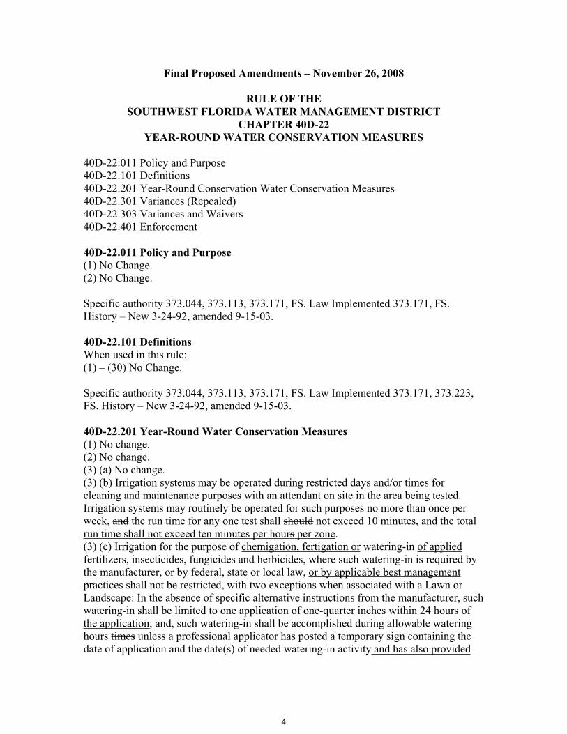
Final Proposed Amendments – November 26, 2008
RULE OF THE SOUTHWEST FLORIDA WATER MANAGEMENT DISTRICT
CHAPTER 40D-22 YEAR-ROUND WATER CONSERVATION MEASURES
40D-22.011 Policy and Purpose 40D-22.101 Definitions 40D-22.201 Year-Round Conservation Water Conservation Measures 40D-22.301 Variances (Repealed) 40D-22.303 Variances and Waivers 40D-22.401 Enforcement
40D-22.011 Policy and Purpose (1) No Change. (2) No Change.
Specific authority 373.044, 373.113, 373.171, FS. Law Implemented 373.171, FS. History – New 3-24-92, amended 9-15-03.
40D-22.101 Definitions When used in this rule: (1) – (30) No Change.
Specific authority 373.044, 373.113, 373.171, FS. Law Implemented 373.171, 373.223, FS. History – New 3-24-92, amended 9-15-03.
40D-22.201 Year-Round Water Conservation Measures (1) No change. (2) No change. (3) (a) No change. (3) (b) Irrigation systems may be operated during restricted days and/or times for cleaning and maintenance purposes with an attendant on site in the area being tested. Irrigation systems may routinely be operated for such purposes no more than once per week, and the run time for any one test shall should not exceed 10 minutes, and the total run time shall not exceed ten minutes per hours per zone.(3) (c) Irrigation for the purpose of chemigation, fertigation or watering-in of applied fertilizers, insecticides, fungicides and herbicides, where such watering-in is required by the manufacturer, or by federal, state or local law, or by applicable best management practices shall not be restricted, with two exceptions when associated with a Lawn or Landscape: In the absence of specific alternative instructions from the manufacturer, such watering-in shall be limited to one application of one-quarter inches within 24 hours of the application; and, such watering-in shall be accomplished during allowable watering hours times unless a professional applicator has posted a temporary sign containing the date of application and the date(s) of needed watering-in activity and has also provided
4
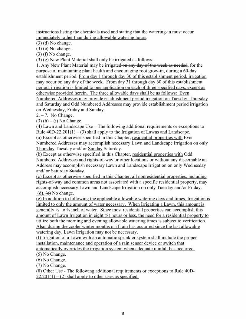
instructions listing the chemicals used and stating that the watering-in must occur immediately rather than during allowable watering hours.(3) (d) No change. (3) (e) No change. (3) (f) No change. (3) (g) New Plant Material shall only be irrigated as follows: 1. Any New Plant Material may be irrigated on any day of the week as needed, for the purpose of maintaining plant health and encouraging root grow-in, during a 60-day establishment period. From day 1 through day 30 of this establishment period, irrigation may occur on any day of the week. From day 31 through day 60 of this establishment period, irrigation is limited to one application on each of three specified days, except as otherwise provided herein. The three allowable days shall be as follows: Even Numbered Addresses may provide establishment period irrigation on Tuesday, Thursday and Saturday and Odd Numbered Addresses may provide establishment period irrigation on Wednesday, Friday and Sunday.2. – 7. No Change.(3) (h) – (j) No Change. (4) Lawn and Landscape Use – The following additional requirements or exceptions to Rule 40D-22.201(1) – (3) shall apply to the Irrigation of Lawns and Landscape. (a) Except as otherwise specified in this Chapter, residential properties with Even Numbered Addresses may accomplish necessary Lawn and Landscape Irrigation on only Thursday Tuesday and/ or Sunday Saturday.(b) Except as otherwise specified in this Chapter, residential properties with Odd Numbered Addresses and rights-of-way or other locations or without any discernable anAddress may accomplish necessary Lawn and Landscape Irrigation on only Wednesday and/ or Saturday Sunday.(c) Except as otherwise specified in this Chapter, all nonresidential properties, including rights-of-way and common areas not associated with a specific residential property, may accomplish necessary Lawn and Landscape Irrigation on only Tuesday and/or Friday. (d). (c) No change.(e) In addition to following the applicable allowable watering days and times, Irrigation is limited to only the amount of water necessary. When Irrigating a Lawn, this amount is generally ½ to ¾ inch of water. Since most residential properties can accomplish this amount of Lawn Irrigation in eight (8) hours or less, the need for a residential property toutilize both the morning and evening allowable watering times is subject to verification.Also, during the cooler winter months or if rain has occurred since the last allowable watering day, Lawn Irrigation may not be necessary. (f) Irrigation of a Lawn with an automatic sprinkler system shall include the proper installation, maintenance and operation of a rain sensor device or switch that automatically overrides the irrigation system when adequate rainfall has occurred.(5) No Change. (6) No Change.(7) No Change.(8) Other Use - The following additional requirements or exceptions to Rule 40D-22.201(1) – (2) shall apply to other uses as specified:
5
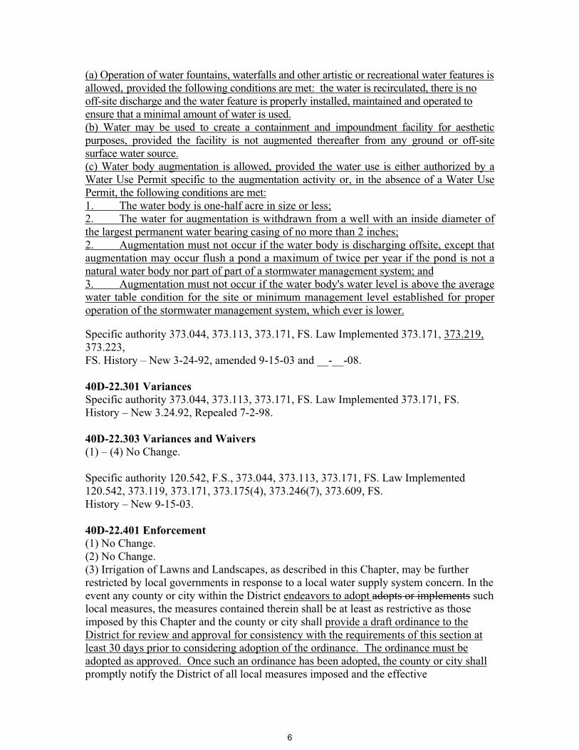
(a) Operation of water fountains, waterfalls and other artistic or recreational water features is allowed, provided the following conditions are met: the water is recirculated, there is no off-site discharge and the water feature is properly installed, maintained and operated to ensure that a minimal amount of water is used.(b) Water may be used to create a containment and impoundment facility for aesthetic purposes, provided the facility is not augmented thereafter from any ground or off-site surface water source.(c) Water body augmentation is allowed, provided the water use is either authorized by a Water Use Permit specific to the augmentation activity or, in the absence of a Water Use Permit, the following conditions are met:1. The water body is one-half acre in size or less;2. The water for augmentation is withdrawn from a well with an inside diameter of the largest permanent water bearing casing of no more than 2 inches;2. Augmentation must not occur if the water body is discharging offsite, except that augmentation may occur flush a pond a maximum of twice per year if the pond is not a natural water body nor part of part of a stormwater management system; and3. Augmentation must not occur if the water body's water level is above the average water table condition for the site or minimum management level established for proper operation of the stormwater management system, which ever is lower.
Specific authority 373.044, 373.113, 373.171, FS. Law Implemented 373.171, 373.219, 373.223,FS. History – New 3-24-92, amended 9-15-03 and __-__-08.
40D-22.301 Variances Specific authority 373.044, 373.113, 373.171, FS. Law Implemented 373.171, FS. History – New 3.24.92, Repealed 7-2-98.
40D-22.303 Variances and Waivers (1) – (4) No Change.
Specific authority 120.542, F.S., 373.044, 373.113, 373.171, FS. Law Implemented 120.542, 373.119, 373.171, 373.175(4), 373.246(7), 373.609, FS.History – New 9-15-03.
40D-22.401 Enforcement (1) No Change. (2) No Change.(3) Irrigation of Lawns and Landscapes, as described in this Chapter, may be further restricted by local governments in response to a local water supply system concern. In the event any county or city within the District endeavors to adopt adopts or implements such local measures, the measures contained therein shall be at least as restrictive as those imposed by this Chapter and the county or city shall provide a draft ordinance to the District for review and approval for consistency with the requirements of this section at least 30 days prior to considering adoption of the ordinance. The ordinance must be adopted as approved. Once such an ordinance has been adopted, the county or city shall promptly notify the District of all local measures imposed and the effective
6

implementation date. Irrigation of established lawns and landscaping, as established above, may be further restricted by local governments.(4) No Change.
Specific authority 373.044, 373.113, 373.171, FS. Law Implemented 373.119, 373.171, 373.175, 373.219, 373.246, 373.603, 373.609, FS. History – New 3-24-92, amended 9-15-03.
7
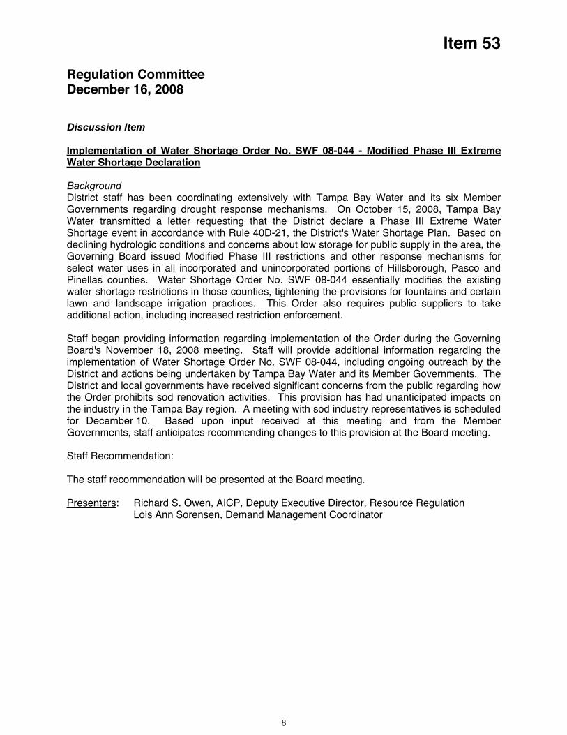
Item 53
Regulation Committee December 16, 2008
Discussion Item
Implementation of Water Shortage Order No. SWF 08-044 - Modified Phase III Extreme Water Shortage Declaration
Background District staff has been coordinating extensively with Tampa Bay Water and its six Member Governments regarding drought response mechanisms. On October 15, 2008, Tampa Bay Water transmitted a letter requesting that the District declare a Phase III Extreme Water Shortage event in accordance with Rule 40D-21, the District's Water Shortage Plan. Based on declining hydrologic conditions and concerns about low storage for public supply in the area, the Governing Board issued Modified Phase III restrictions and other response mechanisms for select water uses in all incorporated and unincorporated portions of Hillsborough, Pasco and Pinellas counties. Water Shortage Order No. SWF 08-044 essentially modifies the existing water shortage restrictions in those counties, tightening the provisions for fountains and certain lawn and landscape irrigation practices. This Order also requires public suppliers to take additional action, including increased restriction enforcement.
Staff began providing information regarding implementation of the Order during the Governing Board's November 18, 2008 meeting. Staff will provide additional information regarding the implementation of Water Shortage Order No. SWF 08-044, including ongoing outreach by the District and actions being undertaken by Tampa Bay Water and its Member Governments. The District and local governments have received significant concerns from the public regarding how the Order prohibits sod renovation activities. This provision has had unanticipated impacts on the industry in the Tampa Bay region. A meeting with sod industry representatives is scheduled for December 10. Based upon input received at this meeting and from the Member Governments, staff anticipates recommending changes to this provision at the Board meeting.
Staff Recommendation:
The staff recommendation will be presented at the Board meeting.
Presenters: Richard S. Owen, AICP, Deputy Executive Director, Resource Regulation Lois Ann Sorensen, Demand Management Coordinator
8
Item 54
Regulation Committee December 16, 2008
Discussion Item
Approval to Adopt Proposed Amendments to Sections 1.7.23, 3.2.7 and 3.3.1.5 of the Environmental Resource Permit (ERP) Basis of Review (BOR) as well as Appendix 5 of the ERP BOR to Maintain Protection for the Bald Eagle
The District’s ERP rules afford protection to aquatic and wetland dependent wildlife species that have been classified by the Florida Fish and Wildlife Conservation Commission (FWC) as endangered, threatened or a species of special concern. This includes protecting the existing nesting and denning habitat for such species because these habitats serve a critical role in these species’ life cycles. Appendix 5 then identifies these species by name. Currently, this table includes the Bald Eagle as a threatened species.
The FWC at its meeting on April 9, 2008 removed the Bald Eagle from Florida's list of wildlife species that are classified as threatened. To ensure that a stable or increasing population of Bald Eagles is maintained throughout Florida, the FWC also approved Bald Eagle Management Guidelines, incorporated by reference into new rules for non-listed nongame birds that are specific to the Bald Eagle (68A-16.002, F.A.C.). These guidelines acknowledge the need for continued protection of nesting habitat and that implementation will require the cooperation of local, state, and federal governmental agencies, non-governmental organizations, business, agricultural and forestry interests, universities, and the public.
Additionally, although the Bald Eagle is no longer classified as threatened in Florida, protection is continued under the Bald and Golden Eagle Protection Act (Eagle Act), a federal law. The Eagle Act prohibits a "take" of any Bald Eagle or of any Bald Eagle part, egg or nest except as authorized by federal regulations. The term “take” covers a broad range of actions including those that disturb an eagle.
Recognizing the importance of Bald Eagle nesting to its survival, and the continuing protections afforded the Bald Eagle by the Eagle Act, the water management districts have proposed that the nesting habitat of Bald Eagles continue to be protected under their ERP rules. To accomplish this goal, this Governing Board at its meeting on June 24, 2008 authorized staff to initiate rulemaking and approved draft rule language. The draft rule language was presented to the public at a rule development workshop held jointly with the SJRWMD and SFWMD on July 24, 2008, to the District's Environmental Advisory Committee on September 8, 2008 and the ERP Advisory Groups on October 22, 2008 and November 6, 14 and 20, 2008. Staff is proposing revisions to the draft rule language in response to comments received as a result of these presentations.
The rule amendments originally approved are contained in Exhibits 1 through 3. There are no changes proposed to the originally approved revisions to BOR Section 1.7.23 to update rule and statutory references to listed wildlife and plants, the originally approved revision to remove the Bald Eagle from the BOR Appendix 5 list of threatened birds, and the originally approved revisions to 40D-4.091, F.A.C., to reference the updated BOR once rulemaking is complete. However, staff is no longer recommending the approved revisions to include the Bald Eagle in the definition of listed species in BOR Section 1.7.23 or to create a separate category for the Bald Eagle in BOR Appendix 5.
9
Item 54
New language not previously approved is contained in Exhibit 4. The new revisions propose to add a reference to the Bald Eagle in BOR Section 3.2.7 as well as reference to the FWC Bald Eagle Management Guidelines and permits. These amendments require that an applicant demonstrate reasonable assurance that a regulated activity will not cause adverse secondary impacts to Bald Eagle nest sites or to critically important feeding areas. Reasonable assurance may be provided by consistency with the FWC Bald Eagle Management Guidelines or the receipt of a Bald Eagle permit from the FWC. Also shown in Exhibit 4, are new revisions proposed to 3.3.1.5, which will allow an applicant to mitigate for certain adverse secondary impacts to Bald Eagles that are unavoidable.
Staff Recommendation: See Exhibits
Approve additional revisions to the proposed rule language and authorize staff to complete the rule making process.
Presenter: H. Clark Hull, Jr., ERP Program Director
10

EXHIBIT 1
RULES OF THE SOUTHWEST FLORIDA WATER MANAGEMENT DISTRICT BASIS OF REVIEW, CHAPTER ONE
Text of rule amendment:
1.7 EXPLANATION OF TERMS
1.7.1 – 1.7.23 No Change
1.7.23 "Listed Species" - Those animal species which are endangered, threatened or of special concern and are listed in sections 68A-27.003 (as amended December 16, 2003), 68A-27.004 (as amended May 15, 2008), and 68A-27.005 (as amended November 8, 2007) 39-27.003, 39-27.004, and 39-27.005, F.A.C., ; the Bald Eagle (Haliaeetus leucocephalus), which is protected under the Bald and Golden Eagle Protection Act (16 U.S.C. 668-668d); and those plant species listed in 50 Code of Federal Regulation 17.12 (as amended April 8, 2004), when such plants are found to be located in a wetland or other surface water.
1.7.24 – 1.7.41 No Change
** The underline and strike-through language was previously approved. Staff is no longer recommending inclusion of the bolded portion of the proposed revision.
11
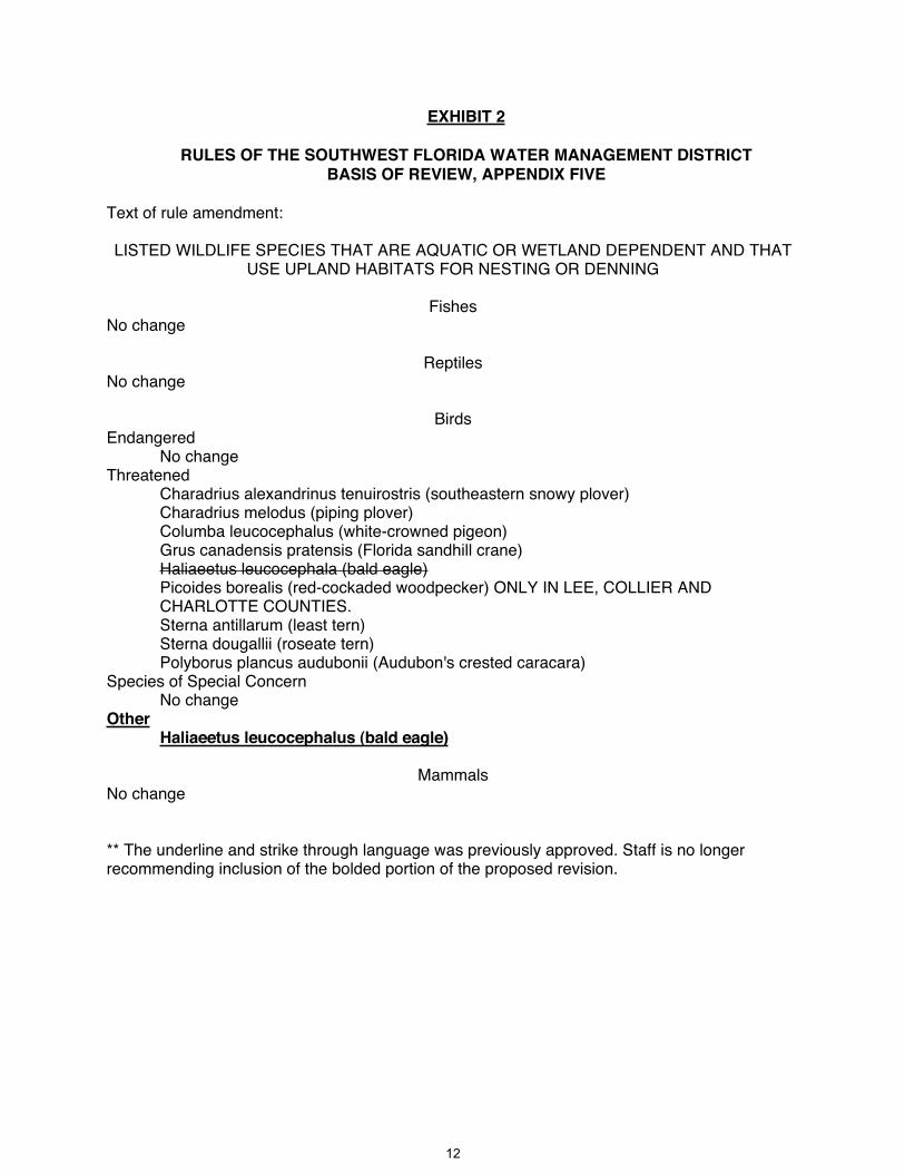
EXHIBIT 2
RULES OF THE SOUTHWEST FLORIDA WATER MANAGEMENT DISTRICT BASIS OF REVIEW, APPENDIX FIVE
Text of rule amendment:
LISTED WILDLIFE SPECIES THAT ARE AQUATIC OR WETLAND DEPENDENT AND THAT USE UPLAND HABITATS FOR NESTING OR DENNING
FishesNo change
ReptilesNo change
BirdsEndangered
No change Threatened
Charadrius alexandrinus tenuirostris (southeastern snowy plover) Charadrius melodus (piping plover) Columba leucocephalus (white-crowned pigeon) Grus canadensis pratensis (Florida sandhill crane) Haliaeetus leucocephala (bald eagle)Picoides borealis (red-cockaded woodpecker) ONLY IN LEE, COLLIER AND CHARLOTTE COUNTIES. Sterna antillarum (least tern) Sterna dougallii (roseate tern) Polyborus plancus audubonii (Audubon's crested caracara)
Species of Special Concern No change
OtherHaliaeetus leucocephalus (bald eagle)
Mammals No change
** The underline and strike through language was previously approved. Staff is no longer recommending inclusion of the bolded portion of the proposed revision.
12

EXHIBIT 3
RULES OF THE SOUTHWEST FLORIDA WATER MANAGEMENT DISTRICT CHAPTER 40D-4
INDIVIDUAL ENVIRONMENTAL RESOURCE PERMITS
Text of rule amendment:
40D-4.091 Publications and Agreements Incorporated by Reference. The following documents are hereby incorporated into this chapter and Chapters 40D-40 and 40D-400, F.A.C.:
(1) Environmental Resource Permitting Information Manual Part B, Basis of Review, Environmental Resource Permit Applications within the Southwest Florida Water Management District, __________ June 22, 2008. This document is available from the District upon request.
(2) – (5) No Change
** The underline and strike through language was previously approved.
13
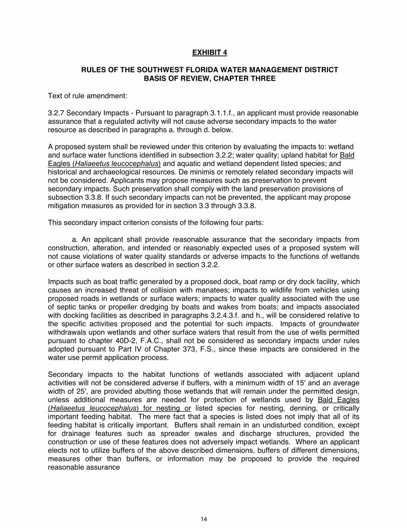
EXHIBIT 4
RULES OF THE SOUTHWEST FLORIDA WATER MANAGEMENT DISTRICT BASIS OF REVIEW, CHAPTER THREE
Text of rule amendment:
3.2.7 Secondary Impacts - Pursuant to paragraph 3.1.1.f., an applicant must provide reasonable assurance that a regulated activity will not cause adverse secondary impacts to the water resource as described in paragraphs a. through d. below.
A proposed system shall be reviewed under this criterion by evaluating the impacts to: wetland and surface water functions identified in subsection 3.2.2; water quality; upland habitat for Bald Eagles (Haliaeetus leucocephalus) and aquatic and wetland dependent listed species; and historical and archaeological resources. De minimis or remotely related secondary impacts will not be considered. Applicants may propose measures such as preservation to prevent secondary impacts. Such preservation shall comply with the land preservation provisions of subsection 3.3.8. If such secondary impacts can not be prevented, the applicant may propose mitigation measures as provided for in section 3.3 through 3.3.8.
This secondary impact criterion consists of the following four parts:
a. An applicant shall provide reasonable assurance that the secondary impacts from construction, alteration, and intended or reasonably expected uses of a proposed system will not cause violations of water quality standards or adverse impacts to the functions of wetlands or other surface waters as described in section 3.2.2.
Impacts such as boat traffic generated by a proposed dock, boat ramp or dry dock facility, which causes an increased threat of collision with manatees; impacts to wildlife from vehicles using proposed roads in wetlands or surface waters; impacts to water quality associated with the use of septic tanks or propeller dredging by boats and wakes from boats; and impacts associated with docking facilities as described in paragraphs 3.2.4.3.f. and h., will be considered relative to the specific activities proposed and the potential for such impacts. Impacts of groundwater withdrawals upon wetlands and other surface waters that result from the use of wells permitted pursuant to chapter 40D-2, F.A.C., shall not be considered as secondary impacts under rules adopted pursuant to Part IV of Chapter 373, F.S., since these impacts are considered in the water use permit application process.
Secondary impacts to the habitat functions of wetlands associated with adjacent upland activities will not be considered adverse if buffers, with a minimum width of 15' and an average width of 25', are provided abutting those wetlands that will remain under the permitted design, unless additional measures are needed for protection of wetlands used by Bald Eagles (Haliaeetus leucocephalus) for nesting or listed species for nesting, denning, or critically important feeding habitat. The mere fact that a species is listed does not imply that all of its feeding habitat is critically important. Buffers shall remain in an undisturbed condition, except for drainage features such as spreader swales and discharge structures, provided the construction or use of these features does not adversely impact wetlands. Where an applicant elects not to utilize buffers of the above described dimensions, buffers of different dimensions, measures other than buffers, or information may be proposed to provide the required reasonable assurance
14

b. An applicant shall provide reasonable assurance that the construction, alteration, and intended or reasonably expected uses of a proposed system will not adversely impact the ecological value of uplands to Bald Eagles (Haliaeetus leucocephalus) and aquatic or wetland dependant listed animal species for enabling existing nesting or denning by these species, but not including:
1. Areas needed for foraging; or 2. Wildlife corridors, except for those limited areas of uplands necessary for ingress and
egress to the nest or den site from the wetland or other surface water.
Appendix 5 identifies those aquatic and wetland dependent listed animal species that use upland habitats for nesting and denning.
For those aquatic and wetland dependent listed animal species for which habitat management guidelines have been developed by the U.S. Fish and Wildlife Service (USFWS) or the Florida Fish and Wildlife Conservation Commission (FFWCC), compliance with these guidelines will provide reasonable assurance that the proposed system will not adversely impact upland habitat functions described in paragraph b. For those aquatic or wetland dependent listed animal species for which habitat management guidelines have not been developed or in cases where an applicant does not propose to use USFWS or FFWCC habitat management guidelines, the applicant may propose measures to mitigate adverse impacts to upland habitat functions described in paragraph b. provided to aquatic or wetland dependent listed animal species. Secondary impacts to the functions of wetlands or uplands for nesting of Bald Eagles (Haliaeetus leucocephalus) will not be considered adverse if a valid permit has been issued to the applicant pursuant to Rule 68A-16.002, F.A.C. (May 15, 2008) for the same activities proposed by the applicant under Part IV of chapter 373, F.S., or if the applicant demonstrates compliance with the FFWCC Eagle Management Guidelines incorporated by reference in Rule 68A-16.002, F.A.C. (May 15, 2008).
c. No change
d. No change
3.3.1.5. To offset adverse secondary impacts from regulated activities to habitat functions that uplands provide to Bald Eagles (Haliaeetus leucocephalus) for nesting and to listed species evaluated as provided in paragraph 3.2.7.b.1., mitigation can include the implementation of management plans, participation in a wildlife mitigation park established by the Florida Fish and Wildlife Conservation Commission, or other measures. Measures to offset adverse secondary impacts on wetlands and other surface waters resulting from use of a system can include the incorporation of culverts or bridge crossings designed to facilitate wildlife movement, fencing to limit access, reduced speed zones, or other measures designed to offset the secondary impact.
**Staff is recommending inclusion of the additional underlined language in the proposed revision.
15

SOUTHERN WATER USE CAUTION AREA
12/2/08December 2008
Governing Board
FLORIDAN AQUIFERPERMITTED QUANTITIES
November 25, 2008
900
950
1,000
1,050
1,100
1,150
1,200
1,250
1,300
Ap
r-98
Oct
-98
Ap
r-99
Oct
-99
Ap
r-00
Oct
-00
Ap
r-01
Oct
-01
Ap
r-02
Oct
-02
Ap
r-03
Oct
-03
Ap
r-04
Oct
-04
Ap
r-05
Oct
-05
Ap
r-06
Oct
-06
Ap
r-07
Oct
-07
Ap
r-08
Oct
-08
MONTH-YEAR
Mill
ion
Gal
lon
s P
er D
ay
Annual Average Quantities
16
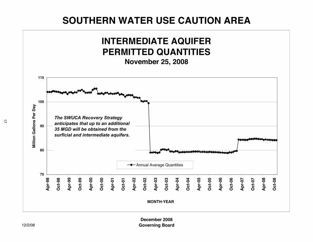
SOUTHERN WATER USE CAUTION AREA
12/2/08December 2008
Governing Board
INTERMEDIATE AQUIFERPERMITTED QUANTITIES
November 25, 2008
75
85
95
105
115
Ap
r-98
Oct
-98
Ap
r-99
Oct
-99
Ap
r-00
Oct
-00
Ap
r-01
Oct
-01
Ap
r-02
Oct
-02
Ap
r-03
Oct
-03
Ap
r-04
Oct
-04
Ap
r-05
Oct
-05
Ap
r-06
Oct
-06
Ap
r-07
Oct
-07
Ap
r-08
Oct
-08
MONTH-YEAR
Mill
ion
Gal
lon
s P
er D
ay
Annual Average Quantities
The SWUCA Recovery Strategy anticipates that up to an additional 35 MGD will be obtained from the surficial and intermediate aquifers.
17
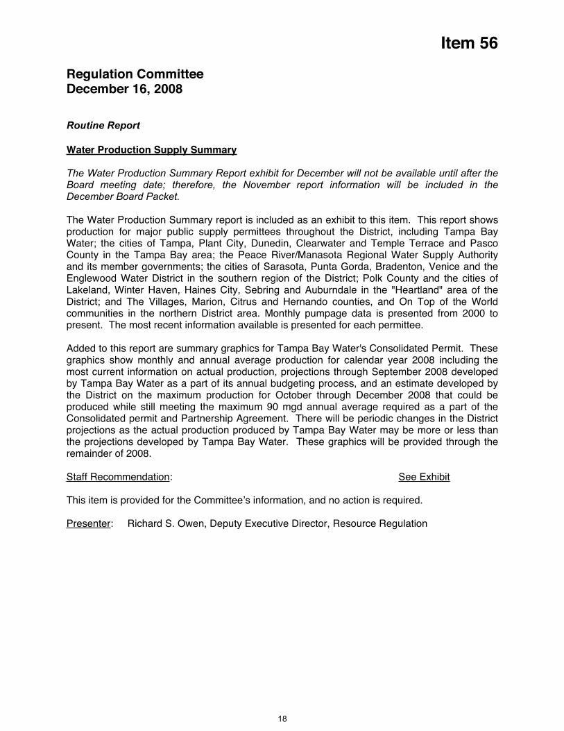
Item 56
Regulation Committee December 16, 2008
Routine Report
Water Production Supply Summary
The Water Production Summary Report exhibit for December will not be available until after the Board meeting date; therefore, the November report information will be included in the December Board Packet.
The Water Production Summary report is included as an exhibit to this item. This report shows production for major public supply permittees throughout the District, including Tampa Bay Water; the cities of Tampa, Plant City, Dunedin, Clearwater and Temple Terrace and Pasco County in the Tampa Bay area; the Peace River/Manasota Regional Water Supply Authority and its member governments; the cities of Sarasota, Punta Gorda, Bradenton, Venice and the Englewood Water District in the southern region of the District; Polk County and the cities of Lakeland, Winter Haven, Haines City, Sebring and Auburndale in the "Heartland" area of the District; and The Villages, Marion, Citrus and Hernando counties, and On Top of the World communities in the northern District area. Monthly pumpage data is presented from 2000 to present. The most recent information available is presented for each permittee.
Added to this report are summary graphics for Tampa Bay Water's Consolidated Permit. These graphics show monthly and annual average production for calendar year 2008 including the most current information on actual production, projections through September 2008 developed by Tampa Bay Water as a part of its annual budgeting process, and an estimate developed by the District on the maximum production for October through December 2008 that could be produced while still meeting the maximum 90 mgd annual average required as a part of the Consolidated permit and Partnership Agreement. There will be periodic changes in the District projections as the actual production produced by Tampa Bay Water may be more or less than the projections developed by Tampa Bay Water. These graphics will be provided through the remainder of 2008.
Staff Recommendation: See Exhibit
This item is provided for the Committee’s information, and no action is required.
Presenter: Richard S. Owen, Deputy Executive Director, Resource Regulation
18
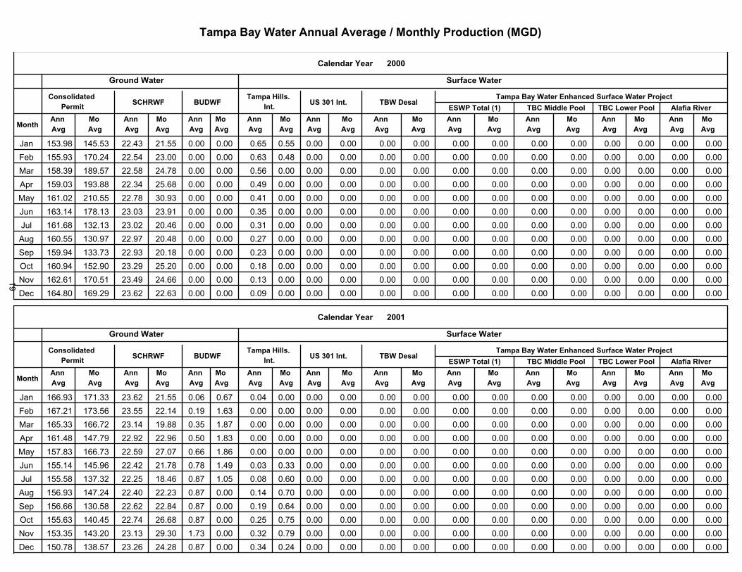
�������������� ������ �������������������������������
�� �
��������������!��������"��#�����������$�� ��#���%������&�'�(���������&������������
��� ��
��� ��
��� ��
��� ��
��� ��
��� ��
��� ��
��� ��
��� ��
��� ��
��� ��
��� ��
��� ��
��� ��
��� ��
��� ��
��� ��
��� ������
"��#�����������������
!"��������)������*��+"�, )�-�.
&��������/���
&��*������������� "&0%1 �+�1
������0���*.�-�.
��� ��
��� ��
��� ����� ���������� �� � ���� ���� ����� ����� ���� ��� ����� ����� ����� ����� ����� ����� ����� ����� ����� �������� ����� ��������� ������ ���� ����� ����� ����� ���� ��� � ����� ����� ����� ����� ����� ����� ����� ����� ����� �������� ����� ���������� ������ ����� �� ��� ����� ����� ���� ����� ����� ����� ����� ����� ����� ����� ����� ����� ����� �������� ����� ���������� ������ ���� ����� ����� ����� ��� � ����� ����� ����� ����� ����� ����� ����� ����� ����� ����� �������� ����� ������������ ����� ������ ���� ����� ����� ��� � ����� ����� ����� ����� ����� ����� ����� ����� ����� ����� �������� ����� ���������� ������ ���� ����� ����� ����� ��� ����� ����� ����� ����� ����� ����� ����� ����� ����� ����� �������� ����� ������������ ����� ����� ���� � ����� ����� ���� ����� ����� ����� ����� ����� ����� ����� ����� ����� ����� �������� ����� ���������� ������ ������ ���� � ����� ����� ����� ����� ����� ����� ����� ����� ����� ����� ����� ����� ����� �������� ����� ���������� ���� ����� ������ ����� ����� ���� ����� ����� ����� ����� ����� ����� ����� ����� ����� ����� �������� ����� ����������� ������ ����� ����� ����� ����� ����� ����� ����� ����� ����� ����� ����� ����� ����� ����� ����� �����!<? ����� ������������ ������ ��� � �� ��� ����� ����� ���� ����� ����� ����� ����� ����� ����� ����� ����� ����� ����� �����^�� ����� �������� ��� ������� ����� ����� ����� ����� ����� ����� ����� ����� ����� ����� ����� ����� ����� ����� ����� �����
�� )�
��������������!��������"��#�����������$�� ��#���%������&�'�(���������&������������
��� ��
��� ��
��� ��
��� ��
��� ��
��� ��
��� ��
��� ��
��� ��
��� ��
��� ��
��� ��
��� ��
��� ��
��� ��
��� ��
��� ��
��� ������
"��#�����������������
!"��������)������*��+"�, )�-�.
&��������/���
&��*������������� "&0%1 �+�1
������0���*.�-�.
��� ��
��� ��
��� ����� ����������� ����� ����� ���� ����� ����� ���� ����� ����� ����� ����� ����� ����� ����� ����� ����� ����� �������� ����� ������������ ����� ��� ����� ����� ���� ����� ����� ����� ����� ����� ����� ����� ����� ����� ����� ����� �������� ����� ��������� ������� ���� ������ ��� ����� ����� ����� ����� ����� ����� ����� ����� ����� ����� ����� ����� �������� ����� ���������� � �� ���� ������ ������ ���� ���� ����� ����� ����� ����� ����� ����� ����� ����� ����� ����� ����� �������� ����� ���������� ������ ����� ������ ����� ����� ����� ����� ����� ����� ����� ����� ����� ����� ����� ����� ����� �������� ����� ��������� �� ��� ���� � ������ ����� ��� � ���� ��� ����� ����� ����� ����� ����� ����� ����� ����� ����� �������� ����� ��������� ����� ����� ���� � ����� ���� ����� ����� ����� ����� ����� ����� ����� ����� ����� ����� ����� �������� ����� ���������� �� ��� ���� � ����� ����� ����� ���� ����� ����� ����� ����� ����� ����� ����� ����� ����� ����� �������� ����� ����������� ����� ������ ����� ����� ����� ����� ���� ����� ����� ����� ����� ����� ����� ����� ����� ����� �������� ����� ��������� �� �� ����� ������ ����� ����� ���� ���� ����� ����� ����� ����� ����� ����� ����� ����� ����� �����!<? ����� �������� �� ��� ���� ����� ���� ����� ���� ����� ����� ����� ����� ����� ����� ����� ����� ����� ����� �����^�� ����� ����������� ����� ����� �� ��� ����� ����� ��� ���� ����� ����� ����� ����� ����� ����� ����� ����� ����� �����
19

�������������� ������ �������������������������������
�� ��
��������������!��������"��#�����������$�� ��#���%������&�'�(���������&������������
��� ��
��� ��
��� ��
��� ��
��� ��
��� ��
��� ��
��� ��
��� ��
��� ��
��� ��
��� ��
��� ��
��� ��
��� ��
��� ��
��� ��
��� ������
"��#�����������������
!"��������)������*��+"�, )�-�.
&��������/���
&��*������������� "&0%1 �+�1
������0���*.�-�.
��� ��
��� ��
��� ����� ������������ ������� ������ ������ ����� ����� ����� ����� ����� ����� ����� ����� ����� ����� ����� ����� ����� ������ ����� ������������ ������� ������ ������ ����� ����� ����� ����� ����� ����� ����� ����� ����� ����� ����� ����� ����� �������� ����� ������������ ������� ������ ������ ����� ����� ����� ����� ����� ����� ����� ����� ����� ����� ����� ����� ����� �������� ����� ������������ ������� ������ ������ ����� ����� ����� ����� ����� ����� ����� ����� ����� ����� ����� ����� ����� �������� ����� ������������ ������� ������ ������ ����� ����� ����� ����� ����� ����� ����� ����� ����� ����� ����� ����� ����� �������� ����� ������������ ������� ������ ������ ����� ����� ����� ����� ����� ����� ����� ����� ����� ����� ����� ����� ����� �������� ����� ������������ ������� ������ ������ ����� ����� ����� ����� ����� ����� ����� ����� ����� ����� ����� ����� ����� �������� ����� ������������ ������� ������ ������ ����� ����� ����� ����� ����� ����� ����� ����� ����� ����� ����� ����� ����� ������� ����� ������������� ������� ������ ������ ����� ����� ����� ����� ����� ����� ����� ����� ����� ������ ����� ����� ����� �������� ����� ������������� ������� ������ ������ ����� ����� ����� ����� ����� ����� ����� ����� ����� ������ ����� ����� ����� �����!<? ����� ������������ ������� ������ ������ ����� ����� ����� ����� ����� ����� ����� ����� ����� ������ ����� ������ ����� �����^� ����� ������������� ������ ������ ������ ����� ����� ����� ����� ����� ����� ����� ����� ����� ������ ����� ������ ����� �����
�� ,�
��������������!��������"��#�����������$�� ��#���%������&�'�(���������&������������
��� ��
��� ��
��� ��
��� ��
��� ��
��� ��
��� ��
��� ��
��� ��
��� ��
��� ��
��� ��
��� ��
��� ��
��� ��
��� ��
��� ��
��� ������
"��#�����������������
!"��������)������*��+"�, )�-�.
&��������/���
&��*������������� "&0%1 �+�1
������0���*.�-�.
��� ��
��� ��
��� ����� ������������� ������ ������ ������ ����� ����� ����� ����� ����� ����� ����� ����� ������ ������ ����� ����� ����� ������ ������ ������������� ������ ������ ������ ����� ����� ����� ����� ����� ����� ����� ����� ������ ������ ����� ����� ����� ��������� ������ ������������� ������ ������ ������ ����� ����� ����� ����� ����� ����� ����� ����� ������ ������ ����� ����� ����� �������� ������ ������������� ������ ������ ������ ����� ����� ����� ����� ����� ����� ����� ������ ������ ������ ����� ������ ����� �������� ������ ������������ ������ ������ ������ ����� ����� ����� ����� ����� ����� ����� ������ ������ ������ ����� ������ ����� �������� ������ ������������ ������ ������ ������ ����� ����� ����� ����� ����� ����� ����� ����� ������ ������ ����� ������ ����� �������� ������ ������������ ������ ������ ������ ����� ����� ����� ����� ����� ����� ����� ����� ������ ������ ����� ����� ����� �������� ������ ������������ ������ ������ ������ ����� ����� ����� ����� ����� ����� ����� ����� ������ ������ ����� ����� ����� ������� ������ ������������ ������ ������ ������ ����� ����� ����� ����� ����� ����� ����� ����� ������ ������ ����� ����� ����� �������� ������ ������������ ������ ������ ������ ����� ����� ����� ����� ����� ����� ����� ������ ������ ������ ����� ����� ����� �����!<? ������ ������������ ������ ������ ������ ����� ����� ����� ����� ����� ����� ����� ����� ������ ������ ����� ������ ����� ������^� ������ ����������� ������ ������ ������ ����� ����� ����� ����� ����� ����� ����� ������ ������ ������ ����� ������ ����� ������
20
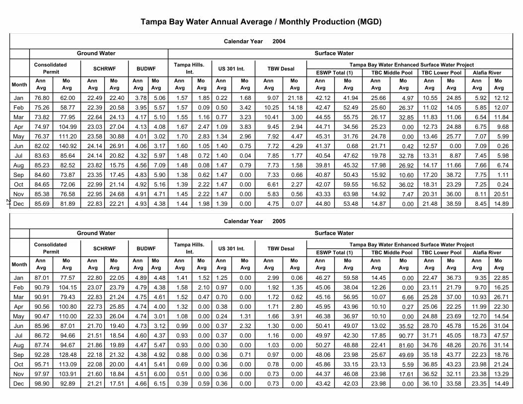
�������������� ������ �������������������������������
����������������������������������������� ���������������������������������������
��� ��
��� ��
��� ��
��� ��
��� ��
��� ��
��� ��
��� ��
��� ��
��� ��
��� ��
��� ��
��� ��
��� ��
��� ��
��� ��
��� ��
��� ��
�����
����
���������������������
���������� �������������� ����
�������������
����������������� ����2 ���2
����������������
��� ��
��� ��
��� � ���� ������ ������ ���� ���� ��� ���� ���� ����������� ����� ������ ������������ ���� ���������� ���������� ���� �� ���� ������ ����� ���� �� ��� ����� ����� ���������� ����� ����� �������� ��� ����������� ���������� �������� ����� ������ ������ ���� ���� ��� ����� ������ �������� ����� ���� ����� ���� ������������ ����������� �������� ���� ������ ����� ����� ����� ���� ���� ���� ���������� ����� ����� ������������ ��� ���������� ����������� �������� ���� ����� ������ ����� ����� ���� ����� ���� ��������� ����� ����� ������������ ��� ���������� �������� �������� ������ ������ ������ ����� ���� ����� ���� ��� ���������� ��� ����� ������������ ���� ��������� ���������� �������� ������ ������ ������ ����� ��� ����� ���� ��� �������� ����� ����� ���������� ��� ���������� ��������� �������� ����� ������ ��� ���� ���� ����� ����� ��� �������� ���� ������ ���������� ���� ��������� ����������� ��������� ������ ����� ���� ����� ���� ����� ����� ���� ��������� ����� ����� ��������� �� ���������� ���������� ��������� ����� ������ ������ ����� ���� ����� ����� ����� �������� ����� ����� �������� ��� ����������� ����������� ������!<? ����� ����� ������ ����� ���� ���� ����� ���� �������� ����� ������ ���������� ����� ����������� ������������ ���^�� ����� ������ ������ ����� ����� ����� ����� ��� ��������� ����� ������ ����������� ���� ������������ ���������� �����
����������������������������������������� ���������������������������������������
��� ��
��� ��
��� ��
��� ��
��� ��
��� ��
��� ��
��� ��
��� ��
��� ��
��� ��
��� ��
��� ��
��� ��
��� ��
��� ��
��� ��
��� ��
���3�
����
���������������������
���������� �������������� ����
�������������
����������������� ����2 ���2
����������������
��� ��
��� ��
��� ����� ������ ����� ����� ����� ����� ���� ����� ��������� ����� ����� ������ ���� ���������� ���������� ����� �� ����� ����� ����� ���� ����� ���� ����� ����� �������� ����� ����� ������������ ���� ����������� ����������� �������� ������ ������ ������ ��� ����� ���� ���� ���� ��������� ����� ����� ��������� ������ ���������� ���������� �������� ����� ����� ���� ���� ����� ����� ����� ���� ���������� ����� ���� ������������� ������ ����������� ����������� ������� ����� ������ ������ ���� ����� ����� ����� ����� ���������� ����� ������ ������������ ����� ����������� ������������ �������� ����� ����� ������ ���� ����� ����� ����� ����� ��������� ����� ����� ���������� ����� ����������� ���������� ������� ����� ����� ����� ����� ���� ����� ����� ����� ��������� ����� ����� ������������ ����� �������� �������� ������� ���� ������ ������ ���� ��� ����� ����� ����� ���������� ����� ���� ����������� ����� ����������� ������������ ��������� ������ ������ ������ ����� ����� ����� ����� ���� ���������� ���� ������ ������������� ������ ���������� �������� ��������� ���� ������ ������ ����� ���� ����� ����� ���� ���������� ����� ����� ������������ ������ ����������� ������������ ���!<? ���� ������ ������ ���� ����� ���� ����� ���� ���������� ����� ����� ������������� ������ ����������� ������������ �����^�� ������ ������ ���� ����� ���� ����� ���� ���� ���������� ����� ������ ������������ ����� ������������ ����������� �����
21

�������������� ������ �������������������������������
�� ��
����������������������������������������� ��������������������������������������
��� ��
��� ��
��� ��
��� ��
��� ��
��� ��
��� ��
��� ��
��� ��
��� ��
��� ��
��� ��
��� ��
��� ��
��� ��
��� ��
��� ��
��� ������
���������������������
�������������������� ��� �����
�������������
����������������� ����2 � �2
����������������
��� ��
��� ��
��� ������ ���������� ������ ������ ����� ���� ���� ����� ����� ����� ����� ����� ����� ����� ����� ���� ������ ������ ��� �� ����� ������������� ������ ������ ����� ���� ���� ����� ����� ����� ����� ����� ����� ���� ����� ����� ����� ����� ��������� ����� ������������ ������� ������ ������ ���� ����� ����� ����� ����� ����� ���� ����� ����� ���� ����� ������ ������ ������� ���� ����������� ������� ������ ����� ��� ��� ����� ����� ����� ����� ����� ����� ���� ����� ����� ����� ������ �������� ���� ����������� ������ ������ ����� ��� ��� ���� ����� ���� ����� ����� ����� ���� ����� ����� ����� ���� �������� ������ ����������� ������� ������ ���� ���� ���� ���� ����� ����� ����� ����� ����� ��� ���� ������ ����� ����� �������� ����� ������������ ������ ����� ����� ���� ��� ���� ����� ����� ����� ����� ����� ���� ����� ���� ����� ����� ��������� ����� ������������ ������ ������ ������ ���� ����� ���� ����� ����� ����� ����� ����� ���� ����� ������ ���� ���� ��������� ���� ����������� ������ ����� ������ ���� ���� ����� ����� ����� ����� ����� ����� ���� ����� ������ ����� ��� ������� ���� ������������ ������ ����� ������ ���� ��� ����� ����� ����� ����� ����� ����� ��� ��� ����� ������ ����� �����!<? ���� ������������ ������� ������ ������ ��� ����� ����� ����� ����� ����� ����� ����� ���� ��� ����� ����� ����� ������^�� ���� ������������ ������ ����� ������ ���� ���� ����� ����� ����� ����� ����� ����� ��� ����� ����� ����� ������ �����
�� ��
����������������������������������������� ��������������������������������������
��� ��
��� ��
��� ��
��� ��
��� ��
��� ��
��� ��
��� ��
��� ��
��� ��
��� ��
��� ��
��� ��
��� ��
��� ��
��� ��
��� ��
��� ������
���������������������
�������������������� ��� �����
�������������
����������������� ����2 � �2
����������������
��� ��
��� ��
��� ���� ������������ ������� ������ ������ �� ���� ���� ���� ����� ����� ����� ����� ���� ��� ����� ����� ������ ���� �� ���� ����������� ����� ����� ������ ��� ���� ����� ����� ����� ����� ����� ����� ���� ���� ������ ����� ����� ��������� ���� ������������ ������ ������ ����� ���� ����� ����� ����� ����� ����� ����� ����� ���� ���� ����� ����� ����� ������� ���� ����������� ����� ������ ����� ���� ��� ���� ���� ����� ����� ���� ���� ���� ����� ���� ����� ����� �������� ���� ������������ ���� ����� ����� ��� ����� ���� ����� ����� ����� ���� ������ ���� ���� ����� ���� ����� �������� ���� ������������ ������ ����� ����� ���� ����� ���� ����� ����� ����� ����� ��� ���� ����� ����� ���� ���� �������� ���� ������������ ������� ����� ������ ���� ����� ����� ���� ����� ����� ����� ����� ����� ����� ���� ����� ������ ������� ����� ������������� ������� ������ ����� ���� ����� ���� ���� ����� ����� ����� ����� ���� ������ ����� ������ ������ ��������� ����� ������������ ������ ������ ������ ����� ����� ����� ���� ����� ����� ��� ����� ����� ����� ����� ���� ������ ��������� ����� ������������ ������� ������ ����� ����� ����� ����� ���� ����� ����� ��� ������ ������ ����� ������ ������ ������ �����!<? ����� ���������� ������� ������ ����� ���� ����� ����� ����� ����� ����� ����� ����� ������ ������ ����� ����� ������ ����^�� ����� ������������ ������� ������ ���� ����� ����� ����� ���� ����� ����� ����� ������ ����� ������ ������ ������ ������ �����
22

�������������� ������ �������������������������������
�� ��
����������������������������������������� ��������������������������������������
��� ��
��� ��
��� ��
��� ��
��� ��
��� ��
��� ��
��� ��
��� ��
��� ��
��� ��
��� ��
��� ��
��� ��
��� ��
��� ��
��� ��
��� ������
���������������������
�������������������� ��� �����
�������������
����������������� ����2 � �2
����������������
��� ��
��� ��
��� ����� ������������ ������ ������ ������ ��� ����� ����� ��� ����� ����� ������ ������ ����� ������ ������ ������ ����� ������� ����� ���������� ������ ����� ������ ����� ����� ����� ��� ����� ����� ������ ���� ����� ������ ����� ������ ����� ������� ����� ����������� ���� ������ ������ ���� ����� ����� ����� ����� ����� ������ ������ ������ ����� ������ ������ ���� �������� ����� ����������� ������ ������ ������ ����� ����� ����� ���� ����� ����� ���� ����� ������ ����� ���� ����� ������ �������� ����� ������������ ������ ������ ���� ����� ����� ���� ����� ����� ����� ����� ������ ������ ����� ������ ������ ������ �������� ����� ������������ ����� ������ ������ ����� ���� ����� ����� ����� ����� ����� ������ ������ ������ ������ ���� ������ ������� ���� ���������� ���� ������ ������ ����� ����� ����� ����� ����� ����� ���� ������ ����� ���� ������ ������ ����� ������� ����� ��������� ������ ����� ����� ����� ����� ���� ����� ����� ����� ����� ����� ��� ����� ������ ������ ������ ��������� ���� ����������� ���� ����� ������ ����� ����� ���� ���� ����� ����� ������ ����� ����� ����� ����� ����� ����� ������� ��� ��������� ���� ���� ������ ����� ����� ���� ����� ����� ����� ������ ������ ���� ����� ������ ���� ��� �����!<? ���� ����������� ������� ����� ������ ����� ���� ��� ����� ����� ����� ������ ����� ��� �� ����� ���� ���� �����
�� � ������ ���� ��� ����� �����
���������������������`{����������|�}~������<��������������|���������2����<����������������� <�<��������<�����������������`{�������|�}~������<��������������|������ �2��������<��`� ��������������������������`{����������|�}~������<��������������|���������������������������������`{���������|�}~������<��������������|����� ����������������������`{���������|�}~������<��������������|�����
������}����������������������{�<������������������������?������<���������<������������������������{�����
�����������������{<<�|������<����{<<�|��������������?��������<�������<�}��{���<����<���������������?<����������������������
4��5
23
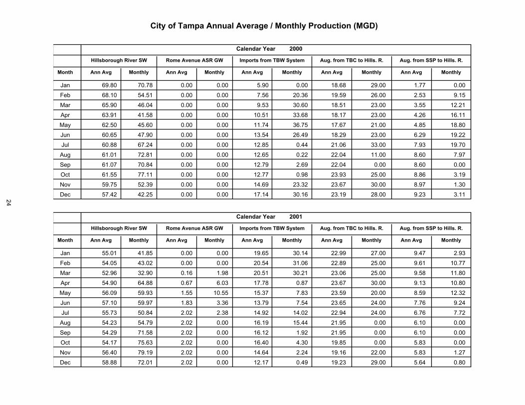
�������������� ������ ���� ��!�"���#���$��%�&������"���
"���#�� ��� � "���#�� ��� �
� '������(($������������� �������� �������������
������ ��� �������� ��� ��
������
���������� ��������
�����������
����
����������������� ���� ������ �����
��� �� ������
��� ������ ������ ����� ���������� ����� ������ ������� ����� ������
�� ����� �� �� ����� ����������� ����� ������ ������� ������ �����
��� ������ � ��� ����� ����������� ����� ����� ������� ������ �����
��� ����� � ��� ���� ����������� ����� ����� ������� � ���� ����
��� ������ � ���� ��� ����������� ����� ������ ������ � ���� ������
��� ������ � ���� ���� ���� ������ ����� ������ ������� ������ ������
��� ������ ����� ����� ��� ����� ����� ������ ������� ������ ������
��� ���� ����� ����� ���������� ����� ����� � ����� ������ ������
��� ����� ����� ����� ���������� ����� ����� � ������ ������ ������
��� ����� ���� ����� ���������� ����� ������� ������� ������ �����
!<? ������ ������ � ��� ����������� ����� ������� ������� ������ �����
^�� ���� � � ���� ��� ���������� ����� ������ ������� ������ ����
������ ��� �� ������ ��� ��
���������������������� �������� �������������
������ ��� �������� ��� ��
������
���������� ��������
�����������
����
����������������� ���� ������ �����
��� �� ������
��� ����� � ��� ����� ���� ����� ����� ������� ������� ��� �� ������
�� �� ��� � ���� ����� ���������� ����� ������� ������� ����� ������
��� ������ ������ ����� ��������� ���� ������� ������� ������ �����
��� �� ��� �� ��� ����� ���������� ����� ������� ������� ����� ������
��� ������ ������ ����� ��������� ����� ������� ������� ������ ������
��� ����� ������ ����� ���� ���� ����� ������� �� ���� ������ ���� �
��� ������ ����� � ��� � �������� ����� ����� � �� ���� ������ ������
��� �� ��� �� ��� ���� ��� ����� ����� ������ ������ ����� ������
��� �� ��� ����� ���� ��������� ����� ������ ������ ����� ������
��� �� �� ������ ��� � � �������� ����� ������ ������ ������ ������
!<? ���� � ����� � �� ���� ����� ����� ����� ������� ������ �����
^�� ������ ����� ���� ��� ������ ����� ������ ������� ���� � ������
24

������������� ������ ������ �����������!���������
������ ��� �� ������ ��� ��
���������������������� �������� �������������
������ ��� �������� ��� ��
������
���������� ��������
�����������
����
����������������� ���� ������ �����
��� �� ������
��� ������ ������ ����� ��������� ����� ������ ������� ����� ������
�� ������ ������ ����� ��������� ����� ������ ������ ������ ������
��� ����� ������ ����� �������� ����� ������ ������ ���� ������
��� ����� ����� ����� ������� ����� ����� ������� ������ ������
��� ����� ������ ����� �������� ����� ������ ������ ������ ������
��� ������ ����� ����� ��������� ����� ������ ����� ����� ������
��� ������ ����� ����� ���������� ����� ����� ������ ����� ������
��� ������ ������ ��� ���������� ����� ����� ������ ����� ������
��� ������ ����� ���� ���������� ����� ����� ������ ����� ������
��� ����� ������ ����� ���������� ����� ����� ������ ����� ������
!<? ����� ����� ����� ���������� ����� ����� ������ ������ ������
^�� ����� ����� ����� ���������� ����� ������ ������ ������ ������
������ ��� �� ������ ��� ��
���������������������� �������� �������������
������ ��� �������� ��� ��
������
������������� ������
�������������
�����
������������������� ����� ������ ����
��� �� �������
��� ������ ������ ����� ���������� ����� ����� ������ ������ ������
�� ������ ������ ����� ���������� ����� ������ ������ ������ ������
��� ���� ������ ����� ���������� ����� ������ ������ ������ ������
��� ������ ����� ���� ��������� ���� ������ ������ ������ ������
��� ������ ����� ��� ��������� ���� ��� ������ ������ ������
��� ������ ������ ��� ��������� ����� ������ ������ ������ ������
��� ������ ����� ��� ���������� ����� ������ ������ ������ ������
��� ����� ������ ����� ���������� ����� ������ ������ ������ ������
��� ����� ������ ����� ���������� ����� ������ ������ ������ ������
��� ����� ������ ����� �������� ����� ������ ������ ������ ������
!<? ������ ������ ����� ��������� ����� ������ ������ ������ ������
^�� ����� ������ ����� ��������� ����� ������ ������ ������ ������
25

������������� ������ ���������������������������������
������� ��� �� ������� ��� ��
����������������������� �����������������������
������� ��� ��������� ��� ��
� !!��
������������� ������
�������������
�����
������������������� ����� ������ ����
��� �� �������
��� ��� ������ ����� ���������� ����� ������ ������ ������ ������
� ���� �� ��� ����� ���������� ����� ������ ������ ������ ������
��� ���� ����� ����� ���������� ���� ������ ������ ������ ������
��� ���� � ������ ����� ���������� ����� ������ ������ ������ ������
��� ������ ��� � ����� ������ ��� ���� ������ ������� ������ ������
��� ������ ����� ����� ������ ��� ��� � ������ ������� ������ ������
��� ����� ������ ����� ������ � � ����� ������ ������ ������ ������
��� ������ ������ ����� ������ ��� ����� ������ ������ ������ ������
�� ������ ������ ����� ������ ��� ����� ������ ������ ������ ������
��� ������ ������ ����� ������ ��� ����� ������ ������ ������ ������
!<? ������ ����� ����� ������ ��� ����� ������ ������ ������ ������
^� ����� ���� ����� ������ ��� ����� ������ ������ ������ ������
������� ��� �� ������� ��� ��
����������������������� �����������������������
������� ��� ��������� ��� ��
���� �
������������� ������
�������������
�����
������������������� ����� ������ ����
��� �� �������
��� ������ ������ ����� ������ ��� ����� ������ ������ ������ ������
� ������ ������ ����� ������ ��� ����� � ���� ������ ������ ������
��� ������ �� ��� ����� ������ �� ��� � ���� ������ ������ ������
��� ������ ������ ����� ������ ��� ����� � �� � ������ ������ ������
��� ���� � ���� ����� ������ ��� ����� � ���� ������ ������ ������
��� ������ ������ ����� ������ �� ����� ������ ������ ������ ������
��� ������ �� ��� ����� ��������� ����� ������ ������ ������ ������
��� ������ ������ ����� ���������� ����� ������ ������ ������ ������
�� ������ ������ ����� ���������� ����� ������ ������ ������ ������
��� ���� � ������ ����� ���������� ����� ������ ������ ������ ������
!<? ���� � ������ ����� ���������� ����� ������ ������ ������ ������
^� ������ ����� ����� ���������� ����� ������ ������ ������ ������
26
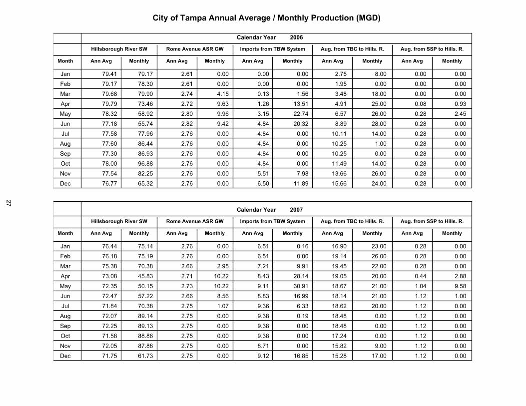
������������� ������ �������!��������������"����������
������� ��� �� ������� ��� ��
����������������������� �����������������������
������� ��� ��������� ��� ��
������
������������� ������
�������������
�����
������������������� ����� ������ ����
��� �� �������
��� ������ ������ ����� ���������� ����� ����� ����� ������ ������
��� ������ ����� ����� ���������� ����� ����� ������ ������ ������
��� ����� ������ ����� ��������� ���� ����� ������ ������ ������
��� ������ ������ ����� ���������� ����� ������ ������ ����� ������
��� ����� ���� ���� ���������� ����� ����� ������� ����� �����
��� ����� ���� ���� ���������� ����� ���� ������ ����� ������
��� ���� ������ ���� ���������� ����� ������� ������� ����� ������
��� ������ ����� ���� ���������� ����� ������ ������ ����� ������
��� ������ ����� ���� ���������� ����� ������ ������ ����� ������
��� ����� ���� ���� ���������� ����� ������� ������� ����� ������
!<? ����� ���� ��� ��������� ����� ������� ������� ����� ������
^�� ������ ����� ���� ���������� ����� ������ ������� ����� ������
������� ��� �� ������� ��� ��
����������������������� �����������������������
������� ��� ��������� ��� ��
���� �
������������� ������
�������������
�����
������������������� ����� ������ ����
��� �� �������
��� ������ ����� ���� ���������� ����� ������� ������� ����� ������
��� ����� ����� ���� ���������� ����� ������� ������� ����� ������
��� ���� ����� ����� ���������� ���� ������ ������� ����� ������
��� ����� ���� ���� ���������� ������ ������ ������� ������ ����
��� ����� ���� ����� ����������� ������ ������ ������� ������ ����
��� ������ ����� ��� ����������� ��� ������ ������� ������ ������
��� ����� ����� ����� ��������� ����� ������ ������� ������ ������
��� ������ ����� ���� ��������� ����� ����� ������ ������ ������
��� ����� ����� ���� ��������� ����� ����� ������ ������ ������
��� ���� ��� ���� ��������� ����� ������� ������ ������ ������
!<? ����� ��� ���� ��������� ����� ����� ������ ������ ������
^�� ����� ������ ����� �������� ����� ����� ������� ������ ������
27

������������� ������ �������!��������������"����������
������� ��� �� ������� ��� ��
����������������������� �����������������������
������� ��� ��������� ��� ��
������
������������� ������
�������������
�����
������������������� ����� ������ ����
��� �� �������
��� ����� ������ ����� ��������� �� ������� ������� ������ ���
�� ����� ������ ������ ��������� �� ������ ��� ������ ���
��� ����� ���� ������ �������� ����� ������ ��� ������ ���
��� �� � � ����� � ��� ������� ����� ����� ��� ����� ���
��� ����� ������ ����� ���������� ����� ��� �� ����� ���� ���
��� ������ ���� ���� ��� ���� �� ���� ������� ��� ���
��� ������ ����� ����� ������� ��� ����� ����� ��� ���
��� ������ ������ ����� �������� �� ����� ��� ��� ���
��� ������ � ���� ����� ������� �� ����� ��� � ��� ���
��� ������ ����� ��� ��������� �� � � � ������ ��� ���
��� � ��� ���� ���
������������������������������������������������������
������������������������������������������������������������� ���������!"����!����������� �!�����!������������� �#���!������$���������!����������$������!������� ���������������������������������$���������!����$��������%�&������'���$������������������!������������� ��������������������!����'�����������������!���������������������"
����
28
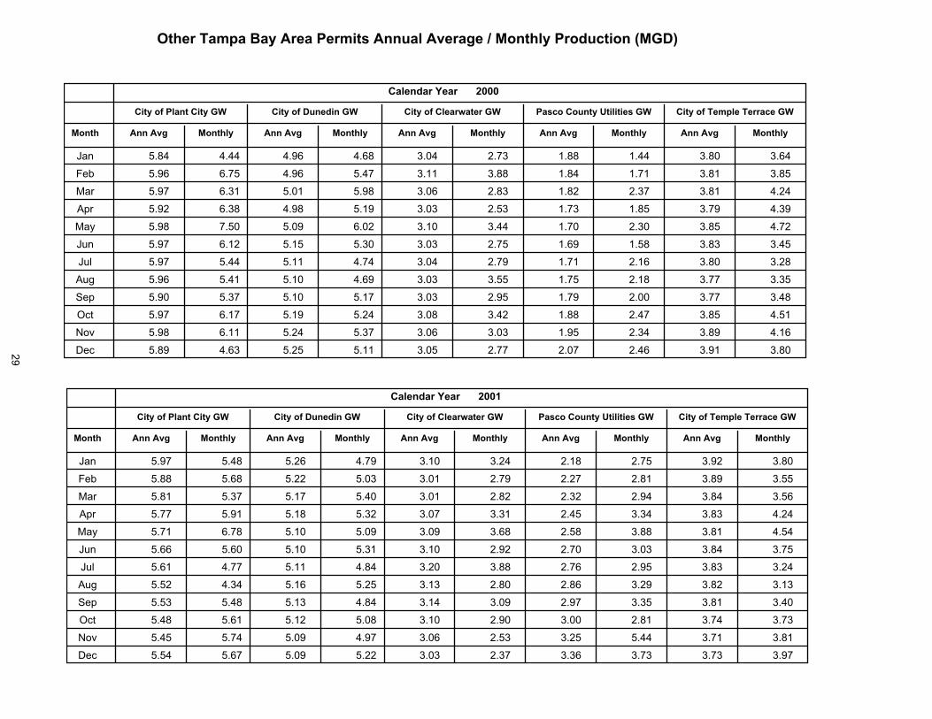
����!���������"�#!���$�!�%�&�#���� �#'�!�!��"�#$��� "�$!$(�)�%$��*#+,-�
#$��� "#���#'!
%%�"�$������ ����!!�)��+�
������
����� ��� ��
����������������������
����� ��� ������� ��� ��
�������������������
�������������
���
������������������ �����������������
��� �� �����
��� ����� ����� ����� ����� ����� ���� ����� ��������� ����
�� ����� ���� ����� ���� ��� ����� ���� ��������� ��
��� ���� ���� ���� ����� ����� ����� ���� ��������� ����
��� ����� ����� ����� ���� ����� ����� ���� �������� ����
��� ����� ���� ����� ����� ���� ����� ����� ������� �����
��� ���� ���� ���� ����� ����� ���� ����� ��������� ����
��� ���� ����� ��� ���� ����� ���� ����� ������� ����
��� ����� ���� ���� ����� ����� ����� ��� �������� ����
��� ����� ���� ���� ��� ����� ����� ��� �������� �����
��� ���� ��� ���� ����� ����� ����� ����� �������� ����
!<? ����� ��� ����� ���� ����� ����� ����� �������� �����
^�� ����� ����� ����� ��� ����� ��� ���� ��������� �����
����� ��� ��
������� �!"��� ���������
����#�
����� ��� ��
����������������������
����� ��� ������� ��� ��
�������������������
�������������
���
������������������ �����������������
��� �� �����
��� ���� ����� ����� ���� ���� ����� ����� ��������� ����
�� ����� ����� ����� ����� ���� ���� ����� ��������� ����
��� ���� ���� ��� ����� ���� ����� ����� ���������� �����
��� ��� ���� ���� ����� ���� ���� ����� ���������� �����
��� ��� ���� ���� ����� ����� ����� ���� ���������� �����
��� ����� ����� ���� ���� ���� ����� ����� �������� �����
��� ���� ��� ��� ����� ����� ����� ����� ��������� �����
��� ����� ����� ���� ����� ���� ����� ����� ��������� �����
��� ����� ����� ���� ����� ���� ����� ���� ��������� �����
��� ����� ���� ���� ����� ���� ����� ���� ��������� ����
!<? ����� ���� ����� ���� ����� ����� ��� ��������� �����
^�� ����� ���� ����� ����� ����� ���� ���� ��������� ����
29

$��� �!"��%��� �������!��� ������ �������&�����������������'���(�
����� ��� ��
������� �!"��� ���������
������
����� ��� ��
����������������������
����� ��� ������� ��� ��
�������������������
�������������
���
������������������ �����������������
��� �� �����
��� ����� ����� ����� ����� ����� ����� ����� ��������� ���
��� ����� ���� ����� ����� ����� ����� ����� �������� ����
��� ����� ����� ����� ���� ��� ���� ���� ������ �����
��� ����� ���� ����� ����� ���� ����� ����� ��������� ����
��� ���� ����� ���� ���� ���� ���� ����� �������� ���
��� ���� ����� ���� ����� ����� ����� ����� �������� �����
��� ����� ����� ���� ���� ����� ����� ���� �������� �����
��� ���� ���� ����� ����� ����� ���� ���� �������� �����
��� ����� ����� ����� ��� ����� ���� ��� ��������� �����
��� ����� ���� ����� ����� ����� ��� ���� ��������� ����
!<? ���� ����� ����� ����� ��� ����� ���� �������� ���
^�� ����� ��� ����� ����� ���� ���� ���� ��������� ����
����� ��� ��
������� �!"��� ���������
������
�����������
�����������������������
����������� �����������
�������������������
������������
�����
������������������ �����������������
������ �����
��� ����� ����� ����� ����� ����� ���� ����� �������� �����
��� ����� ����� ����� ����� ���� ����� ����� ���������� ����
��� ����� ���� ����� ���� ����� ����� ����� ��������� ����
��� ����� ����� ����� ����� ����� ���� ����� �������� �����
��� ���� ����� ����� ����� ���� ����� ����� ������� �����
��� ����� ��� ����� ��� ���� ���� ����� ��������� ����
��� ����� ����� ����� ���� ���� ����� ���� ��������� ����
��� ���� ����� ����� ���� ����� ���� ����� �������� �����
��� ����� ����� ����� ��� ����� ���� ����� �������� ����
��� ���� ����� ���� ���� ����� ��� ���� ������� �����
!<? ���� ���� ����� ����� ����� ����� ����� ������� ����
^�� ��� ����� ����� ����� ����� ����� ���� �������� ���
30
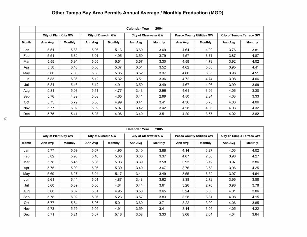
������ �!"��#����������!��������������� ��$������������������%���&�
�����������
������� �!"�� ���������
�'((.�
�����������
������������/����������
����������� �����������
������������������
���� �������
�����
������������������ ����������� ����
������� �������
��� ����� ���(� ����) ����( �(�)� �(�)� �(��) �(�����) ����
� ����� ���(� ����� ���� �(��� �(��� �(��� �������� �(���
��� ����� ���� ����� ����� �(��� �(�(� �(��� �������� ����
��� ����� �)�� ����) ���(� �(�� �(��� �(��� �����)� ���)(
��� ���)) ����� ����� ���(� �(��� �(�(� �(��) ������)) �)���
��� ����( �)�() ����� ���(� �(��� �(�() �(��� ���)���� ���
��� ����� ���) ����� ���� �(��� �(�� �(��� �(�)���)� ���)
��� ����� ����� ����� ���� �(�( ����) ���) �(�(���)� �(��)
��� ����) ���� ����� ��)� �(�� ����� ���( �(�((���� ����
��� ����� ����� ����� ���� �(�� �(�� ���( ���)��() �(���
!<? ����� �)��� ����� ����� �(�� �(�� ���( ��(����� ���(
^�� ����� ���� ����� ���) �(�� �(��� ���� �(������� �(���
��������������
�����������������������
�� !�
��������������
��"���������#�������"��
����������������������������
������������������
���� �������
�����
������������������ ����������� ����
������� �������
��� ����� ����� ����� ���� �(�� �(�)� ���( ������� �(���
� ����� ����� ����� ���(� �(�() �(�(� �(��� �������� �����
��� ����� ���� ����) ����( �(�(� �(��� �(��� �(��)�(��( �(���
��� ����� ����� ����) ���(� �(�� �(�)� �(��) �����(��) �(���
��� ���)� �)��� ���� ����� �(�� �(�� �(��� ��)�(��� �(���
��� ���)� ��� ����� ���� �(�( �(�)� �(��� �(����(�(� �����
��� ���)� ���(� ����� ��� �(� �(�)� �(��) �(����(��) �����
��� ���)� �)��� ����� ���� �(��� �(�)� ���� �(��)�(�� �(��(
��� ����� �)��� ����) ����( �(��� �(��( ���� �����(��� �(�(�
��� ����� ���) ����) ����� �(�)� �(��� ���) �(����(��� �(���
!<? ����( ����� ����� ���� �(��� �(�� ���� �����(�� �(���
^�� ����� ����� ����� ����) �(��� �(�(( ��� �(�)�(��) ���)
31

$�����������%��������������"����������������&������������ �������'���(�
��������������
�����������������������
�� )�
��������������
��"���������#�������"��
����������������������������
������������������
���� �������
�����
������������������ ����������� ����
������� �������
��� ����� ����� ����� ����� ���� ����� ����� ��������� �����
� � ���� ���� ����� ���� ����� ���� ����� ���������� ����
��� ���� ���� ����� ���� ���� ����� ����� ��������� �����
��� ����� ����� ���� ����� ����� ����� ����� ��������� �����
��� ���� ���� ����� ����� ����� ���� ���� ���������� �����
��� ����� ����� ����� ���� ����� ����� ���� ���������� ����
��� ����� ����� ����� ����� ���� ����� ����� �������� ����
��� ����� ����� ����� ����� ����� ����� ����� ��������� �����
� � ���� ���� ����� ����� ���� ����� ����� ��������� �����
��� ����� ����� ����� ����� ��� ���� ���� ��������� ����
!<? ����� ����� ����� ����� ���� ��� ����� �������� ����
^ � ���� ���� ����� ����� ���� ����� ����� ��������� �����
��������������
�����������������������
�� )�
��������������
��"���������#�������"��
����������������������������
������������������
���� �������
�����
������������������ ����������� ����
������� �������
��� ���� ����� ���� ����� ��� ���� ����� ���������� �����
� � ���� ���� ����� ��� ���� ����� ����� ���������� �����
��� ����� ����� ����� ���� ����� ����� ����� ���������� �����
��� ����� ����� ���� ����� ����� ���� ����� ������� �����
��� ���� ����� ��� ����� ����� ����� ���� ���������� ����
��� ����� ���� ���� ����� ����� ���� ���� ��������� �����
��� ����� ����� ���� ����� ����� ����� ��� �������� ����
��� ���� ���� ���� ����� ����� ����� ����� ��������� ����
� � ����� ���� ��� ����� ����� ���� ����� ���������� ����
��� ���� ����� ����� ����� ����� ����� ����� ���������� �����
!<? ����� ����� ���� ����� ����� ����� ���� �������� �����
^ � ����� ����� ����� ����� ����� ���� ����� ��������� ���
32
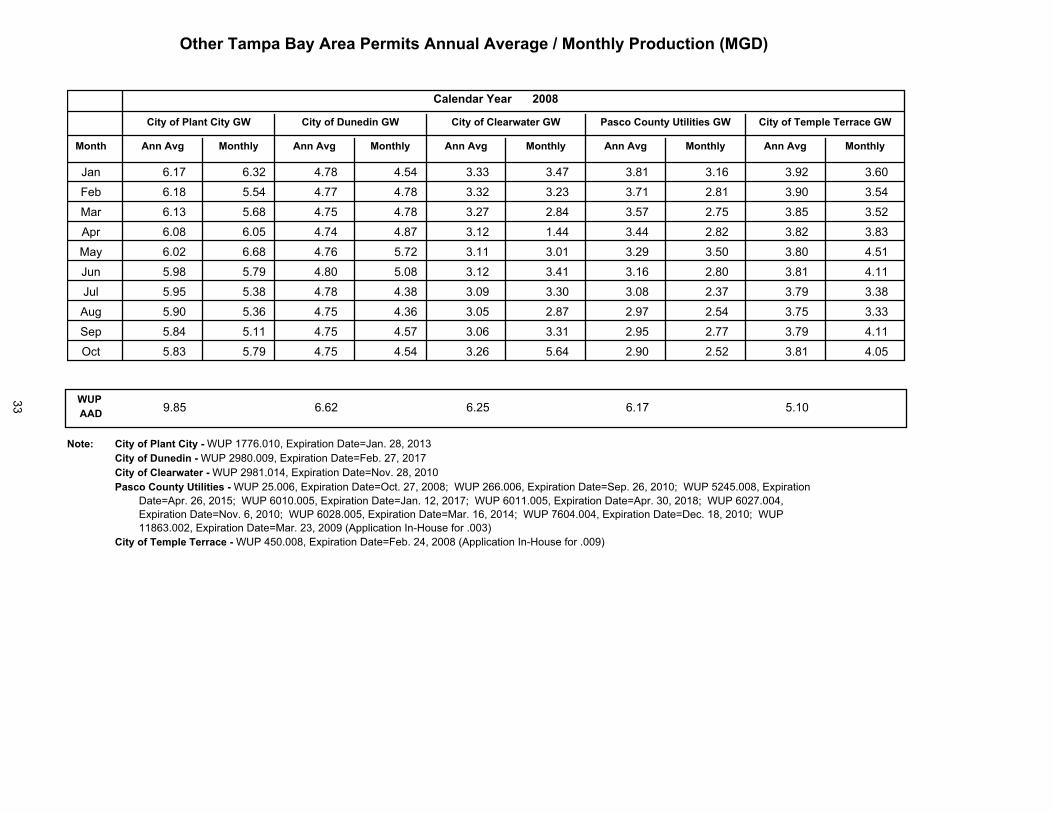
$�����������%��������������"����������������&������������ �������'���(
��������������
�����������������������
�� ��
�����������
�����������������������
����������� �����������
�������������������
������������
�����
������������������ �����������������
������ �����
��� ����� ���� ����� ����� �� ���� ���� ������� ����
�� ����� ����� ����� ����� ��� ��� ��� �������� �����
��� ���� ����� ����� ����� ���� ����� ���� �������� �����
��� ���� ���� ����� ����� ���� ����� ���� ������� �����
��� ���� ����� ����� ����� ���� ��� ��� ��������� ���
��� ����� ����� ���� ���� ���� ���� ���� ��������� ����
��� ����� ���� ����� ���� ��� �� ���� ������ ����
��� ���� ���� ����� ���� ��� ����� ���� ������� �����
��� ����� ����� ����� ����� ��� ��� ���� ���������� �����
��� ���� ����� ����� ����� ���� ����� ���� �������� �����
������� ���� ���� ���� ���� ���
���� ����������������!� �����������������������������������������������������!� ������������������������������������������������������!� ������������������������������������������������������������!� ��������������������������������������� ���������������������������������������� ����������������������
�������������������� ���������������������������������������� ��������������������������������������� ��������������������������������������� ����������������������������������������� ���������������������������������������� ������������������������������������������������������������������
�������"�#$��"�������!� �����������������������������������������������������������������
33

%�������������&�#�$%&����'�%#�����&����& �'�!&&"%��&'��#��&�((����%���#(�#&$�!##&���!����'����&%#&"�'�%�%�&�&�%#�)&�)�
����������������������
� � ����������
����������������������
� � ����������� � ��� �������
� ���� ���� �
�����
��������� ������������ �� ������������� �������������
����� ������ ����� ������ �����������
������
!"## !"�$ !"�� !"%%��� ��������� ��� ���� ���� ������ � ���� ������ ���� �����
��������� ��� ���� ��� � ������� ���� ���� ��� ����� ���� � ������ ������ �����
��������� ��� ��� ���� ���������� � ��� ���� ���� ����� ����� ������ ������ �� ���
��������� ��� ��� ���� ���������� � ��� ��� ���� ������ ������ ���� ����� �� ���
��������� ��� ��� ���� ��������� ����� ���� ����� ������ ������ ���� ���� ������
���� ����� ��� ���� ��� �������� � �� ����� ��� � ����� ������ � ��� ���� � ���� �
��������� ��� ��� ���� ��������� � � � �� ���� ���� ����� � ��� ������ �� ���
��������� ��� ��� ���� ���� ��� � � ���� ����� ��� ������ � ��� ����� �����
��������� ��� ��� ���� �������� � � � ����� ����� ����� � ��� � �� ����� ���� �
�������� ��� ��� ���� �� ����� � ��� ����� ��� ����� ������ � ��� ����� �� �
�������� ��� ��� !<? ���������� � ��� ���� ���� ����� ������ �� ��� ������ ������
�������� ��� ��� �^�� ������ �� ��� ���� ����� ��� � ������ � ���� ������ �� ��
����������������������
� � ����������
����������������������
� � ����������� � ��� �������
� ���� ���� �
�����
��������� ������������ �� ������������� �������������
����� ������ ����� ������ �����������
������
�������� ��� ���� ��� ������ �� ���� ���� ���� ����� ����� ������ ������ �� ���
��������� ��� ���� ���� ������ ��� ��� ������ ���� ����� � ���� �� ��� �� ��� �� ���
�������� ��� ���� ���� ������ ��� ��� ����� ���� ���� � ���� � ���� �� ��� �� ���
���������� ��� ��� ���� ��������� ��� ����� ���� ����� � ���� �� �� �� ��� ������
��������� �������� ���� ���������� ��� ���� ����� ����� � ���� ���� �� �� �� ��
�������� �������� ��� ���������� �� ���� ����� ����� � ��� � ���� �� ��� �� ���
��� ����� ��� ���� ���� �������� ���� ����� ���� ���� � ��� ������ �� ��� �� � �
��������� ��� ���� ���� �� ������ ���� ����� ��� �� � ��� � ���� �� ��� ������
��������� ��� ���� ��� �� ���� ��� ����� ���� ����� � �� � � ���� �� �� ������
��������� �������� ��� ����� �� ����� ����� ����� ���� � ��� ������ �� ��� �� ��
�������� ��� ���� !<? ��������� ����� ����� ����� ��� � ���� �� ��� �� �� ����
�������� ��� ���� ^�� ���������� ����� ���� ��� ���� � ���� �� �� ������ ���
34
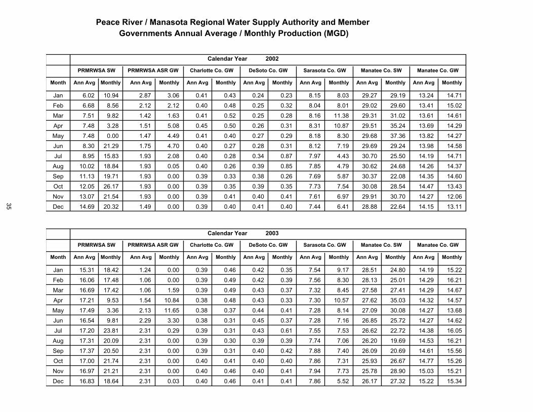
�� ��������� �� � ��� ������� ��� �����!""��!������� �����#$���������#�������! ����� ��� ������������!������%����
����������������������
� � ����������
����������������������
� � ����������� � ��� �������
� ���� ���� �
�����
��������� ������������ �� ������������� �������������
����� ������ ����� ������ �����������
������
�������� ������������ ��������� ��� � ����� � ��� � ��� ����� ���� ����� �����
��� ���� ������������� � ������� ����� ����� � �� � ��� ����� ����� ����� ������
��������� ���� �������� �� ������ ���� ����� � ��� ����� ����� ������ ������ �����
��������� ������������� ���� ��� ����� ���� � ��� ���� � ����� ����� ����� ����
�������� ������������ �������� ���� �� � �� � ��� ���� ������ ���� � �����
��������� ��������� ��� ������ ��� ����� ���� � ��� ���� ���� ���� ���� ����
���� ���� ��� �������� ���� �� �� ���� ���� ���� ��� ������ ������ ���� �����
��������� ��� �������� �� � ������ ���� ����� ��� � ��� ������ ���� ����� �����
��������� ��������� ��� ����������� ���� ����� ���� ��� � ������ ����� ����� �����
��������� ������������ ������������ ���� ����� ����� ���� ����� �� �� ���� �����
�������� ��������!<? ����������� ���� ����� ����� ���� ���� ������ ����� ������
�������� ��������^�� ���������� ��� ����� ��� ���� �� � ����� ����� ������
����������������������
� � ����������
����������������������
� � ����������� � ��� �������
� ���� ���� �
�����
��������� ������������ �� ������������� �������������
����� ������ ����� ������ �����������
������
�������� ������������ �� �������� ���� ����� ���� ���� �� ��� ��� � ���� ������
������� ����������� ���� ������ ����� ����� ����� � ��� �� ��� ������ ���� ������
������� ������������ ���������� ����� ���� ����� � �� ����� ����� ���� �����
��� ���� ������������ ���������� ���� ���� ����� ������ ������ ������ ����� �����
��������� ���������� ��������� ����� ������ ���� � �� ����� ����� ����� �����
��������� ������������ �� ������ ���� ����� ���� ����� ���� � ������ ����� �����
��������� ������������ ���� ������� ����� ���� ����� ����� ������ ������ ���� ������
��������� ����������� ����������� ����� ����� ���� ����� ������ ���� ����� ������
��������� ����������� ������������ ����� ����� ��� ���� ����� ����� ����� ������
�������� ����������� ����������� ����� ����� ��� � ����� ����� ������ ����� ������
�������� ��������!<? ����������� ����� ����� ��� ����� ����� �� �� ������ ������
�������� ��������^�� �� ������ � ����� ����� ��� � ����� ������ ������ ������ �����
35
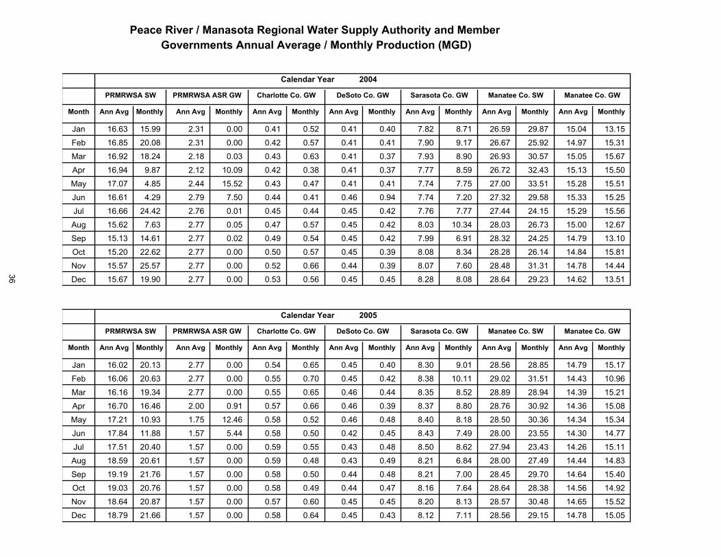
�������������� ����������� ������������������������� ����������� �� ���� �������������� ������������� �����
�� ����� ����� ����� ���
�� �����!�"���
�� ����� ����� ����� ���
�� �����!�"�����������!�"���
!��� ���#��
�� ��
���������� �������������� !��������!�"��� �������!�"���
� ��� �� ���� � ��� �� ���� �� ����� ���
�$%%��
���������� ������������� ���������� ����� ����� ��� � � ��� ����� ��� � ������ ������
���������� ������������� ����� ���� � ����� ����� ���� ���� ������ ����� ����� ������
���������� ������������� �� �������� ���� ����� ���� � �� ����� ������ ������ ������
���� ����� ������������� �� ������ ����� ����� ����� � �� ������ ������ ������ ������
���������� ������������� ��� ������� ����� ������ ����� ����� ������ ������ ����� ������
���������� ������������ ���������� ���� ����� ����� ����� ������ ���� ������ ������
���������� ������������� ������������ ����� ����� ����� ����� ������ ������ ����� ������
���������� ������������� ����������� ����� ����� � ��� ������ �� ��� ������ ������ ������
��������� ������������� ������������ ����� ����� ��� ���� �� ��� ������ ����� ������
���������� ������������ ������������ ����� ����� � �� � ��� �� �� ������ ���� � ���� �
���������� ���������!<? ������������ ����� ����� � ��� ����� �� �� ������ ����� ������
���������� ����������^�� ���������� ����� ����� � �� � �� �� ��� ����� ������ ������
����������������������
� � ����������
����������������������
� � ����������� � ��� �������
� ���� ���� �
�����
��������� ������������ �� ������������� �������������
����� ������ ����� ������ �����������
������
���������� ������������� ������������ ����� ����� � ��� ���� �� ��� �� � � ����� ������
���������� ������������� ������������ ����� ����� � �� ������ ����� ������ ������ �����
���������� ������������� ����������� ����� ����� � ��� � ��� �� � �� �� ����� ������
���������� ������������ ������������ ����� ���� � ��� � � � �� ��� ����� ������ �����
��������� ���� �������� ����������� ����� ������ � ��� � �� �� ��� ������ ������ ������
��������� ������������� ���� ���� � ����� ����� � ��� ���� �� ��� ������ ������ ������
��������� ���� �������� ������������ ����� ����� � ��� � ��� ����� ������ ������ ������
���� ���� ������������ �������� �� ����� ����� � ��� ��� � �� ��� ����� ������ ���� �
��������� ���� �������� ���������� ����� ����� � ��� ����� �� ��� ����� ������ ������
�������� ������������� ����������� ����� ����� � ��� ����� �� ��� �� �� ������ �����
���������� ����������!<? ���� ��� ��� ����� ����� � ��� � ��� �� ��� ����� ������ ������
��������� ����������^�� �������� �� ����� ����� � ��� ����� �� ��� ����� ����� ������
36
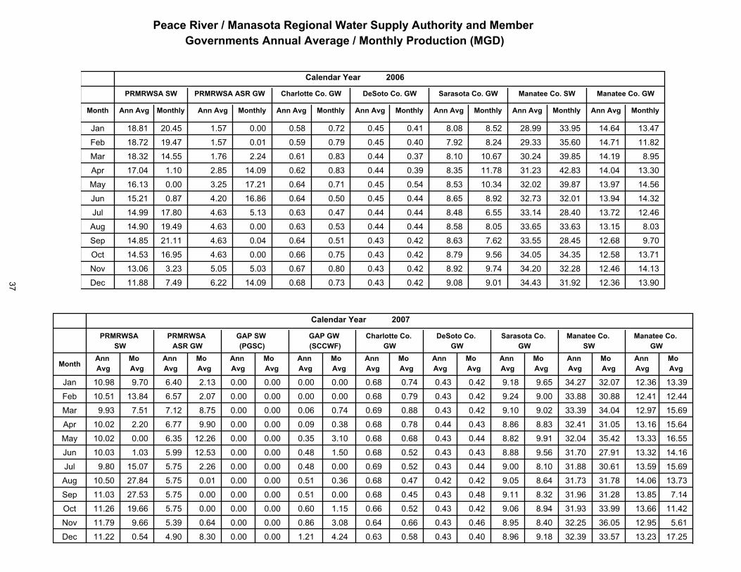
�� ��������� �� � ��� ������� ��� �����!""��!������� �����#$���������#�������! ����� ��� ������������!������%���&
����������������������
� � ����������
����������������������
� � ����������� � ��� �������
� ���� ���� �
�����
��������� ������������ �� ������������� �������������
����� ������ ����� ������ �����������
������
���������& ������������� ��������&�&� ����� ����� �&��& �&��� ��&��� ������ ����� �����
��������� ����������� � ���������� ���� ����� ���� ����� ������ ����� ����� ������
��������� ������������ ������������ ��� ����� ����� ���� ������ ������ ������ �����
��������� ������������� ���������� ����� ������ ����� ����� ������ ������ ������ ������
�������� ������������� ���������� ����� ����� ����� ������ ������ ����� ����� �����
��������� ������������� ���������� ����� ���� ���� ����� ����� ������ ������ ������
�������� ������������� ����������� ���� ����� ����� ���� ������ ������ ����� �����
��������� ������������� ������������ ���� ����� ����� ����� ����� ����� ������ �����
��������� ����������� � ������������ ���� ����� ���� ��� ������ ������ ����� ����
������� ������������� ����������� ���� ����� ���� ���� ������ ������ ������ �����
�������� ����������!<? ���������� ����� ����� ����� ���� ������ ������ ����� ������
�������� ����������^ � ���������� ���� ������ ����� ����� ������ ������ ����� ������
��������
��������
��������
��������
��������
�������
�������
�������
�������
�������
��������
�������
��������
�������
����� �����
�� ��� ��
��������
�������
�������������
������������ �
�������������
�������������
�����
���� �� �
���� ��� ���
���������������
�� ���������
�������
��������
������
�������� ������������� ���������� ���� ����� ����� ���� ����� ����� ����� ������������ ������������ ������
�������� ����������� � ������������ ��� ���� ����� ����� ������ ������ ������ ������������ ������������ ������
��������� ������������� ��������� ���� ���� ����� ����� ������ ������ ����� ���������� ����������� ������
�������� ������������� ����������� �� ����� ���� ����� ������ ������ ����� ����������� ������������ ������
�������� ������������� ����������� ���� ����� ����� ����� ������ ������ ������ ����������� ������������ ������
��������� ������������� ����������� ����� ������ ����� ���� ����� ����� ������ ����������� ������������ ������
��������� ������������� ���������� ���� ���� ����� ����� ������ ����� ������ ����������� ������������ ������
�������� ������������� ����������� ���� ����� ����� ���� ����� ����� ����� ����������� ����������� ������
��������� ����������� � ����������� ���� ����� ����� ����� ����� ������ ������ ���������� ������������ ������
�������� ������������� ��������� ���� ����� ���� ����� ������ ������ ���� ����������� ������������ ������
������� ���������!<? �������� ����� ���� ����� ����� ������ ����� ������ ��������� ������������ ������
��������� ����������^ � ����������� ����� ����� ���� ����� ������ ����� ������ ����������� ������������ ������
37
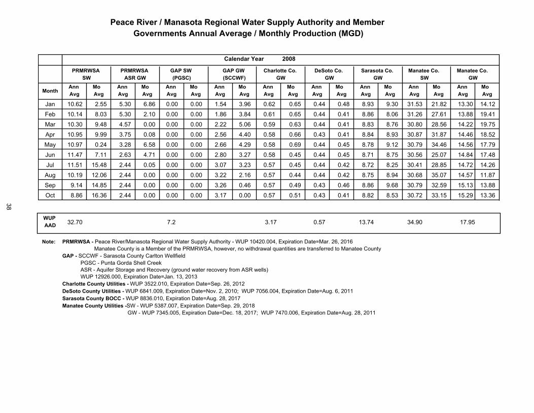
�� ���!����"�������������!����������� #$$�%��#����!�%�������&'��������&��������#�����������"�������%����# �!�������
��������
��������
��������
��������
��������
�������
�������
�������
�������
�������
��������
�������
��������
�������
����� �����
�����������
������ �
����� �
�������������
�������������
��������������
������������
�����
����������
��������������
��������������
������������
����� �
������ �
������
���������� ����������� ��������� � ����� � �� ����� ����� ������ ������ ������ ������������ ���� ������� ������
��� ���� � ������������� ����������� ����� ����� ���� ���� ����� ���� � ������ ���������� � ������������ ������
��� ������ ������������ ����������� ����� ����� ����� ���� ������ ����� ������ ������������ ���� ������� ������
��� ����� ������������� ����������� ����� ����� ����� ����� ������ ������ ����� ���������� � ������������ ������
��� ������ ������������ ����������� ����� � ��� ����� ����� ������ ����� ����� ��������� � ������������ ������
���������� ������������ ����������� ��� � ����� ����� ����� ����� ������ ������ ������������ ������������ ������
���������� ������������� ������������ ����� ����� ����� ����� ������ ������ ������ ����� ������ ������������ ������
���������� ������������� ����� ������ ����� ����� ����� ����� ���� � ������ ������ ������������ ���� ������� ������
���������� ���� �������� ����������� ����� ����� ���� ��� � ������ ������ ������ ���������� � ���� ������� ������
���������� ������������� �� �� ���� ����� ����� ����� ����� ������ ������ ������ ����� ������ ������������ ������
������������ ����� ��� ���� ���� ����� �����
���! ��������"��������������������������������������������������������������������������������� ����� ���������� �����������!����������������������"��������"���#�"��$�������������������#��������� ����
����"�� ����������� ����� �������������#�����%� �������%��#������� ���&�����������$�������������#���������������#�"����������������!�����"����������������� ������������������������������
����������#��$���%�%�%���"���������������������������������� ��������������#��$���%�%�%���"����� ����������������������'�����������(��������� ������������������������ ����������������#��$�&'�"�������� �����������������������������������������#��$���%�%�%���"�����������������������������������������������
���%��������������������������������������������(������������� ����������������������������
38

#������������ ��������������������������� ��������
�������������
������������������� ���
�
�������������
���������� ���
�������������
��������������� �
��������������������������
�����������������
��������!���
�����
������ ��������� ���������������� �
������ �������
��� ������ ������ ��� ������� � ��� ����� ����� ����� ��� � �� � ��
��� ������ ������ �� ������� � � ����� ����� ����� ����� � �� ���
��� ������ ���� � �� � � ������ � ��� ����� ����� ����� ���� � ��� ���
��� ������ ����� ��� ������� � ��� ����� ����� ���� ���� � � � � �
��� ����� ����� �� ����� � �� ���� ���� ����� ���� � �� �����
��� ����� ����� �� � ������� ���� ����� ����� ����� ���� � ��� � ���
��� ������ ����� �� �������� ����� ����� ���� ���� ����� � ��� ����
��� ������ ����� �� � ���� ���� ���� ����� ����� ��� ��� � � ��� � ���
��� ����� ��� ��� �������� �� � ����� ����� ��� ����� � ��� ���
��� ���� ������ ��� �������� � ��� ����� ����� ���� ���� � ��� ����
!<? ���� ���� �� ������� � �� ����� ����� ��� ���� � �� � ���
^�� ��� ��� � ��� ������� ��� ���� ����� ���� ����� � ��� ����
�������������
������������������� ���
� "
�������������
���������� ���
�������������
��������������� �
��������������������������
�����������������
��������!���
�����
������ ��������� ���������������� �
������ �������
��� ����� ��� ���� ������ ���� ����� ����� ���� ����� � ��� � ��
��� ���� ����� ��� �������� � �� ����� ����� ����� ����� � �� ����
��� ����� ����� ���� �� ���� �� ���� ����� ����� ��� � �� � ��
��� ����� ������ ��� ��������� ��� ����� ����� ���� ��� � � ��� � ��
��� ����� ����� ���� ��������� ��� ����� ����� ����� ���� � ��� � ���
��� ����� ���� ���� �������� ����� ����� ����� ����� ��� � � ��� ��
��� ����� ���� ����� ��������� ���� ���� ����� ���� � �� � ��� ����
��� ����� ���� ���� ������ � � � ���� ����� ����� ����� � ��� ���
��� ���� ��� ����� �������� ��� ���� ����� ����� ���� � ��� ����
��� ����� ����� ���� ������� � ��� ���� ����� ��� ���� � ��� � ��
!<? ����� ������ ���� �������� ���� ���� ����� ���� ����� � ��� � � �
^�� ����� ���� ����� �� ���� � ��� ����� ����� ��� ���� � � � �
39

������������ ��������������������������� ��������
�������������
������������������� ���
� �
�������������
���������� ���
�������������
��������������� �
��������������������������
�����������������
��������!���
�����
������ ��������� ���������������� �
������ �������
��� ����� ����� ����� ���������� ���� ��� �� ����� ����� ����� �����
��� ����� ���� ���� �������� ����� ��� �� ���� ����� ����� �����
��� ����� ����� ���� ��������� ����� �� �� ����� ��� ����� �����
�� ����� ����� ����� ���������� ����� �� �� ����� ����� ���� ����
��� ����� ���� ����� ��������� ����� ��� ���� ����� ���� ���� �����
��� ���� ��� ����� ���������� ��� ��� ���� ����� ����� ����� �����
��� ����� ���� ��� ���������� ��� ��� �� ����� ����� ����� �����
�� ���� ���� ���� ���������� ����� ��� ��� ����� ����� ����� �����
��� ����� ����� ��� ��������� ����� ��� ��� ����� ����� ����� �����
��� ����� ����� ���� ���������� ����� ��� ��� ����� ����� ���� �����
!<? ���� ����� ����� ���������� ���� ��� ��� ����� ����� ����� ����
^�� ���� ���� ��� ��������� ����� ��� �� ����� ���� ���� ���
�������������
������������������� ���
� �
�������������
���������� ���
�������������
��������������� �
��������������������������
�����������������
��������!���
�����
������ ��������� ���������������� �
������ �������
��� ���� ��� ���� ���������� ���� ��� ��� ����� ����� ����� ����
��� ����� ���� ���� ��������� ����� ��� �� ����� ����� ����� �����
��� ����� ���� ���� ������ - � - �� �� ���� ���� ����� ����
�� ���� ���� ��� �������� ����� ��� ��� ���� ����� ���� ���
��� ����� ����� ��� ��������� ����� ��� �� ���� ���� ���� �����
��� ����� ��� ���� ��������� ��� ��� �� ����� ����� ����� ����
��� ����� ���� ���� �������� ���� ��� ��� ����� ����� ����� �����
�� ����� ����� ���� ���������� ����� ��� ��� ����� ����� ���� �����
��� ���� ����� ��� �������� ��� ��� ��� ����� ����� ���� �����
��� ���� ����� ��� ���������� ����� ��� ��� ����� ����� ����� ����
!<? ����� ���� ���� ���������� ����� ��� �� ����� ����� ����� �����
^�� ����� ����� ���� ��������� ����� ��� �� ����� ����� ����� �����
40

������������ ��������������������������� ��������
�������������
������������������� ���
� ��
�����������
�����#����������
�����������
�����#�������������
����������� �����������
�����#�������������
������������
�����
�����#������������ �����#���������������
������ �����
��� ����� ����� ���� � ��� ��� � � � ���� ����� ��� � ����� � �� ���
�� ����� ���� ���� ����� - � - ���� ���� � �� ���� � �� ���
��� ����� ����� ���� ����� � � � �� ���� ���� ��� ����� � �� ����
��� ����� ����� ��� � ���� � ��� ���� ���� ��� ����� � � � ���
��� ����� ��� �� � � ���� �� ���� ���� ���� ��� � ����� � � ����
��� ����� ����� ���� ���� �� � ��� ���� ���� ��� � ���� � �� � ��
��� ���� ����� ���� ����� �� �� � ���� ���� ����� ��� � �� ����
��� ����� ���� ���� ��� �� ���� ���� ���� ��� � ����� � � � �
��� ����� ���� ���� ������ �� ��� ���� ���� ��� � ���� � ��� � � �
��� ����� ����� ��� �� �� �� ����� ���� ����� ��� � ����� � �� � ��
!<? ����� ����� ��� � ���� �� ��� ���� ����� ���� ����� � ��� � ��
^�� ���� ����� ��� ���� � ���� ���� ����� ����� ����� � ��� � � �
�����������
�� �����������������������
�� ��
�����������
�����#����������
�����������
�����#�������������
����������� �����������
�����#�������������
������������
�����
�����#������������ �����#���������������
������ �����
��� ����� ����� ���� ���� ��� ����� ���� ����� ����� ����� � ��� ����
�� ���� ���� ���� � ��� �� � �� ���� ����� ����� ����� � ��� ���
��� ���� ���� ���� ����� ��� � �� ���� ����� ����� ����� � ��� ����
��� ����� ����� ���� ����� ��� � ��� ���� ����� ����� ����� � ��� � ���
��� ���� ���� ���� ����� ��� � � ���� ���� ����� ����� � ��� � � �
��� ����� ���� ���� ������ �� ����� ���� ���� ����� ���� � ��� � ���
��� ���� ���� ���� ��� �� � �� ���� ����� ����� ��� � � ��� ��
��� ����� ����� �� � ������ �� � �� ���� ����� ����� ����� � ��� � ���
��� ����� ����� �� � ������ �� ���� ���� ���� ���� ����� � �� � �
��� ����� ���� ��� ��� �� ��� �� ���� ���� ����� ����� � �� � �
!<? ���� ���� ��� ������ ��� ��� � ���� ���� ���� ��� � � � � � �
^�� ����� ����� ��� ���� � � ���� ���� ���� ����� ����� � � � � ���
41
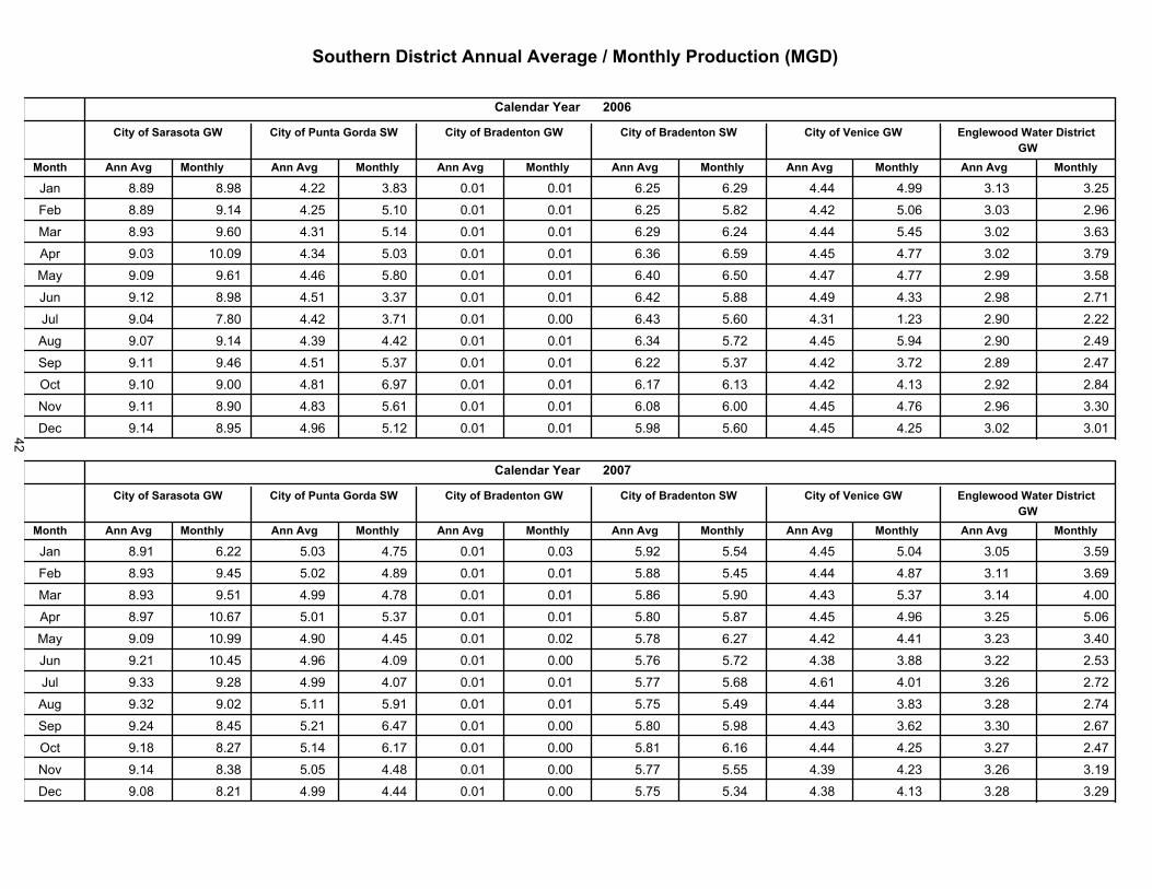
����������������������������� �� ������������������!���"
�����������
�� �����������������������
�� ��
�����������
�����#����������
�����������
�����#�������������
����������� �����������
�����#�������������
������������
�����
�����#������������ �����#���������������
������ �����
��� ����� ����� ��� � ������ ��� ����� ���� ���� ����� ����� � � � ���
��� ����� ��� ����� ������ ��� ��� � ���� ���� ����� ����� � � � �����
��� ����� ����� ����� ������ �� ��� ���� ���� ����� ���� � � ��� �
��� ����� � ���� ����� ������ �� ����� ���� ���� ����� ����� � � � � ���
��� ����� ���� ����� ������ � � ����� ���� ���� ��� � ����� � � � � ���
��� ��� � ����� ����� ���� � �� ����� ���� ���� ��� � ����� � � � � ���
��� ���� ����� ����� ������ � � ���� ���� ����� ��� � ����� � �� � ���
��� ����� ��� ����� ��� �� ��� � � � ���� ���� ���� ����� � � � ����
��� ��� ��� � ����� ��� �� �� ����� ���� ���� ����� ����� � � � �����
��� ��� � ����� ����� ���� � �� ����� ���� ���� ��� � ��� � � � � � � �
!<? ��� ����� ����� ������ ��� ���� ���� ���� ����� ����� � � � � ���
^�� ��� ����� ����� ���� � ��� ��� � ���� ���� ����� ����� � � � � ���
�����������
�� �����������������������
�� #�
�����������
�����#����������
�����������
�����#�������������
����������� �����������
�����#�������������
������������
�����
�����#������������ �����#���������������
������ �����
��� ���� ����� ����� ���������� � ��� ���� ����� ����� ���� � � � ����
��� ����� ��� � ��� ���������� � ��� ���� ���� ����� ��� � � � � ���
��� ����� ���� ��� � ���� ��� � ��� ���� ���� ����� ����� � � � �����
��� ����� � ���� ����� ��������� ����� ���� ���� ����� ����� � � � � ���
��� ����� � ���� ����� ��� �� ��� � � � ���� ����� ����� ����� � � � � �
��� ���� � �� � ����� ������ ��� � ��� ���� ����� ����� ����� � ��� �����
��� ����� ����� ����� ������ ��� � ��� ���� ���� ����� ����� � �� � ��
��� ����� ����� ����� ���� ��� ���� ���� ���� ����� ��� � � � �����
��� ���� ��� � ����� ��������� ��� � ���� ����� ����� ����� � � � �����
��� ��� � ����� ����� ��� ���� ��� � ���� ����� ���� ��� � � � � ���
!<? ��� ����� ����� ��� ������ � � � ���� ����� ����� ����� � ��� � ���
^�� ����� ���� ����� ������ ��� � � ���� ����� ����� ���� � ��� � � �
42

����������������������������� �� ������������������!���"
�����������
�� �����������������������
�� ��
�����������
�����#����������
�����������
�����#�������������
����������� �����������
�����#�������������
������������
�����
�����#������������ �����#���������������
������ �����
��� ���� ��� ���� ���������� ���� ����� ������ ���� ��� ����� ����
�� ���� ���� ����� ��������� ��� � ����� ������ ���� ��� ���� ����
��� ���� ���� ����� ��������� ����� ����� ������ �� � ���� ����� ����
��� ���� ���� ����� ���������� ����� ����� ������ �� � ���� ����� ��� �
��� ���� ��� ���� ���������� ��� ����� ������ �� � ��� ����� ����
��� ����� ���� ���� ��������� ���� ����� ������ �� � ��� ����� �����
��� ����� ���� ���� ������� ����� ����� ������ ��� ���� ���� ���
��� ����� ���� ����� �������� ���� ����� ������ ��� ���� ���� ����
��� ��� � ���� ����� ��������� ����� ����� ������ ���� ���� ����� �����
��� ��� ����� ���� ���������� ����� ����� ������ ���� ���� ���� ����
�&����� �� ��������� ��� �� �
#���$ �����#����������%���������������������������������������������������������������������������������������������������������������������������������������������#�������������%������������������������������������������������#�����������%����� ��������������������������������������#��������%��������������������������������������������������������������������������� ���������������������%������� �����������������������������������������������������������������
43
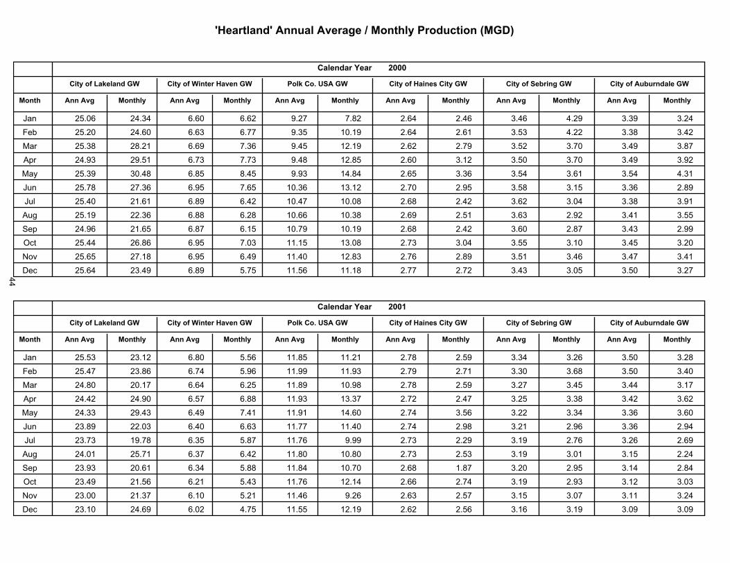
����������� ����������������������� ����������
������������ ����������
��������� � ��������������� ��������
�!"""�
�����������
������������#��������
����������������������
���$���%�& ����
�������'���
����
��������(�$������ ���������������������
����� ������
��� �� �!� ������ ����! ����� ����� ���� ����� ����� ����� ����� ����� �����
��� �� ��! �����! ����� ����� ���� ��!��� ����� ����� ��� � ����� ���� �����
��� �� �� ����� ����� ����� ���� ������ ����� ����� ��� � ����! ����� ����
��� ������ ���� � ����� ����� ���� ���� ����! ����� ��� ! ����! ����� �����
��� �� ��� ��!�� ��� ��� ����� ����� ���� ����� ��� � ����� ��� � �����
��� �� �� ������ ���� ���� ��!��� ������ ����! ���� ��� ���� ����� ����
��� �� ��! ������ ���� ����� ��!��� ��!�! ���� ����� ����� ���!� ���� �����
��� �� ��� ������ ��� ���� ��!��� ��!�� ����� ��� � ����� ����� ����� ���
��� ������ ����� ���� ���� ��!��� ��!��� ���� ����� ����! ���� ����� �����
��� �� ��� ����� ���� ���!� ����� ����! ����� ���!� ��� ����! ���� ����!
!<? �� �� ����� ���� ����� �����! ����� ����� ���� ��� � ����� ����� �����
^�� �� ��� ������ ���� � �� ���� � ����� ����� ����� ����� ���! ��� ! �����
������������ ����������
��������� � ��������������� ��������
�!"")�
�����������
������������#��������
����������������������
���$���%�& ����
�������'���
����
��������(�$������ ���������������������
����� ������
��� �� � � ������ ���! � � � ���� ������ ���� ��� � ����� ����� ��� ! ����
��� �� ��� ����� ����� � ��� ������ ������ ����� ����� ����! ���� ��� ! ����!
��� ����! ��!��� ����� ���� ����� ��!�� ���� ��� � ����� ���� ����� �����
��� ������ �����! ��� � ��� ������ ������ ����� ����� ���� ���� ����� �����
��� ������ ������ ����� ����� ������ �����! ����� ��� � ����� ����� ����� ����!
��� ����� ����!� ����! ����� ������ �����! ����� ���� ����� ����� ����� �����
��� ������ ����� ���� � �� ������ ����� ����� ����� ����� ����� ����� �����
��� ����!� �� ��� ����� ����� ����! ��!�! ����� ��� � ����� ���!� ���� �����
��� ������ ��!��� ����� � � ����� ��!��! ���� ���� ����! ���� ����� ����
��� ������ ���� � ����� � ��� ������ ������ ����� ����� ����� ����� ����� ���!�
!<? ����!! ������ ����! � ��� ������ ����� ����� ��� � ���� ���!� ����� �����
^�� �����! ������ ���!� ���� ���� ������ ����� ��� � ����� ����� ���!� ���!�
44

����������� ����������������������� ����������
������������ ����������
��������� � ��������������� ��������
�!""!�
�����������
������������#��������
����������������������
���$���%�& ����
�������'���
����
��������(�$������ ���������������������
����� ������
��� ������ ������ ����� ����� ��� ��� ����� ���� ����� ���� ���� ����
� � ������ ����� ����� ����� ���� ���� ����� ����� ���� ����� ���� ����
��� ����� ���� ����� ����� ���� ����� ����� ����� ����� ����� ���� ����
��� ����� ������ ����� ���� ���� ���� ����� ����� ����� ����� ���� �����
��� ������ ����� ����� ����� ���� ���� ����� ����� ���� ���� ���� �����
��� ������ ����� ���� ����� ����� ����� ���� ����� ����� ����� ��� �����
��� ������ ����� ���� ���� ����� ����� ����� ����� ����� ���� ����� �����
��� ������ ����� ����� ����� ����� ����� ����� ����� ���� ���� ��� ����
� � ������ ����� ����� ����� ����� ����� ���� ����� ���� ����� ����� �����
��� ����� ���� ����� ����� ����� ����� ���� ����� ����� ����� ��� ����
!<? ������ ���� ���� ����� ����� ���� ����� ����� ����� ����� ����� �����
^ � ���� ����� ���� ����� ����� ���� ����� ����� ����� ��� ����� ����
������������ ����������
��������� � ��������������� ��������
�!"")�
�����������
������������#��������
����������������������
���$���%�& ����
�������'���
����
��������(�$������ ���������������������
����� ������
��� ����� ���� ���� ����� ����� ����� ����� ���� ���� ����� ����� �����
� � ����� ����� ���� ����� ����� ����� ����� ����� ����� ����� ����� ����
��� ����� ����� ���� ����� ����� ����� ����� ����� ����� ����� ����� �����
��� ���� ����� ���� ����� ��� ����� ����� ���� ����� ����� ����� ����
��� ���� ������ ��� ����� ����� ����� ����� ���� ����� ����� ���� ����
��� ���� ���� ���� ����� ����� ���� ����� ����� ����� ����� ����� ����
��� ���� ����� ���� ���� ����� ����� ����� ����� ���� ��� ���� ����
��� ��� ���� ���� ���� ���� ���� ����� ���� ����� ����� ����� ����
� � ����� ����� ���� ����� ���� ����� ���� ����� ����� ����� ����� �����
��� ���� ����� ���� ���� ����� ����� ���� ����� ���� ����� ��� �����
!<? ��� ����� ����� ����� ����� ���� ����� ���� ���� ����� ���� �����
^ � ���� ����� ���� ����� ���� ���� ����� ���� ���� ����� ���� ����
45
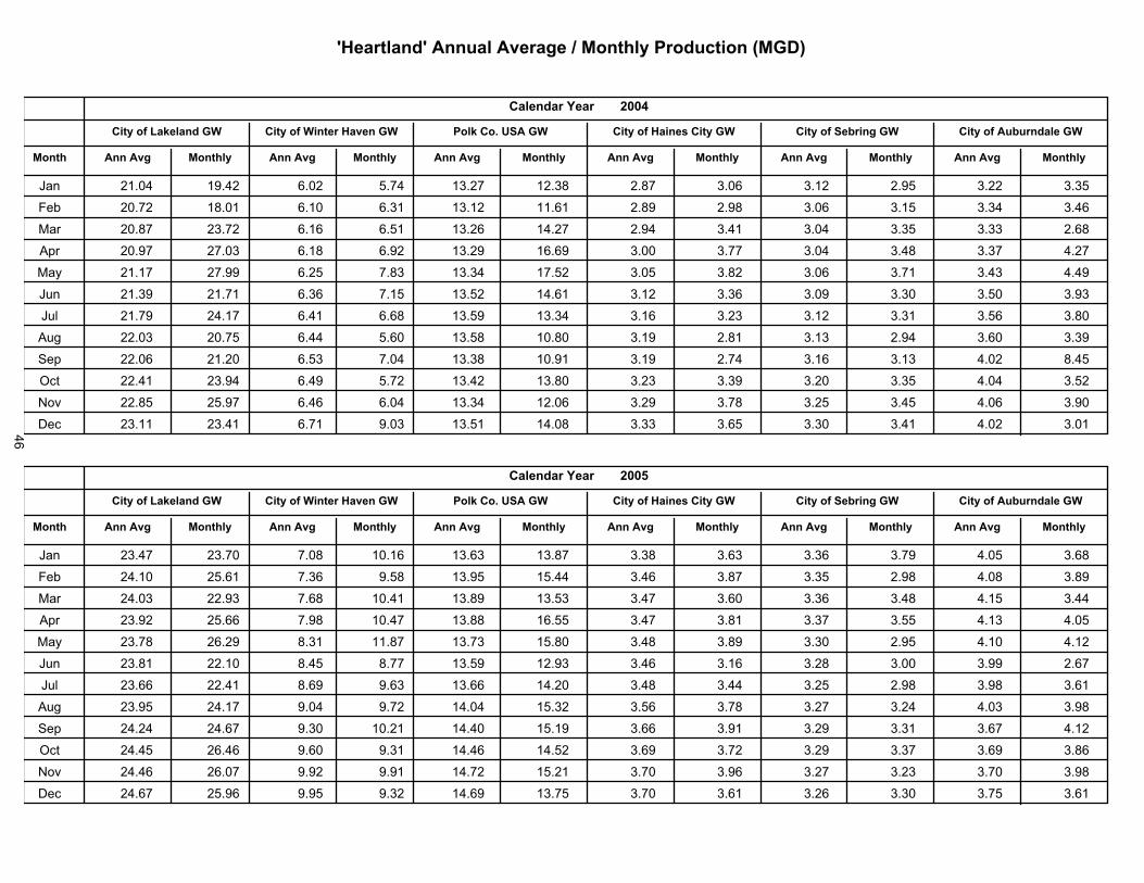
����������� ����������������������� ����������
������������ ����������
��������� � ��������������� ��������
�!""&�
�����������
������������*��������
����������������������
�������������
�� ����������
�����
������������ ����� ����������������������
����� ����� �
��� ����!� ������ �)�!� ���� ������ ������ ����� ���!) ����� ���� ����� ����
� � ��!��� ����!� �)��! �)��� ������ ����)� ����� ����� ���!) ���� ����� ����)
��� ��!��� ������ �)��) �)�� �����) ������ ����� ����� ���!� ���� ����� ���)�
��� ��!��� ����!� �)��� �)��� ������ ��)�)� ���!! ����� ���!� ����� ����� �����
��� ������ ������ �)�� ����� ������ ����� ���! ����� ���!) ����� ����� �����
��� ������ ������ �)��) ���� ����� ����)� ����� ����) ���!� ����! ���! �����
��� ������ ������ �)��� �)�)� ����� ������ ����) ����� ����� ����� ���) ����!
��� ����!� ��!�� �)��� ��)! ����� ��!��! ����� ����� ����� ����� ���)! �����
� � ����!) �����! �)�� ���!� ������ ��!��� ����� ����� ����) ����� ���!� ����
��� ������ ������ �)��� ���� ������ �����! ����� ����� ����! ���� ���!� ����
!<? ����� ����� �)��) �)�!� ������ ����!) ����� ����� ���� ���� ���!) ����!
^ � ������ ������ �)��� ���!� ����� ����!� ����� ���) ����! ����� ���!� ���!�
����� ������ � ����������
��������������� ��������������������
�� !�
����� ������
�������������"�������
����� ����������� ������
#� ����������
�� ����������
�����
������������ ����� ����������������������
����� ����� �
��� ������ �����! ���!� ��!��) ����)� ������ ����� ���)� ����) ����� ���! ���)�
� � �����! ���)� ����) ���� ����� ����� ����) ����� ���� ����� ���!� �����
��� ����!� ������ ���)� ��!��� ������ ����� ����� ���)! ����) ����� ���� �����
��� ������ ���)) ����� ��!��� ������ ��)� ����� ����� ����� ��� ����� ���!
��� ������ ��)��� ����� ������ ������ ����! ����� ����� ����! ���� ����! �����
��� ������ �����! ���� ����� ����� ������ ����) ����) ����� ���!! ����� ���)�
��� ����)) ������ ���)� ���)� ����)) �����! ����� ����� ���� ����� ����� ���)�
��� ����� ������ ���!� ����� ����!� ����� ���) ����� ����� ����� ���!� �����
� � ������ ����)� ����! ��!��� �����! ����� ���)) ����� ����� ����� ���)� �����
��� ����� ��)��) ���)! ����� �����) ����� ���)� ����� ����� ����� ���)� ����)
!<? �����) ��)�!� ����� ����� ������ ����� ����! ����) ����� ����� ����! �����
^ � ����)� ����) ���� ����� ����)� ����� ����! ���)� ����) ����! ���� ���)�
46
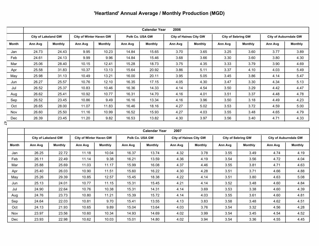
$����� ���$����� ��������%������ ��#����&�����'�()
����� ������ � ����������
��������������� ��������������������
�� *�
����� ������
�������������"�������
����� ����������� ������
#� ����������
�� ����������
�����
������������ ����� ����������������������
����� ����� �
��� ����� ����� ����� ����� ����� ���� � ���� �� � ���� �� � ���� ���
� � ���� � ����� ����� ���� ����� ����� �� �� ��� �� � ��� ����
��� ����� ����� ������ ������ ����� ���� ���� ���� �� ���� ���� ��� �
��� ����� ��� ����� ���� ���� � ������ �� ����� ��� ����� ���� �����
��� ����� ���� ������ ����� �� ��� ������ ���� ����� ���� �� ����� �����
��� �� ��� ������ ����� ������ �� �� ������ ����� ���� ���� ��� ���� ����
��� �� ��� ����� ���� ����� �� � ���� ����� ����� ���� ���� ����� �����
��� �� � � ������ ������ ������ �� �� ������ ���� ����� ���� ��� ���� ����
� � �� ��� ����� ���� ����� �� �� ���� ���� ��� ���� ��� ����� ����
��� �� � � ����� ������ ���� �� �� ���� ����� ����� ��� ���� ����� �����
!<? �� � � ������ ����� ������ �� ��� ����� ����� ���� ���� ��� ��� � �����
^ � �� �� ����� ������ ���� �� �� ���� ���� ���� ��� ���� ����� ���
����� ������ � ����������
��������������� ��������������������
�� *�
����� ������
�������������"�������
����� ����������� ������
#� ����������
�� ����������
�����
������������ ����� ����������������������
����� ����� �
��� �� ��� ������ ����� ������ �� �� ����� ���� ��� ���� ���� ����� �����
� � �� ��� ������ ������ ��� �� ��� ����� ��� ����� ���� ��� ����� �����
��� ���� ���� � ����� ������ ������ �� �� ���� ���� ���� ��� ����� ���
��� ������ �� �� ������ ������ ���� � �� ��� ���� ���� ���� ���� ��� ���
��� ����� ����� ����� ������ ������ ��� ����� ����� ���� ��� ��� ����
��� ����� ������ ������ ������ ����� ������ ����� ����� ���� ��� ��� � ����
��� ������ ���� � ����� ���� ����� ����� ����� �� � ��� �� ��� � ����
��� ����� ���� ����� ������ ����� ������ ����� ���� ���� �� � ��� � ����
� � ���� � ����� ����� ����� ������ ����� ���� �� ��� ��� ��� � �����
��� ����� ����� ���� � ���� ������ ��� � ���� ��� ���� ��� ���� ����
!<? ����� ���� ���� � ����� ����� ���� � ����� ���� ���� ���� ����� �����
^ � ���� ����� ���� � ����� ������ ����� ����� ���� ���� �� ����� �����
47
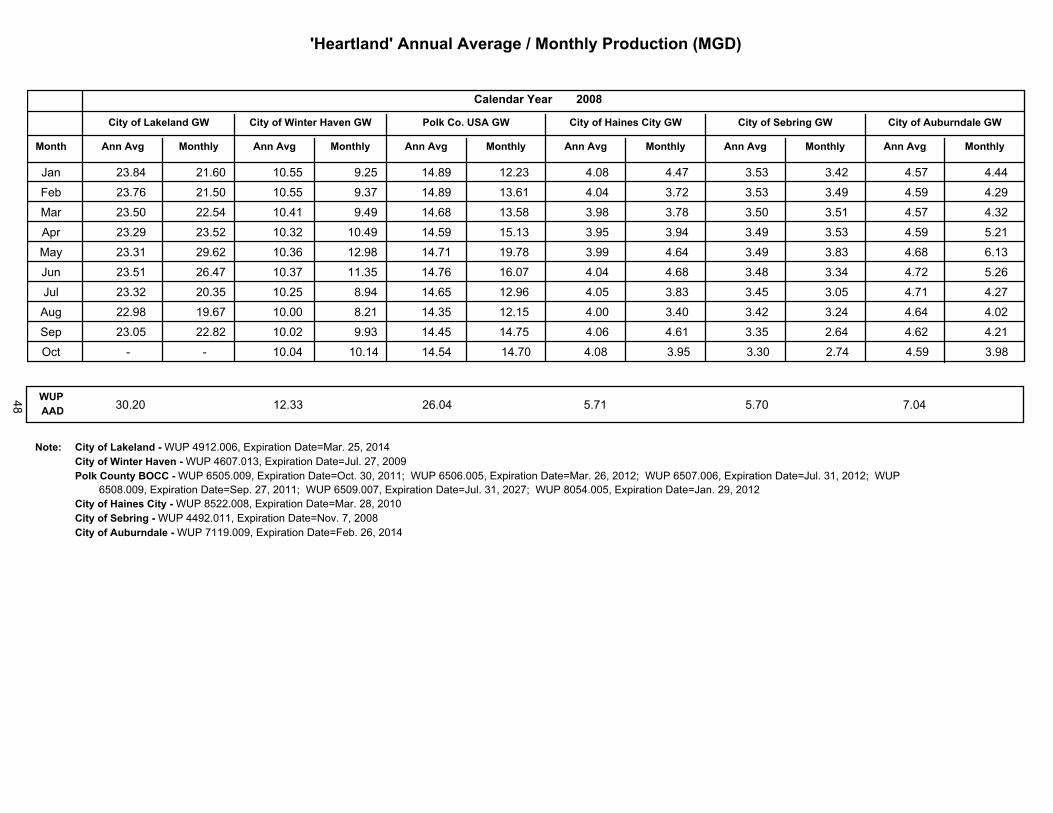
$����� ���$����� ��������%������ ��#����&�����'�()
����� ������ � ����������
��������������� ��������������������
�� +�
����� ������
�������������"�������
����� ����������� ������
#� ����������
�� ����������
�����
������������ ����� ����������������������
����� ����� �
��� ������ ����)� ������ ����� ������ ������ ����� ����� ����� ����� ����� �����
� � �����) ������ ������ ����� ������ ����)� ����� ����� ����� ����� ����� �����
��� ������ ������ ������ ����� ����)� ������ ����� ����� ����� ����� ����� �����
��� ������ ������ ������ ������ ������ ������ ����� ����� ����� ����� ����� �����
��� ������ ����)� �����) ������ ������ ������ ����� ���)� ����� ����� ���)� �)���
��� ������ ��)��� ������ ������ �����) ��)��� ����� ���)� ����� ����� ����� ����)
��� ������ ������ ������ ����� ����)� �����) ����� ����� ����� ����� ����� �����
��� ������ ����)� ������ ����� ������ ������ ����� ����� ����� ����� ���)� �����
� � ������ ������ ������ ����� ������ ������ ����) ���)� ����� ���)� ���)� �����
��� � - � - ������ ����� ����� ����� ���� ���� ���� ���� ����� ����
��#�( ����� ����� �)��� ���� ���� ����
$���+ ������������ ����,������������)���������������� ������������������������������������,������)���������������������� ��������������#� ���������-.���,�����)����������������������� ���������������������)��)�������������������� �������)�������������)������)���������������� �������������������������������
)����������������������� �� ������������������)����������������������� ��������������������������������������������� ���������������������������"������,����������������������������� �������������������������������,����������������������������� ���������������������������� ��,����������������������������� �� ����)������
48
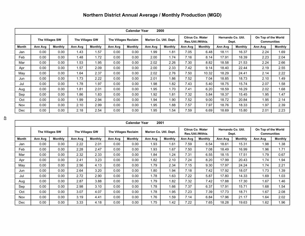
������������� ��������������������������� ��������
������ �������
��������������������������
!!!
��������������������� ������������������
"���������#$���#���#
��������#�����%��#�$���#�������#��������#$���#���#
�������������
���&�������%� ����
��������'���
�����
���&�������(� ���&���������
������ ������� �������������
��� ������ ������ ����� ������ ������ ������ ������ ������ ������ ������ ������� ������ ����� ������ ������ ������ ������ ������ ������ ������ ������ ������ ������ ������ ������� ������ ���� �������� ������ ������ ����� ������ ������ ������ ������ ������ ����� ������ ������� ������ ����� �������� ������ ������ ������ ������ ������ ������ ������ ���� ������ ������ ������� ������� ����� �������� ������ ������ ������ ����� ������ ������ ������ ������ ������ ������ ������� ������� ����� �������� ������ ������ ����� ������ ������ ������ ������ ������ ������ ������ ������� ������ ����� �������� ������ ������ ������ ������ ������ ������ ������ ������ ����� ������ ������� ������� ����� �������� ������ ������ ������ ������ ������ ������ ������ ������ ������ ������ ������� ������� ����� ������� ������ ������ ������ ����� ������ ������ ������ ������ ����� ������ ������ ������� ����� �������� ������ ������ ������ ������ ������ ������ ������ ������ ������ ������ ������� ������� ����� �����!<? ������ ������ ������ ������ ������ ������ ������ ������ ������ ������ ������� ����� ����� ����^� ������ ������ ������ ������ ������ ������ ������ ������ ������ ������ ������� ������� ����� ����
������ �������
��������������������������
!!)
��������������������� ������������������
"���������#$���#���#
��������#�����%��#�$���#�������#��������#$���#���#
�������������
���&�������%� ����
��������'���
�����
���&�������(� ���&���������
������ ������� �������������
��� ������ ������ ������ ������ ������ ������ ����� ������ ������ ������ ������� ������ ����� ����� ������ ������ ������ ������ ������ ������ ����� ������ ������ ������ ������� ������� ����� �������� ������ ������ ����� ���� ������ ������ ������ ������ ����� ������ ������� ������� ����� �������� ������ ������ ������ ���� ������ ������ ������ ������ ������ ������ ������� ������ ����� �������� ������ ������ ������ ����� ������ ������ ������ ����� ������ ����� ������� ������� ����� �������� ������ ������ ������ ����� ������ ������ ������ ������ ������ ������ ������� ������� ���� ������� ������ ������ ������ ������ ������ ������ ������ ����� ������ ������ ������� ����� ����� ������� ������ ������ ������ ����� ������ ������ ������ ������ ����� ������ ������� ������ ����� ������� ������ ������ ������ ����� ������ ������ ������ ������ ����� ����� ������� ������� ����� �������� ������ ������ ����� ������ ������ ������ ������ ������ ����� ����� ������ ������� ����� �����!<? ������ ������ ����� ������ ������ ������ ������ ������ ������ ������ ������� ������� ����� �����^� ������ ������ ��� ������ ������ ������ ������ ������ ������ ������ ������� ������ ����� �����
49

������������� ��������������������������� ��������
������ �������
��������������������������
!!
��������������������� ������������������
"���������#$���#���#
��������#�����%��#�$���#�������#��������#$���#���#
�������������
���&�������%� ����
��������'���
�����
���&�������(� ���&���������
������ ������� �������������
��� ������ ������ ������ ������ ������ ������ ������ ������ ������ ������ �����)� ������� ����� ����)� ������ ������ ������ ������ ������ ������ ������ ������ ������ ������ ������� ������� ����� �������� ������ ������ ������ ������ ������ ������ ������ ������ ������ ������ ������� ������� ����� �������� ������ ������ ������ ������ ������ ������ ������ ������ ������ �)��)� ����)�� ������� ����� ���)���� ������ ������ ���)�� ������ ������ ������ ���)�� ������ ������ ������� ��)��)� ������� ����� �������� ������ ������ ���)�� ������ ������ ������ ���)�� ���)�� ����)� ������ ��)���� ������� ����� �������� ������ ������ ���)�� ������ ������ ������ ���)�� ���)�� ������ ������ ��)���� ������� ����� ���)���� ������ ������ ���)�� ������ ������ ������ ���))� ����)� ������ ����)� ��)���� ������� ����� ������� ������ ������ ���)�� ������ ������ ������ ������ ������ ������ ������ ��)���� ������� ����� �������� ������ ������ ���)�� ������ ������ ������ ������ ������ ������ ������ ��)�)�� �����)� ����� �����!<? ������ ������ ���)�� ������ ������ ������ ������ ����)� ������ ������ ��)���� �����)� ����� �����^� ������ ������ ���)�� ������ ������ ������ ������ ������ ������ ����)� ��)���� �����)� ����) �����
������ �������
��������������������������
!!,
��������������������� ������������������
"���������#$���#���#
��������#�����%��#�$���#�������#��������#$���#���#
�������������
���&�������%� ����
��������'���
�����
���&�������(� ���&���������
������ ������� �������������
��� ������ ������ ���)�� ������ ������ ������ ������ ������ ������ ����)� ��)���� ������� ����) ������ ������ ������ ������ ���)�� ������ ������ ������ ������ ������ ������ ��)���� ������� ����) ����)��� ������ ������ ���))� ���)�� ������ ������ ������ ������ ������ ������ ����)�� ������� ����� �������� ������ ������ ����)� ���)�� ������ ������ ������ ������ ������ ���)�� ����)�� ������� ����� �������� ������ ������ ����)� ����)� ������ ������ ������ ���))� ������ �)�)�� ������� �����)� ����� �������� ������ ������ ����)� ������ ������ ������ ������ ����)� ������ ������ ������� ������� ����� �������� ������ ������ ������ ������ ������ ������ ������ ������ ������ ������ ������� ������� ����� �������� ������ ������ ����)� ������ ������ ������ ������ ������ ����)� ������ ������� ������� ����� ������� ������ ������ ������ �)���� ������ ������ ������ ������ ������ ������� ������� ������� ����� �������� ������ ������ ������ ������ ������ ������ ����)� ����)� ������ ������ ������� ������� ����� �����!<? ������ ������ ���)�� �)���� ������ ������ ����)� ������ ������ ������ ������� ��)���� ����) �����^� ������ ������ ������ ������ ������ ������ ������ ������ ������ ������ ������� ������� ����� �����
50
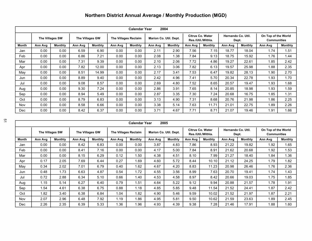
������������� ��������������������������� ��������
������ �������
��������������������������
!!.
��������������������� ������������������
������������� ������
������������������� ��� ������� ������� ������
��������������
����� ������������ �
������������
�����
����� ������� � ����� �������!�
������� ������� ��������������
��� ������ ������ ����� ������ ������ ������ ������ ������ ����� ����� ������� ����� � ���� ������� ������ ������ ������ ������ ������ ������ ������ ���*�� ���� � ����*� ������ ������ ����� ��� ��� ������ ������ ���*�� ���*�� ������ ������ ������ ������ ������ � ���� ������� ������� ���� ��� ���� ������ ������ ������ ������� ������ ������ ����*� �*���� ������ ����*� ������ ������ ����� ���*��� ������ ������ ����� �� ���� ������ ������ ������ �*� �� ���*� ��� �� ������� �����*� ����� �������� ������ ������ ������ ��� �� ������ ������ ��� �� � ���� ��� �� ����� ����* � ������� ����* �������� ������ ������ ������ ����� ������ ������ ������ � ���� ����� ����� ������ ���� �� ����* �������� ������ ������ ���*�� ���� � ������ ������ ������ �*���� ����� ���� � ������ ������� ����* ������� ������ ������ ���� � �� �� ������ ������ ������ �*�*� ���*�� ���� � ������� ������ ���� ���*���� ������ ������ ������ ����*� ������ ������ �*��*� � ���� ���*�� ������ ������� ������� ����� ����!<? ������ ������ ����� ������ ������ ������ �*�*�� ��� � ����*� ������� ������� ������ ����� �����^�� ������ ������ ��� �� ���*�� ������ ������ �*���� � ���� ������ ������ ������� ���� �� ����� �����
������� �������
"�������#���������������� � ��
�$%%&�
��������������������� ���������������������
������������� ������
������������������� ��� ������� ������� ������
��������������
����� ������������ �
������������
�����
����� ������� � ����� �������!�
������� ������� ��������������
��� ������ ������ ��� �� ����*� ������ ������ �*���� � ��*� ������ ����*� ������� ������� ����� ������� ������ ������ ��� �� ������ ������ ������ � ���� ����� ���� � ������ ������� ������� ����� ���*��� ������ ������ ����� ������ ������ ����� � �*�� � ��� ������ ������ ������� ���� �� ���� ���*���� ������ ����� ������ ��� � ������ ������ � ���� ����� ��� � ������� ������� �� ��� ����� �������� ���* � ������ ������ ������ ��� �� ������ � ���� � ���� ����*� �����*� ������� ���� �� ����� ���*���� ��� �� ����*� ����*� � ���� ��� � ������ � �� �*��� ������ ����*� ������� ���� �� ���� ��� *��� ������ ������ ���* � ����� ������ ��� �� � �*� � ��� ������ ��� �� ������� �����*� ���� ������� ����� ��� � ������ ��� �� ������ ����� � �� � ����� ������ ���� � ������� ������ ����� �������� ��� � � ���� ���*�� ����� ������ ������ � ��� ���� ��� �� ���� � ������ �� � �� ����� ��� ���� ������ �*� �� ���*�� ���� � ���� � ������ � ���� �� �� ����� ������� ������ ������� ����� �����!<? ������ ������ ��� �� ������ ������ ������ � ��� ����� ����� ������� ������ ��*��*� ����� ��� ^�� ������ ���*� ���*�� ��**� ���*�� ������ � ��*� � �*�� ���*�� ������ ���� �� ������� ����� �����
51

'��������� ��� ����������������������������������� ���(�!�)
������� �������
"�������#���������������� � ��
�$%%*�
��������������������� ���������������������
������������� ������
������������������� ��� ������� ������� ������
��������������
����� ������������ �
������������
�����
����� ������� � ����� �������!�
������� ������� ��������������
��� ������ �!��� ������ ��!�!� ������ ����!� � ���� ��� !� ����� ������ ������� ���� � ����! ����� ����!� ��� �� ������ ��� �� ������ ����!� � ���� � ���� ����� ������ ������� ��!��!� ����! �������� ������ ������ ������ ������ ������ ���!� ����!� ����� ������ ������� ���� �� ������� ���!� �������� ����!� ����!� ������ �� ���� ������ ������ ����� ������ ��!�!�� �� ���� ������ �� �� ����� ��!���� ��� � �!�!�� ���!� ��!�!�� ������ ��� �� ������ ���!�� ��!��� �� ��� ������ ������ ����� ������ ��� � ���� � ���� � ������� ������ ���� � ���!!� ������ ��!���� ����! � �� ��!� ����!�� ����� ������� ����� ����� ��!���� ����� � ������ ����� ������ ����� ��!���� ����� � �� �� � �� ��� ���� ����!��� ����!� ������ ��!���� ������� ����!� ������ ����� ������ ����!�� ��!���� �� �� � ���� � ����� ���!�� ������ �!���� ���� �� ������� ������ ������ ��� �� ������ ��!���� ��!���� �� ���� ������� ����� ������� ����!� �!�!!� ������ ������ ������ ����!� ������ ������ ������� �� ���� ������ ������� ����� � ���!<? ����� �!� �� ������� ���� �� ������ ������ ������ ��� � ������ ������� �����!� ����!� ���� � �!�^� ������ �!���� ������ ������� ������ ������ ������ ��� � ������� ��!� � ������� ������� ��!� ��!
������� �������
"�������#���������������� � ��
�$%%*�
��������������������� ���������������������
������������� ������
������������������� ��� ������� ������� ������
��������������
����� ������������ �
������������
�����
����� ������� � ����� �������!�
������� ������� ��������������
��� ������ ��� � ������ ��!���� ������ ��� � ���!�� ������ ������� ����� ������� ��!���� ���� ������ ������ ������ ������ ������ ������ ����!� ���!�� ����� ������� ����� �����!� ������ ���� ��� ���� ���!�� �!���� ����!� ���!�� ���!!� ����� ���! � ����� �����!� �����!� ������� ������� ��� �������� ���!�� �!�� � ����� ������ ���! � ������ ���! � ������ ���� �� ������� �� � � ���!�� ���� ������� ���!�� �!�� � ����� �����!� ���!�� ���!�� ������ ������ ���� � ������ �� �! � ����!�� ��� ���!��� ����!� ���!� ������ ������� ���!�� ���!�� ���� � ������ ����� ������� ������ ��� �� ��� �� ��� ������ ����� ���!!� ������ ����!� ���!� ���!�� ������ ����� � ��!���� ������ ��!��!� ��� ������� ��� �� ������ ������� ���� � ����� ���!�� ���!�� ������ ������� ����� � ������ ������� �� � ������ ����� �� �� �����!� ������ ���� � ���!�� ������ ���!�� ������� ���� � ���!�� ��!���� �� � ���!��� ���!�� ���!�� ������� ������ ����!� ����!� ������ ������ ��!���� ����!� ������� ��!�!�� �� ����!<? ���� ����� ����� � ����!� ������ ����� ������ ������ ��!���� ��!��� ������� ������� �� ����^� ������ ��!�� ��!���� ��� �� ������ ���� � ������ ������ ��!���� ������ ������� ������� �� ���
52

'��������� ��� ����������������������������������� ���(�!�)
������� �������
"�������#���������������� � ��
�$%%��
��������������������� ���������������������
������������� ������
������������������� ��� ������� ������� ������
��������������
����� ������������ �
������������
�����
����� ������� � ����� �������!�
������� ������� ��������������
��� ������ � ���� ������ ������ ��� �� � ����� ����� �� ���� � ��� � ����� ���������� ������ ������ ����� � ����� ����� ������ ������ � ���� ���� � �� ���� � ����� ����� ���������� ��� ��������� ����� � ����� ������ ������ ������ � �� �� ����� �� � �� � ��� ���� ���������� ������������ ������ ���� ������ ������ ���� � � ����� � ����� �� � �� ������� ����� ������ ���� ������������� ����� � �� �� ������ ������ ������ ���� � ����� �� � �� ������� ����� ������ �� ������ � ���� ����� � �� �� ���� � ��� � ����� ����� ����� �� ��� ������� ����� ��� �� ���� ���� �������� ������ ��� ������ ����� ������ ��� � ��� �� ������� � ����� ����� ���������� ������������� ����� ����� ������ ������ ������ �� �� ������ ������� � ����� ����� ���� ���� � ����������� ����� ����� ����� ������ ����� �� �� � ����� ������ ������� ����� ������ ���� � � �������� ������ � ����� ������ ������ ������ �� �� ��� � ����� � �� ��� ���� ������ �� ��� ������
������� ���� �� � �� ����� ����
'���+ ����� �������+����� ������������������������������������� ���� ����������� � � ��������+����������������������������������������� �������������������������������������������������������������������������� �������
� � �������������������������������� ��������������� ����������������������������������������������������������������������� ��������� ����������������������������� ����� ����������� ������������������������������������������������������������������ ������� ���������������������������������� �������� �� ���� ����������������������������� �
��������������������������������� ��������������� ����������� �����������+���������������������������������� ���� ����������������������������������!�"�� �������������������������������������� �������� � ��������������������������������� ������������������������������������������� ��������� ������������������������������������������������������������������
����������������� � � ��������+������ ���������������������������� ������������������������������������������� ����� ������������������������������������������ ��������������������������������������� ����� ����������������������������������������������������������������������������� ������� �� ��� ���������������������������� �
"�������#���������������� � ���+����� ���������������������������������� ����������������������������� �
53

54
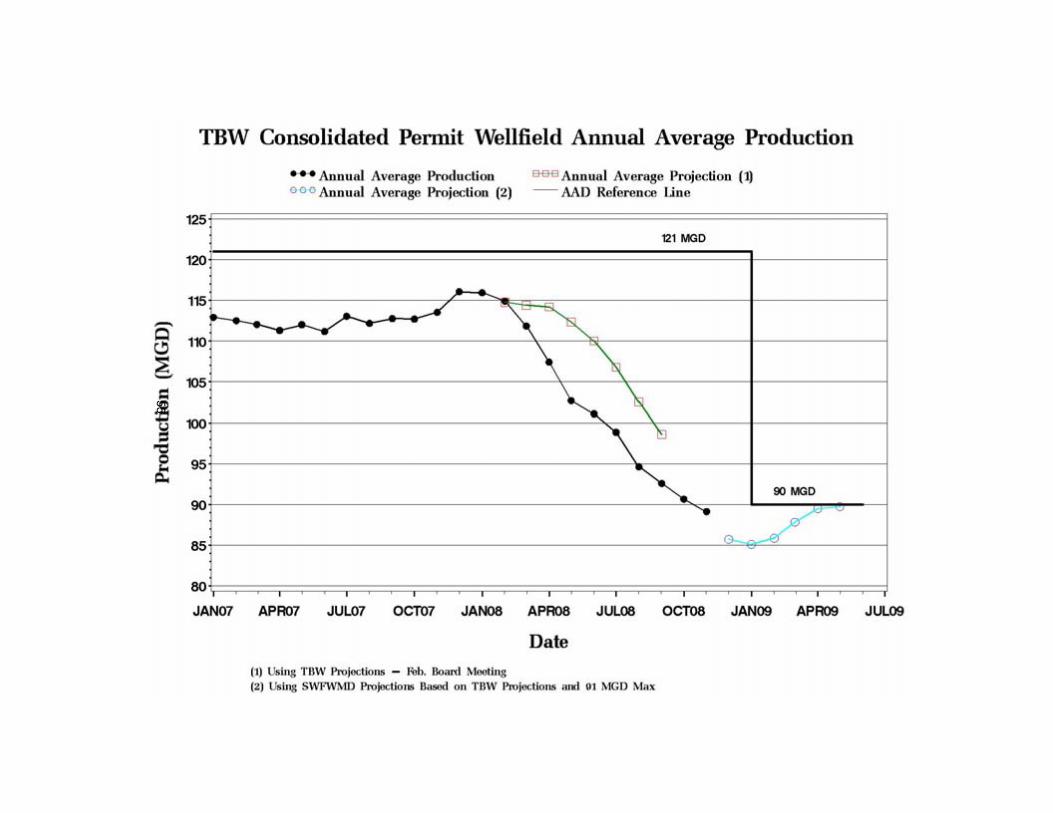
55
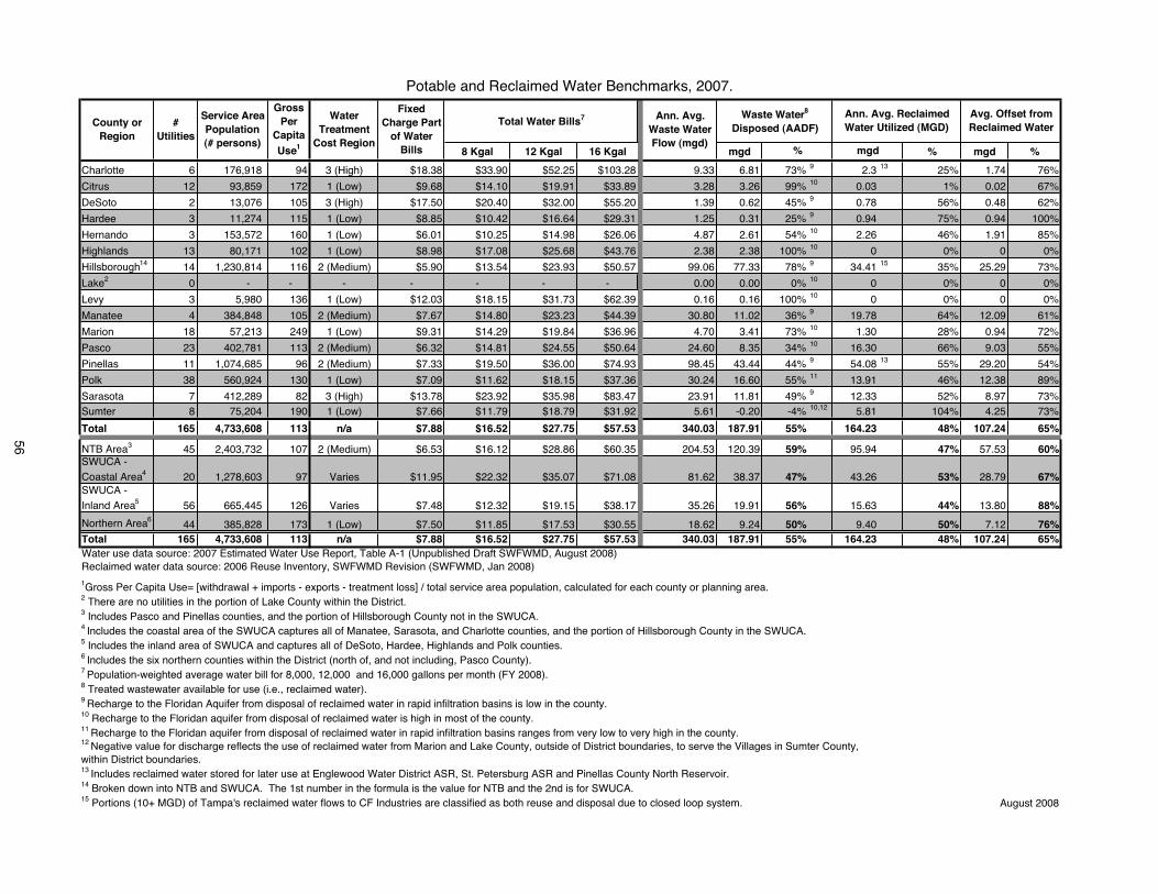
8 Kgal 12 Kgal 16 Kgal mgd % mgd %
Charlotte 6 176,918 94 3 (High) $18.38 $33.90 $52.25 $103.28 9.33 6.81 73% 9 2.3 13 25% 1.74 76%
Citrus 12 93,859 172 1 (Low) $9.68 $14.10 $19.91 $33.89 3.28 3.26 99% 10 0.03 1% 0.02 67%
DeSoto 2 13,076 105 3 (High) $17.50 $20.40 $32.00 $55.20 1.39 0.62 45% 9 0.78 56% 0.48 62%
Hardee 3 11,274 115 1 (Low) $8.85 $10.42 $16.64 $29.31 1.25 0.31 25% 9 0.94 75% 0.94 100%
Hernando 3 153,572 160 1 (Low) $6.01 $10.25 $14.98 $26.06 4.87 2.61 54% 10 2.26 46% 1.91 85%
Highlands 13 80,171 102 1 (Low) $8.98 $17.08 $25.68 $43.76 2.38 2.38 100% 10 0 0% 0 0%
Hillsborough14 14 1,230,814 116 2 (Medium) $5.90 $13.54 $23.93 $50.57 99.06 77.33 78% 9 34.41 15 35% 25.29 73%
Lake2 0 - - - - - - - 0.00 0.00 0% 10 0 0% 0 0%
Levy 3 5,980 136 1 (Low) $12.03 $18.15 $31.73 $62.39 0.16 0.16 100% 10 0 0% 0 0%
Manatee 4 384,848 105 2 (Medium) $7.67 $14.80 $23.23 $44.39 30.80 11.02 36% 9 19.78 64% 12.09 61%
Marion 18 57,213 249 1 (Low) $9.31 $14.29 $19.84 $36.96 4.70 3.41 73% 10 1.30 28% 0.94 72%
Pasco 23 402,781 113 2 (Medium) $6.32 $14.81 $24.55 $50.64 24.60 8.35 34% 10 16.30 66% 9.03 55%
Pinellas 11 1,074,685 96 2 (Medium) $7.33 $19.50 $36.00 $74.93 98.45 43.44 44% 9 54.08 13 55% 29.20 54%
Polk 38 560,924 130 1 (Low) $7.09 $11.62 $18.15 $37.36 30.24 16.60 55% 11 13.91 46% 12.38 89%
Sarasota 7 412,289 82 3 (High) $13.78 $23.92 $35.98 $83.47 23.91 11.81 49% 9 12.33 52% 8.97 73%Sumter 8 75,204 190 1 (Low) $7.66 $11.79 $18.79 $31.92 5.61 -0.20 -4% 10,12 5.81 104% 4.25 73%
Total 165 4,733,608 113 n/a $7.88 $16.52 $27.75 $57.53 340.03 187.91 55% 164.23 48% 107.24 65%
NTB Area3 45 2,403,732 107 2 (Medium) $6.53 $16.12 $28.86 $60.35 204.53 120.39 59% 95.94 47% 57.53 60%SWUCA -
Coastal Area4 20 1,278,603 97 Varies $11.95 $22.32 $35.07 $71.08 81.62 38.37 47% 43.26 53% 28.79 67%SWUCA -
Inland Area5 56 665,445 126 Varies $7.48 $12.32 $19.15 $38.17 35.26 19.91 56% 15.63 44% 13.80 88%
Northern Area644 385,828 173 1 (Low) $7.50 $11.85 $17.53 $30.55 18.62 9.24 50% 9.40 50% 7.12 76%
Total 165 4,733,608 113 n/a $7.88 $16.52 $27.75 $57.53 340.03 187.91 55% 164.23 48% 107.24 65%Water use data source: 2007 Estimated Water Use Report, Table A-1 (Unpublished Draft SWFWMD, August 2008)Reclaimed water data source: 2006 Reuse Inventory, SWFWMD Revision (SWFWMD, Jan 2008)
1Gross Per Capita Use= [withdrawal + imports - exports - treatment loss] / total service area population, calculated for each county or planning area.2 There are no utilities in the portion of Lake County within the District. 3 Includes Pasco and Pinellas counties, and the portion of Hillsborough County not in the SWUCA.4 Includes the coastal area of the SWUCA captures all of Manatee, Sarasota, and Charlotte counties, and the portion of Hillsborough County in the SWUCA.5 Includes the inland area of SWUCA and captures all of DeSoto, Hardee, Highlands and Polk counties. 6 Includes the six northern counties within the District (north of, and not including, Pasco County). 7 Population-weighted average water bill for 8,000, 12,000 and 16,000 gallons per month (FY 2008).8 Treated wastewater available for use (i.e., reclaimed water).9 Recharge to the Floridan Aquifer from disposal of reclaimed water in rapid infiltration basins is low in the county.10 Recharge to the Floridan aquifer from disposal of reclaimed water is high in most of the county.11 Recharge to the Floridan aquifer from disposal of reclaimed water in rapid infiltration basins ranges from very low to very high in the county.
13 Includes reclaimed water stored for later use at Englewood Water District ASR, St. Petersburg ASR and Pinellas County North Reservoir.14 Broken down into NTB and SWUCA. The 1st number in the formula is the value for NTB and the 2nd is for SWUCA. 15 Portions (10+ MGD) of Tampa's reclaimed water flows to CF Industries are classified as both reuse and disposal due to closed loop system. August 2008
FixedCharge Part
of Water Bills
Ann. Avg. Reclaimed Water Utilized (MGD)
Avg. Offset from Reclaimed Water
Waste Water8
Disposed (AADF)
%
WaterTreatment
Cost Region
12 Negative value for discharge reflects the use of reclaimed water from Marion and Lake County, outside of District boundaries, to serve the Villages in Sumter County, within District boundaries.
Potable and Reclaimed Water Benchmarks, 2007.
County or Region
Ann. Avg. Waste Water Flow (mgd)
Total Water Bills7Service Area Population(# persons)
GrossPer
CapitaUse1
#Utilities
mgd
56

Overpumpage Activity ReportOctober 2008
Table 1. Overpumpage Report Summary
Service Office
Projects Under Review(Table 2)
Preparing for RPM / Legal
(Table 3)
Justified/Closed Since Previous Report
(Table 4)
Active Files in Legal (Table 5)
Consent Order Monitoring (Table 6)
Total Files
PreviousMonth
CurrentMonth
PreviousMonth
CurrentMonth
PreviousMonth
CurrentMonth
PreviousMonth
CurrentMonth
PreviousMonth
CurrentMonth
PreviousMonth
CurrentMonth
Bartow 8 5 3 3 3 3 3 3 0 0 17 14
Brooksville 2 0 2 3 0 1 6 6 2 2 12 12
Sarasota 1 1 0 0 0 0 0 0 0 0 1 1
Tampa 0 1 2 0 0 0 0 2 1 1 3 4
Totals 11 7 7 6 3 4 9 11 3 3 33 31
RPM = Regulation Performance Management Department
57

(1) These projects are under review by the Service Office and have not been determined to be in non-compliance at this time(2) Use Types: P = Public Supply R = Recreational A = Agricultural MD = Mining/Dewatering IC = Industrial/Commercial
Overpumpage ReportOctober 2008
Table 2. Projects Under Review (1)
Permit No. Permit Holder Use Type (2) Months onReport Service Office
New Since Previous Report20000660.005 Farmland Reserve A 1 TampaContinuing From Previous Report20001109.005 Bryan Paul Family Ltd. Ptnshp A 2 Bartow
20004230.005 Peace Valley Groves, Inc. A 2 Bartow
20006368.006 Donnis & Kathleen Barber A 2 Bartow
20005920.010 Pioneer Grove, Inc. A 4 Bartow
20009124.003 Westby Corp. A 4 Bartow
20002292.001 River Plantation HOA, Inc. R 2 Sarasota 58

(1) Preliminary determination that permit is in non-compliance; file being prepared for or under review by Regulation Performance Management(2) Use Types: P = Public Supply R = Recreational A = Agricultural MD = Mining/Dewatering IC = Industrial/Commercial*Current pumpage information not available due to permit holder non-submittal of data
Overpumpage ReportOctober 2008
Table 3. Preparing for Regulation Performance Management / Legal (1)
Permit No. Permit HolderUse
Type (2)
PermittedAnnual Average
OriginalReport Date
Annual Avg. UsePercent Over
CurrentAnnual Average Use
Percent OverService Office
New Since Previous Report
20003228.007 Citrus Hills Investment Prop. Inc. R 613,000 gpd
05/28/08647,686 gpd
5.5%
10/28/0841,249 gpd
4.4 %Brooksville
Continuing From Previous Report
2002113.005 Wylie L & Wylie R Hinton A 156,000 gpd06/27/08
261,000 gpd67.3%
09/26/08*232,092 gpd
48.8%Bartow
2003806.004 Laura V Riche Trust A 101,600 gpd06/27/08
214,778 gpd111.4%
09/26/08*157,007 gpd
55.4%Bartow
2005063.004 Rolling Meadows Ranch Inc. A 171,900 gpd01/27/08
316,680 gpd84.2%
10/28/08247,7620 gpd
44.1%Bartow
2011856.000 Brassboys Enterprises R 42,000 gpd02/27/08
52,848 gpd25.8%
10/28/08112,327 gpd
167.4%Brooksville
2010266.002 Pulte Homes R 369,000 gpd04/27/08
483,728 gpd31.1%
10/28/08347,652 gpd
(5.8%)Brooksville
59
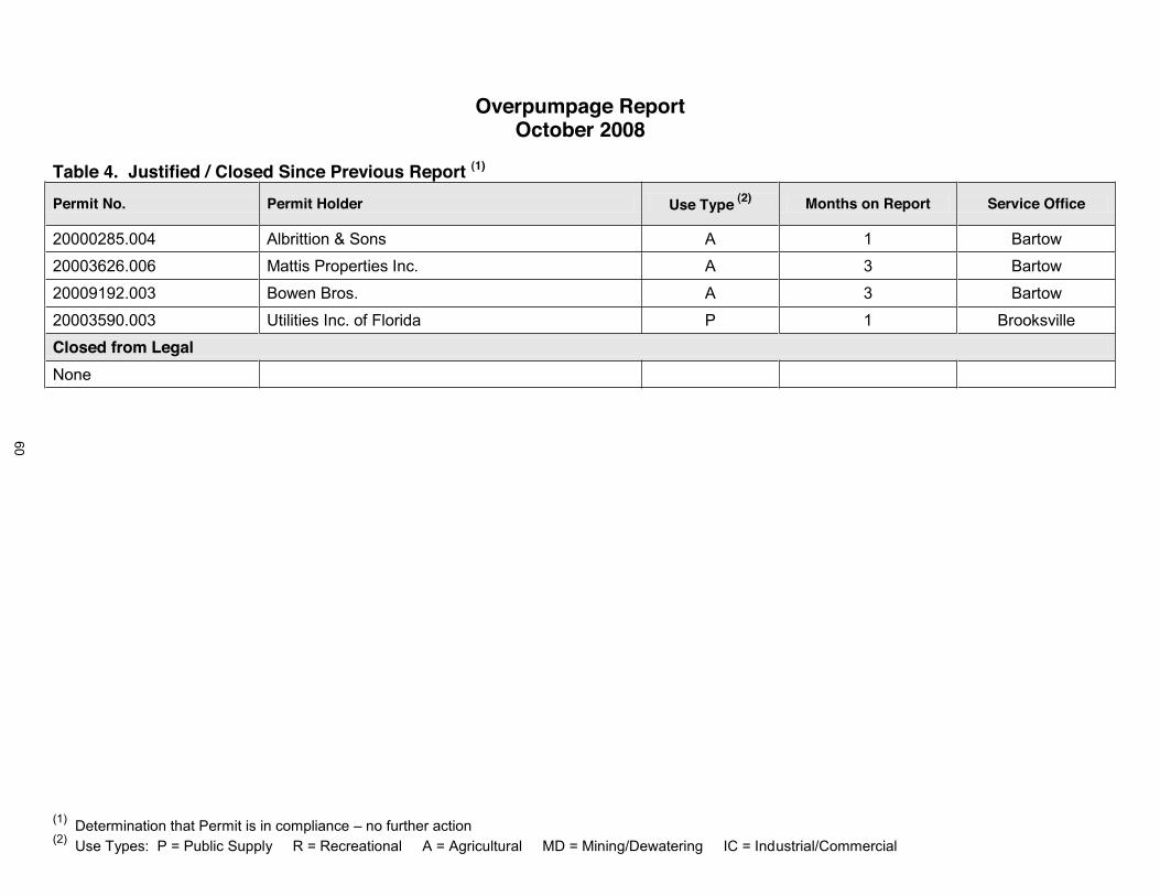
(1) Determination that Permit is in compliance no further action(2) Use Types: P = Public Supply R = Recreational A = Agricultural MD = Mining/Dewatering IC = Industrial/Commercial
Overpumpage ReportOctober 2008
Table 4. Justified / Closed Since Previous Report (1)
Permit No. Permit Holder Use Type (2) Months on Report Service Office
20000285.004 Albrittion & Sons A 1 Bartow
20003626.006 Mattis Properties Inc. A 3 Bartow
20009192.003 Bowen Bros. A 3 Bartow
20003590.003 Utilities Inc. of Florida P 1 Brooksville
Closed from Legal
None
60

(1) Regulation Performance Management concurs with non-compliance and file in Legal for enforcement(2) Use Types: P = Public Supply R = Recreational A = Agricultural MD = Mining/Dewatering IC = Industrial/Commercial
Overpumpage ReportOctober 2008
Table 5. Active Files in Legal (1)
Permit HolderUse
Type (2)
PermittedAnnual
Average
Original Report DateAnnual Average Use
Percent Over
CurrentAnnual Average Use
Percent OverService Office
New Since Previous Report
I 4 Land Holdings LTD Co. A 156,000 gpd06/27/08
170,822 gpd9.5%
10/28/08251,776 gpd
61.3%Tampa
Allison Repetto A 117,800 gpd06/27/08
182,519 gpd54.9%
10/28/08182,853 gpd
55.2%Tampa
Continuing From Previous Report
P 548,300 gpd07/26/06
1,054,200 gpd4.8%
10/28/08535,683 gpd
3.2%Bartow
Sebring Land LP & Highlands P 223,700 gpd06/28/06
275,833 gpd23.3%
10/28/08232,115 gpd
3.8%Bartow
Country Club Utilities, Inc. P 183,000 gpd01/31/06
256,852 gpd40.4%
10/28/08204,233 gpd
11.6%Bartow
St. Leo College Inc. P 113,300 gpd05/27/07
117,679 gpd3.9%
10/28/08 115,956 gpd
2.3 %Brooksville
Vikings LLC R 263,000 gpd06/27/07
500,427 gpd90.3%
10/28/08 348,595 gpd
32.5 %Brooksville
61

(1) Regulation Performance Management concurs with non-compliance and file in Legal for enforcement(2) Use Types: P = Public Supply R = Recreational A = Agricultural MD = Mining/Dewatering IC = Industrial/Commercial
Overpumpage ReportOctober 2008
Table 5. Active Files in Legal (1)
Permit HolderUse
Type (2)
PermittedAnnual
Average
Original Report DateAnnual Average Use
Percent Over
CurrentAnnual Average Use
Percent OverService Office
Timber Pines Community R 363,400 gpd04/27/07
376,487 gpd3.6%
10/28/0833,281 gpd
(90.8%)Brooksville
Spruce Creek Development R 445,800 gpd06/28/06
462,416 gpd3.7%
10/28/08 449,084 gpd
(0.7%)Brooksville
City of Zephyrhills P 2,746,000 gpd05/26/06
2,950,504 gpd7.4%
10/28/082,652,730 gpd
(3.4%)Brooksville
Pasco County Utilities (Lake Jovita) P 327,000 gpd05/26/06
331,981 gpd1.5%
10/28/08383,224 gpd
17.2%Brooksville
62
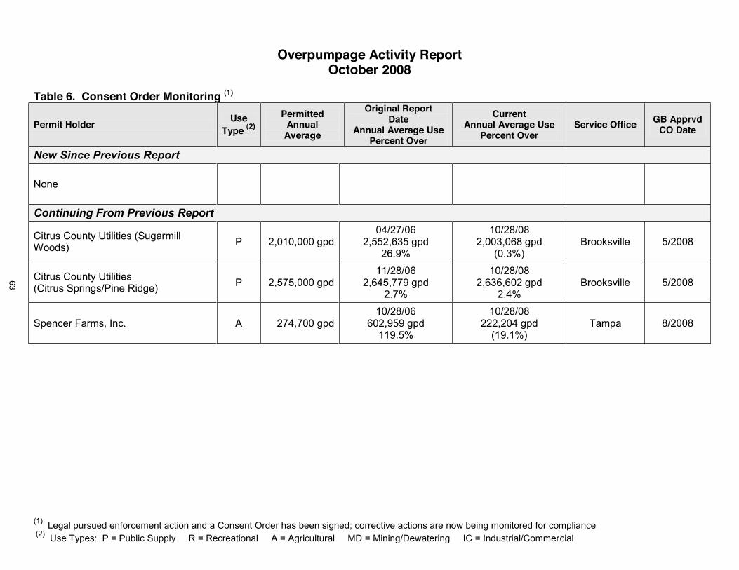
(1) Legal pursued enforcement action and a Consent Order has been signed; corrective actions are now being monitored for compliance(2) Use Types: P = Public Supply R = Recreational A = Agricultural MD = Mining/Dewatering IC = Industrial/Commercial
Overpumpage Activity ReportOctober 2008
Table 6. Consent Order Monitoring (1)
Permit HolderUse
Type (2)
PermittedAnnualAverage
Original ReportDate
Annual Average UsePercent Over
CurrentAnnual Average Use
Percent OverService Office GB Apprvd
CO Date
New Since Previous Report
None
Continuing From Previous Report
Citrus County Utilities (Sugarmill Woods) P 2,010,000 gpd
04/27/062,552,635 gpd
26.9%
10/28/082,003,068 gpd
(0.3%)Brooksville 5/2008
Citrus County Utilities(Citrus Springs/Pine Ridge) P 2,575,000 gpd
11/28/062,645,779 gpd
2.7%
10/28/082,636,602 gpd
2.4%Brooksville 5/2008
Spencer Farms, Inc. A 274,700 gpd10/28/06
602,959 gpd119.5%
10/28/08222,204 gpd
(19.1%)Tampa 8/2008
63
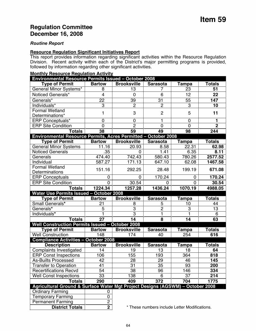
Item 59 Regulation CommitteeDecember 16, 2008
Routine Report
Resource Regulation Significant Initiatives ReportThis report provides information regarding significant activities within the Resource Regulation Division. Recent activity within each of the District's major permitting programs is provided, followed by information regarding other significant activities.
Monthly Resource Regulation Activity Environmental Resource Permits Issued – October 2008
Type of Permit Bartow Brooksville Sarasota Tampa TotalsGeneral Minor Systems* 8 13 7 23 51Noticed Generals* 4 0 6 12 22Generals* 22 39 31 55 147Individuals* 3 2 2 3 10Formal Wetland Determinations* 1 3 2 5 11
ERP Conceptuals* 0 0 1 0 1ERP Site Condition 0 2 0 0 2
Totals 38 59 49 98 244Environmental Resource Permits, Acres Permitted – October 2008
Type of Permit Bartow Brooksville Sarasota Tampa TotalsGeneral Minor Systems 11.16 20.93 8.58 22.31 62.98Noticed Generals .35 0 1.41 6.35 8.11Generals 474.40 742.43 580.43 780.26 2577.52Individual 587.27 171.13 647.10 62.08 1467.58Formal Wetland Determinations 151.16 292.25 28.48 199.19 671.08
ERP Conceptuals 0 0 170.24 0 170.24ERP Site Condition 0 30.54 0 0 30.54
Totals 1224.34 1257.28 1436.24 1070.19 4988.05Water Use Permits Issued – October 2008
Type of Permit Bartow Brooksville Sarasota Tampa TotalsSmall Generals* 21 8 5 10 44Generals* 5 3 2 3 13Individuals* 1 3 1 1 6
Totals 27 14 8 14 63Well Construction Permits Issued – October 2008
Type of Permit Bartow Brooksville Sarasota Tampa TotalsWell Construction 148 174 40 254 616Compliance Activities – October 2008
Description Bartow Brooksville Sarasota Tampa TotalsComplaints Investigated 14 19 13 18 64ERP Const Inspections 106 155 193 364 818As-Builts Processed 42 28 29 46 145Transfer to Operation 41 31 35 93 200Recertifications Recvd 54 38 96 146 334Well Const Inspections 33 138 6 37 214
Totals 290 409 372 704 1775Agricultural Ground & Surface Water Mgt Project Designs (AGSWM) – October 2008 Ordinary Farming 0Temporary Farming 0Permanent Farming 2
District Totals 2 * These numbers include Letter Modifications.
64
Item 59 Central Florida Coordination Area – Central Florida Coordination Area Rules Development and Implementation – Regulation and Legal staff continue to coordinate with St. John's River and South Florida district staff on the development of regulations for the Central Florida Coordination Area (CFCA). The first phase of regulations was approved by all three Governing Boards at their December 2007 meetings. Major components of the Phase 1 rules include establishing 2013 demands as the limit on new groundwater withdrawals in the CFCA. The rules also provide an incentive for permittees to develop alternative water supplies. Those permittees that agree to meet demands beyond 2013 with alternative supplies can obtain a 20 year permit for their groundwater supplies. The rules also contain a sunset provision, requiring the District's to reevaluate this determination of groundwater availability by 2012 and to either reaffirm this determination or adopt new rules which could either lower or increase the available groundwater in the region. Within the SWFWMD, these rules only apply in the portion of Polk County outside the SWUCA, and in Lake County. Representatives of the three Districts have been meeting to develop a plan to evaluate the sustainability issues of the CFCA and chart a course for the next phase of regulations that will focus on longer-term solutions to the area's water resource issues. Meetings have been occurring over the summer months, and are planned through the fall. Environmental staffs of the three Districts have begun environmental assessments within the area. Additionally, meetings have occurred among the staffs undertaking the ground water flow modeling and hydrologic evaluation of the water resources in the area. New activities since last meeting: Because of the multitude of tasks underway and planned among the three Districts to address CFCA issues, the three Districts have determined that the services of a contracted Project Manager/Facilitator would be beneficial to successful coordination of activities. Staff of the three Districts have been developing a scope of work for the contractor and working out an arrangement to divide the cost among the Districts.
Statewide Stormwater Rule – Unmanaged urban stormwater creates a wide variety of effects on Florida’s surface and ground waters. Urbanization leads to the compaction of soil; the addition of impervious surfaces such as roads and parking lots; alteration of natural landscape features such as natural depressional areas which hold water, floodplains and wetlands; construction of highly efficient drainage systems; and the addition of pollutants from everyday human activities. These alterations within a watershed decrease the amount of rainwater that can seep into the soil to recharge our aquifers, maintain water levels in lakes and wetlands, and maintain spring and stream flows. Consequently, the volume, speed, and pollutant loading in stormwater that runs off developed areas increases, leading to flooding, water quality problems and loss of habitat. In 1990, in response to legislation, the Department developed and implemented the State Water resource Implementation Rule (originally known as the State Water Policy rule). This rule sets forth the broad guidelines for the implementation of Florida’s stormwater program and describes the roles of DEP, the water management districts, and local governments. The rule provides that one of the primary goals of the program is to maintain, to the degree possible, during and after construction and development, the predevelopment stormwater characteristics of a site. The rule also provides a specific minimum performance standard for stormwater treatment systems: to remove 80% of the post-development stormwater pollutant loading of pollutants “that cause or contribute to violations of water quality standards.” However, for a variety of reasons, the BMP design criteria in the stormwater or environmental resource permitting rules of DEP or the WMDs were never updated to achieve this level of treatment. In January 2008 the Department initiated rule making to implement these criteria statewide. A Technical Advisory Committee has been meeting monthly with staff representatives from the Department and water management districts. New activities since last meeting: The last TAC meeting was on November 12 and 13 to summarize the issues and input from all of the previous meetings. At this meeting it was announced that the Department is proposing to delay rule adoption (initially proposed for July 2009) by one year, allowing additional time to respond to TAC issues and further refine rule criteria. Agency staff representatives are expected to begin work on a new draft rule before the end of the year with the intent of presenting the rule draft to the TAC in early 2009.
65

Item 59 Low Impact Development – LID is a term used to describe a collection of innovative stormwater management practices that mimic a site's pre-development hydrology, maintain groundwater recharge and protect water quality. The District has been meeting monthly with Sarasota County to develop a Low Impact Development (LID) Manual. Development of the manual is funded by Sarasota County and intended for use in the county but it is expected to have applicability in other parts of the District as well. These monthly meetings have concluded with the release of a draft manual on October 1. The manual focuses on four LID practices: pervious pavement, green roofs, stormwater reuse and biofiltration. New activities since last meeting: District staff is currently working with Sarasota county staff and the Stormwater Management Academy to finalize arrangements for LID training for District and County staff in December.
Conserve Florida - Statewide Public Supply Water Conservation Initiative – Resource Regulation and Resource Projects staffs are actively engaged in Conserve Florida, a statewide initiative to develop a water conservation options program for public supply users, because there are many potential regulatory implications. Staff is participating in a statewide workgroup and its various committees, plus internal coordination with Conservation Projects staff and other non-regulatory departments. The main product of this initiative to date is a web-based computer application called The Guide which a utility can use to develop or update its water conservation plan. The Guide identifies recommended and optional elements to include in a water conservation plan based on the utility's profile (size, mix of customers, existing efforts, etc). Staff has been participating in group oversight of the Conserve Florida Clearinghouse (an entity that includes technical support for The Guide and an on-line water conservation library that is under development). Staff has also participated in several task-specific committees, including one currently looking into a simplified version or different user interface for The Guide designed specifically for small utilities (in conjunction with a Florida Rural Water Association assistance effort funding by the District). The District's financial contribution to the Clearinghouse in Fiscal Year 2009 is $75,000. Conserve Florida's workgroup also sometimes serves in an advisory capacity to FDEP on water conservation projects, and its meetings provide an excellent forum for all participants to receive information and solicit input on their conservation-related activities. New activities since last meeting: The next full workgroup is scheduled to meet on December 2.
Year-Round Water Conservation Measures - Statewide Consistency Initiative – Thecurrent adopted version of the Southwest Florida Water Management District's Year-Round Water Conservation Measures rule went into effect in September 2003. This version was the culmination of a two-year rule development effort that included extensive advisory committee and public input. A statewide consistency effort focusing on lawn and landscape irrigation schedules is underway, including formal rulemaking by this District. During its Governing Board meeting on October 28, this District received testimony from two public supply representatives expressing concerns about proposed amendments related to reclaimed water. Staff was directed to hold a public hearing to receive additional testimony prior to having the Governing Board reconsider amendments for adoption. New activities since last meeting: Please refer to the discussion portion of the agenda for details.
Executive Director Orders – Three emergency authorizations remain in effect as of November 3, 2008. Executive Director Order No. SWF 07-045, as modified, allows the Peace River/Manasota Regional Water Supply Authority to use a temporary diversion schedule for water withdrawals from the Peace River. The higher withdrawal rate is being used to meet current demand and also augment the Authority's existing reservoir and two ASR wellfields. Executive Director Order No. SWF 08-024, as modified, allows Tampa Bay Water to use a temporary diversion schedule for water withdrawals from the Alafia River. The higher withdrawal rate has been used to slow the rate of withdrawal from Tampa Bay Water's C.W. "Bill" Young Reservoir to meet demand, when sufficient river flows were available. Executive Director Order No. SWF 08-043 allows Tampa Bay Water to use a temporary diversion schedule for water withdrawals from the Tampa Bypass Canal's middle pool. These withdrawals are being used to augment the City of Tampa's Hillsborough River, postponing its 66
Item 59 need to purchase potable water from Tampa Bay Water as a means of avoiding further strain on the regional system. As a condition of the non-emergency Water Shortage Order No. SWF 08-044, Tampa Bay Water is required to review its supply supplementation options. This may eventually involve additional emergency authorizations. New activities since last meeting:None; however, the emergency authorization for Alafia River diversions (Executive Director Order No. SWF 08-024) is scheduled to expire on December 31, 2008. It is anticipated a request for extending the Order will be submitted to the District and acted upon, with Governing Board concurrence being sought at the January 2009 meeting.
Water Shortage Order No. SWF 08-044 – This non-emergency order was issued on October 28, 2008. It encompasses all incorporated and unincorporated areas in Hillsborough, Pasco and Pinellas counties and implements Modified "Phase III" water shortage conservation measures for select water uses. New activities since last meeting: Please refer to the discussion portion of the agenda for implementation details.
Water Restriction Hotline – Staff continues to maintain a toll-free hotline (1-800-423-1476, extension 4498 or 1-800-848-0499) and an e-mail address (water.restrictions@ watermatters.org) that citizens and local officials can use to ask questions, report possible violations, and request information about water shortage and year-round water conservation measures. New activities since last meeting: In the four week period ending November 19, the hotline answered 535 calls and 90 e-mails. Related follow-up activity included: sending 53 first-time violation letters, referring 3 multiple-time violation enforcement cases to local government agencies, and resolving 1 petition for variance (request for permission to follow a special watering schedule that abides by the basic intent of current water shortage measures).
New activities since last meeting:
Enhanced Conservation Rulemaking – A total of three public meetings have been held to date. The most recent meeting was held on November 12, 2008, at the Tampa Service Office. The meeting was well attended by public supply utility and other representatives across the region. Significant input to the draft rule and participation at the meeting was received. Attendees were particularly interested in draft rule language pertaining to the following requirements: Informative Billing, Common Area Irrigation, Wholesale Water Use Permits, Definition of Lawn and Landscape use versus Industrial/Commercial use, Reclaimed Water Reporting, Reuse Metering, Flushing Losses and Water losses in general. At the request of some of the attendees, staff has scheduled a meeting with the member governments of Tampa Bay Water that do not hold individual water use permits to discuss the requirements for wholesale water use permits. The meeting is scheduled for December 8, 2008 at Tampa Bay Water offices in Clearwater. In addition, as a result of the significant input received at the last public meeting, staff has also scheduled another public meeting for January 9, 2009 for further public comments. The final rule will be presented to the Governing Board at its February 2009 meeting.
Staff Recommendation:
This item is provided for the Committee’s information, and no action is required.
Presenter: Richard S. Owen, AICP, Deputy Executive Director, Resource Regulation
67
Governing Board MeetingDecember 16, 2008
Outreach and Planning Committee
Discussion Item
60. Merger of the Northwest Hillsborough and Hillsborough River Basin Boards .................................................... (15 minutes) ............ 2(Strategic Plan: Mission Support)
61. Florida Po ................................... (15 minutes) ............ 5(Strategic Plan: Ecologic System Identification & Monitoring)
62. Legislative Update .......................................................................... (20 minutes) ............ 6(Strategic Plan: Mission Support)
Submit & File Reports None
Routine Reports
63. Comprehensive Plan Amendment and Related Reviews Report ..................................... 7
64. Development of Regional Impact Activity Report ............................................................ 11
65. Speakers Bureau ............................................................................................................... 15
66. Significant Activities ........................................................................................................... 17

Item 60
Outreach and Planning Committee Meeting December 16, 2008
Discussion Item
Merger of the Northwest Hillsborough and Hillsborough River Basins
PurposeThe Governing Board conceptually approved moving forward with plans to merge the Northwest Hillsborough and Hillsborough River Basins at their meeting on November 18, 2008, postponing final approval for a month to allow time for Board member and citizen input.
Background/HistoryThe District's Governing Board creates Basins and designates their boundaries under Subsection 373.0693(1)(a), Florida Statutes. For over two decades, management studies of the District concluded that the Governing Board should periodically review its Basin Board boundaries to ensure the operations and responsibilities of the District are being discharged in an efficient and effective manner. This past year, both the Senate Committee on Environmental Preservation and Conservation report "Agency Sunset Review of the Water Management Districts" and OPPAGA's Sunset Memorandum on "Governance of Florida's Water Management Districts: Options for Legislative Consideration," suggested that the District's Governing Board consider merging Basin Boards where appropriate. In response to these recommendations, the District undertook a thorough evaluation of opportunities for such mergers and concluded that combining the Northwest Hillsborough and the Hillsborough River Basins should be considered by the Governing Board. While additional consolidation of Basin Boards might be feasible in the future, at this time staff is only suggesting consideration of combining the Northwest Hillsborough and Hillsborough River Basins.
On November 18, 2009, the Governing Board conceptually approved moving ahead with the merger with the following terms:
Millage rate of 0.2421 (the lower of the two Basins) is recommended. Currently seated Board members will retain membership. Current projects and programs will remain in place. Final approval will be requested on December 16, 2008. Effective date will be January 1, 2009.
On November 19, 2008, a letter was received from Pablo Diaz, Director of Appointments in the Office of the Governor. The letter states the following:
"We have reviewed your proposal to merge the Hillsborough River Basin Board with the Northwest Hillsborough Basin Board. At this time we have no objection with the Governing Board, Southwest Florida Water Management District moving forward with the proposed merger."
On December 9, 2008 the Northwest Hillsborough Basin Board will meet to discuss the anticipated merger. All Hillsborough River Basin Board members have been contacted, and no one expressed opposition to the merger. Any comments and concerns raised by the Basin Board members and citizens will be presented to the Governing Board prior to staff recommending approval of the merger.
2

Item 60
Staff Recommendation: See Exhibit
(1) Adopt Resolution No. 08-30 to modify Basin boundaries merging the Northwest Hillsborough Basin with the Hillsborough River Basin, effective January 1, 2009.
(2) Authorize the initiation of rulemaking to make the necessary adjustments to the Basin legal descriptions contained in Chapter 40D-1.107, Florida Administrative Code, and to complete rulemaking in the absence of public objection.
Presenter: Lou Kavouras, Deputy Executive Director, Outreach, Planning and Board Services
3
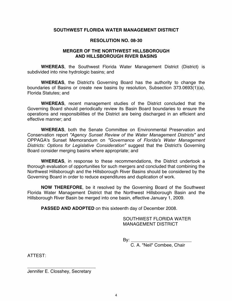
SOUTHWEST FLORIDA WATER MANAGEMENT DISTRICT
RESOLUTION NO. 08-30
MERGER OF THE NORTHWEST HILLSBOROUGH AND HILLSBOROUGH RIVER BASINS
WHEREAS, the Southwest Florida Water Management District (District) is subdivided into nine hydrologic basins; and
WHEREAS, the District's Governing Board has the authority to change the boundaries of Basins or create new basins by resolution, Subsection 373.0693(1)(a), Florida Statutes; and
WHEREAS, recent management studies of the District concluded that the Governing Board should periodically review its Basin Board boundaries to ensure the operations and responsibilities of the District are being discharged in an efficient and effective manner; and
WHEREAS, both the Senate Committee on Environmental Preservation and Conservation report "Agency Sunset Review of the Water Management Districts" and OPPAGA's Sunset Memorandum on "Governance of Florida's Water Management Districts: Options for Legislative Consideration" suggest that the District's Governing Board consider merging basins where appropriate; and
WHEREAS, in response to these recommendations, the District undertook a thorough evaluation of opportunities for such mergers and concluded that combining the Northwest Hillsborough and the Hillsborough River Basins should be considered by the Governing Board in order to reduce expenditures and duplication of work.
NOW THEREFORE, be it resolved by the Governing Board of the Southwest Florida Water Management District that the Northwest Hillsborough Basin and the Hillsborough River Basin be merged into one basin, effective January 1, 2009.
PASSED AND ADOPTED on this sixteenth day of December 2008.
SOUTHWEST FLORIDA WATER MANAGEMENT DISTRICT
By: ________________________ C. A. "Neil" Combee, Chair
ATTEST:
___________________________Jennifer E. Closshey, Secretary
4

Item 61
Outreach and Planning Committee December 16, 2008
Discussion Item
Florida Power & Light’s Clean Energy Story
Florida Power & Light (FPL) is the largest investor-owned electric utility in Florida, serving more than 4.4 million customer accounts. It is one of the largest and fastest growing electric utilities in the United States, and is the nation’s leading utility in customer energy-efficiency programs. The FPL Group is a growing and diversified company investing in clean energy, which includes nuclear, wind, solar and water to meet our energy needs today and tomorrow.
FPL is expanding its current nuclear fleet in South Miami-Dade County and St. Lucie County. In the next five years, the company will upgrade the plants and increase emissions free power generation. FPL is also the nation's leader in wind energy generation, operating 56 wind farms in 16 states. A recent FPL project located with the District coverage area is a solar facility in DeSoto County. It will be the world's largest solar photovoltaic facility and will power 8,700 homes.
Rae Dowling, Area Manager of External Affairs for FPL, will provide an overview of the company's current and future plans including projects within the District.
Staff Recommendation:
This item is presented for the Committee’s information, and no action is required.
Presenter: Rae Dowling, Area Manager, External Affairs, FPL
5
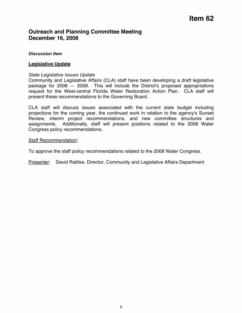
Item 62
Outreach and Planning Committee Meeting December 16, 2008
Discussion Item
Legislative Update
State Legislative Issues Update Community and Legislative Affairs (CLA) staff have been developing a draft legislative package for 2008 — 2009. This will include the District's proposed appropriations request for the West-central Florida Water Restoration Action Plan. CLA staff will present these recommendations to the Governing Board.
CLA staff will discuss issues associated with the current state budget including projections for the coming year, the continued work in relation to the agency's Sunset Review, interim project recommendations, and new committee structures and assignments. Additionally, staff will present positions related to the 2008 Water Congress policy recommendations.
Staff Recommendation:
To approve the staff policy recommendations related to the 2008 Water Congress.
Presenter: David Rathke, Director, Community and Legislative Affairs Department
6

Item 63
Outreach and Planning Committee December 16, 2008
Routine Reports
Comprehensive Plan Amendment and Related Reviews Report
PurposeThis report is provided for the Committee’s information and shows District activity in the review of Local Government Comprehensive Plans and Amendments. Staff updates the report monthly, showing new or changed information in bold.
Background/HistoryThe District provides technical and policy information on water resources and water resource management to local governments as they prepare amendments to their local government comprehensive plans. This information encompasses all aspects of water resource management, including water supply, flood protection, water quality and natural systems, and is intended to support sound land use decisions. A number of statutory provisions direct the District in the provision of this assistance, particularly Section 373.0391, Florida Statutes (F.S.), Technical Assistance to Local Governments. As a part of the District's efforts to ensure that appropriate water resource information and policy direction is reflected in local government comprehensive plans, the District conducts reviews of local government proposed plan amendments. The state land planning agency, the Department of Community Affairs (DCA), administers this review process. Comments submitted by the District typically become a part of DCA's "objections, recommendations, and comments" report to the local government. In addition, the District will often perform informal reviews of draft plan updates working directly with local governments.
Benefits/CostsThe benefits of the District's local government technical assistance program are to ensure local government elected officials have sound water resource technical and policy information as they amend their local government comprehensive plans. This helps to ensure local plans are compatible with the District's plans, programs and statutory direction. Costs for this program primarily include staff time and are budgeted in Fund 10 (Governing Board).
Staff Recommendation: See Exhibit
This item is provided for the Committee's information, and no action is required.
Presenter: Roy A. Mazur, Director, Planning Department
7

Local GovernmentDCA
Project #Amend.Type**
Receivedfrom Gov't
DCA Comment Request Letter
ReceivedComments
SentDCA ORC Report
Received
AdoptedAmend
ReceivedDCA NOI Received
InCompliance? Comments/Issues/Objections
CHARLOTTE 08-2 Regular 04/30/08 05/13/08 06/13/08 07/11/08 09/29/08 Resubmittal of incomplete CPACharlotte 08-PEFE1 Schools 04/28/08 04/28/08 04/30/08 06/27/08 NonePunta Gorda 08-1 Regular 04/09/08 04/05/08 05/06/08 6/6/2008 09/23/08 FLUM amendments; No commentsPunta Gorda 08-PEFE1 Schools 04/21/08 04/21/08 04/25/08 6/20/2008Punta Gorda 08-2ER EAR Based 07/14/08 07/15/08 09/10/08 9/12/2008 EAR Based with RWSPCITRUS 08-02 Regular 09/18/08 09/18/08 10/16/08 11/18/08 43 acre commercial developmentCitrus 08-01 Regular 05/23/08 05/29/08 06/27/08 8/4/2008 10/31/08 Yes Capital Improvements Plan annual updateCitrus 07-02 Regular 08/23/07 08/28/07 09/27/07 10/26/07 Adoption of Springs/Springshed ProtectionCrystal River 08-01 Regular 07/24/08 07/21/08 08/05/08 08/22/08 09/14/08 Yes Conservation Element updateCrystal River 08-02 Regular 09/02/08 09/11/08 10/10/08 11/18/08 Transfer of Development RightsCrystal River 08-1ER EAR Based 04/28/08 04/23/08 05/27/08 EAR amendmentsInverness 07-2ER EAR Based 10/09/07 Not Rcvd 11/06/07 12/07/07 EAR amendmentsHARDEE 07-2 Regular 07/16/07 07/26/07 08/09/07 09/26/07Hardee 08-1 Regular 01/29/08 03/14/08 NoneHardee 08-2 WSP/ Regular 07/09/08 07/28/08Hardee 08-2 EAR 07/09/08 07/28/08Bowling Green 08-PEFE1 PSFE 01/02/08 01/16/08 None 01/24/08 SchoolsWauchula 08-PEFE1 PSFE 01/02/08 01/16/08 None 01/24/08 SchoolsZolfo Springs 08-PEFE1 PSFE 01/02/08 01/16/08 None 01/24/08 SchoolsHERNANDO 08-02 Regular 08/06/08 08/08/08 09/04/08 10/03/08 CIP UpdateHIGHLANDS 08-1 Regular 04/15/08 04/15/08 05/06/08Highlands 08-1PEFE Schools 04/09/08 04/10/08 NoneHighlands 08-1 Regular 04/10/08 04/11/08 05/05/08 6/10/2008Highlands WSFWP WSP 06/05/08 06/11/08 06/23/08
Highlands 08-2 Regular 09/16/08 09/18/08 10/31/08 11/19/2008Blue Head Ranch, Lake Placid Groves, Westby Ranch; 100 page ORC
Avon Park 08-1 EAR, WSP 04/07/08 04/17/08 05/14/08 6/20/2008 10/16/08 Water Supply PlanLake Placid 07-2 Regular 08/13/07 08/27/07 10/26/2007Lake Placid WSFWP WSP 08/18/08 08/21/08 10/08/08 10/20/2008
Hillsborough 08-1ER Ear-based 03/13/08 03/14/08 04/17/08 05/13/08 06/23/08 08/06/08 YesCommented on water supply work plan and several future land use amendments.
Hillsborough 08-2 Regular 08/01/08 08/01/08 08/25/08 No substantive commentsPlant City 08-1 Regular 03/20/08 03/19/08 04/08/08 05/20/08 07/22/08 09/04/08 Yes Amendment includes Plant City's water supply work plan.Plant City 09-1ER Ear-based 10/24/08 10/29/08Tampa 08PEFE1 School 09/11/07 09/11/07 10/10/07 11/09/07 08/12/08 Public education amendments - No substantive commentsTampa 08-1AR AR 04/14/08 04/16/08 05/01/08 05/16/08 Identified flood protection concerns. Tampa 08-2AR AR 08/13/08 08/12/08 09/23/08 10/20/08 EAR-based amendments and water supply work planTemple Terrace 08PEFE1 School 09/11/07 09/11/07 10/10/07 11/09/07 06/17/08 08/06/08 Yes Public education amendments - No substantive commentsTemple Terrace 08-1 Regular 12/04/07 11/30/07 12/27/07 01/29/08 No substantive commentsLAKE 07WSA1 Regular 04/07/07 04/10/07 04/27/07 06/08/07 Not Rcvd Not Rcvd Map amendments/Wekiva Study AreaLake 08-PEFE1 PSFE 09/05/08 09/09/08 10/08/08 SchoolsLake WSFWP WSP 10/09/08 10/10/08 11/07/08 Water Supply PlanLEVY 08-2ER EAR-Based 05/01/08 05/06/08 06/03/08 07/08/08 Text AmendmentsLevy 08-PEFE1 PSFE 03/24/08 03/25/08 03/31/08 05/24/08 Schools
Inglis 08-1 EAR 12/26/07 01/02/08 01/24/08
EAR Review-comments addressed water supply, stormwater management, aquifer recharge areas, water conservation and flood control
Bronson 08-PEFE1 PSFE 04/21/08 04/08/08 06/05/08 SchoolsWilliston 08-PEFE1 PSFE 04/17/08 04/29/08 05/27/08 07/01/08 Not Rcvd 11/14/08 Yes Schools
Williston 08-01 EAR 12/14/07 12/13/07 01/1108 Not Rcvd Not Rcvd Not Rcvd
EAR Review-comments addressed water supply, stormwater management, aquifer recharge areas, water conservation and flood control.
MANATEE 07-1 Regular 06/04/07 06/01/07 07/03/07 08/01/07 09/28/07Commented on water quality concerns for proposed construction debris and demolition landfill.
Manatee 08PEFE1 School 10/26/07 11/09/07 11/28/07 01/02/08 04/09/08 School Facilities ElementManatee 08D1 DRI 04/09/08 04/10/08 05/12/08 06/09/08Manatee 08-1 Regular 04/15/08 04/17/08 06/16/08 06/20/08 08/05/08 Identified wetland concerns
As of December 1, 2008
Local Government Comprehensive Plan Amendment and Related Reviews Report
8

Local GovernmentDCA
Project #Amend.Type**
Receivedfrom Gov't
DCA Comment Request Letter
ReceivedComments
SentDCA ORC Report
Received
AdoptedAmend
ReceivedDCA NOI Received
InCompliance? Comments/Issues/Objections
As of December 1, 2008
Local Government Comprehensive Plan Amendment and Related Reviews Report
Manatee 08-2 Regular 08/11/08 08/10/08 09/09/08 10/20/08 Several water resource concerns identified.Bradenton 08-1 Regular 01/14/08 02/04/08 02/27/08 04/04/08 No substantive commentsBradenton 08-PEFE1 School 06/11/08 06/13/08 07/07/08 08/08/08 10/10/08 School Facilities ElementBradenton 08-2ER EAR 08/29/08 09/16/08 10/14/08
Holmes Beach NA EAR 04/25/07 04/30/07 05/30/07 N/A N/A N/AEAR Review - comments addressed water supply, coastal management and stormwater management.
Holmes Beach 08PEFE1 School 06/13/08 05/27/08 06/17/08 Public education facilities amendmentHolmes Beach 08-1ER EAR 08/29/08 09/02/08 10/13/08 10/28/08 EAR and water supply work plan amendmentsLongboat Key 08-PEFE1 School 12/28/07 01/11/08 01/28/08 03/14/08 07/18/08 09/08/08 Yes Public education facilities amendmentLongboat Key 09-1 11/26/08MARION 08PEFE1 PSFE 02/27/08 02/29/08 03/28/08 04/29/08 07/31/08 09/05/08 Yes SchoolsMarion 08-1 Regular 03/24/08 03/21/08 04/21/08 05/20/08 08/12/08 09/18/08 No 10 FLUM amendmentsDunnellon 08-02 Regular 06/04/08 06/06/08 07/03/08 08/04/08 Regional park/conservation (32 acres)Ocala 08-01 Regular 08/25/08 08/27/08 09/05/08 08/18/08 45 acres public facilities developmentOcala 08PEFE1 PSFE 04/16/08 N/A 05/13/08 06/13/08 10/27/08 SchoolsOcala 07-01 Regular 06/21/07 06/27/07 07/27/07 08/24/07 26 acres residential developmentPASCO 07D1 DRI 12/12/06 12/14/06 01/09/07 02/09/07 Not Received Trinity Proposed Phase TransmittalPasco 07D2 DRI 12/12/06 12/14/06 01/12/07 02/09/07 Not Received Pasco Town CentrePasco 07D5 DRI 08/01/07 08/07/07 08/31/07 10/05/07 10/08/08 Starkey Ranch
Pasco 08-2 Regular 03/18/08 03/18/08 04/16/08 05/19/08 09/22/08 11/03/08 No12 FLU Changes, CHHA, CIE/CIP, US 41 Corridor Study, Employment Center adjacent to District-owned land
Pasco 08-RWSP1 10 Yr WSFWP 07/31/08 08/04/08 08/28/08 09/30/08 10 Year Water Supply Facilities Work PlanPasco 08D1 DRI 08/18/08 08/20/08 08/28/08 10/20/08 Long Lake Ranch DRIZephyrhills 09-1 Regular 11/03/08 11/05/08 11/26/08 2 FLUM Changes: IL to IN and MU to INZephyrhills 08-1PEFE PEFE 12/10/07 N/A 01/08/08 04/24/08 10/06/08 Public School Facilities ElementSan Antonio 08-1ER EAR-Based 02/20/08 03/11/08 04/08/08 05/12/08 May include 10-Yr Water Supply Work PlanDade City EAR EAR 10/10/07 10/17/07 11/06/07 N/A 04/10/08 EAR ReviewDade City 08-1PEFE PEFE 12/03/07 N/A 12/05/07 Public School Facilities ElementNew Port Richey 08-1RWSP 10 Yr WSFWP 05/21/08 05/27/08 06/18/08 7/24/08 09/25/08 11/12/08 Yes 10 Yr Water Supply Facilities Work PlanPort Richey 08-1ER EAR-Based 7/7/2008 7/10/2008 8/6/2008 9/8/08 Text Amendments, Public School Facility ElementClearwater 07-2AR Regular 09/26/07 10/01/07 10/19/07 10/26/07 566 residential unitsClearwater 08-1ARA Regular 05/05/08 05/06/08 05/20/08 6/3/08 07/17/08 08/20/08 YesClearwater 08-1ARB AR 05/05/08 05/06/08 05/20/08 6/3/08 08/01/08 09/02/08 Yes Alternative ReviewClearwater 08RWSP1 WSFWP 06/06/08 06/06/08 07/09/08 8/1/08 10-Year Water Supply PlanClearwater 08-2AR AR 09/16/08 09/16/08 10/15/08 11/18/08 Alternative ReviewDunedin 08-1AR AR 11/06/07 11/06/07 11/29/07 12/11/07Dunedin 08-1ER EAR 07/11/08 07/08/08 07/31/08 9/5/08 EARDunedin 08RWSP1 WSFWP 05/23/08 05/22/08 06/13/08 7/22/08 09/30/08 10-Year Water Supply PlanGulfport 08-1ARA Regular 07/15/08 07/22/08 08/15/08 9/15/08 EAR ReviewGulfport 08-1ARB AR 07/15/08 07/22/08 08/15/08 9/6/08 09/29/08 11/18/08 Yes FLUMGulfport 09PEFE1 PEFE 10/29/08 10/29/08Indian Shores 08-1ER EAR 02/20/08 02/22/08 03/20/08 04/29/08 07/18/08 09/02/08 Yes EAR Review/10 YR Water Supply Work PlanLargo 07-1 Regular 02/20/07 02/20/07 None 04/20/07 DCA noted deficiency in submitted ammendment on 12/26/06Largo 08-2ARA AR 07/29/08 08/25/08 08/25/08 09/26/08 Alternative ReviewLargo 08-2ARB EAR 07/29/08 08/25/08 08/25/08 09/26/08 EAR ReviewOldsmar ASRPP Regular 08/29/07 Not Rcvd 09/13/07 Public School Facilities ElementOldsmar 8-1ARA (08-2ER EAR 03/28/08 03/28/08 05/01/08 05/23/08 08/25/08 10/14/08 Yes EAR ReviewPinellas County 07-1 Regular 12/11/06 12/14/06 01/05/07 02/09/07 04/23/07 2 FLUM ChangesPinellas County 08-2AR AR 08/06/08 08/06/08 None 09/05/08 Alternative ReviewPinellas County 09-1AR AR 11/06/08 11/10/08 Alternative ReviewPinellas Park 07PEFE-1 PEFE 10/16/07 10/18/07 10/19/07 Public School Facilities ElementRedington Beach 08-1ER EAR 08/18/08 09/19/08 11/10/08 EAR ReviewRedington Shores 08-1AR EAR 09/02/08 10/11/08 None 11/18/08 EAR ReviewSt. Petersburg 08-01ARB AR 12/18/07 12/18/07 10/23/08 FLUMSt. Petersburg 08-02ARB AR 09/16/08 09/16/08 10/14/08 11/14/08 10/28/08 Alternative ReviewSt. Pete Beach 08-2AR AR 06/25/08 07/03/08 07/25/08 08/05/08 08/26/08 Alternative ReviewSeminole 08-PEFE1 PEFE 07/24/08 08/21/08 PEFE
9

Local GovernmentDCA
Project #Amend.Type**
Receivedfrom Gov't
DCA Comment Request Letter
ReceivedComments
SentDCA ORC Report
Received
AdoptedAmend
ReceivedDCA NOI Received
InCompliance? Comments/Issues/Objections
As of December 1, 2008
Local Government Comprehensive Plan Amendment and Related Reviews Report
Tarpon Springs 08-1ER EAR 01/09/08 01/11/08 02/20/08 03/06/08 07/11/08 10/02/08 Yes EAR ReviewTarpon Springs 08RWSP1 WSFWP 06/04/08 06/05/08 07/03/08 08/04/08 11/13/08 Yes 10-Year Water Supply PlanTarpon Springs 08-2AR AR 09/28/08 09/28/08 None 10/28/08 10/20/08 FLUMPOLK 08-1 Regular 02/20/08 02/25/08 03/31/08 04/24/08Polk 08-RWSP1 WSFWP 03/17/08 03/20/08 05/06/08 05/19/08 Water Supply PlanAuburndale 07-1 Regular 09/06/07 09/12/07 None 11/13/07Auburndale 08-PEFE1 Schools 02/08/08 02/08/08 None 04/09/08Bartow 07-1 Regular 10/18/07 10/23/07 None 12/06/07 1 LU change - County to City - no increase in demand Bartow 08-1PEFE Schools 04/18/08 04/24/08 None 06/24/08 10/14/08 YesBartow WSFWP WSP 09/24/08 09/25/08 11/18/08 10 Yr WSP - Clear SpringsBartow 08-1 Sector Plan 05/13/08 05/16/08 06/20/08 07/17/08 Clear Springs Sector Plan - CPODavenport 08-1PEFE Schools 03/17/08 03/17/08 None 05/16/08 08/20/08 YesDundee 08-1 Regular 11/05/07 11/08/07 None 01/09/08Dundee 08-1PEFE Schools 04/07/08 06/02/08 None 08/04/08Fort Meade 08-PEFE1 Schools 02/28/08 03/03/08 None 05/05/08Frostproof 08-1PEFE Schools 03/24/08 03/25/08 None 06/05/08Frostproof 08-RWSP1 WSP 07/21/08 07/24/08 08/25/08 09/23/08Haines City 07-2 Regular 08/06/07 08/06/07 08/10/07 10/22/07Haines City 08-PEFE1 Schools 01/18/08 01/22/08 None 03/26/08Haines City 08-1 Regular 07/21/08 07/24/08 None 09/23/08 City View SAPLake Alfred 08-1 WSP WSFWP 04/16/08 04/17/08 05/17/08 06/13/08 Water Supply PlanLake Hamilton 08-1PEFE Schools 04/11/08 04/28/08 None 07/01/08Lake Wales 07-2 Regular 10/03/07 10/04/07 None 12/05/07Lakeland 07-1PEFE Schools 10/19/07 10/22/07 None 11/27/08 Schools ElementLakeland 08-1 WSP WSFWP 04/30/08 05/02/08 6/09/08 - Rand 07/02/08 09/09/08 Yes Water Supply PlanLakeland 08-1 Regular 04/28/08 04/29/08 None None 08/07/08 Yes Will not be reviewed by DCA - 1 Text Amd, PictureMulberry 08-1PEFE Schools 03/18/08 03/17/08 None 05/16/08 08/20/08 YesPolk City 07-1 Regular 07/05/07 07/03/05 08/10/07 08/31/07Polk City 08-PEFE1 Schools 02/28/08 03/03/08 None 05/05/08 08/20/08 YesPolk City 08-1 Regular 06/30/08 06/30/08 None 08/27/08 No WSP from LG - DCA mix up?Winter Haven 08RWSP-1 WSFWP 02/27/08 02/29/08 04/11/08 04/29/08 08/04/08 Yes Water Supply PlanSarasota 07-D1 DRI 02/08/07 02/12/07 None 04/11/07 08/03/07 09/13/07 No SIPOC - FLUM amendmentCity of Sarasota 08-1ER EAR based 05/02/08 05/06/08 06/04/08 07/03/08 WS Plan includedVenice 07-2ER EAR based 07/09/07 07/19/07 08/14/07 09/17/07 Not Rcvd Not RcvdNorth Port 08-1ER EAR based 06/25/08 07/27/08 08/19/08 EAR based with RWSPNorth Port 08-2 Regular 06/30/08 N/A N/A N/A N/A N/A N/A Returned; EAR Basednot adoptedSUMTER 08-PEFE1 Schools 01/22/08 02/01/08 03/03/08 04/03/08 06/24/08 08/20/08 Yes SchoolsCenter Hill 08-01 Regular 07/28/08 07/25/08 08/11/08 09/02/08 11/20/08 12/01/08 Yes 96 acres land uase changeSumter 08-2 Regular 10/09/08 10/22/08 11/20/08 RV Park developmentSumter 08-1 Regular 05/02/08 05/21/08 06/19/08 07/21/08 11/03/08 89 acres land use changeWildwood 08D1 DRI 02/07/08 02/13/08 03/21/08 09/21/08 11/06/08 8,025 homesWildwood 08D2 DRI 06/19/08 06/26/08 07/24/08 08/25/08 11/21/08 1.2 million sq ft (commercial development)Wildwood 07D1 DRI 07/24/07 07/26/07 08/23/07 09/25/07 11/13/08 3,000 homesWildwood 07D2 DRI 07/24/07 07/26/07 08/23/07 09/25/07 2,262 homes
NOTES
Evaluation and Appraisal Reports (EARs) are not plan amendements but are required every 7 years. EAR-Based amendments are required 18 months after the report is determined to be sufficient by the State.Key to Abbreviations:
DCA = FL Dept. of Community AffairsORC Report = Objections, Recommendations & CommentsNOI = Notice of Intent = Determination by DCA whether amendment is in compliance with statutes and rulesEAR = Evaluation and Appraisal ReportDRI = Development of Regional ImpactPRD = Preliminary Review DeterminationASRPP=DCA pilot program for Pinellas and Broward Counties, and the cities of Tampa and Hialeah
** Amendment Types may include: Regular; DRI; EAR Based; Water Supply Plan; ASRPP
10
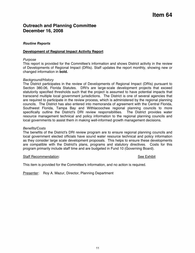
Item 64
Outreach and Planning Committee December 16, 2008
Routine Reports
Development of Regional Impact Activity Report
PurposeThis report is provided for the Committee's information and shows District activity in the review of Developments of Regional Impact (DRIs). Staff updates the report monthly, showing new or changed information in bold.
Background/HistoryThe District participates in the review of Developments of Regional Impact (DRIs) pursuant to Section 380.06, Florida Statutes. DRI's are large-scale development projects that exceed statutorily specified thresholds such that the project is assumed to have potential impacts that transcend multiple local government jurisdictions. The District is one of several agencies that are required to participate in the review process, which is administered by the regional planning councils. The District has also entered into memoranda of agreement with the Central Florida, Southwest Florida, Tampa Bay and Withlacoochee regional planning councils to more specifically outline the District's DRI review responsibilities. The District provides water resource management technical and policy information to the regional planning councils and local governments to assist them in making well-informed growth management decisions.
Benefits/CostsThe benefits of the District's DRI review program are to ensure regional planning councils and local government elected officials have sound water resource technical and policy information as they consider large scale development proposals. This helps to ensure these developments are compatible with the District's plans, programs and statutory directives. Costs for this program primarily include staff time and are budgeted in Fund 10 (Governing Board).
Staff Recommendation: See Exhibit
This item is provided for the Committee's information, and no action is required.
Presenter: Roy A. Mazur, Director, Planning Department
11
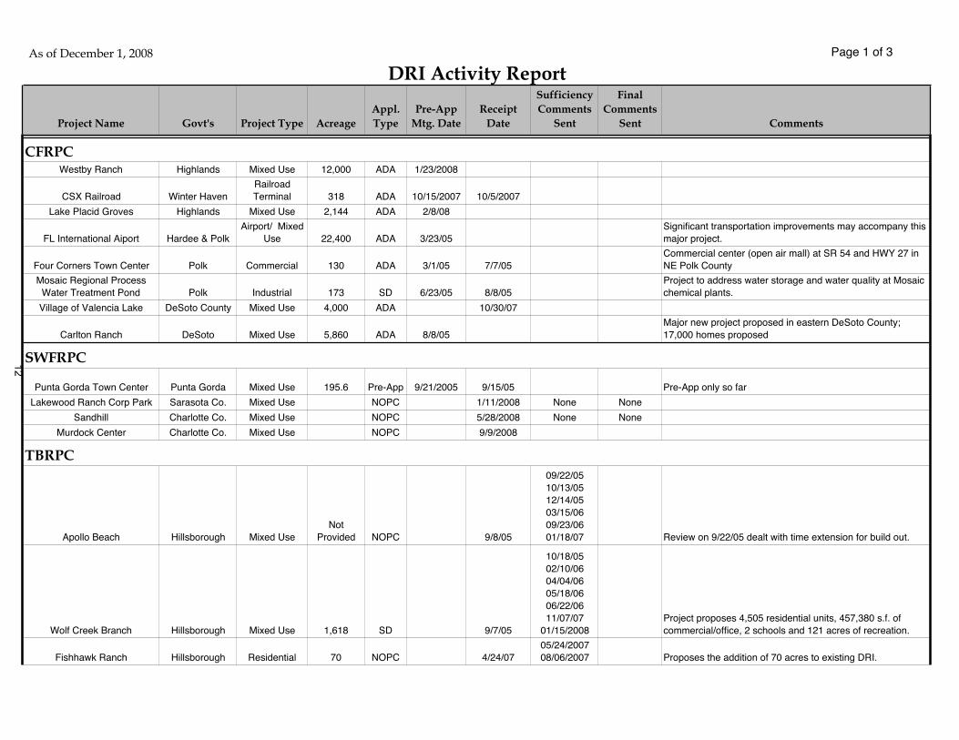
Page 1 of 3
Project Name Govt's Project Type AcreageAppl.Type
Pre-AppMtg. Date
ReceiptDate
SufficiencyComments
Sent
FinalComments
Sent Comments
Westby Ranch Highlands Mixed Use 12,000 ADA 1/23/2008
CSX Railroad Winter HavenRailroadTerminal 318 ADA 10/15/2007 10/5/2007
Lake Placid Groves Highlands Mixed Use 2,144 ADA 2/8/08
FL International Aiport Hardee & PolkAirport/ Mixed
Use 22,400 ADA 3/23/05Significant transportation improvements may accompany this major project.
Four Corners Town Center Polk Commercial 130 ADA 3/1/05 7/7/05Commercial center (open air mall) at SR 54 and HWY 27 in NE Polk County
Mosaic Regional Process Water Treatment Pond Polk Industrial 173 SD 6/23/05 8/8/05
Project to address water storage and water quality at Mosaic chemical plants.
Village of Valencia Lake DeSoto County Mixed Use 4,000 ADA 10/30/07
Carlton Ranch DeSoto Mixed Use 5,860 ADA 8/8/05Major new project proposed in eastern DeSoto County; 17,000 homes proposed
Punta Gorda Town Center Punta Gorda Mixed Use 195.6 Pre-App 9/21/2005 9/15/05 Pre-App only so far
Lakewood Ranch Corp Park Sarasota Co. Mixed Use NOPC 1/11/2008 None None
Sandhill Charlotte Co. Mixed Use NOPC 5/28/2008 None None
Murdock Center Charlotte Co. Mixed Use NOPC 9/9/2008
Apollo Beach Hillsborough Mixed UseNot
Provided NOPC 9/8/05
09/22/0510/13/0512/14/0503/15/0609/23/0601/18/07 Review on 9/22/05 dealt with time extension for build out.
Wolf Creek Branch Hillsborough Mixed Use 1,618 SD 9/7/05
10/18/0502/10/0604/04/0605/18/0606/22/0611/07/07
01/15/2008Project proposes 4,505 residential units, 457,380 s.f. of commercial/office, 2 schools and 121 acres of recreation.
Fishhawk Ranch Hillsborough Residential 70 NOPC 4/24/0705/24/200708/06/2007 Proposes the addition of 70 acres to existing DRI.
As of December 1, 2008
DRI Activity Report
CFRPC
TBRPC
SWFRPC12
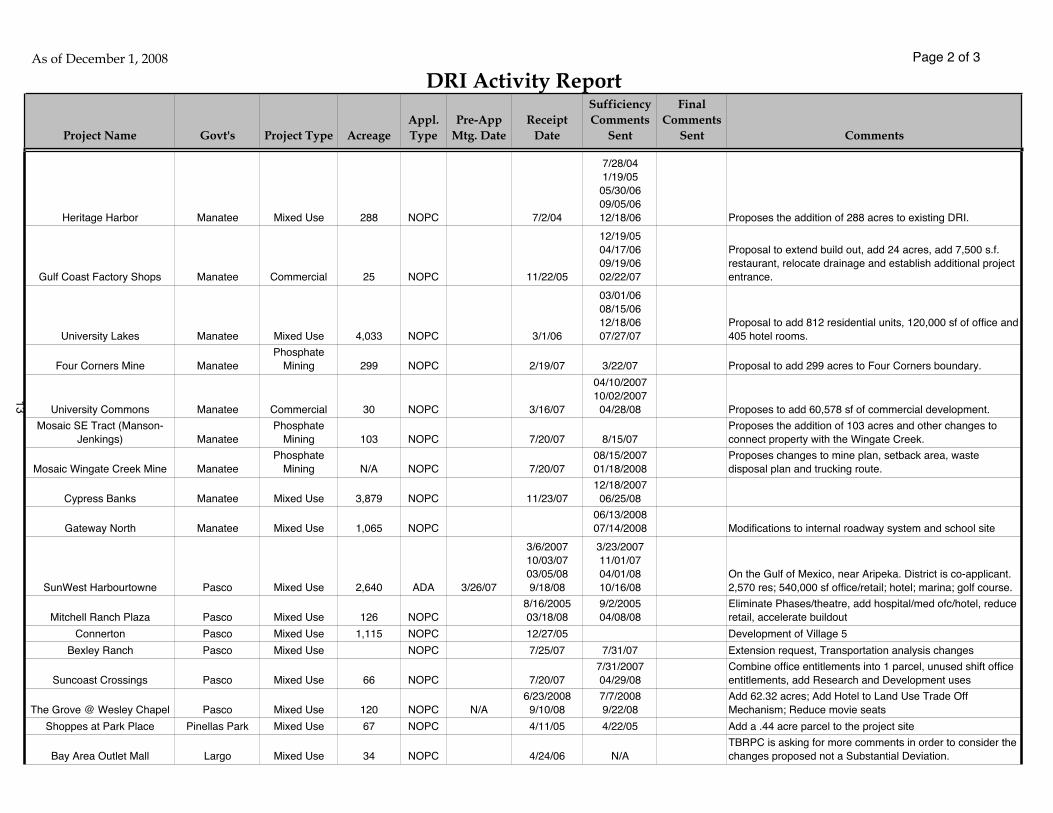
Page 2 of 3
Project Name Govt's Project Type AcreageAppl.Type
Pre-AppMtg. Date
ReceiptDate
SufficiencyComments
Sent
FinalComments
Sent Comments
As of December 1, 2008
DRI Activity Report
Heritage Harbor Manatee Mixed Use 288 NOPC 7/2/04
7/28/041/19/05
05/30/0609/05/0612/18/06 Proposes the addition of 288 acres to existing DRI.
Gulf Coast Factory Shops Manatee Commercial 25 NOPC 11/22/05
12/19/0504/17/0609/19/0602/22/07
Proposal to extend build out, add 24 acres, add 7,500 s.f. restaurant, relocate drainage and establish additional project entrance.
University Lakes Manatee Mixed Use 4,033 NOPC 3/1/06
03/01/0608/15/0612/18/0607/27/07
Proposal to add 812 residential units, 120,000 sf of office and 405 hotel rooms.
Four Corners Mine ManateePhosphate
Mining 299 NOPC 2/19/07 3/22/07 Proposal to add 299 acres to Four Corners boundary.
University Commons Manatee Commercial 30 NOPC 3/16/07
04/10/200710/02/200704/28/08 Proposes to add 60,578 sf of commercial development.
Mosaic SE Tract (Manson-Jenkings) Manatee
PhosphateMining 103 NOPC 7/20/07 8/15/07
Proposes the addition of 103 acres and other changes to connect property with the Wingate Creek.
Mosaic Wingate Creek Mine ManateePhosphate
Mining N/A NOPC 7/20/0708/15/200701/18/2008
Proposes changes to mine plan, setback area, waste disposal plan and trucking route.
Cypress Banks Manatee Mixed Use 3,879 NOPC 11/23/0712/18/200706/25/08
Gateway North Manatee Mixed Use 1,065 NOPC06/13/200807/14/2008 Modifications to internal roadway system and school site
SunWest Harbourtowne Pasco Mixed Use 2,640 ADA 3/26/07
3/6/200710/03/0703/05/089/18/08
3/23/200711/01/0704/01/0810/16/08
On the Gulf of Mexico, near Aripeka. District is co-applicant. 2,570 res; 540,000 sf office/retail; hotel; marina; golf course.
Mitchell Ranch Plaza Pasco Mixed Use 126 NOPC8/16/200503/18/08
9/2/200504/08/08
Eliminate Phases/theatre, add hospital/med ofc/hotel, reduce retail, accelerate buildout
Connerton Pasco Mixed Use 1,115 NOPC 12/27/05 Development of Village 5
Bexley Ranch Pasco Mixed Use NOPC 7/25/07 7/31/07 Extension request, Transportation analysis changes
Suncoast Crossings Pasco Mixed Use 66 NOPC 7/20/077/31/200704/29/08
Combine office entitlements into 1 parcel, unused shift office entitlements, add Research and Development uses
The Grove @ Wesley Chapel Pasco Mixed Use 120 NOPC N/A6/23/20089/10/08
7/7/20089/22/08
Add 62.32 acres; Add Hotel to Land Use Trade Off Mechanism; Reduce movie seats
Shoppes at Park Place Pinellas Park Mixed Use 67 NOPC 4/11/05 4/22/05 Add a .44 acre parcel to the project site
Bay Area Outlet Mall Largo Mixed Use 34 NOPC 4/24/06 N/ATBRPC is asking for more comments in order to consider the changes proposed not a Substantial Deviation.
13

Page 3 of 3
Project Name Govt's Project Type AcreageAppl.Type
Pre-AppMtg. Date
ReceiptDate
SufficiencyComments
Sent
FinalComments
Sent Comments
As of December 1, 2008
DRI Activity Report
Largo Town Center (AKA) Bay Area Outlet Mall Largo Mixed Use 34 NOPC
10/3/200601/18/0709/21/07
10/11/200601/22/0704/05/0710/19/07
Developer provided answers to questions proposed in regards to traffic generation and specific development order changes./ Declared sufficient.
Trinity Communities Pasco & Pinellas Mixed Use 4 NOPC4/5/200710/01/07
4/23/200710/05/0704/08/08
Extend build out date, add 136K mediucal office space, 115 residential units, reduce commnercial/retail use.
Gateway Centre Pinellas Park Mixed Use 558 NOPC 5/2/07 N/A Response to questions posed on Transportation issues.
Long Lake Ranch Pasco Mixed Use 83 NOPC8/15/20089/30/08 8/28/08 10/20/2008
Changes land uses, phasing schedule, and project area acreage.
Hickory Hill Hernando Residential 5 NOPC N/A 4/21/08 5/13/08 None Preservation easement
Hernando Oaks Hernando Residential 1,149 ADA 2/22/06 2/3/06 8/18/06 1,525 residential units
Secret Promise Lake Mixed Use 3,747 ADA 12/29/05 8/21/06
9/11/068/06/07
03/21/08 7,000 residential units
Renaissance Trails Sumter Mixed Use 1,311 ADA 12/16/05 7/10/0608/11/0602/09/07 2,262 residential units
Villages Sumter Mixed Use 340 SD 6/18/2007 5/21/072/25/200804/28/08 10/24/2008 Third Town Center
Landstone Sumter Mixed Use 4,159 ADA 5/14/2007 3/12/07
12/18/0702/23/0803/21/0805/06/08 6/30/2008 8,025 Residential Units
Quarry Preserve Hernando Mixed Use 4,250 ADA 6/7/2007 5/29/073/20/20811/28/08 1,900 residential units
Wildwood Springs Sumter Mixed Use 1,025 ADA 09/25/06 6/1/07
06/27/07 11/14/0702/27/08 6/27/2008 3,000 Residential Units
Key to Abbreviations: CFRPC: Central Florida Regional Planning Council WRPC: Withlacoochee Regional Planning Council
SWFRPC: Southwest Florida Regional Planning Council ADA: Application for Development Approval
TBRPC: Tampa Bay Regional Planning Council NOPC: Notice of Proposed Change
SD: Substantial Deviation DRI: Development of Regional Impact
Notes: For NOPCs and SDs, acreage shown represents the proposed change in project area
Bold text indicates a change from previous report
WRPC
14

Item 65
Outreach and Planning CommitteeDecember 16, 2008
Routine Report
Speakers Bureau
PurposeThis report is provided for the Committee's information and shows District staff participation in the outreach performed by the Speakers' Bureau program.
Background The District has had a Speaker’s Bureau Program since the early 1970s. For the past 20 years, the Program has been administered by the Community and Legislative Affairs Department (CLA) or the Communications Department. Currently, the program is managed by Susan Kessel of the CLA Department. The Speakers Bureau coordinates staff experts and generalists to speak or make presentations to interested community or business groups, or to address professional, governmental or technical groups on a variety of issues. The types of groups and organizations requesting a speaker is varied: civic organizations (Rotary, Kiwanis, Sertoma, etc.), chambers of commerce, colleges and high schools, and associations (homeowners, engineering, realtors, developers, etc.). Every request in the past two years has been honored. Over the past several years, staff has developed a library of PowerPoint presentations to go along with our popular Water 101 video. State-of-the-art audio-visual equipment is available in all of the service offices to accommodate presentations in those areas.
The following table summarizes the Speakers' Bureau activities for the past three months.
Organization Topic Aud Speaker DeptSeptember 2008Democratic Club of SW Citrus County Drought/Conservation 35 Ed Hobin CLAThe Hampton at Clearwater Current/Future Water Supply 38 Ed Hobin CLARotary Club of Tarpon Springs Current/Future Water Supply 60 Ed Hobin CLAThe Abilities Guild of Dunedin Current/Future Water Supply 23 Ed Hobin CLAFour Lakes Golf Club Coffee Talk Drought/Water Conservation 75 Danny Kushmer CLALake Ashton HOA Drought/ Water Conservation 100 Danny Kushmer CLANorthport Area Women's Club Drought/ Water Conservation 36 Terri Behling CLAHillsborough County Extension Service Tampa Bay Watershed 25 Virginia Sternberger COMCentury Commission Water Supply 500 David Moore EXETemple Terrace City Council Hillsborough River MFLs 100 David Moore EXERotary Club of Tarpon Springs Water Conservation 60 Sallie Parks EXEThe Villages Water Expo Water Sources and Supply 20 Tamera McBride PLNSave Our Waters Week Springs in Florida 100 Christine Uranowski PRJOctober 2008Rotary Club of Brooksville Current/Future Water Supply 60 Ed Hobin CLABridgeport at Lake Sumter/The Villages Current/Future Water Supply 90 Ed Hobin CLANational Rural Water Assn FRWA Utility Conserv. Project 125 Ed Hobin CLAGrumman Retirees Club Water Issues/Sink Holes 30 Ed Hobin CLAZephyrhills Women's Club Water Conservation 30 Danny Kushmer CLAJacaranda Public Library/ Venice Watershed Management 10 Terri Behling CLAPR/MRWSA WRAP Update 40 Colleen Thayer CLASebring Women's Club Community Education Grants 20 Virginia Sternberger COMRotary Club of Belleair Bluffs Water Conservation 20 Sallie Parks EXERotary Club of Pinellas Park District Overview/Conservation 30 Sallie Parks EXEDaughters of the American Revolution Water 101 20 Maya Burke PLNSW FL Regional Planning Council District Reviews of DRIs 90 Dianna Davies PLNTemple Terrace Kiwanis Water Conservation 18 Roy Mazur PLN
15
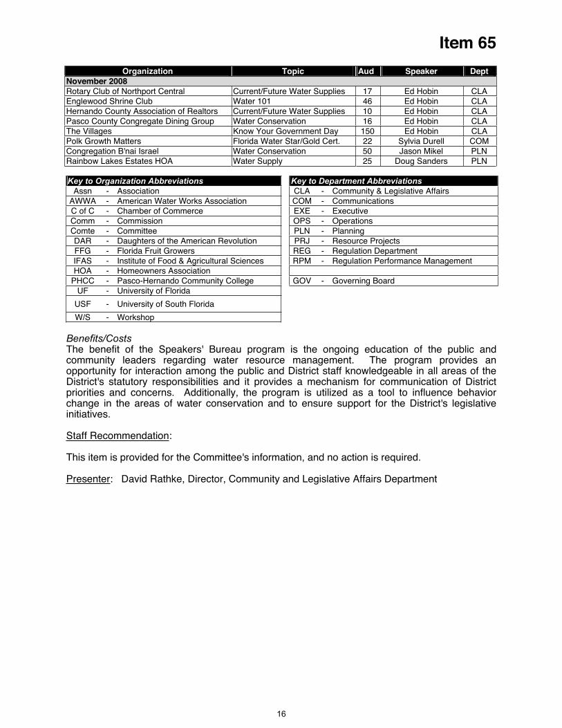
Item 65
Organization Topic Aud Speaker DeptNovember 2008Rotary Club of Northport Central Current/Future Water Supplies 17 Ed Hobin CLAEnglewood Shrine Club Water 101 46 Ed Hobin CLAHernando County Association of Realtors Current/Future Water Supplies 10 Ed Hobin CLAPasco County Congregate Dining Group Water Conservation 16 Ed Hobin CLAThe Villages Know Your Government Day 150 Ed Hobin CLAPolk Growth Matters Florida Water Star/Gold Cert. 22 Sylvia Durell COMCongregation B'nai Israel Water Conservation 50 Jason Mikel PLNRainbow Lakes Estates HOA Water Supply 25 Doug Sanders PLN
Key to Organization Abbreviations Key to Department Abbreviations Assn - Association CLA - Community & Legislative Affairs
AWWA - American Water Works Association COM - CommunicationsC of C - Chamber of Commerce EXE - Executive Comm - Commission OPS - Operations Comte - Committee PLN - Planning DAR - Daughters of the American Revolution PRJ - Resource Projects FFG - Florida Fruit Growers REG - Regulation Department IFAS - Institute of Food & Agricultural Sciences RPM - Regulation Performance Management HOA - Homeowners Association
PHCC - Pasco-Hernando Community College GOV - Governing Board UF - University of Florida
USF - University of South Florida
W/S - Workshop
Benefits/CostsThe benefit of the Speakers' Bureau program is the ongoing education of the public and community leaders regarding water resource management. The program provides an opportunity for interaction among the public and District staff knowledgeable in all areas of the District's statutory responsibilities and it provides a mechanism for communication of District priorities and concerns. Additionally, the program is utilized as a tool to influence behavior change in the areas of water conservation and to ensure support for the District's legislative initiatives.
Staff Recommendation:
This item is provided for the Committee's information, and no action is required.
Presenter: David Rathke, Director, Community and Legislative Affairs Department
16
Item 66
Outreach and Planning Committee December 16, 2008
Routine Report
Significant Activities
Conservation MessagingSince January 2007, the District's conservation messaging has been dominated by water savings messaging related to the drought. Such messaging includes an ongoing grass-roots communications effort using existing tools such as the Speakers Bureau, news media outreach and public affairs programming, as well as outreach to homeowners associations (HOAs), community groups, landscape irrigation professionals, churches and others. The District also developed a web page at WaterMatters.org/drought to serve as a “one-stop-shopping” resource for the public to obtain information on the drought, water restrictions and conservation. Communications staff has continued updating and distributing a PowerPoint presentation, copy points and collateral materials to District staff to reach many of the key target audiences identified in the FY2008 and FY2009 Drought Communications Plan. A radio PSA campaign featuring the District's executive director was launched in mid-October to run through mid-December 2008 in the Tampa Bay region to support the various county and city utilities' and Tampa Bay Water's water conservation messaging efforts. The campaign’s budget was $225,000. New Activities Since Last Meeting — Communications staff distributed a guest column by Governing Board chair Neil Combee on the tightening of the watering restrictions to The Tampa Tribune, St. Petersburg Times and 14 weekly newspapers in Hillsborough, Pasco and Pinellas counties. The column was also provided to more than 1,750 HOAs for their newsletters. In addition, staff scheduled a conference call and online presentation with Tampa TV meteorologists for November 25.
Water Conservation Hotel and Motel Program (Water CHAMP) and Water Program for Restaurant Outreach (Water PRO)Water CHAMP promotes water conservation in hotels and motels through a towel and linen reuse program that encourages guests to use their towels and linens more than once during their stay. Participating hotels and motels receive materials that explain Water CHAMP to staff members and guests. Materials include towel reuse cards, linen reuse cards, environmental table brochures, guest comment cards, staff training materials and an environmental self-audit checklist — all free of charge. Educational workshops on additional ways to save water are also provided to the participating hotels and motels. Surveys of guests staying in Water CHAMP properties indicate that guests like the program and believe conserving water makes a difference to the environment. Staff has completed a Districtwide study confirming Water CHAMP’s effectiveness at maintaining water savings. The original comparison study was conducted the first year of the program (2002–2003) by Pinellas County Utilities and the City of Tampa Water Department, who compared the water use of 71 hotels in their areas before and after implementing Water CHAMP. The studies showed that the program saved an average of 20 gallons of water per occupied room per day. The five-year follow-up water audit was conducted in cooperation with 16 utility companies to determine the current level of water savings. The audit compared water consumption of 115 Water CHAMP participants before the program's implementation in 2002 to water use in 2007. The Districtwide audit showed that participants saved an average of 17 gallons of water per occupied room per day. The slight adjustment in water savings from the original audit is attributed to a larger representative sample of the entire District. Based on these audit findings, the cost benefit for the program, using the total cost amortized over five years, is $0.47 per thousand gallons of water. The Water CHAMP coordinator also coordinates the Water Program for Restaurant Outreach (Water PRO), which extends water conservation achieved through the Water CHAMP program by promoting water conservation in restaurants. Staff educates both restaurateurs and guests through free materials such as table tents, children's coloring sheets, coasters and self-audit checklists. "We
17

Item 66
only serve water on request" buttons are also available for wait staff. New Activities Since Last Meeting — Water CHAMP currently has 47 percent of all hotels/motels in the District participating in the program. Since many of the small bed and breakfast properties do not participate because guests launder their own linens, calculating the percentage of Water CHAMP properties based on the number of rooms gives a more accurate picture of the program's success. Of the 460 hotels/motels within the District with 50 or more rooms, 312 are CHAMP properties or 68 percent. Staff is working with a variety of partners to include the Water CHAMP logo next to participating properties in several visitor guides. Bill inserts have been distributed in partnership with Progress Energy and Pinellas County Utilities, directing 110,000 residents to the CHAMP and PRO web sites. Bill inserts are being designed in partnership with City of Winter Haven and City of Lakeland utilities as well. Water PRO is being promoted through one-on-one visits with restaurant managers, partnerships with utility companies and networking at industry meetings. City of Lakeland Utilities added a description of Water PRO to its web site with a link to the Water PRO home page. In a November 20 story in The (Lakeland) Ledger, the general manager of a Lakeland Beef ‘O’ Brady’s reported monthly water consumption dropped in his restaurant as a result of Water PRO from 182,000 gallons in recent months to 105,000 gallons, with business volume remaining steady. As of November 17, 2008,
5 restaurants within the District had signed up to participate. 8
Florida Water Star SM — Gold Certification ProgramThe Florida Water StarSM (FWS) program certifies new homes based on water conservation criteria developed by the St. Johns River Water Management District (SJRWMD) to encourage water efficiency in household appliances, plumbing fixtures, irrigation systems and landscapes. The certification program encourages builders/developers to save water indoors and outdoors and has some consistency with national green building programs such as LEED by the U.S. Green Building Council and Energy Star® from EPA. The resulting certification criteria were also integrated into the wider “green building umbrella” being developed at the time for the Florida Green Building Coalition. The program's objectives are to increase the knowledge level of the building industry about water-efficient building practices and to provide educational resources and incentives to make these practices common to the marketplace. FWS is currently being implemented successfully in the SJRWMD based on criteria it developed. Because builder/developer education has been ongoing within the SWFWMD for several years, an advanced version of the outdoor water use criteria was developed to be more closely aligned to the University of Florida/Institute of Food and Agricultural Sciences' Florida Yards & Neighborhoods program's Florida-friendly landscaping principles and landscape best management practices. SWFWMD Resource Projects Department staff also participated in developing the indoor water use criteria. The resulting advanced version, Florida Water Star — Gold Certification (FWSG), adds criteria that will result in even more water savings and fewer impacts to water quality. New Activities Since Last Meeting — Twenty-one Extension and Florida Yards & Neighborhoods staff attended a 2.5 hour introductory FWSG training. Many of the same group will be attending the FWS certifier training in January to prepare them to be educational resources for builders and certifiers in the program. In addition, FYN coordinators who do outreach to homeowners will conduct follow-up visits to new FWSG homeowners to educate them on how to maintain the water-conserving features of their homes. A presentation was made to 22 members of the Polk Growth Matters group. Polk Growth Matters is a public forum sponsored by the Polk Growth Management Department, Polk Vision and the Florida Chapter of the American Planning Association. The program contract between SJRWMD and the District has been reviewed and returned to SJRWMD. Following the request for quotes process, Susan Douglas has been hired as program coordinator. Ms. Douglas participated in
e development of the FWS program for SJRWMD. th
Community-Based Social MarketingCommunity-based social marketing (CBSM) programs use research to uncover what drives residents to either participate in or avoid specific behaviors. With the knowledge of what motivates people to behave the way they do, the District can create programs that are tailored to the populations they are meant to target and will most likely result in desired behavior changes. The Communications Department has been using the theories of this social science to
18
Item 66
hools, Water Words That ork and Those That Don't, Focus Groups, Water 101, Talking to the Media and many more. One
tended the conference and awards luncheon.
enhance program design. New Activities Since Last Meeting — Project manager held the second Community-Based Social Marketing Resource Committee meeting at the District's Tampa Service Office on October 10. Approximately 15 representatives from local governments, nonprofits, universities and interested professional social marketers attended to collaborate on landscaping, water conservation and watershed protection behavior change programs. Project manager gave a presentation on the District's progression on the social research repository, as well as the materials pretesting portions of the pilot irrigation program and the upcoming watershed conference and awards ceremony in November. The next committee meeting is scheduled for January 22 at the District's Tampa Service Office. Staff is developing a CBSM page to be added to the District's web site. The CBSM site will serve as a resource for staff and cooperators who are interested in enhancing program design and evaluation. Twenty-six outstanding watershed projects from 2007 were recognized at the Partners in Watershed Education: Inspire, Educate, Celebrate Conference and Awards Luncheon on November 19, 2008. Session offerings at the conference included the following: Transforming Your Program With Social Marketing, How to Use Research to Develop Stronger Programs, Getting to the Root of Change, Institutional Water Use in ScWhundred nineteen people at
Irrigation Pilot ProgramA community-based social marketing pilot program is under way in neighborhoods in The Villages, the City of Lakeland and Charlotte County. Residents will be asked to “water only every other week” during the months of December, January and February and to “take control of their irrigation systems” during the months of July, August and September when rainfall can allow residents to turn off their systems for extended periods of time. The specific education interventions will be determined by results of qualitative (focus groups) and quantitative (survey) research conducted to determine the best way to educate the residents to achieve the desired behaviors. The audio recordings from the focus groups and other related research were used to guide the creation of a telephone survey questionnaire. The survey was pilot-tested with small sample audiences to ensure its understandability and clarity of responses before data collection began. Two sample sets of survey data were collected. New Activities Since Last Meeting —Program components for the Florida-Friendly Irrigating: It Just Makes Sense program have been pretested with our target audience to ensure clarity and comprehension of message. Forty-nine District residents participated in the interviews and helped refine program components such as the logo, advertisements, newspaper insert and more. Final program components were completed in November for program implementation in December. On October 22, staff worked with Mercury Productions to shoot three "how-to" videos to reduce perceived barriers to behavior change. Titles include, "How-To Test Your Rain Sensor," "How-To Do a Catch-Can Test," and "How-To Recognize the Signs That Your Yard Needs Water." These topics were chosen based on the collected research that revealed that most people don't know if their rain sensors work, they don't know how long to run their irrigation systems to get the recommended ¾" with each application and they don't know how to recognize signs that their grass needs water — they simply water on each day they are allowed. The videos featured the Florida-Friendly Irrigating Team, which includes Lou Kavouras, District deputy executive director; Jim Davis, Florida Yards & Neighborhoods Extension agent; and Carol Ann Breyer, master gardener. The team represents the top three expert organizations our residents reported that they would trust when it came to landscaping and irrigation information. Project Manager gave presentations to two homeowners associations (HOA), one in Lakeland on November 10 and one in Punta Gorda on December 10. As a result of the presentations, various members of the HOAs are volunteering to skip a week of irrigation in the winter and only water if it hasn't rained in the summer. Our team master gardener, Carol Ann Breyer, will check in with the volunteers weekly to ensure that their yards are remaining healthy on the Florida-Friendly Irrigating program. The progress of the volunteer's yards will be posted to the Florida-Friendly Irrigating program’s web site at WaterMaters.org/ItJustMakesSense. Staff is continuing to gather water-use information from participating utilities to create historical water data reports that will be used to measure changes in water use throughout the course of the project. Water-use data will be reported and logged monthly throughout the pilot project to gauge program effectiveness.
19
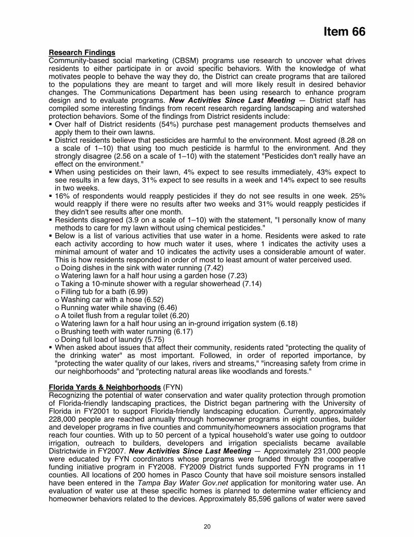
Item 66
Research FindingsCommunity-based social marketing (CBSM) programs use research to uncover what drives residents to either participate in or avoid specific behaviors. With the knowledge of what motivates people to behave the way they do, the District can create programs that are tailored
the populations they are meant to target and will more likely result in desired behavior ications Department has been using research to enhance program
tochanges. The Commundesign and to evaluate programs. New Activities Since Last Meeting — District staff has compiled some interesting findings from recent research regarding landscaping and watershed protection behaviors. Some of the findings from District residents include: Over half of District residents (54%) purchase pest management products themselves and apply them to their own lawns.
District residents believe that pesticides are harmful to the environment. Most agreed (8.28 on a scale of 1–10) that using too much pesticide is harmful to the environment. And they strongly disagree (2.56 on a scale of 1–10) with the statement "Pesticides don't really have an effect on the environment."
When using pesticides on their lawn, 4% expect to see results immediately, 43% expect to see results in a few days, 31% expect to see results in a week and 14% expect to see results in two weeks.
16% of respondents would reapply pesticides if they do not see results in one week. 25% would reapply if there were no results after two weeks and 31% would reapply pesticides if they didn't see results after one month.
Residents disagreed (3.9 on a scale of 1–10) with the statement, "I personally know of many methods to care for my lawn without using chemical pesticides."
Below is a list of various activities that use water in a home. Residents were asked to rate each activity according to how much water it uses, where 1 indicates the activity uses a minimal amount of water and 10 indicates the activity uses a considerable amount of water. This is how residents responded in order of most to least amount of water perceived used. o Doing dishes in the sink with water running (7.42) o Watering lawn for a half hour using a garden hose (7.23) o Taking a 10-minute shower with a regular showerhead (7.14) o Filling tub for a bath (6.99) o Washing car with a hose (6.52) o Running water while shaving (6.46) o A toilet flush from a regular toilet (6.20) o Watering lawn for a half hour using an in-ground irrigation system (6.18) o Brushing teeth with water running (6.17) o Doing full load of laundry (5.75)
When asked about issues that affect their community, residents rated "protecting the quality of the drinking water" as most important. Followed, in order of reported importance, by "protecting the water quality of our lakes, rivers and streams," "increasing safety from crime in our neighborhoods" and "protecting natural areas like woodlands and forests."
Florida Yards & Neighborhoods (FYN)Recognizing the potential of water conservation and water quality protection through promotion of Florida-friendly landscaping practices, the District began partnering with the University of Florida in FY2001 to support Florida-friendly landscaping education. Currently, approximately 228,000 people are reached annually through homeowner programs in eight counties, builder and developer programs in five counties and community/homeowners association programs that reach four counties. With up to 50 percent of a typical household’s water use going to outdoor irrigation, outreach to builders, developers and irrigation specialists became available Districtwide in FY2007. New Activities Since Last Meeting — Approximately 231,000 people were educated by FYN coordinators whose programs were funded through the cooperative
nding initiative program in FY2008. FY2009 District funds supported FYN programs in 11 asco County that have soil moisture sensors installed
fucounties. All locations of 200 homes in Phave been entered in the Tampa Bay Water Gov.net application for monitoring water use. An evaluation of water use at these specific homes is planned to determine water efficiency and homeowner behaviors related to the devices. Approximately 85,596 gallons of water were saved
20
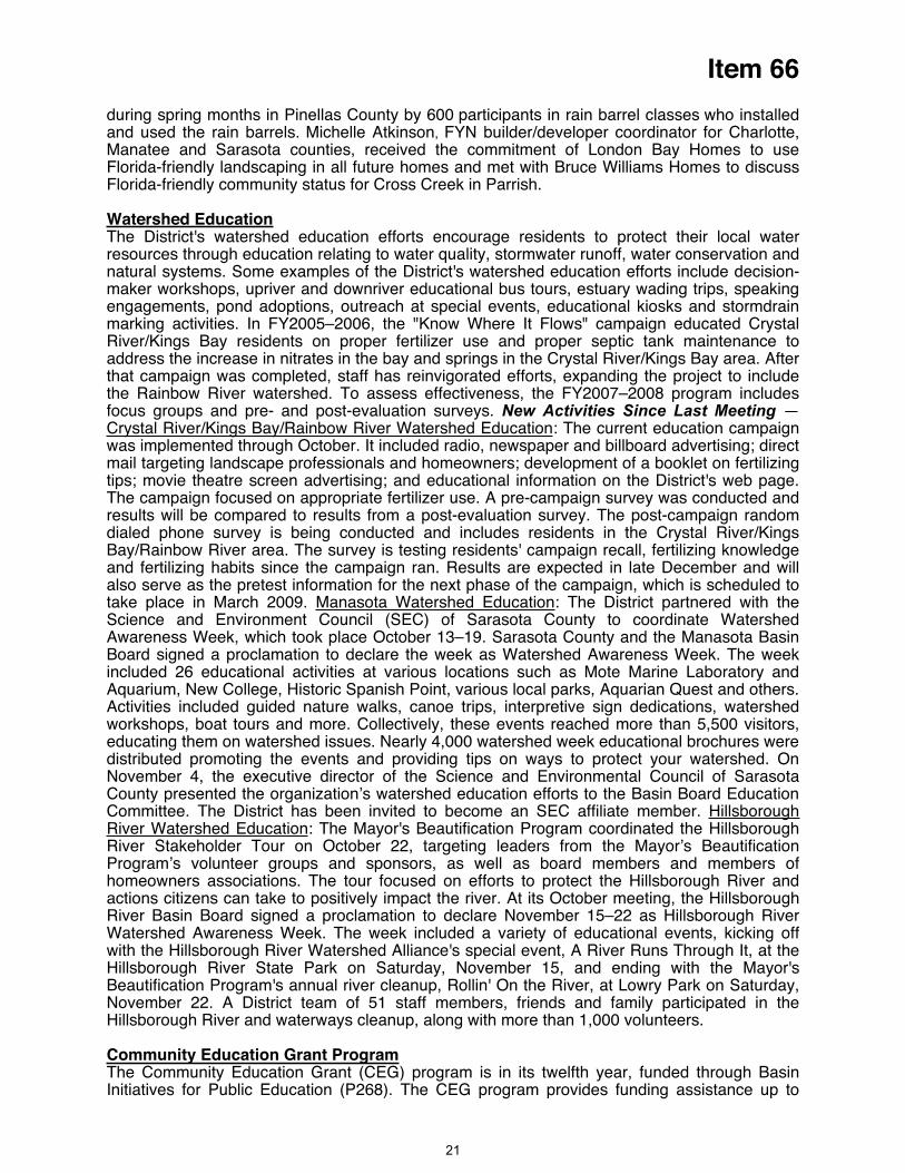
Item 66
during spring months in Pinellas County by 600 participants in rain barrel classes who installed and used the rain barrels. Michelle Atkinson, FYN builder/developer coordinator for Charlotte, Manatee and Sarasota counties, received the commitment of London Bay Homes to use Florida-friendly landscaping in all future homes and met with Bruce Williams Homes to discuss Florida-friendly community status for Cross Creek in Parrish.
tionWatershed EducaThe District's watershed education efforts encourage residents to protect their local water resources through education relating to water quality, stormwater runoff, water conservation and natural systems. Some examples of the District's watershed education efforts include decision-maker workshops, upriver and downriver educational bus tours, estuary wading trips, speaking engagements, pond adoptions, outreach at special events, educational kiosks and stormdrain marking activities. In FY2005–2006, the "Know Where It Flows" campaign educated Crystal River/Kings Bay residents on proper fertilizer use and proper septic tank maintenance to address the increase in nitrates in the bay and springs in the Crystal River/Kings Bay area. After that campaign was completed, staff has reinvigorated efforts, expanding the project to include the Rainbow River watershed. To assess effectiveness, the FY2007–2008 program includes focus groups and pre- and post-evaluation surveys. New Activities Since Last Meeting —Crystal River/Kings Bay/Rainbow River Watershed Education: The current education campaign was implemented through October. It included radio, newspaper and billboard advertising; direct mail targeting landscape professionals and homeowners; development of a booklet on fertilizing tips; movie theatre screen advertising; and educational information on the District's web page. The campaign focused on appropriate fertilizer use. A pre-campaign survey was conducted and results will be compared to results from a post-evaluation survey. The post-campaign random dialed phone survey is being conducted and includes residents in the Crystal River/Kings Bay/Rainbow River area. The survey is testing residents' campaign recall, fertilizing knowledge and fertilizing habits since the campaign ran. Results are expected in late December and will also serve as the pretest information for the next phase of the campaign, which is scheduled to take place in March 2009. Manasota Watershed Education: The District partnered with the Science and Environment Council (SEC) of Sarasota County to coordinate Watershed Awareness Week, which took place October 13–19. Sarasota County and the Manasota Basin Board signed a proclamation to declare the week as Watershed Awareness Week. The week included 26 educational activities at various locations such as Mote Marine Laboratory and Aquarium, New College, Historic Spanish Point, various local parks, Aquarian Quest and others. Activities included guided nature walks, canoe trips, interpretive sign dedications, watershed workshops, boat tours and more. Collectively, these events reached more than 5,500 visitors, educating them on watershed issues. Nearly 4,000 watershed week educational brochures were distributed promoting the events and providing tips on ways to protect your watershed. On November 4, the executive director of the Science and Environmental Council of Sarasota County presented the organization’s watershed education efforts to the Basin Board Education Committee. The District has been invited to become an SEC affiliate member. Hillsborough River Watershed Education: The Mayor's Beautification Program coordinated the Hillsborough River Stakeholder Tour on October 22, targeting leaders from the Mayor’s Beautification Program’s volunteer groups and sponsors, as well as board members and members of homeowners associations. The tour focused on efforts to protect the Hillsborough River and actions citizens can take to positively impact the river. At its October meeting, the Hillsborough River Basin Board signed a proclamation to declare November 15–22 as Hillsborough River Watershed Awareness Week. The week included a variety of educational events, kicking off
ith the Hillsborough River Watershed Alliance's special event, A River Runs Through It, at the on Saturday, November 15, and ending with the Mayor's
wHillsborough River State Park Beautification Program's annual river cleanup, Rollin' On the River, at Lowry Park on Saturday, November 22. A District team of 51 staff members, friends and family participated in the Hillsborough River and waterways cleanup, along with more than 1,000 volunteers.
Community Education Grant ProgramThe Community Education Grant (CEG) program is in its twelfth year, funded through Basin Initiatives for Public Education (P268). The CEG program provides funding assistance up to
21
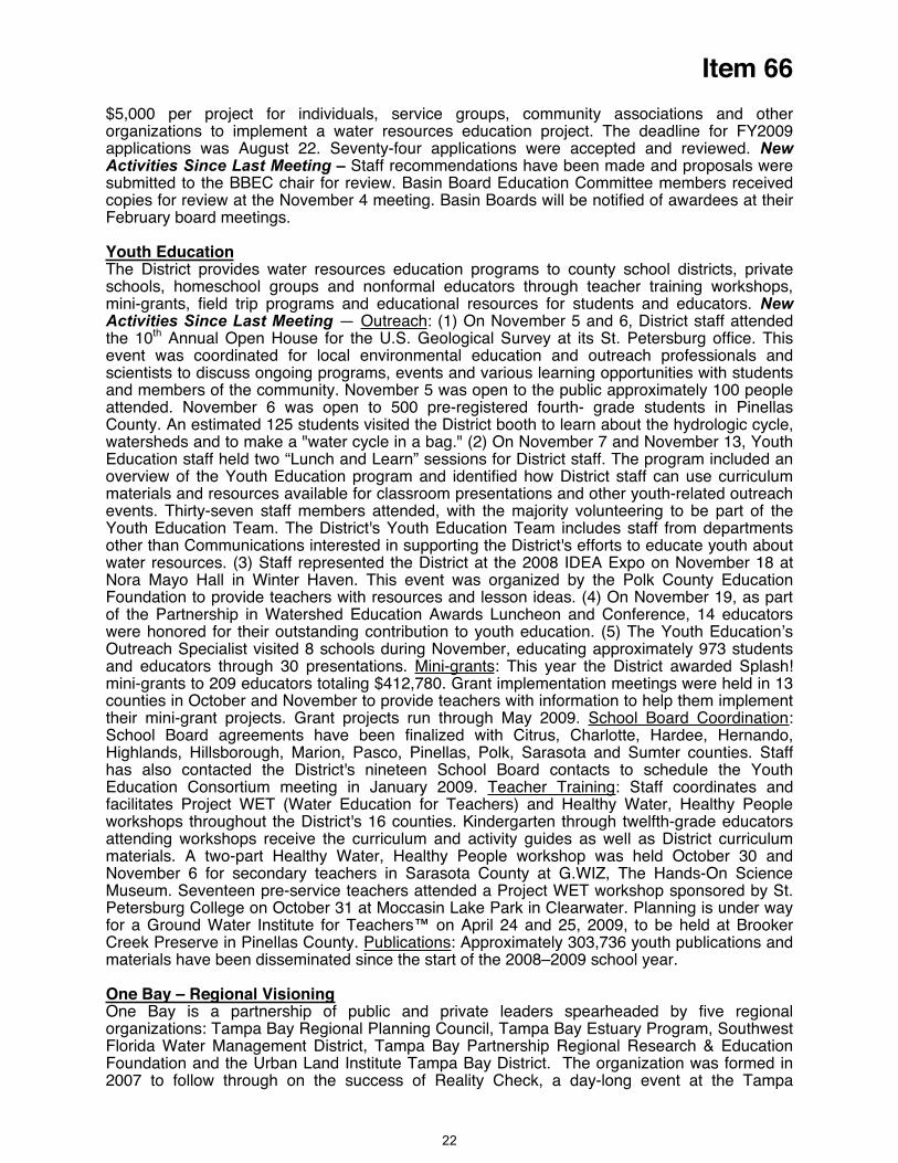
Item 66
$5,000 per project for individuals, service groups, community associations and other organizations to implement a water resources education project. The deadline for FY2009 applications was August 22. Seventy-four applications were accepted and reviewed. New Activities Since Last Meeting – Staff recommendations have been made and proposals were submitted to the BBEC chair for review. Basin Board Education Committee members received copies for review at the November 4 meeting. Basin Boards will be notified of awardees at their February board meetings.
Youth EducationThe District provides water resources education programs to county school districts, private schools, homeschool groups and nonformal educators through teacher training workshops, mini-grants, field trip programs and educational resources for students and educators. NewActivities Since Last Meeting — Outreach: (1) On November 5 and 6, District staff attended the 10th Annual Open House for the U.S. Geological Survey at its St. Petersburg office. This event was coordinated for local environmental education and outreach professionals and
with students
esented the District at the 2008 IDEA Expo on November 18 at ora Mayo Hall in Winter Haven. This event was organized by the Polk County Education
esources and lesson ideas. (4) On November 19, as part
wOa
scientists to discuss ongoing programs, events and various learning opportunitiesand members of the community. November 5 was open to the public approximately 100 people attended. November 6 was open to 500 pre-registered fourth- grade students in Pinellas County. An estimated 125 students visited the District booth to learn about the hydrologic cycle, watersheds and to make a "water cycle in a bag." (2) On November 7 and November 13, Youth Education staff held two “Lunch and Learn” sessions for District staff. The program included an overview of the Youth Education program and identified how District staff can use curriculum materials and resources available for classroom presentations and other youth-related outreach events. Thirty-seven staff members attended, with the majority volunteering to be part of the Youth Education Team. The District's Youth Education Team includes staff from departments other than Communications interested in supporting the District's efforts to educate youth about water resources. (3) Staff reprNFoundation to provide teachers with rof the Partnership in Watershed Education Awards Luncheon and Conference, 14 educators
ere honored for their outstanding contribution to youth education. (5) The Youth Education’s utreach Specialist visited 8 schools during November, educating approximately 973 students nd educators through 30 presentations. Mini-grants: This year the District awarded Splash! ini-grants to 209 educators totaling $412,780. Grant implementation meetings were held in 13 unties in October and November to provide teachers with information to help them implement eir mini-grant projects. Grant projects run through May 2009. School Board Coordination
mcoth :
chool Board agreements have been finalized with Citrus, Charlotte, Hardee, Hernando, ighlands, Hillsborough, Marion, Pasco, Pinellas, Polk, Sarasota and Sumter coun
SH ties. Staff
Ehas also contacted the District's nineteen School Board contacts to schedule the Youth
ducation Consortium meeting in January 2009. Teacher Training: Staff coordinates and cilitates Project WET (Water Education for Teachers) and Healthy Water, Healthy People orkshops throughout the District's 16 counties. Kindergarten through twelfth-grade educators ttending workshops receive the curriculum and activity guides as well as District curriculum aterials. A two-part Healthy Water, Healthy People workshop was held October 30 and ovember 6 for secondary teachers in Sarasota County at G.WIZ, The Hands-On Science useum. Seventeen pre-service teachers attended a Project WET workshop sponsored by St. etersburg College on October 31 at Moccasin Lake Park in Clearwater.
fawamNMP Planning is under way
Cfor a Ground Water Institute for Teachers™ on April 24 and 25, 2009, to be held at Brooker
reek Preserve in Pinellas County. Publications: Approximately 303,736 youth publications and materials have been disseminated since the start of the 2008–2009 school year.
One Bay – Regional Visioningne Bay is a partneO rship of public and private leaders spearheaded by five regional rganizations: Tampa Bay Regional Planning Council, Tampa Bay Estuary Program, Southwest
istrict, Tampa Bay Partnership Regional Research & Education oFlorida Water Management DFoundation and the Urban Land Institute Tampa Bay District. The organization was formed in 2007 to follow through on the success of Reality Check, a day-long event at the Tampa
22
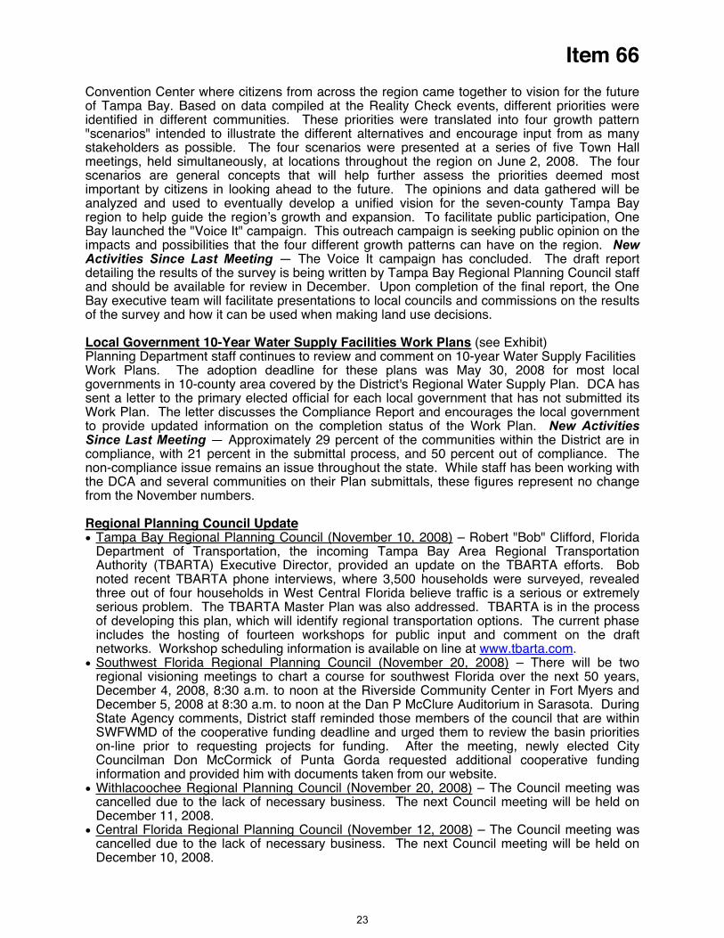
Item 66
Convention Center where citizens from across the region came together to vision for the future of Tampa Bay. Based on data compiled at the Reality Check events, different priorities were identified in different communities. These priorities were translated into four growth pattern "scenarios" intended to illustrate the different alternatives and encourage input from as many stakeholders as possible. The four scenarios were presented at a series of five Town Hall meetings, held simultaneously, at locations throughout the region on June 2, 2008. The four scenarios are general concepts that will help further assess the priorities deemed most important by citizens in looking ahead to the future. The opinions and data gathered will be analyzed and used to eventually develop a unified vision for the seven-county Tampa Bay
gion to help guide the region’s growth and expansion. To facilitate public participation, One paign. This outreach campaign is seeking public opinion on the
es Work Plans
reBay launched the "Voice It" camimpacts and possibilities that the four different growth patterns can have on the region. NewActivities Since Last Meeting — The Voice It campaign has concluded. The draft report detailing the results of the survey is being written by Tampa Bay Regional Planning Council staff and should be available for review in December. Upon completion of the final report, the One Bay executive team will facilitate presentations to local councils and commissions on the results of the survey and how it can be used when making land use decisions.
Local Government 10-Year Water Supply Faciliti (see Exhibit) lanning Department staff continues to review and comment on 10-year Water Supply Facilities
he adoption deadline for these plans was May 30, 2008 for most local
ls, these figures represent no change om the November numbers.
PWork Plans. Tgovernments in 10-county area covered by the District's Regional Water Supply Plan. DCA has sent a letter to the primary elected official for each local government that has not submitted its Work Plan. The letter discusses the Compliance Report and encourages the local government to provide updated information on the completion status of the Work Plan. New Activities Since Last Meeting — Approximately 29 percent of the communities within the District are in compliance, with 21 percent in the submittal process, and 50 percent out of compliance. The non-compliance issue remains an issue throughout the state. While staff has been working with the DCA and several communities on their Plan submittafr
Regional Planning Council UpdateTampa Bay Regional Planning Council (November 10, 2008) – Robert "Bob" Clifford, Florida Department of Transportation, the incoming Tampa Bay Area Regional Transportation Authority (TBARTA) Executive Director, provided an update on the TBARTA efforts. Bob noted recent TBARTA phone interviews, where 3,500 households were surveyed, revealed
ut of four households in West Central Florida believe traffic is a serious or extremely o addressed. TBARTA is in the process
h will identify regional transportation options. The current phase
on is available on line at www.tbarta.com
three oserious problem. The TBARTA Master Plan was alsof developing this plan, whicincludes the hosting of fourteen workshops for public input and comment on the draft networks. Workshop scheduling informati .Southwest Florida Regional Planning Council (November 20, 2008) – There will be two
ning meetings to chart a course for southwest Florida over the next 50 years, erside Community Center in Fort Myers and
December 5, 2008 at 8:30 a.m. to noon at the Dan P McClure Auditorium in Sarasota. During
Don McCormick of Punta Gorda requested additional cooperative funding information and provided him with documents taken from our website.
regional visioDecember 4, 2008, 8:30 a.m. to noon at the Riv
State Agency comments, District staff reminded those members of the council that are within SWFWMD of the cooperative funding deadline and urged them to review the basin priorities on-line prior to requesting projects for funding. After the meeting, newly elected City Councilman
Withlacoochee Regional Planning Council (November 20, 2008) – The Council meeting was cancelled due to the lack of necessary business. The next Council meeting will be held on December 11, 2008. Central Florida Regional Planning Council (November 12, 2008) – The Council meeting was cancelled due to the lack of necessary business. The next Council meeting will be held on December 10, 2008.
23

Item 66
East Pasco Water CoalitionBeginning in July of 2008, representatives from the communities of East Pasco (including
ephyrhills, Dade City, San Antonio, St. Leo, Pasco County, St. Leo University, and interested valuate opportunities to coordinate on water supply planning and
etings and plans to ell as to conduct an
asco community. The East asco Water Coalition met on November 20 to set goals and identify strategies to accomplish
Initially, District staff played a key organizational role coordinating
Zcitizens) gathered to econservation efforts. The Coalition has held several successful scoping mepursue interconnected potable and reclaimed water supply systems as weducation and land use campaign targeted specifically at the East P
thPthe tasks noted above. meetings, setting agendas and providing a history of water resources in the local area. As the group has articulated a vision and focus, District staff has taken on a supporting role offering technical assistance and providing information about various funding opportunities available through the District.
Local Government OutreachAs part of the District's community and legislative affairs program, CLA is responsible for
and their staff,
e newsletter, e-mail alerts and one-on-one eetings. New Activities since Last Meeting —
g Council, the agriculture and the Audubon Society.
and Natural Resources Task Force. Other committees include ducation, Workforce and Economic Development Transportation and Land Use, and
r economic development; link with land use & conservation planning Sustainable & Viable Natural Systems
lture Industry sustainability; linkage with conservation
(1) developing effective relationships with local elected and public officials (2) serving as the District's day-to-day liaison with local officials, (3) facilitating coordination of District programs to assist local governmental entities, (4) promoting the mission of the District and (5) helping to develop and foster sound public policy on water resource related issues. To meet these responsibilities, CLA has developed long-standing programs and tactics, including but not limited to, project tours, the e-Resourcm
Heartland 2060 Similar to OneBay and MyRegion.org, Heartland 2060 is a seven (7) county visioning and planning effort looking to the year 2060. The counties included in this effort are Polk, Hardee Highlands, Desoto, Glades, Hendry and Okeechobee. A kick off meeting was held in September 2007 in Avon Park with presentations from the Central Florida Regional PlanninCentury Commission as well as representatives from These presentations centered on future growth trends in the Heartland and began to identify ways to plan for this growth. While progress to date has been slow, the Heartland 2060 process has begun to take on new life over the past few months.
Heartland 2060 Efforts to Date The Heartland 2060 workgroup was broken into four Task Forces and CLA staff was invited to participate in the EnvironmentECommunity Resources. The Environment and Natural Resources Task Force has identified the following key issues:
Water Ensure future supply & maintain and improve quality
Energy & Climate Change Leverage clean energy fo
Conservation, management & restoration, integrity of natural systems and habitat Agricu
On November 19 the Environment and Natural Resources Task Force met in Sebring to discuss water issues within the Heartland. Four topics were covered: (1) water supply, (2) water quality, (3) conservation, drought protection and water storage, and (4) restoration and management.
Mike Gurr of Gurr and Associates begin with a presentation on population projections and potential greenways. Brian Armstrong gave an overview of the District prior to digging into future water supply and water quality issues. Brian also explained the District's effort on the four
24

Item 66
the four focus topics. he next scheduled meeting of the Environment and Natural Resources Task Force will take
with the topic of discussion being Sustainable and Viable Natural ystems.
p-Coming Meetings:
February 25, 2009 - Education, Workforce and Economic Development March 4, 2009 - Environment and Natural Resources Task Force
Legislation and Policy
discussion topics and then took questions from the audience. John Mulliken of the South Florida Water Management District also gave a presentation on the efforts to restore the Kissimmee River Basin and how it might be a possible future source for water supply. The Task Force has also broken down into groups to develop "goal statements" forTplace February 4, 2009S
U December 15, 2008 - Education, Workforce and Economic Development
CLA acts as the District's day-to-day representatives before the Florida Legislature and U.S. Congress. This includes educating officials and staff regarding the mission of the District, providing information on issues and legislation, and coordinating our legislative program with other state and federal agencies The department recommends, develops and executes the District's legislative program based on Governing Board and executive staff direction. Staff works with executive, legal staff and other departments to develop and manage internal District legislative procedures and policies.New Activities Since Last Meeting — Delegation and Committee Meetings Most of the county delegations in the District have now scheduled their annual meetings and CLA staff will be in attendance and each meeting. A schedule of these events will be provided to the Governing Board during its December meeting. Additionally, the Legislature has held its organizational session in Tallahassee and committee assignments are currently being made by the Speaker of the House and Senate President.
Community OutreachIn addition to acting as the District's liaison to local governments, CLA is responsible for the primary "grassroots and grasstops" outreach to local community organizations and groups. These include the agricultural community, environmental groups, business associations and others. These relationships provide a pivotal component of the District's legislative program and allow for opportunities to communicate the District's mission, policies and goals. New Activities Since Last Meeting — Special EventsThe State of the Water Resources in West-central Florida Workshop was held on Friday, November 21. Among the 180+ attendees were current and former Governing and Basin Board Members, Advisory Committee Members, and County Commission Liaisons to the District. The workshop provided a venue to discuss the state of the resource, update those who attended on current water issues in the District, to avail District staff of the institutional knowledge of former Board Members, and create an opportunity for dialogue on issues of importance to our leadership.
Through the course of the day, many people had the opportunity to renew friendships and to talk about their mutual experiences over their years of service on various boards and committees. Of particular interest was the State of the Resource presentation by Executive Director, David Moore, a presentation on the groundwater replenishment system used in Orange County, CA, and a panel of seven past Governing Board Chairs whose service spanned a period from 1986-2008.
We received many positive comments from the attendees and many suggestions to "do this again!"
Speakers BureauAn important part of CLA's outreach to the public and community leaders within the District is the Speakers Bureau. Most requests for speakers come directly to CLA. Staff fills the majority of requests from within the department and solicits assistance from other departments as needed.
25
Item 66
Since January, 2008, s provided each month
partment is engaged in a project to Bureau. The District Website will be updated to include
them in scheduling speakers for their events. CLA h materials which will be sent to several targeted
taff has responded to 200 requests. A summary isin the Board packet.New Activities Since Last Meeting — The CLA Deenhance the District Speakersadditional information for users and to assistis also developing a letter and other outreacgroups to offer a speaker for their meetings. These currently include, chambers of commerce, service clubs, women's clubs, garden clubs and The League of Women Voters. Additionally, new technology is being explored to enhance presentations and new evaluation tools are being developed to track and analyze the effectiveness of the overall program.
Staff Recommendation:
This item is provided for the Committee's information, and no action is required.
Presenter: Lou Kavouras, Deputy Executive Director, Outreach, Planning and Board Services
26

Item 66
Special Events -- January 1-31, 2009 Event Title: Conner Preserve Grand Opening PicnicDate: Friday, January 16, 2009 Time: 10 a.m.–1 p.m. Location: Conner Preserve, Pasco County Sponsoring Organization(s): DistrictAttendees: Pasco County elected officials, District Board members, media, school children and members of the public Event Description: Through Conner Preserve Grand Opening Picnic the public will learn that Conner Preserve is open for recreation and what opportunities are available on District lands. The event will include guided hikes for school children, a nature tour for adult attendees, model airplane demonstrations, children's watershed activities, speeches and a picnic lunch. District Contact Information Name: Robyn Felix Phone: (352) 796-7211, ext. 4770 Email: [email protected] ---------------------------------------------------------------------------------------------------------------------------------------------------------------------------------------------------------------------------------------------------------------------------------------------------------------------------------------------------------------
Event Title: Tampa Bay Black Heritage Celebration, 9th Annual Street FestivalDate: January 17–18, 2009 Time: 12 noon–6 p.m. Location: Al Lopez Park, Tampa Sponsoring Organization(s): Tampa Bay Black HeritageAttendees: General public and interested parties Event Description: This festival celebrates the culture and heritage of the African American community in Tampa. Exhibits, food vendors and the best in R&B and jazz music make up the weekend's festivities. The District's Water Conservation Restroom Trailer will be at the event again this year, educating participants on the importance of water conservation and Florida-friendly landscaping. For more information, contact Tampa Bay Black Heritage at (813)223-1111, ext. 143. District Contact Information Name: Melissa Roe Phone: (352) 796-7211, ext. 4776Email: Melissa.Roe@WaterMatters.---------------------------------------------------------------------------------------------------------------------------------------------------------------------------------------------------------------------------------------------------------------------------------------------------------------------------------------------------------------
Event Title: Florida-Friendly Landscaping Workshop, DeSoto CountyDate: January 24, 2009 Time: 8 a.m.–NoonLocation: South Florida Community College, 2968 US 17 N, Bowling Green Sponsoring Organization(s): Charlotte Harbor National Estuary Program, District Attendees: General public and interested parties Event Description: Participants will learn how to transform their properties into a Florida-friendly landscape that will conserve water and protect the water resources. District Contact Information Name: Sylvia Durell Phone: (352) 796-7211, ext. 4755 Email: [email protected] ---------------------------------------------------------------------------------------------------------------------------------------------------------------------------------------------------------------------------------------------------------------------------------------------------------------------------------------------------------------
Event Title: Florida-Friendly Landscaping Workshop, Hardee CountyDate: January 24, 2009 Time: 12:45–5 p.m.Location: South Florida Community College, 2251 NE Turner Avenue, Arcadia Sponsoring Organization(s): Charlotte Harbor National Estuary Program, District Attendees: General public and interested parties Event Description: Participants will learn how to transform their properties into a Florida-friendly landscape that will conserve water and protect the water resources. District Contact Information Name: Sylvia Durell Phone: (352) 796-7211, ext. 4755 Email: [email protected]
27
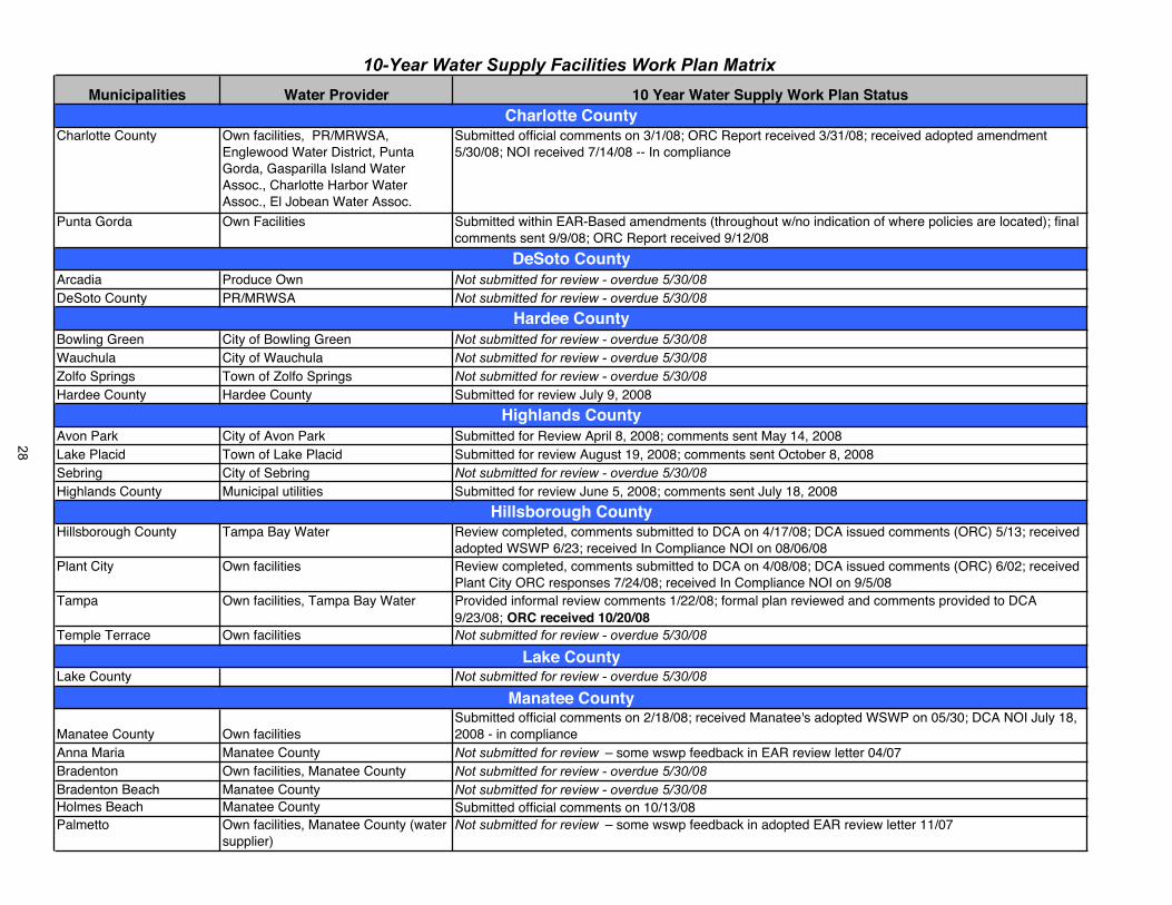
Municipalities Water Provider 10 Year Water Supply Work Plan Status
Charlotte County Own facilities, PR/MRWSA, Englewood Water District, Punta Gorda, Gasparilla Island Water Assoc., Charlotte Harbor Water Assoc., El Jobean Water Assoc.
Submitted official comments on 3/1/08; ORC Report received 3/31/08; received adopted amendment 5/30/08; NOI received 7/14/08 -- In compliance
Punta Gorda Own Facilities Submitted within EAR-Based amendments (throughout w/no indication of where policies are located); finalcomments sent 9/9/08; ORC Report received 9/12/08
Arcadia Produce Own Not submitted for review - overdue 5/30/08DeSoto County PR/MRWSA Not submitted for review - overdue 5/30/08
Bowling Green City of Bowling Green Not submitted for review - overdue 5/30/08Wauchula City of Wauchula Not submitted for review - overdue 5/30/08Zolfo Springs Town of Zolfo Springs Not submitted for review - overdue 5/30/08Hardee County Hardee County Submitted for review July 9, 2008
Avon Park City of Avon Park Submitted for Review April 8, 2008; comments sent May 14, 2008Lake Placid Town of Lake Placid Submitted for review August 19, 2008; comments sent October 8, 2008Sebring City of Sebring Not submitted for review - overdue 5/30/08Highlands County Municipal utilities Submitted for review June 5, 2008; comments sent July 18, 2008
Hillsborough County Tampa Bay Water Review completed, comments submitted to DCA on 4/17/08; DCA issued comments (ORC) 5/13; receivedadopted WSWP 6/23; received In Compliance NOI on 08/06/08
Plant City Own facilities Review completed, comments submitted to DCA on 4/08/08; DCA issued comments (ORC) 6/02; received Plant City ORC responses 7/24/08; received In Compliance NOI on 9/5/08
Tampa Own facilities, Tampa Bay Water Provided informal review comments 1/22/08; formal plan reviewed and comments provided to DCA9/23/08; ORC received 10/20/08
Temple Terrace Own facilities Not submitted for review - overdue 5/30/08
Lake County Not submitted for review - overdue 5/30/08
Manatee County Own facilitiesSubmitted official comments on 2/18/08; received Manatee's adopted WSWP on 05/30; DCA NOI July 18, 2008 - in compliance
Anna Maria Manatee County Not submitted for review – some wswp feedback in EAR review letter 04/07Bradenton Own facilities, Manatee County Not submitted for review - overdue 5/30/08Bradenton Beach Manatee County Not submitted for review - overdue 5/30/08Holmes Beach Manatee County Submitted official comments on 10/13/08Palmetto Own facilities, Manatee County (water
supplier)Not submitted for review – some wswp feedback in adopted EAR review letter 11/07
10-Year Water Supply Facilities Work Plan Matrix
Hillsborough County
Manatee County
Charlotte County
DeSoto County
Hardee County
Highlands County
Lake County
28
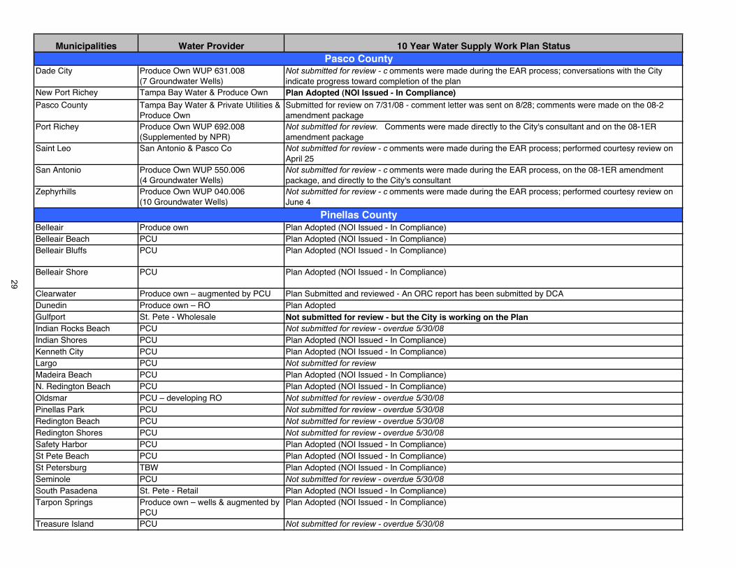
Municipalities Water Provider 10 Year Water Supply Work Plan Status
Dade City Produce Own WUP 631.008 (7 Groundwater Wells)
Not submitted for review - c omments were made during the EAR process; conversations with the City indicate progress toward completion of the plan
New Port Richey Tampa Bay Water & Produce Own Plan Adopted (NOI Issued - In Compliance)Pasco County Tampa Bay Water & Private Utilities &
Produce OwnSubmitted for review on 7/31/08 - comment letter was sent on 8/28; comments were made on the 08-2 amendment package
Port Richey Produce Own WUP 692.008 (Supplemented by NPR)
Not submitted for review. Comments were made directly to the City's consultant and on the 08-1ER amendment package
Saint Leo San Antonio & Pasco Co Not submitted for review - c omments were made during the EAR process; performed courtesy review on April 25
San Antonio Produce Own WUP 550.006 (4 Groundwater Wells)
Not submitted for review - c omments were made during the EAR process, on the 08-1ER amendment package, and directly to the City's consultant
Zephyrhills Produce Own WUP 040.006 (10 Groundwater Wells)
Not submitted for review - c omments were made during the EAR process; performed courtesy review on June 4
Belleair Produce own Plan Adopted (NOI Issued - In Compliance)Belleair Beach PCU Plan Adopted (NOI Issued - In Compliance)Belleair Bluffs PCU Plan Adopted (NOI Issued - In Compliance)
Belleair Shore PCU Plan Adopted (NOI Issued - In Compliance)
Clearwater Produce own – augmented by PCU Plan Submitted and reviewed - An ORC report has been submitted by DCADunedin Produce own – RO Plan Adopted Gulfport St. Pete - Wholesale Not submitted for review - but the City is working on the PlanIndian Rocks Beach PCU Not submitted for review - overdue 5/30/08Indian Shores PCU Plan Adopted (NOI Issued - In Compliance)Kenneth City PCU Plan Adopted (NOI Issued - In Compliance)Largo PCU Not submitted for reviewMadeira Beach PCU Plan Adopted (NOI Issued - In Compliance)N. Redington Beach PCU Plan Adopted (NOI Issued - In Compliance)Oldsmar PCU – developing RO Not submitted for review - overdue 5/30/08Pinellas Park PCU Not submitted for review - overdue 5/30/08Redington Beach PCU Not submitted for review - overdue 5/30/08Redington Shores PCU Not submitted for review - overdue 5/30/08Safety Harbor PCU Plan Adopted (NOI Issued - In Compliance)St Pete Beach PCU Plan Adopted (NOI Issued - In Compliance)St Petersburg TBW Plan Adopted (NOI Issued - In Compliance)Seminole PCU Not submitted for review - overdue 5/30/08South Pasadena St. Pete - Retail Plan Adopted (NOI Issued - In Compliance)Tarpon Springs Produce own – wells & augmented by
PCUPlan Adopted (NOI Issued - In Compliance)
Treasure Island PCU Not submitted for review - overdue 5/30/08
Pasco County
Pinellas County
29
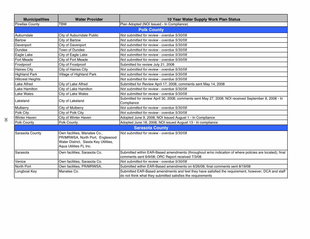
Municipalities Water Provider 10 Year Water Supply Work Plan StatusPinellas County TBW Plan Adopted (NOI Issued - In Compliance)
Auburndale City of Auburndale Public Not submitted for review - overdue 5/30/08Bartow City of Bartow Not submitted for review - overdue 5/30/08Davenport City of Davenport Not submitted for review - overdue 5/30/08Dundee Town of Dundee Not submitted for review - overdue 5/30/08Eagle Lake City of Eagle Lake Not submitted for review - overdue 5/30/08Fort Meade City of Fort Meade Not submitted for review - overdue 5/30/08Frostproof City of Frostproof Submitted for review July 21, 2008 Haines City City of Haines City Not submitted for review - overdue 5/30/08Highland Park Village of Highland Park Not submitted for review - overdue 5/30/08Hillcrest Heights Not submitted for review - overdue 5/30/08Lake Alfred City of Lake Alfred Submitted for Review April 17, 2008; comments sent May 14, 2008Lake Hamilton City of Lake Hamilton Not submitted for review - overdue 5/30/08Lake Wales City of Lake Wales Not submitted for review - overdue 5/30/08
Lakeland City of LakelandSubmitted for review April 30, 2008; comments sent May 27, 2008; NOI received September 8, 2008 - In Compliance
Mulberry City of Mulberry Not submitted for review - overdue 5/30/08Polk City City of Polk City Not submitted for review - overdue 5/30/08Winter Haven City of Winter Haven Adopted June 9, 2008, NOI Issued August 1 - In CompliancePolk County Polk County Adopted June 18, 2008, NOI issued August 13 - In compliance
Sarasota County Own facilities, Manatee Co., PR/MRWSA, North Port, Englewood Water District, Siesta Key Utilities, Aqua Utilities FL Inc.
Not submitted for review - overdue 5/30/08
Sarasota Own facilities, Sarasota Co. Submitted within EAR-Based amendments (throughout w/no indication of where policies are located); final comments sent 6/9/08; ORC Report received 7/3/08
Venice Own facilities, Sarasota Co. Not submitted for review - overdue 5/30/08North Port Own facilities, PR/MRWSA, Submitted within EAR-Based amendments on 6/26/08; final comments sent 8/19/08Longboat Key Manatee Co. Submitted EAR-Based amendments and feel they have satisfied the requirement, however, DCA and staff
do not think what they submitted satisfies the requirements
Polk County
Sarasota County
30
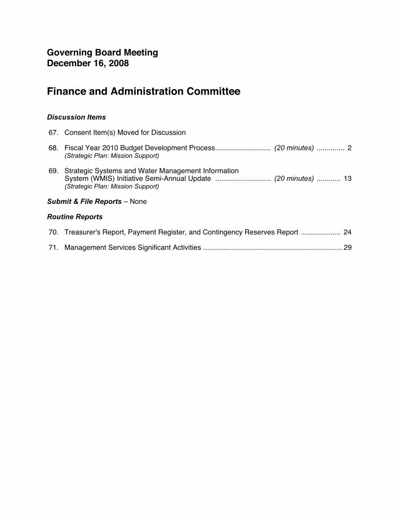
Governing Board Meeting December 16, 2008
Finance and Administration Committee
Discussion Items
67. Consent Item(s) Moved for Discussion
68. Fiscal Year 2010 Budget Development Process............................ (20 minutes) .............. 2 (Strategic Plan: Mission Support)
69. Strategic Systems and Water Management Information System (WMIS) Initiative Semi-Annual Update ............................ (20 minutes) ............ 13
(Strategic Plan: Mission Support)
Submit & File Reports – None
Routine Reports
70. Treasurer's Report, Payment Register, and Contingency Reserves Report .................... 24
71. Management Services Significant Activities ...................................................................... 29

Item 68
Finance and Administration CommitteeDecember 16, 2008
Discussion Item
Fiscal Year 2010 Budget Development Process
PurposeReview and acceptance of the fiscal year (FY) 2010 Budget Development Process establishing budget strategic priorities and general preparation assumptions.
BackgroundDistrict staff will begin the FY2010 budget development process in January. A memorandum with attachments has been prepared for Governing Board review that provides an overview of the planned budget development process.
BenefitsThe Budget Development Process memorandum with attachments provides staff with guidance from the Governing Board for the development of the next fiscal year budget.
Staff Recommendation: See Exhibit
Accept the planned FY2010 Budget Development Process as described in the memorandum and attachments.
Presenters: Linda R. Pilcher, Assistant Finance DirectorEugene A. Schiller, Deputy Executive Director
2

December 8, 2008
MEMORANDUM
TO: Governing Board Members
THROUGH: David L. Moore, Executive Director
FROM: Eugene A. Schiller, Deputy Executive Director Daryl F. Pokrana, Finance Director
Linda R. Pilcher, Assistant Finance Director
SUBJECT: Fiscal Year 2010 Budget Development Process
This memorandum and attachments provide an overview of the District’s planned fiscal year (FY) 2010 budget development process. The following are provided for your review and acceptance to enable staff to proceed with development of the draft budget:
Budget Calendar: The calendar illustrates the District’s budget development process for FY2010, including the statutory notice and hearing requirements of the Truth-In-Millage (TRIM) laws and the Executive Office of the Governor’s (EOG) standard reporting process for water management districts. The process starts in January 2009 with the distribution of the approved budget preparation guidelines to the departments.
Major Budget Strategic Initiatives: The strategic initiatives for FY2010 are listed. The strategic initiatives have been excerpted from the District's Strategic Plan that was approved by the Governing Board on October 28, 2008. The strategic initiatives provide focus for departments to identify the budgetary requirements necessary to carry out District programs. These initiatives are consistent with the Governor’s budget approval letter dated September 16, 2008, which is attached for reference.
General Budget Preparation Assumptions: The general budget preparation assumptions needed to start the development of the FY2010 budget are outlined. Given the current fiscal environment and projected state budget deficits, staff will continue to monitor activities in Tallahassee and nationally. As updated information becomes available that may impact these assumptions, staff will report back to the Governing Board.
Program and Activity Allocations Report: The Program and Activity Allocations report, which is a standard format required by the EOG as part of the August 1 tentative budget submission by the water management districts, is provided for reference. This report displays the District’s FY2009 budget according to the six statutorily defined program areas and the underlying program activities. The program budgets are then allocated into the District’s four statutorily established areas of responsibility: Water Supply, Water Quality, Flood Protection, and Natural Systems.
LRP:jlmAttachments (5) cc: Ronald E. Oakley, Treasurer Senior Staff Budget Staff
Department Budget Contacts
3

SOUTHWEST FLORIDA WATER MANAGEMENT DISTRICT Fiscal Year 2010 Budget Calendar
Rev. 12/08/08 DATES ACTIVITY RESPONSIBILITY
October 2008 Annual Basin Board Planning Workshops and Governing Board Meeting Formal Update WS&WRD Funding Plan Over Planning Horizon of 2025
Basin Boards/Governing Board
October Cooperative Funding Meetings Staff/Prospective Cooperators/Public
December 1-31 Develop FY2010 Budget Preparation Guidelines Executive/Budget December 5 FY2010 Cooperative Funding Applications Due Prospective Cooperators December 16 Governing Board Review FY2010 Budget Development Process Governing Board/Budget/
Planning/Public
January 1-31, 2009 Review FY2010 Cooperative Funding Applications Staff January 2 FY2009 First Quarter Financial Report & Planning Forecast Directors/Budget Beginning January 21 Budget Preparation and BRASS Software Training
Distribute FY2010 Budget Preparation Guidelines Budget/Financial Systems/Staff Budget
February Basin Boards Review Cooperative Funding Applications Basin Boards February Identify New or Continuing FY2010 Major Alternative Water Supply &
Water Resource Development (WS&WRD) Projects from Cooperative Funding Submittals
Staff
February 10 Rank FY2010 Cooperative Funding Applications Staff February 20 Recurring Budget Requests and Staff Resource Allocations Due Directors February 24 FY2010 Budget Update Governing Board February 27 New and Non-Recurring Budget Requests Due Directors
March 6 Capital Improvements Plan (CIP) Requirements Due Directors March 6 General Services and Information Resources Departments
New and Non-Recurring Budget Requests Due Directors
March 9 Preliminary Budget Summary Executive/Budget March 11-20 Executive Review of Budget Submissions Executive/Budget/Directors March 23-27 Departmental Follow-up Review (Executive Adjustments) Executive/Budget/Directors March 31 Present FY2010 WS&WRD Projects; Review Past SB 444
Allocations; Update Existing Project Costs and Schedule/ Budget Update
Executive/Resource Projects/ Budget/Governing Board
April April
Basin Boards Review Preliminary Budgets Present FY2010 Basin WS&WRD Projects; Review Past SB 444 Allocations; Update Existing Project Costs and Schedule/ Budget Update
Basin Boards Basin Boards
April 1 FY2009 Second Quarter Financial Report & Planning Forecast Directors/Budget April 6 Executive Budget Summary (All Funds) Executive/Budget
May 11-15 Final Executive Review of FY2010 Recommended Annual Service Budget
Executive/Budget
May 20 Review Draft Information Resources Five-Year Technology Plan & Draft Five-Year Capital Improvements Plan (CIP)
Executive/Budget/Governing Board
June
June
Basin Boards Review Proposed Budgets & Adopt Proposed Millage Rates Review Elements of WS&WRD Funding Plan Relative to Costs & Schedule of Proposed or Modified Projects, Legislative Appropriation(s) of SB 444 and Grants
Basin Boards
Basin Boards
June 1 Estimates of Taxable Value & Picture-In-Time for Annual Budget Review Budget June 23 FY2010 Annual Budget Review Executive/Budget/Governing Board June 23 Update WS&WRD Funding Plan Revenue Assumptions with Final
Ad Valorem Revenue Estimates & Make Necessary Adjustments to Budget
Executive/Resource Projects/ Budget/Governing Board
July Special Basin Board Meetings, if needed, to adopt proposed FY2010 Millage Rates
July 1-15 Certifications of Taxable Value Property Appraisers/Budget July 2 FY2009 Third Quarter Financial Report & Planning Forecast Directors/Budget July 28 FY2010 Budget Update & Adopt Proposed Millage Rates for District
and Watershed Basins Governing Board
4

SOUTHWEST FLORIDA WATER MANAGEMENT DISTRICT Fiscal Year 2010 Budget Calendar (continued)
Rev. 12/08/08
DATES ACTIVITY RESPONSIBILITY
August Basin Boards Review Final Budgets & Adopt Final Millage Rates and Budgets
Basin Boards
August Update WS&WRD Funding Plan Revenue Assumptions with Final Ad Valorem Revenue Estimates & Make Necessary Adjustments to Budget
Basin Boards
August 1 Submit Standard Format Tentative Budget to Governor, President of the Senate, Speaker of the House, Legislative Committee Chairs, Secretary of the Department of Environmental Protection, and each County Commission
Budget
August 4 Submit Proposed Millage Rates & Preliminary Disclosure of Maximum Millage Levies to Property Appraisers
Budget
August 25 FY2010 Budget Update Executive/Budget/Governing Board August Executive Office of the Governor (EOG) Budget Review EOG/Executive/Budget
September 5 House and Senate Appropriations Chair Comments Due Legislature September 15 Public Hearing (Tentative Budget) - Tampa Service Office Governing Board September 22 EOG Budget Review Comments Due EOG September 24-27 Advertise Millage Rates and Budget Budget September 29 Public Hearing (Final Budget) - District Headquarters Brooksville Governing Board
October 2 Forward Resolutions to Property Appraisers, Tax Collectors & Department of Revenue
Budget
October 9 Issue FY2010 Budget in Brief Report Budget October 29 Certify Compliance to Department of Revenue
Including the DR-487; DR-420s, DR-422s, DR-420 MMs & DR-487 V Budget
October 2009 Annual Basin Board Planning Workshops and Governing Board Meeting Formal Update WS&WRD Funding Plan Over Planning Horizon of 2030
Basin Boards/Governing Board
December 15 EOG Report on Review of Water Management District Budgets for FY2010
EOG
December 31 Certify Compliance to Department of Financial Services Budget
March 1, 2010 Submit Consolidated Water Management District Annual Report (including the Five-Year CIP) to Governor, President of the Senate, Speaker of the House, Legislative Committee Chairs, Secretary of the Department of Environmental Protection, and each County Commission
Planning/Budget
5

SOUTHWEST FLORIDA WATER MANAGEMENT DISTRICT Fiscal Year 2010 Major Budget Strategic Initiatives
Florida Statutes, especially Chapter 373, authorize the District to direct a wide range of initiatives, programs, and actions. These responsibilities can be grouped under four general areas: water supply, flood protection, water quality, and natural systems. In developing the Strategic Plan, the District has established a goal statement for each of these areas, along with strategic initiatives designed to meet those goals. The strategic initiatives provide focus for departments to identify budgetary requirements necessary to carry out District programs, and serve as the foundation for developing the annual service budget. The following FY2010 strategic initiatives, by Area of Responsibility, are included in the District’s Strategic Plan that was approved by the Governing Board on October 28, 2008.
Water SupplyRegional Water Supply Planning – Identify, communicate and promote consensus on the strategies and resources necessary to meet future reasonable and beneficial water supply needs.
Conservation – Enhance water use efficiencies in all water use sectors to reduce demands on all water supplies.
Alternative Water Supplies – Increase development of alternative sources of potable water to ensure ground and surface waters are sustainable.
Reclaimed Water – Maximize beneficial use of reclaimed water to offset demand of ground and potable alternative water supplies.
Water QualityWater Quality Monitoring – Collect and analyze water quality data to determine the region’s water quality status and trends.
Water Quality Maintenance and Improvement – Develop and implement programs, projects and regulations to maintain and improve water quality.
Natural SystemsMinimum Flows and Levels (MFL) Establishment and Monitoring – Establish and monitor MFLs to ensure maintenance of the hydrology necessary to sustain the region’s natural systems.
MFL Recovery – Develop regionally accepted recovery plans and oversee the successful implementation of the plans to ensure the recovery of all water resources not meeting MFLs.
Natural Systems Identification and Monitoring – Identify and monitor critical ecosystems to promote awareness of the region’s ecologic systems and their status.
Natural Systems Conservation and Restoration – Develop plans for acquisition, conservation and restoration of selected ecosystems and monitor, assist and oversee the successful completion of the plans to ensure protection, recovery and function of these ecosystems.
Flood ProtectionFloodplain Management – Develop better floodplain information and utilize the information in the implementation of regulatory and non-regulatory floodplain management programs to maintain floodplain storage and conveyance and to minimize flood damage.
Emergency Flood Response – Operate District flood control and water conservation structures and provide effective and efficient assistance to state and local governments and the public to minimize flood damage during and after storm events.
6
SOUTHWEST FLORIDA WATER MANAGEMENT DISTRICT Fiscal Year 2010 Major Budget Strategic Initiatives (continued)
To successfully achieve the major strategic initiatives, the District must excel in each of the following processes. Consistent with this, budgets will be established for these processes in support of the strategic initiatives.
Water Resources Planning and Knowledge Management oversees watershed and basin management planning for inter- and intra-District water and related resources (including the development of minimum flows and levels) and other water comprehensive resource planning in partnership with local, state, regional, federal and other stakeholders. This process also includes identifying, collecting, analyzing and timely disseminating relevant and accurate data to interested parties.
Innovative Projects: Public Works, Restoration and Land Acquisition initiates and supports creative, collaborative projects to produce measurable benefits to the environment, water resources, critical knowledge and the regional community. The process includes capital projects for water resource development and water supply development assistance, water control and conservation, land acquisition, restoration of lands and water resources, administrative facilities construction and internal projects.
Outreach/Education provides citizens, visitors, media, elected officials, educators and other stakeholders with essential water resource information and ombudsman support to foster behaviors, secure funding and assist in developing laws that conserve, protect and sustain Florida’s precious water and related natural resources.
Regulation involves multiple permit activities that promote a fair allocation of the water resources, protect wetlands, enforce well construction standards and ensure that new development does not increase the risk of flooding or degrade water quality. The permitting process also monitors subsequent operational performance of permitted systems to protect the region’s citizens and water resources.
Land and Structure Operations operates and maintains District lands and water control and conservation structures to restore and sustain natural systems, minimize flood damage and provide opportunities for education and recreation.
Long-Range Financial Plan provides financial incentives on a pay-as-you-go basis to encourage and align partnership efforts for the purpose of conserving water and developing alternative water supplies, enhancing natural systems and water quality, and promoting flood management activities.
Mission Support includes vital functions in support of other core business processes. These functions include human resource development, online information technology, facility and fleet support, records management, risk management, financial, legal counsel and audit services.
7
SOUTHWEST FLORIDA WATER MANAGEMENT DISTRICT Fiscal Year 2010 General Budget Preparation Assumptions
Revenues
Ad valorem revenue anticipated at 10 percent below FY2009 levels. Final millage rates and ad valorem revenue will be determined after the Certifications of Taxable Value are received from the county Property Appraisers due July 1, 2009.
Water Supply and Resource Development (WSRD) program to continue consistent with the Long-Range Water Supply and Water Resource Development Funding Plan of the Regional Water Supply Plan through 2025, currently being updated through 2030. The WSRD is targeted at not less than $60 million per year (General Fund $30 million and Basins $30 million).
State's Florida Forever Trust Fund anticipated funding of $22.5 million for land acquisition, equal to the annual appropriation amount. Consistent with the actual and planned Florida Forever acquisitions, the budget appropriation will be tentatively allocated as follows: $11.25 million or 50 percent for acquisition of lands or easements primarily for water resource development and $11.25 million or 50 percent for acquisition of lands primarily for restoration and conservation purposes.
State's Water Management Lands Trust Fund (WMLTF) anticipated funding of $11.375 million for preacquisition costs, land acquisition ancillary costs, land management costs and payments in lieu of taxes, and the Surface Water Improvement and Management (SWIM) program (to be matched by Basins). Amount based on latest projections from Legislature's Office of Economic and Demographic Research web site, November 21, 2008. Will continue to monitor.
Permit fees projected at $2.3 million.
Interest earnings based on 3 percent rate of return.
Balance forward of $16 million for the General Fund designated for future funding. (Will be adjusted in December based on audited financial results.)
Expenditures
All recurring and non-recurring expenditures (excluding salaries and benefits) will be targeted for planning purposes, subject to reduction or reallocation, at 5 percent below FY2009 levels, including contracts, computer hardware and software, and other capital outlay. This 5 percent target applies to the General Fund, as well as the Basins.
The following non-recurring accounts will be zero-based and each budget item must be separately justified:-- Contract Labor (including part-time and temporary positions) -- Computer Hardware and Software -- Consultant Services -- Contracted Construction -- Capital Outlay
8

SOUTHWEST FLORIDA WATER MANAGEMENT DISTRICT Fiscal Year 2010 General Budget Preparation Assumptions (continued)
No increases are currently anticipated in Governing Board authorized positions or Executive Director authorized positions.
Salary pool budget remains at 3 percent (annualized 4 percent).
Reserves for Contingencies will be budgeted at 5 percent of ad valorem revenue. The Government Finance Officers Association recommends between 5 percent – 15 percent of General Fund revenues. If additional funds are required, they will be taken from WSRD reserves.
All budget requests will be linked to the District Strategic Plan and the District Water Management Plan (DWMP) through the District's program budget.
All budget requests will be consistent with Governor Charlie Crist's Energy and Climate Change Initiative and the District's Efficiency & Environmental Stewardship to increase energy efficiency and reduce carbon footprint.
Facilities improvements and associated revenue contribution will be consistent with the Governing Board draft Five-Year Capital Improvements Plan (CIP) for FY2010 through FY2014.
Internal service charges for Central Garage will be used for Basins and grant-funded projects to budget the General Fund reimbursement for vehicle and equipment use.
Special budget instructions for equipment and vehicle requests:
o New and replacement personal computers, peripherals, and software requests will be entered by the requesting department into a separate section established in the Information Resources Department budget. The computers and software will be evaluated by the Information Resources Department for inclusion in its final budget request, consistent with the draft Information Resources Five-Year Technology Plan for FY2010 through FY2014.
o New and replacement vehicles will generally be budgeted by the General Services Department based on fleet management requirements and departmental requests. Vehicles to be funded by the Water Management Lands Trust Fund will be budgeted by the requesting department after evaluation by the General Services and Land Resources Departments.
o New and replacement outside equipment will be budgeted by the requesting department after evaluation by the General Services Department. Outside Equipment to be funded by the Water Management Lands Trust Fund will also be evaluated by the Land Resources Department.
9
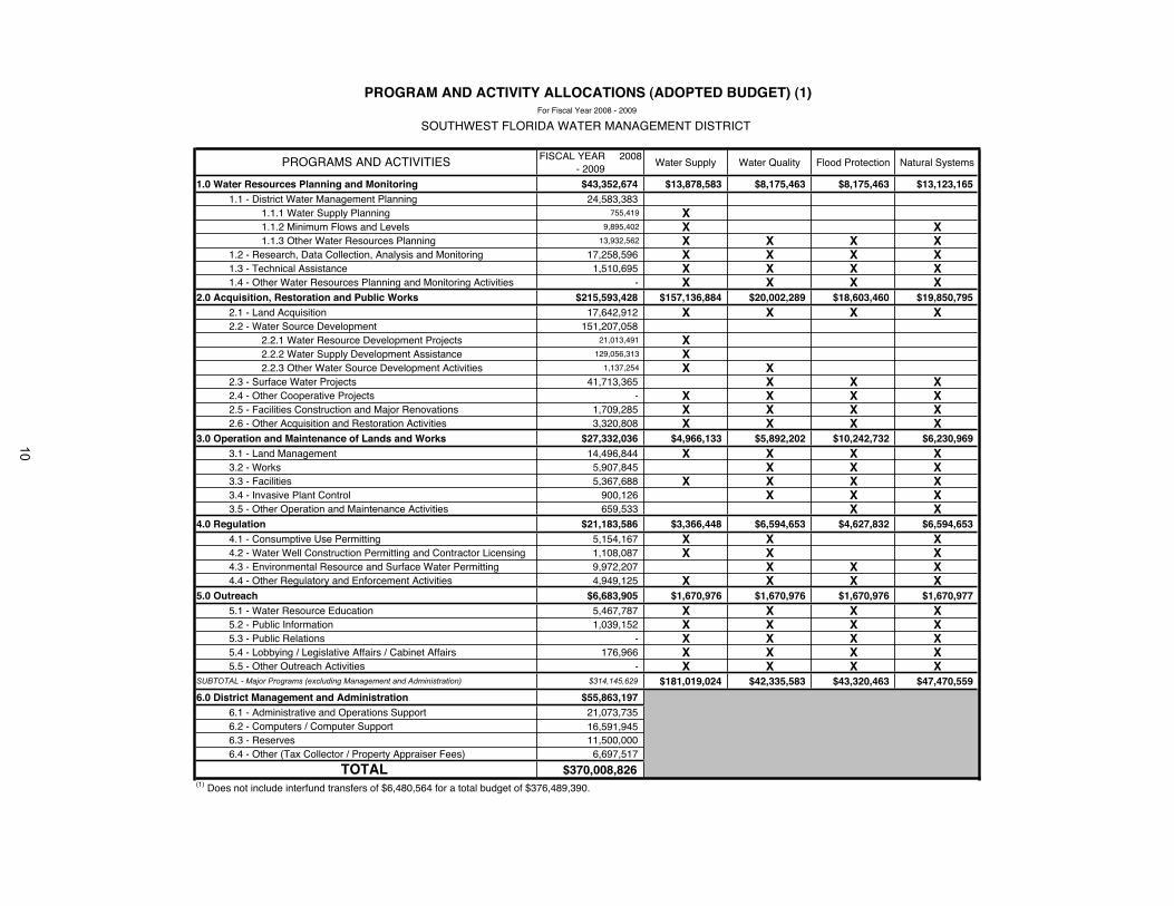
FISCAL YEAR 2008 - 2009
Water Supply Water Quality Flood Protection Natural Systems
1.0 Water Resources Planning and Monitoring $43,352,674 $13,878,583 $8,175,463 $8,175,463 $13,123,1651.1 - District Water Management Planning 24,583,383
1.1.1 Water Supply Planning 755,419 X1.1.2 Minimum Flows and Levels 9,895,402 X X1.1.3 Other Water Resources Planning 13,932,562 X X X X
1.2 - Research, Data Collection, Analysis and Monitoring 17,258,596 X X X X1.3 - Technical Assistance 1,510,695 X X X X1.4 - Other Water Resources Planning and Monitoring Activities - X X X X
2.0 Acquisition, Restoration and Public Works $215,593,428 $157,136,884 $20,002,289 $18,603,460 $19,850,7952.1 - Land Acquisition 17,642,912 X X X X2.2 - Water Source Development 151,207,058
2.2.1 Water Resource Development Projects 21,013,491 X2.2.2 Water Supply Development Assistance 129,056,313 X2.2.3 Other Water Source Development Activities 1,137,254 X X
2.3 - Surface Water Projects 41,713,365 X X X2.4 - Other Cooperative Projects - X X X X2.5 - Facilities Construction and Major Renovations 1,709,285 X X X X2.6 - Other Acquisition and Restoration Activities 3,320,808 X X X X
3.0 Operation and Maintenance of Lands and Works $27,332,036 $4,966,133 $5,892,202 $10,242,732 $6,230,9693.1 - Land Management 14,496,844 X X X X3.2 - Works 5,907,845 X X X3.3 - Facilities 5,367,688 X X X X3.4 - Invasive Plant Control 900,126 X X X3.5 - Other Operation and Maintenance Activities 659,533 X X
4.0 Regulation $21,183,586 $3,366,448 $6,594,653 $4,627,832 $6,594,6534.1 - Consumptive Use Permitting 5,154,167 X X X4.2 - Water Well Construction Permitting and Contractor Licensing 1,108,087 X X X4.3 - Environmental Resource and Surface Water Permitting 9,972,207 X X X4.4 - Other Regulatory and Enforcement Activities 4,949,125 X X X X
5.0 Outreach $6,683,905 $1,670,976 $1,670,976 $1,670,976 $1,670,9775.1 - Water Resource Education 5,467,787 X X X X5.2 - Public Information 1,039,152 X X X X5.3 - Public Relations - X X X X5.4 - Lobbying / Legislative Affairs / Cabinet Affairs 176,966 X X X X5.5 - Other Outreach Activities - X X X X
SUBTOTAL - Major Programs (excluding Management and Administration) $314,145,629 $181,019,024 $42,335,583 $43,320,463 $47,470,559
6.0 District Management and Administration $55,863,1976.1 - Administrative and Operations Support 21,073,7356.2 - Computers / Computer Support 16,591,9456.3 - Reserves 11,500,0006.4 - Other (Tax Collector / Property Appraiser Fees) 6,697,517
$370,008,826(1) Does not include interfund transfers of $6,480,564 for a total budget of $376,489,390.
PROGRAM AND ACTIVITY ALLOCATIONS (ADOPTED BUDGET) (1)
SOUTHWEST FLORIDA WATER MANAGEMENT DISTRICT
PROGRAMS AND ACTIVITIES
TOTAL
For Fiscal Year 2008 - 2009
10
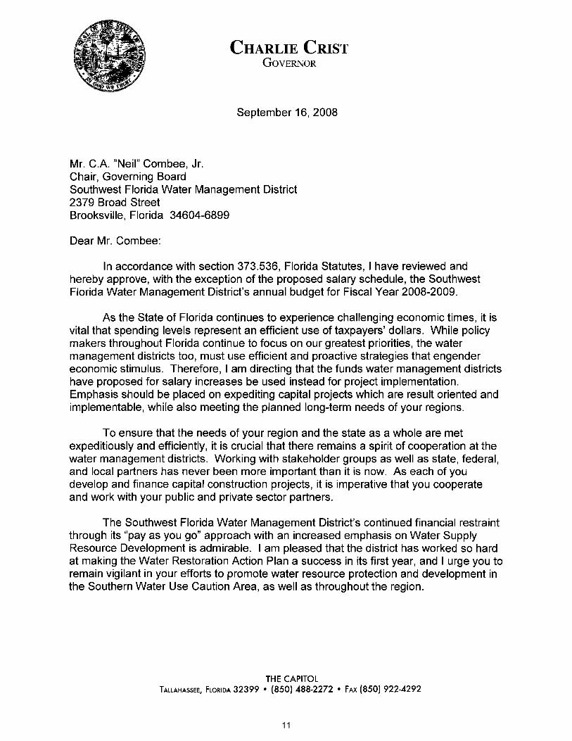
11

12

Item 69
Finance and Administration Committee December 16, 2008
Discussion Item
Strategic Systems and Water Management Information System (WMIS) Initiative Semi-annual Update
PurposeThe purpose of this item is to provide the Governing Board with a semi-annual update on Information Resources Department's Five-Year Technology Plan, Fiscal Years 2009-2013, with emphasis on the status of the Water Management Information System (WMIS) initiative, the key component of this plan.
Background/History In May 2008, the Information Resources Department (IRD) presented the annual Information Resources Department Five-Year Technology Plan to the Governing Board. That presentation included a discussion of IRD's strategic portfolio of projects and how they related to the District's Strategic Plan. During that presentation, IRD advised that staff would return and provide a six-month update.
This update discusses Strategic Project Portfolio Management, the projects' linkage to the District Strategic Plan, and the portfolio's software development status. It includes the current status of the following projects: Water Management Information System (WMIS), Project Information Management System (PIMS), Enterprise Content Management (ECM), Land Resources Information System (LaRIS), the Human Resources Information System (HRIS), Microsoft Exchange as a replacement for Lotus Notes Email and Unified Communications. Additionally, a short presentation on the District's Green IT initiative will be provided.
The WMIS update includes a discussion of a revised schedule to remove the IBM Mainframe Computer in February 2010, which is eight months earlier than originally estimated. The latest WMIS increment, released in November 2008, provided Water Use Permitting Generals, compliance tracking and additional enhancements to the Resource Data component. It was installed on schedule. Well Construction Permitting, Water Use Permitting Small General and Resource Data capabilities were made available to the public in earlier releases. A short demonstration of the WMIS Notification System will also be provided.
Overall, the projects remain on time and within budget. The only project experiencing implementation issues is HRIS. Meetings are being held with the contractor and the latest project status will be provided at the November Governing Board meeting.
Staff Recommendation:
This item is presented for the Committee’s information, and no action is required.
Presenters: Terry Redman, Director, Information Resources Department Charles Gausche, Ph.D., Manager, Enterprise Architecture Section
13

1
Strategic Systems Project Portfolio Update
Terry RedmanFinance and Administration Committee
November 18, 2008
14

2
Agenda• Introduction• Strategic Project Portfolio• WMIS Demonstration• Green IT• Conclusions• Questions
15

Introduction
• Strategic Project Portfolio Management• Linkages to the District Strategic Plan• Strategic Projects Remain on Schedule and
Within Budget– HRIS Technical and Management Updates– Exchange Project – Replaces Lotus Notes for Email– Unified Communications – Long-Range
Communications Improvement Initiative
• Green IT
16

4
17

5
Strategic Project Portfolio
18

6
WMIS Schedule
19
7
WMIS Noticing ToolDemonstration20
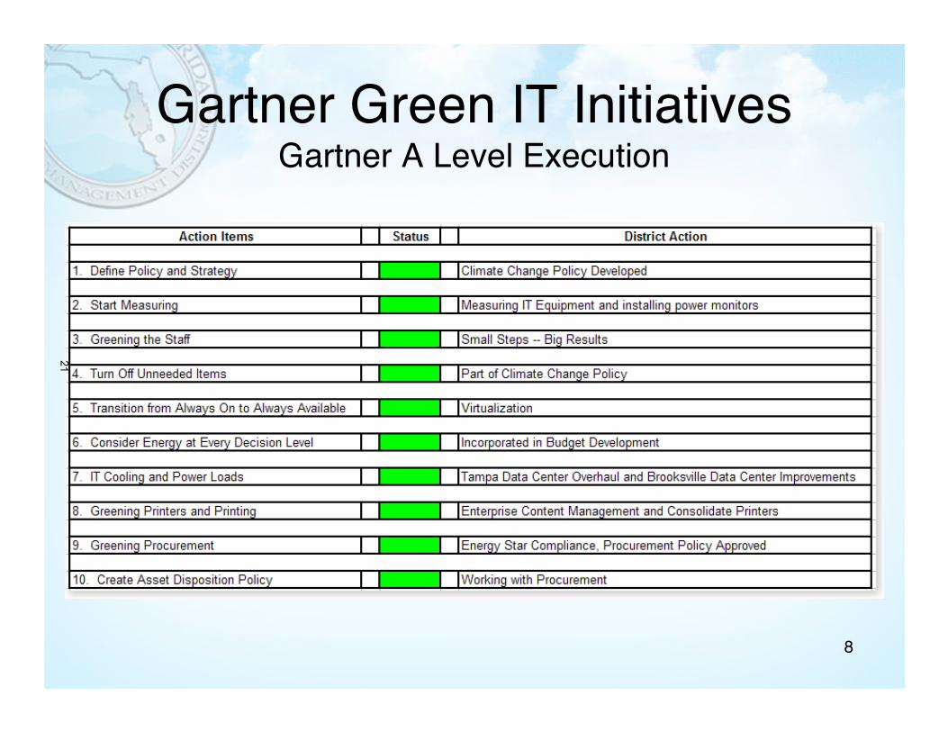
8
Gartner Green IT InitiativesGartner A Level Execution
21

Conclusions
• Strategic Project Portfolio on time and within budget
• WMIS is Meeting Milestones with Major Release in Production -- November 2008
• IBM Mainframe Early Removal (February 2010)• Green IT Initiative is on Course
22

10
Questions?
23
Item 70
Finance and Administration Committee December 16, 2008
Routine Report
Treasurer's Report, Payment Register, and Contingency Reserves
PurposePresentation of the Treasurer's Report, Payment Register, and Contingency Reserves.
Background In accordance with Board Policy 130-3, District Investment Policy, a monthly report on investments shall be provided to the Governing Board. Attached is a copy of the Treasurer's Report as of November 30, 2008, which reflects total cash and investments at a market value of $580,114,049.
As reflected on the November 30, 2008, Treasurer's Report, the investment portfolio had $118.6 million or 20.6 percent invested in the State Board of Administration (SBA) Local Government Surplus Funds Trust Fund (LGSFTF) with $106 million in Pool A and $12.6 million in Pool B. The District has received $.3 million of Pool A interest earnings during the first two months of fiscal year 2009, period ended November 30. Pool B is not distributing interest earnings. The District is managing its short-term and daily liquidity needs through the use of two money market funds (Dreyfus Government Cash Management and Federated Government Obligations #5). Consistent with Board Policy 130-3, the maximum percent of the portfolio that will be invested in any one money market fund is 25 percent.
Pool A consists of all money market appropriate assets and has been assigned a "AAAm" rating by Standard & Poor's Ratings Services. Withdrawals are authorized based on the Pool's liquidity. At November 30, the District's investment in Pool A was $106 million, down from the initial investment of $246.6 million. The $106 million consists of $39 million that is liquid and available for District use and $67 million that is still illiquid and not available for District use without paying a 2 percent redemption fee. By December 31, 2008, the District anticipates that the $67 million will be liquid and no longer subject to withdrawal restrictions.
Pool B consists of assets that had defaulted on a payment, paid more slowly than expected, or had any significant credit and liquidity risk. At November 30, the District's investment in Pool B was $12.6 million, down from the initial investment of $40.7 million. The market value of the Pool B investments is $10 million or 78 percent of cost, reflecting $2.7 million at risk. District staff is not aware of any plans by the SBA to liquidate Pool B investments below cost.
On December 4, 2008, the SBA LGIP released another $426 thousand from Fund B. Therefore, subsequent to November 30, 2008, the balance of $12.6 million has been reduced by $.4 million, leaving the District's balance in Fund B at $12.2 million, which would further reduce the $2.7 million at risk.
Staff will continue to monitor the SBA activities to determine how this will impact the District's current investment in the SBA LGSFTF, and affect the District's investment strategy going forward.
In accordance with Board Policy 130-1, Disbursement of Funds, all general checks written during a period shall be reported to the Governing Board at its next regular meeting. The Payment Register listing disbursements since last month's report is available upon request. The Payment Register includes checks and electronic funds transfers (EFTs).
24
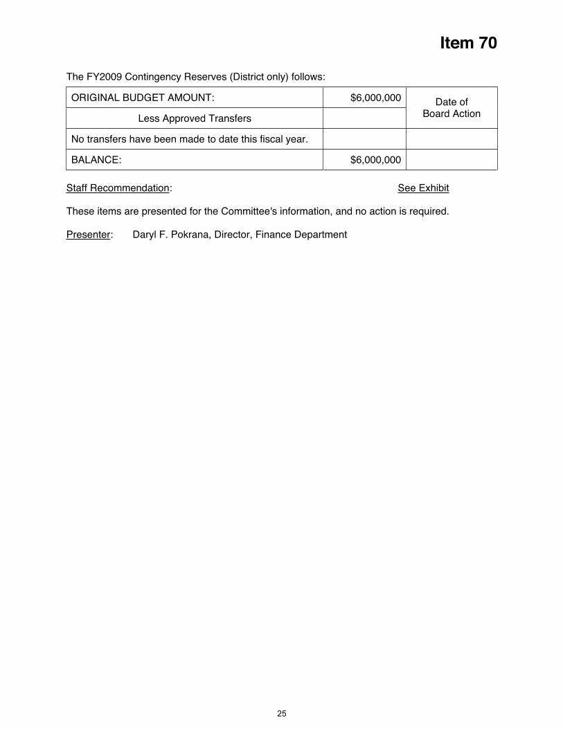
Item 70
The FY2009 Contingency Reserves (District only) follows:
ORIGINAL BUDGET AMOUNT: $6,000,000
Less Approved Transfers
Date of Board Action
No transfers have been made to date this fiscal year.
BALANCE: $6,000,000
UStaff Recommendation U: USee Exhibit U
These items are presented for the Committee's information, and no action is required.
UPresenter U: Daryl F. Pokrana, Director, Finance Department
25

SOUTHWEST FLORIDA WATER MANAGEMENT DISTRICTTREASURER'S REPORT TO THE GOVERNING BOARD
AGENCY SECURITIES
EFFECTIVE
CUSIP INTEREST CALLABLE/ PURCHASE MATURITY DURATION (YRS) DAYS TO PURCHASE MARKET ACCRUED % OFNUMBER RATE BULLET DATE DATE OF SECURITY MATURITY COST VALUE INTEREST PORTFOLIO
31331gduo 3.95 Callable 11/04/2008 11/04/2010 2.00 704 $10,000,000 $10,054,578 $28,528
31331yet3 4.45 Callable 11/26/2007 11/26/2010 3.00 726 10,000,000 10,006,166 3,708
31331yxm7 3.13 Callable 03/10/2008 03/10/2011 3.00 830 10,000,000 10,048,682 69,444
31331yyb0 3.60 Callable 03/18/2008 03/18/2011 3.00 838 10,000,000 10,004,741 72,000
31331yq45 3.88 Bullet 06/13/2008 05/19/2011 2.93 900 9,800,000 10,126,266 9,625
31331y3n8 3.91 Bullet 07/30/2008 07/15/2011 2.96 957 9,920,000 10,246,818 135,938
$59,720,000 $60,487,251 $319,243 10.36
3133xl6b4 5.12 Bullet 06/07/2007 06/04/2009 1.99 186 $10,000,000 $10,155,000 $250,556
3133xflg9 5.20 Bullet 07/09/2007 06/12/2009 1.93 194 10,008,600 10,213,062 245,000
3133xr2y5 3.26 Bullet 11/03/2008 06/11/2010 1.60 558 9,960,000 10,116,839 175,833
3133xs2j6 3.38 Callable 08/27/2008 08/27/2010 2.00 635 10,000,000 10,125,255 87,188
3133xshp6 4.00 Callable 10/20/2008 10/20/2010 2.00 689 10,000,000 10,043,033 44,444
3133xmes6 2.95 Bullet 11/20/2008 10/22/2010 1.92 691 10,264,200 10,344,000 46,181
3133xpny6 3.10 Bullet 05/01/2008 03/11/2011 2.86 831 9,938,300 10,063,875 63,090
3133xqfz0 3.18 Callable 04/01/2008 04/01/2011 3.00 852 10,000,000 10,004,043 52,117
3133xrbz2 3.70 Callable 06/03/2008 06/03/2011 3.00 915 10,000,000 10,004,913 181,917
3133xr4u1 3.44 Bullet 06/10/2008 06/10/2011 3.00 922 9,910,000 10,120,453 177,083
$100,081,100 $101,190,473 $1,323,409 17.36
3128x7mz4 3.35 Callable 05/12/2008 05/12/2010 2.00 528 $10,000,000 $10,048,530 $16,750
3128x7f33 4.05 Callable 06/30/2008 06/30/2010 2.00 577 10,000,000 10,024,962 168,750
3128x6k62 3.63 Callable 01/29/2008 01/28/2011 3.00 789 10,000,000 10,043,885 121,840
3128x7bj2 3.50 Callable 03/18/2008 03/18/2011 3.00 838 10,000,000 10,011,861 70,000
3128x7dg6 3.30 Callable 04/01/2008 04/01/2011 3.00 852 10,000,000 10,019,660 54,083
3128x7tk0 3.88 Callable 05/27/2008 05/27/2011 3.00 908 10,000,000 10,071,393 3,229
3128x7f58 4.25 Callable 06/30/2008 06/30/2011 3.00 942 10,000,000 10,168,318 177,083
$70,000,000 $70,388,609 $611,735 12.14
3136f9pk3 3.10 Callable 05/05/2008 05/05/2010 2.00 521 $10,000,000 $10,083,484 $21,528
31398aee8 5.50 Callable 07/09/2007 07/09/2010 3.00 586 10,000,000 10,048,493 215,417
3136f9pe7 3.50 Callable 05/09/2008 02/09/2011 2.76 801 10,000,000 10,050,741 105,000
3136f9hx4 3.13 Bullet 04/21/2008 04/21/2011 3.00 872 10,000,000 10,119,946 33,854
3136f9mv2 3.25 Callable 05/05/2008 05/05/2011 3.00 886 10,000,000 10,115,715 22,569
3136f9q55 3.55 Callable 11/28/2008 11/28/2011 3.00 1093 10,000,000 10,105,032 1,972
$60,000,000 $60,523,411 $400,340 10.41
TOTAL AGENCY SECURITIES $289,801,100 $292,589,744 $2,654,727 50.27
FEDERAL HOME LOAN MORTGAGE CORPORATION
TOTAL FEDERAL HOME LOAN MORTGAGE CORPORATION
FEDERAL NATIONAL MORTGAGE ASSOCIATION
TOTAL FEDERAL NATIONAL MORTGAGE ASSOCIATION
November 30, 2008
FEDERAL FARM CREDIT
FEDERAL HOME LOAN BANK
TOTAL FEDERAL HOME LOAN BANK
TOTAL FEDERAL FARM CREDIT
26

SOUTHWEST FLORIDA WATER MANAGEMENT DISTRICTTREASURER'S REPORT TO THE GOVERNING BOARDNovember 30, 2008
STATE BOARD OF ADMINISTRATION (SBA) & OTHER INVESTMENT ACCOUNTS
EFFECTIVE
ACCOUNT INTEREST PURCHASE MARKET ACCRUED % OFNUMBER RATE COST VALUE INTEREST PORTFOLIO
Pool A- liquid
271413 1.42 $28,013,452 $28,013,452
271411 1.42 1,306,318 1,306,318
271412 1.42 29,254 29,254
271414 1.42 2,617,792 2,617,792
271415 1.42 5,257,780 5,257,780
271416 1.42 1,747,001 1,747,001
$38,971,597 $38,971,597
Pool A-
illiquid271413 1.42 $52,248,702 $52,248,702
271411 1.42 0 0
271412 1.42 42,426 42,426
271414 1.42 5,450,185 5,450,185
271415 1.42 9,268,820 9,268,820
271416 1.42 0 0
$67,010,133 $67,010,133
Total Pool A $105,981,730 $105,981,730
Pool B (1)271413 0.00 $11,099,027 $8,697,197
271411 0.00 57,861 45,340
271412 0.00 1,291 1,012
271414 0.00 246,604 193,239
271415 0.00 1,137,811 891,589
271416 0.00 89,719 70,303
$12,632,313 $9,898,680
$118,614,043 $115,880,410 20.57
DREYFUS GOVERNMENT CASH MANAGEMENT ACCOUNT 1.13 26,446,468 26,446,468 4.59
FEDERATED GOVERNMENT OBLIGATIONS #5 ACCOUNT 1.43 141,619,863 141,619,863 24.57
$576,481,474 $576,536,485 100.00
3,577,564 3,577,564
$580,059,038 $580,114,049
DESCRIPTION
SBA Benefit Plan
SBA General Investments
SBA Workers' Compensation
SBA General Investments
SBA Workers' Compensation
SBA Benefit Plan
SBA Land Resources
SBA Advanced State Funding
LOCAL GOVERNMENT SURPLUS FUNDS TRUST FUND
Weighted average yield on portfolio at November 30, 2008 is 2.52%.
CASH, SUNTRUST DEMAND ACCOUNT
TOTAL INVESTMENTS
SBA Workers' Compensation
SBA Advanced State Funding (FDOT Maintenance and Monitoring)
SBA Advanced State Funding
ACCOUNT
SBA Advanced State Funding (FDOT Maintenance and Monitoring)
SBA Land Resources
TOTAL CASH AND INVESTMENTS
SBA Benefit Plan
SBA Land Resources
SBA Advanced State Funding
SBA Advanced State Funding (FDOT Maintenance and Monitoring)
TOTAL STATE BOARD OF ADMINISTRATION (SBA) ACCOUNTS
SBA General Investments
27

SOUTHWEST FLORIDA WATER MANAGEMENT DISTRICTTREASURER'S REPORT TO THE GOVERNING BOARDNovember 30, 2008
(1) Pool B commingles investments from participants in a portfolio of securities with the objective to maximize the present value
of distributions to participants, to the extent reasonable and prudent, net of fees. This objective emphasizes both the timeliness and
extent of the recovery of participants' original principal. This is according to Investment Policy Guidelines, Local Government Investment
Pool B, Part III. Investment Objective (effective 12/21/07). The District is not receiving interest earnings distributions from the SBA-
Pool B accounts.
EQUITY - CASH AND INVESTMENTS
DISTRICT AND BASINS
District General Fund $ 280,354,200 48.33%
Alafia River Basin 14,353,775 2.47%
Hillsborough River Basin 34,316,398 5.92%
Northwest Hillsborough Basin 32,225,067 5.56%
Coastal Rivers Basin 12,386,203 2.14%
Pinellas-Anclote River Basin 123,341,863 21.26%
Withlacoochee River Basin 6,674,076 1.15%
Peace River Basin 25,893,635 4.46%
Manasota Basin 42,462,866 7.32%
SWIM Program 8,047,789 1.39%
FDOT Mitigation Program 3,166 0.00% $ 580,059,038 100.00%TOTAL EQUITY IN CASH AND INVESTMENTS
28
Item 71
Finance and Administration Committee December 16, 2008
Routine Report
Management Services Significant Activities
Brooksville Building 1 Feasibility StudyBrooksville Building 1 is a one-story building constructed in 1964 as the first building on the Brooksville campus. There have been three additions to the building since that date. This building currently houses the Information Resources and Finance Departments and the Geographic Information Systems Section of the Operations Department. It is recommended that a condition assessment study be performed of the building to determine on a cost/benefit basis whether to replace the building's major systems (electrical, HVAC, and roof) or to demolish and replace the structure. Based on the results of the study, the recommended building rehabilitation or new construction will be added for the Governing Board's consideration to the proposed capital improvements plan for the future years. New Activities Since Last Meeting: Staff reviewed and provided feedback for changes, to Long & Associates, on their conceptual plans. Long & Associates revised the plans and staff is the process of reviewing the new estimated costs. IRD has provided estimated costs for relocating their servers and phone equipment, which will be included in the overall cost estimates. The study will be completed by December 31, 2008. Project to be included in FY2010 Capital Improvement Plan for funding consistency.
Learning Management SystemAll of the objectives of our current Learning Management System have been successfully completed. Future enhancements and functionality will be included as a Training module in the new Human Resources Information System, the status of which is reported in the Information Resources section of this report. We will discontinue separate reports effective with the current one.
Employee Turnover Employee turnover is widely viewed as a key indicator of an employer's ability to attract and retain the critical talent required to move the enterprise forward. As a public sector employer, the District has historically enjoyed turnover relatively low compared to the private sector and, generally, to other public sector organizations in its geographic area. This District began to experience an upturn in turnover in 2005 that continued in 2006. Specifically, total turnover increased from 7.62% in FY2004 to 9.35% in FY2005 and to 11.33% in FY2006. Early in 2006, with the full support of the Governing Board, the District undertook a major study of its compensation and benefit practices. This effort resulted in the adoption of significant improvements to our direct compensation program, several changes to our benefit plans and the adoption of a District matching contribution arrangement for participants in the deferred compensation plan. In FY2008, the District experienced overall employee turnover of 6.9% versus 6.3% in FY2007. Current Status:
For the two months in FY2009, employee turnover (regular, board-authorized positions) was 0.6% compared to 1.1% for the same time period in FY2008. Assuming separations continue at the current pace, FY2009 turnover is projected to be 3.6%. Retirements account for 25% of separations this fiscal year. Four more retirements are expected within the next two months. The number of vacant positions as of November 30, 2008 was 18, the same as the previous month. The average number of vacancies for the past two Fiscal Years is 24.6. Human Resources staff will continue to track and report to management on turnover trends to ensure that we are prepared to respond to any unusual upward trends that may occur in the future.
29

Item 71
Water Management Information System (WMIS) The vision for the Water Management Information System (WMIS), as defined in the 2005 Vision Statement, is that it will support the District's activities related to Water Use Permitting, Environmental Resource Permitting, and Well Construction Permitting. In addition, the system will have the ability to store and retrieve Scientific and Regulatory data, as well as the ability to capture and track compliance activities. Specifically, it will: Facilitate and allow for comprehensive demonstration of the District’s accomplishment of its mission and accountability for its performance in meeting its areas of responsibility.
Provide for the entry, maintenance, analysis, and presentation of the District’s scientific and regulatory data.
Be easy to use, robust, nimble, and enable appropriate decision-making through the consistent application of the District’s scientific, regulatory, and business processes.
Be a component of the District’s Strategic Information Systems architecture. This project is scheduled for completion in FY 2010 with planned interim releases designed to continuously improve well-defined District regulatory and scientific functions. Current Status:A major release was implemented on October 31, 2008. It included expanded on-line permitting, compliance tracking, and enhanced resource data which includes RADAR rainfall searches. Permitting enhancements included permit renewal, owner transfers, permit modifications and new permit requests. Additional user requested enhancements and additional reporting were also released. Efforts have started on ERP and continue on WUP enhancements. Next Major Milestones: Development continues for the final WUP implementation of mining and public supply applications, along with condition data submittal. This total functionality is targeted for release in August 2009. The conversion of Environmental Resource Permits (ERP) from the Mainframe has started with a projected completion date of February 2010, which coincides with all processing being removed from the Mainframe. A second ERP effort to improve business processes started in October 2008 is scheduled for completion in September 2010. The maintenance team continues to maintain and modify existing systems based on user requested changes. The project remains on time and within budget.
Enterprise Content Management (ECM)The District's critical information is currently located in multiple repositories including desktop computers, network file systems, CD-ROMS, USB drives and multiple electronic systems. The Information Resources Department (IRD) and Records Management share in this task of managing the District's critical information in this environment. Daily volumes of general correspondence, email, spreadsheets, digital images, video, audio, and web content, make it necessary to manage the totality of content at the District. Enterprise Content Management (ECM) provides for the centralized management of all content and allows quick access to the information in a structured manner. It is critical to the District's business continuity that this information is safe, secured and easily retrievable on demand. The ECM strategic project is a collaborative effort between IRD and Records Management. Records Management is working on procedural changes and documenting those procedures to support the ECM effort. IRD is working on the technical architecture and system interfaces required for implementation and operation. Due to requirements listed in FAC 1B-26.003, storage for the electronic records is also a major concern that will be addressed with an ECM infrastructure. The District has already implemented some components of content management such as imaging and workflow processing in the Water Management Information System (WMIS). South Florida and St. Johns Water Management Districts are in like stages of their ECM implementations. Current Status: A notice of award for the ECM RFP was issued on October 20, 2008.to IKnow LLC. They will use the Vignette suite of products. Contract discussions have begun with IKnow. The planned start date will be in January 2009. Next Major Milestones: The next two major milestones are new records management capabilities to address replacing the current IBM Vault application by August 2009 and basic content management by October 2009
30
Item 71
Land Resources Information System (LaRIS)In 1981, the Save Our Rivers program was established by the Florida Legislature for the acquisition of lands necessary for water management, water supply, protection and conservation of water resources. This program was broadened in 1990 with the Preservation 2000 Act and revised in 1999 with the Florida Forever Act. Utilizing these programs, the Southwest Florida Water Management District (District) has acquired fee simple interest in over 330,000 acres and less than fee interest in over 67,000 acres for various water management requirements. The lands that are acquired by the District require management and maintenance to provide public access, recreational use and protection of the natural systems. Managing these resources requires that District staff have access to comprehensive information for each of the District's properties The Land Resources Information System (LaRIS) was envisioned to meet land acquisition and management requirements and significantly improve the business processes. The 2005 LaRIS vision statement states that the system will: Provide a common, centralized storage location for detailed Land Resources data. Have user-friendly applications for the input and maintenance of Land Resources data. Validate information is in proper format. Generate required documentation output such as detailed reports and map documents. Allow District staff to easily and efficiently access and utilize the necessary information pertaining to District-owned lands to perform the duties of their jobs.
Funding for this project is reimbursable through the Water Management Lands Trust Fund. Current Status: The Land Management burn components (Burn Planning, Burn Prescriptions, Burn Evaluations and Burn Coordination) are in production. Work is continuing on developing and implementing additional Land Acquisition components along with the initial release of Land Use components. Next Major Milestones: Continue to assist Land Management with the transition to the new systems and processes through a combination of training and mentoring. Additionally, technology changes are being coordinated with the other strategic projects to ensure the Enterprise Architecture remains standard. The planned Land Use review will begin in January 2009. These changes include the Land Use screens, Land Use Agreements and Agreement Monitoring. A more detailed Land Survey requirements analysis must still be done. It is planned for later in the project schedule. Land Resources, along with Information Resources, will continue to review all identified requirements and funding to ensure the best use of resources and that new requirements, based on system use, are fully integrated. The project remains on time and within budget for a planned completion in January 2010.
Project Information Management System (PIMS)The Project Information Management System (PIMS) project was started in FY 2006 as a replacement for a limited function project management system written in Domino/Lotus Notes. The earlier project management solution was a critical resource used by the Governing Board and Basin Boards to evaluate the progress of existing projects. This evaluation is used by the board to determine the direction of funding for projects on an annual basis. The previous system had no automated integration with the financial system, and required an extensive manual effort to achieve this integration. The previous application also failed to provide appropriate security and auditing to verify the source of the information. The proposed PIMS solution provides an easier to use process for project definition, automates the integration with the financial systems and provides integration with other district applications including the Water Management Information System (WMIS), the Surface Water Improvement Management (SWIM) program and document management. It is designed to reduce the administrative effort to maintain the information, improve the accuracy of the information and provide more flexibility in how the information is reported. It also includes Cooperative Funding Initiative (CFI) online access. Current Status: A major CFI release was implemented on October 1, 2008. This release has the new look and feel of the WMIS screens, and opens up the 2010 application process. External functions include ease of customer use improvements. Internal functions are focused on improved security. This updated version was discussed and demonstrated at the Cooperative Funding workshops during September and October Next Major Milestones:Additional internal updates are planned for mid-December 2008, including the on-line evaluation process. The project remains on time and within budget.
31
Item 71
Human Resources Information System (HRIS)As identified in the Information Resources Department Five-Year Technology Plan, FY 2008 to FY 2012, the District requires greater functionality from its Human Resource and Payroll processes. The existing application, Hewitt CYBORG Human Resource and Payroll, is not fully integrated or as robust as required for current demands. The data is currently on multiple hardware and software platforms and must be better integrated to meet current and future processing requirements and to significantly improve workflows. Replacing the currently disparate systems and processes with an integrated solution, will improve data integrity and data analysis. It will also reduce the staff impact caused by developing multiple interfaces to integrate the current systems. Additionally, replacing the current systems with a more current technology helps ensure the District's technical architecture standards are met and the orderly removal of legacy systems from the Mainframe continues on schedule.Current Status: Based on an aggressive schedule, updated investment requirements were included in the IRD Five-Year Technology Plan, FY2009 - FY2013. HR/Benefits went live on June 28, 2008. We began our first Payroll parallel testing on June 30, 2008. Based on the complexity of the process and interfaces, NuView continues to provide onsite technical assistance. However, the contractor continues to have software quality assurance problems and an inability to meet project milestones. The District continues to take a conservative approach to ensuring employee pay and benefits are 100% correct. These technical and functional issues will delay the project beyond the contractor proposed completion date of March 2009. Information Resources and Human Resources Management met with NuView management on October 7, 2008 to help resolve these issues. A revised timeline, provided by NuView on November 5, 2008, was reviewed by system sponsors and project staff. They provided comments and recommended changes. A meeting with the NuView Vice President of Professional Services was held on November 12, 2008 in Brooksville to discuss project management, project scheduling and District dissatisfaction with the company's ability to meet contract deliverables. The updated timeline was provided to us for review on December 2, 2008. Next Major Milestones: A technical system architecture review is being planned. We are currently waiting for NuView to schedule this review. Meanwhile, an independent third party is also reviewing the draft specifications. The remaining modules are Recruiting, Learning Management, Compensation Planning and Performance. Even with this contractor caused delay, the project has a planned completion of September 2009. According to the original proposal, project completion was planned for FY2010. The current CYBORG Human Resources and Payroll system must be removed from the Mainframe by February 2010.
Unified Communication Process Improvement As discussed in the IRD Five Year Technology Plan, FY2009 – FY2013, the District has identified the need for better and more refined governance and asset management regarding Unified Communications interoperability which includes but is not limited to voice, video, data and two-way radio frequency (RF) communications. According to the IRD Technology Plan, the major milestones are communications support consolidation in October 2008, Networking Infrastructure and telecommunications upgrades in 2009, Voice over IP in 2010, Unified Messaging in 2011 and Unified Communications in 2013. The principles of shared decision making, accountability, business applications and infrastructure for Unified Communications must be part of the District's architecture. These principles become especially critical during emergency events where coordinated communications between the groups are essential. Interoperability needs to be addressed as a coordinated effort between all the departments key in implementing this Unified Communications strategy which includes Finance, Information Resources, Land Resources, Operations and General Services. This project includes implementing this decision-making structure for coordinating the interoperability of various communications technologies throughout the District. The goals of this project are to: Create a common understanding of communications interoperability at the District Integrate existing and future communications systems Establish a process for the acquisition, implementation, on-going support, and maintenance of this communications infrastructure.
Facilitate training to enhance the efforts of a unified communications strategy. Current Status: The detailed network architecture improvement project started in late November 2008. It is required for Voice over IP and related Unified Communication projects.
32
Item 71
This is a budgeted item. A potential seventh radio tower has been identified in the southern portion of the District. Installing equipment at this location will increase capacity for the radio network in areas currently lacking signal coverage. Negotiations with the cell tower owner have begun. Next Major Milestones: A project review is scheduled for the Architecture Review Board in January 2009. Upgrades to the radio infrastructure are ongoing. The first radio systems to be upgraded include vehicles and hand held radios. These upgrades will be accomplished throughout FY 2009. This project currently remains on time and within budget.
Staff Recommendation:
This item is provided for the Committee’s information, and no action is required.
Presenter: Gene Schiller, Deputy Executive Director, Management Services
33
Governing Board Meeting December 16, 2008
General Counsel’s Report
Discussion Items
72. Consent Item(s) Moved for Discussion
73. Final Order – Blanco v. NNP-Bexley, Ltd. and SWFWMD, DOAH Case No. 08-1972 – Pasco County .................................... (10 minutes) ............ 2
(Strategic Plan: Mission Support)
Submit & File Reports – None
Routine Reports
74. Litigation Report ............................................................................................................... 62
75. Rulemaking Update .......................................................................................................... 73
Item 73
General Counsel’s Report December 16, 2008
Discussion Item
Final Order – Blanco v. NNP-Bexley, Ltd. and SWFWMD, DOAH Case No. 08-1972 –Pasco County
On February 22, 2008 the District issued a Notice of Proposed Agency Action for approval of Environmental Resource Permit (ERP) Application No. 43013740.004, submitted by NNP-Bexley, Ltd. (NNP-Bexley). The application is for authorization to construct a surface water management system to serve a 1716.80-acre residential development and associated improvements (the Project). The Project is located in Pasco County, northeast of the intersection of the Suncoast Parkway and State Road 54.
On March 19, 2008, Dr. Octavio Blanco (Blanco) filed a Petition for Formal Administrative Hearing with the District. On March 25, 2008, the District issued ERP No. 43013740.004. On March 26, 2008, the District dismissed Blanco's Petition with leave to amend for failure to comply with Rule 28-106.201(2), Florida Administrative Code. On April 9, 2008, Blanco filed an Amended Petition for Administrative Hearing. The Petition was then referred to the Division of Administrative Hearings for a formal administrative proceeding. A formal Administrative Hearing was held on September 9 and 10, 2008, in Brooksville. NNP-Bexley, the District and Blanco presented a total of ten witnesses and twenty-two exhibits were admitted into evidence.
On November 17, 2008, the Administrative Law Judge (ALJ) issued a Recommended Order. The ALJ recommends the District enter a Final Order issuing ERP No. 43013740.004 to NNP-Bexley. Additionally, the ALJ specifically found that Dr. Blanco participated in the administrative hearing process for an improper purpose therefore entitling NNP-Bexley and the District to an award of costs and attorneys fees pursuant to Section 120.595, Florida Statutes (F.S.). No exceptions to the ALJ's Recommended Order have been filed and deadline for filing exceptions has passed.
Pursuant to Section 120.57(1)(I), F.S., an agency may adopt an ALJ's recommended order as the final order of the agency. This section also provides that an agency may not reject or modify findings of fact in a recommended order unless "the agency first determines from a review of the entire record, and states with particularity in the order, that the findings of fact were not based upon competent substantial evidence or that the proceedings on which the findings were based did not comply with essential requirements of the law." This means that if the Board decides to reject a finding of fact in the recommended order, it will have to do so based upon a review of the transcript of the administrative hearing and the exhibits admitted into evidence at the hearing. The transcript of the hearing and the exhibits admitted into evidence are available to the Governing Board.
Section 120.57 (1)(I), F.S., also provides that an agency may reject or modify conclusions of law over which it has substantive jurisdiction only if the agency states "with particularity its reasons for rejecting or modifying such conclusion of law" and makes a finding that its substituted conclusion of law is as or more reasonable than that which was rejected or modified. That statute also provides that "rejection or modification of conclusions of law may not be the basis for rejection or modification of the findings of facts."
Staff Recommendation: See Exhibit
Approve the proposed Final Order that adopts the Recommended Order entered by the Administrative Law Judge and issues ERP No. 43013740.004.
Presenter: Jack R. Pepper, Deputy General Counsel
2

3

4

5
6
7
8
9

10

11

12
13
14

15

16
17
18

19

20

21

22
23
24

25
26

27

28
29
30

31
32

33
34
35
36
37
38

39
40

41
42
43
44

45
46

47
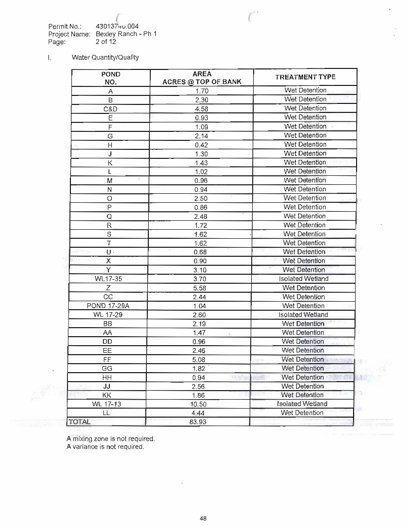
48

49
50

51

52
53

54
55
56

57
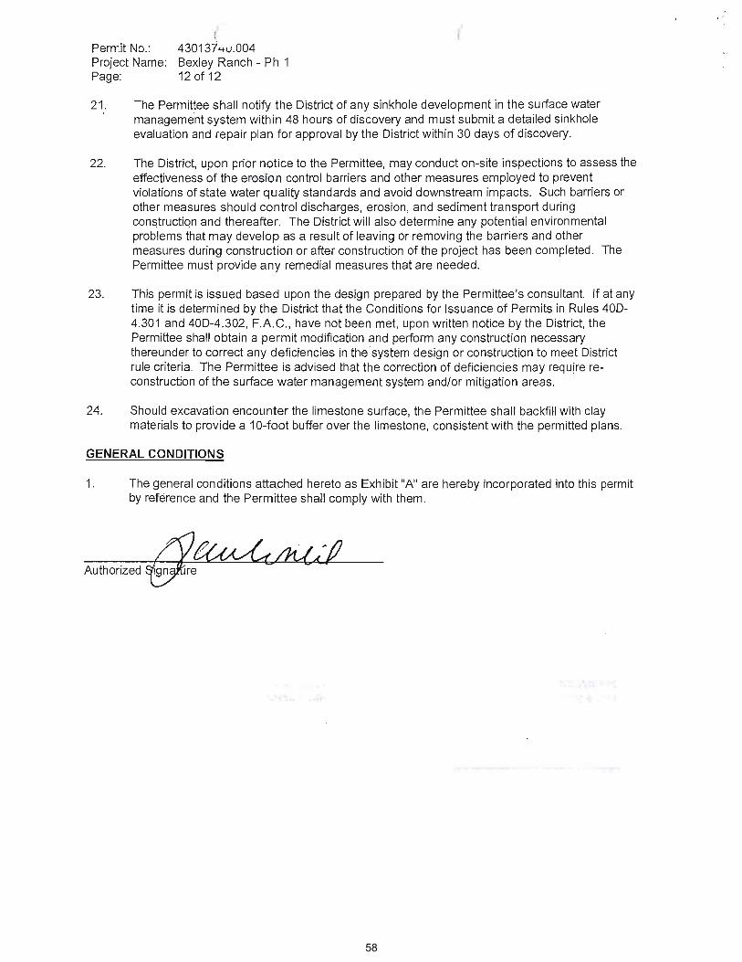
58

59

60
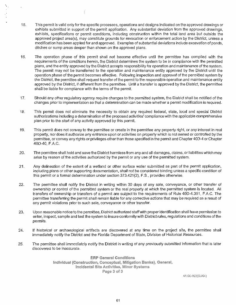
61
1
SOUTHWEST FLORIDA WATER MANAGEMENT DISTRICT LITIGATION REPORTDecember 2008
(Changes in status since last month are in boldface type)
ADMINISTRATIVE PROCEEDINGS
STYLE/CASE NO. COURT/JUDGE ATTORNEY DESCRIPTION STATUS (current as of 12/2/2008)
Blanco, Dr. Octavio v. GPG, Inc. and SWFWMD/Case No. 08-3053
Division of Administrative Hearings/D. Alexander
J. Smith Formal Administrative Proceedings on objection to issuance of ERP No. 43024788.007
6/10/08 Request for Administrative Hearing served. 6/19/08 Referral to DOAH served. 6/23/08 Initial Order entered. 7/23/08 Motion to Dismiss and for Fees and Costs served. 8/26/08 Response to Motion to Dismiss and For Fees and Costs served. 9/3/08 Recommended Order of Dismissal entered. 9/19/08 Petitioner's Exceptions to Recommended Order of Dismissal and Respondent GPG, Inc.'s Response to Exceptions served. 9/30/08 - Final Order No. SWF 08-037approved by Governing Board. 10/1/08 - Notice of Entry of Final Order served. 10/23/08 Respondent's (SWFWMD) Motion for Sanctions and Attorney's Fees and Costs served. 11/19/08 Order Denying Motion (for Sanctions and Attorney's Fees and Costs) entered.
Blanco, Dr. Octaviov. SWFWMD and NNP-Bexley, LTD/ Case No. 08-1972
Division of Administrative Hearings/J. L. Johnston
M. Mitchell/J. Pepper
Formal Administrative Proceedings on objection to issuance of ERP No. 43013740.004
3/19/08 Request for Administrative Hearing served. 3/26/08 -Order of Dismissal Without Prejudice entered. 4/9/08 Amended Request for Administrative Hearing served. 5/2/08 Hearing scheduled for Sept. 9 12, 2008. 5/6/08 Order Denying Motion to Expedite entered. 6/3/08 Order Granting Extension of Time (extending resolution session until 6/30/08) entered. 7/30/08Order Granting Official Recognition entered. 8/4/08 Order Granting Motion in Limine entered. 8/8/08 (NNP-Bexley's) Motion for Fees and Costs served. 8/22/08 Response to Motion for Fees and Costs served; and Order to Show Cause entered. 9/4/08 Order Denying continuance entered. 9/5/08 Notice of Pre-Hearing (teleconference held 9/8/08) served.Administrative Hearing held 9/9/08 and 9/10/08. 10/9/08 (Hearing) Transcript (Volumes I-III) filed. 10/20/08 Notices of Filing Proposed Recommended Order (NNP-Bexley, Ltd. and SWFWMD) served. 11/17/08 Recommended Order and Order on Sanctions entered.
SWFWMD v. Going, William/Case No. 08-5528
Division of Administrative Hearings/B. Canter
A. Vining Formal Administrative Proceedings on Administrative Complaint and Order
11/3/08 Referral to DOAH. 11/5/08 Initial Order entered. 11/12/08 Joint Response to Initial Order. 11/13/08 Orderof Pre-Hearing Instructions and Notice of Hearing by Video Teleconference entered.
Rothenberger, Daniel W. v. DOT andSWFWMD/Case No. 08-4274
Division of Administrative Hearings/B. Canter
A. Vining Formal Administrative Proceedings on objection to issuance of ERP No. 43023532.002
8/11/08 Request for Administrative Hearing served. 8/27/08 Referral to DOAH. 9/2/08 Initial Order entered. 9/12/08 Notice of Hearing (February 25 and 26, 2009) and Order of Pre-Hearing Instructions entered.
62
STYLE/CASE NO. COURT/JUDGE ATTORNEY DESCRIPTION STATUS (current as of 12/2/08)
2
Suggs, Danny J., et al. v SWFWMD/ Case No. 08-3530
Division of Administrative Hearings/J. L. Johnston
D. Graziano/J. Ward Formal Administrative Proceedings on objection to denial of EX 5731
7/17/08 Petition for Hearing served. 7/21/08 Initial Order entered. 8/7/08 Notice of Hearing and Order of Pre-Hearing Instructions entered. Hearing scheduled for January 13 16,2009. 8/18/08 - s Motion to Relinquish Jurisdiction
Relinquish Jurisdiction served. 8/25/08 Response to Respondent's Motion to Relinquish Jurisdiction served. 9/12/08Order denying Motion to Relinquish Jurisdiction entered.11/12/08 (Respondents') Notice of Service of Answers to Expert Interrogatories to Plaintiff (with Answers) and Notice of Service of Expert Interrogatories (to Respondent) served.11/14/08 Notice of Service of Interrogatories (with Interrogatories) served. 11/24/08 Notice of Taking Deposition Duces Tecum served.
DELEGATED ADMINISTRATIVE HEARING MATTERS
Paradise Lakes Utility, LLC v. SWFWMD
J. Smith Request for Extension of Time to File Petition for Extension of Hearing
8/15/08 Motion for Extension of Time to File a Petition for Administrative Hearing served. 8/21/08 Order Granting Request for Extension of Time entered. 9/25/08 - Motion for Extension of Time to File a Petition for Administrative Hearing served. 10/16/08 Order Granting Second Request for Extension of Time entered.
Priors Marina v. SWFWMD & American Marine
A. Vining Request for Administrative Hearing
12/2/08 Request for Administrative Hearing filed.
ENFORCEMENT CASES(Including Administrative Complaints)
SWFWMD v. Abbott, Robert C. and Robin E.
C. Felice Administrative Complaint and Order
11/11/08 - Respondents served. Meter reading reports due 11/21/08.
SWFWMD v. Add-A-Room Self Storage of Bradenton, LLC
L. Pease Administrative Complaint and Order
7/9/08 - Respondent served. 7/24/08 - Order No. SWF 08-025 entered.
SWFWMD v. Bickel, Gary J.and Deborah T./Case No. CA 08-3878
5th Judicial Circuit, Hernando County/
J. Smith Complaint and Petition for Enforcement of Consent Order No. 06-29
11/24/08 Complaint and Petition for Enforcement filed.Summonses forwarded to Sheriff's Dept. for service.
63
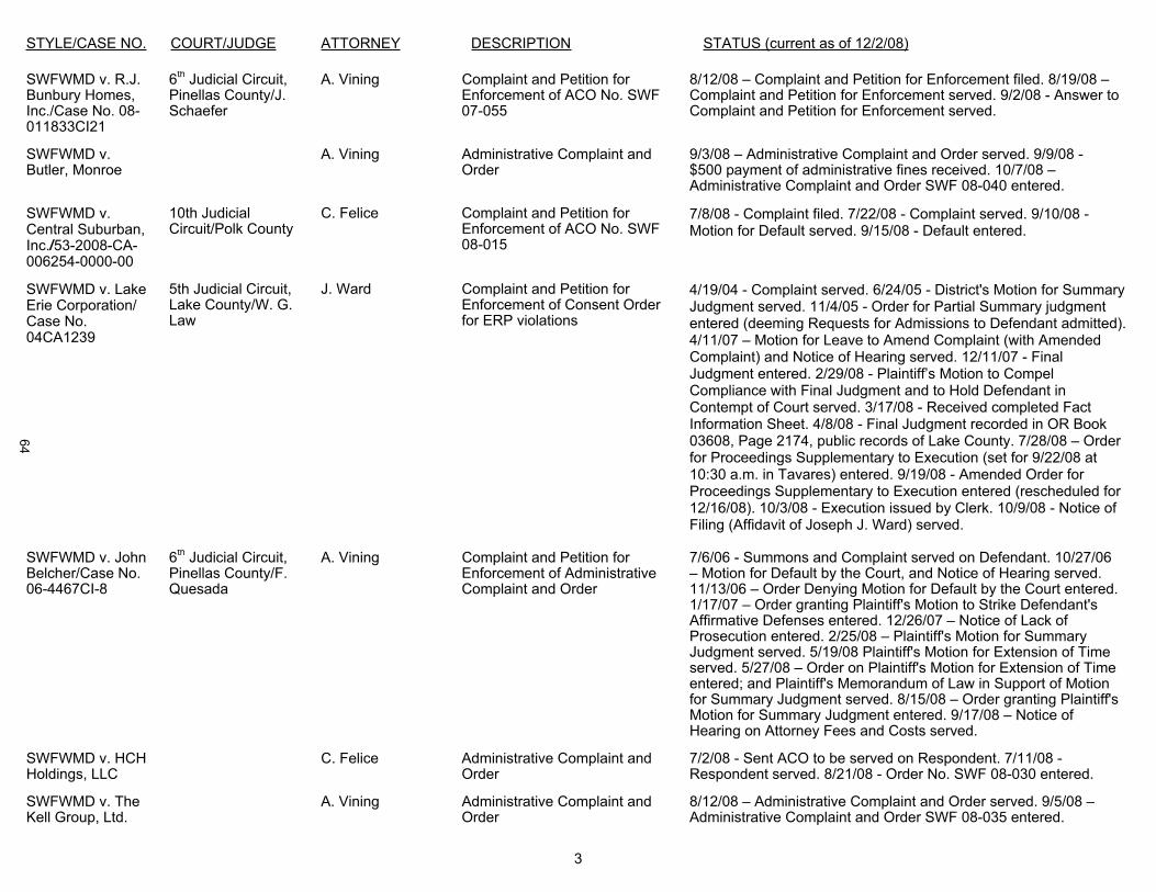
STYLE/CASE NO. COURT/JUDGE ATTORNEY DESCRIPTION STATUS (current as of 12/2/08)
3
SWFWMD v. R.J. Bunbury Homes, Inc./Case No. 08-011833CI21
6th Judicial Circuit, Pinellas County/J.Schaefer
A. Vining Complaint and Petition for Enforcement of ACO No. SWF 07-055
8/12/08 Complaint and Petition for Enforcement filed. 8/19/08Complaint and Petition for Enforcement served. 9/2/08 - Answer to Complaint and Petition for Enforcement served.
SWFWMD v. Butler, Monroe
A. Vining Administrative Complaint and Order
9/3/08 Administrative Complaint and Order served. 9/9/08 -$500 payment of administrative fines received. 10/7/08 Administrative Complaint and Order SWF 08-040 entered.
SWFWMD v. Central Suburban, Inc./53-2008-CA-006254-0000-00
10th Judicial Circuit/Polk County
C. Felice Complaint and Petition for Enforcement of ACO No. SWF 08-015
7/8/08 - Complaint filed. 7/22/08 - Complaint served. 9/10/08 -Motion for Default served. 9/15/08 - Default entered.
SWFWMD v. Lake Erie Corporation/ Case No. 04CA1239
5th Judicial Circuit, Lake County/W. G. Law
J. Ward Complaint and Petition for Enforcement of Consent Order for ERP violations
4/19/04 - Complaint served. 6/24/05 - District's Motion for Summary Judgment served. 11/4/05 - Order for Partial Summary judgment entered (deeming Requests for Admissions to Defendant admitted). 4/11/07 Motion for Leave to Amend Complaint (with Amended Complaint) and Notice of Hearing served. 12/11/07 - FinalJudgment entered. 2/29/08 -Compliance with Final Judgment and to Hold Defendant in Contempt of Court served. 3/17/08 - Received completed Fact Information Sheet. 4/8/08 - Final Judgment recorded in OR Book 03608, Page 2174, public records of Lake County. 7/28/08 Order for Proceedings Supplementary to Execution (set for 9/22/08 at 10:30 a.m. in Tavares) entered. 9/19/08 - Amended Order for Proceedings Supplementary to Execution entered (rescheduled for12/16/08). 10/3/08 - Execution issued by Clerk. 10/9/08 - Notice of Filing (Affidavit of Joseph J. Ward) served.
SWFWMD v. John Belcher/Case No. 06-4467CI-8
6th Judicial Circuit, Pinellas County/F. Quesada
A. Vining Complaint and Petition for Enforcement of Administrative Complaint and Order
7/6/06 - Summons and Complaint served on Defendant. 10/27/06 Motion for Default by the Court, and Notice of Hearing served.
11/13/06 Order Denying Motion for Default by the Court entered. 1/17/07 Order granting Plaintiff's Motion to Strike Defendant's Affirmative Defenses entered. 12/26/07 Notice of Lack of Prosecution entered. 2/25/08 Plaintiff's Motion for Summary Judgment served. 5/19/08 Plaintiff's Motion for Extension of Time served. 5/27/08 Order on Plaintiff's Motion for Extension of Time entered; and Plaintiff's Memorandum of Law in Support of Motion for Summary Judgment served. 8/15/08 Order granting Plaintiff's Motion for Summary Judgment entered. 9/17/08 Notice of Hearing on Attorney Fees and Costs served.
SWFWMD v. HCH Holdings, LLC
C. Felice Administrative Complaint andOrder
7/2/08 - Sent ACO to be served on Respondent. 7/11/08 -Respondent served. 8/21/08 - Order No. SWF 08-030 entered.
SWFWMD v. The Kell Group, Ltd.
A. Vining Administrative Complaint and Order
8/12/08 Administrative Complaint and Order served. 9/5/08 Administrative Complaint and Order SWF 08-035 entered.
64

STYLE/CASE NO. COURT/JUDGE ATTORNEY DESCRIPTION STATUS (current as of 12/2/08)
4
SWFWMD v. Lake Sebring Estates Development, Corp./Case No. 08-892GCS
10th Judicial Circuit, Highlands County/O. Shinholser
J. Ward Complaint and Petition for Enforcement to enforce ACO No. SWF 06-54
7/15/08 - Complaint filed. 7/23/08 Registered Agent served.8/11/08 - Notice of Appearance filed on behalf of Defendantserved. 9/2/08 - Answer and Affirmative Defenses served.
SWFWMD v. McClendon, J.C., Jr./Case No.0811837CI13
6th Judicial Circuit, Pinellas County/M. Shames
A. Vining Complaint and Petition for Enforcement of ACO SWF07-056
8/12/08 Complaint and Petition for Enforcement filed. 8/18/08 Complaint and Petition for Enforcement served. 8/29/08Response served. 9/16/08 Motion for Default by the Court served. 9/19/08 Notice of Hearing on Motion for Default by the Court served. 11/21/08 Proposed Order Denying Plaintiff's Motion for Default by the Court served. 11/26/08 OrderDenying Plaintiff's Motion for Default by the Court entered.
SWFWMD v. Maldonado, Santos, Sr./Case No.252008CA000661
10th Judicial Circuit/Hardee County/
C. Felice Complaint and Petition for Enforcement of ACO SWF 08-031
11/12/08 - Complaint filed.
SWFWMD v. Sean M. Murphy and Shelly A. Murphy
L. Pease Administrative Complaint and Order
2/9/08 Administrative Complaint and Order served on Sean M. Murphy. 2/28/08 Order No. SWF 08-005 entered.
SWFWMD v. Polk Properties, Inc., et al./Case No. G99-1779-08
10th Judicial Circuit, Polk County/C. Moore
M. Moore Complaint and Petition for enforcement of Consent Order
5/27/99 - Complaint filed. Cone Constructors Inc. filed for bankruptcy 6/9/00. 4/3/01 District filed Proof of Claim for $443,240 with Bankruptcy Court. Final Judgment entered against Polk Properties, Inc., for $547,859 on 6/15/01. Bankruptcy still open. 7/28/08 Notice of Reassignment of Case In Re: Cone Constructors, Inc. bankruptcy.
SWFWMD v. David Richardson and Lisa Richardson/Case No. 07-1395CI-07
6th Circuit Court, Pinellas County/L.Allan
J. Ward Complaint and Petition for Enforcement
2/9/07 - Complaint and Petition for Enforcement filed; Summons Issued to Defendants. Return of Service (served 2/27/07). 5/3/07
sfiled. 5/30/07 -Default Against Defendants (with Affidavit of Non-Military Service) served. 8/22/07- Default entered. 9/20/07 - Ex ParteMotion for Entry of Final Judgment After Default (with proposed Order) served. 9/21/07 - Final Judgment entered. 2/20/08 -
to Hold Defendants in Contempt of Court served. 3/12/08 - Order
Judgment and to Hold Defendants in Contempt of Court entered.5/30/08 - Order Adjudging Defendants David Richardson and Lisa Richardson in Contempt of Court and Imposing Sanctions (imposing a per diem fine of $100 per day beginning on the 15th day of June, 2008, and continuing to accrue until Defendants
65
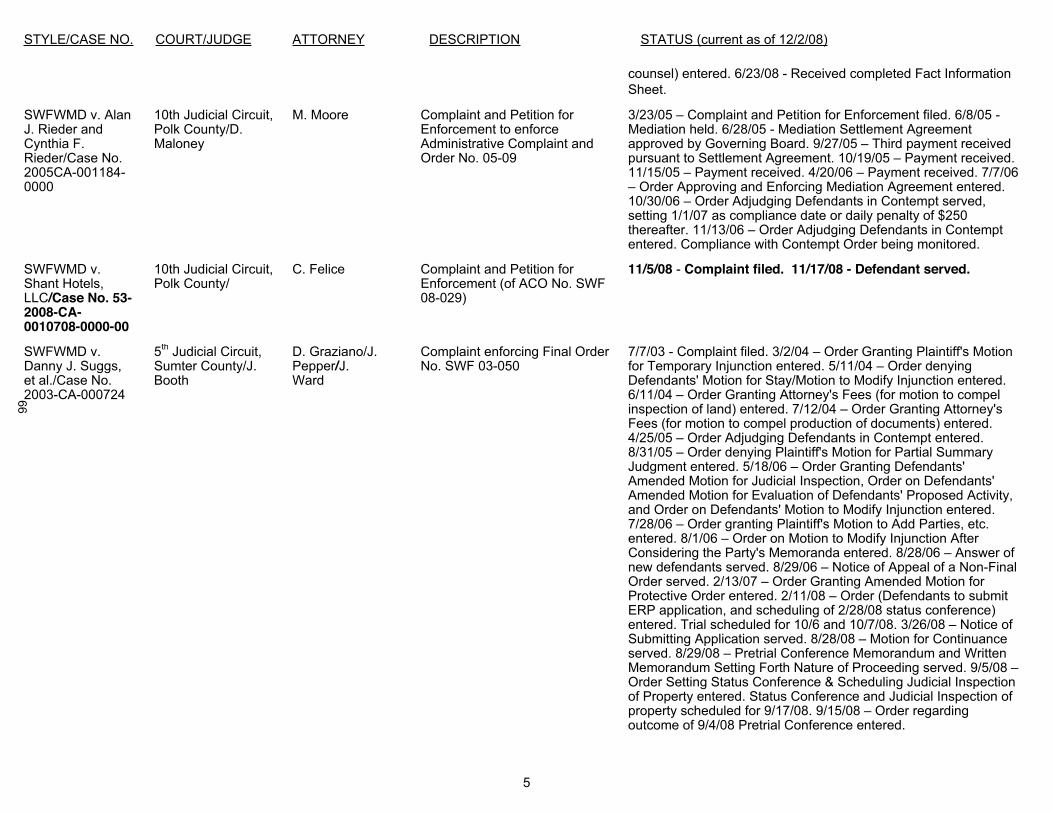
STYLE/CASE NO. COURT/JUDGE ATTORNEY DESCRIPTION STATUS (current as of 12/2/08)
5
counsel) entered. 6/23/08 - Received completed Fact Information Sheet.
SWFWMD v. Alan J. Rieder and Cynthia F. Rieder/Case No. 2005CA-001184-0000
10th Judicial Circuit, Polk County/D. Maloney
M. Moore Complaint and Petition for Enforcement to enforce Administrative Complaint and Order No. 05-09
3/23/05 Complaint and Petition for Enforcement filed. 6/8/05 -Mediation held. 6/28/05 - Mediation Settlement Agreement approved by Governing Board. 9/27/05 Third payment received pursuant to Settlement Agreement. 10/19/05 Payment received. 11/15/05 Payment received. 4/20/06 Payment received. 7/7/06
Order Approving and Enforcing Mediation Agreement entered.10/30/06 Order Adjudging Defendants in Contempt served, setting 1/1/07 as compliance date or daily penalty of $250 thereafter. 11/13/06 Order Adjudging Defendants in Contempt entered. Compliance with Contempt Order being monitored.
SWFWMD v.Shant Hotels, LLC/Case No. 53-2008-CA-0010708-0000-00
10th Judicial Circuit, Polk County/
C. Felice Complaint and Petition for Enforcement (of ACO No. SWF 08-029)
11/5/08 - Complaint filed. 11/17/08 - Defendant served.
SWFWMD v. Danny J. Suggs, et al./Case No. 2003-CA-000724
5th Judicial Circuit, Sumter County/J. Booth
D. Graziano/J.Pepper/J.Ward
Complaint enforcing Final Order No. SWF 03-050
7/7/03 - Complaint filed. 3/2/04 Order Granting Plaintiff's Motion for Temporary Injunction entered. 5/11/04 Order denying Defendants' Motion for Stay/Motion to Modify Injunction entered. 6/11/04 Order Granting Attorney's Fees (for motion to compel inspection of land) entered. 7/12/04 Order Granting Attorney's Fees (for motion to compel production of documents) entered. 4/25/05 Order Adjudging Defendants in Contempt entered. 8/31/05 Order denying Plaintiff's Motion for Partial Summary Judgment entered. 5/18/06 Order Granting Defendants' Amended Motion for Judicial Inspection, Order on Defendants' Amended Motion for Evaluation of Defendants' Proposed Activity, and Order on Defendants' Motion to Modify Injunction entered.7/28/06 Order granting Plaintiff's Motion to Add Parties, etc. entered. 8/1/06 Order on Motion to Modify Injunction After Considering the Party's Memoranda entered. 8/28/06 Answer of new defendants served. 8/29/06 Notice of Appeal of a Non-Final Order served. 2/13/07 Order Granting Amended Motion for Protective Order entered. 2/11/08 Order (Defendants to submit ERP application, and scheduling of 2/28/08 status conference) entered. Trial scheduled for 10/6 and 10/7/08. 3/26/08 Notice of Submitting Application served. 8/28/08 Motion for Continuance served. 8/29/08 Pretrial Conference Memorandum and Written Memorandum Setting Forth Nature of Proceeding served. 9/5/08 Order Setting Status Conference & Scheduling Judicial Inspection of Property entered. Status Conference and Judicial Inspection of property scheduled for 9/17/08. 9/15/08 Order regarding outcome of 9/4/08 Pretrial Conference entered.
66

STYLE/CASE NO. COURT/JUDGE ATTORNEY DESCRIPTION STATUS (current as of 12/2/08)
6
SWFWMD v. TomkoDevelopment, Inc.and Built To The T, Inc./Case No. 05-4689, Division F
13th Judicial Circuit, Hillsborough County/Judge Nielson
J. Ward Complaint to enjoin defendant to complete activities required by ERP Nos. 4419967.000, .001
5/31/05 Complaint filed. 10/25/05 - Order entered granting District's Motion to Strike Affirmative Defenses. 7/13/06 - Order(granting Motion to Amend Complaint) entered. 8/2/06 - Defendant's Motion to Dismiss Count III of Amended Complaint served. 11/10/06 - Built To The T served. 12/29/06 Motion for Entry of Default Judgment, or in the Alternative, Motion to Strike Response of Defendant Built To The T, Inc. served. 1/23/07 Defendant Built To
Defenses to Amended Complaint served. 12/6/07 - Order (denying) Defendant Tomko
III of Amended Complaint; andDefendant Tomko Development, Inc. to Produce Documents entered.
SWFWMD v. Trimar Southeast Developments, Inc./Case No. 512003CA-3209ES, Section Y
6th Judicial Circuit, Pasco County/W. Cobb
J. Ward Complaint and Petition for Enforcement of Consent Order for ERP violations
11/5/03 - Complaint filed. 8/7/06 Order granting Motion to Withdraw; and Order granting Third Motion for Extension of Time to Respond to Discovery entered. 9/7/07 - Notice of Taking Deposition Duces Tecum served. 10/24/07 - Notice of Taking Deposition (of corporate representative of Trimar) served. 10/26/07 - Amended Notice of Taking Deposition (of corporate representative of Trimar)served.
SWFWMD v. Wygant, Wayne
A. Vining Administrative Complaint and Order
9/8/08 Administrative Complaint and Order served. 10/10/08Administrative Complaint SWF 08-042 entered.
MISCELLANEOUS
Crowley Museum and Nature Center, Inc. v. SWFWMD, et al./Case No. 2002-CA-015283NC
12th Judicial Circuit, Sarasota County/B. A. Titus
J. Ward Complaint for inverse condemnation, trespass, nuisance and negligence
11/21/06 - Order Granting Leave to Amend the Complaint entered. 12/11/06 - SWFWMD & SWFWMD Governing Board's Motion to Dismiss Fourth Amended Complaint served. 1/24/07 -
Strike, Motion for a More Definite Statement, and Supporting Memorandum of Law served. 3/20/07
otion to Strike and Motion for a More Definite Statement served. 4/16/07
Order Granting With Prejudice DefendanAmended Motion to Dismiss entered. 4/18/07 (CrowleyNotice of Appeal filed. (See Appeals) 12/11/07 -First Set of Interrogatories to Plaintiff and Accompanying First Request to Produce to Plaintiff served. 3/3/08 - Motion forDisclosure of Settlement Agreement(s) served. 10/3/08 -
for Disclosure of Settlement Agreements served; Amended Memorandum of Law in Support of Defendant, Four Star
67
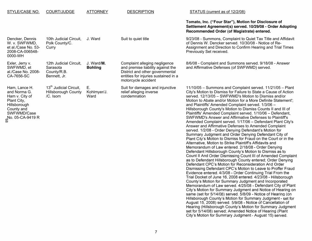
STYLE/CASE NO. COURT/JUDGE ATTORNEY DESCRIPTION STATUS (current as of 12/2/08)
7
for Disclosure of Settlement Agreement(s) served. 10/29/08 - Order Adopting Recommended Order (of Magistrate) entered.
Dencker, Dennis W. v. SWFWMD, et al./Case No. 53-2008-CA-006548-0000-WH
10th Judicial Circuit, Polk County/C. Curry
J. Ward Suit to quiet title 9/23/08 - Summons, Complaint to Quiet Tax Title and Affidavit of Dennis W. Dencker served. 10/30/08 - Notice of Re-Assignment and Direction to Confirm Hearing and Trial Times Previously Set received.
Exler, Jerry v. SWFWMD, et al./Case No. 2008-CA-7656-SC
12th Judicial Circuit, Sarasota County/R.B. Bennett, Jr.
J. Ward/M. Bohling
Complaint alleging negligence and premise liability against the District and other governmental entities for injuries sustained in a motorcycle accident
8/6/08 - Complaint and Summons served. 9/18/08 - Answer and Affirmative Defenses (of SWFWMD) served.
Ham, Lance H. and Norma G. Ham v. City of Plant City, Hillsborough County and SWFWMD/Case No. 05-CA-9419 R
13th Judicial Circuit, Hillsborough County/C. Isom
E.Kohlmyer/J.Ward
Suit for damages and injunctive relief alleging inverse condemnation
11/10/05 Summons and Complaint served. 11/21/05 Plant City's Motion to Dismiss for Failure to State a Cause of Action served. 12/13/05 SWFWMD's Motion to Dismiss and/or Motion to Abate and/or Motion for a More Definite Statement'; and Plaintiffs' Amended Complaint served. 1/3/06 Hillsborough County's Motion to Dismiss Counts II and III of Plaintiffs' Amended Complaint served. 1/10/06 Defendant, SWFWMD's Answer and Affirmative Defenses to Plaintiff's Amended Complaint served. 1/17/06 Defendant Plant City's Answer and Affirmative Defenses to Amended Complaint served.
68

STYLE/CASE NO. COURT/JUDGE ATTORNEY DESCRIPTION STATUS (current as of 12/2/08)
8
Hames, Cedar and Nora H. Scholin v. State of FL Department of Environmental Protection and SWFWMD/Case No. 2007-CA-001649
12th Judicial Circuit, Manatee County/P.Dubensky
D. Graziano/J. Ward
Suit for damages alleging inverse condemnation
4/4/07 Amended Complaint and Summons served. 4/23/07 -
Motion to Dismiss served. 5/16/07 - Order from Middle District of Florida remanding case back to circuit court entered. 5/18/07 -
- Notice of otions to Dismiss
scheduled for 7/18/07) served. 8/7/07 SWFWMD's Answer served. 8/9/07 - firmative Defenses and Motion to Strike served. 8/15/07 -for Summary Judgment and Memorandum of Law in Support of
-Bifurcate served. 10/12/07 - dMotion for Summary Judgment and Memorandum of Law in
10/17/07 -
for Taking Under Counts I, II, IV, V, VII, VIII, X, XI, XIII, XIV, XVII, XX 11/6/07
Summary Judgment served. 12/7/07 - Order Denying
artial Summary Judgment as to 1/14/08 - Order Denying
Motion for Rehearing entered. 2/4/08 - Amended Order of Referral to mediation entered; Agreed Order Regarding Date of Taking entered. 2/20/08 - Notice of Invoking Automatic Stay Pending Review Pursuant to Rule 9.310(b)(2), Fla.R.App.P. served. 2/22/08 - Motion for Relief from Stay; Notice of Hearing (scheduled for 3/4/08) served. 5/9/08 -Serving Proposal for Settlement to Plaintiffs served. 7/15/08Order Setting Case Management Conference (on 8/27/08)entered. 8/7/08 Proposed Stipulated Order served. 8/18/08 -Stipulated Order of Referral to Mediation entered. 9/05/08 -Motion in Limine on Taking Issue served. 9/8/08 - Order Scheduling Case for Jury Trial, Pretrial Conference & Referral to Mediation entered. (Trial set for 1/26/09; Pretrial set for 1/16/09).9/25/08 -the Taking Issue served. 9/29/08 - Motion to Continue Mediation
Partial Summary Judgment for Misrepresentation on the Court served. 10/2/08 -Order Granting Partial Summary Judgment for Misrepresentation on the Court served and Notice of Rescheduled Hearing (set for
69
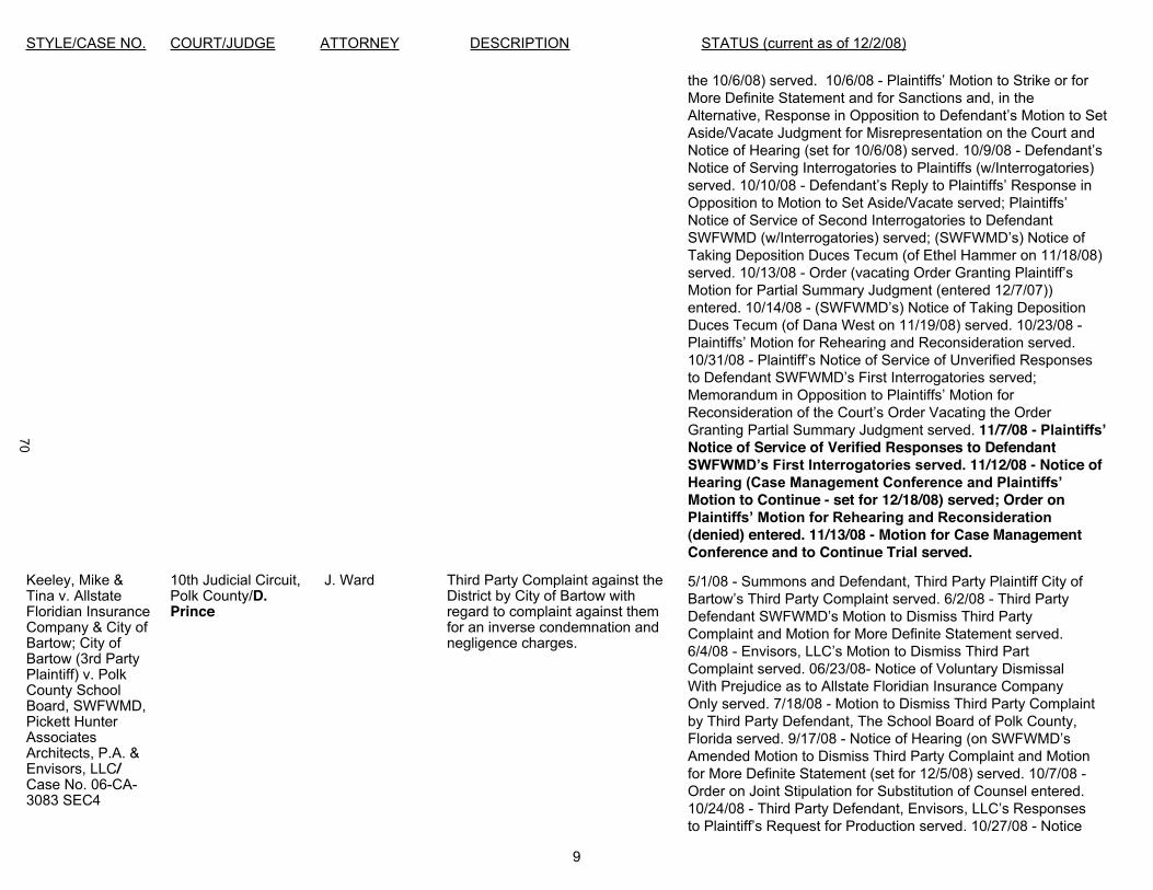
STYLE/CASE NO. COURT/JUDGE ATTORNEY DESCRIPTION STATUS (current as of 12/2/08)
9
the 10/6/08) served. 10/6/08 -More Definite Statement and for Sanctions and, in the Alternative, Response in OppoAside/Vacate Judgment for Misrepresentation on the Court and Notice of Hearing (set for 10/6/08) served. 10/9/08 -Notice of Serving Interrogatories to Plaintiffs (w/Interrogatories) served. 10/10/08 - Defend
Notice of Service of Second Interrogatories to Defendant
Taking Deposition Duces Tecum (of Ethel Hammer on 11/18/08)served. 10/13/08 -Motion for Partial Summary Judgment (entered 12/7/07)) entered. 10/14/08 -Duces Tecum (of Dana West on 11/19/08) served. 10/23/08 -Plain10/31/08 -
rder Vacating the Order Granting Partial Summary Judgment served. 11/7/08 -Notice of Service of Verified Responses to Defendant
11/12/08 - Notice of
Motion to Continue - set for 12/18/08) served; Order on
(denied) entered. 11/13/08 - Motion for Case Management Conference and to Continue Trial served.
Keeley, Mike & Tina v. Allstate Floridian Insurance Company & City of Bartow; City of Bartow (3rd Party Plaintiff) v. Polk County School Board, SWFWMD, Pickett Hunter Associates Architects, P.A. & Envisors, LLC/Case No. 06-CA-3083 SEC4
10th Judicial Circuit, Polk County/D.Prince
J. Ward Third Party Complaint against the District by City of Bartow with regard to complaint against themfor an inverse condemnation and negligence charges.
5/1/08 - Summons and Defendant, Third Party Plaintiff City of 6/2/08 - Third Party
DComplaint and Motion for More Definite Statement served.6/4/08 -Complaint served. 06/23/08- Notice of Voluntary Dismissal With Prejudice as to Allstate Floridian Insurance Company Only served. 7/18/08 - Motion to Dismiss Third Party Complaint by Third Party Defendant, The School Board of Polk County, Florida served. 9/17/08 -Amended Motion to Dismiss Third Party Complaint and Motionfor More Definite Statement (set for 12/5/08) served. 10/7/08 -Order on Joint Stipulation for Substitution of Counsel entered.10/24/08 -
10/27/08 - Notice
70
STYLE/CASE NO. COURT/JUDGE ATTORNEY DESCRIPTION STATUS (current as of 12/2/08)
10
ofto Dismiss Third Party Complaint set for 12/5/08) served.10/29/08 - Third Party Defendant, Pickett Hunter Associates
Request for Production served. 11/20/08 - Third Party
Request for Copies to Plaintiff served.
Mudd, Marcia, et al. v. SWFWMD, et al./Case No. 2006CA-001537-0000
10th Judicial Circuit, Polk County/D.Prince
J. Ward Complaint for Inverse Condemnation and Continuing Trespass
11/3/08 - Summons and Second Amended Complaint forInverse Condemnation and Continuing Trespass served.11/21/08 - Order Granting Stipulation for Substitution of Counsel entered.
Trinkaus, Regina v. SWFWMD/Case No. H27CA2007-175
5th Judicial Circuit, Hernando County/D. Merritt, Sr.
F. Miller/L. Tetreault
Complaint for breach of contract 2/26/07 Complaint served. 3/16/07 se of
Action, or, Alternatively, Motion for More Definite Statement, and Memorandum of Law served. 6/21/07 -Memorandum served. 10/2/07 - Order (granting SWFWMD's Motion to Dismiss without prejudice) entered. 10/02/07 -Amended Complaint served. 10/19/07 -
Cause of Action and Memorandum of Law served. 11/26/07 -
Dismiss the Amended Complaint served. 12/18/07 -Counter Motion for Section 57.105 Sanctions and Incorporated Memorandum of Law served. 3/4/08- Notice of Filing - Motion
Florida Status, and Incorporated Memorandum of Law served.4/15/08 - Notice of Hearing (on our Motion to Dismiss Amended Complaint set for 6/2/08) served. 6/2/08 - Emergency Motion to Continue or in the Alternative Other Relief served.6/3/08 - Order (granting our Motion to Dismiss Amended Complaint w/o prejudice and granting Plaintiff 15 days from 6/2/08, in which to file Second Amended Complaint) entered.6/18/08 - Second Amended Complaint served. 7/1/08 -
Complaint for Failure to State a Cause of Action and Incorporated Memorandum of Law served. 9/25/08 - Order to Show Cause entered (giving Trinkaus 10 days to respond to our Motion to Dismiss Second Amended Complaint). 10/7/08 -Order of Substitution of Counsel (Gonzalez for Miller) entered.10/27/08 -
Amended Complaint served. 11/17/08 - Response to
71
STYLE/CASE NO. COURT/JUDGE ATTORNEY DESCRIPTION STATUS (current as of 12/2/08)
11
Supplement to Motion to Dismiss served.
SWFWMD v. Gerena, Kenneth J. and Baytarian,Melinda Lee/Case No. 08-35951
County Court/Hillsborough County/
L.Tetreault
Complaint for Unlawful Entry 11/12/08 - Complaint filed. 11/17/08 - Complaint served. Defendants have been in communication with Legal staff.They have allegedly removed structures from District property. Site inspection to be performed by Land Resources' staff on 12/2/08.
APPEALS
Blanco, Octavio v. Win-Suncoast, Ltd. and SWFWMD/Case No. 2D08-2012
Second District Court of Appeal
J. Smith/J. Ward Appeal of Final Order of SWFWMD 4/23/08 Notice of Administrative Appeal served. 4/25/08Acknowledgment of New Case filed. 6/5/08 Index to Record served. 7/9/08 Notice of Appearance (of Bricklemyer Smolker & Bolves, P.A.) and Motion for Sanctions served. 7/9/08 Motionfor Enlargement of Time to File Initial Brief served. 7/21/08 Response to Motion for Enlargement of Time to File Initial Brief served. Order granting motion to extend time entered. 7/30/08Order denying motion for sanctions filed by Win-Suncoast entered. 8/7/08 Record on Appeal served. 8/21/08 Initial Brief of Appellant Octavio Blanco served. 8/29/08 SWFWMD's Agreed Motion for Enlargement of Time to File Answer Brief served. 9/3/08 - Stipulated Motion for Extension of Time to File Answer Brief served; and Order Granting Extension of Time for Answer Brief entered. Answer Brief due 10/10/08. 9/5/08 Ordergranting Win-Suncoast's extension of time to file answer brief entered. 10/7/08 Answer Brief of Appellee, Win-Suncoast, Ltd. served. 10/9/08 SWFWMD's Answer Brief served. 11/4/08Motion for Enlargement of Time to File Reply Brief served.11/12/08 Order granting motion for enlargement of time entered. 11/24/08 Reply Brief of Appellant Octavio Blanco served.
Hames, Cedar and Scholin, Nora H. v. SWFWMD, et al./Case No. 2D08-5585
Second District Court of Appeal/
J. Ward Petition for Certiorari 11/12/08 - Petition for Certiorari served. 11/21/08 - Motion for Leave to Supplement Appendix to Petition for Certiorari served.
L:\PRIVATE\Jan Kaesemeyer\Litigation Reports\2008LitRpts\LitigationRptDec08.doc
72
RULEMAKING UPDATE December 2008
PROPOSED RULES FOR WHICH THE GOVERNING BOARD HAS AUTHORIZED INITIATION OF RULEMAKING
Rule InitiationDate
NextScheduled
Action
ProjectedBoard
ApprovalDate
OGC#/ Attorney Assigned
1. (40D-1.002) Rulemaking to expand delegation of authority to the Executive Director for issuance of Environmental Resource and Water Use Permits and to Amend Permit Application Processing Timeframes
Apr 2008 GoverningBoard
Jan 2009 (tentative)
Jan 2009 (tentative)
OGC 2008014 Moore
2. (40D-1.603, 40D-1.1010, 40D-1.1024, 40D-2.091, 40D-2.101, 40D-4.041, 40D-4.101, 40D-40.040, 40D-40.112) Rulemaking to revise permit application noticing provisions and clarify noticing of agency action
Sept 2008 EffectiveNov 2008
N/A OGC 2008005 Moore
3. (40D-1.607, 40D-1.659, 40D-2.021, 40D-2.041, 40D-2.091, 40D-2.321, 40D-2.501, 40D-2.621, BOR) Rulemaking to revise the small general water use permit category and application processing requirements
May 2008 EffectiveApproximately
Jan 2009
N/A OGC 2008031 Moore
4. (40D-1.659, 40D-2.091) Rulemaking to adopt flow meter accuracy verification reporting and forms requirements
Apr 2008 GoverningBoard
Dec 2008
N/A OGC 2008010 Lloyd
5. (40D-2.091) Rulemaking to expand SWUCA per capita requirements District-wide
Jan 2007 EffectiveApproximately
Jan 2009
N/A OGC 200716 Lloyd
6. (40D-2.091) Rulemaking to enhance water conservation requirement
Apr 2007 PublicWorkshop
January 2009
Feb 2009 OGC 200747 Lloyd
73
Rule InitiationDate
NextScheduled
Action
ProjectedBoard
ApprovalDate
OGC#/ Attorney Assigned
7. (40D-2.301, 40D-2.321, BOR 1.9) Rulemaking to provide for a 20-year permit for uses with both traditional and AWS sources, 5-year compliance review, population growth report, establish permit fee, clarify type of ERP required to obtain a 20-year permit for multi-phase, long-term AWS projects
Jul/Aug2006
Sep 2007
PublicWorkshop Jan
2009
Feb 2009 OGC 200786 Lloyd
8. (40D-4.091) Rulemaking to amend ERP BOR rules regarding mitigation for impacts to wetlands and other surface waters
Jun 2008 ERP Advisory Groups, Public
WorkshopsOct-Nov 2008
TBA OGC 2007114 West
9. (40D-4.091) Rulemaking to amend ERP BOR to maintain the protection of certain listed wildlife species of the Bald Eagle
Jun 2008 GoverningBoard
Dec 2008
Dec 2008 OGC 2008039 West
10. (40D-4.091) Rulemaking to incorporate clarifying language in the water quantity section of the ERP BOR
Sept 2008 PublicWorkshop
Dec 2008 or Jan 2009
Jan or Feb 2009
OGC 200757 West
11. (40D-8.624) Rulemaking to add minimum levels for Lake Crews in Pasco County
Nov/Dec2006
TBA TBA OGC 2008009Lloyd
12. (4-D-8.624) Rulemaking to add minimum levels for Lake Anoka in Highlands County
Dec 2008 GoverningBoard
Dec 2008
TBA OGC 2008090 Lloyd
13. (40D-22) Rulemaking to amend Year-Round Water Conservation Measures in accordance with statewide consistency initiative
Apr 2008 GoverningBoard
Dec 2008
Dec 2008 OGC 2008013 Lloyd
14. (40D-26) Rulemaking to adopt the District’s Program “Facilitating Agricultural Resource Management Systems” (FARMS)
Oct 2006 EffectiveApproximately
Dec 2008
N/A OGC 200659 McNeil
74
Items 76 - 79
Governing Board Meeting December 16, 2008
Reports
Environmental Advisory Committee Liaison Report
Basin Board Land Resources Committee Liaison Report
Performance Evaluations of the Executive Director and Inspector General
Purpose
Background

Items 76 - 79
Benefit/Costs
Related Documents