Southwest Florida Water Management District N341 – Lake Manatee LiDAR Enhancement Project #: 12POSOW0457 Florida Minimum Technical Standards for Mapping Projects Survey and Map Report Submitted to: Mr. Al Karlin, Ph.D. GISP Senior GIS Analyst Southwest Florida Water Management District Mapping & GIS Section 2379 Broad Street Brooksville, FL 34604 Office: 352-796-7211, Ext. 4204 Fax: 352-540-6018 [email protected] Prepared by: Mr. Mitchell R. Jarrells, PSM Director of Surveying and Mapping Earth Eye, LLC 3680 Avalon Park Blvd. East Suite 200 Orlando, FL 32828 Office: 407-382-6760 Fax: 407-382-5420 [email protected]

Welcome message from author
This document is posted to help you gain knowledge. Please leave a comment to let me know what you think about it! Share it to your friends and learn new things together.
Transcript

Southwest Florida Water Management District
N341 – Lake Manatee LiDAR Enhancement Project #: 12POSOW0457
Florida Minimum Technical Standards for Mapping Projects
Survey and Map Report
Submitted to:
Mr. Al Karlin, Ph.D. GISP Senior GIS Analyst
Southwest Florida Water Management District Mapping & GIS Section
2379 Broad Street Brooksville, FL 34604
Office: 352-796-7211, Ext. 4204 Fax: 352-540-6018
Prepared by:
Mr. Mitchell R. Jarrells, PSM Director of Surveying and Mapping
Earth Eye, LLC 3680 Avalon Park Blvd. East
Suite 200 Orlando, FL 32828
Office: 407-382-6760 Fax: 407-382-5420

[2]
Florida Minimum Technical Standards for Mapping Projects
Survey and Map Report for the Lake Manatee LiDAR Enhancement Project preformed for the Southwest Florida Water Management District. Earth Eye job number: 10049 The Southwest Florida Water Management District (SWFWMD) contracted Earth Eye, LLC (EE) to acquire one-meter (1m) spacing ground LiDAR data over an area approximately one hundred eighty-six (186) square miles. The LiDAR data will be used to develop topography (i.e., Breaklines and one-foot (1ft) contours) for one hundred eighty-six (186) – 5000 ft by 5000 ft formatted tiles. See figure below for project area.
Project Area Image.
[3]
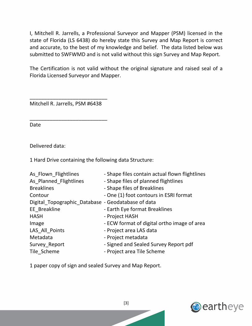
I, Mitchell R. Jarrells, a Professional Surveyor and Mapper (PSM) licensed in the state of Florida (LS 6438) do hereby state this Survey and Map Report is correct and accurate, to the best of my knowledge and belief. The data listed below was submitted to SWFWMD and is not valid without this sign Survey and Map Report. The Certification is not valid without the original signature and raised seal of a Florida Licensed Surveyor and Mapper. ___________________________ Mitchell R. Jarrells, PSM #6438 ___________________________ Date Delivered data: 1 Hard Drive containing the following data Structure: As_Flown_Flightlines - Shape files contain actual flown flightlines As_Planned_Flightlines - Shape files of planned flightlines Breaklines - Shape files of Breaklines Contour - One (1) foot contours in ESRI format Digital_Topographic_Database - Geodatabase of data EE_Breakline - Earth Eye format Breaklines HASH - Project HASH Image - ECW format of digital ortho image of area LAS_All_Points - Project area LAS data Metadata - Project metadata Survey_Report - Signed and Sealed Survey Report pdf Tile_Scheme - Project area Tile Scheme 1 paper copy of sign and sealed Survey and Map Report.

[4]
Survey and Map Report for Lake Manatee LiDAR Enhancement Project
Project Title FY 2012 LAKE MANATEE LiDAR ENHANCEMENT (2012-7) Intended use Geographic Information System (GIS). Southwest Florida Water Management District (SWFWMD) regularly uses digital topographic information to support regulatory, land management and acquisition, planning, engineering and habitat restoration projects. LiDAR data will support hydrologic modeling activities associated with the Federal Emergency Management Agency (FEMA), and in the creation of Digital Flood Insurance Rate Maps (DFIRM). the LiDAR data will support the creation of Federal Emergency Management Agency Flood Insurance Rate Maps (FEMA FIRM) and integrated ground and surface water model for the Lake Manatee Watershed. Client Southwest Florida Water Management District Client contact information Mr. Al Karlin, Ph.D. GISP Senior GIS Analyst Southwest Florida Water Management District Mapping & GIS Section 2379 Broad Street Brooksville, FL 34604 Office: 352-796-7211, Ext. 4204 Fax: 352-540-6018 [email protected]

[5]
Responsible PSM for project Mr. Mitchell R. Jarrells, PSM PSM# 6438 3680 Avalon Park Blvd. East Suite 200 Orlando, FL 32828 Phone: 407-608-7203 [email protected] Name of PSM Company Earth Eye, LLC 3680 Avalon Park Blvd. East Suite 200 Orlando, FL 32828 Phone: 407-382-6760 www.eartheye.com LB Number of PSM Company Earth Eye, LLC LB #7791 Date of LiDAR, Image and Survey Acquisition May 21-23, 2012 Horizontal and Vertical Datum’s Horizontal Datum – North American Datum of 1983 (NAD 83), Florida State Plane Coordinate System, West Zone (902). Vertical Datum – North American Vertical Datum of 1988 (NAVD 88) using GEOID 09 for converting the ellipsoidal heights to orthometric heights. Units - U.S. Survey foot. NGS Monuments and CORS Stations Used EE utilized four (4) Continuing Operated Reference Stations (CORS) were used to control the horizontal and vertical values on the SWFWMD project. The CORS stations used were Bartow (BRTW), Zephyrhills (ZEFR), Mac Dill 6 (MCD6) and Wauchula (WACH). These stations were also used in determining the location values of the base stations used during the LiDAR and image acquisitions. See Appendix C for National Geodetic Survey (NGS) data sheets.

[6]
Accuracy Statement of Survey The ground control survey was provided by SWFWMD and was used to check the overall accuracy of the LiDAR. See Appendix B. Additional Base Stations used during Acquisition The base stations set and used by EE were done in accordance with the standards set forth by the National Geodetic Survey (NGS) and Florida Minimum Technical Standards (FMTS). The base station coordinates were processed against one of the four (4) CORS stations previously mentioned. See appendix D for report. Accuracy Statement of LiDAR The fundamental Vertical Accuracy (FVA) of the LiDAR bare-earth was tested and meets a 0.60’ fundamental accuracy at 95% confidence level using RMSEz x 1.9600 (where as RMSEz ≤0.30’) as defined by the National Standard for Spatial Data Accuracy (NSSDA) in open well defined terrain. Then vertical accuracy testing for LiDAR data over well-defined surfaces will meet or exceed requirements as set forth in the Federal Geographic Data Committee’s (FGDC) Geospatial Positioning Accuracy Standards, Part 3: National Standard for Spatial Data Accuracy (NSSDA). The Calibration image at the end of report will demonstrate the calibration for the horizontal and vertical accuracies based on the 9.5cm flight line to flight line standard. Also at the end of this report is the vertical control report showing the survey to LiDAR comparisons. See Appendix A and E. Metadata The hard drive data that accompanies this report is inclusive of the XML formatted metadata template(s) used for topographic mapping deliverables. Type of Survey being done Topographic Survey

[7]
Appendix A Calibration Image The calibration image is to show the relationship between flight lines. Criteria for the separation tolerance is set according to the project specifications. The criteria used in this calibration image were a vertical separation of 0.15’. The image will show green in the overlap for all areas that are equal to or better than half the tolerance, red if the overlap is out of tolerance.

[8]
Base Stations Coordinates utilized by EE
Appendix B Control Reports Hard surface control for abosute position and accuracy.

[9]
All points Control Report.

[10]
Appendix C
PROGRAM = datasheet95, VERSION = 7.89.6
1 National Geodetic Survey, Retrieval Date = OCTOBER 26, 2012
DF7046
***********************************************************************
DF7046 CORS - This is a GPS Continuously Operating Reference
Station.
DF7046 DESIGNATION - BARTOW CORS ARP
DF7046 CORS_ID - BRTW
DF7046 PID - DF7046
DF7046 STATE/COUNTY- FL/POLK
DF7046 COUNTRY - US
DF7046 USGS QUAD - BARTOW (1987)
DF7046
DF7046 *CURRENT SURVEY CONTROL
DF7046
______________________________________________________________________
DF7046* NAD 83(2011) POSITION- 27 56 58.64214(N) 081 46 58.20071(W)
ADJUSTED
DF7046* NAD 83(2011) ELLIP HT- 13.575 (meters) (08/??/11)
ADJUSTED
DF7046* NAD 83(2011) EPOCH - 2010.00
DF7046* NAVD 88 ORTHO HEIGHT - 39.844 (meters) 130.72 (feet)
ADJUSTED
DF7046
______________________________________________________________________
DF7046 NAD 83(2011) X - 805,863.950 (meters) COMP
DF7046 NAD 83(2011) Y - -5,580,464.277 (meters) COMP
DF7046 NAD 83(2011) Z - 2,971,581.212 (meters) COMP
DF7046 GEOID HEIGHT - -26.26 (meters)
GEOID12A
DF7046 HORZ ORDER - SPECIAL (CORS)
DF7046 VERT ORDER - SECOND CLASS I
DF7046 ELLP ORDER - SPECIAL (CORS)
DF7046
DF7046.The coordinates were established by GPS observations
DF7046.and adjusted by the National Geodetic Survey in August 2011.
DF7046
DF7046.NAD 83(2011) refers to NAD 83 coordinates where the reference
DF7046.frame has been affixed to the stable North American Tectonic Plate.
DF7046
DF7046.The coordinates are valid at the epoch date displayed above
DF7046.which is a decimal equivalence of Year/Month/Day.
DF7046
DF7046.The orthometric height was determined by differential leveling and
DF7046.adjusted by the NATIONAL GEODETIC SURVEY
DF7046.in May 2010.
DF7046
DF7046.No vertical observational check was made to the station.
DF7046
DF7046.The PID for the CORS L1 Phase Center is DF7047.
DF7046

[11]
DF7046.The XYZ, and position/ellipsoidal ht. are equivalent.
DF7046
DF7046.The ellipsoidal height was determined by GPS observations
DF7046.and is referenced to NAD 83.
DF7046
DF7046. The following values were computed from the NAD 83(2011) position.
DF7046
DF7046; North East Units Scale Factor
Converg.
DF7046;SPC FL W - 400,645.544 221,369.597 MT 0.99994681 +0 06
06.4
DF7046;SPC FL W - 1,314,451.26 726,276.75 sFT 0.99994681 +0 06
06.4
DF7046
DF7046! - Elev Factor x Scale Factor = Combined Factor
DF7046!SPC FL W - 0.99999787 x 0.99994681 = 0.99994468
DF7046
DF7046 SUPERSEDED SURVEY CONTROL
DF7046
DF7046 NAD 83(CORS)- 27 56 58.64223(N) 081 46 58.20127(W) AD(2002.00) c
DF7046 ELLIP H (08/??/03) 13.575 (m) GP(2002.00) c
c
DF7046
DF7046.Superseded values are not recommended for survey control.
DF7046
DF7046.NGS no longer adjusts projects to the NAD 27 or NGVD 29 datums.
DF7046.See file dsdata.txt to determine how the superseded data were
derived.
DF7046
DF7046_U.S. NATIONAL GRID SPATIAL ADDRESS: 17RML2299291868(NAD 83)
DF7046
DF7046_MARKER: STATION IS THE ANTENNA REFERENCE POINT OF THE GPS ANTENNA
DF7046_MARK LOGO: NONE
DF7046_MAGNETIC: N = NO MAGNETIC MATERIAL
DF7046
DF7046 STATION DESCRIPTION
DF7046
DF7046'DESCRIBED BY NATIONAL GEODETIC SURVEY 2011
DF7046'STATION IS A GPS CORS. LATEST INFORMATION INCLUDING POSITIONS AND
DF7046'VELOCITIES ARE AVAILABLE IN THE COORDINATE AND LOG FILES ACCESSIBLE
DF7046'BY ANONYMOUS FTP OR THE WORLDWIDE WEB.
DF7046' ftp://cors.ngs.noaa.gov/cors/README.txt
DF7046' ftp://cors.ngs.noaa.gov/cors/coord/coord_08
DF7046' ftp://cors.ngs.noaa.gov/cors/station_log
DF7046' http://geodesy.noaa.gov/CORS

[12]
PROGRAM = datasheet95, VERSION = 7.89.6
1 National Geodetic Survey, Retrieval Date = OCTOBER 26, 2012
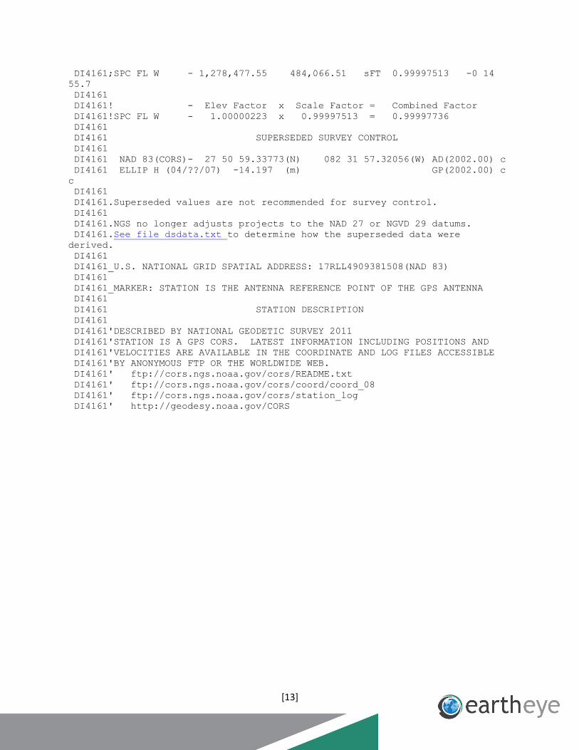
DI4161
***********************************************************************
DI4161 CORS - This is a GPS Continuously Operating Reference
Station.
DI4161 DESIGNATION - MAC DILL AFB 6 CORS ARP
DI4161 CORS_ID - MCD6
DI4161 PID - DI4161
DI4161 STATE/COUNTY- FL/HILLSBOROUGH
DI4161 COUNTRY - US
DI4161 USGS QUAD - PORT TAMPA (1983)
DI4161
DI4161 *CURRENT SURVEY CONTROL
DI4161
______________________________________________________________________
DI4161* NAD 83(2011) POSITION- 27 50 59.33773(N) 082 31 57.32001(W)
ADJUSTED
DI4161* NAD 83(2011) ELLIP HT- -14.200 (meters) (08/??/11)
ADJUSTED
DI4161* NAD 83(2011) EPOCH - 2010.00
DI4161* NAVD 88 ORTHO HEIGHT - **(meters) **(feet)
DI4161
______________________________________________________________________
DI4161 NAD 83(2011) X - 733,442.180 (meters) COMP
DI4161 NAD 83(2011) Y - -5,595,638.686 (meters) COMP
DI4161 NAD 83(2011) Z - 2,961,793.415 (meters) COMP
DI4161 GEOID HEIGHT - -24.80 (meters)
GEOID12A
DI4161 HORZ ORDER - SPECIAL (CORS)
DI4161 ELLP ORDER - SPECIAL (CORS)
DI4161
DI4161.The coordinates were established by GPS observations
DI4161.and adjusted by the National Geodetic Survey in August 2011.
DI4161
DI4161.NAD 83(2011) refers to NAD 83 coordinates where the reference
DI4161.frame has been affixed to the stable North American Tectonic Plate.
DI4161
DI4161.The coordinates are valid at the epoch date displayed above
DI4161.which is a decimal equivalence of Year/Month/Day.
DI4161
DI4161.The PID for the CORS L1 Phase Center is DI4162.
DI4161
DI4161.The XYZ, and position/ellipsoidal ht. are equivalent.
DI4161
DI4161.The ellipsoidal height was determined by GPS observations
DI4161.and is referenced to NAD 83.
DI4161
DI4161. The following values were computed from the NAD 83(2011) position.
DI4161
DI4161; North East Units Scale Factor
Converg.
DI4161;SPC FL W - 389,680.738 147,543.768 MT 0.99997513 -0 14
55.7
[13]
DI4161;SPC FL W - 1,278,477.55 484,066.51 sFT 0.99997513 -0 14
55.7
DI4161
DI4161! - Elev Factor x Scale Factor = Combined Factor
DI4161!SPC FL W - 1.00000223 x 0.99997513 = 0.99997736
DI4161
DI4161 SUPERSEDED SURVEY CONTROL
DI4161
DI4161 NAD 83(CORS)- 27 50 59.33773(N) 082 31 57.32056(W) AD(2002.00) c
DI4161 ELLIP H (04/??/07) -14.197 (m) GP(2002.00) c
c
DI4161
DI4161.Superseded values are not recommended for survey control.
DI4161
DI4161.NGS no longer adjusts projects to the NAD 27 or NGVD 29 datums.
DI4161.See file dsdata.txt to determine how the superseded data were
derived.
DI4161
DI4161_U.S. NATIONAL GRID SPATIAL ADDRESS: 17RLL4909381508(NAD 83)
DI4161
DI4161_MARKER: STATION IS THE ANTENNA REFERENCE POINT OF THE GPS ANTENNA
DI4161
DI4161 STATION DESCRIPTION
DI4161
DI4161'DESCRIBED BY NATIONAL GEODETIC SURVEY 2011
DI4161'STATION IS A GPS CORS. LATEST INFORMATION INCLUDING POSITIONS AND
DI4161'VELOCITIES ARE AVAILABLE IN THE COORDINATE AND LOG FILES ACCESSIBLE
DI4161'BY ANONYMOUS FTP OR THE WORLDWIDE WEB.
DI4161' ftp://cors.ngs.noaa.gov/cors/README.txt
DI4161' ftp://cors.ngs.noaa.gov/cors/coord/coord_08
DI4161' ftp://cors.ngs.noaa.gov/cors/station_log
DI4161' http://geodesy.noaa.gov/CORS
[14]
PROGRAM = datasheet95, VERSION = 7.89.6
1 National Geodetic Survey, Retrieval Date = OCTOBER 26, 2012
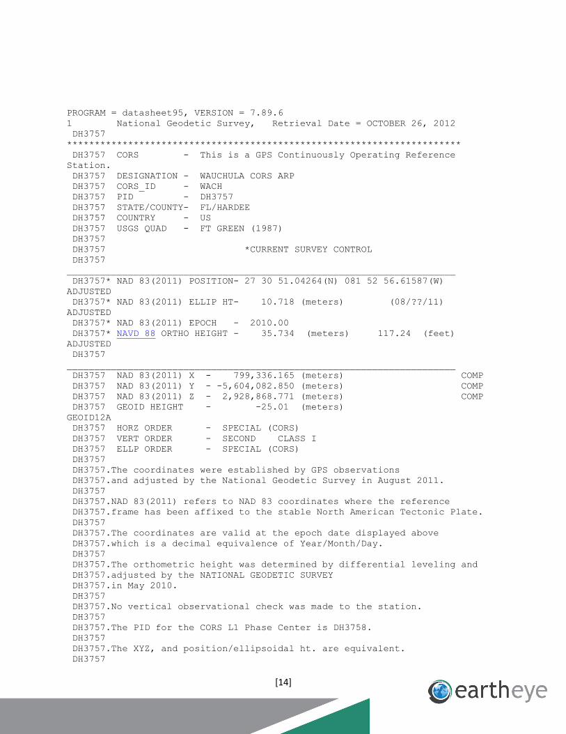
DH3757
***********************************************************************
DH3757 CORS - This is a GPS Continuously Operating Reference
Station.
DH3757 DESIGNATION - WAUCHULA CORS ARP
DH3757 CORS_ID - WACH
DH3757 PID - DH3757
DH3757 STATE/COUNTY- FL/HARDEE
DH3757 COUNTRY - US
DH3757 USGS QUAD - FT GREEN (1987)
DH3757
DH3757 *CURRENT SURVEY CONTROL
DH3757
______________________________________________________________________
DH3757* NAD 83(2011) POSITION- 27 30 51.04264(N) 081 52 56.61587(W)
ADJUSTED
DH3757* NAD 83(2011) ELLIP HT- 10.718 (meters) (08/??/11)
ADJUSTED
DH3757* NAD 83(2011) EPOCH - 2010.00
DH3757* NAVD 88 ORTHO HEIGHT - 35.734 (meters) 117.24 (feet)
ADJUSTED
DH3757
______________________________________________________________________
DH3757 NAD 83(2011) X - 799,336.165 (meters) COMP
DH3757 NAD 83(2011) Y - -5,604,082.850 (meters) COMP
DH3757 NAD 83(2011) Z - 2,928,868.771 (meters) COMP
DH3757 GEOID HEIGHT - -25.01 (meters)
GEOID12A
DH3757 HORZ ORDER - SPECIAL (CORS)
DH3757 VERT ORDER - SECOND CLASS I
DH3757 ELLP ORDER - SPECIAL (CORS)
DH3757
DH3757.The coordinates were established by GPS observations
DH3757.and adjusted by the National Geodetic Survey in August 2011.
DH3757
DH3757.NAD 83(2011) refers to NAD 83 coordinates where the reference
DH3757.frame has been affixed to the stable North American Tectonic Plate.
DH3757
DH3757.The coordinates are valid at the epoch date displayed above
DH3757.which is a decimal equivalence of Year/Month/Day.
DH3757
DH3757.The orthometric height was determined by differential leveling and
DH3757.adjusted by the NATIONAL GEODETIC SURVEY
DH3757.in May 2010.
DH3757
DH3757.No vertical observational check was made to the station.
DH3757
DH3757.The PID for the CORS L1 Phase Center is DH3758.
DH3757
DH3757.The XYZ, and position/ellipsoidal ht. are equivalent.
DH3757
[15]
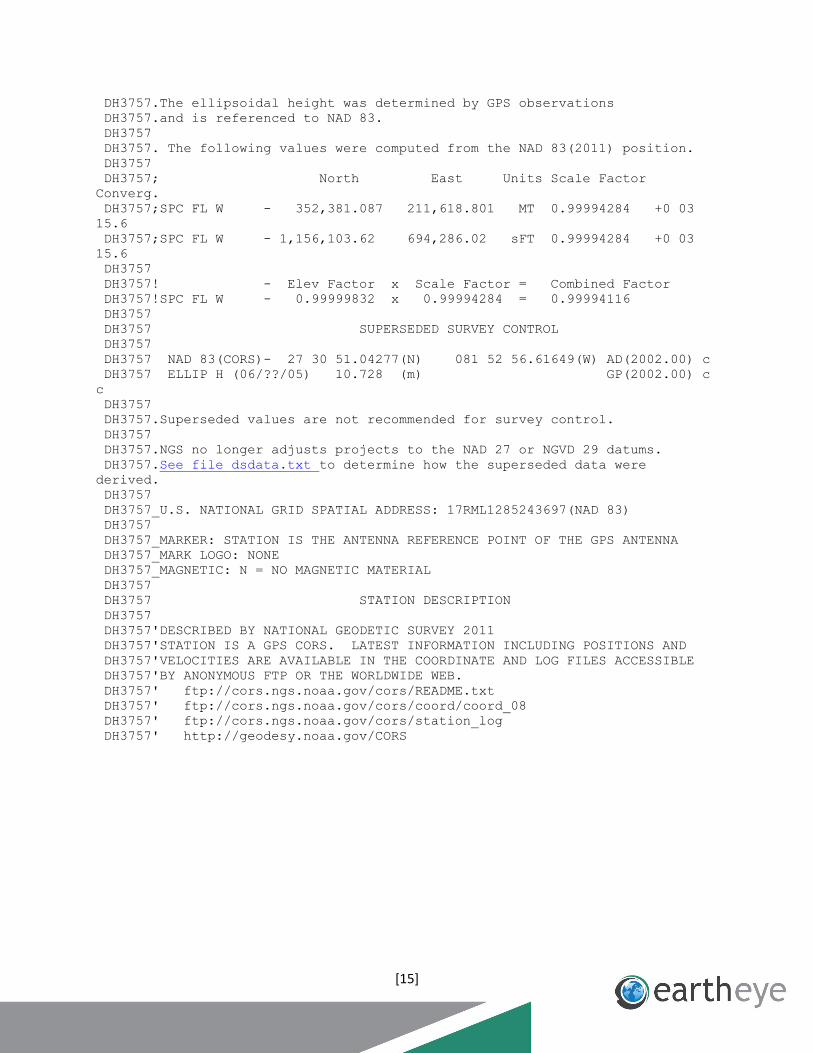
DH3757.The ellipsoidal height was determined by GPS observations
DH3757.and is referenced to NAD 83.
DH3757
DH3757. The following values were computed from the NAD 83(2011) position.
DH3757
DH3757; North East Units Scale Factor
Converg.
DH3757;SPC FL W - 352,381.087 211,618.801 MT 0.99994284 +0 03
15.6
DH3757;SPC FL W - 1,156,103.62 694,286.02 sFT 0.99994284 +0 03
15.6
DH3757
DH3757! - Elev Factor x Scale Factor = Combined Factor
DH3757!SPC FL W - 0.99999832 x 0.99994284 = 0.99994116
DH3757
DH3757 SUPERSEDED SURVEY CONTROL
DH3757
DH3757 NAD 83(CORS)- 27 30 51.04277(N) 081 52 56.61649(W) AD(2002.00) c
DH3757 ELLIP H (06/??/05) 10.728 (m) GP(2002.00) c
c
DH3757
DH3757.Superseded values are not recommended for survey control.
DH3757
DH3757.NGS no longer adjusts projects to the NAD 27 or NGVD 29 datums.
DH3757.See file dsdata.txt to determine how the superseded data were
derived.
DH3757
DH3757_U.S. NATIONAL GRID SPATIAL ADDRESS: 17RML1285243697(NAD 83)
DH3757
DH3757_MARKER: STATION IS THE ANTENNA REFERENCE POINT OF THE GPS ANTENNA
DH3757_MARK LOGO: NONE
DH3757_MAGNETIC: N = NO MAGNETIC MATERIAL
DH3757
DH3757 STATION DESCRIPTION
DH3757
DH3757'DESCRIBED BY NATIONAL GEODETIC SURVEY 2011
DH3757'STATION IS A GPS CORS. LATEST INFORMATION INCLUDING POSITIONS AND
DH3757'VELOCITIES ARE AVAILABLE IN THE COORDINATE AND LOG FILES ACCESSIBLE
DH3757'BY ANONYMOUS FTP OR THE WORLDWIDE WEB.
DH3757' ftp://cors.ngs.noaa.gov/cors/README.txt
DH3757' ftp://cors.ngs.noaa.gov/cors/coord/coord_08
DH3757' ftp://cors.ngs.noaa.gov/cors/station_log
DH3757' http://geodesy.noaa.gov/CORS
[16]
PROGRAM = datasheet95, VERSION = 7.89.6
1 National Geodetic Survey, Retrieval Date = OCTOBER 26, 2012
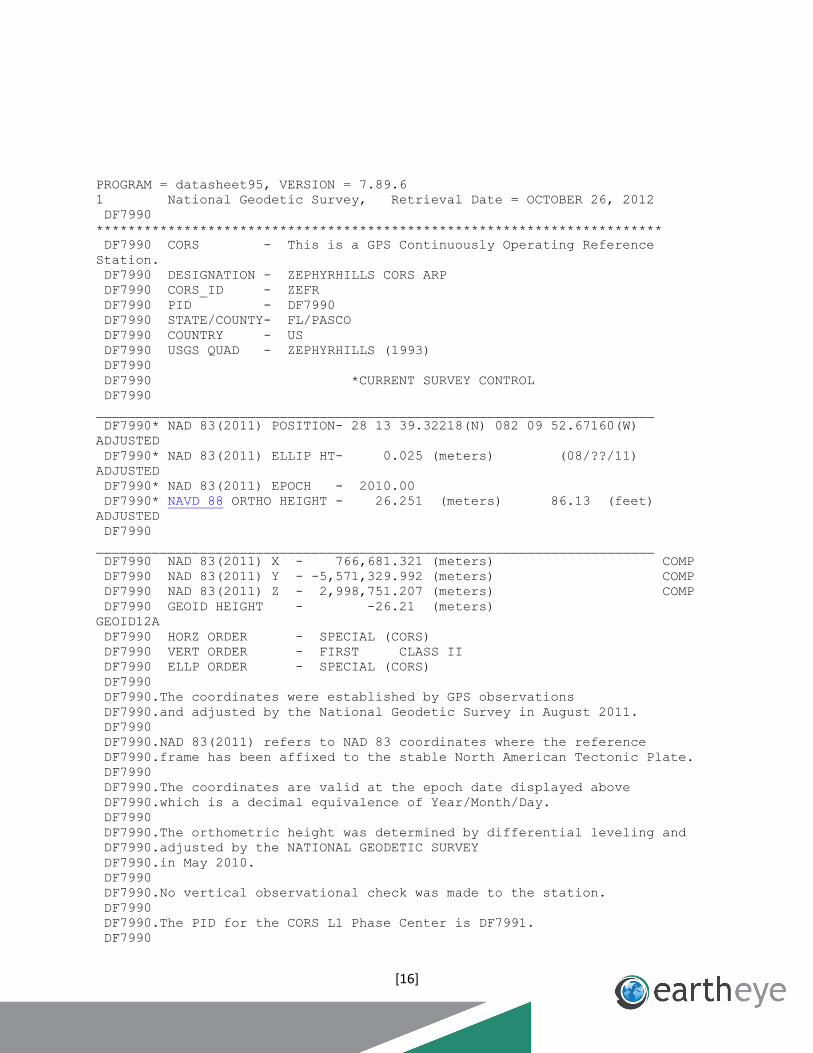
DF7990
***********************************************************************
DF7990 CORS - This is a GPS Continuously Operating Reference
Station.
DF7990 DESIGNATION - ZEPHYRHILLS CORS ARP
DF7990 CORS_ID - ZEFR
DF7990 PID - DF7990
DF7990 STATE/COUNTY- FL/PASCO
DF7990 COUNTRY - US
DF7990 USGS QUAD - ZEPHYRHILLS (1993)
DF7990
DF7990 *CURRENT SURVEY CONTROL
DF7990
______________________________________________________________________
DF7990* NAD 83(2011) POSITION- 28 13 39.32218(N) 082 09 52.67160(W)
ADJUSTED
DF7990* NAD 83(2011) ELLIP HT- 0.025 (meters) (08/??/11)
ADJUSTED
DF7990* NAD 83(2011) EPOCH - 2010.00
DF7990* NAVD 88 ORTHO HEIGHT - 26.251 (meters) 86.13 (feet)
ADJUSTED
DF7990
______________________________________________________________________
DF7990 NAD 83(2011) X - 766,681.321 (meters) COMP
DF7990 NAD 83(2011) Y - -5,571,329.992 (meters) COMP
DF7990 NAD 83(2011) Z - 2,998,751.207 (meters) COMP
DF7990 GEOID HEIGHT - -26.21 (meters)
GEOID12A
DF7990 HORZ ORDER - SPECIAL (CORS)
DF7990 VERT ORDER - FIRST CLASS II
DF7990 ELLP ORDER - SPECIAL (CORS)
DF7990
DF7990.The coordinates were established by GPS observations
DF7990.and adjusted by the National Geodetic Survey in August 2011.
DF7990
DF7990.NAD 83(2011) refers to NAD 83 coordinates where the reference
DF7990.frame has been affixed to the stable North American Tectonic Plate.
DF7990
DF7990.The coordinates are valid at the epoch date displayed above
DF7990.which is a decimal equivalence of Year/Month/Day.
DF7990
DF7990.The orthometric height was determined by differential leveling and
DF7990.adjusted by the NATIONAL GEODETIC SURVEY
DF7990.in May 2010.
DF7990
DF7990.No vertical observational check was made to the station.
DF7990
DF7990.The PID for the CORS L1 Phase Center is DF7991.
DF7990

[17]
DF7990.The XYZ, and position/ellipsoidal ht. are equivalent.
DF7990
DF7990.The ellipsoidal height was determined by GPS observations
DF7990.and is referenced to NAD 83.
DF7990
DF7990. The following values were computed from the NAD 83(2011) position.
DF7990
DF7990; North East Units Scale Factor
Converg.
DF7990;SPC FL W - 431,440.243 183,841.676 MT 0.99994440 -0 04
40.3
DF7990;SPC FL W - 1,415,483.53 603,153.90 sFT 0.99994440 -0 04
40.3
DF7990
DF7990! - Elev Factor x Scale Factor = Combined Factor
DF7990!SPC FL W - 1.00000000 x 0.99994440 = 0.99994440
DF7990
DF7990 SUPERSEDED SURVEY CONTROL
DF7990
DF7990 NAD 83(CORS)- 28 13 39.32227(N) 082 09 52.67214(W) AD(2002.00) c
DF7990 ELLIP H (09/??/03) 0.029 (m) GP(2002.00) c
c
DF7990
DF7990.Superseded values are not recommended for survey control.
DF7990
DF7990.NGS no longer adjusts projects to the NAD 27 or NGVD 29 datums.
DF7990.See file dsdata.txt to determine how the superseded data were
derived.
DF7990
DF7990_U.S. NATIONAL GRID SPATIAL ADDRESS: 17RLM8572722963(NAD 83)
DF7990
DF7990_MARKER: STATION IS THE ANTENNA REFERENCE POINT OF THE GPS ANTENNA
DF7990_MARK LOGO: NONE
DF7990_MAGNETIC: N = NO MAGNETIC MATERIAL
DF7990
DF7990 STATION DESCRIPTION
DF7990
DF7990'DESCRIBED BY NATIONAL GEODETIC SURVEY 2011
DF7990'STATION IS A GPS CORS. LATEST INFORMATION INCLUDING POSITIONS AND
DF7990'VELOCITIES ARE AVAILABLE IN THE COORDINATE AND LOG FILES ACCESSIBLE
DF7990'BY ANONYMOUS FTP OR THE WORLDWIDE WEB.
DF7990' ftp://cors.ngs.noaa.gov/cors/README.txt
DF7990' ftp://cors.ngs.noaa.gov/cors/coord/coord_08
DF7990' ftp://cors.ngs.noaa.gov/cors/station_log
DF7990' http://geodesy.noaa.gov/CORS
Appendix D

[18]
Appendix E

[19]
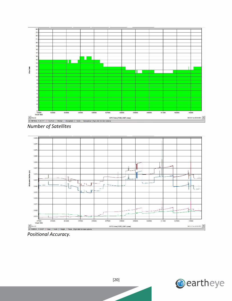
Mission 120521_A
Trajectory Map
DOP Map
[20]
Number of Satellites
Positional Accuracy.
[21]
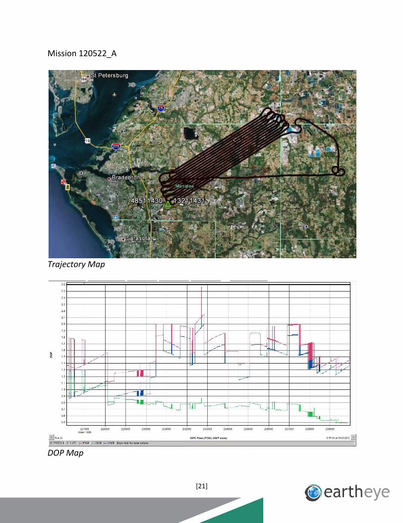
Mission 120522_A
Trajectory Map
DOP Map

[22]
Number of Satellites
Positional Accuracy

[23]
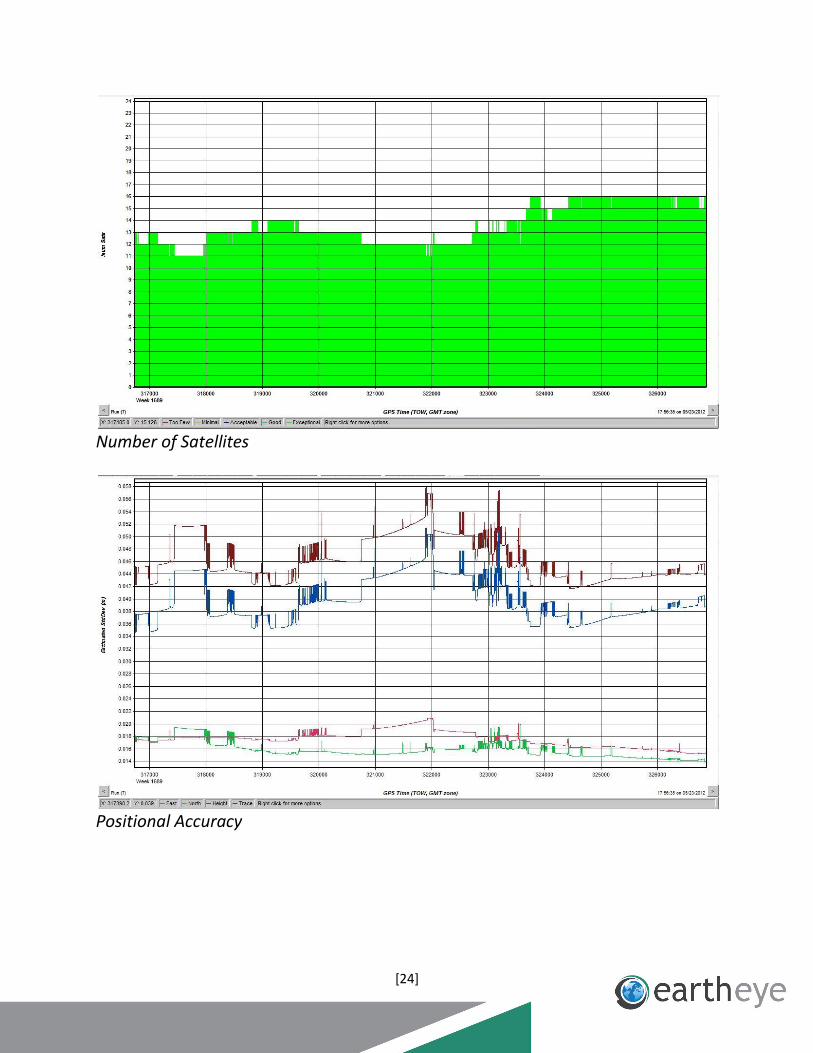
Mission 120523_B
Trajectory Map
DOP Map
[24]
Number of Satellites
Positional Accuracy
Related Documents